Embed Size (px)
Citation preview

Prof. Dr.-Ing. Franz-Josef Behr
SV
G o
riente
d F
ram
ew
ork
for
Web M
ap S
erv
ices
SV
G o
riente
d F
ram
ew
ork
for
Web M
ap S
erv
ices
1PH
PM
yW
MS
PH
PM
yW
MS
PHPMyWMS - an Open Source based, SVG PHPMyWMS - an Open Source based, SVG oriented Framework for extended Web Map oriented Framework for extended Web Map ServicesServices
Prof. Dr.-Ing. Franz-Josef Behr
University of Applied Sciences Stuttgart, Department of Geomatics, Computer Science and Mathematics, Schellingstraße 24, D-70174 Stuttgart

Prof. Dr.-Ing. Franz-Josef Behr
SV
G o
riente
d F
ram
ew
ork
for
Web M
ap S
erv
ices
SV
G o
riente
d F
ram
ew
ork
for
Web M
ap S
erv
ices
2PH
PM
yW
MS
PH
PM
yW
MS
OverviewOverview
• Architecture
• Overview over OGC‘s Web Map Service (WMS)
• Key features of Scalable Vector Graphics (SVG)
• Server side implementation
• Client Implementations
• Conclusion and Outlook
Prof. Dr.-Ing. Franz-Josef Behr
SV
G o
riente
d F
ram
ew
ork
for
Web M
ap S
erv
ices
SV
G o
riente
d F
ram
ew
ork
for
Web M
ap S
erv
ices
3PH
PM
yW
MS
PH
PM
yW
MS
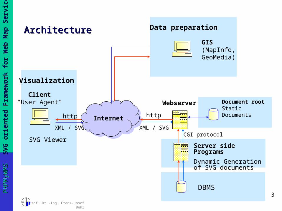
ArchitectureArchitecture
Internethttp
Webserver
http
CGI protocol
Document rootStatic Documents
Server side Programs
Dynamic Generation of SVG documents
Client"User Agent"
SVG Viewer
XML / SVG XML / SVG
DBMS
Visualization
Data preparation
GIS(MapInfo, GeoMedia)

Prof. Dr.-Ing. Franz-Josef Behr
SV
G o
riente
d F
ram
ew
ork
for
Web M
ap S
erv
ices
SV
G o
riente
d F
ram
ew
ork
for
Web M
ap S
erv
ices
4PH
PM
yW
MS
PH
PM
yW
MS
GetCapabilities request GetCapabilities request
http://www.gis-news.de/wms/getmapcap.php?VERSION=1.1.1&SERVICE=WMS&REQUEST=GetCapabilities

Prof. Dr.-Ing. Franz-Josef Behr
SV
G o
riente
d F
ram
ew
ork
for
Web M
ap S
erv
ices
SV
G o
riente
d F
ram
ew
ork
for
Web M
ap S
erv
ices
5PH
PM
yW
MS
PH
PM
yW
MS
GetMap requestGetMap request
http://www.gis-news.de/wms/getmapcap.php?VERSION=1.1.1&BBOX=189775.33,4816305.37,761662.27,5472414.18&LAYERS=airports,ctybdpy2&STYLES=,,&REQUEST=GetMap&style=&SRS=EPSG:26715&4340&WIDTH=800&HEIGHT=600&FORMAT=image/svg+xml&EXCEPTIONS=application/vnd.ogc.se_xml

Prof. Dr.-Ing. Franz-Josef Behr
SV
G o
riente
d F
ram
ew
ork
for
Web M
ap S
erv
ices
SV
G o
riente
d F
ram
ew
ork
for
Web M
ap S
erv
ices
6PH
PM
yW
MS
PH
PM
yW
MS
GetFeatureInfo requestGetFeatureInfo request
Prof. Dr.-Ing. Franz-Josef Behr
SV
G o
riente
d F
ram
ew
ork
for
Web M
ap S
erv
ices
SV
G o
riente
d F
ram
ew
ork
for
Web M
ap S
erv
ices
7PH
PM
yW
MS
PH
PM
yW
MS
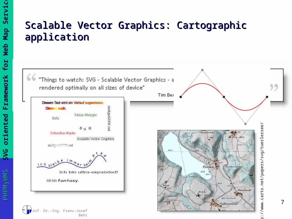
Scalable Vector Graphics: Cartographic Scalable Vector Graphics: Cartographic applicationapplication
htt
p:/
/ww
w.c
art
o.n
et/
pap
ers
/svg
/tu
erl
ers
ee/

Prof. Dr.-Ing. Franz-Josef Behr
SV
G o
riente
d F
ram
ew
ork
for
Web M
ap S
erv
ices
SV
G o
riente
d F
ram
ew
ork
for
Web M
ap S
erv
ices
8PH
PM
yW
MS
PH
PM
yW
MS
Scalable Vector Graphics: Key features and Scalable Vector Graphics: Key features and benefitsbenefits
• Recommendation of World Wide Web Consortium (w3.org)• Several profiles, including mobile profiles SVG Tiny (SVGT)
and SVG Basic
• Advantages– XML based,
• combination with other XML technologies like XLink • True geo-data, used as visualization for GML• conformant to DOM, analysis & modification using
JavaScript– Outstanding graphical quality – very attractive!– Accessibility and searchability

Prof. Dr.-Ing. Franz-Josef Behr
SV
G o
riente
d F
ram
ew
ork
for
Web M
ap S
erv
ices
SV
G o
riente
d F
ram
ew
ork
for
Web M
ap S
erv
ices
9PH
PM
yW
MS
PH
PM
yW
MS
Scalable Vector Graphics: Key features and Scalable Vector Graphics: Key features and benefits IIbenefits II
• Increasing Browser support (Firefox, Opera)• Plug-ins and Stand-alone viewer applications• Mobile viewers• Conversion from many GIS formats / systems
Prof. Dr.-Ing. Franz-Josef Behr
SV
G o
riente
d F
ram
ew
ork
for
Web M
ap S
erv
ices
SV
G o
riente
d F
ram
ew
ork
for
Web M
ap S
erv
ices
10
PH
PM
yW
MS
PH
PM
yW
MS
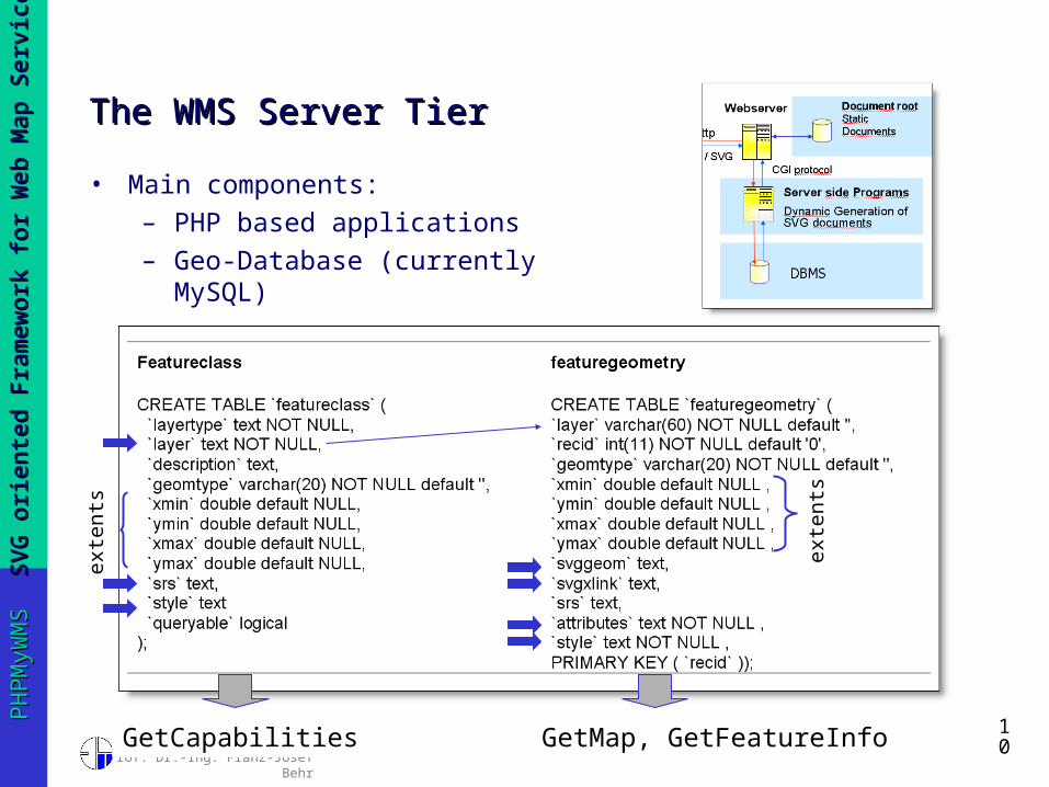
The WMS Server TierThe WMS Server Tier
• Main components:– PHP based applications– Geo-Database (currently
MySQL)
exte
nts
exte
nts
GetCapabilities GetMap, GetFeatureInfo
Prof. Dr.-Ing. Franz-Josef Behr
SV
G o
riente
d F
ram
ew
ork
for
Web M
ap S
erv
ices
SV
G o
riente
d F
ram
ew
ork
for
Web M
ap S
erv
ices
11
PH
PM
yW
MS
PH
PM
yW
MS
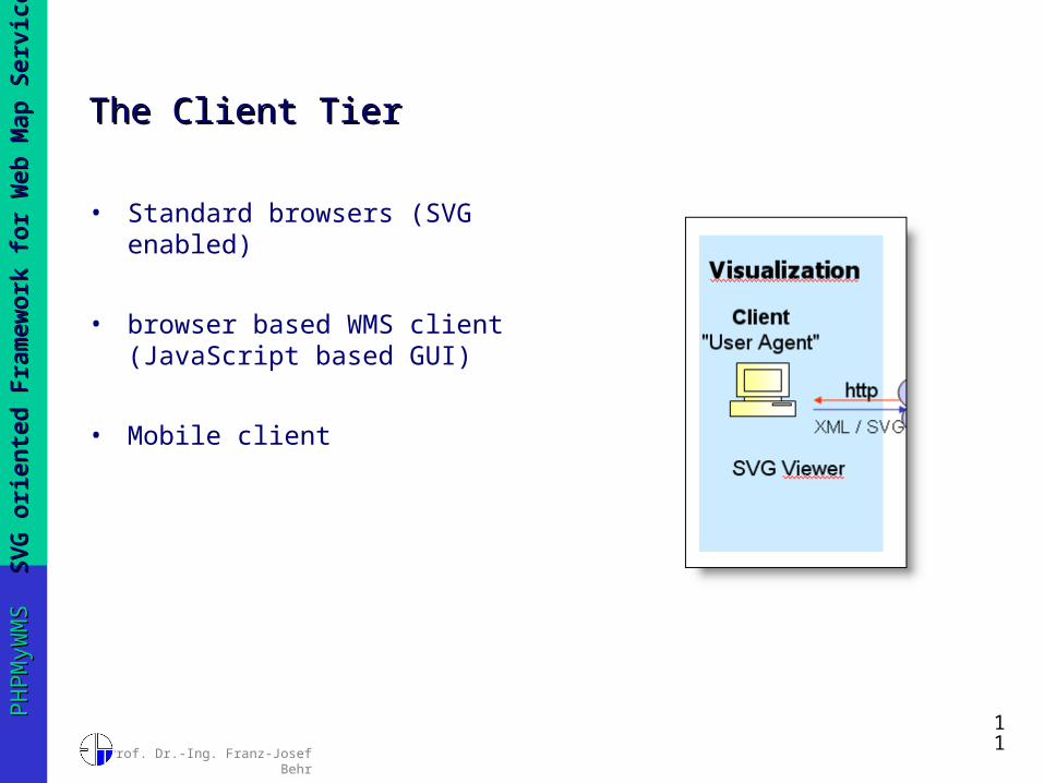
The Client TierThe Client Tier
• Standard browsers (SVG enabled)
• browser based WMS client (JavaScript based GUI)
• Mobile client

Prof. Dr.-Ing. Franz-Josef Behr
SV
G o
riente
d F
ram
ew
ork
for
Web M
ap S
erv
ices
SV
G o
riente
d F
ram
ew
ork
for
Web M
ap S
erv
ices
12
PH
PM
yW
MS
PH
PM
yW
MS
Browser based WMS clientBrowser based WMS client
• JavaScript based GUI• Uses Asynchronous JavaScript and XML (AJAX)
technology - asynchronous progress of data exchanging with servers as background process

Prof. Dr.-Ing. Franz-Josef Behr
SV
G o
riente
d F
ram
ew
ork
for
Web M
ap S
erv
ices
SV
G o
riente
d F
ram
ew
ork
for
Web M
ap S
erv
ices
13
PH
PM
yW
MS
PH
PM
yW
MS
Mobile clientMobile client
• WMS client for mobile devices implemented based on SVGT and Java 2 Micro Edition (J2ME).
• Mobile WMS clients provides a graphical user interface
• typical functions for exploration of the map obtained from the WMS server – Server selection– zoom – Pan
• See PS III-1: Mobile GIS Technology

Prof. Dr.-Ing. Franz-Josef Behr
SV
G o
riente
d F
ram
ew
ork
for
Web M
ap S
erv
ices
SV
G o
riente
d F
ram
ew
ork
for
Web M
ap S
erv
ices
14
PH
PM
yW
MS
PH
PM
yW
MS
PHPMyWMS on the WebPHPMyWMS on the Web
• Supports SVG format as well as raster formats and SWF and PDF
• Open Source
• Homepage: http://www.easywms.com
• Additionally hosted at sourceforge.net
• CVS repository

Prof. Dr.-Ing. Franz-Josef Behr
SV
G o
riente
d F
ram
ew
ork
for
Web M
ap S
erv
ices
SV
G o
riente
d F
ram
ew
ork
for
Web M
ap S
erv
ices
15
PH
PM
yW
MS
PH
PM
yW
MS
Conclusion and OutlookConclusion and Outlook
• Prove of concept: SVG is well suited for storing, transforming, displaying and transferring geo-data.
• Possible improvements :– Support of Styled Layer Descriptor (SLD) specification or
user-defined symbolization.– Extension to cascading server.– LBS extension: User support like GSM-based positioning
techniques, or GPS support would be helpful.– Extending browser based client– Adding additional services (like better GetFeature
support based on geo-coordinates)– Better sample data in the geo-database.

Prof. Dr.-Ing. Franz-Josef Behr
SV
G o
riente
d F
ram
ew
ork
for
Web M
ap S
erv
ices
SV
G o
riente
d F
ram
ew
ork
for
Web M
ap S
erv
ices
16
PH
PM
yW
MS
PH
PM
yW
MS
LiteratureLiterature