Embed Size (px)
Citation preview
Table of Contents……………………………………………………… 1
Adopting Resolution…………………………………………………… 2
Program Overview….………………………………………………… 4
Letter from the Director……..………………………………………… 5
Policies ………...…………………………………………………….… 8
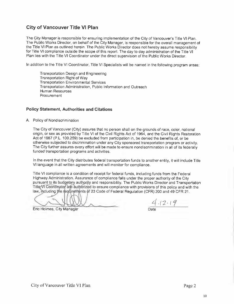
Title VI Policy Statement…….…………………………………..…… 10
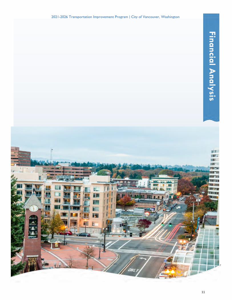
Financial Analysis…………....…………………………………..…… 11
TIP Changes Last Year to This Year….…………………….………… 24
Six-Year Project Lists…….…………..………………………..……… 27
Project Detail Sheets…….…………..……………………..………… 33
Arterial Map Updates…….……...………………………………… 124
Glossary……..…………...……….………………………………… 127
Ta
ble
of C
on
ten
ts
1
RESOLUTION – 1
6/15/20
RESOLUTION NO.__________
A RESOLUTION adopting the City of Vancouver’s Comprehensive Six-Year
Transportation Improvement Program for 2021-2026 and revising the City’s Arterial Street
System and Classification Map.
WHEREAS, pursuant to RCW 35.77.010, the Vancouver Department of Public Works
has prepared the Comprehensive Six-Year Transportation Improvement Program for 2021-2026
(“2021-2026 TIP”); and
WHEREAS, the purpose of the 2021-2026 TIP is to ensure that the City will have
available advance plans as a guide in carrying out a coordinated street construction program; and
WHEREAS, the City’s Arterial Street System and Classification Map (“Arterial
Classification Map”) is maintained within the 2021-2026 TIP; and
WHEREAS, City Council originally adopted the Arterial Classification Map by
Resolution M-781 on November 28, 1961, and annually reviews proposals and makes
classification designation changes on the map where the use of a roadway is inconsistent with its
current arterial designation; and
WHEREAS, notice of the time and place for a hearing on the 2021-2026 TIP was
published in accordance with law; and
WHEREAS, the City Council conducted a public hearing on June 15, 2020 at 6:30 p.m.,
where it considered the 2021-2026 TIP and determined to adopt it.
NOW, THEREFORE,
M-4078
DocuSign Envelope ID: 5D5E9ECF-8855-4CB5-949B-A1F02F99C5FE
2
RESOLUTION – 2
BE IT RESOLVED BY THE CITY OF VANCOUVER:
Section 1. Legislative Findings. The recitals set forth above are adopted as the
legislative findings of Vancouver’s City Council in support of adoption of this resolution.
Section 2. City Council hereby adopts the 2021–2026 Comprehensive Six-Year
Transportation Improvement Program, which is attached as Exhibit “A” and incorporated by this
reference as if fully set forth herein.
Section 3. City Council hereby adopts the Revised Arterial Street System and
Classification Map, which is contained in the 2021-2026 Comprehensive Six-Year
Transportation Improvement Program.
Section 4. The City Manager or his designee is hereby directed to file the 2021-2026
Comprehensive Six-Year Transportation Improvement Program and the Revised Arterial Street
System and Classification Map with the Washington State Department of Transportation within
30 days of the date of this resolution.
ADOPTED at regular session of the Council of the City of Vancouver on June 15, 2020.
______________________________
Anne McEnerny-Ogle, Mayor
Attest: Approved as to form:
______________________________ ______________________________
Natasha Ramras, City Clerk Jonathan Young, City Attorney
DocuSign Envelope ID: 5D5E9ECF-8855-4CB5-949B-A1F02F99C5FE
3
TRANSPORTATION IMPROVEMENT PROGRAM OVERVIEW
The City of Vancouver 2021-2026 Transportation Improvement Program (TIP) is an update of the City’s 2020 - 2025 TIP. The TIP is a technical document for transportation improvements over a six-year period. For more information about the City of Vancouver street system, how it is funded, and how money is spent go to:
www.cityofvancouver.us/betterstreets
The State of Washington law (RCW 35.77.010) requires the City to prepare a TIP annually that is consistent with and implements the city’s adopted comprehensive growth management plan. The TIP identifies capital transportation system improvement projects and includes a policy to work with affected property owners to preserve railroad right-of-way in the event a railroad ceases to operate.
For information about the City’s Comprehensive Plan, contact Vancouver Planning at 360-487-7950. For questions or more information about specific transportation projects,please contact Vancouver Public Works at 360-487-7130, or visit the City’s website:
www.cityofvancouver.us
Projects are added to the TIP each year as needed based on input from citizens, staff, the development community, adopted subarea plans, other agencies, advocacy groups, and as new grant opportunities arise. Projects are removed from the TIP each year once they are constructed. In some cases, a project is removed because the project is no longer needed although this is rare. Citizens can request to have a project added or removed by clicking on the link on the City’s TIP web page:
https://www.cityofvancouver.us/tip
A City of Vancouver Arterial Street System and Classification Map which designates roadways functionally classified as Arterials pursuant to VMC 11.80.040 and VMC 9.02.040 is adopted and attached hereto.
4
2021-2026 Transportation Improvement Program (TIP) Letter from the Public Works Director
Transportation is an essential part of how Vancouver moves. Each year, the City of Vancouver prepares a Six-Year Transportation Improvement Program (TIP), which serves as a detailed work program of all future projects. Projects listed in the TIP include planning studies and major street, bicycle, pedestrian and traffic signal improvements. In accordance with Washington law, the annual TIP document is updated annually, with final City Council approval required before July 1 of each year. To be eligible for state or federal grants, projects must be listed in the TIP. The TIP is posted on the City’s website, along with ability for the public to submit project suggestions or questions, in keeping with community transparency and accountability. Since its adoption by the Council in 2015, Vancouver’s Street Funding Strategy, has dedicated additional revenue sources to help fund TIP projects and improve travel and safety throughout the community. This year’s TIP takes into account recent impacts to that strategic effort. In November 2019, voters approved statewide Initiative 976 (I-976), which capped vehicle license fees at $30 and eliminated TBD license fees adopted by local jurisdictions, including the City of Vancouver. The City’s Transportation Benefit District (TBD) fee generates approximately $5 million in annual revenues, comprising more than half of the City’s Street Funding Strategy revenues. TBD funds are dedicated to improving the City’s transportation system, partially funding both the City’s capital improvement program and the pavement management program.
Loss of the TBD revenue will require the City to delay indefinitely many transportation projects needed to upgrade travel corridors, reduce congestion and improve safety for all – pedestrians, bicyclists and motorists. One of the most visible effects of I-976 is likely to be a reduction in the City’s Pavement Management Program, which has been steadily improving pavement conditions throughout the City in the years since the adoption of the Street Funding Strategy. The loss of TBD funds also eliminates the local match dollars used by the City to leverage State and Federal grant revenue. For example, in 2019 the City used TBD funds to secure $6.6 million in grant funding for a variety of transportation projects. Furthermore, if replacement revenue is not implemented, the City may need to forfeit approximately $4 million in grants already awarded for major capital street projects. The TBD Board and City Council will be considering replacement revenue options in
P.O. Box 1995 • Vancouver, WA 98668-1995 • www.cityofvancouver.us
5
2020-21. More information about the Street Funding Strategy and TBD can be found in the 2019 Street Funding Strategy Annual Report located at www.cityofvancouver/tbd.
In addition, due to the recent COVID-19 pandemic, many revenue sources that directly support transportation infrastructure will be negatively impacted in 2020 and beyond. These revenue sources include: Business License Surcharge fees, utility tax, motor vehicle fuel tax, and real estate excise tax. Additionally, other revenue sources that indirectly support transportation infrastructure via the City’s General Fund will be negatively impacted in 2020 and beyond. These other revenue sources include: sales tax and property tax. The near term impacts will be less transportation capital projects and pavement management work. The long term impacts won’t be known until the pandemic is over.
Going forward, the City of Vancouver’s 2021-2026 Six-Year Transportation Improvement Program (TIP) takes into account remaining revenues from the Street Funding Strategy. Vancouver’s TIP continues to exceed the state statutory requirements by providing a comprehensive look at communitywide projects and programs, reflecting our commitment to transparency in projects and funding.
Our future, in part, depends upon our ability to invest in public infrastructure in a way that both preserves our community’s neighborhoods and supports its economic well-being. Through responsible funding and systematic planning, design, construction, maintenance, operations, and improvements, the City of Vancouver is committed to continued efficient and cost-effective management of its public assets to provide the highest, most sustainable service possible for all users. Highlights for the 2021-2026 TIP are shown on the next page.
Dan Swensen, P.E. Ryan Lopossa, P.E.
Interim Director of Vancouver Public Works Streets and Transportation Manager
6
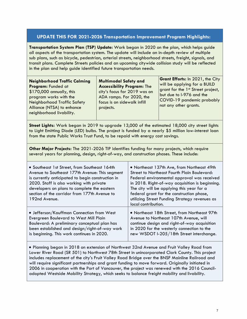
UPDATE THIS FOR 2021-2026 Transportation Improvement Program Highlights:
Transportation System Plan (TSP) Update: Work began in 2020 on the plan, which helps guide all aspects of the transportation system. The update will include an in-depth review of multiple sub plans, such as bicycle, pedestrian, arterial streets, neighborhood streets, freight, signals, and transit plans. Complete Streets policies and an upcoming citywide collision study will be reflected in the plan and help guide identified future transportation needs.
Neighborhood Traffic Calming Program: Funded at $170,000 annually, this program works with the Neighborhood Traffic Safety Alliance (NTSA) to enhance neighborhood livability.
Multimodal Safety and Accessibility Program: The city’s focus for 2019 was on ADA ramps. For 2020, the focus is on sidewalk infill projects.
Grant Efforts: In 2021, the City will be applying for a BUILD grant for the 1st Street project, but due to I-976 and the COVID-19 pandemic probably not any other grants.
Street Lights: Work began in 2019 to upgrade 13,000 of the estimated 18,000 city street lights to Light Emitting Diode (LED) bulbs. The project is funded by a nearly $5 million low-interest loan from the state Public Works Trust Fund, to be repaid with energy cost savings.
Other Major Projects: The 2021-2026 TIP identifies funding for many projects, which require several years for planning, design, right-of-way, and construction phases. These include:
Southeast 1st Street, from Southeast 164th Avenue to Southeast 177th Avenue: This segment is currently anticipated to begin construction in 2020. Staff is also working with private developers on plans to complete the eastern section of the corridor from 177th Avenue to 192nd Avenue.
Northeast 137th Ave, from Northeast 49th Street to Northeast Fourth Plain Boulevard: Federal environmental approval was received in 2018. Right-of-way acquisition is beginning. The city will be applying this year for a federal grant for the construction phase, utilizing Street Funding Strategy revenues as local contribution.
Jefferson/Kauffman Connection from West Evergreen Boulevard to West Mill Plain Boulevard: A preliminary conceptual plan has been established and design/right-of-way work is beginning. This work continues in 2020.
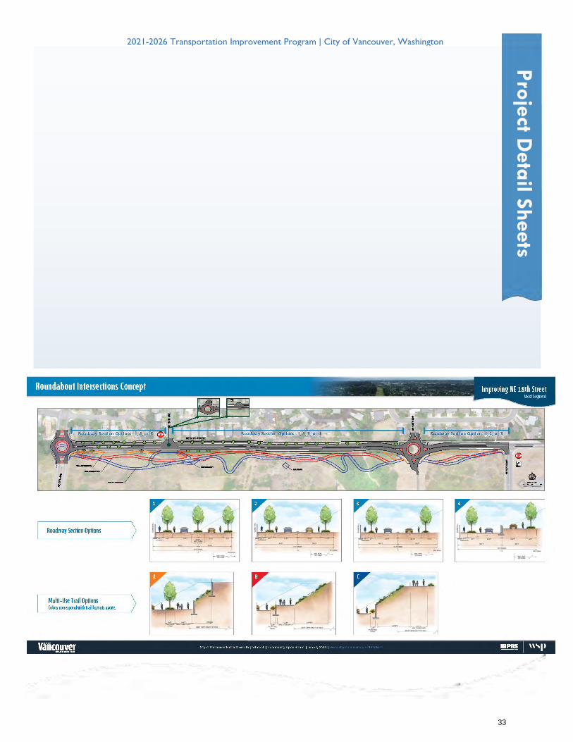
Northeast 18th Street, from Northeast 97th Avenue to Northeast 107th Avenue, will continue design and right-of-way acquisition in 2020 for the westerly connection to the new WSDOT I-205/18th Street interchange.
Planning began in 2018 on extension of Northwest 32nd Avenue and Fruit Valley Road from Lower River Road (SR 501) to Northwest 78th Street in unincorporated Clark County. This project includes replacement of the city’s Fruit Valley Road Bridge over the BNSF Mainline Railroad and will require significant partnerships and grant funding to move forward. Originally initiated in 2006 in cooperation with the Port of Vancouver, the project was renewed with the 2016 Council- adopted Westside Mobility Strategy, which seeks to balance freight mobility and livability.
7
TRANSPORTATION RELATED POLICIES
(“Vancouver Comprehensive Plan 2011-2030”, Chapter 5 – Public Facilities and Services)
1. PFS-4 - TRANSPORTATION SYSTEM: Develop and maintain an interconnected and overlapping transportation system grid of pedestrian walkways, bicycle facilities, roadways for automobiles and freight, transit service, and high capacity transit service. Include support programs such as traffic operations, transportation demand management, neighborhood traffic management, and the regional trails program. Work towards completing and sustaining individual components and programs to ensure success of the entire system.
2. PFS-5 - SYSTEM BALANCE: Allocate resources to balance transportation choices. Promote development of a broader range of
transportation options including pedestrian, bike, and transit systems, rather than focusing all resources on satisfying peak commuting demand with roadway capacity alone.
3. PFS-6 - TRANSPORTATION SAFETY: Ensure high safety standards for motorists, pedestrians, and bicyclists through the development and
capital improvement processes. Allocate city capital resources to high risk and collision location for motorists, bicyclists, and pedestrians.
4. PFS-7 - TRANSPORATION FINANCE: Develop recurring and dedicated funding for a complete transportation program, including system operation and maintenance. Leverage local funding with innovative and aggressive finance strategies including partnerships, grant development, efficient debt, and fee-based funding sources.
5. PFS-8 - TRANSPORTATION CIRCULATION AND SYSTEM CONNECTIVITY: Develop a transportation grid that provides good connections
to surrounding land uses and activity centers and allows for multiple circulation routes to/from each location. Close gaps and complete system connections through the development and capital improvement processes.
6. PFS-9 - LAND USE AND TRANSPORTATION INTEGRATION: Develop and implement innovative transportation investment, design, and
program incentives to achieve the urban environment envisioned in the Comprehensive Plan.
7. PFS-10 - LIVABLE STREETS: Design streets and sidewalks and manage vehicular traffic to encourage livability, interaction, and sense of neighborhood or district ownership in linkage with adjacent land uses. Encourage multi-modal travel, and provide accessible, human scale opportunities for transferring between travel modes.
8. PFS-11 - TRANSPORTATION ACCESSIBILITY: Build an accessible transportation system focused on inter-model connectivity and removing
barriers to personal physical mobility.
9. PFS-12 - TRANSPORTATION SYSTEM EFFICIENCY: Invest in and improve efficiency of the transportation system with multi-modal design, advanced traffic management and operations technology, demand management strategies and high-frequency transit service.
10. PFS-13 - NEIGHBORHOOD TRAFFIC: Protect and enhance neighborhoods with an active program that focuses on safety, safe routes to
school, traffic calming, education, and enforcement.
11. PFS-14 - TRANSPORATION REGIONAL AND METROPOLITAN COORDINATION: Coordinate Vancouver’s transportation plans, policies, and programs with those of other jurisdictions serving the greater Metropolitan area to ensure a seamless transportation system. Focus particularly on cooperation with the Southwest Washington Regional Transportation Council, Washington State Department of Transportation, Clark County and C-TRAN.
12. PFS-16 - ECONOMIC DEVELOPMENT: In order to support the continued economic vitality of Vancouver, major transportation
system investments should facilitate freight mobility, job creation, regional competitive position, and revenue growth.
13. PFS-17 - VEHICILE MILES TRAVELED: Use transportation and land use measures to maintain or reduce single occupant motor vehicle miles traveled per capita to increase system efficiency and lower overall environmental impacts.
14. PFS-18 - STREET DESIGN: Design city streets to achieve safety and accessibility for all modes. Arterial streets shall provide facilities for
automobile, bike, pedestrian and transit mobility, and shall include landscaping and adequate lighting.
15. PFS-19 - PARKING STANDARDS: Adopt coordinated parking standards which maintain neighborhood integrity, promote the use of a multi-modal transportation system, and efficient utilization of limited land, and encourage desired economic development and growth throughout the entire urban area.
ASSET MANAGEMENT COMPREHENSIVE PLAN POLICY (“Vancouver Comprehensive Plan 2011-2030”, Chapter 5 – Public Facilities and Services)
(Adopted 12/16/2013)
16. PFS-35 - City transportation, water, sewer, and surface water facility assets shall be systematically managed to balance full life cycle costs, performance, risk, and service levels, using best management practices and data.
8
CAPITAL PLANNING AND ASSET MANAGEMENT FINANCIAL POLICIES (City of Vancouver Financial Policies as revised 11/19/2018)
17. #32 - Asset management best practice involves managing the performance, risk and expenditures on infrastructure assets in an
optimal and sustainable manner throughout their lifecycle covering planning, design, construction, operation, maintenance, and disposal. The City shall integrate the principles and best practices of asset management such as those embodied in the International Infrastructure Management Manual in the management of its assets.
18. #33 - Asset Inventory will be maintained with maintenance, repair and deferred maintenance costs identified and updated on
an annual basis.
19. #34 - Maintenance of city assets shall be addressed on a current need, rather than deferred into the future.
20. #35 - In 2015, Council adopted a New Street Funding Program in response to formal recommendations from a citizen-led effort. Revenues from this program were established to supplement without supplanting street funding resources identified in the 2015-2016 Adopted Biennial Budget. Annual reporting to the Council and the residents of outcomes achieved through the Streets Funding Initiative Program has been initiated in 2017 and shall continue into the future. The City will maintain funding of the Pavement Management Program at no less than that in the 2015-2016 Biennial Adopted Budget level increased by an appropriate inflationary factor, if necessary. To ensure accountability and transparency, the increase in program level funded by the new Street Funding Program revenue sources will be fully costed, budgeted for and spent from special funds created to track direct operation, capital and administrative expenses. Annual reporting of the outcomes will be published for the residents and the City Council prior to the end of the first quarter of each year for the prior year beginning for fiscal year 2016.
21. #36 - The City will redirect to the new Street Funding Program expiring debt service budget from pre-2015 debt issues
for Transportation projects, beginning with debt expiring in 2016.
22. #37 - A six-year City-Wide Capital Improvement Program shall be developed annually and shall provide a prioritized list of reasonably funded projects and those in process of securing funding. Capital Improvement Plans for utility assets shall be updated no less frequently than every two years. The comprehensive plan will identify longer-term capital needs by program area.
23. #38 - Funding for capital projects, including major facilities maintenance projects, will be allocated in a manner that balances
community needs with City priorities, the potential for attracting matching funds, and the ability to reduce or limit expenses in future years.
24. #39 - The City’s objective is to incorporate a “pay-as-you-go” approach (using available cash and current resources) in the
Capital Improvement program. Proceeds from the sale of city capital assets no longer utilized in operations will be deposited consistent with the initial ownership of the asset and invested in the highest priority capital projects.
25. #40 - The capital budget will be adopted at the same time the City operating budget is adopted. The capital budget will only
include fully funded projects. The capital budget will only contain projects identified in the Capital Improvement Program.
26. #41 - A capital repair appropriation will be maintained for unanticipated major repairs of general operating facilities and for emergency replacement of general fund equipment. Additions to the capital repair contingency reserve will be made based on council directions.
27. #42 - Impacts on net annual operating and maintenance costs will be identified as part of the funding considerations for new
capital projects such as buildings, parks and street enhancements. This includes identifying potential reductions in maintenance costs if Improvements are funded. The necessary funds to operate the capital facility will be identified at the time the capital budget is adopted.
DEBT MANAGEMENT POLICIES
City of Vancouver Financial Policies as revised 11/19/2018)
28. #50 - The City will attempt to pay for capital projects on a “pay-as-you-go” basis. However, if debt is required, the City will follow debt policies as detailed in Exhibit B-Debt Management Policy.
9
10
2021-2026 Transportation Improvement Program | City of Vancouver, Washington
Fin
ancia
l Analy
sis
11
Funding Overview Recent Events Due to the recent COVID-19 pandemic, many revenue sources that directly support transportation infrastructure will be negatively impacted in 2020 and beyond. These revenue sources include: Business License Surcharge fees, utility tax, motor vehicle fuel tax, and real estate excise tax. Additionally, many revenue sources that indirectly support transportation infrastructure via the City’s General Fund will be negatively impacted in 2020 and beyond. These revenue sources include: sales tax and property tax. The near term impacts are less transportation capital projects and pavement management work. The long term impacts won’t be known until the pandemic is over. For additional information about each revenue source, see the Local Funding Sources section below. Due to the recent passage of State initiative 976 (I-976), which caps vehicle license renewal fees at $30, The Vancouver Transportation Benefit District (TBD) will lose approximately $5 million annually. The TBD revenues were used to fund the City’s transportation capital program as well as a portion of the City’s pavement management program. Due to the loss of the TBD revenues, the City will have to indefinitely delay many of our capital projects and reduce our pavement management program. If replacement revenue is not found, the City may need to forfeit approximately $4 million in grants recently awarded. The TBD and City of Vancouver will be pursuing replacement revenue options in 2020 and 2021.
Street Funding Strategy Beginning in 1995, the City of Vancouver began a street funding strategy for local revenue to use for transportation capital improvements. This strategy involved identifying a revenue source and then committing that revenue source for debt service on bonds. Proceeds from the bond sale were then leveraged with grant revenues to the maximum extent possible for transportation improvements. Coupled with impact fees and developer contributions, this strategy netted hundreds of millions worth of capital improvements but resulted in a cyclical search for new revenues to address the continued need for capital improvements. Over the past several years, City Council searched for a reasonable mix of new revenue sources that could be used on a “pay-as-you-go” basis to fund capital improvements as well as halt the gradual decline in our system pavement condition index. Early in 2015, City Council established a goal to complete, by year-end “an adopted street funding program that provides reliable, dedicated, long-term funding for streets, including pedestrian, bike and accessible infrastructure.” In late 2015, City Council enacted a number of revenue sources for streets including:
• Creation of a Transportation Benefit District (TBD) and with the District enacting a new revenue source; a $20 Vehicle License Fee (raised to $40 in 2018).
• Increased the existing Business License Surcharge (BLS) by $10/employee in 2016 and an additional $10/per employee starting on January 1, 2018.
• Increased the Utility Tax on City Owned utilities dedicating the additional revenue for streets. • Dedicated that revenue sources used to pay debt service on bonds (as described above) would
continue to be dedicated for street purposes on a pay-as-you-go basis as debt is retired. • Dedicated that revenue from the increased gas tax resulting from the 2015 state gas tax
increase would be used for median maintenance and street sweeping to accomplish service level increases for esthetic purposes.
The 2019 annual street funding strategy report to the community and more information about the TBD can be found here: http://www.cityofvancouver.us/tbdb/page/vancouver-transportation-benefit-district
12
Local Funding Sources Public Sources:
Vehicle License Fee: Authority for the TBD to implement fee has been removed due to I-976, resulting in estimated annual revenue loss of $5M. Motor Vehicle Fuel Tax aka State Gas Tax: Typically about $3.5 million per year. Due to COVID-19, revenues are expected to be 25% to 50% less for 2020. REET: Real estate excise tax, varies per year, depending on real estate transactions. Due to COVID-19, revenues are expected to be approximately 50% less for 2020. Bonds (debt): Periodically the City sells bonds for transportation construction projects. Revenues to pay those debts come from several sources including gas tax, general fund, REET, and business license surcharge. Business License Surcharge (BLS): Surcharge paid at the time of initial or renewal of business licenses. First $50/employee generates around $2.0 million annually to pay bond debt. An additional $20 starting in 2018 will be used for street improvements on a pay as you go basis. City Council temporarily suspended collection of the BLS fee between Mar, 31, 2020 to April 1, 2021 to support businesses negatively impacted by the COVID-19 crises. Therefore, BLS revenues are expected to be approximately 75% less for 2020. Utility Tax: 1.5% Utility Tax on gross receipts for city-owned utilities including water, sewer, drainage and garbage. This tax raises $1.5M annually. Due to COVID-19, utility tax revenues are expected to be approximately 10% less for 2020.
Private Sources:
Direct Construction: Private developers are required to build or improve on-site roadways and may also be required to make off-site improvements to comply with concurrency or SEPA impacts. Traffic Impact Fees (TIF): The City maintains a TIF program (fees paid by a developer per new trip) which historically covers about 10% of the annual construction program. Proportionate Share Contributions: Developer contributions toward an improvement project to meet concurrency or safety requirements.
Grant Programs Federal Grant Programs:
BUILD: Better Utilizing Investments to Leverage Development—competitive, discretionary grant awarded by U.S. Department of Transportation to local agencies; focus is on large scale transportation projects that catalyze economic development CMAQ: Congestion Mitigation and Air Quality Program funds are administered like STBG funds. CDBG: Community Development Block Grant—periodically available for public street infrastructure (typically used for small sidewalk and ADA ramp improvements). STBG: Surface Transportation Block Grant funds are allocated by the SW Washington Regional Transportation Council and then, through a competitive grant process, to jurisdictions in the region. TAP: Transportation Alternatives Program—provides funding for alternative modes of transportation projects (i.e. modes other than vehicles).
State Grant Programs:
Transportation Improvement Board (TIB): Funded with a small portion of the state gas tax, TIB is the main source for state grant funds to state agencies. Vancouver competes with other urban
13
jurisdictions in Washington State for funds from several TIB grant programs. For example: urban arterial; urban sidewalk; and complete street programs. Pedestrian and Bicycle & Safe Routes to School Grant Program. These programs provide resources to make strategic investments that support pedestrian and bicycle improvements and improve walking/bicycle routes to schools. Washington Traffic Safety Commission Grant Program. Grants awarded on an annual cycle, focusing on projects that address one or more of the top Target Zero priorities including impaired driving, speeding, young drivers, seat belts and occupant protection, distracted driving and traffic records. WSDOT City Safety: Federal Highway Safety Improvement Program funds are allocated by the Washington State Department of Transportation (WSDOT) on a competitive basis to reduce fatal and serious injury crashes on city streets using engineering improvements/countermeasures
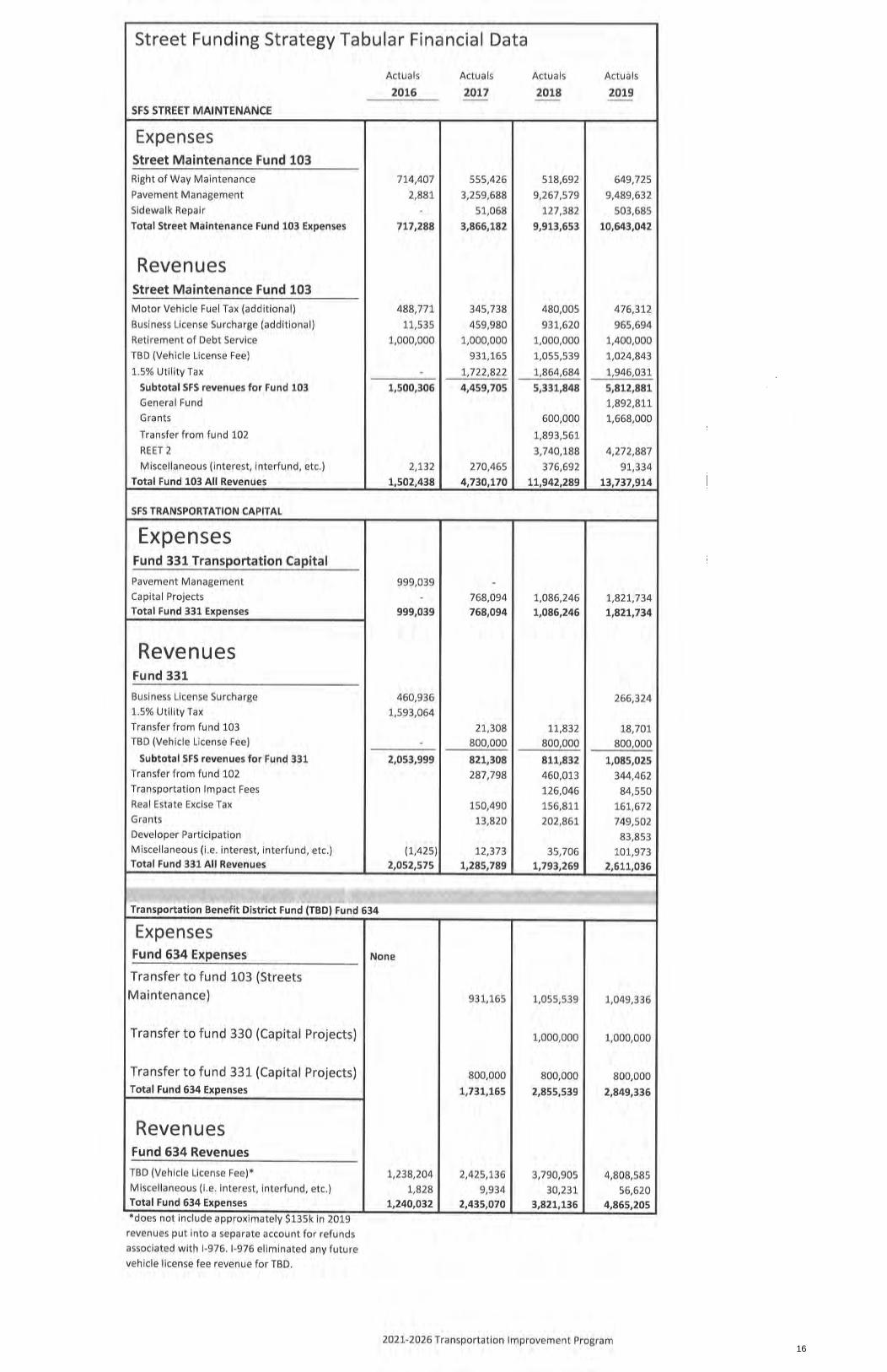
The table and graphs on the next few pages show the historical and forecasted revenues and expenses for streets in the City of Vancouver.
14
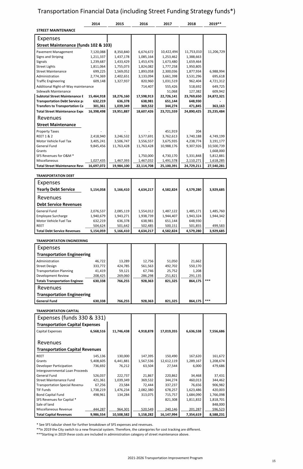
Transportation Financial Data (including Street Funding Strategy funds*)
2014 2015 2016 2017 2018 2019**
STREET MAINTENANCE
ExpensesStreet Maintenance (funds 102 & 103)Pavement Management 7,120,088 8,350,840 6,674,672 10,422,494 11,753,010 11,206,729 Signs and Striping 1,211,337 1,437,178 1,085,164 1,253,462 1,388,663 Signals 1,239,687 1,433,429 1,453,476 1,673,480 1,659,464 Street Lights 1,811,064 1,755,073 1,824,082 1,777,258 1,950,805 Street Maintenance 699,225 1,569,052 1,893,058 2,300,036 1,877,934 6,988,994 Administration 2,774,369 2,402,651 3,133,094 3,661,398 3,531,296 695,618 Traffic Engineering 609,148 1,327,937 820,960 1,031,519 962,404 4,721,312 Additional Right‐of‐Way maintenance 714,407 555,426 518,692 649,725 Sidewalk Maintenance 51,068 127,382 609,942 Subtotal Street Maintenance E 15,464,918 18,276,160 17,598,913 22,726,141 23,769,650 24,872,321 Transportation Debt Service pa 632,219 636,378 638,981 651,144 648,930 ‐ Transfers to Transportation Ca 301,361 1,039,349 369,532 344,274 471,845 363,163 Total Street Maintenance Expe 16,398,498 19,951,887 18,607,426 23,721,559 24,890,425 25,235,484
RevenuesStreet MaintenanceProperty Taxes ‐ ‐ ‐ 451,919 204 REET 1 & 2 2,418,940 3,246,532 3,577,691 3,762,613 3,740,188 4,749,199 Motor Vehicle Fuel Tax 3,405,241 3,506,747 3,556,557 3,675,935 4,238,774 3,191,177 General Fund 9,845,456 11,763,428 11,763,428 10,988,176 9,307,926 10,500,739 Grants 1,668,000 SFS Revenues for O&M * 1,750,000 4,730,170 5,331,848 5,812,881 Miscellaneous 1,027,435 1,467,393 1,467,032 1,491,578 2,110,271 1,618,285 Total Street Maintenance Reve 16,697,072 19,984,100 22,114,708 25,100,391 24,729,211 27,540,281
TRANSPORTATION DEBT
ExpensesYearly Debt Service 5,154,058 5,166,410 4,634,217 4,582,824 4,579,280 3,929,685
RevenuesDebt Service RevenuesGeneral Fund 2,076,537 2,085,119 1,554,012 1,487,122 1,485,171 1,485,760 Employee Surcharge 1,940,679 1,943,271 1,938,739 1,944,407 1,943,324 1,944,342 Motor Vehicle Fuel Tax 632,219 636,378 638,981 651,144 648,930 ‐ REET 504,624 501,642 502,485 500,151 501,855 499,583 Total Debt Service Revenues 5,154,059 5,166,410 4,634,217 4,582,824 4,579,280 3,929,685
TRANSPORTATION ENGINEERING
ExpensesTransportation EngineeringAdministration 46,722 13,289 12,756 51,050 21,662 Street Design 333,772 424,785 561,563 492,702 550,170 Transportation Planning 41,419 59,121 67,746 25,752 1,208 Development Review 208,425 269,060 286,298 251,821 291,135 Totals Transportation Engineer 630,338 766,255 928,363 821,325 864,175 ***
RevenuesTransportation EngineeringGeneral Fund 630,338 766,255 928,363 821,325 864,175 ***
TRANSPORTATION CAPITAL
Expenses (funds 330 & 331)Transportation Capital ExpensesCapital Expenses 6,568,516 11,746,438 4,918,878 17,019,355 6,636,538 7,556,686
RevenuesTransportation Capital RevenuesREET 145,136 130,000 147,395 150,490 167,620 161,672 Grants 5,408,605 6,441,881 1,567,536 12,612,119 1,289,167 1,208,674 Developer Participation 736,692 76,212 63,504 27,544 6,000 479,686 Intergovernmental Loan ProceedsGeneral Fund 526,037 222,737 21,867 220,862 34,468 37,431 Street Maintenance Fund 421,361 1,039,349 369,532 344,274 460,013 344,462 Transportation Special Revenue 67,256 23,584 72,444 337,237 76,656 906,982 TIF Funds 1,738,219 1,476,234 2,082,380 678,257 1,623,486 420,003 Bond Capital Fund 498,961 134,284 313,075 715,757 1,684,090 1,766,098 SFS Revenues for Capital * ‐ 821,308 1,811,832 1,818,701 Sale of land 848,000 Miscellaneous Revenue 444,287 964,301 520,549 240,146 201,287 596,523 Total Capital Revenues 9,986,554 10,508,582 5,158,282 16,147,994 7,354,619 8,588,231
* See SFS tabular sheet for further breakdown of SFS expenses and revenues.**In 2019 the City switch to a new financial system. Therefore, the catergories for cost tracking are different.***Starting in 2019 these costs are included in administration category of street maintenance above.
2021‐2026 Transportation Improvement Program 15
16
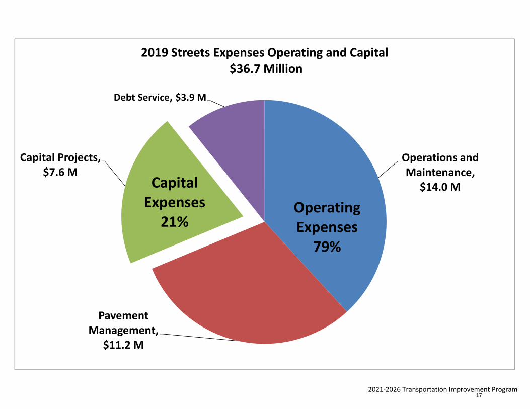
2021‐2026 Transportation Improvement Program
Operations and Maintenance,
$14.0 M
Pavement Management,
$11.2 M
Capital Projects, $7.6 M
Debt Service, $3.9 M
2019 Streets Expenses Operating and Capital$36.7 Million
OperatingExpenses
79%
CapitalExpenses
21%
17
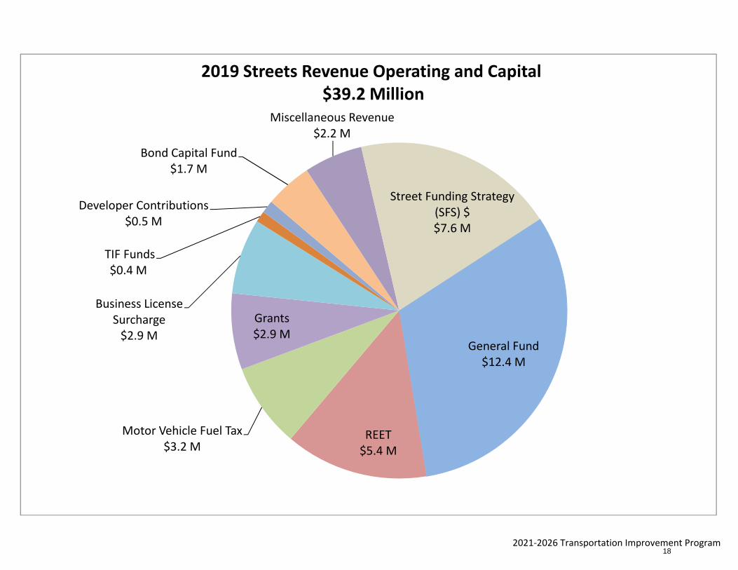
2021‐2026 Transportation Improvement Program
General Fund$12.4 M
REET$5.4 M
Motor Vehicle Fuel Tax$3.2 M
Grants$2.9 M
Business License Surcharge$2.9 M
TIF Funds$0.4 M
Developer Contributions$0.5 M
Bond Capital Fund$1.7 M
Miscellaneous Revenue$2.2 M
Street Funding Strategy (SFS) $$7.6 M
2019 Streets Revenue Operating and Capital$39.2 Million
18
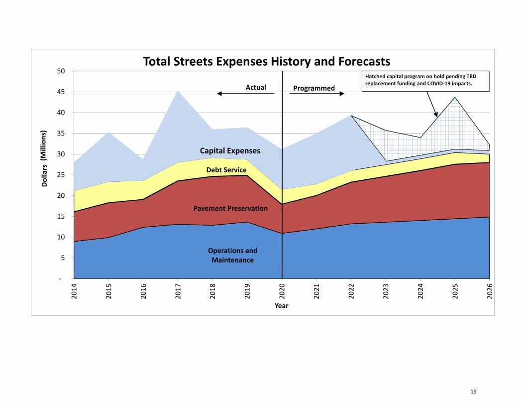
Operations and Maintenance
Pavement Preservation
Debt Service
Capital Expenses
‐
5
10
15
20
25
30
35
40
45
5020
14
2015
2016
2017
2018
2019
2020
2021
2022
2023
2024
2025
2026
Dollars
(Millions)
Year
Total Streets Expenses History and Forecasts
ProgrammedActualHatched capital program on hold pending TBD replacement funding and COVID‐19 impacts.
19

2021‐2026 Transportation Improvement Program
Real Estate Excise Tax
Motor Vehicle Fuel Tax
General Fund
MiscellaneousStreet Funding Strategy $
‐
5
10
15
20
25
30
35
2014
2015
2016
2017
2018
2019
2020
2021
2022
2023
2024
2025
2026
Dollars (M
illions)
Year
Revenue Supporting Street Operations, Pavement Preservation, and Debt Service
Actual Forecasted $1 M annual reduction in SFS $ until TBD $ replacement is found.
20
2021‐2026 Transportation Improvement Program
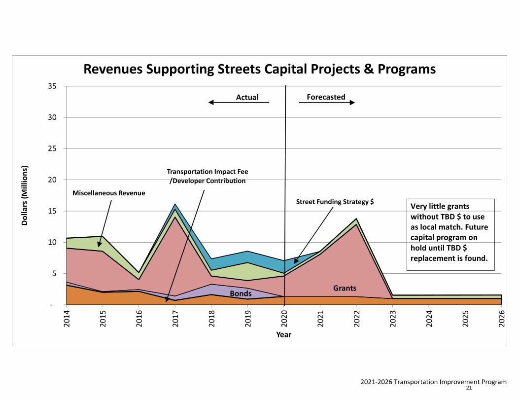
Transportation Impact Fee /Developer Contribution
BondsGrants
Miscellaneous RevenueStreet Funding Strategy $
‐
5
10
15
20
25
30
35
2014
2015
2016
2017
2018
2019
2020
2021
2022
2023
2024
2025
2026
Dollars (M
illions)
Year
Revenues Supporting Streets Capital Projects & Programs
Actual Forecasted
Very little grants without TBD $ to use as local match. Future capital program on hold until TBD $ replacement is found.
21
2021‐2026 Transportation Improvement Program
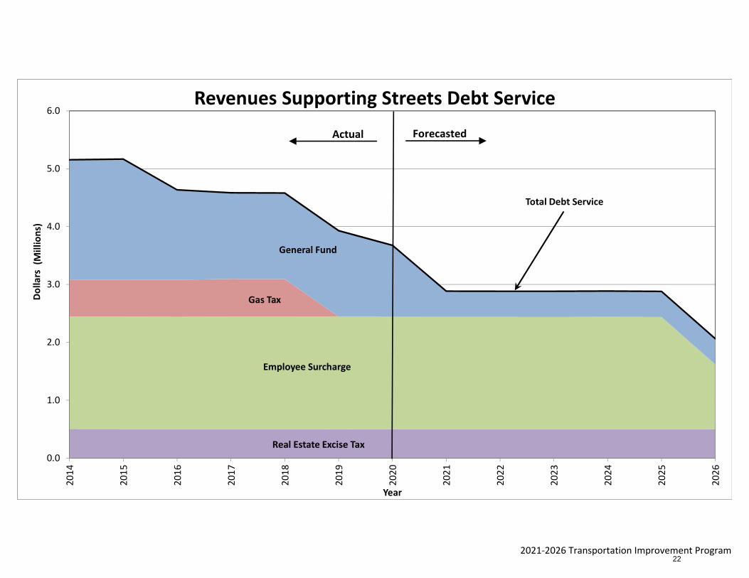
Real Estate Excise Tax
Employee Surcharge
Gas Tax
General Fund
Total Debt Service
0.0
1.0
2.0
3.0
4.0
5.0
6.0
2014
2015
2016
2017
2018
2019
2020
2021
2022
2023
2024
2025
2026
Dollars
(Millions)
Year
Revenues Supporting Streets Debt Service
Actual Forecasted
22
2021-2026 Transportation Improvement Program | City of Vancouver, Washington
Six
-Year P
roje
ct List
23
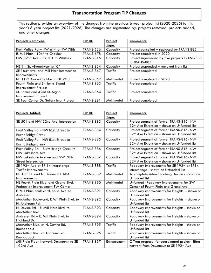
This section provides an overview of the changes from the previous 6 year project list (2020-2025) to this year's 6 year project list (2021-2026). The changes are segmented by: projects removed; projects added; and other changes.
Projects Removed: TIP ID: Project Type:
Comments:
Fruit Valley Rd – NW 61st to NW 78th TRANS-536 Capacity Project cancelled – replaced by TRANS 885 E. Mill Plain –104th to Chaklov TRANS-678 Capacity Project completed in 2020 NW 32nd Ave – SR 501 to Whitney TRANS-816 Capacity Project superseded by five projects TRANS-883
to TRANS-887 NE 9th St. –Broadway to “C” TRANS-834 Capacity Project suspended – removed from list SE 164th Ave. and Mill Plain Intersection Improvements
TRANS-847 Traffic Project completed
NE 112th Ave – Chaklov to NE 9th St TRANS-852 Multimodal Project completed in 2020 Fourth Plain and St. Johns Signal Improvement Project
TRANS-863 Traffic Project completed
St. James and 42nd St. Signal Improvement Project
TRANS-864 Traffic Project completed
SE Tech Center Dr. Safety Imp. Project TRANS-881 Multimodal Project completed
Projects Added: TIP ID: Project Type:
Comments:
SR 501 and NW 32nd Ave. Intersection TRANS-883 Capacity Project segment of former TRANS-816- NW 32nd Ave Extension – shown on Unfunded list
Fruit Valley Rd. - NW 61st Street to Burnt Bridge Creek
TRANS-884 Capacity Project segment of former TRANS-816- NW 32nd Ave Extension – shown on Unfunded list
Fruit Valley Rd. - NW 61st Street to Burnt Bridge Creek
TRANS-885 Capacity Project segment of former TRANS-816- NW 32nd Ave Extension – shown on Unfunded list
Fruit Valley Rd. - Burnt Bridge Creek to NW Lakeshore Ave.
TRANS-886 Capacity Project segment of former TRANS-816- NW 32nd Ave Extension – shown on Unfunded list
NW Lakeshore Avenue and NW 78th Street Intersection
TRANS-887 Capacity Project segment of former TRANS-816- NW 32nd Ave Extension – shown on Unfunded list
SE 192nd Ave at SR 14 Interchange- Traffic Improvements
TRANS-888 Traffic Roadway improvements for SE 192nd at SR14 interchange - shown on Unfunded list
NE 18th St. and N. Devine Rd. ADA Improvements
TRANS-889 Multimodal To complete sidewalk along Devine - shown on Unfunded list
NE Fourth Plain Blvd. and Grand Blvd. - Pedestrian Improvement SW Corner
TRANS-890 Multimodal Unfunded -Roadway improvements for SW Corner of Fourth Plain and Grand Ave.
E. Mill Plain Boulevard, Boise Ave. to Andresen
TRANS-891 Capacity Roadway improvements for Heights - shown on Unfunded list
MacArthur Boulevard, E Mill Plain Blvd. to N. Andresen Rd.
TRANS-892 Capacity Roadway improvements for Heights - shown on Unfunded list
N. Devine Rd – E. Mill Plain Blvd. to MacArthur Blvd.
TRANS-893 Capacity Roadway improvements for Heights - shown on Unfunded list
Andresen Rd – E. Mill Plain Blvd. to Highland Dr.
TRANS-894 Capacity Roadway improvements for Heights - shown on Unfunded list
MacArthur Blvd. at N. Devine Rd. Roundabout
TRANS-895 Traffic Roadway improvements for Heights - shown on Unfunded list
MacArthur Blvd. at Andresen Rd. Roundabout
TRANS-896 Traffic Roadway improvements for Heights - shown on Unfunded list
Mill Plain Fiber Network Downtown to SE 192nd Ave
TRANS-897 Enhancement C-Tran proposal for coordinated project -fiber network from Downtown to SE 192nd Ave
Transportation Program TIP Changes
24
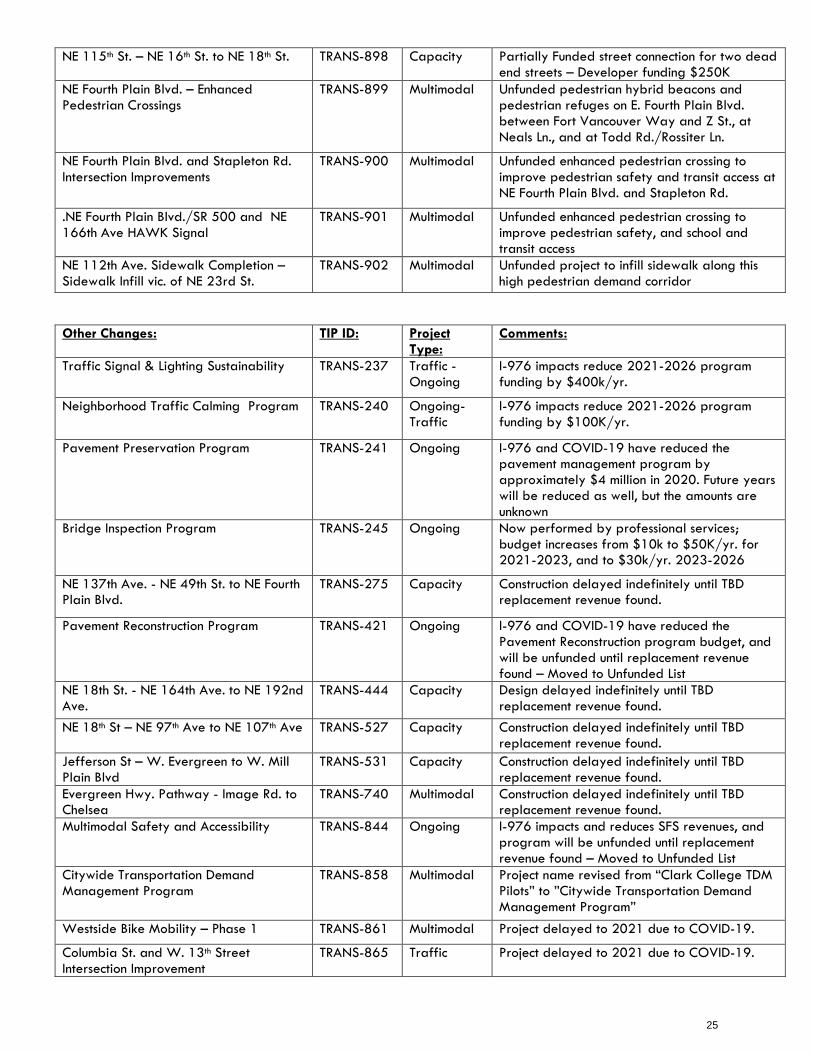
NE 115th St. – NE 16th St. to NE 18th St. TRANS-898 Capacity Partially Funded street connection for two dead end streets – Developer funding $250K
NE Fourth Plain Blvd. – Enhanced Pedestrian Crossings
TRANS-899 Multimodal Unfunded pedestrian hybrid beacons and pedestrian refuges on E. Fourth Plain Blvd. between Fort Vancouver Way and Z St., at Neals Ln., and at Todd Rd./Rossiter Ln.
NE Fourth Plain Blvd. and Stapleton Rd. Intersection Improvements
TRANS-900 Multimodal Unfunded enhanced pedestrian crossing to improve pedestrian safety and transit access at NE Fourth Plain Blvd. and Stapleton Rd.
.NE Fourth Plain Blvd./SR 500 and NE 166th Ave HAWK Signal
TRANS-901 Multimodal Unfunded enhanced pedestrian crossing to improve pedestrian safety, and school and transit access
NE 112th Ave. Sidewalk Completion – Sidewalk Infill vic. of NE 23rd St.
TRANS-902 Multimodal Unfunded project to infill sidewalk along this high pedestrian demand corridor
Other Changes: TIP ID: Project Type:
Comments:
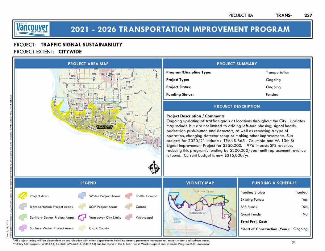
Traffic Signal & Lighting Sustainability TRANS-237 Traffic -Ongoing
I-976 impacts reduce 2021-2026 program funding by $400k/yr.
Neighborhood Traffic Calming Program TRANS-240 Ongoing- Traffic
I-976 impacts reduce 2021-2026 program funding by $100K/yr.
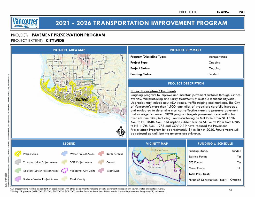
Pavement Preservation Program TRANS-241 Ongoing I-976 and COVID-19 have reduced the pavement management program by approximately $4 million in 2020. Future years will be reduced as well, but the amounts are unknown
Bridge Inspection Program TRANS-245 Ongoing Now performed by professional services; budget increases from $10k to $50K/yr. for 2021-2023, and to $30k/yr. 2023-2026
NE 137th Ave. - NE 49th St. to NE Fourth Plain Blvd.
TRANS-275 Capacity Construction delayed indefinitely until TBD replacement revenue found.
Pavement Reconstruction Program TRANS-421 Ongoing I-976 and COVID-19 have reduced the Pavement Reconstruction program budget, and will be unfunded until replacement revenue found – Moved to Unfunded List
NE 18th St. - NE 164th Ave. to NE 192nd Ave.
TRANS-444 Capacity Design delayed indefinitely until TBD replacement revenue found.
NE 18th St – NE 97th Ave to NE 107th Ave TRANS-527 Capacity Construction delayed indefinitely until TBD replacement revenue found.
Jefferson St – W. Evergreen to W. Mill Plain Blvd
TRANS-531 Capacity Construction delayed indefinitely until TBD replacement revenue found.
Evergreen Hwy. Pathway - Image Rd. to Chelsea
TRANS-740 Multimodal Construction delayed indefinitely until TBD replacement revenue found.
Multimodal Safety and Accessibility TRANS-844 Ongoing I-976 impacts and reduces SFS revenues, and program will be unfunded until replacement revenue found – Moved to Unfunded List
Citywide Transportation Demand Management Program
TRANS-858 Multimodal Project name revised from “Clark College TDM Pilots” to ”Citywide Transportation Demand Management Program”
Westside Bike Mobility – Phase 1 TRANS-861 Multimodal Project delayed to 2021 due to COVID-19.
Columbia St. and W. 13th Street Intersection Improvement
TRANS-865 Traffic Project delayed to 2021 due to COVID-19.
25
SE 1st St – SE 177th Ave to SE 192nd Ave TRANS-870 Capacity Moved out one year to 2022.
N. Devine Sidewalk Improvements –Idaho to NE 18th St
TRANS-871 Multimodal Sidewalk infill project. Grant now awarded & fully funded; schedule moved to 2021.
NE Fourth Plain Blvd. Safety Improvement Project – F St to Ft Vancouver Way
TRANS-872 Multimodal Project scope now between F. St. and Ft. Vancouver Way. Project moved from Funded to Unfunded list.
Main Street Safety Improvement Project – Fourth Plain to 39th St
TRANS-873 Multimodal Moved to 2022 and from Partially Funded to Unfunded List.
5th Street Pedestrian Improvements – Fort Vancouver to Reserve
TRANS-874 Multimodal Grant awarded for design phase. Joint effort with NPS. Moved out one year to 2021
MacArthur Blvd and Mill Plain Multimodal Improvements
TRANS-882 Multimodal Revised project name and moved out one year to 2021.
Other: Project Type: Comments: Non-City Projects Added Non-City Projects Removed I-5 Ramp Metering Capacity WSDOT – Project Completed Bus on Shoulder (I-5 and I-205) Capacity WSDOT – Project Completed SR-500 Safety Improvements Access Management WSDOT Access management at Falk
and Stapleton. – Project Completed
26

Note: All costs are in 2020 dollars. 2020 shown for reference only (6-year plan is for 2021-2026).
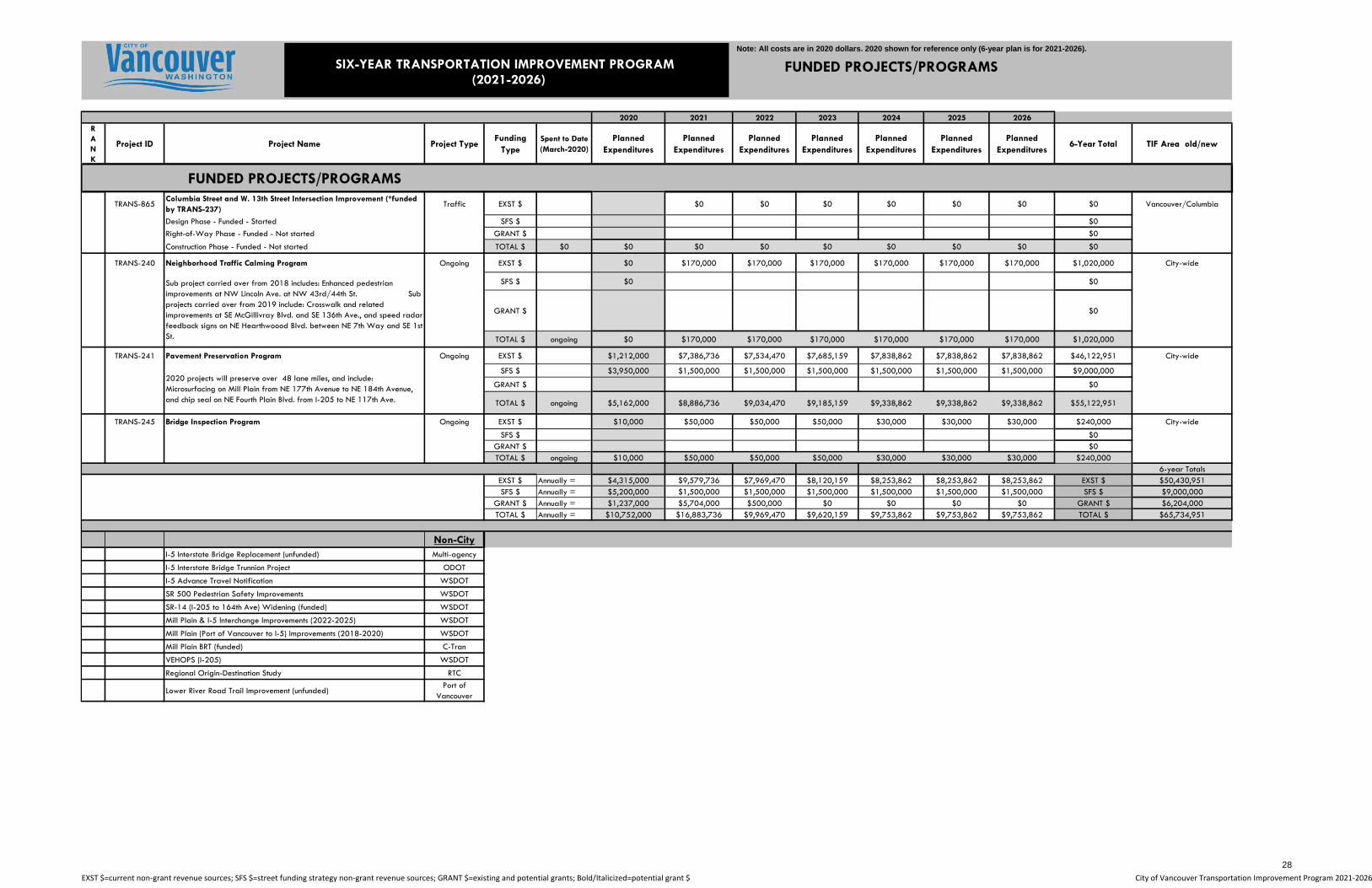
FUNDED PROJECTS/PROGRAMS
2020 2021 2022 2023 2024 2025 2026RANK
Project ID Project Name Project TypeFunding
TypeSpent to Date (March-2020)
Planned Expenditures
Planned Expenditures
Planned Expenditures
Planned Expenditures
Planned Expenditures
Planned Expenditures
Planned Expenditures
6-Year Total TIF Area old/new
FUNDED PROJECTS/PROGRAMSCapacity
TRANS-268 SE 1st St. - SE 164th Ave. to SE 177th Ave. Capacity EXST $ $1,000,000 $0 $0 $0 $0 $0 $1,000,000 East City/Cascade
Design Phase - Funded & started - from 164th to 177th SFS $ $1,250,000 $0 $0
Right-of-Way Phase - Funded & started - from 164th to 177th GRANT $ $750,000 $4,050,000 $4,050,000
Construction Phase - Funded from 164th to 177th TOTAL $ $2,600,842 $2,000,000 $5,050,000 $0 $0 $0 $0 $0 $5,050,000
Traffic
TRANS-853 LED Street Light Retrofit Traffic EXST $ $2,815,000 $0 $0 $0 $0 $0 $0 $0 Vancouver/Columbia
Design Phase - Funded - Started SFS $ $0
Right-of-Way Phase - Not applicable GRANT $ $0
Construction Phase - Funded - Started TOTAL $ $1,663,080 $2,815,000 $0 $0 $0 $0 $0 $0 $0
TRANS-877 Mill Plain Arrival on Green - I-205 to 164th Ave Traffic EXST $ $20,000 $0 Vancouver/Columbia
Design Phase - Funded - Not started SFS $ $0
Right-of-Way Phase - Not applicable GRANT $ $72,000 $0
Construction Phase - Funded - Not started TOTAL $ $0 $92,000 $0 $0 $0 $0 $0 $0 $0
Multimodal
TRANS-451 Destination Downtown TDM Multimodal EXST $ $8,000 $8,000 $0 $0 $0 $0 $0 $8,000 Vancouver/Columbia
Design Phase - Funded - Started SFS $ $0
Right-of-Way Phase - Not applicable GRANT $ $40,000 $40,000 $40,000
Construction Phase - Funded - Not started TOTAL $ $48,000 $48,000 $0 $0 $0 $0 $0 $48,000
TRANS-854 Transportation System Plan (TSP) Update Multimodal EXST $ $250,000 $750,000 $0 $0 $0 $0 $0 $750,000 City-Wide
Design Phase - Funded - Started SFS $ $0
Right-of-Way Phase - Not applicable GRANT $ $0
Construction Phase - Not applicable TOTAL $ $13,072 $250,000 $750,000 $0 $0 $0 $0 $0 $750,000
Trans-862 Mcloughlin Complete Street - Reserve to Mill Plain Multimodal EXST $ $0 Vancouver/Columbia
Design Phase - Partially Funded - Not started SFS $ $0
Right-of-Way Phase - Unfunded - Not started GRANT $ $200,000 $0
Construction Phase - Unfunded - move out to 2020 TOTAL $ $132,621 $200,000 $0
TRANS-871 N. Devine Sidewalk Improvements – N. Idaho to NE 18th St. Multimodal EXST $ $0 $0 Vancouver/Columbia
Design Phase - Funded - Started SFS $ $0 $0 $0
Right-of-Way Phase - Not applicable GRANT $ $175,000 $814,000 $814,000
Construction Phase - Funded TOTAL $ $56,420 $175,000 $814,000 $0 $0 $0 $0 $0 $814,000
Trans-874 E. 5th Street Improvements - Fort Vancouver to Reserve (FLAP grant) Multimodal PAVING $ $0 $100,000 $0 $0 $0 $0 $0 $100,000 Vancouver/Columbia
Design Phase - Funded - FLAP Grant SFS $ $0 $0
Right-of-Way Phase - Not applicable GRANT $ $0 $500,000 $500,000 $1,000,000
Construction Phase - Unfunded - Not started TOTAL $ $892 $0 $600,000 $500,000 $1,100,000
Trans-882 MacArthur Blvd and Mill Plain Multimodal Improvements Multimodal EXST $ $0 $0 $0 $0 $0 $0 $0 $0 Vancouver/Columbia
Design Phase - Funded -TIB Complete Streets Grant SFS $ $0 $0
Right-of-Way Phase - Unfunded - Not started GRANT $ $0 $300,000 $300,000
Construction Phase - Unfunded - Not started TOTAL $ $156 $0 $300,000 $0 $0 $0 $0 $0 $300,000
Ongoing 2020 2021 2022 2023 2024 2025 2025 6 yr. total
TRANS-237 Traffic Signal and Lighting Sustainability Ongoing EXST $ $0 $215,000 $215,000 $215,000 $215,000 $215,000 $215,000 $1,290,000 City-wide
SFS $ $0 $0 $0 $0 $0 $0 $0 $0
GRANT $ $0
TOTAL $ ongoing $0 $215,000 $215,000 $215,000 $215,000 $215,000 $215,000 $1,290,000
SIX-YEAR TRANSPORTATION IMPROVEMENT PROGRAM(2021-2026)
EXST $=current non‐grant revenue sources; SFS $=street funding strategy non‐grant revenue sources; GRANT $=existing and potential grants; Bold/Italicized=potential grant $ City of Vancouver Transportation Improvement Program 2021‐2026
27
Note: All costs are in 2020 dollars. 2020 shown for reference only (6-year plan is for 2021-2026).
FUNDED PROJECTS/PROGRAMS
2020 2021 2022 2023 2024 2025 2026RANK
Project ID Project Name Project TypeFunding
TypeSpent to Date (March-2020)
Planned Expenditures
Planned Expenditures
Planned Expenditures
Planned Expenditures
Planned Expenditures
Planned Expenditures
Planned Expenditures
6-Year Total TIF Area old/new
FUNDED PROJECTS/PROGRAMS
SIX-YEAR TRANSPORTATION IMPROVEMENT PROGRAM(2021-2026)
TRANS-865Columbia Street and W. 13th Street Intersection Improvement (*funded by TRANS-237)
Traffic EXST $ $0 $0 $0 $0 $0 $0 $0 Vancouver/Columbia
Design Phase - Funded - Started SFS $ $0
Right-of-Way Phase - Funded - Not started GRANT $ $0
Construction Phase - Funded - Not started TOTAL $ $0 $0 $0 $0 $0 $0 $0 $0 $0
TRANS-240 Neighborhood Traffic Calming Program Ongoing EXST $ $0 $170,000 $170,000 $170,000 $170,000 $170,000 $170,000 $1,020,000 City-wide
SFS $ $0 $0
GRANT $ $0
TOTAL $ ongoing $0 $170,000 $170,000 $170,000 $170,000 $170,000 $170,000 $1,020,000
TRANS-241 Pavement Preservation Program Ongoing EXST $ $1,212,000 $7,386,736 $7,534,470 $7,685,159 $7,838,862 $7,838,862 $7,838,862 $46,122,951 City-wide
SFS $ $3,950,000 $1,500,000 $1,500,000 $1,500,000 $1,500,000 $1,500,000 $1,500,000 $9,000,000
GRANT $ $0
TOTAL $ ongoing $5,162,000 $8,886,736 $9,034,470 $9,185,159 $9,338,862 $9,338,862 $9,338,862 $55,122,951
TRANS-245 Bridge Inspection Program Ongoing EXST $ $10,000 $50,000 $50,000 $50,000 $30,000 $30,000 $30,000 $240,000 City-wide
SFS $ $0GRANT $ $0TOTAL $ ongoing $10,000 $50,000 $50,000 $50,000 $30,000 $30,000 $30,000 $240,000
6-year TotalsEXST $ Annually = $4,315,000 $9,579,736 $7,969,470 $8,120,159 $8,253,862 $8,253,862 $8,253,862 EXST $ $50,430,951SFS $ Annually = $5,200,000 $1,500,000 $1,500,000 $1,500,000 $1,500,000 $1,500,000 $1,500,000 SFS $ $9,000,000
GRANT $ Annually = $1,237,000 $5,704,000 $500,000 $0 $0 $0 $0 GRANT $ $6,204,000TOTAL $ Annually = $10,752,000 $16,883,736 $9,969,470 $9,620,159 $9,753,862 $9,753,862 $9,753,862 TOTAL $ $65,734,951
Non-CityI-5 Interstate Bridge Replacement (unfunded) Multi-agency
I-5 Interstate Bridge Trunnion Project ODOT
I-5 Advance Travel Notification WSDOT
SR 500 Pedestrian Safety Improvements WSDOT
SR-14 (I-205 to 164th Ave) Widening (funded) WSDOT
Mill Plain & I-5 Interchange Improvements (2022-2025) WSDOT
Mill Plain (Port of Vancouver to I-5) Improvements (2018-2020) WSDOT
Mill Plain BRT (funded) C-Tran
VEHOPS (I-205) WSDOT
Regional Origin-Destination Study RTC
Lower River Road Trail Improvement (unfunded)Port of
Vancouver
Sub project carried over from 2018 includes: Enhanced pedestrian improvements at NW Lincoln Ave. at NW 43rd/44th St. Sub projects carried over from 2019 include: Crosswalk and related improvements at SE McGillivray Blvd. and SE 136th Ave., and speed radar feedback signs on NE Hearthwoood Blvd. between NE 7th Way and SE 1st St.
2020 projects will preserve over 48 lane miles, and include: Microsurfacing on Mill Plain from NE 177th Avenue to NE 184th Avenue, and chip seal on NE Fourth Plain Blvd. from I-205 to NE 117th Ave.
EXST $=current non‐grant revenue sources; SFS $=street funding strategy non‐grant revenue sources; GRANT $=existing and potential grants; Bold/Italicized=potential grant $ City of Vancouver Transportation Improvement Program 2021‐2026
28

Note: All costs are in 2020 dollars. 2020 shown for reference only (6-year plan is for 2021-2026).
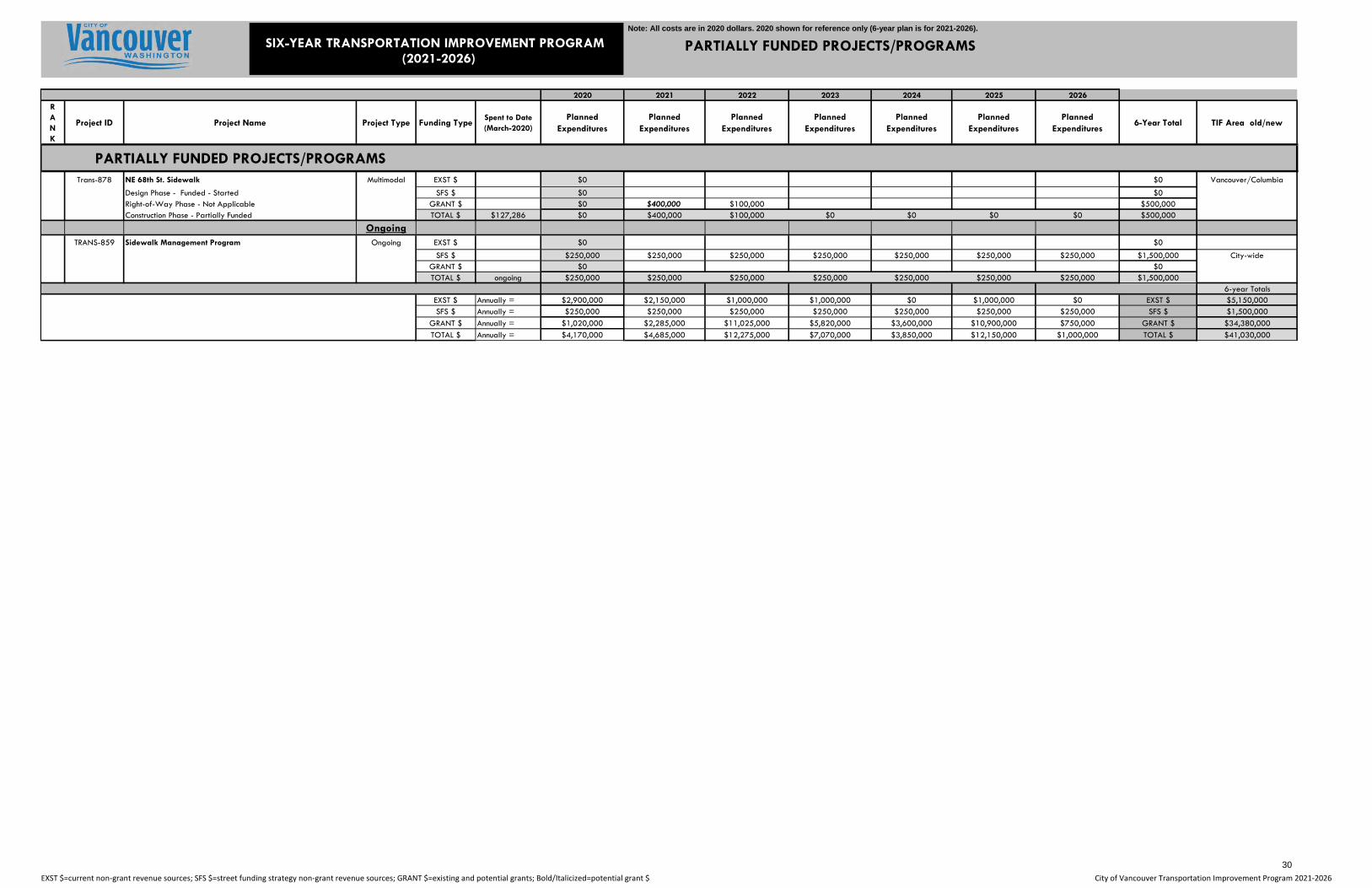
PARTIALLY FUNDED PROJECTS/PROGRAMS
2020 2021 2022 2023 2024 2025 2026RANK
Project ID Project Name Project Type Funding TypeSpent to Date (March-2020)
Planned Expenditures
Planned Expenditures
Planned Expenditures
Planned Expenditures
Planned Expenditures
Planned Expenditures
Planned Expenditures
6-Year Total TIF Area old/new
PARTIALLY FUNDED PROJECTS/PROGRAMSCapacity
TRANS-275 NE 137th Ave. - NE 49th St. to NE Fourth Plain Blvd. Capacity EXST $ $1,450,000 $1,000,000 $1,000,000 Evergreen/Pacific
Design Phase - Funded - Started SFS $ $0 $0 $0 $0 $0Right-of-Way Phase - Funded - Started GRANT $ $970,000 $1,000,000 $5,820,000 $2,100,000 $8,920,000Construction Phase - Partially Funded - Not started TOTAL $ $2,356,603 $2,420,000 $1,000,000 $0 $6,820,000 $2,100,000 $0 $0 $9,920,000
TRANS-444 NE 18th St. - NE 142nd Ave. to NE 162nd Ave. Capacity EXST $ $0 $0 Evergreen & E. City/Design Phase - Funded - Not started SFS $ $0 $0 $0 $0 Pacific & CascadeRight-of-Way Phase - Funded - Not started GRANT $ $0 $750,000 $750,000Construction Phase - Funding uncertain - Not started TOTAL $ $0 $0 $0 $0 $0 $0 $0 $750,000 $750,000
TRANS-527 NE 18th St. - NE 97th Ave. to NE 107th Avenue Capacity EXST $ $1,000,000 $500,000 $1,000,000 $1,500,000 Evergreen & E. City/
Design Phase - Funded - Started SFS $ $0 $0 $0 $0 $0 $0 Pacific & CascadeRight-of-Way Phase - Funded - Started GRANT $ $0 $385,000 $250,000 $7,000,000 $7,635,000Construction Phase - Funding uncertain - Not started TOTAL $ $794,252 $1,000,000 $885,000 $250,000 $0 $0 $8,000,000 $0 $9,135,000
TRANS-531 Jefferson St. - W. Evergreen to W. Mill Plain Blvd Capacity EXST $ $250,000 $500,000 $500,000 Vancouver/Columbia
Design Phase - Funded - Started SFS $ $0 $0 $0 $0 $0Right-of-Way Phase - Funded - Not started GRANT $ $0 $1,500,000 $3,900,000 $5,400,000Construction Phase - Funding uncertain - Not started TOTAL $ $231,183 $250,000 $500,000 $0 $0 $1,500,000 $3,900,000 $0 $5,900,000
TRANS-870 SE 1st St. - SE 177th Ave. to SE 192nd Ave. Capacity EXST $ Developer $ $0 $1,000,000 $1,000,000 East City/Cascade
Design Phase - funded by developer SFS $ $0 $0 $0Right-of-Way Phase - Funded by developer GRANT $ $0 $10,000,000 $10,000,000Construction Phase - Unfunded - Not started TOTAL $ $9,020 $0 $0 $11,000,000 $0 $0 $0 $0 $11,000,000
NEW TRANS-898 NE 115th Ave. - NE 16th St. to NE 18th St. Capacity EXST $ Developer $ $0 $250,000 $250,000 East City/Cascade
Design Phase - not funded SFS $ $0 $0Right-of-Way Phase - Funded by developer GRANT $ $0 $0Construction Phase - Unfunded - Not started TOTAL $ $3,667 $0 $250,000 $0 $0 $0 $0 $0 $250,000
TrafficTRANS-724 Hearthwood at SE 1st St. Traffic EXST $ $150,000 $150,000 $150,000 East City/Cascade
Design Phase - Funded - Started SFS $ $0Right-of-Way Phase - Funded - Started GRANT $ $0Construction Phase - Funding uncertain - Not started TOTAL $ $73,690 $150,000 $150,000 $0 $0 $0 $0 $0 $150,000
MultimodalTRANS-740 Evergreen Hwy. Pathway - Image Rd. to Chelsea Multimodal EXST $ $0 $0 East City/Cascade
Design Phase - Funded - Started SFS $ $0 $0 $0Right-of-Way Phase - Funded - Started GRANT $ $0 $675,000 $675,000Construction Phase - Unfunded - Not started TOTAL $ $395,526 $0 $0 $675,000 $0 $0 $0 $0 $675,000
Trans-741 Evergreen Hwy. Pathway - Columbia Springs to SE 164th Ave. Multimodal EXST $ $0 $0 East City/Cascade
Design Phase - Partially funded by citizen group - Started SFS $ $0 $0Right-of-Way Phase - Unfunded - Not started GRANT $ $0 $0Construction Phase - Unfunded - Not started TOTAL $ $0 $0 $0 $0 $0 $0 $0 $0 $0
TRANS-843 Evergreen Hwy Pathway - Weber Arboretum to 100th Court Multimodal EXST $ $50,000 $0 East City/Cascade
Design Phase - Funded - Started SFS $ $0 $0Right-of-Way Phase - Funded -Started GRANT $ $0 $0Construction Phase - Unfunded - Not started TOTAL $ $48,355 $50,000 $0 $0 $0 $0 $0 $0 $0
Trans-850NW Neighborhood Connectivity Improvements - Franklin Elementary
Multimodal EXST $ $0 $0 Vancouver/Columbia
Design Phase - Partially Funded - Started SFS $ $0 $0 $0Right-of-Way Phase - Funded- Started GRANT $ $50,000 $500,000 $500,000Construction Phase - Partially Funded - Not started TOTAL $ $180,685 $50,000 $500,000 $0 $0 $0 $0 $0 $500,000
Trans-861 Westside Bike Mobility Multimodal EXST $ $0 $750,000 $750,000 Vancouver/ColumbiaDesign Phase - Partially Funded SFS $ $0 $0Right-of-Way Phase - Unfunded - Not started GRANT $ $0 $0Construction Phase - Unfunded - Not started TOTAL $ $117,491 $0 $750,000 $0 $0 $0 $0 $0 $750,000
SIX-YEAR TRANSPORTATION IMPROVEMENT PROGRAM(2021-2026)
EXST $=current non‐grant revenue sources; SFS $=street funding strategy non‐grant revenue sources; GRANT $=existing and potential grants; Bold/Italicized=potential grant $ City of Vancouver Transportation Improvement Program 2021‐2026
29
Note: All costs are in 2020 dollars. 2020 shown for reference only (6-year plan is for 2021-2026).
PARTIALLY FUNDED PROJECTS/PROGRAMS
2020 2021 2022 2023 2024 2025 2026RANK
Project ID Project Name Project Type Funding TypeSpent to Date (March-2020)
Planned Expenditures
Planned Expenditures
Planned Expenditures
Planned Expenditures
Planned Expenditures
Planned Expenditures
Planned Expenditures
6-Year Total TIF Area old/new
PARTIALLY FUNDED PROJECTS/PROGRAMS
SIX-YEAR TRANSPORTATION IMPROVEMENT PROGRAM(2021-2026)
Trans-878 NE 68th St. Sidewalk Multimodal EXST $ $0 $0 Vancouver/Columbia
Design Phase - Funded - Started SFS $ $0 $0Right-of-Way Phase - Not Applicable GRANT $ $0 $400,000 $100,000 $500,000Construction Phase - Partially Funded TOTAL $ $127,286 $0 $400,000 $100,000 $0 $0 $0 $0 $500,000
OngoingTRANS-859 Sidewalk Management Program Ongoing EXST $ $0 $0
SFS $ $250,000 $250,000 $250,000 $250,000 $250,000 $250,000 $250,000 $1,500,000 City-wideGRANT $ $0 $0TOTAL $ ongoing $250,000 $250,000 $250,000 $250,000 $250,000 $250,000 $250,000 $1,500,000
6-year TotalsEXST $ Annually = $2,900,000 $2,150,000 $1,000,000 $1,000,000 $0 $1,000,000 $0 EXST $ $5,150,000SFS $ Annually = $250,000 $250,000 $250,000 $250,000 $250,000 $250,000 $250,000 SFS $ $1,500,000
GRANT $ Annually = $1,020,000 $2,285,000 $11,025,000 $5,820,000 $3,600,000 $10,900,000 $750,000 GRANT $ $34,380,000
TOTAL $ Annually = $4,170,000 $4,685,000 $12,275,000 $7,070,000 $3,850,000 $12,150,000 $1,000,000 TOTAL $ $41,030,000
EXST $=current non‐grant revenue sources; SFS $=street funding strategy non‐grant revenue sources; GRANT $=existing and potential grants; Bold/Italicized=potential grant $ City of Vancouver Transportation Improvement Program 2021‐2026
30
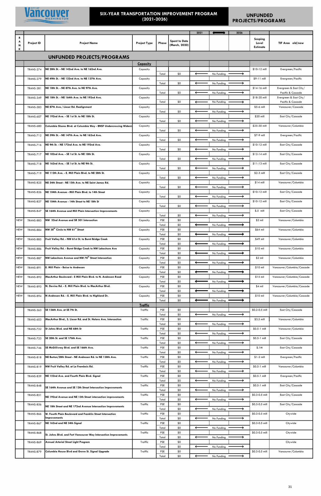
UNFUNDEDPROJECTS/PROGRAMS
2021 2026
RANK
Project ID Project Name Project Type PhaseSpent to Date (March, 2020)
Scoping Level
EstimateTIF Area old/new
UNFUNDED PROJECTS/PROGRAMSCapacity
TRANS-274 NE 28th St. - NE 142nd Ave. to NE 162nd Ave. Capacity $10-12 mill Evergreen/Pacific
Total $0 No Funding
TRANS-279 NE 49th St. - NE 122nd Ave. to NE 137th Ave. Capacity $9-11 mill Evergreen/Pacific
Total $0 No Funding
TRANS-281 NE 18th St. - NE 87th Ave. to NE 97th Ave. Capacity $14-16 mill Evergreen & East City/
Total $0 No Funding Pacific & Cascade
TRANS-349 NE 18th St. - NE 164th Ave. to NE 192nd Ave. Capacity $18-20 mill Evergreen & East City/Total $0 No Funding Pacific & Cascade
TRANS-583 NE 87th Ave./ Lieser Rd. Realignment Capacity $5-6 mill Vancouver/Cascade
Total $0 No Funding
TRANS-607 NE 192nd Ave. - SE 1st St. to NE 18th St. Capacity $20 mill East City/Cascade
Total $0 No Funding
TRANS-680 Columbia Shores Blvd. at Columbia Way - BNSF Undercrossing Widenin Capacity $25-30 mill Vancouver/Columbia
Total $0 No Funding
TRANS-712 NE 59th St. - NE 147th Ave. to NE 162nd Ave. Capacity $7-9 mill Evergreen/Pacific
Total $0 No Funding
TRANS-716 NE 9th St. - NE 172nd Ave. to NE 192nd Ave. Capacity $10-12 mill East City/Cascade
Total $0 No Funding
TRANS-717 NE 182nd Ave. - SE 1st St. to NE 18th St. Capacity $12-14 mill East City/Cascade
Total $0 No Funding
TRANS-718 NE 162nd Ave. - SE 1st St. to NE 9th St. Capacity $11-13 mill East City/Cascade
Total $0 No Funding
TRANS-719 NE 112th Ave. - E. Mill Plain Blvd. to NE 28th St. Capacity $2-3 mill East City/Cascade
Total $0 No Funding
TRANS-825 NE 54th Street - NE 15th Ave. to NE Saint James Rd. Capacity $14 mill Vancouver/Columbia
Total $0 No Funding
TRANS-826 NE 104th Avenue - Mill Plain Blvd. to 14th Street Capacity $10-12 mill East City/Cascade
Total $0 No Funding
TRANS-827 NE 104th Avenue - 14th Street to NE 18th St Capacity $10-12 mill East City/Cascade
Total $0 No Funding
TRANS-847 SE 164th Avenue and Mill Plain Intersection Improvements Capacity $.5 mill East City/Cascade
Total $0 No Funding
NEW TRANS-883 NW 32nd Avenue and SR 501 Intersection Capacity PSE $0 $2 mil Vancouver/Columbia
Total $0 No Funding
NEW TRANS-884 NW 38th Circle to NW 61st Street Capacity PSE $0 $64 mil Vancouver/Columbia
Total $0 No Funding
NEW TRANS-885 Fruit Valley Rd. - NW 61st St. to Burnt Bridge Creek Capacity PSE $0 $49 mil Vancouver/Columbia
Total $0 No Funding
NEW TRANS-886 Fruit Valley Rd. - Burnt Bridge Creek to NW Lakeshore Ave Capacity PSE $0 $10 mil Vancouver/Columbia
Total $0 No Funding
NEW TRANS-887 NW Lakeshore Avenue and NW 78th Street Intersection Capacity PSE $0 $2 mil Vancouver/Columbia
Total $0 No Funding
NEW TRANS-891 E. Mill Plain - Boise to Andresen Capacity PSE $0 $10 mil Vancouver/Columbia/Cascade
Total $0 No Funding
NEW TRANS-892 MacArthur Boulevard - E Mill Plain Blvd. to N. Andresen Road Capacity PSE $0 $15 mil Vancouver/Columbia/Cascade
Total $0 No Funding
NEW TRANS-893 N. Devine Rd. - E. Mill Plain Blvd. to MacArthur Blvd. Capacity PSE $0 $4 mil Vancouver/Columbia/Cascade
Total $0 No Funding
NEW TRANS-894 N Andresen Rd. - E. Mill Plain Blvd. to Highland Dr. Capacity PSE $0 $10 mil Vancouver/Columbia/Cascade
Total $0 No Funding
TrafficTRANS-363 SE 136th Ave. at SE 7th St. Traffic PSE $0 $0.2-0.5 mill East City/Cascade
Total $0 No Funding
TRANS-603 MacArthur Blvd., S. Lieser Rd. and St. Helens Ave. Intersection Traffic PSE $0 $3.5 mill Vancouver/Columbia
Total $0 No Funding
TRANS-722 St Johns Blvd. and NE 68th St Traffic PSE $0 $0.5-1 mill Vancouver/Columbia
Total $0 No Funding
TRANS-723 SE 20th St. and SE 176th Ave. Traffic PSE $0 $0.5-1 mill East City/Cascade
Total $0 No Funding
TRANS-746 SE McGillivray Blvd. and SE 166th Ave. Traffic PSE $0 $.1M East City/Cascade
Total $0 No Funding
TRANS-818 NE Burton/28th Street - NE Andresen Rd. to NE 138th Ave. Traffic PSE $0 $1-2 mill Evergreen/Pacific
Total $0 No Funding
TRANS-819 NW Fruit Valley Rd. at La Frambois Rd. Traffic PSE $0 $0.5-1 mill Vancouver/Columbia
Total $0 No Funding
TRANS-839 NE 152nd Ave. and Fourth Plain Blvd. Signal Traffic PSE $0 $0.5-1 mill Evergreen/Pacific
Total $0 No Funding
TRANS-848 Traffic PSE $0 $0.5-1 mill East City/Cascade
Total $0 No Funding
TRANS-851 Traffic PSE $0 $0.3-0.5 mill East City/Cascade
Total $0 No Funding
TRANS-856 Traffic PSE $0 $0.3-0.5 mill East City/Cascade
Total $0 No Funding
TRANS-866 Traffic PSE $0 $0.3-0.5 mill Citywide
Total $0 No Funding
TRANS-867 NE 162nd and NE 34th Signal Traffic PSE $0 $0.3-0.5 mill Citywide
Total $0 No Funding
TRANS-868 Traffic PSE $0 $0.3-0.5 mill Citywide
Total $0 No Funding
TRANS-869 Annual Arterial Street Light Program Traffic PSE $0 Citywide
Total $0 No Funding
TRANS-879 Columbia House Blvd and Grove St. Signal Upgrade Traffic PSE $0 $0.3-0.5 mill Vancouver/Columbia
Total $0 No Funding
NE 18th Street and NE 172nd Avenue Intersection Improvements
NE 192nd Avenue and NE 13th Street intersection improvements
SE 164th Avenue and SE 12th Street Intersection Improvements
W. Fourth Plain Boulevard and Franklin Street Intersection Improvements
St. Johns Blvd. and Fort Vancouver Way Intersection Improvements
SIX-YEAR TRANSPORTATION IMPROVEMENT PROGRAM (2021-2026)
31

UNFUNDEDPROJECTS/PROGRAMS
2021 2026
RANK
Project ID Project Name Project Type PhaseSpent to Date (March, 2020)
Scoping Level
EstimateTIF Area old/new
UNFUNDED PROJECTS/PROGRAMS
SIX-YEAR TRANSPORTATION IMPROVEMENT PROGRAM (2021-2026)
TRANS-880 McGillivary and Village Loop Drive - Traffic PSE $0 $0.3-0.5 mill East City/Cascade
Total $0 No Funding
NEW TRANS-888 SE 192nd Ave at SR 14 Interchange - Traffic Improvements Traffic PSE $0 $2-5 mill East City/Cascade
Total $0 No Funding
NEW TRANS-895 MacArthur Blvd. at N. Devine Rd. Roundabout Traffic PSE $0 $1 - 1.5 mil Vancouver/Columbia/Cascade
Total $0 No Funding
NEW TRANS-896 MacArthur Blvd. at Andresen Rd. Roundabout Traffic PSE $0 $1 - 1.5 mil Vancouver/Columbia/Cascade
Total $0 No Funding
MultimodalTRANS-258 E. Fourth Plain Blvd. - Ft. Vancouver Way to NE Andresen Rd. Multimodal PSE $0 $2-3 mill Vancouver/Columbia
Total $0 No Funding
TRANS-495 Main St. Reconstruction - 5th St. to 15th Street Multimodal PSE $0 $11-13 mill Vancouver/Columbia
Total $0 No Funding
TRANS-742 Evergreen Hwy. Pathway - SE 164th Ave. to east City Limits Multimodal PSE $0 $7 mill East City/CascadeTotal $0 No Funding
TRANS-857 SE 10th Street Sidewalks - SE 98th Avenue to Ellsworth Road Multimodal PSE $0 $1-2 mill Evergreen/Pacific
Total $0 No Funding
TRANS-858 Citywide Transportation Demand Management Program Multimodal PSE $0 $.5 mil Vancouver/Columbia
Total $0 No Funding
TRANS-872 PSE $0 $0.9 mill Vancouver/Columbia
Total $0 No Funding
TRANS-873 PSE $0 $0.5-1 mill Vancouver/Columbia
Total $0 No Funding
NEW TRANS-889 NE 18th St. and N. Devine Rd. ADA Improvements Multimodal PSE $0 $.5 mil Vancouver/Columbia
Total $0 No Funding
NEW TRANS-890 Multimodal PSE $0 $.7 mil Vancouver/Columbia
Total $0 No Funding
NEW TRANS-899 NE Fourth Plain Blvd. - Enhanced Pedestrian Crossings Multimodal PSE $0 $.75 mil Vancouver/Columbia
Total $0 No Funding
NEW TRANS-900 Multimodal PSE $0 $.15 mil Vancouver/Columbia
Total $0 No Funding
NEW TRANS-901 Multimodal PSE $0 $.41 mil Vancouver/Columbia
Total $0 No Funding
NEW TRANS-902 Multimodal PSE $0 $.36 mil Vancouver/Columbia
Total $0 No Funding
OtherTRANS-421 Pavement Reconstruction Program Ongoing Total Citywide
$0 No Funding
TRANS-836 Evergreen Blvd. Bridge over Blandford Safety PSE $0 $15-20 mill Vancouver/Columbia
Total $0 No Funding
TRANS-838 Evergreen Highway Pavement Project Reconstruction PSE $0 $40-50 mill East City/Cascade
(Scope and extent of this project is under review) Total $0 No Funding
TRANS-844 Multimodal Safety and Accessiblity Ongoing PSE $0 $3.0 mil Vancouver/Columbia
Total $0 No Funding
NEW TRANS-897 Mill Plain Fiber Network - Downtown to SE 192nd Ave. Reconstruction PSE $0 $22 mill East City/Cascade
(Scope and extent of this project is under review) Total $0 No Funding
NE Fourth Plain Blvd. Safety Improvement Project - F St to Ft Vancouver Way
Multimodal
$500K to $1M annually
NE Fourth Plain Blvd. and Grand Blvd. - Pedestrian Improvement SW Corner
NE 112th Ave Sidewalk Completion – Sidewalk Infill vicinity of NE 23rd St.
NE Fourth Plain Blvd. and Stapleton Rd. Intersection Improvements
MultimodalMain Street Safety Improvement Project - Fourth Plain Blvd to 39th St
NE Fourth Plain Blvd./SR 500 and NE 166th Ave. HAWK Signal
32
2021-2026 Transportation Improvement Program | City of Vancouver, Washington
Pro
ject D
eta
il Sheets
33
199th
Lake shore
63rdHazel
D ell
41 st
167th
179th
W ard
164th
Blair
182nd
Risto
1st
78th
3rd
137th
99th
E
28th
72nd
76th
18thGran
d
36th
117th
Main
172nd
Fr ui t V
alley
112th
31st
159th
21st
10th
Lake
189th
162nd
219th
34th
I- 2 05I-5
SR-14 WB
117th
SR-14
58th
M ill Plain
Padden
SR-50 0 EB
Main
Everett
SR - 500 WB
Lowe
r Rive
r
219th
SR-14 EB
10th
212th
58th
M acArthur
Li vin gsto
n
Evergreen
88th
McGi lliv ray
87th 119th
B ra d y
2 09th
C
50th
23rd
Parkw
ay
20th
169th
6th
L1 400
Grace
142nd
83rd
44th
139th
11th
39th
86th
149th
68th
227th
Raws on
239th
32nd
25th
292nd
94th
38th
29th
152nd
53rd
107th
D oleValley
232nd
I ngle
92nd
Delfel
TRANS-237
Ê
Ongoing
PROJECT AREA MAP
PROJECT:
PROJECT SUMMARY
Project Status:
TransportationProgram/Discipline Type:OngoingProject Type:
PROJECT DESCRIPTION
FUNDING & SCHEDULEVICINITY MAPLEGEND
TRAFFIC SIGNAL SUSTAINABILITY
Project Description / CommentsOngoing updating of traffic signals at locations throughout the City. Updatesmay include but are not limited to adding left-turn phasing, signal heads,pedestrian push-button and detectors, as well as removing a type ofoperation, changing detector setup or making other improvements. Subprojects for 2020/21 include : TRANS-865 - Columbia and W. 13th StSignal Improvement Project for $350,000. I-976 impacts SFS revenue,reducing this program's funding by $200,000/year until replacement revenueis found. Current budget is now $215,000/yr.
Ongoing*Start of Construction (Year):
TRANS-PROJECT ID:
2021 - 2026 TRANSPORTATION IMPROVEMENT PROGRAM
PROJECT EXTENT:
Total Proj. Cost:NoGrant Funds:YesSFS Funds:YesExisting Funds:
*All project timing will be dependent on coordination with other departments including streets, pavement management, sewer, water and surface water.**Utility CIP projects (WTR-XXX, SS-XXX, SW-XXX & SCIP-XXX) can be found in the 6 Year Public Works Capital Improvement Program (CIP) document.
FundedFunding Status:
FundedFunding Status:
Project Area
Transportation Project Areas
Sanitary Sewer Project Areas
Surface Water Project Areas
Water Project Areas
SCIP Project Areas
Vancouver City Limits
Clark County
Battle Ground
Camas
Washougal
237
Service Layer Credits: Sources: Esri, HERE, Garmin, Intermap,increment P Corp., GEBCO, USGS, FAO, NPS, NRCAN, GeoBase,IGN, Kadaster NL, Ordnance Survey, Esri Japan, METI, Esri China(Hong Kong), (c) OpenStreetMap contributors, and the GIS UserCommunity
Date:
5/29
/202
0\\
intern
al.city
ofvan
couve
r.us\C
itywi
de\_
Gene
ral Se
rvices
\Cap
ital P
lannin
g\TIP
\Cap
ital P
rojec
ts Tem
plate_
TRAN
S_6Y
ear_P
oly_N
ewBA
SE.m
xd
CITYWIDE
34
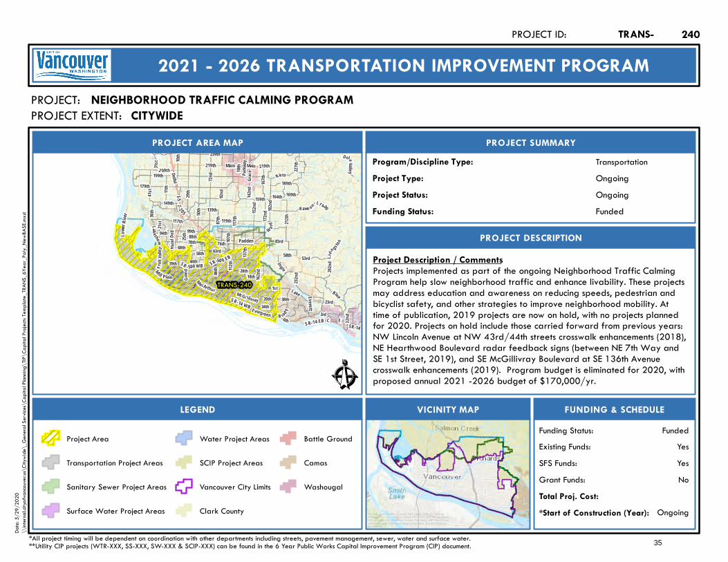
199th
Lake shore
63rdHazel
D ell
41 st
167th
179th
W ard
164th
Blair
182nd
Risto
1st
78th
3rd
137th
99th
E
28th
72nd
76th
18thGran
d
36th
117th
Main
172nd
Fr ui t V
alley
112th
31st
159th
21st
10th
Lake
189th
162nd
219th
34th
I- 2 05I-5
SR-14 WB
117th
SR-14
58th
M ill Plain
Padden
SR-50 0 EB
Main
Everett
SR - 500 WB
Lowe
r Rive
r
219th
SR-14 EB
10th
212th
58th
M acArthur
Li vin gsto
n
Evergreen
88th
McGi lliv ray
87th 119th
B ra d y
2 09th
C
50th
23rd
Parkw
ay
20th
169th
6th
L1 400
Grace
142nd
83rd
44th
139th
11th
39th
86th
149th
68th
227th
Raws on
239th
32nd
25th
292nd
94th
38th
29th
152nd
53rd
107th
D oleValley
232nd
I ngle
92nd
Delfel
TRANS-240
Ê
Ongoing
PROJECT AREA MAP
PROJECT:
PROJECT SUMMARY
Project Status:
TransportationProgram/Discipline Type:OngoingProject Type:
PROJECT DESCRIPTION
FUNDING & SCHEDULEVICINITY MAPLEGEND
NEIGHBORHOOD TRAFFIC CALMING PROGRAM
Project Description / CommentsProjects implemented as part of the ongoing Neighborhood Traffic CalmingProgram help slow neighborhood traffic and enhance livability. These projectsmay address education and awareness on reducing speeds, pedestrian andbicyclist safety, and other strategies to improve neighborhood mobility. Attime of publication, 2019 projects are now on hold, with no projects plannedfor 2020. Projects on hold include those carried forward from previous years:NW Lincoln Avenue at NW 43rd/44th streets crosswalk enhancements (2018),NE Hearthwood Boulevard radar feedback signs (between NE 7th Way andSE 1st Street, 2019), and SE McGillivray Boulevard at SE 136th Avenuecrosswalk enhancements (2019). Program budget is eliminated for 2020, withproposed annual 2021 -2026 budget of $170,000/yr.
Ongoing*Start of Construction (Year):
TRANS-PROJECT ID:
2021 - 2026 TRANSPORTATION IMPROVEMENT PROGRAM
PROJECT EXTENT:
Total Proj. Cost:NoGrant Funds:YesSFS Funds:YesExisting Funds:
*All project timing will be dependent on coordination with other departments including streets, pavement management, sewer, water and surface water.**Utility CIP projects (WTR-XXX, SS-XXX, SW-XXX & SCIP-XXX) can be found in the 6 Year Public Works Capital Improvement Program (CIP) document.
FundedFunding Status:
FundedFunding Status:
Project Area
Transportation Project Areas
Sanitary Sewer Project Areas
Surface Water Project Areas
Water Project Areas
SCIP Project Areas
Vancouver City Limits
Clark County
Battle Ground
Camas
Washougal
240
Service Layer Credits: Sources: Esri, HERE, Garmin, Intermap,increment P Corp., GEBCO, USGS, FAO, NPS, NRCAN, GeoBase,IGN, Kadaster NL, Ordnance Survey, Esri Japan, METI, Esri China(Hong Kong), (c) OpenStreetMap contributors, and the GIS UserCommunity
Date:
5/29
/202
0\\
intern
al.city
ofvan
couve
r.us\C
itywi
de\_
Gene
ral Se
rvices
\Cap
ital P
lannin
g\TIP
\Cap
ital P
rojec
ts Tem
plate_
TRAN
S_6Y
ear_P
oly_N
ewBA
SE.m
xd
CITYWIDE
35
199th
Lake shore
63rdHazel
D ell
41 st
167th
179th
W ard
164th
Blair
182nd
Risto
1st
78th
3rd
137th
99th
E
28th
72nd
76th
18thGran
d
36th
117th
Main
172nd
Fr ui t V
alley
112th
31st
159th
21st
10th
Lake
189th
162nd
219th
34th
I- 2 05I-5
SR-14 WB
117th
SR-14
58th
M ill Plain
Padden
SR-50 0 EB
Main
Everett
SR - 500 WB
Lowe
r Rive
r
219th
SR-14 EB
10th
212th
58th
M acArthur
Li vin gsto
n
Evergreen
88th
McGi lliv ray
87th 119th
B ra d y
2 09th
C
50th
23rd
Parkw
ay
20th
169th
6th
L1 400
Grace
142nd
83rd
44th
139th
11th
39th
86th
149th
68th
227th
Raws on
239th
32nd
25th
292nd
94th
38th
29th
152nd
53rd
107th
D oleValley
232nd
I ngle
92nd
Delfel
TRANS-241
Ê
Ongoing
PROJECT AREA MAP
PROJECT:
PROJECT SUMMARY
Project Status:
TransportationProgram/Discipline Type:OngoingProject Type:
PROJECT DESCRIPTION
FUNDING & SCHEDULEVICINITY MAPLEGEND
PAVEMENT PRESERVATION PROGRAM
Project Description / CommentsOngoing program to improve and maintain pavement surfaces through surfaceoverlay, microsurfacing and slurry treatments at multiple locations citywide.Upgrades may include new ADA ramps, traffic striping and markings. The Cityof Vancouver's more than 1,900 lane miles of streets are carefully inspectedand evaluated to determine most cost-effective means to preserve pavementand manage resources. 2020 program targets pavement preservation forover 48 lane miles, including: microscurfacing on Mill Plain, from NE 177thAve. to NE 184th Ave.; and asphalt rubber seal on NE Fourth Plain from I-205to NE 117th Ave. I-976 and COVID-19 have reduced the PavementPreservation Program by approximately $4 million in 2020. Future years willbe reduced as well, but the amounts are unknown.
Ongoing*Start of Construction (Year):
TRANS-PROJECT ID:
2021 - 2026 TRANSPORTATION IMPROVEMENT PROGRAM
PROJECT EXTENT:
Total Proj. Cost:NoGrant Funds:YesSFS Funds:YesExisting Funds:
*All project timing will be dependent on coordination with other departments including streets, pavement management, sewer, water and surface water.**Utility CIP projects (WTR-XXX, SS-XXX, SW-XXX & SCIP-XXX) can be found in the 6 Year Public Works Capital Improvement Program (CIP) document.
FundedFunding Status:
FundedFunding Status:
Project Area
Transportation Project Areas
Sanitary Sewer Project Areas
Surface Water Project Areas
Water Project Areas
SCIP Project Areas
Vancouver City Limits
Clark County
Battle Ground
Camas
Washougal
241
Service Layer Credits: Sources: Esri, HERE, Garmin, Intermap,increment P Corp., GEBCO, USGS, FAO, NPS, NRCAN, GeoBase,IGN, Kadaster NL, Ordnance Survey, Esri Japan, METI, Esri China(Hong Kong), (c) OpenStreetMap contributors, and the GIS UserCommunity
Date:
5/29
/202
0\\
intern
al.city
ofvan
couve
r.us\C
itywi
de\_
Gene
ral Se
rvices
\Cap
ital P
lannin
g\TIP
\Cap
ital P
rojec
ts Tem
plate_
TRAN
S_6Y
ear_P
oly_N
ewBA
SE.m
xd
CITYWIDE
36
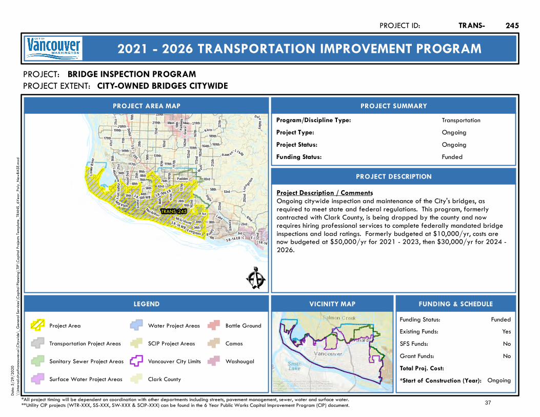
199th
Lake shore
63rdHazel
D ell
41 st
167th
179th
W ard
164th
Blair
182nd
Risto
1st
78th
3rd
137th
99th
E
28th
72nd
76th
18thGran
d
36th
117th
Main
172nd
Fr ui t V
alley
112th
31st
159th
21st
10th
Lake
189th
162nd
219th
34th
I- 2 05I-5
SR-14 WB
117th
SR-14
58th
M ill Plain
Padden
SR-50 0 EB
Main
Everett
SR - 500 WB
Lowe
r Rive
r
219th
SR-14 EB
10th
212th
58th
M acArthur
Li vin gsto
n
Evergreen
88th
McGi lliv ray
87th 119th
B ra d y
2 09th
C
50th
23rd
Parkw
ay
20th
169th
6th
L1 400
Grace
142nd
83rd
44th
139th
11th
39th
86th
149th
68th
227th
Raws on
239th
32nd
25th
292nd
94th
38th
29th
152nd
53rd
107th
D oleValley
232nd
I ngle
92nd
Delfel
TRANS-245
Ê
Ongoing
PROJECT AREA MAP
PROJECT:
PROJECT SUMMARY
Project Status:
TransportationProgram/Discipline Type:OngoingProject Type:
PROJECT DESCRIPTION
FUNDING & SCHEDULEVICINITY MAPLEGEND
BRIDGE INSPECTION PROGRAM
Project Description / CommentsOngoing citywide inspection and maintenance of the City's bridges, asrequired to meet state and federal regulations. This program, formerlycontracted with Clark County, is being dropped by the county and nowrequires hiring professional services to complete federally mandated bridgeinspections and load ratings. Formerly budgeted at $10,000/yr, costs arenow budgeted at $50,000/yr for 2021 - 2023, then $30,000/yr for 2024 -2026.
Ongoing*Start of Construction (Year):
TRANS-PROJECT ID:
2021 - 2026 TRANSPORTATION IMPROVEMENT PROGRAM
PROJECT EXTENT:
Total Proj. Cost:NoGrant Funds:NoSFS Funds:YesExisting Funds:
*All project timing will be dependent on coordination with other departments including streets, pavement management, sewer, water and surface water.**Utility CIP projects (WTR-XXX, SS-XXX, SW-XXX & SCIP-XXX) can be found in the 6 Year Public Works Capital Improvement Program (CIP) document.
FundedFunding Status:
FundedFunding Status:
Project Area
Transportation Project Areas
Sanitary Sewer Project Areas
Surface Water Project Areas
Water Project Areas
SCIP Project Areas
Vancouver City Limits
Clark County
Battle Ground
Camas
Washougal
245
Service Layer Credits: Sources: Esri, HERE, Garmin, Intermap,increment P Corp., GEBCO, USGS, FAO, NPS, NRCAN, GeoBase,IGN, Kadaster NL, Ordnance Survey, Esri Japan, METI, Esri China(Hong Kong), (c) OpenStreetMap contributors, and the GIS UserCommunity
Date:
5/29
/202
0\\
intern
al.city
ofvan
couve
r.us\C
itywi
de\_
Gene
ral Se
rvices
\Cap
ital P
lannin
g\TIP
\Cap
ital P
rojec
ts Tem
plate_
TRAN
S_6Y
ear_P
oly_N
ewBA
SE.m
xd
CITY-OWNED BRIDGES CITYWIDE
37

Mill Plain
Saint
John
s
Fourth Plain
CMa
in
Grand
S aint Jam es
HazelDell
Burton
Broad
way
Andre se n
Highw
ay 99
25th
I-5
Mill Plain15th
SR-500 EB
SR-14 WB
SR-500 WB
SR-14 EB
8th
58th
Fort Vancouver
Evergreen
15th Thurst on
72nd
66th
40th
49th
Ro ss
33rd
44th
39th
86th
87th
54th
Auto
Mall
42nd
MacArthur
McLoughlin
Falk
56th
47th
LieserC olumbia House
Vancouver Mall
18th
82nd
Staple
ton
20th
Blandf
ord
VancouverPlaz a
Columbia
TRANS-258
Ê
Future
PROJECT AREA MAP
PROJECT:
PROJECT SUMMARY
Project Status:
TransportationProgram/Discipline Type:MultimodalProject Type:
PROJECT DESCRIPTION
FUNDING & SCHEDULEVICINITY MAPLEGEND
E. FOURTH PLAIN BLVD. - FT. VANCOUVER WAY TO NE ANDRESEN RD.
Project Description / CommentsThis project will improve safety and aesthetics by upgrading sidewalks andstreet lights in Fourth Plain Sub-Area Plan. Improvements identified as safetypriority include wider sidewalks, upgraded street lights and street trees.
Unknown*Start of Construction (Year):
TRANS-PROJECT ID:
2021 - 2026 TRANSPORTATION IMPROVEMENT PROGRAM
PROJECT EXTENT:
$2,000,000.00Total Proj. Cost:N/AGrant Funds:N/ASFS Funds:N/AExisting Funds:
*All project timing will be dependent on coordination with other departments including streets, pavement management, sewer, water and surface water.**Utility CIP projects (WTR-XXX, SS-XXX, SW-XXX & SCIP-XXX) can be found in the 6 Year Public Works Capital Improvement Program (CIP) document.
UnfundedFunding Status:
UnfundedFunding Status:
Project Area
Transportation Project Areas
Sanitary Sewer Project Areas
Surface Water Project Areas
Water Project Areas
SCIP Project Areas
Vancouver City Limits
Clark County
Battle Ground
Camas
Washougal
258
Service Layer Credits: Sources: Esri, HERE, Garmin, Intermap,increment P Corp., GEBCO, USGS, FAO, NPS, NRCAN, GeoBase,IGN, Kadaster NL, Ordnance Survey, Esri Japan, METI, Esri China(Hong Kong), (c) OpenStreetMap contributors, and the GIS UserCommunity
Date:
5/29
/202
0\\
intern
al.city
ofvan
couve
r.us\C
itywi
de\_
Gene
ral Se
rvices
\Cap
ital P
lannin
g\TIP
\Cap
ital P
rojec
ts Tem
plate_
TRAN
S_6Y
ear_P
oly_N
ewBA
SE.m
xd
TO: NE Andresen RdNE ANDRESEN RDFT VANCOUVER WAY
38
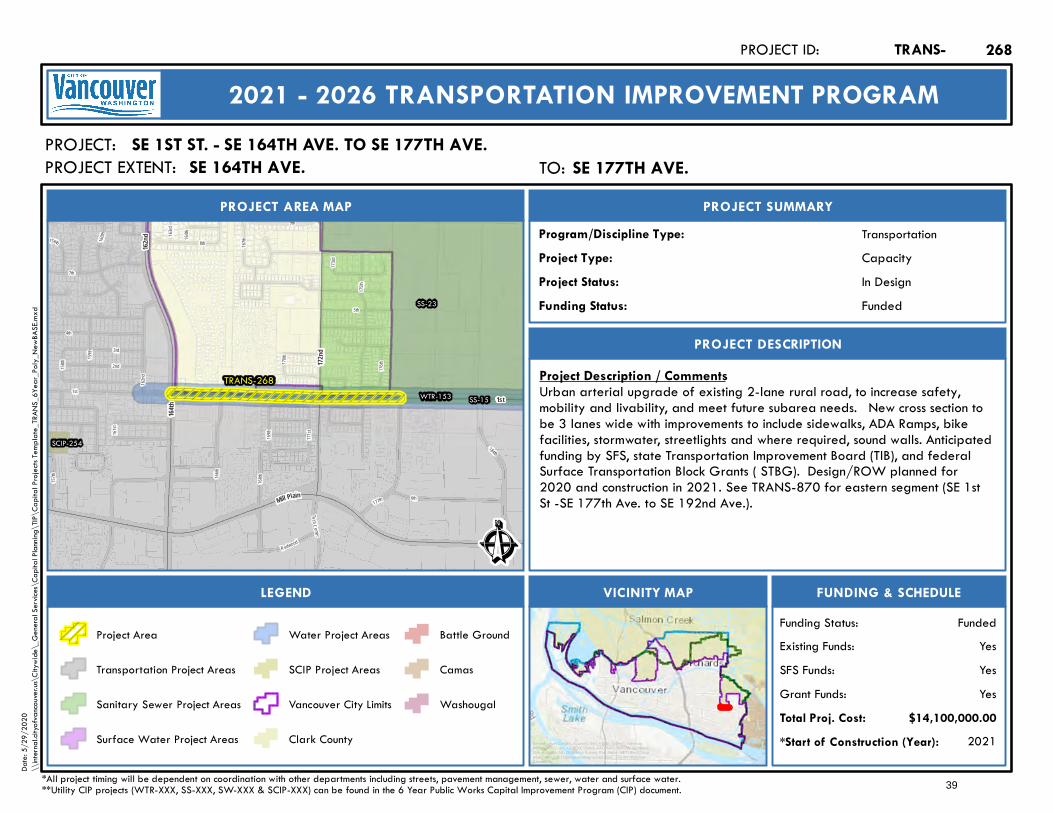
168th
160th
166th
157th
159th
177th
175th
169th
8th
171st
1st
156th
161st
164th
162nd
7th
9th
158th
173rd
17 0th
163rd
3rd
184th
5th
2nd
Te chC enter
176th
4th
6th
167th
R edwood
TRANS-268WTR-153
SS-23
SS-15
SCIP-254
172nd
Mill Plain
1st
164th
162nd
Ê
In Design
PROJECT AREA MAP
PROJECT:
PROJECT SUMMARY
Project Status:
TransportationProgram/Discipline Type:CapacityProject Type:
PROJECT DESCRIPTION
FUNDING & SCHEDULEVICINITY MAPLEGEND
SE 1ST ST. - SE 164TH AVE. TO SE 177TH AVE.
Project Description / CommentsUrban arterial upgrade of existing 2-lane rural road, to increase safety,mobility and livability, and meet future subarea needs. New cross section tobe 3 lanes wide with improvements to include sidewalks, ADA Ramps, bikefacilities, stormwater, streetlights and where required, sound walls. Anticipatedfunding by SFS, state Transportation Improvement Board (TIB), and federalSurface Transportation Block Grants ( STBG). Design/ROW planned for2020 and construction in 2021. See TRANS-870 for eastern segment (SE 1stSt -SE 177th Ave. to SE 192nd Ave.).
2021*Start of Construction (Year):
TRANS-PROJECT ID:
2021 - 2026 TRANSPORTATION IMPROVEMENT PROGRAM
PROJECT EXTENT:
$14,100,000.00Total Proj. Cost:YesGrant Funds:YesSFS Funds:YesExisting Funds:
*All project timing will be dependent on coordination with other departments including streets, pavement management, sewer, water and surface water.**Utility CIP projects (WTR-XXX, SS-XXX, SW-XXX & SCIP-XXX) can be found in the 6 Year Public Works Capital Improvement Program (CIP) document.
FundedFunding Status:
FundedFunding Status:
Project Area
Transportation Project Areas
Sanitary Sewer Project Areas
Surface Water Project Areas
Water Project Areas
SCIP Project Areas
Vancouver City Limits
Clark County
Battle Ground
Camas
Washougal
268
Service Layer Credits: Sources: Esri, HERE, Garmin, Intermap,increment P Corp., GEBCO, USGS, FAO, NPS, NRCAN, GeoBase,IGN, Kadaster NL, Ordnance Survey, Esri Japan, METI, Esri China(Hong Kong), (c) OpenStreetMap contributors, and the GIS UserCommunity
Date:
5/29
/202
0\\
intern
al.city
ofvan
couve
r.us\C
itywi
de\_
Gene
ral Se
rvices
\Cap
ital P
lannin
g\TIP
\Cap
ital P
rojec
ts Tem
plate_
TRAN
S_6Y
ear_P
oly_N
ewBA
SE.m
xd
TO: SE 177th Ave.SE 177TH AVE.SE 164TH AVE.
39
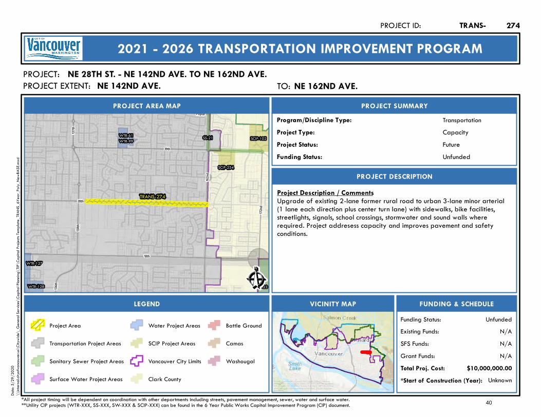
TRANS-274
WTR-127
WTR-99WTR-61
WTR-128 SS-23
SS-21
SCIP-254
SCIP-102
39th
172nd
137th
162nd
138th
28th
18th
136th
Poplar
Ê
Future
PROJECT AREA MAP
PROJECT:
PROJECT SUMMARY
Project Status:
TransportationProgram/Discipline Type:CapacityProject Type:
PROJECT DESCRIPTION
FUNDING & SCHEDULEVICINITY MAPLEGEND
NE 28TH ST. - NE 142ND AVE. TO NE 162ND AVE.
Project Description / CommentsUpgrade of existing 2-lane former rural road to urban 3-lane minor arterial(1 lane each direction plus center turn lane) with sidewalks, bike facilities,streetlights, signals, school crossings, stormwater and sound walls whererequired. Project addresess capacity and improves pavement and safetyconditions.
Unknown*Start of Construction (Year):
TRANS-PROJECT ID:
2021 - 2026 TRANSPORTATION IMPROVEMENT PROGRAM
PROJECT EXTENT:
$10,000,000.00Total Proj. Cost:N/AGrant Funds:N/ASFS Funds:N/AExisting Funds:
*All project timing will be dependent on coordination with other departments including streets, pavement management, sewer, water and surface water.**Utility CIP projects (WTR-XXX, SS-XXX, SW-XXX & SCIP-XXX) can be found in the 6 Year Public Works Capital Improvement Program (CIP) document.
UnfundedFunding Status:
UnfundedFunding Status:
Project Area
Transportation Project Areas
Sanitary Sewer Project Areas
Surface Water Project Areas
Water Project Areas
SCIP Project Areas
Vancouver City Limits
Clark County
Battle Ground
Camas
Washougal
274
Service Layer Credits: Sources: Esri, HERE, Garmin, Intermap,increment P Corp., GEBCO, USGS, FAO, NPS, NRCAN, GeoBase,IGN, Kadaster NL, Ordnance Survey, Esri Japan, METI, Esri China(Hong Kong), (c) OpenStreetMap contributors, and the GIS UserCommunity
Date:
5/29
/202
0\\
intern
al.city
ofvan
couve
r.us\C
itywi
de\_
Gene
ral Se
rvices
\Cap
ital P
lannin
g\TIP
\Cap
ital P
rojec
ts Tem
plate_
TRAN
S_6Y
ear_P
oly_N
ewBA
SE.m
xd
TO: NE 162nd Ave.NE 162ND AVE.NE 142ND AVE.
40
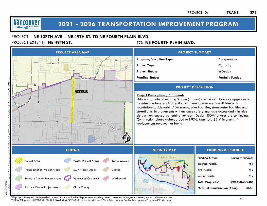
137th
Ghe r
Ward
49th
76th
112th
162nd
Fourth Plain
48thPoplar
117th
S R- 500 E
B
SR-500 W B
162nd
130th
39th
121st
Rosewood
78th
65th
TRANS-275
Ê
In Design
PROJECT AREA MAP
PROJECT:
PROJECT SUMMARY
Project Status:
TransportationProgram/Discipline Type:CapacityProject Type:
PROJECT DESCRIPTION
FUNDING & SCHEDULEVICINITY MAPLEGEND
NE 137TH AVE. - NE 49TH ST. TO NE FOURTH PLAIN BLVD.
Project Description / CommentsUrban upgrade of existing 2-lane (narrow) rural road. Corridor upgrades toinclude: one lane each direction with turn lane or median divider withroundabouts, sidewalks, ADA ramps, bike facilities, stormwater facilities andstreetlights. Improvements will enhance safety, manage access and minimizedelays now caused by turning vehicles. Design/ROW phases are continuing.Construction phase delayed due to I-976. May lose $2 M in grants ifreplacement revenue not found.
2023*Start of Construction (Year):
TRANS-PROJECT ID:
2021 - 2026 TRANSPORTATION IMPROVEMENT PROGRAM
PROJECT EXTENT:
$22,500,000.00Total Proj. Cost:YesGrant Funds:YesSFS Funds:YesExisting Funds:
*All project timing will be dependent on coordination with other departments including streets, pavement management, sewer, water and surface water.**Utility CIP projects (WTR-XXX, SS-XXX, SW-XXX & SCIP-XXX) can be found in the 6 Year Public Works Capital Improvement Program (CIP) document.
Partially FundedFunding Status:
Partially FundedFunding Status:
Project Area
Transportation Project Areas
Sanitary Sewer Project Areas
Surface Water Project Areas
Water Project Areas
SCIP Project Areas
Vancouver City Limits
Clark County
Battle Ground
Camas
Washougal
275
Service Layer Credits: Sources: Esri, HERE, Garmin, Intermap,increment P Corp., GEBCO, USGS, FAO, NPS, NRCAN, GeoBase,IGN, Kadaster NL, Ordnance Survey, Esri Japan, METI, Esri China(Hong Kong), (c) OpenStreetMap contributors, and the GIS UserCommunity
Date:
5/29
/202
0\\
intern
al.city
ofvan
couve
r.us\C
itywi
de\_
Gene
ral Se
rvices
\Cap
ital P
lannin
g\TIP
\Cap
ital P
rojec
ts Tem
plate_
TRAN
S_6Y
ear_P
oly_N
ewBA
SE.m
xd
TO: NE Fourth Plain Blvd.NE FOURTH PLAIN BLVD.NE 49TH ST.
41
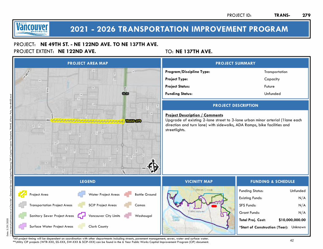
SR-500 EB
44th
121st
45th
125th
57th
136th
51st
141st
134th
37th
39th
128th
41st
122nd
43rd
129th
119th
50th
52nd
49th
48th
143rd
142n d
118th
132n d
58th
130th
53rd
120th
144th
47th
42nd
126th
139th
123rd
46th140
th
124th
38th
138th
133rd40th
55th
135th
131st
54th
127th
56th
59th
TRANS-279
SS-20
39th
121st
12 2nd
49th137
th
138th Ê
Future
PROJECT AREA MAP
PROJECT:
PROJECT SUMMARY
Project Status:
TransportationProgram/Discipline Type:CapacityProject Type:
PROJECT DESCRIPTION
FUNDING & SCHEDULEVICINITY MAPLEGEND
NE 49TH ST. - NE 122ND AVE. TO NE 137TH AVE.
Project Description / CommentsUpgrade of existing 2-lane street to 3-lane urban minor arterial (1lane eachdirection and turn lane) with sidewalks, ADA Ramps, bike facilities andstreetlights.
Unknown*Start of Construction (Year):
TRANS-PROJECT ID:
2021 - 2026 TRANSPORTATION IMPROVEMENT PROGRAM
PROJECT EXTENT:
$10,000,000.00Total Proj. Cost:N/AGrant Funds:N/ASFS Funds:N/AExisting Funds:
*All project timing will be dependent on coordination with other departments including streets, pavement management, sewer, water and surface water.**Utility CIP projects (WTR-XXX, SS-XXX, SW-XXX & SCIP-XXX) can be found in the 6 Year Public Works Capital Improvement Program (CIP) document.
UnfundedFunding Status:
UnfundedFunding Status:
Project Area
Transportation Project Areas
Sanitary Sewer Project Areas
Surface Water Project Areas
Water Project Areas
SCIP Project Areas
Vancouver City Limits
Clark County
Battle Ground
Camas
Washougal
279
Service Layer Credits: Sources: Esri, HERE, Garmin, Intermap,increment P Corp., GEBCO, USGS, FAO, NPS, NRCAN, GeoBase,IGN, Kadaster NL, Ordnance Survey, Esri Japan, METI, Esri China(Hong Kong), (c) OpenStreetMap contributors, and the GIS UserCommunity
Date:
5/29
/202
0\\
intern
al.city
ofvan
couve
r.us\C
itywi
de\_
Gene
ral Se
rvices
\Cap
ital P
lannin
g\TIP
\Cap
ital P
rojec
ts Tem
plate_
TRAN
S_6Y
ear_P
oly_N
ewBA
SE.m
xd
TO: NE 137th Ave.NE 137TH AVE.NE 122ND AVE.
42

I-205
TRANS-281 WTR-99
WTR-99
WTR-51
WTR-6
WTR-63
WTR-151
SW-40
SS-24
86th
87th
AutoMa
ll
98th
Andre
sen
18th
97th
Fourth Plain
Mill Plain
Burton
25th
Ê
Future
PROJECT AREA MAP
PROJECT:
PROJECT SUMMARY
Project Status:
TransportationProgram/Discipline Type:CapacityProject Type:
PROJECT DESCRIPTION
FUNDING & SCHEDULEVICINITY MAPLEGEND
NE 18TH ST. - NE 87TH AVE. TO NE 97TH AVE.
Project Description / CommentsLong-planned construction of new minor arterial street (1lane each directionplus turn lane) with bike facilities, streetlights, sound walls (where required), asidewalk on north side and shared use pathway on south side of street. Projectprovides planned east-west circulation.
Unknown*Start of Construction (Year):
TRANS-PROJECT ID:
2021 - 2026 TRANSPORTATION IMPROVEMENT PROGRAM
PROJECT EXTENT:
$14,200,000.00Total Proj. Cost:N/AGrant Funds:N/ASFS Funds:N/AExisting Funds:
*All project timing will be dependent on coordination with other departments including streets, pavement management, sewer, water and surface water.**Utility CIP projects (WTR-XXX, SS-XXX, SW-XXX & SCIP-XXX) can be found in the 6 Year Public Works Capital Improvement Program (CIP) document.
UnfundedFunding Status:
UnfundedFunding Status:
Project Area
Transportation Project Areas
Sanitary Sewer Project Areas
Surface Water Project Areas
Water Project Areas
SCIP Project Areas
Vancouver City Limits
Clark County
Battle Ground
Camas
Washougal
281
Service Layer Credits: Sources: Esri, HERE, Garmin, Intermap,increment P Corp., GEBCO, USGS, FAO, NPS, NRCAN, GeoBase,IGN, Kadaster NL, Ordnance Survey, Esri Japan, METI, Esri China(Hong Kong), (c) OpenStreetMap contributors, and the GIS UserCommunity
Date:
5/29
/202
0\\
intern
al.city
ofvan
couve
r.us\C
itywi
de\_
Gene
ral Se
rvices
\Cap
ital P
lannin
g\TIP
\Cap
ital P
rojec
ts Tem
plate_
TRAN
S_6Y
ear_P
oly_N
ewBA
SE.m
xd
TO: NE 97th Ave.NE 97TH AVE.NE 87TH AVE.
43
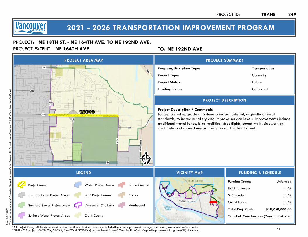
1st Lake
164t h
18th192
nd
28th
162nd
Goodw
in
13th
39th
Fribe
rg-Str
unk
172nd
Ingle
TRANS-349
Ê
Future
PROJECT AREA MAP
PROJECT:
PROJECT SUMMARY
Project Status:
TransportationProgram/Discipline Type:CapacityProject Type:
PROJECT DESCRIPTION
FUNDING & SCHEDULEVICINITY MAPLEGEND
NE 18TH ST. - NE 164TH AVE. TO NE 192ND AVE.
Project Description / CommentsLong-planned upgrade of 2-lane principal arterial, orginally at ruralstandards, to increase safety and improve service levels. Improvements includeadditional travel lanes, bike facilities, streetlights, sound walls, sidewalk onnorth side and shared use pathway on south side of street.
Unknown*Start of Construction (Year):
TRANS-PROJECT ID:
2021 - 2026 TRANSPORTATION IMPROVEMENT PROGRAM
PROJECT EXTENT:
$18,750,000.00Total Proj. Cost:N/AGrant Funds:N/ASFS Funds:N/AExisting Funds:
*All project timing will be dependent on coordination with other departments including streets, pavement management, sewer, water and surface water.**Utility CIP projects (WTR-XXX, SS-XXX, SW-XXX & SCIP-XXX) can be found in the 6 Year Public Works Capital Improvement Program (CIP) document.
UnfundedFunding Status:
UnfundedFunding Status:
Project Area
Transportation Project Areas
Sanitary Sewer Project Areas
Surface Water Project Areas
Water Project Areas
SCIP Project Areas
Vancouver City Limits
Clark County
Battle Ground
Camas
Washougal
349
Service Layer Credits: Sources: Esri, HERE, Garmin, Intermap,increment P Corp., GEBCO, USGS, FAO, NPS, NRCAN, GeoBase,IGN, Kadaster NL, Ordnance Survey, Esri Japan, METI, Esri China(Hong Kong), (c) OpenStreetMap contributors, and the GIS UserCommunity
Date:
5/29
/202
0\\
intern
al.city
ofvan
couve
r.us\C
itywi
de\_
Gene
ral Se
rvices
\Cap
ital P
lannin
g\TIP
\Cap
ital P
rojec
ts Tem
plate_
TRAN
S_6Y
ear_P
oly_N
ewBA
SE.m
xd
TO: NE 192nd Ave.NE 192ND AVE.NE 164TH AVE.
44
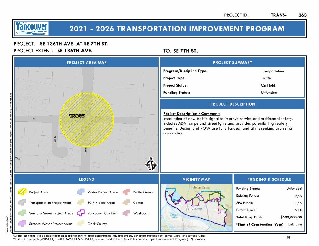
TRANS-363
134th (P)
7th
135t
h
136t
h
Ê
On Hold
PROJECT AREA MAP
PROJECT:
PROJECT SUMMARY
Project Status:
TransportationProgram/Discipline Type:TrafficProject Type:
PROJECT DESCRIPTION
FUNDING & SCHEDULEVICINITY MAPLEGEND
SE 136TH AVE. AT SE 7TH ST.
Project Description / CommentsInstallation of new traffic signal to improve service and multimodal safety.Includes ADA ramps and streetlights and provides potential high safetybenefits. Design and ROW are fully funded, and city is seeking grants forconstruction.
Unknown*Start of Construction (Year):
TRANS-PROJECT ID:
2021 - 2026 TRANSPORTATION IMPROVEMENT PROGRAM
PROJECT EXTENT:
$500,000.00Total Proj. Cost:N/AGrant Funds:N/ASFS Funds:N/AExisting Funds:
*All project timing will be dependent on coordination with other departments including streets, pavement management, sewer, water and surface water.**Utility CIP projects (WTR-XXX, SS-XXX, SW-XXX & SCIP-XXX) can be found in the 6 Year Public Works Capital Improvement Program (CIP) document.
UnfundedFunding Status:
UnfundedFunding Status:
Project Area
Transportation Project Areas
Sanitary Sewer Project Areas
Surface Water Project Areas
Water Project Areas
SCIP Project Areas
Vancouver City Limits
Clark County
Battle Ground
Camas
Washougal
363
Service Layer Credits: Sources: Esri, HERE, Garmin, Intermap,increment P Corp., GEBCO, USGS, FAO, NPS, NRCAN, GeoBase,IGN, Kadaster NL, Ordnance Survey, Esri Japan, METI, Esri China(Hong Kong), (c) OpenStreetMap contributors, and the GIS UserCommunity
Date:
5/29
/202
0\\
intern
al.city
ofvan
couve
r.us\C
itywi
de\_
Gene
ral Se
rvices
\Cap
ital P
lannin
g\TIP
\Cap
ital P
rojec
ts Tem
plate_
TRAN
S_6Y
ear_P
oly_N
ewBA
SE.m
xd
TO: SE 7th St.SE 7TH ST.SE 136TH AVE.
45

199th
Lake shore
63rdHazel
D ell
41 st
167th
179th
W ard
164th
Blair
182nd
Risto
1st
78th
3rd
137th
99th
E
28th
72nd
76th
18thGran
d
36th
117th
Main
172nd
Fr ui t V
alley
112th
31st
159th
21st
10th
Lake
189th
162nd
219th
34th
I- 2 05I-5
SR-14 WB
117th
SR-14
58th
M ill Plain
Padden
SR-50 0 EB
Main
Everett
SR - 500 WB
Lowe
r Rive
r
219th
SR-14 EB
10th
212th
58th
M acArthur
Li vin gsto
n
Evergreen
88th
McGi lliv ray
87th 119th
B ra d y
2 09th
C
50th
23rd
Parkw
ay
20th
169th
6th
L1 400
Grace
142nd
83rd
44th
139th
11th
39th
86th
149th
68th
227th
Raws on
239th
32nd
25th
292nd
94th
38th
29th
152nd
53rd
107th
D oleValley
232nd
I ngle
92nd
Delfel
TRAN S-421
Ê
In Design
PROJECT AREA MAP
PROJECT:
PROJECT SUMMARY
Project Status:
Tra n sportationProgram/Discipline Type:Ongoin gProject Type:
PROJECT DESCRIPTION
FUNDING & SCHEDULEVICINITY MAPLEGEND
PAVEMENT RECONSTRUCTION PROGRAM
Project Description / CommentsMa jor pa vemen t a n d roa dwa y reconstruction of fa iled pa vemen t on existin gstreets at various loca tions cityw ide. Of the City of V a n couver's 1,900 la n emiles, approx. 140 la n e miles were rated 'fa iled' in 2018. SFS fun din g nowcurren tly suspen ded. Ongoin g I-976 a n d COV ID-19 impa cts ha ve reducedthe Pa vemen t Reconstruction Progra m b udget, a n d it will b e un fun ded untilrepla cemen t reven ue is foun d – Moved to Un fun ded List.
2019*Start of Construction (Year):
TRANS-PROJECT ID:
2021 - 2026 TRANSPORTATION IMPROVEMENT PROGRAM
PROJECT EX TEN T:
Total Proj. Cost:N oGra n t Fun ds:YesSFS Fun ds:N oExisting Fun ds:
*All project timing will b e depen den t on coordin a tion w ith other departments in cludin g streets, pa vement ma n a gement, sewer, w ater a n d surfa ce w ater.**Utility CIP projects (W TR-X X X , SS-X X X , SW -X X X & SCIP-X X X ) ca n b e foun d in the 6 Yea r Pub lic W orks Capita l Improvement Progra m (CIP) document.
Un fun dedFun din g Status:
Un fun dedFunding Status:
Project Area
Tra n sportation Project Areas
Sa n ita ry Sew er Project Areas
Surfa ce W a ter Project Areas
W a ter Project Areas
SCIP Project Areas
V a n couver City Limits
Cla rk County
Ba ttle Groun d
Ca ma s
W a shouga l
421
Service Layer Credits: Sources: Esri, HERE, Garmin, Intermap,increment P Corp., GEBCO, USGS, FAO, NPS, NRCAN, GeoBase,IGN, Kadaster NL, Ordnance Survey, Esri Japan, METI, Esri China(Hong Kong), (c) OpenStreetMap contributors, and the GIS UserCommunity
Date: 5/29/2020
\\internal.cityofvancouver.us\Citywide\_General Services\Capital Planning\TIP\Capital Projects Template_TRANS_6Year_Poly_NewBASE.mxd
CITYWIDE
46
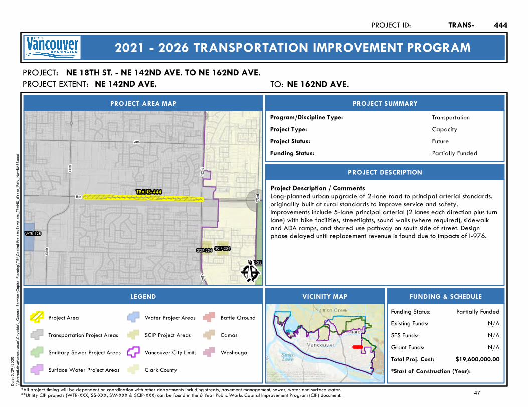
TRANS-444
WTR-128
SS-23
SCIP-254 SCIP-254172
nd
138th
28th
18th
164th
162nd
136th
Ê
Future
PROJECT AREA MAP
PROJECT:
PROJECT SUMMARY
Project Status:
TransportationProgram/Discipline Type:CapacityProject Type:
PROJECT DESCRIPTION
FUNDING & SCHEDULEVICINITY MAPLEGEND
NE 18TH ST. - NE 142ND AVE. TO NE 162ND AVE.
Project Description / CommentsLong-planned urban upgrade of 2-lane road to principal arterial standards.originallly built at rural standards to improve service and safety.Improvements include 5-lane principal arterial (2 lanes each direction plus turnlane) with bike facilities, streetlights, sound walls (where required), sidewalkand ADA ramps, and shared use pathway on south side of street. Designphase delayed until replacement revenue is found due to impacts of I-976.
*Start of Construction (Year):
TRANS-PROJECT ID:
2021 - 2026 TRANSPORTATION IMPROVEMENT PROGRAM
PROJECT EXTENT:
$19,600,000.00Total Proj. Cost:N/AGrant Funds:N/ASFS Funds:N/AExisting Funds:
*All project timing will be dependent on coordination with other departments including streets, pavement management, sewer, water and surface water.**Utility CIP projects (WTR-XXX, SS-XXX, SW-XXX & SCIP-XXX) can be found in the 6 Year Public Works Capital Improvement Program (CIP) document.
Partially FundedFunding Status:
Partially FundedFunding Status:
Project Area
Transportation Project Areas
Sanitary Sewer Project Areas
Surface Water Project Areas
Water Project Areas
SCIP Project Areas
Vancouver City Limits
Clark County
Battle Ground
Camas
Washougal
444
Service Layer Credits: Sources: Esri, HERE, Garmin, Intermap,increment P Corp., GEBCO, USGS, FAO, NPS, NRCAN, GeoBase,IGN, Kadaster NL, Ordnance Survey, Esri Japan, METI, Esri China(Hong Kong), (c) OpenStreetMap contributors, and the GIS UserCommunity
Date:
5/29
/202
0\\
intern
al.city
ofvan
couve
r.us\C
itywi
de\_
Gene
ral Se
rvices
\Cap
ital P
lannin
g\TIP
\Cap
ital P
rojec
ts Tem
plate_
TRAN
S_6Y
ear_P
oly_N
ewBA
SE.m
xd
TO: NE 162nd Ave.NE 162ND AVE.NE 142ND AVE.
47

Mill Plain
Saint Johns
C
Fruit V
alley
Main
Fourth PlainBro
adwa
y
Grand
I-5
Mill Plain
SR-500 WB
15th
SR-14 EB
SR-500 EBLower River
SR-14 WB
Evergreen
Fort Vancouver
6th
Frank
lin
33rd
G ra nt 8th
McLoughlin
Columbia
7th
26th
Port
16th
TRANS-451
Ê
Ongoing
PROJECT AREA MAP
PROJECT:
PROJECT SUMMARY
Project Status:
TransportationProgram/Discipline Type:MultimodalProject Type:
PROJECT DESCRIPTION
FUNDING & SCHEDULEVICINITY MAPLEGEND
DESTINATION DOWNTOWN TDM
Project Description / CommentsDowntown-focused transportation demand management program, supportingCity Center Vision, commute trip reduction and transportation efficiency.Includes employer outreach, commuter training, bike, sidewalk and ADAfacilities and program incentives.
2016*Start of Construction (Year):
TRANS-PROJECT ID:
2021 - 2026 TRANSPORTATION IMPROVEMENT PROGRAM
PROJECT EXTENT:
$459,000.00Total Proj. Cost:YesGrant Funds:NoSFS Funds:YesExisting Funds:
*All project timing will be dependent on coordination with other departments including streets, pavement management, sewer, water and surface water.**Utility CIP projects (WTR-XXX, SS-XXX, SW-XXX & SCIP-XXX) can be found in the 6 Year Public Works Capital Improvement Program (CIP) document.
FundedFunding Status:
FundedFunding Status:
Project Area
Transportation Project Areas
Sanitary Sewer Project Areas
Surface Water Project Areas
Water Project Areas
SCIP Project Areas
Vancouver City Limits
Clark County
Battle Ground
Camas
Washougal
451
Service Layer Credits: Sources: Esri, HERE, Garmin, Intermap,increment P Corp., GEBCO, USGS, FAO, NPS, NRCAN, GeoBase,IGN, Kadaster NL, Ordnance Survey, Esri Japan, METI, Esri China(Hong Kong), (c) OpenStreetMap contributors, and the GIS UserCommunity
Date:
5/29
/202
0\\
intern
al.city
ofvan
couve
r.us\C
itywi
de\_
Gene
ral Se
rvices
\Cap
ital P
lannin
g\TIP
\Cap
ital P
rojec
ts Tem
plate_
TRAN
S_6Y
ear_P
oly_N
ewBA
SE.m
xd
48
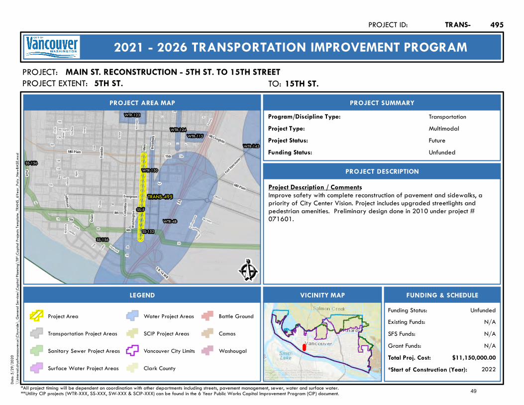
I-5
15thMill Plain
SR-14 WB
C
7th
Reser
ve
13th
Harne
y
Grant G
Fort Va
ncouve
r
H
6th
Esther
Danie
ls
5th
Washi
ngton
Markle
15th
Alvord
McClellan
20th
Lincol
n
Kauffm
an
HathewayWater
front
Tyne
3rd
4th
16th
19th
17th
McLoughlin
Columbia
E F
Cascade
Ingalls
Jeffer
son
9th
King
11th
12th
Frankl
in
D
14th
Hill
Officers
Phil Arnold
TRANS-495
WTR-48
WTR-115
WTR-123
WTR-124
WTR-143
WTR-150
SS-5
SS-152
SS-156
SS-156
Frank
lin
Fort Vancouver
Evergreen
Colum
bia
6th
Gran
t 8th
McLoughlin
Po rt
Jefferson
7th
Broad
way
C
Main
Wash
ingt on
Mill Plain
Ê
Future
PROJECT AREA MAP
PROJECT:
PROJECT SUMMARY
Project Status:
TransportationProgram/Discipline Type:MultimodalProject Type:
PROJECT DESCRIPTION
FUNDING & SCHEDULEVICINITY MAPLEGEND
MAIN ST. RECONSTRUCTION - 5TH ST. TO 15TH STREET
Project Description / CommentsImprove safety with complete reconstruction of pavement and sidewalks, apriority of City Center Vision. Project includes upgraded streetlights andpedestrian amenities. Preliminary design done in 2010 under project #071601.
2022*Start of Construction (Year):
TRANS-PROJECT ID:
2021 - 2026 TRANSPORTATION IMPROVEMENT PROGRAM
PROJECT EXTENT:
$11,150,000.00Total Proj. Cost:N/AGrant Funds:N/ASFS Funds:N/AExisting Funds:
*All project timing will be dependent on coordination with other departments including streets, pavement management, sewer, water and surface water.**Utility CIP projects (WTR-XXX, SS-XXX, SW-XXX & SCIP-XXX) can be found in the 6 Year Public Works Capital Improvement Program (CIP) document.
UnfundedFunding Status:
UnfundedFunding Status:
Project Area
Transportation Project Areas
Sanitary Sewer Project Areas
Surface Water Project Areas
Water Project Areas
SCIP Project Areas
Vancouver City Limits
Clark County
Battle Ground
Camas
Washougal
495
Service Layer Credits: Sources: Esri, HERE, Garmin, Intermap,increment P Corp., GEBCO, USGS, FAO, NPS, NRCAN, GeoBase,IGN, Kadaster NL, Ordnance Survey, Esri Japan, METI, Esri China(Hong Kong), (c) OpenStreetMap contributors, and the GIS UserCommunity
Date:
5/29
/202
0\\
intern
al.city
ofvan
couve
r.us\C
itywi
de\_
Gene
ral Se
rvices
\Cap
ital P
lannin
g\TIP
\Cap
ital P
rojec
ts Tem
plate_
TRAN
S_6Y
ear_P
oly_N
ewBA
SE.m
xd
TO: 15th St.15TH ST.5TH ST.
49
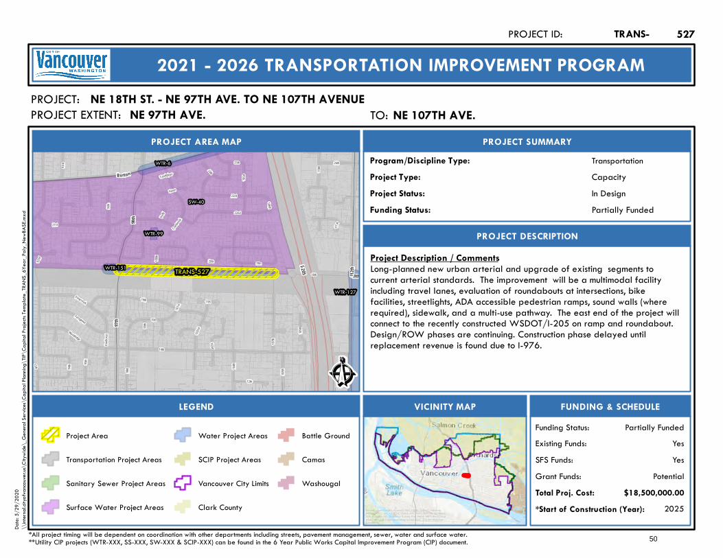
I-205
92nd
110th
14th
15th
18th
98th
Woodridge
102nd
20th 19th
Sandpiper
17th
111th
Cranbrook
100th
13th
Holly
104th
Heron
99th
24th
95th
103rd
101st
Knollc
rest 109
th
96th
25th
106th
105th
107th
Pinecreek
94th
23rd
21st
22nd
93rd
16th
12th
26th
108th
Ferngrove
TRANS-527
WTR-127
WTR-99
WTR-6
WTR-151
SW-40
98th
97th
18th
Burton
112th
Ê
In Design
PROJECT AREA MAP
PROJECT:
PROJECT SUMMARY
Project Status:
TransportationProgram/Discipline Type:CapacityProject Type:
PROJECT DESCRIPTION
FUNDING & SCHEDULEVICINITY MAPLEGEND
NE 18TH ST. - NE 97TH AVE. TO NE 107TH AVENUE
Project Description / CommentsLong-planned new urban arterial and upgrade of existing segments tocurrent arterial standards. The improvement will be a multimodal facilityincluding travel lanes, evaluation of roundabouts at intersections, bikefacilities, streetlights, ADA accessible pedestrian ramps, sound walls (whererequired), sidewalk, and a multi-use pathway. The east end of the project willconnect to the recently constructed WSDOT/I-205 on ramp and roundabout.Design/ROW phases are continuing. Construction phase delayed untilreplacement revenue is found due to I-976.
2025*Start of Construction (Year):
TRANS-PROJECT ID:
2021 - 2026 TRANSPORTATION IMPROVEMENT PROGRAM
PROJECT EXTENT:
$18,500,000.00Total Proj. Cost:PotentialGrant Funds:
YesSFS Funds:YesExisting Funds:
*All project timing will be dependent on coordination with other departments including streets, pavement management, sewer, water and surface water.**Utility CIP projects (WTR-XXX, SS-XXX, SW-XXX & SCIP-XXX) can be found in the 6 Year Public Works Capital Improvement Program (CIP) document.
Partially FundedFunding Status:
Partially FundedFunding Status:
Project Area
Transportation Project Areas
Sanitary Sewer Project Areas
Surface Water Project Areas
Water Project Areas
SCIP Project Areas
Vancouver City Limits
Clark County
Battle Ground
Camas
Washougal
527
Service Layer Credits: Sources: Esri, HERE, Garmin, Intermap,increment P Corp., GEBCO, USGS, FAO, NPS, NRCAN, GeoBase,IGN, Kadaster NL, Ordnance Survey, Esri Japan, METI, Esri China(Hong Kong), (c) OpenStreetMap contributors, and the GIS UserCommunity
Date:
5/29
/202
0\\
intern
al.city
ofvan
couve
r.us\C
itywi
de\_
Gene
ral Se
rvices
\Cap
ital P
lannin
g\TIP
\Cap
ital P
rojec
ts Tem
plate_
TRAN
S_6Y
ear_P
oly_N
ewBA
SE.m
xd
TO: NE 107th Ave.NE 107TH AVE.NE 97TH AVE.
50

Mill Plain15th
7th
13th
H arne
y
Grant
Markle
Lincol
n
Kauffm
an
Danie
ls
16th
17th
McLoughlin
Esther
Ingalls
Jeffer
son
9th
King 12th
Frankl
in
14th
11th
Hill
Harborside
TRANS-531
SS-152
SS-156
Evergreen
8th
Fr ank
lin
Colum
bia
Grant
7th
Jeff erson
16th
Port
Wash
ington
Ê
In Design
PROJECT AREA MAP
PROJECT:
PROJECT SUMMARY
Project Status:
TransportationProgram/Discipline Type:CapacityProject Type:
PROJECT DESCRIPTION
FUNDING & SCHEDULEVICINITY MAPLEGEND
JEFFERSON ST. - W. EVERGREEN TO W. MILL PLAIN BLVD
Project Description / CommentsUpgrade of a priority westside urban arterial circulation route withrealignment of Jefferson/Kauffman at W. 13th St. Projects include 2 lanes (1lane each direction), ADA ramps, sidewalk infill, bike facilities and streetlights,with potential for high safety benefits. Design phase and right-of-way phasesare funded. Construction phase partially funded via grant. Constructionphase delayed due to impacts of I-976. May lose $2 M grant if replacementrevenue not found.
2024*Start of Construction (Year):
TRANS-PROJECT ID:
2021 - 2026 TRANSPORTATION IMPROVEMENT PROGRAM
PROJECT EXTENT:
$11,000,000.00Total Proj. Cost:PotentialGrant Funds:
YesSFS Funds:YesExisting Funds:
*All project timing will be dependent on coordination with other departments including streets, pavement management, sewer, water and surface water.**Utility CIP projects (WTR-XXX, SS-XXX, SW-XXX & SCIP-XXX) can be found in the 6 Year Public Works Capital Improvement Program (CIP) document.
Partially FundedFunding Status:
Partially FundedFunding Status:
Project Area
Transportation Project Areas
Sanitary Sewer Project Areas
Surface Water Project Areas
Water Project Areas
SCIP Project Areas
Vancouver City Limits
Clark County
Battle Ground
Camas
Washougal
531
Service Layer Credits: Sources: Esri, HERE, Garmin, Intermap,increment P Corp., GEBCO, USGS, FAO, NPS, NRCAN, GeoBase,IGN, Kadaster NL, Ordnance Survey, Esri Japan, METI, Esri China(Hong Kong), (c) OpenStreetMap contributors, and the GIS UserCommunity
Date:
5/29
/202
0\\
intern
al.city
ofvan
couve
r.us\C
itywi
de\_
Gene
ral Se
rvices
\Cap
ital P
lannin
g\TIP
\Cap
ital P
rojec
ts Tem
plate_
TRAN
S_6Y
ear_P
oly_N
ewBA
SE.m
xd
TO: 13th St13TH ST8TH ST
51
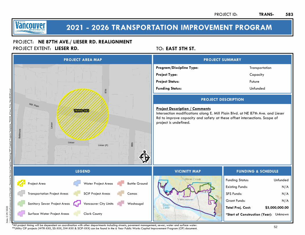
TRANS-583
Lieser (P)Lieser
88th
Balti
mor
e
Mill Plain
Lies
er
87th
Ê
Future
PROJECT AREA MAP
PROJECT:
PROJECT SUMMARY
Project Status:
TransportationProgram/Discipline Type:CapacityProject Type:
PROJECT DESCRIPTION
FUNDING & SCHEDULEVICINITY MAPLEGEND
NE 87TH AVE./ LIESER RD. REALIGNMENT
Project Description / CommentsIntersection modifications along E. Mill Plain Blvd. at NE 87th Ave. and LieserRd to improve capacity and safety at these offset intersections. Scope ofproject is undefined.
Unknown*Start of Construction (Year):
TRANS-PROJECT ID:
2021 - 2026 TRANSPORTATION IMPROVEMENT PROGRAM
PROJECT EXTENT:
$5,000,000.00Total Proj. Cost:N/AGrant Funds:N/ASFS Funds:N/AExisting Funds:
*All project timing will be dependent on coordination with other departments including streets, pavement management, sewer, water and surface water.**Utility CIP projects (WTR-XXX, SS-XXX, SW-XXX & SCIP-XXX) can be found in the 6 Year Public Works Capital Improvement Program (CIP) document.
UnfundedFunding Status:
UnfundedFunding Status:
Project Area
Transportation Project Areas
Sanitary Sewer Project Areas
Surface Water Project Areas
Water Project Areas
SCIP Project Areas
Vancouver City Limits
Clark County
Battle Ground
Camas
Washougal
583
Service Layer Credits: Sources: Esri, HERE, Garmin, Intermap,increment P Corp., GEBCO, USGS, FAO, NPS, NRCAN, GeoBase,IGN, Kadaster NL, Ordnance Survey, Esri Japan, METI, Esri China(Hong Kong), (c) OpenStreetMap contributors, and the GIS UserCommunity
Date:
5/29
/202
0\\
intern
al.city
ofvan
couve
r.us\C
itywi
de\_
Gene
ral Se
rvices
\Cap
ital P
lannin
g\TIP
\Cap
ital P
rojec
ts Tem
plate_
TRAN
S_6Y
ear_P
oly_N
ewBA
SE.m
xd
TO: East 5th St.EAST 5TH ST.LIESER RD.
52
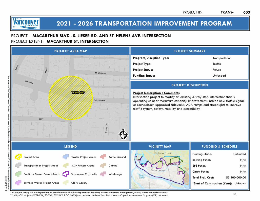
TRANS-603
Sher
ley
(P)
Tam
pa
Mi a
mi
Mt Olympus
Lorry
Lies
er
MacArthur
Saint Helens
Ê
Future
PROJECT AREA MAP
PROJECT:
PROJECT SUMMARY
Project Status:
TransportationProgram/Discipline Type:TrafficProject Type:
PROJECT DESCRIPTION
FUNDING & SCHEDULEVICINITY MAPLEGEND
MACARTHUR BLVD., S. LIESER RD. AND ST. HELENS AVE. INTERSECTION
Project Description / CommentsIntersection project to modify an existing 4-way-stop intersection that isoperating at near maximum capacity. Improvements include new traffic signalor roundabout, upgraded sidewalks, ADA ramps and streetlights to improvetraffic system, safety, mobility and accessibility
Unknown*Start of Construction (Year):
TRANS-PROJECT ID:
2021 - 2026 TRANSPORTATION IMPROVEMENT PROGRAM
PROJECT EXTENT:
$3,500,000.00Total Proj. Cost:N/AGrant Funds:N/ASFS Funds:N/AExisting Funds:
*All project timing will be dependent on coordination with other departments including streets, pavement management, sewer, water and surface water.**Utility CIP projects (WTR-XXX, SS-XXX, SW-XXX & SCIP-XXX) can be found in the 6 Year Public Works Capital Improvement Program (CIP) document.
UnfundedFunding Status:
UnfundedFunding Status:
Project Area
Transportation Project Areas
Sanitary Sewer Project Areas
Surface Water Project Areas
Water Project Areas
SCIP Project Areas
Vancouver City Limits
Clark County
Battle Ground
Camas
Washougal
603
Service Layer Credits: Sources: Esri, HERE, Garmin, Intermap,increment P Corp., GEBCO, USGS, FAO, NPS, NRCAN, GeoBase,IGN, Kadaster NL, Ordnance Survey, Esri Japan, METI, Esri China(Hong Kong), (c) OpenStreetMap contributors, and the GIS UserCommunity
Date:
5/29
/202
0\\
intern
al.city
ofvan
couve
r.us\C
itywi
de\_
Gene
ral Se
rvices
\Cap
ital P
lannin
g\TIP
\Cap
ital P
rojec
ts Tem
plate_
TRAN
S_6Y
ear_P
oly_N
ewBA
SE.m
xd
MACARTHUR ST. INTERSECTION
53

Mill Plain
1st Lake
192nd
18th
172nd
Goodwin
13thFri
berg-
Strun
k
Ingle
Parke r
28th
TRANS-607
Ê
Future
PROJECT AREA MAP
PROJECT:
PROJECT SUMMARY
Project Status:
TransportationProgram/Discipline Type:CapacityProject Type:
PROJECT DESCRIPTION
FUNDING & SCHEDULEVICINITY MAPLEGEND
NE 192ND AVE. - SE 1ST ST. TO NE 18TH ST.
Project Description / CommentsUrban upgrade of existing 2-lane street. Improvements inlcude additionaltravel lanes, sidewalks, bike facilities, ADA ramps and streetlights to improvesystem, safety, mobility and accessibility.
Unknown*Start of Construction (Year):
TRANS-PROJECT ID:
2021 - 2026 TRANSPORTATION IMPROVEMENT PROGRAM
PROJECT EXTENT:
$20,000,000.00Total Proj. Cost:N/AGrant Funds:N/ASFS Funds:N/AExisting Funds:
*All project timing will be dependent on coordination with other departments including streets, pavement management, sewer, water and surface water.**Utility CIP projects (WTR-XXX, SS-XXX, SW-XXX & SCIP-XXX) can be found in the 6 Year Public Works Capital Improvement Program (CIP) document.
UnfundedFunding Status:
UnfundedFunding Status:
Project Area
Transportation Project Areas
Sanitary Sewer Project Areas
Surface Water Project Areas
Water Project Areas
SCIP Project Areas
Vancouver City Limits
Clark County
Battle Ground
Camas
Washougal
607
Service Layer Credits: Sources: Esri, HERE, Garmin, Intermap,increment P Corp., GEBCO, USGS, FAO, NPS, NRCAN, GeoBase,IGN, Kadaster NL, Ordnance Survey, Esri Japan, METI, Esri China(Hong Kong), (c) OpenStreetMap contributors, and the GIS UserCommunity
Date:
5/29
/202
0\\
intern
al.city
ofvan
couve
r.us\C
itywi
de\_
Gene
ral Se
rvices
\Cap
ital P
lannin
g\TIP
\Cap
ital P
rojec
ts Tem
plate_
TRAN
S_6Y
ear_P
oly_N
ewBA
SE.m
xd
TO: NE 18th St.NE 18TH ST.SE 1ST ST.
54

Columbia HouseColumbia HouseColumbia House
TRANS-680
SS-156Cutter (P)
Spinaker (P)
Win
dwar
d (P
)
Fairwinds (P)
Col
umbi
a R
iver Columbia
Colu
mbi
aSh
ores
Mar
itim
e
Ê
Future
PROJECT AREA MAP
PROJECT:
PROJECT SUMMARY
Project Status:
TransportationProgram/Discipline Type:CapacityProject Type:
PROJECT DESCRIPTION
FUNDING & SCHEDULEVICINITY MAPLEGEND
COLUMBIA SHORES BLVD. AT COLUMBIA WAY - BNSF UNDERCROSSING WIDENING
Project Description / CommentsProject to widen existing railroad undercrossing portal and improve ColumbiaShores/Columbia Way intersection to address service levels and increasepedestrian and bike access. Total scope of project is undefined.
Unknown*Start of Construction (Year):
TRANS-PROJECT ID:
2021 - 2026 TRANSPORTATION IMPROVEMENT PROGRAM
PROJECT EXTENT:
$25,000,000.00Total Proj. Cost:N/AGrant Funds:N/ASFS Funds:N/AExisting Funds:
*All project timing will be dependent on coordination with other departments including streets, pavement management, sewer, water and surface water.**Utility CIP projects (WTR-XXX, SS-XXX, SW-XXX & SCIP-XXX) can be found in the 6 Year Public Works Capital Improvement Program (CIP) document.
UnfundedFunding Status:
UnfundedFunding Status:
Project Area
Transportation Project Areas
Sanitary Sewer Project Areas
Surface Water Project Areas
Water Project Areas
SCIP Project Areas
Vancouver City Limits
Clark County
Battle Ground
Camas
Washougal
680
Service Layer Credits: Sources: Esri, HERE, Garmin, Intermap,increment P Corp., GEBCO, USGS, FAO, NPS, NRCAN, GeoBase,IGN, Kadaster NL, Ordnance Survey, Esri Japan, METI, Esri China(Hong Kong), (c) OpenStreetMap contributors, and the GIS UserCommunity
Date:
5/29
/202
0\\
intern
al.city
ofvan
couve
r.us\C
itywi
de\_
Gene
ral Se
rvices
\Cap
ital P
lannin
g\TIP
\Cap
ital P
rojec
ts Tem
plate_
TRAN
S_6Y
ear_P
oly_N
ewBA
SE.m
xd
RR UNDERCROSSING PORTAL
55
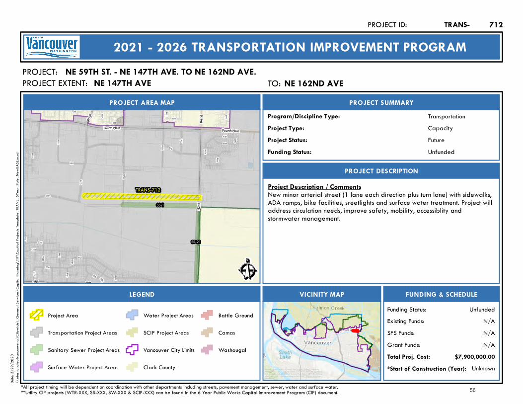
Fourth Plain
162nd
51st
59th
163rd
165th
66th
152nd
140th
70th
150th
147th
50th
151st
142nd
16 6th
52nd
144th
156th
1 4 5th
157th
1 39t h
14 6th
164th
159th
68th
149th
53rd
49th141st
69th
65th
67th
63rd
143rd
TRANS-712
SS-21
SS-1
Ward
49th
Fourth Plain
48th
162nd
Ê
Future
PROJECT AREA MAP
PROJECT:
PROJECT SUMMARY
Project Status:
TransportationProgram/Discipline Type:CapacityProject Type:
PROJECT DESCRIPTION
FUNDING & SCHEDULEVICINITY MAPLEGEND
NE 59TH ST. - NE 147TH AVE. TO NE 162ND AVE.
Project Description / CommentsNew minor arterial street (1 lane each direction plus turn lane) with sidewalks,ADA ramps, bike facilities, sreetlights and surface water treatment. Project willaddress circulation needs, improve safety, mobility, accessiblity andstormwater management.
Unknown*Start of Construction (Year):
TRANS-PROJECT ID:
2021 - 2026 TRANSPORTATION IMPROVEMENT PROGRAM
PROJECT EXTENT:
$7,900,000.00Total Proj. Cost:N/AGrant Funds:N/ASFS Funds:N/AExisting Funds:
*All project timing will be dependent on coordination with other departments including streets, pavement management, sewer, water and surface water.**Utility CIP projects (WTR-XXX, SS-XXX, SW-XXX & SCIP-XXX) can be found in the 6 Year Public Works Capital Improvement Program (CIP) document.
UnfundedFunding Status:
UnfundedFunding Status:
Project Area
Transportation Project Areas
Sanitary Sewer Project Areas
Surface Water Project Areas
Water Project Areas
SCIP Project Areas
Vancouver City Limits
Clark County
Battle Ground
Camas
Washougal
712
Service Layer Credits: Sources: Esri, HERE, Garmin, Intermap,increment P Corp., GEBCO, USGS, FAO, NPS, NRCAN, GeoBase,IGN, Kadaster NL, Ordnance Survey, Esri Japan, METI, Esri China(Hong Kong), (c) OpenStreetMap contributors, and the GIS UserCommunity
Date:
5/29
/202
0\\
intern
al.city
ofvan
couve
r.us\C
itywi
de\_
Gene
ral Se
rvices
\Cap
ital P
lannin
g\TIP
\Cap
ital P
rojec
ts Tem
plate_
TRAN
S_6Y
ear_P
oly_N
ewBA
SE.m
xd
TO: NE 162nd AveNE 162ND AVENE 147TH AVE
56
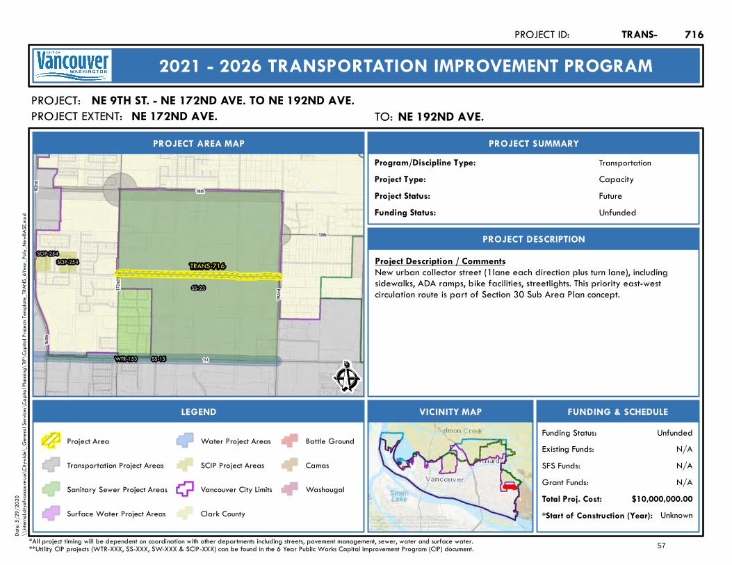
TRANS-716
WTR-153
SS-23
SS-15
SCIP-254SCIP-254
172nd
13th
1st
18th
164th
192nd
162nd
Ê
Future
PROJECT AREA MAP
PROJECT:
PROJECT SUMMARY
Project Status:
TransportationProgram/Discipline Type:CapacityProject Type:
PROJECT DESCRIPTION
FUNDING & SCHEDULEVICINITY MAPLEGEND
NE 9TH ST. - NE 172ND AVE. TO NE 192ND AVE.
Project Description / CommentsNew urban collector street (1lane each direction plus turn lane), includingsidewalks, ADA ramps, bike facilities, streetlights. This priority east-westcirculation route is part of Section 30 Sub Area Plan concept.
Unknown*Start of Construction (Year):
TRANS-PROJECT ID:
2021 - 2026 TRANSPORTATION IMPROVEMENT PROGRAM
PROJECT EXTENT:
$10,000,000.00Total Proj. Cost:N/AGrant Funds:N/ASFS Funds:N/AExisting Funds:
*All project timing will be dependent on coordination with other departments including streets, pavement management, sewer, water and surface water.**Utility CIP projects (WTR-XXX, SS-XXX, SW-XXX & SCIP-XXX) can be found in the 6 Year Public Works Capital Improvement Program (CIP) document.
UnfundedFunding Status:
UnfundedFunding Status:
Project Area
Transportation Project Areas
Sanitary Sewer Project Areas
Surface Water Project Areas
Water Project Areas
SCIP Project Areas
Vancouver City Limits
Clark County
Battle Ground
Camas
Washougal
716
Service Layer Credits: Sources: Esri, HERE, Garmin, Intermap,increment P Corp., GEBCO, USGS, FAO, NPS, NRCAN, GeoBase,IGN, Kadaster NL, Ordnance Survey, Esri Japan, METI, Esri China(Hong Kong), (c) OpenStreetMap contributors, and the GIS UserCommunity
Date:
5/29
/202
0\\
intern
al.city
ofvan
couve
r.us\C
itywi
de\_
Gene
ral Se
rvices
\Cap
ital P
lannin
g\TIP
\Cap
ital P
rojec
ts Tem
plate_
TRAN
S_6Y
ear_P
oly_N
ewBA
SE.m
xd
TO: NE 192nd Ave.NE 192ND AVE.NE 172ND AVE.
57
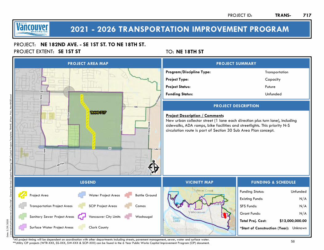
1st
18th
Lake
192nd
164th
Mill Plain
162nd
172nd
13th
Fribe
rg-Str
unk
Goodw
in
TRANS-717
Ê
Future
PROJECT AREA MAP
PROJECT:
PROJECT SUMMARY
Project Status:
TransportationProgram/Discipline Type:CapacityProject Type:
PROJECT DESCRIPTION
FUNDING & SCHEDULEVICINITY MAPLEGEND
NE 182ND AVE. - SE 1ST ST. TO NE 18TH ST.
Project Description / CommentsNew urban collector street (1 lane each direction plus turn lane), includingsidewalks, ADA ramps, bike facilities and streetlights. This priority N-Scirculation route is part of Section 30 Sub Area Plan concept.
Unknown*Start of Construction (Year):
TRANS-PROJECT ID:
2021 - 2026 TRANSPORTATION IMPROVEMENT PROGRAM
PROJECT EXTENT:
$12,000,000.00Total Proj. Cost:N/AGrant Funds:N/ASFS Funds:N/AExisting Funds:
*All project timing will be dependent on coordination with other departments including streets, pavement management, sewer, water and surface water.**Utility CIP projects (WTR-XXX, SS-XXX, SW-XXX & SCIP-XXX) can be found in the 6 Year Public Works Capital Improvement Program (CIP) document.
UnfundedFunding Status:
UnfundedFunding Status:
Project Area
Transportation Project Areas
Sanitary Sewer Project Areas
Surface Water Project Areas
Water Project Areas
SCIP Project Areas
Vancouver City Limits
Clark County
Battle Ground
Camas
Washougal
717
Service Layer Credits: Sources: Esri, HERE, Garmin, Intermap,increment P Corp., GEBCO, USGS, FAO, NPS, NRCAN, GeoBase,IGN, Kadaster NL, Ordnance Survey, Esri Japan, METI, Esri China(Hong Kong), (c) OpenStreetMap contributors, and the GIS UserCommunity
Date:
5/29
/202
0\\
intern
al.city
ofvan
couve
r.us\C
itywi
de\_
Gene
ral Se
rvices
\Cap
ital P
lannin
g\TIP
\Cap
ital P
rojec
ts Tem
plate_
TRAN
S_6Y
ear_P
oly_N
ewBA
SE.m
xd
TO: NE 18th StNE 18TH STSE 1ST ST
58
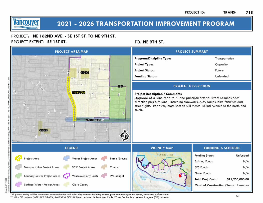
168th
177th
5th
167th
6th
166t h
Countrysi
de
150th
15 7t h
159th
155th
169th
13th
161st
175th
152nd
8th
171st
153rd
3rd
Blue Grass
1st
151st
7th
162nd
4 th
160th
12th
164th
9th
158th
173rd
170th
10th163
rd
2nd
149 th
14th
154th
11th
176th
156th
TRANS-718
WTR-153
SS-23
SS-15
SCIP-254
SCIP-254
172nd
1st
164t h
162nd
Ê
Future
PROJECT AREA MAP
PROJECT:
PROJECT SUMMARY
Project Status:
TransportationProgram/Discipline Type:CapacityProject Type:
PROJECT DESCRIPTION
FUNDING & SCHEDULEVICINITY MAPLEGEND
NE 162ND AVE. - SE 1ST ST. TO NE 9TH ST.
Project Description / CommentsUpgrade of 5-lane road to 7-lane principal arterial street (3 lanes eachdirection plus turn lane), including sidewalks, ADA ramps, bike facilities andstreetlights. Roadway cross section will match 162nd Avenue to the north andsouth.
Unknown*Start of Construction (Year):
TRANS-PROJECT ID:
2021 - 2026 TRANSPORTATION IMPROVEMENT PROGRAM
PROJECT EXTENT:
$11,250,000.00Total Proj. Cost:N/AGrant Funds:N/ASFS Funds:N/AExisting Funds:
*All project timing will be dependent on coordination with other departments including streets, pavement management, sewer, water and surface water.**Utility CIP projects (WTR-XXX, SS-XXX, SW-XXX & SCIP-XXX) can be found in the 6 Year Public Works Capital Improvement Program (CIP) document.
UnfundedFunding Status:
UnfundedFunding Status:
Project Area
Transportation Project Areas
Sanitary Sewer Project Areas
Surface Water Project Areas
Water Project Areas
SCIP Project Areas
Vancouver City Limits
Clark County
Battle Ground
Camas
Washougal
718
Service Layer Credits: Sources: Esri, HERE, Garmin, Intermap,increment P Corp., GEBCO, USGS, FAO, NPS, NRCAN, GeoBase,IGN, Kadaster NL, Ordnance Survey, Esri Japan, METI, Esri China(Hong Kong), (c) OpenStreetMap contributors, and the GIS UserCommunity
Date:
5/29
/202
0\\
intern
al.city
ofvan
couve
r.us\C
itywi
de\_
Gene
ral Se
rvices
\Cap
ital P
lannin
g\TIP
\Cap
ital P
rojec
ts Tem
plate_
TRAN
S_6Y
ear_P
oly_N
ewBA
SE.m
xd
TO: NE 9th St.NE 9TH ST.SE 1ST ST.
59
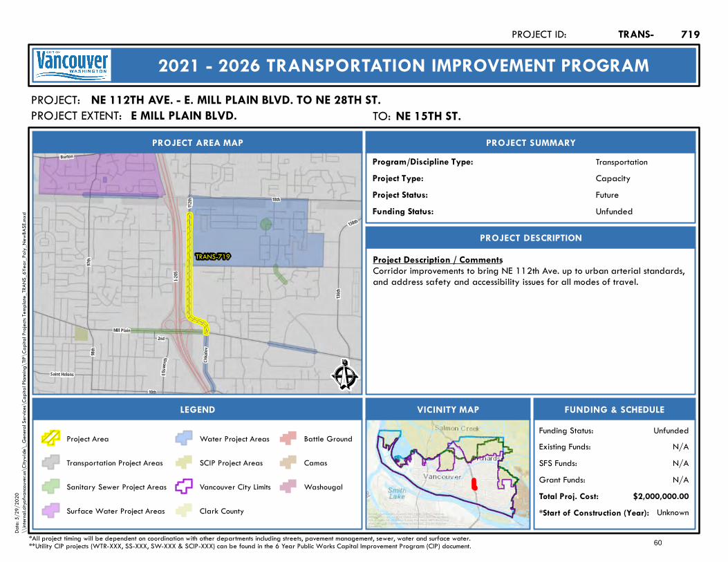
Burton
18th
Mill Plain136
th
112th
138th
I-205
Ellsw
orth
10th
98th
Saint Helens
97th
Chkal
ov
2nd
TRANS-719
Ê
Future
PROJECT AREA MAP
PROJECT:
PROJECT SUMMARY
Project Status:
TransportationProgram/Discipline Type:CapacityProject Type:
PROJECT DESCRIPTION
FUNDING & SCHEDULEVICINITY MAPLEGEND
NE 112TH AVE. - E. MILL PLAIN BLVD. TO NE 28TH ST.
Project Description / CommentsCorridor improvements to bring NE 112th Ave. up to urban arterial standards,and address safety and accessibility issues for all modes of travel.
Unknown*Start of Construction (Year):
TRANS-PROJECT ID:
2021 - 2026 TRANSPORTATION IMPROVEMENT PROGRAM
PROJECT EXTENT:
$2,000,000.00Total Proj. Cost:N/AGrant Funds:N/ASFS Funds:N/AExisting Funds:
*All project timing will be dependent on coordination with other departments including streets, pavement management, sewer, water and surface water.**Utility CIP projects (WTR-XXX, SS-XXX, SW-XXX & SCIP-XXX) can be found in the 6 Year Public Works Capital Improvement Program (CIP) document.
UnfundedFunding Status:
UnfundedFunding Status:
Project Area
Transportation Project Areas
Sanitary Sewer Project Areas
Surface Water Project Areas
Water Project Areas
SCIP Project Areas
Vancouver City Limits
Clark County
Battle Ground
Camas
Washougal
719
Service Layer Credits: Sources: Esri, HERE, Garmin, Intermap,increment P Corp., GEBCO, USGS, FAO, NPS, NRCAN, GeoBase,IGN, Kadaster NL, Ordnance Survey, Esri Japan, METI, Esri China(Hong Kong), (c) OpenStreetMap contributors, and the GIS UserCommunity
Date:
5/29
/202
0\\
intern
al.city
ofvan
couve
r.us\C
itywi
de\_
Gene
ral Se
rvices
\Cap
ital P
lannin
g\TIP
\Cap
ital P
rojec
ts Tem
plate_
TRAN
S_6Y
ear_P
oly_N
ewBA
SE.m
xd
TO: NE 15th St.NE 15TH ST.E MILL PLAIN BLVD.
60
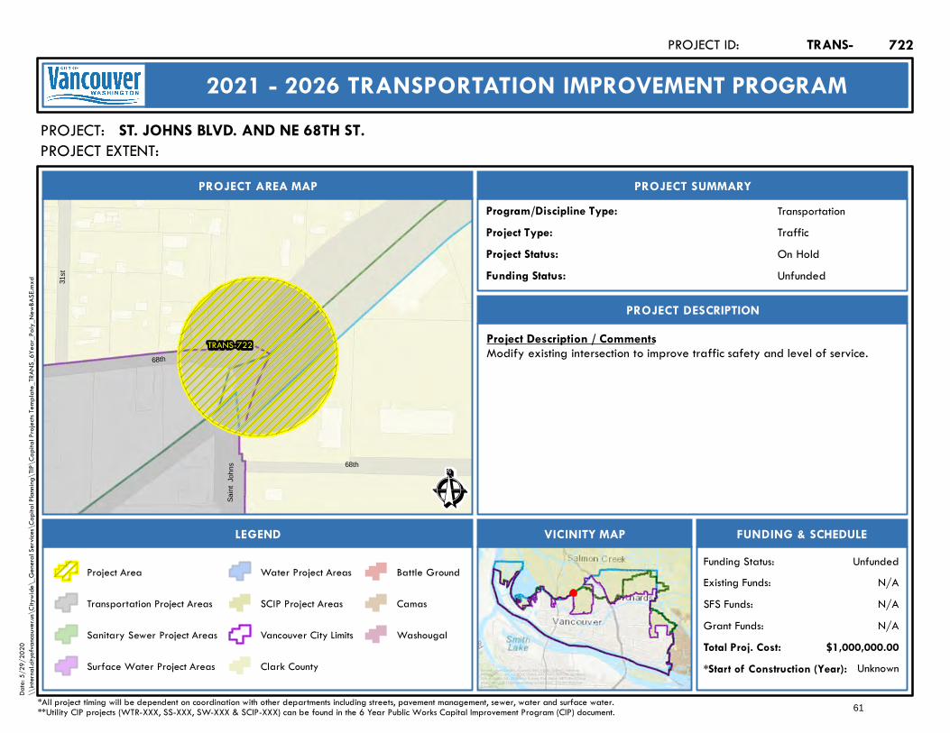
TRANS-722
31st
68th
Sain
t Jo
hns
68th
Ê
On Hold
PROJECT AREA MAP
PROJECT:
PROJECT SUMMARY
Project Status:
TransportationProgram/Discipline Type:TrafficProject Type:
PROJECT DESCRIPTION
FUNDING & SCHEDULEVICINITY MAPLEGEND
ST. JOHNS BLVD. AND NE 68TH ST.
Project Description / CommentsModify existing intersection to improve traffic safety and level of service.
Unknown*Start of Construction (Year):
TRANS-PROJECT ID:
2021 - 2026 TRANSPORTATION IMPROVEMENT PROGRAM
PROJECT EXTENT:
$1,000,000.00Total Proj. Cost:N/AGrant Funds:N/ASFS Funds:N/AExisting Funds:
*All project timing will be dependent on coordination with other departments including streets, pavement management, sewer, water and surface water.**Utility CIP projects (WTR-XXX, SS-XXX, SW-XXX & SCIP-XXX) can be found in the 6 Year Public Works Capital Improvement Program (CIP) document.
UnfundedFunding Status:
UnfundedFunding Status:
Project Area
Transportation Project Areas
Sanitary Sewer Project Areas
Surface Water Project Areas
Water Project Areas
SCIP Project Areas
Vancouver City Limits
Clark County
Battle Ground
Camas
Washougal
722
Service Layer Credits: Sources: Esri, HERE, Garmin, Intermap,increment P Corp., GEBCO, USGS, FAO, NPS, NRCAN, GeoBase,IGN, Kadaster NL, Ordnance Survey, Esri Japan, METI, Esri China(Hong Kong), (c) OpenStreetMap contributors, and the GIS UserCommunity
Date:
5/29
/202
0\\
intern
al.city
ofvan
couve
r.us\C
itywi
de\_
Gene
ral Se
rvices
\Cap
ital P
lannin
g\TIP
\Cap
ital P
rojec
ts Tem
plate_
TRAN
S_6Y
ear_P
oly_N
ewBA
SE.m
xd
61
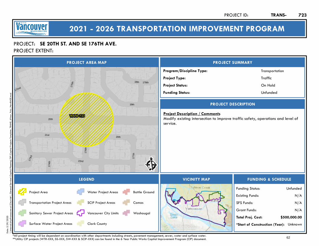
TRANS-723
178th
172nd 175t
h
177t
h176t
h
21st
173r
d
22nd
174t
h
19th
18th
20th
20th
Ê
On Hold
PROJECT AREA MAP
PROJECT:
PROJECT SUMMARY
Project Status:
TransportationProgram/Discipline Type:TrafficProject Type:
PROJECT DESCRIPTION
FUNDING & SCHEDULEVICINITY MAPLEGEND
SE 20TH ST. AND SE 176TH AVE.
Project Description / CommentsModify existing intersection to improve traffic safety, operations and level ofservice.
Unknown*Start of Construction (Year):
TRANS-PROJECT ID:
2021 - 2026 TRANSPORTATION IMPROVEMENT PROGRAM
PROJECT EXTENT:
$500,000.00Total Proj. Cost:N/AGrant Funds:N/ASFS Funds:N/AExisting Funds:
*All project timing will be dependent on coordination with other departments including streets, pavement management, sewer, water and surface water.**Utility CIP projects (WTR-XXX, SS-XXX, SW-XXX & SCIP-XXX) can be found in the 6 Year Public Works Capital Improvement Program (CIP) document.
UnfundedFunding Status:
UnfundedFunding Status:
Project Area
Transportation Project Areas
Sanitary Sewer Project Areas
Surface Water Project Areas
Water Project Areas
SCIP Project Areas
Vancouver City Limits
Clark County
Battle Ground
Camas
Washougal
723
Service Layer Credits: Sources: Esri, HERE, Garmin, Intermap,increment P Corp., GEBCO, USGS, FAO, NPS, NRCAN, GeoBase,IGN, Kadaster NL, Ordnance Survey, Esri Japan, METI, Esri China(Hong Kong), (c) OpenStreetMap contributors, and the GIS UserCommunity
Date:
5/29
/202
0\\
intern
al.city
ofvan
couve
r.us\C
itywi
de\_
Gene
ral Se
rvices
\Cap
ital P
lannin
g\TIP
\Cap
ital P
rojec
ts Tem
plate_
TRAN
S_6Y
ear_P
oly_N
ewBA
SE.m
xd
62
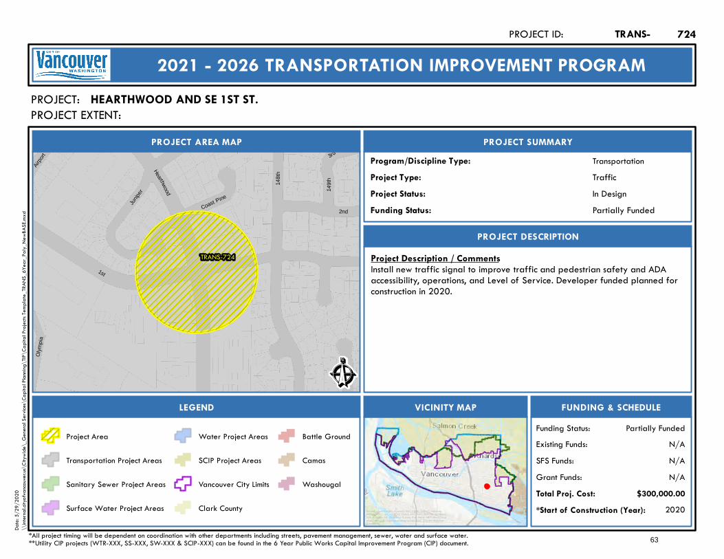
TRANS-724
3rd
Hearthwood
Airp
ort
Junip
er
2nd
1st14
8th
149t
h
Oly
mpi
a
Coast Pine
Ê
In Design
PROJECT AREA MAP
PROJECT:
PROJECT SUMMARY
Project Status:
TransportationProgram/Discipline Type:TrafficProject Type:
PROJECT DESCRIPTION
FUNDING & SCHEDULEVICINITY MAPLEGEND
HEARTHWOOD AND SE 1ST ST.
Project Description / CommentsInstall new traffic signal to improve traffic and pedestrian safety and ADAaccessibility, operations, and Level of Service. Developer funded planned forconstruction in 2020.
2020*Start of Construction (Year):
TRANS-PROJECT ID:
2021 - 2026 TRANSPORTATION IMPROVEMENT PROGRAM
PROJECT EXTENT:
$300,000.00Total Proj. Cost:N/AGrant Funds:N/ASFS Funds:N/AExisting Funds:
*All project timing will be dependent on coordination with other departments including streets, pavement management, sewer, water and surface water.**Utility CIP projects (WTR-XXX, SS-XXX, SW-XXX & SCIP-XXX) can be found in the 6 Year Public Works Capital Improvement Program (CIP) document.
Partially FundedFunding Status:
Partially FundedFunding Status:
Project Area
Transportation Project Areas
Sanitary Sewer Project Areas
Surface Water Project Areas
Water Project Areas
SCIP Project Areas
Vancouver City Limits
Clark County
Battle Ground
Camas
Washougal
724
Service Layer Credits: Sources: Esri, HERE, Garmin, Intermap,increment P Corp., GEBCO, USGS, FAO, NPS, NRCAN, GeoBase,IGN, Kadaster NL, Ordnance Survey, Esri Japan, METI, Esri China(Hong Kong), (c) OpenStreetMap contributors, and the GIS UserCommunity
Date:
5/29
/202
0\\
intern
al.city
ofvan
couve
r.us\C
itywi
de\_
Gene
ral Se
rvices
\Cap
ital P
lannin
g\TIP
\Cap
ital P
rojec
ts Tem
plate_
TRAN
S_6Y
ear_P
oly_N
ewBA
SE.m
xd
63
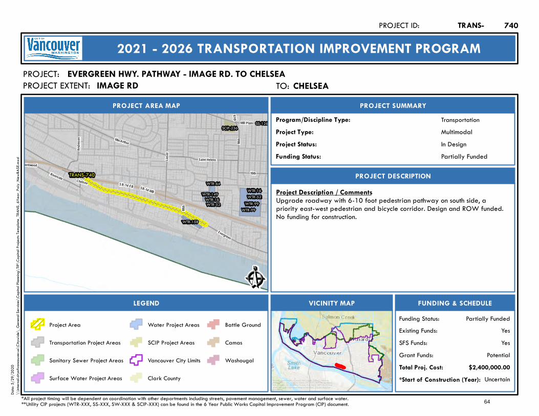
SR-14 EB SR-14 WB
TRANS-740
WTR-99WTR-99
WTR-16WTR-16
WTR-64
WTR-52WTR-52WTR-149
WTR-158
SS-126SCIP-236
97 th
Evergreen
Lieser
MacArthur
Shorewood10th
98th
Andre
sen
88th
Riverside
Saint Helens
Chelsea
Mill Plain
Ê
In Design
PROJECT AREA MAP
PROJECT:
PROJECT SUMMARY
Project Status:
TransportationProgram/Discipline Type:MultimodalProject Type:
PROJECT DESCRIPTION
FUNDING & SCHEDULEVICINITY MAPLEGEND
EVERGREEN HWY. PATHWAY - IMAGE RD. TO CHELSEA
Project Description / CommentsUpgrade roadway with 6-10 foot pedestrian pathway on south side, apriority east-west pedestrian and bicycle corridor. Design and ROW funded.No funding for construction.
Uncertain*Start of Construction (Year):
TRANS-PROJECT ID:
2021 - 2026 TRANSPORTATION IMPROVEMENT PROGRAM
PROJECT EXTENT:
$2,400,000.00Total Proj. Cost:PotentialGrant Funds:
YesSFS Funds:YesExisting Funds:
*All project timing will be dependent on coordination with other departments including streets, pavement management, sewer, water and surface water.**Utility CIP projects (WTR-XXX, SS-XXX, SW-XXX & SCIP-XXX) can be found in the 6 Year Public Works Capital Improvement Program (CIP) document.
Partially FundedFunding Status:
Partially FundedFunding Status:
Project Area
Transportation Project Areas
Sanitary Sewer Project Areas
Surface Water Project Areas
Water Project Areas
SCIP Project Areas
Vancouver City Limits
Clark County
Battle Ground
Camas
Washougal
740
Service Layer Credits: Sources: Esri, HERE, Garmin, Intermap,increment P Corp., GEBCO, USGS, FAO, NPS, NRCAN, GeoBase,IGN, Kadaster NL, Ordnance Survey, Esri Japan, METI, Esri China(Hong Kong), (c) OpenStreetMap contributors, and the GIS UserCommunity
Date:
5/29
/202
0\\
intern
al.city
ofvan
couve
r.us\C
itywi
de\_
Gene
ral Se
rvices
\Cap
ital P
lannin
g\TIP
\Cap
ital P
rojec
ts Tem
plate_
TRAN
S_6Y
ear_P
oly_N
ewBA
SE.m
xd
TO: ChelseaCHELSEAIMAGE RD
64

34th
Mill Plain
16 4th
I-205
SR-14 EB S R-14 WB
20th
Evergreen
McGillivray
136th
Ellsw
orth
10th
Village
15th
TRANS-741
Ê
In Design
PROJECT AREA MAP
PROJECT:
PROJECT SUMMARY
Project Status:
TransportationProgram/Discipline Type:MultimodalProject Type:
PROJECT DESCRIPTION
FUNDING & SCHEDULEVICINITY MAPLEGEND
EVERGREEN HWY. PATHWAY - COLUMBIA SPRINGS TO SE 164TH AVE.
Project Description / CommentsUpgrade roadway with 6-10 foot pedestrian pathway, a priority east-westpedestrian and bicycle corridor. Design partially funded by citizen efforts.
Uncertain*Start of Construction (Year):
TRANS-PROJECT ID:
2021 - 2026 TRANSPORTATION IMPROVEMENT PROGRAM
PROJECT EXTENT:
$5,100,000.00Total Proj. Cost:PotentialGrant Funds:
NoSFS Funds:YesExisting Funds:
*All project timing will be dependent on coordination with other departments including streets, pavement management, sewer, water and surface water.**Utility CIP projects (WTR-XXX, SS-XXX, SW-XXX & SCIP-XXX) can be found in the 6 Year Public Works Capital Improvement Program (CIP) document.
Partially FundedFunding Status:
Partially FundedFunding Status:
Project Area
Transportation Project Areas
Sanitary Sewer Project Areas
Surface Water Project Areas
Water Project Areas
SCIP Project Areas
Vancouver City Limits
Clark County
Battle Ground
Camas
Washougal
741
Service Layer Credits: Sources: Esri, HERE, Garmin, Intermap,increment P Corp., GEBCO, USGS, FAO, NPS, NRCAN, GeoBase,IGN, Kadaster NL, Ordnance Survey, Esri Japan, METI, Esri China(Hong Kong), (c) OpenStreetMap contributors, and the GIS UserCommunity
Date:
5/29
/202
0\\
intern
al.city
ofvan
couve
r.us\C
itywi
de\_
Gene
ral Se
rvices
\Cap
ital P
lannin
g\TIP
\Cap
ital P
rojec
ts Tem
plate_
TRAN
S_6Y
ear_P
oly_N
ewBA
SE.m
xd
TO: SE 164th Ave.SE 164TH AVE.SE SILVER SPRINGS DR.
65

192nd
164th
34th
SR-14 WB
SR-14 EB
Lewis and Clark
McGillivray
McInt osh
Brady
Evergreen
6th
Pacific Rim
TRANS-742
Ê
Future
PROJECT AREA MAP
PROJECT:
PROJECT SUMMARY
Project Status:
TransportationProgram/Discipline Type:MultimodalProject Type:
PROJECT DESCRIPTION
FUNDING & SCHEDULEVICINITY MAPLEGEND
EVERGREEN HWY. PATHWAY - SE 164TH AVE. TO EAST CITY LIMITS
Project Description / CommentsUpgrade roadway with 6-10 foot pedestrian pathway on south side, apriority east-west pedestrian and bicycle corridor.
Unknown*Start of Construction (Year):
TRANS-PROJECT ID:
2021 - 2026 TRANSPORTATION IMPROVEMENT PROGRAM
PROJECT EXTENT:
$7,000,000.00Total Proj. Cost:N/AGrant Funds:N/ASFS Funds:N/AExisting Funds:
*All project timing will be dependent on coordination with other departments including streets, pavement management, sewer, water and surface water.**Utility CIP projects (WTR-XXX, SS-XXX, SW-XXX & SCIP-XXX) can be found in the 6 Year Public Works Capital Improvement Program (CIP) document.
UnfundedFunding Status:
UnfundedFunding Status:
Project Area
Transportation Project Areas
Sanitary Sewer Project Areas
Surface Water Project Areas
Water Project Areas
SCIP Project Areas
Vancouver City Limits
Clark County
Battle Ground
Camas
Washougal
742
Service Layer Credits: Sources: Esri, HERE, Garmin, Intermap,increment P Corp., GEBCO, USGS, FAO, NPS, NRCAN, GeoBase,IGN, Kadaster NL, Ordnance Survey, Esri Japan, METI, Esri China(Hong Kong), (c) OpenStreetMap contributors, and the GIS UserCommunity
Date:
5/29
/202
0\\
intern
al.city
ofvan
couve
r.us\C
itywi
de\_
Gene
ral Se
rvices
\Cap
ital P
lannin
g\TIP
\Cap
ital P
rojec
ts Tem
plate_
TRAN
S_6Y
ear_P
oly_N
ewBA
SE.m
xd
TO: East City LimitsEAST CITY LIMITSSE 164TH AVE.
66
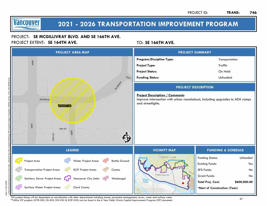
164t
h16
4th
McGillivray
McGilli
vray
TRANS-746
165t
h (P
)
24th (P)
22nd
166th
Ê
On Hold
PROJECT AREA MAP
PROJECT:
PROJECT SUMMARY
Project Status:
TransportationProgram/Discipline Type:TrafficProject Type:
PROJECT DESCRIPTION
FUNDING & SCHEDULEVICINITY MAPLEGEND
SE MCGILLIVRAY BLVD. AND SE 166TH AVE.
Project Description / CommentsImprove intersection with urban roundabout, including upgrades to ADA rampsand streetlights.
*Start of Construction (Year):
TRANS-PROJECT ID:
2021 - 2026 TRANSPORTATION IMPROVEMENT PROGRAM
PROJECT EXTENT:
$600,000.00Total Proj. Cost:NoGrant Funds:NoSFS Funds:YesExisting Funds:
*All project timing will be dependent on coordination with other departments including streets, pavement management, sewer, water and surface water.**Utility CIP projects (WTR-XXX, SS-XXX, SW-XXX & SCIP-XXX) can be found in the 6 Year Public Works Capital Improvement Program (CIP) document.
UnfundedFunding Status:
UnfundedFunding Status:
Project Area
Transportation Project Areas
Sanitary Sewer Project Areas
Surface Water Project Areas
Water Project Areas
SCIP Project Areas
Vancouver City Limits
Clark County
Battle Ground
Camas
Washougal
746
Service Layer Credits: Sources: Esri, HERE, Garmin, Intermap,increment P Corp., GEBCO, USGS, FAO, NPS, NRCAN, GeoBase,IGN, Kadaster NL, Ordnance Survey, Esri Japan, METI, Esri China(Hong Kong), (c) OpenStreetMap contributors, and the GIS UserCommunity
Date:
5/29
/202
0\\
intern
al.city
ofvan
couve
r.us\C
itywi
de\_
Gene
ral Se
rvices
\Cap
ital P
lannin
g\TIP
\Cap
ital P
rojec
ts Tem
plate_
TRAN
S_6Y
ear_P
oly_N
ewBA
SE.m
xd
TO: SE 166th Ave.SE 166TH AVE.SE 164TH AVE.
67
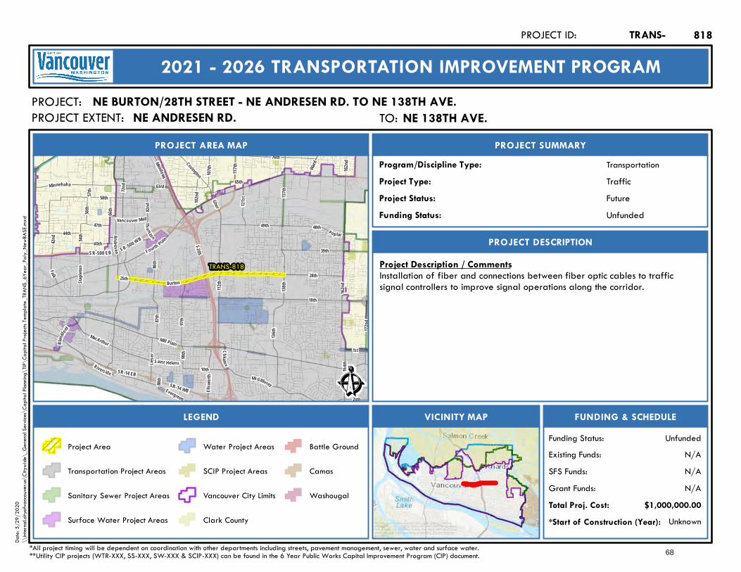
63rd
Fourth Plain
137th
Gher
138th
Mill Plain
49th
28th
18th
76th
Minnehaha
136th
112th
16 4th
Covington
48th
Burton
Andre se n
Ward
Pop lar
162nd
25th
1st
I-205
117th
SR-500 EB SR-500 WB
162nd
SR-14 EBSR-14 WB
58th
MacArthur
172nd
Thu rston
72nd
102nd
39th
10th
66th
98th
40th121
st
Lieser
44th
54th
57th
Evergreen
86th
88th
87th
Riverside
42nd
McGillivray
Falk
56th
Saint Helens
47thVancouver Mall
Ellsw
orth
82nd
20th
Staple
ton
Blandf
ord
65th
107th
97th
Chkal ov
15th
Meadows
TRANS-818
Ê
Future
PROJECT AREA MAP
PROJECT:
PROJECT SUMMARY
Project Status:
TransportationProgram/Discipline Type:TrafficProject Type:
PROJECT DESCRIPTION
FUNDING & SCHEDULEVICINITY MAPLEGEND
NE BURTON/28TH STREET - NE ANDRESEN RD. TO NE 138TH AVE.
Project Description / CommentsInstallation of fiber and connections between fiber optic cables to trafficsignal controllers to improve signal operations along the corridor.
Unknown*Start of Construction (Year):
TRANS-PROJECT ID:
2021 - 2026 TRANSPORTATION IMPROVEMENT PROGRAM
PROJECT EXTENT:
$1,000,000.00Total Proj. Cost:N/AGrant Funds:N/ASFS Funds:N/AExisting Funds:
*All project timing will be dependent on coordination with other departments including streets, pavement management, sewer, water and surface water.**Utility CIP projects (WTR-XXX, SS-XXX, SW-XXX & SCIP-XXX) can be found in the 6 Year Public Works Capital Improvement Program (CIP) document.
UnfundedFunding Status:
UnfundedFunding Status:
Project Area
Transportation Project Areas
Sanitary Sewer Project Areas
Surface Water Project Areas
Water Project Areas
SCIP Project Areas
Vancouver City Limits
Clark County
Battle Ground
Camas
Washougal
818
Service Layer Credits: Sources: Esri, HERE, Garmin, Intermap,increment P Corp., GEBCO, USGS, FAO, NPS, NRCAN, GeoBase,IGN, Kadaster NL, Ordnance Survey, Esri Japan, METI, Esri China(Hong Kong), (c) OpenStreetMap contributors, and the GIS UserCommunity
Date:
5/29
/202
0\\
intern
al.city
ofvan
couve
r.us\C
itywi
de\_
Gene
ral Se
rvices
\Cap
ital P
lannin
g\TIP
\Cap
ital P
rojec
ts Tem
plate_
TRAN
S_6Y
ear_P
oly_N
ewBA
SE.m
xd
TO: NE 138th Ave.NE 138TH AVE.NE ANDRESEN RD.
68
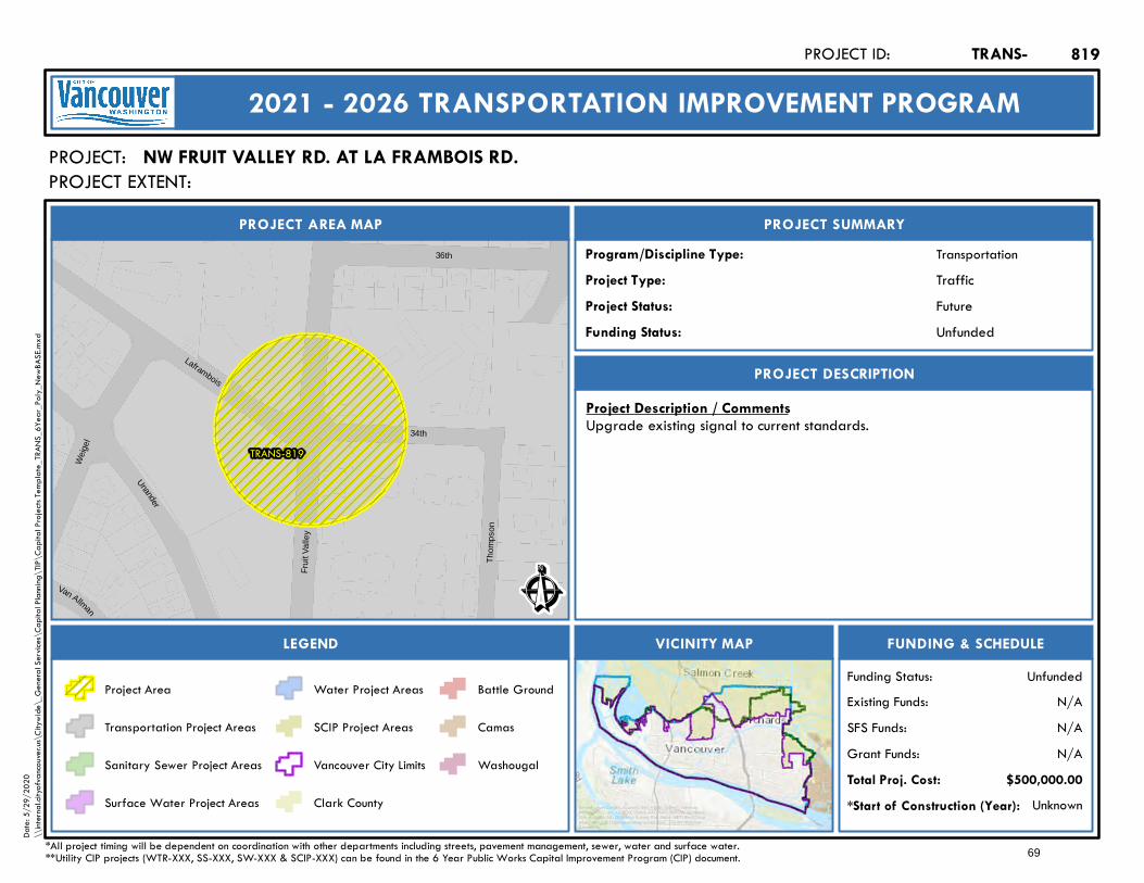
TRANS-819
Unander
Van Allman
34th
Thom
pson
Wei
gel
Laframbois
36th
Frui
t Val
ley
Ê
Future
PROJECT AREA MAP
PROJECT:
PROJECT SUMMARY
Project Status:
TransportationProgram/Discipline Type:TrafficProject Type:
PROJECT DESCRIPTION
FUNDING & SCHEDULEVICINITY MAPLEGEND
NW FRUIT VALLEY RD. AT LA FRAMBOIS RD.
Project Description / CommentsUpgrade existing signal to current standards.
Unknown*Start of Construction (Year):
TRANS-PROJECT ID:
2021 - 2026 TRANSPORTATION IMPROVEMENT PROGRAM
PROJECT EXTENT:
$500,000.00Total Proj. Cost:N/AGrant Funds:N/ASFS Funds:N/AExisting Funds:
*All project timing will be dependent on coordination with other departments including streets, pavement management, sewer, water and surface water.**Utility CIP projects (WTR-XXX, SS-XXX, SW-XXX & SCIP-XXX) can be found in the 6 Year Public Works Capital Improvement Program (CIP) document.
UnfundedFunding Status:
UnfundedFunding Status:
Project Area
Transportation Project Areas
Sanitary Sewer Project Areas
Surface Water Project Areas
Water Project Areas
SCIP Project Areas
Vancouver City Limits
Clark County
Battle Ground
Camas
Washougal
819
Service Layer Credits: Sources: Esri, HERE, Garmin, Intermap,increment P Corp., GEBCO, USGS, FAO, NPS, NRCAN, GeoBase,IGN, Kadaster NL, Ordnance Survey, Esri Japan, METI, Esri China(Hong Kong), (c) OpenStreetMap contributors, and the GIS UserCommunity
Date:
5/29
/202
0\\
intern
al.city
ofvan
couve
r.us\C
itywi
de\_
Gene
ral Se
rvices
\Cap
ital P
lannin
g\TIP
\Cap
ital P
rojec
ts Tem
plate_
TRAN
S_6Y
ear_P
oly_N
ewBA
SE.m
xd
69

I-5
TRANS-825
WTR-49
WTR-159
SW-46
SCIP-251
SCIP-251
SCIP-25140t
h
15th
56th
44th
49th
Ross54th
42nd
17th
63rd
Hazel Dell
Sa int Jo hnsSaint
J ame
s
Minnehaha
Main
Highw
ay 99
Ê
Future
PROJECT AREA MAP
PROJECT:
PROJECT SUMMARY
Project Status:
TransportationProgram/Discipline Type:CapacityProject Type:
PROJECT DESCRIPTION
FUNDING & SCHEDULEVICINITY MAPLEGEND
NE 54TH STREET - NE 15TH AVE. TO NE SAINT JAMES RD.
Project Description / CommentsUpgrade of existing 2-lane road to an urban arterial (1 lane each directionplus turn lane), including sidewalks, ADA ramps, bike facilities and streetlightsto improve safety, mobility, accessiblity and level of service. New signal to beadded at NE 54th St. and St John's Blvd.
Unknown*Start of Construction (Year):
TRANS-PROJECT ID:
2021 - 2026 TRANSPORTATION IMPROVEMENT PROGRAM
PROJECT EXTENT:
$14,000,000.00Total Proj. Cost:N/AGrant Funds:N/ASFS Funds:N/AExisting Funds:
*All project timing will be dependent on coordination with other departments including streets, pavement management, sewer, water and surface water.**Utility CIP projects (WTR-XXX, SS-XXX, SW-XXX & SCIP-XXX) can be found in the 6 Year Public Works Capital Improvement Program (CIP) document.
UnfundedFunding Status:
UnfundedFunding Status:
Project Area
Transportation Project Areas
Sanitary Sewer Project Areas
Surface Water Project Areas
Water Project Areas
SCIP Project Areas
Vancouver City Limits
Clark County
Battle Ground
Camas
Washougal
825
Service Layer Credits: Sources: Esri, HERE, Garmin, Intermap,increment P Corp., GEBCO, USGS, FAO, NPS, NRCAN, GeoBase,IGN, Kadaster NL, Ordnance Survey, Esri Japan, METI, Esri China(Hong Kong), (c) OpenStreetMap contributors, and the GIS UserCommunity
Date:
5/29
/202
0\\
intern
al.city
ofvan
couve
r.us\C
itywi
de\_
Gene
ral Se
rvices
\Cap
ital P
lannin
g\TIP
\Cap
ital P
rojec
ts Tem
plate_
TRAN
S_6Y
ear_P
oly_N
ewBA
SE.m
xd
TO: NE Saint James Rd.NE SAINT JAMES RD.NE 15TH AVE.
70
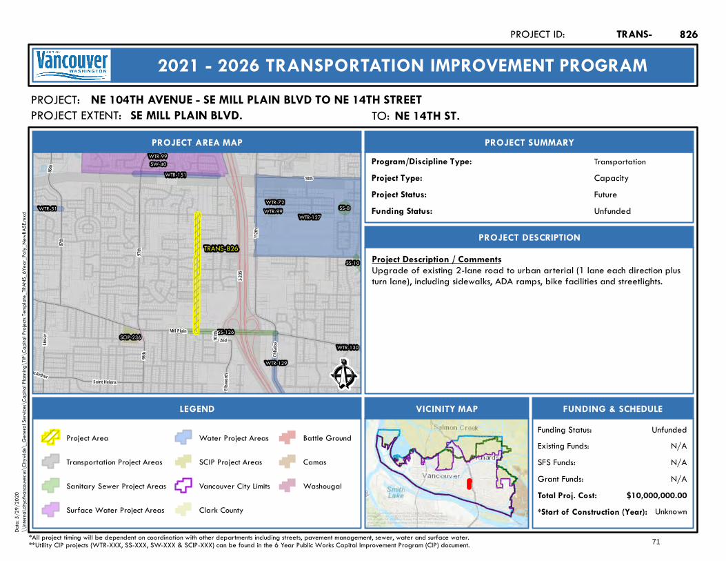
I-205
TRANS-826
WTR-127
WTR-99
WTR-99
WTR-129
WTR-130
WTR-51WTR-72
WTR-151SW-40
SS-10
SS-126
SS-8
SCIP-236
MacArthur
86th
Lieser
98th
87th
Saint Helens
Chkal
ov
107th
97th
2nd
Ellsw
orth
18th
Mill Plain
112th
Ê
Future
PROJECT AREA MAP
PROJECT:
PROJECT SUMMARY
Project Status:
TransportationProgram/Discipline Type:CapacityProject Type:
PROJECT DESCRIPTION
FUNDING & SCHEDULEVICINITY MAPLEGEND
NE 104TH AVENUE - SE MILL PLAIN BLVD TO NE 14TH STREET
Project Description / CommentsUpgrade of existing 2-lane road to urban arterial (1 lane each direction plusturn lane), including sidewalks, ADA ramps, bike facilities and streetlights.
Unknown*Start of Construction (Year):
TRANS-PROJECT ID:
2021 - 2026 TRANSPORTATION IMPROVEMENT PROGRAM
PROJECT EXTENT:
$10,000,000.00Total Proj. Cost:N/AGrant Funds:N/ASFS Funds:N/AExisting Funds:
*All project timing will be dependent on coordination with other departments including streets, pavement management, sewer, water and surface water.**Utility CIP projects (WTR-XXX, SS-XXX, SW-XXX & SCIP-XXX) can be found in the 6 Year Public Works Capital Improvement Program (CIP) document.
UnfundedFunding Status:
UnfundedFunding Status:
Project Area
Transportation Project Areas
Sanitary Sewer Project Areas
Surface Water Project Areas
Water Project Areas
SCIP Project Areas
Vancouver City Limits
Clark County
Battle Ground
Camas
Washougal
826
Service Layer Credits: Sources: Esri, HERE, Garmin, Intermap,increment P Corp., GEBCO, USGS, FAO, NPS, NRCAN, GeoBase,IGN, Kadaster NL, Ordnance Survey, Esri Japan, METI, Esri China(Hong Kong), (c) OpenStreetMap contributors, and the GIS UserCommunity
Date:
5/29
/202
0\\
intern
al.city
ofvan
couve
r.us\C
itywi
de\_
Gene
ral Se
rvices
\Cap
ital P
lannin
g\TIP
\Cap
ital P
rojec
ts Tem
plate_
TRAN
S_6Y
ear_P
oly_N
ewBA
SE.m
xd
TO: NE 14th St.NE 14TH ST.SE MILL PLAIN BLVD.
71
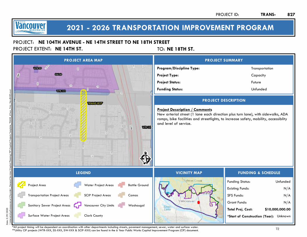
I-205
110th
Cranbrook
111th
14th
15th
18th
98th
102nd
20th 19th
17th
105th
100th
104th
99th
103rd
101st
109th
107th
16th
12th
108th
21st
TRANS-827
WTR-127
WTR-99
WTR-151
SW-4098th
97th
18th
112th
Ê
Future
PROJECT AREA MAP
PROJECT:
PROJECT SUMMARY
Project Status:
TransportationProgram/Discipline Type:CapacityProject Type:
PROJECT DESCRIPTION
FUNDING & SCHEDULEVICINITY MAPLEGEND
NE 104TH AVENUE - NE 14TH STREET TO NE 18TH STREET
Project Description / CommentsNew arterial street (1 lane each direction plus turn lane), with sidewalks, ADAramps, bike facilities and streetlights, to increase safety, mobility, accessiblityand level of service.
Unknown*Start of Construction (Year):
TRANS-PROJECT ID:
2021 - 2026 TRANSPORTATION IMPROVEMENT PROGRAM
PROJECT EXTENT:
$10,000,000.00Total Proj. Cost:N/AGrant Funds:N/ASFS Funds:N/AExisting Funds:
*All project timing will be dependent on coordination with other departments including streets, pavement management, sewer, water and surface water.**Utility CIP projects (WTR-XXX, SS-XXX, SW-XXX & SCIP-XXX) can be found in the 6 Year Public Works Capital Improvement Program (CIP) document.
UnfundedFunding Status:
UnfundedFunding Status:
Project Area
Transportation Project Areas
Sanitary Sewer Project Areas
Surface Water Project Areas
Water Project Areas
SCIP Project Areas
Vancouver City Limits
Clark County
Battle Ground
Camas
Washougal
827
Service Layer Credits: Sources: Esri, HERE, Garmin, Intermap,increment P Corp., GEBCO, USGS, FAO, NPS, NRCAN, GeoBase,IGN, Kadaster NL, Ordnance Survey, Esri Japan, METI, Esri China(Hong Kong), (c) OpenStreetMap contributors, and the GIS UserCommunity
Date:
5/29
/202
0\\
intern
al.city
ofvan
couve
r.us\C
itywi
de\_
Gene
ral Se
rvices
\Cap
ital P
lannin
g\TIP
\Cap
ital P
rojec
ts Tem
plate_
TRAN
S_6Y
ear_P
oly_N
ewBA
SE.m
xd
TO: NE 18th St.NE 18TH ST.NE 14TH ST.
72
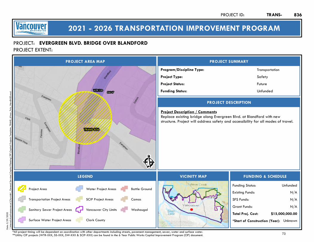
Evergreen
Evergreen
Blan
dfor
d
Blan
dford
TRANS-836
WTR-120 SW-47
8th
Clark
Dubo
is
Farv
iew
Wauna Vista
Evergreen
Ê
Future
PROJECT AREA MAP
PROJECT:
PROJECT SUMMARY
Project Status:
TransportationProgram/Discipline Type:SafetyProject Type:
PROJECT DESCRIPTION
FUNDING & SCHEDULEVICINITY MAPLEGEND
EVERGREEN BLVD. BRIDGE OVER BLANDFORD
Project Description / CommentsReplace existing bridge along Evergreen Blvd. at Blandford with newstructure. Project will address safety and accessibility for all modes of travel.
Unknown*Start of Construction (Year):
TRANS-PROJECT ID:
2021 - 2026 TRANSPORTATION IMPROVEMENT PROGRAM
PROJECT EXTENT:
$15,000,000.00Total Proj. Cost:N/AGrant Funds:N/ASFS Funds:N/AExisting Funds:
*All project timing will be dependent on coordination with other departments including streets, pavement management, sewer, water and surface water.**Utility CIP projects (WTR-XXX, SS-XXX, SW-XXX & SCIP-XXX) can be found in the 6 Year Public Works Capital Improvement Program (CIP) document.
UnfundedFunding Status:
UnfundedFunding Status:
Project Area
Transportation Project Areas
Sanitary Sewer Project Areas
Surface Water Project Areas
Water Project Areas
SCIP Project Areas
Vancouver City Limits
Clark County
Battle Ground
Camas
Washougal
836
Service Layer Credits: Sources: Esri, HERE, Garmin, Intermap,increment P Corp., GEBCO, USGS, FAO, NPS, NRCAN, GeoBase,IGN, Kadaster NL, Ordnance Survey, Esri Japan, METI, Esri China(Hong Kong), (c) OpenStreetMap contributors, and the GIS UserCommunity
Date:
5/29
/202
0\\
intern
al.city
ofvan
couve
r.us\C
itywi
de\_
Gene
ral Se
rvices
\Cap
ital P
lannin
g\TIP
\Cap
ital P
rojec
ts Tem
plate_
TRAN
S_6Y
ear_P
oly_N
ewBA
SE.m
xd
73
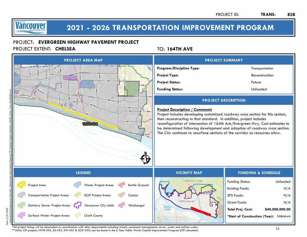
1st138
th
28th
18th
Grand
Lake136
th
F ourth Plain
112th
164th
Burton
Mill Plain
192nd
162nd
25th
34th
I-205
SR-14 WB
SR-500 EBSR-500 WB
SR-14 EB
MacArthur
172nd
Evergreen
McGilliv ray
39th
Bra dy
10th
98th
13th
38th
Lieser
33rd
20th
Good
win
Paci fic Rim
86th
And re
se n
88th
87th
15th
Falk
Bybee
C olumbia Hous e
Ellsw
o rth
6th
Staple
ton
Ingle
B landf
ord 97th
TRANS-838
Ê
Future
PROJECT AREA MAP
PROJECT:
PROJECT SUMMARY
Project Status:
TransportationProgram/Discipline Type:ReconstructionProject Type:
PROJECT DESCRIPTION
FUNDING & SCHEDULEVICINITY MAPLEGEND
EVERGREEN HIGHWAY PAVEMENT PROJECT
Project Description / CommentsProject includes developing customized roadway cross section for this section,then reconstructing to that standard. In addition, project includesreconfiguration of intersection of 164th Ave/Evergreen Hwy. Cost estimates tobe determined following development and adoption of roadway cross section.The City continues to resurface sections of the corridor as resources allow.
Unknown*Start of Construction (Year):
TRANS-PROJECT ID:
2021 - 2026 TRANSPORTATION IMPROVEMENT PROGRAM
PROJECT EXTENT:
$40,000,000.00Total Proj. Cost:N/AGrant Funds:N/ASFS Funds:N/AExisting Funds:
*All project timing will be dependent on coordination with other departments including streets, pavement management, sewer, water and surface water.**Utility CIP projects (WTR-XXX, SS-XXX, SW-XXX & SCIP-XXX) can be found in the 6 Year Public Works Capital Improvement Program (CIP) document.
UnfundedFunding Status:
UnfundedFunding Status:
Project Area
Transportation Project Areas
Sanitary Sewer Project Areas
Surface Water Project Areas
Water Project Areas
SCIP Project Areas
Vancouver City Limits
Clark County
Battle Ground
Camas
Washougal
838
Service Layer Credits: Sources: Esri, HERE, Garmin, Intermap,increment P Corp., GEBCO, USGS, FAO, NPS, NRCAN, GeoBase,IGN, Kadaster NL, Ordnance Survey, Esri Japan, METI, Esri China(Hong Kong), (c) OpenStreetMap contributors, and the GIS UserCommunity
Date:
5/29
/202
0\\
intern
al.city
ofvan
couve
r.us\C
itywi
de\_
Gene
ral Se
rvices
\Cap
ital P
lannin
g\TIP
\Cap
ital P
rojec
ts Tem
plate_
TRAN
S_6Y
ear_P
oly_N
ewBA
SE.m
xd
TO: 164th Ave164TH AVECHELSEA
74
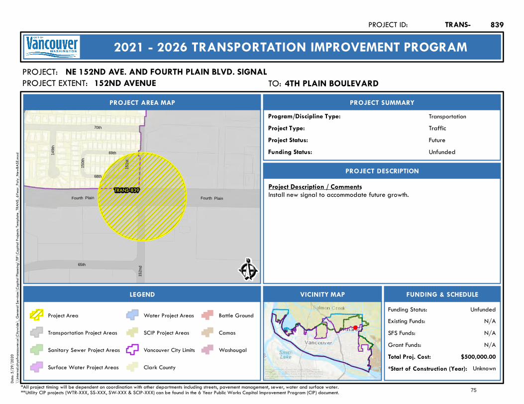
War
d
Fourth Plain Fourth Plain
TRANS-839
69th
152n
d
150t
h
151s
t70th
68th
149t
h
65th Ê
Future
PROJECT AREA MAP
PROJECT:
PROJECT SUMMARY
Project Status:
TransportationProgram/Discipline Type:TrafficProject Type:
PROJECT DESCRIPTION
FUNDING & SCHEDULEVICINITY MAPLEGEND
NE 152ND AVE. AND FOURTH PLAIN BLVD. SIGNAL
Project Description / CommentsInstall new signal to accommodate future growth.
Unknown*Start of Construction (Year):
TRANS-PROJECT ID:
2021 - 2026 TRANSPORTATION IMPROVEMENT PROGRAM
PROJECT EXTENT:
$500,000.00Total Proj. Cost:N/AGrant Funds:N/ASFS Funds:N/AExisting Funds:
*All project timing will be dependent on coordination with other departments including streets, pavement management, sewer, water and surface water.**Utility CIP projects (WTR-XXX, SS-XXX, SW-XXX & SCIP-XXX) can be found in the 6 Year Public Works Capital Improvement Program (CIP) document.
UnfundedFunding Status:
UnfundedFunding Status:
Project Area
Transportation Project Areas
Sanitary Sewer Project Areas
Surface Water Project Areas
Water Project Areas
SCIP Project Areas
Vancouver City Limits
Clark County
Battle Ground
Camas
Washougal
839
Service Layer Credits: Sources: Esri, HERE, Garmin, Intermap,increment P Corp., GEBCO, USGS, FAO, NPS, NRCAN, GeoBase,IGN, Kadaster NL, Ordnance Survey, Esri Japan, METI, Esri China(Hong Kong), (c) OpenStreetMap contributors, and the GIS UserCommunity
Date:
5/29
/202
0\\
intern
al.city
ofvan
couve
r.us\C
itywi
de\_
Gene
ral Se
rvices
\Cap
ital P
lannin
g\TIP
\Cap
ital P
rojec
ts Tem
plate_
TRAN
S_6Y
ear_P
oly_N
ewBA
SE.m
xd
TO: 4th Plain Boulevard4TH PLAIN BOULEVARD152ND AVENUE
75
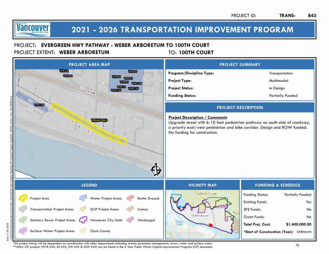
SR-14 EB SR-14 WB
15th
104th
French
100th
88th
103rd
101st
102nd
16th
97th
18th
Hillcrest
Porter
21st
98th
Image
94th
99th
91st
90th
96th
Burlington
95th
92nd
TRANS-843
WTR-99
WTR-99
WTR-16
WTR-16
WTR-64 WTR-64 WTR-52WTR-149
WTR-155WTR-156
WTR-158
Evergreen
88th
Ê
In Design
PROJECT AREA MAP
PROJECT:
PROJECT SUMMARY
Project Status:
TransportationProgram/Discipline Type:MultimodalProject Type:
PROJECT DESCRIPTION
FUNDING & SCHEDULEVICINITY MAPLEGEND
EVERGREEN HWY PATHWAY - WEBER ARBORETUM TO 100TH COURT
Project Description / CommentsUpgrade street with 6-10 foot pedestrian pathway on south side of roadway,a priority east/west pedestrian and bike corridor. Design and ROW funded.No funding for construction.
Unknown*Start of Construction (Year):
TRANS-PROJECT ID:
2021 - 2026 TRANSPORTATION IMPROVEMENT PROGRAM
PROJECT EXTENT:
$1,400,000.00Total Proj. Cost:NoGrant Funds:NoSFS Funds:YesExisting Funds:
*All project timing will be dependent on coordination with other departments including streets, pavement management, sewer, water and surface water.**Utility CIP projects (WTR-XXX, SS-XXX, SW-XXX & SCIP-XXX) can be found in the 6 Year Public Works Capital Improvement Program (CIP) document.
Partially FundedFunding Status:
Partially FundedFunding Status:
Project Area
Transportation Project Areas
Sanitary Sewer Project Areas
Surface Water Project Areas
Water Project Areas
SCIP Project Areas
Vancouver City Limits
Clark County
Battle Ground
Camas
Washougal
843
Service Layer Credits: Sources: Esri, HERE, Garmin, Intermap,increment P Corp., GEBCO, USGS, FAO, NPS, NRCAN, GeoBase,IGN, Kadaster NL, Ordnance Survey, Esri Japan, METI, Esri China(Hong Kong), (c) OpenStreetMap contributors, and the GIS UserCommunity
Date:
5/29
/202
0\\
intern
al.city
ofvan
couve
r.us\C
itywi
de\_
Gene
ral Se
rvices
\Cap
ital P
lannin
g\TIP
\Cap
ital P
rojec
ts Tem
plate_
TRAN
S_6Y
ear_P
oly_N
ewBA
SE.m
xd
TO: 100th Court100TH COURTWEBER ARBORETUM
76
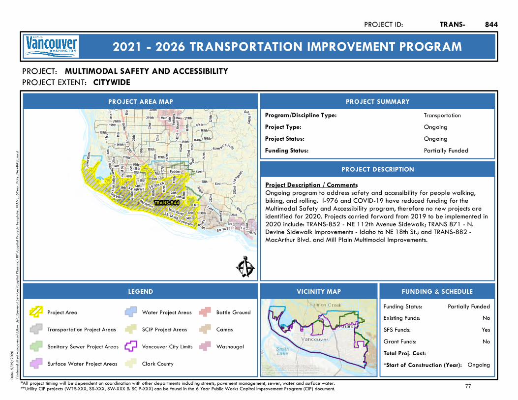
199th
Lake shore
63rdHazel
D ell
41 st
167th
179th
W ard
164th
Blair
182nd
Risto
1st
78th
3rd
137th
99th
E
28th
72nd
76th
18thGran
d
36th
117th
Main
172nd
Fr ui t V
alley
112th
31st
159th
21st
10th
Lake
189th
162nd
219th
34th
I- 2 05I-5
SR-14 WB
117th
SR-14
58th
M ill Plain
Padden
SR-50 0 EB
Main
Everett
SR - 500 WB
Lowe
r Rive
r
219th
SR-14 EB
10th
212th
58th
M acArthur
Li vin gsto
n
Evergreen
88th
McGi lliv ray
87th 119th
B ra d y
2 09th
C
50th
23rd
Parkw
ay
20th
169th
6th
L1 400
Grace
142nd
83rd
44th
139th
11th
39th
86th
149th
68th
227th
Raws on
239th
32nd
25th
292nd
94th
38th
29th
152nd
53rd
107th
D oleValley
232nd
I ngle
92nd
Delfel
TRANS-844
Ê
Ongoing
PROJECT AREA MAP
PROJECT:
PROJECT SUMMARY
Project Status:
TransportationProgram/Discipline Type:OngoingProject Type:
PROJECT DESCRIPTION
FUNDING & SCHEDULEVICINITY MAPLEGEND
MULTIMODAL SAFETY AND ACCESSIBILITY
Project Description / CommentsOngoing program to address safety and accessibility for people walking,biking, and rolling. I-976 and COVID-19 have reduced funding for theMultimodal Safety and Accessibility program, therefore no new projects areidentified for 2020. Projects carried forward from 2019 to be implemented in2020 include: TRANS-852 - NE 112th Avenue Sidewalk; TRANS 871 - N.Devine Sidewalk Improvements - Idaho to NE 18th St.; and TRANS-882 -MacArthur Blvd. and Mill Plain Multimodal Improvements.
Ongoing*Start of Construction (Year):
TRANS-PROJECT ID:
2021 - 2026 TRANSPORTATION IMPROVEMENT PROGRAM
PROJECT EXTENT:
Total Proj. Cost:NoGrant Funds:YesSFS Funds:NoExisting Funds:
*All project timing will be dependent on coordination with other departments including streets, pavement management, sewer, water and surface water.**Utility CIP projects (WTR-XXX, SS-XXX, SW-XXX & SCIP-XXX) can be found in the 6 Year Public Works Capital Improvement Program (CIP) document.
Partially FundedFunding Status:
Partially FundedFunding Status:
Project Area
Transportation Project Areas
Sanitary Sewer Project Areas
Surface Water Project Areas
Water Project Areas
SCIP Project Areas
Vancouver City Limits
Clark County
Battle Ground
Camas
Washougal
844
Service Layer Credits: Sources: Esri, HERE, Garmin, Intermap,increment P Corp., GEBCO, USGS, FAO, NPS, NRCAN, GeoBase,IGN, Kadaster NL, Ordnance Survey, Esri Japan, METI, Esri China(Hong Kong), (c) OpenStreetMap contributors, and the GIS UserCommunity
Date:
5/29
/202
0\\
intern
al.city
ofvan
couve
r.us\C
itywi
de\_
Gene
ral Se
rvices
\Cap
ital P
lannin
g\TIP
\Cap
ital P
rojec
ts Tem
plate_
TRAN
S_6Y
ear_P
oly_N
ewBA
SE.m
xd
CITYWIDE
77
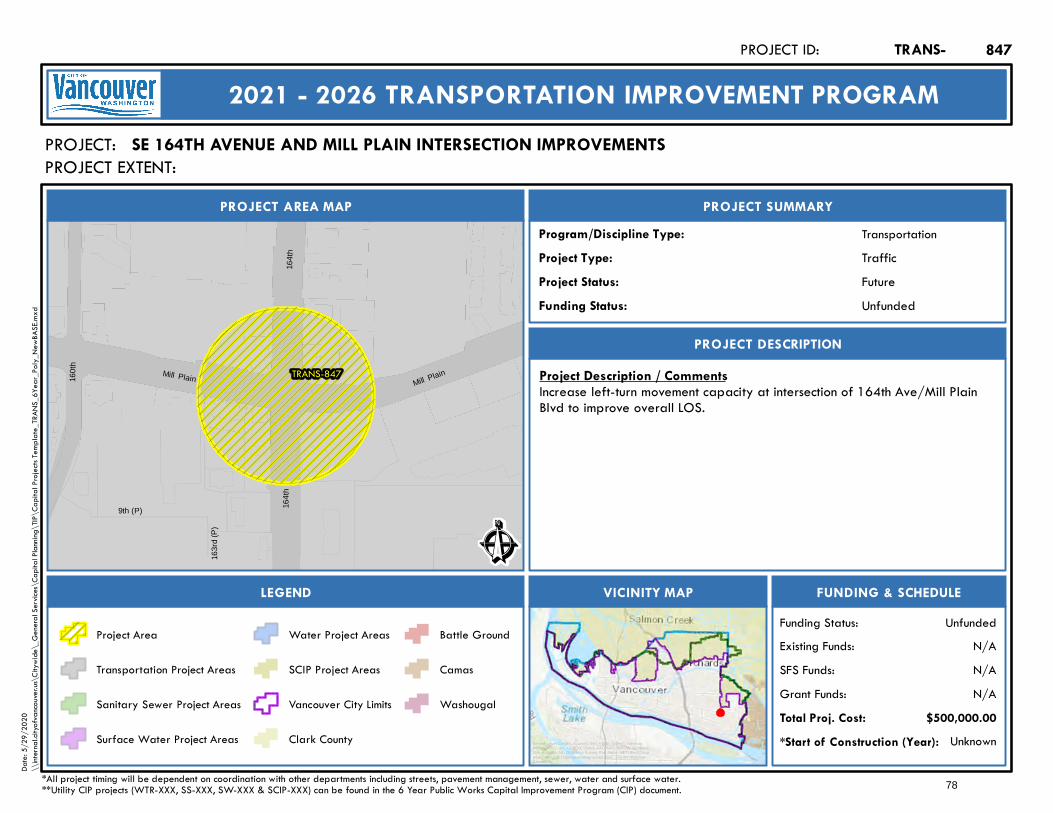
Mill Plain Mill Plain
164t
h16
4th
TRANS-847
9th (P)
163r
d (P
)
160t
h
Ê
Future
PROJECT AREA MAP
PROJECT:
PROJECT SUMMARY
Project Status:
TransportationProgram/Discipline Type:TrafficProject Type:
PROJECT DESCRIPTION
FUNDING & SCHEDULEVICINITY MAPLEGEND
SE 164TH AVENUE AND MILL PLAIN INTERSECTION IMPROVEMENTS
Project Description / CommentsIncrease left-turn movement capacity at intersection of 164th Ave/Mill PlainBlvd to improve overall LOS.
Unknown*Start of Construction (Year):
TRANS-PROJECT ID:
2021 - 2026 TRANSPORTATION IMPROVEMENT PROGRAM
PROJECT EXTENT:
$500,000.00Total Proj. Cost:N/AGrant Funds:N/ASFS Funds:N/AExisting Funds:
*All project timing will be dependent on coordination with other departments including streets, pavement management, sewer, water and surface water.**Utility CIP projects (WTR-XXX, SS-XXX, SW-XXX & SCIP-XXX) can be found in the 6 Year Public Works Capital Improvement Program (CIP) document.
UnfundedFunding Status:
UnfundedFunding Status:
Project Area
Transportation Project Areas
Sanitary Sewer Project Areas
Surface Water Project Areas
Water Project Areas
SCIP Project Areas
Vancouver City Limits
Clark County
Battle Ground
Camas
Washougal
847
Service Layer Credits: Sources: Esri, HERE, Garmin, Intermap,increment P Corp., GEBCO, USGS, FAO, NPS, NRCAN, GeoBase,IGN, Kadaster NL, Ordnance Survey, Esri Japan, METI, Esri China(Hong Kong), (c) OpenStreetMap contributors, and the GIS UserCommunity
Date:
5/29
/202
0\\
intern
al.city
ofvan
couve
r.us\C
itywi
de\_
Gene
ral Se
rvices
\Cap
ital P
lannin
g\TIP
\Cap
ital P
rojec
ts Tem
plate_
TRAN
S_6Y
ear_P
oly_N
ewBA
SE.m
xd
78

TRANS-848
14th (P)
162n
d (P
)
Peacehealth (P)
163r
d (P
)
12th Tech Center
164t
h
Ê
Future
PROJECT AREA MAP
PROJECT:
PROJECT SUMMARY
Project Status:
TransportationProgram/Discipline Type:TrafficProject Type:
PROJECT DESCRIPTION
FUNDING & SCHEDULEVICINITY MAPLEGEND
SE 164TH AVENUE AND SE 12TH STREET INTERSECTION IMPROVEMENTS
Project Description / CommentsIncrease left-turn movement capacity at intersection of SE 164th Ave. and SE12th St to improve overall LOS.
Unknown*Start of Construction (Year):
TRANS-PROJECT ID:
2021 - 2026 TRANSPORTATION IMPROVEMENT PROGRAM
PROJECT EXTENT:
$500,000.00Total Proj. Cost:N/AGrant Funds:N/ASFS Funds:N/AExisting Funds:
*All project timing will be dependent on coordination with other departments including streets, pavement management, sewer, water and surface water.**Utility CIP projects (WTR-XXX, SS-XXX, SW-XXX & SCIP-XXX) can be found in the 6 Year Public Works Capital Improvement Program (CIP) document.
UnfundedFunding Status:
UnfundedFunding Status:
Project Area
Transportation Project Areas
Sanitary Sewer Project Areas
Surface Water Project Areas
Water Project Areas
SCIP Project Areas
Vancouver City Limits
Clark County
Battle Ground
Camas
Washougal
848
Service Layer Credits: Sources: Esri, HERE, Garmin, Intermap,increment P Corp., GEBCO, USGS, FAO, NPS, NRCAN, GeoBase,IGN, Kadaster NL, Ordnance Survey, Esri Japan, METI, Esri China(Hong Kong), (c) OpenStreetMap contributors, and the GIS UserCommunity
Date:
5/29
/202
0\\
intern
al.city
ofvan
couve
r.us\C
itywi
de\_
Gene
ral Se
rvices
\Cap
ital P
lannin
g\TIP
\Cap
ital P
rojec
ts Tem
plate_
TRAN
S_6Y
ear_P
oly_N
ewBA
SE.m
xd
TO: SE 12th St.SE 12TH ST.SE 164TH AVE.
79
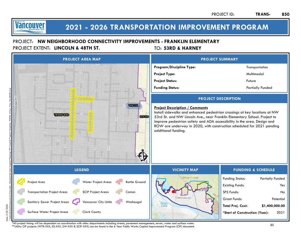
Cherr
y
Frankl
in
Lincol
n
Alki
Washi
ngton
Danie
ls
53rd
49th
Grant
48th
46th
Esther
54th
52nd
Cady
Harne
y
Olive
56th
57th
Kauffm
an
50th
51st
Lavina
8th
58th
Walnu
t
Colum
bia
55th
Suns
et
TRANS-850
WTR-152
SCIP-256
F ru it Valle y
Ê
Future
PROJECT AREA MAP
PROJECT:
PROJECT SUMMARY
Project Status:
TransportationProgram/Discipline Type:MultimodalProject Type:
PROJECT DESCRIPTION
FUNDING & SCHEDULEVICINITY MAPLEGEND
NW NEIGHBORHOOD CONNECTIVITY IMPROVEMENTS - FRANKLIN ELEMENTARY
Project Description / CommentsInstall sidewalks and enhanced pedestrian crossings at key locations at NW53rd St. and NW Lincoln Ave., near Franklin Elementary School. Project toimprove pedestrian safety and ADA accessibility in the area. Design andROW are underway in 2020, with construction scheduled for 2021 pendingadditional funding.
2021*Start of Construction (Year):
TRANS-PROJECT ID:
2021 - 2026 TRANSPORTATION IMPROVEMENT PROGRAM
PROJECT EXTENT:
$1,400,000.00Total Proj. Cost:PotentialGrant Funds:
NoSFS Funds:YesExisting Funds:
*All project timing will be dependent on coordination with other departments including streets, pavement management, sewer, water and surface water.**Utility CIP projects (WTR-XXX, SS-XXX, SW-XXX & SCIP-XXX) can be found in the 6 Year Public Works Capital Improvement Program (CIP) document.
Partially FundedFunding Status:
Partially FundedFunding Status:
Project Area
Transportation Project Areas
Sanitary Sewer Project Areas
Surface Water Project Areas
Water Project Areas
SCIP Project Areas
Vancouver City Limits
Clark County
Battle Ground
Camas
Washougal
850
Service Layer Credits: Sources: Esri, HERE, Garmin, Intermap,increment P Corp., GEBCO, USGS, FAO, NPS, NRCAN, GeoBase,IGN, Kadaster NL, Ordnance Survey, Esri Japan, METI, Esri China(Hong Kong), (c) OpenStreetMap contributors, and the GIS UserCommunity
Date:
5/29
/202
0\\
intern
al.city
ofvan
couve
r.us\C
itywi
de\_
Gene
ral Se
rvices
\Cap
ital P
lannin
g\TIP
\Cap
ital P
rojec
ts Tem
plate_
TRAN
S_6Y
ear_P
oly_N
ewBA
SE.m
xd
TO: 53rd & Harney53RD & HARNEYLINCOLN & 48TH ST.
80
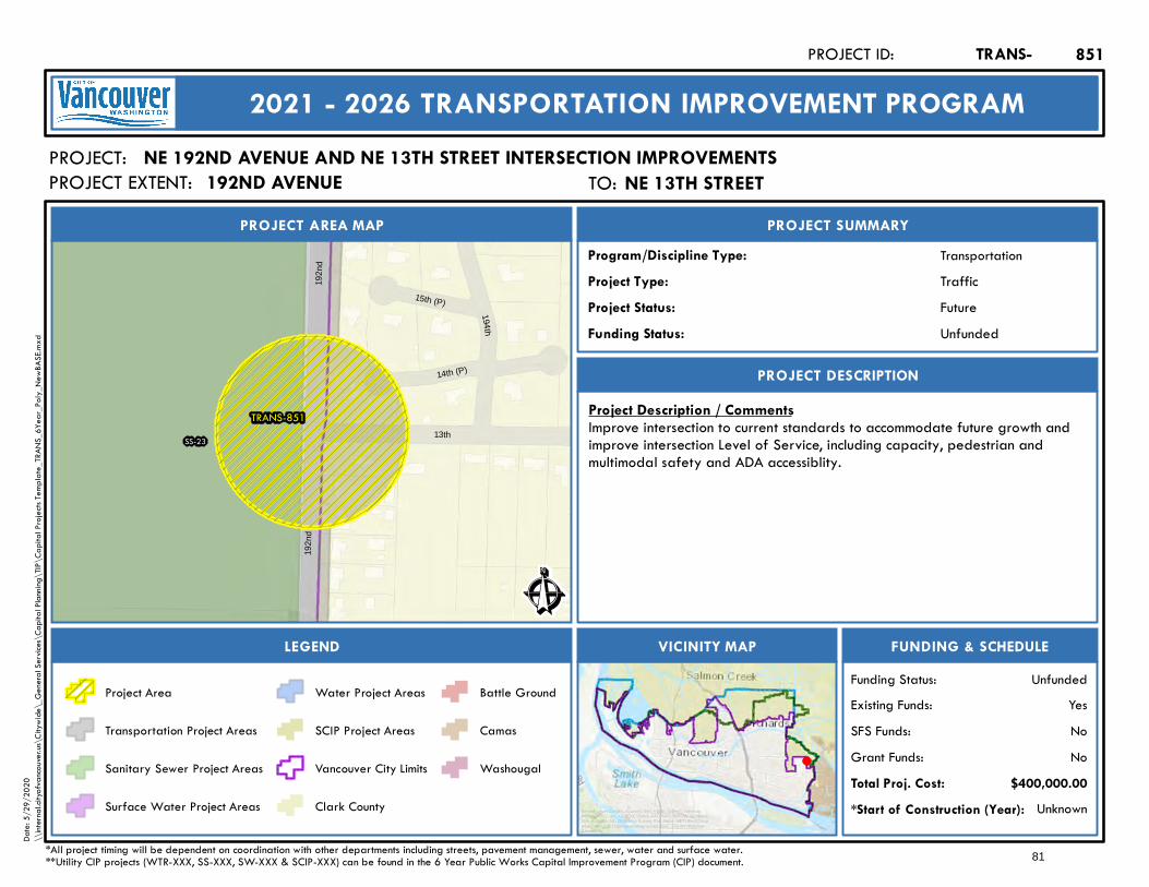
13th
192n
d19
2nd
TRANS-851SS-23
14th (P)
15th (P)
194th
Ê
Future
PROJECT AREA MAP
PROJECT:
PROJECT SUMMARY
Project Status:
TransportationProgram/Discipline Type:TrafficProject Type:
PROJECT DESCRIPTION
FUNDING & SCHEDULEVICINITY MAPLEGEND
NE 192ND AVENUE AND NE 13TH STREET INTERSECTION IMPROVEMENTS
Project Description / CommentsImprove intersection to current standards to accommodate future growth andimprove intersection Level of Service, including capacity, pedestrian andmultimodal safety and ADA accessiblity.
Unknown*Start of Construction (Year):
TRANS-PROJECT ID:
2021 - 2026 TRANSPORTATION IMPROVEMENT PROGRAM
PROJECT EXTENT:
$400,000.00Total Proj. Cost:NoGrant Funds:NoSFS Funds:YesExisting Funds:
*All project timing will be dependent on coordination with other departments including streets, pavement management, sewer, water and surface water.**Utility CIP projects (WTR-XXX, SS-XXX, SW-XXX & SCIP-XXX) can be found in the 6 Year Public Works Capital Improvement Program (CIP) document.
UnfundedFunding Status:
UnfundedFunding Status:
Project Area
Transportation Project Areas
Sanitary Sewer Project Areas
Surface Water Project Areas
Water Project Areas
SCIP Project Areas
Vancouver City Limits
Clark County
Battle Ground
Camas
Washougal
851
Service Layer Credits: Sources: Esri, HERE, Garmin, Intermap,increment P Corp., GEBCO, USGS, FAO, NPS, NRCAN, GeoBase,IGN, Kadaster NL, Ordnance Survey, Esri Japan, METI, Esri China(Hong Kong), (c) OpenStreetMap contributors, and the GIS UserCommunity
Date:
5/29
/202
0\\
intern
al.city
ofvan
couve
r.us\C
itywi
de\_
Gene
ral Se
rvices
\Cap
ital P
lannin
g\TIP
\Cap
ital P
rojec
ts Tem
plate_
TRAN
S_6Y
ear_P
oly_N
ewBA
SE.m
xd
TO: NE 13th StreetNE 13TH STREET192ND AVENUE
81
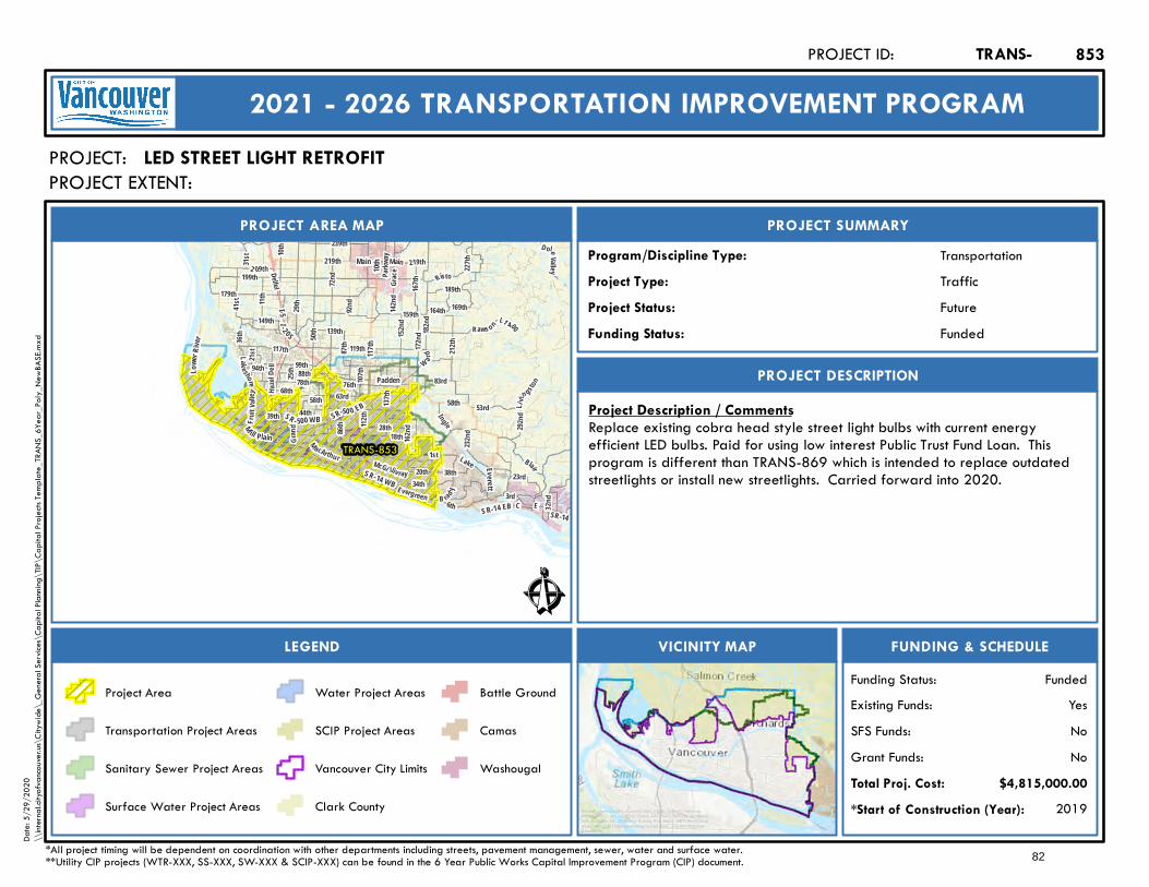
199th
Lake shore
63rdHazel
D ell
41 st
167th
179th
W ard
164th
Blair
182nd
Risto
1st
78th
3rd
137th
99th
E
28th
72nd
76th
18thGran
d
36th
117th
Main
172nd
Fr ui t V
alley
112th
31st
159th
21st
10th
Lake
189th
162nd
219th
34th
I- 2 05I-5
SR-14 WB
117th
SR-14
58th
M ill Plain
Padden
SR-50 0 EB
Main
Everett
SR - 500 WB
Lowe
r Rive
r
219th
SR-14 EB
10th
212th
58th
M acArthur
Li vin gsto
n
Evergreen
88th
McGi lliv ray
87th 119th
B ra d y
2 09th
C
50th
23rd
Parkw
ay
20th
169th
6th
L1 400
Grace
142nd
83rd
44th
139th
11th
39th
86th
149th
68th
227th
Raws on
239th
32nd
25th
292nd
94th
38th
29th
152nd
53rd
107th
D oleValley
232nd
I ngle
92nd
Delfel
TRANS-853
Ê
Future
PROJECT AREA MAP
PROJECT:
PROJECT SUMMARY
Project Status:
TransportationProgram/Discipline Type:TrafficProject Type:
PROJECT DESCRIPTION
FUNDING & SCHEDULEVICINITY MAPLEGEND
LED STREET LIGHT RETROFIT
Project Description / CommentsReplace existing cobra head style street light bulbs with current energyefficient LED bulbs. Paid for using low interest Public Trust Fund Loan. Thisprogram is different than TRANS-869 which is intended to replace outdatedstreetlights or install new streetlights. Carried forward into 2020.
2019*Start of Construction (Year):
TRANS-PROJECT ID:
2021 - 2026 TRANSPORTATION IMPROVEMENT PROGRAM
PROJECT EXTENT:
$4,815,000.00Total Proj. Cost:NoGrant Funds:NoSFS Funds:YesExisting Funds:
*All project timing will be dependent on coordination with other departments including streets, pavement management, sewer, water and surface water.**Utility CIP projects (WTR-XXX, SS-XXX, SW-XXX & SCIP-XXX) can be found in the 6 Year Public Works Capital Improvement Program (CIP) document.
FundedFunding Status:
FundedFunding Status:
Project Area
Transportation Project Areas
Sanitary Sewer Project Areas
Surface Water Project Areas
Water Project Areas
SCIP Project Areas
Vancouver City Limits
Clark County
Battle Ground
Camas
Washougal
853
Service Layer Credits: Sources: Esri, HERE, Garmin, Intermap,increment P Corp., GEBCO, USGS, FAO, NPS, NRCAN, GeoBase,IGN, Kadaster NL, Ordnance Survey, Esri Japan, METI, Esri China(Hong Kong), (c) OpenStreetMap contributors, and the GIS UserCommunity
Date:
5/29
/202
0\\
intern
al.city
ofvan
couve
r.us\C
itywi
de\_
Gene
ral Se
rvices
\Cap
ital P
lannin
g\TIP
\Cap
ital P
rojec
ts Tem
plate_
TRAN
S_6Y
ear_P
oly_N
ewBA
SE.m
xd
82
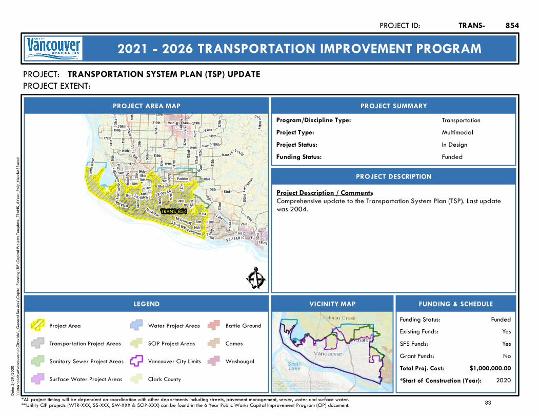
199th
Lake shore
63rdHazel
D ell
41 st
167th
179th
W ard
164th
Blair
182nd
Risto
1st
78th
3rd
137th
99th
E
28th
72nd
76th
18thGran
d
36th
117th
Main
172nd
Fr ui t V
alley
112th
31st
159th
21st
10th
Lake
189th
162nd
219th
34th
I- 2 05I-5
SR-14 WB
117th
SR-14
58th
M ill Plain
Padden
SR-50 0 EB
Main
Everett
SR - 500 WB
Lowe
r Rive
r
219th
SR-14 EB
10th
212th
58th
M acArthur
Li vin gsto
n
Evergreen
88th
McGi lliv ray
87th 119th
B ra d y
2 09th
C
50th
23rd
Parkw
ay
20th
169th
6th
L1 400
Grace
142nd
83rd
44th
139th
11th
39th
86th
149th
68th
227th
Raws on
239th
32nd
25th
292nd
94th
38th
29th
152nd
53rd
107th
D oleValley
232nd
I ngle
92nd
Delfel
TRANS-854
Ê
In Design
PROJECT AREA MAP
PROJECT:
PROJECT SUMMARY
Project Status:
TransportationProgram/Discipline Type:MultimodalProject Type:
PROJECT DESCRIPTION
FUNDING & SCHEDULEVICINITY MAPLEGEND
TRANSPORTATION SYSTEM PLAN (TSP) UPDATE
Project Description / CommentsComprehensive update to the Transportation System Plan (TSP). Last updatewas 2004.
2020*Start of Construction (Year):
TRANS-PROJECT ID:
2021 - 2026 TRANSPORTATION IMPROVEMENT PROGRAM
PROJECT EXTENT:
$1,000,000.00Total Proj. Cost:NoGrant Funds:YesSFS Funds:YesExisting Funds:
*All project timing will be dependent on coordination with other departments including streets, pavement management, sewer, water and surface water.**Utility CIP projects (WTR-XXX, SS-XXX, SW-XXX & SCIP-XXX) can be found in the 6 Year Public Works Capital Improvement Program (CIP) document.
FundedFunding Status:
FundedFunding Status:
Project Area
Transportation Project Areas
Sanitary Sewer Project Areas
Surface Water Project Areas
Water Project Areas
SCIP Project Areas
Vancouver City Limits
Clark County
Battle Ground
Camas
Washougal
854
Service Layer Credits: Sources: Esri, HERE, Garmin, Intermap,increment P Corp., GEBCO, USGS, FAO, NPS, NRCAN, GeoBase,IGN, Kadaster NL, Ordnance Survey, Esri Japan, METI, Esri China(Hong Kong), (c) OpenStreetMap contributors, and the GIS UserCommunity
Date:
5/29
/202
0\\
intern
al.city
ofvan
couve
r.us\C
itywi
de\_
Gene
ral Se
rvices
\Cap
ital P
lannin
g\TIP
\Cap
ital P
rojec
ts Tem
plate_
TRAN
S_6Y
ear_P
oly_N
ewBA
SE.m
xd
83
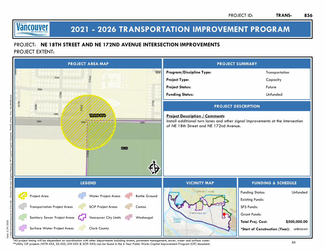
18th 18th 18th
172n
d17
2nd
TRANS-856
SS-23
21st (P)
20th
166t
h
170t
h
22nd
177t
h
171s
t167t
h
169t
h
21st
19th
Ê
Future
PROJECT AREA MAP
PROJECT:
PROJECT SUMMARY
Project Status:
TransportationProgram/Discipline Type:CapacityProject Type:
PROJECT DESCRIPTION
FUNDING & SCHEDULEVICINITY MAPLEGEND
NE 18TH STREET AND NE 172ND AVENUE INTERSECTION IMPROVEMENTS
Project Description / CommentsInstall additional turn lanes and other signal improvements at the intersectionof NE 18th Street and NE 172nd Avenue.
unknown*Start of Construction (Year):
TRANS-PROJECT ID:
2021 - 2026 TRANSPORTATION IMPROVEMENT PROGRAM
PROJECT EXTENT:
$500,000.00Total Proj. Cost:Grant Funds:SFS Funds:Existing Funds:
*All project timing will be dependent on coordination with other departments including streets, pavement management, sewer, water and surface water.**Utility CIP projects (WTR-XXX, SS-XXX, SW-XXX & SCIP-XXX) can be found in the 6 Year Public Works Capital Improvement Program (CIP) document.
UnfundedFunding Status:
UnfundedFunding Status:
Project Area
Transportation Project Areas
Sanitary Sewer Project Areas
Surface Water Project Areas
Water Project Areas
SCIP Project Areas
Vancouver City Limits
Clark County
Battle Ground
Camas
Washougal
856
Service Layer Credits: Sources: Esri, HERE, Garmin, Intermap,increment P Corp., GEBCO, USGS, FAO, NPS, NRCAN, GeoBase,IGN, Kadaster NL, Ordnance Survey, Esri Japan, METI, Esri China(Hong Kong), (c) OpenStreetMap contributors, and the GIS UserCommunity
Date:
5/29
/202
0\\
intern
al.city
ofvan
couve
r.us\C
itywi
de\_
Gene
ral Se
rvices
\Cap
ital P
lannin
g\TIP
\Cap
ital P
rojec
ts Tem
plate_
TRAN
S_6Y
ear_P
oly_N
ewBA
SE.m
xd
84

I-205
SR-14 EB SR-14 WB Nancy
6th
114th
Silver Star
17th
Boulder
12th
10 5th
Butte
15th
11th
Saint Helens
95th
98th
101st
96th
5th
106th
MtS h
asta
107th
94th
14th
16thFrench
3rd
4th
Mt Hood
1 13th
100t h
99th
103rd
102nd
104th
110th
7th
13th
97th
TRANS-857
WTR-99
WTR-99
WTR-16WTR-16
WTR-16
WTR-64
WTR-64
WTR-64
WTR-52
WTR-52
WTR-149
WTR-149
WTR-155
SCIP-236 107th
Saint Helens
98th
10thEll
swort
h
2nd
Ê
Future
PROJECT AREA MAP
PROJECT:
PROJECT SUMMARY
Project Status:
TransportationProgram/Discipline Type:MultimodalProject Type:
PROJECT DESCRIPTION
FUNDING & SCHEDULEVICINITY MAPLEGEND
SE 10TH STREET SIDEWALKS - SE 98TH AVENUE TO ELLSWORTH ROAD
Project Description / CommentsInstall sidewalks and ADA ramps along SE 10th Street from SE 98th Avenue toEllsworth Road.
unknown*Start of Construction (Year):
TRANS-PROJECT ID:
2021 - 2026 TRANSPORTATION IMPROVEMENT PROGRAM
PROJECT EXTENT:
$1,500,000.00Total Proj. Cost:Grant Funds:SFS Funds:Existing Funds:
*All project timing will be dependent on coordination with other departments including streets, pavement management, sewer, water and surface water.**Utility CIP projects (WTR-XXX, SS-XXX, SW-XXX & SCIP-XXX) can be found in the 6 Year Public Works Capital Improvement Program (CIP) document.
UnfundedFunding Status:
UnfundedFunding Status:
Project Area
Transportation Project Areas
Sanitary Sewer Project Areas
Surface Water Project Areas
Water Project Areas
SCIP Project Areas
Vancouver City Limits
Clark County
Battle Ground
Camas
Washougal
857
Service Layer Credits: Sources: Esri, HERE, Garmin, Intermap,increment P Corp., GEBCO, USGS, FAO, NPS, NRCAN, GeoBase,IGN, Kadaster NL, Ordnance Survey, Esri Japan, METI, Esri China(Hong Kong), (c) OpenStreetMap contributors, and the GIS UserCommunity
Date:
5/29
/202
0\\
intern
al.city
ofvan
couve
r.us\C
itywi
de\_
Gene
ral Se
rvices
\Cap
ital P
lannin
g\TIP
\Cap
ital P
rojec
ts Tem
plate_
TRAN
S_6Y
ear_P
oly_N
ewBA
SE.m
xd
TO: Ellsworth RoadELLSWORTH ROAD98TH AVENUE
85

199th
Lake shore
63rdHazel
D ell
41 st
167th
179th
W ard
164th
Blair
182nd
Risto
1st
78th
3rd
137th
99th
E
28th
72nd
76th
18thGran
d
36th
117th
Main
172nd
Fr ui t V
alley
112th
31st
159th
21st
10th
Lake
189th
162nd
219th
34th
I- 2 05I-5
SR-14 WB
117th
SR-14
58th
M ill Plain
Padden
SR-50 0 EB
Main
Everett
SR - 500 WB
Lowe
r Rive
r
219th
SR-14 EB
10th
212th
58th
M acArthur
Li vin gsto
n
Evergreen
88th
McGi lliv ray
87th 119th
B ra d y
2 09th
C
50th
23rd
Parkw
ay
20th
169th
6th
L1 400
Grace
142nd
83rd
44th
139th
11th
39th
86th
149th
68th
227th
Raws on
239th
32nd
25th
292nd
94th
38th
29th
152nd
53rd
107th
D oleValley
232nd
I ngle
92nd
Delfel
TRANS-858
Ê
On Hold
PROJECT AREA MAP
PROJECT:
PROJECT SUMMARY
Project Status:
TransportationProgram/Discipline Type:MultimodalProject Type:
PROJECT DESCRIPTION
FUNDING & SCHEDULEVICINITY MAPLEGEND
CITYWIDE TRANSPORTATION DEMAND MANAGEMENT PROGRAM
Project Description / CommentsNew program to be implemented City-wide that encourages modes of travelother than single occupant vehicles. This includes: bicycle, pedestrian, transit,carpool, rideshare, etc.
*Start of Construction (Year):
TRANS-PROJECT ID:
2021 - 2026 TRANSPORTATION IMPROVEMENT PROGRAM
PROJECT EXTENT:
$290,000.00Total Proj. Cost:PotentialGrant Funds:PotentialSFS Funds:
Existing Funds:
*All project timing will be dependent on coordination with other departments including streets, pavement management, sewer, water and surface water.**Utility CIP projects (WTR-XXX, SS-XXX, SW-XXX & SCIP-XXX) can be found in the 6 Year Public Works Capital Improvement Program (CIP) document.
UnfundedFunding Status:
UnfundedFunding Status:
Project Area
Transportation Project Areas
Sanitary Sewer Project Areas
Surface Water Project Areas
Water Project Areas
SCIP Project Areas
Vancouver City Limits
Clark County
Battle Ground
Camas
Washougal
858
Service Layer Credits: Sources: Esri, HERE, Garmin, Intermap,increment P Corp., GEBCO, USGS, FAO, NPS, NRCAN, GeoBase,IGN, Kadaster NL, Ordnance Survey, Esri Japan, METI, Esri China(Hong Kong), (c) OpenStreetMap contributors, and the GIS UserCommunity
Date:
5/29
/202
0\\
intern
al.city
ofvan
couve
r.us\C
itywi
de\_
Gene
ral Se
rvices
\Cap
ital P
lannin
g\TIP
\Cap
ital P
rojec
ts Tem
plate_
TRAN
S_6Y
ear_P
oly_N
ewBA
SE.m
xd
CITY WIDE
86
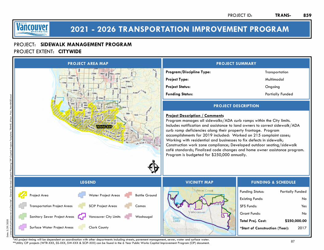
199th
Lake shore
63rdHazel
D ell
41 st
167th
179th
W ard
164th
Blair
182nd
Risto
1st
78th
3rd
137th
99th
E
28th
72nd
76th
18thGran
d
36th
117th
Main
172nd
Fr ui t V
alley
112th
31st
159th
21st
10th
Lake
189th
162nd
219th
34th
I- 2 05I-5
SR-14 WB
117th
SR-14
58th
M ill Plain
Padden
SR-50 0 EB
Main
Everett
SR - 500 WB
Lowe
r Rive
r
219th
SR-14 EB
10th
212th
58th
M acArthur
Li vin gsto
n
Evergreen
88th
McGi lliv ray
87th 119th
B ra d y
2 09th
C
50th
23rd
Parkw
ay
20th
169th
6th
L1 400
Grace
142nd
83rd
44th
139th
11th
39th
86th
149th
68th
227th
Raws on
239th
32nd
25th
292nd
94th
38th
29th
152nd
53rd
107th
D oleValley
232nd
I ngle
92nd
Delfel
TRANS-859
Ê
Ongoing
PROJECT AREA MAP
PROJECT:
PROJECT SUMMARY
Project Status:
TransportationProgram/Discipline Type:MultimodalProject Type:
PROJECT DESCRIPTION
FUNDING & SCHEDULEVICINITY MAPLEGEND
SIDEWALK MANAGEMENT PROGRAM
Project Description / CommentsProgram manages all sidewalks/ADA curb ramps within the City limits.Includes notification and assistance to land owners to correct sidewalk/ADAcurb ramp deficiencies along their property frontage. Programaccomplishments for 2019 included: Worked on 215 complaint cases;Working with residential and businesses to fix defects in sidewalk;Construction work zone compliance; Developed outdoor seating/sidewalkcafé standards; Finalized code changes and home owner assistance program.Program is budgeted for $250,000 annually.
2017*Start of Construction (Year):
TRANS-PROJECT ID:
2021 - 2026 TRANSPORTATION IMPROVEMENT PROGRAM
PROJECT EXTENT:
$250,000.00Total Proj. Cost:NoGrant Funds:YesSFS Funds:NoExisting Funds:
*All project timing will be dependent on coordination with other departments including streets, pavement management, sewer, water and surface water.**Utility CIP projects (WTR-XXX, SS-XXX, SW-XXX & SCIP-XXX) can be found in the 6 Year Public Works Capital Improvement Program (CIP) document.
Partially FundedFunding Status:
Partially FundedFunding Status:
Project Area
Transportation Project Areas
Sanitary Sewer Project Areas
Surface Water Project Areas
Water Project Areas
SCIP Project Areas
Vancouver City Limits
Clark County
Battle Ground
Camas
Washougal
859
Service Layer Credits: Sources: Esri, HERE, Garmin, Intermap,increment P Corp., GEBCO, USGS, FAO, NPS, NRCAN, GeoBase,IGN, Kadaster NL, Ordnance Survey, Esri Japan, METI, Esri China(Hong Kong), (c) OpenStreetMap contributors, and the GIS UserCommunity
Date:
5/29
/202
0\\
intern
al.city
ofvan
couve
r.us\C
itywi
de\_
Gene
ral Se
rvices
\Cap
ital P
lannin
g\TIP
\Cap
ital P
rojec
ts Tem
plate_
TRAN
S_6Y
ear_P
oly_N
ewBA
SE.m
xd
CITYWIDE
87
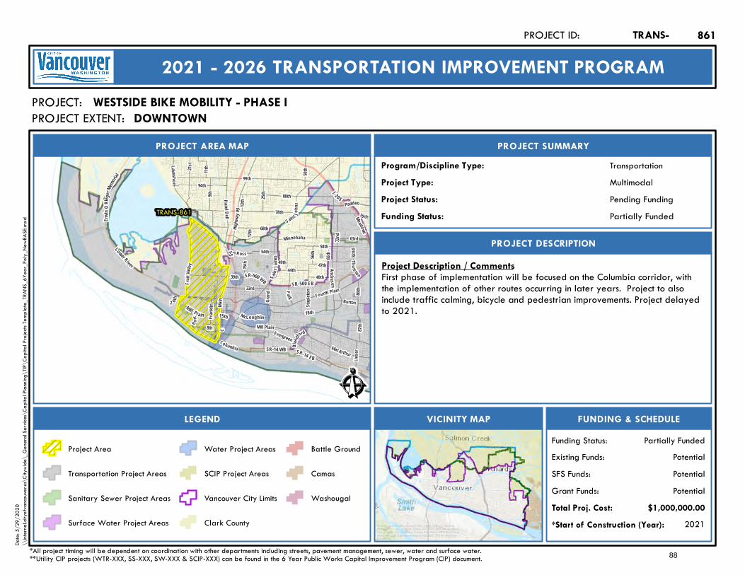
21st
S ain t John
s
Lak esho re
76 th
63rd
Haze l Del l
Fourth Plain
Mill Plain
Highw
ay 99
Padden78th
99th
CMa
in Grand
Sain t
James
50th
F ruit V
al ley
Burton
Andre s en
Minnehaha
I-5
I -205
Mill Pl ain 15th
SR-500 EB
Lower River
SR-14 EBSR-14 WB
SR-500 WB
Erwi n
ORie g
erMem
orial 11t
h
58th
MacArthur
Evergreen
15th
88th
Thurs ton
72nd
66th
40th
49th
Frank
lin
Lieser
9th
R oss
33rd
17th
44th39th
86th
87th
68th
54th
McLoughlin
25th
Fa lk
56th
94th
8th
Columbia
13th
47th
18th
82nd
Staple
ton
B landf
ord
2 6th
P ort
Meadows
TRANS-861
Ê
Pending Funding
PROJECT AREA MAP
PROJECT:
PROJECT SUMMARY
Project Status:
TransportationProgram/Discipline Type:MultimodalProject Type:
PROJECT DESCRIPTION
FUNDING & SCHEDULEVICINITY MAPLEGEND
WESTSIDE BIKE MOBILITY - PHASE I
Project Description / CommentsFirst phase of implementation will be focused on the Columbia corridor, withthe implementation of other routes occurring in later years. Project to alsoinclude traffic calming, bicycle and pedestrian improvements. Project delayedto 2021.
2021*Start of Construction (Year):
TRANS-PROJECT ID:
2021 - 2026 TRANSPORTATION IMPROVEMENT PROGRAM
PROJECT EXTENT:
$1,000,000.00Total Proj. Cost:PotentialGrant Funds:PotentialSFS Funds:PotentialExisting Funds:
*All project timing will be dependent on coordination with other departments including streets, pavement management, sewer, water and surface water.**Utility CIP projects (WTR-XXX, SS-XXX, SW-XXX & SCIP-XXX) can be found in the 6 Year Public Works Capital Improvement Program (CIP) document.
Partially FundedFunding Status:
Partially FundedFunding Status:
Project Area
Transportation Project Areas
Sanitary Sewer Project Areas
Surface Water Project Areas
Water Project Areas
SCIP Project Areas
Vancouver City Limits
Clark County
Battle Ground
Camas
Washougal
861
Service Layer Credits: Sources: Esri, HERE, Garmin, Intermap,increment P Corp., GEBCO, USGS, FAO, NPS, NRCAN, GeoBase,IGN, Kadaster NL, Ordnance Survey, Esri Japan, METI, Esri China(Hong Kong), (c) OpenStreetMap contributors, and the GIS UserCommunity
Date:
5/29
/202
0\\
intern
al.city
ofvan
couve
r.us\C
itywi
de\_
Gene
ral Se
rvices
\Cap
ital P
lannin
g\TIP
\Cap
ital P
rojec
ts Tem
plate_
TRAN
S_6Y
ear_P
oly_N
ewBA
SE.m
xd
DOWNTOWN
88
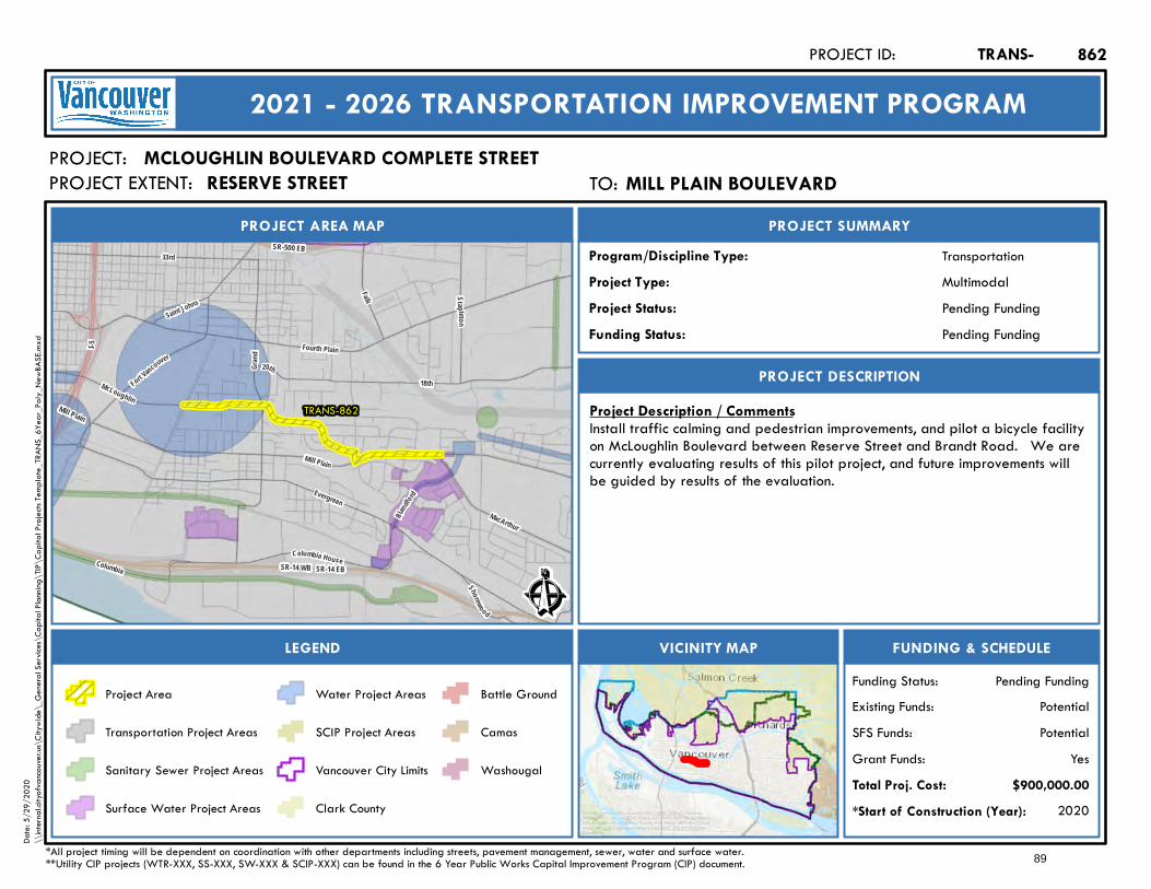
Saint Johns
Mill Plain
Fourth Plain
Grand
I-5
Mill Plain
SR-14 WB
SR-500 EB
SR-14 EB
MacArthur
Fort Vancouver
Evergreen
Shorewood
33rd
McLoughlin
Stapleton
Falk
Columbia House
18th20th
Blandf
ord
Columbia
TRANS-862
Ê
Pending Funding
PROJECT AREA MAP
PROJECT:
PROJECT SUMMARY
Project Status:
TransportationProgram/Discipline Type:MultimodalProject Type:
PROJECT DESCRIPTION
FUNDING & SCHEDULEVICINITY MAPLEGEND
MCLOUGHLIN BOULEVARD COMPLETE STREET
Project Description / CommentsInstall traffic calming and pedestrian improvements, and pilot a bicycle facilityon McLoughlin Boulevard between Reserve Street and Brandt Road. We arecurrently evaluating results of this pilot project, and future improvements willbe guided by results of the evaluation.
2020*Start of Construction (Year):
TRANS-PROJECT ID:
2021 - 2026 TRANSPORTATION IMPROVEMENT PROGRAM
PROJECT EXTENT:
$900,000.00Total Proj. Cost:YesGrant Funds:
PotentialSFS Funds:PotentialExisting Funds:
*All project timing will be dependent on coordination with other departments including streets, pavement management, sewer, water and surface water.**Utility CIP projects (WTR-XXX, SS-XXX, SW-XXX & SCIP-XXX) can be found in the 6 Year Public Works Capital Improvement Program (CIP) document.
Pending FundingFunding Status:
Pending FundingFunding Status:
Project Area
Transportation Project Areas
Sanitary Sewer Project Areas
Surface Water Project Areas
Water Project Areas
SCIP Project Areas
Vancouver City Limits
Clark County
Battle Ground
Camas
Washougal
862
Service Layer Credits: Sources: Esri, HERE, Garmin, Intermap,increment P Corp., GEBCO, USGS, FAO, NPS, NRCAN, GeoBase,IGN, Kadaster NL, Ordnance Survey, Esri Japan, METI, Esri China(Hong Kong), (c) OpenStreetMap contributors, and the GIS UserCommunity
Date:
5/29
/202
0\\
intern
al.city
ofvan
couve
r.us\C
itywi
de\_
Gene
ral Se
rvices
\Cap
ital P
lannin
g\TIP
\Cap
ital P
rojec
ts Tem
plate_
TRAN
S_6Y
ear_P
oly_N
ewBA
SE.m
xd
TO: Mill Plain BoulevardMILL PLAIN BOULEVARDRESERVE STREET
89
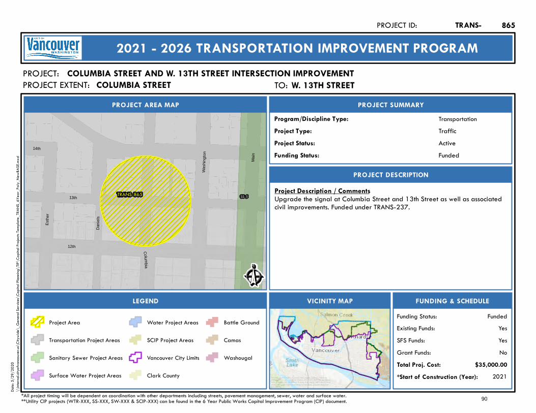
TRANS-865 SS-513th
12th
14th
Dan
iels
Esth
er
Mai
n
C olu mb ia
Was
hing
ton
Ê
Active
PROJECT AREA MAP
PROJECT:
PROJECT SUMMARY
Project Status:
TransportationProgram/Discipline Type:TrafficProject Type:
PROJECT DESCRIPTION
FUNDING & SCHEDULEVICINITY MAPLEGEND
COLUMBIA STREET AND W. 13TH STREET INTERSECTION IMPROVEMENT
Project Description / CommentsUpgrade the signal at Columbia Street and 13th Street as well as associatedcivil improvements. Funded under TRANS-237.
2021*Start of Construction (Year):
TRANS-PROJECT ID:
2021 - 2026 TRANSPORTATION IMPROVEMENT PROGRAM
PROJECT EXTENT:
$35,000.00Total Proj. Cost:NoGrant Funds:YesSFS Funds:YesExisting Funds:
*All project timing will be dependent on coordination with other departments including streets, pavement management, sewer, water and surface water.**Utility CIP projects (WTR-XXX, SS-XXX, SW-XXX & SCIP-XXX) can be found in the 6 Year Public Works Capital Improvement Program (CIP) document.
FundedFunding Status:
FundedFunding Status:
Project Area
Transportation Project Areas
Sanitary Sewer Project Areas
Surface Water Project Areas
Water Project Areas
SCIP Project Areas
Vancouver City Limits
Clark County
Battle Ground
Camas
Washougal
865
Service Layer Credits: Sources: Esri, HERE, Garmin, Intermap,increment P Corp., GEBCO, USGS, FAO, NPS, NRCAN, GeoBase,IGN, Kadaster NL, Ordnance Survey, Esri Japan, METI, Esri China(Hong Kong), (c) OpenStreetMap contributors, and the GIS UserCommunity
Date:
5/29
/202
0\\
intern
al.city
ofvan
couve
r.us\C
itywi
de\_
Gene
ral Se
rvices
\Cap
ital P
lannin
g\TIP
\Cap
ital P
rojec
ts Tem
plate_
TRAN
S_6Y
ear_P
oly_N
ewBA
SE.m
xd
TO: W. 13th StreetW. 13TH STREETCOLUMBIA STREET
90
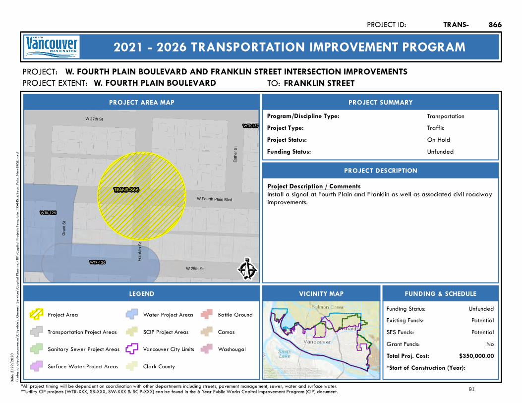
TRANS-866
WTR-125
WTR-126
WTR-157
Esth
er S
t
Fran
klin
St
Gra
nt S
t
W 27th St
W 25th St
W Fourth Plain Blvd
Ê
On Hold
PROJECT AREA MAP
PROJECT:
PROJECT SUMMARY
Project Status:
TransportationProgram/Discipline Type:TrafficProject Type:
PROJECT DESCRIPTION
FUNDING & SCHEDULEVICINITY MAPLEGEND
W. FOURTH PLAIN BOULEVARD AND FRANKLIN STREET INTERSECTION IMPROVEMENTS
Project Description / CommentsInstall a signal at Fourth Plain and Franklin as well as associated civil roadwayimprovements.
*Start of Construction (Year):
TRANS-PROJECT ID:
2021 - 2026 TRANSPORTATION IMPROVEMENT PROGRAM
PROJECT EXTENT:
$350,000.00Total Proj. Cost:NoGrant Funds:
PotentialSFS Funds:PotentialExisting Funds:
*All project timing will be dependent on coordination with other departments including streets, pavement management, sewer, water and surface water.**Utility CIP projects (WTR-XXX, SS-XXX, SW-XXX & SCIP-XXX) can be found in the 6 Year Public Works Capital Improvement Program (CIP) document.
UnfundedFunding Status:
UnfundedFunding Status:
Project Area
Transportation Project Areas
Sanitary Sewer Project Areas
Surface Water Project Areas
Water Project Areas
SCIP Project Areas
Vancouver City Limits
Clark County
Battle Ground
Camas
Washougal
866
Service Layer Credits: Sources: Esri, HERE, Garmin, Intermap,increment P Corp., GEBCO, USGS, FAO, NPS, NRCAN, GeoBase,IGN, Kadaster NL, Ordnance Survey, Esri Japan, METI, Esri China(Hong Kong), (c) OpenStreetMap contributors, and the GIS UserCommunity
Date:
5/29
/202
0\\
intern
al.city
ofvan
couve
r.us\C
itywi
de\_
Gene
ral Se
rvices
\Cap
ital P
lannin
g\TIP
\Cap
ital P
rojec
ts Tem
plate_
TRAN
S_6Y
ear_P
oly_N
ewBA
SE.m
xd
TO: Franklin StreetFRANKLIN STREETW. FOURTH PLAIN BOULEVARD
91
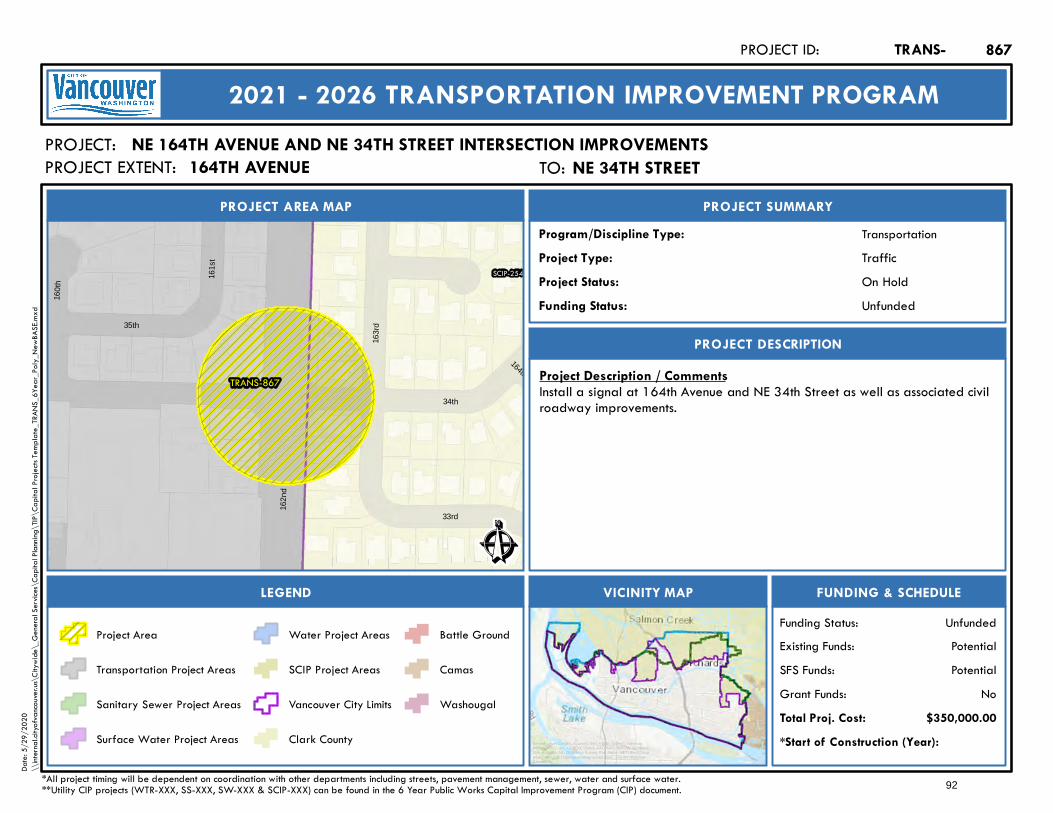
TRANS-867
SCIP-254
34th
164th
163r
d
160t
h
161s
t
33rd
35th
162n
d
Ê
On Hold
PROJECT AREA MAP
PROJECT:
PROJECT SUMMARY
Project Status:
TransportationProgram/Discipline Type:TrafficProject Type:
PROJECT DESCRIPTION
FUNDING & SCHEDULEVICINITY MAPLEGEND
NE 164TH AVENUE AND NE 34TH STREET INTERSECTION IMPROVEMENTS
Project Description / CommentsInstall a signal at 164th Avenue and NE 34th Street as well as associated civilroadway improvements.
*Start of Construction (Year):
TRANS-PROJECT ID:
2021 - 2026 TRANSPORTATION IMPROVEMENT PROGRAM
PROJECT EXTENT:
$350,000.00Total Proj. Cost:NoGrant Funds:
PotentialSFS Funds:PotentialExisting Funds:
*All project timing will be dependent on coordination with other departments including streets, pavement management, sewer, water and surface water.**Utility CIP projects (WTR-XXX, SS-XXX, SW-XXX & SCIP-XXX) can be found in the 6 Year Public Works Capital Improvement Program (CIP) document.
UnfundedFunding Status:
UnfundedFunding Status:
Project Area
Transportation Project Areas
Sanitary Sewer Project Areas
Surface Water Project Areas
Water Project Areas
SCIP Project Areas
Vancouver City Limits
Clark County
Battle Ground
Camas
Washougal
867
Service Layer Credits: Sources: Esri, HERE, Garmin, Intermap,increment P Corp., GEBCO, USGS, FAO, NPS, NRCAN, GeoBase,IGN, Kadaster NL, Ordnance Survey, Esri Japan, METI, Esri China(Hong Kong), (c) OpenStreetMap contributors, and the GIS UserCommunity
Date:
5/29
/202
0\\
intern
al.city
ofvan
couve
r.us\C
itywi
de\_
Gene
ral Se
rvices
\Cap
ital P
lannin
g\TIP
\Cap
ital P
rojec
ts Tem
plate_
TRAN
S_6Y
ear_P
oly_N
ewBA
SE.m
xd
TO: NE 34th StreetNE 34TH STREET164TH AVENUE
92
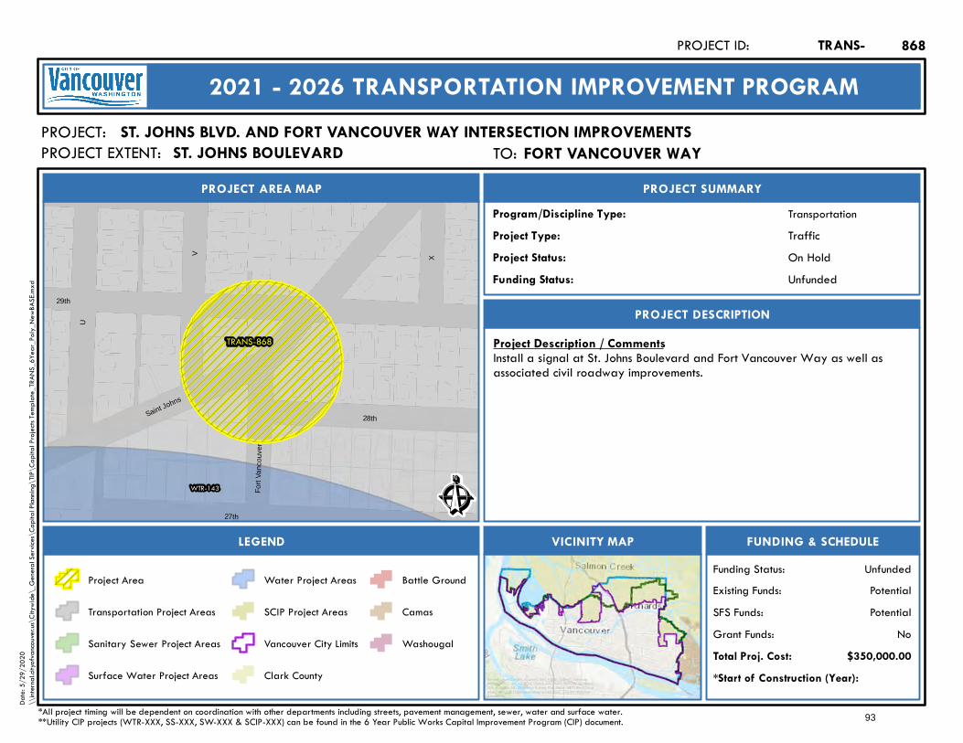
TRANS-868
WTR-143
29th
V
U
27th
X28th
Fort
Vanc
ouve
r
Saint Johns
Ê
On Hold
PROJECT AREA MAP
PROJECT:
PROJECT SUMMARY
Project Status:
TransportationProgram/Discipline Type:TrafficProject Type:
PROJECT DESCRIPTION
FUNDING & SCHEDULEVICINITY MAPLEGEND
ST. JOHNS BLVD. AND FORT VANCOUVER WAY INTERSECTION IMPROVEMENTS
Project Description / CommentsInstall a signal at St. Johns Boulevard and Fort Vancouver Way as well asassociated civil roadway improvements.
*Start of Construction (Year):
TRANS-PROJECT ID:
2021 - 2026 TRANSPORTATION IMPROVEMENT PROGRAM
PROJECT EXTENT:
$350,000.00Total Proj. Cost:NoGrant Funds:
PotentialSFS Funds:PotentialExisting Funds:
*All project timing will be dependent on coordination with other departments including streets, pavement management, sewer, water and surface water.**Utility CIP projects (WTR-XXX, SS-XXX, SW-XXX & SCIP-XXX) can be found in the 6 Year Public Works Capital Improvement Program (CIP) document.
UnfundedFunding Status:
UnfundedFunding Status:
Project Area
Transportation Project Areas
Sanitary Sewer Project Areas
Surface Water Project Areas
Water Project Areas
SCIP Project Areas
Vancouver City Limits
Clark County
Battle Ground
Camas
Washougal
868
Service Layer Credits: Sources: Esri, HERE, Garmin, Intermap,increment P Corp., GEBCO, USGS, FAO, NPS, NRCAN, GeoBase,IGN, Kadaster NL, Ordnance Survey, Esri Japan, METI, Esri China(Hong Kong), (c) OpenStreetMap contributors, and the GIS UserCommunity
Date:
5/29
/202
0\\
intern
al.city
ofvan
couve
r.us\C
itywi
de\_
Gene
ral Se
rvices
\Cap
ital P
lannin
g\TIP
\Cap
ital P
rojec
ts Tem
plate_
TRAN
S_6Y
ear_P
oly_N
ewBA
SE.m
xd
TO: Fort Vancouver WayFORT VANCOUVER WAYST. JOHNS BOULEVARD
93
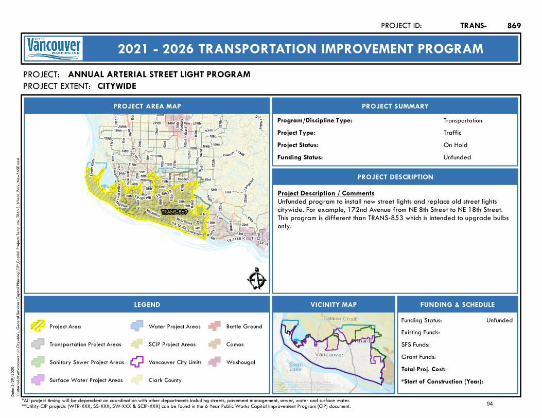
199th
Lake shore
63rdHazel
D ell
41 st
167th
179th
W ard
164th
Blair
182nd
Risto
1st
78th
3rd
137th
99th
E
28th
72nd
76th
18thGran
d
36th
117th
Main
172nd
Fr ui t V
alley
112th
31st
159th
21st
10th
Lake
189th
162nd
219th
34th
I- 2 05I-5
SR-14 WB
117th
SR-14
58th
M ill Plain
Padden
SR-50 0 EB
Main
Everett
SR - 500 WB
Lowe
r Rive
r
219th
SR-14 EB
10th
212th
58th
M acArthur
Li vin gsto
n
Evergreen
88th
McGi lliv ray
87th 119th
B ra d y
2 09th
C
50th
23rd
Parkw
ay
20th
169th
6th
L1 400
Grace
142nd
83rd
44th
139th
11th
39th
86th
149th
68th
227th
Raws on
239th
32nd
25th
292nd
94th
38th
29th
152nd
53rd
107th
D oleValley
232nd
I ngle
92nd
Delfel
TRANS-869
Ê
On Hold
PROJECT AREA MAP
PROJECT:
PROJECT SUMMARY
Project Status:
TransportationProgram/Discipline Type:TrafficProject Type:
PROJECT DESCRIPTION
FUNDING & SCHEDULEVICINITY MAPLEGEND
ANNUAL ARTERIAL STREET LIGHT PROGRAM
Project Description / CommentsUnfunded program to install new street lights and replace old street lightscitywide. For example, 172nd Avenue from NE 8th Street to NE 18th Street.This program is different than TRANS-853 which is intended to upgrade bulbsonly.
*Start of Construction (Year):
TRANS-PROJECT ID:
2021 - 2026 TRANSPORTATION IMPROVEMENT PROGRAM
PROJECT EXTENT:
Total Proj. Cost:Grant Funds:SFS Funds:Existing Funds:
*All project timing will be dependent on coordination with other departments including streets, pavement management, sewer, water and surface water.**Utility CIP projects (WTR-XXX, SS-XXX, SW-XXX & SCIP-XXX) can be found in the 6 Year Public Works Capital Improvement Program (CIP) document.
UnfundedFunding Status:
UnfundedFunding Status:
Project Area
Transportation Project Areas
Sanitary Sewer Project Areas
Surface Water Project Areas
Water Project Areas
SCIP Project Areas
Vancouver City Limits
Clark County
Battle Ground
Camas
Washougal
869
Service Layer Credits: Sources: Esri, HERE, Garmin, Intermap,increment P Corp., GEBCO, USGS, FAO, NPS, NRCAN, GeoBase,IGN, Kadaster NL, Ordnance Survey, Esri Japan, METI, Esri China(Hong Kong), (c) OpenStreetMap contributors, and the GIS UserCommunity
Date:
5/29
/202
0\\
intern
al.city
ofvan
couve
r.us\C
itywi
de\_
Gene
ral Se
rvices
\Cap
ital P
lannin
g\TIP
\Cap
ital P
rojec
ts Tem
plate_
TRAN
S_6Y
ear_P
oly_N
ewBA
SE.m
xd
CITYWIDE
94
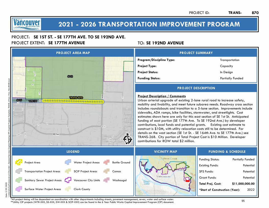
Mill Plain
10th198th
179th
177th
195th
175th
169th
199t h
Tech
Cente
r171
st
4th
Westridge
3rd
2nd
11th
173rd
170th
7th
196th
184th
5th
9th
176th
197th
6th
8th
Redwood
TRANS-870WTR-153
SS-23
SS-15
172nd
1st
Mill Plain
192nd
Ê
In Design
PROJECT AREA MAP
PROJECT:
PROJECT SUMMARY
Project Status:
TransportationProgram/Discipline Type:CapacityProject Type:
PROJECT DESCRIPTION
FUNDING & SCHEDULEVICINITY MAPLEGEND
SE 1ST ST. - SE 177TH AVE. TO SE 192ND AVE.
Project Description / CommentsUrban arterial upgrade of existing 2-lane rural road to increase safety,mobility and livability, and meet future subarea needs. Roadway cross sectionincludes roundabouts and transition to a 5-lane section. Improvements includesidewalks, ADA ramps, bike facilities, stormwater, and streetlights. Costestimates shown here are only for this east section of SE 1st St. Anticipatedfunding of east portion (SE 177th Ave. To SE 192nd Ave.) by developercontributions, local funds and potential grants. Existing cost estimate toconstruct is $10M, with utility relocation costs still to be determined. Fordetails on the west section (SE 1st St. - SE 164th Ave. to SE 177th Ave.) seeTRANS-268. City portion of Total Project Cost is $10 Million. Developercontributions for ROW total $2 million.
2022*Start of Construction (Year):
TRANS-PROJECT ID:
2021 - 2026 TRANSPORTATION IMPROVEMENT PROGRAM
PROJECT EXTENT:
$11,000,000.00Total Proj. Cost:PotentialGrant Funds:PotentialSFS Funds:PotentialExisting Funds:
*All project timing will be dependent on coordination with other departments including streets, pavement management, sewer, water and surface water.**Utility CIP projects (WTR-XXX, SS-XXX, SW-XXX & SCIP-XXX) can be found in the 6 Year Public Works Capital Improvement Program (CIP) document.
Partially FundedFunding Status:
Partially FundedFunding Status:
Project Area
Transportation Project Areas
Sanitary Sewer Project Areas
Surface Water Project Areas
Water Project Areas
SCIP Project Areas
Vancouver City Limits
Clark County
Battle Ground
Camas
Washougal
870
Service Layer Credits: Sources: Esri, HERE, Garmin, Intermap,increment P Corp., GEBCO, USGS, FAO, NPS, NRCAN, GeoBase,IGN, Kadaster NL, Ordnance Survey, Esri Japan, METI, Esri China(Hong Kong), (c) OpenStreetMap contributors, and the GIS UserCommunity
Date:
5/29
/202
0\\
intern
al.city
ofvan
couve
r.us\C
itywi
de\_
Gene
ral Se
rvices
\Cap
ital P
lannin
g\TIP
\Cap
ital P
rojec
ts Tem
plate_
TRAN
S_6Y
ear_P
oly_N
ewBA
SE.m
xd
TO: SE 192nd AvenueSE 192ND AVENUESE 177TH AVENUE
95
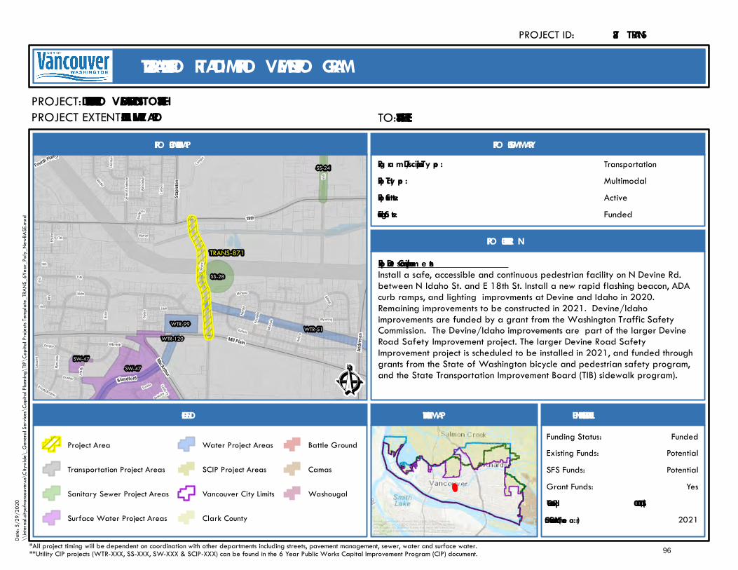
Oregon
17thBrya nt
Gener
al Ande
rson
15th
Namp
a
Willamette
41st
Idaho
Devin
e
Billings
Boise
Uma ti ll
a
Santa Fe
Missou
la
MontanaHe
lena
Ogden
Manza
nita
Sheri
dan
Rhododendron
Kansas
Pocat
ello
13th
Wintler
Berkeley
B erge
ro n
Oswego
Eureka
Murray
Wahcl
ellah
14th
16th
Latou
rell
Utah
65th
Wyoming
Campus
Carlso
n
TRANS-871
WTR-99
WTR-120WTR-51
SW-47SW-47
SS-24
SS-28
Falk
MacArthur
18th
Staple
ton
Blandford
Fourth Plain
Mill Plain
Andre
sen
Ê
Active
PRO JECT AREA MAP
PROJECT:
PRO JECT SUMMARY
Proje ct Sta tus:
TransportationProg ra m /Discipline Ty pe :MultimodalProje ct Ty pe :
PRO JECT DESCRIPTIO N
FUNDING & SCHEDULEVICINITY MAPLEGEND
N. DEVINE SIDEWALK IMPRO VEMENTS – N. IDAHO TO NE 18TH ST
Proje ct De scription / Com m e ntsInstall a safe, accessible and continuous pedestrian facility on N Devine Rd.between N Idaho St. and E 18th St. Install a new rapid flashing beacon, ADAcurb ramps, and lighting improvments at Devine and Idaho in 2020.Remaining improvements to be constructed in 2021. Devine/Idahoimprovements are funded by a grant from the Washington Traffic SafetyCommission. The Devine/Idaho improvements are part of the larger DevineRoad Safety Improvement project. The larger Devine Road SafetyImprovement project is scheduled to be installed in 2021, and funded throughgrants from the State of Washington bicycle and pedestrian safety program,and the State Transportation Improvement Board (TIB) sidewalk program).
2021*Sta rt of Construction (Y e a r):
TRANS-PROJECT ID:
2021 - 2026 TRANSPO RTATIO N IMPRO VEMENT PRO GRAM
PROJECT EXTENT:
$1,100,000.00Tota l Proj. Cost:YesGrant Funds:
PotentialSFS Funds:PotentialExisting Funds:
*All project timing will be dependent on coordination with other departments including streets, pavement management, sewer, water and surface water.**Utility CIP projects (WTR-XXX, SS-XXX, SW-XXX & SCIP-XXX) can be found in the 6 Year Public Works Capital Improvement Program (CIP) document.
FundedFunding Status:
FundedFunding Sta tus:
Project Area
Transportation Project Areas
Sanitary Sewer Project Areas
Surface Water Project Areas
Water Project Areas
SCIP Project Areas
Vancouver City Limits
Clark County
Battle Ground
Camas
Washougal
871
Service Layer Credits: Sources: Esri, HERE, Garmin, Intermap,increment P Corp., GEBCO, USGS, FAO, NPS, NRCAN, GeoBase,IGN, Kadaster NL, Ordnance Survey, Esri Japan, METI, Esri China(Hong Kong), (c) OpenStreetMap contributors, and the GIS UserCommunity
Date:
5/29
/202
0\\
intern
al.city
ofvan
couve
r.us\C
itywi
de\_
Gene
ral Se
rvices
\Cap
ital P
lannin
g\TIP
\Cap
ital P
rojec
ts Tem
plate_
TRAN
S_6Y
ear_P
oly_N
ewBA
SE.m
xd
TO: E 18th StreetE 18TH STREETMILL PLAIN BO ULEVARD
96
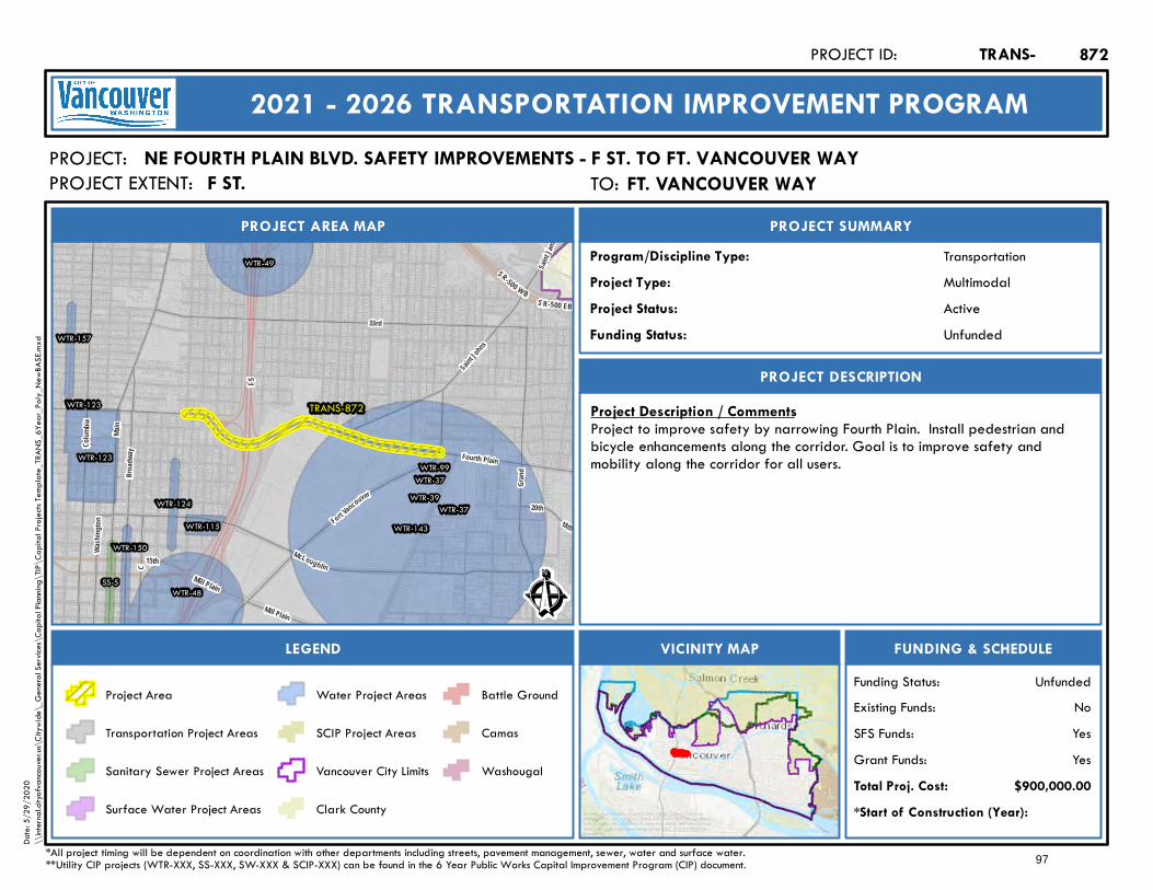
I-5
Mill Plain
15th
SR-500 W BS R-500 EB
TRANS-872
WTR-48
WTR-49
WTR-115
WTR-123
WTR-123WTR-99
WTR-124
WTR-37
WTR-37WTR-39
WTR-143WTR-150
WTR-157
SS-5
Colum
bia
Fort Vancouver
McLoughlin
18th
20th
Saint Johns
Main
Grand
Fourth Plain
Wash
ington
33rd
Broad
way
C
Mill Plain
Saint J
ames
Ê
Active
PROJECT AREA MAP
PROJECT:
PROJECT SUMMARY
Project Status:
TransportationProgram/Discipline Type:MultimodalProject Type:
PROJECT DESCRIPTION
FUNDING & SCHEDULEVICINITY MAPLEGEND
NE FOURTH PLAIN BLVD. SAFETY IMPROVEMENTS - F ST. TO FT. VANCOUVER WAY
Project Description / CommentsProject to improve safety by narrowing Fourth Plain. Install pedestrian andbicycle enhancements along the corridor. Goal is to improve safety andmobility along the corridor for all users.
*Start of Construction (Year):
TRANS-PROJECT ID:
2021 - 2026 TRANSPORTATION IMPROVEMENT PROGRAM
PROJECT EXTENT:
$900,000.00Total Proj. Cost:YesGrant Funds:YesSFS Funds:NoExisting Funds:
*All project timing will be dependent on coordination with other departments including streets, pavement management, sewer, water and surface water.**Utility CIP projects (WTR-XXX, SS-XXX, SW-XXX & SCIP-XXX) can be found in the 6 Year Public Works Capital Improvement Program (CIP) document.
UnfundedFunding Status:
UnfundedFunding Status:
Project Area
Transportation Project Areas
Sanitary Sewer Project Areas
Surface Water Project Areas
Water Project Areas
SCIP Project Areas
Vancouver City Limits
Clark County
Battle Ground
Camas
Washougal
872
Service Layer Credits: Sources: Esri, HERE, Garmin, Intermap,increment P Corp., GEBCO, USGS, FAO, NPS, NRCAN, GeoBase,IGN, Kadaster NL, Ordnance Survey, Esri Japan, METI, Esri China(Hong Kong), (c) OpenStreetMap contributors, and the GIS UserCommunity
Date:
5/29
/202
0\\
intern
al.city
ofvan
couve
r.us\C
itywi
de\_
Gene
ral Se
rvices
\Cap
ital P
lannin
g\TIP
\Cap
ital P
rojec
ts Tem
plate_
TRAN
S_6Y
ear_P
oly_N
ewBA
SE.m
xd
TO: Ft. Vancouver WayFT. VANCOUVER WAYF ST.
97
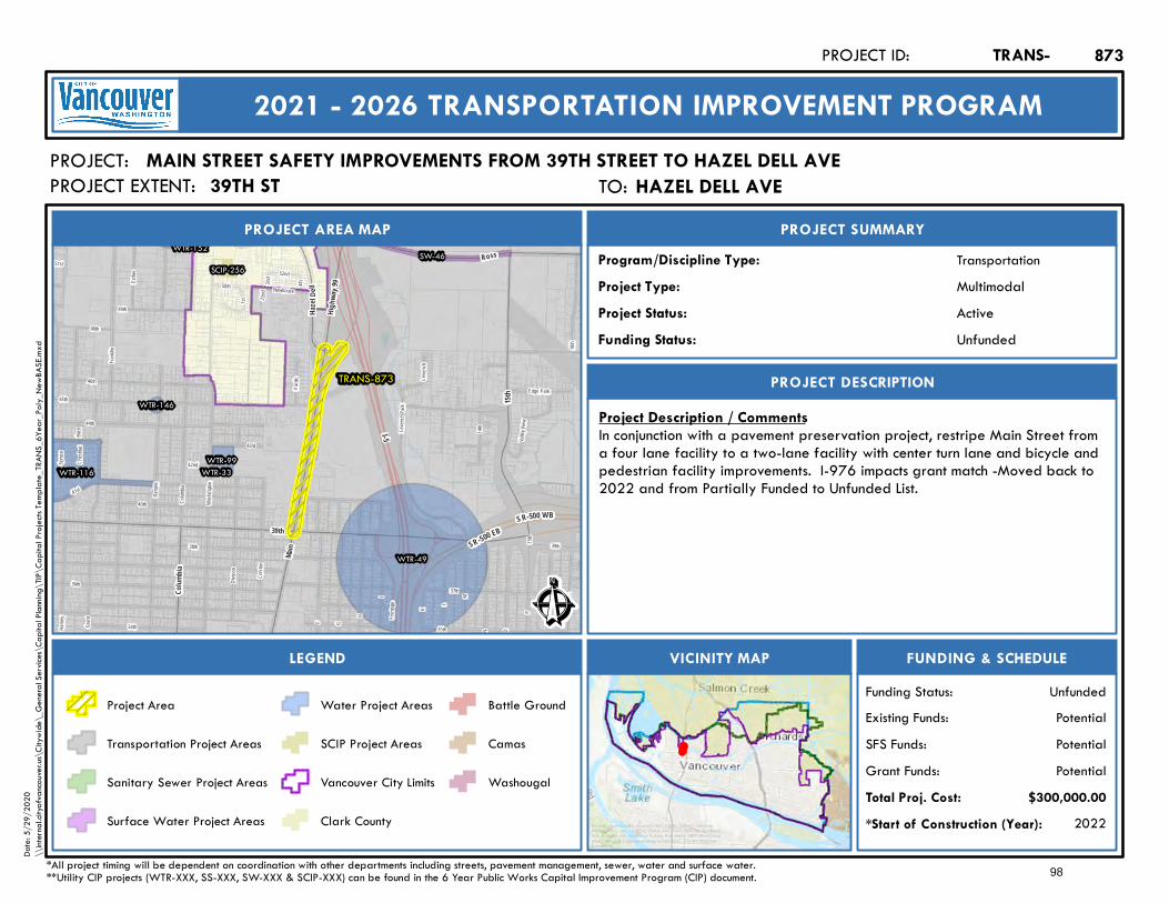
I-5
SR-500 EBSR-500 WB
R
Grant
Edge Park
Q
P
O
Washi
ngton
N
M
Newhouse
L
45th
K
Fronta
ge
49th
2nd
I
4th
H
Colum
bia
15th
Cresto
n
Leveric
h Park
G
Divisio
n
37th36th
35th
F
Harne
y
Danie
ls
51st
44th
14th
2 2nd
40th41st
46th
Birch
C hest
n ut
Frankl
in
1st
43rd
42nd
38th
34th
50th
52nd
Spruc
e
48th
Pac ific Le
v erich
39th
Esther
18th
Valley
View
TRANS-873
WTR-49
WTR-116WTR-99
WTR-33
WTR-152
WTR-146
SW-46SCIP-256
Ross
Colum
bia
15th
39th
Highw
a y9 9
Main
Haze l
Dell
Ê
Active
PROJECT AREA MAP
PROJECT:
PROJECT SUMMARY
Project Status:
TransportationProgram/Discipline Type:MultimodalProject Type:
PROJECT DESCRIPTION
FUNDING & SCHEDULEVICINITY MAPLEGEND
MAIN STREET SAFETY IMPROVEMENTS FROM 39TH STREET TO HAZEL DELL AVE
Project Description / CommentsIn conjunction with a pavement preservation project, restripe Main Street froma four lane facility to a two-lane facility with center turn lane and bicycle andpedestrian facility improvements. I-976 impacts grant match -Moved back to2022 and from Partially Funded to Unfunded List.
2022*Start of Construction (Year):
TRANS-PROJECT ID:
2021 - 2026 TRANSPORTATION IMPROVEMENT PROGRAM
PROJECT EXTENT:
$300,000.00Total Proj. Cost:PotentialGrant Funds:PotentialSFS Funds:PotentialExisting Funds:
*All project timing will be dependent on coordination with other departments including streets, pavement management, sewer, water and surface water.**Utility CIP projects (WTR-XXX, SS-XXX, SW-XXX & SCIP-XXX) can be found in the 6 Year Public Works Capital Improvement Program (CIP) document.
UnfundedFunding Status:
UnfundedFunding Status:
Project Area
Transportation Project Areas
Sanitary Sewer Project Areas
Surface Water Project Areas
Water Project Areas
SCIP Project Areas
Vancouver City Limits
Clark County
Battle Ground
Camas
Washougal
873
Service Layer Credits: Sources: Esri, HERE, Garmin, Intermap,increment P Corp., GEBCO, USGS, FAO, NPS, NRCAN, GeoBase,IGN, Kadaster NL, Ordnance Survey, Esri Japan, METI, Esri China(Hong Kong), (c) OpenStreetMap contributors, and the GIS UserCommunity
Date:
5/29
/202
0\\
intern
al.city
ofvan
couve
r.us\C
itywi
de\_
Gene
ral Se
rvices
\Cap
ital P
lannin
g\TIP
\Cap
ital P
rojec
ts Tem
plate_
TRAN
S_6Y
ear_P
oly_N
ewBA
SE.m
xd
TO: Hazel Dell AveHAZEL DELL AVE39TH ST
98
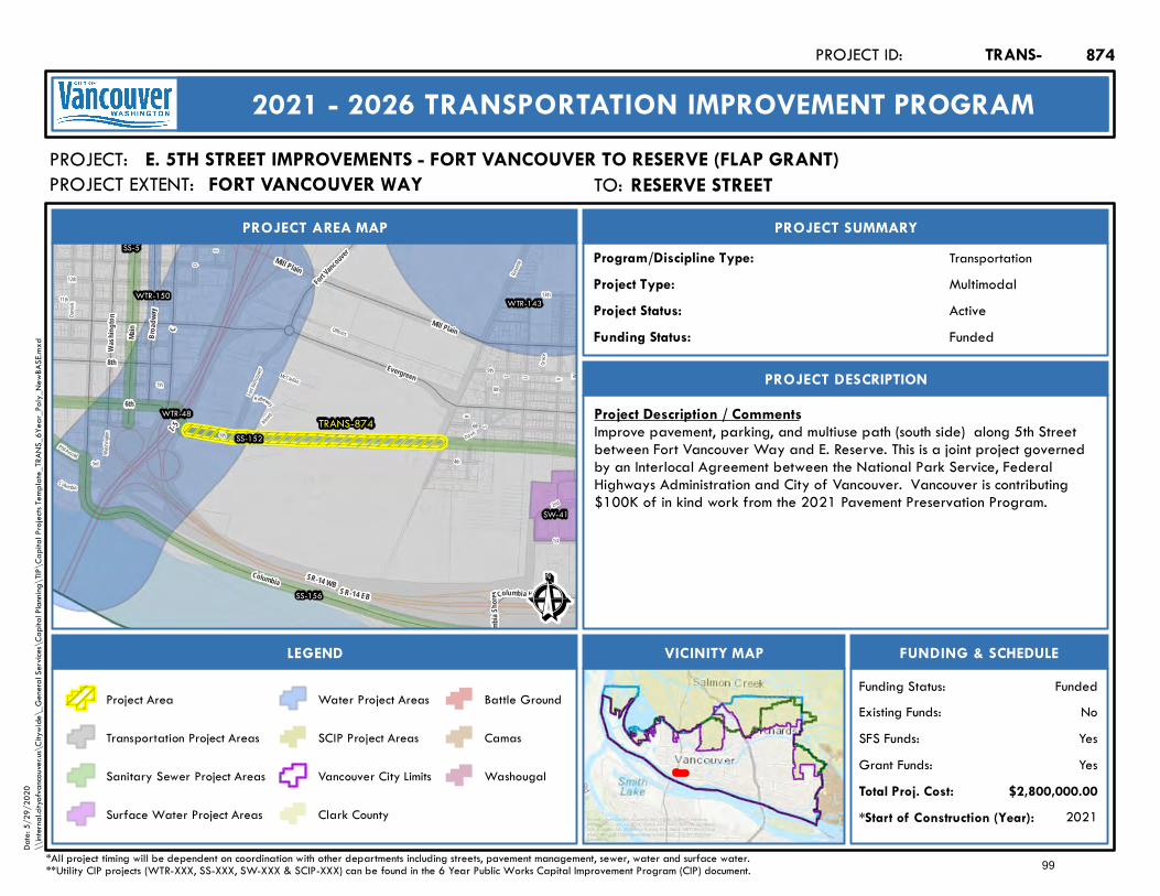
I - 5
SR-14 WB SR-14 EB
Mill Plain
5th
Reser
ve
Fort Va
ncouve
r
Colu mbia
Davis
Alvord
McClellan W
4th
VU
13th
Hatheway
9th
Danie
ls
6th
3rd
T
R
8th
S
12th
11th
2nd
Washi
ngton
D
7th
Grace
E
Phil Arnold
1st
Officers
TRANS-874WTR-48
WTR-143WTR-150
SW-41
SS-5
SS-152
SS-156
Fort Vancouver
Columbia
Evergreen
6th
Colum
bia Sh
ores
Main
8th
Broad
way
Mill PlainC
W ash
in gto n
Columbia HouseÊ
Active
PROJECT AREA MAP
PROJECT:
PROJECT SUMMARY
Project Status:
TransportationProgram/Discipline Type:MultimodalProject Type:
PROJECT DESCRIPTION
FUNDING & SCHEDULEVICINITY MAPLEGEND
E. 5TH STREET IMPROVEMENTS - FORT VANCOUVER TO RESERVE (FLAP GRANT)
Project Description / CommentsImprove pavement, parking, and multiuse path (south side) along 5th Streetbetween Fort Vancouver Way and E. Reserve. This is a joint project governedby an Interlocal Agreement between the National Park Service, FederalHighways Administration and City of Vancouver. Vancouver is contributing$100K of in kind work from the 2021 Pavement Preservation Program.
2021*Start of Construction (Year):
TRANS-PROJECT ID:
2021 - 2026 TRANSPORTATION IMPROVEMENT PROGRAM
PROJECT EXTENT:
$2,800,000.00Total Proj. Cost:YesGrant Funds:YesSFS Funds:NoExisting Funds:
*All project timing will be dependent on coordination with other departments including streets, pavement management, sewer, water and surface water.**Utility CIP projects (WTR-XXX, SS-XXX, SW-XXX & SCIP-XXX) can be found in the 6 Year Public Works Capital Improvement Program (CIP) document.
FundedFunding Status:
FundedFunding Status:
Project Area
Transportation Project Areas
Sanitary Sewer Project Areas
Surface Water Project Areas
Water Project Areas
SCIP Project Areas
Vancouver City Limits
Clark County
Battle Ground
Camas
Washougal
874
Service Layer Credits: Sources: Esri, HERE, Garmin, Intermap,increment P Corp., GEBCO, USGS, FAO, NPS, NRCAN, GeoBase,IGN, Kadaster NL, Ordnance Survey, Esri Japan, METI, Esri China(Hong Kong), (c) OpenStreetMap contributors, and the GIS UserCommunity
Date:
5/29
/202
0\\
intern
al.city
ofvan
couve
r.us\C
itywi
de\_
Gene
ral Se
rvices
\Cap
ital P
lannin
g\TIP
\Cap
ital P
rojec
ts Tem
plate_
TRAN
S_6Y
ear_P
oly_N
ewBA
SE.m
xd
TO: Reserve StreetRESERVE STREETFORT VANCOUVER WAY
99
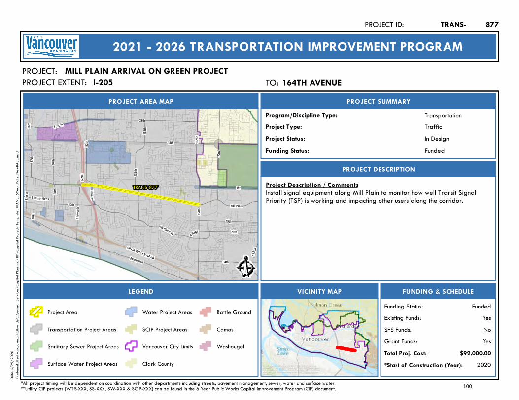
138th
28th
18th
192nd
136th
Mill Plain
162nd
164th
112th
Burton
1st
34th
I-205
SR-14 WB SR-14 EBEvergreen
86th
172nd
McGillivray
10th
98th
Lieser
88th
87th
15th
Village
Saint Helens
Ellsw
orth
20th
97th
Chkal ov
TRANS-877
Ê
In Design
PROJECT AREA MAP
PROJECT:
PROJECT SUMMARY
Project Status:
TransportationProgram/Discipline Type:TrafficProject Type:
PROJECT DESCRIPTION
FUNDING & SCHEDULEVICINITY MAPLEGEND
MILL PLAIN ARRIVAL ON GREEN PROJECT
Project Description / CommentsInstall signal equipment along Mill Plain to monitor how well Transit SignalPriority (TSP) is working and impacting other users along the corridor.
2020*Start of Construction (Year):
TRANS-PROJECT ID:
2021 - 2026 TRANSPORTATION IMPROVEMENT PROGRAM
PROJECT EXTENT:
$92,000.00Total Proj. Cost:YesGrant Funds:NoSFS Funds:YesExisting Funds:
*All project timing will be dependent on coordination with other departments including streets, pavement management, sewer, water and surface water.**Utility CIP projects (WTR-XXX, SS-XXX, SW-XXX & SCIP-XXX) can be found in the 6 Year Public Works Capital Improvement Program (CIP) document.
FundedFunding Status:
FundedFunding Status:
Project Area
Transportation Project Areas
Sanitary Sewer Project Areas
Surface Water Project Areas
Water Project Areas
SCIP Project Areas
Vancouver City Limits
Clark County
Battle Ground
Camas
Washougal
877
Service Layer Credits: Sources: Esri, HERE, Garmin, Intermap,increment P Corp., GEBCO, USGS, FAO, NPS, NRCAN, GeoBase,IGN, Kadaster NL, Ordnance Survey, Esri Japan, METI, Esri China(Hong Kong), (c) OpenStreetMap contributors, and the GIS UserCommunity
Date:
5/29
/202
0\\
intern
al.city
ofvan
couve
r.us\C
itywi
de\_
Gene
ral Se
rvices
\Cap
ital P
lannin
g\TIP
\Cap
ital P
rojec
ts Tem
plate_
TRAN
S_6Y
ear_P
oly_N
ewBA
SE.m
xd
TO: 164th Avenue164TH AVENUEI-205
100
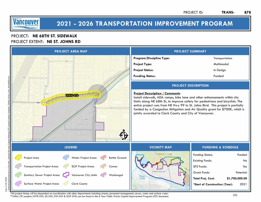
70th
31st
35th
69th
28th
65th
37th
27th
68th
71st
72nd
66th
TRANS-878
68th
Saint
John
s
Minnehaha Ê
In Design
PROJECT AREA MAP
PROJECT:
PROJECT SUMMARY
Project Status:
TransportationProgram/Discipline Type:MultimodalProject Type:
PROJECT DESCRIPTION
FUNDING & SCHEDULEVICINITY MAPLEGEND
NE 68TH ST. SIDEWALK
Project Description / CommentsInstall sidewalk, ADA ramps, bike lane and other enhancements within citylimits along NE 68th St, to improve safety for pedestrians and bicyclists. Theentire project runs from NE Hwy 99 to St. Johns Blvd. This project is partiallyfunded by a Congestion Mitigation and Air Quality grant for $700K, which isjointly awarded to Clark County and City of Vancouver.
2021*Start of Construction (Year):
TRANS-PROJECT ID:
2021 - 2026 TRANSPORTATION IMPROVEMENT PROGRAM
PROJECT EXTENT:
$1,700,000.00Total Proj. Cost:PotentialGrant Funds:
YesSFS Funds:NoExisting Funds:
*All project timing will be dependent on coordination with other departments including streets, pavement management, sewer, water and surface water.**Utility CIP projects (WTR-XXX, SS-XXX, SW-XXX & SCIP-XXX) can be found in the 6 Year Public Works Capital Improvement Program (CIP) document.
FundedFunding Status:
FundedFunding Status:
Project Area
Transportation Project Areas
Sanitary Sewer Project Areas
Surface Water Project Areas
Water Project Areas
SCIP Project Areas
Vancouver City Limits
Clark County
Battle Ground
Camas
Washougal
878
Service Layer Credits: Sources: Esri, HERE, Garmin, Intermap,increment P Corp., GEBCO, USGS, FAO, NPS, NRCAN, GeoBase,IGN, Kadaster NL, Ordnance Survey, Esri Japan, METI, Esri China(Hong Kong), (c) OpenStreetMap contributors, and the GIS UserCommunity
Date:
5/29
/202
0\\
intern
al.city
ofvan
couve
r.us\C
itywi
de\_
Gene
ral Se
rvices
\Cap
ital P
lannin
g\TIP
\Cap
ital P
rojec
ts Tem
plate_
TRAN
S_6Y
ear_P
oly_N
ewBA
SE.m
xd
NE ST. JOHNS RD
101
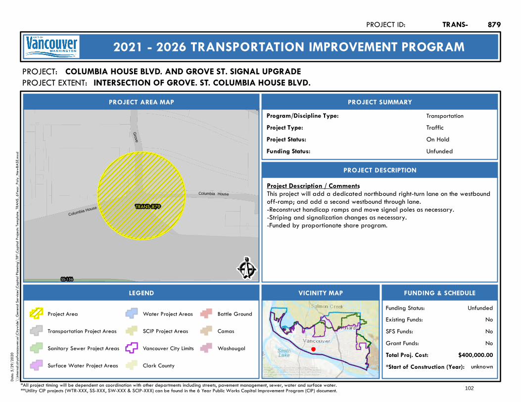
Columbia House
Columbia House
TRANS-879
SS-156
5th
Grove
Ê
On Hold
PROJECT AREA MAP
PROJECT:
PROJECT SUMMARY
Project Status:
TransportationProgram/Discipline Type:TrafficProject Type:
PROJECT DESCRIPTION
FUNDING & SCHEDULEVICINITY MAPLEGEND
COLUMBIA HOUSE BLVD. AND GROVE ST. SIGNAL UPGRADE
Project Description / CommentsThis project will add a dedicated northbound right-turn lane on the westboundoff-ramp; and add a second westbound through lane.-Reconstruct handicap ramps and move signal poles as necessary.-Striping and signalization changes as necessary.-Funded by proportionate share program.
unknown*Start of Construction (Year):
TRANS-PROJECT ID:
2021 - 2026 TRANSPORTATION IMPROVEMENT PROGRAM
PROJECT EXTENT:
$400,000.00Total Proj. Cost:NoGrant Funds:NoSFS Funds:NoExisting Funds:
*All project timing will be dependent on coordination with other departments including streets, pavement management, sewer, water and surface water.**Utility CIP projects (WTR-XXX, SS-XXX, SW-XXX & SCIP-XXX) can be found in the 6 Year Public Works Capital Improvement Program (CIP) document.
UnfundedFunding Status:
UnfundedFunding Status:
Project Area
Transportation Project Areas
Sanitary Sewer Project Areas
Surface Water Project Areas
Water Project Areas
SCIP Project Areas
Vancouver City Limits
Clark County
Battle Ground
Camas
Washougal
879
Service Layer Credits: Sources: Esri, HERE, Garmin, Intermap,increment P Corp., GEBCO, USGS, FAO, NPS, NRCAN, GeoBase,IGN, Kadaster NL, Ordnance Survey, Esri Japan, METI, Esri China(Hong Kong), (c) OpenStreetMap contributors, and the GIS UserCommunity
Date:
5/29
/202
0\\
intern
al.city
ofvan
couve
r.us\C
itywi
de\_
Gene
ral Se
rvices
\Cap
ital P
lannin
g\TIP
\Cap
ital P
rojec
ts Tem
plate_
TRAN
S_6Y
ear_P
oly_N
ewBA
SE.m
xd
INTERSECTION OF GROVE. ST. COLUMBIA HOUSE BLVD.
102
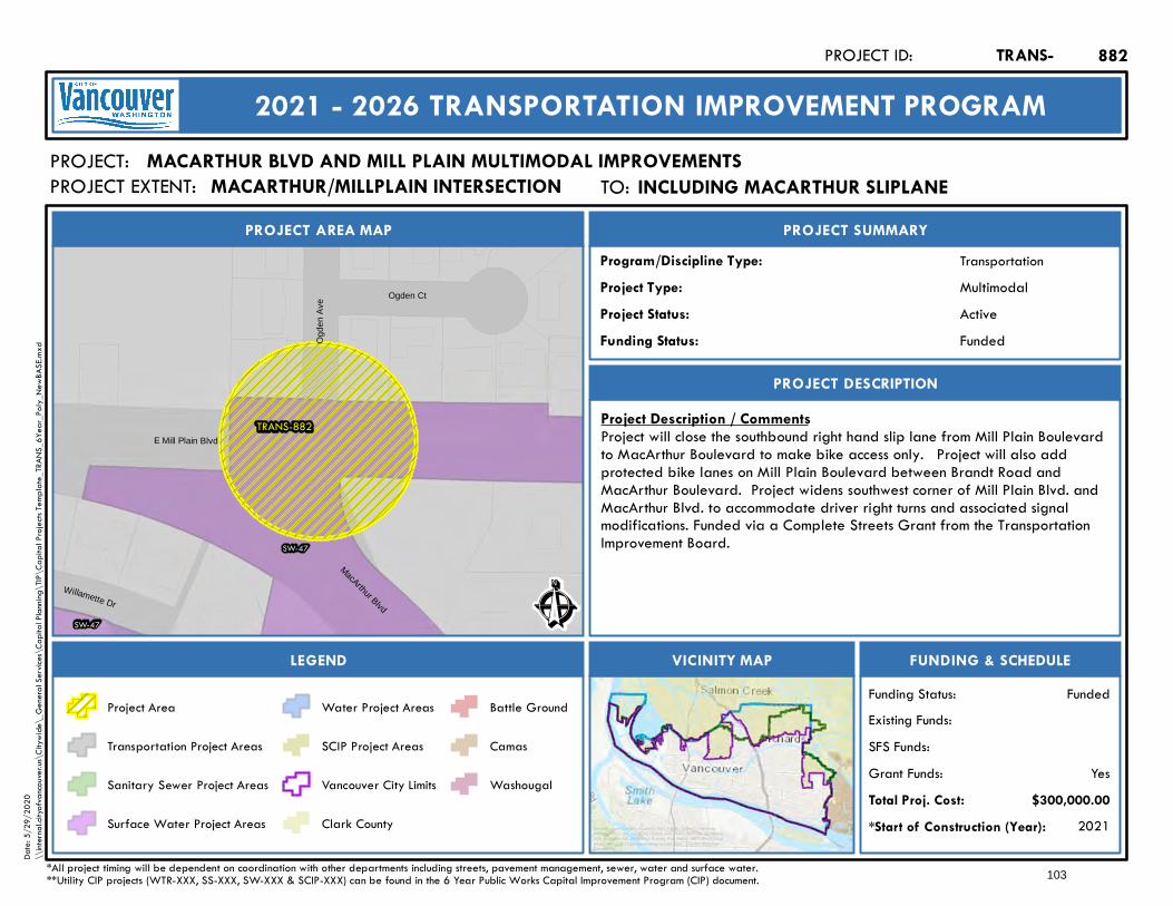
TRANS-882
SW-47
SW-47
Willamette Dr
Ogd
en A
ve
Ogden Ct
MacArthur Blvd
E Mill Plain Blvd
Ê
Active
PROJECT AREA MAP
PROJECT:
PROJECT SUMMARY
Project Status:
TransportationProgram/Discipline Type:MultimodalProject Type:
PROJECT DESCRIPTION
FUNDING & SCHEDULEVICINITY MAPLEGEND
MACARTHUR BLVD AND MILL PLAIN MULTIMODAL IMPROVEMENTS
Project Description / CommentsProject will close the southbound right hand slip lane from Mill Plain Boulevardto MacArthur Boulevard to make bike access only. Project will also addprotected bike lanes on Mill Plain Boulevard between Brandt Road andMacArthur Boulevard. Project widens southwest corner of Mill Plain Blvd. andMacArthur Blvd. to accommodate driver right turns and associated signalmodifications. Funded via a Complete Streets Grant from the TransportationImprovement Board.
2021*Start of Construction (Year):
TRANS-PROJECT ID:
2021 - 2026 TRANSPORTATION IMPROVEMENT PROGRAM
PROJECT EXTENT:
$300,000.00Total Proj. Cost:YesGrant Funds:
SFS Funds:Existing Funds:
*All project timing will be dependent on coordination with other departments including streets, pavement management, sewer, water and surface water.**Utility CIP projects (WTR-XXX, SS-XXX, SW-XXX & SCIP-XXX) can be found in the 6 Year Public Works Capital Improvement Program (CIP) document.
FundedFunding Status:
FundedFunding Status:
Project Area
Transportation Project Areas
Sanitary Sewer Project Areas
Surface Water Project Areas
Water Project Areas
SCIP Project Areas
Vancouver City Limits
Clark County
Battle Ground
Camas
Washougal
882
Service Layer Credits: Sources: Esri, HERE, Garmin, Intermap,increment P Corp., GEBCO, USGS, FAO, NPS, NRCAN, GeoBase,IGN, Kadaster NL, Ordnance Survey, Esri Japan, METI, Esri China(Hong Kong), (c) OpenStreetMap contributors, and the GIS UserCommunity
Date:
5/29
/202
0\\
intern
al.city
ofvan
couve
r.us\C
itywi
de\_
Gene
ral Se
rvices
\Cap
ital P
lannin
g\TIP
\Cap
ital P
rojec
ts Tem
plate_
TRAN
S_6Y
ear_P
oly_N
ewBA
SE.m
xd
TO: Including MacArthur sliplaneINCLUDING MACARTHUR SLIPLANEMACARTHUR/MILLPLAIN INTERSECTION
103

TRANS-883
WTR-122
SS-78
32nd
Ê
Future
PROJECT AREA MAP
PROJECT:
PROJECT SUMMARY
Project Status:
TransportationProgram/Discipline Type:CapacityProject Type:
PROJECT DESCRIPTION
FUNDING & SCHEDULEVICINITY MAPLEGEND
NW 32ND AVENUE AND SR 501 INTERSECTION
Project Description / CommentsProject proposes a roundabout at the intersection of SR 501 and NW 32ndAve. to improve traffic operations.
unknown*Start of Construction (Year):
TRANS-PROJECT ID:
2021 - 2026 TRANSPORTATION IMPROVEMENT PROGRAM
PROJECT EXTENT:
$2,000,000.00Total Proj. Cost:PotentialGrant Funds:
NoSFS Funds:NoExisting Funds:
*All project timing will be dependent on coordination with other departments including streets, pavement management, sewer, water and surface water.**Utility CIP projects (WTR-XXX, SS-XXX, SW-XXX & SCIP-XXX) can be found in the 6 Year Public Works Capital Improvement Program (CIP) document.
UnfundedFunding Status:
UnfundedFunding Status:
Project Area
Transportation Project Areas
Sanitary Sewer Project Areas
Surface Water Project Areas
Water Project Areas
SCIP Project Areas
Vancouver City Limits
Clark County
Battle Ground
Camas
Washougal
883
Service Layer Credits: Sources: Esri, HERE, Garmin, Intermap,increment P Corp., GEBCO, USGS, FAO, NPS, NRCAN, GeoBase,IGN, Kadaster NL, Ordnance Survey, Esri Japan, METI, Esri China(Hong Kong), (c) OpenStreetMap contributors, and the GIS UserCommunity
Date:
5/29
/202
0\\
intern
al.city
ofvan
couve
r.us\C
itywi
de\_
Gene
ral Se
rvices
\Cap
ital P
lannin
g\TIP
\Cap
ital P
rojec
ts Tem
plate_
TRAN
S_6Y
ear_P
oly_N
ewBA
SE.m
xd
104
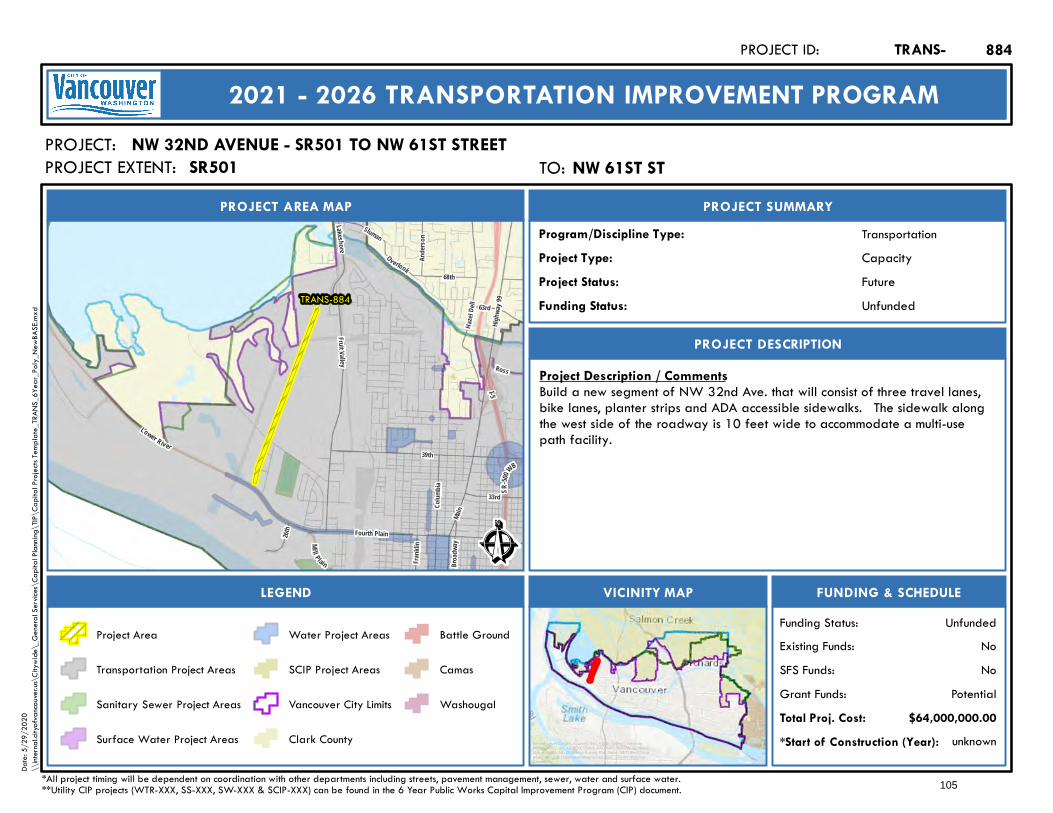
Lakeshore
63rd
Fourth Plain
Hazel
D ell
Main
Fruit Valley
Broad
way
Highw
ay 99
I-5
SR-50
0WB
Lower River
Mill Plain
Ande
rson
68th
Sluman
33rd
Frank
lin
Colum
bia
39th
Overlook
Ross
26th
TRANS-884
Ê
Future
PROJECT AREA MAP
PROJECT:
PROJECT SUMMARY
Project Status:
TransportationProgram/Discipline Type:CapacityProject Type:
PROJECT DESCRIPTION
FUNDING & SCHEDULEVICINITY MAPLEGEND
NW 32ND AVENUE - SR501 TO NW 61ST STREET
Project Description / CommentsBuild a new segment of NW 32nd Ave. that will consist of three travel lanes,bike lanes, planter strips and ADA accessible sidewalks. The sidewalk alongthe west side of the roadway is 10 feet wide to accommodate a multi-usepath facility.
unknown*Start of Construction (Year):
TRANS-PROJECT ID:
2021 - 2026 TRANSPORTATION IMPROVEMENT PROGRAM
PROJECT EXTENT:
$64,000,000.00Total Proj. Cost:PotentialGrant Funds:
NoSFS Funds:NoExisting Funds:
*All project timing will be dependent on coordination with other departments including streets, pavement management, sewer, water and surface water.**Utility CIP projects (WTR-XXX, SS-XXX, SW-XXX & SCIP-XXX) can be found in the 6 Year Public Works Capital Improvement Program (CIP) document.
UnfundedFunding Status:
UnfundedFunding Status:
Project Area
Transportation Project Areas
Sanitary Sewer Project Areas
Surface Water Project Areas
Water Project Areas
SCIP Project Areas
Vancouver City Limits
Clark County
Battle Ground
Camas
Washougal
884
Service Layer Credits: Sources: Esri, HERE, Garmin, Intermap,increment P Corp., GEBCO, USGS, FAO, NPS, NRCAN, GeoBase,IGN, Kadaster NL, Ordnance Survey, Esri Japan, METI, Esri China(Hong Kong), (c) OpenStreetMap contributors, and the GIS UserCommunity
Date:
5/29
/202
0\\
intern
al.city
ofvan
couve
r.us\C
itywi
de\_
Gene
ral Se
rvices
\Cap
ital P
lannin
g\TIP
\Cap
ital P
rojec
ts Tem
plate_
TRAN
S_6Y
ear_P
oly_N
ewBA
SE.m
xd
TO: NW 61st STNW 61ST STSR501
105
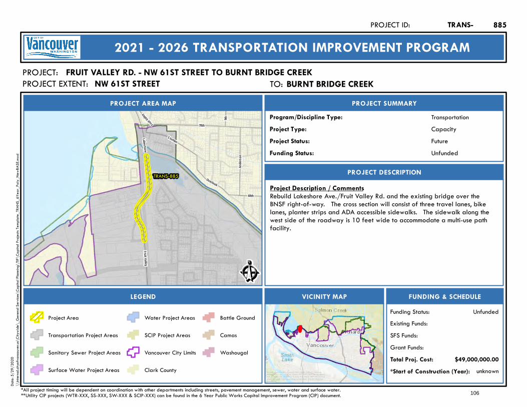
TRANS-885
Ande
rson
68th
Sluman
9th
Fruit Valle
y
Overlook
Lakeshore
78th
Fruit Valley
Ê
Future
PROJECT AREA MAP
PROJECT:
PROJECT SUMMARY
Project Status:
TransportationProgram/Discipline Type:CapacityProject Type:
PROJECT DESCRIPTION
FUNDING & SCHEDULEVICINITY MAPLEGEND
FRUIT VALLEY RD. - NW 61ST STREET TO BURNT BRIDGE CREEK
Project Description / CommentsRebuild Lakeshore Ave./Fruit Valley Rd. and the existing bridge over theBNSF right-of-way. The cross section will consist of three travel lanes, bikelanes, planter strips and ADA accessible sidewalks. The sidewalk along thewest side of the roadway is 10 feet wide to accommodate a multi-use pathfacility.
unknown*Start of Construction (Year):
TRANS-PROJECT ID:
2021 - 2026 TRANSPORTATION IMPROVEMENT PROGRAM
PROJECT EXTENT:
$49,000,000.00Total Proj. Cost:Grant Funds:SFS Funds:Existing Funds:
*All project timing will be dependent on coordination with other departments including streets, pavement management, sewer, water and surface water.**Utility CIP projects (WTR-XXX, SS-XXX, SW-XXX & SCIP-XXX) can be found in the 6 Year Public Works Capital Improvement Program (CIP) document.
UnfundedFunding Status:
UnfundedFunding Status:
Project Area
Transportation Project Areas
Sanitary Sewer Project Areas
Surface Water Project Areas
Water Project Areas
SCIP Project Areas
Vancouver City Limits
Clark County
Battle Ground
Camas
Washougal
885
Service Layer Credits: Sources: Esri, HERE, Garmin, Intermap,increment P Corp., GEBCO, USGS, FAO, NPS, NRCAN, GeoBase,IGN, Kadaster NL, Ordnance Survey, Esri Japan, METI, Esri China(Hong Kong), (c) OpenStreetMap contributors, and the GIS UserCommunity
Date:
5/29
/202
0\\
intern
al.city
ofvan
couve
r.us\C
itywi
de\_
Gene
ral Se
rvices
\Cap
ital P
lannin
g\TIP
\Cap
ital P
rojec
ts Tem
plate_
TRAN
S_6Y
ear_P
oly_N
ewBA
SE.m
xd
TO: Burnt Bridge CreekBURNT BRIDGE CREEKNW 61ST STREET
106

25th
Gregory
75th
23rd
14th
71st
Bacon
19th
22nd 21st
16th
15th
Chikeric
13th
78th
79th
TRANS-886
S luman
Fruit Valley
Lakeshor e
78th
Fruit Valley
Ê
Future
PROJECT AREA MAP
PROJECT:
PROJECT SUMMARY
Project Status:
TransportationProgram/Discipline Type:CapacityProject Type:
PROJECT DESCRIPTION
FUNDING & SCHEDULEVICINITY MAPLEGEND
FRUIT VALLEY RD. - BURNT BRIDGE CREEK TO NW LAKESHORE AVE
Project Description / CommentsRebuild Lakeshore Ave./Fruit Valley Rd. to a cross section consisting of threetravel lanes, bike lanes, planter strips and ADA accessible sidewalks. Thesidewalk along the west side of the roadway is 10 feet wide to accommodatea multi-use path facility.
unknown*Start of Construction (Year):
TRANS-PROJECT ID:
2021 - 2026 TRANSPORTATION IMPROVEMENT PROGRAM
PROJECT EXTENT:
$10,000,000.00Total Proj. Cost:Grant Funds:SFS Funds:Existing Funds:
*All project timing will be dependent on coordination with other departments including streets, pavement management, sewer, water and surface water.**Utility CIP projects (WTR-XXX, SS-XXX, SW-XXX & SCIP-XXX) can be found in the 6 Year Public Works Capital Improvement Program (CIP) document.
UnfundedFunding Status:
UnfundedFunding Status:
Project Area
Transportation Project Areas
Sanitary Sewer Project Areas
Surface Water Project Areas
Water Project Areas
SCIP Project Areas
Vancouver City Limits
Clark County
Battle Ground
Camas
Washougal
886
Service Layer Credits: Sources: Esri, HERE, Garmin, Intermap,increment P Corp., GEBCO, USGS, FAO, NPS, NRCAN, GeoBase,IGN, Kadaster NL, Ordnance Survey, Esri Japan, METI, Esri China(Hong Kong), (c) OpenStreetMap contributors, and the GIS UserCommunity
Date:
5/29
/202
0\\
intern
al.city
ofvan
couve
r.us\C
itywi
de\_
Gene
ral Se
rvices
\Cap
ital P
lannin
g\TIP
\Cap
ital P
rojec
ts Tem
plate_
TRAN
S_6Y
ear_P
oly_N
ewBA
SE.m
xd
TO: NW Lakeshore AveNW LAKESHORE AVEBURNT BRIDGE CREEK
107
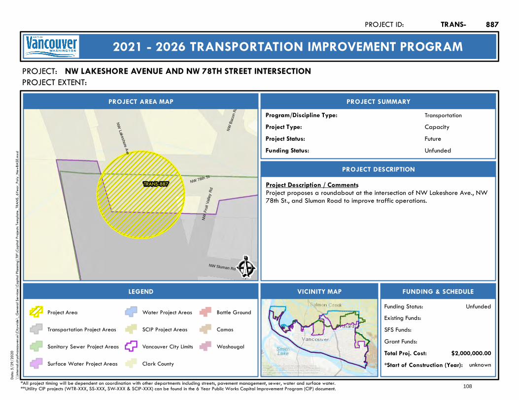
TRANS-887
NW
19t
h Av
e
NW B
acon
Rd
NW Sluman Rd
NWLakeshore
Ave
NWFr
uit V
alle
yRd
NW 78th St
Ê
Future
PROJECT AREA MAP
PROJECT:
PROJECT SUMMARY
Project Status:
TransportationProgram/Discipline Type:CapacityProject Type:
PROJECT DESCRIPTION
FUNDING & SCHEDULEVICINITY MAPLEGEND
NW LAKESHORE AVENUE AND NW 78TH STREET INTERSECTION
Project Description / CommentsProject proposes a roundabout at the intersection of NW Lakeshore Ave., NW78th St., and Sluman Road to improve traffic operations.
unknown*Start of Construction (Year):
TRANS-PROJECT ID:
2021 - 2026 TRANSPORTATION IMPROVEMENT PROGRAM
PROJECT EXTENT:
$2,000,000.00Total Proj. Cost:Grant Funds:SFS Funds:Existing Funds:
*All project timing will be dependent on coordination with other departments including streets, pavement management, sewer, water and surface water.**Utility CIP projects (WTR-XXX, SS-XXX, SW-XXX & SCIP-XXX) can be found in the 6 Year Public Works Capital Improvement Program (CIP) document.
UnfundedFunding Status:
UnfundedFunding Status:
Project Area
Transportation Project Areas
Sanitary Sewer Project Areas
Surface Water Project Areas
Water Project Areas
SCIP Project Areas
Vancouver City Limits
Clark County
Battle Ground
Camas
Washougal
887
Service Layer Credits: Sources: Esri, HERE, Garmin, Intermap,increment P Corp., GEBCO, USGS, FAO, NPS, NRCAN, GeoBase,IGN, Kadaster NL, Ordnance Survey, Esri Japan, METI, Esri China(Hong Kong), (c) OpenStreetMap contributors, and the GIS UserCommunity
Date:
5/29
/202
0\\
intern
al.city
ofvan
couve
r.us\C
itywi
de\_
Gene
ral Se
rvices
\Cap
ital P
lannin
g\TIP
\Cap
ital P
rojec
ts Tem
plate_
TRAN
S_6Y
ear_P
oly_N
ewBA
SE.m
xd
108
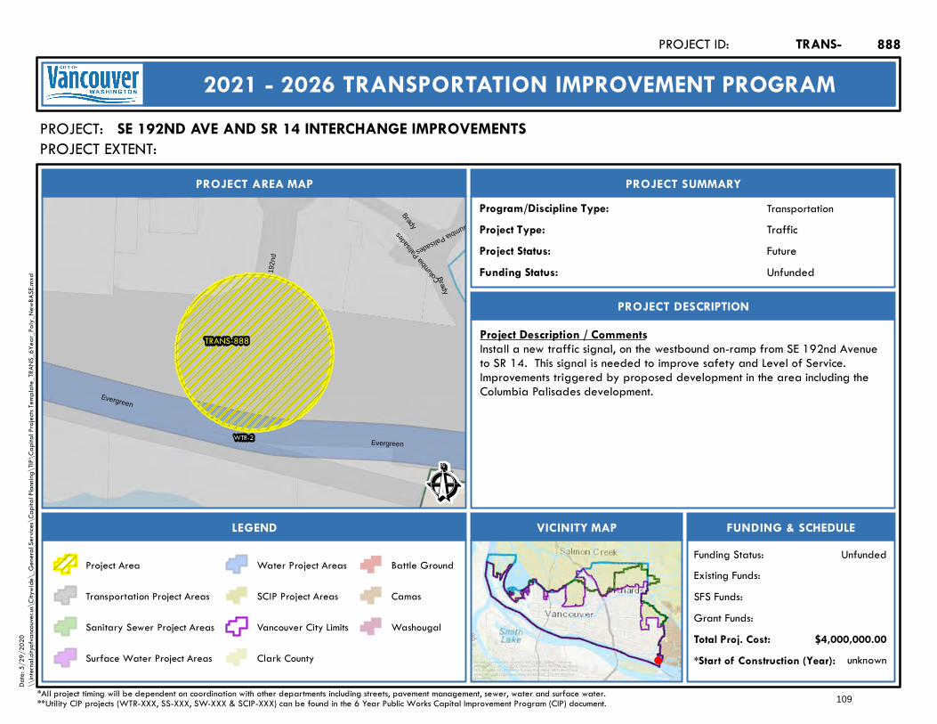
192n
d
Brady
Columbia Palisades
Brady
Evergreen
Evergreen
TRANS-888
WTR-2Colu
mbia P
alisa
des
Ê
Future
PROJECT AREA MAP
PROJECT:
PROJECT SUMMARY
Project Status:
TransportationProgram/Discipline Type:TrafficProject Type:
PROJECT DESCRIPTION
FUNDING & SCHEDULEVICINITY MAPLEGEND
SE 192ND AVE AND SR 14 INTERCHANGE IMPROVEMENTS
Project Description / CommentsInstall a new traffic signal, on the westbound on-ramp from SE 192nd Avenueto SR 14. This signal is needed to improve safety and Level of Service.Improvements triggered by proposed development in the area including theColumbia Palisades development.
unknown*Start of Construction (Year):
TRANS-PROJECT ID:
2021 - 2026 TRANSPORTATION IMPROVEMENT PROGRAM
PROJECT EXTENT:
$4,000,000.00Total Proj. Cost:Grant Funds:SFS Funds:Existing Funds:
*All project timing will be dependent on coordination with other departments including streets, pavement management, sewer, water and surface water.**Utility CIP projects (WTR-XXX, SS-XXX, SW-XXX & SCIP-XXX) can be found in the 6 Year Public Works Capital Improvement Program (CIP) document.
UnfundedFunding Status:
UnfundedFunding Status:
Project Area
Transportation Project Areas
Sanitary Sewer Project Areas
Surface Water Project Areas
Water Project Areas
SCIP Project Areas
Vancouver City Limits
Clark County
Battle Ground
Camas
Washougal
888
Service Layer Credits: Sources: Esri, HERE, Garmin, Intermap,increment P Corp., GEBCO, USGS, FAO, NPS, NRCAN, GeoBase,IGN, Kadaster NL, Ordnance Survey, Esri Japan, METI, Esri China(Hong Kong), (c) OpenStreetMap contributors, and the GIS UserCommunity
Date:
5/29
/202
0\\
intern
al.city
ofvan
couve
r.us\C
itywi
de\_
Gene
ral Se
rvices
\Cap
ital P
lannin
g\TIP
\Cap
ital P
rojec
ts Tem
plate_
TRAN
S_6Y
ear_P
oly_N
ewBA
SE.m
xd
109
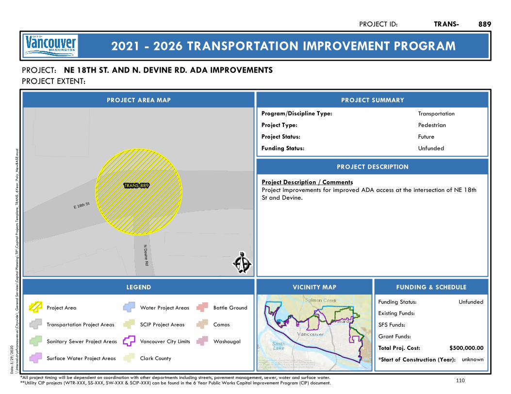
TRANS-889
ND
evi neRd
E 18th St
Ê
Future
PROJECT AREA MAP
PROJECT:
PROJECT SUMMARY
Project Status:
TransportationProgram/Discipline Type:PedestrianProject Type:
PROJECT DESCRIPTION
FUNDING & SCHEDULEVICINITY MAPLEGEND
NE 18TH ST. AND N. DEVINE RD. ADA IMPROVEMENTS
Project Description / CommentsProject improvements for improved ADA access at the intersection of NE 18thSt and Devine.
unknown*Start of Construction (Year):
TRANS-PROJECT ID:
2021 - 2026 TRANSPORTATION IMPROVEMENT PROGRAM
PROJECT EXTENT:
$500,000.00Total Proj. Cost:Grant Funds:SFS Funds:Existing Funds:
*All project timing will be dependent on coordination with other departments including streets, pavement management, sewer, water and surface water.**Utility CIP projects (WTR-XXX, SS-XXX, SW-XXX & SCIP-XXX) can be found in the 6 Year Public Works Capital Improvement Program (CIP) document.
UnfundedFunding Status:
UnfundedFunding Status:
Project Area
Transportation Project Areas
Sanitary Sewer Project Areas
Surface Water Project Areas
Water Project Areas
SCIP Project Areas
Vancouver City Limits
Clark County
Battle Ground
Camas
Washougal
889
Service Layer Credits: Sources: Esri, HERE, Garmin, Intermap,increment P Corp., GEBCO, USGS, FAO, NPS, NRCAN, GeoBase,IGN, Kadaster NL, Ordnance Survey, Esri Japan, METI, Esri China(Hong Kong), (c) OpenStreetMap contributors, and the GIS UserCommunity
Date:
5/29
/202
0\\
intern
al.city
ofvan
couve
r.us\C
itywi
de\_
Gene
ral Se
rvices
\Cap
ital P
lannin
g\TIP
\Cap
ital P
rojec
ts Tem
plate_
TRAN
S_6Y
ear_P
oly_N
ewBA
SE.m
xd
110
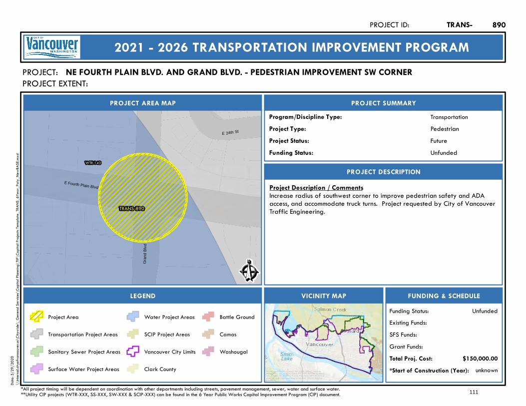
TRANS-890
WTR-143
E 24th St
Gra
nd B
lvd
E Fourth Plain Blvd
Ê
Future
PROJECT AREA MAP
PROJECT:
PROJECT SUMMARY
Project Status:
TransportationProgram/Discipline Type:PedestrianProject Type:
PROJECT DESCRIPTION
FUNDING & SCHEDULEVICINITY MAPLEGEND
NE FOURTH PLAIN BLVD. AND GRAND BLVD. - PEDESTRIAN IMPROVEMENT SW CORNER
Project Description / CommentsIncrease radius of southwest corner to improve pedestrian safety and ADAaccess, and accommodate truck turns. Project requested by City of VancouverTraffic Engineering.
unknown*Start of Construction (Year):
TRANS-PROJECT ID:
2021 - 2026 TRANSPORTATION IMPROVEMENT PROGRAM
PROJECT EXTENT:
$150,000.00Total Proj. Cost:Grant Funds:SFS Funds:Existing Funds:
*All project timing will be dependent on coordination with other departments including streets, pavement management, sewer, water and surface water.**Utility CIP projects (WTR-XXX, SS-XXX, SW-XXX & SCIP-XXX) can be found in the 6 Year Public Works Capital Improvement Program (CIP) document.
UnfundedFunding Status:
UnfundedFunding Status:
Project Area
Transportation Project Areas
Sanitary Sewer Project Areas
Surface Water Project Areas
Water Project Areas
SCIP Project Areas
Vancouver City Limits
Clark County
Battle Ground
Camas
Washougal
890
Service Layer Credits: Sources: Esri, HERE, Garmin, Intermap,increment P Corp., GEBCO, USGS, FAO, NPS, NRCAN, GeoBase,IGN, Kadaster NL, Ordnance Survey, Esri Japan, METI, Esri China(Hong Kong), (c) OpenStreetMap contributors, and the GIS UserCommunity
Date:
5/29
/202
0\\
intern
al.city
ofvan
couve
r.us\C
itywi
de\_
Gene
ral Se
rvices
\Cap
ital P
lannin
g\TIP
\Cap
ital P
rojec
ts Tem
plate_
TRAN
S_6Y
ear_P
oly_N
ewBA
SE.m
xd
111
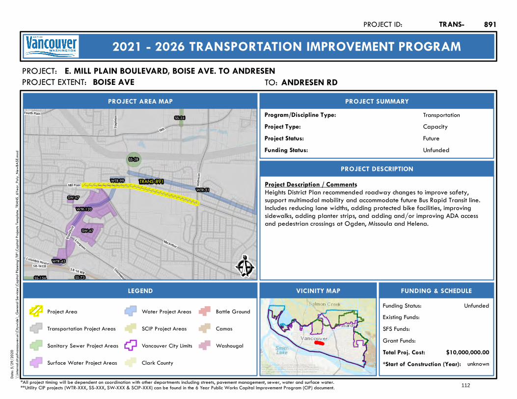
SR-14 WBSR-14 EB
TRANS-891WTR-99
WTR-120
WTR-51
WTR-43
SW-47
SW-47
SS-24
SS-28
SS-73SS-156
EvergreenMacArthur
18th
Andre
sen
Columbia House
Bland
ford
Staple
ton
Shorewood
Fourth Plain
Mill Plain
Ê
Future
PROJECT AREA MAP
PROJECT:
PROJECT SUMMARY
Project Status:
TransportationProgram/Discipline Type:CapacityProject Type:
PROJECT DESCRIPTION
FUNDING & SCHEDULEVICINITY MAPLEGEND
E. MILL PLAIN BOULEVARD, BOISE AVE. TO ANDRESEN
Project Description / CommentsHeights District Plan recommended roadway changes to improve safety,support multimodal mobility and accommodate future Bus Rapid Transit line.Includes reducing lane widths, adding protected bike facilities, improvingsidewalks, adding planter strips, and adding and/or improving ADA accessand pedestrian crossings at Ogden, Missoula and Helena.
unknown*Start of Construction (Year):
TRANS-PROJECT ID:
2021 - 2026 TRANSPORTATION IMPROVEMENT PROGRAM
PROJECT EXTENT:
$10,000,000.00Total Proj. Cost:Grant Funds:SFS Funds:Existing Funds:
*All project timing will be dependent on coordination with other departments including streets, pavement management, sewer, water and surface water.**Utility CIP projects (WTR-XXX, SS-XXX, SW-XXX & SCIP-XXX) can be found in the 6 Year Public Works Capital Improvement Program (CIP) document.
UnfundedFunding Status:
UnfundedFunding Status:
Project Area
Transportation Project Areas
Sanitary Sewer Project Areas
Surface Water Project Areas
Water Project Areas
SCIP Project Areas
Vancouver City Limits
Clark County
Battle Ground
Camas
Washougal
891
Service Layer Credits: Sources: Esri, HERE, Garmin, Intermap,increment P Corp., GEBCO, USGS, FAO, NPS, NRCAN, GeoBase,IGN, Kadaster NL, Ordnance Survey, Esri Japan, METI, Esri China(Hong Kong), (c) OpenStreetMap contributors, and the GIS UserCommunity
Date:
5/29
/202
0\\
intern
al.city
ofvan
couve
r.us\C
itywi
de\_
Gene
ral Se
rvices
\Cap
ital P
lannin
g\TIP
\Cap
ital P
rojec
ts Tem
plate_
TRAN
S_6Y
ear_P
oly_N
ewBA
SE.m
xd
TO: Andresen RdANDRESEN RDBOISE AVE
112
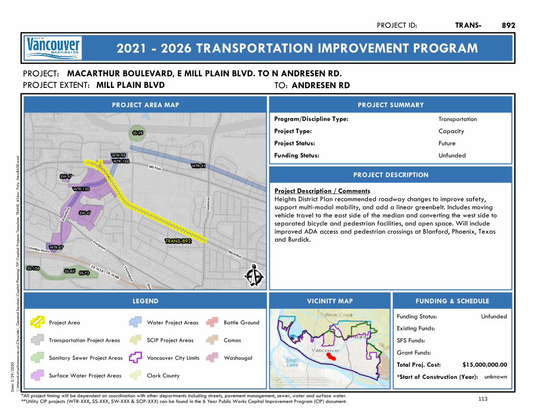
SR-14 EB SR-14 WB
TRANS-892
WTR-99
WTR-120
WTR-51
WTR-67
WTR-106
SW-47
SW-47
SS-28
SS-73SS-85SS-156
Riverside
Evergreen MacArthur
Andre
sen
Shorewood
Columbia House
Bland
ford
Mill Plain
Ê
Future
PROJECT AREA MAP
PROJECT:
PROJECT SUMMARY
Project Status:
TransportationProgram/Discipline Type:CapacityProject Type:
PROJECT DESCRIPTION
FUNDING & SCHEDULEVICINITY MAPLEGEND
MACARTHUR BOULEVARD, E MILL PLAIN BLVD. TO N ANDRESEN RD.
Project Description / CommentsHeights District Plan recommended roadway changes to improve safety,support multi-modal mobility, and add a linear greenbelt. Includes movingvehicle travel to the east side of the median and converting the west side toseparated bicycle and pedestrian facilities, and open space. Will includeimproved ADA access and pedestrian crossings at Blanford, Phoenix, Texasand Burdick.
unknown*Start of Construction (Year):
TRANS-PROJECT ID:
2021 - 2026 TRANSPORTATION IMPROVEMENT PROGRAM
PROJECT EXTENT:
$15,000,000.00Total Proj. Cost:Grant Funds:SFS Funds:Existing Funds:
*All project timing will be dependent on coordination with other departments including streets, pavement management, sewer, water and surface water.**Utility CIP projects (WTR-XXX, SS-XXX, SW-XXX & SCIP-XXX) can be found in the 6 Year Public Works Capital Improvement Program (CIP) document.
UnfundedFunding Status:
UnfundedFunding Status:
Project Area
Transportation Project Areas
Sanitary Sewer Project Areas
Surface Water Project Areas
Water Project Areas
SCIP Project Areas
Vancouver City Limits
Clark County
Battle Ground
Camas
Washougal
892
Service Layer Credits: Sources: Esri, HERE, Garmin, Intermap,increment P Corp., GEBCO, USGS, FAO, NPS, NRCAN, GeoBase,IGN, Kadaster NL, Ordnance Survey, Esri Japan, METI, Esri China(Hong Kong), (c) OpenStreetMap contributors, and the GIS UserCommunity
Date:
5/29
/202
0\\
intern
al.city
ofvan
couve
r.us\C
itywi
de\_
Gene
ral Se
rvices
\Cap
ital P
lannin
g\TIP
\Cap
ital P
rojec
ts Tem
plate_
TRAN
S_6Y
ear_P
oly_N
ewBA
SE.m
xd
TO: Andresen RdANDRESEN RDMILL PLAIN BLVD
113
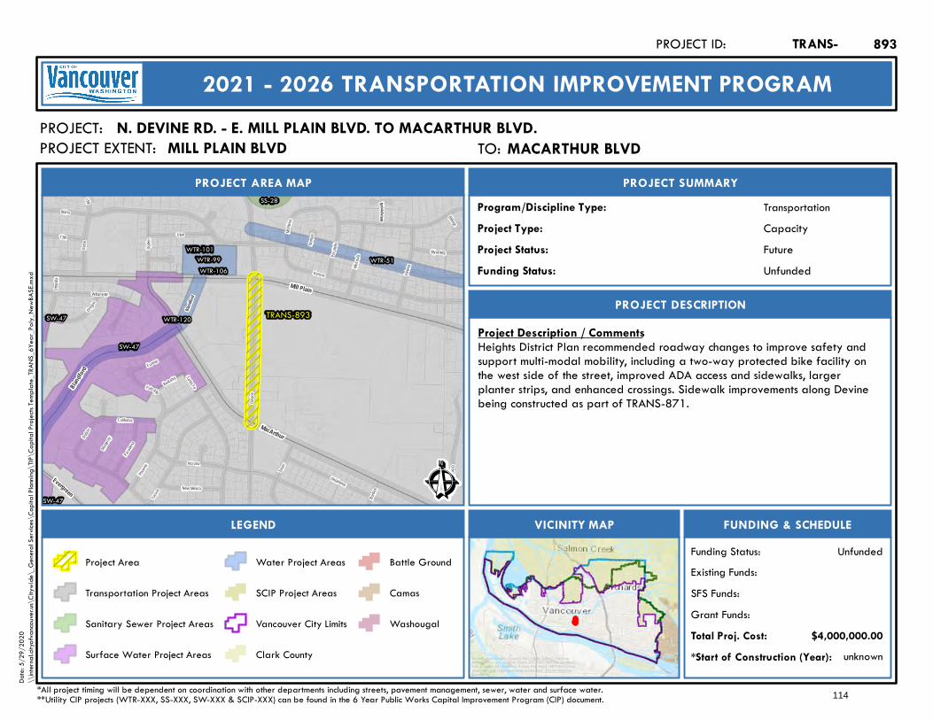
Dubois
Oregon
Phoeni
x
Burdic
k
California
Texas
Namp
a
Willamette
Idaho Billings
B ois e
Umatil
la
Monta
na
Santa Fe
Missou
la
Helen
a
Ogden
Oklahoma
15th
Devin
e
Arizona
Tucson
Kansas
Pocat
ello
PaloAltoBerkeley
Oma ha
13th
Eureka
Monter ey
Wyoming
Pasade
na
New Mexico
Utah
Bro adview
Bland
ford
TRANS-893
WTR-99
WTR-120
WTR-51WTR-101
WTR-106
SW-47
SW-47
SW-47
SS-28
MacArthur
Evergreen
Blandf
ord
Mill Plain
Ê
Future
PROJECT AREA MAP
PROJECT:
PROJECT SUMMARY
Project Status:
TransportationProgram/Discipline Type:CapacityProject Type:
PROJECT DESCRIPTION
FUNDING & SCHEDULEVICINITY MAPLEGEND
N. DEVINE RD. - E. MILL PLAIN BLVD. TO MACARTHUR BLVD.
Project Description / CommentsHeights District Plan recommended roadway changes to improve safety andsupport multi-modal mobility, including a two-way protected bike facility onthe west side of the street, improved ADA access and sidewalks, largerplanter strips, and enhanced crossings. Sidewalk improvements along Devinebeing constructed as part of TRANS-871.
unknown*Start of Construction (Year):
TRANS-PROJECT ID:
2021 - 2026 TRANSPORTATION IMPROVEMENT PROGRAM
PROJECT EXTENT:
$4,000,000.00Total Proj. Cost:Grant Funds:SFS Funds:Existing Funds:
*All project timing will be dependent on coordination with other departments including streets, pavement management, sewer, water and surface water.**Utility CIP projects (WTR-XXX, SS-XXX, SW-XXX & SCIP-XXX) can be found in the 6 Year Public Works Capital Improvement Program (CIP) document.
UnfundedFunding Status:
UnfundedFunding Status:
Project Area
Transportation Project Areas
Sanitary Sewer Project Areas
Surface Water Project Areas
Water Project Areas
SCIP Project Areas
Vancouver City Limits
Clark County
Battle Ground
Camas
Washougal
893
Service Layer Credits: Sources: Esri, HERE, Garmin, Intermap,increment P Corp., GEBCO, USGS, FAO, NPS, NRCAN, GeoBase,IGN, Kadaster NL, Ordnance Survey, Esri Japan, METI, Esri China(Hong Kong), (c) OpenStreetMap contributors, and the GIS UserCommunity
Date:
5/29
/202
0\\
intern
al.city
ofvan
couve
r.us\C
itywi
de\_
Gene
ral Se
rvices
\Cap
ital P
lannin
g\TIP
\Cap
ital P
rojec
ts Tem
plate_
TRAN
S_6Y
ear_P
oly_N
ewBA
SE.m
xd
TO: MacArthur BlvdMACARTHUR BLVDMILL PLAIN BLVD
114
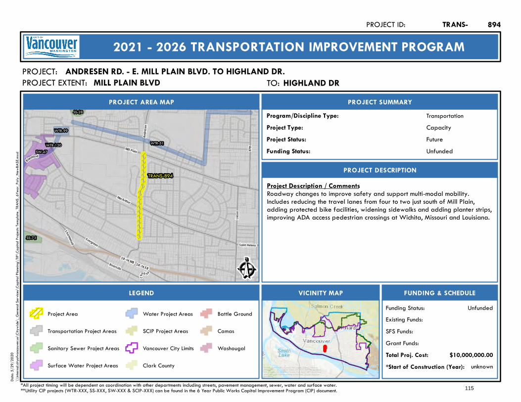
SR-14 WB SR-14 EB
TRANS-894
WTR-99
WTR-120 WTR-51SW-47
SS-28
SS-73
MacArthur
Evergreen
Shorewood Saint Helens
Lieser
Andre
sen
87th
Riverside
Ch
els e a
BlandfordMill Plain
Ê
Future
PROJECT AREA MAP
PROJECT:
PROJECT SUMMARY
Project Status:
TransportationProgram/Discipline Type:CapacityProject Type:
PROJECT DESCRIPTION
FUNDING & SCHEDULEVICINITY MAPLEGEND
ANDRESEN RD. - E. MILL PLAIN BLVD. TO HIGHLAND DR.
Project Description / CommentsRoadway changes to improve safety and support multi-modal mobility.Includes reducing the travel lanes from four to two just south of Mill Plain,adding protected bike facilities, widening sidewalks and adding planter strips,improving ADA access pedestrian crossings at Wichita, Missouri and Louisiana.
unknown*Start of Construction (Year):
TRANS-PROJECT ID:
2021 - 2026 TRANSPORTATION IMPROVEMENT PROGRAM
PROJECT EXTENT:
$10,000,000.00Total Proj. Cost:Grant Funds:SFS Funds:Existing Funds:
*All project timing will be dependent on coordination with other departments including streets, pavement management, sewer, water and surface water.**Utility CIP projects (WTR-XXX, SS-XXX, SW-XXX & SCIP-XXX) can be found in the 6 Year Public Works Capital Improvement Program (CIP) document.
UnfundedFunding Status:
UnfundedFunding Status:
Project Area
Transportation Project Areas
Sanitary Sewer Project Areas
Surface Water Project Areas
Water Project Areas
SCIP Project Areas
Vancouver City Limits
Clark County
Battle Ground
Camas
Washougal
894
Service Layer Credits: Sources: Esri, HERE, Garmin, Intermap,increment P Corp., GEBCO, USGS, FAO, NPS, NRCAN, GeoBase,IGN, Kadaster NL, Ordnance Survey, Esri Japan, METI, Esri China(Hong Kong), (c) OpenStreetMap contributors, and the GIS UserCommunity
Date:
5/29
/202
0\\
intern
al.city
ofvan
couve
r.us\C
itywi
de\_
Gene
ral Se
rvices
\Cap
ital P
lannin
g\TIP
\Cap
ital P
rojec
ts Tem
plate_
TRAN
S_6Y
ear_P
oly_N
ewBA
SE.m
xd
TO: Highland DrHIGHLAND DRMILL PLAIN BLVD
115
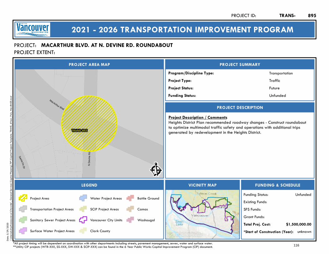
TRANS-895
SantaFe
Dr
N D
evin
e R
d
MacArthur Blvd
Ê
Future
PROJECT AREA MAP
PROJECT:
PROJECT SUMMARY
Project Status:
TransportationProgram/Discipline Type:TrafficProject Type:
PROJECT DESCRIPTION
FUNDING & SCHEDULEVICINITY MAPLEGEND
MACARTHUR BLVD. AT N. DEVINE RD. ROUNDABOUT
Project Description / CommentsHeights District Plan recommended roadway changes - Construct roundaboutto optimize multimodal traffic safety and operations with additional tripsgenerated by redevelopment in the Heights District.
unknown*Start of Construction (Year):
TRANS-PROJECT ID:
2021 - 2026 TRANSPORTATION IMPROVEMENT PROGRAM
PROJECT EXTENT:
$1,500,000.00Total Proj. Cost:Grant Funds:SFS Funds:Existing Funds:
*All project timing will be dependent on coordination with other departments including streets, pavement management, sewer, water and surface water.**Utility CIP projects (WTR-XXX, SS-XXX, SW-XXX & SCIP-XXX) can be found in the 6 Year Public Works Capital Improvement Program (CIP) document.
UnfundedFunding Status:
UnfundedFunding Status:
Project Area
Transportation Project Areas
Sanitary Sewer Project Areas
Surface Water Project Areas
Water Project Areas
SCIP Project Areas
Vancouver City Limits
Clark County
Battle Ground
Camas
Washougal
895
Service Layer Credits: Sources: Esri, HERE, Garmin, Intermap,increment P Corp., GEBCO, USGS, FAO, NPS, NRCAN, GeoBase,IGN, Kadaster NL, Ordnance Survey, Esri Japan, METI, Esri China(Hong Kong), (c) OpenStreetMap contributors, and the GIS UserCommunity
Date:
5/29
/202
0\\
intern
al.city
ofvan
couve
r.us\C
itywi
de\_
Gene
ral Se
rvices
\Cap
ital P
lannin
g\TIP
\Cap
ital P
rojec
ts Tem
plate_
TRAN
S_6Y
ear_P
oly_N
ewBA
SE.m
xd
116
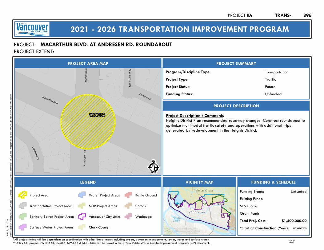
TRANS-896
Sain
tLo u
isW
a y
Carolina Ln
Oklahoma
Dr
N A
ndre
sen
Rd
SA
ndre
sen
R d
MacArthur Blvd
Ê
Future
PROJECT AREA MAP
PROJECT:
PROJECT SUMMARY
Project Status:
TransportationProgram/Discipline Type:TrafficProject Type:
PROJECT DESCRIPTION
FUNDING & SCHEDULEVICINITY MAPLEGEND
MACARTHUR BLVD. AT ANDRESEN RD. ROUNDABOUT
Project Description / CommentsHeights District Plan recommended roadway changes -Construct roundabout tooptimize multimodal traffic safety and operations with additional tripsgenerated by redevelopment in the Heights District.
unknown*Start of Construction (Year):
TRANS-PROJECT ID:
2021 - 2026 TRANSPORTATION IMPROVEMENT PROGRAM
PROJECT EXTENT:
$1,500,000.00Total Proj. Cost:Grant Funds:SFS Funds:Existing Funds:
*All project timing will be dependent on coordination with other departments including streets, pavement management, sewer, water and surface water.**Utility CIP projects (WTR-XXX, SS-XXX, SW-XXX & SCIP-XXX) can be found in the 6 Year Public Works Capital Improvement Program (CIP) document.
UnfundedFunding Status:
UnfundedFunding Status:
Project Area
Transportation Project Areas
Sanitary Sewer Project Areas
Surface Water Project Areas
Water Project Areas
SCIP Project Areas
Vancouver City Limits
Clark County
Battle Ground
Camas
Washougal
896
Service Layer Credits: Sources: Esri, HERE, Garmin, Intermap,increment P Corp., GEBCO, USGS, FAO, NPS, NRCAN, GeoBase,IGN, Kadaster NL, Ordnance Survey, Esri Japan, METI, Esri China(Hong Kong), (c) OpenStreetMap contributors, and the GIS UserCommunity
Date:
5/29
/202
0\\
intern
al.city
ofvan
couve
r.us\C
itywi
de\_
Gene
ral Se
rvices
\Cap
ital P
lannin
g\TIP
\Cap
ital P
rojec
ts Tem
plate_
TRAN
S_6Y
ear_P
oly_N
ewBA
SE.m
xd
117
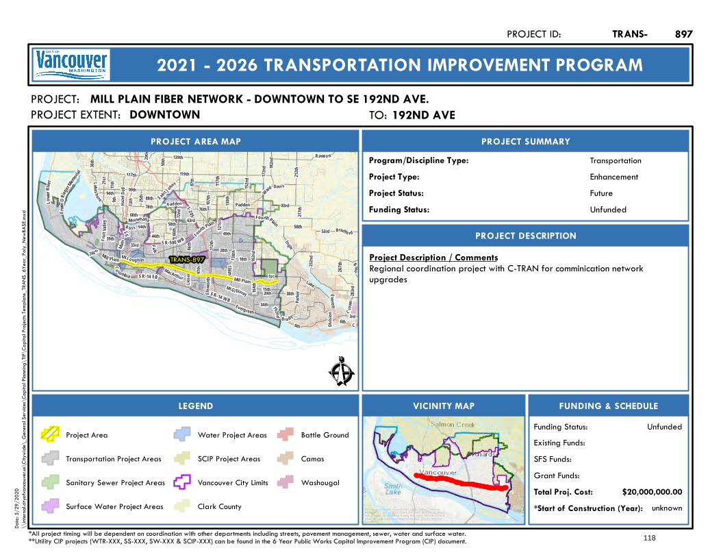
Lakes hore
63rd
Haz el
D ell
Ward
192nd
Padden
1st
Fou
rth Plain
78th
99th
138th
49th
28th
76th
18th
Main
36th
117th
Saint Johns
136th
283rd
172nd 182
nd
F rui t V
a lley
112th
C ro wn
164th
Mill Plain
21st
M i nne haha
3rd
Lake
Blair
162nd
34th
I-2 05
I-5
SR-14 W B
117th
58thFourthPlain
Mill Plai n
SR-14 EB
Padden
6th
Everett
267th
SR-500 WB
Lowe
rRiv e
r
E rwinO
Rieger
Memoria
l
212th
50th
11th Davi s
58th
MacArthur
130th
Rawso n
Evergreen
88th
M cGi llivray
Divisio
n
72nd
87th
119th
Bra dy
66th 121
st
Lieser
9th
R oss
33rd
20th
6th
83rd
44th
139th
39th
8 6th
68th
15thPa
rker
54th
McLo ughlin
25th
Fa lk
94th
38th
Co lumbia
13th
152nd
53rd
29th
Bradfo rd
Ellsw
orth
217th
107th
232nd
97th
C
26t h
I ngle
TRANS-897
Ê
Future
PROJECT AREA MAP
PROJECT:
PROJECT SUMMARY
Project Status:
TransportationProgram/Discipline Type:EnhancementProject Type:
PROJECT DESCRIPTION
FUNDING & SCHEDULEVICINITY MAPLEGEND
MILL PLAIN FIBER NETWORK - DOWNTOWN TO SE 192ND AVE.
Project Description / CommentsRegional coordination project with C-TRAN for comminication networkupgrades
unknown*Start of Construction (Year):
TRANS-PROJECT ID:
2021 - 2026 TRANSPORTATION IMPROVEMENT PROGRAM
PROJECT EXTENT:
$20,000,000.00Total Proj. Cost:Grant Funds:SFS Funds:Existing Funds:
*All project timing will be dependent on coordination with other departments including streets, pavement management, sewer, water and surface water.**Utility CIP projects (WTR-XXX, SS-XXX, SW-XXX & SCIP-XXX) can be found in the 6 Year Public Works Capital Improvement Program (CIP) document.
UnfundedFunding Status:
UnfundedFunding Status:
Project Area
Transportation Project Areas
Sanitary Sewer Project Areas
Surface Water Project Areas
Water Project Areas
SCIP Project Areas
Vancouver City Limits
Clark County
Battle Ground
Camas
Washougal
897
Service Layer Credits: Sources: Esri, HERE, Garmin, Intermap,increment P Corp., GEBCO, USGS, FAO, NPS, NRCAN, GeoBase,IGN, Kadaster NL, Ordnance Survey, Esri Japan, METI, Esri China(Hong Kong), (c) OpenStreetMap contributors, and the GIS UserCommunity
Date:
5/29
/202
0\\
intern
al.city
ofvan
couve
r.us\C
itywi
de\_
Gene
ral Se
rvices
\Cap
ital P
lannin
g\TIP
\Cap
ital P
rojec
ts Tem
plate_
TRAN
S_6Y
ear_P
oly_N
ewBA
SE.m
xd
TO: 192nd Ave192ND AVEDOWNTOWN
118

112t
h11
2th
TRANS-898
WTR-127
WTR-99WTR-56
WTR-72WTR-108
WTR-154WTR-103
17th (P)
14th
18th
16th
15th
117t
h
115t
h
113t
h
119t
h
17th
Four
Seas
ons
118t
h
Ê
Active
PRO JECT AREA MAP
PROJECT:
PRO JECT SUMMARY
Project Status:
TransportationProg ra m /Discipline Type:CapacityProject Type:
PRO JECT DESCRIPTIO N
FUNDING & SCHEDULEVICINITY MAPLEGEND
NE 115TH ST. – NE 16TH ST. TO NE 18TH ST
Project Description / Com m entsThis project proposes a new road connecting NE 16th Street and NE 18thStreet in the vicinity of Four Seasons Lane and Joe's Place farm. This ispartially funded through $250K developer contribution and will require ROWfrom Joe's Place Farms and BPA.
unknown*Sta rt of Construction (Yea r):
TRANS-PROJECT ID:
2021 - 2026 TRANSPO RTATIO N IMPRO VEMENT PRO GRAM
PROJECT EXTENT:
$925,000.00Tota l Proj. Cost:Grant Funds:SFS Funds:Existing Funds:
*All project timing will be dependent on coordination with other departments including streets, pavement management, sewer, water and surface water.**Utility CIP projects (WTR-XXX, SS-XXX, SW-XXX & SCIP-XXX) can be found in the 6 Year Public Works Capital Improvement Program (CIP) document.
Partially FundedFunding Status:
Partially FundedFunding Status:
Project Area
Transportation Project Areas
Sanitary Sewer Project Areas
Surface Water Project Areas
Water Project Areas
SCIP Project Areas
Vancouver City Limits
Clark County
Battle Ground
Camas
Washougal
898
Service Layer Credits: Sources: Esri, HERE, Garmin, Intermap,increment P Corp., GEBCO, USGS, FAO, NPS, NRCAN, GeoBase,IGN, Kadaster NL, Ordnance Survey, Esri Japan, METI, Esri China(Hong Kong), (c) OpenStreetMap contributors, and the GIS UserCommunity
Date:
5/29
/202
0\\
intern
al.city
ofvan
couve
r.us\C
itywi
de\_
Gene
ral Se
rvices
\Cap
ital P
lannin
g\TIP
\Cap
ital P
rojec
ts Tem
plate_
TRAN
S_6Y
ear_P
oly_N
ewBA
SE.m
xd
TO: NE 18th St.NE 18TH ST.NE 16TH ST.
119

Fourth Plain
Fourth Plain
TRANS-899
Nea
ls (P
)
24th (P) Terrace
Nea
ls
19th
Algo
na
Todd
24th
Overloo
k
How
ard
Hazelwood
21st
Ros
site
r
Bran
dt
Wils
onLaur
el
Ê
Future
PROJECT AREA MAP
PROJECT:
PROJECT SUMMARY
Project Status:
TransportationProgram/Discipline Type:MultimodalProject Type:
PROJECT DESCRIPTION
FUNDING & SCHEDULEVICINITY MAPLEGEND
NE FOURTH PLAIN BLVD ENHANCED PEDESTRIAN CROSSINGS
Project Description / CommentsPedestrian and ADA accessible improvements on E Fourth Plain Blvd. east ofFort Vancouver Way. Improvements include pedestrian hybrid beacons andpedestrian refuges on Fourth Plain between Fort Vancouver Wy. And Z St., atNeals Ln., and at Todd Rd./Rossiter Ln.
unknown*Start of Construction (Year):
TRANS-PROJECT ID:
2021 - 2026 TRANSPORTATION IMPROVEMENT PROGRAM
PROJECT EXTENT:
$748,000.00Total Proj. Cost:Grant Funds:SFS Funds:Existing Funds:
*All project timing will be dependent on coordination with other departments including streets, pavement management, sewer, water and surface water.**Utility CIP projects (WTR-XXX, SS-XXX, SW-XXX & SCIP-XXX) can be found in the 6 Year Public Works Capital Improvement Program (CIP) document.
UnfundedFunding Status:
UnfundedFunding Status:
Project Area
Transportation Project Areas
Sanitary Sewer Project Areas
Surface Water Project Areas
Water Project Areas
SCIP Project Areas
Vancouver City Limits
Clark County
Battle Ground
Camas
Washougal
899
Service Layer Credits: Sources: Esri, HERE, Garmin, Intermap,increment P Corp., GEBCO, USGS, FAO, NPS, NRCAN, GeoBase,IGN, Kadaster NL, Ordnance Survey, Esri Japan, METI, Esri China(Hong Kong), (c) OpenStreetMap contributors, and the GIS UserCommunity
Date:
5/29
/202
0\\
intern
al.city
ofvan
couve
r.us\C
itywi
de\_
Gene
ral Se
rvices
\Cap
ital P
lannin
g\TIP
\Cap
ital P
rojec
ts Tem
plate_
TRAN
S_6Y
ear_P
oly_N
ewBA
SE.m
xd
TO: Rossiter LaneROSSITER LANEFT. VANCOUVER WAY
120
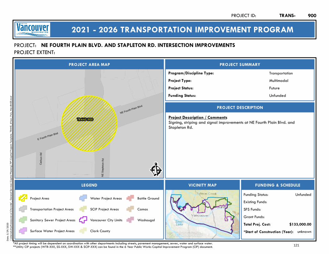
TRANS-900
C arls
onRd
E Fourth Plain Blvd
NE
Stap
leto
n R
d
NE Fourth Plain Blvd
Ê
Future
PROJECT AREA MAP
PROJECT:
PROJECT SUMMARY
Project Status:
TransportationProgram/Discipline Type:MultimodalProject Type:
PROJECT DESCRIPTION
FUNDING & SCHEDULEVICINITY MAPLEGEND
NE FOURTH PLAIN BLVD. AND STAPLETON RD. INTERSECTION IMPROVEMENTS
Project Description / CommentsSigning, striping and signal improvements at NE Fourth Plain Blvd. andStapleton Rd.
unknown*Start of Construction (Year):
TRANS-PROJECT ID:
2021 - 2026 TRANSPORTATION IMPROVEMENT PROGRAM
PROJECT EXTENT:
$133,000.00Total Proj. Cost:Grant Funds:SFS Funds:Existing Funds:
*All project timing will be dependent on coordination with other departments including streets, pavement management, sewer, water and surface water.**Utility CIP projects (WTR-XXX, SS-XXX, SW-XXX & SCIP-XXX) can be found in the 6 Year Public Works Capital Improvement Program (CIP) document.
UnfundedFunding Status:
UnfundedFunding Status:
Project Area
Transportation Project Areas
Sanitary Sewer Project Areas
Surface Water Project Areas
Water Project Areas
SCIP Project Areas
Vancouver City Limits
Clark County
Battle Ground
Camas
Washougal
900
Service Layer Credits: Sources: Esri, HERE, Garmin, Intermap,increment P Corp., GEBCO, USGS, FAO, NPS, NRCAN, GeoBase,IGN, Kadaster NL, Ordnance Survey, Esri Japan, METI, Esri China(Hong Kong), (c) OpenStreetMap contributors, and the GIS UserCommunity
Date:
5/29
/202
0\\
intern
al.city
ofvan
couve
r.us\C
itywi
de\_
Gene
ral Se
rvices
\Cap
ital P
lannin
g\TIP
\Cap
ital P
rojec
ts Tem
plate_
TRAN
S_6Y
ear_P
oly_N
ewBA
SE.m
xd
121
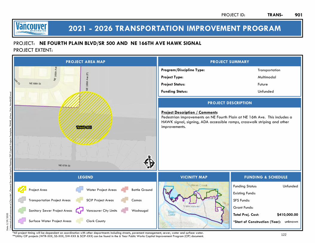
TRANS-901
NE16
6 th
Ave
(P)
NE 164th Ct
NE16
5th
Ave
NE 68th St
NE 67th St Ê
Future
PROJECT AREA MAP
PROJECT:
PROJECT SUMMARY
Project Status:
TransportationProgram/Discipline Type:MultimodalProject Type:
PROJECT DESCRIPTION
FUNDING & SCHEDULEVICINITY MAPLEGEND
NE FOURTH PLAIN BLVD/SR 500 AND NE 166TH AVE HAWK SIGNAL
Project Description / CommentsPedestrian improvements on NE Fourth Plain at NE 16th Ave. This includes aHAWK signal, signing, ADA accessible ramps, crosswalk striping and otherimprovements.
unknown*Start of Construction (Year):
TRANS-PROJECT ID:
2021 - 2026 TRANSPORTATION IMPROVEMENT PROGRAM
PROJECT EXTENT:
$410,000.00Total Proj. Cost:Grant Funds:SFS Funds:Existing Funds:
*All project timing will be dependent on coordination with other departments including streets, pavement management, sewer, water and surface water.**Utility CIP projects (WTR-XXX, SS-XXX, SW-XXX & SCIP-XXX) can be found in the 6 Year Public Works Capital Improvement Program (CIP) document.
UnfundedFunding Status:
UnfundedFunding Status:
Project Area
Transportation Project Areas
Sanitary Sewer Project Areas
Surface Water Project Areas
Water Project Areas
SCIP Project Areas
Vancouver City Limits
Clark County
Battle Ground
Camas
Washougal
901
Service Layer Credits: Sources: Esri, HERE, Garmin, Intermap,increment P Corp., GEBCO, USGS, FAO, NPS, NRCAN, GeoBase,IGN, Kadaster NL, Ordnance Survey, Esri Japan, METI, Esri China(Hong Kong), (c) OpenStreetMap contributors, and the GIS UserCommunity
Date:
5/29
/202
0\\
intern
al.city
ofvan
couve
r.us\C
itywi
de\_
Gene
ral Se
rvices
\Cap
ital P
lannin
g\TIP
\Cap
ital P
rojec
ts Tem
plate_
TRAN
S_6Y
ear_P
oly_N
ewBA
SE.m
xd
122

TRANS-90211
3th
(P)
114th (P)
24th
22nd
23rd
111th
110t
h
112t
h
Ê
Future
PROJECT AREA M AP
PROJECT:
PROJECT SUM M ARY
Proje c t Status:
TransportationProgram/Discipline Type:MultimodalProje c t Type:
PROJECT DESCRIPTION
FUNDING & SCHEDULEV ICINITY M APLEGEND
NE 112TH AV E. SIDEW ALK COM PLETION – SIDEW ALK INFILL NEAR NE 23RD ST.
Proje c t De sc ription / Comme ntsInstall approx. 125 feet of sidewalk, ADA accessible curb ramp and stripingimprovements for sidewalk infill along NE 112th Ave. at NE 23rd St. Thisproject completes a gap and connects two existing sidewalks.
unknown*Start of Construc tion (Y e ar):
TRANS-PROJECT ID:
2021 - 2026 TRANSPORTATION IM PROV EM ENT PROGRAM
PROJECT EXTENT:
$355,000.00Total Proj. Cost:Grant Funds:SFS Funds:Existing Funds:
*All project timing will be dependent on coordination with other departments including streets, pavement management, sewer, water and surface water.**Utility CIP projects (WTR-XXX, SS-XXX, SW-XXX & SCIP-XXX) can be found in the 6 Year Public Works Capital Improvement Program (CIP) document.
UnfundedFunding Status:
UnfundedFund ing Status:
Project Area
Transportation Project Areas
Sanitary Sewer Project Areas
Surface Water Project Areas
Water Project Areas
SCIP Project Areas
Vancouver City Limits
Clark County
Battle Ground
Camas
Washougal
902
Service Layer Credits: Sources: Esri, HERE, Garmin, Intermap,increment P Corp., GEBCO, USGS, FAO, NPS, NRCAN, GeoBase,IGN, Kadaster NL, Ordnance Survey, Esri Japan, METI, Esri China(Hong Kong), (c) OpenStreetMap contributors, and the GIS UserCommunity
Date:
5/29
/202
0\\
intern
al.city
ofvan
couve
r.us\C
itywi
de\_
Gene
ral Se
rvices
\Cap
ital P
lannin
g\TIP
\Cap
ital P
rojec
ts Tem
plate_
TRAN
S_6Y
ear_P
oly_N
ewBA
SE.m
xd
TO: 28th street28TH STREET18TH STREET
123
2021-2026 Transportation Improvement Program | City of Vancouver, Washington
A
rteria
l Map U
pda
te
124
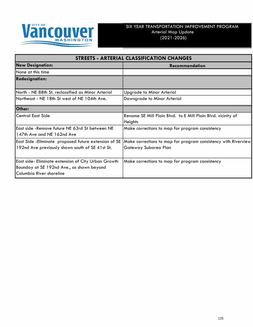
New Designation: RecommendationNone at this time
Redesignation:
North - NE 88th St. reclassified as Minor Arterial Upgrade to Minor ArterialNortheast - NE 18th St west of NE 104th Ave. Downgrade to Minor Arterial
Other:
Central East Side Rename SE Mill Plain Blvd. to E Mill Plain Blvd. vicinity of Heights
East side -Remove future NE 63rd St between NE 147th Ave and NE 162nd Ave
Make corrections to map for program consistency
East Side -Eliminate proposed future extension of SE 192nd Ave previously shown south of SE 41st St.
Make corrections to map for program consistency with Riverview Gateway Subarea Plan
East side- Eliminate extension of City Urban Growth Bounday at SE 192nd Ave., as shown beyond Columbia River shoreline
Make corrections to map for program consistency
STREETS - ARTERIAL CLASSIFICATION CHANGES
SIX YEAR TRANSPORTATION IMPROVEMENT PROGRAMArterial Map Update
(2021-2026)
125

³ARTERIAL STREET SYSTEM
AND CLASSIFICATION
\\internal.c ityofvancouver.us\Cityapps\GIS\Transportation \Arterial Street System & Classification\ArcMap\Arterial Street System & Classification 2020 11x17.mxd
126
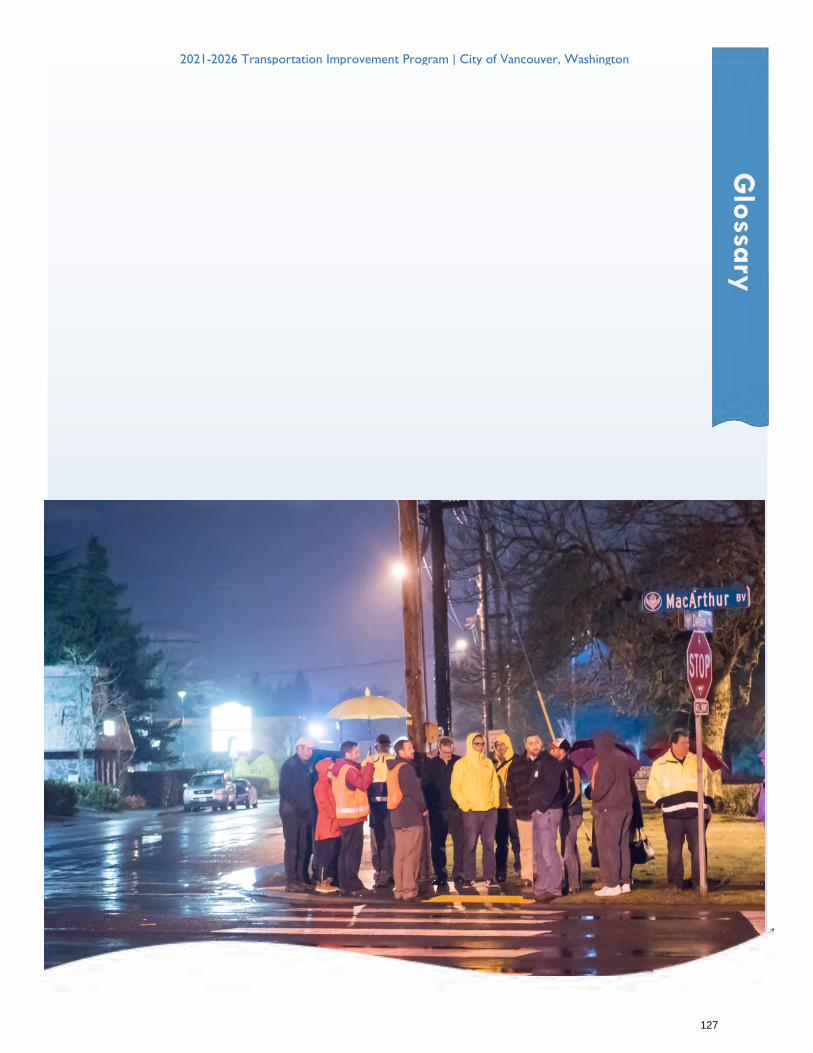
2021-2026 Transportation Improvement Program | City of Vancouver, Washington
G
lossa
ry
127
GLOSSARY
FREQUENTLY USED TERMS AND ACRONYMS
ACP Annual Construction Program or Asphalt Concrete Pavement
ADA Americans with Disabilities Act
ADT Average Daily Traffic
AIP Arterial Improvement Program (TIB funding Program)
Access Access is a means of approach to provide vehicular or pedestrian entrance or exit to a property. This may not necessarily include all movements.
Access Management Access management is the process of providing and managing access to land development while preserving the regional flow of traffic in terms of safety, capacity and speed.
A.M. Peak Hour Identified by a one-hour period in the morning when traffic flow increases. The A.M. peak hour typically occurs between 6:30 a.m. and 9 a.m. Traffic volumes occurring during the A.M. peak hour are used to calculate the overall operation of a roadway or intersection.
ARRA American Recovery and Reinvestment Act. Also referred to as an economic stimulus package, ARRA was enacted by Congress in February 2009. The act provides $28.35 billion for improving and maintaining transportation infrastructure throughout the United States.
Arterial An arterial is a major street carrying the traffic of local and collector streets to and from freeways and other major streets. Arterials generally have traffic signals at intersections and may have limits on driveway spacing and street intersection spacing. Further details can be found in the Vancouver Municipal Code (11.80.040).
128
Biological Assessment A biological assessment is an environmental document required for compliance with the Endangered Species Act for projects with federal funding or permits.
CAT Citizen Advisory Team
CCRP Corridor Congestion Relief Program (State funding source)
CDBG Community Development Block Grant. Block grants are targeted for low and moderate-income areas. Improvements typically consist of sidewalk and capital improvement programs.
CMAQ Congestion Mitigation and Air Quality Improvement (Federal funding source). This funding is for projects that create a direct air quality benefit, leading toward attainment or maintenance of a National Ambient Air Quality Standard (NAAQS).
CN Construction
CTL Center-Turn Lane
C-TRAN Clark County Public Transportation Benefit Area Authority, the transit agency for Clark County, Washington.
CWP Clean Water Program
Capacity The maximum rate of flow at which vehicles can be reasonably expected to traverse a point or uniform segment of a lane or roadway during a specified time period under prevailing roadway, traffic, and control conditions; usually expressed as vehicles per hour. In the project list spreadsheets Capacity is a term used to describe a subset of projects that upgrade existing substandard streets to urban arterial standards. This subset of projects typically improves more than just vehicle capacity. They also improve the pavement section, street lighting, bicycle, pedestrian and ADA facilities.
129
Collector Streets – Urban Collector Collectors – Urban Collector. Urban collector provides for land access and traffic circulation within and between residential neighborhoods, and commercial and industrial areas. Direct access to adjacent land uses, however, is still subordinate to traffic movement. Access to abutting properties is controlled through the use of raised channelization, driveway spacing and pavement markings. Typically, collectors are not continuous for any great length, nor do they form a connected network by themselves.
Comprehensive Plan Long-range plan, typically looking 20 to 50 years into the future, which is intended to guide growth and development of a community. Comprehensive Plans are required by the Washington State Growth Management Act for specific counties and cities in Washington State. The Plans establish goals and policies for managing population growth and land development while ensuring that the growth is adequately served by public facilities.
Concurrency The Concurrency ordinance (VMC 11.95) was adopted in response to the Washington State Growth Management Act, which required local jurisdictions to adopt level-of-service (LOS) standards for the arterial road system and to ensure maintaining those standards when considering new development. This process is called Concurrency. Concurrency applies to any development, land division, site plan and conditional use permit approvals.
EA Environmental Assessment
Environmental Review The consideration of environmental factors as required by the Washington State Environmental Policy Act (SEPA). The environmental review process is the procedure used by agencies and others under SEPA for giving appropriate consideration to the environment in agency decision-making. (WAC 197-11-746).
Enhancement In the project list spreadsheets Capacity is a term used to describe a subset of projects that upgrade pedestrian or bicycle facilities, or otherwise enhance the livability of the community through upgrades to the street system.
ESA The Endangered Species Act was established in 1973 to preserve ecosystems of endangered and threatened species. The Act was recently amended to include various species of fish, wildlife, and plants throughout the United States.
130
FAST Act On December 4, 2015, President Obama signed the Fixing America’s Surface Transportation (FAST) Act (Pub. L. No. 114-94) into law—the first federal law in over a decade to provide long-term funding certainty for surface transportation infrastructure planning and investment. The FAST Act authorizes $305 billion over fiscal years 2016 through 2020 for highway, highway and motor vehicle safety, public transportation, motor carrier safety, hazardous materials safety, rail, and research, technology, and statistics programs. The FAST Act maintains our focus on safety, keeps intact the established structure of the various highway-related programs we manage, continues efforts to streamline project delivery and, for the first time, provides a dedicated source of federal dollars for freight projects. With the enactment of the FAST Act, states and local governments are now moving forward with critical transportation projects with the confidence that they will have a federal partner over the long term.
Growth Management A group of strategies used by a government to direct the timing, location and type of development in a community
Growth Management Act (GMA) The State of Washington's Growth Management Act was adopted in 1990 to address the negative consequences of unprecedented population growth and suburban sprawl in the State. The GMA requires all cities and counties in the State to plan for future growth, with more extensive requirements for the largest and fastest-growing counties and cities in the State. Its requirements include guaranteeing the consistency of transportation and capital facilities plans with land use plans.
HES Hazard Elimination System/Safety (Federal Funding Source). The objective of this fund is to improve specific locations which constituted a danger to vehicles or pedestrians as shown by frequency of accidents.
HIS-HRRP In 2008, a portion of the funding provided through Federal Transportation Act SAFETEA-LU was made available for safety grants. Funds were provided through the Highway Safety Improvement Program (HSIP) and the High Risk Rural Roads Program (HRRRP).
HOV High-Occupancy Vehicle
Impacts Impacts are the effects or consequences of actions. Environmental impacts are effects upon the elements of the environment.
131
Interchange A system of interconnecting roadways in conjunction with one or more grade separations, providing for the movement of traffic between two or more roadways on different levels
Intersection The general area where two or more roadways join or cross, within which are included the roadway and roadside facilities for traffic movements in that area.
ITS Intelligent Transportation System
Land Use The type of activity associated with a specific geographic area. Land-use categories can be broad (e.g., residential, retail, office, industrial, and recreational), or they can be very specific (e.g., single-family residential, convenience market, or elementary school). In order to estimate trip generation characteristics for a specific geographic area, it is necessary to know both the type and intensity of land use (e.g., single-family residential land use at a development intensity of eight units per acre).
Level of Service (LOS) The Level of Service is a grading system developed by the transportation profession to quantify the degree of comfort (including such elements as speed, travel time, number of stops, total amount of stopped delay, and impediments caused by other vehicles) afforded to drivers as they travel through an intersection or roadway segment. LOS is expressed as a letter grade that ranges from “A”, indicating that drivers will experience little, if any delay, to “F”, indicating significant traffic congestion and driver delay will occur.
MVFT Motor Vehicle Fuel Tax
Mitigation (1) Avoiding impacts altogether by not taking a certain action or parts of an action; (2) minimizing impacts by limiting the degree or magnitude of the action and its implementation by using appropriate technology, or by taking affirmative steps to avoid or reduce impacts; (3) rectifying impacts by repairing, rehabilitating, or restoring the affected environment; (4) reducing or eliminating impacts over time by preservation and maintenance operations during the life of the action; (5) compensating for impacts by replacing, enhancing or providing substitute resources or
132
environments; and/or, (6) monitoring impacts and taking appropriate corrective measures (WAC 197-11-768).
Mode The means by which travel is accomplished. Alternative modes of travel include walking, bicycling, auto, bus, light rail, airplane, ferry, etc.
NAAQS The National Ambient Air Quality Standards were set up by the Environmental Protection Agency (EPA) to help mitigate the health impacts of air pollution. EPA established NAAQS measure for six pollutants that include carbon monoxide, ozone, particulate matter, lead, sulfur dioxide, and nitrous oxide.
Non-attainment Area Geographic area in which air pollution levels exceed the NAAQS. (See above.)
Peak Hour A period of 60 consecutive minutes during which an intersection or roadway system experiences the greatest amount of traffic volume
P.M. Peak Hour A one-hour period in the afternoon or evening when traffic flow increases. The P.M. peak hour typically occurs between 4 and 6 p.m. Traffic volumes occurring during the P.M. peak hour are used to calculate the overall operation of a roadway or intersection.
PE Preliminary Engineering
PSE Plans, Specifications and Estimates
PSMP Pedestrian Safety and Mobility Program
PWB Public Works Board. The Public Works Board was created by the 1985 State Legislature. The Board is composed of local government officials, special purpose district representatives and private sector members. The mission of the Washington State Public Works Board is “to assist Washington’s local governments and private water systems in meeting their public works needs to sustain livable communities.” The
133
Board is authorized to loan money to counties, cities, and special purpose districts to repair, replace, or create domestic water systems, sanitary sewer systems, storm water systems, roads, streets, solid waste and recycling facilities and bridges.
PWTF Public Works Trust Fund. This trust fund is administered by the Public Works Board. The PWTF Construction and Pre-construction Loan Programs provide funds to design, repair, replace or create a facility. These loans have a 5- to 20-year term with an interest rate of one-half percent. Maximum for any agency is $10 million per biennium.
RCW Revised Code of Washington. Contains all laws of the state of general and permanent nature.
REET Real-estate Excise Tax
RTC Southwest Washington Regional Transportation Council. RTC is the regional transportation planning agency for Clark, Klickitat and Skamania counties.
WW&RP Washington Wildlife and Recreation Program
Right-of-Way/ROW Right-of-way is property held by the City for existing or future public roads or other public improvements.
Roadway Conditions The geometric characteristics of the street or highway, including the type of facility and its development environment, the number of lanes (by direction), lane and shoulder widths, lateral clearances, design speed, and horizontal and vertical alignments.
Roadway A roadway is the improved portion of an easement or right-of-way, excluding curbs, sidewalks and ditches. Road, roadway and street are used as interchangeable terms.
Roadway Section
134
A roadway section is a cross-section of a roadway which displays, travel lanes, turning lanes, bike lanes, sidewalks and medians with their respective dimensions. Each classification of roadway has a corresponding roadway section.
SAFETEA-LU Safe, Accountable, Flexible, Efficient Transportation Equity Act - A Legacy for Users (SAFETEA-LU. The Act was signed into law by the President on August 10, 2005.). With guaranteed funding for highways, highway safety and public transportation totaling $244.1 billion, SAFETEA-LU represents the largest surface transportation investment in our nation’s history. The two landmark bills ‒ the Intermodal Surface Transportation Efficiency Act of 1991 (ISTEA) and the Transportation Equity Act for the 21st Century (TEA-21) ‒ shaped the highway program to meet the nation’s changing transportation needs. SAFETEA-LU builds on this firm foundation, supplying the funds and refining the programmatic framework for investments needed to maintain and grow our vital transportation infrastructure.
SEPA State Environmental Policy Act. SEPA is a state law requiring agencies to consider the environmental consequences of their decisions. (WAC 197-11-790).
SFS Street Funding Strategy (SFS). Refers to any revenue sources approved in 2015. Including Utility tax increase of 1.5%, Business License Surcharge increase, Transportation Benefit District (TBD) licensing fee revenues, and/or retired debt service being redirected to transportation improvements.
STP Surface Transportation Program (Federal funding source). The objective of the STP is to fund construction, reconstruction, resurfacing, restoration and rehabilitation of roads functionally classified as arterials.
STP-C Surface Transportation Program – Competitive Grant
STP-E Surface Transportation Program – Enhancement Grant
STP-TMA Surface Transportation Program – Transportation Management Area Grant
Signal Warrant
135

A criterion that must be met before the installation of a traffic signal can be considered.
Significant/Significance 1) Significant as used in SEPA means a reasonable likelihood of more than a moderate adverse impact on environment quality. 2) Significance involves context and intensity and does not lend itself to a formula or quantifiable test. Context may vary with the physical setting. Intensity depends on magnitude and duration of an impact. Severity of an impact should be weighed along with the likelihood of its occurrence. An impact may be significant if its chance of occurrence is not great, but the resulting environmental impact would be severe if it occurred. (WAC 197-11-794).
SWCAA Southwest Washington Clean Air Agency. A government agency responsible for air pollution control and planning in Clark, Cowlitz, Lewis, Skamania and Wahkiakum Counties.
SYS Traffic Signal System Improvement
TBD Transportation Benefit District (TBD). In the state of Washington, a Transportation Benefit District is a quasi-municipal corporation and independent taxing district that can raise revenue for specific transportation projects, usually through vehicle license fees or sales taxes. RCW 36.73 authorizes cities (see also RCW 35.21.225) and counties to form TBDs. In other uses, TBD is a common term meaning “to be determined.”
TDM Transportation Demand Management. A demand-based technique for reducing traffic congestion, such as ride-sharing programs and flexible work schedules enabling employees to commute to and from work outside of peak hours.
TEA-21 The Transportation Equity Act for the 21st Century was signed on June 9, 1998, superseding the Intermodal Surface Transportation Efficiency Act (ISTEA) of 1991. This bill provides Federal transportation dollars for Federal, State and Local agencies. The majority of benefits associated with ISTEA are continued or expanded upon through TEA-21. Also, see SAFETEA-LU.
TIB
136
Transportation Improvement Board. A state funding agency that administers several state funding programs. The mission of the TIB is to assist local agencies to preserve and improve transportation systems by providing financial assistance, supporting economic development, promoting multi-jurisdictional and multi-modal coordination and to promote public/private cooperation.
TIF Transportation Impact Fee. TIF is the traffic impact component of a development impact fee. An impact fee is a fee levied on a developer by the county as compensation for expected effects of the development.
TIMACS Transportation Information Management and Control System
TIP Six-Year Transportation Improvement Program
TPP Transportation Partnership Program (TIB Funding Program)
TS Traffic Signal Project
TSNS Traffic Safety Near Schools
TSO Traffic Signal Optimization
UAP Urban Arterial Program (State funding source), formally known as the Arterial Improvement Program. This program was established by the State in 1967 as the Urban Arterial Trust Account (UATA) and designated as the AIP in July 1999. The purpose of this program is to fund city and urban county arterial road and street projects to reduce congestion and improve safety, geometrics and structural concerns.
UCP Urban Corridor Program (State funding source), formally known as the Transportation Partnership Program. This program was established by the State in 1988 as the Transportation Improvement Account (TIA) and designated as the TPP in July 1999.
134
The purpose of the program is to fund projects on the regional transportation plan that are necessitated by existing or future congestion due to economic growth.
UR-SP Urban Sidewalk Program (State funding source), formally known as the Pedestrian Safety and Mobility Program. This program was established by the TIB in 1994 as the Pedestrian Facilities Program (TIA-PFP) and designated as the PSMP in July 1999. The program goal is to enhance and promote pedestrian mobility by providing funding for pedestrian projects that provide access and connectivity of pedestrian facilities.
V/C Ratio Ratio of volume to capacity for a traffic facility
Volume Number of vehicles passing a point on a lane or roadway during some time interval, often taken to be one hour, but may also be expressed in terms such as sub-hourly, daily or annually.
WAC Washington Administrative Code. The WAC is laws adopted by state agencies to implement state legislation.
WSDOT Washington State Department of Transportation. WSDOT is a department of the State of Washington responsible for transportation-related planning, management and coordination.
Zoning A map and ordinance text which divides a city or county into land use “zones” and specifies the types of land uses, setbacks, lot size, and size restrictions for buildings within each zone.
135

For additional information see
www.cityofvancouver.us/streetstip
or
www.cityofvancouver.us/betterstreets
136


![Horizont 2020 Fördermöglichkeiten im Bereich ...€¦ · SFS-7B-2015 . SFS-10B-2015 . SFS-11B-2015 . SFS-13-2015 . SFS-16-2015 . SFS-18-2015 . SFS-20-2015 . First stage [24/02/2015]](https://img.pdfslide.net/doc/110x75/5faa2f8ef3aaba1d563dfeda/horizont-2020-frdermglichkeiten-im-bereich-sfs-7b-2015-sfs-10b-2015-.jpg)