Embed Size (px)
Citation preview
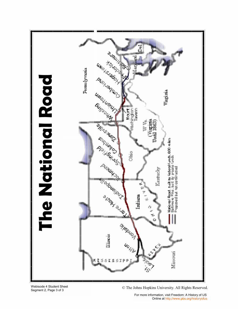
In the early nineteenth century, a stagecoach journey from Boston to New York took a week. Ruts, mud, and holes often made roads nearly impassable. In 1806, engineers began building the National Road to link the east coast with the western frontier. In 1818, the National Road opened, stretching from Cumberland, Maryland, to Wheeling, West Virginia. By 1833, this �Main Street of America� continued through Columbus, Ohio to its terminus in Vandalia, Illinois. While traveling from Baltimore to St. Louis once took four weeks, a stagecoach on the National Road could travel that route in four days. The transportation revolution had begun.
Teacher Directions
1. Using a large map of the United States, trace the National Road from Cumberland, Maryland, to Vandalia, Illinois.
Note to the Teacher: If using Joy Hakim�s A History of US, use the map on pages 122 � 123 in Book Four, The New Nation. (The National Road is now known as old Route 40.)
2. Ask the students the following questions.
• What would it have been like to travel by stagecoach from New York City to Boston in 1800?
• What would it have been like to travel by stagecoach from Baltimore to Vandalia (near St. Louis) after the opening of the National Road?
• Why did some people object to the building of a national road? • How did the National Road affect the communities through which it
traveled? • How did the National Road affect settlement of the west?
3. Make sure students understand the following points in discussing the questions.
In 1774, Dr. Josiah Quincy, president of Harvard College, spent an entire week traveling from Boston, Massachusetts, to New York City. After the building of the National Road, stagecoaches could travel a much greater distance�from Baltimore to St. Louis�in only four days. Some people objected to the use of federal money to build a road that only some of the citizens would use. The communities around the route of the National Road flourished. Small towns grew and prospered as businesses such as taverns, blacksmith shops, and livery stables grew up to serve the travelers. The National Road increased settlement of the Ohio River Valley and the Midwest.
Please note: Each segment in this Webisode has its own Teaching Guide
Visit Freedom: A History of Us online at http://www.pbs.org/historyofus

Teacher Directions
Activity One
1. Distribute the Student Sheet: From Barges and Bicycles to Trains and Planes.
2. Working with a partner, students discuss differences between modes of transportation during the 1830s and travel today.
Activity Two
1. Students use resource materials including Joy Hakim�s A History of US, Book Four, The New Nation, to create a travel brochure for a trip between Baltimore and Vandalia on the National Road.
2. Students gather background material to learn more about the National Road in order to create their brochures. Students consider the towns to be visited, any historical or commercial sites of interest that existed at the time, travel comfort, the mode of transportation they will use, and accommodations available along the way in designing their brochure. Students illustrate their brochures with small maps and drawings of the transportation and accommodations to be used.
3. After students complete their brochures, each student briefly shares his or her product with the class, inviting classmates to join his trip. Display student work in the classroom.
Activity Three 1. Share the following information with the students.
In 1830s, a writer of children�s books named Samuel G. Goodrich created a fictional character named Peter Parley who led young readers through all sorts of exotic adventures. Because Goodrich himself believed in the value of teaching geography, he wrote a book entitled Peter Parley�s Method of Telling About Geography to Children, published in 1831.
He began his �Introductory Lesson� with a series of very simple questions for students, and then made some very bright and witty comments about travel.
2. Distribute the Student Sheet: Where In The World Are You? Explain that on the student sheet, students will find excerpts from the Peter Parley dialogue.
3. Working in their teams, students respond to the questions and activities on the sheet.
4. Students share selected responses with the class.
Segment 2, Webisode 4 Page 2 of 4
Visit Freedom: A History of Us online at http://www.pbs.org/historyofus
Teacher Directions
Students imagine they are living in a community on the route of the National Road. How would your life change after the road opens? What might you see on a typical day? Would your family start a business to serve travelers on the National Road? If so, what kind of business? Students write a journal entry describing how the opening of the road has changed their lives.
Teacher Directions
1. Show the Transparency: The National Road. Point out to students that the building of the National Road opened up greater opportunities for Americans. It enabled citizens to move to new land on the western frontier, to inexpensively move their goods to more distant markets, and to travel to distant towns more easily.
2. Students discuss the following question with teammates.
How did the opening of the National Road move the nation toward freedom?
3. In class discussion, explain that the National Road allowed Americans to move beyond their individual geographic boundaries. An expansion of physical boundaries often allowed individuals to enjoy greater personal freedoms.
Teacher Directions
Use the following activities with your students.
Math � Students calculate the speed of a jet airliner or the speed of ships in knots.
Technology � Working in their teams, students investigate one or all of the following topic questions using the Internet and share their findings with the class.
• How much does it cost today to take an Amtrak train from Washington, D.C., to San Francisco, California? How many hours would it take you to make the trip?
• If you wanted to fly from Washington, D.C., to San Francisco, California, leaving in three days, how much would it cost? How many hours would it take you to get there?
Page 3 of 4 Segment 2, Webisode 4
Visit Freedom: A History of Us online at http://www.pbs.org/historyofus

• How much does it cost to take a cruise from Miami, Florida, to the Bahamas for a week?
• How much does it cost to rent a car for a week in your hometown? • How much does it cost to take a bus from Washington, D.C., to San
Francisco, California? • Many people in England do not own cars. They use trains. Find out
about the importance and use of trains in England. How does it differ from our Amtrak system?
• Many people in Eastern Europe cannot get visas to come to the United States. What is a visa?
• What is a Green Card? What rights does a Green Card give to a visitor to the United States.
Page 4 of 4 Segment 2, Webisode 4
Visit Freedom: A History of Us online at http://www.pbs.org/historyofus
Connections, Cont.

From Barges and Bicycles To Trains and Planes
Directions: With your partner, discuss the purpose and use of the following forms of transportation. What could or would be carried? How fast could a vehicle move? How much could each vehicle hold? How comfortable would the ride be?
1830s Responses Today Responses Horseback Automobiles Stagecoaches Motorcycles Flatboats Navy ships Canal boats Oil tankers Conestoga wagons Tractor trailers Steamboats Passenger planes Foot power (walking) Cargo planes Trains Ocean liners Bicycles Bicycles Ferryboats Ferryboats Canoes Canoes
Webisode 4 Student Sheet Segment 2, Page 1 of 3
For more information, visit Freedom: A History of US Online at http://www.pbs.org/historyofus
© The Johns Hopkins University. All Rights Reserved.
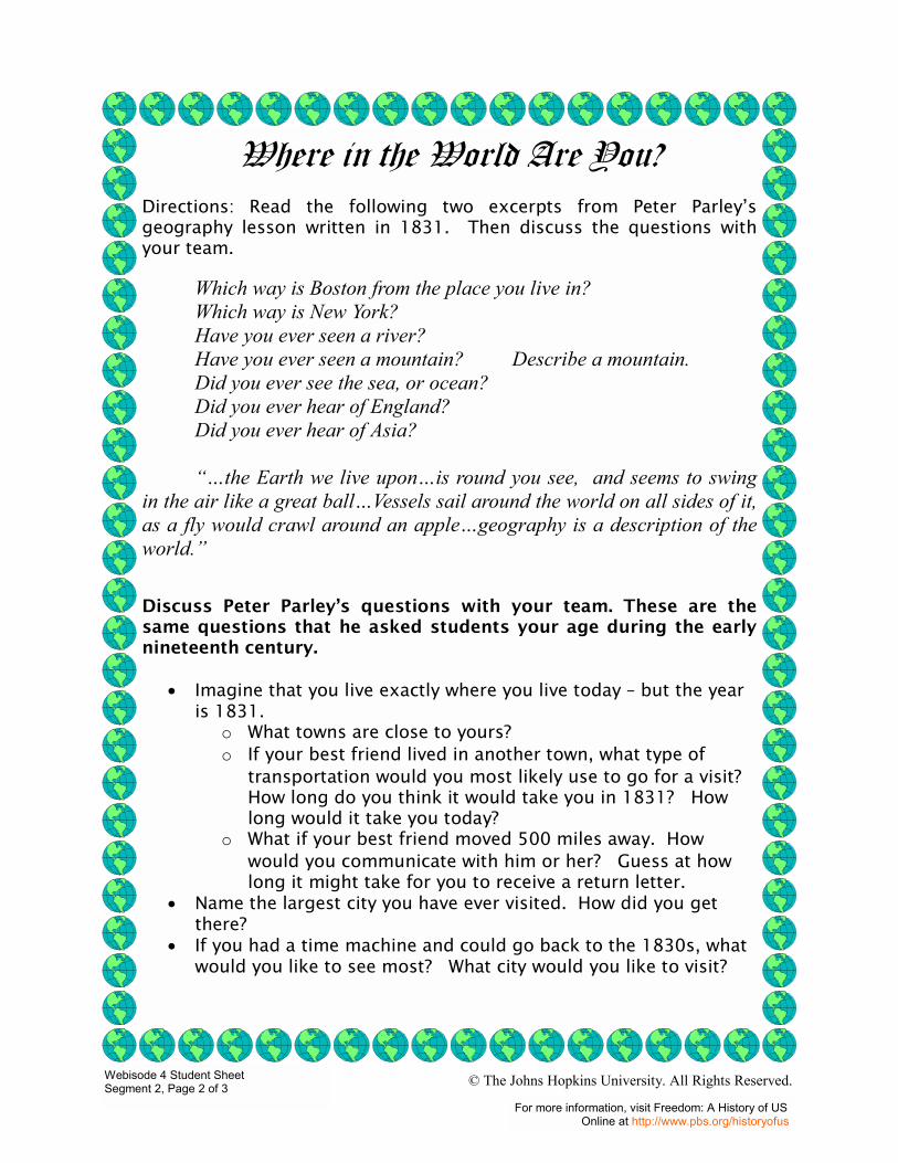
Where in the World Are You?
Directions: Read the following two excerpts from Peter Parley�s geography lesson written in 1831. Then discuss the questions with your team.
Which way is Boston from the place you live in? Which way is New York? Have you ever seen a river? Have you ever seen a mountain? Describe a mountain. Did you ever see the sea, or ocean? Did you ever hear of England? Did you ever hear of Asia? ��the Earth we live upon�is round you see, and seems to swing in the air like a great ball�Vessels sail around the world on all sides of it, as a fly would crawl around an apple�geography is a description of the world.� Discuss Peter Parley�s questions with your team. These are the same questions that he asked students your age during the early nineteenth century.
• Imagine that you live exactly where you live today � but the year is 1831.
o What towns are close to yours? o If your best friend lived in another town, what type of
transportation would you most likely use to go for a visit? How long do you think it would take you in 1831? How long would it take you today?
o What if your best friend moved 500 miles away. How would you communicate with him or her? Guess at how long it might take for you to receive a return letter.
• Name the largest city you have ever visited. How did you get there?
• If you had a time machine and could go back to the 1830s, what would you like to see most? What city would you like to visit?
Webisode 4 Student Sheet Segment 2, Page 2 of 3
For more information, visit Freedom: A History of US Online at http://www.pbs.org/historyofus
© The Johns Hopkins University. All Rights Reserved.
The
Na
tion
al R
oad
Webisode 4 Student Sheet Segment 2, Page 3 of 3
For more information, visit Freedom: A History of US Online at http://www.pbs.org/historyofus
© The Johns Hopkins University. All Rights Reserved.