Embed Size (px)
Citation preview
8/11/2019 Technology Lesson Rev
http://slidepdf.com/reader/full/technology-lesson-rev 1/5
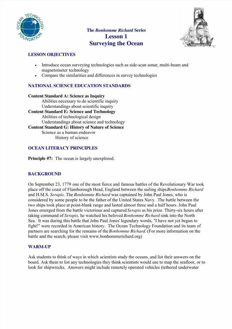
The Bonhomme Richard Series
Lesson 1
Surveying the Ocean
LESSON OBJECTIVES
• Introduce ocean surveying technologies such as side-scan sonar, multi-beam and
magnetometer technology• Compare the similarities and differences in survey technologies
NATIONAL SCIENCE EDUCATION STANDARDS
Content Standard A: Science as InquiryAbilities necessary to do scientific inquiry
Understandings about scientific inquiry
Content Standard E: Science and Technology
Abilities of technological designUnderstandings about science and technology
Content Standard G: History of Nature of ScienceScience as a human endeavor
History of science
OCEAN LITERACY PRINCIPLES
Principle #7: The ocean is largely unexplored.
BACKGROUND
On September 23, 1779 one of the most fierce and famous battles of the Revolutionary War took place off the coast of Flamborough Head, England between the sailing ships Bonhomme Richard
and H.M.S. Serapis. The Bonhomme Richard was captained by John Paul Jones, who is
considered by some people to be the father of the United States Navy. The battle between thetwo ships took place at point-blank range and lasted almost three and a half hours. John Paul
Jones emerged from the battle victorious and captured Serapis as his prize. Thirty-six hours after
taking command of Serapis, he watched his beloved Bonhomme Richard sink into the NorthSea. It was during this battle that John Paul Jones' legendary words, "I have not yet begun to
fight!" were recorded in American history. The Ocean Technology Foundation and its team of
partners are searching for the remains of the Bonhomme Richard . (For more information on the battle and the search, please visit www.bonhommerichard.org)
WARM-UP
Ask students to think of ways in which scientists study the oceans, and list their answers on the
board. Ask them to list any technologies they think scientists would use to map the seafloor, or tolook for shipwrecks. Answers might include remotely operated vehicles (tethered underwater
8/11/2019 Technology Lesson Rev
http://slidepdf.com/reader/full/technology-lesson-rev 2/5
2
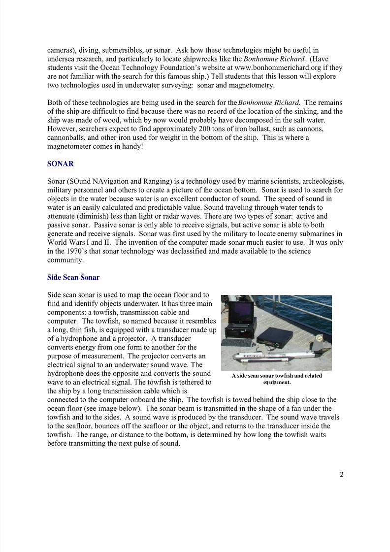
A side scan sonar towfish and related
e ui ment.
cameras), diving, submersibles, or sonar. Ask how these technologies might be useful in
undersea research, and particularly to locate shipwrecks like the Bonhomme Richard . (Havestudents visit the Ocean Technology Foundation’s website at www.bonhommerichard.org if they
are not familiar with the search for this famous ship.) Tell students that this lesson will explore
two technologies used in underwater surveying: sonar and magnetometry.
Both of these technologies are being used in the search for the Bonhomme Richard . The remains
of the ship are difficult to find because there was no record of the location of the sinking, and the
ship was made of wood, which by now would probably have decomposed in the salt water.However, searchers expect to find approximately 200 tons of iron ballast, such as cannons,
cannonballs, and other iron used for weight in the bottom of the ship. This is where a
magnetometer comes in handy!
SONAR
Sonar (SOund NAvigation and Ranging) is a technology used by marine scientists, archeologists,
military personnel and others to create a picture of the ocean bottom. Sonar is used to search forobjects in the water because water is an excellent conductor of sound. The speed of sound in
water is an easily calculated and predictable value. Sound traveling through water tends toattenuate (diminish) less than light or radar waves. There are two types of sonar: active and
passive sonar. Passive sonar is only able to receive signals, but active sonar is able to both
generate and receive signals. Sonar was first used by the military to locate enemy submarines inWorld Wars I and II. The invention of the computer made sonar much easier to use. It was only
in the 1970’s that sonar technology was declassified and made available to the science
community.
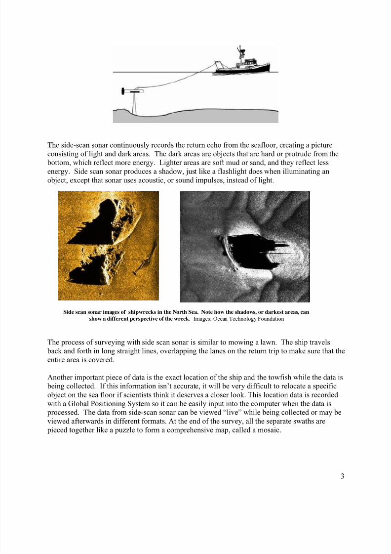
Side Scan Sonar
Side scan sonar is used to map the ocean floor and to
find and identify objects underwater. It has three main
components: a towfish, transmission cable andcomputer. The towfish, so named because it resembles
a long, thin fish, is equipped with a transducer made up
of a hydrophone and a projector. A transducerconverts energy from one form to another for the
purpose of measurement. The projector converts an
electrical signal to an underwater sound wave. Thehydrophone does the opposite and converts the sound
wave to an electrical signal. The towfish is tethered to
the ship by a long transmission cable which isconnected to the computer onboard the ship. The towfish is towed behind the ship close to the
ocean floor (see image below). The sonar beam is transmitted in the shape of a fan under the
towfish and to the sides. A sound wave is produced by the transducer. The sound wave travels
to the seafloor, bounces off the seafloor or the object, and returns to the transducer inside thetowfish. The range, or distance to the bottom, is determined by how long the towfish waits
before transmitting the next pulse of sound.
8/11/2019 Technology Lesson Rev
http://slidepdf.com/reader/full/technology-lesson-rev 3/5
3
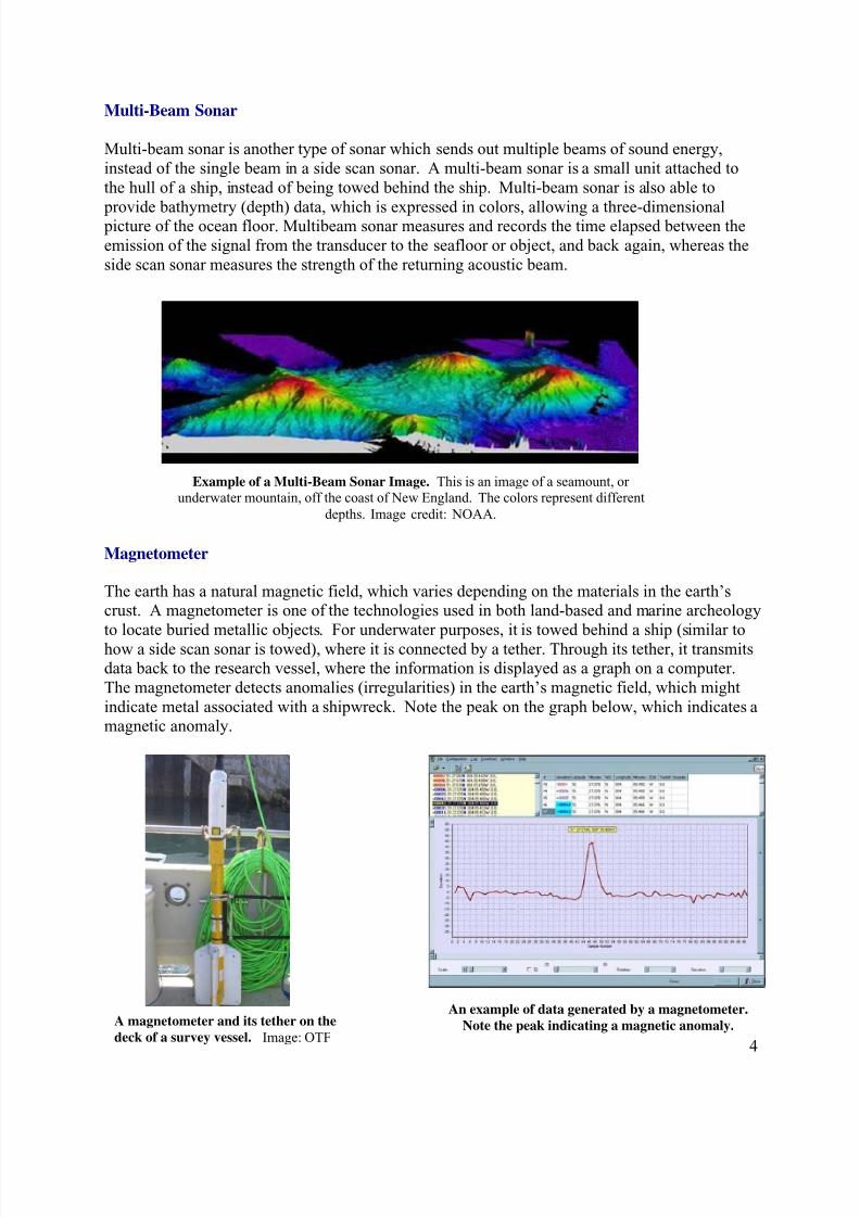
Side scan sonar images of shipwrecks in the North Sea. Note how the shadows, or darkest areas, can
show a different perspective of the wreck. Images: Ocean Technology Foundation
The side-scan sonar continuously records the return echo from the seafloor, creating a picture
consisting of light and dark areas. The dark areas are objects that are hard or protrude from the bottom, which reflect more energy. Lighter areas are soft mud or sand, and they reflect less
energy. Side scan sonar produces a shadow, just like a flashlight does when illuminating an
object, except that sonar uses acoustic, or sound impulses, instead of light.
The process of surveying with side scan sonar is similar to mowing a lawn. The ship travels back and forth in long straight lines, overlapping the lanes on the return trip to make sure that the
entire area is covered.
Another important piece of data is the exact location of the ship and the towfish while the data is
being collected. If this information isn’t accurate, it will be very difficult to relocate a specificobject on the sea floor if scientists think it deserves a closer look. This location data is recorded
with a Global Positioning System so it can be easily input into the computer when the data is processed. The data from side-scan sonar can be viewed “live” while being collected or may be
viewed afterwards in different formats. At the end of the survey, all the separate swaths are
pieced together like a puzzle to form a comprehensive map, called a mosaic.
8/11/2019 Technology Lesson Rev
http://slidepdf.com/reader/full/technology-lesson-rev 4/5
4
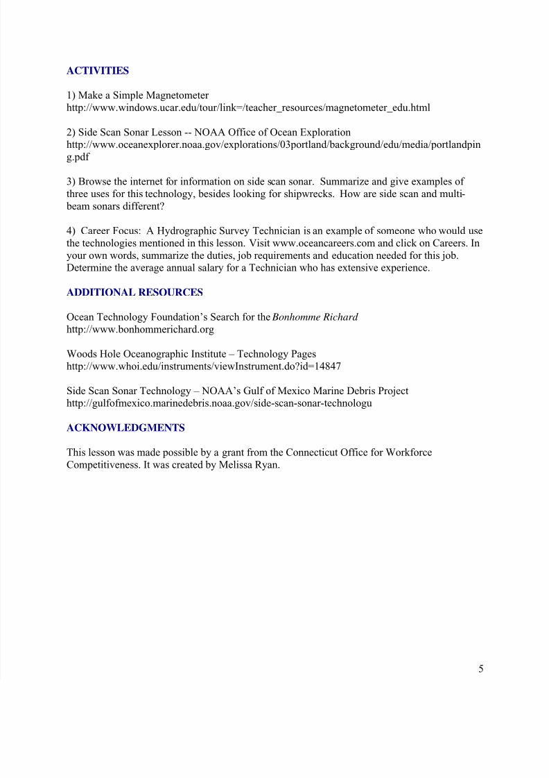
Example of a Multi-Beam Sonar Image. This is an image of a seamount, or
underwater mountain, off the coast of New England. The colors represent different
depths. Image credit: NOAA.
A magnetometer and its tether on the
deck of a survey vessel. Image: OTF
Multi-Beam Sonar
Multi-beam sonar is another type of sonar which sends out multiple beams of sound energy,
instead of the single beam in a side scan sonar. A multi-beam sonar is a small unit attached to
the hull of a ship, instead of being towed behind the ship. Multi-beam sonar is also able to
provide bathymetry (depth) data, which is expressed in colors, allowing a three-dimensional picture of the ocean floor. Multibeam sonar measures and records the time elapsed between the
emission of the signal from the transducer to the seafloor or object, and back again, whereas the
side scan sonar measures the strength of the returning acoustic beam.
Magnetometer
The earth has a natural magnetic field, which varies depending on the materials in the earth’scrust. A magnetometer is one of the technologies used in both land-based and marine archeology
to locate buried metallic objects. For underwater purposes, it is towed behind a ship (similar to
how a side scan sonar is towed), where it is connected by a tether. Through its tether, it transmitsdata back to the research vessel, where the information is displayed as a graph on a computer.
The magnetometer detects anomalies (irregularities) in the earth’s magnetic field, which might
indicate metal associated with a shipwreck. Note the peak on the graph below, which indicates amagnetic anomaly.
An example of data generated by a magnetometer.
Note the peak indicating a magnetic anomaly.
8/11/2019 Technology Lesson Rev
http://slidepdf.com/reader/full/technology-lesson-rev 5/5
5
ACTIVITIES
1) Make a Simple Magnetometer
http://www.windows.ucar.edu/tour/link=/teacher_resources/magnetometer_edu.html
2) Side Scan Sonar Lesson -- NOAA Office of Ocean Explorationhttp://www.oceanexplorer.noaa.gov/explorations/03portland/background/edu/media/portlandpin
g.pdf
3) Browse the internet for information on side scan sonar. Summarize and give examples of
three uses for this technology, besides looking for shipwrecks. How are side scan and multi-
beam sonars different?
4) Career Focus: A Hydrographic Survey Technician is an example of someone who would use
the technologies mentioned in this lesson. Visit www.oceancareers.com and click on Careers. In
your own words, summarize the duties, job requirements and education needed for this job.
Determine the average annual salary for a Technician who has extensive experience.
ADDITIONAL RESOURCES
Ocean Technology Foundation’s Search for the Bonhomme Richard
http://www.bonhommerichard.org
Woods Hole Oceanographic Institute – Technology Pages
http://www.whoi.edu/instruments/viewInstrument.do?id=14847
Side Scan Sonar Technology – NOAA’s Gulf of Mexico Marine Debris Projecthttp://gulfofmexico.marinedebris.noaa.gov/side-scan-sonar-technologu
ACKNOWLEDGMENTS
This lesson was made possible by a grant from the Connecticut Office for Workforce
Competitiveness. It was created by Melissa Ryan.


![Technology Enhanced Lesson[1]](https://img.pdfslide.net/doc/110x75/55796657d8b42a3a5c8b4831/technology-enhanced-lesson1.jpg)