Embed Size (px)
Citation preview
The African e-Journals Project has digitized full text of articles of eleven social science and humanities journals. This item is from the digital archive maintained by Michigan State University Library. Find more at: http://digital.lib.msu.edu/projects/africanjournals/
Available through a partnership with
Scroll down to read the article.
Pula: Botswana Journal of African Studies vol. 15 no. 1
An archaeological survey of Ntsweng in MolepololePrincess Sekgarametso
Ntsweng was the capital of Bakwena before they moved to Molepolole. The bulldozing of a pan ofNtsweng for a sports field in 1994 inspired the mapping of the site. At Ntsweng, several clusters ofruins seem to represent different wards. Analyses of the settlement layout and soil samples suggestcattle were often kept in the center of each ward. This seems to follow the "central cattle pattern ",a conceptual model for the organization of settlements among southern Bantu, where the centralplacement of the kraal reflects the central role of cattle in the culture and ideology of the people.
Ntsweng is a historic site located a few kilometers southeast of Molepolole in KwenengDistrict (Fig. 1). The area was first occupied by Bakwena, led by Sechele I, in 1864. It wasabandoned in 1937 when Bakwena were forced to move to Molepolole by Kgari II, assistedby the colonial administrators (Schapera, 1943).
Ntsweng is one of Botswana's most important monuments. Contrary to the 1970 NationalMonuments and Relics Act, 24,000 sq m of the site were bulldozed in February 1994 tomake a sports field for Sedumedi Community Junior Secondary School. A rescue projectwas carried out by the Archaeology Unit of the University of Botswana, with assistancefrom students of Sedumedi Community Junior Secondary School and Legae Academy, tosalvage the damaged area. A lot of artifacts like bones, pottery, ostrich eggshell beads,metal earrings and other metal objects were recovered from the area (Borgesen et al.,1994).
The inadequacy of cultural resource management in Botswana can be partially blamed forthe bulldozing of Ntsweng, as it failed to provide proper delimitation of the site (Borgesenet ai" 1994). This inadequacy in cultural resource management extends even toarchaeological sites in Dimawe, Manyana, Lose, Modipe and Domboshaba which have alsobeen damaged.
The importance of these sites is that historically written information about Botswana'sdistant past is very limited. Information mostly comes from archaeological sites whichneed to be protected, Even though Ntsweng is documented historically, there is still moreto the site which needs to be exploited archaeologically in order to add to historicalinformation. If these sites are not preserved, historical information would be lost and wewould have no history to talk about.
Ntsweng today consists of a large area covered with traces of occupation. Most notableare the patterns of stones laid on their edges to form house foundations which are stillvisible on the surface. The only building still standing is what used to be Sebele II's officewhich is at present referred to as Mmakgosi' shouse,
The main aim of this paper is to investigate the organization of the settlement at Ntsweng.This was done by conducting an archaeological survey of the remains of structures atNtsweng. Inparticular, the survey was to assess the damage done by the bulldozer and toreconstruct the damaged area. Information generated from the survey is used to observe thesettlement pattern and the site's functional and symbolic layout. The plan produced is alsochecked to see whether it conforms to Huffman's central cattle pattern, a characteristic ofsouthern Bantu settlements where cattle have a central place (Huffman, 1986).
The results of this survey can be used to guide subsequent archaeological research, aswhat lies on the site's surface is often a general reflection of what exists beneath.Excavators can use this surface information to place key excavation units so as to test the
23
hypotheses generated from surface data (Knudson. 1978). In this paper. I aim to addressthree issues. I intend to find out from the archaeological record how the settlement atNtsweng was organized. I intend to find if the settlement plttern at Ntsweng <:<>nfo~ed tothe central cattle pattern. And with the aid of phosphate analysis and oral mtervIews, Iintend to find out how labour was organized and space was used at Ntsweng.
Methodology ..Archaeological survey is taking stock of everything that remains on an archaeological sitein the form of plans, notes and photographs in as much detail as possible withoutexcavating the site (Sharer & Ashmore, 1979). The archaeological survey of Ntsweng wasdone first by walking around the site to familiarize myself with the features and extent ofthe site. This was also done to choose an area to focus my study. The criteria employed forchoosing the area to work were good preservation of stone alignments, sparse bush to allowgood visibility, and a size comparable to the bulldozed area. After choosing the area, Istarted mapping the stones using a dumpy level. The instrument provided the bearing of thestones from the temporary benchmark we had created. A measuring tape was then used totake the distance of the features from the instrument. These measurements and angles werethen plotted on graph paper.
In addition, soil samples were collected and taken to the Archaeology Unit in theUniversity of Botswana to test their phosphate content. This was done because it is knownthat human activities produce phosphorus-rich organic materials which after decaying areincorporated into the soil in the form of stable phosphates. These tend to preserve forthousands of years and can be detected by chemical analysis. This technique dates back tothe 1920s when fieldwork in Sweden revealed the close correlation between ancientsettlements and high concentrations of phosphorus (Renfrew & Bahn, 1991). Phosphateanalysis is a geo-chemical technique the main scope of which is
t? localize ancient monwnents not visible in a surface survey, to assist in detennination of siteIwnts and to give infonnation about the function, activity or duration of occupation. (Bakkevig,1980:74)
Proudford was able to estimate that activities of a POpulation of 100 people would deposit124 kg of phosphorus annually (Clark, 1990). Recent phosphate analyses done in Englandhave revealed that archaeological features that remain undisturbed in the subsoil areaccurately reflected in the topsoil.
!n the ~~ .topsoil was considered to ~ unstratified and hence devoid of archaeologicalinfonnatlOn; It was often removed mechanically and quickly without investigation (Renfrew &Bahn,1991:87) .
Cl~ (l~? says t~t phosphate tests respond mostly to middens cattle pits anddomestic actiVity espeCIally around pits and buildings. Soil samples fro~ Ntsweng werecollect~ to try and ~~te such areas and also to assess the oral historical data collectedconcemmg the OfganIzabon and use of space at Ntswen In all edplus two control samples from ff th . Th g . ., 75 samples were collectnatural content of b . 0 ~ Site. e control samples were taken to detect the10 cm into the so8 =~~~the so~:'fi The collection of soil was done by digging about100 g. ng SOl om underground These samples weighed about
A method known as spot testing was em I edThis was done by placing 0.5 g of so'l fi PeachOY to test the phosphate content of the soil.
1 om bag on a separate filter paper. This was
24
then followed by adding two drops of amonium molybdate to the soil and allowing it tospread into the filter paper. Two drops of ascorbic acid were then added to the soil solutionand left for three minutes to dissolve on to filter paper. It is important to have thechemicals reacting within a given time to avoid over-reaction. The soil was then removedfrom the filter paper which was examined. Sixty two percent of the filter papers showed nosign of blue colouring which means that the soil was <0.08 % P20S. Twenty three percenthad a trace of blue up to 2 mm from the soil, which means that the phosphate content was0.08 - 0.15 %. Nine percent were weak (blue circle, with rays merging) marking phosphatecontent of 0.15 - 0.8 %. And finally, 5 % were positive (distinct blue band 10-15 mm indiameter) marking phosphate content of 0.8 - 0.9 %. The control samples showed nophosphate content which showed that naturally the soil contained no phosphorus.
After collecting the soil samples, oral interviews were conducted in Molepolole. Thesewere used to help interpret the archaeological information at Ntsweng. A preparedquestionnaire was used to guide the oral interviews (see Sekgarametso, 1995). A total of 21informants were consulted in individual and group interviews. The group interview wasconducted amongst a group of women known as Matsosa-Ngwao. These women arevolunteers who have dedicated their spare time to the promotion of Kweneng culture. Thusthey are mostly found at the Kgosi Sechele I Museum or at the kgosi-e-kg% 's kgot/aassisting where help is required. The information gathered from these women was checkedby conducting individual interviews.
Literature consulted was found at the National Museum, Phutadikobo Museum, KgosiSechele I Museum, National Library and University of Botswana Library. These booksgave historical information about Bakwena and the stages that led to the abandonment ofthe site at Ntsweng. Other more general books about settlement studies conducted outsideBotswana were also consulted Problems encountered during the research were mainly thatthe instrument I was using demanded a lot of labour. Thus, I spent more time in the fieldthan I had anticipated. The more efficient Electronic Distance Measurer (EDM) was notworking.
Literature reviewArchaeological work done in Botswana is very limited, especially on historicallydocumented sites. More historical archaeology has been done in neighbouring South Africaand it is information from these sites that would be most useful for comparsion with thesettlement patterns at Ntsweng (e.g., Pistorius, 1992). This is because the occupants ofNtsweng are said to be part of the Sotho-Tswana group which came from South Africa(Ngcongco, 1982).
More broadly, comparative studies on settlement patterns and use of space have beendone worldwide and especially useful to my study is a book edited by Kent (199Oa) ondomestic architecture and use of space. The contributors provide very important andoriginal insights into the relationship between the built environment and the organization ofspace, though from different backgrounds. In their studies the fundamental role of cultureas expressed in technology, symbolism, socio-political organization and economics isexplored. This is done with the aid of case studies of the past and present drawn fromvarious countries. Especially useful information in this book was Lawrence's study onurban housing in Switzerland where he argues that when studying settlement patterns oneshould not look only at specific buildings but also look at the diverse actors involved withtheir design (Lawrence, 1990). Kent's (199Ob) cross-cultural study of segmentation,architecture and the use of space saw Batswana as segmented into gender and age
25
distinctions when observing the relationship between use of space and domestic builtenvironments.
Information regarding survey techniques was available from a number of sourcesincluding Sharer & Ashmore (1979). Renfrew & Bahn (1991) and Knu~n (1978). Theyprovided the necessary details including case studies in which archaeological surveys we~edone and interpretation of the results was given. Literature consulted on phosphate analy.S1Sincludes Nunez (1990), Shackley (1981), Bakkevig (1980) and Clark (1990). These prOVIdedifferent ways of conducting phosphate analysis and include case studies. Particular~yuseful was Bakkevig (1980) who points out some of the problems in phosphate analystswhich have been done in the past and attempts to correct the mistakes ..
Huffman (1986) has proposed a pan-southern African settlement system to explamsouthern Bantu settlements. This has been termed the southern Bantu cattle pattern or thecentral cattle pattern. This pattern, according to Huffman (1986:289) is " ... found amongBantu speakers in southern Africa who are predominantly partrilineal and who exchangecattle for wives". He further says that
attitudes about economy, politics and religion result in a specific arrangement whereby an outer arcof houses, arranged according to some alternating system of status, surround a central zone thatcontains cattle byres, grain storage facilities, elite burials and the men's court. (Huffman, 1986:289)
The settlement, says Huffman, was arranged in such a way that the front was public andreserved for dangerous activities and the back was sacred and private. He further says thatthe settlement pattern is governed by attitudes towards status. Using this model, I willinvestigate whether Ntsweng corresponds to Huffman's central cattle pattern.
Pistorius' (1992) study of Bakwena settlement pattern near Rustenburg was especiallyuseful. He conducted an ethnoarchaeological study in which historical, ethnographic andarchaeological evidence was combined to interpret the settlement pattern at Molokwane. Hefurther attempted to explain the way of life of the inhabitants of the village. Based onethnographic and archaeological information obtained, Pistorius (1992) says that thesettl~~ent had once been that of Bakwena. He found numerous wards occupied by relatedpamlineages (masika) and also found that the settlement pattern conformed to the centralcattle pattern defined by Huffman (1986).
McDonald (1940) conducted an ethnographic study of Bakwena material culture andarchitecture immediately after the abandonment of Ntsweng. Although his study mainly~m~ the Bakwena ~f Molepolole and those in South Africa, he provided usefulinformation about the SOClal, economic and political organization of Bakwena at Ntsweng.Lm:ssc:'n& Larsson .(1?84) documented traditional Tswana housing in Botswana. Theirmam mterest was buil~g methods and they observed the layout of dwellings together withth~ use of space. Then book provides useful information for interpreting the stonealtgnments at Ntsweng.
Arc~l~gi~ wo~ <i?neon historically documented sites in Botswana include Pahl's(1971) linu~ .mveStigation of Motsenekatse Hil~ ongoing research at Modipe Hill inK~tleng Distnct ~ the Archaeology Section of Phuthadikobo MuseUlll, work done at~mawe by the National Museum Monuments and Art Gallery and work done on Kutswehill by Segobye (1994). Inaddition, I looked at van Waarden's interpretati f . satVumba (1989), and her excavations at Leeuki . th .. on 0 ~eWaarden (1980 1989) e......1 structuralistOP~ .eNo~ East District. At these SItes van, uay,oys a View 10 the mte tt. f terial IAt Vwnba she agrees with Hn"---' .}" on 0 IDa cu ture." .. "'1ll14ll S (1986) central cattle pattern, saying that
... oppoSltions of male and female, pastoralism and agriculture, ancestors and descendants,
26
rulers and subjects, cold and hot. .." are represented in the spatial oppositions of thesettlement plans (van Waarden, 1989:133). She says such cognitive and conceptualstructures arc present in all cultural behaviour. She also says that division of labour atLeeukop was along sex lines rather than those of age or status, thus suggesting differencesin male and female activity (van Waarden, (980).
Caister (1980) says that Iron Age settlers had occupied the Kweneng area by the middleor late fIrst millennium. The major phase of occupation of the Molepolole area probablybegan early in the second millennium and is so far represented by 24 sites distributed fromDithejwane in the west to at least as far as Gaborone in the east. Caister mentions thepresence of Cenchrus ciliaris and stone walls on hill top sites around Molepolole andGaborone. The stone walls are said to have been built by the Nakedi and Kgwatheng whowere found occupying the Molepolole area when Bakwena entered present day Botswana.His observations deny the fact that Bakwena could have been involved the building of thestone walls. He further says that sites from the 1820s onwards were chosen for political andmilitary advantage during the Mfecane wars. This is why we find most of the sites locatedon hilltops. The historical background of Bakwena and the causes and consequences offorced abandonment of Ntsweng in 1937 are well documented (Schapera, 1943, 1980;Okihiro, 1973, 1976; Ngcongco, 1982). These sources also describe subsistence amongstBakwena who inhabited Ntsweng.
Historical backgroundBakwena are part of the Sotho-Tswana groups that arc said to have emerged in the periodAD 1000-1500 (Ngcongco, 1982). According to oral traditions, Bakwena trace their originsto Malope, the leader of the Baphotu Kingdom in the early 10th century. The BaphotuKingdom was situated near the source of the Odi or Crocodile River to the northwest ofmodern Pretoria (Ngcongco, 1982). Malope is said to have had two children, Mohurutshe, adaughter and Kwena, a son. These are said to have formed the Kwena-Hurutshe group buteventually split with one group going with Kwena and assuming the name Bakwena, andthe other with Mohurutshe and assuming the name Bahurutshe.
Bakwena of Molepolole today trace their origins to Bakwena ba-ga-Mogopa in theRustenburg District where they had lived until the death of Tebele, when his son Mogopabroke away from his people and settled at Mabyanamatswana (Swartkoppies, near Brits).Among Mogopa' s people there was a ward under Kgabo who was Mogopa' s son from hisjunior house. Periods of drought and moving from one place to another resulted inMogopa's people scattering allover. When he heard that at Mabyanamatswana rain hadfallen and there was plenty of food, he decided to gather his people and go back. Kgabo issaid to have promised to follow later, but instead he is said to have declared himselfindependent and crossed the Marico river into what is now Botswana, settling in presentday Kweneng District (Schapera, 1980). A further split occurred amongst the remainingBakwena at Mabyanamatswana due to drought. A group of Bakwena Bamogopa andBakwena Bamodimosana moved away and it was this group who built and occupied the siteof Molokwane that has been investigated by Pistorius (1992).
Bakwena ba-ga-Kgabo first settled at Dithejwane Hill where they encountered earlierinhabitants of the area, the San and Bakgalagadi. These were" ... expelled, driven west intothe Kgaiagari and maintained under a symbiotic client relationship by the baKwena."(Okihiro, 1973:104). During this period Bakwena are said to have been very rich owningcattle and sheep. They grew pumpkins, beans and other vegetables. This state of affairswent on until the death of Motswasele II (Okihiro, 1973). After this Bakwena are said tohave experienced a period of raids from Sebetwane and Mzilikazi who were at the time
27
terrorizing Batswana by attacking them and stealing their cattle. These raids scatterdBakwena and they were regrouped by Sechele I after Mzilikazi had been defeated atLephephe. Sechele Ihad before been captured and released by Sebetwane (Sillery. 1952).
English traders and missionaries entered Bakwena territory at the time of Sechele I'sreign and he was the first Bakwena chief to be baptized by Lhingstone. Under Sechele IBakwena are said to have increased, absorbing refugees of both Tswana and non-Tswanaorigin and placing them directly under the authority of the royal ward By so doing Secheleis said to have been
able to strengthen his bogosi and use it to capita1ize on the growth in the trans-Kgalagadi trade.After 1850 the BaKwena became the most powerful and prosperous morafe in the region. (Mortonet ai., 1989:64)
From Lephephe, Bakwena moved to several areas. In 1852, whilst staying at Dimawe, theywere attacked by a Boer commando (Ramsay, 1991). Having defeated the Boers, Sechele Imoved his capital first to Dithubaruba and then to Ntsweng in 1863. He was thus the fustBakwena ruler to settle at Ntsweng, and he was well established and prosperous.
Sechele I had three sons: Kgari, Sebele and Tumagole. When he died there was asuccession dispute amongst his people. Kgari was the first born child from the first housebut his mother was a Mongwato. Sebele was the first born child from the second house andhis mother was a Mokwena. This divided the Bakwena, with Sebele's supporters sayingthat they did not want to be ruled by Kgari as he was a child born of a non-Mokwenamother. For this they referred to him as set/ogolo-sa-dichaba (child born of a non-Mokwena mother) (Okihiro, 1976). Another faction supported Kgari as the rightful heirbecause he was born into the first house. Unfortunately for him, Sebele managed to takeover and Kgari and his people were driven away from the capital (Okihiro, 1976). It wasduring Sebele I's reign that Britain wanted to declare a protectorate over the land ofBatswana. Sebele is said to have been against the idea and throughout his reign he is said tohave prevented British interference in Bakwena affairs. In 1896 and 1899
rinderpest, drought, and disease destroyed stock and decimated the BaK wena. For much of thispenod Sebele abdicated his responsibilities by retreating to his cattle post and rejecting BritishotTers of food. (Mortonetai., 1989:110)
Se~le I was succeeded by Sechele II who is sometimes referred to as Kealeboga. Aco~ ..ct r~sulted ~hen Sechele II sanctioned the Anglican Church. As a result. LMSnusslOnanes are saId to have
su~r~e;t th~ ?'~osana in a campaign to discredit him before the British. The resulting conflictsp. 0 epo ? e mto the ~tsw~g and Borakalalo factions and occasioned the first BaK wenaTnbal CO~CIl. The colll1cll, which was controlled by Seche1e's sibling rivals Kebohula andMOiteelasilo,.~n lapsed ~ Sechele n asserted his authority by promoting .uni~r headmen intopowerful posItIons and revIVffigbogwera. (Morton et al., 1989:112) J
Sechele II moved his people back to Ntsweng from BOrakaIal h .remained behind At Borakalal th . 0 were most of his opponents
o ey were ad'acent to th I nial dminis' .,government camp (BNB 9719:3). " e co 0 a tratlon sAt the time of Sechele II's death there bi " .
Ntsweng and Borakalal0 This di was ~ tter diViSIonbetween the residents ofSebele II took over he ~ntinued :.the ::Ign of Se~le I~ (BNB 9719:14). When
cmg ogwera, rammaking and polygamy which
28
offended the Christians and angered the colonial administrator (Morton & Ramsay, 1990).Sebele II is also said to have promoted commoners. This threatened the position of theelite. These dikgosi accused Sebele II of being backward The colonial administratorsaccepted these accusations and supported petitions brought forward by Sebele' s opponents.These opponents, who were mostly from Borakalalo, were questioning Sebele's ability tojudge cases and govern without their advice (Morton & Ramsay, 1990). They wantedSebele II to move from Ntsweng. Sebele, however, managed to defeat his opponents (fordetails see Morton & Ramsay, 1990).
After this he built a new "Bakwena National Office" next to his kgotla. Although SebeleII was seen by his opponents as stubborn, during his reign he is said to have
imposed strict standards on the building of houses and fences and had streets kept clean and wellmaintained. Rubbish pits replaced garbage heaps. He told his people to bury their dead in thegraveyard rather than in their lolwapa. New roads were built, and dam construction was attempted(though unsuccessfully). Sebele also sanctioned youth programmes in the form of Life Brigades forboys and girls. And while in power he welcomed the establislunent of the Scottish-LivingstoneMedical Hospital. (Morton & Ramsay, 1990)
In spite of his efforts his opponents continued to accuse him of being a neo-traditionalist.Where Sebele II's opponents failed, the colonial administration succeeded: he was detainedwithout trial and exiled to Ghanzi. His brother Kgari was then made chief and built ahouse, with Bakwena money, at the site of the present Bakwena main kgotla in Molepolole.
Kgari met many problems during his reign. The colonial administrator reported to hisseniors that Kgari
complained that the people of the hill [Ntsweng] considered themselves as a separate tribe and withthe present position of having two villages in Molepolole, he had no control. (BNA S.260/13)
The people of Ntsweng did not recognize Kgari as chicf. The area became a centcr ofresistance as a movement was established to have Sebele II back as the rightful heir to thethrone (Ramsay, personal communication). The colonial administration responded toKgari ,s complaints by asking him to
inform the brothers and other headmen that the chief would have the support of the government andit is expected that they will carry out his orders, at the same time warning them that if they do not,other measures will have to be considered. (BNA S.260/13)
The people of Ntsweng still refused to move from the area and it is said that the onlyneighbours Kgari had were the tax collectors. The government then decided to use forceand in 1937 houses were knocked down at Ntsweng including the house of Sechele I(Morton & Ramsay, 1990). Some of the Ntsweng residents still refused to move andhaving given a final warning the colonial government decided to take the matter into theirown hands. In April of the same year those who refused to move out were jailed (BNAS.260/15/2). This punishment is said to have had an immediate effect and in May thebuilding of houses near Kgari was in full swing.
Sebele lIs mother, Phetogo, is said to have refused to move and she remained in Sebele' sNational Office which is the only building still standing at Ntsweng. It is now referred to as"ko ga Mmakgosi" by Bakwena. The building is situated next to an area which used to bethe royal kraal at Ntsweng but is now the royal cemetery (Morton & Ramsay, 1990).
29
Ntsweng households .The basic architectural unit at Ntsweng was the house. These were recogmzed by stonealignments that according to oral informants marked the foundation of houses. andcourtyards (malapa). In a few exceptional cases the remains of house walls could stIll beseen standing. According to Schapera & Comaroff (1991 :33), a Kwena house~old ...... hasits own compound (/olwapa, lapa) consisting of one or more huts and grananes Situatedwithin a courtyard surrounded by ...a wooden palisade." These houses, as Kent (1990b)says, are separated according to their activities. Within a household there is said to be thefront lelapa and back lelapa (segotIo) (Fig. 2). The front lelapa consists of ntlo ya lelapa,the main house where the owner sleeps. This is sometimes shared with small children andfor cooking in bad weather. This house normally has a courtyard (Ielapa) in front wherevisitors are received and cooking and eating may be done here. Schapera & Comaroff(1991:33) say:
adolescent children of both sexes may live together in another hut, or share one with an olderfemale relative, and unmarried adults usually also have separate huts, one for the people of eachsex.
This adolescents' house is normally found on the side of the ntlo ya lelapa. It is usuallyrefered to as ntlwana ya lelapa because it is normally where children sleep and itsometimes has a lelapa. This lelapa may be adjacent to the nt/o ya lelapa. On the side maybe a house which is referred to as the loobo. This house is mostly used as a cooking areaand sometimes it is built with a small wall forming a circle and the roof is held up bysupports leaving an open space of about a meter between the roof and the wall to allowsmoke to go out easily.
At the back lelapa (segotlo) is normally the sesoa. This house is used for grain storage.According to Matsosa-Ngwao other household equipment such as building materials maybe stored in the sesoa and sometimes small children or the very old in the household mayuse it as a sleeping area. There is also said to be a serobe at the back lelapa (segotlo) wherelambs and kids are kept during the day, when the adult sheep and goats have gone out tograze. In the evenings they are taken back to their mothers at the central kraal to sleep. Asmall garden may also be made where ntshe (sweet reed), mabele (sorghum), dinawa(beans), magapu (watermelons) and other crops were planted to be eaten by the familywhen produce at the lands was not yet ready. If there were any chickens in the household~ey normally slept on wooden palisades that made up the fence, or in areas made for themm hut stoops.
Building, as mentioned by McDonald (1940) and Larsson & Larsson (1984) usuallyco~en~s after the harvest in winter. This is done to prepare for the rainy se~son andbuilding IS done by both men and women. The dagga application and decoration is done byw~men ~ th~ fnunewo~ buih by men. According to Bakwena tradition, before a hut is~lt, certam ntual practl~ are performed. This is done to protect the household fromWitchcraft and theft. The n.tual practice is performed by traditional doctors and during theprocess .wooden ~gs or ammal horns smeared with medicine are buried in the area wherethe hut ISto be built.
According to ~n & Larsson (1984) early records have it that the circular hut is theoldest shape of traditional Tswana h Atthe circular one. According t M Do°naluSCSd. Ntsweng the most common hut shape was
o c (1940:33), one starts by marking
30
a circle with a string or rein, one end of which is attached to a peg knocked into the groWld and theother end attached to another peg which is drawn at full length aroWld the first, in this waydescribing a circle.
After marking the circle, a hoe or a sJXldeis used to mark clearly the circumference of thecircle. Stones about 40 x 30 cm were then arranged on the circle as the foundation of thehouse. This allows for the building of the wall. All this is done by women and the wall ismade by mixing clay with cow dung. The mixing with cow dung, the people say is toharden and strengthen the wall and to guard it against the effects of rain and the ravages oftermites (McDonald, 1940:34).
After the cow dung is well mixed with the clay, bricks are made. These bricks are thenused to form the wall. They are not left long enough to dry so they are easily compressedtogether to form a circle. This is all done using hands. When the wall has reached thedesired height, men go out into the bush to cut supports for the roof (maotwana) andsometimes for the center pole (pinagare) of the hut, if it is to be used. After the woodenframework (go tlhomesa) is constructed by men the house is then thatched with grasscollected by women. Thatching, however, can be done by both sexes. The same techniqueof building a hut wall is applied to building the lelapa. The lelapa walls are not round butangular. In this case the shape is just marked on the ground using a stick and then stones areused to mark boundaries.
At Ntsweng there were sometimes double lines of stones marking foundations.According to oral information the second line of stones served as a foundation for stoops(maribela I direpodi). Maribela are made to prevent erosion of the walls and they are alsomade for people to sit on. Sometimes in the foundation of huts square shapes on comers ofmalapa (plural of lelapa) were made to provide seats. Smooth round stones known as lite/owere found at Ntsweng. These stones are said to have been used to smoothen floors ofhouses and walls after they had been plastered. A JXlvementof potsherds was found at theentrance of one of the huts. These were placed to prevent the floor eroding when it rainsand they also served as decoration.
Ntsweng has three types of houses. There is the circular shape which is the mostcommonly found. This is a typical Sotho-Tswana type of house. The diameter of thesehouses ranged between 4.4 - 4.8 m. There was, however, one house that had a diameter of6.2 m. There is also the semi-circular type of house which according to one of myinformants, Mr. R Pheto, was invented by Bakwena and later spread to Bakgatla. Semi-circular houses mostly had a radius of 4 m. The rectangular type of house was adoptedafter the coming of the European settlers (Schapera, 1943; Larsson & Larsson, 1984). Itwas not common at Ntsweng: according to Matsosa-Ngwao this type of house markedstatus. This type of house was built with a concrete foundation in front and on the sides.This building material was not commonly used on the site. According to oral information,the rectangular houses at Ntsweng were those of the kgosi-e-kgolo and a missionary by thename of Konobole (Grobler), who owned a store at Ntsweng. Circular structures about onemeter across were found beside the house. These structures, according to oral information,are said to have been bases of difalana (granaries). Similar structures have been found byothers across southern Africa (Maggs, 1976; van Waarden, 1989; Campbell, 1991;Pistorius, 1992; Segobye, 1994).
In the houses from cluster 1 (Fig. 3), 75% had no sign of phosphates, 18% had tracesigns, while only 7% were weak. Out of 24 malapa there was only one /e/apo (structure 5)that had a positive sign of phosphorus. Most malapa had a trace of phosphorus. There was,however, a distinct relationship between the houses and malapa. The higher phosphate
31
content within malapa probably resulted from different activities that took place in them.In the houses there was less activity. Structures 32, 33 and 34 were rich in phosphatecontent. These were close to each oilier and on these structure was a recent goat pen thatcould have accounted for the high phosphate content in the area ..
As recognized by van Waarden (1989), labour amongst Bantu-speaking peoples ISdivided along sex lines rather than age or status. lltis is characteristic of Bakwena. 'f!te~were also servants (malata) who were not given equal status in society to Bakwena. WI~a Kwena household the man is the head of the household but most of the activities withinthe household are carried out by women. According to Matsosa-Ngwao women areresponsible for feeding the family. They work in the fields and this produce was used tofeed the family and maintain the children. Water was fetched by women at Ntsweng fromthe Molepolole river which flows through the modem settlement and is said to have beenperennial in the I920s. To supplement this water SOurce European settlers introducedboreholes and wells which the people of Ntsweng were given access to (McDonald, 1940).
Men were responsible for looking after domestic animals and hunting. Domestic animalsincluded cattle, donkeys, horses, pigs and goats. According to oral information pigs andgoats were kept in small numbers. They were mostly looked after by small boys under thesupervision of their parents. Political and legal affairs were attended to by men and fi~1decisions for the household are said to have been made by men, sometimes in consultationwith women.
Subsistence activities
A lot of cattle bones were found at Ntsweng from the bulldozed area. lltis is becauseBakwena attached much importance to the keeping of cattle as they were the major si~ ofwealth and they were used for transport, ploughing, bridewealth and for ritual practIceSsuch as sacrifices to the ancestors (hadimo) (McDonald, 1940). Bakwena kept cattle atcattle posts far from the villages. These cattle posts were sometimes over 50 kilometersaway from the village (Larsson & Larsson, 1984). Few were kept in the settlement at thecentral kraa1 of the kgotla they belonged to. These cattle consisted mostly of heifers whichwere used for transport and a few female cows which provided milk for the kgotla.
Donkeys w~n: penned with cattle at the central kraal. These were often kept in smallnumbers fo~ nding or when driving cattle. According to oral information, donkey cartswere only mtroduced after the arrival of Europeans. Europeans introduced horses toNtsweng and these were owned by the rich and were a sign of status. According toMcDonald (~940) both goats and sheep were kept though goats were few. Chickens werealso kept. Pigs were kept but for hygenic reasons were later prohibited bv law at Ntsweng(Morton & Ramsay, 1990)..
Evidence for agn.culturaIproducti.. I de ... d ata di on .mc u s grmding stones which were mostly foun
stance from the houses. According to oral information grinding took place at thesegotlo, ~t when performed communally it took place at the kgotla When these stoneswe~ not m use they were stored in the segotlo leaning against woode~ palisades that made~~u~:~~ ~ h~se~~lds. According to Mr R. Pheto, grinding stones found outsidefound at Sat to mark where WOodenpalisades were. Part of an old plough was(940) a;:::' ~ ':1. These ploughs were pulled by oxen. According to McDonaldresulted in Ie :. were as much as 20-30 miles away from the settlement and thisagricultural :n. vmg homesteads at the lands which were mostly used during the
Oral information has it that agri ltural .trading ptlrposes but fi fi . cu .production at the fields was not undertaken for
or Ceding the family (Matsosa-Ngwao, personal communication).
32
These people did not have large fields but they were normally big enough to feed thefamily. Crops were normally all planted in the same field. These fields were used yearlyand the reason why they managed to produce yearly was probably because the planting ofcrops together in one field resulted in minerals absorbed from the soil by crops such assorghum being retained by others crops such as beans. In this way the fertility of the fieldwas maintained and leaching of the soil's nutrients did not occur.
Crops planted were sorghum (mabele) which was the staple crop, beans (dinawa) watermelons (magapu) and sweet reed (ntshe). Other crops like maize, pumpkins, tobacco andtomatoes were introduced by Europeans. Bakwena are said to have had problems with suchcrops as they were not suited to local climatic conditions (Nangati, 1980).
The dominance of cattle bone in the collection of artifacts from the bulldozed areaindicates that hunting amongst the people of Ntsweng did not play a major role in theirsubsistence. However, evidence of other bovids has also been found in the assemblage.Hunting was carried out by men and it was done for subsistence. With the coming ofEuropean hunters and traders this changed. Hunting was then done for trading. Such itemsas ostrich feathers, ivory and skins were traded for such goods as tobacco, beads, guns,wagons and European clothing. As found by Nangati (1980: 141) "In the absence of money,exchange took the form of barter, the rate of exchange being necessarily unequal."
Nangati (1980) also found evidence of Bakwena's trade with the Indian Ocean coast priorto the 184Os. There also existed trade with other Batswana in the Transvaal. Nangati(1980:140) says that
Although there is as yet little archaeological evidence available regarding this trade, it appears fromthe observations of early travelers that a 'hunting economy' for trade with neighbours alreadyexisted in Kweneng prior to world market trade, and that the later development of trade with theCape Colony was merely an extension of existing trade patterns.
One of the existing trade IEttems was that of Ba-Kgalagadi and Bakwena. Skins ofanimals were obtained from Ba-Kgalagadi people and distributed amongst specializedkaross makers by shopkeepers. After being converted to mats and karosses they weretraded outside Bakwena territory (McDonald, 1940).
Beads, pieces of metal pots, pieces of porcelain and metal saucers have been found atNtsweng. These, according to oral traditions, were obtained from stores which had beenestablished at Ntsweng and Borakalalo by the Europeans. Such items as cattle werecollected by the people of Ntsweng and traded for beads, salt and sweets at the stores. Theexistence of these stores led to competition between foreign goods and indigeniousmanufacturers. As more and more foreign goods came in, indigenously manufacturedgoods were abandoned and ended up no longer being manufactured in large numbers.Wooden and clay pots were replaced by metal pots.
After the arrival of the Europeans some form of trade with grain and cattle is said to havetaken place. These white traders are said to have stored grain in large containers and whendrought came they were able to sell it to the people of Ntsweng. TIris changed the ideafrom producing crops for subsistence at Ntsweng to producing for commercial purposes inorder to obtain foreign goods. TIris type of trade was, however, monopolized by the whitesand Asians.
But in the Kweneng Sebele did manage to exercise some control by regulating cattle and grainsales, investigating cases of cheating, and getting the people to boycott goods of poor quality.
(Morton & Ramsay, 1990:36)
33
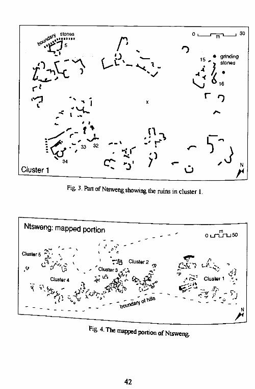
Settlementpa«ernsIn total an area of around 56,000 sq m was mapped at Ntsweng. The mapped area revealedseUlement clusters which could be distinguished by the direction in which the houses werefacing. These houses were all built forming a circle. In the center of each circle there wasno evidence of structures (Fig. 4). There were a total of five clusters mapped and they allconformed to the same ~Uem, except cluster 2 which fonned a semi-circle. A similar kindof ~Uern is apparent in historical photographs which were taken at Ntsweng before thesettlement was abandoned (Fig. 5). Unfortunately, neither the orientation nor the dates ofthese photogrnphs are known. These makgotla which were photographed were not all ofthe same size as is also evident from the plan.
Cluster I (Fig. 3) has thirty-six distinguishable houses. The shapes of the houses arepredominantly circular with a few exceptions which are semicircular in shape. It wasdifficult to determine from the ground or from the recorded pattern what structures 32 and33 were, but behind these Was a hut with a lolwapa (34). The hut /olwapa had ~ of thewall still preserved which was made from the traditional mixture of clay and mud. 33 and32 in the southern ~ are bordered by a long line of stones which had some wall stillstanding on the eastern side of 34. Leaning against the line of stones was a heap of stonesforming a rectangular shape.
The thick lines mark the pattern made by big boulders that were outside the cluster. Weassumed that they could have marked the boundary of the cluster on this side. Right behindthis boundary was what looked like a watercourse. From the southern and western edge ofthe cluster there were natural lines of stones that joined the hills and all the structures foundwithin these lines of stones were considered ~ of cluster I. Artefacts were quite scarcein the area. At 39 a metal rod and a few pieces of poUery were found on the surface. Thesoil at the central ~ce was quite ashy. Holes which were recently dug and left uncoveredrevealed pieces of poUery and ~ of a metal plough. This was near 7 and 10. Grindingstones were found on the western side of the cluster as marked on the map.
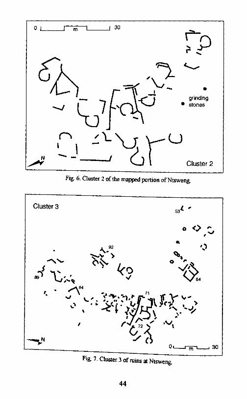
Cluster 2 (Fig. 6) forms an arc around a central s~. On the western side the cluster isseparated from cluster I by a small water course. It Was on this side along the banks of thewater course that ~ding stones were found A lot of potsherds were also foun.daccurnul~ed by mnmng water. It was not particularly clear from the archaeology why thisclUster ~d not form a circular shape like others. Also the shape of cluster 2 houses werepredornmantly semicircular.
It was not ~~ly clear what marked the boundary between cluster 3 and cluster 2,but ~e could distingwsh the difference between the clusters by the different direction theh~ m cluster 3 face (Fig. 7). Most of the stnlctures built were facing the house rnaJk:ed 64which was square and had a concrete floor. There was also in this settlement the centralspace and a .few square houses. At 7I and 92 were houses with malapa on both sides. Onelo/apa was m the !font facing the central space and one was at the back. Behind 53 was anarea that looked like a midden. There were broken pieces of porcelain, pieces of pouey,:ken bottles, broke.n metal POts and the soil was also ashy. Behind 89 was a large space
looked as~y. This also could have been a midden. At 72 a metal saucer was found and84 had part of Its wall still standing.
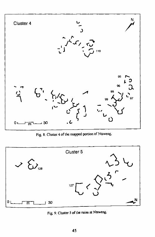
Cluster 4 (Fig. 8) also had structure bu' . '. 1bwalls of 95 96 97 9 s i1t fo~~ .a CIrcle WIth a central space. e
, . ' ,8 and 99 were unusually buIlt jOlmng one another. This formed a very:::: 1:~:~hO~mOstly semi~ in shape. Between 118 and the hill was aand bones. Borden: a:~ The so~ Was ashy with broken pieces of pots, cups, bottles
I. fb' g se ernent UnIt on the eastern side was a sman water course anda me 0 19natural boulders.
34

Cluster 5 also formed a circle of huts with the central sJllce (Fig. 9). This area was notcompletely mapped but was partly recorded to indicate where cluster 4 ended. It was,however, not clear why there was such a big gap between structure 127 and 128. In this gapthere were no distinguishable structures, but on either side the structures were facingtowards the same central sJllce.
Settlement at Ntsweng was governed by a specific attitude towards things. Oralinformation has it that the central sJllce in the clusters was an area in which cattle of thesettlement unit known as a kgot/a (ward) were kept. In .this area there was the central kraalwhere cattle of all households were kept: The kind of cattle kept in these kraals werediph% (oxen) and maradu (adult female). Diph% came in when they had a job to do butthey spent most of their time at the cattle post. Maradu were kept as a source of milk forthe kgotla. Attached to the central kraal was the kgot/a (forum, meeting place). Accordingto Maggs (1976), the kgot/a was where men socialized as well as where legal andadministrative matters were discussed. Visitors were entertained there and their news heardand discussed Various types of manufacturing activities were carried out at kgot/a,especially the processing of skins and hides by men. The central area was mostlyassociated with men; they spent most of their time here and were ultimately buried there.At the periphery were households which were associated with women and where they wereburied.
According to Mr S. Masimega, within the central kraal there is said to be a path thatJllsses across the ward through the central kgot/a. This path is used by cattle and peopleentering the kgotla. The building of the kraal is said to be associated with the kgosi's(chief, headman) house. When settling in an area, the first person to choose an area to havehis house is the kgosi. It did not matter which direction the kgosi wanted to face. The nextpersons to choose an area to settle were the uncles. This was done by the oldest unclesettling on the right and then younger ones on the left of the kgosi. According to Mr RPheto, the idea was to have the kgosi in the center of his uncles. After this, on the right, thesons in the kgotta could choose where to stay, starting with the eldest. If you were not ofclose relation to the kgosi you settled on the left. When everybody was settled, the centralkgot/a and kraal were erected. The kraal was built facing the kgosi 's house. This was sothat when entering the village, if you knew how the settlement was structured it was alwayseasy for you to know where the kgosi 's house was.
...it is appropriateto restate that buildingsembodyhuman intentions;therefore,to Wlderstandthedevelopmentof residential enviromnentsit is inadequate to study only extant dwellingWlits. Thescholarmust analyzenot only specificbuildingsbut also the valuesand intentionsof diverseactorsinvolvedwith their design... (Lawrence,1990:91 )
According to Schapera (1943) members of the same ward or family group were expectedto live together in the settlement and no man could build a home where he pleased norchange residence without the chief knowing. The layout of the kgot/a enabled the kgosi torecognize immediately those who would not conform to the ~ and necessary actioncould easily be taken against such a person. Hence the pattern established a social order.
The soil samples for phosphate analysis were collected from cluster I. The open areaswhich se~ed structures mostly showed no sign of phosphorus. An exception was for thearea marked x (Fig. 3), where a positive presence of phosphorus was found This area islocated at the central space which according to oral and historical data should form part ofthe central kraal. In this area there was also known to have been a kgot/a wereadministrative and judicial proceedings took place. A fire was normally made early in the
35
morning and men would sit and wann themselves. This resulted in. hearths being madewhere ash would be fonned making the soil rich inphosphorus. The higher phosphate levelof the samples taken here is consistent with this interpretation ..
As mentioned earlier, grinding stones were placed leaning against wooden palisades thusmarking the boundary of households. The grinding stones found near structures 15 and 16could have marked the boundary of the household. The dominance of circular huts couldpossibly mean that besides the preference for that shape, the cluster was old an~ thus theshapes of houses that came later did not influence the cluster. It was, however, difficult todetermine what the pile of stones near 34 could have been. This, I think, can only bedetermined by other archaeological techniques like excavation
Cluster 2 was a very small kgotla consisting of about 12 houses. As already mentioned,there was no distinct boundary between clusters 2 and 3, except that the houses faceddifferent directions. According to oral information, if a kgosi had two wives, often thesenior son of the second lelwapa could not build his house in the same kgotla as his father.In this way he was given permission to start his own kgotla. Looking at the settlementpattern, it is possible that cluster 2 was a continuation of cluster 3, as the area for the kgot/ahad already been filled up, or that junior sons in the household had moved out of the kgot/aand established their own at cluster 2.
According to Mr 1. Diago and Huffman (1986), middens are always located outside thekgotla near the entrance to the kgotla. This is said to have been so that when cattle go intothe kraal they could pass through the midden and have their legs covered with ash(Huffman, 1986). This ash is said to have aided in the killing of ticks found on cattle hoofs.At cluster 3 what looked like middens were not formed at the entrance to the kgotla. This, Ithink, was not possible because of lack of space and as a result the middens were placed atthe back of households as is the case in this kgotla as well as with clusters 4 and I.
The joined malapa in cluster 4 are not easy to understand According to my informants,wives of the same man could not stay in the same lelapa so we caDDOt say that they couldhave represented houses ofthe wives of one man (Matsosa-Ngwao). It was, however, saidthat they could have been joined to show how closely related these people were.
Huffman (1986) interprets Bantu settlements in binary opposites. He says that in suchsettlements ~e front was seen as public and thus reserved for dangerous activities whilst the~ck was pnvate and sacred and used as an area where chiefs would stay. This apparentlyl~ not how hO~holds were organized at Ntsweng. According to oral traditions the kgosidid not have his house at the back in a household The back, as already stated, was like astorage area. As Larsson & Larsson (1984) say the front of the households were normallykept clean whilst the back yard was not always laken good care of suggesting that the areawas not at all sacred '
th Huffman (1986) furthe~ ~es that huts were arranged with the right half for male ande left half for female aCtiVities. According to my informants, arrangement of houses were
such that wherever the door opened, behind it would be the sleeping area. The far end ofthe house was used as. ~ storage area, and the hearth could be on the other end. The peopleof Ntsweng were )mtrilineal and paid bride wealth (bogadi) in marriage transactions. For a~ to be seen as Weal~y he was judged according to the number of cattle he had. So as
~ (1986) says this settlement pattern was organized such that cattle were in them:eas they were the principal form of wealth. This was the case at Ntsweng where
:~~~~~f ~:~~ntralkraal and where they were well protected as they were the
lin~e ~:~c:pattern at ~tsweng. can be seen to have been or~ed along strUcturalist. 0 were asSOClated With cattle, were buried at the center where cattle were
36
kept. Women were associated with the periphery which was the household and so whenthey died were buried there. Also in households there was the back lelapa which wasassociated with dirt and the front lelapa which was associated with cleanliness.
Settlement at Ntsweng was hierarchical. It was divided into makgot/a which were allunder one leader, the kgosi-e-kgolo (paramount chief). The type of social organization thatexisted at Ntsweng is what Kent (l990b:139) classes as category IV society. These, shesays, had
hereditary chiefs with formal power and inherited sociopolitical stratification in the form of classes.They often also have hierarchical individual ranking. These societies are usually characterized byfull-time economic and sociopolitical specialization. (Kent, I990b: 139)
According to Mr S. Masimega chieftainship amongst the Bakwena was hereditary and theheir to the throne was usually the first born son of the senior house. At Ntsweng fourimportant makgotla besides the kgosi-e-kgolo's are known to have existed. These wereDifetlhamolelo, Senyeima, Maribana and Mollale. These makgotla were said to have beenstarted by Sechele when he first settled at Ntsweng and they were named after the four menwho wandered with him in the wilderness when he was homeless.
Besides these makgotla there were others namely, Maunatlala, Mokgalong, Segosebe andNtloedibe. Ntloedibe, however, was said to be the most important of the four (recording ofRatlou Sebetlela). This is because Ntloedibe is said to have been older than Sechele, butbecause his mother was not married by traditional expectations he could not be the chief ofBakwena. Oral information has it that during the first harvest (go loma) Ntloedibe is said tohave had first right to the tasting of the produce and from then on his kgotla was given thisright and not the leadership right Because of this, his kgot/a was treated as the mostimportant kgotla of the other makgotla by the kgosi-e-kgolo. The dikgosi of the fourmakgotla were said to have been the closest relations to the kgosi-e-kgolo. Each of theseeight makgot/a according to oral information had small makgotla under them. When amessage was passed from the kgosi-e-kgolo, it was the responsibility of the leaders of theeight makgotla to pass the message to the small makgot/a.
The social organization at the family level was that the family was represented by theman at the family kgotla where matters were discussed and then the kgosana (headman) ofthe kgotla would take the message to the kgosi (chief). From here the kgosi would take themessage to the kgosi-e-kgolo where it would finally rest This was also how courtproceedings were carried out. The most difficult cases like that of murder were the onesthat reached the kgosi-e-kgolo, but small disputes like that of the family were nonnallysolved by the kgosana. If the kgosana had problems solving the case it was passed on tothe kgosi and finally the kgosi-e-kgolo if need be (Schapera & Comaroff, 1991).
Kgosi-e-kgolo is the one who gave the final word as to when ploughing could begin (gobolotsa letsema) and when crops could be harvested (/egwet/a). In each case, beforeeverybody could start ploughing their masimo (fields) they first had to plough and plant thekgosi's fields which were known as masotla. Before the eating of produce at the fieldscould begin, a ceremony had to be held whereby part of the people's produce would betaken to the kgosi. This was known as go isa dikgafela. The grain would then be stored inlarge grain bins and would be redistributed to the morale during times of famine.
Amongst Bakwena there were the nobles, commoners and those who had migrated intothe group. They all recognized the position of the kgosi who also reinforced his power byproviding food for the poor and entrusting some of his cattle to them. This was known as
37
the mafisa system so that the poor could look after these cattle and benefit from the milkand calves produced by the cattle.
When we look at the settlement pattern at Ntsweng, the household with a house having aconcrete floor was located in a kgotla that had more structures than all the other makgot/a.According to Me S. Masimega, the kgosi's kgotla was usually larger than the kgosana's andit could be that cluster 3 was a kgotla of a kgosi while clusters 2 and 4 were makgotla ofdikgosana. This means cluster 3 could have been one of the eight main makgotla atNtsweng with the other clusters being under the order of the kgosi at cluster 3.
ConclusionThe main objective behind mapping Ntsweng was to reconstruct the organization of thesettlement and to assess the damage done by the bulldozer. The total area surveyed atNtsweng covered 56,000 sq m whilst the bulldozed area covered 24,000 sq m. Phosphateanalysis was only useful in that it produced a high concentration of phosphate in the centralspace and low results where structures were. These results, with other archaeologicaltechniques like phytolith analysis can help identify kraals. From this it may be possible todetermine how many related features (e.g., makgotla) had been destroyed by bulldozer.
The mapping of Ntsweng enabled the creation of a map that recorded the organization ofsettlement at Ntsweng. In this it was possible to recognize houses and malapa which wereorganized to form settlement units. The pattern in these settlement units was such thatstructures were built forming a circular shape with a central space forming a kgotla. Thecircular house was the dominant form in the settlement. There were also semi-circular anda few square houses. The square houses were mostly found in the largest settlement unit.This shape of house was found to mark status as it was mostly associated with the elite.
The organization of the settlement at Ntsweng was hierarchical. From the archaeologicaldata, I found that there were small settlement units that surrounded a large one. This wassupported by oral and historical data that said that within the settlement at Ntsweng therewas the kgosi-e-kgolo. kgosi and kgosana. The kgosana in the archaeological record wasrepresented by the small makgotla. The large kgot/a represented that of the kgosi, and thekgosi-e-kgolo's kgotla was where the national office was located.
From .oral and historical data I found out that at Ntsweng division of labour was alon~gender Imes rather those of age or status. Men were associated with the central space and Itis in this area that they were buried. This indicates that the use of space within thesettlement was along gender lines. However, within a household this was not the case.S~~s were organized according to back and front. The use of space also differedWIthin structures. Here the use of space was governed by the direction in which the dooropened.
~twas ~sibl~ from the map to test the applicability of Huffman's central cattle pattern.WIth the aId of Information gathered about Bakwena it was evident that the settlement atN~eng conformed to Huffman's model although in some cases like the use of spaceWIthinstructures it does not appear to be applicable .
. NotesMs. Princess ~ekgarametso is currently curator at the Kgosi Sechele I Museum in Molepolole. HerthesIS, supemsed by Andrew Rel<l, was completed in 1995. The original contains eight photographs~ stmc~ at Nts~~ which were left out of this edited version. A few minor illustrations were
so onutted. Inaddition, the text was pruned and lightly edited for grammar.
38
ReferencesOral SourcesMr. T. Diago: farmer, 94 years, Botlhaganeng ward.Mr. S. Masimega: farmer, 80 years, Goo Tshosa ward.Ms. S. Mmopelwa: elder, 90+ years, Bokaa ward.Mr. R Pheto: farmer, 77 years, Bokaa ward.Ms. M Bodigelo: member of Matsosa-Ngwao, 93 years, Goo Kodisa ward.Ms. L. Sebele: member of Matsosa-Ngwao, 63 years, Kgosieng ward.Ms. S. Moitlamo: member of Matsosa-Ngwao, 61 years, Goo Kodisa ward.Ms. N. Rantaolana: member of Matsosa-Ngwao, 63 years, Difhetlhamolelo ward.Ms. M Modise: member of Matsosa-Ngwao, 62 years, Mokgalong ward.Ms. N. Bodigelo: member of Matsosa-Ngwao, 62 years, Goo Kodisa ward.Ms. N. Moleele: member of Matsosa-Ngwao, 61 years, Gamollale ward.Ms. B. Senuku: member of Matsosa-Ngwao, 64 years, Gamollale ward.Ms. K. Bolele: member of Matsosa-Ngwao, 65 years, Gamosima wardMs. S. Lebeko: member of Matsosa-Ngwao , 72 years, Mokgalong ward.Ms. N. Kgosidintsi: member of Matsosa-Ngwao, 62 years, Mokgalong ward.Ms. A. Makodumentsa: member of Matsosa-Ngwao, 82 years, Bakwena Senyana ward.Mr. A. Pheto: farmer, 80 years, Bokaa wardMs. M Gabaitse: elder, 93 years, Sekamelo ward.Ms. M Gabaraane: elder, 79 years, Sekamelo ward.Ms. M. Gaaratwe: elder, 90+ years, Sekamelo ward.Mr. J. Ramsay: teacher, Gaborone.
Botswana National ArchivesBNA BNB 9719 ("Preliminary look at aspects of the reign of Kgosi E Kgolo Sebele II of Bakwena
prior to the time of his exile" Jeff Ramsay March 1985).BNA S.260/13 _ 260/15/2 (Removal of Borakalalo and hill villages to central site. Location of kgotla
residence and water supply.)
RecordingsRatlou Sebetlela, 26-07-93, recorded by S.J. Knudson, Museum Tape I, Kgosi Sechele 1 Museum,
Molepolole.
Published SourcesBakkevig, S. (1980) 'Phosphate analysis in archaeology: problems and recent progress' Norwegian
Archaeological Review, 13(2): 73-100Borgesen, I.M., P. Lane, J. Ramsay & A. Reid (1994) 'Rescuing Ntsweng' Zebra's Voice, 21 (2/3):
7-8Caister, D. (1980) 'Archaeological perspectives on settlement patterns in South East Kweneng
District', 87-91 in RR Hitchcock & MR Smith (eds.) Settlement in Botswana Gaborone:Botswana Society
Clark, A. (1990) Seeing Beneath the Soil: prospecting methods in archaeology London: B.T.Batsford Ltd.
Campbell, A. (1991) 'Distributions of prehistoric Kalanga villages in the lower Shashe and Letsibogoareas', 19-33 in C. van Waarden (ed) Kalanga Retrospect and Prospect Gaborone: BotswanaSociety
Huffinan T.N. (1986) 'Archaeological evidence and conventional exp1anations of Southern Bantusettlement patterns' Africa 56: 280-297
Kent, S. (ed.) (19908) Domestic architecture and the use of space: an interdisdplinary cross-culturalstudy Cambridge: Cambridge University Press.
Kent, SA (l990b) 'A cross-cultural study of segmentation, architecture, and the use of space', 127-152 in S. Kent (ed) Domestic architecture and the use of space: an interdisciplinary cross-culturalstudy Cambridge: Cambridge University Press.
39
Knudson, S.1. (1978) Culture in Retrospect: an introduction to archaeology Chicago: Rand Mc NallyLarsson, A & V. Larsson (1984) Traditional Tswana housing: a study In four VIllages In eastern
Botswana Stockholm: Swedish Council for Building Research.Lawrence, RJ. (1990) 'Public collective and private space: a study of urban housing in Switzerland',
73-91 in S. Kent (ed.) Domestic architecture and the use of space: an interdisciplinary cross-cultural study Cambridge: Cambridge University Press.
Maggs, T.M (1976) Iron Age communities of the southern highveld Pietermaritzburg: Natal Mu~umMcDonald, C.A. (1940) The material culture of the Kwena tribe of the Tswana. Unpublished
M.A.Thesis, University of South Africa.Morton, F., A Murray & 1. Ramsay (1989) Historical dictionary of Botswana Metuchen: Scarecrow
Press.Morton, F. & 1. Ramsay (1990) The Binh of Botswana: a history of the Bechuanaland Protectorate
from 1910 to 1966. Gaborone: LongmanNangati, F. (1980) 'Early capitalist penetration: the impact of precolonial trade in Kweneng (1840-
1876)', 140-147 in RR Hitchcock & MR Smith (eds.) Settlement in Botswana Gaborone:Botswana Society
Ngcongco,1. (1982) 'Precolonial migration in south-eastem Botswana', 23-80 in R.R Hitchcock &M.R Smith (eds.) Settlement in Botswana Gaborone: Botswana Society
NWlez,M (1990 ) 'Phosphate Survey' Norwegian Archaeological Review 23: 120-127Okihiro G.Y (1973) 'Resistance and accommodation: baKwena - baga Sechele 1842-52' Botswana
Notes and Records 5: 104-116Okihiro, G.Y. (1976) 'Hunters, Herders, Cultivators and Traders: intemction and change in the
Kgalakgadi nineteenth Century' unpublished Ph.D. dissertation, University of Carlifornia, LosAngeles.
Pahl, R (1971) 'Notes on an Iron Age settlement on Motsenekatse Hill' Botswana Notes and Records3: 27-31
Pistorius, 1.C.C. (1992) Molokwane: an Iron Age Bakwena Village. Johannesburg: PerskorRamsay, 1. (1991) 'The Batswana-Boer war of 1852-53: how the Batswana achieved victory'
Botswana Notes and Records 23:193-208Renfrew, C. & P. Bahn (1991) Archaeology:. theories. methods and practice London: Thames &
Hudson
Schapera,1. (1943) Native Land Tenure in the Bechuanaland Protectorate Alice: Lovedale Press.Schapera,1. (1980) 'Notes on the early history of the Kwena' Botswana Notes and Records 12: 83-89Schapera,1. & J. Comaroff (1991) The Tswana. revised edition London: Kegan Paul InternationalSegobye, AK (1994) 'Farming communities in Botswana: an archaeological study of land use and
settlement ill the Mokgware hills c. 10th-15th centuries AD' unpublished Ph. D. dissertation,Cambridge University
Sekgarametso, P. (1995) 'An archaeological survey of Ntsweng in Molepolole' unpublished B.A.thesIS,History Department, University of Botswana
Shackley. M (1981) EnvirOflmental archaeology London: Allen & UnwinSharer, R1. & W. Ashmore (1979) Fundamentals of Archaeology Menlo Park: Benjamin CummingsSillery, A (1952) The Bechuanaland Protectorate London: Oxford University PressTlou T. & A Campbell (1984) History of Botswana Gaborone: Macmillanvan Waarden, C. (1980) 'Archaeological investigation of Leeukop: a fimctional approach' Botswana
Notes and Records 12:151-164
van Waarden, C. (1989) 'The granaries of Vumba: interpretation of a Khami period commoner site'Jou17lll1ofAnthropological Archaeology 8:131-157
40
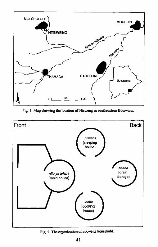
Fig. 1. Map showing the location of Ntsweng in southeastern Botswana.
Front Back
Fig. 2. The organization of a Kwena household
41
O~30rl stones
~#. •.....!I.-
'1~.t15" .•. grinding-' '.l- 15 ... stones-"" ~. \ ..~i ·\. -~ 1_t1~~ 1 ...../
-.J" ~ '-i 16("tr '1,-..:r .... " ...
xI\. .,'-k ,...4>... , ...,. ,,.. ,.,f\],,.../,.,.- f I l)~.~ ,,," .... -\ _, r-
r: • - 32 •• • 33 '1,.... ,)"J
: , .'"~ 34 C!' "J' 7 ~ N
" U rCluster 1
Fig. 3. Part of Ntswengshowing the ruins in cluster 1.
Ntsweng: mapped portion
I I•
Cluster 4
'~ ;'1, ~~I ...
r- ~~•- - - -
~ -'.0 •. "
mOL..JL.["l...J50
~ f1z:.l...t- .... t...i:" .,,.~~'f.) • '- ..:~. ~1." •..• - 1 ~
,. (,.' Cluster .':.•. ... ~.-::=':.:. t~ .J'." - .. --1' ,.
-' ~-~ F r -: )- - ...- -Nr-
Fig. 4. The mapped portion of Ntsweng.
42
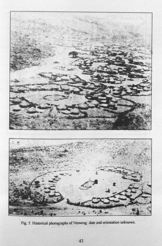
Fig. 5. Historical photographs ofNtsweng: date and orientation unknown.
43
01 1 m
n, \-- -
I 30
•grinding
• stones
Cluster 2
Cluster 3
Fig. 6. Cluster 2 of the mapped portion of Ntsweng.
l. '53
o <> ,..,v
Fig. 7. Cluster 3 of ruins at Ntsweng.
44
Cluster 4 -J
)
... ...,
r'..,I\
o L-...IfilL--l 30
Fig. 8. Cluster 4 of the mapped portion of Ntsweng.
Cluster 5
0~30
Fig. 9. Cluster 5 of the ruins at Ntsweng.
45


![The African e-Journals Project has digitized full text of ...archive.lib.msu.edu/DMC/African Journals/pdfs/PULA/pula016001/pula016001005.pdfOn Monday February 7th, 2000, Mique] Mo]ina,](https://img.pdfslide.net/doc/110x75/5e640943098548616628f356/the-african-e-journals-project-has-digitized-full-text-of-journalspdfspulapula016001pula016001005pdf.jpg)