Embed Size (px)
Citation preview
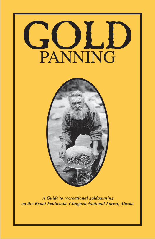
GoldPanning
A Guide to recreational goldpanning on the Kenai Peninsula, Chugach National Forest, Alaska


GoldPANNING
A guide to recreational gold panning on the Kenai Peninsula, Chugach National Forest, Alaska
Written by Carol Huber
Chugach national Forest, anchorage, alaska &
Joseph Kurtak Bureau of Land Management, anchorage, alaska
Technical assistance by nathan Rathbun
Bureau of Land Management, anchorage, alaska
(formerly with the U.S. Bureau of Mines)
graphic design and editing by David L. allen & Charles Lindemuth
Chugach national Forest, anchorage, alaska
graphic art by Kathy Sarns
Chugach national Forest, anchorage, alaska

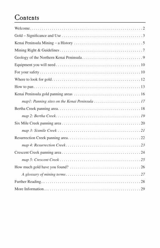
ContentsWelcome. . . . . . . . . . . . . . . . . . . . . . . . . . . . . . . . . . . . . . . . . . . . . . . . . . . . . . . . 2
gold – Significance and Use . . . . . . . . . . . . . . . . . . . . . . . . . . . . . . . . . . . . . . . . 3
Kenai Peninsula Mining – a History . . . . . . . . . . . . . . . . . . . . . . . . . . . . . . . . . . 5
Mining Right & guidelines . . . . . . . . . . . . . . . . . . . . . . . . . . . . . . . . . . . . . . . . . 7
geology of the northern Kenai Peninsula . . . . . . . . . . . . . . . . . . . . . . . . . . . . . . 9
Equipment you will need . . . . . . . . . . . . . . . . . . . . . . . . . . . . . . . . . . . . . . . . . . 10
For your safety . . . . . . . . . . . . . . . . . . . . . . . . . . . . . . . . . . . . . . . . . . . . . . . . . . 10
Where to look for gold. . . . . . . . . . . . . . . . . . . . . . . . . . . . . . . . . . . . . . . . . . . . 12
How to pan . . . . . . . . . . . . . . . . . . . . . . . . . . . . . . . . . . . . . . . . . . . . . . . . . . . . . 13
Kenai Peninsula gold panning areas . . . . . . . . . . . . . . . . . . . . . . . . . . . . . . . . . 16
map1: Panning sites on the Kenai Peninsula . . . . . . . . . . . . . . . . . . . . . . . 17
Bertha Creek panning area. . . . . . . . . . . . . . . . . . . . . . . . . . . . . . . . . . . . . . . . . 18
map 2: Bertha Creek . . . . . . . . . . . . . . . . . . . . . . . . . . . . . . . . . . . . . . . . . . 19
Six Mile Creek panning area . . . . . . . . . . . . . . . . . . . . . . . . . . . . . . . . . . . . . . . 20
map 3: Sixmile Creek . . . . . . . . . . . . . . . . . . . . . . . . . . . . . . . . . . . . . . . . . 21
Resurrection Creek panning area . . . . . . . . . . . . . . . . . . . . . . . . . . . . . . . . . . . . 22
map 4: Resurrection Creek . . . . . . . . . . . . . . . . . . . . . . . . . . . . . . . . . . . . . 23
Crescent Creek panning area . . . . . . . . . . . . . . . . . . . . . . . . . . . . . . . . . . . . . . . 24
map 5: Crescent Creek . . . . . . . . . . . . . . . . . . . . . . . . . . . . . . . . . . . . . . . . 25
How much gold have you found? . . . . . . . . . . . . . . . . . . . . . . . . . . . . . . . . . . . 26
A glossary of mining terms . . . . . . . . . . . . . . . . . . . . . . . . . . . . . . . . . . . . . 27
Further Reading… . . . . . . . . . . . . . . . . . . . . . . . . . . . . . . . . . . . . . . . . . . . . . . . 28
More information…. . . . . . . . . . . . . . . . . . . . . . . . . . . . . . . . . . . . . . . . . . . . . . 29
2
WelcomeStriking it rich! Finding the mother lode! ‘Tis the stuff of miners’ dreams. Unlike professional gold seekers, recreational gold pan-ners benefit mostly from the adventure. The entire family can share in the fun of prospecting and gold panning.
in this booklet, we explain basic gold panning techniques, how to find gold, discuss mining rights and guidelines, and identify areas available for recreational panning on the Chugach national Forest portion of alaska’s Kenai Peninsula.
Recreational gold panning on lands withdrawn from mineral entry is not a mining activity—it is a privilege. Be aware that panning, sluicing, and suction dredging can adversely affect water quality, thereby impacting vegetation, fish, wildlife, and ultimately people.
During the process of separating soil from minerals, silt may be washed into streams, creating turbid water. Fish, fish eggs, and the aquatic insects have difficulty living in heavily silted water because of its reduced oxygen supply.
avoid washing soil and vegetation into streams, and do not dig in stream banks. This increases silt in the stream and is also danger-ous. Many banks are unstable and can slide without warning.
To reduce silt, dig only in active stream gravels. Return rocks or boulders moved during your efforts to their original positions. aquatic insects, an important food source for salmon, often make their homes under these rocks. a little care will help ensure a healthy water ecosystem for both miners and anglers.
Good luck and good prospecting!
3
Gold – Significance and UseThe brightness and ornamental beauty of gold have fascinated hu-mans for at least 5,500 years and still does. This most noble metal takes its name from the germanic “gulth,” meaning glowing or shining metal. gold is also a “precious metal” - this means that it is rare with high economic value. in fact, it has often established the standard by which wealth is measured.
gold is sometimes found free in nature but it is generally found in conjunction with silver. it is usually alloyed with other met-als, such as silver, copper, platinum or palladium, to increase its strength. gold alloys are used to make jewelry, decorative items, dental fillings and coins.
gold is a good conductor of heat and electricity and doesn’t tarnish when it is exposed air, so it can be used to make electrical con-nectors and printed circuit boards. gold is also a good reflector of infrared radiation and can be used to help shield spacecraft and skyscrapers from the sun’s heat. gold coated mirrors can be used to make telescopes that are sensitive to infrared light.
gold is the most malleable and ductile (can be drawn into a very thin wire) of all known metals. a single ounce of gold can be beaten into a sheet measuring roughly 5 meters on a side.
Pure gold is soft. On a scale of 1 to 10, it has an average hardness of 2.8; diamond is 10. gold alloyed with other metals becomes harder.
gold has a specific gravity of 19.3, meaning it is more than 19 times heavier than an equal volume of water. This property is very useful in the recovery of placer gold.
gold has a rich yellow color or “kindly” appearance, turning paler as its silver content increases. gold is relatively easy to identify when you know its properties, but novices can confuse it with minerals such as pyrite and mica. Both can occur with gold. Pyrite, or “fool’s gold,” is brassy light yellow, and brittle. Mica is light yellow to bronzy, light weight, and has a platy appearance.
4
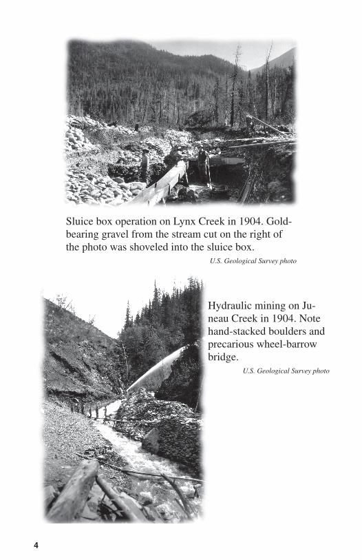
Sluice box operation on Lynx Creek in 1904. gold-bearing gravel from the stream cut on the right of the photo was shoveled into the sluice box.
U .S . Geological Survey photo
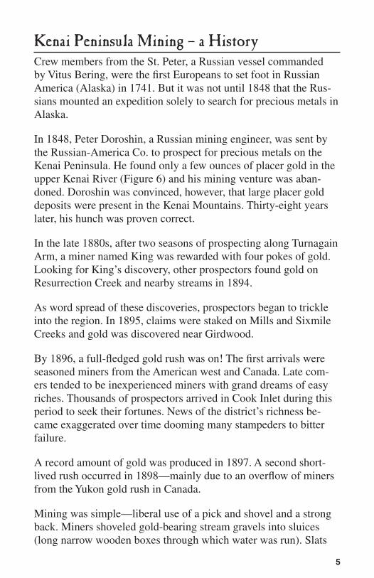
Hydraulic mining on Ju-neau Creek in 1904. note hand-stacked boulders and precarious wheel-barrow bridge.
U .S . Geological Survey photo
5
Kenai Peninsula Mining – a HistoryCrew members from the St. Peter, a Russian vessel commanded by Vitus Bering, were the first Europeans to set foot in Russian america (alaska) in 1741. But it was not until 1848 that the Rus-sians mounted an expedition solely to search for precious metals in alaska.
in 1848, Peter Doroshin, a Russian mining engineer, was sent by the Russian-america Co. to prospect for precious metals on the Kenai Peninsula. He found only a few ounces of placer gold in the upper Kenai River (Figure 6) and his mining venture was aban-doned. Doroshin was convinced, however, that large placer gold deposits were present in the Kenai Mountains. Thirty-eight years later, his hunch was proven correct.
in the late 1880s, after two seasons of prospecting along Turnagain arm, a miner named King was rewarded with four pokes of gold. Looking for King’s discovery, other prospectors found gold on Resurrection Creek and nearby streams in 1894.
as word spread of these discoveries, prospectors began to trickle into the region. in 1895, claims were staked on Mills and Sixmile Creeks and gold was discovered near girdwood.
By 1896, a full-fledged gold rush was on! The first arrivals were seasoned miners from the american west and Canada. Late com-ers tended to be inexperienced miners with grand dreams of easy riches. Thousands of prospectors arrived in Cook inlet during this period to seek their fortunes. news of the district’s richness be-came exaggerated over time dooming many stampeders to bitter failure.
a record amount of gold was produced in 1897. a second short-lived rush occurred in 1898—mainly due to an overflow of miners from the Yukon gold rush in Canada.
Mining was simple—liberal use of a pick and shovel and a strong back. Miners shoveled gold-bearing stream gravels into sluices (long narrow wooden boxes through which water was run). Slats
6
lying crosswise in the bottom of the boxes caught the gold, and let the gravel waste (tailings) wash through. Rich, shallow deposits were soon worked out (Figure 1).
Later, hydraulicking was used (Figure 2). a high pressure water jet broke up the gravels, which in turn were washed through a sluice box. Large amounts of gravel could be processed in a shorter time, allowing lower grade gravels to be mined at a profit. To get enough water at the pressure needed, miners dug long ditches on hillsides above their operations to collect water and funnel it down to the mining area. One of these ditches stands out as a conspicuously straight strip of alder brush on the mountainside east of Canyon Creek. it can be seen from a pullout on the east side of the Seward Highway, 3 miles south of the Hope Road junction. an interpretive site at the pullout describes the mining history of the area.
in some streams, miners noticed milky-white quartz boulders with small specks of gold in them. Curious prospectors, looking for the source, discovered gold-rich quartz veins on Palmer, Bear, and Sawmill Creeks in 1898.
Settlements at Hope and Sunrise sprang up along the shores of Turnagain arm. Both mining communities served as supply and entertainment sources for thousands of people. Sunrise all but dis-appeared after nearby mining played out and fire destroyed much of the town. Placer mining on nearby Resurrection Creek and lode deposits in Palmer Creek kept Hope going. By 1931, only about 20 men were actively engaged in placer mining on local creeks. Today, scant evidence exists of Sunrise, but Hope survives.
almost 100 years of mining in the northern Kenai Peninsula has produced about 133,800 oz. of placer gold. Hard rock mines pro-duced an additional 30,000 oz. Suction dredging and sluicing are currently the most common mining methods.
7
Mining Right & GuidelinesHere are a few simple rules and guidelines that all recreational gold panners must know.
• Recreational gold panning on the Chugach National Forest con-sists of use of hand tools, panning, sluicing, and suction dredg-ing with a 4-inch or smaller intake hose .
• Follow all national forest rules such as camping limits, dis-charge of firearms, use of trails, etc . These regulations are found in Title 36 Code of Federal Regulations (CFR), with general prohibitions in part 261 . Copies are available on the internet and at Chugach National Forest offices in Anchorage, Girdwood, Seward, and Moos Pass . Regulations may or may not be posted .
• Gold pans and hand tools-fed sluice boxes are allowed year-round in streams listed in this booklet . Four-inch or smaller suc-tion dredges are allowed in salmon streams from May 15 to July 15 but only with a permit from the Alaska Department of Fish and Game . The permit is free .
• No hydraulic mining or use of earth moving equipment is al-lowed .
• Work only the active stream channel or unvegetated gravel bars . Do not dig in stream banks!
• You are not allowed to build structures, cut trees or dig up ar-chaeological, historical, or paleontological objects, nor are you allowed to obstruct others in their recreational pursuits .
Mining law and mining claims. The 1872 Mining Law allows a person to locate a mining claim on federal land and to mine that claim. However, when certain lands are withdrawn from min-eral entry, no claims can be located there (although there may be preexisting claims). The four designated areas in this publication are withdrawn from mineral entry and have no mining claims. any other federal lands in the Chugach national Forest not covered by claims are available for recreational panning. Remote areas are less likely to have mining claims. as a recreational panner, you do not operate under the Mining Law.
8
You can hike, fish, hunt, and recreate on a federal mining claim, but you must respect the claimant’s equipment and operations. The claim owner has an exclusive right to mine his/her claim. You must have permission from the claimant to pan on his/her claim.
if you wish to file a claim, or want to know the location, owners, and status of legal claims, do the following:
• Establish the area in which you are interested . (U .S . Bureau of Mines and U .S . Geological Survey publications identify gold-bearing streams .)
• Locate the area on a topographic map, and determine section, township, and range .
• With this information, check with the Bureau of Land Manage-ment which keeps current records for all mining claims on fed-eral lands (see More information section) .
• Mark claim locations on your topographic map, and go out and look for markers in the field .
a placer mining claim is normally 20 acres, generally measuring 660 by 1,320 feet. The long direction of the claim is usually ori-ented parallel to the stream. Be aware that claims may exist with no visible markers. if there is an error in the location description, the marker on the ground rules.
9
Geology of the Northern Kenai PeninsulaThe rocky peaks of the Kenai Mountains have their origin in sands and muds deposited on the seafloor about 65 million years ago. They created large submarine alluvial fans streaming into the sea at the then western edge of the north american continent, piling up to form sedimentary deposits at least a mile thick.
The tremendous weight of this great thickness of sediment generat-ed high internal pressures and temperatures which baked the muck to form siltstone and sandstone. Later hot silica-rich fluids, coming from depth, penetrated these rocks along faults and fractures. Upon cooling the fluids crystallized to form milky white quartz veins. if conditions were right, the hot fluids may have contained gold and silver which became frozen in the veins during crystalliza-tion, forming lode deposits. Excellent examples of quartz veins are exposed along the Seward Highway, 2.7 miles north of the west-side rest area in Turnagain Pass. Subsequent weathering of the veins released the gold to mix with stream gravels. Due to its high specific gravity, the gold was concentrated by the action of water to form placer deposits.
Beginning about 2 million years ago, climatic cooling and heavy precipitation resulted in the formation of large glaciers on the Ke-nai Peninsula. Like giant bulldozers, the advancing glaciers pushed gravel ahead of them, dispersing the placer gold. a warming trend, beginning about 12,000 years ago, caused the glaciers to retreat, leaving behind gravel-filled U-shaped valleys. Knolls and ridges in the Turnagain Pass area are composed of gravels left behind by glaciers that filled the valley to a depth of at least 2,000 feet.
Braided stream channels from the melting glaciers reworked the gravels concentrating the dispersed placer gold. Rapid down cut-ting by streams during the mountain building process left deposits behind as bench placers, perched above the present valley floors. This down cutting concentrated the gold further, forming gulch placers in the stream bottoms. Most of the gold on the Kenai Pen-insula has been produced from placer deposits along Crow, Can-yon, Resurrection, Lynx, Bear, Mills, gulch, and Sixmile Creeks.
10
Equipment you will needThe basic equipment is quite simple and requires only a minimum investment. a gold pan is most important. Metal pans were used by early prospectors; modern versions are plastic with built-in riffles. in a pinch, frying pans and even hub caps will work. new metal pans generally come with a coating of grease and should be cleaned thoroughly by heating over an open fire. The pan will rust, but some rust is beneficial for collecting fine gold.
Suggested equipment.
• gold pan (plastic with riffles or metal); 14” size is best.• shovel to loosen gravel from creek bottom.• grizzly pan with 1⁄2–inch holes in bottom; this pan helps sepa-
rate coarse gravel, speeding up the panning process.• magnifying lens (at least 10X power) to identify minerals.• sluice box, approximately 3 feet long; (construct or obtain com-
mercially; aluminum version is available.)• tweezers for picking up gold; a dry finger will also work.• small magnet for separating out magnetic black sands.• small glass vials to hold gold.• rubber gloves to protect hands from cold water.• rubber boots to keep feet dry while wading in creeks.• Most of these items are available at local miners’ and prospec-
tors’ supply houses, sporting goods stores, and some hardware stores.
For your safetyThe Chugach national Forest is one of the most diverse and beauti-ful of the nation’s 155 national forests. its spectacular mountains, marine shorelines, wetlands, and wildlife lure visitors from around the world.
a place as wild as the Chugach has its dangers, however. a little knowledge and good judgment can help ensure a safe outdoor experience.
11
Here are a few tips. • The Kenai Peninsula is home to brown and
black bears. They have roamed here for thou-sands of years. They are wild animals and can be very dangerous. You will be panning in the stream channel, home of a bear’s favorite din-ner—salmon. Stay alert and avoid bears when-ever possible. get a copy of Bear Facts from the Forest Service for more information.
• We also have some of the world’s largest moose. although they are herbivores, they can still be dangerous— any critter that weighs 1,000 pounds can be dangerous. Moose get especially cranky if they feel their young are in danger. Watch them from a distance.
• The water up here is cold and you can expect to get wet—after all, the gold is in the water. Wear insulated waterproof boots and gloves. Wool clothing can keep you warm even when wet. Bring extra clothing and dress in layers.
• Mine only in the active stream channel—not along the shore or in cut banks. Undercutting stream banks and trees is an extremely danger-ous activity. These banks tend to be very un-stable. Heavy boulders and trees can fall on you if the bank should collapse.
12
Where to look for goldWater is the primary agent in the formation of most placer deposits. Moving water can transport large amounts of material, from fine silt to large boulders, especially during runoff periods. When freed from the rock by weathering, gold is added to stream waters along with rock debris, and is carried along by the stream. Where streams meander, go over falls, or are deflected around boulders, a drop in water velocity occurs, and the gold drops out. Continued agitation by water causes gold to settle down through the gravel until reach-ing bedrock or an impermeable clay layer. These concentrations are called pay streaks.
The best places to find gold exist where turbulence changes to slower-moving water flow. Check out slower water below rapids and waterfalls, deep pools, and the downstream side of boulders. inside bends of meanders, upstream ends of sand or “point” bars are good places to pan fine gold, which is renewed yearly during runoff. Bedrock crevices or pockets acting as natural riffles can collect gold. Scoop out and pan material from these spots. Spring, early summer, and just before freeze up in the fall are good times of the year for panning. Water is low and gold-bearing gravel is exposed. To minimize resource damage, confine digging to active, unvegetated stream gravels.
13
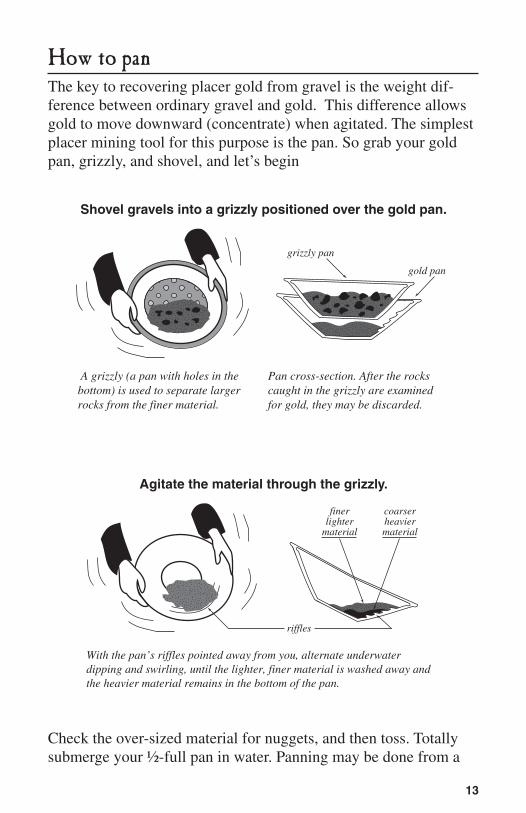
How to panThe key to recovering placer gold from gravel is the weight dif-ference between ordinary gravel and gold. This difference allows gold to move downward (concentrate) when agitated. The simplest placer mining tool for this purpose is the pan. So grab your gold pan, grizzly, and shovel, and let’s begin
Shovel gravels into a grizzly positioned over the gold pan.
A grizzly (a pan with holes in the bottom) is used to separate larger rocks from the finer material.
Pan cross-section. After the rocks caught in the grizzly are examined for gold, they may be discarded.
grizzly pan
gold pan
Agitate the material through the grizzly.
With the pan’s riffles pointed away from you, alternate underwater dipping and swirling, until the lighter, finer material is washed away and the heavier material remains in the bottom of the pan.
riffles
finerlighter
material
coarserheaviermaterial
Check the over-sized material for nuggets, and then toss. Totally submerge your ½-full pan in water. Panning may be done from a
14
squatting or sitting position at the stream edge, in gently moving water, holding the pan between the knees.
Keep pan riffles pointed away from you to catch any gold that might slip over the lip. Liberal water, agitation, and patience are required to persuade gold to settle to the bottom of the pan. While the pan is submerged, break up any clots of dirt and wash any cobbles that may have clay that can trap placer gold. The clay has been removed when the water in the pan starts to clear. Pick pebbles from the pan to get them out of the way. Look for heavy pieces with unusual color or shape. You might find a gold nugget or a gold-bearing piece of vein quartz.
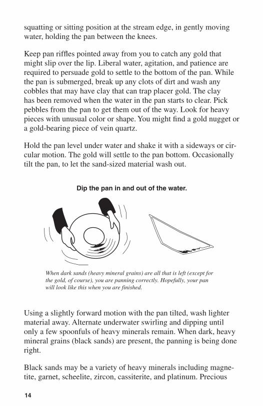
Hold the pan level under water and shake it with a sideways or cir-cular motion. The gold will settle to the pan bottom. Occasionally tilt the pan, to let the sand-sized material wash out.
Dip the pan in and out of the water.
When dark sands (heavy mineral grains) are all that is left (except for the gold, of course), you are panning correctly. Hopefully, your pan will look like this when you are finished.
Using a slightly forward motion with the pan tilted, wash lighter material away. alternate underwater swirling and dipping until only a few spoonfuls of heavy minerals remain. When dark, heavy mineral grains (black sands) are present, the panning is being done right.
Black sands may be a variety of heavy minerals including magne-tite, garnet, scheelite, zircon, cassiterite, and platinum. Precious
15
and semi-precious stones are uncommon in Kenai Peninsula plac-ers, but keep an eye out for them. if it’s heavy, keep it and seek identification from a geologist or miner.
Beginners are often impatient to find gold quickly. Take your time. During the panning motion, black sand and other fines concentrate in the crease or riffles of the pan. gold can be separated from black sands by rolling water in the pan with a combination swirling and rocking motion. Lighter material moves to one side, gold stays put. For safety, do the final panning over another container to keep gold from being lost. Dry the fines. Use a magnet to separate magnetic grains and tweezers, a knife blade, or a dry finger to pick up small gold pieces. Save the gold in a water-filled vial.
Examine your gold. Rough, nugget gold is near its source. gold that is flat and smooth has traveled some distance from its point of origin. Flour gold has been flattened to a few microns thickness and will float on water. Panning is a relatively slow method for recovering gold. Experienced panners can process about 10 large pans per hour. a sluice or suction dredge can increase productivity.
Suction dredgesa free EPa permit is required for all suction dredging in alas-ka. also, regulations for suction dredges are imposed on some streams by the alaska Department of Fish and game (aDF&g). a free aDF&g permit is required to dredge streams that are im-portant for salmon spawning habitat. For information on permits, contact the EPa and aDF&g. if you first secure an aDF&g permit, you will not need to apply for an EPa permit.
The Chugach national Forest considers a suction dredge, 4–inch diameter or less, operated within the active stream channel, a recreational activity.
16
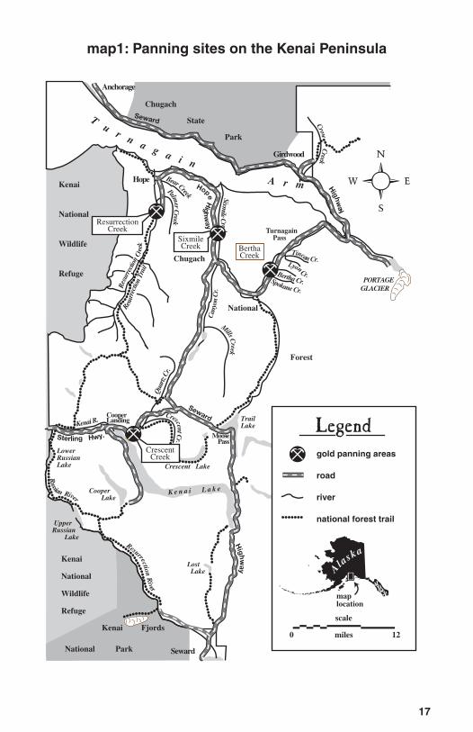
Kenai Peninsula gold panning areasThere is still gold “in them thar hills,” and we would like you to find some of it. We doubt that you will get rich panning gold recreationally, but you might find some color—and have a great time doing it. We have selected four sites on the Kenai Peninsula portion of the Chugach national Forest that we feel would have the best potential for yielding gold (map 1).
These sites are all within two hour’s driving time from anchor-age via the Seward and Sterling Highways. The following pages describe the four sites in detail. We hope that our descriptions will help you find success in your panning endeavors. good luck.
17
map1: Panning sites on the Kenai Peninsula
Sterling Hwy.
CrescentCreek
ResurrectionCreek
SixmileCreek Bertha
Creek
Anchorage
Girdwood
Hope
MoosePass
CooperLanding
Seward
Chugach
State
Park
Chugach
National
Forest
Kenai Fjords
National Park
Kenai
National
Wildlife
Refuge
Kenai
National
Wildlife
Refuge
PORTAGE GLACIER
Turnagain Pass
Seward
Highw
ay
Highw
ay
Tu
r n a g a i n A r m
Res
urre
ction
Cre
ek
Resu
rrec
tion
Trai
l
K e n a i L a k e
TrailLake
Crescent Lake
Cooper Lake
Lost Lake
LowerRussianLake
UpperRussian Lake
Seward
Hope Highw
ay
Sixmile C
reek Tincan Cr.
M
ills Creek
Can
yon
Cr.
Kenai R.
Qua
rtz C
r.
Crescent Cr.
Spokane Cr.
Russian River
Bear Creek
Palmer C
reek
Crow C
reek
Resurrection River
Lyon Cr.
gold panning areas
road
river
national forest trail
Legend
0 miles 12
scale
A
laska
maplocation
�
Bertha Cr.
18
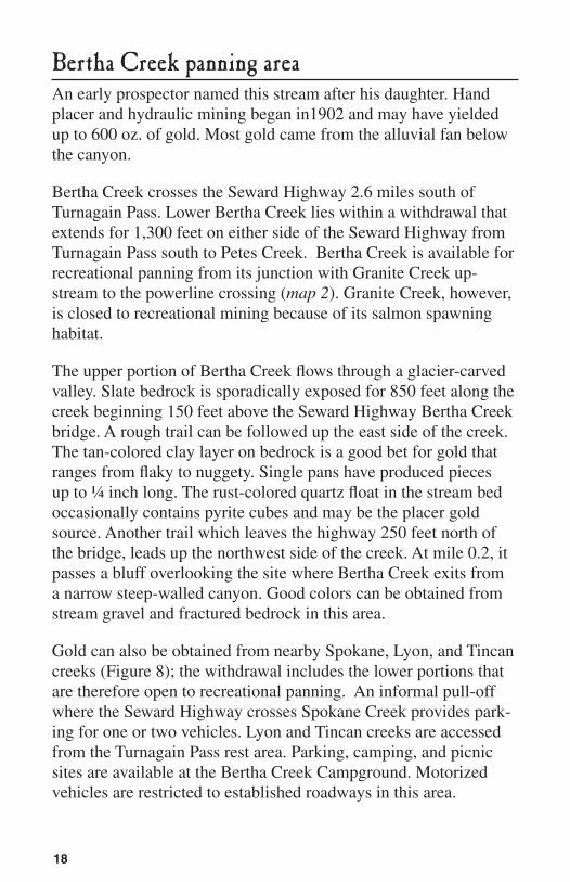
Bertha Creek panning areaan early prospector named this stream after his daughter. Hand placer and hydraulic mining began in1902 and may have yielded up to 600 oz. of gold. Most gold came from the alluvial fan below the canyon.
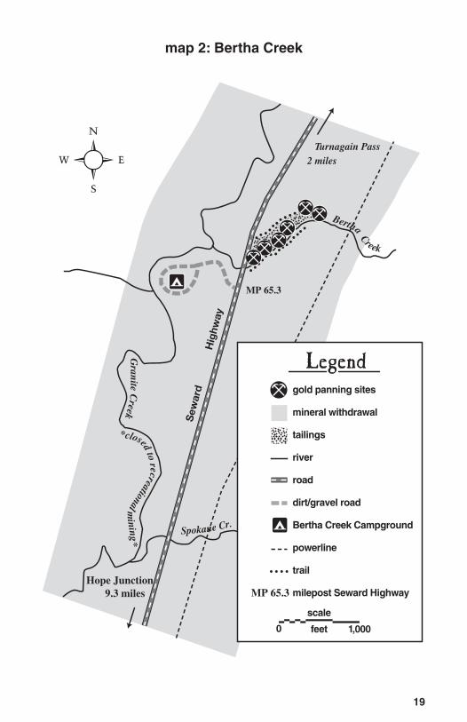
Bertha Creek crosses the Seward Highway 2.6 miles south of Turnagain Pass. Lower Bertha Creek lies within a withdrawal that extends for 1,300 feet on either side of the Seward Highway from Turnagain Pass south to Petes Creek. Bertha Creek is available for recreational panning from its junction with granite Creek up-stream to the powerline crossing (map 2). granite Creek, however, is closed to recreational mining because of its salmon spawning habitat.
The upper portion of Bertha Creek flows through a glacier-carved valley. Slate bedrock is sporadically exposed for 850 feet along the creek beginning 150 feet above the Seward Highway Bertha Creek bridge. a rough trail can be followed up the east side of the creek. The tan-colored clay layer on bedrock is a good bet for gold that ranges from flaky to nuggety. Single pans have produced pieces up to ¼ inch long. The rust-colored quartz float in the stream bed occasionally contains pyrite cubes and may be the placer gold source. another trail which leaves the highway 250 feet north of the bridge, leads up the northwest side of the creek. at mile 0.2, it passes a bluff overlooking the site where Bertha Creek exits from a narrow steep-walled canyon. good colors can be obtained from stream gravel and fractured bedrock in this area.
gold can also be obtained from nearby Spokane, Lyon, and Tincan creeks (Figure 8); the withdrawal includes the lower portions that are therefore open to recreational panning. an informal pull-off where the Seward Highway crosses Spokane Creek provides park-ing for one or two vehicles. Lyon and Tincan creeks are accessed from the Turnagain Pass rest area. Parking, camping, and picnic sites are available at the Bertha Creek Campground. Motorized vehicles are restricted to established roadways in this area.
19
map 2: Bertha Creek
Granite C
reek
*closed to recreational mining*
Bertha Creek
Sew
ard Highw
ay
Turnagain Pass2 miles
Hope Junction 9.3 miles
Spokane Cr.
MP 65.3
gold panning sites
mineral withdrawal
tailings
river
road
dirt/gravel road
Bertha Creek Campground
powerline
trail
milepost Seward Highway
Legend
0 1,000feet
scale
MP 65.3
�
20
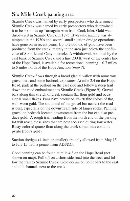
Six Mile Creek panning areaSixmile Creek was named by early prospectors who determined Sixmile Creek was named by early prospectors who determined it to be six miles up Turnagain arm from Cook inlet. gold was discovered in Sixmile Creek in 1895. Hydraulic mining was at-tempted in the 1930s and several small suction dredge operations have gone on in recent years. Up to 2,000 oz. of gold have been produced from the creek, mainly in the area just below the conflu-ence of Sixmile and Canyon creeks. a withdrawal, bounded by the east bank of Sixmile Creek and a line 200 ft. west of the center line of the Hope Road, is available for recreational panning—0.7 miles to 5 miles north of the Hope Junction (map 3).
Sixmile Creek flows through a broad glacial valley with numerous gravel bars and some bedrock exposures. at mile 2.4 on the Hope Road, park at the pullout on the east side and follow a steep trail down the road embankment to Sixmile Creek (Figure 9). gravel bars along this stretch of creek contain flat flour gold and occa-sional small flakes. Pans have produced 15–20 fine colors of flat, well-worn gold. The south end of the gravel bar nearest the road is best, especially on the downstream side of larger rocks. Panning gravel on bedrock located downstream from the bar can also pro-duce gold. a rough trail leading from the north end of the parking lot will reach these sites that are best accessed during low water. Rusty-colored quartz float along the creek sometimes contains pyrite (fool’s gold).
Suction dredges (4-inch or smaller) are only allowed from May 15 to July 15 with a permit from aDF&g.
good panning can be found at mile 4.3 on the Hope Road (not shown on map). Pull off on a short side road into the trees and fol-low the trail to Sixmile Creek. gold occurs on point bars to the east and old channels next to the creek.
21
map 3: Sixmile Creek
Sixm
ile C
reek
(hig
h w
ater
chan
nel)
Beaver Dam Creek
Sixm
ile C
reek
(m
ain
chan
nel)
Hope Junction 2.0 miles
Hope Highw
ay
MP 2.4
Alder Creek
scale
1,000feet0
gold panning sites
mineral withdrawal
tailings
river
road
powerline
parking
milepost Hope Highway
Legend
MP 2.4
�
22
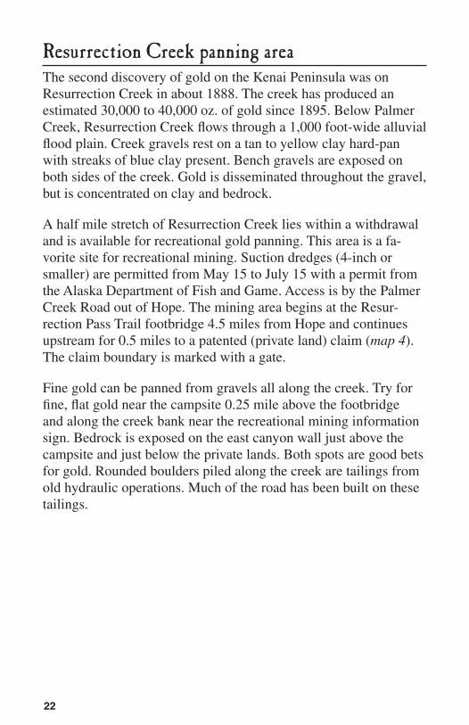
Resurrection Creek panning areaThe second discovery of gold on the Kenai Peninsula was on Resurrection Creek in about 1888. The creek has produced an estimated 30,000 to 40,000 oz. of gold since 1895. Below Palmer Creek, Resurrection Creek flows through a 1,000 foot-wide alluvial flood plain. Creek gravels rest on a tan to yellow clay hard-pan with streaks of blue clay present. Bench gravels are exposed on both sides of the creek. gold is disseminated throughout the gravel, but is concentrated on clay and bedrock.
a half mile stretch of Resurrection Creek lies within a withdrawal and is available for recreational gold panning. This area is a fa-vorite site for recreational mining. Suction dredges (4-inch or smaller) are permitted from May 15 to July 15 with a permit from the alaska Department of Fish and game. access is by the Palmer Creek Road out of Hope. The mining area begins at the Resur-rection Pass Trail footbridge 4.5 miles from Hope and continues upstream for 0.5 miles to a patented (private land) claim (map 4). The claim boundary is marked with a gate.
Fine gold can be panned from gravels all along the creek. Try for fine, flat gold near the campsite 0.25 mile above the footbridge and along the creek bank near the recreational mining information sign. Bedrock is exposed on the east canyon wall just above the campsite and just below the private lands. Both spots are good bets for gold. Rounded boulders piled along the creek are tailings from old hydraulic operations. Much of the road has been built on these tailings.
23
map 4: Resurrection Creek
Bedrock Creek
Hope 4.5 miles
Resurrection C
reek
Resurrec tion P
ass Trail
Palmer Creek
scale
2,000feet0
gold panning sites
mineral withdrawal
patented claim (private)
tailings
river
national forest trail
road
bridge
Legend
�
24
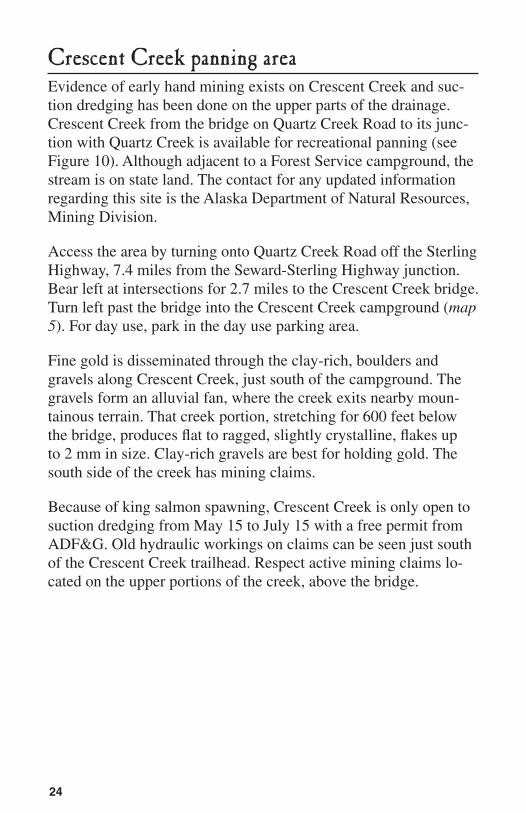
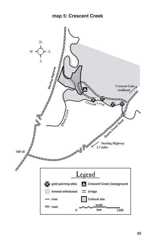
Crescent Creek panning areaEvidence of early hand mining exists on Crescent Creek and suc-tion dredging has been done on the upper parts of the drainage. Crescent Creek from the bridge on Quartz Creek Road to its junc-tion with Quartz Creek is available for recreational panning (see Figure 10). although adjacent to a Forest Service campground, the stream is on state land. The contact for any updated information regarding this site is the alaska Department of natural Resources, Mining Division.
access the area by turning onto Quartz Creek Road off the Sterling Highway, 7.4 miles from the Seward-Sterling Highway junction. Bear left at intersections for 2.7 miles to the Crescent Creek bridge. Turn left past the bridge into the Crescent Creek campground (map 5). For day use, park in the day use parking area.
Fine gold is disseminated through the clay-rich, boulders and gravels along Crescent Creek, just south of the campground. The gravels form an alluvial fan, where the creek exits nearby moun-tainous terrain. That creek portion, stretching for 600 feet below the bridge, produces flat to ragged, slightly crystalline, flakes up to 2 mm in size. Clay-rich gravels are best for holding gold. The south side of the creek has mining claims.
Because of king salmon spawning, Crescent Creek is only open to suction dredging from May 15 to July 15 with a free permit from aDF&g. Old hydraulic workings on claims can be seen just south of the Crescent Creek trailhead. Respect active mining claims lo-cated on the upper portions of the creek, above the bridge.
25
map 5: Crescent Creek
Sterling Highway
Quartz Creek R
oad
Qua
rtz
Cre
ek
Crescent Creek
Crescent Lake trailhead
Sterling Highway2.7 miles
MP 45
gold panning sites
mineral withdrawal
river
road
Crescent Creek Campground
bridge
Cultural site
Legend
0 1,000feet
scale
�
26
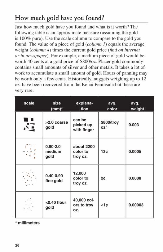
How much gold have you found?Just how much gold have you found and what is it worth? The following table is an approximate measure (assuming the gold is 100% pure). Use the scale column to compare to the gold you found. The value of a piece of gold (column 1) equals the average weight (column 4) times the current gold price (find on internet or in newspaper). For example, a medium piece of gold would be worth 40 cents at a gold price of $800/oz. Placer gold commonly contains small amounts of silver and other metals. it takes a lot of work to accumulate a small amount of gold. Hours of panning may be worth only a few cents. Historically, nuggets weighing up to 12 oz. have been recovered from the Kenai Peninsula but these are very rare.
scale size (mm)*
explana-tion
avg. color worth
avg. weight
>2.0 coarse gold
can be picked up with finger
$800/troy oz°
0.003
0.90-2.0 medium gold
about 2200 color to troy oz.
13¢ 0.0005
0.40-0.90 fine gold
12,000 color to troy oz.
2¢ 0.0008
<0.40 flour gold
40,000 col-ors to troy oz.
<1¢ 0.00003
* millimeters
27
A glossary of mining terms
it helps to know the lingo. Here are a few of the more common terms used in mining. They might help you be a better recreational panner and maybe have even more fun.
alluvial fan: cone-shaped gravel deposit formed where a stream emerges from mountains onto a lowland.
bedrock: solid rock underlying gold-bearing gravel.claim: mining ground held under federal or state laws by virtue of loca-
tion and record.color: a particle of gold found in the prospector’s pan after the gravel
has been washed.concentrate: minerals which have been separated from less valuable materials.false bedrock: a hard formation, usually a clay layer, within a placer deposit
some distance above bedrock.fines: sand or other fine-sized material associated with placer deposits.
Usually the last material left during the panning process.flour gold: finest gold dust, much of which will float.float: rock separated from the parent vein by weathering.heavies: minerals of high specific gravity in a placer concentrate, also
called black sands.lode deposit: a vein of mineral ore deposited between nonmetallic rock layers.nugget: a piece of gold that can usually be picked up with the fingers.patent: a government deed that conveys legal title of public land to the
party to whom the patent is issued.pay streak: a limited horizon within a placer deposit containing a concentra-
tion of gold rich enough to mine.placer deposit: a glacial or alluvial deposit of sand or gravel containing eroded
particles of valuable minerals.point bar: the area on the upstream end of a gravel bar which can contain
superficial concentrations of flour gold in a thin surface layer.poke: a bag or sack of gold.prospector: a person who searches for valuable minerals.riffles: small ridges in the bottom of a sluice box that catch gold in sand
and gravel.sluice box: an elongate wooden or metal trough with riffles, over which al-
luvial gravel is washed to recover gold. stake: laying out and marking the corners of a mining claim. Originally
wooden stakes were used.suction dredge: uses a water jet and venturi effect to suck gravel off the stream
bed and run it over a set of riffles.tailings: sand, gravel, and cobbles which have passed through sluice
boxes.troy ounce: 1⁄12 troy pound, used in reference to precious metals.
28
Further Reading…To learn more about gold panning, the history of mining on the Ke-nai Peninsula, and the geology of mineral deposits in alaska, you may be interested in the following publications.
Barry, M., A History of Mining on the Kenai Peninsula . M.J.P. Barry, anchorage, alaska Co. 1997
Black, J., Gold Prospectors Handbook . Del Oeste Press, Tarzana, California, 1980
Hoekzema, R., and S.F. Fechner, Placer Gold Sampling in and Near the Chugach National Forest, Alaska . U.S. Bureau of Mines information Circular 9091, 1986
Johnson, B. and others, geology and Mineral Resources of Kenai Peninsula, Alaska . U.S. geological Survey Bulletin 587, 1915
nelson, S. and others, Geologic Map of the Chugach National Forest, Alaska . U.S. geologcial Survey Map MF–1645–B, 1985
West, J., How to Mine and Prospect for Placer Gold . U.S. Bureau of Mines information Circular 8517, 1971
Winkler, g. and others, Guide to the Bedrock Geology of a Tra-verse of the Chugach Mountains from Anchorage to Cape Resurrection . alaska geologic Society guidebook, 1984.
29
More Information…if you would like more specific information about recreational pan-ning on the Kenai Peninsula, we encourage you to contact any of the following:
Minerals Administrator glacier Ranger District P.O. Box 129 girdwood, aK 99587-0129 Tel (907) 783–3242 fs.usda.gov/chugach
Minerals Administrator Seward Ranger District 334 Fourth avenue P.O. Box 390 Seward, aK 99664–0390 Tel (907) 224–3374 fs.usda.gov/chugach
Alaska Dept of Fish & Game Office of Habitat Management and Permitting 333 Raspberry Road, Suite 2068 anchorage, aK 99518 Tel (907) 267–2216 www.habitat.adfg.alaska.gov
Environmental Protection Agency 222 West 7th avenue anchorage, aK 99513 Tel. (907) 271-6561 or (800) 718-0983
U.S. Geological Survey Earth Science information/Maps 4230 University Dr. anchorage, aK 99508-4664 Tel (907) 786-7011 www.alaska.usgs.gov
Bureau of Land Management alaska State Office 222 West 7th avenue, no.13 anchorage, aK 99513 Tel (907) 271–5960 www.blm.gov/ak/st/en.html
Bureau of Land Management anchorage District Office 4700 BLM Road anchorage, aK 99507 Tel (907) 267-1246 800-478-1263 www.blm.gov/ak/
Alaska Department of Natural Resourcesanchorage Office Mine Permit-ting/ Mineral Property Mgmt 550 West 7th avenue, Suite 900B anchorage, aK 99501 (907) 269-8652 www.dnr.state.ak.us/mlw/mining/
The solitary seeker with his grub-stake on his back,
The restless buccaneer of pick and pan.
On the mesas of the Southland, on the tundras of the North,
You will find us, changed in face but still the same;
And it isn’t need, it isn’t greed that sends us faring forth—
It’s the fever, it’s the glory of the game.“The Prospector”
Robert Service
2008-2012
CENTENNIAL