Embed Size (px)
Citation preview

"GP-STAR"
The Group on Earth Observations
Expert meeting Vanessa Aellen – GEO Secretariat 1-2 December 2016 Bonn, Germany

Introduction to GEO
Voluntary partnership of Governments & Organizations 103 member-states

Introduction to GEO
Voluntary partnership of Governments & Organizations 103 Participating Organizations

8 Societal Benefit Areas

DRR-SBA links to other SBAs
GEO Initiatives Community Activities
GEO-DARMA (Data Access for Risk Management)
Chinese tsunami mitigation system
GSNL (Geohazard Supersites and Natural Laboratories)
Earth Observations for Disaster Risk Management
GDIS (Global Drought Information System)
Earth Observations for Geohazards, Land Degradation and Environmental Monitoring
Global Wildfire Information System
Global Flood Risk Monitoring
Global Flood Awareness System (GloFAS)
Space & Security

*152 Data Providers
GCI

DRR within GEO
• Working to expand the use of satellite imagery and surface data for reducing disasters risk
• Developing decision-support tools and applications for the full cycle of disaster management
• Working in close collaboration with national space agencies – Through the Committee on Earth Observation Satellites (CEOS),
the space coordination arm of GEO

GP-STAR • Mission of GP-STAR from GEO‘s perspective
– Confirmation of the White paper agreement (reference for us but ready to update)
• Contributing activities, projects, programms
– Support of the implementation plan GEO-DARMA, GSNL, ...
– Available to assess additional contribution from other GEO activities
• Contributions to Outcomes (procedures, products, information, knowledge, know-how)
– Value proposition of GEO: three areas relating to EO: 1. Access to data info and knowledge (portal) 2. Organising of a Knowledge base to gather user needs 3. End-to-end solution and covering elements of value chain (observation to
decisions)

Term of Reference « The partnership committed to fostering the use of Earth observation as well as Space-based Technologies and Applications in the context of the Sendai Framework for Disaster Risk Reduction 2015-2030 (Sendai Framework). In doing so, it will support the implementation of the Sendai Framework through, for example, providing advice to governments, organizations, and projects on the use of space technologies and applications in disaster risk reduction efforts, and the provision of relevant publications and discussion fora. The partnership shall integrate international, regional and national organizations involved in space science and technologies, Earth observation, disaster risk reduction and civil protection. »
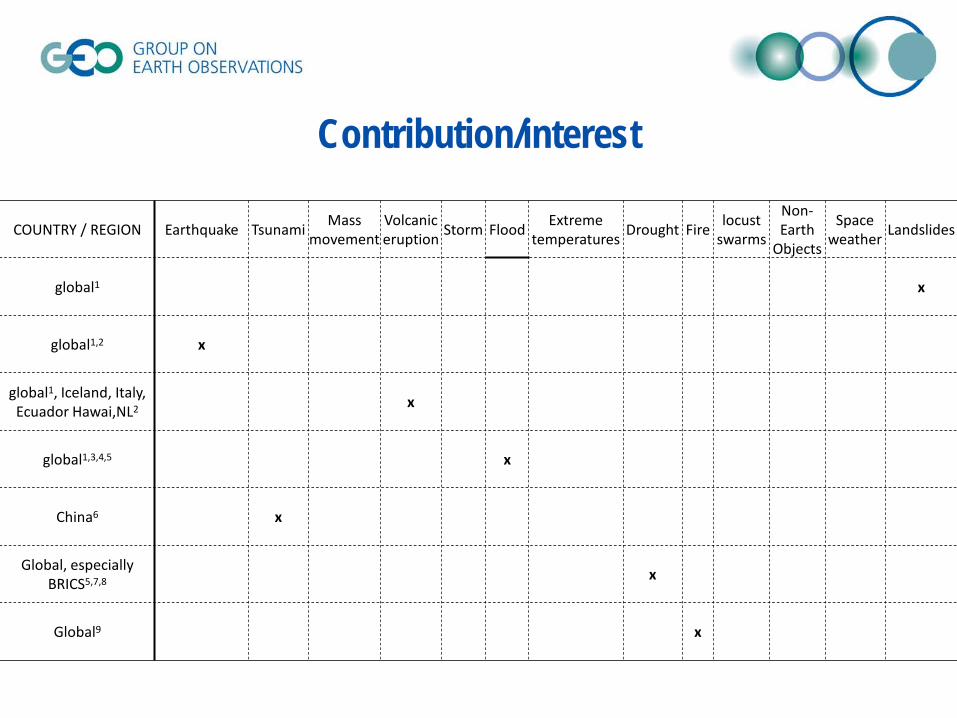
Contribution/interest
COUNTRY / REGION Earthquake Tsunami Mass movement
Volcanic eruption Storm Flood Extreme
temperatures Drought Fire locust swarms
Non-Earth
Objects
Space weather Landslides
global1 x
global1,2 x
global1, Iceland, Italy, Ecuador Hawai,NL2 x
global1,3,4,5 x
China6 x
Global, especially BRICS5,7,8 x
Global9 x
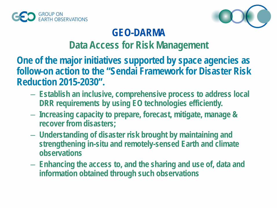
GEO-DARMA Data Access for Risk Management
One of the major initiatives supported by space agencies as follow-on action to the “Sendai Framework for Disaster Risk Reduction 2015-2030”.
– Establish an inclusive, comprehensive process to address local DRR requirements by using EO technologies efficiently.
– Increasing capacity to prepare, forecast, mitigate, manage & recover from disasters;
– Understanding of disaster risk brought by maintaining and strengthening in-situ and remotely-sensed Earth and climate observations
– Enhancing the access to, and the sharing and use of, data and information obtained through such observations

An international partnership aiming to improve, through an Open Science approach, monitoring and research on seismic/volcanic interest areas called Supersites, providing better information support for DRR activities in Prevention and Crisis management.
The partnership
The scientific community The in situ data providers
The satellite data providers
The GEO-GSNL Initiative Geohazards Supersites and Natural Laboratories

Thank you ! www.earthobservations.org
@geosec2025
Group on Earth Observations
GEO 2017-2019 Work Programme Symposium Pretoria, May 12th & 13th