Embed Size (px)
Citation preview

Bulletin of the Marine Geology, Vol. 29, No. 1, June 2014, pp. 29 to 42
29
The Influence of Coastal Conditions to Tsunami Inundation of Bima Bay, West Nusa Tenggara
Pengaruh Kondisi Pantai Terhadap Landaan Tsunami di Teluk Bima, Nusa Tenggara Barat
Yudhicara, Rahayu Robiana, and I.C. Priambodo
Geological Agency, Jl. Diponegoro No. 57 [email protected]
(Received 17 December 2013; in revised form 16 April 2014; accepted 05 May 2014)
ABSTRACT: Area along the coast that includes the territorial waters of the Bima Bay, West NusaTenggara, is prone to tsunamis, evidenced by the historical tsunamis record in 1815 due to the volcaniceruption of Tambora, 1818, 1836 and 1992 caused by earthquakes associated with tectonic system in thenorth of the island of Sumbawa, and 1892 were sourced from a distant source. Based on the coastalcharacteristics, the research area was divided into four types of beaches, namely: Steep rocky beach; Coastalwalled plain; Flat coastal mangroves; and Flat sandy beaches. According to the lateral measurement, houseswere built in the plains with a minimum height difference of 0.04 m at Rababuntu beach and a maximum of22.63 m in New Asakota area. The settlement closest distance to the coastline is 10.3 m in Rababuntu, whilethe farthest extent is at Kawananta 194.58 m from the shoreline. The local bathymetry range between 1 and42.5 m, where the inside of the very shallow waters of the Bay of Bima, gradually steeper at the mouth of thebay to the open sea. This conditions will influence the wave when entering the bay. It will come with largeenough speed at the mouth of the bay, spread along the coastal waters of the eastern and continue spreadingto all parts with the diminishing velocity, but the height increasing when it reaches shallow water, especiallyin the waters of the western Gulf of Bima. Several factors can affect the amount of risk that would be causedby the tsunami, in the research area include are: (1) The research area is located in an enclosed bay; (2) Thelocal sea floor depths around the bay is relatively shallow waters; (3) Coastal characteristics of the researcharea is dominated by a gently sloping beach morphology with low relief, especially in the area of ??Bajo,Rababuntu and Bontokape and other beaches in the city of Bima; (4) Residential location very close to theshoreline; (5) Minimal vegetation cover; and (6) The presence of the artificial protective are inadequate. Based on tsunami modeling using the 1992 Flores earthquake parameter which is placed perpendicular to theresearch area obtain the maximum tsunami height around 4-5 m at Sowa and Kolo, near to the mouth ofBima Bay, while the minimum is at Kalaki, about 0,2 m which is at the inner bay.
Keywords: Tsunami, coastal characteristics, bathymetry, factors influenced to tsunami inundation.
ABSTRAK : Lokasi di sepanjang pantai yang mencakup wilayah Perairan Teluk Bima, Nusa Tenggara Barat,rentan terhadap tsunami, dibuktikan oleh catatan sejarah tsunami tahun 1815 karena letusan gunung berapiTambora, 1818, 1836 dan 1992 disebabkan oleh gempa bumi yang terkait dengan tektonik sistem di bagian utarapulau Sumbawa, dan 1892 yang bersumber dari sumber yang jauh. Berdasarkan karakteristik pantai, daerahpenelitian dibagi menjadi empat jenis pantai, yaitu: Pantai terjal berbatu; Pantai datar berdinding; Pantai datarberbakau; dan Pantai datar berpasir. Berdasarkan hasil pengukuran kemiringan pantai secara lateral, rumahdibangun di dataran pantai dengan perbedaan ketinggian minimal 0,04 m di Rababuntu dan maksimal 22,63 m didaerah Asakota Baru. Jarak terdekat bangunan terhadap garis pantai adalah 10.3 m di Rababuntu, sedangkan jarakterjauh adalah di Kawananta 194,58 m dari garis pantai. Rentang batimetri di perairan Teluk Bima berkisar antara1 dan 42,5 m. Bagian dalam Perairan Teluk Bima sangat dangkal, secara bertahap makin alam dan curam di mulutteluk hingga ke laut terbuka. Kondisi ini akan mempengaruhi gelombang ketika memasuki Teluk. Gelombang akandatang dengan kecepatan yang cukup besar di mulut teluk, tersebar di sepanjang perairan pantai timur dan terusmenyebar ke seluruh bagian dengan kecepatan berkurang, namun ketinggian meningkat saat mencapai perairandangkal, terutama di perairan barat Teluk Bima. Beberapa faktor yang dapat mempengaruhi jumlah risiko yang akandisebabkan oleh tsunami, di daerah penelitian meliputi: (1) Daerah penelitian terletak di teluk tertutup; (2)Kedalaman dasar laut di sekitar Teluk adalah perairan yang relatif dangkal; (3) Karakteristik Pantai daerahpenelitian didominasi oleh pantai morfologi landai dengan relief rendah, terutama di daerah Bajo, Rababuntu dan

30 Yudhicara, et.al.
Bontokape dan pantai-pantai lainnya di Kota Bima; (4) Lokasi perumahan sangat dekat dengan garis pantai; (5)Minimalnya vegetasi penutup; dan (6) Keberadaan pelindung buatan tidak memadai.
Kata Kunci: Tsunami, karakteristik pantai, batimetri, faktor yang mempengaruhi landaan gelombang tsunami.
INTRODUCTIONSumbawa Island is one of the islands which belong
to the region of West Nusa Tenggara. Sumbawa is a partof the cluster of islands located in the northern of IndianOcean and located at the south of the Flores Sea. Bimacity is the capital of Bima district, located at the coastaround the bay, named the Bima Bay.
Bima Bay has areas along the coast which has avery dense urban population with all activities anddistricts serve the residential areas, industrial estates,and being a tourism destination, both domestic andforeign.
Tectonically, the Bima Bay region is affected bythe tectonic system of back arc thrusting located at theFlores Sea (Hamilton, 1979), which is shown byseismic activities dominated by shallow depthearthquakes. Seismic activity which has a shallow depthhypocenter under the seafloor with a magnitude of morethan Mw 7.0 will have the potential to cause a tsunami.
Historically, the Bima Bay was experienced hit bythe tsunami caused by earthquakes originating fromother regions, such as the December 12, 1992earthquake has epicenter in the north of Flores, with amagnitude of 7.8 on the Richter Scale, at a depth of 28km below the sea floor. Other tsunami ever hit occurredin 1818 and two events in 1836 due to the eruption ofTambora Volcano in 1815 also informed has led to sealevel rise in the bay of Bima.
Mapping of coastal characteristics was conductedand beach profile measurements was carried out to getinformation on coastal conditions, its profiles and otherdata were collected to understand about the potentialvulnerability owned by the bay of Bima region in termof tsunami hazard. The results of field data willcombine with seismic data, tsunami modeling and otherdata displayed in a tsunami-prone area map thatillustrates the vulnerability of the research area to theharmful of a tsunami. References used in thedetermination of tsunami vulnerability region is alsobased on the modeling results with the modelparameters of Flores earthquake in 1992 which isplaced perpendicular to the research area.
The research result is expected to be an initial datato provide an overview as an effort to mitigate impactsthat may be caused by the tsunami and particularly is toprovide contributions for local government in spatialplanning for tsunami-prone regions.
The research area is the area along the coast thatbelongs to the region and the city of Bima, SumbawaIsland, West Nusa Tenggara Province, which isgeographically located between coordinates of 118o
00'E-119o 00'E and 8o 00'S-9o 00'S. Administratively,the Bima Bay area is bordered by the Ranggo sub-district and Dompu District on the west, Flores Sea tothe north, Wera sub-district on the east and the Tonggasub-district to the south (Figure 1).
Figure 1. The research area (inset)

The Influence of Coastal Conditions to Tsunami Inundation of Bima Bay, West Nusa Tenggara 31
Regional GeologyAccording to Satyana (2010) Sumbawa island is
an oceanic island which is emerging from an isolatedoceanic crust of the continental crust as a result of thesubduction of the oceanic to oceanic crust. Oceanicislands in Nusa Tenggara formed in the volcanic arc andnon-volcanic, and Sumbawa Island was an oceanicvolcanic islands. The ages of the oceanic islands inNusa Tenggara islands are generally younger than themid-Miocene (15 million years).
The Sumbawa Island is the inner island arc whichhas a volcanic in nature (inner volcanic island arc). Allthese island arcs in the structure is the simplest in NusaTenggara, an oceanic volcanic islands young (<15 Ma),often overgrown with coral reefs at the edges orsedimentary material derived from the erosion of themain part of the island and pilled (accumulated) inbetween the tongues of lava and other volcanic materialextrusion.
Tambora volcano (2850 m) as well as Rinjanivolcano (3726 m) in Lombok is a second generationproduct of volcanoes moving to the north. It can beconcluded that the volcanic arc in the most easternSunda arc system derived from subduction between theIndian Ocean crust with the oceanic crust whichrestricts Sundaland in the southeast, so that the island ofSumbawa be ideal an island arc (different from theSumatra-Java-Bali which is a product of subduction ofoceanic crust under the edge of the Eurasian continentalcrust-transition).
The boundary between the continental crust,Eurasian transition and oceanic crust that limitsSundaland in the southeast is the Lombok Strait, a deepwaterway (Satyana, 2010).
Based on hillslope and lithology, the Bima Baymorphology and its surroundings are grouped into twomorphological units, those are intermediate hills andflatland morphological units. The intermediate hillsmorphological unit is characterized by a gently slopinghills that slope ranges from 2% -15% were composedby the Tertiary volcanic rocks, in the form of breccia,lavas and tuffs. The flatland morphological is scatteredamong the surrounding hills, composed by Quaternaryto recent alluvium.
Seismicity of Sumbawa island and itssurroundings are affected by two major tectonic systemand the system of active subduction zone of the Indo-Australian plate against the Eurasian plate is movingrelative to the north, and thrusting behind the arc (backarc thrusting) in the Flores Sea which is moving relativeto the south. This condition causes the islands ofSumbawa and surrounding areas have a very intenseseismic activity.
Based on the depth the Indo-Australian plate(Wadati-Benioff Zone) which is perpendicular to the
Sumbawa island, the island has depth between 100 and200 km (Kertapati et al., 1998). That is why earthquakesin Sumbawa Island generally has a shallow to mediumdepths, between 100 and 200 km, with focalmechanisms trending east-west directions and hasmaximum compression of north-south direction.
In general, earthquakes the northern of Bima bayregion showed reverse fault mechanism with the faultstrikes of west - east or follow the tectonic system ofback arc thrusting which has also reverse faultmechanisms. Mostly the maximum compression comesfrom the north and south.
This condition shown that that the Bima bay andits surrounding getting a substantial contribution fromthe tectonic system of back arc thrusting compared withthe tectonic system of subduction zone in the south ofSumbawa island represented by earthquake focalmechanism retrieved from Harvard CMT Catalog(2011) (Figure 2).
According to the tsunami catalog of Soloviev andGo (1974), tsunamis those impacted the research area(Table 1) are caused by different sources, such asearthquakes and volcano eruptions.
According to Table 1, tsunamigenic which isinfluenced to the coast of Bima Bay, are come from thenorthern part of research area. Especially the tectonicsystem of back arc thrusting, volcano eruptions, and farfield tsunami from distance sources. While the southernsource of Sumbawa island will not give significantimpact to the Bima Bay.
Methods
Coastal Characteristics Mapping
Secondary data was collected prior toimplementation of field activities in the Bima Bay, WestNusa Tenggara such as geological map, bathymetricmaps, seismic data, and the historical tsunamis .
The aim of coastal characteristics mapping is todetermine the condition and coastal dynamics. Datacollection was performed visually throughout theresearch area. Some of the data were taken, including:coastal morphology, coastal geology, shorelinecharacteristics such as vegetation, coastal structuresand dominantly energy which influence of coastal area(Dolan et al, 1972).
Measurements of laterally beach profile wereperformed using Total Station equipment. Horizontaldistance measured is the distance used coastal plainresidents in performing activities, placing settlementsand other coastal structures to the average sea level(mean sea level); get the height difference of the coastalplain and the sea front center seat shoreline slope(slope). The measurement results will be corrected by

32 Yudhicara, et.al.
No. Events Descriptions
1. 10 April 1815 The eruption of Mount Tambora has caused sea-level rise in the waters of
Sumbawa with a height of about 0.5 to 3.5 m. A large wave burst into the
mouth of the river and immediately jumped back into the sea. In many places
houses and trees were washed away. On the beach Bima, boats torn and
detached from the anchors. Tsunami heights observed at Mount Satonda
estimated to reach up to 10 m.
2. 8 November 1818 An earthquake with a period that lasted for ~ 3 minutes occurred in Bima and
caused an increase in sea level of 3.5 m, based on information from
Wichmann (1918) and Cox (1970), a tidal wave was flooded the town of
Bima on that event.
3. 5 March 1836 Strong earthquakes followed by a tidal wave that flooded the Bima City
locally.
4. 28 November 1836 A powerful earthquake in the city of Bima followed by rising sea levels.
5. 7 June 1892 Volcanic Eruption of Awu in Sangihe Islands has caused the far field tsunami
and affected to the city of Bima approximately 9-11 hours after the eruption.
Tsunami was remotely sent by sea and felt by the people of Bima which is
located along the coast.
Figure 2. Seimotectonic Map of West Nusa Tenggara (Yudhicara et al., 2011)
Table 1. Historical tsunamis those attacked Bima and its suroundings (Soloviev and Ch. N. Go, 1974)

The Influence of Coastal Conditions to Tsunami Inundation of Bima Bay, West Nusa Tenggara 33
the value of mean sea level which are taken from thetidal data for investigations in the field.
Tsunami modeling
Tsunami modeling includes the preparation of thecalculations, extract and analyze data on bathymetry,determination of seismic parameters and then the twoinputs are used in modeling the propagation of tsunamito get the data tsunami height and distance from thewaves reach the shoreline. Then the results of thismodeling combined with field data and the basis fordetermining the level of tsunami-prone areas in theresearch area.
Land topography and bathymetry data were usedas input were obtained from global Suttle Radar
Topography Mission (SRTM) and General BathymetricChart of the Ocean (GEBCO) with an accuracy of 1minute. The first step is extracting the globalbathymetric data in accordance with the limitcalculation, interpolated to have smaller grid sizes, andput into the tsunami modeling program. Bathymetrydata were divided into three grid sizes, such as grid A,grid B and C. Grid A is the coarser, B is finer than A gridsize with accuracy rather detailed. is for the area to becalculated tsunami heights and, while C is the finest,which is include to the area of Bima Bay.
The source used for tsunami modeling referred to asource parameters of Flores earthquake (December 12,1992) ; (Figure 3), but location is shifted perpendicularto the research area. The following are the parameters(Table 2).
Earthquake Parameter Values
Reference point 118.17°E and 7.71°S
Rupture Length (km) 95
Rupture Width (km) 60
Depth (km) 20.4
Strike (°) 80
Dip (°) 40
Vertical displacement (m) 5.2
Rake (°) 95
Figure 3. Tsunami source model (orange box) associated with back arc
thrusting system (jagged line)
Tabel 2. Flores Earthquake parameter

34 Yudhicara, et.al.
The next step is to enter the input parameters andland - ocean topography data into a numerical programthat uses the basic shallow water theory. Shallow watertheory is based on two basic equations, those areequation of motion and equation of continuity:
Where x and y is horizontal coordinate, t is time, h is
water depth, η is water height movement above sea
level., u and v are velocity of water particles in x and y
directions, g gravitational acceleration, and
are seabottom friction in x and y direction.
Seabottom friction are expressed by:
and
Where D is total depth from sum of h + η and f isfriction coefficient. This program is refer to Manningroughness (n):
seabottom roughness is expressed by
and
The next step is to introduce the release of the fluxin the x and y directions, in M and N are associated withvelocity u and v.
and
Integrated equation (1) and (3) from seabottom tothe surface, then shallow water theory resulted fromflux release will be as the following:
Those third equations are used in the calculation ofthe tsunami modeling (Ortiz and Tanioka, 2005).
Results
Coastal Characteristics
In general, the coastal area is composed byalluvium, which is divided into three types, namelybrownish yellow sandy beaches, white sandy beachesand grayish iron sandy beaches.
In hilly terrain composed by old volcanic rocksdominated by breccias, tuffs, lavas and sedimentaryrocks, commonly used as arable land. On the slopesgenerally encountered shrubs, grassland and reeds usedfor herding cattle. In this area the water is rather hard tofind because the area is bumpy, the depth of dug wellsare less than 3 m from the local water table.
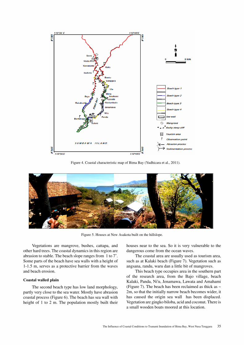
Based on geological conditions, morphology andtopography, coastal relief, vegetation and communityactivities, the research area was divided into four typesof beaches, namely: Steep rocky beach; Coastal walledplain; Flat coastal mangrove; and Flat sandy beach.
Steep rocky beach
The first beach type occupies the northern part ofthe research area, morphology are steep undulating hillsthat form in this region as composed by old volcanicproducts (Figure 5). Population mostly built theirhouses far away from the coast, usually occupies the hillslope. Such as at Kawananta and New Asakota villages.Buildings constructed by wood with stage type on thebase.
( )[ ] ( )[ ]
0
0
0
=+∂∂
+∂∂
+∂∂
+∂∂
=∂+∂
+∂+∂
+∂∂
=+∂∂
+∂∂
+∂∂
+∂∂
ρτη
ηηηρτη
y
x
yg
yvv
xvu
tv
yhv
xhu
t
xg
yuv
xuu
tu (1)
(2)
(3)
ρτ x
ρτ y
22
21 vuuDf
gx +=ρτ 22
21 vuvDf
gy +=ρτ
gfDn2
3/1
=
223/4
2
vuuDgnx +=
ρτ (4)
223/4
2
vuuDgny +=
ρτ (5)
uDhuM =+= )( η
vDhvN =+= )( η
0
0
0
223/7
22
223/7
22
=++∂∂
+⎟⎟⎠
⎞⎜⎜⎝
⎛∂∂
+⎟⎠⎞
⎜⎝⎛
∂∂
+∂∂
=++∂∂
+⎟⎠⎞
⎜⎝⎛
∂∂
+⎟⎟⎠
⎞⎜⎜⎝
⎛∂∂
+∂∂
=∂∂
+∂∂
+∂∂
NMNDgn
ygD
DN
yDMN
xtN
NMMDgn
xgD
DMN
yDM
xtM
yN
xM
t
η
η
η (8)
(9)
(10)
(7)
The Influence of Coastal Conditions to Tsunami Inundation of Bima Bay, West Nusa Tenggara 35
Vegetations are mangrove, bushes, cattapa, andother hard trees. The coastal dynamics in this region areabrasion to stable. The beach slope ranges from 1 to 7˚.Some parts of the beach have sea walls with a height of1-1.5 m, serves as a protective barrier from the wavesand beach erosion.
Coastal walled plain
The second beach type has low land morphology,partly very close to the sea water. Mostly have abrasioncoastal process (Figure 6). The beach has sea wall withheight of 1 to 2 m. The population mostly built their
houses near to the sea. So it is very vulnerable to thedangerous come from the ocean waves.
The coastal area are usually used as tourism area,such as at Kalaki beach (Figure 7). Vegetation such asangsana, randu, waru dan a little bit of mangroves.
This beach type occupies area in the southern partof the research area, from the Bajo village, beachKalaki, Panda, Ni'u, Jenamawa, Lawata and Amahami(Figure 7). The beach has been reclaimed as thick as ~2m, so that the initially narrow beach becomes wider, ithas caused the origin sea wall has been displaced.Vegetation are gingko biloba, acid and coconut. There isa small wooden boats moored at this location.
Figure 4. Coastal characteristic map of Bima Bay (Yudhicara et al., 2011).
Figure 5. Houses at New Asakota built on the hillslope.

36 Yudhicara, et.al.
Flat Coastal mangrove
This third beach type is composed by organic siltand sandy mud, has vegetation of mangrove. Coveringthe southern regions of the Bima Bay and Bima Riverestuary area (Figure 8).
Morphology is generally sloping beach with lowrelief and swampy. Settlements are behind the road oreven far from the beach. Coastal dynamics is stable upto abrasion. In some place we could find sea wall with aheight of 1 m, but not in a good condition. Residents usethe land as fields and ponds (Figure 9A). There are saltponds at Bontokape (Figure 9B). Houses are made ??by
Figure 6. The second beach type at Amahami
Figure 7. Tourism area at Kalaki beach.
Figure 8. The third type at dusun Rababuntu.

The Influence of Coastal Conditions to Tsunami Inundation of Bima Bay, West Nusa Tenggara 37
wood with a bottom made of the stage, which serves aspreventing the entry of sea water into the house at hightide.
Flat Sandy Beach
The beach is characterized by brownish sand, fineto coarse sand size, indicates that the area is close to thesediment sources (Figure 10). This area occupies theriver mouth of Daru and some east coast (near the riverRaba).
The beach has a ramps up wavy morphology,composed by a fine gray sand which is containingshells, gravel, gravel to boulders, with a beach slope of1O . Hills behind the beach are composed of volcanicrocks.
People are generally makes their home near to thebeach, even very close to the shoreline. majority of thepopulation work as fishermen, characterized by many
fishing boats moored on the beach. The vegetation isvery less, some consisting of coconut and Angsana.Beach dynamics is accretion. Most beaches have beenreclaimed as found in Bonto village. Sea wall are find atsome places as high as 1-2m.
Land Uses
Land use in the research area are used such as atourism area like in Kalaki and Wadu Pa'a, port in Bimacity which is accompanied by the fish auction (TPI),steam power plant found in the east end of the city ofBima, salt ponds in the South Bay of Bima, including inBontokape. Settlements scattered along the coast of theresearch area.
Beach Profile Measurements
Coastal morphology is one of the factors that canaffect the run-up height of the tsunami wave as it
Figure 9. Salt ponds (A) and houses (B) at Bontokape village
Figure 10. The fourth type beach at Bonto village.

38 Yudhicara, et.al.
reaches the mainland. The creeping wave flatness of thebeach followed by a relatively fast speed and sweep,knocking down the houses and dragging objects to themainland. Table 3 shows the results of beach profilemeasurements.
Based on the results, shows that the subsidence inthe research area is generally found in the plains with aminimum height difference of 0.04 m at Rababuntubeach and a maximum of 22.63 m in New Asakota area.The subsidence closest distance to the coastline is 10.3m in Rababuntu, while the farthest extent is atKawananta 194.58 m from the shoreline. This conditionindicates that the ideal settlement which is safe from thetsunami wave is Kawananta, while the area is prone totsunamis is Rababuntu. The average beach slopes areranged from 1˚ to 7˚.
Observation results will include defining thecoastal shape, coastal morphology, and coastal geology.Beach shape elongated without curvature would haverun up heights lower than gulf beaches and pockets.Beaches with gentle sloping morphology can produce
inundation distances farther ashore than the steep andrugged coast. this is due to the sloping beach, the waveswill come a long break before finding a barrier thatexceeds the height of the tsunami wave came, while therugged steep coast, the waves will first be broken beforeit reaches the coast further inland. Coastal hilly, rocky,with coral reefs or closed vegetation can reduce theenergy of tsunami waves. Similarly, the beach has anatural levee due to sedimentation in estuaries anddunes will reduce the energy of tsunami waves. Whilethe beach which is composed by alluvium and sand-sized beach sediment with no vegetation less able toreduce the energy of tsunami waves
Bathymetry Analysis
Tsunami waves is strongly influenced by the oceanfloor depth, which will affect the speed of propagationof tsunami waves. Tsunami waves through the deepseabed will have a greater velocity than when throughthe shallow sea floor. The amplitude of tsunami waveswill be higher in the shallower than the deep sea. The
Position
No. Name of Location Long (°E) Lat (°S) BeachSlope
(°)
Horisontal Distance
(m)
Height Diff. (m)
1 Sowa 118.69047 08.36114 7 22.53 3.51 2 Southern Sowa 118.69106 08.37134 1 60.85 4.31 3 Kawananta 118.69533 08.37875 2-3 194.58 10.28 4 New Asakota 118.69049 08.39771 4 92.16 22.63 5 Bajo 118.68507 08.45571 2 38.22 1.3 6 Rababuntu 118.67232 08.47954 12 10.3 0.04 8 Kalaki Beach 118.68094 08.51693 2 17.85 1.47 9 Panda 118.69050 08.51753 2 39.12 1.1 10 Nipa 118.79765 08.28962 4 53.83 3.85 11 Ambalawi 118.80692 08.28640 6 27.83 3.25 12 Mawu 118.83599 08.28204 6 51.81 5.7 13 Sangiang 118.93338 08.29524 3 21.96 1.67 14 Ule 118.72458 08.43515 5 42.41 3.53 15 Ule-Asakota 118.71719 08.42783 3 40.15 2.58 16 Songgela 118.71396 08.42421 4 66.37 4.97 17 Northern Songgela 118.70884 08.42019 4 17.04 1.78 18 Bonto 118.71207 08.40608 3 38.56 2.49 20 Kolo 118.71471 08.37696 3 55.46 3.62 21 Panda 118.70663 08.50686 2 39.76 1.54 22 Eastern Ni’u 118.71268 08.49881 7 11.96 1.97 23 Jenamawa 118.71160 08.48736 4 25.2 2.25 24 Wadumbolo 118.71086 08.47696 4 14.73 1.51 25 Lawata 118.71396 08.47337 15 27.25 2.77 26 Amahami 118.72273 08.46570 9 48.43 2.48 28 Port of Bima 118.71381 08.44753 0.2 25.31 0.67
Table 3. Results of measurements of lateral beach (Yudhicara, et al., 2011)

The Influence of Coastal Conditions to Tsunami Inundation of Bima Bay, West Nusa Tenggara 39
tsunamy velocity is the square root of the sea depthmultiplied by gravity.
Based on the bathymetric map that was resulted byMarine Geology Institute in 1996, shows that theseabed depth range between 1 and 50 m, where theinside of the very shallow waters of the Bay of Bima,gradually steeper at the mouth of the bay to the open sea(Figure 11).
Figure 11, it is known that the depth of seafloor atthe mouth of the bay is deeper, while the inside it looksmore gentle and shallower. The topography of easternwaterfront has a greater steepness than the western part.This condition will be very influential with the tsunamiwaves when it enters into the waters of the bay. In thatconditions, the wave will come with large enough speedentering the mouth of the bay. The diminishing ofvelocity spread along the coastal waters of the easternand continue to all parts. The wave height increasingwhen it reaches shallow water, especially in the watersof the western of Bima Bay. It can be ascertained, thatthe maximum tsunami wave height will be found in thewestern part of the bay, more or less in area Bontokape,
Rababuntu to Bajo which have a relatively flat and lowland coastal morphology.
Discussion
Tsunami Modeling Result
Tsunami waves will be strongly influenced by thegeometry of the coast (lateral direction); in the coastalbelt or pocket-shaped bay beach have potentially ahigher wave height compared with the elongated beachwith no indentation. This is caused by accumulation themass of water that occured in the bay or pocket beach.While on the straight beach, the mass of water willspread in all directions when it reaches the shoreline.Research area has those both beach shape, which are anenclosed and elongated bay. Influx access comes fromthe mouth of the bay, which would have delayed thereturn of the waves out of the bay, thus accumulating thenext wave comes, it will make the wave height increasesin the waters of the research area.
Flatness of the beach (the vertical direction);tsunami waves will have height greater and increases in
Legend:
Bathymetry contour with interval of 2,5 m
Index Map
Research area
30
Kalaki
Bontokape
Rababuntu
Bajo
New Asakota
Kawananta
Sowa
Kolo
Bonto
Bima
Lawata
Panda
118,63�E 118,73�E 8,4�S 8,4�S
118,63�E 118,73�E 8,57�S 8,57�S
5
15
10
20
25
45
35 40
50
2.5
7.5
12.5
17.5
22.5
27.5
32.5
Figure 11. Bathymetry map of Bima Bay (Dharmawan, et al., 1997)

40 Yudhicara, et.al.
coastal areas which has relatively gentle slopecompared to the deep and steep morphology or thathave greater beach slopes. The beach slope of theresearch area ranged from 1 to 7° and along the BimaBay and composed by alluvium with ramps, such atBajo, Soromandi, Rababuntu, Bontokape, Kalaki andother beaches around Bima City, will potentially have adistance range of the tsunami that would inundatecoastal plain, and halted at the edge of the hills that arebehind the beach or behind the highway. The hills willput a halt to the wave, so that the existence of these hillsis very beneficial as a point of evacuation and temporaryrefugee camps.
The achievement of the tsunami waves will bedetermined by the location of the tsunami source. If thesource is far from the research area, then the scope of
the tsunami waves will be smaller than if the location ofthe tsunami source is located perpendicular to theresearch area. The tsunami modeling was made theworst case scenario, in order to have the worst result, toget better plan and solution to mitigate the tsunami risk(Figure 12).
High Tsunami Prone Area
High tsunami prone areas have the potentialdamage to assets and greater safety risk of population.Coastal region including the region has a height ofbetween 4-5 m tsunami, the northern part of theresearch area, Sowa and northern of Kolo. Themorphology of this region including undulating hilly.Other areas have different morphology and high plainssloping towards the mean sea level between 0 to 5 m.
Research area
Figure 12. Tsunami inundation map of Bima Bay (Yudhicara et al., 2011)

The Influence of Coastal Conditions to Tsunami Inundation of Bima Bay, West Nusa Tenggara 41
The maximum tsunami inundation reached about 400 minland from the shoreline.
Intermediate Tsunami Prone Area
Intermediate tsunami prone areas have thepotential risk of damage to property and safety of thepopulation is still quite large. Coastal areas, includingthe area affected by the tsunami had a height between 1-3 m at southeast of Kawananta. The morphology of thisregion including undulating hilly. The maximumdistance the tsunami impacted reaches about 270 mfrom the shoreline.
Low Tsunami Prone Area
Low tsunami prone areas which have lowestdamage potential safety risk assets and the population.Coastal region including the region has a height of lessthan 1 m tsunami, located along the research area,exceptually : Sowa, Kawananta and Kalo. The tsunamiwave will reached a maximum distance of 350 m fromthe shoreline.
Green Belt
The most effective and safer for reducing theimpact of the tsunami risk is by planting along thecoastal areas. Besides, the cost is relatively cheap andvery easy maintenance. The presence of the green lineat the tsunami is quite beneficial because it can: • Stopping the rate of floating objects (boats, wood
or construction debris) that is carried away by thetsunami waves ashore.
• Reduce the speed of the water flow and reduce theheight of inundation.
• Saving people drift (stuck in a tree).
• Reduce wind that carry material (sand) to form a
fine-sized sand dunes (dune) that can be prohibitivetsunami.
In the research area along the coast where thevegetation is less adequate, although there aremangrove plants in several places, but planting a moreorderly and planned will contribute to better preventtsunami inundation. The coastal plant types suitable forplanting in the areas include palm trees, Cattapa,hibiscus, pandanus, pineapple beaches and mangroves.
Natural and artificial Beach Protection
The existence of such a natural protectivemangrove plants along the coast or at the sea wouldprotect the coastline (Figure 13A), so that its presencemust be maintained and preserved. Sea wall andbreakwater are effective as artificial protector reducingwave (Figure 13B), can be built along the coast with afew of securing the coastal areas, residential and otherbuildings from abrasion caused by the pounding wavesand currents along the coast (longshore current).Preparation on build sea wave barrier, would have tofollow the rules, especially to build a tsunamis barrier inthe mouth of the Bima Bay will be more effective towithstand tsunami waves entering the territorial watersof the bay.
Evacuation Route and Sites
The research area generally formed bymorphological hills, where the height of the sea surfaceelevation higher behind the beach. Under theseconditions, evacuation routes and evacuation site can bedirected to a place or location that has a higher elevationof the sea surface, or on the hills behind the beach alongthe research area (Figure 14 A & B)
Figure 13. Mangroves as natural barrier at Rababuntu (A) and Sea wall conditions at Lawata (B)

42 Yudhicara, et.al.
Evacuation routes are equipped with signspointing routes should be prepared as early as possiblein an effort to minimize risk to tsunami hazard in theresearch area.
CONCLUSIONS
Area along the coast that includes the territorialwaters of the Bima Bay, West Nusa Tenggara, is proneto tsunamis, evidenced by the historical tsunamis recordin 1815 due to the volcanic eruption of Tambora, 1818,1836 and 1992 caused by earthquakes associated withtectonic system in the north of the island of Sumbawa,and 1892 were sourced from a distant source.
Several factors can affect the amount of risk thatwould be caused by the tsunami, in the research areainclude are: (1) The research area is located in anenclosed bay; (2) The local sea floor depths around thebay is relatively shallow; (3) Coastal characteristics ofthe research area is dominated by a gently slope beachmorphology with low relief, especially in the area ofBajo, Rababuntu, Bontokape and other beaches in thecity of Bima; (4) Residential location very close to theshoreline; (5) Minimum vegetation cover; and (6) Thepresence of the artificial protective are inadequate.
Based on tsunami modeling using the 1992 Floresearthquake parameter which is placed perpendicular tothe research area obtain the maximum tsunami heightaround 4-5 m at Sowa and Kolo, near to the mouth ofBima Bay, while the minimum is at Kalaki, about 0.2 mwhich is at the inner bay.
ACKNOWLEDGEMENTSThe deep gratitude is expressed to the Geological
Agency, Center of Volcanology and Geological Hazard,who supported the research. Thank you to all peoplewho helped and gave contribution to the paper.
REFERENCES [1] Dharmawan, B., Pasaribu, I., 1997. Laporan
Penyelidikan Kawasan Pantai Teluk Bima, NusaTenggara Barat, Marine Geological Institute,Bandung.
[2] Dolan, R., Hayden, B.P., Vincent, M.K., 1972,Classification of Coastal Landform of America,Zithschr Geomorphology, Encyclopedia ofBeaches and Coastal Environment, 3-6.
[3] Hamilton, W., 1979, Tectonic of the IndonesiaRegion, U.S. Geological Survey, ProfessionalPaper, 1078, 345 pp.
[4] Harvard CMT Catalog, 2011, Global CentroidMoment Tensor Catalog, online data.
[5] Kertapati, E., Djuanda, A., Soehaimi, A., danAffandi, I., 1998, Peta SeismotektonikIndonesia, Skala 1 : 5.000.000, Pusat Penelitiandan Pengembangan Geologi, Bandung.
[6] Ortiz, M., Tanioka, Y., 2005, Catatan KursusPemrograman Pemodelan Tsunami, QuezonCity, Filipina.
[7] Satyana, A.H., 2010, Sejarah Geologi PulauSumbawa, publikasi online.
[8] Soloviev, and Ch.N.GO., 1974, Catalogue ofTsunami in the Western Pacific, TranslationRussia.
[9] Yudhicara, Kurnia, N.P., Heri, Juanda, 2011,Laporan Penyelidikan Tsunamigenik, WilayahTeluk Bima dan Sekitarnya, Nusa TenggaraBarat, Laporan intern, Pusat Vulkanologi danMitigasi Bencana Geologi, Badan Geologi,Bandung.
Figure 14. Hills behind the beach is a good location for evacuation route and sites in the area of Songgela (A) and Bonto (B)