Embed Size (px)
Citation preview
1
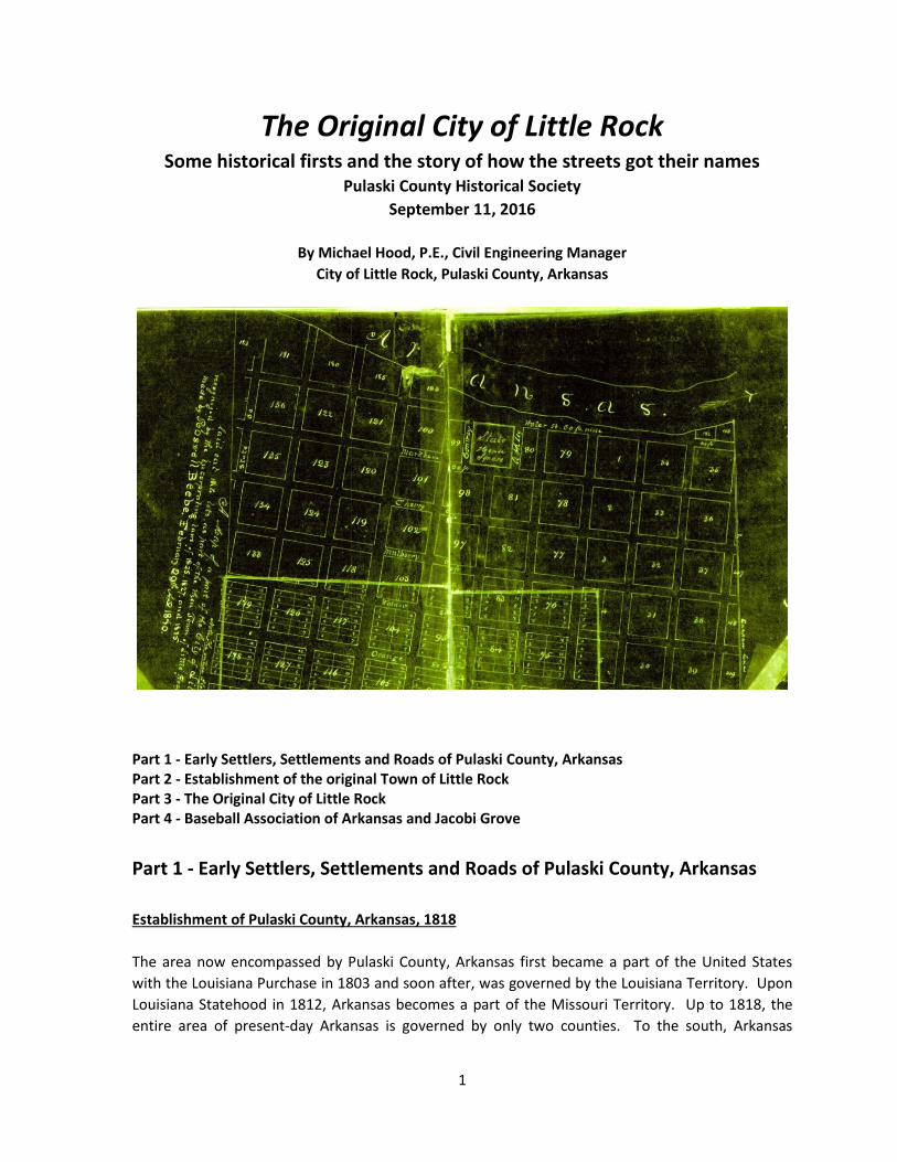
The Original City of Little Rock Some historical firsts and the story of how the streets got their names
Pulaski County Historical Society
September 11, 2016
By Michael Hood, P.E., Civil Engineering Manager
City of Little Rock, Pulaski County, Arkansas
Part 1 - Early Settlers, Settlements and Roads of Pulaski County, Arkansas Part 2 - Establishment of the original Town of Little Rock Part 3 - The Original City of Little Rock Part 4 - Baseball Association of Arkansas and Jacobi Grove
Part 1 - Early Settlers, Settlements and Roads of Pulaski County, Arkansas
Establishment of Pulaski County, Arkansas, 1818
The area now encompassed by Pulaski County, Arkansas first became a part of the United States
with the Louisiana Purchase in 1803 and soon after, was governed by the Louisiana Territory. Upon
Louisiana Statehood in 1812, Arkansas becomes a part of the Missouri Territory. Up to 1818, the
entire area of present-day Arkansas is governed by only two counties. To the south, Arkansas

2
County is governed from Arkansas Post, and to the north, Lawrence County is governed from
Lawrence, soon after named Davidsonville. On October 24, 1818 during the last session of the
territorial legislature of Missouri, Governor William Clark signed into law the creation of three
counties—Pulaski, Clark and Hempstead, taken from the territory of Arkansas county. These three
counties along with the original Arkansas and Lawrence counties, comprised the sum total of
counties at the time of the formation of the Arkansas Territory on July 4th, 1819 when Missouri
became a State.
In Pulaski County there was no town which could be named as the county seat, so the courts were
directed to be held at the house of Samuel McHenry on the south side of the Arkansas River near
the mouth of White Oak Bayou. In 1820 the Arkansas territorial legislature established the Pulaski
County seat further up river at a place called Cadron. The name of Cadron is thought to be derived
from the French word for quadrant. Cadron, now in Faulkner County, was first established as a fur
trapping post in 1818 when a group of families moved there from Crystal Hill. In 1821, after the
territorial capital was moved from the Post of Arkansas to Little Rock, the Pulaski County seat was
moved to Little Rock where it has remained since.
Post Roads and Distances c1824

3
Early Settlers and Settlements of Pulaski County
Up to the establishment of Pulaski County in 1818, few emigrants had settled in the area. Perhaps
the earliest documented settlers were at Crystal Hill north of the Arkansas River along with a smaller
settlement south of the river.
Soon after the establishment of the first Territorial Capitol of Arkansas at Arkansas Post, a fierce
debate arose over choosing the location of a new Territorial Capitol in Pulaski County. The leading
contenders were Cadron, Crystal Hill and Little Rock. Much land speculation arose at these sites as
the debate continued for months.
Crystal Hill - About the beginning of the year 1807 a group of eight families from North
Carolina established a settlement near the Crystal Hill, above “the point of rocks.” Among
them are Major John Pyeatt and his brother, Jacob. Also in 1807, Francis Lafave and his
brother Leon settled in the county. Leon Lafave lived to be over ninety years old, having
lived over eighty years in the county.
Upon arrival, the Pyeatts were surprised to find that a party of immigrants from North
Carolina had preceded them about a year and were then living a few miles above Crystal Hill
on the south side of the river at the foot of the Maumelle mountains, or, as they were then
Cadron, Crystal Hill and Little Rock c1824

4
called, the “Mammal mountains” in the vicinity of the Maumelle River. This indicates the
first settlers arrived in present day Pulaski County in 1806, but their names are no longer
known.
Other Pyeatt families would join them later. In 1812, Major James Pyeatt, Jacob Pyeatt,
Mary Carnahan Pyeatt (daughter-in-law of Henry Pyeatt) and their families arrive at Crystal
Hill. Mary Carnahan documented their travels in her diary. They constructed a large
wooden skiff and operated a ferry service on the Arkansas River at Crystal Hill, likely the first
ferry service in Pulaski County. Other families soon joined them in the area along the
Arkansas River between Crystal Hill and Cadron.
In 1817, Colonel Edmund Hogan, a retired army officer, located near Crystal Hill on a site
near the point of the rocks. In 1821, his home there was said to be the finest in Arkansas.
Hogan was Justice of the Peace in 1818 and the first post master of Crystal Hill in 1820. He
was later appointed as General of the Arkansas Militia.
About 150 others lived in the Crystal Hill area and it was described as a center of fashion and
intelligence as well as religious influence. In 1821, the plat for the town site was recorded
by Edmund Hogan and William O’Hara, a St. Louis land speculator. The first territorial
governor, Governor James Miller, built his home here and eventually acquired ownership of
the entire town site in the years following the establishment of Little Rock as the new
territorial capitol in June 1821.
Crystal Hill declined in importance and by 1843 William Woodruff purchased the entire town
site at auction for back-taxes in the amount of $3.99. In 1933, historian Judge Utley
reported that signs still remained of the “departed glory” of old Crystal Hill including old
brick chimneys and foundations, the remains of a brickyard and a wharf on the old river
bend.
Crystal Hill gets its name from a bluff on the river consisting of sandstone, shale, and
significant amounts of quartz crystal and iron pyrite, which sparkled in the sunlight. The
Crystal Hill Town site was located in present day City of Maumelle at the Maumelle Country
Club. The Crystal Hill is located to the east. Crystal Hill Road gets its name from this early
settlement and the Crystal Hill.
Cadron – Cadron was located near the confluence of Cadron Creek and the Arkansas River,
about five miles west of present day Conway. In the early 1800s, the term “Cadron
Settlement” was used loosely in reference to thirty to forty families that were scattered
along the Arkansas River in the vicinity of Cadron Creek. Cadron served for a time as the
seat of Pulaski County government and is credited with being the first official town in
present day Pulaski County.
In 1818, an early settler and trader, John McElmurry and three other investors laid out the
town of Cadron on about sixty-four acres. A few other families from the Crystal Hill also

5
moved here. McElmurry had built a blockhouse to be used as a residence, tavern, and
protection of his fur trading business (mostly deer pelts), with Cherokee Indians living on
Indian land to the northwest. A ferry crossed both the Arkansas River and Cadron Creek.
English naturalist Thomas Nuttall, who visited Cadron in March of 1819, found prospects for
the town limited by the small area of good ground lying between infertile hills and forest.
The only town residents were McElmurry and his extended family (five or six children, wives,
and slaves). On a return visit in 1820, Nuttall noted several more families, three or four
outlying houses, and a thriving but slovenly tavern. Weekly mail service started in 1820.
Cadron lost out in its bid to become the territorial capitol and later its bid to become the
county seat of newly formed Faulkner County. By 1831, the town had been abandoned.
The site is located in Cadron Park in Faulkner County and a replica of the original blockhouse
stands here.
Future Little Rock Town Site - In 1812, William Lewis, a hunter trapper, became the first
documented land owner at the future site of Little Rock. He stayed only 3 months and sold
his claim to Elisha White in 1814, who sold to William Russell a St. Louis land speculator.
William O’Hara, another prominent land speculator from St. Louis, acquired an interest in
another conflicting title to the town site marking the beginning of three decades of disputes,
lawsuits and acrimony over title.
In 1819, British traveler and naturalist Thomas Nuttall passed through Little Rock and he
notes Colonel Edmund Hogan is operating a ferry at the Little Rock. On his return trip in
1820, he notes a group of bachelors living in a log cabin near the Point of the Rock, possibly
among them is Benjamin Murphy and Wright Daniel.
Benjamin Kellogg settled at the place where Little Rock now is in about the year 1820. He
was a blacksmith and found plenty to do in fashioning iron implements for travelers. It is
written that he made the broadax with which the logs were hewn for the building of the first
house in Little Rock. After a short while he moved northward and established himself at the
lead and silver mines in Pulaski County, which became known as the Kellogg mines in
present day Sherwood. Argenta, now North Little Rock, got its name from the early promise
of those silver and lead mines.
Fourche – Another early settlement in Pulaski County was the Fourche settlement.
Archibald McHenry was another early settler to Pulaski county (1819 or 1820), living ten or
twelve miles southwest from Little Rock along the Military Road, now Stagecoach Road. His
second home on the site still stands and is known as the McHenry House or Stagecoach
House. George Brodie was another early settler here. Across the Fourche Creek as it was
then known were the Lewis Brothers, Washington and Nathaniel, and Jared Martin in those
early years of Pulaski County and Fourche Township.
6
The Early Roads
In 1824, The Map of the United States Intended Chiefly to Exhibit the Post Roads and Distances by
Abraham Bradley showed that Arkansas Territory had few established roads, and those roads were
little more than a network of horse trails through the wilderness. The Town of Little Rock had only
recently been established as the Arkansas Territorial Capitol in 1821 following the establishment of
Little Rock Post Office in 1820. The early roads converged in Pulaski County north of the Arkansas
River.
Military Road through Little Rock, Saint Louis to Texas - The only road and main post road
that passed through Little Rock was along a route in use at least since 1760 that was first
established by Native Americans. That road was referred to as the Military Road, National
Road, and in more recent times, as the Southwest Trail. The early road was little more than
a network of trails following a general compass bearing to the southwest and would soon
become one of the most important transportation corridors through Arkansas on the road
to Texas.
In 1820, Congress began a road construction and improvement project by the military
department to establish a wagon road from St. Louis southwestward to Little Rock. That
early road would pass through the town of Jackson near to Davidsonville in the northeast
corner of the Arkansas Territorial line, crossing the White River just south of Batesville, then
continuing on to Little Rock.
From Little Rock, the Military Road as it would came to be known, continued southwesterly
through Saline Crossing near where Benton would soon be established, through Clark
Courthouse, and onward through the territory to Fulton on the Red River. A branch of the
road would continue west from Washington to Fort Towson in the Indian Territory. Portions
of that early Military Road through Little Rock can be remembered today as the Batesville
Pike in North Little Rock; Ferry Street, Asher Avenue and the Stagecoach Road in Little Rock;
and Military Road in Benton.
Another early branch of the Southwest Trail and the first route mapped by Government
surveyors crossed the Fourche River south of Little Rock and passed through Fourche
Township where some important early springs were located, continuing on towards
Collegeville at the present Pulaski - Saline County line. The Lewis Brothers, Washington and
Nathaniel, and Jared Martin were early settlers along this old road. The route followed
somewhat along the western end of present day Mabelvale Pike.
Arkansas Post Road, Crystal Hill to Arkansas Post - Another early trail passing near to Little
Rock was the road from Crystal Hill. It provided an important link from the settlement of
Crystal Hill located on a bluff overlooking the Arkansas River approximately where the City
of Maumelle is located today, to the Arkansas Post. First established by settler and
adventurer John Pyeatt in 1807, a band of woodsman blazed and cleared a trail from Crystal
Hill to a point where it intersected an old Indian trail west of present day Jacksonville, which
led southeast straight to the Arkansas Post. That early road did not pass through Little Rock
staying along the north and east bank of the Arkansas River.

7
Military Road, Memphis to Little Rock – Beginning with an act of Congress in 1824,
construction began on another important military road that would link Memphis to Little
Rock through Arkansas. This road met the Southwest Trail west of present day Military Road
in Jacksonville. Construction and improvement would continue for decades. Because of
the many rivers and swamps of eastern Arkansas, the road was impassable for much of the
year.
The system of military roads was extended from Little Rock along the north bank of the
Arkansas River to the western territorial boundary and Cherokee lands. Important early
river towns were Lewisburg near Morrilton, Dwight Mission in Pope County, and Norriston
at a ferry on the bank opposite Dardanelle where the road crossed the Arkansas River. This
Military Road continued along the south bank of the Arkansas River on to Fort Smith and
later Fort Gibson near the western boundary of Arkansas Territory.
Some later roads from Little Rock - By the time of the Civil War, several other roads had
been established westward and southward from Little Rock. From Little Rock westward,
Civil War era maps named the roads as the Lower Maumelle Road also known as River Road,
and the Upper Maumelle Road also referred to as the post road to North Point and
Perryville. North Point was an early outpost in Pulaski County located near Pleasant Grove
and Goodson Roads.
The road to Pine Bluff followed along the west bank of the Arkansas River, passed by Terry’s
Ferry at Terry Lock and Dam and onward through Sweet Home and Wrightsville. That route
known as the 21st Street Pike or Fourche Pike can be remembered today as 21st Street,
Barber Street, the former Confederate Boulevard, Springer Boulevard and the Sweet Home
Pike.
Part 2 - Establishment of the original Town of Little Rock and
How the Streets got their Names
Town of Little Rock
Jean-Baptiste Benard de la Harpe, a Frenchman, lead an exploration party up the Arkansas River in
1772 from New Orleans. He noted the first outcropping of rock along the banks of the river since
leaving New Orleans and called the place 'la petite roche' or 'the little rock,' to distinguish it from a
larger cliff or big rock across the river. The location later commonly referred to as the Point of the
Rocks. For a short time, the first town at point of the rocks was called Arkopolis, however, when the
first post office was established at this location in March of 1820, it was named Little Rock. The first
map of the Town of Little Rock was recorded in the land records of Pulaski County, Arkansas
Territory on February 2, 1822.
From June 1821 when the Territorial Capitol was moved from Arkansas Post to 1825, the Territorial
Governor presided over the affairs of the Town of Little Rock. In 1825 (or 1827) Territorial Governor
George Izard signed legislation to provide for a Board of Trustees to govern the town. On November

8
7, 1831, the Town of Little Rock received its first charter as a town. In 1835, Little Rock is re-
chartered as the first city in Arkansas Territory.
The ‘Little Rock’ is located at the foot of Rock Street and the Junction Bridge in Riverfront Park.
LaHarpe Boulevard of today gets its name from the early explorer that is credited with naming the
rock.
Little Rock Land Title Disputes – From the very beginning of the Little Rock town site continuing on
into the 1840s, the ownership of the town was a subject of numerous lawsuits, disputes and
hostilities over early land titles. In 1814, William Russell, a St. Louis land speculator acquired a land
interest in the site and William O’Hara, another prominent land speculator from St. Louis, acquired a
second conflicting title to the town site.
Chester Ashley, one of the first lawyers to settle in Little Rock, was a key figure in the dispute over
the ownership of the land on which the town was to be built. Two groups of speculators held
conflicting claims to the location of what is today downtown Little Rock. Ashley represented the
faction comprised of James Bryan, William O’Hara, Amos Wheeler, and Governor James Miller, who
claimed through a New Madrid certificate. William Russell headed the other faction, which also
included Robert Crittenden, Henry Conway, Judge Andrew Scott, and a number of other prominent
citizens, who claimed through pre-emption. Although Ashley’s faction lost in court, the two sides
compromised and split up downtown Little Rock between them. Still, disputes over title continued
for years after.
Little Rock, Main Street at Markham, 1836
Population 600, about 150 buildings

9
On September 25, 1839, businessman Roswell Beebe received the original patent for the town of
Little Rock, signed by President Martin Van Buren. It was recorded in 1840 in the Pulaski county
recorder’s office Book L, page 312, encompassing 240 acres. This event marked the beginning of the
end of numerous lawsuits, disputes and hostilities over early land titles in the city that began before
the founding of the first Little Rock town site. It is written that upon his return, Beebe gave all the
people who had bought lots from a certain real estate developer, whom he considered to be fair
and honest, title to their land for a dollar. In 1840, Beebe recorded his map of Little Rock and
deeded the streets and alleys to the city for a dollar. He gave the state the title for the land on
Markham Street, where the new capitol building (now the Old State House Museum) was
located. He also donated part of the land for Mount Holly Cemetery, the other portion came from
his brother-in-law Chester Ashley.

10
Quapaw Line – In 1818 a treaty with the Quapaw Indians established the northern and western
boundary of tribal lands as a line commencing at the Point of the Rock and running due south. The
Town of Little Rock was laid out west of this boundary. A series of stone monuments located in River
Front Park commemorates this historic line as well as a monument in MacArthur Park.
North – South Streets of the Town of Little Rock – These were the north – south trending streets
shown on the original Map of the Town of Little Rock in 1822.
1st or East or Commerce or River Market Avenue – While the street was not officially a part
of the original town as it was located east of the Quapaw Line, East Street or 1st Street
figured prominently in the town history. In the early years, it was a short street that
extended from Markham north to the Arkansas River and was a focal point of river trade
where steamboats landed and early log warehouses were constructed. Further east of here
was the ferry landing at future Ferry Street. Because of this role in early trade, it would
soon become known as Commerce Street.
Old Commerce Street remains a focus of local shopping and entertainment in the heart of
the Little Rock River Market District. A portion of Commerce Street has been renamed River
Market Avenue.
Rock Street - Rock gets its name from the Little Rock, Point of the Rocks or La Petite Roche.
Cumberland Street – The Cumberland Gap westward through the Appalachian Mountains
into Kentucky and Tennessee was one of the most important trails in the saga of the
western migration of Europeans into the Territories of the Louisiana Purchase. Many of the
early Little Rock settlers or their ancestors had come through the Cumberland Gap on their
way west and Cumberland Street commemorates their travels.
La Petite Roche at Rock Street
Junction Bridge opened December 1884

11
Scott Street – Andrew Horatio Scott was one of the first Superior Court judges of Arkansas
Territory by virtue of appointment by President James Monroe. He was the first
governmental official to report for duty at the village of Arkansas Post (Arkansas County) on
July 4, 1819, and was first to put into operation the laws of the territory. He served as Circuit
Court Judge for the first District and was the first County Judge of Pope County. The county
of Scott, created in 1833, was named in his honor.
Scott is acknowledged as one of the most distinguished figures in pioneer Arkansas history
however, his career was forever marred by a proclivity toward violet confrontation. On May
26 1824, fellow Superior Court Judge Joseph Selden died at the hand of Scott in a duel on
the east bank of the Mississippi River across from Helena (Phillips County) following an
incident wherein Scott felt that Selden had insulted a lady and demanded that he apologize.
On May 31, 1828, Scott confronted Edmund Hogan in Little Rock and accused him of lying
about Scott during a campaign for Territorial Delegate. A verbal argument escalated into a
shoving match, during which Hogan struck Scott, knocking him down. Scott drew a spear
from his walking cane and thrust it into Hogan’s body, mortally wounding him. Scott was
charged with murder but later acquitted from charges as he was ruled to have acted in self-
defense. After this, Scott removed to Dwight Mission near present day Russellville in
Cherokee Territory.
East Main or Main Street – First mapped as East Main, Main Street and Markham Street
were then as now, the center of the downtown business district. Travelers along the
Military Road, the Southwest Trail, visited and shopped along these streets in their travels.
Territorial Judge Andrew
Horatio Scott
Superior Court Judge 1819
Dueled with fellow judge
Joseph Seldon 1824
Killed Col. Edmund Hogan
during a fight over politics

12
Louisiana Street – The year 1803 marked the historic Louisiana Purchase in which the
United States purchased from France a vast area of land in the west that included Little
Rock, the future Territorial Capitol of Arkansas. Arkansas was first a part of the Louisiana
Territory, then the Missouri Territory, before becoming the Arkansas Territory on July 4th,
1819.
Center Street – Center Street is located near the center of the original Town of Little Rock.
In 1833, the third Territorial Governor John Pope selected a site on Markham Street
centered on Center Street for construction of the new capitol building, now known as the
Old Statehouse. Center Street was the first street constructed through to the town
boundary and the first street that was paved for its entire length in the old town.
Ashley and Conway Streets - With construction of the new capitol building
beginning in 1835, a new street was constructed on the east side of the Statehouse
and named Ashley Street in honor of Chester Ashley, the third senator from
Arkansas. A new street on the west side was named Conway Street in honor of
James Sevier Conway, the first Governor of the new State of Arkansas. Both men
were members of the powerful Conway-Sevier-Johnson faction that controlled
Arkansas politics up to the time of the Civil War.
Spring Street – In 1822 at the foot of Spring Street on the Arkansas River was located a large
perennial spring that served as an important early drinking water source. By 1832, John
Pope described a steam saw mill on the site. The boilers for the mill drew water from the
old spring. During construction of a pedestrian approach for the new Broadway Bridge in
Center Street and the Statehouse
Ashley and Conway Streets

13
2015, an old brick and concrete cistern was uncovered at the site of the old spring, since re-
covered and preserved.
West Main or Broadway Street – Broadway Street or West Main as it was known in the
early years, would become the premier thoroughfare of Little Rock. Many fine homes and
businesses were located on the broad, tree-lined street. During the age of the automobile,
the Broadway Bridge was completed in 1927 and it would be designated as US Highway 70.
East – West Streets of the Town of Little Rock - These were the east – west trending streets shown
on the original Map of the Town of Little Rock in 1822.
North Street – This was the northern most street in the early town extending only a few
blocks in length at the northwest corner of the map on a high river prominence.
Water or Garland Street or Ottenheimer Plaza Drive – Water Street was located one block
north of Markham along the Arkansas River. Early industries and businesses that relied on
river transportation developed along the street including associated saloons, gambling
houses and houses of ill-repute. Catering to the river boat men, gamblers and ruffians, a
portion of Water Street and the adjacent alley Elm Street was referred to as “hell’s half-
acre.” George Featherstonhaugh, an English geologist, who visited in 1838, wrote that, in
his estimation, Little Rock had fewer than twelve citizens who refrained from wearing "two
pistols … and a Bowie knife." German adventurer Frederick Gerstaecker wrote of Little Rock
in 1838 “Boatmen on the Mississippi have good reason when they sing:
“Little Rock in Arkan-saw
Damndest place I ever saw.”
Territorial Governor
John Pope
1829
Progressive and visionary
advocate for improvement of
Arkansas’ reputation as a
place of violence and
corruption

14
Territorial Governor John Pope wrote that: “In the early days of any country, no matter how
intelligent, refined and honorable the better class of the people were, there were to be
found men of lawless and desperate character, who had to be met with force and swift
justice. Besides, the want of action and constant occupation, and the great interest taken in
local politics; or quarrels growing out of some real or fancied wrong, or disputes over a piece
of land or other property, often led to bloody encounters. Sometimes they were decided on
the field of honor, falsely so called, and at others resulted in a rough and tumble fight or a
shooting or cutting scrape. Arkansas was no worse in this respect than any other new State
nor was she any better than her neighbors.”
Today, Water Street as a name has disappeared from the map. The eastern portion of the
old street is now within Julius Breckling Riverfront Park and Ottenheimer Plaza Drive follows
somewhat along the old street within the park. Ottenheimer Plaza and Market Hall are
named in honor of the philanthropies of Little Rock resident Gus Ottenheimer. Julius
Breckling was a long-time Director of the Little Rock Parks Department.
The western remnant of Water Street was re-named Garland Street in honor of Augustus
Hill Garland, the eleventh governor of Arkansas, a member of the Confederate Congress, a
U.S. senator, and attorney general of the United States. Garland Street and Garland County
gets its name from this man.
Elm Street (alley) – Elm Street was described as a very narrow street one-half block north of
Markham. A portion of the original Elm Street remains today located east of LaHarpe
Boulevard in the River Market District. A portion of the alley is still paved in old river stone
cobles.
Arkansas River Commerce
Commerce, Ferry, Water and Elm Streets
Hell’s half acre!

15
Markham Street or Clinton Avenue – The source of the name of Markham Street is
somewhat one of ‘histories mysteries.’ Two or three Markham brothers stayed for a time at
the Point of the Rocks. It is not known where they came from or what became of them or
what their full names were. However, they apparently laid out a street and their sir name is
remembered as Little Rocks’ first street. Markham Street formed the baseline for the layout
of the original Town of Little Rock and is still the baseline for all address assignments in
Pulaski County south of the River. It was not laid out in a true east – west direction and
aligns somewhat with the original river bank.
The portion of Markham Street east of Cumberland Street is now named in honor of William
Jefferson Clinton, a native Arkansan, the 40th and 42nd Governor of Arkansas, and the 42nd
President of the United States. His Presidential Library is located at the eastern terminus of
Clinton Avenue in Riverfront Park.
Mathew Cunningham and the story of Cherry or 2nd Street, Mulberry or 3rd Street, Walnut
or 4th Street, Orange or 5th Street, Elizabeth or 6th Street, Chestnut or 7th Street, Holly or 8th
Street, Hazel or 9th Street, and Caroline or 10th Street – These streets are all given their
names by Dr. Mathew Cunningham, a native of Pennsylvania and the first Mayor of the
Town of Little Rock. The streets are named for streets in his beloved early home of
Philadelphia.
Dr. Cunningham was one of the first settlers of Little Rock in February 1820 and the first
physician. His wife Eliza, became the first female in the Little Rock settlement and the birth
of their son, Chester, named for Chester Ashley, was likely the first baby born to a Little Rock
family. Little Rock received its first town charter in November 1831 and Dr. Cunningham
Dr. Mathew and Eliza Cunningham
1820 first family in Little Rock, 1831 first Mayor
Friend to Chester Ashley, William Woodruff

16
was elected the first Mayor of Little Rock by a margin of 23 to 15. The first City Council
meeting took place at the Cunningham house on the block which is at the southwest corner
of what is now 3rd and Main Streets. A plaque on the side of the old Fulk Building on 3rd
Street makes note of this early event.

17
Part 3 - The Original City of Little Rock
The Original City of Little Rock – The boundaries of what is known as the Original City of Little Rock
were documented by a government land office survey in 1855, but it was not until long after the
Civil War that the final lots, blocks and streets were constructed and named. Lincoln Avenue is the
last street to be named and it appears on the map in 1888.
Early growth in the Town of Little Rock was mostly westward and eastward from the first boundaries
of the early town along the south bank of the Arkansas River. Markham was one of the most
travelled streets and met a road west of town that at various times was referred to as the Lower
Maumelle Road or River Road. After the Civil War, a portion of the old River Road was named
Lincoln Avenue for President Abraham Lincoln. Today it is known as Cantrell Road named for
Deadrick Harrell Cantrell. Cantrell was once the President of the Little Rock Railway and Electric
Company, the company that operated the trolley system in Little Rock.
On the east end of Markham, are the early additions to the Town of Little Rock of Pope’s Addition
(Governor John Pope), Russell’s Addition (William Russell) and Rector Town (Governor Henry
Rector). These additions were part of a ten section, 1000 acre grant of land from the United States
to the Arkansas Territory for the purpose of funding a new territorial capitol and penitentiary.
Governor John Pope presided over the sale of the land grant.
Streets added west of the Town of Little Rock - West of the original town, the following named
streets were added over time west of West Main Street or Broadway.
The stone arch of Arch Street, 1887 drawing

18
Arch Street – In the early years, a deep drainage ravine ran from about Mulberry or 3rd
Street north to the Arkansas River. Soon after the town was established, a large stone arch
bridge was constructed at Markham Street to cross this ravine as Markham accessed one of
the main roads westward from Little Rock. The arch is depicted on early drawings of Little
Rock in 1871 as a rather crude native stone structure and later in 1887 as a more refined
key-stone arch. Today the old ravine has been filled to street level and the arch is gone.
Gaines Street – Gaines Street is within the boundaries of the original town, but it was not
named on the map. It was named in honor of General Edmund Pendleton Gaines who
served with distinction during the War of 1812, the Seminole Wars, and the Blackhawk War,
serving again in the Mexican American War. Fort Gaines on Dauphin Island, Alabama is
named for him as well as Gainesville, Florida, Texas, Georgia, and New York. At least six
other towns, townships, and streets are named for him.
As commander of the Western District of the Military, he spent considerable time in
Arkansas Territory, presiding over Indian affairs and the forts along the western frontier
including Fort Smith, Fort Gibson, and Fort Towson. Governor James Miller called on him to
quite hostilities between the Cherokee and Chickasaw at Dwight Mission (Russellville) west
of Little Rock. While he was in command of military forces during two Indian wars and
numerous skirmishes, he opposed Indian removal policies, espousing the enforcement of
existing treaties.
Tower or State Street – First mapped as Tower Street, the name suggests there was once a
tower on the high bank of the Arkansas River at the north end of the street. It was later and
ever after known as State Street, commemorating Arkansas Statehood on July 4th, 1836.
Brigadier General Edmund
Pendleton Gaines
War of 1812
Seminole Wars
Blackhawk War
Mexican American War
Commander Western Military
District

19
Izard Street – George Izard, scholar, soldier, and army major general, served as Arkansas's
second territorial governor from March 4, 1825, until his death on November 22, 1828.
Referred to as the “aristocrat” he had an extensive education and refinement in the east
and Europe and was a native of South Carolina. He attended the College de Navarre in Paris,
Columbia University in New York, the College of Philadelphia, and the École du Génie at
Metz, France, where he was trained in military engineering. He served for a time as aide-de-
camp to General Alexander Hamilton and attained the rank of major general in the War of
1812.
In 1825, Izard was commissioned as the second governor of the Arkansas Territory. Arriving
in Arkansas on May 31, 1825, Izard found territorial government unorganized, undisciplined,
and lacking adequate record keeping; he also found the acting governor, Robert Crittenden,
out of state. A man of order and discipline, he immediately set about the task of establishing
record keeping and rectifying the territory’s financial disorder. His tenure as governor was
dominated by concerns with natural resources, roads, treaties with Indians, Indian removal,
and the organization and strengthening of the militia. Road development continued during
Izard’s tenure, and it was during this time that some roads became adequate enough to see
the use of the first stagecoaches in the territory.
Izard was a quiet, orderly, and scholarly man, and one historian wrote that much of
Arkansas’s rustic populace could not relate to him. He lived in a small brick house in old
town at the southwest corner of Spring and Cherry Streets and often preferred staying
home and reading to attending social events and was even known to decline events that
were to be held in his honor because he was too busy with his many avocations. He would
emerge in the morning from his small brick house to attend to his duties as territorial
Territorial Governor George
Izard
Aristocratic scholar
Army Major General War of
1812
Organized and disciplined
governor

20
governor, dressed in full military regalia as if to attend a military parade. He served as
governor until his death on November 22, 1828, and was buried first at the old city burial
grounds where Peabody School would later be built, and later in the family plot of Chester
Ashley at Mount Holly Cemetery. Izard County and Izard Street in Little Rock are named for
him.
Chester Street - Chester Ashley was prominent attorney and land owner in territorial and
antebellum Arkansas and is described as the pre-eminent appellate attorney of the period
and the wealthiest citizen of the early town because of his land holdings. He figured
prominently in early land disputed over title in Little Rock. He was the third Arkansan
elected to the U.S. Senate and was probably the wealthiest Arkansan for much of his life.
Ashley practiced law in a brief partnership with Robert Crittenden, the territorial secretary,
and later with George Watkins, who would serve as chief justice of the Arkansas Supreme
Court. Uriah M. Rose later joined the practice with Watkins, and still later, Deadrick Cantrell
joined the firm. That firm endures today as the Rose Law Firm.
Ashley was educated at Williams College in Williamstown, Massachusetts and the Litchfield
Law School in Litchfield, Connecticut. Like many young men at the time, he moved to the
frontier arriving at the little rock in Arkansas in 1820 at a time when Little Rock was a small
group of log houses in the Arkansas Territory, but it was soon to become the territorial
capital. He married Mary Watkins Worthington Elliott of St. Genevieve, Missouri, in 1821
and the newlyweds made their home in Little Rock.
Chester Ashley
Prominent attorney, land
owner, preeminent appellate
attorney
Third U.S. Senator
Ashley’s home was among
Little Rock’s finest

21
Governor John Pope described the Ashley home as the old time seat of refinement and
hospitality. Ashley’s residence occupied the entire block between Markham and Cherry
(Second) streets, and Scott and Cumberland streets fronting the Gazette office, and standing
back some distance from the street. According to Pope, the stately manor “was a very large
two-story brick mansion, built after the Greek style of architecture, with high brick columns,
stuccoed in imitation of stone, supporting the long portico which extended the full length of
the building from east to west. This splendid residence, with its trimly kept gardens and
orchards; its conservatories and hot-houses; its servants' quarters, stables, carriage houses
and other buildings marked its owner, Col. Chester Ashley, as a man of wealth and
elegance.”
He was buried in Mount Holly Cemetery in Little Rock, which is on land he donated to the city for the cemetery. Ashley County is named for him, as are both Chester and Ashley streets in Little Rock.
Ringo Street – Daniel Ringo was the first Chief Justice of the Arkansas Supreme Court
following the establishment of the State of Arkansas in 1836. His fellows were Associate
Justices Townsend Dickinson and Thomas J. Lacy. Herndon Haralson served as the first clerk
of the court, while the colorful Albert Pike was the first reporter of decisions.
Daniel Ringo was born October 27, 1803, in Cross Plains, Kentucky and educated himself in
the reading of the law. He practiced law in the Arkansas Territory beginning in 1830 and
resided in Little Rock for much of his career. Ringo also served as Judge in the U.S. District
Court of Arkansas, and later the Western and Eastern Districts of Arkansas. During the Civil
War, Ringo was Judge of the Confederate District Court of Arkansas. He died September 3,
1873 in Little Rock.
Cross Street – Cross Street is named for the Baring Cross Bridge, the first bridge constructed
and the western-most of the six bridges spanning the Arkansas River in downtown Little
Rock today. The first Baring Cross Bridge opened to railroad traffic on the Cairo and Fulton
Railroad in 1873. The bridge took its name from two sources: the famous Baring and
Company bankers of England, who were the principal financiers of the construction project
and C&F president Thomas Allen, who added “Cross,” which came from President Allen’s
family coat of arms. The coat of arms consisted of a cross and the words Fortiter Girret,
meaning, “bravely he bears the cross.”
In 1877, the Baring Cross Bridge Company constructed a highway deck on top of the bridge
and charged tolls for its use by the public. In early 1886, the company rebuilt most of the
bridge, with the exception of the piers, and lowered the highway deck to the same level as
the rail.
In April 1927, record rains soaked the Arkansas River Valley and caused a flood of historic
proportions. As the floodwaters reached Little Rock, the Missouri Pacific Railroad Company
placed coal cars on the old bridge for ballast, but the bridge washed away on April 21.
During this time, Missouri Pacific took over the ownership rights of the bridge and pledged
to rebuild it. The new bridge opened on February 2, 1929, to a huge community celebration.

22
Today, the Baring Cross Bridge, acquired by Union Pacific in 1997, is a modern steel double-
track bridge with a lift navigation span. It remains one of the busiest railroad bridges in the
country.
Pulaski Street – When Congress established Arkansas Territory in 1819, Pulaski County was
created and named for Count Casimir Pulaski, a Polish nobleman who fought and died in
1779 in the Revolutionary War’s Battle of Savannah. There are numerous towns, counties,
streets, parks, structures and monuments named for General Pulaski throughout the United
States.
Casimir Pulaski, son of Count Joseph Pulaski, was born in Warsaw, Poland, on March 6,
1745. At the age of fifteen, he joined his father and other members of the Polish nobility in
opposing the Russian and Prussian interference in Polish affairs. Outlawed by Russia for his
actions on behalf of Polish liberty, he traveled to Paris where he met Benjamin Franklin, who
induced him to support the colonies against England in the American Revolution. In 1777,
Pulaski arrived in Philadelphia where he met General Washington, Commander-in-Chief of
the Continental Army. Later, at Brandywine, he came to the aid of Washington's forces and
distinguished himself as a brilliant military tactician. For his efforts, Congress appointed him
Brigadier-General in charge of Four Horse Brigades. At the Battle of Germantown, Pulaski's
knowledge of warfare assisted General Washington and his men in securing victory for
American forces. Later in 1778, Congress approved the establishment of the first Cavalry
and put Pulaski at its head. Pulaski became known as the "Father of the American Cavalry."
Baring Cross Bridge at Cross Street
Constructed 1873, toll bridge added to top of bridge 1877

23
Pulaski and his Legion were then ordered to defend Little Egg Harbor in New Jersey and
Minisink on the Delaware; they then proceeded south to Charleston, South Carolina. It was
on October 9, 1779, during the Battle of Savannah, that General Pulaski, charging into battle
on horseback, fell to the ground mortally wounded by the blast from a cannon. Pulaski's
enemies were so impressed with his courage, that they spared him the musket and
permitted him to be carried from the battlefield. Pulaski died several days later on October
15, 1779, at age 34. The Pulaski Monument, erected in his honor, is located in Monterey
Square, Savannah, Georgia.
Pulaski County and Pulaski Street are named for this man as well as numerous other places
throughout the country.
Victory Street – History and timing suggest Victory Street commemorates the victory in
1846 by the United States in the Mexican American War in which Mexico ceded land
occupying nearly all of present day California, Utah, Arizona, and New Mexico for a sum of
$15 million dollars. It also resulted in the acceptance of the Republic of Texas into the Union
as the State of Texas. The gold rush of 1849 began soon after.
There were other victories in which the founders of Little Rock had reason to revel in
including the War of 1812 with the British, settling once and for all the question of America’s
independence. Perhaps the final victory of the time was the establishment of Arkansas as
the 25th State in the Union in 1836 and the establishment of Little Rock in 1835 as the first
chartered city in Arkansas Territory. Victory was won!
City Municipal Auditorium 1906
1836 Victory, Republic of Texas,
1836 Victory, Arkansas Statehood
Victory is won!

24
Cove Street or Wood Lane or Woodlane Drive – Cove Street likely derives its name from the
cove of Rose Bayou located at the north end of the original street and north of present-day
Union Station. Houseboats and commercial fisherman once anchored in a cove along the
mouth of Rose Bayou. Rose Bayou of today is referred to as either Capitol Drain or Rose
Creek, and likely derived its name from the old nick-name for Little Rock, the “City of Roses.”
On May 20, 1929, the City Council of Little Rock renamed Cove Street to Wood Lane in
honor Arkansas Supreme Court Justice Carroll D. Wood. Ordinance 4425 notes that it was
on this date he “ended his career as a jurist on the Supreme Court of the State of Arkansas
after 36 years of continuous service, retiring to private life as one of Arkansas’ most
honored and beloved citizens.”
Wood was born 1858 in Ashley County, Arkansas where he also grew up. The son of a
Baptist minister, he became a lawyer after graduating the University of Arkansas in 1879.
Following his graduation Wood began practicing law and served twice as the Drew County,
Arkansas prosecuting attorney from 1881–1886. He then served twice as a circuit court
judge for circuit 10 of Arkansas from 1886–1893. In 1893 Wood was elected to position 4 of
the Arkansas Supreme Court, an office he held until shortly before his death in 1929.
Wood Lane is mapped today as Woodlane Drive, likely a map or sign makers’ corruption of
the original intent.
Streets added south of the Town of Little Rock - Early growth in the Town of Little Rock to the south
was not as rapid as growth along the river. In 1871, the built-up portion of Little Rock did not reach
to the southern boundary of the early map of the original city. The following streets had been
added south of Caroline or 10th Street by 1888.
Sevier or 11th Street – Ambrose Hundley Sevier was a territorial delegate to congress and
one of the two first U.S. senators from the state of Arkansas. Sevier was also one of the
founders of “The Family, “a political dynasty which ruled antebellum Arkansas politics from
the 1820s until the Civil War. His cousin Henry Wharton Conway founded the Arkansas
Democratic Party, and his other cousin, James Sevier Conway, served as Arkansas’s first
state governor, while yet another cousin, Elias Nelson Conway, was the state’s fifth
governor. He also married into the powerful Johnson family. On September 27, 1827,
Sevier married Juliette E. Johnson, the eldest daughter of Territorial Superior Court Judge
Benjamin Johnson.
Born on November 10, 1801, in Greene County, Tennessee, to John Sevier and Susannah
Conway, he was the grandnephew of John Sevier, a Revolutionary War hero and the first
governor of Tennessee. Sevier left Tennessee in 1820, settling first in Missouri and then,
finally, in Little Rock (Pulaski County) by 1821. That October, Arkansas’s second territorial
legislature convened for the first time in Little Rock, and Sevier became clerk for the
territorial House of Representatives. Two years later, he was admitted to the bar and won a
seat in the territorial lower house representing Pulaski County. In 1827, his fellow legislators
elected him as speaker of the Arkansas Territorial House of Representatives. Sevier
assumed leadership of the family after his cousin, Territorial Delegate Henry W. Conway,
was killed in a duel in 1827.
25
In December, 1827, Sevier was elected territorial delegate in a special election, taking his
seat in Congress on February 13, 1828. He quickly aligned himself with the Andrew Jackson.
It was Sevier who secured Arkansas’s bid for statehood, with President Andrew Jackson
signing the bill making it the twenty-fifth state on June 15, 1836. Arkansas’s first legislature
rewarded Sevier by electing him as one of the state’s first two U.S. senators.
Fulton or 12th Street –
William Savin Fulton was appointed Arkansas’s last territorial governor by President Andrew
Jackson in 1835 and served as Arkansas’s first junior senator after statehood in 1836 until
his death on August 15, 1844. He is most often associated with the Democratic Party, and
when serving as governor, he surrounded himself with controversy by opposing immediate
statehood for Arkansas.
William Fulton was born in Cecil County, Maryland, on June 2, 1795 to his Irish-born parents,
David and Elizabeth Fulton. Fulton was educated by Reverend Samuel Knox and attended
Baltimore College. Fulton married his first cousin, Matilda Frances Nowland, in 1823.
Fulton served as a corporal in the War of 1812 in an elite Boston volunteer unit during the
naval bombardment at Fort McHenry and later served as private secretary to a family friend,
General Andrew Jackson, in the Seminole Wars.
In 1829, Fulton was appointed by President Andrew Jackson as the secretary to the territory
of Arkansas, replacing the Whig candidate, Robert Crittenden. Fulton and his family arrived
in Arkansas in the summer of 1829, and he immediately took over the job as acting governor
in the absence of Governor John Pope. During Pope’s frequent absences from Arkansas,
Fulton often acted as governor or traveled between Washington DC and Little Rock (Pulaski
County) on territorial business. Fulton purchased property in Little Rock that included
several lots, which he called Rosewood, the present-day site of the Arkansas governor’s
mansion.
Jackson appointed Fulton governor on March 9, 1835. He is known for his actions during the
debate whether to enter Arkansas as the twenty-fifth state in the Union. Fulton was
generally opposed to statehood on the grounds that neither the people nor the resources
were ready. As a result, he received a great deal of criticism from politicians, newspapers,
and the public. Despite this, the state legislature elected Fulton to the U.S. Congress as the
junior senator from Arkansas in 1836, joining his friend and fellow senator, Ambrose Sevier,
where he spent most of his time until his death in the late fall of 1844.
Arsenal or 13th Street – In 1836, the same year Arkansas was admitted into the Union, the
federal government requested the building of a military installation in Little Rock. Under
Governor James Sevier Conway and Major Robert B. Lee, a site for the Little Rock Arsenal
was selected on the outskirts of the city. The site was on a former racetrack used by a local
jockey club. At the arsenal’s completion, the Arkansas Gazette declared it to be “a splendid
specimen of masonry.” The arsenal was unique in that it had a center Tower Building,
named for its octagon tower. Over the next decade, more than thirty buildings were added
to the installation.

26
Captain James Totten was commander at the arsenal at the beginning of the Civil War. In
the days leading up to the Civil War, Governor Henry M. Rector was urged by citizens to
seize the installation, but he sought to claim the buildings without violence. In February
1861, Totten surrendered the arsenal to the State of Arkansas. In 1863, Federal troops
entered Little Rock and occupied the arsenal and adjacent St. Johns College for the duration
of the war. From 1863 to its decommissioning in 1890, the Little Rock Arsenal became more
of a housing complex, with weapons stores being replaced with rooms for soldiers and their
families. Douglas MacArthur was born at the arsenal in 1880.
The United States Department of War decided to abandon the Little Rock Arsenal. On April
23, 1892 the City of Little Rock received title to the old arsenal in exchange for land north of
the Arkansas River that the government developed as Fort Roots. This was accomplished
due to a large donation by the estate of Logan Roots. The grounds of the arsenal were
converted to a public park, first called City Park and renamed MacArthur Park in 1942 in
honor of General Douglas MacArthur who was born in the arsenal building. All the buildings
other than the Tower Building were eventually sold or destroyed. In May 2001, the
MacArthur Museum of Arkansas Military History opened in the Tower Building of MacArthur
Park.
Watkins or 14th Street
Isaac Watkins - Major Isaac Watkins was a prominent and highly respected early citizen of
Little Rock who was tragically murdered in 1826 over a matter of a stolen hogs. Watkins and
his wife, Marie Toncre Watkins, set out from Shelbyville, Kentucky the last day of the year
1820 with them their six year old son George and other relatives, arriving in Little Rock
March 11, 1821. Mrs. Watkins diary states that there were but two houses and a few cabins
in the town at the date of her arrival. They built a home at the corner of Cumberland and
Orange Street (5th Street) and owned property east of Mount Holly Cemetery at the edge of
the original Little Rock town site and had a farm, some three miles above town, on the south
side of the river, about where Murray Park is today. He built the first tavern and grist mill in
Little Rock.
An account by Territorial Governor John Pope describes this deplorable tragedy of his
murder. Sometime in the year 1826, Major Isaac Watkins visited his farm. He had been
greatly harassed by having his cattle and hogs stolen and determined to ferret out the
culprit. On this trip to his farm, he discovered the heads of two of his hogs recently killed
lying in a cane-brake near the road. Nearby the road was the cabin of the man Smith, whom
the Major suspected of the crime of hog-stealing. On his return to town, he met Smith on
the street, and charged him with the offense. Smith indignantly denied the charge and
applied some vile epithets to Major Watkins, who struck him with a small stick which he was
carrying. Smith attempted to retaliate, but the interference of bystanders prevented any
further hostilities at the time.
The next day, however, Smith rode into town carrying his rifle across his saddle. About the
same time Major Watkins walked into McLane & Badgett's store, the largest and finest
mercantile store of the day, and took a seat, tilting the chair back against the counter,
presenting his left side to the front door. Smith, observing the Major enter the store, reined

27
his horse up to the sidewalk, and, without dismounting, took deliberate aim and fired upon
his victim, the ball striking a vital spot; Major Watkins fell from the chair mortally wounded,
and died in a few hours in great agony. Amidst the excitement that followed, the assassin
made his escape to the dense woods, a few hundred yards distant, and was never heard of
afterwards, although diligent search was made and large rewards offered for his capture.
Smith was indicted for murder, and long after the case of "The People of Arkansas versus
John Smith" was regularly called at the court, and the sheriff as regularly responded, "Not in
custody." The case was finally strickened from the docket.
George Watkins - The Watkins’ son, George Claiborne Watkins attended Litchfield Law
School and upon his return to Little Rock, formed a partnership with fellow Litchfield Law
School graduate Chester Ashley that continued until Ashley was elected to the U.S. Senate in
1844. He entered state politics serving first as Attorney General of Arkansas in 1843.
Watkins formed a second partnership with James M. Curran of Curran Hall fame and later
served as Chief Justice of the Supreme Court of Arkansas from 1852 to 1854. In 1854, Curran
died and Watkins resigned from the bench to take control of their law firm. He served in the
Confederacy during the Civil War and lost three sons in that war.
In 1865, George Watkins partnered with another prominent attorney Uriah M. Rose, and
that firm endures today as the Rose Law Firm. The Rose Law Firm of Little Rock is the oldest
law firm west of the Mississippi River.
Woodruff or 15th Street – William Edward Woodruff’s life spanned the years of Arkansas’s
territorial days, statehood, Confederacy, and Reconstruction. Although best known today as
the founder of the Arkansas Gazette, the state’s first newspaper, Woodruff became one of
Maria Watkins
Wife of Isaac Watkins
Mother of George Watkins
Grandmother of Calborne
Watkins

28
the state’s most important and colorful historical figures through his other business
interests, political connections, and efforts to promote Arkansas.
William Woodruff was born on December 24, 1795, on a small farm at Fire Place on Long
Island, New York, the oldest of five sons born to Nathaniel Woodruff and Hannah Clarke
Woodruff. His father died when Woodruff was twelve; two years later, his mother
apprenticed him to Alden Spooner, a Sag Harbor, New York, printer who published the
Suffolk Gazette. His original indenture document still exists, held at the Arkansas State
Archives. Woodruff married Jane Eliza Mills, the daughter of Abraham Mills, on November
14, 1827, in Little Rock. They had eleven children—four sons and seven daughters.
Following the creation of Arkansas Territory on March 3, 1819, Woodruff bought on credit
“a small stock of old printing material,” arriving at Arkansas Post on October 30 or 31, 1819,
about six weeks after leaving Tennessee. He published the first issue of the Arkansas
Gazette on November 20. In 1821, he published the first book printed in Arkansas, the 152-
page Laws of the Territory of Arkansas.
Shortly after he arrived at Arkansas Post, Woodruff had his first run-in with Territorial
Secretary Robert Crittenden. Haughty, aristocratic, and taking advantage of his almost
unlimited power as acting governor, Crittenden was a force to contend with. However,
Woodruff refused to allow Crittenden to dictate his editorial policy, and the die was cast. In
short order, Woodruff jumped into the life of this new land, embroiling himself in the fiery—
sometimes deadly—politics of the times. He chose sides as a Democrat and aligned himself
with the powerful lawyer Chester Ashley, who became his close lifelong friend.
When the territorial capital moved to Little Rock, Woodruff moved too. Woodruff owned
the ferry and a steamboat called The Little Rock. In 1823, he formed a land agency that was
so successful that it brought him far more wealth than his newspapers ever did. Woodruff
also held local and state public office. Although he was never a candidate for a major office,
it was said he commanded more political influence than any territorial governor except John
Pope.
Pope or 16th Street - John Pope served variously from 1798 to 1842 as a U.S. senator and
congressional representative from Kentucky, secretary of state for Kentucky, and the third
territorial governor of Arkansas. Initially affiliated with the Democratic-Republican Party, he
joined the Whig Party in the 1830s. During his tenure as territorial governor, he worked to
establish a legislative program to promote migration and economic development and to rid
the region of its reputation as a violent and politically unstable frontier.
John Pope was born in February 1770 in Prince William County, Virginia, the eldest son of
Colonel William and Penelope Edwards Pope. The Pope family moved near Louisville,
Kentucky, in 1779 at the height of the American Revolution. After an accident on his family’s
farm necessitated the amputation of Pope’s arm, his father sent him to a private school in
Bardstown, Kentucky. He graduated from William and Mary College, studied law in
Lexington and established a practice in Shelbyville, Kentucky. Pope married three times and
twice became a widower.
29
In 1798, Pope began a nearly fifty-year political career. Pope later became a political ally of
Andrew Jackson in 1819 and enthusiastically supported the frontier hero’s presidential
candidacy in 1828. After Jackson’s election as president of the United States, he appointed
Pope as the territorial governor of Arkansas in the spring of 1829.
Early in his first term, he expressed his vision for Arkansas: that it might become “by a wise
and just course of policy, the enterprise, public spirit, intelligence, and elevated character of
the people, a bright star in the political constellation.” Almost immediately, Pope introduced
policies designed to turn this vision into a reality. Influenced by his adherence to the
Jacksonian principle of expansive democracy, Pope made many of the territory’s offices
elected rather than appointed. These policies formed the framework of Pope’s desire to
increase migration to the territory and diminish its reputation as a place of violence and
corruption that was unsuitable for settlement by virtuous families. Pope demonstrated his
commitment to this ideal by becoming the first territorial governor of Arkansas to move his
family to the raucous territory when he arrived on May 31, 1829.
Pope’s most persistent and belligerent opponent during his tenure in Arkansas was Robert
Crittenden, another former Kentuckian who led the territory for more than a year due to the
delayed arrival of Governor James Miller. Fortunately for Pope, he gained the powerful
allegiance of Colonel Ambrose Sevier and the Arkansas Gazette; both shared his vision of
Arkansas as a land ripe for positive improvements. These allies proved valuable during the
peak of Crittenden’s opposition, as the encounters with the Crittenden faction were at the
center of most of Pope’s difficulties in office.
Jackson did not appoint Pope to a third term as territorial governor in 1835 but instead
replaced him with William S. Fulton. Pope’s vision of organization and reform, and the
policies that gave shape to that vision, clearly set the stage for statehood. Pope County was
named in his honor to recognize his role in the state’s development.
Russell or 17th Street - The first white settler near the "little rock" is believed to have been
William Lewis, a hunter. In July 1812 he built a small hut and planted a few pumpkin seeds
so that he could file a homestead claim. In 1819 a land speculator from St. Louis named
William Russell had acquired Lewis' claim, and by May 1820, he had staked out a town site.
Later that same year, members of a rival faction led by another St. Louis land speculator,
William O’Hara laid out a second town site that they named it Arkopolis. In 1821 Russell's
Little Rock settlement was chosen as the capital of Arkansas Territory. When tensions
between the two opposing groups touched off fears that the capital would be moved
elsewhere, the speculators resolved their differences amicably, and the site was
authoritatively named Little Rock. However disputes over land titles would continue on for
decades after.
Russell Street commemorates this early land owner and he is credited as being the founder
of the Town of Little Rock. Russell’s Addition east of the Quapaw Line is named for him.
18th Street – At the extreme southwest corner of the map of the Original City of Little Rock
was a very short un-named street that would later become 18th Street.
30
Wright Avenue - Dr. Weldon Edwards Wright was born in Hampton Roads, Virginia, in 1814
to James Wright and Mary Williamson. Wright married Lucy Macon Green and had 4
children. He made his home on a 100 acre tract of land south of the original city. Wright
platted the first addition south of the Original City of Little Rock and named the street
bounding the original city Wright Avenue. Wright Avenue connected to the 19th Street Pike
to the west, a part of the old Military Road the main road southwest of Little Rock.
In Wright’s Addition, 19th Street was platted one block south of Wright Avenue, adding one
extra street, Wright Avenue, to the system of numbered streets. This created confusion in
address assignments that persists to this day. The 1900 address assignments are south
Wright Avenue instead of south of 19th Street.
Weldon E. Wright is also noted for financing Elisha Baxter in the Brooks-Baxter War,
furnishing $30,000 from his own resources. The Brooks-Baxter War, which occurred during
April and May 1874, was an armed conflict between the supporters of two rivals for the
governorship—Joseph Brooks and Elisha Baxter. The violence spilled out of Little Rock
(Pulaski County) into much of the state and was resolved only when the federal government
intervened. Estimates put the number killed in confrontations at more than 200.
President Ulysses S. Grant asked his attorney general for a decision on who should be
governor. The last week of April, U.S. Attorney General George H. Williams began meetings
with representatives of the two factions in Washington. Prominent Little Rock attorney
Uriah M. Rose, along with Albert Pike and former senator Robert W. Johnson, presented the
case for Baxter. Senators Clayton and Dorsey represented Brooks. Williams issued his
opinion May 15 declaring that Baxter was the legal governor. That day, the president issued
a proclamation indicating that because the legitimate government of Arkansas was Baxter,
he would provide federal aid in suppressing insurrectionary forces and ordered all those
opposed to the existing government to disperse. With no hope of support from
Washington, Brooks disbanded his forces and the war was ended. The result of the war
brought a practical end to Republican rule in the state and thus ended the era of
Reconstruction.

31
Part 4 - Baseball Association of Arkansas and Jacobi Grove
7th Inning Stretch - Take me out to the Ball Game
By William Hung, 1908
Take me out to the ball game,
Take me out with the crowd.
Buy me some peanuts and cracker jack,
I don't care if I never get back,
Let me root, root, root for the home team,
If they don't win it's a shame.
For it's one, two, three strikes, you're out,
At the old ball game.
Little Rock Baseball Association
The Little Rock Baseball Association was a professional baseball team that operated in 1886. The
team played 19 games, going 12-7, including two games against the world champion St. Louis
Browns. Games were played at Association Park. The 1886 Little Rock Baseball Association began as
an attempt to create a state league, though the league failed to operate that year. Nevertheless,
Little Rock proceeded to play an enthusiastic schedule of games. In an effort to beat the Hot Springs
club early in the season, Little Rock acquired numerous minor league players, resulting in the first
ever professional baseball team in Arkansas. Among those signed were long-time big leaguer
Tommy Corcoran, convicted murderer Charles Smith, part-time circus acrobat Floyd Lauman, and
several other professionals.
Little Rock went on to beat Hot Springs to become the self-proclaimed Champions of Arkansas. The
team even felt confident enough to take on several semi-pro teams from St. Louis, and win.
However, the season reached its apex when the St. Louis Browns of the National League played in
Little Rock on October 28th and 29th. The Browns were billed as "the champions of all that portion
of the world except Little Rock." However, after St. Louis beat Little Rock in back-to-back games,
Little Rock was forced to admit that the Browns were indeed entitled to the Championship of the
whole world.
The final three games of the year were played against a team reported as the National League's St.
Louis Maroons. However, only 4 of the Maroons regular players made the trip to Little Rock. The
rest of the team was comprised of various St. Louis professionals. Either way, the Maroons won 2 of
the 3 series games, ending Little Rock's season with a record of 12-7.
Little Rock disbanded for the season, though a new professional team was created the next year,
The Little Rock Giants became a member of the 1887 Southwestern League, the first minor league in
Arkansas.

32
Association Park at Jacobi Grove
Early organized baseball teams played first played at City Park on the old Arsenal grounds and later
at Jacobi Grove. Association Park, also known as the High Street Grounds, was a baseball park in
Little Rock and was the home field of the Arkansas Travelers Base Ball Club in 1885, the Little Rock
Base Ball Association in 1886 and the Little Rock Giants in 1887.
Association Park was built in 1885 for the use of the amateur Arkansas Travelers. The grounds were
surrounded by 11th, 12th High, and Victory streets in Little Rock. The park was first known as Jacobi
Grove named for early owner, Henry Jacobi, and included a vineyard and a saloon on the block to
the north.
In 1886, the ballpark became known as Association Park when the Little Rock Base Ball Association,
the city's first professional baseball team, leased the grounds. The association built a grandstand
and a 10-foot fence, making Association Park Little Rock's first enclosed baseball grounds. That fall,
Association Park hosted a series of exhibition games between Little Rock and the major league St.
Louis Browns and St. Louis Maroons. In 1887, Association Park was the home of the city's first minor
league team, the Little Rock Giants following the founding of the Southwestern Baseball League.
Association Park at Jacobi Grove 1887
First park dedicated to league baseball

33
Association Park continued to be the center of baseball in Little Rock until 1901 when a new field
was built in West End Park and the field became Little Rock's main baseball park. West End Park
was located where the Central High School Quigley Stadium is now located. In 1915 after the death
of William Marmaduke Kavanaugh, a former Travelers Baseball owner and president of the Southern
Baseball Association, the West End Park ball field was named Kavanaugh Field.
Some early records from team history renders the quotes that follow.
"The greatest drawback to base-ball in Little Rock has been in getting suitable grounds to
play on. This has been remedied to a great extent, the Arkansas Travelers Base-ball Club of
last year having got permission from Mr. Dutlinger to use the grounds near Jacobi's Grove,
Eleventh and High streets. The management have gone to the expense of putting the
grounds in proper shape, leveling, etc., and practice is indulged in every evening. In a few
days lovers of the national game will be again treated to the sport which they have been
deprived of so far this season."
"A back stop has been built on the new grounds in the shape of a fence, seven by Thirty-two
feet. The game can now proceed without delay."
"The grounds at Eleventh and High streets are to undergo a change soon. The diamond will
William Marmaduke Kavanaugh (1806 – 1915)
Editor, banker, County Judge, U.S. Senator
President, Southern Baseball League

34
be placed back and to the right of where it now is, some sixty-five or seventy feet, thus
securing a longer outfield. Seats will probably be erected at an early day in the rear of the
diamond, from the sale of which the boys hope to make expenses."
"The proposition of Col. Zeb Ward to furnish a park with all improvements at the corner of
Eleventh and High streets at a rental of $300 a year, was accepted. The grounds were leased
for three years with the privilege of renewing for five year once the lease expires. Work will
commence on the grounds tomorrow. The park will be enclosed by a ten-foot fence and a
grand stand fifty-feet one way and 100 another in the shape of a quadrangle, will be
constructed on the west side of the enclosure. The grand stand will accommodate about
800 persons."
Henry Jacobi and the story of Jacobi Grove
Henry Jacobi’s Horse – In 1885, the Statehouse is undergoing a major renovation that
included the removal of the original stair cases in the central hall and replacing them with
circular stairways. There is an old folk tale that has persisted through the generations about
a horse that climbed the circular stairway in the old Statehouse. Although staff at the Old
Statehouse Museum say the story was likely once published, it has not been established as
fact and may not be true. Nevertheless, the old tale is wonderful to tell and goes like this:
In early Little Rock, no boast could go unchallenged. When a circular
staircase was under construction in the new Statehouse to replace an
original staircase, a number of men, among them Albert Pike, were
discussing horses. One man said he could make his horse go up the circular
staircase. A contest was arranged with the rule that no force could be used
and wide publicity was given to the event. A great crowd gathered on the
appointed day to watch. Only one horse, that of Henri Jacobi, performed
the feat successfully!
Henry and Sarah Jacobi – Henry Edward Rudolph Albert Nicholas Cohen Augustus Jacoby
was born February 10, 1813 in Prussia and was of noble lineage. He was educated by a
wealthy Aunt and soon after travelled Europe worked as a wine merchant. He travelled to
America in search of adventure and married Sarah Ann Jewell whose father was a cobbler of
fine foot-ware. Jacoby lived in Philadelphia for a time binding books and making purses. He
became a Mason. He obtained his American citizenship in Pennsylvania on October 17,
1844 and soon after, moved his family to the western frontier staying for a time in
Galesburg, Illinois. By 1850, he is listed on the census of Little Rock. Like many others of the
time, he changed the spelling of his name and was ever after known as Henry Jacobi.
Jacobi initially purchased 40 acres of land just outside the City located south of what was
then the State Penitentiary, now the State Capitol. He built a home there and later planted
a vineyard for his love of wine. He engaged in many endeavors during his time in Little Rock
and eventually acquired an extensive land holding including acquisition of the original
patent for 160 acres at the northeast corner of what is now Shackleford and Markham.
There were additional purchases that eventually totaled 740 acres in Pulaski and Saline
County.
35
He opened a store on Main (or Louisiana) Street and sold books, stationary, and book
binding, an important service for all of the hand written records of the time. In 1858, he
advertised the opening of a new store on Markham Street. In March 1862, he advertised
amusement and recreation at the rathskellar (beer hall) that he was part owner in. For a
time, he was listed as trustee of a school for girls. By 1863, his wife Sarah advertised a store
at 115 Main Street that sold millinery and fancy goods and it mentioned she lived at the
store. He also served as a long-time Justice of the Peace and for a time as Pulaski County
Coroner.
Following the fall of Little Rock to Union forces on September 10, 1863, Jacobi lost his home
when Union troops burned it to the ground. Perhaps this was done so in preparation of the
Union defenses of Little Rock in which Fort Steele was constructed as well as a series of
batteries (Battery Street) that surrounded the City to the south and west. His many
businesses suffered greatly and he lost nearly everything but two tracts of land. But all was
not lost.
Jacobi Grove, Baseball and Association Park – Henry Jacobi’s built and operated one of
several early, private parks in Little Rock on a two-block portion of Jacobi Grove bounded by
10th, 12th, Victory and High Street, now Martin Luther King Boulevard. Many of these early
parks featured a biergarten (beer garden), tables and benches, food sales and perhaps a
flower garden, dance floor, or band stand. Jacobi Grove featured a vineyard and saloon in a
grove of shade trees. In 1885, a baseball field was constructed on the southern portion of
Jacobi Grove becoming the first home of the amateur-league Arkansas Travelers. Prior to
this, baseball was played at City Park on the old Little Rock Arsenal grounds.
Saint Vincent Infirmary - By 1888, a portion of Jacobi’s original 40 acre land holding was
owned by the Roman Catholic Diocese. In the early 1900s, the new 50-bed St. Vincent
Infirmary hospital was built on the location. It was St. Vincent’s third location since the
founding of the 10-bed Charity Hospital in 1888. The Saint Vincent Infirmary remained at
this location until construction of a new hospital in 1954 at the corner of Markham Street
and Hayes Street, now University Avenue where it remains today.
Henry Jacobi retired several years before his death, turning his affairs over to C. Duttlinger of 911 W.
5th Street. Mr. Duttlinger negotiated the lease of Jacobi Grove to the Baseball Association and
hosted Henry’s funeral. Henry Jacobi died on June 23, 1887 and his wife, Sarah Ann died December
31, 1905. They are buried in Mount Holly Cemetery. Jacobi descendants still live in Little Rock
today.
THE END

36
Bibliography
Articles:
A Few Founders and First Families of Little Rock by Mrs. Frederick Hanger Member of the Arkansas History Commission, November 19, 1919 – Arkansas Gazette
Historical Review of Arkansas / Its Commerce, Industry and Modern Affairs By Fay Hempstead, The Lewis Publishing Company, Chicago 1911
Early Days in Arkansas: being for the most part the personal recollections of an old settler By William F. Pope, Little Rock, Ark.: F.W. Allsopp, 1895
A Saga of [Little Rock] Streets, July 8, 1934 – Arkansas Gazette
Naming the Streets of Little Rock, July 8, 1949 – Arkansas Democrat
Little Rock web page: Our Historical City, www.littlerock.org
Arkansas Baseball Encyclopedia , Researching & Archiving Arkansas' Baseball History, www.arkbaseball.com
With special recognition to ‘The Encyclopedia of Arkansas History and Culture’ for biographical and historical
data, www.encyclopediaofarkansas.net
Special thanks to: Henry Jacobi Family History as contributed by Mark Jacobi, 5
th generation Jacobi in Little Rock
Line drawings of the Town of Little Rock and the Original City of Little Rock contributed by Thomas Melton, Little
Rock Planning and Development Department
Vera Stevens, Beach Abstract Company, early maps of the Town of Little Rock
Maps Map of the United States showing Post Roads and Distances, Abraham Bradley 1825
Blaisdell’s Map of Little Rock Arkansas, F.L. Blaisdell, Little Rock 1913
New Handy Map of Little Rock by James McGuire, Allsopp and Chapple, Little Rock 1905
Merrick’s Sectional Map of Pulaski County Arkansas, George Merrick, Little Rock 1898
Map of the Approaches to Little Rock by Major General Sterling Price, Commander of the Arkansas District, August 1863
City of Little Rock and Argenta, Franklin Duff 1888
Pulaski County Land Records, Arkansas History Commission, Beach Abstract Maps of the Town of Little Rock, 1821, 1840, 1844
Bird’s eye view of the City of Little Rock, 1871, 1887 Henry Wellge Company, Milwaukee, Wisconsin for the Arkansas Gazette
Little Rock and Vicinity, as ordered by General Fredrick Steele, 1864
Take the Quiz – Take the quiz on the next page before you look at the answers
Answers to the Quiz
1. a. Military Road, a portion of this road was later named Stagecoach Road 2. c. The home of Samuel McHenry located on the Arkansas at White Oak Bayou 3. d. Rock Street on the Arkansas River 4. b. William Lewis, William Russell a St. Louis investor eventually acquired this claim 5. b. False, many streets have been renamed over the years 6. c. The steamboat landing and warehouses were at Commerce Street 7. a. Mathew Cunningham was the first Mayor, first family 8. d. Judge Andrew Scott, first Superior Court Judge 9. c. Governor John Pope, advocate for Arkansas 10. c. Baseball, followed by horse racing and boxing 11. d. Jacobi Grove on High Drive 12. a. The stone arch on Markham at Arch Street 13. a. Chester Ashley, prominent attorney and land owner, he has two streets named for him 14. b. Baring Cross railroad bridge

37
Little Rock Historical Firsts - Quiz
Pulaski County Historical Society – September 11, 2016
1. The first U.S. road to pass through Little Rock was known as the:
a. Military Road
b. Stagecoach Road
c. Broadway Street, Highway 70
d. Arkansas Post Road
2. The first seat of Pulaski County, Missouri Territory, was located at:
a. Little Rock
b. Cadron
c. The home of Samuel McHenry
d. Argenta
3. Where is the “Little Rock” from which Little Rock gets its name located:
a. Granite Mountain
b. City Hall grounds
c. Ferry Street
d. Rock Street
4. In 1812, the first settler with an established U.S. land claim at Little Rock was:
a. Markham Brothers
b. William Lewis
c. William Russell
d. William O’Hara
5. Which of the following statements concerning the first map of the original Town of Little Rock is
false:
a. The town had just 21 or 22 named streets
b. All of the original streets still bear the same name
c. Chester Ashley and William Russell prepared the first town map
d. The first town was laid out in 1821 when the territorial capital was moved to Little Rock
6. Commerce Street derives its name from:
a. The first business district that was located here
b. The Commerce Bank of Arkansas
c. The steamboat landing and warehouses located here
d. Settler James Commerce
7. The first Mayor of Little Rock was also husband to the first woman to live in town and father to the
first white child born in the town:
a. Dr. Mathew Cunningham
b. Jim Dailey
c. Albert Pike
d. Charles Taylor

38
8. Scott Street is named for:
a. Scott Hamilton, the first President of the Little Rock Business Men’s League
b. Conoway Scott founder of Scott, Arkansas
c. The ancestors of Scott Carter, City of Little Rock historian
d. Judge Andrew Scott, first Superior Court Judge in Arkansas
9. This territorial governor established a fund and commenced construction on the new Statehouse and
the first state penitentiary:
a. Robert Crittenden
b. George Izard
c. John Pope
d. James Miller
10. The most popular spectator sport in the U.S. in 1901 was:
a. Boxing
b. Horse Racing
c. Baseball
d. Football
11. Organized baseball games were first played ball at City Park on the old arsenal grounds. The first
permanent home field dedicated to baseball was located at:
a. The grounds of modern Dickey Stevens Park in North Little Rock
b. Kavanaugh Field at West End Park
c. Ray Winder Field at the old Fair Grounds Park
d. Jacobi Grove on High Street
12. Arch Street gets its name from:
a. A stone arch on Markham at Arch Street that led to the old Lower Maumelle Road (River Road)
b. The view of the graceful arches of the Broadway Bridge
c. Michael Arch, the first county judge
d. The old viaduct over the Rock Island Railroad
13. This man was considered to be the wealthiest citizen of early Little Rock:
a. Chester Ashley
b. William Russell
c. Roswell Beebe
d. Governor John Pope
14. Name the first bridge built over the Arkansas River:
a. Junction Bridge
b. Baring Cross
c. Free Bridge
d. Broadway Bridge