Embed Size (px)
Citation preview

1 www.loc.gov/teachers/tps/journal
The Teaching with Primary Sources Journal Strategies and Resources for K-12 classrooms from the Library of Congress
HISTORICAL AND GEOGRAPHIC THINKING Vol. 8, No. 1, Spring 2016
Primary sources support the study of many
disciplines, including both history and geography.
Connecting and layering these two disciplines
supports investigation of multiple perspectives and
contributes to a multi-dimensional understanding of
complex topics.
About The TPS Journal
The Teaching with Primary Sources (TPS) Journal is an
online publication created by the Library
of Congress Educational Outreach Division in
collaboration with the TPS Educational Consortium.
Each issue focuses on pedagogical approaches to
teaching with Library of Congress digitized primary
sources in K-12 classrooms. The TPS Journal Editorial
Board and Library staff peer review all content
submitted by TPS Consortium members and their
partners. Please email questions, suggestions or
comments about The Teaching with Primary Sources
Journal to Vivian Awumey, TPS Program Manager, at
The TPS Journal Archive
Previous issues of The Teaching with Primary Sources
Journal, formerly known as the Teaching with Primary
Sources Quarterly, are available at secret word
www.loc.gov/teachers/tps/journal/archive.html.
CONTENTS
Integrating Historical and Geographic Thinking
This feature article explores how the Five
Themes of Geography can be used to analyze
primary sources. Page 2
Research and Current Thinking
Summaries of and links to online resources
—articles, research reports, Web sites, and
white papers—that provide research and
current thinking relating to the issue's theme.
Page 9
Related Library of Congress Resources
Links to Library collections and resources to
help educators integrate geographic thinking
into their instruction. Page 10
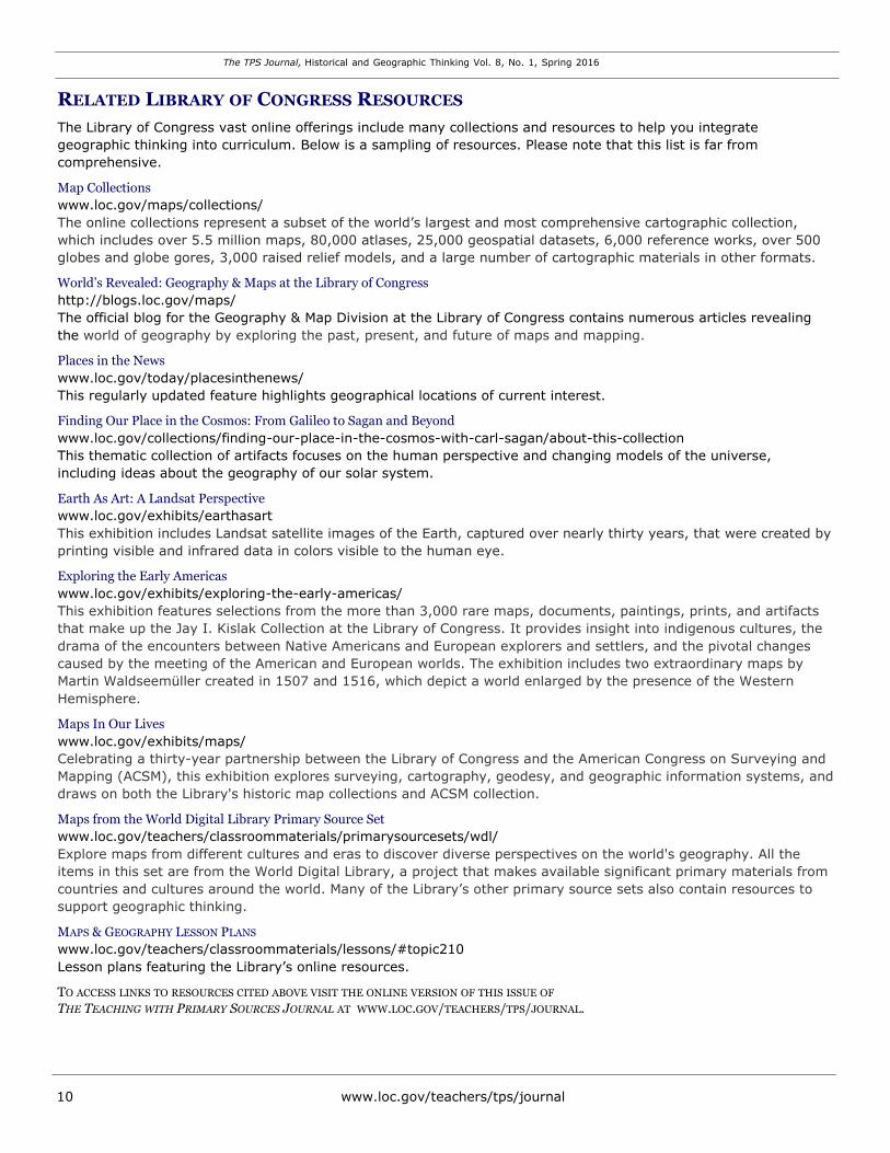
Learning Activity – Elementary Level
Comparing and Contrasting Maps
Students compare and contrast maps across
time to construct knowledge about the
geographic concepts of movement, human-
environment interaction, and place. Page 11
Learning Activity – Secondary Level
The Debate Over North Shore Road
Students study images, maps and text to
explore the environmental impacts of the
construction of this road through the Great
Smoky Mountain National Park. Page 12
Teacher Spotlight
Jennifer Kelly, an 8th grade teacher at Gunston Middle School in Arlington, Virginia,
talks about how she uses primary sources in
her World Geography class. Page 13

The TPS Journal, Historical and Geographic Thinking Vol. 8, No. 1, Spring 2016
2 www.loc.gov/teachers/tps/journal
INTEGRATING HISTORICAL AND GEOGRAPHIC THINKING
By Educational Outreach Staff, with contributions from Dr. Mark Newman and Dr. Peggy O-Neill-Jones
The light bulb went on; the energy in the room bounced off the ceiling. While reflecting
upon their learning after a two-day Teaching with Primary Sources workshop, one teacher
exclaimed, “I can bring geography back into history!” The workshop focused on examining
primary sources through two lenses: history and geography. Another teacher could just
have easily said, “I can bring history back into geography!” with equal enthusiasm.
Primary sources support the study of many disciplines, including both history and
geography. Connecting and layering these two disciplines can contribute new perspectives
and a multi-dimensional understanding of complex topics—no wonder teachers are excited!
Each discipline informs the other with its own specific set of thinking or reasoning routines.
When analyzing a primary source, students might apply historical thinking strategies of
sourcing, contextualizing, close reading, using background knowledge, reading the silences,
and corroborating (See Sam Wineburg, TPS Quarterly — Historical Thinking: Vol. 3, No. 1,
Winter 2010). Or, they might apply geographic thinking or reasoning to the same source,
considering location, place, human-environment interaction, region, and movement, and
looking for patterns and changes (National Geography Standard Index).
GEOGRAPHIC THINKING
Geographic thinking, also called “geographic reasoning” or “spatial thinking,” conceives of
the Earth as a physical system with interconnected sub-systems, including humans as
biological entities as well as members of collective societies (C3 Framework).
By considering the geographic concepts of location, place, human-environment interaction,
region, and movement, students develop an understanding that extends beyond identifying
our planet’s physical features and knowing how to find them on a map. In the new C3
Framework for Social Studies State Standards, the interconnectedness of these themes is
described in four categories:
Geographic Representations: Spatial Views of the World;
Human-Environment Interaction: Place, Regions, and Culture;
Human Population: Spatial Patterns and Movements; and
Global Interconnections: Changing Spatial Patterns.
Applying geographic thinking strategies can help students ponder questions such as: How is
this place unique? How do people influence their environment? Why do people move from
one place to another? Time is an important element in geographic thinking as well. Using
geographic thinking, students can consider how and why places have changed over the last
decades, centuries, or millennia.
LOCATION
Location refers to the physical situation of an identified place. This could be related to its
coordinates on a map or where it is located in relation to or within another location of note,
for example, a town, state, region, country, or continent.
The TPS Journal, Historical and Geographic Thinking Vol. 8, No. 1, Spring 2016
www.loc.gov/teachers/tps/journal 3
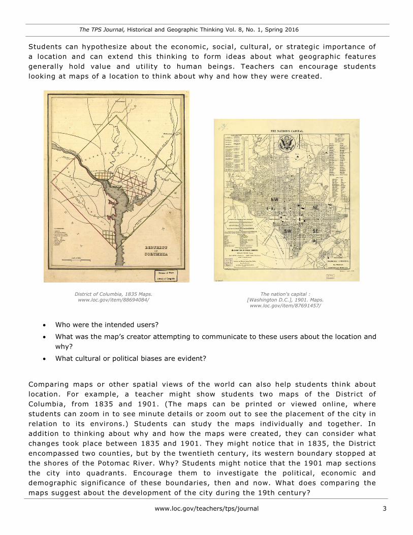
Students can hypothesize about the economic, social, cultural, or strategic importance of
a location and can extend this thinking to form ideas about what geographic features
generally hold value and utility to human beings. Teachers can encourage students
looking at maps of a location to think about why and how they were created.
District of Columbia, 1835 Maps.
www.loc.gov/item/88694084/
The nation's capital :
[Washington D.C.], 1901. Maps.
www.loc.gov/item/87691457/
Who were the intended users?
What was the map’s creator attempting to communicate to these users about the location and
why?
What cultural or political biases are evident?
Comparing maps or other spatial views of the world can also help students think about
location. For example, a teacher might show students two maps of the District of
Columbia, from 1835 and 1901. (The maps can be printed or viewed online, where
students can zoom in to see minute details or zoom out to see the placement of the city in
relation to its environs.) Students can study the maps individually and together. In
addition to thinking about why and how the maps were created, they can consider what
changes took place between 1835 and 1901. They might notice that in 1835, the District
encompassed two counties, but by the twentieth century, its western boundary stopped at
the shores of the Potomac River. Why? Students might notice that the 1901 map sections
the city into quadrants. Encourage them to investigate the political, economic and
demographic significance of these boundaries, then and now. What does comparing the
maps suggest about the development of the city during the 19th century?
The TPS Journal, Historical and Geographic Thinking Vol. 8, No. 1, Spring 2016
4 www.loc.gov/teachers/tps/journal
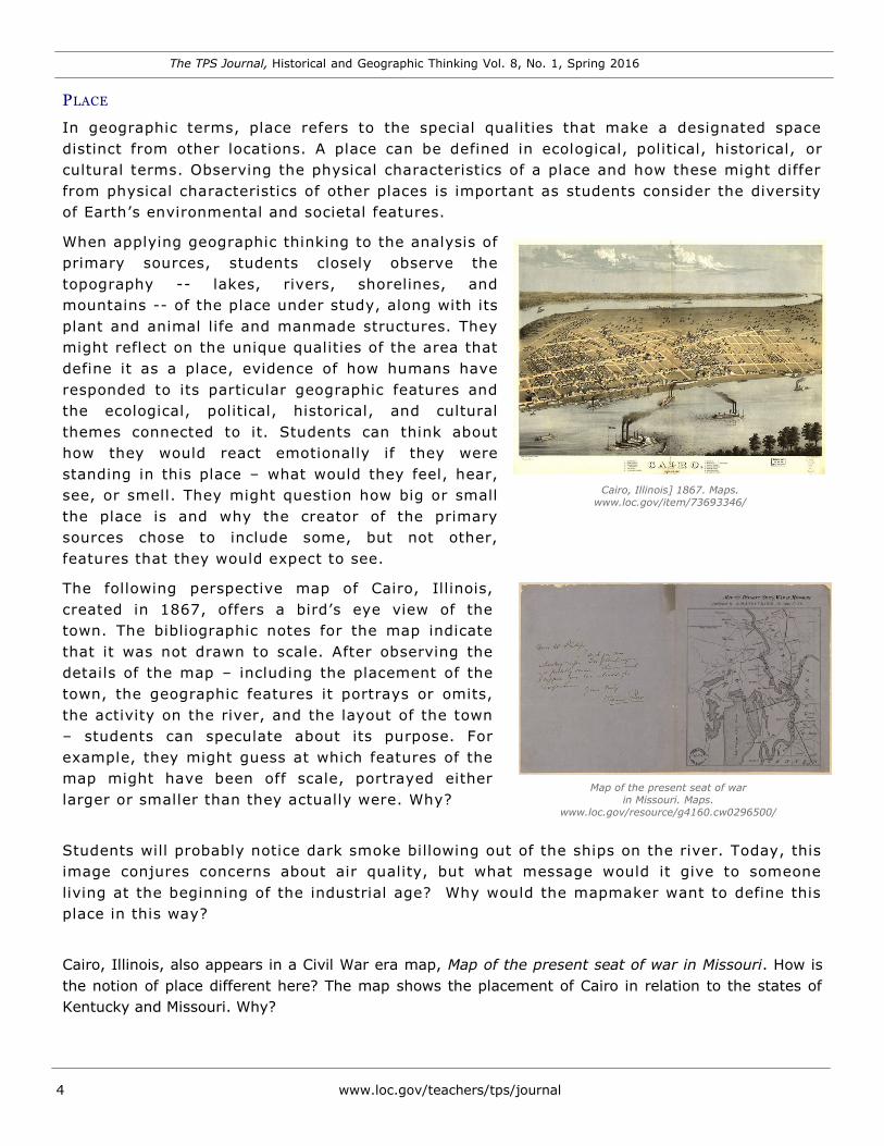
PLACE
In geographic terms, place refers to the special qualities that make a designated space
distinct from other locations. A place can be defined in ecological, political, historical, or
cultural terms. Observing the physical characteristics of a place and how these might differ
from physical characteristics of other places is important as students consider the diversity
of Earth’s environmental and societal features.
When applying geographic thinking to the analysis of
primary sources, students closely observe the
topography -- lakes, rivers, shorelines, and
mountains -- of the place under study, along with its
plant and animal life and manmade structures. They
might reflect on the unique qualities of the area that
define it as a place, evidence of how humans have
responded to its particular geographic features and
the ecological, political, historical, and cultural
themes connected to it. Students can think about
how they would react emotionally if they were
standing in this place – what would they feel, hear,
see, or smell. They might question how big or small Cairo, Illinois] 1867. Maps.
www.loc.gov/item/73693346/
the place is and why the creator of the primary
sources chose to include some, but not other,
features that they would expect to see.
The following perspective map of Cairo, Illinois,
created in 1867, offers a bird’s eye view of the
town. The bibliographic notes for the map indicate
that it was not drawn to scale. After observing the
details of the map – including the placement of the
town, the geographic features it portrays or omits,
the activity on the river, and the layout of the town
– students can speculate about its purpose. For
example, they might guess at which features of the
map might have been off scale, portrayed either Map of the present seat of war
in Missouri. Maps.
www.loc.gov/resource/g4160.cw0296500/ larger or smaller than they actually were. Why?
Students will probably notice dark smoke billowing out of the ships on the river. Today, this
image conjures concerns about air quality, but what message would it give to someone
living at the beginning of the industrial age? Why would the mapmaker want to define this
place in this way?
Cairo, Illinois, also appears in a Civil War era map, Map of the present seat of war in Missouri. How is
the notion of place different here? The map shows the placement of Cairo in relation to the states of
Kentucky and Missouri. Why?
The TPS Journal, Historical and Geographic Thinking Vol. 8, No. 1, Spring 2016
www.loc.gov/teachers/tps/journal 5
What else is included in the map?
What was the purpose of this map?
Who would have used it?
What geographic features made Cairo well suited to both military campaigns and commerce in the
1800s? Are those features still important in 21st century? How does this affect the economic and
social conditions of present-day Cairo?
H UMAN-E NVIRONMEN T I NTE RAC TION
Geographic thinking also focuses on how human beings shape and are shaped by their natural
environments. People’s actions can be both beneficial and detrimental to the natural world, triggering
local, regional and global consequences. Primary sources offer examples of a variety of actions, including
grand environmental change projects, implementation of land use policies and practices, and
conservation efforts. For example:
Documents and photographs about the Tennessee Valley Authority, before and after completion of
dams, offer an excellent example of a significant and large-scale project that had great economic
impact over a whole region. Students can speculate about and find evidence of negotiations between
government officials, professional groups, scientists, and citizens that influence large and small
human-environmental interactions.
Land use maps illustrate the interconnectedness between earth and human economic and social
activity, including farming, mining, manufacturing, and even slavery.
Primary sources related to conservation projects demonstrate how our feelings about the treatment
of our natural environment incorporate both practical considerations and transcendent emotions. For
example, students in younger grades can read the words of conservationist John Muir, who
considered sleeping outdoors to be one of life’s greatest pleasures, and write about their own
encounters with the natural world. Older students can review language from the 1918 bill
establishing the National Park Service to identify the values expressed within it.
These materials can shed light on mental models, through time, that are similar and very different from
those we have today.
MOVEMENT
Location, place, and region focus on defining space in various ways; movement examines how and why
places are connected to one another. This study of how and why people move examines not only where
people leave, but also where they travel to reach their final destinations. The study of population
movement offers students an opportunity to learn vocabulary such as migration, displacement, refugee,
immigrant, alien, and the social, political, cultural, economic, and health connotations of these concepts.
The reason for a population’s movement provides an interesting lens through which students can
analyze primary sources. Primary sources often portray causes of human suffering, such as scarcity,
expulsion, climatic conditions, and extreme competition for resources. Some primary sources were
The TPS Journal, Historical and Geographic Thinking Vol. 8, No. 1, Spring 2016
6 www.loc.gov/teachers/tps/journal
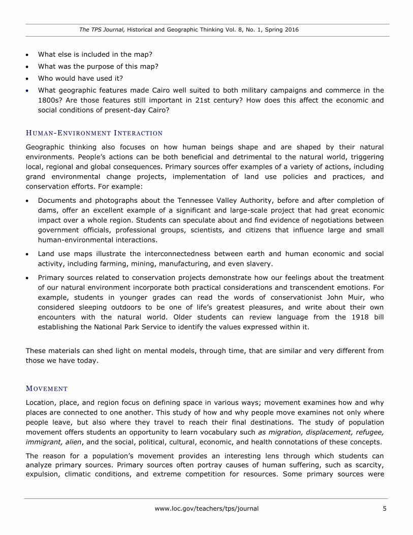
created by individuals who were compelled to move, like
those fleeing the Dust Bowl. Their emotional reactions to
movement often include both a sense of loss for the
cherished familiar and anticipation of new opportunities,
conveyed in diary entries, poetry, songs and artwork. For
example, students can study the photograph Oklahoma dust
bowl refugees. San Fernando, California, taken by Dorothea
Lange in 1934, and imagine the feelings of the occupants of
the car shown, stuffed with inhabitants and laden with
belongings.
In the recording of the song Why We Came to Californy,
students of all levels can hear composer and performer Flora
Robertson’s firsthand account of the conditions that pushed Oklahoma dust bowl refugees. San Fernando, California
her family toward California. Her song provides personal Photos, Prints, Drawings.
insight, promotes empathy, and provokes questions about www.loc.gov/item/fsa1998018535/PP/
why people move, and the relationship between humans and
the places in which they live. Students can reflect on what that means in the context of today and our
own treatment of and dependence on our natural environment.
Listening to Mrs. Robertson’s use of language also suggests her background and level of education,
which might lead to a discussion about the socio-economic aspects of groups that bear the greatest
hardship during population movement. Students will hear how the Robertson family adapted to
their changing environment and how the family’s circumstances affected the way they choose to adapt.
Providing students with a printed copy of the text may help them better understand the recording.
Official documents, like the directives that precipitated the Trail of Tears, can expose another reason for
movement and shed light on the consequences of population shifts; competition for, and ownership of,
natural resources; changing laws; and perceptions of human rights related to land.
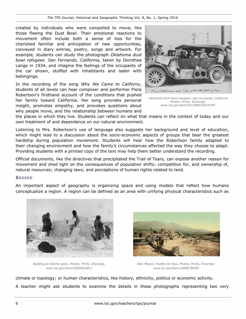
R EGION
An important aspect of geography is organizing space and using models that reflect how humans
conceptualize a region. A region can be defined as an area with unifying physical characteristics such as
Building an Eskimo igloo. Photos, Prints, Drawings.
www.loc.gov/item/2005691861/
New Mexico. Pueblo de Taos. Photos, Prints, Drawings.
www.loc.gov/item/2008678090/
climate or topology; or human characteristics, like history, ethnicity, politics or economic activity.
A teacher might ask students to examine the details in these photographs representing two very
The TPS Journal, Historical and Geographic Thinking Vol. 8, No. 1, Spring 2016
7 www.loc.gov/teachers/tps/journal
different regions within the United States – Alaska and the Southwest. Students’ observations,
reflections, and questions can launch investigations about how the geographic features of these regions
shaped economic, social, and political life over time.
COMBINING THE STUDY OF HISTORY AND GEOGRAPHY
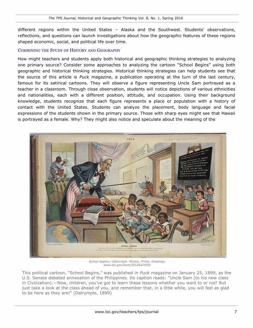
How might teachers and students apply both historical and geographic thinking strategies to analyzing
one primary source? Consider some approaches to analyzing the cartoon “School Begins” using both
geographic and historical thinking strategies. Historical thinking strategies can help students see that
the source of this article is Puck magazine, a publication operating at the turn of the last century,
famous for its satirical cartoons. They will observe a figure representing Uncle Sam portrayed as a
teacher in a classroom. Through close observation, students will notice depictions of various ethnicities
and nationalities, each with a different position, attitude, and occupation. Using their background
knowledge, students recognize that each figure represents a place or population with a history of
contact with the United States. Students can analyze the placement, body language and facial
expressions of the students shown in the primary source. Those with sharp eyes might see that Hawaii
is portrayed as a female. Why? They might also notice and speculate about the meaning of the
School begins / Dalrymple. Photos, Prints, Drawings.
www.loc.gov/item/2012647459/
This political cartoon, “School Begins,” was published in Puck magazine on January 25, 1899, as the
U.S. Senate debated annexation of the Philippines. Its caption reads: “Uncle Sam (to his new class
in Civilization).—Now, children, you’ve got to learn these lessons whether you want to or not! But
just take a look at the class ahead of you, and remember that, in a little while, you will feel as glad
to be here as they are!” (Dalrymple, 1899)

The TPS Journal, Historical and Geographic Thinking Vol. 8, No. 1, Spring 2016
8 www.loc.gov/teachers/tps/journal
placement and activities of the African American and native boys in the cartoon or question the identities
of the orderly students in the back of the room.
Because this primary source refers to American imperialism in the late 19th century, it also contains rich
fodder for applying geographic thinking routines. Students can map the locations of the places shown in
the cartoons, particularly in proximity to the United States. They might look at American interaction with
the regions shown over time, and consider what else might have been happening in the world, such as
wars, colonization, and technological advancements. Imperialism is often based on geographic features,
resources above and below the ground, and intentions for human-environmental projects, such as mines,
dams, fishing, and agricultural plantations. Students can research the characteristics of each place and
reflect on why the American government considered it to be of strategic or economic importance.
Movement is a central theme of American history. This primary source alludes to voluntary and
involuntary movement within, to, and from the continental United States. Students can use both
geographic and historical thinking strategies to identify references to human movement in the cartoon.
For example, people of various races and ethnicities appear. What does the primary source say about
how, when, and why each came to the United States? What turn-of-the-last-century attitudes about each
population does it portray? Students might also consider the movement of people, like soldiers,
administrators, engineers and agriculturalists, away from the U.S. to other regions that might have been
necessary to support imperialistic ambitions.
INTEGRATING GEOGRAPHIC THINKING
Twenty-first century geography is action-oriented and framed by attitudes, skills and knowledge.
Virtually every subject in the curriculum, from social studies to the physical sciences, connects at some
level to geographic thinking. Combining geographic thinking with primary sources can help students build
deeper, more nuanced content knowledge and hone key analysis and literacy skills.
Both loc.gov and the Teachers Page are rich with geography-related primary sources and classroom
materials. Students can use maps, photographs, surveys, blueprints, government documents, battle
plans, diaries, and myriad other primary source formats to enrich their investigations of the geographic
themes of location, place, human-environment interaction, region, and movement.
DR. MARK NEWMAN is Associate Professor of Social Studies Education and Coordinator of Secondary
Teacher Education. He also directs the TPS program delivered by the Federation of Independent Illinois
Colleges and Universities.
DR. PEGGY O’NEILL-JONES is Professor of Journalism and Technical Communication at Metropolitan State
University of Denver. She directs both the TPS program at MSU Denver and the TPS Western Region.
The TPS Journal, Historical and Geographic Thinking Vol. 8, No. 1, Spring 2016
www.loc.gov/teachers/tps/journal 9
RESEARCH AND CURRENT THINKING
For each issue, Teaching with Primary Sources consortium members submit summaries of and links to online
resources—articles, research reports, web sites, and white papers—that provide research and current thinking
relating to the theme.
Geography and History: Bridging the Divide
catdir.loc.gov/catdir/samples/cam041/2003046037.pdf
History is often interpreted as a series of time periods or eras, while geography looks at the past as places
defined by their features and events. Alan R. H. Baker argues that looking at history and geography
interdependently allows new patterns to emerge.
National Geography Standards & Skills (From Geography for Life, Second Edition)
education.nationalgeographic.org/national-geography-standards/
This online collection of articles and information from the National Geographic Society addresses approaches to
help K-12 students engage in geographic thinking, including discussions of geographic perspectives,
standards, and skills pertinent to K-12 education.
A Road Map for 21st Century Geography Education: Geography Education Research
www.j-reading.org/index.php/geography/article/viewFile/63/77
Using action research to evaluate geographic knowledge of students in the United States, Fengtao Guo
suggests strategies and techniques for improving geography education in the United States and engaging
students in the process.
Trove of Information From the 1930s, Animated by the Internet: Lab in Richmond Animates Comprehensive 1932 U.S. Atlas
www.nytimes.com/2013/12/26/arts/lab-in-richmond-animates-comprehensive-1932-us-atlas.html
More than 700 maps from Charles O. Paullin’s impressive Atlas of the Historical Geography have now been
digitized in an interactive format and made available online.
Common Core English Language Arts and Geography Connections
education.nationalgeographic.org/media/common-core-ela-geography-connections/
This guide provides a helpful alignment of Common Core ELA and National Geography Standards.
An Ethnic Geography of New Orleans
archive.oah.org/special-issues/katrina/Campanella.html
This article looks at the diversity of New Orleans from both historical and geographical perspectives and
discusses them within the context of Hurricane Katrina, yielding new perspectives and insights into this tragic
event.
The Lens of the Local: Teaching an Appreciation of the Past through the Exploration of Local Sites, Landmarks, and Hidden
Histories
www.societyforhistoryeducation.org/pdfs/M15_Bischof.pdf
The author advocates teaching history through a local lens – physically immersing students in the landscape to
make history more dynamic, concrete, and tangible.
The Civil War: Looking at the Battle of Gettysburg Through Robert E. Lee’s Eyes
www.smithsonianmag.com/history/looking-at-the-battle-of-gettysburg-through-robert-e-lees-eyes-136851113/?no-ist
This article profiles Anne Kelly Knowles, winner of a 2012 Smithsonian American Ingenuity Award, and her
work using GIS technology for historical geography. Knowles models how the technology works tracing an
example of Robert E. Lee.
The TPS Journal, Historical and Geographic Thinking Vol. 8, No. 1, Spring 2016
10 www.loc.gov/teachers/tps/journal
RELATED LIBRARY OF CONGRESS RESOURCES
The Library of Congress vast online offerings include many collections and resources to help you integrate
geographic thinking into curriculum. Below is a sampling of resources. Please note that this list is far from
comprehensive.
Map Collections
www.loc.gov/maps/collections/
The online collections represent a subset of the world’s largest and most comprehensive cartographic collection,
which includes over 5.5 million maps, 80,000 atlases, 25,000 geospatial datasets, 6,000 reference works, over 500
globes and globe gores, 3,000 raised relief models, and a large number of cartographic materials in other formats.
World’s Revealed: Geography & Maps at the Library of Congress
http://blogs.loc.gov/maps/
The official blog for the Geography & Map Division at the Library of Congress contains numerous articles revealing
the world of geography by exploring the past, present, and future of maps and mapping.
Places in the News
www.loc.gov/today/placesinthenews/
This regularly updated feature highlights geographical locations of current interest.
Finding Our Place in the Cosmos: From Galileo to Sagan and Beyond
www.loc.gov/collections/finding-our-place-in-the-cosmos-with-carl-sagan/about-this-collection
This thematic collection of artifacts focuses on the human perspective and changing models of the universe,
including ideas about the geography of our solar system.
Earth As Art: A Landsat Perspective
www.loc.gov/exhibits/earthasart
This exhibition includes Landsat satellite images of the Earth, captured over nearly thirty years, that were created by
printing visible and infrared data in colors visible to the human eye.
Exploring the Early Americas
www.loc.gov/exhibits/exploring-the-early-americas/
This exhibition features selections from the more than 3,000 rare maps, documents, paintings, prints, and artifacts
that make up the Jay I. Kislak Collection at the Library of Congress. It provides insight into indigenous cultures, the
drama of the encounters between Native Americans and European explorers and settlers, and the pivotal changes
caused by the meeting of the American and European worlds. The exhibition includes two extraordinary maps by
Martin Waldseemüller created in 1507 and 1516, which depict a world enlarged by the presence of the Western
Hemisphere.
Maps In Our Lives
www.loc.gov/exhibits/maps/
Celebrating a thirty-year partnership between the Library of Congress and the American Congress on Surveying and
Mapping (ACSM), this exhibition explores surveying, cartography, geodesy, and geographic information systems, and
draws on both the Library's historic map collections and ACSM collection.
Maps from the World Digital Library Primary Source Set
www.loc.gov/teachers/classroommaterials/primarysourcesets/wdl/
Explore maps from different cultures and eras to discover diverse perspectives on the world's geography. All the
items in this set are from the World Digital Library, a project that makes available significant primary materials from
countries and cultures around the world. Many of the Library’s other primary source sets also contain resources to
support geographic thinking.
MAPS & GEOGRAPHY LESSON PLANS
www.loc.gov/teachers/classroommaterials/lessons/#topic210
Lesson plans featuring the Library’s online resources.
TO ACCESS LINKS TO RESOURCES CITED ABOVE VISIT THE ONLINE VERSION OF THIS ISSUE OF
THE TEACHING WITH PRIMARY SOURCES JOURNAL AT WWW.LOC.GOV/TEACHERS/TPS/JOURNAL.
The TPS Journal, Historical and Geographic Thinking Vol. 8, No. 1, Spring 2016
www.loc.gov/teachers/tps/journal 11
LEARNING ACTIVITY - ELEMENTARY LEVEL
COMPARING AND CONTRASTING MAPS
OVERVIEW
Students will compare and contrast maps across time to construct knowledge about the geographic
concepts of movement, human-environment interaction, and place. This activity uses maps of Albany,
New York; however, maps of other locations could be used.
OBJECTIVES
After completing this learning activity, students will be able to:
Identify similarities and differences between two historic maps.
Articulate their thoughts about the concepts of movement, human interaction, and place.
TIME REQUIRED
One—two 50 minute class periods
GRADE LEVEL
3-5
TOPIC/S Geography, Maps
SUBJECT Albany, New York 1879. Maps.
www.loc.gov/item/75694743/ Social Studies, Geography
STANDARDS Common Core State Standards http://www.corestandards.org/
CCSS.ELA-Literacy.RI.3.9 Compare and contrast the most important points and key details presented in
two texts on the same topic.
C3. Geography Standards
Human-Environment Interaction: Place, Regions, and Culture
D2.Geo.5.3-5. Explain how the cultural and environmental characteristics of places change over time.
D2.Geo.6.3-5. Describe how environmental and cultural characteristics influence population distribution in
specific places or regions.
Human Population: Spatial Patterns and Movements
D2.Geo.7.3-5. Explain how cultural and environmental characteristics affect the distribution and move-
ment of people, goods, and ideas.
D2.Geo.8.3-5. Explain how human settlements and movements relate to the locations and use of various
natural resources.
CREDITS Norman B. Leventhal Map Center at the Boston Public Library
VIEW AND DOWNLOAD THE COMPLETE LEARNING ACTIVITY: www.loc.gov/teachers/tps/journal/integrating-historic-and-geographic-thinking/pdf/
ElementaryLevelLearningActivity.pdf
The TPS Journal, Historical and Geographic Thinking Vol. 8, No. 1, Spring 2016
12 www.loc.gov/teachers/tps/journal
LEARNING ACTIVITY - SECONDARY LEVEL
THE DEBATE OVER NORTH SHORE ROAD
OVERVIEW
This lesson activity explores the debate over the construction of North Shore Road through the Great
Smoky Mountain National Park. Students will study primary source images, maps and the Historic
American Building Survey data pages to determine environmental impact of the North Shore Road project.
OBJECTIVES
After completing this learning activity, students will be able to:
Investigate the impact of human activities on the environment by analyzing primary sources, includ-
ing photographs, written text, and maps.
Form a position on an environmental issue and articulate a defense of this position.
TIME REQUIRED
Two or three class periods
GRADE LEVEL
9 - 12
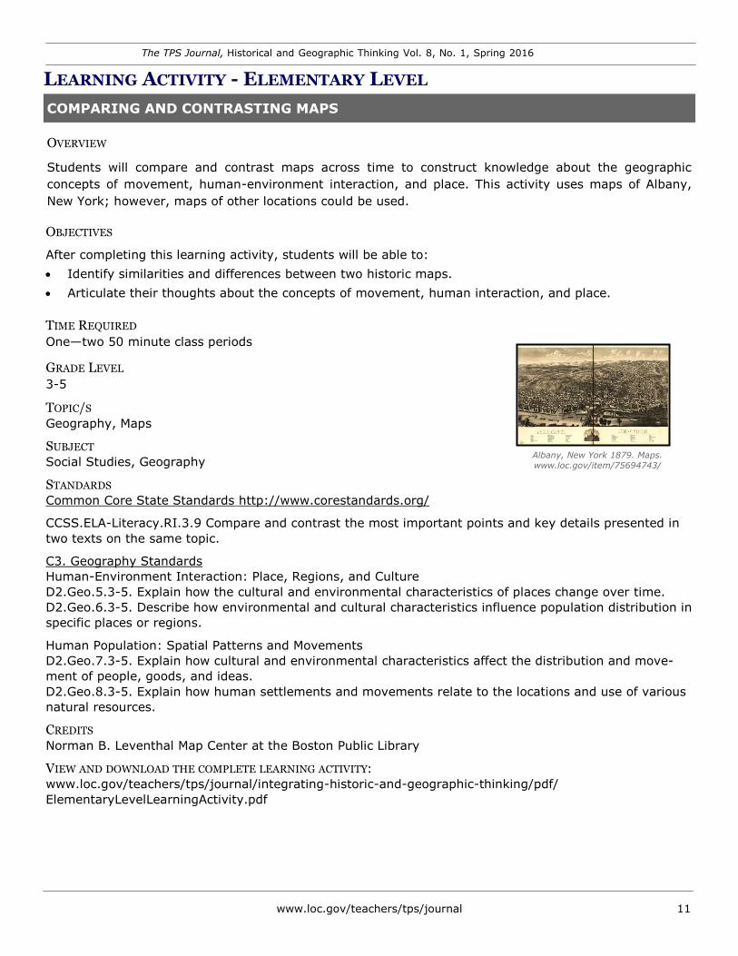
TOPIC/S
Environment, Conservation, Maps Opposition sign posted on private property at the
entrance to the road looking NW. - Great Smoky SUBJECT Mountains National Park Roads & Bridges,
Geography Northshore Road, 1 mile spur at Fontana Dam & Bryson City to Noland Creek, Gatlinburg, Sevier
S County, TN. TANDARDSPrints & Photographs Online Catalog.
C3 Standards: Geography—Geographic Representations: Spatial www.loc.gov/item/tn0286/
Views of the World
D2.Geo.2.9-12. Use maps, satellite images, photographs, and other representations to explain relationships
between the locations of places and regions and their political, cultural, and economic dynamics.
C3 Standards: Geography—Human-Environment Interaction: Place, Regions, and Culture
D2.Geo.4.9-12. Analyze relationships and interactions within and between human and physical systems to
explain reciprocal influences that occur among them
D2.Geo.5.9-12. Evaluate how political and economic decisions throughout time have influenced cultural and
environmental characteristics of various places and regions.
D2.Geo.6.9-12. Evaluate the impact of human settlement activities on the environmental and cultural
characteristics of specific places and regions
C3 Standards: Civics—Processes, Rules, and Laws
D2.Civ.11.9-12. Evaluate multiple procedures for making governmental decisions at the local, state, national,
and international levels in terms of the civic purposes achieved.
D2.Civ.12.9-12. Analyze how people use and challenge local, state, national, and international laws to address
a variety of public issues.
D2.Civ.13.9-12. Evaluate public policies in terms of intended and unintended outcomes, and related conse-
quences.
D2.Civ.14.9-12. Analyze historical, contemporary, and emerging means of changing societies, promoting the
common good, and protecting rights.
CREDITS
Teaching with Primary Sources at Middle Tennessee State University
VIEW AND DOWNLOAD THE COMPLETE LEARNING ACTIVITY:
www.loc.gov/teachers/tps/journal/integrating-historic-and-geographic-thinking/pdf/SecondaryLevelLearningActivity.pdf

The TPS Journal, Historical and Geographic Thinking Vol. 8, No. 1, Spring 2016
www.loc.gov/teachers/tps/journal 13
TEACHER SPOTLIGHT
Jennifer Kelly
In each issue, we introduce a teacher who has
participated in Teaching with Primary Sources (TPS)
professional development and successfully uses primary
sources from the Library of Congress to support effective
instructional practices.
This issue’s Teacher Spotlight features Jennifer Kelly, an
eighth-grade geography teacher at Gunston Middle
School in Arlington, Virginia. This is Jennifer’s eleventh
year teaching, her eighth as a World Geography teacher.
The TPS program in Northern Virginia nominated
Jennifer for her effective use of primary sources in her
lesson design and classroom instruction. In this
interview, conducted the day after Jennifer submitted
her NBCT (National Board Certified Teacher) portfolio,
she discusses teaching strategies and some of her
favorite Library of Congress online resources. Following
are excerpts from that interview. The complete text of
Jennifer’s responses is available at www.loc.gov/
teachers/tps/journal.
How did you become involved with the TPS
Program?
I first gained an appreciation of the Library of Congress
in 1995 when I was doing research as an intern at the
OAS (Organization of American States) in Washington. I
still have my original reader’s card.
In 2005, I was teaching American History when I
became involved with An Adventure of the American
Mind (AAM), a program sponsored by the Library. I
found the early American history resources particularly
strong, so it was the beginning of learning what the
Library of Congress offered for teachers, even back then.
How do you use primary sources to support
teaching and learning about geography?
Using primary sources allows students to make
connections with the people who live in the places we
explore. When I studied geography in school, it was
largely memorization and maps. Much later, I realized
that the study of geography can take us in other
directions. We use lots of maps because I love maps, but
it’s important for students to realize that geography is
not just the study of places, but also of people and the
way we are all connected to places. For the topic of
Apartheid in South Africa, for example, I will certainly
use maps, but I will also use speeches, manuscripts,
photographs, and other primary sources so that my
students can develop more dimensions and layers of
understanding.
Recently, I created a lesson focused on Latin America’s
physical geography. I gathered Library of Congress
primary sources reflecting various locales and assigned
the class the task of planning a trip. Students were
placed in groups of four with each having a unique role:
travel agent, cartographer, tour guide, and travel writer.
First, the students worked together to identify the places
and locate them. They mapped the trip, predicting
obstacles and potential problems, and then presented
their plan to the class. The students really liked this
activity; it forced them to think critically about
geographical features: where, why and how they would
travel to a particular place.
What are some of your favorite teacher resources
from the Library’s website?
Maps, maps, and more maps! I have a closet full and
use the cartographic materials available online in so
many formats. The Teacher Page (www.loc.gov/
teachers) is particularly valuable and has lesson plans,
primary source sets, and professional development. The
World Digital Library (www.wdl.org) is another great
resource for teaching geography and I’d like to explore
more of the audiovisual collections as well.
What advice do you have for teachers who never/
seldom use primary sources in their classrooms
It’s hard to imagine who might not see the benefit of
using primary sources in the classroom. They’re a
natural fit for Social Studies, of course, but using
primary sources should be an essential tool for teachers
of other subjects as well. Carefully chosen primary
sources can enrich a topic and lend authenticity, which
students find intriguing. Ideally, they want to know more
and are willing to do the research to find out.
With everything that teachers have to do, it might
sometimes seem daunting to search and find primary
sources, but the Library of Congress and other
institutions have become much more user-friendly,
making it easy to collect powerful images that are in the
public domain. Once you start gathering primary sources
to use in your classrooms, it becomes almost addictive –
I find myself constantly looking for new material.
It’s very easy to do the same thing over and over, but I
read somewhere that good teachers change at least
25% of the curriculum every year, and that makes sense
to me. One of the best ways I know to do this is
gathering new primary sources, particularly when
textbook adoption cycles can take many years.
To keep current in my instruction and to keep material
fresh, I make it a point to find new resources,
particularly primary sources. I love to travel and often
use my own photos to get my students excited about
what we’re studying whether it’s the Great Wall of China
or Macchu Pichu. I don’t just teach geography; I live it
and love it!