Embed Size (px)
Citation preview

The U.S. Climate Resilience Toolkit and the 5-Step Planning Process
David [email protected]
NOAA NWS WorkshopMay 11, 2016
toolkit.climate.gov

results of pre-webinar survey

results of pre-webinar survey

results of pre-webinar survey
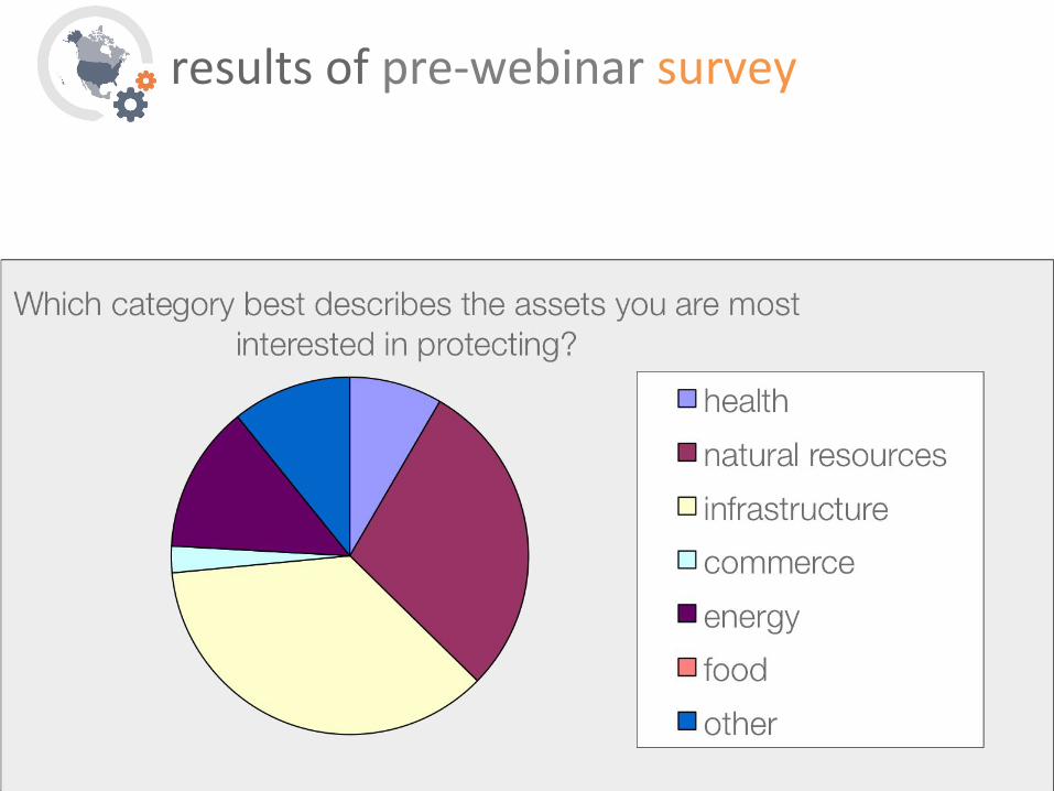
results of pre-webinar survey

6
results of pre-webinar survey

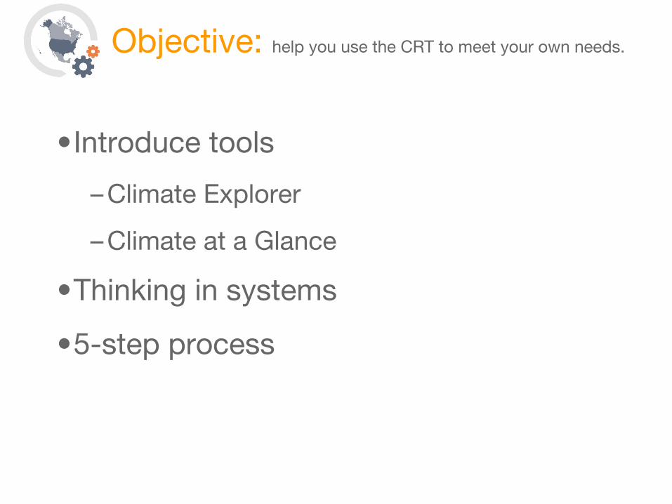
Objective: Help you use the CRT to meet your own needs
•Introduce tools
– Climate Explorer
– Climate at a Glance
•Thinking in systems
•5-step process (Steps to Resilience)

Resilience is the capacity of a system (community, business, or natural environment) to withstand or recover from a disruption.

9
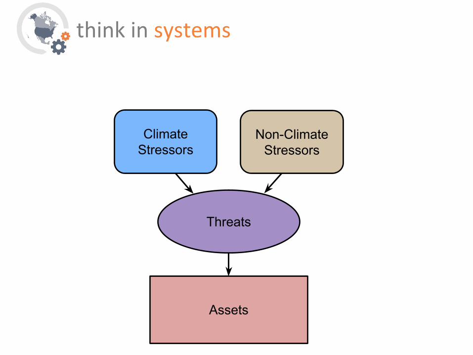
threats

assets

Threats
Assets
asset-threat pairs

exploring asset-threat pairs geospatially

understanding past threats

14

15Dec 29, 2015St. Louis Post Dispatch
16
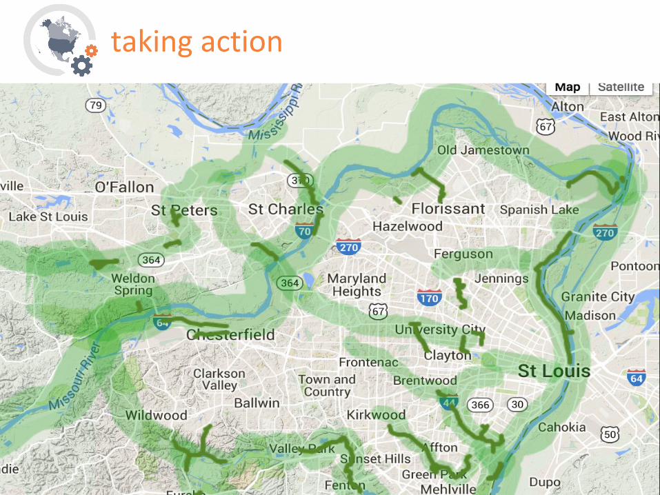
taking action

17

Infrastructure in Floodplain
Asset >
think in systems

Flooding
Infrastructure in Floodplain
Threat >
think in systems

Flooding
Infrastructure in Floodplain
Impervious Surfaces
Heavy Precipitation
Earlier Spring
Snowmelt
^ Climate stressors ^ ^ Non-climate stressor
think in systems

Flooding
Infrastructure in Floodplain
Impervious Surfaces
Heavy Precipitation
Spring Snowmelt
Climate Change
Population Growth
^ Future changes ^
think in systems
Flooding
Infrastructure in Floodplain
Impervious Surfaces
Heavy Precipitation
Spring Snowmelt
Climate Change
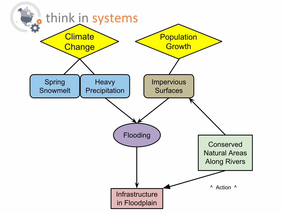
Population Growth
Conserved Natural Areas Along Rivers
^ Action ^
think in systems
Flooding
Infrastructure in Floodplain
Impervious Surfaces
Heavy Precipitation
Spring Snowmelt
Climate Change
Population Growth
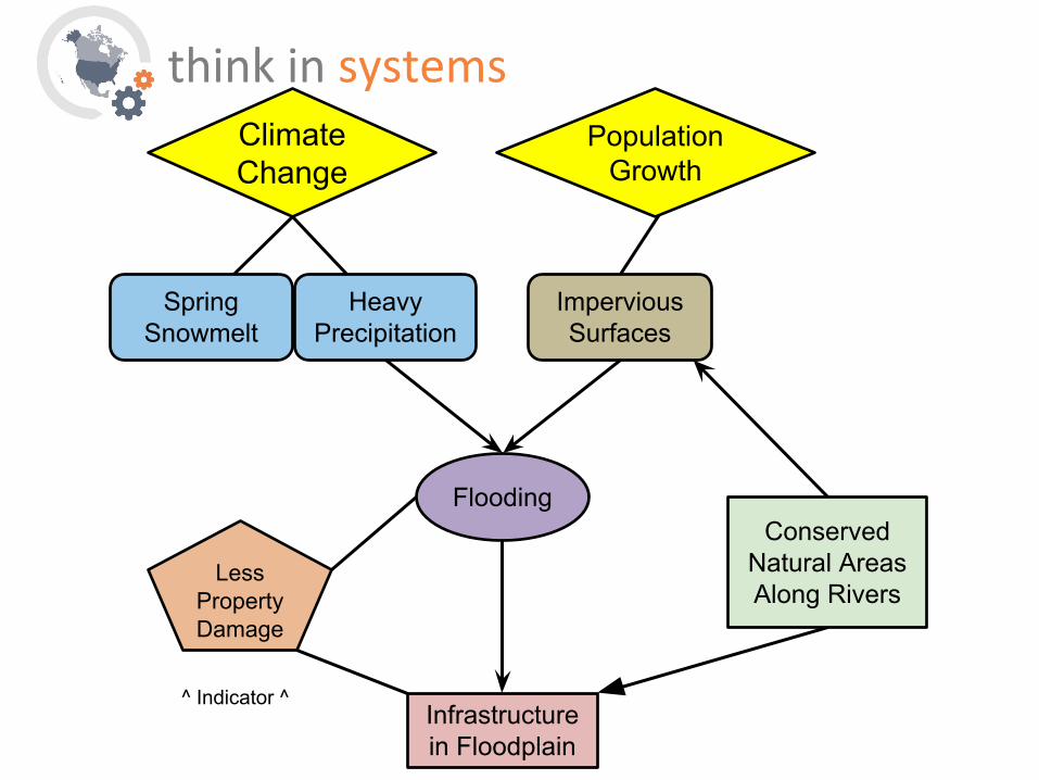
LessProperty Damage
^ Indicator ^
think in systems
Conserved Natural Areas Along Rivers

Flooding
Impervious Surfaces
Heavy Precipitation
Spring Snowmelt
Climate Change
Population Growth
LessProperty Damage
^ Co-benefits ^
think in systems
Infrastructure in Floodplain
Economic Growth
Alt. Transport
Routes
Increase Property Values
Conserved Natural Areas Along Rivers

25

1. Go to the site’s Taking Action (case studies) section
2. Using the filters at the top of the page, select a climate threat/stressor that most interests/concerns you.
3. Select the U.S. region of interest
4. From the remaining result set, select a case study of interest
5. Bookmark the page and, when you have a moment, come back to familiarize yourself with the following…
a) The threat-asset pair
b) The relevant tools used in this case study
c) What solution(s) were implemented?
take a minute


think in systems
Threats
Assets
Non-Climate Stressors
Climate Stressors

Threats
Assets
Climate Stressors
Future Change
Non-Climate Stressors
think in systems

Threats
Assets
Climate Stressors
Indicator &/or
ThresholdAction
Future Change
Non-Climate Stressors
think in systems
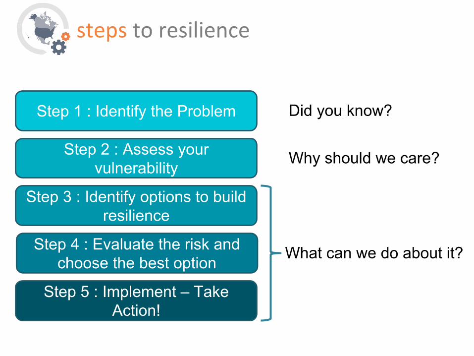
Step 1 : Identify the Problem
Step 2 : Assess your vulnerability
Step 3 : Identify options to build resilience
Step 4 : Evaluate the risk and choose the best option
Step 5 : Implement – Take Action!
Did you know?
Why should we care?
steps to resilience
What can we do about it?

Did you know?
Why should we care?
model helps define steps to resilience
Threats
Assets
Climate Stressors
Future Change
Non-Climate Stressors

What can we do about it?
Indicator &/or
Threshold
Action
model helps define steps to resilience

Step 1: Explore Threats & Hazards Did you know…?
Decision Point: Are things we care about
threatened by climate-related threats and hazards?
List assets of Concern
Identify threats to key assets
Assemble stakeholders
Define goals & objectives
steps to resilience
Alternatively: Are there climate-related
opportunities that we might take advantage of?

National Climate Assessment
Source: Adapted from NCA3

National Climate Assessment
Source: Adapted from NCA3
Heat Waves Extreme Precipitation Coastal Flooding

38

39
4
40

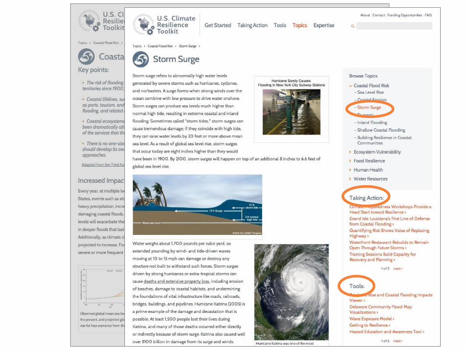
1. Go to the site’s Topics section
2. Select a Topic and sub-topic of interest
3. Note the right-hand navigation items. Identify:a) one case study that interests you
b) one tool that might be helpful to you
take a minute

Step 2: Assess Risks Why should we care?
Decision Point: What is our risk of a significant
loss? Can we tolerate that risk?
Identify critical thresholds
Characterize risk of climate impacts
Determine assets’ exposure
Check sensitivities, adaptive capacities
& vulnerabilities
steps to resilience

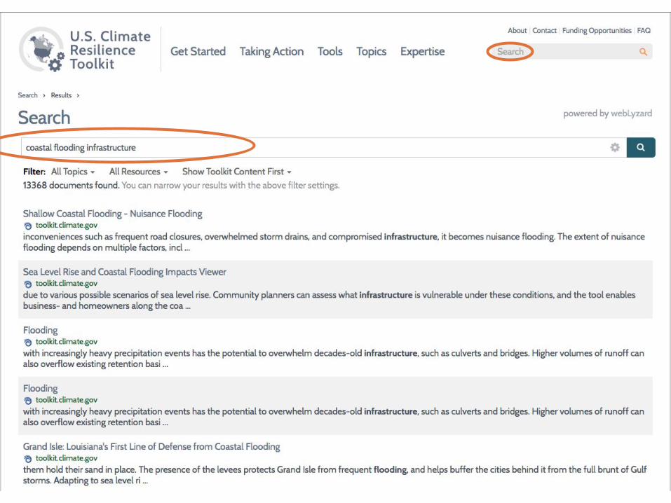
Our main ‘Tools’ page presents more than 220 science-based decision-
support tools.
Users can quickly filter by parent topic of
interest or by functional category, or both.


take a minute
Have climate conditions affected you where you live?
Here is a method to find a tool that helps you visualize at a glance how climate conditions are changing in your city/county/state:
1. Go to the CRT’s Tools section and, using the filter functions (top right), select the following:Category » View Past/Current ConditionsCategory » Analyze/Download Data
1. How many tools are left? Which one(s) best match your search criteria?
2. Select “Climate At A Glance.” Click to visit that website and explore its functionality.

air conditioning in S. Florida

Step 3: Investigate Options What can we do about it?
Decision Point: What actions have the potential to
decrease our risk?
Analyze hazards
Evaluate options’ feasibility, costs, and
benefits
Brainstorm options
Consider best practices
steps to resilience

Threats and Hazards
Assets
Climate Stressors
Indicator &/or
ThresholdAction
Future Change
Non-Climate Stressors
think in systems


We offer a small but growing catalog of
Training Courses to build climate knowledge as
well as skill and capacity to use science-based
tools for decision-making.
Users can easily filter by different categories, type of training, and
level of difficulty.

take a minute
Where can you go to get help with resilience building?
Many organizations are seeking help in analyzing risks and opportunities associated with climate. Here is a way to find expertise related to your concerns or region.
1. Go to the Expertise section. 2. Use the filters to find training opportunities that meet these
criteria:Type: Online, Self-guidedCategory: Climate Adaptation & Mitigation
1. Find a relevant training opportunity.2. Use the Find Experts map to find a land management consultant.3. Which Department of the Interior Climate Science Center is
closest to your study area?
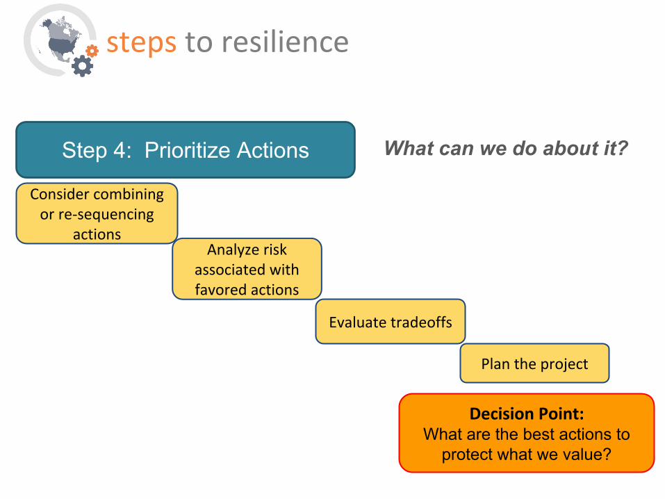
Step 4: Prioritize Actions What can we do about it?
Decision Point: What are the best actions to
protect what we value?
Evaluate tradeoffs
Plan the project
Consider combining or re-sequencing
actions Analyze risk
associated with favored actions
steps to resilience

Asset Threat Indicator Stressors Projected Change
Degree of Sensitivity / Impact
Adaptive Capacity
Critical Threshold?
Vulnerability
Municipal Water Supply
Drought Inability to meet Demand
Extended periods
increasing varied low no medium
Municipal Water Infrastructure
Extreme Cold Snaps
Frozen Water Lines, loss of drinking water
Variability continuing widespread low yes medium
Lake Superior Shoreline
Coastal Erosion
Road Closure Lake Level fluctuation
continuing widespread high
Lake Superior Recreation
Coastal Erosion
Beach Loss
Sands Plain Aquifer
Declining Levels
Dry wells, inland lake level decline
Climate – drought, non-climate, users
increasing high low yes high
Forested Ecosystems
Drought Loss of species
Increased temp, invasive species
low
Forested Ecosystems
Urbaniz-ation
Loss of forest cover
Disease increasing moderate low low
Asset/Threat Pairs identified in Marquette, Michigan

Quantifying Risk depends upon both Probability and Consequence
High
High
Low
Low
Magnitude of Consequence
Prob
abili
ty o
f Th
reat Very High Risk
High Risk
Medium Risk
Low Risk
Medium
Medium
Municipal Water Supply
Municipal Water
Infrastructure
Lake Superior Shoreline

Our Funding Opportunities page presents a curated list
of about two dozen grants offered by federal agencies &
NGOs for municipalities & businesses seeking funds to
help them recover from a disaster, or to build resilience
to climate hazards.

Step 5: Take Action What can we do about it?
Decision Point: Is the solution we chose effective?
What else could we do?
Iterate as needed
Share your story & lessons learned
Implement plan
Monitor progress
steps to resilience

results of ACCO survey

results of ACCO survey

coming soon in Climate Explorer 2
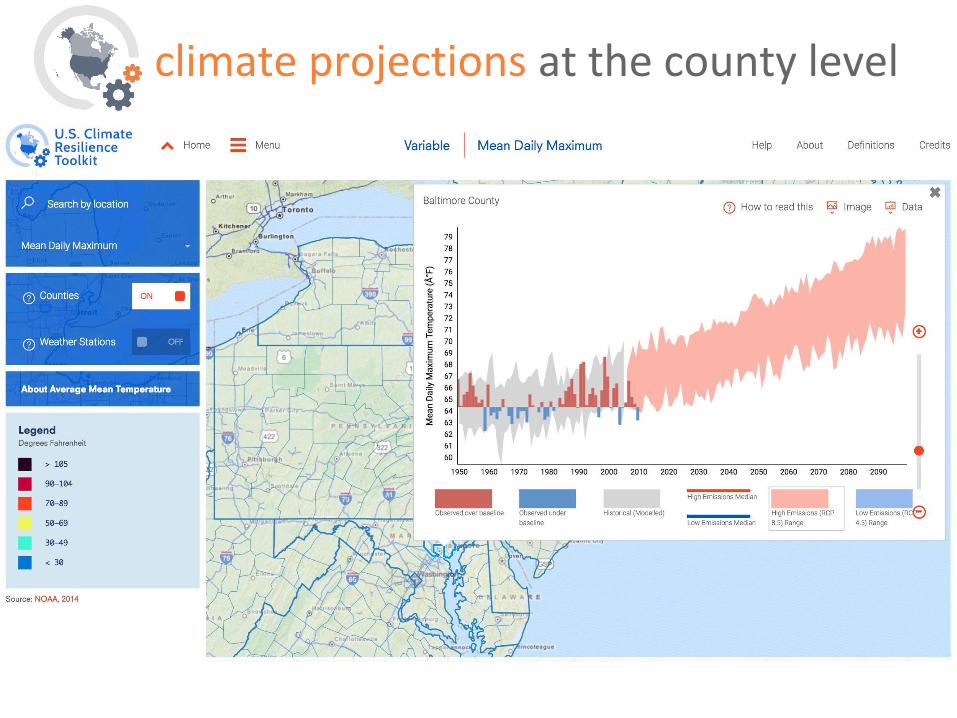
climate projections at the county level
Objective: help you use the CRT to meet your own needs.
•Introduce tools
– Climate Explorer
– Climate at a Glance
•Thinking in systems
•5-step process

May 11, 2016
NOAA Satellite and Information Service | National Centers for Environmental Information
Mike Brewer (and Steve DelGreco and Steve Ansari)NOAA’s National Centers for Environmental Information
Center for Weather and Climate
The NOAA Weather and Climate Toolkit

65NATIONAL CENTERS FOR ENVIRONMENTAL INFORMATION
Overview
•Free, public domain source code
•Desktop and command-line application
•Simple visualization and data export
•Platform independent (Java-based)
•Leverages community tools and standards (NetCDF for Java, Common Data Model, etc…)
66NATIONAL CENTERS FOR ENVIRONMENTAL INFORMATION
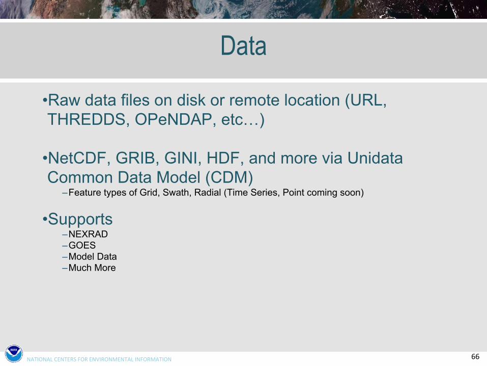
Data
•Raw data files on disk or remote location (URL, THREDDS, OPeNDAP, etc…)
•NetCDF, GRIB, GINI, HDF, and more via Unidata Common Data Model (CDM)
–Feature types of Grid, Swath, Radial (Time Series, Point coming soon)
•Supports–NEXRAD–GOES–Model Data–Much More

67NATIONAL CENTERS FOR ENVIRONMENTAL INFORMATION
Visualization
•Simple 2-D maps
•Basic Overlays included (states, counties, etc…)
•Background images from any OGC WMS–Shaded relief–Topo maps–Landsat
•Save images and animations –Animated GIF–AVI–KMZ (Google Earth)

68NATIONAL CENTERS FOR ENVIRONMENTAL INFORMATION
Visualization
Smoothed NEXRAD Reflectivity Data

69NATIONAL CENTERS FOR ENVIRONMENTAL INFORMATION
Visualization
•Math tools (max, min, average, abs max, sum)–Under “More” on “Data Selector” or “Grid Properties”

70NATIONAL CENTERS FOR ENVIRONMENTAL INFORMATION
New Display Capability – Multi Radar multi Sensed (MRMS) Operational Products

71NATIONAL CENTERS FOR ENVIRONMENTAL INFORMATION
MRMS Overlay
Spatial Distribution of 72-hour rainfall totals > 1 inch from NOAA MRMS with the US Drought Monitor

72NATIONAL CENTERS FOR ENVIRONMENTAL INFORMATION
Works With Big Data

73NATIONAL CENTERS FOR ENVIRONMENTAL INFORMATION
Works With Big Data

74NATIONAL CENTERS FOR ENVIRONMENTAL INFORMATION
Data export
•Bridge between raw weather and climate data and multiple scientific user communities
•Export data to–Shapefile–Well-known text–ArcInfo ASCII GRID–Gridded and Raw NetCDF, GeoTIFF–KMZ (Google Earth)

75NATIONAL CENTERS FOR ENVIRONMENTAL INFORMATION
Applications•GOES satellite imagery from hurricane Rita landfall exported as ASCII GRID, in ArcGIS
76NATIONAL CENTERS FOR ENVIRONMENTAL INFORMATION
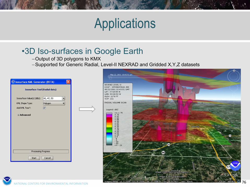
Applications
•3D Iso-surfaces in Google Earth–Output of 3D polygons to KMX–Supported for Generic Radial, Level-II NEXRAD and Gridded X,Y,Z datasets

77NATIONAL CENTERS FOR ENVIRONMENTAL INFORMATION
Applications
•Command-line batch processing of data export

78NATIONAL CENTERS FOR ENVIRONMENTAL INFORMATION
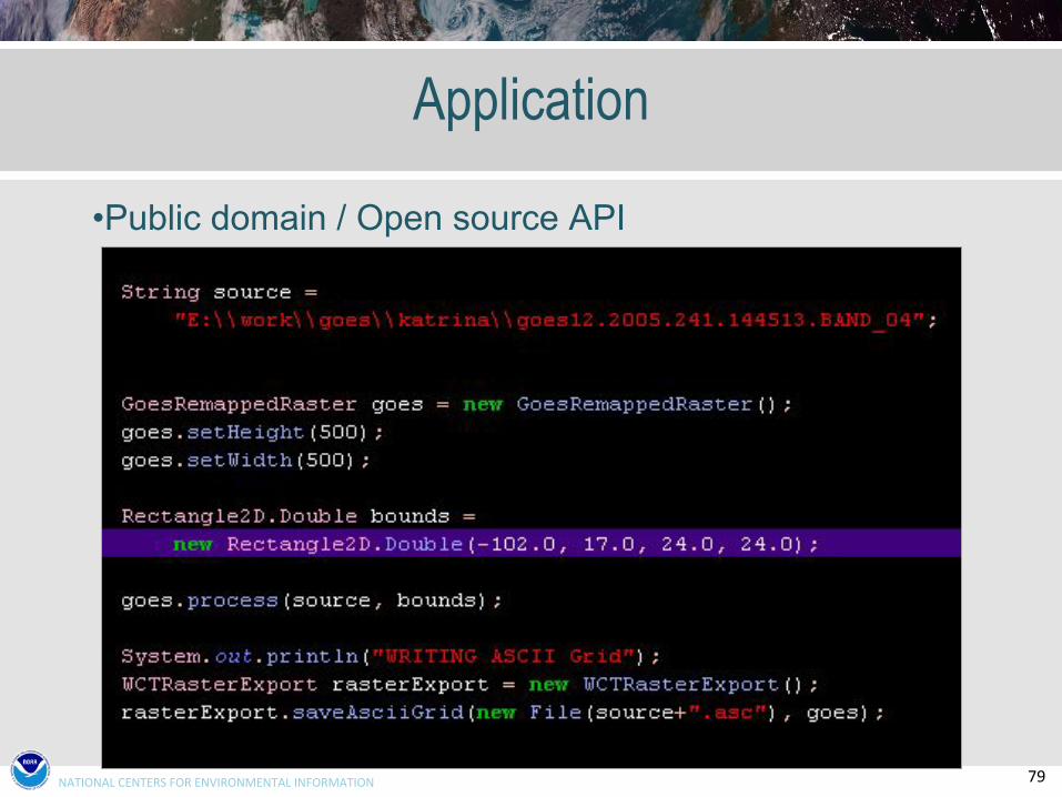
Application
•Public domain / Open source API
79NATIONAL CENTERS FOR ENVIRONMENTAL INFORMATION
Application
•Public domain / Open source API
80NATIONAL CENTERS FOR ENVIRONMENTAL INFORMATION
Other New Features (Version 4.1+)
•GeoJSON output format for point/line/polygon data structures
•Animations of Level III storm attribute products include selected background products
•Snapshot layers can now be exported to a Raster format•Support NEXRAD Level III melting layer and free text message products
•Removal of embedded Google Earth plug-in (no longer supported by Google)
•Command-line export of KMX format (V3.7+)

81NATIONAL CENTERS FOR ENVIRONMENTAL INFORMATION
NCEI Climate Facebook: http://www.facebook.com/NOAANCEIclimateNCEI Ocean & Geophysics Facebook: http://www.facebook.com/NOAANCEIoceangeoNCEI Climate Twitter (@NOAANCEIclimate): http://www.twitter.com/NOAANCEIclimateNCEI Ocean & Geophysics Twitter (@NOAANCEIocngeo): http://www.twitter.com/NOAANCEIocngeo
www.ncei.noaa.gov
NOAA’sNational Centers for Environmental [email protected]@[email protected]