Embed Size (px)
Citation preview

Traffic Calming Program Revision Materials
Enclosure Table of Contents
No. Item Page No.
1 SFMTA Traffic Calming Program Revision Final Report 1
2 Backlog of Traffic Calming Implementation Projects 47
3Citywide Map of Traffic Calming Area-wide and Site Specific Projects
61
M:\PnP\2013\Memos\06 June\Prop K Annual Call Enclosure\Enclosure 2 Traffic Calming\TOC Traffic Calming Revision Materials
Item 8 Enclosure (2 of 2) Plans and Programs Committee June 18, 2013

This Page Intentionally Left Blank

Edwin M. Lee Mayor
Tom Nolan Chairman
Cheryl Brinkman Vice-Chairman
Leona Bridges Director
Malcolm Heinicke Director
Jerry Lee Director
Joél Ramos Director
Cristina Rubke Director
Edward D. Reiskin Director of Transportation
One South Van Ness Ave. Seventh Floor San Francisco, CA 94103
Tele: 415.701.4500
www.sfmta.com
SFMTA Traffic Calming Program Revision
CONTENTS
Introduction ................................................................................................... 2
Background ................................................................................................... 4
Guiding Objectives ........................................................................................ 5
Best Practices For Application Based Programs .......................................... 9
Evaluation of SFMTA’s Application-Based Program ................................... 22
Applications and Acceptance Rates ........................................................ 22
Ranking Criteria ....................................................................................... 24
Traffic Calming Process Timeline ............................................................ 27
Device Types .......................................................................................... 30
Balloting .................................................................................................. 30
Implementation ........................................................................................ 32
Resident Survey ...................................................................................... 33
Revised Methodology For Application Based Program ............................... 34
Outreach ................................................................................................. 34
Year-Round Correspondence ................................................................. 35
Application Requirements ....................................................................... 35
Evaluation & Ranking .............................................................................. 36
Planning Recommendation ..................................................................... 36
Community Outreach .............................................................................. 37
Balloting of Residents .............................................................................. 37
Funding Cycle and Program Costs .......................................................... 38
Rebalanced Priorities .................................................................................. 39
Local Streets Track ................................................................................. 39
Schools Track ......................................................................................... 41
Arterial and Commercial Streets Track .................................................... 41
Program Funding..................................................................................... 43
Next Steps .................................................................................................. 44
1

2
INTRODUCTION The Traffic Calming Program Revision was launched in spring of 2012 to implement changes to the way the SFMTA selects and delivers traffic calming projects in San Francisco. This project was conceived in part to address the City’s increased desire to focus on pedestrian and bicycle safety, spurred by the Mayor’s Executive Directive on Pedestrian Safety. In addition, feedback received from San Francisco residents and stakeholder groups, as well as city staff involved in the Traffic Calming Program, pointed to a need to consider changes to improve the delivery of residential traffic calming projects. Based on this direction and feedback, the following goals were established to guide the process of revising the program:
Improve the efficiency of traffic calming project development and implementation in order to maximize limited resources and deliver projects in a reasonable time frame.
Align project selection and prioritization criteria with the stated goals of traffic calming and other adopted City goals and policies.
This document describes SFMTA staff’s proposal for changes to the Traffic Calming Program, and in particular to projects funded through the dedicated Proposition K sales tax funds for traffic calming. The document details the following topics:
Guiding Objectives for the Revision Process This section lays out the City and agency goals that relate to the traffic calming program, and identifies specific guiding objectives used during the process of the revision to develop the proposals included in this document.
Best Practices for Application-Based Traffic Calming Programs SFMTA staff reviewed traffic calming programs in other US jurisdictions to inform revisions to San Francisco’s process.
Evaluation of the SFMTA’s Application--Based Program SFMTA staff reviewed the processes and results over the past ten years of the application-based traffic calming program, seeking opportunities to increase efficiency and improve project results.
2

3
Revised Methodology for Application-Based Program This section describes SFMTA’s plan to process applications from residents and implement basic traffic calming measures more efficiently and with greater transparency and predictability to applicants.
Rebalanced Funding Priorities This section details the SFMTA’s proposed program areas and relative funding priorities that form a more balanced three-track approach, better reflecting the original intent of the Traffic Calming Guidelines.
Next Steps The revised application-based program will begin immediately, but the increased focus on corridors and schools will be transitioned over the next several years so that the existing backlog of residential traffic calming projects can be addressed.
The proposed changes are consistent with the existing SFMTA Traffic Calming Guidelines, which were developed in 2000 in response to the SFCTA’s Strategic Analysis Report on Traffic Calming. These funding and administrative changes reinforce, rather than shift, the programmatic priorities of the Traffic Calming Guidelines.
3

4
BACKGROUND The San Francisco Municipal Transportation Agency Traffic Calming Program was first developed in 1999 to address traffic safety concerns associated with the growing number of cars in San Francisco, and to make our neighborhood streets friendlier for pedestrians, children, bicyclists, and motorists. At the time, traffic calming was still innovative and there were not as many traffic calming programs nationwide as today, nor was there dedicated funding for traffic calming. With voter approval of Prop K in 2003, the new Expenditure Plan provided a dedicated funding stream that has been the financial backbone of the agency’s traffic calming program over the last decade. The Traffic Calming Program was set up with three different tracks or processes focused on i) local streets (including both site specific measures and area-wide plans), ii) arterial and commercial streets and iii) school areas. The original intent was to reduce the negative quality of life impacts of motor vehicles on San Franciscans, including the safety of vulnerable street users. During the past decade, public interest, practice and the cost of making large-scale changes to arterials have all led the SFMTA to dedicate the majority of Prop K traffic calming funds toward traffic calming planning and implementation on local streets – both through site specific measures and through area-wide plans – resulting in the evaluation of nearly 500 traffic calming applications, the development of nearly 30 area-wide traffic calming plans and the completed and pending installation of hundreds of traffic calming devices citywide. The combination of projects pending implementation and new demand for traffic calming has outpaced available funding, underscoring the need to direct existing resources toward the highest priorities. Meanwhile, ongoing efforts supporting the SFMTA Strategic Plan and the San Francisco Pedestrian Safety Executive Directive helped develop a more comprehensive and unified City set of priorities for pedestrian improvements, including safety improvements. In order to move these visions forward, it was critical that their priorities be reflected in the way the SFMTA selects and implements traffic calming projects. Data analyses through these efforts show that major traffic corridors tend to pose the highest safety risks for all users, but these streets have received little funding through the Traffic Calming program. The Traffic Calming Program Revision was initiated to consider how to realign the program’s focus with the original program intent and with current priorities.
4

5
GUIDING OBJECTIVES San Francisco’s Traffic Calming Guidelines, developed in 2000, lay out goals for traffic calming projects developed by the SFMTA. This revision process was not intended to supplant these goals, but rather to ensure that the SFMTA’s program balances the various priorities identified in the Traffic Calming Guidelines in a way that is consistent with other City and agency priorities, and that makes the best use of limited resources. To this end, the following goals were established to guide the process of revising the program:
Improve the efficiency of traffic calming project development and implementation in order to maximize limited resources and deliver projects in a reasonable time frame.
Align project selection and prioritization criteria with the stated goals of traffic calming and other adopted City goals and policies.
Key San Francisco and SFMTA Goals The decision to make adjustments to the SFMTA’s traffic calming program came in part as a response to Mayor Gavin Newsom’s Executive Directive on Pedestrian Safety, which focuses on reducing serious and fatal pedestrian injuries in San Francisco. This directive is one of several policy documents that relate to traffic calming, prioritizing bicycle and pedestrian safety, increasing bicycling and walking, and improving livability for San Francisco residents. Some of the key policy documents that guided this process are quoted below: Mayors Executive Directive on Pedestrian Safety:
I am directing city agencies to coordinate through the Director’s Working Group toward a citywide target of a 25% reduction in serious and fatal pedestrian injuries by 2016 and 50% reduction by 2012. Serious and fatal pedestrian injury reductions should also reduce existing inequities in serious injuries by neighborhood. These injury prevention goals should be linked with a complementary citywide goal of increasing walking as a share of trips in the city.
San Francisco Municipal Transportation Agency Strategic Plan:
Goal 1. Create a safer transportation experience for everyone. o Objective 1.3: Improve the safety of the transportation system.
Goal 2. Make transit, walking, bicycling, taxi, ridesharing, and carsharing the preferred means of travel.
o Objective 2.3: Increase use of all non-private auto modes.
5

6
Goal 3. Improve the environment and quality of life in San Francisco.
SFMTA Traffic Calming Guidelines
Arterial - Improve safety, especially for pedestrians and bikes Local - Improve traffic safety for residential users, pedestrians and
bicyclists Schools - Improve traffic safety at and near schools, especially for
children (preK-12) In addition to these established goals, SFMTA staff heard from policy makers and stakeholder groups that it is important for San Francisco residents to have a program that is responsive to the concerns for safety on their neighborhood streets. Overall, these goals emphasize safety, particularly for pedestrians and bicyclists, as well as promoting increased walking and biking and improved livability.
Limitations of Application-Based Traffic Calming The program that has been in place for the past decade has focused increasingly on responding to applications on residential streets, and there continues to be a high level of interest from residents across the city to improve traffic safety in their neighborhoods. However, collision data collected over the years shows that the streets that are most likely to have high levels of injuries and fatalities are arterials and busy commercial corridors – streets that are not eligible for the residential traffic calming program. A program that prioritizes safety above all else would look at collisions across the city, and would be unlikely to prioritize the locations that rise through the application-based program. Even within the realm of residential traffic calming, responding to requests favors locations where residents are engaged and active members of their communities, but may miss locations where there are equally severe speeding problems but residents do not know to apply. While the application-based program meets goals related to livability and public engagement, it is not the means through which the goals around reducing injuries and fatalities can be reached. By improving the efficiency of the application-based traffic calming program, the SFMTA hopes to improve the experience for residents wishing to apply,
6

7
while increasing the amount of funding available for traffic calming along busy arterial and commercial corridors and near schools.
Guiding Objectives – Process Efficiency Improving the process efficiency of traffic calming in San Francisco primarily relates to refining the application-based traffic calming program to maximize limited resources and deliver projects in a reasonable time frame.
The steps taken to evaluate the efficiency of the program included:
Reviewing other cities’ traffic calming programs and identifying key lessons and opportunities
Evaluating each step of the application-based process including o Analyzing the process and results from ten years of the
SFMTA’s traffic calming program o Seeking feedback from participants and stakeholders
Developing a proposal for the revised methodology Seeking feedback from stakeholders on the proposed methodology
The resultant process is designed to achieve the following overarching “process efficiency” objectives:
Reduce timeline from application to completed project Improve communication and transparency with residents Continue to implement approximately 20-25 projects based on
resident applications each year
Guiding Objectives – Rebalancing Priorities After 10 years of delivering traffic calming projects, the SFMTA wanted to revisit the priorities of the program to ensure that project selection and prioritization criteria are consistent with the goals stated in the SFMTA’s Traffic Calming Guidelines and other adopted City goals and policies. Through the revision process, the steps taken to re-examine the program’s priorities included:
Reviewing existing agency and city goals Working with stakeholder groups and considering existing city plans
to identify opportunities for traffic calming to have the greatest benefits
Developing a proposal for the rebalanced traffic calming tracks Seeking feedback from stakeholders on the rebalanced traffic
calming tracks
7

8
The resultant process is designed to achieve the following overarching “rebalancing priorities” objectives:
Schools o Increase funding opportunities o Align projects to focus on speed reduction near schools
Arterial and Commercial Streets o Increase funding opportunities o Align projects to focus on speed reduction where the highest
number of collisions occur Local Streets
o Maintain ability for residents to identify potential project locations and engage in the traffic calming process
o Identify opportunities for traffic calming on streets that have the potential to increase walking and biking
8

9
BEST PRACTICES FOR APPLICATION BASED PROGRAMS This chapter provides an overview of traffic calming practices in five North American municipalities, with a focus on program elements that contrast with San Francisco’s methods. The cities that were interviewed for this report are:
Berkeley, California New York City, New York Portland, Oregon Sacramento, California Seattle, Washington
These programs vary in size, criteria, process, and timeline. Some cities manage either a neighborhood traffic calming program, arterial traffic calming program, both, or none. Some cities’ programs are focused on a specific traffic calming device, such as speed humps or traffic circles, while other cities manage these treatment-specific programs in addition to a formal traffic calming program.
Selection of Municipalities SFMTA staff reviewed the program websites of over 20 municipalities, looking for programs that seemed to face some of the same issues as San Francisco, but with approaches that differ from our current program. Eight cities were contacted for further information, and five of these were available for a telephone interview with SFMTA staff.
Berkeley, California Berkeley has a community-driven traffic calming program for residential streets:
Various traffic calming devices are considered Projects cover one or a few residential blocks 3-4 projects added each year Annual application cycle (detailed in graphic on next page) Individual residents request initial review; 50% plus 1 support to
apply 12-30 month timeline depending on treatment type and available
funding Typically 2 community meetings $50,000 annual construction budget Current program model in place since 2009
9

10
Initial Application/Request Residents may submit written requests by an annual deadline that express the location and nature of the perceived traffic problem. If the location meets certain basic criteria (based on speed surveys and collision history), city staff define the impact area and require a petition documenting support from over 50 percent of households in the project area. City staff then collect speed, volume, and collision data and determine fire and access routes to determine whether the request qualifies to enter the traffic calming program. Project Planning & Community Outreach For project locations that qualify, city staff perform a further study of the project area and identify possible solutions to present to neighborhood residents. Community meetings are held to build consensus around specific traffic calming devices, which may include traffic circles, bulb outs, speed feedback signs, striping changes, and more. Note: The City of Berkeley has had a moratorium on speed humps since 1995, when the many speed humps being installed at the time raised concerns from the fire department and from residents with special health problems. Funding Once all the years’ projects have been planned and traffic calming devices are identified, city staff prepare a budget for implementation. There is a small amount of funding allocated to basic traffic calming improvements, but improvements that are more intensive will require additional funding and a request for proposal. The annual budget is $50,000 for top priority projects. If the planned devices exceed the budget, the city will apply their ranking criteria to select the top priority projects for the following year, and include these in the CIP. Implementation At this point, the annual cycle of the traffic calming planning process is complete. In the next year, implementation begins. Basic treatments such as signage and striping are implemented first and more intensive treatments such as chicanes are phased in later in the year, or in the following year if not included in that year’s budget. Most projects take between 12 months (for signing and/or striping projects) and 18 months (for projects including construction) for the entire cycle from first application to construction. However, projects that are lower priority may wait an additional year for the next round of funding.
10

11
Annual cycle of traffic calming including requests, studies, and planning
Key Lessons for San Francisco
Berkeley staff felt the clear annual project cycle was essential for setting expectations among residents.
The annual cycle is oriented around their budget, with the decision on which projects will be completed in the next year coinciding with the annual CIP submittal.
As in San Francisco, requests/applications are initially evaluated on basic criteria such as collision history and 85th percentile speeds. In Berkeley, however, when a location meets these criteria the neighborhood has one month to complete a petition in which over 50% of households declare their support for some traffic calming measure. This occurs before any community meetings are held and before specific devices are proposed. This removes projects from consideration that do not have sufficient community support, and speeds up the process once preferred measures are identified.
New York City, New York The New York Department of Transportation (NYDOT) has a community-driven traffic calming program called Neighborhood Slow Zones. The
11

12
program is inspired by the 20’s Plenty for Us campaign in Britain, and includes reducing the speed limit to 20 mph, adding painted gateway treatments at all entrances to the slow zones, painting the speed limit on the streets, and adding speed humps on some streets. The program features:
Annual application deadline 13 applications selected out of 100 received in 2011 Neighborhood groups or institutions may apply (not individual
residents) Slow Zones range in size from one-tenth to one-third of a square mile Projects are presented for approval to Community Boards at their
standing meetings – no other community meetings or balloting takes place
Each project costs on the order of $200,000 Current program model in place since 2011
Left: Slow Zone Gateway Treatment in the Bronx, New York City. Right: close up of a Slow Zone
sign.
Initial Application Applications must be submitted by Community Boards, local institutions, community groups, merchant associations, or elected officials; individuals may not apply. The application requires applicants to do the following:
Propose “strong” project boundaries that are typically major streets, freeways or surface rail lines, or dead ends.
Complete an inventory of the project area, noting the presence of schools, senior centers, parks, hospitals, truck or bus routes, subway stations.
List all organizations/officials that support the proposed implementation of a slow zone, and provide letters of support.
Project Selection During the review stage, staff assign points to applications that meet criteria related to collision history, presences of schools or parks, community support letters etc There is an emphasis on collision history, rather than
12

13
speeds, with points assigned for crashes per square mile. The presence of hospitals and fire stations count against the application. Neighborhood Slow Zones are applied to mostly residential areas with strong boundaries. Slow Zones can apply to both suburban settings and denser downtown locations, though city staff noted that most applications are from the lower density boroughs of Queens and Staten Island. Project Planning, Approval, and Implementation After staff review applications and select Slow Zones, they investigate speed hump locations and map out all gateways, and create a schematic of the project proposal. Staff note that these plans are fairly formulaic as they only include two types of treatments rather than customizing devices for the specific neighborhood. Staff present their recommendations to the local community board at regularly scheduled meetings. In New York City there are 59 community board districts, with up to 50 members appointed by the Borough President. The graphic below shows the proposed timeline of the application process, with applications due in February. City staff report following this timeline through the design of each Slow Zone, but outreach, approvals, and implementation has taken longer than anticipated. Depending on when Community Boards approve Slow Zones, treatments may be implemented in a staggered fashion. Some Slow Zones may receive signs and markings first while others may receive speed humps. Four of the thirteen accepted locations are expected to be completed in 2012, with the remainder slated for 2013. The city has not yet determined how this will affect the 2013 application schedule.
13

14
Funding Signs, markings, and labor costs combined are approximately $50,000 to $70,000 for each slow zone, and with an average of 14 speed humps at $10,000 each, a typical project budget is approximately $200,000. Because this year was the first year of accepting applications, more were selected than could be completed within the year. Although the process is scheduled to take place on an annual basis, the exact number that can be funded on an annual basis remains uncertain. All projects are supported by NYCDOT operating funds. Speed Hump Program Process New York City has a separate process for implementing individual speed humps. Approximately 1,500 requests are submitted per year by a simple online request form, and speed surveys are conducted at around 500 locations that meet basic criteria (primarily based on transit or past investigation at the same location). Roughly 200 locations meet thresholds for speed and/or collision history; these are recommended to the community boards and built if approved. Neighborhood balloting is only conducted when specifically required by the community board. Speed humps are currently supported by the NYCDOT operating budget and are a routine part of roadwork. Key Lessons for San Francisco
Strong community support is required for initial consideration, and is focused on institutions and community groups rather than on individual resident preference
Staff use a limited toolbox to quickly design each Slow Zone. Because applicants have clear expectations of what will be included in their project if accepted, staff do not engage in a back-and-forth dialogue to develop a customized design.
Contrasting with the strong community support required for Slow Zones, speed humps are regarded as a standard treatment for a specific problem. If a location meets the criteria for a speed hump, it will be recommended for implementation.
Because all funding comes from the department’s operating budget, project timelines are less tied up by funding cycles.
Portland, Oregon Portland has currently suspended its traffic calming program due to funding cuts. Prior to its suspension, the Portland Department of Transportation (PDOT) managed a Streamlined Speed Bump Purchase Program and a
14

15
Traffic Calming Program. This summary focuses on the Traffic Calming Program:
Rolling application deadline Typical project defined as a local street segment from one collector to
another collector street Individual residents request preliminary review; 33% support to apply;
67% support to approve project Typically one open house for projects on local service streets; two
meetings for projects on neighborhood collector streets 200 projects on hold at time of suspension Program and funding focus has shifted from Traffic Calming Program
to Neighborhood Greenways Program Set-Up Portland has a detailed street classification system that helped determine what type of traffic calming process would be required for a given application. Also, traffic calming program staff worked closely with the Portland Fire Department to identify a network of streets that are ineligible for certain types of traffic calming measures. Initial Application/Request Neighborhood residents may submit a written request for an evaluation of their street at any time. High volume local service streets and neighborhood collector streets are evaluated differently from low volume local service streets. If a request for a high volume local service street or neighborhood collector is received, then PDOT staff will define a preliminary project area within 30 days of the request. The project area is defined as all streets which can only be accessed via the proposed location, and parallel routes where there is a potential for diverted traffic. Project Planning & Community Outreach Once the applicant is informed of the preliminary project area, they circulate a neighborhood interest petition that must be signed by at least 33 percent of the project area properties. If the neighborhood meets the minimum support, then PDOT staff will work closely with residents to develop a draft project summary and hosts a public charrette to discuss the draft project; workshop attendees are presented with a budget and collaborate on proposed treatments. To move forward after the public meeting, a project support petition must be signed by at least 67 percent of the project area properties within 60 days from the date of the public meeting. Upon successful completion of all these steps, the project must be presented to all the neighborhood associations covering the project area and attain their endorsement in the form of a letter
15

16
within 60 days. The final approvals include city administrative approval and city council approval. If at any point in the process the proposed project does not meet the program requirements, the neighborhood may reinitiate the process after a 24 month waiting period. Unlike high volume local service streets and neighborhood collectors, low volume local streets typically only require one community meeting to discuss the goal of speed reduction. Local streets require 67 percent project approval from residents. During the review period of local service street applications, staff assign points to applications for traffic volume, traffic speed, presence of high speeders, presence of sidewalks, bikeway designation, and walkway designation.
Funding & Implementation Construction begins as soon as full funding has been received. Funding sources include grants, Urban Renewal Areas, and voluntary financial contributions from residents. In recent years funding has been shifted towards neighborhood greenways and Safe Routes to School projects. Due to this funding reorganization, staff may consider addressing concerns brought by new requests from a neighborhood greenway framework.
Key Lessons for San Francisco
Portland staff reported initially working with the Portland Fire Bureau on a case by case basis, but at some point switched to a full analysis of critical response routes. This six month process resulted in a classification that was far simpler and more consistent, and resulted in greater support from the Fire Bureau.
Portland requires 33 percent of residents’ support before investigating a location, but does not require the full 67 percent support until after a public meeting is held to explain the benefits to residents.
Sacramento, California Sacramento has two separate programs: a residential speed hump program and their Neighborhood Traffic Management Program (NTMP). This summary focus on the NTMP program:
Average size is 600 residences, ranges from 40 to 1,700 4 new applications in 2011, have been clearing a backlog in recent
years Rolling application deadline with well-defined project stages 10 signatures needed to apply
16

17
Projects are prioritized within each of 8 city districts 2 year minimum timeline, historically up to 4-5 years 2 community meetings and 6 working group meetings Each project is $46,000 to $60,000 including $6,000 for pre-
implementation costs (evaluation, outreach materials) Current program model in place since 1999
Initial Application Residents apply to the NTMP program by collecting ten signatures, describing their concerns, and proposing a project area. Nearly all projects are “accepted” and prioritized on a first-come first-served basis within each of the city’s eight districts. City staff will adjust the boundaries to only include residential streets and to exclude streets that have recently received speed lumps through the separate speed lump program. Sacramento has implemented traffic calming measures on a substantial portion of the city since the program was initiated in 1999, so an area will occasionally be rejected if city staff ascertain that there is little left to address. Project Planning and Community Outreach City staff conduct a field review and prepare a map of the project area as well as a mailing list with all residences in that area. Residents and neighborhood groups are invited to an initial kick-off meeting where city staff present the NTMP process and request volunteers for a Traffic Calming Committee (TCC). The TCC meets six times over the next few months: these TCC meetings have standardized agendas including a traffic calming class, a review of survey results, a goal-setting exercise, and more. By the end of the six meetings the TCC has produced a plan that could include a variety of traffic calming devices including speed lumps, chokers, traffic circles and more – but the plan must fit within the stated city budget of $46,000 (though sometimes the city will make allowances to exceed this). During the months when the TCC meetings are being held, all residents receive several mailed newsletters describing the progress of the TCC meetings as well as fliers and postcards announcing general meetings. The newsletters are fairly standardized to coincide with the standard TCC meeting topics, but other timely articles are included as well as general articles related to traffic calming and street safety. A final community meeting is held with all interested residents, where the final project is presented. A ballot is then sent to all residences in the project area, and residents must vote on the entire project (rather than measures for their streets only). The plan will pass if 25% of residences submit a ballot and 51% are in favor of the plan.
17
18
Project Implementation and Next Steps After the project is approved, it may be six months for the city to go through its CEQA process and then installation takes three months to a year depending on the type of devices and the weather conditions. The TCC will meet one more time after the devices have been installed to see whether they feel the neighborhood issues have been addressed; if not, additional measures may be considered. Speed Hump Program The City of Sacramento also has streamlined “Speed Hump Program” – though they typically install split speed lumps instead of humps due to fire department preference. For this process, residents apply for a specific block rather than an area. Ten neighbors must sign the initial application – by signing the petition residents also agree to have the speed hump in placed front of their house, if deemed the most appropriate location. If a street was included in a NTMP area but the plan did not include a speed hump or lump for that street, the street will not be considered through the speed hump program. Locations that meet basic thresholds are then ranked based on traffic speeds and volumes, parks, schools, etc., with especially high priority placed on school locations. Geographic distribution is included in the ranking, with the top locations from each district chosen to move forward, though after equal distribution among districts additional funding will go to highest overall ranked streets. Funded locations will be implemented and unfunded locations will be added to the waiting list for future years. Key Lessons for San Francisco
Sacramento staff note that though each project seems to have a complex and lengthy process, there is little customization in the process for each area plan and they are able to run the program with three staff people.
City staff describe their program as being “down home” and say that the neighbors appreciate the mailed newsletters, fliers, brochures, and other ongoing communication throughout the process. This, too, does not require much customization on the part of city staff except to input data from collected surveys. Each project has materials and mailing costs built in.
Sacramento has an accelerated speed hump program but has policies to remove redundancy between this and the NTMP program.
18

19
Seattle, Washington The Seattle Department of Transportation (SDOT) operates a Traffic Calming Program, Arterial Traffic Calming Program, and a Traffic Circle Program. Traffic Calming Program
Multi-phase application process with rolling requests for education and enforcement and annual deadline to be considered for physical measures (speed humps, traffic circles, chicanes)
Projects cover one to a few blocks All applicants required to attend an informational meeting on the
traffic calming process Residents can reserve speed guns and conduct initial speed
monitoring All complete applications may receive enforcement and education Annual funding for five to ten projects to receive physical measures
Initial Application/Request Seattle’s general Traffic Calming Program is conducted in two phases. Starting in Phase I, residents may submit a request at any time and SDOT staff will perform a preliminary assessment. If the location qualifies, then the applicant will be asked to enlist the support of at least four more neighbors, submit an enrollment form, and attend a neighborhood traffic calming meeting. This is a regularly scheduled informational meeting that occurs in different parts of the city throughout the year. During the meeting, SDOT staff provide an overview of different traffic calming options and the city’s application process, and residents learn how to use a radar speed gun. After attending a meeting, applicants who chose to move forward can check out a radar speed gun and use it to conduct neighborhood speed monitoring. Everyone who goes through this speed survey process qualifies for Phase I, and locations with 85th percentile speeds above 30 mph can be evaluated for Phase II. Of 200 people who submit initial requests for traffic calming, around 100 will attend one of the informational meetings, 50 of these will check out a radar gun at some point during the year, and 5-10 of these will ultimately qualify for Phase II. Phase I: Enforcement and Education Seattle provides education and targeted enforcement for any neighborhood that still has concerns after conducting a speed survey. These are fairly minor measures that are phased in and out, and basically serve as reminders to neighbors that there are speeding concerns. This could include distributing brochures and lawn signs, posting temporary “speed
19

20
watch” signs or speed watch trailers, adding periodic police enforcement, and sending letters to speeders using license plate numbers collected during radar surveys. Phase II: Physical Measures If speed surveys conducted by residents indicate excessive speeding, SDOT will conduct their own 24 hour surveys and volume counts to verify that there is speeding. SDOT staff will propose suitable physical traffic calming devices, usually speed humps but occasionally traffic circles or chicanes. These will then be included in an annual prioritization that selects the projects for the following year based on available funding. SDOT is generally able to fund the five to ten projects each year that have proceeded to Phase II. Some projects are eligible for funding through the Safe Routes to School program. Once the project is selected to be implemented in the following year, residents circulate a petition to gain support of 60% of neighbors on the affected blocks. Traffic Circle Program Process Separately from the Traffic Calming Program, Seattle has a streamlined Traffic Circle Program. Approximately 100 to 150 requests are submitted by an annual deadline every year. Seattle Department of Transportation staff will perform a preliminary traffic safety analysis of proposed intersections by looking at the three-year collision history. Proposed locations on an emergency response route are rejected during this preliminary traffic safety analysis. If two or more collisions were at the location, then the applicant will be given materials to petition for a traffic circle. Resident landscape maintenance agreements are set out with the petition materials; a minimum of 4 agreements must be returned to receive a landscaped traffic circle. Unlike in the Traffic Calming Program, for traffic circles the petition must be circulated prior to prioritization. If the petition meets the minimum approval of 60% of households and businesses on the blocks extending from the proposed location, then the location moves onto the prioritization process. Although there is dedicated funding, the amount varies. Previously, 10 to 15 traffic circles have been constructed per year, but funding has only allowed for 5 to 8 traffic circles in the latest round of applications. Petitions are valid for 3 years if a project is not selected the first year an application was submitted. Key Lessons for San Francisco
A multi-stage application process means that of 200 initial requests for traffic calming only 5-10 submit an application for physical measures.
By requiring applicants to do their own surveys, Seattle reduces the locations where they conduct their own evaluation, and residents get
20
21
a firsthand understanding of what speeds are actually like on their streets.
Regardless of actual speeding, Seattle makes several inexpensive options available to neighborhoods that still want them after measuring speeds
For their traffic circle program, Seattle requires a strong commitment from the entire neighborhood before prioritizing a location
Traffic circle applications are only valid for 3 years so that low-ranked locations do not languish on a waiting list.
21

22
EVALUATION OF SFMTA’S APPLICATION-BASED PROGRAM SFMTA Livable Streets staff reviewed past methodologies for screening traffic calming applications, for prioritizing accepted applications and for public involvement in the development of projects. Staff analyzed the results of past projects and reviewed the time and cost needed to select, plan, design and implement projects. Additionally, a survey was conducted of residents who had previously participated in the Traffic Calming Program. This section details the results of this evaluation and identifies opportunities for improvements. Some key observations from the analysis include:
An average of 26 traffic calming devices are installed each year More new residential traffic calming measures are planned each year
than can be implemented 20 percent of projects are rejected in the neighborhood ballot Residents feel the process is too long and confusing
Each section below includes recommendations for improving the process of delivering traffic calming in San Francisco.
Applications and Acceptance Rates Applications from residents identify locations for traffic calming and establish community support for projects. The application that was previously used in San Francisco required residents to note the details of traffic concerns on their streets as well as to obtain ten signatures from neighbors. Application Requirements In considering what information and degree of support should be required for the application, SFMTA staff reviewed other cities with traffic calming programs and asked residents about their experience with applying for traffic calming. Some key observations from this review include:
Of survey respondents who had submitted a traffic calming application, 61 percent agreed with the statement “It was easy to apply to the traffic calming program” and 32 percent were neutral, while only 7 percent disagreed with the statement.
Many cities require a higher level of community support than San Francisco does before a traffic calming device is planned. (See Best Practices chapter for more information)
These findings indicate that the existing traffic calming application process is not onerous, and that the SFMTA could consider requiring a greater show of commitment from residents up front to reduce the likelihood of a measure being rejected during the balloting process.
22

23
Acceptance Rate For each application that is received and confirmed to be on an eligible street, speed surveys and collision analysis are conducted. In general, the SFMTA considers there to be a speeding problem if 85th percentile speeds are shown to be 5 miles per hour or more above the speed limit for that street. In the past, a resident was informed that their application was “accepted” if they met this threshold, indicating that the SFMTA recognized that there was a speeding issue that could likely be improved through physical measures. “Acceptance” was granted independently from whether or when a project could be completed based on available resources. In some cases, where application locations were within the boundaries of a future area-wide planning process, applications could be accepted without a full evaluation since further analysis would be conducted as part of the area-wide planning process. The following table illustrates the number of applications received each year, and the number of those that were accepted. Applications marked as “Combined with Area-wide” were accepted, but some were not evaluated independently.
Applications Received and Accepted per Year
0
10
20
30
40
50
60
70
80
90
100
Nu
mb
er o
f A
pp
licat
ion
s
Fiscal Year
Other
Rejected
Combined with Areawide
Accepted
23

24
Over ten years of the traffic calming program, an average of 50 applications were received each year, of which an average of 19 were ultimately accepted. (Applications from Fiscal Year 11/12 are not shown because during that year the SFMTA stopped accepting applications for the duration of the Traffic Calming Revision project.) Application Timeline & Ranking In the former traffic calming program, applications were received throughout the year and evaluated on a rolling basis. Once an application was accepted based on speeding thresholds, it would be assigned a score based on the severity of the issue (see section on Ranking Criteria, below) and added to a continually updated list of accepted projects. This ensured that the most severe locations received a higher priority for planning and implementation, but also meant that an “accepted” project that had a low score could be continually outranked by more recent applications. Some of these applications remained on the waiting list for years, causing confusion and frustration for the original applicant who had been told that they were “accepted.” Recommendations
Consider an annual call for applications to gain efficiencies by processing many applications at once, and to be able to rank locations before issuing acceptances, reducing the circumstance that an “accepted” location languishes on the waiting list.
Ranking Criteria The ranking criteria impact the order in which project locations are addressed, and attempt to prioritize locations that are in the greatest need of traffic calming. The SFMTA uses a calculator to determine a score for each location based on the following criteria:
Speeds Volume/Cut-Through traffic Collisions Local Conditions (including schools, parks, bicycle routes) Coordination with other projects Exhibition driving
SFMTA staff analyzed how the points assigned for different criteria affected overall ranking as well as the appropriateness of existing ranking criteria and weights.
24

25
Prioritizing Speeds versus Prioritizing Collisions One topic for evaluation that was identified before the Traffic Calming Program Revision began was that locations were prioritized and evaluated based on speeds, rather than collisions, though collision rates would seem to be the more accurate indication of safety. Unlike speeding data, which is only collected upon request, the SFMTA has access to collision data for the entire city, allowing for a true prioritization of locations by collisions. In fact, citywide collisions have been analyzed in this manner through the Walk First initiative and the Pedestrian Safety Strategy. The analysis showed that the top collision locations are on arterial streets and busy commercial corridors, while the types of residential streets that are evaluated through the Local Track traffic calming program have relatively low levels of collisions. The Rebalancing Priorities section of this report addresses this disparity by presenting recommendations for increasing the focus of the broader Traffic Calming Program to address these high injury corridors. Within the residential areas that are the primary candidates for the application-based program, the low frequency of collisions makes it a difficult metric to use to distinguish between potential projects. Because vehicle speeds correlate to injury severity and are easily quantifiable, speed reduction is a primary goal. Goals around improving livability and increasing walking and biking can also be achieved through speed reduction, which impacts the experience of these streets on a daily basis. Impact of Ranking Points The chart below shows what happened to the top 20 ranked locations when points for each criteria were removed from the total score.
Top 20 Locations when Points for One Criterion are Excluded
The inclusion of vehicle speed in the rankings had the greatest impact on whether or not a location stayed in the top 20, while the top 20 locations did not change at all when points that had been assigned for exhibition driving,
25
26
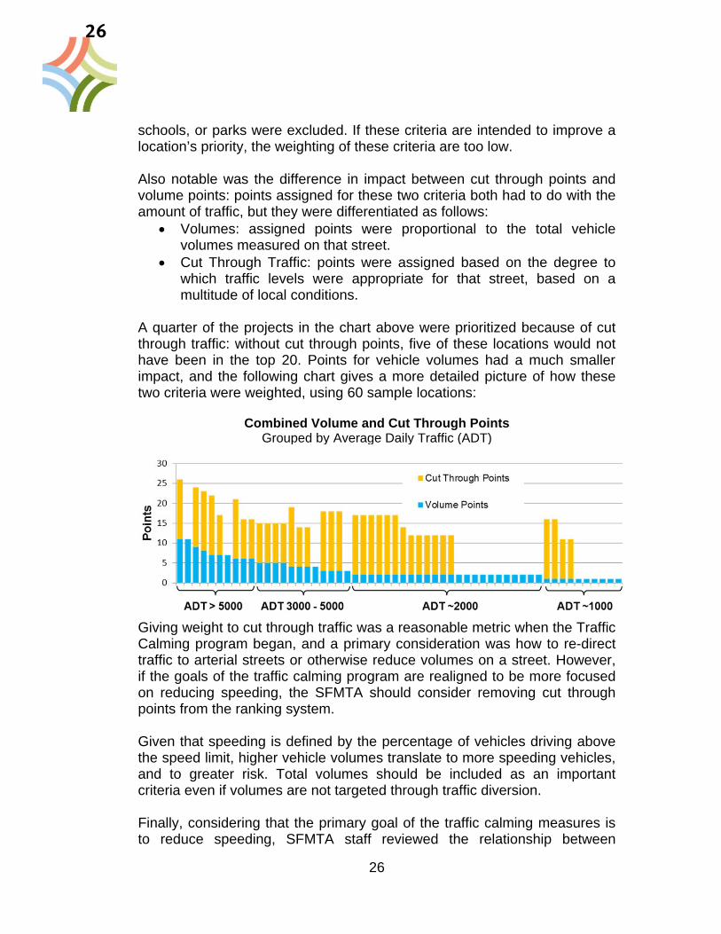
schools, or parks were excluded. If these criteria are intended to improve a location’s priority, the weighting of these criteria are too low. Also notable was the difference in impact between cut through points and volume points: points assigned for these two criteria both had to do with the amount of traffic, but they were differentiated as follows:
Volumes: assigned points were proportional to the total vehicle volumes measured on that street.
Cut Through Traffic: points were assigned based on the degree to which traffic levels were appropriate for that street, based on a multitude of local conditions.
A quarter of the projects in the chart above were prioritized because of cut through traffic: without cut through points, five of these locations would not have been in the top 20. Points for vehicle volumes had a much smaller impact, and the following chart gives a more detailed picture of how these two criteria were weighted, using 60 sample locations:
Combined Volume and Cut Through Points
Grouped by Average Daily Traffic (ADT)
Giving weight to cut through traffic was a reasonable metric when the Traffic Calming program began, and a primary consideration was how to re-direct traffic to arterial streets or otherwise reduce volumes on a street. However, if the goals of the traffic calming program are realigned to be more focused on reducing speeding, the SFMTA should consider removing cut through points from the ranking system. Given that speeding is defined by the percentage of vehicles driving above the speed limit, higher vehicle volumes translate to more speeding vehicles, and to greater risk. Total volumes should be included as an important criteria even if volumes are not targeted through traffic diversion. Finally, considering that the primary goal of the traffic calming measures is to reduce speeding, SFMTA staff reviewed the relationship between
26

27
speeding and total ranking score. The chart below shows the total points for 60 locations; the height of each bar is the total score for each location, and the points for speeding are shown in yellow.
Total Points, Sorted by Speed Points
In the ranking system that the SFMTA has used over the past ten years, many other factors besides speeding had a strong influence on project ranking. If the SFMTA hopes to primarily address speeding, the ranking points should be adjusted accordingly. Recommendations SFMTA staff recommend making the following changes to the ranking criteria:
Increase the weighting given to speeding and to schools Remove cut-through traffic as a ranking criterion, and instead focus
on total traffic volumes
Traffic Calming Process Timeline The long timeline of traffic calming implementation was high on the list of concerns for SFMTA staff and stakeholders alike. In the resident survey, over seventy percent of respondents agreed with the statement “The overall process took longer than I felt was reasonable,” and the statement “The timeline of planning and implementation should be shortened” was rated as the most important of a number of statements about the traffic calming process. At the root of the long timeline for implementing traffic calming devices is the fact that the SFMTA, working with San Francisco residents, identified and
27

28
committed to traffic calming projects at a faster rate than the projects could be delivered given staffing and funding constraints. The practice of approaching traffic calming from an “area-wide” perspective has been particularly responsible for what has become a multi-million dollar backlog of project commitments. The area-wide process was developed as a way to look at multiple locations in the same neighborhood together, to address the possibility that building a traffic calming device on one street – the street that submitted an application – could result in traffic being diverted to a neighboring street which might have similar characteristics but did not apply. The boundaries of area-wide projects were drawn to incorporate all residential streets between arterials, major collectors, or commercial streets that were seen as the appropriate locations for diverted traffic. Once defined, area-wide projects were ranked based on the highest scoring application within that area. The table below shows the timeline of a typical area-wide traffic calming process. The dates are provided for the Silver Terrace Area-wide project, to illustrate the process.
Area-wide Process Silver Terrace Timeline
Accept Applications FY 02/03 – FY 08/09 4 Accepted Applications
Define Area-wide & Rank Location FY 06/07 Ranked 20th
Community Process FY 09/10 – FY 10/11 Public Workshops and Working Group meetings, 20 devices proposed
Legislation, Environmental Review FY 10/11
Implementation FY 11/12 – FY 16/17 First 4 humps installed in 2012; implementation is ongoing
In the case of Silver Terrace, four applications were combined into the Silver Terrace Area-wide in 2006, but the project ranked 20th at the time, and the community process did not begin for several years. For most area-wide projects, multiple public workshops were held and a community working group was established to develop the details of the plan with the SFMTA. During this open-ended process,
28

29
All residents living in a defined area-wide were welcome to participate, and many residential streets were considered for traffic calming devices, whether or not an application had been submitted for that street. Many more devices were proposed through this process than were requested through the original applications. The community process included education about many different types of traffic calming devices, and residents chose from speed humps, islands, chicanes, curb extensions and restriping – devices that range greatly in cost.
This open-ended approach led to the development of thoughtful, comprehensive traffic plans for each area-wide location, but with a long list of desired devices that often included costly measures. For Silver Terrace, the plan for the project included a total of 20 devices at a cost of $500,000. With several area-wide plans approved in a given year, implementation timelines for each plan were broken into phases and implementation scheduled over several years, so that each year each neighborhood could see a piece of their plan realized – but it could take many years before all of the early phase projects were implemented, and often a “wish list” of less critical projects remains with no strategy for implementation in the near term. For the Silver Terrace project, it was ten years between when the first application was accepted and when the first speed humps were installed. The backlog to implement these large area-wide plans causes frustration for residents who have participated in the community process and identified their desired projects. Additionally, the SFMTA staff time required to address the backlog leads to further delays in starting the planning processes for newly received applications – or applications with low rankings that have been on the waiting list for years. Though the goal of addressing traffic calming issues on a neighborhood scale is commendable, the results are unsustainable for the SFMTA. For many of the devices that are implemented, particularly speed humps, the planning process is overly lengthy and costly. Meanwhile, for those proactive residents who recognize a problem on their streets and submit an application, the timeline from application to installation is perceived as unreasonably long. Recommendations
Consider focusing traffic calming on spot improvements to address resident concerns in a more timely manner, rather than an area-wide approach to traffic calming
29

30
Consider other approaches to address residential locations that do not apply for traffic calming
Device Types As noted above, the community process for area wide traffic calming included an opportunity for residents to identify their preferred devices, based on a broad range of available options. Typical device costs vary greatly, from around $7,000 for a speed hump to $20,000 for a median island to $70,000 or more for a curb extension. (These costs include detailed design, construction labor and construction materials; speed hump costs are fairly standardized while horizontal deflection devices and curb extensions vary greatly depending upon the location.) The greater expense of some devices does not translate to increased effectiveness for reducing speeds. Speed humps, which are the least costly device in SFMTA’s traffic calming toolbox, have been consistently successful at bringing speeds to within 5 mph of the speed limit on streets where they have been installed. Other measures have had mixed results due in part to the greater variation in the designs that have been implemented. Furthermore, some designs, like curb extensions, are intended to improve visibility and yielding to pedestrians at intersections, rather than to address speeding than takes place midblock. In order to achieve the goal of speed reduction and to benefit the most people, speed humps should be considered where appropriate based on local conditions. Recommendations
SFMTA staff should recommend an appropriate traffic calming device based on engineering judgment, and should evaluate each location for the appropriateness of speed humps before considering more costly options.
Balloting It is SFMTA policy to ballot residents on streets where traffic calming measures will be installed to ensure that each measure has sufficient public support and to allow an opportunity for further public comment. Twenty percent of ballots must be returned, and over 50 percent must be in favor of the device. Although neighbors have approved the devices a majority of the time, it was not uncommon for the ballot to fail. Furthermore, sometimes a measure passed ballot, but was objected to by residents whose property would front the device – sometimes the measure was approved by the block as a whole but no location could be found to install it.
30

31
SFMTA staff reviewed the frequency that traffic calming measures did not make it through the balloting process. The table below shows the success rate for 59 devices that were balloted between 2010 and 2012, with an overall success rate of 80 percent:
* Two of the failed measures were rejected at the public hearing, before reaching the ballot. By the time projects reach the ballot box, significant SFMTA staff time has already been spent evaluating locations, spearheading the community process, and planning and designing devices. Because the traffic calming program is set up to implement devices requested by residents (rather than identified by staff), each device that fails at the ballot box represents time that staff could have been dedicating to other requests on the traffic calming waiting list. The primary purpose of requiring a petition as part of the application is to ensure that there is community support before the SFMTA dedicates staff time to a project. Though detailed information was not available on why some measures did not pass their neighborhood ballot, a few factors can be identified that may help explain the discrepancy between these results and the community support established through the application:
The long lead time between the original petition and balloting may mean that neighborhood residents or priorities had changed.
The minimum ten signatures from residents represented a fairly small proportion of some blocks, and perhaps the petitioners did not accurately reflect the views of their neighbors.
If a location was identified through the area-wide process rather than through a resident application, there may have been a champion for the location at a community meeting or in the community working groups, while other neighbors may have been less involved.
A ballot was also counted as having failed if not enough responses were received; in some locations, neighbors may not have been opposed to a measure but did not care enough to send in their ballot.
Traffic Calming Measure Total Balloted Failed at Ballot Speed Humps 29 20.7 %
Bulbouts 5 20.0 % Islands 16 6.3 %
Other (eg striping changes) 9* 33.3 % Overall 59 18.6 %
31

32
Recommendations Consider requiring greater commitment from residents at time of
application, to reduce likelihood of going through a planning process but having a device rejected at the ballot box.
Consider having application signatures count towards the ballot to reduce the chances that a measure will fail due to lack of response
Require that by signing the petition signatures or voting “yes” on a ballot, residents also agree to have the device installed in front of their house, if considered the most appropriate location.
Reduce the timeline between application and implementation to maintain support and momentum for traffic calming on a given street
Implementation The implementation process includes ushering planned projects through the final steps of balloting, legislation, environmental review, design, and construction. In recent years, the limiting factor has been available staff resources to plan and implement traffic calming. The backlog of projects that the SFMTA has committed to installing is made up of planned projects that can be implemented as soon as funding and staff time are available. The chart below shows the number of traffic calming devices that have been implemented each year through the traffic calming program (some other devices, particularly curb extensions and median islands, are frequently installed through other SFMTA efforts). Note: The variation in device type from year to year has to do with the timeline of available funding; when a new grant is received, staff will generally prioritize speed humps, which are fastest to implement, as work progresses on other projects.
Number of Traffic Calming Devices Implemented Each Year
32

33
Since 2005, the SFMTA has implemented between around 20 and 35 traffic calming devices each year, and an average of 26 per year. Recommendations
Consider hiring additional staff to keep up with available funding for traffic calming implementation
Consider focusing resources on implementing the residential traffic calming backlog rather than developing new area-wide traffic calming plans
Consider only accepting residential traffic calming applications at a rate that can be implemented in a short timeframe based on funding and staff resources.
Resident Survey The SFMTA conducted a survey of residents who had been involved in the traffic calming process, including those who had applied to the program themselves, had attended a community meeting, or had been a member of a community working group. The survey was also available publicly on the SFMTA website. Responses from these surveys reinforced feedback that SFMTA staff have received anecdotally over the years from residents and stakeholders. Some key elements of the feedback from residents include:
Overall process takes too long Want more transparency and follow-up Value community meetings Want more devices installed Find the process confusing Felt it was easy to apply to the program
Unfortunately, priorities identified by respondents through the survey were sometimes in conflict, such as a desire for thorough community process as well as for a faster implementation timeline. Not all of the interests of residents are possible given the SFMTA’s limited resources, but should be balanced with other SFMTA and city priorities for the Traffic Calming program. Recommendations
Develop improved procedures for communicating with residents about the process for getting traffic calming and the status of specific applications. Reducing the implementation timeline is a broader goal of the program which should also help address the communication issues.
33

34
REVISED METHODOLOGY FOR APPLICATION BASED PROGRAM The SFMTA has revised how it processes requests for traffic calming from San Francisco residents. The process takes cues from best practices in other cities, and is intended to address some of the primary issues identified through the evaluation of the past application process. The new methodology also incorporates feedback from stakeholder groups and policy makers who were consulted as part of the revision process. This section details the process for handling traffic calming applications from first contact with residents to project closeout. Some of the key changes and the issues they are meant to address are summarized below:
Annual program cycle o More transparent, predictable and easier to understand o Shorter waiting time between acceptance and construction o More efficient use of staff resources
More community support required for application o Reduces likelihood of project being rejected at ballot box
Prioritize speed reduction and school locations Only accept applications that can be built the following year Most appropriate and cost effective device is recommended
Outreach SFMTA will update and print brochures and applications, and update the Traffic Calming Program website to reflect the changes to the application-based program. SFMTA staff will also reach out to neighborhood organizations, policy makers, and stakeholder groups to inform them of the traffic calming application, planning and implementation process. The website will include:
An overview of the residential traffic calming program Information about ranking and criteria for inclusion Detailed instructions for applying Links to resources that residents can pursue independently Traffic calming brochure Traffic calming application
Brochure and application materials will be made available in English, Spanish and Chinese.
34

35
Year-Round Correspondence Although applications will be evaluated once a year, residents may have questions throughout the year about the traffic calming process and about whether their neighborhood might be an appropriate candidate. SFMTA staff will be available to respond to these requests. In addition, if residents submit applications in advance of the annual deadline, SFMTA staff will review the applications for completeness within 30 days of receipt, and request missing information if applicable.
Application Requirements The purpose of having residents submit applications for traffic calming is to identify areas of concern and to establish community support for street changes before the SFMTA dedicates resources to a project. Location Characteristics – Completed by Applicant One resident will be the primary contact person for each application, and will be responsible for providing the following pieces of information:
Personal contact information Block to be considered (street name and cross streets) Primary traffic concerns Presence of schools, senior centers, parks etc
Staff will be available year-round to assist residents with any questions they may have about the application process. Community Support – Petition of Neighbors A petition must be circulated to establish community support for traffic calming on each block where it is requested. A completed application will have signatures from at least 20 residential or business units, or 50 percent of addresses on the street if it has fewer than 40 units. Multiple signatures from the same unit will not be counted. By signing the petition, neighbors agree to the following statements:
I agree to have a speed hump installed in front of my residence/ business if deemed the most appropriate solution; and
My signature here counts as a “yes” vote unless I later submit a “no” vote in the upcoming neighborhood ballot.
Applications can be sent to the SFMTA by mail, or sent as a PDF to an email address set up specifically for receiving traffic calming applications and questions about the application process. An annual deadline will be identified for each year’s evaluation cycle; applications received after the deadline will be considered the following year.
35

36
When an application is received, SFMTA staff will acknowledge receipt of the application by informing the applicant of when they can expect to receive a determination of acceptance. Staff will also review any descriptions of traffic concerns in the applications, and will refer any immediate concerns to the SFMTA Traffic Operations division.
Evaluation & Ranking After the application deadline, SFMTA staff will begin the process of evaluating each location. The SFMTA will contract with an outside firm to conduct speed surveys for each eligible location. Staff will review application information for accuracy and will compile additional data needed for the ranking process. Once all data is collected, project locations will be ranked based on the following criteria:
Evidence of speeding Presence of a school, playground, senior center etc Traffic volumes Collision history Evidence of exhibition driving Opportunities for increasing walking and biking
Evidence of speeding will be the weighted highest, with other criteria weighted roughly equally, subject to professional judgment by SFMTA staff. The SFMTA will rank all eligible locations from the year’s batch of applications. The number of accepted projects will depend on the available funding and what devices are recommended, as described in the next section.
Planning Recommendation Once the locations with greatest need for traffic calming are identified, SFMTA staff will begin the process of reviewing locations for the most appropriate engineering solution, beginning with the top 25 ranked locations. Blocks will first be evaluated for whether a speed hump would be appropriate for the location and possible given street geometry. If a speed hump is not an appropriate solution, staff would consider other traffic calming devices such as chicanes, traffic islands, medians and traffic circles. The budget estimate prepared as part of the Traffic Calming Revision was based on approximately 25 devices constructed per year, of which 65% are speed humps. If the top 25 locations result in a significantly higher or lower proportion of speed humps, the total number of devices could change for that year.
36

37
After the list of projects is identified, SFMTA staff will inform applicants of the results. These responses could take one of these forms:
Accepted – locations recommended for devices in the current cycle Rejected – locations that do not rank for the current cycle. Applicants
wishing to be considered in future years must re-apply.
Community Outreach For locations where the recommended device would require parking removal or displacement, or is considered a potentially controversial choice for the location, SFMTA staff will offer to meet with interested residents. SFMTA staff would work with the primary applicant to find a meeting location, and would send the meeting announcement to all residents on the affected block. The purpose of these meeting would be for SFMTA staff to present the pros and cons of one or two devices that would be appropriate for the location, and take feedback from neighbors to advise the projects’ final design. For locations requiring this additional community outreach, the implementation cycle may be delayed a month or two compared to locations receiving standard speed humps.
Balloting of Residents Once the device for each location is determined, either through the planning recommendation process or after a meeting with neighbors, information about the device will be sent out along with ballots. The ballot process is largely unchanged from the current guidelines, as follows: The residents on the block where the device will be located (including corner lots and residents who have to use the affected street to access their homes) will be balloted to get a final vote. Each known address will receive one ballot card for one vote. The SFMTA will make a good faith effort to make sure every valid address gets a vote. A few key elements of the ballot process will be different from the past process:
A “Yes” vote means the respondent agrees to have the device placed in front of their property, if deemed the most appropriate location
A resident who signs the original petition but doesn’t return a ballot would be counted as voting “Yes.” A notification to this effect would be included in the ballot.
37

38
Public Hearing Once the votes are counted and the simple majority of the residents who voted (50%+1) approve, the project is scheduled for an SFMTA Public Hearing where members of the public will have an opportunity for further comment. If the project is approved, the plans are sent to the appropriate City departments for installation.
Detailed Design and Construction Detailed Design and Construction would be conducted by SFMTA and DPW staff according to current standards for traffic calming in San Francisco.
Project Closeout Residents of streets receiving traffic calming will be informed when the device is complete.
Funding Cycle and Program Costs One of the many benefits of having a standardized annual cycle is that it simplifies and streamlines the process of securing funding. By applying for several phases of the project together, the SFMTA will be able to begin project development and design work as soon as project locations are identified. The SFMTA recommends applying to the SFCTA once a year for all funds for the Application-Based Residential Traffic Calming program, with design and construction funds contingent upon the submission of the project list for the that cycle. SFTMA staff estimate the project described in this section would cost approximately $600,000 each year to implement at current costs, as shown: Program Outreach and Correspondence $30,000Project Selection and Development (including evaluation, ranking, planning recommendation, outreach and conceptual engineering)
$300,000
Design Engineering (including SFMTA detailed design) $25,000Construction (including DPW design, labor and materials) $235,000Total $590,000
38

39
REBALANCED PRIORITIES The Proposition K Expenditure Plan item 38 provides approximately $2.5 million each year towards traffic calming projects, divided into the three “tracks” identified in the SFMTA’s Traffic Calming Guidelines: “Arterial and Commercial Streets,” “Local Streets” and Schools. Over the years, in an effort to be responsive to requests from residents, the SFMTA has dedicated the majority of its annual Traffic Calming funds towards the local track. However, the proposed methodology outlined above for the new Application-Based Traffic Calming Program streamlines the SFMTA’s response to resident requests, allowing more of the available funding to be considered for other uses. The next pages detail the SFMTA’s proposed program areas that form a more balanced three-track approach, better reflecting the original intent of the Traffic Calming Guidelines.
Local Streets Track In the past, funding for the “Local Streets Track,” which considers local-access residential streets has primarily gone towards area-wide traffic calming plans. These planning efforts looked at entire neighborhoods identified based on one or several applications from residents. This program was intended to be responsive to applications, but ultimately included a decision from SFMTA staff as to what streets made most sense to include in an area-wide approach. As a result of this approach, each area-wide plan included many more proposed devices, as well as more expensive devices, than would have been recommended if each application was addressed individually. This greater expense led to longer lead times from when applications were received to when planning began. This led to the SFMTA to mainly focus on responding to resident requests rather than proactively planning and implementing traffic calming in areas that could lead to the greatest benefits. The proposal for the revised Local Streets Track is to de-couple the application-based process from the proactive efforts of the SFMTA. This will bring greater transparency to both components, and will allow improved response time for residents who apply, while dedicating specific funding to locations in the city where traffic calming can provide benefits in terms of safety and promoting alternative transportation options. Application-Based Residential Traffic Calming Program The SFMTA will continue to implement 20-25 traffic calming measures per year based on community requests. The key features of the Application-Based program are as follows:
39

40
Community members must apply for a specific block SFMTA staff will evaluate applications once a year and will prioritize
applications based on the following criteria, listed in order of weight: o Evidence of Speeding o Presence of a school, playground, senior center etc o Traffic Volumes o Collision History o Evidence of Exhibition Driving o Opportunities for increasing walking and biking
SFMTA staff will recommend a traffic calming measure for the top 20-25 locations, and residents will vote on the measure. Measures could include:
o Speed humps o Traffic islands o Chicanes o Traffic circles
Construction will take place within a year and a half of evaluation The SFMTA estimates that the total annual funding for this program will be approximately $600,000. Proactive Residential Area Improvements Funding for “Proactive Residential Area Improvements,” will be used by the SFMTA to plan and implement traffic calming measures in residential locations that have not submitted applications but where there is potential for benefits in terms of safety, livability, and mode shift. The criteria for selecting projects for this category are as follows:
Projects that increase geographic equity – The Application-Based program is limited by the fact that it relies on engaged and active residents to take the first step towards identifying problem locations. The SFMTA will consider locations where speeding issues are reported but where community members might be less engaged and not submit official applications.
Projects with the potential to increase walking and biking –
A speed hump or traffic island alone may not be able to increase walking and biking significantly, but could have a greater impact when combined with measures like landscaping, bicycle facilities, or wayfinding efforts. The SFMTA will consider implementing traffic calming measures in coordination with projects aimed at increasing walking and biking.
40

41
Home Zones and Small Area-Wides – In some circumstances, a site-specific traffic calming measure may not be sufficient to address a pattern of speeding or cut-through traffic in a neighborhood. If applications are frequently received from the same neighborhood despite site-specific solutions, or if professional judgment dictates, the SFMTA could consider taking a home-zone or area-wide approach.
The proposed funding for Proactive Residential Area Improvements is $500,000 per year. This would cover about one project if directed towards something like a neighborhood greenway or a home zone type project. The SFMTA will consider and propose projects as part of the recurring CIP process as well as the SFCTA’s 5YPP process.
Schools Track In the past, funding for schools in the Traffic Calming program has been used as a local match for Safe Routes to School grants, which focus on pedestrian safety around San Francisco’s schools. Moving forward, the local match will be provided through other funding sources, freeing up funding within the Traffic Calming program to be directed towards reducing speeds near schools. This is an opportunity to implement similar devices to what are used in residential areas, but without requiring initiation from area residents as in the application based program. The SFMTA will work with the Safe Routes to School Coalition to identify potential locations through existing school-area assessments.
In addition to considering new school locations, the SFMTA proposes adjusting the ranking criteria for the Application-Based Residential Traffic Calming Program to elevate the priority of locations where schools are present. The proposed funding for the Schools track is $150,000 each year.
Arterial and Commercial Streets Track Half of all severe and fatal traffic collisions occur on just 7% of San Francisco’s street miles; these high-injury corridors are primarily arterials or busy commercial streets where there are high volumes of vehicles and pedestrians. Because vehicle speeds are a significant factor in determining the severity of the injuries, traffic calming is an important piece of the puzzle for reducing these injuries and increasing traffic safety in San Francisco. The Traffic Calming Arterial and Commercial Streets Track seeks opportunities to reduce speeds on corridors either in coordination with other projects or as independent projects prioritized based on need.
41

42
Prioritized Corridor Speed Reduction Funding for Prioritized Corridor Speed Reduction will be used to make low-cost improvements on corridors with high collision rates and evidence of speeding, but where there are no current plans for more intensive streetscape improvements. Potential treatments include speed humps, lane narrowing, road diets, and traffic signal changes. The concurrent Corridor Speed Reduction Pilot project and continued development of San Francisco’s Pedestrian Strategy will result in more detailed recommendations for identification of streets and treatments, but the project selection criteria are likely to include:
High levels of injury collisions Evidence of speeding Potential for increased use by people walking and biking Eligible streets include arterials defined in the San Francisco General
Plan as well as commercial streets, multi-lane streets, collectors, and signalized corridors.
The SFMTA Pedestrian Strategy identifies San Francisco’s high-injury corridors using similar prioritization metrics, and will be used in the selection of these corridors. Project Coordination The SFMTA will also seek opportunities to coordinate with planned streetscape projects that reduce speeding and increase safety. This could include projects making significant investment in bicycle facilities, intersection safety, transit improvements, or landscaping, which would not be appropriate to be fully funded through traffic calming, but where matching funds could help with project implementation. Project Coordination funds could also be used to capitalize on smaller coordination opportunities such as regularly scheduled repaving. SFMTA could use these funds for the planning phase for striping changes that could be incorporated into a repaving project on a street that has a history of speeding or collisions but which isn’t at the top of the list for the Prioritized Corridor Speed Reduction program. The proposed budget for the combined Arterial and Commercial Streets Track would be $1,250,000 per year, with a flexible breakdown between Prioritized Corridor Speed Reduction and Project Coordination.
42

43
Program Funding The chart below shows the proposed breakdown of Traffic Calming funding under this revised scenario, with the most notable shift being the increase in funding for arterial traffic calming projects. This is line with city and agency priorities to improve pedestrian safety, which is of greatest concern on San Francisco’s busy arterial and commercial streets.
Current vs Proposed Breakdown of Prop. K Traffic Calming Funds
43

44
NEXT STEPS These recommendations for a revised traffic calming program will be implemented gradually as the SFMTA clears out a backlog of planned residential traffic calming projects, and incorporates the new recommendations into the SFMTA’s Capital Improvement Plan and the SFCTA’s Five Year Prioritization Program. The revised application-based program will begin immediately, but the increased focus on high-injury corridors and schools will be transitioned over the next several years so that the existing backlog of residential traffic calming projects can be addressed.
Roll-out of Application-Based Residential Traffic Calming Traffic calming applications were not accepted for a year during the revision process. In March 2013, the SFMTA reopened the program to residents, with a roll-out that included:
a revised website with information about the new process a new application form announcement email to residents who have expressed interest in
traffic calming over the past year announcement email Supervisors and their aides
The new process for evaluating these applications and planning new measures will start in August 2013 according to the proposed timeline.
Completion of Planned Residential Traffic Calming There are approximately $6 million worth of traffic calming measures in the project development pipeline that have yet to be funded. In locations where area-wide processes were already scheduled, planning has gone on as before and several new area-wide plans are under development, though the resultant plans may be more constrained than in the past. In addition to area-wide plans, many site-specific locations are slated for planning and implementation, including locations that were originally intended to be incorporated into future area-wides. These locations will be reprioritized using the revised criteria and locations that no longer meet SFMTA criteria could be dropped. The SFMTA is devoting staff resources and funding to ensure that its existing traffic calming commitments are fulfilled even while the program is transitioned to place more focus on high-injury corridors, schools, and an annual residential program. This includes hiring more staff in the Livable Streets subdivision, streamlining internal project development and review processes, and working with the Department of Public Works to improve coordination and shorten construction timelines. The SFMTA expects to complete the planned traffic calming measures over the next 6 years.
44

45
Incorporation of Revised Program into CIP The SFMTA’s existing Capital Improvement Program (CIP) incorporates the new Application-Based Program at the proposed funding level of $600,000 per year, and includes the required funding for implementing the backlog of outstanding area-wide and site-specific traffic calming measures within five years. In the first 3 years of the CIP, these combined projects are anticipated to use the majority of available traffic calming funding from Prop K; new projects near schools and along corridors are expected to begin once the backlog is largely complete. SFMTA staff will incorporate the new arterial and local track recommendations into the next draft of the CIP.
Incorporation of Revised Program into Prop K 5YPP As noted previously, the Proposition K EP 38 category provides around $2.5 million each year towards traffic calming projects, divided into the three “tracks” identified in the SFMTA’s Traffic Calming Guidelines: Arterial and Commercial Streets, Local Streets, and Schools. The existing Five Year Prioritization Program for Traffic Calming includes these categories, but with around 90 percent of the funding allocated for the Local Track. As the SFMTA completes its 5YPP update for 2013-2018, the proposed programmatic distribution will be recommended as the eventual funding levels for the different tracks, transitioning gradually as the backlog of projects is cleared out in upcoming years. An amendment will be made to the current 5YPP for the FY 13-14 year allowing the SFMTA to seek funds for the first year of the new Application-Based Program.
45

This Page Intentionally Left Blank
46

Bac
klog
of
Tra
ffic
Cal
min
g Im
ple
men
tati
on P
roje
cts
Co
st B
reak
do
wn
of
Co
mp
lete
d A
reaw
ide
Pro
ject
s
Pro
ject
Sup
D
istr
ict
2011
Est
imat
ed T
otal
C
ore
Impl
emen
tatio
n C
ost*
Rem
aini
ng F
undi
ng
Nee
ds fo
r C
ore
Pro
ject
Im
plem
enta
tion
**
Pro
ject
Sta
tus
(As
of M
ay 2
013)
18th
Ave
(19
th-L
inco
ln B
ypas
s)5,
7$5
88,8
00$0
Will
be
com
plet
e w
hen
wor
k as
soci
ated
with
S
R2S
gra
nt is
com
plet
ed.
Bay
view
10$7
54,2
00$7
2,00
0P
hase
2 o
f 4 is
und
erw
ayB
uena
Vis
ta/1
7th/
Roo
seve
lt W
ay8
$415
,600
$128
,000
Pha
se 2
of 3
und
erw
ayC
edro
/Cer
ritos
& H
ollo
way
/Gar
field
7, 1
1$4
87,6
00$4
8,00
0P
hase
2 o
f 3 is
und
erw
ayC
entr
al R
ichm
ond
1$1
,846
,852
$808
,000
Pha
se 2
of 4
is u
nder
way
Circ
ular
Ave
nue
7,8
$339
,950
$0P
hase
3 o
f 3 is
und
erw
ayC
layt
on5,
8$8
5,60
0$3
2,00
0P
hase
1a
is u
nder
way
Cre
stla
ke4
$247
,500
$0C
ompl
eted
Exc
elsi
or11
$1,0
44,3
50$3
2,00
0P
hase
3 o
f 3 is
und
erw
ayF
illm
ore
5$4
5,00
0$0
Com
plet
edIn
ner
Sun
set
5,7
$1,6
26,9
50$3
70,0
00P
hase
4 o
f 5 u
nder
way
Jord
an P
ark/
Laur
el H
eigh
ts2
$448
,500
$437
,400
Pha
se 1
a is
und
erw
ayM
inna
/Nat
oma
6$8
39,7
00$5
90,8
50P
hase
1 o
f 2 u
nder
way
Nor
th B
erna
l Hei
ghts
9$3
,526
,500
$422
,500
Pha
se 6
of 6
und
erw
ayO
'Sha
ughn
essy
7,8
$133
,750
$0C
ompl
eted
Pot
rero
Hill
10$7
21,2
00$3
84,0
00P
hase
2 o
f 5 u
nder
way
Ran
dolp
h/B
road
11$5
59,0
00$0
Pha
se 2
of 2
is u
nder
way
Sai
nt F
ranc
is W
ood
7$2
66,8
50$2
4,00
0P
hase
2 o
f 3 u
nder
way
Silv
er T
erra
ce10
$677
,050
$436
,000
Pha
se 1
of 2
und
erw
ayS
outh
Ber
nal H
eigh
ts9
$2,1
23,3
00$4
88,0
00P
hase
2 o
f 4 u
nder
way
Sun
nysi
de7,
8$2
61,7
00$1
20,0
00P
hase
2 o
f 3 u
nder
way
Ter
esita
Bou
leva
rd7
$703
,800
$192
,000
Pha
se 2
of 3
und
erw
ayW
est P
orta
l7
$155
,000
$155
,000
Pha
se 3
of 3
und
erw
ay
To
tals
$17,
898,
752
$4,7
39,7
50*
Sho
ws
the
"Tot
al C
ost"
use
d in
201
1 m
inus
the
"Wis
h Li
st"/
Fut
ure
Fun
ding
pro
ject
s. T
hese
cos
ts a
re n
ot u
pdat
ed w
ith 2
013
cost
esi
mat
es.
** T
wo
Are
awid
e P
lans
hav
e be
en c
ompl
eted
sin
ce 2
011:
Jor
dan
Par
k/La
urel
Hei
ghts
and
Cla
yton
. The
se a
re in
clud
ed a
nd c
osts
of m
easu
res
upda
ted.
Est
imat
ed C
ost
Bre
akd
ow
n o
f A
reaw
ides
in P
lan
nin
g P
has
e &
Sit
e-sp
ecif
ic M
easu
res
Pro
ject
Sup
D
istr
ict
Num
ber
of L
ocat
ions
Est
imat
ed F
undi
ng N
eeds
fo
r P
roje
ct
Impl
emen
tatio
n***
Pro
ject
Sta
tus
(As
of M
ay 2
013)
Dew
ey A
reaw
ide
7-
$450
,000
In P
lann
ing
Vis
itaci
on V
alle
y10
-$4
50,0
00In
Pla
nnin
g E
xist
ing
Site
-Spe
cific
Var
ious
20$3
00,0
00R
anke
d Li
st, d
evic
es n
ot id
entif
ied
Fut
ure
Site
-Spe
cific
V
ario
us31
$300
,000
Will
be
eval
uate
d an
d re
-ran
ked
in 2
013
To
tals
$1,5
00,0
00**
* T
hese
est
imat
es a
re b
ased
on
past
exp
erie
nce
with
are
awid
e an
d si
te-s
peci
fic im
plem
enta
tion.
P:\P
rop
K\SP
-5YP
P\20
13 U
pdat
e\5Y
PP e
tc\E
P 38
\TC
Impl
emen
tatio
nRem
aini
ngCo
stEs
timat
es_6
-11-
13Pa
ge 1
of 1
47

Pla
nP
has
eL
ocat
ion
Stat
us
18th
Ave
(19t
h-Li
ncol
n By
pass
)1
Colle
ct S
peed
Dat
a on
Juda
h (1
6th
to 1
7th)
Com
plet
e18
th A
ve (1
9th-
Linc
oln
Bypa
ss)
1E
valu
ate
STO
P sig
n co
ntro
ls in
are
aCo
mpl
ete
18th
Ave
(19t
h-Li
ncol
n By
pass
)1
17th
Ave
Spe
ed H
ump
(bet
Irvi
ng a
nd Ju
dah)
Com
plet
e18
th A
ve (1
9th-
Linc
oln
Bypa
ss)
118
th A
ve S
peed
Hum
p (b
et Ir
ving
and
Juda
h)Co
mpl
ete
18th
Ave
(19t
h-Li
ncol
n By
pass
)1
Hav
e Sc
hool
Saf
ety
Prog
ram
revi
ew sc
hool
circ
ulat
ion
and
load
ing
patte
rns
Com
plet
e18
th A
ve (1
9th-
Linc
oln
Bypa
ss)
118
th A
ve C
hoke
r (be
t Lin
coln
and
Irvi
ng)
Com
plet
e18
th A
ve (1
9th-
Linc
oln
Bypa
ss)
218
th A
ve C
hoke
r (L-
I)Co
mpl
ete
18th
Ave
(19t
h-Li
ncol
n By
pass
)2
17th
Ave
Cho
ker (
L-I)
Rejec
ted
18th
Ave
(19t
h-Li
ncol
n By
pass
)2
18th
Ave
Cho
ker (
I-J)
Rejec
ted
18th
Ave
(19t
h-Li
ncol
n By
pass
)2
Linc
oln
Way
Med
ian E
xten
sions
Rejec
ted
18th
Ave
(19t
h-Li
ncol
n By
pass
)3
18th
Ave
/Lin
coln
Bul
bout
Rejec
ted
18th
Ave
(19t
h-Li
ncol
n By
pass
)3
Juda
h St
Bul
bout
s (@
17th
)U
nder
way
18th
Ave
(19t
h-Li
ncol
n By
pass
)FF
18th
/Irv
ing
Stre
et B
ulbo
uts
Und
erw
ay
Bayv
iew1
Eva
luat
e ST
OP
sign
cont
rols
in a
rea
Com
plet
eBa
yview
1Fi
tzge
rald
(bet
Inga
lls a
nd H
awes
) - Is
land
Com
plet
eBa
yview
1H
udso
n (b
et In
galls
and
Cas
hmer
e) -
Islan
dCo
mpl
ete
Bayv
iew1
Hud
son
(bet
New
hall
and
Men
dell)
- Sp
eed
Hum
pPl
anne
dBa
yview
1M
cKin
non
Spee
d H
ump
(Lan
e to
Keit
h)Co
mpl
ete
Bayv
iew1
Oak
dale
(bet
Inga
lls a
nd G
riffit
h) -
Spee
d H
ump
Com
plet
eBa
yview
1O
akda
le (b
et L
ane
and
Keit
h) -
Hum
p an
d Is
land
Rejec
ted
Bayv
iew1
Palo
u (S
C), b
et L
ane
and
Keit
h - H
ump
and
Islan
dRe
jecte
dBa
yview
1Pa
lou
Ave
Spe
ed C
ushi
ons (
bet K
eith
and
Jenn
ings
)U
nder
way
Bayv
iew1
Que
sada
, bet
Lan
e an
d K
eith
- Isla
ndCo
mpl
ete
Bayv
iew1
Reve
re, b
et L
ane
and
Keit
h - I
sland
Com
plet
eBa
yview
1Sh
afte
r, be
t Lan
e an
d K
eith
- Isla
ndRe
jecte
dBa
yview
1Th
omas
, bet
Lan
e an
d K
eith
- Isla
ndRe
jecte
dBa
yview
1U
nder
woo
d, b
et L
ane
and
Keit
h - H
ump
Com
plet
eBa
yview
1V
an D
yke,
bet L
ane
and
Keit
h - C
ushi
onRe
jecte
dBa
yview
2H
udso
n (W
est o
f Keit
h) -
Hum
p an
d Is
land
Rejec
ted
Bayv
iew3
Kirk
woo
d at
Dor
mito
ry -
Bulb
-out
Com
plet
eBa
yview
3K
irkw
ood
at D
orm
itory
II -
Bulb
-out
Com
plet
eBa
yview
2Pa
lou
(SC)
, bet
Keit
h an
d Je
nnin
gs -
Hum
pU
nder
way
Bayv
iew2
Que
sada
, bet
Keit
h an
d Je
nnin
gs -
Hum
pU
nder
way
Bayv
iew4
Que
sada
, Rev
ere
and
Shaf
ter (
bet I
ngall
s and
Haw
es)
- Hum
psPl
anne
dBa
yview
2Re
vere
, bet
Keit
h an
d Je
nnin
gs -
Cush
ion
Und
erw
ayBa
yview
2Sh
afte
r, be
t Keit
h an
d Je
nnin
gs -
Hum
pU
nder
way
18th
Ave
(19
th-L
inco
ln B
ypas
s)
Bay
view
P:\P
rop
K\SP
-5YP
P\20
13 U
pdat
e\5Y
PP e
tc\E
P 38
\TC
Impl
emen
tatio
nRem
aini
ngCo
stEs
timat
es_6
-11-
13Pa
ge 1
of 1
3
48

Pla
nP
has
eL
ocat
ion
Stat
us
Bayv
iew2
Thom
as, b
et K
eith
and
Jenn
ings
- H
ump
Und
erw
ayBa
yview
2U
nder
woo
d, b
et K
eith
and
Jenn
ings
- H
ump
Rejec
ted
Bayv
iew2
Van
Dyk
e, be
t Keit
h an
d Je
nnin
gs -
Hum
pRe
jecte
dBa
yview
FFPa
lou
Ave
nue
Bike
Lan
esFu
ture
Fun
ding
Bayv
iewFF
Gat
eway
Tre
atm
ents
(Que
sada
bet
3rd
and
Lan
e)Fu
ture
Fun
ding
Bayv
iewFF
Gat
eway
Tre
atm
ents
(Haw
es a
t Que
sada
, Rev
ere
and
Shaf
ter;
Inga
lls a
nd T
hom
as, J
enni
ngFu
ture
Fun
ding
Bayv
iewFF
Gat
eway
Tre
atm
ents
(Haw
es a
t Que
sada
, Rev
ere
and
Shaf
ter;
Inga
lls a
nd T
hom
as, J
enni
n gFu
ture
Fun
ding
Buen
a V
ista/
17th
Stre
et/R
oose
velt
Way
117
th S
treet
from
Tem
ple
to O
rd S
ts -
EB
- Spe
ed-R
adar
Sig
nCo
mpl
ete
Buen
a V
ista/
17th
Stre
et/R
oose
velt
Way
1Ro
osev
elt fr
om M
useu
m W
ay to
Par
k H
ill T
er/1
5th
St -
Chica
neCo
mpl
ete
Buen
a V
ista/
17th
Stre
et/R
oose
velt
Way
1Ro
osev
elt a
t Par
k H
ill/1
5th
St -
Two
Islan
dsCo
mpl
ete
Buen
a V
ista/
17th
Stre
et/R
oose
velt
Way
1Bu
ena
Vist
a A
ve a
t Upp
er T
er -
Bulb
-out
Com
plet
e
Buen
a V
ista/
17th
Stre
et/R
oose
velt
Way
2Ro
osev
elt fr
om 1
7th
St to
Low
er T
er -
Upp
er R
oose
velt
optio
n (ra
dar s
ign
or is
land)
Und
erw
ayBu
ena
Vist
a/17
th S
treet
/Roo
seve
lt W
ay2
Roos
evelt
from
17t
h St
to L
ower
Ter
- E
dge
Line
sU
nder
way
Buen
a V
ista/
17th
Stre
et/R
oose
velt
Way
217
th S
treet
at T
empl
e St
- Bu
lb-o
utU
nder
way
Buen
a V
ista/
17th
Stre
et/R
oose
velt
Way
2Bu
ena
Vist
a A
ve a
t Fre
deric
k St
- Pe
dest
rian
Islan
dU
nder
way
Buen
a V
ista/
17th
Stre
et/R
oose
velt
Way
2Ro
osev
elt a
t Bue
na V
ista
Ter -
Med
ian Is
land
Und
erw
ayBu
ena
Vist
a/17
th S
treet
/Roo
seve
lt W
ay2
Buen
a V
ista
Ave
from
Fre
deric
k St
to B
uena
Vist
a Te
r - E
dge
Line
sU
nder
way
Buen
a V
ista/
17th
Stre
et/R
oose
velt
Way
2Ro
osev
elt a
t Clif
ford
Ter
- Pe
dest
rian
Islan
dU
nder
way
Buen
a V
ista/
17th
Stre
et/R
oose
velt
Way
3Ro
osev
elt a
t 17t
h St
- Pe
dest
rian
Islan
dPl
anne
dBu
ena
Vist
a/17
th S
treet
/Roo
seve
lt W
ay3
Roos
evelt
at 1
5th
St -
Bulb
-out
- SW
cor
ner
Plan
ned
Buen
a V
ista/
17th
Stre
et/R
oose
velt
Way
3Bu
ena
Vist
a Te
r at B
uena
Vist
a A
ve E
ast -
Ped
estri
an Is
land
Plan
ned
Buen
a V
ista/
17th
Stre
et/R
oose
velt
Way
FF17
th S
treet
at C
orbi
n Pl
Ste
ps -
Chok
ers
Futu
re F
undi
ngBu
ena
Vist
a/17
th S
treet
/Roo
seve
lt W
ayFF
Roos
evelt
at M
useu
m W
ay -
Bulb
-out
Futu
re F
undi
ng
Cedr
o/Ce
rrito
s & H
ollo
way
/Gar
field
1H
ollo
way
at J
unip
ero
Serr
a - b
ulb
outs
Com
plet
eCe
dro/
Cerr
itos &
Hol
low
ay/G
arfie
ld1
Hol
low
ay b
etw
een
Beve
rly a
nd H
ead
- chi
cane
s/ed
gelin
es (p
ainte
d tri
al)Co
mpl
ete
Cedr
o/Ce
rrito
s & H
ollo
way
/Gar
field
1Ce
rrito
s bet
wee
n O
cean
and
Mon
cada
- sp
eed
hum
pCo
mpl
ete
Cedr
o/Ce
rrito
s & H
ollo
way
/Gar
field
1Ce
rrito
s bet
wee
n M
onca
da a
nd M
erce
des -
repl
ace
bum
p w
ith h
ump
Com
plet
eCe
dro/
Cerr
itos &
Hol
low
ay/G
arfie
ld1
Gen
eral
oper
atio
nal i
mpr
ovem
ents
- re
d zo
nes,
signa
ge, l
ane
strip
ing
Com
plet
eCe
dro/
Cerr
itos &
Hol
low
ay/G
arfie
ld1
Cedr
o be
twee
n O
cean
and
Mon
cada
- re
plac
e bu
mp
with
hum
pCo
mpl
ete
Cedr
o/Ce
rrito
s & H
ollo
way
/Gar
field
1Pa
lom
a be
twee
n O
cean
and
Mon
cada
- re
plac
e bu
mps
with
hum
pCo
mpl
ete
Cedr
o/Ce
rrito
s & H
ollo
way
/Gar
field
2H
ollo
way
bet
wee
n Be
verly
and
Hea
d - c
hica
nes (
islan
ds if
trial
is su
cces
sful
)Co
mpl
ete
Cedr
o/Ce
rrito
s & H
ollo
way
/Gar
field
2H
ollo
way
bet
wee
n Be
verly
and
Hea
d - h
umps
and
strip
ing
(if tr
ial w
as u
nsuc
cess
ful)
Und
erw
ay
Cedr
o/Ce
rrito
s & H
ollo
way
/Gar
field
2H
ollo
way
bet
wee
n Be
verly
and
Hea
d - h
umps
and
strip
ing
(if tr
ial w
as u
nsuc
cess
ful)
Und
erw
ay
Bu
ena
Vis
ta/
17th
Str
eet/
Roo
seve
lt W
ay
Ced
ro/
Cer
rito
s &
Hol
low
ay/
Gar
fiel
d
P:\P
rop
K\SP
-5YP
P\20
13 U
pdat
e\5Y
PP e
tc\E
P 38
\TC
Impl
emen
tatio
nRem
aini
ngCo
stEs
timat
es_6
-11-
13Pa
ge 2
of 1
3
49

Pla
nP
has
eL
ocat
ion
Stat
us
Cedr
o/Ce
rrito
s & H
ollo
way
/Gar
field
2G
arfie
ld a
t Bev
erly
- isla
ndU
nder
way
Cedr
o/Ce
rrito
s & H
ollo
way
/Gar
field
2G
arfie
ld b
etw
een
Beve
rly a
nd M
ontic
ello
- spe
ed c
ushi
ons
Und
erw
ayCe
dro/
Cerr
itos &
Hol
low
ay/G
arfie
ld2
Gar
field
bet
wee
n By
xbee
and
Rals
ton
- spe
ed c
ushi
ons
Und
erw
ayCe
dro/
Cerr
itos &
Hol
low
ay/G
arfie
ld2
Gar
field
bet
wee
n A
rch
and
Ram
sell
- spe
ed c
ushi
ons
Und
erw
ayCe
dro/
Cerr
itos &
Hol
low
ay/G
arfie
ld2
Beve
rly b
etw
een
Hol
low
ay a
nd G
arfie
ld -
spee
d cu
shio
n/hu
mp
Und
erw
ayCe
dro/
Cerr
itos &
Hol
low
ay/G
arfie
ld2
Cerr
itos-
Mer
cede
s-Lu
nado
cha
nneli
zatio
n isl
and
Und
erw
ayCe
dro/
Cerr
itos &
Hol
low
ay/G
arfie
ld2
Mer
cede
s at J
unip
ero
Serr
a - g
atew
ay is
land
Und
erw
ayCe
dro/
Cerr
itos &
Hol
low
ay/G
arfie
ld3
Hol
low
ay a
t Jun
iper
o Se
rra
- gat
eway
islan
dPl
anne
dCe
dro/
Cerr
itos &
Hol
low
ay/G
arfie
ld3
Gar
field
at J
unip
ero
Serr
a - g
atew
ay is
land
Plan
ned
Cedr
o/Ce
rrito
s & H
ollo
way
/Gar
field
FFG
arfie
ld a
t Byx
bee
- bul
b ou
tsFu
ture
Fun
ding
Cent
ral R
ichm
ond
117
th A
ve b
twn
Balb
oa &
Cab
rillo
Sts
- sp
eed
hum
pCo
mpl
ete
Cent
ral R
ichm
ond
118
th A
ve b
twn
Balb
oa &
Cab
rillo
Sts
- sp
eed
hum
pRe
ject
edCe
ntra
l Rich
mon
d1
Eva
luat
e ST
OP
sign
cont
rols
at in
ters
ectio
nsCo
mpl
ete
Cent
ral R
ichm
ond
123
rd A
ve/A
nza
St -
traffi
c cir
cleCo
mpl
ete
Cent
ral R
ichm
ond
1Ca
brill
o St
/Fun
ston
Ave
- Is
land
Com
plet
eCe
ntra
l Rich
mon
d1
14th
Ave
/Lak
e St
- Pa
inte
d Is
land
Com
plet
eCe
ntra
l Rich
mon
d1
14th
Ave
/Cab
rillo
St -
Islan
dCo
mpl
ete
Cent
ral R
ichm
ond
117
th A
ve b
twn
Anz
a &
Balb
oa -
Islan
dRe
ject
edCe
ntra
l Rich
mon
d1
17th
Ave
btw
n A
nza
& G
eary
- Sp
eed
Hum
pCo
mpl
ete
Cent
ral R
ichm
ond
222
nd A
ve b
twn
Calif
orni
a &
Clem
ent S
ts -
spee
d hu
mp
Und
erw
ayCe
ntra
l Rich
mon
d2
17th
Ave
/Lak
e St
- tra
ffic
circle
Und
erw
ayCe
ntra
l Rich
mon
d2
Fulto
n St
/Fun
ston
Ave
- isl
and
Und
erw
ayCe
ntra
l Rich
mon
d2
Anz
a St
/Fun
ston
Ave
- isl
and
Und
erw
ayCe
ntra
l Rich
mon
d2
Clem
ent S
t/Fu
nsto
n A
ve -
islan
dU
nder
way
Cent
ral R
ichm
ond
2Ca
lifor
nia
St/F
unst
on A
ve -
islan
dU
nder
way
Cent
ral R
ichm
ond
214
th A
ve/C
alifo
rnia
St -
islan
dU
nder
way
Cent
ral R
ichm
ond
214
th A
ve/C
lemen
t St -
islan
dU
nder
way
Cent
ral R
ichm
ond
214
th A
ve/A
nza
St -
islan
dU
nder
way
Cent
ral R
ichm
ond
214
th A
ve/B
alboa
St -
islan
dU
nder
way
Cent
ral R
ichm
ond
2Fu
lton
at 1
6th
Ave
- pe
d isl
ands
on
Fulto
nU
nder
way
Cent
ral R
ichm
ond
2Ca
lifor
nia
near
Alam
o Sc
hool
- isl
and
Und
erw
ayCe
ntra
l Rich
mon
d2
Calif
orni
a ne
ar A
lamo
Scho
ol -
bus b
ulb
Und
erw
ayCe
ntra
l Rich
mon
d3
21st
Ave
/Lak
e St
- tra
ffic
circle
Plan
ned
Cent
ral R
ichm
ond
324
th A
ve/L
ake
St -
traffi
c cir
clePl
anne
dCe
ntra
l Rich
mon
d3
Funs
ton
Ave
btw
n Fu
lton
& C
abril
lo S
ts -
spee
d hu
mp
with
islan
dPl
anne
dCe
ntra
l Rich
mon
d3
Funs
ton
Ave
btw
n Fu
lton
& C
abril
lo S
ts -
spee
d hu
mp
with
islan
dPl
anne
dCe
ntra
l Rich
mon
d3
Funs
ton
Ave
btw
n Ca
brill
o &
Balb
oa S
ts -
spee
d hu
mp
with
islan
dPl
anne
dCe
ntra
l Rich
mon
d3
Funs
ton
Ave
btw
n Ca
brill
o &
Balb
oa S
ts -
spee
d hu
mp
with
islan
dPl
anne
d
Cen
tral
Ric
hm
ond
P:\P
rop
K\SP
-5YP
P\20
13 U
pdat
e\5Y
PP e
tc\E
P 38
\TC
Impl
emen
tatio
nRem
aini
ngCo
stEs
timat
es_6
-11-
13Pa
ge 3
of 1
3
50

Pla
nP
has
eL
ocat
ion
Stat
us
Cent
ral R
ichm
ond
3Fu
nsto
n A
ve b
twn
Balb
oa &
Anz
a St
s - sp
eed
hum
p w
ith is
land
Plan
ned
Cent
ral R
ichm
ond
3Fu
nsto
n A
ve b
twn
Balb
oa &
Anz
a St
s - sp
eed
hum
p w
ith is
land
Plan
ned
Cent
ral R
ichm
ond
3Fu
nsto
n A
ve b
twn
Clem
ent &
Cali
forn
ia St
s - is
land
Plan
ned
Cent
ral R
ichm
ond
314
th A
ve b
twn
Cabr
illo
& F
ulto
n St
s - sp
eed
hum
p w
ith is
land
Plan
ned
Cent
ral R
ichm
ond
314
th A
ve b
twn
Cabr
illo
& F
ulto
n St
s - sp
eed
hum
p w
ith is
land
Plan
ned
Cent
ral R
ichm
ond
4Fu
nsto
n A
ve b
twn
Anz
a &
Gea
ry S
ts -
spee
d hu
mp
with
islan
dPl
anne
dCe
ntra
l Rich
mon
d4
Funs
ton
Ave
btw
n A
nza
& G
eary
Sts
- sp
eed
hum
p w
ith is
land
Plan
ned
Cent
ral R
ichm
ond
4Fu
nsto
n A
ve b
twn
Gea
ry &
Clem
ent S
ts -
islan
dPl
anne
dCe
ntra
l Rich
mon
d4
Funs
ton
Ave
btw
n Ca
lifor
nia
& L
ake
Sts -
islan
dPl
anne
dCe
ntra
l Rich
mon
d4
14th
Ave
btw
n La
ke &
Cali
forn
ia St
s - is
land
Plan
ned
Cent
ral R
ichm
ond
414
th A
ve b
twn
Calif
orni
a &
Clem
ent S
ts -
spee
d hu
mp
with
islan
dPl
anne
dCe
ntra
l Rich
mon
d4
14th
Ave
btw
n Ca
lifor
nia
& C
lemen
t Sts
- sp
eed
hum
p w
ith is
land
Plan
ned
Cent
ral R
ichm
ond
414
th A
ve b
twn
Clem
ent &
Gea
ry S
ts -
spee
d hu
mp
with
islan
dPl
anne
dCe
ntra
l Rich
mon
d4
14th
Ave
btw
n G
eary
& A
nza
Sts -
spee
d hu
mp
with
islan
dPl
anne
dCe
ntra
l Rich
mon
d4
14th
Ave
btw
n G
eary
& A
nza
Sts -
spee
d hu
mp
with
islan
dPl
anne
dCe
ntra
l Rich
mon
d4
14th
Ave
btw
n A
nza
& B
alboa
Sts
- Is
lands
Plan
ned
Cent
ral R
ichm
ond
414
th A
ve b
twn
Balb
oa &
Cab
rillo
Sts
- sp
eed
hum
p w
ith is
land
Plan
ned
Cent
ral R
ichm
ond
414
th A
ve b
twn
Balb
oa &
Cab
rillo
Sts
- sp
eed
hum
p w
ith is
land
Plan
ned
Cent
ral R
ichm
ond
415
th A
ve/C
alifo
rnia
St -
Islan
dsPl
anne
dCe
ntra
l Rich
mon
d4
15th
Ave
btw
n Ba
lboa
& C
abril
lo -
Islan
dsPl
anne
dCe
ntra
l Rich
mon
d4
22nd
Ave
btw
n Cl
emen
t & G
eary
- Is
lands
Plan
ned
Cent
ral R
ichm
ond
424
th A
ve/A
nza
St -
ped
refu
ge is
lands
Plan
ned
Cent
ral R
ichm
ond
425
th A
ve/A
nza
St -
gate
way
islan
dPl
anne
dCe
ntra
l Rich
mon
dFF
14th
Ave
btw
n Fu
lton
and
Cabr
illo
- isla
nd o
r oth
er m
easu
re (i
f nee
ded)
Futu
re F
undi
ngCe
ntra
l Rich
mon
dFF
15th
Ave
btw
n Fu
lton
and
Cabr
illo
- isla
nd o
r oth
er m
easu
re (i
f nee
ded)
Futu
re F
undi
ngCe
ntra
l Rich
mon
dFF
16th
Ave
btw
n Fu
lton
and
Cabr
illo
- isla
nd o
r oth
er m
easu
re (i
f nee
ded)
Futu
re F
undi
ngCe
ntra
l Rich
mon
dFF
17th
Ave
btw
n Fu
lton
and
Cabr
illo
- isla
nd o
r oth
er m
easu
re (i
f nee
ded)
Futu
re F
undi
ngCe
ntra
l Rich
mon
dFF
18th
Ave
btw
n Fu
lton
and
Cabr
illo
- isla
nd o
r oth
er m
easu
re (i
f nee
ded)
Futu
re F
undi
ngCe
ntra
l Rich
mon
dFF
19th
Ave
btw
n Fu
lton
and
Cabr
illo
- isla
nd o
r oth
er m
easu
re (i
f nee
ded)
Futu
re F
undi
ngCe
ntra
l Rich
mon
dFF
20th
Ave
btw
n Fu
lton
and
Cabr
illo
- isla
nd o
r oth
er m
easu
re (i
f nee
ded)
Futu
re F
undi
ngCe
ntra
l Rich
mon
dFF
21st
Ave
btw
n Fu
lton
and
Cabr
illo
- isla
nd o
r oth
er m
easu
re (i
f nee
ded)
Futu
re F
undi
ngCe
ntra
l Rich
mon
dFF
22nd
Ave
btw
n Fu
lton
and
Cabr
illo
- isla
nd o
r oth
er m
easu
re (i
f nee
ded)
Futu
re F
undi
ngCe
ntra
l Rich
mon
dFF
23rd
Ave
btw
n Fu
lton
and
Cabr
illo
- isla
nd o
r oth
er m
easu
re (i
f nee
ded)
Futu
re F
undi
ngCe
ntra
l Rich
mon
dFF
14th
Ave
/Lak
e St
Futu
re F
undi
ngCe
ntra
l Rich
mon
dFF
Oth
er M
easu
res t
o A
ddre
ss U
nant
icipa
ted
Impa
cts
Futu
re F
undi
ngCe
ntra
l Rich
mon
dFF
Bulb
-out
s whe
re c
oord
inat
ion
poss
ible
Futu
re F
undi
ngCe
ntra
l Rich
mon
dFF
Gea
ry G
atew
ays -
to b
e bu
ilt b
y BR
TFu
ture
Fun
ding
Cent
ral R
ichm
ond
FFBa
lboa
Roa
d D
ietFu
ture
Fun
ding
Cent
ral R
ichm
ond
FFFu
lton
at 2
0th
Ave
(loc
atio
n m
ay c
hang
e du
e to
TE
P bu
s sto
p ch
ange
s) -
ped
islan
ds o
n Fu
lton
Futu
re F
undi
ng
P:\P
rop
K\SP
-5YP
P\20
13 U
pdat
e\5Y
PP e
tc\E
P 38
\TC
Impl
emen
tatio
nRem
aini
ngCo
stEs
timat
es_6
-11-
13Pa
ge 4
of 1
3
51

Pla
nP
has
eL
ocat
ion
Stat
us
Cent
ral R
ichm
ond
FF14
th a
nd F
ulto
n - g
atew
ay is
land
Futu
re F
undi
ngCe
ntra
l Rich
mon
dFF
15th
and
Ful
ton
- gat
eway
islan
dFu
ture
Fun
ding
Cent
ral R
ichm
ond
FF16
th a
nd F
ulto
n - g
atew
ay is
land
Futu
re F
undi
ngCe
ntra
l Rich
mon
dFF
17th
and
Ful
ton
- gat
eway
islan
dFu
ture
Fun
ding
Cent
ral R
ichm
ond
FF18
th a
nd F
ulto
n - g
atew
ay is
land
Futu
re F
undi
ngCe
ntra
l Rich
mon
dFF
19th
and
Ful
ton
- gat
eway
islan
dFu
ture
Fun
ding
Cent
ral R
ichm
ond
FF20
th a
nd F
ulto
n - g
atew
ay is
land
Futu
re F
undi
ngCe
ntra
l Rich
mon
dFF
21st
and
Ful
ton
- gat
eway
islan
dFu
ture
Fun
ding
Cent
ral R
ichm
ond
FF22
nd a
nd F
ulto
n - g
atew
ay is
land
Futu
re F
undi
ngCe
ntra
l Rich
mon
dFF
24th
and
Ful
ton
- gat
eway
islan
dFu
ture
Fun
ding
Circ
ular
Ave
nue
1Ci
rcul
ar A
ve S
peed
Hum
ps (C
ongo
- Ju
dson
)Co
mpl
ete
Circ
ular
Ave
nue
1Ci
rcul
ar A
ve S
peed
Cus
hion
(Mon
tere
y - H
ears
t)Co
mpl
ete
Circ
ular
Ave
nue
1Pe
dest
rian
Islan
d at
Circ
ular
/Hea
rst
Com
plet
eCi
rcul
ar A
venu
e2
Pede
stria
n Is
land
at C
ircul
ar/F
lood
Com
plet
eCi
rcul
ar A
venu
e2
Pede
stria
n Is
land
at C
ircul
ar/S
tapl
esCo
mpl
ete
Circ
ular
Ave
nue
3Re
conf
igur
e Ju
dson
/Circ
ular
/Pau
ldin
gU
nder
way
Circ
ular
Ave
nue
3Re
conf
igur
e Ju
dson
/Circ
ular
/Pau
ldin
gU
nder
way
Circ
ular
Ave
nue
FFCh
icane
sFu
ture
Fun
ding
Clay
ton
1aCl
ayto
n St
reet
pain
ted
chica
neCo
mpl
ete
Clay
ton
1aCl
ayto
n St
reet
edg
e lin
esU
nder
way
Clay
ton
1aCl
ayto
n an
d Ca
rl St
reet
med
ian is
land
Und
erw
ayCl
ayto
n1a
Ash
bury
and
Dow
ney
Stre
et re
strip
ing
Und
erw
ayCl
ayto
n1
Clay
ton
Stre
et sp
eed
hum
pPl
anne
dCl
ayto
n1
Ash
bury
Stre
et sp
eed
cush
ions
(3)
Plan
ned
Clay
ton
FFCl
ayto
n an
d A
shbu
ry b
ulb-
outs
Futu
re F
undi
ng
Cres
tlake
1E
valu
ate
STO
P sig
n co
ntro
ls at
inte
rsec
tions
Com
plet
eCr
estla
ke1
36th
Ave
btw
n Y
orba
St a
nd S
unse
t Blv
d - i
sland
Com
plet
eCr
estla
ke1
37th
Ave
btw
n Y
orba
St a
nd S
unse
t Blv
d - i
sland
Com
plet
eCr
estla
ke1
34th
Ave
btw
n Y
orba
St a
nd W
awon
a St
- sp
eed
hum
pCo
mpl
ete
Cres
tlake
135
th A
ve b
twn
Yor
ba S
t and
Waw
ona
St -
spee
d hu
mp
Reje
cted
Cres
tlake
136
th A
ve b
twn
Yor
ba S
t and
Waw
ona
Sts -
spee
d hu
mp
Com
plet
eCr
estla
ke1
Cres
tlake
Dr b
twn
Yor
ba S
t and
Waw
ona
St -
spee
d hu
mp
Com
plet
eCr
estla
ke1
34th
Ave
btw
n W
awon
a St
and
Vice
nte
- spe
ed h
ump
Reje
cted
Cres
tlake
135
th A
ve b
twn
Waw
ona
St a
nd V
icent
e - s
peed
hum
pCo
mpl
ete
Cir
cula
r A
ven
ue
Cla
yton
Cre
stla
ke
P:\P
rop
K\SP
-5YP
P\20
13 U
pdat
e\5Y
PP e
tc\E
P 38
\TC
Impl
emen
tatio
nRem
aini
ngCo
stEs
timat
es_6
-11-
13Pa
ge 5
of 1
3
52

Pla
nP
has
eL
ocat
ion
Stat
us
Cres
tlake
136
th A
ve b
twn
Waw
ona
St a
nd V
icent
e - s
peed
hum
pCo
mpl
ete
Cres
tlake
1Cr
estla
ke D
r btw
n Co
nsta
nso
Wy
and
El M
iraso
l Pl -
spee
d hu
mp
Com
plet
eCr
estla
ke1
Esc
olta
Way
btw
n 33
rd A
ve a
nd 3
1st A
ve -
spee
d hu
mp
Com
plet
eCr
estla
ke1
Waw
ona
St b
twn
33rd
Ave
and
30t
h A
ve -
spee
d hu
mp
Com
plet
eCr
estla
ke1
Cres
tlake
Dr a
t Waw
ona
St -
islan
dCo
mpl
ete
Cres
tlake
134
th A
ve a
t Yor
ba S
t - b
ulb
outs
Com
plet
e
Exc
elsio
r1
Colle
ct T
raffi
c D
ata
on A
ddtl
Stre
ets
Com
plet
eE
xcels
ior
1A
then
s Spe
ed H
umps
Com
plet
eE
xcels
ior
1Li
sbon
Spe
ed H
ump
(Ava
lon/
Peru
)Co
mpl
ete
Exc
elsio
r1
Mad
rid S
peed
Hum
psCo
mpl
ete
Exc
elsio
r1
Mos
cow
Spe
ed C
ushi
ons
Com
plet
eE
xcels
ior
1M
adrid
Med
ian Is
land
Rejec
ted
Exc
elsio
r2
Mos
cow
Cho
ker @
Exc
elsio
rCo
mpl
ete
Exc
elsio
r2
Lisb
on b
etw
een
Italy
and
Fran
ceCo
mpl
ete
Exc
elsio
r2
Lisb
on G
atew
ay tr
eatm
ent
Com
plet
eE
xcels
ior
2M
adrid
gat
eway
trea
tmen
tCo
mpl
ete
Exc
elsio
r2
Spee
d H
umps
on
Add
tl St
reet
sPl
anne
dE
xcels
ior
2N
aples
/Silv
erRe
ject
edE
xcels
ior
3Pe
rsia
Bulb
outs
(@Pa
ris)
Com
plet
eE
xcels
ior
3Pe
rsia
Bulb
outs
(@V
ienna
)Co
mpl
ete
Exc
elsio
r3
Exc
elsio
r Bul
bout
sCo
mpl
ete
Exc
elsio
r3
Pers
ia Bu
lbou
ts (@
Mun
ich)
Und
erw
ayE
xcels
ior
3Pe
rsia/
Dub
lin g
atew
ay tr
eatm
ent
Und
erw
ayE
xcels
ior
FFM
adrid
/Rus
sia B
ulbo
uts N
E C
orne
r Onl
y (P
laygr
ound
)Fu
ture
Fun
ding
Exc
elsio
rFF
Mad
rid/R
ussia
Bul
bout
s All
Oth
er C
orne
rs(P
laygr
ound
)Fu
ture
Fun
ding
Fillm
ore
1W
ebst
er a
t Elli
s - P
ed V
isibi
lity
Impr
ovem
ents
Com
plet
eFi
llmor
e2
Web
ster
at E
llis -
Med
ian E
xten
sion/
Thum
bnail
Islan
dCo
mpl
ete
Fillm
ore
FFFi
llmor
e at
Elli
s - B
ulb-
outs
Futu
re F
undi
ngFi
llmor
eFF
Web
ster
at E
llis -
Bul
b-ou
tsFu
ture
Fun
ding
Fillm
ore
FFFi
llmor
e at
O'F
arre
ll - B
ulb-
outs
Futu
re F
undi
ngFi
llmor
eFF
Fillm
ore
at T
urk
- Bul
b-ou
tsFu
ture
Fun
ding
Fillm
ore
FFFi
llmor
e at
Gol
den
Gat
e - B
ulb-
outs
Futu
re F
undi
ngFi
llmor
eFF
Fillm
ore
at O
'Far
rell
- Rais
ed C
ross
walk
Futu
re F
undi
ng
Inne
r Sun
set
16t
h A
venu
e Sp
eed
Hum
psCo
mpl
ete
Exc
elsi
or
Fill
mor
e
Inn
er S
un
set
P:\P
rop
K\SP
-5YP
P\20
13 U
pdat
e\5Y
PP e
tc\E
P 38
\TC
Impl
emen
tatio
nRem
aini
ngCo
stEs
timat
es_6
-11-
13Pa
ge 6
of 1
3
53

Pla
nP
has
eL
ocat
ion
Stat
us
Inne
r Sun
set
1Lo
cksle
y Is
land
Com
plet
eIn
ner S
unse
t1
7th/
Irvi
ng C
ount
dow
n Si
gnals
Com
plet
eIn
ner S
unse
t1
Eva
luat
e ST
OP
sign
cont
rols
at in
ters
ectio
nsCo
mpl
ete
Inne
r Sun
set
1W
arre
n/La
wto
n Is
lands
Com
plet
eIn
ner S
unse
t2
7th/
Mor
aga
Rest
ripin
gCo
mpl
ete
Inne
r Sun
set
28t
h/Ju
dah
Islan
dCo
mpl
ete
Inne
r Sun
set
25t
h A
ve C
hica
neCo
mpl
ete
Inne
r Sun
set
34t
h A
ve C
hica
neCo
mpl
ete
Inne
r Sun
set
37t
h A
venu
e Bi
ke L
anes
/TW
LTL
Com
plet
eIn
ner S
unse
t3
5th/
Parn
assu
s Isla
ndCo
mpl
ete
Inne
r Sun
set
47t
h A
venu
e/M
orag
a Is
land
Com
plet
eIn
ner S
unse
t4
6th
Ave
Bul
b-ou
tsPl
anne
dIn
ner S
unse
t5
Oth
er M
easu
res t
o A
ddre
ss U
nant
icipa
ted
Impa
cts
Plan
ned
Inne
r Sun
set
FFLi
ncol
n G
atew
ay T
reat
men
ts I
Com
plet
eIn
ner S
unse
tFF
Irvi
ng S
treet
Bul
b-ou
tsCo
mpl
ete
Inne
r Sun
set
FF7t
h/K
irkha
m C
ount
dow
n Si
gnals
Futu
re F
undi
ngIn
ner S
unse
tFF
6th/
Irvi
ng C
ount
dow
n Si
gnals
Futu
re F
undi
ngIn
ner S
unse
tFF
7th
Ave
Bul
b-ou
tsFu
ture
Fun
ding
Inne
r Sun
set
FFLi
ncol
n G
atew
ay T
reat
men
ts II
Futu
re F
undi
ngIn
ner S
unse
tFF
Stre
et T
rees
Reje
cted
Inne
r Sun
set
FF9t
h/Ir
ving
Gat
eway
Tre
atm
ent
Rejec
ted
Inne
r Sun
set
FFLi
ncol
n W
ay B
ulb-
outs
Rejec
ted
Jord
an P
ark/
Laur
el H
eight
s1A
Colli
ns S
t Edg
eline
Stri
ping
Und
erw
ayJo
rdan
Par
k/La
urel
Heig
hts
1ALa
urel
Vill
age
Cont
i X-W
alk U
pgra
des
Plan
ned
Jord
an P
ark/
Laur
el H
eight
s1A
May
fair
Pain
ted
Ped
Islan
dsU
nder
way
Jord
an P
ark/
Laur
el H
eight
s1
Laur
el St
Spe
ed H
ump
Plan
ned
Jord
an P
ark/
Laur
el H
eight
s1
Colli
ns S
t Spe
ed H
ump
Plan
ned
Jord
an P
ark/
Laur
el H
eight
s1
Euc
lid @
Iris
Ped
Islan
dPl
anne
dJo
rdan
Par
k/La
urel
Heig
hts
1E
uclid
Bik
e La
nes/
Rest
ripin
gPl
anne
dJo
rdan
Par
k/La
urel
Heig
hts
1Pa
lm A
ve S
peed
Hum
psPl
anne
dJo
rdan
Par
k/La
urel
Heig
hts
1Jo
rdan
Ave
Spe
ed H
umps
Plan
ned
Jord
an P
ark/
Laur
el H
eight
s1
Com
mon
wea
lth A
ve S
peed
Hum
psPl
anne
dJo
rdan
Par
k/La
urel
Heig
hts
1Pa
rker
Ave
Spe
ed H
umps
Plan
ned
Jord
an P
ark/
Laur
el H
eight
s1
Spru
ce S
t Spe
ed H
umps
Plan
ned
Jord
an P
ark/
Laur
el H
eight
s2
Com
mon
wea
lth @
Cali
forn
ia Pe
d Is
land
Plan
ned
Jord
an P
ark/
Laur
el H
eight
s2
Park
er @
Cali
forn
ia Pe
d Is
land
Plan
ned
Jord
an P
ark/
Laur
el H
eight
s2
Euc
lid @
Spr
uce
Ped
Islan
dsPl
anne
dJo
rdan
Par
k/La
urel
Heig
hts
2E
uclid
@ L
aure
l Ped
Islan
dsPl
anne
d
Jord
an P
ark/
Lau
rel H
eigh
ts
P:\P
rop
K\SP
-5YP
P\20
13 U
pdat
e\5Y
PP e
tc\E
P 38
\TC
Impl
emen
tatio
nRem
aini
ngCo
stEs
timat
es_6
-11-
13Pa
ge 7
of 1
3
54

Pla
nP
has
eL
ocat
ion
Stat
us
Jord
an P
ark/
Laur
el H
eight
s2
Euc
lid S
peed
Hum
pPl
anne
dJo
rdan
Par
k/La
urel
Heig
hts
2M
ayfa
ir Sp
eed
Hum
pPl
anne
dJo
rdan
Par
k/La
urel
Heig
hts
3E
uclid
@ H
eath
er P
ed Is
lands
Plan
ned
Jord
an P
ark/
Laur
el H
eight
s3
Euc
lid @
Par
ker T
raffi
c Ci
rcle
Plan
ned
Jord
an P
ark/
Laur
el H
eight
s3
Euc
lid @
Col
lins T
raffi
c Ci
rcle
Plan
ned
Min
na/N
atom
a1
Nat
oma/
14th
St
Raise
d Cr
ossw
alkCo
mpl
ete
Min
na/N
atom
a1
Min
na/1
4th
Raise
d Cr
ossw
alkCo
mpl
ete
Min
na/N
atom
a1
Capp
/16t
h St
Rais
ed C
ross
walk
Plan
ned
Min
na/N
atom
a1
Ada
ir/Ca
pp R
aised
Cro
ssw
alk
Com
plet
eM
inna
/Nat
oma
1M
inna
btw
n 14
th S
t and
15t
h St
Spe
ed H
ump
Com
plet
eM
inna
/Nat
oma
1N
atom
a bt
wn
14th
St a
nd 1
5th
St S
peed
hum
pCo
mpl
ete
Min
na/N
atom
a1
Capp
btw
n A
dair
and
15th
St S
peed
hum
pU
nder
way
Min
na/N
atom
a1
15th
St/
SVN
-Nat
oma
SPE
ED
HU
MP
Und
erw
ayM
inna
/Nat
oma
1M
inna
btw
n 14
th S
t and
15t
h St
WS
Edg
e Li
neCo
mpl
ete
Min
na/N
atom
a1
Nat
oma
btw
n 14
th S
t and
15t
h St
ES
Edg
e Li
neCo
mpl
ete
Min
na/N
atom
a1
15th
St b
twn
SVN
and
Min
na E
dge
Line
sCo
mpl
ete
Min
na/N
atom
a1
Capp
St b
twn
15th
-16t
h St
s Edg
e Li
nes
Und
erw
ayM
inna
/Nat
oma
1A
dair
St b
twn
Capp
-SV
N N
S E
dge
Line
Com
plet
eM
inna
/Nat
oma
1Ra
ised
Cros
swalk
- M
inna
/15t
hPl
anne
dM
inna
/Nat
oma
1Ra
ised
Cros
swalk
Nat
oma/
15th
Plan
ned
Min
na/N
atom
a1
Raise
d Cr
ossw
alk 1
5th/
Capp
Plan
ned
Min
na/N
atom
a1
Raise
d Cr
ossw
alk 1
5th/
Miss
ion
Plan
ned
Min
na/N
atom
a1
Raise
d Cr
ossw
alk A
dair/
SVN
Plan
ned
Min
na/N
atom
a2
Side
walk
Bul
b-ou
t, Ca
pp, b
twn
15th
-Ada
irPl
anne
dM
inna
/Nat
oma
2Pe
rmea
ble
Pavi
ng M
inna
Nat
omaA
dair
Futu
re F
undi
ng
Nor
th B
erna
l Heig
hts
1Ti
ffany
Spe
ed H
umps
Com
plet
eN
orth
Ber
nal H
eight
s1
Left
Turn
Lan
e Ch
avez
/Miss
ion
Com
plet
eN
orth
Ber
nal H
eight
s1
Reve
rse
Dire
ctio
n of
SJ A
venu
eCo
mpl
ete
Nor
th B
erna
l Heig
hts
2Ti
ffany
/Dun
can
Barr
ierCo
mpl
ete
Nor
th B
erna
l Heig
hts
2A
labam
a/Ce
sar C
have
z Si
gnal
Com
plet
eN
orth
Ber
nal H
eight
s2
SJ/G
uerr
ero
Bulb
-out
Com
plet
eN
orth
Ber
nal H
eight
s2
Folso
m/P
recit
a Bu
lb-o
uts
Com
plet
eN
orth
Ber
nal H
eight
s2
Gat
eway
bul
b-ou
ts a
t Fol
som
/Cha
vez
Com
plet
eN
orth
Ber
nal H
eight
s3
Folso
m C
hica
nes (
Trial
)Co
mpl
ete
Nor
th B
erna
l Heig
hts
3A
labam
a Ch
icane
s (Tr
ial)
Com
plet
eN
orth
Ber
nal H
eight
s4
Folso
m C
hica
nes (
Build
-out
)Co
mpl
ete
Min
na/
Nat
oma
Nor
th B
ern
al H
eigh
ts
P:\P
rop
K\SP
-5YP
P\20
13 U
pdat
e\5Y
PP e
tc\E
P 38
\TC
Impl
emen
tatio
nRem
aini
ngCo
stEs
timat
es_6
-11-
13Pa
ge 8
of 1
3
55

Pla
nP
has
eL
ocat
ion
Stat
us
Nor
th B
erna
l Heig
hts
4A
labam
a Ch
icane
s (Bu
ild o
ut)
Com
plet
eN
orth
Ber
nal H
eight
s4
Prec
ita E
lbow
Com
plet
eN
orth
Ber
nal H
eight
s4
Ston
eman
Chi
cane
s/M
edian
Rejec
ted
Nor
th B
erna
l Heig
hts
5Pr
ecita
Spe
ed H
umps
wes
t of F
olso
mCo
mpl
ete
Nor
th B
erna
l Heig
hts
5A
labam
a/M
ullen
Bul
bCo
mpl
ete
Nor
th B
erna
l Heig
hts
6Si
dew
alks o
n Fo
lsom
and
BH
BCo
mpl
ete
Nor
th B
erna
l Heig
hts
6BH
B/E
smer
alda
Reco
nfig
urat
ion
Und
erw
ayN
orth
Ber
nal H
eight
s6
Gat
eway
bul
b-ou
ts a
t Ces
ar C
have
zU
nder
way
Nor
th B
erna
l Heig
hts
FFTi
ffany
/29t
h Bu
lb-o
utPl
anne
dN
orth
Ber
nal H
eight
sFF
BHB/
Esm
erald
a Re
conf
igur
atio
nPl
anne
dN
orth
Ber
nal H
eight
sFF
Alab
ama/
Nor
wich
Bul
bRe
jecte
d
O'S
haug
hnes
sy1
Strip
ing
edge
lines
, 25
MPH
lege
nds
Com
plet
eO
'Sha
ughn
essy
1Tr
ial G
atew
ay M
edian
Islan
d In
stall
atio
nCo
mpl
ete
O'S
haug
hnes
sy2
Build
out
med
ian
Com
plet
eO
'Sha
ughn
essy
FFBu
ild c
olum
ns, i
mpr
ove
light
ing
Futu
re F
undi
ng
Potre
ro H
ill1
19th
St b
twn
Caro
lina
and
Wisc
onsin
- sp
eed
hum
pCo
mpl
ete
Potre
ro H
ill1
Mar
ipos
a at
Ver
mon
t - g
atew
ay is
land
Com
plet
ePo
trero
Hill
1M
arip
osa
at P
enns
ylvan
ia - g
atew
ay is
land
Reje
cted
Potre
ro H
ill1
Rhod
e Is
land
at S
outh
ern
Heig
hts -
bul
bout
Reje
cted
Potre
ro H
ill1
Rhod
e Is
land
at S
outh
ern
Heig
hts -
islan
dCo
mpl
ete
Potre
ro H
ill1
Kan
sas b
twn
26th
and
23r
d - i
sland
s, ed
gelin
esCo
mpl
ete
Potre
ro H
ill2
Ver
mon
t btw
n M
arip
osa
and
17th
St -
road
diet
(pain
ted)
Und
erw
ayPo
trero
Hill
2Cr
est o
f Hill
- V
ario
us L
ocat
ions
- TB
DU
nder
way
Potre
ro H
ill2
Mar
ipos
a at
Miss
issip
pi -
gate
way
islan
dU
nder
way
Potre
ro H
ill2
Penn
sylv
ania
btw
n 20
th a
nd 2
2nd
- edg
eline
sU
nder
way
Potre
ro H
ill2
Penn
sylv
ania
btw
n 22
nd a
nd 2
3rd
- edg
eline
s, an
gled
par
king
Und
erw
ayPo
trero
Hill
223
rd S
t at K
ansa
s - g
atew
ay is
land
Und
erw
ayPo
trero
Hill
3V
erm
ont b
twn
Mar
ipos
a an
d 17
th S
t - ro
ad d
iet w
ith la
ndsc
aped
islan
dPl
anne
dPo
trero
Hill
3Rh
ode
Islan
d at
20t
h St
- isl
and
Plan
ned
Potre
ro H
ill4
19th
at C
arol
ina
- cho
ker
Plan
ned
Potre
ro H
ill5
Kan
sas a
t 26t
h - g
atew
ay is
land
Plan
ned
Potre
ro H
ill5
26th
St b
twn
Kan
sas a
nd D
e H
aro
- chi
cane
(pain
ted
islan
d tri
al)U
nder
way
Potre
ro H
illFF
17th
St a
t Ark
ansa
s - b
ulbo
uts
Futu
re F
undi
ngPo
trero
Hill
FF17
th S
t at C
arol
ina
- bul
bout
sFu
ture
Fun
ding
Potre
ro H
illFF
20th
St a
t Miss
ouri
- bul
bout
sFu
ture
Fun
ding
Potre
ro H
illFF
20th
St a
t Tex
as -
bulb
outs
Futu
re F
undi
ng
O'S
hau
ghn
essy
Pot
rero
Hill
P:\P
rop
K\SP
-5YP
P\20
13 U
pdat
e\5Y
PP e
tc\E
P 38
\TC
Impl
emen
tatio
nRem
aini
ngCo
stEs
timat
es_6
-11-
13Pa
ge 9
of 1
3
56

Pla
nP
has
eL
ocat
ion
Stat
us
Potre
ro H
illFF
Mar
ipos
a bt
wn
Ark
ansa
s and
Car
olin
a - m
idbl
ock
xwalk
with
bul
bout
Futu
re F
undi
ngPo
trero
Hill
FF17
th S
t at M
issou
ri - b
ulbo
uts
Futu
re F
undi
ngPo
trero
Hill
FFM
arip
osa
at C
arol
ina
- bul
bout
sFu
ture
Fun
ding
Potre
ro H
illFF
Mar
ipos
a at
Ark
ansa
s - b
ulbo
uts
Futu
re F
undi
ngPo
trero
Hill
FFD
eHar
o at
18t
h St
- bu
lbou
tsFu
ture
Fun
ding
Potre
ro H
illFF
DeH
aro
at 1
9th
St -
bulb
outs
Futu
re F
undi
ngPo
trero
Hill
FF18
th S
t at V
erm
ont -
bul
bout
sFu
ture
Fun
ding
Potre
ro H
illFF
19t S
t at V
erm
ont -
bul
bout
sFu
ture
Fun
ding
Potre
ro H
illFF
18th
St a
t Kan
sas -
bul
bout
sFu
ture
Fun
ding
Potre
ro H
illFF
19th
St a
t Kan
sas -
bul
bout
sFu
ture
Fun
ding
Potre
ro H
illFF
7th
St, B
ryan
t to
Bran
nan
- con
vert
from
one
- to
two-
way
(res
tripi
ng, s
igna
l wor
k, re
loca
te
met
ers,
signa
ge)
Futu
re F
undi
ngPo
trero
Hill
FFPo
trero
Hill
Pub
lic H
ousin
g re
desig
nFu
ture
Fun
ding
Rand
olph
/Bro
ad1
Eva
luat
e ST
OP
sign
cont
rols
in a
rea
Com
plet
eRa
ndol
ph/B
road
1E
dgeli
nes
Com
plet
eRa
ndol
ph/B
road
219
th A
ve B
ike
Lane
s (Ra
ndol
ph to
Bev
erly)
Und
erw
ayRa
ndol
ph/B
road
2O
rizab
a at
Ran
dolp
h, M
ove
stop
Rejec
ted
Rand
olph
/Bro
ad2
Rand
olph
at V
ictor
ia - b
ulbs
Futu
re F
undi
ngRa
ndol
ph/B
road
FFRa
ndol
ph a
t Brig
ht A
ve -
bulb
sFu
ture
Fun
ding
Rand
olph
/Bro
adFF
Rand
olph
at H
ead
Ave
- bu
lbs
Futu
re F
undi
ngRa
ndol
ph/B
road
FFRa
ndol
ph a
t 19t
h A
ve -
bulb
sFu
ture
Fun
ding
Sain
t Fra
ncis
Woo
d1
Yer
ba B
uena
Wy
btw
n Sa
nta
Paul
a A
ve a
nd S
anta
Clar
a A
ve H
ump
Com
plet
eSa
int F
ranc
is W
ood
1Sa
nta
Clar
a A
ve b
twn
St. F
ranc
is Bl
vd a
nd M
onte
rey
Blvd
cus
hion
Com
plet
eSa
int F
ranc
is W
ood
1Sa
nta
Ana
Ave
btw
n Po
rtola
Dr a
nd S
t. Fr
ancis
Blv
d hu
mp
Com
plet
eSa
int F
ranc
is W
ood
1Sa
nta
Ana
Ave
btw
n St
. Fra
ncis
Blvd
and
Mon
tere
y Bl
vd h
ump
Com
plet
eSa
int F
ranc
is W
ood
1Sa
n Be
nito
Wy
btw
n Po
rtola
Dr a
nd S
t. Fr
ancis
Blv
d hu
mp
Com
plet
eSa
int F
ranc
is W
ood
1Sa
n Be
nito
Wy
btw
n St
. Fra
ncis
Blvd
and
Mon
tere
y Bl
vd h
ump
Com
plet
eSa
int F
ranc
is W
ood
1Sa
nta
Ana
Ave
at S
an A
nselm
o an
d Po
rtola
Dr c
hann
eliza
tion
Plan
ned
Sain
t Fra
ncis
Woo
d1
Sant
a Cl
ara
Ave
btw
n St
. Fra
ncis
Blvd
and
San
Ans
elmo
Ave
hum
pCo
mpl
ete
Sain
t Fra
ncis
Woo
d1
San
Fern
ando
Wy
btw
n St
. Fra
ncis
Blvd
and
Por
tola
Dr h
ump
Com
plet
eSa
int F
ranc
is W
ood
1Sa
n Fe
rnan
do W
y bt
wn
St. F
ranc
is Bl
vd a
nd M
onte
rey
hum
pCo
mpl
ete
Sain
t Fra
ncis
Woo
d1
San
Pabl
o A
ve b
twn
Yer
ba B
uena
Ave
and
San
ta M
onica
Wy
hum
pCo
mpl
ete
Sain
t Fra
ncis
Woo
d1
San
Pabl
o A
ve b
twn
Sant
a M
onica
Wy
and
Porto
la D
r hum
pCo
mpl
ete
Sain
t Fra
ncis
Woo
d1
Yer
ba B
uena
Ave
at S
an P
ablo
Ave
islan
dRe
ject
edSa
int F
ranc
is W
ood
2Sa
nta
Clar
a A
ve a
t Yer
ba B
uena
Ave
cha
nneli
zatio
n, la
ndsc
apin
gU
nder
way
Sain
t Fra
ncis
Woo
d2
Yer
ba B
uena
btw
n M
iralo
ma
and
San
Pabl
o hu
mp
Com
plet
e
Sain
t F
ran
cis
Woo
d
Ran
dol
ph
/B
road
P:\P
rop
K\SP
-5YP
P\20
13 U
pdat
e\5Y
PP e
tc\E
P 38
\TC
Impl
emen
tatio
nRem
aini
ngCo
stEs
timat
es_6
-11-
13Pa
ge 1
0 of
13
57

Pla
nP
has
eL
ocat
ion
Stat
us
Sain
t Fra
ncis
Woo
d3
Sant
a Cl
ara
Ave
inte
rsec
tion
north
of M
onte
rey
islan
d, c
hoke
r, bu
lb o
utCo
mpl
ete
Sain
t Fra
ncis
Woo
dFF
Yer
ba B
uena
Ave
at S
anta
Pau
la A
ve is
land
Futu
re F
undi
ngSa
int F
ranc
is W
ood
FFSa
n A
nselm
o A
ve a
t St.
Fran
cis B
lvd
islan
dFu
ture
Fun
ding
Sain
t Fra
ncis
Woo
dFF
Oth
er M
easu
res t
o A
ddre
ss U
nant
icipa
ted
Impa
cts
Futu
re F
undi
ng
Silv
er T
erra
ce1
Sco
tia b
twn
Silv
er a
nd Q
uint
Spe
ed h
ump
Und
erw
aySi
lver
Ter
race
1 T
opek
a bt
wn
Silv
er a
nd Q
uint
Spe
ed h
ump
Com
plet
eSi
lver
Ter
race
1Th
ornt
on b
twn
Wat
ervi
lle a
nd M
ercu
ry h
ump
Und
erw
aySi
lver
Ter
race
1 L
aton
a bt
wn
Thor
nton
and
Bay
view
Spe
ed h
ump
Und
erw
aySi
lver
Ter
race
1W
illiam
s at A
pollo
and
at C
eres
Islan
dsU
nder
way
Silv
er T
erra
ce1
Mad
dux
btw
n Q
uint
and
Tho
mas
(Cho
ker)
Now
HU
MP
Und
erw
aySi
lver
Ter
race
1Th
ornt
on b
twn
Nep
tune
and
Dian
a Sp
eed
hum
pCo
mpl
ete
Silv
er T
erra
ce1
Que
sada
btw
n Th
ird a
nd N
ewha
ll Sp
eed
hum
psCo
mpl
ete
Silv
er T
erra
ce1
Reve
re b
twn
Third
and
New
hall
Spee
d hu
mp
Com
plet
eSi
lver
Ter
race
2W
illiam
s/V
esta
Bul
bPl
anne
dSi
lver
Ter
race
2Br
idge
view
/Top
eka
bulb
Plan
ned
Silv
er T
erra
ce2
Silv
er G
atew
ays a
t Led
yard
, Sco
tia, T
opek
aPl
anne
dSi
lver
Ter
race
FFBr
idge
view
/New
hall
bulb
Futu
re F
undi
ngSi
lver
Ter
race
FFTh
ird S
t Gat
eway
at Q
uesa
daFu
ture
Fun
ding
Silv
er T
erra
ceFF
Third
St G
atew
ay a
t Rev
ere/
Bayv
iewFu
ture
Fun
ding
Sout
h Be
rnal
Heig
hts
2St
. Mar
y's A
leman
y/Ju
stin
Bul
b-ou
tCo
mpl
ete
Sout
h Be
rnal
Heig
hts
2Cr
esce
nt/M
issio
n/Co
llege
cha
nneli
zatio
nCo
mpl
ete
Sout
h Be
rnal
Heig
hts
2V
irgin
ia/Co
lerid
ge C
ircle
Com
plet
eSo
uth
Bern
al H
eight
s2
Hol
ly Pa
rk/E
lsie
- Isla
nds a
nd S
peed
Hum
psCo
mpl
ete
Sout
h Be
rnal
Heig
hts
2St
. Mar
y's C
olleg
e/G
eneb
ern
Circ
leCo
mpl
ete
Sout
h Be
rnal
Heig
hts
2St
. Mar
y's M
issio
n/M
urra
y Bu
lb-o
utCo
mpl
ete
Sout
h Be
rnal
Heig
hts
2St
. Mar
y's G
eneb
ern/
Mur
ray
Circ
leCo
mpl
ete
Sout
h Be
rnal
Heig
hts
2St
. Mar
y's G
eneb
ern/
Just
in C
ircle
Com
plet
eSo
uth
Bern
al H
eight
s2
Virg
inia/
Elsi
e/E
ugen
ia Ch
anne
lizat
ion
Com
plet
eSo
uth
Bern
al H
eight
s2
And
over
Spe
ed H
umps
Com
plet
eSo
uth
Bern
al H
eight
s2
BHB
Spee
d H
umps
Upp
erCo
mpl
ete
Sout
h Be
rnal
Heig
hts
2Cr
esce
nt C
ushi
ons
Com
plet
eSo
uth
Bern
al H
eight
s2
And
over
Bul
b-ou
tsCo
mpl
ete
Sout
h Be
rnal
Heig
hts
2BH
B Si
dew
alk U
pper
Com
plet
eSo
uth
Bern
al H
eight
s2
Patto
n Sc
hool
Cro
ssw
alks
Com
plet
eSo
uth
Bern
al H
eight
s2
Cres
cent
Sch
ool C
ross
walk
sCo
mpl
ete
Sout
h Be
rnal
Heig
hts
2Cr
esce
nt B
ike
Lane
/Stri
ping
Com
plet
e
Silv
er T
erra
ce
Sou
th B
ern
al H
eigh
ts
P:\P
rop
K\SP
-5YP
P\20
13 U
pdat
e\5Y
PP e
tc\E
P 38
\TC
Impl
emen
tatio
nRem
aini
ngCo
stEs
timat
es_6
-11-
13Pa
ge 1
1 of
13
58

Pla
nP
has
eL
ocat
ion
Stat
us
Sout
h Be
rnal
Heig
hts
2Cr
esce
nt B
ulb-
outs
(Agn
on)
Und
erw
aySo
uth
Bern
al H
eight
s2
Patto
n Sp
eed
Hum
pPl
anne
dSo
uth
Bern
al H
eight
s2
Cres
cent
Bul
b-ou
ts (M
urra
y)U
nder
way
Sout
h Be
rnal
Heig
hts
4Ri
chlan
d Sp
eed
Hum
psCo
mpl
ete
Sout
h Be
rnal
Heig
hts
4E
smer
alda
Ped
Corr
idor
Tex
ture
d Pa
ving
Com
plet
eSo
uth
Bern
al H
eight
s4
May
flow
er T
extu
red
Pavi
ngCo
mpl
ete
Sout
h Be
rnal
Heig
hts
4BH
B N
ew S
idew
alk a
nd Is
land
at B
HB/
Nev
ada/
Pow
hatta
nCo
mpl
ete
Sout
h Be
rnal
Heig
hts
4A
leman
y /C
resc
ent/
Putn
am R
econ
figur
atio
nPl
anne
dSo
uth
Bern
al H
eight
s4
Boca
na/W
ool S
tripi
ngRe
jecte
dSo
uth
Bern
al H
eight
s4
Alem
any
Bulb
outs
Rejec
ted
Sout
h Be
rnal
Heig
hts
FFRe
vere
Sch
ool B
ulb-
outs
Futu
re F
undi
ngSo
uth
Bern
al H
eight
sFF
Hol
ly Pa
rk B
ulb-
outs
Futu
re F
undi
ng
Sunn
ysid
e1
Floo
d A
ve b
etw
een
Det
roit
and
Edn
a - s
peed
hum
psRe
ject
ed
Sunn
ysid
e1
Ope
ratio
nal i
mpr
ovem
ents
- va
rious
loca
tions
:Co
ngo
St b
twn
Still
ings
and
Mar
tha
red
zone
, Aca
dia
at Jo
ost t
all v
eh re
stric
tion,
Mon
tere
y an
d Ci
rcul
ar y
ield
sign
and
teet
h, W
S Fo
rest
er n
orth
of M
onte
rey
bloc
k of
f driv
eway
, M
onte
rey
at E
dna
cent
er S
TOP
mar
kin g
Com
plet
eSu
nnys
ide
1M
ange
ls A
ve b
etw
een
Foer
ster
and
Gen
ness
ee -
spee
d hu
mp
Com
plet
eSu
nnys
ide
1M
ange
ls A
ve b
etw
een
Foer
ster
and
Det
roit
- spe
ed h
ump
Com
plet
eSu
nnys
ide
1H
ears
t Ave
bet
wee
n Fo
erst
er a
nd G
enne
ssee
- sp
eed
hum
pCo
mpl
ete
Sunn
ysid
e1
Stap
les S
treet
bet
wee
n Fo
erst
er a
nd G
enne
ssee
- sp
eed
hum
pCo
mpl
ete
Sunn
ysid
e1
Joos
t Ave
bet
wee
n E
dna
and
Foer
ster
- sp
eed
hum
pCo
mpl
ete
Sunn
ysid
e1
Man
gels
Ave
bet
wee
n D
etro
it an
d Co
ngo
- spe
ed h
ump
Com
plet
eSu
nnys
ide
1In
ters
ectio
n of
Joos
t and
Lip
pard
med
ian is
land
Com
plet
eSu
nnys
ide
1In
ters
ectio
n of
Mon
tere
y Bo
ulev
ard
and
Circ
ular
exp
and
med
ianU
nder
way
Sunn
ysid
e1
Joos
t bet
wee
n A
cadi
a an
d Li
ppar
d 90
deg
ree
park
ing
Reje
cted
Sunn
ysid
e2
Inte
rsec
tion
of H
ears
t and
Bad
en tr
affic
circ
leU
nder
way
Sunn
ysid
e3
Inte
rsec
tion
of A
cadi
a an
d Jo
ost t
raffi
c cir
clePl
anne
dSu
nnys
ide
Inte
rsec
tion
of Jo
ost a
nd M
onte
rey
expa
nd m
edian
Com
plet
e
Tere
sita
Boul
evar
d1
Tere
sita
Chok
ers P
h. 1
Com
plet
eTe
resit
a Bo
ulev
ard
1Te
resit
a Sp
eed
Cush
ion
(Seq
uoia-
Gav
iota
)Co
mpl
ete
Tere
sita
Boul
evar
d1
Tere
sita
Spee
d Cu
shio
n (Is
ola-
Repo
sa)
Com
plet
eTe
resit
a Bo
ulev
ard
1Sp
eed
Rada
r Sig
n @
Mar
rieta
Com
plet
eTe
resit
a Bo
ulev
ard
1Sp
eed
Rada
r Sig
n @
Melr
ose
Com
plet
eTe
resit
a Bo
ulev
ard
2Te
resit
a/Be
lla V
ista
Chan
neliz
atio
n I
Com
plet
eTe
resit
a Bo
ulev
ard
2Te
resit
a/Be
lla V
ista
Chan
neliz
atio
n II
Com
plet
e
Sun
nys
ide
Ter
esit
a B
oule
vard
P:\P
rop
K\SP
-5YP
P\20
13 U
pdat
e\5Y
PP e
tc\E
P 38
\TC
Impl
emen
tatio
nRem
aini
ngCo
stEs
timat
es_6
-11-
13Pa
ge 1
2 of
13
59

Pla
nP
has
eL
ocat
ion
Stat
us
Tere
sita
Boul
evar
d2
Tere
sita
Chok
ers P
h. 2
Plan
ned
Tere
sita
Boul
evar
d3
Tere
sita/
Mar
rieta
Com
plet
eTe
resit
a Bo
ulev
ard
3Te
resit
a/Fo
wler
Islan
dsPl
anne
dTe
resit
a Bo
ulev
ard
3Te
resit
a Ch
oker
s Ph.
3Pl
anne
d
Wes
t Por
tal
117
th A
ve C
hoke
rCo
mpl
ete
Wes
t Por
tal
2W
awon
a Ch
oker
Com
plet
eW
est P
orta
l3
14th
/Vice
nte
- Circ
le/Ch
anne
lizat
ion
Plan
ned
Wes
t Por
tal
316
th a
nd 1
8th
Ave
Tre
atm
ent
Plan
ned
Wes
t Por
tal
3E
dgeli
nes (
14th
Ave
- V
icent
e to
Ullo
a)Pl
anne
dW
est P
orta
l3
14th
Ave
Cho
ker -
Vice
nte
to U
lloa
Plan
ned
Wes
t P
orta
l
P:\P
rop
K\SP
-5YP
P\20
13 U
pdat
e\5Y
PP e
tc\E
P 38
\TC
Impl
emen
tatio
nRem
aini
ngCo
stEs
timat
es_6
-11-
13Pa
ge 1
3 of
13
60

!!
!!
!!
!!
!!
!!
")
")")")")
")")
")")
")
!(!(!(
!(
!(
!(
!(
!(
!(
!(
!(
!(
!(
!(
!(
!(
!(
!(
!(
!(
!(
!(!(!(
!(!(
!(!(
!(!(
!(!(
!(!(!(
!(
!(
!(!( !(
!(
!(
!( !(
!(
!(
!(
!(
!(
!(
!(
!(!(
!(
!(
!(
!(
!(
!(
!(
!(
!(
!(
!(
!(
!(
!(
!(
!(!(
!(!(
!(
!(!(
!(
!(
!(!(
!(!(!(
!(
!(
!(
!(
!(
!( !(
$+
$+
$+ $+$+
$+$+
$+
$+
$+$+ $+
$+
$+$+$+$+
$+$+
$+$+$+
$+
$+
$+ $+$+$+$+$+
$+
$+$+
$+
$+$+
$+
$+
$+
#*
#*#*#*
#*#*
#*
#*#*#*#*
#*
#*
#*#*#*#*#*#*
#*
#*#* #*#*
#*#* 6,400$ 6,400$ Minna-Natoma
CentralRichmond
KirkhamStreet
Crestlake
Cerritos-Cedro
Dewey
ClaytonStreet
N. Potrero Hill
S. PotreroHill
N. VisitacionValley
Sunnyside
S. BernalHgts
N. BernalHgts
St.FrancisWood
InnerSunset
JordanPark/Laurel Heights
Bayview
Excelsior
WestPortal
18th Ave
Broadway
SilverTerrace
O'Shaughnessy
Randolph-Broad
Circular
Teresita
GlenPark
S. VisitacionValley
Lake St
25th Ave
BuenaVista-Roosevelt-17th St
Fillmore
Rolph/Naples
Divisadero
Valencia
19thAvenue
24th StCesar
Chavez
Ocean
Mission St(S of CesarChavez)
Folsom St
Holloway-Garfield
DiamondHeights
Blvd
Proposed TC Measures#* Spe e d Hu mps o r Cu s hio n s (26)$+ Bu lb-o u ts an d chican e s (39)!( Traffic is lan ds an d circle s (89)") Cro s s w alks an d pavin g tre atme n ts (10)!! To be de te rmin e d (6)
Site Spe cific TC Me as u re s TBD (22)
Areawide TC ProjectsPlan Co mple teIn Plan n in g
Planned Traffic Calming MeasuresThis map s ho w s all lo catio n s w he re the SFMTA cu rre n tly has plan s to in s tall traffic calmin g de vice s .De vice s that have be e n de te rmin e d thro u g h an are aw ide plan n in g pro ce s s are dis playe d. "To BeDe te rmin e d” in dicate s that a lo catio n has be e n acce pte d fo r traffic calmin g bu t the s pe cific de vice s has n o tbe e n e s tablis he d.
61