Embed Size (px)
Citation preview
68 Humanities Australia
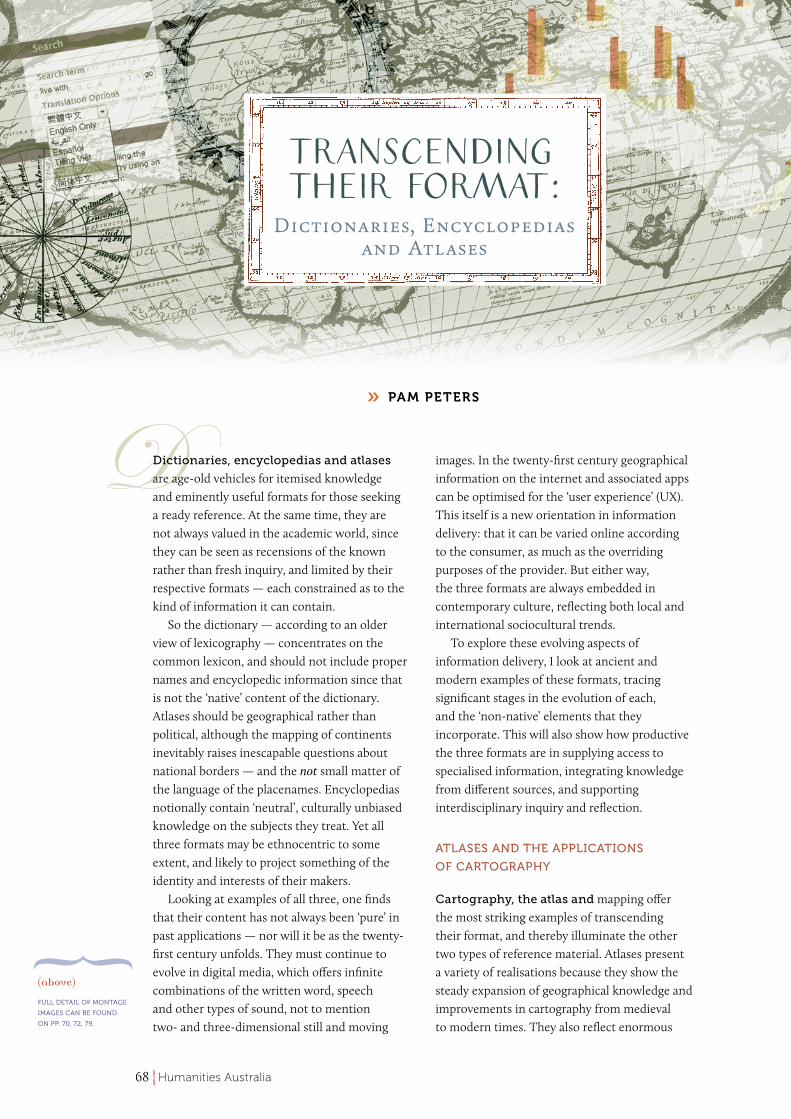
Dictionaries, encyclopedias and atlases are age-old vehicles for itemised knowledge and eminently useful formats for those seeking a ready reference. At the same time, they are not always valued in the academic world, since they can be seen as recensions of the known rather than fresh inquiry, and limited by their respective formats — each constrained as to the kind of information it can contain.
So the dictionary — according to an older view of lexicography — concentrates on the common lexicon, and should not include proper names and encyclopedic information since that is not the ‘native’ content of the dictionary. Atlases should be geographical rather than political, although the mapping of continents inevitably raises inescapable questions about national borders — and the not small matter of the language of the placenames. Encyclopedias notionally contain ‘neutral’, culturally unbiased knowledge on the subjects they treat. Yet all three formats may be ethnocentric to some extent, and likely to project something of the identity and interests of their makers.
Looking at examples of all three, one finds that their content has not always been ‘pure’ in past applications — nor will it be as the twenty-first century unfolds. They must continue to evolve in digital media, which offers infinite combinations of the written word, speech and other types of sound, not to mention two- and three-dimensional still and moving
images. In the twenty-first century geographical information on the internet and associated apps can be optimised for the ‘user experience’ (UX). This itself is a new orientation in information delivery: that it can be varied online according to the consumer, as much as the overriding purposes of the provider. But either way, the three formats are always embedded in contemporary culture, reflecting both local and international sociocultural trends.
To explore these evolving aspects of information delivery, I look at ancient and modern examples of these formats, tracing significant stages in the evolution of each, and the ‘non-native’ elements that they incorporate. This will also show how productive the three formats are in supplying access to specialised information, integrating knowledge from different sources, and supporting interdisciplinary inquiry and reflection.
ATLASES AND THE APPLICATIONS
OF CARTOGRAPHY
Cartography, the atlas and mapping offer the most striking examples of transcending their format, and thereby illuminate the other two types of reference material. Atlases present a variety of realisations because they show the steady expansion of geographical knowledge and improvements in cartography from medieval to modern times. They also reflect enormous
transcending their format:Dictionaries, Encyclopedias
and Atlases
PAM PETERS»
(above)
FULL DETAIL OF MONTAGE
IMAGES CAN BE FOUND
ON PP. 70, 72, 79.
69Humanities Australia
cultural changes from a theocratic to secular-social view of the world. We might add that they are not necessarily ‘disciplined’ by the stringently geographical expectations of twentieth-century exemplars, such as the Times World Atlas.
The word atlas is an eponym from one of two possible Graeco-Roman sources. The better known one (noted in the Oxford English Dictionary) is that it invokes the name of the titan rebel condemned by Zeus to hold up the heavens. Atlas’s burden is well known from the classical sculpture that has him stooping under the weight of the celestial globe — an image perpetuated at the front of Italian and earlier Dutch atlases of the sixteenth century. Later statues of Atlas have him bearing the weight of the terrestrial globe, confirming his association with the modern published atlas. An alternative eponym for the word atlas features on the frontispiece of Gerardus Mercator’s (1595) posthumously published reflections on cartography: that it is the name of the legendary king Atlas of the ancient North African kingdom of Mauretania, bordering the straits of Gibraltar. King Atlas was a wise philosopher, astronomer and mathematician — and thus an appropriate symbol for Mercator’s cylindrical projection
of the world. This was a considerable advance in mapping for practical navigation, at least in the middle sections of the globe between the arctic and antarctic circles. The eclipsing of the first eponymous Atlas by the second helps to symbolise the scientific revolution by which cartography was transformed in the modern era.
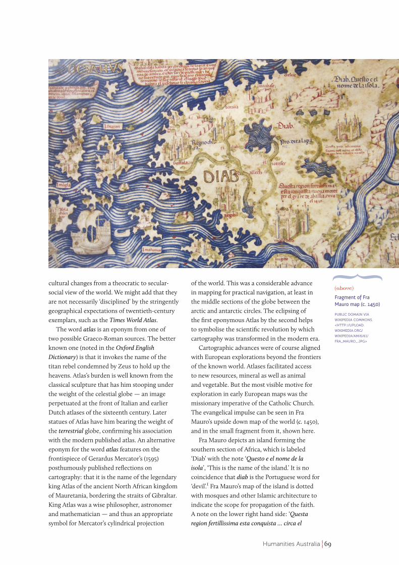
Cartographic advances were of course aligned with European explorations beyond the frontiers of the known world. Atlases facilitated access to new resources, mineral as well as animal and vegetable. But the most visible motive for exploration in early European maps was the missionary imperative of the Catholic Church. The evangelical impulse can be seen in Fra Mauro’s upside down map of the world (c. 1450), and in the small fragment from it, shown here.
Fra Mauro depicts an island forming the southern section of Africa, which is labeled ‘Diab’ with the note ‘Questo e el nome de la isola’, ‘This is the name of the island.’ It is no coincidence that diab is the Portuguese word for ‘devil’.1 Fra Mauro’s map of the island is dotted with mosques and other Islamic architecture to indicate the scope for propagation of the faith. A note on the lower right hand side: ‘Questa region fertillissima esta conquista … circa el
(above)
Fragment of Fra Mauro map (c. 1450)
PUBLIC DOMAIN VIA
WIKIPEDIA COMMONS,
<HTTP://UPLOAD.
WIKIMEDIA.ORG/
WIKIPEDIA/AM/6/61/
FRA_MAURO_.JPG>
70 Humanities Australia
1430’, points out that there is good agricultural land here. The map provides both religious and economic motives for venturing down to Diab, though to modern eyes the chances of reaching your destination with such a map are rather fanciful.
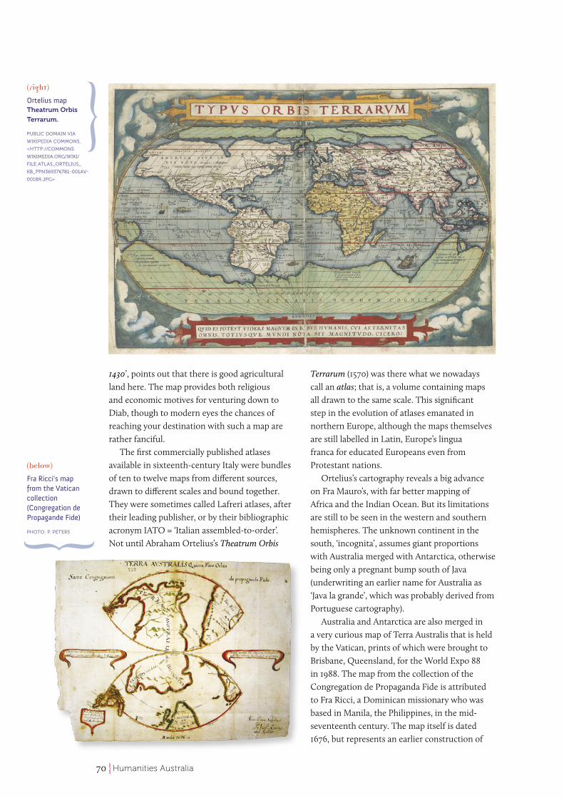
The first commercially published atlases available in sixteenth-century Italy were bundles of ten to twelve maps from different sources, drawn to different scales and bound together. They were sometimes called Lafreri atlases, after their leading publisher, or by their bibliographic acronym IATO = ‘Italian assembled-to-order’. Not until Abraham Ortelius’s Theatrum Orbis
Terrarum (1570) was there what we nowadays call an atlas; that is, a volume containing maps all drawn to the same scale. This significant step in the evolution of atlases emanated in northern Europe, although the maps themselves are still labelled in Latin, Europe’s lingua franca for educated Europeans even from Protestant nations.
Ortelius’s cartography reveals a big advance on Fra Mauro’s, with far better mapping of Africa and the Indian Ocean. But its limitations are still to be seen in the western and southern hemispheres. The unknown continent in the south, ‘incognita’, assumes giant proportions with Australia merged with Antarctica, otherwise being only a pregnant bump south of Java (underwriting an earlier name for Australia as ‘Java la grande’, which was probably derived from Portuguese cartography).
Australia and Antarctica are also merged in a very curious map of Terra Australis that is held by the Vatican, prints of which were brought to Brisbane, Queensland, for the World Expo 88 in 1988. The map from the collection of the Congregation de Propaganda Fide is attributed to Fra Ricci, a Dominican missionary who was based in Manila, the Philippines, in the mid-seventeenth century. The map itself is dated 1676, but represents an earlier construction of
(right)
Ortelius map Theatrum Orbis
Terrarum.
PUBLIC DOMAIN VIA
WIKIPEDIA COMMONS,
<HTTP://COMMONS.
WIKIMEDIA.ORG/WIKI/
FILE:ATLAS_ORTELIUS_
KB_PPN369376781-001AV-
001BR.JPG>
(below)
Fra Ricci’s map from the Vatican collection (Congregation de Propagande Fide)
PHOTO: P. PETERS
71Humanities Australia
the missionary opportunities in the southern hemisphere, in line with papal dispensations of 1494 (Treaty of Tordesillas) and 1529 (Treaty of Zaragoza). Those treaties were put in place to balance the colonial interests of Spain and Portugal, and to divide between them the world that was available to be proselytised.
The Vatican map divides Australia into two for the propagation of the faith, along the meridian identified in the Treaty of Zaragoza, as if the western segment would be for the Portuguese, and the eastern segment for the Spanish. It shows Portuguese dominions in the western Atlantic (Brazil), and their passage via southern Africa into the Indian Ocean, up to Sumatra, Java, Borneo, from which islands ‘haud difficilis est aditus ad terram Australem’, ‘it is not difficult to access the land of Australia’. Meanwhile Spanish dominion stretches down the west side of South America from Lima (Peru) to Chile and across the Pacific to the east coast of Australia. Most remarkably, Australia and Antarctica still form a single super-continent (‘quinta pars orbis’, ‘the fifth part of the globe’), with the South Pole located centrally on the junction between the eastern and western segments. Again this is not a map you could sail by, and the author acknowledges its minimalist cartography: ‘in minimo puncto facta sit’. The map is labelled in Latin, reflecting its alignment with the mission of the Church Universal. The message is clearly much bigger than the medium, though whether one would say it transcends its format depends on one’s point of view.
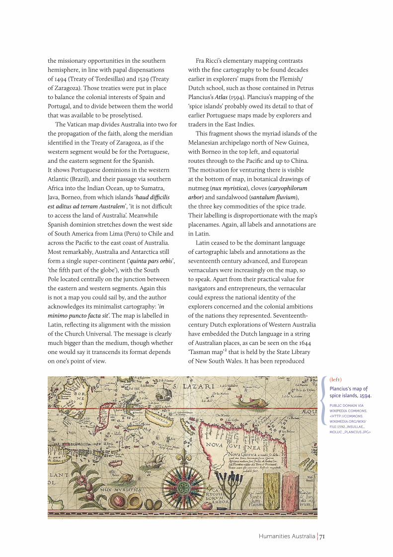
Fra Ricci’s elementary mapping contrasts with the fine cartography to be found decades earlier in explorers’ maps from the Flemish/Dutch school, such as those contained in Petrus Plancius’s Atlas (1594). Plancius’s mapping of the ‘spice islands’ probably owed its detail to that of earlier Portuguese maps made by explorers and traders in the East Indies.
This fragment shows the myriad islands of the Melanesian archipelago north of New Guinea, with Borneo in the top left, and equatorial routes through to the Pacific and up to China. The motivation for venturing there is visible at the bottom of map, in botanical drawings of nutmeg (nux myristica), cloves (caryophilorum arbor) and sandalwood (santalum fluvium), the three key commodities of the spice trade. Their labelling is disproportionate with the map’s placenames. Again, all labels and annotations are in Latin.
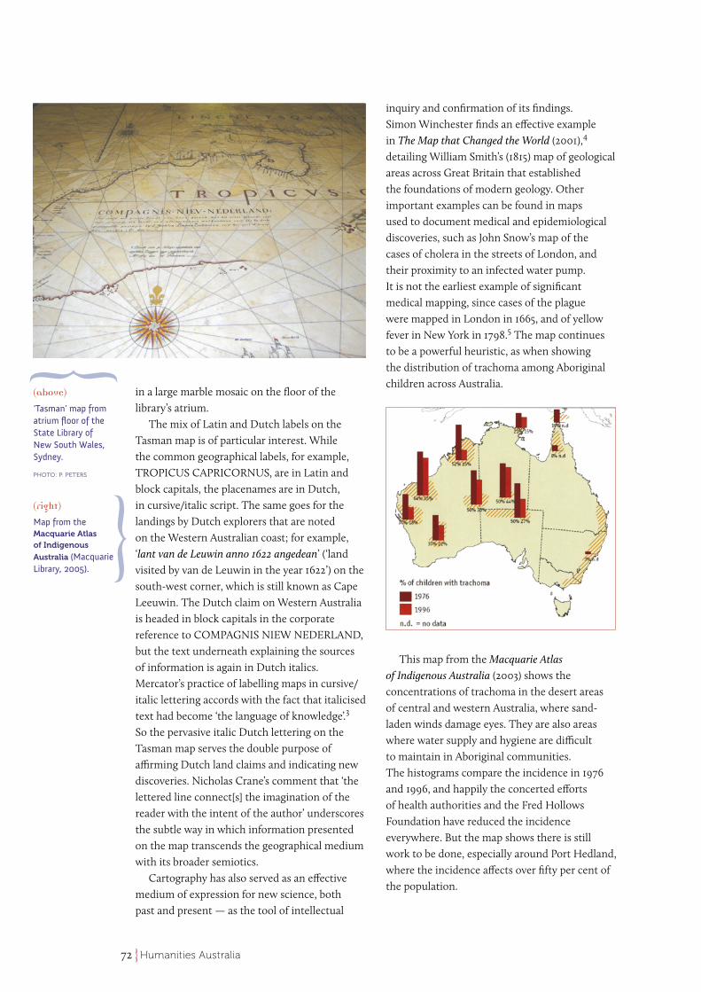
Latin ceased to be the dominant language of cartographic labels and annotations as the seventeenth century advanced, and European vernaculars were increasingly on the map, so to speak. Apart from their practical value for navigators and entrepreneurs, the vernacular could express the national identity of the explorers concerned and the colonial ambitions of the nations they represented. Seventeenth-century Dutch explorations of Western Australia have embedded the Dutch language in a string of Australian places, as can be seen on the 1644 ‘Tasman map’2 that is held by the State Library of New South Wales. It has been reproduced
(left)
Plancius’s map of spice islands, 1594.
PUBLIC DOMAIN VIA
WIKIPEDIA COMMONS,
<HTTP://COMMONS.
WIKIMEDIA.ORG/WIKI/
FILE:1592_INSULLAE_
MOLUC._PLANCIUS.JPG>
72 Humanities Australia
in a large marble mosaic on the floor of the library’s atrium.
The mix of Latin and Dutch labels on the Tasman map is of particular interest. While the common geographical labels, for example, TROPICUS CAPRICORNUS, are in Latin and block capitals, the placenames are in Dutch, in cursive/italic script. The same goes for the landings by Dutch explorers that are noted on the Western Australian coast; for example, ‘lant van de Leuwin anno 1622 angedean’ (‘land visited by van de Leuwin in the year 1622’) on the south-west corner, which is still known as Cape Leeuwin. The Dutch claim on Western Australia is headed in block capitals in the corporate reference to COMPAGNIS NIEW NEDERLAND, but the text underneath explaining the sources of information is again in Dutch italics. Mercator’s practice of labelling maps in cursive/italic lettering accords with the fact that italicised text had become ‘the language of knowledge’.3 So the pervasive italic Dutch lettering on the Tasman map serves the double purpose of affirming Dutch land claims and indicating new discoveries. Nicholas Crane’s comment that ‘the lettered line connect[s] the imagination of the reader with the intent of the author’ underscores the subtle way in which information presented on the map transcends the geographical medium with its broader semiotics.
Cartography has also served as an effective medium of expression for new science, both past and present — as the tool of intellectual
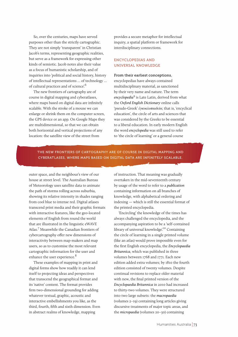
inquiry and confirmation of its findings. Simon Winchester finds an effective example in The Map that Changed the World (2001),4 detailing William Smith’s (1815) map of geological areas across Great Britain that established the foundations of modern geology. Other important examples can be found in maps used to document medical and epidemiological discoveries, such as John Snow’s map of the cases of cholera in the streets of London, and their proximity to an infected water pump. It is not the earliest example of significant medical mapping, since cases of the plague were mapped in London in 1665, and of yellow fever in New York in 1798.5 The map continues to be a powerful heuristic, as when showing the distribution of trachoma among Aboriginal children across Australia.
This map from the Macquarie Atlas of Indigenous Australia (2003) shows the concentrations of trachoma in the desert areas of central and western Australia, where sand-laden winds damage eyes. They are also areas where water supply and hygiene are difficult to maintain in Aboriginal communities. The histograms compare the incidence in 1976 and 1996, and happily the concerted efforts of health authorities and the Fred Hollows Foundation have reduced the incidence everywhere. But the map shows there is still work to be done, especially around Port Hedland, where the incidence affects over fifty per cent of the population.
(above)
‘Tasman’ map from atrium floor of the State Library of New South Wales, Sydney.
PHOTO: P. PETERS
(right)
Map from the Macquarie Atlas of Indigenous
Australia (Macquarie Library, 2005).
73Humanities Australia
So, over the centuries, maps have served purposes other than the strictly cartographic. They are not simply ‘transparent’ in Christian Jacob’s terms, representing geographic realities, but serve as a framework for expressing other kinds of semiotic. Jacob notes also their value as a focus of humanistic scholarship, and of inquiries into ‘political and social history, history of intellectual representations … of technology … of cultural practices and of science’.6
The new frontiers of cartography are of course in digital mapping and cyberatlases, where maps based on digital data are infinitely scalable. With the stroke of a mouse we can enlarge or shrink them on the computer screen, the GPS device or an app. On Google Maps they are multidimensional, so that we can obtain both horizontal and vertical projections of any location: the satellite view of the street from
outer space, and the neighbour’s view of our house at street level. The Australian Bureau of Meteorology uses satellite data to animate the path of storms rolling across suburbia, showing its relative intensity in shades ranging from cool blue to intense red. Digital atlases transcend print media and their graphic formats with interactive features, like the geo-located elements of English from round the world that are illustrated in the linguistic eWAVE Atlas.7 Meanwhile the Canadian frontiers of cybercartography offer new dimensions of interactivity between map-makers and map users, so as to customise the most relevant cartographic information for the user and enhance the user experience.8
These examples of mapping in print and digital forms show how readily it can lend itself to projecting ideas and perspectives that transcend the geographical format and its ‘native’ content. The format provides firm two-dimensional grounding for adding whatever textual, graphic, acoustic and interactive embellishments you like, as the third, fourth, fifth and sixth dimension. Even in abstract realms of knowledge, mapping
provides a secure metaphor for intellectual inquiry, a spatial platform or framework for interdisciplinary connections.
ENCYCLOPEDIAS AND
UNIVERSAL KNOWLEDGE
From their earliest conceptions, encyclopedias have always contained multidisciplinary material, as sanctioned by their very name and nature. The term encyclopedia9 is Late Latin, derived from what the Oxford English Dictionary online calls ‘pseudo-Greek’ ἐγκυκλοπαιδεία; that is, ‘encyclical education’, the circle of arts and sciences that was considered by the Greeks to be essential to a liberal education. In early modern English the word encyclopedia was still used to refer to ‘the circle of learning’ or a general course
of instruction. That meaning was gradually overtaken in the mid-seventeenth century by usage of the word to refer to a publication containing information on all branches of knowledge, with alphabetical ordering and indexing — which is still the essential format of the printed encyclopedia.
‘Encircling’ the knowledge of the times has always challenged the encyclopedia, and the accompanying aspiration to be a ‘self-contained library of universal knowledge’.10 Containing the circle of learning in a single printed volume (like an atlas) would prove impossible even for the first English encyclopedia, the Encyclopaedia Britannica, which was published in three volumes between 1768 and 1771. Each new edition added extra volumes; by 1810 the fourth edition consisted of twenty volumes. Despite continual revisions to replace older material with new, the final printed version of the Encyclopaedia Britannica in 2010 had increased to thirty-two volumes. They were structured into two large subsets: the macropaedia (volumes 2–19) containing long articles giving discursive treatments of major topic areas, and the micropaedia (volumes 20–30) containing
THE NEW FRONTIERS OF CARTOGRAPHY ARE OF COURSE IN DIGITAL MAPPING AND
CYBERATLASES, WHERE MAPS BASED ON DIGITAL DATA ARE INFINITELY SCALABLE.
74 Humanities Australia
short articles (up to 750 words) to allow ready fact checking within circumscribed areas of knowledge. Topics and entities in macropaedia and micropaedia are both alphabetically indexed in volumes 31 and 32, and a conceptual (thesaurus-like) model of the topics covered is offered in the propaedia (volume 1), starting with ten high-level categories. The propaedia revives the schematic array of knowledge that is found in reference books of the eighteenth century, and serves to taxonomise the areas of knowledge contained in the 2010 Encyclopaedia Britannica. Despite all the well-motivated aspects of its design, the Encyclopaedia Britannica could hardly claim to enshrine universal knowledge, even without its inescapably Anglo-Saxon world view.
The cyclopedias published before the first Britannica took a different approach to the encyclopedic challenge. These more modest reference works may owe something to the personal commonplace book,11 in which the owner noted and collated significant sayings and summary facts distilled for personal reference. The first cyclopedia was in fact produced (written and published) by a single well-read
person, Ephraim Chambers. The encyclopedic aspirations of his Cyclopaedia are set out in detail on its title page, along with its aim to be a ‘universal dictionary of arts and sciences’, as well as ‘a course of antient and modern learning’. Chambers not-so-modestly dubbed it ‘the best book in the universe’.12 But, in writing about his Cyclopaedia, Chambers acknowledged the ever-increasing scope of ‘universal knowledge’, which called for its ‘reduction … into a lesser compass’.13 His practical strategy was to distill it into readable portions, focusing on ‘the definitions of terms and accounts of the things signify’d thereby’, as stated on the title page. In contrast, Abraham Rees, Chambers’s partner and successor in the creation of cyclopedias, simply allowed his New Cyclopaedia to expand to forty-five volumes (published 1802–1819), with new articles on science and medicine as well as the mechanical trades written by numerous commissioned
authors, as was practised in the Encyclopaedia Britannica. The distinction between the two encyclopedic genres was lost.
The true successor to Chambers’s Cyclopaedia appeared at the other end of the nineteenth century, in the one-volume Pears Cyclopaedia or ‘Pears Shilling Encyclopaedia’ published in 1897. It was sponsored by a soap-maker and thus easily affordable, unlike the multivolume encyclopedia. Like Chambers’s Cyclopaedia, the Pears volume offered encyclopedic information in concise dictionary-like entries, as well as a chronological list of events, a list of prominent people (past and present), and a compact atlas and gazetteer. Each edition also included around twelve more specialised entries on subjects such as cookery and classical mythology. The selection of these was rotated from year to year, so people could buy new editions relevant to their hobby/cottage industry. By keeping its entries concise, and with annual revisions and updates, Pears Cyclopaedia is still published today and has been able to control the relentless demands of encyclopedic information on space, remaining the most successful of its genre.
Specialisation is an alternative way of managing the demands of information on limited space in the printed encyclopedia. The first edition of the Australian Encyclopaedia, published in two volumes in 1925–1926, included material unique or special to Australia; that is, large amounts of natural history, geology, flora and fauna, and the biographies of notable Australians. Apart from its limited content, the original Australian Encyclopaedia was not particularly balanced in its stance. A European reviewer was surprised by it ‘waving the flag for Australia’ in almost every article,14 making Australia superior in many unsuspected local specialisms. Australian breadmaking (in comparison with European) is: ‘quicker and involves less handling; the flours used are of better quality so that they rise better, hold more water, and make a larger loaf from the same quantity of flour’.15 Nadine Hagen found
… THE ENCYCLOPAEDIA BRITANNICA COULD HARDLY CLAIM TO ENSHRINE UNIVERSAL
KNOWLEDGE, EVEN WITHOUT ITS INESCAPABLY ANGLO-SAXON WORLD VIEW.
75Humanities Australia
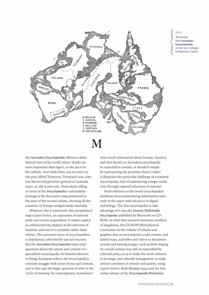
the Australian Encyclopaedia offered a rather limited view of the world, where ‘sharks are more important than tigers’, as she put it in her subtitle. And while there was no entry on the poet Alfred Tennyson, Tennyson’s son, who was the second governor-general of Australia (1903–4), did receive one. Particularly telling in terms of the Encyclopaedia’s nationalistic message is the decorative map positioned at the start of the second volume, showing all the countries of Europe wedged inside Australia.
Whatever else it represents, this uncaptioned map is pure hubris, an expression of national pride and reverse imperialism. It makes explicit an ethnocentricity implicit in the selection of material, and uses it to promote rather than inform. The universal vision of encyclopedism is abandoned, subverted by special interests. But the Australian Encyclopaedia raises vital questions about the nature and content of a specialised encyclopedia. Its limited reference to things European reflects the encyclopedia’s constant struggle with issues of size and content, and in this case the larger question of what is the ‘circle of learning’ for contemporary Australians?
How much information about Europe, America and Asia should an Australian encyclopedia be expected to contain; or should it simply be representing the priorities Down Under? It illustrates the particular challenge of a national encyclopedia, that of maintaining a larger world view through regional selections of material.
Fresh solutions to the world encyclopedia’s problems of accommodating information came early in the 1990s with advances in digital technology. The first encyclopedia to take advantage of it was the Encarta Multimedia Encyclopedia published by Microsoft on CD-ROM. In what then seemed enormous numbers of megabytes, the CD-ROM lifted physical constraints on the volume of articles and graphics that an encyclopedia could contain, and added maps, audiofiles and videos to document sounds and moving images, such as birds singing. Its overall content was still circumscribed by editorial policy so as to make the work coherent in its range, and editorial management to make articles consistent in density and quality, using expert writers. Both Encarta (1993) and the first online release of the Encyclopaedia Britannica
(left)
‘Mind map’ from Australian
Encyclopaedia, 1st ed, vol. 2 (Angus & Robertson, 1926).
76 Humanities Australia
(1994) made the most of digital facilities while still containing the encyclopedia’s scope.
The real paradigm shift came with the third millennium, as open-ended encyclopedias began to be ‘born’ and created on the internet. The first venture of this kind was Nupedia, which lasted less than three years between 2000 and 2003. Its output got bogged down in the refereeing process and editorial quality control, so that it could not keep pace with demands to build a new world-encompassing encyclopedia. It was overtaken by Wikipedia (wiki being the Hawaiian pidgin word for ‘quick’) in a major paradigm shift for the encyclopedia as a form.
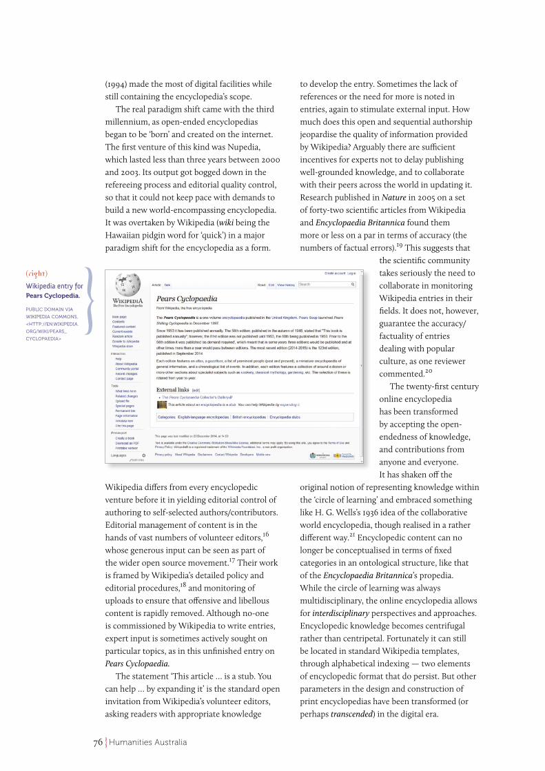
Wikipedia differs from every encyclopedic venture before it in yielding editorial control of authoring to self-selected authors/contributors. Editorial management of content is in the hands of vast numbers of volunteer editors,16 whose generous input can be seen as part of the wider open source movement.17 Their work is framed by Wikipedia’s detailed policy and editorial procedures,18 and monitoring of uploads to ensure that offensive and libellous content is rapidly removed. Although no-one is commissioned by Wikipedia to write entries, expert input is sometimes actively sought on particular topics, as in this unfinished entry on Pears Cyclopaedia.
The statement ‘This article … is a stub. You can help … by expanding it’ is the standard open invitation from Wikipedia’s volunteer editors, asking readers with appropriate knowledge
to develop the entry. Sometimes the lack of references or the need for more is noted in entries, again to stimulate external input. How much does this open and sequential authorship jeopardise the quality of information provided by Wikipedia? Arguably there are sufficient incentives for experts not to delay publishing well-grounded knowledge, and to collaborate with their peers across the world in updating it. Research published in Nature in 2005 on a set of forty-two scientific articles from Wikipedia and Encyclopaedia Britannica found them more or less on a par in terms of accuracy (the numbers of factual errors).19 This suggests that
the scientific community takes seriously the need to collaborate in monitoring Wikipedia entries in their fields. It does not, however, guarantee the accuracy/factuality of entries dealing with popular culture, as one reviewer commented.20
The twenty-first century online encyclopedia has been transformed by accepting the open-endedness of knowledge, and contributions from anyone and everyone. It has shaken off the
original notion of representing knowledge within the ‘circle of learning’ and embraced something like H. G. Wells’s 1936 idea of the collaborative world encyclopedia, though realised in a rather different way.21 Encyclopedic content can no longer be conceptualised in terms of fixed categories in an ontological structure, like that of the Encyclopaedia Britannica’s propedia. While the circle of learning was always multidisciplinary, the online encyclopedia allows for interdisciplinary perspectives and approaches. Encyclopedic knowledge becomes centrifugal rather than centripetal. Fortunately it can still be located in standard Wikipedia templates, through alphabetical indexing — two elements of encyclopedic format that do persist. But other parameters in the design and construction of print encyclopedias have been transformed (or perhaps transcended) in the digital era.
(right)
Wikipedia entry for Pears Cyclopedia.
PUBLIC DOMAIN VIA
WIKIPEDIA COMMONS,
<HTTP://EN.WIKIPEDIA.
ORG/WIKI/PEARS_
CYCLOPAEDIA>
77Humanities Australia
DICTIONARIES AND THEIR USERS
Dictionaries (like encyclopedias and atlases) have continuously evolved in their content and orientation, with marked developments over the course of time. The first English dictionaries to be called by that name were ad hoc bilingual Latin/English glossaries, which were used for the education of children and clerics in the thirteenth century; in the sixteenth century dictionaries were printed to help English travellers to translate from French and Italian. The term dictionary was then applied to monolingual English word lists that concentrated on ‘hard English words’, such as Henry Cockeram’s English Dictionary; or An Interpreter of Hard English Words (1623); or Thomas Blount’s Glossographia: or, A Dictionary Interpreting All Such Hard Words … As Are Now Used in Our Refined English Tongue (1656). Only in the eighteenth century was the word dictionary associated with a comprehensive
reference on the English lexicon, most notably Nathan Bailey’s Universal Etymological Dictionary (1721), and Samuel Johnson’s Dictionary of the English Language (1755). Both left their mark on the dictionary microstructure (i.e., the format of the individual entries), by providing examples of word usage, and indicating the etymologies of words where they were known.
Johnson’s Dictionary of the English Language quickly became the authoritative account of English vocabulary, with its systematic use of citations from English literary greats to validate the senses of words. His representation of usage was, however, conservative since he explicitly excluded living writers: ‘I aimed to admit no testimony of living authors’ (‘Preface’ to Johnson’s Dictionary). Johnson also disclaimed responsibility for what he called ‘fugitive cant’, including colloquial expressions, which were hard to record and rarely listed. Spoken styles of English were not as highly valued as they had been a century before.22 So, although Johnson’s dictionary covered the English lexicon more
fully than any before, there were selectional restrictions on what was included, even within its two large (folio-sized) volumes, which became increasingly problematic as it was reprinted with little editorial change for decades.23
The linguistic and cultural limitations of Johnson’s dictionary were increasingly recognised in the 1850s by members of the Philological Society,24 and action mobilised towards creating a totally different, historical dictionary of English. This culminated in the New English Dictionary (later called the Oxford English Dictionary), published successively in twelve volumes (1884–1928). The Oxford English Dictionary (OED) traced the meanings of English words through historical evidence of their use across the centuries, and provided etymologies based on the latest philological scholarship. It included regionalisms emerging from the growing interest in dialectology. Words were documented from a much wider variety of nonfiction and fiction than Johnson had been
able to consult. The OED included words of colonial English,25 and evidence of lexical developments outside England, however deeply ethnocentric it remained.26 The OED opened English lexicography up as a field of empirical inquiry, freeing it from a priori assumptions of correctness and the bonds of prescriptivism. In all these ways the OED transcended eighteenth-century models of the dictionary, making its scope far greater than any single-volume print dictionary then or since. It remains a monument to the English language at large.
In its greatness, the Oxford English Dictionary allowed smaller (one-volume) dictionaries to concentrate on particular segments of the English lexicon, and to innovate in other ways for particular readerships. Among these more specialised dictionaries, those designed for second-language learners of English (i.e., ‘learners dictionaries’) have embodied some remarkable innovations within the traditional print dictionary model. One such innovation in learners dictionaries of the late twentieth
THE LINGUISTIC AND CULTURAL LIMITATIONS OF JOHNSON’S DICTIONARY WERE
INCREASINGLY RECOGNISED IN THE 1850s BY MEMBERS OF THE PHILOLOGICAL SOCIETY…
78 Humanities Australia
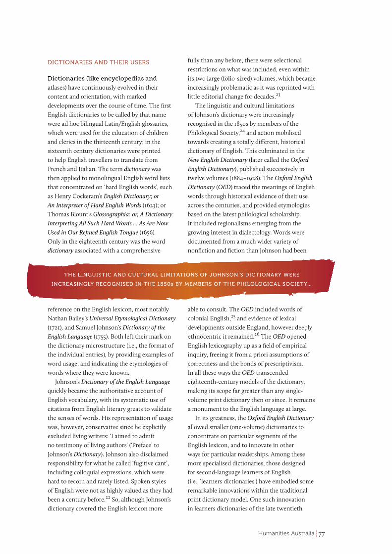
century was the use of large computer corpora of spoken and written language to inform dictionary entries. The publisher’s in-house corpus provided empirical information on the frequencies of words and phrases in spoken and written usage. This allowed them to construct their word list (the ‘macrostructure’) out of words that learners are most likely to encounter in their reading and listening. Corpus-based knowledge of word frequencies also allowed dictionary-makers to control their defining vocabularies to around the top three thousand words, and avoid definitions more challenging to the learner than the mysterious headword itself. The contrasting frequencies of near synonyms in different registers could also be used as evidence of stylistic differences, as with ‘let’, ‘allow’, and ‘permit’.
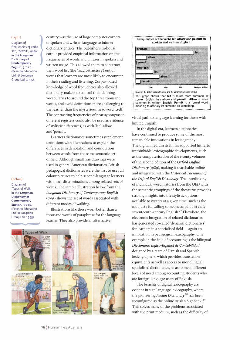
Learners dictionaries sometimes supplement definitions with illustrations to explain the differences in denotation and connotation between words from the same semantic set or field. Although small line drawings were used in general American dictionaries, British pedagogical dictionaries were the first to use full colour pictures to help second-language learners with finer discriminations among related sets of words. The sample illustration below from the Longman Dictionary of Contemporary English (1995) shows the set of words associated with different modes of walking.
Illustrations like these work better than a thousand words of paraphrase for the language learner. They also provide an alternative
visual path to language learning for those with limited English.
In the digital era, learners dictionaries have continued to produce some of the most remarkable innovations in lexicography. The digital medium itself has supported hitherto unthinkable lexicographic developments, such as the computerisation of the twenty volumes of the second edition of the Oxford English Dictionary (1989), making it searchable online and integrated with the Historical Thesaurus of the Oxford English Dictionary. The interlinking of individual word histories from the OED with the semantic groupings of the thesaurus provides striking insights into the stylistic options available to writers at a given time, such as the mot juste for calling someone an idiot in early seventeenth-century English.27 Elsewhere, the electronic integration of related dictionaries has generated so-called ‘dynamic dictionaries’ for learners in a specialised field — again an innovation in pedagogical lexicography. One example in the field of accounting is the bilingual Diccionario Ingles–Espanol de Contabilidad, designed by a team of Danish and Spanish lexicographers, which provides translation equivalents as well as access to monolingual specialised dictionaries, so as to meet different levels of need among accounting students who are foreign-language users of English.
The benefits of digital lexicography are evident in sign language lexicography, where the pioneering Auslan Dictionary28 has been reconfigured as the online Auslan Signbank.29 This solves many of the problems associated with the print medium, such as the difficulty of
(below)
Diagram of ‘Types of Walk’ in the Longman Dictionary of Contemporary
English, 3rd ed. (Pearson Education Ltd, © Longman Group Ltd, 1995).
(right)
Diagram of frequencies of verbs ‘let’, ‘permit’, ‘allow’ in the Longman Dictionary of Contemporary
English, 3rd ed. (Pearson Education Ltd, © Longman Group Ltd, 1995).
79Humanities Australia
representing the motion and directionality of hand signs in small static line drawings on the printed page. For online users the video clips of hand signs are infinitely easier to understand and imitate. Individual signs are much easier to find among the 5500 that are contained in the Signbank through alphabetical indexing. In the printed dictionary they were arranged in a multi-faceted system based on relevant but non-intuitive aspects, such as the hands involved, position relative to body, and the directions of movement, to assist learners with sets of similar signs. But the alphabetical index of the signbank facilitates ready reference. It also accommodates idiomatic uses of Auslan signs, so that the page for the sign for ‘think’ can also show its use as a discourse marker to mean ‘Just as I thought’/ ‘I suspected that’.
There are online termbank projects underway at Macquarie University that are designed to explain specialised terminology to novices in the field. The TermFinder project began as a pedagogical aid to international students in units like accounting, but is now extending into the Australian community with termbanks of
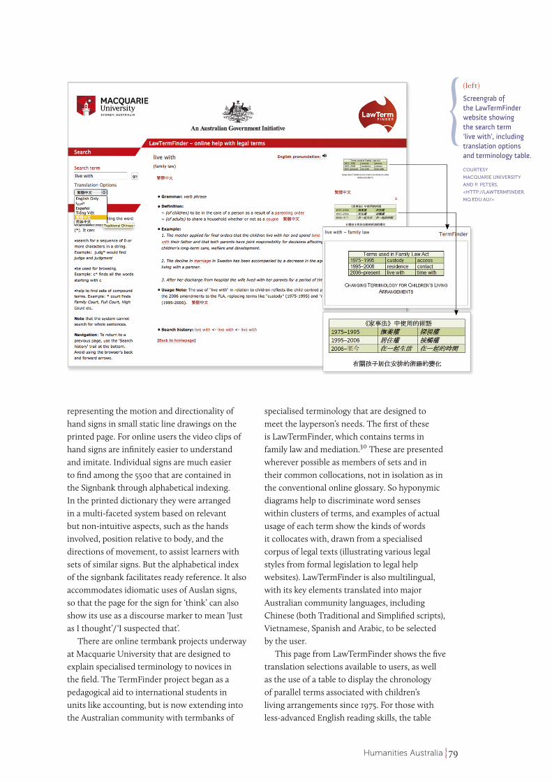
specialised terminology that are designed to meet the layperson’s needs. The first of these is LawTermFinder, which contains terms in family law and mediation.30 These are presented wherever possible as members of sets and in their common collocations, not in isolation as in the conventional online glossary. So hyponymic diagrams help to discriminate word senses within clusters of terms, and examples of actual usage of each term show the kinds of words it collocates with, drawn from a specialised corpus of legal texts (illustrating various legal styles from formal legislation to legal help websites). LawTermFinder is also multilingual, with its key elements translated into major Australian community languages, including Chinese (both Traditional and Simplified scripts), Vietnamese, Spanish and Arabic, to be selected by the user.
This page from LawTermFinder shows the five translation selections available to users, as well as the use of a table to display the chronology of parallel terms associated with children’s living arrangements since 1975. For those with less-advanced English reading skills, the table
(left)
Screengrab of the LawTermFinder website showing the search term ‘live with’, including translation options and terminology table.
COURTESY
MACQUARIE UNIVERSITY
AND P. PETERS,
<HTTP://LAWTERMFINDER.
MQ.EDU.AU/>
80 Humanities Australia
dictionaries, encyclopedias and atlases is their capacity for transformation, so that in principle nothing is alien. Their epigram is there for us in the Australian Academy of the Humanities own motto: humani nihil alienum. 
PAM PETERS faha was appointed
Emeritus Professor at Macquarie
University on her retirement,
after holding a Personal Chair
in Linguistics. She was director
of Macquarie University’s
Dictionary Research Centre from
2001 to 2007, and on the Editorial Committee
of the Macquarie Dictionary from 1986 to 2006.
She continues her research in lexicography and
terminography as Director of the TermFinder project,
developing multilingual online termbanks for
tertiary education in the disciplines of accounting
and statistics, and for community use in family
law (LawTermFinder) and cancer treatment
(HealthTermFinder).
1. The name Diab was earlier used in Capo di Diab, the Portuguese name for the Cape of Good Hope, <http://www.namibiana.de/namibia-information/> [accessed 26 March 2015].
2. Dutch annotations on the map note that it is a compilation from several sources, including Abel Tasman’s own observations that were made under the orders of the Dutch colonial governor Antony van Diemen, <www.sl.nsw.gov.au/discover_collections/history_nation/voyages/rich_lands/voya_tasman.html> [accessed 26 March 2015].
3. Nicholas Crane, Mercator: The Man who Mapped the Planet (Google Books, 2010), ch. 12.
4. Simon Winchester, The Map that Changed the World (London, Penguin Books, 2001).
5. Simon Garfield, On the Map (London, Profile Books, 2013), pp. 230–31.
6. Christian Jacob, ‘Towards a Cultural History of Cartography’, Imago Mundi: International Journal for the History of Cartography, 48, 1 (2008), pp. 191–93.
7. Bernd Kortmann and Kirsten Lunkenheimer, eWAVE Mouton World Atlas of Varieties of English (2012), <http://ewave-atlas.org/> [accessed 26 March 2015].
8. Brian Eddy and Fraser Taylor, ‘Applying a Cybercartographic Human Interface (CHI)’, in Cybercartography: Theory and Practice, ed. by Fraser Taylor (Amsterdam, Elsevier, 2006), p. 537.
9. The Oxford English Dictionary notes that the spelling encyclopaedia (with the digraph) has been preserved from obsolescence because of its use in titles such as Encyclopaedia
complements the usage note at the bottom of the entry in explaining the changes in terminology since 1975. Though custody/access were officially superseded in 1995, the terms are still widely used in everyday talk, and continue to provide the parents’ perspective (and handy nouns), while the new verb-centred phrases live with/spend time with, reflect the child-centred emphasis of the 2006 amendments to the Family Law Act.
With these examples of English dictionaries over three centuries, I hope to have demonstrated how they have indeed transcended their origins and the dictionary format itself, continuously enlarging its scope in print or online. Most of the recent innovations have emerged from the dictionary’s concentration on the needs of the user, adapting and enriching the lexical content with multimodal and multilingual capacity. The needs of the user will continue to inform online dictionary content — and also constrain it,31 so that it does not become an expanding universe, as has occurred with the online encyclopedia. Lexicographical method has undoubtedly evolved along more empirical lines, from the systematic use of historical citations in the Oxford English Dictionary, to the use of corpus data in developing content for learners dictionaries. It underlies current discussions about the science of lexicography,32 which is separate to the ‘art and craft’ of it. The methodology of dictionaries is now multidisciplinary, as its content has long been.
CONCLUSION
All three formats discussed here were and are ready vehicles for the documentation and construction of complex knowledge. The centuries-old paper-based formats have all transitioned into the digital medium and found new purposes and functions that far transcend those of their original formats. Those who go to the internet to ‘look it up’ will find maps that are scalable and multidimensional, an encyclopedia that is open-ended and open-authored, and dictionaries that are multimodal and multilingual, to optimise support for the user. All are effective in underwriting interdisciplinary research and inquiry, and for expanding humanistic interpretations of the intellectual world. The ultimate value of
81Humanities Australia
Britannica. Yet the spelling encyclopedia (without the digraph) is now commonly used in contemporary British English, and standard in American English (Pam Peters, The Cambridge Guide to English Usage (Cambridge University Press, 2004), p. 181). The spelling encyclopedia has therefore been used in the general discussion here, and Encyclopaedia in titles, as appropriate. The same policy has been adopted for cyclopedia, as opposed to Chambers Cyclopaedia.
10. Richard Yeo, Encyclopædic Visions: Scientific Dictionaries and Enlightenment Culture (Cambridge University Press, 2001), p. 92.
11. Yeo, Encyclopaedic Visions, pp. 101–119.
12. Richard Yeo, ‘A Solution to the Multitude of Books: Ephraim Chambers’s Cyclopaedia (1728) as “the Best Book in the Universe”’, Journal of the History of Ideas, 64, 1 (2003), pp. 61–72.
13. Yeo, Encyclopaedic Visions, p. 142.
14. Nadine Hagen, ‘A Mind-Map of a Nation: The Australian Encyclopaedia’, Allgemeinwissen und Gesellschaft (2007), <www.enzyklopaedie.ch/kongress/aufsaetze/hagen.pdf> [accessed 26 March 2015].
15. Australian Encyclopaedia, vol. 1, p. 200.
16. Michael Restivo and Arnout Van der Riit, ‘No Praise without Effort: Experimental Evidence on How Rewards Affect Wikipedia’s Contributor Community’, Information, Communication & Society, 7, 4 (2014), pp. 451–62.
17. For the open source movement and Wikipedia editors, see the exegesis to Anthony Self’s ‘A Style Guide for Authoring Documents using DITA’ (unpublished doctoral thesis, Swinburne University of Technology, 2011), <http://researchbank.swinburne.edu.au/vital/access/manager/Repository/swin:24010> [accessed 26 March 2015].
18. ‘Wikipedia:Editorial Oversight and Control’, <http://en.wikipedia.org/wiki/Wikipedia:Editorial_oversight_and_control> [accessed 26 March 2015].
19. Reviewers from Nature found an average of 2.92 factual errors in the Encyclopaedia Britannica articles, and 3.36 in those from Wikipedia. Online links reporting this research study and others confirming the high quality
of Wikipedia articles in particular scientific and medical fields are embedded in the review article ‘Reliability of Wikipedia’, <http://en.wikipedia.org/wiki/Reliability_of_Wikipedia> [accessed 26 March 2015].
20. Natalie Wolcher, ‘How Accurate Is Wikipedia?’, LiveScience (2011), <www.livescience.com/32950-how-accurate-is-wikipedia.html> [accessed 26 March 2015].
21. Henry George Wells, ‘The Idea of a World Encyclopaedia’, Nature, 138, Supplement (1936), pp. 917–24.
22. Ian Gordon, The Movement of English Prose (London: Longman, 1966), Chapter 12: The Seventeenth Century III: Speech-based prose.
23. Allan Reddick, The Making of Johnson’s Dictionary (Cambridge University Press, 1990), pp. 171, 175–6.
24. John Willinsky, Empire of Words: The Reign of the OED (Princeton University Press, 1994), pp. 14–16.
25. Sarah Ogilvie, Words of the World (Cambridge University Press, 2013).
26. Phil Benson, Ethnocentrism and the English Dictionary (London: Routledge, 2001), p. 105.
27. Robert Ilson, ‘Historical Thesaurus of the Oxford Dictionary’, review article, International Journal of Lexicography, 24, 2 (2011), p. 243.
28. Trevor Johnston, Auslan Dictionary: A Dictionary of the Sign Language of the Australian Deaf Community (Deafness Resources Australia, 1989).
29. <www.auslan.org.au>
30. <lawtermfinder.mq.edu.au>
31. Mike Rundell, ‘It Works in Practice But Will It Work in Theory? The Uneasy Relationship between Lexicography and Matters Theoretical’, in Euralex Proceedings Oslo 2012 (Department of Linguistics and Scandinavian Studies, University of Oslo), pp. 47–92, <http://www.euralex.org/proceedings-toc/euralex_2012/> [accessed 26 March 15].
32. Paul Bogaards, ‘Lexicography: Science without Theory’, in A Way with Words. Festschrift for Patrick Hanks, ed. by Gilles-Maurice de Schryver (Kampala, Uganda: Menha Publishers, 2010), pp. 313–22.

![E. Napp. In 1494, Spain and Portugal divided the lands Columbus had discovered between themselves [The Treaty of Tordesillas]. Conquistadores followed](https://img.pdfslide.net/doc/110x75/56649ea05503460f94ba26dd/e-napp-in-1494-spain-and-portugal-divided-the-lands-columbus-had.jpg)