Embed Size (px)
Citation preview
2011 Trimble Agricultureproduct portfolio Trimble Agriculture. The line everyone follows.
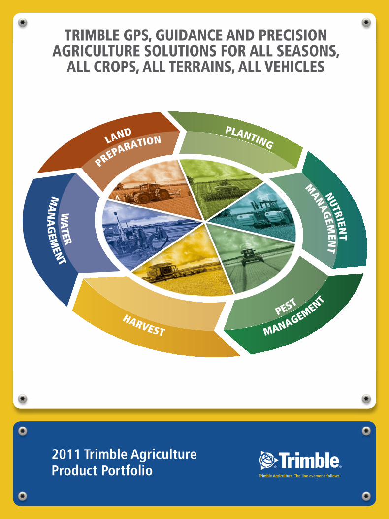
TRIMBLE GPS, GUIDANCE AND PRECISION AGRICULTURE SOLUTIONS FOR ALL SEASONS,
ALL CROPS, ALL TERRAINS, ALL VEHICLES
LAND
MANAGEMENT
P
ESTHARVEST
WA
TER
PREPARATION NUTRIENT
MANAG
EMEN
T
PLANTING
MA
NA
GEM
ENT
GpS
32011 TRIMBLE AGRICULTURE PRODUCT PORTFOLIO2
cON
TEN
TS
2011 TRIMBLE AGRICULTURE PRODUCT PORTFOLIO
You have no doubt heard how the use of GPS technology is revolutionising the agriculture industry by helping growers do things such as navigate through a field, spray their crops without foam markers, and precisely map the elevation of their farms. But what exactly is GPS and why do you need it on your farm?
What is GPS?
The Global Positioning System (GPS) is actually part of a larger system called the Global Navigation Satellite System (GNSS). GNSS is the term for all the satellite constellation systems that provide positioning data. Currently only GPS and GLONASS fall under the GNSS umbrella. GLONASS is operated by the Russian Federation and GPS is operated by the US Department of Defense, but both are available to users worldwide. The Global Positioning System has been in existence longer, so its acronym has gained greater visibility and recognition. In fact, one could argue that GPS has become the common term for all satellite constellation systems, where in fact it only identifies its origin.
GPS is a space-based navigation system formed from a constellation of 24 satellites and their ground stations. GPS uses these satellites as reference points to calculate positions accurate to a matter of centimetres. In fact, with advanced forms of GPS you can take measurements down to less than 2.5 cm. In a sense, it's like giving every square 2.5 cm on the planet—or on your farm—a unique address.
The raw signals generated by GPS alone are not typically accurate enough for use in precision agriculture. Therefore, filtering or corrections must be applied to the GPS signals to improve their accuracy. There are four main forms of filtering and corrections available today—OnPath®, SBAS, RTK and the VRS™ network.
INTRODUCTION TO GPS
Introduction to GPS
What is GPS? 3Correction Types 3-4
Guidance Products and Solutions
Guidance Display Options 5-8EZ-Guide 250 system 6CFX-750 display 7FmX integrated display 8
Steering Products and Solutions
Vehicle Steering 9Implement Steering and Guidance 9EZ-Steer Assisted Steering System 10Autopilot Automated Steering System 11TrueGuide Implement Guidance System 12TrueTracker Implement Steering System 13
Flow and Application Control
products and SolutionsField-IQ Crop Input Control System 14-19Automatic Section Control 15Variable Rate Application Control 15Advanced Seed Monitoring 15 Display Compatibility Chart 19
Flow and Application Control cont.
ApplicationsPlanting and Drilling 16Air Seeding 16Spraying 17Spreading 18Strip Till and Anhydrous 19
Harvest
Overview 20Yield Monitoring 21
Connected Farm and Farm Works Information Management
Connected Farm 22-23Office 24Field 25
Water Management Products and Solutions
Overview 26FieldLevel II System 27
TABLE Of cONTENTS
TRIMBLE PRECISION AGRICULTURETHE LINE EVERYONE FOLLOWS
2.5 cmcm 2.51
+/-2.5 cm pass-to-pass
+/-2.5 cm year-to-year repeatable
RTK
5-10 cm5cm 10
+/-5–10 cm pass-to-pass
+/-10 cm year-to-year repeatable
OMNISTAR Hp
15-20 cm5 10 15 20cm
+/-15–20 cm pass-to-pass
+/-100 cm year-to-year repeatable
OMNISTAR VBS
30 cm30cm 35
AuTONOMOuS GpS uSING ONpATH
+/-30 cm pass-to-pass
SBAS
(SPACE BASED
AUGMENTATION SYSTEM)
SBAS is also known as DGPS (Differential GPS). SBAS or DGPS corrections can be obtained through a number of satellite systems operated by various organisations throughout the world. SBAS uses L-band satellite corrections to provide submeter accuracy from +/- 15–20 cm. There are also a variety of subscription correction services that provide satellite based SBAS corrections as accurate as +/- 5–12.5 cm. Two such options are the OmniSTAR HP and the OmniSTAR XP subscription services.
Many broadacre crop farms can benefit greatly from the submeter accuracy provided by SBAS signals. However, for certain precision agriculture applications, such as row crop bed preparation and planting or topographic map generation, submeter SBAS accuracy is not enough. Using RTK corrections in these applications can provide 2.5 cm accuracy, as well as huge savings in time and money.
Gu
IDAN
cE
52011 TRIMBLE AGRICULTURE PRODUCT PORTFOLIO4 2011 TRIMBLE AGRICULTURE PRODUCT PORTFOLIO
GpS
INTRODUCTION TO GPS
GUIDANCE
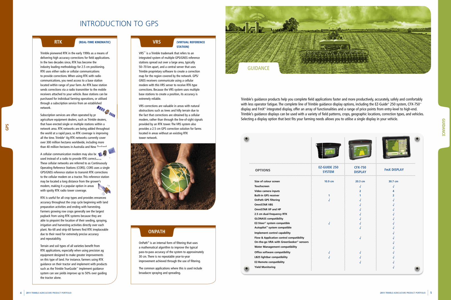
Trimble’s guidance products help you complete field applications faster and more productively, accurately, safely and comfortably with less operator fatigue. The complete line of Trimble guidance display options, including the EZ-Guide® 250 system, CFX-750™ display and FmX® integrated display, offer an array of functionalities and a range of price points from entry-level to high-end. Trimble’s guidance displays can be used with a variety of field patterns, crops, geographic locations, correction types, and vehicles. Selecting a display option that best fits your farming needs allows you to utilise a single display in your vehicle.
Size of colour screen 10.9 cm 20.3 cm 30.7 cm
Touchscreen √ √
Video camera inputs 2 4
Built-in GPS receiver 1 1 2
OnPath GPS filtering √ √ √
OmniSTAR VBS √ √
OmniSTAR XP and HP √ √
2.5 cm dual-frequency RTK √ √
GLONASS compatibility √ √
EZ-Steer® system compatible √ √ √
Autopilot™ system compatible √ √
Implement control capability √
Flow & Application control compatibility √ √
On-the-go VRA with GreenSeeker® sensors √
Water Management compatibility √
Office software compatibility √ √ √
LB25 lightbar compatibility √ √ √
EZ-Remote compatibility √ √
Yield Monitoring √
EZ-GuIDE 250 SYSTEM
fmX DISpLAYcfX-750DISpLAYOPTIONS
Trimble pioneered RTK in the early 1990s as a means of delivering high accuracy corrections for field applications. In the two decades since, RTK has become the industry leading methodology for 2.5 cm positioning. RTK uses either radio or cellular communications to provide corrections. When using RTK with radio communications, you need access to a base station located within range of your farm. An RTK base station sends corrections via a radio transmitter to the mobile receivers attached to your vehicle. Base stations can be purchased for individual farming operations, or utilised through a subscription service from an established network.
Subscription services are often operated by precision agriculture equipment dealers, such as Trimble dealers, that have erected single or multiple stations within a network area. RTK networks are being added throughout the world at a rapid pace, so RTK coverage is improving all the time. Trimble® Ag RTK networks currently cover over 300 million hectares worldwide, including more than 40 million hectares in Australia and New Zealand.
A cellular communication modem may also be used instead of a radio to provide RTK corrections. These cellular networks are referred to as Continuously Operating Reference Stations (CORS). CORS uses a single GPS/GNSS reference station to transmit RTK corrections to the cellular modem on a tractor. This reference station may be located a long distance from the grower’s modem, making it a popular option in areas with spotty RTK radio tower coverage.
RTK is useful for all crop types and provides enhanced accuracy throughout the crop cycle beginning with land preparation activities and ending with harvesting. Farmers growing row crops generally see the largest payback from using RTK systems because they are able to pinpoint the location of their seeding, spraying, irrigation and harvesting activities directly over each plant. No-till and strip-till farmers find RTK irreplaceable due to their need for extremely precise accuracy and repeatability.
Terrain and soil types of all varieties benefit from RTK applications, especially when using precision ag equipment designed to make greater improvements on this type of land. For instance, farmers using RTK guidance on their tractor and implement with products such as the Trimble TrueGuide™ implement guidance system can see yields improve up to 50% over guiding the tractor alone.
(REAL-TIME KINEMATIC)RTK
VRS™ is a Trimble trademark that refers to an integrated system of multiple GPS/GNSS reference stations spread out over a large area, typically 50–70 km apart, and a central server that uses Trimble proprietary software to create a correction map for the region covered by the network. GPS/GNSS receivers communicate using a cellular modem with this VRS server to receive RTK-type corrections. Because the VRS system uses multiple base stations to create a position, its accuracy is extremely reliable.
VRS corrections are valuable in areas with natural obstructions such as trees and hilly terrain due to the fact that corrections are obtained by a cellular modem, rather than through the line-of-sight signals provided by an RTK tower. The VRS system also provides a 2.5 cm GPS correction solution for farms located in areas without an existing RTK tower network.
(VIRTUAL REFERENCE
STATION)VRS
through a subscription service from an established
Subscription services are often operated by precision agriculture equipment dealers, such as Trimble dealers,
than 40 million hectares in Australia and New Zealand.
A cellular communication modem may also be used instead of a radio to provide RTK corrections.
may be located a long distance from the grower’s
RTK is useful for all crop types and provides enhanced
OnPath® is an internal form of filtering that uses a mathematical algorithm to improve the typical pass-to-pass accuracy of the system to approximately 30 cm. There is no repeatable year-to-year improvement achieved through the use of filtering.
The common applications where this is used include broadacre spraying and spreading.
ONpATH
Gu
IDAN
cE
6 72011 TRIMBLE AGRICULTURE PRODUCT PORTFOLIO
Gu
IDA
NcE
2011 TRIMBLE AGRICULTURE PRODUCT PORTFOLIO
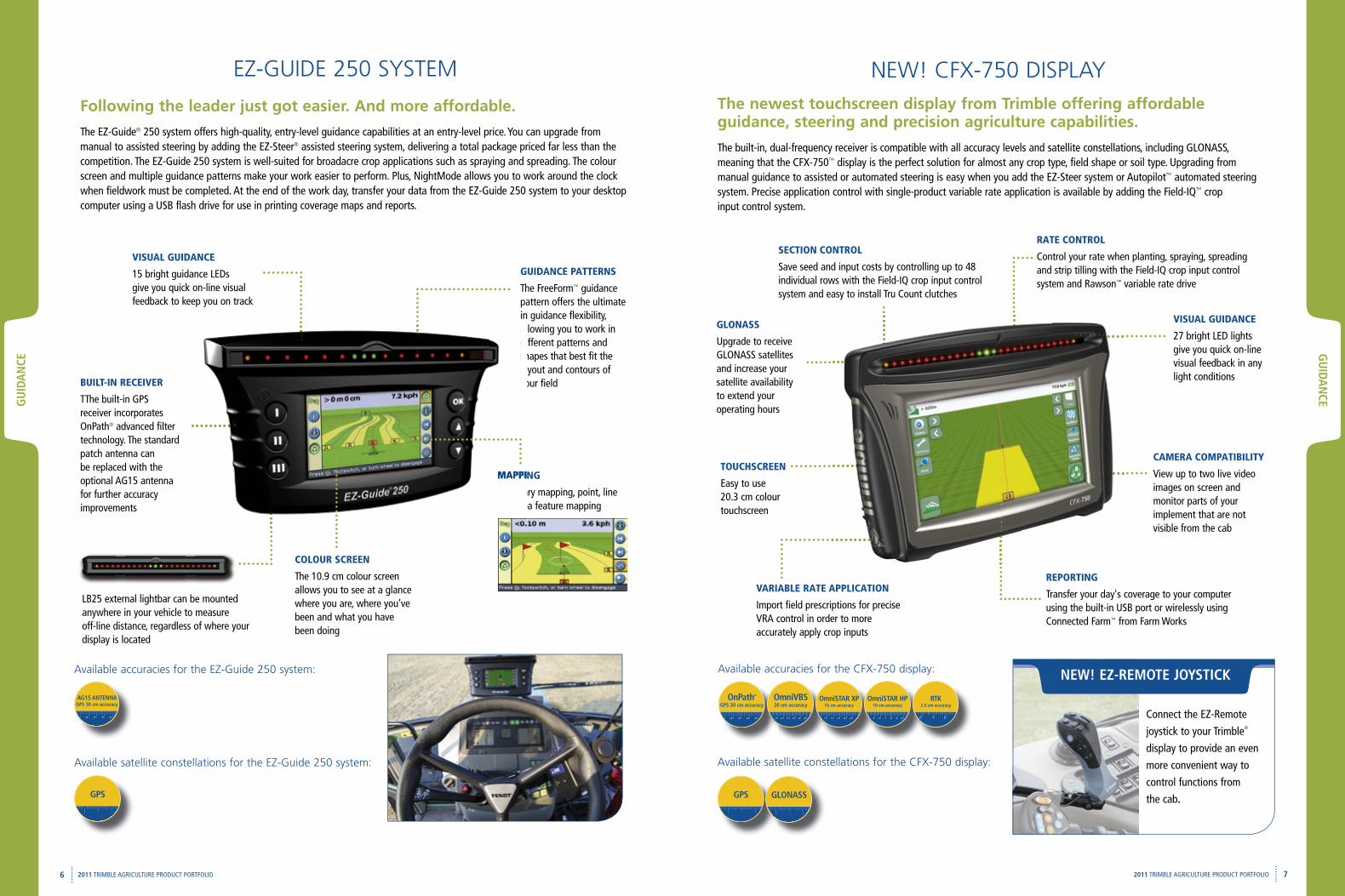
COLOUR SCREEN
The 10.9 cm colour screen allows you to see at a glance where you are, where you’ve been and what you have been doing
GUIDANCE PATTERNS
The FreeForm™ guidance pattern offers the ultimate in guidance flexibility, allowing you to work in different patterns and shapes that best fit the layout and contours of your field
VISUAL GUIDANCE
15 bright guidance LEDs give you quick on-line visual feedback to keep you on track
Following the leader just got easier. And more affordable.
The EZ-Guide® 250 system offers high-quality, entry-level guidance capabilities at an entry-level price. You can upgrade from manual to assisted steering by adding the EZ-Steer® assisted steering system, delivering a total package priced far less than the competition. The EZ-Guide 250 system is well-suited for broadacre crop applications such as spraying and spreading. The colour screen and multiple guidance patterns make your work easier to perform. Plus, NightMode allows you to work around the clock when fieldwork must be completed. At the end of the work day, transfer your data from the EZ-Guide 250 system to your desktop computer using a USB flash drive for use in printing coverage maps and reports.
BUILT-IN RECEIVER
TThe built-in GPS receiver incorporates OnPath® advanced filter technology. The standard patch antenna can be replaced with the optional AG15 antenna for further accuracy improvements
MAPPING
Boundary mapping, point, line and area feature mapping
LB25 external lightbar can be mounted anywhere in your vehicle to measure off-line distance, regardless of where your display is located
allowing you to work in different patterns and shapes that best fit the layout and contours of your field
MAPPING
Boundary mapping, point, line and area feature mapping
EZ-GUIDE 250 SYSTEM
Available accuracies for the EZ-Guide 250 system:
AG15 ANTENNAGPS 30 cm accuracy
3530 40 45
GPS
Available satellite constellations for the EZ-Guide 250 system:
The newest touchscreen display from Trimble offering affordable guidance, steering and precision agriculture capabilities.
The built-in, dual-frequency receiver is compatible with all accuracy levels and satellite constellations, including GLONASS, meaning that the CFX-750™ display is the perfect solution for almost any crop type, field shape or soil type. Upgrading from manual guidance to assisted or automated steering is easy when you add the EZ-Steer system or Autopilot™ automated steering system. Precise application control with single-product variable rate application is available by adding the Field-IQ™ crop input control system.
NEW! CFX-750 DISPLAY
Available accuracies for the CFX-750 display:
GPS
REPORTING
Transfer your day's coverage to your computer using the built-in USB port or wirelessly using Connected Farm™ from Farm Works
GLONASS
Upgrade to receive GLONASS satellites and increase your satellite availability to extend your operating hours
SECTION CONTROL
Save seed and input costs by controlling up to 48 individual rows with the Field-IQ crop input control system and easy to install Tru Count clutches
RATE CONTROL
Control your rate when planting, spraying, spreading and strip tilling with the Field-IQ crop input control system and Rawson™ variable rate drive
TOUCHSCREEN
Easy to use 20.3 cm colour touchscreen
VARIABLE RATE APPLICATION
Import field prescriptions for precise VRA control in order to more accurately apply crop inputs
CAMERA COMPATIBILITY
View up to two live video images on screen and monitor parts of your implement that are not visible from the cab
Available satellite constellations for the CFX-750 display:
GLONASS
NEW! EZ-REMOTE JOYSTIcK
Connect the EZ-Remote
joystick to your Trimble®
display to provide an even
more convenient way to
control functions from
the cab.
VISUAL GUIDANCE
27 bright LED lights give you quick on-line visual feedback in any light conditions
GPS 30 cm accuracy
3530 40 45
OnPath® OmniVBS20 cm accuracy
1615 17 18 19 20
OmniSTAR HP10 cm accuracy
6 5 7 8 9 10
OmniSTAR XP15 cm accuracy
12 11 13 14 15 210
RTK2.5 cm accuracy
STEERING
92011 TRIMBLE AGRICULTURE PRODUCT PORTFOLIO8 2011 TRIMBLE AGRICULTURE PRODUCT PORTFOLIO
Gu
IDA
NcE
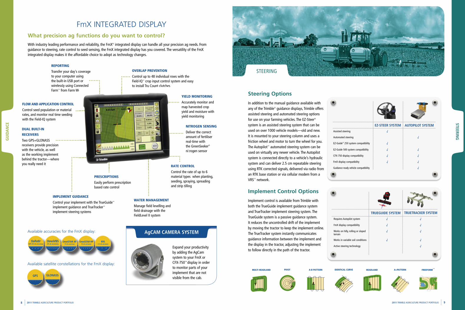
What precision ag functions do you want to control?
With industry leading performance and reliability, the FmX® integrated display can handle all your precision ag needs. From guidance to steering, rate control to seed sensing, the FmX integrated display has you covered. The versatility of the FmX integrated display makes it the affordable choice to adopt as technology changes.
NITROGEN SENSING
Deliver the correct amount of fertiliser real-time with the GreenSeeker® nitrogen sensor
REPORTING
Transfer your day's coverageto your computer usingthe built-in USB port orwirelessly using Connected Farm™ from Farm Works
DUAL BUILT-IN
RECEIVERS
Two GPS+GLONASS receivers provide precision with the vehicle, as well as the working implement behind the tractor—where you really need it
OVERLAP PREVENTION
Control up to 48 individual rows with the Field-IQ™ crop input control system and easy to install Tru Count clutches
RATE CONTROL
Control the rate of up to 6 material types when planting, seeding, spraying, spreading and strip tilling
YIELD MONITORING
Accurately monitor and map harvested crop yield and moisture with yield monitoring
PRESCRIPTIONS
Easily perform prescription based rate control
FLOW AND APPLICATION CONTROL
Control seed population or material rates, and monitor real time seeding with the Field-IQ system
FmX INTEGRATED DISPLAY
IMPLEMENT GUIDANCE
Control your implement with the TrueGuide™ implement guidance and TrueTracker™ implement steering systems
WATER MANAGEMENT
Manage field levelling and field drainage with the FieldLevel II system
GPS
Available satellite constellations for the FmX display:
GLONASS
Available accuracies for the FmX display:
wirelessly using Connected from Farm Works
to install Tru Count clutches
STEERING
Steering Options
In addition to the manual guidance available with any of the Trimble® guidance displays, Trimble offers assisted steering and automated steering options for use on your farming vehicles. The EZ-Steer® system is an assisted steering system that can be used on over 1000 vehicle models—old and new. It is mounted to your steering column and uses a friction wheel and motor to turn the wheel for you. The Autopilot™ automated steering system can be used on virtually any newer vehicle. The Autopilot system is connected directly to a vehicle’s hydraulic system and can deliver 2.5 cm repeatable steering using RTK corrected signals, delivered via radio from an RTK base station or via cellular modem from a VRS™ network.
Implement Control Options
Implement control is available from Trimble with both the TrueGuide implement guidance system and TrueTracker implement steering system. The TrueGuide system is a passive guidance system. It reduces the uncontrolled drift of the implement by moving the tractor to keep the implement online. The TrueTracker system instantly communicates guidance information between the implement and the display in the tractor, adjusting the implement to follow directly in the path of the tractor.
Assisted steering √
Automated steering √
EZ-Guide® 250 system compatibility √
EZ-Guide 500 system compatibility √ √
CFX-750 display compatibility √ √
FmX display compatibility √ √
Guidance ready vehicle compatibility √
EZ-STEER SYSTEM AuTOpILOT SYSTEM
Requires Autopilot system √ √
FmX display compatibility √ √
Works on hilly, rolling or sloped terrain
√ √
Works in variable soil conditions √ √
Active steering technology √
TRuEGuIDE SYSTEM TRuETRAcKER SYSTEM
A-B PATTERN IDENTICAL CURVE A+PATTERNHEADLAND FREEFORM™MULTI HEADLAND PIVOT
Expand your productivity by adding the AgCam system to your FmX or CFX-750™ display in order to monitor parts of your implement that are not visible from the cab.
AgcAM cAMERA SYSTEM
GPS 30 cm accuracy
3530 40 45
OnPath® OmniVBS20 cm accuracy
1615 17 18 19 20
OmniSTAR HP10 cm accuracy
6 5 7 8 9 10
OmniSTAR XP15 cm accuracy
12 11 13 14 15 210
RTK2.5 cm accuracy
STEERING
10 112011 TRIMBLE AGRICULTURE PRODUCT PORTFOLIO
STEE
RIN
G
2011 TRIMBLE AGRICULTURE PRODUCT PORTFOLIO
DISpLAY OpTIONSDISpLAY OpTIONS
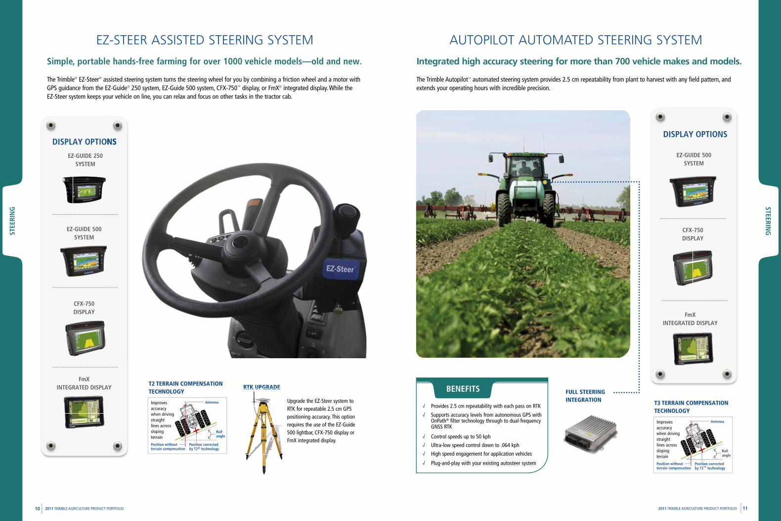
EZ-STEER ASSISTED STEERING SYSTEM
The Trimble® EZ-Steer® assisted steering system turns the steering wheel for you by combining a friction wheel and a motor with GPS guidance from the EZ-Guide® 250 system, EZ-Guide 500 system, CFX-750™ display, or FmX® integrated display. While the EZ-Steer system keeps your vehicle on line, you can relax and focus on other tasks in the tractor cab.
Simple, portable hands-free farming for over 1000 vehicle models—old and new.
T2 TERRAIN COMPENSATION TECHNOLOGY
A
position without terrain compensation
position corrected by T2® technology
Antenna
Roll angle
Improves accuracy when driving straight lines across sloping terrain
RTK UPGRADE RTK UPGRADE
Upgrade the EZ-Steer system to RTK for repeatable 2.5 cm GPS positioning accuracy. This option requires the use of the EZ-Guide 500 lightbar, CFX-750 display or FmX integrated display.
cfX-750 DISpLAY
fmX INTEGRATED DISpLAY
EZ-GuIDE 250 SYSTEM
EZ-GuIDE 500 SYSTEM
AUTOPILOT AUTOMATED STEERING SYSTEM
The Trimble Autopilot™ automated steering system provides 2.5 cm repeatability from plant to harvest with any field pattern, and extends your operating hours with incredible precision.
FULL STEERINGINTEGRATION
Integrated high accuracy steering for more than 700 vehicle makes and models.
T3 TERRAIN COMPENSATION TECHNOLOGY
A
position without terrain compensation
position corrected by T3™ technology
Antenna
Roll angle
Improves accuracy when driving straight lines across sloping terrain
cfX-750 DISpLAY
EZ-GuIDE 500 SYSTEM
DISpLAY OpTIONS
fmX INTEGRATED DISpLAY
√ Provides 2.5 cm repeatability with each pass on RTK√ Supports accuracy levels from autonomous GPS with
OnPath® filter technology through to dual-frequency GNSS RTK
√ Control speeds up to 50 kph√ Ultra-low speed control down to .064 kph√ High speed engagement for application vehicles
√ Plug-and-play with your existing autosteer system
BENEfITS
STEERING
12 132011 TRIMBLE AGRICULTURE PRODUCT PORTFOLIO
STEE
RIN
G
2011 TRIMBLE AGRICULTURE PRODUCT PORTFOLIO
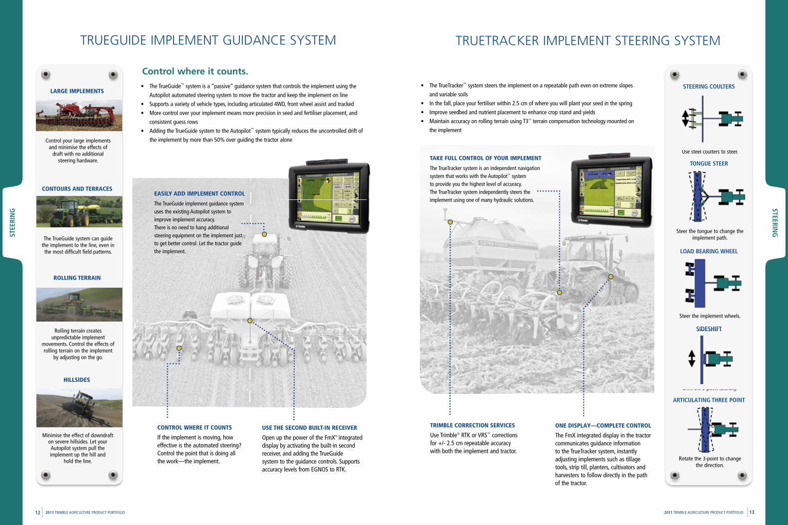
LARGE IMPLEMENTS
Control your large implements and minimise the effects of
draft with no additional steering hardware.
CONTOURS AND TERRACES
The TrueGuide system can guide the implement to the line, even in the most difficult field patterns.
ROLLING TERRAIN
Rolling terrain creates unpredictable implement
movements. Control the effects of rolling terrain on the implement
by adjusting on the go.
HILLSIDES
Minimise the effect of downdraft on severe hillsides. Let your Autopilot system pull the implement up the hill and
hold the line.
USE THE SECOND BUILT-IN RECEIVER
Open up the power of the FmX® integrated display by activating the built-in second receiver, and adding the TrueGuide system to the guidance controls. Supports accuracy levels from EGNOS to RTK.
EASILY ADD IMPLEMENT CONTROL
The TrueGuide implement guidance system uses the existing Autopilot system to improve implement accuracy. There is no need to hang additional steering equipment on the implement just to get better control. Let the tractor guide the implement.
CONTROL WHERE IT COUNTS
If the implement is moving, how effective is the automated steering? Control the point that is doing all the work—the implement.
• The TrueGuide™ system is a “passive” guidance system that controls the implement using the
Autopilot automated steering system to move the tractor and keep the implement on line
• Supports a variety of vehicle types, including articulated 4WD, front wheel assist and tracked
• More control over your implement means more precision in seed and fertiliser placement, and
consistent guess rows
• Adding the TrueGuide system to the Autopilot™ system typically reduces the uncontrolled drift of
the implement by more than 50% over guiding the tractor alone
Control where it counts.
TRUEGUIDE IMPLEMENT GUIDANCE SYSTEM
STEERING cOuLTERS
Use steel coulters to steer.
TONGuE STEER
Steer the tongue to change the implement path.
LOAD BEARING WHEEL
Steer the implement wheels.
SIDESHIfT
Shift the 3-point laterally.
ARTIcuLATING THREE pOINT
Rotate the 3-point to changethe direction.
• The TrueTracker™ system steers the implement on a repeatable path even on extreme slopes
and variable soils
• In the fall, place your fertiliser within 2.5 cm of where you will plant your seed in the spring
• Improve seedbed and nutrient placement to enhance crop stand and yields
• Maintain accuracy on rolling terrain using T3™ terrain compensation technology mounted on
the implement
TRUETRACKER IMPLEMENT STEERING SYSTEM
Use steel coulters to steer.
LOAD BEARING WHEEL
SIDESHIfT
Shift the 3-point laterally.
Rotate the 3-point to change
TAKE FULL CONTROL OF YOUR IMPLEMENT
The TrueTracker system is an independent navigation system that works with the Autopilot™ system to provide you the highest level of accuracy. The TrueTracker system independently steers the implement using one of many hydraulic solutions.
ONE DISPLAY—COMPLETE CONTROL
The FmX integrated display in the tractor communicates guidance information to the TrueTracker system, instantly adjusting implements such as tillage tools, strip till, planters, cultivators and harvesters to follow directly in the path of the tractor.
TRIMBLE CORRECTION SERVICES
Use Trimble® RTK or VRS™ corrections for +/- 2.5 cm repeatable accuracy with both the implement and tractor.
fLOW
& A
ppLIcATIO
N
cON
TROL
14 152011 TRIMBLE AGRICULTURE PRODUCT PORTFOLIO
fLO
W &
App
LIcA
TIO
N
cON
TRO
L
2011 TRIMBLE AGRICULTURE PRODUCT PORTFOLIO
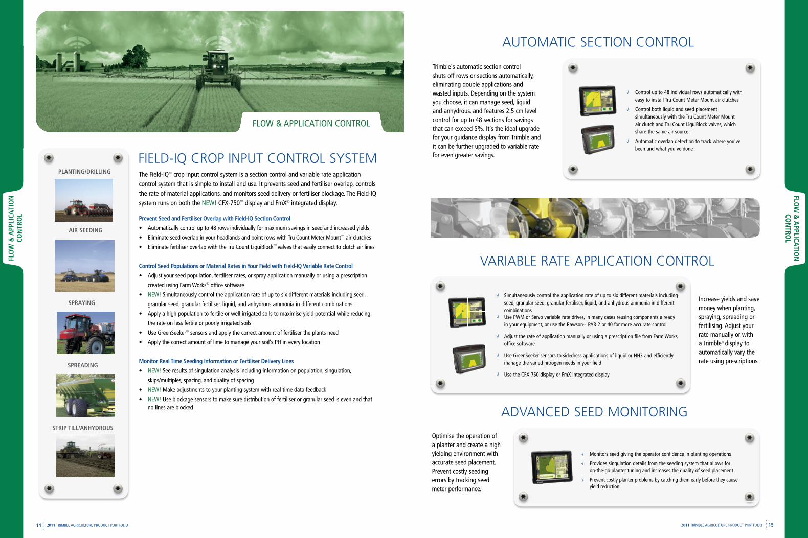
The Field-IQ™ crop input control system is a section control and variable rate application control system that is simple to install and use. It prevents seed and fertiliser overlap, controls the rate of material applications, and monitors seed delivery or fertiliser blockage. The Field-IQ system runs on both the NEW! CFX-750™ display and FmX® integrated display.
prevent Seed and fertiliser Overlap with field-IQ Section control
• Automatically control up to 48 rows individually for maximum savings in seed and increased yields
• Eliminate seed overlap in your headlands and point rows with Tru Count Meter Mount™ air clutches
• Eliminate fertiliser overlap with the Tru Count LiquiBlock™ valves that easily connect to clutch air lines
control Seed populations or Material Rates in Your field with field-IQ Variable Rate control
• Adjust your seed population, fertiliser rates, or spray application manually or using a prescription
created using Farm Works® office software
• NEW! Simultaneously control the application rate of up to six different materials including seed,
granular seed, granular fertiliser, liquid, and anhydrous ammonia in different combinations
• Apply a high population to fertile or well irrigated soils to maximise yield potential while reducing
the rate on less fertile or poorly irrigated soils
• Use GreenSeeker® sensors and apply the correct amount of fertiliser the plants need
• Apply the correct amount of lime to manage your soil's PH in every location
Monitor Real Time Seeding Information or fertiliser Delivery Lines
• NEW! See results of singulation analysis including information on population, singulation,
skips/multiples, spacing, and quality of spacing
• NEW! Make adjustments to your planting system with real time data feedback
• NEW! Use blockage sensors to make sure distribution of fertiliser or granular seed is even and that no lines are blocked
FIELD-IQ CROP INPUT CONTROL SYSTEMpLANTING/DRILLING
AIR SEEDING
SpRAYING
FLOW & APPLICATION CONTROL
Trimble's automatic section control shuts off rows or sections automatically, eliminating double applications and wasted inputs. Depending on the system you choose, it can manage seed, liquid and anhydrous, and features 2.5 cm level control for up to 48 sections for savings that can exceed 5%. It’s the ideal upgrade for your guidance display from Trimble and it can be further upgraded to variable rate for even greater savings.
AUTOMATIC SECTION CONTROL
√ Control up to 48 individual rows automatically with easy to install Tru Count Meter Mount air clutches
√ Control both liquid and seed placement simultaneously with the Tru Count Meter Mountair clutch and Tru Count LiquiBlock valves, which share the same air source
√ Automatic overlap detection to track where you’ve been and what you’ve done
VARIABLE RATE APPLICATION CONTROL
Increase yields and save money when planting, spraying, spreading or fertilising. Adjust your rate manually or with a Trimble® display to automatically vary the rate using prescriptions.
SpREADING
STRIp TILL/ANHYDROuSOptimise the operation of a planter and create a high yielding environment with accurate seed placement. Prevent costly seeding errors by tracking seed meter performance.
√ Simultaneously control the application rate of up to six different materials including seed, granular seed, granular fertiliser, liquid, and anhydrous ammonia in different combinations
√ Use PWM or Servo variable rate drives, in many cases reusing components already in your equipment, or use the Rawson™ PAR 2 or 40 for more accurate control
√ Adjust the rate of application manually or using a prescription file from Farm Works
office software
√ Use GreenSeeker sensors to sidedress applications of liquid or NH3 and efficiently manage the varied nitrogen needs in your field
√ Use the CFX-750 display or FmX integrated display
ADVANCED SEED MONITORING
√ Monitors seed giving the operator confidence in planting operations
√ Provides singulation details from the seeding system that allows for on-the-go planter tuning and increases the quality of seed placement
√ Prevent costly planter problems by catching them early before they cause yield reduction
fLOW
& A
ppLIcATIO
N
cON
TROL
16 172011 TRIMBLE AGRICULTURE PRODUCT PORTFOLIO
fLO
W &
App
LIcA
TIO
N
cON
TRO
L
2011 TRIMBLE AGRICULTURE PRODUCT PORTFOLIO
PLANTING/DRILLING
The planter function manages seed, liquid, or granular application:
• Prevent seed overlap by automatically controlling up
to 48 individual rows
• Eliminate liquid fertiliser overlap in your headlands
and point rows with the Tru Count LiquiBlock™
valves
• Vary seed population in your fields to match soil
potential with Rawson™ variable rate drives
• Use a prescription map from Farm Works® office
software to automatically set the rate of seed
• Analyse your seeding performance with status items
such as population, singulation, skips/multiples, and
spacing
• Track your seed varieties for post harvest
performance analysis
SPRAYING
The WeedSeeker® system helps you cut overall weed-control costs by up to 80% by saving on chemical costs, cutting down on time and labour, and reducing the environmental impact of your field activities.
• Uses advanced optics and computer circuitry to sense if a weed is present
• When a weed enters the sensor's field of view, it signals a spray nozzle to
deliver a precise amount of herbicide
• The WeedSeeker system will spray only weeds, not bare ground, and is effective wherever weeds occur intermittently
WEEDSEEKER AuTOMATIc SpOT SpRAY SYSTEM
fIELD-IQ cROp INpuT cONTROL SYSTEM
The sprayer function manages accurate liquid application:
• Control up to 48 sections or nozzles and shut off sections in waterways
and point rows to avoid overspraying
• Use with existing boom shutoff valves or Tru Count LiquiBlock valves for
easy connections
• Connect directly into the vehicle boom shutoff valves so no additional
cables are required
• Connect using platform specific kits designed to work
with existing sprayer components including factory
installed switches
• Control up to 6 materials simultaneously with
manual rate or prescription
• Minimise overlap detection with control drive or
add sections for liquid/NH3
• Control existing PWM, Linear Acuators, Electric
Motors, or Servo systems
• Monitor up to 144 rows of blockage sensors
• Auxillary sensors can read Fan Speed, Bin Level,
Air Pressure, and Implement switches
•
•
AIR SEEDING
fIELD-IQ™ cROp INpuT cONTROL SYSTEM
AIR SEEDING
fIELD-IQ cROp INpuT cONTROL SYSTEM
FmX® integrated display functions as the cab interface for the GreenSeeker® optical sensing system.
• The GreenSeeker RT200 variable rate application and crop
vigor mapping system offers a more efficient and precise
way to manage crop inputs such as nitrogen
• Delivers the correct amount of fertiliser in real time
averaging an increase in profits of €25 per hectare
• It can be used to verify the amount of nitrogen the soil has
made available in season, then determines on-the-go a nitrogen
prescription for the applicator to instantly deliver
GREENSEEKER cROp SENSOR AppLIcATION SYSTEM
fLOW
& A
ppLIcATIO
N
cON
TROL
18 192011 TRIMBLE AGRICULTURE PRODUCT PORTFOLIO
fLO
W &
App
LIcA
TIO
N
cON
TRO
L
2011 TRIMBLE AGRICULTURE PRODUCT PORTFOLIO
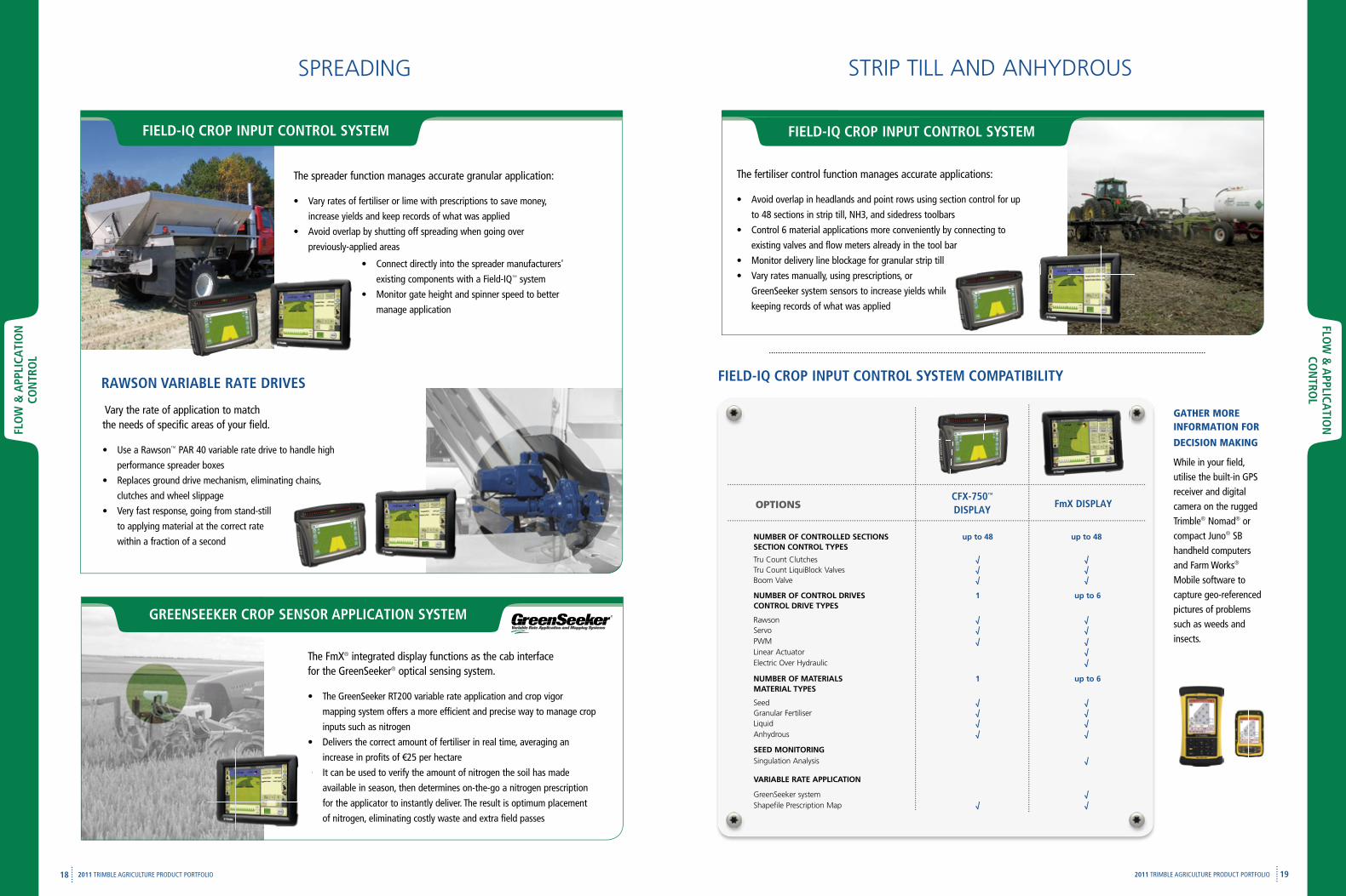
STRIP TILL AND ANHYDROUS
The fertiliser control function manages accurate applications:
• Avoid overlap in headlands and point rows using section control for up
to 48 sections in strip till, NH3, and sidedress toolbars
• Control 6 material applications more conveniently by connecting to
existing valves and flow meters already in the tool bar
• Monitor delivery line blockage for granular strip till
• Vary rates manually, using prescriptions, or
GreenSeeker system sensors to increase yields while
keeping records of what was applied
GreenSeeker system sensors to increase yields while
SPREADING
The FmX® integrated display functions as the cab interfacefor the GreenSeeker® optical sensing system.
• The GreenSeeker RT200 variable rate application and crop vigor
mapping system offers a more efficient and precise way to manage crop
inputs such as nitrogen
• Delivers the correct amount of fertiliser in real time, averaging an
increase in profits of €25 per hectare
• It can be used to verify the amount of nitrogen the soil has made
available in season, then determines on-the-go a nitrogen prescription
for the applicator to instantly deliver. The result is optimum placement
of nitrogen, eliminating costly waste and extra field passes
NUMBER OF CONTROLLED SECTIONSSECTION CONTROL TYPES
up to 48 up to 48
Tru Count Clutches √ √Tru Count LiquiBlock Valves √ √Boom Valve √ √
NUMBER OF CONTROL DRIVESCONTROL DRIVE TYPES
1 up to 6
Rawson √ √Servo √ √PWM √ √Linear Actuator √Electric Over Hydraulic √
NUMBER OF MATERIALSMATERIAL TYPES
1 up to 6
Seed √ √Granular Fertiliser √ √Liquid √ √Anhydrous √ √
SEED MONITORINGSingulation Analysis √
VARIABLE RATE APPLICATION
GreenSeeker system √Shapefile Prescription Map √ √
fmX DISpLAYcfX-750™
DISpLAYOPTIONS
fIELD-IQ cROp INpuT cONTROL SYSTEM cOMpATIBILITY
The spreader function manages accurate granular application:
• Vary rates of fertiliser or lime with prescriptions to save money,
increase yields and keep records of what was applied
• Avoid overlap by shutting off spreading when going over
previously-applied areas
• Connect directly into the spreader manufacturers'
existing components with a Field-IQ™ system
• Monitor gate height and spinner speed to better
manage application
GATHER MORE INFORMATION FOR
DECISION MAKING
While in your field, utilise the built-in GPS receiver and digital camera on the rugged Trimble® Nomad® or compact Juno® SB handheld computers and Farm Works® Mobile software to capture geo-referenced pictures of problems such as weeds and insects.
fIELD-IQ cROp INpuT cONTROL SYSTEM
GREENSEEKER cROp SENSOR AppLIcATION SYSTEM
fIELD-IQ cROp INpuT cONTROL SYSTEM
Vary the rate of application to match the needs of specific areas of your field.
• Use a Rawson™ PAR 40 variable rate drive to handle high
performance spreader boxes
• Replaces ground drive mechanism, eliminating chains,
clutches and wheel slippage
• Very fast response, going from stand-still
to applying material at the correct rate
within a fraction of a second
•
RAWSON VARIABLE RATE DRIVES
HA
RVEST
20 212011 TRIMBLE AGRICULTURE PRODUCT PORTFOLIO
HA
RVES
T
2011 TRIMBLE AGRICULTURE PRODUCT PORTFOLIO
HARVEST
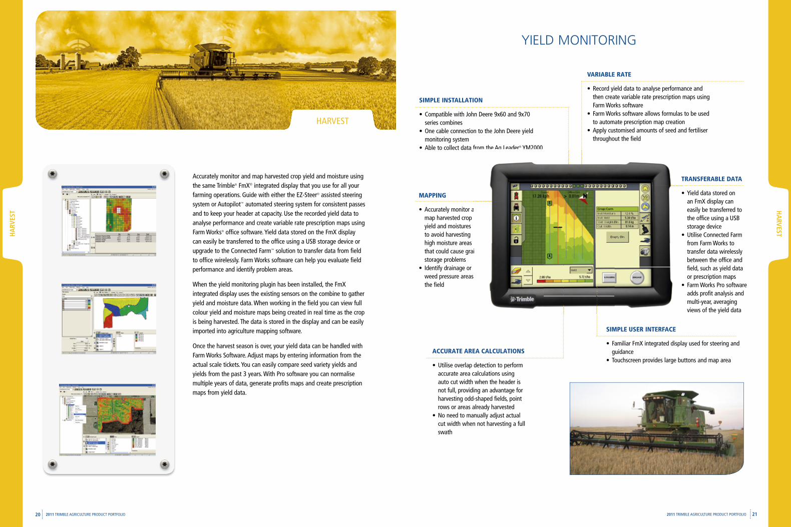
YIELD MONITORING
SIMPLE USER INTERFACE
• Familiar FmX integrated display used for steering and guidance
• Touchscreen provides large buttons and map areaACCURATE AREA CALCULATIONS
• Utilise overlap detection to perform accurate area calculations using auto cut width when the header is not full, providing an advantage for harvesting odd-shaped fields, point rows or areas already harvested
• No need to manually adjust actual cut width when not harvesting a full swath
MAPPING
• Accurately monitor and map harvested crop yield and moistures to avoid harvesting high moisture areas that could cause grain storage problems
• Identify drainage or weed pressure areas in the field
SIMPLE INSTALLATION
• Compatible with John Deere 9x60 and 9x70 series combines
• One cable connection to the John Deere yield monitoring system
• Able to collect data from the Ag Leader® YM2000
Accurately monitor and
that could cause grain
weed pressure areas in
Able to collect data from the Ag Leader YM2000
TRANSFERABLE DATA
• Yield data stored on an FmX display can easily be transferred to the office using a USB storage device
• Utilise Connected Farm from Farm Works to transfer data wirelessly between the office and field, such as yield data or prescription maps
• Farm Works Pro software adds profit analysis and multi-year, averaging views of the yield data
Accurately monitor and map harvested crop yield and moisture using the same Trimble® FmX® integrated display that you use for all your farming operations. Guide with either the EZ-Steer® assisted steering system or Autopilot™ automated steering system for consistent passes and to keep your header at capacity. Use the recorded yield data to analyse performance and create variable rate prescription maps using Farm Works® office software. Yield data stored on the FmX display can easily be transferred to the office using a USB storage device or upgrade to the Connected Farm™ solution to transfer data from field to office wirelessly. Farm Works software can help you evaluate field performance and identify problem areas.
When the yield monitoring plugin has been installed, the FmX integrated display uses the existing sensors on the combine to gather yield and moisture data. When working in the field you can view full colour yield and moisture maps being created in real time as the crop is being harvested. The data is stored in the display and can be easily imported into agriculture mapping software.
Once the harvest season is over, your yield data can be handled with Farm Works Software. Adjust maps by entering information from the actual scale tickets. You can easily compare seed variety yields and yields from the past 3 years. With Pro software you can normalise multiple years of data, generate profits maps and create prescription maps from yield data.
VARIABLE RATE
• Record yield data to analyse performance and then create variable rate prescription maps using Farm Works software
• Farm Works software allows formulas to be used to automate prescription map creation
• Apply customised amounts of seed and fertiliser throughout the field
cON
NEcTED
fARM
& fA
RM W
ORKS
22 23
cON
NEc
TED
fA
RM
& f
ARM
WO
RKS
2011 TRIMBLE AGRICULTURE PRODUCT PORTFOLIO 2011 TRIMBLE AGRICULTURE PRODUCT PORTFOLIO
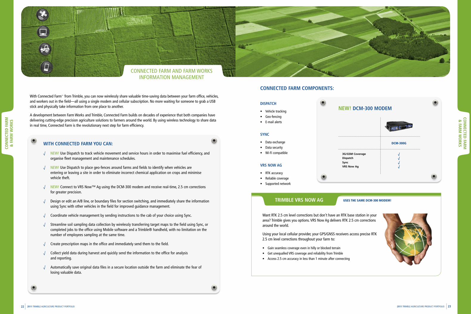
CONNECTED FARM AND FARM WORKS INFORMATION MANAGEMENT
With Connected Farm™ from Trimble, you can now wirelessly share valuable time-saving data between your farm office, vehicles, and workers out in the field—all using a single modem and cellular subscription. No more waiting for someone to grab a USB stick and physically take information from one place to another.
A development between Farm Works and Trimble, Connected Farm builds on decades of experience that both companies have delivering cutting-edge precision agriculture solutions to farmers around the world. By using wireless technology to share data in real time, Connected Farm is the revolutionary next step for farm efficiency.
WITH cONNEcTED fARM YOu cAN:
√ NEW! Use Dispatch to track vehicle movement and service hours in order to maximise fuel efficiency, and organise fleet management and maintenance schedules.
√ NEW! Use Dispatch to place geo-fences around farms and fields to identify when vehicles are entering or leaving a site in order to eliminate incorrect chemical application on crops and minimise vehicle theft.
√ NEW! Connect to VRS Now™ Ag using the DCM-300 modem and receive real-time, 2.5 cm corrections for greater precision.
√ Design or edit an A/B line, or boundary files for section switching, and immediately share the information using Sync with other vehicles in the field for improved guidance management.
√ Coordinate vehicle management by sending instructions to the cab of your choice using Sync.
√ Streamline soil sampling data collection by wirelessly transferring target maps to the field using Sync, or completed jobs to the office using Mobile software and a Trimble® handheld, with no limitation on the number of employees sampling at the same time.
√ Create prescription maps in the office and immediately send them to the field.
√ Collect yield data during harvest and quickly send the information to the office for analysis and reporting.
√ Automatically save original data files in a secure location outside the farm and eliminate the fear of losing valuable data.
Want RTK 2.5 cm level corrections but don't have an RTK base station in your area? Trimble gives you options. VRS Now Ag delivers RTK 2.5 cm corrections around the world.
Using your local cellular provider, your GPS/GNSS receivers access precise RTK 2.5 cm level corrections throughout your farm to:
• Gain seamless coverage even in hilly or blocked terrain
• Get unequalled VRS coverage and reliability from Trimble
• Access 2.5 cm accuracy in less than 1 minute after connecting
TRIMBLE VRS NOW AG USES THE SAME DCM-300 MODEM!
DCM-300G
NEW! DcM-300 MODEMDISpATcH
• Vehicle tracking
• Geo-fencing
• E-mail alerts
SYNc
• Data exchange
• Data security
• Wi-Fi compatible
VRS NOW AG
• RTK accuracy
• Reliable coverage
• Supported network
cONNEcTED fARM cOMpONENTS:
3G/GSM Coverage √Dispatch √Sync √VRS Now Ag √
fARM
WO
RKS
24 252011 TRIMBLE AGRICULTURE PRODUCT PORTFOLIO
fARM
WO
RKS
2011 TRIMBLE AGRICULTURE PRODUCT PORTFOLIO
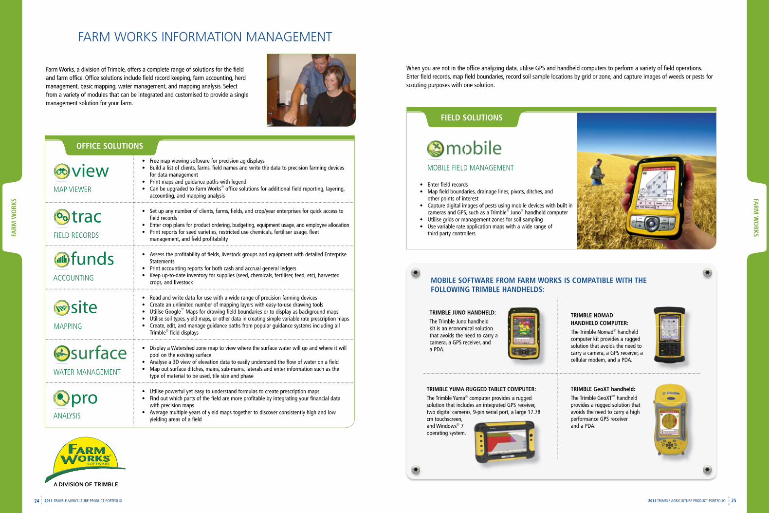
• Enter field records• Map field boundaries, drainage lines, pivots, ditches, and
other points of interest • Capture digital images of pests using mobile devices with built in
cameras and GPS, such as a Trimble® Juno® handheld computer • Utilise grids or management zones for soil sampling • Use variable rate application maps with a wide range of
third party controllers
MOBILE FIELD MANAGEMENT
fIELD SOLuTIONS
TRIMBLE NOMAD HANDHELD cOMpuTER:
The Trimble Nomad® handheld computer kit provides a rugged solution that avoids the need to carry a camera, a GPS receiver, a cellular modem, and a PDA.
TRIMBLE JuNO HANDHELD:
The Trimble Juno handheld kit is an economical solution that avoids the need to carry a camera, a GPS receiver, and a PDA.
TRIMBLE YuMA RuGGED TABLET cOMpuTER:
The Trimble Yuma® computer provides a rugged solution that includes an integrated GPS receiver, two digital cameras, 9-pin serial port, a large 17.78 cm touchscreen, and Windows® 7 operating system.
TRIMBLE GeoXT handheld:
The Trimble GeoXT™ handheld provides a rugged solution that avoids the need to carry a high performance GPS receiver and a PDA.
MOBILE SOfTWARE fROM fARM WORKS IS cOMpATIBLE WITH THE fOLLOWING TRIMBLE HANDHELDS:
Farm Works, a division of Trimble, offers a complete range of solutions for the field and farm office. Office solutions include field record keeping, farm accounting, herd management, basic mapping, water management, and mapping analysis. Select from a variety of modules that can be integrated and customised to provide a single management solution for your farm.
FARM WORKS INFORMATION MANAGEMENT
When you are not in the office analyzing data, utilise GPS and handheld computers to perform a variety of field operations. Enter field records, map field boundaries, record soil sample locations by grid or zone, and capture images of weeds or pests for scouting purposes with one solution.
• Free map viewing software for precision ag displays• Build a list of clients, farms, field names and write the data to precision farming devices
for data management• Print maps and guidance paths with legend• Can be upgraded to Farm Works® office solutions for additional field reporting, layering,
accounting, and mapping analysis
• Set up any number of clients, farms, fields, and crop/year enterprises for quick access to field records
• Enter crop plans for product ordering, budgeting, equipment usage, and employee allocation• Print reports for seed varieties, restricted use chemicals, fertiliser usage, fleet
management, and field profitability
• Assess the profitability of fields, livestock groups and equipment with detailed Enterprise Statements
• Print accounting reports for both cash and accrual general ledgers• Keep up-to-date inventory for supplies (seed, chemicals, fertiliser, feed, etc), harvested
crops, and livestock
• Read and write data for use with a wide range of precision farming devices• Create an unlimited number of mapping layers with easy-to-use drawing tools• Utilise Google™ Maps for drawing field boundaries or to display as background maps• Utilise soil types, yield maps, or other data in creating simple variable rate prescription maps• Create, edit, and manage guidance paths from popular guidance systems including all
Trimble® field displays
• Display a Watershed zone map to view where the surface water will go and where it will pool on the existing surface
• Analyse a 3D view of elevation data to easily understand the flow of water on a field• Map out surface ditches, mains, sub-mains, laterals and enter information such as the
type of material to be used, tile size and phase
• Utilise powerful yet easy to understand formulas to create prescription maps• Find out which parts of the field are more profitable by integrating your financial data
with precision maps• Average multiple years of yield maps together to discover consistently high and low
yielding areas of a field
MAP VIEWER
FIELD RECORDS
ACCOUNTING
MAPPING
WATER MANAGEMENT
ANALYSIS
OffIcE SOLuTIONS
WA
TERM
AN
AG
EMEN
T
26 272011 TRIMBLE AGRICULTURE PRODUCT PORTFOLIO
WA
TER
MA
NA
GEM
ENT
2011 TRIMBLE AGRICULTURE PRODUCT PORTFOLIO
WATER MANAGEMENT
The term water management refers to levelling activities designed to optimise water use when it is scarce, and the
implementation of drainage systems to remove water when it is in excess. Water management is becoming increasingly important
throughout the world due to various drought and rainy conditions, as well as governmental standards
for water conservation.
Your investment in Trimble water management technology can also be leveraged over other agriculture solutions, such as
precision guidance, seeding, and flow and application control. This cross-functional utility means you get more from your
investment. Trimble has 25 years of experience in the water management business and our systems are proven to improve yields
by 25%, and reduce water usage by 30%. Because Trimble knows every bit of profit—and every drop—counts.
GPS SOLUTIONS
GPS solutions for water management can be used to effectively increase crop yields and improve water usage. The operating
principles of GPS have three steps—survey, design and grade—for water management optimization. The survey step requires the
operator to survey the field to be leveled or drained. A design is then created based on this survey to best optimise the levelling
or drainage function to be performed. Finally, the field is graded to the pre-determined design using GPS guidance.
The FieldLevel II system represents cutting-edge GPS technology and significantly decreases the setup, survey, design, and grading time for both levelling and drainage system operation. By utilising GPS signals, the FieldLevel II system greatly diminishes the time required to perform levelling and drainage tasks, allowing the operator to complete a large amount of field work in a fraction of the time.
The same FmX® integrated display that you use with your precision guidance and control applications can also be used for your water management operations. With data collection, design and control functionality built right into this powerful display, managing your levelling and drainage operations has never been easier or more defined.
RuGGED fIELD cOMpuTER
Land levelling and drainage tasks are made much easier with the addition of GPS signals to the process. The FieldLevel II system uses the convenience of GPS and GLONASS RTK technology to streamline the survey, design and grade steps required to level fields or install drainage systems. With the FieldLevel II system, there is no need to exit the tractor to reposition the laser transmitter or set stakes. A great deal of time is saved by performing all calculations from inside the cab.
FIELDLEVEL II SYSTEM FORWATER MANAGEMENT
TOpOGRApHIc MAppING
Use the built-in survey function to record field elevations. There is no need to exit the tractor cab to reposition a laser transmitter.
TILE AND SuRfAcE DRAINAGE
Autoslope will optimise the depth of your drain while ensuring that it stays within your minimum slope requirement. Use Point-and-Slope mode to maintain your desired slope, regardless of direction. RTK positions take the guesswork out of laying tile.
LAND LEVELLING
The FieldLevel II system provides the completel solutions for surveying, designing and levelling field surfaces to ensure optimal water management.
LEVEE MARKING
Use Contour guidance mode to mark rice levees at a constant height with respect to the Earth's gravity. This ensures the fields can be watered with the optimal amount of water, increasing yields and eliminating any waste.
SURVEY—DESIGN—GRADE
Topographic data can be collected via the FmX integrated display while using the Autopilot™ system, or by using the FmX display as a stand-alone. Using the collected topographic data, you can design the shape of the field, or slope and depth of your drainage structures, right on the FmX integrated display. With the completed design you can immediately start levelling or installing drainage structures. If you need to explore more scenarios for field designs, simply take the topographic survey to the office and work with Farm Works® Surface software. Surface is an analysis and design tool that assists with the optimal placement of tile and surface drains.
AuTOpLANE
Best-fit designs can be created in the tractor cab and then modified to your farm's specific needs. This eliminates the need to utilise office software for field design creation.
AuTOSLOpE
Use Autoslope from the seat of your cab to survey, design, and grade either surface or subsurface drainage.
ASIA-pAcIfIcTrimble Navigation Australia pTY LimitedLevel 1/120 Wickham StreetFortitude Valley, QLD 4006AUSTRALIA+61-7-3216-0044 Phone+61-7-3216-0088 Fax
NORTH & SOuTH AMERIcATrimble Agriculture Division10355 Westmoor Drive, Suite #100Westminster, CO 80021USA800-865-7438 Phone (US Toll Free)+1-913-495-2700 Phone+1-913-495-2750 Fax
Trimble Navigation LimitedCorporate Headquarters935 Stewart DriveSunnyvale, CA 94085USA+1-408-481-8000 Phone+1-408-481-7740 Fax
Water Management5475 Kellenburger RoadDayton, OH 45424USA+1-937-245-5154 Phone+1-937-233-9441 Fax
EuROpETrimble Germany GmbHAm Prime Parc 1165479 RaunheimGERMANY+49-6142-2100-226 Phone+49-6142-2100-140 Faxh
© 2005-2011, Trimble Navigation Limited. All rights reserved. Trimble, the Globe & Triangle logo, EZ-Guide, EZ-Steer, farm Works, fmX, Juno, Nomad, Onpath, T2, and Yuma are trademarks of Trimble Navigation Limited, registered in the united States and in other countries. Autopilot, cfX-750, connected farm, field-IQ, freeform, GeoXT, Rawson, T3, Tru count LiquiBlock, Tru count Meter Mount, TrueGuide, TrueTracker, VRS, and VRS Now are trademarks of Trimble Navigation Limited. Microsoft, and Windows are either registered trademarks or trademarks of Microsoft corporation in the united States and/or other countries. All other trademarks are the property of their respective owners. pN 022503-078f-AuS (12/10)
www.trimble.com/agriculture