Embed Size (px)
Citation preview

Type of solar resource parameterType of solar resource parameterfor specific applications, e.g.for specific applications, e.g.
Sky luminanceSky luminanceTilted IrradianceTilted Irradiance
Direct IrradianceDirect Irradiance
Perez et al., ASRC

Perez et al., ASRC
In situ In situ MeasurementMeasurement
customizedcustomized parametersparameters

Per
ez e
t al.,
ASR
C
In situ In situ MeasurementMeasurement
ModelsModels
ModelModel
Direct & DiffuseDirect & DiffuseIrradiancesIrradiances
GlobalGlobalIrradianceIrradiance
Primary irradiance NetworksPrimary irradiance Networks
customizedcustomized parametersparameters

Per
ez e
t al.,
ASR
C
In situ In situ MeasurementMeasurement
ModelsModels
ModelModel
Direct & DiffuseDirect & DiffuseIrradiancesIrradiances
GlobalGlobalIrradianceIrradiance
Primary irradiance NetworksPrimary irradiance Networks
customizedcustomized parametersparameters
Satellite Remote Satellite Remote SensingSensing
ModelsModels

Geostationary Weather Satellites- High resolution
(decaying at high latitudes)- Continuous in time
Polar Orbiters- Very High resolution
at all latitudes- Twice a day only

0
100
200
300
400
500
600
700
800
900
1000
0 200 400 600 800 1000
satellite-derived global irradiance (W/sq.m)
measured global irradiance (W/sq.m)
Perez et al., ASRC
Sat
ellit
e-de
rived
glo
bal i
rrad
ianc
e
Measured global irradiance
Short term Effective AccuracyShort term Effective Accuracy
time/site specific datatime/site specific data

Perez et al., ASRC
0%
5%
10%
15%
20%
25%
30%
35%
40%
45%
50%
0 50 100 150 200 250 300
Northeastern US
Switzerland
satellite confidence level -- simple model(accounting for time mismatch and solar geometry)
Relative RMSE (%)
Distance from station (km)
Nugget Effect
0
100
200
300
400
500
600
700
800
900
1000
0 200 400 600 800 1000
satellite-derived global irradiance (W/sq.m)
measured global irradiance (W/sq.m)
0
100
200
300
400
500
600
700
800
900
1000
0 200 400 600 800 1000
satellite-derived global irradiance (W/sq.m)
measured global irradiance (W/sq.m)
0
100
200
300
400
500
600
700
800
900
1000
0 200 400 600 800 1000
measured global irradiance --site No.1 (W/sq.m)
measured global irradiance --- site No.2 (W/sq.m)
0
100
200
300
400
500
600
700
800
900
1000
0 200 400 600 800 1000
measured global irradiance --site No.1 (W/sq.m)
measured global irradiance --- site No.2 (W/sq.m)
0
100
200
300
400
500
600
700
800
900
1000
0 200 400 600 800 1000
satellite-derived global irradiance (W/sq.m)
measured global irradiance (W/sq.m)
0
100
200
300
400
500
600
700
800
900
1000
0 200 400 600 800 1000
satellite-derived global irradiance (W/sq.m)
measured global irradiance (W/sq.m)0
100
200
300
400
500
600
700
800
900
1000
0 200 400 600 800 1000
satellite-derived global irradiance (W/sq.m)
measured global irradiance (W/sq.m)
0
100
200
300
400
500
600
700
800
900
1000
0 200 400 600 800 1000
satellite-derived global irradiance (W/sq.m)
measured global irradiance (W/sq.m)
0
100
200
300
400
500
600
700
800
900
1000
0 200 400 600 800 1000
satellite-derived global irradiance (W/sq.m)
measured global irradiance (W/sq.m)
0
100
200
300
400
500
600
700
800
900
1000
0 200 400 600 800 1000
measured global irradiance --site No.1 (W/sq.m)
measured global irradiance --- site No.2 (W/sq.m)
0
100
200
300
400
500
600
700
800
900
1000
0 200 400 600 800 1000
measured global irradiance --site No.1 (W/sq.m)
measured global irradiance --- site No.2 (W/sq.m)0
100
200
300
400
500
600
700
800
900
1000
0 200 400 600 800 1000
measured global irradiance --site No.1 (W/sq.m)
measured global irradiance --- site No.2 (W/sq.m)
0
100
200
300
400
500
600
700
800
900
1000
0 200 400 600 800 1000
measured global irradiance --site No.1 (W/sq.m)
measured global irradiance --- site No.2 (W/sq.m)
0
100
200
300
400
500
600
700
800
900
1000
0 200 400 600 800 1000
measured global irradiance --site No.1 (W/sq.m)
measured global irradiance --- site No.2 (W/sq.m)

7000
Wh/sq.m/day
5000
Summer Global Irradiance
A: SatelliteB: NSRDB
Perez, Seals, Zelenka & Renné

GOES-8GOES-10
overlap
Perez et al.

Albuquerque (SNLA)
Burlington (ARM)
Albany (SUNY)
Cocoa (FSEC)
Kramer Junction (SEGS)
Gladstone (U-Oregon)Hermiston (U-Oregon)
Eugene (U-Oregon)Burns (U-Oregon)
Klamath Falls (U-Oregon)


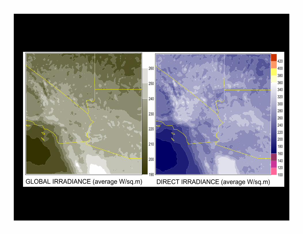
DIRECT IRRADIANCE (average W/sq.m)GLOBAL IRRADIANCE (average W/sq.m)100
120
140
160
180
200
220
240
260
280
300
320
340
360
380
400
420
190
200
210
220
230
240
250
260

• Time/site specific PV output data
• Coincident electric load data
Per
ez e
t al.,
ASR
C
Richard Perez et al., ASRC

15
source: RReDC
lowest highest
ENERGYENERGY
CAPACITYCAPACITY
Perez et al., 2002
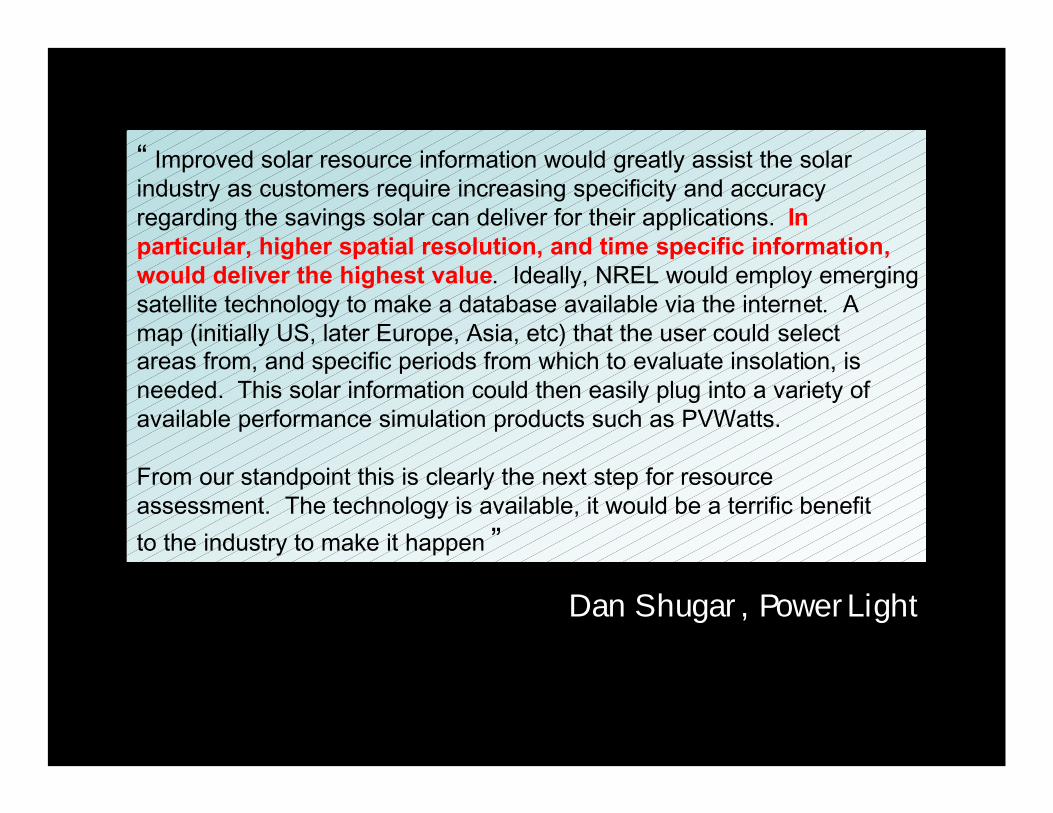
“ Improved solar resource information would greatly assist the solarindustry as customers require increasing specificity and accuracyregarding the savings solar can deliver for their applications. Inparticular, higher spatial resolution, and time specific information,would deliver the highest value. Ideally, NREL would employ emergingsatellite technology to make a database available via the internet. Amap (initially US, later Europe, Asia, etc) that the user could selectareas from, and specific periods from which to evaluate insolation, isneeded. This solar information could then easily plug into a variety ofavailable performance simulation products such as PVWatts.
From our standpoint this is clearly the next step for resourceassessment. The technology is available, it would be a terrific benefit
to the industry to make it happen ”
Dan Shugar, PowerLight


INTERNATIONAL COLLABORATION / EXCHANGE
INDER THE AUSPICES OF IEA
Global satellite coverageHigh resolution informationTime specific information [past, current, future]
Insuring coherence between models and satellite-platformsValidation of satellite-derived productsFacilitating access/exchange of data

IEA – Potential partners
US – NREL / SUNY / NASAGERMANY – DLR/ISE/U.OLDENBURGSWITZERLAND – METEOSUISSE / U.GENEVAFRANCE – ENTPE-LYON / ECOLE DES MINESNORWAY – U. BERGENJAPAN – U. KYOTON. ZEALAND – INDUSTRIAL RESEARCHCANADA – U.CHICOUTIMI
Associated teams
BRAZIL -- IMPEINDIA – TERI….