Embed Size (px)
Citation preview
UK Civil Hydrography Programme
2019 edition
Backscatter Wreck investigation
Bathymetry Seabed characterisation
UK Civil Hydrography Programme
1
Contents
Foreword 2
Introduction 3
News from the CHP 4
• Hydrography and Meteorology Team 4
• CHP Survey Contracts 4
• 2018/19 surveys 4
Civil Hydrography Annual Seminar 2019 5
Survey Vessels 2018/19 6
Autonomous Survey Vessels (ASV) 2018/19 7
Collaboration & Partnerships 8
• Regional Coastal Monitoring Programmes 8
• MPA Evidence Gathering Programme 8
How the MCA Gathers Hydrographic Data 9
• Standards 9
• Technical Requirements 9
• Quality Assurance 9
Propose a Survey 10
Survey Safety 11
Hydrographic Notes 11
Wreck Investigations 11
Sharing Data with the MCA 12
Guidelines for Offshore Developers 13
• Survey requirements 13
• MGN 543: Hydrography 13
• Where to Deliver 13
Annex 1: Completed CHP Surveys 2018/19 14
Annex 2: CHP Survey Plans 2019/20 16
Annex 3: Civil Hydrography Annual Seminar 2019 Programme 17
Contacts 19
UK Civil Hydrography Programme
2
Foreword The UK Civil Hydrography Programme As an executive agency of the Department for Transport, the Maritime and Coastguard Agency (MCA) plays a key role in implementing and enforcing the Government’s maritime safety and environmental protection strategies. We are committed to preventing loss of life, continuously improving maritime safety and protecting the marine environment. As ever, our mission remains: safer lives, safer ships and cleaner seas. Within this remit, the MCA has overall responsibility for the UK’s hydrographic obligations under the Safety of Life at Sea Convention (SOLAS) but works in close partnership with the UK Hydrographic Office (UKHO) to ensure that these obligations are met. The MCA manages a multi-million pound budget to systematically survey the waters around the UK. This programme is known as the “Civil Hydrography Programme” (CHP). Under the CHP, commercial contracts are let to ensure accurate hydrographic information is gathered for updating the nation’s nautical charts and publications. This year has seen a renewal of these contracts to three new contractors, as well as the introduction of the use of Autonomous Surface Vessels on to the CHP.
The Civil Hydrography Annual Seminar (CHAS) represents the main opportunity for the MCA to present its proposed survey plans for the forthcoming year and obtain feedback from our stakeholders. With continued pressure on public spending, there will always remain scope for owners of other marine data gathering programmes to come together and realise collaborative opportunities. Improved co-ordination and co-operation is an enabler for us all, providing better value for money and reducing the burden on the taxpayer. Brexit may be upon us, but we are as open as ever to collaborative opportunities going forward as we have ever been, within the UK and with European partners. From the MCA’s perspective, this greater collaboration results in more information getting on to nautical charts. It is very gratifying therefore, to see the continued growth of attendance at CHAS and the continued willingness of organisations to co-operate and collaborate to minimise the duplication of survey effort between organisations, wherever possible, and to realise the benefits that brings.
Paula English
Acting Head, Hydrography & Meteorology
Maritime & Coastguard Agency
HI 1495: Orford Ness to Southwold
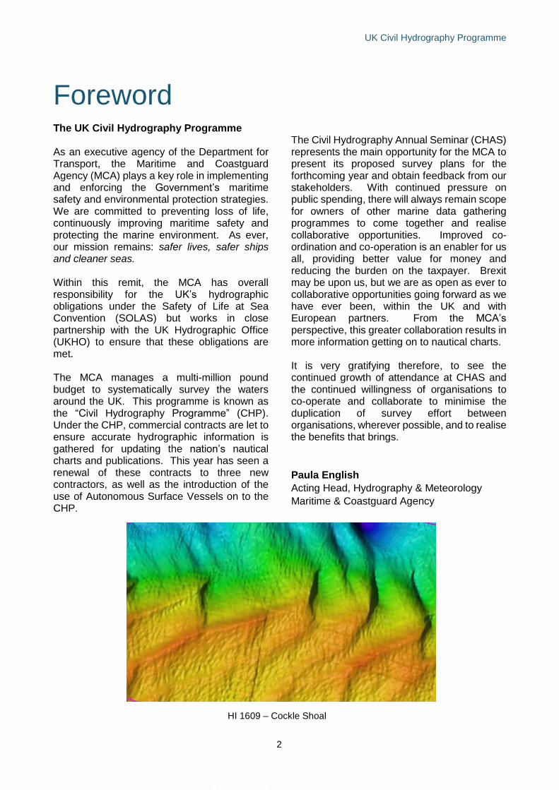
HI 1609 – Cockle Shoal
UK Civil Hydrography Programme
3
Introduction The CHP prioritises areas of highest
navigational safety risk and surveys and maps
UK home waters - defined by the boundaries of
the UK’s Exclusive Economic Zone, an area in
excess of 720,000km2 - in order to keep our
nation’s nautical charts and publications
current, safe and fit for purpose.
The MCA makes extensive use of geographic
information systems (GIS) to prioritise survey
areas using a contemporary risk analysis
methodology capable of reflecting the changing
pressures of the maritime sector.
The hydrographic survey work commissioned
for the CHP is undertaken by contractors, who
gather and report seabed data using their own
personnel, equipment and vessels. The core
CHP work scope has been divided into the
following streams:
• Routine resurvey - navigationally critical
shallow water areas with mobile seabed;
• Shallow water - predominantly 0 to 40m
water depth; and
• Shallow to medium water - 0 to 200m
water depth.
This year saw the introduction of an additional
contract, Supplementary Hydrographic Survey
Services, which the MCA may utilise to
maximise our involvement and input in
collaborative opportunities, where the provision
of hydrographic survey services or technical
expertise may be required to support such
initiatives.
To support the requirements of the CHP, the
MCA specifies state-of-the-art survey
technologies including high resolution
multibeam echosounders (MBES) and Real-
Time Kinematic (RTK) Global Positioning
Systems (GPS) to ensure accurate high-quality
hydrographic information is gathered.
Additionally, more focused work includes high-
resolution wreck investigations, water column
data collection and seabed grab sampling.
Prior to final data being accepted from
contractors, it passes through a rigorous quality
assurance process at the UKHO’s Bathymetry
Scientific Analysis Group, where checks are
made against items such as data density,
interline consistency, geodetic parameters and
tidal observations. Once data has passed
validation, it is archived to the UKHO’s
bathymetric database ready for inclusion in
their nautical charting products.
The UKHO hosts the Marine Environment Data and Information Network (MEDIN) Data Archive Centre (DAC) for bathymetry data. Bathymetry data collected through the CHP are made freely available to visualise and download from https://www.gov.uk/guidance/inspire-portal-and-medin-bathymetry-data-archive-centre The British Geological Survey hosts the MEDIN DAC for geology, geophysics and backscatter data. Backscatter data collected through the CHP are made freely available to visualise and download from http://www.bgs.ac.uk/GeoIndex/offshore.htm
The MCA regularly collaborate with other
public-sector organisations in order to increase
efficiencies under the ‘gather once, use many
times’ philosophy. The MCA have made the
CHP more accessible by:
• Sharing UK CHP Hydrographic Survey
Specification
• Making CHP data accessible via the
MEDIN bathymetry DAC and
backscatter DAC
• Providing British Geological Survey
CHP seabed samples for further
analysis
UK Civil Hydrography Programme
4
News from the CHP Hydrography & Meteorology Team
The MCA Hydrography and Meteorology
(HydroMet) team comprises:
• Head of Hydrography and Meteorology –
Andrew Colenutt
• Acting Head of Hydrography and
Meteorology – Paula English
• Hydrography Programme Lead – Heloise
Warner
• Hydrography and Meteorology Programmes
Coordinator - Rebecca De Bono
The Navigation Safety Branch, led by Assistant
Director, Richard Bell, comprises HydroMet,
Maritime Surveillance, Navigation Safety Policy
and Radio Spectrum and Technical Standards
teams.
CHP Survey Contracts
The MCA HydroMet team commenced the
tender process to award the current CHP
contracts in April 2018. As part of this process,
elements of the work scope relating to survey
prioritisation, analysis and reporting have been
revised to maximize efficiencies and
deliverables and provide best value for money.
Working closely with colleagues at the UKHO,
the team have also reviewed and updated the
UK CHP Survey Specification.
The current CHP work scopes have been
awarded to the following marine survey
contractors following a rigorous competitive
tendering exercise:
Clinton Marine Survey: Lot 1 (Shallow) & Lot 5
(Supplementary Survey Services)
MeriTaito: Lot 2 (Shallow to Medium)
A-2-Sea Solutions: Lot 3 (Routine Resurvey)
EGS International: Lot 4 (Richard Montgomery)
CHP 2018/19 surveys In addition to delivering the full proposed
programme of high priority areas, the MCA
HydroMet team secured further funding for an
additional 2 high priority areas.
In total, 11 CHP surveys have been conducted
during 2018/19, covering approximately
3,900km2 of seabed:
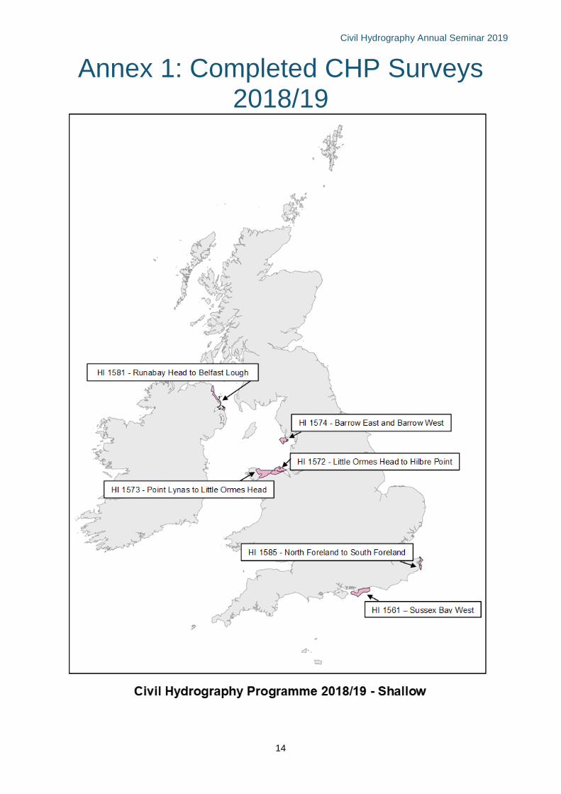
Shallow Water:
• HI 1561 Sussex Bay West
• HI 1572 Little Ormes Head to Hilbre Point
• HI 1573 Point Lynas to Little Ormes Head
• HI 1574 Barrow East and Barrow West
• HI 1581 Runabay Head to Belfast Lough
• HI 1585 North Foreland to South Foreland
Shallow to Medium Water:
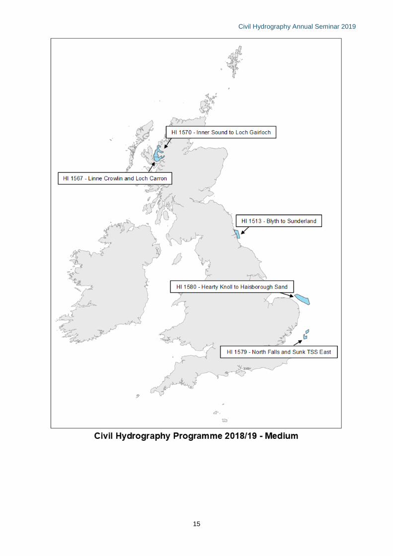
• HI 1513 Blyth to Sunderland
• HI 1567 Linne Crowlin and Loch Carron
• HI 1570 Inner Sound to Loch Gairloch
• HI 1579 North Falls and Sunk TSS East
• HI 1580 Hearty Knoll to Haisborough Sand
Two extension areas were also conducted for
HI 1572 and HI 1573 and were funded by Vale
of Glamorgan Council.
Civil Hydrography Annual Seminar 2019
5
Civil Hydrography Annual Seminar 2019 The MCA annually convene the Civil
Hydrography Annual Seminar (CHAS). This
year’s event was hosted by the International
Maritime Organization, in London on 14th
March.
CHAS is the only Government-led marine event
of its kind that opens its doors to the UK
hydrographic survey and seabed mapping
community.
The aims of CHAS are three-fold:
• To provide an open forum for public
sector organisations to come together
to share data gathering programmes for
the forthcoming years
• To encourage co-operative working and
survey planning integration
• To realise the financial benefits of co-
funding such work.
With over 90 attendees representing nearly 40
organisations, the event has proved as popular
and relevant as ever.
The MCA advocate a coordinated and
integrated approach to the longer-term survey
planning, which hopefully will enable the
hydrographic sector to manage funding
streams more effectively, develop new
partnerships and strengthen existing
collaborations between stakeholders.
Other key factors instrumental in advancing the
hydrographic sector and establishing efficient
ways of working include making high resolution
bathymetric data freely available under the
Open Government Licence and the stronger
adoption of the UK CHP Survey Specification.
In addition, there is a positive approach within
the sector for exchanging ideas and problem
solving in relation to data acquisition,
processing and interpretation.
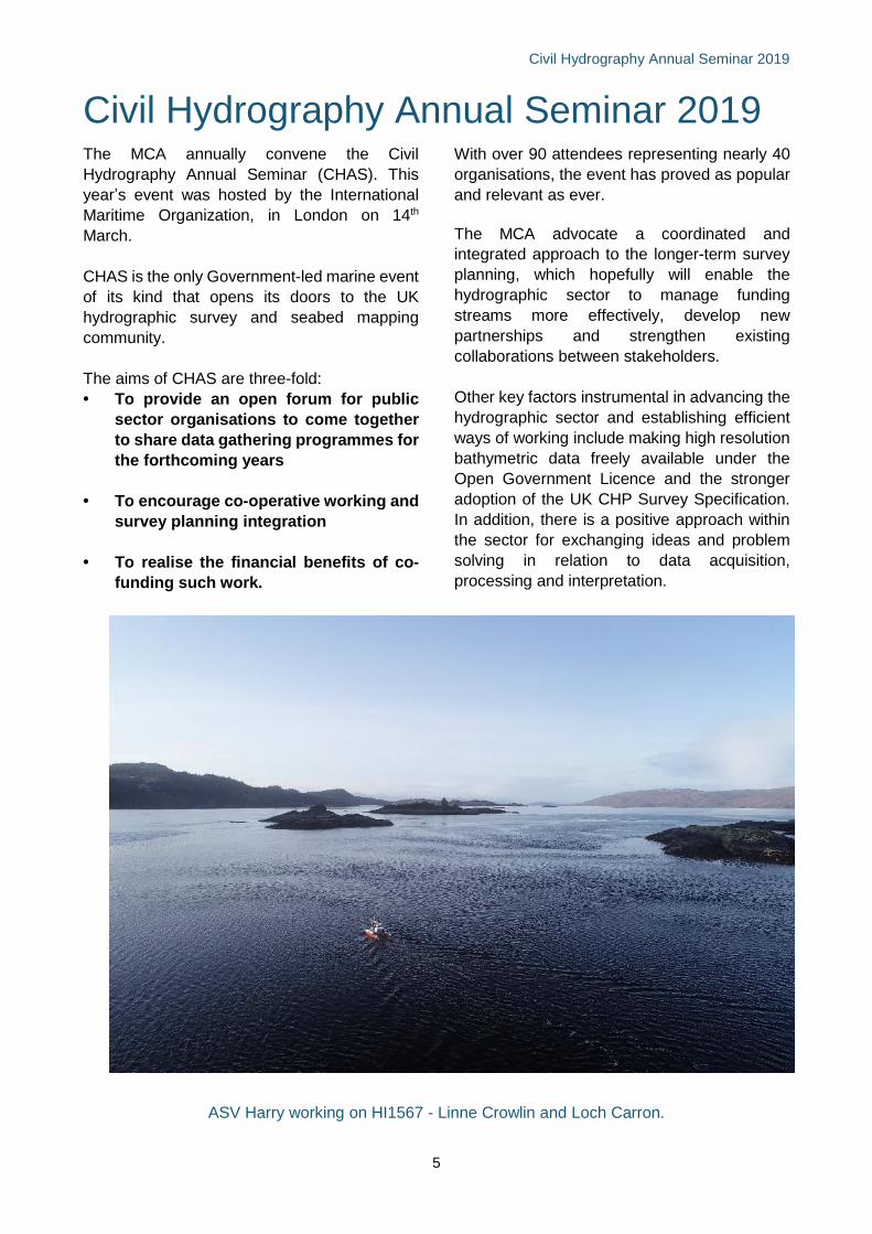
ASV Harry working on HI1567 - Linne Crowlin and Loch Carron.
HI 1495: Orford Ness to Southwold
Civil Hydrography Annual Seminar 2019
6
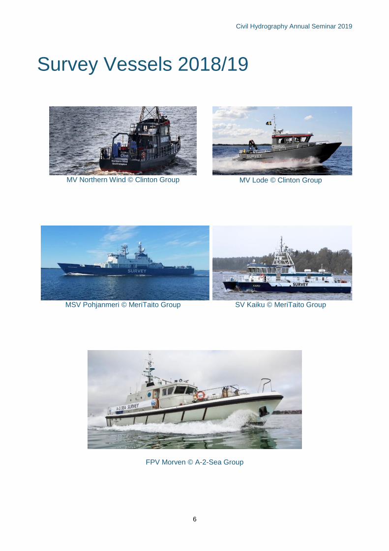
Survey Vessels 2018/19
MV Northern Wind © Clinton Group
MV Lode © Clinton Group
MSV Pohjanmeri © MeriTaito Group
SV Kaiku © MeriTaito Group
FPV Morven © A-2-Sea Group
Civil Hydrography Annual Seminar 2019
7
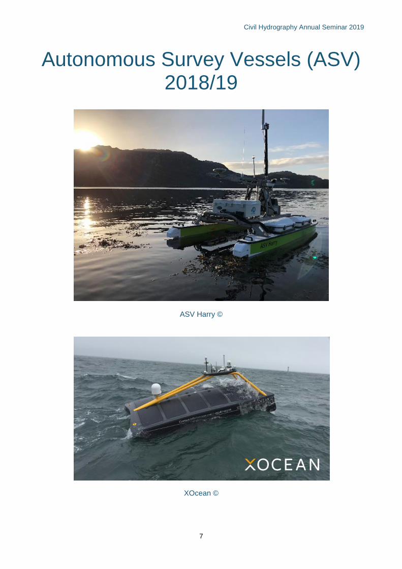
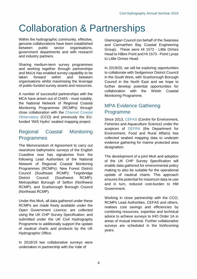
Autonomous Survey Vessels (ASV) 2018/19
ASV Harry ©
XOcean ©
Civil Hydrography Annual Seminar 2019
8
Collaboration & Partnerships
Within the hydrographic community, effective, genuine collaborations have been established between public sector organisations, government departments and with research and industry partners. Sharing medium-term survey programmes and working together through partnerships and MoUs has enabled survey capability to be taken forward within and between organisations whilst maximising the leverage of public-funded survey assets and resources. A number of successful partnerships with the
MCA have arisen out of CHAS - most notably,
the National Network of Regional Coastal
Monitoring Programmes (RCMPs) through
close collaboration with the Channel Coastal
Observatory (CCO) and previously the EU-
funded ‘INIS Hydro’ seabed mapping project.
Regional Coastal Monitoring
Programmes
The Memorandum of Agreement to carry out
nearshore bathymetric surveys of the English
Coastline now has signatories from the
following Lead Authorities of the National
Network of Regional Coastal Monitoring
Programmes (RCMPs): New Forest District
Council (Southeast RCMP); Teignbridge
District Council (Southwest RCMP);
Metropolitan Borough of Sefton (Northwest
RCMP); and Scarborough Borough Council
(Northeast RCMP).
Under this MoA, all data gathered under these
RCMPs are made freely available under the
Open Government Licence; are collected
using the UK CHP Survey Specification; and
submitted under the UK Civil Hydrography
Programme to additionally support the update
of nautical charts and products by the UK
Hydrographic Office.
In 2018/19 two collaborative surveys were
undertaken in partnership with the Vale of
Glamorgan Council (on behalf of the Swansea
and Carmarthen Bay Coastal Engineering
Group). These were HI 1572 - Little Ormes
Head to Hilbre Point and HI 1573 - Point Lynas
to Little Ormes Head.
In 2019/20, we will be exploring opportunities
to collaborate with Sedgemoor District Council
in the South West, with Scarborough Borough
Council in the North East and we hope to
further develop potential opportunities for
collaboration with the Welsh Coastal
Monitoring Programme.
MPA Evidence Gathering
Programme
Since 2013, CEFAS (Centre for Environment,
Fisheries and Aquaculture Science) under the
auspices of DEFRA (the Department for
Environment, Food and Rural Affairs) has
collected seabed mapping data to underpin
evidence gathering for marine protected area
designation.
The development of a joint MoA and adoption
of the UK CHP Survey Specification will
enable data gathered for environmental policy
making to also be suitable for the operational
update of nautical charts. This approach
ensures the potential for maximum data re-use
and in turn, reduced cost-burden to HM
Government.
Working in close partnership with the CCO,
RCMPs Lead Authorities, CEFAS and others,
realises cost savings and efficiencies by
combining resources, expertise and technical
advice to achieve surveys to IHO Order 1A in
areas of mutual interest. Further collaborative
surveys are scheduled in the forthcoming
years.
Civil Hydrography Annual Seminar 2019
9
How the MCA gathers hydrographic data
Hydrographic survey is the process of gathering a wide variety of data for the purpose of describing
the seafloor. To ensure that data is collected to the highest possible quality for navigational charting,
the MCA specify the following requirements.
Standards Quality Assurance
All surveys are conducted to the IHO Order 1a
survey standard, as defined by the
International Hydrographic Organisation (IHO)
publication ‘Standards for Hydrographic
Surveys, Special Publication S44, Edition 5’,
with the exception of single-beam
echosounder (SBES) check lines under the
Routine Resurvey Programme.
Technical Requirements
Multibeam Echsounder (MBES)
• Multibeam bathymetry is collected during
all CHP surveys.
• The MCA usually require 100%
bathymetric coverage in all areas they
survey.
• System detection capability is defined by
IHO requirements. Contractors are
required to detect objects whose size is
greater than a cube measuring 2m3, in
water depths of up to 40m, and a cube with
sides equal to 10% of depth in deeper
waters.
• A minimum of 9 soundings per minimum
detectable object are required.
• Sound velocity measurements are
routinely taken throughout the survey in
order to position the soundings correctly.
• Contractors are often required to conduct
tidal-stream observations at particular
locations.
Data Quality Control
• In addition to QC procedures employed by
CHP survey contractors, technical
personnel from both the MCA and UKHO
routinely visit contractors’ vessels
throughout survey operations to verify data
quality.
• Prior to final survey data being accepted
from contractors, it passes through a
rigorous quality assurance process at the
UKHO, where checks are made for items
such as data density, inter-line
consistency, geodetic parameters, tidal
observations etc.
• Contractors are asked to provide error
budgets prior to and after every survey so
that the contribution of individual error
sources are tightly defined. This ensures
rigorous quality control of the final survey
dataset.
Additional Measurements
• Rigorous tidal reduction is required on all
CHP surveys.
• Depths are reduced to Chart Datum (CD).
• Seabed grab samples are typically taken
at 5km intervals to ground-truth multibeam
backscatter observations.
• MBES water column data is collected over
all found wrecks to support an assessment
of their condition and ensure shoalest
depth is found.
Civil Hydrography Annual Seminar 2019
10
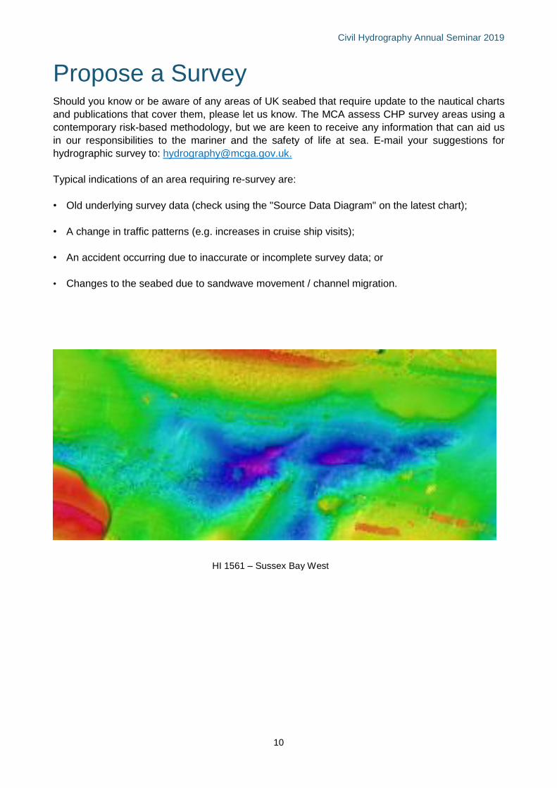
Propose a Survey Should you know or be aware of any areas of UK seabed that require update to the nautical charts
and publications that cover them, please let us know. The MCA assess CHP survey areas using a
contemporary risk-based methodology, but we are keen to receive any information that can aid us
in our responsibilities to the mariner and the safety of life at sea. E-mail your suggestions for
hydrographic survey to: [email protected].
Typical indications of an area requiring re-survey are:
• Old underlying survey data (check using the "Source Data Diagram" on the latest chart);
• A change in traffic patterns (e.g. increases in cruise ship visits);
• An accident occurring due to inaccurate or incomplete survey data; or
• Changes to the seabed due to sandwave movement / channel migration.
HI1509: Approach to Loch Ryan
HI 1561 – Sussex Bay West
Civil Hydrography Annual Seminar 2019
11
Survey SafetyMuch of the hydrographic work completed by the CHP is undertaken by contractors who are required
to gather seabed data using their own personnel, and vessels owned or chartered by themselves.
Acquired data is then submitted to both the MCA and UKHO.
I. Any vessel undertaking work on behalf of
the CHP must adhere to MCA safety and
regulatory guidelines. MCA safety
requirements include:
II. Contractors are always required to supply
and adhere to a Safety Management Plan .
III. All offshore personnel are required to have
a valid medical certificate to at least the
ENG1 standard.
IV. All offshore personnel are required to have
appropriate and valid safety training
certification.
V. Every vessel that participates in CHP
survey operations is subject to approval by
the MCA (via MCA marine office
inspection) prior to work starting. Repeat
inspections are undertaken annually for the
duration of MCA contracts.
VI. Paris MoU. Should a vessel employed on
the CHP develop a high ship risk profile
(HRS), then the MCA reserves the right to
remove said vessel from the contract until
she meets ‘standard’ (SRS) or ‘low’ (LRS)
risk criteria.
VII. All vessels participating in CHP surveys
are visited by an MCA or a UKHO contract
overseer at least once every 2 months. A
report covering each visit is kept on file by
the MCA HydroMet team. Visits are
primarily intended to focus on the quality of
survey procedures and deliverables, but
also include an informal safety
assessment. If significant safety concerns
are raised, then the contract overseer is
required to notify the local MCA marine
office.
Hydrographic Notes
Reports of any newly discovered dangers to surface or sub-surface navigation are passed
immediately by the CHP contractors to the MCA and UKHO using the H102 Hydrographic Note form.
The nature of the CHP means that H-Notes are regularly sent in. This information is then immediately passed on to the mariner. During survey operations in 2018/19, over 160 H Notes were submitted.
Wreck Investigations All wrecks found in a CHP survey are investigated with additional lines and detailed bathymetry and water column data. Sitting proud of the seabed, wrecks and other man-made obstructions often form the critical depth in each area of seabed. It is therefore crucial we have confidence that the shoalest point on these obstructions are found so the mariner can navigate safely.
Civil Hydrography Annual Seminar 2019
12
Sharing Data with the MCA If you are considering performing a hydrographic survey and are willing to share your data with us,
we can pass it on to the UK Hydrographic Office to help them compile new or updated nautical charts
and so help improve safety for mariners.
Your survey does not need to be carried out to full charting standards to be of use. Even without a
full search for dangers, a modern survey can improve on our knowledge of the seabed. There will
be no legal liability on you for the way that we use your data.
The MCA are always happy to give help and advice on hydrographic data gathering requirements in
order to increase the usefulness of hydrographic survey data. Ideally bathymetry data would be
rendered and delivered in digital form, with:
• Data in one of the following: CARIS HDCS
directory (i.e. “HIPS”), Generic Sensor
Format, Fledermaus PFM or ASCII xyz
• Spurious data cleaned from the final,
delivered, dataset with rejected
soundings included, but flagged as
deleted
• Details of the method used for data-
cleaning
• Digital data as full density (i.e. prior to
any gridding or binning being applied),
though if gridded datasets have been
created then please include these too
• The soundings reduced using observed
tides (not predicted tides from Tide
Tables)
• Depths referenced to Chart Datum for the
area.
A report of the survey that describes how the
data was gathered and processed would be of
use, especially if it includes:
• A list of the equipment and software
used;
• How positioning equipment was set up,
calibrated and used;
• How the echo-sounder transducer was
set up and levelled, together with all
sensor offsets;
• Details of the horizontal datum to which
the positions are referred (or the grid, if
appropriate);
• How tides were measured, how the tide
pole or tide gauge was levelled and how
depths were reduced to chart datum.
Data which fully complies with all aspects of
IHO Order 1a would be ideal.
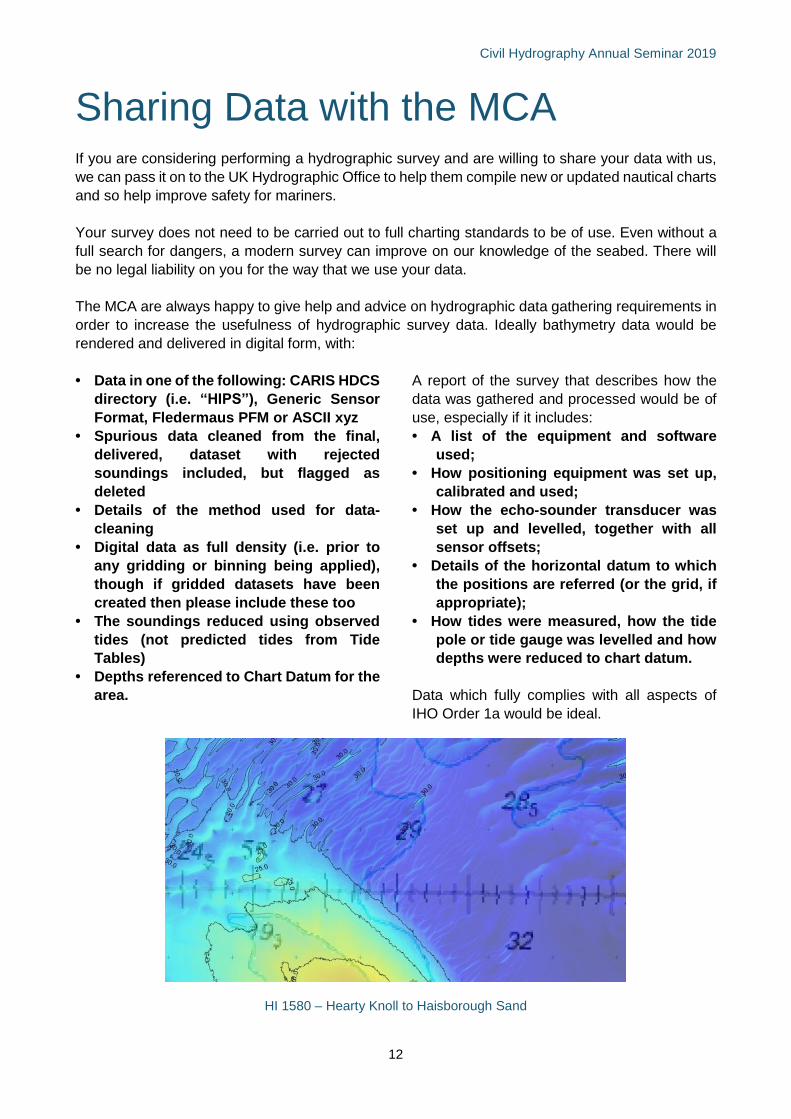
HI 1580 – Hearty Knoll to Haisborough Sand
Civil Hydrography Annual Seminar 2019
13
Guidelines for Offshore Developers
The MCA have issued guidelines which are
intended to aid developers when submitting
consent applications which impact upon
hydrography. These guidelines should be read
in conjunction with Marine Guidance Note
(MGN) 543 which replaces MGN 371. They are
available on the MCA pages on gov.uk.
The MGN 543 guidance note highlights issues
that need to be taken into consideration when
assessing the impact on navigational safety
and emergency response (search and rescue,
salvage and towing, and counter pollution)
caused by offshore renewable energy
installation developments. It applies to
proposals in United Kingdom internal waters,
Territorial Sea and Exclusive Economic Zone.
Survey Requirements
All hydrographic surveys should provide full
seafloor coverage that meets the requirements
of the IHO Order 1a survey standard. Particular
attention should be given to horizontal and
vertical sounding accuracy, together with target
detection requirements and, we would request
that all data and reports are passed on to the
UKHO for the update of the UK’s nautical charts
and publications.
MGN 543: Hydrography
In order to establish a baseline, confirm the safe
navigable depth, monitor seabed mobility and
to identify underwater hazards, detailed and
accurate hydrographic surveys are required of
the development at the following stages:
Pre-consent: The site and its immediate
environs extending to 500m outside of the
development area shall be undertaken as part
of the licence and/or consent application. The
survey shall include all proposed cable route(s).
Post-construction: Cable route(s).
Post-decommissioning of all or part of the
development: Cable route(s) and the area
extending to 500m from the installed generating
assets area.
Any additional hydrographic survey undertaken
for any other purposes should be carried out to
the standard described in section 6.c.
The development may result in an alteration to
maritime traffic patterns as vessels seek
alternative passage around the installed
generating assets area. Where this is the case,
it may be considered necessary that a
hydrographic survey of these alternate
passages and their immediate environs
extending to 500m be undertaken. MCA can
provide guidance here if required.
All hydrographic surveys listed above should
fulfil the requirements of the MCA’s
‘Hydrography Guidelines for Offshore
Developers’ and ‘Post-Construction
Hydrographic Guidelines for Offshore
Developers’, which are both available on the
MCA website.
Where to Deliver
On completion of each survey, the bathymetric
data and associated report of survey should be
delivered to the MCA. The MCA is responsible
for collecting and supplying data to the UKHO
to update nautical charts and publications for
the purposes of navigation safety. The
commercial sensitivity of your data will always
be respected.
Send your data & reports to:
Head of Hydrography & Meteorology
Maritime & Coastguard Agency
Spring Place
105 Commercial Road
Southampton
SO15 1EG
Civil Hydrography Annual Seminar 2019
14
Annex 1: Completed CHP Surveys 2018/19
Civil Hydrography Annual Seminar 2019
15
Civil Hydrography Annual Seminar 2019
16
Annex 2: CHP Survey Plans 2019/20
Civil Hydrography Programme 2019/20 – Shallow & Medium
HI 1588 Summer Isles to Stoerhead
HI 1569 Sound of Raasay
HI 1582 Moray Firth
HI 1568 Sound of Sleat to Loch Alsh
HI 1591 Saint Abb’s Head to Farne Islands
HI 1590 Dogger Bank South West
HI 1597 Turnberry Point to Troon
HI 1593 Lock Ryan to Turnberry Point
HI 1592 Fishguard to Cardigan
HI 1596 Outer Dowsing Channel
HI 1506 Bristol Channel – Ilfracombe to Gower
HI 1560 Gribbin Head to Dodman Point
HI 1584 Northern Approach to Sunk
HI 1571 Red Wharf to Gwynt-y-Mor
Civil Hydrography Annual Seminar 2019
17
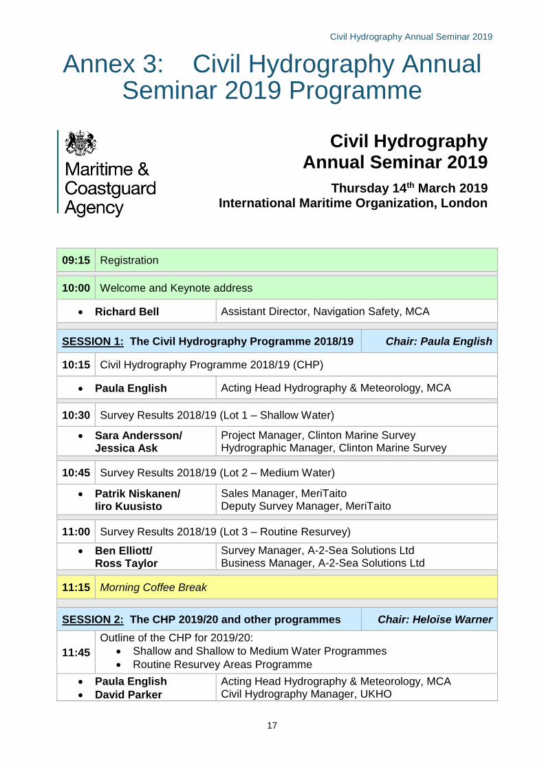
Annex 3: Civil Hydrography Annual Seminar 2019 Programme
Civil Hydrography Annual Seminar 2019
Thursday 14th March 2019 International Maritime Organization, London
09:15 Registration
10:00 Welcome and Keynote address
• Richard Bell Assistant Director, Navigation Safety, MCA
SESSION 1: The Civil Hydrography Programme 2018/19 Chair: Paula English
10:15 Civil Hydrography Programme 2018/19 (CHP)
• Paula English Acting Head Hydrography & Meteorology, MCA
10:30 Survey Results 2018/19 (Lot 1 – Shallow Water)
• Sara Andersson/ Jessica Ask
Project Manager, Clinton Marine Survey Hydrographic Manager, Clinton Marine Survey
10:45 Survey Results 2018/19 (Lot 2 – Medium Water)
• Patrik Niskanen/ Iiro Kuusisto
Sales Manager, MeriTaito Deputy Survey Manager, MeriTaito
11:00 Survey Results 2018/19 (Lot 3 – Routine Resurvey)
• Ben Elliott/ Ross Taylor
Survey Manager, A-2-Sea Solutions Ltd Business Manager, A-2-Sea Solutions Ltd
11:15 Morning Coffee Break
SESSION 2: The CHP 2019/20 and other programmes Chair: Heloise Warner
11:45
Outline of the CHP for 2019/20:
• Shallow and Shallow to Medium Water Programmes
• Routine Resurvey Areas Programme • Paula English
• David Parker
Acting Head Hydrography & Meteorology, MCA Civil Hydrography Manager, UKHO
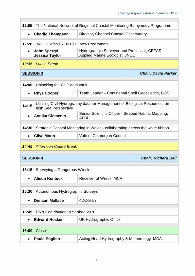
Civil Hydrography Annual Seminar 2019
18
12:05 The National Network of Regional Coastal Monitoring Bathymetry Programme
• Charlie Thompson Director, Channel Coastal Observatory
12:20 JNCC/Cefas FY18/19 Survey Programme
• John Sperry/ Jessica Taylor
Hydrographic Surveyor and Processor, CEFAS Applied Marine Ecologist, JNCC
12:35 Lunch Break
SESSION 3 Chair: David Parker
14:00 Unlocking the CHP data vault
• Rhys Cooper Team Leader – Continental Shelf Geoscience, BGS
14:15 Utilising Civil Hydrography data for Management of Biological Resources: an Irish Sea Perspective
• Annika Clements Senior Scientific Officer - Seabed Habitat Mapping, AFBI
14:30 Strategic Coastal Monitoring in Wales - collaborating across the white ribbon
• Clive Moon Vale of Glamorgan Council
14:45 Afternoon Coffee Break
SESSION 4 Chair: Richard Bell
15:15 Surveying a Dangerous Wreck
• Alison Kentuck Receiver of Wreck, MCA
15:30 Autonomous Hydrographic Surveys
• Duncan Mallace 4DOcean
15:45 UK’s Contribution to Seabed 2030
• Edward Hosken UK Hydrographic Office
16:00 Close
• Paula English Acting Head Hydrography & Meteorology, MCA
Civil Hydrography Annual Seminar 2019
19
UK Civil Hydrography Programme | 2015 Edition
Use of Admiralty charts contained within are © Crown copyright and/or database rights. Reproduced by permission of the Controller of Her Majesty’s Stationary Office and the UK Hydrographic Office (www.ukho.gov.uk).
Contacts Maritime and Coastguard Agency Spring Place 105 Commercial Road Southampton SO15 1EG Tel: 020 3817 2000 Web: www.gov.uk/mca
Hydrography and Meteorology Team Tel: 020 3817 2428 Paula English, A/Head Hydrography & Meteorology 020 3817 2222 Heloise Warner, Hydrography Programmes Lead 020 3817 2244 Rebecca DeBono, HydroMet Programmes Co-ordinator E-mail: [email protected]
© Crown copyright