Embed Size (px)
Citation preview
U.K. OFFSHORE OPERATORS ASSOCIATION(SURVEYING AND POSITIONING COMMITTEE)
UKOOA DATA EXCHANGE FORMAT
P6/98
DEFINITION OF 3D SEISMIC BINNING GRIDS
Revision 3.0May 2000

UKOOA – Bin Grid Definitions Page 1 of 25 Rev. 3, May 2000
SUMMARY
The Guidelines For The Definition of 3D Seismic Binning Grids and the associated data exchangeformat – P6/98 - is recommended by UKOOA for general use in the Oil and Gas, Exploration andProduction industry and set out what is generally regarded in the industry as good practice. Theformat is not mandatory and operators may adopt different format standards in a particularsituation where to do so would maintain an equivalent level of quality and performance.
These guidelines have been written by a working group established by the UKOOA Surveying andPositioning Committee, following discussions and feedback from a wide range of interested partiesin the oil industry. Any comments and suggestions for improvement are welcome and should beaddressed to:
The Chairman, Surveying and Positioning CommitteeUKOOA9 Albyn TerraceAberdeenAB10 1YP
Revision Date ModificationRev 1 Sep ‘94 - First Version Issued
Rev 2 Oct ‘99 - Re-formatted and updated- EPSG coordinate system description included H80 - H81- Data coverage perimeter definition extended H20 - H35- Coordinate system check point included H1401 - H1402
Rev 3 May ‘00 - Minor changes to section 5, defining parameters.- Minor changes to section 6, affine transformation definition.
WORKING GROUP MEMBERS
Rev 1:J. Hand Geco-Prakla Schlumberger Ltd.J. Kerr Landmark EAME Ltd.P. McCartney BP Exploration plcG. Perratt Phillips Petroleum Company UK Ltd.
Rev 2:D. Bingham BP Amoco ExplorationR. Lott BP Amoco ExplorationG. Simensen Shell ExproC. Stevenson Elf Exploration Ltd.

UKOOA – Bin Grid Definitions Page 2 of 25 Rev. 3, May 2000
Table of Contents
1 INTRODUCTION ............................................................................................................... 41.1 Historical Overview...................................................................................................... 41.2 Recent Advances ........................................................................................................ 51.3 Relationship to Other Formats..................................................................................... 5
2 COORDINATE REFERENCE SYSTEMS .......................................................................... 63 MAP GRID TO BIN GRID DISTORTIONS......................................................................... 8
3.1 Scale Factor ................................................................................................................ 83.2 Change in Scale Factor............................................................................................... 93.3 Convergence............................................................................................................... 9
4 DESCRIPTION OF TERMS............................................................................................. 105 DEFINING PARAMETERS.............................................................................................. 146 AFFINE TRANSFORMATION DEFINITION .................................................................... 187 DATA EXCHANGE FORMAT.......................................................................................... 19
APPENDIXA Practical Example ......................................................................................................... 21B Test Conversion ............................................................................................................ 23
UKOOA – Bin Grid Definitions Page 3 of 25 Rev. 3, May 2000

UKOOA – Bin Grid Definitions Page 4 of 25 Rev. 3, May 2000
1. INTRODUCTION
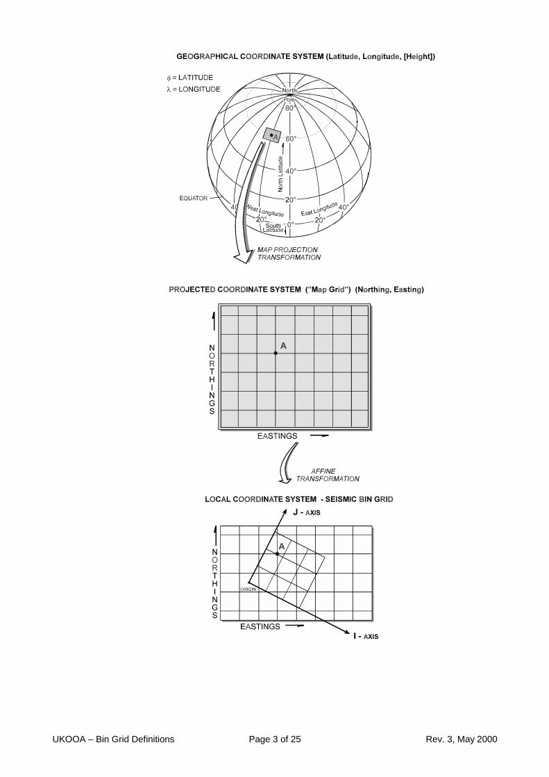
3D seismic data is processed by the grouping of seismic traces. These groups are referenced to apoint defined as a bin node and successive bin nodes are regularly spaced to form a matrix.
The location of each of these nodes can be referenced to its location in the real world by using ageodetic coordinate system. Alternatively the relative location of the node within the matrix can bedefined by counting the nodes along two orthogonal axes.
A set of defining parameters establish the relationship between the relative matrix location and achosen geodetic coordinate system.
These guidelines explain the difficulties inherent in the choice of coordinate reference systems,and supply a set of parameters which defines a 3D seismic binning system. The variety of optionsin current use for the definition of seismic binning will not be supplanted by these parameters butthey will provide an exchange mechanism to allow users to uniquely and unambiguously transferdata. From the defined parameter set, users will be able to determine a subset of parameterswhich satisfy their present definitions.
1.1 Historical Overview
At the acquisition stage of a 3D land or marine seismic survey the survey area and the method ofacquisition are defined. In conventional marine 3D seismic streamers are towed along a set ofparallel lines with a fixed spacing and energy sources are activated at regular intervals.Conventional land seismic is similar, with geophone strings being laid out along a set of parallellines with a regular spacing.
This gives rise to the method of associating the trace information with a regular bin, whosedimensions relate to the shot point interval in one direction, and the line spacing in the other. Thebins are rectangular, and the geometrical centre of the bin is the point defining the location of thetrace data.
The bin centres can be generated as a matrix. To relate the matrix cells to the real world the bincentres must be defined also in terms of cartesian map grid coordinates on a defined projectedcoordinate system.
For a regular binning grid it is more efficient for a computer, instead of holding the coordinates ofeach individual bin centre, to calculate them from a set of defining parameters.
Certain terminology associated with the bin axes has become standard. The term inline isassociated with the direction of the streamer or geophone array and the crossline direction isorthogonal to the inline direction.

UKOOA – Bin Grid Definitions Page 5 of 25 Rev. 3, May 2000
1.2 Recent Advances
Changes to acquisition and processing techniques have complicated matters and require a morerigorous definition to enable accurate and unambiguous relationships between the bin grid and themap grid coordinates.
1. Surveys have become larger. This strains the ability of any map projection to represent thesurvey area as undistorted within an acceptable tolerance over the area of the survey .
2. There is a requirement to merge surveys either directly or through reprocessing. Thisincreases the extent of the survey area and poses problems for the bin dimension, as the binsizes of merged surveys may be different.
3. The concept of inline and crossline has become blurred with modern techniques of shootingacross spreads, circular marine acquisition and north-south binning independent of acquisitiondirection.
4. The concept of a rectangular bin is limiting, as there may be advantages to considering non-rectangular shapes for the bin.
5. As well as the bin centre, there is a need to be able to define other attributes such as thecentre of gravity of the bin.
As a result of these changes, much of the 'standard' terminology can no longer accuratelydescribe the 3D seismic binning grid. Moreover, it is apparent that terminology varies betweencompanies, and even within the same company between acquisition, processing andinterpretation.
1.3 Relationship to Other Formats
The technical provisions and contents of this P6/98 format are identical to those made fordescribing bin grid and area of coverage in the SEG-Y revision 1 format file header. The recorddefinitions differ, but only to the extent required to ensure consistency in style within the respectiveformats.
UKOOA – Bin Grid Definitions Page 6 of 25 Rev. 3, May 2000
2. COORDINATE REFERENCE SYSTEMS
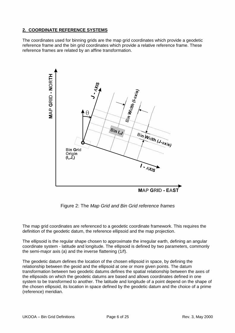
The coordinates used for binning grids are the map grid coordinates which provide a geodeticreference frame and the bin grid coordinates which provide a relative reference frame. Thesereference frames are related by an affine transformation.
Figure 2: The Map Grid and Bin Grid reference frames
The map grid coordinates are referenced to a geodetic coordinate framework. This requires thedefinition of the geodetic datum, the reference ellipsoid and the map projection.
The ellipsoid is the regular shape chosen to approximate the irregular earth, defining an angularcoordinate system - latitude and longitude. The ellipsoid is defined by two parameters, commonlythe semi-major axis (a) and the inverse flattening (1/f).
The geodetic datum defines the location of the chosen ellipsoid in space, by defining therelationship between the geoid and the ellipsoid at one or more given points. The datumtransformation between two geodetic datums defines the spatial relationship between the axes ofthe ellipsoids on which the geodetic datums are based and allows coordinates defined in onesystem to be transformed to another. The latitude and longitude of a point depend on the shape ofthe chosen ellipsoid, its location in space defined by the geodetic datum and the choice of a prime(reference) meridian.

UKOOA – Bin Grid Definitions Page 7 of 25 Rev. 3, May 2000
A projection is chosen as a means of representing the curved surface of the ellipsoid on a flatplane and hence of presenting the data on a map. The choice of projection determines therepresentation of properties such as shape, area, distance and azimuth. Since the ellipsoid is not adevelopable surface (it cannot be flattened without distortion) the choice of projection is important.Over a small area a close approximation to uniformity can be achieved but as the area increasesthe distortions become greater.
The projection system provides a set of map grid coordinates designated by Easting along thegrid East axis and Northing along the grid North axis. Grid bearings are measured clockwise fromgrid North. No grid values can have any meaning unless the related geodetic datum andellipsoid have already been defined.
It would be possible to consider a binning system defined on the ellipsoid. This would haveadvantages in that the measured distances would be 'true', as would the azimuths measured fromtrue North. Whilst it has been common practice to shoot marine seismic lines on the ellipsoid,current workstation software assumes that processing and interpretation are carried out on aCartesian grid based on a defined map grid.
The bin grid is the relative coordinate framework which defines a matrix of evenly spaced pointsreferred to as the bin nodes. These nodes are the points to which groups of traces are referenced.
To be able to relate the bin grid coordinates with their map grid coordinates an affinetransformation is used.
From the practical point of view the exchange format removes the concept of 'inline' and 'crossline'by referring to bin nodes. This represents a unified reference frame. However, by allowingnegative and non-unit bin grid increments it allows the User to define the exchange format to befully compatible with the bin grid numbering of any work station set-up.
UKOOA – Bin Grid Definitions Page 8 of 25 Rev. 3, May 2000
3. MAP GRID TO BIN GRID DISTORTIONS
The choice of a suitable projection for the binning of 3D seismic data is important. There aredistortions associated with the projection which need to be quantified and eliminated or minimisedto avoid anomalies between the bin grid and the map grid.
The principle distortions are Scale Factor, Change of Scale Factor and Convergence.
3.1 Scale Factor
The nominal bin grid is often defined as a fixed size corresponding to the distance set out on theground (land seismic) or the shot point interval (marine seismic). This distance may be either atrue distance on the surface of the earth or a grid distance on the chosen map grid, depending onthe method used for acquisition.
Assuming that a sensible projection has been chosen, the average map grid scale factor over thearea of the bin grid should be close to unity. The difference between the true and the griddimension of any single bin node separation will be the same to two decimal places. (eg 12.500 ·0.9996 = 12.495 = 12.50 to 2 decimal places).
However, as the distance from the origin increases, the projected distance from origin to bin nodewill depart from the multiple of the 'true' bin node separation. For example, if the scale factor is0.9996, then at 10 km there will be a 4 m difference between the map grid coordinate and theproduct of the bin node separation and the number of nodes from origin. This difference canresult in misidentification of a bin node for large surveys, especially where the bin nodeseparation is small.
Having identified the problem, it can be solved in various ways:
a) Keep the map grid coordinates together with the associated bin grid node.
b) Multiply the 'true' bin node separation by the map grid scale factor to get the grid distance.
c) Shoot the survey lines as map grid lines rather than great circles. The shot point interval willthen be the specified distance 'on the map grid', and the scale factor multiple becomes unity.
d) Define a specific map projection which has a unit scale factor at the grid origin or within the bingrid area.
e) Specify a projection which has the specific property of being equidistant.
In the proposed exchange format the scale factor at a point within the bin grid is a requiredparameter. Note that this is not the same as the scale factor at the projection origin, for exampleon the central meridian of a UTM zone. To minimise the secondary effect of the change of scalefactor, defined below, a scale factor near the centre of the bin area may be chosen. Normally,however, the map grid scale factor at the bin grid origin is adequate. If the survey has beenacquired by setting out on the map grid, then the scale factor parameter is unity.

UKOOA – Bin Grid Definitions Page 9 of 25 Rev. 3, May 2000
3.2 Change of Scale Factor
For most projections, having addressed the scale factor problem, there is a secondary effect dueto the change of scale factor over the survey area. This is a negligible effect for any reasonableprojection, producing errors of the order of 0.01 m at 10 km.
It is possible to eliminate this error entirely by leaving the map grid scale factor parameter as avariable and calculating the line scale factor for the bin grid location. However this is anunnecessary refinement which would complicate the transformation calculation.
3.3 Convergence
The orientation of the survey is defined as the Map Grid bearing of the J axis. If the survey isacquired using an azimuth referred to True North then a correction must be made for theconvergence (the angular difference between grid north and true north) at the bin grid origin tocorrectly orient the survey.
If the acquisition is carried out on a map grid bearing, and then the bin grid is defined on adifferent map grid, the change in the convergence at the bin grid origin must be applied . This isfrequently the case for integration or merging of surveys. In this case a failure to correct theorientation for the change in convergence at the bin grid origin between the two projections canlead to significant errors in the orientation of the binning grid.
A one degree error in the convergence will cause an error of 175 m at 10 km from the origin. Athigh latitudes the convergence can be very significant (e.g. equal the difference in longitudebetween the point and the respective central meridian for a TM projection), and for all projections itis crucial that the convergence is correctly applied when converting true azimuths to map gridbearings or when changing map grids.
The best method of handling this problem is for the software to read the geodetic datum, ellipsoidand projection details together with the other defining parameters. If a change in the geodeticreference frame (geodetic datum, ellipsoid, projection) is required, the software shouldautomatically perform the transformation to the new set of parameters defining the survey,including the calculation of the new grid bearing of the J axis.
If no automatic conversion is available, then the conversion must be done 'off-line' and the correctgrid bearing of the bin grid J axis entered as the orientation parameter.
UKOOA – Bin Grid Definitions Page 10 of 25 Rev. 3, May 2000
4. DESCRIPTION OF TERMS
MAP GRID : The geodetic coordinate reference frame defined by the geodetic datum,ellipsoid and projection is the map grid. The map grid axes are defined asthe map grid North axis and the map grid East axis. The East axis is rotated90 degrees clockwise from the North axis. Coordinates in the map grid aredefined by the Easting and the Northing of the point ( E , N ).
BIN NODE : This term is used instead of the term bin centre, and refers to the locationswhere the bin grid lines intersect. The affine transformation requires that thebin nodes are regularly spaced.
BIN : The bin is the area surrounding the bin node. Typically the bin node will beat the bin centre, but this is not necessary. The bin node is the pointrepresenting the bin. The term bin is used rather than the term cell.
BIN GRID : The bin grid is defined by a pair of orthogonal axes designated the I and theJ axes, with the I axis rotated 90 degrees clockwise from the J axis.The order of specifying bin grid coordinates will be the I value followed by theJ value ( I , J )The choice of I , J axes is made to avoid any confusion between bin grid( I , J ) and map grid ( E , N ) coordinates.
Axes may be labelled by users as they wish within their own software,including such terms as Inline and Crossline , Row and Column, x and y.However there is no uniformity of opinion on labels and terms such as Inlineand Crossline are used in contradictory ways by different users. For thepurpose of data exchange the only reference is to the I and J axes.
BIN GRIDORIGIN
: The bin grid origin is at the bin node designated as (Io,Jo), and the mapgrid coordinates of this node are specified parameters.The bin grid origin coordinates are designated by the sign, 5 integers and 3decimal places, with leading zeros shown ( eg ( 01001.000 01001.000) ).This allows for a non integer bin grid increment. Note that coordinates maybe negative or positive. The choice of the numbering convention for the originis at the discretion of the user. There may be a virtue in offsetting the origincoordinates so that I and J values can be immediately discriminated ( eg (00001.000 01001.000), but this is left to the user to chose.
SCALEFACTOR OFBIN GRID
: The scale factor of the bin grid is the point scale factor of the map gridcoordinate system at a point within the bin grid, and depends upon thechosen projection. This is NOT the same as the scale factor at the projectionorigin (e.g. the scale factor on the central meridian of a UTM zone). The usermay choose any point within the bin grid, although generally the bin gridorigin or the centre of the bin grid will be the chosen point. The bin gridcoordinates of the point to which the scale factor refers is also required as acheck on the validity of the parameter.
If the survey has been acquired on the map grid, then the node interval is amap grid interval and the Scale Factor of the Bin Grid is unity.
If the map grid is changed at the processing or reprocessing stage, then theScale Factor of the Bin Grid will also change.
UKOOA – Bin Grid Definitions Page 11 of 25 Rev. 3, May 2000
BIN NODEINCREMENT
: The bin node increment is the numerical increment between successive binnodes. It must be constant along each axis for the entire bin grid, but can benegative.The bin grid increment does not have to be an integer. This allows for theinterpretation of surveys of different bin node separations withoutreprocessing, or for the resampling of a bin grid.
NOMINAL BINWIDTH
: The Nominal Bin Width is the nominal separation of the bin nodes in the I andJ directions.'Nominal' is used to distinguish the parameter from the 'actual' bin nodeseparation, which is the product of the Nominal bin width and the ScaleFactor of Bin Grid.If a survey is acquired with a true shot point interval of 12.5 metres, then theNominal Bin Width will be 12.5 metres, and the Scale Factor of the Bin Gridwill be a function of the Map Grid.If a survey is acquired with a shot point interval of 12.5 metres set out on theMap Grid, then the Nominal Bin Width will be 12.5 metres and the ScaleFactor of the Bin Grid will be unity.
ORIENTATION : The Bin Grid Orientation is defined by the map grid bearing ( measuredclockwise from map grid North) of the J axis.Any other definition of the orientation of the bin grid, such as the rotation frommap grid east, can be derived from the map grid bearing of the bin grid Jaxis.
If the map grid is changed at the processing or reprocessing stage, then theOrientation of the Bin Grid will also change.
UNITS : In all cases the units must be defined for the map grid coordinates andbearings . The conversion factor from the linear measure to internationalmetres must be included in the parameter list.Units must be consistent for all parameters. For example linear units may allbe defined as International metres or all as US Survey Feet. Angular unitsmay all be degrees or all grads. Mixed units are not acceptable.
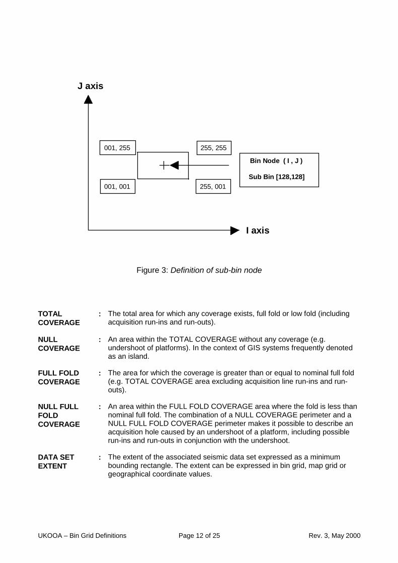
SUB-BINNODE
: To enable offsets from the regular spaced bin nodes, for irregular eventssuch as the bin centre of gravity, the concept of a SUB-BIN is defined.
A sub-bin node is the location of a sub-bin. There will be 255 by 255 sub-bins uniformly surrounding each bin node. The size of each sub-bin willtherefore depend on the bin node spacing.The sub-bin location of the bin node has bin grid coordinates (I,J) [128,128].An attribute such as the centre of gravity of a bin can be referenced to the binnode by bin grid coordinates (I,J) [i,j] - e.g. (00032.000 , 00145.000)[115,027].The sub-bin is not part of the exchange format. The purpose of including it inthe guidelines is to show how to treat irregular attributes within the context ofthe bin grid definition.
UKOOA – Bin Grid Definitions Page 12 of 25 Rev. 3, May 2000
001, 001
255, 255
255, 001
001, 255
J axis
I axis
Bin Node ( I , J )
Sub Bin [128,128]
Figure 3: Definition of sub-bin node
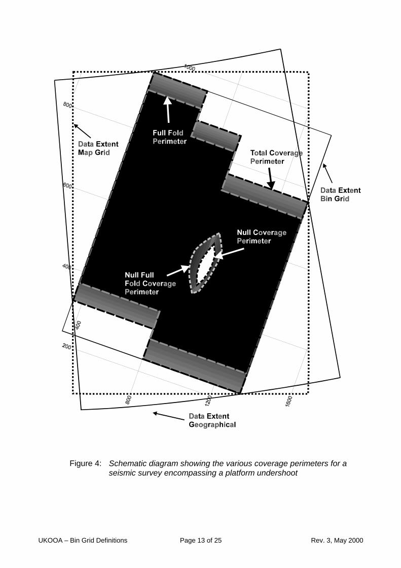
TOTALCOVERAGE
: The total area for which any coverage exists, full fold or low fold (includingacquisition run-ins and run-outs).
NULLCOVERAGE
: An area within the TOTAL COVERAGE without any coverage (e.g.undershoot of platforms). In the context of GIS systems frequently denotedas an island.
FULL FOLDCOVERAGE
: The area for which the coverage is greater than or equal to nominal full fold(e.g. TOTAL COVERAGE area excluding acquisition line run-ins and run-outs).
NULL FULLFOLDCOVERAGE
: An area within the FULL FOLD COVERAGE area where the fold is less thannominal full fold. The combination of a NULL COVERAGE perimeter and aNULL FULL FOLD COVERAGE perimeter makes it possible to describe anacquisition hole caused by an undershoot of a platform, including possiblerun-ins and run-outs in conjunction with the undershoot.
DATA SETEXTENT
: The extent of the associated seismic data set expressed as a minimumbounding rectangle. The extent can be expressed in bin grid, map grid orgeographical coordinate values.
UKOOA – Bin Grid Definitions Page 13 of 25 Rev. 3, May 2000
Figure 4: Schematic diagram showing the various coverage perimeters for aseismic survey encompassing a platform undershoot

UKOOA – Bin Grid Definitions Page 14 of 25 Rev. 3, May 2000
5. DEFINING PARAMETERS:
1. H0100 3D Survey NameThe survey name should be some acronym of the company, year and acquisition orprocessing contractor. For merged surveys two or more acronyms can be concatenatedsubject to the limit of 14 characters. A further format field is available for an extendedsurvey name, but the majority of software packages have a limited display field whichwould use the 14 character field.
2. H0200 Bin Grid DescriptorThis is a descriptive field to include details of the processing sequence or version number,or the details of merged surveys.
3. H0300 Geodetic Datum NameName of the Geodetic Datum used by the coordinate system. (See also H8000 seriescards for EPSG coordinate system description).
4. H0400 Ellipsoid NameDescription of the Reference Ellipsoid used by the coordinate system. (See also H8000series cards for EPSG coordinate system description).
5. H0500 - H0590 ProjectionThe defining parameters of various projection methods differ. Only the relevant parametersneed to be completed for records H0500 to H0590. (See also H8000 series cards forEPSG coordinate system description).The following projection type codes have been defined:
001 U.T.M. Northern Hemisphere002 U.T.M. Southern Hemisphere003 Transverse Mercator (North Oriented)004 Transverse Mercator (South Oriented)005 Lambert Conic Conformal, (one standard parallel)006 Lambert Conic Conformal, (two standard parallels)007 Mercator (2 SP)008 Cassini-Soldner009 Oblique Mercator (Skew Orthomorphic)010 Stereographic011 New Zealand Map Grid999 Any other projection or non-standard variation of the above
projections.
Requirements for projection definition parameters include the following format records:
Projection Defining Parameters to be included in headerU.T.M. H0530 (or 0540)Transverse Mercator H0530 (and/or 0540), 0550, 0560Lambert Conic (1 SP) H0520, 0530, 0540, 0530 (and/or 0540), 0550, 0560Lambert Conic (2 SP) H0520, 0530, 0540, 0550Mercator (2SP) H0520, 0530, 0540, 0550Cassini-Soldner H0540, 0550, 0560Oblique Mercator H0540, 0550, 0560, one of 0580 through 0584, 0590Stereographic H0540, 0550, 0560New Zealand Map Grid H0540, 0550
UKOOA – Bin Grid Definitions Page 15 of 25 Rev. 3, May 2000
6. H0600 Description of Linear UnitsThe code and description of map grid coordinate system linear units is defined as:H0600 Linear unit code is 1 for International metres, 2 for any other unit.
7. H0700 Description of Angular UnitsThe code and description of map grid coordinate system angular units is defined as:H0700 Angular unit code is 1 for sexagesimal degrees, 2 for any other unit.Example: The input format for degrees, minutes and seconds is I3, I2, F6.3, A1
123 deg 4 min 53.124E sec is input as 1230453.124E.
8. H0800 Bin Grid Origin ( Io , Jo )
9. H0900 Map Grid Coordinates ( Eo , No ) of Bin Grid Origin ( Io , Jo)
10. H1000 Scale Factor of Bin Grid at node reference ( I , J )The scale factor of the Bin Grid is defined under the terms in Section 5: Glossary
11. H1100 Nominal Bin Widths along I axis and J axisThe nominal bin width shall be given in map grid linear units and is defined under the termsin Section 5: Description of Terms.
12. H1200 Grid Bearing of Bin Grid J axis ( clockwise from map grid North, θθθθ )The map grid bearing of the bin grid J axis shall be given in map grid angular units and isdefined under the terms in Section 5: Description of Terms.
13 H1300 & H1350 Bin Node Increment on ( I, J ) axes.This number may be positive or negative, and has a format of F9.3 to allow non-integerincrements. The increments along each axis may be different.
14. H1400 to H1430 Check ParametersFor data exchange, check parameters are required to confirm that the grid parametershave been correctly set up. These are three defined locations quoting both the bin grid andthe map grid coordinates. Two of these points must be on the J axis, from which the gridbearing of the J axis can be derived and checked, and the third point should be remotefrom the J axis so that the scale factor and bin parameters can be checked. Although thesevalues will have been derived from the parameters themselves, they will provide a checkagainst transcription errors in the parameters - for example typing errors or errors of sign.Additionally, the H1401 and H1402 records are included to allow for a consistency checkon the geodetic coordinate system definition. The geographic coordinates of the bin gridorigin given in H1400 are given in these records.
15. H2100 Comments

UKOOA – Bin Grid Definitions Page 16 of 25 Rev. 3, May 2000
General comments on grid definition (e.g. which axis has been used as ‘inline’ direction).Repeated as necessary.

UKOOA – Bin Grid Definitions Page 17 of 25 Rev. 3, May 2000
16. H2300 to H3900 Bin Coverage Type, Perimeter and Comments
This format allows for the description of the following coverages:a) The geographical extent of the data set through the maximum and minimum
coordinates which bound the data. Provision is made for all three of bin grid, map gridand/or latitude/longitude values.
b) The total coverage of all data within the data set through the coordinates of a series ofpoints describing the perimeter of the total coverage.
c) Full-fold coverage through the coordinates of a series of points describing outerperimeter of the full fold coverage.
d) Islands within the full-fold coverage with less than full fold through the coordinates of aseries of points describing outer perimeter of the null full fold coverage.
e) Islands within the total coverage within which there is no coverage through thecoordinates of a series of points describing outer perimeter of the null fold coverage.
See figure 4 for a diagram describing these concepts.
For processed data sets (near trace cubes, migrated volumes, etc.), the fold will beaffected by various processing steps (trace summation, offset rejection, migration, etc.).These data sets can be represented by either a Total Coverage Perimeter or a Full FoldPerimeter. The type of processed data set should be stated in the respective commentcards.
As a minimum, the Data Set Extent should be included. If not known in detail, the Data SetExtent should still be described to provide the user with a simple representation of the areacovered by the survey for mapping and data management purposes, rather than a preciserepresentation of the fold of coverage of a binning system or process.
Wherever a detailed perimeter is known for a data set this should be included in theexchange file. Bin grid and/or map grid coordinates may be given for each node of eachperimeter. The data set extent can then be easily derived from the detailed perimeter.However, given the practical importance of the data set extent (e.g. used for loading ofdata onto workstations), the extent should be defined explicitly in bin grid, map grid and/orlatitude and longitude through records H23-25.
Data Set Extent:H2300 Data Set Extent – Max J, Min J, Max I and Min I in Bin Grid Coordinates.H2400 Data Set Extent – North, South, East and West limits in Map Grid Coordinates.H2501 Data Set Extent – North and South limits in Geographical Coordinates (in degrees,
minutes and seconds).H2502 Data Set Extent – East and West limits in Geographical Coordinates (in dms).H2503 Data Set Extent – North and South limits in Geographical Coordinates (in grads).H2504 Data Set Extent – East and West limits in Geographical Coordinates (in grads).H2600 Data Set Extent – Comments on data extent. May be repeated as necessary.
COVERAGE PERIMETERSH2700 Number of perimeter outlines described in the data setNumber of perimeter outlines described in the data set. Up to 99 perimeters may bedescribed. A sequential counter ## (01-99) is used to uniquely identify the perimeter withineach category of perimeters. Each perimeter may have an unlimited number of nodes,given in bin grid and/or map grid coordinates. A single perimeter described with both bingrid and map grid coordinates counts as one (1).

UKOOA – Bin Grid Definitions Page 18 of 25 Rev. 3, May 2000
Total Coverage:H28## Total Coverage - Number of Perimeter NodesNumber of perimeter nodes for boundary number ##, as listed in the H27 or H28 records.This includes a repeat of the first point at the end of the list, i.e. for an n-sided perimeterthere should be n+1 points.
H29## Total Coverage - Perimeter Node Coordinates (i,j,E,N)Bin grid and/or map grid coordinates of total coverage boundary number ##. Repeat recordas necessary, with nodes in sequential order around the perimeter. The coordinates of thefirst node should be repeated at the end of the list as the (n+1)th node.
H30## Total Coverage - CommentsGeneral comments on total coverage (e.g. fold range, type of data set). Record can berepeated as required.
Full Fold Coverage:H31## Full Fold Coverage - Number of Perimeter NodesH32## Full Fold Coverage - Perimeter Node Coordinates (i,j,E,N)H33## Full Fold Coverage - CommentsGeneral comments on full fold coverage (e.g. value of nominal full fold, type of data set).
Null Full Fold Coverage:H34## Null Full Fold Coverage - Number of Perimeter NodesH35## Null Full Fold Coverage - Perimeter Nodes Coordinates (i,j,E,N)H36## Null Full Fold Coverage - CommentsGeneral comments on null full fold perimeter number ## (e.g. reason for hole in coverage).
Null Coverage:H37## Null Coverage - Number of Perimeter NodesH38## Null Coverage - Perimeter Nodes Coordinates (i,j,E,N)H39## Null Coverage - CommentsGeneral comments on null coverage (e.g. reason for hole in coverage).
Perimeter records need to be specified in order, either clockwise or anticlockwise from anystarting point. The total number of nodes must be specified as a check that the fullperimeter list has been recorded. As a second check, the first point should be re-enteredas the last point, to close the polygon. As an example, a rectangular boundary thereforewill be described by 4+1 nodes.
17. H8000 to H8006 EPSG Coordinate System DescriptionFor improved machine readability and/or to enable integrity checking of coordinate systemdefinitions, a set of EPSG records has been adopted for all UKOOA Positioning (P)formats. This allows an industry-standard name to be quoted where the geodeticcoordinate system used for the 3D survey is a common system. Records H8000 andH8001 describe geographic coordinate system; records H8002 and H8003 describeprojected coordinate system; records H8004 and H8005 describe vertical coordinatesystem and the H8006 record gives the EPSG database version number. For the P6/98format, only the H8002, H8003 and H8006 records are required.
Defining parameters and units are then as given by EPSG and are not strictly required tobe explicitly given in the H0300 through H0700 records. However, as an integrity check, itis considered good practice also to include the explicit definition.
UKOOA – Bin Grid Definitions Page 19 of 25 Rev. 3, May 2000
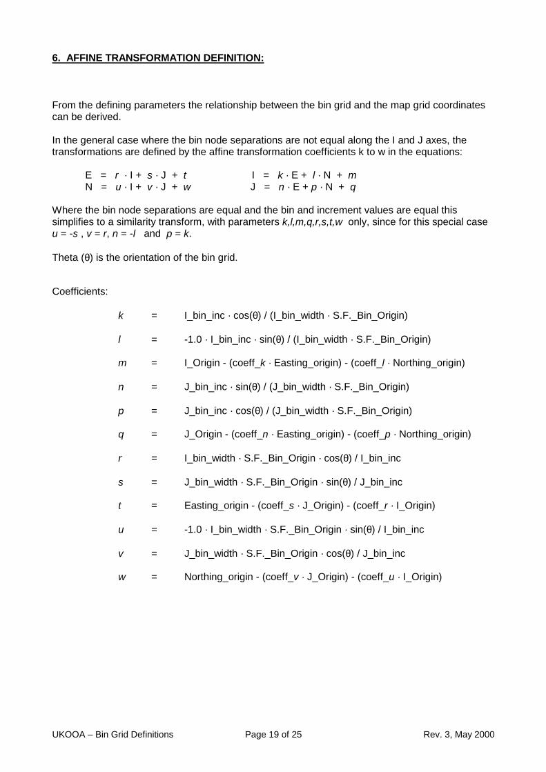
6. AFFINE TRANSFORMATION DEFINITION:
From the defining parameters the relationship between the bin grid and the map grid coordinatescan be derived.
In the general case where the bin node separations are not equal along the I and J axes, thetransformations are defined by the affine transformation coefficients k to w in the equations:
E = r · I + s · J + t I = k · E + l · N + mN = u · I + v · J + w J = n · E + p · N + q
Where the bin node separations are equal and the bin and increment values are equal thissimplifies to a similarity transform, with parameters k,l,m,q,r,s,t,w only, since for this special caseu = -s , v = r, n = -l and p = k.
Theta (θ) is the orientation of the bin grid.
Coefficients:
k = I_bin_inc · cos(θ) / (I_bin_width · S.F._Bin_Origin)
l = -1.0 · I_bin_inc · sin(θ) / (I_bin_width · S.F._Bin_Origin)
m = I_Origin - (coeff_k · Easting_origin) - (coeff_l · Northing_origin)
n = J_bin_inc · sin(θ) / (J_bin_width · S.F._Bin_Origin)
p = J_bin_inc · cos(θ) / (J_bin_width · S.F._Bin_Origin)
q = J_Origin - (coeff_n · Easting_origin) - (coeff_p · Northing_origin)
r = I_bin_width · S.F._Bin_Origin · cos(θ) / I_bin_inc
s = J_bin_width · S.F._Bin_Origin · sin(θ) / J_bin_inc
t = Easting_origin - (coeff_s · J_Origin) - (coeff_r · I_Origin)
u = -1.0 · I_bin_width · S.F._Bin_Origin · sin(θ) / I_bin_inc
v = J_bin_width · S.F._Bin_Origin · cos(θ) / J_bin_inc
w = Northing_origin - (coeff_v · J_Origin) - (coeff_u · I_Origin)
UKOOA – Bin Grid Definitions Page 20 of 25 Rev. 3, May 2000
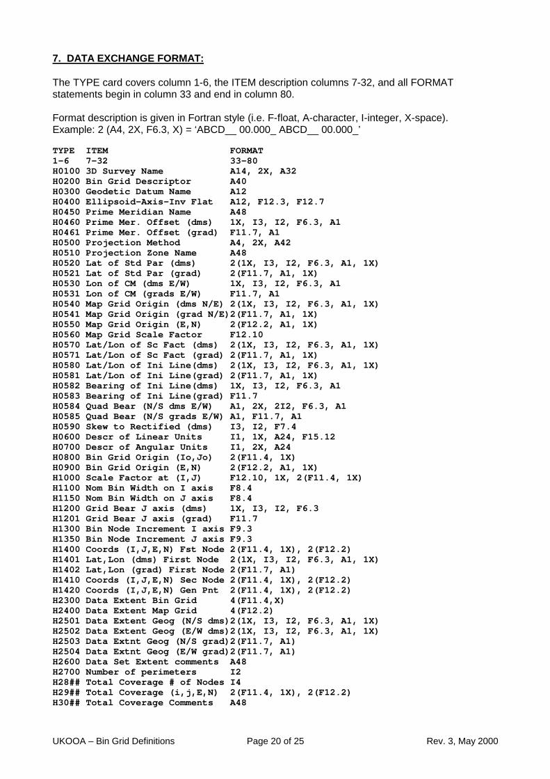
7. DATA EXCHANGE FORMAT:
The TYPE card covers column 1-6, the ITEM description columns 7-32, and all FORMATstatements begin in column 33 and end in column 80.
Format description is given in Fortran style (i.e. F-float, A-character, I-integer, X-space).Example: 2 (A4, 2X, F6.3, X) = ‘ABCD__ 00.000_ ABCD__ 00.000_’
TYPE ITEM FORMAT1-6 7-32 33-80H0100 3D Survey Name A14, 2X, A32H0200 Bin Grid Descriptor A40H0300 Geodetic Datum Name A12H0400 Ellipsoid-Axis-Inv Flat A12, F12.3, F12.7H0450 Prime Meridian Name A48H0460 Prime Mer. Offset (dms) 1X, I3, I2, F6.3, A1H0461 Prime Mer. Offset (grad) F11.7, A1H0500 Projection Method A4, 2X, A42H0510 Projection Zone Name A48H0520 Lat of Std Par (dms) 2(1X, I3, I2, F6.3, A1, 1X)H0521 Lat of Std Par (grad) 2(F11.7, A1, 1X)H0530 Lon of CM (dms E/W) 1X, I3, I2, F6.3, A1H0531 Lon of CM (grads E/W) F11.7, A1H0540 Map Grid Origin (dms N/E) 2(1X, I3, I2, F6.3, A1, 1X)H0541 Map Grid Origin (grad N/E)2(F11.7, A1, 1X)H0550 Map Grid Origin (E,N) 2(F12.2, A1, 1X)H0560 Map Grid Scale Factor F12.10H0570 Lat/Lon of Sc Fact (dms) 2(1X, I3, I2, F6.3, A1, 1X)H0571 Lat/Lon of Sc Fact (grad) 2(F11.7, A1, 1X)H0580 Lat/Lon of Ini Line(dms) 2(1X, I3, I2, F6.3, A1, 1X)H0581 Lat/Lon of Ini Line(grad) 2(F11.7, A1, 1X)H0582 Bearing of Ini Line(dms) 1X, I3, I2, F6.3, A1H0583 Bearing of Ini Line(grad) F11.7H0584 Quad Bear (N/S dms E/W) A1, 2X, 2I2, F6.3, A1H0585 Quad Bear (N/S grads E/W) A1, F11.7, A1H0590 Skew to Rectified (dms) I3, I2, F7.4H0600 Descr of Linear Units I1, 1X, A24, F15.12H0700 Descr of Angular Units I1, 2X, A24H0800 Bin Grid Origin (Io,Jo) 2(F11.4, 1X)H0900 Bin Grid Origin (E,N) 2(F12.2, A1, 1X)H1000 Scale Factor at (I,J) F12.10, 1X, 2(F11.4, 1X)H1100 Nom Bin Width on I axis F8.4H1150 Nom Bin Width on J axis F8.4H1200 Grid Bear J axis (dms) 1X, I3, I2, F6.3H1201 Grid Bear J axis (grad) F11.7H1300 Bin Node Increment I axis F9.3H1350 Bin Node Increment J axis F9.3H1400 Coords (I,J,E,N) Fst Node 2(F11.4, 1X), 2(F12.2)H1401 Lat,Lon (dms) First Node 2(1X, I3, I2, F6.3, A1, 1X)H1402 Lat,Lon (grad) First Node 2(F11.7, A1)H1410 Coords (I,J,E,N) Sec Node 2(F11.4, 1X), 2(F12.2)H1420 Coords (I,J,E,N) Gen Pnt 2(F11.4, 1X), 2(F12.2)H2300 Data Extent Bin Grid 4(F11.4,X)H2400 Data Extent Map Grid 4(F12.2)H2501 Data Extent Geog (N/S dms)2(1X, I3, I2, F6.3, A1, 1X)H2502 Data Extent Geog (E/W dms)2(1X, I3, I2, F6.3, A1, 1X)H2503 Data Extnt Geog (N/S grad)2(F11.7, A1)H2504 Data Extnt Geog (E/W grad)2(F11.7, A1)H2600 Data Set Extent comments A48H2700 Number of perimeters I2H28## Total Coverage # of Nodes I4H29## Total Coverage (i,j,E,N) 2(F11.4, 1X), 2(F12.2)H30## Total Coverage Comments A48
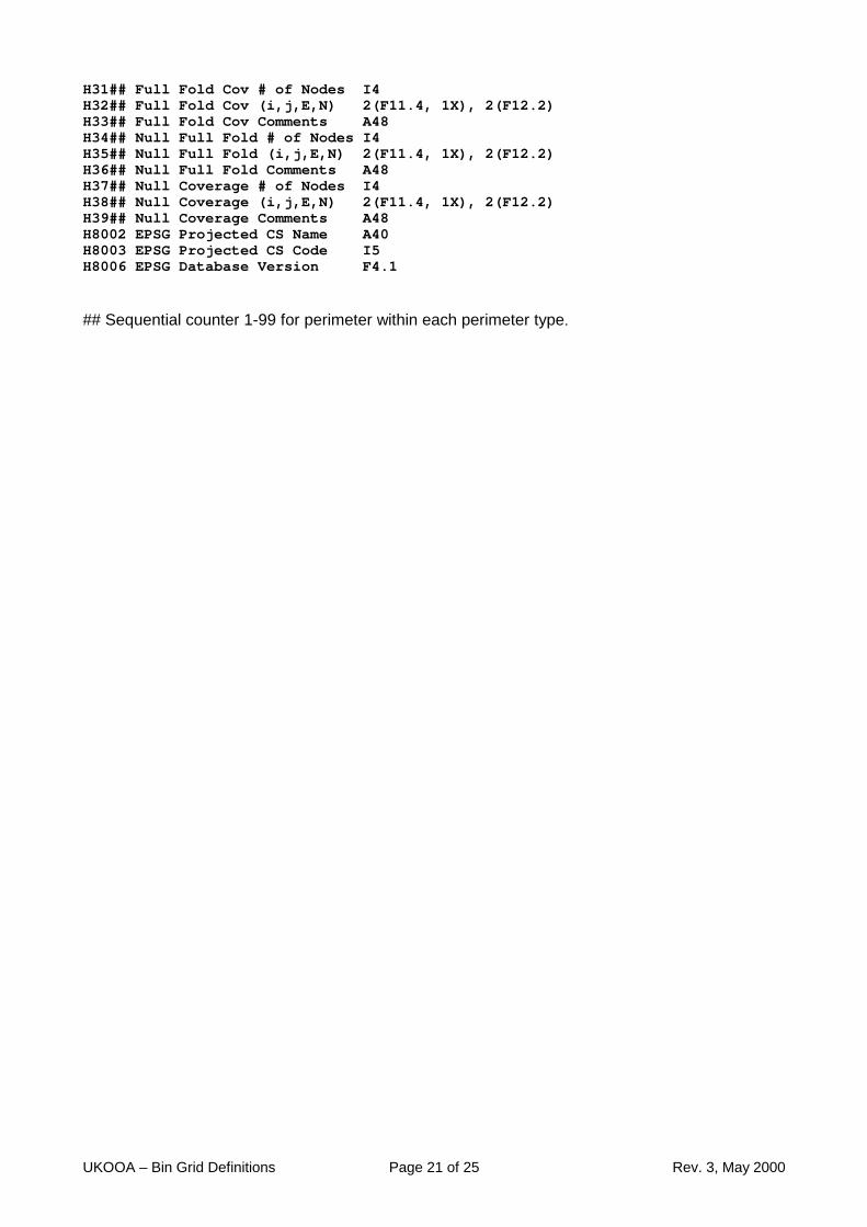
UKOOA – Bin Grid Definitions Page 21 of 25 Rev. 3, May 2000
H31## Full Fold Cov # of Nodes I4H32## Full Fold Cov (i,j,E,N) 2(F11.4, 1X), 2(F12.2)H33## Full Fold Cov Comments A48H34## Null Full Fold # of Nodes I4H35## Null Full Fold (i,j,E,N) 2(F11.4, 1X), 2(F12.2)H36## Null Full Fold Comments A48H37## Null Coverage # of Nodes I4H38## Null Coverage (i,j,E,N) 2(F11.4, 1X), 2(F12.2)H39## Null Coverage Comments A48H8002 EPSG Projected CS Name A40H8003 EPSG Projected CS Code I5H8006 EPSG Database Version F4.1
## Sequential counter 1-99 for perimeter within each perimeter type.
UKOOA – Bin Grid Definitions Page 22 of 25 Rev. 3, May 2000
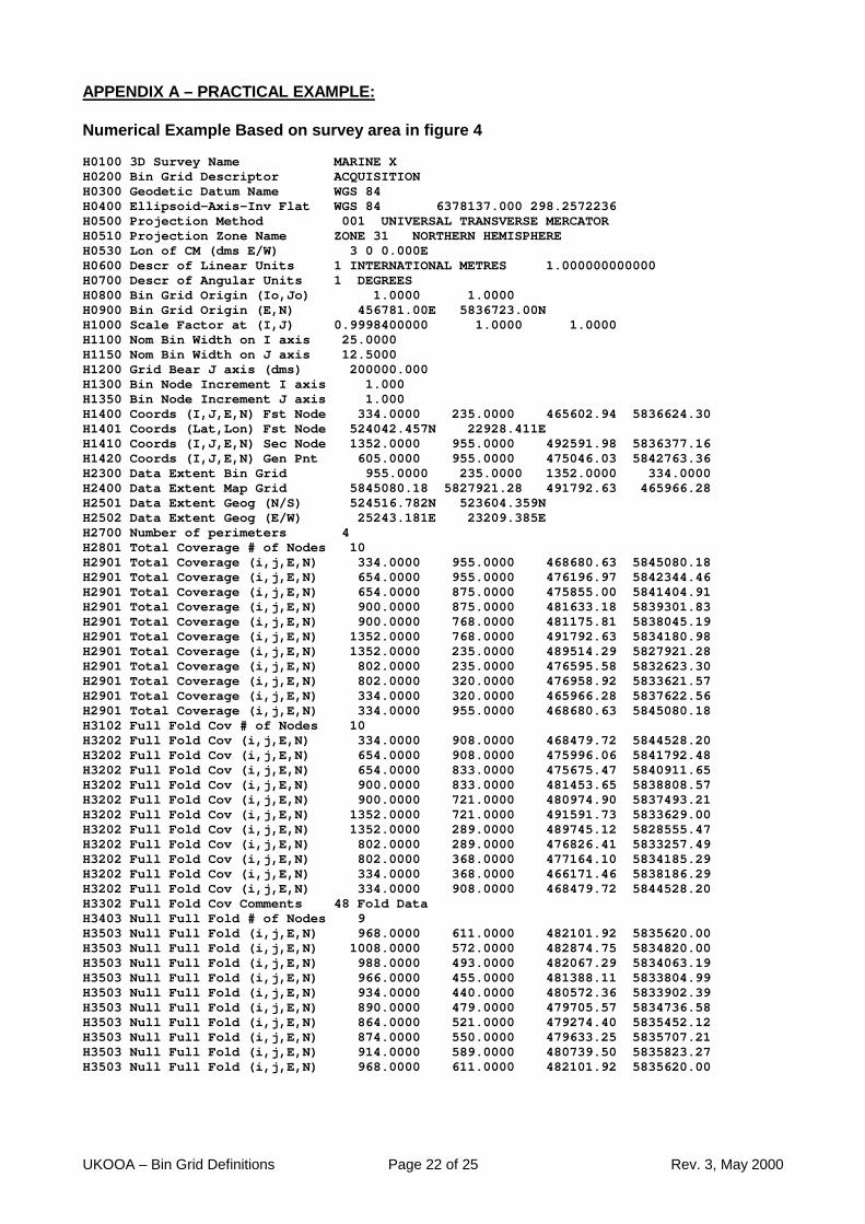
APPENDIX A – PRACTICAL EXAMPLE:
Numerical Example Based on survey area in figure 4
H0100 3D Survey Name MARINE XH0200 Bin Grid Descriptor ACQUISITIONH0300 Geodetic Datum Name WGS 84H0400 Ellipsoid-Axis-Inv Flat WGS 84 6378137.000 298.2572236H0500 Projection Method 001 UNIVERSAL TRANSVERSE MERCATORH0510 Projection Zone Name ZONE 31 NORTHERN HEMISPHEREH0530 Lon of CM (dms E/W) 3 0 0.000EH0600 Descr of Linear Units 1 INTERNATIONAL METRES 1.000000000000H0700 Descr of Angular Units 1 DEGREESH0800 Bin Grid Origin (Io,Jo) 1.0000 1.0000H0900 Bin Grid Origin (E,N) 456781.00E 5836723.00NH1000 Scale Factor at (I,J) 0.9998400000 1.0000 1.0000H1100 Nom Bin Width on I axis 25.0000H1150 Nom Bin Width on J axis 12.5000H1200 Grid Bear J axis (dms) 200000.000H1300 Bin Node Increment I axis 1.000H1350 Bin Node Increment J axis 1.000H1400 Coords (I,J,E,N) Fst Node 334.0000 235.0000 465602.94 5836624.30H1401 Coords (Lat,Lon) Fst Node 524042.457N 22928.411EH1410 Coords (I,J,E,N) Sec Node 1352.0000 955.0000 492591.98 5836377.16H1420 Coords (I,J,E,N) Gen Pnt 605.0000 955.0000 475046.03 5842763.36H2300 Data Extent Bin Grid 955.0000 235.0000 1352.0000 334.0000H2400 Data Extent Map Grid 5845080.18 5827921.28 491792.63 465966.28H2501 Data Extent Geog (N/S) 524516.782N 523604.359NH2502 Data Extent Geog (E/W) 25243.181E 23209.385EH2700 Number of perimeters 4H2801 Total Coverage # of Nodes 10H2901 Total Coverage (i,j,E,N) 334.0000 955.0000 468680.63 5845080.18H2901 Total Coverage (i,j,E,N) 654.0000 955.0000 476196.97 5842344.46H2901 Total Coverage (i,j,E,N) 654.0000 875.0000 475855.00 5841404.91H2901 Total Coverage (i,j,E,N) 900.0000 875.0000 481633.18 5839301.83H2901 Total Coverage (i,j,E,N) 900.0000 768.0000 481175.81 5838045.19H2901 Total Coverage (i,j,E,N) 1352.0000 768.0000 491792.63 5834180.98H2901 Total Coverage (i,j,E,N) 1352.0000 235.0000 489514.29 5827921.28H2901 Total Coverage (i,j,E,N) 802.0000 235.0000 476595.58 5832623.30H2901 Total Coverage (i,j,E,N) 802.0000 320.0000 476958.92 5833621.57H2901 Total Coverage (i,j,E,N) 334.0000 320.0000 465966.28 5837622.56H2901 Total Coverage (i,j,E,N) 334.0000 955.0000 468680.63 5845080.18H3102 Full Fold Cov # of Nodes 10H3202 Full Fold Cov (i,j,E,N) 334.0000 908.0000 468479.72 5844528.20H3202 Full Fold Cov (i,j,E,N) 654.0000 908.0000 475996.06 5841792.48H3202 Full Fold Cov (i,j,E,N) 654.0000 833.0000 475675.47 5840911.65H3202 Full Fold Cov (i,j,E,N) 900.0000 833.0000 481453.65 5838808.57H3202 Full Fold Cov (i,j,E,N) 900.0000 721.0000 480974.90 5837493.21H3202 Full Fold Cov (i,j,E,N) 1352.0000 721.0000 491591.73 5833629.00H3202 Full Fold Cov (i,j,E,N) 1352.0000 289.0000 489745.12 5828555.47H3202 Full Fold Cov (i,j,E,N) 802.0000 289.0000 476826.41 5833257.49H3202 Full Fold Cov (i,j,E,N) 802.0000 368.0000 477164.10 5834185.29H3202 Full Fold Cov (i,j,E,N) 334.0000 368.0000 466171.46 5838186.29H3202 Full Fold Cov (i,j,E,N) 334.0000 908.0000 468479.72 5844528.20H3302 Full Fold Cov Comments 48 Fold DataH3403 Null Full Fold # of Nodes 9H3503 Null Full Fold (i,j,E,N) 968.0000 611.0000 482101.92 5835620.00H3503 Null Full Fold (i,j,E,N) 1008.0000 572.0000 482874.75 5834820.00H3503 Null Full Fold (i,j,E,N) 988.0000 493.0000 482067.29 5834063.19H3503 Null Full Fold (i,j,E,N) 966.0000 455.0000 481388.11 5833804.99H3503 Null Full Fold (i,j,E,N) 934.0000 440.0000 480572.36 5833902.39H3503 Null Full Fold (i,j,E,N) 890.0000 479.0000 479705.57 5834736.58H3503 Null Full Fold (i,j,E,N) 864.0000 521.0000 479274.40 5835452.12H3503 Null Full Fold (i,j,E,N) 874.0000 550.0000 479633.25 5835707.21H3503 Null Full Fold (i,j,E,N) 914.0000 589.0000 480739.50 5835823.27H3503 Null Full Fold (i,j,E,N) 968.0000 611.0000 482101.92 5835620.00
UKOOA – Bin Grid Definitions Page 23 of 25 Rev. 3, May 2000
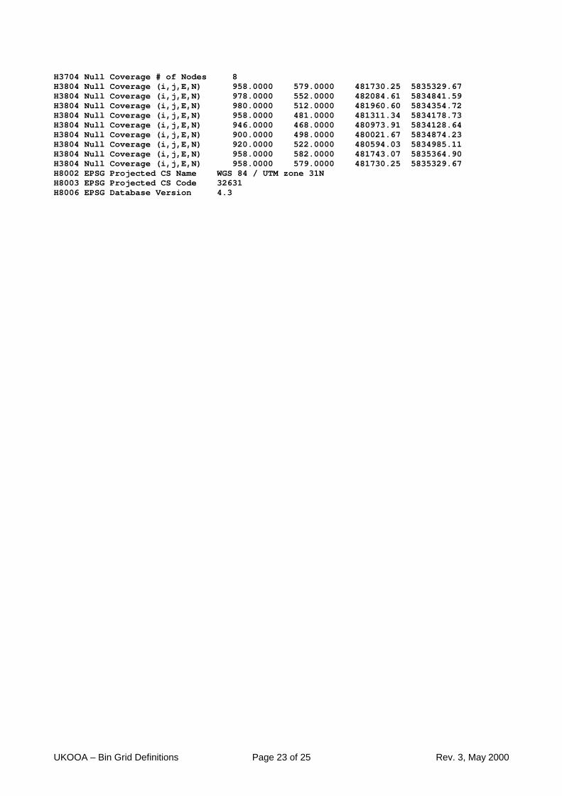
H3704 Null Coverage # of Nodes 8H3804 Null Coverage (i,j,E,N) 958.0000 579.0000 481730.25 5835329.67H3804 Null Coverage (i,j,E,N) 978.0000 552.0000 482084.61 5834841.59H3804 Null Coverage (i,j,E,N) 980.0000 512.0000 481960.60 5834354.72H3804 Null Coverage (i,j,E,N) 958.0000 481.0000 481311.34 5834178.73H3804 Null Coverage (i,j,E,N) 946.0000 468.0000 480973.91 5834128.64H3804 Null Coverage (i,j,E,N) 900.0000 498.0000 480021.67 5834874.23H3804 Null Coverage (i,j,E,N) 920.0000 522.0000 480594.03 5834985.11H3804 Null Coverage (i,j,E,N) 958.0000 582.0000 481743.07 5835364.90H3804 Null Coverage (i,j,E,N) 958.0000 579.0000 481730.25 5835329.67H8002 EPSG Projected CS Name WGS 84 / UTM zone 31NH8003 EPSG Projected CS Code 32631H8006 EPSG Database Version 4.3
UKOOA – Bin Grid Definitions Page 24 of 25 Rev. 3, May 2000
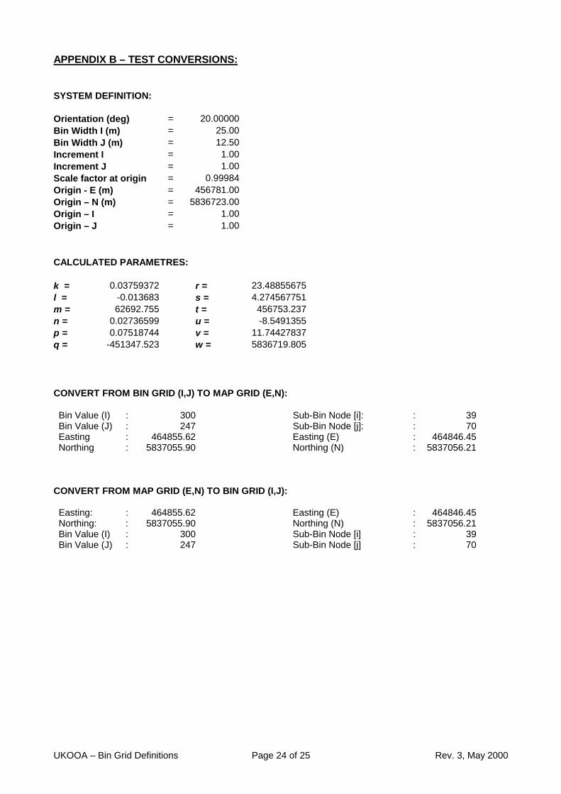
APPENDIX B – TEST CONVERSIONS:
SYSTEM DEFINITION:
Orientation (deg) = 20.00000Bin Width I (m) = 25.00Bin Width J (m) = 12.50Increment I = 1.00Increment J = 1.00Scale factor at origin = 0.99984Origin - E (m) = 456781.00Origin – N (m) = 5836723.00Origin – I = 1.00Origin – J = 1.00
CALCULATED PARAMETRES:
k = 0.03759372 r = 23.48855675l = -0.013683 s = 4.274567751m = 62692.755 t = 456753.237n = 0.02736599 u = -8.5491355p = 0.07518744 v = 11.74427837q = -451347.523 w = 5836719.805
CONVERT FROM BIN GRID (I,J) TO MAP GRID (E,N):
Bin Value (I) : 300 Sub-Bin Node [i]: : 39Bin Value (J) : 247 Sub-Bin Node [j]: : 70Easting : 464855.62 Easting (E) : 464846.45Northing : 5837055.90 Northing (N) : 5837056.21
CONVERT FROM MAP GRID (E,N) TO BIN GRID (I,J):
Easting: : 464855.62 Easting (E) : 464846.45Northing: : 5837055.90 Northing (N) : 5837056.21Bin Value (I) : 300 Sub-Bin Node [i] : 39Bin Value (J) : 247 Sub-Bin Node [j] : 70