Embed Size (px)
Citation preview

Prepared by:
Muller Engineering Company, Inc.Consulting Engineers
Northern Colorado Water Conservancy District
August 22, 2007
U.S. 287 Relocation Study

US 287 Relocation Study August 22, 2007
1
Table of Contents
Appendices ....................................................................................................................1 List of Tables..................................................................................................................2 List of Figures ................................................................................................................2 Chapter 1.0: Project Background and Purpose...........................................................3 Chapter 2.0: Study Area Description............................................................................5 Chapter 3.0: Existing Transportation Conditions .......................................................7
3.1 Roadway........................................................................................................... 7 3.2 Traffic ................................................................................................................ 8 3.3 Safety.............................................................................................................. 10
Chapter 4.0: Alternatives Development and Evaluation...........................................11 4.1 Alternatives Advanced .................................................................................... 11 4.2 Refinements to Alternatives ............................................................................ 14 4.3 Short-Listed Alternatives Evaluation ............................................................... 18
Chapter 5.0: Project Impacts and Mitigation .............................................................26 5.1 Introduction ..................................................................................................... 26 5.2 Traffic and Safety............................................................................................ 26 5.3 Roadway......................................................................................................... 30 5.4 Right-of-Way ................................................................................................... 32 5.5 Geology........................................................................................................... 33 5.6 Drainage and Water Quality............................................................................ 37 5.7 Utilities ............................................................................................................ 41 5.8 Wind and Blowing Snow ................................................................................. 43 5.9 Noise............................................................................................................... 45 5.10 Air Quality ....................................................................................................... 46
Appendices Appendix A: Level 1 and 2a Alternatives Analysis Memo Appendix B: Traffic and Roadway Data (CDOT SLD) Appendix C: Traffic Operations Analysis Appendix D: Accident Summary and Safety Assessment Appendix E: Geotechnical Summary Report Appendix F: Drainage Basin Maps Appendix G: Wind and Snow Report Appendix H: Noise Report Appendix I: Air Quality Report Appendix J: Preliminary Plans (Bound Separately)
US 287 Relocation Study August 22, 2007
2
List of Tables Table 1 Summary of Existing and Projected ADT.................................................. 9 Table 2 Design Criteria........................................................................................ 17 Table 3 Alternatives Evalaution Matrix ................................................................ 18 Table 4 Alternative F Engineers Estimate of Probable Cost................................ 22 Table 5 Alternative J Engineers Estimate of Probable Cost ................................ 23 List of Figures Figure 1 Project Location and Study Area Map ...................................................... 6 Figure 2 Short Listed Alternatives......................................................................... 13 Figure 3 Typical Sections ..................................................................................... 16 Figure 4 Existing and Projected Traffic Volumes .................................................. 28 Figure 5 Conceptual Ted’s Place Intersection Configuration ................................ 30
US 287 Relocation Study August 22, 2007
3
Chapter 1.0: Project Background and Purpose
The U.S. Army Corps of Engineers (Corps) is preparing an Environmental Impact Statement (EIS) for the Northern Integrated Supply Project (NISP). The Applicant that has proposed the NISP is the Northern Colorado Water Conservancy District (District / Applicant). The NISP project goal is to provide 40,000 acre-feet of new reliable municipal water supply annually through a regional project coordinated by the District, which will meet a portion of the District Participants’ current and reasonably projected future additional water supply needs. The focal point of the project is the District’s preferred water supply alternative which includes the construction of a dam and reservoir in the Hook and Moore Glade north of LaPorte and just north of Ted’s Place near the intersection of US 287 and Colorado SH 14. The reservoir resulting from the project is called Glade Reservoir. The construction of the dam and reservoir will result in the inundation of approximately 5 miles of existing US 287, thus requiring the relocation of the highway. The Colorado Department of Transportation (CDOT) is a cooperating agency that will assist the Corps and the District in addressing the proposed relocation of US 287 for the EIS. As a part of the EIS, a study which identified alternatives and conducted a Level 1 and Level 2a screening analysis was completed in November 2005. This screening analysis identified the purpose and need for the US 287 relocation, outlined the screening process and, in conjunction with this study, identified two short-listed alternatives. The purpose and need, as it was identified in the November 2005 screening analysis, is as follows:
The purpose of the first phase of the U.S. 287 relocation study was to identify and screen reasonable alternatives that could be used to maintain the function and continuity of the roadway. The purpose and need developed jointly with CDOT for the relocation of U.S. 287 is as follows:
The purpose of this aspect of the Applicant’s preferred alternative is to relocate U.S. 287, resulting in a roadway that is similar in nature to the existing highway which will safely accommodate current and future traffic levels while maintaining current connectivity.
Definitions of phrases in the purpose and need statement include:
Relocate – provide a highway with similar horizontal and vertical criteria
US 287 Relocation Study August 22, 2007
4
Similar in nature – similar horizontal and vertical design standards, roadway cross section, future expansion capabilities, right of way, access and maintenance issues Safely accommodate – maintain existing level of service (LOS), roadside safety issues, intersections (points of conflict), safe pass zones; ability to expand to maintain LOS and safety Connectivity – maintain continuity of US 287 from north Fort Collins to the Wyoming State Line
The purpose and need established a baseline for which the alternatives developed in this phase were assessed.
This US 287 Relocation Study builds upon the information developed during the initial screening study and presents the data that has been gathered and outlines the improvement recommendations for the relocation of US 287. An assessment of existing conditions and an analysis of impacts are also evaluated.
US 287 Relocation Study August 22, 2007
5
Chapter 2.0: Study Area Description
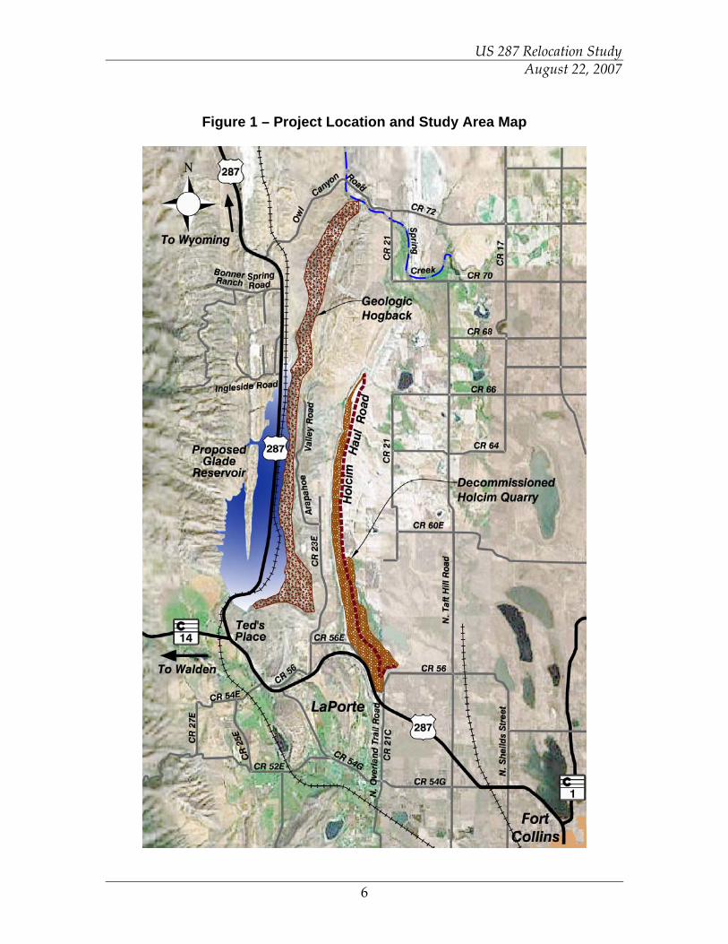
The project area is in unincorporated Larimer County and is located approximately 5 miles northwest of the City of Fort Collins. The study area is roughly bound by the community of LaPorte on the south to Owl Canyon Road (Larimer County Road 72) on the north, Larimer County Road 21 on the east and the existing US 287 (within the Hook and Moore Glade) on the west. The study area is shown in Figure 1. The study area has some rural development including residential, mining and agricultural land uses. One feature in the study area is the decommissioned Holcim cement production plant and limestone quarry. This operation, which was decommissioned and reclaimed between 2004 and 2006, represents a predominant land usage and ownership. The decommissioned plant is located just north of the Overland Trail Road and US 287 intersection. The reclaimed quarry mining operation extends from the plant approximately 5 miles to the north in a fairly narrow band. During the reclamation of the quarry, disturbed landforms were graded and reseeded. The existing quarry haul road was preserved. Between the Holcim quarry and the Hook and Moore Glade where the existing US 287 alignment is located, there is a geologic hogback feature aligned in the north-south direction and creates a ridgeline that is approximately 300 feet to 500 feet higher than the surrounding topography. It is this geologic feature that represents the eastern side of the proposed Glade Reservoir.
US 287 Relocation Study August 22, 2007
6
Figure 1 – Project Location and Study Area Map
US 287 Relocation Study August 22, 2007
7
Chapter 3.0: Existing Transportation Conditions
3.1 Roadway
The segment of US 287 that is impacted by the NISP project is the segment of the highway between the intersection of US 287 with Overland Trail Road (Larimer County Road (LCR) 29) northwest of Fort Collins (approximate milepoint 352.4) and the intersection of US 287 with Owl Canyon Road (LCR 72) (approximate milepoint 363.2). The project is located within unincorporated Larimer County. Along this segment of US 287 within the study area, there is direct access at intersections with LCR 23E (MP 354.2), LCR 54G/56 (MP 354.9), LCR 54E (MP 355.0) and SH 14 at Ted’s Place (MP 355.9). US 287 is designated as a rural principal arterial roadway on the National Highway System. North of SH 14 at Ted’s Place, the highway is a 2-lane facility generally comprising two 12-foot lanes with approximately 7-foot shoulders. On the southern limits of the project area (south of SH 14), US 287 is a divided 4-lane facility. US 287 historically followed a route through the town of LaPorte until it was realigned to circle around the north side of the town on the alignment referred to as the LaPorte Bypass. The historic segments of old US 287 that traverse through LaPorte are currently designated as LCR 54G. The segment of US 287 that is anticipated to be directly impacted by the Glade Reservoir portion of the NISP is the portion between Ted’s Place (MP 355.9) to Owl Canyon Road (MP 363.2). This 7.3 mile segment of US 287 generally follows a north-south alignment in the valley of the Hook and Moore Glade. Access along this segment is relatively minimal, generally providing direct access to private property via individual access points. There are two public road access points: one being Ingleside Road which provides access to residential properties to the west of US 287 as well as to the Pioneer Sand and Gravel quarry operation. This Ingleside Road access is located at approximately MP 361.00. The Bonner Springs Ranch Road provides access to residential properties west of US 287 at MP 362.5. There is a frontage road, designated Big Ridge Way, which is aligned parallel and to the west of US 287 extending from Ingleside Road approximately 0.7 miles to the north. An abandoned railroad line is located to the east of the US 287 alignment through the Hook and Moore Glade. This alignment is not in use and most portions of the ownership have been transferred to the adjacent landholders. US 287 has an EX access control designation (expressway) and is currently a designated truck route. According to the State Highway Access Code, under the EX access code designation, access to public streets, roads, and highways should be planned on no less than one-mile intervals. Access to public streets,
US 287 Relocation Study August 22, 2007
8
roads, and highways are allowed on a one-half mile interval if no reasonable alternative access exists. No access to private property should be permitted unless reasonable access cannot be obtained from the local roadway system. The access along the existing highway generally conforms to the Access Code, although there are several private access locations serving as field approaches, private residential accesses, commercial accesses and residential collector access locations. The existing highway has a posted speed of 65 mph and a design speed of 70 mph. The existing highway, both in the northbound and southbound direction between Ted’s Place and Owl Canyon Road, provides passing zones along approximately 62% of it’s length. 3.2 Traffic
The following planning studies were obtained and reviewed in the evaluation of existing and projected traffic conditions:
• The North Front Range (NFR) Metropolitan Planning Organization 2030 Regional Transportation Plan
• The Upper Front Range (UFR) Regional Planning Commission 2030 Regional Transportation Plan
• Larimer County Transportation Plan (1998) The project area is just outside the NFRMPO but they incorporate some of the project area in their model. The current Larimer County Transportation Plan has an established forecast year of 2020 and the Larimer County 2030 model is currently being developed. Projected traffic volumes were obtained from the draft Larimer County 2030 model by coordinating with the County and the consultant working with the County on the update to the model. In addition, the CDOT website was utilized to obtain existing and projected traffic volumes. Based upon the Larimer County 2020 Plan, vehicle trips in the project area Regional Analysis Zone are anticipated to grow by 1.5% per year. The North Front Range Regional Transportation Plan identifies the segments of US 287 within the project area to operate at LOS D or better in 2030. (Six levels of service are defined from A to F, with LOS A representing the best operating conditions and LOS F the worst. LOS E is generally considered to correspond to maximum capacity.) The Larimer County 2020 Plan and the NFR 2030 Plan do not identify any capacity improvements to US 287 or to any of the intersecting highways in the study area. The UFR 2030 Plan identifies a new interchange at US 287 and LCR 54G in LaPorte and passing lanes and geometric improvement to SH 14 from

US 287 Relocation Study August 22, 2007
9
Ted’s Place west. Neither of these improvements is directly impacted by the proposed relocation of US 287. The existing and projected average daily traffic (ADT) volumes along US 287 from the Larimer County 2020 Transportation Plan, the draft Larimer County 2030 model, the UFR 2030 Plan and the CDOT website are shown in Table 1.
Table 1 – Summary of Existing and Projected ADT
Existing ADT Projected ADT (2030) Location NFR
(2003) UFR
(2003) LC
(1996)CDOT(2005) NFR UFR LC
(2020) LC CDOT
US 287 – East of Overland Trail
6,100 N/A 6,800 7,600 N/A N/A 9,500 10,100 12,000
US 287 – West of Overland Trail
8,400 8,400 N/A 7,600 N/A 13,500 N/A 5,500 12,400
US 287 – North of SH 14 N/A 5,800 4,600 5,500 N/A 9,800 7,400 6,100 7,900
SH 14 – West of US 287 N/A 2,150 2,350 2,400 N/A 3,500 2,800 3,500 4,100
For the purposes of this study, the CDOT projected ADT was used for analysis. The volume for the segment of existing US 287 north of Ted’s Place is assumed to best represent the traffic that will be present along the realigned US 287, since there are no other existing or proposed roadway links that would alter anticipated traffic. In addition, the volume east of the tie-in point will be utilized assuming that there will be minimal, if any, changes in traffic patterns to and from the east due to the realigned highway. These values are highlighted in italics in the table above. With the relocation of US 287, the portion of the existing US 287 roadway bypassing LaPorte (between the new US 287 tie-in point and Ted’s Place) is anticipated to experience significantly less traffic than projected by the current models. CDOT projects a 2030 traffic volume of 12,400 for this segment. Assuming that 7,900 vehicles will be travel on the new US 287, 4,500 vehicles will utilize the existing US 287 segment north of LaPorte. In addition, it is assumed that roughly 1,000 vpd additionally will be utilizing this segment to access the new north leg of the US 287 from the LaPorte area via the CR 54G intersection. In summary, projected 2030 daily traffic of 7,900, 12,000 and 5,500 for the new north (US 287), south (US 287) and west (Old US 287 / SH 14) legs, respectively will be used for this relocated US 287 project.
US 287 Relocation Study August 22, 2007
10
Based on information obtained from the CDOT website, US 287 north of Ted’s Place is currently operating at a volume to capacity ratio of .35, the off-peak hour truck percentage is 18.7% and the peak hour truck percentage is 10%. In addition, the CDOT website indicated that the design hourly volume (DHV) is assumed to be approximately 13% of the annual average daily traffic. 3.3 Safety
Investigation of available CDOT data (a five-year accident history was evaluated for the time period 1/01/99 to 12/31/03) indicates that for the segment of US 287 between Ted’s Place and Owl Canyon Road, there were 90 accidents with the predominant type of accidents being fixed objects, followed by collisions with wild animals. Fixed object impacts accounted for 28 percent of the accidents. An investigation of the details indicated an assortment of collisions with guardrails, bridge rails, as well as other roadway features within the clear-zone. Additionally, impacts with rocks and boulders on the pavement surface were noted. Collisions with wild animals accounted for an additional 27 percent of the accidents. Of the 90 accidents, 5 resulted in fatalities. Of the five fatalities, alcohol and drugs were noted as a contributing factor in three of the accidents. Other than alcohol and drugs there does not appear to be a pattern or similarity in the fatal accidents. This evaluation was limited to the section of US 287 between Ted’s Place (SH 14) and Owl Canyon Road (LCR 72) since this segment most closely reflects the characteristics of the relocated highway. Since the relocated highway is proposed to be a new facility and there is no existing accident data to evaluate with regard to safety, the new facility should be designed to meet all appropriate standards and practices, but should also account for local experience under similar conditions such as is prevalent with the existing US 287 north of Ted’s Place.
US 287 Relocation Study August 22, 2007
11
Chapter 4.0: Alternatives Development and Evaluation
4.1 Alternatives Advanced
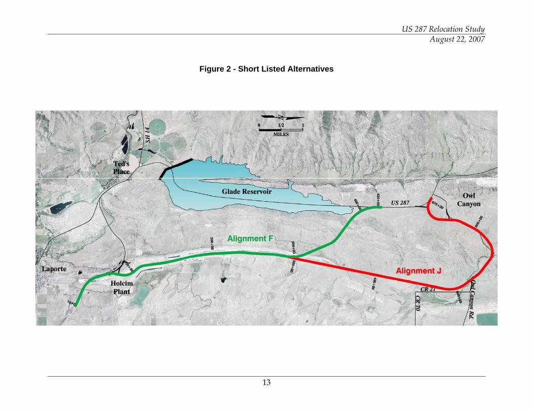
Conceptual alignments for relocating US 287 were developed for the Level 1 screening as part of the NISP project. The concept alignments were presented to the general public at a meeting on March 30, 2005. Following the public meeting and at the initiation of this US 287 Relocation Study, two short-listed alternatives (F&G and M), which both traversed the hogback, were identified to be further evaluated. These two alternatives generally followed a similar alignment as they traversed the hogback but had slightly different alignments in the southern extents, with M traversing along the eastern limits of the Holcim property and F&G utilizing the Holcim haul road. In the early stages of this study, as part of the ongoing Level 2a NISP screening analysis, Alternate M was eliminated because of large impacts to riparian and upland vegetation. It was decided by the District, in order to provide comparative analysis for Alternative F&G (subsequently identified as simply Alternative F in this study), to further consider Alternative J. Alternative J had initially had been eliminated due to excessive wetland impacts. By refining Alternative J to minimize wetland impacts, a reasonable alternative was established that did not require large rock cuts in the hogback formation. For this study, the alignments designated as Alignment F and Alignment J were further refined for evaluation and comparative purposes. The alternatives are shown in Figure 2. Both of the alternatives follow the same alignment for the southern 4 miles through the Holcim property. In this vicinity, the alignments generally follow the Holcim haul road alignment, bisecting the limestone quarries on either side. At the northern end of the Holcim quarry, the alternatives diverge, with one climbing in elevation to the northwest (Alignment F) and traversing the hogback which separates the front range from the Hook and Moore Glade in which the existing US 287 is located. The other alignment (Alignment J) generally follows a northerly alignment around the hogback eventually following the Owl Canyon Road alignment. Alignment F, which traverses the hogback, has a sustained grade (over 1 mile) of maximum vertical grade of 4%. This grade necessitates the need to incorporate a climbing lane in the uphill (northwest) direction. No other climbing lanes are anticipated. Approximately 2,000 linear feet of this alignment cuts through the hogback, necessitating a rock cut of up to 200 feet vertically. The cut section, modeled as a 4-lane, divided section, with 2:1 cut slopes in the Morrison Formation and 1:1 cut slopes in the Lytle Formation generates 2.4 million cubic yards of rock cut material. Approximately 2 million cubic yard of this material will be utilized to construct the mile long approach grade from the southeast, with the
US 287 Relocation Study August 22, 2007
12
remainder of the balance of material being utilized as riprap for the Glade Reservoir project. Alignment J generally traverses relatively level ground through the Weaver Ranch until it intersects with LCR 72 (Owl Canyon Road). The alignment generally follows Owl Canyon Road to the existing US 287 in the vicinity of the Owl Canyon / US 287 intersection. The alignment will traverse the Spring Creek Drainage utilizing a box culvert with a stream channel type bottom to mitigate impacts to wetland and riparian vegetation. The alignment deviates from the existing LCR 72 alignment where required to meet design criteria. This alignment is longer than Alignment F. Also, there are more direct impacts to adjacent residential development with numerous access locations. Since the alignment generally follows natural grades, the earthwork is significantly less than that for Alignment F and is generally a balanced project.
US 287 Relocation Study August 22, 2007
13
Figure 2 - Short Listed Alternatives
US 287 Relocation Study August 22, 2007
14
4.2 Refinements to Alternatives
Based upon input from the District and CDOT, in addition to meeting the purpose and need for the project, several design objectives were identified:
• Minimize Environmental Impacts • Minimize Cost • Balance Earthwork • Enhance Safe Operation / Provide Clear-zone / Minimize Guardrail
In the context of meeting the project purpose and need and the design objectives, there were several design considerations that were accounted for in the refinement and assessment of the alternatives. These design considerations include the following elements. Meet CDOT and AASHTO Design Standards – The alternatives should be developed to meet the established standards for this classification and category of highway. In addition, consideration should be made for the ultimate configuration of the highway. Design of a safe facility taking into account accident history on the existing facility and design consideration for safe roadsides should also be incorporated. It was a desire to provide wider clear-zone and flatter roadway fill slopes than minimally required, where feasible. Variances from design standards should be avoided. Geologic Concerns / Rock Cut – Rock and earthwork cut slopes are an important consideration in the development of alternatives. Slope and excavation issues include stability, rock fall, cost and constructability. CDOT requested that the rock cut through the hogback be designed to accommodate a potential 4-lane divided rural roadway section. Spring Creek Drainageway – In the vicinity of the Alternative J alignment, the Spring Creek Drainage is a perennial stream with wetland vegetation and riparian habitat. This drainageway also serves as a conveyance for the North Poudre Irrigation Company system. Minimizing impacts to this drainage resource by modifying alignment and providing structures to span the drainageway were considered during the development of refined alternatives. Potential Use of LCR 72 (Owl Canyon Road) Alignment – County Road 72 is a facility that could be upgraded to serve as the relocated US 287 alignment. For the Alternative J alignment, the utilization of the roadway may minimize the acquisition of ROW, provide an existing alignment, consolidate local transportation facilities and may realize potential savings in cost. The project team decided that County Road 70 should not have a direct connection to the relocated US 287 and that there should be a single intersection with only LCR 72 providing access and connectivity with the county road system to the east.
US 287 Relocation Study August 22, 2007
15
4.2.1 Project Constraints and Opportunities
The two alignments advanced for further consideration were refined and design alignments were developed. Consideration of design criteria, balance of earthwork and available Holcim property were taken into account in the development of the refined alternatives. 4.2.1.1 Design Criteria
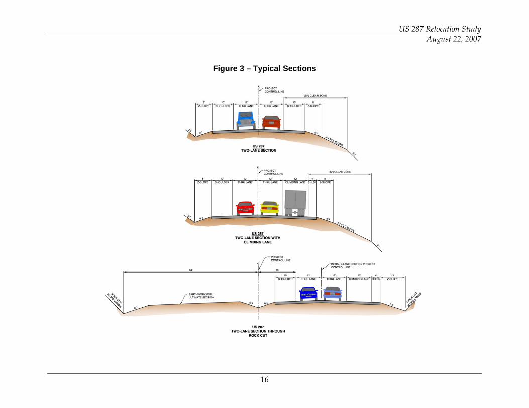
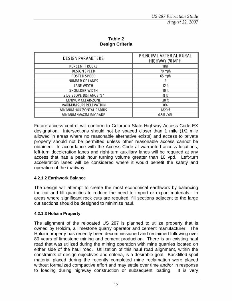
The following information outlines the design criteria utilized in the development of alternatives for the relocation of US 287. The design criteria has been developed using Colorado Department of Transportation (CDOT) Design Guide 2005, Colorado Department of Transportation (CDOT) Standard Plans (July 2006), State of Colorado State Highway Access Code (March 2002), and AASHTO Guide for the Geometric Design of Highways and Streets (2004). US 287 will have a functional classification of Rural Principal Arterial in rolling terrain. For the purposes of this study, the highway will be a two-lane facility with consideration of an ultimate four-lane divided highway in areas of rock cut and in determination of ROW needs. CDOT has requested that the typical section, in the vicinity of the rock cut at the hogback along Alignment F, be designed to accommodate the ultimate divided 4-lane section. The median width should be a minimum of 36 feet in this cut location. Typical sections are shown in Figure 3. In order to enhance safety, where feasible, all fill slopes should be designed to accommodate 4:1 slopes. In addition, where feasible, clear-zone in excess of the minimum required should be provided and non-traversable slopes (2:1 or steeper) should be avoided. Table 2 outlines the design criteria for a 70 mph design speed Rural Principal Arterial roadway that was used to develop the refined alternatives. Proposed ROW width of approximately 250’ is anticipated. This proposed width accommodates a potential utility corridor on each side of the proposed roadway alignment. The ROW width will be adjusted as necessary to accommodate auxiliary lanes and earthwork slopes.
US 287 Relocation Study August 22, 2007
16
Figure 3 – Typical Sections
US 287 Relocation Study August 22, 2007
17
Table 2 Design Criteria
DESIGN PARAMETERS PRINCIPAL ARTERIAL RURAL HIGHWAY 70 MPH
PERCENT TRUCKS 18% DESIGN SPEED 70 mph POSTED SPEED 65 mph
NUMBER OF LANES 2 LANE WIDTH 12 ft
SHOULDER WIDTH 10 ft SIDE SLOPE DISTANCE "Z" 8 ft
MINIMUM CLEAR-ZONE 30 ft MAXIMUM SUPERELEVATION 8%
MINIMUM HORIZONTAL RADIUS 1820 ft MINIMUM / MAXIMUM GRADE 0.5% / 4%
Future access control will conform to Colorado State Highway Access Code EX designation. Intersections should not be spaced closer than 1 mile (1/2 mile allowed in areas where no reasonable alternative exists) and access to private property should not be permitted unless other reasonable access cannot be obtained. In accordance with the Access Code at warranted access locations, left-turn deceleration lanes and right-turn auxiliary lanes will be required at any access that has a peak hour turning volume greater than 10 vpd. Left-turn acceleration lanes will be considered where it would benefit the safety and operation of the roadway. 4.2.1.2 Earthwork Balance
The design will attempt to create the most economical earthwork by balancing the cut and fill quantities to reduce the need to import or export materials. In areas where significant rock cuts are required, fill sections adjacent to the large cut sections should be designed to minimize haul. 4.2.1.3 Holcim Property
The alignment of the relocated US 287 is planned to utilize property that is owned by Holcim, a limestone quarry operator and cement manufacturer. The Holcim property has recently been decommissioned and reclaimed following over 80 years of limestone mining and cement production. There is an existing haul road that was utilized during the mining operation with mine quarries located on either side of the haul road. Utilization of this haul road alignment, within the constraints of design objectives and criteria, is a desirable goal. Backfilled spoil material placed during the recently completed mine reclamation were placed without formalized compactive effort and may settle over time and/or in response to loading during highway construction or subsequent loading. It is very

US 287 Relocation Study August 22, 2007
18
important that the proposed roadway section and horizontal alignment avoid being constructed directly on the interface between native ground and backfilled mine pits due to the potential differential in subgrade stability. 4.3 Short-Listed Alternatives Evaluation
Both alternatives meet the project purpose and need and identified design standards and are not envisioned to require any variances from standards. Appendix J (bound separately) presents the refined preliminary design of the short-listed alternatives. Specific details may change during the final design process. Table 3 is a matrix comparing the two alternatives.
Table 3
Alternatives Evaluation Matrix
Alternative F Alternative J Criteria Hogback Alignment Owl Canyon Alignment
Total Travel Length (Miles) 8.1 (2.3 Shorter than Existing) 11.8 (1.4 Longer than Existing)
New Alignment Length (Miles) 7.0 11.8
Total Lane Miles of Pavement 30 50
Climbing Lanes Required Yes (1 mile) No
Major Structures No Yes (100' to 200' Bridge)
Horizontal Geometry No Minimum Radius Curves 2 -3 Minimum Radius Curves
Roadway Earthwork (CY) 498,000 980,000
Rock Cut (CY) 2,400,000 (1,600,000 Morrison,
800,000 Lytle) -
Project Cost Estimate $41.3 M $37.7 M
ROW (Acres / # of Owners)
250' Width (Plus Cuts/Fills) 250 / 10 Owners 350 / 20 Owners
Access Locations Minimal Field Approaches / No Direct
Residential Access Identified 5 - 10 Field Approaches / 2 - 3
Residential
Intersections Old / New 287 (South End) - MP 0.0 Old / New 287 (South End) - MP 0.0
Possible Future Holcim Subdivision Frontage Road Access - b/w MP 3.1 and 4.7 – This access will need to be
placed in accordance with State Highway Access Code
Possible Future Holcim Subdivision Frontage Road Access - b/w MP 3.1 and 4.7– This access will need to be
placed in accordance with State Highway Access Code
Old / New 287 (North End) - MP 7.0 CR 72 - MP 8.3
Owl Canyon Road - MP 11.1
Old / New 287 (North End) - MP 11.5
US 287 Relocation Study August 22, 2007
19
No decision has been made with regard to the identification of a preferred alternative and the decision will not be made until full public and agency review has occurred. Both short-listed alternatives address the purpose and need statement for the relocation of US 287, specifically as follows:
• The realigned roadway is similar in nature to the existing roadway in that it serves as a rural arterial roadway meeting all design criteria for this classification designation. In addition, the relocated roadway provides upgrades to the existing facilities by providing standard shoulders, clear-zone and an upgraded pavement section.
• Both short-listed alternatives will safely accommodate current and
future traffic through the design of safe intersections and other access locations meeting State Highway Access Code requirements and applicable access design standards. The preliminary roadway alignments have been designed to minimize the need for roadside protection by providing recoverable slopes within the clear-zone. Horizontal and vertical alignment has been designed to provide for greater than minimal standards, where feasible and practical.
The intersection created at the south end of the project connecting the current US 287 with the realignment US 287 has been designed to accommodate projected traffic volumes. This configuration includes a eastbound to southbound free right turn high speed “slip” lane utilizing the existing US 287 alignment for this movement. In addition, the northbound to westbound left turn lane and the southbound to westbound right turn lane will be accommodated through the use of standard deceleration lanes. The eastbound to northbound movement will be accommodated with a left turn acceleration lane to accommodate left turning vehicles merging on an upgrade into high speed through traffic. The right-of-way identified for the alternatives will accommodate a potential 4-lane highway section. Although there are not current plans to expand US 287 in the project area to a 4-lane section, this potential eventuality has been accommodated through the preservation of right-of-way and the consideration of potential implications within the Holcim property. The identified rock cut and typical section in the “hogback” cut area along Alignment F are designed to accommodate the possible ultimate 4-lane section.
• Current connectivity is maintained by the both alternatives. The Alignment F results in a travel distance that is 2.3 miles shorter than the current alignment along US 287 between Fort Collins and Wyoming. The Alignment J results in a travel distance that is 1.4 miles longer than the current alignment along US 287 between Fort Collins and Wyoming.
US 287 Relocation Study August 22, 2007
20
Access to all properties that currently have access onto the State Highway system will be provided by the relocated and modified system.
4.3.1 Conceptual Level Design Plans
Conceptual design plans are provided as Appendix J (bound separately). The conceptual plans include both short-listed alternatives, Alignment F and Alignment J. The conceptual design plans include the following components:
• Typical Sections reflecting the 2-lane rural section and the 4-lane divided rural highway section with clear-zone, roadside ditches and 2:1 cut slopes in the Morrison Formation and 1:1 cut slopes in the Lytle Formation for the segment of Alternative F that is in the rock cut.
• Alignment and roadway section have been designed to eliminate or minimize the need for roadside slope protection by providing necessary z-slope and recoverable slope within the clear-zone. Fill slopes outside the clear-zone have been designed to accommodate 3:1 or 4:1 slopes.
• Project earthwork in the area of the hogback rock cut (Alternative F) is generally balanced by utilizing the rock cut generated from the Lytle and Morrison formations in the east side roadway fill section and the Glade Reservoir Dam construction. The remainder of the roadway earthwork is generally balanced.
• Horizontal alignment has been designed to accommodate largest radius curvature to minimize sections with steeper superelevation and to minimize the need for maximum superelevation curves. Spiral transitions have been provided, based upon CDOT criteria. The horizontal alignment has been designed to meet 70 mph with the exception of the two northernmost curves along Alternative J, which are designed to meet 65 mph to minimize unnecessary earthwork cut and to utilize the existing Owl Canyon Road alignment, where possible.
• Horizontal alignment has been designed to avoid the Holcim quarry mined and other disturbed areas, where feasible. The alignment maximized the use of the historic Holcim haul road alignment.
• Horizontal alignment has been designed to avoid areas in the Holcim quarry that have been backfilled with Cement Kiln Dust.
• Drainage structures (irrigation ditch structures and cross culverts) have been designed to convey the 50-year event.
• Vertical alignment has been designed to meet 70 mph design speed. • Access control has been provided to improve safety in the vicinity of
intersections. Intersection configurations, meeting AASHTO and State Highway Access Code requirements, are provided at the southern tie-in point and the northern tie-in point with US 287. For Alternative J, additional intersections with Larimer County Road 72 and with the existing westernmost section of Owl Canyon Road that is to remain are also
US 287 Relocation Study August 22, 2007
21
provided. No intersection with Larimer County Road 70 is anticipated. Any future access locations should conform to the State Highway Access Code for an EX classification which states that access to public streets, roads and highways should not be provided on intervals any closer than one mile. There are several existing private access locations along the existing Owl Canyon Road that will be perpetuated as part of this project.
• Auxiliary lanes have been designed to meet State Access Code criteria. • Realigned US 287 and SH 14 intersection at Ted’s Place has been
configured to accommodate a through movement in the direction of Poudre Canyon.
• Roadway Cross-Sections are included in the plans.
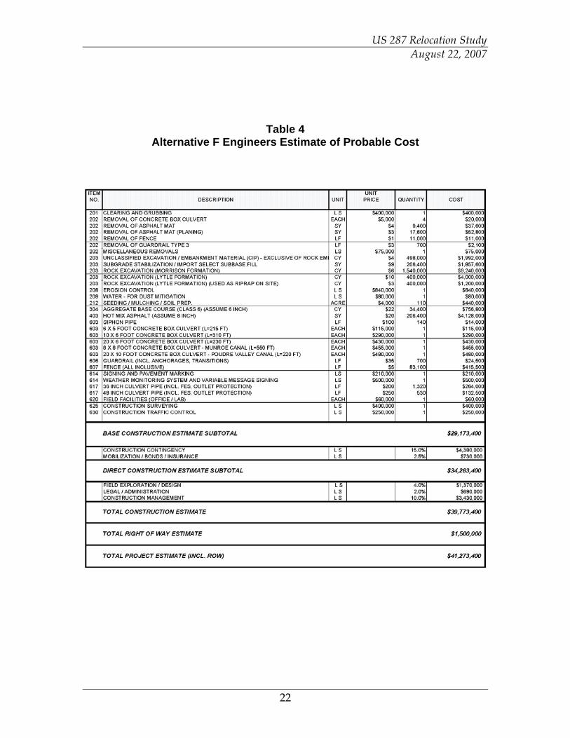
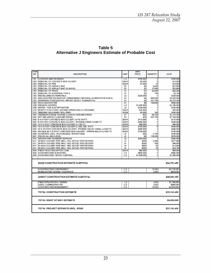
4.3.2 Construction Costs
Construction costs have been identified for the conceptual level design based on an initial opinion of probable construction costs, including contingencies, design and construction engineering, administration expense and right of way. The cost estimate for Alternative F is $41.3 million (Table 4). The cost estimate for Alternative J is $37.7 million (Table 5). The unit cost of right-of-way can vary widely and thus could significantly impact the estimated costs. Based upon information provided by the District, it is estimated that the right of way cost for Alternative F is $1.5 million and for Alternative J is $4.0 million.
US 287 Relocation Study August 22, 2007
22
Table 4 Alternative F Engineers Estimate of Probable Cost
US 287 Relocation Study August 22, 2007
23
Table 5 Alternative J Engineers Estimate of Probable Cost
US 287 Relocation Study August 22, 2007
24
4.3.3 Cost Sensitivity
The costs estimates reflect a reasonable approximation of the cost for comparative purposes for the alternatives evaluated. These estimates provide important information for planning level evaluations but should not be considered estimates of probable construction costs due to numerous variables that could impact overall project costs. Several cost factors, including, but not limited to, rock cut slope stability requirements, rock excavation unit costs, pavement and other roadway costs, right of way costs and anticipated operation and maintenance costs, have the potential to change the project cost estimates substantially. An attempt has been made to address these variable costs by assuming a conservative approach in this report. The following information reflects the potential change in project cost of the two alternatives should variable deviations be considered.
Rock Cut Slope Stability – The conceptual plans for Alignment F reflect an assumed 2:1 rock cut slope for material in the Morrison Formation and a 1:1 cut slope for material in the Lytle Formation. These cut slopes were assumed based upon field observations and may be conservative in nature. During final design, these slopes will be engineered based upon a comprehensive field exploration and testing process. A sensitivity analysis of the potential reduction in rock cut material should a 1:1 cut slope be found to be needed indicates that a reduction to total rock cut of 550,000 CY may be realized. This reduction in material would also result in a reduction in the fill material required for the eastern approach to the hogback. To accommodate this revised balance of materials, the roadway profile would be lowered between 5 and 10 feet. Using the unit costs presented in this document, a potential reduction in the cost of the hogback cut in the range of $4M may be realized. Rock Excavation Unit Costs – Since rock excavation reflects approximately 50% of the overall Base Construction Estimate for Alignment F, any variation in unit costs of this work has a disproportionate impact on the overall project cost. Although the volume of rock excavation is large, it represents only a portion of the total rock excavation work that will be required for the overall Glade Reservoir project, specifically the work required to construct the dam. There may be an opportunity to obtain very competitive pricing on this material. A 10% change in the unit price of this material results in a $1.4M change in Base Construction Costs.
US 287 Relocation Study August 22, 2007
25
Roadway Costs – Alignment J reflects a relatively level alignment with a balance of earthwork. Extensive sections with excessive excavation and embankment are not prevalent. This alignment represents a more traditional roadway configuration than that of Alignment F with the single largest cost item being pavement and other roadway elements (drainage, subgrade stabilization, fencing, seeding). Alignment J is estimated to cost $2.65M per mile. Since Alignment J is longer than Alignment F, variation in “typical” roadway costs result in a larger change in overall cost. A 10% variation in costs of roadway construction result in a $3.1M change in the Base Construction Costs for Alignment J vs. a $1.8M change in Base Construction Cost for Alignment F. ROW Costs – Right-of-Way costs can vary considerably and will be determined through the appraisal and negotiation process with each property owner. Both Alignment F and Alignment J require the acquisition of right-of-way from the same 10 owners. In addition, Alignment J requires right-of-way from 10 additional unique owners that would not be impacted by Alignment F. This additional right-of-way acquisition increases the uncertainty of the cost to acquire property for the highway relocation. Operation and Maintenance Costs – Operation and maintenance costs are not included in the engineer’s estimates but will be realized over the life of the facility. For general comparative purposes, it was assumed that the operation and maintenance costs would be approximately $2,000 per lane mile per year. The present value of O&M over a 20-year period is estimated to be $2.6M and $4.3M for Alignment F and Alignment J, respectively.

US 287 Relocation Study August 22, 2007
26
Chapter 5.0: Project Impacts and Mitigation
5.1 Introduction
The following sections provide a concise description of the general setting for the area that will be affected by both Alternative F and Alternative J. These sections also provide an evaluation of possible impacts that could occur as a result of implementation of either Alternative F or Alternative J. 5.2 Traffic and Safety
5.2.1 Existing Conditions
Refer to Chapter 3 for existing traffic and safety conditions. 5.2.2 Impacts
No traffic volume or turning movement counts were conducted as part of this study. An evaluation of daily traffic volumes on the various roadway links and engineering judgment were used to develop anticipated traffic patterns. At the 2030 projected volume of 7,900 vpd, the new segment of US 287 is projected to operate at a volume to capacity ratio of .38. In addition, according to the UFR 2030 Regional Transportation Plan, a 2-lane principal arterial has a planning level capacity of 16,000 vpd. In addition to the realigned US 287, there will be a new intersection created that will serve SH 14 to the west. This new US 287 / SH 14 intersection was designed to accommodate projected traffic volumes and turning movements. Using the projected 2030 ADT as outlined above and assuming that the design hourly volumes represent approximately 13 percent of the daily volume, peak hour turning movements for the southern tie-in intersection of realigned US 287 were developed. The following assumptions were used in the development of these turning movements:
• The ADT (7,900 vpd) on the realigned US 287 is split 50/50 in northbound/southbound directions.
• 10% of the 7,900 vpd are using SH 14 to access areas west of Ted’s Place.
• 5% of the 7,900 vpd are using SH 14 (old US 287) to access the LaPorte community.
• The remaining 85% of the 7,900 vpd are traveling to and from the Fort Collins area on US 287 to destinations north of the project area (toward Wyoming).
US 287 Relocation Study August 22, 2007
27
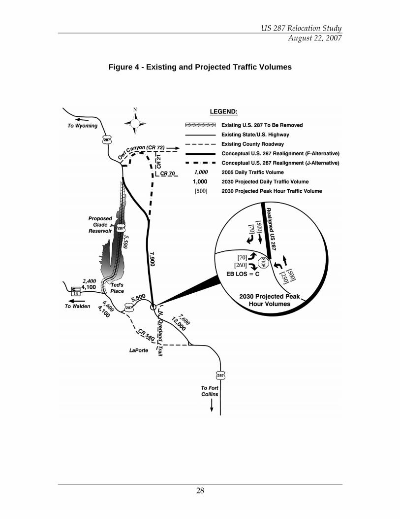
Projected traffic volumes are presented in Figure 4. Analyzing the proposed intersection with the Highway Capacity Software (HCS) shows that using stop control for the eastbound leg results in an approach level of service (LOS) of C. This traffic operation assumes that the eastbound left turn has a median left turn acceleration lane in the northbound direction provided. The auxiliary lanes for the proposed intersection should be designed in accordance with the State Highway Access Code. Traffic patterns within the LaPorte area should remain the same, although some traffic traveling to and from a destination north of LaPorte may choose to use the US 287 / Overland Trail intersection, instead of the US 287 / LCR 54G intersection. Any minor changes in traffic patterns should not have an adverse effect on the safety of either intersection. Turning movement counts and further traffic engineering analysis will be completed during final design of the project. The existing segment of US 287 between the future alignment connection and Ted’s Place will continue to serve local traffic as well as regional traffic utilizing SH 14 up Poudre Canyon. Approximately 2 miles of this segment of US 287 is a 4-lane divided arterial roadway with auxiliary lanes, controlled access and a depressed median. Under the proposed traffic conditions, this segment of existing US 287 will operate with lower traffic volumes than the no-build condition.
US 287 Relocation Study August 22, 2007
28
Figure 4 - Existing and Projected Traffic Volumes
US 287 Relocation Study August 22, 2007
29
5.2.3 Mitigation
The following strategies are important considerations in the development of the relocated highway. All of these strategies have been addressed and incorporated into both alternatives as indicated below. • Provide safe and efficient access management – Access locations and
configurations meet State and industry standards. • Eliminate or minimize the need for guardrail by providing traversable,
unobstructed roadsides with appropriate clear-zone – Traversable, unobstructed roadsides with appropriate clear-zones are incorporated into the design of both alternatives. Guardrail is not shown to be needed along the Alternative F alignment. Guardrail is not shown to be needed along the Alternative J alignment with the exception of short segments adjacent to Spring Creek where steeper slopes are required.
• If hazards exist within the clear-zone and cannot be eliminated, install approach/exit guardrail to latest AASHTO Roadside Design Guide and CDOT Standards and extend guardrail to offer protection from steep side slopes and impacts with objects such as large boulders – It is not anticipate that Alternative F or J will have hazards within the clear-zone. The roadway alignments and cross sections provide for safe roadsides within the clear-zone. The design represented in Appendix J represents roadway traversable fill slopes of 3:1, where feasible, beyond the clear-zone limit to provide a higher level of safety. In areas adjacent to existing fill slopes that are steeper than 3:1 (in the vicinity of the Holcim mine pits), berms and/or guardrail beyond the clear-zone limit will be considered. Alternative J may require approach guardrail for both the existing and proposed Spring Creek drainage structures and potentially adjacent to Spring Creek along the existing Owl Canyon Road segment where steeper roadside slopes are required.
• Design roadway alignment to avoid close proximity to cut slopes and other areas prone to dropping rocks and debris onto the roadway. Practice standard maintenance in the area to remove debris from the roadway. – Rock cut slopes will be designed to accommodate rock fall and slope stability. The Alternative F identifies conceptual cut slopes between 2:1 and 1:1 based upon the type of bedrock material encountered. Other cut slopes represented in the design are 3:1 or flatter and incorporate an appropriate z-slope.
• Consider installing rumble strips in the centerline and at the edge of traveled way. – Rumble strips will be considered as part of the final design effort.
• Incorporate appropriate roadside delineation, signing and pavement markings. – Appropriate roadside delineation, signing and pavement markings will be incorporated along the relocated US 287.
• Evaluate and incorporate safe passing zones. – Approximately 70% to 75% of both the Alternative F and the Alternative J roadway alignments will allow for safe passing.
US 287 Relocation Study August 22, 2007
30
• Incorporate climbing lanes where warranted, to minimize conflicts between vehicles operating at different rates of speed. – Climbing lanes will be provided along the eastern approach to the “Hogback” cut along Alternative F where sustained grades of 4% are designated. Climbing lanes are not warranted along Alternative J.
• If applicable, consider the addition of fences that minimize the possibility of a wild animal entering the roadway clear-zone. Additionally, consider adding delineators specifically designed to reflect headlights away from the traveled way towards animals in the clear-zone to deter them. – Fences and wildlife delineation will be considered during final design. Coordination with the Colorado Division of Wildlife will be conducted to determine the appropriate location and need for animal crossings.
5.3 Roadway
5.3.1 Existing Conditions
Refer to Chapter 3 for existing roadway conditions. 5.3.2 Impacts
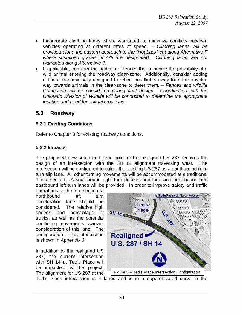
The proposed new south end tie-in point of the realigned US 287 requires the design of an intersection with the SH 14 alignment traversing west. The intersection will be configured to utilize the existing US 287 as a southbound right turn slip lane. All other turning movements will be accommodated at a traditional T intersection. A southbound right turn deceleration lane and northbound and eastbound left turn lanes will be provided. In order to improve safety and traffic operations at the intersection, a northbound left turn acceleration lane should be considered. The relative high speeds and percentage of trucks, as well as the potential conflicting movements, warrant consideration of this lane. The configuration of this intersection is shown in Appendix J. In addition to the realigned US 287, the current intersection with SH 14 at Ted’s Place will be impacted by the project. The alignment for US 287 at the Ted’s Place intersection is 4 lanes and is in a superelevated curve in the
Figure 5 – Ted’s Place Intersection Configuration
US 287 Relocation Study August 22, 2007
31
opposite direction than will be required for the ultimate realignment of SH 14. Approximately 1,500 feet of total length of US 287 and SH 14 will have to be reconstructed to account for correction in superelevation and to transition from the 4-lane divided section on US 287 to the 2-lane section on SH 14. This reconstruction length would accommodate a 70-mph design speed. Access to the Ted’s Place Conoco could remain on SH 14 or be provided from the realigned access to the north that could also serve as the access to the Glade Reservoir, the campground and other facilities. At the north tie-in point of both alternatives, a intersection connection to the existing US 287 alignment will be maintained south to the Ingleside Road which provides access to the Pioneer Sand and Gravel operation, residences and other land uses. Utilizing Big Ridge Way, a local frontage road west and parallel to US 287 is a possible option to accommodate this local traffic (see Appendix J). 5.3.3 Mitigation
5.3.3.1 Climbing Lanes
Climbing lanes are provided when the following criteria are satisfied: upgrade traffic flow exceeds 200 vpd; upgrade truck flow exceeds 10 vpd, and at least a 10 mph speed reduction or one level of service reduction for heavy vehicles. The first two criteria (traffic flow exceeds 200 vpd and upgrade truck flow exceeds 10 vpd) are met under projected conditions. Therefore, the need for climbing lanes will be determined solely by profile grades. For this project, a climbing lane will be warranted with sustained grades of 4 percent in excess of 3,000 feet in length. 5.3.3.2 Passing Lanes
Using the AASHTO A Policy on Geometric Design of Highways and Streets (PGDHS) and the Colorado Department of Transportation (CDOT) Design Guide 2005, the following criteria were established for passing sight distance.
• Design Speed: 70 mph • Height of Eye: 3.5 feet • Height of Object: 3.5 feet • Design Sight Distance: 2480 feet
Areas where inadequate distances for passing were determined graphically using the method for scaling described in the PGDHS. Both directions were analyzed yielding the following results.
Total Alternative F Project Length: 36,779 feet NB %Passing / % No Passing 77% / 23%
US 287 Relocation Study August 22, 2007
32
SB % Passing / % No Passing 72% / 28% Total Alternative J Project Length: 62,221 feet NB %Passing / % No Passing 74% / 26% SB % Passing / % No Passing 77% / 23%
It is important to note that these calculations are for preliminary design purposes only and the locations will need to be field measured and striped in accordance with the Manual on Uniform Traffic Control Devices (MUTCD). 5.4 Right-of-Way
5.4.1 Existing Conditions
Based upon information provided by CDOT, the ROW width on US 287 north of Ted's Place (SH 14 intersection) varies from 200 feet to 250 feet. There are some wider sections of ROW that accommodate large cut sections such as the large cut on the east side of US 287 north of SH 14 in which the ROW is in excess of 400 feet in width. CDOT has requested to have the proposed ROW set at 250' (unless cuts or fills required more) to match existing conditions, to be consistent with other recently reconstructed segments of US 287 and to allow for the accommodation of proposed and future utilities. There are approximately 10 ownerships that are anticipated to be impacted by Alternative F and approximately 20 ownerships that will be impacted by Alternative J. Existing right-of-way and ownerships are shown on the plans in Appendix J. 5.4.2 Right-of-Way Impacts
A preliminary assessment of right-of-way and easement requirements for the two alternatives was completed. Alternative F would require a total of approximately 250 acres of right-of-way from 10 owners and Alternative J would require approximately 350 acres of right-of-way from 20 owners. 5.4.3 Right-of-Way Acquisition Process / Mitigation
All property acquisition will follow the procedures outlined in the CDOT Right of Way Manual. CDOT follows the Federal Uniform Relocation and Real Property Acquisition Act of 1970 (Public Law 91-646), as amended in 1987 (Public Law 100-17), 1991 (Public Law 102-240) and 1997 (Public Law 105-117). The purpose of the act is “To provide for uniform and equitable treatment of persons
US 287 Relocation Study August 22, 2007
33
displaced from their homes, businesses, or farms by Federal and federally assisted programs and to establish uniform and equitable land acquisition policies for Federal and federally assisted programs.” 5.5 Geology
5.5.1 Existing Conditions
Preliminary geologic review was based on existing geologic information and reports available from the literature and from previous construction projects on US 287 in or near the relocation study area. The formations in the relocation study area are of sedimentary origin and have been uplifted and folded forming the hogback which is the major structure in the area. The formations generally trend north-south and dip east-southeast. Dip angles mainly range from 10 to 25 degrees, but can be as high as 40+ degrees. There are several folds present in the east side of the hogback as well as a relatively large, continuous prehistoric landslide. There are also several recent landslides that have been mapped in the existing colluvium. The Bellvue Fault is also in the vicinity of the relocation study area, but is not expected to affect the alignments covered by this report. The formations that will be encountered in the relocation study area include from east to west (youngest to oldest):
Pierre Shale Formation Niobrara Formation Dakota Group Morrison Formation Sundance Formation and Jelm Formation, undivided Lykins Formation Lyons Sandstone
In addition to these bedrock conditions, it is likely that there is alluvium present near creeks and in drainages. Other soil deposits of weathered rock, colluvium, and potentially aeolian (loess) are also likely in the project area. The geologic conditions within the relocation project area present several types of hazards and potential impacts to the project. The following summarizes the most prominent of these concerns:
Landslides Need for large cuts Expansive soils Mine related ground instability Weak or compressible alluvium
US 287 Relocation Study August 22, 2007
34
One of the primary geologic features in the project area is the hogback, a linear rock ridge trending approximately North/South with the sedimentary rock striking with the hogback and dipping to the east at between 12 and 25 degrees. This hogback is traversed by the Alternative F alignment. The eastern exposure is sandstone of the Lytle Formation which is estimated to be a maximum of 80 ft thick and a minimum of approximately 50 ft with a weighted average of approximately 60 ft. Underlying the Lytle formation and exposed on the west side of the hogback is the Morrison Formation. The interface between the Lytle and the Morrison was assumed to dip at 14 degrees to the east. The Morrison Formation is characterized primarily by claystone with some sandstone layers. The southern 4 ½ miles of both alternatives traverse the decommissioned Holcim Cement Plant and Limestone Quarry, generally following the mining haul road that has been in operation for over 80 years. The plant and quarry operation have recently been decommissioned, with the majority of the plant facilities being removed and the quarry pits being re-contoured to provide for slopes no steeper than 2:1 being covered with topsoil and seeded. During prior reclamation activities within the Holcim cement plant and limestone quarry operation, it is know that mined areas were backfilled and reclaimed to a surface resembling original conditions. Based on information provided by personnel from Holcim, it is known that Cement Kiln Dust (CKD) was backfilled into one or more mine pits near the south end of the proposed new highway alignment. The CKD is located in the vicinity of the proposed road alignment somewhere within the reach from station 85+00 to 98+00. The mine pit serving as the basin for the CKD was shallow to the southwest and dipped down to the northeast terminating in a near vertical highwall. It is likely that the maximum depth of fill including a ten foot soil cap is approximately 45 feet. Field exploration has delineated the approximate extent of the CKD backfilled area. This identified backfilled area is represented on the plans in Appendix J. The alignments represented in the plans have been designed to avoid the CKD backfilled areas in order to minimize potential mitigation. 5.5.2 Impacts
For Alternative F, rock excavation and cut slopes will be required on the north end as the alignment traverses west through the existing hogback west of the Holcim property. The proposed road cut is planned to penetrate completely through the hogback and to be approximately 2,000 ft long, a maximum of 220 ft deep, and a maximum width of 880 ft. The side slopes are estimated to be between 2H:1V and 1H:1V depending on the location and ground type. These
US 287 Relocation Study August 22, 2007
35
inclinations are required for slope stability. Some rock reinforcement may also be required. It is expected that rockfall will be addressed with a combination of rock reinforcement, rockfall screen, and catchment ditches. Excavation of the rock cuts is expected to require a combination of blasting and ripping. Preliminary design of the cut is for the side slopes to be 1H:1V in the Lytle Sandstone and 2H:1V in the Morrison Formation. The specific design of these cut slopes will be developed during final design. Material excavated from the Lytle Sandstone may be utilized as riprap material in the dam or spillway of the Glade Reservoir. Additional material excavated from the proposed cut will be hauled and placed as road fill beginning at the cut toe and extending approximately one mile from the cut primarily to the east and south. The fill will be a maximum of approximately 60 ft deep. Another potential risk would be from landslides, especially large landslides on east facing slopes potentially moving down slope with the dip of the geologic formations. Alternative F does not appear to be near large east-facing slopes that would likely present such a danger. However, road cuts necessary to cut through the hogback and outcrops are expected to present a risk for small and intermediate scale slope instabilities. Alternative J will traverse parallel to the base of large east-facing slopes. The alignment is not directly adjacent to these large east facing slopes but further evaluation of the potential impact of these slopes on the alignment will be further evaluated during final design. Some bedrock formations along the Front Range are susceptible to expansive soil problems. During final design, if it is found that design alignment traverses areas of expansive soils, specialized mitigating measures such as excavation and recompaction or replacement would likely be required. Where the alternatives cross creeks and drainages, relatively thick alluvial deposits are likely present. In these areas ground settlement and slope stability are issues will need to be addressed. Also the waterways may have steep side slopes from recent erosion in some areas, and these slopes may exceed long term stability limits. For reaches of Alternative F aligned east/west (including reaches aligned northwest and southwest) the ground conditions will vary rapidly. Because of the north/south trending and upturned character of the geologic formations, bedrock will quickly change from sandstone to claystone, siltstone and shale as each bed is encountered. Alluvium and other soils will further complicate the ground conditions. The steep hogbacks and rock outcrops are surfacial expressions of this variability.
US 287 Relocation Study August 22, 2007
36
5.5.3 Mitigation
The final design stages of the project will include a detailed geotechnical and pavement design to provide structural integrity and ground stability of the roadway for the geological conditions. Roadway cut slopes, engineered fill sections, pavement sections, culvert and other required structures will be designed based on specific geologic conditions. A relatively detailed geotechnical exploration program is recommended to address the stability of the hogback cut, steep rock outcrops, potential landslide areas and rapidly varying ground conditions. This exploration may include borings on close spacings and perhaps other exploratory methods such as geophysics. It is expected that the slope angles will be the primary factor in stabilizing the rock cuts, but that there may be minor rock bolting in the Lytle Sandstone. Additionally it is assumed that there may be rockfall mesh covering the Lytle Sandstone but not the Morrison Formation portion of the cut except for the upper 10 feet. The specific configuration of slopes and stabilization will be further refined and designed during final design. The Lytle sandstone will likely require blasting for excavation. It is anticipated that most of the Morrison Formation could be ripped with a large dozer. It is possible though, that some areas of the Morrison could be excavated directly with a loader or large backhoe. The presence of sandstone beds within the Morrison Formation could require additional effort to loosen and excavate, including ripping and possibly blasting. Following ripping, the material could be excavated with a large loader or backhoe and transported with off-road haul trucks. The alignments of the alternatives have been defined to minimize the impacts of the mining reclamation operation on the stability of the subgrade of the roadway alignments. The existing haul road alignment was generally followed within the limits of the Holcim operation to avoid differential subgrade performance. Within the areas identified as backfilled with CKD, a field investigation was undertaken to identify the extents of the backfilled area in order to develop an alignment that avoids traversing over the CKD fill. Potential expansive soil problems will be identified during final design and can be mitigated, if required, with well established engineering solutions. At this time there has not been an evaluation of whether or not expansive soils are present in the formations present along the Alternative F and Alternative J alignments.
US 287 Relocation Study August 22, 2007
37
5.6 Drainage and Water Quality
Water resources are integral to vegetation, wildlife, economic development, agriculture and recreational uses. The degradation of the quality of the water in the environment has a far-reaching impact on the ecological matrix. Water resources evaluated in this study include surface drainage to streams, irrigation ditches and floodplains. The study area is located within the Cache La Poudre River watershed which is part of the South Platte River Basin. Flow in the basin is primarily snowmelt. The region’s climate is semi-arid with an average annual precipitation of 18 inches. Typical rainfall in the region is high intensity and short duration. 5.6.1 Surface Resources
5.6.1.1 Creeks and Surface Drainage
Stormwater runoff from the study area outflows to several creeks/drainageways which ultimately outfall to the Cache La Poudre River with an ultimate confluence with the South Platte River. Water flow in the creeks tends to be at a minimum in the winter and a maximum in early summer. There are four major (greater than 130 acres in size) drainage basins tributary to the Alternative F alignment and twelve major drainage basins tributary to the Alternative J alignment. The basins primarily flow from west to east, although the basins located at the northern end of the project cross the roadway from north to south (this applies to both alternatives). The basins located along the southern reach of the project are very small and range from 5 to 80 acres in size. The drainage basins for both alternatives are identified on the Drainage Basin Maps located in Appendix F. 5.6.1.2 Irrigation Ditches
There are two irrigation ditch crossings located within the study area. These ditches serve agricultural and municipal uses.
• Poudre Valley Canal crosses both alternatives at approximate station 140+80 and is proposed to be conveyed in a 20’ x 10’ concrete box culvert. The culvert size was provided by the NCWCD.
• Monroe Canal crosses Alternative F at approximate station 330+00 and
Alternative J at approximate station 360+00. The proposed crossing is an 8’ x 8’ concrete box culvert. The culvert size was provided by the NCWCD.
US 287 Relocation Study August 22, 2007
38
In addition, since portions of the Munroe Canal will be removed due to the Glade Reservoir, irrigation flows will be carried in the Poudre Valley Canal to a point east of the US 287 alignments (Alternative F and J). The Monroe Canal flows will then be conveyed in a new pipe to the existing Monroe Canal alignment and are anticipated to cross the US 287 alignment at approximate station 270+00. 5.6.2 Water Quality
Under Section 402 of the Clean Water Act, a National Pollution Discharge Elimination System (NPDES) permit for point discharge and stormwater is required if a proposed project impacts more than a specific size of land. Under the NPDES and Colorado regulations, a Colorado Pollution Discharge System (CPDS) permit is required if one or more acres of land disturbance are anticipated on a construction project, or if the project is part of a larger plan. Since both Alternatives F and J disturb more than one acre, a CPDS permit is required for stormwater discharge associated with construction activities for both alternatives. 5.6.3 Water Resource Impacts
A preliminary storm drainage design has been completed for the project and is shown in the plans in Appendix J. This proposed design is a “conceptual” design of the anticipated storm drainage structures necessary. The existing conditions hydrology was used, while implementing basin travel times to the proposed culverts. The proposed roadway has been designed as a “rural” section. The drainage design consists of roadside ditches, driveway/access culverts and cross culverts. The plans (Appendix J) contain culvert dimensions and roadside ditch typical sections for the rural section of roadway. The culverts were designed to convey the 50-year event. Alternative F would result in an increased impervious surface area of approximately 45 acres due to the construction of the new roadway alignment. Alternative J would result in an increased impervious surface area of approximately 68 acres due to the construction of the new roadway alignment. 5.6.4 Water Resource Mitigation
A conceptual level hydrologic analysis has been completed for the relocation of US 287. Proposed cross culverts along the realigned US 287 convey drainage basins ranging from 5 acres in size to 5700 acres. Based on the criteria set forth in the CDOT Drainage Design Manual (Table 7.2), culverts located under US 287 should be designed to convey the 50-year storm frequency (multi-lane road in
US 287 Relocation Study August 22, 2007
39
rural area). For purposes of this conceptual evaluation, analysis of the drainage basins was completed using data from prior similar projects and utilizing engineering judgment. No project specific hydrology modeling has been completed at this time. Hydrology from prior projects with similar topography, soil characteristics and drainage basin size/geometry was used as baseline data. A flowrate was determined for each US 287 basin by proportioning the area/flowrate data from previous projects to the basin tributary to US 287. As the US 287 realignment project enters final design stages, there are several methodologies that should be evaluated in order to determine design flowrates for basins tributary to the project. The Rational Method can be used for watersheds smaller than 160 acres. The Rational Method is most appropriate for urban basins, but can be used for rural drainage basins with careful evaluation for the accuracy of the results. For basins greater than 160 acres, there are several hydrologic models that will be considered for determining the design flowrate, including the Colorado Urban Hydrograph Procedure (CUHP), Technical Release No. 20 (TR-20), and the USGS Regression Equations. During final design, each of these procedures should be evaluated based on individual basin characteristics to determine the most appropriate methodology. For purposes of this preliminary design, culvert dimensions were determined using inlet control nomographs for circular concrete culverts and box culverts. The headwater to depth ratio for this stage in the design was assumed to be 1.2 for all culverts. A cursory evaluation was completed to verify adequate cover could be achieved over each culvert. This will be assessed further in final design. Final design of the US 287 realignment should include detailed design of the proposed cross culverts. Each culvert should be evaluated to determine adequate cover and headwater is provided as well as examining whether each culvert is under inlet or outlet control. Special details may be required at some culverts for special grading at either the inlet or outlet to accommodate headwalls, wingwalls or other embankment protection structures. Inlet and outlet velocities should also be evaluated to determine if there is a need for channel grade control and/or erosion protection. This project commits to following CDOT’s Erosion Control and Stormwater Quality Guide, sections 107.25 & 208 of the specifications for the Standard Specifications for Road and Bridge Construction and the Stormwater Management Plan. CDOT follows The Municipal Separate Storm Sewer System (MS4) requirements for water quality. These requirements will be followed on this project by the process outlined in Appendix I of the CDOT Drainage Design Manual.
US 287 Relocation Study August 22, 2007
40
A Stormwater Management Plan (SWMP) will be completed during final design. It will address specific methods of reducing pollutants in stormwater runoff during construction. Stormwater Best Management Practices (BMPs) for a site during construction would consist of five major elements:
• Implementation of BMPs for erosion control. These include, but are not limited to, phased seeding with mulch and tackifier, the use of erosion control blankets, the use of embankment protectors, the use of berm diversions or check dams, and outlet protection for storm sewer pipes.
• Implementation of BMPs for sediment control. These include, but are not limited to, erosion bales or logs, silt fence, storm drain inlet and outlet protection, sediment traps, concrete washout and raw water containment basins, and stabilized construction entrances.
• Implementation of BMPs for materials handling and spill prevention. These include, but are not limited to, stockpile management, material management, material use, and spill prevention and control.
• Implementation of BMPs for waste management. These include, but are not limited to, concrete, hazardous, and contaminated waste management to ensure that solid or liquid wastes are not carried off the site by stormwater.
• Implementation of BMPs for pollution prevention. These include treatment during dewatering and paving operations. It also includes the use of street sweeping and temporary waterway crossings.
Permanent BMPs will be designed to protect stormwater quality and reduce pollutant discharges after construction is complete. The permanent BMPs are developed with the intention of mitigating the potential impacts typical of a roadway corridor. These can include petroleum or other vehicle fluids, hazardous spills, sand or other snow melting chemicals, and litter. General BMPs for this project will include the vegetation of all disturbed areas with erosion control blankets on slopes 3:1 or steeper. In addition to maintaining BMPs installed on the project, maintenance activities after construction will include consistent roadway sweeping and removal of sediment from stormwater structures. During final design, a determination will be made of exact methods and locations of stormwater management during construction and will be outlined in the SWMP. Coordination will also be completed with local agencies (Larimer County) to verify that the proposed permanent BMPs fulfill the requirements of the local NPDES Phase 2 Permit.
US 287 Relocation Study August 22, 2007
41
5.7 Utilities
5.7.1 Existing Conditions
The Utility Notification Center of Colorado (UNCC) was contacted to identify private utility companies with facilities in the study area. Each of the utility owners was contacted for available information related to the location of their facility. Numerous utilities exist within the study area and those possibly affected by the proposed improvements are listed below:
• Poudre Valley REA Rod Bledsoe – (970) 282-6438 Single Circuit 115 KV Transmission Line
• Xcel Energy Natural Gas Stephanie Rich – (970) 225-7828 Natural Gas Lines
• Northern Colorado Water Joe Huffaker – (970) 568-3975 Domestic Water
• CSU Fiber Randy Simon – (970) 491-2526 Fiber Optic
• West Fort Collins Water District Doug Bigge – (970) 484-4881 Domestic Water
• Platte River Power Authority Mike Dahl – (970) 229-5303 Double Circuit 230 KV Transmission Line
• US Cable Rich Fremstad – (970) 587-2243 Fiber Cable
• QWEST Jason Garcia – (970) 350-2993 Telephone
• McLeod USA Telephone / Communications

US 287 Relocation Study August 22, 2007
42
• Poudre Valley Canal
• Munroe Canal
Approximate existing utility locations were obtained from key maps or conversations with each utility company. Locations of known utilities are shown in the conceptual design plans. Of particular note is the Platte River Power Authority which owns a double circuit 230 KV transmission line along the western limits of the Holcim quarry. A minimum of 22 feet of clearance is required over a roadway. The cost to relocate a pole is approximately $50,000. The removal of a pole to avoid a conflict may require the replacement of the pole with two poles since the maximum spacing was likely used when line was originally constructed. 5.7.2 Impacts
Two towers on the Platte River Power Authority double circuit 230 KV transmission line will be impacted by the proposed intersection and tie-in to the existing US 287. In addition, the roadway fill approaching the hogback will be in conflict with this overhead transmission line. The Poudre Valley REA single circuit 115 KV transmission line also transverses the roadway alignment in the vicinity of the hogback approach fill. The proposed roadway traverses the Poudre Valley Canal and the Munroe Canal. In the vicinity of the north tie-in, Poudre Valley REA overhead electric lines, McLeodUSA cable communications lines will be traversed by the roadway alignment. Utilities along existing US 287 between Ted’s Place and Owl Canyon will be inundated by the reservoir project and will need to be relocated. It is expected that some additional utilities may be in conflict with the proposed improvements and may require resetting or relocation work to a new permanent location. 5.7.3 Mitigation
All utility locations will be further researched, identified and field verified prior to construction. Exposed utilities, where feasible, will be protected during
US 287 Relocation Study August 22, 2007
43
construction activities. If utility service must be interrupted, temporary service will be provided as needed and maintained during the disruption. Two towers on the Platte River Power Authority overhead transmission line will be relocated to accommodate the proposed intersection and tie-in to the existing US 287. A section of this transmission line as well as the Poudre Valley REA transmission line will also have to be raised over or buried beneath the fill roadway section approaching the hogback cut for the Alternative F alignment. Poudre Valley REA overhead electric lines and McLeodUSA cable communications lines will require relocation at the north tie-in point of the roadway alignment. Where the proposed roadway traverses the Poudre Valley Canal, a 10 foot by 20 foot concrete box culvert, or equivalent, will be utilized. Where the proposed roadway traverses the Munroe Canal, an 8 foot by 8 foot concrete box culvert, or equivalent, will be utilized. An effort will be made to minimize impacting the existing ditches and drainage structures through efficient design and coordination with the owners. Utility corridors will be provided in the proposed ROW to accommodate both relocated and new utilities. Utility lines that currently follow the existing US 287 can be relocated to these utility corridors or to alternate alignments. Impacted utility owners will be contacted during the early stages of the design process to closely coordinate this work and design. 5.8 Wind and Blowing Snow
Refer to Appendix G for a letter report, dated June 22, 2006 from R. D. Tabler, regarding blowing snow and wind mitigation. Also included in Appendix G is a supplemental letter regarding this issue from R. D. Tabler, dated July 25, 2007.
5.8.1 Existing Conditions
Although wind data are not available for the site, the directional distribution of blowing snow events is assumed to be approximately the same as at the Vedauwoo weather station located 29 miles to the north-northwest. The northerly wind component of the directional distribution is associated with snowfall events, and the same synoptic weather patterns pertain in the project area.
US 287 Relocation Study August 22, 2007
44
5.8.2 Impacts
The primary feature characterizing Alternative F is the 220-ft cut required at the hogback. The primary hazard associated with the cut would be localized road icing caused by shading during winter months. Also due to the deep hogback cut section, differential melting of icy road conditions is anticipated to occur. The cut through the hogback will accelerate wind speeds and channel wind parallel to centerline. There will be a tendency for blowing snow to be deposited immediately downwind (east) of the hogback in response to the expanding air flow and the downsloping road alignment. Although the cut should be monitored after construction, it is not anticipated that snow deposition will create any unacceptable hazards on the roadway. 5.8.3 Mitigation
Although operational experience may eventually indicate the need for snow fences, none are recommended at this time. The most important preventive measure is to assure that the cross-section through the cut meets the guidelines for snow and ice control as described in the publication “Controlling Blowing and Drifting Snow with Snow Fences and Road Design,”, 2003 by R. D. Tabler. Although the usual guidelines for cuts specify a minimum distance of 50 ft between the travel lane and the toe of the backslope, it is recognized that this may not be economically feasible in this case because of the excessive volume of earthwork being created by the rock cut for the ultimate 4-lane section. Alternative F designates a 28-ft width from the edge of traveled way (excluding climbing lane) to the toe of backslope. The Z-slope in the rock cut area has been widened from 8 to 12 feet to provide a 12-ft-wide ditch. R. D. Tabler concurs that this cut section and proposed cut and fill slopes will likely mitigate any drifting snow concerns. The cut section through the hogback will be further studied during final design to accommodated not only mitigation for potential drifting snow and icing conditions, but also for slope stability and rock fall mitigation. All of these factors will be incorporated into the design of the ultimate cut slopes and sections. In addition, for safety reasons, the roadway section on both approaches to the hogback cut have been designed to eliminate warrants for guardrail. Although the roadway is roughly parallel to the prevailing wind direction through the cut section and drifting snow is not anticipated to create an unacceptable hazard, by removing the need for guardrail, the likelihood of a drifting snow concern is further reduced. The use of ITS technologies, including variable message signs, pavement sensors, video monitoring and the use of weather station technologies may be

US 287 Relocation Study August 22, 2007
45
warranted to mitigate the potential icy road conditions. Dynamic speed limits correlated to roadway conditions, communicated through the variable message signs, should also be considered. Wind, blowing and drifting snow, and icing conditions are not anticipated to present unacceptable hazards or result in unacceptable operation and maintenance problems along the Alternative F alignment. Due to the localized nature of blowing snow issues and the complexity of factors that determine optimal mitigation, the roadway should be monitored following construction. Appropriate mitigation, should it become necessary, should be designed and implemented based upon in place field conditions. 5.9 Noise
A noise assessment was completed for this project and is included in Appendix H. Following is a brief summary of the report. Refer to the technical report for more specific information. 5.9.1 Existing Conditions
US 287 currently runs adjacent to and north from Ted’s Place toward Owl Canyon. A large portion of the route north of Ted’s Place will become submerged with the reservoir. Since the current route north of Ted’s Place will be abandoned, no existing noise conditions were evaluated for this portion of US 287. The proposed US 287 location is currently undeveloped quarry mines and open terrain. There is no highway currently present along the new realigned location. In addition, there are no residences within 500 feet of the new highway centerline. For purposes of modeling anticipated highway noise the relocated highway was modeled. 5.9.2 Impacts
The Colorado Department of Transportation “Noise Analysis and Abatement Guidelines" dated December 1, 2002 were used to evaluate the noise model. All receivers noise level fall below the Noise Abatement Criteria (NAC) Activity Category B (66-dB criteria) and thus to not warrant noise mitigation. The existing level of noise is expected to be typical of an open field environment. Comparison of the calculated values and on site measurements show that the background levels of 45 dBA will be exceeded by 10 – 15 dBA. No occupied structure exists within 500 feet of the proposed alignments.

US 287 Relocation Study August 22, 2007
46
5.9.3 Mitigation
Based on the site survey, CDOT Noise Abatement Criteria guidelines and the predictive noise model results, the proposed project will not exceed the NAC Category B residential sound levels for the build out year future traffic forecast for any of the monitored receivers. Based on the above conclusions, it is not necessary to provide mitigation from the projected noise impact in the form of a noise barrier. The noise modeling assumed worst case scenario in that they did not consider the existence of natural barriers that may exist between the centerline and receptors –hence reduce further the noise received at the edge of the 500-foot corridors. A common-sense approach to controlling the impact of construction equipment and activities should be considered during the construction of the proposed project. Economical steps can be taken to minimize the effect of construction on local residents and sensitive receivers while not affecting construction schedules. These include:
• Enacting heavy equipment work-hour limits, especially during daylight, • Requiring equipment muffler specifications, • Elimination of tail gate banging, • Minimizing the backing up of equipment with backup alarms, • Gaining community rapport, and • Devising complaint mechanisms for the public.
5.10 Air Quality
An air quality report was completed for this project and is included in Appendix I. Following is a brief summary of the report. Refer to the technical report for more specific information. 5.10.1 Existing Conditions
Section 176(c) of the Clean Air Act and related requirements mandate that federally related transportation plans, programs and projects must demonstrate and assure air quality conformity for non-compliance or redesignated attainment areas (i.e., maintenance plan). An air quality conformity determination is required for all nonexempt projects within or affecting a nonattainment or maintenance area for criteria pollutants as established in the NAAQS.
US 287 Relocation Study August 22, 2007
47
Since the project area is outside of the Fort Collins maintenance area, it was determined that a qualitative air quality assessment would be sufficient, hence Hot Spot modeling and emissions inventories were not completed. 5.10.2 Impacts
Construction activities are not expected to have a significant negative impact on air quality. However, the PM10 levels can be elevated and can be effectively mitigated. The project may include a number of potential emission sources. 5.10.3 Mitigation
Motor vehicle emissions in the study area would not result in any exceedance of the NAAQS; therefore, no direct project air quality mitigation is necessary. Phased construction is an especially effective method of distributing PM10 emissions over a period of time to reduce their negative impact. This technique is dependent upon the abilities of the construction manager to schedule properly, to be alert for periods of the year when weather conditions can worsen air quality, and to follow accepted construction practices. The following strategies can be implemented, when and where feasible, in order to reduce the project’s potential PM10 impact.
• Wetting exposed soil and soil piles for dust suppression, • Cover trucks carrying finer materials, • Application of dust suppression techniques, • Minimizing mud tracking from the construction area, and • Controlling speed limits for trucks traveling in roads with high silt loading
within the construction area.