Embed Size (px)
Citation preview
National Maritime Center Providing Credentials to Mariners
U.S.C.G. Merchant Marine Exam
Master/Chief Mate of Unlimited Tonnage
Q106-Navigation General-Oceans
(Sample Examination)
Page 1 of 19Q106-Navigation General-Oceans
8/29/2017
Q106-Navigation General-Oceans U.S.C.G. Merchant Marine Exam Master/Chief Mate of Unlimited Tonnage Illustrations: 2
Choose the best answer to the following Multiple Choice questions.
1. You are entering an African port and see ahead of you a red can-shaped buoy. What action should you take?
o (A) Alter course to leave the buoy to starboard o (B) Pass the buoy close aboard on either side o (C) Pass the buoy well clear on either side • (D) Alter course to leave the buoy to port
If choice D is selected set score to 1.
2. Ascending and descending air masses with different temperatures is part of an important heat transmitting process in our atmosphere called __________.
• (A) convection o (B) conduction o (C) barometric inversion o (D) radiation
If choice A is selected set score to 1.
3. Which of the following compensates for errors introduced when a vessel heels over?
o (A) The soft iron spheres on the arms of the binnacle o (B) Magnets placed in trays inside the binnacle • (C) A single vertical magnet beneath the compass o (D) The Flinders bar
If choice C is selected set score to 1.
4. At McAlpine L & D, normal upper pool elevation is 420.0 feet (130.8 meters) MSL, equal to 12.0 feet (3.7 meters) on the upper gage. The vertical clearance at the Clark Memorial Highway bridge is 72.6 feet (22.1 meters) above normal pool. What is the clearance if the gage reads 10.6 feet (3.2 meters)?
o (A) 84.6 feet (25.8 meters) • (B) 74.0 feet (22.6 meters) o (C) 83.2 feet (25.4 meters) o (D) 62.0 feet (18.9 meters)
If choice B is selected set score to 1.
Page 2 of 19 Q106-Navigation General-Oceans
8/29/2017
Q106-Navigation General-Oceans U.S.C.G. Merchant Marine Exam Master/Chief Mate of Unlimited Tonnage Illustrations: 2 5. The angle measured from the observer's meridian, clockwise or counterclockwise up to 180°, to the
vertical circle of the body is the __________.
• (A) azimuth angle o (B) observer's longitude o (C) local hour angle o (D) meridian angle
If choice A is selected set score to 1.
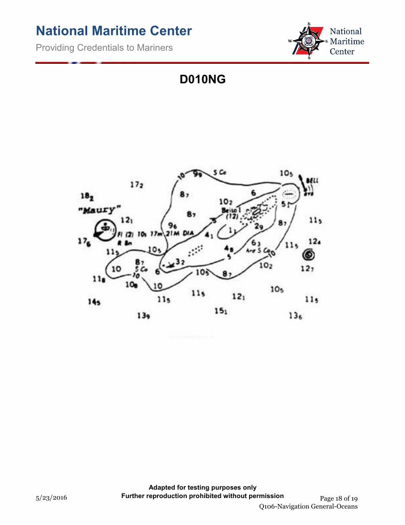
6. Which statement concerning the chartlet seen in illustration D010NG below is TRUE? (Soundings and heights are in meters)
o (A) The bottom to the south-southeast of the lightship is soft coral. o (B) Maury lightship is visible for 17 miles. • (C) There is a dangerous eddy southeast of Beito Island. o (D) There is a 12-meter deep hole west of Beito Island and inside the 5-meter line.
If choice C is selected set score to 1.
7. Which condition(s) is(are) necessary for the formation of dew?
o (A) Earth's surface cooler than the dew point of the air o (B) Clear skies o (C) Calm air • (D) All of the above
If choice D is selected set score to 1.
8. The permanent magnetism of a vessel may change in polarity due to __________.
o (A) being moored for a long time on one heading o (B) loading a homogenous magnetic cargo such as steel plate, iron bars, etc. o (C) steaming from the north magnetic hemisphere to the south magnetic hemisphere • (D) being struck by lighting
If choice D is selected set score to 1.
9. An important lunar cycle affecting the tidal cycle is called the nodal period. How long is this cycle?
o (A) 16 days • (B) 19 years o (C) 6 years o (D) 18 days
If choice B is selected set score to 1.
Page 3 of 19 Q106-Navigation General-Oceans
8/29/2017
Q106-Navigation General-Oceans U.S.C.G. Merchant Marine Exam Master/Chief Mate of Unlimited Tonnage Illustrations: 2 10. What weather change accompanies the passage of a cold front in the Northern Hemisphere?
• (A) A line of cumulonimbus clouds o (B) Steady precipitation, gradually increasing in intensity o (C) Steady dropping of barometric pressure o (D) Wind shift from northeast clockwise to southwest
If choice A is selected set score to 1.
11. The direction of prevailing winds in the Northern hemisphere is caused by the __________.
• (A) Earth's rotation o (B) Gulf Stream o (C) magnetic field at the North Pole o (D) Arctic cold fronts
If choice A is selected set score to 1.
12. Mars will not be visible __________.
• (A) at conjunction o (B) at opposition o (C) from quadrature to opposition o (D) at elongation angles near 180°
If choice A is selected set score to 1.
13. Under the IALA Buoyage Systems, a yellow buoy may mark __________.
o (A) military exercise zones o (B) spoil areas o (C) fish net areas • (D) All of the above
If choice D is selected set score to 1.
14. Little or no change in the barometric reading over a twelve hour period indicates __________.
o (A) stormy weather is imminent o (B) increasing wind strength • (C) that present weather conditions will continue o (D) a defect in the barometer
If choice C is selected set score to 1.
Page 4 of 19 Q106-Navigation General-Oceans
8/29/2017
Q106-Navigation General-Oceans U.S.C.G. Merchant Marine Exam Master/Chief Mate of Unlimited Tonnage Illustrations: 2 15. Under the IALA Buoyage Systems, a cardinal mark may NOT be used to __________.
o (A) draw attention to a feature in the channel such as a bend, junction, bifurcation, or end of a shoal
• (B) indicate the port and starboard sides of well-defined channels o (C) indicate that the deepest water in an area is on the named side of the mark o (D) indicate the safe side on which to pass a danger
If choice B is selected set score to 1.
16. While your vessel is proceeding down a channel you notice a range of lights in line with your vessel's mast. If your vessel is on course 001° per gyro compass and the charted value of the range of lights is 359°T, what is the gyro compass error?
• (A) 2°W o (B) 2°E o (C) 1°E o (D) 1°W
If choice A is selected set score to 1.
17. Three or four feet of the total height of a storm surge in a hurricane can be attributed to __________.
o (A) an increase in the wave period • (B) the decrease in atmospheric pressure o (C) an increase in temperature o (D) the wind velocity
If choice B is selected set score to 1.
18. You are sailing south on the Intracoastal Waterway (ICW) when you sight a red nun buoy with a yellow square painted on it. Which of the following is TRUE?
o (A) The yellow is retro-reflective material used to assist in sighting the buoy at night. o (B) The yellow square is in error and it should be a yellow triangle. o (C) This buoy marks the end of the ICW in that geographic area. • (D) You should leave the buoy on your port hand.
If choice D is selected set score to 1.
19. A current perpendicular to a vessel's track has the greatest effect on the vessel's course made good __________.
• (A) at low vessel speeds o (B) at high vessel speeds o (C) in deep water o (D) in shallow water
If choice A is selected set score to 1.
Page 5 of 19 Q106-Navigation General-Oceans
8/29/2017
Q106-Navigation General-Oceans U.S.C.G. Merchant Marine Exam Master/Chief Mate of Unlimited Tonnage Illustrations: 2 20. When using a buoy as an aid to navigation which of the following should be considered?
o (A) The buoy should be considered to always be in the charted location. o (B) The buoy should be considered to be in the charted position if it has been freshly painted. o (C) If the light is flashing, the buoy should be considered to be in the charted location. • (D) The buoy may not be in the charted position.
If choice D is selected set score to 1.
21. Fog is most commonly associated with a(n) __________.
o (A) cold front in the spring o (B) anticyclone • (C) warm front at night o (D) low pressure area
If choice C is selected set score to 1.
22. If your mercurial barometer reads 30.50 inches (1033 millibars) and the temperature is 56°F (13°C), what is the correct reading at 55°N, 150°W?
o (A) 30.42 inches (1030 millibars) • (B) 30.45 inches (1031 millibars) o (C) 30.50 inches (1032 millibars) o (D) 30.53 inches (1033 millibars)
If choice B is selected set score to 1.
23. In the doldrums you will NOT have __________.
• (A) steep pressure gradients o (B) high relative humidity o (C) frequent showers and thunderstorms o (D) frequent calms
If choice A is selected set score to 1.
24. The upper vertex of a great circle track is in LONG 156°00'E. Sailing eastward, the great circle track will cross the equator in LONG __________.
• (A) 114°00'W o (B) 110°00'W o (C) 66°00'W o (D) 66°00'E
If choice A is selected set score to 1.
Page 6 of 19 Q106-Navigation General-Oceans
8/29/2017
Q106-Navigation General-Oceans U.S.C.G. Merchant Marine Exam Master/Chief Mate of Unlimited Tonnage Illustrations: 2 25. When using the radar for navigating __________.
• (A) and using ranges, the most rapidly changing range should be measured first o (B) and using two radar ranges for a fix, the objects of the ranges should be close to reciprocal
bearings o (C) the best fix is obtained by using a tangent bearing and a range o (D) and crossing a radar range of one object with the visual bearing of a second object, the two
objects should be 80° to 110° apart
If choice A is selected set score to 1.
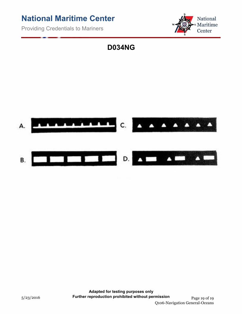
26. Which item in illustration D034NG below shows a flashing light?
o (A) A o (B) B • (C) C o (D) D
If choice C is selected set score to 1.
27. At 2221 your course is 222°pgc at a speed of 11.2 knots, when radar detects a buoy bearing 355° relative, at a range of 5.8 miles. The gyro error is 2°E. If you change course at 2226, what course should you steer to leave the buoy 1.0 mile abeam to port?
o (A) 210°pgc • (B) 228°pgc o (C) 231°pgc o (D) 206°pgc
If choice B is selected set score to 1.
28. In the U.S. Aids to Navigation System, red and green horizontally-banded buoys mark __________.
• (A) junctions or bifurcations o (B) general anchorage areas o (C) channels for shallow draft vessels o (D) fishing grounds
If choice A is selected set score to 1.
29. Perihelion is the point where the Sun __________.
o (A) and Moon and Earth are in line o (B) is on the opposite side of the Earth from the Moon • (C) is nearest to the Earth o (D) is farthest from the Earth
If choice C is selected set score to 1.
Page 7 of 19 Q106-Navigation General-Oceans
8/29/2017
Q106-Navigation General-Oceans U.S.C.G. Merchant Marine Exam Master/Chief Mate of Unlimited Tonnage Illustrations: 2 30. What is the equivalent of 10 min. 52 sec. in arc units?
o (A) 0°47' o (B) 1°12' • (C) 2°43' o (D) 3°52'
If choice C is selected set score to 1.
31. A chart with a scale of 1:45,000 is a __________.
o (A) general chart o (B) coast chart o (C) sailing chart • (D) harbor chart
If choice D is selected set score to 1.
32. A slow rise in the barometric pressure forecasts __________.
o (A) deteriorating weather conditions o (B) high seas o (C) rainy weather for the next 48 hours • (D) improving weather conditions
If choice D is selected set score to 1.
33. Clouds with the prefix "nimbo" in their name __________.
o (A) have undergone great vertical development o (B) are sheet or layer clouds • (C) are rain clouds o (D) are middle or high altitude clouds
If choice C is selected set score to 1.
34. Which statement about an estimated position is TRUE?
o (A) When a 3-LOP fix plots in a triangle, the center of the triangle is the estimated position. o (B) It is more reliable than a fix based on radar bearings. o (C) It is usually based on soundings. • (D) It may be based on a single LOP or questionable data.
If choice D is selected set score to 1.
Page 8 of 19 Q106-Navigation General-Oceans
8/29/2017
Q106-Navigation General-Oceans U.S.C.G. Merchant Marine Exam Master/Chief Mate of Unlimited Tonnage Illustrations: 2 35. You are proceeding under NCS (Naval Control of Shipping) when it becomes necessary to send a
distress message. Which precedence would you assign this message?
• (A) O (IMMEDIATE) o (B) P (PRIORITY) o (C) R (ROUTINE) o (D) Z (FLASH)
If choice A is selected set score to 1.
36. You are on course 180°T and take a relative bearing of a lighthouse of 225°. What is the true bearing of the lighthouse?
o (A) 270° o (B) 135° o (C) 180° • (D) 045°
If choice D is selected set score to 1.
37. You are on course 138°T. To check the latitude of your vessel you should observe a celestial body on which bearing?
• (A) 000° o (B) 270° o (C) 318° o (D) 138°
If choice A is selected set score to 1.
38. When using a recording depth finder in the open ocean, what phenomena is most likely to produce a continuous trace that may not be from the actual ocean bottom?
o (A) Echoes from schools of fish o (B) Poor placement of the transducer on the hull o (C) Multiple returns reflected from the bottom to the surface and to the bottom again • (D) Echoes from a deep scattering layer
If choice D is selected set score to 1.
39. Which current is responsible for the movement of icebergs into the North Atlantic shipping lanes?
o (A) Baltic Current o (B) Iceland Current • (C) Labrador Current o (D) Baffin Current
If choice C is selected set score to 1.
Page 9 of 19 Q106-Navigation General-Oceans
8/29/2017
Q106-Navigation General-Oceans U.S.C.G. Merchant Marine Exam Master/Chief Mate of Unlimited Tonnage Illustrations: 2 40. The equation of time is 8m 00s. The mean Sun is ahead of the apparent Sun. If you are 2°W of the
central meridian of your time zone, when will the apparent Sun cross your meridian?
• (A) 1216 o (B) 1208 o (C) 1200 o (D) 1152
If choice A is selected set score to 1.
41. The West Wind Drift is located __________.
• (A) near 60°S o (B) on each side of the Equatorial Current o (C) in the North Atlantic between Greenland and Europe o (D) in the South Pacific near 5°S
If choice A is selected set score to 1.
42. As the temperature for a given mass of air increases, the __________.
o (A) dew point decreases o (B) dew point increases • (C) relative humidity decreases o (D) relative humidity increases
If choice C is selected set score to 1.
Page 10 of 19 Q106-Navigation General-Oceans
8/29/2017
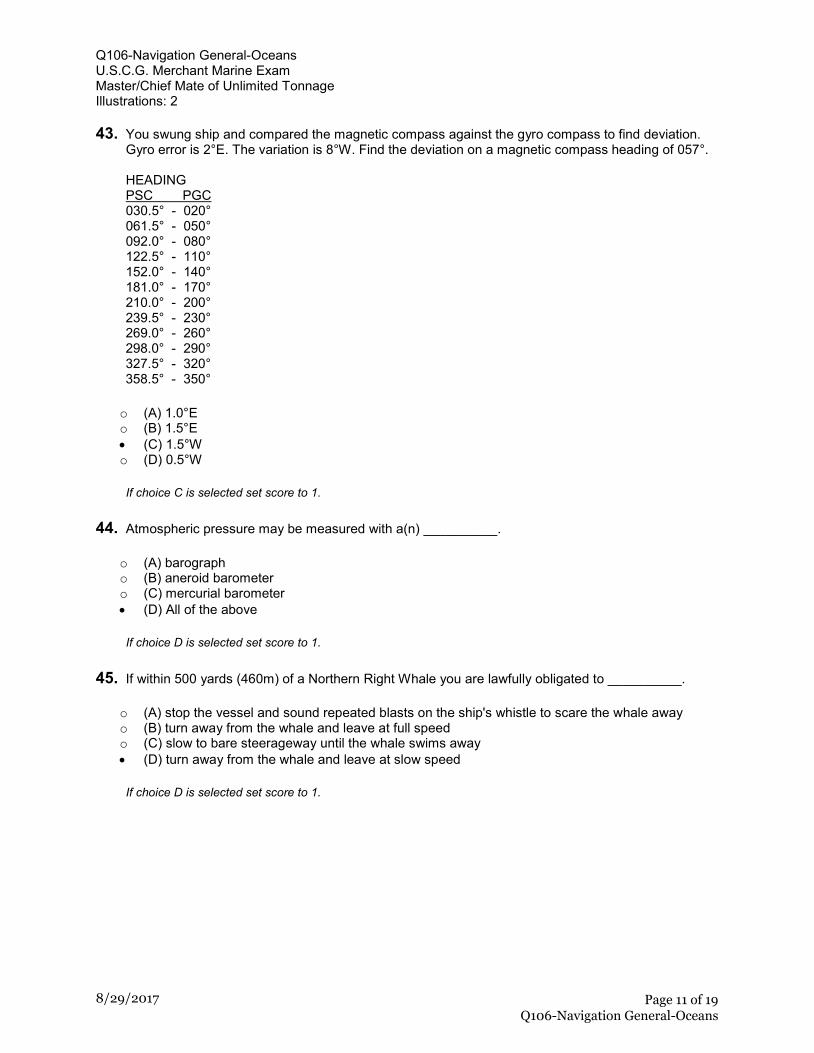
Q106-Navigation General-Oceans U.S.C.G. Merchant Marine Exam Master/Chief Mate of Unlimited Tonnage Illustrations: 2 43. You swung ship and compared the magnetic compass against the gyro compass to find deviation.
Gyro error is 2°E. The variation is 8°W. Find the deviation on a magnetic compass heading of 057°. HEADING PSC PGC 030.5° - 020° 061.5° - 050° 092.0° - 080° 122.5° - 110° 152.0° - 140° 181.0° - 170° 210.0° - 200° 239.5° - 230° 269.0° - 260° 298.0° - 290° 327.5° - 320° 358.5° - 350°
o (A) 1.0°E o (B) 1.5°E • (C) 1.5°W o (D) 0.5°W
If choice C is selected set score to 1.
44. Atmospheric pressure may be measured with a(n) __________.
o (A) barograph o (B) aneroid barometer o (C) mercurial barometer • (D) All of the above
If choice D is selected set score to 1.
45. If within 500 yards (460m) of a Northern Right Whale you are lawfully obligated to __________.
o (A) stop the vessel and sound repeated blasts on the ship's whistle to scare the whale away o (B) turn away from the whale and leave at full speed o (C) slow to bare steerageway until the whale swims away • (D) turn away from the whale and leave at slow speed
If choice D is selected set score to 1.
Page 11 of 19 Q106-Navigation General-Oceans
8/29/2017
Q106-Navigation General-Oceans U.S.C.G. Merchant Marine Exam Master/Chief Mate of Unlimited Tonnage Illustrations: 2 46. On 25 December you observe the Sun's lower limb. The sextant altitude (hs) is 4°06.9'. The height
of eye is 47 feet and the index error is 1.6' on the arc. The temperature is 19°F and the barometer reads 1030.8 millibars. What is the observed altitude (Ho)?
o (A) 3°57.4' • (B) 4°01.9' o (C) 4°02.5' o (D) 4°03.4'
If choice B is selected set score to 1.
47. When the index and horizon mirrors of a properly adjusted sextant are at an angle of 45° to each other, the arc reads __________.
o (A) 22 1/2° o (B) 45° o (C) 60° • (D) 90°
If choice D is selected set score to 1.
48. While navigating in fog off a coastline of steep cliffs, you hear the echo of the ships fog horn 6 seconds after the signal was sounded. What is the distance to the shore?
o (A) 1000 yards • (B) 1100 yards o (C) 1200 yards o (D) 900 yards
If choice B is selected set score to 1.
49. Which information is NOT required to be posted in or near the wheelhouse?
o (A) Stopping time and distance from full speed while maintaining course with minimum rudder • (B) A diagram of advance and transfer for turns of 30°, 60°, 90° and 120° at full speed with
maximum rudder and constant power o (C) Operating instructions for change-over procedures for remote steering gear systems o (D) For vessels with a fixed propeller, a table of shaft RPMs for a representative range of speeds
If choice B is selected set score to 1.
Page 12 of 19 Q106-Navigation General-Oceans
8/29/2017
Q106-Navigation General-Oceans U.S.C.G. Merchant Marine Exam Master/Chief Mate of Unlimited Tonnage Illustrations: 2 50. Your vessel is steering 263°T at 22 knots. At 0413 a light bears 294°T and at 0421 the same light
bears 312°T. What will be your distance off when abeam?
o (A) 3.4 miles • (B) 3.7 miles o (C) 4.3 miles o (D) 4.9 miles
If choice B is selected set score to 1.
51. When using horizontal sextant angles of three objects to fix your position, an indeterminate position will result in which situation?
• (A) A circle will pass through your position and the three objects. o (B) The objects lie in a straight line. o (C) The vessel is inside of a triangle formed by the objects. o (D) The vessel is outside of a triangle formed by the objects.
If choice A is selected set score to 1.
52. You are on course 238°T. To check the course of your vessel you should observe a celestial body on which bearing?
o (A) 180° o (B) 238° • (C) 328° o (D) 090°
If choice C is selected set score to 1.
53. Which of the following describes gyrocompass repeaters which reproduce the indications of the master gyrocompass?
• (A) They are accurate electronic servomechanisms o (B) They are accurate only in the Polar regions o (C) They are accurate only if the vessel is underway o (D) They are hand operated
If choice A is selected set score to 1.
54. Which condition will occur after a cold front passes?
o (A) Stratus clouds form o (B) Pressure decreases o (C) Temperature rises • (D) Humidity decreases
If choice D is selected set score to 1.
Page 13 of 19 Q106-Navigation General-Oceans
8/29/2017
Q106-Navigation General-Oceans U.S.C.G. Merchant Marine Exam Master/Chief Mate of Unlimited Tonnage Illustrations: 2 55. The owner or Master of a towing vessel must ensure that each person that directs and controls the
movement of the vessel knows all of the following EXCEPT _________.
o (A) the speed and direction of any current for the area being transited o (B) how to apply variation and deviation to readings from a magnetic compass • (C) the ownership of the vessel(s) being towed o (D) the effects of maneuvering on the vessel and its tow
If choice C is selected set score to 1.
56. Given are the courses and speeds of 4 vessels. The navigator of which vessel would be required to know the actual time of meridian transit in order to take an accurate observation at LAN?
• (A) C 192°T, Sp 23 knots o (B) C 278°T, Sp 6 knots o (C) C 099°T, Sp 17 knots o (D) C 356°T, Sp 5 knots
If choice A is selected set score to 1.
57. When a buoy is in position only during a certain period of the year, where may the dates when the buoy is in position be found?
• (A) Light List o (B) Notice to Mariners o (C) Coast Pilot o (D) On the chart
If choice A is selected set score to 1.
58. The navigable semicircle of a tropical storm in the South Indian Ocean is located on which side of the storm's track?
o (A) Left • (B) Right o (C) Front o (D) Rear
If choice B is selected set score to 1.
59. The principal vertical circle is that great circle on the celestial sphere that passes through the __________.
o (A) zenith and is parallel to the horizon o (B) poles and Greenwich • (C) zenith and the north and south poles o (D) zenith and the celestial body
If choice C is selected set score to 1.
Page 14 of 19 Q106-Navigation General-Oceans
8/29/2017
Q106-Navigation General-Oceans U.S.C.G. Merchant Marine Exam Master/Chief Mate of Unlimited Tonnage Illustrations: 2 60. Spring tides occur __________.
• (A) when the moon is new or full o (B) when the moon and sun have declination of the same name o (C) at the beginning of spring when the sun is over the equator o (D) only when the moon and sun are on the same sides of the earth
If choice A is selected set score to 1.
61. By what means are indications of the master gyrocompass sent to remote repeaters?
o (A) by follow-up system o (B) by azimuth motor • (C) by transmitter o (D) by phantom element
If choice C is selected set score to 1.
62. You are enroute to assist vessel A. Vessel A is underway at 5.5 knots on course 033°T, and bears 284°T at 43 miles from you. What is the course to steer and running time at 16 knots to intercept vessel A?
o (A) 303°, 3h 13m o (B) 265°, 3h 13m o (C) 265°, 2h 32m • (D) 303°, 2h 32m
If choice D is selected set score to 1.
63. In the Northern Hemisphere you are caught in the dangerous semicircle of a storm with plenty of sea room available. The best course of action is to bring the wind on the __________.
o (A) port quarter and make as much headway as possible o (B) port bow and make as much headway as possible • (C) starboard bow and make as much headway as possible o (D) starboard quarter and make as much headway as possible
If choice C is selected set score to 1.
64. In which voyage, between two points, is the rhumb line distance NOT approximately the same as the great circle distance?
o (A) The two points are in low latitudes in the same hemisphere. o (B) One point is near the equator, one point is in a high latitude, and both are near the 180th
meridian. • (C) The two points are in high latitudes in the same hemisphere. o (D) The two points are near the equator, but in different hemispheres.
If choice C is selected set score to 1.
Page 15 of 19 Q106-Navigation General-Oceans
8/29/2017
Q106-Navigation General-Oceans U.S.C.G. Merchant Marine Exam Master/Chief Mate of Unlimited Tonnage Illustrations: 2 65. The time meridian that is used when computing the currents for Pensacola Bay, Florida, is
__________.
o (A) 60°W o (B) 75°W • (C) 90°W o (D) 105°W
If choice C is selected set score to 1.
66. You are proceeding up a channel at night. It is marked by a range which bears 185°T. You steady up on a compass course of 180° with the range in line dead ahead. This indicates that you(r) __________.
o (A) course is in error • (B) compass has some easterly error o (C) are being affected by a southerly current o (D) must come right to get on the range
If choice B is selected set score to 1.
67. You take a bearing of 264° of a lighthouse. What bearing of another object would give the best fix?
o (A) 120° o (B) 081° o (C) 289° • (D) 350°
If choice D is selected set score to 1.
68. The database information that should be shown when a chart is first displayed on ECDIS is the __________.
• (A) standard display information o (B) display base information o (C) system electronic nautical chart o (D) chart display information
If choice A is selected set score to 1.
69. The altitude at LAN may be observed by starting several minutes in advance and continuing until a maximum altitude occurs. This procedure should not be used __________.
o (A) when the declination is greater than and the same name as the latitude o (B) if the vessel is stopped or making bare steerageway o (C) when the declination and latitude are of different names • (D) on a fast vessel on northerly or southerly headings
If choice D is selected set score to 1.
Page 16 of 19 Q106-Navigation General-Oceans
8/29/2017
Q106-Navigation General-Oceans U.S.C.G. Merchant Marine Exam Master/Chief Mate of Unlimited Tonnage Illustrations: 2 70. You are sailing south on the Intracoastal Waterway (ICW) when you sight a red nun buoy with a
yellow square painted on it. Which statement is TRUE?
o (A) ICW traffic should not proceed beyond the buoy unless the crossing waterway is clear of all traffic.
• (B) You should leave the buoy to port. o (C) The buoy is off station and should be ignored as a navigational mark. o (D) The waterway in that area has shoaled and the available depth of water is less than the
project depth.
If choice B is selected set score to 1.
Page 17 of 19 Q106-Navigation General-Oceans
8/29/2017
National Maritime Center Providing Credentials to Mariners
5/23/2016
D010NG
Adapted for testing purposes only
Further reproduction prohibited without permission
Page 18 of 19 Q106-Navigation General-Oceans
National Maritime Center Providing Credentials to Mariners
5/23/2016
D034NG
Adapted for testing purposes only
Further reproduction prohibited without permission
Page 19 of 19 Q106-Navigation General-Oceans


![A [Track 05] Listen to the conversation between Gloria and James ...€¦ · A [Track 05] Listen to the conversation between Gloria and James. Circle the correct answer to complete](https://img.pdfslide.net/doc/110x75/5fb6201af91e8405cd4b1dd8/a-track-05-listen-to-the-conversation-between-gloria-and-james-a-track-05.jpg)


![CT350 Circle Track Racing Engine (88958602) Specifications1].pdf · CT350 Circle Track Racing Engine (88958602) Specifications Specifications Part Number 88960547 ... Please refer](https://img.pdfslide.net/doc/110x75/5c85001409d3f2fe508b4c45/ct350-circle-track-racing-engine-88958602-1pdf-ct350-circle-track-racing.jpg)