Embed Size (px)
Citation preview
AGENCY OF NATURAL RESOURCES VERMONT DEPARTMENT OF ENVIRONMENTAL CONSERVATION Clean Water Initiative Program MAY 30, 2013 Revised January 12, 2018
http://dec.vermont.gov/watershed/cwi/solutions/municipal-stormwater
VERMONT STORMWATER MASTER PLANNING
GUIDELINES
`
2
Table of Contents
I. What is stormwater and why is it an issue? II. Why do we need to plan for stormwater? III. How is stormwater runoff typically managed? IV. Stormwater master planning: making better use of limited dollars by targeting high priority
stormwater projects. V. Why will stormwater master plans be more effective than what we are doing today? VI. What can we expect if stormwater master plans are developed and implemented? VII. How does a stormwater master planning effort start? VIII. Does stormwater management make sense in rural towns of the state without urbanization
or large areas of impervious surfaces? IX. How can stormwater master planning interface with growth center planning? X. What is the basic outline of a stormwater master plan? XI. State or regional contacts for outline, problem definition, and existing information
assistance. XII. Case studies in Vermont: examples of existing stormwater master plans:
Template 1a: Site, local or small watershed approach with planned build out analysis and traditional (end of pipe or centralized) stormwater management Template 1b: Site, local or small watershed retrofit approach with traditional (end of pipe or centralized) stormwater management Template 1c: Site, local or small watershed retrofit approach with green stormwater infrastructure (GSI) stormwater management Template 2a: Hybrid site & community retrofit approach with green stormwater infrastructure (GSI) stormwater management Template 2b: Community or watershed approach with planned build out analysis and traditional (end of pipe or centralized) stormwater management Template 2c: Watershed flow restoration plan (FRP) approach Template 3a: Large watershed or regional approach with planned build out analysis and traditional (end of pipe or centralized) stormwater management Template 3b: Regional or multi town approach with rural road focus Template 3c: Regional or multi town approach with municipal separate storm sewer system (MS4) minimum measure focus
XIII. Funding sources for stormwater master planning. XIV. References XV. Template references XVI. Glossary XVII. Credits
Appendix –Vermont towns with existing stormwater plans and suggested templates for towns without plans
`
3
I. What is stormwater and why is it an issue?
Stormwater runoff is any form of precipitation (rain or melting snow and ice) that runs off the land. Under natural conditions, this runoff is but a small percentage of the total precipitation with the vast majority of water either infiltrating into subsurface soils and deep groundwater reserves or evapotranspirating into the air. This process is generally known as the hydrologic cycle.
Experience has shown that human developments have a significant impact on the hydrologic cycle. These impacts are usually a result of increasing impervious area. As impervious cover increases, infiltration and evapotranspiration rates decrease which leads to a subsequent increase in stormwater runoff.
The concept of a municipal stormwater management plan was a result of a national stakeholder process. The stakeholders concluded that a comprehensive municipal stormwater management plan was the most cost-effective approach for addressing stormwater runoff. The goal of stormwater planning is to protect or maintain the health of streams, lakes and aquatic life as well as to provide opportunities for human uses of water by mitigating the effects of urban development.
II. Why do we need to plan for stormwater?
(1) Pollutants are mobilized in runoff from impervious and roadway surfaces including: sediment, nutrients, pathogens (animal waste, overflows from combined sewer systems), metals, hydrocarbons, wash-off of air pollution particulate matter, trash and debris;
(2) Runoff leads to flow alterations: changes in land use perviousness lead to changes in hydrologic patterns often leading to channel erosion and channel instability;
(3) Runoff leads to habitat alterations, and to siltation/sedimentation changes in rivers and lakes which impact macroinvertebrates (insect life) and fish;
(4) To maintain healthy and viable communities and to prevent sprawl we need to minimize impacts to water quality from our downtowns and designated growth centers;
(5) The current estimated cost to restore water quality for the 19 water bodies in the state principally impaired by stormwater runoff in Vermont is well over $100 million dollars;
(6) Runoff impacts human use and enjoyment of surface waters.
Federal and State laws will require the following water pollution mitigation plans or Total Maximum Daily Loads (TMDLs) to be implemented:
• Nutrient-based TMDLs - Lake Champlain Phosphorus TMDL - Lake Memphremagog Phosphorus TMDL - Connecticut River Long Island Sound Nitrogen TMDL
• Flow-based TMDLs - 19 urban or developed land stormwater impaired watersheds
• Bacteria-based TMDLs - 22 bacteria impaired stream or river segments
`
4
Other state and local planning efforts such as the ones listed below, acknowledge how regional and localized flooding and water quality problems can stem from ineffective or lack of effective management of stormwater runoff, giving further justification for sound stormwater planning and management:
(1) State All-Hazards Mitigation Plans; (2) State local road and bridge funding tied to water quality practice implementation; (3) Surface drinking water source protection plans; (4) Road and culvert inventories and asset management of those inventories; and, (5) Voluntary or mandated adoption of the six minimum measures of the federal municipal
separate storm sewer system (MS4) permit.
III. How is stormwater runoff typically managed?
Stormwater runoff has historically been addressed by way of engineered systems. A standard technique is to use piped conveyance. Piped conveyance is a strategy that moves water to a specific discharge point using piping, catch basins or inlets and links impervious surfaces together.
Piped conveyance systems unfortunately are singular in function and do not provide any additional ecological benefits. They do little to prevent stormwater runoff from occurring in the first place. Their use does not get us closer to the natural hydrologic cycle. Since 1978 the state has regulated stormwater runoff from new development. In 2002 the state adopted unified sizing criteria that addressed 4 different storm sizes and groundwater recharge. In 2002 a modest stormwater requirement for redevelopment also became law. Many urbanized areas predate the state stormwater regulations and are piped conveyance systems with no stormwater treatment. State stormwater regulations cover about 5% of all the impervious cover in Vermont.
IV. Stormwater master planning: making better use of limited dollars by targeting high priority stormwater projects.
The cost to complete and implement the plans above as well as maintain our existing wastewater, stormwater and drinking water infrastructure are enormous and well beyond any one year’s allocation of financial resources (VTDEC, 2013). It will take many years of concerted effort to achieve the goals that we have set to conserve and improve Vermont‘s waters. We can be more effective with federal, state and municipal dollars, if we plan carefully and implement practices cost effectively. Taking a more cost-effective approach in addressing stormwater involves targeting areas based on our knowledge of: (1) where pollution is generated; and, (2) where it can be captured and removed efficiently and at the least expense. For urbanized areas and rural road networks, developing stormwater master plans is a first step in that effort. In the appendix of these guidelines is a table listing all Vermont towns, the current status of stormwater master planning in the town and a suggested template, or templates, the town could use to better manage its runoff.
V. Why will stormwater master plans be more effective than what we are doing today?
First, stormwater master plans can prevent problems from happening either by mitigating impacts before they create problems or by avoiding the creation of problems; prevention is cheaper than restoration. If we are to avoid the high cost of restoring degraded surface waters, we must better
`
5
manage stormwater runoff before the waters become impaired. Second, plans are developed with public involvement and comment and so should be as comprehensive as possible in listing all known problems. Third, because plans are based on a prioritized list of projects or a strategic approach they are more likely to succeed than a reactionary approach that addresses problems as they arise. Historically almost all municipalities have responded to stormwater runoff or drainage problems the latter way, and frequently during an emergency or after a structural failure has occurred. Finally, stormwater management plans contain important information about preserving natural features and functions of a watershed, and provide a list of evaluated alternatives such as using traditional pipe (gray) infrastructure versus more efficient and economic green infrastructure.
VI. What can we expect if stormwater master plans are developed and implemented? • A better targeting of limited funds to high priority projects; • Community road-maps to achieve and protect water quality into the future; • “Demonstration Projects” for under-tested but promising technology; • Fewer downstream stormwater impacts from upstream (local or regional) incremental
and sub jurisdictional (nonregulated) growth; • Increased awareness and involvement by a more educated public of stormwater runoff
and its long-term impacts; and, • Greater awareness and ownership by the public in finding and implementing stormwater
solutions.
VII. How does a stormwater master planning effort start?
There are many ways for a master plan to be developed. For example, plans have been created by a developer or large landowner in order to provide an orderly and more easily permitted means to develop a subdivided parcel. Plans have been developed by a municipality to address a localized stormwater flooding or instream erosion problem. These guidelines will provide a number of different master plan examples that either exist in Vermont today or have the potential to work in Vermont. In order to be successful any plan must be understood by, and have the support of, the majority of landowners it will impact.
VIII. Does stormwater management make sense in rural towns of the state without urbanization or large areas of impervious surfaces?
Stormwater runoff that degrades surface and groundwater comes from impervious surfaces and all land clearing and land use conversion activities (Booth, 2000, 2002; DeGasperi et. al., 2009). State and Federal laws are largely crafted around the impact that runoff from impervious surfaces has on surface and ground water. Impervious surfaces create the largest volume of runoff per unit area, but all land clearing activities have an impact. Golf courses, ski trails, timber stand improvements, hobby farms, corn fields, suburban lawns, all increase runoff volume and can cause negative impacts on receiving waters. These land uses can deliver pollutants and water volume more directly as a result of decreased soil and vegetation absorption and enhanced pathways or drainage routing. Rural towns can better manage the runoff from these areas when a documented problem arises or has the potential to occur. We increase the flood resiliency of our watersheds and reduce the risk of downstream property damage or personal
`
6
loss during certain storm events by improving runoff management via detention and infiltration. We will also increase our flood resiliency by increasing conveyance capacity of the system through basic maintenance of our drainage structures such as the removal of sediment from piping and inlets.
IX. How can stormwater master planning interface with growth center planning?
Growth center planning in Vermont emphasizes the protection and enhancement of historic growth patterns by providing a formal designation with benefits for downtowns, village centers, new town centers and areas around these centers (VTDHCA, 2007) including designated neighborhood development areas. As part of the growth center planning process, municipalities must undertake several steps that parallel steps often needed to create a stormwater master plan.
Growth center planning requires:
1. A 20-year development build-out analysis; 2. A 5-year capital improvement plan for wastewater and stormwater infrastructure, with a 20-
year projection estimate; 3. An inventory of existing and planned public parks and open spaces; and, 4. The identification of all existing natural resources, a discussion of the anticipated impacts by the
proposed growth center and a plan to mitigate those impacts.
The mitigation of existing stormwater impacts to water resources can best be addressed through a comprehensive approach of stormwater management. Designated new town centers typically accomplish this requirement by receiving a state stormwater discharge permit for the entire town center similar to the example shown in Template 1a. Several of the master stormwater plan templates described below have been used in the other designated growth areas as well.
X. What is the basic outline of a stormwater master plan? The following describes a framework or road map that can apply to a range of stormwater problem needs. Not all water quality problems, either based on local or regional problems, need the same level of effort for plan development. It is important to note that master plans can emphasize structural improvements such as stormwater treatment practices, nonstructural practices such as enhanced tree canopy, impervious cover disconnection, a zoning overlay district/ordinance impacting new development or a combination of both structural and nonstructural. Ultimately stormwater master plans should be inserted into implementation tables of VTDEC Tactical River Basin plans which are developed every 5 years. The inclusion of the master plan, as well as a schedule for implementation of the master plan tasks in the basin plan, will be a prerequisite for VTDEC Clean Water Initiative Program grant funding in the future.
The templates described in this document exemplify roughly three size scales: (1) site or local, (2) community, subwatershed or watershed and (3) regional or multi town. The basic ingredients of a stormwater master plan can be summarized in outline form on the following page.
`
7
Model Outline for Stormwater Master Plans
I. Problem Definition a. Water quality or water quantity problems
I. Biological or chemical monitoring data of receiving waters; II. Receiving stream or river geomorphic data.
II. Existing Data Collection
a. Geographic Information Systems (GIS) data – Stormwater infrastructure, impervious surfaces, soils, wetlands, watershed-subwatershed boundaries, culvert and bridge inventories, roads, stormwater best management practices, tree canopy cover, elevation data, slope, build out analyses and land use;
b. Existing reports/studies of water quality problems (i.e. water quantity or water quality modeling analyses, class 3 or 4 road assessments/inventories, sanitary surveys, surface water drinking water protection plans, stormwater illicit discharge assessments, municipal capital development plans;
c. Existing Data Analysis - Define priorities for receiving water restoration based on current data, define water quality and/or quantity goals, define data gaps
and plan to fill data gaps.
III. New Data Collection a. Conduct field surveys (windshield, public polls, public meetings, DPW –Street Dept.
meetings, watershed walks, etc.) and compile list of sites contributing to the water quality problem;
b. Define any field data gaps and plan to fill gaps; c. Field data analysis; d. Compile list of sources associated with defined water problem; e. Prioritize list based using decision matrix that can lead to feasible project selection,
funding and implementation.
IV. Existing and proposed program, procedure or practice evaluation a. Define existing programs, procedures or practices that address problem; b. Define new programs, procedures or practices that could address problem.
V. Summary and Recommendations
a. Summarize current conditions; b. Propose additional system knowledge acquisition based on II c and III b; c. Proposed actions for existing development; d. Proposed actions for new development; e. Coordinate V c and V d actions with municipal capital development plans; f. Coordinate public comments/input.
`
8
XI. State or regional contacts for outline problem definition and existing information assistance
Municipalities can find assistance in acquiring the necessary information for a plan from
the following sources:
• Vermont Department of Environmental Conservation River Basin Planners: http://dec.vermont.gov/sites/dec/files/wsm/mapp/docs/TBP%20Contacts%20Map.pdf
• Vermont Department of Environmental Conservation River Management Technical Assistance: http://dec.vermont.gov/sites/dec/files/wsm/rivers/docs/rv_River_Scientist_Regions.pdf
• Vermont Center for Geographic Information: http://vcgi.vermont.gov/ • Vermont Department of Environmental Conservation Clean Water Initiative Illicit Discharge
and Detection Elimination Program: http://dec.vermont.gov/watershed/cwi/manage/idde
• Vermont Association of Planning and Development Agencies: http://www.vapda.org/ • Center for Watershed Protection: Methods to Develop Restoration Plans for Small Urban
Watersheds: http://www.bebuffered.com/downloads/center_watershed_protection_methods_develop_rest.pdf
• Vermont League of Cities and Towns Water Resources Assistance: https://www.vlct.org/municipal-assistance/water-resources-assistance-program
• Vermont Natural Resources Council Overlay Districts Information: http://vnrc.org/resources/community-planning-toolbox/tools/overlay-districts/
`
9
XII. Case studies in Vermont: examples of existing stormwater master plans
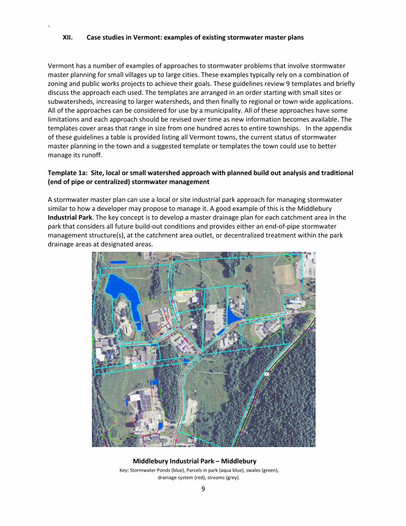
Vermont has a number of examples of approaches to stormwater problems that involve stormwater master planning for small villages up to large cities. These examples typically rely on a combination of zoning and public works projects to achieve their goals. These guidelines review 9 templates and briefly discuss the approach each used. The templates are arranged in an order starting with small sites or subwatersheds, increasing to larger watersheds, and then finally to regional or town wide applications. All of the approaches can be considered for use by a municipality. All of these approaches have some limitations and each approach should be revised over time as new information becomes available. The templates cover areas that range in size from one hundred acres to entire townships. In the appendix of these guidelines a table is provided listing all Vermont towns, the current status of stormwater master planning in the town and a suggested template or templates the town could use to better manage its runoff. Template 1a: Site, local or small watershed approach with planned build out analysis and traditional (end of pipe or centralized) stormwater management A stormwater master plan can use a local or site industrial park approach for managing stormwater similar to how a developer may propose to manage it. A good example of this is the Middlebury Industrial Park. The key concept is to develop a master drainage plan for each catchment area in the park that considers all future build-out conditions and provides either an end-of-pipe stormwater management structure(s), at the catchment area outlet, or decentralized treatment within the park drainage areas at designated areas.
Middlebury Industrial Park – Middlebury Key: Stormwater Ponds (blue), Parcels in park (aqua blue), swales (green), drainage system (red), streams (grey).
`
10
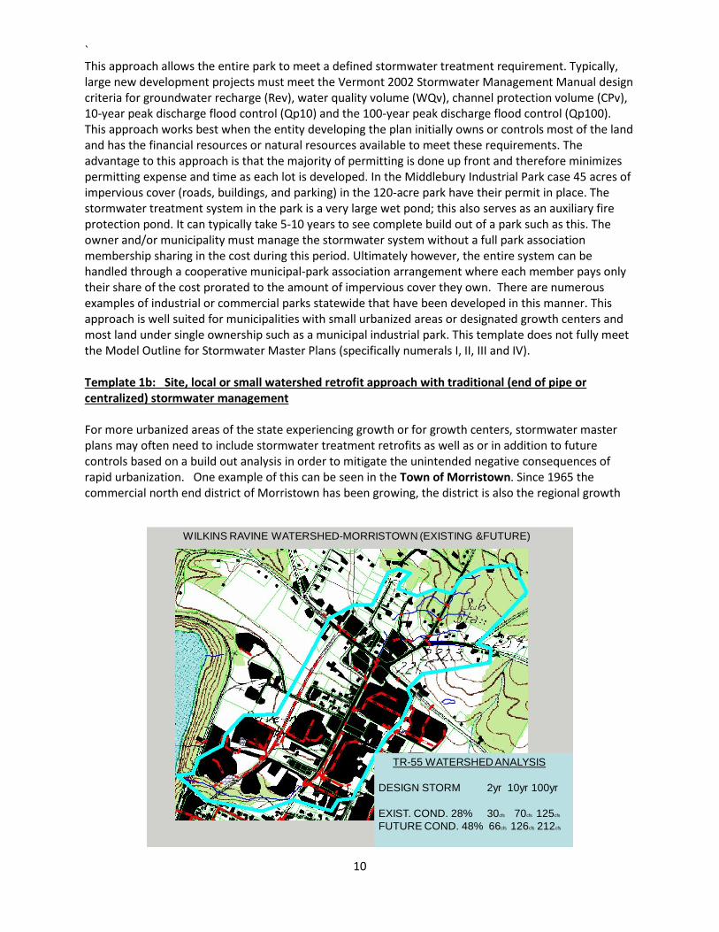
This approach allows the entire park to meet a defined stormwater treatment requirement. Typically, large new development projects must meet the Vermont 2002 Stormwater Management Manual design criteria for groundwater recharge (Rev), water quality volume (WQv), channel protection volume (CPv), 10-year peak discharge flood control (Qp10) and the 100-year peak discharge flood control (Qp100). This approach works best when the entity developing the plan initially owns or controls most of the land and has the financial resources or natural resources available to meet these requirements. The advantage to this approach is that the majority of permitting is done up front and therefore minimizes permitting expense and time as each lot is developed. In the Middlebury Industrial Park case 45 acres of impervious cover (roads, buildings, and parking) in the 120-acre park have their permit in place. The stormwater treatment system in the park is a very large wet pond; this also serves as an auxiliary fire protection pond. It can typically take 5-10 years to see complete build out of a park such as this. The owner and/or municipality must manage the stormwater system without a full park association membership sharing in the cost during this period. Ultimately however, the entire system can be handled through a cooperative municipal-park association arrangement where each member pays only their share of the cost prorated to the amount of impervious cover they own. There are numerous examples of industrial or commercial parks statewide that have been developed in this manner. This approach is well suited for municipalities with small urbanized areas or designated growth centers and most land under single ownership such as a municipal industrial park. This template does not fully meet the Model Outline for Stormwater Master Plans (specifically numerals I, II, III and IV). Template 1b: Site, local or small watershed retrofit approach with traditional (end of pipe or centralized) stormwater management For more urbanized areas of the state experiencing growth or for growth centers, stormwater master plans may often need to include stormwater treatment retrofits as well as or in addition to future controls based on a build out analysis in order to mitigate the unintended negative consequences of rapid urbanization. One example of this can be seen in the Town of Morristown. Since 1965 the commercial north end district of Morristown has been growing, the district is also the regional growth
WILKINS RAVINE WATERSHED-MORRISTOWN (EXISTING &FUTURE)
TR-55 WATERSHED ANALYSIS
DESIGN STORM 2yr 10yr 100yr
EXIST. COND. 28% 30cfs 70cfs 125cfs
FUTURE COND. 48% 66cfs 126cfs 212cfs
`
11
center for Lamoille County. The district largely drains to an unnamed tributary of the Lamoille River called the Wilkins Ravine. In the late 1990’s wastewater expansion feasibility studies conducted by the Town concluded that stormwater infrastructure in the growth center was inadequate. In 2000, an Act 250 permit application for a new development was denied due to the potential for increased erosion and siltation of the Wilkins Ravine and the threat to the trout fishery and habitat of the Lamoille River. In 2001, a culvert upgrade to reduce surcharging stormwater led in 2002 to a failure of a railroad embankment and a massive sediment discharge to the river. In response to this problem, Morristown, with assistance from VTDEC, developed a stormwater master plan consisting of a three-phase approach and requiring the implementation of 12 specific tasks. The three phases were:
• Stabilize and clean up the Wilkins Ravine receiving runoff from the north end commercial growth district.
• Install stormwater quality treatment controls and, where possible, quantity treatment controls in the developed area drainage network upstream of the Ravine.
• Reduce the overall volume of stormwater discharging to the Ravine by retaining water on-site and infiltrating to groundwater as much clean runoff as possible.
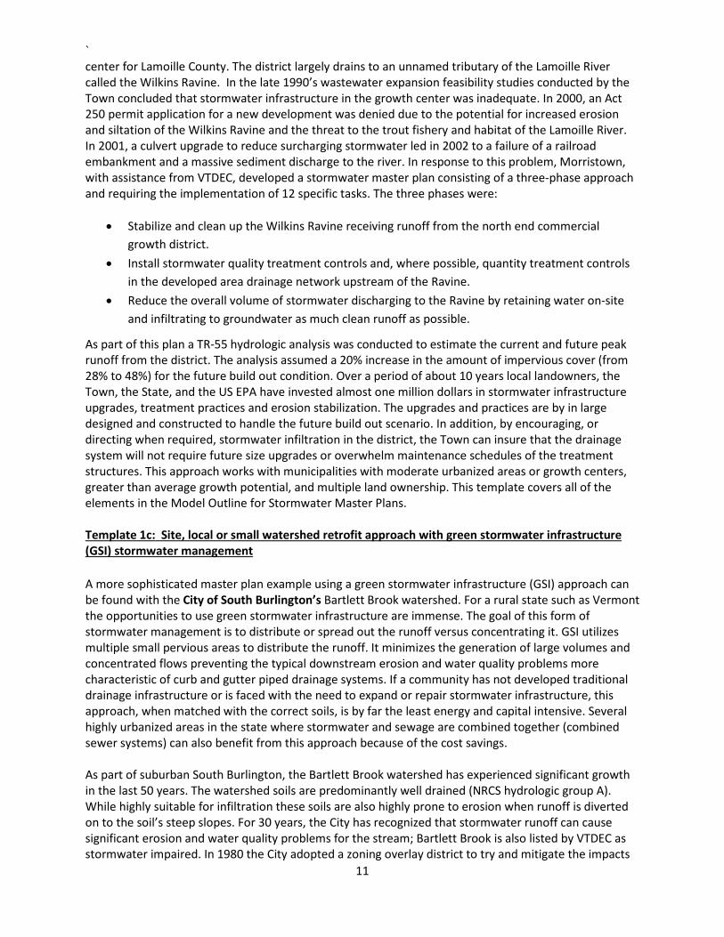
As part of this plan a TR-55 hydrologic analysis was conducted to estimate the current and future peak runoff from the district. The analysis assumed a 20% increase in the amount of impervious cover (from 28% to 48%) for the future build out condition. Over a period of about 10 years local landowners, the Town, the State, and the US EPA have invested almost one million dollars in stormwater infrastructure upgrades, treatment practices and erosion stabilization. The upgrades and practices are by in large designed and constructed to handle the future build out scenario. In addition, by encouraging, or directing when required, stormwater infiltration in the district, the Town can insure that the drainage system will not require future size upgrades or overwhelm maintenance schedules of the treatment structures. This approach works with municipalities with moderate urbanized areas or growth centers, greater than average growth potential, and multiple land ownership. This template covers all of the elements in the Model Outline for Stormwater Master Plans. Template 1c: Site, local or small watershed retrofit approach with green stormwater infrastructure (GSI) stormwater management A more sophisticated master plan example using a green stormwater infrastructure (GSI) approach can be found with the City of South Burlington’s Bartlett Brook watershed. For a rural state such as Vermont the opportunities to use green stormwater infrastructure are immense. The goal of this form of stormwater management is to distribute or spread out the runoff versus concentrating it. GSI utilizes multiple small pervious areas to distribute the runoff. It minimizes the generation of large volumes and concentrated flows preventing the typical downstream erosion and water quality problems more characteristic of curb and gutter piped drainage systems. If a community has not developed traditional drainage infrastructure or is faced with the need to expand or repair stormwater infrastructure, this approach, when matched with the correct soils, is by far the least energy and capital intensive. Several highly urbanized areas in the state where stormwater and sewage are combined together (combined sewer systems) can also benefit from this approach because of the cost savings. As part of suburban South Burlington, the Bartlett Brook watershed has experienced significant growth in the last 50 years. The watershed soils are predominantly well drained (NRCS hydrologic group A). While highly suitable for infiltration these soils are also highly prone to erosion when runoff is diverted on to the soil’s steep slopes. For 30 years, the City has recognized that stormwater runoff can cause significant erosion and water quality problems for the stream; Bartlett Brook is also listed by VTDEC as stormwater impaired. In 1980 the City adopted a zoning overlay district to try and mitigate the impacts
`
12
of new stormwater discharges. In 2010 recognizing the changing science of stormwater mitigation the City revised the requirements of the overlay district to mandate the use of GSI. The purpose of the district in part is to:
• To promote stormwater management practices that maintain predevelopment hydrology through site design, site development, building design and landscape design techniques that infiltrate, filter, store, evaporate and detain stormwater close to its source;
• To promote public safety from flooding and streambank erosion, reduce public expenditures in removing sediment from stormwater drainage systems and natural resource areas, and to prevent damage to municipal infrastructure from inadequate stormwater controls.
To accomplish this purpose the City has undertaken an extensive computer modeling and flow monitoring study of the stream to accurately assess the most damaging and erosive stormwater runoff events (1.5 yr. frequency: 2.2”/24 hour). The City requires that all new development disturbing more than ½ acre to use GSI practices and that the peak discharge rate from the proposed development site for this rain event not exceed the predevelopment rate. South Burlington’s plan also includes additional requirements as part of state and federal permits including: (1) compliance with the six minimum measures of the MS4 permit (Template 3c); (2) stream flow monitoring; and, (3) the development of a stormwater flow restoration plan for the Brook (Template 2c). This approach works best with municipalities with larger urbanized areas, well drained soils, and multiple land ownership. This template covers all the elements in the Model Outline for Stormwater Master Plans. Note: in 2016 the City adopted citywide stormwater regulations similar but not identical to this overlay district.
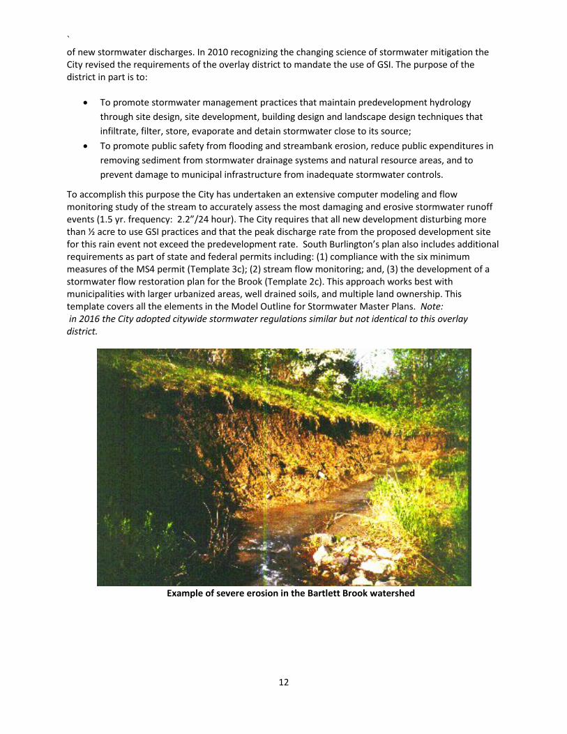
Example of severe erosion in the Bartlett Brook watershed
`
13
Template 2a: Hybrid site & community retrofit approach with green stormwater infrastructure (GSI) stormwater management
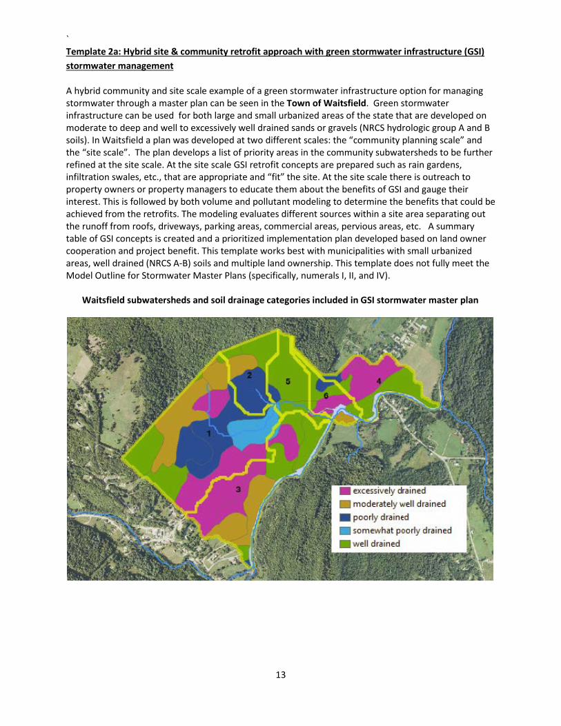
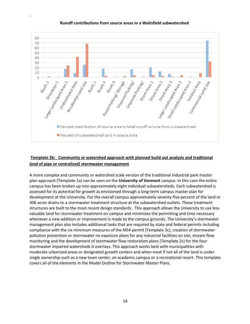
A hybrid community and site scale example of a green stormwater infrastructure option for managing stormwater through a master plan can be seen in the Town of Waitsfield. Green stormwater infrastructure can be used for both large and small urbanized areas of the state that are developed on moderate to deep and well to excessively well drained sands or gravels (NRCS hydrologic group A and B soils). In Waitsfield a plan was developed at two different scales: the “community planning scale” and the “site scale”. The plan develops a list of priority areas in the community subwatersheds to be further refined at the site scale. At the site scale GSI retrofit concepts are prepared such as rain gardens, infiltration swales, etc., that are appropriate and “fit” the site. At the site scale there is outreach to property owners or property managers to educate them about the benefits of GSI and gauge their interest. This is followed by both volume and pollutant modeling to determine the benefits that could be achieved from the retrofits. The modeling evaluates different sources within a site area separating out the runoff from roofs, driveways, parking areas, commercial areas, pervious areas, etc. A summary table of GSI concepts is created and a prioritized implementation plan developed based on land owner cooperation and project benefit. This template works best with municipalities with small urbanized areas, well drained (NRCS A-B) soils and multiple land ownership. This template does not fully meet the Model Outline for Stormwater Master Plans (specifically, numerals I, II, and IV). Waitsfield subwatersheds and soil drainage categories included in GSI stormwater master plan
`
14
Runoff contributions from source areas in a Waitsfield subwatershed
Template 2b: Community or watershed approach with planned build out analysis and traditional (end of pipe or centralized) stormwater management
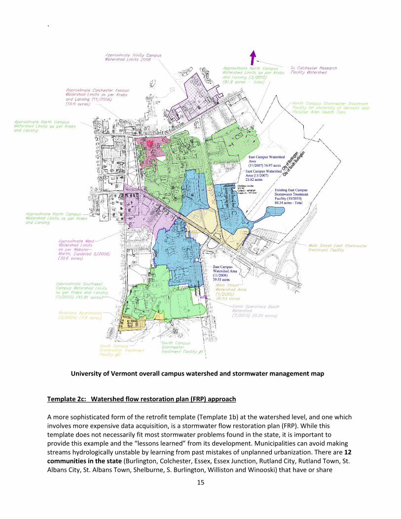
A more complex and community or watershed scale version of the traditional industrial park master plan approach (Template 1a) can be seen on the University of Vermont campus. In this case the entire campus has been broken up into approximately eight individual subwatersheds. Each subwatershed is assessed for its potential for growth as envisioned through a long-term campus master plan for development at the University. For the overall campus approximately seventy-five percent of the land or 306 acres drains to a stormwater treatment structure at the subwatershed outlets. These treatment structures are built to the most recent design standards. This approach allows the University to use less valuable land for stormwater treatment on campus and minimizes the permitting and time necessary whenever a new addition or improvement is made to the campus grounds. The University’s stormwater management plan also includes additional tasks that are required by state and federal permits including compliance with the six minimum measures of the MS4 permit (Template 3c), creation of stormwater pollution prevention or stormwater no exposure plans for any industrial facilities on site, stream flow monitoring and the development of stormwater flow restoration plans (Template 2c) for the four stormwater impaired watersheds it overlays. This approach works best with municipalities with moderate urbanized areas or designated growth centers and when most if not all of the land is under single ownership such as a new town center, an academic campus or a recreational resort. This template covers all of the elements in the Model Outline for Stormwater Master Plans.
`
15
University of Vermont overall campus watershed and stormwater management map
Template 2c: Watershed flow restoration plan (FRP) approach
A more sophisticated form of the retrofit template (Template 1b) at the watershed level, and one which involves more expensive data acquisition, is a stormwater flow restoration plan (FRP). While this template does not necessarily fit most stormwater problems found in the state, it is important to provide this example and the “lessons learned” from its development. Municipalities can avoid making streams hydrologically unstable by learning from past mistakes of unplanned urbanization. There are 12 communities in the state (Burlington, Colchester, Essex, Essex Junction, Rutland City, Rutland Town, St. Albans City, St. Albans Town, Shelburne, S. Burlington, Williston and Winooski) that have or share
`
16
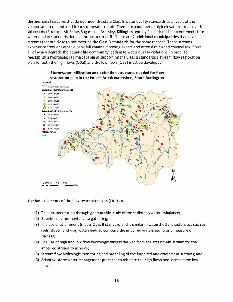
thirteen small streams that do not meet the state Class B water quality standards as a result of the volume and sediment load from stormwater runoff. There are a number of high elevation streams at 6 ski resorts (Stratton, Mt Snow, Sugarbush, Bromley, Killington and Jay Peak) that also do not meet state water quality standards due to stormwater runoff. There are 7 additional municipalities that have streams that are close to not meeting the Class B standards for the same reasons. These streams experience frequent erosive bank full channel flooding events and often diminished channel low flows all of which degrade the aquatic life community leading to water quality violations. In order to reestablish a hydrologic regime capable of supporting the Class B standards a stream flow restoration plan for both the high flows (Q0.3) and the low flows (Q95) must be developed. Stormwater infiltration and detention structures needed for flow
restoration plan in the Potash Brook watershed, South Burlington
The basic elements of the flow restoration plan (FRP) are:
(1) The documentation through geomorphic study of the sediment/water imbalance; (2) Baseline environmental data gathering; (3) The use of attainment (meets Class B standard and is similar in watershed characteristics such as
soils, slope, land use) watersheds to compare the impaired watershed to as a measure of success;
(4) The use of high and low flow hydrologic targets derived from the attainment stream for the impaired stream to achieve;
(5) Stream flow hydrologic monitoring and modeling of the impaired and attainment streams; and, (6) Adaptive stormwater management practices to mitigate the high flows and increase the low
flows.
`
17
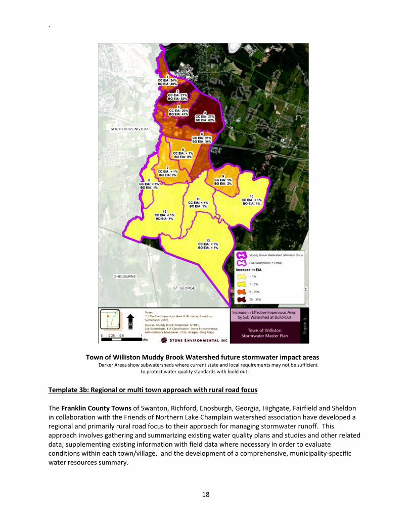
This approach to water resource management is firmly grounded in the sciences of stream geomorphology and aquatic biology. VTDEC has acquired the necessary data and tools to develop the FRPs with the thirteen communities. However, each community is responsible for final plan development, a compliance schedule for implementing the plan and the financial resources to implement the plan. Five ski resorts have developed plans similar to this template and to date have successfully remediated water quality impairments at two. In both the urban and ski resort examples extensive water quality and stream geomorphic monitoring studies have been conducted in collaboration with VTDEC. The watersheds have been broken out into subwatersheds and GIS infrastructure inventories have been completed. A suite of stormwater best management practices to address the water quality impairments have been, or will be, constructed as part of a long-term water quality or water volume remediation plan. Finally, a capital improvement plan with an adequate funding source has been defined as an integral companion to the stormwater management plan. This template is useful for extreme and wide spread water quality or water volume remediation problems. This template covers all of the elements in the master plan. Template 3a: Large watershed or regional approach with planned build out analysis and traditional (end of pipe or centralized) stormwater management An example of a watershed scale plan with a build out analysis approach can be seen in the Town of Williston. Since 1990, Williston’s population has more than doubled. As a result of this rapid growth, the subsequent urbanization of the town, and the subsequent increase in state and federal water quality permit requirements Williston has embarked on the development of a town-wide stormwater master plan including all of the Allen Brook, and the town-wide extent of the Muddy Brook watershed (termed a Town-wide Watershed Improvement Plan). The plan development involved a review of existing data and data gap identification, collection of all existing watershed related data, identification of problem areas from existing reports, local knowledge, and a field survey. A classification of problem areas from high to low based on a decision matrix was constructed and followed by field confirmation of all significant problem areas. Unique to this form of master planning is the modeling of scenarios to determine anticipated future peak stormwater flow rates and flow volumes for the 2-year, 10-year, 25-year, & 100-year 24-hour design storms. Williston’s plan incorporates the expected impact of existing State of Vermont stormwater permit requirements on projected future flow rates and volumes and identifies sub-watersheds where existing stormwater management regulations appear to be inadequate to control future stream flows. The plan also predicts future design flow rates and volumes (2-year, 10-year, 25-year, & 100-year) for all Level 3 (high priority) in-stream problem areas.
The Town of Williston’s plan also includes additional tasks that are required by state and federal permits including compliance with the six minimum measures of the MS4 permit (Template 3c), stream flow monitoring and the development of a stormwater flow restoration plan (Template 2c) for a stormwater impaired watershed. This approach works with municipalities with larger urbanized areas or growth centers, greater than average growth, and multiple land ownership. This template covers all of the elements in the master plan outline.
`
18
Town of Williston Muddy Brook Watershed future stormwater impact areas Darker Areas show subwatersheds where current state and local requirements may not be sufficient to protect water quality standards with build out.
Template 3b: Regional or multi town approach with rural road focus
The Franklin County Towns of Swanton, Richford, Enosburgh, Georgia, Highgate, Fairfield and Sheldon in collaboration with the Friends of Northern Lake Champlain watershed association have developed a regional and primarily rural road focus to their approach for managing stormwater runoff. This approach involves gathering and summarizing existing water quality plans and studies and other related data; supplementing existing information with field data where necessary in order to evaluate conditions within each town/village, and the development of a comprehensive, municipality-specific water resources summary.
`
19
The master plan for each town includes:
(1) A water quality library report; (2) A problem area report; (3) Problem area maps; and, (4) A prioritized list of projects.
This approach can be easily reconciled with any existing municipal road inventories and priority projects can be added to a municipality’s capital planning process. This template will work well with municipalities with very small urbanized areas and most impervious cover as existing roads (gravel and paved). Almost all Vermont municipalities can be characterized as predominantly rural with smaller urbanized areas. This template therefore can apply to the rural areas of most towns. A different template should be applied to the urbanized area(s) within the town. This template meets all of the master plan elements but could be enhanced by describing the “summary and recommendations” mentioned in the Model Outline for Stormwater Master Plans described above (in numeral V).
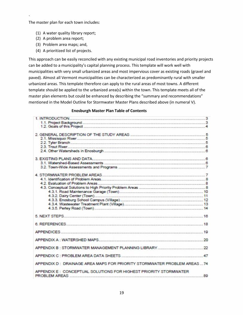
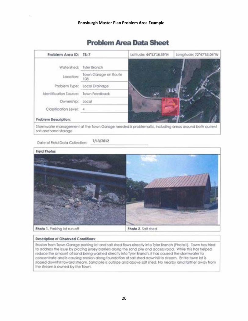
Enosburgh Master Plan Table of Contents
`
20
Enosburgh Master Plan Problem Area Example
Template 3c: Regional or multi town approach with municipal separate storm sewer system (MS4) minimum measure focus
Another regional example of a stormwater master plan that can be adopted by municipalities or groups of municipalities is a plan based on the federal municipal separate storm sewer system (MS4) permit requirements. In 1990 the US EPA began requiring certain large urbanized areas (Phase I) of the United States to be subject to the requirements of the MS4 permit. In 2000 the Vermont Legislature recognized the cost-effective nature of these measures and encouraged by statute, the adoption of these practices by all municipalities. In 2003, EPA expanded the permit jurisdiction to small MS4s (Phase II) which impacted some municipalities in Vermont. A small MS4 is any publicly owned MS4 not already covered by the Phase I program as a medium or large MS4 and which was located in “urbanized areas” (UAs) as defined by the Bureau of the Census, and on a case-by-case basis those small MS4s located outside of UAs that the permitting authority designates. As of 2016 there are 15 designated MS4s (Burlington, Burlington International Airport, Colchester, Essex, Essex Junction, Milton, Rutland Town, St. Albans City, St. Albans Town, Shelburne, S. Burlington, University of Vermont, Vermont Agency of Transportation, Williston and Winooski) subject to the Phase II rule in Vermont. Rutland City abides by the permit requirements voluntarily. In 2004 a Lake Champlain Basin Program study recommended increasing the number of towns subject to the permit requirements. The study recommended including all towns in New York and Vermont with populations of at least 3000 people and with at least 50% of the township area located in the lake watershed (Winsten, 2004). The requirements of the permit are essentially six minimum measures. These measures were developed through a national stakeholder process. The permit requires that over a 5-year period the designated MS4 adopt, implement or contract with others the required minimum measures, in a comprehensive manner such as through a master plan or municipal program. The six minimum measures are:
(1) Develop a public education and outreach effort on the impacts of stormwater runoff; (2) Involve the public in the stormwater plan development; (3) Develop and implement an illicit discharge, detection and elimination plan for nonstormwater discharges to the stormwater system; (4) Adopt a construction erosion control ordinance or reference a qualifying program; (5) Adopt a post-construction stormwater management ordinance or reference a qualifying program; and, (6) Develop and implement a good housekeeping/pollution prevention plan for all municipal facilities including public street sweeping and catch basin cleaning. Taken alone or in conjunction with other plans described above these six measures are simply good common sense. If adopted statewide they would greatly contribute to reducing the impact of stormwater runoff in Vermont. Examples of regional collaboration by municipalities to effectively meet these requirements and examples of nine MS4 stormwater management plans can be found at: http://www.smartwaterways.org/resources/local-resources/. This template does not fully cover Model Outline for Stormwater Master Plan (numerals I-V) and is better viewed as part of a more comprehensive stormwater management framework that could work in conjunction with any of the Templates.
`
22
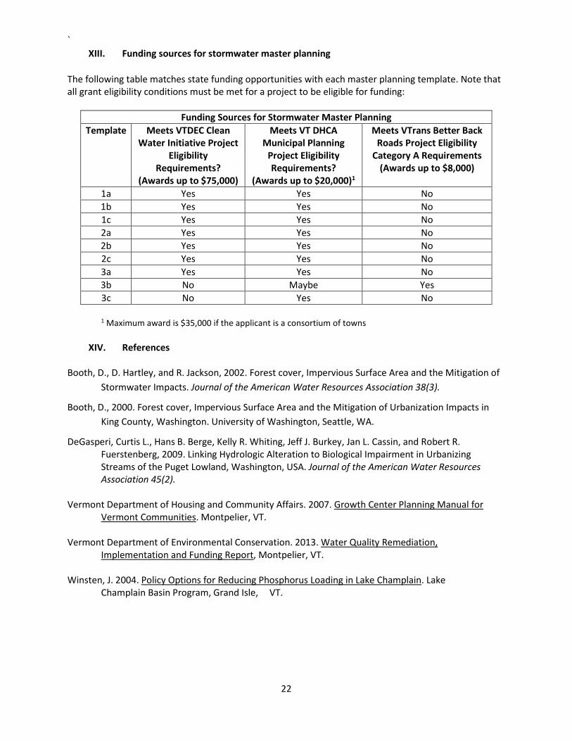
XIII. Funding sources for stormwater master planning
The following table matches state funding opportunities with each master planning template. Note that all grant eligibility conditions must be met for a project to be eligible for funding:
Funding Sources for Stormwater Master Planning Template Meets VTDEC Clean
Water Initiative Project Eligibility
Requirements? (Awards up to $75,000)
Meets VT DHCA Municipal Planning
Project Eligibility Requirements?
(Awards up to $20,000)1
Meets VTrans Better Back Roads Project Eligibility
Category A Requirements (Awards up to $8,000)
1a Yes Yes No 1b Yes Yes No 1c Yes Yes No 2a Yes Yes No 2b Yes Yes No 2c Yes Yes No 3a Yes Yes No 3b No Maybe Yes 3c No Yes No
1 Maximum award is $35,000 if the applicant is a consortium of towns
XIV. References Booth, D., D. Hartley, and R. Jackson, 2002. Forest cover, Impervious Surface Area and the Mitigation of
Stormwater Impacts. Journal of the American Water Resources Association 38(3).
Booth, D., 2000. Forest cover, Impervious Surface Area and the Mitigation of Urbanization Impacts in King County, Washington. University of Washington, Seattle, WA.
DeGasperi, Curtis L., Hans B. Berge, Kelly R. Whiting, Jeff J. Burkey, Jan L. Cassin, and Robert R. Fuerstenberg, 2009. Linking Hydrologic Alteration to Biological Impairment in Urbanizing Streams of the Puget Lowland, Washington, USA. Journal of the American Water Resources Association 45(2). Vermont Department of Housing and Community Affairs. 2007. Growth Center Planning Manual for Vermont Communities. Montpelier, VT. Vermont Department of Environmental Conservation. 2013. Water Quality Remediation, Implementation and Funding Report, Montpelier, VT. Winsten, J. 2004. Policy Options for Reducing Phosphorus Loading in Lake Champlain. Lake Champlain Basin Program, Grand Isle, VT.
`
23
XV. Template References
Example Stormwater Master Plans and Master Plan Webinars are posted on the VTDEC web site at: http://dec.vermont.gov/watershed/cwi/solutions/municipal-stormwater
1a. VTDEC Watershed Management Division Stormwater Section stormwater permit file # 3010-9010.A.
1b. Pease, J., ”Creating Partnerships at the Local Level: Morristown Vermont Case Study.” Presentation at the 2008 New England Nonpoint Source Conference, Groton CT.
http://click.neiwpcc.org/npsconference/08-presentations/Pease.pdf
1c. City of South Burlington Land Development Regulations (May 2012, page 175) 12.03 Stormwater Management Overlay District: http://www.sburl.com/vertical/Sites/%7BD1A8A14E-F9A2-40BE-A701-417111F9426B%7D/uploads/LDRs_9-24-13_Complete_No_Maps.pdf
City of South Burlington Zoning Overlay District map: http://www.southburlingtonvt.gov/Planning/Regulations%20&%20Plans/LDRs%20Effective%2012-11-2017%20Map%204%20Overlays.pdf
2a. Hurley. S. 2012. Green stormwater infrastructure Opportunities in Waitsfield, Vermont. Final Report, VTDEC Ecosystem Restoration Grant 2011-CCC-2-01.
2b. VTDEC Watershed Management Division Stormwater Section MS4 stormwater permit file for the University of Vermont, Notice of Intent for permit #3-9014, March 2008.
2c. VTDEC Watershed Management Division Stormwater Section web site:
http://dec.vermont.gov/watershed/stormwater/impaired-waters/stormwater-tmdls
Dubois & King Inc., 2012. Town of Williston Allen Brook Flow Restoration Plan Draft Report. http://dec.vermont.gov/sites/dec/files/wsm/erp/docs/erp_AllenBrook.pdf
3a. Stone Environmental Inc. 2013.Town of Williston Town-Wide Watershed Improvement Plan, Phase 1 Final Report. Project ID 12-055. Montpelier, VT.
3b. Stone Environmental Inc. 2013. Stormwater Management Plan for the Town of Enosburgh and the Village of Enosburg Falls Final Report. Project ID 112475-W. Montpelier, VT.
3c. US EPA Stormwater Phase II Final Rule Fact Sheet Series, Minimum Control Measures https://www.epa.gov/npdes/stormwater-phase-ii-final-rule-fact-sheet-series
XVI. Glossary
Act 250: Vermont’s land use and development law Green stormwater infrastructure (GSI): an approach to managing stormwater runoff that utilizes the natural infiltration capacity of the soil to filter and absorb water that otherwise becomes runoff. The utilization of existing soils and the natural vegetation of those soils can be a very cost-effective method for reducing stormwater pollution loads and stormwater runoff volume.
`
24
NRCS: United States Natural Resources Conservation Service
Stormwater retrofit: A structural or nonstructural practice installed after development has occurred in a watershed to reduce pollutants from stormwater runoff.
TMDL: A TMDL or Total Maximum Daily Load is a calculation of the maximum amount of a pollutant that a waterbody can receive and still meet water quality standards. Water quality standards identify the uses for each waterbody, for example, drinking water supply, contact recreation (swimming), and aquatic life support (fishing), and the scientific criteria to support that use. The Clean Water Act, section 303, establishes the water quality standards and TMDL programs.
TR-55: NRCS Hydrologic modeling program used for calculating predevelopment and post development stormwater peak discharges for varying storm sizes.
XVII. Credits
The principal author for this guidance is Jim Pease at the Vermont Department of Conservation, with assistance from Milly Archer of the Vermont League of Cities and Towns:
Jim Pease, Environmental Analyst, Clean Water Initiative Program, Vermont Department of Environmental Conservation, 1 National Life Drive, Montpelier, VT, (802) 490-6116, [email protected] Milly Archer, Water Resources Coordinator, Vermont League of Cities and Towns, 89 Street, Suite 4 Montpelier, VT 05602, (802) 229-9111, ext.1964, [email protected]
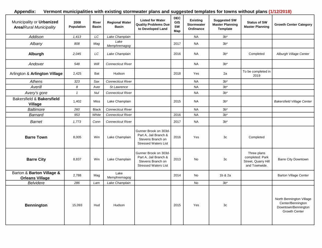
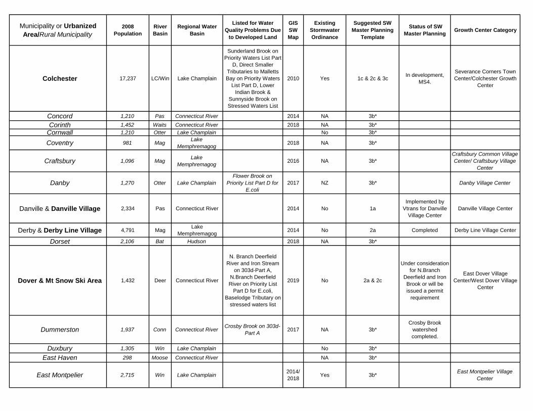
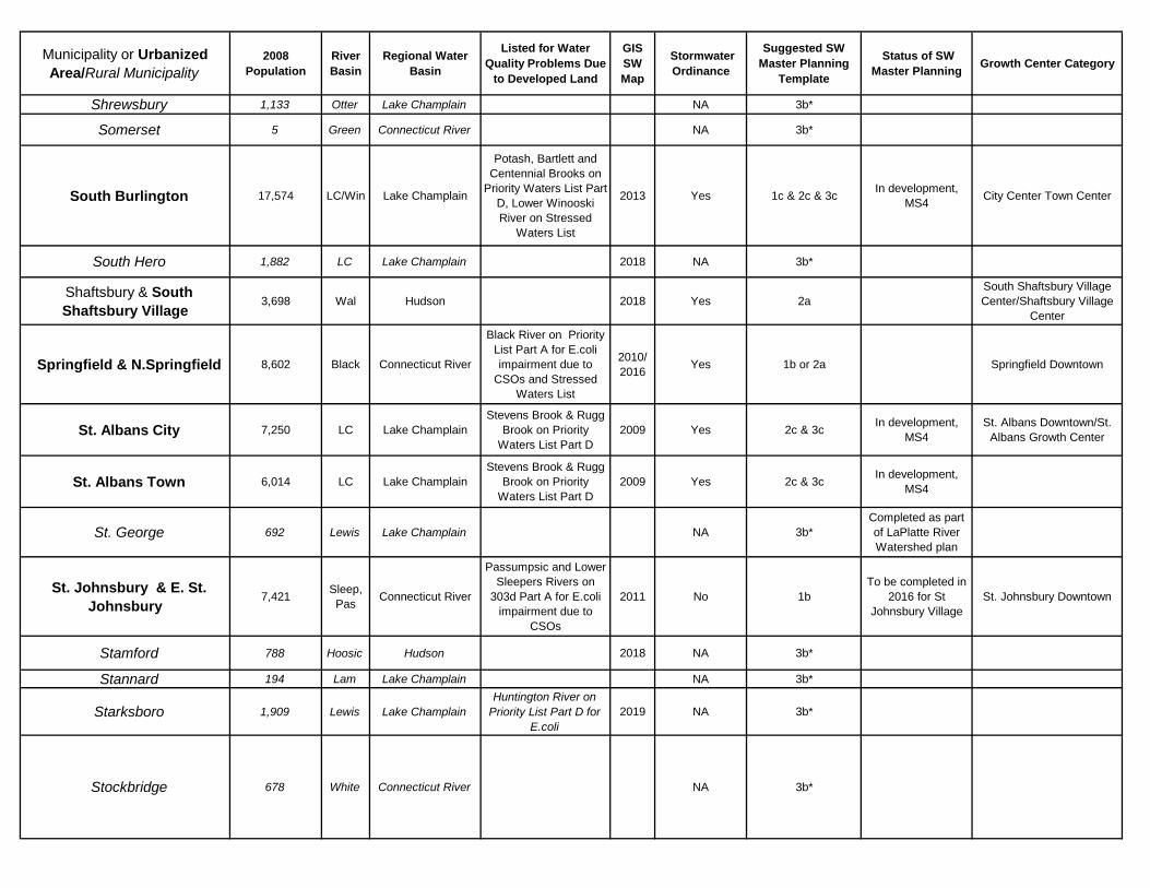
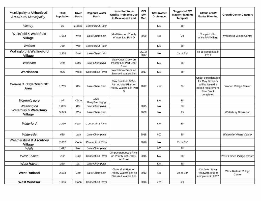
Appendix: Vermont municipalities with existing stormwater plans and suggested templates for towns without plans (1/12/2018)
Municipality or Urbanized Area/Rural Municipality
2008 Population
River Basin
Regional Water Basin
Listed for Water Quality Problems Due
to Developed Land
DEC GIS SW Map
Existing Stormwater Ordinance
Suggested SW Master Planning
Template
Status of SW Master Planning Growth Center Category
.. Addison 1,413 LC Lake Champlain NA 3b*
.. Albany 808 Mag Lake Memphremagog 2017 NA 3b*
..Alburgh 2,045 LC Lake Champlain 2016 NA 3b* Completed Alburgh Village Center
.. Andover 548 Will Connecticut River NA 3b*
..Arlington & Arlington Village 2,425 Bat Hudson 2018 Yes 2a To be completed in 2019
.. Athens 323 Sax Connecticut River NA 3b*
.. Averill 8 Aver St Lawrence NA 3b*
.. Avery's gore 1 Nul Connecticut River NA 3b*
..Bakersfield & Bakersfield Village
1,402 Miss Lake Champlain 2015 NA 3b* Bakersfield Village Center
.. Baltimore 260 Black Connecticut River NA 3b*
.. Barnard 953 White Connecticut River 2016 NA 3b*
.. Barnet 1,773 Conn Connecticut River 2017 NA 3b*
..Barre Town 8,005 Win Lake Champlain
Gunner Brook on 303d-Part A, Jail Branch & Stevens Branch on
Stressed Waters List
2016 Yes 3c Completed
..Barre City 8,837 Win Lake Champlain
Gunner Brook on 303d-Part A, Jail Branch & Stevens Branch on
Stressed Waters List
2013 No 3c
Three plans completed: Park
Street, Quarry Hill and Townwide.
Barre City Downtown
..Barton & Barton Village & Orleans Village
2,788 Mag Lake Memphremagog 2014 No 1b & 2a Barton Village Center
.. Belvidere 286 Lam Lake Champlain No 3b*
..Bennington 15,093 Hud Hudson 2015 Yes 3c
North Bennington Village Center/Bennington
Downtown/Bennington Growth Center
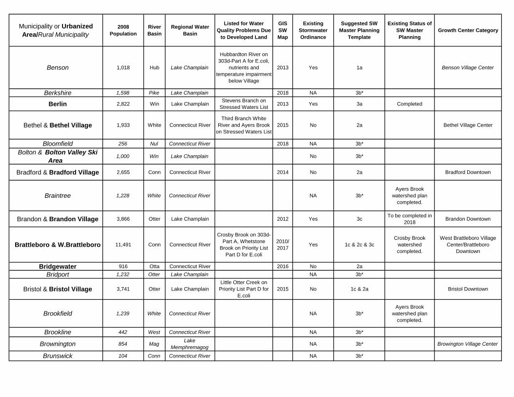
Municipality or Urbanized Area/Rural Municipality
2008 Population
River Basin
Regional Water Basin
Listed for Water Quality Problems Due
to Developed Land
GIS SW Map
Existing Stormwater Ordinance
Suggested SW Master Planning
Template
Existing Status of SW Master Planning
Growth Center Category
.. Benson 1,018 Hub Lake Champlain
Hubbardton River on 303d-Part A for E.coli,
nutrients and temperature impairment
below Village
2013 Yes 1a Benson Village Center
.. Berkshire 1,598 Pike Lake Champlain 2018 NA 3b*
..Berlin 2,822 Win Lake Champlain Stevens Branch on Stressed Waters List 2013 Yes 3a Completed
..Bethel & Bethel Village 1,933 White Connecticut RiverThird Branch White
River and Ayers Brook on Stressed Waters List
2015 No 2a Bethel Village Center
.. Bloomfield 256 Nul Connecticut River 2018 NA 3b*
.. Bolton & Bolton Valley Ski Area
1,000 Win Lake Champlain No 3b*
..Bradford & Bradford Village 2,655 Conn Connecticut River 2014 No 2a Bradford Downtown
.. Braintree 1,228 White Connecticut River NA 3b*Ayers Brook
watershed plan completed.
..Brandon & Brandon Village 3,866 Otter Lake Champlain 2012 Yes 3c To be completed in 2018 Brandon Downtown
..Brattleboro & W.Brattleboro 11,491 Conn Connecticut River
Crosby Brook on 303d-Part A, Whetstone
Brook on Priority List Part D for E.coli
2010/ 2017 Yes 1c & 2c & 3c
Crosby Brook watershed completed.
West Brattleboro Village Center/Brattleboro
Downtown
..Bridgewater 916 Otta Connecticut River 2016 No 2a.. Bridport 1,232 Otter Lake Champlain NA 3b*
..Bristol & Bristol Village 3,741 Otter Lake ChamplainLittle Otter Creek on
Priority List Part D for E.coli
2015 No 1c & 2a Bristol Downtown
.. Brookfield 1,239 White Connecticut River NA 3b*Ayers Brook
watershed plan completed.
.. Brookline 442 West Connecticut River NA 3b*
.. Brownington 854 Mag Lake Memphremagog NA 3b* Browington Village Center
.. Brunswick 104 Conn Connecticut River NA 3b*
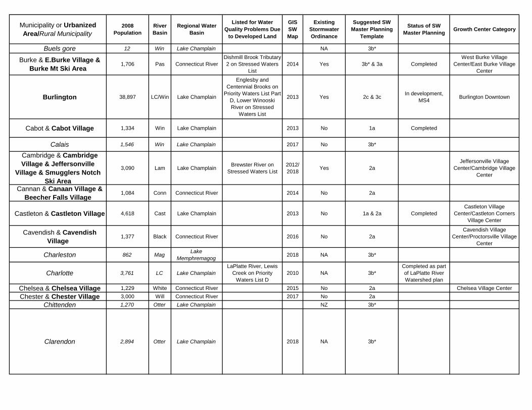
Municipality or Urbanized Area/Rural Municipality
2008 Population
River Basin
Regional Water Basin
Listed for Water Quality Problems Due
to Developed Land
GIS SW Map
Existing Stormwater Ordinance
Suggested SW Master Planning
Template
Status of SW Master Planning Growth Center Category
.. Buels gore 12 Win Lake Champlain NA 3b*
..Burke & E.Burke Village & Burke Mt Ski Area
1,706 Pas Connecticut RiverDishmill Brook Tributary 2 on Stressed Waters
List2014 Yes 3b* & 3a Completed
West Burke Village Center/East Burke Village
Center
..Burlington 38,897 LC/Win Lake Champlain
Englesby and Centennial Brooks on
Priority Waters List Part D, Lower Winooski River on Stressed
Waters List
2013 Yes 2c & 3c In development, MS4 Burlington Downtown
..Cabot & Cabot Village 1,334 Win Lake Champlain 2013 No 1a Completed
.. Calais 1,546 Win Lake Champlain 2017 No 3b*
..Cambridge & Cambridge Village & Jeffersonville
Village & Smugglers Notch Ski Area
3,090 Lam Lake Champlain Brewster River on Stressed Waters List
2012/ 2018 Yes 2a
Jeffersonville Village Center/Cambridge Village
Center
..Cannan & Canaan Village & Beecher Falls Village
1,084 Conn Connecticut River 2014 No 2a
..Castleton & Castleton Village 4,618 Cast Lake Champlain 2013 No 1a & 2a CompletedCastleton Village
Center/Castleton Corners Village Center
..Cavendish & Cavendish Village
1,377 Black Connecticut River 2016 No 2aCavendish Village
Center/Proctorsville Village Center
.. Charleston 862 Mag Lake Memphremagog 2018 NA 3b*
.. Charlotte 3,761 LC Lake ChamplainLaPlatte River, Lewis
Creek on Priority Waters List D
2010 NA 3b*Completed as part of LaPlatte River Watershed plan
..Chelsea & Chelsea Village 1,229 White Connecticut River 2015 No 2a Chelsea Village Center..Chester & Chester Village 3,000 Will Connecticut River 2017 No 2a
.. Chittenden 1,270 Otter Lake Champlain NZ 3b*
.. Clarendon 2,894 Otter Lake Champlain 2018 NA 3b*
Municipality or Urbanized Area/Rural Municipality
2008 Population
River Basin
Regional Water Basin
Listed for Water Quality Problems Due
to Developed Land
GIS SW Map
Existing Stormwater Ordinance
Suggested SW Master Planning
Template
Status of SW Master Planning Growth Center Category
..Colchester 17,237 LC/Win Lake Champlain
Sunderland Brook on Priority Waters List Part
D, Direct Smaller Tributaries to Malletts Bay on Priority Waters
List Part D, Lower Indian Brook &
Sunnyside Brook on Stressed Waters List
2010 Yes 1c & 2c & 3c In development, MS4.
Severance Corners Town Center/Colchester Growth
Center
.. Concord 1,210 Pas Connecticut River 2014 NA 3b*
.. Corinth 1,452 Waits Connecticut River 2018 NA 3b*.. Cornwall 1,210 Otter Lake Champlain No 3b*
.. Coventry 981 Mag Lake Memphremagog 2018 NA 3b*
.. Craftsbury 1,096 Mag Lake Memphremagog 2016 NA 3b*
Craftsbury Common Village Center/ Craftsbury Village
Center
.. Danby 1,270 Otter Lake ChamplainFlower Brook on
Priority List Part D for E.coli
2017 NZ 3b* Danby Village Center
..Danville & Danville Village 2,334 Pas Connecticut River 2014 No 1aImplemented by
Vtrans for Danville Village Center
Danville Village Center
..Derby & Derby Line Village 4,791 Mag Lake Memphremagog 2014 No 2a Completed Derby Line Village Center
.. Dorset 2,106 Bat Hudson 2018 NA 3b*
..Dover & Mt Snow Ski Area 1,432 Deer Connecticut River
N. Branch Deerfield River and Iron Stream
on 303d-Part A, N.Branch Deerfield River on Priority List
Part D for E.coli, Baselodge Tributary on
stressed waters list
2019 No 2a & 2c
Under consideration for N.Branch
Deerfield and Iron Brook or will be issued a permit
requirement
East Dover Village Center/West Dover Village
Center
.. Dummerston 1,937 Conn Connecticut River Crosby Brook on 303d-Part A 2017 NA 3b*
Crosby Brook watershed completed.
.. Duxbury 1,305 Win Lake Champlain No 3b*
.. East Haven 298 Moose Connecticut River NA 3b*
.. East Montpelier 2,715 Win Lake Champlain 2014/ 2018 Yes 3b* East Montpelier Village
Center
Municipality or Urbanized Area/Rural Municipality
2008 Population
River Basin
Regional Water Basin
Listed for Water Quality Problems Due
to Developed Land
GIS SW Map
Existing Stormwater Ordinance
Suggested SW Master Planning
Template
Status of SW Master Planning Growth Center Category
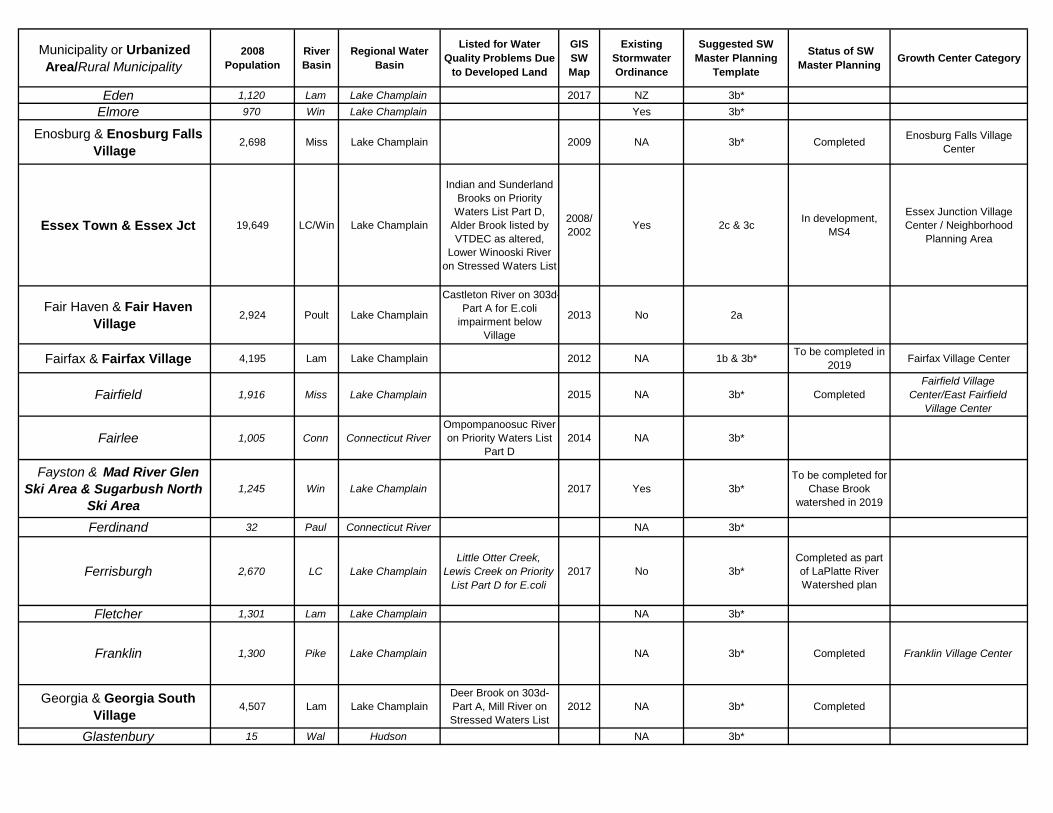
.. Eden 1,120 Lam Lake Champlain 2017 NZ 3b*.. Elmore 970 Win Lake Champlain Yes 3b*
..Enosburg & Enosburg Falls Village
2,698 Miss Lake Champlain 2009 NA 3b* Completed Enosburg Falls Village Center
..Essex Town & Essex Jct 19,649 LC/Win Lake Champlain
Indian and Sunderland Brooks on Priority
Waters List Part D, Alder Brook listed by VTDEC as altered,
Lower Winooski River on Stressed Waters List
2008/ 2002 Yes 2c & 3c In development,
MS4
Essex Junction Village Center / Neighborhood
Planning Area
..Fair Haven & Fair Haven Village
2,924 Poult Lake Champlain
Castleton River on 303d-Part A for E.coli
impairment below Village
2013 No 2a
..Fairfax & Fairfax Village 4,195 Lam Lake Champlain 2012 NA 1b & 3b* To be completed in 2019 Fairfax Village Center
.. Fairfield 1,916 Miss Lake Champlain 2015 NA 3b* CompletedFairfield Village
Center/East Fairfield Village Center
.. Fairlee 1,005 Conn Connecticut RiverOmpompanoosuc River on Priority Waters List
Part D2014 NA 3b*
.. Fayston & Mad River Glen Ski Area & Sugarbush North
Ski Area1,245 Win Lake Champlain 2017 Yes 3b*
To be completed for Chase Brook
watershed in 2019
.. Ferdinand 32 Paul Connecticut River NA 3b*
.. Ferrisburgh 2,670 LC Lake ChamplainLittle Otter Creek,
Lewis Creek on Priority List Part D for E.coli
2017 No 3b*Completed as part of LaPlatte River Watershed plan
.. Fletcher 1,301 Lam Lake Champlain NA 3b*
.. Franklin 1,300 Pike Lake Champlain NA 3b* Completed Franklin Village Center
..Georgia & Georgia South Village
4,507 Lam Lake ChamplainDeer Brook on 303d-Part A, Mill River on Stressed Waters List
2012 NA 3b* Completed
.. Glastenbury 15 Wal Hudson NA 3b*
Municipality or Urbanized Area/Rural Municipality
2008 Population
River Basin
Regional Water Basin
Listed for Water Quality Problems Due
to Developed Land
GIS SW Map
Existing Stormwater Ordinance
Suggested SW Master Planning
Template
Status of SW Master Planning Growth Center Category
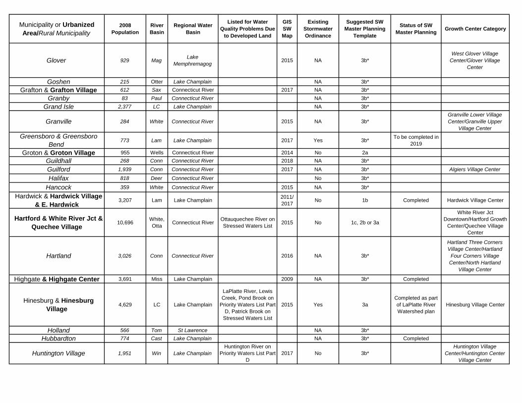
Glover 929 Mag Lake Memphremagog 2015 NA 3b*
West Glover Village Center/Glover Village
Center
.. Goshen 215 Otter Lake Champlain NA 3b*..Grafton & Grafton Village 612 Sax Connecticut River 2017 NA 3b*
.. Granby 83 Paul Connecticut River NA 3b*.. Grand Isle 2,377 LC Lake Champlain NA 3b*
.. Granville 284 White Connecticut River 2015 NA 3b*Granville Lower Village Center/Granville Upper
Village Center.. Greensboro & Greensboro
Bend773 Lam Lake Champlain 2017 Yes 3b* To be completed in
2019
..Groton & Groton Village 955 Wells Connecticut River 2014 No 2a.. Guildhall 268 Conn Connecticut River 2018 NA 3b*.. Guilford 1,939 Conn Connecticut River 2017 NA 3b* Algiers Village Center
.. Halifax 818 Deer Connecticut River No 3b*
.. Hancock 359 White Connecticut River 2015 NA 3b*
..Hardwick & Hardwick Village & E. Hardwick
3,207 Lam Lake Champlain 2011/ 2017 No 1b Completed Hardwick Village Center
..Hartford & White River Jct & Quechee Village
10,696 White, Otta Connecticut River Ottauquechee River on
Stressed Waters List 2015 No 1c, 2b or 3a
White River Jct Downtown/Hartford Growth
Center/Quechee Village Center
.. Hartland 3,026 Conn Connecticut River 2016 NA 3b*
Hartland Three Corners Village Center/Hartland
Four Corners Village Center/North Hartland
Village Center
Highgate & Highgate Center 3,691 Miss Lake Champlain 2009 NA 3b* Completed
..Hinesburg & Hinesburg Village
4,629 LC Lake Champlain
LaPlatte River, Lewis Creek, Pond Brook on
Priority Waters List Part D, Patrick Brook on
Stressed Waters List
2015 Yes 3aCompleted as part of LaPlatte River Watershed plan
Hinesburg Village Center
.. Holland 566 Tom St Lawrence NA 3b*.. Hubbardton 774 Cast Lake Champlain NA 3b* Completed
.. Huntington Village 1,951 Win Lake ChamplainHuntington River on
Priority Waters List Part D
2017 No 3b*Huntington Village
Center/Huntington Center Village Center
Municipality or Urbanized Area/Rural Municipality
2008 Population
River Basin
Regional Water Basin
Listed for Water Quality Problems Due
to Developed Land
GIS SW Map
Existing Stormwater Ordinance
Suggested SW Master Planning
Template
Status of SW Master Planning Growth Center Category
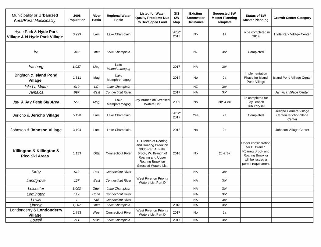
..Hyde Park & Hyde Park Village & N Hyde Park Village
3,299 Lam Lake Champlain 2012/ 2015 No 1a To be completed in
2019 Hyde Park Village Center
.. Ira 449 Otter Lake Champlain NZ 3b* Completed
.. Irasburg 1,037 Mag Lake Memphremagog 2017 NA 3b*
..Brighton & Island Pond Village
1,311 Mag Lake Memphremagog 2014 No 2a
Implementation Phase for Island
Pond VillageIsland Pond Village Center
.. Isle La Motte 510 LC Lake Champlain NZ 3b*
.. Jamaica 897 West Connecticut River 2017 NA 3b* Jamaica Village Center
.. Jay & Jay Peak Ski Area 555 Mag Lake Memphremagog
Jay Branch on Stressed Waters List 2009 No 3b* & 3c
3c completed for Jay Branch Tributary #9
..Jericho & Jericho Village 5,190 Lam Lake Champlain 2012/ 2017 Yes 2a Completed
Jericho Corners Village Center/Jericho Village
Center
..Johnson & Johnson Village 3,194 Lam Lake Champlain 2012 No 2a Johnson Village Center
..Killington & Killington & Pico Ski Areas
1,133 Otta Connecticut River
E. Branch of Roaring and Roaring Brook on
303d-Part A, Falls Brook, W. Branch of Roaring and Upper Roaring Brook on
Stressed Waters List
2016 No 2c & 3a
Under consideration for E. Branch
Roaring Brook and Roaring Brook or will be issued a
permit requirement
.. Kirby 518 Pas Connecticut River NA 3b*
.. Landgrove 137 West Connecticut River West River on Priority Waters List Part D NA 3b*
.. Leicester 1,003 Otter Lake Champlain NA 3b*
.. Lemington 117 Conn Connecticut River NA 3b*
.. Lewis 1 Nul Connecticut River NA 3b*.. Lincoln 1,267 Otter Lake Champlain 2018 NA 3b*
..Londonderry & Londonderry Village
1,793 West Connecticut River West River on Priority Waters List Part D 2017 No 2a
.. Lowell 711 Miss Lake Champlain 2017 NA 3b*
Municipality or Urbanized Area/Rural Municipality
2008 Population
River Basin
Regional Water Basin
Listed for Water Quality Problems Due
to Developed Land
GIS SW Map
Existing Stormwater Ordinance
Suggested SW Master Planning
Template
Status of SW Master Planning Growth Center Category
..Ludlow & Ludlow Village & Okemo Mt Ski Area
2,639 Black Connecticut River
Coleman Brook, Okemo Brook and Trailside Brook on stressed
waters list
2016 No 2a Ludlow Village Center
Lunenburg & Lunenburg Village & Gilman Village
1,285 Conn Connecticut River Scales Brook on Stressed Waters List 2014 NA 3b*
..Lyndon & Lyndonville 5,679 Pas Connecticut River 2014 No 2a Completed Lyndon Village Center.. Maidstone 106 Paul Connecticut River NA 3b*
..Manchester & Manchester Village
4,271 Bat Hudson 2018 Yes 1c
.. Marlboro 969 Deer Connecticut River 2017 NA 3b*
..Marshfield & Marshfield Village
1,593 Win Lake Champlain 2013 No 3b* Completed
.. Mendon 1,096 Otter Lake Champlain NA 3b*
..Middlebury & Middlebury Village
8,271 Otter Lake ChamplainMiddlebury River and
Otter Creek on Priority List Part D for E.coli
2012 No 3c Downtown east side completed
East Middlebury Village Center/Middlebury
Downtown
.. Middlesex & Putnamville 1,872 Win Lake ChamplainWinooski River below Middlesex on Stressed
Waters List2015 Yes 3b*
..Middletown Springs & Middletown Springs Village
802 Poult Lake Champlain Winooski below dam on Stressed Waters List 2013 No 2a
..Milton 10,714 Lam Lake Champlain Streeter Brook on Stressed Waters List 2004 Yes 3c Completed for MS4
designated area
.. Monkton 1,977 Lewis Lake ChamplainLittle Otter Creek, Lewis
Creek on Priority List Part D for E.coli
NA 3b*
..Montgomery & Montgomery Village
1,053 Miss Lake Champlain 2009 No 1a or 2aMontgomery Village
Center/Montgomery Center Village Center
..Montpelier 7,760 Win Lake Champlain
Winooski River & Lower N.Branch Winooski
River on 303d-Part A for E.coli, Winooski
above city on Stressed Waters List
2015 No 3c CompletedMontpelier
Downtown/Montpelier Growth Center
Municipality or Urbanized Area/Rural Municipality
2008 Population
River Basin
Regional Water Basin
Listed for Water Quality Problems Due
to Developed Land
GIS SW Map
Existing Stormwater Ordinance
Suggested SW Master Planning
Template
Status of SW Master Planning Growth Center Category
.. Moretown 1,730 Win Lake Champlain Mad River on Priority List Part D for E.coli 2015 NA 3b*
.. Morgan 744 Mag Lake Memphremagog NA 3b*
..Morristown & Morrisville 5,561 Lam Lake Champlain 2012 Yes 1b To be completed in 2019 Morrisville Downtown
.. Mount Holly & Belmont Village
1,216 Otter Lake Champlain 2017 NA 3b* Belmont Village Center
.. Mount Tabor 198 Otter Lake Champlain NZ 3b*
.. New Haven 1,829 Lit Otter Lake Champlain
Little Otter Creek on Priority List Part D for
E.coliNA 3b* New Haven Village Center
.. Newark 457 Pas Connecticut River NA 3b*
.. Newbury & Newbury Village & Wells River Village
2,167 Conn Connecticut River 2014 NA 3b*
.. Newfane 1,702 West Connecticut River 2017 NA 3b*
..Newport City 5,148 Mag Lake Memphremagog 2014 No 3c Completed Newport Downtown
.. Newport Town & Newport Center
2,032 Mag Lake Memphremagog 2015 NA 3b*
.. North Hero 915 LC Lake Champlain NA 3b* North Hero Village Center
..Northfield & Northfield Village
5,740 Win Lake Champlain 2014 Yes 2a Implementation Phase
Northfield Village Center/Riverside Village
Center.. Norton 231 Conti St Lawrence NA 3b*
..Norwich & Norwich Village 3,523 Conn Connecticut River 2014 Yes 2a Norwich Village Center.. Orange 961 Win Lake Champlain NZ 3b*.. Orwell 1,219 East Lake Champlain 2015 NA 3b* Orwell Village Center.. Panton 683 LC Lake Champlain NA 3b*
..Pawlet 1,418 Met Hudson Flower Brook on Priority List Part D for E.coli 2015 NA 3b*
To be completed in 2016 for the Flower Brook watershed
Pawlet Village Center/West Pawlet Village Center
.. Peacham 670 Conn Connecticut River NA 3b* Peacham Village Center
.. Peru & Bromley Mt Ski Area 425 West Connecticut River
West River on Priority Waters List Part D, Mill Brook Tributary #6 on
303d Part A for stormwater
2017 NA 3b* Peru Village Center
Municipality or Urbanized Area/Rural Municipality
2008 Population
River Basin
Regional Water Basin
Listed for Water Quality Problems Due
to Developed Land
GIS SW Map
Existing Stormwater Ordinance
Suggested SW Master Planning
Template
Status of SW Master Planning Growth Center Category
.. Pittsfield 417 White Connecticut River 2015 NA 3b* Pittsfield Village Center
..Pittsford & Pittsford Village 3,195 Otter Lake Champlain 2012 NA 2aCompleted for Castleton River
watershedPittsford Village Center
..Plainfield & Plainfield Village 1,339 Win Lake Champlain 2013 Yes 2a or 3b* Completed
.. Plymouth 566 Black Connecticut River 2016 NA 3b*
.. Pomfret 955 Conn Connecticut River NA 3b*
..Poultney & Poultney Village 3,532 Poult Lake Champlain 2013 No 2aImplementation
Phase for Poultney Village
East Poultney Village Center/Poultney Downtown
.. Pownal 3,442 Hud Hudson 2018 NA 3b*..Proctor & Proctor Village 1,810 Otter Lake Champlain 2012 Yes 1b or 3b*
.. Putney 2,600 Conn Connecticut River 2017 NA 3b* Putney Village Center
..Randolph & Randolph Village & Vermont Tech
College5,037 White Connecticut River
Third Branch White River and Ayers Brook
on Stressed Waters List2015 Yes 2a
Ayers Brook watershed plan
completed.
East Randolph Village Center/Randolph Downtown
.. Reading 709 Black Connecticut River 2018 NA 3b*
.. Readsboro 764 Deer Connecticut River 2018 NA 3b* Readsboro Village Center
..Richford & Richford Village 2,293 Miss Lake Champlain 2009 No 2a or 3b* To be completed in 2019 Richford Village Center
..Richmond & Richmond Village
4,160 Win Lake Champlain 2009 Yes 2a To be completed in 2019 Richmond Village Center
.. Ripton 586 Otter Lake Champlain NA 3b*..Rochester & Rochester
Village1,123 White Connecticut River 2015 No 2a or 3b* To be completed in
2019 Rochester Village Center
..Rockingham & Saxtons River Village & Bellows Falls
Village4,949 Conn Connecticut River Lower Williams River
on Stressed Waters List 2016 Yes 2aSaxtons River Village Center/Bellows Falls
Downtown
.. Roxbury 551 White Connecticut River 2018 NA 3b*
Municipality or Urbanized Area/Rural Municipality
2008 Population
River Basin
Regional Water Basin
Listed for Water Quality Problems Due
to Developed Land
GIS SW Map
Stormwater Ordinance
Suggested SW Master Planning
Template
Status of SW Master Planning Growth Center Category
..Royalton & S.Royalton Village
2,439 White Connecticut River 2015 No 2aRoyalton Village
Center/South Royalton Village Center
.. Rupert 705 Met & Bat
Lake Champlain & Hudson NA 3b*
Completed for White Creek and
Mill Brook watersheds
..Rutland City 16,742 Otter Lake Champlain
Moon Brook on Priority Waters List Part D, Tenney Brook on
Stressed Waters List, Lower East Creek and
Otter Creek below WWTP on Part A for
E.coli
2012 Yes 2c & 3cCompleted for
Tenney Brook-E Creek area of City.
Rutland Downtown
..Rutland Town 4,076 Otter Lake Champlain
Moon Brook on Priority Waters List Part D,
Tenney Brook listed by VTDEC as stressed
2012 No 2c & 3c In development, MS4
.. Ryegate & E.Ryegate Village and South Ryegate Village
1,201 Wells Connecticut River 2014 NA 3b*
.. Salisbury 1,091 Otter Lake Champlain NA 3b*.. Sandgate 349 Bat Hudson NA 3b* Completed.. Searsburg 89 Green Connecticut River NA 3b*
.. Sharon 1,328 White Connecticut River 2015 NA 3b* Sharon Village Center
.. Sheffield 706 Pas Connecticut River 2018 NA 3b*
..Shelburne 7,146 LC Lake ChamplainMunroe Brook, LaPlatte River on Priority Waters
List Part D2009 Yes 2c & 3c
In development, MS4. Also part of
LaPlatte River Watershed plan
Shelburne Village Center / Neighborhood Planning
Area
..Sheldon 2,303 Miss Lake Champlain 2009/ 2018 Yes 3b* Completed
.. Shoreham 1,294 Otter Lake Champlain 2015 Yes 3b*
Municipality or Urbanized Area/Rural Municipality
2008 Population
River Basin
Regional Water Basin
Listed for Water Quality Problems Due
to Developed Land
GIS SW Map
Stormwater Ordinance
Suggested SW Master Planning
Template
Status of SW Master Planning Growth Center Category
.. Shrewsbury 1,133 Otter Lake Champlain NA 3b*
.. Somerset 5 Green Connecticut River NA 3b*
..South Burlington 17,574 LC/Win Lake Champlain
Potash, Bartlett and Centennial Brooks on
Priority Waters List Part D, Lower Winooski River on Stressed
Waters List
2013 Yes 1c & 2c & 3c In development, MS4 City Center Town Center
.. South Hero 1,882 LC Lake Champlain 2018 NA 3b*
..Shaftsbury & South Shaftsbury Village
3,698 Wal Hudson 2018 Yes 2aSouth Shaftsbury Village Center/Shaftsbury Village
Center
..Springfield & N.Springfield 8,602 Black Connecticut River
Black River on Priority List Part A for E.coli impairment due to
CSOs and Stressed Waters List
2010/ 2016 Yes 1b or 2a Springfield Downtown
..St. Albans City 7,250 LC Lake ChamplainStevens Brook & Rugg
Brook on Priority Waters List Part D
2009 Yes 2c & 3c In development, MS4
St. Albans Downtown/St. Albans Growth Center
..St. Albans Town 6,014 LC Lake ChamplainStevens Brook & Rugg
Brook on Priority Waters List Part D
2009 Yes 2c & 3c In development, MS4
.. St. George 692 Lewis Lake Champlain NA 3b*Completed as part of LaPlatte River Watershed plan
..St. Johnsbury & E. St. Johnsbury
7,421 Sleep, Pas Connecticut River
Passumpsic and Lower Sleepers Rivers on
303d Part A for E.coli impairment due to
CSOs
2011 No 1bTo be completed in
2016 for St Johnsbury Village
St. Johnsbury Downtown
.. Stamford 788 Hoosic Hudson 2018 NA 3b*
.. Stannard 194 Lam Lake Champlain NA 3b*
.. Starksboro 1,909 Lewis Lake ChamplainHuntington River on
Priority List Part D for E.coli
2019 NA 3b*
.. Stockbridge 678 White Connecticut River NA 3b*
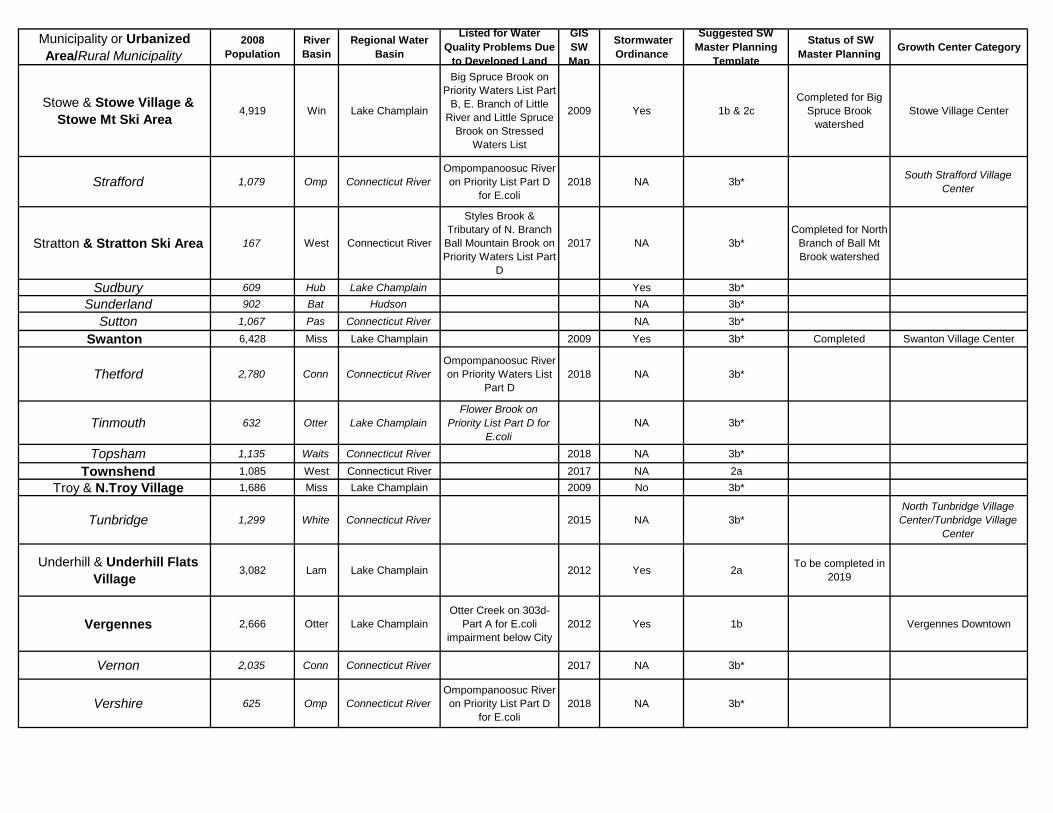
Municipality or Urbanized Area/Rural Municipality
2008 Population
River Basin
Regional Water Basin
Listed for Water Quality Problems Due
to Developed Land
GIS SW Map
Stormwater Ordinance
Suggested SW Master Planning
Template
Status of SW Master Planning Growth Center Category
..Stowe & Stowe Village & Stowe Mt Ski Area
4,919 Win Lake Champlain
Big Spruce Brook on Priority Waters List Part
B, E. Branch of Little River and Little Spruce
Brook on Stressed Waters List
2009 Yes 1b & 2cCompleted for Big
Spruce Brook watershed
Stowe Village Center
.. Strafford 1,079 Omp Connecticut RiverOmpompanoosuc River on Priority List Part D
for E.coli2018 NA 3b* South Strafford Village
Center
..Stratton & Stratton Ski Area 167 West Connecticut River
Styles Brook & Tributary of N. Branch
Ball Mountain Brook on Priority Waters List Part
D
2017 NA 3b*Completed for North
Branch of Ball Mt Brook watershed
.. Sudbury 609 Hub Lake Champlain Yes 3b*.. Sunderland 902 Bat Hudson NA 3b*
.. Sutton 1,067 Pas Connecticut River NA 3b*
Swanton 6,428 Miss Lake Champlain 2009 Yes 3b* Completed Swanton Village Center
.. Thetford 2,780 Conn Connecticut RiverOmpompanoosuc River on Priority Waters List
Part D2018 NA 3b*
.. Tinmouth 632 Otter Lake ChamplainFlower Brook on
Priority List Part D for E.coli
NA 3b*
.. Topsham 1,135 Waits Connecticut River 2018 NA 3b*
..Townshend 1,085 West Connecticut River 2017 NA 2a..Troy & N.Troy Village 1,686 Miss Lake Champlain 2009 No 3b*
.. Tunbridge 1,299 White Connecticut River 2015 NA 3b*North Tunbridge Village
Center/Tunbridge Village Center
..Underhill & Underhill Flats Village
3,082 Lam Lake Champlain 2012 Yes 2a To be completed in 2019
..Vergennes 2,666 Otter Lake ChamplainOtter Creek on 303d-
Part A for E.coli impairment below City
2012 Yes 1b Vergennes Downtown
.. Vernon 2,035 Conn Connecticut River 2017 NA 3b*
.. Vershire 625 Omp Connecticut RiverOmpompanoosuc River on Priority List Part D
for E.coli2018 NA 3b*
Municipality or Urbanized Area/Rural Municipality
2008 Population
River Basin
Regional Water Basin
Listed for Water Quality Problems Due
to Developed Land
GIS SW Map
Stormwater Ordinance
Suggested SW Master Planning
Template
Status of SW Master Planning Growth Center Category
Victory 95 Moose Connecticut River NA 3b*
..Waitsfield & Waitsfield Village
1,683 Win Lake Champlain Mad River on Priority Waters List Part D 2009 No 2a Completed for
Waitsfield Village Waitsfield Village Center
.. Walden 760 Pas Connecticut River NA 3b*
..Wallingford & Wallingford Village
2,324 Otter Lake Champlain 2012/ 2017 No 2a or 3b* To be completed in
2019
.. Waltham 478 Otter Lake ChamplainLittle Otter Creek on
Priority List Part D for E.coli
NA 3b*
..Wardsboro 906 West Connecticut River Wardsboro Brook on Stressed Waters List 2017 NA 3b*
.. Warren & Sugarbush Ski Area
1,735 Win Lake Champlain
Clay Brook on 303d-Part A, Mad River on
Priority Waters List Part D
2017 Yes 3b*
Under consideration for Clay Brook or will be issued a
permit requirement, Rice Brook completed
Warren Village Center
.. Warren's gore 10 Clyde Lake Memphremagog NA 3b*
.. Washington 1,095 Win Lake Champlain 2015 No 3b*..Waterbury & Waterbury
Village5,349 Win Lake Champlain 2009 No 2a Waterbury Downtown
.. Waterford 1,220 Conn Connecticut River NA 3b*
.. Waterville 680 Lam Lake Champlain 2018 NZ 3b* Waterville Village Center
..Weathersfield & Ascutney Village
2,832 Conn Connecticut River 2016 No 2a or 3b*
.. Wells 1,092 Met Lake Champlain NZ 3b*
.. West Fairlee 722 Omp Connecticut RiverOmpompanoosuc River on Priority List Part D
for E.coli2015 NA 3b* West Fairlee Village Center
.. West Haven 310 LC Lake Champlain NA 3b*
..West Rutland 2,513 Cast Lake ChamplainClarendon River on
Priority Waters List on Stressed Waters List
2012 No 2a or 3b*Castleton River
Headwaters to be completed in 2017
West Rutland Village Center
..West Windsor 1,096 Conn Connecticut River 2016 Yes 2a
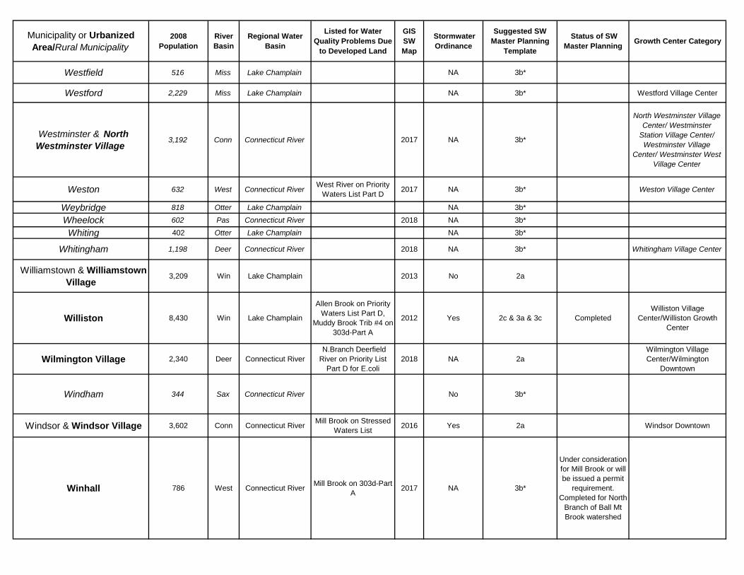
Municipality or Urbanized Area/Rural Municipality
2008 Population
River Basin
Regional Water Basin
Listed for Water Quality Problems Due
to Developed Land
GIS SW Map
Stormwater Ordinance
Suggested SW Master Planning
Template
Status of SW Master Planning Growth Center Category
.. Westfield 516 Miss Lake Champlain NA 3b*
.. Westford 2,229 Miss Lake Champlain NA 3b* Westford Village Center
.. Westminster & North Westminster Village
3,192 Conn Connecticut River 2017 NA 3b*
North Westminster Village Center/ Westminster
Station Village Center/ Westminster Village
Center/ Westminster West Village Center
.. Weston 632 West Connecticut River West River on Priority Waters List Part D 2017 NA 3b* Weston Village Center
.. Weybridge 818 Otter Lake Champlain NA 3b*
.. Wheelock 602 Pas Connecticut River 2018 NA 3b*
.. Whiting 402 Otter Lake Champlain NA 3b*
.. Whitingham 1,198 Deer Connecticut River 2018 NA 3b* Whitingham Village Center
..Williamstown & Williamstown Village
3,209 Win Lake Champlain 2013 No 2a
..Williston 8,430 Win Lake Champlain
Allen Brook on Priority Waters List Part D,
Muddy Brook Trib #4 on 303d-Part A
2012 Yes 2c & 3a & 3c CompletedWilliston Village
Center/Williston Growth Center
..Wilmington Village 2,340 Deer Connecticut River N.Branch Deerfield River on Priority List
Part D for E.coli2018 NA 2a
Wilmington Village Center/Wilmington
Downtown
.. Windham 344 Sax Connecticut River No 3b*
..Windsor & Windsor Village 3,602 Conn Connecticut River Mill Brook on Stressed Waters List 2016 Yes 2a Windsor Downtown
..Winhall 786 West Connecticut River Mill Brook on 303d-Part A 2017 NA 3b*
Under consideration for Mill Brook or will be issued a permit
requirement. Completed for North
Branch of Ball Mt Brook watershed
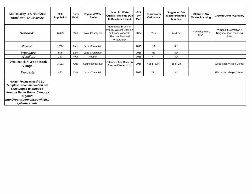
Municipality or Urbanized Area/Rural Municipality
2008 Population
River Basin
Regional Water Basin
Listed for Water Quality Problems Due
to Developed Land
GIS SW Map
Stormwater Ordinance
Suggested SW Master Planning
Template
Status of SW Master Planning Growth Center Category
Winooski 6,429 Win Lake Champlain
Morehouse Brook on Priority Waters List Part
D, Lower Winooski River on Stressed
Waters List
2004 Yes 2c & 3c In development, MS4
Winooski Downtown / Neighborhood Planning
Area
Wolcott 1,714 Lam Lake Champlain 2015 NA 3b*
.. Woodbury 808 Lam Lake Champlain 2018 No 3b*.. Woodford 387 Wal Hudson 2018 NA 3b*
..Woodstock & Woodstock Village
3,133 Otta Connecticut River Ottauquechee River on Stressed Waters List 2016 Yes (Town) 1b or 2a Woodstock Village Center
.. Worcester 860 Win Lake Champlain 2015 No 3b* Worcester Village Center
*Note: Towns with the 3b
Template recommendation are encouraged to pursue a
Vermont Better Roads Category A grant:
http://vtrans.vermont.gov/highway/better-roads