Embed Size (px)
Citation preview

Version 1.0
klm
General Certificate of Secondary Education June 2010
Geography A 40301H
Higher Tier
Unit 1
Mark Scheme
Mark schemes are prepared by the Principal Examiner and considered, together with the relevant questions, by a panel of subject teachers. This mark scheme includes any amendments made at the standardisation meeting attended by all examiners and is the scheme which was used by them in this examination. The standardisation meeting ensures that the mark scheme covers the candidates’ responses to questions and that every examiner understands and applies it in the same correct way. As preparation for the standardisation meeting each examiner analyses a number of candidates’ scripts: alternative answers not already covered by the mark scheme are discussed at the meeting and legislated for. If, after this meeting, examiners encounter unusual answers which have not been discussed at the meeting they are required to refer these to the Principal Examiner. It must be stressed that a mark scheme is a working document, in many cases further developed and expanded on the basis of candidates’ reactions to a particular paper. Assumptions about future mark schemes on the basis of one year’s document should be avoided; whilst the guiding principles of assessment remain constant, details will change, depending on the content of a particular examination paper.
Further copies of this Mark Scheme are available to download from the AQA Website: www.aqa.org.uk Copyright © 2010 AQA and its licensors. All rights reserved. COPYRIGHT AQA retains the copyright on all its publications. However, registered centres for AQA are permitted to copy material from this booklet for their own internal use, with the following important exception: AQA cannot give permission to centres to photocopy any material that is acknowledged to a third party even for internal use within the centre. Set and published by the Assessment and Qualifications Alliance.
The Assessment and Qualifications Alliance (AQA) is a company limited by guarantee registered in England and Wales (company number 3644723) and a registered charity (registered charity number 1073334). Registered address: AQA, Devas Street, Manchester M15 6EX

Geography A - AQA GCSE Mark Scheme 2010 June series
3
GENERAL GUIDANCE FOR GCSE GEOGRAPHY ASSISTANT EXAMINERS
Quality of Written Communication Where candidates are required to produce extended written material in English, they will be assessed on the quality of written communication. Candidates will be required to: present relevant information in a form and style that suits its purpose; ensure that text is legible and that spelling, punctuation and grammar are accurate; use specialist vocabulary where appropriate. Levels Marking - General Criteria Where answers are assessed using a level of response marking system the following general criteria should be used. Level 1: Basic Knowledge of basic information
Simple understanding Little organisation; few links; little or no detail; uses a limited range of specialist terms Reasonable accuracy in the use of spelling, punctuation and grammar Text is legible.
Level 2: Clear Knowledge of accurate information Clear understanding
Organised answers, with some linkages; occasional detail/exemplar; uses a good range of specialist terms where appropriate
Considerable accuracy in spelling, punctuation and grammar Text is legible. Level 3: Detailed Knowledge of accurate information appropriately contextualised and/or at correct scale Detailed understanding, supported by relevant evidence and exemplars
Well organized, demonstrating detailed linkages and the inter-relationships between factors Clear and fluent expression of ideas in a logical form; uses a wide range of specialist terms where appropriate Accurate use of spelling, punctuation and grammar Text is legible Level 3 does not always equate to full marks, a perfect answer is not usually expected, even for full marks.
Geography A - AQA GCSE Mark Scheme 2010 June series
4
Annotation of Scripts One tick equals one mark, except where answers are levels marked (where no ticks should be used). Each tick should be positioned in the part of the answer which is thought to be credit worthy. Where an answer is levels marked the examiner should provide evidence of the level achieved by means of annotating ‘L1’, ‘L2’ or ‘L3’ in the left hand margin. The consequent mark within this level should appear in the right-hand margin. Ticks must not be used where an answer is levels marked. Examiners should add their own brief justification for the mark awarded e.g. Just L3, detail and balance here. Where an answer fails to achieve Level 1, zero marks should be given. The following is a list of the unit-specific annotations available on the CMI+ system: c
desc. exp. adv. dis.
- case study - describe - explain - advantages - disadvantages
m r ev. env. ec.
- managed - restored - evidence - environmental - economic
General Advice Marks for each sub-section should be added in the right-hand margin next to the maximum mark available which is shown in brackets. All marks should then be totaled in the ‘egg’ at the end of each question in the right-hand margin. The totals should then be transferred to the boxes on the front cover of the question paper. These should be totaled. The grand total should be added to the top right-hand corner of the front cover. No half marks should be used. It is important to recognize that many of the answers shown within this mark scheme are only exemplars. Where possible, the range of accepted responses is indicated, but because many questions are open-ended in their nature, alternative answers may be equally creditworthy. The degree of acceptability is clarified through the Standardization Meeting and subsequently by telephone with the Team Leader as necessary. Diagrams are legitimate responses to many questions and should be credited as appropriate. However, contents which duplicate written material or vice versa should not be credited. Quality of Written Communication (QWC) is part of the award of marks in levels marked answers only. In levels marked answers the quality of the geography is assessed and a level and mark awarded according to the geography. As is sometimes the case, the geography may be sound at a particular level but the examiner may not be sure as to whether there is quite enough to raise the mark within that level. In this case the examiner should consider the QWC of the answer. QWC that fulfils the criteria for the level should lead to the rise in the mark but where the QWC does not fulfil the criteria, the answer should remain at the mark first thought appropriate. In cases where QWC has been used in the award of marks, the examiner should indicate this with QWC and arrows that indicate either an upward or downward trend according to its impact on the final award of the mark.
Geography A - AQA GCSE Mark Scheme 2010 June series
5
SECTION A Question 1 The Restless Earth 1 (a) (i) Any 3 facts from Figure 1
e.g. earthquakes occur in linear clusters (1), many occur on plate boundaries (1) especially destructive and/or conservative plate boundaries(1); with example (1). Clustering around edge of Pacific plate (1). Maximum 1 for negative 3x1
(3 marks)
AO1 – 1 AO2 – 1 AO3 – 1
1 (a) (ii) Diagram should show plates moving in similar directions (but not the
same); should label to show sliding past each other; or same direction, but at different speeds; the pressure building up as the plates stick and the sudden release causing the jerking movement which is the earthquake. An example may be used – likely to be San Andreas Fault. Diagrams may be plan view, cross section or a combination of both.
(4 marks)
AO1 – 4
Level 1 (Basic) (1-2 marks) A partial diagram – piecemeal – offers some back up to text. Sequence incomplete. No diagram – text only Level 2 (Clear) (3-4 marks) Diagram is clear and supports labels – makes clearer. Sequence complete. Develops points.

Geography A - AQA GCSE Mark Scheme 2010 June series
6
1 (b) (i) Centre of X accurately located as shown in box – 2 marks. If X within
area bounded by northing 92 & 93 and railway line, and easting 11 (or centred on them) – 1 mark.
(2 marks)
AO2 – 1 AO3 – 1
1 (b) (ii)
Y accurately located – 1 mark. Z accurately located (as shown in ‘close-up’ box by Z label below) – 2 marks. (NB should not touch railway or road. If Z label placed directly on map use position at centre of ‘Z’). If Z located inaccurately but in south east corner of grid square – 1 mark.
(3 marks)
AO2 – 1 AO3 – 2
Geography A - AQA GCSE Mark Scheme 2010 June series
7
1 (b) (iii) Figure 2 shows that the epicentre occurred in a rural area/field so
damage expected to be less than if it had been in a built up area. Also, it measured 5.2 on the Richter scale. This is strong for UK, but many earthquakes occur of this strength worldwide each year. The buildings are well built and can withstand earthquakes of this strength. There should be an understanding of the location from the map and the meaning of the score on the Richter scale and these points may be linked.
(4 marks)
AO1 – 2 AO2 – 1 AO3 – 1
Level 1 (Basic) (1-2 marks) Simple, listed points. Descriptive – of location or Richter scale. Measured 5.2. Happened in middle of nowhere – near a wood. Level 2 (Clear) (3-4 marks) Specific reference to map needed. Reference to own knowledge. Points are developed and linked. Links the location and/or the Richter scale score to the limited amount of damage Epicentre in a rural area/field so damage less than if it had been in a built up area. It only measured 5.2 on the Richter scale. This is not a strong earthquake generally, although it is for UK.
1 (c) Actual content will depend on the case study being used – Boxing Day tsunami of 2004 is likely to be used. Expect reference to either whole area affected or a focus on just one country – either approach is permissible. Following exemplar refers to Boxing Day tsunami. Immediate – There will be reference to the need to rescue people – getting people to safety – out of the water, possibly references to moving inland or to higher ground. People searching for friends and relatives, getting people to hospital. A need to try to provide adequate medical help, to ensure there is clean water (and food). All of this required international aid and teams of sniffer dogs, heavy equipment, medical staff, provisions of water purifying tablets, blankets, setting up shelters, tents etc. There was a need to bury the dead – often in mass graves to stop the spread of disease. The launching of appeals to support international aid effort. Longer term – this will involve the need to rebuild houses – ideally using different materials and designs – to make them less easy to destroy; to provide the means to be able to do this and to rebuild public buildings; to rebuild roads, railways; to ensure jobs are being created (arguably tourism prospered and aid provided real impetus in some places); to help people to come to terms with a traumatic event and loss of parents, children; to predict tsunami and installation of early warning system in Indian Ocean – with details on how it works and the action taken.
(9 marks)
AO1 – 5 AO2 – 4
Geography A - AQA GCSE Mark Scheme 2010 June series
8
Level 1 (Basic) (1-4 marks)
Describes responses to a tsunami Statements are general in a random order. No example or generic information. People ran away from the sea. They tried to find family they had been separated from. Holidaymakers tried to get back home out of the countries affected. People tried to get injured to hospital. Level 2 (Clear) (5-7 marks) Likely to begin to categorise – such as immediate and long term responses – to give a clearer structure. May be clear imbalance between immediate and long term (to immediate) classification may be implicit. Statements are linked. There is clear reference to the case study named. People were caught unaware – holidaymakers were on beaches in Thailand and fled as the wave approached. They tried to get to higher storeys in hotels, out of the way of the wave. After, there were many bodies that had to be buried quickly so that disease would not spread. Mass graves were dug. Later, schools had to be rebuilt as well as people’s homes. Level 3 (Detailed) (8-9 marks) Will have a clear structure – likely to be determined by time scale - immediate and long term responses – in greater balance and explicit classification. Statements are logically ordered and linked. Detailed references to specific case study. People were caught unaware – holidaymakers were on beaches in Phuket, Thailand and fled as the wave approached. They tried to get to higher storeys in hotels, out of the way of the wave. In Banda Aceh, the first area to be hit, hospitals couldn’t cope and people were left untreated in corridors. After, there were many bodies that had to be buried quickly so that disease would not spread. Mass graves were dug, as the scale of the disaster was so large. Aid agencies brought in water purification tablets and tents for survivors. The Disasters Emergency Committee spent £40m on rebuilding projects in Sri Lanka and Indonesia, following a major appeal for aid. A new Indian Ocean tsunami warning system became operational in 2006, so that warning of future tsunamis can be given.
Total for Question 1: 25 marks
Geography A - AQA GCSE Mark Scheme 2010 June series
9
Question 2 Rocks, resources and scenery 2 (a) (i) Era represents a longer time than a Period (1) + 1 for giving figures as
evidence, e.g. Cenozic period about 65 million years (1) is more than Quaternary period – less than 10 million years (1). Era is divided into periods (1). Era is overall title – that is then split (1).
(2 marks)
AO1 – 1 AO2 - 1
2 (a) (ii) 3×1
Period - Permian Rock Type – Limestone Age (millions of years) - 145 – 65.
(3 marks)
AO1 – 1 AO2 – 1 AO3 – 1
2 (b) (i) The limestone is light grey in colour – dominates landscape. There is
some variation in colour – the area to the left being lighter. Joints/vertical cracks in the rock can be seen, as can bedding planes – these are especially obvious. The slope formed by the limestone is steep, almost vertical in places. In places, the rock overhangs and ledges are visible. The landscape is dominated by the cliff like formation that curves backwards in shape.
(4 marks)
AO1 – 1 AO2 – 2 AO3 – 1
Level 1 (Basic) (1-2 marks) Describes features of the rock/or the landscape Points are quite general. Simple, separate points. There is a very steep cliff–like feature. It dips down in the middle. It is less steep at the side. Level 2 (Clear) (3-4 marks) Develops statements – refers to features of the rock and the landscape. Photograph is specifically used. Statements are linked and developed. The landscape is dominated by the steep, almost vertical cliff type feature. The rock overhangs in places and bedding planes can be clearly seen, especially near the top. The height of cliff is lower in the middle where it forms a broad V – shape. .
2 (b) (ii) Rainwater is a weak carbonic acid (1) as rain mixes with carbon dioxide as it falls through the atmosphere (1). Limestone is soluble in this weak acid (1) and so is dissolved by it (1) over a long period of time (1). Allow chemical formulae (1). Occurs especially at joints/along bedding planes (1). Not acid rain. 3x1
(3 marks)
AO1 - 3

Geography A - AQA GCSE Mark Scheme 2010 June series
10
2 (c) X is a large hole in the ground (about 0.5 sq km) where the rock has
been removed from – this is likely to be visible. Dust from the quarry itself is likely to be present, changing the colour of the immediate area. Blasting of the rock is likely to remove it – creating noise. This material must be transported to the works – there are small roads for this – lorries will be noisy.
(4 marks)
AO1 – 2 AO2 – 1 AO3 – 1
Level 1 (Basic) (1-2 marks) Simple statements in no specific order. May be descriptive of any features. General points without evidence. The quarry is a big hole in the ground. It will be noisy and there will be lots of dust. Level 2 (Clear) (3-4 marks) Develops statements and makes links. The response is clearly linked to the question – environmental disadvantages are targeted. There is some specific reference to the map. The quarry is about half a square km as it takes up half a square. It is a very large hole in the ground and the bare rock will be visible from the area around it. There are some minor roads near it that will take the rock away. This will mean having to go through Westbury to get to the cement works. These will make it noisy and possibly dirty for residents

Geography A - AQA GCSE Mark Scheme 2010 June series
11
2 (d) Management during extractions likely to relate to how impact on
environment and local people is reduced. Actual information will depend on case study selected. Likely to refer to points such as – planting of hedgerows/lines of trees to shield area from view to reduce visual intrusion; limiting blast times/heavy goods vehicle movement to reduce noise, cleaning roads to reduce dust; having a programme of landscaping, replacement of topsoil once an area is worked out and restoring area to specific use such as farming – or a new use – such as bike tracks, golf course. After extraction, restoration is more complete – large numbers of plants are often planted to recreate a habitat for wildlife; wetlands may be created – with conservation a focus or lakes for recreation, footpaths may be added or there may be a complete return to farming as the area is improved and enhanced – so that it may be even better than before quarrying took place. Response should demonstrate specific knowledge of case study and places, facts therefore should be noted.
(9 marks)
AO1 – 5 AO2 – 4
Level 1 (Basic) (1-4 marks) Simple statements, perhaps list like at lower end. Separate ideas. Generalised statements. Trees planted on edges. Roads cleaned at night. Used for other things like lakes. Level 2 (Clear) (5-7 marks) Develops statements and makes links e.g. between strategy and problem solved. Reference to during and after extraction may be clearly imbalanced. There is clear reference to the case study. At Hope in Derbyshire, a lot of trees have been planted to make the quarry and cement works less obvious. Much is transported by traffic on narrow roads in the countryside is reduced. Road cleaning is arranged to get rid of dust in immediate area. After an area is finished it is restored to farming or a different use, such as fishing lakes. Level 3 (Detailed) (8-9 marks) Detailed development of statements, response is organised and focussed. Both aspects are addressed – during and after extraction in greater balance. Case study is specifically referred to and points made relate to this – detailed factual information. At Lafarge Cement in Hope in Derbyshire, over 75000 trees have been planted to make the quarry and cement works less obvious and make it blend in with the environment. Two and a half million tonnes of limestone that could not be used for making cement have been used to help conceal the entrance by altering the landscape. Much is transported by train, so traffic on narrow roads in the countryside is reduced. Road cleaning is arranged to get rid of dust in immediate area. After an area is finished it is restored to farming or a different use, such as fishing lakes and a 9- hole golf course has been opened.
Total for Question 2: 25 marks
Geography A - AQA GCSE Mark Scheme 2010 June series
12
Question 3 – Challenge of weather and climate 3 (a) (i) Any 3 valid statements from the map – e.g. cool in north, warm in
south (1) it is hottest in the South East (1). Temperatures fall as you move north (1) Temperatures are also lower westwards (1) 3x1 Maximum 1 for evidence (must have degrees C)
(3 marks)
AO1 – 1 AO2 – 1 AO3 – 1
3 (a) (ii) Reasons likely to relate to: latitude which means that the angle of the
sun is higher/insolation greater so rays travel through less of the atmosphere; are spread over a smaller area of the land; impact of the sea in summer as sea warms up more slowly than land it has a cooling effect in western areas; (which can be linked to); continental influence in east – areas nearer Europe where air coming from here will be warmer due to continental influence as land warms up faster than water; relief – areas that are higher are cooler at a rate of 1 degree per 100 metres.
(4 marks)
AO1 – 4
Level 1 (Basic) (1-2 marks) Simple statements Explanation will be partial – such as an idea that latitude may be important. The sun is higher in the sky in some areas, so it is warmer. Areas that are high up are cooler. Level 2 (Clear) (3-4 marks) Will engage with question and the need to explain. May refer back to pattern as exemplification. Reasons relating to latitude, maritime influence, relief will be clear. Southern areas are warmer as the latitude is lower and the angle of the sun is higher, so there is greater insolation. Higher areas in the north of England tend to be colder as the temperature falls I degree for every 100 metres increase in height.
Geography A - AQA GCSE Mark Scheme 2010 June series
13
3 (b) There is reference to May, June and July 2007 being the wettest June
since records began in 1760 – i.e. 247 years earlier. June was the wettest since 1882 – over 100 years ago. 110mm fell on 25 June – 110mm in 21 hours – approx 4 -mm per hour. Rainfall was very heavy and intense – not what expected in a summer month – and this occurred on 2 separate occsaions – 14/15 June & 20-24 June – before 25th. Should recognise exceptional weather, its rarity.
(4 marks)
AO1 – 2 AO2 – 1 AO3 – 1
Level 1 (Basic) (1-2 marks) Simple statements providing relevant evidence from Figure 8. Relies on Figure 8, may copy relevant parts. Random order. May, June and July were the wettest since records began. More rain fell in June 2007 than in any June since 1882. Level 2 (Clear) (3-4 marks) Begins to develop points and to link ideas. Information in Figure 8 is used. Answer has clear structure – provide evidence and is aware of significance of it. May, June and July 2007 were the wettest since records began in 1760, i.e. 247 years earlier. June was the wettest since 1882 - over 100 years ago. Both these show extreme weather and both records were broken in 2007. 110mm fell from 0200 to 2330 hours on 25 June – 110mm in 21 hours – approx. 5mm per hour. This is the amount expected during the whole month – not on one day. Rainfall was very heavy and intense – not what is expected in July that is a summer month.
Geography A - AQA GCSE Mark Scheme 2010 June series
14
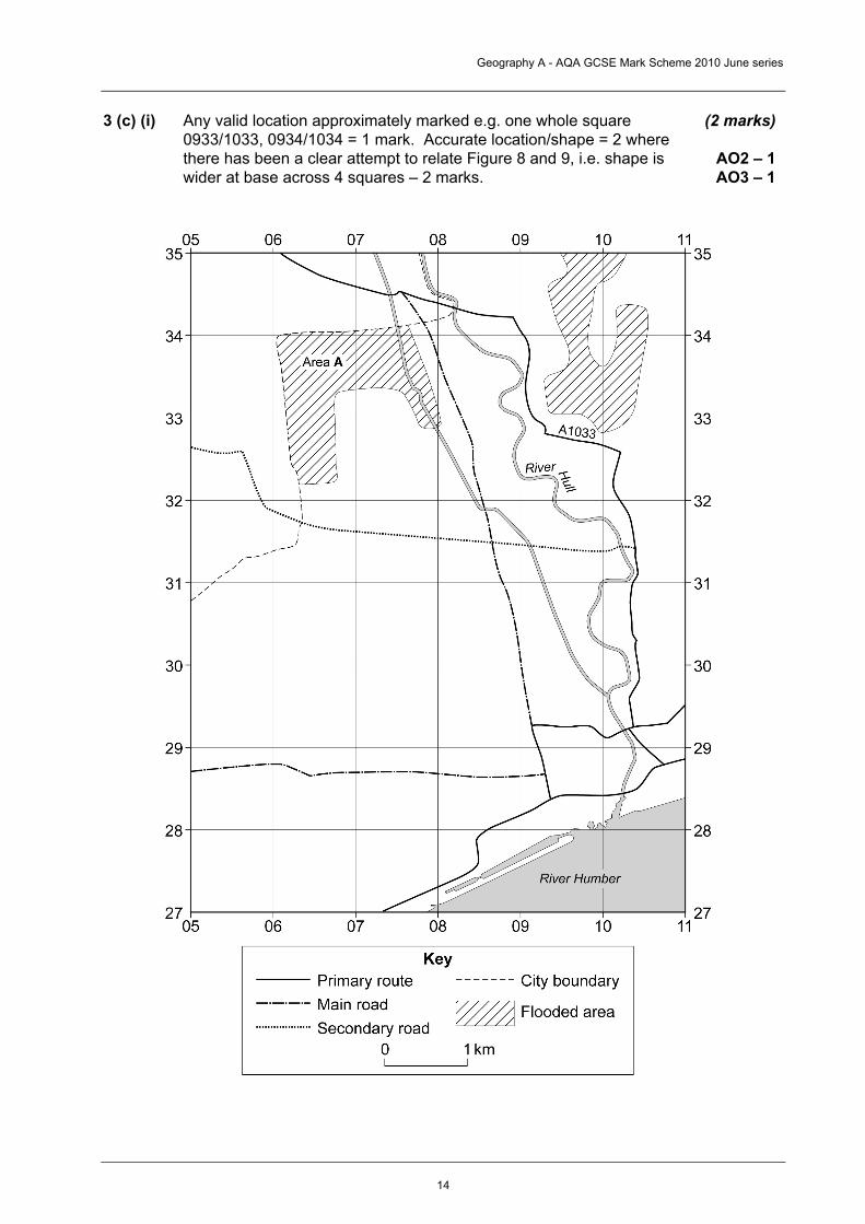
3 (c) (i)
Any valid location approximately marked e.g. one whole square 0933/1033, 0934/1034 = 1 mark. Accurate location/shape = 2 where there has been a clear attempt to relate Figure 8 and 9, i.e. shape is wider at base across 4 squares – 2 marks.
(2 marks)
AO2 – 1 AO3 – 1
Geography A - AQA GCSE Mark Scheme 2010 June series
15
3 (c) (ii) Built-up / housing estate / residential area (1). Appears to be a
straight drain / canal / stream going through area (1). Housing area quite new as on edge / suburbs (1). Housing varies – large blocks in north west (1) much smaller in east (1). Minor road and local estate roads serve area (1), many of these are cul-de-sacs (1). Allow 1 for facility/ies present, eg church, cycle path. Allow other physical descriptions e.g. flat land (1). Any 3 valid points 3×1.
(3 marks)
AO2 – 1 AO3 – 2
3 (d) Actual content will depend on the content candidates have been taught – likely to be influenced by content of textbooks – but is potentially very diverse. Economic effects – likely to include loss of earnings, loss of businesses/livelihood e.g. as ice melts and skiing cannot occur, impact on farming – different crops grown as climates change e.g. parts of southern England growing more crops linked to Mediterranean areas such as vines, olives whilst part of southern Europe may become too dry if deserts spread, costs of sea defences. Environmental effects – loss of coastal areas and habitats, changing conditions will mean changes in vegetation – warmer conditions in parts of northern Europe may see coniferous forest disappear or adapt, areas will flood especially low lying coastal areas, icebergs will be more apparent; hurricanes and extreme weather will become more common.
(9 marks)
AO1 – 5 AO2 – 4
Level 1 (Basic) (1-4 marks) Simple Statements, perhaps list like at lower end. Separate ideas – consequences are included in a random order. A UK focus is likely. Lots of coastal areas will be flooded. People will have to move; businesses will go into the sea. If it gets hotter, some crops will not grow. Fires could occur and forests lost. Level 2 (Clear) (5-7 marks) Develops statements and makes links. Environmental and economic are partly distinguished – possibly imbalanced. There is some reference to areas beyond UK. Lots of low-lying coastal areas will be flooded, such as in East Anglia. People will have to move; beaches and resorts will disappear and businesses will follow. If it gets hotter, some crops will not grow; others like potatoes and outdoor tomatoes may have an increased yield benefiting farmers. There would be a greater risk of forest fires and the Houses of Parliament could be flooded. Fires could occur and forests lost. Low-lying islands like the Maldives would disappear and areas of tropical rainforest would be under treat.
Geography A - AQA GCSE Mark Scheme 2010 June series
16
Level 3 (Detailed) (8-9 marks)
Fully developed statements that are linked. Environmental and economic are clearly distinguished, in greater balance. Detailed knowledge of effects and exemplars. The global element is properly addressed. There will be many environmental changes. Lots of low-lying coastal areas will be flooded, such as in East Anglia in UK and much of the country of Bangladesh. If it gets hotter, some crops will increase in yield like potatoes and outdoor tomatoes, benefiting farmers. A wider variety of crops could be grown such as vines, oranges in the south, increasing farmer’s profits. There would be a greater risk of forest fires and the Houses of Parliament could be flooded. Low-lying islands like the Maldives and islands in the Pacific would disappear and areas of tropical rainforest would be under threat. Icebergs would break off from the Antarctic ice sheet. As well as these environmental changes, some people would lose their jobs as warmer temperatures mean the ski resorts in the Alps in Switzerland around Interlaken don’t have enough snow. Another problem would be the cost of trying to protect major cities like London and Hull from the rising sea levels.
Total for Question 3: 25 marks
Geography A - AQA GCSE Mark Scheme 2010 June series
17
Question 4 – Living World 4 (a) (i) Any valid point that relates to the oak tree itself in contrast to other
parts of the food chain, oak tree makes its own food (1) via photosynthesis/or explanation of this such as energy from sun (1) and so is a producer (1) whereas other insects, birds etc rely on the plants (1) either directly as eat them (1) – herbivores (1) or indirectly – as eat things that eat plants (1) – carnivores (1) These are consumers (1). Recognition of how tree underpins food chain (1). 3x1
(3 marks)
AO1 – 2 AO2 – 1
4 (a) (ii) There is a clue in Figure 11 to this answer – that decomposers are
responsible for the breakdown of dead plants, insects, birds, animals. These include bacteria and fungi. Nutrients contained in the decaying matter are released. They go back into the soil where they are ultimately taken up by the roots of plants to go back into the food chain. Leaf fall and animals dying will result in the cycle starting again. The cycle should be recognised.
(4 marks)
AO1 – 3 AO2 – 1
Level 1 (Basic) (1-2 marks) Simple statements Sequence is partial – sections identified – basic cycle Level 2 (Clear) (3-4 marks) Begins to develop points and to link ideas. There is recognition of the cycle that takes place and the sequence within it.
4 (b) (i) 4.5kms – 4.6kms = 2 marks;
4.3kms – 4.4kms and 4.7kms – 4.8kms = 1 mark (2 marks)
AO3 – 2 4 (b) (ii) Any 3 different recreational activities – need to identify activity from
map, e.g. picnics, pub lunches (at High Beach); walking on many tracks/paths in forest, e.g. Three Forests Way; finding out about the trees and animals at the conservation centre; learning about the ecosystem at the field study centre; fishing in pond/along rivers. 3×1 for each different type of activity. Need evidence and activity for 1 mark.
(3 marks)
AO2 – 1 AO3 – 2
Geography A - AQA GCSE Mark Scheme 2010 June series
18
4 (c) Description should refer to the amount of vegetation cover – more
extensive in 13b, but still not complete as areas of bare soil are visible; its location – on valley floor only in 13a but extends further up sides in 13b; its height – relatively low lying, but taller in 13b; its flowering status – many flowers and colours are testimony to variety of species in 13b, whereas no flowers in 13a. There should be a recognition that this is the result of recent rainfall, where seeds that have lain dormant germinate, flower, seed and die in a short life cycle following bursts of rain.
(4 marks)
AO1 – 2 AO2 – 1 AO3 – 1
Level 1 (Basic) (1-2 marks) Simple statements. These are generalised and separate, but do use photo. One element – likely to be description (or possible explanation) is addressed. Some grassier and low bushes in 13a. There is lots of bare rock. There are a lot of yellow flowers in 13b. It is colourful. Level 2 (Clear) (3-4 marks) Develops points. Linked statements, making use of photo. Explanation and description are both considered. There is more vegetation in 13b than 13a. There seems more variety; the vegetation has flowered. This is possibly because it has rained recently, so seeds will have germinated and have flowered.
Geography A - AQA GCSE Mark Scheme 2010 June series
19
4 (d) Case studies likely to be dependent on those appearing in related
texts – South West US likely to be used, perhaps western Australia. Management should focus on water supply and how it is managed, such as dams along the Colorado, provision for commercial farming – supplying water to California, possible provision of a power source to facilitate development – such as tourism; development of tourism on a large scale, such as Las Vegas, building areas for retirement such as Sun city in Phoenix. Question demands a focus on management but also requires a link to sustainability.
(9 marks)
AO1 – 5 AO2 – 4
Level 1 (Basic) (1-4 marks) Simple statements, perhaps list like at lower end. Describes ways in which areas used. Some reference about management. Information is general. Max L1 If poorer part of world shown. There are dams built. This gives a water supply. People have a lot of water. There is tourism in some areas. Level 2 (Clear) (5-7 marks) Develops statements. Links are made between uses of the area and management. There is some linking to sustainability. Some reference is made to the case study. Dams hold back rivers, like the Colorado. The Hoover Dam means there is water for big resorts like Las Vegas. This allows lots of tourists to go there and lots of jobs have been developed. These jobs should be long term if the area is looked after carefully. Level 3 (Detailed) (8-9 marks) Fully developed statements. Links are clearly made between uses of the area and management. There is clear linking to sustainability – may question the extent to which it can be sustainable. Specific, detailed reference is made to the case study. Dams hold back rivers, like Colorado. The Hoover Dam and Lake Mead means there is water for big resorts like Las Vegas. This allows lots of tourists to go there and lots of jobs have been developed. These jobs should be long term if the area is looked after carefully – and it should be stainable. However, there have been problems – there are other dams such as Glen Canyon at Lake Powell and little water reaches the lower reaches of the river. In Phoenix, there are larger retirement areas and an increasing demand for water. Lots of homes have pools in an area that is very dry that is uncertain whether this can continue forever.
Total for Question 4: 25 marks
Geography A - AQA GCSE Mark Scheme 2010 June series
20
SECTION B Question 5 – Water on the land 5 (a) Near the source, the cross profile is narrow, steep sided and relatively
deep valley (1). As movement occurs downstream, the cross profile becomes wider, less deep and the valley sides are less steep (1). Nearest the mouth, the valley is especially broad, the sides are a long way from the river and these are gentle and very low lying. (1) There should be 3 statements that convey change downstream. The above is one strategy – going site by site, other approaches may refer to stages or the characteristic of an individual change that takes place downstream. Accept river channel changes as well as valley. 3 x 1 per stage or overall change from source to mouth.
(3 marks)
AO1 – 3
5 (b) (i) Any valid point relating to landform – e.g. steep/vertical drop,
descends in two steps/falls, plunge pool visible at base; white water, covers width of valley; gorge visible in foreground / steep sided / v-shaped 3x1/1 + (1+1)
(3 marks)
AO2 – 1 AO3 – 2
5 (b) (ii) Diagrams likely to be drawn – probably two – to show horizontal band
of hard rock over underlying band of soft rock, erosion of softer rock at a faster rate causes an overhang to develop, abrasion and hydraulic action are particularly important erosion processes; material from overhang collapsing increases rate of erosion and waterfall – which plunges over steep drop to retreat (leaving a gorge).
(4 marks)
AO1 – 1 AO2 – 1 AO3 – 2
Level 1 (Basic) (1-2 marks) Simple diagram (s) probably partial. Simple labels. Order not correct – jumps about. Sequence may be incomplete. No diagram Level 2 (Clear) (3-4 marks) Complete, clear, diagram (s). Diagrams illustrate clear labels – that are developed and linked. Sequence and formation of waterfall is clear.
5 (c) (i) Any valid contrast – the difference needs to be made clear for the mark to be awarded. E.g. Austwick Beck has a much higher peak (1) – 25 cumecs compared to 10 cumecs (+1 for evidence): Austwick Beck has a shorter lag time (1) 5 ½ hours in contrast to 17 hours (+1 for evidence) rising limb is steeper for Austwick Beck (1) as is the falling limb (1); Austwick Beck has a flashier hydrograph (1). Maximum 1 for evidence.
(3 marks)
AO1 – 1 AO2 – 1 AO3 – 1
Geography A - AQA GCSE Mark Scheme 2010 June series
21
5 (c) (ii) Any valid reason. E.g. Relief is steeper at Austwick Beck, so runoff
will be rapid over the surface reducing time it takes to get to stream, possibly impermeable rock at Austwick Beck means water cannot soak in and so flows over land; lack of vegetation in drainage basin of Austwick Beck so that there is no interception, roots do not take up water so runoff is rapid. Urbanisation, dams valid reasons.
(4 marks)
AO1 – 2 AO2 – 2
Level 1 (Basic) (1-2 marks) Simple, listed points. States valid factors. Steep slopes may cause difference. The rock type may be different – one may not let water soak in. Level 2 (Clear) (3-4 marks) Points are developed – aware of the significance of the factors. Makes the link between feature and storm hydrograph. The slopes in the drainage basin for Austwick Beck may be steeper and so the rainfall will runoff faster giving a shorter lag time. The rock type here may be impermeable, so that the water runs over the surface giving a flashier hydrograph.

Geography A - AQA GCSE Mark Scheme 2010 June series
22
5 (d) Actual content will depend on strategies selected.
Likely to refer to the fact that there are areas of surplus – that are self sufficient and areas of deficit – where needs cannot be met. These are areas of water stress and there needs to be transfer from areas of surplus to deficit. This means storing water in these areas – via dams and reservoirs and then moving it via aqueducts and pipelines. This is expensive and currently, smaller, local schemes are important. Equally valid in ensuring that demand is met is to ensure that water available is not wasted – neither by people in their own homes nor by water companies in distribution. New technology in terms of dual flush toilets, building homes that partly recycle water can ensure that the demand for water is met throughout the UK.
(8 marks)
AO1 – 5 AO2 – 3
Level 1 (Basic) (1-4 marks) Describes 1 or 2 strategies. Simple statements, may be in a random order. Water is stored in big lakes, behind dams. People turn taps off instead of letting them run, when cleaning teeth. There are small lakes where water is stored in local areas. Level 2 (Clear) (5-6 marks) Begins to consider how the strategies meet the demand. Statements are developed and linked. Some areas have more water than they need; some have too little. Water can be transferred between these. More and more, local areas try to store enough water and some areas use water that has been stored underground. As well as trying to get water where it is needed, people try not to waste water and new fittings in houses can try to conserve water – such as washing machines that use less water, dual flush toilets. Level 3 (Detailed) (7-8 marks) Clearly focuses on how strategy meets demand. Statements are linked and detailed. Offers support for ideas. Some areas have more water than they need; some have too little. Many parts of Wales have more water than they need – so water stored in reservoirs like Lake Vrynwy is used to supply cities like Liverpool. Water can be long distance via aqueducts and pipelines. More and more, local areas try to store enough water as this saves cost of transfers. Water companies try not to waste water in transfer and so pipelines need repairing when there are signs of leaks. As well as trying to get water where it is needed, people try not to waste water and new fittings in houses can try to conserve water – such as washing machines that use less water; dual flush toilets and having systems installed that will recycle water used in the home.
Total for Question 5: 25 marks
Geography A - AQA GCSE Mark Scheme 2010 June series
23
Question 6 – Ice on the land 6 (a) (i) Response should show an awareness of the maximum cover and
describe this e.g. 3 large ice sheets, North America had the largest ice sheet. This extended furthest south to approximately 40 degrees north. Ice sheets also over Scandinavia and Greenland. Smaller areas of ice over north Asia. Areas further south had smaller areas covered by ice e.g. in southern Europe. Today, the extent of ice is much reduced – with only Greenland ice sheet remaining of the largest expanses. Some of the smaller ones still are present, such as in southern Europe. There are isolated remnants of the once very large North American ice sheet.
(4 marks)
AO2 – 2 AO3 – 2
Level 1 (Basic) (1-2 marks) Simple, listed points. Detail on some aspects. Evidence may be detailed or general. Focus on separate time periods. There was a very big area covered by ice. Large areas of North America were covered in ice. A lot of Europe had ice. There is an area in southern Europe today. Level 2 (Clear) (3-4 marks) Points are developed and linked. Clearly has an overview and is aware of change. Evidence is presented purposefully in support. The extent of ice cover has reduced dramatically – it extended below 40 degrees North at its maximum extent in North America – this was the furthest south. Now, it extends furthest south in Greenland. In North America, only areas in the west mountainous areas remain – as in southern Europe.
6 (a) (ii) (W - Previous Ice Age - exemplar already done) X – end section of graph.; Y – 600,000 years ago approx Z – any of the time periods when warmer than average shown
(3 marks)
AO1 – 1 AO2 – 1 AO3 – 1
Geography A - AQA GCSE Mark Scheme 2010 June series
24
6 (b) Temperatures have clearly fluctuated. The overall trend has been one
of increase. This has not been gradual. Until approximately 1977, temperatures worldwide were below the 1961-90 average. They were below to varying extents – the lowest being 13.5 in 1910 and the highest 14.0 in 1940. After 1940, temperatures fell but not to the same level as previously, being about 0.2 to 0.3 lower than average. The rise since 1977 has been stepped and has reached above 14.4. Recently, the steepness of the rise has reduced.
(4 marks)
AO1 – 1 AO2 – 1 AO3 – 2
Level 1 (Basic) (1-2 marks) Simple, separate listed points. May be step by step with detail on limited parts. Evidence may be present, but seen in context of above. Temperatures start off below average. They drop during the 1850s. It gets a bit warmer during the 1860s and 1870s. Then it goes cooler again during 1880s. From 1910 the temperature gets warmer. It almost gets to the average by 1940. Then it gets colder again. It gets warmer during the 1950s. In 1980 it reaches the average. During the 1980s and 1990s the temperatures are above average. Level 2 (Clear) (3-4 marks) Points are developed and linked. Has an overview of trends. Uses evidence to support trends being observed. Temperatures fluctuate, but overall they have increased. They were below the 14 degree average until 1980. Then they went above and have generally increased to about 0.4 above the average. There is a slight decline at the end of the graph. Between 1850 and 1950 temperatures were always below the average, but to varying degrees. It was colder during the 1850s and 1860s and them between 1900 and 1920 than the other years. 1920 was the coldest at about 13.5.
6 (c) (i) Ice carries material on top of it, within it and beneath it / material carried in a glacier. (1) This material is called moraine. It falls onto the surface (due to freeze thaw weathering) from the sides and moves with the ice (1). It gets into the ice via a large number of cracks (crevasses) on the surface. (1) Plucking/abrasion at the base leads to further material beneath the glacier (1). Material is pushed to the front of the glacier where it is moved along. (1) This is called bulldozing (1). 3x1 or 1 + (1+1)
(3 marks)
AO1 – 3
6 (c) (ii) Moraine contains material of different sizes/it is unsorted due to the
way ice transports, unlike water (1) It results from deposition (1). May refer to origin of material – freeze thaw weathering/plucking/abrasion (1). The lines of material carried on the surface at the sides from valley sides become lateral moraine (1), whilst that meeting in the middle from the sides of two tributary glaciers is medial moraine (1). The terminal moraine is found at the end/snout and represents the material bulldozed to the front of the glacier (1). 3x1
(3 marks)
AO1 – 2 AO2 – 1
Geography A - AQA GCSE Mark Scheme 2010 June series
25
6 (d) Effects are likely to be far reaching.
Environmental – less snow means the low lying ski resorts will lack their essential ingredient. Large, famous resorts such as Kitzbuhel in Austria would be affected. The avalanche risk is likely to increase. Snow is brought in from outside of immediate area or is made by machines. As the ground melts, the safety of bases for cable cars may become uncertain. Pressure will be put on higher altitude areas – many of which are fragile. Economic – the loss of snow means loss of income, investment is limited – e.g. banks will not lend to businesses in low lying areas in Switzerland. It has been predicted that losses in lower lying areas such as Bernese Oberland could be very high, with losses in Switzerland amounting to between $1.2 and $1.6 billion each year. There is a need to look for alternative activities such as Nordic walking, Christmas markets or pay for snow making machines, ensure access to higher slopes. These also incur costs. Social – may relate to loss of jobs and therefore, young people moving out. Loss of facilities. Perhaps, changing the type of tourism and the age groups of tourists and impact this will have on local facilities.
(8 marks)
AO1 – 5 AO2 – 3
Level 1 (Basic) (1-4 marks) Describes effects of unreliable snowfall Will be general. Statements may be in a random order. Snow has to be made and put on hillsides. People will lose money. Jobs will be lost. Level 2 (Clear) (5-6 marks) Begins to consider economic and/or environmental clearly. Offers evidence in support. Statements are linked. Seeks to explain. Not being certain of snow means people feel less secure in their jobs – as they don’t know what will happen from one year to the next. It is difficult to get loans from banks for developments in lower lying areas and so, people cannot invest and develop their business. As there is less snow lower down, more and more people will crowd into the higher lying resorts and this will lead to more damage in these areas.
Geography A - AQA GCSE Mark Scheme 2010 June series
26
Level 3 (Detailed) (7-8 marks)
Focus on economic and environmental effects. Evidence is used to illustrate points. Statements are linked and detailed. Aware of the impact of limited snowfall on economic and environmental aspects – explain these. Not being certain of snow means people feel less secure in their jobs – as they don’t know what will happen from one year to the next. This can increase stress levels. It is difficult to get loans from banks for developments in lower lying areas, such as the Bernes Otherland in Switzerland. People cannot invest and develop their business – so the economy will suffer. As there is less snow lower down, more and more people will crowd into the higher lying resorts and this will lead to more damage in these areas. An alternative is snow–making machines, but these are costly and artificially lengthen the season with environmental impacts – increasing trampling of underlying vegetation. There will be an increased avalanche risk due to warmer temperatures, which may then discourage people from coming later in the season or in subsequent years.
Total for Question 6: 25 marks
Geography A - AQA GCSE Mark Scheme 2010 June series
27
Question 7 – Coastal zone 7 (a) Mass movement occurs when loose material on the land surface (1)
moves downslope (1) due to gravity (1) sliding and slumping (1). This is often fast and sudden (1) as with landslides (1) when the base of the cliff has been eroded, making the cliff unstable (1). With a landslide, the whole column of material moves in one go (1), slumping is similar, but this involves a curved movement (1). 3x1
(3 marks)
AO1 – 3
7 (b) (i) Labels should identify relevant landforms such as cliffs, wave cut
platform, sea stack stump. 3x1
(3 marks)
AO2 – 1 AO3 – 2
7 (b) (ii) Waves attack between lwm and hwm; base of cliff eroded, wave cut
notch formed; notch gets bigger/cliff overhangs and is cliff liable to collapse; as erosion continues, overhang collapses. The cliff retreats and flat area of rock at base is exposed, forming the wave cut platform. May refer to subaerial weathering.
(4 marks)
AO1 – 1 AO2 – 2 AO3 – 1
Level 1 (Basic) (1-2 marks) Simple points. Sequence is partial. Waves hit the bottom of the cliff. Parts of cliff above overhang and there is more erosion. Overhang collapses. Level 2 (Clear) (3-4 marks) Points are developed and linked. Geographical terminology used. Complete sequence. Waves hit the bottom of the cliff between hwm and lwm. A wave cut notch is formed at the base of the cliff. Erosion continues and the overhang gets bigger and finally collapses. This results in the cliff retreating and exposing an area of flat/gently sloping rock in front of the cliffs, known as a wave cut platform.
7 (c) (i) Increase in sea level due to melting of ice sheets (1) +1 for detail on
locations of these (1). Recognition that this will remove water stored in a frozen state (1) on land and enable it to flow to the sea increasing amount of water in the sea (1). May relate to underlying cause – global warming (1) and causes of this, e.g. increase in carbon dioxide (1) and reasons for this (1). 3×1
(3 marks)
AO1 – 3
Geography A - AQA GCSE Mark Scheme 2010 June series
28
7 (c) (ii) Content will depend on example used. Expect reference to London
and Thames and other low lying coastal areas of England; Netherlands; Bangladesh; islands in Indian Ocean such as Maldives; area affected by Boxing Day tsunami. Nile Delta. Examples will depend on textbooks. Economic effects likely to relate to loss/damage to areas/businesses/food crops in subsistence economy; cash crops/exports; impact on tourism; need to try to protect and costs incurred in this.
(4 marks)
AO1 – 3 AO2 – 1
Level 1 (Basic) (1-2 marks) Simple, listed points. Will refer to some effects may be drift into non – economic ones. Crops will be destroyed. People will lose their food supply and land. They will have nowhere to live. Parts of cities will be flooded. Businesses will be lost and people will lose their jobs. Level 2 (Clear) (3-4 marks) Points are developed and linked. Focus on economic effects. Refers to case study. As sea level rises, low lying parts of the UK will be flooded. Parts of the fertile Fens will be lost and people will lose their businesses. Crop production will fall – cereals and vegetables will be affected. Areas next to the Thames in London, including the Houses of Parliament will be flooded. The City will be affected and jobs could be lost. It will cost a lot of money to try to protect the coast from rising sea levels – in order of £10 billion.
Geography A - AQA GCSE Mark Scheme 2010 June series
29
7 (d) Actual content will depend on strategy selected. Should consider
advantages of strategy chosen and disadvantages of one rejected. For hard engineering – advantages – likely to be effective. The area behind will be protected, land stable and income, such as from tourism, will be safeguarded. Disadvantages of hard engineering – they are expensive – going into millions of pounds, they need maintaining – sea walls cost up to £5000 per metre to repair. They have a visual impact on the environment. They interfere with natural processes and may cause problems somewhere else. For soft engineering – advantages – work with nature rather than against it, blend in with the environment and can improve it e.g. adding sand to beaches, don’t interfere with processes elsewhere and jeopardise other areas; are sustainable. Disadvantages of soft engineering – areas can just be left at the mercy of the sea, more gentle intervention may not be effective, people can lose homes, livelihoods, often no real compensation from government
(8 marks)
AO1 – 2 AO2 – 4 AO3 – 2
Level 1 (Basic) (1-4 marks) Describes methods of hard and/or soft engineering strategies. Will be general. Statements may be in a random order. There will be a new sea wall, built to protect the sea front. Shingle will be put on the beach near Lucy’s jetty. There will be some rock armour and rip-rap. Level 2 (Clear) (5-6 marks) Consider both hard and soft engineering strategies. Begins to explain why both used – looking at advantages and/or disadvantages. Some elaboration/illustration in support. Statements are linked. There will be a new sea wall, built to protect the sea front from the waves. A new groyne will stop the movement of the shingle. Rocks will be put in front of the mouth of the River Lim, protecting the coast behind. These are all hard engineering methods but they are strong and reliable and offer protection. Shingle will be put on the beach near Lucy’s jetty. Shingle is to be replaced on the beach – this will protect the coast by building up the beach – and improving its appearance.
Geography A - AQA GCSE Mark Scheme 2010 June series
30
Level 3 (Detailed) (7-8 marks)
Focus on both hard and soft engineering strategies. Explains why both used – looking at advantages and disadvantages – aware of complementary role and need for secure protection. Illustrates points made – with reference to Figure 22. Statements are linked and detailed. There will be a new sea wall, built to protect the sea from the waves. A new groyne will stop the movement of the shingle, making the beach wider to protect the sea wall and promenade. Rocks will be put in front of the mouth of the River Lim, protecting the coast behind. All these hard engineering methods are relatively expensive, but they are effective and offer protection needed for the seaside resort. Shingle will be put on the beach near Lucy’s jetty. Shingle is to be replaced on the beach – this will protect the coast by building up the beach and maintain the beach. It is likely that this type of soft engineering that works with the natural system would not be effective enough on its own.
Total for Question 7: 25 marks