Embed Size (px)
Citation preview
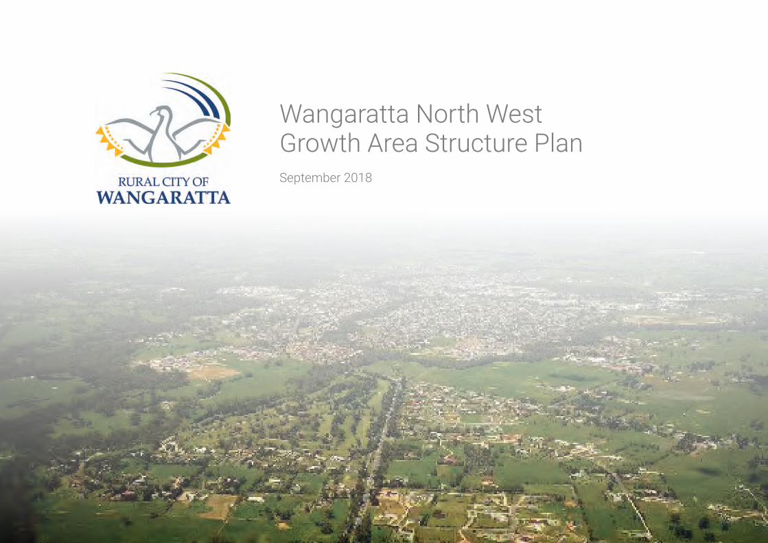
Wangaratta North West Growth Area Structure PlanSeptember 2018
TABLE OF FIGURES
list of tables
Figure 1: Wangaratta North West Growth Area Structure Plan Area Figure 2: Context Plan Figure 3: Land Ownership Plan Figure 4: Zoning and Overlays Figure 5: Landform and TopographyFigure 6: Drainage Catchments Figure 7A: Flora and Fauna –Remnant PatchesFigures 7B & 7C: Flora and Fauna – Scattered trees Figure 8: Cultural Heritage Figure 9: Movement Network Figure 10: Wangaratta North West Growth Area Site Analysis Figure 11: Wangaratta North West Growth Area Structure Plan Figure 12: Movement Network Figure 13: Collector & Local Road Cross-sections Figure 14: Open Space & Biodiversity Figure 15: Activity Centre and Community Facilities Figure 16: Neighbourhoods and Density Figure 17: Drainage Infrastructure Figure 18: Development Plan Precincts
Table 1: Summary Land BudgetTable 2: Population ForecastsTable 3: Dwelling ForecastsTable 4: Social & Active Recreation Infrastructure Needs Analysis Summary
TABLE OF CONTENTS
1 INTRODUCTION1.1. Purpose 21.2. Land to which the Structure Plan Applies 21.3. Implementation 2
2 SITE CONTEXT AND ANALYSIS2.1. Regional and Local Context 42.2. Site Analysis 62.2.1. Site Description 62.2.2. Properties, Ownership and Land Use 62.2.3. Planning Context 82.2.4. Landform and Topography 82.2.5. Drainage 92.2.6. Flora and Fauna 102.2.7. Heritage & Culture 122.2.8.BushfireManagement 122.2.9.MovementNetwork 142.3.0. Site Analysis Summary 17
3 FORECAST POPULATION AND NEEDS3.1. Introduction 183.2. Land Budget and Housing Yield 183.3. Residential Housing Density Descriptions 183.4. Demographic Projections 193.4. Needs Analysis 20
4 VISIONMovementNetwork 22OpenSpace,BiodiversityandBushfireManagement 22ActivityCentreandCommunityFacilities 22Neighbourhood and Density 23Utilities and Drainage 23
5 STRUCTUREPLANELEMENTS5.1. Introduction 245.2. MovementNetwork 245.3. OpenSpace,Biodiversity&BushfireManagement 285.4. ActivityCentreandCommunityFacilities 325.5. Neighbourhoods and Density 345.6. Utilities and DrainageA series of internal neighbourhoods that: „ 3336
6 IMPLEMENTATIONPLAN6.1. DevelopmentStagingandDevelopmentPlanAreas 386.2. SubdivisionworksbyDevelopers 396.3. DevelopmentContributionsPlan 39
7 REFERENCES
3
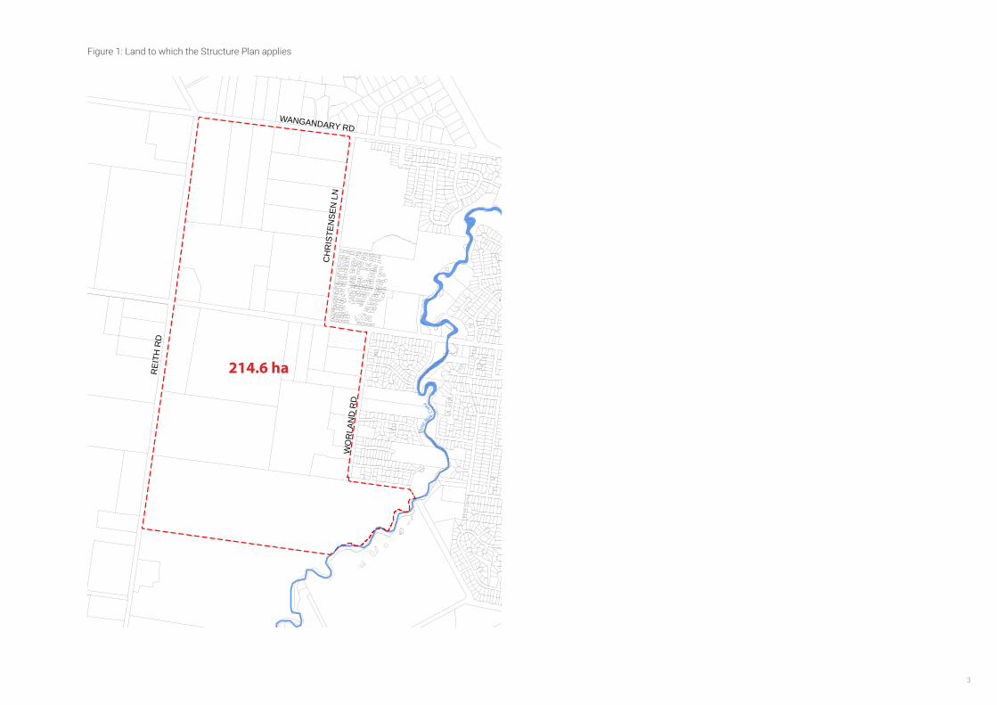
Figure 1: Land to which the Structure Plan applies
Thre
e Mil e
Creek
WANGANDARY RD
WO
RLA
ND
RD
CH
RIS
TEN
SEN
LN
REI
TH R
D
214.6 ha
N
1:7500 at A3
0 75 140 215 290METERS
10 May 2016GREATER CITY OF WANGARATTA
Level 2, 6 Riverside Quay Southbank, VIC 3006 t 9695 3025 f 9695 3001
PSP EXTENT Northern PSP
WANGARATTA NORTH WEST GROWTH AREA STRUCTURE PLAN4
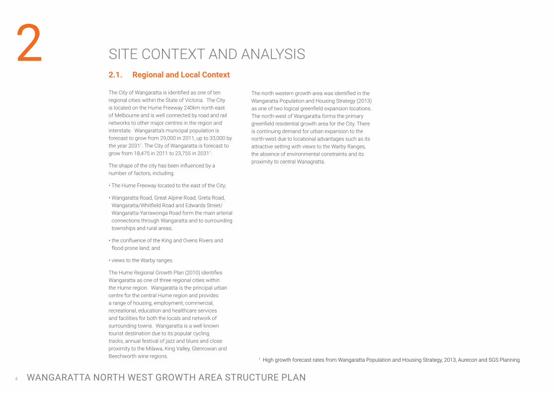
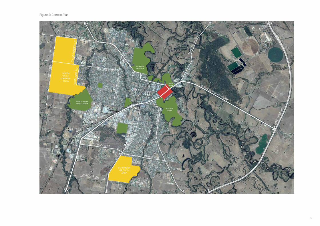
2The north western growth area was identified in the Wangaratta Population and Housing Strategy (2013) as one of two logical greenfield expansion locations. The north-west of Wangaratta forms the primary greenfield residential growth area for the City. There is continuing demand for urban expansion to the north-west due to locational advantages such as its attractive setting with views to the Warby Ranges, the absence of environmental constraints and its proximity to central Wanagratta.
2.1. Regional and Local Context
The City of Wangaratta is identified as one of ten regional cities within the State of Victoria. The City is located on the Hume Freeway 240km north east of Melbourne and is well connected by road and rail networks to other major centres in the region and interstate. Wangaratta’s municipal population is forecast to grow from 29,000 in 2011, up to 33,000 by the year 20311. The City of Wangaratta is forecast to grow from 18,475 in 2011 to 23,755 in 20311.
The shape of the city has been influenced by a number of factors, including:
• The Hume Freeway located to the east of the City;
• Wangaratta Road, Great Alpine Road, Greta Road, Wangaratta/Whitfield Road and Edwards Street/Wangaratta-Yarrawonga Road form the main arterial connections through Wangaratta and to surrounding townships and rural areas;
• the confluence of the King and Ovens Rivers and flood prone land; and
• views to the Warby ranges.
The Hume Regional Growth Plan (2010) identifies Wangaratta as one of three regional cities within the Hume region. Wangaratta is the principal urban centre for the central Hume region and provides a range of housing, employment, commercial, recreational, education and healthcare services and facilities for both the locals and network of surrounding towns. Wangaratta is a well known tourist destination due to its popular cycling tracks, annual festival of jazz and blues and close proximity to the Milawa, King Valley, Glenrowan and Beechworth wine regions.
SITE CONTEXT AND ANALYSIS
1 High growth forecast rates from Wangaratta Population and Housing Strategy, 2013, Aurecon and SGS Planning
5
Figure 2: Context Plan
EDWARDS ST
PHIL
LIPS
ON
ST
GRET
A RD
JORDANS LN
CLARKES LN
MASON ST
TONE RD
CRIBBES RDM
UR
DO
CH
RD
WILLIAMS RD
WANGANDARY RD
WO
RLA
ND
RD
CH
RIS
TEN
SEN
LN
REI
TH R
D
BOW
SER
RD (C
314)
GREAT ALPINE RD (B500)
HUM
E FR
EEW
AY
Thre
e M
ile C
reek
One M
ile Creek
KALUNA PARK
HP BARR RESERVE
WANGARATTARACECOURSE
APEX PARK
SOUTHERNGROWTH
AREA
NORTHWEST
GROWTH AREA

WANGARATTA NORTH WEST GROWTH AREA STRUCTURE PLAN6
2.2 Site Analysis
2.2.1 Site Description
The North Western growth area is located 4km from the Central Business District of Wangaratta. The WNWSP area comprises approximately 215 hectares of land. The WNW growth area forms part of the broader growth of Wangaratta that will provide for establishment of a new community of approximately 5,000 people.
The Wangaratta North Western (WNW) growth area is bounded by Wangandary Road to the north, Reith Road to the west, Christensen Lane, Worland Road and Three Mile Creek to the east, and the Wangaratta Racecourse and equine precinct to the south. Surrounding the area is rural land to the west and south, lifestyle blocks to the north and the current residential edge of Wangaratta together with Three Mile Creek to the east.
The area is relatively flat, has few environmental constraints and has attractive views to the Warby Ranges. In addition, reticulated services located to the east of the study area are able to be extended to service the future growth.
The area contains an existing grid based road network which will require upgrading to cater for future growth, however, several road reserves are constrained due to the presence of significant native vegetation. The site is subject to flooding which is compounded by a range of drainage issues regarding the surrounding farming land and existing residential development. Furthermore, the existing equine facilities located along the southern edge of the site will require an appropriate interface treatment to transition from residential to rural land uses.
The Structure Plan area comprises a total of 27 individual land holdings of varying sizes ranging from 2 to 50 hectares (see Figure 3). With the exception of several landholdings the typical block is between 2 and 6 hectares in size with a single dwelling.
The majority of the WNWSP area has been used predominantly for grazing and currently comprises a mix of small scale farms and lifestyle living; land uses which are not likely to impact significantly on the environment. Notwithstanding, preliminary environmental site assessments will be required for all landholdings that review and examine the history of land uses within the area and the potential for soil and groundwater contamination will be required as part of preparation of a Development Plan. The recommendations of these assessments, including any recommendation for further detailed assessments or management, will then need to be taken into account as part of planning permit applications/ conditions.
Figure 3: Land Ownership Plan
Thre
e Mil e
Creek
1
3 4
5
6
7
89
10 11
1415
1617
1819
2021
22
2324
25
26
27
12 13
2
WANGANDARY RD
WO
RLA
ND
RD
LINDNER RD
CH
RIS
TEN
SEN
LN
REI
TH R
D
2.2.2 Properties, Ownership and Land Use
7
Figure 3: Land Ownership Plan
Figure 5: Landform and Topography
Figure 4: Land Zoning and Overlays Figure 6: Drainage Catchments
Three Mile
Cr
e ek
Ovens River
One M
ile Creek
EDWARDS ST
PHIL
LIPS
ON
ST
WILLIAMS RD
WANGGANDARY RD
WO
RLA
ND
RD
LINDNER RD
CH
RIS
TEN
SEN
ST
REI
TH R
D
BOW
SER
RD (C
314)
TONE RD
GREAT ALPINE RD (B500)
WANGARATTA NORTH WEST GROWTH AREA STRUCTURE PLAN8
2.2.3 Planning Context
As noted above, the WNWSP area was identified in the Wangaratta Population and Housing Strategy (2013) as a preferred location to accommodate future growth. The recommendations of this Strategy were incorporated into the Municipal Strategic Statement (MSS), and the WNWSP area was identified as one of two key growth areas within the municipality at Clause 21.06
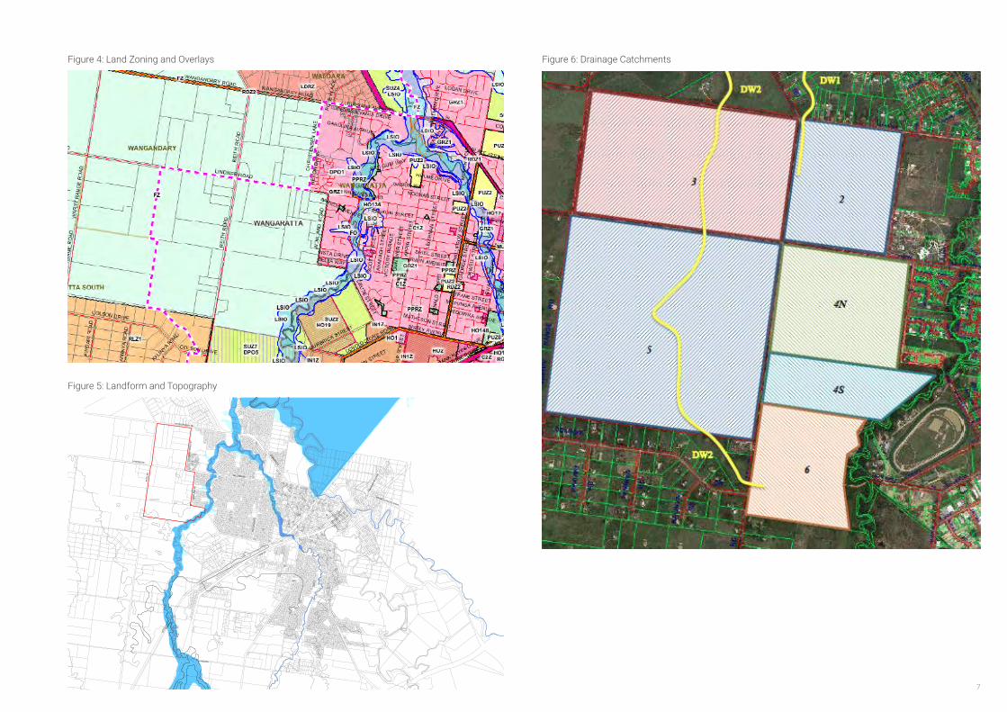
The area is zoned Farming Zone. The Land Subject to Inundation Overlay applies to land adjacent to and generally affected by flooding of Three Mile Creek.
In order to facilitate growth in the WNWSP area a new suite of planning tools is required to be implemented, including:
• Incorporation into the Planning Scheme of the Wangaratta North West Structure Plan to ensure that the land is developed in accordance with a clear and holistic vision for the growth area.
• Incorporation into the Planning Scheme of the Wangaratta North West Development Contributions Plan to define necessary infrastructure to support the new community and to provide a fair and equitable funding tool to deliver this infrastructure.
• Rezoning of the land to the General Residential Zone and the Neighbourhood Activity Centre (NAC) to Mixed Use Zone. It is intended that the NAC would be rezoned to Commercial 1 Zone was development was complete.
2.2.4 Landform and Topography
The landform and topography of the area is relatively uniform, the area largely comprises flat flood plains with several low lying areas and little variation, however the area does have views to the Warby Ranges, located to the west. In addition, existing native vegetation is located throughout the area and along Three Mile Creek.
• Retention of the existing Land Subject to Inundation Overlay which affects the area directly east of Three Mile Creek.
• Application of the Development Plan Overlay, which will require that any future subdivision or development of the land to be generally in accordance with an approved Development Plan and to ensure that more detailed design of the precinct is coordinated across property boundaries.
• Application of the Development Contributions Plan Overlay to implement the Wangaratta North West Development Contributions Plan.
• Utilisation of Clause 52.01 to implement and equalise passive open space contributions across the plan area.
9
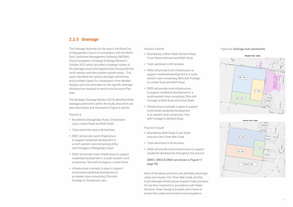
2.2.5 Drainage
The Drainage Authority for the area is the Rural City of Wangaratta Council in consultation with the North East Catchment Management Authority (NECMA). Council prepared a Strategic Drainage Review in October 2015 which provided a strategic review of the drainage issues and opportunities facing both the north western and the southern growth areas. This report identified the various drainage catchments and provided a basis for subsequent more detailed designs and cost estimates for the specific drainage infrastructure required to service the Structure Plan area.
The Strategic Drainage Review (2015) identified three drainage catchments within the study area which are described below and illustrated in Figure 6 and 6a.
Precinct 2
> Bounded by Wangandary Road, Christensens Lane, Lindner Road and Reith Road.
> Total catchment area is 80 hectares.
> DR01 will provide trunk infrastructure to support residential development in a north-western zone comprising 43ha with frontage to Wangandary Road.
> DR02 will provide trunk infrastructure to support residential development in a south-western zone comprising 15ha with frontage to Lindner Road.
> Infrastructure is already in place to support incremental residential development in an eastern zone comprising 22ha with frontage to Christensen Lane.
Precinct 4 North
> Bounded by Lindner Road, Worland Road, Cruse Street extension and Reith Road.
> Total catchment is 85 hectares.
> DR02 will provide trunk infrastructure to support residential development in a north-western zone comprising 40ha with frontage to Lindner Road and Reith Road.
> DR03 will provide trunk infrastructure to support residential development in a south-western zone comprising 29ha with frontage to Reith Road and Cruse Street.
> Infrastructure is already in place to support incremental residential development in an eastern zone comprising 14ha with frontage to Worland Road.
Precinct 4 South
> Bounded by Reith Road, Cruse Street extension and Three Mile Creek
> Total catchment is 36 hectares.
> DR03 will provide trunk infrastructure to support residential development throughout this precinct
(DRO1, DRO2 & DRO3 are shown in Figure 17, page 36)
Each of the above precincts will ultimately discharge urban stormwater into Three Mile Creek, and the trunk drainage infrastructure projects make provision for low-flow treatment in accordance with Water Sensitive Urban Design principles and criteria to protect the creek environment and ecosystems.
PRECINCT FOUR - ZONES
NW – 40ha
SW – 29ha
P4-SOUTH – 36ha
NW – 40ha
E – 14ha
PRECINCT TWO - ZONES
NW – 43ha
SW – 15ha
E – 22ha
Figure 6a: Drainage Sub-catchments
WANGARATTA NORTH WEST GROWTH AREA STRUCTURE PLAN10
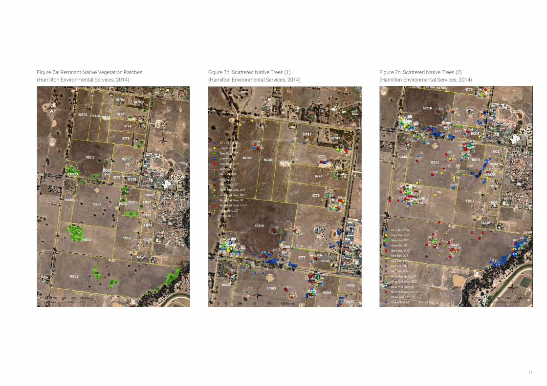
2.2.6 Flora and Fauna
An assessment of the Flora and Fauna values of the area has been undertaken by Hamilton Environmental Services in September 2014, and a report was prepared in November 2014.
The WNWSP is defined as being within the Victorian Riverina Bioregion. Two ‘endangered’ Ecological Vegetation Classes (EVC) have been identified in the study area including Plains Woodland (EVC 803) and an area of Creekline Grassy Woodland (EVC 68) along the Three Mile Creek alignment in the south-eastern corner. However, it was noted that the extent of EVC mapping was not supported by the field assessment.
The WNWSP area was found to be a highly modified and fragmented landscapes; long-term agricultural land use has removed and simplified the composition of native vegetation, and while modified remnant elements remain, only small areas adequately represent the original flora of the area.
22 Remnant Patches were identified in the WNWSP area, comprising a total of 10.2 hectares. The vast majority of scattered trees in the study area were found within these remnant patches.
There are three recorded threatened flora species in the North-Western Growth Area although extensive field assessment carried out for the report failed to find any sign of these. Of the 29 threatened flora species identified as likely to occur within 10km of the area it is considered that none would be found on the site given the high level of disturbance. Fifty-two threatened fauna species were identified as likely to occur within 10km of the site. Although none were sighted, it is considered that eighteen of the species could still use the Remnant Patches if they were better connected.
The recommendations of the biodiversity report are summarised as follows:
• Protect and enhance all existing remnant patches;
• Connect remnant patches along Reith and Lindner Roads and One and Three Mile Creeks corridors as Habitat Links;
• Avoid and minimise the loss of Scattered Trees and ensure tree protection zones are implemented; and
• Utilise remnant patches as offsets for any vegetation losses across the two areas.
Notwithstanding the above, it is noted that Hamilton Environmental Services were not able to gain access to four properties. Therefore, flora and fauna assessments will need to be undertaken for these properties at the Development Plan stage.
11
Figure 7a: Remnant Native Vegetation Patches (Hamilton Environmental Services, 2014)
Figure 7b: Scattered Native Trees (1) (Hamilton Environmental Services, 2014)
Figure 7c: Scattered Native Trees (2) (Hamilton Environmental Services, 2014)
Biodiversity Study – North West and South Wangaratta Residential Growth Areas
119
Aerial image of the North West Growth Area showing defined Remnant Patches. All Remnant Patches are shown with an associated number, which refers to the
able in Appendix G. Title boundaries are shown as solid yellow lines, and Property numbers are also shown (Image from NearMap 2014).
Biodiversity Study – North West and South Wangaratta Residential Growth Areas
88
Aerial image of the northern section of the North West Growth Area showing assessed trees. All trees are depicted with a symbol and associated number, which refers to the tree number in the table in Appendix D. ST is Small Trees, MOT is Medium Old Trees, LOT is Large Old Trees, and VLOT is Very Large Old Trees. Title
boundaries are shown as solid yellow lines, and Property numbers are also shown (Image from NearMap 2014).
Biodiversity Study – North West and South Wangaratta Residential Growth Areas
89
Aerial image of the southern section of the North West Growth Area showing assessed trees. All trees are depicted with a symbol and associated number, which refers to the tree number in the table in Appendix D. ST is Small Trees, MOT is Medium Old Trees, LOT is Large Old Trees, and VLOT is Very Large Old Trees. Title
boundaries are shown as solid yellow lines, and Property numbers are also shown (Image from NearMap 2014).
WANGARATTA NORTH WEST GROWTH AREA STRUCTURE PLAN12
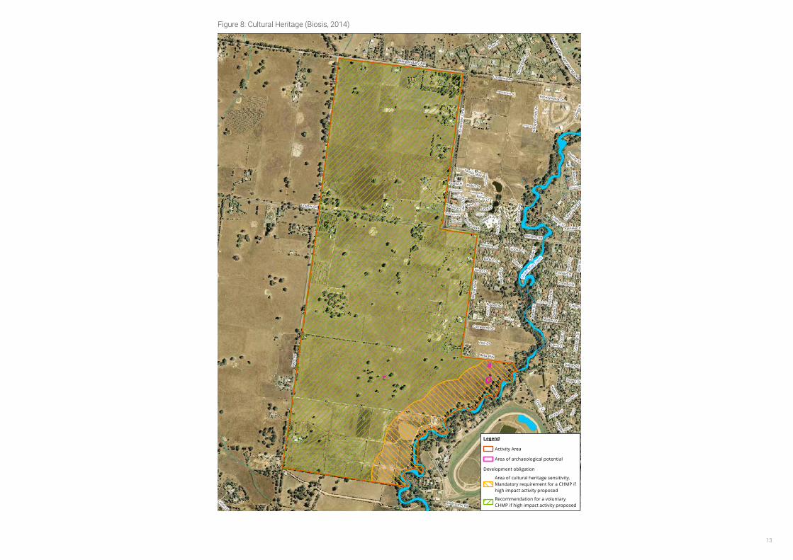
2.2.7 Heritage & Culture
A Cultural Heritage Assessment was undertake by Biosis in October 2014 on behalf of Council.
This report identified evidence of land disturbance due to the construction of residences, the excavation of dams and stock watering holes. Furthermore, the study area is relatively featureless, no depressions or rises are present that may have attracted and been the focus of Aboriginal activity in the past. A limited field study was undertaken as part of this report and no Aboriginal archeological material was identified, however three areas of archaeological potential were marked as warranting further archaeological subsurface testing in the north study area near Three Mile Creek.
Biosis identified that a Cultural Heritage Management Plan (CHMP) must be prepared as part of preparation of a Development Plan for the areas along Three Mile Creek, and that a voluntary CHMP should be undertaken for all other landholdings. All CHMPs will be required to be approved by Aboriginal Affairs Victoria (and/or any other Registered Aboriginal Party) prior to issue of a permit, in accordance with the Aboriginal Heritage Act 2006.
Areas of archaeological potential were identified in the ground survey outside of the designated area of cultural heritage sensitivity, (potential Aboriginal ovens in the north west study area) and there is a potential for unidentified subsurface archaeological material across the remainder of the study area.
A voluntary CHMP will effectively manage the risk of harming cultural heritage. Under Section 27 of the Aboriginal Heritage Act 2006, harming Aboriginal cultural heritage is unlawful, and penalties apply if a person knowingly, recklessly or negligently harms Aboriginal cultural heritage.
2.2.8 BushfireManagement
A Strategic Bushfire Risk Assessment of the study area was undertaken by Terramatrix in 2014. The report highlighted the need to include bushfire management throughout the planning and development process. The study area was identified as being predominantly grassland with small pockets of low-threat vegetation.
The main potential bushfire threat is from a fire established in the Warby Ranges or agricultural land to the west or north-west of the city and spreading towards the North-Western Growth Area as a grass fire. This may be spurred by strong, hot and dry north and north-westerly winds that are frequent during the summer months.
Fire impacts from the south or east are limited as easterly winds are rarely correlated with fire weather conditions.
Any wildfire impacts on the study area would be from grass fires, as areas of forest that may burn in the same event are located at least 5km from the growth area.
The fundamental principal of bushfire risk mitigation is to direct development away from high-risk areas as this reduces the exposure of people and property to potential impact. The report concludes that the WNWSP area is appropriate for residential growth from a bushfire risk perspective.
The report outlines a number of broad guidelines around the design of the future growth areas such as;
• Ensuring the staging of the development occurs to allow emergency access at all times;
• Providing a suitable ‘edge’ treatment along the western boundary of the North-Western Growth Area; and
• Ensuring the area minimises fire risk during construction phases and on nearby vacant land.
The study area is currently within the Bushfire Prone Area (BPA) which may put unnecessary restrictions on building development. As such it is recommended that the future developers and stakeholders work together with Council, Country Fire Authority (CFA) and the Department of Environment, Land, Water and Planning (DELWP) to discuss the possible excising of the study area from the BPA as development stages progress.
13
Th
ree Mile
Creek
Franklin St
Robin Dr
Fran
k Ri
char
ds D
r
Fantail Way
Red Gum Way
Turt
ledo
ve C
t
Hila
ndra
Av
Geor
gia
Pl
Will
owD
r
Cava
nagh
St
Hayes Ct
Orkney St
Plover Pl
Williams Rd
Rosella Pl
Low
e Ct
Barrington Ct
Raven Ct
Ross Ct
Corella Ct
Scot
t St
Pennsylvania Av
Wattlebird Ct
Carolina Av
Thornbill Way
Hillandra Av
Pauline Tce
Walter St
Regi
nald
Ct
Cedar Ct
Wor
land
Rd
Goodwin Ct
Russell Av
Spin
k Av
Laura Ct
Honeyeater Rd
Valiant Ct
Tudgey St
Colson Dr
Ibis Pl
Chris
tens
en L
ane
Racecourse Rd
King
ston
Ct
Cruse St
Kathleen Ct
Brolga
Walk
Suns
et D
r
Lindner Rd
Vista Dr
Bella Way
Hogan St
Barkoo Av
Louisiana Av
Sisely Av
Baroona Ct Cooba Ct
Dianne Cl
Dal
lwitz
Ct
Hun
tingd
ale Pl
BellbirdPl
Esmond St
Currawong Dr
Rose Pl
Osboldstone RdPurbrick St
Reith
Rd
Her
onD
r
Collyn
- DaleDr
Arlin
gton
Park
Av
Rangeview Av
Pennsylvania Dr
Jane
t Ct
Finch Cr
Wren Ct
Grace Ct
Lorikeet Av
Colleen Cl
Corv
ino
Bvd
Wangaratta
- YarrawongaRd
Wangandary Rd
0 80 160 240 320 400
MetresMatter: 18409 CHMP No. Date: 29 October 2014, Checked by: TSC, Drawn by: LDM, Last edited by: jshepherdLocation:P:\18400s\18409\Mapping\18409_F7_8_Dev_Ob.mxd
Biosis Pty Ltd
Ballarat, Brisbane, Canberra, Melbourne, Sydney, Wangaratta & Wollongong
Acknowledgements: Vicmap (C) State of Victoria
Legend
Activity Area
Area of archaeological potential
Development obligation
Area of cultural heritage sensitivity.Mandatory requirement for a CHMP ifhigh impact activity proposed
Recommendation for a voluntaryCHMP if high impact activity proposed
Scale 1:8,500 @ A3Coordinate System: GDA 1994 MGA Zone 55
Figure 7: Development obligations - North
41
Figure 8: Cultural Heritage (Biosis, 2014)
WANGARATTA NORTH WEST GROWTH AREA STRUCTURE PLAN14
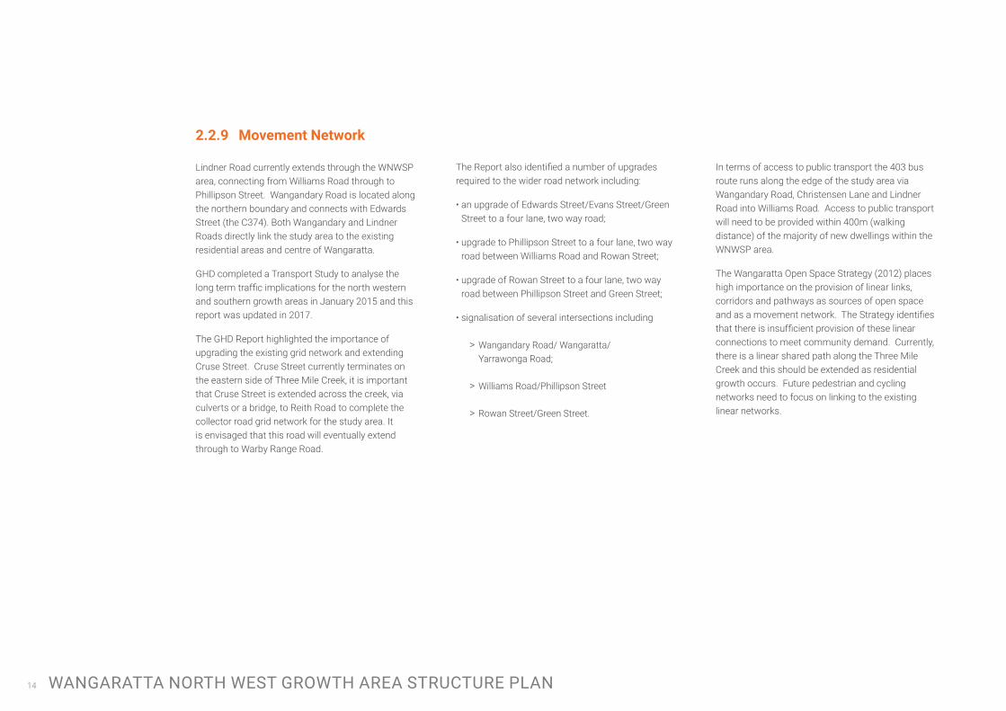
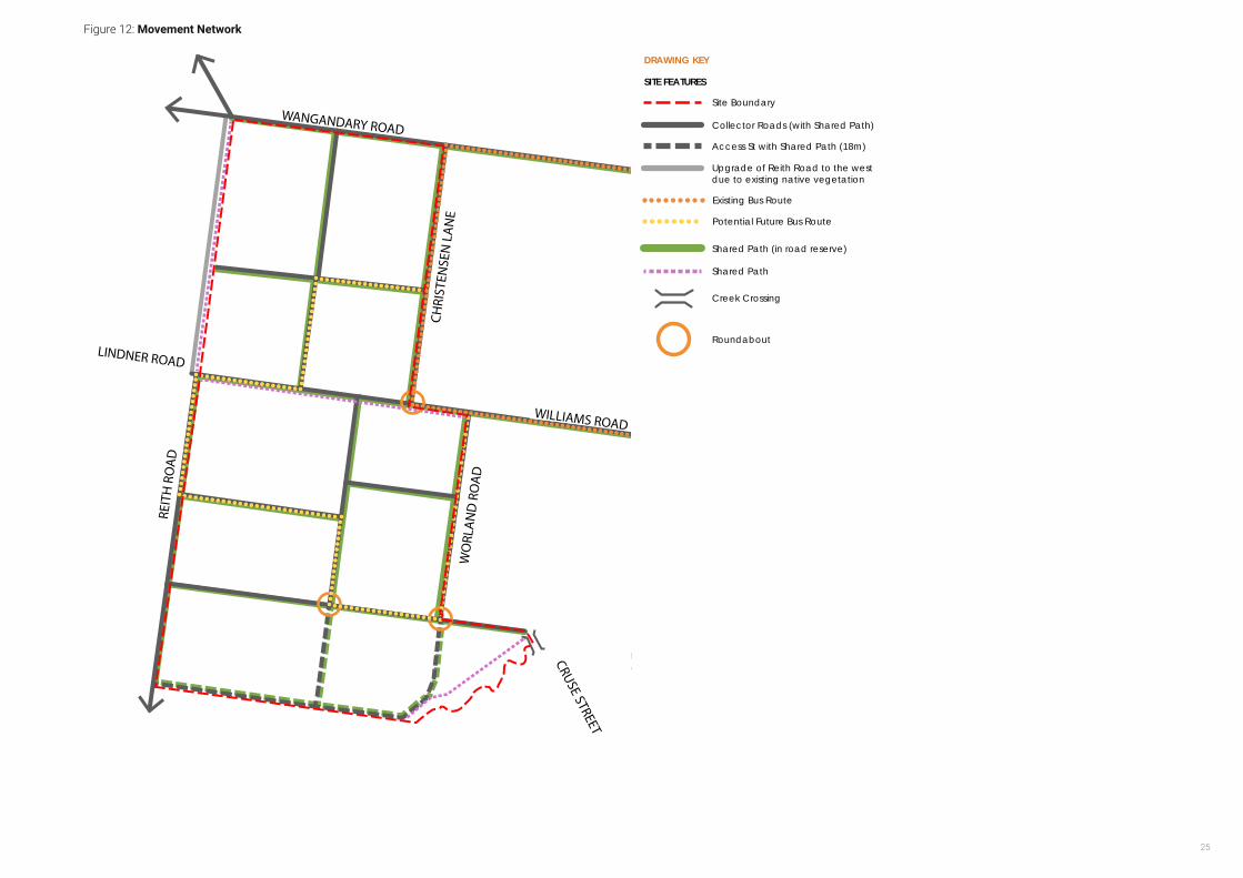
2.2.9 MovementNetwork
Lindner Road currently extends through the WNWSP area, connecting from Williams Road through to Phillipson Street. Wangandary Road is located along the northern boundary and connects with Edwards Street (the C374). Both Wangandary and Lindner Roads directly link the study area to the existing residential areas and centre of Wangaratta.
GHD completed a Transport Study to analyse the long term traffic implications for the north western and southern growth areas in January 2015 and this report was updated in 2017.
The GHD Report highlighted the importance of upgrading the existing grid network and extending Cruse Street. Cruse Street currently terminates on the eastern side of Three Mile Creek, it is important that Cruse Street is extended across the creek, via culverts or a bridge, to Reith Road to complete the collector road grid network for the study area. It is envisaged that this road will eventually extend through to Warby Range Road.
The Report also identified a number of upgrades required to the wider road network including:
• an upgrade of Edwards Street/Evans Street/Green Street to a four lane, two way road;
• upgrade to Phillipson Street to a four lane, two way road between Williams Road and Rowan Street;
• upgrade of Rowan Street to a four lane, two way road between Phillipson Street and Green Street;
• signalisation of several intersections including
> Wangandary Road/ Wangaratta/Yarrawonga Road;
> Williams Road/Phillipson Street
> Rowan Street/Green Street.
In terms of access to public transport the 403 bus route runs along the edge of the study area via Wangandary Road, Christensen Lane and Lindner Road into Williams Road. Access to public transport will need to be provided within 400m (walking distance) of the majority of new dwellings within the WNWSP area.
The Wangaratta Open Space Strategy (2012) places high importance on the provision of linear links, corridors and pathways as sources of open space and as a movement network. The Strategy identifies that there is insufficient provision of these linear connections to meet community demand. Currently, there is a linear shared path along the Three Mile Creek and this should be extended as residential growth occurs. Future pedestrian and cycling networks need to focus on linking to the existing linear networks.
15
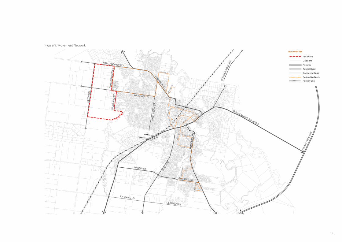
Figure 9: Movement Network
PHIL
LIPS
ON
ST
WILLIAMS RD
WANGANDARY RD
WO
RLA
ND
RD
CH
RIS
TEN
SEN
LN
REI
TH R
D
BOW
SER
RD (C
314)
GREAT ALPINE RD (B500)
HUM
E FR
EEW
AY
GRE
A RD
TONE RD
T
JORDANS LN
CLARKES LN
MASON ST
MU
RD
OC
H R
D
EDWARDS ST
MU
RD
OC
H R
D
CRIBBES RD
DIX
ON
ST
SCHI
LLIN
G DR
COLLEGE ST
ROWAN ST
REID ST
OVENS ST
PER
RY
ST
VINCENT ST
CRISP ST
HAL
LETT
CR
ES
DO
NO
VAN
DR
DRAWING KEY
PSP Extent
Cadastre
Freeway
Arterial Road
Connector Road
Existing Bus Route
Railway Line
WANGARATTA NORTH WEST GROWTH AREA STRUCTURE PLAN16
This page has been intentionally left blank.

17
Figure 10: Site Analysis
2.3 Site Analysis Summary
Figure 10 provides a summary of the site analysis features of the land and identifies key opportunities and constraints for development.
• The land is relatively flat and has views to Warby Ranges which should be maximised.
• Existing grid road network provides the basis for the future collector road network.
• The site contains a small number of native vegetation patches and scattered trees. There is an opportunity to preserve and enhance these features and add to the character of the area.
• Three Mile Creek and the LSIO affecting land immediately to the west of the creek presents the opportunity for wide green open space to be utilised for a range of activities. Design to provide public access to the river through edge roads. Connections (pedestrian/cycle and vehicle) will be required to connect communities.
• Close proximity to existing residential development and Wangaratta CBD. There is the opportunity to create an additional vehicle connection across Three Mile Creek through the extension of Cruse Street.
• The land is relatively flat and flood prone and will require construction of drainage infrastructure to enable development of the land.
• The existing equine precinct located to the south of the Structure Plan area provides the opportunity for larger sized lots to be developed to provide an interface and transition from general residential to these rural land uses.
Three Mile
Cr
e ek
WANGANDARY RD
WO
RLA
ND
RD
LINDNER RD
CH
RIS
TEN
SEN
LN
REI
TH R
D
DRAWING KEY
SITE FEATURES
Cadastre
Heavy Vehicle (truck) Route
Cruse Street Extension
Local Road
Views to Warby Ranges
Flooding Area
Site Boundary
Contours
Watercourses/Drainage Lines
Land Subject to Inundation
Low Density Residential
Heritage Overlay
Equine Activities
Native Vegetation
WANGARATTA NORTH WEST GROWTH AREA STRUCTURE PLAN18
33.1. Introduction
The purpose of this chapter is to examine and describe the population forecast for the WNWSP area, drawing on previous work undertaken, including the Wangaratta Population and Housing Strategy (2013) and the Wangaratta Growth Areas Structure Planning Report (2015). Understanding the forecast population and approximate number of dwellings will enable an understanding to be gained of the needs of the future population.
3.2. Land Budget and Housing Yield
The gross land area of the WNWSP area is 215ha. However, approximately 11.6 hectares of land is not available for development as it is encumbered by native vegetation and drainage.
Taking into account developable land that will be set aside for other purposes, including open space and for road widening, there is capacity to develop approximately 1,670 lots based on an average density of 10 lots per net developable ha. A more detailed lot yield for individual land holdings will be determined during preparation of Development Plans.
3.3. Residential Housing Density Descriptions
Housing Type Definition
Low Density Lot size of a minimum of 2000 square metres
Medium Density
Medium density housing to provide for attached and semi-detached dwellings such as units and town houses or large designated medium density housing sites
Lot size less than 500 square metres
High Density Adopt a form of between 3 and four stories
Compact
Smaller lots to accommodate more compact and affordable detached or semi-detached dwellings
Lot sizes 500 - 600 metres
FORECAST POPULATION AND NEEDS
Land Budget (Ha)
Total Precinct Area 214.6
Encumbered Land
Drainage 2.0
Land Subject to Inundation Overlay 3.2
Native Vegetation 6.5
Open Space
Active Open Space 4.0
Passive Open Space 9.2
Other Uses
Road widening 3.9
Shared Paths 1.6
Community Facility 0.5
Net Developable Area 183.8
Table 1: Summary Land Budget
19
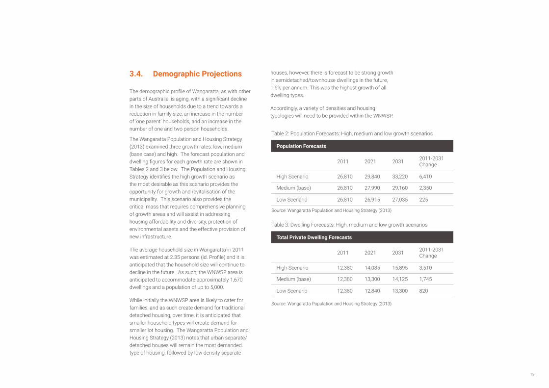
3.4. Demographic Projections
The demographic profile of Wangaratta, as with other parts of Australia, is aging, with a significant decline in the size of households due to a trend towards a reduction in family size, an increase in the number of ‘one parent’ households, and an increase in the number of one and two person households.
The Wangaratta Population and Housing Strategy (2013) examined three growth rates: low, medium (base case) and high. The forecast population and dwelling figures for each growth rate are shown in Tables 2 and 3 below. The Population and Housing Strategy identifies the high growth scenario as the most desirable as this scenario provides the opportunity for growth and revitalisation of the municipality. This scenario also provides the critical mass that requires comprehensive planning of growth areas and will assist in addressing housing affordability and diversity, protection of environmental assets and the effective provision of new infrastructure.
The average household size in Wangaratta in 2011 was estimated at 2.35 persons (id. Profile) and it is anticipated that the household size will continue to decline in the future. As such, the WNWSP area is anticipated to accommodate approximately 1,670 dwellings and a population of up to 5,000.
While initially the WNWSP area is likely to cater for families, and as such create demand for traditional detached housing, over time, it is anticipated that smaller household types will create demand for smaller lot housing. The Wangaratta Population and Housing Strategy (2013) notes that urban separate/ detached houses will remain the most demanded type of housing, followed by low density separate
Population Forecasts
2011 2021 2031 2011-2031 Change
High Scenario 26,810 29,840 33,220 6,410
Medium (base) 26,810 27,990 29,160 2,350
Low Scenario 26,810 26,915 27,035 225
Total Private Dwelling Forecasts
2011 2021 2031 2011-2031 Change
High Scenario 12,380 14,085 15,895 3,510
Medium (base) 12,380 13,300 14,125 1,745
Low Scenario 12,380 12,840 13,300 820
houses, however, there is forecast to be strong growth in semidetached/townhouse dwellings in the future, 1.6% per annum. This was the highest growth of all dwelling types.
Accordingly, a variety of densities and housing typologies will need to be provided within the WNWSP.
Table 2: Population Forecasts: High, medium and low growth scenarios
Table 3: Dwelling Forecasts: High, medium and low growth scenarios
Source: Wangaratta Population and Housing Strategy (2013)
Source: Wangaratta Population and Housing Strategy (2013)
WANGARATTA NORTH WEST GROWTH AREA STRUCTURE PLAN20
3.5. Needs Analysis
Noting the quantum of projected population, and the anticipated characteristics of the population, the types of future infrastructure required by the community can be anticipated.
The Wangaratta Growth Areas Structure Planning Report (Aurecon, 2015) provides detail of the demographic profile of Wangaratta and typical benchmarks for provision of infrastructure, including schools, sporting and recreation facilities and retail and services. A summary of the assessment is provided in Table 4 below.
InfrastructureRecommended Provision Ratio (Population)
North-Western Structure Plan area requirements (based on 5,000 population)
Neighbourhood active open space (8ha)
1 per 10,000 50% (4 ha)
Level 1 Community Centre, including kindergarten and playgroup
1 per 8,000 62.5%
Level 1 youth space 1 per 8,000 62.5%
Long Day Child Care 1 per 9,000 55.5%
Government Primary School 1 per 9,000 55.5%
Table 4: Social and Recreation Infrastructure Needs Analysis Summary
Based on these findings and having regard to surrounding existing infrastructure, it is anticipated that the WNWSP area will create demand for the following facilities:
• Community Activity Centre;
• Local activity centre for convenience shopping and services;
• Active playing fields (4 hectares);
• Public transport (bus route); and
• Walking and cycling trails.

21
This page has been intentionally left blank.
WANGARATTA NORTH WEST GROWTH AREA STRUCTURE PLAN22
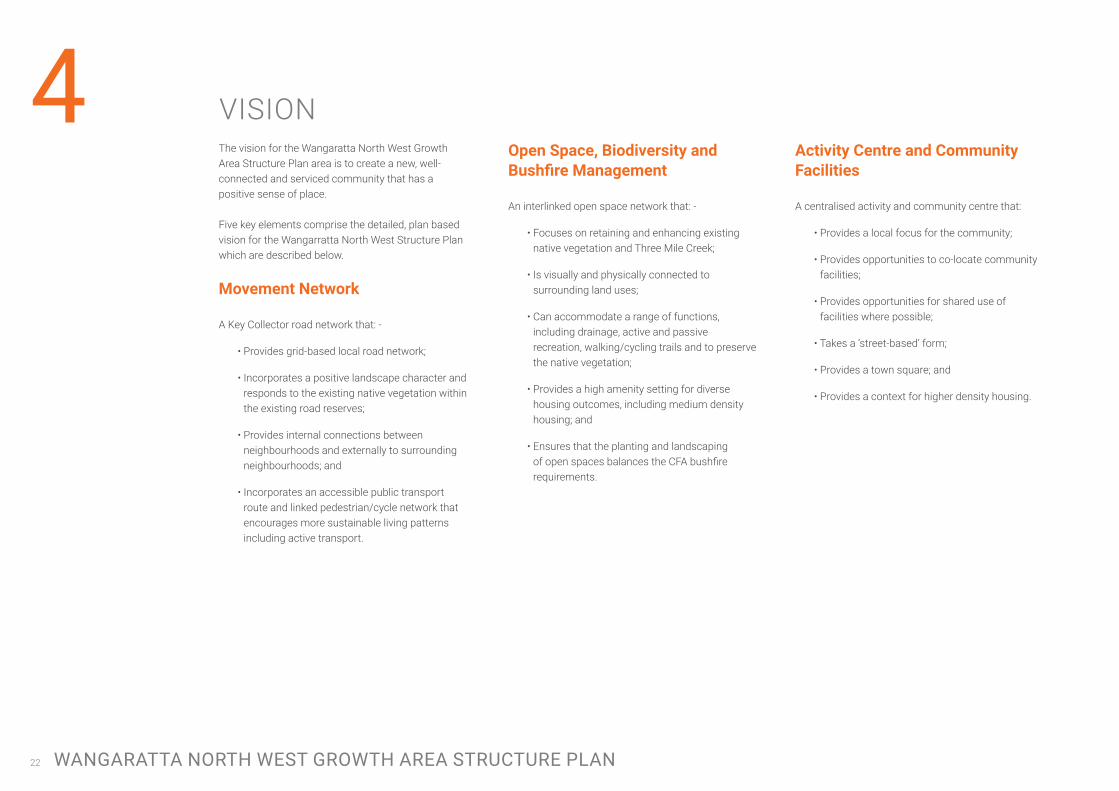
4 VISIONThe vision for the Wangaratta North West Growth Area Structure Plan area is to create a new, well-connected and serviced community that has a positive sense of place. Five key elements comprise the detailed, plan based vision for the Wangarratta North West Structure Plan which are described below.
MovementNetwork
A Key Collector road network that: -
• Provides grid-based local road network;
• Incorporates a positive landscape character and responds to the existing native vegetation within the existing road reserves;
• Provides internal connections between neighbourhoods and externally to surrounding neighbourhoods; and
• Incorporates an accessible public transport route and linked pedestrian/cycle network that encourages more sustainable living patterns including active transport.
OpenSpace,BiodiversityandBushfireManagement
An interlinked open space network that: -
• Focuses on retaining and enhancing existing native vegetation and Three Mile Creek;
• Is visually and physically connected to surrounding land uses;
• Can accommodate a range of functions, including drainage, active and passive recreation, walking/cycling trails and to preserve the native vegetation;
• Provides a high amenity setting for diverse housing outcomes, including medium density housing; and
• Ensures that the planting and landscaping of open spaces balances the CFA bushfire requirements.
ActivityCentreandCommunityFacilities
A centralised activity and community centre that:
• Provides a local focus for the community;
• Provides opportunities to co-locate community facilities;
• Provides opportunities for shared use of facilities where possible;
• Takes a ‘street-based’ form;
• Provides a town square; and
• Provides a context for higher density housing.

23
NeighbourhoodandDensity
A series of internal neighbourhoods that:
• Create high quality residential environments;
• Are diverse in landscape, streetscape and built form character;
• Are clearly defined and incorporates sustainable design principles;
• Contain an identifiable neighbourhood ‘core’ (open space, activity centre, key natural feature) to establish a sense of place; and
• Provide opportunities for diverse housing outcomes, from smaller lots to larger lots, to achieve an average density of 10 lots per net developable hectare and meet the varying needs of the local population.
Utilities and Drainage
Physical services and Infrastructure that:
• Focuses on holistic and coordinated water sensitive urban design approaches to stormwater treatment and management;
• Protect and enhance key watercourses and drainage lines;
• Encourage innovative, sustainable and energy efficient approaches to the provision of services;
• Meets the needs of the community and the development;
• Is equitably funded and efficiently delivered; and
• Represents ‘best practice’ provision and design.
Figure 11: Wangaratta North West Structure Plan
Three
Mile
Cr eek
CHRI
STEN
SEN
LA
NE
WO
RLA
ND
RO
AD
REIT
H R
OA
D
LINDNER ROAD
WILLIAMS ROAD
WANGANDARY ROAD
CRUSE STREET
N
1:7500 at A3
0 75 140 215 290METERS
25 August 2017GREATER CITY OF WANGARATTA
Level 2, 6 Riverside Quay Southbank, VIC 3006 t 9695 3025 f 9695 3001
Structure Plan Northern PSP
SITE FEATURES
Cadastre
Existing Bus Route
Potential Future Bus Route
Access St with Shared Path (18m)
Shared Path
Restricted Direct Lot Access
Collector Roads (with Shared Path)(able to cater for future bus routes)
Creek Crossing
Site Boundary
Drainage (Retarding Basins / Bioretention / Stormwater Management)and trunk infrastructure
Three Mile Creek
Standard Density Residential
Low Density Residential
Diverse Housing / Medium Density Residential
Neighbourhood Activity Centre
Community Activity Centre
Active Open Space
Passive Open Space
Land Subject to Inundation
Native Vegetation
WANGARATTA NORTH WEST GROWTH AREA STRUCTURE PLAN24
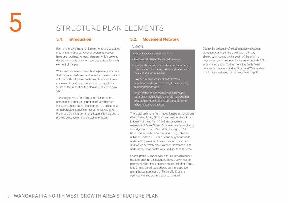
5 STRUCTURE PLAN ELEMENTS5.1. Introduction
Each of the key structure plan elements are described in turn in this Chapter. A set of design objectives have been outlined for each element, which seeks to describe in words the intent and aspirations for each element of the plan.
While each element is described separately, it is noted that they are interlinked, and as such, one component influences the other. As such, any alterations to one component must be considered more broadly in terms of the impact on the plan and the vision as a whole.
These objectives of the Structure Plan must be responded to during preparation of Development Plans and subsequent Planning Permit applications for subdivision. Specific direction for Development Plans and planning permit applications is included to provide guidance on more detailed matters.
5.2. Movement Network
A key collector road network that: -
• Provides grid-based local road network;
• Incorporates a positive landscape character and responds to the existing native vegetation within the existing road reserves;
• Provides internal connections between neighbourhoods and externally to surrounding neighbourhoods; and
• Incorporates an accessible public transport route and linked pedestrian/cycle network that encourages more sustainable living patterns including active transport.
The proposed movement network uses and upgrades Wangandary Road, Christensen Lane, Worland Road, Lindner Road and Reith Road and proposes the extension of Cruse Street/Bella Way (via new culverts or bridge over Three Mile Creek) through to Reith Road. Collectively these roads form a grid-based network which will link and define neighbourhoods and enable provision of an extension to bus route 403, which currently travels along Christensen Lane and Lindner Road, to the west and south of the area.
Shared paths will be provided to link key community facilities such as the neighbourhood activity centre, community facilities and open space including Three Mile Creek. An off-road shared path is proposed along the western edge of Three Mile Creek to connect with the existing path to the north.
VISION Due to the presence of existing native vegetation along Lindner Road, there will be an off-road shared path located to the south of the existing reservation and all other collector roads include 2.5m wide shared paths. Furthermore, the Reith Road reservation between Lindner Road and Wangandary Road may also include an off-road shared path.
25
Figure 12: MovementNetwork
Three Mile
Cre e
k
CHRI
STEN
SEN
LA
NE
WO
RLA
ND
RO
AD
REIT
H R
OA
D
LINDNER ROAD
WILLIAMS ROAD
WANGANDARY ROAD
CRUSE STREET
N
1:7500 at A3
0 75 140 215 290METERS
25 August 2017GREATER CITY OF WANGARATTA
Level 2, 6 Riverside Quay Southbank, VIC 3006 t 9695 3025 f 9695 3001
Movement Network Northern PSP
DRAWING KEY
SITE FEATURES
Access St with Shared Path (18m)
Upgrade of Reith Road to the west due to existing native vegetation
Shared Path (in road reserve)
Shared Path
Collector Roads (with Shared Path)
Creek Crossing
Roundabout
Site Boundary
Existing Bus Route
Potential Future Bus Route
WANGARATTA NORTH WEST GROWTH AREA STRUCTURE PLAN26
Structure Plan Objectives:
• To utilise and upgrade the existing connector road network comprising Wangandary Road, Christensen Lane, Worland Road, Lindner Road and Reith Road to connect externally, and to define and connect internal neighbourhoods
• To provide an additional east-west connection across Three Mile Creek through the extension of Cruse Street/Bella Way via a bridge (or culverts) to connect the WNWSP area with the urban areas to the east.
• To provide a collector road network that is able to cater for bus routes that are within a five minute walk (400m) of the majority of residents.
• To provide a connected on and off road pedestrian/cycle network that utilises Three Mile Creek and local open space links.
• To provide an active edge to all open space areas via edge roads.
• To provide ‘direct’ property access to all roads.
• To provide a sustainable transport network comprising a permeable grid-based layout that encourages multi-modal transport.
Direction for Development Plans:
Cross-sections
Typical cross-sections have been prepared for roads shown in the Structure Plan. These cross-sections reflect the access and design objectives set out above.
All collector roads provide a pavement suitable for accommodating buses, and indented parking bays (with landscaped kerb outstands) to form an attractive and functional collector road.
An off-road shared path has been located immediately south of Lindner Road due to the presence of native vegetation, this will link the active open space to the community centre and neighbourhood activity centre.
Local roads are not shown on the Structure Plan, however they will need to be designed through the Development Plan process. Figure 13 illustrates a standard cross-section for local access streets, however, it is emphasised that the vision for WNWSP is to create neighbourhoods that are distinct and diverse.
As such, a design objective of this Structure Plan that must be responded to at the Development Plan stage is to deliver diverse streetscapes through modifications to the local street cross-section. These modifications should respond specifically to the site, and may comprise alternative parking arrangements (for example angled), widened nature strips, central medians etc. However it is noted that narrowing of the road pavement will not generally be supported.
Restricted Direct Access to Roads
Direct access onto Lindner Road will be restricted in sections due to the presence of native vegetation within the existing road reservation. Furthermore, direct access to Reith Road, south of Lindner Road, may be restricted pending the finalisation of the future alignment of the Western Freight Bypass.
Road realignment to protect existing native vegetation
There is currently native vegetation located within the existing Lindner Road reservation, therefore it is proposed that the road be located in the northern part of the existing reservation and that a 3m shared path be located to the south of the existing reserve.
There is also significant vegetation located within the existing Reith Road reservation between Wangandary Road and Lindner Road, any future upgrade of this section of road will require the road to be offset to the west.

27
Figure 13: Collector Road and Access Street Cross-sections
Intersections
Intersection works are proposed with upgrading of the collector road network in the following locations: -
• Christensen Lane/ Lindner Road (roundabout);
• Worland Road/Cruse Street extension (roundabout);
• Cruse Street extension/ North-south local road (roundabout).
Road Construction Timing
Development Plans must set out proposed road works and timing of construction of these works in accordance with the WNWDCP. Please refer to the WNWDCP for project details and indicative provision triggers.
WANGARATTA NORTH WEST GROWTH AREA STRUCTURE PLAN28
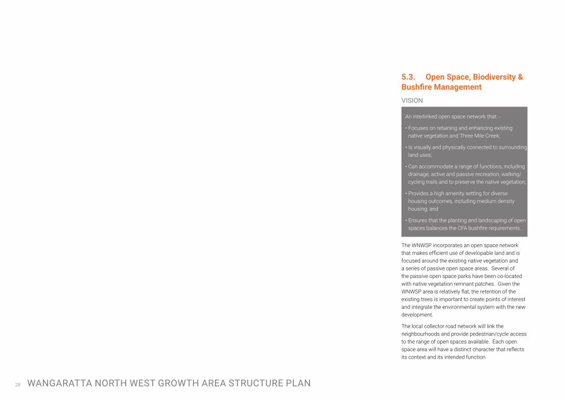
5.3. OpenSpace,Biodiversity&BushfireManagement
An interlinked open space network that: -
• Focuses on retaining and enhancing existing native vegetation and Three Mile Creek;
• Is visually and physically connected to surrounding land uses;
• Can accommodate a range of functions, including drainage, active and passive recreation, walking/cycling trails and to preserve the native vegetation;
• Provides a high amenity setting for diverse housing outcomes, including medium density housing; and
• Ensures that the planting and landscaping of open spaces balances the CFA bushfire requirements.
The WNWSP incorporates an open space network that makes efficient use of developable land and is focused around the existing native vegetation and a series of passive open space areas. Several of the passive open space parks have been co-located with native vegetation remnant patches. Given the WNWSP area is relatively flat, the retention of the existing trees is important to create points of interest and integrate the environmental system with the new development.
The local collector road network will link the neighbourhoods and provide pedestrian/cycle access to the range of open spaces available. Each open space area will have a distinct character that reflects its context and its intended function.
VISION
29
Figure 14: Open Space & Biodiversity
Three
Mile
Cr eek
CHRI
STEN
SEN
LA
NE
WO
RLA
ND
RO
AD
REIT
H R
OA
D
LINDNER ROAD
WILLIAMS ROAD
WANGANDARY ROAD
CRUSE STREET
N
1:7500 at A3
0 75 140 215 290METERS
25 August 2017GREATER CITY OF WANGARATTA
Level 2, 6 Riverside Quay Southbank, VIC 3006 t 9695 3025 f 9695 3001
Open Space and Biodiversity Northern PSP
DRAWING KEY
SITE FEATURES
Site Boundary
Active Open Space (AOS)
Passive Open Space (POS)
400m POS Catchment
Native Vegetation
WANGARATTA NORTH WEST GROWTH AREA STRUCTURE PLAN30
Structure Plan Objectives:
• To identify, protect and enhance areas of significant environmental value through the open space network.
• To locate passive open space to coincide with native vegetation to protect and enhance these features and provide each space with its own distinct character.
• To visually and physically link open space to neighbourhoods through the use of edge road treatments and connected by an off-road pedestrian/cycle network.
• To incorporate small urban ‘green’ spaces within the detailed design of subdivisions, including small pockets parks, widened naturestrips, central medians to provide a point of difference within neighbourhoods that can be utilised as a context for higher density housing.
• To ensure that the location, design and construction of development considers the need to implement bushfire protection measures.
• To identify areas where the bushfire hazard requires specified bushfire management measures for subdivision and buildings and works to be implemented.
• To require future subdivision to set aside passive open space within 400m walkable catchments of 95% of all homes.
Direction for Development Plans:
Encumbered Open Space
The Structure Plan contains several types of encumbered land including drainage retarding basins and biorention basins; an existing Land Subject to Inundation Overlay which applies to land directly abutting the Three Mile Creek; and numerous patches of native vegetation. It is recognised that these areas can accommodate multiple functions, and are a valuable open space resource.
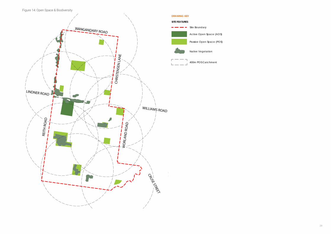
Native Vegetation
The WNWSP has identified 10 of the 22 remnant native vegetation patches, or 6.5 of the total 10.2 hectares, to be retained. Remnant patches numbered 1-7, & 12-14 (as numbered in the Flora and Fauna Report prepared by Hamilton Environmental Services, 2014) are not shown as being retained. The Structure Plan prioritises the retention of existing scattered trees and native vegetation in open spaces which will contribute to the character of Wangaratta. It is intended that the Development Plan Overlay will include controls to protect scattered trees and remnant patches at the time of detailed subdivision.
It is important to note that Council has not sought approval from Department of Environment, Land, Water and Planning (DELWP) in relation to this approach. As part of the public exhibition process the Rural City of Wangaratta will seek confirmation and approval for this approach from the DELWP.
Furthermore, the areas identified as being retained have been removed from the net developable area for the purpose of calculating the Development Contributions Plan charge rate.
Therefore any change to the amount of native vegetation being removed or retained will impact on the Development Contributions Plan.
Lastly, the method of satisfying offsets required with native vegetation removal will be resolved at the planning permit stage and will be met by the development proponent, offsets are not included in the Development Contributions Plan.
Active Open Space
The Wangaratta Growth Areas Structure Planning Report (Aurecon, 2015) identified that a community of 5,000 people meets the benchmark for provision of approximately 4 hectares of active open space. A shared pavilion and car park will be required to be located with these facilities. A four hectare area of active open space, located south of Lindner Road has been identified.
Given that the active open space facilities will be constructed by Council at a later date, the actual facilities will be determined at that time.
Passive Open Space
A series of local parks are required to be provided throughout the Structure Plan. These range in size from a large central park of three hectares north of Lindner Road to a series of smaller parks ranging in size from 1-0.5 hectares in area. These small local parks are located to form the heart of neighbourhoods, and where possible have been co-located with existing vegetation to contribute to the protection and enhancement of the existing environmental habitats.
31
Overall 9.2 hectares of passive open space has been identified across the WNW Structure Plan area which is equivalent to 5% of the total Net Developable Area and will be implemented via the DCP and Clause 52.01.
Specific objectives include: -
• To protect significant roadside vegetation along Lindner Road and Reith Road.
• Prioritise the cohesive retention of existing trees, native vegetation and habitat design in open spaces which contribute to the character of north west Wangaratta.
• The local open space network must be integrated into the broader open space network including links to the Three Mile Creek.
• Each open space area should be designed to have a distinct character that reflects its context and intended use. In particular, the local park co-located with the neighbourhood activity centre is to form an urban heart to the neighbourhood. This open space area should take on an urban plaza/town square character, and be incorporated into the design of the activity centre.
• Passive parks should cater for a broad range of users by providing a mix of spaces and planting to support both structured and unstructured recreational activities and play opportunities for all ages and abilities.
• Any fencing of open space, whether encumbered or unencumbered, must be low scale and visually permeable to facilitate public safety and surveillance. Fences other than vehicle exclusion bollards or pedestrian exclusion fencing to prevent access to conservation areas are to be avoided.
• The design of waterway corridors, conservation areas, wetlands and retarding basins, and any other encumbered open space must seek to maximise the amenity value of that open space and provide for a range of flexible recreational opportunities. This is to be prioritised when such land abuts unencumbered passive or active open space.
• Open space areas should be located and designed to contribute to the protection and enhancement of existing environmental, habitat and historical values of the precinct.
• Ensure planting, landscaping and vegetation of open spaces balance the CFA bushfire requirements.
Bushfire Management
A Bushfire Hazard Management Plan is to be prepared before the commencement of works addressing the bushfire risk. The plan should specify, amongst other things: -
• Bushfire hazard, whether from the land or nearby land, that may threaten life and property on the land during and after development;
• Measures to reduce the risk from fire within the surrounding rural landscape and protect residents from the threat of fire;
• The staging of development;
• How the bushfire hazard will change as development proceeds;
• How adequate opportunities for access and egress will be provided to early residents, construction workers and emergency vehicles;
• Providing a suitable ‘edge’ treatment along the western boundary; and
• Any lot on which buildings must be constructed to a specified Bushfire Attack Level (BAL).
The Plan must be carried out to the satisfaction of the responsible authority and relevant fire authority. The Bushfire Hazard Management Plan should address whether it is appropriate to remove the Bushfire Prone Area designation from the WNWSP area as development stages progress.
WANGARATTA NORTH WEST GROWTH AREA STRUCTURE PLAN32
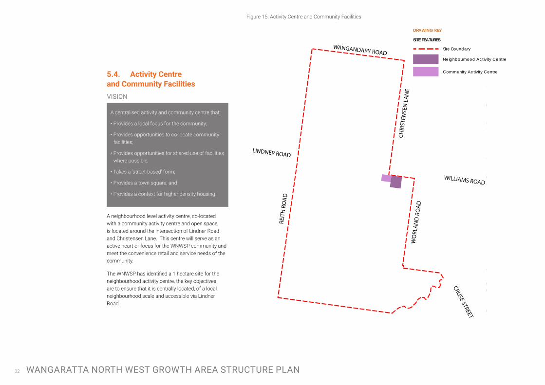
5.4. ActivityCentre and Community Facilities
A centralised activity and community centre that:
• Provides a local focus for the community;
• Provides opportunities to co-locate community facilities;
• Provides opportunities for shared use of facilities where possible;
• Takes a ‘street-based’ form;
• Provides a town square; and
• Provides a context for higher density housing.
A neighbourhood level activity centre, co-located with a community activity centre and open space, is located around the intersection of Lindner Road and Christensen Lane. This centre will serve as an active heart or focus for the WNWSP community and meet the convenience retail and service needs of the community.
The WNWSP has identified a 1 hectare site for the neighbourhood activity centre, the key objectives are to ensure that it is centrally located, of a local neighbourhood scale and accessible via Lindner Road.
Figure 15: Activity Centre and Community Facilities
Three
Mile
Cr eek
CHRI
STEN
SEN
LA
NE
WO
RLA
ND
RO
AD
REIT
H R
OA
D
LINDNER ROAD
WILLIAMS ROAD
WANGANDARY ROAD
CRUSE STREET
N
1:7500 at A3
0 75 140 215 290METERS
25 August 2017GREATER CITY OF WANGARATTA
Level 2, 6 Riverside Quay Southbank, VIC 3006 t 9695 3025 f 9695 3001
Neighbourhood and Density Northern PSP
DRAWING KEY
SITE FEATURES
Site Boundary
Neighbourhood Activity Centre
Community Activity Centre
VISION
33
Structure Plan Objectives:
• To locate a neighbourhood-scale activity centre centrally within the WNWSP area, on the south side of Lindner Road that will form an accessible and vibrant ‘heart’ to the WNW community.
• To provide local convenience centre retail and services, possibly including a small convenience/general store, small service businesses, a café and community services such as childcare and a medical centre.
• To incorporate public space as a central part of the activity centre by co-locating the activity centre with a 1 hectare town park/square.
• To integrate the activity centre with surrounding community uses such as the community activity centre.
• To provide opportunities for higher density housing and mixed uses, such as home offices surrounding the activity centre.
• To ensure the activity centre is accessible via public transport by locating it on a bus route.
Direction for Development Plans:
Activity Centre Design
At the Development Stage it will be necessary to develop a design for the structure of the activity centre, that integrates with the local road network and other land uses and comprises a high quality built form. Specific objectives include:
• Scale of activity centre (i.e. retail floor space) must reflect its status as a Neighbourhood Convenience Centre, providing daily goods and services. It is anticipated that the retail floorspace would be around 4,000m2.
• Activity centre must be designed to be visible and accessible from Lindner Road.
• Buildings fronting the Linder Road must provide a continuous built form edge with fine grain development and outward facing built form.
• Mixed uses, incorporating higher density residential, community uses and home/ office style uses are encouraged in the area immediately surrounding the activity centre.
• A supermarket/big box retail must be sleeved by single fronted retail on the main street (Lindner Road) edge with off-street parking located to the rear of the buildings
• The road and path networks within the neighbourhood centre must promote pedestrian and bicycle trips through a clear, direct layout and design.
• The activity centre and community centre should comprise high quality built form that positively address the surrounding streets, corners and public spaces, including open space.
• Buildings and uses should be of a scale sympathetic to the surrounding residential context.
• Adequate parking must be provided in a location that does not feature prominently from key locations, such as Lindner Road.
• Future bus stop locations must include a bus stop at the activity centre

WANGARATTA NORTH WEST GROWTH AREA STRUCTURE PLAN34
5.5. NeighbourhoodsandDensity
A series of internal neighbourhoods that:
• Create high quality residential environments;
• Are diverse in landscape, streetscape and built form character;
• Are clearly defined and incorporates sustainable design principles;
• Contain an identifiable neighbourhood ‘core’ (open space, activity centre, key natural feature) to establish a sense of place; and
• Provide opportunities for diverse housing outcomes, from smaller lots to larger lots, to achieve an average density of 10 lots per net developable hectare and meet the varying needs of the local population.
The WNWSP area comprises of a series of neighbourhoods of approximately 400m in radius (i.e. a five minute walk in each direction) which are focused around centralised features, such as a local park or activity centre which serves to provide a local point of difference, to give the neighbourhood a distinct character and identity and as a context for diverse housing outcomes. The precise boudaries of these neighbourhoods will be determined during the Development Plan stage.
Figure 16: Neighbourhoods and Density
Three
Mile
Cr eek
60m low density interface
Larger 1,000m2 lots facing
Wangandary Road
CHRI
STEN
SEN
LA
NE
WO
RLA
ND
RO
AD
REIT
H R
OA
D
LINDNER ROAD
WILLIAMS ROAD
WANGANDARY ROAD
CRUSE STREET
N
1:7500 at A3
0 75 140 215 290METERS
25 August 2017GREATER CITY OF WANGARATTA
Level 2, 6 Riverside Quay Southbank, VIC 3006 t 9695 3025 f 9695 3001
Neighbourhood and Density Northern PSP
DRAWING KEY
SITE FEATURES
Site Boundary
Standard Density Residential
Low Density Residential
Diverse Housing / Medium Density Residential
Larger Lots (1,000M2 )VISION
35
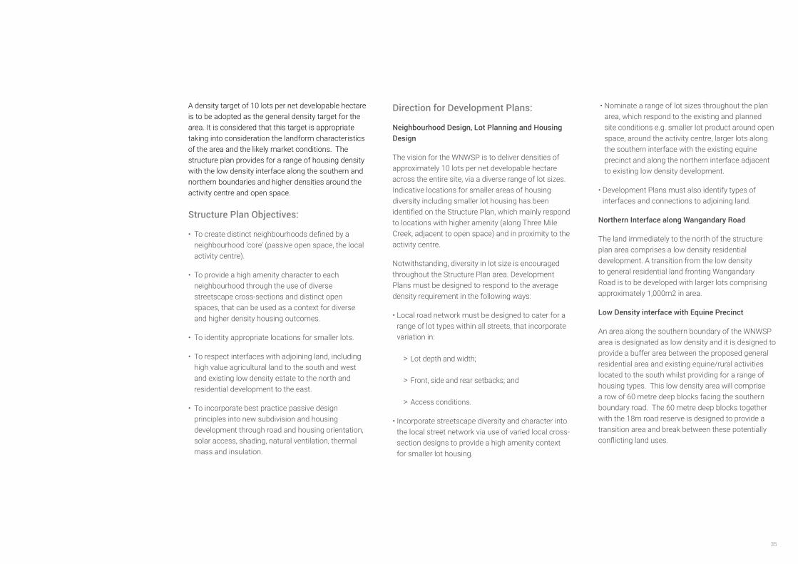
A density target of 10 lots per net developable hectare is to be adopted as the general density target for the area. It is considered that this target is appropriate taking into consideration the landform characteristics of the area and the likely market conditions. The structure plan provides for a range of housing density with the low density interface along the southern and northern boundaries and higher densities around the activity centre and open space.
Structure Plan Objectives:
• To create distinct neighbourhoods defined by a neighbourhood ‘core’ (passive open space, the local activity centre).
• To provide a high amenity character to each neighbourhood through the use of diverse streetscape cross-sections and distinct open spaces, that can be used as a context for diverse and higher density housing outcomes.
• To identity appropriate locations for smaller lots.
• To respect interfaces with adjoining land, including high value agricultural land to the south and west and existing low density estate to the north and residential development to the east.
• To incorporate best practice passive design principles into new subdivision and housing development through road and housing orientation, solar access, shading, natural ventilation, thermal mass and insulation.
Direction for Development Plans:
Neighbourhood Design, Lot Planning and Housing Design
The vision for the WNWSP is to deliver densities of approximately 10 lots per net developable hectare across the entire site, via a diverse range of lot sizes. Indicative locations for smaller areas of housing diversity including smaller lot housing has been identified on the Structure Plan, which mainly respond to locations with higher amenity (along Three Mile Creek, adjacent to open space) and in proximity to the activity centre.
Notwithstanding, diversity in lot size is encouraged throughout the Structure Plan area. Development Plans must be designed to respond to the average density requirement in the following ways:
• Local road network must be designed to cater for a range of lot types within all streets, that incorporate variation in:
> Lot depth and width;
> Front, side and rear setbacks; and
> Access conditions.
• Incorporate streetscape diversity and character into the local street network via use of varied local cross-section designs to provide a high amenity context for smaller lot housing.
• Nominate a range of lot sizes throughout the plan area, which respond to the existing and planned site conditions e.g. smaller lot product around open space, around the activity centre, larger lots along the southern interface with the existing equine precinct and along the northern interface adjacent to existing low density development.
• Development Plans must also identify types of interfaces and connections to adjoining land.
Northern Interface along Wangandary Road
The land immediately to the north of the structure plan area comprises a low density residential development. A transition from the low density to general residential land fronting Wangandary Road is to be developed with larger lots comprising approximately 1,000m2 in area.
Low Density interface with Equine Precinct
An area along the southern boundary of the WNWSP area is designated as low density and it is designed to provide a buffer area between the proposed general residential area and existing equine/rural activities located to the south whilst providing for a range of housing types. This low density area will comprise a row of 60 metre deep blocks facing the southern boundary road. The 60 metre deep blocks together with the 18m road reserve is designed to provide a transition area and break between these potentially conflicting land uses.
WANGARATTA NORTH WEST GROWTH AREA STRUCTURE PLAN36
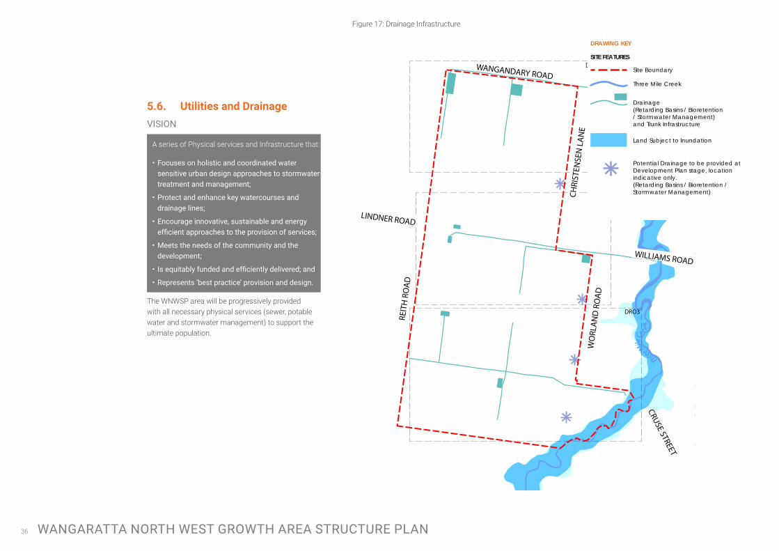
5.6. Utilities and Drainage
A series of Physical services and Infrastructure that:
• Focuses on holistic and coordinated water sensitive urban design approaches to stormwater treatment and management;
• Protect and enhance key watercourses and drainage lines;
• Encourage innovative, sustainable and energy efficientapproachestotheprovisionofservices;
• Meets the needs of the community and the development;
• Isequitablyfundedandefficientlydelivered;and
• Represents ‘best practice’ provision and design.
The WNWSP area will be progressively provided with all necessary physical services (sewer, potable water and stormwater management) to support the ultimate population.
Figure 17: Drainage Infrastructure
Three Mile
Cr
e ek
Three Mile
Cr
e ek
DRO1
DRO2
DRO3
CHRI
STEN
SEN
LA
NE
WO
RLA
ND
RO
AD
REIT
H R
OA
D
LINDNER ROAD
WILLIAMS ROAD
WANGANDARY ROAD
CRUSE STREET
N
1:7500 at A3
0 75 140 215 290METERS
25 August 2017GREATER CITY OF WANGARATTA
Level 2, 6 Riverside Quay Southbank, VIC 3006 t 9695 3025 f 9695 3001
Drainage Infrastructure Northern PSP
DRAWING KEY
SITE FEATURES
Site Boundary
Drainage (Retarding Basins / Bioretention/ Stormwater Management)and Trunk Infrastructure
Three Mile Creek
Land Subject to Inundation
Potential Drainage to be provided at Development Plan stage, location indicative only. (Retarding Basins / Bioretention / Stormwater Management)
VISION
37
Structure Plan Objectives:
• To identify key infrastructure that will serve the broader WNW community, and as such, funding of this infrastructure should be shared (see Figure 17 for list of infrastructure).
• To identify a Water Sensitive Urban Design approach to stormwater management that meets the drainage requirements of the development and also protects the water quality of the Three Mile Creek. This approach provides for three catchments that will drain to a series of retarding and bioretention basins that will manage stormwater flows and quality, supported by main drainage infrastructure to be incorporated within the local street network.
• To utilise the WNW Development Contributions Plan to equitably distribute the costs associated with provision of drainage and road infrastructure.
Direction for Development Plans:
Servicing and Drainage
Current infrastructure providers to the WNW area are: -
All providers have advised that the land can be serviced.
The major drainage infrastructure required to service the WNWSP area is described below and illustrated in Figure 17.
WaterNorth East Region Water Corporation
Electricity Ausnet Services
Telecommunications Telstra
DrainageRural City of Wangaratta, North East Catchment Management Authority
Gas APA Group
DR01
Wangandary Road Trunk Drainage. Construction of major spine drainage system along Wangandary Road to service the northern portion of the North-Western Growth Area. A total of 1,920 lm of pipe is required along with the construction of one retarding basin and one bio-retention basin. Total land area required is 1.05 hectares.
DR02
Lindner Road Trunk Drainage. Construction of major spine drainage system along Lindner Road to service the central section of the North-Western Growth Area. A total of 1,975 lm of pipe is required along with the construction of two retarding basins and one bio-retention basin. Total land area required is 0.485 hectares.
DR03
Reith-Cruse Street Trunk Drainage. Construction of major spine drainage system within the new Cruse Street road reserve to service the southern section of the North-Western Growth Area. A total of 2,600 lm of pipe is required along with the construction of one retarding basin and two bio-retention basins. Total land area required is 0.45 hectares.
Details of servicing staging and delivery, including any easements which may be required, must be provided as part of future Development Plans.
Developments Plans must provide the details of servicing staging and delivery in the following ways: -
• The development must provide best practice stormwater quality treatment.
• Delivery of underground services must be coordinated, located, and bundled (utilising common trenching) to facilitate the planting of trees and other vegetation within road verges to the satisfaction of the Responsible Authority.
• The design and layout of open space should maximise water use efficiency and long term viability of vegetation through the use of Water Sensitive Urban Design initiatives, including use of locally treated stormwater for irrigation purposes.
• Integrated water management systems should be designed to:
> Maximise habitat values for local flora and fauna species.
> Enable future harvesting and/or treatment and re-use of stormwater, including those options or opportunities.
• New electricity supply infrastructure should be provided underground where possible.
• Above ground utility infrastructure should be located outside of key view lines and must be screened with vegetation or architectural features.
WANGARATTA NORTH WEST GROWTH AREA STRUCTURE PLAN38
6 IMPLEMENTATION PLAN6.1. DevelopmentStagingand
DevelopmentPlanAreas
A Development Plan is required to be approved by the responsible authority before a planning permit can be issued (some exemptions apply). Development Plans must be prepared in accordance with the Wangaratta North West Development Plan Overlay Schedule 7, and must be prepared for a group of landholdings that represent a logically defined precinct. Indicative Development Plan areas are provided in Figure 18.
The key purpose of a Development Plan is to resolve:
• Layout issues at the local road network scale, including connections at property boundaries and local connections to adjoining land outside the Structure Plan area;
• Detailed location and configuration of the activity centre (where relevant);
• Design of open space;
• Typical cross-sections for a variety of local streets;
• Provision of servicing infrastructure;
• Native vegetation and heritage issues; and
• Details of Development Contribution Plan items proposed to be undertaken as ‘works in lieu’ of cash contributions.
Figure 18: Development Plan Precincts
Three
Mile
Cr eek
87
6
1A
1B
2
3
4
5
9 CHRI
STEN
SEN
LA
NE
WO
RLA
ND
RO
AD
REIT
H R
OA
D
LINDNER ROAD
WILLIAMS ROAD
WANGANDARY ROAD
CRUSE STREET
N
1:7500 at A3
0 75 140 215 290METERS
25 August 2017GREATER CITY OF WANGARATTA
Level 2, 6 Riverside Quay Southbank, VIC 3006 t 9695 3025 f 9695 3001
Development Staging Northern PSP
39
6.2. SubdivisionworksbyDevelopers
As part of subdivision construction works, new development is required to meet the cost of delivering the following infrastructure (where the infrastructure is not included in the Development Contributions Plan for the land incorporated into the Wangaratta Planning Scheme):
• East-west connector and local streets (with reimbursement for those that are included in the WNW Development Contributions Plan incorporated in the scheme to the satisfaction of the collecting agency);
• Landscaping of all existing and future roads and local streets (with reimbursement for those that are included in the WNW Development Contributions Plan incorporated in the scheme to the satisfaction of the collecting agency);
• Intersection works and traffic management measures along collector roads and local streets (with reimbursement for those that are included in WNW Development Contributions Plan incorporated in the scheme to the satisfaction of the collecting agency);
• Local pedestrian and bicycle paths along collector roads and local streets and within local parks (with reimbursement for those that are included in the WNW Development Contributions Plan incorporated in the scheme to the satisfaction of the collecting agency);
6.3. DevelopmentContributionsPlan
A Development Contributions Plan has been prepared for the WNW area in conjunction with this Structure Plan, which also details open space contributions.
The WNW Development Contributions Plan is an incorporated document of the Wangaratta Planning Schedule and implemented through the Development Contributions Overlay. Open space contributions are to be provided in accordance with the Development Contributions Plan, with contributions implemented through the Schedule to Clause 52.01.
• Basic improvements to local parks and passive open space including levelling, grassing, tree planting, local playgrounds and shared paths and footpaths;
• Local drainage systems; and
• Infrastructure as required by utility services providers including water, sewerage, drainage (except where the item is funded through the WNW Development Contributions Plan), electricity, gas, and telecommunications.
WANGARATTA NORTH WEST GROWTH AREA STRUCTURE PLAN40
7 REFERENCESAurecon, 2015, Wangaratta Growth areas Structure Planning Report
Aurecon, SGS, Rural City of Wangaratta, 2013, Population and Housing Strategy
Biosis, 2014, Residential Growth Area Precinct Planning, Wangaratta, Victoria: Cultural Heritage Assessment
GHD, 2017, Wangaratta Growth Areas Transport Study – Final Report
Hamilton Environmental Services, 2014, Biodiversity Study – North West and South Wangaratta Residential Growth Area Precinct Plans
Rural City of Wangaratta, 2012, Recreation Strategy and Open Space Strategy
Rural City of Wangaratta, 2015, Strategic Drainage Review – Growth Areas
Terramatrix, 2014, Strategic Bushfire Assessment for Wangaratta Residential Growth Areas

41