Embed Size (px)
Citation preview

Ward Walk Profile:
Streetly
January 2019Version 1.0 - FINAL
Cllr Brian Douglas-Maul (Conservatives)
Cllr Amers Kudhail (Conservatives)
Cllr Suky Samra (Conservatives)

Geography
Covers 5.83 sq km (583 ha)
Makes up 5.6% of the area of
Walsall borough
Population density of 24
people per hectare (lower
than borough average of 27)
Source: Ordnance Survey; ONS, Mid-2016 Population Estimates


16%
21%
58%
61%
26%
18%
0% 20% 40% 60% 80% 100%
Streetly
Walsall
Children (0-15) Working age (16-64) Older people (65+)
1086420246810
0 - 4
5 - 9
10 - 14
15 - 19
20 - 24
25 - 29
30 - 34
35 - 39
40 - 44
45 - 49
50 - 54
55 - 59
60 - 64
65 - 69
70 - 74
75 - 79
80 - 84
85 - 89
90+
%
Age
(ye
ars)
Stre
etly
(20
16)
Mal
e
Fem
alePopulation Structure
Total population: 12,900
Less children than the borough
as a whole
Fewer proportion of working age
More over 65’s than borough
Source: ONS, Mid-2016 Population Estimates

Ethnicity
Source: ONS, 2011 Census
14% minority ethnic residents
Asian is the largest minority group
at 8.9% (on par with Walsall
average of 15.2%)
Of the Asian minority group, Indian
is the most prolific at 6.1%

Housing
5,710 households (with at least 1
usual resident)
Increase of 12.6% since 2001
(Proportion of borough total 5.3%)
Average household size: 2.4
residents per h/hold (similar to
Walsall average of 2.5)
Composition
Source: ONS, Census 2011
Tenure
2.3% of households ‘overcrowded’*
(Walsall average 6.5%)
1.4% of households without central
heating (Walsall average 2.8%)
Low proportion of socially rented (1.6%)
properties compared to borough (24.1%)
Above average (31.9%) mortgage owned
(41.6%) * ONS measure – based on (room) occupancy rating of -1 or less

Social SegmentationThe largest groups of households are classified as group B – Prestige Positions
(35%) & group F – Senior Security (25%)
Source: Experian, Mosaic Public Sector Profiler 2017
Most effective
communication
route
Least effective
communication
route
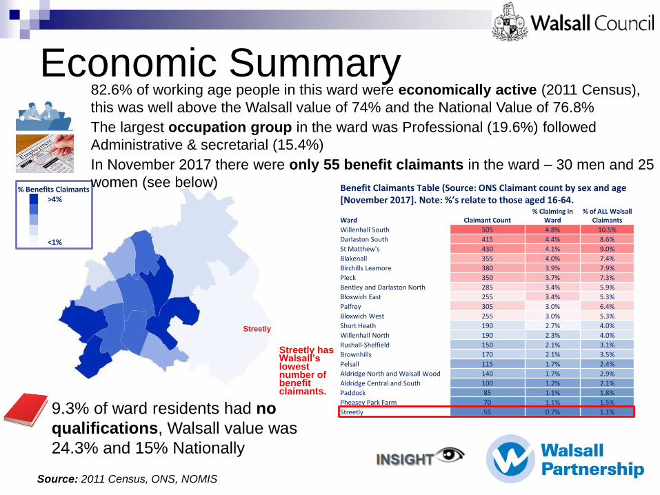
Benefit Claimants Table (Source: ONS Claimant count by sex and age [November 2017]. Note: %’s relate to those aged 16-64.
Ward Claimant Count% Claiming in
Ward% of ALL Walsall
Claimants
Willenhall South 505 4.8% 10.5%
Darlaston South 415 4.4% 8.6%
St Matthew's 430 4.1% 9.0%
Blakenall 355 4.0% 7.4%
Birchills Leamore 380 3.9% 7.9%
Pleck 350 3.7% 7.3%
Bentley and Darlaston North 285 3.4% 5.9%
Bloxwich East 255 3.4% 5.3%
Palfrey 305 3.0% 6.4%
Bloxwich West 255 3.0% 5.3%
Short Heath 190 2.7% 4.0%
Willenhall North 190 2.3% 4.0%
Rushall-Shelfield 150 2.1% 3.1%
Brownhills 170 2.1% 3.5%
Pelsall 115 1.7% 2.4%
Aldridge North and Walsall Wood 140 1.7% 2.9%
Aldridge Central and South 100 1.2% 2.1%
Paddock 85 1.1% 1.8%
Pheasey Park Farm 70 1.1% 1.5%
Streetly 55 0.7% 1.1%
% Benefits Claimants >4%
<1%
Streetly
82.6% of working age people in this ward were economically active (2011 Census),
this was well above the Walsall value of 74% and the National Value of 76.8%
The largest occupation group in the ward was Professional (19.6%) followed
Administrative & secretarial (15.4%)
In November 2017 there were only 55 benefit claimants in the ward – 30 men and 25
women (see below)
• 9.3% of ward residents had no
qualifications, Walsall value was
24.3% and 15% Nationally
Streetly has Walsall’s lowest number of benefit claimants.
Source: 2011 Census, ONS, NOMIS
Economic Summary

Deprivation
All LSOAs within the 20%
least deprived in England.
Source: DCLG, Index of Multiple Deprivation, 2015
Note – LSOA (Lower Super Output Area) – part of a
geographical hierarchy with an average population of 1,500

Educational Attainment
Source: Department for Education & Skills (DfES), 2017
Well Above
average
within Early
Years & Y1
phonicsWell Above
average within
KS1
Well Above
average within
KS2
Above
average KS4
ave. progress
8 score
Well
Above
average
for
exclusions

Childhood Obesity
• The above charts show the proportion of children resident in the ward that are overweight or obese in Reception (Aged 5) and in Year 6 (Age 10).
• Of the 20 Walsall wards, Streetly ranks 19th in Reception and 20th in Year 6 in terms of the prevalence of excess weight in childhood.
Source: National Child Measurement Programme (NCMP), 2014-17

Adult Obesity PrevalenceWard %
Rushall-Shelfield 18.14
Aldridge North & Walsall
Wood 17.81
Pheasey Park Farm 16.60
Brownhills 15.91
Pelsall 14.48
Streetly 12.80
Aldridge Central and South 11.28
WALSALL 14.89
Streetly has lower prevalence
of adult obesity (12.8%) than
the borough average of
14.9%
Source: Quality and Outcomes Framework, 2015/16
Note – based on GP practice patient lists
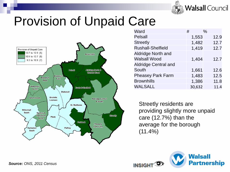
Provision of Unpaid Care
Streetly residents are
providing slightly more unpaid
care (12.7%) than the
average for the borough
(11.4%)
Ward # %
Pelsall 1,553 12.9
Streetly 1,482 12.7
Rushall-Shelfield 1,419 12.7
Aldridge North and
Walsall Wood 1,404 12.7
Aldridge Central and
South 1,661 12.6
Pheasey Park Farm 1,483 12.5
Brownhills 1,386 11.8
WALSALL 30,632 11.4
Source: ONS, 2011 Census

Ward
Total
Recorded
Crime
Serious
Acquisitive
crime
Aldridge Central and South 722 162
Aldridge North and Walsall Wood 616 162
Bentley and Darlaston North 1,191 361
Birchills Leamore 1,587 335
Blakenall 1,290 294
Bloxwich East 1,093 235
Bloxwich West 1,079 254
Brownhills 757 162
Darlaston South 927 231
Paddock 557 252
Palfrey 966 290
Pelsall 575 179
Pheasey Park Farm 406 144
Pleck 1,397 355
Rushall Shelfield 708 184
Short Heath 725 228
St Matthew's 3,248 547
Streetly 550 179
Willenhall North 841 204
Willenhall South 1,992 508
Low number of recorded crimes in this Ward during
2017.
Appro
x S
everity
*Serious Acquisitive crimes are defined as :
Residential burglary
Robbery (person)
Robbery (business)
Theft of motor vehicle
Theft from motor vehicle
LSOA’s in the Ward showing mainly
low numbers of recorded crimes with
one hot-spot LSOA.
Data Source: WM Police Data
Theft (other) and residential burglary are the biggest
issues here (43.8%)
Recorded Crime
Source: West Midlands Police, Jan to Dec 2017

Wards
Police Patrol Hotspot Areas
Source: West Midlands Police, Jan to Dec 2017

Voluntary & Community Orgs.
There are a range of groups within Streetly including (not
exhaustive to): Brownies, Guides, Scouts, Blackwood Singers,
Forget Me Not – Streetly dementia support group, Sutton
Coldfield Canoe Club
A network meeting for all groups / organisations meets on a
quarterly basis. The next planned meeting is 16 January
2019.
Source: Localities & Partnerships, Walsall Council

Regeneration Well established residential area with access to Greenbelt.
Streetly is a more affluent part of the Borough and therefore
intervention is limited.
Healthy local centres providing a range of good services and
with good levels of occupancy: Blackwood and Streetly.
Many residents are likely to commute for work, e.g. Walsall,
Birmingham and Sutton Coldfield.
Streetly CA is well established and active in the area.
Streetly Library continues to be operated in conjunction with
the friends group.
Area of Special Townscape Character (Thornhill Road/
Middleton Road/ Foley Road East) – used by Development
Management as guidance for new development to protect the
character and appearance of this area.
Future housing opportunity at Enterprise Drive subject to
industry vacating site (occupied site to be considered for
release in Site Allocation Document).
Future proposals include the Library Garden and car parking
provision for St Anne's School on the site of the former youth
club.
Source: Regeneration & Development, Walsall Council

Greenbelt
Blackwood Local
Centre (including
local library)
Streetly CA
Streetly Local
Centre
St Anne’s
Catholic Primary
School
Enterprise Drive,
Streetly
Streetly
Area of
Special
Townscape
Character
Source: Regeneration & Development, Walsall Council

Useful Links
• Walsall Intelligence: Data and intelligence portal for Walsall
Partnership, including links to profiles, needs assessments and
additional resources www.walsallintelligence.org.uk
• 2011 Census: Information related to the release of the latest
census results, including analysis and reports for Walsall and
links to official ONS websites www.walsall.gov.uk/census
• Nomis: detailed and up‐to‐date UK labour market and
economic statistics from official sources www.nomisweb.co.uk

These profiles have been compiled by analysts and other
colleagues from across Walsall Insight
Contact: [email protected] or [email protected]
Key Contributors:
Emma Thomas, Claire Heath, David Hughes & Lee Harley (Public Heath), Liz
Connolly & Jill Collins (Economic Intelligence), John Morris (Localities &
Partnerships), Kauser Agha (Regeneration), Nick Perks (Children’s Services), Andy
Brumwell (WM Police)
Extended Thanks to Ruby Bacha & Christine Williams
January 2019
Mapping used in this profile is reproduced from the Ordnance Survey mapping with the permission of Her Majesty’s
Stationary Office. © Crown copyright. Unauthorised infringes Crown Copyright and may lead to prosecution or civil
proceedings.
A-Z mapping is reproduced by permission of Geographers’ A-Z Map Co. Ltd. © Crown Copyright 2019. All rights
reserved.
Walsall Council licence number 100017302.

Notes