Embed Size (px)
Citation preview
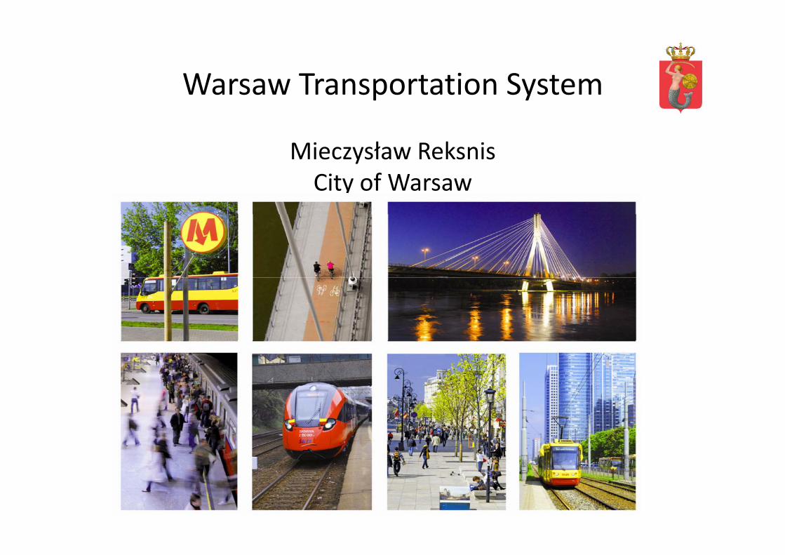
Warsaw Transportation SystemWarsaw Transportation System
Mieczysław ReksnisMieczysław ReksnisCity of Warsaw
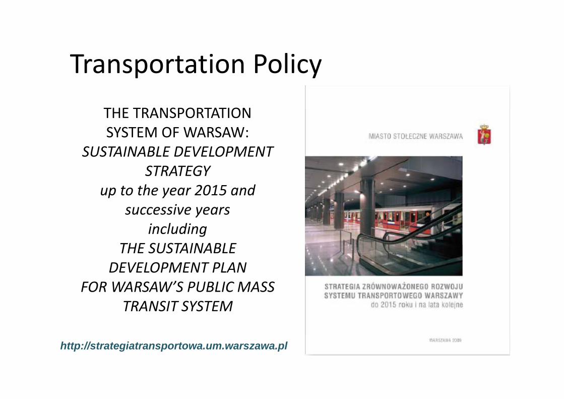
Transportation PolicyTHE TRANSPORTATION
Transportation PolicyTHE TRANSPORTATION SYSTEM OF WARSAW:
SUSTAINABLE DEVELOPMENTSUSTAINABLE DEVELOPMENT STRATEGY
up to the year 2015 and successive years
includingTHE SUSTAINABLETHE SUSTAINABLE
DEVELOPMENT PLANFOR WARSAW’S PUBLIC MASSFOR WARSAW S PUBLIC MASS
TRANSIT SYSTEM
http://strategiatransportowa.um.warszawa.pl
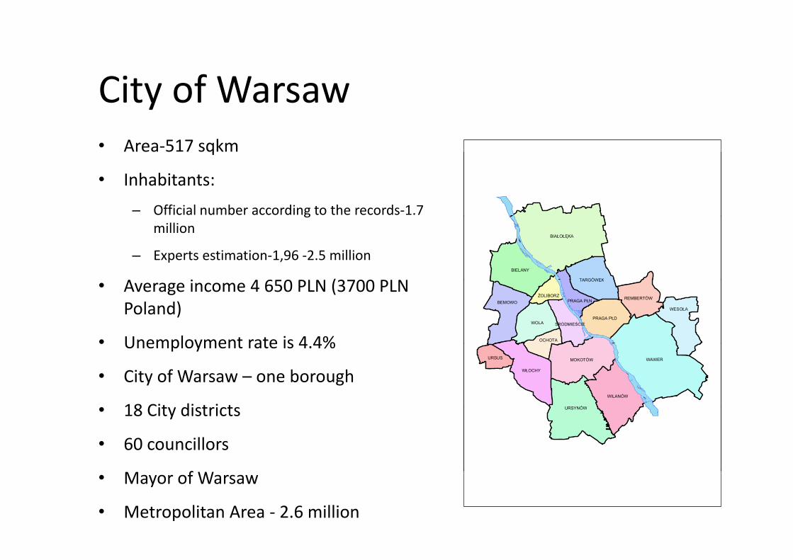
City of WarsawCity of Warsaw• Area‐517 sqkm q
• Inhabitants: – Official number according to the records‐1.7 g
million
– Experts estimation‐1,96 ‐2.5 million
A i 4 650 PLN (3700 PLN
BIAŁOŁĘKA
BIELANY
TARGÓWEK
BIAŁOŁĘKA
BIELANY
TARGÓWEK• Average income 4 650 PLN (3700 PLN Poland)
• Unemployment rate is 4 4%WOLA
WESOŁABEMOWO
TARGÓWEK
PRAGA PŁD
REMBERTÓW
OCHOTA
ŚRÓDMIEŚCIE
PRAGA PŁNŻOLIBORZ
WOLA
WESOŁABEMOWO
TARGÓWEK
PRAGA PŁD
REMBERTÓW
OCHOTA
ŚRÓDMIEŚCIE
PRAGA PŁNŻOLIBORZ
• Unemployment rate is 4.4%
• City of Warsaw – one borough
• 18 Cit districts
WAWER
URSYNÓW
WILANÓW
MOKOTÓW
WŁOCHY
URSUS WAWER
URSYNÓW
WILANÓW
MOKOTÓW
WŁOCHY
URSUS
• 18 City districts
• 60 councillors
URSYNÓWURSYNÓW
• Mayor of Warsaw
• Metropolitan Area ‐ 2.6 million
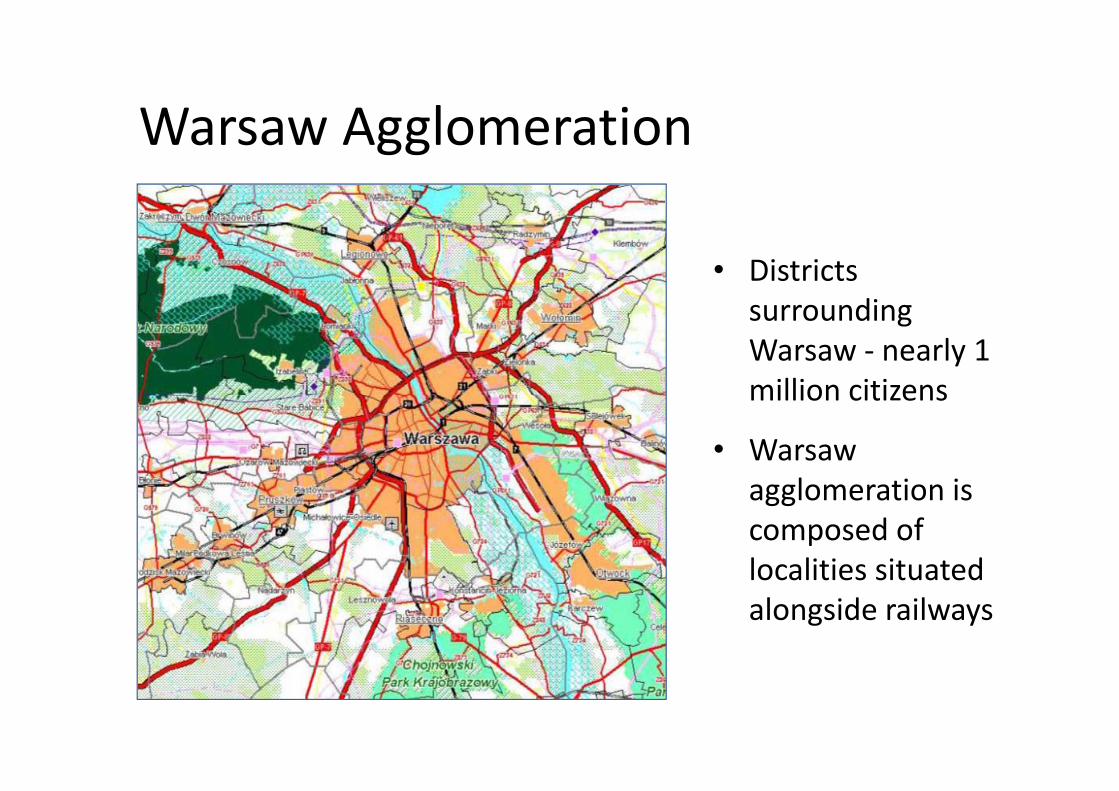
Warsaw AgglomerationWarsaw Agglomeration
• Districts surroundingsurrounding Warsaw ‐ nearly 1 million citizensmillion citizens
• Warsaw agglomeration isagglomeration is composed of localities situatedlocalities situated alongside railways
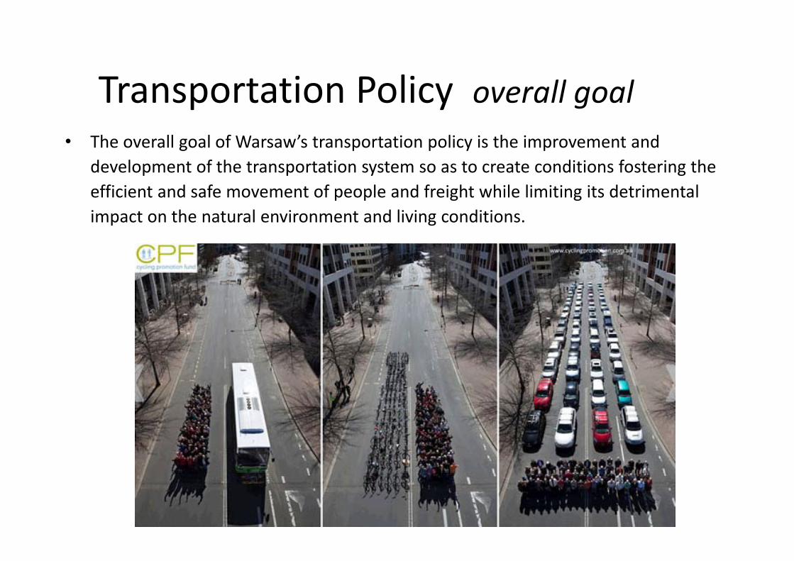
Transportation Policy overall goalTransportation Policy overall goal• The overall goal of Warsaw’s transportation policy is the improvement and
development of the transportation system so as to create conditions fostering the efficient and safe movement of people and freight while limiting its detrimental impact on the natural environment and living conditionsimpact on the natural environment and living conditions.
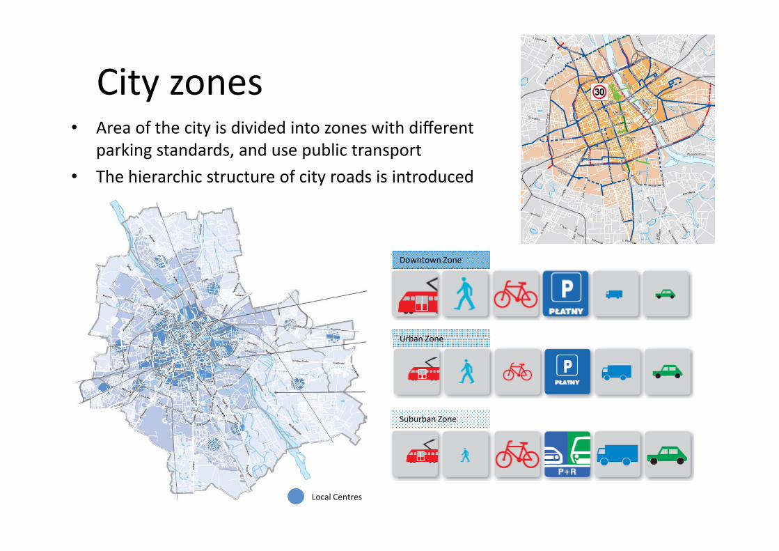
City zonesCity zones• Area of the city is divided into zones with different
parking standards and use public transportparking standards, and use public transport• The hierarchic structure of city roads is introduced
Downtown Zone
Urban ZoneUrban Zone
Suburban Zone
Local Centres
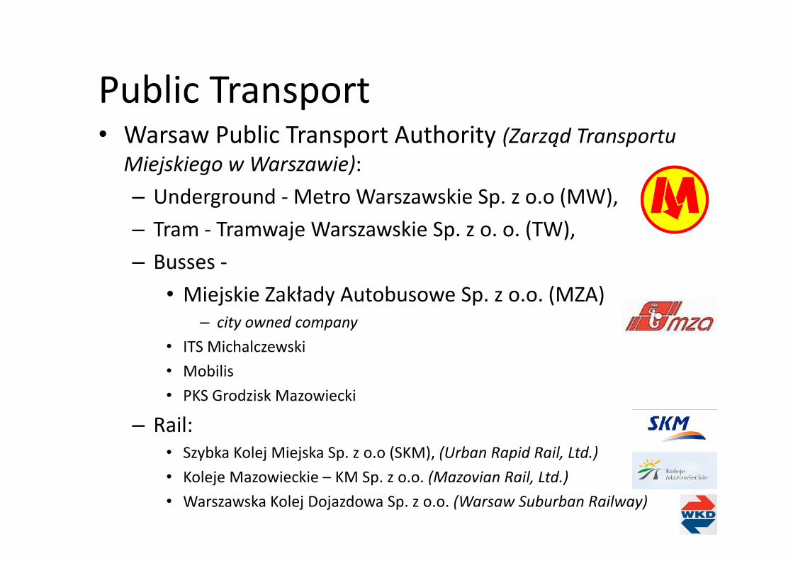
Public TransportPublic Transport• Warsaw Public Transport Authority (Zarząd Transportu
Miejskiego w Warszawie):– Underground ‐Metro Warszawskie Sp. z o.o (MW),– Tram ‐ Tramwaje Warszawskie Sp. z o. o. (TW), – Busses ‐
• Miejskie Zakłady Autobusowe Sp. z o.o. (MZA) – city owned company
• ITS Michalczewski• ITS Michalczewski• Mobilis• PKS Grodzisk Mazowiecki
– Rail:• Szybka Kolej Miejska Sp. z o.o (SKM), (Urban Rapid Rail, Ltd.)K l j M i ki KM S (M i R il L d )• Koleje Mazowieckie – KM Sp. z o.o. (Mazovian Rail, Ltd.)
• Warszawska Kolej Dojazdowa Sp. z o.o. (Warsaw Suburban Railway)
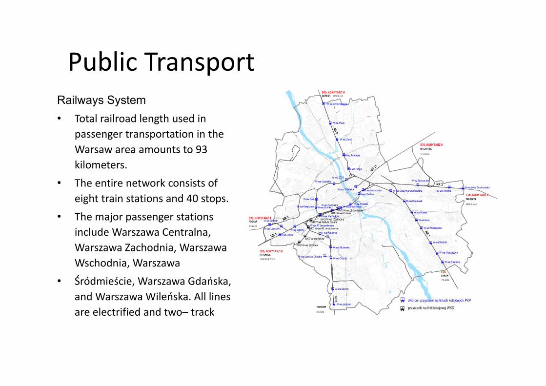
Public TransportPublic TransportRailways Systemy y• Total railroad length used in
passenger transportation in the Warsaw area amounts to 93Warsaw area amounts to 93 kilometers.
• The entire network consists of eight train stations and 40 stops.
• The major passenger stations include Warszawa Centralna, ,Warszawa Zachodnia, Warszawa Wschodnia, Warszawa
• Śródmieście Warszawa Gdańska• Śródmieście, Warszawa Gdańska, and Warszawa Wileńska. All lines are electrified and two– track
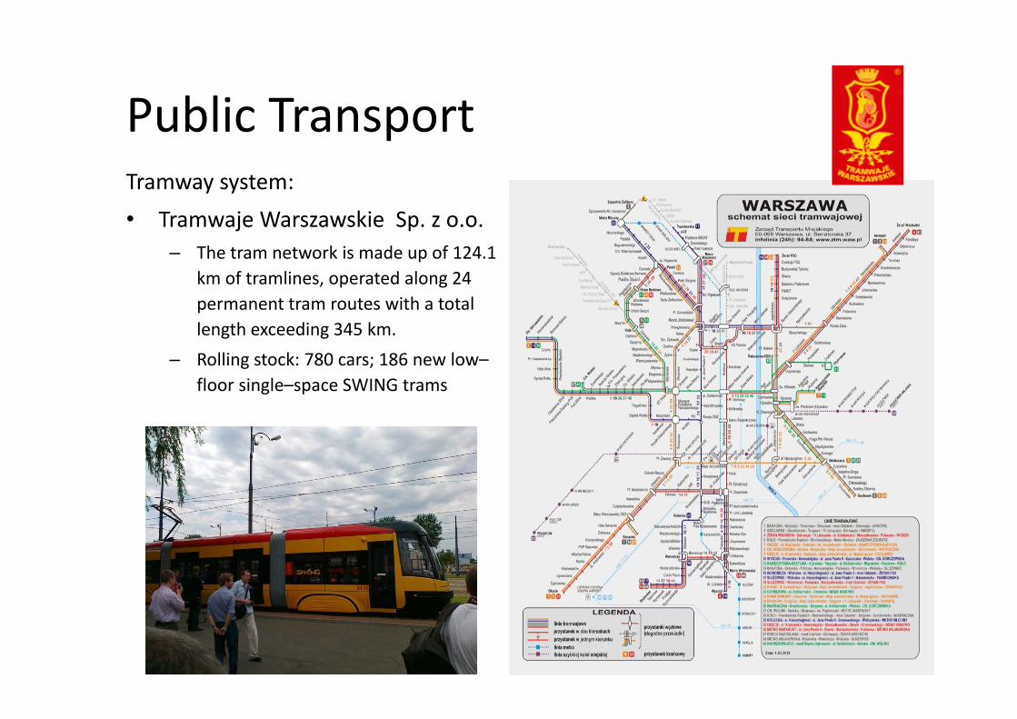
Public TransportPublic TransportTramway system:• Tramwaje Warszawskie Sp. z o.o.
– The tram network is made up of 124.1 km of tramlines operated along 24km of tramlines, operated along 24 permanent tram routes with a total length exceeding 345 km.Rolling stock: 780 cars; 186 new low–– Rolling stock: 780 cars; 186 new low–floor single–space SWING trams
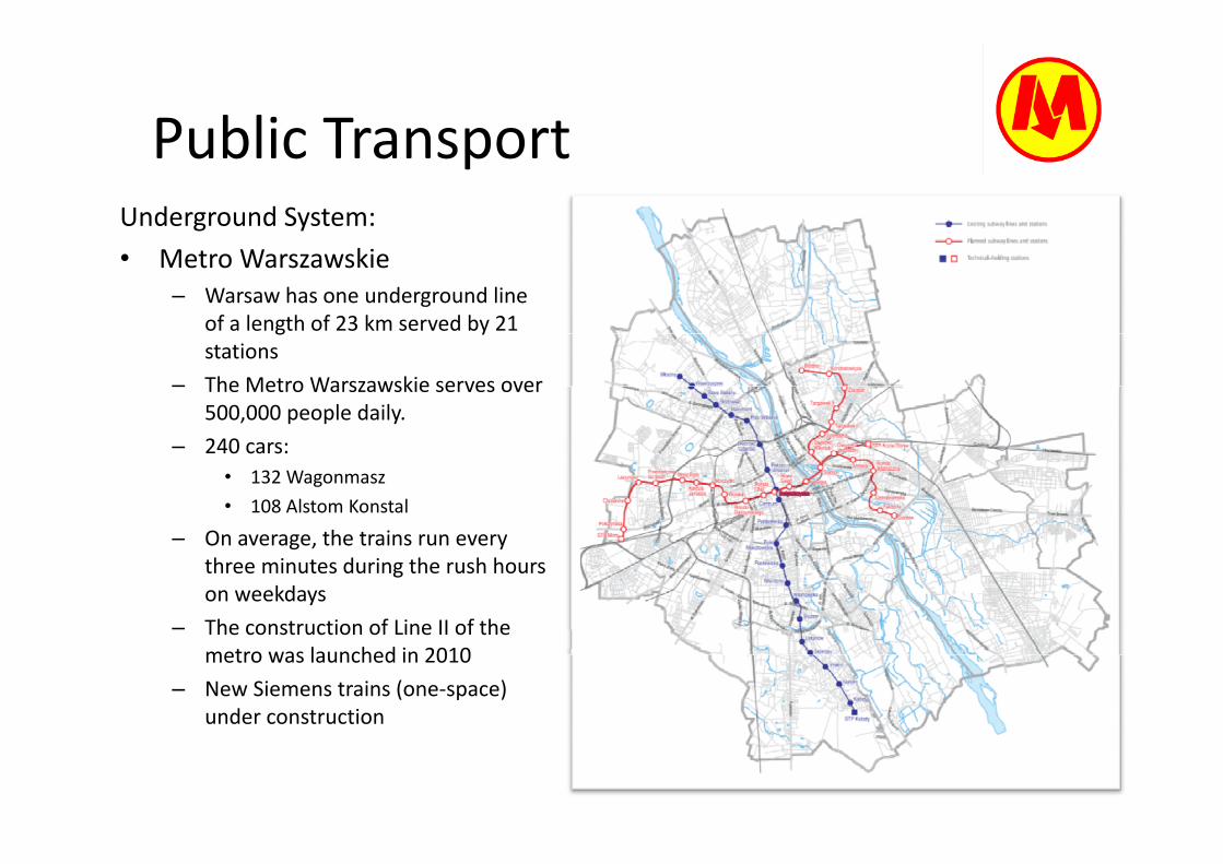
Public TransportPublic TransportUnderground System:• Metro Warszawskie
– Warsaw has one underground line of a length of 23 km served by 21 g ystations
– The Metro Warszawskie serves over 500,000 people daily.
– 240 cars: • 132 Wagonmasz• 108 Alstom Konstal
h– On average, the trains run every three minutes during the rush hours on weekdays
– The construction of Line II of the– The construction of Line II of the metro was launched in 2010
– New Siemens trains (one‐space) under construction
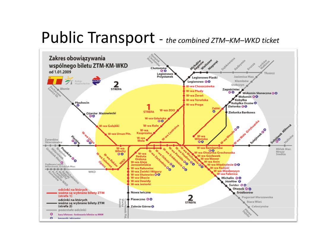
Public TransportPublic Transport ‐ the combined ZTM–KM–WKD ticket
11
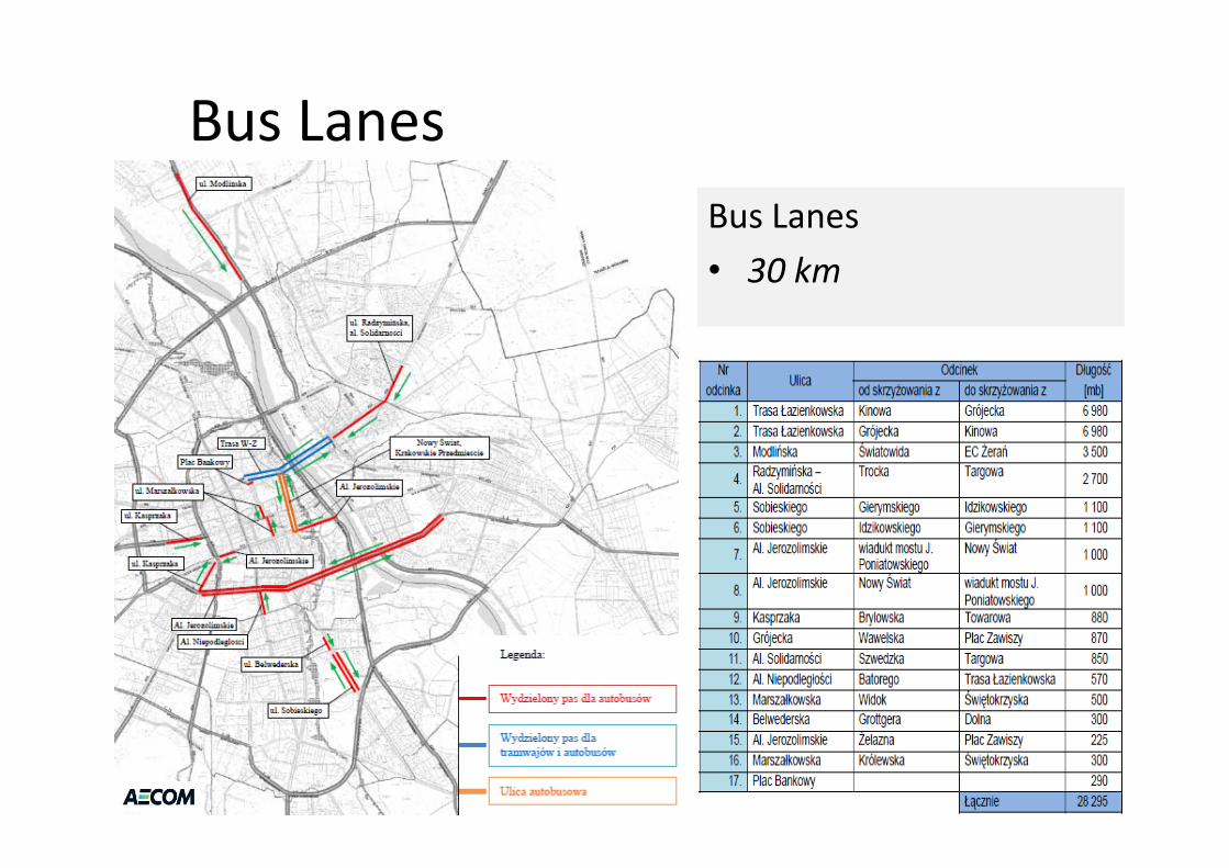
Bus LanesBus LanesBus Lanes• 30 km
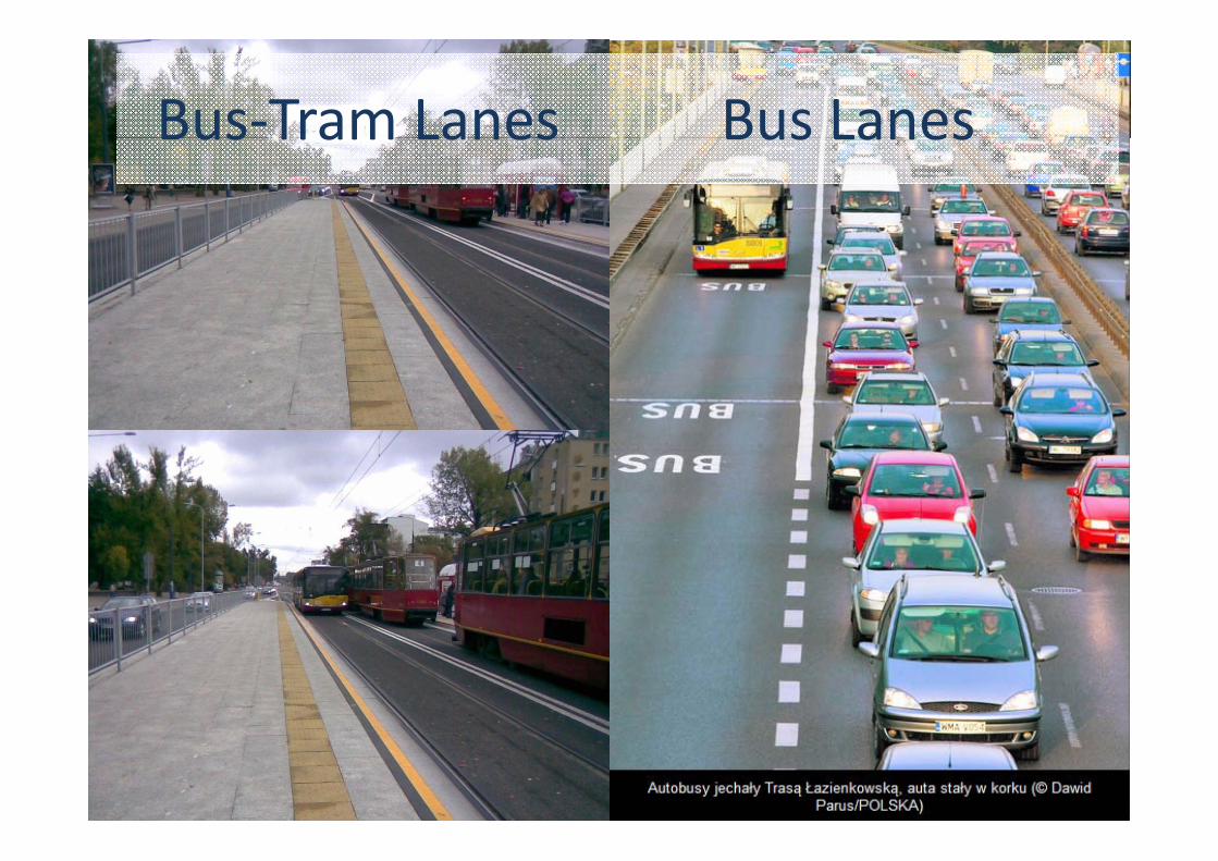
Bus‐Tram Lanes Bus LanesBus Tram Lanes Bus Lanes
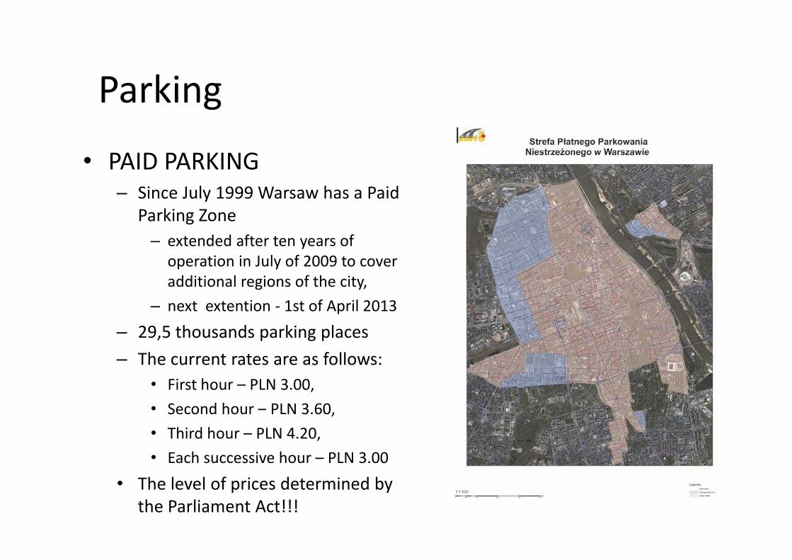
ParkingParking
PAID PARKING• PAID PARKING– Since July 1999 Warsaw has a Paid
Parking ZoneParking Zone– extended after ten years of operation in July of 2009 to cover additional regions of the cityadditional regions of the city,
– next extention ‐ 1st of April 2013
– 29,5 thousands parking places – The current rates are as follows:
• First hour – PLN 3.00,• Second hour PLN 3 60• Second hour – PLN 3.60,• Third hour – PLN 4.20,• Each successive hour – PLN 3.00
• The level of prices determined by the Parliament Act!!!
ParkingParking
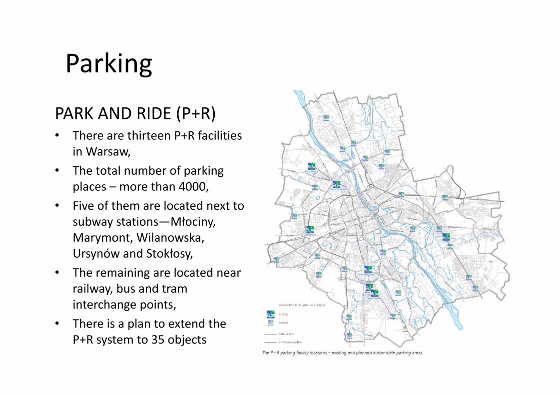
PARK AND RIDE (P R)PARK AND RIDE (P+R)• There are thirteen P+R facilities
in Warsawin Warsaw, • The total number of parking
places – more than 4000,• Five of them are located next to
subway stations—Młociny, Marymont, Wilanowska, y , ,Ursynów and Stokłosy,
• The remaining are located near railway bus and tramrailway, bus and tram interchange points,
• There is a plan to extend the P+R system to 35 objects
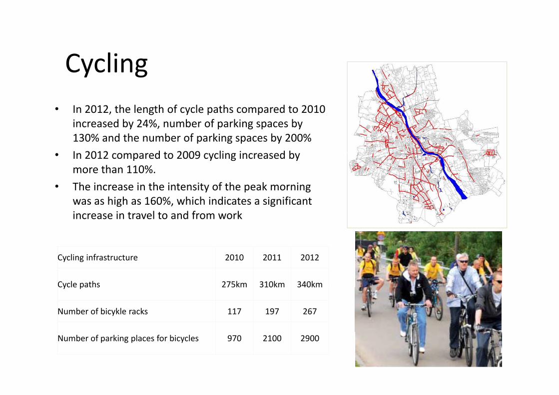
CyclingCycling• In 2012 the length of cycle paths compared to 2010• In 2012, the length of cycle paths compared to 2010
increased by 24%, number of parking spaces by 130% and the number of parking spaces by 200%I 2012 d t 2009 li i d b• In 2012 compared to 2009 cycling increased by more than 110%.
• The increase in the intensity of the peak morning hi h 160% hi h i di i ifiwas as high as 160%, which indicates a significant
increase in travel to and from work
Cycling infrastructure 2010 2011 2012
Cycle paths 275km 310km 340kmCycle paths 275km 310km 340km
Number of bicykle racks 117 197 267
Number of parking places for bicycles 970 2100 2900
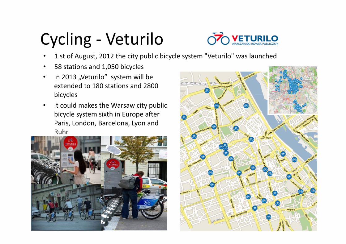
Cycling VeturiloCycling ‐ Veturilo• 1 st of August, 2012 the city public bicycle system "Veturilo" was launched • 58 stations and 1 050 bicycles• 58 stations and 1,050 bicycles• In 2013 „Veturilo” system will be
extended to 180 stations and 2800 bicyclesbicycles
• It could makes the Warsaw city public bicycle system sixth in Europe after Paris London Barcelona Lyon andParis, London, Barcelona, Lyon and Ruhr
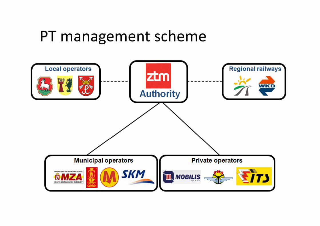
PT management schemePT management scheme

Funding sourcesFunding sources
• Municipal budget,– long‐term contracts for the performance of transport services concluded with the carriers: MZA until 2017, the SKM 2024, TW and Metro to 2027to 2027,
• EU‐funds, • Bank credits (e.g. EBRD),• Bonds,,• Contribution of municipalities served
– 30 boroughs and 1 county– 30 boroughs and 1 county
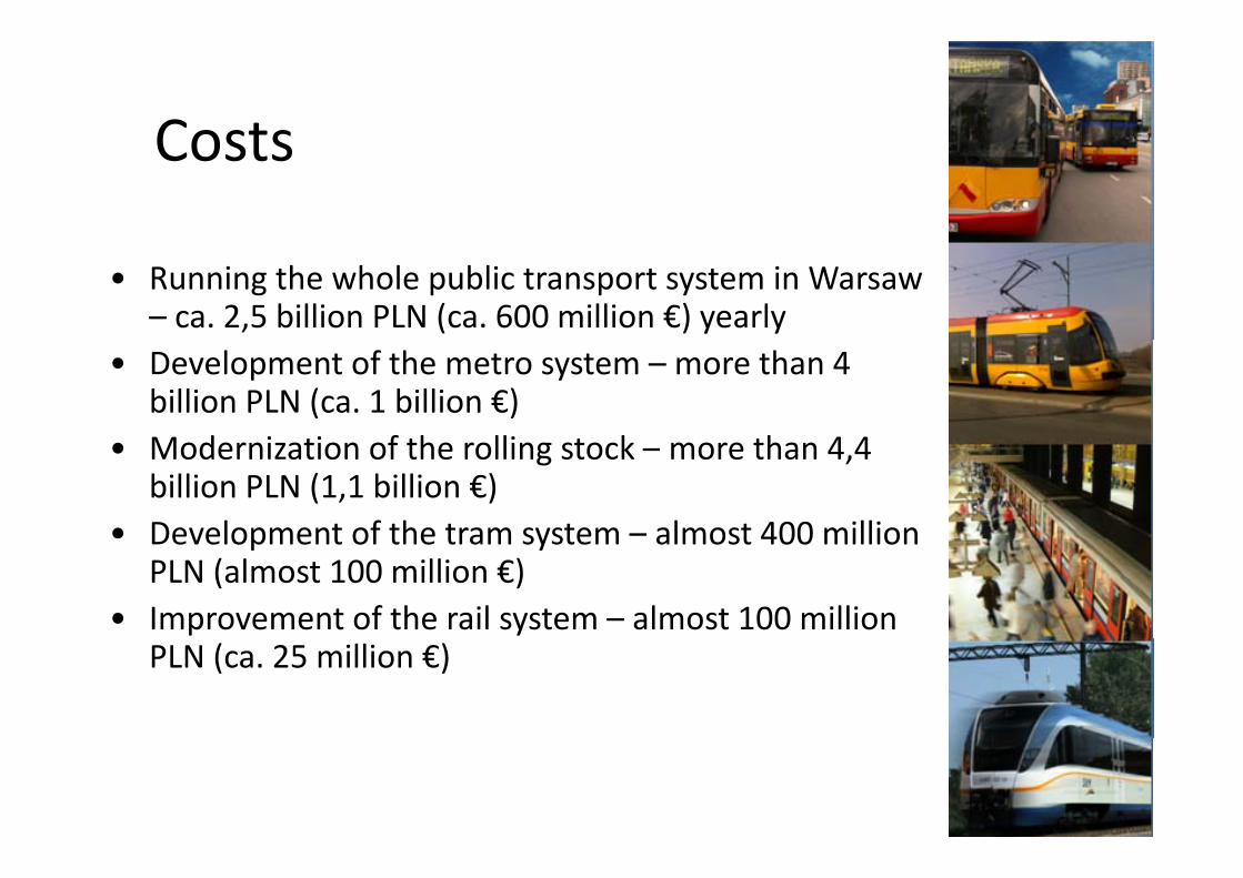
CostsCosts
• Running the whole public transport system in Warsaw – ca. 2,5 billion PLN (ca. 600 million €) yearly
• Development of the metro system – more than 4 billion PLN (ca. 1 billion €)M d i ti f th lli t k th 4 4• Modernization of the rolling stock – more than 4,4 billion PLN (1,1 billion €)
• Development of the tram system – almost 400 millionDevelopment of the tram system almost 400 millionPLN (almost 100 million €)
• Improvement of the rail system – almost 100 millionPLN (ca. 25 million €)
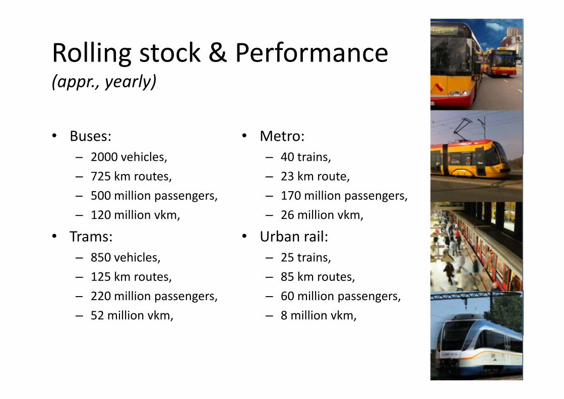
Rolling stock & Performance g(appr., yearly)
• Buses: 2000 hi l
• Metro: 40 t i– 2000 vehicles,
– 725 km routes, – 500 million passengers,
– 40 trains, – 23 km route, – 170 million passengers,500 million passengers,
– 120 million vkm,
• Trams:
170 million passengers, – 26 million vkm,
• Urban rail: – 850 vehicles, – 125 km routes,
– 25 trains, – 85 km routes,
– 220 million passengers, – 52 million vkm,
– 60 million passengers, – 8 million vkm,
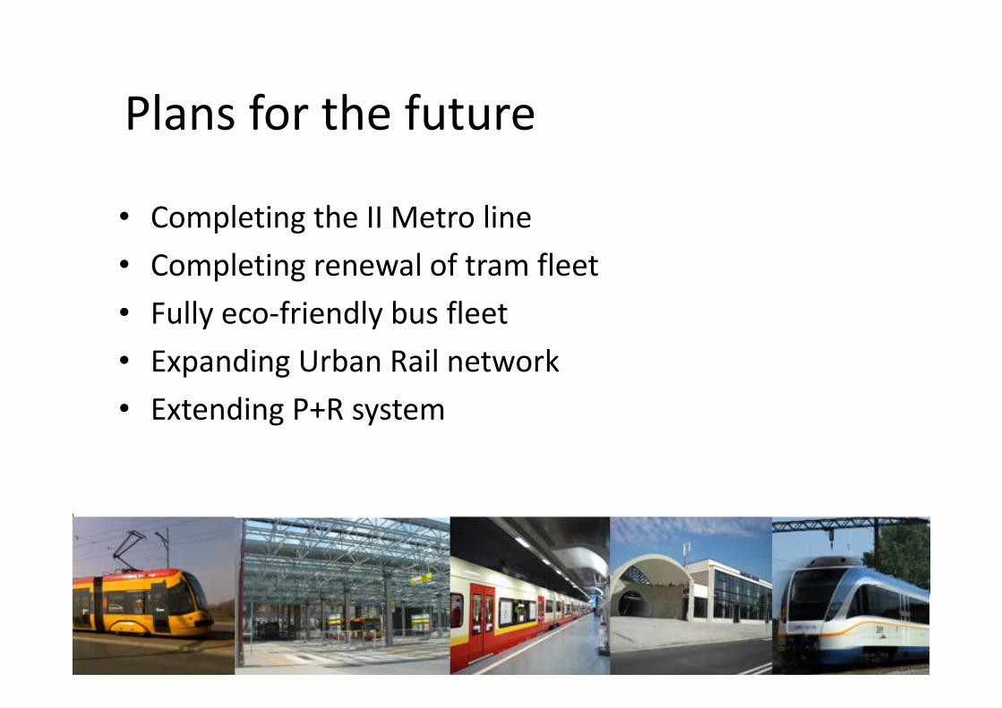
Plans for the futurePlans for the future
• Completing the II Metro line• Completing renewal of tram fleetCompleting renewal of tram fleet• Fully eco‐friendly bus fleetE di U b R il t k• Expanding Urban Rail network
• Extending P+R system
22
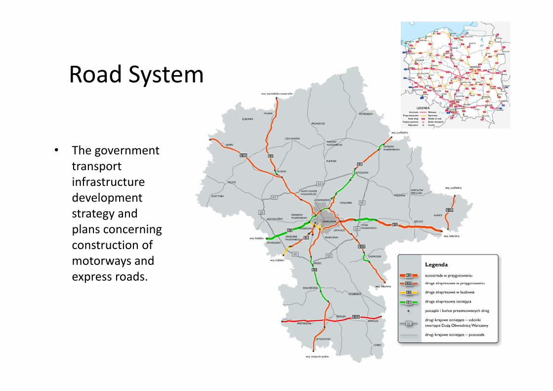
Road System
• The government• The government transport infrastructure developmentdevelopment strategy and plans concerning construction of motorways and express roads.
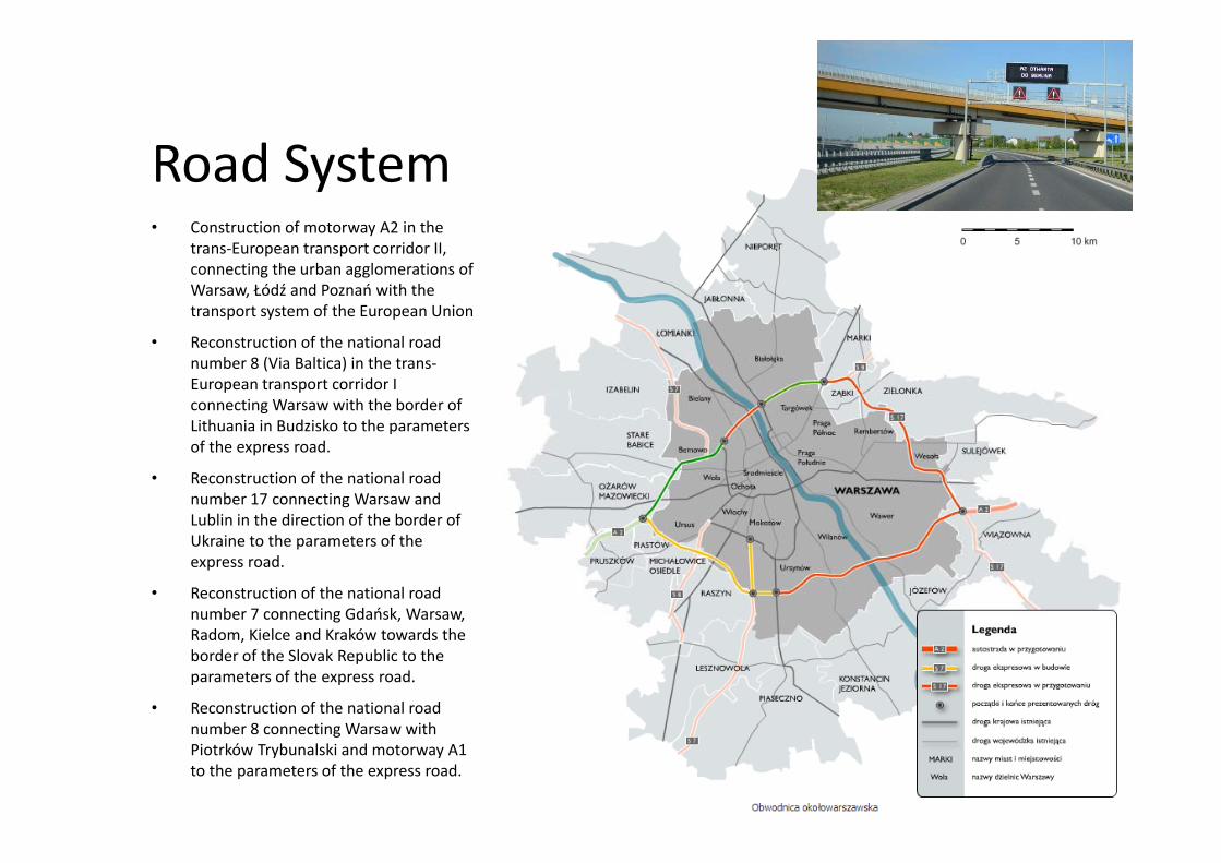
• Construction of motorway A2 in the
Road Systemy
trans‐European transport corridor II, connecting the urban agglomerations of Warsaw, Łódź and Poznań with the transport system of the European Union
• Reconstruction of the national road number 8 (Via Baltica) in the trans‐European transport corridor I connecting Warsaw with the border of Lithuania in Budzisko to the parameters pof the express road.
• Reconstruction of the national road number 17 connecting Warsaw and Lublin in the direction of the border of Ukraine to the parameters of the express road.
• Reconstruction of the national road number 7 connecting Gdańsk, Warsaw, Radom, Kielce and Kraków towards the border of the Slovak Republic to the parameters of the express road.
• Reconstruction of the national road b 8 ti W ithnumber 8 connecting Warsaw with
Piotrków Trybunalski and motorway A1 to the parameters of the express road.
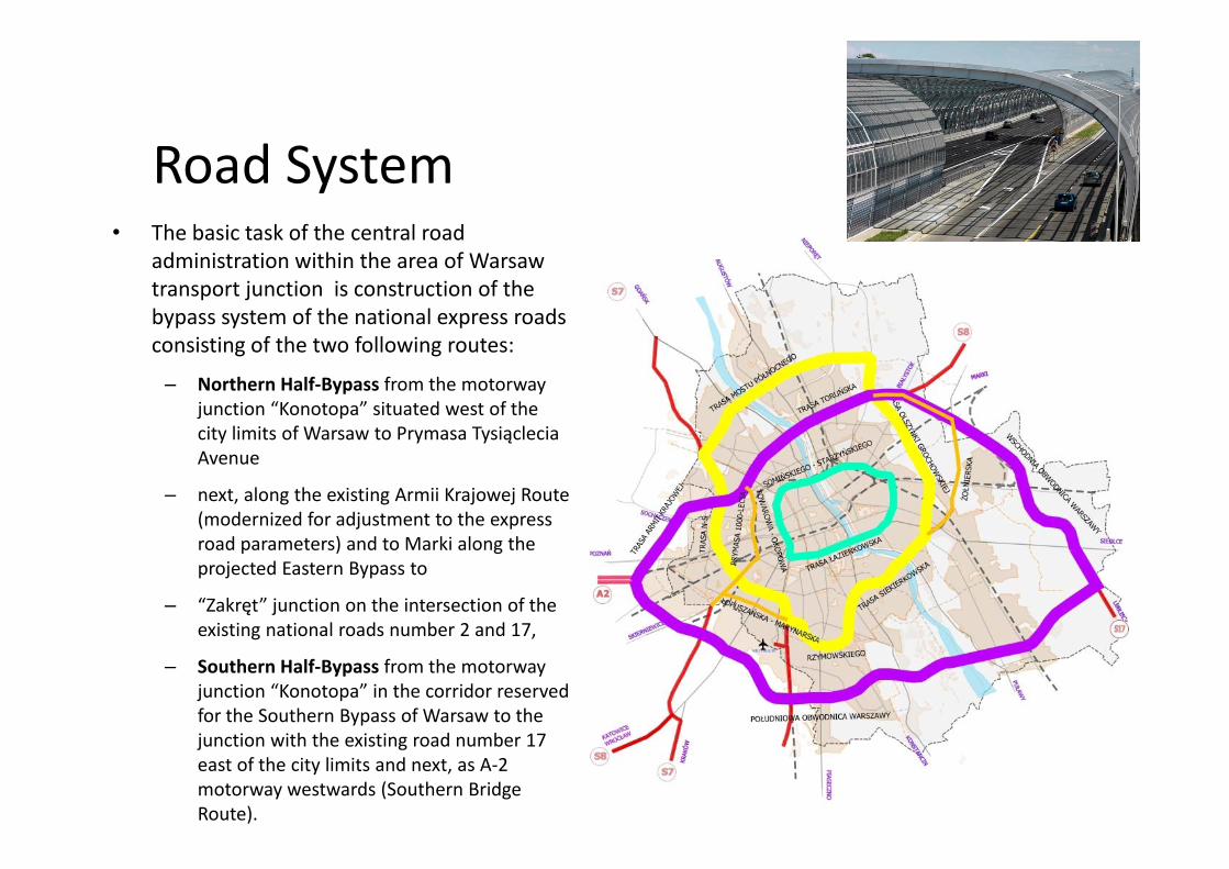
• The basic task of the central road
Road SystemThe basic task of the central road administration within the area of Warsaw transport junction is construction of the bypass system of the national express roads consisting of the two following routes:
– Northern Half‐Bypass from the motorway junction “Konotopa” situated west of the city limits of Warsaw to Prymasa Tysiącleciacity limits of Warsaw to Prymasa Tysiąclecia Avenue
– next, along the existing Armii Krajowej Route (modernized for adjustment to the express road parameters) and to Marki along the projected Eastern Bypass to
– “Zakręt” junction on the intersection of the existing national roads number 2 and 17existing national roads number 2 and 17,
– Southern Half‐Bypass from the motorway junction “Konotopa” in the corridor reserved for the Southern Bypass of Warsaw to the junction with the existing road number 17 east of the city limits and next, as A‐2 motorway westwards (Southern Bridge Route).
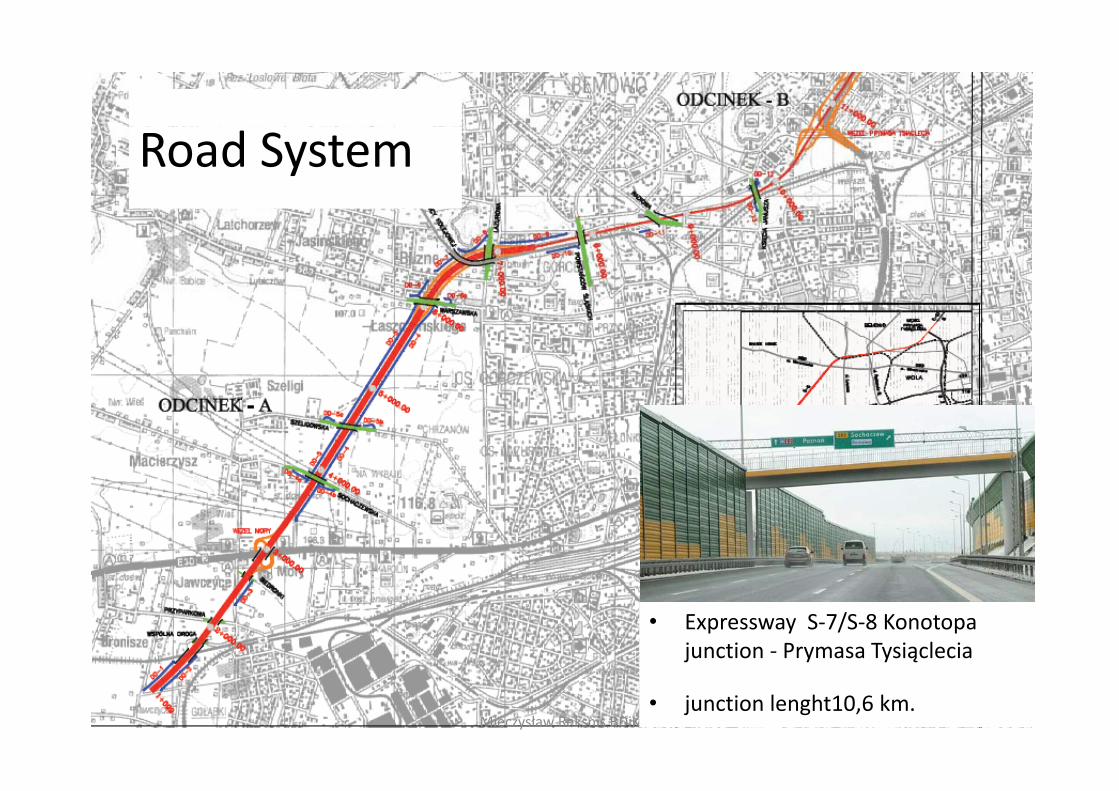
Road System
• Expressway S‐7/S‐8 Konotopa junction ‐ Prymasa Tysiąclecia
26Mieczysław Reksnis BDiK• junction lenght10,6 km.
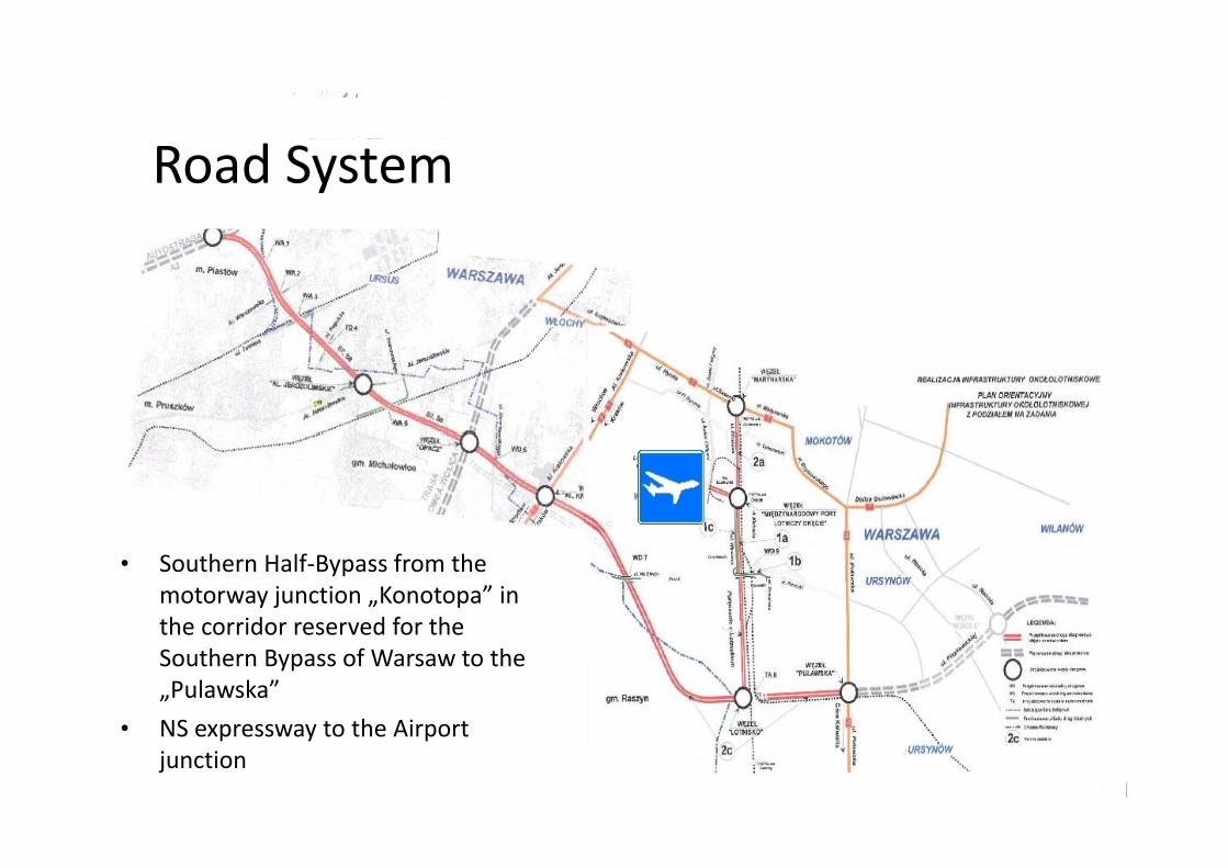
Road System
• Southern Half‐Bypass from the motorway junction „Konotopa” in the corridor reserved for thethe corridor reserved for the Southern Bypass of Warsaw to the „Pulawska”
• NS expressway to the Airport• NS expressway to the Airport junction
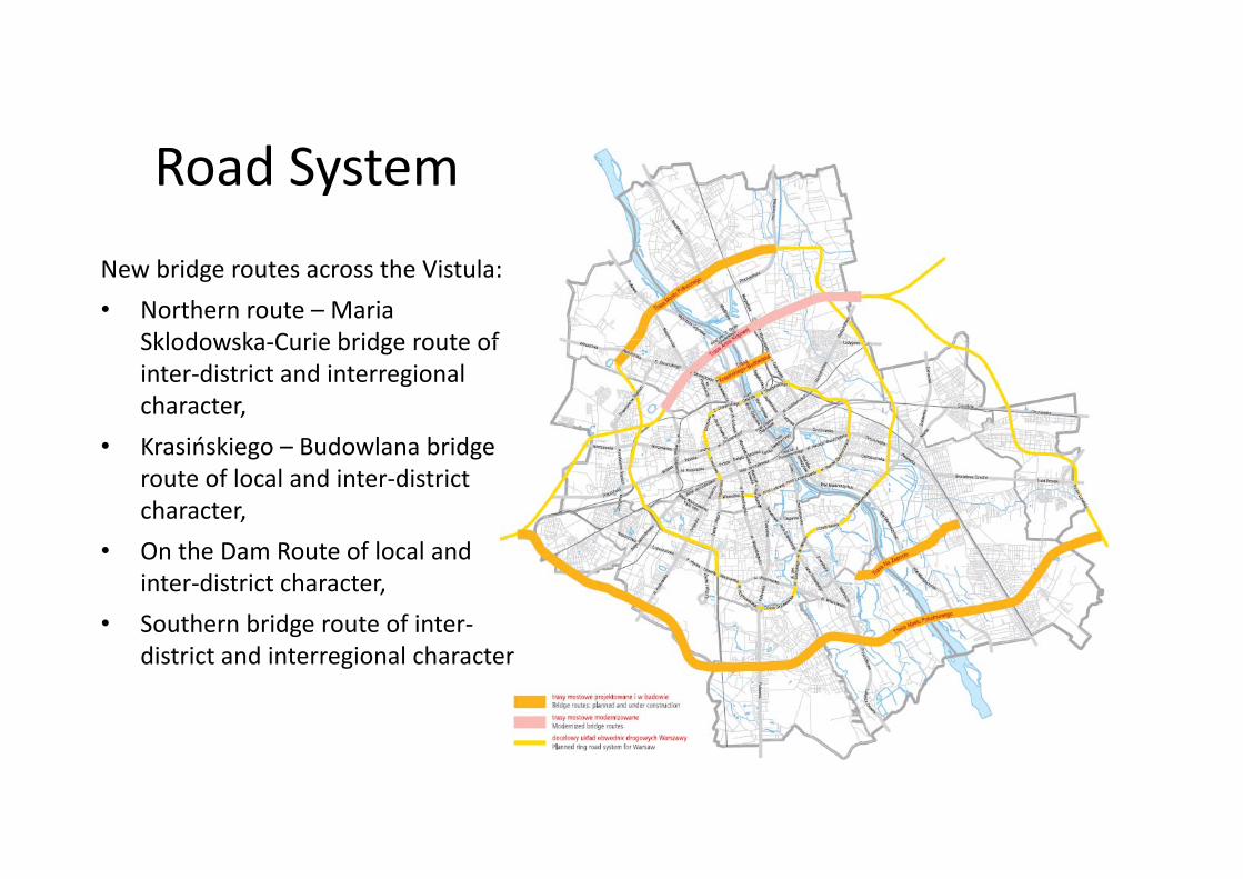
Road SystemNew bridge routes across the Vistula:• Northern route – Maria
Sklodowska Curie bridge route ofSklodowska‐Curie bridge route of inter‐district and interregional character,K iń ki B d l b id• Krasińskiego – Budowlana bridge route of local and inter‐district character,
• On the Dam Route of local and inter‐district character,
• Southern bridge route of inter‐district and interregional character
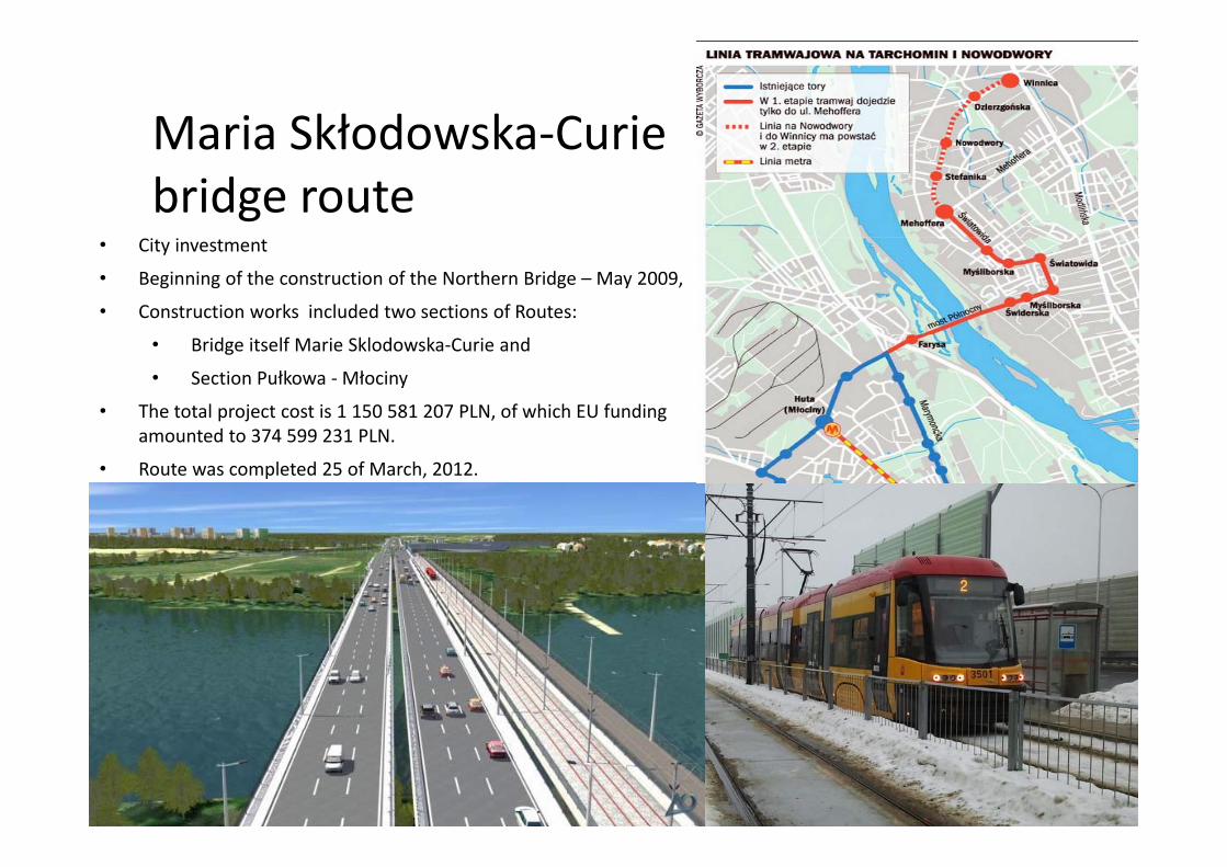
Maria Skłodowska‐CurieMaria Skłodowska Curie bridge route
• City investment
• Beginning of the construction of the Northern Bridge – May 2009,
• Construction works included two sections of Routes:
• Bridge itself Marie Sklodowska‐Curie and
• Section Pułkowa ‐Młociny
• The total project cost is 1 150 581 207 PLN, of which EU funding amounted to 374 599 231 PLNamounted to 374 599 231 PLN.
• Route was completed 25 of March, 2012.
Th k f tt ti !Thank you for your attention!
Mieczysław ReksnisDirector of the Roads & Public Transportation Department
City of Warsaw
mreksnis@um warszawa [email protected]


![[Transportation] 13. bugaj (warsaw)](https://img.pdfslide.net/doc/110x75/55a2c4a01a28ab77158b4649/transportation-13-bugaj-warsaw.jpg)