Embed Size (px)
Citation preview
WATER DISTRICT #1
CONCEPTS, PRACTICES, AND PROCEDURES USED TO DISTRIBUTE WATER WITHIN
WATER DISTRICT #1 Upper Snake River Basin, Idaho
Tony Olenichak
2/28/2020

2 February 28, 2020
Table of Contents
INTRODUCTION ............................................................................................................................................. 7
DEFINITIONS .................................................................................................................................................. 8
Chapter 1: WATER DISTRICT #1 GEOGRAPHIC AREA AND DIVERSIONS ................................................. 15
1.1 Water District #1 establishment and evolution .............................................................................. 15
1.2 Tributaries regulated by Water District #1 that are not in the computerized water right
accounting and “futile call” ..................................................................................................................... 16
1.3 Snake River tributaries not regulated by Water District #1 ............................................................ 17
1.4 Groundwater diversions .................................................................................................................. 18
Chapter 2: CALCULATION OF NATURAL FLOW ...................................................................................... 19
2.1 Water right accounting river reaches ............................................................................................. 19
2.2 Reach gain equation ........................................................................................................................ 22
2.3 Reservoir evaporation loss and seepage ......................................................................................... 23
2.4 Summing reach gains to calculate total natural flow ..................................................................... 27
Chapter 3: NATURAL FLOW DISTRIBUTION ........................................................................................... 29
3.1 Prior appropriation doctrine and water rights ................................................................................ 29
3.2 Remaining natural flow calculation ................................................................................................. 30
3.3 Computing storage deliveries.......................................................................................................... 33
3.4 Reach actual flow, natural flow, and storage flow .......................................................................... 33
3.5 Reach priority determination .......................................................................................................... 35
3.6 Ungaged or calculated river reaches ............................................................................................... 38
3.7 Reach losses deducted from available natural flow or storage conveyance .................................. 39
3.8 Distribution to multiple diversions with identical priority dates .................................................... 41
3.9 Natural flow distribution to single entities with multiple points of diversion, including “combined
diversions” .............................................................................................................................................. 45
3.10 Negative remaining natural flow, negative stored flow, and exchanging storage ....................... 46
3.11 Adjustments when losses exceed the reach natural flow ............................................................. 47
Chapter 4: ADJUSTING REACH GAINS FOR WATER TRAVEL (LAG) TIMES ............................................. 49
4.1 Water right accounting water travel times ..................................................................................... 50
4.2 Milner time vs. Actual time ............................................................................................................. 51
Chapter 5: REACH GAIN AVERAGING .................................................................................................... 55
5.1 Reach gain fluctuations caused by imprecise travel time ............................................................... 55

3 February 28, 2020
5.2 Reach gain fluctuations caused by imprecise measurement of reservoir content ........................ 55
5.3 Determining appropriate number of days to average reach gains ................................................. 56
5.4 Reach gain averaging consequences ............................................................................................... 58
5.5 Using different time periods for reach gain averaging in adjacent reaches ................................... 59
5.6 Discrepancy in reservoir system contents due to gain averaging ................................................... 60
Chapter 6: SPRING CREEK ADJUSTMENT AND AMERICAN FALLS GAIN DIFFERENCE ............................ 61
6.1 Reach gain calculation using Spring Creek correlation ................................................................... 61
6.2 Discrepancy in reservoir system contents due to Spring Creek Adjustment .................................. 63
Chapter 7: PROJECTING CURRENT AND FUTURE DIVERSIONS, REACH GAINS, AND PRIORITY DELIVERIES .................................................................................................................................................. 64
7.1 Computing reach projected data .................................................................................................... 65
7.2 Projected water right accounting accuracy .................................................................................... 66
7.3 Increased projection accuracy when remaining natural flow is zero ............................................. 67
Chapter 8: DAILY ACCOUNTING OF STORAGE ACCRUAL AND DELIVERY .............................................. 69
8.1 Reservoir water rights, spaceholder contracts, and ownership ..................................................... 69
8.2 Natural flow distribution to reservoirs versus canals/pumps ........................................................ 70
8.3 Determining new reservoir accrual from the daily accounting printout ........................................ 72
8.4 Water right accrual (paper fill) vs. water physically stored in the reservoir .................................. 74
8.5 Reservoir operations and reservoir releases ................................................................................... 75
8.6 Storage accrual affected by downstream reach losses................................................................... 75
8.7 Storage delivery to tributaries without reservoirs ......................................................................... 76
8.8 Moving storage from downstream reservoirs to upstream reservoirs ......................................... 77
8.9 Storage past Milner and Milner Spill .............................................................................................. 78
8.10 Milner Spill determination ............................................................................................................ 78
8.11 Flow augmentation, Idaho Power, and IWRB storage delivery .................................................... 79
8.12 The practice of cancelling storage usage ...................................................................................... 80
8.13 Storage refill water rights .............................................................................................................. 80
8.14 Distribution and allocation of refill storage .................................................................................. 82
8.15 Late-season fill, length of storage season, reservoir water right volume limits and reset date for
annual reservoir water right accrual ....................................................................................................... 83
Chapter 9: STORAGE ALLOCATIONS AND CARRYOVER DISTRIBUTION USING STORAGE REPORT ........ 85
9.1 Day of Allocation – Distribution of accrued storage to spaceholders ............................................ 85
9.2 Reductions to storage allocations attributed to flood control and other reservoir operations .... 86

4 February 28, 2020
9.3 Estimation and distribution of preliminary storage evaporation losses ......................................... 87
9.4 Allocation of reservoir storage fill to spaceholders ........................................................................ 89
9.5 Determination of reservoir carryover for spaceholders with multiple reservoir allocations ......... 93
9.6 Final carryover and excess storage usage ....................................................................................... 96
Chapter 10: SPECIAL CALCULATIONS TO ACCOMMODATE EXCEPTIONAL DELIVERY CONDITIONS ...... 97
10.1 Reach losses in the Below Blackfoot to Near Blackfoot reach ...................................................... 97
10.2 Groundwater exchange wells ....................................................................................................... 98
10.3 Diversions in different reaches that share water rights ............................................................... 99
10.4 Great Western Canal Spillway adjustment ................................................................................. 100
10.5 CrossCut Canal delivery to Falls River Canal and Teton River ..................................................... 101
10.6 North Fork of Teton River ........................................................................................................... 103
10.7 Willow Creek and Sand Creek water distribution ....................................................................... 105
10.8 Reservation Canal, Fort Hall Water Rights Agreement, and Mitigation Inc. storage delivery .... 110
10.9 Sand Creek Exchange between Ft. Hall Irrigation Project and North Side Canal ....................... 114
10.10 Great Feeder Canal (Dry Bed) water distribution ..................................................................... 115
10.11 Water right and storage delivery to Minidoka North Side and Minidoka South Side Canals ... 117
10.12 Delivery of Southwest Irrigation District water right 1-23 ....................................................... 118
10.13 American Falls Reservoir District #2 delivery ............................................................................ 119
10.14 Milner Gooding Canal seepage loss .......................................................................................... 122
10.15 Hydropower water right delivery .............................................................................................. 123
10.16 Storage delivery when diversions aren’t exceeding in-priority irrigation water rights ............ 124
10.17 Minidoka Return Flow Credit storage adjustment ................................................................... 125
Chapter 11: WATER DISTRICT #1 RENTAL POOL .................................................................................... 127
11.1 Rental Pool 1979-1987 ................................................................................................................ 128
11.2 Rental Pool 1988-1993 ................................................................................................................ 128
11.3 Rental Pool 1994-2002 ................................................................................................................ 129
11.4 Global Rental Pool Concept - 2003 .............................................................................................. 129
11.5 Rental Pool - 2004 ....................................................................................................................... 131
11.6 Rental Pool 2005-2019 ................................................................................................................ 132
11.7 Rental Pool - 2020 ....................................................................................................................... 134
11.8 Rental Pool Impacts ..................................................................................................................... 135
11.9 Last-to-fill space .......................................................................................................................... 136

5 February 28, 2020
11.10 Reservoir assignment of last-to-fill space ................................................................................. 138
11.11 Last-to-fill priorities ................................................................................................................... 140
11.12 Distribution of monies collected from rentals .......................................................................... 140
Chapter 12: PRELIMINARY vs. FINAL WATER RIGHT ACCOUNTING ...................................................... 142
12.1 Canal diversion data .................................................................................................................... 142
12.2 USGS streamflow data ................................................................................................................ 144
12.3 Pump diversion data .................................................................................................................... 144
12.4 Reservoir data and reach gains analysis...................................................................................... 145
12.5 Timeline for final water right accounting .................................................................................... 146
12.6 Differences between preliminary and final accounting .............................................................. 147
Chapter 13: WATER DISTRICT #1 BILLING AND ASSESSMENTS ............................................................ 149
Table of Tables Table 1: Description of the 36 river and tributary reaches in the Water District #1 water right accounting. .................................................................................................................................................. 20 Table 2: Computed reach gain from reach streamflow, diversion, and reservoir data using the reach gain equation and summing reach gains to compute total natural flow. .......................................................... 28 Table 3: Reach Gain, Total Natural flow, and Remaining Natural Flow in each reach after the total natural flow has been distributed to diversions according to priority. ...................................................... 32 Table 4: Actual reach outflow segregated into remaining natural flow and storage flow. ....................... 34 Table 5: Illustration of the most junior priority water right or LAST RIGHT that can be filled with available natural flow in each reach for the diversions currently diverting water. ................................................... 36 Table 6: Locations of calculated gages in the water right accounting used to distribute remaining natural flow from Falls River and Teton River flowing into the Henrys Fork, and remaining natural flow from Willow Creek and Blackfoot River flowing into the Snake River. ............................................................... 38 Table 7: Distribution of natural flow to diversions with identical priority water rights, different water right flow rates, diverting water in separate reaches with different amounts of available natural flow in each reach. .................................................................................................................................................. 42 Table 8: First iteration of distributing 300 cfs of available natural flow to three diversions in different reaches with identical priority dates as shown in Table 7. ......................................................................... 43 Table 9: Second iteration of distributing 300 cfs of available natural flow to three diversions in different reaches with identical priority dates as was shown in Table 7. .................................................................. 44 Table 10: Distribution of natural flow to diversions with identical priority water rights, different water right flow rates, diverting water in separate reaches with different amounts of available natural flow in each reach. .................................................................................................................................................. 44 Table 11: Calculation of reach gain without adjusting for water travel time. ........................................... 49 Table 12: Calculation of reach gain adjusting for one day of water travel time between the inflow and outflow gages. ............................................................................................................................................. 49
6 February 28, 2020
Table 13: Reaches with one day of water travel time to provide for the five days of water travel time from Moran to Milner and seven days of travel time from Henrys Lake to Milner. .................................. 50 Table 14: May 20th (Milner Time) day of water right accounting displaying the "actual date" for each reach of when the block of water arriving at Milner on May 20th passed through the reach and how it was distributed (diverted) according to the reach priority date occurring on the actual date displayed for each reach. .................................................................................................................................................. 53 Table 15: Days of reach gain averaging for each reach in the water right accounting. ............................. 57 Table 16: Reservoir water rights and actively administered volumes in the water right accounting. ...... 69 Table 17: Reservoir carryover, new accural, total fill, evaporation, and yield. ......................................... 90 Table 18: The first iteration in computing new reservoir accural plus carryover distributed to a spaceholder. ................................................................................................................................................ 91 Table 19: Final iteration when computing an individual's spaceholder allocation after distributing new reservoir accrual, carryover, and evaporation losses. ................................................................................ 92 Table 20: Comparison of reservoir yield percentage to a spaceholder's allocation percentage. ............. 92
Table of Figures Figure 1: Schematic Illustrating relative positions of Snake River and tributary reaches described in Table 1. ................................................................................................................................................................. 21 Figure 2: Schematic of CrossCut Canal and its associated measuring stations. ...................................... 101 Figure 3: Schematic of Lower Teton River. .............................................................................................. 103 Figure 4: Lower Willow Creek Basin below USGS station 13057940. ...................................................... 106 Figure 5: Illustration of Reservation Canal. .............................................................................................. 110 Figure 6: Great Feeder (Dry Bed) Channel of the Snake River. ................................................................ 115

7 February 28, 2020
INTRODUCTION The earliest description of water district regulation practices was included in the appendix of the 1964 annual Watermaster’s Report (Black Book) documenting the water right accounting procedures that were being used in 1964. Bob J. Sutter and Alan Robertson prepared a draft manual for the procedures used in October 1980. Bruce Sandoval created a manual in July 1992 based on the FORTRAN computerized water right accounting used at that time. Tony Olenichak completed his first version of a Water District #1 water right accounting procedures manual in March 2, 2015, as requested by the Committee of Nine in 2013. This February 28, 2020 manual is an updated version of the previous March 2, 2015 manual that includes water distribution changes that have occurred since the previous manual was written. Revisions from the previous March 2015 manual include:
Reservoir “refill” water rights in Section 8.13 Storage Refill Water Rights and Section 8.14 Distribution and Allocation of Refill Storage.
The “reset date” for reservoir water right volumes in Section 8.15 Late Season Fill, Length of Storage Season, Reservoir Water Right Limits, and Reset Date.
Distributing losses in the Below Blackfoot to Near Blackfoot Reach in Section 10.1 Reach Losses in the Below Blackfoot to Near Blackfoot Reach.
Section 11.10 Palisades powerhead storage, USBR uncontracted storage space, and last-to-fill” was renamed to Section 11.11 Last-to-fill priorities and rewritten to encompass the discussions and changes surrounding the adopted 2019 and drafted 2020 Rental Pool Procedures.
Minor changes were made to language and terminology in other manual sections to eliminate typographical errors, to further clarify current practices, and to be consistent with revisions made in Sections 8.13, 8.14, 8.15, 11.10, and 11.11.
This manual begins with basic concepts of water delivery, gradually becoming more complex as data limitations, canal management, unique water delivery situations, and other water delivery obstacles are considered. Chapters and sections are organized to address specific topics or processes. Most processes intertwine and overlap with processes described in other sections or chapters. Evaluation of any process identified in a specific section or chapter may require a comprehensive understanding of all previous and subsequent chapters. Procedures and scenarios described in this manual are the ones commonly used and commonly encountered by Water District #1 staff. It is impossible to present every possible scenario and circumstance, and the procedures at times may need to be altered slightly to accommodate new, rare, or infrequent occurrences. During these times, the Water District #1 Watermaster and Director of the Idaho Department of Water Resources are ultimately responsible for administering water distribution using the tools and budget available to them. This manual describes the primary concepts, policies, and procedures currently and sometimes previously used by Water District #1 to account for water deliveries within the district using the tools and budget provided. Changes to water right accounting procedures in Water District #1 subsequent to the date of this manual may occur at any time resulting from changes to policies, funding, legislation, new technology, or any other new developments affecting the administration and distribution of water.
8 February 28, 2020
DEFINITIONS Account (noun): reservoir or diversion line item in the water right accounting that shows the natural flow (and/or storage) volume (and/or flow rate) accrued or distributed to each reservoir or diversion. Account (verb): distributing water using the water right accounting process. Accrue, Accrual, or accrued: the amount of natural flow distributed to a reservoir or storage account in the water right accounting. Actual date or time: the date when water is at a particular reach or diversion without being adjusted for the time it takes for the water to travel downstream to Milner Dam. Actual flow or discharge: the surface flow (cfs) observed in a stream channel at the end of a river reach that is comprised of natural flow, storage, and/or exchanged surface water. Ag preference: a Rental Pool principle that provided for limiting the amount of storage that could be rented for hydropower purposes below Milner when the Rental Pool supply wasn’t sufficient to fill all ag (agricultural) rental requests above Milner. Allocate or Allocation: storage (water) volume allotted to a diversion available to be used during the irrigation season. Cancelled storage usage: storage diverted by a canal or pump in the daily water right accounting that is not deducted from the diversion’s storage allocation. Carryover: the remaining storage in a diversion’s or spaceholder’s storage allocation (after all debits and credits for storage usage, rentals, and any other adjustments have been made in the water right accounting) carried over from one irrigation year to the next irrigation year. Channel losses: surface water exiting the stream channel between the beginning and ending points of a reach caused by evaporation, evapotranspiration, bank storage, or surface water percolating down to ground water below the channel bottom. Code: the computer language or software responsible for enabling the computer to perform water distribution calculations in the water right accounting and storage report computer programs. Combined diversion: when two or more diversions supplied from the same water right are combined to determine the total amount of natural flow distributed to the multiple diversions sharing the same water right in the water right accounting. Committee of Nine: an advisory committee elected by the water users of Water District 1 to advise the Watermaster between annual meetings and also to facilitate the rental of stored water within the district. Common Pool: Storage supplied to the Rental Pool indirectly from participating spaceholders according to the Rental Pool Procedures and used for both rentals above and below Milner Dam.

9 February 28, 2020
Conveyance losses: water losses in a channel incurred as a result of conveying water from one point to the next. Day of Allocation: the day of water right accounting in which the maximum amount of storage was available to be allocated to reservoir spaceholders after Milner spill ceased. Discharge: flowing water usually expressed in units of cubic feet per second (cfs). Distribute or Distribution: natural flow and storage delivered to diversions and reservoirs computed using a water right accounting process. Diversion (assumed to be surface diversion unless specified as a “ground water diversion”): a canal or pump that diverts surface water from a reach. (Note: A dam is sometimes described as a diversion for surface water or natural flow, but canals and pumps are more commonly exclusively characterized as diversions). Excess storage use: the amount water diverted by a canal or pump exceeding its natural flow and storage allocation supply. Exchange: when water diverted in one location or source is replaced by an equivalent amount of water from another location or source, e.g. natural flow diverted in exchange for injecting ground water from a well into a stream, or diverting natural flow in exchange for storage released from a reservoir, or physically capturing natural flow in one reservoir in exchange for releasing stored water from another reservoir. Fill: can have several different meanings 1) distributing natural flow to a water right in the accounting, 2) accruing natural flow to a reservoir water right in the accounting, 3) the paper fill of a reservoir, or 4) the physical fill of a reservoir. Final water right accounting: the water right accounting computed for the entire irrigation year (after the irrigation year has ended) using diversion, streamflow, and reservoir data that has been reviewed and finalized. Flood control: reservoir operations whereby storage is evacuated from a reservoir (prior to peak inflows) to enable the reservoir to later capture additional storage during forecasted peak inflows, and release less water from the reservoir than is coming into the reservoir to prevent (or lessen) flooding downstream during the peak runoff period. Flow augmentation: water deducted from storage allocations or deducted from rented storage supplies released past Milner Dam for augmenting downstream river discharges. Futile call: when it is futile for a downstream senior water right to call for an upstream junior water right to be curtailed when curtailment of the junior water right won’t result in any additional water provided to the downstream senior water right. Gage: A measuring instrument used to quantify water discharge, or the act of determining water discharge using measurement instruments.

10 February 28, 2020
Groundwater: water in aquifers or water beneath the ground or below the bottom of a stream channel. Groundwater diversion: a well that diverts groundwater to the surface. Inflow: surface water entering a reach or entering an on-stream reservoir In-priority: when natural flow is sufficient to fill (or partially fill) a diversion’s water right after senior diversion water rights have been satisfied, the diversion’s water right is said to be “in priority”. Irrigation demand: the amount of water diverted by canals and pumps for irrigation. Irrigation season: the time of year when irrigation is occurring. Irrigation year: November 1st through October 31st. Iteration or iterative process: a mathematical process that continually repeats itself until it closes in on the final result or value. Junior: arriving later in time, as in having a junior priority. Lag time: the time it takes for water in a stream channel to travel from one point to the next, same as “travel time”. Last right: the latest (most junior) priority water right in a reach receiving natural flow on a day of water right accounting. Late season fill: natural flow accrued to in-priority reservoir storage rights during the last few months of the irrigation year. Milner date: the actual date or time in the furthest downstream reach (Minidoka-to-Milner) in the water right accounting. Milner spill: water released past Milner Dam that was not released for flow augmentation, Shoshone-Bannock Tribe, Minidoka hydropower water right delivery, or Idaho Power storage delivery. Natural flow: the reach gain, or total cumulative upstream reach gains, in a river system. Natural flow diversion: canals or pumps that are distributed natural flow in the water right accounting, or the amount of natural flow distributed to a canal or pump. Non-irrigation season: The period of the year when diversions are not diverting water for irrigation. On-stream reservoir: a reservoir resulting from a dam constructed across a stream or river. Outflow: surface water exiting out the end of a reach or being released from an on-stream reservoir.

11 February 28, 2020
Out-of-priority: when natural flow is insufficient to fill a diversion’s water right after senior diversion water rights have been filled in the water right accounting, the diversion’s water right is said to be “out of priority”. Pan evaporation: the amount of water (inches) evaporated from an evaporation pan of water. Paper carryover: carryover storage in a reservoir water right account after storage usage has been deducted from the storage that was allocated to it on the Day of Allocation in the water right accounting. Paper fill (for an individual reservoir): the cumulative reach gains or natural flow distributed to a reservoir’s water right in the water right accounting unadjusted for: 1) reservoir evaporation; 2) reservoir releases; 3) storage physically captured during when the reservoir was out of priority; 4) storage physically held in the reservoir that was accrued to another reservoir’s water right; and 5) accrual to the reservoir that was physically captured by another upstream reservoir or was diverted as storage by a water user upstream. Paper fill (for the reservoir system): the sum of all individual reservoir’s paper fill (see preceding definition) in the reservoir system unadjusted for reservoir evaporation, storage usage, and storage spilled past Milner Dam. Physical fill or physical carryover: the volume of water physically held in a reservoir or in the reservoir system. Point of diversion: the location (or point) on a stream where water is diverted by a dam, pump, or canal. Power (Pwr) flow: the amount of natural flow delivered exclusively to the Minidoka hydropower water right in the water right accounting program. Preliminary water right accounting: the water right accounting computed during the irrigation season using preliminary diversion, streamflow, and reservoir data being reported at that time. Prior appropriation doctrine: the policy whereby water diversions developed prior to other diversions have a priority (date) and a right to divert water ahead of diversions developed later in time when the amount of natural flow is insufficient to fill all water rights, also characterized by the phrase “first in time, first in right”. Priority: the date when a water right was first developed and its relative delivery sequence to other water rights developed before (senior) or after (junior) that date under the prior appropriation doctrine. Projected data: water right accounting data forecasted to occur in the future based on previous diversions and trends in reach gains. Projections: forecasted priority, diversion, and reach gain values in the water right accounting. Reach: a segment of stream channel.
12 February 28, 2020
Reach gain: the gain (positive value) or loss (negative value) of water between the beginning and ending of a reach, computed as the reach outflow minus the reach inflow, plus the reach’s surface diversions, change in reservoir content, reservoir evaporation, and injections from groundwater exchange wells. Reach loss: a negative reach gain. Real time: immediately or concurrently. Recharge: diverting surface water to a site where it will sink into the ground to replenish the aquifer. Remaining natural flow: the calculated natural flow remaining in a river reach after distribution of natural flow to water rights in the water right accounting. Rental: storage supplied, purchased, or leased through the Water District #1 Rental Pool. Rental Pool: a vehicle for the temporary one-year transfer of storage from a spaceholder to another water user, or the one-year transfer to use storage for purposes different than what is listed on the storage water right, as allowed and described in the Rental Pool Procedures. Rental Pool Procedures: a set of procedures formulated by the Committee of Nine governing the methods to supply storage to, and rent storage from, the Water District #1 Rental Pool. Reservoir content: the volume of water physically held in a reservoir. Reservoir evaporation: the increased amount of evaporation caused by a reservoir after it has been constructed on top of a natural streambed, lake, or riparian area. Reservoir releases: the physical (actual) discharge flowing through the dam(s). Reservoir system: the nine reservoirs listed in the water right accounting program that include: Jackson Lake, Palisades, Henrys Lake, Island Park, Grassy Lake, Ririe, American Falls, Lake Walcott, and Milner Lake Reservoirs. Return flow: water that returns to the stream after being diverted from the stream. Runoff: melting snow and rain that runs off the watershed creating discharge in the streams and rivers. Senior: arriving earlier in time, as in having a senior priority. Seepage loss: surface water percolating down through the canal bottom and sides and becoming ground water. Shift: the deviation from the stage-discharge rating equation of a stream or canal as channel conditions change that result in slowing water velocity cause by vegetation growth, deposition, or irrigation check structures (negative shift), or resulting from vegetation removal or channel scouting (positive shift) as the irrigation season progresses.

13 February 28, 2020
Shortfall: the volume of space in a reservoir or the reservoir system that fails to physically fill as a result of flood control operations. Spaceholder: a person or entity that contracts or owns space in a reservoir that may have some entitlement to storage accrued to, or allocated from, the reservoir water right. Storage: water held in a reservoir or natural flow that has accrued to a reservoir water right. Storage diversion: canal or pump diversion that diverts an amount of water exceeding the amount of natural flow distributed to the diversion in the water right accounting, or the amount of water diverted in excess of natural flow. Storage past Milner: the cumulative amount of water passing Milner Dam that was previously accrued to a reservoir storage right account in the water right accounting. Storage report: the computer program used for distributing storage available to reservoir and surface diversion accounts with adjustments for reservoir evaporation, diverted storage, storage rentals, and other storage transactions, also used to compute storage carryover for each diversion or spaceholder at the end of the irrigation year. Storage right: A water right with storage as a purpose of use (always in conjunction with an on-stream reservoir in this manual). Storage season: the time of year when water accrues to reservoir water rights approximately from October through June, but the number of days or months can vary from year to year depending on the water supply and the irrigation demand by senior diversions. Storage usage: the total amount of water diverted by a canal or pump minus the natural flow distributed to the canal or pump on a day of water right accounting. Storage yield: the volume of storage allocated to a reservoir water right or to a spaceholder’s contracted space after evaporation losses have been deducted from the water right’s fill comprised of new accrual and/or carryover. Stored flow: the actual flow minus the remaining natural flow computed for a reach in the water right accounting. Surface water: water on top of the surface contained in a channel, pond, lake, or reservoir. System: the area containing the streams, reservoirs, and/or diversions regulated by Water District #1. Travel time: the time it takes for water in a stream channel to travel from one point to the next, same as “lag time”. Unallocated (unaccounted or undefined) storage: reach gain or natural flow that was physically stored in the reservoir system that was not distributed to a water right on a day of water right accounting or was not allocated to a reservoir spaceholder on the Day of Allocation.

14 February 28, 2020
USBR: United States Bureau of Reclamation. USGS: United States Geological Survey. Water right: the entitlement (obtained through a judicial court decree, or obtained as a permit or license from the Idaho Department of Water Resources) to divert an amount of natural flow under priority from a stream channel for a particular purpose or use. Water right accounting: the quantification and distribution of natural flow and storage to reservoirs and surface diversions. Water right accounting program: the computer program used for quantifying and distributing natural flow and storage to reservoirs and surface diversions.

15 February 28, 2020
Chapter 1: WATER DISTRICT #1 GEOGRAPHIC AREA AND DIVERSIONS
1.1 Water District #1 establishment and evolution The office of the Snake River Watermaster was established in 1919 to distribute Snake River water upstream from Milner Dam following two water right adjudications. The Rexburg Decree, dated December 16, 1910, adjudicated and decreed water rights to diversions on the Snake River and its tributaries upstream from the confluence with the Blackfoot River. The Foster Decree, dated June 20, 1913, adjudicated and decreed water rights to diversions on the Snake River from Minidoka Dam to Milner Dam. The two decrees, including the delivery of Jackson Lake Reservoir storage water, provided for the initial distribution area of Water District #1. Originally called Water District #36 up until 1971, Water District #1 accounts for the water deliveries to nine major reservoirs and approximately 350 canal and pump diversions each day. In addition to the diversions regulated on a daily basis, the water district is also responsible for regulating several other diversions on a less rigorous schedule. Water right accounting began when the Watermaster first started hand calculating and recording the natural (normal) flow and storage water delivered to major canal diversions in the Snake River and some of its tributaries. Advances in technology allowed for a computerized program to replace the hand calculated water distribution in 1978. Computerized water right accounting reduced hand calculations and significantly sped up the process for producing a near real-time accounting. Accounting accuracy has also been increased over time by adopting new technology. Some diversions historically monitored only once per day are now monitored continuously over the entire day. Telemetered canal gaging stations now measure diversions every 15 minutes, computing precise water volumes diverted over the entire 24-hour period, and transmitting the data to the Water District #1 office daily. Small irrigation pumps that previously were not included in the water right accounting because of the additional time it would take for data collection and computation can now be included in the water right accounting using modern computer technology that allows for much quicker computations and allows for an unlimited number of diversions to be included. Historically, data produced from the water right accounting was only available by mail, phone, or visiting the Water District #1 office, and sometimes not available until the end of the year. Measurement and water distribution information is now readily available for water users via computer networking and electronic data-transfer to view on a real-time basis to help manage water supplies during the irrigation season. In addition to the current year’s data posted on the internet, historical delivery data for previous years is also published on the water district’s webpage for canal managers to analyze and compare to the current year’s water supply.

16 February 28, 2020
1.2 Tributaries regulated by Water District #1 that are not in the
computerized water right accounting and “futile call” There are some tributaries regulated by Water District #1 not included in the computerized water right accounting. Rainey Creek in Swan Valley and the Teton River tributaries in the Upper Teton Basin are examples. These tributaries are regulated and measured by Water District #1 hydrographers and deputy watermasters on a regular basis but are not included in the computerized water right accounting because those streams are intermittent throughout most of the irrigation season and the diversions from those intermittent sources are often regulated on separate priority systems different from the downstream tributaries. During times when the water of a tributary is connected to the river on the surface, tributary diversions are regulated on the same priority system as the downstream river diversions. However, when all diversions on the tributary have been curtailed and the tributary becomes intermittent, priorities on the tributary upstream from the dry section(s) are delivered according to water right priorities that can be filled on the tributary upstream from the dry section, independent of the water right priorities delivered downstream of the dry section, until such time the tributary once again becomes connected on the surface to the downstream reaches. This protocol is based on futile call doctrine where it is futile for downstream senior water rights to call for additional water from upstream junior diversions when curtailment of a diversion does not provide an appropriate amount of additional water to the downstream senior diversion, as determined by the Watermaster. For example, South Leigh Creek, tributary to the Teton River, may go dry in two different stretches of the creek before reaching the Teton River after all diversions on the creek have been curtailed during the summer. When this occurs, the most senior diversions on the creek upstream of the dry stretches have been allowed to divert natural flow independent of the priorities being delivered downstream on the Teton River. When the curtailment of South Leigh Creek diversions does not increase the amount of surface water reaching the Teton River from South Leigh Creek, water rights with priorities junior to those being curtailed on the Teton River are allowed to divert water on South Leigh Creek as if they were diverting from a completely separate water source different from the Teton River. Intermittent streams are not included in the computerized accounting because it would require an installation of additional stream gaging stations at multiple locations along each intermittent stream where the stream may potentially go dry to accurately compute the priority delivered within each reach of each intermittent stream. The cost of installing additional stream gaging stations to accommodate this calculation for intermittent streams has been determined to be prohibitive. Instead of using a computerized program, Water District #1 hydrographers and deputy watermasters determine the appropriate water right priorities that can be filled within each reach of each intermittent stream. This provides for a more cost-effective method to regulate these diversions while still protecting downstream senior water rights when intermittent tributaries are connected to those sources on the surface.

17 February 28, 2020
1.3 Snake River tributaries not regulated by Water District #1 Within the Upper Snake River Basin there are some Snake River tributaries that have not been regulated by Water District #1. These tributaries fall into a few different categories. The first category includes tributaries that have their own established water districts where water deliveries within those districts are administered by those district Watermasters. This category includes the Portneuf River Basin, Blackfoot River Basin, and Rock Creek Basin. The second category of tributaries not historically regulated by Water District #1 consists of tributaries and drains that receive most or all of their water from canals. Water rights to natural flow in these areas would be very difficult to measure and regulate because of the difficulty of distinguishing how much tributary or drain water is natural flow versus water being conveyed in the tributaries for canal deliveries. To establish regulation in these areas, it would likely require considerable amounts of new stream gaging stations added to each small tributary or drain to segregate natural flow from canal water. Previous evaluations have determined the additional equipment and labor expenses associated with expanded regulation would be prohibitive when compared to the very small amount of additional natural flow that would be added to the system as a result of the expanded areas of regulation. The last category of tributaries not historically regulated by Water District #1 includes tributaries in isolated or very remote locations with relatively small amounts of water diverted, also making them very costly to administer on a daily basis. Visiting these remote locations to collect data and to regulate the diversions daily would require additional staffing and equipment. Adding these diversions to the daily regulation schedule would require significant increases to Water District #1 expenditures without significantly increasing the amount of natural flow regulated within the water district.

18 February 28, 2020
1.4 Groundwater diversions Net gains and losses in a river reach calculated by the water right accounting are the summed effects of unmeasured tributary inflow, spring inflows, irrigation return flow, evapotranspiration, channel seepage, and any other factor that can influence gains and losses within a river reach. Channel seepage can occur because of porous channel substrate and re-emerge as spring inflows in downstream reaches. Channel seepage and spring inflow can also be affected by groundwater withdrawals and aquifer recharge projects. The Water District #1 surface water right accounting quantifies only the net gain or loss in a river reach from all these influences but does not segregate or quantify each individual effect. The purpose of the Water District #1 surface water right accounting is to compute the available natural flow and storage water in each river reach, measure each reach’s surface diversions, and regulate the surface diversions according to their water rights and the actual measured quantities of surface water available each day. The water right accounting does not segregate or quantify specific reasons for any natural flow net gains or depletions within a river reach after the effects of surface diversions and reservoirs have been removed from the reaches. Groundwater (water beneath the surface) is not distributed to surface water rights. Therefore, groundwater diversions are not regulated by Water District #1 and are not included in the Water District #1 surface water right accounting, except for the groundwater exchange wells discussed in Chapter 10. Groundwater models or models that incorporate surface water right accounting can be used to regulate groundwater priorities or to theoretically estimate mitigation requirements from junior groundwater diversions to senior surface diversions. Incorporating modeled groundwater depletion or modeled subterranean return flow resulting from recharge into Water District #1’s surface water right accounting could corrupt proper distribution of actual surface natural flow to surface water right holders because of the inability to precisely measure the depletion and subterranean return flow quantities and timing of those inflows for each individual reach each day. Any underestimation or overestimation of theoretical daily depletions would result in an inaccurate amount of natural flow delivered to surface water right diversions within Water District #1. For these reasons, groundwater diversions, groundwater depletions, or modeled return flow from groundwater recharge have not been included in Water District #1’s daily surface water right accounting used to distribute the actual (rather than theoretical or forecasted) surface water flow available to diversions’ surface water rights each day. The actual surface water flow is the observed discharge in the river channel comprised of natural flow, storage, and exchanged surface water.

19 February 28, 2020
Chapter 2: CALCULATION OF NATURAL FLOW
2.1 Water right accounting river reaches A river reach in the water right accounting is defined as a stream segment within a basin where the gain of water between the beginning and ending points of the reach are measured or calculated. The Snake River and its tributaries regulated by Water District #1 are broken into 36 separate reaches. Water District #1 gathers daily streamflow, reservoir, and diversion data for each reach and then computes the natural flow and water right priority filled on that day for each reach. Table 1 lists the description of the 36 reaches beginning with the furthest upstream reach Snake River to Moran and proceeding downstream to the furthest downstream reach Minidoka to Milner. Alpha-numeric labels are assigned to each reach shown in Table 1 based on the water source of the reach, relative position to other reaches, and the number of reaches on each source. For example, Falls River has three reaches designated with an alpha character “F” followed by the numbers 1 through 3 with Reach F1 being the furthest upstream Falls River reach and Reach F3 being the furthest downstream Falls River reach. Figure 1 immediately following Table 1 illustrates the relative positions of reaches within the district.

20 February 28, 2020
Table 1: Description of the 36 river and tributary reaches in the Water District #1 water right accounting.
REACH LABEL
REACH NAME (DESCRIPTION)
SNAKE RIVER S1 To Moran (Snake River Basin upstream of Jackson Lake outlet) S2 Moran to Alpine
GREYS RIVER G1 Greys River (above Palisades Reservoir)
SALT RIVER L1 Salt River (above Palisades Reservoir)
SNAKE RIVER S3 Alpine to Irwin (Includes Palisades Reservoir) S4 Irwin to Heise S5 Heise to below Dry Bed (Includes Dry Bed and all Great Feeder Canal diversions) S6 Below Dry Bed to Lorenzo
HENRYS FORK H1 To Henrys Lake (Henrys Fork Basin upstream of Henrys Lake Outlet) H2 Henrys Lake Outlet to Island Park (Includes Island Park Reservoir) H3 Island Park to Ashton H4 Ashton to above Falls River (Ashton to confluence of Falls River)
FALLS RIVER F1 To Grassy Lake (Falls River Basin upstream of Grassy Lake outlet) F2 Grassy Lake to above Yellowstone Canal F3 Above Yellowstone Canal to Chester (end of Falls River)
HENRYS FORK H5 Above Falls River to St. Anthony (Falls River confluence to Henrys Fork St. Anthony gage) H6 St. Anthony to above North Fork Teton River (St. Anthony to confluence of Teton River)
TETON RIVER T1 Above South Leigh Creek to Near St. Anthony gage T2 Near St. Anthony to Teton River Forks (Nr St. Anthony gage to Teton North and South Fork gages) T3 Teton Forks to Mouth (Lower North Fork of Teton River to confluence with Henrys Fork)
HENRYS FORK H7 Above North Fork Teton River to Rexburg (Confluence of Teton River to Henrys Fork Rexburg gage)
SNAKE RIVER S7 Lorenzo to Menan (Includes confluence of Henrys Fork to Snake River) S8 Menan to near Idaho Falls S9 Near Idaho Falls to abv Willow Creek (Nr Idaho Falls gage to confluence of Willow Creek Floodway
Channel) WILLOW CR
W1 Willow Creek below Tex Creek (Willow Creek Basin upstream of Willow Creek below Tex Creek gage) W2 Below Tex Creek to near Ririe (Includes Ririe Reservoir) W3 Near Ririe to Willow Creek Floodway near Ucon (Includes Sand Creek and Willow Creek diversions) W4 Floodway near Ucon to End of Floodway Channel (Floodway Channel confluence with Snake River)
SNAKE RIVER S10 Willow Creek to Shelley (Confluence of Willow Creek Floodway to Snake River Shelley gage) S11 Shelley to Snake River at Blackfoot gage S12 At Blackfoot to below Blackfoot (Snake River at Blackfoot gage to Parsons Canal) S13 Below Blackfoot to near Blackfoot (Parsons Canal to Snake River near Blackfoot gage – includes confluence
of Blackfoot River) PORTNEUF R.
P1 Portneuf River at Pocatello to confluence with American Falls Reservoir SNAKE RIVER
S14 Near Blackfoot to Neeley (includes American Falls Reservoir) S15 Neeley to Minidoka (includes Lake Walcott) S16 Minidoka to Milner (includes Lake Milner)

21 February 28, 2020
Figure 1: Schematic Illustrating relative positions of Snake River and tributary reaches described in Table 1.
The alpha numeric labels in Table 1 and Figure 1 will be used in this manual to allow readers to more easily identify the source and position of each reach. Table 1 and Figure 1 reach numbers are not the same numbers assigned to the reaches in the computer code used to compute the water right accounting. Reach numbers used in the computer code may be found in other manuals describing the accounting code. The Portneuf River Reach P1 in Water District #1’s water right accounting is a measure of the surface inflow to American Falls Reservoir from the Portneuf River measured at the USGS Portneuf River at Pocatello streamflow gaging station. Reach P1 was included in the water right accounting to segregate the Portneuf River surface discharge from all other gains in the Below Blackfoot to Neeley reach (S14) of the Snake River. The Fort Hall Michaud Pumping Plant at the mouth of the Portneuf River has historically been regulated by Water District #1 because it pumps American Falls and Palisades storage water downstream of the USGS Portneuf River at Pocatello gage. All other stream gages and diversions upstream of the Fort Hall Michaud Pumping Plant and all other Portneuf River tributaries are regulated by other water districts.
Snake River Reaches (S)
S 1-2 Greys River Reach (G)
Salt River Reach (L)
S 3-6
Henrys Fork Reaches (H)
Falls River Reaches (F)
Teton River Reaches (T)
S 7-9 Willow Creek Reaches (W)
Portneuf River Reach (P) S 1
0-1
3 S 1
5-1
6
Milner Dam
S 14

22 February 28, 2020
The Henrys Fork, Falls River, Teton River, and Snake River reaches upstream from Blackfoot also include diversions on tributaries to those reaches. For example, Conant Creek and Squirrel Creek are tributaries to the Falls River in Reach F3. Therefore, Conant Creek and Squirrel Creek diversions are included with the Falls River diversions between the USGS Falls River above Yellowstone gage and USGS Falls River near Chester gage when calculating the natural flow and distributing water to water rights in Reach F3. Another example is Canyon Creek that flows into the Teton River in Reach T1. All Canyon Creek diversions are included in the natural flow calculation for Reach T1 and are regulated according to the natural flow and priorities available in Reach T1. Regulated diversions on tributaries entering a reach between the inflow and outflow gages of that reach are regulated according to the available natural flow and priorities in that reach. A current list of diversions with water rights and their reaches is available on the www.waterdistrict1.com website under the DIVERSION WATER RIGHT LIST tab.
2.2 Reach gain equation After reaches in the system have been identified, the next step for computing natural flow in the water right accounting is to calculate the reach gain or loss of water within every river reach. A river reach is defined as a stretch of river with a measurement at its beginning and ending points. The reach gain is calculated using the following equation for reaches that don’t contain any diversions, reservoirs, or exchange wells: Reach Gain = Reach Outflow – Reach Inflow The inflow and outflow values are stream discharges expressed in cubic feet per second (cfs) at the beginning (inflow) and ending (outflow) of the reach. This inflow and outflow data is obtained from USGS streamflow stations when both the beginning and ending of the reach is bounded by USGS gaging stations. If the reach is at the top of a drainage and only has a single USGS streamflow station at its downstream end, the inflow at the beginning of the reach at the top of the watershed is zero. When the equation results in a positive value for reach gain, there is a gain of surface water between the beginning and ending of the reach. Diversions (canals and pumps) between reach inflow and outflow points are included in the reach gain equation to accurately quantify the gains or losses of natural flow in the reach. The value for diversions is the sum of flow rates (cfs) for all canals and pumps diverting water between the inflow and outflow points of the reach. For reaches containing diversions, the equation to calculate reach gain or loss between the inflow and outflow points becomes Reach Gain = Reach Outflow – Reach Inflow + Diversions.

23 February 28, 2020
Reservoirs also affect the natural outflow of a reach in a few different ways. When reservoir contents are increasing, the reservoir has the effect of decreasing the amount of reach outflow that otherwise would be present if the reservoir did not exist. When reservoir contents are decreasing, the effect of the reservoir is to increase the amount of reach outflow that otherwise would not be present without the additional reservoir releases. Reservoirs also create a larger water surface area compared to the river channel existing prior to reservoir construction. The increased surface area of a reservoir creates additional evaporation losses that would not have occurred had the reservoir not been constructed. To remove reservoir effects from natural flow calculations, the reach gain equation for reaches containing reservoirs becomes Reach gain = Outflow – Inflow + Diversions + Change in Reservoir Content + Reservoir Evaporation. Change in reservoir content represents the change in content during the 24-hour period, midnight to midnight. If reservoir content increases over a 24-hour period, a positive value is used for change in content. If reservoir content decreases, a negative value is used for change in reservoir content in the equation. The change in content must be expressed in units of 24-hour cubic feet per second (cfs). To convert from acre-feet contents to 24-hour cfs, the acre-feet value is divided by 1.98347 acre-feet per cfs. If a reach does not contain a reservoir, the reservoir contents and evaporation for that reach are set to zero in the reach gain equation. There is a net gain of water between the beginning and ending of the reach when the computed reach gain results in a positive value. There is a net loss of water between the beginning and ending of the reach when the computed reach gain results in a negative value.
2.3 Reservoir evaporation loss and seepage
Evaporation from the water surface and transpiration from phreatophyte vegetation are factors which contribute to losses in a river reach. Evaporation and transpiration from a river occur naturally and are part of the loss to the natural flow supply. Reservoir evaporation is the only component of evaporation itemized in the reach gain equation. Reservoir evaporation is the increased amount of evaporation caused by an on-stream reservoir after it has been constructed on top of an existing natural streambed, expanding the water surface area, and increasing evaporation greater than what existed in the stream channel previously. The increased reservoir evaporation is calculated in the water right accounting and added back into the reach gain equation to recreate the reach gain conditions that existed in the stream channel prior to reservoir construction.

24 February 28, 2020
There are nine major on-stream reservoirs in Water District #1. Five of the nine reservoirs were determined to have significantly increased river channel water surface areas after water was impounded behind the dams and thus increased reach evaporation losses following dam construction. The reaches containing Jackson Lake, Henrys Lake, Grassy Lake, and Lake Milner have zero amounts of reservoir evaporation added into the reach gain equation in the water right accounting. Jackson Lake, Henrys Lake, and Grassy Lake Reservoirs did not significantly increase natural evaporation losses because these three reservoirs impounded water on top of existing natural lakes resulting in nearly equivalent amounts of evaporation before and after dam construction. Milner Dam’s purpose was to raise the surface elevation of the Snake River to provide water to Twin Falls and North Side Canals without impounding additional irrigation storage. Any increase in evaporation loss as a result of Milner Dam construction has the effect of reducing the amount of natural flow arising in the Minidoka to Milner reach containing the two canals for which the dam was constructed. Because water physically held in Lake Milner is not allocated to spaceholders, no adjustment for evaporation in the water right accounting for the Minidoka to Milner reach was necessary. Hydropower dams and irrigation diversion dams built in the river such as Ashton Dam, Chester Dam, and Gem Lake Dam do not impound storage water for irrigation and are assumed to have not significantly increased natural evaporation losses. Therefore, no adjustment to evaporation for these structures has been included in the water right accounting. Pan evaporation data was initially used to measure reservoir evaporation for Lake Walcott, American Falls, Ririe, Island Park, and Palisades Reservoirs in the computerized water right accounting. However, daily real-time data collection for pan evaporation eventually proved to be unreliable, so regression equations were developed in 1991 to correlate the historical pan evaporation data with the more readily available evapotranspiration data recorded at the Aberdeen Weather Station (Sutter, 1/31/1992). Evaporation losses are not calculated in the water right accounting from November through March. Historical pan evaporation data had not been collected November through March, and reservoir evaporation losses were considered less significant in the winter months because of lower temperatures and ice covered reservoirs. The primary reason reservoir evaporation losses are not calculated from November through March is a matter of convenience and practicality in the water right accounting. Calculating and adding reservoir evaporation into the reach gain equation from November through March would add an additional amount of natural flow accrued to reservoir storage water rights but because the reservoir evaporation losses are later subtracted from reservoir accrual before allocation to spaceholders in the spring (Chapter 9), the net effect of adding the reservoir evaporation into reservoir accrual during the non-irrigation season and then subtracting it from spaceholders’ allocations would be zero. The only time it is necessary to add reservoir evaporation into the reach gain equation is during the irrigation season when all, or a portion of, calculated natural flow is being delivered to non-reservoir water rights.

25 February 28, 2020
Computed evaporation losses are reduced by any precipitation falling on the reservoir surface. If the daily precipitation amount is greater than the daily evaporation caused by the expanded surface area of the reservoir, the net daily evaporation loss for the reservoir in the water right accounting is set to zero. The following equation has been used to compute net daily evaporation losses on Lake Walcott in the water right accounting:
Walcott Evap = ((((ABEIET *1.18)*0.7)-Precip)/12)* Surface acres where Walcott Evap = acre-feet net evaporation loss from Lake Walcott Reservoir ABEIET = daily inches of evapotranspiration measured at Aberdeen Weather Station 1.18 = correlation factor converting evapotranspiration to pan evaporation 0.7 = ratio of reservoir evaporation to pan evaporation Precip = daily inches of precipitation at Lake Walcott 12 = conversion factor from inches to feet Surface acres = expanded water surface area of Lake Walcott beyond original channel area The American Falls Reservoir evaporation is calculated only for the first 8,000 acres of reservoir surface area because it was determined that only the first 8,000 acres of land inundated by American Falls Reservoir in 1926 was arid desert land. The remaining 50,000 surface acres covered by the reservoir at full capacity were comprised of swamps, springs, and riparian areas. It has been assumed in the water right accounting the evapotranspiration from these 50,000 acres prior to reservoir construction was equivalent to the reservoir surface evaporation after reservoir construction. Therefore, only the first 8,000 acres of the American Falls Reservoir covering arid land is considered to increase the naturally occurring evapotranspiration existing prior to the construction of American Falls Reservoir (1931 Watermaster Report, pg. 34). In the water right accounting, when American Falls Reservoir’s daily surface area is greater or equal to 8,000 acres, the net evaporation is multiplied by 8,000 acres to compute the additional daily acre-feet of evaporation caused by the reservoir. When the surface area of the reservoir is less than 8,000 acres, the daily evaporation is computed on the actual reservoir surface area. The equation used for computing net daily evaporation losses on American Falls Reservoir in the water right accounting is: American Falls Evap = ((((ABEIET * 1.18)*0.7)-Precip)/12)*Surface Acres where American Falls Evap = acre-feet net evaporation loss from American Falls Reservoir ABEIET = daily inches of evapotranspiration measured at Aberdeen Weather Station 1.18 = correlation factor converting evapotranspiration to pan evaporation 0.7 = ratio of reservoir evaporation to pan evaporation Precip = daily inches of precipitation at American Falls 12 = conversion factor from inches to feet Surface acres = water surface area of American Falls Reservoir (not to exceed 8,000 acres)

26 February 28, 2020
The reservoir evaporation equations for Palisades, Island Park, and Ririe Reservoirs are similar to those for Lake Walcott and American Falls Reservoirs but have slightly adjusted correlations to convert Aberdeen evapotranspiration data to reservoir pan evaporation data at higher elevations. The adjustments to correlate evapotranspiration data to pan evaporation data for those reservoirs are:
0.91*ABEIET – 0.03 for Palisades Reservoir; 0.67*ABEIET – 0.03 for Island Park Reservoir; and 0.95*ABEIET – 0.02 for Ririe Reservoir.
This results in the following net reservoir evaporation equations for the three reservoirs: Palisades Evap = ((((ABEIET *1.18 * 0.91 – 0.03)*0.7)-Precip)/12)*Surface Acres Island Park Evap = ((((ABEIET *1.18 * 0.67 – 0.03)*0.7)-Precip)/12)*Surface Acres Ririe Evap = ((((ABEIET *1.18 * 0.95 – 0.02)*0.7)-Precip)/12)*Surface Acres The net reservoir evaporation losses are calculated using the ABEIET (daily evapotranspiration inches at the Aberdeen Weather Station), daily inches of precipitation at each reservoir, and the daily surface area of each reservoir. The increased water surface area or increased wetted perimeter resulting from reservoir construction also has the potential to increase seepage loss that may not have existed prior to reservoir construction. Seepage losses are not itemized or calculated separately in the water right accounting program but may be part of the reach gain when the seepage loss occurs or when the groundwater resulting from the seepage loss returns to the surface at a later time or in a downstream reach. Seepage losses are not included or considered in the reservoir evaporation loss computation. A thorough study on the evaporation of American Falls Reservoir, titled The Change in Total Evaporation and Water Consumption from the American Falls Reservoir Reach following the Creation and Filling of the Reservoir, September 2006, was conducted by the University of Idaho for the Idaho Department of Water Resources. No changes to the methodology used to calculate the net reservoir evaporation in the water right accounting occurred as a result of this study.

27 February 28, 2020
2.4 Summing reach gains to calculate total natural flow After computing the gain or loss of water in each reach using the inflow, outflow, diversion, and reservoir data, the individual reach gains are summed from upstream reach to downstream reach to calculate the total natural flow available to diversions in each reach. Table 2 shows the results of calculating the reach gain using example streamflow, diversion, and reservoir data, and then summing the reach gains to compute the total natural flow available to each reach for the Water District #1 water right accounting upstream from Milner Dam. The reach gain in the furthest upstream Snake River Reach S1 has a reach gain of 685 cfs. The total natural flow available at the end of Reach S1 (because it is the furthest upstream reach) is also 685 cfs. The next downstream Snake River Reach S2 has a reach gain of 2,120 cfs resulting in a total natural flow available at the end of Reach S2 as 2,805 cfs when adding the total natural flow at the end of Reach S1 to the reach gain in Reach S2. The Greys River and Salt River (Reaches G1 and L1) flow into the Snake River immediately downstream from the USGS station Snake River above Reservoir near Alpine and are initially calculated separately from the Snake River reach gains. The total natural flow available at the next downstream Snake River Reach S3 is equal to the reach gain calculated for Reach S3 plus the total natural flow at the end of Reach S2 plus the total natural flow at the ends of Reaches G1 and L1. This process of computing the total natural flow by summing individual reach gains continues from upstream to downstream until the total natural flow available at the end of each reach in the system has been computed. Summing the gains and losses calculated for each reach as shown in Table 2 yields a total system natural flow of 11,696 cfs available to be distributed to diversions in this example of water right accounting.

28 February 28, 2020
Table 2: Computed reach gain from reach streamflow, diversion, and reservoir data using the reach gain equation and summing reach gains to compute total natural flow.
REACH
REACH
OUTFLOW (cfs)
REACH
INFLOW (cfs)
REACH
DIVERSION (cfs)
CHANGE IN RESERVOIR CONTENT
(cfs)
RESERVOIR
EVAPORATN (cfs)
REACH GAIN (cfs)
TOTAL NATURAL
FLOW (cfs)
SNAKE RIVER S1 1,690 0 0 -1,005 0 685 685 S2 3,810 1,690 0 0 0 2,120 2,805
GREYS RIVER G1 488 0 0 0 0 488 488
SALT RIVER L1 483 0 0 0 0 483 483
SNAKE RIVER S3 9,380 4,781 0 -3,941 115 773 4,549 S4 10,200 9,380 22 0 0 842 5,391 S5 5,999 10,200 4,201 0 0 0 5,391 S6 5,570 5,999 514 0 0 85 5,476
HENRYS FORK H1 40 0 0 -30 0 10 10 H2 1,410 40 0 -892 34 512 522 H3 2,220 1,410 8 0 0 818 1,340 H4 2,216 2,220 4 0 0 0 1,340
FALLS RIVER F1 20 0 0 -10 0 10 10 F2 902 20 0 0 0 882 892 F3 474 902 497 0 0 69 961
HENRYS FORK H5 1,560 2,690 1,030 0 0 -100 2,201 H6 901 1,560 659 0 0 0 2,201
TETON RIVER T1 347 0 7 0 0 354 354 T2 0 347 510 0 0 163 517 T3 0 0 34 0 0 34 551
HENRYS FORK H7 1,480 901 0 0 0 579 3,331
SNAKE RIVER S7 7,010 7,050 0 0 0 -40 8,767 S8 6,180 7,010 1,411 0 0 581 9,348 S9 5,970 6,180 210 0 0 0 9,348
WILLOW CR W1 31 0 10 0 0 41 41 W2 64 31 0 -51 14 -4 37 W3 28 64 20 0 0 -16 21 W4 28 28 0 0 0 0 21
SNAKE RIVER S10 5,640 5,998 444 0 0 86 9,455 S11 2,920 5,640 2,388 0 0 -332 9,123 S12 2,788 2,920 132 0 0 0 9,123 S13 2,795 2,788 0 0 0 7 9,130
PORTNEUF R. P1 55 0 0 0 0 55 55
SNAKE RIVER S14 10,868 2,850 188 -5,850 84 2,440 11,625 S15 8,850 10,868 1,838 -9 111 -78 11,547 S16 0 8,850 9,100 -101 0 149 11,696

29 February 28, 2020
Chapter 3: NATURAL FLOW DISTRIBUTION After the reach gains and the total natural flow for each reach have been calculated, the amount of natural flow diverted by each diversion is determined. This is accomplished by comparing the water rights for each diversion to the amount of water being diverted and the total natural flow available in the reach containing each diversion.
3.1 Prior appropriation doctrine and water rights Natural flow delivery to diversions is based on the Prior Appropriation Doctrine, which sometimes is characterized by the phrase “first in time, first in right”. The priority date of a water right indicates when the water right was first developed and its relative delivery sequence when compared to other water rights with different priority dates. The earliest (senior) priority water right is delivered natural flow ahead of later (junior) priority water rights when the natural flow is not sufficient to fill all water rights in a reach. When there is sufficient natural flow available to fill a water right, that water right is said to be “in-priority”. When natural flow is insufficient to fill a water right, that water right is said to be “out-of-priority.” In addition to priority dates, water rights also have other limitations that include source limitations, flow rate limitations, volume limitations, and period of use limitations. For example, a diversion that has the earliest priority date in the system for 10 cfs cannot divert more than 10 cfs ahead of other junior priority water rights unless it has a second water right for an additional flow rate that is also senior to the junior priority water rights. If a diversion with the earliest priority has a water right volume limit of 2,700 acre-feet, and the diversion has diverted 2,700 acre-feet of natural flow by July 10th, the water right can no longer be delivered natural flow after reaching its volume limit on July 10th, regardless of its priority date or seniority. Location is also critical to determining whether a diversion can be delivered natural flow. Natural flow delivery is limited to the amount of natural flow available in the reach containing the diversion. For example, an 1890 priority water right is only filled during “high water” (peak runoff at the beginning of the irrigation season) on Willow Creek, but the 1890 priority water right usually is not curtailed until the end of the summer for Snake River diversions upstream from Blackfoot because there is a greater amount of total natural flow available in the Snake River to fill junior priorities than there is in Willow Creek during the summer. The 1890 priority has never been curtailed for diversions on the Snake River below Blackfoot because there are additional gains to natural flow arising below Blackfoot that are not available to water rights above Blackfoot. These gains below Blackfoot have always exceeded the amount of natural flow necessary to fill all water rights on the Snake River below Blackfoot that are senior to the October 11, 1900 priority date.

30 February 28, 2020
3.2 Remaining natural flow calculation After the total natural flow has been calculated for each reach by summing the reach gains, the next accounting step is to distribute the total natural flow to diversions that are currently diverting water. Canals and pumps not currently diverting water are not included in the natural flow distribution regardless of their water right priorities because they are not receiving any portion of the available natural flow. One of the principles for water distribution and prior appropriation doctrine is, if a canal or pump is not diverting its water right, the natural flow that otherwise would be allocated to that water right is delivered to the next junior appropriator diverting water. Assuming there is 11,696 cfs of total natural flow available to be distributed to diversions (as shown in Table 2), the natural flow is distributed in sequence according to water right priority for the diversions that are currently diverting water. The natural flow delivery is limited to the amounts of natural flow available in the reach and also subject to any other limitations contained in each water right. Assuming the earliest water right shown in the system has a priority date of April 1, 1874 with a flow rate limit of 0.8 cfs in Reach W1 of Willow Creek for the “Smith Pump”. If the Smith Pump is off, the accounting would proceed to the next junior water right in the system. If the Smith Pump is on, and diverting 0.8 cfs on this day, the next step is to check the total natural flow in Reach W1 to see if there is sufficient natural flow in the Willow Creek reach to fill the entire 0.8 cfs of the 1874 priority water right. Table 2 shows there is 41 cfs of total natural flow in Reach W1, so the entire 0.8 cfs diverted by the Smith Pump is natural flow. After the 0.8 cfs of natural flow has been distributed to the Smith Pump, the remaining natural flow available to diversions in the Willow Creek reach and all other downstream reaches is the computed natural flow minus the 0.8 cfs of natural flow delivered to the Smith Pump from Reach W1. This results in a remaining natural flow of 40.2 cfs in Reach W1, 36.2 cfs in Reach W2, 20.2 cfs in Reach W3, 20.2 cfs in Reach W4, 9454.2 cfs in Reach S10, 9122.2 cfs in Reach S11, 9122.2 cfs in Reach S12, 9129.2 cfs in Reach S13, 11624.2 cfs in Reach S14, 11546.2 cfs in Reach S15, and 11695.2 cfs of remaining natural flow in Reach S16. The total natural flow in the Portneuf River Reach P1 is not reduced by the 0.8 cfs because the diversion of natural flow by the Willow Creek diversion only affects the total remaining natural flow on the Willow Creek reaches and the downstream Snake River reaches. It does not affect the total natural flow measured for the Portneuf River tributary Reach P1. Because the remaining natural flow at the end of the system in Reach S16 is still greater than zero after distributing the first 0.8 cfs to the Smith Pump, additional natural flow on this day can be distributed to diversions with water rights junior to the Smith water right. The accounting proceeds to the next junior priority in the system. Assume that the Farmers Canal diversion has an April 2, 1874 water right for 4.18 cfs in Reach W3. If the Farmers Canal diversion is diverting an amount greater than 4.18 cfs, the water right accounting checks to see if the remaining natural flow in Reach W3, is greater than 4.18 cfs. Since the remaining natural flow computed in the last sequence for Reach W3 was 20.2 cfs, the entire 4.18 cfs water right is filled with natural flow. The remaining natural flow is then recomputed for Reach W3 by subtracting the 4.18 cfs of natural flow diversion from the previous remaining natural flow value of 20.2 cfs resulting in an updated remaining natural flow in Reach W3 of 16.02 cfs. The 4.18 cfs is then subtracted from the previous computed remaining natural flow of all subsequent downstream reaches affected by the diversion of 4.18 cfs upstream.

31 February 28, 2020
Since the remaining natural flow at the end of the system in Reach S16 is still greater than zero after subtracting the 4.18 cfs of natural flow delivered to the Farmers Canal diversion, the water right accounting proceeds to the next junior priority in the system and keeps repeating this process until the total 11,696 cfs of system natural flow has been distributed and there is zero remaining natural flow at the end of the system in Reach S16. Here are some principles applied when distributing natural flow:
1) When a diversion is diverting less natural flow than its water right, only the amount diverted is subtracted from the remaining natural flow. For example, if a diversion has a water right for 4.18 cfs but the diversion is only diverting 2.79 cfs, only 2.79 cfs of natural flow is delivered to the diversion and only 2.79 cfs of natural flow is subtracted from the remaining natural flow in the reach to obtain an updated remaining natural flow value.
2) When a diversion is not exceeding its water right flow rate limit but the remaining natural flow in the reach is less than the amount being diverted, the amount of natural flow delivered to the diversion is limited to the amount of remaining natural flow in the reach. In this situation, the recalculated remaining natural flow is set to zero because all the natural flow has been diverted from the reach. For example, if a diversion has a water right for 4.18 cfs, but there is only 1.45 cfs of remaining natural flow available in the reach, only 1.45 cfs of natural flow is delivered to the diversion, resulting in an adjusted remaining natural flow of zero after the 1.45 cfs of natural flow has been delivered to the diversion.
3) When the remaining natural flow becomes zero in the reach, no additional natural flow is available to be delivered to diversions in that reach.
Table 3 shows the results after utilizing the water right accounting to distribute the 11,696 cfs of total natural flow (in Table 2) available to canals and pumps according to the natural flow available and the amount of water diverted by the diversions in each reach. The sum of the natural flow diversions and the reach gain for each reach in Table 3 totals 11,696 and the remaining natural flow in Reach S16 is zero. Zero remaining natural flow in the furthest downstream reach (Reach S16) indicates all the natural flow in the system has been distributed and diverted upstream of Milner Dam.
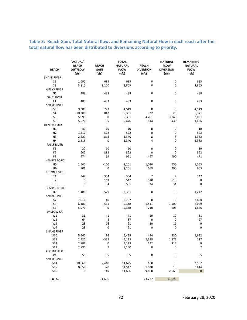
32 February 28, 2020
Table 3: Reach Gain, Total Natural flow, and Remaining Natural Flow in each reach after the total natural flow has been distributed to diversions according to priority.
REACH
“ACTUAL” REACH
OUTFLOW (cfs)
REACH GAIN (cfs)
TOTAL NATURAL
FLOW (cfs)
REACH
DIVERSION (cfs)
NATURAL FLOW
DIVERSION (cfs)
REMAINING NATURAL
FLOW (cfs)
SNAKE RIVER S1 1,690 685 685 0 0 685 S2 3,810 2,120 2,805 0 0 2,805
GREYS RIVER G1 488 488 488 0 0 488
SALT RIVER L1 483 483 483 0 0 483
SNAKE RIVER S3 9,380 773 4,549 0 0 4,549 S4 10,200 842 5,391 22 20 5,371 S5 5,999 0 5,391 4,201 3,340 2,031 S6 5,570 85 5,476 514 430 1,686
HENRYS FORK H1 40 10 10 0 0 10 H2 1,410 512 522 0 0 522 H3 2,220 818 1,340 8 8 1,332 H4 2,216 0 1,340 4 0 1,332
FALLS RIVER F1 20 10 10 0 0 10 F2 902 882 892 0 0 892 F3 474 69 961 497 490 471
HENRYS FORK H5 1,560 -100 2,201 1,030 550 1,153 H6 901 0 2,201 659 490 663
TETON RIVER T1 347 354 354 7 7 347 T2 0 163 517 510 510 0 T3 0 34 551 34 34 0
HENRYS FORK H7 1,480 579 3,331 0 0 1,242
SNAKE RIVER S7 7,010 -40 8,767 0 0 2,888 S8 6,180 581 9,348 1,411 1,400 2,069 S9 5,970 0 9,348 210 203 1,866
WILLOW CR W1 31 41 41 10 10 31 W2 64 -4 37 0 0 27 W3 28 -16 21 20 11 0 W4 28 0 21 0 0 0
SNAKE RIVER S10 5,640 86 9,455 444 330 1,622 S11 2,920 -332 9,123 2,388 1,173 117 S12 2,788 0 9,123 132 117 0 S13 2,795 7 9,130 0 0 7
PORTNEUF R. P1 55 55 55 0 0 55
SNAKE RIVER S14 10,868 2,440 11,625 188 0 2,502 S15 8,850 -78 11,547 1,838 10 2,414 S16 0 149 11,696 9,100 2,563 0
TOTAL 11,696 23,227 11,696
33 February 28, 2020
3.3 Computing storage deliveries There are only two types of flow in the water right accounting: natural flow and storage (stored) flow. Any water in excess of the natural flow (by definition) must be stored flow. After distributing the entire 11,696 cfs of natural flow to diversions according to their water rights (as shown in Table 3), any remaining loss of water from the system must be either reservoir evaporation losses or storage diverted by diversions. Therefore, the storage delivery to diversions can be calculated using the following equation:
Storage delivery = Total diversion – Natural flow delivery When the storage delivery to each diversion in the system is summed for a day of water right accounting after the reservoir storage rights have ceased filling and after water has ceased spilling past Milner Dam, the sum of storage diversions plus evaporation loss will equal the decrease in reservoir system physical contents.
3.4 Reach actual flow, natural flow, and storage flow The actual (observed) discharge at the end of each reach can be segregated into natural flow and stored flow after distributing the natural flow to canals, pumps, and reservoirs (as shown in Table 3). The actual flow is the actual river discharge measured at the streamflow gage at the end of the reach and is used as the outflow value in the reach gain equation. The stored flow at the end of the reach is calculated by subtracting the remaining natural flow from the actual flow. The remaining natural flow added to the stored flow will equal the actual flow at the end of each reach. Stored flow can be computed using the following equation: Stored Flow = Actual Flow – Remaining Natural Flow One of the guiding principles in the water right accounting is that the water right accounting neither creates nor destroys water. The water right accounting is a measure of the actual surface water delivery segregated each day into either natural flow or storage flow. Table 4 (having the same reach gains and diversions in Tables 2 and 3) shows the storage delivered to diversions in each reach and also shows the segregation of actual flow into natural flow and storage flow at the end of each reach. The columns of data shown in Table 4 are similar to the columns of data displayed on the output of the Water District #1’s daily water right accounting.

34 February 28, 2020
Table 4: Actual reach outflow segregated into remaining natural flow and storage flow.
REACH
ACTUAL REACH
OUTFLOW (cfs)
REACH GAIN (cfs)
TOTAL NATURAL
FLOW (cfs)
TOTAL REACH
DIVERSION (cfs)
NATURAL FLOW
DIVERSION (cfs)
STORAGE
DIVERSION (cfs)
REMAINING NATURAL
FLOW (cfs)
STORED FLOW (cfs)
SNAKE RIVER S1 1,690 685 685 0 0 0 685 1,005 S2 3,810 2,120 2,805 0 0 0 2,805 1,005
GREYS RIVER G1 488 488 488 0 0 0 488 0
SALT RIVER L1 483 483 483 0 0 0 483 0
SNAKE RIVER S3 9,380 773 4,549 0 0 0 4,549 4,831 S4 10,200 842 5,391 22 20 2 5,371 4,829 S5 5,999 0 5,391 4,201 3,340 861 2,031 3,968 S6 5,570 85 5,476 514 430 84 1,686 3,884
HENRYS FK H1 40 10 10 0 0 0 10 30 H2 1,410 512 522 0 0 0 522 888 H3 2,220 818 1,340 8 8 0 1,332 888 H4 2,216 0 1,340 4 0 4 1,332 884
FALLS RIVER F1 20 10 10 0 0 0 10 10 F2 902 882 892 0 0 0 892 10 F3 474 69 961 497 490 7 471 3
HENRYS FK H5 1,560 -100 2,201 1,030 550 480 1,153 407 H6 901 0 2,201 659 490 169 663 238
TETON RIVER T1 347 354 354 7 7 0 347 0 T2 0 163 517 510 510 0 0 0 T3 0 34 551 34 34 0 0 0
HENRYS FK H7 1,480 579 3,331 0 0 0 1,242 238
SNAKE RIVER S7 7,010 -40 8,767 0 0 0 2,888 4,122 S8 6,180 581 9,348 1,411 1,400 11 2,069 4,111 S9 5,970 0 9,348 210 203 7 1,866 4,104
WILLOW CR W1 31 41 41 10 10 0 31 0 W2 64 -4 37 0 0 0 27 37 W3 28 -16 21 20 11 9 0 28 W4 28 0 21 0 0 0 0 28
SNAKE RIVER S10 5,640 86 9,455 444 330 114 1,622 4,018 S11 2,920 -332 9,123 2,388 1,173 1,215 117 2,803 S12 2,788 0 9,123 132 117 15 0 2,788 S13 2,795 7 9,130 0 0 0 7 2,788
PORTNEUF R P1 55 55 55 0 0 0 55 0
SNAKE RIVER S14 10,868 2,440 11,625 188 0 188 2,502 8,366 S15 8,850 -78 11,547 1,838 10 1,828 2,414 6,436 S16 0 149 11,696 9,100 2,563 6,537 0 0
TOTAL 11,696 23,227 11,696 11,531

35 February 28, 2020
3.5 Reach priority determination One of the most useful outcomes of the water right accounting is the publishing of priority dates being filled each day for diversions currently diverting water in each reach. The reach priorities are shown on the daily water right accounting under a column labeled LAST RIGHT shown in Table 5. All reach water right diversions senior to the LAST RIGHT are diverting natural flow on this day of water right accounting. All reach diversions junior to the LAST RIGHT are diverting storage water on this day. If a diversion has a water right with the same priority as shown as the LAST RIGHT, the water right with this priority is being filled between 0% and 100%. The water right accounting output does not indicate directly what percentage between 0% and 100% the LAST RIGHT is being filled, but the percentage can be determined by using a few additional computations. The method used to determine what percentage the LAST RIGHT is being filled is to find an individual diversion owning a water right priority the same as the LAST RIGHT shown in the accounting that is also diverting both natural flow and storage on this day of accounting. If the diversion doesn’t have any other water rights senior to the LAST RIGHT, the percentage of the LAST RIGHT being filled can be determined by simply taking the amount of natural flow (cfs) being delivered to this diversion on this day of accounting and dividing it by the quantity (cfs) of the right owned by the diversion. If the diversion having the same water right priority as the LAST RIGHT being shown on this day of water right accounting also has water rights senior to the priority of the LAST RIGHT shown, the amount of senior water rights owned by the diversion must first be subtracted from the total natural flow being delivered to the diversion, and the remainder of natural flow delivered to the diversion must then be divided by the amount of the water right owned by the diversion with the same priority as the LAST RIGHT shown in the accounting. For example, let’s assume the following scenario:
A canal on the Snake River upstream from Blackfoot is diverting a total of 50 cfs, and 30 cfs of the total diverted by the canal has been determined to be natural flow distributed in the water right accounting with the other 20 cfs diverted by the canal charged as stored flow or usage.
The canal has three water rights: 10 cfs with a priority of 1890-06-01; 30 cfs with a priority of 1891-08-01; and 40 cfs with a priority of 1908-06-01.
The LAST RIGHT shown for the reach containing the canal in the water right accounting is 1891-08-01.
Of the 30 cfs natural flow being distributed to the diversion, 10 cfs was distributed to the senior 1890 priority water right. The remaining 20 cfs of natural flow was delivered to the 1891-08-01 priority water right, meaning 66.7% (20/30=0.667) of the 1891-08-01 priority was being filled on this day of accounting in this reach. None of the 1908 priority water right was being filled and the canal was diverting 20 cfs of storage water in addition to the 30 cfs of natural flow delivered to it. Table 5 shows an example of the LAST RIGHT being filled based on the natural flow that was available and distributed to each reach in Table 4. Notice the LAST RIGHT for some reaches is different from other reaches. This can result from the remaining natural flow at the end of a reach being zero. Whenever the remaining natural flow at the end of a reach is zero, the LAST RIGHT in the adjoining downstream reach will always be junior to the LAST RIGHT shown for the reach containing the zero remaining natural flow. This occurs when senior water rights upstream have diverted all of the natural flow and, because of additional gains in the downstream reach(es), junior water rights downstream are being filled with natural flow that was not available to the senior diversions in the upstream reach(es).

36 February 28, 2020
Table 5: Illustration of the most junior priority water right or LAST RIGHT that can be filled with available natural flow in each reach for the diversions currently diverting water.
REACH
“ACTUAL” REACH
OUTFLOW (cfs)
REACH GAIN (cfs)
TOTAL NATURAL
FLOW (cfs)
REACH
DIVERSION (cfs)
NATURAL FLOW
DIVERSION (cfs)
REMAINING NATURAL
FLOW (cfs)
LAST RIGHT
PRIORITY (yyyy-mm-dd)
SNAKE RIVER S1 1,690 685 685 0 0 685 1891-08-01 S2 3,810 2,120 2,805 0 0 2,805 1891-08-01
GREYS RIVER G1 488 488 488 0 0 488 1891-08-01
SALT RIVER L1 483 483 483 0 0 483 1891-08-01
SNAKE RIVER S3 9,380 773 4,549 0 0 4,549 1891-08-01 S4 10,200 842 5,391 22 20 5,371 1891-08-01 S5 5,999 0 5,391 4,201 3,340 2,031 1891-08-01 S6 5,570 85 5,476 514 430 1,686 1891-08-01
HENRYS FORK H1 40 10 10 0 0 10 1891-08-01 H2 1,410 512 522 0 0 522 1891-08-01 H3 2,220 818 1,340 8 8 1,332 1891-08-01 H4 2,216 0 1,340 4 0 1,332 1891-08-01
FALLS RIVER F1 20 10 10 0 0 10 1891-08-01 F2 902 882 892 0 0 892 1891-08-01 F3 474 69 961 497 490 471 1891-08-01
HENRYS FORK H5 1,560 -100 2,201 1,030 550 1,153 1891-08-01 H6 901 0 2,201 659 490 663 1891-08-01
TETON RIVER T1 347 354 354 7 7 347 1885-06-01 T2 0 163 517 510 510 0 1885-06-01 T3 0 34 551 34 34 0 1885-10-17
HENRYS FORK H7 1,480 579 3,331 0 0 1,242 1891-08-01
SNAKE RIVER S7 7,010 -40 8,767 0 0 2,888 1891-08-01 S8 6,180 581 9,348 1,411 1,400 2,069 1891-08-01 S9 5,970 0 9,348 210 203 1,866 1891-08-01
WILLOW CR W1 31 41 41 10 10 31 1883-04-01 W2 64 -4 37 0 0 27 1883-04-01 W3 28 -16 21 20 11 0 1883-04-01 W4 28 0 21 0 0 0 1883-04-01
SNAKE RIVER S10 5,640 86 9,455 444 330 1,622 1891-08-01 S11 2,920 -332 9,123 2,388 1,173 117 1891-08-01 S12 2,788 0 9,123 132 117 0 1891-08-01 S13 2,795 7 9,130 0 0 7 1900-10-11
PORTNEUF R. P1 55 55 55 0 0 55 1900-10-11
SNAKE RIVER S14 10,868 2,440 11,625 188 0 2,502 1900-10-11 S15 8,850 -78 11,547 1,838 10 2,414 1900-10-11 S16 0 149 11,696 9,100 2,563 0 1900-10-11
TOTAL 11,696 23,227 11,696

37 February 28, 2020
Table 5 illustrates there is only enough natural flow to fill up to the 1885-06-01 water rights on the Teton River Reaches T1 and T2 before the remaining natural flow at the end of Reach T2 goes to zero. Because there is additional reach gains downstream in the Teton River Reach T3, water rights senior to the 1885-10-17 priority for diversions in Reach T3 are being filled with natural flow. Natural flow in Willow Creek Reaches W1, W2, W3, and W4 is only adequate to fill up to 1883-04-01 priorities for Willow Creek diversions. All other Henrys Fork and Snake River reaches above Blackfoot (Reach S13) have sufficient natural flow available to fill up to 1891-08-01 water rights for diversions in those reaches. The remaining natural flow at the end of Snake River Reach S12 (below Blackfoot) is zero because diversions senior to all downstream diversions are diverting all of the natural flow above Blackfoot. Because there are additional reach gains below Blackfoot not available to upstream diversions, there is sufficient natural flow to partially fill the 1900-10-11 priority for diversions between Blackfoot and Milner in Reaches S13 through S16. The LAST RIGHT shown for the reach does not necessarily mean there are diversions in that reach with the LAST RIGHT priority. It only means that there is sufficient natural flow to fill up to that priority as natural flow in the reach, and natural flow is being delivered to a diversion in that reach, in an upstream reach, or in a downstream reach that has a water right with the same or senior priority to the LAST RIGHT shown.

38 February 28, 2020
3.6 Ungaged or calculated river reaches Reaches generally begin and end with a USGS streamflow gaging station. However, some stretches of river between USGS gaging stations have large tributaries flowing into the river between the two gages. This is not a problem when calculating the reach gain between the two gages but it can be a problem when distributing the available natural flow to diversions in the reach where the tributary enters. The river reach segment upstream from where the tributary enters the river channel may not have any natural flow in it but the segment of reach downstream from the tributary may contain a significant amount of natural flow that is not available to diversions immediately upstream from the tributary. It usually isn’t practical to have USGS streamflow gaging stations installed on the river immediately upstream and downstream from each major tributary to determine the precise amount of natural flow available to diversions immediately upstream and downstream of where the tributary enters the river. When USGS gaging stations are not available immediately upstream from the confluence with a major tributary, a “calculated gage” is used in the water right accounting as the outflow gage for the river reach upstream from the tributary and as the inflow gage for the river reach downstream from the tributary. This methodology ensures natural flow contributed from a tributary is not distributed to diversions upstream from where the tributary enters the river. There are four calculated gages in the water right accounting used to accurately distribute natural flow contributed to the main river channel from major tributaries. These calculated gages are shown with their locations in Table 6. The discharges at the calculated gages are estimated by assuming there is zero reach gain between the calculated gage and the USGS gage upstream. The reach gain for Reaches H4, H6, S9, and S12 containing calculated gages as outflow gages are all assumed to be zero. Table 6: Locations of calculated gages in the water right accounting used to distribute remaining natural flow from Falls River and Teton River flowing into the Henrys Fork, and remaining natural flow from Willow Creek and Blackfoot River flowing into the Snake River.
CALCULATED GAGE LOCATION
Used as Reach Outflow Gage for…
Used as Reach Inflow Gage for…..
Above (mouth of) Falls River Henrys Fork Reach H4 Henrys Fork Reach H5 Above (mouth of) North Fork Teton R. Henrys Fork Reach H6 Henrys Fork Reach H7 Above (mouth of ) Willow Creek Snake River Reach S9 Snake River Reach S10 Below last Blackfoot diversion (Parsons Canal) Snake River Reach S12 Snake River Reach S13
For example, the estimated outflow for Reach H4 would be estimated at the calculated gage using the following equation:
Reach H4 Outflow = 0 Reach Gain + Reach H4 Inflow – Reach H4 Diversions The value calculated for Reach H4 Outflow is the same value used for Reach H5 Inflow. In addition to the four calculated gages shown in Table 6, there are calculated gages at the end of Heise to below Dry Bed reach (S5), Teton Forks to Mouth (T3), and Floodway near Ucon to End of Floodway reach (W4). The distribution of natural flow in these reaches will be discussed in Chapter 10.

39 February 28, 2020
3.7 Reach losses deducted from available natural flow or storage conveyance Reach losses are incorporated into the natural flow distribution in the water right accounting with a few exceptions discussed in subsequent sections of this manual. The distribution of reach losses to natural flow water rights is inherent in the reach gain equation. If there is less water at the reach outflow gage than at the reach inflow gage after accounting for diversion and reservoir effects, there is a loss of water (or negative reach gain) between the upstream and downstream gages. These channel losses (or negative reach gains) reduce the amount of available natural flow based on the premise that total natural flow available to diversions is calculated by summing the reach gains, which includes both positive and negative gains. Prior to reservoirs being built, there were channel losses in some reaches. The assumption in the water right accounting for most reaches is channel losses are not significantly increased when storage water is released on top of the existing natural flow. While this assumption holds true for many reaches, there are some reaches where increases in discharge from storage deliveries result in significant increases in channel losses such as in Willow Creek, which has a special adjustment in the water right accounting discussed in Chapter 10. Any additional reach loss caused by added storage is usually more than offset by positive contributions of storage and increased return flow either directly or indirectly within the reach. Storage usage by canals often increases reach gain or natural flow in the downstream reaches of the river, especially later in the irrigation season when natural flow is at its lowest point. For example, let’s assume the result of conveying 500 cfs of storage from Palisades Reservoir to a canal near Idaho Falls increases the channel losses between the two points by 10 cfs, however, after the canal uses the 500 cfs of storage for flood irrigation, perhaps 15 cfs of the water returns to the river channel to provide additional natural flow. In this example, the return flow from storage usage exceeded the additional channel losses caused by conveying the storage to the diversion, and creates a net 5 cfs of additional natural flow or reach gain in the water right accounting from the return flow that otherwise would not have existed without the storage water diversion and subsequent return of some of that storage adding to the natural flow supply. Quantifying the portion of channel losses due solely to storage conveyance would be exceedingly difficult and likely create additional problems in the water right accounting for the following reasons:
If it is assumed channel losses are increased when storage is released from reservoirs, it could also be assumed channel losses decrease when water is being stored in reservoirs. If storage conveyance losses were deducted from reservoir allocations in the water right accounting, a system of credits may also need to be computed under the assumption channel losses are less than what would have occurred prior to the reservoir being constructed when the reservoir is releasing less water than would otherwise be in the channel without the reservoir.

40 February 28, 2020
Determining which reservoir or spaceholder allocations to deduct storage conveyance losses would be difficult. Should diversions upstream from the river reach containing the losses be charged for this storage conveyance loss that occurs downstream from their diversions? Or, should only diversions using storage downstream from the river reach containing the losses have their storage allocations reduced for the conveyance loss?
The current stream gaging may not be an accurate way to measure the loss solely attributed to the main river channel. Commonly, there are many small ungaged tributaries or return flows from canals entering the main channel between the two river streamflow gages. If the reach gain (loss) measured between the two river gages was -500 cfs, but the unmeasured tributary inflow into the reach between the two gages totaled 300 cfs, the actual loss in the main river channel would be -800 cfs instead of the -500 cfs. Using only the two measured gages would result in an underestimation of the main river channel loss.
A river reach can have a positive calculated reach gain between gages but still have storage conveyance losses between gages. For example, when the reach gain between two river gages is measured as +100 cfs but the unmeasured tributary inflow into the reach between the two gages totals 300 cfs, the channel loss in the main river channel is -200 cfs. Should storage conveyance losses be assessed for only those reaches that have a net negative reach gain, or should it be assumed that all reaches (even those with net positive reach gains) have additional channel losses from storage conveyance?
Gaging error can also create some large errors in conveyance loss estimates. For example, let’s assume there is 6,000 cfs of discharge at a USGS river gage, but the amount being reported by the USGS is only 5,800 cfs due to an outdated measurement shift. This could result in a calculated 200 cfs loss in the upstream reach and a 200 cfs gain in the downstream reach in the water right accounting, when actually there is not a gain or loss in either reach. Fortunately, under the current accounting system the gaging error would not affect the total natural flow because natural flow is calculated by summing the gains and losses of the two reaches. However, if conveyance losses were incorporated into the accounting, the gaging error would result in too high of a conveyance loss (200 cfs) being deducted from storage accounts and 200 cfs too much water being included as natural flow and delivered to diversions.
These bullet points illustrate the futility of attempting to quantify storage conveyance losses in the water right accounting to increase natural flow deliveries. If the various reasons for reach gains and reach losses are segregated and quantified, one factor may lead to additional natural flow, and another factor may lead to reduced natural flow (or move natural flow), resulting in some diversions getting more and some diversions getting less natural flow. Identifying and quantifying only one component such as storage conveyance would lead to the necessity to quantifying all components of reach gains and losses, which would lead to less certain, more theoretical (problematic) delivery of water. Canal managers also sometimes ask if their canals can get credited for the amount of storage water diverted at their headgates that they return to the river at the end of their system. Returning water to the river increases reach gains (natural flow) in downstream reaches resulting in return flows that benefit diversions in downstream reaches instead of directly benefitting the canal that returned the water to the river. However, it has not been the policy of Water District #1 to credit canals for any flows they return to the river. The water district’s response to canal managers has been that they need to reduce the diversion at the head of their canals to reduce the amount of unused water flowing out the end of their system. An exception to this rule has been the Minidoka Return Flow Credit discussed in Chapter 10.

41 February 28, 2020
3.8 Distribution to multiple diversions with identical priority dates When natural flow is insufficient to fill all water rights sharing the same priority date, a methodology must be developed to distribute the natural flow equitably among the various diversions with identical priority dates. If there are only two diversions with the same priority in the same reach and the natural flow is not sufficient to completely fill both water rights in the reach, both diversions would receive their proportional share of natural flow according to the amounts listed in their water rights. For example, let’s assume one diversion with an 1889-06-01 priority has a water right flow rate of 50 cfs and the other diversion with an 1889-06-01 priority has a water right flow rate of 150 cfs, and there was only 120 cfs of natural flow available to fill the 1889-06-01 priority in the reach. The 120 cfs of natural flow would be proportioned according to the summed amount of flow for both water rights in the current water right accounting, resulting in one-fourth (or 30 cfs) of the natural flow distributed to the diversion with the 50 cfs water right and three-fourths (or 90 cfs) of the natural flow distributed to the 150 cfs water right in the same reach. If one of the two diversions sharing the 1889-06-01 water right in the same reach was diverting less than their prorated share, the amount that was not diverted would be added to the prorated share of the other diversion in the reach. For example, in the previous example if the smaller diversion entitled to a prorated share of 30 cfs was only diverting 20 cfs of water, the larger diversion initially given a prorated share of 90 cfs would be delivered 100 cfs of natural flow under the 1889-06-01 priority as a result of the other diversion not using 10 cfs of its prorated share. The distribution of natural flow gets more complicated when diversions in different reaches share the same priority because there likely will be differing amounts of remaining natural flow in each of the different reaches available to water rights sharing the same priority. This can sometimes prevent diversions with identical priority dates from receiving identical percentages of natural flow. The simplest example occurs when a diversion sharing the same priority is in a reach with only 1 cfs of remaining natural flow while the other diversion is in a reach with 100 cfs of remaining natural flow. If both diversions have a water right for 300 cfs, the percentage of water right filled for the diversion in the reach with only 1 cfs of remaining natural flow will be much lower than the diversion in the reach with 100 cfs of remaining natural flow. The situation becomes more complicated, and the solution less apparent, when there are three or four diversions sharing the same priority but have different water right flow rates and are located in different reaches with different amounts of remaining natural flow. Table 7 illustrates an example where three diversions in three different reaches with identical priority dates are diverting water with differing amounts of remaining natural flow available at the end of each reach. In this example, there are two mainstem reaches A1 and A2, with a tributary reach B1 entering between the two mainstem reaches. Each diversion has a different water right flow rate and each reach has a different amount of natural flow available to it. The question then becomes, what amounts of available natural flow should be distributed to each of the three diversions with identical priorities shown in Table 7 in different reaches?

42 February 28, 2020
Table 7: Distribution of natural flow to diversions with identical priority water rights, different water right flow rates, diverting water in separate reaches with different amounts of available natural flow in each reach.
REACH
AVAILABLE NATURAL FLOW
DIVERSION WATER RIGHT
“CUMULATIVE WATER RIGHT”
TOTAL WATER DIVERTED
NATURAL FLOW DIVERTED
A1 100 cfs 300 cfs 300 cfs 200 cfs ? B1 200 cfs 100 cfs 100 cfs 200 cfs ? A2 300 cfs 400 cfs 800 cfs 300 cfs ?
The following steps are used in the iterative process to distribute the available natural flow to diversions sharing the same priority in different reaches when the natural flow is not sufficient to fill all water right diversions with the same priority:
I. The cumulative total for all rights sharing the same priority is calculated for each reach in downstream order.
o In Table 7, the uppermost river Reach A1 has a water right for 300 cfs. The tributary Reach B1 that flows into the river between Reaches A1 and A2 has a water right for 100 cfs. The “Cumulative Water Right” for Reach A1 is 300 cfs since it is the uppermost reach, and the cumulative water right for Reach B1 is 100 cfs because Reach A1 does not contribute any water to the tributary Reach B1. The cumulative water right total for Reach A2 is 800 cfs, the sum of upstream reaches A1, B1 and A2 because both Reach A1 and Reach B1 provide inflow to the downstream Reach A2.
II. The available natural flow at each reach is divided by the cumulative total of water rights applicable to the reach to determine the initial percentage (PCT) of the right that can be filled in the reach. Values greater than 1.0 (100%) are limited to 1.0 and then revised downward if necessary so that no reach has a percentage (PCT) greater than the percentage in the downstream reach because diversions in a downstream reach can’t receive less of a percentage fill to their water right than an identical priority water right upstream unless it is allowed under the futile call doctrine.
o In Table 7, the value for Reach A1 is calculated as 100/300=0.333. The value for Reach B1 is 200/100=2, but the value is greater than 1.0, so it is set equal to 1.0. The value for Reach A2 is 300/800=0.375 and, because the value for Reach A2 is less than the value for the upstream Reach B1, the value for B1 is revised downwards to 0.375 to prevent a water right in an upstream reach being filled at a higher percentage than a water right in the downstream reach.
III. The PCT value is multiplied by the diversion water right in each reach to compute the amount of natural flow delivered to each diversion for the first iteration of natural flow distribution.
o Table 8 shows that that diversion in Reach A1 (diverting 200 cfs and having a water right for 300 cfs in Table 7) only has 100 cfs of natural flow available in the reach and is therefore entitled to the full 100 cfs of available natural flow after multiplying the PCT value by the diversion’s water right. The Reach B1 diversion receives 37.5 cfs of natural flow after multiplying the reach PCT value by the diversion water right. The Reach A2 diversion receives 150 cfs of natural flow.

43 February 28, 2020
IV. After distributing the natural flow computed in the previous step to each reach diversion, the amount distributed is subtracted from the available natural flow in each reach to compute the remaining natural flow (if any) to be distributed to the diversions with identical priority dates in the second iteration (if needed). If the remaining natural flow in the furthest downstream reach is greater than zero, an additional iteration is required to distribute the remaining natural flow.
o Table 8 shows the remaining natural flow in Reach A1 is zero after distributing to all the diversions with identical priority dates in the first iteration but there is 12.5 cfs of remaining natural flow to distribute in the furthest downstream reach, requiring a second iteration to distribute the remaining 12.5 cfs.
Table 8: First iteration of distributing 300 cfs of available natural flow to three diversions in different reaches with identical priority dates as shown in Table 7.
REACH
REACH PCT
DIVERSION WATER RIGHT
PCT x WATER RIGHT
AVAILABLE NATURAL FLOW
DIVERTED NATURAL FLOW
REMAINING NATURAL FLOW
A1 0.333 300 cfs 100 cfs 100 cfs 100 cfs 0 cfs B1 0.375 100 cfs 37.5 cfs 200 cfs 37.5 cfs 165.5 cfs A2 0.375 400 cfs 150 cfs 300 cfs 150 cfs 12.5 cfs
V. Any remaining natural flow after the first iteration is then distributed by computing the cumulative rights for each reach with remaining natural flow and unfilled water rights.
o The cumulative rights and PCT value in Reach A1 are set to zero because all the remaining natural flow in that reach was distributed in the first iteration. Since Reach B1 diversion had 37.5 cfs of its 100 cfs water right filled in the first iteration, it has 62.5 cfs of water right available to be filled in the second iteration with any remaining natural flow. Reach A2 diversion received 150 cfs of its 400 cfs water right during the first iteration, leaving 250 cfs remaining to be filled in the second iteration. Therefore the cumulative remaining water right available to be filled from upstream to downstream is zero for Reach A1, 62.5 cfs for Reach B1 (100 – 37.5 = 62.5), and 312.5 cfs for the last Reach A2 (62.5 + 400 – 150 cfs = 312.5).
VI. After computing the cumulative unfilled rights, a new PCT value is computed to distribute remaining natural flow in the second iteration. The PCT value is computed and revised the same way as computed in the first iteration whereby it is equal to the remaining natural flow divided by the cumulative unfilled portion of the water right(s), not to exceed a value of 1.0 or the PCT value computed for the downstream reach.
o The PCT value for Reach A1 is zero. The PCT value for Reach B1 is initially computed as 165.5/62.5=2.65, but is revised to 1.0. The PCT value for Reach A2 is computed as 12.5/312.5=0.04, resulting in the PCT value for upstream Reach B1 being revised to 0.04 so the percentage of the water right filled in the upstream reach does not exceed the percentage of the water right filled in the downstream reach.
VII. The PCT values are then multiplied by the unfilled water rights to determine the distribution of natural flow to diversions in the second iteration.
o Table 9 shows the results of the second iteration. The diversion in Reach A1 does not get any additional natural flow in the second iteration because it received the entire amount of natural flow in Reach A1 during the first iteration. The diversion in Reach B1 receives 2.5 cfs of natural flow in addition to the 37.5 cfs of natural flow received in the first iteration. The diversion in Reach A2 receives 10 cfs of natural flow in addition to the 150 cfs received in the first iteration.
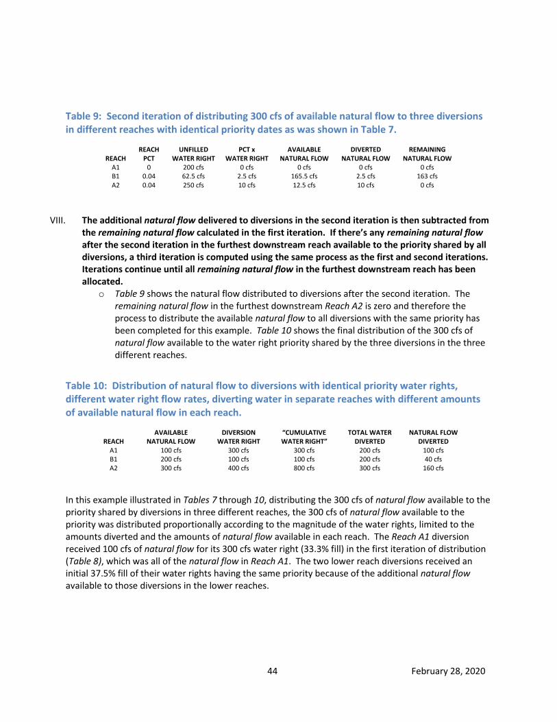
44 February 28, 2020
Table 9: Second iteration of distributing 300 cfs of available natural flow to three diversions in different reaches with identical priority dates as was shown in Table 7.
REACH
REACH PCT
UNFILLED WATER RIGHT
PCT x WATER RIGHT
AVAILABLE NATURAL FLOW
DIVERTED NATURAL FLOW
REMAINING NATURAL FLOW
A1 0 200 cfs 0 cfs 0 cfs 0 cfs 0 cfs B1 0.04 62.5 cfs 2.5 cfs 165.5 cfs 2.5 cfs 163 cfs A2 0.04 250 cfs 10 cfs 12.5 cfs 10 cfs 0 cfs
VIII. The additional natural flow delivered to diversions in the second iteration is then subtracted from the remaining natural flow calculated in the first iteration. If there’s any remaining natural flow after the second iteration in the furthest downstream reach available to the priority shared by all diversions, a third iteration is computed using the same process as the first and second iterations. Iterations continue until all remaining natural flow in the furthest downstream reach has been allocated.
o Table 9 shows the natural flow distributed to diversions after the second iteration. The remaining natural flow in the furthest downstream Reach A2 is zero and therefore the process to distribute the available natural flow to all diversions with the same priority has been completed for this example. Table 10 shows the final distribution of the 300 cfs of natural flow available to the water right priority shared by the three diversions in the three different reaches.
Table 10: Distribution of natural flow to diversions with identical priority water rights, different water right flow rates, diverting water in separate reaches with different amounts of available natural flow in each reach.
REACH
AVAILABLE NATURAL FLOW
DIVERSION WATER RIGHT
“CUMULATIVE WATER RIGHT”
TOTAL WATER DIVERTED
NATURAL FLOW DIVERTED
A1 100 cfs 300 cfs 300 cfs 200 cfs 100 cfs B1 200 cfs 100 cfs 100 cfs 200 cfs 40 cfs A2 300 cfs 400 cfs 800 cfs 300 cfs 160 cfs
In this example illustrated in Tables 7 through 10, distributing the 300 cfs of natural flow available to the priority shared by diversions in three different reaches, the 300 cfs of natural flow available to the priority was distributed proportionally according to the magnitude of the water rights, limited to the amounts diverted and the amounts of natural flow available in each reach. The Reach A1 diversion received 100 cfs of natural flow for its 300 cfs water right (33.3% fill) in the first iteration of distribution (Table 8), which was all of the natural flow in Reach A1. The two lower reach diversions received an initial 37.5% fill of their water rights having the same priority because of the additional natural flow available to those diversions in the lower reaches.

45 February 28, 2020
After the first iteration of distribution, there was 12.5 cfs of natural flow at the end of the system remaining to be distributed to the diversions sharing the same priority in the second iteration. The diversion in Reach A1 diverted all the natural flow from its reach in the first iteration and therefore didn’t receive any of the 12.5 cfs available to be distributed in the second iteration. The two remaining downstream diversions were distributed an additional 4% fill to their remaining unfilled natural flow rights. The Reach B1 diversion received 2.5 cfs and the Reach A2 diversion received 10 cfs (Table 9). The total percentage fill for the three water rights in different reaches having the same priority was 33.3% for the Reach A1 diversion, 40.0% for the Reach B1 diversion, and 40.0% for the Reach A2 diversion. The process used to distribute natural flow to diversions sharing the same priority in the water right accounting ensures that each diversion receives an equitable fill to its unfilled water right, but is limited to the amount diverted and amount of natural flow available in each reach.
3.9 Natural flow distribution to single entities with multiple points of
diversion, including “combined diversions” Water rights can sometimes have multiple points of diversion. The Snake River water rights for Progressive Irrigation District allow the irrigation district to divert its natural flow through the Anderson Canal or Eagle Rock Canal. The New Sweden Irrigation District diverts its water rights through the Great Western or Porter Canals. The North Fremont Canal Systems Inc. water rights include the Yellowstone, Marysville, and Farmers Own Canals on Falls River. The North Side Canal Company has the North Side Canal and the PA Lateral Canal as points of diversion from the Snake River in addition to the A Lateral, Brune Pump, and North Side CrossCut diversions from the Milner Gooding Canal. These are some of the examples of entities having water rights with multiple points of diversion. There are two options in the water right accounting for natural flow delivery to single entities having multiple points of diversion. The first option is the entity must designate a precise portion of their water right to be assigned to each diversion. For example, if the Blacksmith Canal Company had two points of diversion (Canal A and Canal B) for its 200 cfs, 1890-06-01 priority water right, it could designate 50 cfs of the water right be assigned to Canal A and 150 cfs be assigned to Canal B at the start of the irrigation season. In most instances, the portions assigned to each canal remain in effect until the end of the irrigation year, unless changed by a temporary water right transfer. The reasons for not allowing changes during mid-season include:
It could lead to uncertainty when projecting upcoming water right priority deliveries to other canals;
It creates additional computer programming for the water district staff during the irrigation season, and it also increases the possibility of accounting errors if changes are not made on a timely basis.
This first option is generally less desirable to canals unless the canal wants to have one of its multiple points of diversion regulated independently from its other points of diversion.

46 February 28, 2020
The second (and usually preferred) option is that the entity with multiple points of diversion pools their water rights together, allowing them to divert the entire amount(s) of available natural flow through any one or all of their points of diversion. These are often referred to as combined diversions in the water right accounting. The accounting technique for this option sums a single entity’s multiple diversions and then compares the summed combined diversion to the entity’s water rights and the available natural flow to determine how much natural flow and storage is being delivered to the entity each day in the water right accounting. For example, if the Blacksmith Canal Company opted to combine its two points of diversion, and its 1890-06-01 water right for 200 cfs was in priority, the Blacksmith Canal Company would not be delivered any storage water as long as its two diversions totaled less than 200 cfs and there was sufficient natural flow to fill its priority.
3.10 Negative remaining natural flow, negative stored flow, and exchanging
storage All remaining natural flow and stored flow previously illustrated in Table 4 had positive values. There are occasions when negative values for remaining natural flow and stored flow occur in the daily water right accounting. Actual flow in a reach is always equal to the remaining natural flow plus the stored flow in the reach. Therefore, if the remaining natural flow in a reach exceeds the actual flow, the stored flow must be negative. When the stored flow exceeds the actual flow, the remaining natural flow becomes negative. Negative stored flow occurs when a reservoir’s physical contents are increasing at a rate greater than the amount of storage accruing to the reservoir’s storage water right. For example, when the outflow from Ririe Reservoir is shut to zero and Ririe Reservoir is physically storing water when there isn’t sufficient natural flow to fill its water right priority, this will result in a negative stored value at the end of the reach immediately below Ririe Dam. Let’s assume the American Falls Reservoir water right (which is senior to the Ririe Reservoir water right) has not completely filled. If the outflow for the Ririe Reservoir was zero, and the Ririe Reservoir contents were increasing by 100 acre-feet (or 50 cfs) per day, the remaining natural flow at the end of the Ririe reach would be 50 cfs (accrued to the downstream senior American Falls Reservoir storage right) and the storage flow at the end of the Ririe reach would be shown as -50 cfs in the water right accounting because natural flow belonging to the American Falls Reservoir water right was not physically released from Ririe Dam to be allowed to flow down and physically be captured in American Falls Reservoir and was instead physically captured in Ririe Reservoir. A negative stored flow can also occur if diversions are using more storage than is physically being released from upstream reservoirs. For example, Grassy Lake is the only reservoir upstream from diversions on the Falls River. If the outflow from Grassy Lake is zero and one or more diversions on the Falls River are diverting water out-of-priority (i.e. diverting storage water), the calculated remaining natural flow at the mouth of the Falls River will be greater than the actual flow, resulting in a negative stored flow at the end of the last Falls River reach where it joins the Henrys Fork. This ensures that natural flow diverted from Falls River as storage is exchanged downstream.

47 February 28, 2020
A negative stored flow does not impact the delivery to natural flow entitlements when water is released from a reservoir offsetting the negative remaining natural flow. This process is termed “storage exchange” and occurs when stored flow from a reservoir is released to offset natural flow that was diverted as storage by out-of-priority diversions. As long as sufficient water is released from a reservoir to prevent the river channel from going dry, these exchanges can be accommodated. For example, water can be released from Island Park Reservoir and exchanged for storage diverted on Falls River. The amount exchanged would be equal to the amount of negative stored flow computed at the mouth of the Falls River. The release from Island Park Reservoir supplements the actual flow in the Henrys Fork at the mouth of Falls River to replace the natural flow that was diverted as storage by out-of-priority Falls River diversions. This exchange process allows for water to be kept in upstream, more difficult to fill reservoirs while exchanging storage for water held in other easier to fill reservoirs in the system. It also allows for storage diversions on tributaries without reservoirs to divert (exchange) storage physically released from reservoirs on other connecting tributaries or rivers. A negative remaining natural flow can occur in a reach, but not at the same time a negative stored flow occurs because the reach’s actual flow can never be negative. A negative remaining natural flow occurs in the Henrys Lake and Grassy Lake reaches at the top of their respective sub-basins when the outflow (or releases from the reservoirs) at the end of the reach is less than the decrease of reservoir contents. For example, if the outflow of either Henrys Lake or Grassy Lake is zero and the reservoir content decreases, a loss is calculated in the reach. The loss causes the remaining natural flow to become negative and the stored flow to become equal to the loss in this uppermost reach that contains the reservoir. The loss in the reach is not deducted from the previous storage accrual to the water rights of Henrys Lake or Grassy Lake. The loss is summed with the downstream reach gains in the current day of accounting to compute the total natural flow available to downstream water rights. This process ensures that water is neither created nor destroyed in the water right accounting.
3.11 Adjustments when losses exceed the reach natural flow Reach losses (or negative reach gains) sometime exceed the remaining natural flow at the end of the adjacent upstream reach. When this occurs there are three options to offset the loss of water:
1) Reduce the amount of natural flow available to diversions upstream from the losing reach; 2) Reduce the amount of natural flow available to diversions downstream from the losing reach; 3) Deduct the losses from the reach’s stored flow.
Option 1) is used for all reaches other than the reaches discussed in Options 2 and 3. When a reach loss (or negative reach gain) is greater than the remaining natural flow, the amount of loss in excess of the remaining natural flow is offset by reach gains in reaches immediately upstream. For example, the remaining natural flow in the Alpine to Irwin reach (S3) is sometimes entirely accrued to the Palisades storage water right when there is a loss in the downstream Blw Dry Bed to Lorenzo reach (S6) that exceeds the gain in the Irwin to Heise reach (S4). When this occurs, natural flow that arises above Irwin is used to offset the loss in the Blw Dry Bed to Lorenzo reach (S6) to satisfy the downstream loss, reducing the amount of natural flow that would otherwise accrue to the upstream Palisades Reservoir storage water right. Storage accrual affected by downstream losses is discussed again in Chapter 8.

48 February 28, 2020
Option 2) is used for the uppermost reaches of the system containing reservoirs. The reaches that contain Henrys Lake and Grassy Lake Reservoirs (Reaches H1 and F1) are examples. A negative remaining natural flow occurs in these two reaches when the reservoir contents decrease by an amount greater than the outflow of the reach. Because there are not any reaches upstream from these reservoirs, the only available option is to sum the losses with the reach gains in the adjacent downstream reaches to determine the natural flow available to downstream water rights. Option 3) is used for the Willow Creek reaches downstream from Ririe Reservoir and also used for distributing some reach losses that occur in the Blw Blackfoot to Nr Blackfoot reach (S13). Negative reach gains or losses for all other reaches in the district are subtracted from the natural flow supply using either Options 1 or 2. The option used to distribute losses in the Blw Blackfoot to Nr Blackfoot reach and Willow Creek reaches is discussed in Chapter 10.

49 February 28, 2020
Chapter 4: ADJUSTING REACH GAINS FOR WATER TRAVEL (LAG) TIMES To accurately measure gains or losses using the reach gain equation, the water travel time between gages must be taken into consideration to offset the unnatural fluctuations that otherwise would occur if flows were not adjusted for the time it takes water to travel from the reach inflow gage to the reach outflow gage. Consider a reach where it takes 24 hours for water to travel from the reach’s inflow gage to the reach’s outflow gage. Table 11 illustrates the discharge of inflow and outflow stations along with the calculation of reach gains using the reach gain equation (reach gain equals outflow minus inflow) without adjusting for the 24-hour travel time between gages.
Table 11: Calculation of reach gain without adjusting for water travel time.
ACTUAL DATE
INFLOW GAGE (cfs)
OUTFLOW GAGE (cfs)
REACH GAIN (cfs)
June 1 2,521 2,735 214 June 2 2,522 2,738 216 June 3 3,480 2,733 -747 June 4 3,483 3,695 212 June 5 3,481 3,699 218 June 6 1,953 3,697 1,744 June 7 1,951 2,162 211 June 8 1,952 2,164 212
The large reach gain fluctuations that occur on June 3rd and June 6th in the last column of Table 11 result from increases and decreases at the reach inflow gage that have yet to arrive at the reach outflow gage. To correct the errors, the discharges measured at the outflow gage can be lagged one day from the discharges measured at the inflow gage. When the reach gains are recalculated using the lagged data for the outflow gage, the calculated reach gains more closely correspond to the actual gains and losses occurring in the reach. Table 12 shows the adjusted reach gains computed using a one-day travel time between the inflow and outflow gages.
Table 12: Calculation of reach gain adjusting for one day of water travel time between the inflow and outflow gages.
INFLOW GAGE ACTUAL DATE
INFLOW GAGE (cfs)
OUTFLOW GAGE ACTUAL DATE
OUTFLOW GAGE (cfs)
REACH GAIN (cfs)
June 1 2,521 June 2 2,738 217 June 2 2,522 June 3 2,733 211 June 3 3,480 June 4 3,695 215 June 4 3,483 June 5 3,699 216 June 5 3,481 June 6 3,697 216 June 6 1,953 June 7 2,162 209 June 7 1,951 June 8 2,164 213 June 8 1,952 June 9 2,167 215

50 February 28, 2020
4.1 Water right accounting water travel times It takes approximately five days for water to travel from Jackson Lake to the end of the system at Milner Dam. It takes approximately seven days for water to travel from Henrys Lake to Milner Dam. Examining a hydrograph of water traveling from the top of the system to the bottom of the system reveals there is not precisely 24 hours of water travel time between each reach or each USGS gage. Water travel time between river gages is usually less than 24 hours. Current programming code requires travel times or lag times in the water right accounting to be expressed in whole day increments. Discharges for stream gaging stations and diversions in addition to changes in reservoir contents and evaporation are all currently averaged or calculated over a 24-hour period from midnight to midnight. Because of this 24-hour limitation of measuring data midnight to midnight, the accounting program can only accommodate lag times between inflow and outflow gages of either zero or one day (midnight to midnight). While travel times greater than zero and less than 24 hours may lead to more accurate calculations of reach gains between inflow and outflow gages, the current water right accounting would need to be modified to accommodate shorter time steps (e.g. one hour instead of one day time steps). To further complicate travel time adjustments, the water travel time is variable depending on how much water is in the river. For example, it takes 27 hours for water to travel from Heise to Shelley at 1,000 cfs, but only 17 hours at 18,000 cfs (1977 Watermaster Report, Plate No. 15). To compute the most accurate reach gain between river gages, time steps would need to be changed from one day to one hour increments and the hours of water travel time between gages would need to vary each hour depending on the discharge in the reach. One-hour time steps may require collection of diversion data and reservoir change in contents for each hour of the day, it may lead to water rights going into and out of priority multiple times during one day, and would make it more difficult for canal managers and the Watermaster to regulate diversions. Reaches in the water right accounting currently assigned one day of water travel time between the reach inflow and reach outflow gages are shown in Table 13. Reservoir data and diversion data used in the reach gain equation assigned one day of travel time usually correspond to the same day used for the outflow gage data, unless the reservoir or diversion gage(s) are in closer proximity to the inflow gage. Reaches assigned zero days of water travel time use the same day’s inflow, outflow, reservoir, and diversion data in the reach gain equation to calculate the natural flow in the reach.
Table 13: Reaches with one day of water travel time to provide for the five days of water travel time from Moran to Milner and seven days of travel time from Henrys Lake to Milner.
Reaches with one day of water travel time between inflow and outflow gages. SNAKE RIVER
S3 Alpine to Irwin (Includes Palisades Reservoir) HENRYS FORK
H2 Henrys Lake Outlet to Island Park (Includes Island Park Reservoir) H3 Island Park to Ashton H7 Above North Fork Teton River to Rexburg (Confluence of Teton River to Henrys Fork Rexburg gage)
SNAKE RIVER S10 Willow Creek to Shelley (Confluence of Willow Creek Floodway to Snake River Shelley gage) S13 Below Blackfoot to near Blackfoot (Parsons Canal to Snake River near Blackfoot gage – includes confluence of Blackfoot
River) S14 Near Blackfoot to Neely (includes American Falls Reservoir) S16 Minidoka to Milner (includes Lake Milner)
51 February 28, 2020
4.2 Milner time vs. Actual time Water travel times are necessary in the water right accounting for the Watermaster to accurately distribute water because it takes multiple days for water to travel through the Water District #1 system from top to bottom. The Watermaster must wait until a 24-hour block of water travels through the entire system to see which diversions divert water from that block. A canal can have the earliest water right in the system but, if the canal chooses not to divert any water, the natural flow becomes available to the next junior appropriator. Because the Watermaster does not know with absolute certainty which diversions will be diverting from the 24-hour block of water traveling through the system, he must wait until the block of water has passed every diversion to be certain how the 24-hour block of water was distributed to water right diversions as it passed through the system. As an example to illustrate the difficulties facing the Watermaster, consider an irrigation system with the following characteristics:
It takes five days for water to travel from beginning to end of the system.
There are five reaches in the system, each with one day travel time between each reach.
Only half of the canals in the system have been diverting water over the previous five days and the total natural flow has been steady and constant.
It is possible that all the canals in the system will turn on in the next five days, but it is unknown precisely when (or if) they will turn on and off during the five days.
It is possible that some of the canals that have been diverting natural flow the past five days will increase or decrease the amount of water they are diverting.
Junior and senior water rights are dispersed throughout the system, some currently diverting water and some not currently diverting water.
The uppermost reach has diversions with unfilled natural flow rights but their water rights are junior to some downstream water rights.
Suddenly, there is a huge surge of inflow into the uppermost reach from rain and melting snow, increasing the natural flow on Day 1 by 1,000 cfs in the first reach. It will take until Day 2 for the 1,000 cfs to flow into the next downstream reach. It will take until Day 3 when the 1,000 cfs is available to diversions in the next downstream reach, and so on…..until the additional 1,000 cfs of natural flow is available to diversions in the last reach at the end of the system on Day 5.
Assuming these conditions……Would the priority being filled for diversions in the uppermost reach increase, decrease, or stay the same on Day 1 with the additional 1,000 cfs of natural flow entering this reach?

52 February 28, 2020
The answer is…….The Watermaster will not know for certain what priority was filled in the uppermost reach on Day 1 until the 1,000 cfs block of water has passed every diversion in the system on Day 5. The diversions in the uppermost reach are not entitled to any of the 1,000 cfs of additional natural flow if senior diversions in downstream reaches that previously were not diverting water decide to increase their diversions when the 1,000 cfs of additional natural flow travels down to their reach over the next few days and becomes available to them. However, any portion of the 1,000 cfs of natural flow that is not diverted by senior downstream diversions on Days 2, 3, 4, and 5, could be delivered to diversions in the uppermost reach on Day 1. The three possible answers to the previous question are:
1) If the amount of additional senior diversions downstream is greater than 1,000 cfs on Days 2, 3, 4, and 5, the priority being filled for diversions in the uppermost reach would decrease on Day 1.
2) If the amount of additional senior diversions downstream is equal to 1,000 cfs on Days 2, 3, 4, and 5, the priority being filled for diversions in the uppermost reach would stay the same on Day 1.
3) If the amount of additional senior diversion downstream is less than 1,000 cfs on Days 2, 3, 4, and 5, the priority being filled for diversions in the uppermost reach would increase on Day 1.
The same situation applies in Water District #1. The Watermaster cannot precisely determine which diversion has diverted the natural flow passing the Snake River at Moran (Jackson Dam) gage until that block of water has been allowed to pass every gage from Jackson Dam to Milner Dam over the next five days. The Watermaster cannot precisely determine which diversion has diverted the natural flow passing Henrys Lake until that block of water has traveled entirely through the system and reached Milner Dam seven days later. Delivery dates in the water right accounting are expressed by using either actual date or Milner date. Table 14 lists the actual dates of when a block of water passes through the various reaches in the water right accounting and arrives at the end of the system for a day of accounting on the May 20th Milner date. This May 20th (Milner date) day of accounting shown in Table 14 is a snapshot of a 24-hour block of water traveling through the entire system and how it was distributed to diversions beginning on May 13th actual time at Henrys Lake (Reach H1), beginning May 15th actual time at Jackson Lake (Reach S1), and ending at Milner Dam (Reach S16) on May 20th. The day of accounting was May 20th Milner date, but the actual dates when the block of water was distributed to canals in each upstream reach varied depending on the number of days it took for the block of water to travel from the diversion reach to the end of the system at Milner Dam.
The diversions in Reach A16 (Minidoka to Milner) shown in Table 14 are the natural flow and stored flow diversions of the water that reached the end of the system on May 20th. The diversions shown for Reaches S14 and S15 (Nr Blackfoot to Minidoka) are the natural flow and stored flow diversions of that same block of water when it passed through those reaches on May 19th and arrived at the end of the system at Milner Dam on May 20th. That same block of water moved through the reaches between the confluence of Willow Creek and Blackfoot (Reaches S10 thru S12) on May 17th, three days before it arrived at Milner Dam. The block of water moved through the Snake River reaches from Irwin to Willow Creek (Reaches S3 thru S9) on May 16th, and moved through the Henrys Fork reaches H3 thru H6, Falls River reaches F1 thru F3, and Teton River reaches T1 thru T3 on May 15th.

53 February 28, 2020
Table 14: May 20th (Milner Time) day of water right accounting displaying the "actual date" for each reach of when the block of water arriving at Milner on May 20th passed through the reach and how it was distributed (diverted) according to the reach priority date occurring on the actual date displayed for each reach.
REACH
ACTUAL
DATE
“ACTUAL” REACH
OUTFLOW (cfs)
REACH GAIN (cfs)
TOTAL NATURAL
FLOW (cfs)
REACH
DIVERSION (cfs)
NATURAL FLOW
DIVERSION (cfs)
REMAINING NATURAL
FLOW (cfs)
LAST RIGHT
PRIORITY (yyyy-mm-dd)
SNAKE RIVER S1 May 15 1,690 685 685 0 0 685 1891-12-14 S2 May 15 3,810 2,120 2,805 0 0 2,805 1891-12-14
GREYS RIVER G1 May 15 488 488 488 0 0 488 1891-12-14
SALT RIVER L1 May 15 483 483 483 0 0 483 1891-12-14
SNAKE RIVER S3 May 16 9,380 773 4,549 0 0 4,549 1891-12-14 S4 May 16 10,200 842 5,391 22 20 5,371 1891-12-14 S5 May 16 5,999 0 5,391 4,201 3,340 2,031 1891-12-14 S6 May 16 5,570 85 5,476 514 430 1,686 1891-12-14
HENRYS FORK H1 May 13 40 10 10 0 0 10 1891-12-14 H2 May 14 1,410 512 522 0 0 522 1891-12-14 H3 May 15 2,220 818 1,340 8 8 1,332 1891-12-14 H4 May 15 2,216 0 1,340 4 0 1,332 1891-12-14
FALLS RIVER F1 May 15 20 10 10 0 0 10 1891-12-14 F2 May 15 902 882 892 0 0 892 1891-12-14 F3 May 15 474 69 961 497 490 471 1891-12-14
HENRYS FORK H5 May 15 1,560 -100 2,201 1,030 550 1,153 1891-12-14 H6 May 15 901 0 2,201 659 490 663 1891-12-14
TETON RIVER T1 May 15 347 354 354 7 7 347 1885-06-01 T2 May 15 0 163 517 510 510 0 1885-06-01 T3 May 15 0 34 551 34 34 0 1885-10-17
HENRYS FORK H7 May 16 1,480 579 3,331 0 0 1,242 1891-12-14
SNAKE RIVER S7 May 16 7,010 -40 8,767 0 0 2,888 1891-12-14 S8 May 16 6,180 581 9,348 1,411 1,400 2,069 1891-12-14 S9 May 16 5,970 0 9,348 210 203 1,866 1891-12-14
WILLOW CR W1 May 16 31 41 41 10 10 31 1883-04-01 W2 May 16 64 -4 37 0 0 27 1883-04-01 W3 May 16 28 -16 21 20 11 0 1883-04-01 W4 May 16 28 0 21 0 0 0 1883-04-01
SNAKE RIVER S10 May 17 5,640 86 9,455 444 330 1,622 1891-12-14 S11 May 17 2,920 -332 9,123 2,388 1,173 117 1891-12-14 S12 May 17 2,788 0 9,123 132 117 0 1891-12-14 S13 May 18 2,795 7 9,130 0 0 7 1900-10-11
PORTNEUF R. P1 May 18 55 55 55 0 0 55 1900-10-11
SNAKE RIVER S14 May 19 10,868 2,440 11,625 188 0 2,502 1900-10-11 S15 May 19 8,850 -78 11,547 1,838 10 2,414 1900-10-11 S16 May 20 0 149 11,696 9,100 2,563 0 1900-10-11
TOTAL 11,696 23,227 11,696

54 February 28, 2020
The time that it takes for a block of water to travel through the entire system makes it difficult for the Watermaster and canal managers in the upstream reaches to know the precise amounts of natural flow and storage that can be diverted on a real-time basis because the accounting for that block of water usually cannot be determined until several days after it has passed the diversion(s). Also, the accounting for the current day cannot be completed until the next day because data for the current day is required through midnight for all diversions, reservoirs, and streamflow stations in the reach. For example, to calculate the water right accounting and water distribution for May 20th (Milner date), the Watermaster must wait until May 21st to calculate the accounting required to track a block of water traveling through the system from May 13th through May 20th. The May 20th (Milner date) water accounting (compiled on May 21st) will show the amount of water diverted and the priority filled for Snake River diversions near Heise and Rigby five days earlier on May 16th, but does not give any indication what priority was filled for those diversions for the actual date May 17th in that reach. To forecast the priority being filled in any reach on a real-time basis requires “projecting” future reach gains, diversions, and filled priority dates. The further a diversion is located upstream, the longer the forecast needs to be to enable real-time projections of what priority water right will likely be filled in that reach. For example, to determine the amount of natural flow available to diversions near Heise and Rigby on a real-time basis, the Watermaster must make projections five days into the future, forecasting the daily quantities of reach gains, diversions, and reservoir changes that will occur over the next five days. These forecasts are referred to as “projected data” and will be discussed in Chapter7.

55 February 28, 2020
Chapter 5: REACH GAIN AVERAGING Fluctuations in computed reach gains are caused by fluctuations in spring or tributary inflows between the reach’s beginning and ending gages. Reach gain fluctuations can also occur because of imprecise discharge measurements, imprecise water travel times, and imprecise measurements of reservoir contents incorporated into the water right accounting. Large and frequent reach gain fluctuations due to these gaging errors can cause unrealistic fluctuations in natural flow and priority deliveries making it difficult for canal managers to manage their canals daily. To adjust for these unnatural fluctuations, a reach gain averaging process over a multi-day period has been incorporated into the water right accounting.
5.1 Reach gain fluctuations caused by imprecise travel time As demonstrated in Tables 11 and 12, when the reach gain equation is adjusted for water travel time between inflow and outflow gages, the outcome can more closely reflect the actual gain of water between the beginning and ending of the reach. The time it took for water to travel from the inflow to the outflow gage in Tables 11 and 12 was exactly 24 hours. The water right accounting is limited to either using 24 hours or zero hours of travel time between gages because it is limited to one-day time steps. The time it takes for water to actually travel between the inflow and outflow gages of reaches in the water right accounting is always greater than zero but usually less than 24 hours. When the actual water travel time between gages is greater than the travel time assigned to the reach in the water right accounting, the calculated reach gain will be underestimated when streamflow is increasing and overestimated when streamflow is decreasing in the reach. This was illustrated in Table 11 on June 3rd and June 6th, respectively. The exact opposite effect occurs when the actual water travel time between gages is less than the travel time assigned in the water right accounting, whereby the calculated reach gain will be overestimated when streamflow is increasing and underestimated when the streamflow is decreasing in the reach. Because the water right accounting assigns either a zero or 24-hour travel time to each reach, it sometimes causes unrealistic fluctuations in reach gains due to the imprecise adjustments for water travel times when the discharges at the inflow and outflow gages of the reach are increasing or decreasing. One of the ways to smooth unrealistic fluctuations due to travel times is to average the computed daily reach gain values over several days. For example, if the daily calculated reach gains over a 4-day period are 240 cfs, 320 cfs, 310 cfs, and 270 cfs and the fluctuations are being caused by travel time adjustments to the reach gain equation, the four days of gains could be averaged together yielding a 285 cfs averaged reach gain. This process would help offset any error induced by water travel times greater than zero but less than 24 hours during times of increasing and decreasing discharges, and represent an averaged value closer to the actual reach gain occurring during the four days.
5.2 Reach gain fluctuations caused by imprecise measurement of reservoir
content Large daily reach gain fluctuations in reaches that contain large reservoirs are often not caused by sudden increases and decreases in spring/tributary inflow into the reach. They are usually caused by the inability to precisely measure daily changes in reservoir contents.

56 February 28, 2020
For example, let’s assume a constant storage elevation at Lake Walcott is maintained (i.e., no change in reservoir content) over several days while inflows, outflows, reach diversions, and evaporation remain steady. The daily reach gain calculation during this period will remain steady because all the parameters in the reach gain equation remain unchanged. Now, let’s assume on a windy day the reservoir gage shows a datum increase of 0.08 foot, without any changes to inflows, diversions, evaporation, or reservoir releases. The next day the wind stops and the reservoir gage returns to the previous water elevation level showing a gage height decrease of 0.08 foot. The water right accounting in this example measures the actual reservoir contents increasing 0.08 foot one day and decreasing 0.08 foot the next day, but it was only because of the wind pushing the reservoir surface towards the gage making it appear the reservoir was rising when the wind was blowing and then receding when the wind stopped. When the water right accounting uses the reach gain equation to compute the reach gain for each of the two days, a 490 cfs reach gain is computed on the day when the reservoir contents appear to rise, followed by a -490 cfs reach loss the next day when the wind stops and the reservoir contents appear to recede. The two-day fluctuation of +490 cfs and -490 cfs was not a real change in the reach gain. It was caused by the inability to accurately measure the reservoir contents on the day the wind was blowing. Reservoirs with large surface areas relative to the amount of water stored in the reservoir, or reservoirs that are exposed to more frequent high winds, have greater and more frequent reach gain fluctuations than reservoirs with smaller surface areas or reservoirs that do not receive as much wind. For example, a gage height fluctuation of 0.08 feet (one inch) caused by wind on Lake Walcott results in a 490 cfs (970 acre-feet) reach gain fluctuation at full capacity. A gage height fluctuation of 0.08 feet on American Falls Reservoir at full capacity results in a 2,340 cfs (4,650 acre-feet) fluctuation because of its larger surface area. Reach gain averaging can be used in the water right accounting to adjust for unnatural variations in reach gains caused by windswept reservoirs. Averaging the daily reach gain over a multi-day period can help smooth the reach gain fluctuations caused by the inability of reservoir gages to accurately measure and account for reservoir contents at all times.
5.3 Determining appropriate number of days to average reach gains The original computerized accounting when it was first compiled in the late 1970’s probably did not have any reach gain averaging until the problems caused by imprecise travel times and imprecise daily reservoir content data were realized. A 4-day reach gain averaging was initially added to the accounting for reaches containing reservoirs but it was later found that this was too short of a time period for the reaches containing American Falls Reservoir, Lake Walcott, and Lake Milner. The 4-day averaging for these reaches did not do an adequate job of smoothing reach gain fluctuations caused by imprecise travel times and reservoir content fluctuations. The averaging period for the reaches containing Lake Walcott and Lake Milner were eventually changed from four to seven days to better smooth fluctuations caused by the inability to precisely measure water travel time and wind effects on those reservoirs. The reach containing American Falls Reservoir was changed to a 10-day averaging period, and then eventually changed to a 15-day averaging period in the water right accounting to smooth fluctuations for this larger wind affected reservoir.

57 February 28, 2020
A 4-day averaging period for reaches containing Jackson Lake, Palisades, Henrys Lake, Island Park, Grassy Lake, and Ririe Reservoirs was sufficient to adequately smooth reach gain fluctuations since they are not as frequently affected by wind as the reaches containing American Falls Reservoir, Lake Walcott, and Lake Milner. A 4-day averaging is also used for some reaches without reservoirs to smooth unnatural reach gain fluctuations caused by travel times that do not fit well within the 24-hour time period. Reaches without reservoirs that typically do not have fluctuations caused by travel times do not have their reach gains averaged. Table 15 shows the time periods the reaches in the water right accounting are averaged.
Table 15: Days of reach gain averaging for each reach in the water right accounting.
DAYS AVERAGED
REACH GAIN
4 days S1 - To Moran (includes Jackson Lake)
No averaging S2 - Moran to Alpine No averaging G1 - Greys River (above Palisades Reservoir) No averaging L1 - Salt River (above Palisades Reservoir)
4 days S3 - Alpine to Irwin (Includes Palisades Reservoir) No averaging S4 - Irwin to Heise
4 days S5 - Heise to below Dry Bed (includes Dry Bed and all Great Feeder Canal diversions) 4 days S6 - Below Dry Bed to Lorenzo 4 days H1 - To Henrys Lake (includes Henrys Lake) 4 days H2 - Henrys Lake Outlet to Island Park (Includes Island Park Reservoir)
No averaging H3 - Island Park to Ashton 4 days H4 - Ashton to above Falls River (Ashton to confluence of Falls River) 4 days H5 - To Grassy Lake (includes Grassy Lake)
No averaging F1 - Grassy Lake to above Yellowstone Canal No averaging F2 - Above Yellowstone Canal to Chester (end of Falls River)
4 days F3 - Above Falls River to St. Anthony (Falls River confluence to Henrys Fork St. Anthony gage) 4 days H6 - St. Anthony to above North Fork Teton River (St. Anthony to confluence of Teton River)
No averaging T1 - Above South Leigh Creek to Near St. Anthony gage No averaging T2 - Near St. Anthony to Teton River Forks (Nr St. Anthony gage to Teton North and South Fork gages) No averaging T3 - Teton Forks to Mouth (Lower North Fork of Teton River to confluence with Henrys Fork) No averaging H7 - Above North Fork Teton River to Rexburg (Confluence of Teton River to Henrys Fork Rexburg gage)
4 days S7 - Lorenzo to Menan (Includes confluence of Henrys Fork to Snake River) 4 days S8 - Menan to near Idaho Falls 4 days S9 - Near Idaho Falls to abv Willow Creek (Nr Idaho Falls gage to confluence of Willow Creek Floodway Channel)
No averaging W1 - Willow Creek below Tex Creek (Top of Willow Creek Basin to Below Tex Creek gage) No averaging W2 - Below Tex Creek to near Ririe (Includes Ririe Reservoir) No averaging W3 - Near Ririe to Willow Creek Floodway near Ucon (Includes Sand Creek and Willow Creek diversions) No averaging W4 - Floodway near Ucon to End of Floodway Channel (Floodway Channel confluence with Snake River)
4 days S10 - Willow Creek to Shelley (Confluence of Willow Creek Floodway to Snake River Shelley gage) 4 days S11 - Shelley to At Blackfoot
No averaging S12 - At Blackfoot to below Blackfoot (Snake River At Blackfoot gage to Parsons Canal) 4 days S13 - Below Blackfoot to near Blackfoot (Parsons Canal to Snake River near Blackfoot gage – includes confluence of
Blackfoot River) No averaging P1 - Portneuf River at Pocatello to confluence with American Falls Reservoir
15 days S14 - Near Blackfoot to Neely (includes American Falls Reservoir) 7 days S15 - Neeley to Minidoka (includes Lake Walcott) 7 days S16 - Minidoka to Milner (includes Lake Milner)

58 February 28, 2020
If there are 4 days of averaging displayed for a reach in Table 15, the computed reach gain for that reach printed on the daily water right accounting includes the current day’s calculated reach gain and the previous three days of calculated reach gain averaged together. For example, if the calculated un-averaged reach gain for the Alpine to Irwin reach on June 15th was 600 cfs, and the un-averaged gains on June 12th through June 14th were 750 cfs, 520 cfs, and 630 cfs, the REACH GAIN shown on the output of the June 15th water right accounting would be the 4-day averaged reach gain of 625 cfs. This averaged reach gain would be summed with all other reach gains on this day of accounting to compute the total natural flow available to diversions. The reach gain averaging is based on a “moving average” so the most recent time period is always being averaged. A reach with a 4-day average on July 21st would average the values of the reach gains calculated for the period July 18th through July 21st. A 7-day averaged reach on July 19th would have its calculated reach gain averaged using the individual daily gains computed for July 13th through July 19th.
5.4 Reach gain averaging consequences The primary purpose for using reach gain averaging is to smooth out unnatural fluctuations (due to gaging error and/or inaccurate travel time) in calculated daily reach gains. However, reach gain averaging can also prevent sudden natural peaks of natural flow due to sudden rainfall or rapid snowmelt from being distributed to junior water rights. For example, assume the calculated daily reach gain for a 4-day period was 214 cfs, 210 cfs, 230 cfs, and 310 cfs. If a 4-day average was used for the reach gain on the fourth day, the averaged gain would be 241 cfs for that day. However, if it rained all day on the fourth day, a sharper rise in reach gain could be expected. The 241 cfs 4-day averaged gain would likely be an underestimation of the actual gain that occurred on the day it was raining. If it rained for only one day, the effects of the rain on the one day would be spread over the next three days with the four days of averaging. This could result in distributing less natural flow than would have otherwise been available (without averaging) on the day it rained, and distributing more natural flow on the three days following the rain that otherwise wouldn’t have been available without averaging. Natural reach gain peaks are likely to be dampened too severely if the averaging period is too long. For example, if a 365-day gain averaging period was used, it would certainly smooth out the unnatural fluctuations of reach gain, but it would also eliminate natural fluctuations that should have occurred during the year. Therefore, the time period for averaging reach gains should be reduced to the smallest practical increment to smooth unnatural fluctuations without significantly affecting real natural reach gain fluctuations.

59 February 28, 2020
5.5 Using different time periods for reach gain averaging in adjacent reaches Reach gain averaging can also present a problem when adjacent reaches have different periods of gain averaging and there is a gaging error in the river gage shared by the two reaches. For example, let’s assume a gaging error of 500 cfs occurs at the Snake River at Neeley gage shared by both the Near Blackfoot to Neeley (S14) and the Neeley to Minidoka (S15) reaches. This would result in a 500 cfs overestimation of the reach gain in one reach and a 500 cfs underestimation in the adjacent reach due to the gaging error. However, the measured total natural flow for the two reaches will be accurate when the gains of the two reaches are summed together because the gaging error in one reach will completely offset the gaging error in the adjoining reach as long as the period of gain averaging is the same for both reaches. If different periods of gain averaging are used for the two reaches, the gaging error will not completely offset when summing the natural flow of the two reaches on a daily basis. For example, if both adjacent reaches had a 7-day gain averaging period, the 500 cfs gaging error would be spread over seven days (71 cfs per day) and the error would be offset when both reaches were summed together to calculate the total natural flow during the seven days. However, if the Near Blackfoot to Neeley reach is averaged over a 15-day period and the Neeley to Minidoka reach is averaged over a 7-day period, the gaging error will not completely offset each day. The 500 cfs gaging error would be spread over fifteen days (33 cfs per day) in the Near Blackfoot to Neeley reach and spread over 7 days (71 cfs per day) in the Neeley to Minidoka reach resulting in an imbalanced total natural flow for the two reaches over the 15-day period. While the simple solution to this problem would be to make the gain averaging period for both reaches the same (either seven days or fifteen days), the 15-day averaging period in the Neeley to Minidoka reach is too long because it results in excessively smoothing actual reach gain fluctuations in that reach, and a 7-day averaging period in the Near Blackfoot to Neeley reach is too short to sufficiently smooth reach gain fluctuations caused by the inability to precisely measure the American Falls Reservoir change in reservoir contents in that reach. In the water right accounting, gain averaging of different periods in adjoining reaches has been the accepted practice because it seems more practical to use the shortest period of gain averaging necessary for each reach rather than using identical periods of averaging for all reaches that are either too long or too short for the individual reaches.

60 February 28, 2020
5.6 Discrepancy in reservoir system contents due to gain averaging Without gain averaging, the water right accounting would distribute all of the water in the system each day, and the change in total reservoir system contents would be equivalent to the amount of storage used from (or the amount of water stored in) the reservoir storage water right accounts. However, the daily fluctuations in reach gains that occur without gain averaging would also make it very difficult to manage the water supply due to the large swings in natural flow from day-to-day that are calculated without perfect travel times and without accurate reservoir content changes. When gain averaging is added to the water right accounting to smooth large fluctuations caused by imprecise travel times and reservoir content changes, it can cause a temporary imbalance to the total reservoir system contents when compared to the amount of storage used from (or storage accrued to) the reservoir storage water right accounts. This imbalance can be negative or positive depending on the difference between the unaveraged gain and the averaged gain used in the water right accounting to distribute total natural flow each day. Over the course of the season, the temporary fluctuations will cause differences (between the distributed storage and remaining physical contents) oscillating back and forth from a net zero difference. Historically, the discrepancy between reservoir system physical contents and the storage distributed to diversions caused by gain averaging typically ranges somewhere between + 20,000 acre-feet on any given day for the nearly four million acre-feet in the reservoir system.

61 February 28, 2020
Chapter 6: SPRING CREEK ADJUSTMENT AND AMERICAN FALLS GAIN DIFFERENCE In 1989, a new procedure was incorporated into the Water District #1 water right accounting to compute the daily Near Blackfoot to Neeley reach gain because the previous method of using the reach gain equation and 15-day gain averaging continued to produce reach gain fluctuations that weren’t representative of actual changes in daily gains and losses. The new procedure added in 1989 operated under the assumptions that Spring Creek is the largest gaged contributor of spring inflows to American Falls Reservoir and a correlation of Spring Creek discharge to the gain in the Near Blackfoot to Neeley reach could be used to decrease fluctuations and improve the accuracy of the daily reach gain calculated in the water right accounting. The relationship between the Spring Creek discharge and the Near Blackfoot to Neeley reach gain for the period of August 1980 through September 1982 is described in USGS Report 87-4063. Using this study as a basis, the IDWR correlated the annual ungaged inflows to American Falls Reservoir with the annual Spring Creek discharge for the water years 1981 through 1988, omitting 1984 because of apparent uncorrected gaging errors. A procedure was then devised to modify the computed reach gain based on the correlation, without creating a surplus or deficit of water in the water right accounting (Sutter, 12/27/1989).
6.1 Reach gain calculation using Spring Creek correlation The water right accounting computes the Near Blackfoot to Neeley reach gain using the Spring Creek regression equation: RGSPRING = 5.2 (S) + 970 – E1 where RGSPRING = reach gain calculated using Spring Creek regression equation (cfs)
S = discharge at USGS gaging station Spring Creek at Sheepskin Road (cfs) E1 = net evaporation of American Falls surface area greater than 8,000 acres (cfs). The net evaporation for the American Falls surface area greater than 8,000 acres is subtracted in the equation because the original correlation of Spring Creek discharge to the Near Blackfoot to Neeley reach gain included the evaporation for the entire surface area of American Falls Reservoir, whereas the reach gain equation in the water right accounting includes only the evaporation for the first 8,000 surface acres of American Falls Reservoir. The evaporation is reduced in the correlation equation to include only the evaporation for the first 8,000 acres to make it compatible with the gain computed using the inflow–outflow equation.

62 February 28, 2020
After computing the RGSPRING gain, the water right accounting computes the Near Blackfoot to Neeley reach gain using the basic inflow–outflow reach gain equation: RGInOut = QN – QB – QP + D + C + E2
where RGInOut = reach gain calculated using inflow–outflow equation (cfs)
QN = discharge at USGS station Snake River at Neeley (cfs) QB = discharge at USGS station Snake River near Blackfoot (cfs) QP = discharge of the USGS station Portneuf River at Pocatello (cfs)
D = diversions in Blackfoot to Neeley reach (cfs) C = change in American Falls Reservoir contents (cfs)
E2 = net evaporation for first 8,000 acres of American Falls surface area (cfs). The 15-day averaged gain is computed, averaging the daily values for RGInOut for the most recent 15-day period, and then compared to the RGSPRING gain calculated using the Spring Creek regression equation. If the averaged RGInOut value is less than RGSPRING value, the RGSPRING value is adjusted downward and used as the daily reach gain value for the Near Blackfoot to Neeley reach in the water right accounting. If the averaged RGInOut value is greater than RGSPRING value, the RGSPRING value is adjusted upward and used in the water right accounting as the daily reach gain for the Near Blackfoot to Neeley reach. The RGSPRING value is adjusted either upward or downward using a gain adjustment coefficient. The gain adjustment coefficient is calculated by taking the difference between RGSPRING and the averaged RGInOut value, and multiplying the difference by 0.0001. The difference between RGSPRING and the 15-day averaged RGInOut value is then multiplied by this adjustment coefficient and is added to RGSPRING, yielding the final Near Blackfoot to Neeley reach gain used to compute natural flow in the water right accounting. The difference between the reach gain used to compute natural flow and the 15-day averaged RGInOut value is then carried to the next day of water right accounting and added to the adjustment for RGSPRING to prevent creating a surplus or deficit of water remaining at the end of the irrigation year. As the cumulative total difference between the adjusted gain used in the daily water right accounting and the 15-day averaged RGInOut values get larger, the adjustment to RGSPRING gets larger. For example, assume the “cumulative difference total” (AM FALLS GAIN DIFF) to date between the Near Blackfoot to Neeley reach gain used in the water right accounting and the computed 15-day averaged RGInOut values has accumulated to 1,500 cfs, and the RGSPRING and averaged RGInOut values were calculated as 2,500 cfs and 3,000 cfs respectively for the current day of water right accounting. The reach gain used in the water right accounting program so far for the season has underestimated the 15-day averaged RGInOut values by a total of 1,500 cfs this season, and there is a difference of 500 cfs between the RGSPRING and RGInOut values calculated in today’s water right accounting. The daily difference of 500 cfs is added to the 1,500 cfs cumulative difference total to yield a current cumulative difference total of 2,000 cfs. The gain adjustment coefficient is computed by multiplying the cumulative difference total (2,000 cfs) by 0.0001, yielding a value of 0.2. The gain adjustment coefficient (0.2) is then multiplied by the cumulative difference total (2,000) for an adjustment to the RGSPRING value of 400 cfs. The 400 cfs adjustment is added to the 2,500 cfs RGSPRING value resulting in 2,900 cfs used as the Near Blackfoot to Neeley reach gain in the daily water right accounting for this day of accounting.

63 February 28, 2020
The water right accounting output in this example would show a reach gain of 2,900 cfs for the Near Blackfoot to Neeley reach. The new AM FALLS GAIN DIFF is calculated by adding the 100 cfs difference between the 15-day averaged RGInOut value (3,000 cfs) and the final adjusted reach gain (2,900 cfs) to the previous day’s AM FALLS GAIN DIFF (1,500 cfs), yielding a new AM FALLS GAIN DIFF of 1,600 cfs. In other words, the inflow-outflow reach gain has been underestimated by 1,600 cfs using the modified RGSPRING so far for this season in the Near Blackfoot to Neeley reach. (Note: The AM FALLS GAIN DIFF listed on the water right accounting output is in acre-feet units, so a difference of 1,600 cfs would be shown as 3,174 acre-feet.)
6.2 Discrepancy in reservoir system contents due to Spring Creek Adjustment The Spring Creek Adjustment smooths peaks or changes the timing of the Blackfoot to Neeley reach gain that would occur if only the 15-day averaged reach gain were used in the water right accounting. When using the adjusted RGSPRING value for the Blackfoot to Neeley reach gain in the water right accounting, it creates an imbalance to the total reservoir system contents when compared to the amount of storage used, or storage accrued to, the reservoir storage water rights similar to the effect caused by reach gain averaging. Depending on whether the resulting AM FALLS GAIN DIFF is negative or positive, it can either increase or decrease the discrepancy in reservoir system contents attributed to gain averaging for the purpose of smoothing sudden unnatural reach gain peaks. The AM FALLS GAIN DIFF is included in the discrepancy in reservoir contents attributed to gain averaging.

64 February 28, 2020
Chapter 7: PROJECTING CURRENT AND FUTURE DIVERSIONS, REACH GAINS, AND PRIORITY DELIVERIES When the water right accounting is computed for the system above Milner Dam, the water distribution for the current day can’t be accurately determined because the full 24-hour averaged data for the current day won’t be available until after midnight occurs. The last full day of accounting for all reaches that can be computed is the day prior to when the calculations are actually being made. For example, if the water right accounting is being computed on May 21st, the last day when the full 24-hour averaged data is available for a full day of water right accounting is from midnight May 19th through midnight of May 20th, or the May 20th day (Milner date) of water right accounting. If the current day of water right accounting is to be calculated, a forecast or “projection” of the diversion, streamflow, and reservoir content data for the remainder of the day up until midnight must be estimated or projected to compute the water distribution for the current day based on the projected data. Water travel times further complicate the computation of the current day’s water right accounting for each reach as you move upstream. For example, if today’s date is May 21st and you’ve just finished computing the latest day of accounting that shows priority dates and natural flow delivered in each reach from May 13th through May 20th, depending on which reach you are interested. The day of accounting on May 20th (Milner date) will show the reach gain, diversion, and priority data for the Minidoka to Milner reach that occurred on May 20th; the reach gain, diversion, and priority data for the reaches between Nr Blackfoot and Minidoka that occurred May 19th (actual time at Minidoka); the reach gain, diversion and priority data for the reaches Shelley to Blw Blackfoot that occurred May 17th (actual time at Blackfoot)…. and so on up the basin, lagging reaches for the time it takes water to travel from the reach on its actual date and arrive at Milner Dam on May 20th (Milner date). If today’s date is May 21st, to determine the priority dates and natural flow delivered in each reach from May 14th through May 21st (i.e. the May 21st Milner date day of accounting), one day of “projected” water right accounting must be calculated because the streamflow, diversion, and reach gain data for the full 24-hour period in the Minidoka to Milner reach has not yet occurred for the full day of May 21st. Once the data for the day of May 21st in the Minidoka to Milner reach has been “projected”, the projected data is used for that reach, and the actual data for the dates May 14th through May 20th for the remaining upstream reaches are used to compute the one day of “projected” water right accounting for May 21st (Milner date). To project the priority dates and natural flow being delivered to diversions on the May 21st actual date in the Nr Blackfoot to Minidoka reaches today on May 21st Milner date, two days of projected data for the Minidoka to Milner reach (May 21-22) and one day of projected data (May 21) for the Nr Blackfoot to Minidoka reaches must be used for projecting today’s natural flow and storage deliveries to diversions. This is because it takes one additional day for water to travel from Neeley to Milner than it does for water to travel from Minidoka to Milner. The actual data for the remaining reaches above Nr Blackfoot can be used to compute the May 21st Milner date of water right accounting.

65 February 28, 2020
Four days of projected data in the furthest downstream reach, three days of data for the reaches between Nr Blackfoot and Minidoka, two days for reaches between Blw Blackfoot and Nr Blackfoot, and one day of projected data for reaches between Shelley and Blackfoot are needed to compute the natural flow and storage currently being delivered today to diversions from Shelley to Blackfoot. It takes five days of projected data to compute the natural flow and storage delivered to diversions in the Idaho Falls and Heise areas. It takes six days of projected data to determine the current day’s water distribution to canals downstream of Island Park on the Henrys Fork, Falls River, and Teton River so that canal managers for those diversions can determine what priority and natural flow are projected to be delivered for the current day in those reaches.
7.1 Computing reach projected data
After all diversion, streamflow, and reservoir data has been collected to compile the water right accounting for the previous day(s), the reach gains data must be projected for reaches upstream of Milner Dam when the data for a reach’s actual date has not yet occurred. If the most recent previous day is May 20th, to estimate the reach gain that will occur in the Minidoka to Milner reach (S16) for the first day of projected accounting on May 21st, the change in the reach gain for the Minidoka to Milner reach is averaged for the previous three days (May 18th, 19th, and 20th) and that average change is added to the gain of the last measured day on May 20th. The May 21st projected diversion and reservoir data for the Minidoka to Milner reach is set equal to the previous day’s (May 20th) values in that reach. Once the projected reach gain, diversion, and reservoir content are determined for the Minidoka to Milner reach, they are combined with all the actual diversion and reach gain data for all upstream reaches that occurred on the day of May 21st (Milner date) day of accounting. If a second day of projected accounting (May 22nd Milner date) is performed, reach gain, diversion, and reservoir data between the Nr Blackfoot and Milner reaches (Reaches S14, S15, and S16) must be projected. The same projected data computed for the Minidoka to Milner reach (S16) for the first projected day (May 21st) is repeated for the second projected day of accounting on May 22nd. The projected reach gain data for Reaches S14 and S15 for May 22nd (Milner date) are computed by averaging the change in daily reach gain of the previous three days (May 19th, 20th, and 21st) and then adding this average change to the gain of the last actual day calculated (May 21st Milner date). The May 22nd (Milner date) diversion and reservoir contents for Reaches S14, S15, and S16 are set equal to the actual diversion and reservoir contents that occurred on May 21st for those reaches. Data collected on the actual dates for all other upstream reaches are used to compute the projected natural flow and storage distribution that occurred on the May 22nd (Milner date) of the projected accounting. This projection methodology continues upstream as additional days of projected accounting are calculated. For the first projected day when the actual collected data for a reach is not available to calculate the reach gain, the change in reach gain for that reach is averaged for the previous three days and then the average change in gain is added to the reach gain calculated for the previous day. This projected reach gain is then combined with all other reach gains to compute the distribution of natural flow and storage to diversions for the projected day (Milner date) of accounting. On the second projected day when the actual collected data for the reach is not available, the reach gain calculated on the first projected day is repeated and used again for the second projected day and every subsequent projected day thereafter.

66 February 28, 2020
The water right accounting does not project future reservoir contents. The accounting program sets the reservoir contents to the previous day’s value for reaches that contain projected data, but the change in reservoir contents that result on the projected day (zero change in contents) are not used to compute reach gains for the day of projection. The reach gains for the reach being projected are calculated by using the previous day(s) reach gains values instead of using the inflow-outflow (reach gains) equation that is used to compute reach gains for non-projected days. In other words, the reservoir contents in the reaches that are being projected could be left “blank” in the water right accounting output to prevent someone from reaching the incorrect conclusion that the water right accounting is forecasting that the reservoir contents will not change during the projected days.
7.2 Projected water right accounting accuracy The accuracy of the projected water right accounting depends on whether or not the trends in projected reach gains and diversions matches the actual reach gain and diversion changes that eventually occur over the projected period. If diversions remain the same as the previous three days, and the change in reach gains rises or falls at the same rate as projected, the forecasted or projected accounting should come very close to the eventual non-projected water right accounting. The first day of projected accounting is usually more accurate than the second day of projected accounting because there is more actual data used in calculating the first projected day than is used on the second projected day. For the same reason, the second day of projected accounting is likely to be more accurate than the third day of projected accounting. As additional projected days are added, the forecasts or projections are more likely to become less accurate. If the amount of projected days goes beyond five days, most of the data being used to compute natural flow and storage delivery is based on projected data instead of actual collected data and may not be a good forecast of the future conditions if trends in reach gains and diversions change. For these reasons, five days of projected data is generally considered the outer limit of practical forecasting for reaches upstream from Blackfoot. Projected data is usually less accurate at the beginning of the irrigation season, when reach gain fluctuation variability is at its highest due to changing snowmelt rates, more frequent rain events, and varying temperatures that influence daily changes in diversions and gains to the river each day. Projected data is most accurate in the middle of the irrigation season after the snowpack has subsided, fluctuations from rain events are less likely to occur, and diversions have stabilized. Mid-season projections are generally more accurate because reach gain fluctuations usually are at their minimums during this time period. Projections start to become less accurate at the very end of the irrigation season as diversions are decreasing or curtailing each day as irrigation demand subsides.

67 February 28, 2020
7.3 Increased projection accuracy when remaining natural flow is zero Canal managers with canals in the upper reaches are somewhat at a disadvantage during the first part of the irrigation season because it takes more days of projection to determine the natural flow being delivered to their canals on the current day than it takes to determine the natural flow being delivered on the current day to canals in the lower reaches. As discussed in the previous section(s) of this chapter, it only takes one day of projected data to determine the natural flow projected to be delivered to diversions in the Minidoka to Milner reach for the current day, but it takes six days of projected data to determine the natural flow projected to be delivered on the current day to diversions in the Henrys Fork reaches. An increase in the amount of projected or forecasted data used to compute a reach’s current day’s natural flow distribution has the effect of decreasing the likelihood that the current day’s natural flow distribution has been forecasted or projected accurately. This is analogous to a weather forecast computed on March 14th for what the weather will be like on March 20th compared to a weather forecast computed on March 19th for what the weather will be like on March 20th. The March 19th forecast is likely to be more accurate than the March 14th forecast to predict what the weather will be on March 20th because a lesser amount of forecasted or projected data is needed to compute the 1-day forecast than is needed to compute the 6-day forecast. The accuracy of the projections increases for diversions upstream from Blackfoot when the remaining natural flow in the At Blackfoot to Blw Blackfoot reach becomes zero. This typically occurs during most irrigation seasons after the peak runoff occurs when the total natural flow that arises above Blackfoot is only sufficient to fill senior water rights above Blackfoot, and zero natural flow is remaining to be delivered to more junior diversions downstream below Blackfoot. When diversions below Blackfoot are only being delivered natural flow that arises below Blackfoot, the amount of projected data needed to estimate the current priorities and natural flow delivered to diversions above Blackfoot decreases by three days because the projected data for the reaches below Blackfoot no longer have any effect on the natural flow distribution above Blackfoot. When remaining natural flow in the At Blackfoot to Blw Blackfoot reach is greater than zero, the projected data for the reaches downstream from Blackfoot influence the amount of natural flow distributed to diversions both above and below Blackfoot. When remaining natural flow in the At Blackfoot to Blw Blackfoot reach is equal to zero, only the projected data computed for reaches above Blackfoot influence the amount of natural flow projected to be distributed to diversions above Blackfoot. Diversions below Blackfoot are no longer diverting natural flow available to diversions above Blackfoot and therefore do not affect the projections for reaches above Blackfoot when the remaining natural flow in the At Blackfoot to Blw Blackfoot reach is zero.

68 February 28, 2020
Six days of projected water right accounting from the Milner date are still needed to determine the current day’s projected priority and natural flow distribution for diversions in the Henrys Fork reaches. However, when the remaining natural flow in the At Blackfoot to Blw Blackfoot reach becomes zero, the first three days of this projected water right accounting are the actual diversions and natural flow that was distributed to diversions upstream of Blackfoot, and will not change as a result of any projected data errors or corrections in the reach gain data for the reaches below Blackfoot. Therefore, when the remaining natural flow below Blackfoot becomes zero, the amount of projected data used to compute the current day’s priorities and natural flow delivered to diversions above Blackfoot effectively becomes one day for diversions in the Shelley to Blackfoot reaches, two days of projected data used for projecting natural flow deliveries in the Idaho Falls and Heise areas, and three days of projected data used for projecting natural flow deliveries to diversions in the Teton River, Falls River, and Henrys Fork reaches that are downstream from Island Park. This same principle applies to Teton River natural flow distribution when the remaining natural flow in the lower Teton River becomes zero. If the senior Teton River canals are diverting all the natural flow that arises in the Teton River, and zero natural flow is being passed to junior diversions downstream on the Henrys Fork or Snake River, the projected data for the Snake River and Henrys Fork reaches do not have any effect on the distribution of natural flow to diversions on the Teton River. Therefore, only one projected day of data is effectively being used to project the current day’s natural flow deliveries to diversions on the Teton River when the remaining natural flow at the end of the Teton River becomes zero. This principle also applies when the remaining natural flow becomes zero on the Snake River at Lorenzo, or becomes zero at the lowest reach(es) of the Henrys Fork, or when the remaining natural flow becomes zero at the mouth of Falls River. However, these occurrences are much less frequent (and sometimes don’t occur at all in most irrigation seasons) than the occurrence of the remaining natural flow becoming zero in the Snake River below Blackfoot and at the mouth of the Teton River. When the remaining natural flow in a reach becomes zero, the projected data used to compute the reach gain and natural flow distributed in downstream reaches no longer has an effect on the distribution of natural flow in the reaches upstream of where the remaining natural flow becomes zero.

69 February 28, 2020
Chapter 8: DAILY ACCOUNTING OF STORAGE ACCRUAL AND DELIVERY There are eight major irrigation reservoirs in Water District #1’s water right accounting that store natural flow under their respective water right priorities totaling approximately 4.3 million acre-feet. The content of Lake Milner (approximately 37,000 acre-feet) is also included in the water right accounting but water stored in Lake Milner is not allocated for irrigation because the primary purpose for Lake Milner is simply to raise the water surface elevation of the Snake River to provide water to diversions in the Minidoka to Milner reach.
8.1 Reservoir water rights, spaceholder contracts, and ownership Similar to canal and pump diversions, each major reservoir in the Water District #1 system has its own set of water rights. Henrys Lake and Jackson Lake have multiple water rights that reflect expansions of reservoir capacities when the dams were reconstructed. Other reservoirs in the system have multiple water rights created in the Snake River Basin Adjudication recognizing historical delivery practices. These include delivery of the 1921-priority water right to a portion of the Island Park Reservoir space and the delivery to the Winter Water Savings space in American Falls and Palisades Reservoirs. Table 16 lists the primary water right priorities and administered volumes for each irrigation reservoir in the water right accounting.
Table 16: Reservoir water rights and actively administered volumes in the water right accounting (not including refill storage water rights).
RESERVOIR WATER RIGHT # VOLUME (ac-ft) PRIORITY DATE
JACKSON LAKE 1-4055 298,981 August 23, 1906 1-10044 138,829 August 18, 1910 1-10045 409,190 May 24, 1913 PALISADES 1-10043 259,600 March 29, 1921 1-2068 940,400 July 28, 1939 1-10401 157,000 June 6, 2002 AMERICAN FALLS 1-10042 156,830 March 29, 1921 1-2064 1,515,750 March 30, 1921 LAKE WALCOTT 1-219 95,200 December 14, 1909 HENRYS LAKE 21-12946 79,350 May 15, 1917 21-2161 10,650 July 29, 1965 ISLAND PARK 21-10560 45,000 March 29, 1921 21-2156 90,000 March 14, 1935 GRASSY LAKE 21-4155 15,204 February 13, 1936 RIRIE 25-7004 80,500 June 16, 1969

70 February 28, 2020
The Henrys Lake water rights accrue storage for the North Fork Reservoir Company comprised of six Henrys Fork canals. All other water rights listed in Table 16 are owned by the United States of America acting through the U.S. Bureau of Reclamation (USBR) with the irrigation storage used by reservoir spaceholders holding contracts with the United States. Grassy Lake and Island Park Reservoir storage contracts are held by Fremont-Madison Irrigation District which is comprised of canals and pumps diverting water from the Henrys Fork, Falls River, Teton River and their tributaries. Ririe Reservoir’s storage contract for 80,500 acre-feet is held by Mitigation Incorporated. The contract for the active storage held in Lake Walcott is held by Minidoka and Burley Irrigation Districts. The contracts for the majority of the remaining volumes in Jackson Lake, Palisades, and American Falls Reservoirs are held by diversions throughout Water District #1. The 157,000 ac-ft water right (1-10401) in Palisades Reservoir, commonly referred to as powerhead space, is used by the USBR when there is not sufficient water to satisfy flow augmentation requirements downstream from Milner Dam. Powerhead space and flow augmentation are discussed in Chapter 11. In addition to the primary reservoir storage water rights listed in Table 16, Jackson and Palisades Reservoirs share refill water right 1-10621B that allows the two reservoirs to refill under an effective priority of May 1, 2014 up to 1,043,298 AF of storage that was evacuated for flood control purposes and flowed past Milner Dam. Ririe Reservoir also has refill water right 25-14413B that allows Ririe Reservoir to refill up to 12,000 AF under the same May 1, 2014 effective priority for storage evacuated for flood control that spilled past Milner Dam. All system reservoirs each have a water right to refill storage evacuated for any purpose during the annual fill period but these rights are subordinated to all other water rights. The subordinated reservoir refill water rights are 1-10623 (Jackson Lake), 1-10621A (Palisades), 21-13193 (Henrys Lake), 21-21261 (Island Park), 21-13194 (Grassy Lake), 25-14413A (Ririe), 1-10620 (American Falls), and 1-10622 (Lake Walcott). Refill water rights are discussed further in Section 8.13.
8.2 Natural flow distribution to reservoirs versus canals/pumps There are two primary differences between on-stream reservoir storage water rights and water rights used to divert natural flow into canals or pumps for irrigation. Water rights for canals or pumps are usually limited to diverting their water rights only during the irrigation season from approximately April through October. The period of use for on-stream reservoir storage water rights extends through the entire year, January 1st through December 31st. A second difference is canal and pump water rights have their natural flow diversion limited by a flow rate (cfs), whereas the irrigation reservoirs in Water District #1 do not have flow rate limits and can accrue the entire natural flow in the reach available to the reservoir water right priority, up to the amount of natural flow in the reach containing the reservoir, not to exceed the reservoir’s water right annual volume limit.

71 February 28, 2020
Water rights diverted by canals and pumps receive their natural flow from the same natural flow supply available to reservoir storage water rights. The natural flow supply is delivered to canals, pumps, and reservoirs according to priority date and any other water right limitations. During the irrigation season, a junior canal or pump water right cannot receive any natural flow until a senior reservoir storage water right has accrued the entire volume of natural flow allowed under the reservoir’s annual volume limit. The only exception occurs when the junior diversion of natural flow does not interfere with the natural flow available to the senior reservoir water right. This could occur if the reservoir were on a different source than the junior diversion or if the junior diversion was located downstream from the reservoir and had access to additional reach gains that were not available to the upstream senior reservoir water right. The quantity of natural flow available to reservoir storage water rights is determined by the water right accounting in the same manner as was used to determine the quantity available to diversions (described in the previous section titled Remaining Natural Flow Calculation in Chapter 3 and illustrated in Table 3) whereby the available natural flow is distributed to the earliest priority water right when there is sufficient remaining natural flow in the reach containing the diversion. During the non-irrigation season when irrigation diversions are not occurring and only the unfilled storage water rights are receiving natural flow, all the remaining natural flow in the reach containing the in-priority reservoir is delivered to that reservoir’s storage accrual until the reservoir’s water right has reached its volume limit or until the remaining natural flow is insufficient to fill the reservoir’s priority water right. When the amount of natural flow accrued to the reservoir’s water right reaches the reservoir’s water right volume limit, natural flow is no longer delivered to the filled water right, usually resulting in natural flow becoming available to a junior reservoir or diversion in another reach. This process continues in the water right accounting until all reservoir water rights have reached their volume limits or the storage water rights are out-of-priority, i.e. the quantity of remaining natural flow is insufficient to fill the reservoir water right priorities. At the beginning of the irrigation season, it is common for natural flow to be delivered to canal and pump water rights at the same time natural flow is being delivered to unfilled reservoir water rights. For example, let’s assume during the peak snowmelt runoff in June, the Palisades 1939 priority storage water right is the only unfilled storage water right in the system. The water right accounting computes the reach gain for each reach and the total natural flow available in the system. The accounting then distributes the natural flow according to diversion water rights and the amount of remaining natural flow available in the reach containing each diversion. In this example, it is assumed there is sufficient natural flow to deliver to all canal and pump water rights diverting water with priorities earlier than 1939 and there is still remaining natural flow in Reach S3 containing Palisades Reservoir. All the remaining natural flow available to the Palisades Reservoir 1939-priority water right in Reach S3 would then be delivered to the storage water right since there is not a flow rate limitation on the reservoir until the water right has reached its volume limitation. Diversions with water right priorities junior to the 1939 priority would not be able to divert natural flow while the storage water right was accruing natural flow into its water right unless there were sufficient gains downstream to fill junior priorities in the lower reaches below Palisades Reservoir.

72 February 28, 2020
8.3 Determining new reservoir accrual from the daily accounting printout The amount of natural flow accrued to each reservoir water right during the 24-hour period of the computed day of accounting (ACCRD CFS) is shown on the daily water right accounting output along with the cumulative total accrued storage (AF STORED) that includes new accrual for the year plus carryover from the previous year. Spaceholders sometimes incorrectly assume the percentage of space in the reservoir water right (AF RIGHT) that has been filled by the amount accrued to the water right (AF STORED) on the water right accounting output is the same percentage that will get allocated to each spaceholder if this were the Day of Allocation. This is an incorrect assumption if the AF STORED account holds any carryover from the previous year. For example, if the water right accounting showed the PALISADES 1939 account (AF RIGHT) had 940,000 acre-feet of total space and had current fill of 470,000 acre-feet (AF STORED), it does not necessarily mean that every spaceholder in the PALISADES 1939 space would receive a 50% fill to their space. The individual Palisades spaceholder allocations could range from 0% to 100% depending on the portion of the 470,000 AF STORED was carryover from the previous year and what portion was new accrual during the current year. If any portion of the 470,000 AF STORED was comprised of carryover, spaceholders who had carryover from the previous year would have a greater percentage fill in their Palisades space than spaceholders that did not have any carryover from the previous year. If the entire amount of the 470,000 acre-feet AF STORED was carryover (i.e., no new accrual), only those Palisades spaceholders with carryover would receive a fill greater than zero percent. In both situations, the average fill for all PALISADES 1939 spaceholders would be 50% but it is possible that none of the individual spaceholders would have a fill of exactly 50%. Some would have more, and some would have less, depending on the quantity of carryover storage carried forward from the previous year. This example does not apply in years when there is not sufficient storage physically held in the reservoir system to match the storage accrual (paper fill) in the water right accounting because a deficit or shortfall was created between the physical contents and paper fill as a result of storage spilled past Milner following flood control operations. In this scenario, according to the procedures created by the USBR, each spaceholder in a reservoir account that fails to fill because of flood-control operations shares in the deficit or shortfall created by those operations within that reservoir. All spaceholder allocations in the reservoir from where the water was spilled are reduced, and all spaceholders receive their proportional allocation according to the remaining available storage and their percentage of space contracted in the reservoir. This calculation is not performed by the water right accounting program because the daily water right accounting program does not determine from which reservoir account the storage originated that spilled past Milner, nor does it determine whether the storage spilled past Milner came from carryover held in the reservoir system the previous year or it came from storage that accrued to the reservoir account(s) in the current year. The determination is made by the USBR and Watermaster on the Day of Allocation.

73 February 28, 2020
An accurate estimation of the amounts to be allocated to spaceholders can only be computed using the AF RIGHT and AF STORED amounts shown on the daily water right accounting when the carryover in the AF STORED is subtracted from the total shown in the AF STORED account (yielding the new accrual in AF STORED), and then distributing the new accrual according to the contracted percentages to each spaceholder, and adding the spaceholder’s carryover to it, assuming a deficit in physical contents was not created by spilling water from the system resulting from flood control operations. If a deficit of physical contents is created as a result of flood control operations, the estimation of the amounts to be allocated to spaceholders cannot be computed until the precise deficit is known on the day of maximum system reservoir contents.

74 February 28, 2020
8.4 Water right accrual (paper fill) vs. water physically stored in the reservoir When there is natural flow available to any of the unfilled storage water rights (Table 16) in the water right accounting, all natural flow available to that water right is accrued to the reservoir storage account regardless of the amount of water physically released from the reservoir. For example, the reach gain in Reach S1 physically flows into Jackson Reservoir and may be entirely accrued to the Jackson Lake water right when it is in priority. However, if the USBR has chosen to release the same amount of discharge through the dam that is coming into the reservoir, the physical contents of Jackson Lake remain steady and do not increase. The natural flow in the reach continues to accrue to the in-priority Jackson Lake storage water right in the water right accounting even though the reservoir contents do not change. This process of distributing the available natural flow in Reach S1 to the Jackson Lake storage water right accrual is “paper fill” into the Jackson Lake storage right while the “physical fill” of the reservoir remains unchanged in this example. Often the water released from Jackson Lake (but accrued to the Jackson Lake water right) is physically captured in the downstream reservoirs of either Palisades or American Falls Reservoirs. In this example, the daily paper fill for Jackson Lake will be greater than the daily physical fill in Jackson Lake, and the paper fill for the junior Palisades and American Falls storage water rights will be less than the physical fill of those two reservoirs as a result of the storage accrual being physically released from Jackson Lake and physically held in Palisades and American Falls Reservoirs. Conversely, a junior upstream reservoir can physically capture storage water accruing as paper fill to a downstream senior reservoir’s water right. For example, Ririe Reservoir often physically captures all water flowing into it during the winter period prior to the downstream senior American Falls Reservoir’s storage right filling. The entire amount of water flowing into Ririe Reservoir is accrued to the unfilled American Falls Reservoir storage right even though the water is physically being stored in Ririe Reservoir. In this example, the physical contents of Ririe Reservoir increased but the paper fill to Ririe Reservoir’s water right stayed the same. The American Falls Reservoir physical contents did not increase from the Willow Creek water captured by Ririe Reservoir, but the paper fill to the American Falls Reservoir water right increased by an equivalent amount of storage physically captured in Ririe Reservoir. A common misconception is that paper fill represents imaginary water created by the water right accounting that does not physically exist. This misconception incorrectly equates the physical fill with the accrual to a reservoir water right. Paper fill is the amount of existing natural flow accrued to reservoir water rights without taking into account storage physically moved from reservoir to reservoir, storage diverted by canals and pumps, storage released out the end of the system past Milner Dam, and reservoir evaporation. The daily water right accounting program does not track: (1) where reservoir accrual is physically being held in the reservoir system; (2) which individual reservoir’s accrual is diverted by canals and pumps; and (3) which individual reservoir’s accrual is released past Milner Dam. Daily paper fill is equal to the total natural flow that is accrued to reservoir water rights on a given day. The system's paper fill is equal to the system's physical fill if storage has not been delivered to diversions, storage has not been released past Milner Dam, and reservoir evaporation has not occurred. The reservoir system's physical fill becomes less than the paper fill when any of these things occur. Physical fill reflects the volume of water physically held in reservoirs after storage has been diverted by diversions, released from the system below Milner Dam, and evaporated from the reservoirs.

75 February 28, 2020
8.5 Reservoir operations and reservoir releases The water right accounting does not determine how the reservoirs should be operated nor determine how much water should be physically stored or released from the reservoirs. The USBR considers factors such as flood control, erosion control, water quality, recreation, fisheries, contractual obligations, and water rights when making their operational decisions on the amount of water to be released from the reservoirs each day. The amount accrued to a reservoir's AF STORED account in the water right accounting is not controlled by (a) the amount of water physically flowing into the reservoir, (b) the amount of water physically being released from the reservoir, or (c) the change in the physical reservoir contents. As a result, the amount accrued to a reservoir’s water right can be either greater or less than the physical change in reservoir contents when:
Natural flow accruing to the reservoir water right is physically being captured in an upstream reservoir.
The reservoir is physically releasing water to be held in a downstream reservoir at the same time the reservoir is accruing natural flow to its water right.
Storage is being released from the reservoir for delivery to downstream diversions while the reservoir water right is accruing natural flow.
Storage is being distributed to a diversion upstream from the reservoir while the reservoir water right is accruing natural flow.
There are operational releases from a reservoir accruing natural flow, or operational releases from another reservoir upstream of the reservoir accruing natural flow.
It is not possible to determine the accrual to a reservoir water right solely by observing reservoir contents or the amount flowing into or out of a reservoir because changes in reservoir releases do not affect the cumulative total natural flow available in Water District #1, nor do reservoir releases change the amount of natural flow accrued to reservoir water rights. Reservoir releases and management only affect the physical location of stored water and whether accrued storage is released past the end of the system at Milner Dam.
8.6 Storage accrual affected by downstream reach losses When natural flow is distributed to a reservoir’s unfilled storage water right during the non-irrigation season, all remaining natural flow in the reach containing the reservoir is accrued to the reservoir’s water right, leaving zero remaining natural flow at the end of the reach containing the reservoir. The exception to this rule occurs when a reach loss occurs downstream of the reservoir and the loss exceeds the gains (if any) between the reservoir and the end of the downstream reach with the loss, as previously discussed in Section 3.11 of this manual. In this case, because there is insufficient natural flow to compensate for the loss below the reservoir, the accrual to the reservoir’s water right on that day must be reduced by the minimum amount necessary to offset the downstream loss and result in a zero remaining natural flow at the end of the downstream losing reach. The most common example of this situation occurs when the Palisades Reservoir water right is accruing all of the natural flow available in the Alpine to Irwin (S3) reach, and there is a large negative reach gain (loss) in the Below Dry Bed to Lorenzo (S6) reach downstream.

76 February 28, 2020
For example, assume the amount of natural flow available to the Palisades Reservoir water right on this day is 954 cfs (1,892 acre-feet) resulting in the remaining natural flow in the Alpine to Irwin reach being zero after the entire 954 cfs of natural flow is accrued to the Palisades storage right. Also assume there is 900 cfs of stored flow physically being released from Palisades Reservoir, the reach gain in the adjacent downstream Irwin to Heise reach is 325 cfs, and the reach gain in the next downstream Blw Dry Bed to Lorenzo reach is -425 cfs. In this situation, the remaining natural flow of 325 cfs at the end of the Irwin to Heise reach is not sufficient to completely offset the -425 cfs loss in the adjacent downstream Blw Dry Bed to Lorenzo reach. Therefore, 100 cfs of natural flow is delivered downstream from the Alpine to Irwin reach, increasing the remaining natural flow at the end of the two adjacent reaches by 100 cfs and completely offsetting the -425 cfs loss in the furthest downstream Blw Dry Bed to Lorenzo reach so that the remaining natural flow at the end of the Blw Dry Bed to Lorenzo reach becomes zero. As a result, instead of the Palisades Reservoir water right accruing the entire 954 cfs (1,892 acre-feet) of natural flow in the Alpine to Irwin reach, 854 cfs (1,694 acre-feet) of remaining natural flow is available and accrued to the reservoir water right while 100 cfs is delivered to the downstream reaches to offset the net loss downstream. No adjustment is necessary to the accrual of natural flow to the reservoir water right if the remaining natural flow in the downstream reach is greater than zero. The maximum amount of adjusted reduction to the reservoir accrual is either limited by the amount necessary to raise the remaining natural flow in the downstream reach to zero or limited by the amount of natural flow available for accrual to the reservoir water right.
8.7 Storage delivery to tributaries without reservoirs Storage deliveries to diversions that are upstream from reservoirs can be facilitated in the water right accounting through an exchange of natural flow diverted at the diversion by releasing storage from a downstream reservoir to replace the water diverted by the upstream diversion. This exchange process also allows for diversions on tributaries without reservoirs to divert storage water when their water rights are out-of-priority. For example, Palisades Canal is located on Palisades Creek, a tributary that flows into the Snake River downstream from Palisades Dam. Palisades Canal has natural flow water rights and storage allocated to it, but there is not a reservoir on Palisades Creek upstream from the canal so storage water cannot be “physically” diverted by Palisades Canal. However, when Palisades Canal diverts water out-of-priority, the water right accounting will show the canal diverting storage water. Physically, the canal is diverting natural flow out of Palisades Creek. On paper, in the water right accounting, the canal is diverting storage water out of the Irwin to Heise (S4) reach. The exchange process is facilitated in the water right accounting when the storage diverted by Palisades Canal is physically released into the Irwin to Heise (S4) reach by Palisades Reservoir to replace the natural flow that was physically diverted by the out-of-priority diversion on Palisades Creek. The physical diversion of natural flow on Palisades Creek will not affect the natural flow supply to Snake River diversions downstream from the confluence of Palisades Creek because the natural flow physically diverted by Palisades Canal was physically exchanged with Palisades Canal storage released from Palisades Reservoir into Reach S4.

77 February 28, 2020
The exchange of natural flow diverted on a tributary (for storage released from a downstream reservoir) can only be accommodated when there is sufficient water physically in the tributary to provide for natural flow water rights that are in-priority on the tributary. There also must be sufficient storage physically stored in the reservoir so it can be released to prevent the river channel from going dry to accommodate the exchange of natural flow with the storage so as not to interfere with deliveries to other natural flow water rights on the river downstream from the tributary diversion.
8.8 Moving storage from downstream reservoirs to upstream reservoirs During the irrigation season when the reservoirs’ water rights are out-of-priority but a reservoir in the system is physically capturing natural flow and increasing its physical contents, an equivalent amount of storage must be physically released from a downstream reservoir to replace the natural flow captured by the out-of-priority upstream reservoir. The natural flow that is not being released by the upstream reservoir belongs to a downstream senior water right diversion. As long as the senior water right diversion is downstream of another reservoir, and the downstream reservoir releases additional water to replace the natural flow captured by the out-of-priority upstream reservoir, no interference to the delivery of natural flow to the downstream senior water right diversion occurs. For example, it is common for Palisades Reservoir physical contents to continue to increase while the American Falls Reservoir contents decrease by a greater amount during the early irrigation season after the 1939 and 1921 priorities have been cut. Palisades Reservoir is physically capturing natural flow while its water right is out-of-priority, and an equivalent amount of previously stored water in American Falls Reservoir is released to replace the natural flow captured by Palisades Reservoir that is delivered to in-priority water rights downstream from American Falls Reservoir. By replacing water physically captured in Palisades Reservoir with water physically released from American Falls Reservoir, the effect is that spaceholder storage previously (physically) stored in the downstream American Falls Reservoir is being moved upstream to be physically stored in Palisades Reservoir as this exchange of natural flow for storage released from American Falls Reservoir is occurring. This process of physically capturing natural flow out-of-priority in upstream reservoirs and exchanging it with previously stored water released from out-of-priority downstream reservoirs provides for the movement of system storage to reservoirs higher in the system, maximizing the ability of the reservoir system to capture additional water when the reservoirs’ water rights come back into priority. This process only changes the physical location of the previously stored water and does not change the accrual or carryover stored “on paper” in the water right accounting from one reservoir to another reservoir. For example, if storage accrued into the American Falls water right (and initially physically stored in American Falls) is exchanged for water captured out-of-priority in Palisades Reservoir later in the irrigation season, the exchanged water physically residing in Palisades Reservoir now becomes American Falls allocated storage, and if unused by the end of the irrigation year, will be American Falls carryover physically held in Palisades Reservoir.

78 February 28, 2020
8.9 Storage past Milner and Milner Spill When the actual flow below Milner Dam exceeds the remaining natural flow at the end of the Minidoka to Milner (S16) reach in the water right accounting, stored water is passing Milner Dam. Stored water is defined as previous natural flow that accrued to one of the reservoir storage water rights or to the refill storage accounts during a day of water right accounting. A positive value listed in the daily water right accounting under the STORED FLOW column for the Minidoka to Milner (S16) reach is the amount of stored water released from the reservoir system passing Milner Dam on this day of accounting. The cumulative amount of stored water released past Milner Dam (up through the current day of accounting) is listed in the water right accounting under the heading of STO PAST MILNER (acre-feet). The water right accounting determines the amount of stored water passing Milner Dam but it does not segregate the storage being “spilled” past Milner Dam from the storage delivered past Milner Dam for Idaho Power or flow augmentation. Also, when storage is passing Milner Dam, the water right accounting does not determine which specific individual storage account the spilled storage originated. The water right accounting merely indicates accrued storage from one or more storage accounts is being released from the system past Milner Dam when the value STO PAST MILNER increases from the previous day of accounting. “Milner spill” occurs when water is being released past Milner Dam because of reservoir management operations used to evacuate water from the system (e.g. flood control) or because the lower reservoirs in the system cannot physically capture additional water when they are physically full to capacity and the reservoir inflows are exceeding the irrigation demands downstream, resulting in water passing Milner Dam that is not being delivered from the Idaho Power or flow augmentation storage/rental allocations. Milner spill may be comprised of both previously stored water (STORED FLOW) and remaining natural flow at the end of Reach S16 (Minidoka to Milner).
8.10 Milner Spill determination When there is available empty space in Lake Milner, Lake Walcott, or American Falls to capture inflows coming into those reservoirs, previously stored water should not be flowing out the end of the system past Milner Dam except for the following reasons:
Flow augmentation storage is being released past Milner Dam;
Idaho Power storage is being released past Milner Dam;
Idaho Water Resource Board storage is being released past Milner Dam; or
USBR reservoir operations require storage to be evacuated for flood control or other operational purposes.
The water spilled past Milner Dam consists of natural flow and/or stored flow in the water right accounting. Milner spill ceases on the day when the lower reservoirs are physically able to capture all water flowing into them and when the USBR ceases releasing storage past Milner Dam for flood control or other operational purposes. Simply observing the actual flow below Milner Dam is often not sufficient to determine when Milner spill ceases because either Idaho Power or the USBR storage delivery for flow augmentation could be occurring at any time.

79 February 28, 2020
When the remaining natural flow at the end of the Reach S16 (Minidoka to Milner) is less than the actual flow, some or all of the remaining natural flow is physically being stored in upstream reservoirs. When the actual flow is greater than the stored flow at the end of the reach, natural flow is being released out the end of the system past Milner Dam. Water released past Milner Dam is no longer available for usage by diversions above Milner Dam. Based on the Idaho State Water Plan policy of zero flow at Milner Dam and the historical delivery practices of Water District #1, there isn’t any natural flow delivery to water rights below Milner Dam. This includes hydropower water rights at and below Milner Dam that are subordinate to all other upstream uses including reservoir storage. Delivery of natural flow to these hydropower water rights result in release of water below Milner Dam and therefore the hydropower water rights at or below Milner Dam can only generate electricity when:
Using the uncapturable water spilled past Milner Dam;
Using water delivered below Milner Dam for flow augmentation rental;
Delivery from Idaho Power’s storage allocation and rental; or
Idaho Water Resource Board storage used below Milner.
8.11 Flow augmentation, Idaho Power, and IWRB storage delivery Storage volumes that have been allocated for USBR flow augmentation, Idaho Power hydropower generation, or the Idaho Water Resource Board (IWRB) can be released at any time past Milner as requested by the USBR, Idaho Power, or IWRB. The USBR and Idaho Power generally wait until after Milner spill has ceased to begin releasing their storage allocations below Milner Dam to maximize their efficiencies, but it is possible the USBR, Idaho Power, or IWRB could call for their storage allocations to be released prior to, or during, the time water is spilling past Milner Dam. In some years, the USBR or Idaho Power have requested their storage allocations be released immediately following Milner spill to maintain a constant, uninterrupted discharge flowing past Milner Dam. Under these circumstances, it is not possible to determine when Milner spill ceases and when storage delivery past Milner Dam begins by solely observing the daily discharge flowing past Milner Dam. To determine the date Milner spill ceases, the Watermaster must calculate the last day water would have spilled past Milner Dam if it had not been for any additional releases of USBR and Idaho Power storage allocations. When Milner spill has ceased and storage delivery to Idaho Power or flow augmentation has begun, 100% of the water released past Milner Dam is deducted from either Idaho Power’s storage allocation or from the storage allocated for flow augmentation. Any remaining natural flow at the end of Reach S16 (Minidoka to Milner) when delivery to Idaho Power or flow augmentation is occurring is included in the total volume to be delivered for those purposes.

80 February 28, 2020
8.12 The practice of cancelling storage usage Storage diverted by canals prior to Milner spill ceasing has been “cancelled” and not deducted from the canal’s storage allocation. The premise for this procedure is that if the canal had not diverted the storage, it would have increased the amount of spill past Milner Dam by an amount equivalent to the amount of storage used by the canal, and therefore would not have an effect on the eventual storage allocations or the maximum physical contents of the reservoir system. There can be situations in which storage usage would not have decreased the spill past Milner, and therefore would have affected the reservoir physical contents and allocations to other spaceholders. In these situations, the storage usage by a canal would not be cancelled, and would be deducted from the water users’ storage allocations. Cancellation of storage usage after Milner spill ends can also occur. This happens when the amount of physical storage in the reservoir system equals or exceeds the amount necessary to fill all storage accounts. For example, if Milner spill ceased on May 12th, but the reservoir system is physically full on June 24th, all storage usage that occurred prior to June 24th can be cancelled and every spaceholder can be given a full allocation. In this situation, allocations to spaceholders who did not use any storage prior to June 24th are not affected from cancelling of storage used by other spaceholders prior to June 24th.
8.13 Storage refill water rights The Snake River Basin Adjudication (SRBA) issued decreed storage rights to the eight major irrigation reservoirs in Water District #1 giving those reservoirs the right to “refill” their water right volumes that had been previously satisfied within a single annual period. Refill has always been occurring each year in the water right accounting but was previously referred to as undefined, unaccounted, or unallocated storage accrual. Unaccounted storage or refill storage accumulates in the system when the remaining natural flow at the end of Reach S16 (Minidoka to Milner) exceeds the amount of actual flow passing Milner Dam in a day of water right accounting. When remaining (unused) natural flow at the end of the system hasn’t been diverted or accrued to an upstream water right and doesn’t flow past Milner Dam, it physically has been captured in upstream reservoirs. The refill water rights decreed in the SRBA gave reservoir water rights the right to accrue additional volume of water after the satisfaction of their original licensed or decreed water right volumes. In other words, reservoir volumes are allowed to refill multiple times during the same annual period after their senior reservoir water right volumes have been satisfied. There are two types of refill water rights: Refill 1 and Refill 2 water rights. Refill 1 water rights are subordinate to all other water rights and allow for the capture of refill storage resulting from having empty space physically available in reservoirs when natural flow is in excess of the demand by all other water rights and the reservoir’s senior water right volumes have been satisfied. Refill 2 water rights have an effective priority date of 5/1/2014 and are exclusive to accruals to Jackson Lake, Palisades, and Ririe Reservoir that sometimes must refill their previously accrued storage released from those reservoirs for flood control and then spilled past Milner Dam.

81 February 28, 2020
The USBR must make a call to the Watermaster to begin delivery of the Jackson Lake, Palisades and/or Ririe Reservoir Refill 2 water rights after 1) flood-control releases have ceased; 2) water is no longer spilling past Milner; and 3) after the senior water rights of the reservoir have been satisfied. The volume limit for the Jackson/Palisades shared Refill 2 water right 1-10621B is set equal to the combined empty physical space residing in Jackson Lake and Palisades Reservoirs when the delivery to 1-10621B is requested by the USBR. This is the volume of accrual for which water rights junior to the 5/1/2014 priority may be curtailed as the reservoir Refill 2 space is refilling. The volume limit for the Ririe Refill 2 water right 25-14413B is set equal to the empty physical space residing in Ririe Reservoir at the time the call is made for delivery to Ririe Reservoir space evacuated for flood control after the senior Ririe Reservoir water right volume has been satisfied. If additional flood-control releases from these reservoirs are necessary after the initial call for delivery to the Refill 2 water rights has been made, resulting in resumption of Milner Spill, the initial call for the Refill 2 water right is suspended. The refilling of the evacuated flood control space may resume under the Refill 2 water right after Milner Spill ceases and a call for the delivery of the Refill 2 water rights is again requested. Volumes for the Refill 2 water rights are reset to the current empty physical space in Jackson, Palisades, or Ririe Reservoirs after Milner Spill ceases and a new call is made to resume refilling the empty space using the Refill 2 water rights. The amount that accrues to the Refill 2 volume each day may not necessarily be equal to the physical volume of water physically captured in the Refill 2 reservoirs. The Refill 2 accrual may be physically released from the reservoirs for storage delivery to downstream diversions or may be released to be physically stored in downstream reservoirs. The Refill 2 accrual evacuated for delivery to downstream storage diversions or physically held in downstream reservoirs without spilling past Milner is not available to be refilled a second time under the Refill 2 water right priority. The Refill 2 water right volume may be refilled multiple times during an annual period only if, after the initial call for delivery of the Refill 2 water right, additional water is evacuated from the reservoir for flood control and is spilled past Milner Dam. The Refill 1 water rights apply to all irrigation reservoirs in the system. The Refill 2 water rights solely apply to Jackson Lake, Palisades, and Ririe Reservoirs. There isn’t any need to call for the delivery of the Refill 1 water rights. When the remaining natural flow is greater than the actual flow at Milner, the difference between the two values is the amount of natural flow stored in the reservoir system that accrued to the Refill 1 storage account. There is only one Refill 1 storage account for all the system reservoirs in the water right accounting, and the water right accounting does not identify which individual reservoir physically stored the Refill 1 storage. Refill 1 storage accrual that does not spill past Milner Dam becomes available for distribution.

82 February 28, 2020
8.14 Distribution and allocation of refill storage As stated in the previous section, when remaining (unused) natural flow at the end of the system hasn’t been diverted or accrued to an upstream water right and doesn’t flow past Milner Dam, it physically has been captured in reservoirs upstream from Milner Dam. Refill 2 accrual captured in the reservoir system is allocated to Jackson, Palisades, and/or Ririe Reservoir water rights. Refill 1 accrual captured in the reservoir system is first allocated to offset the physical storage captured and held in Lake Milner. The amount commonly held in Lake Milner during the irrigation season is approximately 37,000 acre-feet. Because the storage in Lake Milner isn’t allocated for irrigation, the inactive or unallocated storage physically residing in Lake Milner is usually considered part of the Refill1 storage. If Refill 1 storage captured in the reservoir system exceeds the amount of storage set aside for the Lake Milner contents in the water right accounting, the remaining Refill 1 storage is distributed on the Day of Allocation (Chapter 9.1). The distribution and allocation of Refill 1 storage is usually distributed in the following sequence but can vary depending on the circumstances each year:
Offsets storage spilled past Milner;
Added to unfilled reservoir accounts;
Cancels previously diverted storage. If the quantity of available Refill 1 storage is not sufficient to completely offset the storage spilled past Milner, the Refill 1 storage would be insufficient for adding any Refill 1 storage to reservoir accounts or using it for canceling previously used storage. In years when Refill 1 storage is sufficient to completely offset storage held in Lake Milner in addition to offsetting all the storage spilled past Milner Dam, any additional Refill 1 storage captured in the system may be distributed to unfilled reservoir storage rights. If the American Falls Reservoir storage water right accrual has not reached 100% fill, the Refill 1 storage is added to the accrual in the American Falls Reservoir storage water right (not to exceed 100% of the water right volume). If the amount of available Refill 1 storage exceeds the amount needed for 100% accrual fill to the American Falls Reservoir water right, the remaining Refill 1 storage is allocated to upstream reservoirs. For example, if Island Park Reservoir had been physically storing water accruing to the American Falls storage right during the non-irrigation season, and the reach gains below Island Park were sufficient to accumulate enough Refill 1 storage to physically fill American Falls Reservoir and all other reservoirs were physically full, Island Park spaceholders could get allocated enough Refill 1 storage to match the physical contents held in Island Park Reservoir because it could be assumed, without Island Park Reservoir physically capturing storage accruing to the American Falls water right, the Refill 1 storage that was physically captured in American Falls Reservoir would have otherwise spilled past Milner Dam. Another example of distributing Refill 1 storage to upstream reservoirs occurs when Jackson, Palisades, and/or Ririe Reservoirs physically hold carryover from those reservoirs or other reservoirs that is later released for flood control and spilled past Milner Dam. Carryover spilled past Milner Dam can be refilled using the water accruing to the Refill 1 and Refill 2 water rights. The refill water rights reduce the likelihood that allocations to reservoir spaceholders will need to be reduced after storage previously accrued to the reservoir water rights is spilled past Milner Dam.

83 February 28, 2020
If there are multiple reservoir storage water rights upstream from American Falls Reservoir that didn’t receive 100% accrual fill to their water rights, and the available Refill 1 storage is insufficient to fill all remaining upstream reservoir water rights when Refill 1 storage is added to the storage accrued to the reservoirs’ senior water rights, limiting factors to be considered when distributing the Refill 1 storage may include the physical contents of the reservoirs or the basin water yields that occurred upstream of the reservoirs. For example, the Refill 1 storage may be distributed proportionally to the water yield of the basin upstream of each reservoir, not to exceed the physical contents of the reservoir after the Refill 1 storage is added to the reservoir’s senior water right(s) accrual. If there is a sufficient amount of Refill 1 storage captured in the reservoir system to offset all the storage spilled past Milner Dam and increase the accrual to 100% fill for all reservoir storage rights, any remaining Refill 1 storage physically residing in the system can be used to cancel previously used storage. For example, if the reservoir system was physically full three weeks after Milner Spill ceased, and there had been 2,000 acre-feet of storage usage by diversions between when Milner Spill ceased and three weeks later when the reservoir system was physically full, the amount of Refill 1 storage held in the reservoir system would be sufficient to allocated 100% fill to all spaceholders and cancel the 2,000 acre-feet of system storage usage without subtracting the storage usage from full spaceholder storage allocations.
8.15 Late-season fill, length of storage season, reservoir water right volume
limits and reset date for annual reservoir water right accrual The irrigation year has been defined as beginning on November 1st and ending on October 31st. Towards the end of the irrigation year in late September and October, senior irrigation diversion demand for natural flow significantly declines resulting in some of the total natural flow becoming available to reservoir water right priorities before the end of the irrigation year. Diversion of storage allocations during the irrigation year have been limited to the volumes allocated to spaceholders on the Day of Allocation usually occurring sometime in May, June, or July when reservoir system contents and storage water right accruals reached their maximums. Accruals of natural flow to the reservoir water rights in the last few weeks of the irrigation year prior to October 31st are not added to the individual spaceholder allocations issued earlier in the irrigation season. Instead, this new storage accrual becomes the first storage accrued to the reservoir water right volumes to be allocated in the following irrigation season. This storage accrual in the last few weeks of the irrigation year has been called late-season reservoir fill. Reservoir storage water rights have a period of use listed as January 1 through December 31. Natural flow accrues to reservoir water right priorities at any time during the year as long as the reservoir water rights have not met their annual volume limitation. The annual volume accrued to storage water rights does not necessarily begin on January 1st and end on December 31st. It usually begins when the reservoir water rights are in priority following the Day of Allocation. This usually occurs in October but has sometimes occurred as early as September. To properly account for this late-season fill into the reservoir water rights, the previously allocated and used reservoir accrual volumes (allocated to spaceholders earlier in the irrigation season) are reset in the water right accounting to allow reservoirs whose water right volumes had been satisfied earlier in the year to resume accruing storage to their reservoir water rights.

84 February 28, 2020
The earliest date late-season fill is allowed to begin accruing to reservoir water rights in the water right accounting has been called the “reset date” for reservoir water right accrual. Resetting of reservoir accrual volumes that previously may have reached (or were close to reaching) their annual water right volume limits on the Day of Allocation earlier in the irrigation season allows these previously filled reservoir water rights to begin accruing additional natural flow when it is available to reservoir priorities in September and October to be included in the following irrigation year’s storage allocations. Milner Irrigation District challenged the use of the reset date in the water right accounting during the 2017 season. Following many discussions, the Director of the Department of Water Resources issued an interlocutory order on June 1, 2018 accepting the 2018 settlement prepared by the contesting parties instructing the Watermaster to reset the storage accounting on September 15, 2018 and limit the rate of accrual to the Lake Walcott water right to 2,500 cfs from September 15th until October 15th. In the following year, the Director issued a new interlocutory order on September 11, 2019 instructing the Water District 01 watermaster to change the previous year’s reset date for the storage accounting from September 15th to October 1st. The order excluded a flow-rate limit for accrual to the Lake Walcott water right. The 2019 interlocutory order was issued for only the 2019 calendar year while the contesting parties are seeking relevant relief from the Snake River Basin Adjudication Court in an attempt to permanently resolve the issue. The last day of the year that new storage accrual is allocated to spaceholders occurs on the Day of Allocation which varies from year to year, usually occurring in May, June, or July. The irrigation season runs from approximately mid-March to mid-November, but can be shorter in length depending on the location of irrigation within the basin and the weather conditions. The season in which water accrues to reservoir water rights occurs from late September through July, but can be shorter in length depending on the water supply (primarily from snowmelt) and the diversion demand from senior water rights. Storage volumes allocated to reservoir spaceholders include the water accrued to reservoir water rights from the end of the irrigation season through July plus any carryover remaining in the reservoir accounts from the previous irrigation year ending on October 31st and adjusting for any reservoir space that failed to refill after releasing the storage from the system as a result of flood-control operations. The annual period natural flow accrues to the reservoir water right volumes extends from the Day of Allocation in the current year to the Day of Allocation in the following year, or could be more precisely described as extending from the reset date of the current year to the reset date of reservoir water right volume accruals in the following year’s water right accounting.

85 February 28, 2020
Chapter 9: STORAGE ALLOCATIONS AND CARRYOVER DISTRIBUTION USING STORAGE REPORT The first eight chapters of this manual concentrated on the calculation and distribution of system natural flow distributed to water rights in addition to the accounting for storage deliveries to diversions each day as computed in the daily water right accounting program. Chapter 9 discusses how the storage accrued in the daily water right accounting is eventually allocated to reservoir spaceholders and how the storage carryover at the end of the irrigation year for each spaceholder is determined using a separate computer program called the Storage Report. The formulas for distributing storage to spaceholders and how storage is to be evacuated from the various reservoir accounts were formulated by the U.S. Bureau of Reclamation (USBR). As a matter of convenience so that the two agencies wouldn’t need to pass information back and forth several times during the irrigation year, Water District #1 has been calculating the storage distribution to spaceholders based on methodologies provided by the USBR in the Storage Report computer program developed by both agencies. The Storage Report is a summary of:
Storage, evaporation loss, and Blw Blackfoot-to-Nr Blackfoot reach loss allocated to each reservoir storage account;
Reservoir space and storage allocation assigned to each diversion;
Storage used, rental pool, and other adjustments to diversion storage allocations;
Total carryover for each diversion after storage usage and other adjustments have been applied;
Carryover in each reservoir account for each diversion on October 31st (last day of irrigation year).
Summed storage carryover for all diversions and late-season fill segregated into individual reservoir accounts.
9.1 Day of Allocation – Distribution of accrued storage to spaceholders The Day of Allocation occurs on the day when the reservoir fill available for spaceholders’ allocations has reached its maximum. Three things must occur prior to the Day of Allocation. When all three things have occurred, the maximum storage allocations available for spaceholders to use during the irrigation season can be determined.
1) Milner spill ceases following the peak runoff; 2) The maximum reservoir system physical contents for the irrigation season have occurred; 3) The last day of accrual to unfilled reservoir water rights following the peak runoff has occurred
in the daily water right accounting. The Watermaster has not historically issued storage allocations to spaceholders prior to the Day of Allocation because of the potential adjustments that would be required each day as new amounts of storage accrual (including refill storage accrual) and additional storage spilled past Milner occurred. When storage is being spilled past Milner, the Watermaster is not certain whether or not the spill will result in an eventual reduction to the amounts of storage accrued to the various reservoir accounts in the water right accounting because all the reservoir space evacuated resulting from the spill could refill prior to the Day of Allocation. Only when the reservoir system contents reach its maximum system volume, and all spill and reservoir accrual has ceased, can the Watermaster become certain of the amount of storage available to be allocated to reservoir storage accounts.

86 February 28, 2020
If there isn’t any Milner spill, reductions to the storage accrual (a.k.a. paper fill) are not necessary but issuing new storage allocations to spaceholders each day as new storage is accruing to reservoir accounts is time consuming and has not been the historical practice of Water District #1. The idea that the computerized accounting be automated to calculate and revise the storage allocations each day for each diversion immediately following when Milner spill ceases has been proposed in the past but the idea has not been implemented for the following reasons:
Increased complexity in computer programming;
Uncertainty in real-time as to whether or not Milner spill has ceased during the peak runoff;
Limited time and budget available to spend on calculating multiple preliminary storage allocations versus more efficient time spent on other water distribution responsibilities during reservoir filling;
USBR would need to identify from which reservoir storage account(s) spill past Milner came from in real-time rather than waiting until after the reservoir system has reached its maximum contents;
Natural flow water rights are usually in-priority and very little storage is used by diversions prior to the day of maximum contents. Therefore, waiting until the day of maximum contents to allocate storage to spaceholders generally does not create hardships for the spaceholders.
9.2 Reductions to storage allocations attributed to flood control and other
reservoir operations When storage accrued to reservoir storage accounts in the water right accounting is spilled past Milner, and the refill storage captured after the storage has been spilled is less than the spilled amount, spaceholder allocations must be reduced from the amount accrued (paper fill) in the water right accounting before being allocated to spaceholders. Otherwise, the unreduced allocation would result in more storage allocated to spaceholders than was physically captured in the reservoir system (not spilled past Milner). The amount of reduction is often referred to as the “shortfall” of failing to fill the reservoir space that was evacuated and spilled out the end of the system. Each year is unique and the reasons for failure to fill storage spilled out the end of the system must be evaluated after the reservoir system reaches its maximum physical contents and before reductions are made to reservoir storage accounts. Typically, shortfalls result from evacuating storage from Palisades and Jackson Reservoirs for flood control but shortfalls could also occur for reasons such as reservoir gate maintenance, dam safety concerns, erosion control, or other types of reservoir management operations and decisions.

87 February 28, 2020
When the USBR has identified the reason for the shortfall (i.e. the difference in actual reservoir system contents from the reservoir accrual (paper fill) in the water right accounting as a result of storage spilled past Milner), the accrual in the appropriate storage accounts is reduced by the shortfall amount and then allocated to spaceholders. In most years when the failure to fill the reservoir system is attributed solely to the Palisades and Jackson Reservoir flood control operations, the shortfall is split 75% to Palisades spaceholder allocations and 25% to Jackson spaceholder allocations. These percentages are based on the proportionate share of flood control space generally required from the two reservoirs during flood control operations. However, these percentages could vary depending on the reasons, timing, and amounts of storage physically evacuated from each of those two reservoirs. When a reservoir storage account fills but its allocation is reduced as a result of flood control or some other reservoir operation, every contracted spaceholder in that reservoir receives the same percentage storage allocation regardless of the amount of carryover held by the spaceholder at the end of the previous irrigation year based on the USBR procedures described in the spaceholder contracts.
9.3 Estimation and distribution of preliminary storage evaporation losses Chapter 2 described the process for calculating daily reservoir evaporation losses added into the daily reach gain equation used to compute natural flow that would exist without the effects of reservoirs. Reservoir storage spaceholders are responsible for the additional water evaporation losses created by the reservoirs. Reservoir evaporation losses are therefore subtracted from the reservoir accrual to compute the physical amount of storage water available to be used by spaceholders during the irrigation year. At the end of the irrigation year, the daily water right accounting has computed all the evaporation losses that must be subtracted from the amount accrued to reservoir storage accounts to determine the amount of storage that physically was available to canals and pumps. However, when the Day of Allocation arrives towards the start of the irrigation season, evaporation losses that will occur for the remainder of the irrigation year have not yet been calculated and must be estimated by the Watermaster before he can issue storage allocations to spaceholders. The cumulative daily reservoir evaporation loss through October 31st is subtracted from the total reservoir fill so only the physical volume of storage available for use by spaceholders through October 31st is allocated to them. System evaporation totals are dependent upon the weather and the water surface areas of the reservoirs in the system. Hot, dry, windy weather leads to higher amounts of evaporation compared to cold, wet weather. Water surface area of full reservoirs creates more evaporation than the smaller water surface area of empty reservoirs. The process of estimating evaporation that will occur after the Day of Allocation usually involves a comparison of years that had similar reservoir contents on the same date as the current year’s Day of Allocation. Additional criteria can also be evaluated such as weather conditions, natural flow supply, and any other factors that may impact reservoir evaporation.

88 February 28, 2020
When estimating the reservoir evaporation loss that will occur between the Day of Allocation and October 31st, the three most critical reservoirs to evaluate are Palisades, Island Park, and Ririe Reservoirs. The contents of these reservoirs can vary greatly, resulting in varying amounts of reservoir evaporation loss from year to year. Evaporation calculated from Lake Walcott and American Falls tends to be very consistent from year to year. Lake Walcott remains nearly full for the entire season to facilitate water delivery to the Minidoka Canals. American Falls Reservoir evaporation is calculated for only 8,000 acres of water surface area during most, or all, of the days in the irrigation season, as explained in Chapter 2. Evaporation calculated for American Falls and Lake Walcott Reservoirs remains fairly constant from year to year due to the consistent amount of water surface area used to compute evaporation for these two reservoirs in the water right accounting. Reservoir evaporation from Jackson Lake, Henrys Lake, Grassy Lake, and Lake Milner is not measured in the daily water right accounting (as described in Chapter 2), so the water surface areas of those reservoirs are not a factor when estimating annual system reservoir evaporation to be subtracted from spaceholder fill. For example, assume the Day of Allocation is June 24th with reservoir system contents of 3.94 million acre-feet, and there are five historical years with reservoir system contents of approximately 3.9 million acre-feet on June 24th. It is likely the evaporation from June 24th to October 31st will be similar to one or more of those five years but additional criteria would need to be evaluated to arrive at the best estimate. Further assume the evaporation measured by the daily water right accounting from June 24th to October 31st for the five historical years with reservoir system contents of approximately 3.9 million acre-feet on June 24th were 68387, 67694, 72141, 73029, and 73135 acre-feet. If we knew that in the year with 68,387 acre-feet of evaporation Palisades Reservoir contents were much lower as compared to the current year, that historical year would likely underestimate the total system evaporation expected to occur from June 24th to October 31st in the current year. Similarly, if we knew the year with 67,694 acre-feet of evaporation had extremely wet and cool weather, and we were expecting a season with average temperature and precipitation, that historical year would likely also underestimate the total system evaporation to occur from June 24th to October 31st. Therefore, a reasonable estimate of evaporation occurring between June 24th and October 31st assuming average temperatures and precipitation would likely be close to the average of the other three years, or approximately 73,000 acre-feet. Reservoir evaporation losses are deducted from reservoir fill in the Storage Report and do not include any daily reservoir evaporation occurring prior to Milner spill ceasing. Evaporation losses occurring prior to Milner spill ceasing are canceled and are not deducted from spaceholder storage allocations for the same reason storage usage is cancelled prior to Milner spill ceasing. It is assumed reservoir evaporation losses prior to Milner spill ceasing merely result in reducing the amount of storage that otherwise would have spilled past Milner Dam and would not have affected the storage accrual allocated to spaceholders. After a volume of evaporation occurring between the Day of Allocation and October 31st has been estimated, this estimate is added to the reservoir system evaporation calculated by the daily water right accounting program for the period between the day Milner spill ceases and the Day of Allocation. The system evaporation total is then prorated to the various reservoir accounts according to the fill to be allocated to each account. For example, if Jackson Lake received 23.5% of the total system reservoir fill to be allocated to Jackson Lake spaceholders, the Jackson Lake allocation receives 23.5% of the reservoir’s system evaporation losses deducted from its storage accrual.

89 February 28, 2020
There have been various methodologies used by Water District #1 in the past to prorate the reservoir system evaporation losses to spaceholders. The current process was developed as a result of physically storing water in reservoirs other than the ones which the storage has accrued. For example, in drought years, most of the water physically residing in Island Park and Ririe Reservoirs may be allocated to American Falls spaceholders. The evaporation losses in Island Park and Ririe Reservoirs in this situation are not resulting from the fill to Island Park and Ririe Reservoir water rights, but are attributable to the American Falls storage physically held in those two other reservoirs. Also, evaporation losses from Jackson Lake, Henrys Lake, and Grassy Lake are not calculated in the daily water right accounting, however, the spaceholders in those reservoirs share in the evaporation losses because the water allocated to those reservoirs may be physically held in other reservoirs for which evaporation is calculated. A resolution adopted by Water District #1 titled EVAPORATION LOSSES FROM RESERVOIRS WITHIN WATER DISTRICT 1 reflects the current methodology used to distribute reservoir system evaporation losses to all system spaceholders.
9.4 Allocation of reservoir storage fill to spaceholders After all the following items have occurred, all information required for the Storage Report is complete and preliminary storage allocations can be computed and issued to spaceholders:
1) The Day of Allocation has arrived; 2) Refill storage has been distributed; 3) Reductions have been applied to the AF STORED values for any shortfalls due to spilling storage
past Milner; and 4) The seasonal reservoir system evaporation and Nr Blackfoot-to-Blw Blackfoot reach losses have
been estimated. The reservoir water right accrual or fill (AF STORED plus any refill storage minus any reductions for Milner spill) entered into the Storage Report is reduced by its pro-rata share of evaporation and Blw Blackfoot-to-Nr Blackfoot reach losses to determine the storage yield allocated to each reservoir’s storage water right. The computerized Storage Report segregates the reservoir’s new accrual from the previous year’s carryover and prorates the new accrual to reservoir spaceholders according to the space each spaceholder holds in each reservoir storage account. The computer program uses an iterative process where the pro-rata portion of new accrual is added to each spaceholder’s carryover in their storage space. If the new accrual plus carryover exceeds 100% of the spaceholder’s space, the spaceholder’s new fill is reduced so the amount of new fill plus carryover equals 100% of the spaceholder’s space. If it is not necessary to reduce a spaceholder’s fill to 100%, then the process to distribute the entire new accrual to reservoir spaceholders is complete. If it is necessary to reduce one or more spaceholder’s pro-rata fill because the initial summed amount exceeds 100% of their space, the amount in excess of 100% is distributed to all remaining spaceholders with unfilled space. This iterative process continues until all the new reservoir accrual has been distributed to spaceholders and no spaceholder receives a total fill and carryover in their space greater than 100%.

90 February 28, 2020
After the iterative process used to distribute new accrual is complete, the percentage of evaporation and Blackfoot reach losses to total reservoir fill (the new accrual plus any carryover) is deducted from each spaceholder’s fill to determine the storage yield. The storage yield after subtracting the evaporation and Blackfoot reach losses from the reservoir fill in each spaceholder’s account is the amount of storage allocated to the spaceholder available to be used during the irrigation year. Table 17 illustrates the segregation of reservoir fill into carryover from the previous year, new accrual of the current year, prorated evaporation, prorated Blackfoot reach loss, and total reservoir fill. The total reservoir system evaporation of 82,524 acre-feet and total Blackfoot reach loss of 1,179 acre-feet are proportioned across all reservoir accounts according to the total fill in each reservoir, i.e., each reservoir receives the same evaporation percentage loss (2.10%) and same Blackfoot reach loss percentage (0.03%) deducted from their fill to calculate the reservoir yield.
Table 17: Reservoir carryover, new accural, total fill, evaporation, and yield.
RESERVOIR ACCOUNT
RESERVOIR CARRYOVER
RESERVOIR NEW ACCRUAL
RESERVOIR TOTAL FILL
RESERVOIR EVAPORATION
BLACKFOOT REACH LOSS
RESERVOIR YIELD
Jackson Lake 790,115 56,885 847,000 17,787 254 828,959 Palisades-1939 132,491 661,895 794,386 16,682 238 777,466 Palisades WWS 98,724 160,876 259,600 5,452 78 254,071 Henrys Lake 67,785 18,616 86,401 1,814 26 84,561 Island Park 26,541 75,847 102,398 2,150 31 100,217 Grassy Lake 8,976 4,239 13,215 278 4 12,934 Ririe 20,154 38,772 58,926 1,237 18 57,671 American Falls 8,214 1,507,546 1,515,760 31,831 454 1,483,474 Amer Flls WWS 0 156,830 156,830 3,293 47 153,490 Lake Walcott 0 95,200 95,200 1,999 29 93,172 TOTAL 1,153,000 2,776,706 3,929,716 82,524 1,179 3,846,015

91 February 28, 2020
Table 18 illustrates the first iteration when computing a single spaceholder’s fill based on the spaceholder’s carryover and new reservoir accrual that was shown in Table 17. Notice the prorated share of new accrual distributed to the spaceholder was reduced down from 712 acre-feet to 265 acre-feet in the Jackson Reservoir account so that the amount of total fill to the spaceholder’s Jackson space could not exceed 100% of the space. The 447 acre-feet of excess Jackson new accrual not distributed to the spaceholder in the first iteration will be distributed to other unfilled Jackson spaceholders in the second iteration of the distribution calculation. This iterative process of distributing the new reservoir accrual to each spaceholder (not to exceed 100% total fill in a spaceholder’s space) continues until the entire 2,776,706 acre-feet of new reservoir accrual shown in Table 17 has been distributed to system spaceholders.
Table 18: The first iteration in computing new reservoir accrual plus carryover distributed to a spaceholder.
RESERVOIR ACCOUNT
SPACEHOLDER SPACE
RESERVOIR NEW
ACCRUAL
SPACEHOLDER % SPACE IN RESERVOIR
SPACEHOLDER NEW
ACCRUAL
SPACEHOLDER CARRYOVER
TOTAL SPACEHOLDER
FILL Jackson 10,603 56,885 .012518 *712 10,338 * 10,603 Palisds-1939 23,400 661,895 .026167 17,320 3,943 21,263 Palisds WWS 8,000 160,876 .026167 4,210 0 4,210 Henrys Lake 0 18,616 0 0 0 0 Island Park 0 75,847 0 0 0 0 Grassy Lake 0 4,239 0 0 0 0 Ririe 0 38,772 0 0 0 0 Americ Falls 9,343 1,507,546 .006167 9,297 0 9,297 Am Fls WWS 0 156,830 0 0 0 0 Lake Walcott 0 95,200 0 0 0 0 TOTAL 51,346 2,776,706 31,539 14,281 45,373
* Initial distribution of 712 acre-feet of new accrual limited to 265 acre-feet because total fill cannot exceed 100% of spaceholder’s space.

92 February 28, 2020
Table 19 shows the final iteration of computing an individual’s spaceholder allocation after the iterative process has been completed and all the new reservoir accrual shown in Table 17 was distributed to spaceholders without exceeding 100% fill in any spaceholder’s space. Notice the new spaceholder accrual in the Palisades-1939, Palisades WWS, and American Falls space is greater in Table 19 (final iteration) than it was in Table 18 (first iteration). This occurred because there were other spaceholders in the system whose pro-rata share of new accrual when added to their carryover in the first iteration exceeded 100% fill in their space, and the amount exceeding 100% was distributed to unfilled spaceholders in the next iteration. Table 19 also shows the 1,050 acre-feet (2.13%) of Blackfoot reach and evaporation losses deducted from the spaceholder’s total fill.
Table 19: Final iteration when computing an individual's spaceholder allocation after distributing new reservoir accrual, carryover, and evaporation losses.
RESERVOIR ACCOUNT
TOTAL RESERVOIR
FILL
SPACEHOLDER SPACE
SPACEHOLDER CARRYOVER
SPACEHOLDER NEW
ACCRUAL
SPACEHOLDER TOTAL
FILL
BLKFT REACH & RESERVOIR EVAP LOSSES
SPACEHOLDER ALLOCATION
Jackson 847,000 10,603 10,338 265 10,603 226 10,377 Palisds-1939 794,386 23,400 3,943 17,408 21,351 455 20,896 Palisds WWS 259,600 8,000 0 8,000 8,000 170 7,830 Henrys Lake 86,401 0 0 0 0 0 0 Island Park 102,398 0 0 0 0 0 0 Grassy Lake 13,215 0 0 0 0 0 0 Ririe 58,926 0 0 0 0 0 0 Americ Falls 1,515,760 9,343 0 9,343 9,343 199 9,144 Am Fls WWS 156,830 0 0 0 0 0 0 Lake Walcott 95,200 0 0 0 0 0 0 TOTAL 3,929,716 51,346 14,281 35,572 49,297 1,050 48,247
Table 20 compares the total reservoir yield shown in Table 17 to the final spaceholder’s allocation shown in Table 19. Only when reservoirs fill to 100%, or when yields are reduced for failure to fill due to flood control, would the percentage of reservoir yield and spaceholder allocation become identical. The percentages for unfilled reservoir accounts will usually always be different than the spaceholder allocation percentages because of the varying amounts of carryover held in each spaceholder’s space. For example in Table 20, the reservoir yield percentage for the Palisades-1939 reservoir account was 82.7% but the individual spaceholder shown in Table 20 received an 89.3% allocation to their Palisades-1939 space as a result of his 3,943 acre-feet of carryover added to their prorated share of new accrual.
Table 20: Comparison of reservoir yield percentage to a spaceholder's allocation percentage.
RESERVOIR ACCOUNT
RESERVOIR SPACE
RESERVOIR YIELD
SPACEHOLDER SPACE
SPACEHOLDER ALLOCATION
Jackson 847,000 828,959 (97.9%) 10,603 10,377 (97.9%) Palisades-1939 940,400 777,466 (82.7%) 23,400 20,896 (89.3%) Palisades WWS 259,600 254,071 (97.9%) 8,000 7,830 (97.9%) Henrys Lake 90,000 84,561 (94.0%) 0 0 Island Park 135,000 100,217 (74.2%) 0 0 Grassy Lake 15,204 12,934 (85.1%) 0 0 Ririe 80,500 57,671 (71.6%) 0 0 American Falls 1,515,760 1,483,474 (97.9%) 9,343 9,144 (97.9%)
Amer Falls WWS 156,830 153,490 (97.9%) 0 0 Lake Walcott 95,200 93,172 (97.9%) 0 0 TOTAL 4,135,494 3,846,015 (93.0%) 51,346 48,257 (94.0%)

93 February 28, 2020
9.5 Determination of reservoir carryover for spaceholders with multiple
reservoir allocations Many diversions in Water District #1 have more than one reservoir account that comprises the diversion’s total storage allocation. These multiple accounts itemized in the preliminary and final storage reports are summed together for each spaceholder storage (including any rented or leased storage) assigned to a diversion in the daily water right accounting as one total storage allocation available for the diversion to use during the irrigation year. When storage is used by a diversion with allocations from multiple storage accounts, the storage usage is deducted in the final water right accounting from their various storage accounts in the following sequence:
1) Rental (purchased) storage 2) Lake Walcott 3) Island Park/Grassy Lake 4) American Falls WWS 5) American Falls 6) Palisades WWS 7) Palisades 8) Jackson Lake 9) Henrys Lake 10) Ririe Reservoir
If a spaceholder was allocated 10,377 acre-feet in Jackson Lake, 20,896 acre-feet in Palisades, 7,830 acre-feet in Palisades WWS, and 9,144 acre-feet in American Falls (as was shown in Table 20), storage used by the spaceholder will be first deducted from his 9,144 acre-feet allocation in American Falls. If the spaceholder uses all 9,144 acre-feet of his American Falls allocation, additional storage usage is deducted from the spaceholder’s Palisades WWS storage allocation up to a maximum of the 7,830 acre-feet allocated. If the storage usage exceeds the amounts allocated to the American Falls and Palisades WWS allocations, then storage usage is subtracted from the spaceholder’s Palisades allocation. Lastly, storage usage is deducted from the Jackson Lake allocation when the spaceholder has used all of his American Falls, Palisades WWS, and Palisades allocations. If the spaceholder purchases any rental storage during the irrigation year, any storage usage by the spaceholder during the year is applied against the amount of rental storage before any reductions are made to the spaceholder’s other storage allocations regardless of when the storage rental was purchased or used during the year. Any amounts not used from a spaceholder’s storage allocation are termed “carryover”. The sequence of storage usage from the various reservoir accounts determined by the USBR is based on their interpretation of their storage contracts. The sequence relies on the following concepts:
1) Any rental storage assigned to a diversion is used prior to any other storage allocated to the diversion in the final water right accounting at the end of the year because rental (purchased) storage cannot be carried over from one year to the next in the purchaser’s contracted reservoir space.
2) Storage is deducted from the spaceholder’s easier to fill reservoir space before deducting it from the spaceholder’s harder to fill reservoir space to maximize reservoir storage in the system.

94 February 28, 2020
The easier to fill concept is primarily based on the position of the reservoir on the watershed, assuming an empty reservoir system. It is not based solely on the priority of the reservoir and does not fluctuate based upon the carryover storage held in the reservoir. For example, the American Falls Reservoir water right has a 1921 priority and the Jackson Lake water rights are priorities 1906, 1910, and 1913. If both reservoirs were completely empty, it would be more likely the American Falls Reservoir would fill than the Jackson Lake Reservoir because the amount of water flowing into Jackson Lake is limited by the smaller drainage area above Jackson Lake. Even though Jackson Lake has an earlier priority water right than American Falls Reservoir, American Falls Reservoir is more likely to fill because of the larger amount of water that feeds the Snake River between Jackson Dam and American Falls Dam. An argument can be made that if Jackson Lake Reservoir held a large amount of carryover and American Falls Reservoir held zero carryover at the end of the irrigation season, Jackson Lake’s water right would be more likely to fill ahead of American Falls Reservoir water right but no adjustments are made in the storage usage sequence in the water right accounting based upon the anticipated carryover at the end of the season. The sequence of storage usage remains the same every year, regardless of storage allocation or carryover. Another argument often heard is that it is more difficult to fill the Palisades Reservoir water rights than Jackson Lake water rights because of the amount of carryover usually held in Jackson Lake Reservoir at the end of each year. However, if both reservoirs were completely empty, the volume of water accrued to the Palisades storage water right would likely be greater than the volume accrued to the Jackson storage water rights because of the larger drainage area between Jackson Dam and Palisades Dam that only drains into Palisades Reservoir. Another consideration is that Jackson Lake is higher in elevation than Palisades Reservoir resulting in a later snowmelt runoff into Jackson Lake that sometimes doesn’t occur until senior downstream water rights have begun diverting water for irrigation. Therefore, Jackson Lake Reservoir is harder to fill than Palisades Reservoir and comes later in the sequence when deducting storage from spaceholder allocations that have contracted space in both of those reservoirs. With these concepts in mind, Lake Walcott (the first reservoir listed in the sequence) is certainly the easiest to fill reservoir because it is located near the bottom of the basin and draws water from the largest area upstream from the reservoir as compared to all other reservoirs. Island Park and Grassy Lake are next in the sequence. Those two reservoirs come in the sequence prior to American Falls Reservoir but are not easier to fill than American Falls storage because of their relatively smaller drainage areas upstream from the two dams. However, Enterprise Irrigation District is the only system spaceholder that has contracted storage space in American Falls Reservoir in addition to Island Park/Grassy Lake space assigned to it from Fremont-Madison Irrigation District. It was decided that the Enterprise Irrigation District will use its storage assigned from Fremont-Madison (similar to rental) before it uses its own contracted storage in American Falls Reservoir. Following American Falls Reservoir in the sequence of storage usage is Palisades Reservoir. Palisades Reservoir is harder to fill than American Falls Reservoir but easier to fill than the next three reservoirs in the sequence (Jackson Lake, Henrys Lake, and Ririe Reservoirs) because of the smaller drainage areas above those three other reservoirs.
95 February 28, 2020
The sequence of storage usage pertains only to the final water right accounting at the end of the irrigation year to determine where the spaceholder’s carryover storage resides when a spaceholder has storage allocated to more than one account. The sequence does not indicate the order in which the storage was actually used during the irrigation year. If a storage rental purchase occurs during the irrigation year, the rental storage is the first storage from which the diversion’s total storage usage at the end of the irrigation year is deducted to determine the diversion’s carryover, regardless of when the rental occurred during the irrigation year. Preliminary estimates can be made during the irrigation season of where (in which reservoir account) a spaceholder’s remaining storage currently resides, but preliminary estimates could be altered by a subsequent rental storage purchase assigned to the diversion after the preliminary estimate has been computed. In more recent years, storage allocated to Palisades Water Users Incorporated (PWUI) and diverted through canals having other reservoir storage allocations has not followed the sequence of storage usage previously described. The computerized Storage Report program was initially coded so that PWUI storage was used after all American Falls storage was used by a canal but ahead of any Palisades WWS storage used by the canal. This automated process presented a problem in some years when a PWUI shareholder having their PWUI storage assigned to a canal used all of their PWUI storage but the computerized Storage Report accounting didn’t show any PWUI storage diverted by the canal because the canal hadn’t diverted all of American Falls or Grassy Lake/Island Park storage contracted by the canal. Conversely, there were some situations where a PWUI shareholder hadn’t used any of their PWUI storage but the computer program showed that all the PWUI storage had been diverted by the canal after the canal had diverted its entire storage allocation with the exception of its Henrys Lake or Jackson Lake storage allocation. To resolve this delivery dilemma, PWUI agreed to report the amount of PWUI storage assigned to and used by each PWUI shareholder in the water right accounting so that the PWUI storage is delivered separate from a canal’s storage allocation and separate from the sequence of usage of multiple reservoir storage accounts contracted by the canal.

96 February 28, 2020
9.6 Final carryover and excess storage usage At the end of the irrigation year, the actual reservoir evaporation and Blackfoot reach losses calculated by the daily water right accounting through October 31st replace the previously estimated evaporation and Blackfoot Reach losses used in the preliminary Storage Report issued earlier in the year on the Day of Allocation. Additionally, the final water right accounting of storage accrual and storage used, along with any storage rental pool transactions and other storage adjustments, are entered into the Storage Report for each diversion. The storage used by each diversion is subtracted from any rental purchased and storage allocated to the diversion in the sequence described previously in this manual. Any unused or remaining allocation in each of the diversions’ various reservoir accounts on October 31st is carried over into the next irrigation year. The diversion carryover for each diversion with contracted reservoir space is summed to compute the total carryover in each reservoir account. Finally, the late-season fill accrued to each reservoir account is added to the account’s summed carryover to compute the final system carryover on October 31st unless the late-season fill has otherwise been used for other purposes discussed in Chapter 11. The final carryover for each reservoir account is then entered into the November 1st daily water right accounting as the storage volume held in each reservoir water right and applied to the reservoir’s annual volume limit to begin a new irrigation year. Physical contents of individual reservoirs usually do not equal the carryover held in that reservoir’s water right account(s) because of the reservoir operations that occur during the year resulting in physically holding new accrual and carryover in reservoirs different from reservoir accounts in the water right accounting. However, the summed physical contents of all reservoirs in the system should equal the summed carryover of all reservoir accounts on October 31st. The only exception to this rule occurs when the Common Pool rentals are in excess of the amount of late-season fill. This exception will be discussed in Chapter 11. When a spaceholder has a portion of his original storage allocation remaining at the end of the year, it is carried over into the next irrigation year. When a spaceholder diverts more storage during the year than was allocated on the Day of Allocation, the amount diverted in excess of their allocation was not subtracted from any spaceholder and creates an imbalance between the carryover in the water right accounting and the reservoir system contents. To correct this imbalance, diversions that exceeded their storage allocations are billed at the current year’s Rental Pool rate for the “excess storage use”, and the imbalance is rectified using the Common Pool storage supply (Chapter 11). Rental Pool payments for the excess storage usage are then distributed according to the Rental Pool Procedures. Ideally, diversions are not allowed to exceed their storage allocations. If storage in addition to the diversion’s preliminary storage allocation is needed to satisfy its irrigation demands, the diversion proprietor should purchase rental storage from the Rental Pool prior to exhausting their preliminary storage allocation. If water is not available in the Common Pool, the proprietor should secure a two-party rental lease or the Watermaster will curtail the diversion when possible so the diversion does not exceed its preliminary storage allocation amount.

97 February 28, 2020
Chapter 10: SPECIAL CALCULATIONS TO ACCOMMODATE EXCEPTIONAL DELIVERY CONDITIONS The previous chapters in this manual discuss the basic concepts in the water right accounting. However, there are unique situations or water right delivery requirements that do not fit the basic concepts. This chapter includes explanations and examples of special calculations required in the water right accounting to accommodate these exceptional delivery conditions.
10.1 Reach losses in the Below Blackfoot to Near Blackfoot reach During times between May and October (depending on the water supply and diversion demand in a particular year), the natural flow available to diversions on the Snake River upstream from the confluence of the Blackfoot River is entirely used by water rights that are senior to any Snake River water rights downstream from Blackfoot. In other words, during mid-irrigation season, there is usually zero remaining natural flow at the end of Reach S12 (At Blackfoot to Below Blackfoot ) when all the natural flow has been distributed to diversions above Blackfoot and the natural flow supplied to junior diversions below Blackfoot is limited to the reach gains that arise solely below Blackfoot. The Parsons Canal is the furthest downstream diversion in Reach S12 (At Blackfoot to Below Blackfoot) of the Snake River. The adjoining downstream reach is Reach S13 (Below Blackfoot to Near Blackfoot). Reach S13 begins immediately downstream from the Parsons Canal and contains the inflow to the Snake River from the Blackfoot River. The end of Reach S13 is at the USGS Snake River near Blackfoot gage. No diversions are in Reach S13 and the diversions upstream from this reach are not entitled to the reach gains (if any) arising in, or below, this reach. Any positive reach gains in the Reach S13 (Below Blackfoot to Near Blackfoot) fill the natural flow water rights assigned to downstream diversions between the Parsons Canal and Milner Dam. When the entire amount of Snake River water passing the Parsons Canal in the Snake River channel is storage water, a reach loss sometimes occurs in Reach S13 (Below Blackfoot to Near Blackfoot). Prior to the 2018 irrigation year, when the inflow from the Blackfoot River wasn’t sufficient to offset the entire loss in the Snake River channel in Reach S13, the net loss was deducted from the natural flow supply available to diversions above Blackfoot in the water right accounting. On January 18, 2017, Aberdeen-Springfield Canal submitted a letter to the Department of Water Resources Director requesting the way losses in the Below Blackfoot to Near Blackfoot Reach were being distributed to diversions in the water right accounting be changed. The challenge by Aberdeen-Springfield Canal led to the Director ordering the implementation of a settlement amongst the parties on October 31, 2017. The order changed the water right accounting procedures beginning the 2018 irrigation season so that when there was a loss in the Below Blackfoot to Near Blackfoot Reach and only storage water was passing the Parsons Canal, 25% of the loss is deducted from the natural flow supply for reaches upstream of the Parsons Canal, 25% of the loss is deducted from the natural flow supply for reaches below the Parsons Canal, and 50% of the loss is deducted from all reservoir storage allocations in Water District #1. When there is a net gain in the reach, the gain is added to the natural flow available to diversions below Blackfoot.

98 February 28, 2020
10.2 Groundwater exchange wells
There are diversions in the water right accounting whose source of water supply is groundwater but the water they use for irrigation is water pumped from the river. The surface water they pump from the river is exchanged for the groundwater pumped into the river from their groundwater well(s). Many of the groundwater exchange wells originated immediately following the failure of the Teton Dam. Water users within the Fremont-Madison Irrigation District invested money and equipment in expanding their irrigated acres assuming they would have additional storage available to divert from the new Teton Reservoir. The Teton Dam collapsed as the reservoir was filling for the first time in 1976 and the water users were left with newly purchased irrigation equipment and no water supply. Because there was not any available natural flow in the Teton River (because it had already been appropriated by existing water rights), their only option was to obtain a new groundwater right to irrigate the additional ground anticipated to be irrigated from storage water up until the time the dam failed. The ground surrounding the failed reservoir is not very suitable for groundwater wells, so many of the water users such as Parkinson, Schwendiman, Brown, Ricks, Canyon Creek Lateral, and Clementsville Pipeline (Bott, Hoopes, Ard, Hink, and Ehco Ranch) obtained water rights to drill groundwater wells downstream and inject groundwater into the Teton River in exchange for the surface water they pumped (out-of-priority) from the Teton River upstream. There were also five additional groundwater exchange wells drilled by the USBR to provide water to Fremont-Madison Irrigation District who also had intended to distribute the additional storage provided by the Teton Reservoir to Fremont-Madison shareholders. The USBR exchange wells are located along the lower Teton and Henrys Fork Rivers. Water rights were also obtained for exchange wells on Falls River (Loosli) and the Snake River (Covington) that were not associated with the Teton Dam failure. Groundwater injected into the Snake River directly from wells is earmarked for specific diversions owned by the proprietors of the exchange wells. Therefore, the injected groundwater must not become part of the natural flow distributed to other diversions in the water right accounting. To prevent the injected groundwater from being distributed to other diversions in the system, the reach gain for reaches containing exchange wells is calculated using the following formula:
Reach gain = Outflow – Inflow + Diversions – GW exchange pumping This formula ensures water pumped into a surface reach from a groundwater well does not become part of the natural flow supply when summing the reach gains to calculate the total available natural flow to distribute to surface water rights. The daily amounts and cumulative totals pumped from each of the exchange wells are set aside until they are used to offset the owners’ surface diversion storage usage in the final Storage Report at the end of the irrigation year. The water right priority dates for these groundwater wells are not entered into the water right accounting because the groundwater wells are regulated on a separate priority system by another water district. For example, a groundwater well with a 1979 priority water right to pump groundwater is not curtailed by Water District #1 when the 1979 priority surface water rights are curtailed on the Teton River, Henrys Fork, or Snake River.

99 February 28, 2020
10.3 Diversions in different reaches that share water rights There are some water rights that have multiple points of diversion. If a water right has multiple points of diversion in the same reach, the diversions are “combined” or summed and the summed total is applied against the water right to determine whether the water right is in-priority or out-of-priority in the daily water right accounting for that reach. However, when a water right has multiple points of diversion in different reaches, it can present a problem trying to decide how much natural flow is diverted from each reach supplying the one water right. One way to solve this problem is to split the water right, assigning one portion of the water right to the shared diversion in the upstream reach and the other portion(s) of the water right to the diversion(s) in the downstream reach(es). However, this resolution sometimes creates another problem when one of the diversions is diverting less water than is available to its portion of water right and the other diversion is diverting more water than is available to its portion of the water right. This arrangement could result in storage usage by the canal owning the multiple points of diversion whereas, if the water right had not been divided between the two diversions, perhaps very little or no storage usage would have been diverted by the canal. Therefore, when a water right has multiple diversions in different reaches such as New Sweden Irrigation District (Great Western and Porter Canals) and the Saint Anthony Canals (St. Anthony and St. Anthony Union Feeder), the two diversions sharing the water right are summed and the total diversion is initially assigned to the reach containing the upstream diversion in the accounting process. Depending on the outcome of the initial natural flow allocation to the water right, two things can occur:
1) If the secondary diversion in the lower reach was not allocated any natural flow and was diverting all stored flow, no further corrections to the water right accounting are necessary to reflect the actual remaining natural flow and natural flow diversion in each of the reaches.
2) If the secondary diversion in the lower reach was allocated natural flow from the upper reach, the amount of natural flow delivered to the diversion in the lower reach is added to the remaining natural flow in the upper reach because the diversion actually takes place downstream. Remaining natural flow in the lower reach is not corrected because the natural flow was already reduced when the two diversions were combined in the upper reach. The natural flow diversion values in each reach are then corrected by decreasing the upper reach’s natural flow diversion (previously containing the “combined” amount) by the amount of natural flow diverted by the diversion in the lower reach, and then increasing the lower reach’s natural flow diversion by the amount of natural flow diverted by the diversion in the lower reach.
For example, let’s assume there are two adjoining reaches (Reaches A & B) and each reach contains one diversion. The two diversions share the same 100 cfs water right. The diversion in upstream Reach A is diverting 75 cfs and the secondary diversion in the downstream Reach B is diverting 25 cfs. The two diversions sharing the water right are initially combined in the water right accounting and included in Reach A for the initial determination of whether the combined 100 cfs diversion is diverting natural flow or stored flow in the water right accounting.

100 February 28, 2020
In the initial allocation of natural flow, assuming the diversion’s water right is in-priority and sufficient natural flow is available to fill the entire water right, the natural flow for the combined diversion in Reach A will be 100 cfs (75 cfs + 25 cfs) and the natural flow diversion in Reach B will be zero. However, since 25 cfs of the 100 cfs is actually being diverted in Reach B, the initially calculated remaining natural flow and natural flow diversion values in Reach A must be adjusted to the 75 cfs actually diverted in Reach A. The initially calculated natural flow diversion in Reach B must be increased by 25 cfs. The initially calculated remaining natural flow at the end of Reach B does not need to be adjusted since it previously included the 25 cfs natural flow diversion in the upstream adjoining reach during the initial allocation. This process effectively distributes the appropriate amount of natural flow to the single water right shared by the combined diversions and preserves the accuracy of the reach totals for natural flow diversion and stored water usage in the water right accounting.
10.4 Great Western Canal Spillway adjustment The Great Western Canal diverts water from the Snake River in the Menan to Near Idaho Falls (S8) reach. Some of the water in the canal is re-regulated and returned back to the Snake River via the Great Western Spillway prior to passing through the measurement section for the Great Western Canal. Before 1987, the water injected back into the Snake River from the Great Western Spillway was in the same Snake River reach as the Great Western headgate, so no adjustments to the reach gains or measured flows were necessary prior to 1987. In 1987, the USGS moved the Snake River near Idaho Falls gage (outflow gage for the Menan to Near Idaho Falls reach) from where it had been previously located downstream from the Great Western Spillway to a location on the Snake River upstream from the spillway but downstream from the Great Western Canal headgate. Without any adjustment in the water right accounting, moving the USGS gage upstream would cause an apparent decrease in reach gain between the USGS Snake River nr Menan and USGS Snake River nr Idaho Falls gages, and also an apparent increase in reach gain of the same magnitude between the USGS Snake River nr Idaho Falls and USGS Snake River nr Shelley gages. To adjust for this condition and treat the return from the Great Western Spillway as if it were in the same reach as the water diverted into the Great Western Canal, the discharge from the spillway is added to the reach gain calculated for the Snake River Menan to Near Idaho Falls (S8) reach. This has the same effect as adding the discharge from the Great Western Spillway to the actual flow measured at the Snake River near Idaho Falls gage to re-create the condition that existed prior to 1987 before the river gage was moved upstream. As a result, the gain from the spillway that actually occurs in the next downstream reach (containing the USGS Snake River nr Shelley gage as its outflow gage) must be subtracted from the reach gain or discharge measured at the Snake River nr Shelley gage so that the accounting does not create water when discharge from the Great Western Spillway is added to the upstream Menan to Idaho Falls (S8) reach gain.

101 February 28, 2020
10.5 CrossCut Canal delivery to Falls River Canal and Teton River Fremont-Madison Irrigation District’s CrossCut Canal diverts water from the Henrys Fork, immediately downstream from the confluence with Falls River. The CrossCut Canal ends where the canal injects water into the Teton River upstream from the USGS Teton River near St. Anthony gage. The CrossCut Canal serves two purposes:
Delivery of natural flow and stored flow to Falls River Canal.
Delivery of Fremont-Madison storage water from Island Park and Grassy Lake Reservoirs to Teton River diversions.
Figure 2 illustrates the CrossCut Canal and the measuring stations associated with it.
Figure 2: Schematic of CrossCut Canal and its associated measuring stations.
13049560
13048560
13050016 13050102
13050108 13050018
13055000
Discharge Measurement Stations 13048560 Fall River Canal at Head 13049560 CrossCut Canal at Head 13050016 CrossCut Canal nr Middle 13050018 CrossCut Canal at End 13050102 S. Br. Fall River Canal abv Xcut 13050108 S. Br. Fall River Canal blw Xcut 13055000 Teton River nr St. Anthony

102 February 28, 2020
The water diverted at the head of the CrossCut Canal is initially measured at station 13049560. Then Fall River Canal injects water into the CrossCut Canal and rediverts it back out of the CrossCut Canal using the North and Middle Branches of the Fall River Canal between CrossCut Canal gages 13049560 and 13050016. When the discharge measured at gage 13050016 is less than the discharge at gage 13049560, the difference is assumed to be water diverted by Fall River Canal from the CrossCut Canal between the measurement stations. When the discharge at gage 13050016 is greater than the discharge at gage 13049560, the difference is assumed to be a gain in the Crosscut Canal that is not credited to Fall River Canal. Additionally, the Fall River Canal injects water into the CrossCut Canal from its South Branch Canal at station 13050102 and diverts water back out of the CrossCut Canal at station 13050108. If more water is being diverted out of the CrossCut Canal at 13050108 than is being injected into the CrossCut Canal at 1305102, the difference is CrossCut Canal water diverted by Fall River Canal. The amount diverted here plus the water diverted by Fall River Canal between the station 13049560 and station 13050016 is added to the discharge measured at the head of the Fall River Canal (13048560) and is treated as a “combined” diversion in the water right accounting. If the discharge injected into the CrossCut Canal at station 13050102 is greater than the discharge taken out of the CrossCut Canal at station 1305108, no credit is given to Fall River Canal and it becomes a gain to the CrossCut Canal. The total amount of CrossCut water added to the Fall River Canal main diversion is labeled as XCUT FALL R in the water right accounting diversion list. The remainder of discharge diverted by the CrossCut Canal from the Henrys Fork is labeled as CROSSCUT TO TETN in the water right accounting and represents the stored flow diverted from the Henrys Fork to the Teton River. If there is a net gain in the CrossCut Canal after it has been adjusted for the Fall River Canal diversions (i.e. Station 13050018 discharge minus CROSSCUT TO TETN diversion results in positive value), the gain is added to the Above S. Leigh to St. Anthony (T1) reach gain of the Teton River where the CrossCut Canal injects water into the Teton River. If there is a net loss of water in the CrossCut Canal after adjusting for the CrossCut water diverted by the Fall River Canal (i.e. Station 13050018 discharge minus CROSSCUT TO TETN diversion results in a negative value), the loss of water is shown as storage used by the CROSSCUT TO TETN diversion of the daily water right accounting and is deducted in the Storage Report as a storage loss from Fremont-Madison Irrigation District’s storage allocation. The discharge at station 13050018 is deducted from the inflow-outflow equation used to compute the reach gain in the Above S. Leigh to St Anthony (T1) reach of the Teton River in the water right accounting so that it does not increase the reach gain unless there is a natural flow gain in the CrossCut Canal. The inflow-outflow equation for the Above S. Leigh to St Anthony (T1) reach is: Reach Gain = Station 13055000 discharge – Station 13050018 discharge + Reach diversions + Station 13050018 natural flow No natural flow is allocated to the CrossCut Canal except for the natural flow delivered to the Fall River Canal diversions from the CrossCut Canal. The discharge injected into the Teton River at gage 13050018 is usually comprised mostly of storage water, but may include some natural flow gain that arises between the head of the CrossCut Canal (13049560) and its injection point (13050018) into the Teton River. Any gain in the CrossCut Canal is passed on to the reach gain computed for the Above S. Leigh to ST Anthony (T1) reach of the Teton River.
103 February 28, 2020
10.6 North Fork of Teton River In most years, the natural flow upstream of USGS gages 13055250 (North Fork Teton River) and 13055340 (South Fork Teton River) isn’t sufficient to fill any of the water right priorities for canals on the lower North Fork Teton River below gage 13055250 with the natural flow that arises upstream from that gage. There are usually some additional reach gains (spring flows and return flows ) that arise downstream of gage 13055250 but, because there isn’t a streamflow gage at the end of the reach before the North Fork enters the Henrys Fork, determining the amount of reach gain or natural flow available to the Lower North Fork River diversions is a challenge. The reach gain in the Lower North Fork downstream of gage 13055250 can be computed by summing the diversions and subtracting the diversion sum from the discharge at 13055250. If the calculated value is less than zero, the reach gain in the Lower North Fork River reach is assumed to be zero. If the calculated value is greater than zero, the reach gain is assumed to be the calculated amount of natural flow available to water rights downstream of gage 13055250 that is not available to Teton River diversions upstream from gage 13055250. Figure 3 illustrates the relative positions of the stream flow gages and diversions on the lower Teton River.
Figure 3: Schematic of Lower Teton River.
13055000
13055250
13055340
Teto
n
Riv
er
Henrys Fork
USGS Discharge Measurement Stations 13055000 Teton River nr St. Anthony 13055250 North Fork Teton River nr Sugar City 13055340 South Fork Teton River at Rexburg
Rexburg Irrigation Canal

104 February 28, 2020
When the natural flow on the Teton River drops to a point where it is only sufficient to fill water right priorities senior to October 17, 1885 for diversions upstream of gage 13055250, the “Splitter” headgates (where the river splits into the North and South Forks) are usually operated by the Teton River water users so that only the water supply demand by the Teton Island Feeder Canal is passed down the North Fork channel through the Splitter headgates. This results in drying up the North Fork Teton River channel below the Teton Island Feeder Canal and enables the water right accounting to compute the natural flow (reach gain) arising downstream of the Teton Island Feeder Canal that is available to the Lower North Fork canal water rights that are junior to unfilled senior water rights upstream. Sending water down the North Fork channel at the Splitter in excess of the demand by the Teton Island Feeder after the October 17, 1885 priority has been cut can interfere with the calculation of reach gains below gage 13055250 and reduce the amount of computed natural flow available to canals downstream of gage 13055250. Adding additional stored flow to the North Fork channel below the Teton Island Feeder can also result in increasing channel losses and potentially decrease the total natural flow available to upstream Teton River diversions.
105 February 28, 2020
10.7 Willow Creek and Sand Creek water distribution Prior to Ririe Reservoir being constructed in 1977, Willow Creek and Sand Creek were operated as a water district separate from Water District #1 with a different Watermaster. Progressive Irrigation District, Enterprize Canal, Farmers Friend Canal, and Idaho Irrigation District have shareholders that divert Willow Creek natural flow in addition to Snake River water injected into Willow Creek. The Progressive Irrigation District manager historically acted as the Watermaster for the Willow Creek Water District, tracking the exchanges between canal companies and segregating the water delivered on Willow Creek and Sand Creek to the various diversions depending on the availability of Willow Creek natural flow and the amounts of Snake River water injected into Willow Creek. The Willow Creek Basin became part of Water District #1 following the construction of Ririe Reservoir so water physically captured in Ririe Reservoir could be properly regulated and accounted for in accordance with downstream reservoir and irrigation water rights. A special computation in the water right accounting was required when the Willow Creek Basin was added to the Water District #1 water right accounting to preserve the methods previously used by the Willow Creek Watermaster to deliver Willow Creek natural flow and the water injected into Willow Creek from other canals,. Willow Creek natural flow above Ririe Reservoir typically recedes to approximately 15 cfs or less during the middle and later parts of the irrigation season. Prior to reservoir construction, the losses in Willow Creek never exceeded the amount of natural flow (i.e. the stream never went dry without diversions) and the most senior Willow Creek water rights were always delivered some natural flow throughout the entire irrigation season. After Ririe Reservoir was constructed, Willow Creek channel losses increased from the additional water released from the reservoir. The increased losses from additional reservoir storage releases often exceed the entire amount of natural flow in the Willow Creek channel between the reservoir and the confluence with the Snake River. Unlike other reaches in the water right accounting, it was decided that Willow Creek channel losses would not be solely deducted from the Willow Creek natural flow supply in order to allow for the continuation of natural flow delivery to Willow Creek diversions that would be unaffected by the newly constructed Ririe Reservoir. Willow Creek channel losses would be proportionally shared by: 1) natural flow deliveries; 2) storage water released from Ririe Reservoir; and 3) Enterprize Canal, Farmers Friend Canal, and Progressive Irrigation District water injected into Willow Creek from the Snake River. Willow Creek diversion owners usually have a mixture of their own individual Willow Creek water rights in addition to being shareholders in the various water organizations that inject water into Willow Creek. Progressive Irrigation District’s canal manager has historically been responsible for segregating the amounts of Willow Creek natural flow, the amounts of Snake River water injected into Willow Creek, and storage water delivered to Willow Creek and Sand Creek diversions. Therefore, water delivery to Willow Creek diversions in the water right accounting is unique from deliveries in other basins because of the exchanges that occur between the various water organizations. When Willow Creek diversions exceed their allotted amount of Willow Creek natural flow, the diversions are not individually charged for the storage diverted in the water right accounting. Instead, the combined amount of all storage diverted by all Willow Creek diversions except for two pumps downstream from Ririe Reservoir is charged to Progressive Irrigation District, the entity historically responsible for managing all the exchanges and storage deliveries on Willow Creek downstream from Ririe Dam.

106 February 28, 2020
Figure 4 illustrates the area of Willow Creek Basin extending from the USGS Willow Creek nr Tex Creek gage down to the Snake River.
Figure 4: Lower Willow Creek Basin below USGS station 13057940.
There are two pump stations in Willow Creek immediately downstream from Ririe Reservoir (13058015 Foster Pump and 13058050 Century Holdings Pump) that have their own water rights/storage and are not part of any canal system. All the remaining irrigation pumps and canals diverting from Willow Creek between Ririe Reservoir and discharge measuring station 13058520 receive water from the various canal companies in addition to their individual water rights. Figure 4 identifies the locations for the largest measuring stations on Willow Creek.
Will
ow
Cre
ek
Ririe Reservoir
13037977
13057940
13058000
13058510
13058530
13058520
13058515
DISCHARGE MEASURING STATIONS 13057940 Willow Creek blw Tex Creek 13058000 Willow Creek nr Ririe 13037977 Eagle Rock Dump 13058510 Sand Creek nr Ucon 13058515 Idaho Canal diversion from Sand Cr 13058530 Willow Creek nr Ucon 13058520 Willow Cr Floodway nr Ucon

107 February 28, 2020
Two of the largest Willow Creek diversions are 13058510 Sand Creek and 13058530 Willow Creek diversions. These two diversions serve many additional lateral canals within the various irrigation districts and canal companies. Water District #1 does not measure lateral diversions that receive their water through stations 13058510 and 13058530. Instead, the water rights for lateral diversions below these stations are assigned to the water right accounting diversions 13058510 and 1305830. Any storage diversion at these two headgates is charged against Progressive Irrigation District’s storage allocation, and Progressive Irrigation District has been responsible for regulating the pumps and canals downstream from these headgates. The one exception is the Sand Creek diversion to Idaho Canal (13058515). For many years Water District #1 measured the discharge at diversion 13058515 because it had its own water right separate from Progressive Irrigation District. Any water delivery measured at station 13058515 was delivered to the Idaho Canal Company’s water right 25-224 and any storage diverted (water out-of-priority) at this station was deducted from Idaho Canal’s storage allocation. In more recent years, Idaho Irrigation has decided it doesn’t want Water District #1 to deliver any Willow/Sand Creek water to Idaho Irrigation at this point and has placed its natural flow water right into the State Water Bank for preservation. The reach gain for the Willow Creek reaches are computed using the same equation as used for other reaches in the water right accounting: Reach Gain = Outflow – Inflow + Diversions + Change in Reservoir Storage + Reservoir Evaporation
The outflow for the Willow Creek nr Ririe to Floodway (W3) reach is measured at station 13058520. The inflow is the sum of the measured stations 13037977 (injection of Snake River water) and 13058000 (releases from Ririe Dam). The diversions in the equation include every pump and canal downstream from station 13058000 and ending with diversion 13058530. The water delivery to Idaho Canal (13058515) is not included as a diversion in the reach gain equation because water delivered to this point has already been included in the measured diversion 13058510. If the reach gain for the Ririe to Floodway (W3) reach is positive, the reach gain is summed with the reach gain calculated for the Willow Creek to Blw Tex Creek (W1) reach and is distributed as natural flow to diversions. If the reach gain for the Ririe to Floodway (W3) reach is negative (a loss), the loss is assigned proportionally to the Willow Creek natural flow, the stored flow computed at the end of the upstream reach, and the water injected from the Eagle Rock Dump. For purposes of proportioning the losses to natural flow released below Ririe Dam, Willow Creek natural flow is defined as the lesser of the actual flow at either Willow Creek blw Tex Creek (13057940) or Willow Creek nr Ririe (13058000). The stored flow would be the actual flow at Willow Creek nr Ririe (13058000) minus the natural flow.

108 February 28, 2020
For example, if the actual flow at Willow Creek nr Tex Creek (13057940) was 25 cfs, the actual flow at Willow Creek nr Ririe (13058000) was 225 cfs, the discharge injected into Willow Creek by the Eagle Rock Dump (13037977) was 400 cfs, and the reach gain computed for the reach between Ririe Dam and the Willow Creek Floodway was -115 cfs, the Willow Creek natural flow would be 25 cfs, the stored flow at Willow Creek near Ririe would be 200 cfs, and the 115 cfs loss would be proportioned as follows: 4.6 cfs (4%) of the loss would be deducted from the 25 cfs available natural flow; 36.8 cfs (32%) would be attributed to storage loss in the channel; and 73.5 cfs (64%) of the loss would be deducted from the water injected by the Eagle Rock Dump. The diversions from Willow Creek on this day would have 20.4 cfs of natural flow available to them plus 163.2 cfs of storage water plus 326.5 cfs from the Eagle Rock Dump. After the loss has been distributed and the amounts of water available to Willow Creek diversions has been computed, the next step is allocating the Willow Creek natural flow and water injected by the Eagle Rock Dump. If the amount of available Eagle Rock Dump water is less than the sum of Willow Creek diversions, the diversions are using some or all of the Willow Creek available natural flow. In this situation, the available natural flow is distributed to the individual diversions according to the water right amounts and priorities assigned to each diversion first. If the natural flow is insufficient to satisfy all diversions, the available Eagle Rock Dump water, beginning with the furthest upstream diversion in the reach, is delivered to Willow Creek diversions served by Progressive Irrigation District until all the Eagle Rock Dump water has been used up by Willow Creek diversions. If all diversions have been completely satisfied by natural flow and/or Eagle Rock Dump water and there is remaining unused Eagle Rock Dump water, it becomes a gain (remaining natural flow) at the end of the Willow Creek nr Ririe to Floodway (W3) reach. If the diversions in the Willow Creek reach have not been completely filled with natural flow and/or Eagle Rock Dump water, the remaining diversions are delivered storage water. The effect of filling diversions with Eagle Rock Dump water from upstream to downstream is that storage water will be delivered first at the Willow Creek diversion (13058530) in the water right accounting. If the total storage delivered to Progressive Irrigation District exceeds the total diversion at station 13058530, the remaining storage will be charged to the Sand Creek diversion (13058510) up to the total amount being diverted. If the amount of storage being used exceeds both 13058530 and 13058510 diversions, the additional Progressive Irrigation storage usage is charged to the Demick (13058519) diversion up to the amount it is diverting. This process continues moving upstream to each diversion until all the storage water diverted by Willow Creek diversions has been distributed. This procedure allows Progressive Irrigation District to more easily manage the storage usage so only the Willow Creek diversion (13058530) and sometimes the Sand Creek diversion (13058510) is diverting storage water, with any remaining natural flow or storage water flowing out the Willow Creek Floodway (13058520).

109 February 28, 2020
The reach gain in the Blw Tex Creek to Ririe (W2) reach that contains Ririe Reservoir tends to be negative. The negative gain (loss) has been attributed to the construction of Ririe Reservoir. Therefore, the reach gain computed for the Blw Tex Creek to Ririe (W2) reach is not included in the sum of the Willow Creek reaches to compute the amount of natural flow available to Willow Creek diversions. The reach gain in the Blw Tex Creek to Ririe (W2) reach is set to zero when the natural flow is computed and distributed in the water right accounting. The actual reach gain computed for the Blw Tex Creek to Ririe (W2) reach (both positive and negative daily values) are set aside and accumulated throughout the irrigation season instead of being added or deducted from the natural flow supply to Willow Creek diversions. If the cumulative total is negative, there is a net loss of water to the Water District #1 accounting system. If the cumulative total is positive, there is a net gain of water to the system. The cumulative reach gain for the Blw Tex Creek to Ririe (W2) reach is labeled on the output of the daily water right accounting as RIRIE LOSS. Unlike other reach gains in the system, the RIRIE LOSS is not added or deducted from the natural flow supply distributed to diversions. Instead, the natural flow distributed to Willow Creek diversions is the amount of water measured at the USGS Willow Creek below Tex Creek gage (above Ririe Reservoir) without the loss created by Ririe Reservoir. Delivering an amount of natural flow that would otherwise be there without the RIRIE LOSS during the irrigation season creates an imbalance between the reservoir system storage contents and the reservoir system paper carryover resulting from the loss not been deducted from any natural flow or storage supply. In the past, individual storage spaceholders or reservoirs haven’t been held responsible for the Willow Creek gain or loss in this reach. It may seem obvious to add the RIRIE LOSS to Mitigation Inc. or the Ririe Reservoir storage allocation, however, the storage physically held in Ririe Reservoir often belongs to other reservoir spaceholders or is released for flood control towards the end of the season. No attempt has been made in the past to determine the specific reservoir account from which to deduct the RIRIE LOSS. As discussed earlier in this section, when there is a negative reach gain (loss) computed for the Willow Creek nr Ririe to Floodway (W3) reach, a portion of this loss is attributed to the conveyance of storage released from Ririe Reservoir. The loss in the Willow Creek channel attributed to the Ririe Reservoir storage conveyance is labeled as the WILLOW CREEK LOSS in the daily water right accounting. The WILLOW CREEK LOSS (similar to the RIRIE LOSS) is not deducted from specific reservoir spaceholders nor is it deducted from the natural flow supply. This creates an imbalance between the physical reservoir system contents and the paper carryover in the water right accounting. To correct this imbalance, the WILLOW CREEK LOSS and the RIRIE LOSS are both summed together and deducted from storage remaining in the reservoir system at the end of the year that is not contracted spaceholder carryover. This summed loss of storage has often been documented as the “Willow Creek Correction” or “Willow/Ririe Loss” in the final Storage Report.

110 February 28, 2020
10.8 Reservation Canal, Fort Hall Water Rights Agreement, and Mitigation Inc. storage delivery
The Reservation Canal is operated by the Bureau of Indian Affairs Fort Hall Irrigation Project. The Reservation Canal diverts Snake River water to be injected into the Blackfoot River for Blackfoot River diversions to be used in Water District #27. Historically, the Snake River water right accounting and the Blackfoot River water right accounting have been separate programs for the two different water districts. The Snake River water right delivery to Blackfoot River water users ends where water is injected from the Reservation Canal into the Blackfoot River. Blackfoot River discharges and Blackfoot River diversions are not included in the Water District #1 water right accounting program. Figure 5 illustrates how the Reservation Canal conveys Snake River water to Water District #27 and the Blackfoot River diversions.
Figure 5: Illustration of Reservation Canal.
13060500
13065500
13064500
Discharge Measurement Stations 13060500 Reservation Canal @ Head 13064500 Sand Creek @ Wolverine Rd 13065500 Reservation Canal @ Drop

111 February 28, 2020
Prior to the implementation of the Snake River Basin Adjudication’s 1990 Fort Hall Indian Water Rights Agreement, the entire Fort Hall water right diverted at the head of the Reservation Canal had an 1891 priority date and the Reservation Canal was treated the same as every other diversion in the water right accounting with the diversion only being measured at the head of the canal. The 1990 Fort Hall Indian Water Rights Agreement split the Fort Hall water right into an 1867 priority (Tribal portion for 390 cfs) and an 1891 priority (non-Tribal portion for 260 cfs). Additionally, a 100,000 acre-feet volume limitation was placed on the Tribal portion (measured at the Reservation Drop where the Reservation Canal drops into the Blackfoot River), and a 60,000 acre-feet volume limitation was placed on the non-Tribal portion measured at the head of the Reservation Canal. In exchange for agreeing to change the Tribal water right from an 1891 priority to an 1867 priority, Snake River water users received the active storage in Ririe Reservoir and some uncontracted space in Palisades Reservoir to mitigate for the reduction of natural flow delivered to Water District #1 diversions as a result of the Tribal water right delivered as an 1867 priority instead of an 1891 priority. The diversions above Blackfoot potentially impacted by the delivery of the new 1867 Tribal water right formed an organization called Mitigation Inc. to manage the storage allocated to them in Ririe and Palisades Reservoirs as mitigation. The additional water right volume limitations and determining mitigation amounts required for the implementation of the 1867 priority portion of the Fort Hall water right necessitated some additional special calculations in the water right accounting. There are two methodologies that could be used for mitigating the effects of changing 390 cfs of the Reservation Canal’s water right from an 1891 priority to an 1867 priority:
1) Compute two different water right accountings parallel to each other. One water right accounting would represent the previous water distribution with the 390 cfs Tribal water right delivered to the Reservation Canal with an 1891 priority. The second water right accounting would have the 390 cfs delivered as an 1867 priority instead of an 1891 priority representing the water distribution according to the 1990 Fort Hall Indian Water Rights Agreement. Some Snake River diversions would divert additional storage in the second accounting due to the additional natural flow delivered to the Reservation Canal. The additional storage amounts diverted by the affected Snake River canals would be equivalent to the amounts of Mitigation Inc. storage transferred to these canals to mitigate the effects of implementing the new 1867 priority water right in the accounting; or
2) Segregate the non-Tribal and Tribal water deliveries in the accounting as if they were two separate diversions for the Reservation Canal but keep the same 1891 priority for both the non-Tribal and Tribal water right deliveries. When the 1891 priority is cut in the water right accounting, Mitigation Inc. storage is exchanged for the 390 cfs of natural flow delivered to the Tribal portion of the Reservation Canal diversion.
The second methodology is currently used in the water right accounting because it results in less storage adjustments and does not require a second, parallel daily water right accounting for comparison. If the Mitigation Inc. storage allocation volume is less than the total volume needed for exchanging the 390 cfs of natural flow delivered to the Tribal water right throughout the entire season, the 1891 priority for the 390 cfs would need to be replaced with the 1867 priority in the water right accounting beginning on the day Mitigation Inc.’s storage allocation becomes exhausted, or Mitigation Inc. would otherwise need to secure an additional amount of rental storage to enable Mitigation Inc. to continue exchanging storage for the delivery of the Tribal water right with an effective 1891 priority.

112 February 28, 2020
The Tribal delivery (390 cfs with 1867 priority) at the head of the Reservation Canal is represented in the water right accounting as the RESERV MITIG diversion and is assigned an 1891 priority in the water right accounting. When the 1891 water right is in-priority on the Snake River, RESERV MITIG shows the amount of natural flow delivered to the Tribal water right at the Reservation Canal head. After the 1891 priority has been cut, RESERV MITIG shows the amount of Mitigation Inc. storage that has been exchanged for the water delivered to the 1867 priority Tribal water right at the head of the Reservation Canal. The non-Tribal portion of water delivered to the head of the Reservation Canal is represented in the water right accounting as the RESERVATION diversion. The non-Tribal water rights assigned to the head of the Reservation Canal include:
260 cfs 1891 priority non-Tribal water right (1-10248) with a 60,000 acre-feet volume limit delivered at the head of the Reservation Canal to the Fort Hall Irrigation Project;
1.82 cfs 1890 priority water right (1-28D) with a 137 acre-feet volume limit delivered at the head of the Reservation Canal to a Blackfoot River water user.
0.6 cfs 1890 priority water right (1-28F) with a 63 acre-feet volume limit delivered at the head of the Reservation Canal to a Blackfoot River water user.
The Reservation Canal should be managed so that Snake River storage is not diverted towards the non-Tribal (RESERVATION) diversion in the water right accounting. However, when the diversion at the head of the Reservation Canal exceeds 390 cfs after the 1890 priority has been cut, or exceeds 392.42 cfs after the 1891 priority has been cut, the RESERVATION (non-Tribal) portion of the Reservation Canal diversion will be charged with diverting storage. This storage diversion (if any) is deducted from the Ft. Hall Michaud storage allocation. The water diverted at the head of the Reservation Canal is divided between the RESERVATION and RESERV MITIG diversions in the water right accounting. The following scenarios detail how the water is delivered:
1) When the 1891 water right is in-priority and no volume limits have been met The first 2.42 cfs diverted at the Reservation Head is natural flow diverted by the RESERVATION delivered to water rights 1-28D & 1-38F. The next 260 cfs diverted at the Reservation Head is natural flow diverted by the RESERVATION delivered to the non-Tribal water right (1-10248). If the diversion at the Reservation Head exceeds 262.42 cfs, the amount in excess (up to 390 cfs) is assigned to the RESERV MITIG and delivered to the Tribal water right (1-10223). If the diversion at the Reservation Head exceeds 652.42 cfs, the amount exceeding 652.42 cfs is charged as a storage diversion to the RESERVATION diversion in the water right accounting.
2) When the 1891 priority has been cut, the 1890 water right is in-priority, and no volume limits have been met
The first 2.42 cfs diverted at the Reservation Head is natural flow diverted by the RESERVATION and delivered to water rights 1-28D & 1-38F. The next 390 cfs diverted at the Reservation Head is Mitigation Inc. storage exchanged for natural flow diverted by RESERV MITIG and delivered to the Tribal water right (1-10223). If the diversion at the Reservation Head exceeds 392.42 cfs, the amount in excess is charged as a storage diversion to the RESERVATION diversion in the water right accounting.

113 February 28, 2020
3) When both the 1890 and 1891 priorities have been cut and no volume limits have been met The first 390 cfs diverted at the Reservation Head is Mitigation Inc. storage exchanged for natural flow diverted by RESERV MITIG delivered to the Tribal water right (1-10223). If the diversion at the Reservation Head exceeds 390 cfs, the amount in excess is charged as a storage diversion to the RESERVATION diversion in the water right accounting.
4) When any of the water rights have reached their volume limitations The amount of natural flow available to water rights that have reached their volume limit becomes zero. This results in the reduction of total natural flow that can be diverted at the head of the Reservation Canal. Any diversion by the non-Tribal water rights in excess of the amount of natural flow available to them, results as storage charged to the RESERVATION diversion in the water right accounting. Any diversion to the Tribal water rights at the head of the Reservation Canal after the 100,000 acre-feet volume limit has been reached also results as storage charged to the RESERVATION diversion. When volume limitations for all Tribal and non-Tribal water rights have been reached, all water diverted at the Reservation Canal Head is charged as storage diversion to the RESERVATION diversion in the water right accounting.
If the Mitigation Inc. storage allocation is insufficient to provide the entire volume of Tribal natural flow delivered to RESERV MITIG when the 1891 priority is not being filled, the 1891 priority assigned to the RESERV MITIG diversion in the water right accounting must be replaced with the 1867 priority on the day the Mitigation Inc. storage allocation becomes exhausted or, alternatively, the 1891 priority can remain assigned to the RESERV MITIG diversion in the water right accounting but Mitigation Inc. must supplement its storage allocation by purchasing additional rental storage sufficient to cover the entire amount of storage delivered to the RESERV MITIG diversion on days when the 1867-priorty water right is delivered to the Reservation Canal and the 1891 priority has been cut on the Snake River in the Shelley-to-At Blackfoot Reach. The sequence of distributing the water at the head of the Reservation Canal to the RESERVATION and RESERV MITIG diversions in the water right accounting is based on maximizing the available amount of natural flow delivered through the Reservation Canal per the 1990 Fort Hall Water Rights Agreement. The junior non-Tribal water right (1-10248) is delivered ahead of the senior Tribal water right (1-10223) because the 1891 priority usually gets cut on the Snake River prior to reaching its 60,000 acre-feet volume limit. Delivering the maximum amount of natural flow to the 1891 priority water right while it is in-priority maximizes the amount of natural flow available to the Fort Hall Irrigation Project under their water rights during the irrigation season. The daily amount charged to the 100,000 acre-feet volume limit for the 1867 priority Tribal water right 1-10223 is calculated in the water right accounting as the daily volume of discharge measured at the Reservation Canal Drop (13065500) minus the natural flow and storage delivered to the RESERVATION diversion at the Reservation Head (13060500). If the computed value is less than zero, the daily value is set to zero. The daily amount charged to the 60,000 acre-feet volume limit for the 1891 priority non-Tribal water right (1-10248) is the daily volume of natural flow delivered to the RESERVATION diversion in the water right accounting minus any natural flow delivered to water rights 1-28D & 1-28F.

114 February 28, 2020
The contribution of water to the Reservation Canal from Sand Creek (13064500) is included in the volume of water flowing over the Reservation Drop (13064500) and therefore is included in the volume charged towards the 100,000 acre-feet volume limit of the 1867 priority Tribal water right (1-10223). The Sand Creek volume has its own special calculation associated with it, as outlined in the next section of this manual.
10.9 Sand Creek Exchange between Ft. Hall Irrigation Project and North Side
Canal A provision in the Tribal water right 01-10223, delivered through the Reservation Canal from the Snake River to the Blackfoot River says all available inflow to the Reservation Canal upstream from the Drop, including Sand Creek, shall be counted as part of this water right delivered to the North and Main Canals on the Blackfoot River. However, if 85% of the Sand Creek water in the Reservation Canal cannot be diverted through the North and Main Canals, this portion of Sand Creek water (if reaching the Snake River) shall be delivered to North Side Canal in exchange for an equivalent amount of storage transferred from North Side Canal Company’s storage allocation to meet the Tribe’s Snake River diversion requirements that would have been met by the Sand Creek water. Specifics of the methodologies used to calculate the Sand Creek Exchange are contained in the Blackfoot River Water Management Plan implemented beginning in the 2014 irrigation season. To accommodate the Sand Creek Exchange, the daily credit is first computed in the Basin 27 water right accounting according to the provisions of the Blackfoot River Water Management Plan. The daily credit is then entered into the Water District #1 water right accounting. The effect of the credit reduces the reach gain in the Below Blackfoot-to-Near Blackfoot (S13) reach. Since there are not any diversions in this reach, the reach gain equation for the Below Blackfoot to Near Blackfoot (S13) reach becomes:
Reach Gain = Outflow – Inflow – Sand Creek Credit
This prevents the Sand Creek Exchange water from being included in the natural flow arising in the Snake River Below Blackfoot to Near Blackfoot (S13) reach and being distributed to diversions other than the North Side Canal. The volume from the cumulative Sand Creek Credit, similar to an exchange well in the Below Blackfoot to Near Blackfoot (S13) reach, can then be transferred to North Side Canal’s storage allocation (as Sand Creek natural flow credit) with an equivalent amount of storage transferred from North Side Canal’s storage allocation to the Reservation Canal. The credit computed in the Blackfoot River Management Plan can be transferred to the Water District #1 water right accounting up to the amount of storage used by the RESERVATION diversion at the head of the Reservation Canal after the 100,000 acre-feet volume of 01-10223 has been reached. If the 100,000 acre-feet limit of 01-10223 isn’t reached, none of the Sand Creek Credit calculated in the Blackfoot River Management Plan is entered into the Snake River accounting and no exchange with North Side Canal takes place.

115 February 28, 2020
10.10 Great Feeder Canal (Dry Bed) water distribution The Snake River downstream from the USGS Snake River near Heise gage splits into two channels. The headgates of the Great Feeder regulate the amount of water flowing down the southern channel known as the Great Feeder or Dry Bed channel of the Snake River. The remaining water not diverted through the Great Feeder headgates continues flowing down the main Snake River channel towards Lorenzo where it joins with the Henrys Fork. The Dry Bed channel reconnects with the Snake River channel in the Menan to Near Idaho Falls (S8) reach downstream from the confluence of the Henrys Fork with the Snake River. There are several canal and pump diversions that divert water from the Dry Bed channel. Figure 6 is a graphical depiction of the Great Feeder (Dry Bed) channel in relation to the Snake River and Henrys Fork channels.
Figure 6: Great Feeder (Dry Bed) Channel of the Snake River.
Snake River 13037500
13038000 13038500
13056500
13057000
13037155
USGS STREAMFLOW MEASURING STATIONS 13037500 Snake River near Heise 13038000 Dry Bed near Ririe 13038500 Snake River at Lorenzo 13056500 Henrys Fork near Rexburg 13057000 Snake River near Menan 13057155 Snake River near Idaho Falls CALCULATED STREAMFLOW DISCHARGE STATION Snake River below Dry Bed
HEISE
LORENZO
REXBURG
MENAN
IDAHO FALLS
Below Dry Bed to Lorenzo Reach
Heise to Below Dry Bed Reach

116 February 28, 2020
A special computation for the water delivery from the Dry Bed is needed in the water right accounting to account for the gain or loss in the Dry Bed channel because a routine to handle reaches which diverge and recombine has not historically been included in the water right accounting. Water rights are not assigned to the Great Feeder headgates. Natural flow and storage is delivered to each canal and pump that divert water from the Dry Bed according to each diversion’s individual water rights and storage allocations. The inflow for the Below Dry Bed to Lorenzo (S6) reach is calculated by summing the discharge at station 13037500 (Snake River near Heise) with diversions between 13037500 and 13038000, and then subtracting the discharge measured at 13038000 (Dry Bed near Ririe) from this summed total. This results in the calculated actual flow in the Snake River channel immediately downstream from where the Great Feeder diverts water into the Dry Bed channel. This calculated discharge for the Snake River is used as the actual flow at the end of the Heise to Below Dry Bed (S5) reach and is also used as the inflow value for computing the Below Dry Bed to Lorenzo (S6) reach gain. The next step in the water right accounting is to determine if the total discharge diverted by Great Feeder (Dry Bed) diversions is greater than, or less than, the discharge measured at station 13038000 (Dry Bed near Ririe) at the head of the Great Feeder (Dry Bed) channel.
If the discharge measured at station 13038000 (Dry Bed near Ririe) is less than the sum of all Dry Bed diversions, the difference between the streamflow station and sum of Dry Bed diversions is a gain in the Heise to Below Dry Bed (S5) reach. This gain of natural flow is then added into the Menan to Idaho Falls (S8) reach gain calculation because the Dry Bed flows into that Snake River reach. None of the gain from the Heise to Below Dry Bed (S5) reach (i.e. a zero reach gain) is added to the Below Dry Bed to Lorenzo (S6) reach because the gain in the Dry Bed channel is not available to Snake River diversions upstream from the Menan to Near Idaho Falls (S8) reach.
If the discharge measured at station 13038000 (Dry Bed near Ririe) is greater than the sum of all Dry Bed diversions, there may be a loss of water (negative reach gain) in the Dry Bed channel. The other possibility is that the amount of discharge at station 13038000 is exceeding the amount diverted by Dry Bed diversions and water is flowing out the end of the Dry Bed channel back into the main Snake River channel in the Menan to Near Idaho Falls (S8) reach. When the amount of discharge at station 13038000 exceeds the sum of Dry Bed diversions, the amount of exceedence is assumed to be a loss in the Heise to Below Dry Bed (S5) reach and is deducted from the reach gain computed for the Menan to Near Idaho Falls (S8) reach. None of the Heise to Below Dry Bed (S5) computed loss (i.e. a zero reach gain) is deducted from natural flow available to the Below Dry Bed to Lorenzo (S6) reach because the computed loss in the Dry Bed channel does not affect the total natural flow available to diversions in the Below Dry Bed to Lorenzo (S6) reach. If the reason for the discharge at station 13038000 being greater than the sum of all Dry Bed diversions is due to water flowing out the end of the Dry Bed and not because of channel loss, the water flowing out the end of the Dry Bed is included in the Menan to Near Idaho Falls (S8) reach gain and will offset any loss computed for the Heise to Below Dry Bed (S5) reach deducted from the Menan to Near Idaho Falls (S8) reach in the water right accounting.

117 February 28, 2020
10.11 Water right and storage delivery to Minidoka North Side and Minidoka
South Side Canals The Minidoka North Side Canal diverts Snake River water at Minidoka Dam to lands served by the Minidoka Irrigation District on the north side of the Snake River. The Minidoka South Side Canal diverts Snake River water at Minidoka Dam to lands served by the Minidoka and the Burley Irrigation Districts on the south side of the Snake River. Water rights owned by Minidoka Irrigation District have points of diversion for both the Minidoka North Side and South Side Canals. The Minidoka Irrigation District can divert all, or a portion of, its water rights through either North Side or South Side Canals. Water rights owned by Burley Irrigation District have their points of diversion assigned only to the South Side Canal. The Water District #1 measurement station for the Minidoka South Side Canal is near the head of the canal upstream of the Minidoka Irrigation District and Burley Irrigation District diversions from the canal. Because the Minidoka and Burley Irrigation Districts’ diversions from the South Side Canal are downstream of the Water District #1 measurement station, the split of water between the two districts cannot be determined by Water District #1 at the gaging station near the head of the South Side Canal. Therefore, the Minidoka North Side and Minidoka South Side Canals are treated as a combined diversion in the water right accounting for all Minidoka Irrigation District and Burley Irrigation District water rights. When the combined diversion of Minidoka North Side and South Side Canals is less than the natural flow available to the combined Minidoka and Burley Irrigation Districts’ water rights, the canals are only delivered natural flow. When the combined diversion of Minidoka North Side and South Side Canals is greater than the natural flow available to the combined water rights of the two districts, storage water is being diverted from the Snake River by the Minidoka canals. A determination of the split between the two irrigation districts of storage delivered to each canal is not made in the daily water right accounting. Only the combined storage diverted by the two canals is listed in the daily water right accounting during the irrigation year. The Bureau of Reclamation sends Water District #1 the percentage split of storage used by the two irrigation districts at the end of the irrigation season. The storage usage between the two irrigation districts is documented in the final Storage Report to determine carryover storage for each of the irrigation districts at the end of the year.

118 February 28, 2020
10.12 Delivery of Southwest Irrigation District water right 1-23 Southwest Irrigation District (SWID) purchased water right 1-23 (77.9 cfs with a 2/6/1895 priority) from Canyon View Irrigation and transferred its original point of diversion from the Aberdeen-Springfield Canal in the Shelley to At Blackfoot (S11) reach to four points of diversion in the reaches below American Falls Reservoir (S15 and S16). The 1895-priority water right is typically cut mid-season in the Shelley to At Blackfoot reach, however, the 1895 priority has never been cut in the reaches below American Falls Reservoir. As a result, the following delivery conditions were placed on water right 1-23 by the Idaho Department of Water Resources (IDWR) during the transfer process to prevent an expansion of the amount of water diverted by the water right during the irrigation season:
Annual volume is limited to 6,725 acre-feet, but any water diverted prior to Milner spill ceasing is not counted towards the annual volume.
Water is only delivered to water right 1-23 when the 1895-priority water right would be filled in the Shelley to At Blackfoot (S11) reach.
In addition to the delivery conditions placed on the water right by the IDWR, the following delivery conditions were agreed upon by Water District #1 and SWID to facilitate administration of the natural flow delivery:
Portions of water right 1-23 to be delivered to each of the four diversions described in the water right must be designated prior to the start of diverting water at the beginning of the irrigation season.
If the entire flow rate (77.9 cfs) was not to be delivered at the beginning of the irrigation season, SWID shall designate the amounts and time period the lesser amounts should be delivered to each diversion before delivering the full amount to diversions. Historically, Water District #1 has only allowed two different periods to be designated for the delivery.
To accommodate delivery specifications, the water rights in the water right accounting are modified each year (if necessary) to reflect the amounts of water right 1-23 to be delivered to each diversion as designated by SWID. The conditions imposed on the water right by IDWR require natural flow delivered to water right 1-23 to be filled by gains arising upstream from the original point of diversion at the Aberdeen-Springfield Canal headgate. To accomplish this, a special computation in the water right accounting follows these steps:
1) Determine the amounts of water being diverted by each point of diversion specified for water right 1-23.
2) The amount of natural flow delivered to water right 1-23 is limited to the amount of 1-23 flow rate assigned to the diversion or the amount of water diverted by the diversion, whichever is less.
3) Sum the potential amount of water to be delivered to the points of diversion for water right 1-23 below Blackfoot and assign it to the SWID diversion 13061625 in the Shelley to At Blackfoot (S11) reach in the water right accounting.
4) When the water right accounting distributes the available natural flow to diversions, any natural flow available to be distributed to water right 1-23 is removed from the natural flow available in the Shelley to At Blackfoot (S11) reach and is delivered to the designated diversions.

119 February 28, 2020
5) If natural flow for water right 1-23 is delivered to diversions below Blackfoot, the natural flow delivered to each diversion for water right 1-23 is subtracted from the diversions total discharge, and the remaining diversion’s discharge is distributed either natural flow or storage from the diversion’s other water rights or the diversion’s storage allocation in the reach containing the diversion below Blackfoot.
6) Any natural flow delivered to water right 1-23 after Milner spill ceases is charged towards the water right’s annual volume limit.
7) Natural flow is not diverted by water right 1-23 diversions when: 1) the designated diversions below Blackfoot are off; 2) water right 1-23 is out-of-priority in the Shelley to At Blackfoot (S11) reach; or 3) the 1-23 annual volume limits have been reached. When any of these things occur, natural flow is not removed from the Shelley to At Blackfoot reach to fill water right 1-23 and no adjustments are necessary to the designated diversions below Blackfoot, i.e., the diversions below Blackfoot are delivered natural flow or storage from the available supply in the reaches below Blackfoot available to the canals’ water rights or storage allocations.
10.13 American Falls Reservoir District #2 delivery The American Falls Reservoir District #2 (AFRD2) natural flow water right has an identical priority date (March 30, 1921) as the American Falls Reservoir’s storage water right. This is a unique situation because it is the only instance in the entire system whereby a canal diversion has an identical priority as a reservoir water right. This creates a problem when attempting to proportion the daily natural flow available to both the canal and reservoir water rights when natural flow is not sufficient to fill both rights. To understand this problem, recall the situation discussed in Chapter 3 (Distribution to Multiple Diversions with Identical Priority Dates) where two different canals both share the same priority. The Water District #1 accounting proportions the natural flow available to the identical priorities depending upon the size of the two water rights and the amount of water available in the reach. For example, assume there is 3,060 cfs of natural flow available to two canals sharing the same March 30, 1921 priority water right, and one canal has a water right for 1,700 cfs and the other canal has a water right for 3,400 cfs. In this example, there is only enough available natural flow to fill 60% of the total 5,100 cfs of March 30, 1921 priority water rights, so each canal would receive a 60% fill of their water right. The canal with the 1,700 cfs water right would receive 1,020 cfs of natural flow, and the canal with the 3,400 cfs water right would receive 2,040 cfs of natural flow under their March 30, 1921 priorities. Instead of the March 30, 1921 priority water right being shared by two canals, let’s say it is shared between a canal and a reservoir having identical water right priorities. The canal has a water right for 1,700 cfs, the reservoir has a water right to store 1,700,000 acre-feet of natural flow (without any flow rate limitation), and the amount of natural flow available to the March 30, 1921 priority on this day is 3,060 cfs. How much of the 3,060 cfs should be delivered to the canal’s water right on this day and how much of the 3,060 cfs should be stored to the reservoir’s water right with an identical priority?

120 February 28, 2020
Historically, there have been several different resolutions to this problem of splitting the natural flow available to the March 30, 1921 water rights between AFRD2 and the American Falls Reservoir. Currently, the methodology used to proportion the natural flow is based on the following language carried forward from some earlier decrees to the most recent Snake River Basin Adjudication proceedings for AFRD2’s water right 1-6:
The right to divert as natural flow during each irrigation season under this water right, having a March 30, 1921, priority, as follows: From May 1 of each irrigation season continuing during that season so long as there is natural flow available for that priority, the first 1,700 cubic feet per second of flow to be available one-half (1/2) to American Falls Reservoir District No. 2 and one-half (1/2) to American Falls Reservoir, except that in any year in which American Falls Reservoir is full to capacity on April 30 or fills after that date, taking into account any water that may be temporarily stored to its credit in upstream reservoirs, all water diverted by American Falls Reservoir District No. 2 within the maximum of 1,700 cubic feet per second during the year prior to the initial storage draft on American Falls Reservoir after the reservoir finally fills in that year shall be considered as natural flow under water right No. 1-6. Nothing herein shall prevent American Falls Reservoir District No. 2 from diverting water under said license prior to May 1 of a given irrigation season but all such diversions shall be charged as storage in the event the reservoir is not full on April 30 of that season or does not fill after April 30 of that season.
This language limits the natural flow delivered to AFRD2 if the American Falls Reservoir water right has not yet filled when AFRD2 begins diverting water for the irrigation season. If the reservoir does not fill during the season, everything diverted by AFRD2 prior to May 1st is charged as storage, and AFRD2 has a right to half of the first 1,700 cfs available to the March 30, 1921 priority after May 1st. If the reservoir fills, AFRD2 has a water right to the full 1,700 cfs under the March 30, 1921 priority for the entire season as long as it does not prevent the fill of the American Falls Reservoir water right. In hindsight, after it is known whether the American Falls Reservoir water right has filled, it is easy to determine how much natural flow should have been delivered to AFRD2 each day. However, during the irrigation season prior to the reservoir filling, it can be difficult to determine how to split the natural flow available to the March 30, 1921 priority between AFRD2 and the American Falls Reservoir water rights if it is uncertain as to whether or not the American Falls water right will fill to 100%.
Because of the unique difficulties associated with the delivery of natural flow to water right 1-6, an order was issued by the Idaho Department of Water Resources Director, to the Water District #1 Watermaster, dated February 11, 2013, instructing the Watermaster how to account for the split of natural flow between American Falls Reservoir District #2’s water right 1-6 and the American Falls Reservoir water right 1-2064 during the irrigation season. The distribution of natural flow to water right 1-6 is based on the following three step process:
1) The natural flow available under priority of March 30, 1921 shall initially be distributed to water right no. 1-6 from March 15 to November 15 on a daily basis, not to exceed the daily diversion of water by AFRD2 and not to exceed 1700 cfs. If water right no. 1-2064 fills, no subsequent adjustment to this initial accounting is necessary. If water right no. 1-2064 does not fill, the initial accounting must be adjusted as described in 2) and 3).

121 February 28, 2020
2) If water right no. 1-2064 does not fill, the initial accounting for water rights nos. 1-6 and 1-2064 must be adjusted as follows. Distributions to water right no. 1-6 must be limited to the period from May 1 to November 15 and to one-half (1/2) of the first 1,700 cfs of natural flow available under priority of March 30, 1921; and all remaining natural flow available under that priority is to be distributed to water right no. 1-2064. If water right no. 1-2064 does not fill under this adjusted accounting, no further accounting adjustments are necessary. If water right no. 1-2064 fills under this adjusted accounting, further adjustments to the accounting must be made, as described in 3).
3) If water right no. 1-2064 fills under the adjusted accounting described in 2), any natural flow available under priority of March 30, 1921 in excess of the quantity required to fill water right no. 1-2064 shall be distributed to water right no. 1-6 from March 15 to November 15 on a daily basis, not to exceed the daily diversion of water by AFRD2 and not to exceed 1,700 cfs.
Step 1 assumes the American Falls Reservoir water right will fill to 100% while AFRD2 is entitled to divert the full 1,700 cfs of its March 30, 1921 priority water right for the entire irrigation season because history has shown the American Falls Reservoir water right has filled in the majority of years. In this initial step, the water right accounting delivers the first 1,700 cfs of March 30, 1921 natural flow to AFRD2 when it is diverting water, and any remaining natural flow is delivered to the American Falls Reservoir water right if it hasn’t yet filled to 100% for the year. If the American Falls water right fills to 100%, Steps 2 and 3 are not necessary. If the American Falls Reservoir water right does not fill to 100% by the Day of Allocation, the water right accounting must be recomputed to distribute the natural flow according to Step 2. Step 2 does not allow for any natural flow to be distributed to AFRD2 prior to May 1st in the water right accounting. Beginning May 1st, half of the first 1,700 cfs of March 30, 1921 natural flow is distributed to AFRD2 and half is distributed to American Falls Reservoir, with all remaining natural flow available under the March 30, 1921 priority distributed to American Falls Reservoir. If Step 2 does not result in the American Falls Reservoir water right filling to 100%, Step 3 is not necessary. If Step 2 results in the American Falls Reservoir storage filling to 100%, Step 3 is necessary to distribute the additional natural flow available to the March 30, 1921 priority water right that was not distributed in Step 2. Step 3 computes the maximum amount of natural flow available to AFRD2 under the March 30, 1921 priority while still filling the American Falls Reservoir water right to 100%. The amount of natural flow received by AFRD2 would be less than the full 1,700 cfs delivered in Step 1 because that computation resulted in American Falls Reservoir failing to fill to 100%. However, if the American Falls Reservoir water right fills in Step 2, that indicates there is additional natural flow available to the March 30, 1921 priority that was not distributed to either AFRD2 or American Falls Reservoir due to the limitations placed on AFRD2’s diversion of natural flow in Step 2. Step 3 distributes the additional natural flow available to AFRD2’s March 30, 1921 priority without disrupting the 100% fill to the American Falls Reservoir water right. Step 3 results in a quantity of natural flow delivered to AFRD2 prior to May 1st and/or natural flow quantities exceeding half of the first 1,700 cfs available to the March 30, 1921 priority delivered to AFRD2 after May 1st that are not essential for filling the American Falls Reservoir water right.

122 February 28, 2020
10.14 Milner Gooding Canal seepage loss The hydraulics near the head of the Milner Gooding Canal are affected by the backwater created by Lake Milner and, as a result, there is not a good location near the head of the canal to establish an accurate stage-discharge relationship of water flowing through the canal headgate. Additionally, the Milner Gooding Canal conveys water to two different entities: North Side Canal Company and American Falls Reservoir District #2 (AFRD2). This creates a unique situation where there are four measuring stations installed along the first three miles of the Milner Gooding Canal to account for the water delivered by the canal to the two entities from the Minidoka to Milner reach in the water right accounting:
1) A-Lateral Canal (13086510 – discontinued at this time) 2) John Brune Pump (13086512) 3) North Side Crosscut Canal (13086520) 4) AFRD2 (13086530)
The North Side Crosscut and AFRD2 measuring stations are located on the Milner Gooding Canal approximately three miles from the head of the canal on the Snake River. The A-Lateral and John Brune Pump are located approximately halfway between the head of the Milner Gooding Canal and the North Side Crosscut and AFRD2 measurement stations. The A-Lateral, John Brune Pump, and North Side Crosscut Canal all deliver water to North Side Canal Company. Any remaining water in the Milner Gooding Canal flowing past the North Side Crosscut diversion is delivered to AFRD2. Summing the four measured diversions along the first three miles of the Milner Gooding Canal would result in an underestimation of the actual diversion at the head of the canal in the Minidoka to Milner (S16) reach because of the seepage loss in the canal that occurs between the head of the canal and the AFRD2 measuring station. Because the seepage does not return to the Snake River above Milner Dam, the seepage loss along the first three miles of the Milner Gooding Canal has been added to the measurement stations along the canal to compute the total diversion from the Snake River at the head of the Milner Gooding Canal. This computed amount at the head of the canal (four lateral diversions plus seepage) is the amount of Milner Gooding Canal diversion used in the reach gain equation when computing the natural flow in the Minidoka to Milner (S16) reach in the water right accounting. Because the Milner Gooding Canal seepage loss upstream from the discharge measurement stations is treated as a “diversion” in the water right accounting, it must be added to one or more of the discharge measurement stations on the Milner Gooding Canal. The seepage loss between the head of the Milner Gooding Canal and the last two measurement stations (North Side Cross-Cut and AFRD2) has been assumed to be 1.5% of the total amount measured at those two stations. Therefore, the water delivery charged to North Side Crosscut Canal and AFRD2 in the water right accounting is the amount of discharge measured at each of those stations increased by 1.5%. For example, if the discharge measured at the North Side Crosscut station (13086520) was 900 cfs and the discharge measured at the AFRD2 station (13086530) was 1,100 cfs, after adding the 1.5% seepage loss, the adjusted amount of water diverted at the head of the Milner Gooding Canal to supply the North Side Crosscut Canal in the water right accounting would be 913.7 cfs. The amount of water diverted at the head of the Milner Gooding Canal to supply AFRD2 would be 1,116.8 cfs. By increasing the amount of water reported at the two gaging stations on the Milner Gooding Canal, the loss of water between the headworks and measuring stations is charged to the two companies (North Side and AFRD2) rather than decreasing the natural flow (reach gain) available to other canals in the Minidoka to Milner (S16) reach.

123 February 28, 2020
10.15 Hydropower water right delivery The City of Idaho Falls has three small run-of-the-river hydropower dams in the Snake River that raise the river level to generate hydropower as the Snake River water runs through their turbines and continues down the Snake River channel. Utah Power and Light built Ashton Dam on the Henrys Fork for the same purpose. The level of water pooled behind these dams usually does not vary, so the storage behind the dams is not evacuated and does not affect the reach gain calculation (i.e., no change in contents behind the dams). Island Park, Palisades, American Falls, and Milner Dams contain hydropower turbines that utilize the water flowing through the dams for generating electricity. Additionally, there is a hydropower plant between the headworks and measuring station for Twin Falls Canal that discharges water back to the Snake River below Milner Dam. The amount of water flowing through this hydropower plant is added to the water measured at the USGS Snake River at Milner station (13087900) to compute the total “combined” amount (station 13088000) of water flowing past Milner Dam at the end of the Minidoka to Milner (S16) reach in the water right accounting. All of these hydropower facilities have water rights with priorities for the purpose of generating electricity but they all have been subordinated (junior) to all irrigation water rights. They do not have the ability to “call” for any additional water to be run through their turbines than is currently in the river flowing past their dams. The water flowing through the hydropower dams is natural flow or stored flow being conveyed downstream. The water can be run through the turbines regardless of the priority currently being delivered on the river in the water right accounting because the hydropower generation is non-consumptive. The hydropower water rights may not be included in the water rights listing within the water right accounting because they do not affect the distribution of available natural flow to other non-hydropower diversions. The one exception is the Minidoka Dam hydropower water rights. These hydropower water rights 1-217 and 1-218 have not been subordinated to other water rights. They have priorities of 1909 and 1912 for a total of 2,700 cfs. These water rights have the ability to draw natural flow away from junior upstream water rights if the water flowing through Minidoka Dam to satisfy downstream diversion demand is less than the 2,700 cfs when the hydropower water rights are in-priority in the water right accounting. Unlike irrigation water rights that consume and divert water away from the river, the Minidoka hydropower water rights simply use the water in the Snake River upstream from Minidoka Dam and return it to the river downstream from Minidoka Dam. Delivery to the Minidoka hydropower rights cannot take natural flow away from junior water rights downstream from Minidoka Dam but the hydropower water rights can sometimes take natural flow away from junior water rights upstream that would otherwise receive the natural flow if the downstream hydropower water rights did not exist, especially during the non-irrigation season when junior upstream reservoir water rights are being filled. When diversions in the Minidoka to Milner (S16) reach exceed 2,700 cfs, there is not any need to deliver natural flow to the hydropower water rights at Minidoka Dam because there is at least 2,700 cfs of water flowing through the dam being conveyed to downstream diversions, completely satisfying the capacity of the hydropower turbines. However, when the downstream diversion demand is less than 2,700 cfs and the 1909 and 1912 hydropower water rights are in-priority, the hydropower water rights are entitled to delivery of up to 2,700 cfs of natural flow at Minidoka Dam ahead of upstream, junior water rights.

124 February 28, 2020
When the diversion demand below Minidoka Dam is less than 2,700 cfs (usually occurring during the non-irrigation season) the U.S. Bureau of Reclamation (USBR) can choose to release up to 2,700 cfs of water through the dam to satisfy the Minidoka hydropower water rights when the water rights are in-priority. The effect of releasing 2,700 cfs when the diversion demand below Minidoka Dam is zero reduces the natural flow available to upstream junior diversions in the water right accounting, including reservoir water rights. The amount of natural flow sufficient to match the physical release through Minidoka Dam, not to exceed 2,700 cfs, is delivered to the Neeley to Minidoka (S15) reach in the water right accounting to provide for the filling of the Minidoka hydropower water rights with natural flow. The amount of natural flow used solely for the Minidoka hydropower water rights in the water right accounting is termed power flow. Power flow during the non-irrigation season results in remaining natural flow being released past Milner Dam when the delivery to the Minidoka hydropower water right exceeds the diversions in the Minidoka to Milner (S16) reach. There is not any need to allocate any natural flow for the delivery to the Minidoka hydropower water rights (power flow) during the irrigation season when the diversion demand in the Minidoka to Milner (S16) reach exceeds 2,700 cfs because the capacity of the Minidoka turbines can be completely satisfied by the natural flow and stored flow being conveyed downstream to diversions below Minidoka Dam. When the Minidoka hydropower water rights are in-priority during the non-irrigation season, the natural flow or power flow delivered to fill the Minidoka hydropower water rights in the water right accounting are limited to the actual flow measured at the USGS Snake River near Minidoka station (13081500), not to exceed 2,700 cfs. When the actual flow at Minidoka exceeds 2,700 cfs during the non-irrigation season and is not being used by downstream diversions, the USBR is spilling water past Milner Dam.
10.16 Storage delivery when diversions aren’t exceeding in-priority irrigation
water rights Canal diversions sometimes carry storage for other entities or carry storage for non-irrigation purposes when the canal’s irrigation water rights are in priority. If the amount diverted at the canal’s headgate is not exceeding its in-priority water rights, the accounting will assume all the water diverted at the canal headgate is natural flow unless information is input into the computerized accounting program to tell it to do otherwise. When a canal or pump is diverting storage for some other entity or purpose and the canal is not exceeding its in-priority water rights, the canal or pump manager is responsible for notifying the Watermaster that the canal or pump is diverting storage water rather than diverting all natural flow towards the diversion’s water rights. For example, assume a canal only has one irrigation water right with an 1889-priority for 1,000 cfs, does not have a water right for recharge purposes, and the canal is diverting 500 cfs at its river headgate while its 1,000 cfs water right is in priority, with 50 cfs being used in the canal system for recharge and the remaining 450 cfs is being used for irrigation. Because the canal does not have a water right for recharge, the 50 cfs diverted for recharge must be storage water. However, if the canal manager doesn’t notify Water District #1 that the canal is diverting 50 cfs of storage on this day for recharge, the water right accounting will assume that the entire 500 cfs of water being diverted at the canal headgate is natural flow being delivered towards the canal’s water right for irrigation on this day.

125 February 28, 2020
Another example occurs when a canal is carrying irrigation storage for an entity to use within the canal’s delivery system when the entity doesn’t own any shares in the canal or doesn’t have a water right to use natural flow on the place-of-use. Assuming the canal’s irrigation water rights are in priority and the total canal diversion from the river isn’t exceeding the amount of the canal’s in-priority water rights, the water right accounting won’t charge any storage diverted by the canal unless the canal manager reports to Water District #1 the quantity of storage being delivered to the non-canal entity using the storage. It’s important for the canal manager to report the storage delivery to Water District #1 on days when the canal’s river diversion isn’t exceeding its in-priority water rights. Otherwise it may result in a taking of natural flow from another canal that would have otherwise received the natural flow if the storage delivery had been reported by the canal manager to Water District #1 and the water right accounting was adjusted accordingly. To prevent such a taking, Water District #1 has a resolution titled STORAGE DIVERSION REPORTING that requires diversions to report to Water District #1 when a diversion is delivering storage to entities within the canal system that are not entitled to receive natural flow. Any storage delivery reported by the canal can be entered into the daily “storage diversion” account for each diversion in the water right accounting database. Entries into the daily “storage diversion” for a canal instructs the computerized water right accounting to charge the canal with diverting at least the amount of storage reported when the water right accounting is showing that the canal’s natural flow rights are in priority.
10.17 Minidoka Return Flow Credit storage adjustment An interpretation of the Twin Falls Canal v. Charles Foster decree, 6/20/1913, led to the development of the Minidoka Return Flow Credit. The Minidoka Return Flow Credit was based on the concept that the reach gains in the Snake River between Neeley and Milner changed after the construction of the Minidoka Project. It was theorized that the construction of Minidoka Dam likely created new losses in the Neeley to Minidoka (S15) reach and the return flows from the newly constructed Minidoka Canals plus leakage from Lake Walcott likely increased gains in the Minidoka to Milner (S16) reach. So as not to affect the natural flow delivery to North Side and Twin Falls Canals, the Watermaster began making adjustments to the water right accounting by crediting the Minidoka Canals with the gains and losses between Neeley and Milner that were attributed to the newly constructed project. Prior to 1978, the total net reach gains and losses occurring in the reaches Neeley to Minidoka (S15) and Minidoka to Milner (S16) when the Minidoka Project was diverting storage were credited back to the Minidoka Project instead of including the reach gains in the natural flow calculation and delivery to North Side and Twin Falls Canals. When the procedure for the credit was re-evaluated in 1978, only the positive gains in the Minidoka to Milner (S16) reach were credited back to the Minidoka Project when the project was diverting storage water, concluding that the Minidoka Project was only entitled to gains in the Snake River downstream from the Minidoka Project’s storage diversion that returned to the river. Any gains in the Neeley to Minidoka (S15) reach after the Minidoka Project’s water rights were cut, plus any losses in the two reaches between Neeley and Milner, were included in the calculation to determine the amount of natural flow to be delivered to Twin Falls and North Side Canals instead of crediting those gains and losses to the Minidoka Project.

126 February 28, 2020
In 2001, responding to complaints from Twin Falls Canal concerning natural flow computations in the Minidoka to Milner (S16) reach, the Water District #1 Watermaster determined the Minidoka Return Flow Credit was no longer needed because the increased losses created by the construction of Lake Walcott in the Neeley to Minidoka (S15) reach and corresponding increased gains in the Minidoka to Milner (S16) reach had subsided over time. The Watermaster recommended the credit be discontinued. The Watermaster’s recommendation was appealed to the Idaho Department of Water Resources Director who directed the Watermaster to resume computing the Minidoka Return Flow Credit but, instead of crediting only the positive gains measured in the Minidoka to Milner (S16) reach, the net credit would also include the negative gains (losses) in the reach. Implementing this procedure resulted in zero return flow credit for the Minidoka Canals because there was a net loss in the Minidoka to Milner (S16) reach for the years 2001 and 2002. Recognizing the Minidoka Canals did return some water to the Minidoka to Milner (S16) reach, an agreement was entered between Twin Falls Canal, North Side Canal, Minidoka Canals, and the Watermaster to change the water right accounting from the method previously used in 2001 and 2002, to giving credit for 25% of the discharge measured at the Main Drain North of Heyburn (13085065) that returned water to the Snake River. This new methodology provided for a portion of the surface return flow credited back to the Minidoka Project, isolating it from the other gains and losses in the Minidoka to Milner (S16) reach used to calculate the natural flow available to other diversions. A new agreement was entered into beginning in 2007 and referenced in the subsequent Snake River Basin Decree. The new agreement provided that North Side Canal would provide 7,750 acre-feet and Twin Falls would provide 6,750 acre-feet of storage annually to the following canals in exchange for the return-flow attributed to the Minidoka Project’s irrigation practices:
3,370 acre-feet to Minidoka Irrigation District
5,130 acre-feet to Burley Irrigation District
1,000 acre-feet to American Falls Reservoir District #2 The new agreement alleviated the need for any special calculations previously made in the daily water right accounting. Since the agreement in 2007, none of the reach gains in the Neeley to Minidoka (S15) or Minidoka to Milner (S16) reaches have been distributed to the Minidoka Project’s water rights when they were out-of-priority. The storage adjustment for the Minidoka Return Flow Credit is now made in the preliminary storage allocation and the final Storage Report at the end of the year without any need for a special computation to distribute the natural flow in the daily water right accounting.

127 February 28, 2020
Chapter 11: WATER DISTRICT #1 RENTAL POOL The Water District #1 Rental Pool was created to provide a vehicle for the temporary one-year transfer of storage from a spaceholder to another water user and also provided for the one-year transfer to use storage for purposes different than what is listed on the storage water right. The process of supplying storage to the Rental Pool and purchasing storage from the Rental Pool is described in the Rental Pool Procedures formulated by the Committee of Nine and approved by the Water Resources Board each year. When the term “rental” is used by itself in this chapter, it is referring to the storage either supplied to, or rented from, the Rental Pool. Prior to 1978, there was an informal process for reservoir spaceholders, whose storage allocations exceeded their irrigation need, to supply a portion of their storage allocation to other water users facing immediate water shortages. In exchange for supplying the storage, the water user would pay the spaceholder supplying the storage a rental fee for the one-time usage of the storage. The USBR storage contracts prevented spaceholders from profiteering from their storage rentals, so the rental fees were low enough so they would cover only the spaceholder’s storage operating and maintenance costs. Also, the USBR would split the rental proceeds 50-50 with the spaceholders. Rental fees fluctuated from a low of $0.17 per acre-foot (1932) to $0.50 per acre-foot (1977). The Rental Pool Procedures were formalized in 1978 and had three principles:
Storage leased by the Rental Pool cannot result in injury.
Releases of stored water past Milner Dam represent the most consumptive use of Snake River water.
Stored water in Snake River reservoirs was appropriated for irrigation purposes and therefore irrigation should have the first right to lease storage from the Rental Pool.
The Rental Pool fees and payment structure were revised in 1979. The rental price was set at $0.75 per acre-foot with $0.25 of the proceeds paid to Water District #1 for administration costs and $0.50 paid to the spaceholder supplying the storage, and it was determined that the USBR had no basis for being included in the Rental Pool payments. Also in 1979, the Idaho State Water Supply Bank was created by the Idaho Legislature and the Idaho Water Resources Board was appointed to operate it. Additional legislation provided for the appointment of local committees to facilitate the rental of stored water in local rental pools. The Idaho Water Resources Board appointed the Committee of Nine to administer the Water District #1 Rental Pool. Initially there was no need for special computations in the daily water right accounting to distribute Rental Pool supplies or payments. Storage allocations were simply adjusted in the preliminary water right accounting during the irrigation season or the storage adjustments were made at the end of the irrigation year in the final Storage Report. As the Rental Pool procedures evolved, some changes to the water right accounting were made to accommodate the changes. The following sections arranged in chronological order highlight how the Rental Pool policies and procedures have evolved since 1979.

128 February 28, 2020
11.1 Rental Pool 1979-1987 All reservoir spaceholders were given the opportunity each year to supply all, a portion, or none of their storage allocations to the Rental Pool. The supplied rental storage was made available to water users (purchasers) willing to pay for the usage of the rented storage water. The storage supplied to the Rental Pool was deducted from the suppliers’ storage allocations when deposited. Purchasers would contact Water District #1 (on a first come, first served basis) and rent storage if a rental supply was available. Suppliers shared proportionally in the rental proceeds. In other words, if 63% of the total storage supplied to the Rental Pool was purchased, spaceholders would be paid for 63% of the storage they supplied. Any remaining unrented storage would be returned to the spaceholder to carry over to the next year in their storage accounts. When the rental demand was less than the total supply, storage from the group of spaceholders supplying their storage prior to July 1st was rented before storage supplied from spaceholders supplying their storage after July 1st.
11.2 Rental Pool 1988-1993 The drought that occurred in 1987-1988 triggered a concern for the consumptive uses and demand for rental below Milner. Rental storage released past Milner Dam didn’t provide any return flows and it increased the probability of the reservoir system not filling in the year following the release of rental storage out the end of the system. Beginning in 1988, storage suppliers to the Rental Pool were given the option to designate whether their space would be made available for rentals below Milner for power purposes in addition to it being made available for ag (agricultural) purposes above Milner. If a spaceholder supplied storage to the Rental Pool and it was rented for purposes below Milner, the space evacuated to provide the rental became “last-to-fill” in the reservoir for the following season, and for each season thereafter until the space refilled. The purpose of the last-to-fill procedure was to ensure the refill of the evacuated space that provided the rental below Milner did not interfere with the refill of reservoir space evacuated for purposes above Milner. Because it was anticipated that only American Falls or Palisades spaceholders would be supplying rental for purposes below Milner, two new storage accounts were added to the water right accounting: AMER FALLS PWR and PALISADES PWR. These two new storage accounts represented the space evacuated to supply rental storage for hydropower purposes below Milner during the preceding year. For example, if the Blacksmith Canal owned 10,000 acre-feet of space in American Falls Reservoir (1921 priority), and the canal supplied 500 acre-feet of their American Falls storage allocation to the Rental Pool, which was rented by the Rental Pool to Idaho Power for hydropower purposes below Milner, the 500 acre-feet of the Blacksmith Canal’s American Falls storage space rented below Milner would be removed from the regular American Falls space (1921 priority) and placed in the AMER FALLS PWR space with a 1989 priority (last-to-fill in American Falls). This last-to-fill process protected all other water rights and spaceholders senior to a 1989 priority from being impacted by the evacuation and subsequent refilling of the 500 acre-feet of American Falls space evacuated to provide rental below Milner Dam during the previous season. A similar last-to-fill account PALISADES PWR was created for spaceholders that supplied their Palisades storage allocation to the Rental Pool rented for hydropower purposes below Milner Dam.

129 February 28, 2020
The first usage of rental for flow augmentation below Milner occurred in 1993. The U.S. Bureau of Reclamation (USBR) paid the Rental Pool administrative fee to use 206,647 acre-feet of uncontracted and powerhead space in Ririe, Palisades, and Lake Walcott Reservoirs for flow augmentation below Milner Dam to satisfy the Upper Snake River’s share of the 427,000 acre-feet required annually by the recent National Marine Fisheries Service Biological Opinion.
11.3 Rental Pool 1994-2002 Due to the potential for additional depletion from the Upper Snake River Basin, the price for rental storage outside the district below Milner Dam was raised to a higher price than the cost of rental storage used for irrigation. Up until 1994, the price for storage rental above and below Milner was the same. The only limitation on rental below Milner prior to 1994 was that all rental requests for irrigation above Milner must be satisfied prior to supplying rentals below Milner. This policy became known as the “ag preference”, making certain that all ag rental requests above Milner were filled prior to providing any rental storage below Milner for hydropower purposes. The price for rental above Milner was set at $2.95 per acre-foot in 1994. The price for rental below Milner was raised to $8.45 per acre-foot, and raised further to $10.50 per acre-foot for the years 1995-2000. Demand for irrigation rental exceeded the rental supply in dry years 1994, 2001, and 2002, so no rentals for hydropower purposes below Milner were approved in those three years. However, the USBR was allowed to use 342,187 acre-feet of its reservoir uncontracted and powerhead space for flow augmentation in 1994, paying only the Rental Pool administrative fee to the water district. A resolution was passed at the 1995 Water District #1 Annual Meeting discontinuing the allowance of powerhead storage to be used for flow augmentation, and required the USBR to pay the “below Milner” price for flow augmentation rental when a sufficient supply was available from the supplying spaceholders. A sufficient supply was available for flow augmentation rental 1995-2000, but there wasn’t any rental available for purposes below Milner, including flow augmentation, in the years 2001 and 2002.
11.4 Global Rental Pool Concept - 2003 The primary concern for canal managers is to have enough water for their canals to make it through the year. Canals are more reluctant to supply a portion of their storage allocation to the Rental Pool prior to the day of maximum reservoir system contents until they are more certain of their water supply for the remainder of the year. Additionally, canals may not be willing to supply storage to the Rental Pool with a less-than-full allocation. However, if the summer is reasonably wet and diversion demand below average, canals with more storage carryover at the end of the year than originally anticipated would sometimes supply additional storage to the Rental Pool towards the end of the irrigation season.

130 February 28, 2020
The demand for renting storage from the Rental Pool usually comes early in the season so a supply problem sometimes occurs when spaceholders wait until the middle or later part of the year to supply storage to the Rental Pool. In the drought years of 1992, 1994, 2001, and 2002, water users with rental requests were turned away early in the season after the entire rental supply had been rented. However, canals with more carryover at the end of the season than originally anticipated probably would have contributed additional storage to the Rental Pool but the demand for rentals above Milner at the end of the season dissipated when there was no longer a need for irrigation water. A pattern was recognized during these drought years whereby spaceholders were reluctant to provide any of their storage to the Rental Pool unless they were reasonably certain they would have unused storage remaining at the end of the year, especially as it pertained to storage provided for purposes below Milner Dam. As a result of the Rental Pool’s inability to provide a reliable rental supply at the beginning of drought years, a new “Global Rental Pool” concept was proposed. The Global Rental Pool proposal was based on the following principles:
Every spaceholder commits to supplying all, or any portion, of their remaining storage (carryover) at the end of the season to provide for water users needing (renting) additional water during the irrigation season.
Because there is usually at least a half million acre-feet of unused storage (carryover) in the reservoirs at the end of the year, and there had always been less than a half million acre-feet of rentals each year, the rental supply should always be adequate for the demand.
Spaceholders have the ability to use their entire storage allocation for the irrigation year. If they have some storage allocation remaining (unused) at the end of the year, they would get paid for providing their unused storage (or any portion thereof) needed for the Rental Pool supply.
Rental price would depend upon the water supply. Rental price would be high in dry years to limit demand. Rental price would be low in wet years when water is plentiful and demand for rental is less than the supply.
Sufficient storage would be available for all willing to pay the rental price. At first, there was a lot of opposition to the idea of a Global Rental Pool. Some of the obstacles of implementing the new idea included:
Not all spaceholders were willing to participate because some spaceholders wanted their carryover to remain available to them in case reservoirs did not refill the following year.
Some spaceholders did not want storage rental made available for purposes below Milner.
Some spaceholders wanted solely to rent to other specific entities through two-party leases.
Many spaceholders did not like the idea of the Water District #1 Rental Pool having control over their unused storage allocation at the end of the year.
There was a concern if rental supplies and rental demands became “unlimited”, it could result in dry reservoirs at the end of each year if demand matched the total supply.
The average farmer may not be able to pay a high rental price in dry years when competing for rentals with the federal government and Idaho Power Company. Farmers generally lose when water is sold to the highest bidder.
The process may not work well in back-to-back drought years or in a series of drought years resulting in more storage purchased than physically available, creating dry reservoirs, sedimentation problems, water delivery problems, and complaints from fisherman, recreationalists, and the public.

131 February 28, 2020
The 2003 Rental Pool procedures incorporated some, but not all, of the Global Rental Pool concepts. Spaceholders were petitioned at the beginning of the season for participation in the Rental Pool, agreeing to supply all, or a portion, of their anticipated carryover at the end of the year. The rental price was set at $6.00 per acre-foot and no storage was made available for rental below Milner for either power production or flow augmentation based on the anticipated short water supply for the 2003 season. Two-party private leases were permitted. By the end of the 2003 season, there was 124,751 acre-feet of irrigation rental supplied from carryover plus an additional 20,434 acre-feet of two-party leases for irrigation rental above Milner, totaling 145,185 acre-feet of rentals above Milner. All irrigation rental requests were filled for those willing to pay the $6.00 per acre-foot price or willing to enter into two-party leases.
11.5 Rental Pool - 2004 A new concept was considered for the 2004 Rental Pool Procedures. Rather than petition each spaceholder at the beginning of the year for the amount of their carryover (if they had any) at the end of the year to supply to the Rental Pool, the storage available to the Rental Pool would be supplied by the first new reservoir accrual that filled the reservoirs at the end of the irrigation season. This “late season fill” that usually begins in October is the first storage to accrue to reservoir accounts for the upcoming irrigation season. The late season fill would be provided to the Rental Pool creating a supply for rental using the following steps:
1) When storage rental is purchased and used in the current season without deducting it from any spaceholder storage allocation or carryover, it creates a temporary deficit between the physical reservoir system contents and the spaceholder carryover shown in the water right accounting.
2) The first new reservoir fill for the next season, sometimes occurring as early as September and continuing through October and November, would be used to reconcile the deficit between accounting carryover and physical system contents created by the usage of rental storage during the irrigation season.
If the reservoir system filled 100% by the Day of Allocation subsequent to using the late season fill to provide for the previous year’s rentals, spaceholders would receive money for renting their reservoir system storage without seeing any reductions to their storage allocations. If the reservoir system did not completely fill in the year following the rentals, spaceholders would still be paid money for renting their storage but some spaceholders’ allocations would likely be “impacted” by the usage of the reservoir fill in the previous September, October, and November that otherwise would have been added to the spaceholders storage allocations prior to the Day of Allocation.

132 February 28, 2020
Initially, the idea of supplying the Rental Pool with storage that accrued to the reservoirs in September, October, and November was accepted but the idea of calculating “impacts” to spaceholders’ unfilled space in 2005 as a result of supplying 2004 rentals was rejected. The Committee of Nine also set the following criteria for rentals in 2004:
50,000 acre-feet would be supplied from late season fill for irrigation purposes at a rental price of $9.60 per acre-foot.
Spaceholders could opt to have their 2004 storage allocation reduced by 3% to provide for flow augmentation purposes below Milner and paid a price of $14.55 per acre-foot supplied. A total of 46,417 acre-feet was eventually provided by willing spaceholders and released past Milner for this purpose.
Two-party leases for purposes above Milner were permitted. A total of 63,325 acre-feet were eventually rented through two-party leases.
Spaceholders could opt to have their 2004 storage allocations reduced by any amount they agreed to supply to the Rental Pool for irrigation rentals above Milner, similar to the process that existed prior to 2003. A total of 52,784 acre-feet of storage was rented from this supply.
After the 2004 season was completed, the Committee of Nine realized there was an oversight in the initial 2004 Rental Pool procedures they had created earlier in the year. Monies were collected for the 50,000 acre-feet supplied by the late season fill but no method was outlined to pay the collected proceeds to spaceholders. As a result, the Committee of Nine reversed their earlier decision, and directed the Watermaster to compute the impacts to spaceholders whose 2005 storage allocations were impacted by the rental of the 50,000 acre-feet and to pay those impacted spaceholders all the proceeds collected for that 50,000 acre-feet of rental. The Committee of Nine agreed to compute impacts to unfilled spaceholders for the 50,000 acre-feet supply but they did not want impacts computed resulting from 46,417 acre-feet rented below Milner, 63,325 acre-feet rented for two-party leases, and 52,784 acre-feet rented from spaceholder allocations for purposes above Milner.
11.6 Rental Pool 2005-2019 The concepts incorporated into the Rental Pool procedures have not changed significantly since new concepts were incorporated into the 2005 Rental Pool procedures. These concepts were carried forward to future years:
Spaceholders are given the choice to participate or not to participate in the Rental Pool.
55,000 acre-feet of the Rental Pool (Common Pool) supply for uses above Milner comes from the late season fill.
A variable amount, ranging from 0 to 205,000 acre-feet, of the Rental Pool (Common Pool) supply for flow augmentation below Milner comes from the late season fill. The amount supplied for flow augmentation varies depending on each year’s November 1st reservoir contents and the April 1st runoff forecast, unless otherwise increased by the Committee of Nine. Amounts required for flow augmentation are summarized in the rainbow colored chart contained in the Rental Pool Procedures.
Two-party leases for uses above Milner are allowed and are not a part of the Common Pool supply, but the space evacuated to supply the leases becomes last-to-fill in the reservoir system for one year.

133 February 28, 2020
The Common Pool rental price varies depending on the water supply. There is a higher rental price for short water years and lower rental price for plentiful water years.
A portion of the rental proceeds collected from Common Pool rentals are paid to all participating spaceholders.
A portion of the rental proceeds collected from the Common Pool rentals are set aside to pay spaceholders when their storage allocations are impacted from the previous year’s rentals.
Spaceholders that choose not to participate in the Rental Pool do not receive any rental pool payments, cannot supply any of their storage allocation for rental, cannot be a supplier for a two-party private lease, and any impacts to their storage allocation as a result of Common Pool rentals are mitigated by supplying them storage from the Rental Pool supply to offset the impacts to their storage allocations.
Between 2005 and 2019, there were a few provisions added to the Rental Pool Procedures to allow an increased amount of storage assigned to the Rental Pool under certain circumstances:
Flow augmentation extraordinary circumstances: The amount of Common Pool storage provided for flow augmentation may be increased by the Committee of Nine to an amount greater than described in the rainbow colored chart if the Committee determines that extraordinary circumstances justify a change in the amount of storage made available for flow augmentation.
Assignments to the Common Pool: Participating spaceholders can “assign” amounts of their storage allocation to increase the supply available to renters from the Rental Pool when the 55,000 acre-feet Common Pool supply has been depleted. The rental price collected for assigned storage are paid to the assigning spaceholders, but the assigning spaceholder’s space evacuated to provide the rental becomes last-to-fill space for one year similar to the procedure for two-party leases.
Supplemental Pool: Spaceholders have the ability to assign a portion of their storage allocation for rental below Milner in good water years when the Committee of Nine allows for a Supplemental Pool to provide rental storage to Idaho Power. The rental price collected for Supplemental Pool rentals are paid to the spaceholders providing storage to the Supplemental Pool, but the space evacuated to provide the rental becomes last-to-fill space. Unlike the last-to-fill space for two-party leases and assigned storage, space evacuated for the Supplemental Pool becomes last-to-fill until the system completely refills, which could last for two or more consecutive years.
Equitable Adjustment Storage: Rental Pool storage can be provided to the Shoshone-Bannock Tribe in accordance with the terms of the Blackfoot River Equitable Adjustment Settlement Agreement.

134 February 28, 2020
11.7 Rental Pool - 2020 In the 2019 and leading up to the 2020 irrigation seasons there were growing concerns for the ever-increasing demands on the Water District #1 Rental Pool each year to provide for mitigating the effects of new water uses, additional groundwater development, and for providing supplemental storage water to other basins or water districts outside the historical boundaries of Water District #1. One of the original purposes of the Water District #1 Rental Pool was to provide a vehicle whereby Water District #1 spaceholders with surplus storage water could rent their surplus storage to be used by other Water District #1 water users that were facing curtailments and short water supplies. These rentals decreased the likelihood of crop losses to existing water rights and reduced Water District #1 regulation costs. Increased emphasis on regulation in recent years by the Idaho Department of Water Resources has led to increasing demands on the Water District #1 Rental Pool from groundwater users and other water users outside the historical areas served by Water District #1. Water users outside the boundaries of Water District #1 have begun seeking use of water stored in Water District #1 reservoirs to mitigate for their out-of-priority water usage in other districts. In an effort to protect existing Water District #1 spaceholders and water users, the Committee of Nine began exploring ways in which to limit Water District #1 storage rentals from new uses and to limit storage rentals from areas that haven’t been historically served by the district. In 2020, the Committee of Nine began drafting new rental pool procedures in an attempt to prevent rental pool storage usage on lands without an existing irrigation water right developed before 2019 and also to prevent rentals to areas outside of Water District #1. The purpose of these new limitations is to ensure that existing uses within the district are preserved ahead of new uses of storage both inside and outside the district. For more specific information concerning rental prices, amounts, and distribution, please refer to the current year’s Water District #1 Rental Pool Procedures published on the www.waterdistrict1.com website.

135 February 28, 2020
11.8 Rental Pool Impacts Storage evacuated to supply two-party leases, storage assignments, and Supplemental Pool rentals is deducted from the supplying spaceholder’s storage allocation when the storage is supplied. Impacts to other spaceholders’ storage allocations could occur when the evacuated space fills in the following year when the fill of that evacuated space results in other spaceholders receiving lesser amounts of fill than they otherwise would have received if the previous year’s rentals from other spaceholder’s had not occurred. Impacts to other spaceholders’ storage allocations are prevented when space evacuated to supply two-party leases, storage assignments, and the Supplemental Pool is placed in last-to-fill in the reservoir system so that all other space fills ahead of the space evacuated for rentals for private leases, storage assignments, and Supplemental Pool rentals. Space evacuated for Common Pool rental (including flow augmentation rental) are not deducted from any spaceholder’s storage allocations during the year of the rental. The space evacuated to supply Common Pool rentals can have an impact on the following year’s spaceholder storage allocations if the reservoir system fails to completely fill in the year following Common Pool rentals. For example, let’s assume there are 45,000 acre-feet of rentals for purposes above Milner plus 150,000 acre-feet of rentals for flow augmentation below Milner that come from the Common Pool supply. Also, assume all 195,000 acre-feet have been used by renters prior to the end of September. This will result in a 195,000 acre-feet deficit when comparing the physical reservoir system contents to the total system spaceholder carryover at the end of September. The physical reservoir system contents will be 195,000 acre-feet less than spaceholder carryover in the water right accounting because the storage rented and used during the irrigation season wasn’t deducted from any spaceholders’ storage allocations issued on the Day of Allocation. To reconcile the 195,000 acre-feet difference between physical contents and spaceholder carryover caused by the Common Pool rental towards the end of the irrigation season, the first 195,000 acre-feet of reservoir accrual that would have otherwise accrued to reservoir accounts in October, November, etc. is used to backfill the space previously evacuated during the season for rentals. If the reservoir system fails to fill in the year following rentals, there could be up to 195,000 acre-feet of impacts to spaceholders’ storage allocations as a result of using (renting) the 195,000 acre-feet of storage. “Impacted spaceholders” are spaceholders that receive smaller storage allocations than they otherwise would have received if the initial 195,000 acre-feet of reservoir fill at the end of the previous irrigation year had not been used to supply the Common Pool and flow augmentation rentals. There aren’t any differences between physical reservoir contents and spaceholder carryover caused by storage supplied for private leases, storage assignments, and Supplemental Pool rentals because those rentals are deducted from the suppliers’ storage allocations, reducing their carryover equivalent to the amount of storage rented and used during the season. Private leases, storage assignments, and Supplemental Pool rentals do not create any impacts to other spaceholders’ storage allocations because the late season fill is not used to backfill the space evacuated to supply those rentals. The evacuated space for these types of rentals becomes last-to-fill space in the reservoir system to prevent any impacts to other spaceholders when the evacuated space refills in a subsequent year.

136 February 28, 2020
Senior priority spaceholder storage allocations are less likely to be impacted by Common Pool rentals than junior priority spaceholders. The fill to senior priority reservoir space may be delayed until after the rental deficit is reconciled at the end of the season but it eventually fills ahead of the junior priority reservoir space. For example, senior priority reservoir space that usually completely fills October through December may have its fill delayed until January through March. Junior priority spaceholders are more likely to receive smaller storage allocations when new accrual to storage water rights is delayed in years when the reservoir system doesn’t completely fill because the period when those junior reservoir water rights receive fill extends into the months when senior irrigation water rights begin diverting all the available natural flow. To compute which spaceholders storage allocations have been impacted from reducing the year’s initial storage accrual, a second parallel water right accounting is computed immediately following the Day of Allocation. The parallel water right accounting is calculated without reducing the initial fill for the previous year’s Common Pool rentals, as if the rentals had never occurred. When the storage accrual for the second accounting without the reduction for the previous year’s rentals is compared to the storage accrual with the reduction in the first accounting, the spaceholders that otherwise would have received a greater storage allocation, if it had not been for Common Pool rentals, are the spaceholders whose storage allocations were impacted. If the reservoir system completely fills in the year following the rentals or storage spills past Milner Dam prior to the Day of Allocation, it is assumed there are not any impacts to spaceholder allocations from the previous year’s rentals and a second accounting to compute impacts is not necessary for those years.
11.9 Last-to-fill space The last-to-fill concept was first introduced into the Rental Pool Procedures in 1988. There was a concern that storage rented for purposes below Milner could significantly impact the fill of the reservoirs because of the fully consumptive aspect of storage released out the end of the system past Milner Dam. When a spaceholder was paid for the storage they provided for rental below Milner 1988-2002, an amount of the spaceholder’s reservoir space equivalent to the amount rented below Milner was assigned a priority (e.g. 12/31/1999) that was junior to all other water rights in the water right accounting. The space remained in last-to-fill until it filled, which could have taken more than one year during a period of consecutive drought years. Once filled, the space would move back into the regular water right priority space in the reservoir.

137 February 28, 2020
For example, if a spaceholder designated 1,500 acre-feet of their Palisades space made available through the Rental Pool to Idaho Power for rental below Milner, 1,500 acre-feet of the spaceholder’s Palisades space (previously with a 1939 priority) was treated as having a 1999 priority so the fill of the space evacuated for rental could not occur until after all the other 1939-priority space in Palisades Reservoir was 100% full. The same procedure applied to spaceholders renting their American Falls storage for power purposes below Milner. The 1921-priority American Falls space designated for power rental below Milner was treated as having a 1999 priority in American Falls Reservoir in the year(s) following the rental until the last-to-fill space filled. Since the American Falls Reservoir water right was senior to the Palisades Reservoir water right, the American Falls last-to-fill space was assigned a last-to-fill priority one day earlier than the Palisades last-to-fill priority. This sometimes resulted in the American Falls last-to-fill spaceholders receiving some new accrual or filling to 100% while the Palisades last-to-fill spaceholders received zero new accrual in the same year. When a spaceholder’s last-to-fill space filled, it was moved back into the regular Palisades (1939 priority) or American Falls (1921 priority) space. In 2004, the procedures for supplying storage to the Rental Pool for purposes below Milner were changed, and the concept of last-to-fill was eliminated from the Rental Pool procedures for that year. Beginning in 2005, a new last-to-fill procedure was implemented which was quite different than the procedures used 1988 through 2003. Storage provided from the Common Pool for rental below Milner was no longer subject to last-to-fill. Instead, the impacts to spaceholder allocations were computed for the year following the Common Pool rentals and the new procedures provided for a payment system to attempt to “make whole” the impacted spaceholders. The effects of renting Common Pool storage for purposes below Milner (flow augmentation and hydropower) are more consumptive than rentals for irrigation above Milner, however, the impacts for all Common Pool rentals were treated the same and were limited to affecting reservoir fill and allocation for only one year. It was also recognized beginning in 2005 that two-party leases could impact the fill of other spaceholders in the year following the lease. The concern was that spaceholders in senior reservoirs could receive money by leasing all of their surplus storage remaining in those reservoirs at the end of the year but the true impact of the leases would be passed to junior spaceholders when the reservoir system failed to fill in the year following the lease. To protect other spaceholders, or to provide mitigation when the reservoir system did not fill, spaceholders choosing to lease their storage to a second party were required to have their evacuated space placed in the reservoir system’s last-to-fill space in the year following the lease. This new last-to-fill requirement beginning in 2005 differed in a few ways from the last-to-fill requirement that existed prior to 2004:
Last-to-fill required for two-party leases above Milner beginning in 2005. No last-to-fill was required prior to 2004 for any rentals used above Milner.
Beginning in 2005, last-to-fill required for only one year following a two-party lease. Last-to-fill prior to 2004 was last-to-fill until the space filled, which could last for more than one year during periods of consecutive drought years. (Note: The last-to-fill prior to 2004 only applied to rentals below Milner and did not apply to rentals above Milner.)
Last-to-fill beginning in 2005 was last-to-fill in the reservoir system, with one last-to-fill priority for all spaceholders. Last-to-fill space prior to 2004 was assigned a junior priority in each individual reservoir and spaceholders in different reservoirs received different last-to-fill priorities and sometimes received differing amounts of fill in their last-to-fill space.

138 February 28, 2020
There was a post-2005 debate discussing whether last-to-fill for leases above Milner should be last-to-fill for only one year or until the last-to-fill space filled, which could take multiple years in consecutive drought years. The Committee of Nine decided that last-to-fill would only be for one year. There were two major reasons why last-to-fill for private leases and rental assignments above Milner were limited to only one year following the rentals:
Irrigation rentals above Milner may not be entirely 100% consumptive because some water may return to the Snake River or reservoir system following the rental. Therefore, requiring last-to-fill for rentals above Milner to be for more than one year could result in too strict of a requirement to prevent impacts to other spaceholder storage allocations.
Impacts from Common Pool rentals have been limited to computing impacts for only one year following the rental. There was not sufficient reason to require mitigation for two-party leases and rental assignments above Milner to be more stringent than for Common Pool rentals that often include rentals below Milner.
Beginning in 2012, a provision was added to the Rental Pool procedures allowing participating spaceholders to contribute a portion of their storage allocation to a Supplemental Pool when all rental requests above Milner have been filled and Idaho Power is requesting rental below Milner, as approved by the Committee of Nine. The Supplemental Pool was created to allow rentals below Milner to Idaho Power in good water years when surplus storage was available and the demand for rentals above Milner was satisfied. Spaceholders evacuating space to provide rentals to the Supplemental Pool have their space moved to last-to-fill in the reservoir system for the year following the rental. The last-to-fill space for Supplemental Pool rentals shall be junior to all other spaceholder last-to-fill space resulting from private leases and assignments. The last-to-fill space for storage rented through the Supplemental Pool remains in last-to-fill space until filled, which could last for more than one year during a period of consecutive drought years.
11.10 Reservoir assignment of last-to-fill space When a spaceholder has storage accounts in multiple reservoirs and provides storage through the Rental Pool for a two-party lease, assignment, or Supplemental Pool rental, the reservoir space that becomes last-to-fill is the last storage space evacuated by the spaceholder at the end of the irrigation year. The rational for this method is that, if the lease or rental had not occurred, the spaceholder would have had more storage in their reservoir accounts at the end of the year. When a spaceholder reduces carryover in their reservoir account at the end of the year as a result of supplying a rental that occurred earlier in the year, it creates a potential impact to other spaceholders when that evacuated space refills under the reservoir priority in the year following the lease. Therefore, the reservoir space that has less carryover than it otherwise would have had absent the lease (or rental) occurring becomes the reservoir space that becomes last-to-fill in the system.

139 February 28, 2020
For example, let’s assume a spaceholder has three reservoir accounts (American Falls, Palisades, and Jackson) and has 5,000 acre-feet of storage allocated in each reservoir at the beginning of the season, i.e., a total storage allocation of 15,000 acre-feet. During the irrigation season the spaceholder’s canal uses 12,000 acre-feet of its storage allocation and leases an additional 2,000 acre-feet to another party. Because of the sequence used to evacuate storage, the entire amount of the spaceholder’s American Falls and Palisades storage has been used and the spaceholder will have 1,000 acre-feet of carryover in Jackson at the end of the irrigation year (see Determination of Reservoir Carryover for Spaceholders with Multiple Reservoir Allocations in Chapter 9). If the 2,000 acre-feet had not been leased by the spaceholder, the spaceholder’s carryover in Jackson would have been 3,000 acre-feet instead of 1,000 acre-feet. Therefore, in the year following the lease, 2,000 acre-feet of the spaceholder’s Jackson space would be placed in last-to-fill space. Another example would be, if the same spaceholder had a 5,000 acre-feet allocated in each of the three reservoirs, but the spaceholder’s canal only used 1,000 acre-feet plus the 2,000 acre-feet leased to another party. This scenario would have resulted in the spaceholder having 2,000 acre-feet of carryover in American Falls, 5,000 acre-feet of carryover in Palisades, and 5,000 acre-feet of carryover in Jackson. If the 2,000 acre-feet had not been leased by the spaceholder, the spaceholder’s carryover in American Falls would have been 4,000 acre-feet instead of 2,000 acre-feet. Therefore, in this scenario, the 2,000 acre-feet evacuated to provide storage for the two-party lease was American Falls space that would become last-to-fill in the year following the lease. The reservoir space that becomes last-to-fill is the spaceholder’s space that ended up being evacuated at the end of the irrigation season as a result of providing storage for the two-party lease, assignment, or Supplemental Pool. The spaceholder cannot choose which reservoir space becomes last-to-fill. The reservoir space that becomes last-to-fill is determined by the allocation to the spaceholder’s various reservoir accounts and the amount of spaceholder storage used and rented during the entire irrigation year. This method provides for the space actually evacuated as a result of the spaceholder’s leased rental becoming last-to-fill in the system so the fill of that evacuated space in the subsequent year does not affect or impact the fill of other reservoir system spaceholders. There is not a water right specifically for last-to-fill in the water right accounting. The last-to-fill space (RENTAL LTF) in the water right accounting is comprised of space from multiple reservoir water rights whose storage allocations were used to supply rental to other water users in the previous year. The priority for the space in RENTAL LTF in the water right accounting is simply changed from the original reservoir priority to a junior priority so fill in RENTAL LTF space follows the fill of other (non-last-to-fill) spaceholders. Palisades Dam had been the chosen point-of-diversion for the last-to-fill space in the water right accounting for several years, however, this accounting decision is currently being re-evaluated. The problem encountered when assigning last-to-fill space originating from several different reservoirs with different points-of-diversion to one single point-of-diversion in the reservoir system can result in the last-to-fill space receiving new storage accrual ahead of other non-last-to-fill reservoir space when certain hydrologic conditions occur. A new accounting process is currently being explored for the 2020 irrigation season to prevent last-to-fill space from receiving fill ahead of non-last-to-fill space.

140 February 28, 2020
11.11 Last-to-fill priorities Leases of storage can be supplied from various categories of reservoir space for purposes above and below Milner. Spaceholder contracted storage is leased for purposes above Milner or is leased through the Supplemental Pool for purposes below Milner. USBR uncontracted storage and Palisades Powerhead storage is leased for flow augmentation purposes below Milner. IWRB contracted storage is leased below Milner Dam for mitigating minimum flows at Murphy. The question arises as to whether all of these leases should share in the same last-to-fill priority when the space evacuated to supply a lease is filled in the year following the lease, or should there be a sequence of filling last-to-fill space so that some categories of last-to-fill space fills ahead of other last-to-fill categories or suppliers. While there have been various methodologies over the years to determine last-to-fill priorities for different categories of space leased through the rental pool, the answer to the question was more clearly addressed beginning with the 2019 Water District 1 Rental Pool Procedures. The sequence of last-to-fill priorities to prevent impacts to spaceholders from leases are outlined under Rule 7.0 of the rental pool procedures. The priority date for the Palisades powerhead water right is June 6, 2002, which is junior to all other reservoir storage water rights. Last-to-fill space, resulting from reservoir system space evacuated in the previous year to supply private leases both above and below Milner, receives a priority date junior to June 6, 2002 and the last-to-fill priorities are sequenced as outlined under Rule 7.0 in the rental pool procedures. If the reservoir system completely fills in the year following the rentals or storage spills past Milner Dam prior to the Day of Allocation, it is assumed there are not any impacts to spaceholder allocations from the previous year’s rentals and last-to-fill priorities are not necessary to prevent impacts from the previous year’s leases.
11.12 Distribution of monies collected from rentals Distribution of monies collected for storage rentals is mostly financial accounting, but it also involves water right accounting because the amount of storage fill, allocation, and impact all determine the amount of money paid to each spaceholder. All participating spaceholders share in the rental price proceeds collected for Common Pool rentals, including rental for flow augmentation rentals below Milner that are supplied by the Common Pool. But the proportionate share of the monies paid to each spaceholder depends on the amount of space owned, the allocation or fill of their space, and the amount of impact to that space resulting from the rentals supplied the previous year. The idea of the Common Pool is to provide rental storage for irrigation rentals and flow augmentation rentals from all participating spaceholders each year. The storage supplied to the Common Pool is not deducted from any spaceholder allocations during the year of the rental but, because the supply is provided from the first fill to the reservoir system for the following season, the rental has the potential

141 February 28, 2020
to decrease the amount of storage allocated to some (impacted) spaceholders in the year following the Common Pool rental. The Committee of Nine debated whether to pay all the proceeds collected from Common Pool rentals to all participating spaceholders ….or…..pay all the proceeds collected for Common Pool rentals to only those spaceholders impacted by the rentals from the previous year. A compromise was reached whereby 70% of the rental price collected from Common Pool rentals would be paid to all participating spaceholders with 30% of the rental price set aside in an “Impact Fund” to pay impacted spaceholders when impacts to their storage allocations occurred in the year following the rentals. The committee also debated whether or not to pay the 70% of rental proceeds to all participating spaceholders prorated on the space owned ….or……prorated based on the fill of the space held by each spaceholder. The final decision was to pay half of the 70% collected, prorated on the amount of space owned by the spaceholder and pay the other half of the 70% pro-rated on the amount of fill in that space allocated to spaceholders in the preliminary water right accounting. The remaining 30% of rental proceeds are deposited in the Impact Fund. Spaceholders whose preliminary storage allocations are impacted by the previous year’s rentals are paid from the Impact Fund an amount of money in addition to the payment received for space and fill. Impact payments to impacted spaceholders are based on the premise of paying the rental price to impacted spaceholders from the Impact Fund so that they can chose to keep the money or use it to purchase rental storage to mitigate for the impact to their storage allocations from the previous year’s rentals. If there is not enough money in the Impact Fund to pay impacted spaceholders the full rental price, impacted spaceholders receive less than the full rental price as an impact payment so as not to completely exhaust the Impact Fund. There have been discussions over the past few years of whether or not to adjust the 70%-30% split when the amounts held in the impact fund get too high or too low but, as of 2019, the 70%-30% remains in the Rental Pool Procedures. The storage supplied for two-party leases, rental assignments, and Supplemental Pool rentals, are not included in the Common Pool monies distributed to all participating spaceholders. The spaceholders that supply non-Common Pool rental keep the entire rental price paid by the renters to the suppliers, excepting any administrative or Idaho Water Resource Board fees. Because the amount supplied for these rentals can be immediately deducted from the supplying spaceholder’s allocation and placed in the RENTAL LTF space for the following year, the evacuation of this space cannot impact other spaceholder storage allocations in the year following the rentals. Please refer to the most recent Water District #1 Rental Pool Procedures (www.waterdistrict1.com) for the current rental practices and payment methodologies.

142 February 28, 2020
Chapter 12: PRELIMINARY vs. FINAL WATER RIGHT ACCOUNTING The irrigation year begins on November 1st and signals the start of a new water right accounting to distribute water for the new irrigation year. The “preliminary” accounting cannot begin for the current year until the “final” water right accounting has been completed for the previous irrigation year. The difference between preliminary and final water right accounting is the accuracy of the data and thoroughness of the data review. The preliminary water right accounting contains preliminary data that is the best data available for near real-time accounting and distribution of water during the irrigation season. The final water right accounting occurs after the irrigation season has ended when all the preliminary data collected during the irrigation season has been thoroughly reviewed for correctness and completeness. Data input requirements for the water right accounting include all the data necessary to compute the reach gains (natural flow) and any other special computation needed for distribution of natural flow and storage water. These include:
24-hour averaged discharges for each canal diversion, pump diversion, and exchange well
24-hour averaged discharges for each river gaging station
24-hour change in reservoir contents
Daily reservoir evaporation data
Rental Pool storage supplies and purchases
Updates to water-right listings, including new water rights and transfers
12.1 Canal diversion data The preliminary diversion data is collected for each day of the irrigation year for each diversion using two primary methods: Downloading 24-hour averaged canal discharge from telemetry stations or by obtaining a single instantaneous canal gage height collected once a day by Water District #1 gage readers and then converting it into a daily discharge. Most of the larger canals in Water District #1 have telemetry stations whereby the station records the canal gage-height every 15 minutes and then calculates the discharge by using a weir equation or stage-discharge (rating) relationship for each 15-minute gage reading. At the end of the day, all 96 of the 15-minute computed discharges are averaged and the single daily averaged reading for the previous day is transmitted to the Water District #1 office to be included in the preliminary water right accounting.

143 February 28, 2020
Some canals do not have telemetry but do have continuous stage-recorders or pressure transducers that store 15-minute gage-height data until the data is downloaded and averaged for the 24-hour period at some point in the future. Water District #1 gage readers visit these canals once per day during the irrigation season to record one instantaneous gage height for the canal that can be used to estimate the 24-hour discharge for the preliminary water right accounting until the continuous stage recorder or pressure transducer data can be retrieved and reviewed later in the season to determine a more representative and accurate 24-hour averaged discharge for the canal. If a canal has a broad-crested weir and telemetry, the preliminary data collected from the daily transmissions for canals are fairly accurate and usually do not change between preliminary and final accounting unless a problem is discovered with the recorded data. One of the problems that can occur (but happens infrequently) is the measuring tape connecting the stilling-well float to the data collection platform’s shaft encoder can slip, causing inaccurately recorded gage heights. Another problem that can occur is when there is “electronic drift” in the data collection platform or perhaps a nearby lightning strike disables the telemetry equipment, preventing it from transmitting an accurate discharge value or no value at all. Water District #1 personnel visit these sites periodically to make sure the actual gage heights correlate to the gage readings recorded by the electronic equipment. However, there are times when the telemetry equipment malfunctions, transmitting inaccurate data into the preliminary water right accounting that goes undetected until the end of the season when it is reviewed. Canals with rated measuring sections (without weirs) typically experience changes in water velocity as moss and vegetation grows in the canal during the summer leading to an inaccurate discharge estimate in the preliminary water right accounting between discharge measurements. Canal discharges in these canals are measured with a flowmeter approximately every three to four weeks. The only day the discharge is known with certainty is on the day the canal is measured with the flowmeter. Between discharge measurements, the canal’s daily discharges are estimated using the daily gage reading, the canal’s rating table, and the “shift” to the canal’s rating table based on the previous discharge measurement. When a new canal discharge measurement is performed, a new shift to the rating table is computed, and the previously estimated preliminary daily discharges are interpolated back to the previous measurement shift. The previously recorded daily discharges are replaced with the more accurate recalculated discharges in the water right accounting. Historically, the recalculating and replacement of daily canal discharges typically occurred at the end of the season but, in more recent years, the practice has occurred as near as possible to receiving new measurement data from the hydrographers, resulting in a revision of the diversion data periodically during the season instead of waiting until the end of the season. The gage reader telephones the Water District #1 Office to report the daily gage-height readings in addition to recording them in their daily record books each day. The water district staff records the information relayed by telephone and uses it to calculate the preliminary discharges input into the daily preliminary water right accounting. Occasionally, transcription errors occur during this process resulting in an inaccurate canal discharge being entered into the daily accounting. At some point later in the irrigation season, the monthly gage-reading books submitted by the gage readers at the end of each month are checked against the data previously entered into the preliminary water right accounting. If a transcription error is discovered, the previously entered diversion data is corrected in the water right accounting.

144 February 28, 2020
At the end of the year after all preliminary diversion data has been entered into the accounting, the preliminary accounting has been thoroughly reviewed to make certain that all errors caused by equipment malfunction have been corrected, once-a-day gage readings have been replaced with 24-hour averaged data (when available), measurement shift interpolations have been performed, and any transcription errors have been corrected, the corrected data replaces the preliminary canal data initially used in the preliminary water right accounting and becomes “finalized” at the end of the season after it has all been reviewed.
12.2 USGS streamflow data The river discharge data entered into the water right accounting to determine natural and stored flow in each river reach is provided by the U.S. Geologic Survey (USGS). All of the USGS streamgaging stations have rated sections similar to canals that do not have broad-crested weirs. The reported discharge is based on an initial gage-height reading used to calculate the estimated discharge using a rating equation or stage-discharge relationship. This stage-discharge relationship sometimes shifts from the rating equation when moss or vegetation grows in the river and slows water velocities. Shifts can also occur when channel geometry changes as a result of channel scour or deposition. To evaluate any shifting to rating equations, the USGS periodically uses flowmeters (approximately once every 6 weeks) to measure the discharge at the streamflow stations. If a shift in the stage-discharge relationship is discovered following the measurement, the USGS revises the daily discharge data previously reported to the water district since the previous measurement. When the discharges are revised by the USGS, the discharges previously input into the preliminary water right accounting are also revised by the water district. Additionally, at the end of the irrigation year, the USGS and Water District #1 do a thorough review of the preliminary streamflow data previously reported during the irrigation season and any errors discovered due to equipment malfunction or other discrepancies missed during the irrigation year are corrected by the USGS. This “final” USGS streamflow data replaces all previous preliminary streamflow data used during the irrigation year.
12.3 Pump diversion data Most pump diversion data is not collected each day during the irrigation season and entered into the preliminary water right accounting because of the additional staffing that would be required to collect the data for each pump each day. The total amount of volume diverted by most pumps is small as compared to the volume of water diverted by canals, and small pump diversions usually do not significantly affect priorities delivered to diversions in the preliminary water right accounting. Data for large pumping facilities on the Snake River and its tributaries (e.g. Willow Creek and Teton River Canyon) that can significantly affect natural flow deliveries on those sources are collected and entered into the preliminary water right accounting on a daily basis during the irrigation season.

145 February 28, 2020
Water District #1 collects flow meter and power meter readings from small pumps approximately once a month during the irrigation season. The monthly volumes diverted by these pumps are calculated from the flow meter and power meter data collected. In addition, pump owners are sent pump cards to complete and return to the water district at the end of each month. The pump cards indicate the hours and amounts of water pumped each day. The returned pump cards are evaluated for accuracy by comparing them to monthly volume readings collected by Water District #1. A daily record of discharge diversion is then computed using the collected data, and is entered into the water right accounting. During the irrigation season, especially in drought years, a preliminary value of estimated diversion for each pump may be entered into the water right accounting and later replaced with a more accurate value after monthly readings and pump card data have been evaluated later in the year. In most years, the small-pump data is compiled and entered into the water right accounting at the end of the irrigation season.
12.4 Reservoir data and reach gains analysis Water elevation levels are reported each day for each reservoir in the water right accounting and converted to acre-feet contents before being downloaded into the preliminary accounting. Reservoir content inaccuracies can be caused by reservoir gage malfunctions or can be caused by wind either blowing against or away from the reservoir’s water elevation gage. Wind blowing across the surface of a reservoir can cause over-estimations or under-estimations of the 24-hour change in contents depending on wind speed and direction. Changes in reservoir content (midnight to midnight) can also be affected by imprecise water travel times and gaging response times as inflows and outflows from the reservoir are increasing or decreasing. Reservoir content inaccuracies caused by gage malfunctions can sometimes be quickly recognized and can be corrected quickly in the preliminary water right accounting when discovered. Recognizing inaccuracies resulting from changing inflows and outflows, wind effects, and some other types of gage malfunctions are not as easily recognizable and often do not get corrected until the data is thoroughly reviewed at the end of the season. Reservoir content inaccuracies are most recognizable after all preliminary canal, pump, and streamflow data have been reviewed and finalized. After all diversion and streamflow data have been reviewed and finalized, a reach gains analysis is performed calculating the daily reach gain for each reach using the finalized diversion and finalized streamflow data, along with the preliminary reservoir data for the entire year without any gain averaging. Anomalies in the daily reach gains can sometimes point to reservoir content inaccuracies. When these inaccuracies are discovered as a result of this analysis, the reservoir contents are corrected. For example, if there is an uncharacteristically large daily reach gain peak followed by an uncharacteristically large peak loss of reach gain the next day in a reach containing a reservoir, and the inflow, outflow, diversion, and evaporation for the two days remains relatively steady, the fluctuation in gain/loss over the two-day period is most likely caused by an inaccurate reservoir content reported during midnight between the two days of calculated reach gain. As a result of this analysis the midnight reservoir content is corrected to a more accurate value that eliminates the sudden fluctuation that cannot be explained by any change in streamflow, diversion, or evaporation data.

146 February 28, 2020
The reach gains analysis can also point to remaining diversion and streamflow inaccuracies that were overlooked in the initial review. Inaccurate diversion data discovered in the analysis are corrected by Water District #1. Inaccuracies attributed to streamflow are sent to the USGS for re-review and possible correction. If the USGS makes corrections to their streamflow data based on their re-review, the revised streamflow data is entered in the water right accounting, and the reach gains are recalculated. If the USGS does not make corrections, the streamflow data is not changed and the fluctuations in reach gains (that cannot be explained by either errors in diversion or reservoir data) remain in the final water right accounting. The reach gain analysis is the final step in the data review process before computing the final water right accounting.
12.5 Timeline for final water right accounting
While Water District #1 is compiling and finalizing the daily records for small pump diversions and reviewing all other preliminary diversion data at the end of the irrigation season, the USGS is finalizing all of its streamflow data collected through October 31st and usually submits its finalized data for the irrigation year to Water District #1 sometime in January. A reach gain analysis is then performed with the finalized data. Any inaccuracies discovered in the reservoir and diversion data are corrected by Water District #1. Any apparent inaccuracies in streamflow data are sent back to the USGS for additional review. After the USGS completes its review and makes any additional corrections, the finalized diversion, streamflow, and reservoir data now replaces all the preliminary data previously contained in the water right accounting, usually occurring sometime in February. The final daily water right accounting contains all the newly finalized data beginning on November 1st through October 31st of the previous irrigation year. Storage allocations are recomputed using the same process that was used to allocate storage in the preliminary accounting except that the final accounting data is used in place of the preliminary data. Evaporation estimates used earlier in the preliminary water right accounting are replaced with the final calculated evaporation that occurred during the season. The final Storage Report is prepared including all storage rentals and adjustments combined with the final storage allocations and final storage uses from the final water right accounting. This process is usually completed by early March. After the final water right accounting for the previous irrigation year has been completed approximately in March, the preliminary water right accounting can begin to be computed for the current irrigation year.

147 February 28, 2020
12.6 Differences between preliminary and final accounting The preliminary water right accounting contains the best data available to distribute natural flow and storage water in Water District #1 as the irrigation season is occurring. The final water right accounting contains the most accurate record of water actually diverted, stored, and distributed looking back at the irrigation year after all the data has been thoroughly reviewed and corrected. Ideally, the results from the two accountings would be identical. However, because data collection and data review during the irrigation season is limited, more often is the case that some storage usage and carryover by diversions will change between the preliminary and final water right accounting. A canal’s storage usage will obviously change if a canal’s daily diversion data is either increased or decreased from preliminary to final accounting if the canal was diverting water out-of-priority during the period of correction. For example, if a canal was diverting 1,263 cfs on August 27th in the preliminary accounting and was using 965 cfs of storage, and the canal’s diversion was corrected to 1,363 cfs in the final accounting, it’s likely the canal’s August 27th storage usage would increase to approximately 1,065 cfs (an increase of 100 cfs) as a result of the data correction in the final water right accounting. The reason is less apparent when a canal’s storage usage increases by 100 cfs from preliminary to final accounting on August 27th but the canal’s diversion does not change between the preliminary and final accounting. In this case, the canal’s storage usage can only increase in the final accounting because there was 100 cfs less natural flow available to the canal’s water right in the final accounting as compared to the natural flow that was available to the water right in the preliminary accounting. The decrease in natural flow can be caused by changes to the USGS streamflow data, reservoir data, and/or changes to other diversion data between the preliminary and final accounting that resulted in decreasing the natural flow available to the diversion on August 27th. When USGS data changes, it affects the natural flow computed by the reach gain equation:
Reach Gain = Outflow – Inflow + Diversions + Chng in Resv Content + Evap For example, assume the preliminary data for the reach outflow (streamflow) was 4,385 cfs, the inflow (streamflow) was 3,684 cfs, the reach diversions were 645 cfs, the change in reservoir content was 250 cfs, and the evaporation was 52 cfs. This data results in a preliminary reach gain or natural flow of 1,648 cfs. Also assume after this natural flow is distributed, the canal is diverting a total of 940 cfs on August 27th and 540 cfs of the total is (in-priority) natural flow and 400 cfs of the total is being diverted (out-of-priority) as storage usage. In other words, 57.4% of the canal’s natural flow water right is being filled with the available natural flow.

148 February 28, 2020
Assuming the USGS corrects its streamflow data for the outflow station at the end of the season from 4,385 cfs (preliminary accounting) to 4,285 cfs (final accounting) without any of the other data changing in the reach gain equation, this would result in a 100 cfs decrease in reach gain after entering the corrected USGS discharge value into the reach gain equation. The reduction in natural flow could reduce the filling of the canal’s natural flow right from 57.4% (preliminary) to 46.8% (final accounting). The final accounting with the corrected USGS streamflow data would show the canal’s diversion of 940 cfs on August 27th was comprised of 440 cfs of natural flow and 500 cfs of storage diversion in the final accounting, whereas it was comprised of 540 cfs of natural flow and 400 cfs of storage diversion in the preliminary accounting. The storage usage by the canal went up by 100 cfs between the preliminary and final accounting without changing the amount of water diverted by the canal. A decrease in natural flow does not necessarily mean every canal will divert additional storage. For example, if a portion of the 1905 water right was being filled on August 27th in the preliminary accounting but, because of a correction to the reach gain data in the final accounting, only a portion of the 1903 water right was being filled on that day, only canals diverting the 1903 and 1905 water rights would likely be affected by the change. Canals diverting the 1900 priority water right on August 27th wouldn’t be impacted because their water right was being entirely filled both before and after the correction between the preliminary water right accounting and the final water right accounting.

149 February 28, 2020
Chapter 13: WATER DISTRICT #1 BILLING AND ASSESSMENTS After the final water right accounting has been completed, Water District #1 assesses its costs of measurement and regulation to the water users within the district. All diversions in the water right accounting are assessed for the water they diverted, including both natural flow and storage water for the entire irrigation year. Water users in other areas regulated by Water District #1 (i.e., outside the area of the water right accounting) are also assessed for their water usage. If a canal or pump is measured on a regular schedule, they are usually billed “directly” from the Water District #1 office for their diversion after the final water right accounting has been completed. If a canal has not organized into a formal canal company, irrigation district, or water users association, each individual land owner within the water right’s place-of-use served by the diversion is assessed for the water district costs. The assessments are prorated based on the annual amount of water diverted by the canal or pump as compared to the total amount diverted by all diversions in the water district. For example, if a canal diverted 34,996 ac-ft of water during the irrigation year, the total amount diverted by all diversions in the district was 8,138,694 ac-ft, and the total water district costs were $987,462, the canal would be assessed 0.43% (34,996 / 8,138,694 = 0.0043) of the total districts costs, resulting in an assessment to the canal of $4,246. A minimum assessment amount is determined each year in a resolution passed by water users at the Water District #1 annual meeting. If the pro-rata formula used in the previous example results in an assessment of less than the minimum amount, the water user is assessed the minimum amount. Water users with diversions that are not measured on a regular basis are also sent assessments for the minimum amount because precise annual volumes diverted by those diversions cannot be calculated. Water users that are assessed “directly” are water users that are mailed their water district assessment directly from the Water District #1 office. Some water users are billed through the county instead of being billed directly by Water District #1. In 2019, there were three counties that participated in collecting Water District #1 assessments though their county tax rolls: Bonneville, Fremont, and Teton Counties. Water District #1 provides the three counties with a list of water rights and their appurtenant land parcels that were not included in the direct billing. Single-ownership diversions measured on a regular basis are usually billed directly by Water District #1. Irrigation diversions in Bonneville, Fremont, and Teton Counties with multiple ownerships, and diversions that are not measured on a regular basis, have their minimum assessments collected through the counties. Property owners in these counties served by diversions with multiple ownerships that don’t have canal companies or water users associations established to manage the diversions are each sent assessments for the minimum amount.