Embed Size (px)
Citation preview
WAYFINDING IN LIBRARIES: CAN PROBLEMS BE PREDICTED?
Abstract. The main library at the authors’ university campus with its large size and multiple-level structures is challenging for patrons to navigate. Requests for directions are among the most frequently posed questions at help desks in this library. As a first step toward improving wayfinding aids, such as maps or signs, we took a spatial science perspective of combining spatial and behavioral approaches to reveal objectively areas where wayfinding problems occur. To this end, we employed formal spatial descriptions of the environment addressing visibility, layout complexity, and connectivity. The term coined in the literature for these methods is space syntax. Additionally, we used a behavioral approach to investigate actual wayfinding behaviors of library patrons and compared these behaviors to the results of the space syntax analysis. The results show that a building’s layout complexity and visual access potentially predicts how well patrons find their goals (books). Other aspects such as individual characteristics of patrons or signs were also found to play a role in understanding human wayfinding performance. The goal of this study was to broadly explore wayfinding problems in relation to the environment and to individual characteristics of patrons, such as their familiarity and sense of direction. Our approach introduces an objective perspective to assess wayfinding problems in libraries. Thereby, it provides potentially valuable information for library administrators to improve the design of library wayfinding systems. Keywords: Wayfinding, space syntax, library, wayfinding systems.
BY
RUI LI and ALEXANDER KLIPPEL
GeoVISTA Center, Department of Geography
The Pennsylvania State University
University Park, PA, USA
Wayfinding in Libraries 2
WAYFINDING IN LIBRARIES: CAN PROBLEMS BE PREDICTED?
Introduction
Anecdotally referred to as a maze, the interior spaces of the main library on the authors’
university campus (hereafter, “the library”) are a challenge for patrons to navigate. The library’s
three wings (Paterno, Central Stacks, and West Pattee) are connected only on the first floor and
all have different physical structures and layouts. This layout complexity increases the possibility
of patrons having trouble finding their way, and these troubles persist despite considerable
efforts on the part of library administration to install new signage. We identified two important
research questions: 1) whether the current wayfinding systems are informative and cognitively
adequate according to the requirement of effectively solving wayfinding problems (Strube,
1992); and 2) where library patrons have wayfinding problems, and whether these places can be
identified through a quantitative assessment of environment characteristics.
Both research questions attempt to reveal wayfinding problems in the library. The first
research question addresses individual strategies for acquiring knowledge from wayfinding
systems and using this knowledge to navigate effectively. For example, maps are commonly
used to provide general location information about the major areas of the library. However,
designing maps specifically for wayfinding support is not trivial, and, for example, orienting a
map such that it is misaligned with the map readers’ frame of reference (for example, “up” in the
map should correspond to “in front of”) increases their cognitive load in interpreting the map
(Levine, 1982; Warren and Scott, 1993; Shepard and Hurwitz, 1984). A comprehensive overview
of design considerations for these location specific you-are-here (YAH) maps, extending the
original work by Levine (1982), can be found in Klippel et al. (2006). Factors going into YAH
Wayfinding in Libraries 3
map design can be attributed to the relation between environment and map or to map
characteristics as such. In case of the latter, for example, the amount of information shown on a
YAH map influences how quickly and how accurately that information can be read (Meilinger et
al., 2007). Similarly, using signs requires careful planning, as misplacing signs can increase the
chance of causing people to get lost(Carr, 2006).
The second and more central focus of this paper is analyzing the influences of both the
physical environment and patrons’ individual characteristics on wayfinding performance in
libraries. By physical environment, we mean (for example) the building layout, book stacks
structure, and the book cataloguing/organization scheme, all of which can play a large part in
determining how easy or how difficult it is for patrons to find their way. Likewise, individual
characteristics include a) how familiar a patron is with the library and b) how good the patron’s
general sense of direction (spatial awareness). In sum, as an essential step to improve wayfinding
systems and reducing wayfinding problems, this study attempts to identify aspects of both
physical environment and individual spatial awareness which potentially cause wayfinding
problems in the library.
In this article, we first introduce theories that elucidate environmental factors potentially
related to indoor wayfinding problems. We then give brief descriptions of the tools we chose to
formally analyze the environment. We present a behavioral study that we designed to shed light
on the intricate relationship between environmental and individual characteristics and
wayfinding performance. We present the results of both formal analyses and behavioral
experiments. Finally, because the wayfinding problems we identified may be common to
multiple indoor environments, we provide suggestions of possible improvements to the
Wayfinding in Libraries 4
wayfinding systems, both those tailored to the library in this study, but also recommendations for
public buildings in general.
Assessing Environmental Characteristics
Human wayfinding behaviors are influenced by different factors of the physical
environment. The three most important factors were identified by Lynch (1960) to reflect the
ease of understanding and finding one’s way in an environment: 1) differentiation of the
environment, 2) visual access, and 3) complexity of the spatial layout. Lynch also introduced the
term legibility to describe how characteristics of different environments contribute differently to
the development of cognitive maps and to subsequent wayfinding behaviors. In the following
paragraphs, we introduce each factor and then summarize their relation to wayfinding problems.
First, the degree of differentiation can help wayfinders recognize locations. Evans and
collaborators (1984) suggested that varying sizes, forms, colors or architectural styles can help
wayfinders distinguish locations. If a location is easily distinguished from others, the likelihood
of getting lost would be lower. In a library environment for example, signs and color codes are
used to specify locations of collections. As many libraries expand over time through the addition
of wings or new buildings, they may also have architecturally distinguishing characteristics.
These features are, potentially, used by patrons to identify their current location.
Second, visual access, also referred to as visibility, is a measure of how much and how
far a wayfinder can see from a specific location. The higher the visibility of a location, the better
its visual access is. Studies have shown that higher visibility potentially helps spatial orientation
and wayfinding (Gärling et al., 1983). In the present study, it is important to note that areas
formerly intended only to store books have been opened to public access (the Central Stacks).
These areas have very different characteristics than those designed with patrons in mind.
Wayfinding in Libraries 5
Third, the complexity of the spatial layout is a little more difficult to define concisely.
Aspects related to complexity are the size of the environment, the number of possible
destinations and routes, and whether the routes intersect at right angles or not.
The factors discussed above do not measure orthogonal (independent) environmental
characteristics. It is likely that, for example, a simple layout increases visual access. In libraries,
the layout created by book stacks (long rows of bookshelves and narrow corridors) increases
layout complexity and decreases visibility at the same time.
In general, it is important to understand the influences of different factors of physical
environments on wayfinding behaviors. In the following section, we introduce the term space
syntax which is a summary term for multiple methods to quantitatively analyze physical
environmental factors. Our particular approach allows us to compare different environments and
to potentially link wayfinding behaviors to environmental characteristics.
Space Syntax
Originally a set of methods used in urban studies and social theory, space syntax has been
adopted in wayfinding research to help understand the relationship between physical
environments and wayfinding behaviors through formal, quantitative characterization of the
environment. It is “one [way] of representing and quantifying aspects of the built environment
and then using these as the independent variables in a statistical analysis of observed behavioral
patterns” (Penn, 2003, p. 34). Space syntax has been modified for use in other disciplines to
capture relevant aspects of physical environments. The most popular space syntax methods
include isovists (Benedikt, 1979), axial maps (Hillier and Hanson, 1984), visibility graph
analysis (VGA) (Turner et al., 2001), and interconnection density (ICD) (O'Neill, 1991). In the
Wayfinding in Libraries 6
present study, the following space syntax methods were selected: axial maps, VGA and ICD.
They address three important and complementary aspects of environments previously discussed:
visibility, connectivity, and layout complexity. Detailed explanations of each method and
resulting formal descriptions of the library environment are provided in the results section.
Space syntax has been used to correlate human wayfinding behaviors with indoor
building characteristics. For example, Wiener and Franz (2004) asked participants to find the
best indoor overview or hiding place. They found that either the best overview place or hiding
place was directly related to the visibility of locations. Hence, space syntax, with its formal
definitions of visibility, seems to be an effective analytical tool for predicting participants’
choices of indoor locations. Additionally, space syntax methods were able to shed light on
participants’ indoor wayfinding strategies. Hölscher et al. (2006) used space syntax to correlated
with individuals’ preferences for certain wayfinding strategies in a complex building.
Wayfinders were more inclined to walk in areas where the connectivity of routes and visibility
were higher. However, the correlation between space syntax analysis and spatial behaviors is
questioned by some researchers. For example, Davies and Peebles (2010) found it problematic to
predict orientation performance from 2D spatial layout alone (as assessed by several space
syntax measures). By using three space syntax measures as well as considering the role of signs
not included in the assessment of space syntax, we hope to increase the potential for relating
formal, quantitative characterizations of environments and spatial behaviors.
To recap, space syntax provides quantitative descriptions of built environments based on
their configurational information, and potentially quantifies spatial intelligibility of a space
which is “the property of the space that allows a situated or immersed observer to understand it
in such a way as to be able to find his or her way around it” (Bafna, 2003, p. 26). Although space
Wayfinding in Libraries 7
syntax does not provide fully comprehensive descriptions of environments, it quantifies several
aspects of the environment (e.g. layout complexity and visual access) that potentially contribute
to understand wayfinding behaviors. In this article, we designed a behavioral study to provide
not only an assessment of wayfinding behaviors in a library but also additional insights into ways
to predict wayfinding performance using space syntax methods. We complemented an
assessment of environmental characteristics with assessments of individual differences. The
combination of both environmental and individual characteristics may provide a more accurate
understanding of wayfinding behaviors in buildings.
Methods
In this section, we describe the design of the behavioral study for assessing wayfinding
performance in the library. Results will be presented in the following section together with
results of our space syntax analyses.
Participants
Considering that an individual’s familiarity with an environment might contribute to
wayfinding performance in that environment, two groups of participants with different
familiarity levels were recruited for the study. Four students who had visited the library at the
beginning of the semester formed a group of participants with limited familiarity; a second group
with four students who had never been to the library formed a group with no familiarity.
Environment
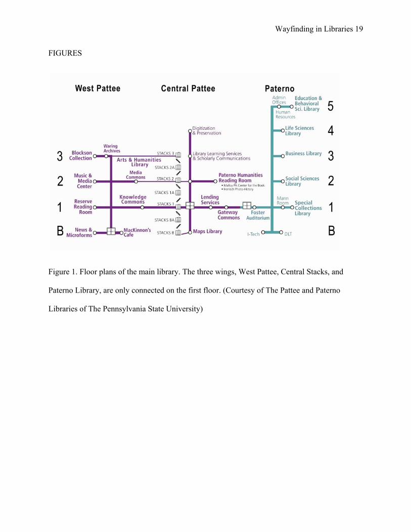
The study was designed to assess participant’s wayfinding behaviors in areas with
different environmental characteristics. Three wings of the main library were selected: Paterno
Wayfinding in Libraries 8
Library, Central Stacks, and West Pattee Library. There are two interesting characteristics of the
three areas: they are only connected on the first floor. Within each area the number of floors was
totally different. The floor plans of the main library are illustrated in Figure 1.
(Insert Figure 1 approximately here)
Materials and procedures
The experiment was done with one participant at a time. Each participant met the
experimenter at the lending services desk on the first floor of Pattee Library, and the experiment
began when the participant gave his/her consent. First, the participant was asked to locate two
books in Paterno Library, starting from the lending services desk. The two books were shelved
on two different floors (2nd and 5th).When a participant had found these two books, he/she was
asked to estimate in which direction lay the lending services desk.
Once the tasks in Paterno Library were finished, the participant was given a second task
of locating two books in the Central Stacks, again on two different floors (1A and 2A). Upon
finishing this task, the participant was again asked to estimate the direction back to the same
lending services desk, and then given a final task of locating two more books in West Pattee
Library. Each participant was told to use whatever information he/she could find in the library to
help locate the books. The experimenter followed each participant in a medium distance to give
each participant a feeling of freedom in making wayfinding decisions. A Sony HandyCam video
camera was used to record the entire wayfinding process.
When all three book-locating tasks were completed, the participant was led to a quiet
study area in the library to complete a questionnaire. The questionnaire included questions not
only about the participant’s personal information but also how the participant rated their own
Wayfinding in Libraries 9
sense of direction. The Santa Barbara Sense of Direction Scale (Hegarty et al., 2002) was used.
The completion of the questionnaire marked the end of the experiment.
Results
Formal Descriptions of Environments
Wayfinding in the library was not limited to just walking along the hallway. Within each
library area, participants also had to explore the aisles created by the stacks arrangement. To
analyze participants’ wayfinding behavior, locations of books, shapes of bookshelves, and the
library floor plans were digitized. This allowed for quantitatively characterizing the environment
using space syntax methods.
We employed certain space syntax methods in this study to assess the factors of buildings
which potentially influence wayfinding behaviors. Thus we have organized this section into
paragraphs about each of the three environmental aspects we focused on in this study: visibility,
layout complexity, and connectivity. It is important to note that current space syntax methods do
not cover signage, so a discussion of signage will be included separately in the Discussion
section.
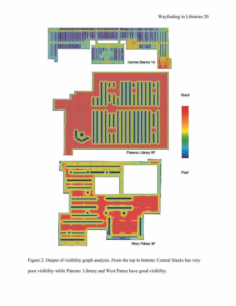
Visibility. The open-source software Depthmap (Turner, 2004) was used to carry out a
systematic analysis of the visual access (visibility) of the three library areas. One major
component of Depthmap, visibility graph analysis (VGA), provides comprehensive analysis of
the visual access of an entire floor regarding all accessible locations.
Examples of visual access on library floors are presented in Figure 2. Results of VGA for
Central Stacks 1A show very poor visibility for the entire area with few exceptions. In contrast,
Wayfinding in Libraries 10
results for Paterno Library fifth floor (5F) show good visibility except for areas between
bookshelves. West Pattee third floor (3F) showed similar visibility as Paterno Library. Based on
the introduction of visibility above, these differences in visibility among the Central Stacks,
Paterno Library and West Pattee potentially lead to different wayfinding performance.
(Insert Figure 2 approximately here)
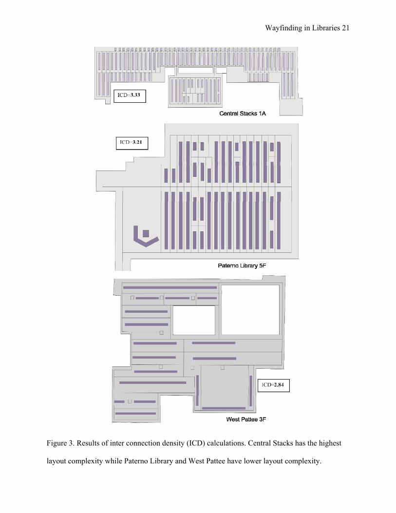
Layout complexity. The layout complexity of the library areas was assessed by the inter
connection density method (ICD). ICD measures calculate the density (number) of direct
connections between intersections (decision points) in a floor plan of a building as a way to
assess a floor’s layout complexity. In our study, density is calculated by dividing the total
number of connections (which is the sum of all connections at all intersections) by the total
number of intersections. ICD, therefore, is a global measure of complexity that disregards
individual decision points. For examples, see Figure 3, which shows the nodes and connectivity
between nodes on Central Stacks 1A, Paterno 5F, and West Pattee 3F. The ICD value of each
floor is also shown. Since we considered the actual location of all book shelves in this
assessment, we calculated the ICD based on all bookshelves and alleyways (not just the main
path). only the alleyways in the library were considered. Our ICD results seem to correlate
negatively with our VGA results in that low visibility areas seem to have higher layout
complexity. It is thus reasonable to assume that a complex layout may lead to poor visibility.
(Insert Figure 3 approximately here)
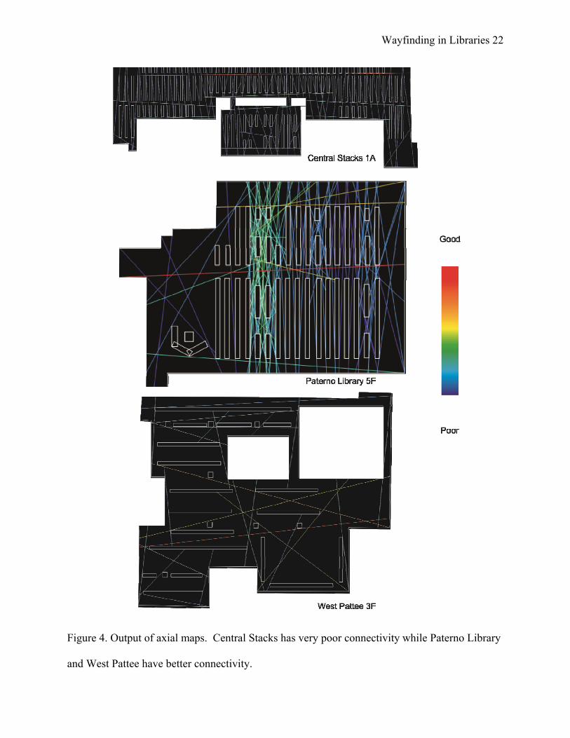
Connectivity. Connectivity, revealed in axial maps, was originally used to represent street
networks in a less complex way. An axial map “[is] the least set of lines which pass through each
convex space and makes all axial links'' (Hillier and Hanson, 1984, p91-92). These lines which
Wayfinding in Libraries 11
can be treated as paths (which can be possibly chosen as routes) are called axial lines. Figure 4
shows the axial maps of the three library areas. The results of the axial map assessment show that
areas of higher visibility tend to have higher connectivity and lower layout complexity, and vice
versa.
(Insert Figure 4 approximately here)
Wayfinding Performance
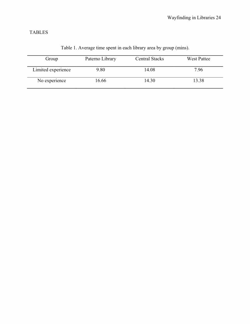
Wayfinding time. Participants performed differently with respect to time spent in each book
locating task (Table 1). First of all, participants with different levels of familiarity showed
varying performance. It was not surprising to see that participants with limited experience spent
less time than participants with no experience to locate books in Paterno Library and West
Pattee. It is surprising, however, that both groups of participants spent the most time overall, and
almost the same time as each other, to locate books in the Central Stacks. These results show that
wayfinding behaviors are related not only to the wayfinder’s familiarity but potentially also to
the physical structures of the buildings. Regardless of familiarity, participants tended to spend
more time at areas whose visibility and connectivity were low and whose layout complexity was
high.
(Insert table 1 approximately here)
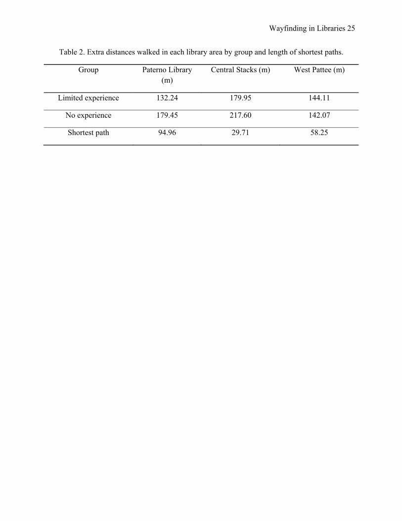
Extra walking distances. In general, the more time a participant spent in a library looking for
books, the more distance he/she walked. The captured videos helped the authors to trace each
participant’s route and calculate the extra distance they walked, by subtracting the shortest
distance to locate a book from the actually walked distance (Table 2). It is surprising again to see
that both groups of participants covered more distance in the Central Stacks, which according to
Wayfinding in Libraries 12
our previous results, was shown out all three library areas to have the highest layout complexity,
lowest visibility, and lowest connectivity.
(Insert table 2 approximately here)
Correlation between sense of direction and wayfinding performance. We found a correlation
between the length of extra walking distance and participants’ self-rating of sense of direction.
This correlation indicated that the higher that participants rated themselves, the better the
wayfinding performance they actually had, that is, they walked fewer extra routes. This implies
that if a patron has a good sense of direction, he or she might show better wayfinding
performance particularly in buildings with lower layout complexity, higher visibility, and higher
connectivity.
Pointing errors. The pointing errors made by each participant in all three library areas are shown
in Table 3. These data show a similar pattern compared to time spent and extra distance walked
in each library area. Both groups of participants had similar and higher pointing errors in the
Central Stacks as compared to all their pointing errors in the two other library areas. However,
the pointing errors differ greatly between groups in Paterno Library and West Pattee. It seems
that in areas with low visibility, low connectivity, and high layout complexity, familiarity did not
influence direction pointing performance as much as environmental characteristics did.
(Insert table 3 approximately here)
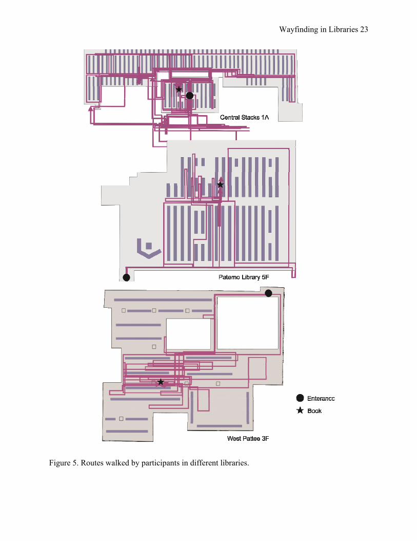
Route patterns. The routes walked by participants showed very distinct patterns. In the Central
Stacks, no participant walked directly toward the location of the books. Instead, routes showed
many detours and turns. The visibility and connectivity in the Central Stacks is the lowest and
Wayfinding in Libraries 13
the layout complexity is the highest among all three library areas. It certainly can be considered
the most difficult part of the library in which to orient oneself. In the other two library areas,
participants walked toward the correct general location of the books, even though they had some
difficulty locating the book at the local scale (at the actual shelf, where participants were mostly
influenced by signage). Figure 5 shows the maps of all routes walked by all participants in the
three library areas. In the following paragraph, we elaborate on the impact of signage on
wayfinding performance.
(Insert figure 5 approximately here)
Signs. We found that the routes walked in Paterno Library were influenced by the signs present
in that environment. Routes on just the 5th floor of Paterno Library showed that most participants
bypassed the correct location of the book and went to a different bookshelf. We think this is due
to inconsistency between the signs provided in the library, and the information participants found
in the online library catalog. At this location, participants were looking for a picture book;
picture books are part of the larger juvenile collection. Yet the catalog only indicated “Juvenile”;
participants went directly to the bookshelf marked “Juvenile” instead of going to the bookshelf
marked “Picture Books”. This finding not only demonstrates the importance of signage in
libraries (Carr, 2006), but also shows the problems created by inconsistencies between the
organization in the online catalog and the physical organization of books on a shelf.
Discussion
Role of Visibility
Locations where participants made wrong turns or hesitated to make wayfinding
decisions had very low visibility. For example, at each entrance to the Central Stacks,
Wayfinding in Libraries 14
participants could not see much information about the floor layout. Furthermore, no additional
information was provided at these locations to give participants descriptions of collections on
this floor. It was apparent that participants had difficulties at these points to make wayfinding
decisions, which lengthened their time spent looking for books, and caused them to make detours
to reach their destination. All participants encountered these difficulties in the Central Stacks
independent of their familiarity.
In West Pattee and Paterno Libraries, it appears that wayfinding difficulty was not as
closely related to the environment as in the Central Stacks. First, the visibility of two areas is
better than in the Central Stacks. Second, participants of the two groups showed varying
wayfinding performance in the two areas. Here, familiarity seemed to play a more important role
in explaining wayfinding difficulties than in less complex environments.
Role of Layout Complexity
Layout complexity was inversely related to visibility and connectivity in this study; areas
with high layout complexity had low visibility and low connectivity. Layout complexity showed
slight differences in its relation to wayfinding performance as compared to visibility. First,
layout complexity seemed to correlate with the time participants spent in each area. Regardless
of familiarity, participants spent the most time where layout complexity was highest. Second,
pointing errors did not represent a simple relationship with just visibility, but also depended upon
layout complexity (which further depended on participants’ familiarity). To participants who had
limited familiarity, the areas with the highest visibility were related to the smallest pointing
errors. To participants with no familiarity, the areas of the highest layout complexity were related
to the largest pointing errors.
Wayfinding in Libraries 15
Layout Complexity vs. Familiarity
Analysis of layout complexity against familiarity revealed an interesting pattern across
the three library areas. The time spent by participants was longer and the distances walked were
longer in areas where layout complexity was higher (in the Central Stacks). The pointing errors
also implied that areas of higher layout complexity add more difficulties to pointing tasks. Hence
the layout complexity played a much more important role than the familiarity in this area.
However, in Paterno West Pattee, where layout complexity was lower, individual familiarity
with the environment played a more important role than layout complexity. This finding is in
contrast to earlier suggestions that familiarity plays a more important role than layout complexity
in wayfinding performance (O'Neill, 1992). Further assessments are necessary to clarify the
different levels of impact of layout complexity and familiarity on wayfinding performance.
Conclusion
This study demonstrated that wayfinding behaviors can be correlated with both
characteristics of physical environments and individual differences. Methods of space syntax are
effective in quantifying certain aspects of physical environments and relating them to human
wayfinding behaviors. This can provide valuable insight for designing and improving wayfinding
systems in libraries, and for assessing potentially problematic areas without the need to perform
user studies.
The major finding in this study is the confirmation of the relationship between aspects of
environments (i.e. visibility, connectivity, and layout complexity) and human wayfinding
behaviors. More importantly, this study investigated factors of physical environments in libraries
that impact wayfinding behaviors. Previous studies pointed out the potential relations of choices
Wayfinding in Libraries 16
of places in buildings and visibility (Wiener and Franz, 2004). We used three different space
syntax methods to address different aspects of buildings.
Furthermore, wayfinding difficulties are due not only to the environment but also to the
familiarity of the wayfinder with that environment. We suggest that both environment and
familiarity have different weights on influencing wayfinding performance. The layout
complexity of an environment may be the most influential factor of wayfinding behaviors1.
When an environment has a very high layout complexity, all wayfinders have great wayfinding
difficulties regardless their familiarity. However, when the environment is less complex, the
familiarity of the environment is then the major factor impacting wayfinding performance. This
current study presents the different wayfinding performance in libraries such as the time spent
and the extra distance walked in relation to layout complexity.
For revealing and predicting wayfinding problems that exist in libraries, it is beneficial to
combine methods that address both the quantitative assessment of physical environments and
allow for evaluating individual behaviors. Similar studies also showed the effectiveness of using
tools of spatial science to understand wayfinding behaviors (Mandel, 2010). Slightly different
from Mandel’s study, which only considered the entry areas of a library, we addressed the areas
where patrons have the most difficulties—areas where books are shelved—to reveal the
wayfinding difficulties resulting from different aspects of the environment.
In general, findings of this study indicate that the design of wayfinding systems for
library users should be tailored to the specific characteristics of areas. For example, the Central
Stacks in this study need more facilitation of user navigation such as maps and signs, due to its
1 The layout complexity in this study is associated with visibility and connectivity. Here we use high layout complexity to indicate low visibility and connectivity in library areas.
Wayfinding in Libraries 17
low visibility, low connectivity, and high layout complexity. Only when wayfinding systems are
designed for and implemented at the locations where wayfinding difficulties begin, such as the
entrance to each floor of the Central Stacks, can wayfinding problemsbe limited. This study
signifies the future research of designing tailored wayfinding systems, and extending the
application of this research from libraries to other public buildings should be of high priority.
References
Bafna, S. 2003. Space syntax: A brief Introduction to its logic and analytical techniques. Environment and Behavior 35 (1):17-28.
Benedikt, M. L. 1979. To take hold of space: isovists and isovist fields. Environment and Planning B: Planning and Design 6 (1):47-65.
Carr, A. R. 2006. An Experiment with Art Library Users, Signs, and Wayfinding, Library Science, University of North Carolina at Chapel Hill, Chapel Hill.
Davies, C., and D. Peebles. 2010. Spaces or scenes: Map-based orientation in urban environments. Spatial Cognition & Computation 10 (2):135-156.
Evans, G. W., M. A. Skorpanich, T. Gärling, K. J. Bryant, and B. Bresolin. 1984. The effects of pathway configuration, landmarks and stress on environmental cognition. Journal of Environmental Psychology 4 (4):323-335.
Gärling, T., E. Lindberg, and T. Mäntylä. 1983. Orientation in buildings: effects of familiarity, visual access, and orientation aids. Journal of Applied Psychology 68 (1):177-86.
Hegarty, M., A. E. Richardson, D. R. Montello, K. L. Lovelace, and I. Subbiah. 2002. Development of a self-report measure of environmental spatial ability. Intelligence 30:425-447.
Hillier, B., and J. Hanson. 1984. The social logic of space. Cambridge, UK: Cambridge University Press.
Hölscher, C., M. Brösamle, and G. Vrachliotis. 2006. Challenges in Multi-level Wayfinding: A Case-study with Space Syntax Technique. Paper read at Spatial Cognition '06 Space Syntax and Spatial Cognition Workshop, at Breman, Germany.
Klippel, A., C. Freksa, and S. Winter. 2006. The danger of getting lost-YAH maps in emergencies. Journal of Spatial Sciences 51 (1):117-131.
Levine, M. 1982. You-are-here maps psychological considerations. Environment and Behavior 14 (2):221-237.
Lynch, K. 1960. The Image of the City. Cambridge, MA: MIT Press. Mandel, Lauren H. 2010. Toward an understanding of library patron wayfinding: Observing
patrons' entry routes in a public library. Library & Information Science Research 32 (2):116-130.
Meilinger, T., C. Hölscher, S. J. Büchner, and M. Brösamle. 2007. How Much Information Do You Need? Schematic Maps in Wayfinding and Self Localisation. In Spatial Cognition V: Reasoning, Action, Interaction, edited by T. Barkowsky, M. Knauff, G. Ligozat and D. R. Montello. Berling, Heidelberg: Springer.
Wayfinding in Libraries 18
O'Neill, M. J. 1991. Evaluation of a conceptual model of architectual legibility. Environment and Behavior 23 (3):259-284.
O'Neill, M. J. 1992. Effects of familiarity and plan complexity on wayfinding in simulated buildings. Journal of Environmental Psychology 12 (4):319-327.
Penn, A. 2003. Space Syntax And Spatial Cognition: Or Why the Axial Line? Environment and Behavior 35 (1):30-65.
Shepard, R.N., and S. Hurwitz. 1984. Upward direction, mental rotation, and discrimination of left and right turns in maps. Cognition 18 (1-3):161-193.
Strube, G. 1992. The Role of Cognitive Science in Knowledge Engineering. In Contemporary knowledge engineering and cognition, Proceedings of the First Joint Workshop on Contemporary Knowledge Engineering and Cognition. London: Springer-Verlag.
Turner, A. 2004. Depthmap 4, A Researcher'sa Handbook. London, UK: Bartlett School of Graduate Studies, University College of London.
Turner, A., M. Doxa, D. O'Sullivan, and A. Penn. 2001. From isovists to visibility graph: A methodology for the analysis of architecture space. Environment and Planning B: Planning and Design 28 (1):103-121.
Warren, D.H., and T.E. Scott. 1993. Map alignment in traveling multisegment routes. Environment and Behavior 25 (4):643.
Wiener, J. M., and G. Franz. 2004. Isovists as a means to predict spatial experience and behavior. In Spatial Cognition IV: Reasoning, Action, and Interaction, Lecture Notes of Artificial Intelligence edited by C. Freksa, M. Knauff, B. Krieg-Brückner, B. Nebel and T. Barkowsky. Verlag Berlin Heidelberg: Springer.
Wayfinding in Libraries 19
FIGURES
Figure 1. Floor plans of the main library. The three wings, West Pattee, Central Stacks, and
Paterno Library, are only connected on the first floor. (Courtesy of The Pattee and Paterno
Libraries of The Pennsylvania State University)
Wayfinding in Libraries 20
Figure 2. Output of visibility graph analysis. From the top to bottom: Central Stacks has very
poor visibility while Paterno Library and West Pattee have good visibility.
Wayfinding in Libraries 21
Figure 3. Results of inter connection density (ICD) calculations. Central Stacks has the highest
layout complexity while Paterno Library and West Pattee have lower layout complexity.
Wayfinding in Libraries 22
Figure 4. Output of axial maps. Central Stacks has very poor connectivity while Paterno Library
and West Pattee have better connectivity.
Wayfinding in Libraries 23
Figure 5. Routes walked by participants in different libraries.
Wayfinding in Libraries 24
TABLES
Table 1. Average time spent in each library area by group (mins).
Group Paterno Library Central Stacks West Pattee
Limited experience 9.80 14.08 7.96
No experience 16.66 14.30 13.38
Wayfinding in Libraries 25
Table 2. Extra distances walked in each library area by group and length of shortest paths.
Group Paterno Library (m)
Central Stacks (m) West Pattee (m)
Limited experience 132.24 179.95 144.11
No experience 179.45 217.60 142.07
Shortest path 94.96 29.71 58.25
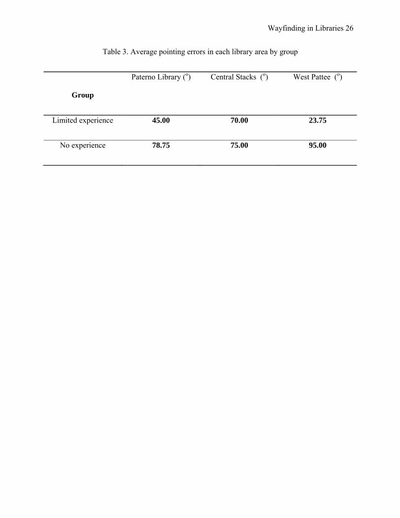
Wayfinding in Libraries 26
Table 3. Average pointing errors in each library area by group
Group
Paterno Library (o) Central Stacks (o) West Pattee (o)
Limited experience 45.00 70.00 23.75
No experience 78.75 75.00 95.00

![wayfinding interpreti]e branding - Studio L'Imagestudiolimage.com/downloads/Wayfinding-Urban.pdf · Wayfinding Program In the heart of Chinatown, bilingual wayfinding signage directs](https://img.pdfslide.net/doc/110x75/5e8e6c5f99e6632d522e7817/wayfinding-interpretie-branding-studio-l-wayfinding-program-in-the-heart-of.jpg)