Embed Size (px)
Citation preview
fmars-06-00353 June 22, 2019 Time: 14:10 # 1
MINI REVIEWpublished: 25 June 2019
doi: 10.3389/fmars.2019.00353
Edited by:Justin Manley,
Just Innovation Inc., United States
Reviewed by:Tom Shyka,
Northeastern Regional Associationof Coastal Ocean Observing Systems
(NERACOOS), United StatesTodd Holland,
United States Naval ResearchLaboratory, United States
*Correspondence:Gregory Dusek
†Present address:Mark Willis,
National Weather Service, NationalOceanic and Atmospheric
Administration, Wilmington, NC,United States
Specialty section:This article was submitted to
Ocean Observation,a section of the journal
Frontiers in Marine Science
Received: 04 October 2018Accepted: 07 June 2019Published: 25 June 2019
Citation:Dusek G, Hernandez D, Willis M,
Brown JA, Long JW, Porter DE andVance TC (2019) WebCAT: Pilotingthe Development of a Web Camera
Coastal Observing Networkfor Diverse Applications.
Front. Mar. Sci. 6:353.doi: 10.3389/fmars.2019.00353
WebCAT: Piloting the Development ofa Web Camera Coastal ObservingNetwork for Diverse ApplicationsGregory Dusek1* , Debra Hernandez2, Mark Willis3†, Jenna A. Brown4, Joseph W. Long5,Dwayne E. Porter6 and Tiffany C. Vance7
1 Center for Operational Oceanographic Products and Services, National Ocean Service, National Oceanic and AtmosphericAdministration, Silver Spring, MD, United States, 2 Southeast Coastal Ocean Observing Regional Association, Charleston,SC, United States, 3 Surfline, Inc., Nags Head, NC, United States, 4 St. Petersburg Coastal and Marine Science Center,United States Geological Survey, Saint Petersburg, FL, United States, 5 Department of Earth and Ocean Sciences, Universityof North Carolina Wilmington, Wilmington, NC, United States, 6 Arnold School of Public Health, University of South Carolina,Columbia, SC, United States, 7 United States Integrated Ocean Observing System Program, National Ocean Service,National Oceanic and Atmospheric Administration, Silver Spring, MD, United States
Web cameras are transforming coastal environmental monitoring. Improvements incamera technology and image processing capabilities, paired with decreases incost, enable widespread use of camera systems by researchers, managers and firstresponders for a growing range of environmental monitoring applications. Applicationsare related to transportation and commerce, preparedness, risk reduction andresponse, and stewardship of coastal resources. While web cameras are seeminglyubiquitous, operators often follow unique installation procedures and collect, store,and process imagery data in various ways. These inconsistencies significantly limitthe ability for imagery data to be shared and utilized across research and operationaldisciplines. Similar to the early days of other remote sensing networks like HighFrequency Radar, the benefits and downstream application of coastal imagery datacan be greatly enhanced through centralized data access and standardization of datacollection, analysis and dissemination. The NOAA National Ocean Service Web CameraApplications Testbed (WebCAT) was launched in 2017 in partnership with SECOORA,as a public-private partnership to address this coastal ocean observing standardizationneed. WebCAT is a pilot project relying on the private sector expertise of Surfline, Inc.,to install and operate several web cameras capable of meeting the short-term needs ofdiverse users including NOAA, USGS, state health agencies, academia and others. Theproject aims to determine operational imagery collection, storage, processing, access,and archival requirements that will foster collaboration across research and operationaluser communities. Seven web cameras have been installed at six locations along thesoutheast United States coast (from Florida to North Carolina) for purposes including:counting animals on the beach and migrating right whales, identifying rip currents,validating wave runup models, and understanding human use of natural resources.Here we present a review of the state of coastal imagery data and an overview of theWebCAT project. Goals of an upcoming community workshop will also be presentedalong with our vision for how WebCAT can motivate a future sustained operational webcamera network.
Keywords: webcam, coastal observations, observing network, environmental monitoring, video imagery
Frontiers in Marine Science | www.frontiersin.org 1 June 2019 | Volume 6 | Article 353
fmars-06-00353 June 22, 2019 Time: 14:10 # 2
Dusek et al. WebCAT: Webcam Coastal Observing Network
INTRODUCTION
Over the past several decades coastal imagery has becomea proven and invaluable tool for remote sensing of thecoastal environment. Uses for imagery data range from coastalmorphological change, to surf zone hydrodynamics, to beachattendance and safety, and even to detecting marine debris. Fixedposition cameras for scientific coastal monitoring have been inuse since the 1980s with the Argus systems the most well-knownand utilized (Holman and Stanley, 2007), along with several othersystems and approaches (Pearre and Puleo, 2009; Nieto et al.,2010; Brignone et al., 2012; Taborda and Silva, 2012). Thesesystems typically consist of one or more stationary cameras atwell elevated positions with a wide field-of-view, onsite computerfor image processing and file transfer, and a set of algorithms thatuse individual pixels or groups of pixels for monitoring coastalfeatures and processes. Although use of these types of systemshave expanded as cameras have become smaller and more costeffective, there are challenges preventing widespread installation.These challenges include difficulties in finding suitable siteinfrastructure or an appropriate host; expertise needed for systeminstallation and data processing; and costs associated with systeminstallation, operation and maintenance.
Web cameras (sometimes called surfcams or webcams) haveemerged as a potential alternative or complement to coastalimagery systems established for scientific use. Webcams aresmall, stand-alone and relatively inexpensive camera systems,which may have either remote or onsite data acquisition,processing, and analysis. A typical webcam installation consistsof a single robotic pan-tilt-zoom camera, which can rotateto provide the field-of-view range of a multi-camera system.Webcams are already widely used for a range of activitiesincluding observing surf conditions, news and weather reporting,beach safety, and monitoring recreational beach use. Due to theseuse cases, an extensive network of coastal webcams already exists.For instance, there are over 500 cams on the Surfline networkalone1. Researchers relied on a similarly extensive network inAustralia to investigate webcam use for wave observations andshoreline monitoring (Splinter et al., 2011; Mole et al., 2013;Bracs et al., 2016), and were able to demonstrate acceptableshoreline monitoring performance. Though researchers in theUnited States have begun to install and utilize webcams forsimilar research objectives, more standardized use of webcaminfrastructure and resulting downstream imagery products hasyet to be realized.
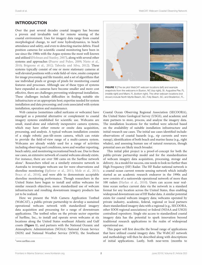
Here we present the Web Camera Application Testbed(WebCAT), a public-private partnership to develop a sustainedoperational webcam network with standardized imagerydata acquisition and processing for a range of downstreamapplications. The testbed relies on the private sector expertiseof Surfline, Inc., to install and operate seven webcams at sixlocations along the United States southeast Atlantic and Gulfcoasts (Figure 1), and partners with the National Oceanic andAtmospheric Administration (NOAA) National Ocean Service(NOS) and National Weather Service (NWS), the Southeast
1www.surfline.com
FIGURE 1 | The six pilot WebCAT webcam locations (left) and examplesnapshots from the webcams in Buxton, NC (top right), St. Augustine Pier, FL(middle right) and Miami, FL (bottom right). The other webcam locations (notshown) include North Myrtle Beach, SC, Folly Beach, SC, and Bradenton, FL.
Coastal Ocean Observing Regional Association (SECOORA),the United States Geological Survey (USGS), and academic andstate partners to store, process, and analyze the imagery data.The installation locations for the testbed were selected basedon the availability of suitable installation infrastructure andinitial research use cases. The initial use cases identified include:observations of coastal hazards (e.g., rip currents and waverunup), identification of both beach and marine fauna (e.g., rightwhales), and assessing human use of natural resources, thoughpotential uses are likely much broader.
This initial pilot project is a proof-of-concept for both thepublic-private partnership model and for the standardizationof webcam imagery data acquisition, processing, storage anddelivery. As a model for success, one needs to look no further thanHigh Frequency (HF) Radar. The HF Radar national network isa coastal ocean current remote sensing network which initiallystarted as an academic research endeavor in the 1990s andnow consists of a nationwide operational network of more than100 radars (Harlan et al., 2010). Users can access near real-time ocean surface current data via the network in a standardformat for any location across the United States, thus enablingwidespread downstream use of HF Radar data. A similar potentialexists for coastal webcam imagery data; webcams operated byprivate industry, academic, federal, regional or local partnersshare standardized imagery data with a regional (e.g., SECOORA,other IOOS regional associations) or federal (NOAA and USGS)centralized repository. Single site access to standardized coastalimagery data has the potential to spark innovation beyondtraditional research applications to the realm of widespreadoperational use.
This paper will first describe the broad range of applicationsthat have utilized coastal imagery data. The WebCAT networkand methodology will then be described along with descriptionsof initial applications. Lastly, both near-term (months to
Frontiers in Marine Science | www.frontiersin.org 2 June 2019 | Volume 6 | Article 353
fmars-06-00353 June 22, 2019 Time: 14:10 # 3
Dusek et al. WebCAT: Webcam Coastal Observing Network
years) and long-term (years to decades) goals for WebCATwill be presented.
IMAGERY TO MONITOR THE COASTALENVIRONMENT
Over the past several decades coastal imagery data has been usedfor a wide range of research applications. Imagery data related tohydrodynamics and morphodynamics has been predominantlyacquired and processed via the well-established Argus camerasystems (Holman and Stanley, 2007; Holman and Haller, 2013),though more recently other camera or webcam systems havebeen utilized for coastal monitoring. The uses for coastalimagery can be broken into categories of coastal morphologicalchange, hydrodynamics, human impact on coastal resources, andecological, environmental and water quality observations.
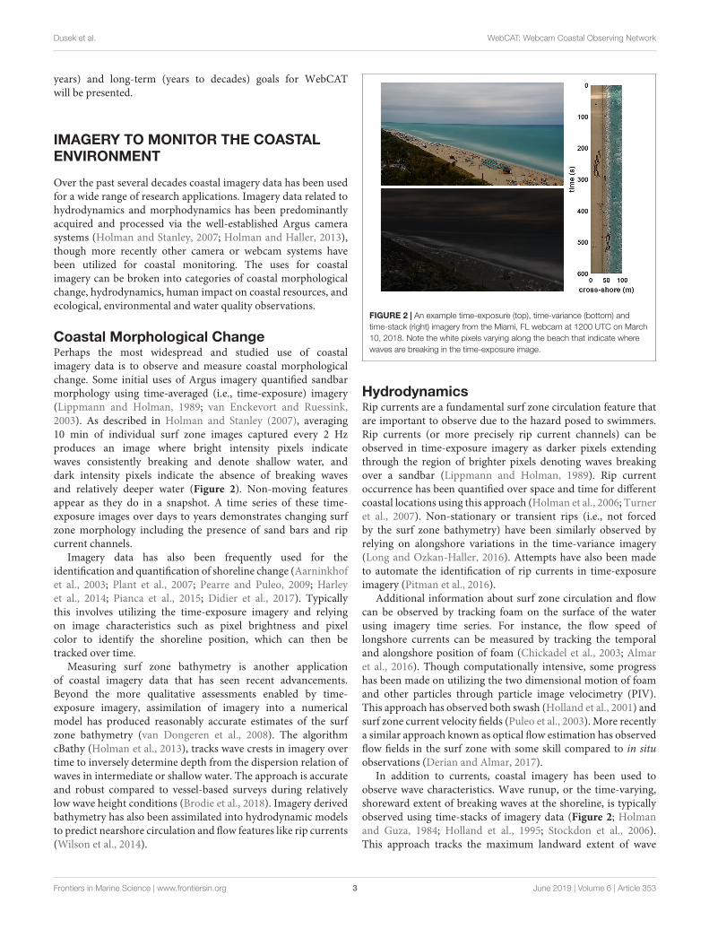
Coastal Morphological ChangePerhaps the most widespread and studied use of coastalimagery data is to observe and measure coastal morphologicalchange. Some initial uses of Argus imagery quantified sandbarmorphology using time-averaged (i.e., time-exposure) imagery(Lippmann and Holman, 1989; van Enckevort and Ruessink,2003). As described in Holman and Stanley (2007), averaging10 min of individual surf zone images captured every 2 Hzproduces an image where bright intensity pixels indicatewaves consistently breaking and denote shallow water, anddark intensity pixels indicate the absence of breaking wavesand relatively deeper water (Figure 2). Non-moving featuresappear as they do in a snapshot. A time series of these time-exposure images over days to years demonstrates changing surfzone morphology including the presence of sand bars and ripcurrent channels.
Imagery data has also been frequently used for theidentification and quantification of shoreline change (Aarninkhofet al., 2003; Plant et al., 2007; Pearre and Puleo, 2009; Harleyet al., 2014; Pianca et al., 2015; Didier et al., 2017). Typicallythis involves utilizing the time-exposure imagery and relyingon image characteristics such as pixel brightness and pixelcolor to identify the shoreline position, which can then betracked over time.
Measuring surf zone bathymetry is another applicationof coastal imagery data that has seen recent advancements.Beyond the more qualitative assessments enabled by time-exposure imagery, assimilation of imagery into a numericalmodel has produced reasonably accurate estimates of the surfzone bathymetry (van Dongeren et al., 2008). The algorithmcBathy (Holman et al., 2013), tracks wave crests in imagery overtime to inversely determine depth from the dispersion relation ofwaves in intermediate or shallow water. The approach is accurateand robust compared to vessel-based surveys during relativelylow wave height conditions (Brodie et al., 2018). Imagery derivedbathymetry has also been assimilated into hydrodynamic modelsto predict nearshore circulation and flow features like rip currents(Wilson et al., 2014).
FIGURE 2 | An example time-exposure (top), time-variance (bottom) andtime-stack (right) imagery from the Miami, FL webcam at 1200 UTC on March10, 2018. Note the white pixels varying along the beach that indicate wherewaves are breaking in the time-exposure image.
HydrodynamicsRip currents are a fundamental surf zone circulation feature thatare important to observe due to the hazard posed to swimmers.Rip currents (or more precisely rip current channels) can beobserved in time-exposure imagery as darker pixels extendingthrough the region of brighter pixels denoting waves breakingover a sandbar (Lippmann and Holman, 1989). Rip currentoccurrence has been quantified over space and time for differentcoastal locations using this approach (Holman et al., 2006; Turneret al., 2007). Non-stationary or transient rips (i.e., not forcedby the surf zone bathymetry) have been similarly observed byrelying on alongshore variations in the time-variance imagery(Long and Ozkan-Haller, 2016). Attempts have also been madeto automate the identification of rip currents in time-exposureimagery (Pitman et al., 2016).
Additional information about surf zone circulation and flowcan be observed by tracking foam on the surface of the waterusing imagery time series. For instance, the flow speed oflongshore currents can be measured by tracking the temporaland alongshore position of foam (Chickadel et al., 2003; Almaret al., 2016). Though computationally intensive, some progresshas been made on utilizing the two dimensional motion of foamand other particles through particle image velocimetry (PIV).This approach has observed both swash (Holland et al., 2001) andsurf zone current velocity fields (Puleo et al., 2003). More recentlya similar approach known as optical flow estimation has observedflow fields in the surf zone with some skill compared to in situobservations (Derian and Almar, 2017).
In addition to currents, coastal imagery has been used toobserve wave characteristics. Wave runup, or the time-varying,shoreward extent of breaking waves at the shoreline, is typicallyobserved using time-stacks of imagery data (Figure 2; Holmanand Guza, 1984; Holland et al., 1995; Stockdon et al., 2006).This approach tracks the maximum landward extent of wave
Frontiers in Marine Science | www.frontiersin.org 3 June 2019 | Volume 6 | Article 353
fmars-06-00353 June 22, 2019 Time: 14:10 # 4
Dusek et al. WebCAT: Webcam Coastal Observing Network
runup at one alongshore location over time, and can helpexplain storm-induced morphological change including beachand dune erosion and overwash. Progress has also been madein measuring wave characteristics from surf zone imagery. Waveperiod and peak wave direction can be estimated (Herbers andGuza, 1990; Stockdon and Holman, 2000), but the ability tomeasure wave height has been limited, and typically requiresmultiple-cameras for stereo imaging (Bechle and Wu, 2011; deVries et al., 2011; Shand et al., 2012). Lastly, other hydrodynamictopics explored via imagery data include observing internal waves(Suanda et al., 2014) and tracking movement of coastal sea ice(Druckenmiller et al., 2009).
Human Impact on Coastal ResourcesCoastal imagery has also been widely used outside of the realm ofphysical processes. Perhaps most common is the use of imageryto identify and quantify beach users for the purposes of coastalzone management. This typically involves the development ofan automated person counting method, which is then appliedto a coastal region to analyze beach use over time (Green et al.,2005; Guillen et al., 2008; Balouin et al., 2014). Preferred locationsof beach users can also be assessed to determine associationwith potential hazards (Silva-Cavalcanti et al., 2018) and tosupport beach management by relating use to beach carryingcapacity (Jimenez et al., 2007; Cisneros et al., 2016). Marinedebris or beach litter can also be identified and spatially andtemporally tracked using imagery (Kako et al., 2010; Kataokaet al., 2012). Debris on the beach were identified based onpixel color and the relative differences from the surroundingbeach or coastal background. Physical mechanisms leading todebris occurrence and position on the beach has been established(Kako et al., 2018).
Ecological, Environmental and WaterQuality ObservationsThough coastal applications are thus far limited, recent effortshave demonstrated the ecological and environmental monitoringcapabilities of webcam or other stationary imagery (Bradleyand Clarke, 2011). These include quantifying the increases inforested extent for an alpine treeline ecotone (Roush et al.,2007), monitoring deciduous autumnal color change (Astolaet al., 2008), calculating normalized snow indices from ground-based cameras (Hinkler et al., 2002), comparing the “green-up”signal to canopy photosynthesis data (Richardson et al., 2007,2009), and tracking the development of invasive Pepperweed(Sonnentag et al., 2011). Though not relying on a webcam,
a smartphone camera app has been developed and tested toperform above water observations of water quality includingsuspended sediment, chlorophyll and dissolved organic matter(Leeuw and Boss, 2018). Presumably webcams could be used forsimilar types of observations.
THE WEB CAMERA APPLICATIONTESTBED
The WebCAT was initiated to meet short-term coastalobservation needs and to pilot a proposed model for apublic-private partnership to develop a web camera observationnetwork. As described above, coastal imagery data is widely usedfor a range of applications in the research community. However,data acquisition, delivery and processing varies dependingon the camera type, operator and end use. WebCAT seeks tostandardize these aspects of the collection of coastal webcamimagery to maximize data access and the benefit for a range ofend use applications. The observation needs initially identifiedinclude observing and quantifying wave runup, rip currentoccurrence, beach use and counting fauna on land and in theocean. These use cases, coupled with existing infrastructureand host availability largely dictated the locations for camerainstallation (Figure 1 and Table 1). The camera installation anddata acquisition was handled by Surfline, Inc., and their expertiseand pre-existing infrastructure minimized cost and made theprocess much more efficient than it would have been otherwise.SECOORA and Axiom utilized their existing web services tohost the near real-time and archived imagery data and developeda site to deliver the data to end users2. The data page includesdenoting camera downtime, which can occur for a varietyof reasons including camera malfunction (there were severallightning strikes at the Miami camera), as well as modificationsor errors in the data transmission system. Data users such asNOAA, USGS and academic partners are applying downstreamprocessing methods for specific end use applications.
Surfline installed seven webcams for the WebCAT project.After an initial prioritization process with the stakeholders,Surfline spent several months searching for suitable hosts. Sitereviews were conducted at each location to ensure suitabilityfor the project. Host agreements were made with propertyowners of each location, which outline privacy, liability, rightto terminate and other considerations. High Definition PTZ IP
2secoora.org/webcat
TABLE 1 | WebCAT camera specific information and metadata.
Camera location Stationary (S) or panning (P) Surveyed (y/n) Elevation above ground (m) Primary purpose
Buxton, NC S Y 10 Runup
North Myrtle Beach, SC S N 15 Beach use and water quality; rip currents
Folly Beach, SC (north and south) S (north) P (south) N 15 15 General monitoring
St. Augustine, FL P N 10 Whale monitoring
Miami, FL S Y 40 Rip currents; runup
Bradenton, FL S N 5 Rip currents
Frontiers in Marine Science | www.frontiersin.org 4 June 2019 | Volume 6 | Article 353
fmars-06-00353 June 22, 2019 Time: 14:10 # 5
Dusek et al. WebCAT: Webcam Coastal Observing Network
cameras were installed at each site with a minimum imageryresolution of 1280 × 720, a sampling rate of 30 Hz (or framesper second) and a bitrate of 1500 kbps. Imagery data was madeoperational via existing Surfline processes and technologies. Forexample, Surfline already stores camera streams on AmazonWeb Services (AWS) to allow their users access to the data inten minute increments. This process was replicated for theseinstallations, and data access was provided to Axiom who in turnmade archived imagery data available to project stakeholders. Inaddition, Surfline had existing processes to share live streamsof their cams with partners, which allowed seamless syndicationof the cams on the SECOORA WebCAT website. In addition,site surveys and additional calibrations were performed at twolocations (Buxton, NC and Miami, FL) to aid in convertingimage coordinates to real world coordinates. Standard practicefor converting to real world coordinates includes intrinsiccalibrations, which account for lens distortion, and extrinsiccalibrations, which account for camera position and lookangles, and applying standard photogrammetric relationships(Holland et al., 1997).
Several cameras (initially Miami, FL and Bradenton, FL)will be used to aid in rip current identification and wereselected in part because a NOAA rip current forecast modelis being validated at those locations (Dusek and Seim, 2013).Initially the time-exposure imagery will be utilized to manuallyidentify rip currents during select time periods, however,approaches to identify rip currents in an automated or machinelearning approach are also being explored. Images from selectcameras with sufficiently high viewpoints and camera calibrationmeasurements (Miami, FL and Buxton, NC) are being usedto create wave runup time-stacks for extracting water levels atthe shoreline and validating total water level models3. Imageryis also being used as a means to count and inventory itemsand activities along swimming beaches and the nearshore.Explorations include automated identification and counting ofpets and birds, which may be correlated to bacterial loadingand corresponding swimming beach water quality forecasts.Similarly, identification and monitoring of St. Augustine-basedmigrating right whales will enable the correlation of imagery-based and in-person sightings.
There were some challenges in developing the pilot WebCATnetwork. Finding a suitable host for new camera installationswas particularly difficult. This is a common issue with camerainstallation, as private businesses and residences are oftenhesitant to participate. In some cases, this challenge resultedin camera locations, and particularly camera elevations, beingless than ideal for some applications. Another challenge wasinstalling the camera to meet the broadest range of needs foreach installation. For applications where camera stability isn’t asimportant (e.g., counting people or animals), a panning camerais preferred to maximize field-of-view. However, for applicationswhere stability is essential (e.g., wave runup calculations) apanning camera potentially introduces more error than isdesirable (Bracs et al., 2016).
3coastal.er.usgs.gov/hurricanes/research/twlviewer/
A FUTURE OPERATIONAL WEBCAMERA OBSERVING SYSTEM
The WebCAT project will focus on continuing to enhancestandardized data delivery over the near-term. For instance,investigating how best to include the downstream processingcommon in other scientific monitoring stations includingtime-exposure images, variance images and time-stacksas part of standard imagery products accessible to endusers. One potential approach is to process imagery in nearreal-time, as each 10-min video segment is available fordownload. Users could then download only the processedimages, potentially including rectified imagery where possible,instead of having to download the full video and performthis processing locally. An important consideration whenstandardizing and optimizing how to deliver webcam coastalimagery data is coordinating the needs of both the establishedcoastal imagery research community and operational endusers (e.g., NOAA, USGS, etc.). A recent coastal webcamworkshop brought these user groups together to identifyand document universal requirements and best practicesfor webcam installation, imagery acquisition, delivery,and processing. Further, it is envisioned that an ongoingcommunity of practice will be initiated to ensure the processes,successes and lessons learned are carried forward beyond theinitial WebCAT pilot.
In the long-term the WebCAT project lays the groundworkfor a potential future nationwide webcam coastal oceanobserving network. Similar to the HF Radar network andother national coastal observing networks, it is envisionedthat common data collection and QA/QC procedures (IOOS,2016) and data and metadata formats will be followed byall systems existing within the network. This standardizationwill enable the imagery data to be provided through regionalhubs or websites of individual institutions or providers whilealso being available through a national centralized repository.This standardization will also ensure that a data user caneasily access high quality imagery data for their specificapplication from potentially hundreds of different coastallocations throughout the United States regardless of the webcamoperator. However, unlike other coastal observing networksthe relatively low costs associated with webcam installation,operation and maintenance will equate to a wide range of dataproviders including federal, private (e.g., Surfline), academic,regional (SECOORA) and local partners. If this vision isachieved, webcam coastal imagery will transform environmentalmonitoring along our coastlines.
AUTHOR CONTRIBUTIONS
GD was the primary author. DH was the project leadand contributed to the text. MW was the webcam leadand contributed to the text. JB created Figure 2 andcontributed to the text. JL and DP provided the referencesand contributed to the text. TV contributed to thetext and reviewed.
Frontiers in Marine Science | www.frontiersin.org 5 June 2019 | Volume 6 | Article 353
fmars-06-00353 June 22, 2019 Time: 14:10 # 6
Dusek et al. WebCAT: Webcam Coastal Observing Network
REFERENCESAarninkhof, S. G. J., Turner, I. L., Dronkers, T. D. T., Caljouw, M., and Nipius,
L. (2003). A video-based technique for mapping intertidal beach bathymetry.Coast. Eng. 49, 275–289. doi: 10.1016/S0378-3839(03)00064-64
Almar, R., Larnier, S., Castelle, B., Scott, T., and Floc’h, F. (2016). On the use ofthe Radon transform to estimate longshore currents from video imagery. Coast.Eng. 114, 301–308. doi: 10.1016/j.coastaleng.2016.04.016
Astola, H., Molinier, M., Mikkola, T., and Kubin, E. (2008). “Web cameras inautomatic autumn colour monitoring,” in Proceedings of the IEEE InternationalGeoscience and Remote Sensing Symposium, (Boston, MA: IEEE), 824–827.
Balouin, Y., Rey-Valette, H., and Picand, P. A. (2014). Automatic assessment andanalysis of beach attendance using video images at the Lido of Sete beach,France. Ocean Coast. Manag. 102, 114–122. doi: 10.1016/j.ocecoaman.2014.09.006
Bechle, A. J., and Wu, C. H. (2011). Virtual wave gauges based upon stereoimaging for measuring surface wave characteristics. Coast. Eng. 58, 305–316.doi: 10.1016/j.coastaleng.2010.11.003
Bracs, M. A., Turner, I. L., Splinter, K. D., Short, A. D., Lane, C., Davidson,M. A., et al. (2016). Evaluation of opportunistic shoreline monitoringcapability utilizing existing "Surfcam" infrastructure. J. Coast. Res. 32, 542–554.doi: 10.2112/Jcoastres-D-14-00090.1
Bradley, E. S., and Clarke, K. C. (2011). Outdoor webcams as geospatial sensornetworks: challenges, issues and opportunities.Cartogr. Geogr. Inf. Sci. 38, 3–19.doi: 10.1559/152304063813
Brignone, M., Schiaffino, C. F., Isla, F. I., and Ferrari, M. (2012). A system forbeach video-monitoring: beachkeeper plus. Comput. Geosci. 49, 53–61. doi:10.1016/j.cageo.2012.06.008
Brodie, K. L., Palmsten, M. L., Hesser, T. J., Dickhudt, P. J., Raubenheimer, B.,Ladner, H., et al. (2018). Evaluation of video-based linear depth inversionperformance and applications using altimeters and hydrographic surveys in awide range of environmental conditions.Coast. Eng. 136, 147–160. doi: 10.1016/j.coastaleng.2018.01.003
Chickadel, C. C., Holman, R. A., and Freilich, M. H. (2003). An optical techniquefor the measurement of longshore currents. J. Geophys. Res. Ocean 108:3364.doi: 10.1029/2003jc001774
Cisneros, M. A. H., Sarmiento, N. V. R., Delrieux, C. A., Piccolo, M. C., andPerillo, G. M. E. (2016). Beach carrying capacity assessment through imageprocessing tools for coastal management. Ocean Coast. Manag. 130, 138–147.doi: 10.1016/j.ocecoaman.2016.06.010
de Vries, S., Hill, D. F., de Schipper, M. A., and Stive, M. J. F. (2011). Remotesensing of surf zone waves using stereo imaging. Coast. Eng. 58, 239–250.doi: 10.1016/j.coastaleng.2010.10.004
Derian, P., and Almar, R. (2017). Wavelet-based optical flow estimation of instantsurface currents from shore-based and UAV videos. IEEE Trans. Geosci. RemoteSens. 55, 5790–5797. doi: 10.1109/Tgrs.2017.2714202
Didier, D., Bernatchez, P., Augereau, E., Caulet, C., Dumont, D., Bismuth, E., et al.(2017). LiDAR validation of a video-derived beachface topography on a tidalflat. Remote Sens. 9:826. doi: 10.3390/rs9080826
Druckenmiller, M. L., Eicken, H., Johnson, M. A., Pringle, D. J., and Williams, C. C.(2009). Toward an integrated coastal sea-ice observatory: system componentsand a case study at Barrow, Alaska. Cold Reg. Sci. Technol. 56, 61–72. doi:10.1016/j.coldregions.2008.12.003
Dusek, G., and Seim, H. (2013). A probabilistic rip current forecast model. Journalof Coastal Research 29, 909–925. doi: 10.2112/Jcoastres-D-12-00118.1
Green, S., Blumenstein, M., Browne, M., and Tomlinson, R. (2005). “The detectionand quantification of persons in cluttered beach scenes using neural network-based classification,” in Proceedings of the ICCIMA 2005: Sixth InternationalConference on Computational Intelligence and Multimedia Applications, (LasVegas, NV: IEEE), 303–308.
Guillen, J., Garcia-Olivares, A., Ojeda, E., Osorio, A., Chic, O., and Gonzalez,R. (2008). Long-term quantification of beach users using video monitoring.J. Coast. Res. 24, 1612–1619. doi: 10.2112/07-0886.1
Harlan, J., Terrill, E., Hazard, L., Keen, C., Barrick, D., Whelan, C., et al. (2010).The integrated ocean observing system high-frequency radar network: statusand local, regional, and national applications. Mar. Technol. Soc. J. 44, 122–132.doi: 10.4031/Mtsj.44.6.6
Harley, M. D., Andriolo, U., Armaroli, C., and Ciavola, P. (2014). Shoreline rotationand response to nourishment of a gravel embayed beach using a low-cost videomonitoring technique: San Michele-Sassi Neri, Central Italy. J. Coast. Conserv.18, 551–565. doi: 10.1007/s11852-013-0292-x
Herbers, T. H. C., and Guza, R. T. (1990). Estimation of directional wavespectra from multicomponent observations. J. Phys. Oceanogr. 20, 1703–1724.doi: 10.1175/1520-04851990020<1703:Eodwsf<2.0.Co;2
Hinkler, J., Pedersen, S. B., Rasch, M., and Hansen, B. U. (2002). Automatic snowcover monitoring at high temporal and spatial resolution, using images takenby a standard digital camera. Int. J. Remote Sens. 23, 4669–4682. doi: 10.1080/01431160110113881
Holland, K. T., Holman, R. A., Lippmann, T. C., Stanley, J., and Plant, N. (1997).Practical use of video imagery in nearshore oceanographic field studies. IEEE J.Ocean. Eng. 22, 81–92. doi: 10.1109/48.557542
Holland, K. T., Puleo, J. A., and Kooney, T. N. (2001). Quantification of swashflows using video-based particle image velocimetry. Coast. Eng. 44, 65–77.doi: 10.1016/S0378-3839(01)00022-29
Holland, K. T., Raubenheimer, B., Guza, R. T., and Holman, R. A. (1995). Runupkinematics on a natural beach. J. Geophys. Res. Ocean 100, 4985–4993. doi:10.1029/94jc02664
Holman, R., and Haller, M. C. (2013). Remote Sensing of the Nearshore. Ann. Rev.Mar. Sci. 5 5, 95–113. doi: 10.1146/annurev-marine-121211-172408
Holman, R., Plant, N., and Holland, T. (2013). cBathy: a robust algorithm forestimating nearshore bathymetry. J. Geophys. Res. Ocean 118, 2595–2609. doi:10.1002/jgrc.20199
Holman, R. A., and Guza, R. T. (1984). Measuring run-up on a natural beach.Coast.Eng. 8, 129–140. doi: 10.1016/0378-3839(84)90008-90005
Holman, R. A., and Stanley, J. (2007). The history and technical capabilities ofArgus. Coast. Eng. 54, 477–491. doi: 10.1016/j.coastaleng.2007.01.003
Holman, R. A., Symonds, G., Thornton, E. B., and Ranasinghe, R. (2006).Rip spacing and persistence on an embayed beach. J. Geophys. Res. Ocean111:C01006. doi: 10.1029/2005jc002965
IOOS (2016). Manual for Real-Time Quality Control of High Frequency RadarSurface Current Data: A Guide to Quality Control and Quality Assurance of HighFrequency Radar Surface Currents Data Observations. Silver Spring, MD: U.S.Integrated Ocean Observing System.
Jimenez, J. A., Osorio, A., Marino-Tapia, I., Davidson, M., Medina, R., Kroon,A., et al. (2007). Beach recreation planning using video-derived coastal stateindicators. Coast. Eng. 54, 507–521. doi: 10.1016/j.coastaleng.2007.01.012
Kako, S., Isobe, A., Kataoka, T., Yufu, K., Sugizono, S., Plybon, C., et al. (2018).Sequential webcam monitoring and modeling of marine debris abundance.Mar. Pollut. Bull. 132, 33–43. doi: 10.1016/j.marpolbul.2018.04.075
Kako, S., Isobe, A., and Magome, S. (2010). Sequential monitoring of beach litterusing webcams. Mar. Pollut. Bull. 60, 775–779. doi: 10.1016/j.marpolbul.2010.03.009
Kataoka, T., Hinata, H., and Kako, S. (2012). A new technique for detecting coloredmacro plastic debris on beaches using webcam images and CIELUV. Mar.Pollut. Bull. 64, 1829–1836. doi: 10.1016/j.marpolbul.2012.06.006
Leeuw, T., and Boss, E. (2018). The hydrocolor app: above water measurements ofremote sensing reflectance and turbidity using a smartphone camera. Sensors18, E256. doi: 10.3390/s18010256
Lippmann, T. C., and Holman, R. A. (1989). Quantification of sand-barmorphology - a video technique based on wave dissipation. J. Geophys. Res.Ocean 94, 995–1011. doi: 10.1029/JC094iC01p00995
Long, J. W., and Ozkan-Haller, H. T. (2016). Forcing and variability ofnonstationary rip currents. J. Geophys. Res. Ocean 121, 520–539. doi: 10.1002/2015jc010990
Mole, M. A., Mortlock, T. R. C., Turner, I. L., Goodwin, I. D., Splinter, K. D., andShort, A. D. (2013). Capitalizing on the surfcam phenomenon: a pilot study inregional-scale shoreline and inshore wave monitoring utilizing existing camerainfrastructure. J. Coast. Res. 2, 1433–1438. doi: 10.2112/Si65-242.1
Nieto, M. A., Garau, B., Balle, S., Simarro, G., Zarruk, G. A., Ortiz, A., et al. (2010).An open source, low cost video-based coastal monitoring system. Earth Surf.Process. Landf. 35, 1712–1719. doi: 10.1002/esp.2025
Pearre, N. S., and Puleo, J. A. (2009). Quantifying seasonal shoreline variability atrehoboth beach, delaware, using automated imaging techniques. J. Coast. Res.25, 900–914. doi: 10.2112/08-1029.1
Frontiers in Marine Science | www.frontiersin.org 6 June 2019 | Volume 6 | Article 353
fmars-06-00353 June 22, 2019 Time: 14:10 # 7
Dusek et al. WebCAT: Webcam Coastal Observing Network
Pianca, C., Holman, R., and Siegle, E. (2015). Shoreline variability from daysto decades: results of long-term video imaging. J. Geophys. Res. Ocean 120,2159–2178. doi: 10.1002/2014jc010329
Pitman, S., Gallop, S. L., Haigh, I. D., Mahmoodi, S., Masselink, G., and Ranasinghe,R. (2016). Synthetic imagery for the automated detection of rip currents.J. Coast. Res. 75, 912–916. doi: 10.2112/Si75-183.1
Plant, N. G., Aarninkhof, S. G. J., Turner, I. L., and Kingston, K. S. (2007). Theperformance of shoreline detection models applied to video imagery. J. Coast.Res. 23, 658–670. doi: 10.2112/1551-5036(2007)23%5B658:tposdm%5D2.0.co;2
Puleo, J. A., Farquharson, G., Frasier, S. J., and Holland, K. T. (2003). Comparisonof optical and radar measurements of surf and swash zone velocity fields.J. Geophys. Res. Ocean 108:3100.
Richardson, A. D., Braswell, B. H., Hollinger, D. Y., Jenkins, J. P., andOllinger, S. V. (2009). Near-surface remote sensing of spatial and temporalvariation in canopy phenology. Ecol. Appl. 19, 1417–1428. doi: 10.1890/08-2022.1
Richardson, A. D., Jenkins, J. P., Braswell, B. H., Hollinger, D. Y., Ollinger, S. V.,and Smith, M. L. (2007). Use of digital webcam images to track spring green-upin a deciduous broadleaf forest. Oecologia 152, 323–334. doi: 10.1007/s00442-006-0657-z
Roush, W., Munroe, J. S., and Fagre, D. B. (2007). Development of a spatial analysismetho using ground-based repeat photography to detect changes in the alpinetreeline ecotone, Glacier National Park, Montana, USA. Arctic Antarctic AlpineRes. 39, 297–308. doi: 10.1657/1523-0430(2007)39%5B297:doasam%5D2.0.co;2
Shand, T. D., Bailey, D. G., and Shand, R. D. (2012). Automated detection ofbreaking wave height using an optical technique. J. Coast. Res. 28, 671–682.doi: 10.2112/Jcoastres-D-11-00105.1
Silva-Cavalcanti, J. S., Costa, M. F., and Pereira, P. S. (2018). Rip currents signalingand users behaviour at an overcrowded urban beach. Ocean Coast. Manag. 155,90–97. doi: 10.1016/j.ocecoaman.2018.01.031
Sonnentag, O., Detto, M., Vargas, R., Ryu, Y., Runkle, B. R. K., Kelly, M., et al.(2011). Tracking the structural and functional development of a perennialpepperweed (Lepidium latifolium L.) infestation using a multi-year archive ofwebcam imagery and eddy covariance measurements. Agric. For. Meteorol. 151,916–926. doi: 10.1016/j.agrformet.2011.02.011
Splinter, K. D., Strauss, D. R., and Tomlinson, R. B. (2011). Assessment of post-storm recovery of beaches using video imaging techniques: a case study at
gold coast, Australia. IEEE Trans. Geosci. Remote Sens. 49, 4704–4716. doi:10.1109/Tgrs.2011.2136351
Stockdon, H. F., and Holman, R. A. (2000). Estimation of wave phase speedand nearshore bathymetry from video imagery. J. Geophys. Res. Ocean 105,22015–22033. doi: 10.1029/1999jc000124
Stockdon, H. F., Holman, R. A., Howd, P. A., and Sallenger, A. H. (2006). Empiricalparameterization of setup, swash, and runup. Coast. Eng. 53, 573–588.doi: 10.1016/j.coastaleng.2005.12.005
Suanda, S. H., Barth, J. A., Holman, R. A., and Stanley, J. (2014). Shore-based videoobservations of nonlinear internal waves across the inner shelf. J. Atmos. Ocean.Technol. 31, 714–728. doi: 10.1175/Jtech-D-13-00098.1
Taborda, R., and Silva, A. (2012). COSMOS: a lightweight coastal video monitoringsystem. Comput. Geosci. 49, 248–255. doi: 10.1016/j.cageo.2012.07.013
Turner, I. L., Whyte, D., Ruessink, B. G., and Ranasinghe, R. (2007). Observationsof rip spacing, persistence and mobility at a long, straight coastline. Mar. Geol.236, 209–221. doi: 10.1016/j.margeo.2006.10.029
van Dongeren, A., Plant, N., Cohen, A., Roelvink, D., Haller, M. C., andCatalan, P. A. (2008). Beach wizard: nearshore bathymetry estimation throughassimilation of model computations and remote observations. Coast. Eng. 55,1016–1027. doi: 10.1016/j.coastaleng.2008.04.011
van Enckevort, I. M. J., and Ruessink, B. G. (2003). Video observations of nearshorebar behaviour. Part 1: alongshore uniform variability. Cont. Shelf Res. 23,501–512. doi: 10.1016/S0278-4343(02)00234-230
Wilson, G. W., Ozkan-Haller, H. T., Holman, R. A., Haller, M. C., Honegger, D. A.,and Chickadel, C. C. (2014). Surf zone bathymetry and circulation predictionsvia data assimilation of remote sensing observations. J. Geophys. Res. Ocean 119,1993–2016. doi: 10.1002/2013jc009213
Conflict of Interest Statement: The authors declare that the research wasconducted in the absence of any commercial or financial relationships that couldbe construed as a potential conflict of interest.
Copyright © 2019 Dusek, Hernandez, Willis, Brown, Long, Porter and Vance. Thisis an open-access article distributed under the terms of the Creative CommonsAttribution License (CC BY). The use, distribution or reproduction in other forumsis permitted, provided the original author(s) and the copyright owner(s) are creditedand that the original publication in this journal is cited, in accordance with acceptedacademic practice. No use, distribution or reproduction is permitted which does notcomply with these terms.
Frontiers in Marine Science | www.frontiersin.org 7 June 2019 | Volume 6 | Article 353


![[ES] webcat 2014-03 Demystifying Development Techniques](https://img.pdfslide.net/doc/110x75/55d5690cbb61eb206e8b457e/es-webcat-2014-03-demystifying-development-techniques.jpg)