Embed Size (px)
Citation preview
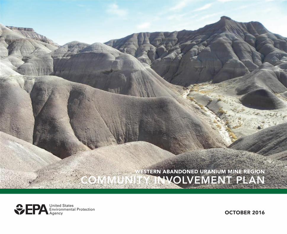
Western AbAndoned UrAniUm mine region
Community involvement Plan
oCtober 2016
introduCtion
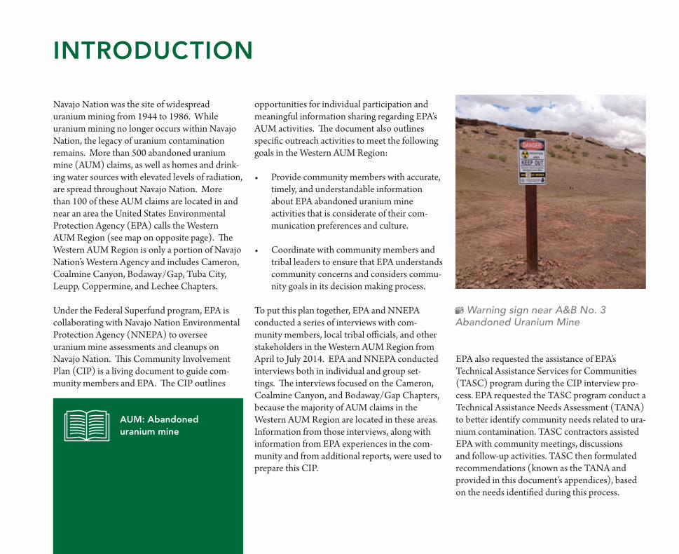
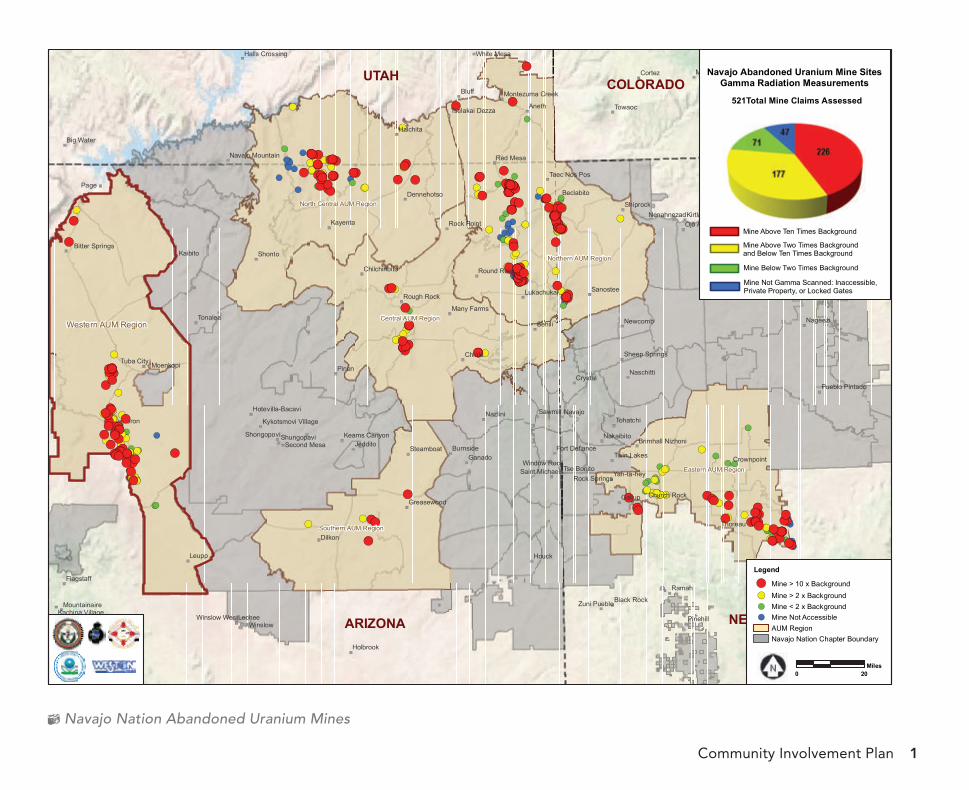
Navajo Nation was the site of widespread uranium mining from 1944 to 1986. While uranium mining no longer occurs within Navajo Nation, the legacy of uranium contamination remains. More than 500 abandoned uranium mine (AUM) claims, as well as homes and drink-ing water sources with elevated levels of radiation, are spread throughout Navajo Nation. More than 100 of these AUM claims are located in and near an area the United States Environmental Protection Agency (EPA) calls the Western AUM Region (see map on opposite page). The Western AUM Region is only a portion of Navajo Nation’s Western Agency and includes Cameron, Coalmine Canyon, Bodaway/Gap, Tuba City, Leupp, Coppermine, and Lechee Chapters.
Under the Federal Superfund program, EPA is collaborating with Navajo Nation Environmental Protection Agency (NNEPA) to oversee uranium mine assessments and cleanups on Navajo Nation. This Community Involvement Plan (CIP) is a living document to guide com-munity members and EPA. The CIP outlines
opportunities for individual participation and meaningful information sharing regarding EPA’s AUM activities. The document also outlines specific outreach activities to meet the following goals in the Western AUM Region:
Provide community members with accurate, •timely, and understandable information about EPA abandoned uranium mine activities that is considerate of their com-munication preferences and culture.
Coordinate with community members and •tribal leaders to ensure that EPA understands community concerns and considers commu-nity goals in its decision making process.
To put this plan together, EPA and NNEPA conducted a series of interviews with com-munity members, local tribal officials, and other stakeholders in the Western AUM Region from April to July 2014. EPA and NNEPA conducted interviews both in individual and group set-tings. The interviews focused on the Cameron, Coalmine Canyon, and Bodaway/Gap Chapters, because the majority of AUM claims in the Western AUM Region are located in these areas. Information from those interviews, along with information from EPA experiences in the com-munity and from additional reports, were used to prepare this CIP.
aum: abandoned uranium mine
Warning sign near A&B No. 3 Abandoned Uranium Mine
EPA also requested the assistance of EPA’s Technical Assistance Services for Communities (TASC) program during the CIP interview pro-cess. EPA requested the TASC program conduct a Technical Assistance Needs Assessment (TANA) to better identify community needs related to ura-nium contamination. TASC contractors assisted EPA with community meetings, discussions and follow-up activities. TASC then formulated recommendations (known as the TANA and provided in this document’s appendices), based on the needs identified during this process.
Community Involvement Plan 1
Navajo Nation Abandoned Uranium Mines
")
")
")
")
")
")
")
")
")
")
")
")
")
")
")
")
")
")
")
")
")
")
")
")
")
")
")
")
")
")
!(
Page
Big Water
")
")
")
")
")
")
")
")
")
")
")
")
")
")
")
")
")
")")
")
")
")
)
")
")
")
")
")
")")
")
")
")
")
")
")
")
")
")
")
")
")
")
")
")
")
")
")
")
")
")
")
")
")
")
")
")
")
")
")
")
")
")
")
")
")
")
")
")
")
")
")
")
")
")
")
")
")
")
!(!(
!(!(!(!(!(
!(!(!(!(!(
!(
!(
!(
!(!(
!(!(!(!(
!(!(!(!(!(!(
!(!(!(
!(
!(
!(
!(!(!(
!(
!(
!(
!(
!(
!(
!(
!(!(
!(
!(
!(!(
!(
!(
!(
!(!(
!(!(
!(
!(
!(
!(!(
!(
!(
!(
!(
!(!(!(
!(
!(
!(
!( !(!(
!(
!(
!(!(
!(
!(!(
!(
!(!(
!(
!(
!(!(
!(
!( !(
!(
!(
!(
!(!(
!(
!(
!(!(!(!(!(!(!(!(!(!(!(!(!(!(!(
!(!(!(!(!(!(!(!(!(
!(
!(
!(
!(!(!(
!(
!(!(
!(!(!(
!(!(!(!(!(!(!(!(!(!(!(!(!(!(!(!(!(
!(!(
!(
!(!(!(!(!(!(
!(!(!(!(
!(
!(!(!(!(!(!(
!(!(
!(
!(!(!(!(
!(
!(
!(!(
!(
!(!(
!(
!(
!(!(!(!(
!(
!(!(
!(!(!(
!(!(!(
!(
!(
!(!(!(
!(!(
!(!(!(
!(!(!(
!(!(
!(
!(!(!(!(!(
!(
!(!(!(
!(!(
!(!(!(
!(
!(
!(!(
!(
!(
!(
!(
!(
!(!(!(
!(
!(!(!(!(
!(!(!(!(
!(!(!(!(!(!(!(
!(!(!(!(!(!(!(!(
!(!(
!(!(!(!(!(!(!(!(!(!(!(!(
!(
!(
!(!(!(
!(!(!(
!(
!(!(!(
!(!(!(!(!(!(!(!(!(!(
!(!(!(
!(
!(
!(!(
!(!(
!(!(
!(
!(
!(!(!(
!(!(!(!(!(!(!(
!(
!(
!(
!(!(!(!(!(
!(
!(
!( !(
!(!(
!(!(!(!(!(!(!(!(!(!(!(!(
!(
!(!(!(
!(!(!(!(!(!(!(!(!(!(!(!(!(!(
!(
!(!(!(
!(!(
!(!(
!(
!(
!(
!(
!(!(!(
!(
!(
!( !(
!(
!(
!(
!(
!(!(!(!(
!(
!(
!(
!(
!(!(!(
!(
!( !(!(
!(
!(!( !(
!(
!(
!(
!(!(
!(!(!(!(!(!(!(!(!(!(!(!(!(!(!(
!(!(!(
!(
!(
!(!(!(!(!(!(!(!(!(!(!(
!(
!(
!(!(
!(!(
!(!(
!(
!(!(
!(
!(
!(
!(
!(!(!(
!(
!(!(!(!(
!(
!(
!(!(!(!(!(!(
!(!(!(!(!(
!(
!(!(!(!(
!(
!(
!(
!(
!(
!(
!(!(
!(!(!(!(
!(!(!( !(!(
!(!(!(!(!(!(!(
!(!(!(!(!(!(!(!(!(
!(!(
!(
!(!(
!(!(
!(!(!(!(!(!(!(!(!( !(
!(
!(
!(
!(
!(
!(!(!(
!(
!(
!(!(!(!(
!(!( !(
!(
!(!(!(!(!(!(!(!(
!(!(
!(!(!(!(!(!(!(!(!(
!(!(
!(
!(!(
!(!(
!(!(!(
!(
!(
!(!(!(
!(
!(
!(
!( !(
!(
!(
!(
!(!(
UTAH COLORADO
ARIZONA NEW MEXICO
RA M AH
RA M AH
RA M AH
RA M AH
RA M AH
RA M AH
RA M AH
RA M AH
RA M AH
RA M AH
RA M AH
RA M AH
RA M AH
RA M AH
RA M AH
RA M AH
RA M AH
RA M AH
RA M AH RA M AH
RA M AH
Western AUM Region
Northern AUM Region
Central AUM Region
North Central AUM Region
Eastern AUM Region
Southern AUM Region
Bluff
Aneth
Seama
Ramah
Milan
Aztec
Pinon
Leupp Houck
Navajo
Laguna
Grants
Gallup
Towaoc
MancosCortez
Shonto
Sehili
Lechee
Ganado
Dilkon
Chinle
Thoreau
Paguate
Newcomb Nageezi
Encinal
Crystal
Ignacio
Durango
Arboles
Winslow
Tonalea
SawmillNazlini
Kayenta
Kaibito
Jeddito
Cameron
Halchita
Tohatchi
Shiprock
Sanostee
Pinehill
Kirtland
Huerfano
Bayfield
Red Mesa
Moenkopi
Holbrook
Burnside
Naschitti
Nakaibito
Beclabito
Tuba City
Steamboat
Flagstaff
White Mesa
Yah-ta-hey
Twin Lakes
Tse Bonito
Nenahnezad Farmington
Crownpoint
Bloomfield
Black Rock
ShungopaviShongopovi
Round Rock
Rough Rock
Rock Point
Munds Park
Many Farms
Lukachukai
Greasewood
Dennehotso
Zuni Pueblo
Flora Vista
Church Rock
Window Rock
Second Mesa
Rock Springs
Ojo Amarillo
Acomita Lake
Winslow West
Teec Nos Pos
Mountainaire
Keams Canyon
Chilchinbito
Sheep Springs
Fort Defiance
Tselakai Dezza
Halls Crossing
Pueblo Pintado
Saint Michaels
Bitter Springs
Navajo Mountain
Montezuma Creek
Kachina Village
Brimhall Nizhoni
Hotevilla-Bacavi
Kykotsmovi Village
North Acomita Village
20 0Miles
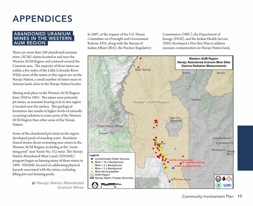
Legend
!( Mine > 10 x Background
!( Mine > 2 x Background!( Mine < 2 x Background!( Mine Not Accessible
AUM RegionNavajo Nation Chapter Boundary
Navajo Abandoned Uranium Mine SitesGamma Radiation Measurements
Mine Below Two Times Background
Mine Above Two Times Backgroundand Below Ten Times Background
Mine Not Gamma Scanned: Inaccessible, Private Property, or Locked Gates
521Total Mine Claims Assessed
Mine Above Ten Times Background
") !(
!(
!(!(
!(!(
!(!(
!(
!(
!(
!(
!(!(
!(
!(
!(
!(
!(
!(
!(!(!(
!(!(
!(!(!(!(!(!(!(!(!(!(!(!(!(!(!(!(!(!(!(!(!(
!(!(!(!(
!(!(!(!(
!(!(!(
!(!(
!(!(
!( !(
!(!(!(
!(!(
!(!(!(
!(
!(
!(!(
!(!(!(
!(!(
!(!( !(!(!(
!(!(
!(
!(
!(
!(
!(
!(
!(!(
!(
!(
!(
!(
!(!(
!(
!(!(
!(
!(!(!(!(!(!(!(!(!(
!(
!(!(!(
!(
!(
!(!(!(
!(!(
!(
!(
!(!(
!(!(
!(!(!(!(!(!(
!(
!(
!(
!(
!(
!(
Community involvement Plan organization
3theCommunity
This section provides a brief community profile and identifies concerns and preferences raised during the community interviews.
9the CommunityinvolvementaCtion Plan
This section explains the tools EPA will use to share information with the community, and outlines opportunities for community members to provide input during EPA’s process. This section also provides EPA and NNEPA contact information.
17aPPendiCes The appendices include information about:
Abandoned uranium mines in the Western AUM Region•Other uranium concerns in the Western AUM Region•EPA Superfund Process on Navajo Nation•EPA information repository•Newspaper and radio communication•Glossary•List of acronyms•Technical Assistance Needs Assessment Recommendations•Additional Contacts•
Community Involvement Plan 3
Navajo Nation AbandonedUranium Mines
The Community
Community Profile
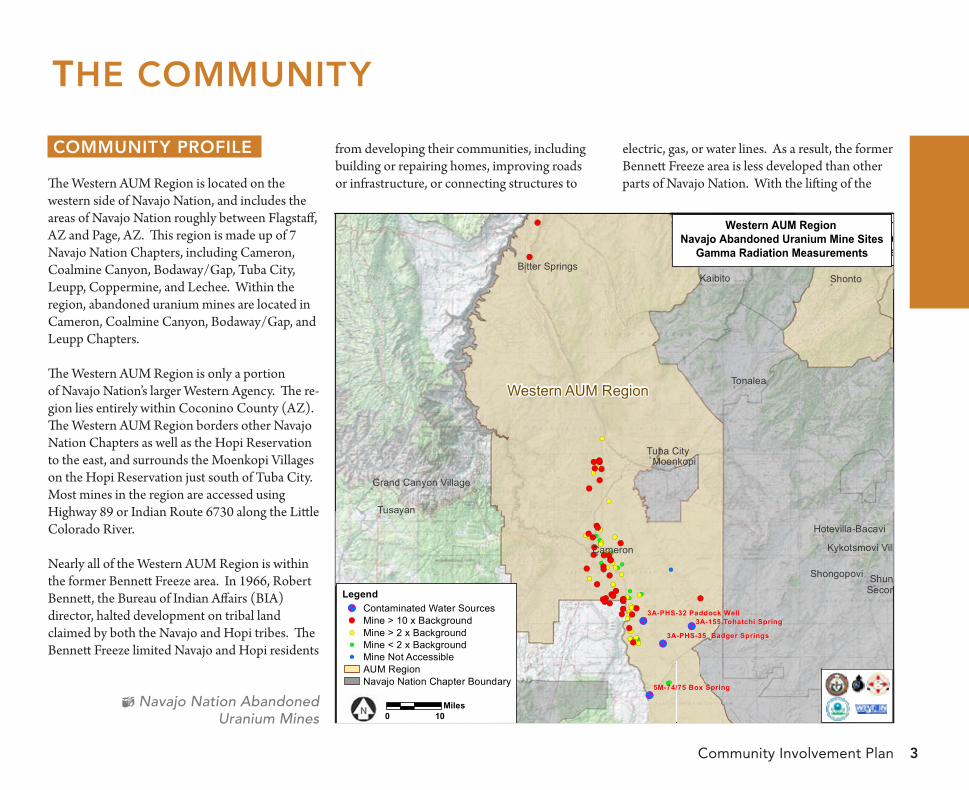
The Western AUM Region is located on the western side of Navajo Nation, and includes the areas of Navajo Nation roughly between Flagstaff, AZ and Page, AZ. This region is made up of 7 Navajo Nation Chapters, including Cameron, Coalmine Canyon, Bodaway/Gap, Tuba City, Leupp, Coppermine, and Lechee. Within the region, abandoned uranium mines are located in Cameron, Coalmine Canyon, Bodaway/Gap, and Leupp Chapters.
The Western AUM Region is only a portion of Navajo Nation’s larger Western Agency. The re-gion lies entirely within Coconino County (AZ). The Western AUM Region borders other Navajo Nation Chapters as well as the Hopi Reservation to the east, and surrounds the Moenkopi Villages on the Hopi Reservation just south of Tuba City. Most mines in the region are accessed using Highway 89 or Indian Route 6730 along the Little Colorado River.
Nearly all of the Western AUM Region is within the former Bennett Freeze area. In 1966, Robert Bennett, the Bureau of Indian Affairs (BIA) director, halted development on tribal land claimed by both the Navajo and Hopi tribes. The Bennett Freeze limited Navajo and Hopi residents
from developing their communities, including building or repairing homes, improving roads or infrastructure, or connecting structures to
electric, gas, or water lines. As a result, the former Bennett Freeze area is less developed than other parts of Navajo Nation. With the lifting of the
")
")
")
")
")
")
")
")
")
")
")
")
")
")
")
")
")
")
")
")
")
!(
!(
!(
!(
!(
!(!(
!(!(
!(
!(
!(
!(
!(!(
!(
!(!(
!(
!(
!(
!(
!(
!(
!(!(
!(
!(
!(
!(!(!(!(!(!(!(!(!(!(!(
!(
!(!(!(
!(
!(!(!(!(!(
!(!(
!(!(
!(
!( !(!(
!(!(!(
!(!(
!(!(
!( !(
!(!(!(
!(
!(
!(!(
!(
!(
!(
!(
!( !(
!(
!(!(
!(
!(
!(!( !(
!(
!(
!(
!(
!(
!(
!(
!(!(
!(
!(
!(
!(!(
!(
!(
!(
!(
!(!(
!(
!(
!(
!(
!(
!(
!(
!(!(!(!(!(
!(
!(!(
!(
!(
!(!(!(
!(
!(
!(!(!(
!(
!(
!(
!(
!(
!(
!(
!(!(
!(!( !(!(
!(
!(
!(
!(
!(
!(
!(
!(
!(
!(
!(
!(
!(!(
!(
!(
Western AUM Region
Southern AUM Region
5M-74/75 Box Spring5M-74/75 Box Spring
3A-PHS-32 Paddock Well3A-PHS-32 Paddock Well3A-155 Tohatchi Spring3A-155 Tohatchi Spring
3A-PHS-35 Badger Springs3A-PHS-35 Badger Springs
Pinon
Shonto
Dilkon
Tusayan
Tonalea
Kayenta
Kaibito
Jeddito
Cameron
MoenkopiTuba City
ShungopaviShongopoviFirst Mesa
Second Mesa
Keams Canyon
Chilchinbito
Bitter Springs
Hotevilla-Bacavi
Kykotsmovi Village
Grand Canyon Village
Western RegionNavajo Abandoned Uranium Mine Sites
Gamma Radiation Measurements
Western AUM Region Navajo Abandoned Uranium Mine Sites
Gamma Radiation Measurements
0 10Miles
Legend!( Contaminated Water Sources!( Mine > 10 x Background!( Mine > 2 x Background!( Mine < 2 x Background!( Mine Not Accessible
AUM RegionNavajo Nation Chapter Boundary
")
")
")
")
")
")
")
")
")
")
")
")
")
")
")
")
")
")
")
")
")
!(
!(
!(
!(
!(
!(!(
!(!(
!(
!(
!(
!(
!(!(
!(
!(!(
!(
!(
!(
!(
!(
!(
!(!(
!(
!(
!(
!(!(!(!(!(!(!(!(!(!(!(
!(
!(!(!(
!(
!(!(!(!(!(
!(!(!(!(
!(
!( !(!(
!(!(!(
!(!(
!(!(
!( !(
!(!(!(
!(
!(
!(!(
!(
!(
!(
!(
!( !(
!(
!(!(
!(
!(
!(!( !(
!(
!(
!(
!(
!(
!(
!(
!(!(
!(
!(
!(
!(!(
!(
!(
!(
!(
!(!(
!(
!(
!(
!(
!(
!(
!(
!(!(!(!(!(
!(
!(!(
!(
!(
!(!(!(
!(
!(
!(!(!(
!(
!(
!(
!(
!(
!(
!(
!(!(
!(!( !(!(
!(
!(
!(
!(
!(
!(
!(
!(
!(
!(
!(
!(
!(!(
!(
!(
Western AUM Region
Southern AUM Region
5M-74/75 Box Spring5M-74/75 Box Spring
3A-PHS-32 Paddock Well3A-PHS-32 Paddock Well3A-155 Tohatchi Spring3A-155 Tohatchi Spring
3A-PHS-35 Badger Springs3A-PHS-35 Badger Springs
Pinon
Shonto
Dilkon
Tusayan
Tonalea
Kayenta
Kaibito
Jeddito
Cameron
MoenkopiTuba City
ShungopaviShongopoviFirst Mesa
Second Mesa
Keams Canyon
Chilchinbito
Bitter Springs
Hotevilla-Bacavi
Kykotsmovi Village
Grand Canyon Village
Western RegionNavajo Abandoned Uranium Mine Sites
Gamma Radiation Measurements
Western AUM Region Navajo Abandoned Uranium Mine Sites
Gamma Radiation Measurements
0 10Miles
Legend!( Contaminated Water Sources!( Mine > 10 x Background!( Mine > 2 x Background!( Mine < 2 x Background!( Mine Not Accessible
AUM RegionNavajo Nation Chapter Boundary

Western Abandoned Uranium Mine Region4
Bennett Freeze in 2009, local communities are discussing and planning projects that will benefit residents in the area. Options for future land use and development are also being considered on a regional level.
Community overview
The Western AUM Region includes population centers such as Cameron and Tuba City, where residents generally have more access to resources such as regulated water. Many residents, espe-cially in more rural areas, drive long distances to reach Chapter Houses, grocery stores, and regulated water hauling points.
Many community members in the region graze sheep, cattle, and horses near their homesites and sheepcamps. Most of the land in the region is used for grazing and farming. Various plants in the region are also used for medicinal and traditional purposes.
economics
According to the Navajo Nation Division of Economic Development, most jobs on Navajo Nation are in the government and service sectors (including schools, hospitals, and hotels and motels). Additionally, many activities of the Navajo Nation economy are unreported, such as selling arts & crafts or food at food stalls. Even with these activities, the unemployment rate for the Navajo Nation is substantially higher than the U.S. national average.1
1 The Navajo Nation Division of Economic Development. 2009-2010 Comprehensive Economic Development Strategy of the Navajo Nation.
Little Colorado River near Cameron
While economic information is not collected specifically for the Western AUM Region, the government and service employment sectors are visible in the region. Tourism is also a visible part of the economy. The region features a desert landscape that includes parts of the Painted Desert, the Echo Cliffs of Bodaway/Gap Chapter, and part of the Little Colorado River near the Grand Canyon. Jewelry stands, concession vendors, and trading posts catering to passing
tourists can be seen along Highway 89, a main paved road that passes through the region and connects the cities of Flagstaff and Page.
demographics
According to the 2010 U.S. Census, there are more than 15,000 people living in the Western AUM Region. Those living in the region are primarily Native American - many Chapters in the region have Native American populations that are above 95%. While the majority of Native Americans in the Western AUM Region are Navajo, members of the San Juan Southern Paiute tribe and Hopi tribe also live in the region.
The languages spoken in the region are primarily English and Navajo. In Cameron Chapter, where
Community Involvement Plan 5
a large number of the abandoned uranium mines in the region are located, EPA has interacted with many community members that either speak only Navajo or don’t feel comfortable express-ing themselves in English. According to the 2009-2013 American Community Survey, more than half of community members in Cameron Chapter (over 55%) speak a language other than English at home. Around a third of community members in Cameron (about 35%) report speaking English “less than very well”.
Community ConCernsand PreferenCes
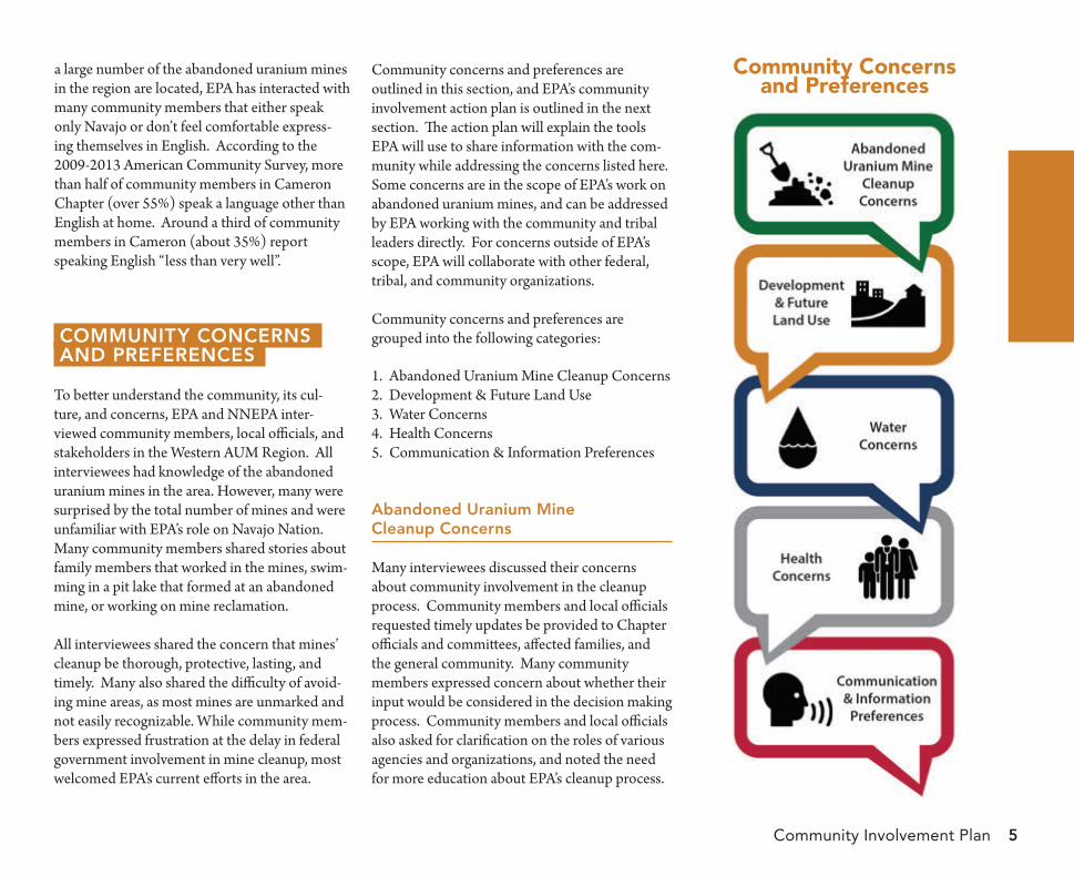
To better understand the community, its cul-ture, and concerns, EPA and NNEPA inter-viewed community members, local officials, and stakeholders in the Western AUM Region. All interviewees had knowledge of the abandoned uranium mines in the area. However, many were surprised by the total number of mines and were unfamiliar with EPA’s role on Navajo Nation. Many community members shared stories about family members that worked in the mines, swim-ming in a pit lake that formed at an abandoned mine, or working on mine reclamation.
All interviewees shared the concern that mines’ cleanup be thorough, protective, lasting, and timely. Many also shared the difficulty of avoid-ing mine areas, as most mines are unmarked and not easily recognizable. While community mem-bers expressed frustration at the delay in federal government involvement in mine cleanup, most welcomed EPA’s current efforts in the area.
Community concerns and preferences are outlined in this section, and EPA’s community involvement action plan is outlined in the next section. The action plan will explain the tools EPA will use to share information with the com-munity while addressing the concerns listed here. Some concerns are in the scope of EPA’s work on abandoned uranium mines, and can be addressed by EPA working with the community and tribal leaders directly. For concerns outside of EPA’s scope, EPA will collaborate with other federal, tribal, and community organizations.
Community concerns and preferences are grouped into the following categories:
Abandoned Uranium Mine Cleanup Concerns1.Development & Future Land Use2.Water Concerns3.Health Concerns4.Communication & Information Preferences5.
abandoned uranium mine Cleanup Concerns
Many interviewees discussed their concerns about community involvement in the cleanup process. Community members and local officials requested timely updates be provided to Chapter officials and committees, affected families, and the general community. Many community members expressed concern about whether their input would be considered in the decision making process. Community members and local officials also asked for clarification on the roles of various agencies and organizations, and noted the need for more education about EPA’s cleanup process.
Community Concernsand Preferences
Western Abandoned Uranium Mine Region6
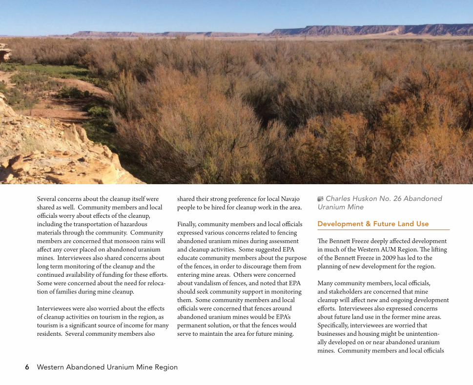
Several concerns about the cleanup itself were shared as well. Community members and local officials worry about effects of the cleanup, including the transportation of hazardous materials through the community. Community members are concerned that monsoon rains will affect any cover placed on abandoned uranium mines. Interviewees also shared concerns about long term monitoring of the cleanup and the continued availability of funding for these efforts. Some were concerned about the need for reloca-tion of families during mine cleanup.
Interviewees were also worried about the effects of cleanup activities on tourism in the region, as tourism is a significant source of income for many residents. Several community members also
shared their strong preference for local Navajo people to be hired for cleanup work in the area.
Finally, community members and local officials expressed various concerns related to fencing abandoned uranium mines during assessment and cleanup activities. Some suggested EPA educate community members about the purpose of the fences, in order to discourage them from entering mine areas. Others were concerned about vandalism of fences, and noted that EPA should seek community support in monitoring them. Some community members and local officials were concerned that fences around abandoned uranium mines would be EPA’s permanent solution, or that the fences would serve to maintain the area for future mining.
Charles Huskon No. 26 Abandoned Uranium Mine
development & future land use
The Bennett Freeze deeply affected development in much of the Western AUM Region. The lifting of the Bennett Freeze in 2009 has led to the planning of new development for the region.
Many community members, local officials, and stakeholders are concerned that mine cleanup will affect new and ongoing development efforts. Interviewees also expressed concerns about future land use in the former mine areas. Specifically, interviewees are worried that businesses and housing might be unintention-ally developed on or near abandoned uranium mines. Community members and local officials
Community Involvement Plan 7
expressed the need for robust communication between EPA, Navajo Nation, and Chapter Land Use Planning Committees as well as grazing committees.
Community members and local officials also shared their thoughts about future land use of mine areas. Some questioned whether the land will ever be safe for humans or livestock. Many expressed their preference that the land be returned safely to farming and grazing use. Other community members and local officials were interested in using the land for economic uses such as solar power generation. Questions were asked about the EPA Brownfields program (the Brownfields program cleans up and reinvests in properties that have or potentially have contami-nants on site). Most agreed that the land should not simply be fenced off and restricted from use by current and future residents. Finally, some interviewees were concerned that the areas would be developed for mining again in the future.
Water Concerns
Water quality and access to water were among the most important environmental issues in the area.
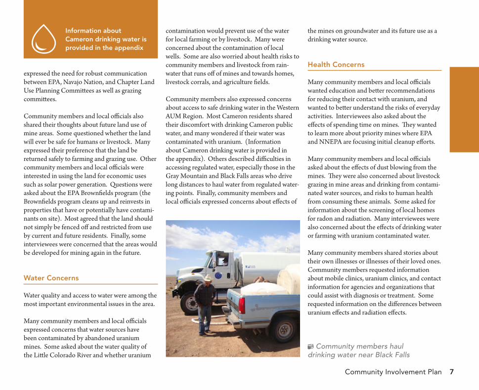
Many community members and local officials expressed concerns that water sources have been contaminated by abandoned uranium mines. Some asked about the water quality of the Little Colorado River and whether uranium
contamination would prevent use of the water for local farming or by livestock. Many were concerned about the contamination of local wells. Some are also worried about health risks to community members and livestock from rain-water that runs off of mines and towards homes, livestock corrals, and agriculture fields.
Community members also expressed concerns about access to safe drinking water in the Western AUM Region. Most Cameron residents shared their discomfort with drinking Cameron public water, and many wondered if their water was contaminated with uranium. (Information about Cameron drinking water is provided in the appendix). Others described difficulties in accessing regulated water, especially those in the Gray Mountain and Black Falls areas who drive long distances to haul water from regulated water-ing points. Finally, community members and local officials expressed concerns about effects of
the mines on groundwater and its future use as a drinking water source.
health Concerns
Many community members and local officials wanted education and better recommendations for reducing their contact with uranium, and wanted to better understand the risks of everyday activities. Interviewees also asked about the effects of spending time on mines. They wanted to learn more about priority mines where EPA and NNEPA are focusing initial cleanup efforts.
Many community members and local officials asked about the effects of dust blowing from the mines. They were also concerned about livestock grazing in mine areas and drinking from contami-nated water sources, and risks to human health from consuming these animals. Some asked for information about the screening of local homes for radon and radiation. Many interviewees were also concerned about the effects of drinking water or farming with uranium contaminated water.
Many community members shared stories about their own illnesses or illnesses of their loved ones. Community members requested information about mobile clinics, uranium clinics, and contact information for agencies and organizations that could assist with diagnosis or treatment. Some requested information on the differences between uranium effects and radiation effects.
Community members hauldrinking water near Black Falls
information about Cameron drinking water is provided in the appendix
Western Abandoned Uranium Mine Region8
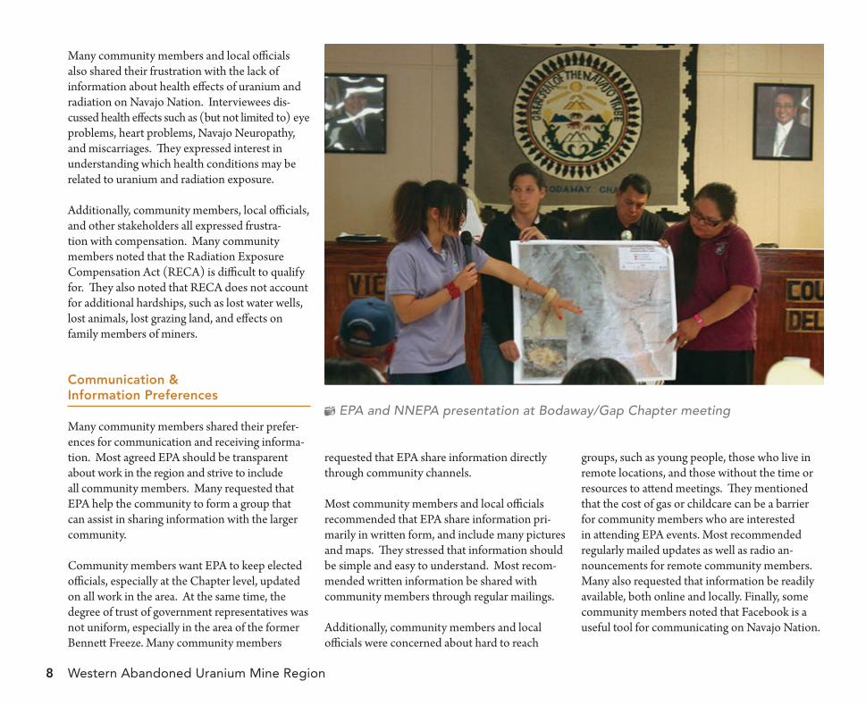
Many community members and local officials also shared their frustration with the lack of information about health effects of uranium and radiation on Navajo Nation. Interviewees dis-cussed health effects such as (but not limited to) eye problems, heart problems, Navajo Neuropathy, and miscarriages. They expressed interest in understanding which health conditions may be related to uranium and radiation exposure.
Additionally, community members, local officials, and other stakeholders all expressed frustra-tion with compensation. Many community members noted that the Radiation Exposure Compensation Act (RECA) is difficult to qualify for. They also noted that RECA does not account for additional hardships, such as lost water wells, lost animals, lost grazing land, and effects on family members of miners.
Communication & information Preferences
Many community members shared their prefer-ences for communication and receiving informa-tion. Most agreed EPA should be transparent about work in the region and strive to include all community members. Many requested that EPA help the community to form a group that can assist in sharing information with the larger community.
Community members want EPA to keep elected officials, especially at the Chapter level, updated on all work in the area. At the same time, the degree of trust of government representatives was not uniform, especially in the area of the former Bennett Freeze. Many community members
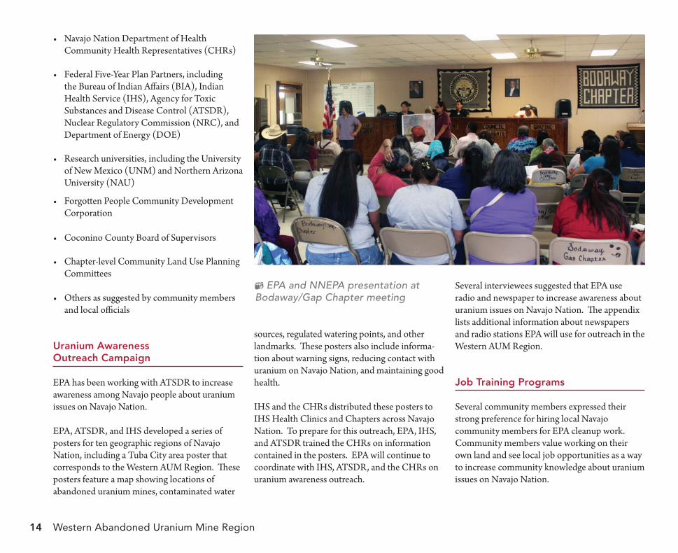
EPA and NNEPA presentation at Bodaway/Gap Chapter meeting
requested that EPA share information directly through community channels.
Most community members and local officials recommended that EPA share information pri-marily in written form, and include many pictures and maps. They stressed that information should be simple and easy to understand. Most recom-mended written information be shared with community members through regular mailings.
Additionally, community members and local officials were concerned about hard to reach
groups, such as young people, those who live in remote locations, and those without the time or resources to attend meetings. They mentioned that the cost of gas or childcare can be a barrier for community members who are interested in attending EPA events. Most recommended regularly mailed updates as well as radio an-nouncements for remote community members. Many also requested that information be readily available, both online and locally. Finally, some community members noted that Facebook is a useful tool for communicating on Navajo Nation.
9
the Community involvement aCtion PlanAfter interviewing community members, local officials, and stakeholders to better understand community concerns and preferences, EPA prepared this community involvement action plan for the Western AUM Region. This action plan outlines the tools EPA will use to share information with the community. The action plan also outlines how EPA will make itself available to receive input from the community that will be considered in the decision making process. Finally, the action plan details EPA’s
recognition of tribal government and interaction with government officials.
Timing information is included with each outreach tool to help community members understand when EPA will conduct outreach activities and what type of activities to expect. Community members can also contact the EPA Community Involvement Coordinator with questions about future outreach activities.
EPA understands that many residents, especially elders, are Navajo language speakers. In order to help facilitate inclusion of all community members, EPA will have an interpreter or tribal representative present during informational meet-ings, open houses, and door-to-door outreach. EPA typically conducts outreach with a represen-tative from NNEPA present as well. Interviewees recommended EPA printed materials be presented in English, as English is the primary written language in the region.
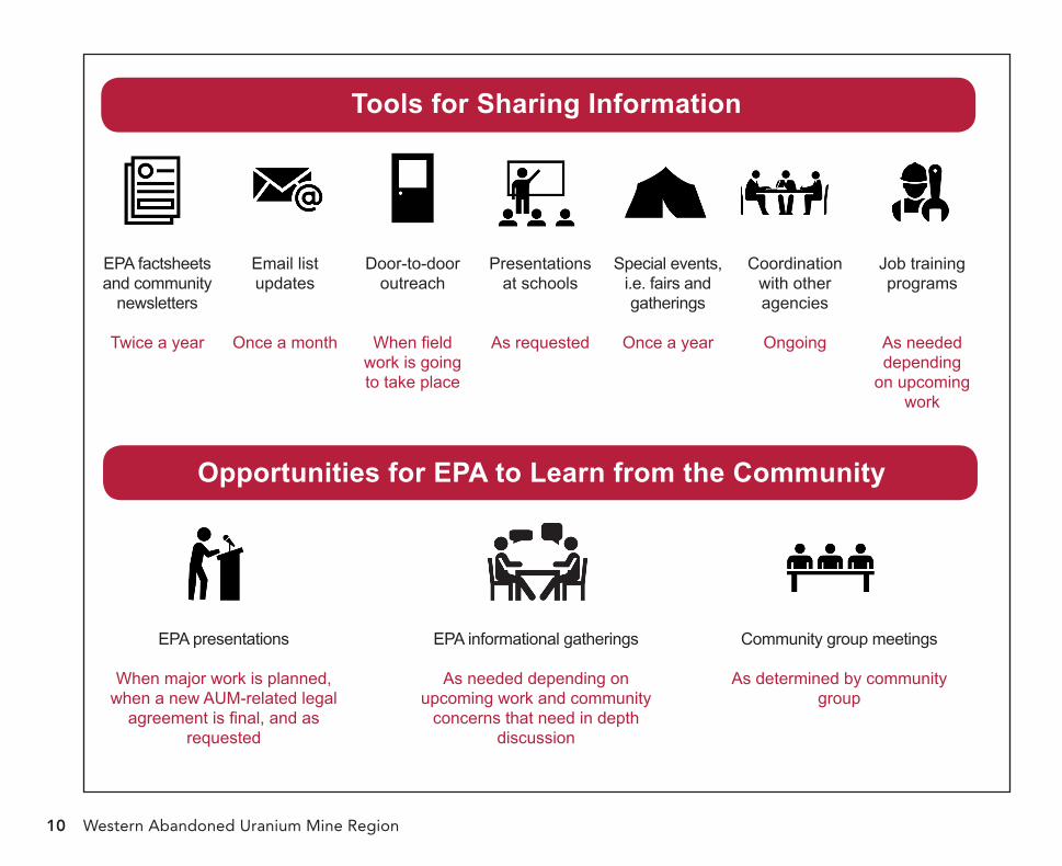
tools for sharinginformation
Interviewees noted a significant need for EPA to share information about abandoned uranium mines in the region. Community members and local officials expressed they lack information about the current status of uranium mine cleanup and the EPA cleanup process. They would like to be updated regularly on progress. EPA will use the following tools to provide information to community members in the Western AUM Region:
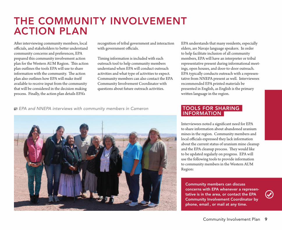
EPA and NNEPA interviews with community members in Cameron
Community members can discuss concerns with ePa whenever a represen-tative is in the area, or contact the ePa Community involvement Coordinator by phone, email , or mail at any time.
Community Involvement Plan
Western Abandoned Uranium Mine Region10
Tools for Sharing Information
EPA factsheets and community
newsletters
Twice a year
Email list updates
Once a month
Door-to-door outreach
When field work is going to take place
Presentations at schools
As requested
Special events, i.e. fairs and gatherings
Once a year
Coordination with other agencies
Ongoing
Job training programs
As needed depending
on upcoming work
Opportunities for EPA to Learn from the Community
EPA presentations
When major work is planned, when a new AUM-related legal
agreement is final, and as requested
EPA informational gatherings
As needed depending on upcoming work and community
concerns that need in depth discussion
Community group meetings
As determined by community group
Community Involvement Plan 11
Written Communication
Most interviewees expressed a preference for receiving written communication from EPA. Additionally, community members and local officials noted written communications are an effective tool for reaching remote residents. They stressed that written communication be short and simple, and include as many graphics as possible.
Factsheets & NewslettersHistorically, EPA has provided written commu-nications through EPA factsheets. A community group in the Cameron area has also expressed interest in writing community newsletters fo-cused on uranium issues. EPA will aim to provide written communication twice a year, either as EPA factsheets or as support to the community group newsletter.
EPA will use written communication both to provide updates on work taking place in the region and to cover topics in greater depth, in response to community need. Interviewees have already identified some topics, such as: the EPA cleanup process and the roles of different agencies; information about water in the Western AUM Region; and information about health stud-ies and uranium clinics in the area. Community members on the EPA mailing list will likely receive information, such as EPA factsheets or postcard meeting invitations, every three to six months.
Email ListsEPA uses email lists to update community members on EPA activities and events hosted by other organizations, such as workshops and clinics. Generally, EPA sends these emails about
once a month. EPA includes community partners in these emails, such as Chapter officials, local organizations and schools, and local post offices. These partners are encouraged to spread the word about these events for community members who do not have email access.
EPA has shared the following materials with com-munity members in the Western AUM Region:
Western aum region mapsEPA created maps of the Western AUM Region showing abandoned uranium mines, contaminated water sources, regulated watering points, and landmarks such as highways and Chapter Houses. These maps have been shared with Chapters and community groups, and are available upon request.
Western aum region factsheetEPA created a factsheet providing background information on mines in the area (and including the Western AUM Region map) as well as water and health concerns. This factsheet was shared with local officials, community members, and sent to the mailing list in fall 2014.
health factsheetsEPA worked with the Agency for Toxic Substances and Disease Registry (ATSDR) and other partner agencies to create a series of
topics for future Written Communications
• EPA Superfund Process• Roles of Different Agencies• Water in the Western AUM Region• Health Studies and Uranium Clinics
topics from Past Written Communications
• Western AUM Region Maps• Western AUM Region Factsheet• Health Factsheets• Agencies to Contact with Questions
Factsheet
Cameron Area Water Sources
Is regulated water in the Cameron
area contaminated?
Navajo Tribal Utility Authority’s (NTUA)
water system serves the Cameron area with
regulated water that is not contaminated with
uranium. At times, the water system has had
elevated levels of disinfection by-products,
which can cause health eff ects if consumed
over a long period of time. Th e water system
also has high levels of iron and manganese,
which is not hazardous for human health,
but does aff ect the taste, odor, and color of
the water.
EPA issued an order to NTUA to address these
water quality issues. To comply with this order,
NTUA will connect the Cameron community
water system with NTUA’s Bodaway/Gap/
Cedar Ridge water system, bringing improved
water from the Gap area. Construction of the
pipeline is scheduled to begin in 2015. After
this connection is complete, NTUA will build
an extension bringing piped water from the
Cameron area to the Gray Mountain area.
Th e 2013 Consumer Confi dence Report for
the Cameron community water system, which
provides water quality information, is available
at http://www.ntua.com/ccr13.html.
Has EPA found contamination in
unregulated water sources? What
has been done to protect community
members from this contamination?
Four unregulated livestock-use-only wells
in the Black Falls area were found to have
elevated levels of uranium and other con-
taminants. EPA, NNEPA, and other agencies
installed warning signs at these contaminated
water sources, informed community members
about the risks of drinking from unregu-
lated water sources, constructed a waterline
extension to serve 18 homes, constructed
a new regulated water hauling station, and
implemented a water hauling pilot program
that delivers water every week.
Uranium and Radiation Health Concerns
How can uranium and radiation affect
my health?
Coming in contact with uranium and radia-
tion, either at high levels or for a long period
of time, can aff ect your health, including
damaging your kidneys and increasing your
risk for cancer.
Community members should take precautions
to limit their exposure to uranium and radia-
tion in areas of Navajo Nation where uranium
mining occurred.
How can community members limit
their exposure to uranium and
radiation?
Stay away from abandoned mine sites
Community members should avoid spending
time at abandoned mines, as some mines
have high levels of radiation. You should
never build, gather building materials, play,
ride ATVs, or ride horses on or near mine
sites. Community members should also
graze animals away from mine sites. A map
showing locations of abandoned uranium
mines in the Western AUM Region is
included in this factsheet, available at local
Chapter houses, and available on the EPA
website: epaosc.org/Cameron_Area_Mines.
Screen your home for radiation
If you suspect that your home may have
been built using radioactive materials from
abandoned mine sites, you should contact the
Navajo Superfund Program at (800) 314-1846
to have your home screened.
Only drink regulated water
Regulated water is monitored and treated to
meet EPA and NNEPA drinking water stan-
dards for uranium and other contaminants.
Community members should only drink from
regulated water sources, including water piped
to your home and water from regulated water-
ing points. You should also use good water
hauling practices to keep water clean. Never
drink water from livestock-use-only wells.
Community
Involvement
How can I get information about
EPA work and be involved in the
cleanup process?
EPA is committed to involving com-
munity members during the cleanup
process. EPA interviewed community
members in the Western AUM Region to
get feedback on eff ective ways to involve
the community during mine investigation
and cleanup. Information from these
interviews will be used to write a Com-
munity Involvement Plan, which will
outline EPA’s action plan and community
outreach methods. Th is plan will be made
available to community members when it
is completed (end of 2014).
Additionally, EPA keeps a list of communi-
ty members who would like to be updated
about meetings and activities in the area. To
be added to this list, contact Community
Involvement Coordinator Amanda Pease.
Where to Get Information
ZiZi Angelica Searles
US EPA Remedial Project Manager
(415) 972-3178
Amanda Pease
US EPA Community
Involvement Coordinator
(415) 972-3068
toll-free (800) 231-3075
Michele Dineyazhe
Navajo Nation EPA Superfund Program
Remedial Project Manager
(928) 871-7089
micheledineyazhe@navajo-nsn
.gov
Sararesa Hopkins
Navajo Nation EPA Superfund Program
Public Information Offi cer
(928) 871-7328
toll-free (800) 314-1846
widesprea
1944 to 1
mining ac
Navajo N
progra
mines’ physical hazar
contamination r
minedrinking water sour
levels of radiation. Mor
these mine claims ar
AUM Region, a r
including Camer
Bodaway/Gap, T
75 Hawthorne Str
area? Wher
Th erthe map in this factsheet).
located in Camer
Chapters. Th
Colorado Riv
close to the N
Camer
U.S. Environmenta
Pacific Southwest
The Navajo Nation was the site of widespread uranium mining from 1944 to 1986. Although uranium mining activities no longer occur on Navajo Nation and the Navajo Nation Abandoned Mine Lands (NNAML) program addressed many of the mines’ physical hazards, a legacy of contamination remains. This includes more than 500 abandoned uranium mine (AUM) claims as well as homes and drinking water sources with elevated levels of radiation. More than 100 of these mine claims are in the Western AUM Region, a region of Navajo Nation including Cameron, Coalmine Canyon, Bodaway/Gap, Tuba City, Leupp, Coppermine, and Lechee Chapters.
Cameron Area Abandoned Uranium Mines
75 Hawthorne Street, San Francisco, CA 94105 August 2014
How many abandoned uranium mines are in the Cameron area? Where are they located?Th ere are more than 100 abandoned uranium mine claims located in the Western AUM Region and centered around the Cameron area (see map in this factsheet). Within the Western AUM Region, mines are located in Cameron, Coalmine Canyon, Bodaway/Gap, and Leupp Chapters. Th e majority of the mines are within a few miles of the Little Colorado River. A small number of sites also exist on Arizona lands close to the Navajo Nation border.
Maps showing mine locations are available at Cameron, Coalmine Canyon, and Bodaway/Gap Chapters, as well as on EPA’s website (epaosc.org/Cameron_Area_Mines), and in this factsheet. Addition-ally, EPA can provide copies of maps to community members and groups upon request.
Who is responsible for the contamination? Who will pay for cleanup?
Under Superfund law, EPA can ask or compel responsible companies to address contamination at mines where they or their legal predecessors mined for uranium. In 2013, EPA identifi ed El Paso Natural Gas as having responsibility for 19 mine claims near Cameron and the Little Colorado River. El Paso Natural Gas entered into a legal agreement
In October 2007, at the request of the U.S. House Committee on Oversight and Government Reform, the U.S. Environmental Protection Agency (EPA), along with the Bureau of Indian Affairs (BIA), the Nuclear Regulatory Commission (NRC), the Department of Energy (DOE), and the Indian Health Service (IHS) developed a Five-Year Plan to address uranium contamination on Navajo Nation land, in consultation with EPA’s partners at the Navajo Nation EPA (NNEPA).
The initial task of these federal partners was to outline and execute a strategy for gaining a better understanding of the scope of the problem and to identify
sites with the greatest human health risks. As part of this effort, EPA screened 521 mine claims across Navajo Nation. EPA and NNEPA used this information to identify 43 priority mine claims that pose the greatest risk to community members, based on their levels of radiation and location near homes. EPA is working on several priority mines in and around the Cameron area.
The initial screening reports, called Site Screens, from the Western AUM Region have been shared with Chapter leaders and community members, and can be found on EPA’s website: epaosc.org/Cameron_Area_Mines.
Cameron Area Abandoned Uranium Mineswith EPA to investigate the extent of the contamination for these mines. After investigation work is complete, EPA and NNEPA will determine next steps to address the contamination and will share these plans with the community for feedback and comment.
EPA continues to identify companies responsible for mines in and around the Navajo Nation and will keep community members updated on our progress. EPA will also continue to inform community members about mine locations and provide recommendations for limiting exposure to hazards associated with uranium and radiation.
What are EPA’s current activities at mines in the Cameron area?
EPA will be putting up warning signs at A&B No. 3 mine, which is located near the Cameron Chapter and trading post. Th ese signs will alert community members to stay away from the mine.
EPA is working with NNEPA and El Paso Natural Gas to obtain access agreements before the start of fi eld work. In order for El Paso Natural Gas to begin investigating the 19 mine claims they are responsible for under their agreement with EPA, they must obtain access agreements from homesite lease and grazing permit holders that will be impacted by their work.
U.S. Environmental Protection AgencyPacific Southwest Region 9
om
essed many of the
ds, a legacy of
emains. This includes
ces with elevated
e than 100 of
e in the Western
egion of Navajo Nation
on, Coalmine Canyon,
uba City, Leupp,
Cameron Area
Abandoned Uranium Mines
eet, San Francisco, CA 94105
August 2014
e in the Cameron
e are they located?
e are more than 100 abandoned uranium mine claims located in
Western AUM Region and centered around the Cameron area (see
Within the Western AUM Region, mines are
on, Coalmine Canyon, Bodaway/Gap, and Leupp
e majority of the mines are within a few miles of the Little
er. A small number of sites also exist on Arizona lands
avajo Nation border.
Maps showing mine locations are available at Cameron, Coalmine
Canyon, and Bodaway/Gap Chapters, as well as on EPA’s website
(epaosc.org/Cameron_Area_Mines), and in this factsheet. Addition-
ally, EPA can provide copies of maps to community members and
groups upon request.
Who is responsible for the contamination? Who will pay
for cleanup?
Under Superfund law, EPA can ask or compel responsible companies to
address contamination at mines where they or their legal predecessors
mined for uranium. In 2013, EPA identified El Paso Natural Gas as
having responsibility for 19 mine claims near Cameron and the Little
Colorado River. El Paso Natural Gas entered into a legal agreement
In October 2007, at the request of the
U.S. House Committee on Oversight
and Government Reform, the U.S.
Environmental Protection Agency
(EPA), along with the Bureau of Indian
Affairs (BIA), the Nuclear Regulatory
Commission (NRC), the Department of
Energy (DOE), and the Indian Health
Service (IHS) developed a Five-Year
Plan to address uranium contamination
on Navajo Nation land, in consultation
with EPA’s partners at the Navajo
Nation EPA (NNEPA).
The initial task of these federal partners
was to outline and execute a strategy
for gaining a better understanding of
the scope of the problem and to identify
sites with the greatest human health
risks. As part of this effort, EPA screened
521 mine claims across Navajo Nation.
EPA and NNEPA used this information to
identify 43 priority mine claims that pose
the greatest risk to community members,
based on their levels of radiation and
location near homes. EPA is working on
several priority mines in and around the
Cameron area.
The initial screening reports, called Site
Screens, from the Western AUM Region
have been shared with Chapter leaders
and community members, and can be
found on EPA’s website:
epaosc.org/Cameron_Area_Mines.
on Area Abandoned Uranium Mines
with EPA to investigate the extent of the contamination for these mines.
After investigation work is complete, EPA and NNEPA will determine
next steps to address the contamination and will share these plans with
the community for feedback and comment.
EPA continues to identify companies responsible for mines in and
around the Navajo Nation and will keep community members updated
on our progress. EPA will also continue to inform community members
about mine locations and provide recommendations for limiting
exposure to hazards associated with uranium and radiation.
What are EPA’s current activities at mines in the
Cameron area?
EPA will be putting up warning signs at A&B No. 3 mine, which is
located near the Cameron Chapter and trading post. These signs will
alert community members to stay away from the mine.
EPA is working with NNEPA and El Paso Natural Gas to obtain access
agreements before the start of field work. In order for El Paso Natural
Gas to begin investigating the 19 mine claims they are responsible for
under their agreement with EPA, they must obtain access agreements
from homesite lease and grazing permit holders that will be impacted by
their work.
l Protection Agency
Region 9
Cameron Area Water SourcesIs regulated water in the Cameron area contaminated?
Navajo Tribal Utility Authority’s (NTUA) water system serves the Cameron area with regulated water that is not contaminated with uranium. At times, the water system has had elevated levels of disinfection by-products, which can cause health effects if consumed over a long period of time. The water system also has high levels of iron and manganese, which is not hazardous for human health, but does affect the taste, odor, and color of the water.
EPA issued an order to NTUA to address these water quality issues. To comply with this order, NTUA will connect the Cameron community water system with NTUA’s Bodaway/Gap/Cedar Ridge water system, bringing improved water from the Gap area. Construction of the pipeline is scheduled to begin in 2015. After this connection is complete, NTUA will build an extension bringing piped water from the Cameron area to the Gray Mountain area.
The 2013 Consumer Confidence Report for the Cameron community water system, which provides water quality information, is available at http://www.ntua.com/ccr13.html.
Has EPA found contamination in unregulated water sources? What has been done to protect community members from this contamination?Four unregulated livestock-use-only wells in the Black Falls area were found to have elevated levels of uranium and other con-taminants. EPA, NNEPA, and other agencies installed warning signs at these contaminated water sources, informed community members about the risks of drinking from unregu-lated water sources, constructed a waterline extension to serve 18 homes, constructed a new regulated water hauling station, and implemented a water hauling pilot program that delivers water every week.
Uranium and Radiation Health ConcernsHow can uranium and radiation affect my health?
Coming in contact with uranium and radia-tion, either at high levels or for a long period of time, can affect your health, including damaging your kidneys and increasing your risk for cancer.
Community members should take precautions to limit their exposure to uranium and radia-tion in areas of Navajo Nation where uranium mining occurred.
How can community members limit their exposure to uranium and radiation?
Stay away from abandoned mine sitesCommunity members should avoid spending time at abandoned mines, as some mines have high levels of radiation. You should never build, gather building materials, play, ride ATVs, or ride horses on or near mine sites. Community members should also graze animals away from mine sites. A map
showing locations of abandoned uranium mines in the Western AUM Region is included in this factsheet, available at local Chapter houses, and available on the EPA website: epaosc.org/Cameron_Area_Mines.
Screen your home for radiationIf you suspect that your home may have been built using radioactive materials from abandoned mine sites, you should contact the Navajo Superfund Program at (800) 314-1846 to have your home screened.
Only drink regulated waterRegulated water is monitored and treated to meet EPA and NNEPA drinking water stan-dards for uranium and other contaminants. Community members should only drink from regulated water sources, including water piped to your home and water from regulated water-ing points. You should also use good water hauling practices to keep water clean. Never drink water from livestock-use-only wells.
Community InvolvementHow can I get information about EPA work and be involved in the cleanup process?
EPA is committed to involving com-munity members during the cleanup process. EPA interviewed community members in the Western AUM Region to get feedback on effective ways to involve the community during mine investigation and cleanup. Information from these interviews will be used to write a Com-munity Involvement Plan, which will outline EPA’s action plan and community outreach methods. This plan will be made available to community members when it is completed (end of 2014).
Additionally, EPA keeps a list of communi-ty members who would like to be updatedabout meetings and activities in the area. To be added to this list, contact CommunityInvolvement Coordinator Amanda Pease.
Where to Get Information
ZiZi Angelica Searles US EPA Remedial Project Manager(415) [email protected]
Amanda Pease US EPA Community Involvement Coordinator(415) 972-3068 toll-free (800) [email protected]
Michele DineyazheNavajo Nation EPA Superfund ProgramRemedial Project Manager(928) [email protected]
Sararesa HopkinsNavajo Nation EPA Superfund ProgramPublic Information Officer(928) 871-7328toll-free (800) [email protected]
Contact the ePa Community involvement Coordinator to be added to the mailing list.
Western Abandoned Uranium Mine Region12
factsheets on uranium and radiation in Navajo Nation. These factsheets discuss uranium and radiation basics, health effects of uranium and radiation, and how to reduce contact with uranium and radiation.
resource list factsheetEPA worked with partner agencies to create a factsheet to help community members deter-mine the correct agency to contact for different questions related to uranium or radiation on Navajo Nation.
These materials are available on the EPA website (https://epa.gov/r9uraniumcleanup/western-abandoned-uranium-mine-region), and commu-nity members can request copies by contacting the EPA Community Involvement Coordinator.
door-to-door outreach
Many community members and local officials expressed concerns that information should be shared specifically with families that live or have grazing permits near priority mines and mines where work will take place. EPA will share information and discuss concerns with these residents through door-to-door outreach by EPA staff or community liaisons. EPA will also coordinate with local officials to contact grazing permit holders and homesite lease holders near these mine areas.
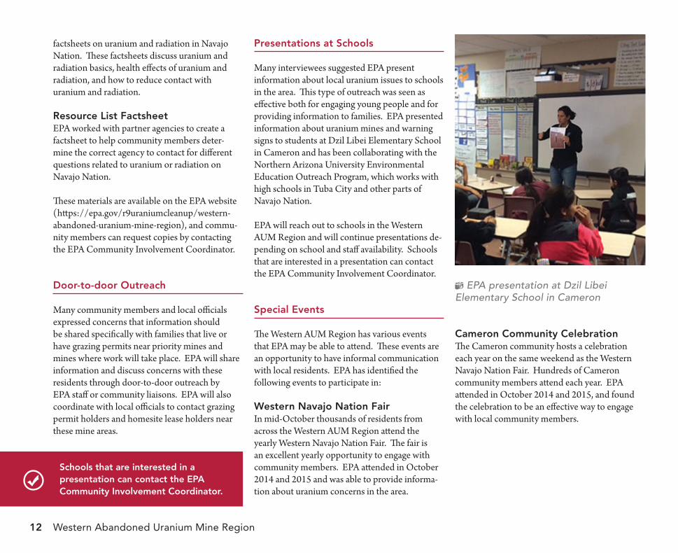
Presentations at schools
Many interviewees suggested EPA present information about local uranium issues to schools in the area. This type of outreach was seen as effective both for engaging young people and for providing information to families. EPA presented information about uranium mines and warning signs to students at Dzil Libei Elementary School in Cameron and has been collaborating with the Northern Arizona University Environmental Education Outreach Program, which works with high schools in Tuba City and other parts of Navajo Nation.
EPA will reach out to schools in the Western AUM Region and will continue presentations de-pending on school and staff availability. Schools that are interested in a presentation can contact the EPA Community Involvement Coordinator.
special events
The Western AUM Region has various events that EPA may be able to attend. These events are an opportunity to have informal communication with local residents. EPA has identified the following events to participate in:
Western navajo nation fairIn mid-October thousands of residents from across the Western AUM Region attend the yearly Western Navajo Nation Fair. The fair is an excellent yearly opportunity to engage with community members. EPA attended in October 2014 and 2015 and was able to provide informa-tion about uranium concerns in the area.
EPA presentation at Dzil Libei Elementary School in Cameron
Cameron Community CelebrationThe Cameron community hosts a celebration each year on the same weekend as the Western Navajo Nation Fair. Hundreds of Cameron community members attend each year. EPA attended in October 2014 and 2015, and found the celebration to be an effective way to engage with local community members.
schools that are interested in a presentation can contact the ePa Community involvement Coordinator.
Community Involvement Plan 13
EPA meeting with BIA in Tuba City
information repositories
• Check out the repository orvisit the website: https://epa.gov/r9uraniumcleanup/western-abandoned-uranium-mine-region
• Contact the EPA CommunityInvolvement Coordinator if your schoolor group would like to host an additionalrepository location
tuba City flea marketThere is a weekly flea market in Tuba City that occurs every Friday. EPA will aim to set up a booth once a year to discuss uranium issues with community members in the area.
information repository
Several interviewees noted that information should be made available to all community members, both online and locally.
As a part of the Superfund process, EPA maintains a set of documents and information locally, where it can be easily accessed by the public in printed and DVD copies. This is called the “Information Repository.” Information repositories contain copies of technical or plan-ning documents, factsheets, results of previous meetings, and other similar types of information.
The main Information Repository for the Western AUM Region is the Tuba City Branch Library (see repository information in the appendix). However, it is important to provide documents to
local Chapters and community partners as well. EPA has created an information center at the Cameron Chapter House and is open to creating additional information centers with interested schools and community groups. Interested schools and community groups can contact the EPA Community Involvement Coordinator.
ePa WebsiteEPA’s website will be updated regularly with cleanup information and important documents.
Information is available online at:https://epa.gov/r9uraniumcleanup/western-abandoned-uranium-mine-region
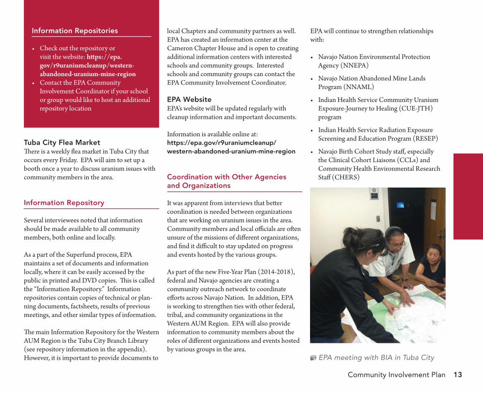
Coordination with other agencies and organizations
It was apparent from interviews that better coordination is needed between organizations that are working on uranium issues in the area. Community members and local officials are often unsure of the missions of different organizations, and find it difficult to stay updated on progress and events hosted by the various groups.
As part of the new Five-Year Plan (2014-2018), federal and Navajo agencies are creating a community outreach network to coordinate efforts across Navajo Nation. In addition, EPA is working to strengthen ties with other federal, tribal, and community organizations in the Western AUM Region. EPA will also provide information to community members about the roles of different organizations and events hosted by various groups in the area.
EPA will continue to strengthen relationships with:
Navajo Nation Environmental Protection•Agency (NNEPA)
Navajo Nation Abandoned Mine Lands•Program (NNAML)
Indian Health Service Community Uranium•Exposure-Journey to Healing (CUE-JTH)program
Indian Health Service Radiation Exposure•Screening and Education Program (RESEP)
Navajo Birth Cohort Study staff, especially•the Clinical Cohort Liaisons (CCLs) andCommunity Health Environmental ResearchStaff (CHERS)
Western Abandoned Uranium Mine Region14
Navajo Nation Department of Health •Community Health Representatives (CHRs)
Federal Five-Year Plan Partners, includ• ing the Bureau of Indian Affairs (BIA), Indian Health Service (IHS), Agency for Toxic Substances and Disease Control (ATSDR), Nuclear Regulatory Commission (NRC), and Department of Energy (DOE)
Research universities, including the University •of New Mexico (UNM) and Northern Arizona University (NAU)
Forgotten People Community Development •Corporation
Coconino County Board of Supervisors•
Chapter-level Community Land Use Planning •Committees
Others as suggested by community members •and local officials
uranium awareness outreach Campaign
EPA has been working with ATSDR to increase awareness among Navajo people about uranium issues on Navajo Nation.
EPA, ATSDR, and IHS developed a series of posters for ten geographic regions of Navajo Nation, including a Tuba City area poster that corresponds to the Western AUM Region. These posters feature a map showing locations of abandoned uranium mines, contaminated water
sources, regulated watering points, and other landmarks. These posters also include informa-tion about warning signs, reducing contact with uranium on Navajo Nation, and maintaining good health.
IHS and the CHRs distributed these posters to IHS Health Clinics and Chapters across Navajo Nation. To prepare for this outreach, EPA, IHS, and ATSDR trained the CHRs on information contained in the posters. EPA will continue to coordinate with IHS, ATSDR, and the CHRs on uranium awareness outreach.
Several interviewees suggested that EPA use radio and newspaper to increase awareness about uranium issues on Navajo Nation. The appendix lists additional information about newspapers and radio stations EPA will use for outreach in the Western AUM Region.
Job training Programs
Several community members expressed their strong preference for hiring local Navajo community members for EPA cleanup work. Community members value working on their own land and see local job opportunities as a way to increase community knowledge about uranium issues on Navajo Nation.
EPA and NNEPA presentation at Bodaway/Gap Chapter meeting
Community Involvement Plan 15
EPA awarded an Environmental Workforce Development and Jobs Training grant in 2014 to NAU to train Navajo residents for environmental cleanup jobs and provide job placement as-sistance. This training targeted residents living in communities affected by uranium mining for training programs in 2014 and 2015. EPA will consider additional job training programs throughout the cleanup process through this grant as well as continued collaboration with NAU and/or EPA’s Superfund Job Training Initiative. EPA will use the outreach methods described previously to inform community members about these opportunities.
oPPortunities forePa to learn fromthe Community
In addition to sharing information, EPA will use various techniques to give community members opportunities to provide meaningful input and ensure that community concerns are considered in the EPA cleanup process. In addition to the opportunities outlined here, community mem-bers can provide input at any time by contacting the EPA Community Involvement Coordinator.
ePa Presentations
EPA periodically makes presentations at local meetings in the Western AUM Region. These meetings include Chapter meetings, Community Land Use Planning Committee meetings, and both Chapter and District Level Grazing Meetings. These short presentations provide
time for community members to ask questions and give feedback. Typically, EPA will make presentations when major work is planned in an area, when a new AUM-related legal agreement is final, periodically to increase awareness about EPA work, and as requested by Chapter officials and community members.
ePa informational gatherings
Many interviewees recommended EPA also host informational gatherings, especially when more time is needed for deep engagement with community members. Examples for these types of meetings include discussion about signs and fences in a region, cleanup options for a mine or group of mines, large amounts of work planned for an area, or particular community concerns that need to be discussed in depth.
Depending on the topics to be discussed, the following formats are recommended:
Meetings and Open Houses – larger commu-•nity meetings that may include EPA presenta-tions, information presented on posters, andtime for the community to ask questions andgive feedback.Small Venue Meetings and Focus Groups –•smaller and more informal gatherings focusingon a particular geographic region, interestedgroup, or extended family.
your input is important. Please provide input at any time by contacting the ePa Community involvement Coordinator.
Key Contacts
u.s. environmental Protection agencyZiZi Angelica SearlesRemedial Project Manager75 Hawthorne St., SFD-6-2San Francisco, CA 94105(415) [email protected]
Amanda PeaseCommunity Involvement CoordinatorRemedial Project Manager – Section 9 Lease75 Hawthorne St., SFD-6-2San Francisco, CA 94105(415) [email protected]
navajo nation environmental Protection agencyNavajo Superfund ProgramNavajo EPA, Box 2946Window Rock, AZ 86515(800) 314-1846
Western Abandoned Uranium Mine Regio16
Listening Sessions – opportunities for com-•munity members to share their thoughts and concerns with EPA representatives.Workshops and Facilitated Discussions •– facilitated meetings designed to answer specific questions or address specific community concerns.
EPA will send meeting notices for these gatherings to the email list, mailing list, com-munity partners, and radio and newspapers as appropriate.
Community group meetings
Several community members also recommended creating a community group to help facilitate EPA communication with the community. This group would meet regularly to discuss topics related to uranium and EPA work in the region, share information with community members, and share community feedback with EPA. EPA is available to assist community members with forming community groups in the Western AUM Region, and can provide facilitation and meeting logistics support. Additionally, EPA can provide technical assistance to help community groups understand technical documents and the cleanup process through EPA’s Technical Assistance Services for Communities (TASC) program. Interested community members should contact the EPA Community Involvement Coordinator.
technical assistance services for Communities
Contact the EPA Community Involvement Coordinator if you are interested in learning more about technical assistance services that EPA can provide to community groups.
reCognizing tribalgovernment
The Navajo Nation is a federally-recognized tribe with its own governmental system. EPA policy is to consult on a government-to-government basis with federally recognized tribal governments when EPA actions and decisions may affect tribal interests.
EPA interacts with Navajo Nation government on several levels as a part of abandoned uranium mine assessment and cleanup on Navajo Nation. EPA consults directly with the Navajo Nation President for significant developments, such as major settlements and new Federal Five-Year Plans for addressing uranium contamination on Navajo Nation. EPA collaborates continuously with Navajo Nation EPA Superfund Program and Navajo Nation Department of Justice on all abandoned uranium mine assessment and cleanup. Finally, EPA provides regular updates to local officials. In the Western AUM Region specifically, EPA communicates regularly with local Navajo Nation Council Delegates, Chapter officials, and Community Land Use Planning Committees.
n
summary
EPA, together with NNEPA, interviewed community members, local officials, and other stakeholders in the Western AUM Region from April 2014 to July 2014. EPA used information from these interviews to learn about community concerns and prepare this Community Involvement Plan. EPA would like to thank interviewees and the communities for their time, patience, and willingness to share their stories and concerns with us.
EPA recognizes that receiving input and feedback from community members is crucial to the success of uranium cleanup on Navajo Nation. EPA will continue to work closely with community members and elected officials in our cleanup process, as outlined in this Community Involvement Plan. Additionally, community members are always welcome to provide input by contacting EPA’s Community Involvement Coordinator.
Community Involvement Plan 17
aPPendiCes
abandoned uraniummines in the Westernaum region
There are more than 100 abandoned uranium mine (AUM) claims located in and near the Western AUM Region and centered around the Cameron area. The majority of these mines are within a few miles of the Little Colorado River. While most of the mines in this region are on the Navajo Nation, a small number of mines exist on Arizona lands close to the Navajo Nation border.
Mining took place in the Western AUM Region from 1950 to 1963. The mines were primarily pit mines, as uranium bearing rock in this region is located near the surface. This geological formation also results in higher levels of naturally occurring radiation in some parts of the Western AUM Region than other areas of the Navajo Nation.
Some of the abandoned pit mines in the region developed pools of standing water. Residents shared stories about swimming near mines in the Western AUM Region, including at the “swim-ming pool” near Yazzie No. 312 mine. The Navajo Nation Abandoned Mine Lands (NNAML) program began reclaiming many of these mines in 1994. NNAML focused on addressing physical hazards associated with the mines, including filling pits and draining pools.
")
")
")
")
")
")
")
")
")
")
")
")
")
")
!(
!(
!(
!(
!(
!(!(
!(!(
!(
!(
!(
!(
!(!(
!(
!(!(
!(
!(
!(
!(
!(
!(!(
!(
!(
!(
!(!(!(!(!(!(!(!(!(!(!(
!(
!(!(!(
!(
!(!(!(!(!(
!(!(
!(!(
!(
!( !(!(
!(!(!(
!(!(
!(!(
!( !(
!(!(!(
!(
!(
!(!(
!(
!(
!(
!(
!( !(
!(
!(!(
!(
!(
!(!( !(
!(
!(
!(
!(
!(
!(
!(
!(!(
!(
!(
!(
!(!(
!(
!(
!(
!(
!(!(
!(
!(
!(
!(
!(
!(!(!(!(!(
!(
!(!(
!(
!(
!(!(!(
!(
!(
!(!(!(
!(
!(
!(
!(
!(
!(
!(
!(!(
!(!( !(!(
!(
!(
!(
!(
!(
!(
!(
!(
!(
!(
!(!(
!(
!(
Western AUM Region
5M-74/75 Box Spring5M-74/75 Box Spring
3A-PHS-32 Paddock Well3A-PHS-32 Paddock Well3A-155 Tohatchi Spring3A-155 Tohatchi Spring
3A-PHS-35 Badger Springs3A-PHS-35 Badger Springs
Shonto
Tusayan
Tonalea
Kaibito
Cameron
MoenkopiTuba City
ShungShongopoviSecon
Bitter Springs
Hotevilla-Bacavi
Kykotsmovi Vill
Grand Canyon Village
Navajo AbGamma
WesterNavajo Abando Sites
Gamma Rad
0 10Miles
Legend!( Contaminated Water Sources!( Mine > 10 x Background!( Mine > 2 x Background!( Mine < 2 x Background!( Mine Not Accessible
AUM RegionNavajo Nation Chapter Boundary
")
KayentaWestern RegionNavajo Abandoned Uranium Mine Sites
Gamma Radiation Measurements
Western AUM Region Navajo Abandoned Uranium Mine Sites
Gamma Radiation Measurements
")
")
")
")
")
")
")
!(!(
!(
!(
!(
Southern AUM Region
Pinon
Dilkon
Kayenta
Jedditoopavi
First Mesa
d Mesa
Keams Canyon
Chilchinbito
age
estern Regioned Uranium Mine Sites
ion Measurements
")
")
")
")
")
")
")
")
")
")
")
")
")
")
")
")
")
")
")
")
")
!(
!(
!(
!(
!(
!(!(
!(!(
!(
!(
!(
!(
!(!(
!(
!(!(
!(
!(
!(
!(
!(
!(
!(!(
!(
!(
!(
!(!(!(!(!(!(!(!(!(!(!(
!(
!(!(!(
!(
!(!(!(!(!(
!(!(!(!(
!(
!( !(!(
!(!(!(
!(!(
!(!(
!( !(
!(!(!(
!(
!(
!(!(
!(
!(
!(
!(
!( !(
!(
!(!(
!(
!(
!(!( !(
!(
!(
!(
!(
!(
!(
!(
!(!(
!(
!(
!(
!(!(
!(
!(
!(
!(
!(!(
!(
!(
!(
!(
!(
!(
!(
!(!(!(!(!(
!(
!(!(
!(
!(
!(!(!(
!(
!(
!(!(!(
!(
!(
!(
!(
!(
!(
!(
!(!(
!(!( !(!(
!(
!(
!(
!(
!(
!(
!(
!(
!(
!(
!(
!(
!(!(
!(
!(
Western AUM Region
Southern AUM Region
5M-74/75 Box Spring5M-74/75 Box Spring
3A-PHS-32 Paddock Well3A-PHS-32 Paddock Well3A-155 Tohatchi Spring3A-155 Tohatchi Spring
3A-PHS-35 Badger Springs3A-PHS-35 Badger Springs
Pinon
Shonto
Dilkon
Tusayan
Tonalea
Kayenta
Kaibito
Jeddito
Cameron
MoenkopiTuba City
ShungopaviShongopoviFirst Mesa
Second Mesa
Keams Canyon
Chilchinbito
Bitter Springs
Hotevilla-Bacavi
Kykotsmovi Village
Grand Canyon Village
Western RegionNavajo Abandoned Uranium Mine Sites
Gamma Radiation Measurements
Western AUM Region Navajo Abandoned Uranium Mine Sites
Gamma Radiation Measurements
0 10Miles
Legend!( Contaminated Water Sources!( Mine > 10 x Background!( Mine > 2 x Background!( Mine < 2 x Background!( Mine Not Accessible
AUM RegionNavajo Nation Chapter Boundary
In 2007, at the request of the U.S. House Committee on Oversight and Government Reform, EPA, along with the Bureau of Indian Affairs (BIA), the Nuclear Regulatory
Commission (NRC), the Department of Energy (DOE), and the Indian Health Service (IHS) developed a Five-Year Plan to address uranium contamination on Navajo Nation land,
Western AUM Region
Southern AUM Region
5M-74/75 Box Spring5M-74/75 Box Spring
3A-PHS-32 Paddock Well3A-PHS-32 Paddock Well3A-155 Tohatchi Spring3A-155 Tohatchi Spring
3A-PHS-35 Badger Springs3A-PHS-35 Badger Springs
Pinon
Shonto
Dilkon
Tusayan
Tonalea
Kaibito
Jeddito
Cameron
MoenkopiTuba City
ShungopaviShongopoviFirst Mesa
Second Mesa
Keams Canyon
Chilchinbito
Bitter Springs
Hotevilla-Bacavi
Kykotsmovi Village
Grand Canyon Village
0 10Miles
Legend!( Contaminated Water Sources!( Mine > 10 x Background!( Mine > 2 x Background!( Mine < 2 x Background!( Mine Not Accessible
AUM RegionNavajo Nation Chapter Boundary
Navajo Nation AbandonedUranium Mines
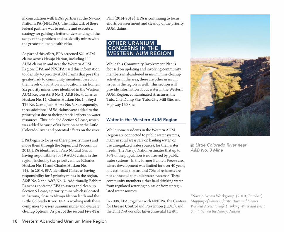
Western Abandoned Uranium Mine Regio18
Little Colorado River near A&B No. 3 Mine
in consultation with EPA’s partners at the Navajo Nation EPA (NNEPA). The initial task of these federal partners was to outline and execute a strategy for gaining a better understanding of the scope of the problem and to identify mines with the greatest human health risks.
As part of this effort, EPA screened 521 AUM claims across Navajo Nation, including 111 AUM claims in and near the Western AUM Region. EPA and NNEPA used this information to identify 43 priority AUM claims that pose the greatest risk to community members, based on their levels of radiation and location near homes. Six priority mines were identified in the Western AUM Region: A&B No. 2, A&B No. 3, Charles Huskon No. 12, Charles Huskon No. 14, Boyd Tisi No. 2, and Juan Horse No. 3. Subsequently, three additional AUM claims were added to the priority list due to their potential effects on water resources. This included Section 9 Lease, which was added because of its location near the Little Colorado River and potential effects on the river.
EPA began to focus on these priority mines and move them through the Superfund Process. In 2013, EPA identified El Paso Natural Gas as having responsibility for 19 AUM claims in the region, including two priority mines (Charles Huskon No. 12 and Charles Huskon No. 14). In 2014, EPA identified Coltec as having responsibility for 2 priority mines in the region, A&B No. 2 and A&B No. 3. Additionally, Babbitt Ranches contacted EPA to assess and clean up Section 9 Lease, a priority mine which is located in Arizona, close to Navajo Nation lands and the Little Colorado River. EPA is working with these companies to assess uranium mines and evaluate cleanup options. As part of the second Five-Year
Plan (2014-2018), EPA is continuing to focus efforts on assessment and cleanup of the priority AUM claims.
other uranium ConCerns in the Western aum region
While this Community Involvement Plan is focused on updating and involving community members in abandoned uranium mine cleanup activities in the area, there are other uranium issues in the region as well. This section will provide information about water in the Western AUM Region, contaminated structures, the Tuba City Dump Site, Tuba City Mill Site, and Highway 160 Site.
Water in the Western aum region
While some residents in the Western AUM Region are connected to public water systems, many in rural areas rely on hauling water, or use unregulated water sources, for their water needs. The Navajo Nation estimates that up to 30% of the population is not served by public water systems. In the former Bennett Freeze area, where development was limited for over 40 years, it is estimated that around 70% of residents are not connected to public water systems.2 These community members either haul drinking water from regulated watering points or from unregu-lated water sources.
2 Navajo Access Workgroup. (2010, October). Mapping of Water Infrastructure and Homes Without Access to Safe Drinking Water and Basic Sanitation on the Navajo Nation
In 2008, EPA, together with NNEPA, the Centers for Disease Control and Prevention (CDC), and the Diné Network for Environmental Health
n
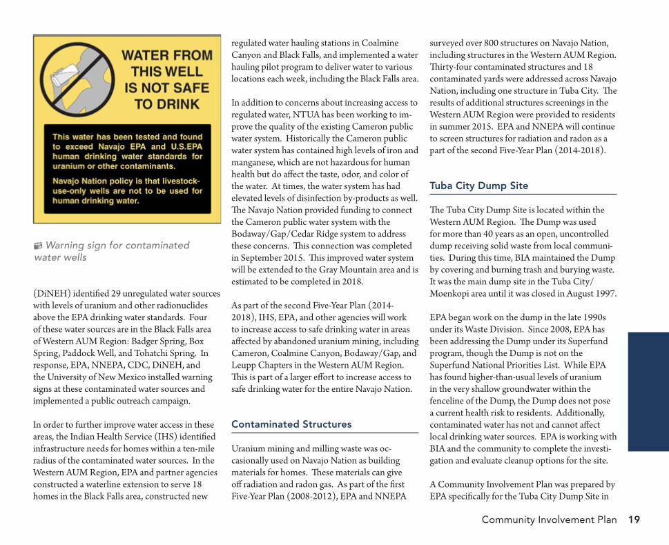
Community Involvement Plan 19
Warning sign for contaminated water wells
(DiNEH) identified 29 unregulated water sources with levels of uranium and other radionuclides above the EPA drinking water standards. Four of these water sources are in the Black Falls area of Western AUM Region: Badger Spring, Box Spring, Paddock Well, and Tohatchi Spring. In response, EPA, NNEPA, CDC, DiNEH, and the University of New Mexico installed warning signs at these contaminated water sources and implemented a public outreach campaign.
In order to further improve water access in these areas, the Indian Health Service (IHS) identified infrastructure needs for homes within a ten-mile radius of the contaminated water sources. In the Western AUM Region, EPA and partner agencies constructed a waterline extension to serve 18 homes in the Black Falls area, constructed new
regulated water hauling stations in Coalmine Canyon and Black Falls, and implemented a water hauling pilot program to deliver water to various locations each week, including the Black Falls area.
In addition to concerns about increasing access to regulated water, NTUA has been working to im-prove the quality of the existing Cameron public water system. Historically the Cameron public water system has contained high levels of iron and manganese, which are not hazardous for human health but do affect the taste, odor, and color of the water. At times, the water system has had elevated levels of disinfection by-products as well. The Navajo Nation provided funding to connect the Cameron public water system with the Bodaway/Gap/Cedar Ridge system to address these concerns. This connection was completed in September 2015. This improved water system will be extended to the Gray Mountain area and is estimated to be completed in 2018.
As part of the second Five-Year Plan (2014-2018), IHS, EPA, and other agencies will work to increase access to safe drinking water in areas affected by abandoned uranium mining, including Cameron, Coalmine Canyon, Bodaway/Gap, and Leupp Chapters in the Western AUM Region. This is part of a larger effort to increase access to safe drinking water for the entire Navajo Nation.
Contaminated structures
Uranium mining and milling waste was oc-casionally used on Navajo Nation as building materials for homes. These materials can give off radiation and radon gas. As part of the first Five-Year Plan (2008-2012), EPA and NNEPA
surveyed over 800 structures on Navajo Nation, including structures in the Western AUM Region. Thirty-four contaminated structures and 18 contaminated yards were addressed across Navajo Nation, including one structure in Tuba City. The results of additional structures screenings in the Western AUM Region were provided to residents in summer 2015. EPA and NNEPA will continue to screen structures for radiation and radon as a part of the second Five-Year Plan (2014-2018).
tuba City dump site
The Tuba City Dump Site is located within the Western AUM Region. The Dump was used for more than 40 years as an open, uncontrolled dump receiving solid waste from local communi-ties. During this time, BIA maintained the Dump by covering and burning trash and burying waste. It was the main dump site in the Tuba City/Moenkopi area until it was closed in August 1997.
EPA began work on the dump in the late 1990s under its Waste Division. Since 2008, EPA has been addressing the Dump under its Superfund program, though the Dump is not on the Superfund National Priorities List. While EPA has found higher-than-usual levels of uranium in the very shallow groundwater within the fenceline of the Dump, the Dump does not pose a current health risk to residents. Additionally, contaminated water has not and cannot affect local drinking water sources. EPA is working with BIA and the community to complete the investi-gation and evaluate cleanup options for the site.
A Community Involvement Plan was prepared by EPA specifically for the Tuba City Dump Site in
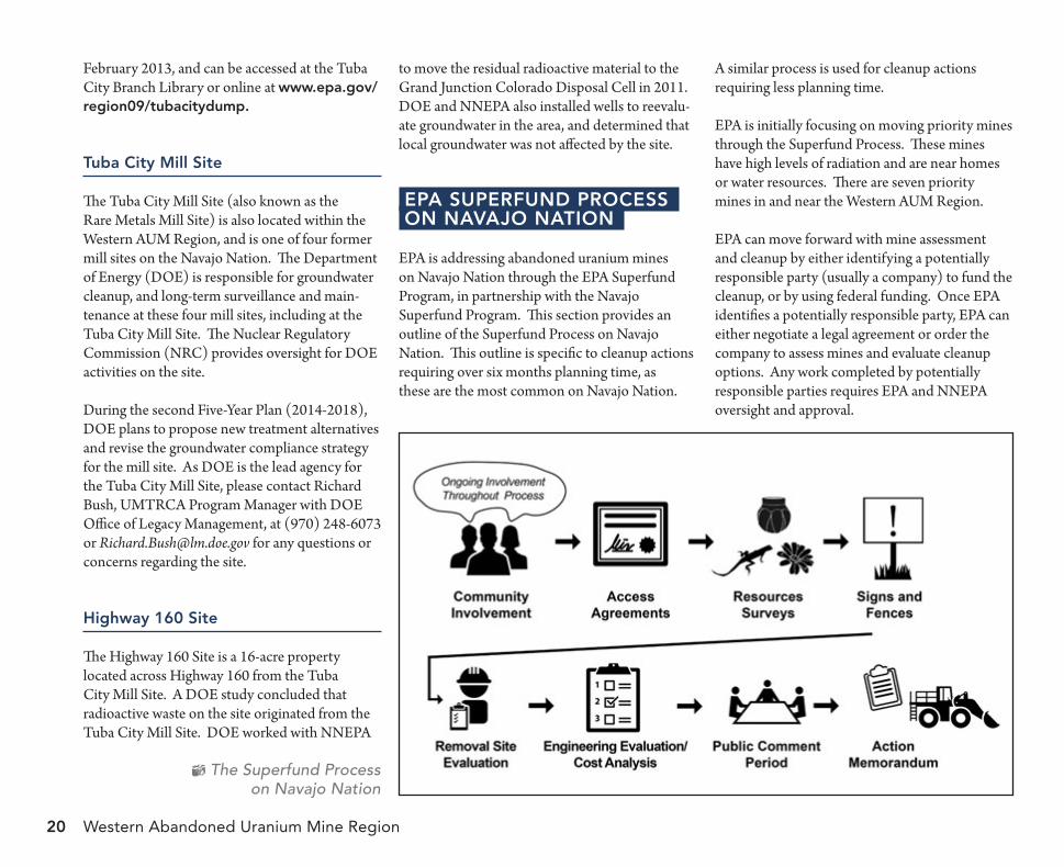
Western Abandoned Uranium Mine Region20
February 2013, and can be accessed at the Tuba City Branch Library or online at www.epa.gov/region09/tubacitydump.
tuba City mill site
The Tuba City Mill Site (also known as the Rare Metals Mill Site) is also located within the Western AUM Region, and is one of four former mill sites on the Navajo Nation. The Department of Energy (DOE) is responsible for groundwater cleanup, and long-term surveillance and main-tenance at these four mill sites, including at the Tuba City Mill Site. The Nuclear Regulatory Commission (NRC) provides oversight for DOE activities on the site.
During the second Five-Year Plan (2014-2018), DOE plans to propose new treatment alternatives and revise the groundwater compliance strategy for the mill site. As DOE is the lead agency for the Tuba City Mill Site, please contact Richard Bush, UMTRCA Program Manager with DOE Office of Legacy Management, at (970) 248-6073 or [email protected] for any questions or concerns regarding the site.
highway 160 site
The Highway 160 Site is a 16-acre property located across Highway 160 from the Tuba City Mill Site. A DOE study concluded that radioactive waste on the site originated from the Tuba City Mill Site. DOE worked with NNEPA
The Superfund Process on Navajo Nation
to move the residual radioactive material to the Grand Junction Colorado Disposal Cell in 2011. DOE and NNEPA also installed wells to reevalu-ate groundwater in the area, and determined that local groundwater was not affected by the site.
ePa suPerfund ProCesson navaJo nation
EPA is addressing abandoned uranium mines on Navajo Nation through the EPA Superfund Program, in partnership with the Navajo Superfund Program. This section provides an outline of the Superfund Process on Navajo Nation. This outline is specific to cleanup actions requiring over six months planning time, as these are the most common on Navajo Nation.
A similar process is used for cleanup actions requiring less planning time.
EPA is initially focusing on moving priority mines through the Superfund Process. These mines have high levels of radiation and are near homes or water resources. There are seven priority mines in and near the Western AUM Region.
EPA can move forward with mine assessment and cleanup by either identifying a potentially responsible party (usually a company) to fund the cleanup, or by using federal funding. Once EPA identifies a potentially responsible party, EPA can either negotiate a legal agreement or order the company to assess mines and evaluate cleanup options. Any work completed by potentially responsible parties requires EPA and NNEPA oversight and approval.
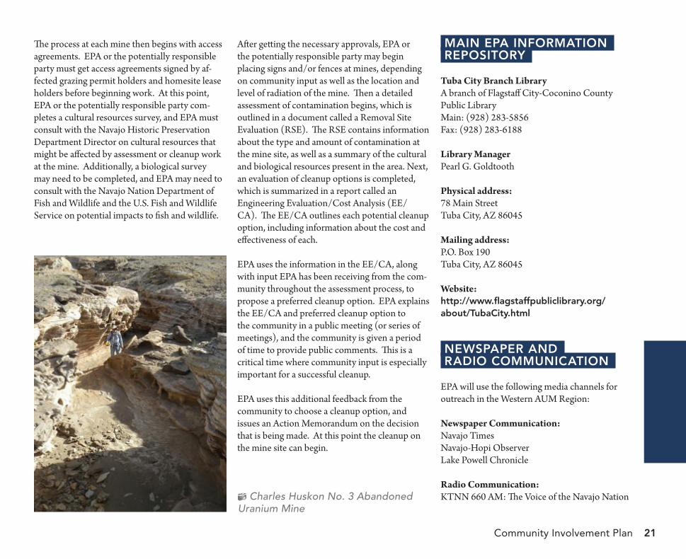
Community Involvement Plan 21
The process at each mine then begins with access agreements. EPA or the potentially responsible party must get access agreements signed by af-fected grazing permit holders and homesite lease holders before beginning work. At this point, EPA or the potentially responsible party com-pletes a cultural resources survey, and EPA must consult with the Navajo Historic Preservation Department Director on cultural resources that might be affected by assessment or cleanup work at the mine. Additionally, a biological survey may need to be completed, and EPA may need to consult with the Navajo Nation Department of Fish and Wildlife and the U.S. Fish and Wildlife Service on potential impacts to fish and wildlife.
After getting the necessary approvals, EPA or the potentially responsible party may begin placing signs and/or fences at mines, depending on community input as well as the location and level of radiation of the mine. Then a detailed assessment of contamination begins, which is outlined in a document called a Removal Site Evaluation (RSE). The RSE contains information about the type and amount of contamination at the mine site, as well as a summary of the cultural and biological resources present in the area. Next, an evaluation of cleanup options is completed, which is summarized in a report called an Engineering Evaluation/Cost Analysis (EE/CA). The EE/CA outlines each potential cleanup option, including information about the cost and effectiveness of each.
EPA uses the information in the EE/CA, along with input EPA has been receiving from the com-munity throughout the assessment process, to propose a preferred cleanup option. EPA explains the EE/CA and preferred cleanup option to the community in a public meeting (or series of meetings), and the community is given a period of time to provide public comments. This is a critical time where community input is especially important for a successful cleanup.
EPA uses this additional feedback from the community to choose a cleanup option, and issues an Action Memorandum on the decision that is being made. At this point the cleanup on the mine site can begin.
Charles Huskon No. 3 Abandoned Uranium Mine
main ePa informationrePository
Tuba City Branch LibraryA branch of Flagstaff City-Coconino County Public LibraryMain: (928) 283-5856Fax: (928) 283-6188
Library ManagerPearl G. Goldtooth
Physical address:78 Main StreetTuba City, AZ 86045
Mailing address:P.O. Box 190Tuba City, AZ 86045
Website:http://www.flagstaffpubliclibrary.org/about/tubaCity.html
neWsPaPer and radio CommuniCation
EPA will use the following media channels for outreach in the Western AUM Region:
Newspaper Communication:Navajo TimesNavajo-Hopi ObserverLake Powell Chronicle
Radio Communication:KTNN 660 AM: The Voice of the Navajo Nation
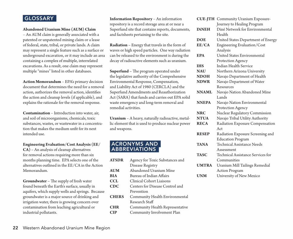
Western Abandoned Uranium Mine Region22
glossary
Abandoned Uranium Mine (AUM) Claim – An AUM claim is generally associated with a patented or unpatented mining claim or a lease of federal, state, tribal, or private lands. A claim may represent a single feature such as a surface or underground excavation, or it may include an area containing a complex of multiple, interrelated excavations. As a result, one claim may represent multiple “mines” listed in other databases.
Action Memorandum – EPA’s primary decision document that determines the need for a removal action, authorizes the removal action, identifies the action and cleanup levels (if applicable), and explains the rationale for the removal response.
Contamination – Introduction into water, air, and soil of microorganisms, chemicals, toxic substances, wastes, or wastewater in a concentra-tion that makes the medium unfit for its next intended use.
Engineering Evaluation/Cost Analysis (EE/CA) – An analysis of cleanup alternatives for removal actions requiring more than six months planning time. EPA selects one of the alternatives outlined in the EE/CA in the Action Memorandum.
Groundwater – The supply of fresh water found beneath the Earth’s surface, usually in aquifers, which supply wells and springs. Because groundwater is a major source of drinking and irrigation water, there is growing concern over contamination from leaching agricultural or industrial pollutants.
Information Repository – An information repository is a record storage area at or near a Superfund site that contains reports, documents, and factsheets pertaining to the site.
Radiation – Energy that travels in the form of waves or high speed particles. One way radiation can be released to the environment is during the decay of radioactive elements such as uranium.
Superfund – The program operated under the legislative authority of the Comprehensive Environmental Response, Compensation, and Liability Act of 1980 (CERCLA) and the Superfund Amendments and Reauthorization Act (SARA) that funds and carries out EPA solid waste emergency and long-term removal and remedial activities.
Uranium – A heavy, naturally radioactive, metal-lic element that is used to produce nuclear power and weapons.
aCronyms andabbreviations
ATSDR Agency for Toxic Substances and Disease Registry
AUM Abandoned Uranium MineBIA Bureau of Indian AffairsCCL Clinical Cohort LiaisonsCDC Centers for Disease Control and
PreventionCHERS Community Health Environmental
Research StaffCHR Community Health RepresentativeCIP Community Involvement Plan
CUE-JTH Community Uranium Exposure-Journey to Healing Program
DiNEH Diné Network for Environmental Health
DOE United States Department of EnergyEE/CA Engineering Evaluation/Cost
AnalysisEPA United States Environmental
Protection AgencyIHS Indian Health ServiceNAU Northern Arizona UniversityNDOH Navajo Department of HealthNDWR Navajo Department of Water
ResourcesNNAML Navajo Nation Abandoned Mine
LandsNNEPA Navajo Nation Environmental
Protection AgencyNRC Nuclear Regulatory CommissionNTUA Navajo Tribal Utility AuthorityRECA Radiation Exposure Compensation
ActRESEP Radiation Exposure Screening and
Education ProgramTANA Technical Assistance Needs
AssessmentTASC Technical Assistance Services for
CommunitiesUMTRA Uranium Mill Tailings Remedial
Action ProgramUNM University of New Mexico
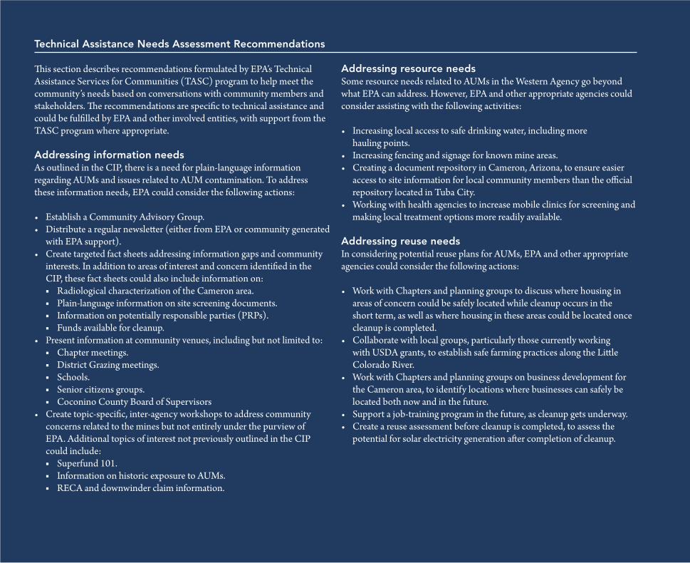
Community Involvement Plan 23
technical assistance needs assessment recommendations
This section describes recommendations formulated by EPA’s Technical Assistance Services for Communities (TASC) program to help meet the community’s needs based on conversations with community members and stakeholders. The recommendations are specific to technical assistance and could be fulfilled by EPA and other involved entities, with support from the TASC program where appropriate.
addressing information needsAs outlined in the CIP, there is a need for plain-language information regarding AUMs and issues related to AUM contamination. To address these information needs, EPA could consider the following actions:
Establish a Community Advisory Group.•Distribute a regular newsletter (either from EPA or community generated •with EPA support).Create targeted fact sheets addressing information gaps and community •interests. In addition to areas of interest and concern identified in the CIP, these fact sheets could also include information on:
Radiological characterization of the Cameron area. ■Plain-language information on site screening documents. ■Information on potentially responsible parties (PRPs). ■Funds available for cleanup. ■
Present information at community venues, including but not limited to:•Chapter meetings. ■District Grazing meetings. ■Schools. ■Senior citizens groups. ■Coconino County Board of Supervisors ■
Create topic-specific, inter-agency workshops to address community •concerns related to the mines but not entirely under the purview of EPA. Additional topics of interest not previously outlined in the CIP could include:
Superfund 101. ■Information on historic exposure to AUMs. ■RECA and downwinder claim information. ■
addressing resource needsSome resource needs related to AUMs in the Western Agency go beyond what EPA can address. However, EPA and other appropriate agencies could consider assisting with the following activities:
Increasing local access to safe drinking water, including more •hauling points.Increasing fencing and signage for known mine areas.•Creating a document repository in Cameron, Arizona, to ensure easier •access to site information for local community members than the official repository located in Tuba City.Working with health agencies to increase mobile clinics for screening and •making local treatment options more readily available.
addressing reuse needsIn considering potential reuse plans for AUMs, EPA and other appropriate agencies could consider the following actions:
Work with Chapters and planning groups to discuss where housing in •areas of concern could be safely located while cleanup occurs in the short term, as well as where housing in these areas could be located once cleanup is completed.Collaborate with local groups, particularly those currently working •with USDA grants, to establish safe farming practices along the Little Colorado River.Work with Chapters and planning groups on business development for •the Cameron area, to identify locations where businesses can safely be located both now and in the future.Support a job-training program in the future, as cleanup gets underway.•Create a reuse assessment before cleanup is completed, to assess the •potential for solar electricity generation after completion of cleanup.
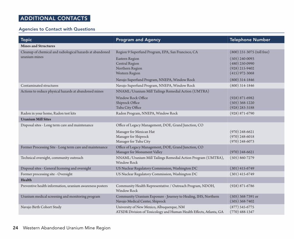
Western Abandoned Uranium Mine Region24
additional ContaCts
agencies to Contact with Questions
topic Program and agency telephone numberMines and StructuresCleanup of chemical and radiological hazards at abandoned uranium mines
Region 9 Superfund Program, EPA, San Francisco, CA
Eastern RegionCentral RegionNorthern RegionWestern Region
(800) 231-3075 (toll free)
(505) 240-0093(480) 250-0990(928) 215-9402(415) 972-3068
Navajo Superfund Program, NNEPA, Window Rock (800) 314-1846Contaminated structures Navajo Superfund Program, NNEPA, Window Rock (800) 314-1846Actions to reduce physical hazards at abandoned mines NNAML/Uranium Mill Tailings Remedial Action (UMTRA)
Window Rock OfficeShiprock OfficeTuba City Office
(928) 871-6982(505) 368-1220(928) 283-3188
Radon in your home, Radon test kits Radon Program, NNEPA, Window Rock (928) 871-6790Uranium Mill SitesDisposal sites - Long term care and maintenance Office of Legacy Management, DOE, Grand Junction, CO
Manager for Mexican HatManager for ShiprockManager for Tuba City
(970) 248-6621(970) 248-6018(970) 248-6073
Former Processing Site - Long term care and maintenance Office of Legacy Management, DOE, Grand Junction, COManager for Monument Valley (970) 248-6621
Technical oversight, community outreach NNAML/Uranium Mill Tailings Remedial Action Program (UMTRA), Window Rock
(505) 860-7279
Disposal sites - General licensing and oversight US Nuclear Regulatory Commission, Washington DC (301) 415-6749Former processing site - Oversight US Nuclear Regulatory Commission, Washington DC (301) 415-6749HealthPreventive health information, uranium awareness posters Community Health Representative / Outreach Program, NDOH,
Window Rock(928) 871-6786
Uranium medical screening and monitoring program Community Uranium Exposure - Journey to Healing, IHS, Northern Navajo Medical Center, Shiprock
(505) 368-7391 or(505) 368-7402
Navajo Birth Cohort Study University of New Mexico, Albuquerque, NM ATSDR Division of Toxicology and Human Health Effects, Atlanta, GA
(877) 545-6775(770) 488-1347
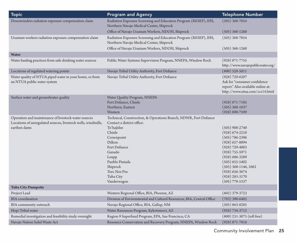
Community Involvement Plan 25
topic Program and agency telephone numberDownwinders radiation exposure compensation claim Radiation Exposure Screening and Education Program (RESEP), IHS, (505) 368-7054
Northern Navajo Medical Center, Shiprock Office of Navajo Uranium Workers, NDOH, Shiprock (505) 368-1260
Uranium workers radiation exposure compensation claim Radiation Exposure Screening and Education Program (RESEP), IHS, (505) 368-7054Northern Navajo Medical Center, ShiprockOffice of Navajo Uranium Workers, NDOH, Shiprock (505) 368-1260
WaterWater hauling practices from safe drinking water sources Public Water Systems Supervision Program, NNEPA, Window Rock (928) 871-7755
http://www.navajopublicwater.org/Locations of regulated watering points Navajo Tribal Utility Authority, Fort Defiance (800) 528-5011Water quality of NTUA piped water in your home, or from Navajo Tribal Utility Authority, Fort Defiance (928) 729-6207an NTUA public water system Ask for “consumer confidence
report.” Also available online at: http://www.ntua.com/ccr14.html
Surface water and groundwater quality Water Quality Program, NNEPAFort Defiance, Chinle (928) 871-7185Northern, Eastern (505) 368-1037Western (928) 890-7599
Operation and maintenance of livestock water sources Technical, Construction, & Operations Branch, NDWR, Fort DefianceLocations of unregulated sources, livestock wells, windmills, Contact a district office:earthen dams To’hajiilee (505) 908-2740
Chinle (928) 674-2210Crownpoint (505) 786-2396Dilkon (928) 657-8094Fort Defiance (928) 729-4003Ganado (928) 755-5971Leupp (928) 686-3289Pueblo Pintada (505) 655-5402Shiprock (505) 368-1146, 1062Teec Nos Pos (928) 656-3674Tuba City (928) 283-3170Vanderwagon (505) 778-5337
Tuba City DumpsiteProject Lead Western Regional Office, BIA, Phoenix, AZ (602) 379-3723BIA coordination Division of Environmental and Cultural Resources, BIA, Central Office (703) 390-6482BIA community outreach Navajo Regional Office, BIA, Gallup, NM (505) 863-8285Hopi Tribal water Water Resources Program, Kykotsmovi, AZ (928) 734-3712Remedial investigation and feasibility study oversight Region 9 Superfund Program, EPA, San Francisco, CA (800) 231-3075 (toll free)Navajo Nation Solid Waste Act Resource Conservation and Recovery Program, NNEPA, Window Rock (928) 871-7816
Western Abandoned Uranium Mine Region epa.gov/r9uraniumcleanup/western-abandoned-uranium-mine-region
Community Involvement PlanOctober 2016