Embed Size (px)
Citation preview
Hillsboro Airport Parallel Runway Project Port of Portland July 2009
Wetland Functions and Values Assessment

Wetland Functions and Values Assessment Hillsboro Airport Parallel Runway Project
Prepared for: Port of Portland
7000 NE Airport Way Portland, OR 97218
Contact: Maureen Minister (503) 460-4682
Prepared by:
317 SW Alder Street, Suite 800 Portland, OR 97204
Contact: Matt Kuziensky (503) 248-9507 ext. 236
July 2009

This document should be cited as: ICF Jones & Stokes. 2009. Wetland Functions and Values Assessment. Hillsboro Airport Parallel Runway Project. July. (ICF J&S 00265.08.) Portland, OR. Prepared for the Port of Portland.
July 2009 i
Table of Contents 1.0 Introduction ............................................................................. 1
2.0 Project Description ................................................................. 1 2.1 Existing Site Conditions ................................................ 2
2.1.1 Topography ............................................................................ 2 2.1.2 Soils ....................................................................................... 2 2.1.3 Hydrology ............................................................................... 2 2.1.4 Land Use (Historical Disturbance) ......................................... 3 2.1.5 Existing Wetlands and Other Waters ..................................... 3
3.0 Methodology ........................................................................... 6 3.1 Assessment Method ...................................................... 6 3.2 Representative Sample and Reference Site ................. 7
4.0 Assessment Results .............................................................. 8 4.1 Wetland Functions ........................................................ 8
4.1.1 Water Storage and Delay ....................................................... 9 4.1.2 Sediment Stabilization and Phosphorus Retention ................ 9 4.1.3 Nitrogen Removal .................................................................. 9 4.1.4 Thermoregulation ................................................................... 9 4.1.5 Primary Production .............................................................. 10 4.1.6 Resident Fish Habitat Support ............................................. 10 4.1.7 Anadromous Fish Habitat Support ....................................... 10 4.1.8 Invertebrate Habitat Support ................................................ 10 4.1.9 Amphibian and Turtle Habitat ............................................... 10 4.1.10 Breeding Waterbird Support ................................................. 11 4.1.11 Wintering and Migrating Waterbird Support ......................... 11 4.1.12 Songbird Habitat Support ..................................................... 11 4.1.13 Support of Characteristic Vegetation ................................... 11
4.2 Wetland Values ........................................................... 12
5.0 Summary ............................................................................... 12
6.0 References ............................................................................ 13
HGM Functional Assessment Report
Hillsboro Airport Parallel Runway Project ii
Appendices Appendix A Figures
Appendix B Functional Assessment Data Forms
Tables Table 1. Wetlands and Other Waters Identified on the Study Area during 2008-2009. ...... 4
Table 2. Wetlands and Other Waters Previously Identified on the Study Area in 2004 ...... 5
Table 3. Summary of Function Scores and Ratings by Assessed Wetland ........................ 8
Table 4. Summary of Value Scores and Ratings by Assessed Wetland .......................... 12
Acronyms and Abbreviations proposed project proposed Hillsboro Airport Parallel Runway Project
DSL Oregon Department of State Lands
HUC Hydrologic Unit Code
PEM palustrine emergent
Port Port of Portland
1987 Manual 1987 U.S. Army Corps of Engineers Wetland Delineation Manual
Oregon-HGM Guidebook for Hydrogeomorphic (HGM)-based Assessment of Oregon Wetland and Riparian Sites: I. Willamette Valley Ecoregion Riverine Impounding and Slope/Flats Subclasses
July 2009 1
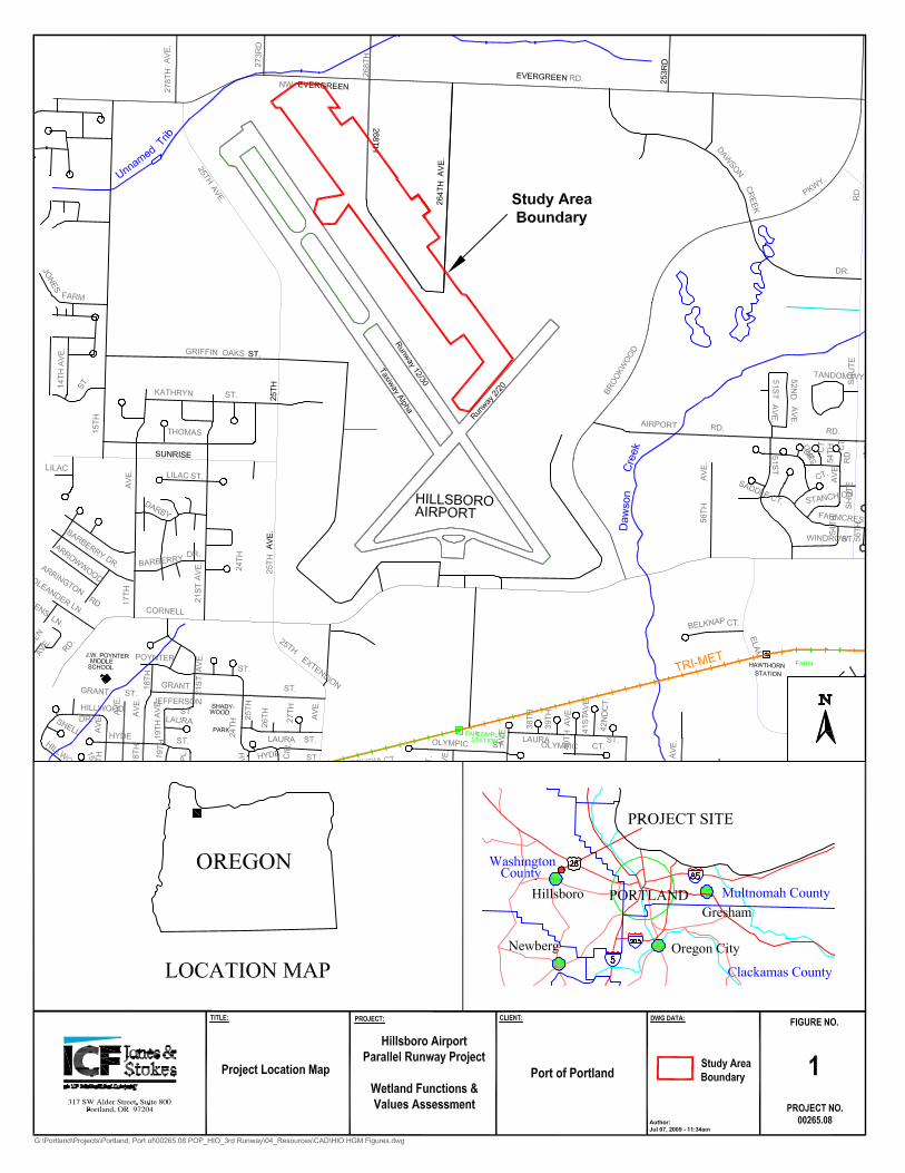
1.0 Introduction ICF Jones & Stokes was retained by the Port of Portland (Port) to perform a functions and values assessment for the wetlands present within the study area of the Hillsboro Airport Parallel Runway Project (proposed project) at Hillsboro Airport in Washington County, Oregon (Appendix A, Figure 1). This assessment was conducted as part of the Joint Section 404/Removal-Fill Permit Application for the proposed project, and for use in the preparation of a compensatory wetland mitigation plan. The following report provides a summary of the proposed project and the existing conditions present within the study area; describes the methodology used to perform the functions and values assessment; and presents the results of the assessment. It also includes a discussion of the assessment conclusions and the rationale behind the assignment of function and value scores.
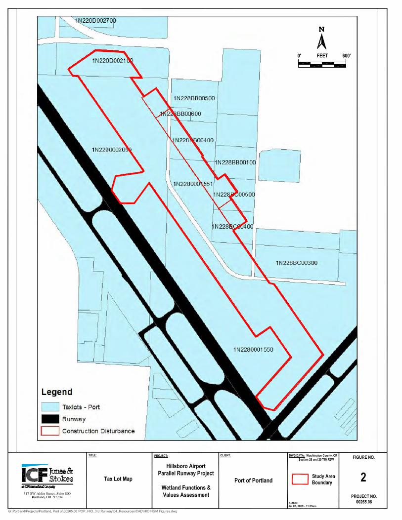
2.0 Project Description The 76.0-acre study area is situated in the northeast quarter of Hillsboro Airport, which is located at 3355 NE Cornell Road in the City of Hillsboro, Washington County, Oregon (Appendix A, Figure 1). The study area lies in Sections 20, 28, and 29 of Township 1 North, Range 2 West and includes the following Tax Lots: 1N220D002100, 1N2280001550, 1N2280001551, 1N228BB00100, 1N228BB00400, 1N228BB00600, 1N228BC00300, 1N228BC00400, 1N228BC00500, and 1N2290002050 (Appendix A, Figure 2).
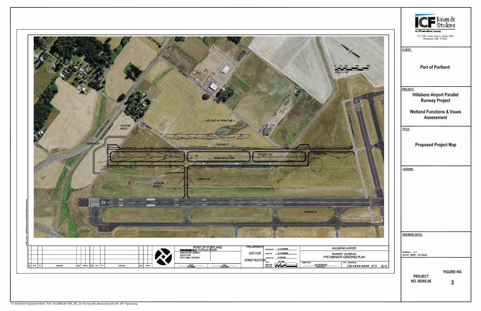
On this site, the Port, owner and operator of Hillsboro Airport, proposes to expand the existing capacity of the airport by constructing a new runway, an associated taxiway, and a new helicopter pad (helipad) (Appendix A, Figure 3). The proposed runway, Runway 12L/30R, would be built parallel to and approximately 700 feet east of existing Runway 12/30, Hillsboro Airport’s primary runway. The new taxiway, Taxiway D, would be built parallel to the proposed runway. Since the proposed runway would occur on the site of the existing helipad, a new helipad would need to be constructed. The proposed location for this new helipad is approximately 500 feet east of the new runway, providing separation of rotary wing aircraft training from fixed wing aircraft operations.
The proposed project would occur in three phases. Taxiway D would be built first in 2010, followed by the construction of the new runway in 2011, and finally by construction of the ne helipad in 2015, dependent on air traffic levels. Once constructed, Taxiway D would be used as an interim replacement for the helipad until air traffic levels warrant construction of the new helipad.
As proposed, the project would cause unavoidable impacts on 2.37 acres of potential wetlands and other waters of the state/U.S through the excavation of approximately 1,769 cubic yards of material from, and the placement of approximately 1,592 cubic yards of fill material into these areas. The limits of construction disturbance encompass an area of approximately 76.0 acres. All of the identified wetlands and other waters within these limits would be permanently impacted by the proposed work.
HGM Functional Assessment Report
Hillsboro Airport Parallel Runway Project 2
2.1 Existing Site Conditions In order to provide background information for the functions and values assessment, a summary of the principal physical attributes of the study area are provided in the following sections.
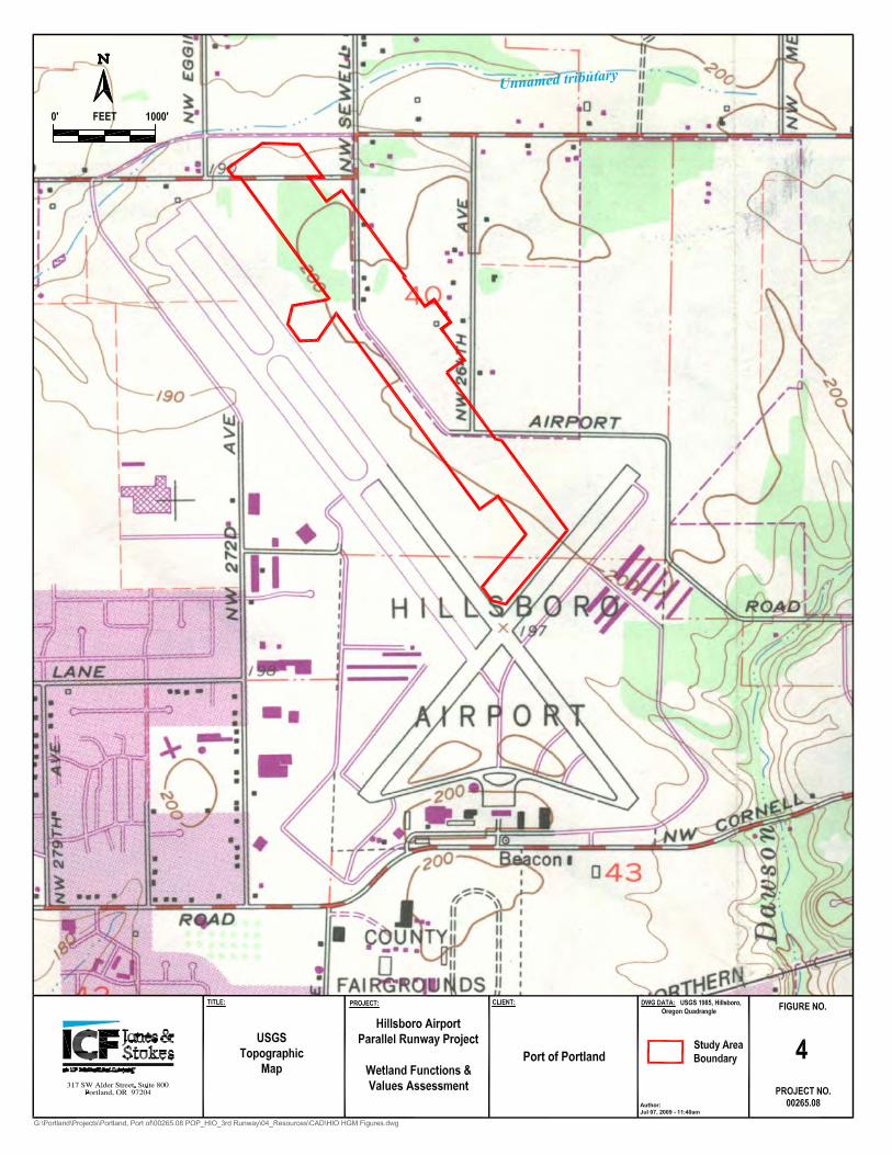
2.1.1 Topography Hillsboro Airport is located on the northeast side of the City of Hillsboro on the flat agricultural lands in the Tualatin watershed of the Willamette River subbasin. According to the Hillsboro, Oregon topographic quadrangle (U.S. Geological Survey 1961), topography in the majority of the study area is primarily flat and is located approximately 200 feet above mean sea level (Appendix A, Figure 4). The majority of the topographic relief is afforded by historic fills and excavations as a result of past land development and agricultural activities.
2.1.2 Soils The study area lies at the northern boundary of the Willamette Valley, a broad erosional and structural basin located between the Coast Range to the west and the Cascade Range to the east. Originating in the Coast Range, the Tualatin River and its main tributaries flow generally eastward to the Willamette River and are the water systems influencing the Hillsboro area. The historical meanderings of the Tualatin and Willamette rivers have deposited unconsolidated alluvium material over marine sedimentary rocks, sandstone, and siltstone from formations during the Eocene to Oligocene epochs (Green 1982).
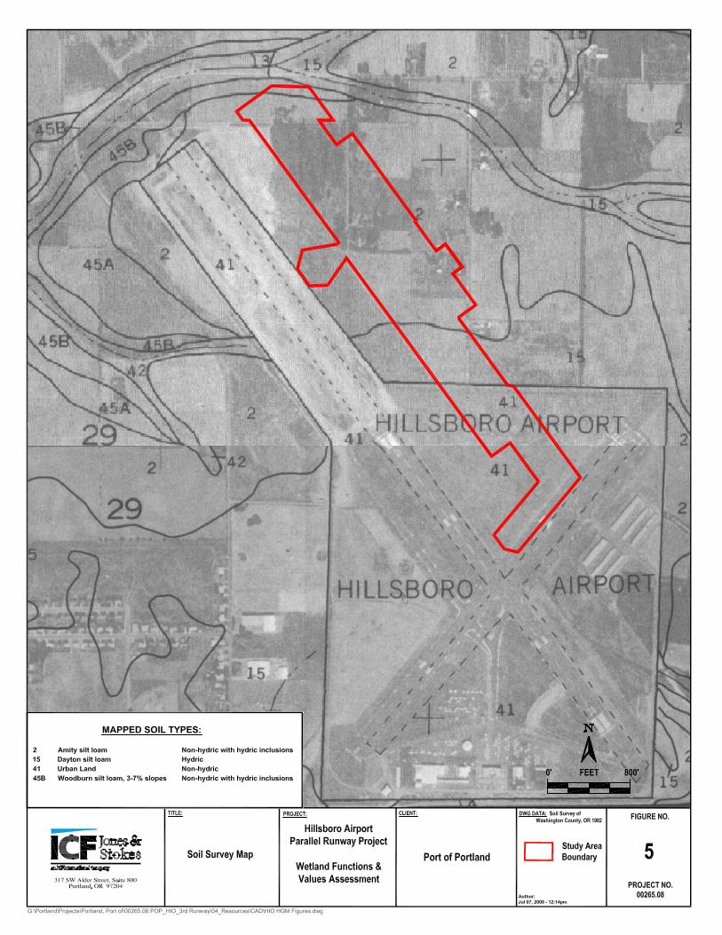
The Soil Survey of Washington County, Oregon (Green 1982) has mapped three soils in the study area: Amity silt loam, Dayton silt loam, and Urban Land (Appendix A, Figure 5). The local hydric soil list for Washington County (Natural Resources Conservation Service 2006) does not show the Amity series as hydric, but indicates that this soil series is known to contain hydric inclusions. Dayton silt loam is listed as hydric. Urban Land is listed as non-hydric and is not known to contain hydric inclusions. The soils in the study area generally formed in valley terraces.
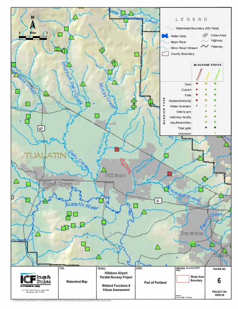
2.1.3 Hydrology Located in the Tualatin River watershed, the study area lies within the Dawson Creek and McKay Creek drainages. The hydrologic unit code (HUC) for this area is 17090010. The northern portion of Hillsboro Airport drains to the unnamed tributary to McKay Creek (Appendix A, Figure 6). McKay Creek is a tributary to Dairy Creek, which eventually drains to the Tualatin River. The southern portion of the study area drains to the east to Dawson Creek, which flows into Rock Creek, approximately 1 mile from its confluence with the Tualatin River.
Within the study area, drainage and natural runoff have been greatly manipulated. The majority of the study area has been in agricultural production since before 1976. Many of the original drainage tiles have failed or were removed during the helipad construction. The remaining
HGM Functional Assessment Report
July 2009 3
drainage tiles generally direct sub-surface water into collector ditches that flow off site and eventually into tributaries of McKay and Dawson creeks. After precipitation events, surface water generally ponds in microtopographic depressions for 1 or 2 days before infiltrating the soil.
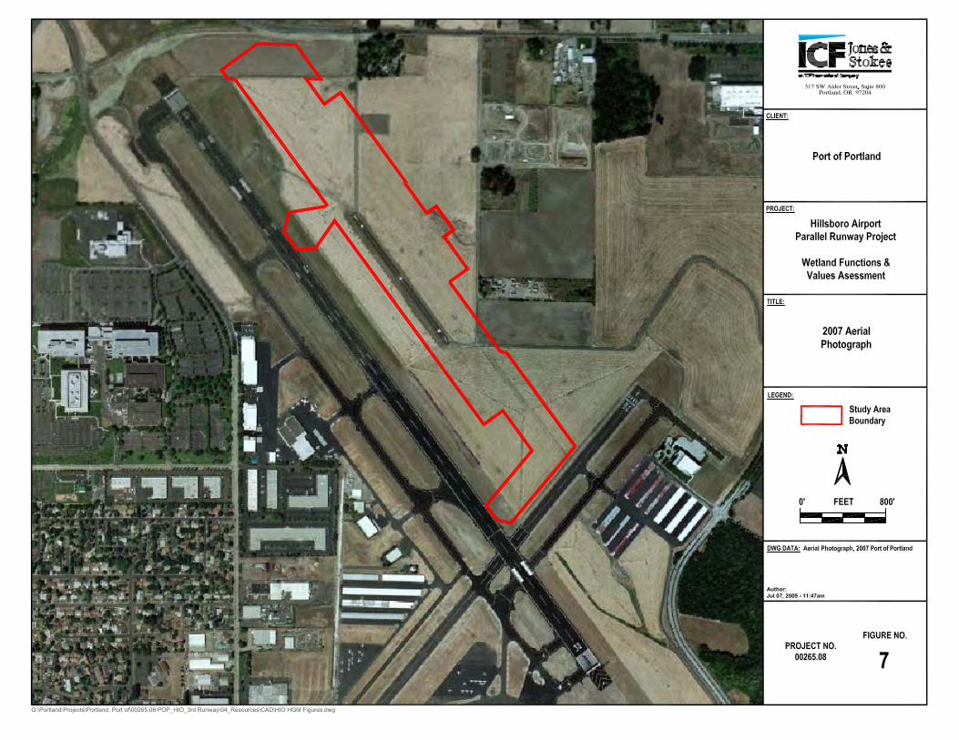
2.1.4 Land Use (Historical Disturbance) The 76.0 acre study area is located inside the Hillsboro Airport perimeter fence. Hillsboro Airport is currently operated as a public, general aviation airport (Appendix A, Figure 7). Within the airport perimeter fence: one main runway (Runway 12/30) parallels the western boundary of the study area from northwest to southeast; the cross-wind runway borders the southern boundary of the study area; and a helicopter training area, consisting of a small, narrow helipad only for helicopter use and a large, grassy knoll for slope operations, lies within the study area.
Prior to 1999, land use surrounding the study area was primarily agricultural and rural residential. In recent years, suburban residential, commercial, and industrial developments have replaced many of the larger agricultural fields. Within these urban areas, the vegetation and soils have been heavily influenced by a variety of human activities. The existing plant communities are generally dominated by a variety of grasses and other herbaceous species that reflect urban- and development related disturbances. Several smaller agricultural fields still exist both inside and outside of the airport’s perimeter fence. These fields are currently leased to farmers who use them for grass seed production. The study area lies within the northeast quarter of the airport property, where cultivation of grass occurs between the two runways. The construction of the helipad and regular airport maintenance activities have also altered the previous agriculturally dominated landscape. All of these activities directly influence the size, location, and quality of wetlands and waters in the study area.
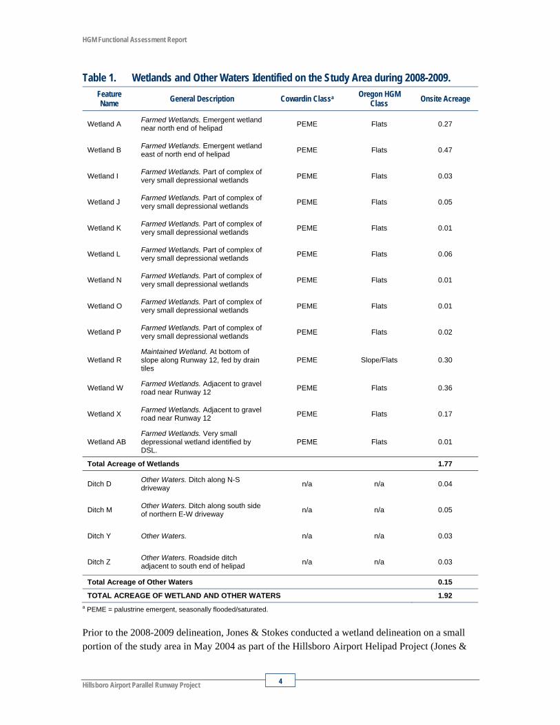
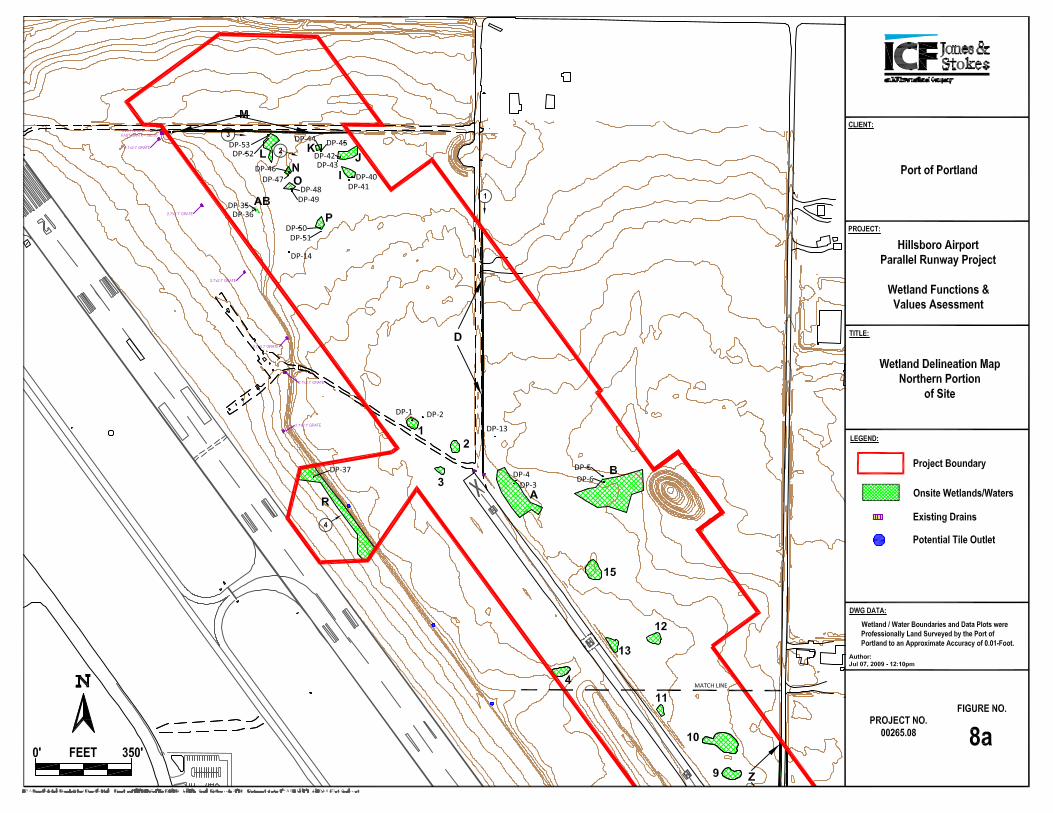
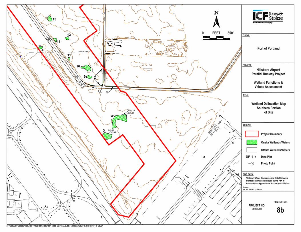
2.1.5 Existing Wetlands and Other Waters ICF Jones & Stokes delineated the 76.0 acre study area in 2008 and 2009 (ICF Jones & Stokes 2009) using the routine and atypical determination methods outlined in the 1987 Corps of Engineers Wetland Delineation Manual (1987 Manual; Environmental Laboratory 1987). Site visits to collect wetland delineation data were performed on March 26 and 27, 2008; April 1 and 2, 2008; and March 26, 2009. During these visits, a total of 13 palustrine emergent (PEM)-Slope/Flats wetlands (Wetlands A, B, I, J, K, L, N, O, P, R, W, X, and AB) totaling 1.77 acres in size, and four potential other waters of the state/United States (Ditches D, M, Y, and Z), totaling 0.15 acre in size were delineated (Appendix A, Figures 8a and 8b). Total acreage of these areas is approximately 1.92 acres (Table 1). ICF Jones & Stokes submitted this wetland delineation report to the Oregon Department of State Lands (DSL) on June 10, 2008. DSL performed a delineation verification site visit on December 30, 2008 and requested that additional data be collected for the project site. This additional information was provided to DSL in a revised delineation report submitted on July 10, 2009. A delineation concurrence letter was issued by DSL for this report on July 15, 2009 (WD #2008-0332).
HGM Functional Assessment Report
Hillsboro Airport Parallel Runway Project 4
Table 1. Wetlands and Other Waters Identified on the Study Area during 2008-2009. Feature Name General Description Cowardin Classa Oregon HGM
Class Onsite Acreage
Wetland A Farmed Wetlands. Emergent wetland near north end of helipad PEME Flats 0.27
Wetland B Farmed Wetlands. Emergent wetland east of north end of helipad PEME Flats 0.47
Wetland I Farmed Wetlands. Part of complex of very small depressional wetlands PEME Flats 0.03
Wetland J Farmed Wetlands. Part of complex of very small depressional wetlands PEME Flats 0.05
Wetland K Farmed Wetlands. Part of complex of very small depressional wetlands PEME Flats 0.01
Wetland L Farmed Wetlands. Part of complex of very small depressional wetlands PEME Flats 0.06
Wetland N Farmed Wetlands. Part of complex of very small depressional wetlands PEME Flats 0.01
Wetland O Farmed Wetlands. Part of complex of very small depressional wetlands PEME Flats 0.01
Wetland P Farmed Wetlands. Part of complex of very small depressional wetlands PEME Flats 0.02
Wetland R Maintained Wetland. At bottom of slope along Runway 12, fed by drain tiles
PEME Slope/Flats 0.30
Wetland W Farmed Wetlands. Adjacent to gravel road near Runway 12 PEME Flats 0.36
Wetland X Farmed Wetlands. Adjacent to gravel road near Runway 12 PEME Flats 0.17
Wetland AB Farmed Wetlands. Very small depressional wetland identified by DSL.
PEME Flats 0.01
Total Acreage of Wetlands 1.77
Ditch D Other Waters. Ditch along N-S driveway n/a n/a 0.04
Ditch M Other Waters. Ditch along south side of northern E-W driveway n/a n/a 0.05
Ditch Y Other Waters. n/a n/a 0.03
Ditch Z Other Waters. Roadside ditch adjacent to south end of helipad n/a n/a 0.03
Total Acreage of Other Waters 0.15
TOTAL ACREAGE OF WETLAND AND OTHER WATERS 1.92 a PEME = palustrine emergent, seasonally flooded/saturated.
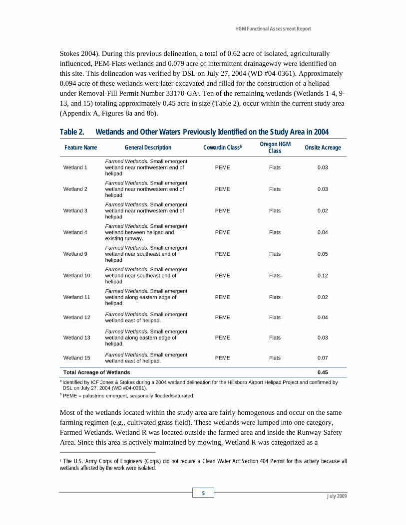
Prior to the 2008-2009 delineation, Jones & Stokes conducted a wetland delineation on a small portion of the study area in May 2004 as part of the Hillsboro Airport Helipad Project (Jones &
HGM Functional Assessment Report
July 2009 5
Stokes 2004). During this previous delineation, a total of 0.62 acre of isolated, agriculturally influenced, PEM-Flats wetlands and 0.079 acre of intermittent drainageway were identified on this site. This delineation was verified by DSL on July 27, 2004 (WD #04-0361). Approximately 0.094 acre of these wetlands were later excavated and filled for the construction of a helipad under Removal-Fill Permit Number 33170-GA1. Ten of the remaining wetlands (Wetlands 1-4, 9-13, and 15) totaling approximately 0.45 acre in size (Table 2), occur within the current study area (Appendix A, Figures 8a and 8b).
Table 2. Wetlands and Other Waters Previously Identified on the Study Area in 2004
Feature Name General Description Cowardin Classb Oregon HGM Class Onsite Acreage
Wetland 1 Farmed Wetlands. Small emergent wetland near northwestern end of helipad
PEME Flats 0.03
Wetland 2 Farmed Wetlands. Small emergent wetland near northwestern end of helipad
PEME Flats 0.03
Wetland 3 Farmed Wetlands. Small emergent wetland near northwestern end of helipad
PEME Flats 0.02
Wetland 4 Farmed Wetlands. Small emergent wetland between helipad and existing runway.
PEME Flats 0.04
Wetland 9 Farmed Wetlands. Small emergent wetland near southeast end of helipad
PEME Flats 0.05
Wetland 10 Farmed Wetlands. Small emergent wetland near southeast end of helipad
PEME Flats 0.12
Wetland 11 Farmed Wetlands. Small emergent wetland along eastern edge of helipad.
PEME Flats 0.02
Wetland 12 Farmed Wetlands. Small emergent wetland east of helipad. PEME Flats 0.04
Wetland 13 Farmed Wetlands. Small emergent wetland along eastern edge of helipad.
PEME Flats 0.03
Wetland 15 Farmed Wetlands. Small emergent wetland east of helipad. PEME Flats 0.07
Total Acreage of Wetlands 0.45 a Identified by ICF Jones & Stokes during a 2004 wetland delineation for the Hillsboro Airport Helipad Project and confirmed by
DSL on July 27, 2004 (WD #04-0361). b PEME = palustrine emergent, seasonally flooded/saturated.
Most of the wetlands located within the study area are fairly homogenous and occur on the same farming regimen (e.g., cultivated grass field). These wetlands were lumped into one category, Farmed Wetlands. Wetland R was located outside the farmed area and inside the Runway Safety Area. Since this area is actively maintained by mowing, Wetland R was categorized as a 1 The U.S. Army Corps of Engineers (Corps) did not require a Clean Water Act Section 404 Permit for this activity because all wetlands affected by the work were isolated.
HGM Functional Assessment Report
Hillsboro Airport Parallel Runway Project 6
Maintained Wetland. Many of the ditches mapped within the study area lack vegetation and are generally used to drain the farmed fields and portions of the airfield. They were identified for their conveyance function and potential connection to other waters.
3.0 Methodology
3.1 Assessment Method The functions and values of the wetlands within the study area were evaluated according to the methods and procedure prescribed in the Guidebook for Hydrogeomorphic (HGM)-based Assessment of Oregon Wetland and Riparian Sites: I. Willamette Valley Ecoregion Riverine Impounding and Slope/Flats Subclasses (Oregon-HGM) (Adamus et al. 2001). This methodology evaluates functions separately from values, because many functions have multiple, and sometimes conflicting, values. The assessment of wetland values is also considerably more subjective than the assessment of wetland functions.
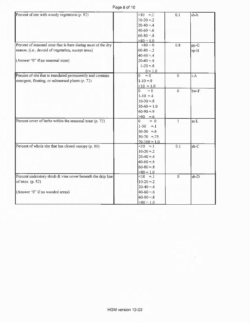
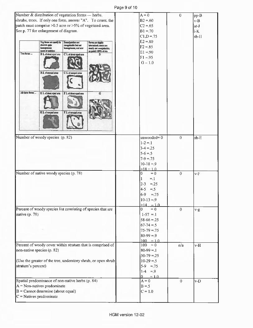
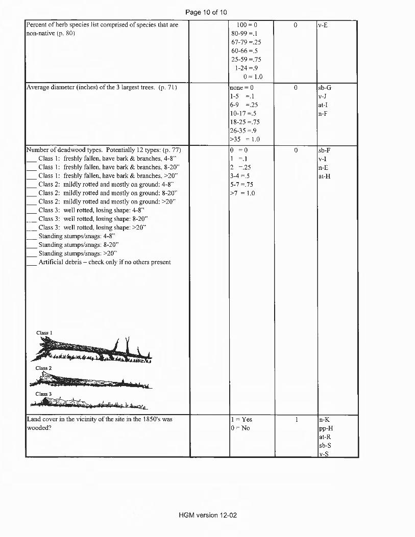
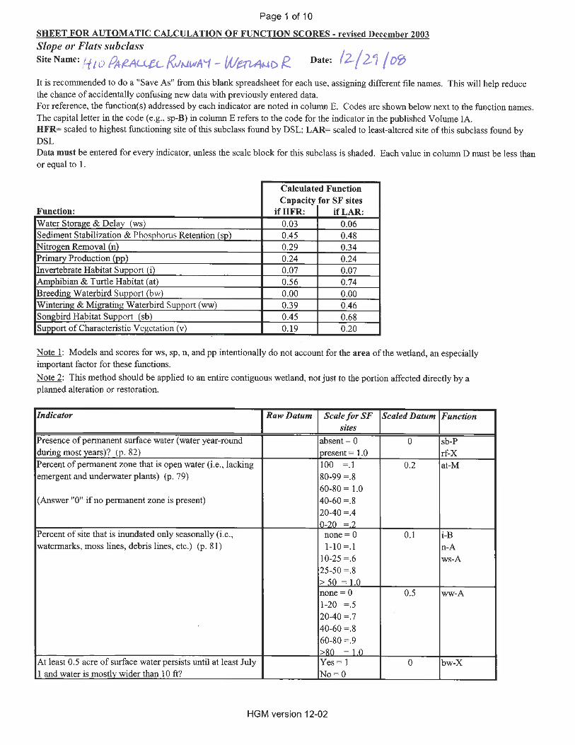
For wetland functions, the Oregon-HGM method provides procedures for evaluating the ability of a wetland to perform 13 functions2 using data collected by the visual observation of various indicators in the field, as well as information obtained from existing maps, aerial photographs, and other data sources (e.g., local soil surveys). Two assessment approaches are provided: (1) the Reference-Based Method, which assesses functions quantitatively by comparing observations of functional indicators in the wetland being assessed to data from reference wetlands; and (2) the Judgmental Method, which assesses functions based on a qualitative checklist. Currently, DSL has only collected reference data and published a guidebook for Riverine Impounding and Slope/Flat wetlands of the Willamette Valley (Adamus et al. 2001). As such, wetlands outside the Willamette Valley or within other HGM classes/subclasses are typically assessed using the Judgmental Method.
For the Reference-Based Method comparison, DSL has two standards: the Highest-Functioning standard, and the Least-Altered standard. The Highest-Functioning standard compares the assessment site(s) functional capacity score with the highest score found among all reference sites of the same class or subclass. The Least-Altered standard compares the assessment site(s) functional capacity score to the scores from the reference sites of the same class, that were determined to be the Least-Altered sites in the Willamette Valley during the field visits performed in 2000 (Adamus et al. 2001).
The Oregon-HGM methodology also provides a qualitative approach for assessing wetland values. This approach involves the comparison of the assessment site with descriptions of the
2 The 13 functions assessed by the Oregon-HGM are water storage and delay; sediment stabilization and phosphorus retention; nitrogen removal; thermoregulation; primary production; resident fish habitat support; anadromous fish habitat support; invertebrate habitat support; amphibian and turtle habitat support; breeding waterbird support; wintering and migratory waterbird support; songbird habitat support; and support of characteristic vegetation (Adamus et al. 2001).
HGM Functional Assessment Report
July 2009 7
highest and minimal values for a series of indicators that represent the same thirteen functions evaluated in the quantitative assessment. Both the opportunity of the site to perform these functions and their significance are addressed in the evaluation. The assessment site is then ranked on a 0-to-1 scale with 0 representing the minimal and 1 representing the highest of the function value descriptions. The method allows either an overall ranking of the site or the individual ranking of each indicator with the final ranking determined by averaging or some other method selected by the evaluator.
3.2 Representative Sample and Reference Site All of the wetlands delineated within the study area are considered PEME wetlands and classified as Flats or Slope/Flats wetlands under the Oregon-HGM classification system (Adamus 2001 et al.). Due to the heavily manipulated and maintained character of land in the study area, these wetlands are all very similar in size, topographic position, soil composition, vegetation, and hydrologic sources. Therefore, four representative wetlands were chosen to assess the 23 wetlands that would be impacted by the proposed project. These wetlands represent the minor differences amongst the 23 wetlands.
• Wetland R represents the mown, uncropped wetland in the Runway Safety Area.
• Wetland B represents the larger, mostly bare ground agricultural wetlands (Wetlands A, B, W, and X).
• Wetland K represents the wetlands located an area formally disturbed by residential buildings and construction activities and storage (Wetlands I, J, and K).
• Wetland 2 represents the smaller, isolated agricultural wetlands (Wetlands 1-15, L, N, O, P, and AB)
Site visits to collect data on wetland functions were conducted on April 2 and December 29, 2008. ICF Jones & Stokes compared these four wetlands to the Least-Altered Jackson-Frazier Prairie reference site (reference site). This 144-acre reference site is located northeast of Corvallis, Oregon and was selected based on its similarity in structure and situation in a prairie setting.
Prior to European settlement, the Hillsboro Airport property and surrounding areas were largely forested. Hillsboro Airport has been in existence since 1928 and operated by the Port since 1966. Throughout this period, vegetation and hydrology were altered by numerous projects; irrigation, livestock, and agricultural activities; and residential and commercial development. Plowing, seeding, and cultivating likely resulted in soil leveling that further altered natural soil characteristics.
HGM Functional Assessment Report
Hillsboro Airport Parallel Runway Project 8
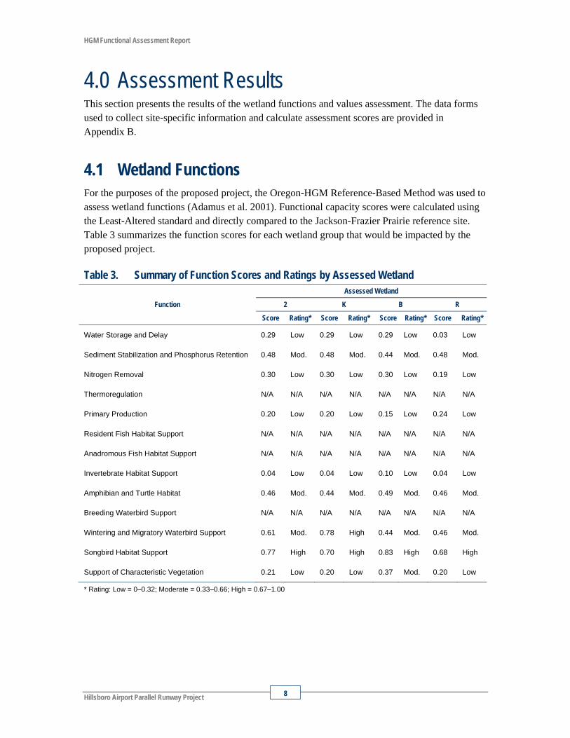
4.0 Assessment Results This section presents the results of the wetland functions and values assessment. The data forms used to collect site-specific information and calculate assessment scores are provided in Appendix B.
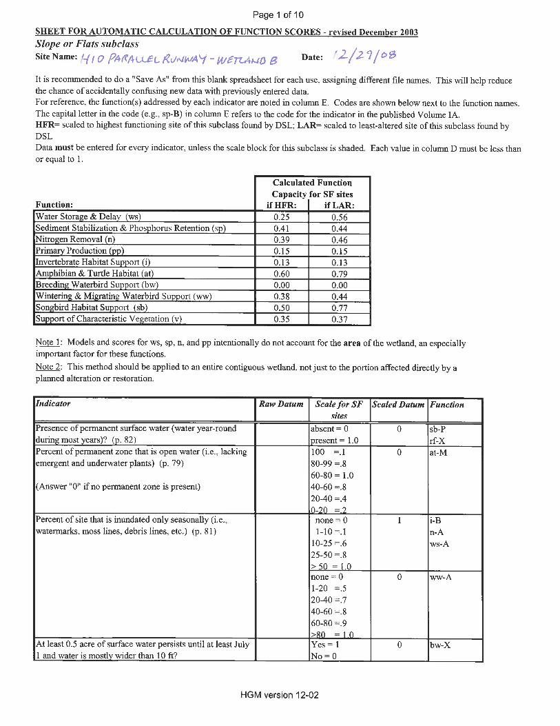
4.1 Wetland Functions For the purposes of the proposed project, the Oregon-HGM Reference-Based Method was used to assess wetland functions (Adamus et al. 2001). Functional capacity scores were calculated using the Least-Altered standard and directly compared to the Jackson-Frazier Prairie reference site. Table 3 summarizes the function scores for each wetland group that would be impacted by the proposed project.
Table 3. Summary of Function Scores and Ratings by Assessed Wetland
Function
Assessed Wetland
2 K B R
Score Rating* Score Rating* Score Rating* Score Rating*
Water Storage and Delay 0.29 Low 0.29 Low 0.29 Low 0.03 Low
Sediment Stabilization and Phosphorus Retention 0.48 Mod. 0.48 Mod. 0.44 Mod. 0.48 Mod.
Nitrogen Removal 0.30 Low 0.30 Low 0.30 Low 0.19 Low
Thermoregulation N/A N/A N/A N/A N/A N/A N/A N/A
Primary Production 0.20 Low 0.20 Low 0.15 Low 0.24 Low
Resident Fish Habitat Support N/A N/A N/A N/A N/A N/A N/A N/A
Anadromous Fish Habitat Support N/A N/A N/A N/A N/A N/A N/A N/A
Invertebrate Habitat Support 0.04 Low 0.04 Low 0.10 Low 0.04 Low
Amphibian and Turtle Habitat 0.46 Mod. 0.44 Mod. 0.49 Mod. 0.46 Mod.
Breeding Waterbird Support N/A N/A N/A N/A N/A N/A N/A N/A
Wintering and Migratory Waterbird Support 0.61 Mod. 0.78 High 0.44 Mod. 0.46 Mod.
Songbird Habitat Support 0.77 High 0.70 High 0.83 High 0.68 High
Support of Characteristic Vegetation 0.21 Low 0.20 Low 0.37 Mod. 0.20 Low
* Rating: Low = 0–0.32; Moderate = 0.33–0.66; High = 0.67–1.00
HGM Functional Assessment Report
July 2009 9
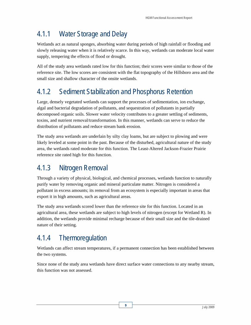
4.1.1 Water Storage and Delay Wetlands act as natural sponges, absorbing water during periods of high rainfall or flooding and slowly releasing water when it is relatively scarce. In this way, wetlands can moderate local water supply, tempering the effects of flood or drought.
All of the study area wetlands rated low for this function; their scores were similar to those of the reference site. The low scores are consistent with the flat topography of the Hillsboro area and the small size and shallow character of the onsite wetlands.
4.1.2 Sediment Stabilization and Phosphorus Retention Large, densely vegetated wetlands can support the processes of sedimentation, ion exchange, algal and bacterial degradation of pollutants, and sequestration of pollutants in partially decomposed organic soils. Slower water velocity contributes to a greater settling of sediments, toxins, and nutrient removal/transformation. In this manner, wetlands can serve to reduce the distribution of pollutants and reduce stream bank erosion.
The study area wetlands are underlain by silty clay loams, but are subject to plowing and were likely leveled at some point in the past. Because of the disturbed, agricultural nature of the study area, the wetlands rated moderate for this function. The Least-Altered Jackson-Frazier Prairie reference site rated high for this function.
4.1.3 Nitrogen Removal Through a variety of physical, biological, and chemical processes, wetlands function to naturally purify water by removing organic and mineral particulate matter. Nitrogen is considered a pollutant in excess amounts; its removal from an ecosystem is especially important in areas that export it in high amounts, such as agricultural areas.
The study area wetlands scored lower than the reference site for this function. Located in an agricultural area, these wetlands are subject to high levels of nitrogen (except for Wetland R). In addition, the wetlands provide minimal recharge because of their small size and the tile-drained nature of their setting.
4.1.4 Thermoregulation Wetlands can affect stream temperatures, if a permanent connection has been established between the two systems.
Since none of the study area wetlands have direct surface water connections to any nearby stream, this function was not assessed.
HGM Functional Assessment Report
Hillsboro Airport Parallel Runway Project 10
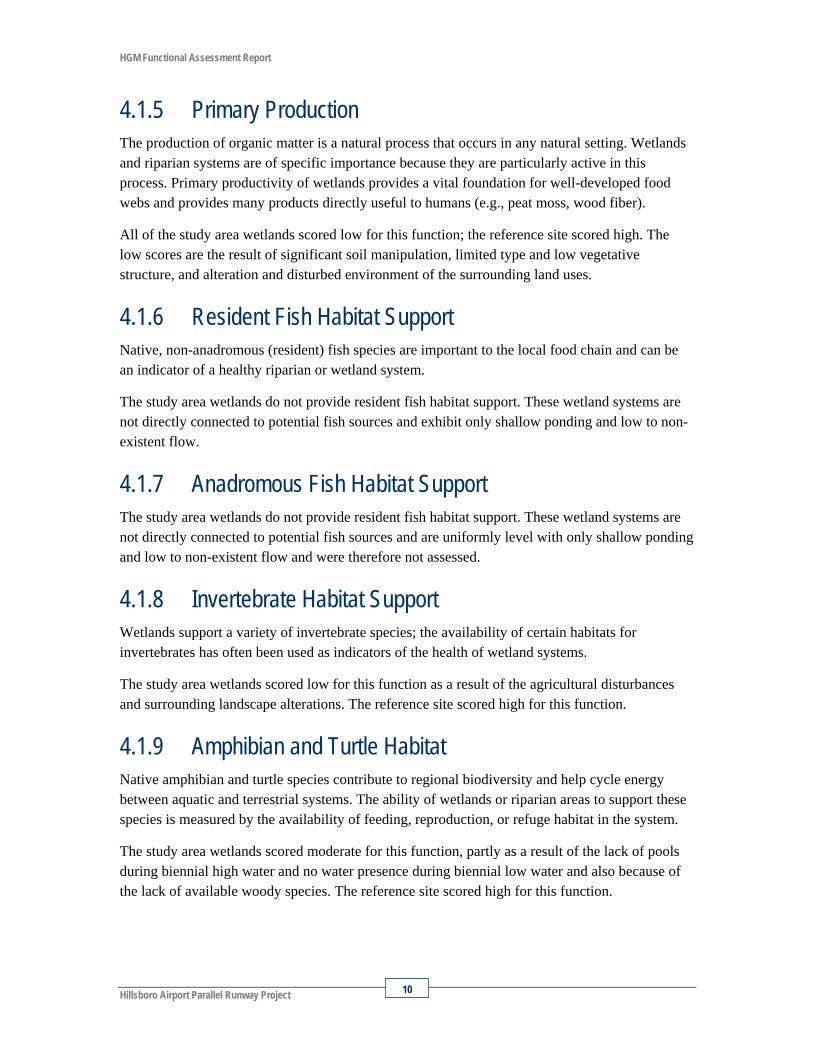
4.1.5 Primary Production The production of organic matter is a natural process that occurs in any natural setting. Wetlands and riparian systems are of specific importance because they are particularly active in this process. Primary productivity of wetlands provides a vital foundation for well-developed food webs and provides many products directly useful to humans (e.g., peat moss, wood fiber).
All of the study area wetlands scored low for this function; the reference site scored high. The low scores are the result of significant soil manipulation, limited type and low vegetative structure, and alteration and disturbed environment of the surrounding land uses.
4.1.6 Resident Fish Habitat Support Native, non-anadromous (resident) fish species are important to the local food chain and can be an indicator of a healthy riparian or wetland system.
The study area wetlands do not provide resident fish habitat support. These wetland systems are not directly connected to potential fish sources and exhibit only shallow ponding and low to non-existent flow.
4.1.7 Anadromous Fish Habitat Support The study area wetlands do not provide resident fish habitat support. These wetland systems are not directly connected to potential fish sources and are uniformly level with only shallow ponding and low to non-existent flow and were therefore not assessed.
4.1.8 Invertebrate Habitat Support Wetlands support a variety of invertebrate species; the availability of certain habitats for invertebrates has often been used as indicators of the health of wetland systems.
The study area wetlands scored low for this function as a result of the agricultural disturbances and surrounding landscape alterations. The reference site scored high for this function.
4.1.9 Amphibian and Turtle Habitat Native amphibian and turtle species contribute to regional biodiversity and help cycle energy between aquatic and terrestrial systems. The ability of wetlands or riparian areas to support these species is measured by the availability of feeding, reproduction, or refuge habitat in the system.
The study area wetlands scored moderate for this function, partly as a result of the lack of pools during biennial high water and no water presence during biennial low water and also because of the lack of available woody species. The reference site scored high for this function.
HGM Functional Assessment Report
July 2009 11
4.1.10 Breeding Waterbird Support The ability of a wetland or riparian system to support waterbirds during their reproductive period is measured as the availability of nesting, feeding, or refuge areas. Waterbird populations are economically, socially, and ecologically important on both regional and local scales.
The study area wetlands did not meet the minimum requirements for rating this function, because of their small size and drained nature.
4.1.11 Wintering and Migrating Waterbird Support The capacity of a wetland or riparian system to support wintering and migrating waterbirds can be measured as the availability of roosting, feeding, or refuge areas during the fall, winter, and/or spring. Waterbird populations are economically, socially, and ecologically important on both regional and local scales.
Wetlands 2, B, and R rated moderate for this function. The reference site also rated moderate for this function. Wetland K rated high for this function; the higher scores for this function were derived from the agricultural, open nature of the wetlands and surrounding area. However, the assessment method does not factor in the small scale of these wetlands. In addition, bird activity is discouraged within the Hillsboro Airport boundaries because of the risk of aircraft colliding with birds.
4.1.12 Songbird Habitat Support The ability of a wetland or riparian system to support songbird is measured as the availability of breeding, roosting, feeding, and/or refuge areas. Songbird populations contribute to regional biodiversity and support significant recreational interest.
The study area wetlands rated high for this function; the reference site also rated high. However, the Oregon-HGM assessment method does not factor in the small scale of these wetlands. In addition, bird activity is discouraged within the Hillsboro Airport boundaries because of the risk of aircraft colliding with birds.
4.1.13 Support of Characteristic Vegetation Plant communities are major influences on local species diversity and are also one of the largest contributors to regional biodiversity. Different types of communities (such as forested, scrub/shrub, grasslands) play a variety of roles on economical and ecological scales.
The study area wetlands scored low to moderate for this function; the reference site scored high. The low scores can be attributed to the agricultural and development disturbances. Wetland B rated slightly higher than the other rated wetlands due to its greater distance from a busy road (Evergreen Parkway).
HGM Functional Assessment Report
Hillsboro Airport Parallel Runway Project 12
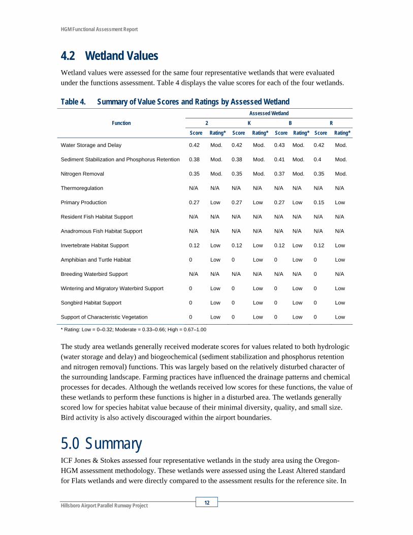
4.2 Wetland Values Wetland values were assessed for the same four representative wetlands that were evaluated under the functions assessment. Table 4 displays the value scores for each of the four wetlands.
Table 4. Summary of Value Scores and Ratings by Assessed Wetland
Function
Assessed Wetland
2 K B R
Score Rating* Score Rating* Score Rating* Score Rating*
Water Storage and Delay 0.42 Mod. 0.42 Mod. 0.43 Mod. 0.42 Mod.
Sediment Stabilization and Phosphorus Retention 0.38 Mod. 0.38 Mod. 0.41 Mod. 0.4 Mod.
Nitrogen Removal 0.35 Mod. 0.35 Mod. 0.37 Mod. 0.35 Mod.
Thermoregulation N/A N/A N/A N/A N/A N/A N/A N/A
Primary Production 0.27 Low 0.27 Low 0.27 Low 0.15 Low
Resident Fish Habitat Support N/A N/A N/A N/A N/A N/A N/A N/A
Anadromous Fish Habitat Support N/A N/A N/A N/A N/A N/A N/A N/A
Invertebrate Habitat Support 0.12 Low 0.12 Low 0.12 Low 0.12 Low
Amphibian and Turtle Habitat 0 Low 0 Low 0 Low 0 Low
Breeding Waterbird Support N/A N/A N/A N/A N/A N/A 0 N/A
Wintering and Migratory Waterbird Support 0 Low 0 Low 0 Low 0 Low
Songbird Habitat Support 0 Low 0 Low 0 Low 0 Low
Support of Characteristic Vegetation 0 Low 0 Low 0 Low 0 Low
* Rating: Low = 0–0.32; Moderate = 0.33–0.66; High = 0.67–1.00
The study area wetlands generally received moderate scores for values related to both hydrologic (water storage and delay) and biogeochemical (sediment stabilization and phosphorus retention and nitrogen removal) functions. This was largely based on the relatively disturbed character of the surrounding landscape. Farming practices have influenced the drainage patterns and chemical processes for decades. Although the wetlands received low scores for these functions, the value of these wetlands to perform these functions is higher in a disturbed area. The wetlands generally scored low for species habitat value because of their minimal diversity, quality, and small size. Bird activity is also actively discouraged within the airport boundaries.
5.0 Summary ICF Jones & Stokes assessed four representative wetlands in the study area using the Oregon-HGM assessment methodology. These wetlands were assessed using the Least Altered standard for Flats wetlands and were directly compared to the assessment results for the reference site. In
HGM Functional Assessment Report
July 2009 13
general, the study area wetlands scored lower than the reference site in all functions. The lower scores were expected because the reference site is a Least-Altered reference site and the rated wetlands are heavily manipulated and altered from agricultural practices.
6.0 References Adamus, P.R. 2001. Guidebook for Hydrogeomorphic (HGM)-based Assessment of Oregon
Wetland and Riparian Sites. I. Willamette Valley Ecoregion, Riverine Impounding and Slope/Flats Subclasses. Volume 1A: Assessment Methods. Oregon Department of State Lands, Salem, OR.
Environmental Laboratory. 1987. U.S. Army Corps of Engineers Wetland Delineation Manual. Technical Report Y-87-1. U.S. Army Waterways Experiment Station. Vicksburg, Mississippi. 100 pp. + appendices.
Green, George L. 1982. Soil Survey of Washington County, Oregon. U.S. Department of Agriculture. 589 pp. + tables.
ICF Jones & Stokes. 2009. Wetland Delineation Report. Hillsboro Airport Parallel Runway Project. July. (ICF J&S 00265.08.) Portland, OR. Prepared for the Port of Portland, Portland, OR.
Jones & Stokes. 2004. Wetland Delineation Report. Port of Portland Hillsboro Airport Helipad. Portland, OR. Prepared for the Port of Portland, Portland, OR.
Natural Resources Conservation Service. 2006. Hydric Soils List—Washington County, Oregon: Detailed Soil Map Legend. U.S. Department of Agriculture.
U.S. Geological Survey. 1961. Photo revised 1985. United States Geological Survey. 7.5’ Series (Topographic) – Hillsboro, Oregon Quadrangle.

Appendix A Figures
Figure 1. Project Location Map
Figure 2. Tax Lot Map
Figure 3. Proposed Project Map
Figure 4. USGS Topographic Map
Figure 5. Soil Survey Map
Figure 6. Watershed Map
Figure 7. 2007 Aerial Photograph
Figure 8a. Wetland Delineation Map – Northern Portion of Site
Figure 8b. Wetland Delineation Map – Southern Portion of Site


Appendix B Functional Assessment Data Forms