Embed Size (px)
Citation preview
WORLD METEOROLOGICAL ORGANIZATION
COMMISSION FOR BASIC SYSTEMS
DraftREGIONAL SUBPROJECT IMPLEMENTATION PLAN FOR THE
SEVERE WEATHER FORECASTINGDEMONSTRATION PROJECT (SWFDP) FOR THE EASTERN CARIBBEAN
Port de France, Martinique, 15 December 2016Miami, USA, 26 May 2017
IMPLEMENTATION PLAN(draft)
TABLE OF CONTENTS
1. Introduction....................................................................................................1
1.1 Principles of the SWFDP and ‘cascading forecasting process’........................................1 1.2 SWFDP as an end-to-end cross-programme collaborative activity.................................2 1.3 Vision, objectives and scope of SWFDP…………………………………………………………………………..2 1.4 The four phases of the SWFDP.......................................................................................4 1.5 Expected benefits of SWFDP..........................................................................................4
2. The Framework of the Regional Subproject in RA IV (the Caribbean).................6
2.1 Hydrometeorological hazards situation in the Caribbean…………………………………………………6
2.2 Foundation laid for formulation of a subproject in RA IV.................................................62.3 Key objectives................................................................................................................72.4 Participating countries, centres and organizations.........................................................72.5 Severe phenomena targeted within the framework of SWFDP-Eastern Caribbean.........82.6 Domain of the Subproject...............................................................................................82.7 Projects in synergy with SWFDP-Eastern Caribbean.......................................................92.8 Synergy between SWFDP and RA IV Hurricane Committee............................................9
3. Setting up a Management Structure................................................................9
3.1 Roles and responsibilities of the RSMT..........................................................................9 3.2 Identification of responsible organization in the region………………………………………………….9 3.3 Members of the RSMT....................................................................................................9 3.4 Responsibilities of members of the RSMT....................................................................10 4. Responsibilities of Participating/ Contributing Centres …………………………………12
4.1 Global Centres.............................................................................................................12 4.2 Regional Centres.........................................................................................................12 4.3 NMHSs.........................................................................................................................13
5. Training and capacity development...............................................................14
5.1 Training and capacity development requirements............................................................145.2 Training design and topics................................................................................................145.2 Other related opportunities..............................................................................................15
6. Monitoring and Evaluation.............................................................................15
6.1 Overview and requirements.............................................................................................156.2 Submission of Quarterly Progress Reports through SWFDP database...............................156.3 Feedback from users from the viewpoint of Service Delivery...........................................166.4 Timetable of implementation and execution....................................................................16
7. Costs............................................................................................................17
8. Sustainability and Criteria for transition to Phase IV.......................................17
9. Communication and publicity of the subproject..............................................19
10. List of Annexes............................................................................................19
11. References..................................................................................................20
ii

iii
Regional Subproject Implementation Plan (RSIP)Version 15 December 201626 May 2017
1. Introduction
1.1 Principles of the SWFDP and ‘Cascading Forecasting Process’
Numerical Weather Prediction (NWP) systems have become increasingly relevant and indeed essential to the severe weather forecasting process, with a growing number and variety of sophisticated outputs currently available from NWP producing centres. This had led the World Meteorological Congress, at its fifteenth session (Cg-XV, 2007), to provide vision on NWP strategy for developing countries to improve severe weather forecasting and warning services in the following words:
“NMHSs in developing countries are able to implement and maintain reliable and effective routine forecasting and severe weather warning programmes through enhanced use of NWP products and delivery of timely and authoritative forecasts and early warnings, thereby contributing to reducing the risk of disasters from natural hazards”.
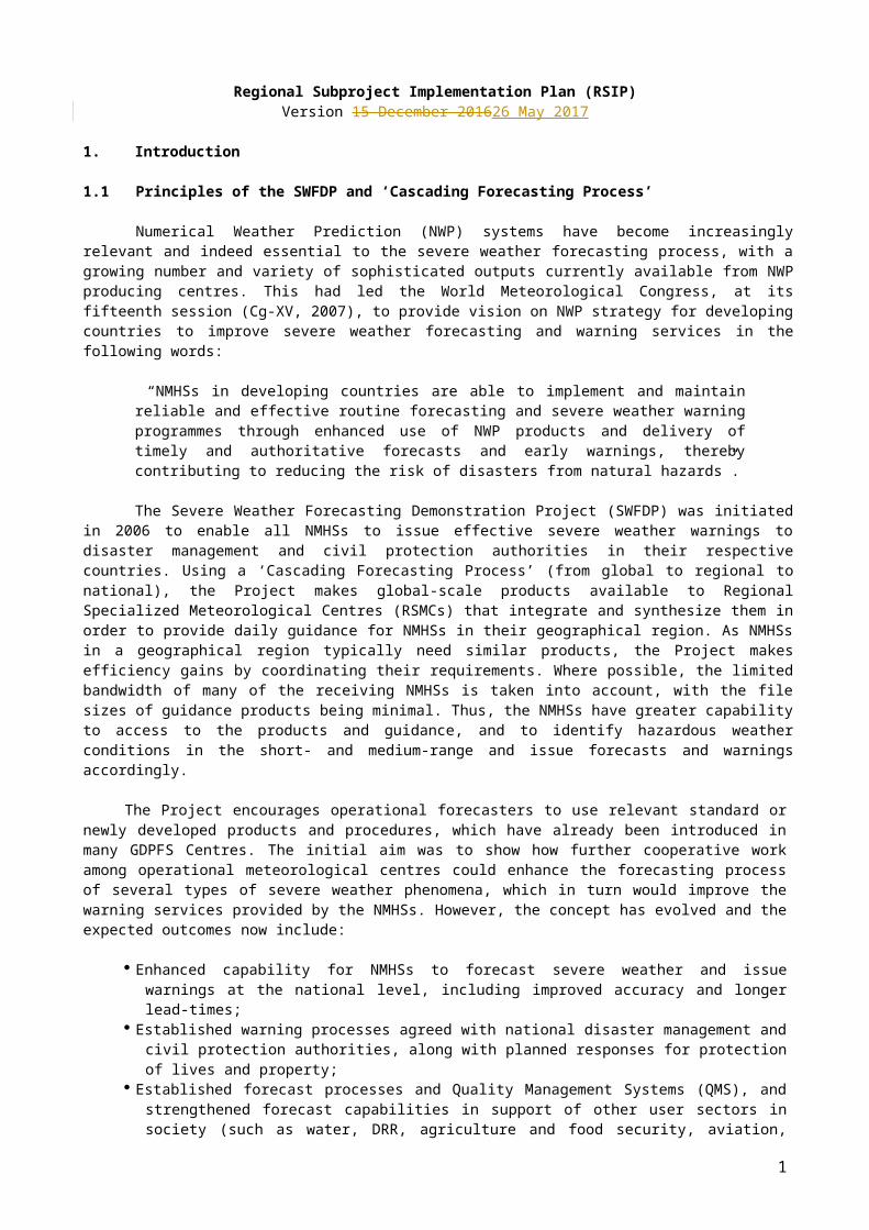
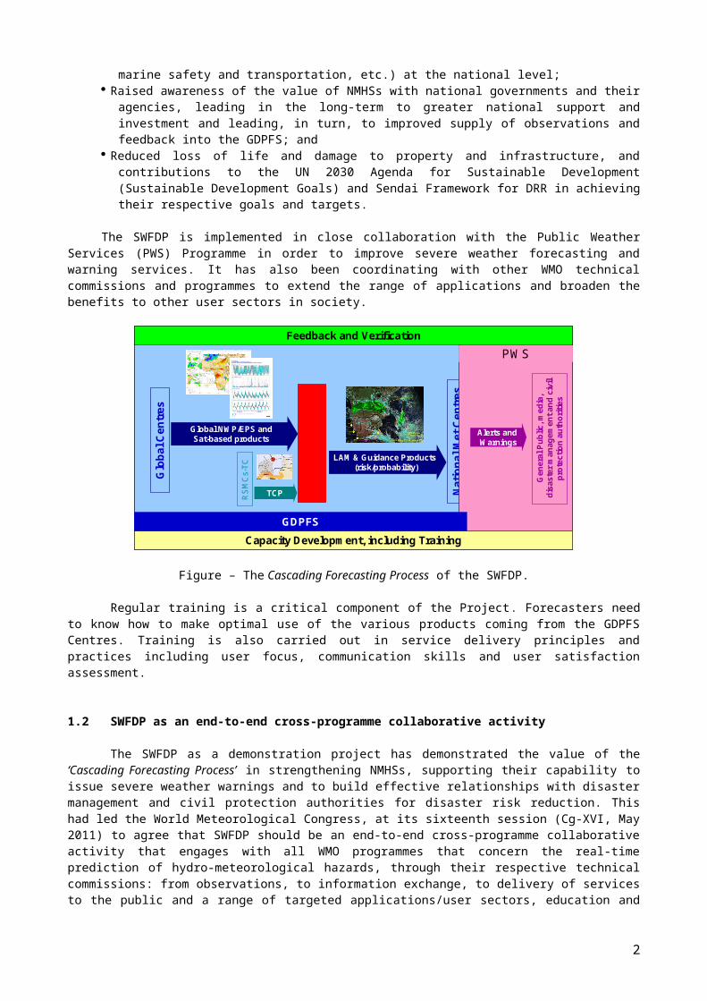
The Severe Weather Forecasting Demonstration Project (SWFDP) was initiated in 2006 to enable all NMHSs to issue effective severe weather warnings to disaster management and civil protection authorities in their respective countries. Using a ‘Cascading Forecasting Process’ (from global to regional to national), the Project makes global-scale products available to Regional Specialized Meteorological Centres (RSMCs) that integrate and synthesize them in order to provide daily guidance for NMHSs in their geographical region. As NMHSs in a geographical region typically need similar products, the Project makes efficiency gains by coordinating their requirements. Where possible, the limited bandwidth of many of the receiving NMHSs is taken into account, with the file sizes of guidance products being minimal. Thus, the NMHSs have greater capability to access to the products and guidance, and to identify hazardous weather conditions in the short- and medium-range and issue forecasts and warnings accordingly.
The Project encourages operational forecasters to use relevant standard or newly developed products and procedures, which have already been introduced in many GDPFS Centres. The initial aim was to show how further cooperative work among operational meteorological centres could enhance the forecasting process of several types of severe weather phenomena, which in turn would improve the warning services provided by the NMHSs. However, the concept has evolved and the expected outcomes now include:
Enhanced capability for NMHSs to forecast severe weather and issue warnings at the national level, including improved accuracy and longer lead-times;
Established warning processes agreed with national disaster management and civil protection authorities, along with planned responses for protection of lives and property;
Established forecast processes and Quality Management Systems (QMS), and strengthened forecast capabilities in support of other user sectors in society (such as water, DRR, agriculture and food security, aviation, marine safety and transportation, etc.) at the national level;
Raised awareness of the value of NMHSs with national governments and their agencies, leading in the long-term to greater national support and investment and leading, in turn, to improved supply of observations and feedback into the GDPFS; and
Reduced loss of life and damage to property and infrastructure, and contributions to the UN 2030 Agenda for Sustainable Development (Sustainable Development Goals) and Sendai Framework for DRR in achieving their respective goals and targets.
The SWFDP is implemented in close collaboration with the Public Weather Services (PWS) Programme in order to improve severe weather forecasting and warning services. It has also been coordinating with other WMO technical commissions and programmes to extend the range of applications and broaden the benefits to other user sectors in society.
1
Reg
iona
l Cen
tre
(RSM
Cs,
RFS
C, R
CC
s)
Glo
bal C
entr
es
RS
MC
s-TC
Global NWP/EPS andSat-based products
TCP
LAM & Guidance Products(risk/probability)
Nat
iona
l Met
Cen
tres
Alerts andWarnings
Gen
eral
Pub
lic, m
edia
, di
sast
er m
anag
emen
t and
civ
il pr
otec
tion
auth
oriti
es
Capacity Development, including Training
Feedback and VerificationPWS
Reg
iona
l Cen
tre
(RSM
Cs,
RFS
C, R
CC
s)
GDPFS
Reg
iona
l Cen
tre
(RSM
Cs,
RFS
C, R
CC
s)
Glo
bal C
entr
es
RS
MC
s-TC
Global NWP/EPS andSat-based products
TCP
LAM & Guidance Products(risk/probability)
Nat
iona
l Met
Cen
tres
Alerts andWarnings
Gen
eral
Pub
lic, m
edia
, di
sast
er m
anag
emen
t and
civ
il pr
otec
tion
auth
oriti
es
Capacity Development, including Training
Feedback and VerificationPWS
Reg
iona
l Cen
tre
(RSM
Cs,
RFS
C, R
CC
s)
GDPFS
Figure – The Cascading Forecasting Process of the SWFDP.
Regular training is a critical component of the Project. Forecasters need to know how to make optimal use of the various products coming from the GDPFS Centres. Training is also carried out in service delivery principles and practices including user focus, communication skills and user satisfaction assessment.
1.2 SWFDP as an end-to-end cross-programme collaborative activity
The SWFDP as a demonstration project has demonstrated the value of the ‘Cascading Forecasting Process’ in strengthening NMHSs, supporting their capability to issue severe weather warnings and to build effective relationships with disaster management and civil protection authorities for disaster risk reduction. This had led the World Meteorological Congress, at its sixteenth session (Cg-XVI, May 2011) to agree that SWFDP should be an end-to-end cross-programme collaborative activity that engages with all WMO programmes that concern the real-time prediction of hydro-meteorological hazards, through their respective technical commissions: from observations, to information exchange, to delivery of services to the public and a range of targeted applications/user sectors, education and training, capacity development and support to LDCs, and to the transfer of relevant promising research outputs into operations.
The SWFDP develops regional projects in a phased approach, with three phases of development and demonstration followed by a transition to sustainable operations in Phase IV (as explained in Para 1.4 below). In order to provide the resources to support expansion to cover additional regions towards global coverage, and to maintain a sustainable service in the regions which have reached Phase IV, the project should become a strategic programme of WMO supported by core funding and a permanently staffed Project Office. The SWFDP will continue to be guided by a project Steering Group (PSG) led from the CBS/DPFS, but now involving all relevant technical commissions and programmes.
1.3. Vision, Objectives and Scope of the SWFDP
The Cg-XVI (2011) approved a vision for the SWFDP as an end-to-end cross-programme collaborative activity led by the GDPFS, in which the participants in the Projects:
a) Make best possible use of all existing and newly developed products and facilities at the global, regional and national levels, including high-resolution NWP and ensemble prediction products, and very-short-range forecasting, including nowcasting, tools;
b) Establish sustainable services of reliable and effective early warnings tailored to the needs of the general public and a wide range of socio-economic sectors in developing countries including specially least developed countries (LDCs) and Small Island Developing States (SIDSs);
2
c) Ensure a continuous improvement cycle and quality assurance of services, including efficient and responsive feedback loops between the NMHSs and the end users at the national level.
According to the recommendations of the CBS-XIII (2005) the goals of the SWFDP are defined as follows:
to improve the ability of NMCs to forecast severe weather events; to improve the lead time of alerting of these events; to improve interaction of NMCs with DMCPA before and during events; to identify gaps and areas for improvements; to improve the skill of products from GDPFS centres through feedback from NMCs.
The scope of the SWFDP is to test the usefulness of the products currently available from NWP centres, including EPS products to improve severe weather forecasting services in WMO Members especially where the use of NWP model outputs is limited. Such a demonstration project would make use of the cascading forecasting approach to provide greater lead-time for severe weather warnings and would at the same time contribute to capacity development of the participating NMHSs and improving links with users including especially Disaster Management and Civil Protection Authorities (DMCPA). Given the need to work with DMCPA and media organizations to improve delivery of severe weather warning services to end users, the Public Weather Services (PWS) and DRR aspects are integrated into the SWFDP. Further, as part of WMO Strategy for Service Delivery (approved by Cg-17 , 2015), impact-based forecast and risk-based warnings will be introduced and strengthened through improved engagement of NMHSs with users as part of SWFDP implementation. Ultimately, SWFDP regional subprojects are expected to provide operational support to Multi-Hazard Early Warning Systems (MHEWS) at regional and national levels as envisioned in WMO Road Map for DRR.
Following ‘Cascading Forecasting Process’ Approach
In the framework of the general organization of the Global Data-Processing and Forecasting System (GDPFS), a SWFDP regional subproject implies a coordinated functioning among three types of GDPFS centres. Conceptually, it should involve one or more global centres, one regional centre and a number of NMHSs located within the area of responsibility of the regional centre. In practice, a project could involve additional regional centres, if beneficial and practical to do so. In case more than one regional centres are involved, one of the regional centres will serve as a lead Centre for regional forecast guidance support and coordination with participating NMHSs/NMCs. Such a regional centre shall preferably be selected from within the geographical area of SWFDP regional subproject.
The SWFDP is a way to apply the cascading approach for forecasting severe weather in three levels, as follows:
global centres to provide available NWP including EPS products, satellite information, nowcasting system etc.;
regional centres to interpret information received from global centres, run limited-area models to refine products, liaise with the participating NMCs including provision of forecast guidance;
NMCs to issue alerts, advisories, severe weather warnings; to collaborate with Media, and DMCPA; and to contribute to the evaluation of the project.
The participating centres will be required to adjust and tailor the list of products to the requirements of the particular regional subproject. 1.4. The Four Phases of the SWFDP
The development and implementation of SWFDP regional subprojects involve following four phases:
Phase I: Overall Project Planning. This phase includes: identification of the needs for support for NMHSs in consultation with concerned
Regional Association;
3
the preparatory work necessary to prepare the project specifications; to identify the possible participating centres; to select suitable regional subproject according to the geographical area, the type
of severe weather and the chosen period for the demonstration; engagement of funding organizations; and the list of types of products to be exchanged.
Phase II: Regional Subproject Implementation Planning and Execution. This phase involves: preparation of the detailed specifications, for example: data and products to be
exchanged, performance measurements, reviewing and reporting etc.; allowing the participants (representatives of the participating GDPFS centres)
forming a regional subproject management team to develop the specific regional subproject implementation plan, including a training programme, and to manage its implementation;
starting demonstration of the subproject which is likely to continue for 1-2 years; start submission of progress reports; identification of regional entity to take responsibility; and engagement with other projects providing similar support for related hazards (e.g.
FFGS).
Phase III: Regional Subproject Evaluation. This phase includes: the analysis and the evaluation of the entire subproject as well as its contributions
to the evaluation of the overall SWFDP with respect to the goals proposed initially; to identify gaps and deficiencies, and areas for improvement in order to ensure a
sustainability of the organization tested during the demonstration; and to provide improved specifications including for other similar regional subprojects.
Phase IV: Regional Subproject Long-term Sustainability and Future Developments. This phase includes: long-term sustainability of the benefits gained and a process of continual
improvement; to continuously take advantage of future capability and technology developments,
and to foster broadening of activities in synergy with other WMO projects and programmes; and
the responsibility for management, including seeking funding, lies with the relevant regional association or a regional entity identified by the regional association , while the PSG continues to be informed of developments and to provide advice as appropriate.
1.5 Expected Benefits of SWFDP
The SWFDP aims to demonstrate the benefits of applying the cascading forecast process for severe weather forecasting in the NMHSs, with the intention of not incurring research and development costs. It is viewed as a way to explore how the concept could benefit several NMHSs in the same geographical region while facilitating a certain level of harmonization of forecasts and warnings to render them consistent across the region.
The SWFDP will help strengthen the links between the NMHS, the DMCPA and the media. This in turn will increase the efficiency and effectiveness of the public warning services in case of severe weather events.
The SWFDP will provide the opportunity to encourage forecasters to use and experiment with standard products and recommended procedures, which have already been introduced in GDPFS centres and could be relevant to a number of NMHSs that have not yet used them.
The SWFDP will be a cross-programme activity lead by GDPFS in coordination with other related WMO programmes including AgM, AeM, HWR, TCP, MMO, ETR, SAT and WWRP to ensure that desired, sustainable and relevant outcomes are achievable
4
through implementation of SWFDP regional subprojects in synergy with other projects (e.g. FFGS, CIFDP, METAGRI etc.) as appropriate. Similar SWFDP cascading forecasting process can be applied to improve forecast and warnings for different hazards with multi hazard early warning system (MHEWS) approach including application of the process to benefit widest possible range of sectors such as agriculture and aviation.
The SWFDP underpins basic forecasting capabilities which also enable forecasting for other applications such as aviation and agriculture.
The SWFDP framework shall be used to implement modernizing enhancements to the forecasting process, as well as to provide a channel for the transfer of relevant promising S&T research and development outputs through trials, such as from the WWRP/THORPEX TIGGE project “Global Interactive Forecast System” (GIFS), and involves the WWRP/SERA to support effective propagation of benefits to society. Other examples include: Establish synergies with the High-Impact Weather (HIWeather) project, which
aims to develop new forecast and weather impact tools, and seek to trial them with SWFDP as an operational platform and link to end-users;
Link with Sub-seasonal to Seasonal (S2S) project for seamless forecasts; Continue to implement new verification methods through the SWFDP; Strengthen synergies with the Nowcasting research activities.
SWFDP regional subprojects represent the regional infrastructure to support national warnings programmes, including in collecting and conveying the requirements for the “Basic Systems” (including coordination with WIGOS and WIS), while addressing aspects related to severe weather forecasting and warning services. Examples of possible engagement of the other CBS OPAGs and CIMO include: WIGOS (e.g. Support for planning and developing/rehabilitating observing
networks, education and training in managing observing networks, support for improved integration of satellite data into operational work of NMHS, support for development of regional radar mosaics etc.)
WIS (e.g. support to enhance data collection, explore options for exchanging information between NMHSs and RTHs or/and send information to centres by means alternative to GTS)
SAT (e.g. SCOPE-NWC Nowcasting to support SWFDP with nowcasting capabilities, distribution of global and regional centre products through GEONETCAST)
Observations from WIGOS and SAT used in verification of severe weather forecast
In case a new development project (e.g. regional FFGS) under a WMO Programme is planned to be implemented in a geographical area of SWFDP, it should be appropriately reflected and included in the Regional Sub-Project Implementation Plan of SWFDP in that area. The geographic areas for the new project and the SWFDP should be aligned to meet the requirements of both, wherever feasible.
2. The Framework of SWFDP Regional Subproject in RA IV (the Eastern Caribbean)
2.1 Hydrometeorological hazards situation in the Eastern Caribbean
The Caribbean region has a long a history of natural disasters including those which are hydro-meteorological in nature, for example: hurricanes, strong winds, heavy rains, floods, earthquakes, volcanic eruptions, landslides and droughts. The economies of Small Island Developing States (SIDS) in the Caribbean are particularly adversely affected by these disasters. The adverse impact of hurricanes which are blend of heavy precipitation, severe thunderstorms, and extremely strong winds and associated storm surges can potentially change the course of whole planning and development activities in SIDS in the Caribbean.
5
In August 2015, tropical storm Erika caused devastation in several islands in the Caribbean. With at least 31 deaths, it proved to be the deadliest tropical storm in Dominica since hurricane David in 1979. It produced 321 mm of precipitation at Dominica’s Canefield Airport, causing catastrophic mudslides and flooding. Hundreds of homes were left uninhabitable and thousands of people were displaced. A total of 890 homes were destroyed or left uninhabitable while 14,291 people were rendered homeless, and some villages were flattened. Considering the overall damage in Dominica, the island was set back approximately 20 years in terms of development. Several other SIDS also experienced heavy rainfall during the passage of Erika. In Guadeloupe, heavy rainfall in the vicinity of Basse-Terre caused flooding and mudslides, forcing roads to temporarily close. Approximately 250,000 people in Puerto Rico were left without electricity. The island experienced US$17.37 million in agricultural damage. An unofficial weather station in Barahona (in Dominican Republic) measured 616 mm of rain, 220 mm in a single hour. Five people also died in Haiti, four from a weather-related traffic accident and one from a landslide. Total damage from Erika was estimated to be over US$500 million, with US$482.8 million in Dominica alone.
The NMHSs of SIDS in the Eastern Caribbean are relatively small with limited human and financial resources. The projected increase in the frequency of severe weather and climate extremes due to global warming is expected to pose more challenges for the Caribbean SIDS including for their small NMHSs to continuously improve forecasting of such events.
(More text to be added, needs revision)
2.2 Foundation laid for formulation of a Subproject in RA IV
The Regional Association IV (RA IV) Management Group has been, over the last two years, discussing the development of a WMO Severe Weather Forecasting Demonstration Project (SWFDP) for southern portions of RA IV. The RA IV Management Group created an Expert Group to further elaborate this demonstration project. In August 2016, the President of the RA IV formally requested that WMO initiate a SWFDP Regional Subproject in part of RA IV in the Caribbean. Météo-France Martinique has been proposed as the sub-regional operational facility to provide guidance to participating countries. Following this request, WMO Secretariat convened a meeting of RA IV Expert Group on SWFDP in Fore de France, Martinique, during 13-15 December 2016. The main objective of the meeting is to develop an outline of the Regional Subproject Implementation Plan (RSIP) for SWFDP-Caribbean as per guidelines provided in the “SWFDP Guidebook for Developing Regional Subprojects” including to identify the potential global NWP and satellite centres, regional centres and participating countries and list of required products and training needs, and list of hydrometeorological hazards criteria to start with,and threshold criteria for the issuance of Daily Severe Weather Forecast Guidance product by the lead Regional Centre towards the participating NMHSs. The meeting was attended by the experts from Antigua and Barbuda, The Caribbean Institute of Meteorology and Hydrology (CIMH) Barbados, Environment Canada, US NOAA/NCEP……
(More text to be added, needs revision)
Timeline of key milestones in the SWFDP Regional Subproject in RA IV (the Eastern Caribbean):
Date ActivityDecember 2016 Meeting of RA IV Experts Group on SWFDP to develop outline
of the Regional Subproject Implementation Plan (RSIP) for SWFDP-Eastern Caribbean
2.3 Key objectives
To realize its vision and to support the overall goals and scope of SWFDP, the overarching objectives for the SWFDP activities in RA IV (the Eastern Caribbean) are:
6
(1) To raise the operational capacity of small NMHSs in the region to produce effective severe weather alerts and warnings for the people in their countries;
(2) To strengthen the role of the various Regional Centres in their services to countries in the region including RFSF Martinique in its provision for Daily Severe Weather Forecast Guidance product and RSMC Miami–TCC in its provision of Hurricanes forecast and warning services support;
(3) To improve the interaction of participating NMHSs with DMCPAs. Gaps and areas for improvement should be identified, which can then be addressed through capacity and resilience building activities under various regional programmes and projects;
(4) To improve engagement of NMHSs with users including DMCPA and other relevant stakeholders to introduce and strengthen impact-based forecasts and risk-based warning services to improve DRR activities and for improved decision making by users and communities.
2.4 Participating countries, centres and organizations
The subproject focuses on NMHSs in the Eastern Caribbean. The subproject involves participants in a complete end-to-end cascading process, drawn from the following centres including Members of the Caribbean Meteorological Organization (CMO):
NMHSs: CMO Members (Anguilla, Antigua and Barbuda, Barbados, Belize, British Virgin Islands, Cayman Islands, Dominica, Grenada, Guyana, Jamaica, Montserrat, St. Kitts / Nevis, St. Lucia, St. Vincent and the Grenadines, Trinidad and Tobago, Turks and Caicos Islands); Dominican Republic; French Guiana; Guyana; Haiti; Martinique and Guadeloupe (of France)……..?;
Regional Centres: RFSF Martinique (lead Regional Centre); RSMC Miami-TCC (for Hurricane forecast and warning support); CIMH (for technical training support)
Global Centres: Meteo France; US NOAA/NCEP; Environment Canada; UKMO; ECMWF
(UKMO – United Kingdom Met Office, US – United States, NOAA – National Oceanic and Atmospheric Administration, NCEP – National Centers for Environmental Prediction, ECMWF – European Centre for Medium-Range Weather Forecasts,).
2.5 Severe Phenomena Targeted within the framework of SWFDP-Eastern Caribbean
The SWFDP is focused on improving the forecasting and warning services of high impact weather including associated with hurricanes/tropical cyclones, and heavy precipitation/strong wind/large waves not associated with hurricanes/tropical cyclones.
The regional subproject focuses on the following severe weather or potentially damaging phenomena:
(a) Heavy rain and flooding(b) Strong wind(c) High waves/ swells(d) Storm surge(e) …….?
The following thresholds values shall be used in the RFSF Daily Severe Weather Forecasting Guidance:
Heavy raino 50mm/24h ? o 100mm/24h ?
Strong winds
7
o 10 m/s (20 Kt) ?o 20 m/s (30 Kt) ?
High waves / swellso 2.5 m ?o 3.5 m ?
Storm surge o 1 m?o 2 m?
(More text to be added, needs revision based on discussion on hazard types and thresholds)
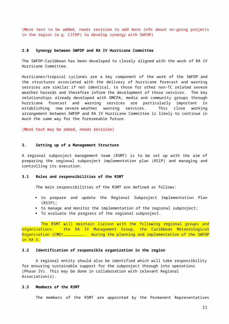
2.6 Domain of the Subproject
The domain to be covered for monitoring, diagnosing and forecasting of various severe weather events and associated hydrometeorological hazards in the Eastern Caribbean was agreed as shown in the Figure below (90W, 50W, 5N, 35N)….?
(Project domain to be decided and added here based on discussions)
2.7 Projects in synergy with SWFDP-Eastern Caribbean
There are opportunities for working with established projects currently active in the region including the ………………….
Several activities underway or proposed for this project offer opportunities to extend the scope of capacity development within the SWFDP project objectives to participating countries.
(More text to be added, needs revision to add more info about on-going projects in the region (e.g. CIFDP) to develop synergy with SWFDP)
2.8 Synergy between SWFDP and RA IV Hurricane Committee
The SWFDP-Caribbean has been developed to closely aligned with the work of RA IV Hurricane Committee.
8
Hurricanes/tropical cyclones are a key component of the work of the SWFDP and the structures associated with the delivery of hurricane forecast and warning services are similar if not identical, to those for other non-TC related severe weather hazards and therefore inform the development of those services. The key relationships already developed with DMCPA, media and community groups through hurricane forecast and warning services are particularly important in establishing new severe weather warning services. This close working arrangement between SWFDP and RA IV Hurricane Committee is likely to continue in much the same way for the foreseeable future.
(More text may be added, needs revision)
3. Setting up of a Management Structure
A regional subproject management team (RSMT) is to be set up with the aim of preparing the regional subproject implementation plan (RSIP) and managing and controlling its execution.
3.1 Roles and responsibilities of the RSMT
The main responsibilities of the RSMT are defined as follows:
to prepare and update the Regional Subproject Implementation Plan (RSIP); to manage and monitor the implementation of the regional subproject; To evaluate the progress of the regional subproject.
The RSMT will maintain liaison with the following regional groups and organizations: the RA IV Management Group, the Caribbean Meteorological Organization (CMO),…………………….. during the planning and implementation of the SWFDP in RA V.
3.2 Identification of responsible organization in the region
A regional entity should also be identified which will take responsibility for ensuring sustainable support for the subproject through into operations (Phase IV). This may be done in collaboration with relevant Regional Association(s).
3.3 Members of the RSMT
The members of the RSMT are appointed by the Permanent Representatives (PRs) and/or Directors of NMHSs and/or Heads of participating Centres. The list of the members comprising the RSMT is as follows:
NMHSs: Designated representative of CMO?; Designated representative of British Caribbean Territories?; Designated representative of Haiti?; Designated representative of Dominican Republic?;
Regional Centres: Designated representative of RFSF Martinique?; Designated representative of RSMC Miami?; Designated representative of CIMH Barbados?;
Global Centres: Designated representative of Environment Canada?; Designated representative of Meteo France ?; Designated representative of UKMO, Exeter’; Designated representative of US NOAA/NCEP?; Designated representative of ECMWF Reading?;
a representative of the regional entity (taking responsibility of the subproject in Phase IV)
9
a project Steering Group (PSG) contact person; TBD, the regional PWS and/or DRR representatives if any a representative of any other collaborating development project if any;
The Regional Subproject Management Team is chaired by XXXXXXX (RFSF Martinique?). A co-chairperson may be co-opted if required.
(More text may be added, needs revision based on discussions)
3.4 Responsibilities of the members of the RSMT
3.4.1 Responsibilities of the RSMT Chairperson
The responsibilities of the RSMT Chairperson will be:
to draft a detailed regional subproject development plan (RSIP) and to share with participating centres;
to coordinate training requirements that support the demonstration project and to provide information to WMO Secretariat;
to report on the project to PSG.
3.4.2 Responsibilities of the representative of each participating global centre
coordinating all aspects of project implementation and execution at their respective centres, especially the cascading structure;
evaluating and implementing possible data-processing and forecasting developments (e.g. work required to adjust or tailor NWP including EPS products);
evaluating possible satellite-based developments (e.g. work required to adjust or tailor satellite-based products), where appropriate;
arranging the verification of products from his/her global centre.
3.4.3 Responsibilities of the representative of each participating regional centre
The representative of each participating regional centre will be responsible for:
coordinating all aspects of project implementation and execution at their respective centres, especially the cascading structure;
evaluating and implementing possible data-processing and forecasting developments (e.g. work required to adjust or tailor NWP including EPS products);
identifying preparatory training requirements; preparing regular evaluation of the Regional Severe Weather Forecasting Guidance
(for RFSF Martinique); reporting on the status of the activities in the respective centre; arranging the verification of products from his/her regional centre.
3.4.4 Responsibilities of the representative of each participating NMC
The representative of each participating national centre will be responsible for:
coordinating all aspects of project implementation at their respective centres; evaluating possible data-processing and forecasting developments (e.g. work
required to adjust or tailor NWP products); arranging forecasters to receive or have access to the agreed products; defining the information to be exchanged with their DMCPA and other users; defining the information to be transmitted to the media; identifying additional training requirements; arranging verification of non-TC forecasts and warnings; preparing at least one case study per year for a severe weather or wave event
affecting their country; reporting on the status of the activities in their respective centre.
3.4.5 The contact person on the SWFDP Project Steering Group (PSG)
10
The RA IV representative to the SWFDP Project Steering Group (PSG) will be responsible for:
to liaise with the PSG on aspects of the SWFDP; to provide regular updates on the implementation of the RSIP.
3.3.6 The regional PWS and DRR representatives will be responsible for:
liaising and keeping regular contact with the representative of each participating NMHS to ensure the implementation of the PWS component of SWFDP;
providing advice and guidance to the representative of each participating NMHS on strengthening dialogue with the media organizations;
providing advice and guidance to the representative of each participating NMHS on strengthening collaboration with the disaster management and civil protection agencies;
advising and reminding the representative of each participating NMHS on the preparation of progress reports;
consulting with the representative of each participating NMHS and assisting them to clearly identify their users’ specific requirements for services;
supporting the development of national communication strategies with DMCPAs and the media to ensure effective response to alerts and warnings;
keeping regular contact with the WMO PWS Programme to inform of activities in the region and to inform representatives of participating NMHSs of latest developments in PWS which can be applied in the region;
representing the regional DRR community in the planning and implementation of the SWFDP;
advising the RSMT on how to make the SWFDP beneficial to the DRR community; liaising with each country's DMCPA on their requirements from the SWFDP; reporting on the SWFDP to regional DRR organizations.
Each participating country to nominate a PWS focal point (where not existing) for liaison with the region PWS representative.
4. Responsibilities of Participating/Contributing Centres
4.1 Global Centres
The responsibilities of Global Centres are:
to provide the regional and national centres with medium-range NWP including EPS guidance and probabilistic products specially adapted to the concerned severe weather event;
to suggest suitable existing satellite imagery and satellite-based information that are helpful in assessing the current meteorological situation, and therefore also assess the quality of global NWP including EPS products;
to evaluate the efficiency of products dedicated to medium-range severe weather forecasting through the feedback provided by the other centres.
to provide consultations and training support on interpretation of the NWP including EPS products and its usage in severe weather forecasting
to provide medium-range NWP including EPS products adapted specifically for assessing the risk of severe weather and large waves associated with tropical cyclones and other weather systems.
to tailor products to the requirements of the Regional Centres including the provision of sub-domains and probabilistic products according to the lists given in Annex A and Annex B.
4.2 Regional Centres
11
Regional Centres participating in the SWFDP-Eastern Caribbean will contribute according to their area of specialization: RSMC Miami (hurricane/tropical cyclone forecasting specialization) will continue to produce products relating to severe weather associated with hurricanes/tropical cyclones, RFSC Martinique will provide regional scale analyses and NWP charts and Daily Severe Weather Forecast Guidance product including for non-TC severe weather and waves, according to the list given in Annex C. The CIMH Barbados will provide support for technical training and capacity development of participating NMHSs/NMCs.
The general responsibilities of regional centres of RFSF Martinique and RSMC Miami are:
to redirect toward the NMHSs relevant products issued from the global centre(s) (if necessary);to provide NMHSs with its own interpretation of the medium-range guidance, including EPS products if required by the NMHSs and agreed in the regional subproject implementation plan;
to provide the NMHSs with the short-range NWP guidance (including products adapted to severe weather events), if possible;
to indicate existing satellite/radar imagery and satellite-/radar-based information that could be used for nowcasting purposes;
the lead regional centre (RFSF Martinique) to issue a severe weather daily bulletin (called the RFSF Daily Guidance product) summarizing interpretation of NWP including EPS products with respect to severe weather over the responsibility area of the NMHSs if required by the NMHSs and agreed in the regional subproject implementation plan;
to conduct post event reviews and evaluate its own interpretation of NWP including EPS products and guidance if applicable;
to provide global centres with a feedback about the usefulness and efficiency of the global products;
to facilitate the flow of all forecasting guidance information to all participating centres in the SWFDP through a dedicated password protected Web site and portal (Ideally this Web site would be maintained on a 24/7 basis and dedicated for the regional subproject); to coordinate real-time 24/7 communications among the participating centres in the region of the subproject when necessary.
to provide training support for the regular specialized training programme as designed for the participating NMHSs/NMCs based on the subproject needs.
to ensure maintenance of its resources (infrastructure, human, technical etc.) to successfully continue its role as a regional centre for the SWFDP regional subproject including adapting to the new technological advancements and capacity development of its staff.
to share information as digital data in supplement to images where required to support specific applications including for flash flood warning system and agriculture.
to share higher resolution data where available and required by any new project initiated by a WMO programme.
Minimum required NWP products to be provided by the Regional Centres within the Framework of the SWFDP are listed in Annex C.1. A list of products that RSMC Miami will make available to RFSF Martinique for uploading to the Project web site is given in Annex C.2.
A Table of Warning Hazards and Thresholds Applicable to the RFSF Daily Guidance Product and a sample of the guidance provided by RSMC Wellington for NMHSs in South Pacific is available in Annex D.
An example of guidance products to be provided by RFSF Martinique is given in Annex E. An Example of a guidance product provided by RSMC Miami is given in Annex F.
(More text may be added based on Martinique and RSMC Miami input, needs revision based on discussions)
4.3 NMHSs/NMCs
The Subproject will involve a group of NMHSs in the Eastern Caribbean including: CMO Members (Anguilla, Antigua and Barbuda, Barbados, Belize, British Virgin Islands, Cayman Islands, Dominica, Grenada, Guyana, Jamaica, Montserrat, St. Kitts / Nevis, St. Lucia, St. Vincent and the Grenadines, Trinidad and Tobago, Turks and Caicos Islands); Dominican Republic;
12
French Guiana; Guyana; Haiti; Martinique and Guadeloupe (of France)……..? These will be provided with severe weather and wave guidance products by RFSF Martinique and hurricane/tropical cyclone forecast and warning products by RSMC Miami. (More text may be added, needs revision based on discussions)
The responsibilities of national centres are:
to ensure maintenance of good speed internet at the NMCs to have easy access to all the available products from Global and Regional centres including especially from the lead Regional Centre;
to interpret the guidance provided by the global centre(s) and the regional centre(s); to issue special bulletins and warnings as required by the users (hydrological
services, DMCPA services, media, etc.) for dissemination to end users when severe weather is expected;
to exchange information on warnings with participating NMHSs, and between NMHS and regional centre(s);
to provide regional and global centres with a feedback on the efficiency of the global and regional products;
to ensure that the designated Public Weather Services (PWS) Focal Point accesses training opportunities within SWFDP, focused on the delivery of alert and warning services;
to develop a communication strategy and plan with the media and end users to ensure effective response when warnings are issued;
to develop skills and procedures to enable NMHSs work effectively with the media including how to write effective press releases, conduct interviews, host press conferences and provide efficient communication channels for the media;
to establish contacts with DMCPA services and end users prior and during severe weather events;
to develop if necessary a generic basic set of standard operational procedures (SOPs) between NMHS and DMCPA to ensure effective use of the SWFDP products (to be developed and included as an annex to the regional subproject implementation plan)
to obtain feedback from users after the event (opportunity of warning, usefulness of warnings, lead time, degree of impacts);
to obtain feedback from the public, disaster risk management agencies and media on utilization/benefits of warnings issued by NMHS under the SWFDP (templates for user assessment questionnaires are available as annex to this Guidebook);
to prepare a compiled report on the severe weather events that contains all the data needed to perform the evaluation of both RFSF Daily Guidance relevant to the country, and warnings issued by the NMC;
to provide training on how to improve communication with the users;
The status of NMHSs/NMCs (e.g. internet speed, operational capacity, warning service delivery etc. ) and list of products to be provided by the participating NMHSs/NMCs within the Framework of SWFDP is given in Annex G.
(Each of the participating NMHSs/NMCs is to provide the information which may be reviewed and refined based vision based on discussions during the meeting to update the Annex-G)
5. Training and capacity development
5.1 Training and capacity development requirements
Training/capacity development is necessary to ensure that forecasters from Regional Centres and NMHSs/NMCs are able to correctly interpret the various NWP including EPS and guidance products and satellite-based information made available for the SWFDP regional subproject and to prepare user-focused information. Also, the training will inform forecasters of all responsibilities as outlined in the RSIP.
The training should also involve interactions with DMCPAs in each country and others in the field of Public Weather Services (including media organizations) and any other relevant
13
agencies (e.g. Government or non-Government). Such training should take place with reference to any documented guidelines about service delivery principles and practices such WMO Strategy for Service Delivery.
The NMHSs are requested to assess their current capacity in the use of NWP products and the delivery of services to user communities and groups and to provide information to the RSMT to assist in the development of SWFDP-Caribbean training workshops.
5.2 Training design and topics
The SWFDP training programme will be designed based on the regional needs and national requirements. The specialized training programme may include but not limited to the following topics:
Interpretation and best practice use of NWP including EPS products for the forecasting of severe weather;
understanding and interpretation of specialized NWP products for forecasting severe weather associated with tropical cyclones:
- Madden-Julian Oscillation (MJO) diagnostics and predictors;- tropical cyclone genesis parameters;- environmental controls on tropical cyclone movement and intensification;- strike probability maps;- Lagrangian meteograms;- feature-based tropical low probability maps;- sea state probability maps;
Interpretation of RFSF Martinique and RSMC Miami guidance products; Use and applications of the SWFDP-RAIV project web portal (RFSF Martinique
website); Use of probabilities in the preparation of weather forecasts; Model verification as part of the forecast process; Guidance on the completion of the SWFDP evaluation form(s); Guidance on constructing case-studies Verification of forecasts/warnings. Communication skills in broadcast and print media Coordination with DMCPAs and media for delivery of warnings services Engagement with DMCPAs, users and stakeholders to introduce and strengthen
impact-based forecasts and risk-based warnings User satisfaction and perception evaluation including use of surveys Public outreach and awareness raising Feedback mechanisms, reporting through SWFDP database Contingency plans, and Standard Operating Procedures (SOPs);
Additional training should be provided for any new products introduced into the project.
(More text may be added, training topics needs revision based on discussions)
5.3 Other related opportunities
Existing or planned regional activities may provide potential opportunities for relevant training in forecasting and service delivery:
Regular Forecaster Attachment Training at RSMC Miami; Annual ECMWF training course especially on NWP interpretation and use; WMO Verification Methods tutorial; NOAA/NCEP training desk; E-Learning opportunities (e.g. COMET)
(More text may be added, needs revision based on discussions)
6. Monitoring and Evaluation
6.1 Overview and requirements
14
Every SWFDP regional subproject is required to be evaluated against the SWFDP goals as mentioned in Para 1.3 above. The aims of the SWFDP evaluation are:
to assess the performances of the Daily Regional Severe Weather Forecasting Guidance;
to assess the performances of the NMHS warning system, to inform about the efficiency of the SWFDP system and the level of satisfaction of
the users.
During the demonstration phase, a continuous evaluation procedure using regular progress report must be implemented to check if the cascading process works efficiently. At the end of the demonstration phase, a final evaluation of the regional subproject needs to be carried out by the RSMT to identify gaps and areas for improvement to ensure future sustainability of the demonstrated procedures and for other similar subprojects. In this evaluation, a qualitative assessment will be made of the success of the SWFDP related to the specific benefits of the subproject and in particular the measurable improvements that have been noted in the warning services that are provided to the DMCPAs and the media.
6.2 Submission of Quarterly Progress Reports through SWFDP Database
To keep regularly informed the RSMT and WMO about the progress of the implementation of the subproject and its evaluation against SWFDP goals, each participating NMHS shall prepare quarterly progress reports including case studies and submit to WMO Secretariat online through SWFDP database after the end of each quarter. The SWFDP database has been developed using WMO’s Country Profile Database (CPDB) web portal. Each of the NMHSs involved in the subproject shall have specific user ID and password to have access to the SWFDP database for submission of its progress reports. The designated national focal points for the subproject (RSMT members) shall be responsible for implementation of the tasks related to the project at national levels including submission of SWFDP quarterly progress reports.
A progress report should contain information about the way the SWFDP is being implemented, such as the NWP/EPS products used in preparing severe weather forecasts and warnings, severe weather events observed, number of warnings issued during the reporting period, probability of detection and false alarms, dissemination channels, clients/users’ feedback etc. The quarterly progress reports shall be prepared according to the schedule given in Section 10. The list of key elements and information that need to be reported in progress reports is given in Annex H.
To ensure that the needed information is reliably completed it is proposed that the information for the evaluation severe weather events be collected by using an “evaluation form”. A template of evaluation form is shown in Annex I. This evaluation form has to be completed by the NMHS when a severe weather event has been observed or when a severe weather event has been forecast.
The evaluation form needs to be formatted in a convenient form (MS Excel file) in order to simplify the processing and archiving of the data. The products that have been used in the production of severe weather forecasts must also be archived for use in future case studies. The information collected and maintained using such forms is expected to be helpful in preparation of progress reports and it will also be in doing case studies.
Presently, only NMHSs involved in the ongoing SWFDP regional subprojects (e.g. in Southern Africa, South Pacific, Eastern Africa, South-East Asia, and Bay of Bengal (South Asia)) can submit their quarterly progress report on-line through SWFDP database. However, SWFDP database is subject to further enhancements based on development of new subprojects. NMHSs/NMCs involved in SWFDP-Eastern Caribbean can send their feedback in the form of quarterly progress reports and case studies to RFSF Martinique with cc to WMO Secretariat through eMail until SWFDP database enhancement is done to include the provision of on-line submission for NMHSs/NMCs in the Eastern Caribbean. RFSF Martinique will analyses the progress reports and case studies and prepare a consolidated report for the region. The findings of progress reports ad case studies may also be shared with all participating Centres as it may be useful to further improve the overall forecasting system including RFSF Severe Weather Forecast Guidance product towards the NMHSs/NMCs.
15
(More text may be added, needs revision based on discussions)
6.3 Feedback from users from the viewpoint of Service Delivery
During the field phase it will be particularly important for participating NMHSs to keep regular contacts with users i.e. public, DMCPAs and the media to ensure smooth flow of information with a view to measuring the level of user satisfaction. The information in this continuous evaluation should be consolidated into regular quarterly progress reports. The feedbacks from users are quite useful to improve the severe weather forecasting services. The NMHSs/NMCs regularly obtain these feedbacks using the user assessment questionnaire for the public, DMCPAs and the media as available in Annex J. The user assessment questionnaires may be reviewed and updated if necessary, and the feedback obtained from users should be included in regular progress report.
6.4 Timetable of implementation and execution
The table below contains key milestones for the SWFDP-Eastern Caribbean, including reporting and evaluation requirements:
When WhatTask
WhoRSMT member
Q1-Q2 2017 To make preparations to kick start the subproject including development of required products, subproject password-protected Web portal etc.
All participating centres
Q1 2017 Formation of RSMT by designation of representatives by Members and participating/contributing centres
All(WMO Secretariat may send the letters to PRs and/or Centres…?)
Q2 2017 First Meeting of RSMT to review and finalize the RSIP including timeline to start demonstration phase of the subproject
All
Q3/Q4 2017 Start of demonstration phase AllQ4 2017 Submission of first quarterly progress report All NMHSs
(More text/activities may be added, needs revision based on discussions)
7. Costs
Though advanced global and regional centres are expected to participate in a SWFDP regional subproject to provide their in-kind contributions to the subproject, financial assistance from a variety of sources will still be to initiate the subproject and execute its various activities especially related to capacity development, project website enhancements, and technical/ RSMT meetings.
SWFDP regional subprojects are to be funded through extra-budgetary resources. There is potential for additional assistance as part of ongoing projects and activities in the region. The potential impact of the subproject-related activities on operational staffing should be considered by all participating centres.
The WMO DPFS, PWS, DRR, ETR (Education and Training), TCP programmes and DRA/RMO may be able to source funding to assist with conducting RSMT meetings and training. The CBS has commended the efforts of the Secretariat in supporting the SWFDP through optimizing activities across WMO programmes and in seeking support from aid donors. Members and participating centres involved in SWFDP-Caribbean are urged to seek funds from potential development partners and other agencies who stand to benefit from the important results of the SWFDP.
(More text may be added, needs revision based on discussions)
16
8. Sustainability and Criteria for transition to Phase IV
As per recommendations of SWFDP-PSG during its last meeting (Geneva, Switzerland, March 2016), the EC-68 (June 2016) has approved the following:
8.1 Once SWFDP transforms from project level to sustainable operational activity (Phase IV), this programme should be named the Severe Weather Forecasting programme (SWFP) which would still retain a close link with the well-established acronym, SWFDP during Phases I-III. There is also a strong emphasis on operational capability through the term forecasting.
8.2 A fully operational regional component of the severe weather forecasting programme, supported by the cascading forecasting process, requires:
A Regional Management Team (RMT) comprising the PRs (or their representatives) of global, regional and national centres of participating countries, which reports to a Steering Group and the respective regional associations;
A regional entity (e.g. Meteorological Association for Southern Africa (MASA) for the SWFDP – Southern Africa) to oversee and coordinate, in collaboration with the Secretariat, the subproject activities, including support activities such as training, organizing meetings and resource mobilization. This regional entity requires to be identified before a new SWFDP is initiated to ensure long-term sustainability of subprojects;
Global centres providing input data and products to the regional and national centres, as agreed through discussions at the RMT;
A regional centre providing forecast guidance to NMHSs in the region through the cascading forecasting process, and operating and maintaining a dedicated website, as agreed through discussions at the RMT;
National centres ensuring that appropriate warnings of severe weather are issued.
8.3 In addition to the activities listed above, the sustainability of operational regional components requires a number of non-operational activities to be supported and funded. These activities include:
8.3.1 The Regional Management Team is in charge of:
• The strategic leadership for the region;• Evaluating Phases I to III of the SWFDP regional subproject, and decide on its
transition to operations (Phase IV);• Defining the criteria for the regional severe weather guidance, based on the NMHS
criteria for severe weather warnings;• Assessing every opportunity to combine with existing activities of other programmes
and technical commissions related to hazardous weather, such as for flash flood forecasting, marine and aviation;
• Encouraging the use of the cascading forecasting process by other regional projects to facilitate the implementation of multi-hazard impact-based forecast and risk-based warning services.
8.3.2 The regional entity, in collaboration with the Secretariat, is in charge of organizing:
• RMT meetings around every two years;• Training for RSMC and NMHS staff on a regular basis, combining on-site training and
making use of e-learning facilities;• Resource mobilization, including sustainable funding for the implementation of new,
and further development of the existing, subprojects.
8.3.3 The Steering Group is responsible for:
• Providing strategic oversight for the further development of the cascading forecasting process;
17
• Monitoring and evaluating the progress of existing SWFDP regional subprojects and their transition to operations; and provide guidance on the planning, implementation and execution of new SWFDP regional subprojects;
• Facilitating the use of the cascading forecasting process by other WMO Programmes and technical commissions’ activities, based on the SWFDP model;
• Developing recommendations to NMHSs, especially those from LDCs, SIDS and MITs, for their full engagement in and benefit from the cascading forecasting process.
8.3.4 The NMHSs should contribute to:
• The evaluation of products and provide feedback to global and regional centre(s);• Keeping up-to-date their criteria for severe weather warnings, according to the
feedback provided by the end-users, and inform the RMT as appropriate.
8.3.5 The regional centre should:
Be in charge of the routine website maintenance, including upgrades as required; Provide regional severe weather guidance, based on the NMHS criteria for severe
weather warnings; Contribute to the monitoring, evaluation and reporting.
8.3.6 The global and regional centres which contributed to the demonstration phases of the SWFDP regional subprojects are expected to continue to provide support, on the understanding that their data and products would be used only for the intended purpose by the participating regional centres and NMHSs, fulfilling the requirements for designation described in the draft new Manual on the Global Data-processing and Forecasting System (WMO-No. 485).
9. Communication and publicity of the subproject (SWFDP stakeholder engagement)
Informing SWFDP stakeholders about the subproject is an important on-going task. There should be publicity about the initiation of the subproject as well as regular progress reports.
Stakeholders could include, but not limited to: NMHSs in the region, including spreading information within the NMHS; DMCPAs; RFSF Martinique and RSMC Miami Relevant Global Centres WMO Congress/EC/CBS RA IV/RA IV President/RA IV Management Group Regional Office for the Americas (RAM)\ Relevant RA IV Working Groups; Donors, including aid agencies and development partners; NGOs, community organizations& local media; RA IV Hurricane Committee WMO Secretariat
Communication could be through newsletters, information pamphlets, presentations (e.g., at the TC sessions, regular sessions of RA IV and other regional meetings).
This Regional Subproject Implementation Plan (RSIP) should be passed to stakeholders for information and feedback. Responsibility for communicating the subproject and publicity is a task for all participants, but with overall coordination by the Chairman.
Informing stakeholders about the subproject is an important ongoing task. There should be publicity about the subproject by way of newsletters, information pamphlets, meet-ing presentations, progress reports and documents for sessions of WMO constituent bodies.
(More text may be added, needs revision based on discussions)
10. List of the Annexes
Annex A: Minimum required NWP products to be provided by the Global Centres
18
within the Framework of SWFDP and a list of available products Annex B: List of the stations where EPSgrams (or ENS Meteograms) are required by
the participating NMHSs/NMCs Annex C: Minimum required products to be provided by the Regional Centres within the Framework of SWFDP and a list of available products Annex D: Table of Warning Hazards and Thresholds Applicable to the RFSF Daily
Guidance Product and a sample of the South Pacific Guidance provided by RSMC Wellington for NMHSs/NMCs in South Pacific
Annex E: Example of the guidance to be issued by RFSF to NMHSs/NMCs by way of a Hurricane/tropical cyclone Outlook
Annex F: Example of the products and guidance issued by RSMC Miami to NMHSs/NMCs by way of a Hurricane/tropical cyclone Outlook
Annex G: List of products to be provided by the Participating NMHSs within the Framework of SWFDP
Annex H: List of key elements of SWFDP Progress Report to be submitted by participating NMHSs
Annex I: Template of Severe Weather Event Evaluation form with forecast/warnings verification to be completed by participating NMHSs/NMCs
Annex J: User assessment questionnaire for the public, DMCPA and the media
11. References
Final Report of the 13th session of CBS (St. Petersburg, 23 February - 3 March 2005) Final Report of the Extra-ordinary session of CBS in 2006 (Seoul, Republic of Korea, 9-
16 November 2006) Final Report of Congress-15 (2007) Final Report of the 14th session of CBS (Dubrovnik, Croatia , 25 March - 2 April, 2009) Final Report of Congress-16 (2011) Final Report of the 4th meeting of CBS Steering Group for the SWFDP, Geneva,
Switzerland, 28 February to 2 March 2012). Final Report of the 15th session of CBS (Jakarta, Indonesia, 10-15 September, 2012) Final Report of the 5thmeeting of CBS Steering Group for the SWFDP, Geneva,
Switzerland, 3 – 5 December, 2013). Regional Subproject Implementation Plan for SWFDP– South Pacific Final Report of the Extra-ordinary session of CBS (Asunción, Paraguay, 8–12 September
2014) (CBS-Ext.(2014)) Final Report of Congress-17 (May 2015) Final Report of the 6th meeting of CBS Steering Group for the SWFDP (Geneva,
Switzerland, 14-16 March 2016) Final Report of EC-68 (June 2016)
19
ANNEX A
Minimum required NWP products to be provided by the Global Centreswithin the Framework of SWFDP and a list of available products
A.1 Minimum required NWP products to be provided by the Global Centres
Global NWP graphical products which can be made available by the global centres Météo-France, NOAA/NCEP, UKMO, ECMWF, should be cut and formatted to fit the subproject domain area (90W, 50W, 5N, 35N)….?
NWP forecasts should be updated every 12 hours, or every 6 hours if available. In addition to the daily production all the forecasts should be archived for a minimum of 7 days.
Products which are not routinely transmitted through the GTS should be provided in graphical form (Web pages) via Internet for rapid display and dissemination, and may also be made available by other methods (e.g. ftp).
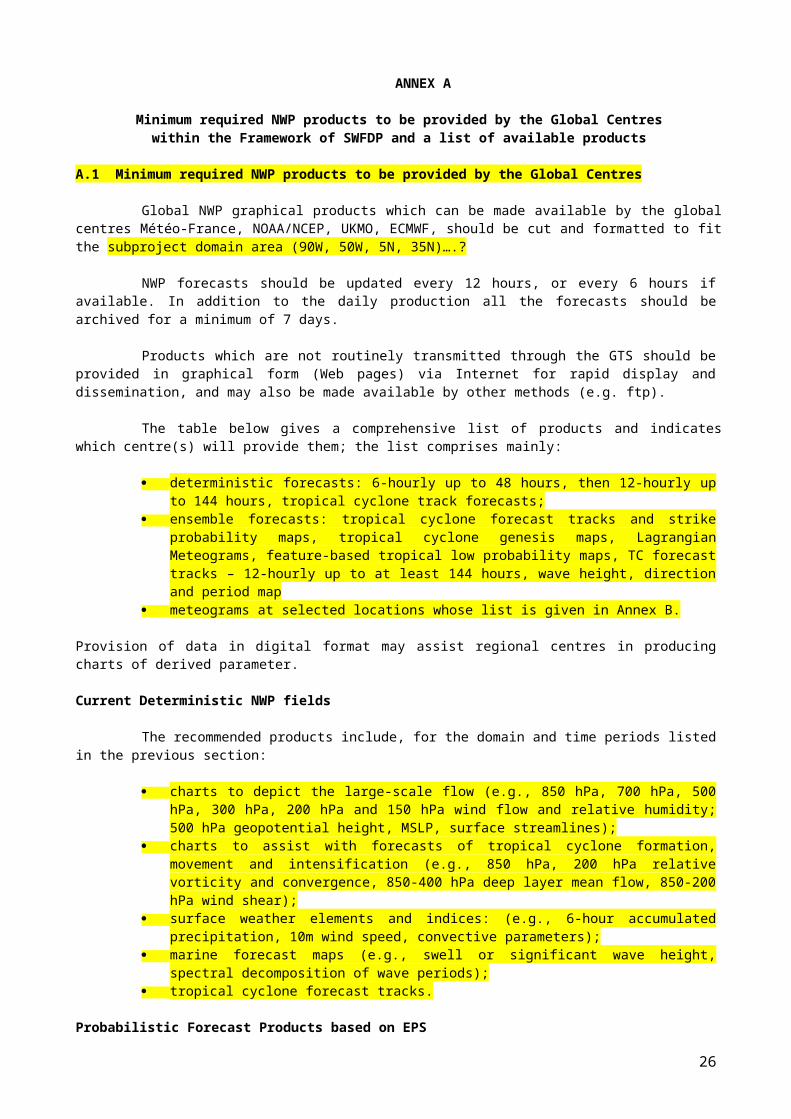
The table below gives a comprehensive list of products and indicates which centre(s) will provide them; the list comprises mainly:
deterministic forecasts: 6-hourly up to 48 hours, then 12-hourly up to 144 hours, tropical cyclone track forecasts;
ensemble forecasts: tropical cyclone forecast tracks and strike probability maps, tropical cyclone genesis maps, Lagrangian Meteograms, feature-based tropical low probability maps, TC forecast tracks – 12-hourly up to at least 144 hours, wave height, direction and period map
meteograms at selected locations whose list is given in Annex B.
Provision of data in digital format may assist regional centres in producing charts of derived parameter.
Current Deterministic NWP fields
The recommended products include, for the domain and time periods listed in the previous section:
charts to depict the large-scale flow (e.g., 850 hPa, 700 hPa, 500 hPa, 300 hPa, 200 hPa and 150 hPa wind flow and relative humidity; 500 hPa geopotential height, MSLP, surface streamlines);
charts to assist with forecasts of tropical cyclone formation, movement and intensification (e.g., 850 hPa, 200 hPa relative vorticity and convergence, 850-400 hPa deep layer mean flow, 850-200 hPa wind shear);
surface weather elements and indices: (e.g., 6-hour accumulated precipitation, 10m wind speed, convective parameters);
marine forecast maps (e.g., swell or significant wave height, spectral decomposition of wave periods);
tropical cyclone forecast tracks.
Probabilistic Forecast Products based on EPS
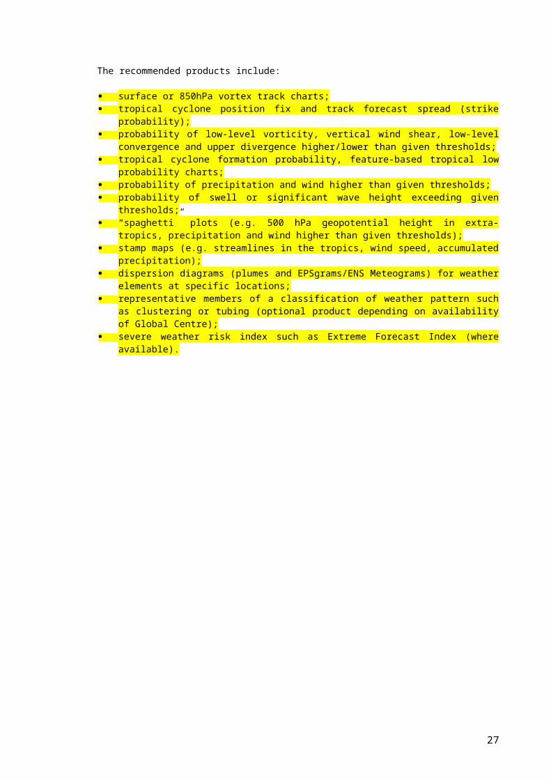
The recommended products include:
surface or 850hPa vortex track charts; tropical cyclone position fix and track forecast spread (strike probability); probability of low-level vorticity, vertical wind shear, low-level convergence and
upper divergence higher/lower than given thresholds; tropical cyclone formation probability, feature-based tropical low probability
charts; probability of precipitation and wind higher than given thresholds; probability of swell or significant wave height exceeding given thresholds; “spaghetti” plots (e.g. 500 hPa geopotential height in extra-tropics, precipitation
20
and wind higher than given thresholds); stamp maps (e.g. streamlines in the tropics, wind speed, accumulated
precipitation); dispersion diagrams (plumes and EPSgrams/ENS Meteograms) for weather
elements at specific locations; representative members of a classification of weather pattern such as clustering
or tubing (optional product depending on availability of Global Centre); severe weather risk index such as Extreme Forecast Index (where available).
21
ANNEX A
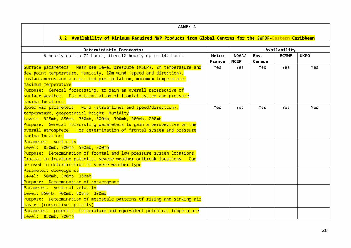
A.2 Availability of Minimum Required NWP Products from Global Centres for the SWFDP-Eastern Caribbean
Deterministic Forecasts: Availability6-hourly out to 72 hours, then 12-hourly up to 144 hours Meteo
FranceNOAA/NCEP
Env. Canada
ECMWF UKMO
Surface parameters: Mean sea level pressure (MSLP), 2m temperature and dew point temperature, humidity, 10m wind (speed and direction), instantaneous and accumulated precipitation, minimum temperature, maximum temperaturePurpose: General forecasting, to gain an overall perspective of surface weather. For determination of frontal system and pressure maxima locations.
Yes Yes Yes Yes Yes
Upper Air parameters: wind (streamlines and speed/direction), temperature, geopotential height, humidityLevels: 925mb, 850mb, 700mb, 500mb, 300mb, 200mb, 200mbPurpose: General forecasting parameters to gain a perspective on the overall atmosphere. For determination of frontal system and pressure maxima locations
Yes Yes Yes Yes Yes
Parameter: vorticityLevel: 850mb, 700mb, 500mb, 300mbPurpose: Determination of frontal and low pressure system locations. Crucial in locating potential severe weather outbreak locations. Can be used in determination of severe weather typeParameter: dievergenceLevel: 500mb, 300mb, 200mbPurpose: Determination of convergenceParameter: vertical velocityLevel: 850mb, 700mb, 500mb, 300mbPurpose: Determination of mesoscale patterns of rising and sinking air masses (convective updrafts)Parameter: potential temperature and equivalent potential temperatureLevel: 850mb, 700mbPurpose: Frontal position diagnosis and change in airmass
Parameter: 1000-500mb thickness, 700-500mb thicknessLevel: partial atmospheric columnPurpose: Freezing level determination and air mass distinguishingParameter: precipitable waterLevel: atmospheric columnPurpose: Determination of total liquid water in the atmosphere and thus potential rainfall
22
Special parameters: convective inhibition (CIN), convective available potential energy (CAPE)Level: atmospheric columnPurpose: CIN for estimation of strength of force preventing convective initiation and the amount of energy (frontal forcing or daytime heating) that is needed to begin convection, and CAPE to estimate the amount of energy available in the atmosphere for storm productionParameter: Lifted index, K index, Total totals index, Showalter index, etc.Level: stability indexPurpose: Pre-calculated indices to generalize severe weather potentialParameter: significant wave height, mean wave direction, and mean wave periodPurpose: General sea-state forecasting parameters.Parameter: significant wave height and period, wind sea wave height and period, spectral decomposition of wave energy by range of periodsPurpose: Marine forecasting parameters. Crucial in locating potential heavy swell areas.
Ensemble Forecasts:12-hourly out to 144 hours
Probability of 6-hour and 24-hour accumulated precipitation exceeding 50mm and 100mm threshold valueProbability of 10-meter wind speed exceeding 10m/s (20kt) and 15m/s (30kt) threshold valueProbability of significant wave height exceeding 2 m, 4 m and 6 m threshold valueProbability of significant wave period exceeding 8s, 10 s, 12s and 15 s threshold valueEnsemble Prediction System meteograms for specified locations (10-day/ 15 day)Spaghetti diagrams for 500mb geopotential heightThumbnails of probability of precipitation in excess of threshold of 50mm/6h at 6 hours intervalsECMWF Extreme Forecast Index and Shift of Tails, and M-Climate for TMean, TMax, TMin, wind gust, wind speed, total precipitation, Max significant wave height, total snowfallENS Cumulative Distribution Functions (Forecast and M-Climate) and EFI values (for precipitationMJO Index - Extended range forecastTropical cyclone occurrence and genesis probability mapsTropical cyclone strike probability mapsTropical cyclone forecast tracks from ensemble members, including ensemble mean, deterministic and control tracks
23
Tropical Cyclone Lagrangian meteograms
Other REQUESTED Products: Availability
SKEW-T logarithmic forecast plots for selected grid points based on NWP output (out to 144 hours, 12-hourly)
Meteo France
NOAA/NCEP
Env. Canada
ECMWF UKMO
24
ANNEX B
List of the stations for which Global Centres will provideEPSgrams/ ENS Meteograms in the framework of SWFDP
(All participating NMHSs to provide the coordinates of the stations for which they need EPSgrams/ ENS Meteograms)
B1: EPSgrams/ ENS Meteograms
No. WMO id.
Station Name Lat. Lon. Altitude
(a.m.s.l)Meteo France
NOAA/NCEP
Env. Canada
ECMWF UKMO
1 YES YES YES YES
2
3
4
5
6
7
8
9
10
11
12
13
14
15
16
17
18
19
20
21
22
23
24
25
26
27
28
25
B2: Wave EPSgrams
No. WMO id.
Station Name Latitude Long. Altitude
(a.m.s.l)NOAA/NCEP
Env. Canada
ECMWF
UKMO
1 YES YES YES YES
2
3
4
5
6
7
8
9
10
11
12
13
14
15
16
17
18
19
20
21
22
23
24
25
26
27
28
26
ANNEX C
Minimum required products to be provided by the Regional Centreswithin the Framework of SWFDP and a list of available products
(More info on detail of available and/or required products may be added, needs revision based on discussions)
C.1 Minimum required NWP products to be provided by the Regional Centres
The SWFDP guidebook suggests that interpretation of fields available from Global and Regional Centres synthesized in the form of daily guidance bulletins be issued twice per day indicating the likelihood of severe weather occurrence:
a short range (48 h) guidance mainly based on the interpretation of NWP models, issued during the morning (optionally there may be a review of days 3 to 5).
a medium range (up to 5 days) guidance mainly based on the interpretation of EPS products, issued during the afternoon.
Products which are not routinely transmitted through the GTS should be provided in graphical form (Web page) via Internet for rapid display and dissemination, and may also be made available by other methods (e.g. ftp or EMWIN).
C.2 Available products from Regional Centres participating in the SWFDP
RFSF Martinique:
Presently produced
PEARP: ensemble prediction from Arpege Aladin Model (LAM): over the Caribbean every 3 hours from 0 to 54 hours:
cumulative rainfall for 6 hours and winds at 10 m. MFWAM : (ocean model from Meteo-France with the swell forced by ARPEGE
or IFS winds) over the same area: Significant Wave Heights (height, direction and period) every 6 hours, to 54 hours.
MSLP, gradient wind and 200hPa streamline analyses over the agreed subproject domain;
ensemble’ rainfall predictions for the caribbean region; archive of all products relevant to the project on case-by-case basis (when
severe weather event is either observed or forecast); ….. etc……?
Products expected to be available
Daily Severe Weather Forecast Guidance product for short-range (48 h?) Daily Severe Weather Forecast Guidance product for Medium-range (3-5
Days) ? ?
RSMC Miami:
Presently produced tropical cyclone alerts, warnings and advisory bulletins issued under the
Hurricane Committee Operational Plan for the North Atlantic Ocean – Tropical Disturbance Summaries. Hurricane/Tropical Cyclone Advisories, Marine Warnings, Tropical Cyclone Special Advisories for each island state or participating country in the Caribbean; Tropical Disturbance Advisories;
27
tropical cyclone track and threat maps; forecasts & warnings for damaging swell for each island state or
participating country in the Caribbean; a daily tropical cyclone guidance bulletin for short range and medium
range, incorporating a probabilistic forecast of tropical cyclone genesis (TC Outlook - an example of the content of the guidance bulletins is given in Annex C). This daily guidance must be archived;
TC forecast track uncertainty maps (based on ensemble predictions); additional content in tropical cyclone warnings and special advisory
bulletins describing threat of storm tide inundation; …...etc.?
Additional products to be made available
28
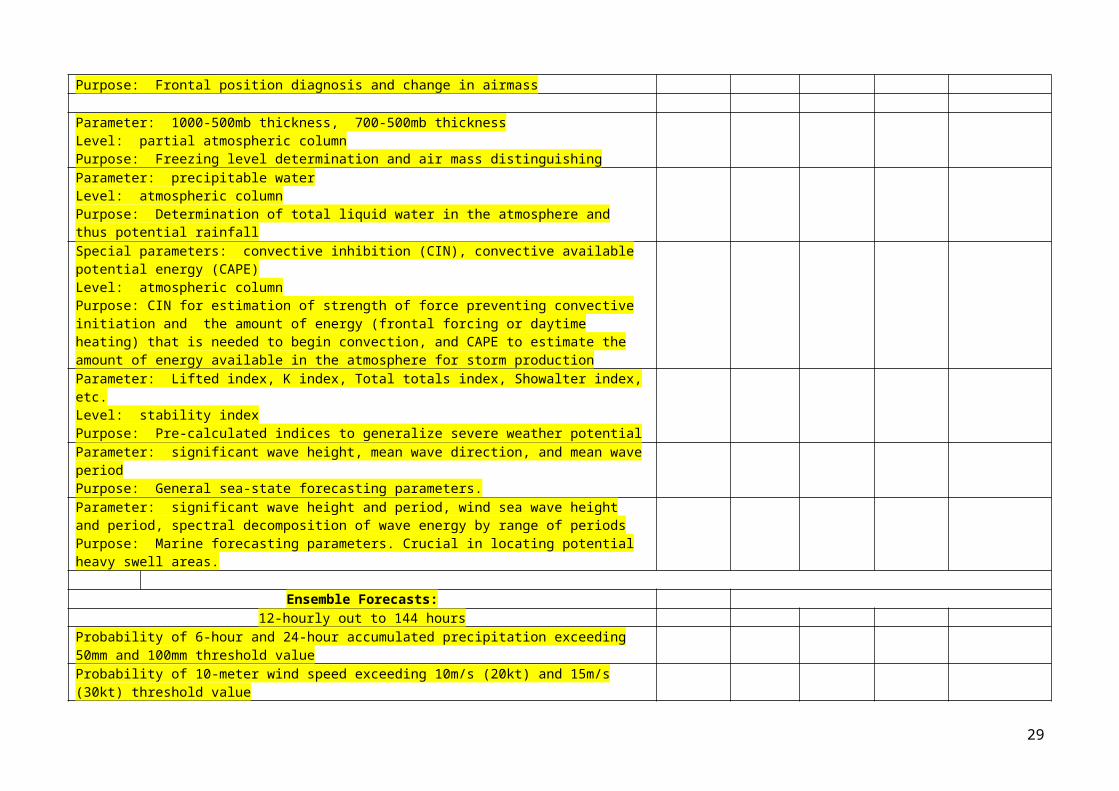
Annex D
Table of Warning Hazards and Thresholds Applicable to the RFSF Daily Guidance Product
(More info on types of severe weather and threshold may be added if necessary, needs revision based on discussions)
A representative list of severe weather hazards and the relevant thresholds will be used to prepare guidance products for all areas in SWFDP-Eastern Caribbean region by the RFSF Martinique. This does not imply that local, in country, warning systems must use the same thresholds for an NMHS to issue warnings. Each country has its own thresholds based on good, historical reasons. However, the guidance forecasts will use a representative threshold for each hazard designed in such a way that it will draw the attention of forecasters of all NMHSs to potential hazards threatening their region. This will help the NMHS to decide if the threat is real and monitor it for proper advisory or warning actions as determined in their particular countries.
The meteorological hazards of concern in this region are those for which NMHSs issue warnings to the public at large. This approach recognizes the decisions by governments, through their respective NMHSs, to have set threshold criteria for official weather warnings. At the same time, it is recognized that some other meteorological phenomena could have significant impact on the public, such as heat waves or rapid temperature changes. There are also some hazardous phenomena for which there is presently no methodology for supporting a Regional Guidance by RSMC Martinique.
Table: The hazards for the SWFDP that will be monitored by RFSF Martinique for a lead time up to 5 days and included in the guidance products are listed here with related thresholds. Conditions associated with hurricanes/tropical cyclones (heavy rain, strong wind, high seas) expected to impact land areas will indicate the tropical cyclone association using the forecast and advisories issued by RSMC Miami separately.HAZARD THRESHOLD COMMENTSHeavy Rain ≥ 50 mm in 24 hours
≥ 100 mm in 24 hours
(the risk over 200mm/24 should be described in discussion in the RFSF Daily Guidance product)
The operational country-thresholds may differ widely among participating countries of SWFDP-Eastern Caribbean.
NMHSs may translate the heavy rain into potential flooding in areas likely to be affected by heavy rain depending upon the soil condition, topography and drainage systems in respective areas
Strong winds ≥ 10 m/s (20 knots)≥ 15 m/s (30 knots)
Affecting oceanic and coastal areas especially.
Gusts on land from severe convective systems are not predictable on this time scale effectively
High Waves ≥ 2.5 m≥ 3.5 m
NMHSs may use the information contained in the RFSF Guidance Product to generate impact-based forecasts and risk-based warnings for use by the coastal communities, fisheries, disaster managers etc. at national levels.
Sample of South Pacific Guidance (issued by RSMC Wellington)
29
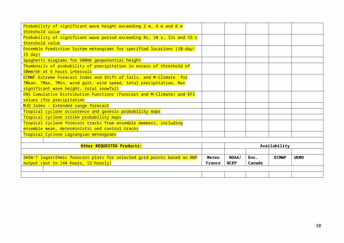
GUIDANCE PROVIDED BY RSMC WELLINGTON TO NMHSsFOR MAKING SEVERE WEATHER FORECASTSOUT TO 5 DAYS
The South Pacific Guidance comprises the following:
Five separate situation statements for days 1, 2, 3, 4 and 5. Five separate geographical maps for days 1, 2, 3, 4 and 5 identifying the areas of
possible severe weather with an indication of the degree of confidence of the forecaster.
Example:
Day 1: Issued at: 12:45 12 Dec 2016 UTCValid at: 12:00 12 Dec 2016 UTCEasterlies dominate much of the Southwest Pacific. A low lies to the northwest of Fiji.
Day 2: Issued at: 12:45 12 Dec 2016 UTCValid at: 12:00 13 Dec 2016 UTCEasterlies prevail over the Southwest Pacific. A low lying to the northwest of Fiji may deepen.
Day 3: Issued at: 12:45 12 Dec 2016 UTC
30
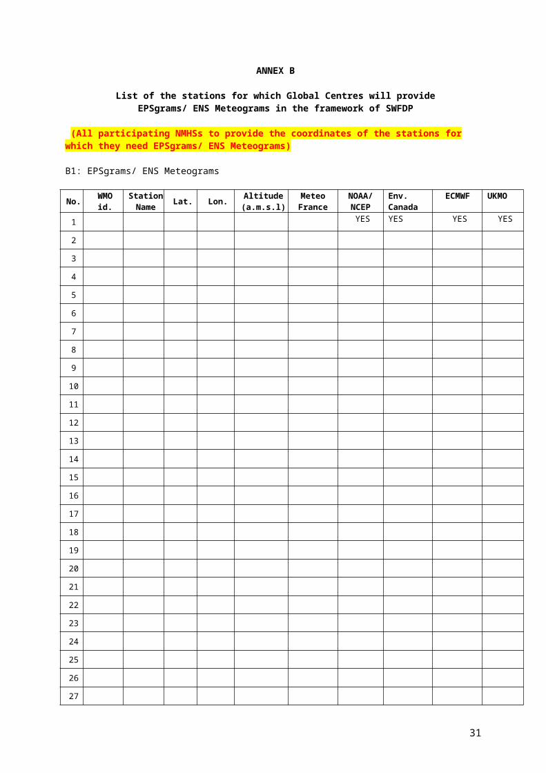
Valid at: 12:00 14 Dec 2016 UTCA low lying to the northwest of Fiji may continue to deepen, and extending a trough to the Southern Cook Islands.
Day 4: Issued at: 12:45 12 Dec 2016 UTCValid at: 12:00 15 Dec 2016 UTCA low between Vanuatu and Fiji should continue to deepen, and extend a trough to the Southern Cook Islands.
Day 5: Issued at: 12:45 12 Dec 2016 UTCValid at: 12:00 16 Dec 2016 UTCA low near Fiji should continue to deepen and may develop into a tropical cyclone.
ANNEX E
31
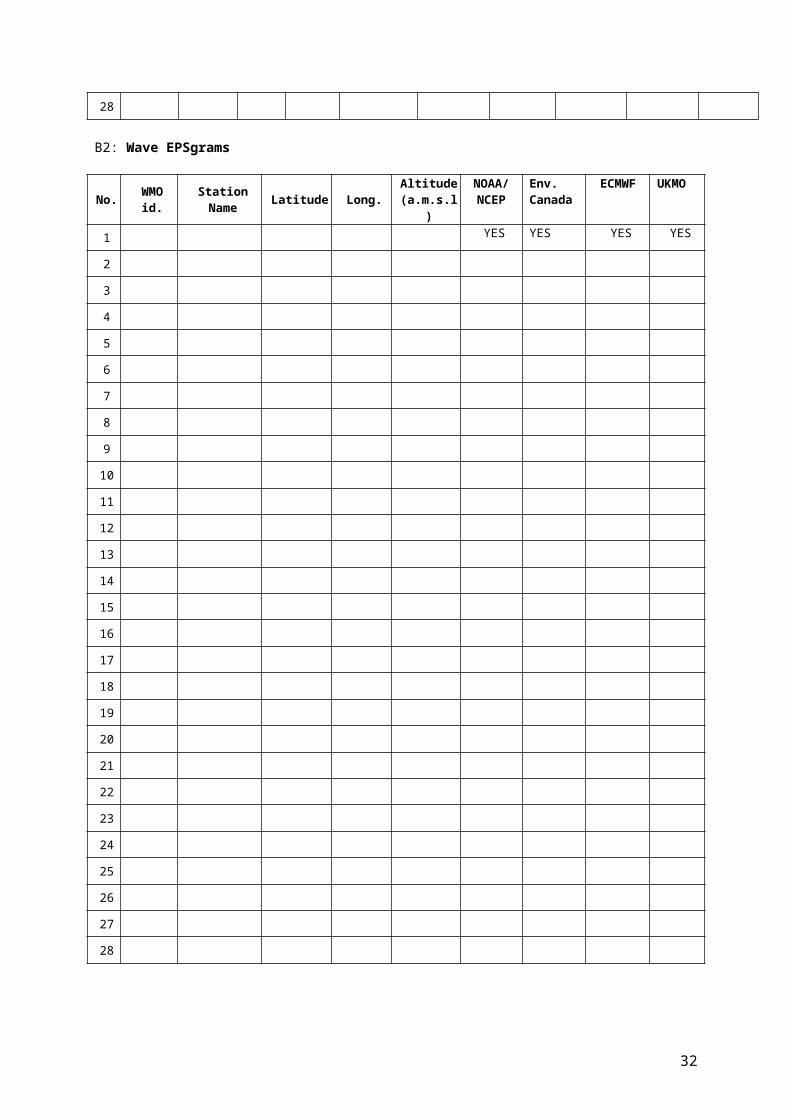
GUIDANCE TO BE ISSUED BY RFSF MARTINIQUE TO NMHSs
(May be reviewed and refined based vision based on discussions during the meeting)
RFSF Daily Regional Guidance for Short-range (Day 1 & 2) ?
to be issued by the RFSF Martinique toward the NMHSs/NMCs for Severe Weather Forecasting up to 48 Hours (for Day 1 and 2)
The Daily Regional Guidance to be issued by the RFSF Martinique toward the NMHSs/NMCs for Short Range Severe Weather Forecasting up to 48 Hours (for Day 1 and Day 2) comprises five parts:
Part A: Text; depiction of the expected evolution of the weather up to 48 h (for Day 1 and Day 2) and comments about the more representative short range products that are used with reference to figures included in the part B or to charts clearly identified (model, parameter, level, forecast range).
Part B: Charts or graphics coming essentially from deterministic models (global or LAM).
Part C: The assessment of the degree of confidence of the forecast by the forecaster.
RFSF Daily Regional Guidance for Medium-range (Day 3 to 5) ?
to be issued by the RFSF Martinique toward the NMHSs for Severe Weather Outlook (for Day 3, Day 4 and Day 5)
The Daily Regional Guidance to be issued by RSMC New Delhi toward the NMHSs for Medium Range Severe Weather Outlook (for Day 3, Day 4 and Day 5) comprises five parts:
Part A: Text; depiction of the expected evolution of the weather for Day 3, Day 4 and Day 5 and comments about the more representative medium range products that are used with reference to figures included in the part B or to graphics clearly identified (EPS charts or meteograms).
Part B: Figures; Charts or graphics coming essentially from Ensemble Prediction Systems (EPS).
Part C: The assessment of the degree of confidence of the forecast by the forecaster.
32

ANNEX F
GUIDANCE TO BE ISSUED BY RSMC MIAMI TO NMHSsBY WAY OF A HURRICANE/ TROPICAL CYCLONE OUTLOOK
(RSMC may provide the information. It may be reviewed and refined based vision based on discussions during the meeting)
The Hurricane/TC Outlook includes a description of areas with very low, low, moderate or high TC genesis probability over the forecast area out to 3 or 5 days.
33
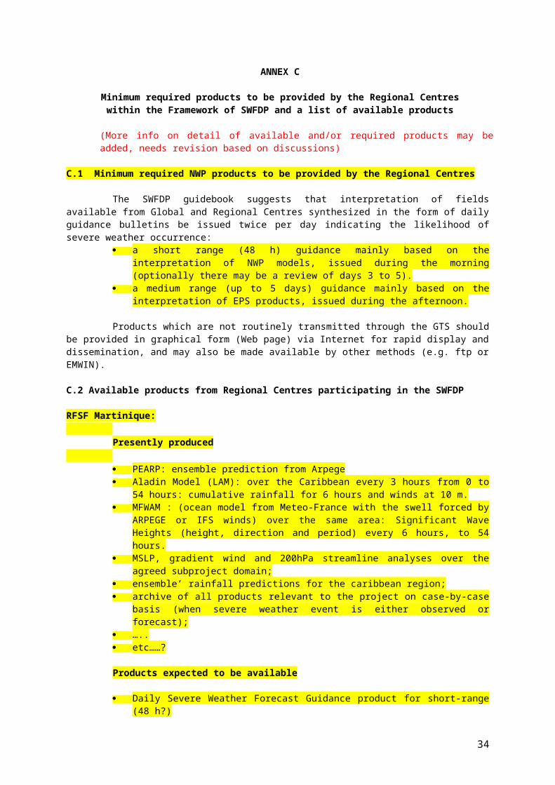
ANNEX G
Status of NMHSs/NMCs (e.g. internet speed, operational capacity, warning service delivery etc. ) and list of products to be provided by the participating
NMHSs/NMCs within the Framework of SWFDP
(Each of the participating NMHSs/NMCs is to provide the information which may be reviewed and refined based vision based on discussions during the meeting)
NMHS of ………:Present Status: Internet speed Operational capacity (e.g. number of forecasters, 24/7, etc.) Warning service delivery status (e.g. means of communication, NMC
website, coordination with users including disaster managers, media, SOPs if any, etc.)
.
Products presently produced TC Best Track Map, TC Information Bulletin, Advisories and Warnings,
Special Messages for Radio Vanuatu in English (translated into French and Bislama at radio station);
TC Forecast Track Map, up to 48 hours; Five (5) Day Tropical Cyclone Outlook; Severe Weather Warning Bulletin (winds of 20 knots or more over land and
heavy rainfall, reference to flooding is also made); Three Day Severe Weather Outlook covering heavy rainfall, strong inland
winds, rough seas and heavy swells; Coastal Marine Warning (strong wind, gale and hurricane); High Seas Forecast and Warning (gale, storm and hurricane); Monthly briefs with DMCPA, the media and other partners.
Additional Products to be produced Extend TC forecast track map from 48 h to 72 hours (for DMCPA briefing); Multi-level flood advisory (rainfall threshold: 50mm in 24 hours); Tropical cyclone outlook product (based on guidance from RSMC Miami) for
DMCPA; Swell advisory (using a threshold of 2.5 m).
ANNEX H
Progress Report of the SWFDP-Eastern Caribbean
34
Important elements & information to be reported in the Quarterly Progress Report (to be submitted on-line through SWFDP database)
1. Reporting Period (Start date to end date) 2. Severe events (e.g. heavy rainfall, strong winds, high waves, flooding etc.)3. Reporting period highlights (e.g. duration and amount of rainfall, impact of
rainfall and/or strong wind and high waves, affected areas, damages (if any), coordination with disaster management offices etc.)
4. Clients (e.g. Disaster Management Offices, media, humanitarian organizations etc. New clients can also be added)
5. Client feedback (e.g. adequacy and effectiveness of the warning and how it was used etc.)
6. Desired products (e.g. NMHS may propose a demand for additional product(s) from global and/or regional centres if already not available etc.)
7. Forecast Period and Area (to provide information about area of responsibility of an NMHS and the period for which NMHS issues forecast etc.)
8. Dissemination channels (e.g. TV, radio, mobile SMS etc. New channel can also added)
9. Observing Systems (e.g. basic synoptic network, AWS network, radar and satellite information receiving stations etc.)
10. Workshop (to provide title, duration and summary outcome of the training workshops arranged for the forecasters, emergency managers, media, school officials, general public etc. during the reporting period)
11. Product usage (to select various products which are available from participating global and regional centres and are used in making forecasts at national level etc.)
12. Local forecasting tools (to provide information about the existing forecasting tools used at the NMHS and any new forecasting tool implemented at the NMHS etc.)
13. Resources (to provide information about the budget of NMHS and the number of forecasters and observers working in NMHS etc.)
14. Case Studies (to provide title and description of case studies related to the severe event(s) observed during the reporting period, key findings of the study etc.)
15. Related projects (to provide information about the on-going and new related projects etc.)
16. PROJECT EVALUATION AGAINST SWFDP GOALS
SWFDP GOAL COMMENTS ON PROGRESS TOWARDS EACH GOAL
Questions to help you with an answer for each box
35
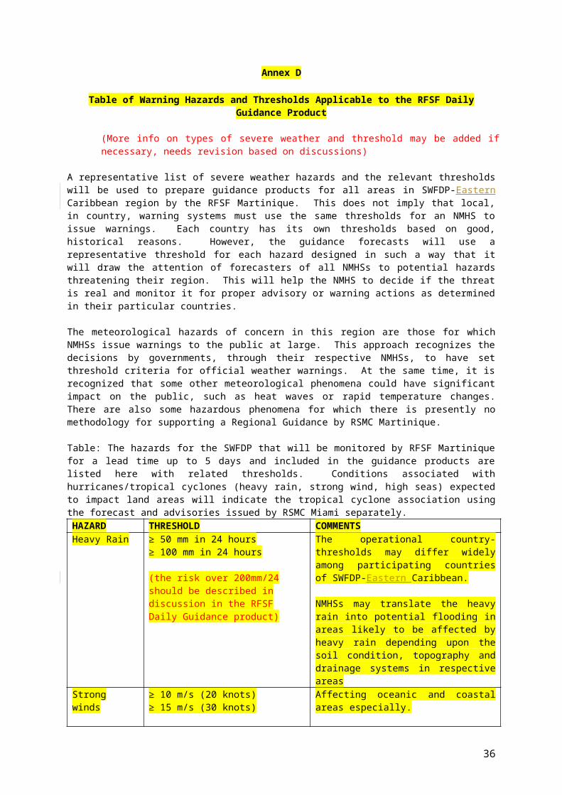
To improve the ability of NMHSs to forecast severe weather events
How did the products on the RSMC New Delhi help you make better severe weather forecasts and warnings?
To improve the lead time of alerting these events
How much earlier do you issue severe weather forecasts & warnings now compared to before?
To improve the interaction of NMHSs with Disaster Management and Civil Protection authorities (DMCPAs), the media, and the public, before, during and after severe weather events
Comment on any interactions with your disaster agency, media agencies and the public. Please indicate if there hasn't been any interaction since the last repor,.
To identify gaps and areas for improvements
What are the weaknesses in your forecast system?
To improve the skill of products from Global Centres through feedback from NMHSs
What weaknesses have you found in the products from RSMC, New Delhi, JMA, NCEP, UKMO, ECMWFetc.?
17. EVALUATION OF PWS COMPONENT
Users Question Answer Comments
Public
Any feedback from the public? Yes or No If Yes, please give details.
Any public reaction when the warnings were heard or received?
Yes or No If Yes, please give details.
Were there any difficulties in obtaining feedback?
Yes or No If Yes, please give details.
Disaster Managemen
t
Any feedback from disaster management authorities about the timeliness and/or usefulness of the warnings
Yes or No If Yes, please give details.
Were safety messages and/or call to action statements issued by the disaster management authority in agreement with your forecasts & warnings?
Yes or No If Yes, please give details.
Media Any feedback from the Media? Yes or No If Yes, please give details.
How did your relationship with the Media work in getting warnings delivered?
Yes or No If Yes, please give details.
Were their difficulties in working Yes or No If Yes, please give
36
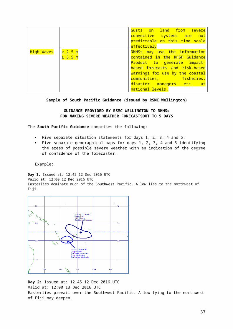
with the Media? details.
18. SUMMARY (general comments, challenges, etc)
19. CASE STUDY (PowerPoint presentation to include guidance products (RSMC and NWP), satellite imagery, warnings issued, impact evidence etc.)
Case studies for each severe weather event DON'T need to be completed at the same time as the rest of this report.
Comment: Case studies don't need to be long. What's important is the learning experience that you gain from actually doing the case study.
20. Severe Event Evaluation (See attached example of Severe Weather Event Evaluation Form)
Annex I
TEMPLATE OF A SEVERE WEATHER EVENT EVALUATION FORM
Severe Weather Event Evaluation form with forecast/warnings verification MS Excel spreadsheet template to be prepared and completed by participating
NMHSs/NMCs
Note: The proposed evaluation form is given as template for consideration by NMHSs/NMCs. It should be reviewed, formatted and develop further (e.g. using MS Excel spreadsheet) to allow NMHSs/NMCs to evaluate the performance of the RFSF Severe
37
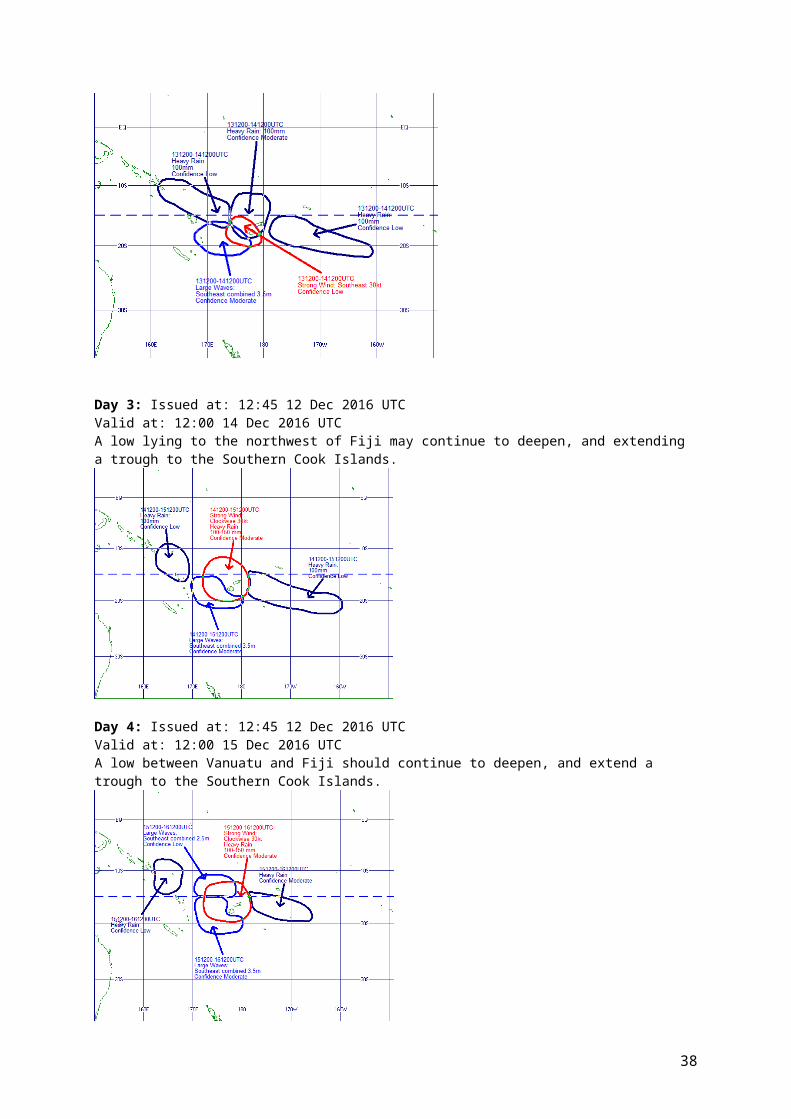
Weather Forecasting Guidance and as well as the efficiency of the NMHS warning system. It must be completed by a NMHS/NMC in both of the following cases:
a severe weather event has been observed; and a severe weather event has been forecast.
The evaluation form should document the characteristics of the severe weather event (whether observed or forecast) and allow to evaluate the efficiency of the forecasts given by the RFSF Severe Weather Forecasting Daily Guidance as well as the performance of the warnings issued by the NMHS. Therefore it should include the three following sections.
Section A – Identification of the severe weather event: NMHS/NMC concerned; number of the event; type of event; region affected.
Section B – Information about the observed weather event: start and end times of the severe weather event; maximum observed value of the characteristic parameter; assessment about the efficiency of the warning given the DMCPA; information from the end-users (number of interventions, casualties, damages,
usefulness of the warning ).
Section C – Information about the forecast and warning issued from the NMHS: lead-time of the warning; start and end time of the severe weather event according to the forecaster’s
assessment; level of risk as indicated in the RFSF Severe Weather Forecasting Daily Guidance; probabilities of medium-range in the RFSF Severe Weather Forecasting Daily
Guidance; usefulness of the various products (RFSF Guidance, various models); comments including information on usefulness and applicability of used tools.
How to use this evaluation form to evaluate the performance of warnings ?
The common way to evaluate the performance of a warning system is based on the 2 x 2 contingency table matrix including the number of justified warnings (“hits”) “a”, the number of missed severe events “b” and the number of false alarms “c”. The POD index (Probability of Detection) is defined as the ratio of the number of hits by the total number of severe events, i.e., a/(a+b) ; the FAR (False Alarm Ratio) is defined as the ratio of the number of false alarms by the number warnings issued, i.e., c/(a+c).The information contained in the proposed evaluation form enables to computes the performance indicators of the warning issued by the NMHS as long as the assessment of the DMCPA (in section C) is correctly taken into consideration.
A template of an evaluation form is provided in the following pages. The evaluation form is to be filled by the NMHSs/NMCs (preferably by a forecaster or manager of the forecasting unit) participating to the SWFDP regional subproject. This template can be modified with respect to the products selected for preparing the severe weather forecasts and warnings.
It is important that the design of the evaluation form be adapted to allow the data and information to be easily gathered and transformed into a tabular form. Avoid unnecessary and repetitive typing, and as much as possible to encourage and allow reliable creation and maintenance of the dataset that is needed to analyze and evaluate the performance indicators.
38
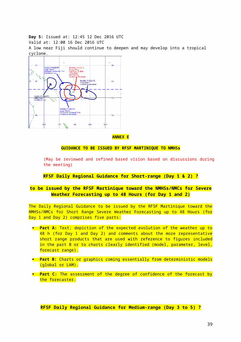
SEVERE WEATHER EVALUATION FORM(Page 1)
39
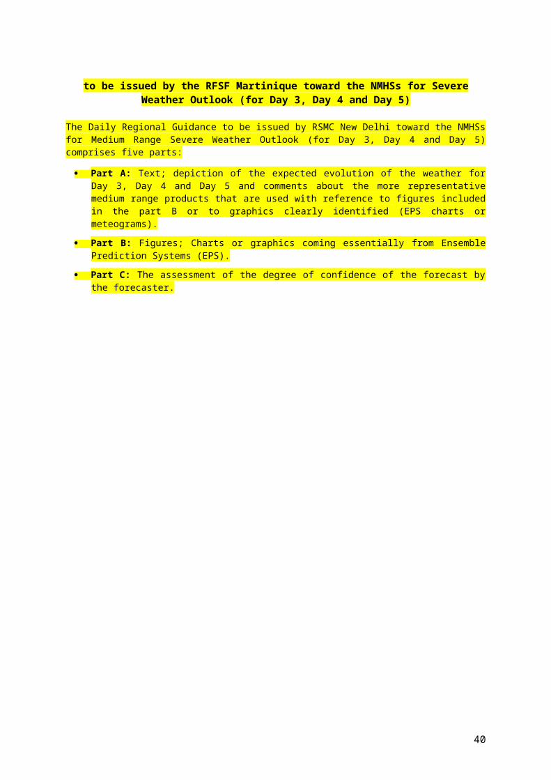
INSTRUCTIONS: :1. This form must be filled in whenever: (1) Severe weather is observed (Sections A and B)
(2) A warning has been issued to DM/CPA (Sections A and C)
2. Email the completed document to RFSF Martinique, WMO and other agreed recipients To standardize please put the title “SWFDP Evaluation Form” in the title list of the email
A. IDENTIFICATION OF THE SEVERE EVENT
NMHS: Alphabetic
Region affected: Alphabetic
Event Number: Numeric
Type of event: Numeric (put the right number in the cell)
1: Heavy Precipitation
(indicate the most significant phenomenon,
2: Strong wind either heavy precipitation or strong wind)
Severe convection Numeric (put 1 if extreme phenomena arethe consequence of severeconvection or 0 otherwise)
B. SEVERE WEATHER OBSERVED (to be completed even if no severe weather has been forecast)
JJ MM DD HH MMStart of the event: at UTCEnd of the event: at UTC
Max. observed value:
Unit
Numeric Alphabetic(According to the event: accumulated precipitation, gusts, other significant parameter)
Information from the end-usersshort text explaining the consequences and possibly some figures(number of interventions, casualties, damages, usefulness of the warning )
40

SEVERE WEATHER EVALUATION FORM(Page 2)
C. SEVERE WEATHER FORECAST (to be completed even if severe weather did not occur)
JJ MM DD HH MM Time of the
warningtoward DMCPA at UTC
Start of the event;
forecaster assessment
at UTC
End of the event; forecaster assessment
at UTC
Usefulness of the warning (feedback from the DMCPA)
check in the chosen cell Lack of warningFalse alarm warningLate warningUseful warning
Level of risk as appreciated by RSMC (put 1 in the chosen cell)
No Low Med. HighLevel of risk 1 day before:
Level of risk 2 days before:
Probabilities of medium range outlooks as appreciated by RSMC
Probability 3 days before: %
Probability 4 days before: %
Probability 5 days before: %
Mark for usefulness of products (put 1 in the chosen cell)KEY
41

A = Very useful (basis of the warning)
RFSF Guidance
B = Useful (aided warning confidence)C = Neutral (not useful) NWP EPSD = Negative (misleading) Meteo FranceX = Not used NCEP
UKMOECMWFNWP LAM (RFSF)
Comments including information on usefulness and applicability of used tools
42
SEVERE WEATHER EVALUATION FORM(Page 3)
Quarterly Evaluation Table (to be fulfilled based on the Severe Weather Event Evaluation Form)
A row has to be filled in this table whenever a severe weather event is observed or a warning is issued toward DMCPA.
Event No.
Weather event type
Region/ Area Obs. Start time
Obs. end time
Observations (list all reports in
region)
Severe Weather
observed?
Forecast/Warning issued?
RFSF Guidance product checked and used?
Other products checked and used?
Forecast/ Warning start
time
Forecast/ Warning end time
Lead time of Forecast/ Warning
Impact of event
Impact of Forecast/ Warning
(Yes=1, No=0) (Yes=1, No=0)Evaluate the usefulness of
RFSF Guidance on scale 0 to 3 (0=Poor, Excellent=3
List the other products used and evaluate their
usefulness on scale 0 to 3 (0=Poor, Excellent=3)
Short-range : Meto France:
Day 1 Map, Day 2 Map etc. NOAA/NCEP
Medium-range: ECMWF:
Day 3 to 5 Maps etc. UKMO:
Severe Weather Event Evaluation FormNMHS/NMC: Period: MM/YYYY to MM/YYYY
Please fill out this table for each event, either observed or forecast or both for each region/area of the country where an event observed or was forecast. Please also calculate probability of detection, false alarm ratio etc. using 'contingency table' on separate sheet
1
43
Annex J
USER ASSESSMENT QUESTIONNAIRE
J.1 Evaluation Questionnaire for the Public
Q1. Do you get the warnings and forecasts issued by the National Meteorological Service?
Yes
No
Q2. Do the warnings and forecasts arrive early enough for you to take any actions?
Yes
No
Q3. How Do you get the forecasts and warnings? (Can choose more than one)
Radio TV Internet Telephone Local radionetwork
Other(s)
If other(s), please specify:
Q4. Do you understand the warnings and forecasts?
Yes
No
Q5. Do you take any action in response to the warnings and forecasts?
Yes
No
If yes, what did you do?
Q6. The warning was useful to protect your (Can choose more than one)
family
home
boat
farm animals
other(s)
If other(s), please specify:
Q7. Are warnings issued by the National Meteorological Service correct?
Yes
No
More or less
Q8. Are forecasts issued by the National Meteorological Service correct?
Ye N More or less
44
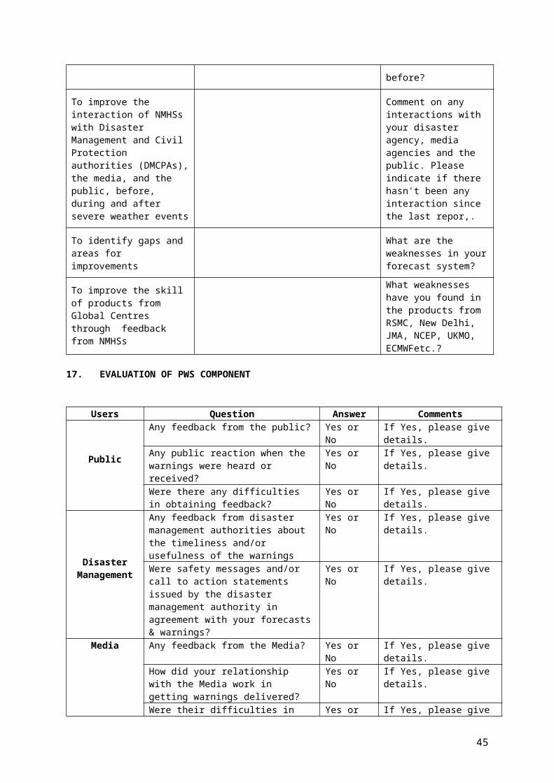
s o
Name: Date:
J.2 Evaluation Questionnaire for Disaster Management (DMCPA)
Q1. Did you get the warnings for the severe weather events in the period…to….? (Specify)
Yes
No
Q2. Did the warnings arrive early enough for you to take the necessary actions according to your specified responsibilities?
Yes
No
Q3. How did you get the warnings? (Can choose more than one)
Radio TV Fax Internet Telephone Local radionetwork
Other(s)
If other(s), please specify:
Q4. Did you understand the warnings?
Yes
No
Q5. Did you take any action in response to the warnings?
Yes
No
If yes, what did you do?
Q6. In your opinion were the warnings correct?
Yes
No
More or less
Q7. Do you have any suggestions on how to improve the warning process, including dissemination methods, format, language etc.
Name & designation: Date:
45
J.3 Evaluation Questionnaire for Media
Q1. Do you get the warnings for the severe weather events and forecasts from the National Meteorological Service?
Yes
No
Q2. Do the warnings and forecasts arrive early enough for you to take the necessary actions according to your specified responsibilities?
Yes
No
Q3. How do you get the warnings and forecasts? (Can choose more than one)
Radio TV Fax Internet Telephone Local radionetwork
Other(s)
If other(s), please specify:
Q4. Do you understand the warnings and forecasts?
Yes
No
Q5. Are the language and format clear enough for you?
Yes
No
Q6. Do you take any action in response to the warnings and forecast you receive?
Yes
No
If yes, what do you do?
Q7. In your opinion are the warnings and forecasts accurate?
Yes
No
More or less
Q8. Do you have any suggestions on how to improve the warning and forecast process, including dissemination methods, format, language etc.
Name and designation: Date:
46