Embed Size (px)
Citation preview

SCHOOL OF ARCHITECTURE, BUILDING AND DESIGNCENTER FOR ARCHITECTURE STUDIES IN SOUTHEAST ASIA (MASSA)
BACHELOR OF SCIENCE (HONOURS) (ARCHITECTURE)
ARCHITECTURE DESIGN PROJECT(ARC 3127)
PROJECT 1C:DETAILED DESIGN
“SUSTAINING HUMANITIES”
STUDENT NAME : HOW PEI NGOHSTUDENT ID : 0316929TUTOR : MR.CHAN MUN INN
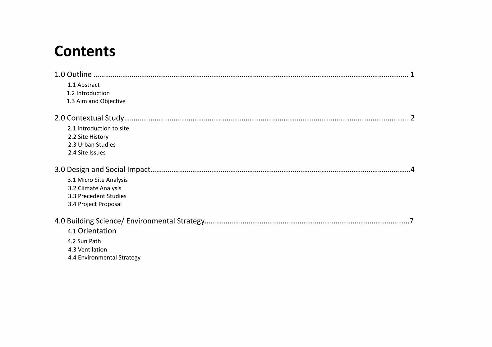
Contents
1.0 Outline …………………………………………………………………………………………………………………………………………………. 11.1 Abstract
1.2 Introduction1.3 Aim and Objective
2.0 Contextual Study…………………………………………………………………………………………………………………………………... 22.1 Introduction to site
2.2 Site History 2.3 Urban Studies 2.4 Site Issues
3.0 Design and Social Impact………………………………………………………………………………………………………………..………43.1 Micro Site Analysis
3.2 Climate Analysis3.3 Precedent Studies3.4 Project Proposal
4.0 Building Science/ Environmental Strategy………………………………………………………………………………………………74.1 Orientation 4.2 Sun Path
4.3 Ventilation4.4 Environmental Strategy

1.0 Outline1.1 Abstract
1.2 Introduction
1.3 Aim and Objective
The purpose of this report is to reinforce the understanding of architectural design process by incorporating and focusing on diverse field of knowledge. The research was done by undergoingmicro and macro site analysis, an in-depth analysis based on interview, precedent studies as well as considering the history of the site, all combined with the standard architectural designprocess. Apart from the basic site response, additional strategies such as double skin façade for both ventilation and noise filtering purpose were being looked into, along with energyconservation features, materials and resources.
The aim is to encourage tourist and local resident to communicate andintegrate, in order to promote the multicultural of Malacca. Hence,learning endangered traditional languages is proposed as a tool toestablishes the concept.
The architectural design project is intended to encourage the 2 major users of the site to integrate and communicate, as known as local resident and tourist. The architectural design projectproposed to be a language learning centre, namely “ UNESCO language learning centre”, which promoting endangered traditional languages in Malacca The aim of UNESCO is “to contribute tothe building of peace, the eradication of poverty, sustainable development and intercultural dialogue through education, the sciences, culture, communication and information”. In order toestablish the concept, some of the studies and analysis has been done. Besides that, the project also concerned about the building performance, safety and adopting regulatory frameworkaccording to UBBL and local authority regulation.

2.0 Contextual Study 2.1 Introduction to site
The site is located along Jalan Laksamana, a road linking to the UNESCO Heritage site after 3main roads. The topography of site is sandwiched between Malacca River and UNESCO Heritagesite, where is the heart of the town and a happening site. Within a radius distance of 200m,St.Francis Xavier Church, Discovery café, little india, Christ Church, Jonkey Street are thesignificant landmarks in the neighbourhood of the selected site. Not to mention, the selectedsite also included a historical site as known as “ Bastion Victoria”, a part of fortification ofA’Famosa, built in Portuguese era.
2.2 Site History
Figure 1 : KEY PLAN N.T.S Figure 2 : LOCATION PLAN
Malacca History
Early Malaya 1396
Sumatran Prince Arrives from Singapore on a hunting expedition and seeks sanctuary here. He gave the name “MELAKA”
Malay Fort was built by indigenous Malay for protection made of a system of earthworks surrounded by wooden stockades.
1511-1641 Portuguese
Era
Portuguese defeated the armies of Malacca Sultanate and took over the fort. The wooden fort was reconstructed with stone and mortar in 1511 after war.
1641-1700 Dutch Era
Dutch invaded Malacca after 8 month siege and started rebuilt the city after much destruction of battle. St Domingo was renamed to Bastion Victoria
1700-1807 Dutch Era
The Dutch built up many parts of the city, including the system of road due to the population expands. Many houses and shops were built outside of the fort
1807-1957 British Rule
British invaded Malacca and destroyed the fort and Malacca flourish under the ruling of the British.
1957-Present
Malaya gained independence from Britain. Malacca’s land reclamation was done due to the increasing population and is administered by the Malacca City
Council. In 2008, Malacca was inscribed in the UNESCO Wordl Heritage List
2.2.1 History Timeline
2.2.2 Transformation of Malacca
Figure 3 : Malacca in early Malay era(1396)
Figure 4 : Malacca in Portuguese Era(1511-1641)
Figure 5 : Malacca in Dutch Era (1641-1700)
Figure 6 : Malacca in Dutch Era (1700-1807)
Figure 6 : Malacca in British Rule(1807-1957)
Figure 6 : Malacca in 1957- Present

2.3 Urban Studies
2.3.1 District & Landmark
The site is a strategies location that is a transition point of the city, that leading to the core ofUNESCO Heritage site and local commercial district. It is center point that everyone will passby before heading to their destination, no matter whether is people in vehicle or pedestrian.
HERITAGE
COMMERCIAL
RELIGION
RESIDENTIAL
MIX-USE
GOVERNMENT
2.3.2 Path
1
2
3
4
5
6
1. Little India 2. Discovery Cafe 3. St.francisXavier Church
4. Bastion Victoria 5. Christ Church 6. Jonkey Street
District
Landmark
Figure 7 : District diagram
Figure 8 : Vehicular path diagram Figure 9 : Pedestrian path diagram
Primary path
Secondary path
Pedestrian path
Main pedestrian path to site
2.4 Site Issues2.4.1 Strength
2.4.2 Weakness
2.4.3 Opportunity 2.4.4 Threat
Traffic Congestion- 3 main road into one
UNESCO Heritage Site
Node
District Center Point between- Commercial District - Historical District - Government District
Center Point - Strategic Location - Entrance of UNESCO Heritage site
Limited Car ParkPigeons Nesting Habits- Excretion, Noise and bad smell
Exiting Car Park
Foundation and earth work might affect the soil stability near the river bank causing the river bank to collapse
Focal / Staring point- An entrance to UNESCO Heritage Core
Involvement of Bastion Victoria Ruins- Allow history and culture
education to take place- Attract more people
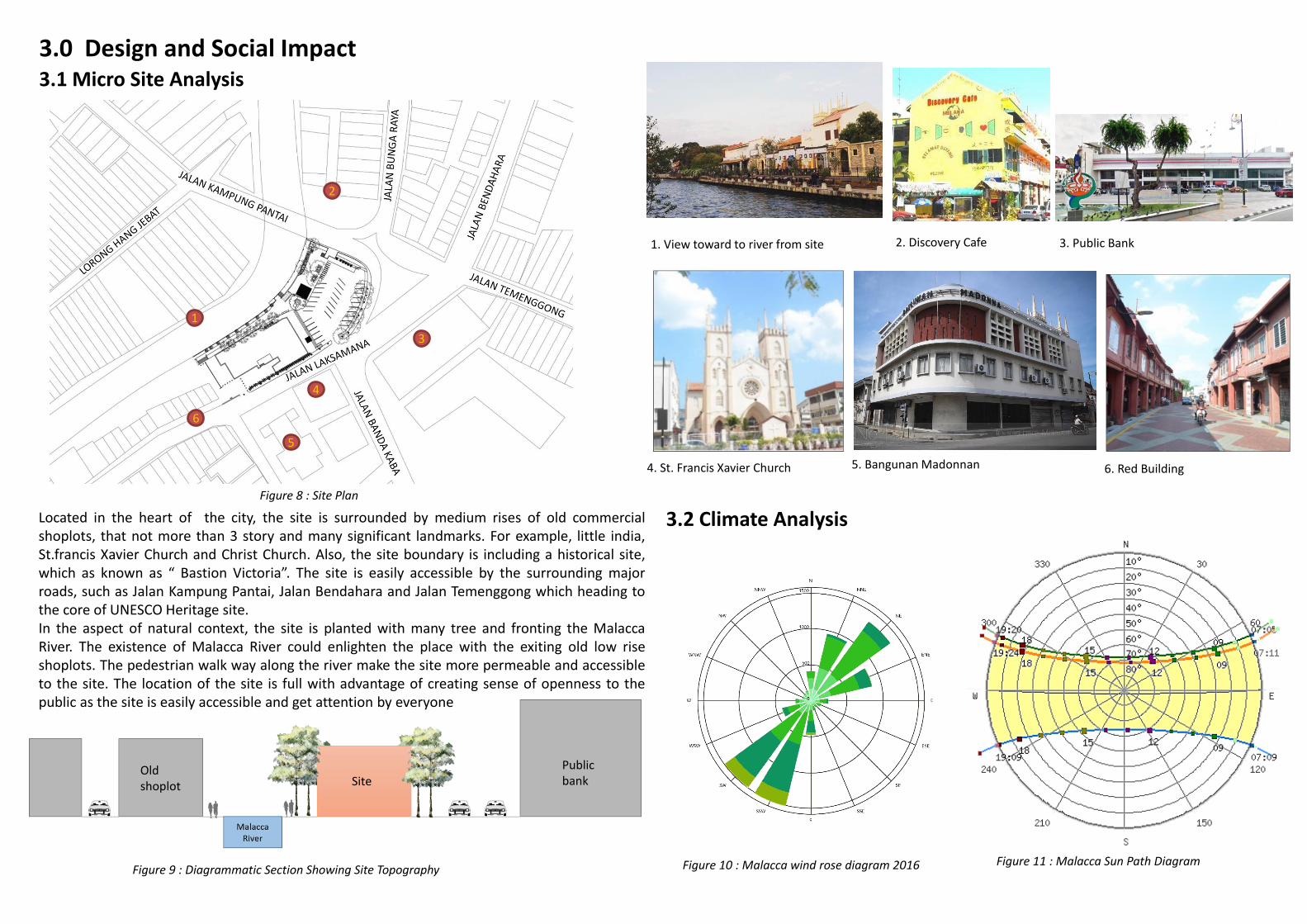
3.0 Design and Social Impact 3.1 Micro Site Analysis
Figure 9 : Diagrammatic Section Showing Site Topography
Located in the heart of the city, the site is surrounded by medium rises of old commercialshoplots, that not more than 3 story and many significant landmarks. For example, little india,St.francis Xavier Church and Christ Church. Also, the site boundary is including a historical site,which as known as “ Bastion Victoria”. The site is easily accessible by the surrounding majorroads, such as Jalan Kampung Pantai, Jalan Bendahara and Jalan Temenggong which heading tothe core of UNESCO Heritage site.In the aspect of natural context, the site is planted with many tree and fronting the MalaccaRiver. The existence of Malacca River could enlighten the place with the exiting old low riseshoplots. The pedestrian walk way along the river make the site more permeable and accessibleto the site. The location of the site is full with advantage of creating sense of openness to thepublic as the site is easily accessible and get attention by everyone
Figure 8 : Site Plan
3.2 Climate Analysis
Figure 10 : Malacca wind rose diagram 2016 Figure 11 : Malacca Sun Path Diagram
1
2
3
5
4
6
2. Discovery Cafe1. View toward to river from site 3. Public Bank
5. Bangunan Madonnan4. St. Francis Xavier Church 6. Red Building
SitePublicbank
Oldshoplot

3.3 Precedent Studies3.3.1 Paris Ecole Polytechnique Learning Center, Paris
Project Year : 2015Architect: Sou Fujimoto Architects, Manal RachdiOXO architects, Nicolas Laisne Associes
“ Flexibility, mingling and openness” is the concept of the project. “Opening up to the linear park in front, the learning center is invaded by nature,” describes the team
A wide atrium is planted with light vegetation and a series of walkways and staircases creating numerous informal spaces for teachers, students and visitors allowing new places to meet or work.
The big staircase and also siting area make the people wont pass each other in corridors anymore, but meet in vivid places that bathed in soft light and surprising views
3.3.2 Costa Nova Social and Cultural Center, Portugal
The conceptual strategy is aims to take advantage of enjoy a wide ocean view. As acounterweight, and following natural topography, the public walkway stretches into theheart of the building, that leads the visitor inside and protect from the wind
Project Year : 2015Architect : ARX Portugal
The project intended to reinterpret, in a clearly contemporary way, Costa Nova’s Characteristic and Ancestral way of looking a place and building it.
Figure 12 : Front view of Paris Ecole Polytechnique Learning Center
Figure 13 : Section of Paris Ecole Polytechnique Learning Center
Figure 16 : Bird view of costa nova social and cultural center
Figure 14 : buffer zone
Figure 15 : Atrium
Figure 16 : Section of Costa Noca Social and Cultural Center
Figure 17 : perspective Figure 18 : ground floor plan
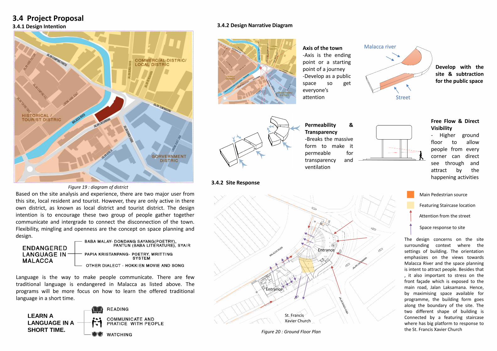
3.4 Project Proposal3.4.1 Design Intention
Based on the site analysis and experience, there are two major user fromthis site, local resident and tourist. However, they are only active in thereown district, as known as local district and tourist district. The designintention is to encourage these two group of people gather togethercommunicate and intergrade to connect the disconnection of the town.Flexibility, mingling and openness are the concept on space planning anddesign.
Language is the way to make people communicate. There are fewtraditional language is endangered in Malacca as listed above. Theprograms will be more focus on how to learn the offered traditionallanguage in a short time.
LEARN A
LANGUAGE IN A
SHORT TIME.
3.4.2 Site Response
Main Pedestrian source
3.4.2 Design Narrative Diagram
Axis of the town-Axis is the endingpoint or a startingpoint of a journey-Develop as a publicspace so geteveryone’sattention
Permeability &Transparency-Breaks the massiveform to make itpermeable fortransparency andventilation
Free Flow & DirectVisibility- Higher groundfloor to allowpeople from everycorner can directsee through andattract by thehappening activities
Develop with thesite & subtractionfor the public space
Malacca river
Street
Entrance
Entrance
The design concerns on the sitesurrounding context where thesettings of building. The orientationemphasizes on the views towardsMalacca River and the space planningis intent to attract people. Besides that, it also important to stress on thefront façade which is exposed to themain road, Jalan Laksamana. Hence,by maximising space available forprogramme, the building form goesalong the boundary of the site. Thetwo different shape of building isConnected by a featuring staircasewhere has big platform to response tothe St. Francis Xavier Church
Attention from the street
Featuring Staircase location
St. Francis Xavier Church
Space response to site
Figure 19 : diagram of district
Figure 20 : Ground Floor Plan

4.0 Building Science / Environmental Strategies 4.1 Orientation4.1.1 Solar Analysis
4.1.2 Wind Analysis
Due to the existing building is low, so the site will be fully exposed to the sun without any shade fromsurrounding building. Double skin façade is adapted, timber as outer and curtain wall as inner. The façade isgoes all over the building to get sufficient sunlight, but at the same time protect the building from heat.
Based on the wind rose diagram, the prevailing wind is come from north-east and south-west, so thevoid in between of building maximize the air flow and high ceiling as strategy is proposed
Figure 21 : Sun path diagram Figure 22 : Wind rose diagram

4.2 Sun Path 4.2.1 Shadow Analysis
Throughout the year the site is not shaded by any existing building due to the low rise building around is not morethan 3 storys and have certain distance from our site. However, the front façade facing east-south will be shaded byitself, but the part of the back elevation will be fully exposes to the western sun, which has also resulted
3pm March 3pm June 3pm December
Figure 24 : Floor plan with highlighted service area as a strategy to minimize penetration of westernsun into the building
4.2.2 Façade Treatment
Ground Floor Plan N.T.S First Floor Plan N.T.S
Second Floor Plan N.T.S Third Floor Plan N.T.S
Services Area
Façade Exposed To Western Sun
Façade Exposed To Eastern Sun
Double skin façade is adapted to minimize the heat gain from morning sun penetrate on frontfaçade. Besides the sustainable design strategy, the double skin façade is used to attract public asit facing towards to the main junction with hectic traffic.
The double skin face is featuring with a layer of timber façade as outer skin and curtain as inner.In order to provide varying degree of shading and transparency to public.
For the façade exposed to western sun, openings are kept minimum to reduce heat gain, vegetationsuch as evergreen trees are also featured to block sunlight penetration.
Timber Facade
Curtain Wall
Figure 23 : shadow study
Figure 25 : wall section
Figure 26 : Front Elevation with eastern sun
Figure 27 : Rear Elevation with western sun

4.3 Ventilation 4.3.1 Natural Ventilation
Figure 28 : Diagram showing the airflow from prevailing wind direction. According toresearch, the air will be cooler by water evaporation of river before entering to building. Inaddition of trees, the amphitheatre becomes more cooler compare to other space
Section A-A N.T.S
Figure 30 : Section A-A showing the stack ventilation of the whole building. The air is exhausted through the void in between of every block of building
Figure 29 : Floor plans showing airflow from prevailing wind direction
The site receives prevailing winds from north-northeast and northeast, where is from theriver. In addition of fronting the Malacca river, the air flow passes through water surfacebefore entering building, it cooler down the breeze, allowing cool breeze go through andventilate the building . Besides that, the void in between of building block, allowing the hotair can escape from the building within a short time.
Ground Floor Plan N.T.S First Floor Plan N.T.S
Second Floor Plan N.T.S Third Floor Plan N.T.S

4.4 Environmental Strategies4.4.1 Acoustical Consideration
4.4.2 Energy Conservation Features : Skylight
Figure 34 : The section showing the daylight penetrate through the skylight of the roof and illuminate the interior during daytime. The feature of skylight lessened the dependency on artificial lighting can help reduce the use ofelectricity. Also, it increased visual appeal to interiors
The site is surroundsby 3 major road thatcauses noise fromtraffic and affect thesite. On the other,there is a pigeonsquare in front ofthe site, that isanother noise issueof the site, that mayproduce annoyingsound
4.4.1.1 Noise issue
4.4.1.2 Strategies to reduce noise level on site
Program arrangementIn order to lower down the noise of vehicle, mostof the programs is placed and start from first floor.The ground floor is keeping as open as possible as apublic space.
Timber double skin facadeTimber is a good material that have afunction of absorb noise. The timber hasgreatly reduced the noise produced by birdand vehicle. However, the glass alsoreflected the noise as second layer of filter,makes the interior to be as quiet aspossible
Figure 31 : source of noise diagram
Timber Facade
Curtain Wall
Figure 32 : SectionFigure 33 : Wall Section