Embed Size (px)
Citation preview

ELSEVIER Geomorphology 22 (1998) 181-192
A comparative analysis of nebkhas in central Tunisia and northern Burkina Faso
Anna Tengberg * , Deliang Chen Gijteborg University, Department of Physical Geography, Earth Sciences Centre, S-413 81 Giiteborg, Sweden
Received 24 May 1995; revised 2 February 1996; accepted 28 February 1997
Abstract
This paper reports a acomparative analysis of nebkha morphology in central Tunisia and northern Burkina Faso based on a total of 473 measured nebkhas. Nebkhas are mounds composed of wind-borne sediment that accumulated around shrubs. The size of the mounds was measured by height (H) and a horizontal component (L), the latter being the mean of the length and width of the mound. In the Tunisian data set, three trends of development of the mounds were distinguished for Ziziphus lotus nebkhas. Initially, the height increases linearly with the increase in the horizontal component until it reaches about 17 m. When the horizontal component exceeds 17 m, the height stabilizes before a decreasing trend of the height occurs. These results provided the basis for mathematical modelling of nebkha development. A non-linear and a linear fit were compared and a second-order polynomial function was found to best fit the data on nebkha size from Tunisia. The results indicate that nebkhas have three stages of development: a growing, a stabilizing, and a degrading stage. The model was applied to data on Acacia sp. nebkhas and B&mites aegyptiucu nebkhas from Burkina Faso with good results. The non-linear fit was slightly better than the linear fit. Nebkhas exist at all three stages of development in Tunisia, whereas Burkina Faso has nebkhas that are mainly at the growing stage. These differences are a function of time lag in land degradation between the two study areas, because the wind1 transport of sediment and the sediment supply are highly related to the density of the vegetation cover in semiarid areas. This conclusion is further supported by dating of nebkhas and of historical and recent vegetation changes in the study areas reported in the literature. The results show that differences in plant ecologies, however, are also very important for the rate of development of nebkhas, which is demonstrated by the much faster growth of BuZunites nebkhas as compared to Acacia nebkhas, even though they occur in the same type of environment. 0 1998 Elsevier Science B.V.
Keywords: nebkhas; land degradation; Tunisia; Burkina Faso; Sahel
1. Introduction
Nebkha, or nabkha, is an Arabic term given to mounds of wind-borne sediment that accumulated
* Corresponding author. Fax: +46 (31) 773-1986.
around shrubs (Cooke et al., 1993). Nebkhas display similarities with coppice dunes reported from the southwestern U.S. (e.g. Gile, 1966) and with hum- mocky dunes (Pye and Tsoar, 1990).
These mounds may occur in as different environ- ments as on linear dunes, in inter-ridge areas, on pan surfaces or near wadis (cf. Thomas and Tsoar, 1990). Khalaf et al. (1995) studied nebkhas in a sabkha flat
0169-555X/98/$19.00 0 1998 Elsevier Science B.V. All rights reserved. PZZ SO169-555X(97)00068-8

182 A. Tengberg, D. Chen/Geomorphology 22 (19981181-192
and Marston (1986) investigated coppice dunes in a New Mexico range. Nebkhas have also been com- pared to shadow dunes occurring in coastal areas, studied by e.g. Hesp (1981) and Clemmensen (1986). Kocurek et al. (1992) identified cyclic destructional and constructional phases in a coastal dune field. The cycles corresponded to seasonal weather changes. Areas adjacent to and leeward of vegetated mounds were found to be one type of the initial depositional sites in the constructional phase of dune fields.
Nebkhas accumulated around the Ziziphus lotus thornscrub have long been reported from the North African steppe region (Killian, 1945; Long, 1954; Mensching and Ibrahim, 1977; Tengberg, 1994). In recent time, nebkhas have also been reported from several areas in the Sahelian zone south of the Sahara (Mainguet et al., 1979; Ibrahim, 1980; Ahlcrona, 1988; Tengberg, 1995a). In a southern Sahelian area in ‘northern Burkina Faso, nebkhas occurred in degraded rangelands and in millet fields (Tengberg, 1995a). Coppice dunes in the southwest- ern U.S. have been hypothesized to represent a dras- tic change in vegetation because of changes in land use that have taken place in many areas during the last 100 years (Gile, 1975).
The morphology of nebkhas is, to a large extent, controlled by the growth pattern of the shrub. The height of nebkhas is considered to be related to the height of the shrub crown and the dune length to the total shrub height (Khalaf et al., 1995). The height of shadow dunes is dependent on width of the basal element and the repose angle of the sand, whereas the length of shadow dunes is dependent on the width of the basal element and wind velocity (Hesp, 1981). Other important factors affecting dune mor- phology include time, equilibrium form, sediment size and sorting, sediment supply, wind, climate and upwind roughness (cf. Cooke et al., 1993). The effects of the temporal factor are not yet well under- stood. In longer time scales, dunes appear to achieve an equilibrium size, which means that they are in equilibrium with the wind and sand supply and that long-term and spatially averaged form is constant (cf. Cooke et al., 1993).
Recent publications have focused attention on the application of the equilibrium concept in geomor- phology (e.g. Ahnert, 1994; Thorn and Welford, 1994). The term equilibrium identifies an equality of
forces that compensate each other. As an indicator of equilibrium in geomorphology, the mass budget is generally considered more relevant than the energy budget. In this case, equilibrium exists if the amount of material that is removed from an area1 unit of the surface per time unit is equal to the amount of material that is supplied to this area1 unit during the same time (Ahnert, 1994). An inevitable simplifica- tion is associated with systems and equilibria, ac- cording to Thorn and Welford (1994) but it is offset by the possibility to identify general trends of devel- opment of land forms and the possibility to make predictions.
This paper reports a comparative analysis of nebkha morphology in central Tunisia and northern Burkina Faso. On the basis of a large data set from central Tunisia, different trends are distinguished in the development of nebkha form. Thereafter, a com- parative analysis of the development of nebkhas in central Tunisia and northern Burkina Faso was con- ducted. The importance of the temporal factor was analysed by applying the equilibrium concept to the development of the nebkha form in conjunction with additional evidence from dates and a literature sur- vey. The nebkhas analysed in this study are assumed to be in a closed system, that is, a system where the boundaries prevent the import and export of mass, but not of energy. This assumption is supported by several studies that have indicated that the sediments in nebkhas are generally derived from adjacent top soils and, therefore, have only been transported over short distances (Gile, 1975; Marston, 1986; Teng- berg, 1994, 1995b; Khalaf et al., 1995). The ex- change of energy takes place between the system and the atmosphere.
2. Study areas
2.1. Tunisia
The study area, which is approximately 50 km X 60 km, is located in the Governorate of Sidi Bouzid, in the southern part of the central Tunisian steppe region (Fig. 1). It receives rains from October to March. The mean annual precipitation is approxi- mately 220 mm and the annual potential evapotran- spiration 1400 mm. During the winter months, most

A. Tengberg, D. Chen / Geomorphology 22 (1998) 181-l 92 183
~~
FASO
h1 ./ AFRICA
Fig. 1. Location of the study areas in central Tunisia and northern Burkina Faso.
of North Africa is affected by westerlies. The pas- sage of fronts associated with the westerlies is often marked by intense sandstorms. In the summer months, the region :is influenced by etesian winds, which blow from the northeast (Dubief, 1953; Cha- bani, 1989). The relief is characterized by a series of plains at approximately 300 m a.s.1. The plains are divided by mountain ridges that rise about 400 to 500 m above them. Playas have generally developed in the lowest-lying areas. The natural vegetation cover on the plains consists of shrubs, mostly Zizi-
phus lotus, which often is associated with the devel- opment of nebkhas (Long, 1954).
2.2. Burkina Faso
This study area, which is approximately 36 km X 43 km, and is located in the northernmost part of Burkina Faso is a tylpical southern Sahelian environ- ment (Fig. 1). It rec:eives about 400 to 550 mm of mean annual rainfall, mainly between June and September, in connection with the passage of the intertropical convergence zone (ITCZ). The annual potential evapotranspiration is 1900 mm. The domi-
nant wind is the dry, dust-laden Harmattan that blows from the northeast during the dry season and the humid monsoon that blows from the southwest during the wet season (Sivakumar and Gnoumou, 1987). The geomorphology is characterized by a vast and flat, ancient pediplain approximately 300 m a.s.l., with the natural vegetation being mainly Aca- cia steppe. The monotony of the landscape is inter- rupted by ancient, vegetation-fixed dune systems formed during the Late Pleistocene and early Holocene. These dunes have a WSW-ENE orienta- tion and rise approximately 20 m above the plains. A few inselbergs and duricrusts are also found in the area (Courel, 1977). Cultivation is chiefly concen- trated to the ancient dunes, while the interdune plains are generally used as rangelands (Marchal, 1983).
3. Methods
3.1. Morphometric measurements
In Tunisia and Burkina Faso, between 10 and 20 randomly chosen nebkhas were measured at each site. The reason for this sample size is that nebkha clusters can be very small and that the mounds can occur widely apart. To use statistical analysis, a minimum of ten nebkhas were measured at each site. In the study by Khalaf et al. (1995) a total of eighteen nebkhas were used for dune morphometry. From a starting point at each field site, a random compass direction was chosen. The first encountered nebkha in this direction was measured. From this nebkha, a new random direction was chosen and the first encountered nebkha in this new direction was measured, and so on. Care was taken not to measure the same dune more than once.
The size of the mound was measured by a hori- zontal component (L) and height (H), where the height is the maximum height of the sand mound, and the horizontal component is the mean of length (1) and width(w) of the mound, thus L = (I + w)/2. The sizes of 264 Ziziphus lotus nebkhas were mea- sured in Tunisia. In Burkina Faso, the size of 74 Acacia sp. nebkhas and 135 Balanites aegyptiaca nebkhas were measured. The nebkhas from Tunisia belong to an extended version of the data set pre-

184 A. Tengberg, D. Chen / Geomorphology 22 (1998) 181-192
sented by Tengberg (19941, and the nebkhas from Burkina Faso to the data set presented by Tengberg (1995a).
In a sub-sample of 76 Ziziphus nebkhas from Tunisia, shrub height was measured in addition to dune size. Total shrub height and the height of the part of the bush protruding above the dune crest were measured. The latter is defined as crown height (e.g. Khalaf et al., 1995). The basal length and width of the shrub corresponded in general with the length and the width of the dune.
approximation of age. The main weakness with this method is, of course, that it has to be based on a set of assumptions, such as an even sediment supply and minor fluctuations in climate.
3.2. Assessment of age
Nebkhas are difficult to date because of recent formation and the biological activity in the mounds. Mensching and Ibrahim (1977) tried to date a nebkha in central Tunisia with radiocarbon methods and found that it was approximately 100 years old, al- though the accuracy of the method is low in this time interval. Tengberg (1994) tried another method and dated four Ziziphus nebkhas in central Tunisia by means of tree-ring analysis. It was assumed that the nebkhas had the same age as the Ziziphus lotus scrub, because the scrub had begun to develop hori- zontally from the very beginning of its growth. This indicates a simultaneous accumulation of sand, as the Ziziphus Zotus develops into a tree with a trunk under stable conditions with low erosion rates Long (1954, pp. 168-171). The ages of the nebkhas were be- tween 50 and 200 years. The Laboratory of Quater- nary Biology (Lund University, Sweden) was con- sulted for the tree-ring analysis. It was found that it was possible to distinguish between real and false annual rings when whole cross-sections of the stems were used (Thomas Bartholin, pers. commun., 1995). A similar method was used by Biot (1990) for dating of Acacias.
Relative dating of three Balanites nebkhas in Burkina Faso was carried out using the data set presented by Tengberg (1995a). Multi-temporal stud- ies of aerial photographs from 1955, 1974 and 1981, and a satellite image (SPOT, panchromatic) from 1990 of changes in the vegetation cover, showed that 46 clusters of nebkha sites in 1991 only occurred at sites where the vegetation cover had become very degraded between 1955 and 1990. Nebkha size was measured at 15 of these 46 sites. Three of the sites, where the size of BaZanites nebkhas were measured, were present on all photographs. At two of the sites, nebkha formation was initiated during the period 1955 to 1974, approximately set to 26 years before the field measurements of nebkha size in 1991. At the third site, nebkha formation was initiated during the period from 1974 to 198 1, approximately dated to 15 years before the field measurement of nebkha size. The horizontal component (,CJ related to the age value is taken as the maximum value found at each of the three sites.
4. Results
4.1. Trends in the development of nebkha morphol-
WY
Fig. 2 clearly displays the differences in size between the nebkhas in central Tunisia and in north- em Burkina Faso. Most of the Tunisian nebkhas are higher and have a larger horizontal component than the Sahelian nebkhas.
In Burkina Faso, the nebkhas are probably younger For Ziziphus nebkhas in Tunisia (Fig. 2a), the than those in Tunisia (Tengberg, 1995a). The shrubs height increases with the increase in the horizontal in and around the dunes are constantly subjected to component until the horizontal component reaches wood cutting and browsing. The age of the dune about 17 m. When the horizontal component grows cannot be related to the age or the growth rate of the further, the height appears to stabilize somewhat. shrub. The accumulation of sediments in and around Thereafter, a slight decreasing trend of the height Acacias and Balanites may have started first after appears, although significant scattering of the height they have attained a shrub-like appearance because is apparent. Indeed, the scattering of the data in- of intensified land use. Relative dating of the nebkhas creases with the increased horizontal component even is, therefore, currently the only way of obtaining an from the very beginning. This is not surprising be-
A. Tengberg, D. Chen / Geomorphology 22 (1998) 181-192 185
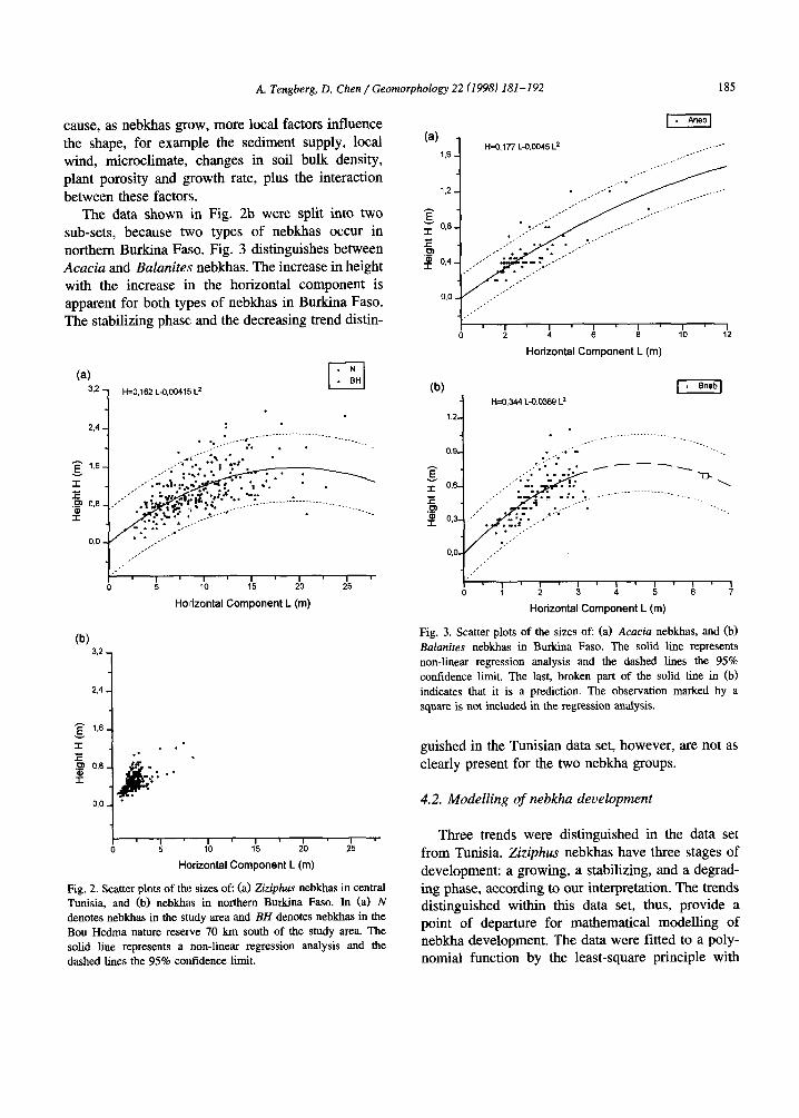
cause, as nebkhas grow, more local factors influence the shape, for example the sediment supply, local wind, microclimate, changes in soil bulk density, plant porosity and growth rate, plus the interaction between these factors.
The data shown in Fig. 2b were split into two sub-sets, because two types of nebkhas occur in northern Burkina Faso. Fig. 3 distinguishes between Acacia and B&mites nebkhas. The increase in height with the increase in the horizontal component is apparent for both types of nebkhas in Burkina Faso. The stabilizing phase and the decreasing trend distin-
(4 3.2
1
H=0,162 L-9,004111 L*
.
2.4
E I.6
I
E .P 0,6
f
0.0
I n I ’ I ’ I a ,I 5 10 15 20 25
Horizontal Component L (m)
(b) 3.2
1 2.4
Horizontal Component L (m)
Fig. 2. Scatter plots of the sizes of: (a) Ziziphus nebkhas in central Tunisia, and (b) nebkhas in northern Burkina Faso. In (a> N denotes nebkhas in the study area and BH denotes nebkhas in the Bou Hedma nature reserve 70 km south of the study area. The solid line represents a non-linear regression analysis and the dashed lines the 95% contidence limit.
0 2 4 6 6 10 12
Horizontal Component L (m)
(b) -1 H=0,344L-0.0369L2
1, .
. _..-.-
___.......------......._____
0% . ,__.~~m . .._ ._
-1
-.... ..__ -_
,' ,,'
I ' I s I' t ' I * I 'I 0 1 2 3 4 5 6 7
Horizontal Component L (m)
Fig. 3. Scatter plots of the sizes of: (a) Acacia nebkhas, and (b) Balm&es nebkhas in Burkina Faso. The solid line represents non-linear regression analysis and the dashed lines the 95% confidence limit. The last, broken part of the solid line in (b) indicates that it is a prediction. The observation marked by a square is not included in the regression analysis.
guished in the Tunisian data set, however, are not as clearly present for the two nebkha groups.
4.2. Modelling of nebkha development
Three trends were distinguished in the data set from Tunisia. Ziziphus nebkhas have three stages of development: a growing, a stabilizing, and a degrad- ing phase, according to our interpretation. The trends distinguished within this data set, thus, provide a point of departure for mathematical modelling of nebkha development. The data were fitted to a poly- nomial function by the least-square principle with

186 A. Tengberg, D. Chen/Geomorphology 22 (1998) 181-192
the constraint of H = 0 when L = 0. Different orders of polynomials were tested, and it was found that order-two best fit the data. The result can be repre- sented by:
H=A.L-B.L2 (0
where H is the dune height, L is the horizontal component of the mound and A and B are constants. For Ziziphus nebkhas, it was estimated that A = 0.162 and B = 0.00415. The determination coeffi- cient (R’) is 0.908. Both A and B are significant at the 0.01 significance level. The fitted function is displayed in Fig, 2a. For the straight line fit A = 0.109 and R2 = 0.882, which means that the polyno- mial explains 2.6% more of the data distribution than the straight line does. It can be seen in Fig. 2a that when L is small, the linear trend (positive) domi- nates, indicating a growing phase. As L increases, however, the quadratic trend (negative) increases in importance. A critical L exists at which the second trend begins to be more important than the first. At this point, the height ceases to increase. That point may represent a short stabilizing period. After this, H decreases with increased L, which may indicate a degrading phase of the nebkha development.
This critical point exists because at least one limiting factor, either biological or environmental, restrains the growth of the dunes in the vertical direction. The model presented in Eq. (1) may be used to estimate the equilibrium form of the nebkha. According to the definition of equilibrium, the criti- cal point discussed above may be a good approxima- tion of an equilibrium as the positive and negative trends balance each other here. The response of the model can be studied by comparing the rate of growth in the vertical and horizontal directions. A relative rate of growth RR can be defined as:
RR = (dH/dt)/(dL/dt)
=dH/dL=A-2.B.L (2)
RR depends on L, decreasing linearly with L in the growing period, being equal to zero at the equi- librium point and becoming negative in the period of degradation. As L approaches zero, RR approaches a maximum value of A. Setting RR = 0 gives an estimate of L at equilibrium, as L, = A/2 B accord- ing to Eq. (2). For Ziziphus nebkhas, the horizontal component at equilibrium was found to be 19.5 m.
The corresponding equilibrium height can be calcu- lated with Eq. (1) as H, = 1.6 m.
This model was also applied to the data from Burkina Faso. As the model gives a good description of the different trends in nebkha development in Tunisia, it is believed that the form of the model may be valid for nebkhas in general, although the coeffi- cients may vary according to environmental condi- tions and shrub species. As implied by the model, the data from Burkina Faso have included informa- tion about the negative trend, i.e. the degrading stage of nebkha development, even though the positive trend is dominant. However, as the deviation from the model tends to grow with the development of nebkhas, lack of data on the development in the later stages may affect the precise determination of the coefficients, especially coefficient B.
The regression analysis of Acacia nebkhas shows that the model tits the data very well (Fig. 3a). The determination coefficient is estimated to be 0.940 with A = 0.177 and B = 0.00450. The estimate of A is very significant, whereas B is significant at the 95% level. A linear fit was tried again, but it was not as good as the polynomial one (A = 0.158, R2 = 0.9371, which means that the polynomial explains 0.3% more of the data distribution than the straight line. The significance level of B for the second-order polynomial gives confidence in using the model to predict the equilibrium form of Acacia nebkhas. The predictions of L, and H, are 19.7 m and 1.7 m, respectively. Similar results have been obtained with Bulunites nebkhas (Fig. 3b). For the polynomial, the determination coefficient is 0.944 in this case, with A = 0.344 and B = 0.0369. The estimates of A and B are both very significant. The equilibrium form can be given as L, = 4.7 m and H, = 0.8 m. Fig. 3b shows that the data set contains one Bulunites nebkha far from the other observations. This single point is not included in the regression analysis, although it can be seen that it lies close to the model prediction. To include the outlying point does not affect the form or the significance of the polynomial fit notice- ably. A straight line fit was also tried without the single point. Although the linear fit is also significant (A = 0.249, R2 = 0.917), the fit with the polynomial again shows a better fit (2.7%), as in the other cases.
As shown by Eq. (2), the parameter A of the model represents the maximum relative rate of

A. Tengberg, D. Chen / Geomophology 22 (1998) IN-192 187
growth, and B is the rate at which the relative rate of growth decreases with increased L. Among all nebkhas discussed, Balunites nebkhas have the high- est maximum rate of growth, whereas Acacia and Ziziphus nebkhas have similar maximum rates of growth. At the beginning, Balanites nebkhas grow about two times more quickly than Ziziphus and Acacia nebkhas in ‘terms of the relative rate of growth.
Larger A seems to be related to larger B in all cases, which means that fast-growing nebkhas start to degrade quicker than those that grow slowly. Because B of Balunites nebkhas is about eight times greater than those for Ziziphus and Acacia nebkhas the smallest equilibrium form occurs for Bulanites nebkhas. Acacia nebkhas in Burkina Faso and Zizi- phus nebkhas in Tunisia have similar equilibrium forms. As Acacia and Balanites nebkhas have a similar large-scale environment, i.e. they have been observed in one area of limited size, with similar climatic conditions, soils and large-scale geomor- phology, the difference between the equilibrium forms emphasizes the importance of the variations in plant morphologies and growth rates, and micro-scale factors in determining the size of nebkhas.
4.3. Sediment supply and plant morphology
The nebkhas measared in the Bou Hedma nature reserve in Tunisia (Fig. 2a), where some of the original steppe vegetation with scattered Acacias has been preserved, shows the lowest dune heights. This implies that the sediment supply, which proba- bly is more limited in the reserve than outside, is an important factor in determining the height of nebkhas. Thus, variations in sediment supply can correspond to part of the deviations from the fitted functions caused by local factors. That Balunites nebkhas have higher H in relation to L of the three types of nebkhas could be explained because B&unites ae- gyptiaca has a denser canopy than Acacia sp. and Ziziphus lotus. Flow velocities within Balanites ae- gyptiaca can, therefore, be reduced to a greater extent than in the other two shrubs. This gives higher rates of sediment deposition witbin the plant (Fig. 41, which agrees with findings by Hesp (1989) regarding incipient foredunes accumulated in and around vege- tation. In zones having a high density of vegetation,
Fig. 4. (a) Ziziphus nebkhas in central Tunisia. (b) Acacia nebkhas in northern Burkina Faso. (c) Balanires nebkhas in northern Burkina Faso.
sand is trapped over a shorter distance and in greater volume than in lower-density zones. The faster growth rate of B&unites nebkhas, as compared to the others, could also be explained by a faster growth rate of the Balanites aegyptiaca shrub than for the other shrubs.
The morphology of the nebkhas in this study differs from other types of mounds accumulated around vegetation because no tails are apparent.

A. Tengberg, D. Chen/Geomorphology 22 (1998) 181-192
.
0 I I - I I ’ 1 0 5 10 15 20 25
Horizontal Component L (m)
Fig. 5. Scatter plot of the horizontal components (L) of Ziziphus nebkhas in relation to total height of the bush.
Furthermore, the basal length and width of the plant corresponds with length and width of the mound (Fig. 4). This is due to the fact that these mounds accumulated around perennials are not purely aeolian in origin. As the nebkhas investigated in this study occur in semiarid areas with distinct dry and rainy seasons, overland flow is also likely to contribute to the build-up of the mounds (Coque, 1962; Tengberg, 1995b). Other factors involved in the formation of mounds around bushes can be changes in the bulk density of the soil in the vicinity of the bush stem, high root density and termite or ant activity (Biot, 1990).
horizontal component of the dune (I,), with a deter- mination coefficient of 0.923 (Fig. 5), which con- firms the conclusion above, i.e. that L is strongly related to the dimensions of the shrub. As seen in Fig. 6, no apparent relationship exists between bush crown height and dune height, which disagrees with the findings by Khalaf et al. (1995). Other factors, such as sediment supply, wind regime, microclimate and time, must control nebkha height.
4.4. Nebkha age
For Ziziphus lotus nebkhas in Tunisia, a linear The horizontal component of nebkhas appears to relationship exists between total bush height and the be positively correlated with age (Fig. 7). The analy-
2.5
I .
i f 1.5 ~-
s g l-- Q 2 6 0.5 --
20 1
0 50 100 150 200
Age (year)
Fig. 7. The ages of nebkhas in relation to the horizontal compo- nent, based on dating Ziziphus nebkhas in Tunisia and B&mites nebkhas in Burkina Faso. The equations for the regression lines are given in the text.
. .
.
. 0 ,
0 0.5 1 1.5 2 2.5 3 Dune Height(m)
Fig. 6. The heights (h) of Ziziphus nebkhas in relation to the crown height of the shrub.

A. Tengberg, D. Chen/ Geonwrphology 22 (1998) 181-192 189
sis of Ziziphus nebkhas in Tunisia and Balanires nebkhas in Burkina Faso showed that a positive correlation holds for leach of the two groups. Linear correlation was performed with the constraint that the horizontal component (L) should be zero at the starting time (t = 0) for nebkha development for the two groups. The results are that L = 0.081 t CR2 = 0.960) for Ziziphus and L = 0.22 t CR2 = 0.980) for Balunites nebkhas. B’oth regressions are significant at the 99% confidence level. The slopes, i.e. the rate of growth of the horizontal component, are different for the two groups. B&unites nebkhas grow about two times faster than Ziziphus nebkhas do. Although the data are scarce and scattered, this confirms the results obtained from the analysis of trends in nebkha development, i.e. that the Sahelian nebkhas are younger than the Tunisian ones, and that the Bulun- ites nebkhas have a. higher rate of growth than Ziziphus nebkhas.
5. Historical and recent vegetation changes
Ash and Wasson (1983) found that when the vegetation cover exceeds 30%, the sediment trans- port rate approaches zero. Recent findings (Wiggs et al., 1995) have shown no threshold of vegetation cover below which sediment movement occurs, but rather a reduction in vegetation cover increases the potential for sediment movement by wind. In the southwestern Kalahari desert, a threshold of about 14% vegetation cover was observed, although the local variations were considerable (Wiggs et al., 1995). Transport of sediment by the wind is related to the density of the vegetation, although the density at which transport can start varies widely. Moreover, the sediment supply is also related to the density of the vegetation cover. A discussion follows on histori- cal and recent vegetation changes in the study areas to assess whether the difference in the temporal factor in nebkha development between Tunisia and Burkina Faso can be explained as a function of the density of vegetation.
5. I. Tunisia
Conflicting views exist about the type of natural vegetation that existed before human transformation of the landscape in central Tunisia (cf. Gsell, 1913;
Long, 1954; Despois, 1955; Johansson, 1993). Gsell (1913, p. 150) concluded that the lack of trees in extensive areas cannot be attributed to human-in- duced deforestation, because the soils are not suit- able for forest vegetation. Long (1954, p. 2991, who conducted studies of the natural vegetation in the Sidi Bouzid area, considered open juniper forest with isolated AZeppo pines to have been the original vegetation in the mountains. In the mountains sur- rounding Sidi Bouzid, this forest has almost com- pletely disappeared, but the character of the remain- ing vegetation suggests that it is a degraded form of Juniperus phoeniceu forest. On the vegetation map constructed by Long (1954) between 1949 and 1954, some scattered jumpers are noted on the mountain ridges. Some isolated Acacia rudiunu, Pistuciu ut- lunticu, Rhus oxyucunhu and Ziziphus lotus trees are found in the plains. During field work carried out for this study in the Sidi Bouzid area in 1989 and 1994, none of these tree species was seen, with the excep- tion of Ziziphus lotus in the form of scrubs. A stand of Acacia rudiunu 70 km south of the area investi- gated, still exists in the Bou Hedma nature reserve. Despois (1955, p. 37) suggested that the natural state of the Tunisian steppes before any large-scale human interference resembled the present-day steppes of the Sahelian zone south of the Sahara and supported primarily scattered Acacias and other trees and scrubs. The remnants of this original steppe were probably mapped by Long (1954).
Different opinions exist about when the most extensive vegetation changes took place in central Tunisia. Mensching and Ibrahim (1977) suggested that the natural vegetation before Roman coloniza- tion in the first century AD had been a steppe with scattered trees. Because of extensive cultivation dur- ing the Roman period, skeletic soils developed and initial nebkha formation occurred. The Arab nomadic period that started around the 1 lth century was one of relative soil conservation. The vegetation cover recovered and a half steppe developed in the plains. With the French colonization in the late 19th cen- tury, a second phase of land degradation started because of a change again to a life of stable settle- ment. Land degradation was manifested primarily in the development of large nebkhas and, according to Long (19541, a deteriorating quality of the vegetation cover. The assumption that French colonization led

190 A. Tengberg, D. Chen / Geomorphology 22 (1998) 181- 192
to land degradation and soil erosion is supported by radiometric dates of playa sediments from the Sidi Bouzid area. The rate of sedimentation appears to have been relatively even over the past 16,000 years with the exception of the last 100 years, during which the sedimentation rate accelerated about ten to twenty times (Hjehnroos and Franz&, 1991; Lam Franzen, pers. commun., 1995).
5.2. Burkina Faso
The Sahelian zone south of the Sahara is currently undergoing considerable transformations in vegeta- tion because of changes in land use and climate (e.g. Gomitz and NASA, 1985). Unfortunately, compre- hensive data on vegetation changes throughout the Sahel are deficient in quality and quantity (IUCN, 1989), although several studies have shown that, in northern Burkina Faso, a considerable degradation of the vegetation cover has taken place during the last few decades (Chamard and Courel, 1979; Krings, 1979; Courel, 1985; Claude et al., 1991; Lindqvist and Tengberg, 1993; Lindskog and Tengberg, 1994; Tengberg, 1995a). Between 1955 and 1990, a steppe vegetation with continuous cover of bushes and low trees was replaced in many areas by a steppe with discontinuous bush cover and with scattered patches of bare ground or, in the worst cases, by bare ground. The most serious degradation occurred with the onset of the Sahelian drought in the late 1960s and impacted in the rangelands surrounding the old dune systems. An intensified use of agricultural land, however, led to land degradation around settlements on the old, fixed dunes as well @rings, 1979). Whereas the rate of degradation slowed down during the 1980s the vegetation cover has not recovered (Lindqvist and Tengberg, 1993).
Thus, extensive land degradation is a much older phenomenon in Tunisia than in Burkina Faso. Whereas the latest period of land degradation in central Tunisia appears to have been initiated in the late 19th century, in connection with the French colonization, serious land degradation in Burkina Faso started in the late 1960s.
6. Discussion and conclusions
Analysis of nebkha development in central Tunisia showed that the relationship between the height and
the horizontal component follows a polynomial form, which means that three phases of development of the mounds can be distinguished: a growing, a stabiliz- ing, and a degrading phase. A quadratic equation was found to describe the relationship. A compara- tive analysis with two types of nebkhas in a Sahelian area, in northern Burkina Faso, showed that the model, based upon forms in Tunisia, was applicable. Comparison between the second-order polynomial fit and a linear fit showed that the former had a higher explanatory power in all three cases. Although the non-linear fit was only slightly better for the Acacia sp. nebkhas in Burkina Faso, it can be argued that this fit is more reasonable in physical terms. The dunes don not grow infinitely, but are constrained by plant growth and sediment supply. According to Cooke et al. (19931, the core of the nebkha grows to a height at which wind velocity can re-entrain sedi- ment. The trends of initial growth, stabilization and finally degradation of nebkhas are parallel to the constructional and destructional phases of coastal dunes identified by Kocurek et al. (1992). A factor limiting the growth of nebkhas, apart from plant growth, is supply of sediment. In nebkha fields, sandy top soils in adjacent areas are the major sediment source (e.g. Gile, 1975; Tengberg, 1995b). In the areas investigated in this study, only the top soils contain loose, sandy sediments. When the top soil is lost, the main source of sediment for nebkhas is lost. The wind flow then becomes undersaturated and erosion occurs (cf. Kocurek et al., 1992). The degradation in nebkha development can be distin- guished in the Tunisian data set.
The model developed is based mainly on the observations of Ziziphus nebkhas in Tunisia. The statistical approach provided almost no distinction with regard to local factors between different field sites. Although the relationships are statistically sig- nificant, the deviation is considerable for observa- tions from the last stage of nebkha development. This underscores the necessity of noting local fac- tors, such as sand supply, wind climate, plant growth, micro-climate and changes in land use. Local varia- tions in sediment supply, for example, create varia- tions in the ratio of height to the horizontal compo- nent. A careful consideration of important local fac- tors and a grouping of all observations into sub- groups accordingly will most likely result in differ-

A. Tengberg, D. Chen / Geommphology 22 (1998) IN-192 191
ent coefficients of .the model and a reduction in the deviation. Parameters A and B of the model should, therefore, be made functions of these local factors. The overall pattern of the model will probably not change because its application in Burkina Faso has proven to be succe.ssful. The model represents two essential contradictory processes, namely the growth and degradation of nebkhas. Growth and degrada- tion, however, are empirically related to the mor- phology of the mounds. In this sense, this model may be considered a semi-empirical model and may be applied at other sites if calibrated.
The results of assessing growth of nebkhas in conjuncture with dates of nebkhas indicate that the temporal factor is very important in determining the size of the nebkha. Moreover, nebkha development is more recent in Burkina Faso than in Tunisia. Extensive land degradation from colonisation and land use changes are also much older phenomena in Tunisia than in Burkina Faso. Whereas the latest period of land degradation in central Tunisia was initiated in the late 19th century, serious land degra- dation in northern Burkina Faso only began in the late 1960s. The time lag in the land degradation process, occurring later in Burkina Faso than in Tunisia, may be the reason why the stabilizing and degrading phases in nebkha development have gen- erally not yet been attained in Burkina Faso. The time lag in the initiation of nebkha development is on the order of 100 to 200 years, according to the datings of nebkhas. These dates are, however, very approximative, because exact dating of nebkhas is very difficult where biological activity in the mounds is present. Extensive nebkha development coincides with major land use changes and land degradation, as has been the case in the southwestern U.S (Gile, 1975). Indications of the difference in size of nebkhas in central Tunisia and northern Burkina Faso is, at least partly, a response to a time lag in their develop- ment. This research shows, however, that differences in plant ecologies, the much faster growth of Balan- ites nebkhas as compared to Acacia nebkhas in northern Burkina Faso, are also of importance.
Acknowledgements
Valuable comments on different versions of the manuscript were given by S. Lindqvist, P. Hesp, H.
Tsoar, M. Stocking and an anonymous referee. Thanks are also due to N. Almered and B. Karlsson for their assistance in the field in Tunisia, March 1994.
References
Ahlcrona, E., 1988. The impact of climate and man on the land transformation in Central Sudan - Application of remote sensing. Medd. Lunds Univ. Geogr. Inst. Avh. 103, 140 pp.
Ahnert, F., 1994. Equilibrium, scale and inheritance in geomor- phology. Geomorphology 11, 125-140.
Ash, J.E., Wasson, R.H., 1983. Vegetation and sand mobility in the Australian desert dunetield. Z. Geomorphol. 45, 7-25.
Biot, Y., 1990. The use of tree mounds as benchmarks of previous land surfaces in a semi-arid tree savanna, Botswana. In: Thomes, J.B. (Ed.), Vegetation and Erosion. John Wiley, London, pp. 437-450.
Chabani, B., 1989. Les vents et les couloirs toliens dam le centre et sud Tunisiens. 3Bme rencontre annuelle, PICG 252, Jerba, 23-30 Octobre, 61 pp.
Chamard, P.C., Courel, M.F., 1979. Contribution ‘a l’etude du Sahel voltaique. Causes et consequences de la degradation du couvert &g&al des dunes. Secteur de Mtnegou - Bidi. Trav. Inst. GBogr. Reims 39/40, 75-90.
Claude, J., Grouzis, M., Milleville, P., 1991. Un espace sahtlien. La mare d’Oursi Burkina Faso. ORSTOM, Paris, 241 pp.
Clemmensen, L.B., 1986. Storm-generated eolian sand shadows and their sedimentary structures, Vejers Strand Denmark. J. Sediment. Petrol. 56, 520-527.
Cooke, R.U., Warren, A., Goudie, A.S., 1993. Desert Geomor- phology. UCL Press, London, 526 pp.
Coque, R., 1962. La Tunisie PrC-Saharienne. Etude Geomotphologique. Colin, Paris, 476 pp.
Courel, M.F., 1977. Etude geomorphologique des dunes du Sahel; Niger nord occidental et Haute-Volta septentrional. These de 3e cycle, Univ. Paris VII, 284 pp.
Courel, M.F., 1985. Etude de l’tvolution recente des milieux saheliens a partir des mesures fournies par les satellites. These de doctorat, Univ. Paris I, 407 pp.
Despois, J., 1955. La Tunisie orientale. Sahel et basse steppe. Etude gtographique. Publications de 1’Instimt des hautes Etudes de Tunis, Section des Lettres, Vol. 1, Presses universi- mires de France, Paris, 554 pp.
Dubief, J., 1953. Les vents de sable dans le Sahara fran9ais. Cent. Nat. Rech. Sci. Actions Eoliennes 35, 45-70.
Gile, L.H., 1966. Coppice dunes and the Rotura soil. Proc. Soil Sci. Sot. Am. 30, 657-660.
Gile, L.H., 1975. Holocene soils and soil-geomorphic relations in an arid region of southern New Mexico. Quat. Res. 5,321-360.
Gomitz, V., NASA, 1985. A survey of anthropogenic vegetation changes in West Africa during the last century - climatic implications. Climatic Change 7, 285-325.
Gsell, S., 1913. Histoire ancienne de 1’Afrique du Nord, Vol. 1. Hachette, Paris, 544 pp.

192 A. Tengberg, D. Chen/Geomorphology 22 (1998) 181-192
Hesp, P.A., 1981. The formation of shadow dunes. .I. Sediment. Petrol. 51, 101-112.
Hesp, P.A., 1989. A review of biological and geomorphological processes involved in the initiation and development of incipi- ent foredunes. In: Gimmingham, C.H., Ritchie, W., Willets, B.B., Willis, A.J. (Eds.), Symposium: Coastal Sand Dunes. Proc. R. Sot. Edinburgh B96, 181-215.
Hjehnroos, M., Franz&, L.G., 1991. Desert formation and soil damage in central Tunisia during the Holocene. PACT (Jour. nal of the European Study Group on Physical, Chemical, Mathematical and Biological Techniques Applied to Archaeol- ogy) 33, 33-38.
lbrahim, F.N., 1980. Desertification in Nord-Darfur - Unter- suchungen zur Gef&rdung des Naturpotentials durch nicht angepaDte Landnutzungsmethoden in der Sahelzone der Re- publik Sudan. Hamburger Geogr. Stud. 35, 175 pp.
IUCN, 1989. The IUCN Sahel Studies. IUCN Regional Office for Eastern Africa, Nairobi, 152 pp.
Johansson, L., 1993. L’homme et l’environnement dans la rkgion de Sidi Bouzid (Tunisie centrale): Une relation historique. Development Studies Unit, Deparment of Social Anthropol- ogy, Stockholm University. Rep. 25, 64 pp.
Khalaf, F.I., Misak, R., Al-Dousari, A., 1995. Sedimentological and morphological characteristics of some nabkha deposits in the northern coastal plain of Kuwait, Arabia. J. Arid Environ. 29, 267-292.
Killian, Ch., 1945. Un cas t&s particulier d’humification au desert due 2 l’activit6 des micro-organismes dans le sol de nebka. Rev. Can. Biol. 4, 3-36.
Kocurek, G., Townsley, M., Yeh, E., Havholm, K., Sweet, M.L., 1992. Dune and dune-field development on Padre Island, Texas, with implications for interdune deposition and water-ta- ble-controlled accumulation. J. Sediment. Petrol. 62, 622-635.
Krings, T., 1979. Der Sahel von Obervolta. Kulturgeographischer Wandel und seine Auswirknngen auf das Naturpotential. Ge- ogr. Rundsch. 31, 372-378.
Lindqvist, S., Tengberg, A., 1993. New evidence of desertification from case studies in northern Burkina Faso. Geogr. Ann. 75A, 127-135.
Lindskog, P., Tengberg, A., 1994. Land degradation, natural resources and local knowledge in the Sahel zone of Burkina Faso. GeoJoumal 33, 365-375.
Long, G., 1954. Contribution B l’ttude de la vtgCtation de la Tunisie centrale. Ann. Serv. Bot. Agron. Tunis 27, 388 pp.
Mainguet, M., Canon-Cossus, L., Chemin, M.C., 1979. DCgrada- tion dans les regions centrales de la Republique du Niger. Trav. Inst. Gtogr. Reims 39/40, 61-73.
Marchal, M., 1983. Les paysages agraires de Haute-Volta. Atlas des structures agraires au sud du Sahara, 18. ORSTOM, Paris, 115 pp.
Marston, R.A., 1986. Maneuver-caused wind erosion impacts, South Central New Mexico. In: Nickling, W.G. (Ed.), Aeolian Geomorphology. Allen and Unwin, Boston, MA, pp. 273-290.
Mensching, H., Ibrahim, F., 1977. The problem of desertification in and around arid lands. In: Mensching, H., Hohnholz, J. (Ed%), Applied Science and Development, 10, pp. 7-43.
Pye, K., Tsoar, H., 1990. Aeolian Sand and Sand Dunes. Unwin Hyman, London, 396 pp.
Sivakumar, M.V.K., Gnoumou, F., 1987. Agroclimatology of West Africa: Burkina Faso. ICRISAT lnf. Bull. 23, 192 pp.
Tengberg, A., 1994. Nebkhas - their spatial distribution, mor- phometry, composition and age - in the Sidi Bouzid area, central Tunisia. 2. Geomorphol. 38, 311-325.
Tengberg, A., 1995a. Nebkha dunes as indicators of wind erosion and land degradation in the Sahel zone of Burkina Faso. J. Arid Environ. 30, 265-282.
Tengberg, A., 1995b. Sediment sources of nebkhas in the Sahel zone of Burkina Faso. Phys. Geogr. 16, 259-275.
Thomas, D.S.G., Tsoar, H., 1990. The geomorphological role of vegetation in desert dune systems. In: Themes, J.B. (Ed.), Vegetation and Erosion. John Wiley, London, pp. 471-489.
Thorn. C.E., Welford, M.R., 1994. The equilibrium concept in geomorphology. Ann. Assoc. Am. Geogr. 84, 666-696.
Wiggs, G.F.S., Thomas, D.S.G., Bullard, J.E., Livingstone, I., 1995. Dune mobility and vegetation cover in the southwestern Kalahari desert. Earth Surf. Process. Landforms 20, 515-529.