Embed Size (px)
Citation preview
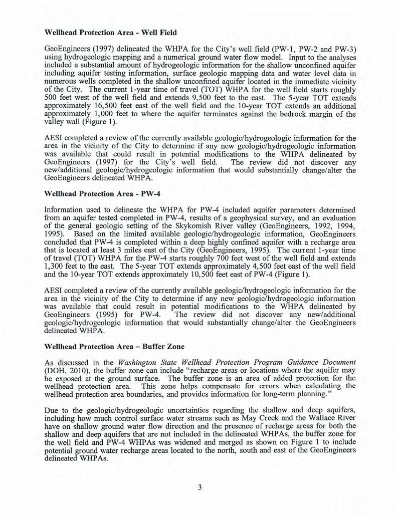
Appendix G
WELLHEAD PROTECTION PLAN
This Page Intentionally Blank
!
!
!
!
!
!!
!
!
! 7
6
1
2 4
5
3
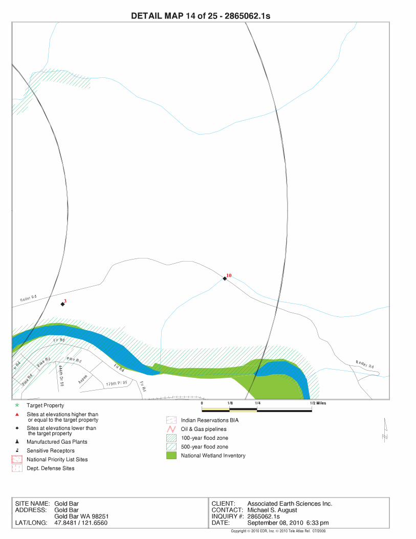
10
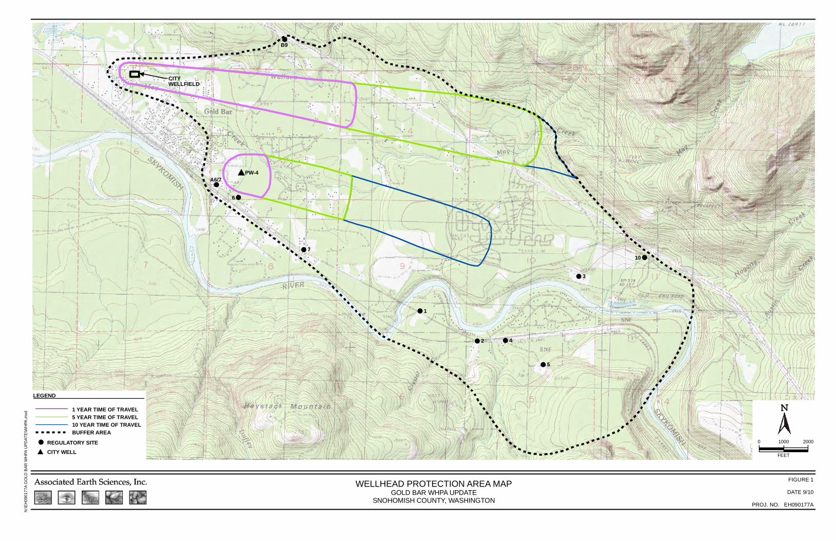
B9
A6/7
0 20001000
FEET
FIGURE 1
DATE 9/10
PROJ. NO. EH090177A
N:\E
H09
0177
A G
OLD
BAR
WH
PA U
PDAT
E\W
HPA
.mxd
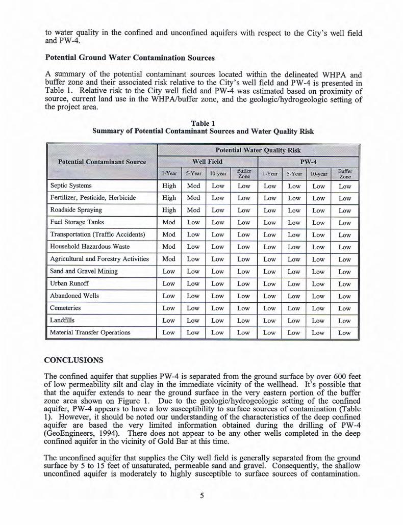
WELLHEAD PROTECTION AREA MAPGOLD BAR WHPA UPDATE
SNOHOMISH COUNTY, WASHINGTON
CITYWELLFIELD
#PW-4
LEGEND
BUFFER AREA10 YEAR TIME OF TRAVEL5 YEAR TIME OF TRAVEL1 YEAR TIME OF TRAVEL
!
#REGULATORY SITECITY WELL

FORM-NULL-ARB
®kcehCoeG htiw ™saltA suidaR RDE ehT
440 Wheelers Farms RoadMilford, CT 06461Toll Free: 800.352.0050www.edrnet.com
Gold BarGold BarGold Bar, WA 98251
Inquiry Number: 2865062.1sSeptember 08, 2010

SECTION PAGE
Executive Summary ES1
Overview Map 2
Details Maps 3
Map Findings Summary 28
Map Findings 31
Orphan Summary 86
Government Records Searched/Data Currency Tracking GR-1
GEOCHECK ADDENDUM
Physical Setting Source Addendum A-1
Physical Setting Source Summary A-2
Physical Setting SSURGO Soil Map A-5
Physical Setting Source Map A-9
Physical Setting Source Map Findings A-11
Physical Setting Source Records Searched A-47
TC2865062.1s Page 1
Thank you for your business.Please contact EDR at 1-800-352-0050
with any questions or comments.
Disclaimer - Copyright and Trademark Notice
This Report contains certain information obtained from a variety of public and other sources reasonably available to Environmental DataResources, Inc. It cannot be concluded from this Report that coverage information for the target and surrounding properties does not exist fromother sources. NO WARRANTY EXPRESSED OR IMPLIED, IS MADE WHATSOEVER IN CONNECTION WITH THIS REPORT. ENVIRONMENTALDATA RESOURCES, INC. SPECIFICALLY DISCLAIMS THE MAKING OF ANY SUCH WARRANTIES, INCLUDING WITHOUT LIMITATION,MERCHANTABILITY OR FITNESS FOR A PARTICULAR USE OR PURPOSE. ALL RISK IS ASSUMED BY THE USER. IN NO EVENT SHALLENVIRONMENTAL DATA RESOURCES, INC. BE LIABLE TO ANYONE, WHETHER ARISING OUT OF ERRORS OR OMISSIONS, NEGLIGENCE,ACCIDENT OR ANY OTHER CAUSE, FOR ANY LOSS OF DAMAGE, INCLUDING, WITHOUT LIMITATION, SPECIAL, INCIDENTAL,CONSEQUENTIAL, OR EXEMPLARY DAMAGES. ANY LIABILITY ON THE PART OF ENVIRONMENTAL DATA RESOURCES, INC. IS STRICTLYLIMITED TO A REFUND OF THE AMOUNT PAID FOR THIS REPORT. Purchaser accepts this Report "AS IS". Any analyses, estimates, ratings,environmental risk levels or risk codes provided in this Report are provided for illustrative purposes only, and are not intended to provide, norshould they be interpreted as providing any facts regarding, or prediction or forecast of, any environmental risk for any property. Only a Phase IEnvironmental Site Assessment performed by an environmental professional can provide information regarding the environmental risk for anyproperty. Additionally, the information provided in this Report is not to be construed as legal advice.
Copyright 2010 by Environmental Data Resources, Inc. All rights reserved. Reproduction in any media or format, in wholeor in part, of any report or map of Environmental Data Resources, Inc., or its affiliates, is prohibited without prior written permission.
EDR and its logos (including Sanborn and Sanborn Map) are trademarks of Environmental Data Resources, Inc. or its affiliates. All othertrademarks used herein are the property of their respective owners.
TABLE OF CONTENTS
EXECUTIVE SUMMARY
TC2865062.1s EXECUTIVE SUMMARY 1
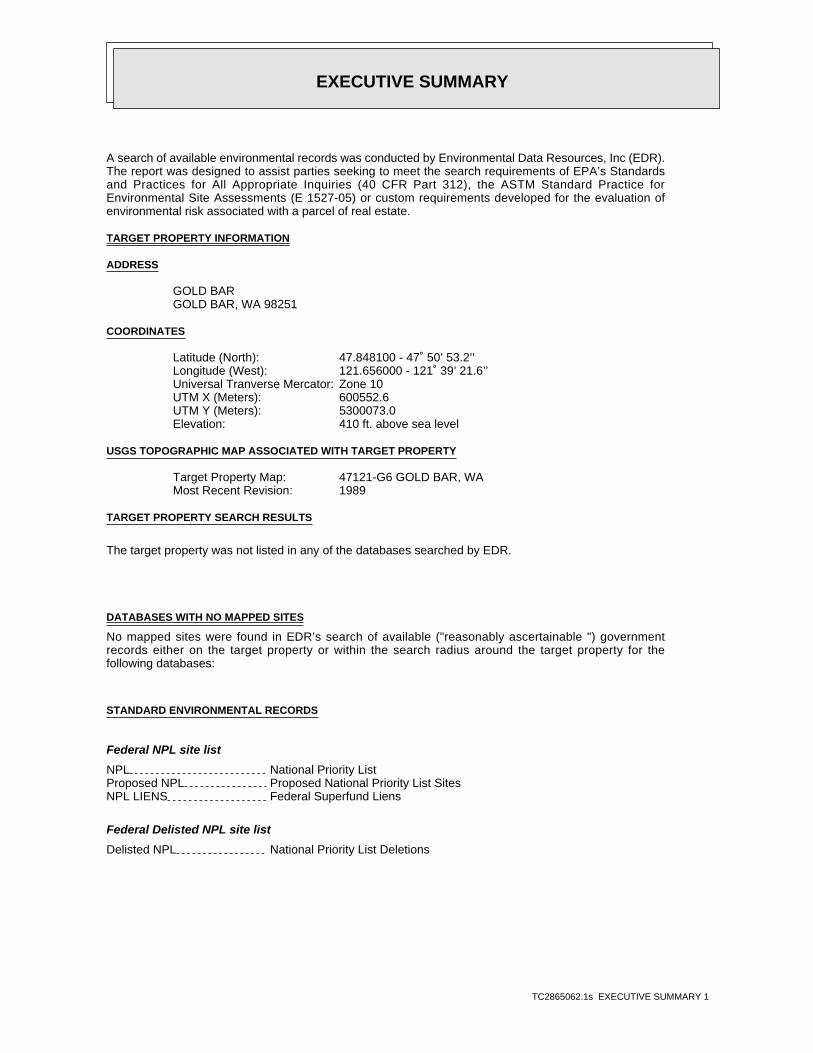
A search of available environmental records was conducted by Environmental Data Resources, Inc (EDR).The report was designed to assist parties seeking to meet the search requirements of EPA’s Standardsand Practices for All Appropriate Inquiries (40 CFR Part 312), the ASTM Standard Practice forEnvironmental Site Assessments (E 1527-05) or custom requirements developed for the evaluation ofenvironmental risk associated with a parcel of real estate.
TARGET PROPERTY INFORMATION
ADDRESS
GOLD BARGOLD BAR, WA 98251
COORDINATES
47.848100 - 47˚ 50’ 53.2’’Latitude (North): 121.656000 - 121˚ 39’ 21.6’’Longitude (West): Zone 10Universal Tranverse Mercator: 600552.6UTM X (Meters): 5300073.0UTM Y (Meters): 410 ft. above sea levelElevation:
USGS TOPOGRAPHIC MAP ASSOCIATED WITH TARGET PROPERTY
47121-G6 GOLD BAR, WATarget Property Map:1989Most Recent Revision:
TARGET PROPERTY SEARCH RESULTS
The target property was not listed in any of the databases searched by EDR.
DATABASES WITH NO MAPPED SITES
No mapped sites were found in EDR’s search of available ("reasonably ascertainable ") governmentrecords either on the target property or within the search radius around the target property for thefollowing databases:
STANDARD ENVIRONMENTAL RECORDS
Federal NPL site list
NPL National Priority ListProposed NPL Proposed National Priority List SitesNPL LIENS Federal Superfund Liens
Federal Delisted NPL site list
Delisted NPL National Priority List Deletions
EXECUTIVE SUMMARY
TC2865062.1s EXECUTIVE SUMMARY 2
Federal CERCLIS list
CERCLIS Comprehensive Environmental Response, Compensation, and Liability Information SystemFEDERAL FACILITY Federal Facility Site Information listing
Federal CERCLIS NFRAP site List
CERC-NFRAP CERCLIS No Further Remedial Action Planned
Federal RCRA CORRACTS facilities list
CORRACTS Corrective Action Report
Federal RCRA non-CORRACTS TSD facilities list
RCRA-TSDF RCRA - Treatment, Storage and Disposal
Federal RCRA generators list
RCRA-LQG RCRA - Large Quantity GeneratorsRCRA-SQG RCRA - Small Quantity GeneratorsRCRA-CESQG RCRA - Conditionally Exempt Small Quantity Generator
Federal institutional controls / engineering controls registries
US ENG CONTROLS Engineering Controls Sites ListUS INST CONTROL Sites with Institutional Controls
Federal ERNS list
ERNS Emergency Response Notification System
State- and tribal - equivalent NPL
HSL Hazardous Sites List
State- and tribal - equivalent CERCLIS
CSCSL Confirmed and Suspected Contaminated Sites List
State and tribal leaking storage tank lists
INDIAN LUST Leaking Underground Storage Tanks on Indian Land
State and tribal registered storage tank lists
AST Aboveground Storage Tank LocationsINDIAN UST Underground Storage Tanks on Indian LandFEMA UST Underground Storage Tank Listing
State and tribal institutional control / engineering control registries
INST CONTROL Institutional Control Site List
State and tribal voluntary cleanup sites
INDIAN VCP Voluntary Cleanup Priority Listing
EXECUTIVE SUMMARY
TC2865062.1s EXECUTIVE SUMMARY 3
State and tribal Brownfields sites
BROWNFIELDS Brownfields Sites Listing
ADDITIONAL ENVIRONMENTAL RECORDS
Local Brownfield lists
US BROWNFIELDS A Listing of Brownfields Sites
Local Lists of Landfill / Solid Waste Disposal Sites
DEBRIS REGION 9 Torres Martinez Reservation Illegal Dump Site LocationsODI Open Dump InventorySWTIRE Solid Waste Tire FacilitiesINDIAN ODI Report on the Status of Open Dumps on Indian Lands
Local Lists of Hazardous waste / Contaminated Sites
US CDL Clandestine Drug LabsCDL Clandestine Drug Lab Contaminated Site ListHIST CDL List of Sites Contaminated by Clandestine Drug LabsUS HIST CDL National Clandestine Laboratory Register
Local Land Records
LIENS 2 CERCLA Lien InformationLUCIS Land Use Control Information System
Records of Emergency Release Reports
HMIRS Hazardous Materials Information Reporting SystemSPILLS Reported Spills
Other Ascertainable Records
DOT OPS Incident and Accident DataDOD Department of Defense SitesFUDS Formerly Used Defense SitesCONSENT Superfund (CERCLA) Consent DecreesROD Records Of DecisionUMTRA Uranium Mill Tailings SitesTRIS Toxic Chemical Release Inventory SystemTSCA Toxic Substances Control ActFTTS FIFRA/ TSCA Tracking System - FIFRA (Federal Insecticide, Fungicide, & Rodenticide Act)/TSCA (Toxic Substances Control Act)HIST FTTS FIFRA/TSCA Tracking System Administrative Case ListingSSTS Section 7 Tracking SystemsICIS Integrated Compliance Information SystemPADS PCB Activity Database SystemMLTS Material Licensing Tracking SystemRADINFO Radiation Information DatabaseFINDS Facility Index System/Facility Registry System
EXECUTIVE SUMMARY
TC2865062.1s EXECUTIVE SUMMARY 4
RAATS RCRA Administrative Action Tracking SystemUIC Underground Injection Wells ListingMANIFEST Hazardous Waste Manifest DataDRYCLEANERS Drycleaner ListNPDES Water Quality Permit System DataAIRS Washington Emissions Data SystemInactive Drycleaners Inactive DrycleanersINDIAN RESERV Indian ReservationsSCRD DRYCLEANERS State Coalition for Remediation of Drycleaners ListingCOAL ASH Coal Ash Disposal Site ListingCOAL ASH DOE Sleam-Electric Plan Operation DataCOAL ASH EPA Coal Combustion Residues Surface Impoundments ListPCB TRANSFORMER PCB Transformer Registration Database
EDR PROPRIETARY RECORDS
EDR Proprietary Records
Manufactured Gas Plants EDR Proprietary Manufactured Gas Plants
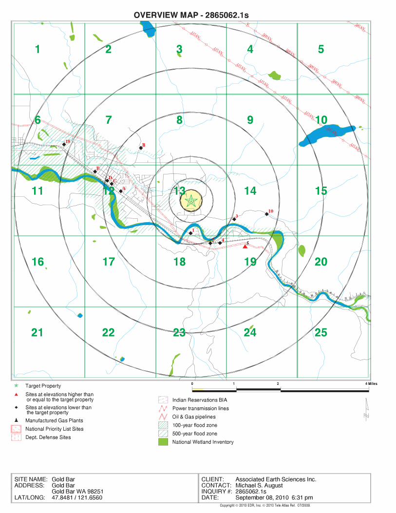
SURROUNDING SITES: SEARCH RESULTS
Surrounding sites were identified in the following databases.
Elevations have been determined from the USGS Digital Elevation Model and should be evaluated ona relative (not an absolute) basis. Relative elevation information between sites of close proximityshould be field verified. Sites with an elevation equal to or higher than the target property have beendifferentiated below from sites with an elevation lower than the target property.Page numbers and map identification numbers refer to the EDR Radius Map report where detaileddata on individual sites can be reviewed.
Sites listed in bold italics are in multiple databases.
Unmappable (orphan) sites are not considered in the foregoing analysis.
STANDARD ENVIRONMENTAL RECORDS
State and tribal landfill and/or solid waste disposal site lists
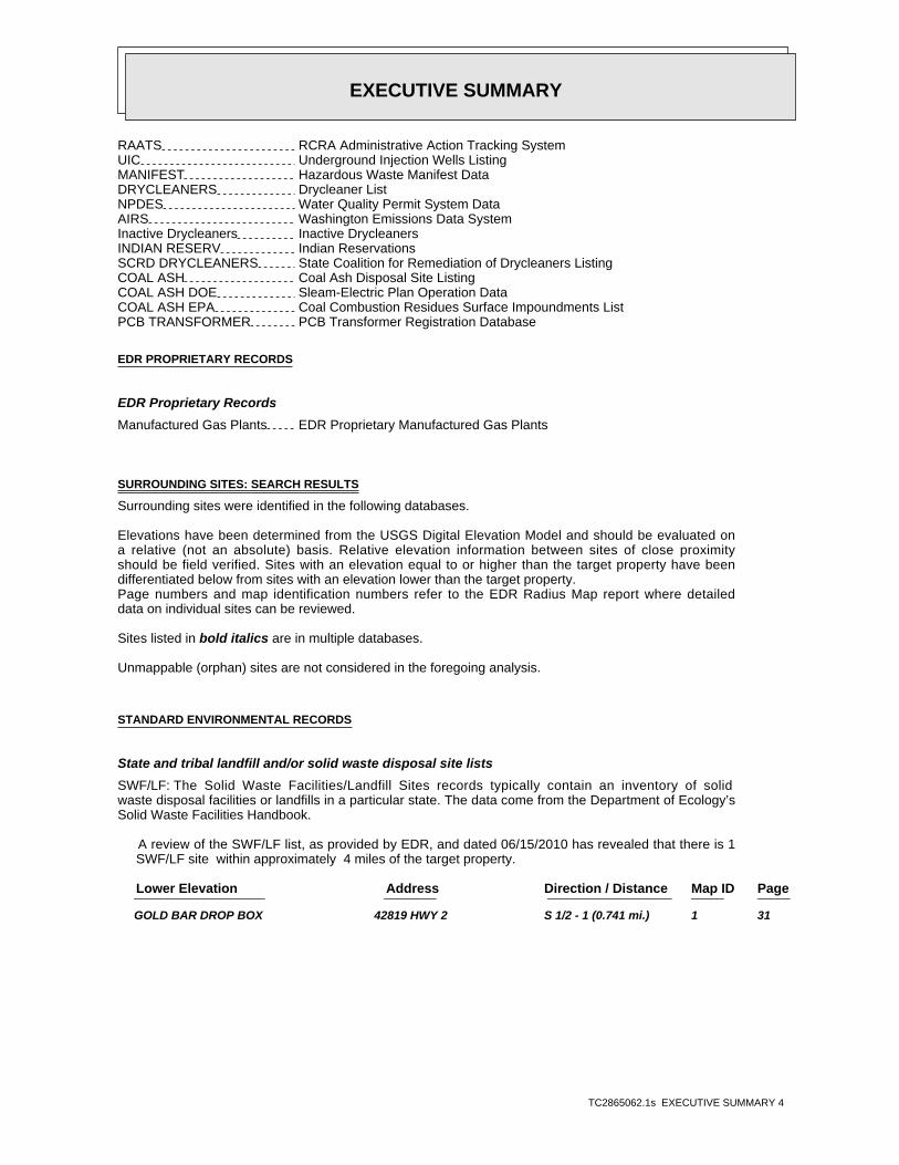
SWF/LF: The Solid Waste Facilities/Landfill Sites records typically contain an inventory of solidwaste disposal facilities or landfills in a particular state. The data come from the Department of Ecology’sSolid Waste Facilities Handbook.
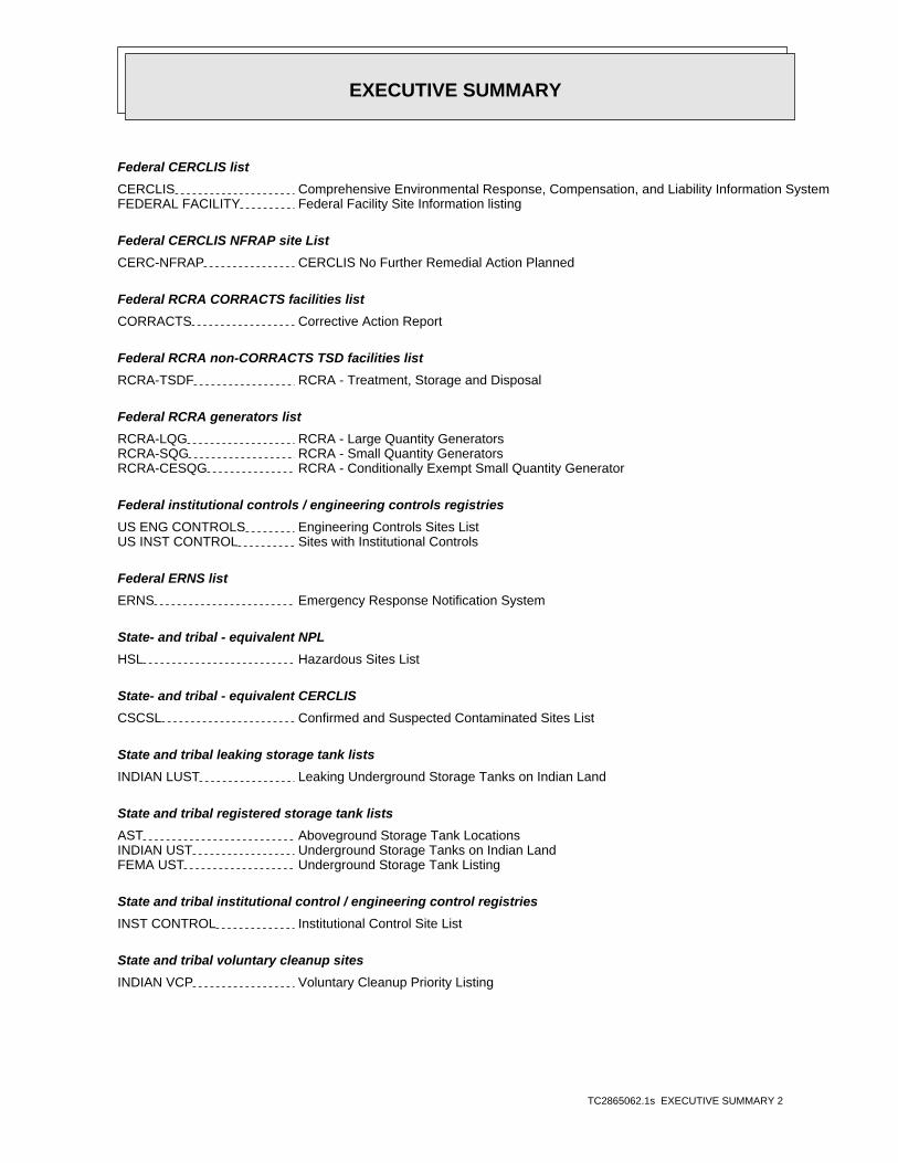
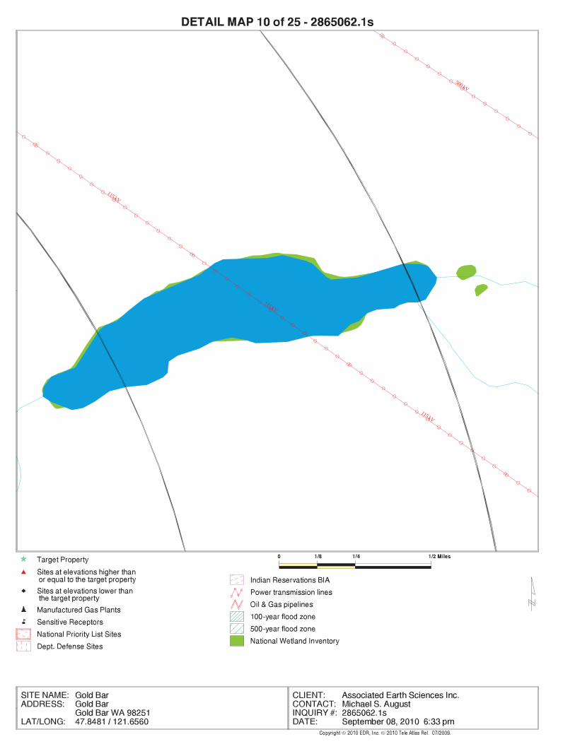
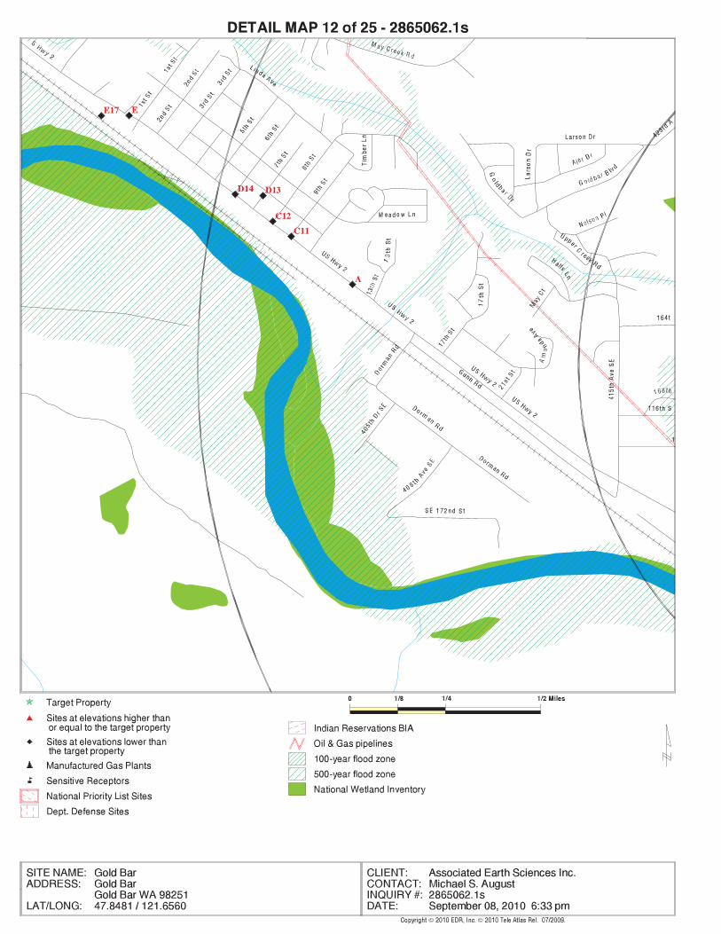
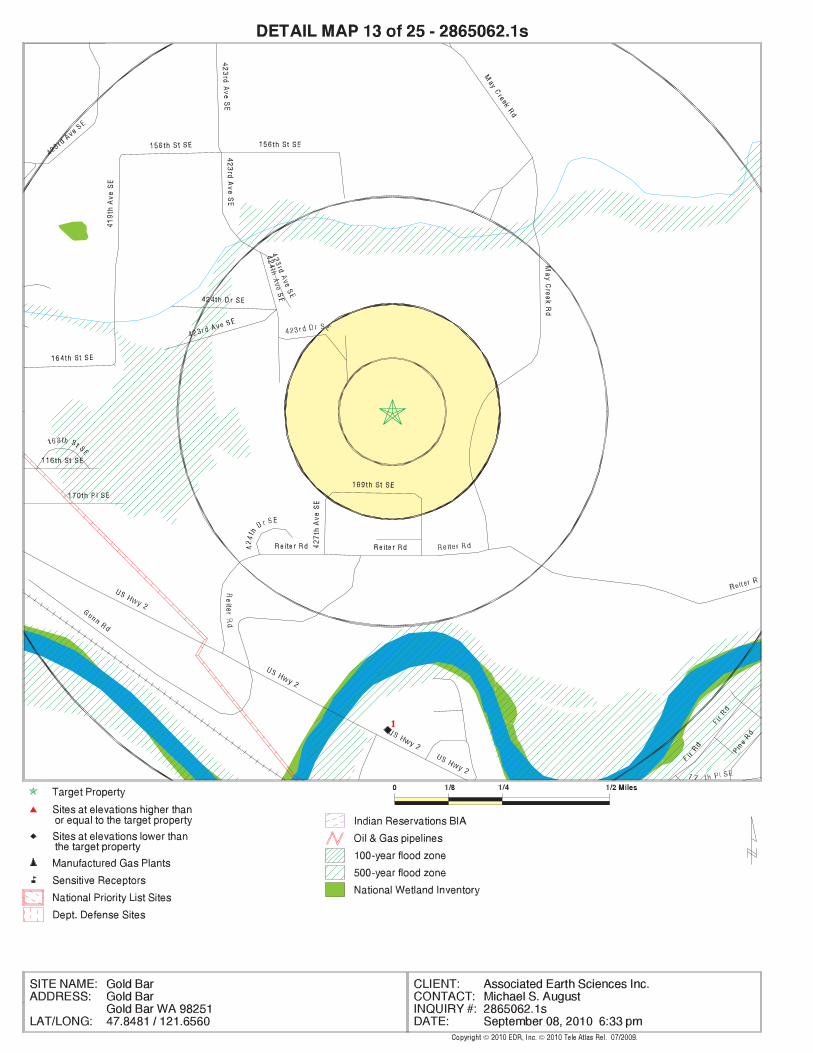
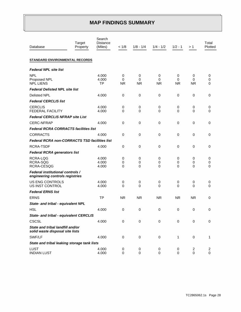
A review of the SWF/LF list, as provided by EDR, and dated 06/15/2010 has revealed that there is 1 SWF/LF site within approximately 4 miles of the target property.
PageMap IDDirection / Distance Address Lower Elevation ____________________ ________ ___________________ _____ _____
GOLD BAR DROP BOX 42819 HWY 2 S 1/2 - 1 (0.741 mi.) 1 31
EXECUTIVE SUMMARY
TC2865062.1s EXECUTIVE SUMMARY 5
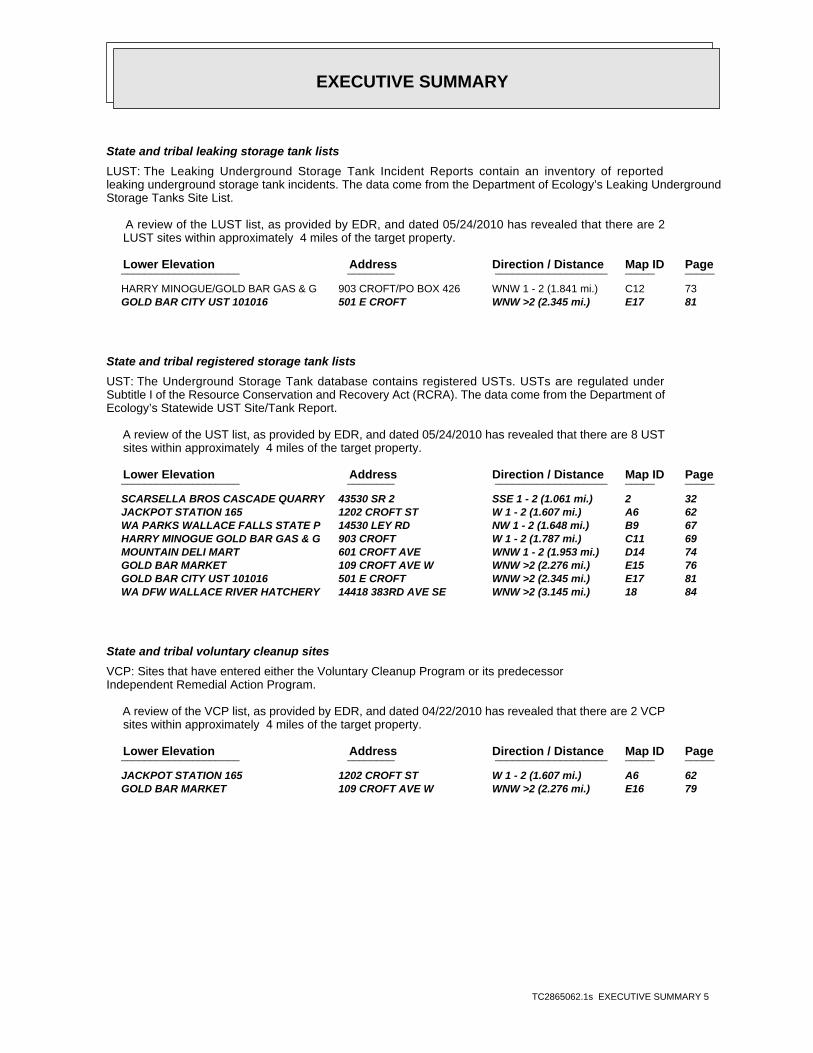
State and tribal leaking storage tank lists
LUST: The Leaking Underground Storage Tank Incident Reports contain an inventory of reportedleaking underground storage tank incidents. The data come from the Department of Ecology’s Leaking UndergroundStorage Tanks Site List.
A review of the LUST list, as provided by EDR, and dated 05/24/2010 has revealed that there are 2 LUST sites within approximately 4 miles of the target property.
PageMap IDDirection / Distance Address Lower Elevation ____________________ ________ ___________________ _____ _____
HARRY MINOGUE/GOLD BAR GAS & G 903 CROFT/PO BOX 426 WNW 1 - 2 (1.841 mi.) C12 73 GOLD BAR CITY UST 101016 501 E CROFT WNW >2 (2.345 mi.) E17 81
State and tribal registered storage tank lists
UST: The Underground Storage Tank database contains registered USTs. USTs are regulated underSubtitle I of the Resource Conservation and Recovery Act (RCRA). The data come from the Department ofEcology’s Statewide UST Site/Tank Report.
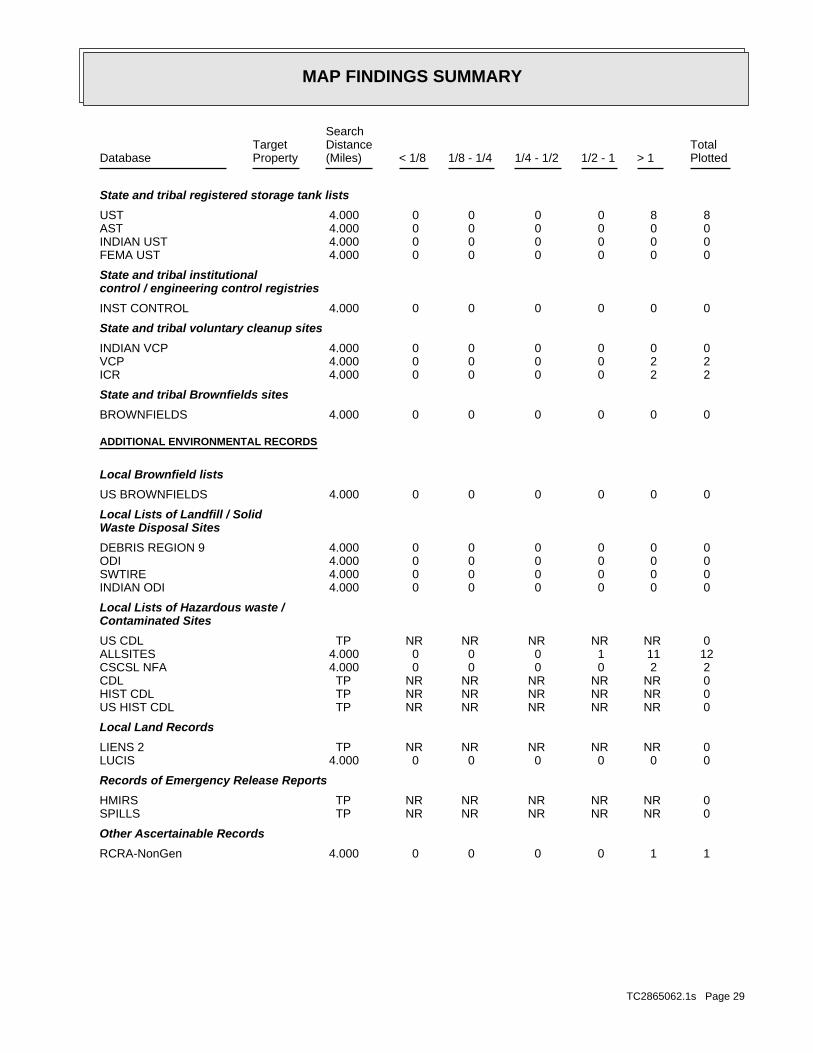
A review of the UST list, as provided by EDR, and dated 05/24/2010 has revealed that there are 8 UST sites within approximately 4 miles of the target property.
PageMap IDDirection / Distance Address Lower Elevation ____________________ ________ ___________________ _____ _____
SCARSELLA BROS CASCADE QUARRY 43530 SR 2 SSE 1 - 2 (1.061 mi.) 2 32 JACKPOT STATION 165 1202 CROFT ST W 1 - 2 (1.607 mi.) A6 62 WA PARKS WALLACE FALLS STATE P 14530 LEY RD NW 1 - 2 (1.648 mi.) B9 67 HARRY MINOGUE GOLD BAR GAS & G 903 CROFT W 1 - 2 (1.787 mi.) C11 69 MOUNTAIN DELI MART 601 CROFT AVE WNW 1 - 2 (1.953 mi.) D14 74 GOLD BAR MARKET 109 CROFT AVE W WNW >2 (2.276 mi.) E15 76 GOLD BAR CITY UST 101016 501 E CROFT WNW >2 (2.345 mi.) E17 81 WA DFW WALLACE RIVER HATCHERY 14418 383RD AVE SE WNW >2 (3.145 mi.) 18 84
State and tribal voluntary cleanup sites
VCP: Sites that have entered either the Voluntary Cleanup Program or its predecessorIndependent Remedial Action Program.
A review of the VCP list, as provided by EDR, and dated 04/22/2010 has revealed that there are 2 VCP sites within approximately 4 miles of the target property.
PageMap IDDirection / Distance Address Lower Elevation ____________________ ________ ___________________ _____ _____
JACKPOT STATION 165 1202 CROFT ST W 1 - 2 (1.607 mi.) A6 62 GOLD BAR MARKET 109 CROFT AVE W WNW >2 (2.276 mi.) E16 79
EXECUTIVE SUMMARY
TC2865062.1s EXECUTIVE SUMMARY 6
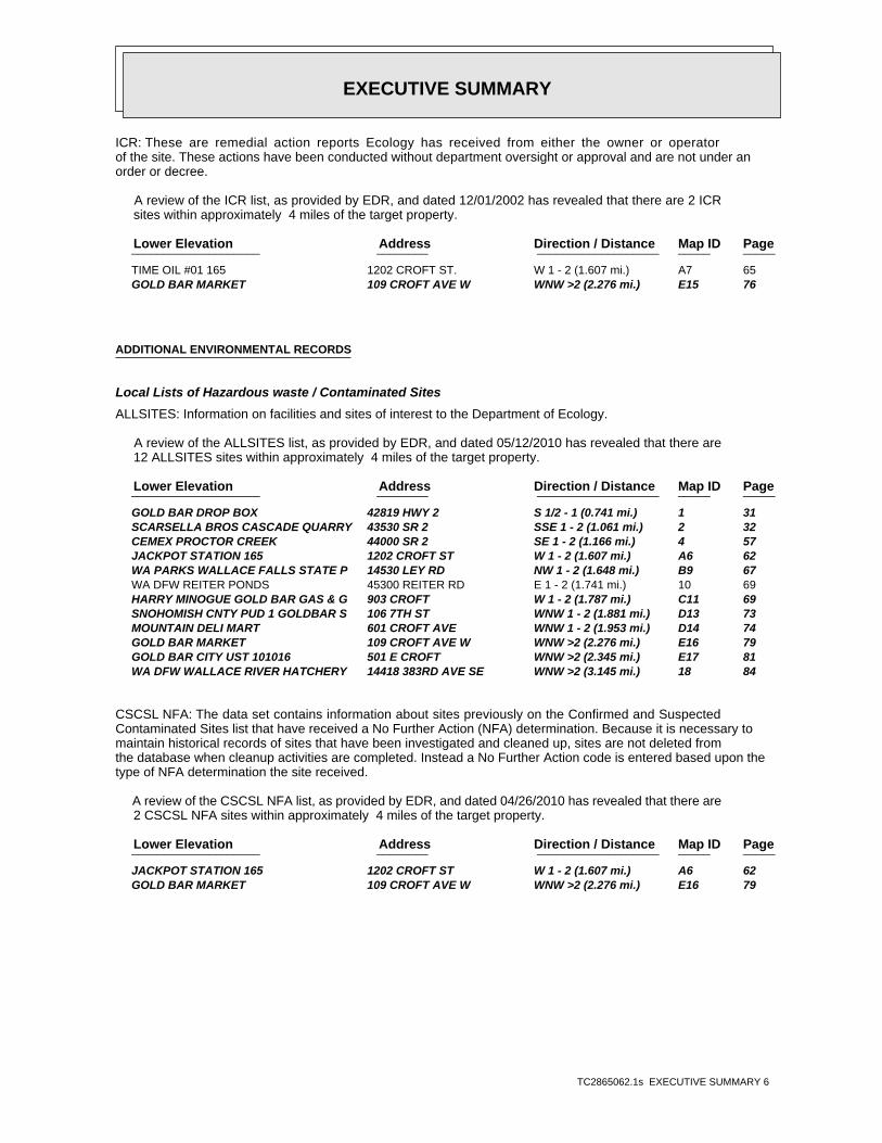
ICR: These are remedial action reports Ecology has received from either the owner or operatorof the site. These actions have been conducted without department oversight or approval and are not under anorder or decree.
A review of the ICR list, as provided by EDR, and dated 12/01/2002 has revealed that there are 2 ICR sites within approximately 4 miles of the target property.
PageMap IDDirection / Distance Address Lower Elevation ____________________ ________ ___________________ _____ _____
TIME OIL #01 165 1202 CROFT ST. W 1 - 2 (1.607 mi.) A7 65 GOLD BAR MARKET 109 CROFT AVE W WNW >2 (2.276 mi.) E15 76
ADDITIONAL ENVIRONMENTAL RECORDS
Local Lists of Hazardous waste / Contaminated Sites
ALLSITES: Information on facilities and sites of interest to the Department of Ecology.
A review of the ALLSITES list, as provided by EDR, and dated 05/12/2010 has revealed that there are 12 ALLSITES sites within approximately 4 miles of the target property.
PageMap IDDirection / Distance Address Lower Elevation ____________________ ________ ___________________ _____ _____
GOLD BAR DROP BOX 42819 HWY 2 S 1/2 - 1 (0.741 mi.) 1 31 SCARSELLA BROS CASCADE QUARRY 43530 SR 2 SSE 1 - 2 (1.061 mi.) 2 32 CEMEX PROCTOR CREEK 44000 SR 2 SE 1 - 2 (1.166 mi.) 4 57 JACKPOT STATION 165 1202 CROFT ST W 1 - 2 (1.607 mi.) A6 62 WA PARKS WALLACE FALLS STATE P 14530 LEY RD NW 1 - 2 (1.648 mi.) B9 67 WA DFW REITER PONDS 45300 REITER RD E 1 - 2 (1.741 mi.) 10 69 HARRY MINOGUE GOLD BAR GAS & G 903 CROFT W 1 - 2 (1.787 mi.) C11 69 SNOHOMISH CNTY PUD 1 GOLDBAR S 106 7TH ST WNW 1 - 2 (1.881 mi.) D13 73 MOUNTAIN DELI MART 601 CROFT AVE WNW 1 - 2 (1.953 mi.) D14 74 GOLD BAR MARKET 109 CROFT AVE W WNW >2 (2.276 mi.) E16 79 GOLD BAR CITY UST 101016 501 E CROFT WNW >2 (2.345 mi.) E17 81 WA DFW WALLACE RIVER HATCHERY 14418 383RD AVE SE WNW >2 (3.145 mi.) 18 84
CSCSL NFA: The data set contains information about sites previously on the Confirmed and SuspectedContaminated Sites list that have received a No Further Action (NFA) determination. Because it is necessary tomaintain historical records of sites that have been investigated and cleaned up, sites are not deleted fromthe database when cleanup activities are completed. Instead a No Further Action code is entered based upon thetype of NFA determination the site received.
A review of the CSCSL NFA list, as provided by EDR, and dated 04/26/2010 has revealed that there are 2 CSCSL NFA sites within approximately 4 miles of the target property.
PageMap IDDirection / Distance Address Lower Elevation ____________________ ________ ___________________ _____ _____
JACKPOT STATION 165 1202 CROFT ST W 1 - 2 (1.607 mi.) A6 62 GOLD BAR MARKET 109 CROFT AVE W WNW >2 (2.276 mi.) E16 79
EXECUTIVE SUMMARY
TC2865062.1s EXECUTIVE SUMMARY 7
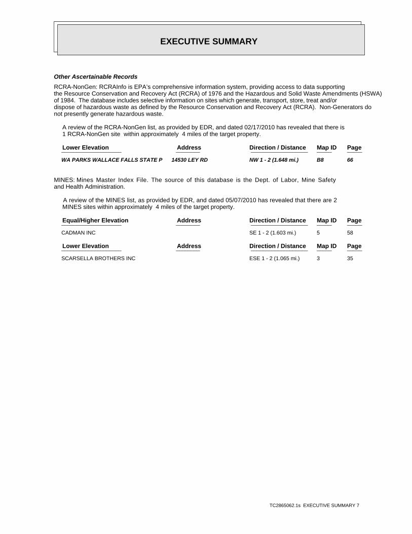
Other Ascertainable Records
RCRA-NonGen: RCRAInfo is EPA’s comprehensive information system, providing access to data supportingthe Resource Conservation and Recovery Act (RCRA) of 1976 and the Hazardous and Solid Waste Amendments (HSWA)of 1984. The database includes selective information on sites which generate, transport, store, treat and/ordispose of hazardous waste as defined by the Resource Conservation and Recovery Act (RCRA). Non-Generators donot presently generate hazardous waste.
A review of the RCRA-NonGen list, as provided by EDR, and dated 02/17/2010 has revealed that there is 1 RCRA-NonGen site within approximately 4 miles of the target property.
PageMap IDDirection / Distance Address Lower Elevation ____________________ ________ ___________________ _____ _____
WA PARKS WALLACE FALLS STATE P 14530 LEY RD NW 1 - 2 (1.648 mi.) B8 66
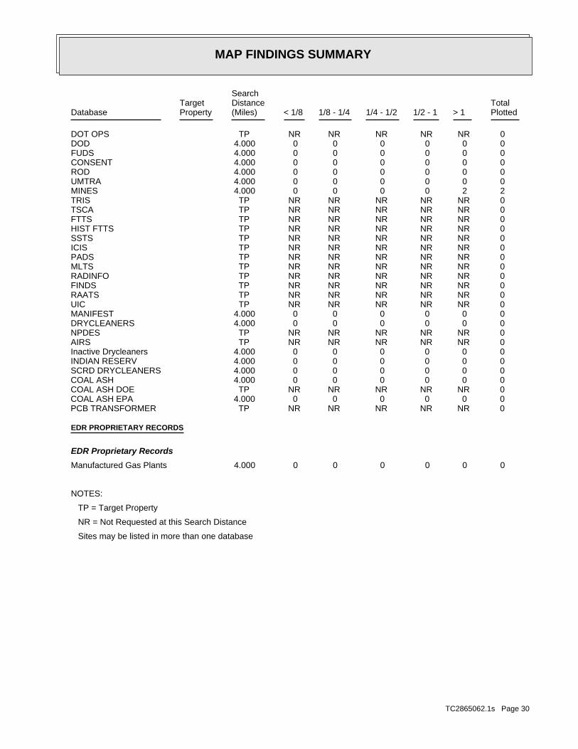
MINES: Mines Master Index File. The source of this database is the Dept. of Labor, Mine Safetyand Health Administration.
A review of the MINES list, as provided by EDR, and dated 05/07/2010 has revealed that there are 2 MINES sites within approximately 4 miles of the target property.
PageMap IDDirection / Distance Address Equal/Higher Elevation ____________________ ________ ___________________ _____ _____
CADMAN INC SE 1 - 2 (1.603 mi.) 5 58
PageMap IDDirection / Distance Address Lower Elevation ____________________ ________ ___________________ _____ _____
SCARSELLA BROTHERS INC ESE 1 - 2 (1.065 mi.) 3 35
EXECUTIVE SUMMARY
TC2865062.1s EXECUTIVE SUMMARY 8
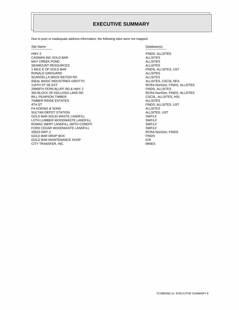
Due to poor or inadequate address information, the following sites were not mapped:
Site Name Database(s)____________ ____________
HWY 2 FINDS, ALLSITESCADMAN INC GOLD BAR ALLSITESMAY CREEK POND ALLSITESSEAMOUNT RESOURCES ALLSITES1 MILE E OF GOLD BAR FINDS, ALLSITES, USTRONALD GIROUARD ALLSITESSCARSELLA BROS REITER RD ALLSITESIDEAL BASIC INDUSTRIES GROTTO ALLSITES, CSCSL NFA116TH ST SE EXT RCRA-NonGen, FINDS, ALLSITES29908TH FERN BLUFF RD & HWY 2 FINDS, ALLSITES300 BLOCK OF KELLOGG LAKE RD RCRA-NonGen, FINDS, ALLSITESBILL PEARSON TIMBER CSCSL, ALLSITES, HSLTIMBER RIDGE ESTATES ALLSITES4TH ST FINDS, ALLSITES, USTFA KOENIG & SONS ALLSITESSULTAN DEPOT STATION ALLSITES, USTGOLD BAR SOLID WASTE LANDFILL SWF/LFLOTH LUMBER WOODWASTE LANDFILL SWF/LFROMAC INERT LANDFILL (WITH CONDITI SWF/LFFORD CEDAR WOODWASTE LANDFILL SWF/LF33523 HWY 2 RCRA-NonGen, FINDSGOLD BAR DROP BOX FINDSGOLD BAR MAINTENANCE SHOP ICRCITY TRANSFER, INC. MINES
EDR Inc.EDR Inc.EDR Inc.EDR Inc.EDR Inc.EDR Inc.EDR Inc.EDR Inc.EDR Inc.EDR Inc.EDR Inc.EDR Inc.EDR Inc.EDR Inc.EDR Inc.EDR Inc.EDR Inc.EDR Inc.EDR Inc.EDR Inc.EDR Inc.EDR Inc.EDR Inc.EDR Inc.EDR Inc.EDR Inc.EDR Inc.EDR Inc.EDR Inc.EDR Inc.EDR Inc.EDR Inc.EDR Inc.EDR Inc.EDR Inc.EDR Inc.EDR Inc.EDR Inc.EDR Inc.EDR Inc.
115 kV
115 kV
115 kV
115 kV
115 kV
115 kV
115 kV
115 kV
345 kV
500 kV
500 kV
500 kV
500 kV
500 kV
V
EDR Inc.EDR Inc.EDR Inc.EDR Inc.EDR Inc.EDR Inc.EDR Inc.EDR Inc.EDR Inc.EDR Inc.EDR Inc.EDR Inc.EDR Inc.EDR Inc.EDR Inc.EDR Inc.EDR Inc.EDR Inc.EDR Inc.EDR Inc.EDR Inc.EDR Inc.EDR Inc.EDR Inc.EDR Inc.EDR Inc.EDR Inc.EDR Inc.EDR Inc.EDR Inc.EDR Inc.EDR Inc.EDR Inc.EDR Inc.EDR Inc.EDR Inc.EDR Inc.EDR Inc.EDR Inc.EDR Inc.
EDR Inc.EDR Inc.EDR Inc.EDR Inc.EDR Inc.EDR Inc.EDR Inc.EDR Inc.EDR Inc.EDR Inc.EDR Inc.EDR Inc.EDR Inc.EDR Inc.EDR Inc.EDR Inc.EDR Inc.EDR Inc.EDR Inc.EDR Inc.EDR Inc.EDR Inc.EDR Inc.EDR Inc.EDR Inc.EDR Inc.EDR Inc.EDR Inc.EDR Inc.EDR Inc.EDR Inc.EDR Inc.EDR Inc.EDR Inc.EDR Inc.EDR Inc.EDR Inc.EDR Inc.EDR Inc.EDR Inc.
EDR Inc.EDR Inc.EDR Inc.EDR Inc.EDR Inc.EDR Inc.EDR Inc.EDR Inc.EDR Inc.EDR Inc.EDR Inc.EDR Inc.EDR Inc.EDR Inc.EDR Inc.EDR Inc.EDR Inc.EDR Inc.EDR Inc.EDR Inc.EDR Inc.EDR Inc.EDR Inc.EDR Inc.EDR Inc.EDR Inc.EDR Inc.EDR Inc.EDR Inc.EDR Inc.EDR Inc.EDR Inc.EDR Inc.EDR Inc.EDR Inc.EDR Inc.EDR Inc.EDR Inc.EDR Inc.EDR Inc.
115 kV
115 kV
500 kV
500 kV
500 kV
EDR Inc.EDR Inc.EDR Inc.EDR Inc.EDR Inc.EDR Inc.EDR Inc.EDR Inc.EDR Inc.EDR Inc.EDR Inc.EDR Inc.EDR Inc.EDR Inc.EDR Inc.EDR Inc.EDR Inc.EDR Inc.EDR Inc.EDR Inc.EDR Inc.EDR Inc.EDR Inc.EDR Inc.EDR Inc.EDR Inc.EDR Inc.EDR Inc.EDR Inc.EDR Inc.EDR Inc.EDR Inc.EDR Inc.EDR Inc.EDR Inc.EDR Inc.EDR Inc.EDR Inc.EDR Inc.EDR Inc.
345 kV
500 kV
500 kV
EDR Inc.EDR Inc.EDR Inc.EDR Inc.EDR Inc.EDR Inc.EDR Inc.EDR Inc.EDR Inc.EDR Inc.EDR Inc.EDR Inc.EDR Inc.EDR Inc.EDR Inc.EDR Inc.EDR Inc.EDR Inc.EDR Inc.EDR Inc.EDR Inc.EDR Inc.EDR Inc.EDR Inc.EDR Inc.EDR Inc.EDR Inc.EDR Inc.EDR Inc.EDR Inc.EDR Inc.EDR Inc.EDR Inc.EDR Inc.EDR Inc.EDR Inc.EDR Inc.EDR Inc.EDR Inc.EDR Inc.
EDR Inc.EDR Inc.EDR Inc.EDR Inc.EDR Inc.EDR Inc.EDR Inc.EDR Inc.EDR Inc.EDR Inc.EDR Inc.EDR Inc.EDR Inc.EDR Inc.EDR Inc.EDR Inc.EDR Inc.EDR Inc.EDR Inc.EDR Inc.EDR Inc.EDR Inc.EDR Inc.EDR Inc.EDR Inc.EDR Inc.EDR Inc.EDR Inc.EDR Inc.EDR Inc.EDR Inc.EDR Inc.EDR Inc.EDR Inc.EDR Inc.EDR Inc.EDR Inc.EDR Inc.EDR Inc.EDR Inc.
EDR Inc.EDR Inc.EDR Inc.EDR Inc.EDR Inc.EDR Inc.EDR Inc.EDR Inc.EDR Inc.EDR Inc.EDR Inc.EDR Inc.EDR Inc.EDR Inc.EDR Inc.EDR Inc.EDR Inc.EDR Inc.EDR Inc.EDR Inc.EDR Inc.EDR Inc.EDR Inc.EDR Inc.EDR Inc.EDR Inc.EDR Inc.EDR Inc.EDR Inc.EDR Inc.EDR Inc.EDR Inc.EDR Inc.EDR Inc.EDR Inc.EDR Inc.EDR Inc.EDR Inc.EDR Inc.EDR Inc.

EDR Inc.EDR Inc.EDR Inc.EDR Inc.EDR Inc.EDR Inc.EDR Inc.EDR Inc.EDR Inc.EDR Inc.EDR Inc.EDR Inc.EDR Inc.EDR Inc.EDR Inc.EDR Inc.EDR Inc.EDR Inc.EDR Inc.EDR Inc.EDR Inc.EDR Inc.EDR Inc.EDR Inc.EDR Inc.EDR Inc.EDR Inc.EDR Inc.EDR Inc.EDR Inc.EDR Inc.EDR Inc.EDR Inc.EDR Inc.EDR Inc.EDR Inc.EDR Inc.EDR Inc.EDR Inc.EDR Inc.
115 kV
115 kV
115 kV
500 kV
EDR Inc.EDR Inc.EDR Inc.EDR Inc.EDR Inc.EDR Inc.EDR Inc.EDR Inc.EDR Inc.EDR Inc.EDR Inc.EDR Inc.EDR Inc.EDR Inc.EDR Inc.EDR Inc.EDR Inc.EDR Inc.EDR Inc.EDR Inc.EDR Inc.EDR Inc.EDR Inc.EDR Inc.EDR Inc.EDR Inc.EDR Inc.EDR Inc.EDR Inc.EDR Inc.EDR Inc.EDR Inc.EDR Inc.EDR Inc.EDR Inc.EDR Inc.EDR Inc.EDR Inc.EDR Inc.EDR Inc.
EDR Inc.EDR Inc.EDR Inc.EDR Inc.EDR Inc.EDR Inc.EDR Inc.EDR Inc.EDR Inc.EDR Inc.EDR Inc.EDR Inc.EDR Inc.EDR Inc.EDR Inc.EDR Inc.EDR Inc.EDR Inc.EDR Inc.EDR Inc.EDR Inc.EDR Inc.EDR Inc.EDR Inc.EDR Inc.EDR Inc.EDR Inc.EDR Inc.EDR Inc.EDR Inc.EDR Inc.EDR Inc.EDR Inc.EDR Inc.EDR Inc.EDR Inc.EDR Inc.EDR Inc.EDR Inc.EDR Inc.
EDR Inc.EDR Inc.EDR Inc.EDR Inc.EDR Inc.EDR Inc.EDR Inc.EDR Inc.EDR Inc.EDR Inc.EDR Inc.EDR Inc.EDR Inc.EDR Inc.EDR Inc.EDR Inc.EDR Inc.EDR Inc.EDR Inc.EDR Inc.EDR Inc.EDR Inc.EDR Inc.EDR Inc.EDR Inc.EDR Inc.EDR Inc.EDR Inc.EDR Inc.EDR Inc.EDR Inc.EDR Inc.EDR Inc.EDR Inc.EDR Inc.EDR Inc.EDR Inc.EDR Inc.EDR Inc.EDR Inc.
EDR Inc.EDR Inc.EDR Inc.EDR Inc.EDR Inc.EDR Inc.EDR Inc.EDR Inc.EDR Inc.EDR Inc.EDR Inc.EDR Inc.EDR Inc.EDR Inc.EDR Inc.EDR Inc.EDR Inc.EDR Inc.EDR Inc.EDR Inc.EDR Inc.EDR Inc.EDR Inc.EDR Inc.EDR Inc.EDR Inc.EDR Inc.EDR Inc.EDR Inc.EDR Inc.EDR Inc.EDR Inc.EDR Inc.EDR Inc.EDR Inc.EDR Inc.EDR Inc.EDR Inc.EDR Inc.EDR Inc.
EDR Inc.EDR Inc.EDR Inc.EDR Inc.EDR Inc.EDR Inc.EDR Inc.EDR Inc.EDR Inc.EDR Inc.EDR Inc.EDR Inc.EDR Inc.EDR Inc.EDR Inc.EDR Inc.EDR Inc.EDR Inc.EDR Inc.EDR Inc.EDR Inc.EDR Inc.EDR Inc.EDR Inc.EDR Inc.EDR Inc.EDR Inc.EDR Inc.EDR Inc.EDR Inc.EDR Inc.EDR Inc.EDR Inc.EDR Inc.EDR Inc.EDR Inc.EDR Inc.EDR Inc.EDR Inc.EDR Inc.
EDR Inc.EDR Inc.EDR Inc.EDR Inc.EDR Inc.EDR Inc.EDR Inc.EDR Inc.EDR Inc.EDR Inc.EDR Inc.EDR Inc.EDR Inc.EDR Inc.EDR Inc.EDR Inc.EDR Inc.EDR Inc.EDR Inc.EDR Inc.EDR Inc.EDR Inc.EDR Inc.EDR Inc.EDR Inc.EDR Inc.EDR Inc.EDR Inc.EDR Inc.EDR Inc.EDR Inc.EDR Inc.EDR Inc.EDR Inc.EDR Inc.EDR Inc.EDR Inc.EDR Inc.EDR Inc.EDR Inc.
EDR Inc.EDR Inc.EDR Inc.EDR Inc.EDR Inc.EDR Inc.EDR Inc.EDR Inc.EDR Inc.EDR Inc.EDR Inc.EDR Inc.EDR Inc.EDR Inc.EDR Inc.EDR Inc.EDR Inc.EDR Inc.EDR Inc.EDR Inc.EDR Inc.EDR Inc.EDR Inc.EDR Inc.EDR Inc.EDR Inc.EDR Inc.EDR Inc.EDR Inc.EDR Inc.EDR Inc.EDR Inc.EDR Inc.EDR Inc.EDR Inc.EDR Inc.EDR Inc.EDR Inc.EDR Inc.EDR Inc.
EDR Inc.EDR Inc.EDR Inc.EDR Inc.EDR Inc.EDR Inc.EDR Inc.EDR Inc.EDR Inc.EDR Inc.EDR Inc.EDR Inc.EDR Inc.EDR Inc.EDR Inc.EDR Inc.EDR Inc.EDR Inc.EDR Inc.EDR Inc.EDR Inc.EDR Inc.EDR Inc.EDR Inc.EDR Inc.EDR Inc.EDR Inc.EDR Inc.EDR Inc.EDR Inc.EDR Inc.EDR Inc.EDR Inc.EDR Inc.EDR Inc.EDR Inc.EDR Inc.EDR Inc.EDR Inc.EDR Inc.
EDR Inc.EDR Inc.EDR Inc.EDR Inc.EDR Inc.EDR Inc.EDR Inc.EDR Inc.EDR Inc.EDR Inc.EDR Inc.EDR Inc.EDR Inc.EDR Inc.EDR Inc.EDR Inc.EDR Inc.EDR Inc.EDR Inc.EDR Inc.EDR Inc.EDR Inc.EDR Inc.EDR Inc.EDR Inc.EDR Inc.EDR Inc.EDR Inc.EDR Inc.EDR Inc.EDR Inc.EDR Inc.EDR Inc.EDR Inc.EDR Inc.EDR Inc.EDR Inc.EDR Inc.EDR Inc.EDR Inc.
EDR Inc.EDR Inc.EDR Inc.EDR Inc.EDR Inc.EDR Inc.EDR Inc.EDR Inc.EDR Inc.EDR Inc.EDR Inc.EDR Inc.EDR Inc.EDR Inc.EDR Inc.EDR Inc.EDR Inc.EDR Inc.EDR Inc.EDR Inc.EDR Inc.EDR Inc.EDR Inc.EDR Inc.EDR Inc.EDR Inc.EDR Inc.EDR Inc.EDR Inc.EDR Inc.EDR Inc.EDR Inc.EDR Inc.EDR Inc.EDR Inc.EDR Inc.EDR Inc.EDR Inc.EDR Inc.EDR Inc.
EDR Inc.EDR Inc.EDR Inc.EDR Inc.EDR Inc.EDR Inc.EDR Inc.EDR Inc.EDR Inc.EDR Inc.EDR Inc.EDR Inc.EDR Inc.EDR Inc.EDR Inc.EDR Inc.EDR Inc.EDR Inc.EDR Inc.EDR Inc.EDR Inc.EDR Inc.EDR Inc.EDR Inc.EDR Inc.EDR Inc.EDR Inc.EDR Inc.EDR Inc.EDR Inc.EDR Inc.EDR Inc.EDR Inc.EDR Inc.EDR Inc.EDR Inc.EDR Inc.EDR Inc.EDR Inc.EDR Inc.
EDR Inc.EDR Inc.EDR Inc.EDR Inc.EDR Inc.EDR Inc.EDR Inc.EDR Inc.EDR Inc.EDR Inc.EDR Inc.EDR Inc.EDR Inc.EDR Inc.EDR Inc.EDR Inc.EDR Inc.EDR Inc.EDR Inc.EDR Inc.EDR Inc.EDR Inc.EDR Inc.EDR Inc.EDR Inc.EDR Inc.EDR Inc.EDR Inc.EDR Inc.EDR Inc.EDR Inc.EDR Inc.EDR Inc.EDR Inc.EDR Inc.EDR Inc.EDR Inc.EDR Inc.EDR Inc.EDR Inc.
EDR Inc.EDR Inc.EDR Inc.EDR Inc.EDR Inc.EDR Inc.EDR Inc.EDR Inc.EDR Inc.EDR Inc.EDR Inc.EDR Inc.EDR Inc.EDR Inc.EDR Inc.EDR Inc.EDR Inc.EDR Inc.EDR Inc.EDR Inc.EDR Inc.EDR Inc.EDR Inc.EDR Inc.EDR Inc.EDR Inc.EDR Inc.EDR Inc.EDR Inc.EDR Inc.EDR Inc.EDR Inc.EDR Inc.EDR Inc.EDR Inc.EDR Inc.EDR Inc.EDR Inc.EDR Inc.EDR Inc.
EDR Inc.EDR Inc.EDR Inc.EDR Inc.EDR Inc.EDR Inc.EDR Inc.EDR Inc.EDR Inc.EDR Inc.EDR Inc.EDR Inc.EDR Inc.EDR Inc.EDR Inc.EDR Inc.EDR Inc.EDR Inc.EDR Inc.EDR Inc.EDR Inc.EDR Inc.EDR Inc.EDR Inc.EDR Inc.EDR Inc.EDR Inc.EDR Inc.EDR Inc.EDR Inc.EDR Inc.EDR Inc.EDR Inc.EDR Inc.EDR Inc.EDR Inc.EDR Inc.EDR Inc.EDR Inc.EDR Inc.
EDR Inc.EDR Inc.EDR Inc.EDR Inc.EDR Inc.EDR Inc.EDR Inc.EDR Inc.EDR Inc.EDR Inc.EDR Inc.EDR Inc.EDR Inc.EDR Inc.EDR Inc.EDR Inc.EDR Inc.EDR Inc.EDR Inc.EDR Inc.EDR Inc.EDR Inc.EDR Inc.EDR Inc.EDR Inc.EDR Inc.EDR Inc.EDR Inc.EDR Inc.EDR Inc.EDR Inc.EDR Inc.EDR Inc.EDR Inc.EDR Inc.EDR Inc.EDR Inc.EDR Inc.EDR Inc.EDR Inc.
MAP FINDINGS SUMMARY
SearchTarget Distance Total
Database Property (Miles) < 1/8 1/8 - 1/4 1/4 - 1/2 1/2 - 1 > 1 Plotted
STANDARD ENVIRONMENTAL RECORDS
Federal NPL site list
0 0 0 0 0 0 4.000NPL 0 0 0 0 0 0 4.000Proposed NPL 0 NR NR NR NR NR TPNPL LIENS
Federal Delisted NPL site list
0 0 0 0 0 0 4.000Delisted NPL
Federal CERCLIS list
0 0 0 0 0 0 4.000CERCLIS 0 0 0 0 0 0 4.000FEDERAL FACILITY
Federal CERCLIS NFRAP site List
0 0 0 0 0 0 4.000CERC-NFRAP
Federal RCRA CORRACTS facilities list
0 0 0 0 0 0 4.000CORRACTS
Federal RCRA non-CORRACTS TSD facilities list
0 0 0 0 0 0 4.000RCRA-TSDF
Federal RCRA generators list
0 0 0 0 0 0 4.000RCRA-LQG 0 0 0 0 0 0 4.000RCRA-SQG 0 0 0 0 0 0 4.000RCRA-CESQG
Federal institutional controls /engineering controls registries
0 0 0 0 0 0 4.000US ENG CONTROLS 0 0 0 0 0 0 4.000US INST CONTROL
Federal ERNS list
0 NR NR NR NR NR TPERNS
State- and tribal - equivalent NPL
0 0 0 0 0 0 4.000HSL
State- and tribal - equivalent CERCLIS
0 0 0 0 0 0 4.000CSCSL
State and tribal landfill and/orsolid waste disposal site lists
1 0 1 0 0 0 4.000SWF/LF
State and tribal leaking storage tank lists
2 2 0 0 0 0 4.000LUST 0 0 0 0 0 0 4.000INDIAN LUST
TC2865062.1s Page 28
MAP FINDINGS SUMMARY
SearchTarget Distance Total
Database Property (Miles) < 1/8 1/8 - 1/4 1/4 - 1/2 1/2 - 1 > 1 Plotted
State and tribal registered storage tank lists
8 8 0 0 0 0 4.000UST 0 0 0 0 0 0 4.000AST 0 0 0 0 0 0 4.000INDIAN UST 0 0 0 0 0 0 4.000FEMA UST
State and tribal institutionalcontrol / engineering control registries
0 0 0 0 0 0 4.000INST CONTROL
State and tribal voluntary cleanup sites
0 0 0 0 0 0 4.000INDIAN VCP 2 2 0 0 0 0 4.000VCP 2 2 0 0 0 0 4.000ICR
State and tribal Brownfields sites
0 0 0 0 0 0 4.000BROWNFIELDS
ADDITIONAL ENVIRONMENTAL RECORDS
Local Brownfield lists
0 0 0 0 0 0 4.000US BROWNFIELDS
Local Lists of Landfill / SolidWaste Disposal Sites
0 0 0 0 0 0 4.000DEBRIS REGION 9 0 0 0 0 0 0 4.000ODI 0 0 0 0 0 0 4.000SWTIRE 0 0 0 0 0 0 4.000INDIAN ODI
Local Lists of Hazardous waste /Contaminated Sites
0 NR NR NR NR NR TPUS CDL 12 11 1 0 0 0 4.000ALLSITES 2 2 0 0 0 0 4.000CSCSL NFA 0 NR NR NR NR NR TPCDL 0 NR NR NR NR NR TPHIST CDL 0 NR NR NR NR NR TPUS HIST CDL
Local Land Records
0 NR NR NR NR NR TPLIENS 2 0 0 0 0 0 0 4.000LUCIS
Records of Emergency Release Reports
0 NR NR NR NR NR TPHMIRS 0 NR NR NR NR NR TPSPILLS
Other Ascertainable Records
1 1 0 0 0 0 4.000RCRA-NonGen
TC2865062.1s Page 29
MAP FINDINGS SUMMARY
SearchTarget Distance Total
Database Property (Miles) < 1/8 1/8 - 1/4 1/4 - 1/2 1/2 - 1 > 1 Plotted
0 NR NR NR NR NR TPDOT OPS 0 0 0 0 0 0 4.000DOD 0 0 0 0 0 0 4.000FUDS 0 0 0 0 0 0 4.000CONSENT 0 0 0 0 0 0 4.000ROD 0 0 0 0 0 0 4.000UMTRA 2 2 0 0 0 0 4.000MINES 0 NR NR NR NR NR TPTRIS 0 NR NR NR NR NR TPTSCA 0 NR NR NR NR NR TPFTTS 0 NR NR NR NR NR TPHIST FTTS 0 NR NR NR NR NR TPSSTS 0 NR NR NR NR NR TPICIS 0 NR NR NR NR NR TPPADS 0 NR NR NR NR NR TPMLTS 0 NR NR NR NR NR TPRADINFO 0 NR NR NR NR NR TPFINDS 0 NR NR NR NR NR TPRAATS 0 NR NR NR NR NR TPUIC 0 0 0 0 0 0 4.000MANIFEST 0 0 0 0 0 0 4.000DRYCLEANERS 0 NR NR NR NR NR TPNPDES 0 NR NR NR NR NR TPAIRS 0 0 0 0 0 0 4.000Inactive Drycleaners 0 0 0 0 0 0 4.000INDIAN RESERV 0 0 0 0 0 0 4.000SCRD DRYCLEANERS 0 0 0 0 0 0 4.000COAL ASH 0 NR NR NR NR NR TPCOAL ASH DOE 0 0 0 0 0 0 4.000COAL ASH EPA 0 NR NR NR NR NR TPPCB TRANSFORMER
EDR PROPRIETARY RECORDS
EDR Proprietary Records
0 0 0 0 0 0 4.000Manufactured Gas Plants
NOTES:
TP = Target Property
NR = Not Requested at this Search Distance
Sites may be listed in more than one database
TC2865062.1s Page 30
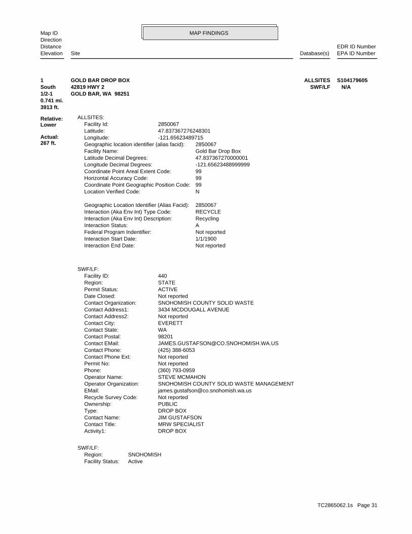
MAP FINDINGSMap IDDirection
EDR ID NumberDistanceEPA ID NumberDatabase(s)SiteElevation
ActiveFacility Status:SNOHOMISHRegion:
SWF/LF:
DROP BOXActivity1: MRW SPECIALISTContact Title: JIM GUSTAFSONContact Name: DROP BOXType: PUBLICOwnership: Not reportedRecycle Survey Code: [email protected]: SNOHOMISH COUNTY SOLID WASTE MANAGEMENTOperator Organization: STEVE MCMAHONOperator Name: (360) 793-0959Phone: Not reportedPermit No: Not reportedContact Phone Ext: (425) 388-6053Contact Phone: [email protected] EMail: 98201Contact Postal: WAContact State: EVERETTContact City: Not reportedContact Address2: 3434 MCDOUGALL AVENUEContact Address1: SNOHOMISH COUNTY SOLID WASTEContact Organization: Not reportedDate Closed: ACTIVEPermit Status: STATERegion: 440Facility ID:
SWF/LF:
Not reportedInteraction End Date: 1/1/1900Interaction Start Date: Not reportedFederal Program Indentifier: AInteraction Status: RecyclingInteraction (Aka Env Int) Description: RECYCLEInteraction (Aka Env Int) Type Code: 2850067Geographic Location Identifier (Alias Facid):
NLocation Verified Code: 99Coordinate Point Geographic Position Code: 99Horizontal Accuracy Code: 99Coordinate Point Areal Extent Code: -121.65623488999999Longitude Decimal Degrees: 47.837367270000001Latitude Decimal Degrees: Gold Bar Drop BoxFacility Name: 2850067Geographic location identifier (alias facid): -121.65623489715Longitude: 47.837367276248301Latitude: 2850067Facility Id:
ALLSITES:
3913 ft.0.741 mi.
Relative:Lower
Actual:267 ft.
1/2-1 GOLD BAR, WA 98251South SWF/LF42819 HWY 2 N/A1 ALLSITESGOLD BAR DROP BOX S104179605
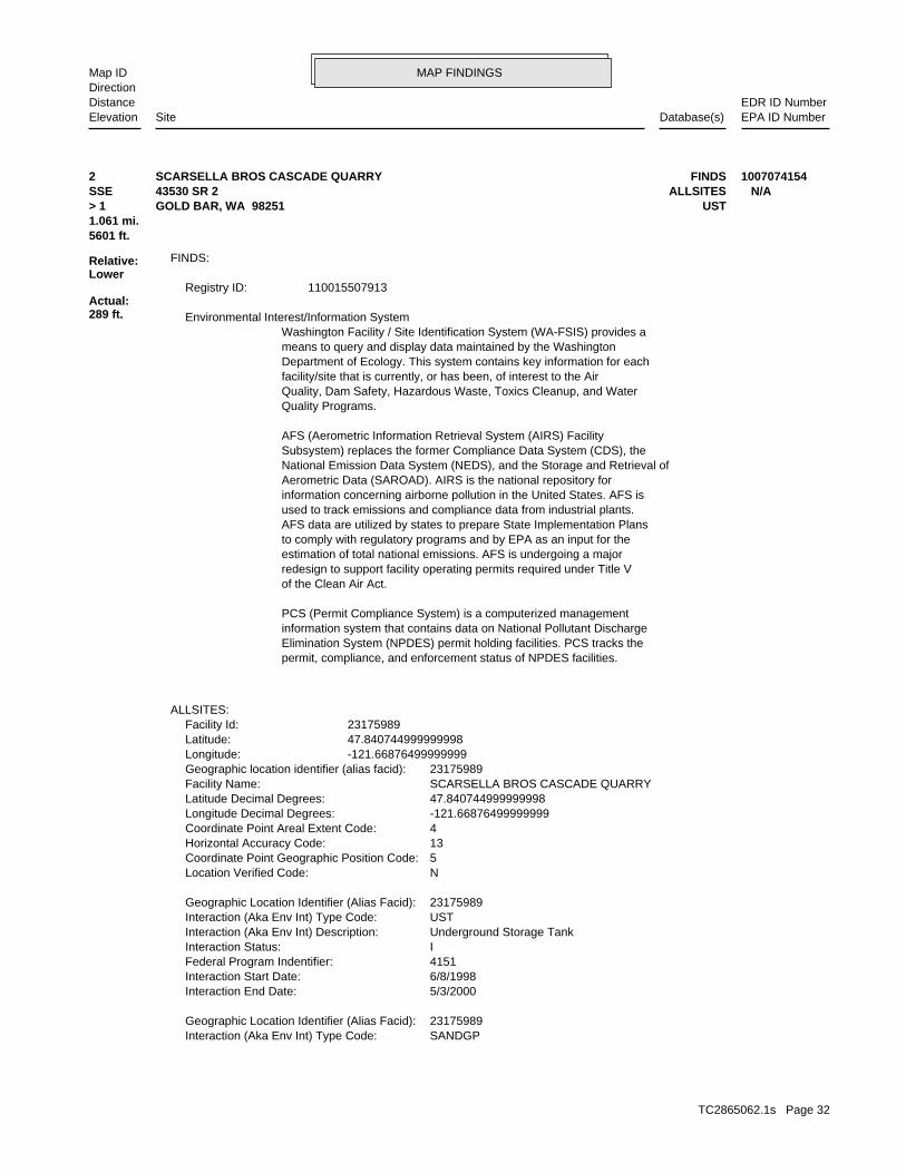
TC2865062.1s Page 31
MAP FINDINGSMap IDDirection
EDR ID NumberDistanceEPA ID NumberDatabase(s)SiteElevation
SANDGPInteraction (Aka Env Int) Type Code: 23175989Geographic Location Identifier (Alias Facid):
5/3/2000Interaction End Date: 6/8/1998Interaction Start Date: 4151Federal Program Indentifier: IInteraction Status: Underground Storage TankInteraction (Aka Env Int) Description: USTInteraction (Aka Env Int) Type Code: 23175989Geographic Location Identifier (Alias Facid):
NLocation Verified Code: 5Coordinate Point Geographic Position Code: 13Horizontal Accuracy Code: 4Coordinate Point Areal Extent Code: -121.66876499999999Longitude Decimal Degrees: 47.840744999999998Latitude Decimal Degrees: SCARSELLA BROS CASCADE QUARRYFacility Name: 23175989Geographic location identifier (alias facid): -121.66876499999999Longitude: 47.840744999999998Latitude: 23175989Facility Id:
ALLSITES:
permit, compliance, and enforcement status of NPDES facilities.Elimination System (NPDES) permit holding facilities. PCS tracks theinformation system that contains data on National Pollutant DischargePCS (Permit Compliance System) is a computerized management
of the Clean Air Act.redesign to support facility operating permits required under Title Vestimation of total national emissions. AFS is undergoing a majorto comply with regulatory programs and by EPA as an input for theAFS data are utilized by states to prepare State Implementation Plansused to track emissions and compliance data from industrial plants.information concerning airborne pollution in the United States. AFS isAerometric Data (SAROAD). AIRS is the national repository forNational Emission Data System (NEDS), and the Storage and Retrieval ofSubsystem) replaces the former Compliance Data System (CDS), theAFS (Aerometric Information Retrieval System (AIRS) Facility
Quality Programs.Quality, Dam Safety, Hazardous Waste, Toxics Cleanup, and Waterfacility/site that is currently, or has been, of interest to the AirDepartment of Ecology. This system contains key information for eachmeans to query and display data maintained by the WashingtonWashington Facility / Site Identification System (WA-FSIS) provides a Environmental Interest/Information System
110015507913Registry ID:
FINDS:
5601 ft.1.061 mi.
Relative:Lower
Actual:289 ft.
> 1 USTGOLD BAR, WA 98251SSE ALLSITES43530 SR 2 N/A2 FINDSSCARSELLA BROS CASCADE QUARRY 1007074154
TC2865062.1s Page 32
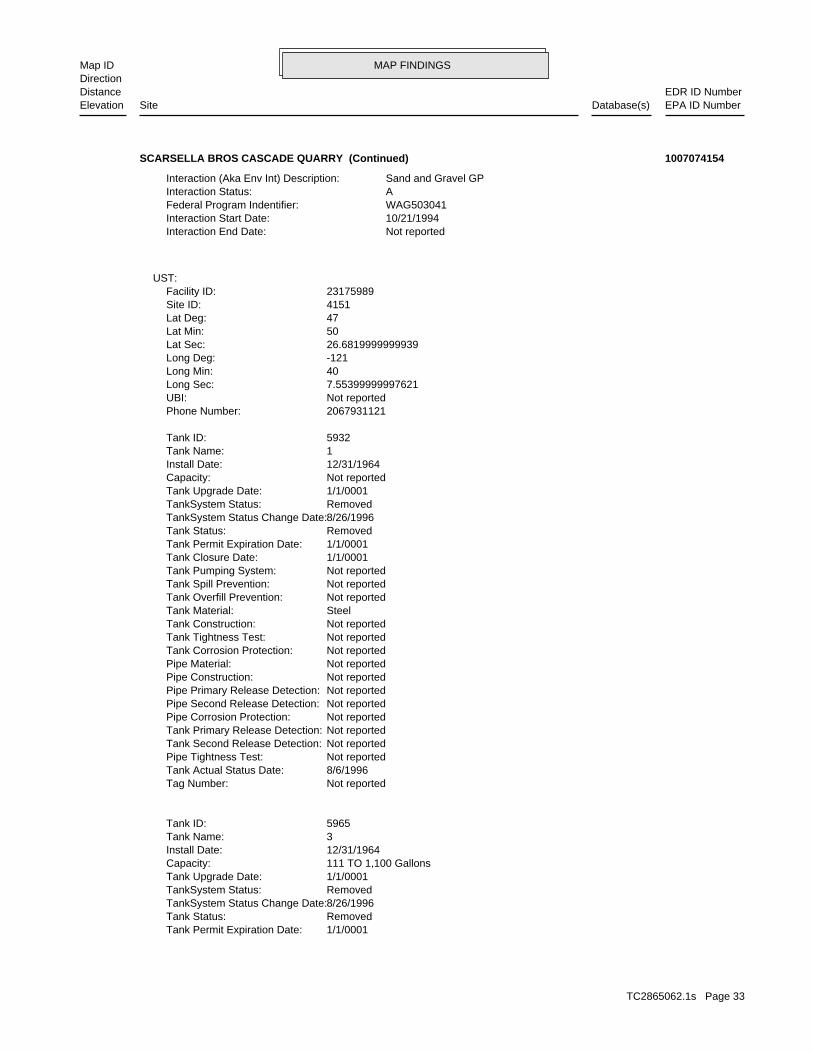
MAP FINDINGSMap IDDirection
EDR ID NumberDistanceEPA ID NumberDatabase(s)SiteElevation
1/1/0001Tank Permit Expiration Date: RemovedTank Status: 8/26/1996TankSystem Status Change Date: RemovedTankSystem Status: 1/1/0001Tank Upgrade Date: 111 TO 1,100 GallonsCapacity: 12/31/1964Install Date: 3Tank Name: 5965Tank ID:
Not reportedTag Number: 8/6/1996Tank Actual Status Date: Not reportedPipe Tightness Test: Not reportedTank Second Release Detection: Not reportedTank Primary Release Detection: Not reportedPipe Corrosion Protection: Not reportedPipe Second Release Detection: Not reportedPipe Primary Release Detection: Not reportedPipe Construction: Not reportedPipe Material: Not reportedTank Corrosion Protection: Not reportedTank Tightness Test: Not reportedTank Construction: SteelTank Material: Not reportedTank Overfill Prevention: Not reportedTank Spill Prevention: Not reportedTank Pumping System: 1/1/0001Tank Closure Date: 1/1/0001Tank Permit Expiration Date: RemovedTank Status: 8/26/1996TankSystem Status Change Date: RemovedTankSystem Status: 1/1/0001Tank Upgrade Date: Not reportedCapacity: 12/31/1964Install Date: 1Tank Name: 5932Tank ID:
2067931121Phone Number: Not reportedUBI: 7.55399999997621Long Sec: 40Long Min: -121Long Deg: 26.6819999999939Lat Sec: 50Lat Min: 47Lat Deg: 4151Site ID: 23175989Facility ID:
UST:
Not reportedInteraction End Date: 10/21/1994Interaction Start Date: WAG503041Federal Program Indentifier: AInteraction Status: Sand and Gravel GPInteraction (Aka Env Int) Description:
SCARSELLA BROS CASCADE QUARRY (Continued) 1007074154
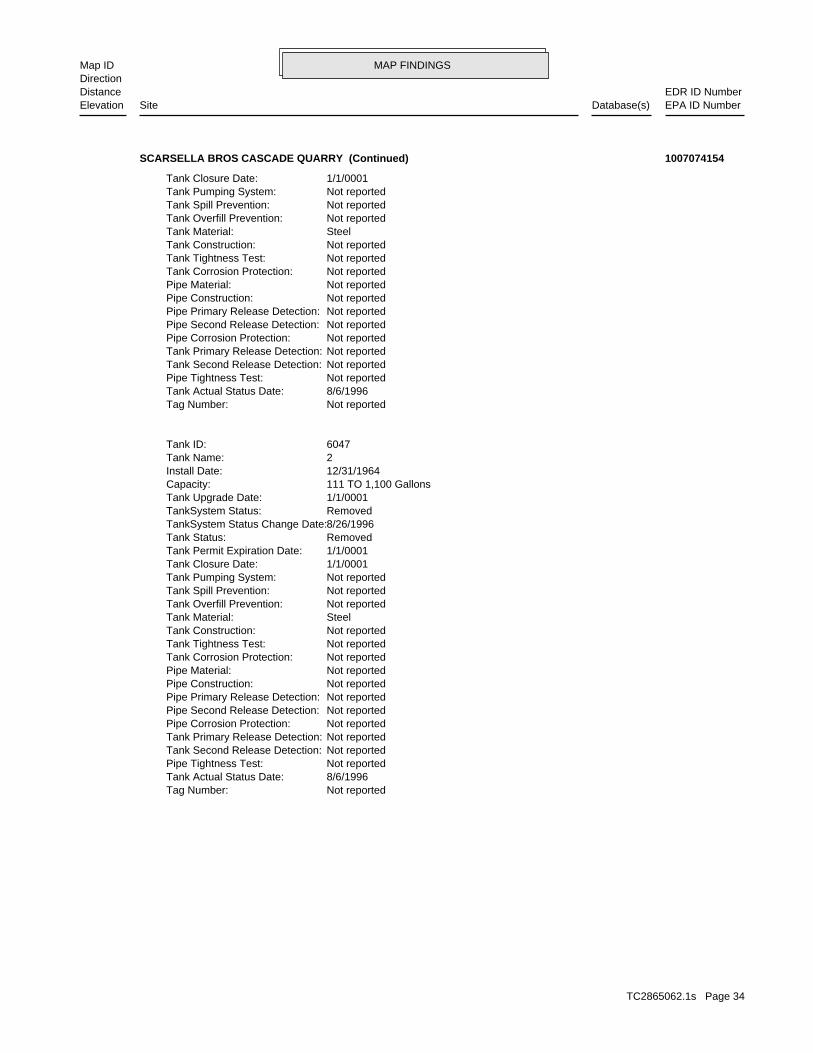
TC2865062.1s Page 33
MAP FINDINGSMap IDDirection
EDR ID NumberDistanceEPA ID NumberDatabase(s)SiteElevation
Not reportedTag Number: 8/6/1996Tank Actual Status Date: Not reportedPipe Tightness Test: Not reportedTank Second Release Detection: Not reportedTank Primary Release Detection: Not reportedPipe Corrosion Protection: Not reportedPipe Second Release Detection: Not reportedPipe Primary Release Detection: Not reportedPipe Construction: Not reportedPipe Material: Not reportedTank Corrosion Protection: Not reportedTank Tightness Test: Not reportedTank Construction: SteelTank Material: Not reportedTank Overfill Prevention: Not reportedTank Spill Prevention: Not reportedTank Pumping System: 1/1/0001Tank Closure Date: 1/1/0001Tank Permit Expiration Date: RemovedTank Status: 8/26/1996TankSystem Status Change Date: RemovedTankSystem Status: 1/1/0001Tank Upgrade Date: 111 TO 1,100 GallonsCapacity: 12/31/1964Install Date: 2Tank Name: 6047Tank ID:
Not reportedTag Number: 8/6/1996Tank Actual Status Date: Not reportedPipe Tightness Test: Not reportedTank Second Release Detection: Not reportedTank Primary Release Detection: Not reportedPipe Corrosion Protection: Not reportedPipe Second Release Detection: Not reportedPipe Primary Release Detection: Not reportedPipe Construction: Not reportedPipe Material: Not reportedTank Corrosion Protection: Not reportedTank Tightness Test: Not reportedTank Construction: SteelTank Material: Not reportedTank Overfill Prevention: Not reportedTank Spill Prevention: Not reportedTank Pumping System: 1/1/0001Tank Closure Date:
SCARSELLA BROS CASCADE QUARRY (Continued) 1007074154
TC2865062.1s Page 34
MAP FINDINGSMap IDDirection
EDR ID NumberDistanceEPA ID NumberDatabase(s)SiteElevation
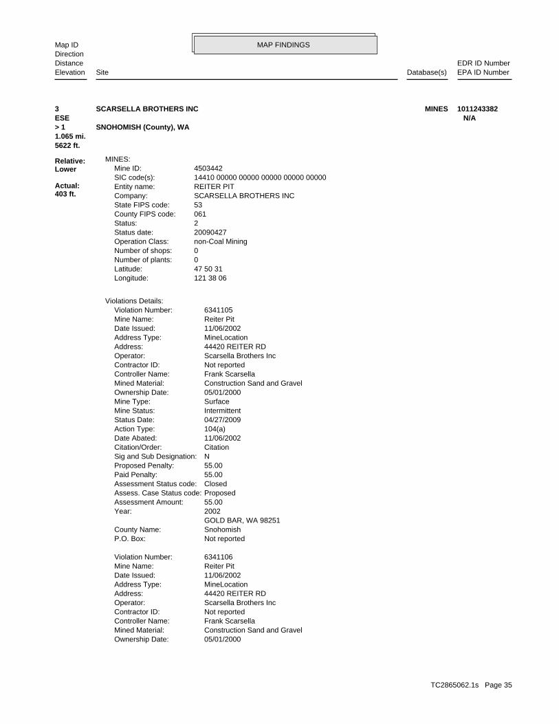
05/01/2000Ownership Date: Construction Sand and GravelMined Material: Frank ScarsellaController Name: Not reportedContractor ID: Scarsella Brothers IncOperator: 44420 REITER RDAddress: MineLocationAddress Type: 11/06/2002Date Issued: Reiter PitMine Name: 6341106Violation Number:
Not reportedP.O. Box: SnohomishCounty Name: GOLD BAR, WA 98251 2002Year: 55.00Assessment Amount: ProposedAssess. Case Status code: ClosedAssessment Status code: 55.00Paid Penalty: 55.00Proposed Penalty: NSig and Sub Designation: CitationCitation/Order: 11/06/2002Date Abated: 104(a)Action Type: 04/27/2009Status Date: IntermittentMine Status: SurfaceMine Type: 05/01/2000Ownership Date: Construction Sand and GravelMined Material: Frank ScarsellaController Name: Not reportedContractor ID: Scarsella Brothers IncOperator: 44420 REITER RDAddress: MineLocationAddress Type: 11/06/2002Date Issued: Reiter PitMine Name: 6341105Violation Number:
Violations Details:
121 38 06Longitude: 47 50 31Latitude: 0Number of plants: 0Number of shops: non-Coal MiningOperation Class: 20090427Status date: 2Status: 061County FIPS code: 53State FIPS code: SCARSELLA BROTHERS INCCompany: REITER PITEntity name: 14410 00000 00000 00000 00000 00000SIC code(s): 4503442Mine ID:
MINES:
5622 ft.1.065 mi.
Relative:Lower
Actual:403 ft.
> 1 SNOHOMISH (County), WA ESE N/A3 MINESSCARSELLA BROTHERS INC 1011243382
TC2865062.1s Page 35
MAP FINDINGSMap IDDirection
EDR ID NumberDistanceEPA ID NumberDatabase(s)SiteElevation
04/27/2009Status Date: IntermittentMine Status: SurfaceMine Type: 05/01/2000Ownership Date: Construction Sand and GravelMined Material: Frank ScarsellaController Name: Not reportedContractor ID: Scarsella Brothers IncOperator: 44420 REITER RDAddress: MineLocationAddress Type: 04/02/2003Date Issued: Reiter PitMine Name: 6341169Violation Number:
Not reportedP.O. Box: SnohomishCounty Name: GOLD BAR, WA 98251 2002Year: 55.00Assessment Amount: ProposedAssess. Case Status code: ClosedAssessment Status code: 55.00Paid Penalty: 55.00Proposed Penalty: NSig and Sub Designation: CitationCitation/Order: 11/06/2002Date Abated: 104(a)Action Type: 04/27/2009Status Date: IntermittentMine Status: SurfaceMine Type: 05/01/2000Ownership Date: Construction Sand and GravelMined Material: Frank ScarsellaController Name: Not reportedContractor ID: Scarsella Brothers IncOperator: 44420 REITER RDAddress: MineLocationAddress Type: 11/06/2002Date Issued: Reiter PitMine Name: 6341107Violation Number:
Not reportedP.O. Box: SnohomishCounty Name: GOLD BAR, WA 98251 2002Year: 55.00Assessment Amount: ProposedAssess. Case Status code: ClosedAssessment Status code: 55.00Paid Penalty: 55.00Proposed Penalty: NSig and Sub Designation: CitationCitation/Order: 11/06/2002Date Abated: 104(a)Action Type: 04/27/2009Status Date: IntermittentMine Status: SurfaceMine Type:
SCARSELLA BROTHERS INC (Continued) 1011243382
TC2865062.1s Page 36
MAP FINDINGSMap IDDirection
EDR ID NumberDistanceEPA ID NumberDatabase(s)SiteElevation
CitationCitation/Order: 11/16/2007Date Abated: 104(a)Action Type: 04/27/2009Status Date: IntermittentMine Status: SurfaceMine Type: 05/01/2000Ownership Date: Construction Sand and GravelMined Material: Frank ScarsellaController Name: Not reportedContractor ID: Scarsella Brothers IncOperator: 44420 REITER RDAddress: MineLocationAddress Type: 11/15/2007Date Issued: Reiter PitMine Name: 7989351Violation Number:
Not reportedP.O. Box: SnohomishCounty Name: GOLD BAR, WA 98251 2007Year: 100.00Assessment Amount: ProposedAssess. Case Status code: ClosedAssessment Status code: 100.00Paid Penalty: 100.00Proposed Penalty: NSig and Sub Designation: CitationCitation/Order: 11/19/2007Date Abated: 104(a)Action Type: 04/27/2009Status Date: IntermittentMine Status: SurfaceMine Type: 05/01/2000Ownership Date: Construction Sand and GravelMined Material: Frank ScarsellaController Name: Not reportedContractor ID: Scarsella Brothers IncOperator: 44420 REITER RDAddress: MineLocationAddress Type: 11/15/2007Date Issued: Reiter PitMine Name: 7989350Violation Number:
Not reportedP.O. Box: SnohomishCounty Name: GOLD BAR, WA 98251 2003Year: 55Assessment Amount: ProposedAssess. Case Status code: ClosedAssessment Status code: 55Paid Penalty: 55Proposed Penalty: NSig and Sub Designation: CitationCitation/Order: 04/02/2003Date Abated: 104(a)Action Type:
SCARSELLA BROTHERS INC (Continued) 1011243382
TC2865062.1s Page 37
MAP FINDINGSMap IDDirection
EDR ID NumberDistanceEPA ID NumberDatabase(s)SiteElevation
60Paid Penalty: 60Proposed Penalty: NSig and Sub Designation: CitationCitation/Order: 10/15/2003Date Abated: 104(a)Action Type: 04/27/2009Status Date: IntermittentMine Status: SurfaceMine Type: 05/01/2000Ownership Date: Construction Sand and GravelMined Material: Frank ScarsellaController Name: Not reportedContractor ID: Scarsella Brothers IncOperator: 44420 REITER RDAddress: MineLocationAddress Type: 10/15/2003Date Issued: Reiter PitMine Name: 6350840Violation Number:
Not reportedP.O. Box: SnohomishCounty Name: GOLD BAR, WA 98251 2003Year: 60Assessment Amount: ProposedAssess. Case Status code: ClosedAssessment Status code: 60Paid Penalty: 60Proposed Penalty: NSig and Sub Designation: CitationCitation/Order: 10/15/2003Date Abated: 104(a)Action Type: 04/27/2009Status Date: IntermittentMine Status: SurfaceMine Type: 05/01/2000Ownership Date: Construction Sand and GravelMined Material: Frank ScarsellaController Name: Not reportedContractor ID: Scarsella Brothers IncOperator: 44420 REITER RDAddress: MineLocationAddress Type: 10/15/2003Date Issued: Reiter PitMine Name: 6350839Violation Number:
Not reportedP.O. Box: SnohomishCounty Name: GOLD BAR, WA 98251 2007Year: 100.00Assessment Amount: ProposedAssess. Case Status code: ClosedAssessment Status code: 100.00Paid Penalty: 100.00Proposed Penalty: NSig and Sub Designation:
SCARSELLA BROTHERS INC (Continued) 1011243382
TC2865062.1s Page 38
MAP FINDINGSMap IDDirection
EDR ID NumberDistanceEPA ID NumberDatabase(s)SiteElevation
60Assessment Amount: ProposedAssess. Case Status code: ClosedAssessment Status code: 60Paid Penalty: 60Proposed Penalty: NSig and Sub Designation: CitationCitation/Order: 10/28/2003Date Abated: 104(a)Action Type: 04/27/2009Status Date: IntermittentMine Status: SurfaceMine Type: 05/01/2000Ownership Date: Construction Sand and GravelMined Material: Frank ScarsellaController Name: Not reportedContractor ID: Scarsella Brothers IncOperator: 44420 REITER RDAddress: MineLocationAddress Type: 10/15/2003Date Issued: Reiter PitMine Name: 6350842Violation Number:
Not reportedP.O. Box: SnohomishCounty Name: GOLD BAR, WA 98251 2003Year: 60Assessment Amount: ProposedAssess. Case Status code: ClosedAssessment Status code: 60Paid Penalty: 60Proposed Penalty: NSig and Sub Designation: CitationCitation/Order: 10/16/2003Date Abated: 104(a)Action Type: 04/27/2009Status Date: IntermittentMine Status: SurfaceMine Type: 05/01/2000Ownership Date: Construction Sand and GravelMined Material: Frank ScarsellaController Name: Not reportedContractor ID: Scarsella Brothers IncOperator: 44420 REITER RDAddress: MineLocationAddress Type: 10/15/2003Date Issued: Reiter PitMine Name: 6350841Violation Number:
Not reportedP.O. Box: SnohomishCounty Name: GOLD BAR, WA 98251 2003Year: 60Assessment Amount: ProposedAssess. Case Status code: ClosedAssessment Status code:
SCARSELLA BROTHERS INC (Continued) 1011243382
TC2865062.1s Page 39
MAP FINDINGSMap IDDirection
EDR ID NumberDistanceEPA ID NumberDatabase(s)SiteElevation
SnohomishCounty Name: GOLD BAR, WA 98251 2003Year: 60Assessment Amount: ProposedAssess. Case Status code: ClosedAssessment Status code: 60Paid Penalty: 60Proposed Penalty: NSig and Sub Designation: CitationCitation/Order: 10/15/2003Date Abated: 104(a)Action Type: 04/27/2009Status Date: IntermittentMine Status: SurfaceMine Type: 05/01/2000Ownership Date: Construction Sand and GravelMined Material: Frank ScarsellaController Name: Not reportedContractor ID: Scarsella Brothers IncOperator: 44420 REITER RDAddress: MineLocationAddress Type: 10/15/2003Date Issued: Reiter PitMine Name: 6350844Violation Number:
Not reportedP.O. Box: SnohomishCounty Name: GOLD BAR, WA 98251 2003Year: 60Assessment Amount: ProposedAssess. Case Status code: ClosedAssessment Status code: 60Paid Penalty: 60Proposed Penalty: NSig and Sub Designation: CitationCitation/Order: 10/16/2003Date Abated: 104(a)Action Type: 04/27/2009Status Date: IntermittentMine Status: SurfaceMine Type: 05/01/2000Ownership Date: Construction Sand and GravelMined Material: Frank ScarsellaController Name: Not reportedContractor ID: Scarsella Brothers IncOperator: 44420 REITER RDAddress: MineLocationAddress Type: 10/15/2003Date Issued: Reiter PitMine Name: 6350843Violation Number:
Not reportedP.O. Box: SnohomishCounty Name: GOLD BAR, WA 98251 2003Year:
SCARSELLA BROTHERS INC (Continued) 1011243382
TC2865062.1s Page 40
MAP FINDINGSMap IDDirection
EDR ID NumberDistanceEPA ID NumberDatabase(s)SiteElevation
6350331Violation Number:
Not reportedP.O. Box: SnohomishCounty Name: GOLD BAR, WA 98251 2004Year: 60.00Assessment Amount: ProposedAssess. Case Status code: ClosedAssessment Status code: 60.00Paid Penalty: 60.00Proposed Penalty: NSig and Sub Designation: CitationCitation/Order: 04/08/2004Date Abated: 104(a)Action Type: 04/27/2009Status Date: IntermittentMine Status: SurfaceMine Type: 05/01/2000Ownership Date: Construction Sand and GravelMined Material: Frank ScarsellaController Name: Not reportedContractor ID: Scarsella Brothers IncOperator: 44420 REITER RDAddress: MineLocationAddress Type: 04/06/2004Date Issued: Reiter PitMine Name: 6350330Violation Number:
Not reportedP.O. Box: SnohomishCounty Name: GOLD BAR, WA 98251 2003Year: 60Assessment Amount: ProposedAssess. Case Status code: ClosedAssessment Status code: 60Paid Penalty: 60Proposed Penalty: NSig and Sub Designation: CitationCitation/Order: 10/15/2003Date Abated: 104(a)Action Type: 04/27/2009Status Date: IntermittentMine Status: SurfaceMine Type: 05/01/2000Ownership Date: Construction Sand and GravelMined Material: Frank ScarsellaController Name: Not reportedContractor ID: Scarsella Brothers IncOperator: 44420 REITER RDAddress: MineLocationAddress Type: 10/15/2003Date Issued: Reiter PitMine Name: 6350845Violation Number:
Not reportedP.O. Box:
SCARSELLA BROTHERS INC (Continued) 1011243382
TC2865062.1s Page 41
MAP FINDINGSMap IDDirection
EDR ID NumberDistanceEPA ID NumberDatabase(s)SiteElevation
MineLocationAddress Type: 07/14/2005Date Issued: Reiter PitMine Name: 6355350Violation Number:
Not reportedP.O. Box: SnohomishCounty Name: GOLD BAR, WA 98251 2004Year: 60.00Assessment Amount: ProposedAssess. Case Status code: ClosedAssessment Status code: 60.00Paid Penalty: 60.00Proposed Penalty: NSig and Sub Designation: CitationCitation/Order: 04/08/2004Date Abated: 104(a)Action Type: 04/27/2009Status Date: IntermittentMine Status: SurfaceMine Type: 05/01/2000Ownership Date: Construction Sand and GravelMined Material: Frank ScarsellaController Name: Not reportedContractor ID: Scarsella Brothers IncOperator: 44420 REITER RDAddress: MineLocationAddress Type: 04/06/2004Date Issued: Reiter PitMine Name: 6350332Violation Number:
Not reportedP.O. Box: SnohomishCounty Name: GOLD BAR, WA 98251 2004Year: 60.00Assessment Amount: ProposedAssess. Case Status code: ClosedAssessment Status code: 60.00Paid Penalty: 60.00Proposed Penalty: NSig and Sub Designation: CitationCitation/Order: 04/06/2004Date Abated: 104(a)Action Type: 04/27/2009Status Date: IntermittentMine Status: SurfaceMine Type: 05/01/2000Ownership Date: Construction Sand and GravelMined Material: Frank ScarsellaController Name: Not reportedContractor ID: Scarsella Brothers IncOperator: 44420 REITER RDAddress: MineLocationAddress Type: 04/06/2004Date Issued: Reiter PitMine Name:
SCARSELLA BROTHERS INC (Continued) 1011243382
TC2865062.1s Page 42

MAP FINDINGSMap IDDirection
EDR ID NumberDistanceEPA ID NumberDatabase(s)SiteElevation
Not reportedContractor ID: Scarsella Brothers IncOperator: 44420 REITER RDAddress: MineLocationAddress Type: 01/31/2006Date Issued: Reiter PitMine Name: 6355371Violation Number:
Not reportedP.O. Box: SnohomishCounty Name: GOLD BAR, WA 98251 2005Year: 60.00Assessment Amount: ProposedAssess. Case Status code: ClosedAssessment Status code: 60.00Paid Penalty: 60.00Proposed Penalty: NSig and Sub Designation: CitationCitation/Order: 07/18/2005Date Abated: 104(a)Action Type: 04/27/2009Status Date: IntermittentMine Status: SurfaceMine Type: 05/01/2000Ownership Date: Construction Sand and GravelMined Material: Frank ScarsellaController Name: Not reportedContractor ID: Scarsella Brothers IncOperator: 44420 REITER RDAddress: MineLocationAddress Type: 07/14/2005Date Issued: Reiter PitMine Name: 6355351Violation Number:
Not reportedP.O. Box: SnohomishCounty Name: GOLD BAR, WA 98251 2005Year: 60.00Assessment Amount: ProposedAssess. Case Status code: ClosedAssessment Status code: 60.00Paid Penalty: 60.00Proposed Penalty: NSig and Sub Designation: CitationCitation/Order: 07/14/2005Date Abated: 104(a)Action Type: 04/27/2009Status Date: IntermittentMine Status: SurfaceMine Type: 05/01/2000Ownership Date: Construction Sand and GravelMined Material: Frank ScarsellaController Name: Not reportedContractor ID: Scarsella Brothers IncOperator: 44420 REITER RDAddress:
SCARSELLA BROTHERS INC (Continued) 1011243382
TC2865062.1s Page 43
MAP FINDINGSMap IDDirection
EDR ID NumberDistanceEPA ID NumberDatabase(s)SiteElevation
05/01/2000Ownership Date: Construction Sand and GravelMined Material: Frank ScarsellaController Name: Not reportedContractor ID: Scarsella Brothers IncOperator: 44420 REITER RDAddress: MineLocationAddress Type: 12/19/2005Date Issued: Reiter PitMine Name: 6371138Violation Number:
Not reportedP.O. Box: SnohomishCounty Name: GOLD BAR, WA 98251 2006Year: 60.00Assessment Amount: ProposedAssess. Case Status code: ClosedAssessment Status code: 60.00Paid Penalty: 60.00Proposed Penalty: NSig and Sub Designation: CitationCitation/Order: 02/01/2006Date Abated: 104(a)Action Type: 04/27/2009Status Date: IntermittentMine Status: SurfaceMine Type: 05/01/2000Ownership Date: Construction Sand and GravelMined Material: Frank ScarsellaController Name: Not reportedContractor ID: Scarsella Brothers IncOperator: 44420 REITER RDAddress: MineLocationAddress Type: 01/31/2006Date Issued: Reiter PitMine Name: 6355372Violation Number:
Not reportedP.O. Box: SnohomishCounty Name: GOLD BAR, WA 98251 2006Year: 60.00Assessment Amount: ProposedAssess. Case Status code: ClosedAssessment Status code: 60.00Paid Penalty: 60.00Proposed Penalty: NSig and Sub Designation: CitationCitation/Order: 02/01/2006Date Abated: 104(a)Action Type: 04/27/2009Status Date: IntermittentMine Status: SurfaceMine Type: 05/01/2000Ownership Date: Construction Sand and GravelMined Material: Frank ScarsellaController Name:
SCARSELLA BROTHERS INC (Continued) 1011243382
TC2865062.1s Page 44

MAP FINDINGSMap IDDirection
EDR ID NumberDistanceEPA ID NumberDatabase(s)SiteElevation
04/27/2009Status Date: IntermittentMine Status: SurfaceMine Type: 05/01/2000Ownership Date: Construction Sand and GravelMined Material: Frank ScarsellaController Name: Not reportedContractor ID: Scarsella Brothers IncOperator: 44420 REITER RDAddress: MineLocationAddress Type: 04/27/2006Date Issued: Reiter PitMine Name: 6384624Violation Number:
Not reportedP.O. Box: SnohomishCounty Name: GOLD BAR, WA 98251 2006Year: 124.00Assessment Amount: ProposedAssess. Case Status code: ClosedAssessment Status code: 124.00Paid Penalty: 124.00Proposed Penalty: YSig and Sub Designation: CitationCitation/Order: 04/28/2006Date Abated: 104(a)Action Type: 04/27/2009Status Date: IntermittentMine Status: SurfaceMine Type: 05/01/2000Ownership Date: Construction Sand and GravelMined Material: Frank ScarsellaController Name: Not reportedContractor ID: Scarsella Brothers IncOperator: 44420 REITER RDAddress: MineLocationAddress Type: 04/27/2006Date Issued: Reiter PitMine Name: 6384623Violation Number:
Not reportedP.O. Box: SnohomishCounty Name: GOLD BAR, WA 98251 2005Year: 60.00Assessment Amount: ProposedAssess. Case Status code: ClosedAssessment Status code: 60.00Paid Penalty: 60.00Proposed Penalty: NSig and Sub Designation: CitationCitation/Order: 12/19/2005Date Abated: 104(a)Action Type: 04/27/2009Status Date: IntermittentMine Status: SurfaceMine Type:
SCARSELLA BROTHERS INC (Continued) 1011243382
TC2865062.1s Page 45

MAP FINDINGSMap IDDirection
EDR ID NumberDistanceEPA ID NumberDatabase(s)SiteElevation
CitationCitation/Order: 04/28/2006Date Abated: 104(a)Action Type: 04/27/2009Status Date: IntermittentMine Status: SurfaceMine Type: 05/01/2000Ownership Date: Construction Sand and GravelMined Material: Frank ScarsellaController Name: Not reportedContractor ID: Scarsella Brothers IncOperator: 44420 REITER RDAddress: MineLocationAddress Type: 04/27/2006Date Issued: Reiter PitMine Name: 6384626Violation Number:
Not reportedP.O. Box: SnohomishCounty Name: GOLD BAR, WA 98251 2006Year: 177.00Assessment Amount: ProposedAssess. Case Status code: ClosedAssessment Status code: 177.00Paid Penalty: 177.00Proposed Penalty: YSig and Sub Designation: CitationCitation/Order: 04/28/2006Date Abated: 104(a)Action Type: 04/27/2009Status Date: IntermittentMine Status: SurfaceMine Type: 05/01/2000Ownership Date: Construction Sand and GravelMined Material: Frank ScarsellaController Name: Not reportedContractor ID: Scarsella Brothers IncOperator: 44420 REITER RDAddress: MineLocationAddress Type: 04/27/2006Date Issued: Reiter PitMine Name: 6384625Violation Number:
Not reportedP.O. Box: SnohomishCounty Name: GOLD BAR, WA 98251 2006Year: 60.00Assessment Amount: ProposedAssess. Case Status code: ClosedAssessment Status code: 60.00Paid Penalty: 60.00Proposed Penalty: NSig and Sub Designation: CitationCitation/Order: 04/28/2006Date Abated: 104(a)Action Type:
SCARSELLA BROTHERS INC (Continued) 1011243382
TC2865062.1s Page 46
MAP FINDINGSMap IDDirection
EDR ID NumberDistanceEPA ID NumberDatabase(s)SiteElevation
60.00Paid Penalty: 60.00Proposed Penalty: NSig and Sub Designation: CitationCitation/Order: 04/28/2006Date Abated: 104(a)Action Type: 04/27/2009Status Date: IntermittentMine Status: SurfaceMine Type: 05/01/2000Ownership Date: Construction Sand and GravelMined Material: Frank ScarsellaController Name: Not reportedContractor ID: Scarsella Brothers IncOperator: 44420 REITER RDAddress: MineLocationAddress Type: 04/27/2006Date Issued: Reiter PitMine Name: 6384628Violation Number:
Not reportedP.O. Box: SnohomishCounty Name: GOLD BAR, WA 98251 2006Year: 217.00Assessment Amount: ProposedAssess. Case Status code: ClosedAssessment Status code: 217.00Paid Penalty: 217.00Proposed Penalty: YSig and Sub Designation: CitationCitation/Order: 04/28/2006Date Abated: 104(a)Action Type: 04/27/2009Status Date: IntermittentMine Status: SurfaceMine Type: 05/01/2000Ownership Date: Construction Sand and GravelMined Material: Frank ScarsellaController Name: Not reportedContractor ID: Scarsella Brothers IncOperator: 44420 REITER RDAddress: MineLocationAddress Type: 04/27/2006Date Issued: Reiter PitMine Name: 6384627Violation Number:
Not reportedP.O. Box: SnohomishCounty Name: GOLD BAR, WA 98251 2006Year: 60.00Assessment Amount: ProposedAssess. Case Status code: ClosedAssessment Status code: 60.00Paid Penalty: 60.00Proposed Penalty: NSig and Sub Designation:
SCARSELLA BROTHERS INC (Continued) 1011243382
TC2865062.1s Page 47
MAP FINDINGSMap IDDirection
EDR ID NumberDistanceEPA ID NumberDatabase(s)SiteElevation
100.00Assessment Amount: ProposedAssess. Case Status code: ClosedAssessment Status code: 100.00Paid Penalty: 100.00Proposed Penalty: NSig and Sub Designation: CitationCitation/Order: 11/16/2007Date Abated: 104(a)Action Type: 04/27/2009Status Date: IntermittentMine Status: SurfaceMine Type: 05/01/2000Ownership Date: Construction Sand and GravelMined Material: Frank ScarsellaController Name: Not reportedContractor ID: Scarsella Brothers IncOperator: 44420 REITER RDAddress: MineLocationAddress Type: 11/15/2007Date Issued: Reiter PitMine Name: 6398231Violation Number:
Not reportedP.O. Box: SnohomishCounty Name: GOLD BAR, WA 98251 2006Year: 60.00Assessment Amount: ProposedAssess. Case Status code: ClosedAssessment Status code: 60.00Paid Penalty: 60.00Proposed Penalty: NSig and Sub Designation: CitationCitation/Order: 04/28/2006Date Abated: 104(a)Action Type: 04/27/2009Status Date: IntermittentMine Status: SurfaceMine Type: 05/01/2000Ownership Date: Construction Sand and GravelMined Material: Frank ScarsellaController Name: Not reportedContractor ID: Scarsella Brothers IncOperator: 44420 REITER RDAddress: MineLocationAddress Type: 04/27/2006Date Issued: Reiter PitMine Name: 6384629Violation Number:
Not reportedP.O. Box: SnohomishCounty Name: GOLD BAR, WA 98251 2006Year: 60.00Assessment Amount: ProposedAssess. Case Status code: ClosedAssessment Status code:
SCARSELLA BROTHERS INC (Continued) 1011243382
TC2865062.1s Page 48
MAP FINDINGSMap IDDirection
EDR ID NumberDistanceEPA ID NumberDatabase(s)SiteElevation
SnohomishCounty Name: GOLD BAR, WA 98251 2007Year: 100.00Assessment Amount: ProposedAssess. Case Status code: ClosedAssessment Status code: 100.00Paid Penalty: 100.00Proposed Penalty: NSig and Sub Designation: CitationCitation/Order: 11/16/2007Date Abated: 104(a)Action Type: 04/27/2009Status Date: IntermittentMine Status: SurfaceMine Type: 05/01/2000Ownership Date: Construction Sand and GravelMined Material: Frank ScarsellaController Name: Not reportedContractor ID: Scarsella Brothers IncOperator: 44420 REITER RDAddress: MineLocationAddress Type: 11/15/2007Date Issued: Reiter PitMine Name: 6398233Violation Number:
Not reportedP.O. Box: SnohomishCounty Name: GOLD BAR, WA 98251 2007Year: 100.00Assessment Amount: ProposedAssess. Case Status code: ClosedAssessment Status code: 100.00Paid Penalty: 100.00Proposed Penalty: NSig and Sub Designation: CitationCitation/Order: 11/16/2007Date Abated: 104(a)Action Type: 04/27/2009Status Date: IntermittentMine Status: SurfaceMine Type: 05/01/2000Ownership Date: Construction Sand and GravelMined Material: Frank ScarsellaController Name: Not reportedContractor ID: Scarsella Brothers IncOperator: 44420 REITER RDAddress: MineLocationAddress Type: 11/15/2007Date Issued: Reiter PitMine Name: 6398232Violation Number:
Not reportedP.O. Box: SnohomishCounty Name: GOLD BAR, WA 98251 2007Year:
SCARSELLA BROTHERS INC (Continued) 1011243382
TC2865062.1s Page 49

MAP FINDINGSMap IDDirection
EDR ID NumberDistanceEPA ID NumberDatabase(s)SiteElevation
6396302Violation Number:
Not reportedP.O. Box: SnohomishCounty Name: GOLD BAR, WA 98251 2007Year: 228.00Assessment Amount: ProposedAssess. Case Status code: ClosedAssessment Status code: 228.00Paid Penalty: 228.00Proposed Penalty: YSig and Sub Designation: CitationCitation/Order: 01/24/2007Date Abated: 104(a)Action Type: 04/27/2009Status Date: IntermittentMine Status: SurfaceMine Type: 05/01/2000Ownership Date: Construction Sand and GravelMined Material: Frank ScarsellaController Name: Not reportedContractor ID: Scarsella Brothers IncOperator: 44420 REITER RDAddress: MineLocationAddress Type: 01/24/2007Date Issued: Reiter PitMine Name: 6396301Violation Number:
Not reportedP.O. Box: SnohomishCounty Name: GOLD BAR, WA 98251 2007Year: 60.00Assessment Amount: ProposedAssess. Case Status code: ClosedAssessment Status code: 60.00Paid Penalty: 60.00Proposed Penalty: NSig and Sub Designation: CitationCitation/Order: 01/24/2007Date Abated: 104(a)Action Type: 04/27/2009Status Date: IntermittentMine Status: SurfaceMine Type: 05/01/2000Ownership Date: Construction Sand and GravelMined Material: Frank ScarsellaController Name: Not reportedContractor ID: Scarsella Brothers IncOperator: 44420 REITER RDAddress: MineLocationAddress Type: 01/24/2007Date Issued: Reiter PitMine Name: 6396300Violation Number:
Not reportedP.O. Box:
SCARSELLA BROTHERS INC (Continued) 1011243382
TC2865062.1s Page 50
MAP FINDINGSMap IDDirection
EDR ID NumberDistanceEPA ID NumberDatabase(s)SiteElevation
MineLocationAddress Type: 01/24/2007Date Issued: Reiter PitMine Name: 6396304Violation Number:
Not reportedP.O. Box: SnohomishCounty Name: GOLD BAR, WA 98251 2007Year: 60.00Assessment Amount: ProposedAssess. Case Status code: ClosedAssessment Status code: 60.00Paid Penalty: 60.00Proposed Penalty: NSig and Sub Designation: CitationCitation/Order: 01/25/2007Date Abated: 104(a)Action Type: 04/27/2009Status Date: IntermittentMine Status: SurfaceMine Type: 05/01/2000Ownership Date: Construction Sand and GravelMined Material: Frank ScarsellaController Name: Not reportedContractor ID: Scarsella Brothers IncOperator: 44420 REITER RDAddress: MineLocationAddress Type: 01/24/2007Date Issued: Reiter PitMine Name: 6396303Violation Number:
Not reportedP.O. Box: SnohomishCounty Name: GOLD BAR, WA 98251 2007Year: 60.00Assessment Amount: ProposedAssess. Case Status code: ClosedAssessment Status code: 60.00Paid Penalty: 60.00Proposed Penalty: NSig and Sub Designation: CitationCitation/Order: 01/24/2007Date Abated: 104(a)Action Type: 04/27/2009Status Date: IntermittentMine Status: SurfaceMine Type: 05/01/2000Ownership Date: Construction Sand and GravelMined Material: Frank ScarsellaController Name: Not reportedContractor ID: Scarsella Brothers IncOperator: 44420 REITER RDAddress: MineLocationAddress Type: 01/24/2007Date Issued: Reiter PitMine Name:
SCARSELLA BROTHERS INC (Continued) 1011243382
TC2865062.1s Page 51
MAP FINDINGSMap IDDirection
EDR ID NumberDistanceEPA ID NumberDatabase(s)SiteElevation
Not reportedContractor ID: Scarsella Brothers IncOperator: 44420 REITER RDAddress: MineLocationAddress Type: 01/24/2007Date Issued: Reiter PitMine Name: 6396306Violation Number:
Not reportedP.O. Box: SnohomishCounty Name: GOLD BAR, WA 98251 2007Year: 60.00Assessment Amount: ProposedAssess. Case Status code: ClosedAssessment Status code: 60.00Paid Penalty: 60.00Proposed Penalty: NSig and Sub Designation: CitationCitation/Order: 01/30/2007Date Abated: 104(a)Action Type: 04/27/2009Status Date: IntermittentMine Status: SurfaceMine Type: 05/01/2000Ownership Date: Construction Sand and GravelMined Material: Frank ScarsellaController Name: Not reportedContractor ID: Scarsella Brothers IncOperator: 44420 REITER RDAddress: MineLocationAddress Type: 01/24/2007Date Issued: Reiter PitMine Name: 6396305Violation Number:
Not reportedP.O. Box: SnohomishCounty Name: GOLD BAR, WA 98251 2007Year: 60.00Assessment Amount: ProposedAssess. Case Status code: ClosedAssessment Status code: 60.00Paid Penalty: 60.00Proposed Penalty: NSig and Sub Designation: CitationCitation/Order: 01/24/2007Date Abated: 104(a)Action Type: 04/27/2009Status Date: IntermittentMine Status: SurfaceMine Type: 05/01/2000Ownership Date: Construction Sand and GravelMined Material: Frank ScarsellaController Name: Not reportedContractor ID: Scarsella Brothers IncOperator: 44420 REITER RDAddress:
SCARSELLA BROTHERS INC (Continued) 1011243382
TC2865062.1s Page 52

MAP FINDINGSMap IDDirection
EDR ID NumberDistanceEPA ID NumberDatabase(s)SiteElevation
05/01/2000Ownership Date: Construction Sand and GravelMined Material: Frank ScarsellaController Name: Not reportedContractor ID: Scarsella Brothers IncOperator: 44420 REITER RDAddress: MineLocationAddress Type: 01/25/2007Date Issued: Reiter PitMine Name: 6396308Violation Number:
Not reportedP.O. Box: SnohomishCounty Name: GOLD BAR, WA 98251 2007Year: 60.00Assessment Amount: ProposedAssess. Case Status code: ClosedAssessment Status code: 60.00Paid Penalty: 60.00Proposed Penalty: NSig and Sub Designation: CitationCitation/Order: 01/30/2007Date Abated: 104(a)Action Type: 04/27/2009Status Date: IntermittentMine Status: SurfaceMine Type: 05/01/2000Ownership Date: Construction Sand and GravelMined Material: Frank ScarsellaController Name: Not reportedContractor ID: Scarsella Brothers IncOperator: 44420 REITER RDAddress: MineLocationAddress Type: 01/24/2007Date Issued: Reiter PitMine Name: 6396307Violation Number:
Not reportedP.O. Box: SnohomishCounty Name: GOLD BAR, WA 98251 2007Year: 60.00Assessment Amount: ProposedAssess. Case Status code: ClosedAssessment Status code: 60.00Paid Penalty: 60.00Proposed Penalty: NSig and Sub Designation: CitationCitation/Order: 01/30/2007Date Abated: 104(a)Action Type: 04/27/2009Status Date: IntermittentMine Status: SurfaceMine Type: 05/01/2000Ownership Date: Construction Sand and GravelMined Material: Frank ScarsellaController Name:
SCARSELLA BROTHERS INC (Continued) 1011243382
TC2865062.1s Page 53
MAP FINDINGSMap IDDirection
EDR ID NumberDistanceEPA ID NumberDatabase(s)SiteElevation
04/27/2009Status Date: IntermittentMine Status: SurfaceMine Type: 05/01/2000Ownership Date: Construction Sand and GravelMined Material: Frank ScarsellaController Name: Not reportedContractor ID: Scarsella Brothers IncOperator: 44420 REITER RDAddress: MineLocationAddress Type: 09/24/2008Date Issued: Reiter PitMine Name: 6433859Violation Number:
Not reportedP.O. Box: SnohomishCounty Name: GOLD BAR, WA 98251 2008Year: 100.00Assessment Amount: ProposedAssess. Case Status code: ClosedAssessment Status code: 100.00Paid Penalty: 100.00Proposed Penalty: NSig and Sub Designation: CitationCitation/Order: 02/19/2008Date Abated: 104(a)Action Type: 04/27/2009Status Date: IntermittentMine Status: SurfaceMine Type: 05/01/2000Ownership Date: Construction Sand and GravelMined Material: Frank ScarsellaController Name: Not reportedContractor ID: Scarsella Brothers IncOperator: 44420 REITER RDAddress: MineLocationAddress Type: 02/19/2008Date Issued: Reiter PitMine Name: 6433075Violation Number:
Not reportedP.O. Box: SnohomishCounty Name: GOLD BAR, WA 98251 2007Year: 60.00Assessment Amount: ProposedAssess. Case Status code: ClosedAssessment Status code: 60.00Paid Penalty: 60.00Proposed Penalty: NSig and Sub Designation: CitationCitation/Order: 01/25/2007Date Abated: 104(a)Action Type: 04/27/2009Status Date: IntermittentMine Status: SurfaceMine Type:
SCARSELLA BROTHERS INC (Continued) 1011243382
TC2865062.1s Page 54
MAP FINDINGSMap IDDirection
EDR ID NumberDistanceEPA ID NumberDatabase(s)SiteElevation
CitationCitation/Order: 10/22/2008Date Abated: 104(a)Action Type: 04/27/2009Status Date: IntermittentMine Status: SurfaceMine Type: 05/01/2000Ownership Date: Construction Sand and GravelMined Material: Frank ScarsellaController Name: Not reportedContractor ID: Scarsella Brothers IncOperator: 44420 REITER RDAddress: MineLocationAddress Type: 10/21/2008Date Issued: Reiter PitMine Name: 6433525Violation Number:
Not reportedP.O. Box: SnohomishCounty Name: GOLD BAR, WA 98251 2008Year: 100.00Assessment Amount: ProposedAssess. Case Status code: ClosedAssessment Status code: 100.00Paid Penalty: 100.00Proposed Penalty: NSig and Sub Designation: CitationCitation/Order: 10/22/2008Date Abated: 104(a)Action Type: 04/27/2009Status Date: IntermittentMine Status: SurfaceMine Type: 05/01/2000Ownership Date: Construction Sand and GravelMined Material: Frank ScarsellaController Name: Not reportedContractor ID: Scarsella Brothers IncOperator: 44420 REITER RDAddress: MineLocationAddress Type: 10/21/2008Date Issued: Reiter PitMine Name: 6433524Violation Number:
Not reportedP.O. Box: SnohomishCounty Name: GOLD BAR, WA 98251 2008Year: 100.00Assessment Amount: ProposedAssess. Case Status code: ClosedAssessment Status code: 100.00Paid Penalty: 100.00Proposed Penalty: NSig and Sub Designation: CitationCitation/Order: 09/24/2008Date Abated: 104(a)Action Type:
SCARSELLA BROTHERS INC (Continued) 1011243382
TC2865062.1s Page 55

MAP FINDINGSMap IDDirection
EDR ID NumberDistanceEPA ID NumberDatabase(s)SiteElevation
100.00Paid Penalty: 100.00Proposed Penalty: NSig and Sub Designation: CitationCitation/Order: 10/22/2008Date Abated: 104(a)Action Type: 04/27/2009Status Date: IntermittentMine Status: SurfaceMine Type: 05/01/2000Ownership Date: Construction Sand and GravelMined Material: Frank ScarsellaController Name: Not reportedContractor ID: Scarsella Brothers IncOperator: 44420 REITER RDAddress: MineLocationAddress Type: 10/21/2008Date Issued: Reiter PitMine Name: 6433527Violation Number:
Not reportedP.O. Box: SnohomishCounty Name: GOLD BAR, WA 98251 2008Year: 100.00Assessment Amount: ProposedAssess. Case Status code: ClosedAssessment Status code: 100.00Paid Penalty: 100.00Proposed Penalty: NSig and Sub Designation: CitationCitation/Order: 10/22/2008Date Abated: 104(a)Action Type: 04/27/2009Status Date: IntermittentMine Status: SurfaceMine Type: 05/01/2000Ownership Date: Construction Sand and GravelMined Material: Frank ScarsellaController Name: Not reportedContractor ID: Scarsella Brothers IncOperator: 44420 REITER RDAddress: MineLocationAddress Type: 10/21/2008Date Issued: Reiter PitMine Name: 6433526Violation Number:
Not reportedP.O. Box: SnohomishCounty Name: GOLD BAR, WA 98251 2008Year: 100.00Assessment Amount: ProposedAssess. Case Status code: ClosedAssessment Status code: 100.00Paid Penalty: 100.00Proposed Penalty: NSig and Sub Designation:
SCARSELLA BROTHERS INC (Continued) 1011243382
TC2865062.1s Page 56
MAP FINDINGSMap IDDirection
EDR ID NumberDistanceEPA ID NumberDatabase(s)SiteElevation
Not reportedP.O. Box: SnohomishCounty Name: GOLD BAR, WA 98251 2008Year: 100.00Assessment Amount: ProposedAssess. Case Status code: ClosedAssessment Status code: 100.00Paid Penalty: 100.00Proposed Penalty: NSig and Sub Designation: CitationCitation/Order: 10/23/2008Date Abated: 104(a)Action Type: 04/27/2009Status Date: IntermittentMine Status: SurfaceMine Type: 05/01/2000Ownership Date: Construction Sand and GravelMined Material: Frank ScarsellaController Name: Not reportedContractor ID: Scarsella Brothers IncOperator: 44420 REITER RDAddress: MineLocationAddress Type: 10/21/2008Date Issued: Reiter PitMine Name: 6433528Violation Number:
Not reportedP.O. Box: SnohomishCounty Name: GOLD BAR, WA 98251 2008Year: 100.00Assessment Amount: ProposedAssess. Case Status code: ClosedAssessment Status code:
SCARSELLA BROTHERS INC (Continued) 1011243382
AInteraction Status: Sand and Gravel GPInteraction (Aka Env Int) Description: SANDGPInteraction (Aka Env Int) Type Code: 73781715Geographic Location Identifier (Alias Facid):
NLocation Verified Code: 8Coordinate Point Geographic Position Code: 99Horizontal Accuracy Code: 99Coordinate Point Areal Extent Code: -121.63511172Longitude Decimal Degrees: 47.830379929999999Latitude Decimal Degrees: CEMEX PROCTOR CREEKFacility Name: 73781715Geographic location identifier (alias facid): -121.635111721938Longitude: 47.830379931805901Latitude: 73781715Facility Id:
ALLSITES:
6156 ft.1.166 mi.
Relative:Lower
Actual:299 ft.
> 1 GOLD BAR, WA 98251SE NPDES44000 SR 2 N/A4 ALLSITESCEMEX PROCTOR CREEK S107863000
TC2865062.1s Page 57
MAP FINDINGSMap IDDirection
EDR ID NumberDistanceEPA ID NumberDatabase(s)SiteElevation
2/4/2005Effective Date: 2/4/2010Permit Expiration Date: SnohomishWRIA: Jeff KilleleaEcology Contact: General PermitsFacility Size: 1/5/2005Permit Issue Date: WAG503074CPermit ID: 360.260.6018Contact Phone Number: Noel BarnettContact Name: 121.63388999999999Longitude: 47.830559999999998Latitude: Sand And GravelFacility Type:
NPDES:
Not reportedInteraction End Date: 1/1/1997Interaction Start Date: CRK000044320Federal Program Indentifier: AInteraction Status: Emergency/Haz Chem Rpt TIER2Interaction (Aka Env Int) Description: TIER2Interaction (Aka Env Int) Type Code: 73781715Geographic Location Identifier (Alias Facid):
Not reportedInteraction End Date: 11/4/1994Interaction Start Date: WAG503074Federal Program Indentifier:
CEMEX PROCTOR CREEK (Continued) S107863000
Heidelberg Cement AGController Name: Not reportedContractor ID: Cadman IncOperator: 44716 State Route 2Address: MineLocationAddress Type: 03/17/2009Date Issued: Cadman Longview (Gold Bar) PitMine Name: 6480403Violation Number:
Violations Details:
121 37 47Longitude: 47 49 59Latitude: 0Number of plants: 0Number of shops: non-Coal MiningOperation Class: 20061024Status date: 1Status: 061County FIPS code: 53State FIPS code: CADMAN INCCompany: CADMAN LONGVIEW (GOLEntity name: 14410 00000 00000 00000 00000 00000SIC code(s): 4503591Mine ID:
MINES:
8466 ft.1.603 mi.
Relative:Higher
Actual:447 ft.
> 1 SNOHOMISH (County), WA SE N/A5 MINESCADMAN INC 1011243520
TC2865062.1s Page 58
MAP FINDINGSMap IDDirection
EDR ID NumberDistanceEPA ID NumberDatabase(s)SiteElevation
SurfaceMine Type: 02/07/2006Ownership Date: Construction Sand and GravelMined Material: Heidelberg Cement AGController Name: Not reportedContractor ID: Cadman IncOperator: 44716 State Route 2Address: MineLocationAddress Type: 04/12/2007Date Issued: Cadman Longview (Gold Bar) PitMine Name: 7963663Violation Number:
Not reportedP.O. Box: SnohomishCounty Name: Gold Bar, WA 98251 2007Year: 60.00Assessment Amount: ProposedAssess. Case Status code: ClosedAssessment Status code: 60.00Paid Penalty: 60.00Proposed Penalty: NSig and Sub Designation: CitationCitation/Order: 04/12/2007Date Abated: 104(a)Action Type: 10/24/2006Status Date: ActiveMine Status: SurfaceMine Type: 02/07/2006Ownership Date: Construction Sand and GravelMined Material: Heidelberg Cement AGController Name: Not reportedContractor ID: Cadman IncOperator: 44716 State Route 2Address: MineLocationAddress Type: 04/12/2007Date Issued: Cadman Longview (Gold Bar) PitMine Name: 7963662Violation Number:
Not reportedP.O. Box: SnohomishCounty Name: Gold Bar, WA 98251 2009Year: 100.00Assessment Amount: ProposedAssess. Case Status code: ClosedAssessment Status code: 100.00Paid Penalty: 100.00Proposed Penalty: NSig and Sub Designation: CitationCitation/Order: 03/18/2009Date Abated: 104(a)Action Type: 10/24/2006Status Date: ActiveMine Status: SurfaceMine Type: 02/07/2006Ownership Date: Construction Sand and GravelMined Material:
CADMAN INC (Continued) 1011243520
TC2865062.1s Page 59
MAP FINDINGSMap IDDirection
EDR ID NumberDistanceEPA ID NumberDatabase(s)SiteElevation
104(a)Action Type: 10/24/2006Status Date: ActiveMine Status: SurfaceMine Type: 02/07/2006Ownership Date: Construction Sand and GravelMined Material: Heidelberg Cement AGController Name: Not reportedContractor ID: Cadman IncOperator: 44716 State Route 2Address: MineLocationAddress Type: 11/14/2007Date Issued: Cadman Longview (Gold Bar) PitMine Name: 6398229Violation Number:
Not reportedP.O. Box: SnohomishCounty Name: Gold Bar, WA 98251 2010Year: 100.00Assessment Amount: ProposedAssess. Case Status code: ClosedAssessment Status code: 100.00Paid Penalty: 100.00Proposed Penalty: NSig and Sub Designation: CitationCitation/Order: 01/27/2010Date Abated: 104(a)Action Type: 10/24/2006Status Date: ActiveMine Status: SurfaceMine Type: 02/07/2006Ownership Date: Construction Sand and GravelMined Material: Heidelberg Cement AGController Name: Not reportedContractor ID: Cadman IncOperator: 44716 State Route 2Address: MineLocationAddress Type: 01/27/2010Date Issued: Cadman Longview (Gold Bar) PitMine Name: 6399409Violation Number:
Not reportedP.O. Box: SnohomishCounty Name: Gold Bar, WA 98251 2007Year: 124.00Assessment Amount: ProposedAssess. Case Status code: ClosedAssessment Status code: 124.00Paid Penalty: 124.00Proposed Penalty: YSig and Sub Designation: CitationCitation/Order: 04/12/2007Date Abated: 104(a)Action Type: 10/24/2006Status Date: ActiveMine Status:
CADMAN INC (Continued) 1011243520
TC2865062.1s Page 60
MAP FINDINGSMap IDDirection
EDR ID NumberDistanceEPA ID NumberDatabase(s)SiteElevation
NSig and Sub Designation: CitationCitation/Order: 10/24/2006Date Abated: 104(a)Action Type: 10/24/2006Status Date: ActiveMine Status: SurfaceMine Type: 02/07/2006Ownership Date: Construction Sand and GravelMined Material: Heidelberg Cement AGController Name: Not reportedContractor ID: Cadman IncOperator: 44716 State Route 2Address: MineLocationAddress Type: 10/24/2006Date Issued: Cadman Longview (Gold Bar) PitMine Name: 6396266Violation Number:
Not reportedP.O. Box: SnohomishCounty Name: Gold Bar, WA 98251 2007Year: 100.00Assessment Amount: ProposedAssess. Case Status code: ClosedAssessment Status code: 100.00Paid Penalty: 100.00Proposed Penalty: NSig and Sub Designation: CitationCitation/Order: 11/15/2007Date Abated: 104(a)Action Type: 10/24/2006Status Date: ActiveMine Status: SurfaceMine Type: 02/07/2006Ownership Date: Construction Sand and GravelMined Material: Heidelberg Cement AGController Name: Not reportedContractor ID: Cadman IncOperator: 44716 State Route 2Address: MineLocationAddress Type: 11/14/2007Date Issued: Cadman Longview (Gold Bar) PitMine Name: 6398230Violation Number:
Not reportedP.O. Box: SnohomishCounty Name: Gold Bar, WA 98251 2007Year: 100.00Assessment Amount: ProposedAssess. Case Status code: ClosedAssessment Status code: 100.00Paid Penalty: 100.00Proposed Penalty: NSig and Sub Designation: CitationCitation/Order: 11/15/2007Date Abated:
CADMAN INC (Continued) 1011243520
TC2865062.1s Page 61
MAP FINDINGSMap IDDirection
EDR ID NumberDistanceEPA ID NumberDatabase(s)SiteElevation
Not reportedP.O. Box: SnohomishCounty Name: Gold Bar, WA 98251 2008Year: 100.00Assessment Amount: ProposedAssess. Case Status code: ClosedAssessment Status code: 100.00Paid Penalty: 100.00Proposed Penalty: NSig and Sub Designation: CitationCitation/Order: 05/16/2008Date Abated: 104(a)Action Type: 10/24/2006Status Date: ActiveMine Status: SurfaceMine Type: 02/07/2006Ownership Date: Construction Sand and GravelMined Material: Heidelberg Cement AGController Name: YBZContractor ID: Cadman IncOperator: 44716 State Route 2Address: MineLocationAddress Type: 04/30/2008Date Issued: Cadman Longview (Gold Bar) PitMine Name: 6433095Violation Number:
Not reportedP.O. Box: SnohomishCounty Name: Gold Bar, WA 98251 2006Year: 60.00Assessment Amount: ProposedAssess. Case Status code: ClosedAssessment Status code: 60.00Paid Penalty: 60.00Proposed Penalty:
CADMAN INC (Continued) 1011243520
VOLCLNSTInteraction (Aka Env Int) Type Code: 76833467Geographic Location Identifier (Alias Facid):
YLocation Verified Code: 5Coordinate Point Geographic Position Code: 7Horizontal Accuracy Code: 4Coordinate Point Areal Extent Code: -121.704061Longitude Decimal Degrees: 47.857796999999998Latitude Decimal Degrees: JACKPOT STATION 165Facility Name: 76833467Geographic location identifier (alias facid): -121.704061Longitude: 47.857796999999998Latitude: 76833467Facility Id:
ALLSITES:
8486 ft. Site 1 of 2 in cluster A1.607 mi. VCP
Relative:Lower
Actual:208 ft.
> 1 USTGOLD BAR, WA 98251West CSCSL NFA1202 CROFT ST N/AA6 ALLSITESJACKPOT STATION 165 U001123452
TC2865062.1s Page 62
MAP FINDINGSMap IDDirection
EDR ID NumberDistanceEPA ID NumberDatabase(s)SiteElevation
SteelTank Material: Automatic Shutoff (fill pipe)Tank Overfill Prevention: Spill Bucket/Spill BoxTank Spill Prevention: Suction System Tank Check ValveTank Pumping System: 1/1/0001Tank Closure Date: 1/1/0001Tank Permit Expiration Date: RemovedTank Status: 8/24/1993TankSystem Status Change Date: RemovedTankSystem Status: 1/1/0001Tank Upgrade Date: 5,000 to 9,999 GallonsCapacity: 1/1/1970Install Date: 29Tank Name: 12525Tank ID:
2067932810Phone Number: Not reportedUBI: 14.619599999985Long Sec: 42Long Min: -121Long Deg: 28.0691999999925Lat Sec: 51Lat Min: 47Lat Deg: 4067Site ID: 76833467Facility ID:
UST:
YVCP: Not reportedRank: 9/7/2000NFA Date: NFA after assessment, IRAP, or VCPNFA Type: 76833467Facility/Site Id:
CSCSL NFA:
8/24/1993Interaction End Date: 1/1/1970Interaction Start Date: 4067Federal Program Indentifier: IInteraction Status: Underground Storage TankInteraction (Aka Env Int) Description: USTInteraction (Aka Env Int) Type Code: 76833467Geographic Location Identifier (Alias Facid):
9/7/2000Interaction End Date: 9/28/1994Interaction Start Date: 4067Federal Program Indentifier: IInteraction Status: LUST FacilityInteraction (Aka Env Int) Description: LUSTInteraction (Aka Env Int) Type Code: 76833467Geographic Location Identifier (Alias Facid):
9/7/2000Interaction End Date: 7/12/2000Interaction Start Date: Not reportedFederal Program Indentifier: IInteraction Status: Voluntary Cleanup SitesInteraction (Aka Env Int) Description:
JACKPOT STATION 165 (Continued) U001123452
TC2865062.1s Page 63
MAP FINDINGSMap IDDirection
EDR ID NumberDistanceEPA ID NumberDatabase(s)SiteElevation
Automatic Shutoff (fill pipe)Tank Overfill Prevention: Spill Bucket/Spill BoxTank Spill Prevention: Suction System Tank Check ValveTank Pumping System: 1/1/0001Tank Closure Date: 1/1/0001Tank Permit Expiration Date: RemovedTank Status: 8/24/1993TankSystem Status Change Date: RemovedTankSystem Status: 1/1/0001Tank Upgrade Date: 10,000 to 19,999 GallonsCapacity: 1/1/1970Install Date: 32Tank Name: 20363Tank ID:
Not reportedTag Number: 8/6/1996Tank Actual Status Date: Every 3 Years (suction tank check valve)Pipe Tightness Test: Not reportedTank Second Release Detection: Not reportedTank Primary Release Detection: NonePipe Corrosion Protection: Not reportedPipe Second Release Detection: Not reportedPipe Primary Release Detection: Single Wall PipePipe Construction: SteelPipe Material: NoneTank Corrosion Protection: Not reportedTank Tightness Test: Single Wall TankTank Construction: SteelTank Material: Automatic Shutoff (fill pipe)Tank Overfill Prevention: Spill Bucket/Spill BoxTank Spill Prevention: Suction System Tank Check ValveTank Pumping System: 1/1/0001Tank Closure Date: 1/1/0001Tank Permit Expiration Date: RemovedTank Status: 8/24/1993TankSystem Status Change Date: RemovedTankSystem Status: 1/1/0001Tank Upgrade Date: 2,001 to 4,999 GallonsCapacity: 1/1/1970Install Date: 26Tank Name: 12732Tank ID:
Not reportedTag Number: 8/6/1996Tank Actual Status Date: Every 3 Years (suction tank check valve)Pipe Tightness Test: Not reportedTank Second Release Detection: Not reportedTank Primary Release Detection: NonePipe Corrosion Protection: Not reportedPipe Second Release Detection: Not reportedPipe Primary Release Detection: Single Wall PipePipe Construction: SteelPipe Material: NoneTank Corrosion Protection: Not reportedTank Tightness Test: Single Wall TankTank Construction:
JACKPOT STATION 165 (Continued) U001123452
TC2865062.1s Page 64
MAP FINDINGSMap IDDirection
EDR ID NumberDistanceEPA ID NumberDatabase(s)SiteElevation
Not reportedRank:9/7/2000Date NFA:NFA after assessment, IRAP, or VCPNFA Type:Not reportedEcology Status:YVCP:Not reportedVCP Status:76833467Facility ID:98251edr_zip:SNOHOMISHedr_fcnty:98251edr_fzip:WAedr_fstat:
VCP:
Not reportedTag Number: 8/6/1996Tank Actual Status Date: Every 3 Years (suction tank check valve)Pipe Tightness Test: Not reportedTank Second Release Detection: Not reportedTank Primary Release Detection: NonePipe Corrosion Protection: Not reportedPipe Second Release Detection: Not reportedPipe Primary Release Detection: Single Wall PipePipe Construction: SteelPipe Material: NoneTank Corrosion Protection: Not reportedTank Tightness Test: Single Wall TankTank Construction: SteelTank Material:
JACKPOT STATION 165 (Continued) U001123452
Not reportedReport Title: Not reportedContact: 31County Code: 93-35Site Register Issue: Interim cleanup reportType of Report Ecology Received: North WesternRegion: TankWaste Management: Groundwater, SoilMedia Contaminated: Petroleum productsContaminants Found at Site: 09/28/94Date Ecology Received Report:
Not reportedReport Title: Not reportedContact: 31County Code: 93-37Site Register Issue: Interim cleanup reportType of Report Ecology Received: North WesternRegion: TankWaste Management: Groundwater, SoilMedia Contaminated: Petroleum productsContaminants Found at Site: 09/28/94Date Ecology Received Report:
ICR:
8486 ft. Site 2 of 2 in cluster A1.607 mi.
Relative:Lower
Actual:208 ft.
> 1 GOLD BAR, WA 98251West 1202 CROFT ST. N/AA7 ICRTIME OIL #01 165 S103510142
TC2865062.1s Page 65
MAP FINDINGSMap IDDirection
EDR ID NumberDistanceEPA ID NumberDatabase(s)SiteElevation
Not reportedReport Title: Not reportedContact: 31County Code: 94-28Site Register Issue: Final cleanup reportType of Report Ecology Received: North WesternRegion: TankWaste Management: Groundwater, SoilMedia Contaminated: Petroleum productsContaminants Found at Site: 04/30/96Date Ecology Received Report:
Not reportedReport Title: Not reportedContact: 31County Code: 94-28Site Register Issue: Interim cleanup reportType of Report Ecology Received: North WesternRegion: TankWaste Management: Groundwater, SoilMedia Contaminated: Petroleum productsContaminants Found at Site: 04/30/96Date Ecology Received Report:
TIME OIL #01 165 (Continued) S103510142
NoU.S. importer of hazardous waste:Handler Activities Summary:
Not reportedOwner/Op end date: 03/24/1997Owner/Op start date: OperatorOwner/Operator Type: PrivateLegal status: Not reportedOwner/operator telephone: USOwner/operator country: GOLDBAR, WA 98251 14530 LEY RDOwner/operator address: MARK WEBBOwner/operator name:
Owner/Operator Summary:
Handler: Non-Generators do not presently generate hazardous wasteDescription: Non-GeneratorClassification: 10EPA Region: Not reportedContact email: (360)652-7417Contact telephone: USContact country: GOLDBAR, WA 98251 14530 LEY RDContact address: MARK WEBBContact: WAR000002360EPA ID: GOLD BAR, WA 98251 14530 LEY RDFacility address: WA PARKS WALLACE FALLS STATE PARKFacility name: 02/26/2002Date form received by agency:
RCRA-NonGen:
8701 ft. Site 1 of 2 in cluster B1.648 mi.
Relative:Lower
Actual:264 ft.
> 1 GOLD BAR, WA 98251NW FINDS14530 LEY RD WAR000002360B8 RCRA-NonGenWA PARKS WALLACE FALLS STATE PARK 1001031531
TC2865062.1s Page 66
MAP FINDINGSMap IDDirection
EDR ID NumberDistanceEPA ID NumberDatabase(s)SiteElevation
corrective action activities required under RCRA.program staff to track the notification, permit, compliance, andand treat, store, or dispose of hazardous waste. RCRAInfo allows RCRAevents and activities related to facilities that generate, transport,Conservation and Recovery Act (RCRA) program through the tracking ofRCRAInfo is a national information system that supports the Resource
Quality Programs.Quality, Dam Safety, Hazardous Waste, Toxics Cleanup, and Waterfacility/site that is currently, or has been, of interest to the AirDepartment of Ecology. This system contains key information for eachmeans to query and display data maintained by the WashingtonWashington Facility / Site Identification System (WA-FSIS) provides a Environmental Interest/Information System
110005399906Registry ID:
FINDS:
No violations foundViolation Status:
Commercial status unknownOff-site waste receiver: NoUsed oil transporter: NoUsed oil transfer facility: NoUsed oil Specification marketer: NoUsed oil fuel marketer to burner: NoUser oil refiner: NoUsed oil processor: NoUsed oil fuel burner: NoFurnace exemption: NoOn-site burner exemption: NoUnderground injection activity: NoTreater, storer or disposer of HW: NoTransporter of hazardous waste: NoRecycler of hazardous waste: NoMixed waste (haz. and radioactive):
WA PARKS WALLACE FALLS STATE PARK (Continued) 1001031531
71661272Geographic Location Identifier (Alias Facid):
NLocation Verified Code: 99Coordinate Point Geographic Position Code: 99Horizontal Accuracy Code: 99Coordinate Point Areal Extent Code: -121.68195Longitude Decimal Degrees: 47.86495Latitude Decimal Degrees: WA PARKS Wallace Falls State ParkFacility Name: 71661272Geographic location identifier (alias facid): -121.68195Longitude: 47.86495Latitude: 71661272Facility Id:
ALLSITES:
8701 ft. Site 2 of 2 in cluster B1.648 mi.
Relative:Lower
Actual:264 ft.
> 1 GOLD BAR, WA 98251NW UST14530 LEY RD N/AB9 ALLSITESWA PARKS WALLACE FALLS STATE PARK U001127647
TC2865062.1s Page 67
MAP FINDINGSMap IDDirection
EDR ID NumberDistanceEPA ID NumberDatabase(s)SiteElevation
Not reportedTag Number: 8/6/1996Tank Actual Status Date: AnnualPipe Tightness Test: Not reportedTank Second Release Detection: Not reportedTank Primary Release Detection: NonePipe Corrosion Protection: Not reportedPipe Second Release Detection: Not reportedPipe Primary Release Detection: Single Wall PipePipe Construction: Not reportedPipe Material: NoneTank Corrosion Protection: Not reportedTank Tightness Test: Single Wall TankTank Construction: Not reportedTank Material: NoneTank Overfill Prevention: NoneTank Spill Prevention: Not reportedTank Pumping System: 1/1/0001Tank Closure Date: 6/30/1997Tank Permit Expiration Date: RemovedTank Status: 11/10/1997TankSystem Status Change Date: RemovedTankSystem Status: 1/1/0001Tank Upgrade Date: 111 TO 1,100 GallonsCapacity: 1/1/1981Install Date: 1Tank Name: 19026Tank ID:
5098562700Phone Number: 3420078280010024UBI: 55.0200000000018Long Sec: 40Long Min: -121Long Deg: 53.8200000000012Lat Sec: 51Lat Min: 47Lat Deg: 97760Site ID: 71661272Facility ID:
UST:
12/31/2000Interaction End Date: 5/8/1995Interaction Start Date: WAR000002360Federal Program Indentifier: IInteraction Status: Hazardous Waste GeneratorInteraction (Aka Env Int) Description: HWGInteraction (Aka Env Int) Type Code: 71661272Geographic Location Identifier (Alias Facid):
5/3/2000Interaction End Date: 1/1/1981Interaction Start Date: 97760Federal Program Indentifier: IInteraction Status: Underground Storage TankInteraction (Aka Env Int) Description: USTInteraction (Aka Env Int) Type Code:
WA PARKS WALLACE FALLS STATE PARK (Continued) U001127647
TC2865062.1s Page 68
MAP FINDINGSMap IDDirection
EDR ID NumberDistanceEPA ID NumberDatabase(s)SiteElevation
Not reportedInteraction End Date: 12/27/1990Interaction Start Date: WAG133005Federal Program Indentifier: AInteraction Status: Upland Fish Hatchery GPInteraction (Aka Env Int) Description: FISHGPInteraction (Aka Env Int) Type Code: 18901Geographic Location Identifier (Alias Facid):
Not reportedLocation Verified Code: 0Coordinate Point Geographic Position Code: 99Horizontal Accuracy Code: 0Coordinate Point Areal Extent Code: -121.623Longitude Decimal Degrees: 47.838099999999997Latitude Decimal Degrees: WA DFW REITER PONDSFacility Name: 18901Geographic location identifier (alias facid): -121.623Longitude: 47.838099999999997Latitude: 18901Facility Id:
ALLSITES:
9194 ft.1.741 mi.
Relative:Lower
Actual:404 ft.
> 1 GOLD BAR, WA 98251East 45300 REITER RD N/A10 ALLSITESWA DFW REITER PONDS S110040127
NLocation Verified Code: 5Coordinate Point Geographic Position Code: 7Horizontal Accuracy Code: 4Coordinate Point Areal Extent Code: -121.704144Longitude Decimal Degrees: 47.857796999999998Latitude Decimal Degrees: HARRY MINOGUE GOLD BAR GAS & GROCERYFacility Name: 17526353Geographic location identifier (alias facid): -121.704144Longitude: 47.857796999999998Latitude: 17526353Facility Id:
ALLSITES:
Quality Programs.Quality, Dam Safety, Hazardous Waste, Toxics Cleanup, and Waterfacility/site that is currently, or has been, of interest to the AirDepartment of Ecology. This system contains key information for eachmeans to query and display data maintained by the WashingtonWashington Facility / Site Identification System (WA-FSIS) provides a Environmental Interest/Information System
110015516583Registry ID:
FINDS:
9433 ft. Site 1 of 2 in cluster C1.787 mi.
Relative:Lower
Actual:215 ft.
> 1 USTGOLD BAR, WA 98251West ALLSITES903 CROFT N/AC11 FINDSHARRY MINOGUE GOLD BAR GAS & GROCERY 1007075014
TC2865062.1s Page 69
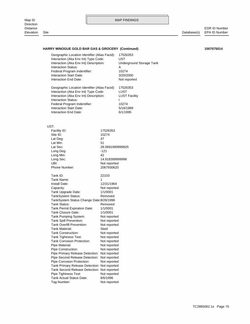
MAP FINDINGSMap IDDirection
EDR ID NumberDistanceEPA ID NumberDatabase(s)SiteElevation
Not reportedTag Number: 8/6/1996Tank Actual Status Date: Not reportedPipe Tightness Test: Not reportedTank Second Release Detection: Not reportedTank Primary Release Detection: Not reportedPipe Corrosion Protection: Not reportedPipe Second Release Detection: Not reportedPipe Primary Release Detection: Not reportedPipe Construction: Not reportedPipe Material: Not reportedTank Corrosion Protection: Not reportedTank Tightness Test: Not reportedTank Construction: SteelTank Material: Not reportedTank Overfill Prevention: Not reportedTank Spill Prevention: Not reportedTank Pumping System: 1/1/0001Tank Closure Date: 1/1/0001Tank Permit Expiration Date: RemovedTank Status: 8/26/1996TankSystem Status Change Date: RemovedTankSystem Status: 1/1/0001Tank Upgrade Date: Not reportedCapacity: 12/31/1964Install Date: 1Tank Name: 22103Tank ID:
2067930620Phone Number: Not reportedUBI: 14.918399999998Long Sec: 42Long Min: -121Long Deg: 28.0691999999925Lat Sec: 51Lat Min: 47Lat Deg: 10274Site ID: 17526353Facility ID:
UST:
6/1/1995Interaction End Date: 5/16/1989Interaction Start Date: 10274Federal Program Indentifier: IInteraction Status: LUST FacilityInteraction (Aka Env Int) Description: LUSTInteraction (Aka Env Int) Type Code: 17526353Geographic Location Identifier (Alias Facid):
Not reportedInteraction End Date: 3/20/2000Interaction Start Date: 10274Federal Program Indentifier: AInteraction Status: Underground Storage TankInteraction (Aka Env Int) Description: USTInteraction (Aka Env Int) Type Code: 17526353Geographic Location Identifier (Alias Facid):
HARRY MINOGUE GOLD BAR GAS & GROCERY (Continued) 1007075014
TC2865062.1s Page 70

MAP FINDINGSMap IDDirection
EDR ID NumberDistanceEPA ID NumberDatabase(s)SiteElevation
Not reportedTag Number: 8/6/1996Tank Actual Status Date: Not reportedPipe Tightness Test: Not reportedTank Second Release Detection: Not reportedTank Primary Release Detection: Not reportedPipe Corrosion Protection: Not reportedPipe Second Release Detection: Not reportedPipe Primary Release Detection: Not reportedPipe Construction: Not reportedPipe Material: Not reportedTank Corrosion Protection: Not reportedTank Tightness Test: Not reportedTank Construction: SteelTank Material: Not reportedTank Overfill Prevention: Not reportedTank Spill Prevention: Not reportedTank Pumping System: 1/1/0001Tank Closure Date: 1/1/0001Tank Permit Expiration Date: RemovedTank Status: 8/26/1996TankSystem Status Change Date: RemovedTankSystem Status: 1/1/0001Tank Upgrade Date: Not reportedCapacity: 12/31/1964Install Date: 3Tank Name: 22248Tank ID:
Not reportedTag Number: 8/6/1996Tank Actual Status Date: Not reportedPipe Tightness Test: Not reportedTank Second Release Detection: Not reportedTank Primary Release Detection: Not reportedPipe Corrosion Protection: Not reportedPipe Second Release Detection: Not reportedPipe Primary Release Detection: Not reportedPipe Construction: Not reportedPipe Material: Not reportedTank Corrosion Protection: Not reportedTank Tightness Test: Not reportedTank Construction: SteelTank Material: Not reportedTank Overfill Prevention: Not reportedTank Spill Prevention: Not reportedTank Pumping System: 1/1/0001Tank Closure Date: 1/1/0001Tank Permit Expiration Date: RemovedTank Status: 8/26/1996TankSystem Status Change Date: RemovedTankSystem Status: 1/1/0001Tank Upgrade Date: Not reportedCapacity: 12/31/1964Install Date: 5Tank Name: 22158Tank ID:
HARRY MINOGUE GOLD BAR GAS & GROCERY (Continued) 1007075014
TC2865062.1s Page 71
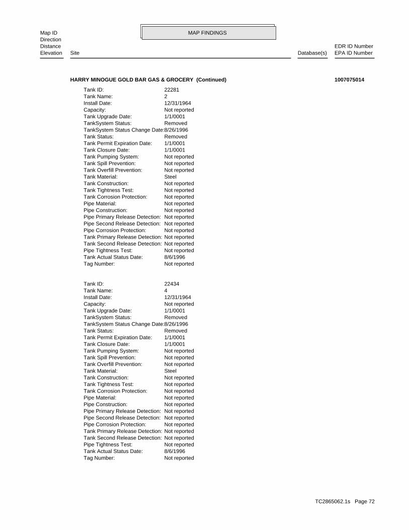
MAP FINDINGSMap IDDirection
EDR ID NumberDistanceEPA ID NumberDatabase(s)SiteElevation
Not reportedTag Number: 8/6/1996Tank Actual Status Date: Not reportedPipe Tightness Test: Not reportedTank Second Release Detection: Not reportedTank Primary Release Detection: Not reportedPipe Corrosion Protection: Not reportedPipe Second Release Detection: Not reportedPipe Primary Release Detection: Not reportedPipe Construction: Not reportedPipe Material: Not reportedTank Corrosion Protection: Not reportedTank Tightness Test: Not reportedTank Construction: SteelTank Material: Not reportedTank Overfill Prevention: Not reportedTank Spill Prevention: Not reportedTank Pumping System: 1/1/0001Tank Closure Date: 1/1/0001Tank Permit Expiration Date: RemovedTank Status: 8/26/1996TankSystem Status Change Date: RemovedTankSystem Status: 1/1/0001Tank Upgrade Date: Not reportedCapacity: 12/31/1964Install Date: 4Tank Name: 22434Tank ID:
Not reportedTag Number: 8/6/1996Tank Actual Status Date: Not reportedPipe Tightness Test: Not reportedTank Second Release Detection: Not reportedTank Primary Release Detection: Not reportedPipe Corrosion Protection: Not reportedPipe Second Release Detection: Not reportedPipe Primary Release Detection: Not reportedPipe Construction: Not reportedPipe Material: Not reportedTank Corrosion Protection: Not reportedTank Tightness Test: Not reportedTank Construction: SteelTank Material: Not reportedTank Overfill Prevention: Not reportedTank Spill Prevention: Not reportedTank Pumping System: 1/1/0001Tank Closure Date: 1/1/0001Tank Permit Expiration Date: RemovedTank Status: 8/26/1996TankSystem Status Change Date: RemovedTankSystem Status: 1/1/0001Tank Upgrade Date: Not reportedCapacity: 12/31/1964Install Date: 2Tank Name: 22281Tank ID:
HARRY MINOGUE GOLD BAR GAS & GROCERY (Continued) 1007075014
TC2865062.1s Page 72
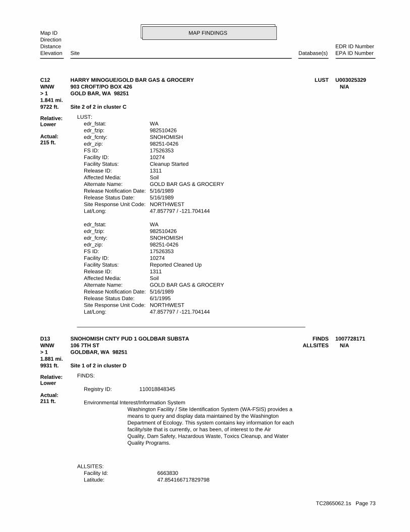
MAP FINDINGSMap IDDirection
EDR ID NumberDistanceEPA ID NumberDatabase(s)SiteElevation
47.857797 / -121.704144Lat/Long: NORTHWESTSite Response Unit Code: 6/1/1995Release Status Date: 5/16/1989Release Notification Date: GOLD BAR GAS & GROCERYAlternate Name: SoilAffected Media: 1311Release ID: Reported Cleaned UpFacility Status: 10274Facility ID: 17526353FS ID: 98251-0426edr_zip: SNOHOMISHedr_fcnty: 982510426edr_fzip: WAedr_fstat:
47.857797 / -121.704144Lat/Long: NORTHWESTSite Response Unit Code: 5/16/1989Release Status Date: 5/16/1989Release Notification Date: GOLD BAR GAS & GROCERYAlternate Name: SoilAffected Media: 1311Release ID: Cleanup StartedFacility Status: 10274Facility ID: 17526353FS ID: 98251-0426edr_zip: SNOHOMISHedr_fcnty: 982510426edr_fzip: WAedr_fstat:
LUST:
9722 ft. Site 2 of 2 in cluster C1.841 mi.
Relative:Lower
Actual:215 ft.
> 1 GOLD BAR, WA 98251WNW 903 CROFT/PO BOX 426 N/AC12 LUSTHARRY MINOGUE/GOLD BAR GAS & GROCERY U003025329
47.854166717829798Latitude: 6663830Facility Id:
ALLSITES:
Quality Programs.Quality, Dam Safety, Hazardous Waste, Toxics Cleanup, and Waterfacility/site that is currently, or has been, of interest to the AirDepartment of Ecology. This system contains key information for eachmeans to query and display data maintained by the WashingtonWashington Facility / Site Identification System (WA-FSIS) provides a Environmental Interest/Information System
110018848345Registry ID:
FINDS:
9931 ft. Site 1 of 2 in cluster D1.881 mi.
Relative:Lower
Actual:211 ft.
> 1 GOLDBAR, WA 98251WNW ALLSITES106 7TH ST N/AD13 FINDSSNOHOMISH CNTY PUD 1 GOLDBAR SUBSTA 1007728171
TC2865062.1s Page 73
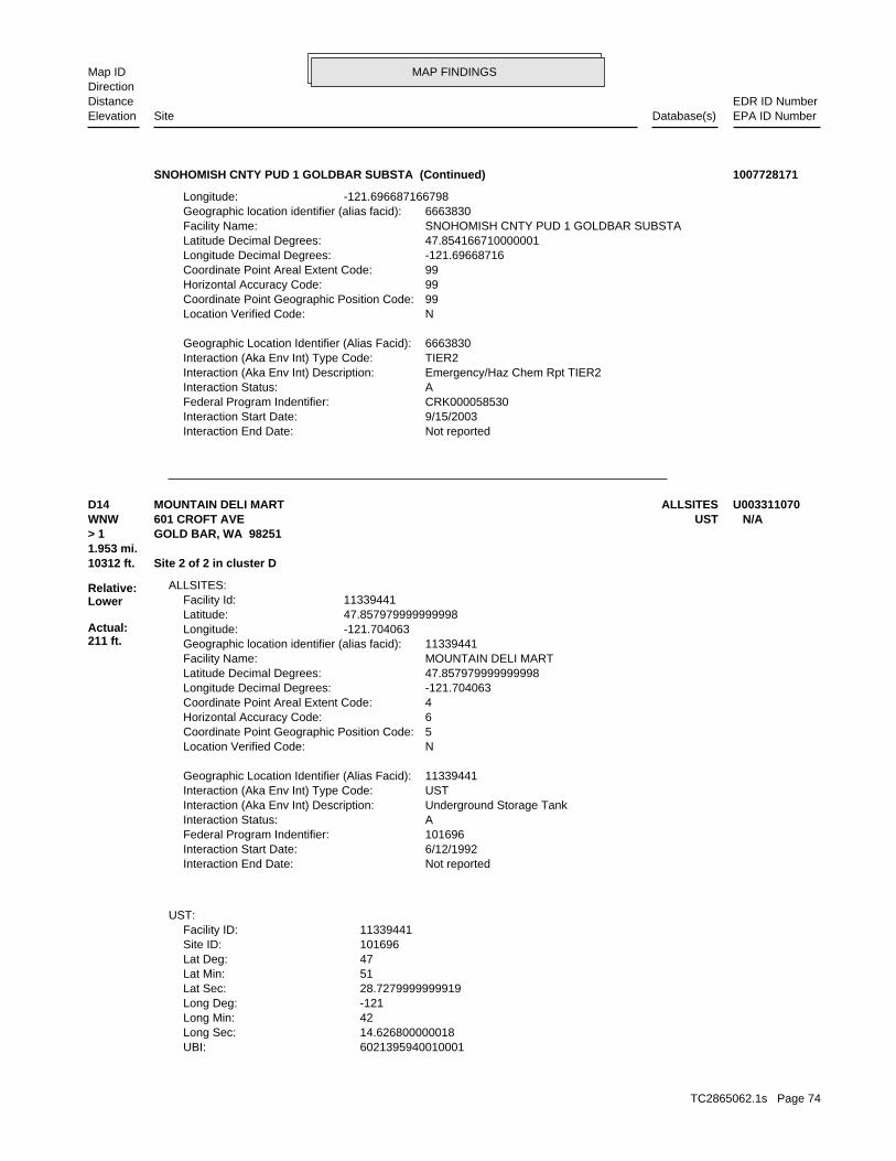
MAP FINDINGSMap IDDirection
EDR ID NumberDistanceEPA ID NumberDatabase(s)SiteElevation
Not reportedInteraction End Date: 9/15/2003Interaction Start Date: CRK000058530Federal Program Indentifier: AInteraction Status: Emergency/Haz Chem Rpt TIER2Interaction (Aka Env Int) Description: TIER2Interaction (Aka Env Int) Type Code: 6663830Geographic Location Identifier (Alias Facid):
NLocation Verified Code: 99Coordinate Point Geographic Position Code: 99Horizontal Accuracy Code: 99Coordinate Point Areal Extent Code: -121.69668716Longitude Decimal Degrees: 47.854166710000001Latitude Decimal Degrees: SNOHOMISH CNTY PUD 1 GOLDBAR SUBSTAFacility Name: 6663830Geographic location identifier (alias facid): -121.696687166798Longitude:
SNOHOMISH CNTY PUD 1 GOLDBAR SUBSTA (Continued) 1007728171
6021395940010001UBI: 14.626800000018Long Sec: 42Long Min: -121Long Deg: 28.7279999999919Lat Sec: 51Lat Min: 47Lat Deg: 101696Site ID: 11339441Facility ID:
UST:
Not reportedInteraction End Date: 6/12/1992Interaction Start Date: 101696Federal Program Indentifier: AInteraction Status: Underground Storage TankInteraction (Aka Env Int) Description: USTInteraction (Aka Env Int) Type Code: 11339441Geographic Location Identifier (Alias Facid):
NLocation Verified Code: 5Coordinate Point Geographic Position Code: 6Horizontal Accuracy Code: 4Coordinate Point Areal Extent Code: -121.704063Longitude Decimal Degrees: 47.857979999999998Latitude Decimal Degrees: MOUNTAIN DELI MARTFacility Name: 11339441Geographic location identifier (alias facid): -121.704063Longitude: 47.857979999999998Latitude: 11339441Facility Id:
ALLSITES:
10312 ft. Site 2 of 2 in cluster D1.953 mi.
Relative:Lower
Actual:211 ft.
> 1 GOLD BAR, WA 98251WNW UST601 CROFT AVE N/AD14 ALLSITESMOUNTAIN DELI MART U003311070
TC2865062.1s Page 74
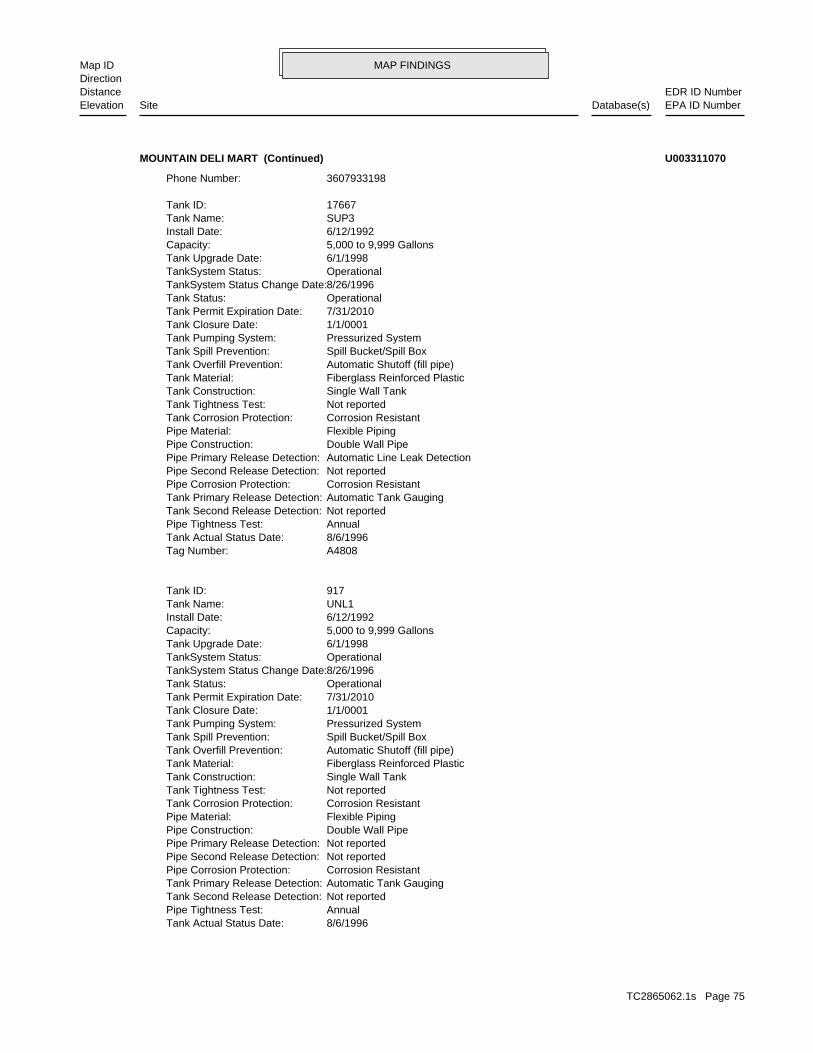
MAP FINDINGSMap IDDirection
EDR ID NumberDistanceEPA ID NumberDatabase(s)SiteElevation
8/6/1996Tank Actual Status Date: AnnualPipe Tightness Test: Not reportedTank Second Release Detection: Automatic Tank GaugingTank Primary Release Detection: Corrosion ResistantPipe Corrosion Protection: Not reportedPipe Second Release Detection: Not reportedPipe Primary Release Detection: Double Wall PipePipe Construction: Flexible PipingPipe Material: Corrosion ResistantTank Corrosion Protection: Not reportedTank Tightness Test: Single Wall TankTank Construction: Fiberglass Reinforced PlasticTank Material: Automatic Shutoff (fill pipe)Tank Overfill Prevention: Spill Bucket/Spill BoxTank Spill Prevention: Pressurized SystemTank Pumping System: 1/1/0001Tank Closure Date: 7/31/2010Tank Permit Expiration Date: OperationalTank Status: 8/26/1996TankSystem Status Change Date: OperationalTankSystem Status: 6/1/1998Tank Upgrade Date: 5,000 to 9,999 GallonsCapacity: 6/12/1992Install Date: UNL1Tank Name: 917Tank ID:
A4808Tag Number: 8/6/1996Tank Actual Status Date: AnnualPipe Tightness Test: Not reportedTank Second Release Detection: Automatic Tank GaugingTank Primary Release Detection: Corrosion ResistantPipe Corrosion Protection: Not reportedPipe Second Release Detection: Automatic Line Leak DetectionPipe Primary Release Detection: Double Wall PipePipe Construction: Flexible PipingPipe Material: Corrosion ResistantTank Corrosion Protection: Not reportedTank Tightness Test: Single Wall TankTank Construction: Fiberglass Reinforced PlasticTank Material: Automatic Shutoff (fill pipe)Tank Overfill Prevention: Spill Bucket/Spill BoxTank Spill Prevention: Pressurized SystemTank Pumping System: 1/1/0001Tank Closure Date: 7/31/2010Tank Permit Expiration Date: OperationalTank Status: 8/26/1996TankSystem Status Change Date: OperationalTankSystem Status: 6/1/1998Tank Upgrade Date: 5,000 to 9,999 GallonsCapacity: 6/12/1992Install Date: SUP3Tank Name: 17667Tank ID:
3607933198Phone Number:
MOUNTAIN DELI MART (Continued) U003311070
TC2865062.1s Page 75
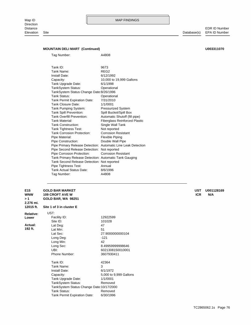
MAP FINDINGSMap IDDirection
EDR ID NumberDistanceEPA ID NumberDatabase(s)SiteElevation
A4808Tag Number: 8/6/1996Tank Actual Status Date: AnnualPipe Tightness Test: Not reportedTank Second Release Detection: Automatic Tank GaugingTank Primary Release Detection: Corrosion ResistantPipe Corrosion Protection: Not reportedPipe Second Release Detection: Automatic Line Leak DetectionPipe Primary Release Detection: Double Wall PipePipe Construction: Flexible PipingPipe Material: Corrosion ResistantTank Corrosion Protection: Not reportedTank Tightness Test: Single Wall TankTank Construction: Fiberglass Reinforced PlasticTank Material: Automatic Shutoff (fill pipe)Tank Overfill Prevention: Spill Bucket/Spill BoxTank Spill Prevention: Pressurized SystemTank Pumping System: 1/1/0001Tank Closure Date: 7/31/2010Tank Permit Expiration Date: OperationalTank Status: 8/26/1996TankSystem Status Change Date: OperationalTankSystem Status: 6/1/1998Tank Upgrade Date: 10,000 to 19,999 GallonsCapacity: 6/12/1992Install Date: REG2Tank Name: 9673Tank ID:
A4808Tag Number:
MOUNTAIN DELI MART (Continued) U003311070
6/30/1996Tank Permit Expiration Date: RemovedTank Status: 10/17/2000TankSystem Status Change Date: RemovedTankSystem Status: 1/1/0001Tank Upgrade Date: 5,000 to 9,999 GallonsCapacity: 6/1/1972Install Date: 3Tank Name: 42364Tank ID:
3607930411Phone Number: 6021308150010001UBI: 8.49959999998646Long Sec: 42Long Min: -121Long Deg: 27.9000000000104Lat Sec: 51Lat Min: 47Lat Deg: 101028Site ID: 12922599Facility ID:
UST:
12015 ft. Site 1 of 3 in cluster E2.276 mi.
Relative:Lower
Actual:192 ft.
> 1 GOLD BAR, WA 98251WNW ICR109 CROFT AVE W N/AE15 USTGOLD BAR MARKET U001128169
TC2865062.1s Page 76
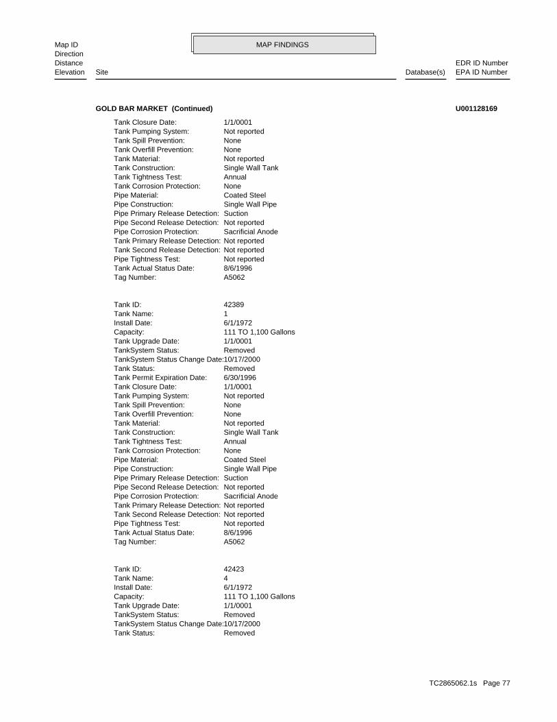
MAP FINDINGSMap IDDirection
EDR ID NumberDistanceEPA ID NumberDatabase(s)SiteElevation
RemovedTank Status: 10/17/2000TankSystem Status Change Date: RemovedTankSystem Status: 1/1/0001Tank Upgrade Date: 111 TO 1,100 GallonsCapacity: 6/1/1972Install Date: 4Tank Name: 42423Tank ID:
A5062Tag Number: 8/6/1996Tank Actual Status Date: Not reportedPipe Tightness Test: Not reportedTank Second Release Detection: Not reportedTank Primary Release Detection: Sacrificial AnodePipe Corrosion Protection: Not reportedPipe Second Release Detection: SuctionPipe Primary Release Detection: Single Wall PipePipe Construction: Coated SteelPipe Material: NoneTank Corrosion Protection: AnnualTank Tightness Test: Single Wall TankTank Construction: Not reportedTank Material: NoneTank Overfill Prevention: NoneTank Spill Prevention: Not reportedTank Pumping System: 1/1/0001Tank Closure Date: 6/30/1996Tank Permit Expiration Date: RemovedTank Status: 10/17/2000TankSystem Status Change Date: RemovedTankSystem Status: 1/1/0001Tank Upgrade Date: 111 TO 1,100 GallonsCapacity: 6/1/1972Install Date: 1Tank Name: 42389Tank ID:
A5062Tag Number: 8/6/1996Tank Actual Status Date: Not reportedPipe Tightness Test: Not reportedTank Second Release Detection: Not reportedTank Primary Release Detection: Sacrificial AnodePipe Corrosion Protection: Not reportedPipe Second Release Detection: SuctionPipe Primary Release Detection: Single Wall PipePipe Construction: Coated SteelPipe Material: NoneTank Corrosion Protection: AnnualTank Tightness Test: Single Wall TankTank Construction: Not reportedTank Material: NoneTank Overfill Prevention: NoneTank Spill Prevention: Not reportedTank Pumping System: 1/1/0001Tank Closure Date:
GOLD BAR MARKET (Continued) U001128169
TC2865062.1s Page 77
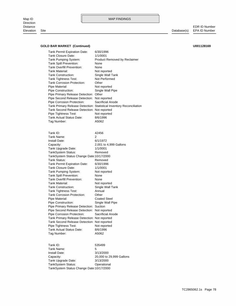
MAP FINDINGSMap IDDirection
EDR ID NumberDistanceEPA ID NumberDatabase(s)SiteElevation
10/17/2000TankSystem Status Change Date: OperationalTankSystem Status: 3/13/2000Tank Upgrade Date: 20,000 to 29,999 GallonsCapacity: 3/13/2000Install Date: 5Tank Name: 535499Tank ID:
A5062Tag Number: 8/6/1996Tank Actual Status Date: Not reportedPipe Tightness Test: Not reportedTank Second Release Detection: Not reportedTank Primary Release Detection: Sacrificial AnodePipe Corrosion Protection: Not reportedPipe Second Release Detection: SuctionPipe Primary Release Detection: Single Wall PipePipe Construction: Coated SteelPipe Material: OtherTank Corrosion Protection: AnnualTank Tightness Test: Single Wall TankTank Construction: Not reportedTank Material: NoneTank Overfill Prevention: NoneTank Spill Prevention: Not reportedTank Pumping System: 1/1/0001Tank Closure Date: 6/30/1996Tank Permit Expiration Date: RemovedTank Status: 10/17/2000TankSystem Status Change Date: RemovedTankSystem Status: 1/1/0001Tank Upgrade Date: 2,001 to 4,999 GallonsCapacity: 6/1/1972Install Date: 2Tank Name: 42456Tank ID:
A5062Tag Number: 8/6/1996Tank Actual Status Date: Not reportedPipe Tightness Test: Not reportedTank Second Release Detection: Statistical Inventory ReconciliationTank Primary Release Detection: Sacrificial AnodePipe Corrosion Protection: Not reportedPipe Second Release Detection: OtherPipe Primary Release Detection: Single Wall PipePipe Construction: Not reportedPipe Material: OtherTank Corrosion Protection: Not PerformedTank Tightness Test: Single Wall TankTank Construction: Not reportedTank Material: NoneTank Overfill Prevention: NoneTank Spill Prevention: Product Removed by ReclaimerTank Pumping System: 1/1/0001Tank Closure Date: 6/30/1996Tank Permit Expiration Date:
GOLD BAR MARKET (Continued) U001128169
TC2865062.1s Page 78
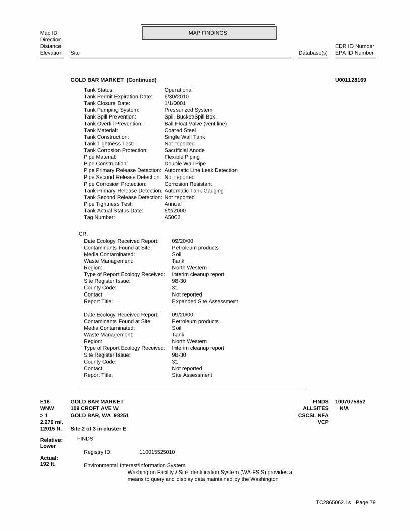
MAP FINDINGSMap IDDirection
EDR ID NumberDistanceEPA ID NumberDatabase(s)SiteElevation
Site AssessmentReport Title: Not reportedContact: 31County Code: 98-30Site Register Issue: Interim cleanup reportType of Report Ecology Received: North WesternRegion: TankWaste Management: SoilMedia Contaminated: Petroleum productsContaminants Found at Site: 09/20/00Date Ecology Received Report:
Expanded Site AssessmentReport Title: Not reportedContact: 31County Code: 98-30Site Register Issue: Interim cleanup reportType of Report Ecology Received: North WesternRegion: TankWaste Management: SoilMedia Contaminated: Petroleum productsContaminants Found at Site: 09/20/00Date Ecology Received Report:
ICR:
A5062Tag Number: 6/2/2000Tank Actual Status Date: AnnualPipe Tightness Test: Not reportedTank Second Release Detection: Automatic Tank GaugingTank Primary Release Detection: Corrosion ResistantPipe Corrosion Protection: Not reportedPipe Second Release Detection: Automatic Line Leak DetectionPipe Primary Release Detection: Double Wall PipePipe Construction: Flexible PipingPipe Material: Sacrificial AnodeTank Corrosion Protection: Not reportedTank Tightness Test: Single Wall TankTank Construction: Coated SteelTank Material: Ball Float Valve (vent line)Tank Overfill Prevention: Spill Bucket/Spill BoxTank Spill Prevention: Pressurized SystemTank Pumping System: 1/1/0001Tank Closure Date: 6/30/2010Tank Permit Expiration Date: OperationalTank Status:
GOLD BAR MARKET (Continued) U001128169
means to query and display data maintained by the WashingtonWashington Facility / Site Identification System (WA-FSIS) provides a Environmental Interest/Information System
110015525010Registry ID:
FINDS:
12015 ft. Site 2 of 3 in cluster E2.276 mi. VCP
Relative:Lower
Actual:192 ft.
> 1 CSCSL NFAGOLD BAR, WA 98251WNW ALLSITES109 CROFT AVE W N/AE16 FINDSGOLD BAR MARKET 1007075852
TC2865062.1s Page 79
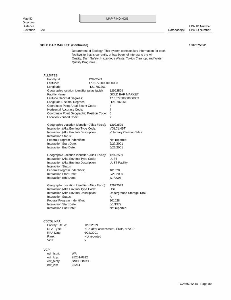
MAP FINDINGSMap IDDirection
EDR ID NumberDistanceEPA ID NumberDatabase(s)SiteElevation
98251edr_zip:SNOHOMISHedr_fcnty:98251-0812edr_fzip:WAedr_fstat:
VCP:
YVCP: Not reportedRank: 6/26/2001NFA Date: NFA after assessment, IRAP, or VCPNFA Type: 12922599Facility/Site Id:
CSCSL NFA:
Not reportedInteraction End Date: 6/1/1972Interaction Start Date: 101028Federal Program Indentifier: AInteraction Status: Underground Storage TankInteraction (Aka Env Int) Description: USTInteraction (Aka Env Int) Type Code: 12922599Geographic Location Identifier (Alias Facid):
6/7/2006Interaction End Date: 2/29/2000Interaction Start Date: 101028Federal Program Indentifier: IInteraction Status: LUST FacilityInteraction (Aka Env Int) Description: LUSTInteraction (Aka Env Int) Type Code: 12922599Geographic Location Identifier (Alias Facid):
6/26/2001Interaction End Date: 2/27/2001Interaction Start Date: Not reportedFederal Program Indentifier: IInteraction Status: Voluntary Cleanup SitesInteraction (Aka Env Int) Description: VOLCLNSTInteraction (Aka Env Int) Type Code: 12922599Geographic Location Identifier (Alias Facid):
YLocation Verified Code: 5Coordinate Point Geographic Position Code: 7Horizontal Accuracy Code: 4Coordinate Point Areal Extent Code: -121.702361Longitude Decimal Degrees: 47.857750000000003Latitude Decimal Degrees: GOLD BAR MARKETFacility Name: 12922599Geographic location identifier (alias facid): -121.702361Longitude: 47.857750000000003Latitude: 12922599Facility Id:
ALLSITES:
Quality Programs.Quality, Dam Safety, Hazardous Waste, Toxics Cleanup, and Waterfacility/site that is currently, or has been, of interest to the AirDepartment of Ecology. This system contains key information for each
GOLD BAR MARKET (Continued) 1007075852
TC2865062.1s Page 80
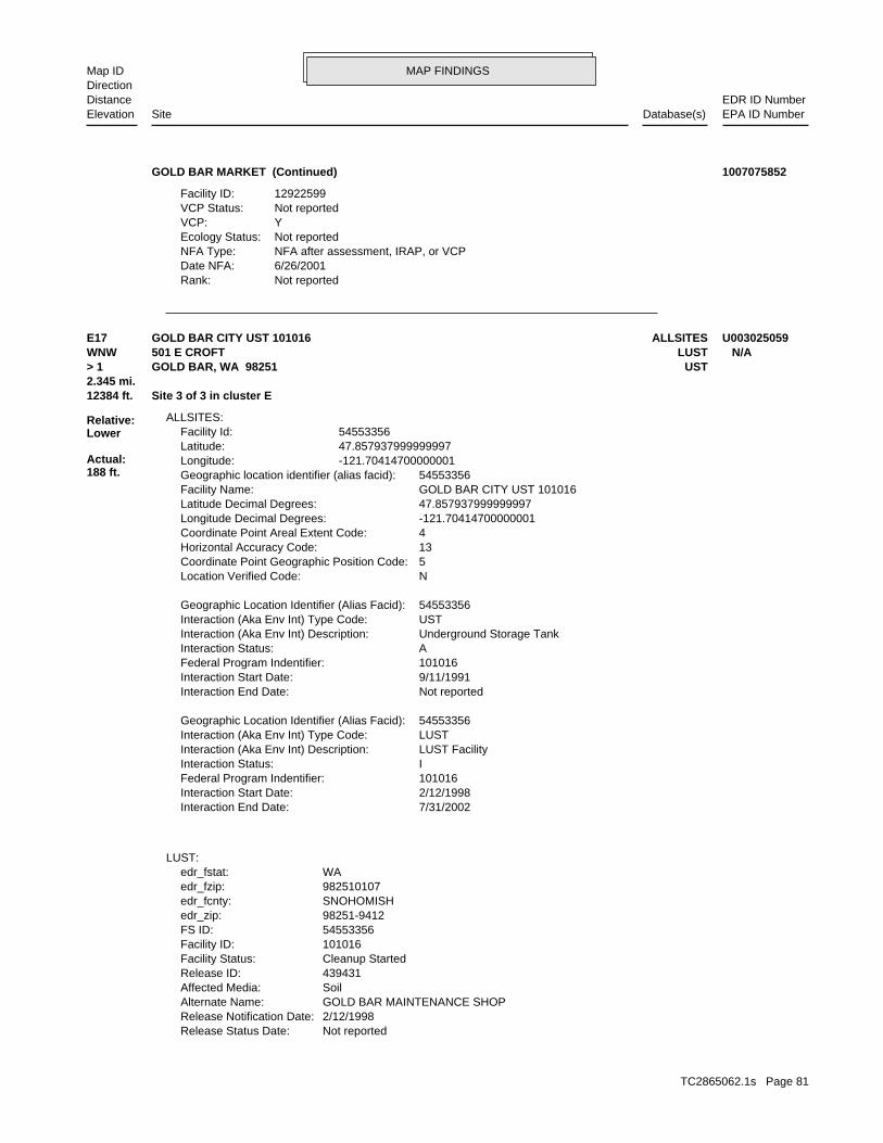
MAP FINDINGSMap IDDirection
EDR ID NumberDistanceEPA ID NumberDatabase(s)SiteElevation
Not reportedRank:6/26/2001Date NFA:NFA after assessment, IRAP, or VCPNFA Type:Not reportedEcology Status:YVCP:Not reportedVCP Status:12922599Facility ID:
GOLD BAR MARKET (Continued) 1007075852
Not reportedRelease Status Date: 2/12/1998Release Notification Date: GOLD BAR MAINTENANCE SHOPAlternate Name: SoilAffected Media: 439431Release ID: Cleanup StartedFacility Status: 101016Facility ID: 54553356FS ID: 98251-9412edr_zip: SNOHOMISHedr_fcnty: 982510107edr_fzip: WAedr_fstat:
LUST:
7/31/2002Interaction End Date: 2/12/1998Interaction Start Date: 101016Federal Program Indentifier: IInteraction Status: LUST FacilityInteraction (Aka Env Int) Description: LUSTInteraction (Aka Env Int) Type Code: 54553356Geographic Location Identifier (Alias Facid):
Not reportedInteraction End Date: 9/11/1991Interaction Start Date: 101016Federal Program Indentifier: AInteraction Status: Underground Storage TankInteraction (Aka Env Int) Description: USTInteraction (Aka Env Int) Type Code: 54553356Geographic Location Identifier (Alias Facid):
NLocation Verified Code: 5Coordinate Point Geographic Position Code: 13Horizontal Accuracy Code: 4Coordinate Point Areal Extent Code: -121.70414700000001Longitude Decimal Degrees: 47.857937999999997Latitude Decimal Degrees: GOLD BAR CITY UST 101016Facility Name: 54553356Geographic location identifier (alias facid): -121.70414700000001Longitude: 47.857937999999997Latitude: 54553356Facility Id:
ALLSITES:
12384 ft. Site 3 of 3 in cluster E2.345 mi.
Relative:Lower
Actual:188 ft.
> 1 USTGOLD BAR, WA 98251WNW LUST501 E CROFT N/AE17 ALLSITESGOLD BAR CITY UST 101016 U003025059
TC2865062.1s Page 81
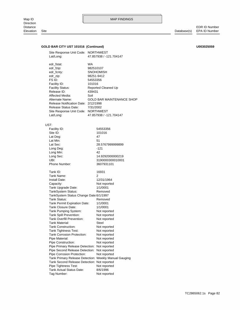
MAP FINDINGSMap IDDirection
EDR ID NumberDistanceEPA ID NumberDatabase(s)SiteElevation
Not reportedTag Number: 8/6/1996Tank Actual Status Date: Not reportedPipe Tightness Test: Not reportedTank Second Release Detection: Weekly Manual GaugingTank Primary Release Detection: Not reportedPipe Corrosion Protection: Not reportedPipe Second Release Detection: Not reportedPipe Primary Release Detection: Not reportedPipe Construction: Not reportedPipe Material: Not reportedTank Corrosion Protection: Not reportedTank Tightness Test: Not reportedTank Construction: SteelTank Material: Not reportedTank Overfill Prevention: Not reportedTank Spill Prevention: Not reportedTank Pumping System: 1/1/0001Tank Closure Date: 1/1/0001Tank Permit Expiration Date: RemovedTank Status: 6/1/1997TankSystem Status Change Date: RemovedTankSystem Status: 1/1/0001Tank Upgrade Date: Not reportedCapacity: 12/31/1964Install Date: 2Tank Name: 16931Tank ID:
3607931101Phone Number: 3190000300010001UBI: 14.9292000000219Long Sec: 42Long Min: -121Long Deg: 28.5767999999899Lat Sec: 51Lat Min: 47Lat Deg: 101016Site ID: 54553356Facility ID:
UST:
47.857938 / -121.704147Lat/Long: NORTHWESTSite Response Unit Code: 7/31/2002Release Status Date: 2/12/1998Release Notification Date: GOLD BAR MAINTENANCE SHOPAlternate Name: SoilAffected Media: 439431Release ID: Reported Cleaned UpFacility Status: 101016Facility ID: 54553356FS ID: 98251-9412edr_zip: SNOHOMISHedr_fcnty: 982510107edr_fzip: WAedr_fstat:
47.857938 / -121.704147Lat/Long: NORTHWESTSite Response Unit Code:
GOLD BAR CITY UST 101016 (Continued) U003025059
TC2865062.1s Page 82
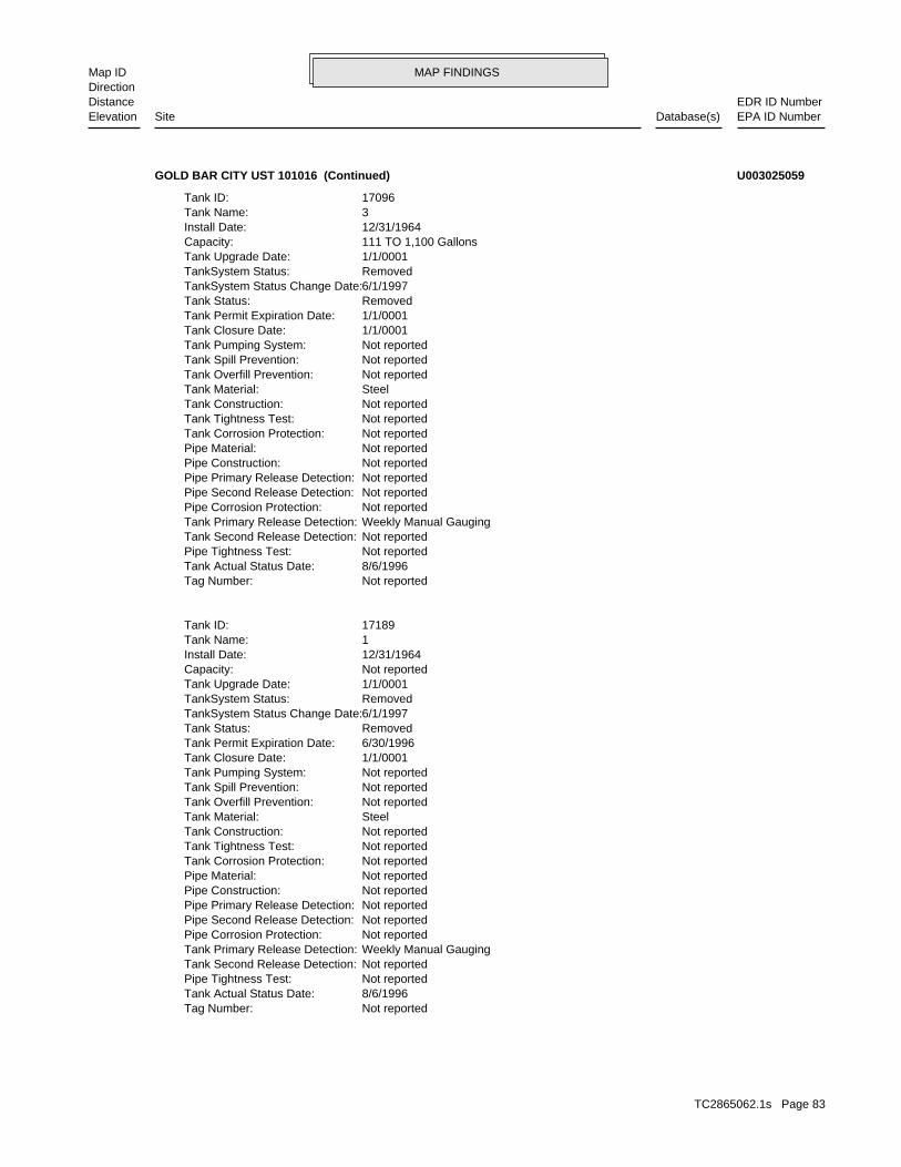
MAP FINDINGSMap IDDirection
EDR ID NumberDistanceEPA ID NumberDatabase(s)SiteElevation
Not reportedTag Number: 8/6/1996Tank Actual Status Date: Not reportedPipe Tightness Test: Not reportedTank Second Release Detection: Weekly Manual GaugingTank Primary Release Detection: Not reportedPipe Corrosion Protection: Not reportedPipe Second Release Detection: Not reportedPipe Primary Release Detection: Not reportedPipe Construction: Not reportedPipe Material: Not reportedTank Corrosion Protection: Not reportedTank Tightness Test: Not reportedTank Construction: SteelTank Material: Not reportedTank Overfill Prevention: Not reportedTank Spill Prevention: Not reportedTank Pumping System: 1/1/0001Tank Closure Date: 6/30/1996Tank Permit Expiration Date: RemovedTank Status: 6/1/1997TankSystem Status Change Date: RemovedTankSystem Status: 1/1/0001Tank Upgrade Date: Not reportedCapacity: 12/31/1964Install Date: 1Tank Name: 17189Tank ID:
Not reportedTag Number: 8/6/1996Tank Actual Status Date: Not reportedPipe Tightness Test: Not reportedTank Second Release Detection: Weekly Manual GaugingTank Primary Release Detection: Not reportedPipe Corrosion Protection: Not reportedPipe Second Release Detection: Not reportedPipe Primary Release Detection: Not reportedPipe Construction: Not reportedPipe Material: Not reportedTank Corrosion Protection: Not reportedTank Tightness Test: Not reportedTank Construction: SteelTank Material: Not reportedTank Overfill Prevention: Not reportedTank Spill Prevention: Not reportedTank Pumping System: 1/1/0001Tank Closure Date: 1/1/0001Tank Permit Expiration Date: RemovedTank Status: 6/1/1997TankSystem Status Change Date: RemovedTankSystem Status: 1/1/0001Tank Upgrade Date: 111 TO 1,100 GallonsCapacity: 12/31/1964Install Date: 3Tank Name: 17096Tank ID:
GOLD BAR CITY UST 101016 (Continued) U003025059
TC2865062.1s Page 83
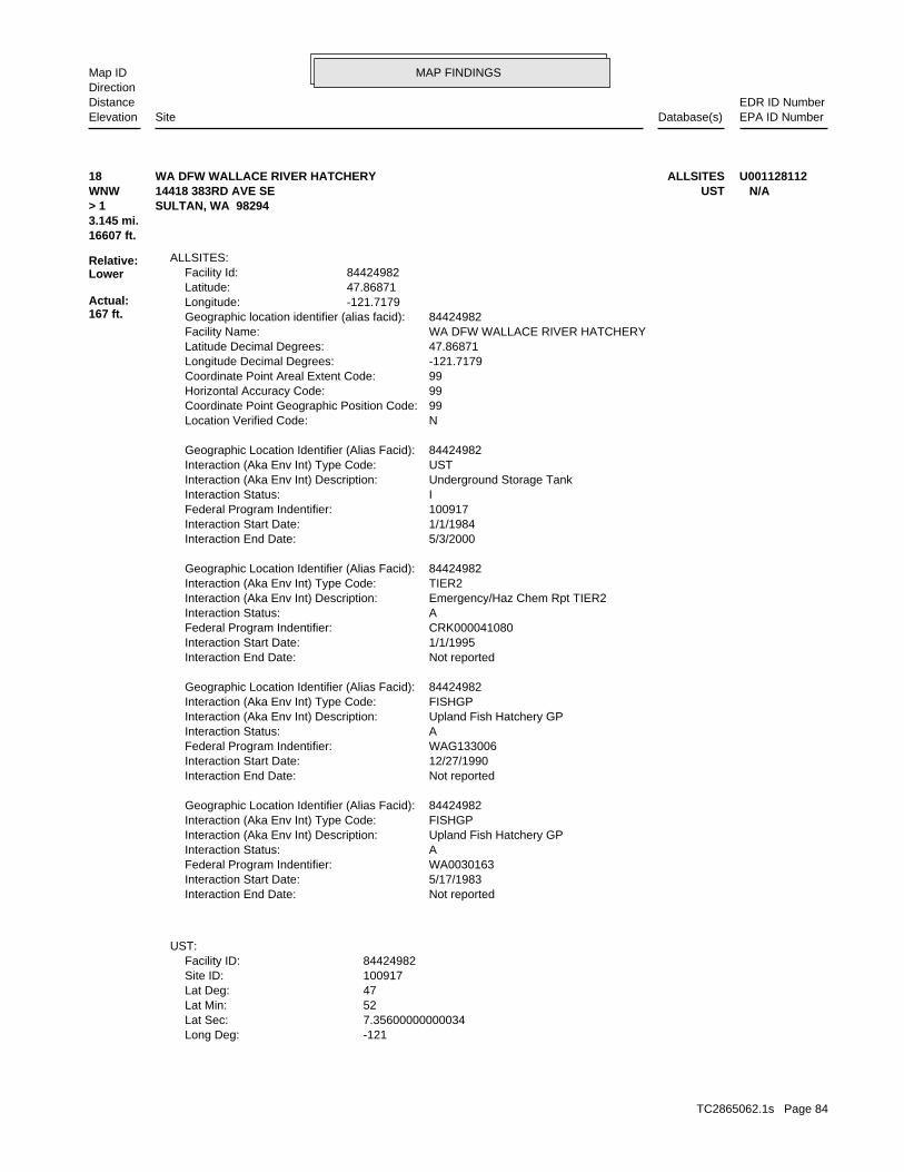
MAP FINDINGSMap IDDirection
EDR ID NumberDistanceEPA ID NumberDatabase(s)SiteElevation
-121Long Deg: 7.35600000000034Lat Sec: 52Lat Min: 47Lat Deg: 100917Site ID: 84424982Facility ID:
UST:
Not reportedInteraction End Date: 5/17/1983Interaction Start Date: WA0030163Federal Program Indentifier: AInteraction Status: Upland Fish Hatchery GPInteraction (Aka Env Int) Description: FISHGPInteraction (Aka Env Int) Type Code: 84424982Geographic Location Identifier (Alias Facid):
Not reportedInteraction End Date: 12/27/1990Interaction Start Date: WAG133006Federal Program Indentifier: AInteraction Status: Upland Fish Hatchery GPInteraction (Aka Env Int) Description: FISHGPInteraction (Aka Env Int) Type Code: 84424982Geographic Location Identifier (Alias Facid):
Not reportedInteraction End Date: 1/1/1995Interaction Start Date: CRK000041080Federal Program Indentifier: AInteraction Status: Emergency/Haz Chem Rpt TIER2Interaction (Aka Env Int) Description: TIER2Interaction (Aka Env Int) Type Code: 84424982Geographic Location Identifier (Alias Facid):
5/3/2000Interaction End Date: 1/1/1984Interaction Start Date: 100917Federal Program Indentifier: IInteraction Status: Underground Storage TankInteraction (Aka Env Int) Description: USTInteraction (Aka Env Int) Type Code: 84424982Geographic Location Identifier (Alias Facid):
NLocation Verified Code: 99Coordinate Point Geographic Position Code: 99Horizontal Accuracy Code: 99Coordinate Point Areal Extent Code: -121.7179Longitude Decimal Degrees: 47.86871Latitude Decimal Degrees: WA DFW WALLACE RIVER HATCHERYFacility Name: 84424982Geographic location identifier (alias facid): -121.7179Longitude: 47.86871Latitude: 84424982Facility Id:
ALLSITES:
16607 ft.3.145 mi.
Relative:Lower
Actual:167 ft.
> 1 SULTAN, WA 98294WNW UST14418 383RD AVE SE N/A18 ALLSITESWA DFW WALLACE RIVER HATCHERY U001128112
TC2865062.1s Page 84
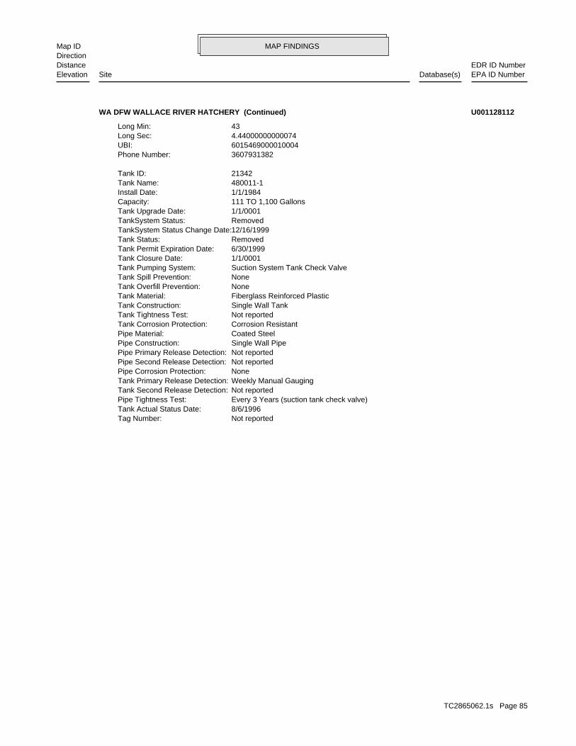
MAP FINDINGSMap IDDirection
EDR ID NumberDistanceEPA ID NumberDatabase(s)SiteElevation
Not reportedTag Number: 8/6/1996Tank Actual Status Date: Every 3 Years (suction tank check valve)Pipe Tightness Test: Not reportedTank Second Release Detection: Weekly Manual GaugingTank Primary Release Detection: NonePipe Corrosion Protection: Not reportedPipe Second Release Detection: Not reportedPipe Primary Release Detection: Single Wall PipePipe Construction: Coated SteelPipe Material: Corrosion ResistantTank Corrosion Protection: Not reportedTank Tightness Test: Single Wall TankTank Construction: Fiberglass Reinforced PlasticTank Material: NoneTank Overfill Prevention: NoneTank Spill Prevention: Suction System Tank Check ValveTank Pumping System: 1/1/0001Tank Closure Date: 6/30/1999Tank Permit Expiration Date: RemovedTank Status: 12/16/1999TankSystem Status Change Date: RemovedTankSystem Status: 1/1/0001Tank Upgrade Date: 111 TO 1,100 GallonsCapacity: 1/1/1984Install Date: 480011-1Tank Name: 21342Tank ID:
3607931382Phone Number: 6015469000010004UBI: 4.44000000000074Long Sec: 43Long Min:
WA DFW WALLACE RIVER HATCHERY (Continued) U001128112
TC2865062.1s Page 85
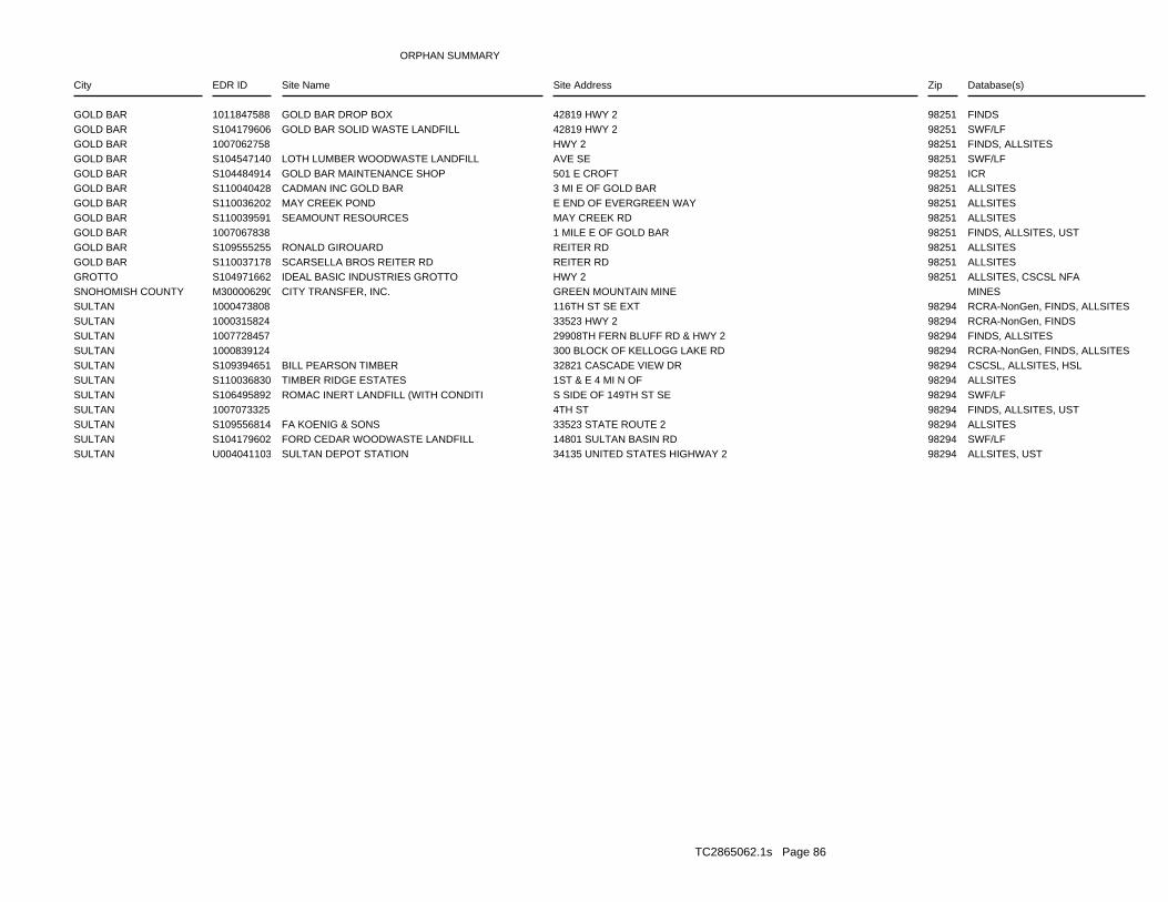
ORPHAN SUMMARY
City EDR ID Site Name Site Address Zip Database(s)
GOLD BAR 1011847588 GOLD BAR DROP BOX 42819 HWY 2 98251 FINDSGOLD BAR S104179606 GOLD BAR SOLID WASTE LANDFILL 42819 HWY 2 98251 SWF/LFGOLD BAR 1007062758 HWY 2 98251 FINDS, ALLSITESGOLD BAR S104547140 LOTH LUMBER WOODWASTE LANDFILL AVE SE 98251 SWF/LFGOLD BAR S104484914 GOLD BAR MAINTENANCE SHOP 501 E CROFT 98251 ICRGOLD BAR S110040428 CADMAN INC GOLD BAR 3 MI E OF GOLD BAR 98251 ALLSITESGOLD BAR S110036202 MAY CREEK POND E END OF EVERGREEN WAY 98251 ALLSITESGOLD BAR S110039591 SEAMOUNT RESOURCES MAY CREEK RD 98251 ALLSITESGOLD BAR 1007067838 1 MILE E OF GOLD BAR 98251 FINDS, ALLSITES, USTGOLD BAR S109555255 RONALD GIROUARD REITER RD 98251 ALLSITESGOLD BAR S110037178 SCARSELLA BROS REITER RD REITER RD 98251 ALLSITESGROTTO S104971662 IDEAL BASIC INDUSTRIES GROTTO HWY 2 98251 ALLSITES, CSCSL NFASNOHOMISH COUNTY M300006290 CITY TRANSFER, INC. GREEN MOUNTAIN MINE MINESSULTAN 1000473808 116TH ST SE EXT 98294 RCRA-NonGen, FINDS, ALLSITESSULTAN 1000315824 33523 HWY 2 98294 RCRA-NonGen, FINDSSULTAN 1007728457 29908TH FERN BLUFF RD & HWY 2 98294 FINDS, ALLSITESSULTAN 1000839124 300 BLOCK OF KELLOGG LAKE RD 98294 RCRA-NonGen, FINDS, ALLSITESSULTAN S109394651 BILL PEARSON TIMBER 32821 CASCADE VIEW DR 98294 CSCSL, ALLSITES, HSLSULTAN S110036830 TIMBER RIDGE ESTATES 1ST & E 4 MI N OF 98294 ALLSITESSULTAN S106495892 ROMAC INERT LANDFILL (WITH CONDITI S SIDE OF 149TH ST SE 98294 SWF/LFSULTAN 1007073325 4TH ST 98294 FINDS, ALLSITES, USTSULTAN S109556814 FA KOENIG & SONS 33523 STATE ROUTE 2 98294 ALLSITESSULTAN S104179602 FORD CEDAR WOODWASTE LANDFILL 14801 SULTAN BASIN RD 98294 SWF/LFSULTAN U004041103 SULTAN DEPOT STATION 34135 UNITED STATES HIGHWAY 2 98294 ALLSITES, UST
TC2865062.1s Page 86
To maintain currency of the following federal and state databases, EDR contacts the appropriate governmental agencyon a monthly or quarterly basis, as required.
Number of Days to Update: Provides confirmation that EDR is reporting records that have been updated within 90 daysfrom the date the government agency made the information available to the public.
STANDARD ENVIRONMENTAL RECORDS
Federal NPL site list
NPL: National Priority ListNational Priorities List (Superfund). The NPL is a subset of CERCLIS and identifies over 1,200 sites for prioritycleanup under the Superfund Program. NPL sites may encompass relatively large areas. As such, EDR provides polygoncoverage for over 1,000 NPL site boundaries produced by EPA’s Environmental Photographic Interpretation Center(EPIC) and regional EPA offices.
Date of Government Version: 03/31/2010Date Data Arrived at EDR: 04/02/2010Date Made Active in Reports: 04/12/2010Number of Days to Update: 10
Source: EPATelephone: N/ALast EDR Contact: 07/14/2010Next Scheduled EDR Contact: 10/25/2010Data Release Frequency: Quarterly
NPL Site Boundaries
Sources:
EPA’s Environmental Photographic Interpretation Center (EPIC)Telephone: 202-564-7333
EPA Region 1 EPA Region 6Telephone 617-918-1143 Telephone: 214-655-6659
EPA Region 3 EPA Region 7Telephone 215-814-5418 Telephone: 913-551-7247
EPA Region 4 EPA Region 8Telephone 404-562-8033 Telephone: 303-312-6774
EPA Region 5 EPA Region 9Telephone 312-886-6686 Telephone: 415-947-4246
EPA Region 10Telephone 206-553-8665
Proposed NPL: Proposed National Priority List SitesA site that has been proposed for listing on the National Priorities List through the issuance of a proposed rulein the Federal Register. EPA then accepts public comments on the site, responds to the comments, and places onthe NPL those sites that continue to meet the requirements for listing.
Date of Government Version: 03/31/2010Date Data Arrived at EDR: 04/02/2010Date Made Active in Reports: 04/12/2010Number of Days to Update: 10
Source: EPATelephone: N/ALast EDR Contact: 07/14/2010Next Scheduled EDR Contact: 10/25/2010Data Release Frequency: Quarterly
NPL LIENS: Federal Superfund LiensFederal Superfund Liens. Under the authority granted the USEPA by CERCLA of 1980, the USEPA has the authorityto file liens against real property in order to recover remedial action expenditures or when the property ownerreceived notification of potential liability. USEPA compiles a listing of filed notices of Superfund Liens.
Date of Government Version: 10/15/1991Date Data Arrived at EDR: 02/02/1994Date Made Active in Reports: 03/30/1994Number of Days to Update: 56
Source: EPATelephone: 202-564-4267Last EDR Contact: 08/16/2010Next Scheduled EDR Contact: 11/29/2010Data Release Frequency: No Update Planned
TC2865062.1s Page GR-1
GOVERNMENT RECORDS SEARCHED / DATA CURRENCY TRACKING
Federal Delisted NPL site list
DELISTED NPL: National Priority List DeletionsThe National Oil and Hazardous Substances Pollution Contingency Plan (NCP) establishes the criteria that theEPA uses to delete sites from the NPL. In accordance with 40 CFR 300.425.(e), sites may be deleted from theNPL where no further response is appropriate.
Date of Government Version: 03/31/2010Date Data Arrived at EDR: 04/02/2010Date Made Active in Reports: 04/12/2010Number of Days to Update: 10
Source: EPATelephone: N/ALast EDR Contact: 07/14/2010Next Scheduled EDR Contact: 10/25/2010Data Release Frequency: Quarterly
Federal CERCLIS list
CERCLIS: Comprehensive Environmental Response, Compensation, and Liability Information SystemCERCLIS contains data on potentially hazardous waste sites that have been reported to the USEPA by states, municipalities,private companies and private persons, pursuant to Section 103 of the Comprehensive Environmental Response, Compensation,and Liability Act (CERCLA). CERCLIS contains sites which are either proposed to or on the National PrioritiesList (NPL) and sites which are in the screening and assessment phase for possible inclusion on the NPL.
Date of Government Version: 01/29/2010Date Data Arrived at EDR: 02/09/2010Date Made Active in Reports: 04/12/2010Number of Days to Update: 62
Source: EPATelephone: 703-412-9810Last EDR Contact: 09/02/2010Next Scheduled EDR Contact: 10/11/2010Data Release Frequency: Quarterly
FEDERAL FACILITY: Federal Facility Site Information listingA listing of National Priority List (NPL) and Base Realignment and Closure (BRAC) sites found in the ComprehensiveEnvironmental Response, Compensation and Liability Information System (CERCLIS) Database where EPAa??s FederalFacilities Restoration and Reuse Office is involved in cleanup activities.
Date of Government Version: 06/23/2009Date Data Arrived at EDR: 01/15/2010Date Made Active in Reports: 02/10/2010Number of Days to Update: 26
Source: Environmental Protection AgencyTelephone: 703-603-8704Last EDR Contact: 07/21/2010Next Scheduled EDR Contact: 10/25/2010Data Release Frequency: Varies
Federal CERCLIS NFRAP site List
CERCLIS-NFRAP: CERCLIS No Further Remedial Action PlannedArchived sites are sites that have been removed and archived from the inventory of CERCLIS sites. Archived statusindicates that, to the best of EPA’s knowledge, assessment at a site has been completed and that EPA has determinedno further steps will be taken to list this site on the National Priorities List (NPL), unless information indicatesthis decision was not appropriate or other considerations require a recommendation for listing at a later time.This decision does not necessarily mean that there is no hazard associated with a given site; it only means that,based upon available information, the location is not judged to be a potential NPL site.
Date of Government Version: 06/23/2009Date Data Arrived at EDR: 09/02/2009Date Made Active in Reports: 09/21/2009Number of Days to Update: 19
Source: EPATelephone: 703-412-9810Last EDR Contact: 09/02/2010Next Scheduled EDR Contact: 12/13/2010Data Release Frequency: Quarterly
Federal RCRA CORRACTS facilities list
CORRACTS: Corrective Action ReportCORRACTS identifies hazardous waste handlers with RCRA corrective action activity.
TC2865062.1s Page GR-2
GOVERNMENT RECORDS SEARCHED / DATA CURRENCY TRACKING
Date of Government Version: 03/25/2010Date Data Arrived at EDR: 03/31/2010Date Made Active in Reports: 05/27/2010Number of Days to Update: 57
Source: EPATelephone: 800-424-9346Last EDR Contact: 08/16/2010Next Scheduled EDR Contact: 11/29/2010Data Release Frequency: Quarterly
Federal RCRA non-CORRACTS TSD facilities list
RCRA-TSDF: RCRA - Treatment, Storage and DisposalRCRAInfo is EPA’s comprehensive information system, providing access to data supporting the Resource Conservationand Recovery Act (RCRA) of 1976 and the Hazardous and Solid Waste Amendments (HSWA) of 1984. The databaseincludes selective information on sites which generate, transport, store, treat and/or dispose of hazardous wasteas defined by the Resource Conservation and Recovery Act (RCRA). Transporters are individuals or entities thatmove hazardous waste from the generator offsite to a facility that can recycle, treat, store, or dispose of thewaste. TSDFs treat, store, or dispose of the waste.
Date of Government Version: 02/17/2010Date Data Arrived at EDR: 02/19/2010Date Made Active in Reports: 05/17/2010Number of Days to Update: 87
Source: Environmental Protection AgencyTelephone: (206) 553-1200Last EDR Contact: 08/19/2010Next Scheduled EDR Contact: 10/18/2010Data Release Frequency: Quarterly
Federal RCRA generators list
RCRA-LQG: RCRA - Large Quantity GeneratorsRCRAInfo is EPA’s comprehensive information system, providing access to data supporting the Resource Conservationand Recovery Act (RCRA) of 1976 and the Hazardous and Solid Waste Amendments (HSWA) of 1984. The databaseincludes selective information on sites which generate, transport, store, treat and/or dispose of hazardous wasteas defined by the Resource Conservation and Recovery Act (RCRA). Large quantity generators (LQGs) generateover 1,000 kilograms (kg) of hazardous waste, or over 1 kg of acutely hazardous waste per month.
Date of Government Version: 02/17/2010Date Data Arrived at EDR: 02/19/2010Date Made Active in Reports: 05/17/2010Number of Days to Update: 87
Source: Environmental Protection AgencyTelephone: (206) 553-1200Last EDR Contact: 08/19/2010Next Scheduled EDR Contact: 10/18/2010Data Release Frequency: Quarterly
RCRA-SQG: RCRA - Small Quantity GeneratorsRCRAInfo is EPA’s comprehensive information system, providing access to data supporting the Resource Conservationand Recovery Act (RCRA) of 1976 and the Hazardous and Solid Waste Amendments (HSWA) of 1984. The databaseincludes selective information on sites which generate, transport, store, treat and/or dispose of hazardous wasteas defined by the Resource Conservation and Recovery Act (RCRA). Small quantity generators (SQGs) generatebetween 100 kg and 1,000 kg of hazardous waste per month.
Date of Government Version: 02/17/2010Date Data Arrived at EDR: 02/19/2010Date Made Active in Reports: 05/17/2010Number of Days to Update: 87
Source: Environmental Protection AgencyTelephone: (206) 553-1200Last EDR Contact: 08/19/2010Next Scheduled EDR Contact: 10/18/2010Data Release Frequency: Quarterly
RCRA-CESQG: RCRA - Conditionally Exempt Small Quantity GeneratorsRCRAInfo is EPA’s comprehensive information system, providing access to data supporting the Resource Conservationand Recovery Act (RCRA) of 1976 and the Hazardous and Solid Waste Amendments (HSWA) of 1984. The databaseincludes selective information on sites which generate, transport, store, treat and/or dispose of hazardous wasteas defined by the Resource Conservation and Recovery Act (RCRA). Conditionally exempt small quantity generators(CESQGs) generate less than 100 kg of hazardous waste, or less than 1 kg of acutely hazardous waste per month.
Date of Government Version: 02/17/2010Date Data Arrived at EDR: 02/19/2010Date Made Active in Reports: 05/17/2010Number of Days to Update: 87
Source: Environmental Protection AgencyTelephone: (206) 553-1200Last EDR Contact: 08/19/2010Next Scheduled EDR Contact: 10/18/2010Data Release Frequency: Varies
TC2865062.1s Page GR-3
GOVERNMENT RECORDS SEARCHED / DATA CURRENCY TRACKING
Federal institutional controls / engineering controls registries
US ENG CONTROLS: Engineering Controls Sites ListA listing of sites with engineering controls in place. Engineering controls include various forms of caps, buildingfoundations, liners, and treatment methods to create pathway elimination for regulated substances to enter environmentalmedia or effect human health.
Date of Government Version: 12/20/2009Date Data Arrived at EDR: 01/20/2010Date Made Active in Reports: 04/12/2010Number of Days to Update: 82
Source: Environmental Protection AgencyTelephone: 703-603-0695Last EDR Contact: 06/14/2010Next Scheduled EDR Contact: 09/27/2010Data Release Frequency: Varies
US INST CONTROL: Sites with Institutional ControlsA listing of sites with institutional controls in place. Institutional controls include administrative measures,such as groundwater use restrictions, construction restrictions, property use restrictions, and post remediationcare requirements intended to prevent exposure to contaminants remaining on site. Deed restrictions are generallyrequired as part of the institutional controls.
Date of Government Version: 12/20/2009Date Data Arrived at EDR: 01/20/2010Date Made Active in Reports: 04/12/2010Number of Days to Update: 82
Source: Environmental Protection AgencyTelephone: 703-603-0695Last EDR Contact: 06/14/2010Next Scheduled EDR Contact: 09/27/2010Data Release Frequency: Varies
Federal ERNS list
ERNS: Emergency Response Notification SystemEmergency Response Notification System. ERNS records and stores information on reported releases of oil and hazardoussubstances.
Date of Government Version: 07/09/2010Date Data Arrived at EDR: 07/09/2010Date Made Active in Reports: 08/17/2010Number of Days to Update: 39
Source: National Response Center, United States Coast GuardTelephone: 202-267-2180Last EDR Contact: 07/09/2010Next Scheduled EDR Contact: 10/18/2010Data Release Frequency: Annually
State- and tribal - equivalent NPL
HSL: Hazardous Sites ListThe Hazardous Sites List is a subset of the CSCSL Report. It includes sites which have been assessed and rankedusing the Washington Ranking Method (WARM).
Date of Government Version: 02/17/2010Date Data Arrived at EDR: 02/19/2010Date Made Active in Reports: 02/24/2010Number of Days to Update: 5
Source: Department of EcologyTelephone: 360-407-7200Last EDR Contact: 08/25/2010Next Scheduled EDR Contact: 11/29/2010Data Release Frequency: Semi-Annually
State- and tribal - equivalent CERCLIS
CSCSL: Confirmed and Suspected Contaminated Sites ListState Hazardous Waste Sites. State hazardous waste site records are the states’ equivalent to CERCLIS. These sitesmay or may not already be listed on the federal CERCLIS list. Priority sites planned for cleanup using state funds(state equivalent of Superfund) are identified along with sites where cleanup will be paid for by potentiallyresponsible parties. Available information varies by state.
Date of Government Version: 04/26/2010Date Data Arrived at EDR: 04/29/2010Date Made Active in Reports: 05/19/2010Number of Days to Update: 20
Source: Department of EcologyTelephone: 360-407-7200Last EDR Contact: 07/28/2010Next Scheduled EDR Contact: 11/08/2010Data Release Frequency: Semi-Annually
TC2865062.1s Page GR-4
GOVERNMENT RECORDS SEARCHED / DATA CURRENCY TRACKING
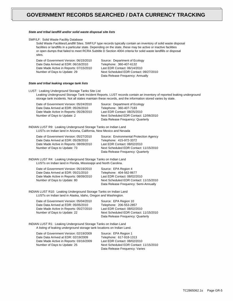
State and tribal landfill and/or solid waste disposal site lists
SWF/LF: Solid Waste Facility DatabaseSolid Waste Facilities/Landfill Sites. SWF/LF type records typically contain an inventory of solid waste disposalfacilities or landfills in a particular state. Depending on the state, these may be active or inactive facilitiesor open dumps that failed to meet RCRA Subtitle D Section 4004 criteria for solid waste landfills or disposalsites.
Date of Government Version: 06/15/2010Date Data Arrived at EDR: 06/16/2010Date Made Active in Reports: 07/15/2010Number of Days to Update: 29
Source: Department of EcologyTelephone: 360-407-6132Last EDR Contact: 06/14/2010Next Scheduled EDR Contact: 09/27/2010Data Release Frequency: Annually
State and tribal leaking storage tank lists
LUST: Leaking Underground Storage Tanks Site ListLeaking Underground Storage Tank Incident Reports. LUST records contain an inventory of reported leaking undergroundstorage tank incidents. Not all states maintain these records, and the information stored varies by state.
Date of Government Version: 05/24/2010Date Data Arrived at EDR: 05/26/2010Date Made Active in Reports: 05/28/2010Number of Days to Update: 2
Source: Department of EcologyTelephone: 360-407-7183Last EDR Contact: 08/25/2010Next Scheduled EDR Contact: 12/06/2010Data Release Frequency: Quarterly
INDIAN LUST R9: Leaking Underground Storage Tanks on Indian LandLUSTs on Indian land in Arizona, California, New Mexico and Nevada
Date of Government Version: 05/27/2010Date Data Arrived at EDR: 05/28/2010Date Made Active in Reports: 08/09/2010Number of Days to Update: 73
Source: Environmental Protection AgencyTelephone: 415-972-3372Last EDR Contact: 08/02/2010Next Scheduled EDR Contact: 11/15/2010Data Release Frequency: Quarterly
INDIAN LUST R4: Leaking Underground Storage Tanks on Indian LandLUSTs on Indian land in Florida, Mississippi and North Carolina.
Date of Government Version: 05/19/2010Date Data Arrived at EDR: 05/21/2010Date Made Active in Reports: 08/09/2010Number of Days to Update: 80
Source: EPA Region 4Telephone: 404-562-8677Last EDR Contact: 08/02/2010Next Scheduled EDR Contact: 11/15/2010Data Release Frequency: Semi-Annually
INDIAN LUST R10: Leaking Underground Storage Tanks on Indian LandLUSTs on Indian land in Alaska, Idaho, Oregon and Washington.
Date of Government Version: 05/04/2010Date Data Arrived at EDR: 05/05/2010Date Made Active in Reports: 05/27/2010Number of Days to Update: 22
Source: EPA Region 10Telephone: 206-553-2857Last EDR Contact: 08/02/2010Next Scheduled EDR Contact: 11/15/2010Data Release Frequency: Quarterly
INDIAN LUST R1: Leaking Underground Storage Tanks on Indian LandA listing of leaking underground storage tank locations on Indian Land.
Date of Government Version: 02/19/2009Date Data Arrived at EDR: 02/19/2009Date Made Active in Reports: 03/16/2009Number of Days to Update: 25
Source: EPA Region 1Telephone: 617-918-1313Last EDR Contact: 08/02/2010Next Scheduled EDR Contact: 11/15/2010Data Release Frequency: Varies
TC2865062.1s Page GR-5
GOVERNMENT RECORDS SEARCHED / DATA CURRENCY TRACKING
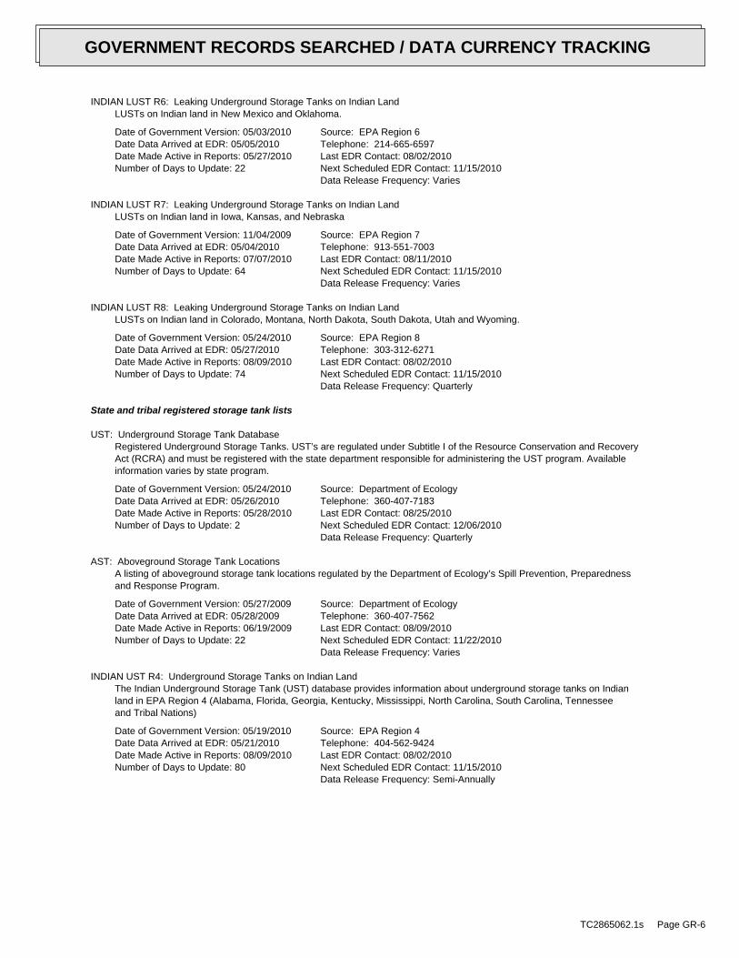
INDIAN LUST R6: Leaking Underground Storage Tanks on Indian LandLUSTs on Indian land in New Mexico and Oklahoma.
Date of Government Version: 05/03/2010Date Data Arrived at EDR: 05/05/2010Date Made Active in Reports: 05/27/2010Number of Days to Update: 22
Source: EPA Region 6Telephone: 214-665-6597Last EDR Contact: 08/02/2010Next Scheduled EDR Contact: 11/15/2010Data Release Frequency: Varies
INDIAN LUST R7: Leaking Underground Storage Tanks on Indian LandLUSTs on Indian land in Iowa, Kansas, and Nebraska
Date of Government Version: 11/04/2009Date Data Arrived at EDR: 05/04/2010Date Made Active in Reports: 07/07/2010Number of Days to Update: 64
Source: EPA Region 7Telephone: 913-551-7003Last EDR Contact: 08/11/2010Next Scheduled EDR Contact: 11/15/2010Data Release Frequency: Varies
INDIAN LUST R8: Leaking Underground Storage Tanks on Indian LandLUSTs on Indian land in Colorado, Montana, North Dakota, South Dakota, Utah and Wyoming.
Date of Government Version: 05/24/2010Date Data Arrived at EDR: 05/27/2010Date Made Active in Reports: 08/09/2010Number of Days to Update: 74
Source: EPA Region 8Telephone: 303-312-6271Last EDR Contact: 08/02/2010Next Scheduled EDR Contact: 11/15/2010Data Release Frequency: Quarterly
State and tribal registered storage tank lists
UST: Underground Storage Tank DatabaseRegistered Underground Storage Tanks. UST’s are regulated under Subtitle I of the Resource Conservation and RecoveryAct (RCRA) and must be registered with the state department responsible for administering the UST program. Availableinformation varies by state program.
Date of Government Version: 05/24/2010Date Data Arrived at EDR: 05/26/2010Date Made Active in Reports: 05/28/2010Number of Days to Update: 2
Source: Department of EcologyTelephone: 360-407-7183Last EDR Contact: 08/25/2010Next Scheduled EDR Contact: 12/06/2010Data Release Frequency: Quarterly
AST: Aboveground Storage Tank LocationsA listing of aboveground storage tank locations regulated by the Department of Ecology’s Spill Prevention, Preparednessand Response Program.
Date of Government Version: 05/27/2009Date Data Arrived at EDR: 05/28/2009Date Made Active in Reports: 06/19/2009Number of Days to Update: 22
Source: Department of EcologyTelephone: 360-407-7562Last EDR Contact: 08/09/2010Next Scheduled EDR Contact: 11/22/2010Data Release Frequency: Varies
INDIAN UST R4: Underground Storage Tanks on Indian LandThe Indian Underground Storage Tank (UST) database provides information about underground storage tanks on Indianland in EPA Region 4 (Alabama, Florida, Georgia, Kentucky, Mississippi, North Carolina, South Carolina, Tennesseeand Tribal Nations)
Date of Government Version: 05/19/2010Date Data Arrived at EDR: 05/21/2010Date Made Active in Reports: 08/09/2010Number of Days to Update: 80
Source: EPA Region 4Telephone: 404-562-9424Last EDR Contact: 08/02/2010Next Scheduled EDR Contact: 11/15/2010Data Release Frequency: Semi-Annually
TC2865062.1s Page GR-6
GOVERNMENT RECORDS SEARCHED / DATA CURRENCY TRACKING
INDIAN UST R9: Underground Storage Tanks on Indian LandThe Indian Underground Storage Tank (UST) database provides information about underground storage tanks on Indianland in EPA Region 9 (Arizona, California, Hawaii, Nevada, the Pacific Islands, and Tribal Nations).
Date of Government Version: 05/27/2010Date Data Arrived at EDR: 05/28/2010Date Made Active in Reports: 08/09/2010Number of Days to Update: 73
Source: EPA Region 9Telephone: 415-972-3368Last EDR Contact: 08/02/2010Next Scheduled EDR Contact: 11/15/2010Data Release Frequency: Quarterly
INDIAN UST R8: Underground Storage Tanks on Indian LandThe Indian Underground Storage Tank (UST) database provides information about underground storage tanks on Indianland in EPA Region 8 (Colorado, Montana, North Dakota, South Dakota, Utah, Wyoming and 27 Tribal Nations).
Date of Government Version: 05/24/2010Date Data Arrived at EDR: 05/27/2010Date Made Active in Reports: 08/09/2010Number of Days to Update: 74
Source: EPA Region 8Telephone: 303-312-6137Last EDR Contact: 08/02/2010Next Scheduled EDR Contact: 11/15/2010Data Release Frequency: Quarterly
INDIAN UST R10: Underground Storage Tanks on Indian LandThe Indian Underground Storage Tank (UST) database provides information about underground storage tanks on Indianland in EPA Region 10 (Alaska, Idaho, Oregon, Washington, and Tribal Nations).
Date of Government Version: 05/04/2010Date Data Arrived at EDR: 05/05/2010Date Made Active in Reports: 05/27/2010Number of Days to Update: 22
Source: EPA Region 10Telephone: 206-553-2857Last EDR Contact: 08/02/2010Next Scheduled EDR Contact: 11/15/2010Data Release Frequency: Quarterly
INDIAN UST R1: Underground Storage Tanks on Indian LandThe Indian Underground Storage Tank (UST) database provides information about underground storage tanks on Indianland in EPA Region 1 (Connecticut, Maine, Massachusetts, New Hampshire, Rhode Island, Vermont and ten TribalNations).
Date of Government Version: 02/19/2009Date Data Arrived at EDR: 02/19/2009Date Made Active in Reports: 03/16/2009Number of Days to Update: 25
Source: EPA, Region 1Telephone: 617-918-1313Last EDR Contact: 08/02/2010Next Scheduled EDR Contact: 11/15/2010Data Release Frequency: Varies
INDIAN UST R5: Underground Storage Tanks on Indian LandThe Indian Underground Storage Tank (UST) database provides information about underground storage tanks on Indianland in EPA Region 5 (Michigan, Minnesota and Wisconsin and Tribal Nations).
Date of Government Version: 02/11/2010Date Data Arrived at EDR: 02/11/2010Date Made Active in Reports: 04/12/2010Number of Days to Update: 60
Source: EPA Region 5Telephone: 312-886-6136Last EDR Contact: 08/02/2010Next Scheduled EDR Contact: 11/15/2010Data Release Frequency: Varies
INDIAN UST R6: Underground Storage Tanks on Indian LandThe Indian Underground Storage Tank (UST) database provides information about underground storage tanks on Indianland in EPA Region 6 (Louisiana, Arkansas, Oklahoma, New Mexico, Texas and 65 Tribes).
Date of Government Version: 05/03/2010Date Data Arrived at EDR: 05/05/2010Date Made Active in Reports: 05/27/2010Number of Days to Update: 22
Source: EPA Region 6Telephone: 214-665-7591Last EDR Contact: 08/02/2010Next Scheduled EDR Contact: 11/15/2010Data Release Frequency: Semi-Annually
TC2865062.1s Page GR-7
GOVERNMENT RECORDS SEARCHED / DATA CURRENCY TRACKING
INDIAN UST R7: Underground Storage Tanks on Indian LandThe Indian Underground Storage Tank (UST) database provides information about underground storage tanks on Indianland in EPA Region 7 (Iowa, Kansas, Missouri, Nebraska, and 9 Tribal Nations).
Date of Government Version: 04/01/2008Date Data Arrived at EDR: 12/30/2008Date Made Active in Reports: 03/16/2009Number of Days to Update: 76
Source: EPA Region 7Telephone: 913-551-7003Last EDR Contact: 08/11/2010Next Scheduled EDR Contact: 11/15/2010Data Release Frequency: Varies
FEMA UST: Underground Storage Tank ListingA listing of all FEMA owned underground storage tanks.
Date of Government Version: 01/01/2010Date Data Arrived at EDR: 02/16/2010Date Made Active in Reports: 04/12/2010Number of Days to Update: 55
Source: FEMATelephone: 202-646-5797Last EDR Contact: 07/19/2010Next Scheduled EDR Contact: 11/01/2010Data Release Frequency: Varies
State and tribal institutional control / engineering control registries
INST CONTROL: Institutional Control Site ListSites that have institutional controls.
Date of Government Version: 05/18/2010Date Data Arrived at EDR: 05/18/2010Date Made Active in Reports: 05/28/2010Number of Days to Update: 10
Source: Department of EcologyTelephone: 360-407-7170Last EDR Contact: 08/18/2010Next Scheduled EDR Contact: 11/29/2010Data Release Frequency: Varies
State and tribal voluntary cleanup sites
INDIAN VCP R1: Voluntary Cleanup Priority ListingA listing of voluntary cleanup priority sites located on Indian Land located in Region 1.
Date of Government Version: 04/02/2008Date Data Arrived at EDR: 04/22/2008Date Made Active in Reports: 05/19/2008Number of Days to Update: 27
Source: EPA, Region 1Telephone: 617-918-1102Last EDR Contact: 07/08/2010Next Scheduled EDR Contact: 10/18/2010Data Release Frequency: Varies
VCP: Voluntary Cleanup Program SitesSites that have entered either the Voluntary Cleanup Program or its predecessor Independent Remedial Action Program.
Date of Government Version: 04/22/2010Date Data Arrived at EDR: 04/30/2010Date Made Active in Reports: 05/19/2010Number of Days to Update: 19
Source: Department of EcologyTelephone: 360-407-7200Last EDR Contact: 07/27/2010Next Scheduled EDR Contact: 11/08/2010Data Release Frequency: Varies
INDIAN VCP R7: Voluntary Cleanup Priority LisitngA listing of voluntary cleanup priority sites located on Indian Land located in Region 7.
Date of Government Version: 03/20/2008Date Data Arrived at EDR: 04/22/2008Date Made Active in Reports: 05/19/2008Number of Days to Update: 27
Source: EPA, Region 7Telephone: 913-551-7365Last EDR Contact: 04/20/2009Next Scheduled EDR Contact: 07/20/2009Data Release Frequency: Varies
TC2865062.1s Page GR-8
GOVERNMENT RECORDS SEARCHED / DATA CURRENCY TRACKING
ICR: Independent Cleanup ReportsThese are remedial action reports Ecology has received from either the owner or operator of the sites. These actionshave been conducted without department oversight or approval and are not under an order or decree. This databaseis no longer updated by the Department of Ecology.
Date of Government Version: 12/01/2002Date Data Arrived at EDR: 01/03/2003Date Made Active in Reports: 01/22/2003Number of Days to Update: 19
Source: Department of EcologyTelephone: 360-407-7200Last EDR Contact: 08/10/2009Next Scheduled EDR Contact: 11/09/2009Data Release Frequency: No Update Planned
State and tribal Brownfields sites
BROWNFIELDS: Brownfields Sites ListingA listing of brownfields sites included in the Confirmed & Suspected Sites Listing. Brownfields are abandoned,idle or underused commercial or industrial properties, where the expansion or redevelopment is hindered by realor perceived contamination. Brownfields vary in size, location, age, and past use -- they can be anything froma five-hundred acre automobile assembly plant to a small, abandoned corner gas station.
Date of Government Version: 04/26/2010Date Data Arrived at EDR: 04/29/2010Date Made Active in Reports: 05/19/2010Number of Days to Update: 20
Source: Department of EcologyTelephone: 360-725-4030Last EDR Contact: 07/28/2010Next Scheduled EDR Contact: 11/08/2010Data Release Frequency: Varies
ADDITIONAL ENVIRONMENTAL RECORDS
Local Brownfield lists
US BROWNFIELDS: A Listing of Brownfields SitesIncluded in the listing are brownfields properties addresses by Cooperative Agreement Recipients and brownfieldsproperties addressed by Targeted Brownfields Assessments. Targeted Brownfields Assessments-EPA’s Targeted BrownfieldsAssessments (TBA) program is designed to help states, tribes, and municipalities--especially those without EPABrownfields Assessment Demonstration Pilots--minimize the uncertainties of contamination often associated withbrownfields. Under the TBA program, EPA provides funding and/or technical assistance for environmental assessmentsat brownfields sites throughout the country. Targeted Brownfields Assessments supplement and work with other effortsunder EPA’s Brownfields Initiative to promote cleanup and redevelopment of brownfields. Cooperative AgreementRecipients-States, political subdivisions, territories, and Indian tribes become Brownfields Cleanup RevolvingLoan Fund (BCRLF) cooperative agreement recipients when they enter into BCRLF cooperative agreements with theU.S. EPA. EPA selects BCRLF cooperative agreement recipients based on a proposal and application process. BCRLFcooperative agreement recipients must use EPA funds provided through BCRLF cooperative agreement for specifiedbrownfields-related cleanup activities.
Date of Government Version: 06/24/2010Date Data Arrived at EDR: 06/25/2010Date Made Active in Reports: 08/17/2010Number of Days to Update: 53
Source: Environmental Protection AgencyTelephone: 202-566-2777Last EDR Contact: 06/25/2010Next Scheduled EDR Contact: 10/11/2010Data Release Frequency: Semi-Annually
Local Lists of Landfill / Solid Waste Disposal Sites
DEBRIS REGION 9: Torres Martinez Reservation Illegal Dump Site LocationsA listing of illegal dump sites location on the Torres Martinez Indian Reservation located in eastern RiversideCounty and northern Imperial County, California.
Date of Government Version: 01/12/2009Date Data Arrived at EDR: 05/07/2009Date Made Active in Reports: 09/21/2009Number of Days to Update: 137
Source: EPA, Region 9Telephone: 415-947-4219Last EDR Contact: 07/28/2010Next Scheduled EDR Contact: 09/20/2010Data Release Frequency: Varies
TC2865062.1s Page GR-9
GOVERNMENT RECORDS SEARCHED / DATA CURRENCY TRACKING
ODI: Open Dump InventoryAn open dump is defined as a disposal facility that does not comply with one or more of the Part 257 or Part 258Subtitle D Criteria.
Date of Government Version: 06/30/1985Date Data Arrived at EDR: 08/09/2004Date Made Active in Reports: 09/17/2004Number of Days to Update: 39
Source: Environmental Protection AgencyTelephone: 800-424-9346Last EDR Contact: 06/09/2004Next Scheduled EDR Contact: N/AData Release Frequency: No Update Planned
SWTIRE: Solid Waste Tire FacilitiesThis study identified sites statewide with unauthorized accumulations of scrap tires.
Date of Government Version: 11/01/2005Date Data Arrived at EDR: 03/16/2006Date Made Active in Reports: 04/13/2006Number of Days to Update: 28
Source: Department of EcologyTelephone: N/ALast EDR Contact: 06/17/2010Next Scheduled EDR Contact: 09/27/2010Data Release Frequency: Varies
INDIAN ODI: Report on the Status of Open Dumps on Indian LandsLocation of open dumps on Indian land.
Date of Government Version: 12/31/1998Date Data Arrived at EDR: 12/03/2007Date Made Active in Reports: 01/24/2008Number of Days to Update: 52
Source: Environmental Protection AgencyTelephone: 703-308-8245Last EDR Contact: 09/07/2010Next Scheduled EDR Contact: 11/22/2010Data Release Frequency: Varies
Local Lists of Hazardous waste / Contaminated Sites
US CDL: Clandestine Drug LabsA listing of clandestine drug lab locations. The U.S. Department of Justice ("the Department") provides thisweb site as a public service. It contains addresses of some locations where law enforcement agencies reportedthey found chemicals or other items that indicated the presence of either clandestine drug laboratories or dumpsites.In most cases, the source of the entries is not the Department, and the Department has not verified the entryand does not guarantee its accuracy. Members of the public must verify the accuracy of all entries by, for example,contacting local law enforcement and local health departments.
Date of Government Version: 05/07/2010Date Data Arrived at EDR: 06/18/2010Date Made Active in Reports: 08/17/2010Number of Days to Update: 60
Source: Drug Enforcement AdministrationTelephone: 202-307-1000Last EDR Contact: 03/08/2010Next Scheduled EDR Contact: 09/20/2010Data Release Frequency: Quarterly
ALLSITES: Facility/Site Identification System ListingInformation on facilities and sites of interest to the Department of Ecology.
Date of Government Version: 05/12/2010Date Data Arrived at EDR: 05/13/2010Date Made Active in Reports: 05/19/2010Number of Days to Update: 6
Source: Department of EcologyTelephone: 360-407-6423Last EDR Contact: 08/10/2010Next Scheduled EDR Contact: 11/22/2010Data Release Frequency: Quarterly
CSCSL NFA: Confirmed and Contaminated Sites - No Further ActionThe data set contains information about sites previously on the Confirmed and Suspected Contaminated Sites listthat have received a No Further Action (NFA) determination. Because it is necessary to maintain historical recordsof sites that have been investigated and cleaned up, sites are not deleted from the database when cleanup activitiesare completed. Instead, a No Further Action code is entered based upon the type of NFA determination the sitereceived.
TC2865062.1s Page GR-10
GOVERNMENT RECORDS SEARCHED / DATA CURRENCY TRACKING
Date of Government Version: 04/26/2010Date Data Arrived at EDR: 04/29/2010Date Made Active in Reports: 05/19/2010Number of Days to Update: 20
Source: Department of EcologyTelephone: 360-407-7170Last EDR Contact: 07/28/2010Next Scheduled EDR Contact: 11/08/2010Data Release Frequency: Semi-Annually
CDL: Clandestine Drug Lab Contaminated Site ListIllegal methamphetamine labs use hazardous chemicals that create public health hazards. Chemicals and residuescan cause burns, respiratory and neurological damage, and death. Biological hazards associated with intravenousneedles, feces, and blood also pose health risks.
Date of Government Version: 02/09/2009Date Data Arrived at EDR: 03/18/2009Date Made Active in Reports: 03/24/2009Number of Days to Update: 6
Source: Department of HealthTelephone: 360-236-3380Last EDR Contact: 08/16/2010Next Scheduled EDR Contact: 11/29/2010Data Release Frequency: Varies
HIST CDL: List of Sites Contaminated by Clandestine Drug LabsThis listing of contaminated sites by Clandestine Drug Labs includes non-remediated properties. The current CDLlisting does not. This listing is no longer updated by the state agency.
Date of Government Version: 02/08/2007Date Data Arrived at EDR: 06/26/2007Date Made Active in Reports: 07/19/2007Number of Days to Update: 23
Source: Department of HealthTelephone: 360-236-3381Last EDR Contact: 06/02/2008Next Scheduled EDR Contact: 09/01/2008Data Release Frequency: No Update Planned
US HIST CDL: National Clandestine Laboratory RegisterA listing of clandestine drug lab locations. The U.S. Department of Justice ("the Department") provides thisweb site as a public service. It contains addresses of some locations where law enforcement agencies reportedthey found chemicals or other items that indicated the presence of either clandestine drug laboratories or dumpsites.In most cases, the source of the entries is not the Department, and the Department has not verified the entryand does not guarantee its accuracy. Members of the public must verify the accuracy of all entries by, for example,contacting local law enforcement and local health departments.
Date of Government Version: 09/01/2007Date Data Arrived at EDR: 11/19/2008Date Made Active in Reports: 03/30/2009Number of Days to Update: 131
Source: Drug Enforcement AdministrationTelephone: 202-307-1000Last EDR Contact: 03/23/2009Next Scheduled EDR Contact: 06/22/2009Data Release Frequency: No Update Planned
Local Land Records
LIENS 2: CERCLA Lien InformationA Federal CERCLA (’Superfund’) lien can exist by operation of law at any site or property at which EPA has spentSuperfund monies. These monies are spent to investigate and address releases and threatened releases of contamination.CERCLIS provides information as to the identity of these sites and properties.
Date of Government Version: 05/06/2010Date Data Arrived at EDR: 05/11/2010Date Made Active in Reports: 08/09/2010Number of Days to Update: 90
Source: Environmental Protection AgencyTelephone: 202-564-6023Last EDR Contact: 08/02/2010Next Scheduled EDR Contact: 11/15/2010Data Release Frequency: Varies
LUCIS: Land Use Control Information SystemLUCIS contains records of land use control information pertaining to the former Navy Base Realignment and Closureproperties.
Date of Government Version: 12/09/2005Date Data Arrived at EDR: 12/11/2006Date Made Active in Reports: 01/11/2007Number of Days to Update: 31
Source: Department of the NavyTelephone: 843-820-7326Last EDR Contact: 09/08/2010Next Scheduled EDR Contact: 12/06/2010Data Release Frequency: Varies
TC2865062.1s Page GR-11
GOVERNMENT RECORDS SEARCHED / DATA CURRENCY TRACKING
Records of Emergency Release Reports
HMIRS: Hazardous Materials Information Reporting SystemHazardous Materials Incident Report System. HMIRS contains hazardous material spill incidents reported to DOT.
Date of Government Version: 04/06/2010Date Data Arrived at EDR: 04/07/2010Date Made Active in Reports: 05/27/2010Number of Days to Update: 50
Source: U.S. Department of TransportationTelephone: 202-366-4555Last EDR Contact: 07/09/2010Next Scheduled EDR Contact: 10/18/2010Data Release Frequency: Annually
SPILLS: Reported SpillsSpills reported to the Spill Prevention, Preparedness and Response Division.
Date of Government Version: 06/25/2010Date Data Arrived at EDR: 06/25/2010Date Made Active in Reports: 07/15/2010Number of Days to Update: 20
Source: Department of EcologyTelephone: 360-407-6950Last EDR Contact: 06/21/2010Next Scheduled EDR Contact: 09/27/2010Data Release Frequency: Semi-Annually
Other Ascertainable Records
RCRA-NonGen: RCRA - Non GeneratorsRCRAInfo is EPA’s comprehensive information system, providing access to data supporting the Resource Conservationand Recovery Act (RCRA) of 1976 and the Hazardous and Solid Waste Amendments (HSWA) of 1984. The databaseincludes selective information on sites which generate, transport, store, treat and/or dispose of hazardous wasteas defined by the Resource Conservation and Recovery Act (RCRA). Non-Generators do not presently generate hazardouswaste.
Date of Government Version: 02/17/2010Date Data Arrived at EDR: 02/19/2010Date Made Active in Reports: 05/17/2010Number of Days to Update: 87
Source: Environmental Protection AgencyTelephone: (206) 553-1200Last EDR Contact: 08/19/2010Next Scheduled EDR Contact: 10/18/2010Data Release Frequency: Varies
DOT OPS: Incident and Accident DataDepartment of Transporation, Office of Pipeline Safety Incident and Accident data.
Date of Government Version: 01/12/2010Date Data Arrived at EDR: 02/09/2010Date Made Active in Reports: 04/12/2010Number of Days to Update: 62
Source: Department of Transporation, Office of Pipeline SafetyTelephone: 202-366-4595Last EDR Contact: 08/11/2010Next Scheduled EDR Contact: 11/22/2010Data Release Frequency: Varies
DOD: Department of Defense SitesThis data set consists of federally owned or administered lands, administered by the Department of Defense, thathave any area equal to or greater than 640 acres of the United States, Puerto Rico, and the U.S. Virgin Islands.
Date of Government Version: 12/31/2005Date Data Arrived at EDR: 11/10/2006Date Made Active in Reports: 01/11/2007Number of Days to Update: 62
Source: USGSTelephone: 703-692-8801Last EDR Contact: 07/22/2010Next Scheduled EDR Contact: 11/01/2010Data Release Frequency: Semi-Annually
FUDS: Formerly Used Defense SitesThe listing includes locations of Formerly Used Defense Sites properties where the US Army Corps of Engineersis actively working or will take necessary cleanup actions.
Date of Government Version: 12/31/2008Date Data Arrived at EDR: 09/30/2009Date Made Active in Reports: 12/01/2009Number of Days to Update: 62
Source: U.S. Army Corps of EngineersTelephone: 202-528-4285Last EDR Contact: 08/12/2010Next Scheduled EDR Contact: 09/27/2010Data Release Frequency: Varies
TC2865062.1s Page GR-12
GOVERNMENT RECORDS SEARCHED / DATA CURRENCY TRACKING
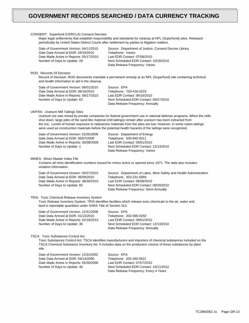
CONSENT: Superfund (CERCLA) Consent DecreesMajor legal settlements that establish responsibility and standards for cleanup at NPL (Superfund) sites. Releasedperiodically by United States District Courts after settlement by parties to litigation matters.
Date of Government Version: 04/11/2010Date Data Arrived at EDR: 04/19/2010Date Made Active in Reports: 05/17/2010Number of Days to Update: 28
Source: Department of Justice, Consent Decree LibraryTelephone: VariesLast EDR Contact: 07/08/2010Next Scheduled EDR Contact: 10/18/2010Data Release Frequency: Varies
ROD: Records Of DecisionRecord of Decision. ROD documents mandate a permanent remedy at an NPL (Superfund) site containing technicaland health information to aid in the cleanup.
Date of Government Version: 06/01/2010Date Data Arrived at EDR: 06/16/2010Date Made Active in Reports: 08/17/2010Number of Days to Update: 62
Source: EPATelephone: 703-416-0223Last EDR Contact: 06/16/2010Next Scheduled EDR Contact: 09/27/2010Data Release Frequency: Annually
UMTRA: Uranium Mill Tailings SitesUranium ore was mined by private companies for federal government use in national defense programs. When the millsshut down, large piles of the sand-like material (mill tailings) remain after uranium has been extracted fromthe ore. Levels of human exposure to radioactive materials from the piles are low; however, in some cases tailingswere used as construction materials before the potential health hazards of the tailings were recognized.
Date of Government Version: 01/05/2009Date Data Arrived at EDR: 05/07/2009Date Made Active in Reports: 05/08/2009Number of Days to Update: 1
Source: Department of EnergyTelephone: 505-845-0011Last EDR Contact: 09/01/2010Next Scheduled EDR Contact: 12/13/2010Data Release Frequency: Varies
MINES: Mines Master Index FileContains all mine identification numbers issued for mines active or opened since 1971. The data also includesviolation information.
Date of Government Version: 05/07/2010Date Data Arrived at EDR: 06/09/2010Date Made Active in Reports: 08/30/2010Number of Days to Update: 82
Source: Department of Labor, Mine Safety and Health AdministrationTelephone: 303-231-5959Last EDR Contact: 06/09/2010Next Scheduled EDR Contact: 09/20/2010Data Release Frequency: Semi-Annually
TRIS: Toxic Chemical Release Inventory SystemToxic Release Inventory System. TRIS identifies facilities which release toxic chemicals to the air, water andland in reportable quantities under SARA Title III Section 313.
Date of Government Version: 12/31/2008Date Data Arrived at EDR: 01/13/2010Date Made Active in Reports: 02/18/2010Number of Days to Update: 36
Source: EPATelephone: 202-566-0250Last EDR Contact: 09/01/2010Next Scheduled EDR Contact: 12/13/2010Data Release Frequency: Annually
TSCA: Toxic Substances Control ActToxic Substances Control Act. TSCA identifies manufacturers and importers of chemical substances included on theTSCA Chemical Substance Inventory list. It includes data on the production volume of these substances by plantsite.
Date of Government Version: 12/31/2002Date Data Arrived at EDR: 04/14/2006Date Made Active in Reports: 05/30/2006Number of Days to Update: 46
Source: EPATelephone: 202-260-5521Last EDR Contact: 07/07/2010Next Scheduled EDR Contact: 10/11/2010Data Release Frequency: Every 4 Years
TC2865062.1s Page GR-13
GOVERNMENT RECORDS SEARCHED / DATA CURRENCY TRACKING
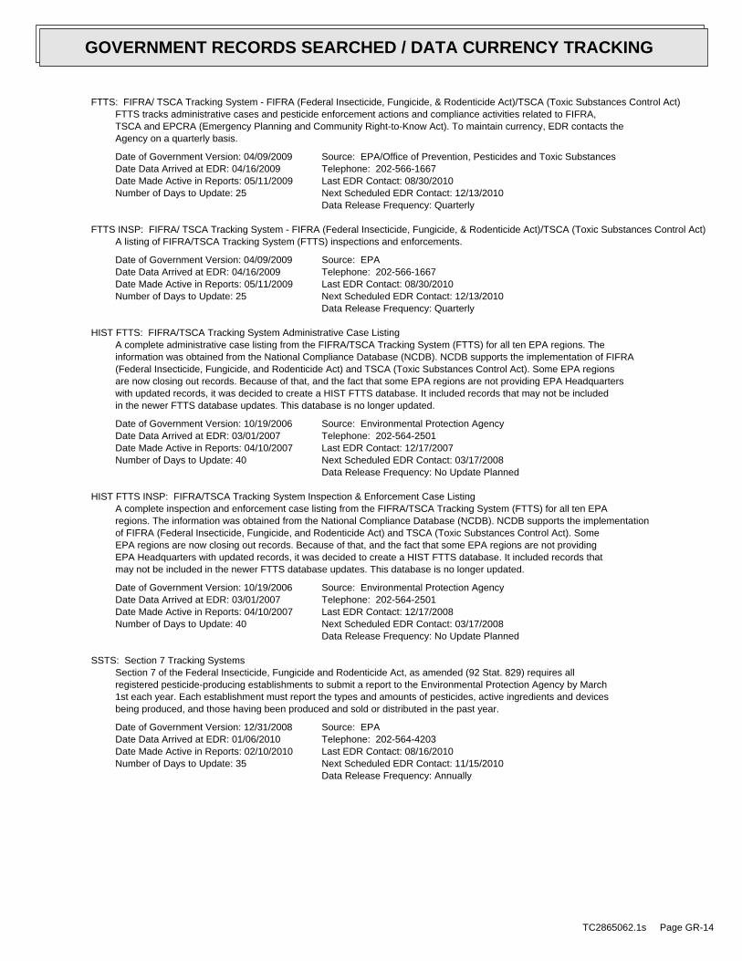
FTTS: FIFRA/ TSCA Tracking System - FIFRA (Federal Insecticide, Fungicide, & Rodenticide Act)/TSCA (Toxic Substances Control Act)FTTS tracks administrative cases and pesticide enforcement actions and compliance activities related to FIFRA,TSCA and EPCRA (Emergency Planning and Community Right-to-Know Act). To maintain currency, EDR contacts theAgency on a quarterly basis.
Date of Government Version: 04/09/2009Date Data Arrived at EDR: 04/16/2009Date Made Active in Reports: 05/11/2009Number of Days to Update: 25
Source: EPA/Office of Prevention, Pesticides and Toxic SubstancesTelephone: 202-566-1667Last EDR Contact: 08/30/2010Next Scheduled EDR Contact: 12/13/2010Data Release Frequency: Quarterly
FTTS INSP: FIFRA/ TSCA Tracking System - FIFRA (Federal Insecticide, Fungicide, & Rodenticide Act)/TSCA (Toxic Substances Control Act)A listing of FIFRA/TSCA Tracking System (FTTS) inspections and enforcements.
Date of Government Version: 04/09/2009Date Data Arrived at EDR: 04/16/2009Date Made Active in Reports: 05/11/2009Number of Days to Update: 25
Source: EPATelephone: 202-566-1667Last EDR Contact: 08/30/2010Next Scheduled EDR Contact: 12/13/2010Data Release Frequency: Quarterly
HIST FTTS: FIFRA/TSCA Tracking System Administrative Case ListingA complete administrative case listing from the FIFRA/TSCA Tracking System (FTTS) for all ten EPA regions. Theinformation was obtained from the National Compliance Database (NCDB). NCDB supports the implementation of FIFRA(Federal Insecticide, Fungicide, and Rodenticide Act) and TSCA (Toxic Substances Control Act). Some EPA regionsare now closing out records. Because of that, and the fact that some EPA regions are not providing EPA Headquarterswith updated records, it was decided to create a HIST FTTS database. It included records that may not be includedin the newer FTTS database updates. This database is no longer updated.
Date of Government Version: 10/19/2006Date Data Arrived at EDR: 03/01/2007Date Made Active in Reports: 04/10/2007Number of Days to Update: 40
Source: Environmental Protection AgencyTelephone: 202-564-2501Last EDR Contact: 12/17/2007Next Scheduled EDR Contact: 03/17/2008Data Release Frequency: No Update Planned
HIST FTTS INSP: FIFRA/TSCA Tracking System Inspection & Enforcement Case ListingA complete inspection and enforcement case listing from the FIFRA/TSCA Tracking System (FTTS) for all ten EPAregions. The information was obtained from the National Compliance Database (NCDB). NCDB supports the implementationof FIFRA (Federal Insecticide, Fungicide, and Rodenticide Act) and TSCA (Toxic Substances Control Act). SomeEPA regions are now closing out records. Because of that, and the fact that some EPA regions are not providingEPA Headquarters with updated records, it was decided to create a HIST FTTS database. It included records thatmay not be included in the newer FTTS database updates. This database is no longer updated.
Date of Government Version: 10/19/2006Date Data Arrived at EDR: 03/01/2007Date Made Active in Reports: 04/10/2007Number of Days to Update: 40
Source: Environmental Protection AgencyTelephone: 202-564-2501Last EDR Contact: 12/17/2008Next Scheduled EDR Contact: 03/17/2008Data Release Frequency: No Update Planned
SSTS: Section 7 Tracking SystemsSection 7 of the Federal Insecticide, Fungicide and Rodenticide Act, as amended (92 Stat. 829) requires allregistered pesticide-producing establishments to submit a report to the Environmental Protection Agency by March1st each year. Each establishment must report the types and amounts of pesticides, active ingredients and devicesbeing produced, and those having been produced and sold or distributed in the past year.
Date of Government Version: 12/31/2008Date Data Arrived at EDR: 01/06/2010Date Made Active in Reports: 02/10/2010Number of Days to Update: 35
Source: EPATelephone: 202-564-4203Last EDR Contact: 08/16/2010Next Scheduled EDR Contact: 11/15/2010Data Release Frequency: Annually
TC2865062.1s Page GR-14
GOVERNMENT RECORDS SEARCHED / DATA CURRENCY TRACKING
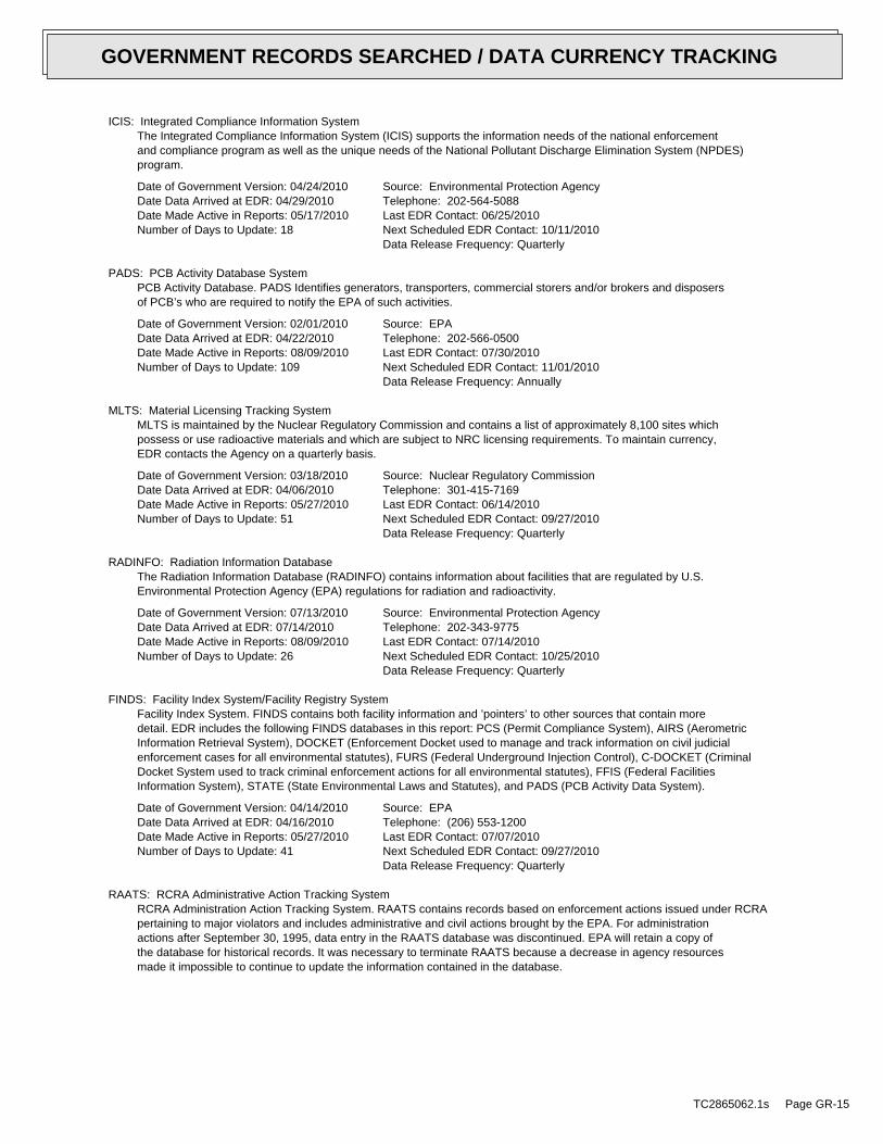
ICIS: Integrated Compliance Information SystemThe Integrated Compliance Information System (ICIS) supports the information needs of the national enforcementand compliance program as well as the unique needs of the National Pollutant Discharge Elimination System (NPDES)program.
Date of Government Version: 04/24/2010Date Data Arrived at EDR: 04/29/2010Date Made Active in Reports: 05/17/2010Number of Days to Update: 18
Source: Environmental Protection AgencyTelephone: 202-564-5088Last EDR Contact: 06/25/2010Next Scheduled EDR Contact: 10/11/2010Data Release Frequency: Quarterly
PADS: PCB Activity Database SystemPCB Activity Database. PADS Identifies generators, transporters, commercial storers and/or brokers and disposersof PCB’s who are required to notify the EPA of such activities.
Date of Government Version: 02/01/2010Date Data Arrived at EDR: 04/22/2010Date Made Active in Reports: 08/09/2010Number of Days to Update: 109
Source: EPATelephone: 202-566-0500Last EDR Contact: 07/30/2010Next Scheduled EDR Contact: 11/01/2010Data Release Frequency: Annually
MLTS: Material Licensing Tracking SystemMLTS is maintained by the Nuclear Regulatory Commission and contains a list of approximately 8,100 sites whichpossess or use radioactive materials and which are subject to NRC licensing requirements. To maintain currency,EDR contacts the Agency on a quarterly basis.
Date of Government Version: 03/18/2010Date Data Arrived at EDR: 04/06/2010Date Made Active in Reports: 05/27/2010Number of Days to Update: 51
Source: Nuclear Regulatory CommissionTelephone: 301-415-7169Last EDR Contact: 06/14/2010Next Scheduled EDR Contact: 09/27/2010Data Release Frequency: Quarterly
RADINFO: Radiation Information DatabaseThe Radiation Information Database (RADINFO) contains information about facilities that are regulated by U.S.Environmental Protection Agency (EPA) regulations for radiation and radioactivity.
Date of Government Version: 07/13/2010Date Data Arrived at EDR: 07/14/2010Date Made Active in Reports: 08/09/2010Number of Days to Update: 26
Source: Environmental Protection AgencyTelephone: 202-343-9775Last EDR Contact: 07/14/2010Next Scheduled EDR Contact: 10/25/2010Data Release Frequency: Quarterly
FINDS: Facility Index System/Facility Registry SystemFacility Index System. FINDS contains both facility information and ’pointers’ to other sources that contain moredetail. EDR includes the following FINDS databases in this report: PCS (Permit Compliance System), AIRS (AerometricInformation Retrieval System), DOCKET (Enforcement Docket used to manage and track information on civil judicialenforcement cases for all environmental statutes), FURS (Federal Underground Injection Control), C-DOCKET (CriminalDocket System used to track criminal enforcement actions for all environmental statutes), FFIS (Federal FacilitiesInformation System), STATE (State Environmental Laws and Statutes), and PADS (PCB Activity Data System).
Date of Government Version: 04/14/2010Date Data Arrived at EDR: 04/16/2010Date Made Active in Reports: 05/27/2010Number of Days to Update: 41
Source: EPATelephone: (206) 553-1200Last EDR Contact: 07/07/2010Next Scheduled EDR Contact: 09/27/2010Data Release Frequency: Quarterly
RAATS: RCRA Administrative Action Tracking SystemRCRA Administration Action Tracking System. RAATS contains records based on enforcement actions issued under RCRApertaining to major violators and includes administrative and civil actions brought by the EPA. For administrationactions after September 30, 1995, data entry in the RAATS database was discontinued. EPA will retain a copy ofthe database for historical records. It was necessary to terminate RAATS because a decrease in agency resourcesmade it impossible to continue to update the information contained in the database.
TC2865062.1s Page GR-15
GOVERNMENT RECORDS SEARCHED / DATA CURRENCY TRACKING
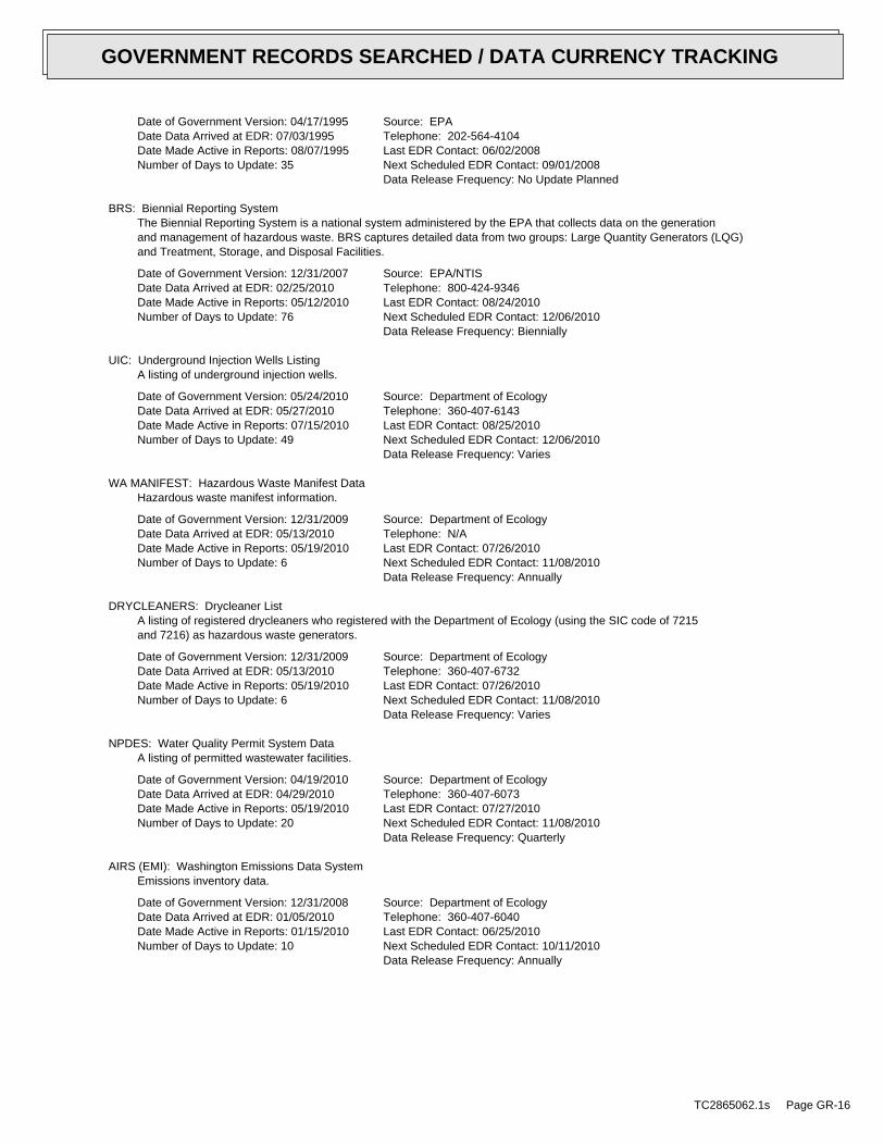
Date of Government Version: 04/17/1995Date Data Arrived at EDR: 07/03/1995Date Made Active in Reports: 08/07/1995Number of Days to Update: 35
Source: EPATelephone: 202-564-4104Last EDR Contact: 06/02/2008Next Scheduled EDR Contact: 09/01/2008Data Release Frequency: No Update Planned
BRS: Biennial Reporting SystemThe Biennial Reporting System is a national system administered by the EPA that collects data on the generationand management of hazardous waste. BRS captures detailed data from two groups: Large Quantity Generators (LQG)and Treatment, Storage, and Disposal Facilities.
Date of Government Version: 12/31/2007Date Data Arrived at EDR: 02/25/2010Date Made Active in Reports: 05/12/2010Number of Days to Update: 76
Source: EPA/NTISTelephone: 800-424-9346Last EDR Contact: 08/24/2010Next Scheduled EDR Contact: 12/06/2010Data Release Frequency: Biennially
UIC: Underground Injection Wells ListingA listing of underground injection wells.
Date of Government Version: 05/24/2010Date Data Arrived at EDR: 05/27/2010Date Made Active in Reports: 07/15/2010Number of Days to Update: 49
Source: Department of EcologyTelephone: 360-407-6143Last EDR Contact: 08/25/2010Next Scheduled EDR Contact: 12/06/2010Data Release Frequency: Varies
WA MANIFEST: Hazardous Waste Manifest DataHazardous waste manifest information.
Date of Government Version: 12/31/2009Date Data Arrived at EDR: 05/13/2010Date Made Active in Reports: 05/19/2010Number of Days to Update: 6
Source: Department of EcologyTelephone: N/ALast EDR Contact: 07/26/2010Next Scheduled EDR Contact: 11/08/2010Data Release Frequency: Annually
DRYCLEANERS: Drycleaner ListA listing of registered drycleaners who registered with the Department of Ecology (using the SIC code of 7215and 7216) as hazardous waste generators.
Date of Government Version: 12/31/2009Date Data Arrived at EDR: 05/13/2010Date Made Active in Reports: 05/19/2010Number of Days to Update: 6
Source: Department of EcologyTelephone: 360-407-6732Last EDR Contact: 07/26/2010Next Scheduled EDR Contact: 11/08/2010Data Release Frequency: Varies
NPDES: Water Quality Permit System DataA listing of permitted wastewater facilities.
Date of Government Version: 04/19/2010Date Data Arrived at EDR: 04/29/2010Date Made Active in Reports: 05/19/2010Number of Days to Update: 20
Source: Department of EcologyTelephone: 360-407-6073Last EDR Contact: 07/27/2010Next Scheduled EDR Contact: 11/08/2010Data Release Frequency: Quarterly
AIRS (EMI): Washington Emissions Data SystemEmissions inventory data.
Date of Government Version: 12/31/2008Date Data Arrived at EDR: 01/05/2010Date Made Active in Reports: 01/15/2010Number of Days to Update: 10
Source: Department of EcologyTelephone: 360-407-6040Last EDR Contact: 06/25/2010Next Scheduled EDR Contact: 10/11/2010Data Release Frequency: Annually
TC2865062.1s Page GR-16
GOVERNMENT RECORDS SEARCHED / DATA CURRENCY TRACKING
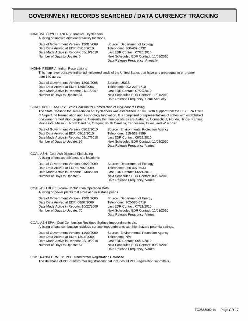
INACTIVE DRYCLEANERS: Inactive DrycleanersA listing of inactive drycleaner facility locations.
Date of Government Version: 12/31/2009Date Data Arrived at EDR: 05/13/2010Date Made Active in Reports: 05/19/2010Number of Days to Update: 6
Source: Department of EcologyTelephone: 360-407-6732Last EDR Contact: 07/26/2010Next Scheduled EDR Contact: 11/08/2010Data Release Frequency: Annually
INDIAN RESERV: Indian ReservationsThis map layer portrays Indian administered lands of the United States that have any area equal to or greaterthan 640 acres.
Date of Government Version: 12/31/2005Date Data Arrived at EDR: 12/08/2006Date Made Active in Reports: 01/11/2007Number of Days to Update: 34
Source: USGSTelephone: 202-208-3710Last EDR Contact: 07/22/2010Next Scheduled EDR Contact: 11/01/2010Data Release Frequency: Semi-Annually
SCRD DRYCLEANERS: State Coalition for Remediation of Drycleaners ListingThe State Coalition for Remediation of Drycleaners was established in 1998, with support from the U.S. EPA Officeof Superfund Remediation and Technology Innovation. It is comprised of representatives of states with establisheddrycleaner remediation programs. Currently the member states are Alabama, Connecticut, Florida, Illinois, Kansas,Minnesota, Missouri, North Carolina, Oregon, South Carolina, Tennessee, Texas, and Wisconsin.
Date of Government Version: 05/12/2010Date Data Arrived at EDR: 05/13/2010Date Made Active in Reports: 08/17/2010Number of Days to Update: 96
Source: Environmental Protection AgencyTelephone: 615-532-8599Last EDR Contact: 08/23/2010Next Scheduled EDR Contact: 11/08/2010Data Release Frequency: Varies
COAL ASH: Coal Ash Disposal Site ListingA listing of coal ash disposal site locations.
Date of Government Version: 06/29/2009Date Data Arrived at EDR: 07/02/2009Date Made Active in Reports: 07/08/2009Number of Days to Update: 6
Source: Department of EcologyTelephone: 360-407-6933Last EDR Contact: 06/21/2010Next Scheduled EDR Contact: 09/27/2010Data Release Frequency: Varies
COAL ASH DOE: Sleam-Electric Plan Operation DataA listing of power plants that store ash in surface ponds.
Date of Government Version: 12/31/2005Date Data Arrived at EDR: 08/07/2009Date Made Active in Reports: 10/22/2009Number of Days to Update: 76
Source: Department of EnergyTelephone: 202-586-8719Last EDR Contact: 07/21/2010Next Scheduled EDR Contact: 11/01/2010Data Release Frequency: Varies
COAL ASH EPA: Coal Combustion Residues Surface Impoundments ListA listing of coal combustion residues surface impoundments with high hazard potential ratings.
Date of Government Version: 11/09/2009Date Data Arrived at EDR: 12/18/2009Date Made Active in Reports: 02/10/2010Number of Days to Update: 54
Source: Environmental Protection AgencyTelephone: N/ALast EDR Contact: 06/14/2010Next Scheduled EDR Contact: 09/27/2010Data Release Frequency: Varies
PCB TRANSFORMER: PCB Transformer Registration DatabaseThe database of PCB transformer registrations that includes all PCB registration submittals.
TC2865062.1s Page GR-17
GOVERNMENT RECORDS SEARCHED / DATA CURRENCY TRACKING

Date of Government Version: 01/01/2008Date Data Arrived at EDR: 02/18/2009Date Made Active in Reports: 05/29/2009Number of Days to Update: 100
Source: Environmental Protection AgencyTelephone: 202-566-0517Last EDR Contact: 08/10/2010Next Scheduled EDR Contact: 11/15/2010Data Release Frequency: Varies
FEDLAND: Federal and Indian LandsFederally and Indian administrated lands of the United States. Lands included are administrated by: Army Corpsof Engineers, Bureau of Reclamation, National Wild and Scenic River, National Wildlife Refuge, Public Domain Land,Wilderness, Wilderness Study Area, Wildlife Management Area, Bureau of Indian Affairs, Bureau of Land Management,Department of Justice, Forest Service, Fish and Wildlife Service, National Park Service.
Date of Government Version: 12/31/2005Date Data Arrived at EDR: 02/06/2006Date Made Active in Reports: 01/11/2007Number of Days to Update: 339
Source: U.S. Geological SurveyTelephone: 888-275-8747Last EDR Contact: 07/22/2010Next Scheduled EDR Contact: 11/01/2010Data Release Frequency: N/A
EDR PROPRIETARY RECORDS
EDR Proprietary Records
Manufactured Gas Plants: EDR Proprietary Manufactured Gas PlantsThe EDR Proprietary Manufactured Gas Plant Database includes records of coal gas plants (manufactured gas plants)compiled by EDR’s researchers. Manufactured gas sites were used in the United States from the 1800’s to 1950’sto produce a gas that could be distributed and used as fuel. These plants used whale oil, rosin, coal, or a mixtureof coal, oil, and water that also produced a significant amount of waste. Many of the byproducts of the gas production,such as coal tar (oily waste containing volatile and non-volatile chemicals), sludges, oils and other compoundsare potentially hazardous to human health and the environment. The byproduct from this process was frequentlydisposed of directly at the plant site and can remain or spread slowly, serving as a continuous source of soiland groundwater contamination.
Date of Government Version: N/ADate Data Arrived at EDR: N/ADate Made Active in Reports: N/ANumber of Days to Update: N/A
Source: EDR, Inc.Telephone: N/ALast EDR Contact: N/ANext Scheduled EDR Contact: N/AData Release Frequency: No Update Planned
COUNTY RECORDS
KING COUNTY:
Abandoned Landfill Study in King CountyThe King County Abandoned Landfill Survey was conducted from October through December 1984 by the Health Department’sEnvironmental Health Division at the request of the King County Council. The primary objective of the survey wasto determine if any public health problems existed at the predetermined 24 sites.
Date of Government Version: 04/30/1985Date Data Arrived at EDR: 11/07/1994Date Made Active in Reports: N/ANumber of Days to Update: 0
Source: Seattle-King County Department of Public HealthTelephone: 206-296-4785Last EDR Contact: 10/21/1994Next Scheduled EDR Contact: N/AData Release Frequency: No Update Planned
SEATTLE COUNTY:
Abandoned Landfill Study in the City of SeattleThe Seattle Abandoned Landfill Survey was conducted in June and July of 1984 by the Health Department’s EnvironmentalHealth Division at the request of the Mayor’s Office. The primary objective of the survey was to determine ifany public health problems existed at the predetermined 12 sites.
TC2865062.1s Page GR-18
GOVERNMENT RECORDS SEARCHED / DATA CURRENCY TRACKING
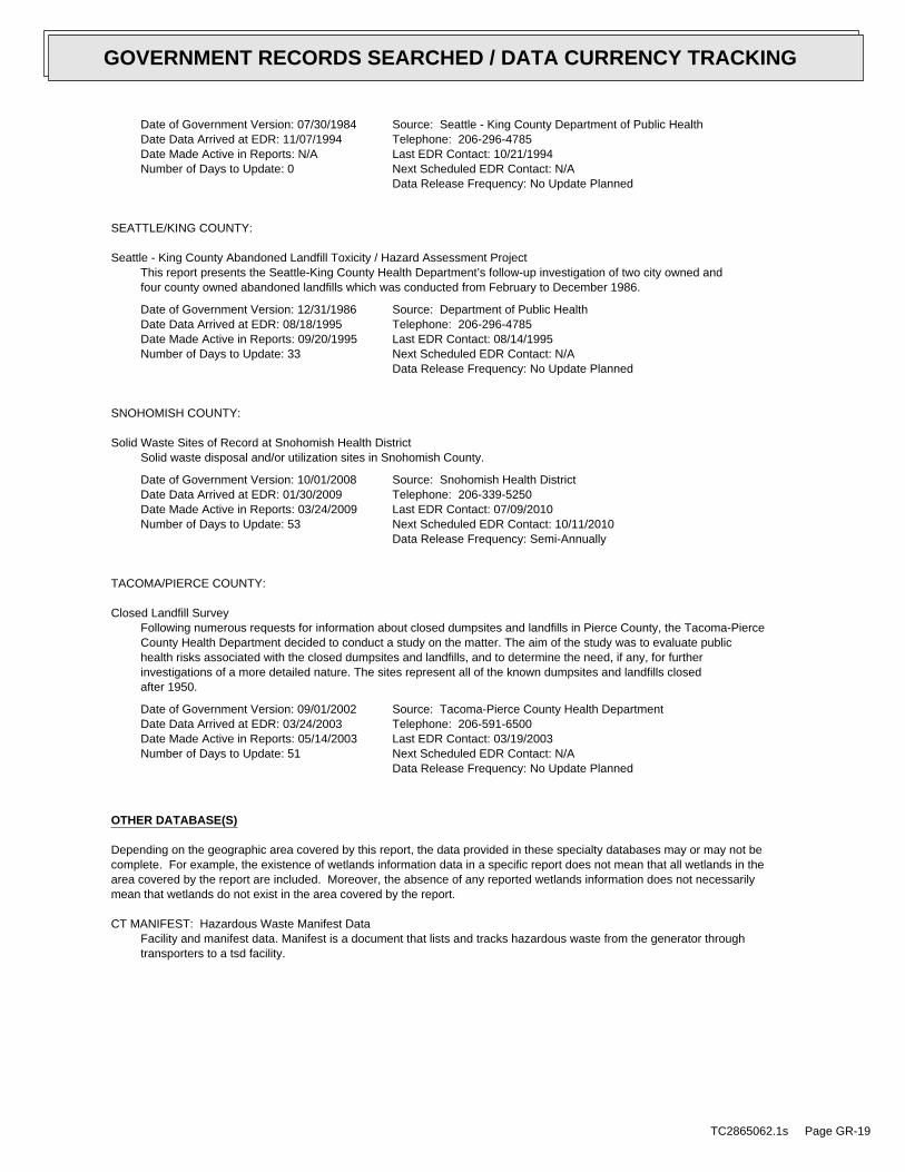
Date of Government Version: 07/30/1984Date Data Arrived at EDR: 11/07/1994Date Made Active in Reports: N/ANumber of Days to Update: 0
Source: Seattle - King County Department of Public HealthTelephone: 206-296-4785Last EDR Contact: 10/21/1994Next Scheduled EDR Contact: N/AData Release Frequency: No Update Planned
SEATTLE/KING COUNTY:
Seattle - King County Abandoned Landfill Toxicity / Hazard Assessment ProjectThis report presents the Seattle-King County Health Department’s follow-up investigation of two city owned andfour county owned abandoned landfills which was conducted from February to December 1986.
Date of Government Version: 12/31/1986Date Data Arrived at EDR: 08/18/1995Date Made Active in Reports: 09/20/1995Number of Days to Update: 33
Source: Department of Public HealthTelephone: 206-296-4785Last EDR Contact: 08/14/1995Next Scheduled EDR Contact: N/AData Release Frequency: No Update Planned
SNOHOMISH COUNTY:
Solid Waste Sites of Record at Snohomish Health DistrictSolid waste disposal and/or utilization sites in Snohomish County.
Date of Government Version: 10/01/2008Date Data Arrived at EDR: 01/30/2009Date Made Active in Reports: 03/24/2009Number of Days to Update: 53
Source: Snohomish Health DistrictTelephone: 206-339-5250Last EDR Contact: 07/09/2010Next Scheduled EDR Contact: 10/11/2010Data Release Frequency: Semi-Annually
TACOMA/PIERCE COUNTY:
Closed Landfill SurveyFollowing numerous requests for information about closed dumpsites and landfills in Pierce County, the Tacoma-PierceCounty Health Department decided to conduct a study on the matter. The aim of the study was to evaluate publichealth risks associated with the closed dumpsites and landfills, and to determine the need, if any, for furtherinvestigations of a more detailed nature. The sites represent all of the known dumpsites and landfills closedafter 1950.
Date of Government Version: 09/01/2002Date Data Arrived at EDR: 03/24/2003Date Made Active in Reports: 05/14/2003Number of Days to Update: 51
Source: Tacoma-Pierce County Health DepartmentTelephone: 206-591-6500Last EDR Contact: 03/19/2003Next Scheduled EDR Contact: N/AData Release Frequency: No Update Planned
OTHER DATABASE(S)
Depending on the geographic area covered by this report, the data provided in these specialty databases may or may not becomplete. For example, the existence of wetlands information data in a specific report does not mean that all wetlands in thearea covered by the report are included. Moreover, the absence of any reported wetlands information does not necessarilymean that wetlands do not exist in the area covered by the report.
CT MANIFEST: Hazardous Waste Manifest DataFacility and manifest data. Manifest is a document that lists and tracks hazardous waste from the generator throughtransporters to a tsd facility.
TC2865062.1s Page GR-19
GOVERNMENT RECORDS SEARCHED / DATA CURRENCY TRACKING
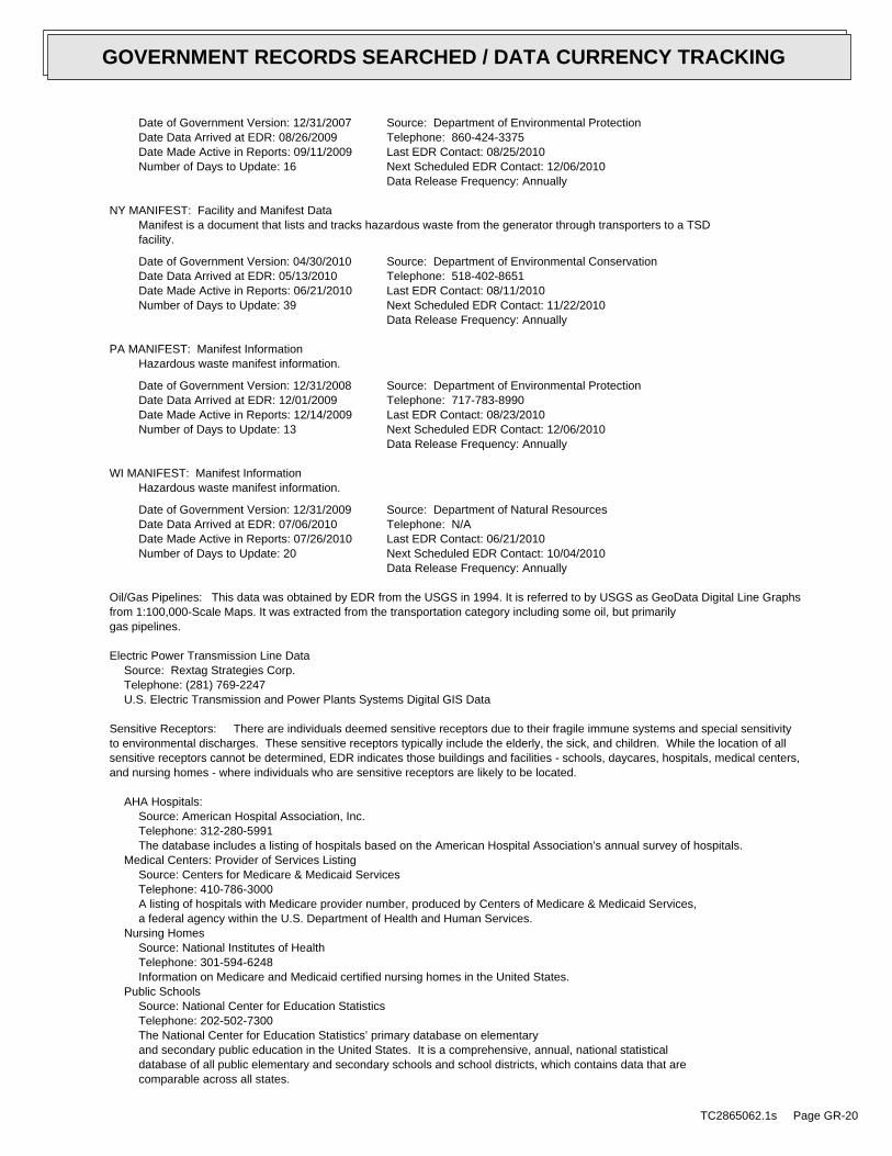
Date of Government Version: 12/31/2007Date Data Arrived at EDR: 08/26/2009Date Made Active in Reports: 09/11/2009Number of Days to Update: 16
Source: Department of Environmental ProtectionTelephone: 860-424-3375Last EDR Contact: 08/25/2010Next Scheduled EDR Contact: 12/06/2010Data Release Frequency: Annually
NY MANIFEST: Facility and Manifest DataManifest is a document that lists and tracks hazardous waste from the generator through transporters to a TSDfacility.
Date of Government Version: 04/30/2010Date Data Arrived at EDR: 05/13/2010Date Made Active in Reports: 06/21/2010Number of Days to Update: 39
Source: Department of Environmental ConservationTelephone: 518-402-8651Last EDR Contact: 08/11/2010Next Scheduled EDR Contact: 11/22/2010Data Release Frequency: Annually
PA MANIFEST: Manifest InformationHazardous waste manifest information.
Date of Government Version: 12/31/2008Date Data Arrived at EDR: 12/01/2009Date Made Active in Reports: 12/14/2009Number of Days to Update: 13
Source: Department of Environmental ProtectionTelephone: 717-783-8990Last EDR Contact: 08/23/2010Next Scheduled EDR Contact: 12/06/2010Data Release Frequency: Annually
WI MANIFEST: Manifest InformationHazardous waste manifest information.
Date of Government Version: 12/31/2009Date Data Arrived at EDR: 07/06/2010Date Made Active in Reports: 07/26/2010Number of Days to Update: 20
Source: Department of Natural ResourcesTelephone: N/ALast EDR Contact: 06/21/2010Next Scheduled EDR Contact: 10/04/2010Data Release Frequency: Annually
Oil/Gas Pipelines: This data was obtained by EDR from the USGS in 1994. It is referred to by USGS as GeoData Digital Line Graphsfrom 1:100,000-Scale Maps. It was extracted from the transportation category including some oil, but primarilygas pipelines.
Electric Power Transmission Line DataSource: Rextag Strategies Corp.Telephone: (281) 769-2247U.S. Electric Transmission and Power Plants Systems Digital GIS Data
Sensitive Receptors: There are individuals deemed sensitive receptors due to their fragile immune systems and special sensitivityto environmental discharges. These sensitive receptors typically include the elderly, the sick, and children. While the location of allsensitive receptors cannot be determined, EDR indicates those buildings and facilities - schools, daycares, hospitals, medical centers,and nursing homes - where individuals who are sensitive receptors are likely to be located.
AHA Hospitals:Source: American Hospital Association, Inc.Telephone: 312-280-5991The database includes a listing of hospitals based on the American Hospital Association’s annual survey of hospitals.
Medical Centers: Provider of Services ListingSource: Centers for Medicare & Medicaid ServicesTelephone: 410-786-3000A listing of hospitals with Medicare provider number, produced by Centers of Medicare & Medicaid Services,a federal agency within the U.S. Department of Health and Human Services.
Nursing HomesSource: National Institutes of HealthTelephone: 301-594-6248Information on Medicare and Medicaid certified nursing homes in the United States.
Public SchoolsSource: National Center for Education StatisticsTelephone: 202-502-7300The National Center for Education Statistics’ primary database on elementaryand secondary public education in the United States. It is a comprehensive, annual, national statisticaldatabase of all public elementary and secondary schools and school districts, which contains data that arecomparable across all states.
TC2865062.1s Page GR-20
GOVERNMENT RECORDS SEARCHED / DATA CURRENCY TRACKING
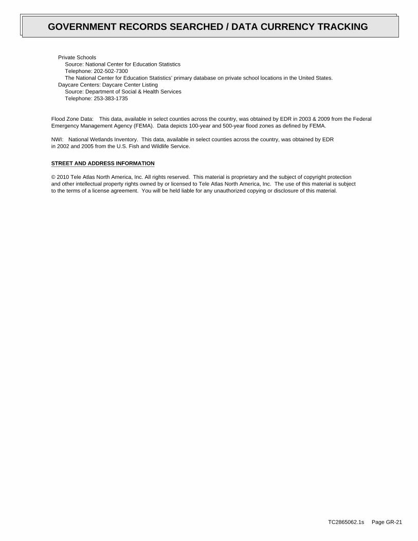
Private SchoolsSource: National Center for Education StatisticsTelephone: 202-502-7300The National Center for Education Statistics’ primary database on private school locations in the United States.
Daycare Centers: Daycare Center ListingSource: Department of Social & Health ServicesTelephone: 253-383-1735
Flood Zone Data: This data, available in select counties across the country, was obtained by EDR in 2003 & 2009 from the FederalEmergency Management Agency (FEMA). Data depicts 100-year and 500-year flood zones as defined by FEMA.
NWI: National Wetlands Inventory. This data, available in select counties across the country, was obtained by EDRin 2002 and 2005 from the U.S. Fish and Wildlife Service.
STREET AND ADDRESS INFORMATION
© 2010 Tele Atlas North America, Inc. All rights reserved. This material is proprietary and the subject of copyright protectionand other intellectual property rights owned by or licensed to Tele Atlas North America, Inc. The use of this material is subjectto the terms of a license agreement. You will be held liable for any unauthorized copying or disclosure of this material.
TC2865062.1s Page GR-21
GOVERNMENT RECORDS SEARCHED / DATA CURRENCY TRACKING
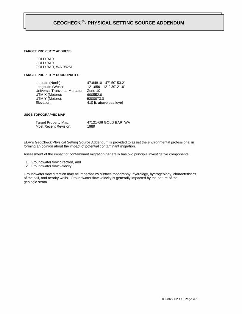
TC2865062.1s Page A-1
geologic strata.of the soil, and nearby wells. Groundwater flow velocity is generally impacted by the nature of theGroundwater flow direction may be impacted by surface topography, hydrology, hydrogeology, characteristics
2. Groundwater flow velocity. 1. Groundwater flow direction, and
Assessment of the impact of contaminant migration generally has two principle investigative components:
forming an opinion about the impact of potential contaminant migration.EDR’s GeoCheck Physical Setting Source Addendum is provided to assist the environmental professional in
1989Most Recent Revision:47121-G6 GOLD BAR, WATarget Property Map:
USGS TOPOGRAPHIC MAP
410 ft. above sea levelElevation:5300073.0UTM Y (Meters): 600552.6UTM X (Meters): Zone 10Universal Tranverse Mercator: 121.656 - 121˚ 39’ 21.6’’Longitude (West): 47.84810 - 47˚ 50’ 53.2’’Latitude (North):
TARGET PROPERTY COORDINATES
GOLD BAR, WA 98251GOLD BARGOLD BAR
TARGET PROPERTY ADDRESS
GEOCHECK - PHYSICAL SETTING SOURCE ADDENDUM®
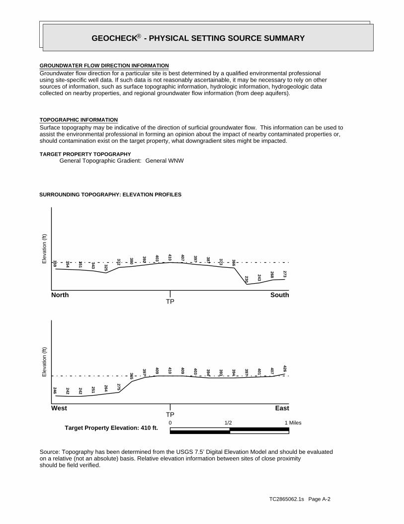
TC2865062.1s Page A-2
should be field verified.on a relative (not an absolute) basis. Relative elevation information between sites of close proximitySource: Topography has been determined from the USGS 7.5’ Digital Elevation Model and should be evaluated
SURROUNDING TOPOGRAPHY: ELEVATION PROFILES
Ele
vatio
n (f
t)E
leva
tion
(ft)
TP
TP0 1/2 1 Miles
✩Target Property Elevation: 410 ft.
North South
West East
273
268243
230
366
373
387
397
407
410
403
392
380
372325
343
351
354
359246
242
242
251
264
275
365
397
409
410
409
403
394
393
394
397
401
407
426
General WNWGeneral Topographic Gradient:TARGET PROPERTY TOPOGRAPHY
should contamination exist on the target property, what downgradient sites might be impacted.assist the environmental professional in forming an opinion about the impact of nearby contaminated properties or,Surface topography may be indicative of the direction of surficial groundwater flow. This information can be used toTOPOGRAPHIC INFORMATION
collected on nearby properties, and regional groundwater flow information (from deep aquifers).sources of information, such as surface topographic information, hydrologic information, hydrogeologic datausing site-specific well data. If such data is not reasonably ascertainable, it may be necessary to rely on otherGroundwater flow direction for a particular site is best determined by a qualified environmental professionalGROUNDWATER FLOW DIRECTION INFORMATION
GEOCHECK - PHYSICAL SETTING SOURCE SUMMARY®
TC2865062.1s Page A-3
Not Reported
GENERAL DIRECTIONLOCATIONGROUNDWATER FLOWFROM TPMAP ID
hydrogeologically, and the depth to water table.authorities at select sites and has extracted the date of the report, groundwater flow direction as determinedflow at specific points. EDR has reviewed reports submitted by environmental professionals to regulatoryEDR has developed the AQUIFLOW Information System to provide data on the general direction of groundwater
AQUIFLOW®
Search Radius: 1.000 Mile.
Not found Status:1.25 miles Search Radius:
Site-Specific Hydrogeological Data*:
* ©1996 Site−specific hydrogeological data gathered by CERCLIS Alerts, Inc., Bainbridge Island, WA. All rights reserved. All of the information and opinions presented are those of the cited EPA report(s), which were completed undera Comprehensive Environmental Response Compensation and Liability Information System (CERCLIS) investigation.
contamination exist on the target property, what downgradient sites might be impacted.environmental professional in forming an opinion about the impact of nearby contaminated properties or, shouldof groundwater flow direction in the immediate area. Such hydrogeologic information can be used to assist theHydrogeologic information obtained by installation of wells on a specific site can often be an indicatorHYDROGEOLOGIC INFORMATION
YES - refer to the Overview Map and Detail MapINDEX SW
NATIONAL WETLAND INVENTORYNWI ElectronicData CoverageNWI Quad at Target Property
5355340520B - FEMA Q3 Flood data5355340540B - FEMA Q3 Flood data5302850001A - FEMA Q3 Flood data5355340510B - FEMA Q3 Flood data5355340400B - FEMA Q3 Flood dataAdditional Panels in search area:
5355340530B - FEMA Q3 Flood dataFlood Plain Panel at Target Property:
YES - refer to the Overview Map and Detail MapSNOHOMISH, WA
FEMA FLOOD ZONEFEMA FloodElectronic DataTarget Property County
and bodies of water).Refer to the Physical Setting Source Map following this summary for hydrologic information (major waterways
contamination exist on the target property, what downgradient sites might be impacted.the environmental professional in forming an opinion about the impact of nearby contaminated properties or, shouldSurface water can act as a hydrologic barrier to groundwater flow. Such hydrologic information can be used to assistHYDROLOGIC INFORMATION
GEOCHECK - PHYSICAL SETTING SOURCE SUMMARY®
TC2865062.1s Page A-4
Map, USGS Digital Data Series DDS - 11 (1994).of the Conterminous U.S. at 1:2,500,000 Scale - a digital representation of the 1974 P.B. King and H.M. BeikmanGeologic Age and Rock Stratigraphic Unit Source: P.G. Schruben, R.E. Arndt and W.J. Bawiec, Geology
ROCK STRATIGRAPHIC UNIT GEOLOGIC AGE IDENTIFICATION
Eugeosynclinal DepositsCategory:MesozoicEra:CretaceousSystem:Upper MesozoicSeries:uMzeCode: (decoded above as Era, System & Series)
at which contaminant migration may be occurring.Geologic information can be used by the environmental professional in forming an opinion about the relative speedGEOLOGIC INFORMATION IN GENERAL AREA OF TARGET PROPERTY
move more quickly through sandy-gravelly types of soils than silty-clayey types of soils.characteristics data collected on nearby properties and regional soil information. In general, contaminant plumesto rely on other sources of information, including geologic age identification, rock stratigraphic unit and soilusing site specific geologic and soil strata data. If such data are not reasonably ascertainable, it may be necessaryGroundwater flow velocity information for a particular site is best determined by a qualified environmental professionalGROUNDWATER FLOW VELOCITY INFORMATION
GEOCHECK - PHYSICAL SETTING SOURCE SUMMARY®
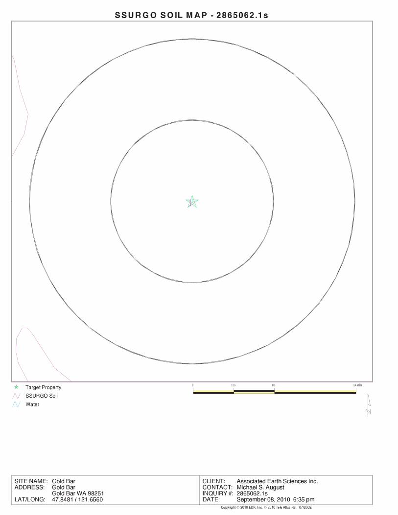
EDR Inc.EDR Inc.EDR Inc.EDR Inc.EDR Inc.EDR Inc.EDR Inc.EDR Inc.EDR Inc.EDR Inc.EDR Inc.EDR Inc.EDR Inc.EDR Inc.EDR Inc.EDR Inc.EDR Inc.EDR Inc.EDR Inc.EDR Inc.EDR Inc.EDR Inc.EDR Inc.EDR Inc.EDR Inc.EDR Inc.EDR Inc.EDR Inc.EDR Inc.EDR Inc.EDR Inc.EDR Inc.EDR Inc.EDR Inc.EDR Inc.EDR Inc.EDR Inc.EDR Inc.EDR Inc.EDR Inc.
1
0 1/16 1/8 1/4 Miles
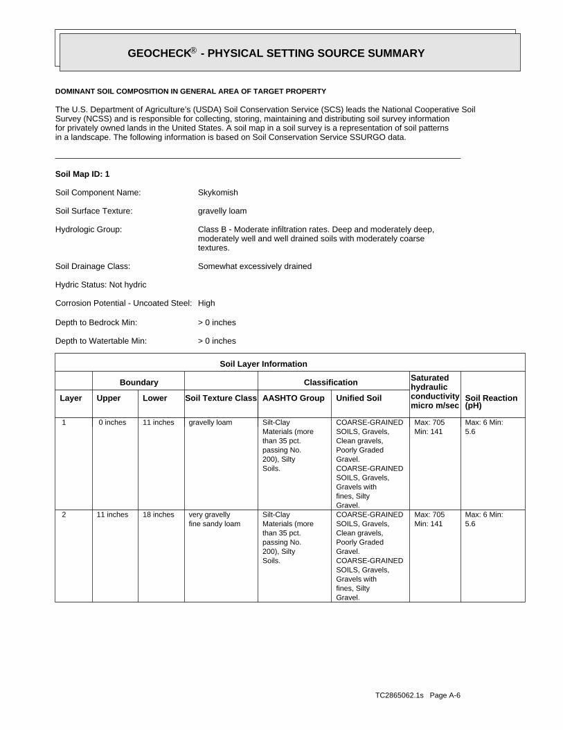
TC2865062.1s Page A-6
5.6Max: 6 Min:
Min: 141Max: 705
Gravel.fines, SiltyGravels withSOILS, Gravels,COARSE-GRAINEDGravel.Poorly GradedClean gravels,SOILS, Gravels,COARSE-GRAINED
Soils.200), Siltypassing No.than 35 pct.Materials (moreSilt-Clay
fine sandy loamvery gravelly18 inches11 inches 2
5.6Max: 6 Min:
Min: 141Max: 705
Gravel.fines, SiltyGravels withSOILS, Gravels,COARSE-GRAINEDGravel.Poorly GradedClean gravels,SOILS, Gravels,COARSE-GRAINED
Soils.200), Siltypassing No.than 35 pct.Materials (moreSilt-Claygravelly loam11 inches 0 inches 1
Soil Layer Information
Boundary Classification Saturatedhydraulicconductivitymicro m/sec
Layer Upper Lower Soil Texture Class AASHTO Group Unified Soil Soil Reaction(pH)
> 0 inchesDepth to Watertable Min:
> 0 inchesDepth to Bedrock Min:
HighCorrosion Potential - Uncoated Steel:
Hydric Status: Not hydric
Somewhat excessively drainedSoil Drainage Class:
textures.moderately well and well drained soils with moderately coarseClass B - Moderate infiltration rates. Deep and moderately deep,Hydrologic Group:
gravelly loamSoil Surface Texture:
SkykomishSoil Component Name:
Soil Map ID: 1
in a landscape. The following information is based on Soil Conservation Service SSURGO data.for privately owned lands in the United States. A soil map in a soil survey is a representation of soil patternsSurvey (NCSS) and is responsible for collecting, storing, maintaining and distributing soil survey informationThe U.S. Department of Agriculture’s (USDA) Soil Conservation Service (SCS) leads the National Cooperative Soil
DOMINANT SOIL COMPOSITION IN GENERAL AREA OF TARGET PROPERTY
GEOCHECK - PHYSICAL SETTING SOURCE SUMMARY®
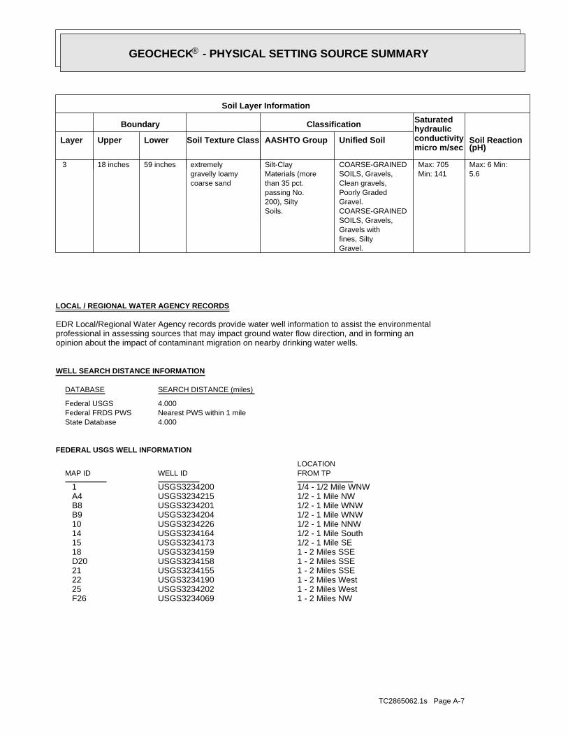
TC2865062.1s Page A-7
1 - 2 Miles NWUSGS3234069 F261 - 2 Miles WestUSGS3234202 251 - 2 Miles WestUSGS3234190 221 - 2 Miles SSEUSGS3234155 211 - 2 Miles SSEUSGS3234158 D201 - 2 Miles SSEUSGS3234159 181/2 - 1 Mile SEUSGS3234173 151/2 - 1 Mile SouthUSGS3234164 141/2 - 1 Mile NNWUSGS3234226 101/2 - 1 Mile WNWUSGS3234204 B91/2 - 1 Mile WNWUSGS3234201 B81/2 - 1 Mile NWUSGS3234215 A41/4 - 1/2 Mile WNWUSGS3234200 1
FEDERAL USGS WELL INFORMATION
LOCATIONFROM TPWELL IDMAP ID
4.000State DatabaseNearest PWS within 1 mileFederal FRDS PWS4.000Federal USGS
WELL SEARCH DISTANCE INFORMATION
SEARCH DISTANCE (miles)DATABASE
opinion about the impact of contaminant migration on nearby drinking water wells.professional in assessing sources that may impact ground water flow direction, and in forming anEDR Local/Regional Water Agency records provide water well information to assist the environmental
LOCAL / REGIONAL WATER AGENCY RECORDS
5.6Max: 6 Min:
Min: 141Max: 705
Gravel.fines, SiltyGravels withSOILS, Gravels,COARSE-GRAINEDGravel.Poorly GradedClean gravels,SOILS, Gravels,COARSE-GRAINED
Soils.200), Siltypassing No.than 35 pct.Materials (moreSilt-Clay
coarse sandgravelly loamyextremely59 inches18 inches 3
Soil Layer Information
Boundary Classification Saturatedhydraulicconductivitymicro m/sec
Layer Upper Lower Soil Texture Class AASHTO Group Unified Soil Soil Reaction(pH)
GEOCHECK - PHYSICAL SETTING SOURCE SUMMARY®
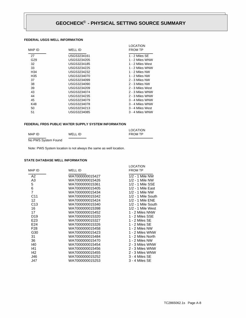
TC2865062.1s Page A-8
3 - 4 Miles SEWA7000000015253 J473 - 4 Miles SEWA7000000015252 J462 - 3 Miles WNWWA7000000015455 I422 - 3 Miles WNWWA7000000015456 I412 - 3 Miles WNWWA7000000015454 I401 - 2 Miles NWWA7000000015470 361 - 2 Miles NorthWA7000000015484 311 - 2 Miles WNWWA7000000015423 G301 - 2 Miles NWWA7000000015458 F281 - 2 Miles SEWA7000000015326 E241 - 2 Miles SEWA7000000015327 E231 - 2 Miles SSEWA7000000015320 D191 - 2 Miles NNWWA7000000015452 171/2 - 1 Mile WestWA7000000015398 161/2 - 1 Mile SouthWA7000000015340 C131/2 - 1 Mile ENEWA7000000015424 121/2 - 1 Mile SouthWA7000000015342 C111/2 - 1 Mile NWWA7000000015434 71/2 - 1 Mile EastWA7000000015405 61/2 - 1 Mile SSEWA7000000015361 51/2 - 1 Mile NWWA7000000015426 A31/2 - 1 Mile NWWA7000000015427 A2
STATE DATABASE WELL INFORMATION
LOCATIONFROM TPWELL IDMAP ID
Note: PWS System location is not always the same as well location.
No PWS System Found
FEDERAL FRDS PUBLIC WATER SUPPLY SYSTEM INFORMATION
LOCATIONFROM TPWELL IDMAP ID
3 - 4 Miles WNWUSGS3234085 513 - 4 Miles WestUSGS3234213 503 - 4 Miles WNWUSGS3234078 K483 - 4 Miles WNWUSGS3234079 452 - 3 Miles WNWUSGS3234235 442 - 3 Miles WNWUSGS3234074 432 - 3 Miles WestUSGS3234209 392 - 3 Miles NWUSGS3234090 382 - 3 Miles NWUSGS3234099 371 - 2 Miles NWUSGS3234070 H351 - 2 Miles NWUSGS3234232 H341 - 2 Miles WNWUSGS3234225 331 - 2 Miles WestUSGS3234185 321 - 2 Miles WNWUSGS3234205 G291 - 2 Miles SEUSGS3234161 27
FEDERAL USGS WELL INFORMATION
LOCATIONFROM TPWELL IDMAP ID
GEOCHECK - PHYSICAL SETTING SOURCE SUMMARY®
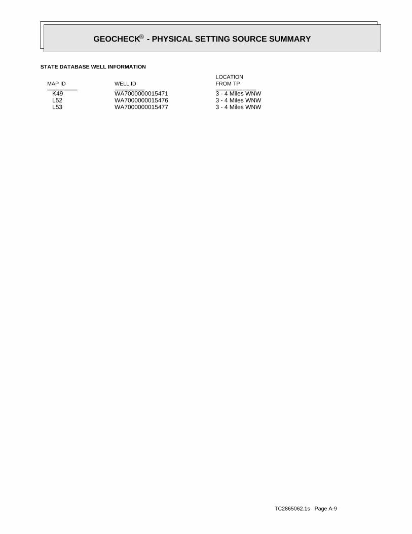
TC2865062.1s Page A-9
3 - 4 Miles WNWWA7000000015477 L533 - 4 Miles WNWWA7000000015476 L523 - 4 Miles WNWWA7000000015471 K49
STATE DATABASE WELL INFORMATION
LOCATIONFROM TPWELL IDMAP ID
GEOCHECK - PHYSICAL SETTING SOURCE SUMMARY®
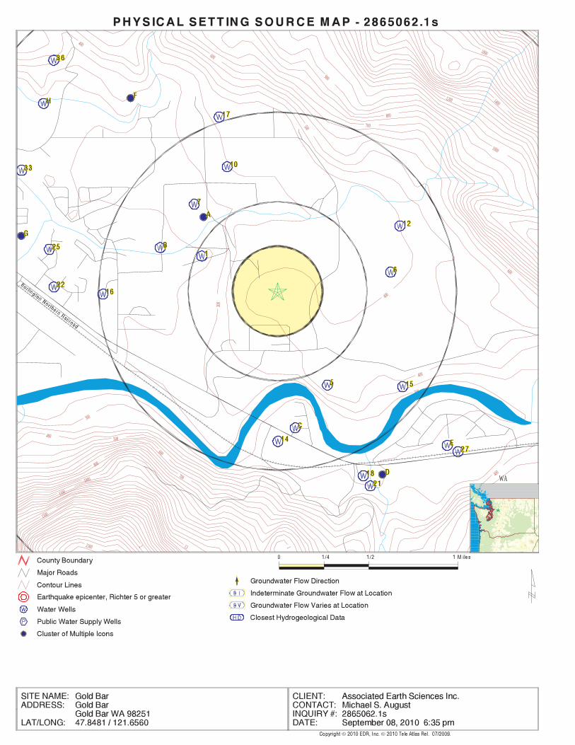
EDR Inc.EDR Inc.EDR Inc.EDR Inc.EDR Inc.EDR Inc.EDR Inc.EDR Inc.EDR Inc.EDR Inc.EDR Inc.EDR Inc.EDR Inc.EDR Inc.EDR Inc.EDR Inc.EDR Inc.EDR Inc.EDR Inc.EDR Inc.EDR Inc.EDR Inc.EDR Inc.EDR Inc.EDR Inc.EDR Inc.EDR Inc.EDR Inc.EDR Inc.EDR Inc.EDR Inc.EDR Inc.EDR Inc.EDR Inc.EDR Inc.EDR Inc.EDR Inc.EDR Inc.EDR Inc.EDR Inc.
12
400
400
400
400
400
600
600
600
800
800
800
1000
1000
1200 1400
1800
2300
300
300
300
500
500
500
700
700
700
900
1100
13
1500
WA
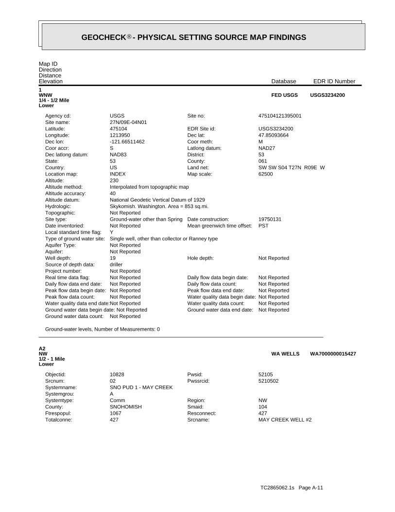
TC2865062.1s Page A-11
MAY CREEK WELL #2Srcname:427Totalconne:427Resconnect:1067Ftrespopul:104Smaid:SNOHOMISHCounty:NWRegion:CommSystemtype:
ASystemgrou:SNO PUD 1 - MAY CREEKSystemname:
5210502Pwssrcid:02Srcnum:52105Pwsid:10828Objectid:
A2NW1/2 - 1 MileLower
WA7000000015427WA WELLS
Ground-water levels, Number of Measurements: 0
Not ReportedGround water data count:Not ReportedGround water data end date:Ground water data begin date: Not ReportedNot ReportedWater quality data count:Not ReportedWater quality data end date:Not ReportedWater quality data begin date:Not ReportedPeak flow data count:Not ReportedPeak flow data end date:Not ReportedPeak flow data begin date:Not ReportedDaily flow data count:Not ReportedDaily flow data end date:Not ReportedDaily flow data begin date:Not ReportedReal time data flag:
Not ReportedProject number:drillerSource of depth data:
Not ReportedHole depth:19Well depth:Not ReportedAquifer:Not ReportedAquifer Type:Single well, other than collector or Ranney typeType of ground water site:YLocal standard time flag:
PSTMean greenwich time offset:Not ReportedDate inventoried:19750131Date construction:Ground-water other than SpringSite type:
Not ReportedTopographic:Skykomish. Washington. Area = 853 sq.mi.Hydrologic:National Geodetic Vertical Datum of 1929Altitude datum:40Altitude accuracy:Interpolated from topographic mapAltitude method:230Altitude:
62500Map scale:INDEXLocation map:SW SW S04 T27N R09E WLand net:USCountry:061County:53State:53District:NAD83Dec latlong datum:NAD27Latlong datum:SCoor accr:MCoor meth:-121.66511462Dec lon:47.85093664Dec lat:1213950Longitude:USGS3234200EDR Site id:475104Latitude:
27N/09E-04N01Site name:475104121395001Site no:USGSAgency cd:
1WNW1/4 - 1/2 MileLower
USGS3234200FED USGS
Map IDDirectionDistanceElevation EDR ID NumberDatabase
GEOCHECK - PHYSICAL SETTING SOURCE MAP FINDINGS®
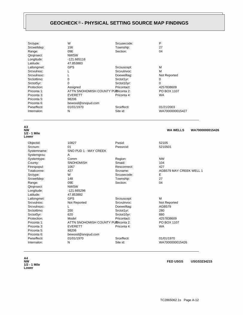
TC2865062.1s Page A-12
A4NW1/2 - 1 MileLower
USGS3234215FED USGS
WA7000000015426Site id:NInternalon:01/01/1970Srceffecti:01/01/1970Pwseffecti:
[email protected] 6:98206Priconta 5:
WAPriconta 4:EVERETTPriconta 3:PO BOX 1107Priconta 2:ATTN SNOHOMISH COUNTY PUDPriconta 1:4257838609Pricontact:ModelProtection:880Srctot10yr:620Srctot5yr:280Srctot1yr:200Srctot6mo:AGB579Doewelltag:LSrcvulnsoc:Not ReportedSrcvulnvoc:Not ReportedSrcvulnioc:MSrcsuscept:GPSLatlongmet:
47.853882Latitude:-121.665296Longitude:NWSWQtrqtrsect:
04Section:09ERange:27Township:148Srcwelldep:ESrcusecode:WSrctype:AGB579 MAY CREEK WELL 1Srcname:427Totalconne:427Resconnect:1067Ftrespopul:104Smaid:SNOHOMISHCounty:NWRegion:CommSystemtype:
ASystemgrou:SNO PUD 1 - MAY CREEKSystemname:
5210501Pwssrcid:01Srcnum:52105Pwsid:10827Objectid:
A3NW1/2 - 1 MileLower
WA7000000015426WA WELLS
WA7000000015427Site id:NInternalon:01/21/2003Srceffecti:01/01/1970Pwseffecti:
[email protected] 6:98206Priconta 5:
WAPriconta 4:EVERETTPriconta 3:PO BOX 1107Priconta 2:ATTN SNOHOMISH COUNTY PUDPriconta 1:4257838609Pricontact:AssignedProtection:0Srctot10yr:0Srctot5yr:0Srctot1yr:0Srctot6mo:Not ReportedDoewelltag:LSrcvulnsoc:MSrcvulnvoc:LSrcvulnioc:MSrcsuscept:GPSLatlongmet:
47.853883Latitude:-121.665116Longitude:NWSWQtrqtrsect:
04Section:09ERange:27Township:156Srcwelldep:PSrcusecode:WSrctype:
GEOCHECK - PHYSICAL SETTING SOURCE MAP FINDINGS®
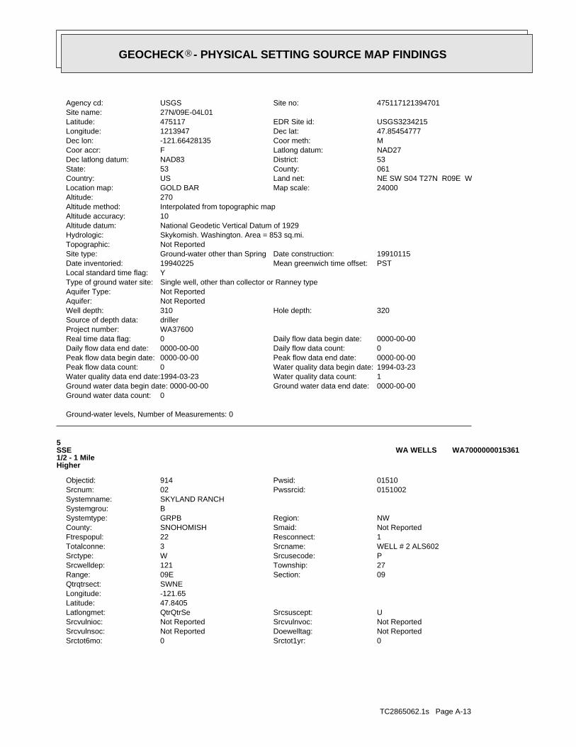
TC2865062.1s Page A-13
0Srctot1yr:0Srctot6mo:Not ReportedDoewelltag:Not ReportedSrcvulnsoc:Not ReportedSrcvulnvoc:Not ReportedSrcvulnioc:USrcsuscept:QtrQtrSeLatlongmet:
47.8405Latitude:-121.65Longitude:SWNEQtrqtrsect:
09Section:09ERange:27Township:121Srcwelldep:PSrcusecode:WSrctype:WELL # 2 ALS602Srcname:3Totalconne:1Resconnect:22Ftrespopul:Not ReportedSmaid:SNOHOMISHCounty:NWRegion:GRPBSystemtype:
BSystemgrou:SKYLAND RANCHSystemname:
0151002Pwssrcid:02Srcnum:01510Pwsid:914Objectid:
5SSE1/2 - 1 MileHigher
WA7000000015361WA WELLS
Ground-water levels, Number of Measurements: 0
0Ground water data count:0000-00-00Ground water data end date:Ground water data begin date: 0000-00-001Water quality data count:1994-03-23Water quality data end date:1994-03-23Water quality data begin date:0Peak flow data count:0000-00-00Peak flow data end date:0000-00-00Peak flow data begin date:0Daily flow data count:0000-00-00Daily flow data end date:0000-00-00Daily flow data begin date:0Real time data flag:
WA37600Project number:drillerSource of depth data:
320Hole depth:310Well depth:Not ReportedAquifer:Not ReportedAquifer Type:Single well, other than collector or Ranney typeType of ground water site:YLocal standard time flag:
PSTMean greenwich time offset:19940225Date inventoried:19910115Date construction:Ground-water other than SpringSite type:
Not ReportedTopographic:Skykomish. Washington. Area = 853 sq.mi.Hydrologic:National Geodetic Vertical Datum of 1929Altitude datum:10Altitude accuracy:Interpolated from topographic mapAltitude method:270Altitude:
24000Map scale:GOLD BARLocation map:NE SW S04 T27N R09E WLand net:USCountry:061County:53State:53District:NAD83Dec latlong datum:NAD27Latlong datum:FCoor accr:MCoor meth:-121.66428135Dec lon:47.85454777Dec lat:1213947Longitude:USGS3234215EDR Site id:475117Latitude:
27N/09E-04L01Site name:475117121394701Site no:USGSAgency cd:
GEOCHECK - PHYSICAL SETTING SOURCE MAP FINDINGS®
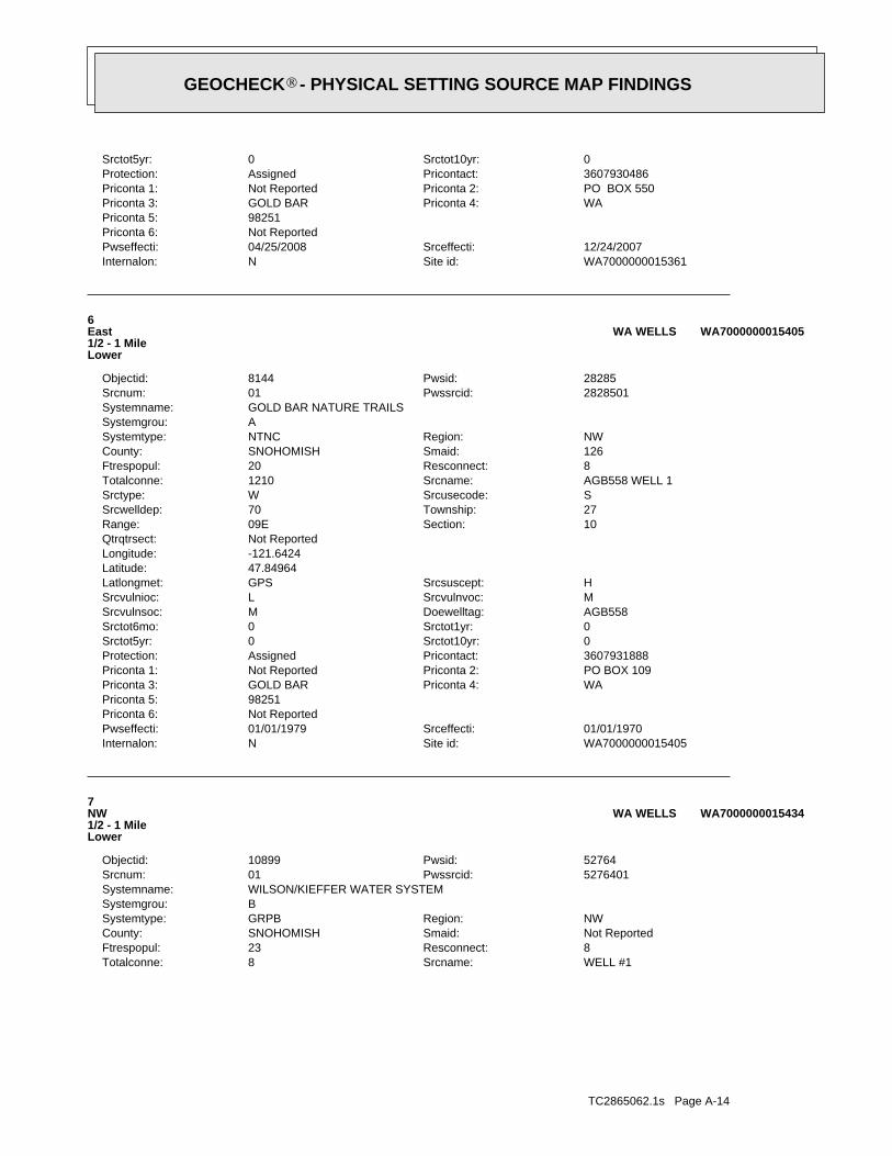
TC2865062.1s Page A-14
WELL #1Srcname:8Totalconne:8Resconnect:23Ftrespopul:Not ReportedSmaid:SNOHOMISHCounty:NWRegion:GRPBSystemtype:
BSystemgrou:WILSON/KIEFFER WATER SYSTEMSystemname:
5276401Pwssrcid:01Srcnum:52764Pwsid:10899Objectid:
7NW1/2 - 1 MileLower
WA7000000015434WA WELLS
WA7000000015405Site id:NInternalon:01/01/1970Srceffecti:01/01/1979Pwseffecti:
Not ReportedPriconta 6:98251Priconta 5:
WAPriconta 4:GOLD BARPriconta 3:PO BOX 109Priconta 2:Not ReportedPriconta 1:3607931888Pricontact:AssignedProtection:0Srctot10yr:0Srctot5yr:0Srctot1yr:0Srctot6mo:AGB558Doewelltag:MSrcvulnsoc:MSrcvulnvoc:LSrcvulnioc:HSrcsuscept:GPSLatlongmet:
47.84964Latitude:-121.6424Longitude:Not ReportedQtrqtrsect:
10Section:09ERange:27Township:70Srcwelldep:SSrcusecode:WSrctype:AGB558 WELL 1Srcname:1210Totalconne:8Resconnect:20Ftrespopul:126Smaid:SNOHOMISHCounty:NWRegion:NTNCSystemtype:
ASystemgrou:GOLD BAR NATURE TRAILSSystemname:
2828501Pwssrcid:01Srcnum:28285Pwsid:8144Objectid:
6East1/2 - 1 MileLower
WA7000000015405WA WELLS
WA7000000015361Site id:NInternalon:12/24/2007Srceffecti:04/25/2008Pwseffecti:
Not ReportedPriconta 6:98251Priconta 5:
WAPriconta 4:GOLD BARPriconta 3:PO BOX 550Priconta 2:Not ReportedPriconta 1:3607930486Pricontact:AssignedProtection:0Srctot10yr:0Srctot5yr:
GEOCHECK - PHYSICAL SETTING SOURCE MAP FINDINGS®
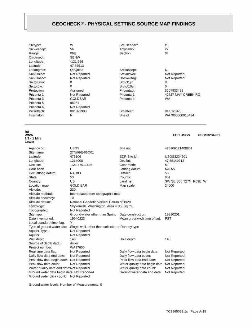
TC2865062.1s Page A-15
Ground-water levels, Number of Measurements: 0
Not ReportedGround water data count:Not ReportedGround water data end date:Ground water data begin date: Not ReportedNot ReportedWater quality data count:Not ReportedWater quality data end date:Not ReportedWater quality data begin date:Not ReportedPeak flow data count:Not ReportedPeak flow data end date:Not ReportedPeak flow data begin date:Not ReportedDaily flow data count:Not ReportedDaily flow data end date:Not ReportedDaily flow data begin date:Not ReportedReal time data flag:
WA37600Project number:drillerSource of depth data:
140Hole depth:140Well depth:Not ReportedAquifer:Not ReportedAquifer Type:Single well, other than collector or Ranney typeType of ground water site:YLocal standard time flag:
PSTMean greenwich time offset:19940223Date inventoried:19910201Date construction:Ground-water other than SpringSite type:
Not ReportedTopographic:Skykomish. Washington. Area = 853 sq.mi.Hydrologic:National Geodetic Vertical Datum of 1929Altitude datum:10Altitude accuracy:Interpolated from topographic mapAltitude method:230Altitude:
24000Map scale:GOLD BARLocation map:SW SE S05 T27N R09E WLand net:USCountry:061County:53State:53District:NAD83Dec latlong datum:NAD27Latlong datum:FCoor accr:MCoor meth:-121.67011486Dec lon:47.85149212Dec lat:1214008Longitude:USGS3234201EDR Site id:475106Latitude:
27N/09E-05Q01Site name:475106121400801Site no:USGSAgency cd:
B8WNW1/2 - 1 MileLower
USGS3234201FED USGS
WA7000000015434Site id:NInternalon:01/01/1970Srceffecti:08/01/1988Pwseffecti:
Not ReportedPriconta 6:98251Priconta 5:
WAPriconta 4:GOLDBARPriconta 3:42627 MAY CREEK RDPriconta 2:Not ReportedPriconta 1:3607933488Pricontact:AssignedProtection:0Srctot10yr:0Srctot5yr:0Srctot1yr:0Srctot6mo:Not ReportedDoewelltag:Not ReportedSrcvulnsoc:Not ReportedSrcvulnvoc:Not ReportedSrcvulnioc:USrcsuscept:QtrQtrSeLatlongmet:
47.85513Latitude:-121.666Longitude:SENWQtrqtrsect:
04Section:09ERange:27Township:56Srcwelldep:PSrcusecode:WSrctype:
GEOCHECK - PHYSICAL SETTING SOURCE MAP FINDINGS®
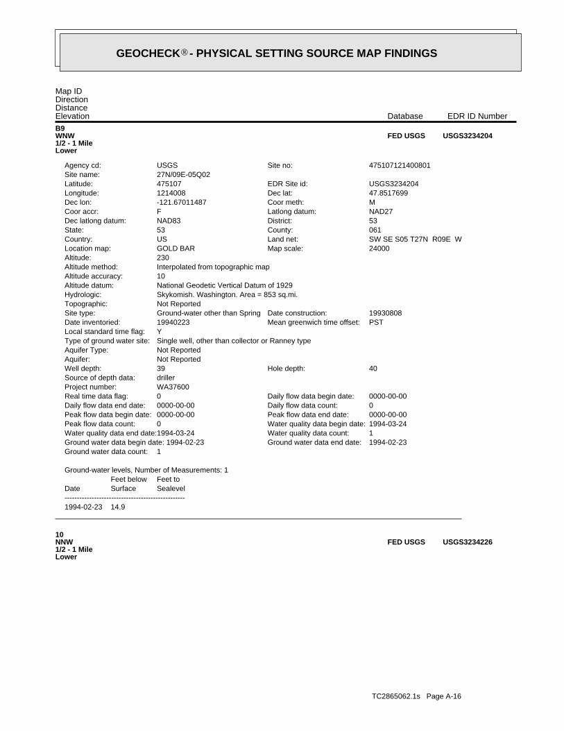
TC2865062.1s Page A-16
10NNW1/2 - 1 MileLower
USGS3234226FED USGS
1994-02-23 14.9
DateFeet belowSurface
Feet toSealevel
-------------------------------------------------
Ground-water levels, Number of Measurements: 1
1Ground water data count:1994-02-23Ground water data end date:Ground water data begin date: 1994-02-231Water quality data count:1994-03-24Water quality data end date:1994-03-24Water quality data begin date:0Peak flow data count:0000-00-00Peak flow data end date:0000-00-00Peak flow data begin date:0Daily flow data count:0000-00-00Daily flow data end date:0000-00-00Daily flow data begin date:0Real time data flag:
WA37600Project number:drillerSource of depth data:
40Hole depth:39Well depth:Not ReportedAquifer:Not ReportedAquifer Type:Single well, other than collector or Ranney typeType of ground water site:YLocal standard time flag:
PSTMean greenwich time offset:19940223Date inventoried:19930808Date construction:Ground-water other than SpringSite type:
Not ReportedTopographic:Skykomish. Washington. Area = 853 sq.mi.Hydrologic:National Geodetic Vertical Datum of 1929Altitude datum:10Altitude accuracy:Interpolated from topographic mapAltitude method:230Altitude:
24000Map scale:GOLD BARLocation map:SW SE S05 T27N R09E WLand net:USCountry:061County:53State:53District:NAD83Dec latlong datum:NAD27Latlong datum:FCoor accr:MCoor meth:-121.67011487Dec lon:47.8517699Dec lat:1214008Longitude:USGS3234204EDR Site id:475107Latitude:
27N/09E-05Q02Site name:475107121400801Site no:USGSAgency cd:
B9WNW1/2 - 1 MileLower
USGS3234204FED USGS
Map IDDirectionDistanceElevation EDR ID NumberDatabase
GEOCHECK - PHYSICAL SETTING SOURCE MAP FINDINGS®
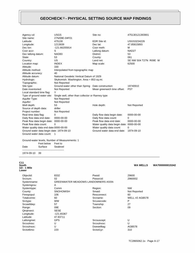
TC2865062.1s Page A-17
310Srctot1yr:220Srctot6mo:AGB578Doewelltag:USrcvulnsoc:USrcvulnvoc:USrcvulnioc:USrcsuscept:GPSLatlongmet:
47.83711Latitude:-121.65367Longitude:SESEQtrqtrsect:
09Section:09ERange:27Township:57Srcwelldep:PSrcusecode:WWSrctype:WELL #2 AGB578Srcname:60Totalconne:60Resconnect:106Ftrespopul:Not ReportedSmaid:SNOHOMISHCounty:NWRegion:CommSystemtype:
ASystemgrou:GREENWATER MEADOWS LANDOWNERS ASSNSystemname:
2960002Pwssrcid:02Srcnum:29600Pwsid:8332Objectid:
C11South1/2 - 1 MileLower
WA7000000015342WA WELLS
1974-09-10 39
DateFeet belowSurface
Feet toSealevel
-------------------------------------------------
Ground-water levels, Number of Measurements: 1
1Ground water data count:1974-09-10Ground water data end date:Ground water data begin date: 1974-09-100Water quality data count:0000-00-00Water quality data end date:0000-00-00Water quality data begin date:0Peak flow data count:0000-00-00Peak flow data end date:0000-00-00Peak flow data begin date:0Daily flow data count:0000-00-00Daily flow data end date:0000-00-00Daily flow data begin date:0Real time data flag:
Not ReportedProject number:drillerSource of depth data:
Not ReportedHole depth:53Well depth:Not ReportedAquifer:Not ReportedAquifer Type:Single well, other than collector or Ranney typeType of ground water site:YLocal standard time flag:
PSTMean greenwich time offset:Not ReportedDate inventoried:19740910Date construction:Ground-water other than SpringSite type:
Not ReportedTopographic:Skykomish. Washington. Area = 853 sq.mi.Hydrologic:National Geodetic Vertical Datum of 1929Altitude datum:40Altitude accuracy:Interpolated from topographic mapAltitude method:330Altitude:
62500Map scale:INDEXLocation map:SE NW S04 T27N R09E WLand net:USCountry:061County:53State:53District:NAD83Dec latlong datum:NAD27Latlong datum:SCoor accr:MCoor meth:-121.66205914Dec lon:47.85815893Dec lat:1213939Longitude:USGS3234226EDR Site id:475130Latitude:
27N/09E-04F01Site name:475130121393901Site no:USGSAgency cd:
GEOCHECK - PHYSICAL SETTING SOURCE MAP FINDINGS®
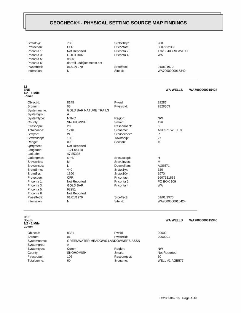
TC2865062.1s Page A-18
WELL #1 AGB577Srcname:60Totalconne:60Resconnect:106Ftrespopul:Not ReportedSmaid:SNOHOMISHCounty:NWRegion:CommSystemtype:
ASystemgrou:GREENWATER MEADOWS LANDOWNERS ASSNSystemname:
2960001Pwssrcid:01Srcnum:29600Pwsid:8331Objectid:
C13South1/2 - 1 MileLower
WA7000000015340WA WELLS
WA7000000015424Site id:NInternalon:01/01/1970Srceffecti:01/01/1979Pwseffecti:
Not ReportedPriconta 6:98251Priconta 5:
WAPriconta 4:GOLD BARPriconta 3:PO BOX 109Priconta 2:Not ReportedPriconta 1:3607931888Pricontact:CFRProtection:1970Srctot10yr:1390Srctot5yr:620Srctot1yr:440Srctot6mo:AGB571Doewelltag:LSrcvulnsoc:MSrcvulnvoc:MSrcvulnioc:HSrcsuscept:GPSLatlongmet:
47.85338Latitude:-121.64128Longitude:Not ReportedQtrqtrsect:
10Section:09ERange:27Township:180Srcwelldep:PSrcusecode:WSrctype:AGB571 WELL 3Srcname:1210Totalconne:8Resconnect:20Ftrespopul:126Smaid:SNOHOMISHCounty:NWRegion:NTNCSystemtype:
ASystemgrou:GOLD BAR NATURE TRAILSSystemname:
2828503Pwssrcid:03Srcnum:28285Pwsid:8145Objectid:
12ENE1/2 - 1 MileLower
WA7000000015424WA WELLS
WA7000000015342Site id:NInternalon:01/01/1970Srceffecti:01/01/1970Pwseffecti:
[email protected] 6:98251Priconta 5:
WAPriconta 4:GOLD BARPriconta 3:17619 433RD AVE SEPriconta 2:Not ReportedPriconta 1:3607992360Pricontact:CFRProtection:980Srctot10yr:700Srctot5yr:
GEOCHECK - PHYSICAL SETTING SOURCE MAP FINDINGS®
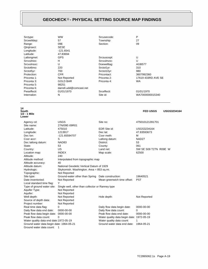
TC2865062.1s Page A-19
1Ground water data count:1964-05-21Ground water data end date:Ground water data begin date: 1964-05-211Water quality data count:1972-05-19Water quality data end date:1972-05-19Water quality data begin date:0Peak flow data count:0000-00-00Peak flow data end date:0000-00-00Peak flow data begin date:0Daily flow data count:0000-00-00Daily flow data end date:0000-00-00Daily flow data begin date:0Real time data flag:
Not ReportedProject number:Not ReportedSource of depth data:
Not ReportedHole depth:Not ReportedWell depth:Not ReportedAquifer:Not ReportedAquifer Type:Single well, other than collector or Ranney typeType of ground water site:YLocal standard time flag:
PSTMean greenwich time offset:Not ReportedDate inventoried:19640521Date construction:Ground-water other than SpringSite type:
Not ReportedTopographic:Skykomish. Washington. Area = 853 sq.mi.Hydrologic:National Geodetic Vertical Datum of 1929Altitude datum:40Altitude accuracy:Interpolated from topographic mapAltitude method:240Altitude:
62500Map scale:INDEXLocation map:SW SE S09 T27N R09E WLand net:USCountry:061County:53State:53District:NAD83Dec latlong datum:NAD27Latlong datum:SCoor accr:MCoor meth:-121.65594707Dec lon:47.83593673Dec lat:1213917Longitude:USGS3234164EDR Site id:475010Latitude:
27N/09E-09R01Site name:475010121391701Site no:USGSAgency cd:
14South1/2 - 1 MileLower
USGS3234164FED USGS
WA7000000015340Site id:NInternalon:01/01/1970Srceffecti:01/01/1970Pwseffecti:
[email protected] 6:98251Priconta 5:
WAPriconta 4:GOLD BARPriconta 3:17619 433RD AVE SEPriconta 2:Not ReportedPriconta 1:3607992360Pricontact:CFRProtection:980Srctot10yr:700Srctot5yr:310Srctot1yr:220Srctot6mo:AGB577Doewelltag:USrcvulnsoc:USrcvulnvoc:HSrcvulnioc:USrcsuscept:GPSLatlongmet:
47.83694Latitude:-121.6541Longitude:SESEQtrqtrsect:
09Section:09ERange:27Township:57Srcwelldep:PSrcusecode:WWSrctype:
GEOCHECK - PHYSICAL SETTING SOURCE MAP FINDINGS®
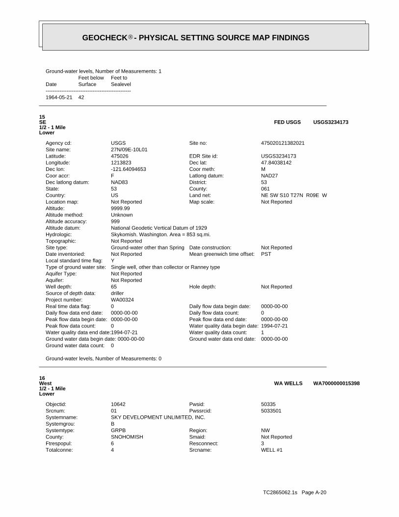
TC2865062.1s Page A-20
WELL #1Srcname:4Totalconne:3Resconnect:6Ftrespopul:Not ReportedSmaid:SNOHOMISHCounty:NWRegion:GRPBSystemtype:
BSystemgrou:SKY DEVELOPMENT UNLIMITED, INC.Systemname:
5033501Pwssrcid:01Srcnum:50335Pwsid:10642Objectid:
16West1/2 - 1 MileLower
WA7000000015398WA WELLS
Ground-water levels, Number of Measurements: 0
0Ground water data count:0000-00-00Ground water data end date:Ground water data begin date: 0000-00-001Water quality data count:1994-07-21Water quality data end date:1994-07-21Water quality data begin date:0Peak flow data count:0000-00-00Peak flow data end date:0000-00-00Peak flow data begin date:0Daily flow data count:0000-00-00Daily flow data end date:0000-00-00Daily flow data begin date:0Real time data flag:
WA00324Project number:drillerSource of depth data:
Not ReportedHole depth:65Well depth:Not ReportedAquifer:Not ReportedAquifer Type:Single well, other than collector or Ranney typeType of ground water site:YLocal standard time flag:
PSTMean greenwich time offset:Not ReportedDate inventoried:Not ReportedDate construction:Ground-water other than SpringSite type:
Not ReportedTopographic:Skykomish. Washington. Area = 853 sq.mi.Hydrologic:National Geodetic Vertical Datum of 1929Altitude datum:999Altitude accuracy:UnknownAltitude method:9999.99Altitude:
Not ReportedMap scale:Not ReportedLocation map:NE SW S10 T27N R09E WLand net:USCountry:061County:53State:53District:NAD83Dec latlong datum:NAD27Latlong datum:FCoor accr:MCoor meth:-121.64094653Dec lon:47.84038142Dec lat:1213823Longitude:USGS3234173EDR Site id:475026Latitude:
27N/09E-10L01Site name:475020121382021Site no:USGSAgency cd:
15SE1/2 - 1 MileLower
USGS3234173FED USGS
1964-05-21 42
DateFeet belowSurface
Feet toSealevel
-------------------------------------------------
Ground-water levels, Number of Measurements: 1
GEOCHECK - PHYSICAL SETTING SOURCE MAP FINDINGS®
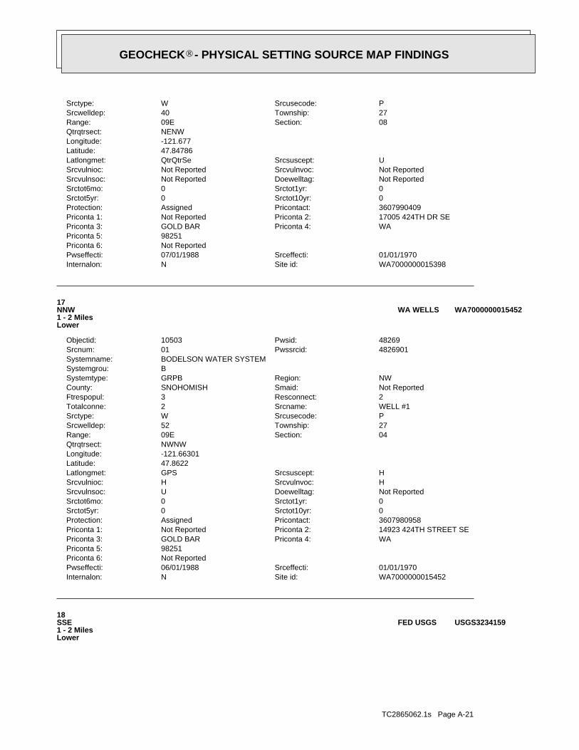
TC2865062.1s Page A-21
18SSE1 - 2 MilesLower
USGS3234159FED USGS
WA7000000015452Site id:NInternalon:01/01/1970Srceffecti:06/01/1988Pwseffecti:
Not ReportedPriconta 6:98251Priconta 5:
WAPriconta 4:GOLD BARPriconta 3:14923 424TH STREET SEPriconta 2:Not ReportedPriconta 1:3607980958Pricontact:AssignedProtection:0Srctot10yr:0Srctot5yr:0Srctot1yr:0Srctot6mo:Not ReportedDoewelltag:USrcvulnsoc:HSrcvulnvoc:HSrcvulnioc:HSrcsuscept:GPSLatlongmet:
47.8622Latitude:-121.66301Longitude:NWNWQtrqtrsect:
04Section:09ERange:27Township:52Srcwelldep:PSrcusecode:WSrctype:WELL #1Srcname:2Totalconne:2Resconnect:3Ftrespopul:Not ReportedSmaid:SNOHOMISHCounty:NWRegion:GRPBSystemtype:
BSystemgrou:BODELSON WATER SYSTEMSystemname:
4826901Pwssrcid:01Srcnum:48269Pwsid:10503Objectid:
17NNW1 - 2 MilesLower
WA7000000015452WA WELLS
WA7000000015398Site id:NInternalon:01/01/1970Srceffecti:07/01/1988Pwseffecti:
Not ReportedPriconta 6:98251Priconta 5:
WAPriconta 4:GOLD BARPriconta 3:17005 424TH DR SEPriconta 2:Not ReportedPriconta 1:3607990409Pricontact:AssignedProtection:0Srctot10yr:0Srctot5yr:0Srctot1yr:0Srctot6mo:Not ReportedDoewelltag:Not ReportedSrcvulnsoc:Not ReportedSrcvulnvoc:Not ReportedSrcvulnioc:USrcsuscept:QtrQtrSeLatlongmet:
47.84786Latitude:-121.677Longitude:NENWQtrqtrsect:
08Section:09ERange:27Township:40Srcwelldep:PSrcusecode:WSrctype:
GEOCHECK - PHYSICAL SETTING SOURCE MAP FINDINGS®

TC2865062.1s Page A-22
0Srctot1yr:0Srctot6mo:ABR728Doewelltag:USrcvulnsoc:HSrcvulnvoc:LSrcvulnioc:HSrcsuscept:GPSLatlongmet:
47.83365Latitude:-121.64332Longitude:NENWQtrqtrsect:
15Section:09ERange:27Township:46Srcwelldep:PSrcusecode:WSrctype:ABR728 WELL 1Srcname:2Totalconne:1Resconnect:5Ftrespopul:Not ReportedSmaid:SNOHOMISHCounty:NWRegion:TNCSystemtype:
ASystemgrou:ZEKES DRIVE-INSystemname:
9940501Pwssrcid:01Srcnum:99405Pwsid:14483Objectid:
D19SSE1 - 2 MilesLower
WA7000000015320WA WELLS
1974-03-18 27
DateFeet belowSurface
Feet toSealevel
-------------------------------------------------
Ground-water levels, Number of Measurements: 1
1Ground water data count:1974-03-18Ground water data end date:Ground water data begin date: 1974-03-180Water quality data count:0000-00-00Water quality data end date:0000-00-00Water quality data begin date:0Peak flow data count:0000-00-00Peak flow data end date:0000-00-00Peak flow data begin date:0Daily flow data count:0000-00-00Daily flow data end date:0000-00-00Daily flow data begin date:0Real time data flag:
Not ReportedProject number:drillerSource of depth data:
Not ReportedHole depth:49Well depth:Not ReportedAquifer:Not ReportedAquifer Type:Single well, other than collector or Ranney typeType of ground water site:YLocal standard time flag:
PSTMean greenwich time offset:Not ReportedDate inventoried:19740318Date construction:Ground-water other than SpringSite type:
Not ReportedTopographic:Skykomish. Washington. Area = 853 sq.mi.Hydrologic:National Geodetic Vertical Datum of 1929Altitude datum:40Altitude accuracy:Interpolated from topographic mapAltitude method:350Altitude:
62500Map scale:INDEXLocation map:NW NW S15 T27N R09E WLand net:USCountry:061County:53State:53District:NAD83Dec latlong datum:NAD27Latlong datum:SCoor accr:MCoor meth:-121.64566874Dec lon:47.83315911Dec lat:1213840Longitude:USGS3234159EDR Site id:475000Latitude:
27N/09E-15D02Site name:475000121384001Site no:USGSAgency cd:
GEOCHECK - PHYSICAL SETTING SOURCE MAP FINDINGS®
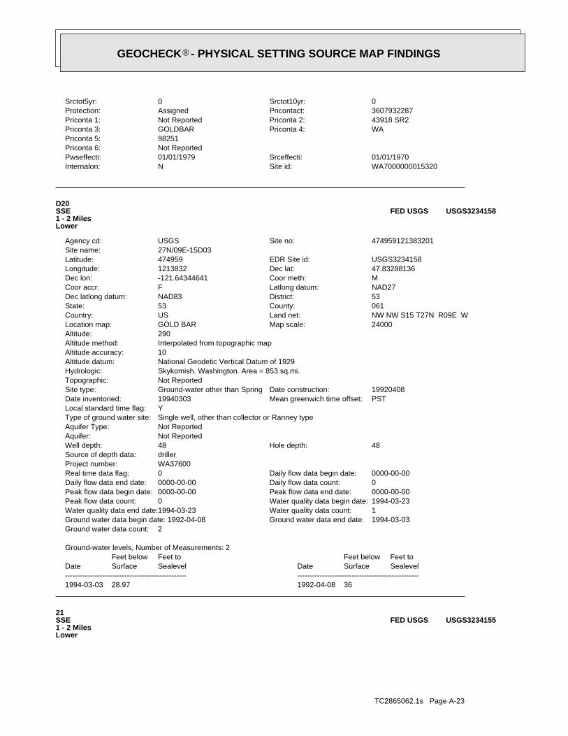
TC2865062.1s Page A-23
21SSE1 - 2 MilesLower
USGS3234155FED USGS
1994-03-03 28.97 1992-04-08 36
DateFeet belowSurface
Feet toSealevel
-------------------------------------------------Date
Feet belowSurface
Feet toSealevel
-------------------------------------------------
Ground-water levels, Number of Measurements: 2
2Ground water data count:1994-03-03Ground water data end date:Ground water data begin date: 1992-04-081Water quality data count:1994-03-23Water quality data end date:1994-03-23Water quality data begin date:0Peak flow data count:0000-00-00Peak flow data end date:0000-00-00Peak flow data begin date:0Daily flow data count:0000-00-00Daily flow data end date:0000-00-00Daily flow data begin date:0Real time data flag:
WA37600Project number:drillerSource of depth data:
48Hole depth:48Well depth:Not ReportedAquifer:Not ReportedAquifer Type:Single well, other than collector or Ranney typeType of ground water site:YLocal standard time flag:
PSTMean greenwich time offset:19940303Date inventoried:19920408Date construction:Ground-water other than SpringSite type:
Not ReportedTopographic:Skykomish. Washington. Area = 853 sq.mi.Hydrologic:National Geodetic Vertical Datum of 1929Altitude datum:10Altitude accuracy:Interpolated from topographic mapAltitude method:290Altitude:
24000Map scale:GOLD BARLocation map:NW NW S15 T27N R09E WLand net:USCountry:061County:53State:53District:NAD83Dec latlong datum:NAD27Latlong datum:FCoor accr:MCoor meth:-121.64344641Dec lon:47.83288136Dec lat:1213832Longitude:USGS3234158EDR Site id:474959Latitude:
27N/09E-15D03Site name:474959121383201Site no:USGSAgency cd:
D20SSE1 - 2 MilesLower
USGS3234158FED USGS
WA7000000015320Site id:NInternalon:01/01/1970Srceffecti:01/01/1979Pwseffecti:
Not ReportedPriconta 6:98251Priconta 5:
WAPriconta 4:GOLDBARPriconta 3:43918 SR2Priconta 2:Not ReportedPriconta 1:3607932287Pricontact:AssignedProtection:0Srctot10yr:0Srctot5yr:
GEOCHECK - PHYSICAL SETTING SOURCE MAP FINDINGS®

TC2865062.1s Page A-24
PSTMean greenwich time offset:Not ReportedDate inventoried:19750214Date construction:Ground-water other than SpringSite type:
Not ReportedTopographic:Skykomish. Washington. Area = 853 sq.mi.Hydrologic:National Geodetic Vertical Datum of 1929Altitude datum:40Altitude accuracy:Interpolated from topographic mapAltitude method:200Altitude:
62500Map scale:INDEXLocation map:NE NW S08 T27N R09E WLand net:USCountry:061County:53State:53District:NAD83Dec latlong datum:NAD27Latlong datum:SCoor accr:MCoor meth:-121.68289312Dec lon:47.84843635Dec lat:1214054Longitude:USGS3234190EDR Site id:475055Latitude:
27N/09E-08C01Site name:475055121405401Site no:USGSAgency cd:
22West1 - 2 MilesLower
USGS3234190FED USGS
1974-07-02 30
DateFeet belowSurface
Feet toSealevel
-------------------------------------------------
Ground-water levels, Number of Measurements: 1
1Ground water data count:1974-07-02Ground water data end date:Ground water data begin date: 1974-07-020Water quality data count:0000-00-00Water quality data end date:0000-00-00Water quality data begin date:0Peak flow data count:0000-00-00Peak flow data end date:0000-00-00Peak flow data begin date:0Daily flow data count:0000-00-00Daily flow data end date:0000-00-00Daily flow data begin date:0Real time data flag:
Not ReportedProject number:drillerSource of depth data:
Not ReportedHole depth:51Well depth:Not ReportedAquifer:Not ReportedAquifer Type:Single well, other than collector or Ranney typeType of ground water site:YLocal standard time flag:
PSTMean greenwich time offset:Not ReportedDate inventoried:19740702Date construction:Ground-water other than SpringSite type:
Not ReportedTopographic:Skykomish. Washington. Area = 853 sq.mi.Hydrologic:National Geodetic Vertical Datum of 1929Altitude datum:40Altitude accuracy:Interpolated from topographic mapAltitude method:300Altitude:
62500Map scale:INDEXLocation map:NW NW S15 T27N R09E WLand net:USCountry:061County:53State:53District:NAD83Dec latlong datum:NAD27Latlong datum:SCoor accr:MCoor meth:-121.64483534Dec lon:47.83232579Dec lat:1213837Longitude:USGS3234155EDR Site id:474957Latitude:
27N/09E-15D01Site name:474957121383701Site no:USGSAgency cd:
GEOCHECK - PHYSICAL SETTING SOURCE MAP FINDINGS®
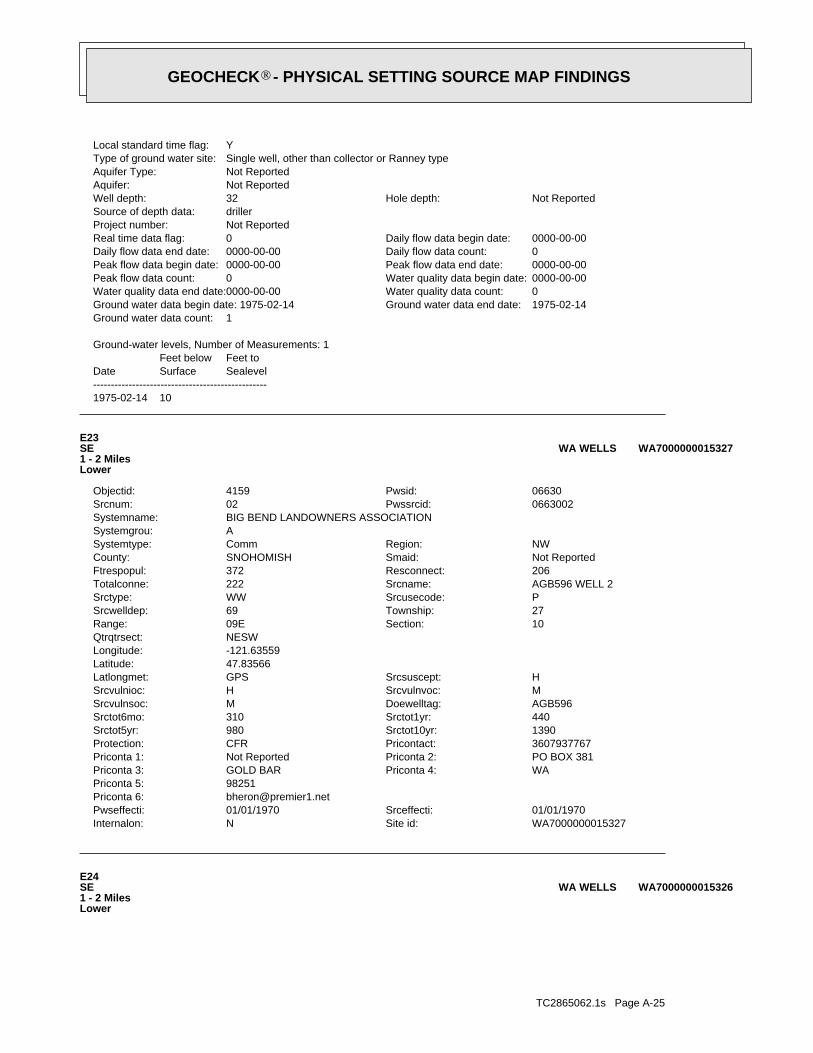
TC2865062.1s Page A-25
E24SE1 - 2 MilesLower
WA7000000015326WA WELLS
WA7000000015327Site id:NInternalon:01/01/1970Srceffecti:01/01/1970Pwseffecti:
[email protected] 6:98251Priconta 5:
WAPriconta 4:GOLD BARPriconta 3:PO BOX 381Priconta 2:Not ReportedPriconta 1:3607937767Pricontact:CFRProtection:1390Srctot10yr:980Srctot5yr:440Srctot1yr:310Srctot6mo:AGB596Doewelltag:MSrcvulnsoc:MSrcvulnvoc:HSrcvulnioc:HSrcsuscept:GPSLatlongmet:
47.83566Latitude:-121.63559Longitude:NESWQtrqtrsect:
10Section:09ERange:27Township:69Srcwelldep:PSrcusecode:WWSrctype:AGB596 WELL 2Srcname:222Totalconne:206Resconnect:372Ftrespopul:Not ReportedSmaid:SNOHOMISHCounty:NWRegion:CommSystemtype:
ASystemgrou:BIG BEND LANDOWNERS ASSOCIATIONSystemname:
0663002Pwssrcid:02Srcnum:06630Pwsid:4159Objectid:
E23SE1 - 2 MilesLower
WA7000000015327WA WELLS
1975-02-14 10
DateFeet belowSurface
Feet toSealevel
-------------------------------------------------
Ground-water levels, Number of Measurements: 1
1Ground water data count:1975-02-14Ground water data end date:Ground water data begin date: 1975-02-140Water quality data count:0000-00-00Water quality data end date:0000-00-00Water quality data begin date:0Peak flow data count:0000-00-00Peak flow data end date:0000-00-00Peak flow data begin date:0Daily flow data count:0000-00-00Daily flow data end date:0000-00-00Daily flow data begin date:0Real time data flag:
Not ReportedProject number:drillerSource of depth data:
Not ReportedHole depth:32Well depth:Not ReportedAquifer:Not ReportedAquifer Type:Single well, other than collector or Ranney typeType of ground water site:YLocal standard time flag:
GEOCHECK - PHYSICAL SETTING SOURCE MAP FINDINGS®
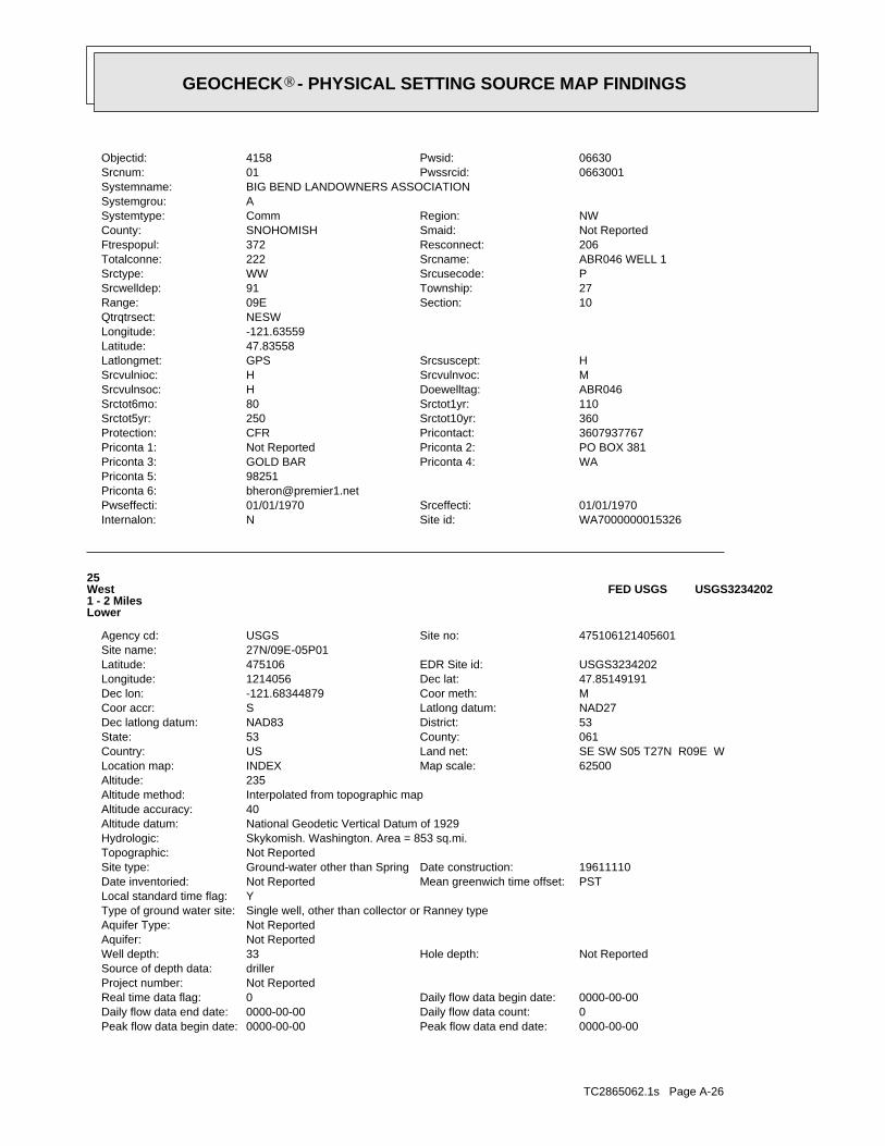
TC2865062.1s Page A-26
0000-00-00Peak flow data end date:0000-00-00Peak flow data begin date:0Daily flow data count:0000-00-00Daily flow data end date:0000-00-00Daily flow data begin date:0Real time data flag:
Not ReportedProject number:drillerSource of depth data:
Not ReportedHole depth:33Well depth:Not ReportedAquifer:Not ReportedAquifer Type:Single well, other than collector or Ranney typeType of ground water site:YLocal standard time flag:
PSTMean greenwich time offset:Not ReportedDate inventoried:19611110Date construction:Ground-water other than SpringSite type:
Not ReportedTopographic:Skykomish. Washington. Area = 853 sq.mi.Hydrologic:National Geodetic Vertical Datum of 1929Altitude datum:40Altitude accuracy:Interpolated from topographic mapAltitude method:235Altitude:
62500Map scale:INDEXLocation map:SE SW S05 T27N R09E WLand net:USCountry:061County:53State:53District:NAD83Dec latlong datum:NAD27Latlong datum:SCoor accr:MCoor meth:-121.68344879Dec lon:47.85149191Dec lat:1214056Longitude:USGS3234202EDR Site id:475106Latitude:
27N/09E-05P01Site name:475106121405601Site no:USGSAgency cd:
25West1 - 2 MilesLower
USGS3234202FED USGS
WA7000000015326Site id:NInternalon:01/01/1970Srceffecti:01/01/1970Pwseffecti:
[email protected] 6:98251Priconta 5:
WAPriconta 4:GOLD BARPriconta 3:PO BOX 381Priconta 2:Not ReportedPriconta 1:3607937767Pricontact:CFRProtection:360Srctot10yr:250Srctot5yr:110Srctot1yr:80Srctot6mo:ABR046Doewelltag:HSrcvulnsoc:MSrcvulnvoc:HSrcvulnioc:HSrcsuscept:GPSLatlongmet:
47.83558Latitude:-121.63559Longitude:NESWQtrqtrsect:
10Section:09ERange:27Township:91Srcwelldep:PSrcusecode:WWSrctype:ABR046 WELL 1Srcname:222Totalconne:206Resconnect:372Ftrespopul:Not ReportedSmaid:SNOHOMISHCounty:NWRegion:CommSystemtype:
ASystemgrou:BIG BEND LANDOWNERS ASSOCIATIONSystemname:
0663001Pwssrcid:01Srcnum:06630Pwsid:4158Objectid:
GEOCHECK - PHYSICAL SETTING SOURCE MAP FINDINGS®
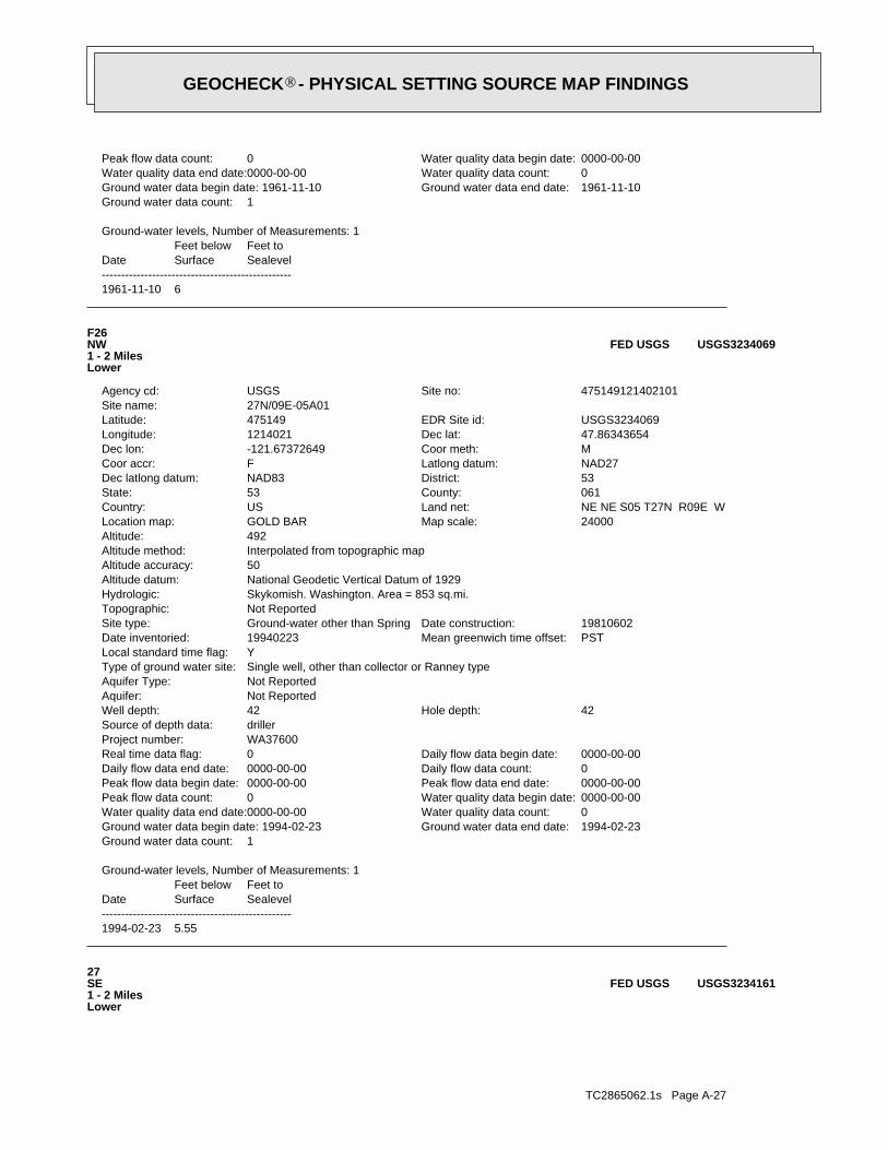
TC2865062.1s Page A-27
27SE1 - 2 MilesLower
USGS3234161FED USGS
1994-02-23 5.55
DateFeet belowSurface
Feet toSealevel
-------------------------------------------------
Ground-water levels, Number of Measurements: 1
1Ground water data count:1994-02-23Ground water data end date:Ground water data begin date: 1994-02-230Water quality data count:0000-00-00Water quality data end date:0000-00-00Water quality data begin date:0Peak flow data count:0000-00-00Peak flow data end date:0000-00-00Peak flow data begin date:0Daily flow data count:0000-00-00Daily flow data end date:0000-00-00Daily flow data begin date:0Real time data flag:
WA37600Project number:drillerSource of depth data:
42Hole depth:42Well depth:Not ReportedAquifer:Not ReportedAquifer Type:Single well, other than collector or Ranney typeType of ground water site:YLocal standard time flag:
PSTMean greenwich time offset:19940223Date inventoried:19810602Date construction:Ground-water other than SpringSite type:
Not ReportedTopographic:Skykomish. Washington. Area = 853 sq.mi.Hydrologic:National Geodetic Vertical Datum of 1929Altitude datum:50Altitude accuracy:Interpolated from topographic mapAltitude method:492Altitude:
24000Map scale:GOLD BARLocation map:NE NE S05 T27N R09E WLand net:USCountry:061County:53State:53District:NAD83Dec latlong datum:NAD27Latlong datum:FCoor accr:MCoor meth:-121.67372649Dec lon:47.86343654Dec lat:1214021Longitude:USGS3234069EDR Site id:475149Latitude:
27N/09E-05A01Site name:475149121402101Site no:USGSAgency cd:
F26NW1 - 2 MilesLower
USGS3234069FED USGS
1961-11-10 6
DateFeet belowSurface
Feet toSealevel
-------------------------------------------------
Ground-water levels, Number of Measurements: 1
1Ground water data count:1961-11-10Ground water data end date:Ground water data begin date: 1961-11-100Water quality data count:0000-00-00Water quality data end date:0000-00-00Water quality data begin date:0Peak flow data count:
GEOCHECK - PHYSICAL SETTING SOURCE MAP FINDINGS®
TC2865062.1s Page A-28
0Srctot1yr:0Srctot6mo:AGB581Doewelltag:USrcvulnsoc:HSrcvulnvoc:LSrcvulnioc:HSrcsuscept:GPSLatlongmet:
47.86403Latitude:-121.67363Longitude:NENEQtrqtrsect:
05Section:09ERange:27Township:40Srcwelldep:PSrcusecode:WSrctype:WELL #2 (AGB581)Srcname:15Totalconne:5Resconnect:8Ftrespopul:Not ReportedSmaid:SNOHOMISHCounty:NWRegion:TNCSystemtype:
ASystemgrou:HUSTON CAMP & CONFERENCE CENTERSystemname:
3509302Pwssrcid:02Srcnum:35093Pwsid:8993Objectid:
F28NW1 - 2 MilesLower
WA7000000015458WA WELLS
1966-01-17 42
DateFeet belowSurface
Feet toSealevel
-------------------------------------------------
Ground-water levels, Number of Measurements: 1
1Ground water data count:1966-01-17Ground water data end date:Ground water data begin date: 1966-01-170Water quality data count:0000-00-00Water quality data end date:0000-00-00Water quality data begin date:0Peak flow data count:0000-00-00Peak flow data end date:0000-00-00Peak flow data begin date:0Daily flow data count:0000-00-00Daily flow data end date:0000-00-00Daily flow data begin date:0Real time data flag:
Not ReportedProject number:drillerSource of depth data:
Not ReportedHole depth:91Well depth:Not ReportedAquifer:Not ReportedAquifer Type:Single well, other than collector or Ranney typeType of ground water site:YLocal standard time flag:
PSTMean greenwich time offset:Not ReportedDate inventoried:19660117Date construction:Ground-water other than SpringSite type:
Not ReportedTopographic:Skykomish. Washington. Area = 853 sq.mi.Hydrologic:National Geodetic Vertical Datum of 1929Altitude datum:40Altitude accuracy:Interpolated from topographic mapAltitude method:350Altitude:
62500Map scale:INDEXLocation map:SW SE S10 T27N R09E WLand net:USCountry:061County:53State:53District:NAD83Dec latlong datum:NAD27Latlong datum:SCoor accr:MCoor meth:-121.63427939Dec lon:47.83510374Dec lat:1213759Longitude:USGS3234161EDR Site id:475007Latitude:
27N/09E-10Q01Site name:475007121375901Site no:USGSAgency cd:
GEOCHECK - PHYSICAL SETTING SOURCE MAP FINDINGS®
TC2865062.1s Page A-29
G30WNW1 - 2 MilesLower
WA7000000015423WA WELLS
1994-02-28 -60
DateFeet belowSurface
Feet toSealevel
-------------------------------------------------
Ground-water levels, Number of Measurements: 1
1Ground water data count:1994-02-28Ground water data end date:Ground water data begin date: 1994-02-280Water quality data count:0000-00-00Water quality data end date:0000-00-00Water quality data begin date:0Peak flow data count:0000-00-00Peak flow data end date:0000-00-00Peak flow data begin date:0Daily flow data count:0000-00-00Daily flow data end date:0000-00-00Daily flow data begin date:0Real time data flag:
WA37600Project number:geologistSource of depth data:
720Hole depth:690Well depth:Not ReportedAquifer:Not ReportedAquifer Type:Single well, other than collector or Ranney typeType of ground water site:YLocal standard time flag:
PSTMean greenwich time offset:19940518Date inventoried:19940209Date construction:Ground-water other than SpringSite type:
Flood plainTopographic:Skykomish. Washington. Area = 853 sq.mi.Hydrologic:National Geodetic Vertical Datum of 1929Altitude datum:10Altitude accuracy:Interpolated from topographic mapAltitude method:205Altitude:
24000Map scale:GOLD BARLocation map:SW SW S05 T27N R09E WLand net:USCountry:061County:53State:53District:NAD83Dec latlong datum:NAD27Latlong datum:FCoor accr:MCoor meth:-121.6867823Dec lon:47.8523252Dec lat:1214108Longitude:USGS3234205EDR Site id:475109Latitude:
27N/09E-05N01Site name:475109121410801Site no:USGSAgency cd:
G29WNW1 - 2 MilesLower
USGS3234205FED USGS
WA7000000015458Site id:NInternalon:01/01/1970Srceffecti:01/01/1970Pwseffecti:
[email protected] 6:98251Priconta 5:
WAPriconta 4:GOLD BARPriconta 3:PO BOX 140Priconta 2:Not ReportedPriconta 1:3607930441Pricontact:AssignedProtection:0Srctot10yr:0Srctot5yr:
GEOCHECK - PHYSICAL SETTING SOURCE MAP FINDINGS®
TC2865062.1s Page A-30
WA7000000015484Site id:NInternalon:01/01/1970Srceffecti:01/01/1970Pwseffecti:
Not ReportedPriconta 6:98272Priconta 5:
WAPriconta 4:MONROEPriconta 3:14209 - 242ND DR SEPriconta 2:Not ReportedPriconta 1:3607944856Pricontact:AssignedProtection:0Srctot10yr:0Srctot5yr:0Srctot1yr:0Srctot6mo:Not ReportedDoewelltag:Not ReportedSrcvulnsoc:Not ReportedSrcvulnvoc:Not ReportedSrcvulnioc:USrcsuscept:QtrQtrSectionLatlongmet:
47.8695Latitude:-121.66Longitude:SENEQtrqtrsect:
33Section:09Range:28Township:0Srcwelldep:PSrcusecode:SPSrctype:UNAMEDSrcname:3Totalconne:3Resconnect:8Ftrespopul:Not ReportedSmaid:SNOHOMISHCounty:NWRegion:GRPBSystemtype:
BSystemgrou:FLORENCE ACRES WATER SYSTEMSystemname:
2084701Pwssrcid:01Srcnum:20847Pwsid:18651Objectid:
31North1 - 2 MilesHigher
WA7000000015484WA WELLS
WA7000000015423Site id:NInternalon:08/03/1995Srceffecti:01/01/1970Pwseffecti:
[email protected] 6:98251Priconta 5:
WAPriconta 4:GOLDBARPriconta 3:107 5TH STPriconta 2:Not ReportedPriconta 1:3607931101Pricontact:ModelProtection:0Srctot10yr:0Srctot5yr:0Srctot1yr:0Srctot6mo:Not ReportedDoewelltag:LSrcvulnsoc:MSrcvulnvoc:HSrcvulnioc:MSrcsuscept:GPSLatlongmet:
47.85284Latitude:-121.68688Longitude:NESWQtrqtrsect:
05Section:09ERange:27Township:720Srcwelldep:PSrcusecode:WSrctype:WELL #4Srcname:734Totalconne:685Resconnect:2200Ftrespopul:Not ReportedSmaid:SNOHOMISHCounty:NWRegion:CommSystemtype:
ASystemgrou:GOLD BAR, CITY OFSystemname:
2830004Pwssrcid:04Srcnum:28300Pwsid:8150Objectid:
GEOCHECK - PHYSICAL SETTING SOURCE MAP FINDINGS®
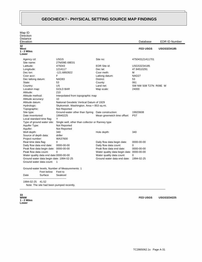
TC2865062.1s Page A-31
33WNW1 - 2 MilesLower
USGS3234225FED USGS
Note: The site had been pumped recently.1994-02-25 41.52
DateFeet belowSurface
Feet toSealevel
-------------------------------------------------
Ground-water levels, Number of Measurements: 1
1Ground water data count:1994-02-25Ground water data end date:Ground water data begin date: 1994-02-250Water quality data count:0000-00-00Water quality data end date:0000-00-00Water quality data begin date:0Peak flow data count:0000-00-00Peak flow data end date:0000-00-00Peak flow data begin date:0Daily flow data count:0000-00-00Daily flow data end date:0000-00-00Daily flow data begin date:0Real time data flag:
WA37600Project number:drillerSource of depth data:
340Hole depth:340Well depth:Not ReportedAquifer:Not ReportedAquifer Type:Single well, other than collector or Ranney typeType of ground water site:YLocal standard time flag:
PSTMean greenwich time offset:19940225Date inventoried:19920608Date construction:Ground-water other than SpringSite type:
Not ReportedTopographic:Skykomish. Washington. Area = 853 sq.mi.Hydrologic:National Geodetic Vertical Datum of 1929Altitude datum:10Altitude accuracy:Interpolated from topographic mapAltitude method:210Altitude:
24000Map scale:GOLD BARLocation map:SW NW S08 T27N R09E WLand net:USCountry:061County:53State:53District:NAD83Dec latlong datum:NAD27Latlong datum:FCoor accr:MCoor meth:-121.6892822Dec lon:47.84510291Dec lat:1214117Longitude:USGS3234185EDR Site id:475043Latitude:
27N/09E-08E01Site name:475043121411701Site no:USGSAgency cd:
32West1 - 2 MilesLower
USGS3234185FED USGS
Map IDDirectionDistanceElevation EDR ID NumberDatabase
GEOCHECK - PHYSICAL SETTING SOURCE MAP FINDINGS®
TC2865062.1s Page A-32
PSTMean greenwich time offset:Not ReportedDate inventoried:19700618Date construction:Ground-water other than SpringSite type:
Not ReportedTopographic:Skykomish. Washington. Area = 853 sq.mi.Hydrologic:National Geodetic Vertical Datum of 1929Altitude datum:40Altitude accuracy:Interpolated from topographic mapAltitude method:160Altitude:
62500Map scale:INDEXLocation map:NE NW S06 T27N R09E WLand net:USCountry:061County:53State:53District:NAD83Dec latlong datum:NAD27Latlong datum:SCoor accr:MCoor meth:-121.6842825Dec lon:47.86288082Dec lat:1214059Longitude:USGS3234232EDR Site id:475147Latitude:
27N/09E-06C01Site name:475147121405901Site no:USGSAgency cd:
H34NW1 - 2 MilesLower
USGS3234232FED USGS
1974-04-13 11
DateFeet belowSurface
Feet toSealevel
-------------------------------------------------
Ground-water levels, Number of Measurements: 1
1Ground water data count:1974-04-13Ground water data end date:Ground water data begin date: 1974-04-130Water quality data count:0000-00-00Water quality data end date:0000-00-00Water quality data begin date:0Peak flow data count:0000-00-00Peak flow data end date:0000-00-00Peak flow data begin date:0Daily flow data count:0000-00-00Daily flow data end date:0000-00-00Daily flow data begin date:0Real time data flag:
Not ReportedProject number:drillerSource of depth data:
Not ReportedHole depth:27Well depth:Not ReportedAquifer:Not ReportedAquifer Type:Single well, other than collector or Ranney typeType of ground water site:YLocal standard time flag:
PSTMean greenwich time offset:Not ReportedDate inventoried:19740413Date construction:Ground-water other than SpringSite type:
Not ReportedTopographic:Skykomish. Washington. Area = 853 sq.mi.Hydrologic:National Geodetic Vertical Datum of 1929Altitude datum:40Altitude accuracy:Interpolated from topographic mapAltitude method:240Altitude:
62500Map scale:INDEXLocation map:SW NW S05 T27N R09E WLand net:USCountry:061County:53State:53District:NAD83Dec latlong datum:NAD27Latlong datum:SCoor accr:MCoor meth:-121.68678246Dec lon:47.85788077Dec lat:1214108Longitude:USGS3234225EDR Site id:475129Latitude:
27N/09E-05E01Site name:475129121410801Site no:USGSAgency cd:
GEOCHECK - PHYSICAL SETTING SOURCE MAP FINDINGS®
TC2865062.1s Page A-33
2Ground water data count:1994-03-03Ground water data end date:Ground water data begin date: 1991-01-231Water quality data count:1994-03-23Water quality data end date:1994-03-23Water quality data begin date:0Peak flow data count:0000-00-00Peak flow data end date:0000-00-00Peak flow data begin date:0Daily flow data count:0000-00-00Daily flow data end date:0000-00-00Daily flow data begin date:0Real time data flag:
WA37600Project number:drillerSource of depth data:
200Hole depth:200Well depth:Not ReportedAquifer:Not ReportedAquifer Type:Single well, other than collector or Ranney typeType of ground water site:YLocal standard time flag:
PSTMean greenwich time offset:19940303Date inventoried:19910117Date construction:Ground-water other than SpringSite type:
Not ReportedTopographic:Skykomish. Washington. Area = 853 sq.mi.Hydrologic:National Geodetic Vertical Datum of 1929Altitude datum:10Altitude accuracy:Interpolated from topographic mapAltitude method:230Altitude:
24000Map scale:GOLD BARLocation map:NE NW S05 T27N R09E WLand net:USCountry:061County:53State:53District:NAD83Dec latlong datum:NAD27Latlong datum:FCoor accr:MCoor meth:-121.68400473Dec lon:47.86371416Dec lat:1214058Longitude:USGS3234070EDR Site id:475150Latitude:
27N/09E-05C01Site name:475150121405801Site no:USGSAgency cd:
H35NW1 - 2 MilesLower
USGS3234070FED USGS
1970-06-18 10
DateFeet belowSurface
Feet toSealevel
-------------------------------------------------
Ground-water levels, Number of Measurements: 1
1Ground water data count:1970-06-18Ground water data end date:Ground water data begin date: 1970-06-180Water quality data count:0000-00-00Water quality data end date:0000-00-00Water quality data begin date:0Peak flow data count:0000-00-00Peak flow data end date:0000-00-00Peak flow data begin date:0Daily flow data count:0000-00-00Daily flow data end date:0000-00-00Daily flow data begin date:0Real time data flag:
Not ReportedProject number:drillerSource of depth data:
Not ReportedHole depth:25Well depth:Not ReportedAquifer:Not ReportedAquifer Type:Single well, other than collector or Ranney typeType of ground water site:YLocal standard time flag:
GEOCHECK - PHYSICAL SETTING SOURCE MAP FINDINGS®
TC2865062.1s Page A-34
PSTMean greenwich time offset:Not ReportedDate inventoried:19740924Date construction:Ground-water other than SpringSite type:
Not ReportedTopographic:Skykomish. Washington. Area = 853 sq.mi.Hydrologic:National Geodetic Vertical Datum of 1929Altitude datum:40Altitude accuracy:Interpolated from topographic mapAltitude method:560Altitude:
62500Map scale:INDEXLocation map:SE NW S32 T28N R09E WLand net:USCountry:061County:53State:53District:NAD83Dec latlong datum:NAD27Latlong datum:SCoor accr:MCoor meth:-121.68344942Dec lon:47.87288087Dec lat:1214056Longitude:USGS3234099EDR Site id:475223Latitude:
28N/09E-32F01Site name:475223121405601Site no:USGSAgency cd:
37NW2 - 3 MilesHigher
USGS3234099FED USGS
WA7000000015470Site id:NInternalon:12/03/1997Srceffecti:12/03/1997Pwseffecti:
Not ReportedPriconta 6:98251Priconta 5:
WAPriconta 4:GOLD BARPriconta 3:14424 WALLACE LAKE RDPriconta 2:Not ReportedPriconta 1:3607991675Pricontact:AssignedProtection:0Srctot10yr:0Srctot5yr:0Srctot1yr:0Srctot6mo:Not ReportedDoewelltag:USrcvulnsoc:HSrcvulnvoc:HSrcvulnioc:HSrcsuscept:GPSLatlongmet:
47.86679Latitude:-121.68291Longitude:SESWQtrqtrsect:
32Section:09ERange:28Township:144Srcwelldep:PSrcusecode:WSrctype:WELL #1Srcname:2Totalconne:1Resconnect:6Ftrespopul:Not ReportedSmaid:SNOHOMISHCounty:NWRegion:GRPBSystemtype:
BSystemgrou:SWANSON BED & BREAKFASTSystemname:
0636901Pwssrcid:01Srcnum:06369Pwsid:3980Objectid:
36NW1 - 2 MilesLower
WA7000000015470WA WELLS
1994-03-03 7.95 1991-01-23 3
DateFeet belowSurface
Feet toSealevel
-------------------------------------------------Date
Feet belowSurface
Feet toSealevel
-------------------------------------------------
Ground-water levels, Number of Measurements: 2
GEOCHECK - PHYSICAL SETTING SOURCE MAP FINDINGS®

TC2865062.1s Page A-35
2Ground water data count:1994-02-23Ground water data end date:Ground water data begin date: 1986-07-020Water quality data count:0000-00-00Water quality data end date:0000-00-00Water quality data begin date:0Peak flow data count:0000-00-00Peak flow data end date:0000-00-00Peak flow data begin date:0Daily flow data count:0000-00-00Daily flow data end date:0000-00-00Daily flow data begin date:0Real time data flag:
WA37600Project number:drillerSource of depth data:
204Hole depth:204Well depth:Not ReportedAquifer:Not ReportedAquifer Type:Single well, other than collector or Ranney typeType of ground water site:YLocal standard time flag:
PSTMean greenwich time offset:19940223Date inventoried:19860702Date construction:Ground-water other than SpringSite type:
Not ReportedTopographic:Skykomish. Washington. Area = 853 sq.mi.Hydrologic:National Geodetic Vertical Datum of 1929Altitude datum:20Altitude accuracy:Interpolated from topographic mapAltitude method:420Altitude:
24000Map scale:GOLD BARLocation map:SW NW S32 T28N R09E WLand net:USCountry:061County:53State:53District:NAD83Dec latlong datum:NAD27Latlong datum:FCoor accr:MCoor meth:-121.68678286Dec lon:47.87149192Dec lat:1214108Longitude:USGS3234090EDR Site id:475218Latitude:
28N/09E-32E01Site name:475218121410801Site no:USGSAgency cd:
38NW2 - 3 MilesHigher
USGS3234090FED USGS
1974-09-24 12
DateFeet belowSurface
Feet toSealevel
-------------------------------------------------
Ground-water levels, Number of Measurements: 1
1Ground water data count:1974-09-24Ground water data end date:Ground water data begin date: 1974-09-240Water quality data count:0000-00-00Water quality data end date:0000-00-00Water quality data begin date:0Peak flow data count:0000-00-00Peak flow data end date:0000-00-00Peak flow data begin date:0Daily flow data count:0000-00-00Daily flow data end date:0000-00-00Daily flow data begin date:0Real time data flag:
Not ReportedProject number:drillerSource of depth data:
Not ReportedHole depth:50Well depth:Not ReportedAquifer:Not ReportedAquifer Type:Single well, other than collector or Ranney typeType of ground water site:YLocal standard time flag:
GEOCHECK - PHYSICAL SETTING SOURCE MAP FINDINGS®
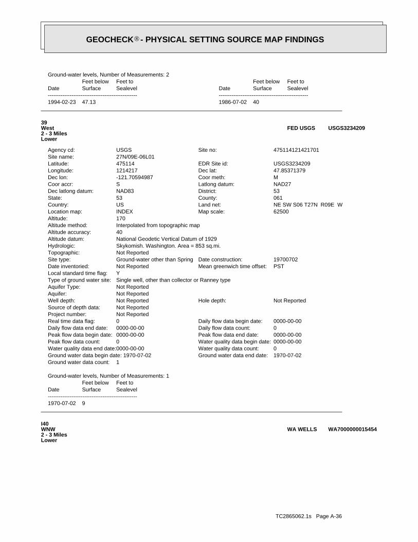
TC2865062.1s Page A-36
I40WNW2 - 3 MilesLower
WA7000000015454WA WELLS
1970-07-02 9
DateFeet belowSurface
Feet toSealevel
-------------------------------------------------
Ground-water levels, Number of Measurements: 1
1Ground water data count:1970-07-02Ground water data end date:Ground water data begin date: 1970-07-020Water quality data count:0000-00-00Water quality data end date:0000-00-00Water quality data begin date:0Peak flow data count:0000-00-00Peak flow data end date:0000-00-00Peak flow data begin date:0Daily flow data count:0000-00-00Daily flow data end date:0000-00-00Daily flow data begin date:0Real time data flag:
Not ReportedProject number:Not ReportedSource of depth data:
Not ReportedHole depth:Not ReportedWell depth:Not ReportedAquifer:Not ReportedAquifer Type:Single well, other than collector or Ranney typeType of ground water site:YLocal standard time flag:
PSTMean greenwich time offset:Not ReportedDate inventoried:19700702Date construction:Ground-water other than SpringSite type:
Not ReportedTopographic:Skykomish. Washington. Area = 853 sq.mi.Hydrologic:National Geodetic Vertical Datum of 1929Altitude datum:40Altitude accuracy:Interpolated from topographic mapAltitude method:170Altitude:
62500Map scale:INDEXLocation map:NE SW S06 T27N R09E WLand net:USCountry:061County:53State:53District:NAD83Dec latlong datum:NAD27Latlong datum:SCoor accr:MCoor meth:-121.70594987Dec lon:47.85371379Dec lat:1214217Longitude:USGS3234209EDR Site id:475114Latitude:
27N/09E-06L01Site name:475114121421701Site no:USGSAgency cd:
39West2 - 3 MilesLower
USGS3234209FED USGS
1994-02-23 47.13 1986-07-02 40
DateFeet belowSurface
Feet toSealevel
-------------------------------------------------Date
Feet belowSurface
Feet toSealevel
-------------------------------------------------
Ground-water levels, Number of Measurements: 2
GEOCHECK - PHYSICAL SETTING SOURCE MAP FINDINGS®
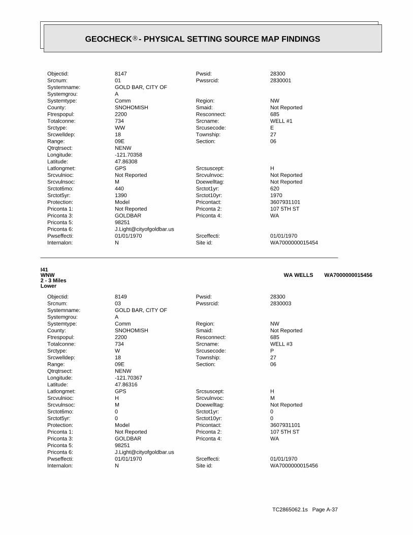
TC2865062.1s Page A-37
WA7000000015456Site id:NInternalon:01/01/1970Srceffecti:01/01/1970Pwseffecti:
[email protected] 6:98251Priconta 5:
WAPriconta 4:GOLDBARPriconta 3:107 5TH STPriconta 2:Not ReportedPriconta 1:3607931101Pricontact:ModelProtection:0Srctot10yr:0Srctot5yr:0Srctot1yr:0Srctot6mo:Not ReportedDoewelltag:MSrcvulnsoc:MSrcvulnvoc:HSrcvulnioc:HSrcsuscept:GPSLatlongmet:
47.86316Latitude:-121.70367Longitude:NENWQtrqtrsect:
06Section:09ERange:27Township:18Srcwelldep:PSrcusecode:WSrctype:WELL #3Srcname:734Totalconne:685Resconnect:2200Ftrespopul:Not ReportedSmaid:SNOHOMISHCounty:NWRegion:CommSystemtype:
ASystemgrou:GOLD BAR, CITY OFSystemname:
2830003Pwssrcid:03Srcnum:28300Pwsid:8149Objectid:
I41WNW2 - 3 MilesLower
WA7000000015456WA WELLS
WA7000000015454Site id:NInternalon:01/01/1970Srceffecti:01/01/1970Pwseffecti:
[email protected] 6:98251Priconta 5:
WAPriconta 4:GOLDBARPriconta 3:107 5TH STPriconta 2:Not ReportedPriconta 1:3607931101Pricontact:ModelProtection:1970Srctot10yr:1390Srctot5yr:620Srctot1yr:440Srctot6mo:Not ReportedDoewelltag:MSrcvulnsoc:Not ReportedSrcvulnvoc:Not ReportedSrcvulnioc:HSrcsuscept:GPSLatlongmet:
47.86308Latitude:-121.70358Longitude:NENWQtrqtrsect:
06Section:09ERange:27Township:18Srcwelldep:ESrcusecode:WWSrctype:WELL #1Srcname:734Totalconne:685Resconnect:2200Ftrespopul:Not ReportedSmaid:SNOHOMISHCounty:NWRegion:CommSystemtype:
ASystemgrou:GOLD BAR, CITY OFSystemname:
2830001Pwssrcid:01Srcnum:28300Pwsid:8147Objectid:
GEOCHECK - PHYSICAL SETTING SOURCE MAP FINDINGS®
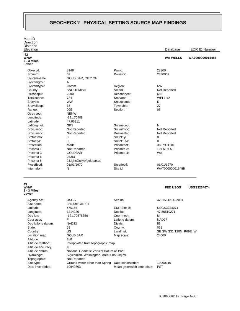
TC2865062.1s Page A-38
PSTMean greenwich time offset:19940303Date inventoried:19900316Date construction:Ground-water other than SpringSite type:
Not ReportedTopographic:Skykomish. Washington. Area = 853 sq.mi.Hydrologic:National Geodetic Vertical Datum of 1929Altitude datum:10Altitude accuracy:Interpolated from topographic mapAltitude method:180Altitude:
24000Map scale:GOLD BARLocation map:SE SW S31 T28N R09E WLand net:USCountry:061County:53State:53District:NAD83Dec latlong datum:NAD27Latlong datum:FCoor accr:MCoor meth:-121.70678356Dec lon:47.86510271Dec lat:1214220Longitude:USGS3234074EDR Site id:475155Latitude:
28N/09E-31P01Site name:475155121422001Site no:USGSAgency cd:
43WNW2 - 3 MilesLower
USGS3234074FED USGS
WA7000000015455Site id:NInternalon:01/01/1970Srceffecti:01/01/1970Pwseffecti:
[email protected] 6:98251Priconta 5:
WAPriconta 4:GOLDBARPriconta 3:107 5TH STPriconta 2:Not ReportedPriconta 1:3607931101Pricontact:ModelProtection:0Srctot10yr:0Srctot5yr:0Srctot1yr:0Srctot6mo:Not ReportedDoewelltag:Not ReportedSrcvulnsoc:Not ReportedSrcvulnvoc:Not ReportedSrcvulnioc:NSrcsuscept:GPSLatlongmet:
47.86311Latitude:-121.70408Longitude:NENWQtrqtrsect:
06Section:09ERange:27Township:18Srcwelldep:ESrcusecode:WWSrctype:WELL #2Srcname:734Totalconne:685Resconnect:2200Ftrespopul:Not ReportedSmaid:SNOHOMISHCounty:NWRegion:CommSystemtype:
ASystemgrou:GOLD BAR, CITY OFSystemname:
2830002Pwssrcid:02Srcnum:28300Pwsid:8148Objectid:
I42WNW2 - 3 MilesLower
WA7000000015455WA WELLS
Map IDDirectionDistanceElevation EDR ID NumberDatabase
GEOCHECK - PHYSICAL SETTING SOURCE MAP FINDINGS®
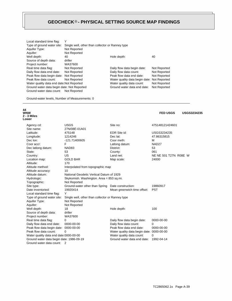
TC2865062.1s Page A-39
2Ground water data count:1992-04-14Ground water data end date:Ground water data begin date: 1986-09-190Water quality data count:0000-00-00Water quality data end date:0000-00-00Water quality data begin date:0Peak flow data count:0000-00-00Peak flow data end date:0000-00-00Peak flow data begin date:0Daily flow data count:0000-00-00Daily flow data end date:0000-00-00Daily flow data begin date:0Real time data flag:
WA37600Project number:drillerSource of depth data:
100Hole depth:18Well depth:Not ReportedAquifer:Not ReportedAquifer Type:Single well, other than collector or Ranney typeType of ground water site:YLocal standard time flag:
PSTMean greenwich time offset:19920414Date inventoried:19860917Date construction:Ground-water other than SpringSite type:
Not ReportedTopographic:Skykomish. Washington. Area = 853 sq.mi.Hydrologic:National Geodetic Vertical Datum of 1929Altitude datum:10Altitude accuracy:Interpolated from topographic mapAltitude method:170Altitude:
24000Map scale:GOLD BARLocation map:NE NE S01 T27N R08E WLand net:USCountry:061County:53State:53District:NAD83Dec latlong datum:NAD27Latlong datum:FCoor accr:MCoor meth:-121.71400605Dec lon:47.86315815Dec lat:1214246Longitude:USGS3234235EDR Site id:475148Latitude:
27N/08E-01A01Site name:475148121424601Site no:USGSAgency cd:
44WNW2 - 3 MilesLower
USGS3234235FED USGS
Ground-water levels, Number of Measurements: 0
Not ReportedGround water data count:Not ReportedGround water data end date:Ground water data begin date: Not ReportedNot ReportedWater quality data count:Not ReportedWater quality data end date:Not ReportedWater quality data begin date:Not ReportedPeak flow data count:Not ReportedPeak flow data end date:Not ReportedPeak flow data begin date:Not ReportedDaily flow data count:Not ReportedDaily flow data end date:Not ReportedDaily flow data begin date:Not ReportedReal time data flag:
WA37600Project number:drillerSource of depth data:
40Hole depth:40Well depth:Not ReportedAquifer:Not ReportedAquifer Type:Single well, other than collector or Ranney typeType of ground water site:YLocal standard time flag:
GEOCHECK - PHYSICAL SETTING SOURCE MAP FINDINGS®
TC2865062.1s Page A-40
WELL HW-4Srcname:115Totalconne:107Resconnect:350Ftrespopul:Not ReportedSmaid:SNOHOMISHCounty:NWRegion:CommSystemtype:
ASystemgrou:INDEX WATER DEPTSystemname:
3560003Pwssrcid:03Srcnum:35600Pwsid:9051Objectid:
J46SE3 - 4 MilesHigher
WA7000000015252WA WELLS
Ground-water levels, Number of Measurements: 0
Not ReportedGround water data count:Not ReportedGround water data end date:Ground water data begin date: Not ReportedNot ReportedWater quality data count:Not ReportedWater quality data end date:Not ReportedWater quality data begin date:Not ReportedPeak flow data count:Not ReportedPeak flow data end date:Not ReportedPeak flow data begin date:Not ReportedDaily flow data count:Not ReportedDaily flow data end date:Not ReportedDaily flow data begin date:Not ReportedReal time data flag:
WA37600Project number:drillerSource of depth data:
26Hole depth:26Well depth:Not ReportedAquifer:Not ReportedAquifer Type:Single well, other than collector or Ranney typeType of ground water site:YLocal standard time flag:
PSTMean greenwich time offset:19920602Date inventoried:19790306Date construction:Ground-water other than SpringSite type:
Not ReportedTopographic:Skykomish. Washington. Area = 853 sq.mi.Hydrologic:National Geodetic Vertical Datum of 1929Altitude datum:10Altitude accuracy:Interpolated from topographic mapAltitude method:180Altitude:
24000Map scale:GOLD BARLocation map:SE SE S36 T28N R08E WLand net:USCountry:061County:53State:53District:NAD83Dec latlong datum:NAD27Latlong datum:FCoor accr:MCoor meth:-121.71372839Dec lon:47.86760261Dec lat:1214245Longitude:USGS3234079EDR Site id:475204Latitude:
28N/08E-36R03Site name:475204121424501Site no:USGSAgency cd:
45WNW3 - 4 MilesLower
USGS3234079FED USGS
1992-04-14 6.9 1986-09-19 8
DateFeet belowSurface
Feet toSealevel
-------------------------------------------------Date
Feet belowSurface
Feet toSealevel
-------------------------------------------------
Ground-water levels, Number of Measurements: 2
GEOCHECK - PHYSICAL SETTING SOURCE MAP FINDINGS®

TC2865062.1s Page A-41
K48WNW3 - 4 MilesLower
USGS3234078FED USGS
WA7000000015253Site id:NInternalon:10/19/2005Srceffecti:01/01/1970Pwseffecti:
[email protected] 6:98256Priconta 5:
WAPriconta 4:INDEXPriconta 3:PO BOX 88Priconta 2:TOWN OF INDEXPriconta 1:3607937767Pricontact:AssignedProtection:0Srctot10yr:0Srctot5yr:0Srctot1yr:0Srctot6mo:Not ReportedDoewelltag:USrcvulnsoc:HSrcvulnvoc:HSrcvulnioc:HSrcsuscept:QtrQtrSeLatlongmet:
47.82258Latitude:-121.603Longitude:SESEQtrqtrsect:
13Section:09ERange:27Township:0Srcwelldep:PSrcusecode:WWSrctype:WELL HW-5Srcname:115Totalconne:107Resconnect:350Ftrespopul:Not ReportedSmaid:SNOHOMISHCounty:NWRegion:CommSystemtype:
ASystemgrou:INDEX WATER DEPTSystemname:
3560004Pwssrcid:04Srcnum:35600Pwsid:9052Objectid:
J47SE3 - 4 MilesHigher
WA7000000015253WA WELLS
WA7000000015252Site id:NInternalon:10/19/2005Srceffecti:01/01/1970Pwseffecti:
[email protected] 6:98256Priconta 5:
WAPriconta 4:INDEXPriconta 3:PO BOX 88Priconta 2:TOWN OF INDEXPriconta 1:3607937767Pricontact:AssignedProtection:0Srctot10yr:0Srctot5yr:0Srctot1yr:0Srctot6mo:Not ReportedDoewelltag:USrcvulnsoc:HSrcvulnvoc:HSrcvulnioc:HSrcsuscept:QtrQtrSeLatlongmet:
47.82258Latitude:-121.603Longitude:SESEQtrqtrsect:
13Section:09ERange:27Township:0Srcwelldep:PSrcusecode:WWSrctype:
GEOCHECK - PHYSICAL SETTING SOURCE MAP FINDINGS®
TC2865062.1s Page A-42
0Srctot1yr:0Srctot6mo:Not ReportedDoewelltag:USrcvulnsoc:HSrcvulnvoc:HSrcvulnioc:HSrcsuscept:GPSLatlongmet:
47.866938Latitude:-121.717456Longitude:SESEQtrqtrsect:
36Section:08ERange:28Township:70Srcwelldep:PSrcusecode:WSrctype:WELL #2Srcname:6Totalconne:4Resconnect:10Ftrespopul:Not ReportedSmaid:SNOHOMISHCounty:NWRegion:TNCSystemtype:
ASystemgrou:WALLACE RIVER SALMON HATCHERYSystemname:
0898202Pwssrcid:02Srcnum:08982Pwsid:5482Objectid:
K49WNW3 - 4 MilesLower
WA7000000015471WA WELLS
1992-06-02 8.9
DateFeet belowSurface
Feet toSealevel
-------------------------------------------------
Ground-water levels, Number of Measurements: 1
1Ground water data count:1992-06-02Ground water data end date:Ground water data begin date: 1992-06-020Water quality data count:0000-00-00Water quality data end date:0000-00-00Water quality data begin date:0Peak flow data count:0000-00-00Peak flow data end date:0000-00-00Peak flow data begin date:0Daily flow data count:0000-00-00Daily flow data end date:0000-00-00Daily flow data begin date:0Real time data flag:
WA37600Project number:drillerSource of depth data:
30Hole depth:24Well depth:Not ReportedAquifer:Not ReportedAquifer Type:Single well, other than collector or Ranney typeType of ground water site:YLocal standard time flag:
PSTMean greenwich time offset:19920602Date inventoried:19730501Date construction:Ground-water other than SpringSite type:
Not ReportedTopographic:Skykomish. Washington. Area = 853 sq.mi.Hydrologic:National Geodetic Vertical Datum of 1929Altitude datum:10Altitude accuracy:Interpolated from topographic mapAltitude method:140Altitude:
24000Map scale:GOLD BARLocation map:SE SE S36 T28N R08E WLand net:USCountry:061County:53State:53District:NAD83Dec latlong datum:NAD27Latlong datum:FCoor accr:MCoor meth:-121.71733963Dec lon:47.86676922Dec lat:1214258Longitude:USGS3234078EDR Site id:475201Latitude:
28N/08E-36R02Site name:475201121425801Site no:USGSAgency cd:
GEOCHECK - PHYSICAL SETTING SOURCE MAP FINDINGS®
TC2865062.1s Page A-43
51WNW3 - 4 MilesLower
USGS3234085FED USGS
1992-04-15 10.29 1988-09-27 38
DateFeet belowSurface
Feet toSealevel
-------------------------------------------------Date
Feet belowSurface
Feet toSealevel
-------------------------------------------------
Ground-water levels, Number of Measurements: 2
2Ground water data count:1992-04-15Ground water data end date:Ground water data begin date: 1988-09-270Water quality data count:0000-00-00Water quality data end date:0000-00-00Water quality data begin date:0Peak flow data count:0000-00-00Peak flow data end date:0000-00-00Peak flow data begin date:0Daily flow data count:0000-00-00Daily flow data end date:0000-00-00Daily flow data begin date:0Real time data flag:
WA37600Project number:logsSource of depth data:
140Hole depth:140Well depth:Not ReportedAquifer:Not ReportedAquifer Type:Single well, other than collector or Ranney typeType of ground water site:YLocal standard time flag:
PSTMean greenwich time offset:19920415Date inventoried:19880922Date construction:Ground-water other than SpringSite type:
Not ReportedTopographic:Skykomish. Washington. Area = 853 sq.mi.Hydrologic:National Geodetic Vertical Datum of 1929Altitude datum:10Altitude accuracy:Interpolated from topographic mapAltitude method:160Altitude:
24000Map scale:GOLD BARLocation map:NE SE S02 T27N R08E WLand net:USCountry:061County:53State:53District:NAD83Dec latlong datum:NAD27Latlong datum:FCoor accr:MCoor meth:-121.7367846Dec lon:47.85426888Dec lat:1214408Longitude:USGS3234213EDR Site id:475116Latitude:
27N/08E-02J01Site name:475116121440801Site no:USGSAgency cd:
50West3 - 4 MilesLower
USGS3234213FED USGS
WA7000000015471Site id:NInternalon:02/19/2002Srceffecti:09/01/1981Pwseffecti:
Not ReportedPriconta 6:98294Priconta 5:
WAPriconta 4:SULTANPriconta 3:14418 383RD AVE SEPriconta 2:Not ReportedPriconta 1:3607931382Pricontact:AssignedProtection:0Srctot10yr:0Srctot5yr:
GEOCHECK - PHYSICAL SETTING SOURCE MAP FINDINGS®

TC2865062.1s Page A-44
620Srctot1yr:440Srctot6mo:ABR045Doewelltag:USrcvulnsoc:USrcvulnvoc:HSrcvulnioc:USrcsuscept:GPSLatlongmet:
47.86841Latitude:-121.734Longitude:SWNEQtrqtrsect:
36Section:08ERange:28Township:30Srcwelldep:PSrcusecode:WWSrctype:ABR045 WELL 2Srcname:254Totalconne:239Resconnect:600Ftrespopul:Not ReportedSmaid:SNOHOMISHCounty:NWRegion:CommSystemtype:
ASystemgrou:STARTUP WATER DISTRICTSystemname:
8385002Pwssrcid:02Srcnum:83850Pwsid:13373Objectid:
L52WNW3 - 4 MilesLower
WA7000000015476WA WELLS
1961-12-02 18
DateFeet belowSurface
Feet toSealevel
-------------------------------------------------
Ground-water levels, Number of Measurements: 1
1Ground water data count:1961-12-02Ground water data end date:Ground water data begin date: 1961-12-020Water quality data count:0000-00-00Water quality data end date:0000-00-00Water quality data begin date:0Peak flow data count:0000-00-00Peak flow data end date:0000-00-00Peak flow data begin date:0Daily flow data count:0000-00-00Daily flow data end date:0000-00-00Daily flow data begin date:0Real time data flag:
Not ReportedProject number:drillerSource of depth data:
Not ReportedHole depth:38Well depth:Not ReportedAquifer:Not ReportedAquifer Type:Single well, other than collector or Ranney typeType of ground water site:YLocal standard time flag:
PSTMean greenwich time offset:Not ReportedDate inventoried:19611202Date construction:Ground-water other than SpringSite type:
Not ReportedTopographic:Skykomish. Washington. Area = 853 sq.mi.Hydrologic:National Geodetic Vertical Datum of 1929Altitude datum:40Altitude accuracy:Interpolated from topographic mapAltitude method:300Altitude:
62500Map scale:INDEXLocation map:NW SW S36 T28N R08E WLand net:USCountry:061County:53State:53District:NAD83Dec latlong datum:NAD27Latlong datum:SCoor accr:MCoor meth:-121.73095144Dec lon:47.87010236Dec lat:1214347Longitude:USGS3234085EDR Site id:475213Latitude:
28N/08E-36M01Site name:475213121434701Site no:USGSAgency cd:
GEOCHECK - PHYSICAL SETTING SOURCE MAP FINDINGS®
TC2865062.1s Page A-45
WA7000000015477Site id:NInternalon:01/01/1970Srceffecti:01/01/1970Pwseffecti:
[email protected] 6:98293Priconta 5:
WAPriconta 4:STARTUPPriconta 3:PO BOX 114Priconta 2:Not ReportedPriconta 1:3607931833Pricontact:CFRProtection:2436Srctot10yr:1723Srctot5yr:771Srctot1yr:545Srctot6mo:ABR044Doewelltag:MSrcvulnsoc:HSrcvulnvoc:HSrcvulnioc:HSrcsuscept:GPSLatlongmet:
47.86856Latitude:-121.73401Longitude:SWNEQtrqtrsect:
36Section:08ERange:28Township:32Srcwelldep:PSrcusecode:WWSrctype:ABR044 WELL 1Srcname:254Totalconne:239Resconnect:600Ftrespopul:Not ReportedSmaid:SNOHOMISHCounty:NWRegion:CommSystemtype:
ASystemgrou:STARTUP WATER DISTRICTSystemname:
8385001Pwssrcid:01Srcnum:83850Pwsid:13372Objectid:
L53WNW3 - 4 MilesLower
WA7000000015477WA WELLS
WA7000000015476Site id:NInternalon:01/01/1970Srceffecti:01/01/1970Pwseffecti:
[email protected] 6:98293Priconta 5:
WAPriconta 4:STARTUPPriconta 3:PO BOX 114Priconta 2:Not ReportedPriconta 1:3607931833Pricontact:CFRProtection:1970Srctot10yr:1390Srctot5yr:
GEOCHECK - PHYSICAL SETTING SOURCE MAP FINDINGS®
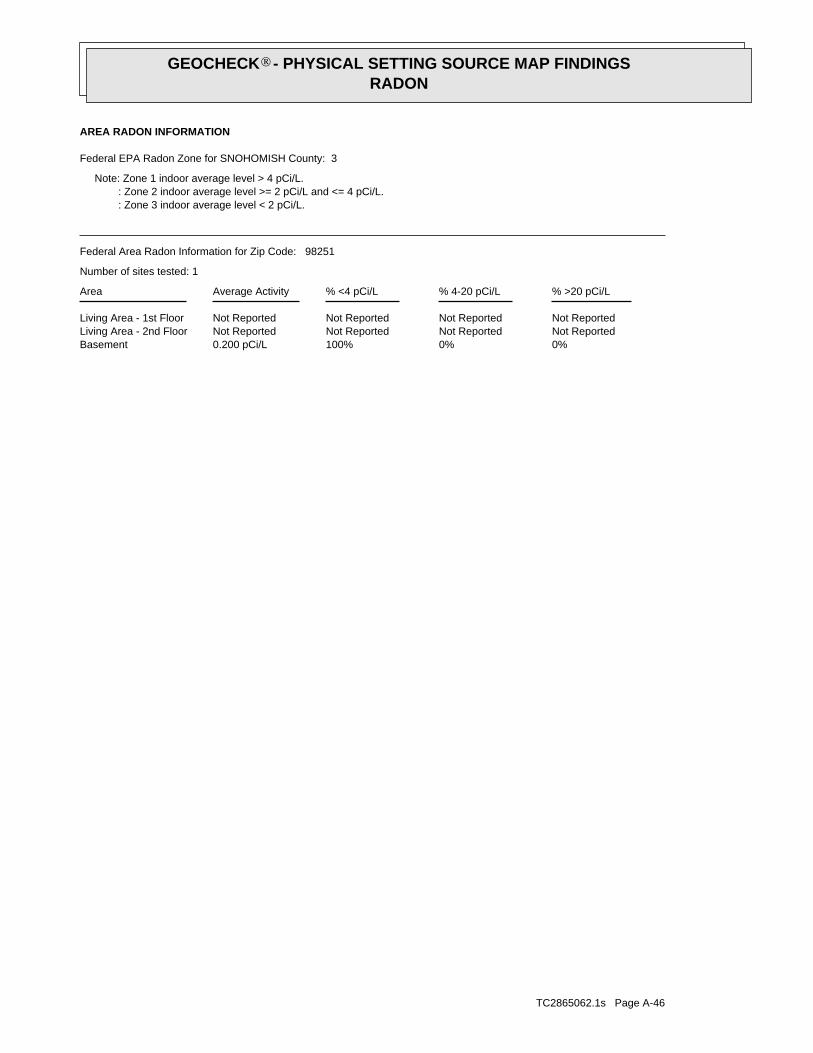
TC2865062.1s Page A-46
0%0%100%0.200 pCi/LBasementNot ReportedNot ReportedNot ReportedNot ReportedLiving Area - 2nd FloorNot ReportedNot ReportedNot ReportedNot ReportedLiving Area - 1st Floor
% >20 pCi/L% 4-20 pCi/L% <4 pCi/LAverage ActivityArea
Number of sites tested: 1
Federal Area Radon Information for Zip Code: 98251
: Zone 3 indoor average level < 2 pCi/L. : Zone 2 indoor average level >= 2 pCi/L and <= 4 pCi/L. Note: Zone 1 indoor average level > 4 pCi/L.
Federal EPA Radon Zone for SNOHOMISH County: 3
AREA RADON INFORMATION
GEOCHECK - PHYSICAL SETTING SOURCE MAP FINDINGSRADON
®
TOPOGRAPHIC INFORMATION
USGS 7.5’ Digital Elevation Model (DEM)Source: United States Geologic SurveyEDR acquired the USGS 7.5’ Digital Elevation Model in 2002 and updated it in 2006. The 7.5 minute DEM correspondsto the USGS 1:24,000- and 1:25,000-scale topographic quadrangle maps. The DEM provides elevation datawith consistent elevation units and projection.
HYDROLOGIC INFORMATION
Flood Zone Data: This data, available in select counties across the country, was obtained by EDR in 2003 & 2009 from the FederalEmergency Management Agency (FEMA). Data depicts 100-year and 500-year flood zones as defined by FEMA.
NWI: National Wetlands Inventory. This data, available in select counties across the country, was obtained by EDRin 2002 and 2005 from the U.S. Fish and Wildlife Service.
HYDROGEOLOGIC INFORMATION
AQUIFLOW Information SystemR
Source: EDR proprietary database of groundwater flow informationEDR has developed the AQUIFLOW Information System (AIS) to provide data on the general direction of groundwater
flow at specific points. EDR has reviewed reports submitted to regulatory authorities at select sites and hasextracted the date of the report, hydrogeologically determined groundwater flow direction and depth to water tableinformation.
GEOLOGIC INFORMATION
Geologic Age and Rock Stratigraphic UnitSource: P.G. Schruben, R.E. Arndt and W.J. Bawiec, Geology of the Conterminous U.S. at 1:2,500,000 Scale - A digitalrepresentation of the 1974 P.B. King and H.M. Beikman Map, USGS Digital Data Series DDS - 11 (1994).
STATSGO: State Soil Geographic DatabaseSource: Department of Agriculture, Natural Resources Conservation ServicesThe U.S. Department of Agriculture’s (USDA) Natural Resources Conservation Service (NRCS) leads the nationalConservation Soil Survey (NCSS) and is responsible for collecting, storing, maintaining and distributing soilsurvey information for privately owned lands in the United States. A soil map in a soil survey is a representationof soil patterns in a landscape. Soil maps for STATSGO are compiled by generalizing more detailed (SSURGO)soil survey maps.
SSURGO: Soil Survey Geographic DatabaseSource: Department of Agriculture, Natural Resources Conservation Services (NRCS)Telephone: 800-672-5559SSURGO is the most detailed level of mapping done by the Natural Resources Conservation Services, mappingscales generally range from 1:12,000 to 1:63,360. Field mapping methods using national standards are used toconstruct the soil maps in the Soil Survey Geographic (SSURGO) database. SSURGO digitizing duplicates theoriginal soil survey maps. This level of mapping is designed for use by landowners, townships and countynatural resource planning and management.
LOCAL / REGIONAL WATER AGENCY RECORDS
FEDERAL WATER WELLS
PWS: Public Water SystemsSource: EPA/Office of Drinking WaterTelephone: 202-564-3750Public Water System data from the Federal Reporting Data System. A PWS is any water system which provides water to at
least 25 people for at least 60 days annually. PWSs provide water from wells, rivers and other sources.
TC2865062.1s Page A-47
PHYSICAL SETTING SOURCE RECORDS SEARCHED