Embed Size (px)
Citation preview

Atlanta BeltLine Corridor Environmental Study April 2012
ATLANTA BELTLINE CORRIDOR ENVIRONMENTAL STUDY
TIER 1 F INAL ENVIRONMENTAL
IMPACT STATEMENT APPENDICES
Prepared for: Atlanta BeltLine, Inc.
and Metropolitan Atlanta Rapid Transit Authority
Prepared by: AECOM/JJG Joint Venture
Atlanta, GA
Version (1.0): April 2012
General Planning Consultant Services RFP P5413
Contract No. 200703566 Work Order No. 2008-07

Atlanta BeltLine Corridor Environmental Study April 2012
Atlanta BeltLine Corridor Environmental Study April 2012
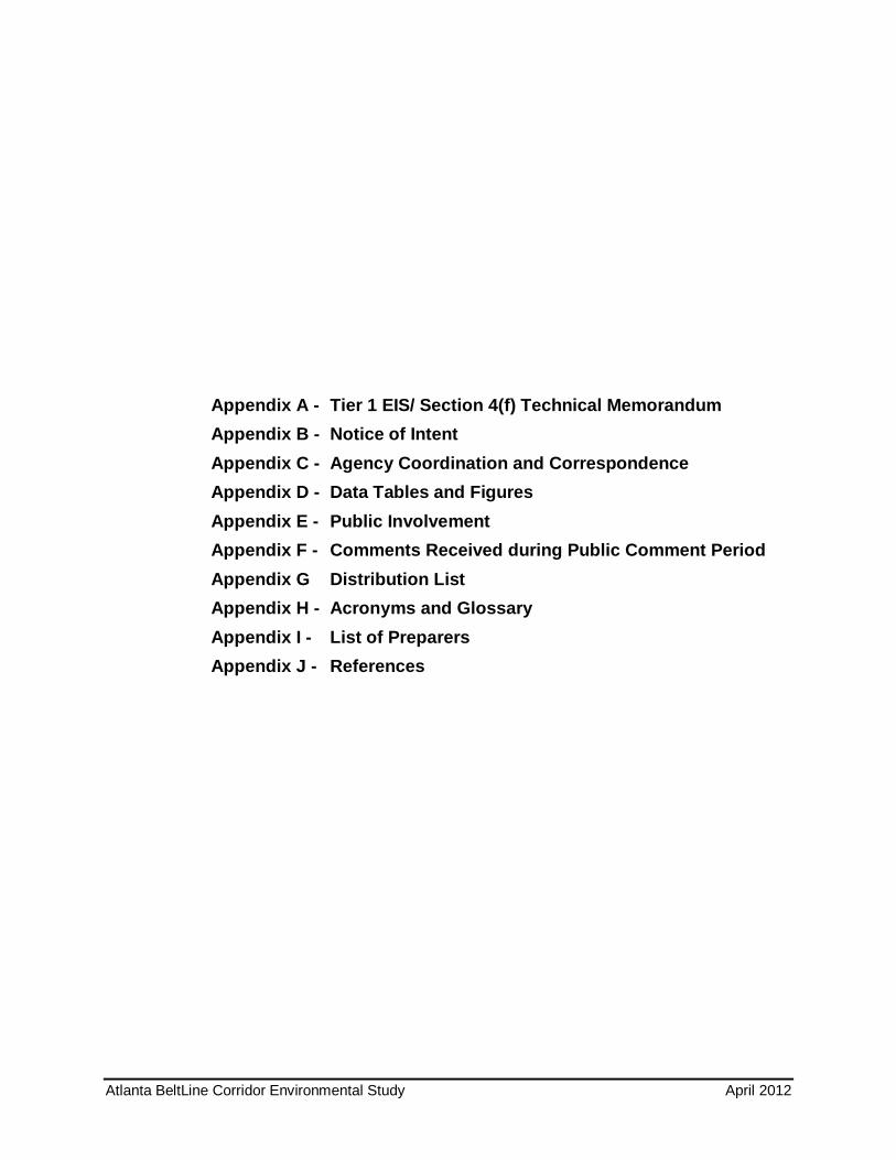
Appendix A - Tier 1 EIS/ Section 4(f) Technical Memorandum Appendix B - Notice of Intent Appendix C - Agency Coordination and Correspondence Appendix D - Data Tables and Figures Appendix E - Public Involvement Appendix F - Comments Received during Public Comment Period Appendix G Distribution List Appendix H - Acronyms and Glossary Appendix I - List of Preparers Appendix J - References

Atlanta BeltLine Corridor Environmental Study April 2012
Page Left Intentionally Blank

Atlanta BeltLine Corridor Environmental Study A April 2012
Appendix A - Tier 1 FEIS/ Section 4(f) Technical Memorandum

Atlanta BeltLine Corridor Environmental Study April 2012
Page Left Intentionally Blank

Atlanta BeltLine Corridor Environmental Study April 2012
Appendix A: FEIS/ 4f Technical Memorandum
ATLANTA BELTLINE COR RIDOR
ENVIRONMENTAL STUDY
T IER 1 FINAL ENVIRONMENTAL
IMPACT STATEMENT /
SECTION 4(F )
TECHNICAL MEMORANDUM
Prepared for: Atlanta BeltLine, Inc.
and Metropolitan Atlanta Rapid Transit Authority
Prepared by: AECOM/JJG Joint Venture
Atlanta, GA
Version (1.0): April 2012
General Planning Consultant Services RFP P5413
Contract No. 200703566
Work Order No. 2008-07

Atlanta BeltLine Corridor Environmental Study April 2012
Appendix A: FEIS/ 4f Technical Memorandum
Page Left Intentionally Blank
Atlanta BeltLine Corridor Environmental Study i April 2012
Appendix A: FEIS/ 4f Technical Memorandum
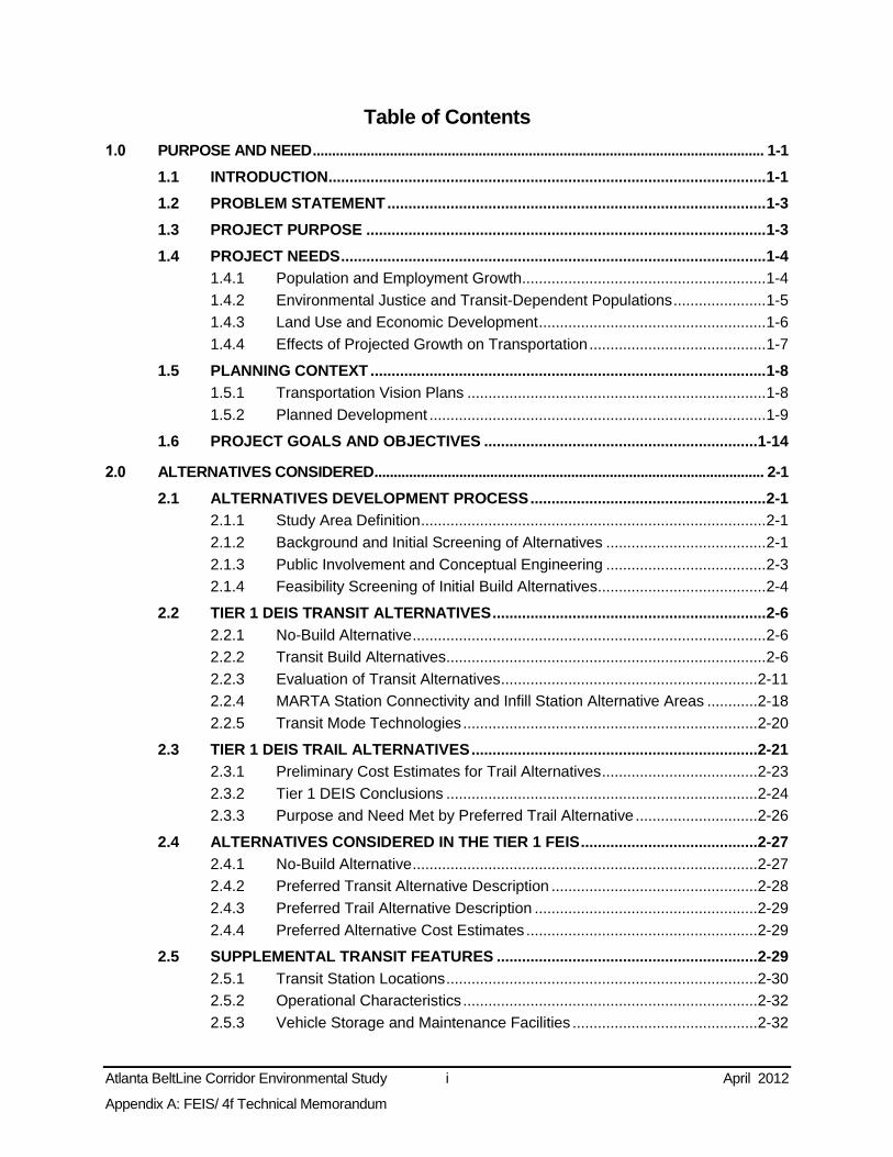
Table of Contents 1.0 PURPOSE AND NEED ..................................................................................................................... 1-1
1.1 INTRODUCTION ........................................................................................................ 1-1
1.2 PROBLEM STATEMENT .......................................................................................... 1-3
1.3 PROJECT PURPOSE ............................................................................................... 1-3
1.4 PROJECT NEEDS ..................................................................................................... 1-4
1.4.1 Population and Employment Growth.......................................................... 1-4
1.4.2 Environmental Justice and Transit-Dependent Populations ...................... 1-5
1.4.3 Land Use and Economic Development ...................................................... 1-6
1.4.4 Effects of Projected Growth on Transportation .......................................... 1-7
1.5 PLANNING CONTEXT .............................................................................................. 1-8
1.5.1 Transportation Vision Plans ....................................................................... 1-8
1.5.2 Planned Development ................................................................................ 1-9
1.6 PROJECT GOALS AND OBJECTIVES ................................................................. 1-14
2.0 ALTERNATIVES CONSIDERED ..................................................................................................... 2-1
2.1 ALTERNATIVES DEVELOPMENT PROCESS ........................................................ 2-1
2.1.1 Study Area Definition .................................................................................. 2-1
2.1.2 Background and Initial Screening of Alternatives ...................................... 2-1
2.1.3 Public Involvement and Conceptual Engineering ...................................... 2-3
2.1.4 Feasibility Screening of Initial Build Alternatives........................................ 2-4
2.2 TIER 1 DEIS TRANSIT ALTERNATIVES ................................................................. 2-6
2.2.1 No-Build Alternative .................................................................................... 2-6
2.2.2 Transit Build Alternatives ............................................................................ 2-6
2.2.3 Evaluation of Transit Alternatives ............................................................. 2-11
2.2.4 MARTA Station Connectivity and Infill Station Alternative Areas ............ 2-18
2.2.5 Transit Mode Technologies ...................................................................... 2-20
2.3 TIER 1 DEIS TRAIL ALTERNATIVES .................................................................... 2-21
2.3.1 Preliminary Cost Estimates for Trail Alternatives ..................................... 2-23
2.3.2 Tier 1 DEIS Conclusions .......................................................................... 2-24
2.3.3 Purpose and Need Met by Preferred Trail Alternative ............................. 2-26
2.4 ALTERNATIVES CONSIDERED IN THE TIER 1 FEIS .......................................... 2-27
2.4.1 No-Build Alternative .................................................................................. 2-27
2.4.2 Preferred Transit Alternative Description ................................................. 2-28
2.4.3 Preferred Trail Alternative Description ..................................................... 2-29
2.4.4 Preferred Alternative Cost Estimates ....................................................... 2-29
2.5 SUPPLEMENTAL TRANSIT FEATURES .............................................................. 2-29
2.5.1 Transit Station Locations .......................................................................... 2-30
2.5.2 Operational Characteristics ...................................................................... 2-32
2.5.3 Vehicle Storage and Maintenance Facilities ............................................ 2-32

Atlanta BeltLine Corridor Environmental Study ii April 2012
Appendix A: FEIS/ 4f Technical Memorandum
2.5.4 Transit and Multi-Use Trail Cross Sections .............................................. 2-33
3.0 AFFECTED ENVIRONMENT ........................................................................................................... 3-1
3.1 SUMMARY OF POTENTIAL ENVIRONMENTAL EFFECTS................................... 3-1
3.2 TRANSPORTATION SYSTEMS AND FACILITIES ................................................. 3-1
3.2.1 Methodology ............................................................................................... 3-1
3.2.2 Travel Patterns ........................................................................................... 3-7
3.2.3 Transit Services ........................................................................................ 3-11
3.2.4 Roadway System...................................................................................... 3-16
3.2.5 Freight Rail ............................................................................................... 3-20
3.2.6 Passenger Rail ......................................................................................... 3-27
3.2.7 Pedestrian and Bicycle ............................................................................. 3-29
3.2.8 Consistency with Transportation Plans .................................................... 3-33
3.2.9 Potential Avoidance, Minimization, and Mitigation Measures .................. 3-34
3.2.10 Subsequent Analysis ................................................................................ 3-36
3.3 LAND USE AND ZONING ....................................................................................... 3-36
3.3.1 Methodology ............................................................................................. 3-36
3.3.2 Land Use .................................................................................................. 3-37
3.3.3 Zoning ....................................................................................................... 3-45
3.3.4 Local Plans ............................................................................................... 3-48
3.3.5 Economic Conditions and Development Strategies ................................. 3-50
3.3.6 Potential Avoidance, Minimization, and Mitigation Measures .................. 3-50
3.3.7 Subsequent Analysis ................................................................................ 3-51
3.4 NEIGHBORHOODS AND COMMUNITY FACILITIES ........................................... 3-51
3.4.1 Methodology ............................................................................................. 3-51
3.4.2 Affected Environment ............................................................................... 3-51
3.4.3 Preliminary Environmental Consequences .............................................. 3-53
3.4.4 Potential Avoidance, Minimization, and Mitigation Measures .................. 3-55
3.4.5 Subsequent Analysis ................................................................................ 3-55
3.5 SOCIOECONOMICS AND ENVIRONMENTAL JUSTICE ..................................... 3-56
3.5.1 Methodology ............................................................................................. 3-56
3.5.2 Affected Environment - Socioeconomics ................................................. 3-57
3.5.3 Affected Environment - Environmental Justice ........................................ 3-66
3.5.4 Preliminary Environmental Consequences .............................................. 3-70
3.5.5 Potential Avoidance, Minimization, and Mitigation Measures .................. 3-76
3.5.6 Subsequent Analysis ................................................................................ 3-76
3.6 VISUAL AND AESTHETIC RESOURCES ............................................................. 3-77
3.6.1 Methodology ............................................................................................. 3-77
3.6.2 Affected Environment ............................................................................... 3-77
3.6.3 Preliminary Environmental Consequences .............................................. 3-78
3.6.4 Potential Avoidance, Minimization, and Mitigation Measures .................. 3-79
3.6.5 Subsequent Analysis ................................................................................ 3-79

Atlanta BeltLine Corridor Environmental Study iii April 2012
Appendix A: FEIS/ 4f Technical Memorandum
3.7 CULTURAL, HISTORIC, AND ARCHAEOLOGICAL RESOURCES .................... 3-79
3.7.1 Methodology ............................................................................................. 3-79
3.7.2 Affected Environment ............................................................................... 3-81
3.7.3 Potential Avoidance, Minimization, and Mitigation Measures .................. 3-85
3.7.4 Subsequent Analysis ................................................................................ 3-85
3.8 PARKS AND RECREATIONAL RESOURCES ...................................................... 3-85
3.8.1 Methodology ............................................................................................. 3-85
3.8.2 Planning Context ...................................................................................... 3-86
3.8.3 Affected Environment ............................................................................... 3-86
3.8.4 Preliminary Environmental Consequences .............................................. 3-88
3.8.5 Potential Avoidance, Minimization, and Mitigation Measures .................. 3-90
3.8.6 Subsequent Analysis ................................................................................ 3-91
3.9 SAFETY AND SECURITY ....................................................................................... 3-91
3.9.1 Methodology ............................................................................................. 3-91
3.9.2 Affected Environment ............................................................................... 3-92
3.9.3 Environmental Consequences ................................................................. 3-92
3.9.4 Potential Avoidance, Minimization, and Mitigation Measures .................. 3-94
3.9.5 Subsequent Analysis ................................................................................ 3-94
3.10 CONTAMINATED AND HAZARDOUS MATERIALS ............................................ 3-94
3.10.1 Methodology ............................................................................................. 3-95
3.10.2 Affected Environment ............................................................................... 3-96
3.10.3 Preliminary Environmental Consequences .............................................. 3-98
3.10.4 Potential Avoidance, Minimization, and Mitigation Measures ................3-101
3.10.5 Subsequent Analysis ..............................................................................3-101
3.11 UTILITIES ..............................................................................................................3-102
3.11.1 Methodology ...........................................................................................3-102
3.11.2 Affected Environment .............................................................................3-102
3.11.3 Preliminary Environmental Consequences ............................................3-103
3.11.4 Potential Avoidance, Minimization, and Mitigation Measures ................3-105
3.11.5 Subsequent Analysis ..............................................................................3-105
3.12 AIR QUALITY ........................................................................................................3-105
3.12.1 Methodology ...........................................................................................3-105
3.12.2 Preliminary Environmental Consequences ............................................3-108
3.12.3 Transportation Conformity Determination ..............................................3-109
3.12.4 Potential Avoidance, Minimization, and Mitigation Measures ................3-109
3.12.5 Subsequent Analysis ..............................................................................3-109
3.13 NOISE AND VIBRATION ......................................................................................3-110
3.13.1 Methodology ...........................................................................................3-110
3.13.2 Affected Environment .............................................................................3-112
3.13.3 Preliminary Environmental Consequences ............................................3-113
3.13.4 Potential Avoidance, Minimization, and Mitigation Measures ................3-113

Atlanta BeltLine Corridor Environmental Study iv April 2012
Appendix A: FEIS/ 4f Technical Memorandum
3.13.5 Subsequent Analysis ..............................................................................3-114
3.14 ENERGY ................................................................................................................3-114
3.14.1 Methodology ...........................................................................................3-114
3.14.2 Affected Environment .............................................................................3-114
3.14.3 Preliminary Environmental Consequences ............................................3-115
3.14.4 Potential Avoidance, Minimization, and Mitigation Measures ................3-116
3.14.5 Subsequent Analysis ..............................................................................3-117
3.15 WATER RESOURCES ..........................................................................................3-117
3.15.1 Methodology ...........................................................................................3-117
3.15.2 Affected Environment .............................................................................3-118
3.15.3 Environmental Consequences ...............................................................3-120
3.15.4 Potential Avoidance, Minimization, and Mitigation Measures ................3-123
3.15.5 Potentially Required Permits and Approvals ..........................................3-124
3.15.6 Subsequent Analysis ..............................................................................3-124
3.16 BIOLOGICAL RESOURCES.................................................................................3-124
3.16.1 Methodology ...........................................................................................3-124
3.16.2 Affected Environment .............................................................................3-125
3.16.3 Preliminary Environmental Consequences ............................................3-127
3.16.4 Potential Avoidance, Minimization, and Mitigation Measures ................3-128
3.16.5 Potentially Required Permits ..................................................................3-128
3.16.6 Subsequent Analysis ..............................................................................3-128
3.17 GEOLOGIC RESOURCES ....................................................................................3-128
3.17.1 Methodology ...........................................................................................3-129
3.17.2 Affected Environment .............................................................................3-129
3.17.3 Preliminary Environmental Consequences ............................................3-130
3.17.4 Potential Avoidance, Minimization, and Mitigation Measures ................3-130
3.17.5 Subsequent Analysis ..............................................................................3-130
4.0 SECONDARY AND CUMULATIVE EFFECTS .............................................................................. 4-1
4.1 METHODOLOGY ....................................................................................................... 4-1
4.2 LEGAL AND REGULATORY CONTEXT ................................................................. 4-1
4.2.1 Secondary Impacts ..................................................................................... 4-1
4.2.2 Cumulative Impacts .................................................................................... 4-2
4.3 POTENTIAL FOR SECONDARY AND CUMULATIVE IMPACTS ........................... 4-2
4.3.1 Potential Sensitive Resources ................................................................... 4-2
4.3.2 Potential Area of Effect ............................................................................... 4-2
4.3.3 Potential for Secondary Effects .................................................................. 4-3
4.3.4 Potential for Cumulative Effects ................................................................. 4-3
5.0 CONSTRUCTION IMPACTS ........................................................................................................... 5-1
5.1 PROBABLE IMPACTS AND POTENTIAL MITIGATION STRATEGIES ................ 5-1
5.1.1 Disruption to Existing Businesses .............................................................. 5-1

Atlanta BeltLine Corridor Environmental Study v April 2012
Appendix A: FEIS/ 4f Technical Memorandum
5.1.2 Neighborhoods and Community Cohesion ................................................ 5-1
5.1.3 Visual and Aesthetic Quality....................................................................... 5-2
5.1.4 Parks and Recreation ................................................................................. 5-2
5.1.5 Freight Rail Operations .............................................................................. 5-3
5.1.6 Air Quality ................................................................................................... 5-3
5.1.7 Noise and Vibration .................................................................................... 5-4
5.1.8 Water Resources ........................................................................................ 5-4
5.1.9 Infrastructure and Utilities ........................................................................... 5-5
5.1.10 Contamination ............................................................................................ 5-5
6.0 PRELIMINARY SECTION 4(F) EVALUATION .............................................................................. 6-1
6.1 METHODOLOGY ....................................................................................................... 6-1
6.2 LEGAL AND REGULATORY CONTEXT ................................................................. 6-1
6.2.1 Section 4(f) ................................................................................................. 6-1
6.3 AFFECTED ENVIRONMENT .................................................................................... 6-2
6.3.1 Section 4(f)/6(f) Properties ......................................................................... 6-2
6.4 PRELIMINARY SECTION 4(F) ANALYSIS .............................................................. 6-2
6.4.1 No-Build Alternative .................................................................................... 6-2
6.4.2 Preferred Alternatives ................................................................................. 6-3
6.5 CONCLUSIONS ......................................................................................................... 6-4
7.0 PUBLIC INVOLVEMENT .................................................................................................................. 7-1
7.1 PUBLIC INVOLVEMENT AND AGENCY COORDINATION PLAN SUMMARY ..... 7-1
7.2 PUBLIC INVOLVEMENT ACTIVITIES ...................................................................... 7-1
7.3 PUBLIC INVOLVEMENT: SCOPING, WORKSHOPS, AND MEETINGS ............... 7-2
7.3.1 Fall 2008 Public Scoping Meetings ............................................................ 7-2
7.3.2 Spring 2009 Public Workshops .................................................................. 7-3
7.3.3 Fall 2009 and 2010 Public Meetings .......................................................... 7-5
7.3.4 Public Hearing and Public Comment Period .............................................. 7-6
7.4 AGENCY INVOLVEMENT: COORDINATION, COMMITTEES, AND MEETINGS . 7-7
7.4.1 Lead Agencies and the Technical Advisory Committee ............................ 7-8
7.4.2 Stakeholder Advisory Committee ............................................................... 7-9
7.5 COMMUNICATION TOOLS .................................................................................... 7-11
7.5.1 Stakeholder Contact Database ................................................................ 7-11
7.5.2 Project Website and Email ....................................................................... 7-11
7.5.3 Newsletter ................................................................................................. 7-12
7.5.4 Study Update ............................................................................................ 7-12
7.5.5 Telephone Hotline and Business Card .................................................... 7-12
7.5.6 Media Relations ........................................................................................ 7-12
7.5.7 Comment Form ......................................................................................... 7-12
8.0 ISSUES TO BE RESOLVED AND NEXT STEPS .......................................................................... 8-1

Atlanta BeltLine Corridor Environmental Study vi April 2012
Appendix A: FEIS/ 4f Technical Memorandum
APPENDIX B – NOI ........................................................................................................................................ B-1
APPENDIX C – AGENCY COORDINATION AND CORRESPONDENCE ............................................... C-1
APPENDIX D – DATA TABLES AND FIGURES ........................................................................................ D-1
APPENDIX E – PUBLIC INVOLVEMENT .................................................................................................... E-1
APPENDIX F – COMMENTS RECEIVED DURING PUBLIC COMMENT PERIOD ................................ F-1
APPENDIX G – DISTRIBUTION LIST ..........................................................................................................G-1
APPENDIX H – ACRONYMS AND GLOSSARY ........................................................................................ H-1
APPENDIX I – LIST OF PREPARERS ...........................................................................................................I-1
APPENDIX J – REFERENCES ..................................................................................................................... J-1
List of Tables Table 1-1: Environmental Justice and Transit-Dependent Populations (2000).................................. 1-6
Table 1-2: Atlanta BeltLine Goals, Objectives, and Performance Measures ................................... 1-14
Table 2-1: Feasibility Screening of Initial Build Alternatives ............................................................... 2-5
Table 2-2: Transit Alternative Characteristics and Constraints in Northwest Zone ......................... 2-12
Table 2-3: Summary of Performance Measure Results By Alignments for All Goals ...................... 2-13
Table 2-4: Summary of Preliminary Transit Capital Cost Estimates ................................................ 2-14
Table 2-7: Summary of Typical Mode Characteristics ...................................................................... 2-20
Table 2-8: Mode Characteristics and Constraints as Applied to the Atlanta BeltLine Project ......... 2-21
Table 2-9: Trail Alternative Characteristics and Constraints in Northwest Zone ............................. 2-23
Table 2-10: Summary of Preliminary Capital Cost Estimates for Trails ........................................... 2-23
Table 2-11: Potential Station Locations ............................................................................................ 2-30
Table 3-1: Summary of Potential Effects for the No-Build and Preferred Alternatives ...................... 3-2
Table 3-2: Preliminary Travel Times and Travel-Time Savings ....................................................... 3-10
Table 3-3: Population and Employment within ½-mile of the Proposed Transit Stations ............... 3-11
Table 3-4: Transit-Dependent, Low-Income, and Minority Populations within ½-mile of the Proposed Transit Stations - 2000 ............................................................................................. 3-11
Table 3-5: MARTA Rail Stations ....................................................................................................... 3-11
Table 3-6: Potential Effects of At-Grade Crossings .......................................................................... 3-19
Table 3-7: Potential Effects, Proposed In-Street Sections ............................................................... 3-20
Table 3-8: Characteristics of Active Freight Rail Corridors within the Study Area ........................... 3-20
Table 3-9: On-Street Bicycle Routes Intersecting the Preferred Transit Alternative ........................ 3-30
Table 3-10: Atlanta BeltLine Projects in Envision6 RTP/TIP ............................................................ 3-33

Atlanta BeltLine Corridor Environmental Study vii April 2012
Appendix A: FEIS/ 4f Technical Memorandum
Table 3-11: Acres of Potential Direct or Indirect Land Use Effect .................................................... 3-40
Table 3-12: Direct Land Use Effects ................................................................................................. 3-40
Table 3-13: Potential Changes in Land Use in Service Areas ......................................................... 3-43
Table 3-14: Underutilized Land within ½-mile of the Potential Station Locations ............................ 3-45
Table 3-15: Potential Residential and Commercial Development Capacity ..................................... 3-45
Table 3-16: Zoning of ROWs ............................................................................................................ 3-47
Table 3-17: Neighborhoods .............................................................................................................. 3-53
Table 3-18: Potentially Served or Affected Neighborhoods and Community Facilities .................... 3-54
Table 3-19: Population - 1990 to 2030 ............................................................................................. 3-57
Table 3-20: Employment - 1990 to 2030 .......................................................................................... 3-58
Table 3-21: Households - 1990 to 2030 ........................................................................................... 3-63
Table 3-22: Housing Units and Housing Unit Growth - 1990 to 2030 .............................................. 3-66
Table 3-23: Population below Poverty Level .................................................................................... 3-67
Table 3-24: Minority Populations - 2000 ........................................................................................... 3-67
Table 3-25: Zero-Car Households and Percent of Workers Using Public Transportation - 2000 .... 3-70
Table 3-26: Population and Employment within ½-mile of the Proposed Transit Station ............... 3-72
Table 3-27: Housing and Employment within ½-mile of the Proposed Trail Access Points ............ 3-73
Table 3-28: Transit-Dependent, Low-Income, and Minority Populations within ½-mile of the Proposed Transit Station Locations - 2000 ............................................................. 3-73
Table 3-29: Potential Effects on Environmental Justice Populations within the Study Area ........... 3-74
Table 3-30: Potentially Sensitive Views and Visual Resources by Zone ......................................... 3-78
Table 3-31: Number of Historic and Archaeological Resources by Zone ........................................ 3-82
Table 3-32: Potential Impacts to Cultural Resources ....................................................................... 3-84
Table 3-33: No-Build Alternative: Planned Park, Pedestrian, and Multi-Use Trail Resource Improvements within the Study Area ....................................................................... 3-88
Table 3-34: Number of Parks and Recreational Resources Accessible by the Preferred Alternatives by Zone .................................................................................................................... 3-89
Table 3-35: Estimated Exclusive Right-of-Way and Access Points for Multi-Use Trails .................. 3-93
Table 3-36: Preliminary Federal and State Reports and Database Reports .................................... 3-97
Table 3-37: Preliminary Recognized Environmental Condition (REC) Sites .................................... 3-98
Table 3-38: Preliminary Number of REC and CERCLA-Related Sites ..........................................3-100
Table 3-39: Preliminary Number of Potential Direct Impacts to REC Sites, CERCLA-Related Sites and Buildings ..........................................................................................................3-100
Table 3-40: Potential Utility Effects of the Preferred Transit Alternative ........................................3-104
Table 3-41: Ridership Estimates - 2030 .........................................................................................3-108
Table 3-42: Existing and Projected Traffic Growth and Roadway Congestion - 2000 and 2030 ...3-109
Table 3-43: Number of Residences within the FTA Noise Screening Distances ...........................3-113
Table 3-44: Annual Energy Savings ...............................................................................................3-116
Table 3-45: Water Resource Terminology ......................................................................................3-117
Table 3-46: Stream Crossings by Zone ..........................................................................................3-118
Table 3-47: Potential Impacts to Streams ......................................................................................3-123
Table 3-48: Amount of New Impervious Surface Outside of MARTA Rail Station Areas ..............3-123
Table 3-49: Listed Plant and Animal Species in Fulton County .....................................................3-126
Atlanta BeltLine Corridor Environmental Study viii April 2012
Appendix A: FEIS/ 4f Technical Memorandum
Table 6-1: Parks and Recreational Properties .................................................................................... 6-3
Table 6-2: Significant Historic Sites Potentially Affected .................................................................... 6-4
Table 6-3: Potential Uses of Publicly Owned Park and Recreation Properties ................................. 6-5
Table 7-1: Summary of Comments Received During Public Comment Period .................................. 7-7
List of Figures Figure 1-1: Atlanta BeltLine Study Area and Zones ........................................................................... 1-2
Figure 1-2: Population Growth 1990 to 2030 ...................................................................................... 1-4
Figure 1-3: Employment Growth 1990 to 2030 ................................................................................... 1-5
Figure 1-4: Existing and Proposed Activity Centers and Trip Generators ....................................... 1-10
Figure 1-5: Economic Development Focus Areas ............................................................................ 1-13
Figure 2-1: Atlanta BeltLine Timeline.................................................................................................. 2-2
Figure 2-2: Transit Build Alternatives Using CSX Corridor ................................................................. 2-7
Figure 2-3: Transit Build Alternatives Adjacent to but Outside the CSX Corridor .............................. 2-9
Figure 2-4: Transit Build Alternatives Adjacent to the Norfolk Southern Corridor ............................ 2-10
Figure 2-5: Preferred Transit Alternative .......................................................................................... 2-16
Figure 2-6: Areas Surrounding MARTA Station Connectivity and Infill Station Alternatives ........... 2-19
Figure 2-7: Trail Build Alternatives .................................................................................................... 2-22
Figure 2-8: Preferred Trail Alternative .............................................................................................. 2-25
Figure 2-9: Typical Section of Trail and Transit ................................................................................ 2-33
Figure 3-1: Existing Transit Service .................................................................................................. 3-14
Figure 3-2: 2030 Roadway Volumes and Congestion Levels .......................................................... 3-17
Figure 3-3: In-Street Sections – Preferred Transit Alternative ......................................................... 3-21
Figure 3-4: Freight Rail Corridors and Facilities ............................................................................... 3-22
Figure 3-5: Freight and Amtrak Rail Traffic Volumes ....................................................................... 3-23
Figure 3-6: Typical Section of Transit and Trails Elements in Freight Rail ROW ............................ 3-26
Figure 3-7: Proposed Commuter Train Routes ................................................................................ 3-28
Figure 3-8: Planned On-Street Bicycle Routes and Multi-Use Trails ............................................... 3-31
Figure 3-9: Future Land Use Map (FLUM) ....................................................................................... 3-38
Figure 3-10: Future Land Use Map (FLUM) ..................................................................................... 3-39
Figure 3-11: Additional Required Right-of-Way ................................................................................ 3-42
Figure 3-12: Zoning in the Study Area .............................................................................................. 3-46
Figure 3-13: Atlanta BeltLine Subarea Master Plans ....................................................................... 3-49
Figure 3-14: Neighborhoods ............................................................................................................. 3-52
Figure 3-15: Population Density - 2008 ............................................................................................ 3-59
Figure 3-16: Population Density - 2030 ............................................................................................ 3-60
Figure 3-17: Employment Density - 2008 ........................................................................................ 3-61
Figure 3-18: Employment Density - 2030 ......................................................................................... 3-62
Figure 3-19: Household Density - 2008 ............................................................................................ 3-64
Figure 3-20: Household Density - 2030 ............................................................................................ 3-65
Figure 3-21: Population below Poverty Level - 2000 ........................................................................ 3-68
Figure 3-22: Minority Population - 2000............................................................................................ 3-69

Atlanta BeltLine Corridor Environmental Study ix April 2012
Appendix A: FEIS/ 4f Technical Memorandum
Figure 3-23: Zero-Car Households - 2000 ........................................................................................ 3-71
Figure 3-24: Historic Resources ....................................................................................................... 3-83
Figure 3-25: Parks............................................................................................................................. 3-87
Figure 3-26: Preliminary REC and Current and Former CERCLA Sites within the 300-Foot Buffer Area .......................................................................................................................... 3-99
Figure 3-27: Typical A-Weighted Noise Levels ..............................................................................3-111
Figure 3-28: Typical Ground-Borne Vibration Levels .....................................................................3-112
Figure 3-29: Study Area Surface Water Resources .......................................................................3-119
Figure 3-30: Floodplains .................................................................................................................3-121
Figure 3-31: Potential Crossings of Water Resources ...................................................................3-122

Atlanta BeltLine Corridor Environmental Study i April 2012
Appendix A: FEIS/ 4f Technical Memorandum
Page Left Intentionally Blank

Atlanta BeltLine Corridor Environmental Study 1-1 April 2012
Appendix A: FEIS/ 4f Technical Memorandum
1.0 PURPOSE AND NEED
1.1 Introduction The Federal Transit Administration (FTA), an administration of the U.S. Department of Transportation (USDOT), has prepared this Tier 1 Final Environmental Impact Statement (FEIS) Technical Memorandum for the Atlanta BeltLine in the City of Atlanta, Fulton County, Georgia, in cooperation with the Metropolitan Atlanta Rapid Transit Authority (MARTA), which operates and maintains bus and rail transit service in the Atlanta region.
The Atlanta BeltLine is a proposed fixed guideway transit and multi-use trails system with a corridor of approximately 22 miles encircling central Atlanta. The Atlanta BeltLine study area is defined as a ¼-mile on each side of the proposed corridor, considered a comfortable walking distance. The study area is comprised of four zones: northeast, southeast, southwest, and northwest. Figure 1-1 illustrates the Atlanta BeltLine study area.
This FEIS/ 4(f) Technical Memorandum is an appendix (Appendix A) to the main Tier 1 FEIS/ Section 4(f) Evaluation. It presents the technical data and evaluation methodologies used in assessing the No-Build and Preferred Alternatives. Preparation of this FEIS/ 4(f) Technical Memorandum is in accord with the National Environmental Policy Act (NEPA), as amended and implemented by:
the Council on Environmental Quality (CEQ) regulations (40 CFR parts 1500-1508);
FTA regulations (23 CFR part 771);
FTA Statewide Planning and Metropolitan Planning regulations (23 CFR part 450);
regulations of the Safe, Accountable, Flexible, Efficient Transportation Equity Act: A Legacy for Users (SAFETEA-LU) (Public Law 109-59);
regulations of Section 106 of the National Historic Preservation Act of 1966;
the Clean Air Act Amendments of 1990;
Executive Order 12898 on Environmental Justice; and,
other applicable statutes, rules, and regulations.
Tiering of the EIS allowed FTA and MARTA to focus on those decisions that are ready for this level of NEPA analysis to support future right-of-way (ROW) preservation, local master planning, and project development activities. These decisions included the following:
identification of either Modern Streetcar (SC) or Light Rail Transit (LRT) technology as the transit mode;
identification of a general alignment of new transit and trails; and,
establishment of ROW requirements.
Following the Tier 1 EIS process, subsequent analysis in a Tier 2 NEPA process as a separate action will refine the preferred transit and trail alignments to achieve the most cost-effective investment while avoiding or minimizing potential adverse environmental effects; identify and evaluate transit station locations, vehicle types, maintenance and

Atlanta BeltLine Corridor Environmental Study 1-2 April 2012
Appendix A: FEIS/ 4f Technical Memorandum
storage facilities, site-specific impacts, trail design elements, and mitigation measures for unavoidable adverse affects.
Figure 1-1: Atlanta BeltLine Study Area and Zones
Source: AECOM/JJG Joint Venture

Atlanta BeltLine Corridor Environmental Study 1-3 April 2012
Appendix A: FEIS/ 4f Technical Memorandum
1.2 Problem Statement The City of Atlanta is challenged to meet its mobility, housing, and economic development needs by its uneven and low-density growth patterns, a lack of affordable housing, deficiencies of transportation connectivity across all modes, underutilization of existing transportation resources, and limited transit, bicycle, and pedestrian options to address travel needs. Individually, each of these issues contributes to reduced quality of life, mobility, and economic competitiveness. Together, they are a severe impediment to creating sustainable growth and a vibrant livable community in the years to come. If the City is to address these problems proactively, a comprehensive and progressive solution is required to integrate land use, economic development, social, and transportation needs holistically.
Mobility and access in the study area are challenged by a fragmented and discontinuous transportation network and a lack of transit, bicycle, and pedestrian options as follows:
The existing transportation network is frequently fragmented by major physical barriers including active and abandoned railroad lines and yards and interstate highways. It is also characterized by discontinuous local roadway, bicycle, and pedestrian networks and superblock development patterns. These deficiencies are particularly acute adjacent to the proposed Atlanta BeltLine railroad corridors, where the continuity of the transportation network is broken by: 1) the numerous large tracts of underutilized industrial land that lack an urban transportation grid; and 2) the high density of railroad ROW and related facilities that have few existing crossings (Please refer to Chapter 3.2 for a detailed description of the transportation system in the study area)
There is a lack of connections between these limited transit options in the study area. The existing rail and bus transit network provides limited coverage and connectivity in the study area and is focused primarily on providing service to the Central Business District (CBD) rather than circulation within the study area or to other activity centers in the City. (Chapter 3.2.5 see railroad facilities map and Chapter 3.3.4 see Atlanta BeltLine Subarea Master Plans and Connect Atlanta Plan).
Stops on the existing rail service are infrequent within the study area forcing most study area residents to access rail via a bus transfer or walking (Please refer to Chapter 3.2.6 for details on the passenger rail service in the study area).
Non-motorized access options are also limited as a result of discontinuous or absent links in the City’s pedestrian and bicycle network, making walk access to activity centers and the rail and bus system challenging (Please refer to Chapter 3.2.7 for further details on the pedestrian and bicycle network in the study area).
These transit and non-motorized conditions are particularly evident when travel between communities and neighborhoods within the City is attempted. These so-called local trips are the dominant type of travel in the City and are most often accomplished by personal automobile (Chapter 1.4.4). Transportation-related problems caused by the deficiencies listed above include limited access and mobility, increased travel times, and roadway congestion (Chapter 1.4.4 and Chapter 3.2). These problems also contribute to a lack of economic opportunity at the individual, communitywide, and citywide levels.
1.3 Project Purpose The transportation purpose of the Atlanta BeltLine project is to improve access and mobility for existing and future residents and workers by increasing in-city transit and

Atlanta BeltLine Corridor Environmental Study 1-4 April 2012
Appendix A: FEIS/ 4f Technical Memorandum
bicycle/pedestrian options, and providing links in and between those networks. In addition, the Atlanta BeltLine has a land use and economic development component that is intended to stimulate economic activity and structure growth. The combined purpose of the transportation and land use components of the Atlanta BeltLine is to encourage balanced growth in all study area zones by increasing transportation options, greenspace, affordable housing, and improving livability and economic opportunities.
1.4 Project Needs This section summarizes the project needs for the Atlanta BeltLine project. More detail on the issues described in this section may be found in Chapters 3.2, 3.3, 3.5 and 3.8 of this FEIS/ 4(f) Technical Memorandum.
1.4.1 Population and Employment Growth
In 2030, population in the City of Atlanta is projected to increase to 602,700, a 26 percent increase. The study area population is projected to increase by 26 percent to a population of 97,900 during the same period. The percentage increases in population by zone by 2030 are: 41 percent in the northeast; 37 percent in the southeast; 13 percent in the southwest; and 20 percent in northwest. In the City, employment is projected to increase by about 136,000 jobs, or 34 percent by 2030. Employment growth in the zones by 2030 will range from a 6 percent increase in the southwest to a 77 percent increase in the northeast.
Figure 1-2 and Figure 1-3 present the growth rates for years 1990 to 2000 and projections for the year 2030 for population and employment, respectively. These data point to a need to provide public transit improvements to accommodate growing population and employment in the study area.
Figure 1-2: Population Growth 1990 to 2030
Source: U.S. Census Bureau and Atlanta Regional Commission (ARC)

Atlanta BeltLine Corridor Environmental Study 1-5 April 2012
Appendix A: FEIS/ 4f Technical Memorandum
Figure 1-3: Employment Growth 1990 to 2030
Source: U.S. Census Bureau and ARC
1.4.2 Environmental Justice and Transit-Dependent Populations
Compared to Fulton County, the study area contains relatively high percentages of minority and low-income populations that qualify as environmental justice populations, as well as populations without access to automobiles, the latter known herein as zero-car populations as defined by the U.S. Census Bureau. Public transportation options are often critical to the mobility of these population groups. Table 1-1 presents 2000 U.S. Census percentages for environmental justice and zero-car populations within the Atlanta BeltLine study area zones, the entire study area, the City, and Fulton County. These data show the southwest and southeast zones are environmental justice areas with a higher percentage of people living below the poverty level, minority populations, and transit–dependent1 populations in 2000 compared to the other Atlanta BeltLine study area zones, city, and county. These data indicate a need to provide public transit and bicycle/pedestrian options in those areas in which environmental justice populations have been identified in the study area.
1 Transit-dependent populations are defined by the U.S. Census Bureau in the Census 2000 as individuals in zero-car households and workers over 16 reporting the use of transit to get to work.

Atlanta BeltLine Corridor Environmental Study 1-6 April 2012
Appendix A: FEIS/ 4f Technical Memorandum
Table 1-1: Environmental Justice and Transit-Dependent Populations (2000)
Area Percent Below
Poverty Percent Minority
Population
Percent Transit Dependent Population
Northeast Zone of the Study Area 19.4% 44.9% 14.5%
Southeast Zone of the Study Area 28.0% 72.1% 15.5%
Southwest Zone of the Study Area 33.9% 98.9% 26.1%
Northwest Zone of the Study Area 19.8% 50.1% 12.4%
Atlanta BeltLine Study Area* 23.8% 60.9% 15.0%
Atlanta 24.4% 68.7% 15.0%
Fulton County 15.7% 54.7% 9.3%
* Includes the northeast, southeast, southwest, and northwest zones. Source: U.S. Census Bureau, Summary File 3, 2000 Note: The U.S. Census Bureau determines poverty status for all people except institutionalized people, people in military group quarters, people in college dormitories, and unrelated individuals under 15 years old. 1.4.3 Land Use and Economic Development
Over the past 30 years, Atlanta’s real estate development pattern has been skewed to the northern and eastern zones of the City. Much of this activity has been dominated by low-density, auto-centric development, such as single-family and townhouse residential development. Meanwhile, in the southeast and southwest zones, little to no development occurred during the same period. Losses in population and employment occurred in the southeast and southwest zones during a period of exceptionally strong growth in the Atlanta region. Market and demographic analyses show that without intervention these trends are set to continue into the future (see Chapter 3.5.2 for a description of the demographic trends in the study area).
The effect of this development pattern has been to generate a large number of both work and non-work vehicle trips to and within the northeast and northwest zones, creating congestion and impaired mobility that reduces quality of life and limits the potential of the available development sites to be re-purposed to a higher intensity use (see Chapter 3.2 for a description of the existing traffic conditions). In these zones, the existing transportation infrastructure is ROW constrained leaving limited opportunities to provide additional capacity improvements through the establishment of new corridors or expansion of existing facilities.
In the southeast and southwest zones, development patterns have generated relatively stable or declining travel demands. This has resulted in low congestion levels (see Chapter 3.2), reduced job opportunities and economic vitality (see Chapter 3.5 for a description of the employment growth patterns in the study area), and a large number of prime redevelopment sites that are impaired by the low level of market demand and surrounding blight (see Chapter 3.3 for a description of existing land uses). For example, 15 percent of land in the southeast zone is vacant compared with an overall study area average of 13 percent and a low of 11 percent in the northeast zone.
If the existing low-density land use patterns and skewed development trends continue this may lead to increased roadway congestion, decreased mobility, and a reduced quality of life in the northwest and northeast zones, while doing nothing to address the

Atlanta BeltLine Corridor Environmental Study 1-7 April 2012
Appendix A: FEIS/ 4f Technical Memorandum
economic opportunities and quality of life issues, or make use of infrastructure capacity, and take advantage of redevelopment opportunities in the southeast and southwest zones. Thus, there is a need to increase transportation options in parallel with making changes in land use and development patterns in the study area to improve economic opportunities and quality of life.
1.4.4 Effects of Projected Growth on Transportation
The Transit Planning Board (TPB) Concept 3 Creating and Realizing the Regional Transit Vision Final Technical Report (2008) states, “Congestion is the greatest threat to Atlanta’s continued economic growth.” Planned improvement of transportation facilities could contribute to the reduction of congestion when implemented in conjunction with greater density of development within central Atlanta, as discussed in Chapter 2 of Connect Atlanta, the City of Atlanta’s Comprehensive Transportation Plan (CTP), and in the Atlanta Development Authority’s (ADA’s), Atlanta BeltLine Five Year Work Plan (2007).
Connect Atlanta found the average car trip originating in the City is only 5.5 miles and that 35 percent of these trips have destinations in the City. Travel patterns within the study area are expected to remain primarily short trips between neighborhoods, commercial, and employment activity centers, and MARTA rail stations. These trips include a combination of home-to-work based trips and non-work trips. The study area includes more than 45 residential neighborhoods and many existing and proposed commercial and office developments. Non-work trips include tourism, recreation, and shopping trips.
Envision6, the Regional Development Plan (RDP) and the Regional Transportation Plan (RTP) / FY 2008-2013 Transportation Improvement Program (TIP), found that projected 2030 work trips to the CBD originate in dense clusters immediately around the CBD. These growth forecasts and travel patterns present a need to expand public transit and bicycle/pedestrian options in the study area in the foreseeable future. (Please refer to section 3.2.2 for further travel pattern details.)
1.4.4.1 Roadways
The City’s roadway network includes arterial and surface streets and the convergence of Atlanta’s major interstates, including I-20, I-75, and I-85. Highway interchanges in the study area and central Atlanta are important links in the interstate system and contribute to Atlanta’s role as a transportation hub for the southeastern United States. These interstates serve as the primary routes for commuters traveling between Atlanta and the suburban counties in the region and currently operate at Level of Service (LOS) F during the peak hours, meaning severe congestion. Projections to 2030 for I-20, I-75, and I-85 indicate a continuation of this heavy congestion and LOS F.
The geographic extent and the duration of local traffic congestion, primarily in the northeast and northwest zones, also are likely to increase with more vehicles using local streets in 2030. Peak period traffic on local streets will include a higher proportion of motorists seeking relief from interstate congestion by using local streets, in addition to the burden of more locally generated traffic. Atlanta Regional Commission (ARC) projections indicate the number of non-interstate roadway segments experiencing high levels of congestion will double between 2010 and 2030 (see Chapter 3.2).

Atlanta BeltLine Corridor Environmental Study 1-8 April 2012
Appendix A: FEIS/ 4f Technical Memorandum
These data point to a need to increase transportation options in the study area that will provide more travel connections, greater efficiency, and potentially reduce roadway congestion.
1.4.4.2 Transit
Currently, there are limited transportation options to the automobile for many trips because of the absence of direct transit connections between many neighborhoods and major activity centers in the City. Increased roadway congestion in the future will further limit access to freeways, major streets, and MARTA rail stations, and reduce the reliability of bus service, particularly route running times (see Chapter 3.2). Thus, there is a need to increase rail transit options between neighborhoods and activity centers in the study area and provide connections to MARTA.
1.4.4.3 Multi-Use Trails and Recreational Opportunities
Bicycle and pedestrian connections between neighborhoods, major activity centers, and other bicycle and pedestrian facilities in the City are often lacking or discontinuous. Poor or lacking infrastructure, combined with land use barriers, inhibit the ability for non-motorized travel (see Chapter 3.2). Thus, there is a need to improve bicycle and pedestrian access to and connections between neighborhoods and activity centers.
The City recognizes there is a relatively small amount of public greenspace available to its residents and poor interconnectivity among the City’s parks for bicyclists and pedestrians. Atlanta’s existing park system accounts for approximately 4 percent of the City’s total land area, or about 3,400 acres. The City’s planning goal is to provide 10.5 acres per 1,000 residents. In 2030, that goal will require a total of approximately 6,330 acres, producing a need for approximately 2,930 additional acres by 2030 (see Chapter 3.8). These data point to a need to increase the amount of public greenspace in the study area as well as provide connections to and between parks.
1.5 Planning Context This FEIS/ 4(f) Technical Memorandum has emerged from various planning efforts beginning in 1992 that sought to provide alternative means of transportation serving the City of Atlanta, additional park space, and the redevelopment of underutilized or derelict areas. These planning efforts are described in Chapter 2.1 of this FEIS/ 4(f) Technical Memorandum.
1.5.1 Transportation Vision Plans
A number of plans currently guide the Atlanta regional transportation vision. Elements of each plan support the Atlanta BeltLine. They are described in the following sections.
1.5.1.1 Envision6 Regional Transportation Plan (RTP)
Adopted in December 2007 by the ARC Board, the RTP2 recognizes both the transit and multi-use trails elements of the Atlanta BeltLine plan as key components of the future multi-modal transportation system in the region. The ARC is the Metropolitan Planning
2 The updated version of the RTP was adopted in part by ARC in late 2011 and includes all trail and transit elements of the BeltLine.

Atlanta BeltLine Corridor Environmental Study 1-9 April 2012
Appendix A: FEIS/ 4f Technical Memorandum
Organization (MPO) for the Atlanta area. The website is: www.atlantaregional.com/html/3791.aspx.
1.5.1.2 Fiscal Years 2008-2013 Transportation Improvement Program (TIP)
The current TIP, adopted by the ARC, ranks RTP projects based on the long-range objectives and the availability of funds. The TIP includes $18 million for Atlanta BeltLine trail ROW acquisition and construction. The TIP website is: www.atlantaregional.com/html/359.aspx.
1.5.1.3 Atlanta Region Bicycle Transportation and Pedestrian Walkways Plan
Completed in 2007, this ARC plan examined pedestrian and bicycle conditions throughout the 18-county metropolitan area. The Plan measured bicycle and pedestrian conditions for safety and comfort. The findings indicate generally poor bicycle and pedestrian conditions. The Plan establishes objectives and makes recommendations for regional pedestrian and bicycle planning. The Atlanta BeltLine contributes to these objectives by providing a safe and effective bicycle network with access to high demand destinations, transportation options for those unable or unwilling to use an automobile, and potential improvement in the health of area residents. The Plan website is: www.atlantaregional.com/html/1769.aspx.
1.5.1.4 Concept 3: Creating and Realizing the Regional Transit Vision
Adopted in 2008 by the Transit Implementation Board (then the Transit Planning Board), a regional organization established to coordinate transit planning initiatives, Concept 3 is a long-range plan that envisions an integrated transit network including the Atlanta BeltLine. The Plan website is: www.atlantaregional.com/html/4660.htm.
1.5.1.5 Connect Atlanta
Adopted in 2008, Connect Atlanta is the City’s Comprehensive Transportation Plan (CTP), which emphasizes improved mobility, economic growth, and enhanced quality of life. The Atlanta BeltLine is ranked as the highest priority and is included in the transit and bicycle elements. The Plan website is: www.connectatlantaplan.com.
1.5.2 Planned Development
Central Atlanta has seen pronounced changes in its real estate market and land use in recent history beginning in the 1990s in preparation for the 1996 Centennial Olympic Games. A new awareness by investors and developers of the potential of central Atlanta has kindled numerous investments there.
While growth continues in the suburban counties, there is a growing demand for living, working, and the pursuit of leisure activities in central Atlanta as evidenced by the growth in housing construction and the reversal in the population decline documented in Chapter 3.5 of this FEIS/ 4(f) Technical Memorandum. The various existing developments and those proposed in the studies and plans discussed here represent important trip generators for the Atlanta BeltLine. Figure 1-4 illustrates the location and extent of these trip generators and indicates whether they are included in one of the development plans discussed here. Additional detail regarding these trip generators and activity centers from a land use perspective is found in Chapter 3.3.

Atlanta BeltLine Corridor Environmental Study 1-10 April 2012
Appendix A: FEIS/ 4f Technical Memorandum
Figure 1-4: Existing and Proposed Activity Centers and Trip Generators
Sources: ARC and Atlanta BeltLine, Inc. (ABI)

Atlanta BeltLine Corridor Environmental Study 1-11 April 2012
Appendix A: FEIS/ 4f Technical Memorandum
1.5.2.1 Atlanta Strategic Action Plan (also known as the Comprehensive Development Plan) and Atlanta BeltLine Subarea Master Plans
The Atlanta Strategic Action Plan functions as the City’s Comprehensive Development Plan (CDP) and is the policy guide for land use decisions. Adopted by the Atlanta City Council in 2008, the Plan updates the City of Atlanta’s Future Land Use Map (FLUM), which is reviewed quarterly to consider applications that propose changes in policy or the rezoning of specific parcels. The Atlanta Strategic Action Plan will be referred to as the CDP for the remainder of this FEIS/ 4(f) Technical Memorandum.
In addition to the CDP, ABI is undertaking a Subarea Master Planning process for the entire Atlanta BeltLine study area. Each Atlanta BeltLine Subarea Master Plan includes a recommended FLUM for its study area. The City adopted five of the Atlanta BeltLine Subarea Master Plans changes in 2009. The other Subarea Master Plans are underway. The FLUM in the Atlanta BeltLine study area is illustrated in Chapter 3.3. The Plan website is: www.atlantaga.gov/government/planning/asap.aspx.
1.5.2.2 Atlanta BeltLine Five-Year Work Plan
This plan was issued by the ADA in July 2006 and outlines the following goals for the first five years of the Atlanta BeltLine implementation period:
Acquire land for ten new parks, including Westside Park; develop two fully and four partially;
Acquire and construct the trails element of the Atlanta BeltLine in the northeast and southwest totaling five to seven miles, and three spur trails, connecting the Atlanta BeltLine to parks totaling five to nine miles;
Prepare for transit construction by completing the NEPA process, selecting the transit route in the northwest, and completing the engineering design and acquiring the ROW for the first phase of transit development;
Complete master planning studies to establish a foundation for the elements of the 25-year project;
Provide for economic development incentives in the southeast and southwest;
Provide for affordable workforce housing incentives in all Atlanta BeltLine zones; and
Construct roadway, bicycle, and pedestrian improvements to enhance mobility and access to the Atlanta BeltLine.
The Plan website is: www.beltline.org/Portals/26/Media/PDF/Final%20WorkPlan20July05.pdf.
The following describes three related economic development plans, initiated before the Atlanta BeltLine Five-Year Work Plan, that correlate directly to the Atlanta BeltLine and economic development initiatives within or near the study area.

Atlanta BeltLine Corridor Environmental Study 1-12 April 2012
Appendix A: FEIS/ 4f Technical Memorandum
1.5.2.3 New Century Economic Development Plan
Adopted in December 2004 by the Atlanta City Council, the Plan specifically addresses the need to develop the Atlanta BeltLine and calls for creation of a Tax Allocation District (TAD) to provide a source of local funding for Atlanta BeltLine improvements. This Plan also calls for improved transit and trails in the study area to connect communities with the existing MARTA system and the activity centers in central Atlanta. As population and employment increase in the region, the Plan also seeks to attract these growth increases into the study area and to provide the necessary supporting transportation infrastructure. Since adoption a TAD has been established (see Chapter 3.3). The Plan website is: www.atlantada.com/media/EDPRevisionAugust05.pdf.
1.5.2.4 Atlanta BeltLine Tax Allocation District Feasibility Study
This Study was prepared by ADA in March 2005 to evaluate the feasibility of a TAD. The findings indicated development in association with the Atlanta BeltLine could add more than $20 billion over 25 years to the tax bases of the City of Atlanta, Fulton County, and the Atlanta Board of Education. Other benefits could include 48,000 construction jobs; 37,500 permanent jobs; 28,000 new residential units, including 5,600 affordable units (20 percent of new residential units); and, nine million square feet of retail, office, and light industrial space. Later in 2005, the taxing authorities approved the TAD based on the Atlanta BeltLine Redevelopment Plan (ABI 2005) as described below. The Study website is: www.atlantaga.gov/client_resources/government/development%20authority/beltlinefeasibilitystudy_final.pdf.
1.5.2.5 Atlanta BeltLine Redevelopment Plan
Completed by the ADA in November 2005, based on the TAD Feasibility Study, the Plan recommends transit, trails, greenspace, pedestrian and roadway improvements, and affordable workforce housing. The Plan specifically identifies 12 activity centers of existing and potential development as the critical anchors of the study area to stimulate economic activity and structure growth. While much recent development has occurred in the northeast and northwest, the Plan encourages growth in all zones. The distribution of activity centers is intended to spread travel demand over a wide area. These activity centers are illustrated on Figure 1-4. The Plan website is: www.atlantada.com/adaInitiatives/BeltLineRedevelopmentPlanA.jsp.
The Economic Development Focus Areas, shown on Figure 1-5, identified in the Plan constitute a total of approximately 2,500 acres of developable land, exclusive of the Atlanta BeltLine greenspace system. According to the Plan, the total redevelopment area could absorb 50,000 new residents and generate over 30,000 new, permanent jobs over the next 25 years. These projected numbers vary from those in the Atlanta BeltLine Tax Allocation District Feasibility Study because the adopted TAD differed from the study area of the TAD feasibility study. Also, the Atlanta BeltLine Redevelopment Plan used different development assumptions based on updated market and planning information for the 25-year timeframe of the TAD.
Currently, redevelopment is ongoing or planned within or adjacent to the study area. Many projects are currently in planning stages, under construction or recently completed, as illustrated previously in Figure 1-4.

Atlanta BeltLine Corridor Environmental Study 1-13 April 2012
Appendix A: FEIS/ 4f Technical Memorandum
Figure 1-5: Economic Development Focus Areas
Sources: ARC and ABI

Atlanta BeltLine Corridor Environmental Study 1-14 April 2012
Appendix A: FEIS/ 4f Technical Memorandum
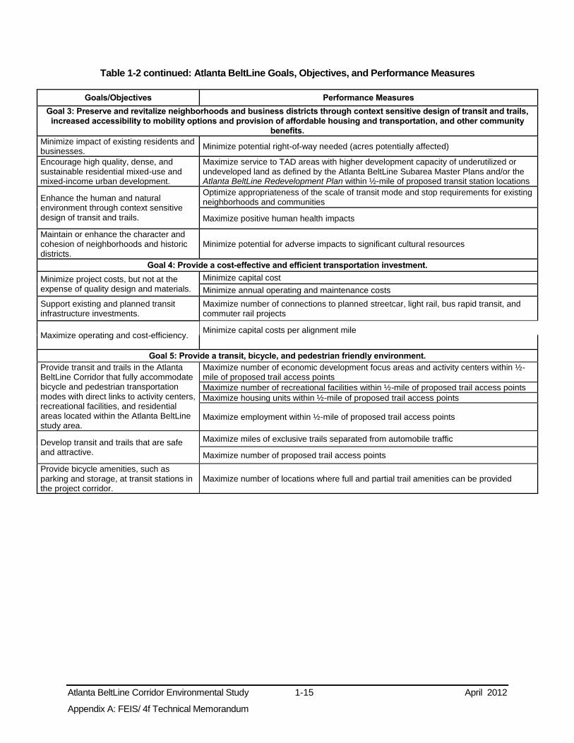
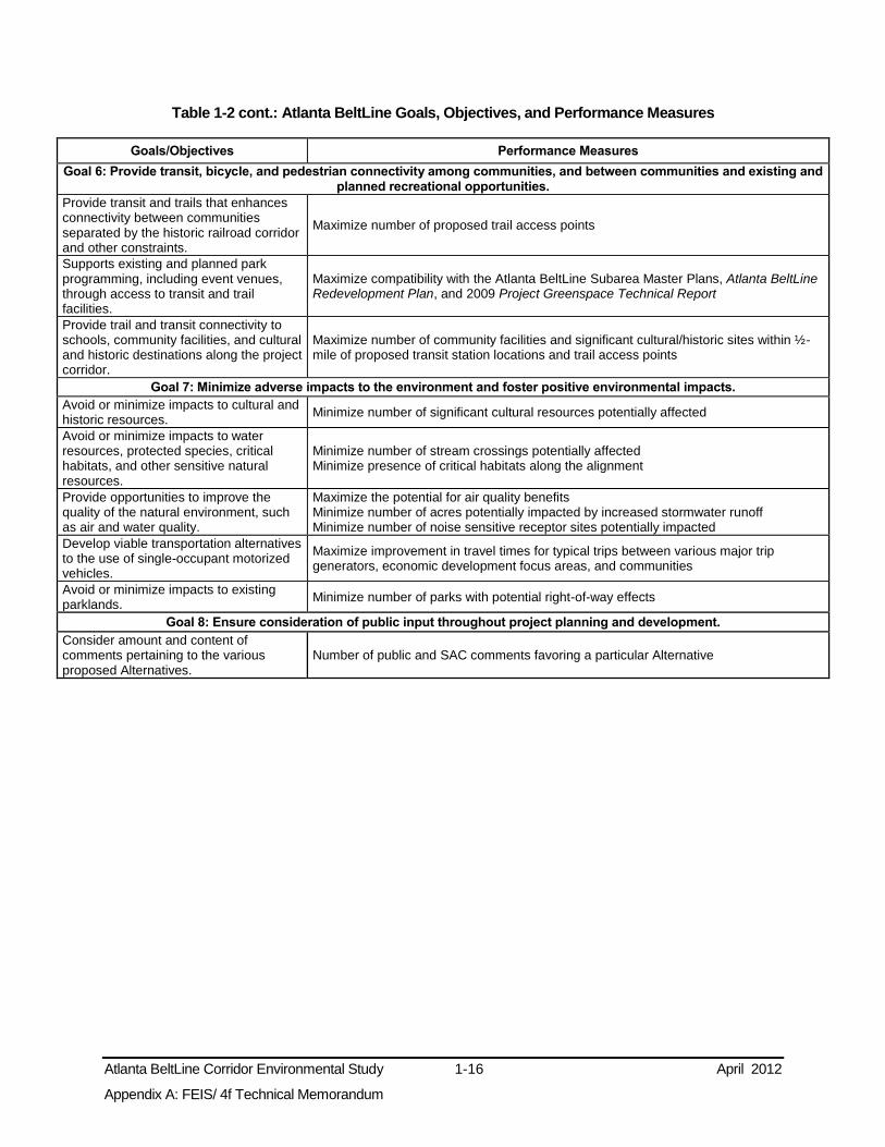
1.6 Project Goals and Objectives Goals and objectives for the project were developed in consultation with the Technical Advisory Committee (TAC) and Stakeholder Advisory Committee (SAC) established for the project and the public. The goals and objectives provide the basis for identifying project alternatives and the benchmarks for evaluating them to select a mode technology, alignment, and ROW requirements. The project goals and objectives are listed in Table 1-2.
The project alternatives are described in Chapter 2.0; Chapters 3.0 through 6.0 describe the affected environment and potential consequences of the project alternatives. More detail on the activities of the committees and the public in this FEIS/ 4(f) Technical Memorandum may be found in Chapter 7.0.
Table 1-2: Atlanta BeltLine Goals, Objectives, and Performance Measures
Goals/Objectives Performance Measures
Goal 1: Contribute to an integrated regional multi-modal transportation network that promotes seamless intermodal connectivity, increases community access to existing transit and trails networks, and improves reliability of personal travel.
Increase access to the existing regional transit system. Maximize number of connections to peak period express buses per hour
Improve transit and trail connections to the existing rail and bus network.
Maximize number of direct connections to MARTA rail stations Maximize number of direct connections to peak hour local buses Maximize number of direct connections to other trails
Minimize travel times to points accessible from the rail and bus network.
Maximize improvement in travel times for typical trips between various major trip generators, economic development focus areas, and communities
Improve accessibility and connectivity among existing neighborhoods and to major destinations and employment centers.
Maximize population within ½-mile of proposed transit station locations Maximize employment within ½-mile of proposed transit station locations Maximize number of Atlanta BeltLine activity centers within ½-mile of proposed transit station locations
Minimize transfers and mode changes per trip.
Minimize number of transfers required for a typical trip between major trip origin and destination points
Increase transit options for transit-dependent, low-income, and minority populations.
Maximize service to low-income population within ½-mile of proposed transit stations Maximize service to minority population within ½-mile of proposed transit stations Maximize service to zero-car households within ½-mile of proposed transit stations Maximize service to population over 65 within ½-mile of proposed transit stations Maximize service to disabled population within ½-mile of proposed transit stations Minimize potential for disproportionate adverse impacts to low-income, minority, and zero-car populations
Goal 2: Manage and encourage the growth and economic development of the City, region, and state by providing transit and transportation improvements to areas designated for growth.
Support redevelopment and revitalization efforts in the Atlanta BeltLine Tax Allocation District (TAD).
Maximize areas of TAD land within ½-mile of proposed transit station locations Maximize service to Atlanta BeltLine Five-Year Work Plan’s 20 economic development focus areas Maximize compatibility with the Atlanta BeltLine Subarea Master Plans and Atlanta BeltLine Redevelopment Plan based on urban design character, station locations, alignments, and connection points
Support the City of Atlanta’s and other regional economic development initiatives as well as growth management policies.
Maximize consistency with future land use plans
Maximize connections with Connect Atlanta Comprehensive Transportation Plan (all modes) and TPB Concept 3 regional transit vision
Support the redevelopment of Brownfields sites for transit-oriented development.
Maximize service to areas of underutilized industrial land within ½-mile of proposed transit station locations (potential Brownfields)
Atlanta BeltLine Corridor Environmental Study 1-15 April 2012
Appendix A: FEIS/ 4f Technical Memorandum
Table 1-2 continued: Atlanta BeltLine Goals, Objectives, and Performance Measures
Goals/Objectives Performance Measures
Goal 3: Preserve and revitalize neighborhoods and business districts through context sensitive design of transit and trails, increased accessibility to mobility options and provision of affordable housing and transportation, and other community
benefits.
Minimize impact of existing residents and businesses. Minimize potential right-of-way needed (acres potentially affected)
Encourage high quality, dense, and sustainable residential mixed-use and mixed-income urban development.
Maximize service to TAD areas with higher development capacity of underutilized or undeveloped land as defined by the Atlanta BeltLine Subarea Master Plans and/or the Atlanta BeltLine Redevelopment Plan within ½-mile of proposed transit station locations
Enhance the human and natural environment through context sensitive design of transit and trails.
Optimize appropriateness of the scale of transit mode and stop requirements for existing neighborhoods and communities
Maximize positive human health impacts
Maintain or enhance the character and cohesion of neighborhoods and historic districts.
Minimize potential for adverse impacts to significant cultural resources
Goal 4: Provide a cost-effective and efficient transportation investment.
Minimize project costs, but not at the expense of quality design and materials.
Minimize capital cost Minimize annual operating and maintenance costs
Support existing and planned transit infrastructure investments.
Maximize number of connections to planned streetcar, light rail, bus rapid transit, and commuter rail projects
Maximize operating and cost-efficiency. Minimize capital costs per alignment mile
Goal 5: Provide a transit, bicycle, and pedestrian friendly environment.
Provide transit and trails in the Atlanta BeltLine Corridor that fully accommodate bicycle and pedestrian transportation modes with direct links to activity centers, recreational facilities, and residential areas located within the Atlanta BeltLine study area.
Maximize number of economic development focus areas and activity centers within ½-mile of proposed trail access points Maximize number of recreational facilities within ½-mile of proposed trail access points Maximize housing units within ½-mile of proposed trail access points
Maximize employment within ½-mile of proposed trail access points
Develop transit and trails that are safe and attractive.
Maximize miles of exclusive trails separated from automobile traffic
Maximize number of proposed trail access points Provide bicycle amenities, such as parking and storage, at transit stations in the project corridor.
Maximize number of locations where full and partial trail amenities can be provided
Atlanta BeltLine Corridor Environmental Study 1-16 April 2012
Appendix A: FEIS/ 4f Technical Memorandum
Table 1-2 cont.: Atlanta BeltLine Goals, Objectives, and Performance Measures
Goals/Objectives Performance Measures
Goal 6: Provide transit, bicycle, and pedestrian connectivity among communities, and between communities and existing and planned recreational opportunities.
Provide transit and trails that enhances connectivity between communities separated by the historic railroad corridor and other constraints.
Maximize number of proposed trail access points
Supports existing and planned park programming, including event venues, through access to transit and trail facilities.
Maximize compatibility with the Atlanta BeltLine Subarea Master Plans, Atlanta BeltLine Redevelopment Plan, and 2009 Project Greenspace Technical Report
Provide trail and transit connectivity to schools, community facilities, and cultural and historic destinations along the project corridor.
Maximize number of community facilities and significant cultural/historic sites within ½-mile of proposed transit station locations and trail access points
Goal 7: Minimize adverse impacts to the environment and foster positive environmental impacts.
Avoid or minimize impacts to cultural and historic resources. Minimize number of significant cultural resources potentially affected
Avoid or minimize impacts to water resources, protected species, critical habitats, and other sensitive natural resources.
Minimize number of stream crossings potentially affected Minimize presence of critical habitats along the alignment
Provide opportunities to improve the quality of the natural environment, such as air and water quality.
Maximize the potential for air quality benefits Minimize number of acres potentially impacted by increased stormwater runoff Minimize number of noise sensitive receptor sites potentially impacted
Develop viable transportation alternatives to the use of single-occupant motorized vehicles.
Maximize improvement in travel times for typical trips between various major trip generators, economic development focus areas, and communities
Avoid or minimize impacts to existing parklands. Minimize number of parks with potential right-of-way effects
Goal 8: Ensure consideration of public input throughout project planning and development.
Consider amount and content of comments pertaining to the various proposed Alternatives.
Number of public and SAC comments favoring a particular Alternative

Atlanta BeltLine Corridor Environmental Study 2-1 April 2012
Appendix A: FEIS/ 4f Technical Memorandum
2.0 ALTERNATIVES CONSIDERED This chapter describes the development of the Atlanta BeltLine Transit and Multi-Use Trail Alternatives as well as FTA and MARTA’s selection of the Preferred Alternatives. This chapter is organized into five sections:
Section 2.1 summarizes the Transit and Multi-Use Trail Alternatives developed and considered from the origin of the Atlanta BeltLine through the selection of Alternatives considered in the Tier 1 DEIS;
Section 2.2 describes the Transit Build Alternatives and technologies considered in the Tier 1 DEIS;
Section 2.3 describes the Trail Build Alternatives considered in the Tier 1 DEIS;
Section 2.4 describes the Preferred Alternatives and the No-Build Alternative considered in this FEIS/ 4(f) Technical Memorandum; and
Section 2.5 discusses the conceptual planning for stations, operational characteristics, and storage and maintenance facilities.
2.1 Alternatives Development Process 2.1.1 Study Area Definition
The ½-mile wide Atlanta BeltLine study area is centered on the proposed Transit and Multi-Use Trail Alternatives considered in the Tier 1 DEIS. It contains many of Atlanta’s residential neighborhoods, employment centers, a majority of the parks and greenspace, and a significant number of major attractions and points of interest. The study area width represents the maximum comfortable walking distance of ¼ mile on each side, and in some cases a ½ mile around the potential station locations. As described in Chapter 1.1 and illustrated in Figure 1-1, the study area is divided into four geographic zones defined by intersections of the proposed alignment with the existing MARTA rail lines.
2.1.2 Background and Initial Screening of Alternatives
A timeline highlighting the development of the Atlanta BeltLine Alternatives is illustrated in Figure 2-1. The following subsections summarize key events in the alternatives development process.
2.1.2.1 Inner Core BeltLine Alternatives Analysis
In 2007, MARTA completed the Inner Core BeltLine Alternatives Analysis Detailed Screening Results designed to identify and evaluate transit improvements within the Inner Core. The Inner Core BeltLine Alternatives Analysis Detailed Screening Results served a dual purpose: to examine transit alternatives to improve local and regional mobility, accessibility, and connectivity, and support the City of Atlanta's plan to add mixed-use developments, bicycle and pedestrian greenway trails, and neighborhood connectivity.
The analysis prescreened five candidate transit mode technologies to operate on the Atlanta BeltLine including: Bus, Bus Rapid Transit (BRT), LRT, Modern Streetcar (SC),

Atlanta BeltLine Corridor Environmental Study 2-2 April 2012 Appendix A: FEIS/ 4f Technical Memorandum
Figure 2-1: Atlanta BeltLine Timeline
Atlanta BeltLine Corridor Environmental Study 2-3 April 2012
Appendix A: FEIS/ 4f Technical Memorandum
and Diesel Multiple Unit (DMU), and identified BRT, SC, and LRT as potential applicable technologies with 4 potential alignments (Alternative B1 through B4) generating 12 different Build Alternatives. Initially, B3 LRT was eliminated in a fatal flaw analysis; however, subsequent engineering/design analysis revealed that B3 LRT would be acceptable and should be carried forward in the planning process. B3 is the predecessor of the Preferred Alternative. A map of the B3 Build Alternative can be found in Figure 2.1-1 of Appendix D.
2.1.3 Public Involvement and Conceptual Engineering
2.1.3.1 Scoping
Following the screening phase, MARTA advanced the development and evaluation of alternatives for the Atlanta BeltLine by initiating the NEPA process. This included Scoping and Public Involvement and Agency Coordination. The formal Public Scoping Process for the Atlanta BeltLine Corridor Environmental Study began with the publication on July 24, 2008 in the Federal Register of a Notice of Intent (NOI) to prepare a Tier 1 EIS and ended September 22, 2008.
2.1.3.2 Transit and Trail Alignments Workshops
From April 13, 2009 to May 4, 2009, five workshops were held, one in each of the Atlanta BeltLine study area zones: the southeast, northeast, and southwest zones, and two distinct areas of the northwest zone (westside and northside) to engage the general public in identifying alternative transit and multi-use trail alignments and service characteristics for the Atlanta BeltLine. Chapter 7.0 provides a detailed description of the workshops and other public involvement efforts and the comments received during these efforts. The B3 Alternative served as the basis for these discussions regarding transit. Multi-use trails proposed by previous studies3 within the Atlanta BeltLine Corridor were the basis for discussions of the trails. The workshops enabled the project team to refine the service characteristics, alignments, potential station locations, and possible connections to existing MARTA rail stations found in the B3 Alternative. Common themes heard at the workshops included the following:
Transit should provide enhanced and frequent accessibility rather than favoring high mobility and transit travel speeds;
Service should allow for expansive coverage providing the maximum number of stations and accessibility to neighborhoods and other destinations;
Stations should be spaced to provide enhanced access to origins and destinations;
Transit and trail alignments should run parallel to each other to the maximum extent possible to both minimize impacts and to form a complementary system;
Transit alignments should connect to MARTA rail stations as well as other planned transit services;
Transit and trail design should include pedestrian access and accommodate special transportation needs (i.e., Americans with Disabilities Act compliance); and
All transit and trail design should include provisions for ensuring the safety of users.
3 City of Atlanta’s 1993 Parks, Open Space and Greenways Plan; the Connect Atlanta Plan, Atlanta’s
Comprehensive Plan; and the BeltLine Redevelopment Plan.

Atlanta BeltLine Corridor Environmental Study 2-4 April 2012
Appendix A: FEIS/ 4f Technical Memorandum
2.1.3.3 Technology and Transit Service Characteristics Workshops
MARTA, in partnership with ABI, consulted the public through the five previously mentioned formal public workshops, as well as an additional 12 public and community organization presentations in the Spring and Summer of 2009 to determine the type of transit service most suitable for the Atlanta BeltLine. The public and stakeholders were presented with two service concepts.
The first, an “expanded service” concept, emphasized access using a higher number of Atlanta BeltLine transit stops and more direct operations within communities, where feasible, thereby minimizing walking and bicycling distances.
The second concept, an “express service” concept, focused on minimizing travel time through the Atlanta BeltLine Corridor, with fewer stops supported by a greater number of connecting pedestrian, bicycle, and transit services.
Consensus from public and stakeholder representatives suggested a preference for the “expanded service” concept. However, recognizing the potential role of transit services in the Atlanta BeltLine Corridor in improving regional mobility, many respondents supported a hybrid of the “express” and “expanded” services that would provide service flexibility, particularly during peak travel periods.
The comments received during Scoping, public workshops, and other public involvement efforts (described in Chapter 7.0) helped to refine the transit and trail alternatives carried forward from the Inner Core BeltLine Alternatives Analysis. Additionally, the comments helped to identify additional alternatives to evaluate in the feasibility screening.
2.1.4 Feasibility Screening of Initial Build Alternatives
The information gained through public involvement activities identified alternatives for consideration, in addition to the B3 Alternative. These Transit and Multi-Use Trail Alternatives vary within several portions of the Atlanta BeltLine and include different potential station locations. Sections 2.2.2 and 2.3 discuss the full range of Transit and Multi-Use Trail Build Alternatives identified during Scoping (Appendix D provides detail on each alternative by zone). These Alternatives were screened for their ability to meet the purpose and need statement discussed in Chapter 1.0 and feasibility to determine which should be considered further in the Tier 1 DEIS.
The focus of the feasibility screening was the locations where the Transit and Multi-Use Trail Build Alternatives may have to depart from the existing railroad ROW. Sixty total transit and multi-use trail alignment options were considered in the feasibility screening process. The full range of transit and multi-use trail alignments are listed in the 2009 Atlanta BeltLine Feasibility Screening Technical Memorandum. The nine screening criteria employed during the feasibility are listed below in Table 2-1. They are described in detail in the Atlanta BeltLine Feasibility Screening Technical Memorandum.
In addition to the feasibility criteria, a key factor in alignment screening was the geographic location of Alternatives within a TAD, as described by the Atlanta BeltLine Tax Allocation District Feasibility Study. As described in Section 1.5.2.4, the TAD provides a critical mechanism for economic development as well as funding and policy for transit, trails, and land use implementation.

Atlanta BeltLine Corridor Environmental Study 2-5 April 2012
Appendix A: FEIS/ 4f Technical Memorandum
Table 2-1: Feasibility Screening of Initial Build Alternatives
Criteria Screening Issues by Mode
Transit Trail
Engineering Feasibility Avoid vertical geometry with grades greater than six percent Avoid horizontal geometry with turn radii less than 100 feet
Separate trail from roadway Path width and clearance Horizontal alignments Grades, sight distances, and vertical curves
Security and Safety Safe interaction between modes Remoteness from activity centers Number and distance between access points Visual access
Service Effectiveness and Efficiency Serve destinations within shortest travel time and minimal service disruptions Minimize meandering between destinations
Access between residential neighborhoods, commercial and employment centers, schools and parks
Avoidance of Negative Impacts to Environmental Features
Avoid adverse impacts to water resources and noise-sensitive land uses
Avoidance of Negative Impacts to Historical and Community Resources
Avoid National Register of Historic Places resources Avoid Georgia State Historic Preservation office resources Avoid City of Atlanta designated resources
Assessment of Transit and Traffic Operations and Parking
On-street alignments subjected to geometric and traffic conditions assessment; traffic signal delays
Minimization of Potential Impacts to Utilities and Other Infrastructure
Utility features including: overhead and underground wires and pipes Other infrastructure including: bridges, abutments, and retaining walls
Minimization of Potential Impacts to Private ROW
Evaluate impacts to existing structures and private ROW including: buildings, utility easements, and existing railroad ROW
Order of Magnitude Capital Costs Evaluate relative costs and benefits
2.1.4.1 Screening Results
The feasibility screening eliminated various alignment options based on poor performance relative to one or more of the criteria described above. Alignments were eliminated primarily because of the following (see Atlanta BeltLine Feasibility Screening Technical Memorandum for a detailed description of each alternative and reason for elimination of further evaluation):
Failure to meet the Atlanta BeltLine’s purpose and need;
Safety and security concerns;
Significant ROW and/or parking impacts;
Operational efficiencies;
Redundancy with other planned transit projects; or,
Location outside the Atlanta BeltLine TAD, an area expressly intended to encompass and promote economic development by means of land use policy and funding for transit.
The feasibility screening process yielded three transit and three trail alignment concepts for advancement to the Tier 1 DEIS. The options retained after screening were subsequently renamed as Build Alternatives and refined. Each surviving Build Alternative is described in Section 2.2 below.

Atlanta BeltLine Corridor Environmental Study 2-6 April 2012
Appendix A: FEIS/ 4f Technical Memorandum
2.2 Tier 1 DEIS Transit Alternatives The FTA and MARTA considered transit and multi-use trail alignment concepts as well as the No-Build Alternative in the Tier 1 DEIS. This section describes those alternatives and the results of the DEIS analysis. More detail may be found in the Tier 1 DEIS.4
2.2.1 No-Build Alternative
In addition to the Build Alternatives, the Tier 1 DEIS assessed a No-Build Alternative in order to provide a basis of comparison with the Build Alternatives. The No-Build Alternative is comprised of the following:
The existing transportation system including roadways, transit service, and trails;
All programmed transportation projects in the cost constrained ARC’s Envision6 RTP and the Fiscal Years 2008-2013 TIP, except for the Atlanta BeltLine transit and trails; and
The trail improvements that the City of Atlanta and ABI have committed would be constructed, although some are elements of the Build Alternatives.
2.2.2 Transit Build Alternatives
The Transit Build Alternatives that survived the screening analysis, discussed in Section 2.1.4, were considered potentially viable and were assessed in the Tier 1 DEIS. The Transit Build Alternatives were all approximately 22-miles long and would accommodate approximately 50 proposed station locations with an average spacing of slightly less than a ½-mile. The Transit Build Alternatives were identical in the northeast, southeast, and southwest zones as described in the Tier 1 DEIS, and shown in Figure 2-2 through Figure 2-4.
There were four Transit Build Alternatives that would use portions of the existing CSX freight rail ROW in the northwest zone. They include:
A- CSX Howell Junction LRT Transit Alternative
A- CSX Howell Junction SC Transit Alternative
C- CSX Marietta Boulevard LRT Transit Alternative
C- CSX Marietta Boulevard SC Transit Alternative
The four Transit Build Alternatives that would use the CSX corridor are illustrated in Figure 2-2.
4 FTA and MARTA, June 2011. Atlanta BeltLine Corridor Environmental Study, Tier 1 Draft Environmental Impact Statement/Draft Section 4(f) Evaluation.

Atlanta BeltLine Corridor Environmental Study 2-7 April 2012
Appendix A: FEIS/ 4f Technical Memorandum
Figure 2-2: Transit Build Alternatives Using CSX Corridor
Source: AECOM 2011

Atlanta BeltLine Corridor Environmental Study 2-8 April 2012
Appendix A: FEIS/ 4f Technical Memorandum
Four Transit Build Alternatives would be located adjacent to, but outside, the existing CSX freight rail ROW in the northwest zone. They include:
B- Howell Junction LRT Transit Alternative
B- Howell Junction SC Transit Alternative
D- Marietta Boulevard LRT Transit Alternative
D- Marietta Boulevard SC Transit Alternative
The four Transit Build Alternatives adjacent to the CSX corridor are illustrated in Figure 2-3.
Two Transit Build Alternatives would be located adjacent to, but outside, the existing Norfolk Southern freight rail corridor in the northwest zone. They include:
F- Atlantic Station LRT Alternative
F- Atlantic Station SC Alternative
The two Transit Build Alternatives adjacent to the Norfolk Southern corridor are illustrated in Figure 2-4.

Atlanta BeltLine Corridor Environmental Study 2-9 April 2012
Appendix A: FEIS/ 4f Technical Memorandum
Figure 2-3: Transit Build Alternatives Adjacent to but Outside the CSX Corridor
Source: AECOM 2011

Atlanta BeltLine Corridor Environmental Study 2-10 April 2012
Appendix A: FEIS/ 4f Technical Memorandum
Figure 2-4: Transit Build Alternatives Adjacent to the Norfolk Southern Corridor
Source: AECOM 2011

Atlanta BeltLine Corridor Environmental Study 2-11 April 2012
Appendix A: FEIS/ 4f Technical Memorandum
2.2.3 Evaluation of Transit Alternatives
Table 2-2 provides a comparison of the distinguishing characteristics and constraints of the Transit Build Alternatives identified in the Tier 1 DEIS. Factors include engineering, operational, and environmental considerations as well as public observations. Some, or all, Transit Build Alternatives share certain characteristics, such as the need for coordination with the freight railroads; however, other characteristics or constraints, such as connections to key destinations or the amount of in-street running alignment, set the alternatives apart from one another.
The Tier 1 DEIS evaluated each Transit Build Alternative to compare their responsiveness to project goals and objectives set forth in the purpose and need found in Section 0 and in Table 1-2. As the Transit Build Alternatives differed from one another only in the northwest zone, this evaluation examined the alternatives only within the northwest zone. Table 2-3 summarizes the final scores for each alternative, including the highest performer, D- Marietta Boulevard SC Transit Build Alternative. The first number in each box is the total “high performing” score for that alternative, while the second number is the total “moderately performing” score for that alternative.

Atlanta BeltLine Corridor Environmental Study 2-12 April 2012
Appendix A: FEIS/ 4f Technical Memorandum
Table 2-2: Transit Alternative Characteristics and Constraints in Northwest Zone
Transit Alignment Alternative
Required Agreements with Freight Railroads
Req
uir
es N
ew
Str
uctu
re A
cro
ss
Ho
well J
un
cti
on
Connections to Key Destinations
No
rth
erl
y A
ccess t
o P
each
tre
e
In-s
treet
Ru
nn
ing
(P
erc
en
t)1
Nu
mb
er
of
Parc
els
Po
ten
tially
Imp
acte
d2
SAC/TAC/Public Input
Other Key Differences
Tra
nsit
Co
rrid
or
Insid
e
Exis
tin
g R
OW
RO
W a
s N
eed
ed
fo
r
Co
nstr
ucti
on
or
to O
verc
om
e
Lo
calized
Sp
ati
al C
on
str
ain
t
Perm
issio
n f
or
Gra
de
Sep
ara
ted
Cro
ssin
gs
Ban
kh
ead
MA
RT
A r
ail s
tati
on
Wests
ide P
ark
Atl
an
tic S
tati
on
Pie
dm
on
t H
osp
ital
Co
nsis
ten
t w
ith
th
e p
roje
ct
Vis
ion
3
Reach
es a
n A
rea U
nd
ers
erv
ed
by R
ail T
ran
sit
Pre
serv
es A
bilit
y t
o K
eep
Tra
nsit
an
d T
rail T
og
eth
er
A- CSX Howell Jct. Alternatives
0% 60 High performing - connection to the TAD Consistent with current plans
B- Howell Jct. Alternatives
0% 71 High performing - connection to the TAD Consistent with current plans
C- CSX Marietta Blvd. Alternatives
26% 61
Connects to most neighborhoods and commercial facilities Connects to most parks Connects to other transit services High performing - connection to the TAD Consistent with current plans Adds the least amount of runoff during a storm
D- Marietta Blvd. Alternatives
27% 68
Connects to most neighborhoods and commercial facilities Connects to most parks Connects to other transit services High performing - connection to the TAD Consistent with current plans Adds the least amount of runoff during a storm
F- Atlantic Station Alternatives
32% 56
Moderate performing - connection to the TAD Low performing - potential impacts on cultural resources High performing - low number of ecological impacts High performing - low number of noise, vibration, and biological effects Low performing - high number of at-grade crossings Serves one less economic development focus area
1 Percentages are of in-street running in the northwest zone only, excluding MARTA Connectivity Areas and Infill Station Alternatives which will be studied in future phases of analysis. 2 Totals include the number of parcels in the northwest zone only, excluding MARTA Connectivity Areas and Infill Station Alternatives which will be studied in future phases of analysis; includes partial impacts and total impacts; calculations were obtained from the Analysis of Potential Right-of-Way Needs Technical Memorandum. 3 Consistency with the project vision includes location relative to the Atlanta BeltLine Tax Allocation District (TAD) and proximity to areas of potential future development.

Atlanta BeltLine Corridor Environmental Study 2-13 April 2012
Appendix A: FEIS/ 4f Technical Memorandum
Table 2-3: Summary of Performance Measure Results By Alignments for All Goals
Goal
Transit Alternative Trail Alternative
A- CSX Howell
Jct.
B- Howell
Jct.
C- CSX Marietta
Blvd.
D- Marietta
Blvd.
F- Atlantic Station
Marietta Blvd./
Howell Jct.
On-Street
1
Contribute to an integrated regional multi-modal transportation network that promotes seamless intermodal connectivity, increases community access to the existing transit and trails networks, and improves reliability of personal travel.
10/2 10/2 10/2 10/2 6/3 1/0 1/0
2
Manage and encourage the growth and economic development of the City, region, and state by providing transit and transportation improvements to areas designated for growth.
3/1 3/2 3/1 3/2 1/2 1/0 1/0
3
Preserve and revitalize neighborhoods and business districts through context sensitive design of transit and trails, increased accessibility to mobility options and provision of affordable housing and transportation, and other community benefits.
2/1 4/1 2/2 5/1 5/0 5/0 3/0
4 Provide a cost-effective and efficient transportation investment. 6/2 6/2 6/2 6/2 6/2 2/0 2/0
5 Provide a transit, bicycle, and pedestrian friendly environment. 0/0 0/0 0/0 0/0 0/0 5/1 5/0
6
Provide transit, bicycle, and pedestrian connectivity among communities, and between communities and existing and planned recreational opportunities.
1/0 1/0 0/0 0/0 0/1 1/0 2/0
7 Minimize adverse impacts to the environment and foster positive environmental impacts. 4/1 5/0 5/0 5/1 7/1 8/0 4/0
8 Ensure consideration of public input throughout project planning and development. 2/0 2/0 2/0 2/0 0/2 2/0 0/0
Total Number of High/Moderate Ratings 28/7 31/7 28/7 31/8 25/11 25/1 18/0 Note: The gray table cells indicate the best performing Build Alternative(s) for each measure and goal. The first number is the total “high performing” score for that alternative and the second number is the total “moderately performing” score for that alternative. Source: FTA and MARTA, June 2011. Atlanta BeltLine Corridor Environmental Study, Tier 1 Draft Environmental Impact Statement/Draft Section 4(f) Evaluation
2.2.3.1 Preliminary Cost Estimates for Transit Alternatives
Preliminary cost estimates in 2009 dollars were calculated during the Tier 1 DEIS in order to evaluate the ability of each Build Alternative to meet the goals of the project. Two estimates were created for each Build Alternative, the capital costs and the operations and maintenance (O&M) costs. Capital cost estimates include all elements of construction including rights-of-way, grading, excavation, and similar needs. O&M cost estimates include those elements associated with running the proposed system on an annual basis.
Table 2-4 below provides a summary of preliminary capital cost estimates for each of the Transit Build Alternatives reviewed during the DEIS.
The current preliminary transit and trail capital cost estimates will be further refined in subsequent stages of project planning and engineering design as project elements are rendered in greater detail. The format of the estimates, as it makes use of FTA Standard

Atlanta BeltLine Corridor Environmental Study 2-14 April 2012
Appendix A: FEIS/ 4f Technical Memorandum
Cost Categories with clearly documented assumptions, lends itself to updates throughout the project development process.
Table 2-4: Summary of Preliminary Transit Capital Cost Estimates
Zone Zone
Low Cost Transit
(millions, $2009)
Length (route miles)
Cost (per Mile)
High Cost Transit
(millions, $2009)
Length (route miles)
Cost (per mile)
Light Rail Transit (LRT) Capital Cost Estimates
Northeast All Build Alternatives $424 6.51 $65 $482 6.50 $74 Southeast All Build Alternatives $363 6.02 $60 $542 6.50 $83 Southwest All Build Alternatives $180 3.13 $58 $250 3.87 $65
Northwest
A or B- CSX Howell Jct. Alternatives $481 6.56 $73 $490 6.80 $72 C or D- CSX Marietta Blvd. Alternatives $483 6.86 $70 $496 7.17 $69
(E- Norfolk Southern Alternatives)* $445 6.22 $72 $481 6.55 $73
Totals (assuming C or D- CSX Marietta Blvd.)** $1,450 22.52 $1,770 24.04 Per mile $65 $74
Modern Streetcar (SC) Capital Cost Estimates
Northeast All Build Alternatives $372 6.51 $57 $428 6.50 $66
Southeast All Build Alternatives $321 6.02 $53 $487 6.50 $75 Southwest All Build Alternatives $164 3.13 $52 $225 3.87 $58
Northwest
A or B- CSX Howell Jct. Alternatives $418 6.56 $64 $431 6.80 $63 C or D- CSX Marietta Blvd. Alternatives $421 6.86 $61 $439 7.17 $61
(E- Norfolk Southern Alternatives)* $392 6.22 $63 $427 6.55 $65
Totals (assuming C or D- CSX Marietta Blvd.)** $1,278 22.52 $1,611 24.04 Per mile $57 $66
Source: AECOM 2010 * The E- Norfolk Southern Alternatives are compared in this table for informational purposes only. These Transit Alternatives have since been removed from consideration. ** Total cost for the complete Atlanta BeltLine corridor using the C or D- CSX Marietta Blvd. Alternatives are reported for simplicity. Total cost using the other northwest zone alignment may be obtained by summing the northeast, southeast, and southwest zones with the desired northwest zone alternative.
During the DEIS process, the O&M costs for each of the alternatives were calculated and compared. The differences in O&M costs between alternatives result from the differences in the estimated run time of each alternative and the number of vehicles needed in service to meet the required headway. However, it was found that among all the alternatives, the main difference that affected the O&M costs was the mode technology. Although each alternative varies in length, this did not significantly affect the overall O&M estimates.
The low O&M estimate for all SC alternatives is $14,082,054 and the high estimate is $14,865,235. Similarly, the low O&M cost estimate for the LRT is $10,953,331 and the

Atlanta BeltLine Corridor Environmental Study 2-15 April 2012
Appendix A: FEIS/ 4f Technical Memorandum
high estimate is $11,735,712. The difference between O&M costs for SC and LRT are driven by the fact that a LRT vehicle typically has a larger passenger capacity; therefore, fewer cars and operators are required to meet the projected demand and headways for the Atlanta BeltLine.
2.2.3.2 Tier 1 DEIS Conclusions
Based on the analysis presented in the Tier 1 DEIS and from the comments received during the DEIS public comment period, FTA and MARTA have determined that the D-Marietta Boulevard SC Transit Build Alternative (adjacent to but outside of CSX ROW) is the best performing and Preferred Transit Alternative. Figure 2-5 shows the location of the Preferred Transit Alternative.
The Preferred Transit Alternative (D-Marietta Boulevard SC Transit Build Alternative) performs distinctly better than the other transit alternatives in response to the Atlanta BeltLine’s purpose and need as expressed through the goals and objectives listed below. The Tier 1 DEIS analysis indicates that the Preferred Transit Alternative is the most effective in improving access and mobility for existing and future residents and workers, increasing in-city transit options, and providing links in and between the transit network. In tandem with the land use and economic development component of the Atlanta BeltLine, the Preferred Transit Alternative will stimulate economic activity, structure growth, and address livability and economic opportunity.
The project sponsors considered the input heard from the TAC and SAC committees and the public during the DEIS as well as the results of the DEIS analysis of the Build and No-Build Alternatives prior to selecting the Preferred Alternatives. The committee and public input played a particularly strong role in the decision-making process as it emphasized some of the differences observed among the alternatives in the DEIS analysis and highlighted the importance of those differences to the community The factors weighting the decision to select the Preferred Transit and Trails Alternatives included the fact that the use of Railroad ROW in the northwest zone is uncertain in the Tier 1 phase and that the Preferred Alternatives would:
Provide connectivity to the most parks, neighborhoods, other transit and trails, BeltLine Tax Allocation District (TAD) acreage, and key destinations in the northwest zone such as Bankhead MARTA Rail Station, Westside Park, Atlantic Station, and Piedmont Hospital;
Provide the most northerly access to Peachtree Street;
Minimize private property impacts by placing alignments in existing transportation rights-of-way; and
Reach the largest area underserved by rail transit.
The factors weighting the decision to select the modern streetcar mode included:
Desire for operating plan with frequent stops;
Lower potential operating noise, vibration and visual impacts; and
Potentially fewer land use impacts, appropriate scale and community fit with smaller vehicles and infrastructure.

Atlanta BeltLine Corridor Environmental Study 2-16 April 2012
Appendix A: FEIS/ 4f Technical Memorandum
Figure 2-5: Preferred Transit Alternative
Source: AECOM 2011

Atlanta BeltLine Corridor Environmental Study 2-17 April 2012
Appendix A: FEIS/ 4f Technical Memorandum
2.2.3.3 Purpose and Need Met by Preferred Transit Alternative
The Preferred Transit Alternative distinguishes itself by responding to the Atlanta BeltLine goals and objectives as follows:
Goal 1 – Contribute to an integrated regional multi-modal transportation network that promotes seamless intermodal connectivity, increases community access to the existing transit and trails networks, and improves reliability of personal travel.
The most desired connections to major employment centers and activity areas, such as Piedmont Hospital and a northern portion of Peachtree Street, can be made from the Preferred Transit Alternative (also applies to Goal 5).
The Preferred Transit Alternative more effectively contributes to a multi-modal transportation network and provides an additional access point to existing transit, both heavy rail and bus service, by connecting to a fifth MARTA rail station (the Bankhead MARTA rail station) (also applies to Goal 5).
The Preferred Transit Alternative does not rely on freight rail ROW in the northwest zone; it also avoids the contentious crossing of Howell Junction.
Goal 2 – Manage and encourage the growth and economic development of the city, region, and state by providing transit and transportation improvements to areas designated for growth.
The adjacency of the Preferred Transit Alternative to underutilized industrial land, much of which is within the Atlanta BeltLine TAD, creates the greatest opportunity for redevelopment benefits (also applies to Goal 3).
The Preferred Transit Alternative provides a connection to a major recreation asset and adjacent redevelopment opportunity with the redevelopment of Westside Reservoir Park.
Goal 3 – Preserve and revitalize neighborhoods and business districts through context sensitive design of transit and trails, increased accessibility to mobility options and provision of affordable housing and transportation, and other community benefits.
The adjacency of the Preferred Transit Alternative to underutilized industrial land, much of which is within the TAD, creates the greatest opportunity for redevelopment benefits (also applies to Goal 2).
Due to its high use of on-street ROW, the Preferred Transit Alternative adds the least amount of runoff during a storm (also applies to Goal 7).
Goal 4 – Provide a cost-effective and efficient transportation investment.
There is no distinguishing rationale among all transit alignment alternatives considered.
Goal 5 – Provide a transit, bicycle, and pedestrian friendly environment.
Goal 1 rationale bullets apply equally to Goal 5.

Atlanta BeltLine Corridor Environmental Study 2-18 April 2012
Appendix A: FEIS/ 4f Technical Memorandum
Goal 6 – Provide transit, bicycle, and pedestrian connectivity among communities, and between communities and existing and planned recreational opportunities.
Goal 1 and 2 rationales apply equally to Goal 6 for the Preferred Transit Alternative.
Goal 7 – Minimize adverse impacts to the environment and foster positive environmental impacts.
Due to its high use of on-street ROW, the Preferred Transit Alternative adds the least amount of runoff during a storm (also applies to Goal 3).
Goal 8 – Ensure consideration of public input throughout project planning and development.
Public comment cited concerns regarding congestion around Atlantic Station, Deering Road, and the proximity of activities to Brookwood Hills, which the Preferred Transit Alternative avoids.
2.2.4 MARTA Station Connectivity and Infill Station Alternative Areas
There is a need for the Atlanta BeltLine to interconnect with MARTA rail stations in order to permit travelers to move from one transportation facility to another. However, the existing railroad ROW on which most of the Atlanta BeltLine would operate does not extend to or connect directly with existing MARTA rail stations. The geographic areas in which a connection is needed are referred to as MARTA Station Connectivity and Infill Station Alternative areas. In some instances, these areas present challenges for identifying appropriate connections and the Atlanta BeltLine station sites such as significant grade differences between MARTA and the Atlanta BeltLine or proximity to active rail facilities. Connectivity options occur near six MARTA rail stations as shown in Figure 2-6 at the following locations: Lindbergh Center, Inman Park/Reynoldstown, King Memorial, West End, Bankhead, and Ashby. In three of these areas, there are also opportunities for potential infill stations: West End at Lee Street/Donnelly Avenue; Ashby at Joseph E. Boone Boulevard/MARTA Proctor Creek Line; and Lindbergh at Armour Yard.
The intent is to identify possible connections across these challenge areas. In the Tier 1 DEIS, the alignments within each of the MARTA Station Connectivity and Infill Station Alternative areas and their potential impacts were evaluated as a composite group, not individually. Evaluation of and decisions regarding the selection of preferred MARTA Station Connectivity and Infill Station Alternatives will be made during analyses subsequent to the Tier 1 FEIS. At that time, evaluations and decisions will be made regarding transit and trail alignments and potential infill stations along the MARTA rail corridors.

Atlanta BeltLine Corridor Environmental Study 2-19 April 2012
Appendix A: FEIS/ 4f Technical Memorandum
Figure 2-6: Areas Surrounding MARTA Station Connectivity and Infill Station Alternatives
Source: AECOM 2011

Atlanta BeltLine Corridor Environmental Study 2-20 April 2012
Appendix A: FEIS/ 4f Technical Memorandum
2.2.5 Transit Mode Technologies
As described in Section 2.1.2.1, the Inner Core BeltLine Alternatives Analysis included a prescreening of five candidate transit mode technologies to operate on the Atlanta BeltLine with this initial screening finding that either LRT or SC would be a viable transit mode technology. The basic goal of an LRT or SC project is to provide commuters and other travelers with the benefits of improved public transportation in a cost effective, environmentally sensitive, and socially responsible manner.
LRT and SC are in the same transit class, but are typically used differently. SC, a type of light rail vehicle, is substantially smaller than an LRT vehicle and usually operates as a single car train. On the Atlanta BeltLine, streetcars would draw electric power from overhead wires, and are relatively quiet, electrically-powered, zero-emissions vehicles. LRT vehicles look similar to SC and are powered in the same way, but the vehicles are substantially larger and LRT trains are typically operated as sets of two or three vehicles.
SC is most often used in urbanized conditions where it operates at relatively slow speeds in mixed traffic. LRT is typically used in urban and suburban locations where it operates at relatively higher speeds primarily in exclusive ROW. The characteristics of SC and LRT are summarized in Table 2-5.
Table 2-5: Summary of Typical Mode Characteristics Characteristic Light Rail Transit (LRT) Modern Streetcar (SC)
Units per train One to three cars One
Vehicle Length/ Train Length
1 vehicle: 77 ft. to 110 ft. 2 vehicles: 154 ft. to 220 ft. 3 vehicles: 231 ft. to 330 ft.
66 to 85 ft.
Passenger capacity per vehicle 180 passengers per vehicle 128 to 133 (41 seated / 87 to 92 standing)
Power source Overhead catenary Overhead catenary ROW / Operations Exclusive ROW or in-street Operate in-street Station spacing ½- to one-mile Three blocks to ½-mile Peak hour passenger capacity 1,900 to 7,200 (1 to 3 vehicles) 1,170 to 1,300 (1 vehicle)
Conceptual designs for the Atlanta BeltLine assumed the more conservative LRT geometric standards to assure that either LRT or SC could be used. By using the more conservative LRT design standards, the project sponsors are preserving the option for modal interoperability with other future transit projects.
Because LRT is a larger vehicle than SC, requiring station lengths, track geometry, systems and structures that are typically longer than those of SC, the impacts stemming from LRT design standards in the DEIS are considered to be worst case. Only those parameters that meaningfully differ between the two technologies are described in the DEIS.
The project sponsors performed conceptual engineering analyses to support the DEIS that took into consideration alignments within all four zones as well as MARTA Station Connectivity and Infill Station Alternative Area design considerations. The analysis examined transit geometry (curve radii, grades, and clearances), track configuration, and safety needs. The outcome of these analyses is that either mode can be accommodated throughout the corridor.
Further examination of mode performance in terms of system, vehicle, and infrastructure characteristics as well as community desires determined that SC is better adapted to the

Atlanta BeltLine Corridor Environmental Study 2-21 April 2012
Appendix A: FEIS/ 4f Technical Memorandum
Atlanta BeltLine project. As shown in Table 2-6, LRT and SC are equally adaptable in terms of conceptual design and ability to connect to other planned transit projects. Although LRT has a slightly lower annual O&M cost, SC can be implemented at a generally lower capital cost while its shorter vehicle lengths provide greater flexibility than LRT in navigating the constrained geometry of the alignments, and may result in fewer noise, vibration, and land use impacts. In addition, SC is better adapted to the Atlanta BeltLine operating plan that calls for frequent stops. For these reasons, SC is FTA and MARTA’s preferred mode technology for the Atlanta BeltLine project.
Table 2-6: Mode Characteristics and Constraints as Applied to the Atlanta BeltLine Project
Mode Characteristics Light Rail
Transit (LRT) Modern
Streetcar (SC)
System
Conceptual design for entire Atlanta BeltLine project (main line and connectivity areas) can accommodate mode
Potentially higher operating speed Ability to connect with other planned transit projects Generally lower capital costs for systems
Vehicle and Infrastructure
Higher single vehicle capacity Potentially smaller fleet (total number of vehicles) Greater flexibility in constrained track geometry Generally lower capital costs per vehicle
Community Desires
Ability to make frequent stops (adaptable to operating plan and Atlanta BeltLine economic development objectives) +
Lower potential for noise, vibration and visual impacts Small vehicle and infrastructure (potentially fewer land use impacts, appropriate scale and community fit)
2.3 Tier 1 DEIS Trail Alternatives In general, the Trail Build Alternatives are alongside the Transit Build Alternatives in the northeast, southeast, and southwest zones, as illustrated in Figure 2-7. The parallel alignment of the Preferred Transit and Trails Alternatives reduces the potential for community and environmental disruption and would be the least costly. In the northwest zone, two of the three Trail Build Alternatives, the Marietta Boulevard and Howell Junction Trail Alternatives, would follow alongside the Transit Build Alternatives that are located within or adjacent to, but outside the CSX freight rail corridor.
The exception is the On-Street Trail Alternative, which is parallel to the CSX railroad corridor in the northwest zone for a portion of its length; however, it would use other parallel streets and ROW for much of its length. The on-street portions of the Preferred Trail Alternative enable access to neighborhoods and parks that are not adjacent to the Preferred Transit Alternative alignment.
Table 2-7 provides a comparison of the distinguishing characteristics and constraints of the Trail Build Alternatives. Factors include engineering, operational, and environmental considerations as well as public observations. Some or all Trail Build Alternatives share certain characteristics, such as consistency with the Atlanta BeltLine vision; however, other characteristics or constraints, such as preserving the ability to keep transit and trails together, set the Trail Build Alternatives apart from each other. Table 2-3 summarizes the final scores for each Trail Build Alternative, including the better performers, the Marietta Boulevard and Howell Junction Trail Alternatives.

Atlanta BeltLine Corridor Environmental Study 2-22 April 2012
Appendix A: FEIS/ 4f Technical Memorandum
Figure 2-7: Trail Build Alternatives
Source: AECOM 2011

Atlanta BeltLine Corridor Environmental Study 2-23 April 2012
Appendix A: FEIS/ 4f Technical Memorandum
Table 2-7: Trail Alternative Characteristics and Constraints in Northwest Zone
Trail Alignment Alternative
Req
uir
es N
ew
Str
uctu
re
Acro
ss H
ow
ell J
un
cti
on
Connections to Key Destinations
No
rth
erl
y A
ccess t
o P
each
tre
e
Nu
mb
er
of
Parc
els
Po
ten
tially
Imp
acte
d1
SAC/TAC/Public Input
Other Key Differences B
an
kh
ead
MA
RT
A r
ail
sta
tio
n
Wests
ide P
ark
Atl
an
tic S
tati
on
Pie
dm
on
t H
osp
ital
Co
nsis
ten
t w
ith
th
e
pro
ject
Vis
ion
2
Reach
es a
n A
rea
Un
ders
erv
ed
by R
ail
Tra
nsit
P
reserv
es A
bilit
y t
o
Keep
Tra
nsit
an
d T
rail
To
geth
er
Howell Jct. Alternative 843
High performing - community benefits Low performing – low number of potential ecological impacts
Marietta Blvd. Alternative 1033
High performing - community benefits Low performing – low number of potential ecological impacts Low performing – low number of potential for hazardous waste effects
On-Street Alternative 693
High performing - access to transit and other trails Potentially adds one additional stream impact Has the most runoff during a storm
1 Totals include the number of parcels in the northwest zone only, excluding MARTA Connectivity Areas and Infill Station Alternatives which will be studied in future phases of analysis; includes partial impacts and total impacts; calculations were obtained from the Analysis of Potential Right-of-Way Needs Technical Memorandum. 2 Consistency with the project vision includes location relative to the Atlanta BeltLine Tax Allocation District (TAD) and proximity to areas of potential future development. 3 Totals include the number of parcels for transit and trail.
2.3.1 Preliminary Cost Estimates for Trail Alternatives
Table 2-8 summarizes the preliminary capital costs for the Trail Build Alternatives reviewed during the DEIS.
Table 2-8: Summary of Preliminary Capital Cost Estimates for Trails
Trail Alternative
Preliminary Capital Cost Estimates (millions of 2009 dollars)
Construction Cost
Potential Right-of-Way (ROW) Cost
Total Cost Length (miles) Total Cost per
Mile
Howell Jct. $98.5 $30.1 $128.6 20.9 $6.15 Marietta Blvd. $99.1 $29.3 $128.4 21.4 $6.00
On-Street $106.0 $28.7 $134.7 21.8 $6.18 Source: AECOM 2010
The current preliminary transit and trail capital cost estimates will be further refined in subsequent stages of project planning and engineering design as project elements are rendered in greater detail. The format of the estimates, as it makes use of FTA Standard Cost Categories with clearly documented assumptions, lends itself to updates throughout the project development process.

Atlanta BeltLine Corridor Environmental Study 2-24 April 2012
Appendix A: FEIS/ 4f Technical Memorandum
2.3.2 Tier 1 DEIS Conclusions
Based on the analysis presented in the Tier 1 DEIS and from the comments received during the DEIS public comment period, FTA and MARTA determined that the best performing and preferred multi-use trail alternative is a hybrid of the Marietta Boulevard Trail Alternative and the On-Street Trail Alternative, using the best features of each. Specifically, the Preferred Trail Alternative would be the majority of the Marietta Boulevard Trail Alternative from the Ashby MARTA Station and Connectivity Infill Alternative area to the area just south of Jefferson Street where it connects with the On-Street Trail Alternative around the Fulton County Jail. Continuing north, it uses the Marietta Boulevard Trail Alternative to the Atlanta Water Works, where it follows the On-Street Trail Alternative until the Lindbergh Center MARTA Station and Connectivity Infill Alternative area. Figure 2-8 shows the elements of the Preferred Trail Alternative derived from a combination of the Marietta Boulevard Trail and the On-Street Trail Alternatives. It is important to note that this is not a new trail, but a combination of alignments that were each studied in the Tier 1 DEIS.
The project sponsors considered the input heard from the TAC and SAC committees and the public during the DEIS as well as the results of the DEIS analysis of the Build and No-Build Alternatives prior to selecting the Preferred Alternatives. The committee and public input played a particularly strong role in the decision-making process as it emphasized some of the differences observed among the alternatives in the DEIS analysis and highlighted the importance of those differences to the community. The factors weighting the decision to select the Preferred Transit and Trails Alternatives included the fact that the use of Railroad ROW in the northwest zone is uncertain in the Tier 1 phase and that the Preferred Alternatives would:
Provide connectivity to the most parks, neighborhoods, other transit and trails, BeltLine Tax Allocation District (TAD) acreage, and key destinations in the northwest zone such as Bankhead MARTA Rail Station, Westside Park, Atlantic Station, and Piedmont Hospital;
Provide the most northerly access to Peachtree Street;
Minimize private property impacts by placing alignments in existing transportation rights-of-way; and
Reach the largest area underserved by rail transit.

Atlanta BeltLine Corridor Environmental Study 2-25 April 2012
Appendix A: FEIS/ 4f Technical Memorandum
Figure 2-8: Preferred Trail Alternative
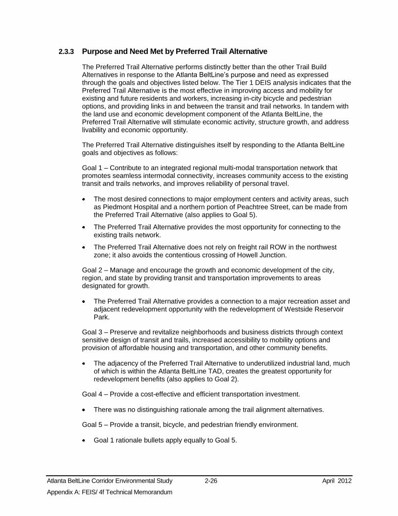
Atlanta BeltLine Corridor Environmental Study 2-26 April 2012
Appendix A: FEIS/ 4f Technical Memorandum
2.3.3 Purpose and Need Met by Preferred Trail Alternative
The Preferred Trail Alternative performs distinctly better than the other Trail Build Alternatives in response to the Atlanta BeltLine’s purpose and need as expressed through the goals and objectives listed below. The Tier 1 DEIS analysis indicates that the Preferred Trail Alternative is the most effective in improving access and mobility for existing and future residents and workers, increasing in-city bicycle and pedestrian options, and providing links in and between the transit and trail networks. In tandem with the land use and economic development component of the Atlanta BeltLine, the Preferred Trail Alternative will stimulate economic activity, structure growth, and address livability and economic opportunity.
The Preferred Trail Alternative distinguishes itself by responding to the Atlanta BeltLine goals and objectives as follows:
Goal 1 – Contribute to an integrated regional multi-modal transportation network that promotes seamless intermodal connectivity, increases community access to the existing transit and trails networks, and improves reliability of personal travel.
The most desired connections to major employment centers and activity areas, such as Piedmont Hospital and a northern portion of Peachtree Street, can be made from the Preferred Trail Alternative (also applies to Goal 5).
The Preferred Trail Alternative provides the most opportunity for connecting to the existing trails network.
The Preferred Trail Alternative does not rely on freight rail ROW in the northwest zone; it also avoids the contentious crossing of Howell Junction.
Goal 2 – Manage and encourage the growth and economic development of the city, region, and state by providing transit and transportation improvements to areas designated for growth.
The Preferred Trail Alternative provides a connection to a major recreation asset and adjacent redevelopment opportunity with the redevelopment of Westside Reservoir Park.
Goal 3 – Preserve and revitalize neighborhoods and business districts through context sensitive design of transit and trails, increased accessibility to mobility options and provision of affordable housing and transportation, and other community benefits.
The adjacency of the Preferred Trail Alternative to underutilized industrial land, much of which is within the Atlanta BeltLine TAD, creates the greatest opportunity for redevelopment benefits (also applies to Goal 2).
Goal 4 – Provide a cost-effective and efficient transportation investment.
There was no distinguishing rationale among the trail alignment alternatives.
Goal 5 – Provide a transit, bicycle, and pedestrian friendly environment.
Goal 1 rationale bullets apply equally to Goal 5.

Atlanta BeltLine Corridor Environmental Study 2-27 April 2012
Appendix A: FEIS/ 4f Technical Memorandum
Goal 6 – Provide transit, bicycle, and pedestrian connectivity among communities, and between communities and existing and planned recreational opportunities.
The Preferred Trail Alternative provides close access to major recreational facilities, such as the Westside Reservoir Park, Tanyard Creek Park, and Bobby Jones Golf Course.
Goal 1 and 2 rationales apply equally to Goal 6 for the Preferred Trail Alternative.
Goal 7 – Minimize adverse impacts to the environment and foster positive environmental impacts.
There was no distinguishing rationale among the trail alignment alternatives.
Goal 8 – Ensure consideration of public input throughout project planning and development.
Public comment cited concerns regarding congestion around Atlantic Station, Deering Road, and the proximity of activities to Brookwood Hills, which the Preferred Trail Alternative would avoid.
2.4 Alternatives Considered in the Tier 1 FEIS The FTA and MARTA are considering three alternatives in this FEIS/ 4(f) Technical Memorandum, the No-Build Alternative the Preferred Transit Alternative (known in the Tier 1 DEIS as D-Marietta Boulevard SC Alternative), and the Preferred Trail Alternative (a hybrid of the Marietta Boulevard and On-Street Alternatives considered in the Tier 1 DEIS). This section describes each alternative.
2.4.1 No-Build Alternative
As described in the Tier 1 DEIS, the No-Build Alternative is comprised of the following:
The existing transportation system including roadways, transit service, and trails;
All programmed transportation projects in the cost constrained ARC’s Envision6 RTP and the Fiscal Years 2008-2013 TIP, except for the Atlanta BeltLine transit and trails; and,
The trail improvements that the City of Atlanta and ABI have committed would be constructed, although some are elements of the Build Alternatives.
The proposed elements of the transportation system comprising the No-Build Alternative in the study area are listed in Appendix Table 2.2-1 and illustrated in Appendix Figure 2.2-2, both in Appendix D. These elements would provide a number of roadway maintenance, operational and capacity improvements; primarily radial transit services; and localized bicycle/pedestrian improvements.
Collectively, these facilities would not address the elements of the purpose and need. Specifically, the No-Build Alternative would not increase in-city transit and bicycle/pedestrian options to the extent that those options would improve access and mobility for existing and future residents and workers study area-wide. None of the planned projects specifically targets the study area for transit or bicycle/pedestrian improvements, although several would cross the study area to connect Downtown and

Atlanta BeltLine Corridor Environmental Study 2-28 April 2012
Appendix A: FEIS/ 4f Technical Memorandum
Midtown areas with areas outside the study area. As a result, the No-Build Alternative would not:
provide public transit improvements to accommodate growing population and employment in the study area;
provide public transit and bicycle/pedestrian options in those areas in which environmental justice populations have been identified in the study area;
increase transportation options in parallel with making changes in land use and development patterns in the study area to improve economic opportunities and quality of life;
increase transportation options in the study area that will provide more travel connections and greater efficiency and potentially reduce roadway congestion;
increase rail transit options between neighborhoods and activity centers in the study area and provide connections to MARTA; or
provide connections between parks.
Despite its failings and in accordance with NEPA, the No-Build Alternative is retained in this FEIS/ 4(f) Technical Memorandum to serve as a baseline by which the Preferred Alternatives are compared.
2.4.2 Preferred Transit Alternative Description
The D- Marietta Boulevard SC Alternative, from here on known as the Preferred Transit Alternative, is approximately 22-miles long and will accommodate approximately 50 proposed station locations with an average spacing of slightly less than a ½-mile. The Preferred Transit Alternative is described below by zone, and shown in Figure 2-5.
Northeast zone – The alignment begins at Lindbergh MARTA rail station and proceeds southeast (see discussion under Section 2.2.4 MARTA Station Connectivity and Infill Station Alternatives). At Ansley Golf Course, the alignment enters the Decatur Belt and continues south to Edgewood Avenue on the Decatur Belt, an unused freight corridor owned by the ADA. Between these points, and starting on the north, the alignment crosses under Montgomery Ferry Road, proceeds behind Ansley Mall, crosses under Piedmont Road, proceeds alongside Piedmont Park, crosses Monroe Drive, crosses over Ponce de Leon Avenue and North Avenue, crosses under Freedom Parkway and Highland Avenue, and ends at Edgewood Avenue on the south. At the southern end, the alignment enters the area that includes the Inman Park/Reynoldstown and King Memorial MARTA rail stations.
Southeast zone – The alignment begins at the Inman Park/Reynoldstown and King Memorial MARTA rail stations areas and proceeds southwest (see discussion under Section 2.2.4). From the point where the MARTA Station Connectivity and Infill Station Alternatives converge near the intersection of Memorial Drive and Bill Kennedy Way, the alignment proceeds southwest to Allene Avenue primarily on the A&WP BeltLine, a freight railroad owned by CSX. A short section of the alignment between Memorial Drive and Glenwood Avenue is on-street ROW owned by the City of Atlanta. Between these points, and starting on the north, the alignment proceeds south within the Bill Kennedy Way roadway ROW, crosses I-20, enters the CSX ROW at Glenwood Avenue, crosses over Ormewood Avenue and Confederate Avenue, crosses Boulevard and Milton Avenue, crosses under McDonough Boulevard and I-75/85, crosses over Metropolitan Parkway, and ends at Allene

Atlanta BeltLine Corridor Environmental Study 2-29 April 2012
Appendix A: FEIS/ 4f Technical Memorandum
Avenue on the southwest. At the western end, the alignment enters the area that includes the West End MARTA rail station.
Southwest zone – The alignment begins at the West End MARTA rail station and proceeds northwest (see discussion under Section 2.2.4). From the convergence of the MARTA Station Connectivity and Infill Station Alternatives near Rose Circle, the alignment proceeds north to Martin Luther King, Jr. Drive on an unused railroad ROW owned by Georgia Department of Transportation (GDOT). Between these points, the alignment proceeds northwest crossing under Lawton Street, Ralph David Abernathy Boulevard, and I-20, and ends at Martin Luther King, Jr. Drive. At the northern end, the alignment enters the area that includes the Ashby MARTA rail station.
Northwest zone - The alignment extends north from Joseph E. Boone Boulevard on former railroad ROW before transitioning to an alignment using Marietta Boulevard as an in-street running section. The alignment turns east across vacant land to rejoin the area adjacent to but outside the CSX corridor west of Howell Mill Road.
2.4.3 Preferred Trail Alternative Description
In general, the Preferred Trail Alternative follows alongside the Preferred Transit Alternative in the northeast, southeast, and southwest zones, as illustrated in Figure 2-8. The parallel alignment of the transit and trails reduces the potential for community and environmental disruption and would be the least costly. In the northwest zone, the Preferred Trail Alternative follows the Preferred Transit Alternative alignment except in three key areas: around Maddox Park, around the Atlanta Water Works, and along Tanyard Creek near Bobby Jones Golf Course. In these areas, the Preferred Trail Alternative would use other, parallel streets and ROW for much of its length. Separate trail alignments are required because of a lack of sufficient existing ROW, an engineering or access issue, or a need to provide a connection to a park that is not adjacent to the transit alignment.
2.4.4 Preferred Alternative Cost Estimates
The project sponsors developed an estimate of capital as well as operating and maintenance costs to implement the Preferred Transit Alternative. The estimated capital cost in 2009 dollars is approximately $1,611 million, or $66 million per mile. The estimated annual operations and maintenance cost in 2009 dollars is approximately $14.49 million.
The project sponsors developed an estimate of capital as well as operating and maintenance costs to implement the Preferred Trail Alternative. The estimated capital cost in 2009 dollars is approximately $100.4 million or $4.6 million per mile.
2.5 Supplemental Transit Features Other elements of the proposed Atlanta BeltLine Preferred Transit Alternative are described below, which would be integral to the operation of a transit service, but are not decisive factors in this Tier 1 EIS. These other elements will be considered in detail in subsequent analysis. They include transit station locations, operational characteristics, and vehicle storage and maintenance facilities.

Atlanta BeltLine Corridor Environmental Study 2-30 April 2012
Appendix A: FEIS/ 4f Technical Memorandum
2.5.1 Transit Station Locations
The Preferred Transit Alternative includes approximately 50 potential station locations, which are illustrated in Figure 2-2 through Figure 2-4 and other figures throughout this FEIS/ 4(f) Technical Memorandum. Previous and ongoing studies, along with public and agency input, have helped to identify potential station locations and provide guidance regarding station spacing and frequency. Public and agency input has indicated a preference for numerous transit stops providing enhanced origin and destination accessibility relative to high mobility and transit travel speeds. A preference was also expressed for a few park-and-ride type facilities due to the high-density land use characteristics of the study area and transit-oriented focus of future development planning.
Potential station locations were identified through the Atlanta BeltLine Redevelopment Plan and subsequent Atlanta BeltLine Subarea Master Plans (Section 1.5.2.1). Table 2-9 lists the potential station locations along with which Atlanta Beltline Subarea Master Plan addresses them, the likely mode of access to the stations, and key potential connectivity with transit projects in the No-Build Alternative. These station locations are based on existing bus routes, as well as access, land use, and circulation plans developed through the Atlanta BeltLine Redevelopment Plan and Atlanta BeltLine Subarea Master Plans. These station locations and access details are preliminary in nature. Refinement of station access and locations will occur in future project development efforts.
Table 2-9: Potential Station Locations
Station Name Atlanta BeltLine Subarea Master
Plan Primary Access Types Comments
Northeast Zone
Montgomery Ferry Subarea 6 Bicycle - pedestrian - bus Ansley Mall Subarea 6 Bicycle - pedestrian - bus Piedmont Park Subarea 6 Bicycle - pedestrian - bus Virginia Monroe Subarea 6 Bicycle - pedestrian - bus Ponce De Leon Subarea 5 Bicycle - pedestrian - bus Angier Springs Subarea 5 Bicycle - pedestrian - bus Highland Subarea 5 Bicycle - pedestrian - bus Irwin Subarea 5 Bicycle - pedestrian - bus Potential connection to Atlanta Streetcar
Edgewood Subarea 5 Bicycle - pedestrian - bus Potential connection to Atlanta Streetcar
Southeast Zone
Reynoldstown Subarea 4 Bicycle - pedestrian - bus Memorial Subarea 4 Bicycle - pedestrian - bus - car Potential connection to I-20 East and
Memorial Drive BRT projects
Glenwood Subarea 4 Bicycle - pedestrian - bus - car Potential connection to I-20 East and Memorial Drive BRT projects
Ormewood Subarea 3 Bicycle - pedestrian - bus Delmar Subarea 3 Bicycle - pedestrian - bus Confederate Avenue Subarea 3 Bicycle - pedestrian - bus Boulevard Subarea 3 Bicycle - pedestrian - bus Cherokee (Extension) Subarea 3 Bicycle - pedestrian - bus

Atlanta BeltLine Corridor Environmental Study 2-31 April 2012
Appendix A: FEIS/ 4f Technical Memorandum
Station Name Atlanta BeltLine Subarea Master
Plan Primary Access Types Comments
Hill Street Subarea 3 Bicycle - pedestrian - bus Milton Subarea 2 Bicycle - pedestrian - bus McDonough - University Subarea 2 Bicycle - pedestrian - bus Pryor Subarea 2 Bicycle - pedestrian - bus - car McDaniel Subarea 2 Bicycle - pedestrian - bus Metropolitan Subarea 2 Bicycle - pedestrian - bus Allene Subarea 2 Bicycle - pedestrian - bus
Southwest Zone
Lee Subarea 1 Bicycle - pedestrian - bus Lawton Subarea 1 Bicycle - pedestrian - bus RDA Subarea 1 Bicycle - pedestrian - bus Langhorn Subarea 1 Bicycle - pedestrian - bus - car Westview Subarea 10 Bicycle - pedestrian - bus - car MLK Subarea 10 Bicycle - pedestrian - bus
Northwest Zone
Boone Subarea 9 Bicycle - pedestrian - bus Bankhead MARTA Subarea 9 Bicycle - pedestrian - bus - rail
- car Rice Subarea 9 Bicycle - pedestrian - bus W. Marietta Subarea 9 Bicycle - pedestrian - bus Elaine Subarea 8 Bicycle - pedestrian - bus Fairmont Subarea 8 Bicycle - pedestrian - bus Howell Mill Subarea 8 Bicycle - pedestrian - bus Northside Subarea 8 Bicycle - pedestrian - bus Potential connection to I-75 LRT project
I-75 Subarea 7 Bicycle - pedestrian - bus - car Potential connection to I-75 LRT project
Collier Subarea 7 Bicycle - pedestrian - bus Peachtree Subarea 7 Bicycle - pedestrian - bus - car Potential connection to Atlanta Streetcar
Fairhaven Subarea 7 Bicycle - pedestrian - bus Note: Does not include stations in MARTA Connectivity and Infill Station Alternative Areas, because the alignments in these areas are not being determined in Tier 1
Station location and characteristics will be refined during the Tier 2 analysis. The Atlanta BeltLine project may include improvements to the street, curbside areas, and sidewalks near proposed stations to facilitate pedestrian, bicycle, and transit passenger access, roadway-based vehicle circulation, and the required geometry for operation of the selected technology. The decision regarding joint infill stations serving both MARTA heavy rail and the Atlanta BeltLine in the MARTA Station Connectivity and Infill Station Alternative areas is being deferred to subsequent analysis.

Atlanta BeltLine Corridor Environmental Study 2-32 April 2012
Appendix A: FEIS/ 4f Technical Memorandum
2.5.2 Operational Characteristics
Assumptions from previous studies and public and agency input have provided guidance in establishing Atlanta BeltLine transit service characteristics such as vehicle headways, scheduling, and train capacity provisions. Public and agency input has indicated a preference for providing enhanced and frequent origin and destination accessibility relative to favoring long distance mobility and transit travel speeds.
Ridership projections were developed during the Inner Core BeltLine Alternatives Analysis Detailed Screening Results (MARTA 2007). The results indicate the line loads for the B3 Alternative would be 1,129 passengers in the morning and afternoon peak periods, peak direction (between Lindbergh and Armour Drive). Peak periods are from 6:30am to 9:30am, and 3:30pm to 6:30pm. Through the 2007 screening analysis, the estimated end-to-end travel time for both LRT and SC would be over 71 minutes.
In this FEIS/ 4(f) Technical Memorandum, the service frequencies, or headways, are assumed to be 10 minutes during the peak period, 12 minutes during the off-peak period, and 15 and 30 minutes for evening and late evening, respectively.
For the Preferred SC mode, these assumptions result in a need for 19 SC trains in the three-hour peak period. This service would require 38 SC vehicles in the peak periods, and 46 SC vehicles total, including a 20 percent spare ratio5.
2.5.3 Vehicle Storage and Maintenance Facilities
The new transit system developed for the Atlanta BeltLine project would require facilities to support operations and would potentially include the following:
Storage yard for overnight and midday storage of vehicles, parts, materials, and special maintenance equipment;
Employee facilities for operations offices, reporting crew, and welfare functions; and
Maintenance facility for daily maintenance (cleaning, fueling, inspection, and running repairs) and heavy repair or overhaul.
A single storage and maintenance facility has been assumed to serve the entire Atlanta BeltLine fleet. Previous studies identified a potential site for vehicle storage and maintenance in the area immediately south of the existing MARTA Armour Yard facility near the northern end of the northeast zone of the Atlanta BeltLine alignment. This site is approximately 10 to 12 acres and would have the capacity for approximately 50 LRT-scale vehicles accommodating vehicle storage, daily and heavy maintenance activities, fleet operations, and employee welfare functions.
Consideration of this site and other potential sites will occur during Tier 2 analysis. In the Tier 1 EIS, the project sponsors considered operations and maintenance of Atlanta BeltLine vehicles in the context of the operation and maintenance of other vehicle technologies currently used or planned for use in other MARTA projects.
5 Spare ratio is the number of spare vehicles divided by the vehicles required for maximum service.

Atlanta BeltLine Corridor Environmental Study 2-33 April 2012
Appendix A: FEIS/ 4f Technical Memorandum
2.5.4 Transit and Multi-Use Trail Cross Sections
Typically, the transit and trail corridor requires a 55-foot wide cross section for implementation, as illustrated in Figure 2-9. This cross section consists of a 37-foot wide transit corridor including a 5-foot buffer adjacent to a 18-foot trail corridor that includes a 4-foot buffer. At minimum, the transit and trail combined can fit within a 52-foot wide section with the removal of buffer space. Transit stations with platforms can be configured as a 72-foot wide section with a center platform for use in both directions of transit or a 75-foot wide section with a side platform for each direction of transit.
Figure 2-9: Typical Section of Trail and Transit
The transit component will operate in both directions, with tracks laid immediately adjacent to each other along the entirety of the alignment. Each travel direction will have dedicated track, with the potential exception of some bridge and tunnel sections where track sharing for bi-directional movement is the only option for travel due to ROW constraints.

Atlanta BeltLine Corridor Environmental Study 3-1 April 2012
Appendix A: FEIS/ 4f Technical Memorandum
3.0 AFFECTED ENVIRONMENT
3.1 Summary of Potential Environmental Effects Table 3-1 provides an at-a-glance summary of the potential effects of the Preferred Transit and Trails Alternatives and the No Build Alternative. In addition to performing at the highest level with respect to the project purpose and need, the Preferred Transit and Trails Alternatives will provide many transportation, community, and environmental benefits. These benefits are achieved through planning and design efforts to date that have optimized the alignments and operations in response to the purpose and need and public input, while avoiding or minimizing adverse community and environmental impacts. FTA and MARTA intend to continue applying these avoidance and minimization strategies during Tier 2 analysis and to develop effective mitigation commitments to overcome potential unavoidable impacts that remain.
3.2 Transportation Systems and Facilities This section describes existing and planned transportation systems and facilities in the study area, explains how the No-Build and the Preferred Transit and Trail Alternatives would potentially benefit or adversely affect them, describes means to avoid or minimize potential adverse effects, and identifies evaluations to be undertaken during subsequent analyses.
Topics covered within this section include travel patterns, transit services, the roadway network, freight rail services, transit and passenger rail services, bicycle and pedestrian routes, and transportation planning. Separately, a Technical Memorandum on Transportation Systems and Facilities provides further detail regarding these topics.
3.2.1 Methodology
The transportation elements discussed here include publicly owned and operated systems and private railroads. These systems include City of Atlanta streets, roadways maintained by GDOT, public transit (local bus service, commuter bus service, and MARTA heavy rail), railroads (freight and passenger), and pedestrian and bicycle networks. Planned transportation systems include additional modes not already present in the Atlanta area, such as SC, LRT, and passenger rail6.
3.2.1.1 Assessment of Effects of Transportation Systems and Facilities
Consistent with the Tier 1 EIS approach, the potential effects of the alternatives on transportation systems and facilities were assessed at a general level using existing information. This evaluation of effects recognizes the need for a more detailed analysis to refine the design and evaluations in subsequent phases of the project.
This section addresses the effects of the No-Build Alternative and of the Preferred Transit and Trail Alternatives outside of the MARTA Station Connectivity and Infill Station Alternative areas. As described in Section 2.2.4, decisions regarding alternatives in those areas will be evaluated in subsequent analysis.
6 Passenger rail is an electric or diesel propelled railway for urban passenger train service consisting of local short distance travel operating between adjacent cities and towns, or between a central city and adjacent suburbs.

Atlanta BeltLine Corridor Environmental Study 3-2 April 2012
Appendix A: FEIS/ 4f Technical Memorandum
Table 3-1: Summary of Potential Effects for the No-Build and Preferred Alternatives No-Build Alternative Preferred Transit and Trail Alternatives
Transportation Systems and Facilities
Tra
vel P
att
ern
s
Would not facilitate trips among activity centers, major travel generators, or MARTA rail stations in study area
Would not increase transportation options or improve travel efficiency in study area
Substantial gaps in bicycle and pedestrian networks between activity centers will remain
Serve nearly 80,000 people and 80,000 jobs in 2030 within ½-mile of proposed station
Serves regional Home-Based Work (HBW) trips destined for study area
Redirects over 6,000 daily trips from radial routes Improves average travel time savings in study area Reduces number of study area transit trips transfers Serves nearly 138,000 people and 117,000 jobs in 2030 within ½-mile of proposed stations
Serves twice the population of underserved groups compared to the No-Build
Tra
nsit
Serv
ices
No affects to existing MARTA rail or local bus services or GRTA commuter bus service
Connects to14 planned transit and passenger rail projects
In-street alignments of planned transit projects could impact existing bus service
Does not improve bicycle and pedestrian access to and from MARTA stations and bus stops
Reduces transit transfers and rail congestion at MARTA Five Points Station
Does not duplicate existing transit services Connects to 21 local bus routes, 6 express routes, and 24 planned transit and passenger rail projects
In-street alignments could affect existing bus service. Shared use of lane/facilities could improve bus service, whereas exclusive lane for Preferred Transit Alternative could negatively affect bus service
Improves bicycle and pedestrian access to and from MARTA stations, bus stops, and passenger rail
Subsequent analysis in the Tier 2 NEPA phase will determine potential effects on transit services, especially schedule adjustments, to facilitate transfers between services
Ro
ad
way S
yste
m Most travelers with origins and destinations in
the study area would not be provided with a transport alternative
Provide maintenance and operational upgrades, capacity improvements
The Atlanta Streetcar, SR 13 bus rapid transit (BRT), and Memorial Drive BRT will operate in-street and could increase congestion
Diversion of home based work (HBW) and non-work trips may slow growth of congestion on study area roadways
At-grade crossings and in-street sections will have a minor effect on roadway operations
Bill Kennedy Way in-street section may affect congestion, parking, and existing bike facilities
Forecasted congestion and nearby intersections will require design to minimize operation effects. Further analysis and design refinement will occur in Tier 2 analysis
Fre
igh
t
Rail Lindbergh/Emory High Speed Transit and the
Atlanta to Lovejoy Commuter Rail would potentially use or cross freight rail corridors
Could affect existing and future freight operations in the southeast zone
Mitigation of effects to be determined and minimized through on-going consultation with freight rail operators.
Passen
ger
Rail
No affects to existing passenger rail operations
No affects to existing / planned passenger rail Passenger rail connections support the project need to increase transportation connections, travel efficiency, and reduce travel by personal vehicle
Ped
estr
ian
an
d B
icycle
Ralph David Abernathy Boulevard and Marietta Boulevard facilities would supplement existing facilities
Significant gaps in network would remain throughout the study area
Minimally responsive to project needs Would not increase amount of public greenspace in the study area or provide connections between parks
New bike/pedestrian facilities have no exclusive ROW
Provides connectivity between areas separated by natural and manmade obstacles, and between activity centers, MARTA rail stations, and recreational and cultural facilities
Provides bicycle/pedestrian options in those areas in which environmental justice populations have been identified in the study area
Increases public greenspace and serves two trails Trail has 15.9 miles of exclusive ROW

Atlanta BeltLine Corridor Environmental Study 3-3 April 2012
Appendix A: FEIS/ 4f Technical Memorandum
No-Build Alternative Preferred Transit and Trail Alternatives
Pla
n C
on
sis
ten
cy
Not consistent with a majority of the local and regional transportation plans that include the Atlanta BeltLine transit and/or multi-use trails elements in their recommendations
Consistent with the Atlanta Regional Freight Mobility Plan
Consistent with Envision6 RTP/TIP, Connect Atlanta Plan, Concept 3, Atlanta Region Bicycle Transportation and Pedestrian Walkways Plan, Plan for a Walkable Atlanta, and the 2004-2019 Comprehensive Development Plan (CDP)
Potentially conflict with the Atlanta Regional Freight Mobility Plan Mitigation of effects to be determined and minimized through on-going consultation with freight rail operators
Land Use and Zoning
Lan
d U
se
Direct effects on land use in the study area by the additional ROW would be examined in the environmental analyses for each project
Inconsistent with FLUM 213 acres underutilized land within ½-mile of potential stations
91.8 acres of converted land for Transit 76.9 acres of converted land for Trails Consistent with Future Land Use Map (FLUM) 765 acres of underutilized land within ½-mile of potential stations Could create pressures to convert low-density or industrial uses into higher-density uses that may be inconsistent with neighborhood character
Further analysis at the Tier 2 phase will evaluate potential effects
Zo
nin
g
Inconsistent with zoning because the base zoning districts were adopted to support the CDP and FLUM
The purpose of the existing Atlanta BeltLine Overlay District would not be met
Consistent with the Atlanta BeltLine Overlay District Transit infrastructure is permitted except in Multi-Family (MR) zones
Trails are permitted in public ROW, but outside of ROW, must meet zoning setback and buffer requirements if not designated as parks
If designated as parks: o Special Use Permit required in Residential and Office zoning
districts o Application process available under existing regulations in MR,
Mixed Residential Commercial, and Planned Development districts
Some districts require amendments to permit parks Further analysis at Tier 2 phase to evaluate potential mitigation steps
Lo
cal
Pla
ns Not fully consistent with the CDP
Not consistent with the other plans Consistent with the CDP Consistent with the local Atlanta BeltLine Subarea Master Plans
Eco
no
mic
Develo
pm
en
t
Str
ate
gie
s
Direct short term positive effect associated with construction employment
Supports the long-term economic conditions Serves seven economic development focus areas
101 acres of potential residential and commercial development capacity within ½-mile of proposed stations
Inconsistent with the economic development strategies in the CDP relative to the Atlanta BeltLine
Would not support the estimates of the economic growth in the study area
Direct short-term positive effect associated with construction employment
Supports the long-term local and regional economies Serves 20 economic development focus areas 499 acres of potential residential and commercial development capacity within ½-mile of proposed stations
Will serve approximately 4,915 acres of Atlanta BeltLine TAD land Could conflict with the City’s policy of retaining as much industrial land within the City as possible
Strategies to avoid or minimize these effects will be considered during the Atlanta BeltLine Subarea Master Planning process and Tier 2 analysis
Neighborhoods and Community Facilities
Limited accessibility impact on neighborhoods and community facilities in study area
Would serve only the study area neighborhoods that are crossed, leaving large geographic areas that would not be served
Would not provide recreational space Would not remove the barrier created by the existing rail corridors in the study area
Increases regional access for neighborhood residents Up to 61 neighborhoods served and up to 71 community facilities accessed
Trail will provide recreational space Trail will remove existing barrier between neighborhoods currently divided by the railroad ROW

Atlanta BeltLine Corridor Environmental Study 3-4 April 2012
Appendix A: FEIS/ 4f Technical Memorandum
No-Build Alternative Preferred Transit and Trail Alternatives
Socioeconomics and Environmental Justice
So
cio
eco
no
mic
s Incremental growth and development both
within and outside the study area ½ - mile service area of proposed transit station locations will contain an estimated 79,874 people in 2030
½ - mile service area of proposed transit station locations will contain an estimated 80,474 jobs in 2030
Will complement and support the projected population, employment, and household growth
½ - mile service area of proposed transit station locations will contain an estimated 137,940 people in 2030
½ - mile service area of proposed transit station locations will contain an estimated 116,799 jobs in 2030
Creates 30,000 new full-time jobs; 48,000 year-long construction jobs; and 28,000 new housing units including 5,600 affordable units over its 25-year project span
En
vir
on
men
tal Ju
sti
ce
Improved transit service for some environmental justice (EJ) populations relative to the existing conditions
In 2000, ½ - mile service area of proposed transit station locations contained 5,850 zero-car households; 3,777 older adults; 9,368 disabled people; 11,700 low-income; and 28,272 minority people
Improved transit service for some EJ populations, improving mobility and access to employment
In 2000, ½ - mile service area of proposed transit station locations contained 10,079 zero-car households; 8,005 older adults; 18,724 disabled people; 21,784 low-income households; and 59,864 minority people
Market pressures on low-income housing may be offset by existing affordable housing programs and City policy to protect single-family homes
Noise and vibration impacts will affect all residents in the southeast and southwest, including EJ populations.
Further analysis during Tier 2 to determine severity of impacts and mitigation measures
Visual and Aesthetic Resources
No affect to existing viewshed Infrequent maintenance of ROW vegetation has created an unsightly overgrown condition
Where vegetation or other screening is absent, views of railroad materials such as piles of ties or occasional dumped trash can also be observed
New visual elements including new track and ballast, bridges, underpasses, power stations, poles and overhead wires, stations, storage yards, and trail signage, lighting, and furniture
Improves visual aesthetics of deteriorated elements Currently obscured Railroad may be visible Signage and warning indicators will be visible at at-grade crossings
The Trail will create new views, such as parks and historic structures
Detailed analysis as part of Tier 2 will evaluate impacts and suggest best management practices
Cultural, Historic, and Archaeological Resources
Potential for cultural resource impacts would be highly localized and determined during required review process
105 total resources have the potential to be impacted by the Preferred Transit Alternative, and 103 by the Preferred Trail
Direct impacts to the Historic Resources located within the Atlanta BeltLine study area
39 archaeologically sensitive sites in study area Tier 2 analysis will report unavoidable impacts. Continued consultations with Georgia State Historic Preservation Office (SHPO) to identify mitigations and prepare a Programmatic Agreement
Parks and Recreational Resources
Provides no new acres of park access in study area
Lovejoy Commuter Rail has the potential to affect Adair II Park, and the I-20 East BRT has the potential to affect Rawson-Washington Park
Provides over 50 acres of park access Provides connectivity between park activity centers, and between residences and park resources
Provides a transit option to access 22 existing parks and recreational facilities
Positive effect on future park and recreation facilities

Atlanta BeltLine Corridor Environmental Study 3-5 April 2012
Appendix A: FEIS/ 4f Technical Memorandum
No-Build Alternative Preferred Transit and Trail Alternatives
Safety and Security
Requires existing safety and security protocols, such as compliance with American Association of State Highway and Transportation Officials (AASHTO) and Americans with Disabilities Act, or the control of roadway-track interactions for at-grade crossings, and measures in operation for existing transportation services
Potential for pedestrian conflicts with transit, roadways, and pedestrian security along the trails
Shared ROW with existing freight rail will require appropriate horizontal and vertical clearances between freight rail, streetcar, and trail modes
Tier 2 analysis will identify needs and strategies for safe trail, station, roadway-track interactions, and freight rail-track interactions
Contaminated and Hazardous Materials
Subject to the U.S. Environmental Protection Agency (USEPA) and Georgia Environmental Protection Division (GEPD) requirements for identifying and managing any contaminated or hazardous material sites
187 Recognized Environmental Condition REC sites are within the 300-foot study area for the Preferred Transit Alternative; of these 13 sites have the potential of being directly impacted
166 REC sites within the 300-foot study area for the Preferred Trail; of these 13 sites have the potential of being directly impacted
10 Comprehensive Environmental Response, Compensation, and Liability Act (CERCLA)-related sites are within the 300-foot study area for the Preferred Transit and Trail Alternatives; only 2 of these have the potential for direct impact
A survey of hazardous material will be completed prior to demolition or renovation of an identified structure, and will include abatement measures
Required subsequent activities include Phase I and Phase II Environmental Site Assessments, removal of underground storage tanks where necessary, development of remedial strategies, and coordination with GEPD
Utilities
The sponsors of the No-Build projects will be responsible for identifying utilities and addressing potential conflicts
Low potential for utility relocations along rail ROW High potential for utility relocations along street Moderate potential for utility relocations south of CSX rail ROW High potential for utility relocations along the west of Peachtree Street
Potential impacts to water/sewer lines under CSX ROW connecting to the Atlanta City Water Works
Unavoidable relocations will be coordinated with the utility owners to minimize disruptions
Air Quality
Improves local and regional air quality through improvements to the existing bus, rail, and roadway networks
Reduction in vehicular emissions. Reduction should offset insignificant emissions increase from off-site electricity generation
The Preferred Trail will contribute no new emissions Does not require a formal conformity determination on a regional level and, therefore, will not have air quality impacts for the nonattainment pollutants
Noise and Vibration
Noise and vibration levels in the portions of the study area will be similar to those under the existing conditions
155 residences within noise screening distance and 113 residences within vibration screening distance in the northwest zone
A detailed noise and vibration analysis will take place during the Tier 2 analysis
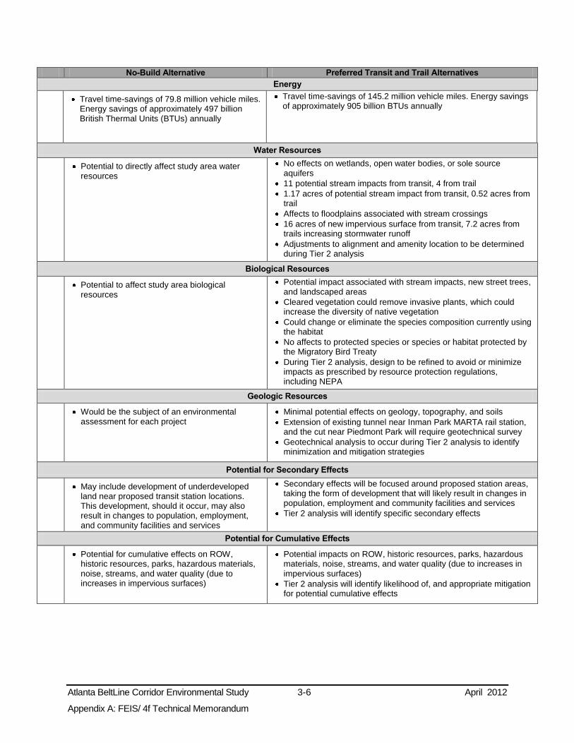
Atlanta BeltLine Corridor Environmental Study 3-6 April 2012
Appendix A: FEIS/ 4f Technical Memorandum
No-Build Alternative Preferred Transit and Trail Alternatives
Energy
Travel time-savings of 79.8 million vehicle miles. Energy savings of approximately 497 billion British Thermal Units (BTUs) annually
Travel time-savings of 145.2 million vehicle miles. Energy savings of approximately 905 billion BTUs annually
Water Resources
Potential to directly affect study area water resources
No effects on wetlands, open water bodies, or sole source aquifers
11 potential stream impacts from transit, 4 from trail 1.17 acres of potential stream impact from transit, 0.52 acres from trail
Affects to floodplains associated with stream crossings 16 acres of new impervious surface from transit, 7.2 acres from trails increasing stormwater runoff
Adjustments to alignment and amenity location to be determined during Tier 2 analysis
Biological Resources
Potential to affect study area biological resources
Potential impact associated with stream impacts, new street trees, and landscaped areas
Cleared vegetation could remove invasive plants, which could increase the diversity of native vegetation
Could change or eliminate the species composition currently using the habitat
No affects to protected species or species or habitat protected by the Migratory Bird Treaty
During Tier 2 analysis, design to be refined to avoid or minimize impacts as prescribed by resource protection regulations, including NEPA
Geologic Resources
Would be the subject of an environmental assessment for each project
Minimal potential effects on geology, topography, and soils Extension of existing tunnel near Inman Park MARTA rail station, and the cut near Piedmont Park will require geotechnical survey
Geotechnical analysis to occur during Tier 2 analysis to identify minimization and mitigation strategies
Potential for Secondary Effects
May include development of underdeveloped land near proposed transit station locations. This development, should it occur, may also result in changes to population, employment, and community facilities and services
Secondary effects will be focused around proposed station areas, taking the form of development that will likely result in changes in population, employment and community facilities and services
Tier 2 analysis will identify specific secondary effects
Potential for Cumulative Effects
Potential for cumulative effects on ROW, historic resources, parks, hazardous materials, noise, streams, and water quality (due to increases in impervious surfaces)
Potential impacts on ROW, historic resources, parks, hazardous materials, noise, streams, and water quality (due to increases in impervious surfaces)
Tier 2 analysis will identify likelihood of, and appropriate mitigation for potential cumulative effects

Atlanta BeltLine Corridor Environmental Study 3-7 April 2012
Appendix A: FEIS/ 4f Technical Memorandum
The assessment measured the ability of each alternative to provide transportation benefits, such as the number of connections to bus routes, travel-time savings, and other factors. Qualitative measures that compare the relative merits of the alternatives were used where quantitative measures are either inappropriate or unavailable. Examples of qualitative measures are potential effects at roadway crossings and along in-street running sections.
3.2.1.2 Sources of Data
Primary data sources include field reconnaissance, assessment of conditions not available from secondary sources, and input from public and private entities having jurisdiction over transportation facilities in the study area. Secondary sources include studies and plans available from MARTA including past Atlanta BeltLine studies, including the Regional Freight Mobility Plan and traffic data from the regional travel demand model, the ARC, Georgia Regional Transportation Authority (GRTA), Atlanta Regional Transit Implementation Board (TIB), the City of Atlanta, GDOT, including the State Rail Plan, and other agencies. All traffic data are from the ARC unless otherwise indicated.
3.2.2 Travel Patterns
3.2.2.1 Affected Environment
Travel patterns in central Atlanta and the Atlanta BeltLine study area were analyzed in the Atlanta BeltLine Feasibility Wrap-Up Report (MARTA 2005) with a focus on home-based work (HBW) trips (commute trips from home to work). The report confirms the findings of the Atlanta BeltLine Baseline Conditions Assessment (MARTA 2004). There are numerous employment centers throughout the Atlanta region with travel patterns that are scattered to a number of major employment destinations rather than to a single primary CBD destination. Currently, the strongest HBW pattern is from the northern suburbs to Downtown and Midtown in central Atlanta and to Buckhead, which is north of central Atlanta and the study area. Findings in Envision6 (ARC 2007) indicate that about 35 percent of HBW trips both originate and end within the City of Atlanta, that the average automobile trip beginning in the City is 5.5 miles in length.
As reported by ARC in the 2008 Transportation Fact Book, approximately 12 percent of total daily person trips in the region are work trips, compared with approximately 84 percent that are non-work trips. Examples of non-work destinations within the study area include major shopping centers at Lindbergh, Ansley, and the West End Mall; parks including Piedmont Park and Maddox Park; schools; and community facilities. Most of these trips, regional and within Atlanta, use private vehicles or public transit services. For some areas, public transit is efficient and convenient, but other areas are underserved, as described in the following discussions by zone.
Land use planning in the City is focused on development of activity centers in the study area and central Atlanta, as shown in Figure 1-4, and discussed in Sections 1.5 and 3.3. The existing regional transportation system for both roadways and transit is radial. Other transportation projects currently being studied under the No-Build Alternative also are essentially radial. The circumferential path of the Atlanta BeltLine that connects many activity centers currently is underserved, but the number of trips is expected to rise as density increases in the activity centers and increased roadway congestion substantially affects travel in the foreseeable future, as discussed in Section 3.2.4.2.

Atlanta BeltLine Corridor Environmental Study 3-8 April 2012
Appendix A: FEIS/ 4f Technical Memorandum
Northeast Zone
The northeast zone has been the focus of much of the recent land development in the City. Projections to 2030 indicate that it will have the largest population and employment increases of all zones, and be second to the southeast in the growth of housing units. (Detailed socioeconomic data can be found in Section 3.5.) Major travel generators in this zone include Piedmont Park and the Atlanta Botanical Garden, the Carter Center, Ansley Mall, Martin Luther King Jr. National Historic Site, Lindbergh Center, and City Hall East.
Southeast Zone
The southeast zone has experienced recent land development. Projections to 2030 indicate the second largest increases in population and employment in the study area, and the highest increase of housing units. In 2000, nearly a quarter of households in the southeast zone was below poverty and had no automobile, while 16 percent of the workers used transit for their work trip. Major travel generators in this zone include Glenwood Park and Oakland Cemetery. Grant Park and Zoo Atlanta are nearby but not in the study area.
Southwest Zone
Between 2000 and 2008, the southwest zone experienced employment growth compared to the other study area zones and other parts of the City and County, which experienced job losses during the same period. Projections to 2030, however, indicate modest population and employment growth, and increase in housing units. U.S. Census 2000 data indicate that the southwest zone was the least affluent in the study area with nearly a third of households below poverty and with no automobile. Over a quarter of workers used transit for their work trip in 2000. Major travel generators in this zone include Historic Westside Village and West End Mall. Outside the study area, but nearby, is a concentration of four institutions of higher learning.
Northwest Zone
Projections to 2030 indicate that the northwest zone will have population and employment growth rates below the southeast zone, but above the southwest, and only a small increase in housing units as large areas are occupied by industrial uses and rail facilities. The northwest zone contains the largest contiguous portion of the Atlanta BeltLine TAD. In 2000, nearly a fifth of households in the northwest zone was below the poverty level and had no automobile, while 12.4 percent of the workers used transit for their work trip. Major travel generators in this zone include Piedmont Hospital, Maddox and Washington Parks, King Plow Arts Center, and the Atlantic Station development.
3.2.2.2 Effects on Travel Patterns
No-Build Alternative
As described in the Technical Memorandum on Transportation Systems and Facilities, the No-Build Alternative includes the Atlanta Streetcar, Lindbergh/Emory High Speed Transit, SR 13/Buford Highway BRT, and the Memorial Drive BRT and other transit projects that would serve radial trips. These projects are expected to accommodate some in-city HBW and non-work trips within their geographic area of influence. However, none of these projects individually or in aggregate would accommodate circumferential trips among the study area activity centers, major travel generators, and MARTA rail

Atlanta BeltLine Corridor Environmental Study 3-9 April 2012
Appendix A: FEIS/ 4f Technical Memorandum
stations, or collect trips from the study area to deliver passengers to and from the MARTA rail system. Moreover, the projects in aggregate would not address the need to increase transportation options in the study area in order to provide more travel connections, or improve travel efficiency. In addition, as described in Section 3.2.7, a number of bicycle and pedestrian network improvements are planned, but substantial gaps in bicycle and pedestrian networks between activity centers and other destinations will remain, requiring other modes to make many trips. Thus, the project need to expand bicycle/pedestrian options within the study area in a systematic way that provides connections to activity centers, major travel generators, MARTA rail stations, and recreational facilities will not be met by the No-Build Alternative.
Preferred Alternatives
The mostly short trips between neighborhoods, commercial and employment destinations, activity centers, and MARTA rail stations, especially those with one or both ends in the study area, will be facilitated by the Preferred Transit Alternative. The Preferred Transit Alternative also will serve regional HBW trips not destined for Downtown or Midtown by connecting the various radial routes with each other and the activity centers in the study area with a circumferential service. By doing so, the Preferred Transit Alternative will provide an alternative to travel by personal vehicle, thereby potentially reducing roadway congestion in central Atlanta.
The Detailed Screening Analysis (MARTA, January 2007) for the Atlanta BeltLine evaluated the travel benefits of Alternative B3, the predecessor to the Build Alternatives used in the Tier 1 DEIS. This and other benefits of B3 identified in the 2007 analysis apply to the Preferred Transit Alternative, as it is a refinement of B3. Using the regional travel demand model, the analysis determined that B3, and, therefore, the Preferred Transit Alternative, will have an estimated:
annual ridership of 26.41 million,
annual new ridership of 6.43 million,
annual travel-time savings of 1.65 million hours,
more direct rail transit travel with 6,376 fewer daily transfers at the Five Points MARTA rail station,
a slight reduction of the average number of transfers per regional transit trip, and
a daily reduction of 113,000 vehicle miles traveled.
These data indicate the Preferred Transit Alternative will provide an improvement in study area-wide travel patterns, overall travel–time savings, and a reduction in vehicle miles traveled (VMT) compared with the No-Build Alternative.
The Atlanta BeltLine transit element seeks to sustain the regional economy by serving the projected travel patterns forecast to result from Atlanta’s planned redevelopment program of dense, urban, transit-oriented development ringing central Atlanta, rather than to meet existing travel demands or to cure existing capacity constraints in transportation. It also will provide some reduction of congestion as discussed in Section 3.2.4.
The Preferred Transit Alternative will connect existing and proposed activity centers and will redirect over 6,000 daily trips from the radial corridors to a circumferential one. This is shown by the number of transfers eliminated at the Five Points MARTA rail station as

Atlanta BeltLine Corridor Environmental Study 3-10 April 2012
Appendix A: FEIS/ 4f Technical Memorandum
stated above. These transfers represent trips that follow radial lines often because those are the only routes to a destination.
Travel Performance Measures Travel performance measures were used to evaluate the performance of the No-Build and Preferred Transit Alternative, including travel-time savings, number of transfers, population and employment near stations, and service to various underserved groups.
Travel-time savings measures the estimated change in travel times between various origins and destinations determined by comparing the estimated transit travel times for the No-Build and the Preferred Alternatives for the same trips, as shown in Table 3-2.
Table 3-2: Preliminary Travel Times and Travel-Time Savings
Transit Trip Average Travel Time
(minutes) Travel-Time Savings Difference between
Preferred Transit Alternative and No-
Build Alternative (minutes)
Origin Destination No-Build
Alternative
Preferred Transit
Alternative
Grant Park Cascade Avenue at Ralph David Abernathy Boulevard 48 28 20
Cascade Avenue at Ralph David Abernathy Boulevard
Joseph E Boone (Simpson Road) 66 10 56
Lindbergh Center Joseph E Boone (Simpson Road) 37 25 12
Boulevard Heights Ansley Mall 99 27 72 Colonial Homes Ansley Mall 56 24 32 Source: AECOM 2010
The trips shown in Table 3-2 were selected to represent typical trips made within the study area. The No-Build Alternative travel time estimates are based on the existing transit service. Travel times for the Preferred Transit Alternative were derived from the preliminary operating plans based on route length, walk time to access stations, the number of stations, dwell times at stations, typical vehicle acceleration and deceleration rates, vehicle speeds, and estimates of congestion delay along in-street running segments. Assumptions include 12-minute headways, 30-second train holds at each station, and allowable speed of 55 miles per hour with actual speeds being lower. For the trips evaluated, the Preferred Transit Alternative would provide substantial improvement in travel time compared with the No-Build Alternative.
Number of Transfers evaluates the Preferred Transit Alternative relative to the number of transfers that would be required to make the trips in Table 3-2. The Preferred Transit Alternative will require no transfers while the No-Build Alternative would require an average of three per trip.
Population and Employment within ½-Mile of Potential Transit Stations evaluates the Preferred Transit Alternative based on the projected population to be served. Table 3-3 shows that the Preferred Transit Alternative will serve substantially higher projected population and employment than the No-Build Alternative.

Atlanta BeltLine Corridor Environmental Study 3-11 April 2012
Appendix A: FEIS/ 4f Technical Memorandum
Table 3-3: Population and Employment within ½-mile of the Proposed Transit Stations
Transit Alternative Population Employment
2008 2030 2008 2030
No-Build Alternative 54,776 79,874 65,256 80,474 Preferred Transit Alternative 110,205 137,941 87,681 116,799
Source: ARC 2008 Regional Forecasts and Geographic Information Systems (GIS)
Access for Underserved Groups evaluates the potential to improve mobility for low-income, minority, and disabled populations, populations over age 65, and zero-car households within ½-mile of proposed transit stations. Table 3-4 shows that the Preferred Transit Alternative will provide twice the amount of access to transit for transit-dependent, low-income, and minority populations than the No-Build Alternative.
Table 3-4: Transit-Dependent, Low-Income, and Minority Populations within ½-mile of the Proposed Transit Stations - 2000
Transit Alternative
Transit-Dependent Low-Income
Population
Minority Population Zero-Car
Households Population over Age 65
Disabled Population
No-Build Alternative 5,850 3,777 9,368 11,700 28,272 Preferred Transit Alternative 10,079 8,005 18,724 21,784 59,864
Source: U.S. Census Bureau, Census 2000
In addition, the Preferred Transit Alternative will serve both Piedmont Hospital, a 481-bed facility with over 4,000 employees, over 900 physicians, and over 300,000 patients per year, and the Shepherd Center, a 132-bed facility with over 1,200 employees and over 14,000 patients per year. Other destinations serving the transit-dependent population for both work and non-work trips are highlighted by reviewing the lists of schools, churches, and community facilities in Section 3.4.
3.2.3 Transit Services
3.2.3.1 Affected Environment
Existing transit services in the study area include all MARTA heavy rail lines, 6 MARTA rail stations, 36 local MARTA bus routes, and GRTA Xpress regional commuter bus service between Lindbergh Center MARTA rail station and Gwinnett County. Figure 3-1 shows existing transit services in the study area zones and central Atlanta. Table 3-5 lists MARTA rail stations and connecting bus routes by zone. The following sections discuss the bus service in each zone.
Table 3-5: MARTA Rail Stations
MARTA Rail Station Study Area Zone Line Average
Daily Entries Connecting Bus Routes
Lindbergh Center northwest and northeast Red and Gold 8,402 5, 6, 27, 30, 39 Inman Park/Reynoldstown northeast and southeast Blue and Green 2,973 4, 6, 34, 107 King Memorial northeast and southeast Blue and Green 2,087 21 West End southeast and southwest Red and Gold 7,990 67, 68, 71, 81, 95 Ashby southwest and northwest Blue and Green 2,244 68 Bankhead northwest Green 2,376 26, 50, 58 Source: MARTA 2010

Atlanta BeltLine Corridor Environmental Study 3-12 April 2012
Appendix A: FEIS/ 4f Technical Memorandum
Northeast Zone
Thirteen MARTA local bus routes serve this zone (routes 2, 3, 4, 5, 6, 16, 21, 27, 30, 36, 99, and 186). Most bus routes are radial and provide feeder service to MARTA rail stations, while others access Downtown or Midtown. An exception is Route 6 Emory that connects Lindbergh Center and Inman Park/Reynoldstown MARTA rail stations. It is parallel with the Atlanta BeltLine study area, but aligned largely outside the study area to the east. With the exception of Route 6, there is no direct access between the MARTA rail stations; though, riders can make a transfer at the Five Points MARTA rail station in Downtown
In addition to accessing central Atlanta directly or via transfers at MARTA rail stations, two bus routes operating in the northeast zone access the southeast zone; one accesses the southwest zone; and four access the northwest zone.
In 2030, heavy roadway congestion is projected for all of the arterial streets in the zone north of Ralph McGill Boulevard, as well as on Highland Avenue, Freedom Parkway, Irwin Street, and Hilliard Street. Therefore, many of the current bus routes in the northeast zone would operate on streets projected to have heavy congestion.
Southeast Zone
Seventeen MARTA local bus routes serve the southeast zone (routes 4, 21, 32, 34, 42, 49, 55, 67, 68, 71, 74, 81, 95, 107, 155, 186, and 193). All routes are radial with some providing feeder service to MARTA rail stations while others directly access Downtown. Transit connection between either King Memorial or Inman Park/Reynoldstown and the West End MARTA rail station is limited to a rail trip requiring a transfer at Five Points MARTA rail station as there is no connecting bus route. Provision of a bus route parallel to the proposed Atlanta BeltLine would be circuitous because of the lack of an effective roadway grid.
In addition to accessing central Atlanta directly or via transfers at MARTA rail stations, two bus routes operating in the southeast zone provide access to the northeast zone; five provide access to the southwest zone; and one provides access to the northwest zone.
In 2030, projected heavy roadway congestion in the northern portion of this zone is a result of the I-20 entrance and exit ramps and the constraints of crossing the freight railroad ROW. Congestion in the southern and western portions of this zone is found on north-south radial streets parallel to I-75/85. Due to the projected congestion, several of the current bus routes will operate on streets projected to have heavy congestion in 2030, including two routes that operate on I-20 and its entrance and exit ramps.
Southwest Zone
Seven MARTA bus routes serve the southwest zone (3, 13, 67, 68, 71, 81, and 95). All bus routes are essentially radial with some providing feeder service to the MARTA rail stations, while others directly access Downtown or connect MARTA rail stations outside the study area with Five Points MARTA rail station. There is no direct access to the northern portions of the study area except via MARTA rail. Route 68 Donnelly connects West End and Ashby MARTA rail stations and crosses a portion of central Atlanta in relatively straight lines rather than following the curve of the study area.

Atlanta BeltLine Corridor Environmental Study 3-13 April 2012
Appendix A: FEIS/ 4f Technical Memorandum
In addition to accessing central Atlanta directly or via transfers at MARTA rail stations, one bus route operating in the southwest zone provides access to the northeast zone; five provide access to the southeast zone; and one accesses the northwest zone.
In 2030, heavy roadway congestion is projected for Murphy Avenue, Ralph David Abernathy Boulevard, Cascade Road, and Joseph E. Lowery Boulevard from Lee Street to I-20. Therefore, the current bus routes will operate on streets projected to have heavy congestion.
Northwest Zone
Fourteen MARTA bus routes provide service in the zone (routes 1, 5, 6, 12, 26, 27, 30, 37, 39, 50, 51, 58, 68, and 110). Except for Route 6 discussed above in the northeast zone, all bus routes are radial with some providing feeder service to MARTA rail stations while others directly access Downtown or Midtown.
In addition to accessing central Atlanta directly or via transfers at MARTA rail stations, four bus routes operating in the northwest zone provide access the northeast zone; one provides access to the southeast zone; and one accesses the southwest zone.
In 2030, heavy roadway congestion is projected for all but three radial arterials due to traffic entering or exiting the interstate system. Therefore, half of the current bus routes will operate on streets projected to have heavy congestion.
3.2.3.2 Effects on Transit Service
No-Build Alternative
The No-Build Alternative will not affect existing MARTA rail or local bus services or GRTA commuter bus service.
Preferred Alternatives
The Preferred Transit Alternative will enhance existing and planned transit service by providing connecting service between radial transit routes that cross the Atlanta BeltLine and new service where it is currently unavailable. This expanded network will attract new ridership on the existing transit services as discussed in the following sections.
MARTA Rail Service The Atlanta BeltLine transit element will supplement the existing MARTA rail network by providing cross-town and circumferential transit service. Figure 3-1 shows the Atlanta BeltLine overlaid onto the existing MARTA rail lines and the stations for each. The Preferred Transit Alternative was evaluated to determine its potential to serve the largest number of MARTA rail stations with direct connections. The Preferred Transit Alternative will potentially serve the following MARTA rail stations or infill stations: Lindbergh Center, Inman Park/Reynoldstown or King Memorial, West End, Ashby, and Bankhead. The Preferred Transit Alternative will intersect rather than duplicate MARTA rail service. As discussed earlier, an important aspect of the Preferred Transit Alternative is its ability to reduce transfers at the Five Points MARTA rail station. The circumferential route of the Preferred Transit Alternative will benefit MARTA rail service by reducing transfers and transit congestion in central Atlanta. The Preferred Trail Alternative will also benefit the MARTA rail system by improving bicycle and pedestrian access to and from stations.

Atlanta BeltLine Corridor Environmental Study 3-14 April 2012
Appendix A: FEIS/ 4f Technical Memorandum
Figure 3-1: Existing Transit Service
Source: MARTA, GRTA, 2010 Note: The Atlanta BeltLine is not considered to be existing transit service, but for reference it is shown on this map. The MARTA service route data is current to September 2010.

Atlanta BeltLine Corridor Environmental Study 3-15 April 2012
Appendix A: FEIS/ 4f Technical Memorandum
MARTA Bus Service The Preferred Transit Alternative will enhance the MARTA local and GRTA Xpress bus networks by providing connecting service at proposed Atlanta BeltLine stations.
The number of local bus connections to the Preferred Transit Alternative was evaluated. The number of bus connections is defined as the cumulative number of connection operations made by bus routes during the peak periods with potential stops at the proposed Atlanta BeltLine stations. Assuming the bus routes and schedules implemented in September 2010, the Preferred Transit Alternative will serve up to 73 local bus connections in the study area and connect with 21 routes. A similar evaluation of express bus connections shows that the Preferred Transit Alternative will provide six express bus connections. No bus routes provide circumferential service; therefore, the Atlanta BeltLine transit element will not duplicate MARTA bus service.
Localized effects on existing bus routes may occur in the in-street running portions of the Atlanta BeltLine depending on that portion’s specific configuration. Potential adverse effects include MARTA buses experiencing potential delays from Atlanta BeltLine vehicles and changes to the traffic signal system. Conversely, operational accommodations for the Atlanta BeltLine could see an overall travel-time savings along bus routes if the buses operate in the Atlanta BeltLine transit lanes and utilize the signal system.
Atlanta BeltLine vehicles might temporarily block travel when at stations causing potential delays for local bus service, but potential effects will depend upon the frequency of stops, the dwell time, and the locations of local bus stops. A small subset of MARTA bus riders may experience adverse effects that result from potential changes in routes or headways, but the potentially beneficial effects of the Preferred Transit Alternative for riders in general will offset these limited potential adverse effects.
The Preferred Trail Alternative will beneficially affect the MARTA bus system by improving bicycle and pedestrian access to and from bus stops along trail routes.
Other Transit Service The Preferred Transit Alternative will benefit existing commuter bus services by providing connecting service. As these routes generally have a radial pattern connecting central Atlanta with suburban locations, the Atlanta BeltLine will complement their service by providing a circumferential transit link that will enable riders to access additional activity centers. When operating in segments of in-street running, the same potential adverse and beneficial effects on commuter bus services may occur as with the local bus routes. The Preferred Trail Alternative will beneficially affect other transit services by improving bicycle and pedestrian access to and from stops along trail routes.
Planned Transit Services The Preferred Transit Alternative was also evaluated to determine its potential to directly connect to No-Build Alternative transit projects illustrated in Appendix Figure 2.2-2 in Appendix D and to planned passenger rail service. The Preferred Transit Alternative will connect to approximately 24 planned transit and passenger rail projects, while the No-Build Alternative will connect to 14 planned projects. The Atlanta BeltLine and the planned services will be mutually complementary wherever the services share a station.
The measure evaluating the potential to connect to other transit projects also considered the capability of the Preferred Transit Alternative to be compatible with the technologies proposed for other projects. Final determinations as to the technologies for many of these planned projects have not been made with the exception of the first phase of the

Atlanta BeltLine Corridor Environmental Study 3-16 April 2012
Appendix A: FEIS/ 4f Technical Memorandum
Atlanta Streetcar Project, which will be a streetcar. Thus, performance by the Preferred Alternatives was measured qualitatively based on the typical operational characteristics of LRT and SC. Though the selected mode for the Atlanta BeltLine is SC, the Atlanta BeltLine corridor is being developed in a manner that preserves the option for proposed LRT projects connecting to counties surrounding the City of Atlanta to operate within the corridor. For this reason, the conceptual design of the Preferred Transit Alternative reflects the more conservative rail infrastructure and geometrical requirements of LRT to accommodate LRT projects planned under the No-Build Alternative. The potential effects of the Preferred Transit Alternative on proposed passenger rail services are discussed in Section 3.2.6.
The Preferred Trail Alternative will beneficially affect planned transit services by improving bicycle and pedestrian access to and from stops and stations along the trail route.
3.2.4 Roadway System
3.2.4.1 Affected Environment
The existing roadway network in the study area, depicted in Figure 3-1, consists of a radial interstate system superimposed on an arterial and local street system, portions of which are laid out in a grid. The arterial and local street system enables radial travel as well as travel patterns between destinations within the City. The local street pattern was developed over time through cumulative expansions that were influenced by terrain, land use, and successive urban design theories. Today’s roadway network of grid and non-grid streets substantially influences travel patterns.
Appendix E of Connect Atlanta, the City of Atlanta’s Comprehensive Transportation Plan, contains a figure entitled Map 8 Roadway Segments at LOS F [ARC 2005 Model Year]. It shows that the number of vehicles using many principal roadways, especially the interstate system, equal or exceed the roadway’s maximum capacity, a condition commonly referred to as “gridlock.”
The 2008 Final Technical Report by the Transit Planning Board (TPB) found that congestion in Atlanta costs the region nearly $2 billion per year, roughly $1,127 per commuter. The ARC Envision6 Needs Assessment Report, Section 3, issued in 2005, projects that by 2030, if no transportation improvements are implemented, the annual cost per person will rise to approximately $2,400.
Figure 3-2 presents the projected year 2030 roadway congestion in the study area. A map of regional roadway congestion in 2030 can be found in the Technical Memorandum on Transportation Systems and Facilities. ARC measures the traffic congestion levels using volume-to-capacity (V/C) ratios. A V/C ratio is the volume of automobiles traveling on a roadway relative to the capacity available on the roadway in terms of travel lanes available. A V/C ratio of 1.0 indicates a volume of traffic that is equal to the design capacity of the roadway. The level of congestion is measured by three categories of severity: Low (V/C ratio of 0.10 to 0.69); Moderate (V/C ratio of 0.70 to 1.00); and High (V/C ratio over 1.00). As shown in Figure 3-2, many of the streets in the study area, especially in the northeast and northwest zones, will experience levels of congestion with V/C ratios greater than 1.00.

Atlanta BeltLine Corridor Environmental Study 3-17 April 2012
Appendix A: FEIS/ 4f Technical Memorandum
Figure 3-2: 2030 Roadway Volumes and Congestion Levels
Source: ARC 2006

Atlanta BeltLine Corridor Environmental Study 3-18 April 2012
Appendix A: FEIS/ 4f Technical Memorandum
Congestion substantially affects travel patterns and efficiency. The Atlanta BeltLine Baseline Conditions Assessment (2004) projected that the number of trips in congested conditions in the study area will increase from 59 percent of trips in the year 2000 to 70 percent in 2030. The assessment identified the need for faster, more convenient and more reliable transit service, bicycle and pedestrian connections, and better utilization of the MARTA rail system, especially between the existing and planned activity centers.
3.2.4.2 Effects on the Roadway System
No-Build Alternative
Roadway projects in the No-Build Alternative will provide maintenance and limited operational upgrades, as well as capacity improvements in some areas to reduce congestion. The projects are intended to provide localized operational improvements and congestion relief. However, no study area-wide project or combination of projects to address roadway congestion problems is planned. Several transit projects in the No-Build Alternative, including the Atlanta Streetcar, SR 13 (Buford Highway) BRT, and Memorial Drive BRT will operate in-street and could increase congestion.
As discussed in Section 3.2.2.2, the No-Build Alternative transit projects will attract riders that may otherwise travel by car. However, given the radial service areas of those projects, most travelers with origins and destinations in the study area will not be provided with an alternative to the use of private vehicles.
Preferred Alternatives
Diversion of HBW and non-work trips by the Preferred Transit and Trail Alternatives may slow the growth of congestion on the roadways serving the study area. Over time, congestion may be reduced on some of these roadways, which will allow the roadways to better accommodate future travel patterns without changing their characteristics or capacity.
Since the Preferred Transit Alternative will operate partly in public road ROW, its effect on roadways depends on how safely and efficiently the Atlanta BeltLine vehicles are able to share roadways with other transit modes and general traffic. The principal concerns in this regard are as follows:
At-grade crossings in which the transit vehicle enters or exits a roadway or crosses it at-grade; and
In-street running in which the transit vehicle operates in a travel lane of a roadway, which it shares with other transit modes and general traffic or from which general traffic, and possibly other transit modes, have been removed.
The potential effects of the Preferred Transit Alternative on the general roadway traffic are discussed below in each of these areas. Further analysis and design refinement will be undertaken in Tier 2 analysis to avoid or minimize potential effects on roadway operations. The MARTA Station Connectivity and Infill Station Alternative areas will be assessed in subsequent analysis.
At-Grade Crossings At-grade crossings are found in the northeast and southeast zones for the Preferred Transit Alternative, but not in the southwest zone. In the northwest zone, the Preferred Transit Alternative has five at-grade crossings. At most locations, at-grade crossings will
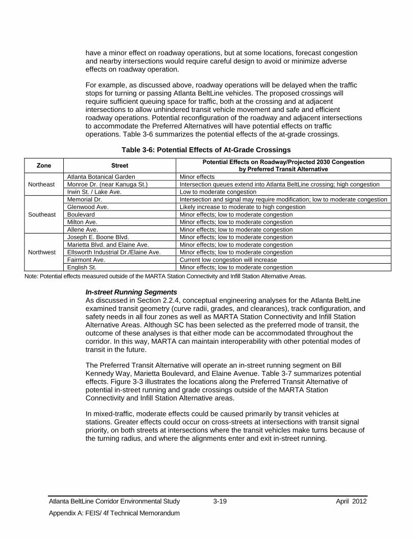
Atlanta BeltLine Corridor Environmental Study 3-19 April 2012
Appendix A: FEIS/ 4f Technical Memorandum
have a minor effect on roadway operations, but at some locations, forecast congestion and nearby intersections would require careful design to avoid or minimize adverse effects on roadway operation.
For example, as discussed above, roadway operations will be delayed when the traffic stops for turning or passing Atlanta BeltLine vehicles. The proposed crossings will require sufficient queuing space for traffic, both at the crossing and at adjacent intersections to allow unhindered transit vehicle movement and safe and efficient roadway operations. Potential reconfiguration of the roadway and adjacent intersections to accommodate the Preferred Alternatives will have potential effects on traffic operations. Table 3-6 summarizes the potential effects of the at-grade crossings.
Table 3-6: Potential Effects of At-Grade Crossings
Zone Street Potential Effects on Roadway/Projected 2030 Congestion
by Preferred Transit Alternative
Northeast Atlanta Botanical Garden Minor effects Monroe Dr. (near Kanuga St.) Intersection queues extend into Atlanta BeltLine crossing; high congestion Irwin St. / Lake Ave. Low to moderate congestion
Southeast
Memorial Dr. Intersection and signal may require modification; low to moderate congestion Glenwood Ave. Likely increase to moderate to high congestion Boulevard Minor effects; low to moderate congestion Milton Ave. Minor effects; low to moderate congestion Allene Ave. Minor effects; low to moderate congestion
Northwest
Joseph E. Boone Blvd. Minor effects; low to moderate congestion Marietta Blvd. and Elaine Ave. Minor effects; low to moderate congestion Ellsworth Industrial Dr./Elaine Ave. Minor effects; low to moderate congestion Fairmont Ave. Current low congestion will increase English St. Minor effects; low to moderate congestion
Note: Potential effects measured outside of the MARTA Station Connectivity and Infill Station Alternative Areas.
In-street Running Segments As discussed in Section 2.2.4, conceptual engineering analyses for the Atlanta BeltLine examined transit geometry (curve radii, grades, and clearances), track configuration, and safety needs in all four zones as well as MARTA Station Connectivity and Infill Station Alternative Areas. Although SC has been selected as the preferred mode of transit, the outcome of these analyses is that either mode can be accommodated throughout the corridor. In this way, MARTA can maintain interoperability with other potential modes of transit in the future.
The Preferred Transit Alternative will operate an in-street running segment on Bill Kennedy Way, Marietta Boulevard, and Elaine Avenue. Table 3-7 summarizes potential effects. Figure 3-3 illustrates the locations along the Preferred Transit Alternative of potential in-street running and grade crossings outside of the MARTA Station Connectivity and Infill Station Alternative areas.
In mixed-traffic, moderate effects could be caused primarily by transit vehicles at stations. Greater effects could occur on cross-streets at intersections with transit signal priority, on both streets at intersections where the transit vehicles make turns because of the turning radius, and where the alignments enter and exit in-street running.

Atlanta BeltLine Corridor Environmental Study 3-20 April 2012
Appendix A: FEIS/ 4f Technical Memorandum
Table 3-7: Potential Effects, Proposed In-Street Sections
Zone Street Potential Effects on Atlanta
BeltLine Transit Performance Potential Effects on Roadway/ Projected 2030 Congestion
by Preferred Transit Alternative
Southeast Bill Kennedy Way Long travel times and unreliable operations
High congestion forecast; potential removal of on-street parking; dedicated lane potentially infeasible at I-20 bridge; eliminates bicycle lane
Northwest Marietta Blvd. Adverse effects unlikely Adverse effects unlikely Elaine Ave. Adverse effects unlikely Moderate adverse effects
Note: Assuming shared travel lanes, and potential effects measured outside of the MARTA Station Connectivity and Infill Station Alternative Areas. There are no in-street running sections in the northeast or southwest zones.
3.2.5 Freight Rail
3.2.5.1 Affected Environment
Active and inactive freight rail corridors are present throughout the study area, some forming the basis for the proposed Atlanta BeltLine Corridor. As shown on Figure 3-4, GDOT and the ADA are the principal owners of the inactive corridors, and CSX and Norfolk Southern operate and own or lease the active freight lines. Figure 3-5 depicts the approximate volumes of freight rail traffic and the route used by Amtrak. Section 3.2.6 provides discussion of Amtrak passenger rail service. Table 3-8 summarizes the important characteristics of the active freight rail corridors based on information available from MARTA, GDOT, a 2006 field survey and assessment of the freight rail corridors conducted by MARTA (MARTA Rail Freight Analysis Report, Inner Core BeltLine/C-Loop Alternatives Analysis 2006), and other sources as noted.
Table 3-8: Characteristics of Active Freight Rail Corridors within the Study Area Zone Owner Railroad Corridor Freight Activity*
Southeast CSX A&WP 2-3 trains per week
Northwest
CSX CSX Bellwood Yard / CSX Northside
34-59 trains per day / 15-34 trains per day
CSX CSX Tilford Line / CSX Northside
15-34 trains per day / 15-34 trains per day
NS Norfolk Southern Northside
15-34 trains per day, over 35 on western segment
Source: GDOT estimates 2008 Note: There are no active freight rail corridors in the northeast or southwest zones.
The Atlanta Regional Freight Mobility Plan (ARC, 2008) reviewed existing and projected conditions for all freight modes through 2030. It notes that Atlanta is a critical junction and logistics point for freight rail in the southeastern U.S., and that it is an important operations center for CSX. All freight modes are important to the regional economy, but freight rail is important to providing an alternative to trucks in central Atlanta. In 2005, freight rail tonnage was 130 million tons. The plan projects that by 2030 freight rail tonnage will increase by 37 percent and carloads by 53 percent.

Atlanta BeltLine Corridor Environmental Study 3-21 April 2012
Appendix A: FEIS/ 4f Technical Memorandum
Figure 3-3: In-Street Sections – Preferred Transit Alternative
Source: AECOM Analysis 2010

Atlanta BeltLine Corridor Environmental Study 3-22 April 2012
Appendix A: FEIS/ 4f Technical Memorandum
Figure 3-4: Freight Rail Corridors and Facilities
Source: GDOT 2009

Atlanta BeltLine Corridor Environmental Study 3-23 April 2012
Appendix A: FEIS/ 4f Technical Memorandum
Figure 3-5: Freight and Amtrak Rail Traffic Volumes
Source: GDOT 2005

Atlanta BeltLine Corridor Environmental Study 3-24 April 2012
Appendix A: FEIS/ 4f Technical Memorandum
This Atlanta Regional Freight Mobility Plan includes 11 rail projects of which 3 are in the study area. The principal one is the improvement to Howell Junction, the major pinch point of the regional freight rail corridors.
Communication with public and private entities having jurisdiction over transportation facilities in the study area, including GDOT, CSX, and Norfolk Southern, identified several studies and discussions that are underway that have been considered in the evaluation of the No-Build and the Preferred Alternatives. First, GDOT is currently preparing a Tier 1 EIS for a project that would establish high-speed passenger rail service between Atlanta and Chattanooga. Although a definitive alignment has not been selected, one alternative would potentially use a portion of the Norfolk Southern corridor in the northwest zone. Second, potentially relocating Amtrak to the Atlantic Station area of the Norfolk Southern corridor has been discussed for some years, but concepts are yet unformed. The third is GDOT’s Howell Junction study to determine how to separate CSX and Norfolk Southern operations in the congested Howell Junction property that it owns. However, no specific project has been identified to date. The fourth is CSX and Norfolk Southern’s potential for future expansion of their corridor capacity in the northwest zone.
The following subsections describe by zone the existing freight rail corridors within the study area.
Decatur Belt - Northeast Zone The ADA owns the inactive Decatur Belt between the Norfolk Southern Armour Yard and the CSX Hulsey Yard. The Decatur Belt includes all former Norfolk Southern property from near the junction of the wyes to Armour Yard in the north to DeKalb Avenue in the south. Tracks are present in the corridor only from Armour Yard south to Montgomery Ferry Road. The ROW width varies from 200 feet at the Armour Yard wye and around Ralph McGill Boulevard, but narrows to as little as 40 feet beyond Airline Street.
A&WP BeltLine - Southeast Zone The A&WP BeltLine begins at the CSX Hulsey Yard and runs south to Confederate Avenue and west to the CSX mainline near the intersection of Sylvan Road and Murphy Avenue. The ROW is approximately 100 feet wide, varying at several locations. The line is double-tracked from Glenwood Avenue to Boulevard and single-tracked from there to Murphy Avenue.
CSX owns most of the A&WP Beltline, except as noted below, and the line is still active along most of its length. CSX periodically delivers hopper cars to a customer between Berne Street and Glenwood Avenue.
GDOT owns the segment of the A&WP Beltline from just south of Wylie Street to Memorial Drive; the City of Atlanta owns the short segment from the old A&WP station on Memorial Drive to approximately Glenwood Avenue that is now Bill Kennedy Way, a surface street.
L&N Beltline - Southeast Zone The inactive L&N Beltline is owned by GDOT. It begins near the western end of the southeast zone at a turnout from the A&WP BeltLine owned by ADA located between Metropolitan Parkway and Allene Avenue. It continues into the southwest zone.
L&N Beltline - Southwest Zone The inactive L&N Beltline, owned by GDOT, begins in the southeast zone as described above and runs through the southwest zone and into the northwest zone. The ROW is
Atlanta BeltLine Corridor Environmental Study 3-25 April 2012
Appendix A: FEIS/ 4f Technical Memorandum
generally 100 feet wide, but it widens to nearly 300 feet between Lawton Street and Cascade Avenue. In the north near Lena Street, there are no tracks.
L&N Beltline - Northwest Zone The northwest zone has a complex network of active freight rail lines. Beginning in the south at Lena Street, the inactive L&N Beltline owned by GDOT extends northward to the MARTA Proctor Creek Line.
CSX Corridor - Northwest Zone The CSX corridor consists of two active elements, the mainline (also known as the Abbeyville Subdivision) that extends north from the Tilford and Howell Yards to the Lindbergh area, and a line (A&WP Subdivision) that enters the study area in the vicinity of Joseph E. Boone Boulevard and turns north to Tilford and Bellwood Yards. The ROW contains a single-tracked mainline with a major siding track from Howell Yard up to East Switch at I-75. The ROW width ranges from 60 to 100 feet.
Norfolk Southern Corridor - Northwest Zone The Norfolk Southern Corridor runs east from Inman Yard just outside of the study area to Howell Junction and then northeast to Armour Yard and continues to the northeast past Lindbergh Center. The segment between Howell Junction and Lindbergh Center is used by Amtrak. East of the I-75/85 interchange the MARTA Red and Gold Lines share the corridor; the Brookwood Amtrak station is at the intersection of Peachtree Street. From the Howell Junction Tower to Lindbergh Center, the Norfolk Southern corridor is double-tracked.
Howell Junction – Northwest Zone Howell Junction is the major pinch point in the regional freight rail system as it is where the CSX and Norfolk Southern freight corridors come together at grade. At the junction, mainline Norfolk Southern tracks connecting the Inman Yard and the Corridor pass through a CSX interlocking to cross the CSX tracks from Tilford Yard traveling toward the south on a corridor leased from the Georgia State Properties Commission.
3.2.5.2 Effects on Freight Rail Corridors
No-Build Alternative
The No-Build Alternative includes a mix of transportation improvements to existing facilities and new transportation projects. Two projects, the Lindbergh/Emory High Speed Transit project and the Atlanta to Lovejoy Commuter Rail project will potentially use or cross freight rail corridors within the Lindbergh and West End Connectivity Areas, respectively. Detailed assessment of the extent of potential impacts of the No-Build projects on freight rail corridors will occur during environmental analysis for those projects.
Preferred Alternatives
The Preferred Alternatives are planned to share the CSX corridors with active freight railroads in the southeast zone. As a result, they have the potential to affect active existing and future freight operations and infrastructure.
As described in Section 3.2.5.1, the active freight rail ROWs within the study area vary in width, and train movements range from 2 or 3 trains per week to almost 60 trains per day. The Atlanta BeltLine segments that contain co-aligned transit and multi-use trail elements have a 55-foot wide typical section. At station locations, the width could be as
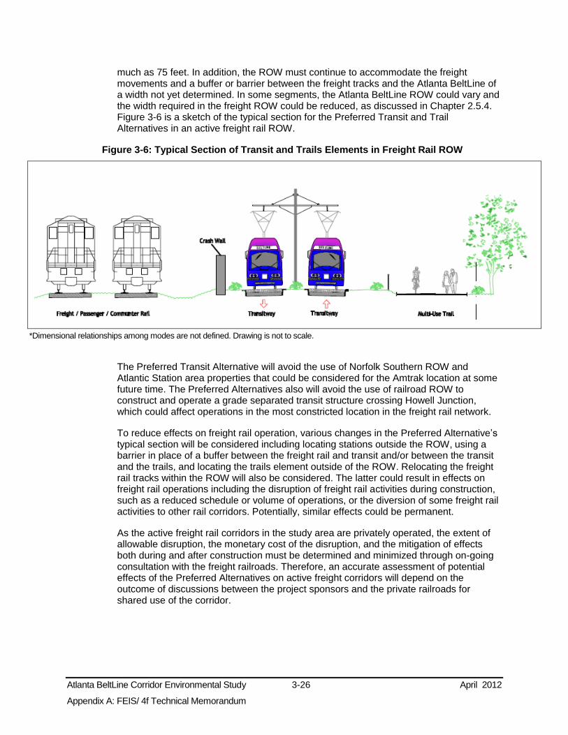
Atlanta BeltLine Corridor Environmental Study 3-26 April 2012
Appendix A: FEIS/ 4f Technical Memorandum
much as 75 feet. In addition, the ROW must continue to accommodate the freight movements and a buffer or barrier between the freight tracks and the Atlanta BeltLine of a width not yet determined. In some segments, the Atlanta BeltLine ROW could vary and the width required in the freight ROW could be reduced, as discussed in Chapter 2.5.4. Figure 3-6 is a sketch of the typical section for the Preferred Transit and Trail Alternatives in an active freight rail ROW.
Figure 3-6: Typical Section of Transit and Trails Elements in Freight Rail ROW
*Dimensional relationships among modes are not defined. Drawing is not to scale.
The Preferred Transit Alternative will avoid the use of Norfolk Southern ROW and Atlantic Station area properties that could be considered for the Amtrak location at some future time. The Preferred Alternatives also will avoid the use of railroad ROW to construct and operate a grade separated transit structure crossing Howell Junction, which could affect operations in the most constricted location in the freight rail network.
To reduce effects on freight rail operation, various changes in the Preferred Alternative’s typical section will be considered including locating stations outside the ROW, using a barrier in place of a buffer between the freight rail and transit and/or between the transit and the trails, and locating the trails element outside of the ROW. Relocating the freight rail tracks within the ROW will also be considered. The latter could result in effects on freight rail operations including the disruption of freight rail activities during construction, such as a reduced schedule or volume of operations, or the diversion of some freight rail activities to other rail corridors. Potentially, similar effects could be permanent.
As the active freight rail corridors in the study area are privately operated, the extent of allowable disruption, the monetary cost of the disruption, and the mitigation of effects both during and after construction must be determined and minimized through on-going consultation with the freight railroads. Therefore, an accurate assessment of potential effects of the Preferred Alternatives on active freight corridors will depend on the outcome of discussions between the project sponsors and the private railroads for shared use of the corridor.

Atlanta BeltLine Corridor Environmental Study 3-27 April 2012
Appendix A: FEIS/ 4f Technical Memorandum
3.2.6 Passenger Rail
3.2.6.1 Affected Environment
Amtrak provides intercity passenger rail service in Atlanta via the Crescent. The Crescent travels between New Orleans and New York City at a rate of two trains per day. Amtrak operates on the Norfolk Southern Corridor and uses the Brookwood station at Peachtree Street and I-85. Relocating Amtrak to the Atlantic Station area has been discussed for some years, but concepts are yet unformed.
Various conceptual planning efforts for expanded statewide passenger rail services have examined proposals for new services that would serve Atlanta. GDOT’s Intercity Rail Passenger Plan (1995) identified long-range priorities for passenger routes across the State of Georgia using existing rail corridors with Atlanta as a hub. GDOT prepared the Georgia State Rail Plan in 2009, which updated GDOT’s passenger and freight rail programs.
Currently there is no commuter rail service in the region, but there are seven proposed commuter rail routes, shown in Figure 3-7 and in TPB’s Concept 3, that would operate from the proposed Multi-Modal Passenger Terminal (MMPT), a new station that would be located near the Five Points MARTA rail station. The MMPT would serve commuter rail, intercity rail, high-speed rail, and regional bus transit. In the 2009 State Rail Plan, the first priority route runs along the CSX/Norfolk Southern tracks to Lovejoy, GA with a planned extension to Macon. This route parallels the MARTA Red and Gold Lines and crosses the study area near the West End MARTA rail station. Six other routes would serve Canton, Gainesville, Athens, Madison, Senoia, and Bremen.
Atlanta is on the federally designated high-speed rail Southeast Corridor. GDOT, in coordination with several Southeastern States, is studying high-speed rail service from Macon, GA, to Greenville, SC, and Charlotte, NC via Atlanta. In addition, there is a proposed statewide Intercity Passenger Rail Service priority list with a route to Macon via Lovejoy and Griffin as the first priority. Second priority routes all extend the commuter rail services from Atlanta to Augusta via Madison, to Columbus via Griffin, and to Greenville, SC via Gainesville and Toccoa.
GDOT, the Federal Highway Administration (FHWA), and the Federal Railroad Administration (FRA) are currently preparing a Tier 1 EIS for a project that would establish high-speed passenger rail service between Atlanta and Chattanooga, TN. Although a definitive alignment has not been selected, the project would cross the Atlanta BeltLine within the northwest zone.
3.2.6.2 Effects on Passenger Rail
No-Build Alternative
The No-Build Alternative will not affect existing passenger rail operations.
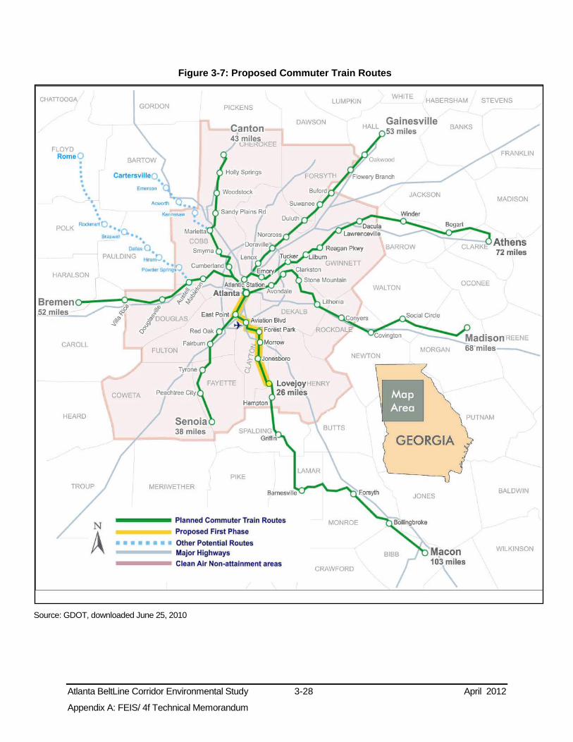
Atlanta BeltLine Corridor Environmental Study 3-28 April 2012
Appendix A: FEIS/ 4f Technical Memorandum
Figure 3-7: Proposed Commuter Train Routes
Source: GDOT, downloaded June 25, 2010

Atlanta BeltLine Corridor Environmental Study 3-29 April 2012
Appendix A: FEIS/ 4f Technical Memorandum
Preferred Alternatives
No commuter rail or intercity passenger service is proposed to operate along the length of the CSX Corridor; thus, there will be no conflict with the Preferred Transit Alternative. The Preferred Alternatives will also avoid potential conflicts with the four passenger/commuter rail proposed projects that would use the Western Trunk from Howell Junction into Downtown Atlanta including the commuter rail lines to Bremen, Canton, Athens and Gainesville, along with Amtrak. There will also be no conflict with the proposed passenger/commuter rail lines to Athens and Gainesville that would use the Norfolk Southern Corridor to access the MMPT in Downtown Atlanta. Likewise, no conflict is anticipated between the Atlanta BeltLine and the Crescent Amtrak service connecting New Orleans and New York via Atlanta, which operates on the Norfolk Southern Corridor.
The Preferred Transit Alternative will also avoid effects to the potential alignment of the Atlanta – Chattanooga High Speed Ground Transportation (HSGT) project being considered by GDOT, which proposes to use a portion of the Norfolk Southern Corridor, west of the Atlanta BeltLine, as one of several potential HSGT alignments.
From a ridership market perspective, the Preferred Transit Alternative will not compete with the proposed commuter and intercity passenger rail as the Atlanta BeltLine will provide local service while passenger rail service is a regional or long-distance function. The Preferred Transit Alternative also will have potentially beneficial effects on future commuter rail service ridership if commuter rail services include stations at junctions with the Atlanta BeltLine transit alignment. The Preferred Transit Alternative will potentially benefit passenger rail service if joint stations are developed that provide transfer opportunities between the various services and modes. Connections that can be provided between the Atlanta BeltLine transit and trails and passenger rail services support the project need to increase transportation connections, travel efficiency, and reduce travel demand by personal vehicle.
MARTA will coordinate with GDOT and Amtrak as the Atlanta BeltLine project advances to assess opportunities, constraints, and solutions regarding these respective operations and projects, as described in Section 3.2.9.
3.2.7 Pedestrian and Bicycle
3.2.7.1 Affected Environment
Pedestrian Facilities
The quality of sidewalks, crosswalks, and pedestrian signals in the study area ranges from satisfactory to poor. A cursory assessment of sidewalks by the Atlanta Department of Watershed Management suggests that about 60 percent of streets have sidewalks relative to street length. As collecting current, accurate data for existing pedestrian facilities is outside the scope of this Tier 1 EIS, a qualitative assessment was undertaken. Many sidewalks are cracked or overgrown, and many crosswalks are dysfunctional or non-existent.
Bicycle Facilities
Currently, there are few on-street bicycle facilities. However, an extensive network is planned as shown on Figure 3-8. The Connect Atlanta Plan (Atlanta 2008) proposes both “Core” routes providing longer-distance connectivity, and “Secondary” routes providing

Atlanta BeltLine Corridor Environmental Study 3-30 April 2012
Appendix A: FEIS/ 4f Technical Memorandum
access to the Core routes. Table 3-9 lists the routes planned in the study area, the type of route, and its completion status.
Table 3-9: On-Street Bicycle Routes Intersecting the Preferred Transit Alternative
Zone Roadway Type of Route Existing Relationship to
Preferred Transit Alternative
Northeast
Monroe Dr. Secondary No At-grade
Piedmont Ave. Core No Over
Montgomery Ferry Rd. Secondary No Over
North Ave. Secondary No Under
North Highland Ave. Secondary No Over
Virginia Ave. Secondary No Over
Ralph McGill Blvd. Core No Under
Southeast
Glenwood Ave. Secondary Yes At-grade
Bill Kennedy Way Secondary Yes In-street
Hill St. Secondary No Under
Pryor Rd. Secondary No Under
Confederate Ave. Secondary No Under
Southwest
Cascade Rd. Core No Over
Westview Dr. Secondary No Over
Lawton St. Secondary No Over
Northwest
Marietta St. Core No At-grade
Marietta Blvd. Core No In-street
Howell Mill Rd. Core No Over
Collier Rd. Secondary No Over
Peachtree Rd. Core No Over
Source: City of Atlanta Bureau of Planning 2008
Multi-Use Trails
Figure 3-8 also shows existing and planned multi-use trails that provide both bicycle and pedestrian facilities within or connecting to the study area and with the proposed on-street network. Currently, the region has few multi-use trails and the planned network, aside from the Atlanta BeltLine, has few cross-town trails and no circumferential trails.

Atlanta BeltLine Corridor Environmental Study 3-31 April 2012
Appendix A: FEIS/ 4f Technical Memorandum
Figure 3-8: Planned On-Street Bicycle Routes and Multi-Use Trails
Source: City of Atlanta Bureau of Planning 2008

Atlanta BeltLine Corridor Environmental Study 3-32 April 2012
Appendix A: FEIS/ 4f Technical Memorandum
3.2.7.2 Effects on Bicycle and Pedestrian Facilities
No-Build Alternative
The No-Build Alternative includes bicycle and pedestrian facilities along Ralph David Abernathy Boulevard and Marietta Boulevard that will supplement existing facilities, but significant gaps in the bicycle and pedestrian network will remain throughout the study area. Thus, three bicycle/pedestrian elements of the project need will not be addressed by the No-Build Alternative. First, the No-Build Alternative will not address the project need to expand bicycle/pedestrian options in a manner that benefits the larger study area. Second, the No-Build Alternative improvements will be in-street and will not directly connect existing parks. Thus, the No-Build Alternative will not increase the amount of public greenspace in the study area or provide connections between parks. Third, while the projects in the No-Build Alternative may serve minority and/or low-income populations in their immediate geographic vicinity, many study area populations will not benefit. As a result, the No-Build Alternative is minimally responsive to the project need to provide bicycle/pedestrian options in those areas in which environmental justice populations have been identified (see Section 3.5 for a discussion on environmental justice populations).
Preferred Alternatives
Specific to the Atlanta BeltLine purpose and need, the Preferred Trail Alternative will have beneficial effects on bicycle and pedestrian facilities by creating a circumferential route of multi-use trails that provides connections among existing and proposed pedestrian and bicycle facilities and other multi-use trails. The trails element will provide connectivity between areas currently separated by natural and manmade obstacles, and between activity centers, MARTA rail stations, and recreational and cultural facilities. The Preferred Trail Alternative will provide bicycle/pedestrian options in those areas in which environmental justice populations have been identified in the study area (see Section 3.5). In addition, the Preferred Trail Alternative will increase public greenspace.
The number of connections to other trails is a performance measure that considers the ability of the Preferred Trail Alternative to maximize the number of connections to other trails. The Preferred Trail Alternative will serve two other trails.
Miles of exclusive trails is another performance measure that evaluates the Preferred Trail Alternative by the number of miles of trails separated from automobile traffic. It assesses user safety in terms of separation from automobile traffic by measuring the length of potential exclusive ROW for the Preferred Trail Alternative. Preliminary estimates indicate that the Preferred Trail Alternative will have 15.9 miles of exclusive ROW and 4.1 miles of in-street trail outside of the Lindbergh MARTA Station Connectivity and Infill Station Alternative area. Section 3.9 discusses potential effects to pedestrian and bicycle safety and security.
The number of proposed trail access points, which include transit stations, connecting trails, and street crossings, is another performance measure. Access to trails is also possible at multiple points along permeable linear areas, for example the edge of Tanyard Creek Park. The Preferred Trail Alternative will have 68 planned access points, an average of 3 access points per mile.
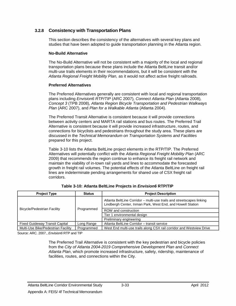
Atlanta BeltLine Corridor Environmental Study 3-33 April 2012
Appendix A: FEIS/ 4f Technical Memorandum
3.2.8 Consistency with Transportation Plans
This section describes the consistency of the alternatives with several key plans and studies that have been adopted to guide transportation planning in the Atlanta region.
No-Build Alternative
The No-Build Alternative will not be consistent with a majority of the local and regional transportation plans because these plans include the Atlanta BeltLine transit and/or multi-use trails elements in their recommendations, but it will be consistent with the Atlanta Regional Freight Mobility Plan, as it would not affect active freight railroads.
Preferred Alternatives
The Preferred Alternatives generally are consistent with local and regional transportation plans including Envision6 RTP/TIP (ARC 2007), Connect Atlanta Plan (Atlanta 2008), Concept 3 (TPB 2008), Atlanta Region Bicycle Transportation and Pedestrian Walkways Plan (ARC 2007), and Plan for a Walkable Atlanta (Atlanta 2004).
The Preferred Transit Alternative is consistent because it will provide connections between activity centers and MARTA rail stations and bus routes. The Preferred Trail Alternative is consistent because it will provide increased infrastructure, routes, and connections for bicyclists and pedestrians throughout the study area. These plans are discussed in the Technical Memorandum on Transportation Systems and Facilities prepared for this project.
Table 3-10 lists the Atlanta BeltLine project elements in the RTP/TIP. The Preferred Alternatives will potentially conflict with the Atlanta Regional Freight Mobility Plan (ARC 2009) that recommends the region continue to enhance its freight rail network and maintain the viability of in-town rail yards and lines to accommodate the forecasted growth in freight rail volumes. The potential effects of the Atlanta BeltLine on freight rail lines are indeterminate pending arrangements for shared use of CSX freight rail corridors.
Table 3-10: Atlanta BeltLine Projects in Envision6 RTP/TIP
Project Type Status Project Description
Bicycle/Pedestrian Facility Programmed
Atlanta BeltLine Corridor – multi-use trails and streetscapes linking Lindbergh Center, Inman Park, West End, and Howell Station
ROW and construction Tier 1 environmental design Preliminary engineering
Fixed Guideway Transit Capital Long Range Atlanta BeltLine Corridor – transit service Multi-Use Bike/Pedestrian Facility Programmed West End multi-use trails along CSX rail corridor and Westview Drive
Source: ARC. 2007., Envision6 RTP and TIP
The Preferred Trail Alternative is consistent with the key pedestrian and bicycle policies from the City of Atlanta 2004-2019 Comprehensive Development Plan and Connect Atlanta Plan, which promote increased infrastructure, safety, ridership, maintenance of facilities, routes, and connections within the City.

Atlanta BeltLine Corridor Environmental Study 3-34 April 2012
Appendix A: FEIS/ 4f Technical Memorandum
3.2.9 Potential Avoidance, Minimization, and Mitigation Measures
During the Public Scoping Process, questions and concerns were raised regarding potential impacts to traffic, bicycle, and pedestrian circulation. In response, MARTA planned the Preferred Alternatives to avoid or minimize potential adverse effects. The Atlanta BeltLine Preferred Transit Alternative will be aligned in or adjacent to exclusive ROW of existing rail corridors to the maximum extent possible to minimize in-street running segments and will use grade separations to minimize at-grade intersections with roadways and to avoid at-grade crossings of active rail lines. Further means to avoid, minimize, and mitigate adverse effects on roadways, transit, freight rail corridors, and bicycle and pedestrian facilities are discussed below.
3.2.9.1 Transit
As discussed in Section 3.2.3.2, potential adverse effects to existing MARTA local bus routes will consist largely of the effects of in-street alignments of the Preferred Transit Alternative. To the extent that the local bus routes are able to share exclusive transit lanes, the effects should be beneficial, but in cases where an exclusive lane is not shared with bus routes, especially if it reduces roadway capacity, there could be a negative effect. The use of shared exclusive transit lanes will be considered in the Tier 2 analysis because of these benefits. However, where shared exclusive use is determined to not be possible, appropriate mitigation measures will be reviewed during the Tier 2 analysis.
Subsequent analysis will determine potential effects, especially schedule adjustments, on MARTA rail services to facilitate transfers between these services and the Atlanta BeltLine. The Preferred Alternatives will not have a negative effect on existing commuter bus service, but will likely result in refinements to transit service in general.
3.2.9.2 Roadways
As outlined in Section 3.2.4.2, in-street running and at-grade crossings will potentially affect the roadway network at localized areas. Where heavy congestion is projected to be created or exacerbated by the Atlanta BeltLine transit, potential avoidance and mitigation measures may include purchase of additional roadway ROW to accommodate an exclusive or mixed-use transit lane. If the additional ROW would adversely affect private property, other means to minimize or avoid congestion may be required. At-grade crossings close to congested intersections and congested intersections within the in-street running segments will be analyzed to determine if new signalization or modification of existing signals would reduce congestion, including signal timing or pre-emption.
3.2.9.3 Freight Rail
As discussed in Section 3.2.5.2, the shared use of or proximity to active freight rail corridors could have potential adverse effects to freight rail operation. During initial consultation with Norfolk Southern and CSX, each railroad cited critical elements to their consideration of passenger rail or trails activity in their ROW. CSX, in particular, cited its “four pillars: uncompromised safety, capacity for current and future needs, no subsidization by CSX, and liability protection.” Thus, whether the Preferred Transit and Trail Alternatives are within or adjacent to a freight railroad corridor, specific CSX concerns must be addressed. Key issues of concern to the railroads include the effect of freight ROW use, crossing, or proximity on the safety and capacity of existing and future freight operations.
Atlanta BeltLine Corridor Environmental Study 3-35 April 2012
Appendix A: FEIS/ 4f Technical Memorandum
CSX, in its correspondence (shown in Appendix C) and during meetings, indicated a willingness to consider Atlanta BeltLine in or adjacent to its ROW. The correspondence states:
“Because of the potential impact to our rail network, CSXT7 requests that we
continue to be included in the foregoing discussions concerning the potential use and preliminary engineering design that includes CSXT ROW for trails and transit lines during the NEPA process.”
8
“CSXT will cooperate in establishment of such paths, recognizing that important requirements must be met and safety precautions taken to protect those who use the pathways.”
9
“There may be a possibility of using some of the CSX right-of-way as long as the railroad’s needs for capacity are met and efficiency and safety are not compromised.”
10
“If in the future, if it is determined that CSX’s needs for capacity are met and efficiency and safety are not compromised, CSX will be willing to continue discussing the possibility of the BeltLine project operating in their right-of-way but they cannot guarantee or commit to anything.”
11
The Atlanta BeltLine project sponsors intend to continue coordinating with the railroads as engineering details of alignment, geometry, vertical clearance, horizontal separation, cross section, safety barriers, and other design considerations are developed and evaluated. Moreover, matters of particular interest and concern to the railroads will be examined in consultation with the railroads, including but not limited to: interoperability of passenger and freight trains, shared facilities, capacity, operational safety and security, liability and insurance, access fees and compensation, equipment requirements, and capital improvements.
This Tier 1 EIS examines the Preferred Transit and Trail Alternatives within and outside freight railroad ROW. As is stated in Section 3.2.5, for the small portion of the Preferred Alternative that is planned to share active freight rail ROW in the southeast zone, means to further avoid or minimize potential effects through design refinements will be considered. For example, the typical section of the Preferred Transit and Trail Alternatives could potentially be modified to make it narrower. Temporal separation of transit and freight operations could be considered to potentially avoid adverse effects, but would involve freight operations for late-night/early morning hours when the transit service would not be in operation. Both temporal separation and diversion of the Atlanta BeltLine outside the railroad ROW would create other potential effects requiring assessment such as late-night noise, increases in vibration, and ROW impacts outside freight railroad corridors.
7 CSX Transportation Inc. (CSXT) is CSX’s principal operating company.
8 Letter from CSXT to Atlanta BeltLine, Inc. “Re: CSXT Comments on the Atlanta BeltLine Tier 1 Draft Environmental Impact Statement.” 08 Oct. 2010.
9 Ibid.
10 Coordination Meeting between MARTA, ABI, and CSX. “Meeting Notes.” 10 Nov. 2010.
11 Ibid.

Atlanta BeltLine Corridor Environmental Study 3-36 April 2012
Appendix A: FEIS/ 4f Technical Memorandum
3.2.9.4 Passenger Rail Operations
As is stated in Section 3.2.6, there is no apparent conflict between the commuter rail or intercity passenger service and the Preferred Alternative. However, if in future phases of the project that changes, and a conflict does arise, the shared use of existing and potential future passenger/commuter rail corridors could adversely affect their operation. In that event, the typical section will be modified to the extent possible. If this proves infeasible, the transit and/or trail elements could be realigned outside of the rail corridors. Continued coordination between MARTA, GDOT, Amtrak, and others, as appropriate, is necessary as the Atlanta BeltLine project advances to assess opportunities, constraints, and solutions regarding these respective operations and projects.
3.2.9.5 Bicycle and Pedestrian
Potential effects to existing bicycle and pedestrian facilities could be their elimination or modification in some situations to provide a transit lane in a street ROW. Other potential effects on these facilities concern at-grade crossings of the Atlanta BeltLine and safety and security. Section 3.9 discusses proposed measures to address safety and security. A Tier 2 analysis will consider in more detail the potential project effects on the existing and planned bicycle and pedestrian facilities, especially at locations where in-street sections affect facilities and warrant mitigation.
3.2.10 Subsequent Analysis
A Tier 2 analysis will provide a more detailed examination of the potential effects of the Preferred Alternatives on transportation systems and facilities. Emphasis will be placed on effects on freight rail operations; in-street running sections; at-grade crossings and intersections; interfaces with future transit projects; trail crossings, access points, connections, and amenities; Atlanta BeltLine station locations, and MARTA Station Connectivity and Infill Station Alternatives areas including potential joint and infill MARTA rail stations. Means to avoid or minimize adverse effects will be considered, and appropriate mitigation measures to offset unavoidable effects will be developed.
3.3 Land Use and Zoning Section 3.3 examines the existing and future land use and zoning in the study area. This includes the potential direct effects within the ROW of the Preferred Alternatives and potential indirect effects in the service areas (refer to the Methodology section below for a description of the term service area). The discussion of the land use and zoning within the ROW requirements is intended to address the potential needs to amend the zoning of parcels and to understand the existing and future land use designations to be converted by the acquisition of the parcels within the ROW.
3.3.1 Methodology
Areas of potential direct or indirect effects were calculated in acres for existing and future land use, zoning, and estimates of existing and additional required ROW. The direct land use effects will occur within the proposed ROW for the Preferred Alternatives, which is estimated to be 37 feet wide for transit and 20 feet wide for trails.
The indirect land use effects were assessed based on the area within ¼-mile of the alignment of the Preferred Transit Alternative, otherwise known as the service area, but not including the area directly within the proposed ROW (the direct effects). Indirect land use effects for the Preferred Trail Alternative were assumed in the calculations for the

Atlanta BeltLine Corridor Environmental Study 3-37 April 2012
Appendix A: FEIS/ 4f Technical Memorandum
indirect effects of the Preferred Transit Alternative because the Preferred Trail Alternative is intended to serve the same stations, activity centers, and communities. The acreage within the MARTA Station Connectivity and Infill Station Alternative Areas was included in the estimate of the direct effects.
3.3.2 Land Use
The existing land use data, illustrated on Figure 3-9, was primarily provided by the City of Atlanta and supplemented by the Fulton County Tax Assessor’s parcel level data and by LandPro data compiled by the ARC. For some parcels, such as state-owned highway ROW, a use was not indicated. The existing land use, therefore, shows a smaller number of acres than future land use and zoning.
Future land use, presented in Figure 3-10, represents the City of Atlanta’s Future Land Use Map (FLUM) that provides policy for development of vacant land and for redevelopment projects. The FLUM covers all areas of the City. It includes a large quantity of land that is designated as mixed-use and a category for transportation/utility land use. Within the study area, the transportation/utility category in the FLUM ranges from four percent in the northeast and southeast to five percent in the northwest and six percent in the southwest. It encompasses the public roadways and freight railroad corridors that would be used by the proposed Atlanta BeltLine alignment.
In this section, the many land use categories used by the City are aggregated into the generalized categories of residential, commercial, industrial, institutional, parks, transportation/utilities, and vacant. All of these generalized land use categories are found in each of the study area zones, but the proportions of the categories differ. The predominant existing land use category in the study area is residential, ranging from 30 percent to 56 percent of total land area in each zone.
3.3.2.1 Direct Effects on Land Use
No-Build Alternative
Direct effects on land use in the study area by the additional ROW requirements of the No-Build Alternative will be examined in the individual environmental analyses for each constituent project.

Atlanta BeltLine Corridor Environmental Study 3-38 April 2012
Appendix A: FEIS/ 4f Technical Memorandum
Figure 3-9: Future Land Use Map (FLUM)
Source: City of Atlanta, Bureau of Planning 2008

Atlanta BeltLine Corridor Environmental Study 3-39 April 2012
Appendix A: FEIS/ 4f Technical Memorandum
Figure 3-10: Future Land Use Map (FLUM)
Source: City of Atlanta, Bureau of Planning 2008

Atlanta BeltLine Corridor Environmental Study 3-40 April 2012
Appendix A: FEIS/ 4f Technical Memorandum
Preferred Alternatives
Table 3-11 presents the total acreage of the Preferred Transit Alternative’s direct and indirect effects and the Preferred Trail Alternative’s direct effects by zone.
Table 3-11: Acres of Potential Direct or Indirect Land Use Effect
Zone
Preferred Alternative’s Potential Direct or Indirect Land Use Effects (Acres)
Transit Trail
Direct Indirect Direct
Northeast 17.5 1353.4 9.4 Southeast 20.0 1532.9 11.0 Southwest 9.2 767.7 5.0 Northwest 24.5 1836.9 10.4
Totals 71.2 5490.9 35.8
Source: AECOM analysis 2011
The Technical Memorandum on Land Use, Zoning, and Local Plans (AECOM 2011) provides further detail regarding the existing and planned conditions including objectives, policies, and recommended projects of the Comprehensive Development Plan; the Atlanta BeltLine Subarea Master Plans; and the relevant sections of the Zoning Ordinance.
Table 3-12 presents the direct effects of the Preferred Alternatives on existing land use in the proposed ROW. The direct effect of the Preferred Alternative is to convert all acreages in the ROWs to the Transportation/Utility land use category. It should be noted that the “total converted” numbers in Table 3-12 include the No Data category that, in large part, includes railroad, roadway, or utility ROW that more appropriately should be included in the transportation/utility category. In general, the smaller number of acres converted from other uses to Transportation/Utility have less direct effect on existing land use.
Table 3-12: Direct Land Use Effects
Zone Alternative
Direct Land Use Effects (Acres)
Resid
en
tial
Co
mm
erc
ial
Ind
ustr
ial
Insti
tuti
on
al
Park
s
Vacan
t
No
Data
To
tal C
on
vert
ed
Tra
nsp
ort
ati
on
/
Uti
lity
To
tal
Northeast Preferred Alternatives 0.3 0.3 0.1 0.0 0.0 0.0 26.1 26.8 0.0 26.8 Southeast Preferred Alternatives 0.1 0.1 0.4 0.3 0.0 0.5 29.5 30.9 0.1 31.0 Southwest Preferred Alternatives 0.0 0.1 0.2 0.0 0.0 2.7 7.6 10.6 3.7 14.3
Northwest Preferred Transit Alternative 2.1 1.2 2.6 1.9 0.0 4.0 11.7 23.5 0.9 24.4 Preferred Trail Alternative 2.1 0.7 0.4 2.7 1.1 1.1 0.5 8.6 2.2 10.8
Source: AECOM analysis 2011
In the northeast, southeast, and southwest zones outside the MARTA Station Connectivity and Infill Station Alternative Areas, there are 72.1 acres of direct impact due to acquisition for the Preferred Alternatives, of which 3.8 acres are shown in the transportation/utility land use category. The 68.3 acres of other generalized categories

Atlanta BeltLine Corridor Environmental Study 3-41 April 2012
Appendix A: FEIS/ 4f Technical Memorandum
that will be converted is comprised of 0.4 acres residential, 0.5 acres commercial, 0.7 acres industrial, 0.3 acres institutional, 3.2 acres vacant, and 63.2 acres for which no data is available. No acres used as parks are in the combined ROWs in these zones.
In the northwest zone, the Preferred Transit Alternative is adjacent to the active railroad ROWs. In the other zones, the Preferred Transit Alternative is aligned primarily in active and inactive railroad ROW or in roadways. These and certain other lands in the proposed ROW that are not owned by the City of Atlanta, MARTA, GDOT, or some other project sponsor, constitute additional required ROW. Figure 3-11 shows the alignments and estimated areas of the additional required ROW. While actual cross sections may vary due to site-specific conditions, the estimates of direct impacts within proposed ROWs use the typical cross sections as conservative estimates.
In the northwest zone, the Preferred Transit Alternative will convert 23.5 acres from other land use categories to transportation/utility. If the acres of vacant or “no data” land use categories are excluded from estimating the direct effect in the northwest zone, the Preferred Transit Alternative converts only 7.8 acres of land use (residential, commercial, industrial, institutional, or parks) to transportation/utility.
The Preferred Trail Alternative in the northwest zone will convert 8.6 acres from other land use categories to transportation/utility. If the acres of vacant or “no data” land use categories, are excluded from estimating the direct effect in the northwest zone, the Preferred Trail Alternative converts only 7.0 acres of land use (residential, commercial, industrial, institutional, or parks) to transportation/utility.
As described in Section 2.5.1 and illustrated by Figure 2-2, approximately 50 preliminary locations for stations were identified for evaluating potential Atlanta BeltLine service characteristics. These stations are located approximately ½-mile apart near major roadway intersections, existing or proposed trip generators, and other key access points. The final station locations, their designs and dimensions, and an assessment of the potential direct effects will occur in the Tier 2 analysis.

Atlanta BeltLine Corridor Environmental Study 3-42 April 2012
Appendix A: FEIS/ 4f Technical Memorandum
Figure 3-11: Additional Required Right-of-Way
Source: AECOM 2010
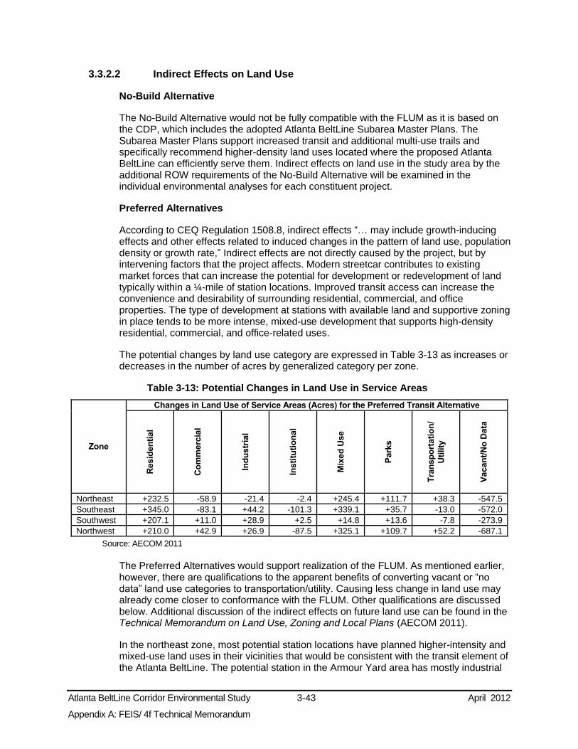
Atlanta BeltLine Corridor Environmental Study 3-43 April 2012
Appendix A: FEIS/ 4f Technical Memorandum
3.3.2.2 Indirect Effects on Land Use
No-Build Alternative
The No-Build Alternative would not be fully compatible with the FLUM as it is based on the CDP, which includes the adopted Atlanta BeltLine Subarea Master Plans. The Subarea Master Plans support increased transit and additional multi-use trails and specifically recommend higher-density land uses located where the proposed Atlanta BeltLine can efficiently serve them. Indirect effects on land use in the study area by the additional ROW requirements of the No-Build Alternative will be examined in the individual environmental analyses for each constituent project.
Preferred Alternatives
According to CEQ Regulation 1508.8, indirect effects “… may include growth-inducing effects and other effects related to induced changes in the pattern of land use, population density or growth rate,” Indirect effects are not directly caused by the project, but by intervening factors that the project affects. Modern streetcar contributes to existing market forces that can increase the potential for development or redevelopment of land typically within a ¼-mile of station locations. Improved transit access can increase the convenience and desirability of surrounding residential, commercial, and office properties. The type of development at stations with available land and supportive zoning in place tends to be more intense, mixed-use development that supports high-density residential, commercial, and office-related uses.
The potential changes by land use category are expressed in Table 3-13 as increases or decreases in the number of acres by generalized category per zone.
Table 3-13: Potential Changes in Land Use in Service Areas
Zone
Changes in Land Use of Service Areas (Acres) for the Preferred Transit Alternative
Resid
en
tial
Co
mm
erc
ial
Ind
ustr
ial
Insti
tuti
on
al
Mix
ed
Use
Park
s
Tra
nsp
ort
ati
on
/
Uti
lity
Vacan
t/N
o D
ata
Northeast +232.5 -58.9 -21.4 -2.4 +245.4 +111.7 +38.3 -547.5 Southeast +345.0 -83.1 +44.2 -101.3 +339.1 +35.7 -13.0 -572.0 Southwest +207.1 +11.0 +28.9 +2.5 +14.8 +13.6 -7.8 -273.9 Northwest +210.0 +42.9 +26.9 -87.5 +325.1 +109.7 +52.2 -687.1
Source: AECOM 2011
The Preferred Alternatives would support realization of the FLUM. As mentioned earlier, however, there are qualifications to the apparent benefits of converting vacant or “no data” land use categories to transportation/utility. Causing less change in land use may already come closer to conformance with the FLUM. Other qualifications are discussed below. Additional discussion of the indirect effects on future land use can be found in the Technical Memorandum on Land Use, Zoning and Local Plans (AECOM 2011).
In the northeast zone, most potential station locations have planned higher-intensity and mixed-use land uses in their vicinities that would be consistent with the transit element of the Atlanta BeltLine. The potential station in the Armour Yard area has mostly industrial

Atlanta BeltLine Corridor Environmental Study 3-44 April 2012
Appendix A: FEIS/ 4f Technical Memorandum
future land use in its vicinity, which could be vulnerable to market pressures for future land use conversions (Atlanta 2008). To some extent, this is foreseen by the FLUM that anticipates a reduction in the acres of industrial land.
In the southeast zone, near Garibaldi Street and Ormewood Avenue, the potential station locations have nearby land uses that are mostly low-density residential or industrial that could be vulnerable to future market pressures for land use conversions. Near McDonough Boulevard, Glenwood Avenue, and Moreland Avenue / Hardee Street, land uses of higher-intensity and mixed-use are consistent with the transit element. A notable change projected in this zone is the large reduction in institutional acreage.
In the southwest zone, potential station locations near Martin Luther King, Jr. Drive and Westview Drive are almost entirely low-density residential future land uses designations. Two others near Westview Drive and Rose Circle have significant industrial future land use designations. These potential station areas could be vulnerable to future market pressures for land use conversions. Other potential station locations have higher-intensity and mixed-use future land uses in their vicinities that are consistent with and will benefit from the transit element of the Atlanta BeltLine.
In the northwest zone, there is the potential for growth in residential use, industrial uses, and parks. The extent of potential indirect land use effects in this zone could depend on further definition of the shared ROW in segments of freight rail. Although industrial uses near potential station locations near Marietta Street and along Marietta Boulevard near Elaine Avenue could be vulnerable to market pressure for conversion to other uses; this is not reflected in the changes projected by the FLUM.
The potential development that could result in the long-term could also result in increased property values. While the project is intended to encourage economic development in proximity to some station and amenity areas, as described in the CDP, it also could create market pressures to convert existing low-density or industrial uses into higher-density uses. For example, although the FLUM includes denser uses in the ¼-mile vicinity of proposed stations, it retains a significant amount of low-density residential land use. Parcels designated for future industrial use could be vulnerable to market demand for residential, office, and retail development near transit stations (Atlanta 2008). In some locations, this might be incompatible with neighborhood character. Further, higher property values may reduce the affordability of affected neighborhoods for low-to-moderate income households (Immergluck 2007). To mitigate this potential adverse effect, the Atlanta BeltLine TAD reserves 15 percent of its bond funds to assure that 20 percent of its new housing units are affordable. Further analysis in the Tier 2 phase would evaluate these potential effects in more detail.
The following measures evaluate how well the No-Build and Preferred Alternatives meet the land use objectives of the FLUM in relation to specific issues.
Provide service to areas of underutilized land including Brownfields: This measure estimates the extent to which the Preferred Transit Alternative would provide service to underutilized land by estimating the number of acres of this land within a ½-mile of proposed stations. Section 101 of Comprehensive Environmental Response, Compensation, and Liability Act (CERCLA) defines a Brownfield as “real property, the expansion, redevelopment, or reuse of which may be complicated by the presence or potential presence of a hazardous substance, pollutant, or contaminant.” Underutilized parcels are defined as parcels whose existing building’s value is less than 40 percent of the total appraised land value, suggesting the high likelihood of redevelopment or reinvestment. The results are shown in Table 3-14,

Atlanta BeltLine Corridor Environmental Study 3-45 April 2012
Appendix A: FEIS/ 4f Technical Memorandum
Table 3-14: Underutilized Land within ½-mile of the Potential Station Locations
Transit Alternatives Acres
No-Build 213 Preferred Transit Alternative 765
Source: AECOM 2010
Provide service to areas in the Atlanta BeltLine TAD with high development capacity of underutilized or undeveloped land within ½-mile of proposed stations: This measure estimates the extent to which the Preferred Transit Alternative would serve underutilized or undeveloped areas within ½-mile of the proposed station locations. Underutilized/undeveloped parcels were identified by using existing land use maps, aerial photography, and field surveys. These properties were then categorized to identify the ones with higher development capacity as defined by the Atlanta BeltLine Redevelopment Plan and the Atlanta BeltLine Subarea Master Plans. Table 3-15 shows the estimated acreage of potential higher density residential and commercial development capacity by Alternative.
Table 3-15: Potential Residential and Commercial Development Capacity
Transit Alternative Acres
No-Build 101 Preferred Transit Alternative 499
Source: AECOM 2010
The number of economic development focus areas within ½-mile of the proposed station and trail access points: This measure tallies the number of economic development focus areas, as defined by ABI, within ½-mile of the proposed station locations and trail access points. They are shown in Figure 1-5 the Preferred Alternatives will serve all 20 economic development focus areas, while the No-Build Alternative would serve seven.
3.3.3 Zoning
The City of Atlanta Zoning Ordinance (City of Atlanta Zoning Ordinance August 2009) is intended to assure the development of future land use in a manner that is compatible with the CDP and the FLUM. All properties are within a zoning district. Figure 3-12 shows the base districts that regulate permitted uses and the Atlanta BeltLine Overlay District. Base zoning districts regulate land use through various development regulations. Most base zoning districts contain a single permitted use, but there also are Special Public Interest (SPI) Districts that regulate areas with special attributes such as Downtown, Landmark Districts (LD) that regulate areas of historic and cultural importance, and Planned Development Districts for multiple parcels developed together. The Preferred Alternatives would have no direct effects to SPI and LD districts.

Atlanta BeltLine Corridor Environmental Study 3-46 April 2012
Appendix A: FEIS/ 4f Technical Memorandum
Figure 3-12: Zoning in the Study Area
Source: City of Atlanta, Bureau of Planning 2008

Atlanta BeltLine Corridor Environmental Study 3-47 April 2012
Appendix A: FEIS/ 4f Technical Memorandum
There also are Overlay Zoning Districts that apply additional regulations, such as the Atlanta BeltLine Overlay District. The District was ordained in 2007 and has the same geographic boundaries as the Atlanta BeltLine Redevelopment Area, defined in the Atlanta BeltLine Redevelopment Plan (Atlanta 2005). It regulates aspects of building and site design and implements the Atlanta BeltLine Street Framework Plan (Atlanta 2008) that has been adopted to improve the street grid and the pedestrian and bicycle routes, while the underlying base zoning districts regulate the permitted uses.
No-Build Alternative
The No-Build Alternative generally would not be consistent with zoning because the base zoning districts were adopted to support the land use policies in the CDP and the FLUM. These policies promote transit-oriented development. The Atlanta BeltLine Overlay District was adopted specifically to support the implementation of the Atlanta BeltLine, which would not be met under the No-Build Alternative.
Preferred Alternatives
This subsection summarizes the current zoning designations of directly affected areas and considers the requirements for potential zoning changes based on land use conversions to transportation/utility land uses or to parks. Table 3-16 presents the number of acres of land in the proposed ROWs by zoning district outside the MARTA Station Connectivity and Infill Station Alternative Areas. Many parcels in the vicinity of proposed stations are zoned for higher residential and employment densities as part of a transit-oriented development strategy (defined as higher-density mixed use development within walking distance of transit), but other conditions apply in some areas.
Table 3-16: Zoning of ROWs
Zone Build Alternative
Areas where Zoning May be Affected (Acres)
Sin
gle
Fam
ily
Resid
en
tial
Mu
lti-
Fam
ily
Resid
en
tial
Mix
ed
Use
Co
mm
erc
ial
Ind
ustr
ial
Pla
nn
ed
Develo
pm
en
t
To
tal A
cre
s
Northeast Preferred Alternatives 9.2 0.6 1.0 4.4 10.6 1.0 26.8 Southeast Preferred Alternatives 4.2 4.4 0.9 2.5 17.9 1.1 31.0 Southwest Preferred Alternatives 3.5 4.3 0.0 0.4 6.1 0.0 14.3
Northwest Preferred Transit Alternative 4.4 2.4 0.4 1.9 13.1 2.2 24.4 Preferred Trail Alternative 4.3 2.4 0.7 1.8 6.6 1.5 17.3
Source: City of Atlanta, Bureau of Planning. 2011. Note: Assuming potential effects measured outside of the MARTA Station Connectivity and Infill Station Alternative Areas.
Atlanta BeltLine transit tracks, stations, and operating infrastructure either would be permitted uses or would be considered Special Exceptions in the Residential districts other than MR (Multi-Family). Other facilities, such as storage and maintenance yards, are permitted uses only in the light and heavy industrial districts, but these were not included in the estimates of directly affected ROW and will be addressed in the Tier 2 analysis.
Unless the MR district is redefined to allow transit tracks, stations and operating infrastructure either as permitted uses or Special Exceptions, the acres needing zoning amendments for the Preferred Transit Alternative are: 0.6 acres in the northeast zone,
Atlanta BeltLine Corridor Environmental Study 3-48 April 2012
Appendix A: FEIS/ 4f Technical Memorandum
4.4 acres in the southeast zone, 4.3 acres in the southwest zone, and 2.4 acres in the northwest zone,
The Preferred Trail Alternative will generally be permitted in existing public ROW, but the sections of trail outside a public ROW could be in a zoning district that limits paved areas or requires setbacks between the trail and existing structures. Regulations would vary if the Preferred Trail Alternative is designated as a park. Residential and Office zoning districts allow parks by Special Use Permit. Multi-Family, Mixed Residential Commercial, and Planned Development (PD) (other than PD-Business Park), have a process through which applications can be made under existing regulations. Other zoning districts do not provide for parks, open space, or recreation and would require an amendment to the ordinance to provide for implementation of the trails.
Based on the assumption that the PD districts are Business Parks and, together with the Commercial and Industrial districts, will require amendments to permit the trails, the acres needing amended zoning for the Preferred Trail Alternative are: 16 acres in the northeast zone, 21.5 acres in the southeast zone, 6.5 acres in the southwest zone, and 9.9 acres in the northwest zone, The Preferred Alternatives will have no direct effects to SPI and LD districts. Unless these zoning districts are redefined to permit transit, transit accessories, and parks, the Preferred Alternatives will require zoning amendments for 65.6 acres.
Most of the MARTA Station Connectivity and Infill Station Alternative Areas and the entire study area of the Preferred Alternatives are within the Atlanta BeltLine Overlay District (City of Atlanta Zoning Map, August 2009). The Atlanta BeltLine Overlay District could potentially be redefined to include the portions of the study area currently not in that district following further analysis.
3.3.4 Local Plans
A number of plans and studies have guided land development and the transit, multi-use trails, and greenspace components of the Atlanta BeltLine as described in Chapter 1.0. The principal ones are the Atlanta Strategic Action Plan, Comprehensive Development Plan (CDP) (City of Atlanta 2008); the Atlanta BeltLine Subarea Master Plans (ABI ongoing); and the Regional Development Plan (RDP) (ARC 2007).
Atlanta BeltLine Subarea Master Planning efforts are underway for 10 “subareas” of the study area shown on Figure 3-13. This planning process builds on recommendations of the Atlanta BeltLine Redevelopment Plan (ABI 2005) that led to the creation of the Atlanta BeltLine TAD. The Atlanta BeltLine Subarea Master Plans address parks and open space, mixed-use residential and commercial land use, urban design proposals including public art, and mobility and circulation. Atlanta BeltLine Subarea Master Plans for Subareas 2, 3, 4, 5, 7, and 9 are adopted and the other four are in process. The plans assume implementation of the Atlanta BeltLine by 2030.Transportation recommendations are contained in the Atlanta BeltLine Street Framework Plan (ABI 2008). Additional discussion of these plans can be found in the Technical Memorandum on Land Use, Zoning and Local Plans (AECOM 2011).
No-Build Alternative
The No-Build is not fully consistent with the CDP because it does not include the Atlanta BeltLine, a proposed project in the CDP. It is not consistent with the Atlanta BeltLine Subarea Master Plans or the RDP because they are based on the assumption that the Atlanta BeltLine would be constructed.

Atlanta BeltLine Corridor Environmental Study 3-49 April 2012
Appendix A: FEIS/ 4f Technical Memorandum
Figure 3-13: Atlanta BeltLine Subarea Master Plans
Source: ABI 2009
Atlanta BeltLine Corridor Environmental Study 3-50 April 2012
Appendix A: FEIS/ 4f Technical Memorandum
Preferred Alternatives
The Preferred Alternatives are consistent with the Atlanta BeltLine Subarea Master Plans as the Atlanta BeltLine is included in each. The Preferred Alternatives are also consistent with the City’s adopted CDP.
3.3.5 Economic Conditions and Development Strategies
Economic studies that evaluate the economic effects of the project in the study area were reviewed in this evaluation. The studies are discussed in Chapter 1.0. The principal studies include Update of Market Forecasts for the Atlanta BeltLine Study Area (RCRLO 2008) and Atlanta BeltLine Tax Allocation District Feasibility Study (EDAW 2005). Both found an existing, diverse economic base, projected significant population and economic growth, and recognized the Atlanta BeltLine as an important component in attracting economic activity and facilitating mobility.
No-Build Alternative
The No-Build Alternative would have a direct short-term positive effect associated with construction employment, but this would be a smaller effect than that of the Preferred Alternatives. In the long term, it generally would support the existing economic conditions. It would be inconsistent with the economic development strategies in the CDP, relative to the Atlanta BeltLine, and its associated projects and would not support the estimates of the economic growth discussed above.
Preferred Alternatives
The Preferred Alternatives will have a direct short-term positive effect associated with construction employment. In the long term, the Atlanta BeltLine and its associated projects will increase mobility and provide development opportunities, as described in the Section 3.3.2 above. The studies reviewed indicate that the long-term effects on the local and regional economies would be beneficial. The Preferred Alternatives will serve all 20 economic development focus areas and several activity centers discussed in Section 1.5.2.
The land use impacts of the Atlanta BeltLine could conflict with the City’s policy of retaining as much industrial land within the City as possible.
Update of Market Forecasts for the Atlanta BeltLine Study Area projects an increase in the study area of 84 percent in the number of households; over 3.1 million square feet of new regional office space; over ¾ million square feet of new local office space; over 2.2 million square feet of new local retail; and over 1.6 million square feet of new regional retail. The Atlanta BeltLine Tax Allocation District Feasibility Study estimates that the TAD will create approximately 37,500 permanent jobs, 48,000 construction jobs, 28,000 new residential units including 5,600 affordable units; and 9 million square feet of new retail, office, and light industrial space that would add over $20 billion to the tax base. The Preferred Alternatives would serve approximately 4,900 acres of Atlanta BeltLine TAD land.
3.3.6 Potential Avoidance, Minimization, and Mitigation Measures
During the Public Scoping Process, questions and concerns were raised regarding the potential direct impacts to residences and businesses, the secondary effects of associated redevelopment projects, and the consistency of that development with

Atlanta BeltLine Corridor Environmental Study 3-51 April 2012
Appendix A: FEIS/ 4f Technical Memorandum
existing land uses. In response, the Preferred Alternatives have been designed to minimize the additional required ROW and potential adverse effects on existing land uses. The Preferred Alternatives would use existing transportation ROW to the maximum extent possible. Also, local policies and the Atlanta BeltLine Subarea Master Plans are intended to protect community character.
To some extent, the indirect conversion of land uses is an integral aspect of the Atlanta BeltLine. Implementation of the City’s industrial retention policy could mitigate development pressures on industrial areas. Strategies to avoid or minimize these effects will be considered through the Atlanta BeltLine Subarea Master Planning process and in subsequent Tier 2 analysis.
The potential development that could result in the long-term could also result in increased property values. While the project is intended to encourage economic redevelopment, higher property values may reduce the affordability of affected neighborhoods for low-to-moderate income households (Immergluck 2007). To mitigate this potential adverse effect, the Atlanta BeltLine TAD reserves 15 percent of its bond funds to assure that 20 percent of its new housing units are affordable. Further analysis in the Tier 2 phase would evaluate these potential effects in more detail.
3.3.7 Subsequent Analysis
This Tier 1 analysis identifies acres of potential direct impacts based on the proposed alignments and typical sections. The Tier 2 analysis will determine site-specific ROW requirements that result from station locations, topography and other physical constraints, need for zoning amendments, and insufficient available ROW in public ownership for the Preferred Alternatives. The Tier 2 analysis also will evaluate the economic development effects of the Preferred Alternatives.
3.4 Neighborhoods and Community Facilities This section presents a description of the neighborhoods and community facility resources within the Atlanta BeltLine study area, as well as the potential effects of the project on these resources.
3.4.1 Methodology
The neighborhoods in the study area were identified from information obtained from the City’s Bureau of Planning. Community services and facilities were identified within the study area using information obtained from the ARC and the U.S. Geographic Survey (USGS). A qualitative assessment of potential impacts was undertaken by examining the location of the No-Build and Preferred Alternatives in relation to neighborhoods and community facilities.
3.4.2 Affected Environment
3.4.2.1 Neighborhoods
The City, and particularly the study area, contains a number of long-standing and historic neighborhoods. The study area contains 61 neighborhoods. Figure 3-14 depicts the neighborhoods and their boundaries as defined by the City. Table 3-17 lists the neighborhoods by study area zone. The neighborhoods are briefly described in the following paragraph; a more detailed description of the neighborhoods can be found in the Atlanta BeltLine Existing Conditions Report (MARTA 2009).

Atlanta BeltLine Corridor Environmental Study 3-52 April 2012
Appendix A: FEIS/ 4f Technical Memorandum
Figure 3-14: Neighborhoods
Source: City of Atlanta, Bureau of Planning 2009

Atlanta BeltLine Corridor Environmental Study 3-53 April 2012
Appendix A: FEIS/ 4f Technical Memorandum
Table 3-17: Neighborhoods Northeast Zone
Ansley Park Inman Park Morningside/Lenox Park Sherwood Forest* Butler Street Lindridge/Martin Manor Old Fourth Ward Virginia-Highland Downtown Lindbergh/Morosgo* Piedmont Heights Grady/Antoine Graves Midtown* Poncey-Highland
Southeast Zone
Adair Park* Capitol View High Point Reynoldstown Benteen Park Capitol View Manor Oakland City* South Atlanta Boulevard Heights Chosewood Park Ormewood Park The Villages at Carver Cabbagetown Englewood Manor Peoplestown Capitol Gateway Grant Park Pittsburgh
Southwest Zone
Adair Park* Harris-Chiles Magnolia Park* Vine City* Ashview Heights Hunter Hills* Mozley Park West End Atlanta University Center Just Us Neighbors Oakland City* Westview
Northwest Zone
Ardmore Channing Valley Hills Park Peachtree Hills Atlantic Station Collier Hills Home Park Sherwood Forest Bankhead Collier Hills North Hunter Hills* Underwood Hills Berkeley Park Colonial Homes Knight Park/Howell Station Vine City* Blandtown English Avenue Lindbergh/Morosgo* Washington Park* Brookwood Garden Hills Loring Heights Brookwood Hills Haynes Manor Midtown*
* Neighborhood falls across two zones
Neighborhoods in the northeast zone range from historic streetcar suburbs constructed in the late 1800s and early 1900s to residential areas built following World War II. In the southeast zone, neighborhoods range from late 19th and early 20th century single-family communities to apartment and single-family developments built in the early twenty-first century. The southwest zone consists almost entirely of single-family residential neighborhoods, many originally established in the late 19th and early 20th centuries. The northwest zone consists of a variety of neighborhoods, including early 20th century garden suburbs, light industrial areas and freight yards, 1940s garden apartment complexes, townhouses, and early twenty-first century mixed-use developments.
3.4.2.2 Community Facilities
The study area contains approximately 81 community facilities, including police stations, fire stations, schools, places of worship, libraries, hospitals and health facilities, and museums. These resources provide basic services to the neighborhoods, help to shape the area’s overall quality of life, and foster a sense of community identity. Appendix D contains a figure depicting the locations of community facilities and a table listing them by study area zone. A detailed description of the community facilities within the study area can be found in the Atlanta BeltLine Existing Conditions Reports (MARTA 2009).
3.4.3 Preliminary Environmental Consequences
The preliminary assessment of the potential environmental consequences of the No-Build and Preferred Alternatives is described below.

Atlanta BeltLine Corridor Environmental Study 3-54 April 2012
Appendix A: FEIS/ 4f Technical Memorandum
3.4.3.1 No-Build Alternative
The No-Build Alternative includes a mix of improvements to existing facilities and new transit projects. These projects would have limited impact on regional accessibility for the neighborhoods and community facilities in the study area, and, therefore, would have limited impact on study area residents. The projects in the No-Build Alternative will serve only a limited number of neighborhoods, leaving multiple neighborhoods and community facilities that will not be served by improved transit. A more refined assessment of impacts to neighborhoods and community facilities resulting from the No-Build projects will occur during investigations for those projects.
Currently, the railroad ROW that comprises the Atlanta BeltLine creates a barrier dividing neighborhoods. In the southeast and northeast zones, these rail ROWs frequently serve as neighborhood boundaries with limited connectivity across. The No-Build Alternative will not remove this barrier.
3.4.3.2 Preferred Alternatives
The Preferred Alternatives will either use existing railroad and roadway ROW or run parallel to existing railroad ROW. This strategy will minimize the potential for creating new physical barriers that would reduce connectivity between neighborhoods. As noted in the Atlanta BeltLine Health Impact Assessment (Ross 2007), the rail corridors have “historically divided people and places. The new vision for this corridor has the opportunity to reintegrate many neighborhoods” (p. 11).
Neighborhood and Community Access
The Preferred Transit Alternative is expected to increase regional access for neighborhood residents, while the Preferred Trail Alternative will provide recreational space and serve to knit together neighborhoods currently divided by the railroad ROW. In addition, as noted in the Atlanta BeltLine Health Impact Assessment (Ross 2007), “[t]he [Atlanta] BeltLine can also be connected to existing neighborhood institutions to promote increased physical activity and social capital” (p. 56).
The neighborhoods and community facilities potentially served or affected by the Preferred Alternatives are summarized in Table 3-18. These data show that the Preferred Transit Alternative will serve 61 neighborhoods and provide access to 68 community facilities. The Preferred Trail Alternative will serve 55 neighborhoods and provide access to 71 community facilities. A map of community facilities and a full list by zone can be found in Appendix D.
Table 3-18: Potentially Served or Affected Neighborhoods and Community Facilities Zone Build Alternative Affected Neighborhood / Community Facility
Northeast Preferred Alternatives 14 neighborhoods, 5 schools, 5 places of worship, 2 fire stations, 2 police precincts, 1 library, Martin Luther King, Jr. Community Center, Atlanta Botanical Gardens, City Hall East
Southeast Preferred Alternatives 17 neighborhoods, 11 schools, 8 places of worship, 1 fire station, 1 corrections facility
Southwest Preferred Alternatives 10 neighborhoods, 4 schools, 6 places of worship, 2 fire stations, 1 library, 1 senior citizens center
Northwest Preferred Transit Alternative 20 neighborhoods, 8 places of worship, 1 school, 2 hospitals, 1 jail, 1 court, 2 fire stations Preferred Trail Alternative 14 neighborhoods, 11 places of worship, 2 schools, 2 hospitals, 3 fire stations

Atlanta BeltLine Corridor Environmental Study 3-55 April 2012
Appendix A: FEIS/ 4f Technical Memorandum
Appropriateness of Scale
An evaluation measure considered in this FEIS/ 4(f) Technical Memorandum is the potential of the Preferred Alternatives, both the transit mode and the stations and other fixed facilities, to be of a physical scale that is appropriate for the existing neighborhoods and communities through which they would pass. This qualitative measure considers the Preferred Alternatives relative to the proportions (size and mass) of the surrounding buildings, especially along the proposed routes. The determination of SC as the preferred transit technology relied in part upon this performance measure.
Other key factors in assessing the appropriateness of the Atlanta BeltLine within the context of the surrounding community were noise, vibration, and visual effects. The land uses adjacent to each of the Preferred Alternatives were also considered, especially when greater ROW requirements could be anticipated.
As was described in the service characteristics found in Chapter 2.2.5, SC will perform well in overall fit and appropriateness given the key factors considered. SC have smaller, lighter vehicles and tighter turning radii, which tend to cause fewer noise and vibration impacts. Specifically, this means less likelihood of high-pitched wheel squeal that occurs as the wheels rub against the rails as vehicles increase in length.
Due to the shorter length of SC vehicles, SC track geometry can fit into existing roadway and railroad ROWs without many precautionary design elements. For example, relatively tighter turns at roadway intersections would be possible for SC vehicles, rather than requiring additional ROW to accommodate a larger turning radius. Thus, SC technology is likely to incur fewer ROW impacts, thereby having less potential impact on land uses and visual effects.
3.4.4 Potential Avoidance, Minimization, and Mitigation Measures
Conceptual design of the Preferred Alternatives conservatively indicates low potential for impacts on neighborhoods and community facilities. As the project advances, the design will be refined with the intent of avoiding or minimizing impacts. There also will be a focus on context sensitive design of Atlanta BeltLine infrastructure to ensure compatibility with the surrounding neighborhoods.
Some impacts, such as visual changes caused by overhead power wiring, may be found to be unavoidable. A number of best management practices and mitigation strategies will be considered at that time to effectively offset these impacts. Strategies could include visual buffering, architectural treatments, and design adjustments to improve access or address pre-existing access issues. The development of appropriate mitigation strategies will occur in consultation with the affected neighborhoods and community facilities.
3.4.5 Subsequent Analysis
Detailed analysis will take place as part of Tier 2 to identify potential impacts to neighborhoods and community facilities. Analysis during Tier 2 will evaluate the potential for localized impacts on neighborhoods and communities. At that time, the project sponsors will coordinate with neighborhoods and communities to assess the need for and develop appropriate design strategies to offset unavoidable impacts.

Atlanta BeltLine Corridor Environmental Study 3-56 April 2012
Appendix A: FEIS/ 4f Technical Memorandum
3.5 Socioeconomics and Environmental Justice This section provides summary project area demographics and identifies populations in the study area that meet the environmental justice criteria outlined in Section 3.5.1. This chapter also presents a preliminary assessment of the potential environmental impacts of the Atlanta BeltLine project on socioeconomics and environmental justice populations.
3.5.1 Methodology
The study area for the socioeconomic and environmental justice analyses presented in this section consists of the census tracts within the Atlanta BeltLine study area. The assumption is this area generally reflects the population characteristics of the study area and the extent to which the Atlanta BeltLine project may result in changes to existing conditions.
3.5.1.1 Socioeconomics
Data presented in this section are from the ARC 2030 Demographic Forecasts and the U.S. Census Bureau (Census 2000). The data were characterized at the census tract, city, and county level.
3.5.1.2 Environmental Justice
The Council on Environmental Quality (CEQ) provides guidance for identifying environmental justice populations in Environmental Justice Guidance under the National Environmental Policy Act (CEQ 1997). The guidance defines environmental justice populations as low-income or minority. Low-income populations are defined according to CEQ guidance, which states, “low-income populations in an affected area should be identified with the annual statistical poverty threshold from the Bureau of the Census’ Current Population Reports, Series P-60 on Income and Poverty.” The guidance defines minorities as “Individual(s) who are members of the following population groups: American Indian or Alaskan Native; Asian or Pacific Islander; Black, not of Hispanic origin; or Hispanic.”
For this FEIS/ 4(f) Technical Memorandum, a description of existing transit-dependent populations within the study area, as well as a discussion of the potential effects on these populations has been included. A transit-dependent household is a household that reported having no access to a vehicle in the 2000 U.S. Census, also known as a zero-car household. Transit-dependent populations discussed in this FEIS/ 4(f) Technical Memorandum also include those workers 16 or over who reported to the 2000 U.S. Census who utilize public transportation to get to work. In some cases, transit-dependency also includes 2000 U.S. Census data for populations over 65 and the disabled.
Based on CEQ guidance, a census tract has a large concentration of either minority, low-income, or transit-dependent population if:
At least 50 percent of the population in the zone is minority, low-income, or transit-dependent; or
The minority or low-income population or zero-car households is at least 10 percent greater than the average of the minority, low-income, or transit-dependent population in the county.

Atlanta BeltLine Corridor Environmental Study 3-57 April 2012
Appendix A: FEIS/ 4f Technical Memorandum
In this study, identification of concentrations of minorities and other special population groups in the study area occurred through analysis of U.S. Census Bureau, Census 2000 data at both the county and the zone level. Comparison of census data for each zone to countywide data helped determine if any of the zones would qualify as having large concentrations of minority, low-income, or transit-dependent populations according to the parameters described above. Using these thresholds, a zone in this FEIS/ 4(f) Technical Memorandum has a large concentration of a special group if the:
Minority population within that zone is greater than or equal to 67 percent of total zone population;
Low-income households within that zone are greater than or equal to 26 percent of the total number of households within that zone; or
Transit-dependent populations - zero-car households within that zone is greater than or equal to 25 percent of total zone population and/or workers using public transportation is greater than or equal to 19 percent of the total zone.
3.5.2 Affected Environment - Socioeconomics
Long-term forecasts predict an increase in population and employment growth for the City of Atlanta and the surrounding region. This section describes the demographic trends in the study area.
In 2008, the overall study area contained 16 percent of Atlanta’s population, 12 percent of Atlanta’s total employment, and 17 percent of Atlanta’s households. The ARC forecasts the population will increase by 29 percent, employment by 66 percent, and households by 24 percent by 2030. The forecasts also indicate that the number of housing units within the study area will increase by approximately 15 percent.
3.5.2.1 Population Growth
Table 3-19 presents the population for years 1990, 2000, and 2008 and projections for the year 2030. During 2008, population in the Atlanta BeltLine study area made up 16 percent of Atlanta’s population. Historically, the northwest zone had the highest population of all the study area zones, while the southwest zone had the lowest population. The 2030 projection shows population growth for all zones, but with the northwest continuing to lead with the highest population.
Table 3-19: Population - 1990 to 2030
Area
Population (Year) Growth (Percent Change)
1990 2000 2008 2030 1990 to
2000 2000 to
2008 2008 to
2030
Northeast Zone 14,681 17,385 21,583 30,458 18% 24% 41% Southeast Zone 14,156 14,622 17,021 23,281 3% 16% 37%
Southwest Zone 8,598 9,530 11,029 12,477 11% 16% 13%
Northwest Zone 18,600 22,616 26,423 31,716 22% 17% 20% Atlanta BeltLine Study Area 56,035 64,153 76,056 97,932 14% 19% 29% Atlanta 415,200 416,474 477,300 602,783 0% 15% 26%
Fulton County 670,800 816,006 951,500 1,145,902 22% 17% 20% Source: U.S. Census Bureau, Census 2000 and ARC 2008 Regional Forecasts

Atlanta BeltLine Corridor Environmental Study 3-58 April 2012
Appendix A: FEIS/ 4f Technical Memorandum
3.5.2.2 Population Density
Figure 3-15 and Figure 3-16 depict year 2008 and 2030 population densities, respectively. In general, 2008 densities were greatest in three small geographic areas (as indicated by dark brown shades on the map). This includes two areas in the northeast (Lindbergh Center and Old Fourth Ward) and one within the southwest zone south of the Ashby MARTA rail station. Year 2030 projections forecast population densities will be greatest in the north portions of the northwest and northeast zones and the southern portion of the northeast zone.
3.5.2.3 Employment
Table 3-20 presents employment for the study area zones, the Atlanta BeltLine study area as a whole, the City, and Fulton County for years 1990, 2000, and 2008 and projections for the year 2030. Historically, the northeast zone had the highest employment of all the study area zones while the southwest zone had the least employment. Declines in employment between 2000 and 2008 were likely due to citywide losses in corporate and construction jobs. The 2030 projection shows growth in all zones, but with the northeast continuing to lead in total employment.
Table 3-20: Employment - 1990 to 2030
Area
Employment (Year) Growth (Percent Change)
1990 2000 2008 2030 1990 to
2000 2000 to
2008 2008 to
2030
Northeast Zone 27,341 29,028 21,547 38,233 6% -26% 77%
Southeast Zone 9,230 8,354 6,801 11,515 -9% -19% 69%
Southwest Zone 2,698 2,249 2,697 2,865 -17% 20% 6%
Northwest Zone 18,531 27,034 18,582 29,622 46% -31% 59%
Atlanta BeltLine Study Area 57,800 66,665 49,627 82,235 15% -26% 66%
Atlanta 397,147 437,195 398,426 534,073 10% -9% 34%
Fulton County 560,600 730,900 727,740 1,046,985 30% 0% 44%
Source: U.S. Census Bureau, Census 2000, and ARC 2008 Regional Forecasts
3.5.2.1 Employment Density
In 2008, employment was primarily concentrated in the northeast and northwest zones of the study area. Year 2030 employment projections estimate increases in all zones, but predict employment will continue to concentrate primarily in the northeast and northwest zones. Figure 3-17 And Figure 3-18 2008 and 2030 employment densities, respectively.
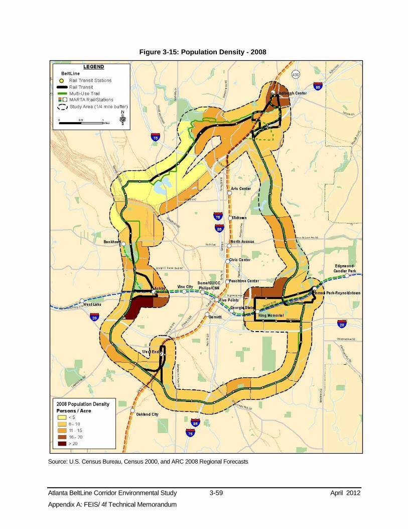
Atlanta BeltLine Corridor Environmental Study 3-59 April 2012
Appendix A: FEIS/ 4f Technical Memorandum
Figure 3-15: Population Density - 2008
Source: U.S. Census Bureau, Census 2000, and ARC 2008 Regional Forecasts

Atlanta BeltLine Corridor Environmental Study 3-60 April 2012
Appendix A: FEIS/ 4f Technical Memorandum
Figure 3-16: Population Density - 2030
Source: U.S. Census Bureau, Census 2000 and ARC 2008 Regional Forecasts

Atlanta BeltLine Corridor Environmental Study 3-61 April 2012
Appendix A: FEIS/ 4f Technical Memorandum
Figure 3-17: Employment Density - 2008
Source: U.S. Census Bureau, Census 2000 and ARC 2008 Regional Forecasts

Atlanta BeltLine Corridor Environmental Study 3-62 April 2012
Appendix A: FEIS/ 4f Technical Memorandum
Figure 3-18: Employment Density - 2030
Source: U.S. Census Bureau, Census 2000, and ARC 2008 Regional Forecasts

Atlanta BeltLine Corridor Environmental Study 3-63 April 2012
Appendix A: FEIS/ 4f Technical Memorandum
3.5.2.2 Households
Table 3-21 presents a summary of household data for the geographically defined areas within the study area. “Households are defined as the set of people who occupy a housing unit — a house, an apartment, a mobile home, a group of rooms, or a single room occupied as separate living quarters. Households are classified by their size (the number of people living in them) and by their type (the relationships among the members of the household)” (Lewis 2002). According to the ARC, the average household size in the Atlanta region12 in 2008 was 2.72 persons. In the Atlanta BeltLine study area, the average household size is slightly lower at 2.25 persons13.
During 2008, the Atlanta BeltLine study area had 33,791 households. Historically, the northwest zone had the greatest number of households of all the study area zones, while the southwest zone had the least number of households. The 2030 projection shows growth in all zones, but with the northeast leading in total households.
Table 3-21: Households - 1990 to 2030
Area
Number of Households (Year) Growth (Percent Change)
1990 2000 2008 2030 1990 to
2000 2000 to
2008 2008 to
2030
Northeast Zone 7,716 8,765 11,362 16,227 14% 30% 43%
Southeast Zone 5,166 5,672 6,927 10,008 10% 22% 44%
Southwest Zone 3,140 3,560 3,724 5,049 13% 5% 36%
Northwest Zone 8,031 9,592 11,778 13,935 19% 23% 18%
Atlanta BeltLine Study Area 24,053 27,589 33,791 45,219 15% 22% 34%
Atlanta 155,752 168,242 198,641 251,887 8% 18% 27%
Fulton County 257,140 321,242 382,422 479,900 25% 19% 25%
Source: U.S. Census Bureau, Census 2000, and ARC 2008 Regional Forecasts
3.5.2.3 Household Density
Figure 3-19 and Figure 3-20 depict study area household densities for 2008 and 2030, respectively. Generally, projections indicate household density will increase between years 2008 and 2030 equally across the study area.
In 2008, study area household density ranged from 3.0 to 5.3 households per acre. The average household density in the study area in 2008 was approximately 3.7 households per acre. Year 2030 projections report density to increase to an average of 4.3 households per acre. Areas with the greatest household density are along the Peachtree Corridor, Piedmont Park, and near Lindbergh Center, Inman Park/Reynoldstown, West End, and Ashby MARTA rail stations.
12 The Atlanta Region is defined as the 10-county area including Cherokee, Clayton, Cobb, DeKalb, Douglas, Fayette, Fulton, Gwinnett, Henry and Rockdale counties, as well as the City of Atlanta. (ARC 2010)
13 Average household size is based on the ARC 2030 population projection divided by the 2030 household projection.

Atlanta BeltLine Corridor Environmental Study 3-64 April 2012
Appendix A: FEIS/ 4f Technical Memorandum
Figure 3-19: Household Density - 2008
Source: U.S. Census Bureau, Census 2000; ARC 2008 Regional Forecasts

Atlanta BeltLine Corridor Environmental Study 3-65 April 2012
Appendix A: FEIS/ 4f Technical Memorandum
Figure 3-20: Household Density - 2030
Source: U.S. Census Bureau, Census 2000; ARC 2008 Regional Forecasts
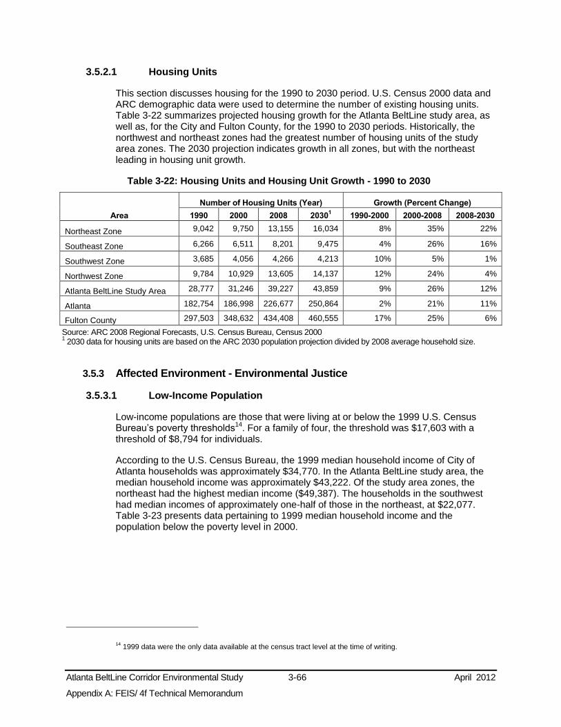
Atlanta BeltLine Corridor Environmental Study 3-66 April 2012
Appendix A: FEIS/ 4f Technical Memorandum
3.5.2.1 Housing Units
This section discusses housing for the 1990 to 2030 period. U.S. Census 2000 data and ARC demographic data were used to determine the number of existing housing units. Table 3-22 summarizes projected housing growth for the Atlanta BeltLine study area, as well as, for the City and Fulton County, for the 1990 to 2030 periods. Historically, the northwest and northeast zones had the greatest number of housing units of the study area zones. The 2030 projection indicates growth in all zones, but with the northeast leading in housing unit growth.
Table 3-22: Housing Units and Housing Unit Growth - 1990 to 2030
Area
Number of Housing Units (Year) Growth (Percent Change)
1990 2000 2008 20301 1990-2000 2000-2008 2008-2030
Northeast Zone 9,042 9,750 13,155 16,034 8% 35% 22%
Southeast Zone 6,266 6,511 8,201 9,475 4% 26% 16%
Southwest Zone 3,685 4,056 4,266 4,213 10% 5% 1%
Northwest Zone 9,784 10,929 13,605 14,137 12% 24% 4%
Atlanta BeltLine Study Area 28,777 31,246 39,227 43,859 9% 26% 12%
Atlanta 182,754 186,998 226,677 250,864 2% 21% 11%
Fulton County 297,503 348,632 434,408 460,555 17% 25% 6%
Source: ARC 2008 Regional Forecasts, U.S. Census Bureau, Census 2000 1 2030 data for housing units are based on the ARC 2030 population projection divided by 2008 average household size.
3.5.3 Affected Environment - Environmental Justice
3.5.3.1 Low-Income Population
Low-income populations are those that were living at or below the 1999 U.S. Census Bureau’s poverty thresholds
14. For a family of four, the threshold was $17,603 with a threshold of $8,794 for individuals.
According to the U.S. Census Bureau, the 1999 median household income of City of Atlanta households was approximately $34,770. In the Atlanta BeltLine study area, the median household income was approximately $43,222. Of the study area zones, the northeast had the highest median income ($49,387). The households in the southwest had median incomes of approximately one-half of those in the northeast, at $22,077. Table 3-23 presents data pertaining to 1999 median household income and the population below the poverty level in 2000.
14 1999 data were the only data available at the census tract level at the time of writing.

Atlanta BeltLine Corridor Environmental Study 3-67 April 2012
Appendix A: FEIS/ 4f Technical Memorandum
Table 3-23: Population below Poverty Level
Area Median
Household Income (1999)
Population for whom Poverty Status is
Determined1 (2000)
Population Below Poverty
Level
Percent Below
Poverty
Northeast Zone $49,387 15,964 3,104 19.4% Southeast Zone $28,989 14,020 3,925 28.0% Southwest Zone $22,077 8,347 2,836 33.9% Northwest Zone $48,293 18,171 3,610 19.8% Atlanta BeltLine Study Area $43,222 56,502 13,475 23.8% Atlanta $34,770 392,406 95,743 24.4% Fulton County $47,321 789,793 124,241 15.7%
Source: U.S. Census Bureau, Census 2000 1The U.S. Census Bureau determines poverty status for all people except institutionalized people, people in military group quarters, people in college dormitories, and unrelated individuals under 15 years old.
Of the zones within the study area, the southwest and southeast zones are characterized as environmental justice areas for low-income with 33.9 and 28 percent of the population, respectively, living below the poverty level in 2000. Figure 3-21 illustrates the incidence of low-income populations in the study area.
3.5.3.2 Minority Population
In the year 2000, the U.S. Census identified 68.7 percent of the City’s population as minority and 60.9 percent of the Atlanta BeltLine study area population as minority. The southwest and southeast zones had the highest concentration of minority populations. Table 3-24 shows the percentage of minorities within the study area, each of the four zones and other jurisdictions. Figure 3-22 shows the distribution of minority population throughout the study area.
Table 3-24: Minority Populations - 2000
Area Total Population (2000) Minority Population Percent Minority Population
Northeast Zone 17,385 7,810 44.9% Southeast Zone 14,622 10,549 72.1% Southwest Zone 9,530 9,434 98.9% Northwest Zone 22,616 11,336 50.1% Atlanta BeltLine Study Area 64,153 39,129 60.9% Atlanta 416,629 286,212 68.7% Fulton County 816,006 445,957 54.7%
Source: U.S. Census Bureau, Census 2000
Of the zones within the study area, the northeast zone is the only zone that does not qualify as an environmental justice area for minority concentrations according to the criteria.

Atlanta BeltLine Corridor Environmental Study 3-68 April 2012
Appendix A: FEIS/ 4f Technical Memorandum
Figure 3-21: Population below Poverty Level - 2000
Source: U.S. Census Bureau, Census 2000

Atlanta BeltLine Corridor Environmental Study 3-69 April 2012
Appendix A: FEIS/ 4f Technical Memorandum
Figure 3-22: Minority Population - 2000
Source: U.S. Census Bureau, Census 2000

Atlanta BeltLine Corridor Environmental Study 3-70 April 2012
Appendix A: FEIS/ 4f Technical Memorandum
3.5.3.1 Transit-Dependent Population
Table 3-25 lists the percentage of zero-car households and workers using public transportation within the study area, the City of Atlanta, and Fulton County.
Table 3-25: Zero-Car Households and Percent of Workers Using Public Transportation - 2000
Area Total
Households
Percent Zero-Car
Households
Workers 16 Years and
Older
Percent Using Public Transportation to Get
to Work
Northeast Zone 8,765 18.2% 10,603 14.5% Southeast Zone 5,672 23.8% 6,427 15.5% Southwest Zone 3,560 34.1% 2,722 26.1% Northwest Zone 9,592 18.6% 10,663 12.4% Atlanta BeltLine Study Area 27,589 21.2% 30,415 15.0% Atlanta 168,242 23.6% 178,970 15.0% Fulton County 321,242 15.2% 385,442 9.3%
Source: U.S. Census Bureau, Census 2000
In 2000, 23.6 percent of City households had no vehicle, while 21.2 percent of households within the study area had no vehicle. The southwest and southeast zones had the highest percentage of households with no vehicle. Figure 3-23 depicts the distribution of zero-car households in the study area.
Fifteen percent of Atlanta workers over the age of 16 used public transportation to get to work in year 2000. Within the study area, 15 percent of workers used public transportation to get to work. Of the zones in the study area, the highest percentages of workers using public transportation were in the southwest and southeast zones, while the northeast and northwest zones had the lowest percentages. The percentage of transit-dependent residents in each of the four zones, the study area, and the City of Atlanta surpasses that of Fulton County.
3.5.4 Preliminary Environmental Consequences
This section summarizes the findings of the potential socioeconomic and environmental justice effects of the No-Build and Preferred Alternatives. The evaluation measures that relate to the socioeconomic and environmental justice resource areas are also presented in this section. The evaluation measures include: population and employment within ½-mile of the proposed station locations; housing and employment within ½-mile of the proposed trail access points; and transit-dependent, low-income, and minority populations within ½-mile of the proposed transit station locations
This section addresses environmental justice in accordance with the provisions of Executive Order (EO) 12898, Federal Actions to Address Environmental Justice in Minority Populations and Low-Income Populations.

Atlanta BeltLine Corridor Environmental Study 3-71 April 2012
Appendix A: FEIS/ 4f Technical Memorandum
Figure 3-23: Zero-Car Households - 2000
Source: U.S. Census Bureau, Census 2000
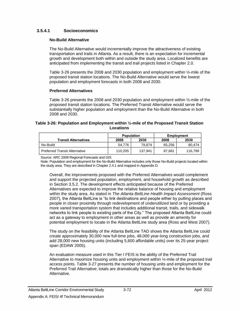
Atlanta BeltLine Corridor Environmental Study 3-72 April 2012
Appendix A: FEIS/ 4f Technical Memorandum
3.5.4.1 Socioeconomics
No-Build Alternative
The No-Build Alternative would incrementally improve the attractiveness of existing transportation and trails in Atlanta. As a result, there is an expectation for incremental growth and development both within and outside the study area. Localized benefits are anticipated from implementing the transit and trail projects listed in Chapter 2.0.
Table 3-26 presents the 2008 and 2030 population and employment within ½-mile of the proposed transit station locations. The No-Build Alternative would serve the lowest population and employment forecasts in both 2008 and 2030.
Preferred Alternatives
Table 3-26 presents the 2008 and 2030 population and employment within ½-mile of the proposed transit station locations. The Preferred Transit Alternative would serve the substantially higher population and employment than the No-Build Alternative in both 2008 and 2030.
Table 3-26: Population and Employment within ½-mile of the Proposed Transit Station Locations
Transit Alternatives
Population Employment
2008 2030 2008 2030
No-Build 54,776 79,874 65,256 80,474
Preferred Transit Alternative 110,205 137,941 87,681 116,799
Source: ARC 2008 Regional Forecasts and GIS Note: Population and employment for the No-Build Alternative includes only those No-Build projects located within the study area. They are described in Chapter 2.4.1 and mapped in Appendix D.
Overall, the improvements proposed with the Preferred Alternatives would complement and support the projected population, employment, and household growth as described in Section 3.5.2. The development effects anticipated because of the Preferred Alternatives are expected to improve the relative balance of housing and employment within the study area. As stated in The Atlanta BeltLine Health Impact Assessment (Ross 2007), the Atlanta BeltLine is “to link destinations and people either by putting places and people in closer proximity through redevelopment of underutilized land or by providing a more varied transportation system that includes additional transit, trails, and sidewalk networks to link people to existing parts of the City.” The proposed Atlanta BeltLine could act as a gateway to employment in other areas as well as provide an amenity for potential employment to locate in the Atlanta BeltLine study area (Ross and West 2007).
The study on the feasibility of the Atlanta BeltLine TAD shows the Atlanta BeltLine could create approximately 30,000 new full-time jobs, 48,000 year-long construction jobs, and add 28,000 new housing units (including 5,600 affordable units) over its 25-year project span (EDAW 2005).
An evaluation measure used in this Tier I FEIS is the ability of the Preferred Trail Alternative to maximize housing units and employment within ½-mile of the proposed trail access points. Table 3-27 presents the number of housing units and employment for the Preferred Trail Alternative; totals are dramatically higher than those for the No-Build Alternative.

Atlanta BeltLine Corridor Environmental Study 3-73 April 2012
Appendix A: FEIS/ 4f Technical Memorandum
Table 3-27: Housing and Employment within ½-mile of the Proposed Trail Access Points
Trail Alternatives Housing (2008) Employment (2008)
No-Build 9,489 6,707 Preferred Trail Alternative 53,696 63,928
Source: U.S. Census Bureau, Census 2000 Note: Housing and employment data for the No-Build Alternative include only the No-Build projects located within the study area. The No-Build projects in the study area are described in Chapter 2.4.1. and mapped in Appendix D.
3.5.4.2 Environmental Justice
In 2006, FTA issued Environmental Justice: Principles, Policies, Guidance, and Effective Practices that contains three principles of environmental justice to guide transit agencies in their compliance efforts:
Ensure that new investments and changes in transit support structures, services, maintenance, and vehicle replacement deliver equitable levels of service and benefits to minority and low-income populations;
Avoid, minimize, or mitigate disproportionately high and adverse effects on minority and low-income populations; and
Enhance public involvement activities to identify and address the needs of minority and low-income populations in making transportation decisions.
No-Build Alternative
The transportation improvements under the No-Build Alternative will provide improved transit service for some environmental justice populations relative to the existing conditions. Neighborhoods served within the study area will benefit from enhanced accessibility near one of the projects, but the number of transit-dependent, low-income, and minority populations served is smaller in comparison to the Preferred Transit Alternative (shown in Table 3-28).
Table 3-28: Transit-Dependent, Low-Income, and Minority Populations within ½-mile of the Proposed Transit Station Locations - 2000
Transit Alternative
Transit-Dependent* Low-Income Population
Minority Population Zero-Car
Households Population over Age 65
Disabled Population
No-Build 5,850 3,777 9,368 11,700 28,272 Preferred Transit Alternative 10,079 8,005 18,724 21,784 59,864
Source: U.S. Census Bureau, Census 2000 *: In this performance measure, transit dependent was defined as zero-car households, population of 65 and disabled populations in the initial screening conducted in the 2007 Inner Core BeltLine Alternatives Analysis Detailed Screening Results Note: Data for the No-Build Alternative include only those No-Build projects located within the study area. The No-Build projects in the study area are described in Chapter 2.4.1 and mapped in Appendix D.
Many of the opinions expressed during the Public Scoping meetings involving environmental justice communities will not be addressed by the No-Build Alternative, particularly those involving development and interconnectivity throughout the study area. However, the No-Build Alternative will not disproportionately affect environmental justice populations as transit and trail improvements other than the Atlanta BeltLine are planned

Atlanta BeltLine Corridor Environmental Study 3-74 April 2012
Appendix A: FEIS/ 4f Technical Memorandum
in all zones of the study area, including the zones defined as environmental justice. Therefore, they would experience somewhat improved access.
Preferred Alternatives
Potential effects to environmental justice populations because of the Preferred Alternatives are summarized in Table 3-29 and detailed in the Socioeconomics and Environmental Justice Technical Memorandum.
Table 3-29: Potential Effects on Environmental Justice Populations within the Study Area Resource Potential Effect of Preferred Alternatives
Land Use and Development
Potential land use conversions may occur where existing and future land uses are not compatible (e.g., residential uses) with the transit or trails elements. While effects are not expected to be disproportionate because they would occur throughout the entire study area, further evaluation is needed in the Tier 2 analysis.
Access to Housing and Property Values
As public and private investment takes place in the Atlanta BeltLine study area, increases in property values and subsequent increases in property taxes and rents could lead to the displacement of long-time residents within the southeast and southwest zone neighborhoods. Low-income residents may be forced to move to more affordable neighborhoods outside of the proposed Atlanta BeltLine service area. However, there are programs, administered by the City, ABI and the Atlanta Collaborative Land Trust, in place to prevent existing residents from being displaced. Further, the overall household cost of transportation would be reduced partially offsetting higher housing costs. In addition, the City of Atlanta has policies in place and is completing Atlanta BeltLine Subarea Master Planning to develop a framework for protecting single-family residences.
Parks The proposed transit and multi-use trails would improve access to existing parks. Neighborhoods and Community Facilities
Environmental justice communities, especially within the southeast and southwest zones, would experience improved regional mobility and better access to community facilities within the study area and to other neighborhoods because of the Preferred Alternatives. With improved connections, the character of the neighborhoods would not be significantly altered. No disproportionate effects are expected to environmental justice communities since all communities in the study area would experience the improved mobility and access equally.
Employment Environmental justice communities would have improved access to employment within the study area, as well as the region, potentially creating new job opportunities. Approximately 30,000 new full-time jobs and 48,000 year-long construction jobs would be created over the 25-year project span. No disproportionate impacts to environmental justice communities are anticipated since all communities would have improved access as a result of the project.
Noise & Vibration The preliminary noise and vibration analyses indicate that the southeast and southwest zones would have the most residents that could experience the highest residential noise and vibration impacts. This potential disproportionate effect will be evaluated further during the Tier 2 analysis to determine the severity of the potential noise effects and mitigation measures to mediate them.
Many of the considerations heard during meetings involving environmental justice communities will be addressed by the Preferred Alternatives, particularly those involving development and interconnectivity throughout the study area. As the project advances, the project sponsors will consider the many design and construction-related considerations heard, such as station amenities, crossing conditions, and the means to avoid adverse impacts to all study area populations.
An evaluation measure used in this FEIS/ 4(f) Technical Memorandum is the ability of the Preferred Alternatives to maximize services to low-income, minority and transit-dependent populations within ½-mile of proposed transit station locations. According to the 2000 U.S. Census data presented in Table 3-28, the Preferred Transit Alternative would provide transit options to more transit-dependent, low-income, and minority populations than the No-Build Alternative.

Atlanta BeltLine Corridor Environmental Study 3-75 April 2012
Appendix A: FEIS/ 4f Technical Memorandum
Public Involvement
The project sponsors developed a Public Involvement and Agency Coordination Plan (PIAC) in August 2008 for the Atlanta BeltLine project. The plan addresses CEQ Guidance that states that an agency should identify any potentially affected minority populations, low-income populations, and develop a strategy for their effective public involvement in the agency’s determination of the scope of the NEPA analysis. As such, the intent of the PIAC is to encourage citizens and local decision-makers to take part in the identification, development, and implementation of transit and trail improvements in the Atlanta BeltLine study area, and to identify potential impacts of alternatives on transportation, social, environmental, and economic conditions. Specific outreach efforts to Environmental Justice populations included coordination with neighborhood organizations, faith-based organizations, cultural groups, and community centers.
The public outreach for the Atlanta BeltLine Tier 1 DEIS was initiated with the Scoping Phase from July 24, 2008 to September 22, 2008. Eight formal Public Scoping meetings, two in each of the four zones of the study area, were conducted in accordance with NEPA guidelines 40 CFR Parts 1500-1508 and 23 CFR Part 771.
Chapter 7.0 provides a full discussion of the PIAC plan and summarizes all of the comments received during the Scoping Phase. A summary of the key themes in the comments received that relate to socioeconomics and environmental justice include:
The cost of the project to taxpayers;
The potential for disproportionate effects on the elderly, low-income and minority communities - the elderly should not be displaced;
Consistent and equitable development and infrastructure investment in all neighborhoods served by the Atlanta BeltLine;
The potential for the Atlanta BeltLine to attract additional crime and vagrants, especially along the proposed trail system;
The ability to prevent accidents and injuries at crossing locations and during construction;
Transit preferences: ensure Americans with Disabilities Act Accessibility; use electric/natural gas vehicles; use vehicles carrying 50 to 60 riders; use trolley-like cars; provide a combination of short- and long-trips to both local and regional destinations; use dedicated streetcar lanes; provide raised pedestrian crossovers with lighting; provide more stations in southeast and southwest zones; provide retail shops in stations; provide raised platforms, provide ample parking; provide 24-hour service; use MARTA card;
Trail amenity preferences: clearly marked trails; use cameras to monitor the trails; limit vehicle crossings; provide traffic signals at heavy pedestrian crossings; and design trails to be as seamless as possible; and
The improved access to stops and the quality of life that the transit and trails could provide.
During the Tier 1 EIS, small group workshops were held to solicit neighborhood and community input to the alternatives development and evaluation process and learn community issues and concerns. These workshops were supplemented by Stakeholder Advisory Committee (SAC) and Technical Advisory Committee (TAC) meetings comprised of community representatives and interested parties. Meetings for the public

Atlanta BeltLine Corridor Environmental Study 3-76 April 2012
Appendix A: FEIS/ 4f Technical Memorandum
were also held in various locations within the project corridor. Events were advertized via newsletters, website, and distribution and posting of flyers within communities along the Atlanta BeltLine. A list of the announcement dates and locations can be found in Appendix E.
Likewise, supplemental public notification of the public comment period and public hearings was undertaken to generate interest with as many people as possible in participating in the Tier 1 EIS process. Chapter 7.0 provides more detail regarding community and public outreach activities.
3.5.5 Potential Avoidance, Minimization, and Mitigation Measures
As the project advances, the conceptual design will be refined with the intent of avoiding or minimizing potential disproportionate adverse impacts on environmental justice populations. Specifically, during Tier 2 analysis, adjustments to the configuration, alignment, and location of amenities will be examined to avoid disproportionate adverse impacts to environmental justice populations. The project sponsors intend to continue coordination with all communities, particularly environmental justice populations, to develop context sensitive design solutions that benefit all populations.
With regard to housing, affordable housing units will be targeted to households with incomes that are below 60 percent of the Area Median Income (AMI) for renters and 115 percent of AMI for homebuyers. In addition, the City has policies in place and is completing Atlanta BeltLine Subarea Master Planning to develop a framework for protecting single-family residences. ABI and the City are currently exploring adopting tax assessment policies to reduce the potential impact of increasing property taxes on lower income owner-occupants or tenants. These include the development of a community land trust to maintain permanent affordable housing, providing financial and legal consulting services, and creating a property tax endowment to assist senior and low-income residents with the payment of their property taxes to enable those citizens to remain in their communities (ABI 2007).
Some impacts may be unavoidable and will be reported during Tier 2 analysis. A discussion of the potential mitigation strategies for each of the resource areas listed in Table 3-29 above is provided in the respective resource sections.
3.5.6 Subsequent Analysis
Subsequent environmental evaluations during the Tier 2 analysis will address the following:
Detailed effects of the project on population, employment, and housing growth;
Detailed effects of the project on potential land use conversion and community benefits;
Detailed adverse and beneficial effects of the project on environmental justice communities;
Review of potential adverse and beneficial effects on neighborhoods, parks, and community facilities;
Relocation impact analysis for potentially displaced residences, including environmental justice residences, and other uses;
Pedestrian and vehicular circulation studies; and

Atlanta BeltLine Corridor Environmental Study 3-77 April 2012
Appendix A: FEIS/ 4f Technical Memorandum
Detailed noise and vibration analyses and mitigation measures.
3.6 Visual and Aesthetic Resources This section presents a description of the visual and aesthetic resources within the Atlanta BeltLine study area, as well as the potential effects of the project on these resources.
3.6.1 Methodology
The existing visual and aesthetic characteristics of the study area were determined by viewing and qualitatively describing existing land uses, and by reviewing available maps and photographs. Site visits provided an understanding of the aesthetic conditions within each zone. More detailed analysis will be conducted during the Tier 2 analysis.
3.6.2 Affected Environment
The study area encompasses a variety of land uses with differing visual and aesthetic characteristics, including industrial and light industrial areas served by the rail lines, parks, commercial areas, and residential neighborhoods. The visual context of the study area includes former light industrial areas converted to commercial and residential uses, new multi-family residential, industrial and light industrial, garden apartments, commercial developments, single-family neighborhoods, and open space. In general, development in the study area backs up to the railroad ROW, which in residential areas is frequently screened by vegetation or physically separated from surrounding uses by changes in grade. Whereas vegetative buffering can be seen as a benefit, infrequent maintenance of that vegetation can also create an unsightly overgrown condition. Street crossings include overpasses and underpasses, as well as at-grade crossings. Often the railroad ROW is only visible at these crossings.
Where views of the ROW are unobscured, the sight of old railroad embankment, structures, rails, ties and ballast beds are present. Railroad-related structures and equipment are visible at all at-grade crossings including signs and crossing warning indicators. Rail yards, sidings, and active or parked trains can be observed from public ROW in numerous locations in the study area. Where vegetation or other screening is absent, views of railroad materials such as piles of ties may still be evident. Dumped trash can also be observed along some ROWs.
Views from the ROW are not a factor if the railroad ROW is currently unused. Where the railroad ROW is active, viewers from within the ROW are restricted to train operators and maintenance personnel as public access is not provided along ROW.
3.6.2.1 Potentially Sensitive Views and Resources
Potentially sensitive views and resources throughout the study area include the prominent visual resources described in Table 3-30 by zone, as well as the cultural and recreational resources identified along the route, as described in Section 3.7. During the public scoping process, community members in all zones expressed concern regarding potential effects to residential neighborhoods bordering the ROW.
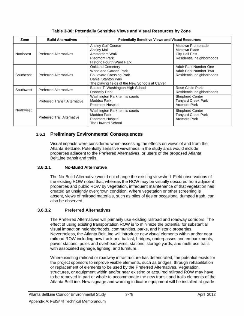
Atlanta BeltLine Corridor Environmental Study 3-78 April 2012
Appendix A: FEIS/ 4f Technical Memorandum
Table 3-30: Potentially Sensitive Views and Visual Resources by Zone
Zone Build Alternatives Potentially Sensitive Views and Visual Resources
Northeast Preferred Alternatives
Ansley Golf Course Ansley Mall Amsterdam Walk Piedmont Park Historic Fourth Ward Park
Midtown Promenade Midtown Place City Hall East Residential neighborhoods
Southeast Preferred Alternatives
Oakland Cemetery Woodland Garden Park Boulevard Crossing Park Daniel Stanton Park The playing fields of the New Schools at Carver
Adair Park Number One Adair Park Number Two Residential neighborhoods
Southwest Preferred Alternatives Booker T. Washington High School Donnelly Park
Rose Circle Park Residential neighborhoods
Northwest
Preferred Transit Alternative Washington Park tennis courts Maddox Park Piedmont Hospital
Shepherd Center Tanyard Creek Park Ardmore Park
Preferred Trail Alternative
Washington Park tennis courts Maddox Park Piedmont Hospital The Howard School
Shepherd Center Tanyard Creek Park Ardmore Park
3.6.3 Preliminary Environmental Consequences
Visual impacts were considered when assessing the effects on views of and from the Atlanta BeltLine. Potentially sensitive viewsheds in the study area would include properties adjacent to the Preferred Alternatives, or users of the proposed Atlanta BeltLine transit and trails.
3.6.3.1 No-Build Alternative
The No-Build Alternative would not change the existing viewshed. Field observations of the existing ROW noted that, whereas the ROW may be visually obscured from adjacent properties and public ROW by vegetation, infrequent maintenance of that vegetation has created an unsightly overgrown condition. Where vegetation or other screening is absent, views of railroad materials, such as piles of ties or occasional dumped trash, can also be observed.
3.6.3.2 Preferred Alternatives
The Preferred Alternatives will primarily use existing railroad and roadway corridors. The effect of using existing transportation ROW is to minimize the potential for substantial visual impact on neighborhoods, communities, parks, and historic properties. Nevertheless, the Atlanta BeltLine will introduce new visual elements within and/or near railroad ROW including new track and ballast, bridges, underpasses and embankments, power stations, poles and overhead wires, stations, storage yards, and multi-use trails with associated signage, lighting, and furniture.
Where existing railroad or roadway infrastructure has deteriorated, the potential exists for the project sponsors to improve visible elements, such as bridges, through rehabilitation or replacement of elements to be used by the Preferred Alternatives. Vegetation, structures, or equipment within and/or near existing or acquired railroad ROW may have to be removed in part or whole to accommodate the new transit and trails elements of the Atlanta BeltLine. New signage and warning indicator equipment will be installed at-grade

Atlanta BeltLine Corridor Environmental Study 3-79 April 2012
Appendix A: FEIS/ 4f Technical Memorandum
crossings. These activities and amenities have the potential to change the visual characteristics of and from the railroad ROW and immediate surroundings. Railroad ROWs that are currently obscured by vegetation may be readily visible as a result of implementing the Preferred Alternatives.
The Preferred Trail Alternative will be aligned within and/or near existing railroad ROW alongside the Atlanta BeltLine transit component and/or adjacent to existing roadways. Within railroad ROW and, in some cases along existing roadways, the multi-use trails will create new views of the study area from these locations. Public users of the trails will have a new set of views of adjacent prominent resources, such as parks and historic structures.
3.6.4 Potential Avoidance, Minimization, and Mitigation Measures
The proposed use of existing railroad ROW or proximity to existing railroad ROW is intended to locate new transportation resources in already designated transportation corridors. The intent of aligning the Atlanta BeltLine alongside existing freight railroad infrastructure is to minimize the potential for substantial visual impact on neighborhoods and communities. However, as described in Section 3.3, some changes in existing visual characteristics may occur. Conceptually, mitigation strategies that can be considered to address unavoidable adverse visual impacts include modifying the location and configuration of new visual elements to reduce visual impact, providing visual screening or buffers, shielding lighting, and addressing related concerns such as maintenance and trash removal.
3.6.5 Subsequent Analysis
Detailed analysis will be undertaken as the project design is further developed during Tier 2 analysis to identify and assess the extent of adverse impacts on the visual and aesthetic resources within the study area. Further development of project design will include refining the conceptual design presented in this FEIS/ 4(f) Technical Memorandum using more detailed environmental analysis and ongoing public input. For example, for each of the proposed station sites, further analysis will be conducted in conjunction with local agencies to develop an understanding of the relationship of the proposed station architecture, lighting systems, and other features to the surrounding natural and built environment, and the historic context of the area. The analysis would identify the potential for blockage of valued views and the areas where the scale, form, and aesthetics of project facilities could be designed to complement the surrounding landscape. Tier 2 analyses would yield a basis for considering specific measures that could be integrated into the final station designs to avoid or reduce the visual impacts of the stations on their surroundings.
3.7 Cultural, Historic, and Archaeological Resources This section describes the cultural, historic, and archaeological resources that exist within the Atlanta BeltLine study area as well as the potential effects of the project on these resources.
3.7.1 Methodology
Coordination with the State Historic Preservation Office (SHPO) determined the approach for identifying known and potential cultural, historic, and archaeological resources along the corridor for the Tier 1 EIS, as documented in Appendix C, Agency Coordination. A meeting on August 6, 2009 obtained concurrence from the SHPO

Atlanta BeltLine Corridor Environmental Study 3-80 April 2012
Appendix A: FEIS/ 4f Technical Memorandum
regarding an approach to the cultural resources evaluation that includes the following three steps:
Study Area Definition
Existing Data Sources Review
Field Reconnaissance
The Tier 1 and 2 analyses will fulfill the requirements of Section 106 of the National Historic Preservation Act (NHPA) as codified in 36 CFR 400. Section 106 requires federal agencies or projects requiring a federal permit to take into account the effects their actions might have on historic properties. In the Atlanta BeltLine Tier 1 FEIS, the focus of Section 106 analysis is on identifying areas of cultural, historic, and archaeological sensitivity. Both documented sites and those undocumented areas with a potential for historic or prehistoric archaeological resources define the term “areas of archaeological sensitivity.” Subsequent analysis to be undertaken during the Tier 2 phase of the project is described in Section 3.7.4.
A Cultural Resources Reconnaissance Technical Memorandum (2009) was prepared to support the Tier 1 DEIS. Neither a Historic Resources Survey Report (HRSR) or a Phase I archaeological study was prepared for this FEIS/ 4(f) Technical Memorandum . A more detailed assessment will be prepared as part of future Tier 2 analyses for both historic resources and archaeological resources using the Preferred Alternative.
3.7.1.1 Study Area Definition
In consultation with the SHPO, the study areas used to identify cultural resources for the Tier 1 study were ¼-mile from each side of the Atlanta BeltLine corridor centerline for historic architectural resources, for a maximum of a ½-mile within which both direct and indirect effects to these resources might occur. For archaeological resources, the study area was identified to include 150 feet from each side of the proposed Atlanta BeltLine corridor centerline, for a maximum of 300 feet within which construction of any project improvements could potentially affect archaeological resources.15 A resource was considered to be potentially directly affected if it was wholly or partially inside the APE of the Preferred Alternative, or if the boundary of the resource was adjacent to the APE. The study area for historic architectural resources is broader to include potential indirect effects.
3.7.1.2 Existing Data Sources Review
Existing information on previously identified historic properties was reviewed to identify any known resources that exist within the study area. This review included properties listed on the National Register of Historic Places (NRHP), NRHP nominations, National Historic Landmarks, and the updated Georgia Historic Bridge Survey (GHBS 2008). Also consulted were the Georgia’s Natural, Archaeological, and Historic Resources GIS (NAHRGIS) database (https://www.itos.uga.edu/nahrgis/) and documentation available at the Georgia Department of Natural Resources (GADNR), SHPO, Atlanta Urban Design
15 As part of the Georgia Environmental Policy Act (GEPA) study conducted specifically for the northeast zone of the Atlanta BeltLine Corridor, surveying and documentation of cultural resources took place (2008 - 2009). The Cultural
Resources Reconnaissance Technical Memorandum (2009) shows the data gathered from the cultural resources study, which is also included in the Tier 1 EIS.

Atlanta BeltLine Corridor Environmental Study 3-81 April 2012
Appendix A: FEIS/ 4f Technical Memorandum
Commission (AUDC), Historic American Building Survey (HABS), Historic American Engineering Record (HAER), and other available sources of information.
Additional information specifically for the northeast zone was obtained from the Atlanta BeltLine Georgia Environmental Policy Act (GEPA) study. Supporting technical reports for that study, the Historic Resources Survey Report (HRSR) and a Phase I Archaeological Report, were reviewed.
Review of the state archaeological site files at the University of Georgia and existing survey reports identified archaeological sites within a one-kilometer (0.62 miles) distance surrounding the archaeological study area. In addition, topographic maps, aerial photography, and as-built maps for the original MARTA line identified areas of high archaeological site potential.
Construction of a predictive model determined potential prehistoric site locations, based on topography, known site locations, and the degree of historic landform disturbance. Historic maps from the 19th Century through the 20th Century were also sources of information for locating areas of historic archaeological site potential.
Identification of potential consulting parties followed the review of existing information on previously identified historic properties. In addition to the SHPO, other consulting parties were determined based on the guidance in the GDOT/FHWA Cultural Resource Survey Guidelines. The consulting parties invited by FTA and MARTA to comment on the Atlanta BeltLine project included the SHPO, the National Park Service Southeast Regional Office, the ARC, the Fulton County Board of Commissioners, and the City of Atlanta Bureau of Planning. For more information regarding the review of resources and sources consulted, see the Cultural Resources Reconnaissance Technical Memorandum (2009).
3.7.1.3 Field Reconnaissance
Field reconnaissance was conducted in the historic architectural study area to identify any historic properties potentially eligible for listing in the NRHP or Georgia Register of Historic Places (GRHP). This reconnaissance involved a windshield survey to locate properties that appeared to be over 50 years of age and potentially eligible based upon National Register criteria. The basis for this evaluation included the physical appearance of the resources and their architectural design. Other factors such as integrity, setting, and historical importance based upon knowledge of the development of the neighborhood also were included in the evaluation of potential eligibility.
A reconnaissance also was conducted in the archaeological study area to confirm the sensitivity of areas assessed to have archaeological potential based on background research or prehistoric site predictive modeling. Field-testing was performed in the northeast zone as part of the GEPA study and is documented in the Environmental Effects Report – Atlanta BeltLine Corridor Northeast Zone report.16
3.7.2 Affected Environment
The discussion of cultural resources is organized by study area zone. A total of 180 cultural resources were identified. Lists of all cultural resources by study area zone can
16 AECOM, Inc., 2009. Environmental Effects Report – Atlanta BeltLine Corridor Northeast Zone, Atlanta BeltLine Corridor Environmental Study. Prepared for MARTA and ABI.

Atlanta BeltLine Corridor Environmental Study 3-82 April 2012
Appendix A: FEIS/ 4f Technical Memorandum
be found in the Cultural Resources Reconnaissance Technical Memorandum (2009). One resource, the Historic Railroads of the Atlanta BeltLine, has been determined eligible for the entire Atlanta BeltLine Corridor. The contributing elements within the northeast zone were surveyed in detail during the Atlanta BeltLine GEPA study.
Other resources, such as Atlanta’s Historic Apartment Complexes, exist in more than one zone, but were counted only once. Figure 3-24 shows all NRHP-listed, or potentially eligible historic resources in the study area. Table 3-31 lists the number of existing and potential historic and archeological resources by zone. Appendix D includes detailed figures by zone illustrating areas of archaeological sensitivity in the 300-foot study area for archaeological resources. No sacred Native American Lands were identified within this study area.
Table 3-31: Number of Historic and Archaeological Resources by Zone
Zone
Georgia/National Register of Historic Places
AUDC Additional
“Significant” properties
Additional Resources Identified
During Field Reconnaissance
Archaeologically Sensitive Areas
Total Number of Resources Listed Sites Eligible Sites
Northeast 16 28 0 0 8 52 Southeast 10 2 13 17 12 54 Southwest 6 1 4 6 4 21 Northwest 12 3 9 14 15 53 Total All Zones 180
Sources: NRHP, GRHP, AUDC, and ARC 2011.
A Tier 2 analysis will be completed to determine potential eligibility of those resources not already listed on the NRHP or determined eligible.
3.7.2.1 Preliminary Environmental Consequences
This section describes the potential impacts of the No-Build and Preferred Alternatives on cultural resources, including both historic and archaeological sites that are listed, eligible, and potentially eligible for listing on the GRHP or the NRHP. For the purpose of this section, and for ease of discussion, all of the resources are referred to as “cultural resources.”
No-Build Alternative
The No-Build Alternative includes a mix of improvements to existing facilities and new transit projects. The improvements to existing facilities are geographically specific; as such, the potential for cultural resource impacts will be highly localized. Assessment of the extent of potential cultural resource impacts of the No-Build projects will occur during environmental analysis for those projects. Public outreach and Section 106 coordination in regard to avoiding, minimizing, and mitigating the potential adverse cultural resources effects of the No-Build projects will take place during those environmental reviews.

Atlanta BeltLine Corridor Environmental Study 3-83 April 2012
Appendix A: FEIS/ 4f Technical Memorandum
Figure 3-24: Historic Resources
Sources: NRHP, GRHP, AUDC, and ARC. 2010 Note: Resources on more than one list are mapped according to their highest designation level. National and/or State Register listing takes precedence over AUDC listing, for example.

Atlanta BeltLine Corridor Environmental Study 3-84 April 2012
Appendix A: FEIS/ 4f Technical Memorandum
Preferred Alternatives
The proposed use of existing railroad ROW by the Atlanta BeltLine will aggregate transportation resources in existing transportation corridors and minimize the potential for substantial impacts on the environment, including cultural resources.
During the scoping process, the general public as well as regional agencies provided input regarding cultural resources. Comments from the public and agencies expressed concern that the proposed Atlanta BeltLine could have detrimental effects on historic structures and archaeological resources, and there should be an assessment of these potential impacts. Preliminary design of the Preferred Alternatives occurred with the intent of avoiding or minimizing impacts to cultural resources, wherever feasible.
Although 180 total resources were identified within the larger project study area across all four zones, as discussed in Section 3.7.2 and in the Cultural Resources Reconnaissance Technical Memorandum (2010), only 105 resources fall within 150 feet of the Preferred Transit Alternative and 103 resources for the Preferred Trail Alternative, noted in Section 3.7.1.
Table 3-32 indicates the total number of historic resources and areas of archaeological sensitivity potentially subject to direct and indirect, proximity impacts within each zone. It should be noted that there has not yet been a formal evaluation of eligibility or effects under Section 106 as part of this project.
Table 3-32: Potential Impacts to Cultural Resources
Zone Alternative
Numbers of Potential Impacts
to Cultural Resources
Northeast Preferred Alternatives 29
Southeast Preferred Alternatives 42
Southwest Preferred Alternatives 16
Northwest Preferred Transit Alternative 17
Preferred Trail Alternative 15
For a list of cultural resources located within the study area, and their physical relationship to the Preferred Alternatives, see the Cultural Resources Reconnaissance Technical Memorandum (2009) and Cultural Resources Reconnaissance Technical Memorandum Addendum (2011).
As stated above, the use of existing railroad and roadway ROW, wherever possible, to locate proposed transit and trail elements minimizes the potential for direct effects on historic resources. On the other hand, the main resource that will be directly impacted by the Preferred Transit Alternative is the Historic Railroad Resources of the Atlanta BeltLine. This resource, which spans all four study area zones, is comprised of numerous contributing elements including railroad ROW, track, ballast, bridges, culverts, retaining walls, and other related features. Any proposed action within the former Atlanta BeltLine railroad system footprint will likely cause impacts to the resource.
Additional ROW is expected to be needed in specific areas adjacent to the Atlanta BeltLine corridor to accommodate the Preferred Alternatives. A preliminary assessment of ROW needs identified the Orkin-Rollins Building as another historic resource that

Atlanta BeltLine Corridor Environmental Study 3-85 April 2012
Appendix A: FEIS/ 4f Technical Memorandum
would be directly impacted by the Preferred Alternatives in the northeast zone. This resource could have an element of the project constructed on a portion of the property, creating a direct impact to the building itself. Other historic resources could be indirectly affected by proximity impacts such as visual, noise, vibration, and access changes.
Finally, 39 areas of archaeological sensitivity are identified by background research and field reconnaissance in all zones. The investigations suggest that the areas of sensitivity could retain potentially significant archaeological sites.
3.7.3 Potential Avoidance, Minimization, and Mitigation Measures
Conceptual design of the Preferred Alternatives conservatively indicates the potential for direct and indirect impacts on cultural resources. As the project advances, the design will be refined with the intent of further avoiding or minimizing impacts on cultural resources.
Some impacts may be unavoidable and will be reported during Tier 2 analysis. At this point, FTA and MARTA will work in consultation with the Georgia SHPO and Consulting Parties to identify mitigation strategies, which will eliminate or mitigate adverse effects; and if necessary, prepare a Programmatic Agreement to outline mitigation commitments.
3.7.4 Subsequent Analysis
During the Tier 2 analysis, further design development will enable the identification of specific direct and indirect effects on cultural resources and allow compliance with the requirements of Section 106 to proceed. In addition, during Tier 2 analysis, additional investigations and studies will take place to: 1) identify cultural resources and determine eligibility for the NRHP; 2) determine the direct and indirect effects on those cultural resources; and 3) develop appropriate mitigation measures for unavoidable impacts.
As part of meeting the requirements of Section 106, the project sponsors would consult with the Georgia SHPO and other consulting parties and the public concerning the full range of effects to cultural resources during Tier 2 analysis.
3.8 Parks and Recreational Resources This section presents a description of the parks and recreational resources within the Atlanta BeltLine study area, as well as the potential effects of the project on these resources.
3.8.1 Methodology
The methodology for assessing potential effects on parks and recreational resources included the following tasks:
Identification of publicly-owned parks and recreational properties in the study area;
Identification and assessment of the potential effects of the alternatives on the parks and recreational resources potentially crossed or otherwise affected by the alternatives;
Determination of the consistency of the alternatives with City and regional plans for park and recreational facilities;
Identification of general areas where the alternatives could need additional ROW that could affect adjacent park properties; and

Atlanta BeltLine Corridor Environmental Study 3-86 April 2012
Appendix A: FEIS/ 4f Technical Memorandum
Identification of potential design and mitigation strategies to offset potential negative impacts.
The analysis applied both quantitative and qualitative assessments in the tasks presented above. The analysis utilized quantitative assessments to determine if parks and recreational resources exist within the ¼ mile study area and the 150-foot buffer to either side of the Preferred Alternatives. The larger ¼-mile study area allows a broader view of potential effects within the overall Atlanta BeltLine study area, while the 150-foot buffer area focuses on direct physical impacts with a width that conservatively allows for anticipated alternative impacts. Data on parks and recreation areas in the study area were obtained from the City of Atlanta through their GIS resources and adopted park and recreation plans. All City classifications of parks were used, which include: Regional Parks, Community Parks, Neighborhood Parks, Block Parks, Garden Parks, and Conservation Parks.
The identification of the potential impacts on parklands and recreation areas in the study area focused on potential ROW impacts. A qualitative assessment evaluated the potential of the alternatives to contribute to or detract from existing or planned parks and recreational resources.
3.8.2 Planning Context
According to the Atlanta’s Project Greenspace Summary Report, released in 2009 by the City of Atlanta, the City lags behind its U.S. peers in greenspace per capita. This number will continue to fall if the City is not proactive in implementing a greenspace vision. Currently, Atlanta offers 0.75 acres of public parkland per 100 residents. Its goal is to increase that ratio to one acre per 100 residents. Goals outlined in the report include:
Protecting a minimum of 20 percent of the City’s land area as greenspace;
Providing a minimum of 10.5 acres of public parkland per 1,000 residents;
Providing publicly accessible greenspace within a ½-mile walk of every resident;
Protecting at least 75 percent of Atlanta’s environmentally sensitive lands via ownership and/or development regulations; and
Providing recreational facilities and programs to meet citizen needs based on a level of service standards.
3.8.3 Affected Environment
Twenty-two public parks, including two regional parks, six community parks, six neighborhood parks, seven garden parks, and one block park are located within the original 150-foot buffer used for the Preferred Alternatives. These parks total approximately 65.5 acres within the 150-foot buffer and extend beyond the buffer to cover a total of 605 acres. Appendix D contains a table listing park and recreational facilities by zone, within the 150-foot buffer, and within the ¼-mile study area (shown in Figure 3-25).

Atlanta BeltLine Corridor Environmental Study 3-87 April 2012
Appendix A: FEIS/ 4f Technical Memorandum
Figure 3-25: Parks
Source: City of Atlanta, Department of Parks, Recreation, & Cultural Affairs 2010

Atlanta BeltLine Corridor Environmental Study 3-88 April 2012
Appendix A: FEIS/ 4f Technical Memorandum
3.8.4 Preliminary Environmental Consequences
3.8.4.1 No-Build Alternative
Existing Park and Recreational Effects Under the No-Build Alternative, only two projects will potentially affect parks and recreational resources in the study area. Commuter Rail-Lovejoy/Griffin/Macon has the potential to affect Adair II Park near West End in the southeast zone, and the I-20 East BRT has the potential to affect Rawson-Washington Park at the edge of the Atlanta BeltLine study area in the southeast zone. The sponsors of the projects in the No-Build Alternative will be required to identify unavoidable impacts to these and any other parks, and to develop appropriate mitigation strategies for these in accord with federal, state, and local requirements.
Future Park and Recreational Effects The No-Build Alternative will have some positive effects on future park and recreational resources in the study area, as it would add bicycle and pedestrian facilities and trails to improve access to parks and recreational resources. Planned parks and recreational resources identified in the City’s CDP include park expansions, new parks, and recreational resources. These projects are included in the No-Build definition provided in Section 2.4 of this document. Table 3-33 summarizes the locations of these new facilities, which will primarily benefit the local community.
Table 3-33: No-Build Alternative: Planned Park, Pedestrian, and Multi-Use Trail Resource Improvements within the Study Area
Project Name Project Type Zone Project Description
Lindbergh to Inman trail Hiking trail Northeast Unpaved trail improvement project
Piedmont Park Expansion Regional park Northeast
Expansion of a regional park and recreational resource per the Piedmont Park Master Plan (Currently under construction)
Eastside Trail Multi-use bicycle / pedestrian resource Northeast
Eastside multi-use trail from Piedmont Park to Glenwood (Currently under construction)
Four Corners Park Expansion Neighborhood park Southeast Expansion to neighborhood park and recreational resource
Ralph David Abernathy Boulevard pedestrian/intersection improvements Pedestrian resource Southwest Ralph David Abernathy Boulevard
pedestrian and intersection improvements
West End multi-use trails Multi-use bicycle / pedestrian resource Southwest West End multi-use trails along CSX RR
and Westview Drive
Southwest Hiking Trail Hiking trail Southeast Unpaved trail improvement project
Enota Park Neighborhood park Southeast New neighborhood park
Westside Reservoir Park Regional park Northwest New regional park and recreational resource
Marietta Boulevard pedestrian improvements
Multi-use bicycle / pedestrian resource Northwest Marietta Boulevard pedestrian
improvements
Northside Atlanta BeltLine Trail Multi-use bicycle / pedestrian resource Northwest Northside multi-use trail along Ardmore,
Tanyard, and Atlanta Memorial Parks Source: City of Atlanta. 2007. Atlanta Strategic Action Plan CDP
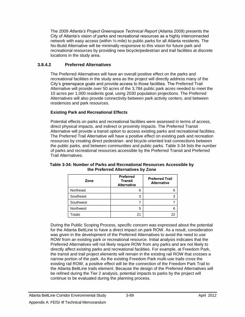
Atlanta BeltLine Corridor Environmental Study 3-89 April 2012
Appendix A: FEIS/ 4f Technical Memorandum
The 2009 Atlanta’s Project Greenspace Technical Report (Atlanta 2009) presents the City of Atlanta’s vision of parks and recreational resources as a highly interconnected network with easy access (within ½-mile) to public parks for all Atlanta residents. The No-Build Alternative will be minimally responsive to this vision for future park and recreational resources by providing new bicycle/pedestrian and trail facilities at discrete locations in the study area.
3.8.4.2 Preferred Alternatives
The Preferred Alternatives will have an overall positive effect on the parks and recreational facilities in the study area as the project will directly address many of the City’s greenspace goals and provide access to those facilities. The Preferred Trail Alternative will provide over 50 acres of the 3,784 public park acres needed to meet the 10 acres per 1,000 residents goal, using 2030 population projections. The Preferred Alternatives will also provide connectivity between park activity centers, and between residences and park resources.
Existing Park and Recreational Effects
Potential effects on parks and recreational facilities were assessed in terms of access, direct physical impacts, and indirect or proximity impacts. The Preferred Transit Alternative will provide a transit option to access existing parks and recreational facilities. The Preferred Trail Alternative will have a positive effect on existing park and recreation resources by creating direct pedestrian- and bicycle-oriented trail connections between the public parks, and between communities and public parks. Table 3-34 lists the number of parks and recreational resources accessible by the Preferred Transit and Preferred Trail Alternatives.
Table 3-34: Number of Parks and Recreational Resources Accessible by the Preferred Alternatives by Zone
Zone Preferred Transit
Alternative
Preferred Trail Alternative
Northeast 6 6
Southeast 3 3
Southwest 7 7
Northwest 5 6
Totals 21 22
During the Public Scoping Process, specific concern was expressed about the potential for the Atlanta BeltLine to have a direct impact on park ROW. As a result, consideration was given in the development of the Preferred Alternatives to avoid the need to use ROW from an existing park or recreational resource. Initial analysis indicates that the Preferred Alternatives will not likely require ROW from any parks and are not likely to directly affect existing parks and recreational facilities. For example, at Freedom Park, the transit and trail project elements will remain in the existing rail ROW that crosses a narrow portion of the park. As the existing Freedom Park multi-use trails cross the existing rail ROW, a positive effect will be the connection of the Freedom Park Trail to the Atlanta BeltLine trails element. Because the design of the Preferred Alternatives will be refined during the Tier 2 analysis, potential impacts to parks by the project will continue to be evaluated during the planning process.

Atlanta BeltLine Corridor Environmental Study 3-90 April 2012
Appendix A: FEIS/ 4f Technical Memorandum
The intent of the Atlanta BeltLine is to avoid or minimize adverse effects on existing parks and recreational facilities. Providing trail connections to or through existing parks could require use of parkland; however, the connections and trails will provide an enhancement to the parks by improving access and connectivity to other parks. It is likely that the ownership of the park will remain the same.
It should be noted that where the transit and trail alternatives cross existing trails, such as at Freedom Park, access and safety measures in the form of design and operational controls will be provided. These could include strategies such as grade-separated crossings of transit and trails, or gated and signalized at-grade crossings. The details of these strategies will be determined during Tier 2 analysis.
Indirect Effects
The potential exists for indirect effects as defined by Section 4(f) of the USDOT Act due to the proximity of transit operations to 13 park and recreational facilities in the Preferred Alternatives listed below:
Freedom Park
Piedmont Park
Daniel Stanton Park
Gordon-White Park
Green Leaf Circle
Napoleon Circle
South Gordon Triangle
Stafford Street Park
Ardmore Park
Bobby Jones Golf Course
Maddox Park
Tanyard Creek Park
Washington Park
Indirect effects of transit operations due to proximity can include noise and/or vibration impacts. However, initial noise and vibration screening indicates a low potential for direct effects due to the Atlanta BeltLine project. As the project design advances, strategies to avoid the potential for direct effects on parks and recreational facilities will be applied.
A more detailed list of individual park acreage within the 150-foot buffer and the ¼ mile study area is provided in Appendix D, along with figures that illustrate the park locations by zone.
Planned Park and Recreational Resources
The Atlanta BeltLine is part of the City’s greenspace plan. Thus, anticipation is for the Preferred Alternatives to have a positive effect on future park and recreation facilities, as they will help realize the City’s vision of increased public park space and park connectivity.
3.8.5 Potential Avoidance, Minimization, and Mitigation Measures
As the project design advances, the project sponsors will strive to avoid or minimize adverse effects on parks and recreational resources. Identification of unavoidable, specific impacts and determination of appropriate mitigation measures will occur by coordinating with the resource owner.

Atlanta BeltLine Corridor Environmental Study 3-91 April 2012
Appendix A: FEIS/ 4f Technical Memorandum
Potential mitigation strategies might include use of best management practices during construction activities and specific park enhancements or potential land replacement for long-term adverse impacts. Mitigation of proximity effects to parks could take place through context sensitive design, plantings, and sound buffering.
Should there be a temporary impact to parks and recreational resources during construction activities, public access will be restored when construction is complete. Construction activities will occur in a manner that will least disturb the use of these resources. Temporarily affected land within parks will mean restoration to pre-construction or better conditions after construction activities are complete.
3.8.6 Subsequent Analysis
During the Tier 2 analysis of the Preferred Alternatives, more detailed research on the types of functions and activities at each resource, public access, and exact property boundaries will occur to determine the extent of any potential effects. The analyses will include:
Descriptions of the uses and functions of each of the resources, and identification of resource boundaries including: total size of resources, specific services and facilities, and access to resources;
Specific potential effects on each resource, including property acquisition, if any;
Physical effects, proximity effects, and temporary effects on each resource resulting from proposed operations and infrastructure improvements to accommodate the Atlanta BeltLine; and
Documentation of consultation with the affected federal, state, and local jurisdictions and owners/operators of the identified resources.
3.9 Safety and Security This section describes the potential safety and security issues raised by the Preferred Alternatives, possible strategies to minimize risks during project construction and operation, and possible subsequent analysis regarding project safety and security.
3.9.1 Methodology
This section qualitatively assesses the potential safety and security issues that will be addressed as the Atlanta BeltLine development progresses, which respond to the FTA’s Safety and Security Management Plan (SSMP) requirements.
Safety and security regulations and guidance related to the project include the American Association of State Highway and Transportation Officials (AASHTO), the Illuminating Engineering Society of North America (IESNA), and the Americans with Disabilities Act. Materials, engineering guidelines, and accessibility requirements are addressed.
When the project is ready to enter the Preliminary Engineering phase, applicants for and recipients of FTA funding must submit a Safety and Security Management Plan (SSMP). The SSMP describes how the applicant will address safety and security for the Atlanta BeltLine project regardless of the chosen transit mode technology. During the Tier 1 FEIS analysis, certain features that respond to the SSMP requirements were identified. They are described in brief below.

Atlanta BeltLine Corridor Environmental Study 3-92 April 2012
Appendix A: FEIS/ 4f Technical Memorandum
3.9.2 Affected Environment
Existing safety protocols and measures in operation for existing transportation services are in effect. These protocols and measures are procedures to protect the safety of the public and the employees of MARTA, GDOT, the City of Atlanta, CSX, Norfolk Southern, and other entities that operate along or across the Atlanta BeltLine. Clearance requirements are in place along passenger and freight railroad lines, including CSX, Norfolk Southern, and MARTA. The sponsors of the projects listed on the TIP, included in the No-Build Alternative, would implement safety measures that are consistent with their own protocols and requirements.
Seventeen fire stations serve the study area. The project study area is entirely within the limits of existing fire, police, and emergency response team protection.
3.9.3 Environmental Consequences
Safety and security are conditions of transportation operations that protect the resources, the operators, and the users of those resources. This section contains a qualitative assessment of the potential operational safety and security conditions of the No-Build and Preferred Alternatives.
3.9.3.1 No-Build Alternative
Under the No-Build Alternative, existing safety and security protocols, such as compliance with AASHTO and American’s with Disabilities Act, or the control of roadway-track interactions for at-grade crossings, and measures in operation for existing transportation services will be in effect. This will include MARTA, GDOT, the City of Atlanta, CSX, Norfolk Southern, and other entity procedures to protect the safety and security of their resources, the public, and their employees who use the resources.
The No-Build Alternative will not change existing fire, police, and emergency response team routes or access.
3.9.3.2 Preferred Alternatives
Assessment of safety and security for the Preferred Alternatives occurs through four key topic areas: trails, stations, roadway-track interactions, and freight rail-track interactions. The provisions described for safety in this section are conceptual and subject to refinement and detailed evaluation of effects in a Tier 2 analysis.
In general, the Preferred Alternatives will not change fire, police, and emergency response team routes or access. During Tier 2 analysis, an evaluation of emergency services access routes will be undertaken to ensure that the Atlanta BeltLine facilitates access.
Trails
The Atlanta BeltLine trail design provides for a safe and secure environment for trail users. Utilization of the standards established in guidelines from AASHTO, IESNA, or by the American’s with Disabilities Act will address most safety issues along the trails. The AASHTO guide will address vertical and horizontal alignment issues. The American’s with Disabilities Act will specify standards for steps, ramps, handrails, and guardrails. Installation of lighting will meet the IESNA guidelines and be tailored appropriately for different conditions along the trails.

Atlanta BeltLine Corridor Environmental Study 3-93 April 2012
Appendix A: FEIS/ 4f Technical Memorandum
Several issues could present safety and security concerns for potential trail users, including the potential for pedestrian conflicts with transit, roadways, and pedestrian security along the trails. During the conceptual design, consideration was given to all these factors to help minimize the potential for such conflicts and breeches of pedestrian security. The design provides for safe interaction of trail users with transit and roadway traffic through use of signage and visual indicators at crossings.
A performance measure was used in this FEIS/ 4(f) Technical Memorandum to evaluate the ability of the Preferred Trail Alternative to maximize the miles of exclusive trails separated from roadway traffic. This measure assesses trail user safety in terms of the extent to which the trail alignment is within its own ROW and entirely separate from roadways. The assessment considered the number of linear feet of potential exclusive ROW for the Preferred Trail Alternative based on conceptual design.
Another area for potential conflicts is at proposed planned trail access points, particularly at roadway crossings. Trail access points include transit stations, connecting trails, and street crossings. Access to trails is also possible along linear areas (e.g., Tanyard Creek Park edge). Prescribed safety designations, such as appropriate crosswalks and visual cues, will be provided to minimize risks for both trail users and vehicles. Table 3-35 highlights the number of miles of exclusive ROW versus in-street ROW, as well as the number of proposed trail access points for the Preferred Trail Alternative.
Table 3-35: Estimated Exclusive Right-of-Way and Access Points for Multi-Use Trails
Alternative Miles within
Exclusive ROW Miles in Street Proposed Trail Access Points
Preferred Trail Alternative 15.9 4.1 68
Source: AECOM 2011 The security of the trail users is paramount. Where the trail diverges from the transit line the trail may become more isolated. These potential areas of low visibility might create a security risk for trail users. City policing of the trails may be an option to provide increased security to trail users.
Stations
Safety and security of stations will be an important consideration during Tier 2 analysis and design. Station design will conform to MARTA safety and design criteria as well as American’s with Disabilities Act standards, National Fire Protection Association (NFPA), and Building Officials and Code Administrators International, Inc. (BOCA) standards. The design of lighting will promote safety and security and conform to IESNA guidelines. In addition, there will be a provision for appropriate access for emergency response by police, fire department, and paramedic equipment and personnel. Where stations are not within street ROW, access will be from adjacent streets. Construction materials for the stations will meet code requirements from BOCA and the NFPA. Outside of stations, safe management of pedestrian interactions with transit vehicles will minimize conflicts between pedestrians and vehicular traffic.
Roadway – Track Interactions
A major issue with transit systems is the interaction between transit and roadway vehicles. Efforts will be made to protect both transit users and drivers of roadway vehicles that interact with transit. Landscaping can act as a buffer between vehicular and transit traffic, but, when used, vehicular and pedestrian crossings will provide clear views

Atlanta BeltLine Corridor Environmental Study 3-94 April 2012
Appendix A: FEIS/ 4f Technical Memorandum
in all directions. Traffic signals will be installed at intersections where the trail crosses a high-traffic vehicular road at grade. Railroad warning devices for highway grade crossings will be used where appropriate. The design of the crossing circuitry will avoid unnecessary delays to motorists. Where needed, the grade crossing warning system will preempt adjacent traffic lights to avoid automobiles forming a queue across the tracks.
Mainline grade crossings will consist of durable, long lasting materials. Construction of grade crossings will occur with due consideration to access for track maintenance, electrical isolation, non-interference with electrical track circuits or rail fastenings, tire adhesion, and slip resistance for pedestrians. Grade crossings will be on tangent track and away from special trackwork areas, unless otherwise approved by MARTA. Rail joints will not exist in grade crossings.
As the design advances, there will be an evaluation of the warrant for modifications to existing roadways. Plans to permanently alter existing roadways will take place in coordination with GDOT and/or the City to assure safety of all modes of travel.
Freight Rail – Track Interactions
The Preferred Alternatives will avoid sharing active freight rail ROW for the majority of the length of the corridor. A shared ROW will require additional coordination between MARTA, in partnership with ABI, and freight rail companies. Such coordination will determine design and operating conditions for a shared ROW situation. As described in Section 3.2.5.2, for example, CSX and MARTA have clearance requirements that will have to be accommodated in shared use or parallel ROW.
3.9.4 Potential Avoidance, Minimization, and Mitigation Measures
The design of safety and security strategies will focus on addressing the conditions developed as part of the Preferred Alternatives. The selection and application of those strategies will strive to avoid adverse impacts on adjacent properties and land uses. Where impacts are unavoidable, means to minimize those impacts will occur. Typical considerations could include, but will not be limited to design modification or selection of alternate strategies. In all cases, the project sponsors will coordinate with the affected property owner to identify and design appropriate solutions or mitigation strategies. The project sponsors will coordinate with police, fire, and other safety agencies through the development of the project.
3.9.5 Subsequent Analysis
A Tier 2 analysis will identify the specific safety and security needs and strategies for the Preferred Alternatives regarding trails, stations, roadway-track interactions, and freight rail-track interactions. Potential for impacts to traffic and safety response times will also be evaluated for all emergency services.
3.10 Contaminated and Hazardous Materials This section describes the known contaminated and hazardous materials located in the study area of the Preferred Alternatives, possible strategies to minimize exposure during project construction and operation, and subsequent analysis regarding project handling requirements.

Atlanta BeltLine Corridor Environmental Study 3-95 April 2012
Appendix A: FEIS/ 4f Technical Memorandum
3.10.1 Methodology
An investigation for known or suspected contaminated and hazardous material sites occurred within both the ¼-mile study area and the 300-foot buffer area (defined as 150 feet on either side of the proposed alignments). The larger ¼-mile study area allows a broader view of potential effects within the overall Atlanta BeltLine study area, while the 300-foot buffer area focuses on direct physical impacts with a width that conservatively allows for all anticipated alternative impacts. In compliance with United States Environmental Protection Agency (USEPA) and American Society for Testing and Material (ASTM) requirements, federal and state environmental regulatory database reports, including current and historic status reports, were reviewed to determine the number of hazardous materials sites and Recognized Environmental Conditions (REC) sites located within the 300-foot study area.
A field survey of potential REC sites was completed all zones and included a visual review of the sites to observe signs of spills, stressed vegetation, evidence of the presence of buried tanks or buried waste, subsidence, unusual soil discolorations, or any other unnatural items that may indicate the possible presence of environmental conditions. The findings of the site reconnaissance were limited to the readily observable conditions within the 300-foot buffer area.
The regulations of the USEPA and the GEPD govern the activities that are associated with the identification, investigation, and remediation of contaminated sites. The USEPA and GEPD also regulate the generation, handling, and disposal of solid and hazardous materials and wastes.
The identification of potential contaminated sites or “due diligence” requirements are
included in the USEPA’s All Appropriate Inquiries (AAI) codified as 40 CFR Part 312, and by the American Society for Testing and Materials (ASTM) E1527-05 Standard Practice for Environmental Site Assessments.
The governing regulations on managing, investigating and handling hazardous materials include: the Resource Conservation and Recovery Act and CERCLA including the Superfund Amendments and Reauthorization Act; the Toxic Substances Control Act; and the Hazardous and Solid Waste Amendments of 1984, as codified in 40 CFR et al. Georgia’s environmental rules are codified as 391, et al. The primary environmental rules dealing with hazardous or contaminated sites are the Hazardous Site Response, incorporated in 391-3-19. The remaining environmental rules contained in 391 help support Georgia’s Hazardous Site Response Program.
This review of contaminated and hazardous material sites provides the necessary information for the Atlanta BeltLine Corridor project to fulfill the regulations set forth by NEPA.
Federal regulations dealing with asbestos containing building materials (ACM) are in part contained in 40 CFR, Part 763. The USEPA enforces the Asbestos Hazard Emergency Response Act (AHERA) and the National Emission Standards for Hazardous Air Pollutants (NESHAPS) and regulates ACM abatements in residences of more than four units, commercial buildings, and federal facilities and projects. ACM within the State of Georgia is governed by Environmental Rule 391-3-14 and the Georgia Asbestos Safety Act, which oversees the handling, management, transportation, and disposal of ACM.
Federal regulations that govern lead-based paint (LBP) are included in 40 CFR, Part 745 through enforcement by the USEPA. LBP within the State of Georgia is governed by

Atlanta BeltLine Corridor Environmental Study 3-96 April 2012
Appendix A: FEIS/ 4f Technical Memorandum
Environmental Rule 391-3-24 and the Georgia Lead Poisoning Prevention Act of 1994. The environmental rule contains the procedures, requirements, and standards for performing LBP abatement activities.
3.10.2 Affected Environment
3.10.2.1 Regulatory Database Reports
The regulatory database searches indicated an estimated total of 2,226 reports of potential hazardous sites were within the ¼-mile study area. Of this total, 1,102, or 49.5 percent, are in the northwest zone. The largest percentage of industrial and non-residential properties also occurs within the northwest zone. In general, areas that contain higher percentages of industrial or non-residential properties contain higher numbers of reports and potentially higher amounts of contaminated or hazardous material sites. Areas containing a greater percentage of residential properties, such as in the southwest zone, typically contain fewer database reports within the ¼-mile study area. In this case, the southwest zone contains 6.8 percent of the total, and potentially lesser numbers of contaminated or hazardous material sites.
A summary of the regulatory database reports for the study areas is included in Table 3-36. Note that individual sites can appear on multiple databases. For example, a site listed on the Underground Storage Tank (UST) database could also be listed on the Leaking Underground Storage Tank (LUST) database. Also of note is that Facility Index System / Facility Registry System (FINDS) reports are often redundant to selected federal or state databases in content and listing.
3.10.2.2 Recognized Environmental Conditions (REC) Sites
The database reports were also reviewed to determine the number of REC sites located within the 300-foot buffer area; preliminary findings identify approximately 828 REC sites. Table 3-37 details the estimated number by zone of REC sites within the 300-foot buffer area. A preliminary list of the REC and Comprehensive Environmental Response, Compensation, and Liability Act (CERCLA) (i.e., Superfund) sites located within or adjacent to each zone is included in Appendix D and shown on Figure 3-26. For the purposes of this FEIS/ 4(f) Technical Memorandum , the sites and their locations are approximate.

Atlanta BeltLine Corridor Environmental Study 3-97 April 2012
Appendix A: FEIS/ 4f Technical Memorandum
Table 3-36: Preliminary Federal and State Reports and Database Reports
Regulatory Database Number of Sites Within the ¼-Mile Study Area
Number of Sites Within 300 Foot Buffer Area
1
Federal Records
Comprehensive Environmental Response, Compensation, and Liability Information System (CERCLIS) 12 4
CERCLIS No Further Remedial Action Planned (CERCLIS-NFRAP) 20 11 Corrective Action Report (CORRACTS) 4 2 Emergency Response Notification System (ERNS) 52 13 Facility Index System/Facility Registry System (FINDS)2 552 208 FIFRA (Federal Insecticide, Fungicide, & Rodenticide Act)/TSCA Tracking System (FTTS) 15 5
FIFRA/TSCA Tracking System Administrative Case Listing (HIST FTTS) 16 6 Hazardous Materials Information Reporting System (HMIRS) 21 8 Integrated Compliance Information System (ICIS) 10 6 CERCLA Lien Information (LIENS) 1 1 PCB Activity Database System (PADS) 2 0 Conditionally Exempt Small Quantity Generators (RCRA-CESQG) 42 17 Non Generators (RCRA-NonGen) 209 84 Large Quantity Generators (RCRA-LQG) 4 1 Small Quantity Generators (RCRA-SQG) 29 14 Resource Conservation Recovery Act - Transporters, Storage and Disposal (RCRA-TSDF) 3 1
Section 7 Tracking Systems (SSTS) 5 0 Toxic Chemical Release Inventory System (TRIS) 4 1 Toxic Substances Control Act (TSCA) 6 4 US BROWNFIELDS 1 1 Engineering Controls Sites List (US ENG CONTROLS) 1 0 Sites with Institutional Controls (US INST CONTROL) 1 0
State Records
Permitted Facility & Emissions Listing (AIRS) 67 33 Above Ground Storage Tanks (AST) 5 1 Drycleaner Database A listing of drycleaners in Georgia (DRYCLEANERS) 27 6 GA BROWNFIELDS 35 14 Non-Hazardous Site Inventory (GA NON HIS) 140 56 List of Leaking Underground Storage Tanks (LUST) 206 80 Hazardous Site Inventory (SHWS) 10 5 Delisted Hazardous Site Inventory Listing (DEL SHWS) 1 1 Spills Information Oil or Hazardous Material Spills or Releases (SPILLS) 343 93 Solid Waste Disposal Facilities (SWF/LF) 1 1 A listing of facilities which store or manufacture hazardous materials and submit a chemical inventory report (TIER 2) 55 30
Underground Storage Tank Database (UST) 326 121 Source: Environmental Data Resources, Inc. (EDR) DataMap™ Corridor Study, Inquiry Numbers: 02244958.3r, dated June 17, 2008, 02517938.1r, dated June 15, 2009, 02517938.2r, dated June 16, 2009, and 02558078.1r dated August 10, 2009. Sites and properties may be listed in more than one database reports. 1 Information is preliminary and locations should be considered approximate. Addresses of the sites were reviewed and verified using a geo-referencing program. However, field verification, except where noted, of all sites is required for a more accurate location. 2 FINDS reports are often redundant in content and listing to the other reports provided.

Atlanta BeltLine Corridor Environmental Study 3-98 April 2012
Appendix A: FEIS/ 4f Technical Memorandum
Table 3-37: Preliminary Recognized Environmental Condition (REC) Sites
Zone REC Sites within the 300-
foot Buffer Area
Northeast Zone 73 Southeast Zone 112 Southwest Zone 20 Northwest Zone 107 Total RECs within 300-foot APE 312
Source: EDR DataMap™ Corridor Study, Inquiry Numbers: 02244958.3r, dated June 17, 2008, 02517938.1r, dated June 15, 2009, 02517938.2r, dated June 16, 2009, and 02558078.1r dated August 10, 2009. Note: Information is preliminary and locations should be considered approximate. All sites were reviewed and verified using Google Earth® or similar geo-referencing program. However, field verification, except where noted, of all sites should be completed for the Tier 2 analysis or subsequent investigations.
In the northeast zone, a cluster of industrial/non-commercial use properties are present in and around the Armour Drive/Ottley Drive area. These sites have had reported spills and USTs and were reported to generate hazardous waste. In addition, one former CERCLA site is present in this industrial park. Hulsey Yard is also considered an REC given ongoing railroad-related operations.
In the southeast zone, the areas along Memorial Drive and near the Inman Park/Reynoldstown MARTA rail station contain numerous sites that have had reported spills, USTs, and had generated hazardous waste including one CERCLA-related site. REC sites are also prevalent at the areas of Milton Avenue and Hank Aaron Drive, including one former CERCLA site. Two former CERCLA sites are present immediately east of the West End area.
In the southwest zone, the industrial and non-residential areas near the West End MARTA rail station have a high occurrence of reported spills, USTs, and sites that have generated hazardous waste.
In the northwest zone, many of the REC sites in the northwest zone contain USTs, leaking USTs, spills, or handle/generate hazardous waste, and are current and/or former CERCLA-related sites.
3.10.3 Preliminary Environmental Consequences
3.10.3.1 No-Build Alternative
Proposed projects included in the No-Build Alternative (e.g., BRT and Atlanta Streetcar) that may overlap or intersect the Atlanta BeltLine Corridor have the potential to encounter identified REC sites within their respective study areas. The No-Build projects are subject to the requirements as the Atlanta BeltLine Corridor Preferred Alternatives for identifying and managing any contaminated or hazardous material sites.

Atlanta BeltLine Corridor Environmental Study 3-99 April 2012
Appendix A: FEIS/ 4f Technical Memorandum
Figure 3-26: Preliminary REC and Current and Former CERCLA Sites within the 300-Foot Buffer Area
Source: EDR DataMap™ Corridor Study, Inquiry Numbers: 02244958.3r, dated June 17, 2008, 02517938.1r, dated June 15, 2009, 02517938.2r, dated June 16, 2009, and 02558078.1r dated August 10, 2009. Note: Information is preliminary and locations should be considered approximate. All sites were reviewed and verified using Google Earth® or similar geo-referencing program. However, field verification, except where noted, of all sites should be completed for the Tier 2 analysis or subsequent investigations.

Atlanta BeltLine Corridor Environmental Study 3-100 April 2012
Appendix A: FEIS/ 4f Technical Memorandum
3.10.3.2 Preferred Alternatives
The Preferred Alternatives have the potential to encounter RECs within the 300-foot buffer area. Table 3-38 summarizes the numbers of REC sites located within the 300-foot buffer area of each study area zone.
Table 3-38: Preliminary Number of REC and CERCLA-Related Sites
Zone Alternative Number of REC
Sites within the 300-Foot Buffer Area*
Number of Former/Current CERCLA-Related Sites
within the 300-Foot Buffer Area*
Northeast Preferred Alternatives 43 3
Southeast Preferred Alternatives 80 4
Southwest Preferred Alternatives 14 0
Northwest Preferred Transit Alternative 50 3
Preferred Trail Alternative 29 3
Source: EDR DataMap™ Corridor Study, Inquiry Numbers: 02244958.3r, dated June 17, 2008, 02517938.1r, dated June 15, 2009, 02517938.2r, dated June 16, 2009, and 02558078.1r dated August 10, 2009. Note: Information is preliminary and locations should be considered approximate. All sites were reviewed and verified using Google Earth® or similar geo-referencing program. However, field verification, except where noted, of all sites should be completed for the Tier 2 analysis or subsequent investigations. * Includes the maximum number of REC sites present along a given MARTA Station Connectivity and Infill Station Alternatives.
The Preferred Transit Alternative has the potential to encounter 187 RECs and 10 CERCLA-related sites within the 300-foot buffer area, while the Preferred Trail Alternative has the potential to encounter 166 RECs and 10 CERCLA-related sites.
Potential direct impacts to properties of concern were evaluated for the Preferred Alternatives located in the northwest zone where the alignments differ. As shown by Table 3-39, the Preferred Transit Alternative has the potential to affect up to 13 REC sites, 2 former or current CERCLA-related sites, and possibly affect 22 buildings. The Preferred Trail Alternative has the potential to affect the same number of REC and CERCLA-related sites, and possibly affect three buildings.
Table 3-39: Preliminary Number of Potential Direct Impacts to REC Sites, CERCLA-Related Sites and Buildings
Zone Alternative
Number of Potential Direct Impacts
REC Sites Former/Current
CERCLA-Related Sites
Building Impacts
Northwest Preferred Transit Alternative 13 2 22
Preferred Trail Alternative 13 2 3
Source: EDR DataMap™ Corridor Study, Inquiry Numbers: 02244958.3r, dated June 17, 2008, 02517938.1r, dated June 15, 2009, 02517938.2r, dated June 16, 2009, and 02558078.1r dated August 10, 2009. Note: Information is preliminary and locations should be considered approximate. All sites were reviewed and verified using Google Earth® or similar geo-referencing program. However, field verification, except where noted, of all sites should be completed for the Tier 2 analysis or subsequent investigations.
Affecting a known REC site or previously unidentified contaminated site will require coordination with the respective property owner and regulators, and potentially require

Atlanta BeltLine Corridor Environmental Study 3-101 April 2012
Appendix A: FEIS/ 4f Technical Memorandum
soil and groundwater sampling investigations, as well as the possible remediation of contaminated or hazardous materials within the ROW. Additionally, impacts to buildings will require the identification and/or abatement of ACM and LBP prior to the full or partial demolition of the structures. Wherever possible, impacts to REC sites, CERCLA-related sites, and buildings should be avoided or minimized to limit impacts to hazardous and contaminated materials.
3.10.4 Potential Avoidance, Minimization, and Mitigation Measures
The Preferred Alternatives have the potential to encounter contaminated or hazardous materials. As project design advances, the project sponsors will strive to avoid impacts to and from contaminated sites and hazardous materials. Where impacts are unavoidable, minimization of the impacts will occur. Minimization strategies could include designing project components at- or near-grade, or elevating the system using fill material or structure. These strategies can greatly avoid or reduce the impacts to and from contaminated materials.
Properties acquired for the development of the Preferred Alternatives could include buildings, facilities, or structures that require demolition. ACM and/or LBP could be present in these buildings. In addition, ACM and/or LBP may be present in both older and active facilities and equipment still present on the railroad and roadway ROW to be used by the Preferred Alternatives. In accord with federal, state, and local requirements, a survey would be conducted for ACM and LBP and assured completion of abatement prior to the demolition or renovation of a building or structure.
During operations and maintenance, the project sponsors will be subject to compliance with applicable federal, state, and local regulations governing the storage, handling, and disposal of hazardous and contaminated materials.
3.10.5 Subsequent Analysis
Subsequent analysis for contaminated and hazardous materials sites will include additional investigations along the ROW of the Preferred Alternatives, at a potential area of concern, or for properties considered for acquisition during the development of the project. Additional investigations could include the following:
Phase I Environmental Site Assessments for properties considered for acquisition, inclusive of reviews of the historical land use and Freedom of Information Act (FOIA) file searches;
Phase II Environmental Site Assessments of the proposed ROW, specific areas of concern, or for properties considered for acquisition;
ACM and/or LBP investigations of facilities, structures, and/or equipment present along the proposed alignment; or at properties considered for acquisition;
Identification of likely removals of relic and/or active underground storage tanks;
If applicable, development of remedial strategies, for the proposed alignment, area of concern, or properties considered for acquisition; and
Coordination and prioritization of all investigations and remediation activities with property owners, the EPA, and GEPD.

Atlanta BeltLine Corridor Environmental Study 3-102 April 2012
Appendix A: FEIS/ 4f Technical Memorandum
3.11 Utilities This section presents a description of the utility resources within the Atlanta BeltLine study area, as well as the potential effects of the project on these resources.
3.11.1 Methodology
The presence of common utility types, described in Section 3.11.2, was identified through a review of aerial photographs, mapping available from utility companies and contractors, and visual inspections. Contact was made with each utility company and contractor through the Utility Protection Center of Georgia.
For the purpose of this FEIS/ 4(f) Technical Memorandum , the definition of a potential utility conflict is the location of any utility within 200 feet of the centerline of a No-Build or Preferred Alternative alignment. Typically, construction of transit requires a large amount of land disturbance within the transit ROW. In this case, the potential for encountering utilities is high. In contrast, trail construction typically requires a small area of land disturbance and is considerably less likely to encounter utilities.
NEPA requires that all major federal actions assess potential impacts to the built and natural environment. Utilities are a commodity or service for public use and, therefore, require consideration in the environmental process.
3.11.2 Affected Environment
The Atlanta BeltLine study area contains infrastructure for potable water treatment and supply, sanitary sewer collection and treatment, stormwater collection and discharge, electric distribution, communication facilities and cabling, and natural gas storage and distribution. Many utilities run adjacent to roadway and railroad ROWs. A description of each type of utility infrastructure is provided below.
3.11.2.1 Water and Sewer
Potable water, sanitary sewer, and stormwater collection systems are found throughout the study area. With the exception of treatment plants and certain types of pump stations, most sanitary sewer infrastructure is subsurface. Manholes for system access or air-release provide surface evidence of the sanitary sewer system.
Stormwater collection and discharge systems also occur throughout the study area. These underground systems may be as simple as a single pipe carrying drainage underneath the roadbed or as complicated as a network of pipes and inlets designed to collect and detain drainage from heavily developed areas. An example is the stormwater treatment facility near Piedmont Park and Amsterdam Avenue.
3.11.2.2 Electric
Georgia Power provides and maintains the majority, if not all, of the electric distribution systems within the study area. Power plants serving the study area, but not located in the study area, are generally coal-fired or nuclear. The distribution systems include high voltage lines on towers, substations, transmission lines both above and below ground, ground and pole-mounted transformers, and service lines.

Atlanta BeltLine Corridor Environmental Study 3-103 April 2012
Appendix A: FEIS/ 4f Technical Memorandum
3.11.2.3 Communication Facilities
Communication facilities throughout the study area consist predominantly of fiber optics for local and national telecommunications. AT&T, Verizon, and a number of other companies maintain fiber optic lines in the study area. The communication infrastructure is both aerial and underground cabling.
3.11.2.4 Natural Gas
Residences and businesses throughout Atlanta use natural gas for cooking, space heating, water heating, and industrial processes. The pressurized infrastructure that supplies natural gas consists of underground distribution pipes and compressor stations. The Atlanta Gas Light Company is the dominant supplier of gas in the study area.
3.11.3 Preliminary Environmental Consequences
3.11.3.1 No-Build Alternative
The No-Build Alternative could result in potential impacts on utilities to implement the projects. The sponsors of those projects will be responsible for identifying utilities and addressing potential conflicts.
3.11.3.2 Preferred Alternatives
Based on the Tier 1 assessment, many utilities run adjacent to or within roadway and rail ROW that are part of the Preferred Alternatives. The potential for utility impacts and relocations is dependent on the exact location of utilities in relation to Atlanta BeltLine construction and operation activities.
In general, the Preferred Alternatives should encounter few potential utility locations within existing rail ROWs. In contrast, in-street alignments could encounter a high concentration of utilities, such as gas, water, and stormwater lines, and, therefore, a high number of potential utility relocations. The following situations may occur during implementation of the Preferred Alternatives:
Major electrical lines such as overhead primary, underground primary, and underground network form a dense network in the Atlanta BeltLine study area. In the case of electric utilities, overhead primary lines run along most of the streets considered for in-street alignments of the transit and trails system. Although these primary lines cross over the streets at numerous locations, the potential for relocation of poles and wires will be minimal. The potential for utility relocations, however, may occur with underground primary and network lines.
Underground fiber optic conduits potentially pose conflicts with the Preferred Alternatives. However, due to a typical conduit depth of eight feet or greater, it is possible that fiber optic lines will experience minimal to no project-related impacts.
Two six-inch gas lines are generally located under many of the streets considered for the Preferred Alternatives. Typically, gas lines do not occur along active and abandoned railroad ROW, but cross the ROW at particular locations. Gas lines are typically located three feet underground although depths can vary greatly. The project sponsors will strive to avoid gas lines.

Atlanta BeltLine Corridor Environmental Study 3-104 April 2012
Appendix A: FEIS/ 4f Technical Memorandum
Stormwater drainage and communication utilities installed by the railroads may occur along existing and former railroad ROW. The project sponsors will strive to avoid stormwater and communication utilities installed by the railroads.
Table 3-40 summarizes the potential utility issues associated with the Preferred Transit Alternative only, as the Preferred Trail Alternative will have minimal potential effect.
Table 3-40: Potential Utility Effects of the Preferred Transit Alternative Zone Potential Utility Effects
Northeast Southeast Southwest
Low concentration of potential utility relocations along rail ROW High concentration of potential utility relocations along in-street segments
Northwest Moderate concentration of potential utility relocations south of CSX rail ROW High concentration of potential utility relocations along the west of Peachtree St.
The following subsections describe specific utility configurations by zone. As the Atlanta BeltLine project design advances, examination of potential utility conflicts will occur and the means to avoid impacts will be sought. Where a utility cannot be avoided during construction or where access to a utility generates interference during operation, relocation of the utility will be considered. Current utility easements in and across the ROW may need to be consolidated to facilitate potential relocations and implementation of improvements. Utility relocations may be needed so that maintenance of the utility will not interfere with transit operation or vice versa.
Water and Sewer
Throughout the study area, underground water and sewer lines cross or run parallel to roadways and railroad ROWs. The project sponsors would strive to avoid water and sewer utilities. In the northeast zone, adjacent to the Atlanta Botanical Gardens and Clear Creek, a large underground combined sewer overflow facility exists close to the Preferred Alternatives. Atlanta BeltLine improvements intend not to interfere with operations or maintenance of the facility.
In the northwest zone, the Atlanta City Water Works Reservoirs One and Two and the associated treatment plant are located just south of the Preferred Alternatives in the vicinity of Howell Mill Road. Piping connecting to these facilities may cross under the CSX ROW. Engineering design of the Preferred Alternatives would consider the presence of these reservoirs and strive to avoid or minimize impacts on them.
Electric
Throughout the study area, underground primary and network electrical lines cross or run parallel to the railroad ROW and in-street segments in numerous locations. These potential areas of effect are often near the intersection of the Preferred Alternatives with a major roadway or MARTA rail line. Appendix D contains a list of the electrical lines that lie within or near the study area. The project sponsors would strive to avoid electric utilities.
Communication Facilities
Throughout the study area, communication lines cross or run parallel to or within the railroad ROW and in-street segments in numerous locations. Appendix D contains a list

Atlanta BeltLine Corridor Environmental Study 3-105 April 2012
Appendix A: FEIS/ 4f Technical Memorandum
of the communication lines that lie within or near the study area. The project sponsors would strive to avoid communication lines.
Natural Gas
Throughout the study area, gas lines cross or run along most of the streets proposed for in-street running by the Preferred Alternatives. Appendix D contains a list of the natural gas lines that lie within or near the study area. The project sponsors would strive to avoid natural gas lines.
3.11.4 Potential Avoidance, Minimization, and Mitigation Measures
Design efforts will strive to avoid or minimize conflicts with existing utilities. Where impacts are unavoidable, coordination with utility representatives will proceed regarding relocation or other appropriate mitigating actions. Current utility easements in and across the ROW may need to be consolidated to facilitate potential relocations and implementation of Atlanta BeltLine improvements. Further evaluation considering utility size, lateral, and vertical location is needed, as these are primary indicators to the extent of impact and not necessarily quantity alone. Any necessary utility relocation decisions will include consideration of sensitivity to surrounding built and natural environments.
Specific mitigation measures are not available at this time since specific impacts are unidentified. It will be possible to minimize most impacts through utility operator/owner involvement during preliminary design of the Preferred Alternatives. If utility relocations are unavoidable, coordination with the City of Atlanta and utility owners will be conducted to develop relocation and construction phasing plans around peak usage hours to minimize utility disruptions.
3.11.5 Subsequent Analysis
Subsequent analyses will focus on project-specific impacts identified during design when more precise definitions of the utility size and location, ROW, transit and trail alignments, proposed station locations, and operations are developed.
3.12 Air Quality This section describes the air quality of the region surrounding the Preferred Alternatives’ study area, possible strategies to minimize air quality impacts during project construction and operation, and possible subsequent analysis regarding air quality.
3.12.1 Methodology
Existing air quality characteristics were determined by reviewing available air quality data from GEPD-managed monitoring sites and comparing that data to federal and state National Ambient Air Quality Standards (NAAQS).
Any project constructed in the State of Georgia has to achieve compliance with the NAAQS and the Georgia Ambient Air Standards. The USEPA delegates authority to the Air Protection branch of GEPD to monitor and enforce air quality regulations in the State. The Georgia State Implementation Plan (SIP), developed in accordance with the CAA, contains the major requirements with respect to transportation in general.

Atlanta BeltLine Corridor Environmental Study 3-106 April 2012
Appendix A: FEIS/ 4f Technical Memorandum
3.12.1.1 Relevant Pollutants
"Air Pollution" is a general term that refers to one or more chemical substances that degrade the quality of the atmosphere. Individual air pollutants degrade the atmosphere by reducing visibility, damaging property, reducing the productivity or vigor of crops or natural vegetation, or reducing human or animal health. Regulations for air pollutant emissions exist to protect human health and welfare, and the environment.
The 1970 Federal Clean Air Act was established by NAAQS to protect the public health. The USEPA identifies eight air pollutants of nationwide concern: carbon monoxide (CO), sulfur oxides (SOx), hydrocarbons (volatile organic compounds, or VOCs), nitrogen oxides (NOx), ozone (O3), particulate matter sized 10 micrometers or less (PM10), particulate matter with a size of 2.5 micrometers or less (PM2.5), and lead (Pb). The sources of these pollutants, their effects on human health, and their concentrations in the atmosphere vary considerably.
3.12.1.2 Pollutants of Concern
The pollutants that are most important for this air quality assessment are those that are traceable principally to motor vehicle engines and electrical power plants. In the study area, ambient concentrations of CO and O3 are predominantly influenced by roadway motor vehicle activity. Emissions of VOCs, NOx, PM10, and PM2.5 come from both mobile and stationary sources, while emissions of Pb are associated mainly with various stationary sources.
CO is the primary pollutant used to indicate the potential for adverse air quality impacts from motor vehicles in general, and at roadway intersections in particular. This is because roadway motor vehicles produce most of the ambient CO, and emission rates of CO from vehicles are relatively high in comparison to emissions of other pollutants. The CO standard would most likely be exceeded first under federal and state ambient air quality standards. Accordingly, CO is the main pollutant of concern for air quality analysis.
Similarly, because the formation of O3 a regional pollutant, occurs in the presence of VOC and NOX, indirect evaluation of O3 takes place through its precursors. However, because the CO standard would be exceeded first before either NO2 or VOCs, only CO is included in the modeling analysis. As a result, measurements of O3 concentrations typically occur directly in the atmosphere rather than through modeling predictions.
Appendix D lists the NAAQS and the Georgia Ambient Air Standards, which are almost identical. Presently, there are NAAQS for seven criteria pollutants: O3, CO, NO2, sulfur dioxide (SO2), PM10, PM2.5, and Pb.
3.12.1.3 Climate Change and Greenhouse Gas Emissions
In addition to criteria pollutants, greenhouse gases (GHGs) emissions were also considered in this report for NEPA disclosure purposes by following the Draft NEPA Guidance on Consideration of the Effects of Climate Change and Greenhouse Gas Emissions issued by the Council of Environmental Quality (CEQ) in February 2010. As the proposed action is anticipated to release GHGs to the atmosphere, these emissions are quantified and disclosed for each activity of the proposed action.
GHGs are compounds that contribute to the greenhouse effect. The greenhouse effect is a natural phenomenon where gases trap heat within the surface-troposphere (lowest

Atlanta BeltLine Corridor Environmental Study 3-107 April 2012
Appendix A: FEIS/ 4f Technical Memorandum
portion of the earth’s atmosphere) system, causing heating (radiative forcing) at the surface of the earth. The primary long-lived GHGs directly emitted by human activities are carbon dioxide (CO2), methane (CH4), nitrous oxide (N2O), hydrofluorocarbons (HFCs), perfluorocarbons (PFCs), and sulfur hexafluoride (SF6). These gases influence the global climate by trapping heat in the atmosphere that would otherwise escape to space. The heating effect from these gases is considered the probable cause of the global warming observed over the last 50 years. Global warming and climate change can affect many aspects of the environment. Not all effects of GHGs are related to climate, for example, elevated concentrations of CO2 can lead to ocean acidification and stimulate terrestrial plant growth, and CH4 emissions can contribute to O3 levels.
The USEPA Administrator has recognized potential risks to public health or welfare and on December 7, 2009 signed an endangerment finding regarding greenhouse gases under Section 202(a) of the CAA, which finds that the current and projected concentrations of the six key well-mixed greenhouse gases in the atmosphere threaten the public health and welfare of current and future generations.
As per CEQ’s Draft NEPA Guidance on Consideration of the Effects of Climate Change and Greenhouse Gas Emissions, an increase of 25,000 metric tons or more of GHG emissions is considered an indicator that a quantitative and qualitative assessment may be meaningful to decision makers and the public. Although the likelihood that this threshold is met will be investigated in further detail during the Tier 2 analysis phase, indirect emissions produced to power electrically-powered transit corridors is expected to be considerably less than the CEQ threshold.
To determine the potential effects on air quality, the estimated probable 2030 annual ridership was used to ascertain the extent to which each alternative would attract ridership and transfer trips from roadways to transit. The assumption is an emissions reduction would be highly correlated to ridership attraction.Affected Environment
This section summarizes measured ambient air quality data for the region, including the study area. GEPD maintains a statewide network of monitoring stations that routinely measure pollutant concentrations in the ambient air. These stations provide data to assess compliance with the NAAQS and to evaluate the effectiveness of pollution control strategies. The relevant monitored pollutants are O3, NO2, CO, particulates, and SO2.
Appendix D presents the “Recently Monitored Ambient Air Quality in the Region” showing the maximum measured concentrations for these pollutants measured at representative monitoring stations nearest to the study area, as reported by the GEPD for 2005-2008.Below is a summary of those findings:
Fulton and DeKalb Counties recorded the fourth highest concentrations of O3 in Georgia, exceeding the NAAQS of 0.075 parts per million (ppm) in the given measured years of 2005 to 2008, which ranged from a low of 0.084 ppm in 2008 to a high of 0.098 ppm in 2007.
The highest average concentrations of PM2.5 (three-year mean) measured within Fulton County ranged from 15.30 µg/m3 in 2006, to16.05 µg/m3 in 2007, which continued to exceed the NAAQS of 15 ppm.
There are short-term exceedances of the SO2 standard, but none of the standards for longer time periods (including 24-hours and annual) are exceeded.
The reported concentrations for CO, NO2, and PM10 do not exceed their respective standards.

Atlanta BeltLine Corridor Environmental Study 3-108 April 2012
Appendix A: FEIS/ 4f Technical Memorandum
3.12.2 Preliminary Environmental Consequences
The following subsections describe the probable effects of each alternative on air quality in the context of probable ridership. A detailed air quality assessment will take place as part of the Tier 2 analysis for the Preferred Alternatives and a detailed evaluation of potential station locations.
3.12.2.1 No-Build Alternative
None of the Atlanta BeltLine project elements will occur under the No-Build Alternative. However, the other transportation improvements proposed in the Envision6 RTP have the intent of improving local and regional air quality through strategic improvements to the existing bus, rail, and roadway networks.
3.12.2.2 Preferred Alternatives
As part of the Inner Core BeltLine Alternatives Analysis Detailed Screening Results (MARTA 2007) phase of the Atlanta BeltLine project, the annual total ridership of 26.4 million was estimated for the preferred B3 Alternative, the predecessor of the Preferred Transit Alternative. This ridership rate represents an 80 percent increase over the 14.5 million predicted under the No-Build Alternative17.
As shown in Table 3-41, new ridership attributed directly to the system-wide enhancements proposed as part of the Atlanta BeltLine Corridor, has an expected increase of 44 percent. These data show a substantial increase in ridership between the No-Build and the Preferred Transit Alternative. In terms of air quality, the ridership numbers for the Preferred Transit Alternative equates to eliminating a number of vehicles from roadways in the region and their corresponding vehicular emissions.
Table 3-41: Ridership Estimates - 2030
Performance Measure No-Build
Alternative
Preferred Alternative (B3)
Ridership Percent Change
Total Ridership (annualized in millions) 14.5 26.4 +82%
New Riders (annualized in millions) - 6.4 +44% Source: MARTA. 2007. Inner Core BeltLine Alternatives Analysis Detailed Screening Results. Atlanta, GA.
During this same period, projected traffic in the metropolitan Atlanta region has an expectation of increasing by slightly less than one percent per year (0.77 percent) or 25.9 percent between 2000 and 2030.
As shown in Table 3-42, projections indicate vehicle hours traveled (VHT) increasing by 39.6 percent, indicating longer commute times because of increased traffic congestion. In fact, expectations are that total hours of delay (an indication of total traffic congestion) will increase almost threefold (262.9 percent) from 2000 to 2030.
17 Detailed Screening Results and Selection of Locally Preferred Alternative, Inner Core BeltLine Alternatives Analysis, MARTA, Atlanta, GA, January 2007.

Atlanta BeltLine Corridor Environmental Study 3-109 April 2012
Appendix A: FEIS/ 4f Technical Memorandum
Table 3-42: Existing and Projected Traffic Growth and Roadway Congestion - 2000 and 2030
Roadway Performance Measures 2000 2030 Percent Change
Vehicle Miles Traveled (VMT) 9,591,054 12,077,922 25.9%
Vehicle Hours Traveled (VHT) 27,178 37,936 39.6%
Hours of Delay 99,002 359,319 262.9%
Source: MARTA. 2005. Feasibility Wrap-Up Report, Inner Core BeltLine/C-Loop Transit Feasibility Study. Atlanta, GA.
The traffic congestion and delay summarized in Table 3-42 clearly indicates not only the need for transit in the region, but also the likelihood for use of that transit service. As a result, the air quality benefits associated with the Preferred Transit Alternative include a reduction in vehicular emissions as automobile drivers switch to transit. This emissions reduction should meet with an insignificant emissions increase from off-site electricity generation required to power the SC vehicles via overhead catenaries.
The Preferred Trail Alternative provides a non-motorized transportation option that will contribute no new emissions. To the extent the Preferred Alternatives would reduce the number of automobiles on the road, there is an expectation of a reduction in regional emissions and concentrations of CO, volatile organic compounds, nitrogen oxides, and particulate matter. This reduction in regional emissions would also apply to greenhouse gases (such as water vapor, carbon dioxide (CO2), methane (CH4), nitrous oxide (N2O), and fluorinated gases). Any reductions in man-made emissions would contribute to an overall reduction in both greenhouse gases and the criteria pollutants as automobile drivers switch to transit. To the extent that travelers opt to use the trails as an alternative to motorized travel, air quality will benefit.
3.12.3 Transportation Conformity Determination
Based on the project’s inclusion in the Envision6 RTP, the proposed action will not require a formal conformity determination on a regional level and, therefore, will not have significant air quality impacts for the nonattainment pollutants.
3.12.4 Potential Avoidance, Minimization, and Mitigation Measures
With respect to regional emissions and conformity, the Envision6 RTP includes the Atlanta BeltLine project. Estimated ridership for the Preferred Transit Alternative will have a beneficial effect on air quality by reducing automobile emissions. Therefore, compliance with the transportation conformity requirements and regional air quality do not warrant mitigation measures at this time. A detailed assessment of the potential impacts from the project (such as intersection hot spot analysis) is proposed as part of the Tier 2 analysis phase.
3.12.5 Subsequent Analysis
Subsequent analysis will include a detailed air quality assessment of the Preferred Transit Alternative including station locations. This detailed hot spot analysis is proposed as part of the Tier 2 analysis phase to demonstrate project-level conformity with the NAAQS. This will include assessments of the potential effect of project-related motor vehicle emissions on local roadways near stations and congested intersections. An evaluation will also occur on the role of indirect emissions used to power the Atlanta BeltLine vehicles and other potential associated emission sources, such as freight rail locomotive emissions from modified freight operations in terms of regional air quality.

Atlanta BeltLine Corridor Environmental Study 3-110 April 2012
Appendix A: FEIS/ 4f Technical Memorandum
3.13 Noise and Vibration This section describes the potential noise and vibration impacts of the Preferred Alternatives, possible strategies to minimize these impacts during project construction and operation, and possible subsequent analysis.
3.13.1 Methodology
The noise and vibration assessment took place in accordance with FTA’s Transit Noise and Vibration Impact Assessment guidelines18, which specify the type of analysis appropriate for a Tier 1 EIS. The FTA guidelines assess noise and vibration impacts from transit vehicles and facilities (such as buses, trains, and stationary sources such as grade crossings bells and maintenance facilities). FTA assesses impacts at sensitive receivers such as residences, schools, hospitals, museums, and libraries. Typically not under consideration are commercial and industrial properties sensitive to transit noise and vibration, except perhaps, laboratories and other facilities that utilize sensitive photographic or imaging equipment.
3.13.1.1 Noise
The use of various sound levels exists to quantify noise from transit sources, including a sound’s loudness, duration, and tonal character. The A-weighted decibel (dBA) is commonly used to describe the overall noise level because it more closely matches the human ear’s response to audible frequencies. Because the A-weighted decibel scale is logarithmic, a 10 dBA increase in a noise level is generally perceived as a doubling of loudness, while a 3 dBA increase in a noise level is just barely perceptible to the human ear. Figure 3-27 shows typical A-weighted sound levels from transit and other common sources.
The FTA guidelines prescribe a screening distance of 125 feet for low- and intermediate-capacity vehicles, such as SC vehicles. The screening distances are measured from the centerline of the rail route within which an impact may occur from passenger rail noise sources. This screening distance applies to FTA Category 2 land uses, which includes residences and buildings where people normally sleep such as hospitals and hotels. For the initial screening assessment, the FTA recommends only evaluating potential impacts at residences as a surrogate for other land-use categories and sensitivities such as schools, libraries, churches, and parks. Using this screening distance, a total number of potentially impacted residences within the study area was determined.
3.13.1.2 Vibration
Ground-borne vibration associated with vehicle movements is usually the result of uneven interactions between wheels and the road or rail surfaces. Examples of such interactions (and subsequent vibrations) include train wheels over a jointed rail, untrue, warped rail car wheel, a motor vehicle wheel hitting a pothole, a manhole cover, or any other uneven surface. Figure 3-28 shows typical ground-borne vibration levels from transit and other common sources.
18 USDOT, FTA, Office of Planning and Environment. 2006. Transit Noise and Vibration Impact Assessment, FTA-VA-90-1003-06.Washington, DC.

Atlanta BeltLine Corridor Environmental Study 3-111 April 2012
Appendix A: FEIS/ 4f Technical Memorandum
Figure 3-27: Typical A-Weighted Noise Levels
Source: FTA. 2006. Transit Noise and Vibration Impact Assessment. Washington, DC.

Atlanta BeltLine Corridor Environmental Study 3-112 April 2012
Appendix A: FEIS/ 4f Technical Memorandum
Figure 3-28: Typical Ground-Borne Vibration Levels
Source: FTA. 2006. Transit Noise and Vibration Impact Assessment. Washington, DC.
The FTA guidelines prescribe a screening distance of 100 feet for low- and intermediate-capacity vehicles, such as SC. The screening distances are used to identify areas within which an impact may occur between a passenger rail vibration source and existing residences. As with noise, only rail service factored into this assessment (i.e., other transit sources, such as wheel squeal, traction power substations, and maintenance facilities would be evaluated in further detail in the Tier 2 analysis phase). Using these screening distances, a total number of potentially impacted residences within the study area were determined.
3.13.2 Affected Environment
The existing ambient noise and vibration environment in all zones is typical of developed urban and suburban communities. Primary influences on noise conditions in the study area include traffic noise along local roadways and highways and existing freight railroad activity where applicable. Roadway traffic dominates ambient noise levels. More than in the other zones, the ambient noise levels in the northwest zone are affected by existing CSX and Norfolk Southern freight railroad activity, especially for residences near active grade crossings because of the federally mandated use of warning horns.

Atlanta BeltLine Corridor Environmental Study 3-113 April 2012
Appendix A: FEIS/ 4f Technical Memorandum
3.13.3 Preliminary Environmental Consequences
3.13.3.1 No-Build Alternative
Noise and vibration levels in the portions of the study area within the FTA screening distances under the No-Build Alternative will be similar to those under the existing conditions. The No-Build Alternative will result in no changes in noise or vibration without the Atlanta BeltLine and without any modifications to the existing freight rail operations.
3.13.3.2 Preferred Alternatives
The FTA screening distances for noise and vibration were utilized to identify potential impacts among the almost 18,000 receptors identified within the project study area. The screening distances were applied to the Preferred Transit Alternative. Table 3-43 identifies the estimated number of residences within the noise and vibration screening distances of SC for the Preferred Transit Alternative.
Table 3-43: Number of Residences within the FTA Noise Screening Distances
Zone Number of Residences within FTA Noise Screening Distance
for SC (125 feet)
Number of Residences within FTA Vibration Screening Distance of SC (100 feet)
Northwest 155 113
The distinguishing features of SC vehicles cannot be more precisely quantified during the initial Tier 1 FEIS when details such as SC vehicle type, headway times, consist sizes, operating speeds, and track curvature have not been defined.
3.13.4 Potential Avoidance, Minimization, and Mitigation Measures
A detailed noise and vibration analysis will take place for the Preferred Transit Alternative during the Tier 2 analysis. At that time, strategies to avoid or minimize noise and vibration impacts will be examined for feasibility and incorporated into the project design, while strategies to mitigate the unavoidable impacts will be examined further.
Most importantly, the Preferred Alternative has been conceptually designed to avoid and minimize impacts on residences and other noise and vibration sensitive land-uses such as hospitals, libraries, churches, parks, and museums. For example, several segments of alternatives have been selected within or adjacent to existing, active freight railroad corridors to minimize noise and vibration impacts due to land-takings or expanded ROW acquisitions. The types of noise and vibration control strategies that could be examined to mitigate any potential impacts include:
Selecting and maintaining equipment, such as rail grinding and wheel truing;
Increasing the radius of curves to minimize the onset of wheel squeal;
Eliminating train horn noise at grade crossings in compliance with the Quiet Zone requirements in the FRA whistle ban regulation19;
Installing noise buffers, barriers and screening;
19 Final Rule on the Use of Locomotive Horns at Highway-Rail Grade Crossings, August 17, 2006, 49 Code of Federal Regulations, 222 and 229.

Atlanta BeltLine Corridor Environmental Study 3-114 April 2012
Appendix A: FEIS/ 4f Technical Memorandum
Selecting the least noise and vibration-producing equipment and construction techniques; and
Utilizing operational controls such as restricting vibration-inducing activities to locations with no potentially affected receptors or restricting vibration-producing activities to less sensitive times of day.
3.13.5 Subsequent Analysis
Subsequent analysis that will take place during Tier 2 analysis to determine specific noise and vibration impacts include the following:
Measuring existing ambient conditions;
Analyzing future transit vehicle operations;
Determining project impacts from transit vehicles and any modifications to the existing freight rail operations;
Determining impact from other ancillary sources such as maintenance facilities, park and ride lots, warning horns and bells; and
Determining appropriate mitigation during operations and construction.
3.14 Energy This section describes the potential energy use of the Preferred Transit Alternative, possible strategies to minimize energy consumption during project construction and operation, and possible subsequent analysis regarding project energy use.
3.14.1 Methodology
A qualitative examination of existing energy resources used by transportation was made in part by using data and statistics presented in the 28th Edition of the Transportation Energy Data Book (Center for Transportation Analysis 2008). The sources of existing energy used by transportation facilities in the City of Atlanta were determined through observation and consultation with the Georgia Power and Southern Company websites.
The evaluation of potential energy use by the Preferred Transit Alternative focused on forecast ridership and savings in VMT by personal car and the relationship of those factors to energy use. The evaluation used the ridership forecast reported in Table 3-41 and developed during the Inner Core Atlanta BeltLine Alternatives Analysis (MARTA 2007).
3.14.2 Affected Environment
The Transportation Energy Data Book (Center for Transportation Analysis 2008) reports that highway vehicles were responsible for approximately 80 percent of all transportation energy use in the United States in 2007. Non-highway modes (air, water, pipeline, and rail) accounted for the remaining 20 percent, with air travel accounting for nearly half of the non-highway energy use. Rail accounted for approximately 2 percent of transportation energy use.
The sources of energy that power transportation in the study area include electricity and fossil fuels. Electricity powers the MARTA heavy rail system. Gasoline and diesel fuel are the primary fuels for roadway and other transit vehicles. According to the 2000 U.S.

Atlanta BeltLine Corridor Environmental Study 3-115 April 2012
Appendix A: FEIS/ 4f Technical Memorandum
Census, 15 percent of workers over the age of 16 in Atlanta and in the Atlanta BeltLine study area used public transit to get to work, while the majority of the remaining workers traveled by personal car.
Georgia Power, one of four utilities that comprise Southern Company, provides electrical power to the Atlanta region. As indicated on their website, Georgia Power derives electricity from a range of sources including coal, nuclear, oil and gas, and hydroelectric plants.
3.14.3 Preliminary Environmental Consequences
3.14.3.1 No-Build Alternative
The No-Build Alternative assumes the planned service changes and enhancements identified in the ARC Envision6 RTP and the Fiscal Years 2008-2013 TIP will be implemented, with the exception of the Atlanta BeltLine. The forecast population and employment changes in the Atlanta region, documented in Section 3.5 are also assumed.
As described in Chapter 2.0, the planned projects in the RTP and TIP will collectively address some issues related to suburb-to-city mobility. However, many transportation imbalances and issues will remain concerning in-city mobility, transit accessibility and connectivity, particularly with the existing MARTA system, and insufficient transportation options.
As part of the Inner Core BeltLine Alternatives Analysis Detailed Screening Results (MARTA 2007) phase of the Atlanta BeltLine project, annual total ridership of 14.5 million was predicted for the elements of the No-Build Alternative20. This number is approximately equivalent to an annual automobile travel savings of 79.8 million vehicle miles. Using the industry standard for automobile energy use, 6,233 British Thermal Units (BTUs) per vehicle mile,21 the energy savings by diverting personal car drivers to transit services available under the No-Build Alternative will be up to approximately 497 billion BTUs annually. However, growth in the number of vehicles on roadways will be substantial in the No-Build Alternative because existing and planned transit services will provide only a partial solution to the transportation needs of the region and study area. Growth in the number of vehicles on roadways will require additional energy and fuel consumption in proportion to the number of added vehicles. Moreover, increased traffic volume will adversely affect LOS, as described in Chapter 1.0, thereby reducing average travel speeds by 24 percent in 2030 and increasing fuel consumption.
3.14.3.2 Preferred Alternatives
The expected source of energy for the Atlanta BeltLine transit element is electricity provided by Georgia Power. However, the preliminary findings of this assessment can apply to either electricity or diesel fuel use, the two typical sources of energy for SC transit systems. Energy will be necessary to power the Atlanta BeltLine transit
20 MARTA. 2007. Detailed Screening Results and Selection of Locally Preferred Alternative, Inner Core Atlanta BeltLine Alternatives Analysis.
21 Federal Transit Administration. 1999. Technical Guidance on Section 5309 New Starts Criteria.

Atlanta BeltLine Corridor Environmental Study 3-116 April 2012
Appendix A: FEIS/ 4f Technical Memorandum
equipment, station equipment, and maintenance yard operations. Of these sources, the rail transit equipment will have the highest demand for energy.
Atlanta BeltLine ridership is projected to be 26.4 million boardings annually with a travel savings of 145.2 million vehicle miles per year. Using the industry standard for automobile energy use, 6,233 BTUs per vehicle mile, the energy savings by diverting personal car drivers to Atlanta BeltLine riders will be up to approximately 905 billion BTUs annually.
Comparison of the No-Build Alternative travel and energy savings with the Preferred Transit Alternative travel and energy savings indicates a net increase of 11.9 million boardings annually and 65.5 million vehicle miles annual travel savings for the latter. As shown in Table 3-41 in Section 3.12 Air Quality, new ridership attributed directly to the system-wide enhancements proposed as part of the Atlanta BeltLine, is expected to be 6.4 million boardings, a savings of 35.4 million annual vehicle travel miles and approximately 220 billion BTUs. Table 3-44 summarizes the estimates of annual energy savings for the No-Build and Preferred Transit Alternatives.
Table 3-44: Annual Energy Savings
Alternative Annual Boardings
(millions) Annual Travel Miles
Saved (millions) Annual Energy Savings
(billion BTUs)
No-Build 14.5 79.8 497 Preferred (New Ridership) 6.4 35.4 220 Preferred (All Atlanta BeltLine Ridership) 26.4 145.2 905
Sources: MARTA. 2007. Inner Core BeltLine Alternatives Analysis Detailed Screening Results and AECOM 2010
As reported in the Transportation Energy Data Book, rail transit typically uses 12 times more energy, or BTUs, than an automobile based on an average energy-efficiency of approximately 70,000 BTU per vehicle mile. However, each rider on an SC vehicle uses approximately 8 percent of the energy that a person in an automobile uses. Therefore, the energy efficiency or the amount of BTUs saved by a rail transit rider is significant in comparison to that of a single driver. As a result, although Atlanta BeltLine operations will be a new energy consumer, the effect of the project on overall energy supply and use will be a substantial savings. Other savings, such as reduced congestion and delays on roadways in the Atlanta region, are additional energy benefits of the Preferred Transit Alternative.
3.14.4 Potential Avoidance, Minimization, and Mitigation Measures
Consideration of energy conservation measures will be ongoing during construction and operation of the Atlanta BeltLine to minimize overall energy needs. For example, a potential energy plan could encourage construction contractors and operations personnel to adopt energy conservation measures including, but not limited to, the following:
Use energy-efficient equipment;
Incorporate energy-saving techniques;
Avoid unnecessary idling of equipment;
Consolidate material delivery, whenever possible, during construction to ensure efficient vehicle utilization;

Atlanta BeltLine Corridor Environmental Study 3-117 April 2012
Appendix A: FEIS/ 4f Technical Memorandum
Schedule delivery of material during non-rush hours to minimize fuel use lost to traffic congestion;
Use renewable energy sources along the system;
Encourage employees and contractors to carpool; and
Maintain equipment and machinery in good working condition, especially those using fossil fuels.
3.14.5 Subsequent Analysis
Upon a decision to proceed with the proposed action, MARTA will coordinate with Georgia Power in relation to its energy needs to operate the Atlanta BeltLine. This FEIS/ 4(f) Technical Memorandum anticipates that adequate power will be available from Georgia Power to serve the Atlanta BeltLine. Subsequent efforts might include more detailed analysis on potential energy consumption by the Preferred Alternative.
3.15 Water Resources This section identifies and describes the water resources in the study area, including wetlands, streams, floodplains, open water bodies (lakes and ponds), groundwater recharge areas, and sole source aquifers. The section also summarizes the effects of the No-Build and Preferred Alternatives on the water resources in the study area. Table 3-45 provides the definitions for the various water resource terminology used throughout this section.
Table 3-45: Water Resource Terminology Term Information Source Definition
Wetlands
U.S. Army Corps of Engineers (USACE) / U.S. Environmental Protection Agency (USEPA)
Areas that are inundated or saturated by surface or groundwater at a frequency and duration sufficient to support, and that under normal circumstances do support, a prevalence of vegetation typically adapted for life in saturated soil conditions (USEPA and USACE, 42 Federal Register, 37, 125-126, 37128-29, July 19, 1977)
Groundwater recharge areas
Georgia DNR’s Hydrologic Atlas 18 (1989 Edition)
Portions of the earth’s surface where water infiltrates into the ground to replenish an aquifer
Sole source aquifers
USEPA Region 4 Sole Source Aquifers maps
A sole or principal source of water that supplies at least 50 percent of the drinking water consumed in the area overlying the aquifer
Runoff The portion of stormwater that cannot infiltrate the ground surface
3.15.1 Methodology
The identification of water resources was accomplished by review of USGS topographic maps, the National Wetlands Inventory (NWI), aerial photography, Flood Insurance Rate Maps (FIRM), and other available reports and studies (e.g. water quality reports, soil surveys) and by undertaking field observations to verify resources identified from these reviews.
An area of potential impact of 150 feet on each side of the alignments of the Preferred Alternatives was used to assess the potential direct effects on water resources. A water resource within the potential impact area was considered to be potentially directly impacted.

Atlanta BeltLine Corridor Environmental Study 3-118 April 2012
Appendix A: FEIS/ 4f Technical Memorandum
3.15.2 Affected Environment
The northern part of Atlanta drains into the Chattahoochee and Little Rivers and by the tributaries of the Flint River, which drain into the Gulf of Mexico. The southern part of Atlanta and adjacent areas to the south drain into tributaries of the South River, which flows eastward into the Atlantic Ocean.
3.15.2.1 Surface Water Resources
Streams
Table 3-46 summarizes the number of surface waterways by study area zone and their principal characteristics. Each crossing of the study area has been defined individually and is illustrated on Figure 3-29.
Table 3-46: Stream Crossings by Zone Zone Number of Streams (Type)
Northeast 9 Streams (5 Perennial, 3 Intermittent, 1 Ephemeral) Southeast 2 Streams (1 Intermittent, 1 Ephemeral)
Southwest The southwest zone is within the watershed of Proctor Creek. However, the Preferred Alternatives do not cross the streams.
Northwest 14 Streams (11 Perennial, 2 Intermittent, 1 Ephemeral) Source: ARC 2008
Wetlands
There are two wetland areas in the study area and both are in the northeast zone. One is along the edge of Piedmont Park near the Park Drive Bridge, between the rail corridor and the park. The U.S Army Corps of Engineers (USACE) system classification of the first wetland is low quality resulting from its presence in fragmented habitat, being of limited size, and supporting the growth of invasive plant species. The other wetland is located north of Armour Drive and west of Piedmont Road, near Peachtree Creek. This USACE system classification of the second wetland is medium quality resulting from its relative maturity and ability to retain floodwater, provide limited wildlife habitat, and filter pollutants from the environment.
Open Water Bodies
There are five open water bodies in the study area, one in the northeast zone and the others in the northwest zone. In the northeast zone, Lake Clara Meer is a major, manmade surface water body located in Piedmont Park; it is surrounded by maintained lawn and landscaped areas. It serves as a recreational and aesthetic asset of the park. In the northwest zone, there are four manmade impoundments including the Atlanta Waterworks ponds.

Atlanta BeltLine Corridor Environmental Study 3-119 April 2012
Appendix A: FEIS/ 4f Technical Memorandum
Figure 3-29: Study Area Surface Water Resources
Source: USGS topographic maps, NWI, aerial photography, FIRMs, other available reports and studies, and field observations 2008

Atlanta BeltLine Corridor Environmental Study 3-120 April 2012
Appendix A: FEIS/ 4f Technical Memorandum
Groundwater Recharge Areas
There are no significant groundwater recharge areas in the study area. All parks and greenspace, including vegetated residential areas, provide a surface area conducive for stormwater runoff to filter into the ground. The remainder of the study area consists of impervious surfaces, such as roadways and commercial land uses with associated parking areas.
Sole Source Aquifers
There are no sole source aquifers in the study area based on the USEPA definition.
Floodplains
As shown on Figure 3-30, there are 100- and 500-year floodplains in the northeast zone associated with Peachtree Creek, Clear Creek, and their unnamed tributaries. They are located near the Lindbergh Center MARTA station and within and near Piedmont Park. In the southwest zone, the floodplains are associated with Proctor Creek and its unnamed tributaries south of the Ashby MARTA station. In the northwest zone, the floodplains are associated with Peachtree Creek, Proctor Creek, and their unnamed tributaries.
3.15.3 Environmental Consequences
During the Public Scoping Process, questions and concerns were raised regarding how the Atlanta BeltLine would affect water resources. Particularly, there was concern about the potential effects on stormwater runoff, flooding, groundwater and surface waters, and water quality. It was asked whether potential mitigation strategies to protect water resources would be identified in the Tier 1 EIS. In response, the potential effects of the No-Build and Preferred Alternatives and potential strategies to avoid, minimize, and mitigate potential impacts on water resources are discussed below.
3.15.3.1 No-Build Alternative
Several projects included in the No-Build Alternative have the potential to directly affect study area water resources. These potential effects will be identified and strategies to avoid, minimize, and mitigate the potential effects will evaluated during the environmental reviews of those projects.
3.15.3.2 Preferred Alternatives
The Preferred Alternatives will have no effects on wetlands, open water bodies, or sole source aquifers, but will have the potential to directly affect surface waters, groundwater resources, floodplains, and stormwater in the study area. These affects are briefly described below.
Streams
Streams could be impacted with new crossing structures, extensions of existing culvert crossings, and stream buffer encroachments. Figure 3-31 shows the potential crossings of streams by the Preferred Alternatives in the study area. Stream impacts are listed in Table 3-47 where impacts exist.

Atlanta BeltLine Corridor Environmental Study 3-121 April 2012
Appendix A: FEIS/ 4f Technical Memorandum
Figure 3-30: Floodplains
Source: ARC 2009

Atlanta BeltLine Corridor Environmental Study 3-122 April 2012
Appendix A: FEIS/ 4f Technical Memorandum
Figure 3-31: Potential Crossings of Water Resources
Source: ARC 2008
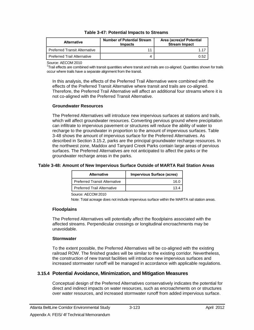
Atlanta BeltLine Corridor Environmental Study 3-123 April 2012
Appendix A: FEIS/ 4f Technical Memorandum
Table 3-47: Potential Impacts to Streams
Alternative Number of Potential Stream
Impacts Area (acres)of Potential
Stream Impact
Preferred Transit Alternative 11 1.17
Preferred Trail Alternative 4 0.52
Source: AECOM 2010 1Trail effects are combined with transit quantities where transit and trails are co-aligned. Quantities shown for trails occur where trails have a separate alignment from the transit.
In this analysis, the effects of the Preferred Trail Alternative were combined with the effects of the Preferred Transit Alternative where transit and trails are co-aligned. Therefore, the Preferred Trail Alternative will affect an additional four streams where it is not co-aligned with the Preferred Transit Alternative.
Groundwater Resources
The Preferred Alternatives will introduce new impervious surfaces at stations and trails, which will affect groundwater resources. Converting pervious ground where precipitation can infiltrate to impervious pavement or structures will reduce the ability of water to recharge to the groundwater in proportion to the amount of impervious surfaces. Table 3-48 shows the amount of impervious surface for the Preferred Alternatives. As described in Section 3.15.2, parks are the principal groundwater recharge resources. In the northwest zone, Maddox and Tanyard Creek Parks contain large areas of pervious surfaces. The Preferred Alternatives are not anticipated to affect the parks or the groundwater recharge areas in the parks.
Table 3-48: Amount of New Impervious Surface Outside of MARTA Rail Station Areas
Alternative Impervious Surface (acres)
Preferred Transit Alternative 16.0
Preferred Trail Alternative 13.4
Source: AECOM 2010 Note: Total acreage does not include impervious surface within the MARTA rail station areas.
Floodplains
The Preferred Alternatives will potentially affect the floodplains associated with the affected streams. Perpendicular crossings or longitudinal encroachments may be unavoidable.
Stormwater
To the extent possible, the Preferred Alternatives will be co-aligned with the existing railroad ROW. The finished grades will be similar to the existing corridor. Nevertheless, the construction of new transit facilities will introduce new impervious surfaces and increased stormwater runoff will be managed in accordance with applicable regulations.
3.15.4 Potential Avoidance, Minimization, and Mitigation Measures
Conceptual design of the Preferred Alternatives conservatively indicates the potential for direct and indirect impacts on water resources, such as encroachments on or structures over water resources, and increased stormwater runoff from added impervious surface.

Atlanta BeltLine Corridor Environmental Study 3-124 April 2012
Appendix A: FEIS/ 4f Technical Memorandum
As the project advances, the design will be refined to avoid or minimize impacts on water resources. During Tier 2 analysis, adjustments to the alignment and the location of amenities will be examined to avoid effects on water resources.
Unavoidable effects will be reported during Tier 2 analysis. Best management practices will be identified and mitigation strategies developed at that time to minimize unavoidable impacts. These may include soil erosion control measures, stormwater management, and water quality provisions that may be applied temporarily during construction, or permanently as appropriate, to protect water resources.
3.15.5 Potentially Required Permits and Approvals
3.15.5.1 Federal
Unavoidable impacts to streams regulated by 33 CFR Part 328.3(b) and protected by Section 404 of the Clean Water Act (22 United State Code 1344) will require a Section 404 permit from the USACE. Tier 2 analysis will require demonstration of project compliance with Executive Order 11988 Floodplain Management that prescribes protection of floodplains from impacts, particularly longitudinal impacts, wherever possible.
3.15.5.2 State
Unavoidable impacts to buffers around streams will require a Stream Buffer Variance permit from the GEPD.
3.15.5.3 City
Impacts to stream buffers are subject to compliance with the City of Atlanta’s specifications regarding stream or riparian buffers and associated erosion and sediment control requirements.
3.15.6 Subsequent Analysis
During Tier 2 analysis, the design will be refined to avoid or minimize impacts on water resources including adjustments to the alignment and location of amenities, as prescribed by federal, state, and local water resource protection regulations and guidelines under NEPA.
3.16 Biological Resources This section identifies the biological resources in the study area and describes the potential effects of the No-Build and Preferred Alternatives on those resources, including aquatic and terrestrial species protected by the Endangered Species Act, birds protected by the Migratory Bird Treaty Act, and invasive species.
3.16.1 Methodology
The identification of existing biological resources employed a combination of existing available data from the Wildlife Resources Division of the GADNR and a preliminary field reconnaissance of the area of potential impact, which is 150 feet on each side of the alignment of the Preferred Alternatives to conservatively allow for all anticipated effects.

Atlanta BeltLine Corridor Environmental Study 3-125 April 2012
Appendix A: FEIS/ 4f Technical Memorandum
3.16.1.1 Aquatic Habitats and Species Resources
The water bodies supporting aquatic biota within the study area were identified using available data. Investigation of the potential for trout streams used the GADNR Wildlife Resources Division database, which contains existing data for known rare species and natural communities as well as potentially occurring rare species and natural communities. Field examinations occurred in rivers, streams, and open water bodies to characterize potential aquatic resources.
3.16.1.2 Terrestrial Habitats and Species Resources
The terrestrial habitats identified in the study area include non-aquatic fields, woodlands, and landscaped areas. A determination of wildlife and plant life known or likely to use the identified terrestrial habitats took place using available data sources and field observations.
3.16.1.3 Protected Species
The potential for protected species to occur in the study area was evaluated by coordination with the GADNR and by a preliminary field reconnaissance for suitable habitat. GADNR is a repository for data on known threatened, endangered, and rare species that are recognized by them and by the U.S. Fish and Wildlife Service (USFWS). On July 24, 2009, information relating to the locations and potential occurrences of protected species was requested from GADNR, and the response, dated September 9, 2009, is included in Appendix C of the Tier 1 FEIS. Field verification to identify potential habitats that could support protected species took place. A formal biological assessment will take place during Tier 2 analysis.
3.16.1.4 Migratory Bird Treaty Act
Areas potentially used by birds protected by the Federal Migratory Bird Treaty Act were identified. The focus of this investigation was areas containing greater than 100 acres of contiguous habitat and other habitats such as culverts and bridges.
3.16.1.5 Invasive Species
During the terrestrial habitat evaluation, species determined by the state to be invasive were identified through observation.
3.16.2 Affected Environment
3.16.2.1 Aquatic Habitats and Species Resources
As discussed in Section 3.14.2, aquatic resources included in the study area are Peachtree Creek and its tributary streams, a number of tributaries to Clear and Tanyard Creeks, Lake Clara Meer in Piedmont Park, Sugar, Intrenchment, and Proctor Creeks, and the South River. None of the aquatic resources is a designated wild trout stream.
Aquatic biota likely to inhabit these resources are restricted to species tolerant of medium quality, somewhat impaired to fully impaired water quality. Generally, the number and diversity of species in impaired condition aquatic resources are limited to commonly occurring species that are tolerant of the impaired conditions.

Atlanta BeltLine Corridor Environmental Study 3-126 April 2012
Appendix A: FEIS/ 4f Technical Memorandum
3.16.2.2 Terrestrial Habitats and Species Resources
Piedmont Park provides a combination of manicured landscaping and wooded edges. Oakland Cemetery, Freedom Park, Daniel Stanton Park, Adair Park, Washington Park, Maddox Park, Tanyard Creek Park, Ardmore Park, and Peachtree Hills Park provide manicured landscaping. The ballasted track area within the Decatur Belt Corridor is flanked by opportunistic tree, shrub, and herb vegetation. The L&N Corridor is overgrown in many areas with opportunistic tree, shrub, and herb vegetation. The CSX and Norfolk Southern Corridors are kept clear of excess vegetation, but the edges may contain opportunistic tree, shrub, and herb vegetation.
In many areas, invasive plants dominate as discussed in greater detail in Section 3.16.2.5. These terrestrial characteristics provide little food and cover for a low number of commonly occurring animals that are adapted to a human environment, such as squirrels, rabbits, raccoons, opossums, robins, and starlings.
3.16.2.3 Protected Species
Table 3-49 presents a list of federally and/or state protected plants and animals observed through GADNR field reconnaissance near the study area and obtained from GADNR coordination. See Appendix D of the Tier 1 FEIS for a full list of federally and/or state protected plants and animals in Fulton County.
Table 3-49: Listed Plant and Animal Species in Fulton County Zone
Species Name Type of Species
Listing Location Where Species Observed
Northeast
Bay Star-vine – Schisandra glabra Plant State Protected –
Threatened
Unspecified locations approximately 1.25 miles northeast of the study area, 2.25 miles east of the study area, and a 2.75 miles east of the study area
Chattahoochee Crayfish – Cambarus howardi
Aquatic Arthropod State Protected Approximately 1.75 miles east of the study
area in Peachtree Creek Peregrine Falcon – Falco peregrinus Bird State Protected Approximately 1.75 miles southwest of the
study area
Southwest
Bachman’s Sparrow – Aimophila aestivalis Bird State Protected Approximately 1.75 miles south of the study
area Pink Ladyslipper – Cypripedium acaule Plant State Protected Approximately 2.25 miles southwest of the
study area
Northwest Georgia Aster – Symphyotrichum georgianum Plant Federally Protected –
Candidate Approximately 2.25 miles northwest of the study area
Source: GADNR www.gadnr.org site accessed June 2008; USFWS, www.fws.gov site accessed June 2008 Note: The southeast zone did not have any listings of plant or animal species.
GADNR reported that a single federally-protected species and five state protected species occur within a three-mile radius of the study area. Preliminary field reconnaissance within the 300-foot area of potential impact found no additional protected species or suitable habitat for a protected species.
3.16.2.4 Migratory Bird Treaty Act
Preliminary field reconnaissance within the area of potential impact found no large tracts of intact forest that would provide suitable habitat for migratory birds. Several migratory bird nests were observed beneath the overpass carrying the MARTA rail line over Proctor Creek and North Avenue, beneath the Collier Road Bridge over Tanyard Creek, and the Peachtree Road Bridge over Peachtree Creek. The overpasses located at

Atlanta BeltLine Corridor Environmental Study 3-127 April 2012
Appendix A: FEIS/ 4f Technical Memorandum
Ormewood Avenue, Berne Street, Confederate Avenue, Murphy Avenue, Lawton Street, Ralph David Abernathy Boulevard, Lucile Avenue, I-20, Martin Luther King, Jr. Drive, Mobile Street, Joseph E. Boone Boulevard, Donald Lee Hollowell Parkway, and the railroad trestles over Tanyard and Clear Creeks potentially would provide nesting habitat for migratory bird species.
3.16.2.5 Invasive Species
Nine invasive species were found within the area of potential impact including Chinese privet, Japanese honeysuckle, mimosa, kudzu, English ivy, Chinese lespedeza, Nepalese browntop, Johnsongrass, and multiflora rose.
3.16.3 Preliminary Environmental Consequences
During the Public Scoping Process, questions and concerns were raised regarding how the Atlanta BeltLine would affect biological resources. Issues expressed included what the project effects would be on animals including threatened and endangered species, animal habitat, and vegetation. In response, the anticipated effects of the Preferred Alternatives are described in this section, as are potential strategies to avoid, minimize, and mitigate potential impacts on biological resources.
3.16.3.1 No-Build Alternative
The No-Build Alternative includes several planned projects with the potential to affect study area biological resources. These potential effects will be investigated under the environmental processes for future projects that may comprise the No-Build Alternative.
3.16.3.2 Preferred Alternatives
The Preferred Alternatives have the potential to affect biological resources associated with existing streams and stream buffers, as well as street trees and landscaped areas that may be affected where additional ROW is required.
As summarized in Chapter 3.15, the Preferred Transit Alternative will potentially affect up to 11 streams. Some typical effects could include shading, enclosure, and/or filling of the waterway within the limit of disturbance, which may degrade or eliminate the habitat values of the aquatic resources, thereby changing or eliminating the species composition currently using the resources.
The Preferred Alternatives will also clear vegetation from the railroad corridors. This effect could remove opportunistic plant materials, particularly invasive species.
Impacts on biological resources because of new ROW acquisition could include removing landscaped areas or edge areas. Removing the profusion of invasive species will be a benefit as these species prohibit the growth and diversity of native terrestrial vegetation. The small percentage of the terrestrial vegetation that is native opportunistic species may also be reduced or removed. These effects could change or eliminate the species composition currently using the resources.
Based on current data and observations, the Preferred Alternatives will not be expected to affect protected species or to affect species or habitat protected by the Migratory Bird Treaty Act. The elevated structures that will potentially provide suitable habitat for migratory bird species are stated in Section 3.16.2.4.

Atlanta BeltLine Corridor Environmental Study 3-128 April 2012
Appendix A: FEIS/ 4f Technical Memorandum
3.16.4 Potential Avoidance, Minimization, and Mitigation Measures
Conceptual design of the Preferred Alternatives conservatively indicates the potential for impacts on biological resources. As the project advances, the design will be refined to avoid or minimize effects on biological resources. During Tier 2 analysis, adjustments to the alignment and the location of amenities will be examined to avoid effects on biological resources as prescribed by federal and state regulations and guidelines including NEPA.
Unavoidable effects will be reported during Tier 2 analysis. A number of best management practices will be identified and mitigation strategies developed at that time to minimize unavoidable impacts. These could include:
coordination with regulators to identify appropriate and reasonable means to accommodate protected species;
removal and disposal of invasive plant parts to avoid future infestations; and
enhancement of landscaping using native species or cultivars of native species that will provide superior food and shelter resources to the vegetative community that is currently present.
3.16.5 Potentially Required Permits
3.16.5.1 Federal
Unavoidable impacts to aquatic resources will require Section 404 of the Clean Water Act permit from the USACE; USEPA review and concurrence will be required regarding project compliance with the Migratory Bird Treaty Act during Tier 2 analysis; Section 7 of the Federal Endangered Species Act will likely require consultation during Tier 2 analysis if federally protected species are encountered.
3.16.5.2 State
GADNR consultation could be required during Tier 2 analysis if state regulated species are encountered, and a GEPD Stream Buffer Variance could be required for unavoidable impacts to terrestrial resources near streams.
3.16.5.3 Local
Compliance with the City of Atlanta’s specifications regarding stream or riparian buffers and associated erosion and sediment control requirements would be required.
3.16.6 Subsequent Analysis
During Tier 2 analysis, the design will be refined to avoid or minimize impacts on biological resources including adjustments to the Preferred Alternative alignment and location of amenities as prescribed by federal, state, and local biological resource protection regulations and guidelines including NEPA.
3.17 Geologic Resources This section describes the geologic resources in the study area and the potential effects of the No-Build and Preferred Alternatives on these resources.

Atlanta BeltLine Corridor Environmental Study 3-129 April 2012
Appendix A: FEIS/ 4f Technical Memorandum
3.17.1 Methodology
The assessment of geologic resources included identification of topography, underlying geologic conditions, unique geologic formations, and primary soil types including soils designated as prime, unique, of statewide importance, or of local importance. This was completed through a review of USGS topographic maps, aerial photography, the Natural Resources Conservation Service (NRCS) Soil Survey, and data from the U.S. Department of Agriculture (USDA) as appropriate.
A qualitative assessment of potential effects on geologic resources took place by examining the conceptual engineering needs associated with the No-Build and Preferred Alternatives and making a preliminary assessment of effects. The assessment focused on evaluating potential earthmoving and excavation activities, particularly in areas where deep excavations could occur to build tunnels or foundations for elevated structures.
3.17.2 Affected Environment
3.17.2.1 Topography
The study area is located on a series of ridgetops that overlie the valleys formed by Peachtree, Proctor, Clear, South River, Sugar, and Intrenchment creeks. There are dramatic bedrock outcrops along several railroad ROWs; creek corridors tend to be narrow, deep, and steep-sided.
While the terrain is moderate, it is still rolling. The natural ridge and valley terrain is responsible in part for the manner in which the streets and land use have developed. Major arteries such as the interstate systems and railroads follow ridgelines and routes of least topographic change. Exceptions to this trend can be observed near the Lindbergh Center MARTA rail station, for example, where dramatic changes in natural elevation required the use of elevated structures to support MARTA and other arteries.
3.17.2.2 Geology
The study area is located in the Piedmont Physiographic Province of Georgia. The character of the Piedmont Province is of narrow waterways below broad valleys and moderate slopes. It is composed of hard igneous and metamorphic rocks derived from ancient (300 to 600 million years old) sediments, once deeply buried and subjected to high temperatures and pressures. The primary bedrock formations that underlie the study area are the Lithonia Gneiss, Clairmont, Wahoo Creek, Stonewall Gneiss, and Clarkston formations (shown in Appendix D). These formations consist of hard rock types including biotite gneiss and schist, granite, granite gneiss, mica schist, and other rocks of the Precambrian and Paleozoic age (Hodler and Schretter 1986).
3.17.2.3 Soils
The soil series present in the study area includes Cecil, Cartecay-Toccoa, Congaree, Congaree-Cartecay, Rion, and Wickham. A description of each soil type can be found in Appendix D. The study area’s principal soil associations consist of urban land (soil areas of cut and fill), also referred to as Udorthents, and a combination of native soils series’ and urban lands (USDA 2009).

Atlanta BeltLine Corridor Environmental Study 3-130 April 2012
Appendix A: FEIS/ 4f Technical Memorandum
3.17.3 Preliminary Environmental Consequences
During the Public Scoping Process, questions and concerns were raised regarding how the Atlanta BeltLine would affect environmental resources in general, including geology, soils, and topography. In response, the expected effects of the alternatives are described in this section, as are potential strategies to avoid, minimize, and mitigate potential effects on geological resources.
3.17.3.1 No-Build Alternative
The projects assumed in the No-Build Alternative will be the subject of an environmental assessment for each project. In general, the effects of the No-Build Alternative on geology, topography, and soils will be incremental.
3.17.3.2 Preferred Alternatives
The Preferred Transit Alternative will follow a similar grade to those of the existing railroads and streets. The Preferred Trail Alternative will follow existing grades in most locations in order to facilitate access. As a result, the anticipation is for there to be minimal potential effects on geology, topography, and soils in most areas. In some locations, however, deeper and/or wider excavations than required for at-grade construction will occur. Examples include extensions of existing tunnels under existing roadways near Inman Park/Reynoldstown MARTA rail station, and cutting back existing exposed bedrock in the cut section of the Decatur Belt ROW near Piedmont Park.
3.17.4 Potential Avoidance, Minimization, and Mitigation Measures
Geotechnical testing will occur as the design advances to identify location-specific geologic and soils conditions and to determine an appropriate design and construction approach to avoid or minimize potential adverse effects. Selection of soil and rock removal techniques will take place based on localized conditions and requirements. The project sponsors will employ soil erosion and sediment control best management practices to control disturbed soils during construction. There will be a containment of excavated soils and a stabilization of finish graded soils.
3.17.5 Subsequent Analysis
Geotechnical analysis will occur during a Tier 2 analysis. A geotechnical survey will be required to characterize local soil and rock conditions to assist decision making on appropriate design and construction methods, the suitability of existing soils and geology to support structures, the need for fill material, the amount of material to be removed and how to remove it, and the rationale for using retaining walls and other slope stabilization techniques. At that time, a more detailed assessment of localized effects on topography, geology, and soils will take place, and there will be an identification of minimization and mitigation strategies as warranted
Atlanta BeltLine Corridor Environmental Study 4-1 April 2012
Appendix A: FEIS/ 4f Technical Memorandum
4.0 SECONDARY AND CUMULATIVE EFFECTS This chapter presents a preliminary evaluation of the potential secondary (indirect) impacts and cumulative (incremental) impacts of the Preferred Transit and Trails Alternatives as compared to the No-Build Alternative.
4.1 Methodology Secondary (indirect) effects are defined as “impacts which are caused by the action and are later in time or farther removed in distance, but are still reasonably foreseeable. Secondary impacts could include growth-inducing impacts and other impacts related to changes in the pattern of land use, population density or growth rate, and related impacts on air and water and on other natural systems, including ecosystems” (40 CFR 1508.8(b)). An example of a secondary effect is when a new rail station is built in an undeveloped area and commercial uses, which otherwise would not have been built, develop in the station area.
Cumulative impacts are changes to the environment that are brought about by an action in combination with other past, present, and future human actions. In simplest terms, analyzing cumulative impacts means considering and accounting for the impacts of a proposed action in the context of the existing transportation system and improvements to it that are reasonably foreseeable in the vicinity. For the purposes of this FEIS/ 4(f) Technical Memorandum , the basis for the estimation of potential cumulative impacts relies on the Preferred Alternatives for the project design year of 2030 and on the No-Build Alternative.
The secondary and cumulative effects analysis qualitatively addresses each resource type identified in the study area and makes an assessment of whether or not the resource has the potential to be affected by secondary or cumulative effects.
Based on guidance from the CEQ, USDOT, Federal Highway Administration (FHWA), and the USEPA, the following methodology was developed. This methodology serves to provide a Tier 1 level assessment of potential secondary and cumulative effects. It is assumed that a greater level of analysis will be undertaken during the Tier 2 analysis. The following steps were applied to this Tier 1 analysis:
Identify potential sensitive resources and potential area of effect;
Identify potential sources of effects; and
Identify potential effects.
4.2 Legal and Regulatory Context 4.2.1 Secondary Impacts
CEQ NEPA regulations require that there be an analysis of potential secondary impacts for federally funded projects. The CEQ implementing regulations (40 CFR 1500-1508) require that an EIS include a discussion of preliminary environmental consequences, including “indirect effects and their significance” (40 CFR 1502.16). In addressing potential uncertainties in this type of analysis, the CEQ regulations require the EIS to make a “good faith effort” to identify and disclose indirect or secondary impacts (CEQ, 1981).

Atlanta BeltLine Corridor Environmental Study 4-2 April 2012
Appendix A: FEIS/ 4f Technical Memorandum
4.2.2 Cumulative Impacts
The CEQ/NEPA regulations also require that an analysis of potential cumulative impacts take place for federally funded projects. The CEQ/NEPA implementing regulations (40 CFR 1500-1508) require that an EIS include a discussion of preliminary environmental consequences, including “the impact on the environment, which results from the incremental impact of the action when added to other past, present, and reasonably foreseeable future actions, regardless of what agency (federal or non-federal) or person undertakes such other actions” (40 CFR 1508.7). In addressing potential uncertainties in this type of analysis, CEQ requires the EIS to make a “good faith effort” to identify and disclose cumulative impacts (CEQ, 1981).
4.3 Potential for Secondary and Cumulative Impacts As described in Chapter 1.1, the proposed transit and trails elements of the Atlanta BeltLine are part of a comprehensive economic development effort that combines greenspace, trails, transit, and new development along 22 miles of historic rail segments that encircle central Atlanta. The combination of the following elements: transportation, affordable housing, brownfield redevelopment, land use, historic preservation, parks and recreation, and economic development is intended to attract and organize some of the region’s future growth around parks, transit, and trails. A desired secondary effect of the Atlanta BeltLine is to change the pattern of regional sprawl in the coming decades, which will lead to a more livable Atlanta with an enhanced quality of life and sustained economic growth.
4.3.1 Potential Sensitive Resources
For purposes of this analysis, sensitive resources are defined as those areas that have been identified as being directly affected or those resources that could be affected by potential secondary development or those resources that are particularly susceptible to cumulative effects. Based on the analysis provided in this FEIS/ 4(f) Technical Memorandum, the following potentially sensitive resources have been identified:
Property owners and occupiers within and near the potential Atlanta BeltLine ROW
Land Use and Economic Conditions
Historic Resources
Parks
Hazardous Materials
Noise
Streams
Water Quality
4.3.2 Potential Area of Effect
The Atlanta BeltLine study area encompasses a large geographic area, mostly focused around the central core of Atlanta. However, from a cumulative effects perspective, potential effects on sensitive resources, such as water quality, may not be limited to the defined study area and therefore should consider the potential effects to identified resources from a more regional perspective. For this reason, the potential area of effect

Atlanta BeltLine Corridor Environmental Study 4-3 April 2012
Appendix A: FEIS/ 4f Technical Memorandum
should extend to the boundaries of the watershed associated with the study area. It is assumed, that during Tier 2 analysis, the potential area of effect will be further refined.
4.3.3 Potential for Secondary Effects
4.3.3.1 No-Build Alternative
Under the No-Build Alternative, it is assumed that various transportation projects programmed into the 2013 TIP will occur and may result in some level of secondary effects. Secondary effects related to the No-Build Alternative may include development of underdeveloped and/or undeveloped land near proposed transit stations or stops. This development, should it occur, may also result in changes to population, employment, and community facilities and services.
4.3.3.2 Preferred Alternatives
Owners and occupiers of property within and near the Atlanta BeltLine ROW have the potential to experience secondary effects due to the Preferred Alternatives. It is likely that secondary effects will be focused in and around proposed station areas, taking the form of development that will likely result in changes in population, employment, and community facilities and services. During Tier 2 analysis, specific secondary effects will be identified.
4.3.4 Potential for Cumulative Effects
4.3.4.1 No-Build Alternative
The projects in the No-Build Alternative, in aggregate, have the potential for cumulative effects on ROW, historic resources, parks, hazardous materials, noise, streams, and water quality (due to increases in impervious surfaces).
4.3.4.2 Preferred Alternatives
The various transportation projects planned within the study area, in combination with the Atlanta BeltLine project, will potentially have impacts on ROW, historic resources, parks, hazardous materials, noise, streams, and water quality (due to increases in impervious surfaces). During Tier 2 analysis, an assessment of potential cumulative effects will occur to determine the likelihood and appropriate mitigation for potential cumulative effects.

Atlanta BeltLine Corridor Environmental Study April 2012
Appendix A: FEIS/ 4f Technical Memorandum
Page Left Intentionally Blank

Atlanta BeltLine Corridor Environmental Study 5-1 April 2012
Appendix A: FEIS/ 4f Technical Memorandum
5.0 CONSTRUCTION IMPACTS This section describes potential construction-related impacts of selecting the Preferred Alternatives. For purposes of the FEIS/ 4(f) Technical Memorandum, a discussion of probable construction impacts and potential mitigation strategies is provided. During the Tier 2 analysis, more site-specific construction impacts will be identified and appropriate mitigation would be developed.
All construction will conform to the applicable federal, state, and local requirements. Construction of the Preferred Alternatives will include, but will not be limited to: laying tracks; modifying roadways and sidewalks; paving and repaving of surfaces; clearing vegetation; grading; excavating; removing debris; stabilizing soil; and constructing, demolishing and/or modifying structures, utilities, and drainage infrastructure. For all activities, the project sponsors anticipate using standard construction practices.
5.1 Probable Impacts and Potential Mitigation Strategies 5.1.1 Disruption to Existing Businesses
5.1.1.1 Probable Impacts
Construction of the Preferred Alternatives may temporarily disrupt existing businesses along the Atlanta BeltLine Corridor. During construction, access to and from businesses may be impacted; however, some level of access will be maintained to all businesses during construction. The potential for disruption may result in patrons opting to take their business elsewhere, which could result in a temporary economic impact on existing businesses along the corridor.
5.1.1.2 Potential Mitigation Strategies
Potential disruption to existing businesses will be temporary, only lasting during construction activities for that area. Construction will be phased in order to minimize possible disruptions. In addition, MARTA in partnership with ABI, will make a reasonable effort to maintain access, both pedestrian and vehicular, to existing businesses during construction. Existing access points will be used to the extent possible; however, if alternative access to these businesses is required, appropriate signage and detours will be provided. MARTA in partnership with ABI will establish good communication protocols with potentially affected business in order to minimize temporary effects.
5.1.2 Neighborhoods and Community Cohesion
5.1.2.1 Probable Impacts
Any major construction project, public or private, could temporarily inconvenience or disturb neighboring communities and services. Potential temporary impacts may include:
Traffic congestion and detours
Interrupted access to residences and businesses
Loss of roadside parking
Light intrusion (night construction)
Disruption of utility services
Atlanta BeltLine Corridor Environmental Study 5-2 April 2012
Appendix A: FEIS/ 4f Technical Memorandum
Presence of construction workers and materials
Noise and vibrations from construction equipment and vehicles
5.1.2.2 Potential Mitigation Strategies
MARTA will make a reasonable effort to minimize temporary construction impacts to neighboring communities and services. Construction activities are not expected to impede community cohesion. Reasonable efforts to maintain access to community services will be made. Appropriate signage and detours will be provided to maintain access to neighborhoods and amenities for both pedestrians and vehicles. Construction activities affecting roadways and transit operations will likely occur during off-peak hours to minimize disruption. Best management practices will be employed to minimize the potential effects of construction-related fugitive dust emissions, light intrusion, noise, and vibration. Potential disruptions in utilities will be timed not to occur during peak usage hours. Appropriate notifications and ongoing communications with the affected communities will be made prior to construction activities taking place.
5.1.3 Visual and Aesthetic Quality
5.1.3.1 Probable Impacts
The visual and aesthetic quality of the corridor will be temporarily affected by construction equipment and construction staging areas. For residents living along the corridor, some materials stored for the project could be visually displeasing. This will be a temporary condition.
5.1.3.2 Potential Mitigation Strategies
In general, to reduce the potential for visual impacts, construction activities will be contained as much as practical. Construction easements on parcels outside the corridor, where required, will be managed to minimize potential visual impact. Following construction, the use of ground cover, landscaping, or related materials will restore areas to pre-construction conditions or better. Further, during Tier 2 analysis, areas that may be considered visually sensitive, such as recreational, natural, or historic resources, will require site specific mitigation to minimize the temporary and permanent impacts related to construction.
5.1.4 Parks and Recreation
5.1.4.1 Potential Construction Effects
Likely construction effects could include temporary use of property for staging equipment, temporary disturbances to access and activities, and temporary land disturbances, such as impacts to vegetation and increased sediment and erosion.
5.1.4.2 Potential Mitigation Strategies
If construction staging or access occurs in or adjacent to a publicly owned park or recreational facility, the project sponsors will coordinate with the property owner during the development of construction plans.

Atlanta BeltLine Corridor Environmental Study 5-3 April 2012
Appendix A: FEIS/ 4f Technical Memorandum
5.1.5 Freight Rail Operations
5.1.5.1 Probable Impacts
As stated in Section 3.2.9.3, CSX business decisions regarding potential use of its ROW by activities other than their own freight operation are predicated on safety, maintenance of current operations, accommodation for future needs, and liability protection. In this context, construction activities within or near freight railroad ROW, when agreed to by the railroad, must not compromise these essential criteria.
As the Atlanta BeltLine project advances, construction planning and staging will be developed in consultation with the railroads. Although the goals of such planning are to avoid or minimize impacts to the railroads and their operations, some impacts such as construction of structures to cross over railroad tracks may have unavoidable temporary impacts. An example is temporary interruption of operations while constructing nearby facilities to assure the safety of construction workers and railroad operators. These interruptions could result in operational delays.
5.1.5.2 Potential Mitigation Strategies
To address unavoidable effects of construction activities on the railroads, the project sponsors will consult with the railroads to develop mutually agreeable mitigation strategies. These could include, but will not be limited to, design adjustments to minimize effects and scheduling of activities to cause the least disruption.
5.1.6 Air Quality
5.1.6.1 Probable Impacts
Temporary effects to the local ambient air quality will occur during construction activities. These potential impacts include direct emissions from construction equipment and trucks, increased emissions from motor vehicles on the streets due to disruption of traffic flow, rerouted trains, and fugitive dust emissions. These impacts will be temporary and will affect only the immediate vicinity of the construction sites and access routes.
5.1.6.2 Potential Mitigation strategies
Measures potentially used to mitigate fugitive dust impacts could include:
Spraying exposed areas with water or other dust suppressants;
Covering trucks carrying dusty materials to and from the site;
Washing construction vehicles, particularly their wheels and underbodies before they leave construction sites;
Minimizing the use of vehicles in unpaved or uncovered areas; and
Regularly cleaning adjacent paved areas to remove dust before it has the potential for re-suspension into the air.
Atlanta BeltLine Corridor Environmental Study 5-4 April 2012
Appendix A: FEIS/ 4f Technical Memorandum
5.1.7 Noise and Vibration
5.1.7.1 Probable Impacts
Project construction activities could have short-term noise and vibration effects on sensitive receptors in the immediate vicinity of the construction site. Potential sources of noise and vibration during construction could include noise and vibration from construction equipment and noise from construction vehicles and delivery vehicles traveling to and from the site.
Similar effects also could result from rerouted train movements required during construction in certain corridors. The level of effect of these noise and vibration sources depends upon the noise characteristics of the equipment and activities involved (e.g., pile driving), the construction schedule (time of day and duration of activity), and the distance from sensitive receptors.
During Tier 2 analysis, the identification of potentially highly sensitive receptors, such as historic sites or receptors that deal with highly sensitive equipment, will occur to minimize any potential construction effects to those resources.
5.1.7.2 Potential Mitigation Strategies
During the construction phase, noise and vibration control measures may be required to ensure compliance with all federal and local guidelines and noise limits. For example, specifications could require contractors to use properly maintained and operated equipment, including the use of exhaust mufflers according to the equipment manufacturer's specifications. As determined to be necessary during final design, there could be an incorporation of additional noise control measures into the construction specification documents. Methods of potential noise and vibration control during construction include, for example, the following measures:
Erecting temporary noise barriers between noisy activities and noise-sensitive receptors;
Utilizing alternative construction methods that avoid impact pile driving near vibration-sensitive receptors, such as residences, schools, and hospitals. Whenever possible, use of drilled piles or sonic/vibratory pile drivers to reduce excessive vibration;
Re-routing construction traffic along roadways that minimize noise and vibration impacts at nearby sensitive receptors; or,
Requiring contractors to use Best Available Control Technologies (BACT) to limit excessive noise and vibration.
5.1.8 Water Resources
5.1.8.1 Probable Impacts
The Preferred Alternatives have the potential to directly affect streams in the study area during construction with one or a combination of new crossing structures, extensions of existing culvert crossings, and stream buffer encroachments. During construction, possible temporary impacts on water quality may also occur. Water quality may be affected by turbidity caused by in-stream work. The potential exists for water quality to also be affected by disturbance of existing contaminated facilities and spills or potential

Atlanta BeltLine Corridor Environmental Study 5-5 April 2012
Appendix A: FEIS/ 4f Technical Memorandum
or accidental discharges during construction. Additionally, increased runoff from construction sites may affect water resources within the study area.
5.1.8.2 Potential Mitigation Strategies
Potential effects on water resources will be minimized using best management practices such as silt fencing, restricting certain in-stream activities at certain times, and proper planning. All appropriate federal, state, and local regulations will be followed during construction. As appropriate, an erosion and sediment control plan and all applicable permits will be approved and acquired prior to commencing construction activities.
5.1.9 Infrastructure and Utilities
5.1.9.1 Probable Impacts
Short-term utility service disruptions could occur due to construction activities. This will occur where utility relocations are necessary or in the event a utility line is impacted during construction.
5.1.9.2 Potential Mitigation Strategies
All utilities within the study area that have the potential to be affected will be identified during the Tier 2 analysis. Prior to construction activities, coordination will occur with utility owners in order to identify ways to minimize utility disruptions to their customers. Most utility companies have technologies to alter facilities without inconveniences to the customers. To the extent feasible, mitigation strategies will include:
Maintaining utility connections in temporary locations;
Minimizing the time without service;
Installing alternative service before disconnecting the existing service; and
Allowing service disruption only during periods of non-usage or minimum usage.
5.1.10 Contamination
5.1.10.1 Probable Impacts
To varying degrees, the Preferred Alternatives could disturb contaminated soils. In some areas, depending on the severity of contamination, the soils on site will be considered hazardous wastes, subject to state and federal remediation regulations. Some of these wastes could undergo removal prior to the commencement of construction activities to avoid the following potential impacts:
Groundwater contamination;
Exposure of construction workers to health risks; and
The wider distribution of pollutants by contaminated dust.
All corridors could potentially involve the removal or disturbance of contaminated soils. Further testing and evaluation will occur prior to the completion of preliminary engineering and documentation of appropriate mitigation strategies will take place in a subsequent Tier 2 analysis.

Atlanta BeltLine Corridor Environmental Study 5-6 April 2012
Appendix A: FEIS/ 4f Technical Memorandum
5.1.10.2 Potential Mitigation Strategies
Encountering any contaminated materials will require mitigation, remediation, and/or removal, as well as protection from those contaminants during the construction of the project. Additional remedial investigations or actions could depend on the types, frequencies, and amounts of contamination encountered, if any. Impacted media or materials that could possibly be encountered include the site soils, groundwater, underground or above ground storage tank systems, and asbestos containing materials (should any buildings or structures require demolition).
Best management practices, industry standards, and regulatory-approved methods will be used during any investigation and upon handling any materials. Coordination with all required regulatory agencies will be completed to ensure the continued compliance of the Atlanta BeltLine Corridor. Any work with regard to contaminated or hazardous materials undertaken as part of the Atlanta BeltLine Corridor project should be completed in accordance with all local, state, and federal regulatory requirements.
Additionally, the nature and extent of a contaminated site or hazardous materials will require developing site-specific environmental health and safety planning concerning the workers, the surrounding area, and the environment. Material handling plans, personal protection, workplace monitoring, construction environmental control plans, alternative designs, and methods of construction will need to be evaluated and adjusted to limit impacts from those materials.

Atlanta BeltLine Corridor Environmental Study 6-1 April 2012
Appendix A: FEIS/ 4f Technical Memorandum
6.0 PRELIMINARY SECTION 4(F) EVALUATION This chapter is a preliminary Section 4(f) evaluation that describes the potentially protected properties identified within the study area. As planning for the project progresses, more detailed analysis will occur and if a potential use of Section 4(f) resources is identified at that time, a Section 4(f) evaluation will be prepared as part of the Tier 2 document.
6.1 Methodology Section 4(f) properties as defined include “publicly owned land of a public park, recreation area, or wildlife and waterfowl refuge of national, State, or local significance, or land of an historic site of national, State, or local significance,” as per Section 4(f) codified in 49 U.S.C. §303(c) and 23 C.F.R. Part 774. Section 4(f) properties were identified in each of the four zones of the study area. Information was compiled based on the analysis conducted as part of the Tier 1 EIS for parklands and historic properties. For more detail on the methodology used to identify these properties, refer to Chapters 3.7 and 3.8 of this FEIS.
Publicly owned recreation facilities and historic properties were identified using readily available information from various state and local agencies and limited field reviews. As determined in consultation with the SHPO, the study area for historic architectural properties was determined to be a ¼-mile to either side of the proposed Preferred Alternatives. For archaeological properties, the buffer area consists of a linear corridor that extends 150 feet from each side of the centerline of the proposed Preferred Alternatives’ alignments. For publicly owned recreation facilities, the buffer area considers facilities within 150-feet on either side of the Preferred Alternatives’ alignments. The buffer area for each resource is used in addition to the ¼ mile study area in order to capture all potential for use.
For purposes of the preliminary Section 4(f) analysis, Section 4(f) properties (historic properties and parklands) identified in Chapters 3.7 and 3.8 as being affected are discussed. In this chapter, the potential use of and benefits to Section 4(f) properties by the Preferred Transit and Trails Alternatives are described.
6.2 Legal and Regulatory Context 6.2.1 Section 4(f)
As stated above, Section 4(f) provides protection to significant publicly owned parks, recreation areas, and wildlife and waterfowl refuges, as well as privately or publicly owned sites with historic significance. This is done by prohibiting any agency within the U.S. DOT from approving the “use” of Section 4(f) properties unless there is no feasible and prudent alternative that avoids the use of Section 4(f) properties, and that the project incorporates measures to minimize harm to those properties if they cannot be avoided.
Under Section 4(f), a “use” is considered to occur under the following conditions:
When a project permanently incorporates land from a Section 4(f) property,
When a project temporarily occupies land within a Section 4(f) property, or
When a project introduces proximity effects, such as noise or visual effects, which substantially impair the intended use of the Section 4(f) property.

Atlanta BeltLine Corridor Environmental Study 6-2 April 2012
Appendix A: FEIS/ 4f Technical Memorandum
The Safe, Accountable, Flexible, Efficient Transportation Equity Act: A Legacy for Users (SAFETEA-LU), Section 4(f) was amended to include a de minimis impact determination, which allows the U.S. DOT to approve a minor use of Section 4(f) property without identifying and evaluating avoidance alternatives. A de minimis impact determination is made on an individual basis and does not apply to an entire project. Certain criteria must be met in order for an impact to Section 4(f) properties to be considered de minimis. Guidance on de minimis impacts is provided in the December 2005 FHWA and FTA joint memorandum “Guidance for Determining De Minimis Impacts to Section 4(f) Resources.”
6.3 Affected Environment The Section 4(f) properties identified within the Atlanta BeltLine study and buffer area are described below.
6.3.1 Section 4(f)/6(f) Properties
6.3.1.1 Cultural Resources
Properties that have been determined to be on or eligible for the NRHP (including historic districts, buildings, structures, objects, and certain archaeological sites) qualify for Section 4(f) protection. There were 180 cultural resources identified in the larger project study area. Of those 78 are either listed or eligible for listing on the National Register of Historic Places (NRHP). Although not currently Section 4(f) properties, an additional 37 resources were identified as being potentially eligible for listing on the NRHP. The Atlanta Urban Design Commission (AUDC) considers 26 resources to be significant Atlanta BeltLine resources. The remaining 39 are areas of archaeological sensitivity. These additional resources will require further investigation in Tier 2 analysis. If any of these are determined in the future to be National Register eligible, they would be considered Section 4(f) properties. Appendix D provides a list of those resources and their status.
6.3.1.2 Parks and Recreational Properties
There are 22 publicly-owned parks within the 300-foot potential limits of disturbance area. These parks are listed in Table 6-1. Another 11 projects are in development to create new parks or improve existing park and recreational facilities (Chapter 3.8).
6.4 Preliminary Section 4(f) Analysis 6.4.1 No-Build Alternative
The No-Build Alternative includes approved regional transportation projects (Envision6 RTP/TIP Projects 2030) within the Atlanta BeltLine study area. The No-Build Alternative could potentially use potential Section 4(f) properties within the study area. Several of the planned transportation improvements, such as the I-20 East BRT, Memorial Drive BRT, and the Commuter Rail-Lovejoy/Griffin/Macon project, cross the Historic Rail Resources of the Atlanta BeltLine. In addition, multiple trails are planned to connect with existing parks and recreation properties within the study area.

Atlanta BeltLine Corridor Environmental Study 6-3 April 2012
Appendix A: FEIS/ 4f Technical Memorandum
Table 6-1: Parks and Recreational Properties
Property Name Description
Northeast Zone
Piedmont Park 185-acre regional park; active and passive amenities: tennis courts, trails, gazebos, ball fields, playgrounds, soccer fields, swimming pool, dog park
Delta Park 0.22-acre garden park; no specified or designated use; no amenities
Historic Fourth Ward Park 18-acre neighborhood park, that offers a trail, water detention pond, and playgrounds
Freedom Park Approximately 188 acre regional park that offers a trail and a playground
Selena S. Butler Park Approximately three acres; active recreational uses: basketball, tennis, playground, and recreation center
Springvale Park Approximately four acres; playground Southeast Zone
Adair Park II Approximately 10-acres:passive and active amenities: tennis courts, basketball courts, ball field, playground, picnic shelters, grills
Boulevard Crossing 22-acre neighborhood park with multi-use fields and playgrounds
Daniel Stanton Park Approximately eight-acres unused; plans are to rehabilitate the park for active recreation
Southwest Zone
Gordon-White Park Approximately two acres; no amenities, specified or designated uses Green Leaf Circle Approximately one acres; no amenities, specified or designated uses Napoleon Circle A small garden park; no amenities Rose Circle Park A small greenspace Rose Circle Triangle A small greenspace South Gordon Triangle A small garden park; no amenities, no specified or designated uses Stafford Street Park A small garden park; no amenities; no specified or designated uses
Northwest Zone
Ardmore Park 1.74-acres; no amenities; no specified or designated uses Bobby Jones Golf Course 149 acres; golf course
Maddox Park 51.5-acre; amenities include basketball courts, a tennis court, a ball field, a playground, pavilion, pavilion parking and a swimming pool
Mayson Turner-Ashby Street Triangle 1.27-acre in-street greenspace Tanyard Creek Park 14.5-acre community park that provides a playground
Washington Park 20.43-acres; amenities: restrooms, recreation center, trail, pavilion, picnic shelters, ball fields, natatorium, playground, grills
6.4.2 Preferred Alternatives
The Preferred Transit and Trail Alternatives are not engineered alignment concepts, but rather generalized alignment locations that will be further developed and assessed in Tier 2 analyses. Section 6.4.2.2 describes the preliminary analysis for parks.
6.4.2.1 Preliminary Section 4(f) Analysis for Historic Properties
As identified in the previous sections, 180 historic properties have been identified within the study corridor of the proposed Atlanta BeltLine. The Preferred Transit and Trail Alternatives have the potential to affect a similar number of historic properties as the other transit and trails alternatives considered in the Tier 1 DEIS, shown in Table 6-2. It should be noted that a formal evaluation of effects under Section 106 for this project will occur during Tier 2 analysis as directed by the GA SHPO.

Atlanta BeltLine Corridor Environmental Study 6-4 April 2012
Appendix A: FEIS/ 4f Technical Memorandum
Table 6-2: Significant Historic Sites Potentially Affected
Zone
Numbers of Significant Historic Sites Potentially Affected
Transit Alternatives Trail Alternatives
All A- CSX
Howell Jct.
All B- Howell
Jct.
All C- CSX
Marietta Blvd.
Preferred Transit Alternative
(All D- Marietta Blvd.)
All F- Atlantic Station
Marietta Blvd.
Howell Jct.
On-Street
Preferred Trail Alternative
Northeast * 29 29 29 29 29 29 29 29 29 Southeast* 42 42 42 42 42 42 42 42 42 Southwest* 16 16 16 16 16 16 16 16 16 Northwest 19 18 17 17 21 12 12 16 15 Totals 106 105 104 104 108 99 99 103 102
* The impacts of the Preferred Transit and Preferred Trail Alternatives share the same number of potential impacts where transit and trails are co-aligned in the Northeast, Southeast, and Southwest Zones. Note: Preferred Transit and Trails Alternatives are shaded.
In the northwest zone, the Preferred Transit and Trails Alternatives will have the same or fewer potential effects to historic properties than the other transit and trails considered in the Tier 1 DEIS.
Each property for which a potential affect may occur will be examined on a case-by-case basis in Tier 2 to determine National Register eligibility and effect under Section 106. Eligible properties will be subject to Section 4(f) evaluation, including a determination of use of Section 4(f) properties and the potential to avoid or minimize use of the properties according to the evaluation procedures of Section 4(f).
6.4.2.2 Preliminary Section 4(f) Analysis for Public Parks, Recreation Areas, and Wildlife Refuges
Table 6-3 below provides a summary of the identified public parks and recreation areas within the potential area of effect and the relationship of those resources to the Preferred Transit and Trails Alternatives. No direct use of public parks, recreation areas, or wildlife refuges is anticipated to occur with the Preferred Transit and Trails Alternatives.
6.5 Conclusions As described in the previous sections of this chapter, potential 4(f) properties are located within the Atlanta BeltLine study area. The No-Build Alternative proposes projects that could use some of the identified potential Section 4(f) properties. While it is unknown during this phase of planning, it is possible that direct uses of Section 4(f) properties could occur because of the Preferred Transit and Trails Alternatives. During subsequent phases of project development, more detailed planning and engineering will occur. The Atlanta BeltLine project will seek to avoid direct or constructive use of Section 4(f) resources.
Each potential historic property for which a potential affect may occur will be examined on a case-by-case basis in Tier 2 to determine National Register eligibility and effect under Section 106. Eligible properties will be subject to Section 4(f) evaluation, including a determination of use of Section 4(f) properties and the potential to avoid or minimize use of the properties according to the evaluation procedures of Section 4(f).

Atlanta BeltLine Corridor Environmental Study 6-5 April 2012
Appendix A: FEIS/ 4f Technical Memorandum
In Tier 2, public parkland and recreational resource uses, if any, will be determined and the potential to avoid or minimize use of the properties will be assessed according to the evaluation procedures of Section 4(f).
Table 6-3: Potential Uses of Publicly Owned Park and Recreation Properties
Property Preferred Transit Alternative Preferred Trail Alternative
Northeast Zone
Piedmont Park Adjacent to park No use Delta Park Adjacent to park No use Historic Fourth Ward Park Adjacent to park No use
Freedom Park Passes perpendicularly through park within existing rail ROW
Passes perpendicularly through park within existing rail ROW, low potential for use
Selena S. Butler Park Adjacent to park No use Springvale Park Adjacent to park No use
Southeast Zone
Adair Park II Adjacent to park No use Boulevard Crossing Adjacent to park No use Daniel Stanton Park Adjacent to park No use
Southwest Zone
Gordon-White Park Adjacent to park, transit line separated from property by White St. NW No use
Green Leaf Circle No use No use Napoleon Circle No use No use Rose Circle Park No use No use Rose Circle Triangle Adjacent to park No use South Gordon Triangle Adjacent to park No use Stafford Street Park Adjacent to park No use
Northwest Zone
Ardmore Park Adjacent to park Adjacent to park Bobby Jones Golf Course No use Adjacent to park Maddox Park Adjacent to park Adjacent to park Mayson-Turner Ashby Street Triangle Adjacent to park No use
Tanyard Creek Park Adjacent to park Adjacent to park Washington Park Adjacent to park Adjacent to park
Part of the purpose and need for the project is to provide greater connectivity and increased greenspace within the study area. The addition of the Preferred Trail Alternative will help to accomplish this goal. While portions of the trail alignment will be incorporated into existing parks or connect to existing trail systems, it is assumed that these actions will not result in a Section 4(f) “use” of the publicly owned properties as long as land ownership will remain the same and the addition of the trail is consistent with existing uses on the properties.

Atlanta BeltLine Corridor Environmental Study April 2012
Appendix A: FEIS/ 4f Technical Memorandum
Page Left Intentionally Blank

Atlanta BeltLine Corridor Environmental Study 7-1 April 2012
Appendix A: FEIS/ 4f Technical Memorandum
7.0 PUBLIC INVOLVEMENT This chapter describes the public involvement activities that were conducted as part of the Tier 1 EIS.
7.1 Public Involvement and Agency Coordination Plan Summary A Public Involvement and Agency Coordination (PIAC) Plan, based on ABI’s Community Engagement Framework (CEF 2006) created by City of Atlanta Resolution 06-R-1576 and MARTA’s public participation plan, was developed to guide the public involvement process for the Atlanta BeltLine Corridor Environmental Study. The objective of the public participation program is to invite and encourage the public to learn about and become involved in the study. The development of the PIAC Plan ensured ongoing public involvement throughout the course of the project using a variety of tools and techniques. The PIAC Plan describes how the public, local, state, and federal agencies and decision-makers took part in the identification, development, and implementation of the proposed transit and multi-use trails system in the Atlanta BeltLine Corridor. The PIAC Plan summary can be found in Appendix E.
As noted above, the PIAC Plan is based on ABI’s CEF and MARTA’s Public Participation Plan. ABI’s CEF consists of the following in order to keep Atlanta residents informed and actively engaged in the BeltLine’s creation so that the Atlanta BeltLine reflects the aspirations of its many neighborhoods and communities:
Tax Allocation District Advisory Committee (TADAC)
Atlanta BeltLine Affordable Housing Advisory Board (BAHAB)
Quarterly Updates for the public
Community Engagement Advocate Office
Atlanta BeltLine Study Groups
The remaining sections of this Chapter and Appendix E document how the CEF has been an integral part of the EIS public participation process.
Key objectives of the public involvement efforts are to facilitate public understanding, to solicit input on the alternatives, and to identify potential consequences of alternative courses of action relative to the transportation, social, environmental, and economic context. As part of the PIAC Plan, the public, federal, state, and local agencies were given the opportunity to review and comment on key project milestone decisions and to provide MARTA in partnership with ABI with the benefit of public insight throughout the project planning and development process.
The PIAC Plan was developed in accordance with Section 6002 of Public Law 104-59 “Safe, Accountable, Flexible, Efficient Transportation Equity Act: A Legacy for Users” (SAFETEA-LU), which mandates the development of a coordination plan for all projects for which an EIS is prepared under NEPA. It stipulates opportunity be provided for involvement at key points by the public and agencies.
7.2 Public Involvement Activities The public, committees, and agencies were engaged on an ongoing basis during the Tier 1 DEIS to provide timely and current feedback, and to ensure that the EIS process is

Atlanta BeltLine Corridor Environmental Study 7-2 April 2012
Appendix A: FEIS/ 4f Technical Memorandum
consistent with federal policy regarding public participation. A copy of public involvement outreach activities including public, committee, and agency meetings is included in the PIAC Plan.
7.3 Public Involvement: Scoping, Workshops, and Meetings To date, there have been three major decision points in the process where significant involvement from the public, agencies, and project committees was solicited:
Fall 2008 Public Scoping process to develop the purpose and need as well as goals and objectives for the Tier 1 DEIS
Spring 2009 Public Workshops series to determine the conceptual ROW for transit and trails and identify possible station locations, transit stops, transit and trail routes, and transit service characteristics
Fall 2009 and 2010 Public Workshops to present progress-to-date and solicit input from the public on the proposed transit and trail alignment and technology alternatives and No Build Alternative
The meetings were conducted in accordance with NEPA guidelines 40 CFR Parts 1500-1508 and 23 CFR Part 771, and all public meetings locations were compliant with the Americans with Disabilities Act and accessible by public transportation.
7.3.1 Fall 2008 Public Scoping Meetings
The project sponsors conducted a number of Public Scoping Meetings during the Scoping process, which began on July 25, 2008 and ended on September 22, 2008. The forums included formal Public Scoping Meetings, as well as other briefings with neighborhood and business organizations to inform the public, interest groups, and involved agencies about the study, the alternatives under consideration, and related issues. The goal was to encourage active participation from the public and agencies early in the decision-making process.
7.3.1.1 Formal Public Scoping Meetings
The project sponsors conducted eight formal Public Scoping Meetings, two in each of the four zones of the study area. A list of the Public Scoping Meeting locations, dates, and number of attendees are listed in Appendix E.
Each of the formal Public Scoping Meetings followed the same format. At each meeting location, attendees signed-in upon arrival and received a Scoping Information Package. Meeting locations included an “open house” area with information boards illustrating the Atlanta BeltLine Corridor; a tiered EIS process overview; the Tier 1 DEIS goals and objectives; and the proposed transit and trail alignments. MARTA and ABI staff was available to answer questions.
Each meeting included a formal presentation with an overview of the project background and purpose and need; a summary of the environmental process; an overview of the No-Build and Build Alternatives; and a summary of the key issues associated with project implementation. Following the presentation, members of the public had the opportunity to ask questions and provide input to the purpose and need, goals and objectives, alternatives, and their concerns. Attendees had the option of either completing the comment form contained in the Scoping Package at the meeting and dropping it in a comment box or mailing it in prior to the close of the comment period. A record of all

Atlanta BeltLine Corridor Environmental Study 7-3 April 2012
Appendix A: FEIS/ 4f Technical Memorandum
attendees and participants was compiled; individuals were added to the overall Tier 1 DEIS mailing list and database.
A court reporter was present to record the public’s comments. Reports from the meetings are available from the MARTA Office of Transit System Planning upon request. The Scoping Summary Report (December 2008) details the comments and issues raised by the public during the Scoping meetings.
7.3.1.2 Other Meetings Held During Scoping
Prior to, during, and after the formal Public Scoping Meetings, over 46 supplemental progress presentations and stakeholder briefings occurred at regularly scheduled meetings of ABI, community, neighborhood, and business organizations. Information about the Tier 1 DEIS and the proposed project was available at each meeting. The location, date and time, and number of attendees for these meetings are shown in Appendix E. More than 1,928 residents participated in these other meetings.
7.3.1.3 Summary of Public Scoping Comments Received
The formal comment period for Public and Agency Scoping began July 25, 2008 and ended on September 22, 2008. Throughout the Tier 1 DEIS process, comments received during Scoping were reviewed, considered, and used to shape the purpose and need, goals and objectives, transit and trail alternatives, and evaluation process (see Appendix E for a summary of Public Scoping comments received). The conceptual transit and trail alignments and transit technologies included in the Tier 1 DEIS reflect the comments received during the formal comment period (summarized in the Scoping Summary Report (MARTA 2008).
Over 300 people submitted 947 comments: 769 were from comment forms distributed during Public Scoping Meetings and briefings and provided on the Atlanta BeltLine project website at that time, www.itsmarta.com/newsroom/BeltLine.html (the current project websites are www.itsmarta.com/BeltLine-Corr.aspx and eis.beltline.org). The Scoping Summary Report (MARTA 2008) details the comments and issues raised during the Public Scoping Meetings.
7.3.1.4 Scoping Meeting Advertisement and Notice
Advertisement of the Public Scoping Meetings appeared in the following venues:
Newspapers: Atlanta Journal-Constitution (August 9, 2008; August 17, 2008) and Atlanta Daily World (August 14-20, 2008)
Project Websites
Other Announcements: A Study Update/Flyer printed in English and Spanish was distributed through the contact database, hand-distributed at neighborhood meetings and locations within the community, and placed on the Atlanta BeltLine project websites that advertised the meetings.
7.3.2 Spring 2009 Public Workshops
7.3.2.1 Citywide Conversation on Transit and Trails
The project sponsors conducted a Citywide Conversation on Transit and Trails on April 2, 2009, from 6:00-8:00 PM at the All Saints Episcopal Church (634 West Peachtree

Atlanta BeltLine Corridor Environmental Study 7-4 April 2012
Appendix A: FEIS/ 4f Technical Memorandum
Street, Atlanta, GA 30308), inviting members of the Steering Agency Committee (SAC), and the public at-large. The purpose of the meetings was to inform the community of the status of the project, obtain input on purpose and need, goals and objectives, and the performance measures and evaluation criteria to be used in assessing the alternatives.
The Citywide Conversation on Transit and Trails included discussions of the overall Atlanta BeltLine project, the Atlanta BeltLine Corridor Environmental Study, and the environmental study interface with Atlanta BeltLine Subarea Master Planning efforts. However, the presentation and subsequent conversation focused on the Evaluation Criteria that would be used to evaluate the project alternatives and upcoming public workshops.
Following the presentation, the attendees (61 in total) divided into groups to review the purpose and need, goals and objectives, preliminary evaluation criteria and associated performance measures. The purpose of this exercise was to get a consensus that the right evaluation criteria and performance measures were in use and to insure that there was not an omission of important information. Breakout discussion topics included study purpose and need; goals and objectives of the project; existing conditions in the corridor; a study update; and, the evaluation criteria and outcomes. A summary of the list of questions received from participants during the meeting, as well as the feedback received from the breakout session, is provided in Appendix E.
7.3.2.2 Spring 2009 Public Workshop Series
From April 13, 2009 to May 4, 2009, five workshops were held, one in each of the Atlanta BeltLine Study Group areas: the southeast, northeast, and southwest zones, and two in distinct areas of the northwest zone (westside and northside) to engage the public in identifying appropriate transit technologies and potential transit and multi-use trail alternatives considered for the project.
Promotion of the workshops took place throughout the study area to involve the public, some of whom were previously involved in Atlanta BeltLine planning efforts, through MARTA and ABI outreach methods. Others participated because of a host of outreach strategies designed to reach community, transit and trail users, and stakeholders of the future transit and trails project. These activities resulted in small group hands-on workshops attended by approximately 105 individuals. A list of the public workshop meeting locations, dates, and number of attendees are listed in Appendix E.
The first portion of the public workshops provided an opportunity for the participants to view a series of display boards and a continuous video that described the various transit and trails improvement options identified in previous studies for the Atlanta BeltLine. A short presentation followed describing the overall Tier 1 DEIS process, results of previous studies, and the purpose of the workshop.
After the presentation, participants formed smaller discussion groups for an interactive exercise focused on identifying potential modifications or additions to the alternative service types, alignments, and station locations previously identified for the Atlanta BeltLine project. Each breakout group included a staff facilitator to lead the discussion, access to an interactive video screen that displayed maps of the proposed project alignment and stations, and a staff person to document the comments and suggestions offered by the group. Following the breakout session, a representative for each group presented a short summary regarding the key points raised by their group.

Atlanta BeltLine Corridor Environmental Study 7-5 April 2012
Appendix A: FEIS/ 4f Technical Memorandum
7.3.2.3 Public Workshop Advertisement
Advertisement for the Public Workshops appeared on the project websites and through a Study Update/Flyer distributed to those listed in the contact database and hand-distributed at neighborhood meetings, churches, community centers, grocery stores, libraries, businesses and other high traffic locations.
7.3.2.4 Public Workshop Extension
To gain additional feedback from the public, there was an extension on the Public Workshop comment period to June 12, 2009. Additional opportunities to engage the public in identifying transit mode technologies and potential transit and multi-use trail alternatives occurred during 12 public and community organization presentations listed in Appendix E.
Through intensified efforts to engage the public in identifying opportunities and impacts for the transit and trails design, community forums already in place, such as libraries, office complexes and mall food courts received an abbreviated version of the presentation. These activities resulted in attendance of approximately 502 individuals. Staff documented the comments and suggestions offered. A summary of the issues raised during the Public Workshops is provided in Appendix E, and detailed in the Public and Committee Workshops April-June 2009 report prepared as part of this project.
7.3.2.5 Post Public Workshop Meetings
The project sponsors continued to introduce the Tier 1 EIS to new audiences and to update audiences that were formerly briefed. During regularly scheduled meetings of community groups and organizations, the project sponsors provided updates to the community to create awareness of the study and to help promote future public meetings. Public comments and input were included in the project record and considered based on the impact to the project. A list of the post workshop briefings can be found in Appendix E.
7.3.2.6 Summary of Public Workshop Comments Received
Recorded and considered in the refinement of alternatives and transit mode technologies were the comments and suggestions from the five Public Workshops. A summary of the comments made during the workshops regarding transit service type, transit alignments, station locations, and trail alignments is available in Appendix E. The Public and Committee Workshops April-June 2009 presents a full summary of issues raised by the public during all of the Public Workshops.
7.3.3 Fall 2009 and 2010 Public Meetings
MARTA in partnership with ABI conducted five formal Public Meetings, one in each study area in 2009, and an additional Public Meeting in Fall 2010 to address revisions to Alternatives following FTA comments from the initial version of the Administrative DEIS. A list of the public meeting locations, dates, and number of attendees is in Appendix E.
The public meetings provided an opportunity for the participants to view a series of display boards and videos that described and demonstrated the various transit and trail alternatives. The video presentations at the 2009 and 2010 meetings highlighted potential transit and trail features and provided a “birds-eye view” of the corridor. Also included was the preliminary evaluation and associated methodology of the Build

Atlanta BeltLine Corridor Environmental Study 7-6 April 2012
Appendix A: FEIS/ 4f Technical Memorandum
Alternatives for the Atlanta BeltLine. A presentation followed describing the meeting purpose, overall study process, and preliminary results of the evaluation process reviewing how well the alternatives supported the project’s purpose and need. After the presentation, the participants broke into smaller discussion groups for an interactive exercise to obtain feedback on the proposed alternatives and evaluation results for the Atlanta BeltLine. Each breakout group included two consultant team members: one to facilitate the discussion and the other to document group feedback. Comments received from the workshops are detailed in MARTA’s Public and Committee Meetings November 2009 Report and the Public Meetings December 2010 Report, which are summarized in Appendix E.
7.3.4 Public Hearing and Public Comment Period
The USEPA published a Notice of Availability of the Tier 1 DEIS in the Federal Register on July 29, 2011, signaling the beginning of the public comment period. The Tier 1 DEIS was made available for review at libraries and key agencies throughout the City according to federal requirements. The public comment period for the Tier 1 DEIS was held from July 29 to September 17, 2011.
Four Public Hearings were held at 2 locations within the study area, on August 16 and 18, 2011, at which 61 people attended. The hearings were led by MARTA and ABI who used a project video and question and answer session to inform attendees about the project. A formal comment period followed that was led by a neutral third-party facilitator. A court recorder documented the comments and responses.
7.3.4.1 Additional Outreach Before and During the Public Comment Period
A variety of meeting and public involvement strategies were used to update the public on the status of the project and to invite the public to the Public Hearings. For example, a series of meetings was held to present the results of input from the Agencies, TAC, and SAC prior to the public hearings. An additional 19 outreach meetings and activities occurred including NPU briefings, MARTA Elderly & Disabled Advisory Committee, Atlanta Planning Advisory Board, and the TADAC.
7.3.4.2 Comments Received During the Formal Public Comment Period
The total of all comments received during the DEIS comment period was 33. The comments came from the following sources: (14) from the Public Hearing, (8) from the project website, (7) from an online Peak Democracy survey, (2) from MARTA email, (1) from the Project Hotline, and (1) from the Public Hearing Comment Form.
Public comments received during the Public Comment period can be grouped into several general categories described in the Table 7-1 below. Each comment is addressed by the Project Sponsors in Appendix F: Comments Received During the Public Comment Period. FTA and MARTA considered input received during the public involvement process prior to selecting the Preferred Transit and Trail Alternatives.

Atlanta BeltLine Corridor Environmental Study 7-7 April 2012
Appendix A: FEIS/ 4f Technical Memorandum
Table 7-1: Summary of Comments Received During Public Comment Period Comment Category Content
Documentation Request Request for information or draft document Planning Process Comments that relate to the EIS planning process and previous or ongoing
planning efforts around the Atlanta BeltLine project Environmental Justice/ Public Involvement Process
Requests for further outreach, or comments related to types of outreach included in the planning process
Agency Coordination Requests for ongoing and additional agency coordination Opposed to the Project Comments in opposition to the Atlanta BeltLine project as a whole General Support for the Project
Comments in support for the Atlanta BeltLine and the planning efforts surrounding the project
Support for a Specific Technology or Alignment
Comments in support of LRT or SC; comments in support of specific trail and transit alignments reviewed in the Tier 1 EIS process
Alternate Technology or Alignment Suggestions
Suggestions of alternative technologies to LRT or SC, alternative alignments for transit or trail, or additional trail connections and MARTA station connections
Community Impacts Comments from neighborhood associations, or comments about general community impacts
Environmental Impacts Comments about the quality of the existing environment or comments concerning potential impacts of the project
Cost Estimates/ Funding Request for cost estimates and comments regarding funding sources Agency Comments Official comments from affected agencies are covered by the other categories
in this table No Comment Agency or association decided to not make an official comment
7.3.4.3 Public Hearing Advertisements
Advertisement of the Public Hearings appeared in the following venues:
Newspapers: Atlanta Journal-Constitution (August 8, 2011; August 10, 2011), Atlanta Daily World (August 11, 2011) and Mundo Hispanico (Spanish – August 11, 2011)
Project Websites
Other Announcements: A meeting flyer and Study Fact Sheet (Newsletter #6) were printed to advertise the public hearings and the newsletter was distributed through public libraries, email, and to frequently visited retail venues in the study group area. Notice of the meeting was also placed on the project websites and notices emailed to SAC and TAC members to share the meeting notice with their contacts.
7.4 Agency Involvement: Coordination, Committees, and Meetings
SAFETEA-LU requires the identification of Lead, Cooperating, and Participating agencies in the development of an EIS. Under SAFETEA-LU, Lead Agencies must perform the functions that they have traditionally performed in preparing an EIS in accord with 23 CFR 771 and 40 CFR parts 1500-1508. According to CEQ regulations, 40 CFR 1508.5, a Cooperating Agency is any federal agency, other than a Lead Agency, that has jurisdiction by law or special expertise with respect to any environmental impact involved in a proposed project or project alternative.
Participating Agencies are those with an interest in the project, invited to comment on the environmental documentation produced as part of the project. Appendix E includes a list of agencies by category designation of Lead, Cooperating, or Participating.
Atlanta BeltLine Corridor Environmental Study 7-8 April 2012
Appendix A: FEIS/ 4f Technical Memorandum
Formation of two committees supported the development of the Tier 1 EIS: the SAC and the TAC. Descriptions of the agency coordination and TAC and SAC committee meetings are provided below.
7.4.1 Lead Agencies and the Technical Advisory Committee
Federal, state, and local agencies received invitations to participate and provide comments regarding possible concerns or considerations for the resource areas under their authority. The Lead Agencies for the Atlanta BeltLine Corridor Environmental Study are FTA and MARTA. The Cooperating and Participating agencies are listed in the PIAC Plan and Appendix E.
The TAC is composed of representatives of organizations and agencies that have a specific interest and/or responsibility in the Atlanta BeltLine project or that have shown special interest in the redevelopment of the corridor. It included individuals with technical environmental skills and background.
The role of TAC is to provide advice and input regarding methodology and the scoping process and specific guidance on technical matters. By nature of their technical expertise, in some cases there was an invitation to agencies to serve on both the Agency Coordination Group and the TAC. A list of the TAC member organizations is provided in the PIAC Plan and Appendix E.
7.4.1.1 Agency/TAC Meetings and Outreach
Agency/TAC Scoping Meeting
MARTA in partnership with ABI invited interested agencies and the TAC to participate in three meetings in the early stage of the Tier 1 DEIS. One meeting served as the kick-off meeting to introduce the Tier 1 DEIS and the proposed project. The other two meetings occurred during the Public Scoping period.
The Scoping meetings held on July 17, 2008 and August 12, 2008 provided an overview of the Tier 1 DEIS and allowed the participants to comment and ask questions on the purpose and need, goals and objectives, project alternatives and their potential impacts. On August 22, 2008, interested agencies and the TAC reconvened to respond to the Scoping materials provided at the August 12 meeting. There was also a synopsis of comments made during the formal Public Scoping Meetings. The Scoping Summary Report (MARTA 2009) lists comments of note mentioned during the meeting and responses to the request for comment.
At the Agency Scoping Meetings, attendees reviewed presentation materials provided at the Public Scoping Meetings. After a review of the project and Atlanta BeltLine background, participants had the opportunity to comment on the Tier 1 DEIS and advise MARTA of their issues of concern. The Scoping Summary Report (MARTA 2009) discusses these comments in detail, as well as the responses to comments received. The Agency and TAC members provided comments during the Scoping Meeting. Full detail of comments is listed in Appendix E.

Atlanta BeltLine Corridor Environmental Study 7-9 April 2012
Appendix A: FEIS/ 4f Technical Memorandum
Agency/TAC and Client Group Meeting on the Existing Conditions and Evaluation Criteria
MARTA in partnership with ABI held a meeting on March 23, 2009 with interested agencies and the TAC to review and discuss the results of the analysis of existing conditions in the Atlanta BeltLine study area and evaluation criteria for the alternatives.
The Agency/TAC meeting included; viewing of project display boards, discussion on the purpose of the meeting, presentation on key project milestones, highlights of the Environmental Effects Report (MARTA & ABI 2009) and evaluation methodology and criteria, discussion on the upcoming public workshops, and review of the next steps in the study process. Following the presentation, the attendees formed two smaller groups to review the evaluation criteria, specifically the performance measures. The purpose of this exercise was to get a consensus that the performance measures aligned with the goals and objectives of the project, and any revisions or additions to the evaluation criteria.
Additional Agency/TAC Meetings on Alternative Alignments
MARTA in partnership with ABI held workshops were held with the following agencies to discuss the alternative alignments: ADA staff and Atlanta’s Economic Development Sub-Cabinet A on May 28, 2009; TAC workshop on June 2, 2009; and MARTA staff on July 9, 2009. The workshops followed a format that was similar to the Spring 2009 Public Workshops described in Section 7.3.2. The Public and Committee Workshops April-June 2009 (MARTA) report includes the meeting notes from each of these meetings. Appendix E shows the meetings held with the Agency/TAC in Phases 2 and 3.
Agency/TAC Meetings on Alternatives Evaluation
Meetings were held by MARTA in partnership with ABI to review the methodology and results of the analysis of the transit and trails alternatives, to see how the alternatives supported the project purpose and need, how committee and public comments were incorporated into the analysis and to solicit comments and issues from attendees. There were three meetings total: a TAC meeting on November 2, 2009; a TAC meeting on November 30, 2010; and an ADA Economic Development Sub-Cabinet on November 12, 2009. The format and content of the meeting is shown in Appendix E.
7.4.1.2 Notification and Advertisements for Technical Advisory and Agency Committee Workshops
Committee members received email notices two weeks prior to the meetings. Within two days of the meetings, committee members were telephoned to confirm attendance.
7.4.2 Stakeholder Advisory Committee
The SAC serves a key role in encouraging public participation. It is composed of representatives from a variety of area organizations, such as the TADAC, MARTA and ABI’s network of citizen and business organizations, faith-based organizations, community-based organizations, and advocacy groups. The SAC provided ongoing assistance to the project, especially in the outreach component. The SAC provided input and comments on the project findings, and played a key role in generating participation from the public at large. A list of SAC members is provided in the PIAC Plan and Appendix E.

Atlanta BeltLine Corridor Environmental Study 7-10 April 2012
Appendix A: FEIS/ 4f Technical Memorandum
7.4.2.1 SAC Meetings and Outreach
Formal SAC Kick-Off Meeting
The kick-off meeting for the SAC, held on July 22, 2008 by MARTA in partnership with ABI, introduced the project, the environmental process, and project milestones, and discussed the role of the SAC. There was also encouragement of the SAC to solicit community participation throughout the Tier 1 DEIS. Twenty-five committee members attended (see Appendix E).
SAC Scoping Meeting
MARTA in partnership with ABI invited the SAC to participate, along with the public, in a series of Scoping Meetings. In preparation for the meetings, the SAC assisted in promoting the series of meetings by distributing meeting notices both electronically and in hard copy within their community, organizations, and area of influence. At the SAC Scoping Meeting, attendees reviewed presentation materials. After a review of the project and Atlanta BeltLine background, participants had the opportunity to comment on the Tier 1 DEIS purpose and need, goals and objectives, and advise MARTA of their issues of concern. The Scoping Summary Report discusses these comments.
SAC / Spring 2009 Public Workshops
SAC members received email invitations to participate, along with the public, in the five Public Workshops held April 13, 2009 through May 4, 2009. The format of the Public Workshops is provided in Section 7.3.2.
SAC Workshop
A SAC Workshop, held by MARTA in partnership with ABI, took place on June 2, 2009 to review and comment on the alternatives considered. The workshop with the SAC followed a format similar to the Public Workshops described in Section 7.3.2 including a brief presentation and interactive breakout group exercise focused on soliciting comments and suggestions relative to the project alignments, station locations, and service types considered for the Atlanta BeltLine project. The Public and Committee Workshops April-June 2009 report includes the meeting notes and comments received. Appendix E shows the location of the workshop held with the SAC. Appendix E provides a summary of the input received following the Public Workshops.
Fall 2009 and 2010 SAC Meetings on Alternatives Evaluation
MARTA, in partnership with ABI, held a SAC meeting on November 2, 2009 and on November 30, 2010 to review the methodology and results of the analysis of the transit and trails alternatives; to see how well the alternatives supported the project purpose and need; how committee and public comments were incorporated into the analysis; and to solicit comments and issues from attendees.
7.4.2.2 Notification for Stakeholder Advisory Committee Meetings
SAC members were notified of meetings by way of email notices and telephone notification two weeks prior to the meetings. Within two days of the meetings, phone call reminders encouraged members to attend the meeting.

Atlanta BeltLine Corridor Environmental Study 7-11 April 2012
Appendix A: FEIS/ 4f Technical Memorandum
7.5 Communication Tools Utilization of a variety of collateral materials and communication tools helped to inform and solicit input from the public and agencies. The communication tools complimented and supplemented the outreach effort. These tools include:
Stakeholder Contact Database
Project Websites and Email
Newsletter
Study Update
Telephone Hotline and Business Card
Media Relations
Comment Form
7.5.1 Stakeholder Contact Database
The project team developed a master database, which expanded over the course of the project. The database listed interested individuals and groups who desired to keep informed of the progress of the study, and aided in promoting participation at public meetings and notifying the public of key updates to the project website.
The database includes over 850 entries of individuals representing the public, property owners adjacent to the proposed transit and trail alignments, neighborhood planning units, committees, agencies, elected and public officials, civic and community groups, public interest groups, faith-based organizations, and the business community. Updates to the stakeholder contact database have been ongoing throughout the term of the Tier 1 EIS.
7.5.2 Project Website and Email
MARTA hosted a website for the Atlanta BeltLine Corridor Environmental Study at www.itsmarta.com/BeltLine-Corr.aspx.
The ABI/Atlanta BeltLine Partnership website also hosted a project website at http://www.BeltLine.org/BeltLineBasics/TransitTrailsandTransportation/EnvironmentalImpactStudyEIS/tabid/2936/Default.aspx, which later became eis.beltline.org. ABI also issues blast emails regarding meetings and other events.
Both the MARTA and ABI websites provided information and solicited input on the project. The websites contain a synopsis of the project, frequently asked questions, the Tier 1 EIS schedule, newsletters, and study updates. They also contain Tier 1 EIS reports, links to previous relevant studies, as well as contact information and how citizens can get involved. A comment form is available on the MARTA project website. During the project, recording and responding to emailed comments occurred when appropriate. Update of the Comment Summary Database for the project happened as new comments arrived.

Atlanta BeltLine Corridor Environmental Study 7-12 April 2012
Appendix A: FEIS/ 4f Technical Memorandum
7.5.3 Newsletter
The team produced and distributed seven newsletters during the course of the study. These publications address major accomplishments in the Tier 1 DEIS as well as upcoming events. Distribution both electronically and in hard copy made the publications accessible to a greater range of people. The newsletters are available on the Atlanta BeltLine project websites.
7.5.4 Study Update
Six study updates will have been produced during the course of the Tier 1 EIS. The updates are comprised of brief summaries of specific developments, primarily of a technical nature, that have been completed. These updates are written in easy to understand language and are suitable for distribution in hard copy and electronically. The study updates are available on the Atlanta BeltLine project websites.
7.5.5 Telephone Hotline and Business Card
A telephone hotline number allowed interested individuals to contact the Tier 1 EIS team with questions and/or comments regarding the project. The number, (404) 524-2070, links to a recorded message in English and Spanish and remained accessible throughout the course of the Tier 1 EIS. The Hotline number appears in all printed information materials and on the project websites.
A business card created specifically for the project contains all the contact information, including the website addresses, and hotline number. The procedure for collecting and responding to messages left on the Hotline is contained in the PIAC Plan. The Tier 1 EIS team logs and responds to all telephone inquiries.
7.5.6 Media Relations
Media coverage aided in advertising the study and as a tool to encourage public participation in the development of the Tier 1 EIS. The PIAC Plan contains more than 50 media outlets covered including printed media, radio, television, colleges and universities, and community outlets.
7.5.7 Comment Form
Comment forms, in English and Spanish, are part of the public outreach program. The comment forms solicit responses that pertain to a variety of specific issues as well as general input on the project. Comment forms were available at all meetings and on the project websites. Distribution of the first comment forms took place at the Public Scoping Meetings, while the second was made available through the Atlanta BeltLine project websites.

Atlanta BeltLine Corridor Environmental Study 8-1 April 2012
Appendix A: FEIS/ 4f Technical Memorandum
8.0 ISSUES TO BE RESOLVED AND NEXT STEPS The Tier 1 EIS process enabled the project sponsors to select a transit mode as well as transit and trail alignments. As described in this FEIS, the Tier 2 analysis will evaluate the Preferred Alternatives in greater detail, focusing on decisions regarding:
Transit and trail alignments in Station Connectivity Areas;
Connections to existing or potential infill MARTA stations;
Determining actual stop locations and developing engineering designs for stops;
Refining ridership, travel forecasting and developing an operating plan;
Assessing in-street operating conditions;
Selecting a maintenance and storage facility site;
Conducting detailed environmental analyses, striving to avoid or minimize impacts, and developing mitigation where appropriate;
Refining engineering design for transit and trails, right-of-way needs, cost estimates and a financing plan; and
Continuing public and agency involvement as required by NEPA in the Tier 2 analysis. Public and agency engagement during the Tier 1 EIS identified the continuing need for outreach, in particular, outreach to minority and low-income communities as well as youth organizations during Tier 2. On-going coordination with CSX during Tier 2 will be undertaken to refine the engineering design where crossings or proximate alignments are contemplated by the Preferred Alternatives. Greater involvement with the City of Atlanta, the State Historic Preservation Office and the Georgia Environmental Planning Department will be important to completing the Tier 2 analysis.
The Tier 1 FEIS process includes a 30-day period for review and comment on the FEIS document. The FTA will consider comments received as it prepares a Record of Decision (ROD). The ROD will either approve or deny the Atlanta BeltLine Preferred Alternatives. It will also state that the NEPA process for the Atlanta BeltLine is not complete until the project sponsors undertake and complete Tier 2 analysis.
The Tier 2 analysis will refine the preferred transit and trail alignments to achieve the most cost-effective investment while avoiding or minimizing potential adverse environmental effects; identify and assess trail design elements, transit station locations, vehicle types, storage facilities, site-specific impacts, and mitigation measures for impacts that cannot be avoided.
The project sponsors will continue public and agency outreach during the Tier 2 as a means of developing and evaluating these elements of the Atlanta BeltLine. The Tier 2 analysis will culminate in an environmental document that is consistent with NEPA requirements under the USDOT Act.

Atlanta BeltLine Corridor Environmental Study B April 2012
Appendix B - Notice of Intent

Atlanta BeltLine Corridor Environmental Study April 2012
Page Left Intentionally Blank

43278 Federal Register / Vol. 73, No. 143 / Thursday, July 24, 2008 / Notices
the result of combining AC 20–27F and AC 20–139, Commercial Assistance During Construction of Amateur-Built Aircraft), as well as for comments on the percentage of fabrication and assembly that must be completed by an amateur builder to obtain an experimental airworthiness certificate for an amateur- built aircraft. These and other related documents are located on the FAA main Web page. The Web link is: http:// www.faa.gov/aircraft/draft_docs/ display_docs/ index.cfm?Doc_Type=Pubs.
DATES: Please submit your comments on or before September 30, 2008.
ADDRESSES: You may submit your comments via e-mail to [email protected], via fax to (202) 267–8850 (ATTN: Miguel Vasconcelos, AIR–230) or via mail or hand delivery to: Production and Airworthiness Division (AIR–200), Federal Aviation Administration (Room 815), 800 Independence Ave, SW., Washington, DC 20591, ATTN: Miguel Vasconcelos.
FOR FURTHER INFORMATION CONTACT: Frank Paskiewicz, Manager, Production and Airworthiness Division, AIR–200, Federal Aviation Administration, 800 Independence Ave., SW., Washington, DC 20591; telephone number: (202) 267–8361.
SUPPLEMENTARY INFORMATION:
Background
On July 15, 2008 (73 FR 40652), the FAA published a notice requesting comments on proposed changes to FAA Order 8130.2F and Advisory Circular (AC) 20–27G, as well as comments on the percentage of fabrication and assembly that must be completed by an amateur builder to obtain an experimental airworthiness certificate for an amateur-built aircraft. The comment close date of August 15, 2008 was not specifically posted in that notice and was only available on the FAA Web site. Because some interested parties may not have web access and, therefore, may not have been aware of the original comment deadline, the FAA has decided to extend the comment period by 45 days to September 30, 2008, and to publish this announcement in the Federal Register. This extension will also allow more time for the public to participate and provide the FAA with more in-depth comments on the proposed changes.
Issued in Washington, DC on July 21, 2008. Frank Paskiewicz, Manager, Production and Airworthiness Division. [FR Doc. E8–16989 Filed 7–23–08; 8:45 am] BILLING CODE 4910–13–P
DEPARTMENT OF TRANSPORTATION
Federal Aviation Administration
[Summary Notice No. PE–2008–29]
Petition for Exemption; Summary of Petition Received
AGENCY: Federal Aviation Administration (FAA), DOT. ACTION: Notice of petition for exemption received.
SUMMARY: This notice contains a summary of a petition seeking relief from specified requirements of 14 CFR. The purpose of this notice is to improve the public’s awareness of, and participation in, this aspect of FAA’s regulatory activities. Neither publication of this notice nor the inclusion or omission of information in the summary is intended to affect the legal status of the petition or its final disposition. DATES: Comments on this petition must identify the petition docket number involved and must be received on or before August 13, 2008. ADDRESSES: You may send comments identified by Docket Number FAA– 2008–0741, using any of the following methods:
• Government-wide rulemaking Web site: Go to http://www.regulations.gov and follow the instructions for sending your comments electronically.
• Mail: Send comments to the Docket Management Facility; U.S. Department of Transportation, 1200 New Jersey Avenue, SE., West Building Ground Floor, Room W12–140, Washington, DC 20590.
• Fax: Fax comments to the Docket Management Facility at 202–493–2251.
• Hand Delivery: Bring comments to the Docket Management Facility in Room W12–140 of the West Building Ground Floor at 1200 New Jersey Avenue, SE., Washington, DC, between 9 a.m. and 5 p.m., Monday through Friday, except Federal holidays.
Privacy: We will post all comments we receive, without change, to http:// www.regulations.gov, including any personal information you provide. Using the search function of our docket Web site, anyone can find and read the comments received into any of our dockets, including the name of the individual sending the comment (or signing the comment for an association,
business, labor union, etc.). You may review DOT’s complete Privacy Act Statement in the Federal Register published on April 11, 2000 (65 FR 19477–78).
Docket: To read background documents or comments received, go to http://www.regulations.gov at any time or to the Docket Management Facility in Room W12–140 of the West Building Ground Floor at 1200 New Jersey Avenue, SE., Washington, DC, between 9 a.m. and 5 p.m., Monday through Friday, except Federal holidays. FOR FURTHER INFORMATION CONTACT: Katrina Holiday (202) 267–3603, Program Analyst, or Frances Shaver (202) 267–9681, Office of Rulemaking, Federal Aviation Administration, 800 Independence Avenue, SW., Washington, DC 20591.
This notice is published pursuant to 14 CFR 11.85.
Pamela Hamilton-Powell, Director, Office of Rulemaking.
Petition for Exemption Docket No.: FAA–2008–0741. Petitioner: Cessna Aircraft Company. Section of 14 CFR Affected: 21.190(d). Description of Relief Sought: Cessna
Aircraft Company requests relief from the requirements of 14 CFR part 21.190(d) for aircraft manufactured outside the United States to be eligible for a special airworthiness certificate in the light-sport category.
[FR Doc. E8–16860 Filed 7–23–08; 8:45 am] BILLING CODE 4910–13–P
DEPARTMENT OF TRANSPORTATION
Federal Transit Administration
Preparation of a Tier 1 Environmental Impact Statement for Transit Improvements in the BeltLine Corridor in the City of Atlanta, GA
AGENCY: Federal Transit Administration (FTA), Department of Transportation (DOT). ACTION: Notice of Intent to prepare an Environmental Impact Statement and 4(f) Evaluation.
SUMMARY: The Federal Transit Administration and the Metropolitan Atlanta Rapid Transit Authority (MARTA) are planning to prepare a Tier 1 Environmental Impact Statement (Tier 1 EIS) and 4(f) Evaluation for an approximately 22-mile loop of proposed transit and trail improvements within the City of Atlanta. The Tier 1 EIS will be prepared in accordance with regulations implementing the National Environmental Policy Act (NEPA), as
VerDate Aug<31>2005 15:14 Jul 23, 2008 Jkt 214001 PO 00000 Frm 00078 Fmt 4703 Sfmt 4703 E:\FR\FM\24JYN1.SGM 24JYN1eben
thal
l on
PR
OD
PC
60 w
ith N
OT
ICE
S

43279 Federal Register / Vol. 73, No. 143 / Thursday, July 24, 2008 / Notices
well as provisions of the Safe, Accountable, Flexible, Efficient Transportation Equity Act: A Legacy for Users (SAFETEA–LU), enacted in 2005. The purpose of this Notice of Intent (NOI) is to alert interested parties regarding the plan to prepare the Tier 1 EIS; to provide information on the nature of the proposed project; to invite participation in the Tier 1 EIS process, including comments on the scope of the Tier 1 EIS proposed in this notice; and to announce that public scoping meetings will be conducted. Tiering reflects FTA and MARTA’s belief that it is necessary to focus on the actual issues ripe for decision at each level of environmental review (40 CFR 1508.28). It is the intent of this preliminary environmental documentation to determine and environmentally evaluate transit mode and general alignment for both the transit and trails in this corridor.
DATES: Comment Due Date: Written comments on the scope of the Tier 1 EIS should be sent to Don Williams, Project Manager, MARTA, by September 22, 2008.
Scoping Meetings: Eight public scoping meetings will be held between August 19 and August 21, 2008, at locations indicated under ADDRESSES below. An interagency pre-scoping meeting will be held on August 12, 2008, and an interagency post-scoping meeting will be held on August 22, 2008, at MARTA Headquarters. ADDRESSES: Written comments on the scope of the Tier 1 EIS should be sent to Don Williams, Project Manager, Metropolitan Atlanta Rapid Transit Authority, 2424 Piedmont Road, NE., Atlanta, GA 30324–3330. Comments may also be offered at the public scoping meetings and via e-mail at [email protected].
The dates, times, and locations for the public scoping meetings are as follow: Meetings 1&2: Tuesday, August 19,
2008, 1 p.m.–3 p.m. and 6 p.m.–8 p.m., Trinity Presbyterian Church, 3003 Howell Mill Road, Room B, Atlanta, GA 30327.
Meetings 3&4: Tuesday, August 19, 2008, 1 p.m.–3 p.m. and 6 p.m.–8 p.m., The Trolley Barn, 963 Edgewood Avenue, NE., Atlanta, GA 30307.
Meetings 5&6: Thursday, August 21, 2008, 1 p.m.–3 p.m. and 6 p.m.–8 p.m., Georgia Hill Neighborhood Center, 250 Georgia Avenue, SE., Atlanta, GA 30312.
Meetings 7&8: Thursday, August 21, 2008, 1 p.m.–3 p.m. and 6 p.m.–8 p.m., Central United Methodist
Church, 503 Mitchell Street, SW., Atlanta, GA 30314. The appropriate federal, state, and
local agency offices will be notified individually about the time and location of the interagency scoping meeting.
The locations of the scoping meetings are accessible to persons with disabilities. If translation, signing services, or other special accommodations are needed, please contact Project Hotline at (404) 524– 2070 or for hearing impaired TTY (404) 848–4931 at least 48 hours before the meeting. A scoping information packet is available on the project Web site at: http://www.itsmarta.com/newsroom/ beltline.html or by calling the Project Hotline at (404) 524–2070. Copies will also be available at the scoping meetings. FOR FURTHER INFORMATION CONTACT: David Schilling, Community Planner, Federal Transit Administration, 230 Peachtree, NW., Suite 800, Atlanta, Georgia 30303, Telephone: (404) 865– 5600, Facsimile (404) 865–5605; Don Williams, Manager Regional Planning and Analysis, Metropolitan Atlanta Rapid Transit Authority, 2424 Piedmont Road, NE., Atlanta, GA 30324–3330, Telephone: (404) 848–4422, Facsimile (404) 848–5132; or Nate Conable, Senior Project Manager, Atlanta BeltLine, Inc., 86 Pryor Street, Suite 200, Atlanta, Georgia 30303, Telephone: (404) 880– 4100, Facsimile: (404) 880–0616. SUPPLEMENTARY INFORMATION:
Description of Study Area and Proposed Project: The BeltLine Corridor contains many of Atlanta’s residential neighborhoods, a majority of the parks in the central city area, as well as a significant number of major attractions and points of interest. Transit improvements in the Atlanta BeltLine Corridor would create a new 22-mile transit loop, including potential new stations on an existing rail right-of-way. The BeltLine Corridor would connect to the MARTA heavy rail system at or near four locations: Lindbergh Center, Inman Park/Reynoldstown, West End, and Ashby Stations. Improvements in the BeltLine Corridor would support the MARTA bus network, other regional bus services, future High Capacity Transit projects along I–75, I–285, Memorial Drive and Buford Highway, the pending commuter rail service between Lovejoy and downtown Atlanta, and the proposed Peachtree Streetcar. The Atlanta BeltLine Corridor also includes approximately 33 miles of new multi- use trails in a linear park located primarily along the corridor, with extensions connecting to parks and other trails.
Purpose of and Need for the Proposed Project: The purpose of the BeltLine Corridor transit and trails improvements are to improve local and regional mobility, address accessibility and connectivity, and support the City of Atlanta’s redevelopment plans. The need for the proposed project stems from population and employment growth that is related to the occurring and planned redevelopment within the City and the City’s desire to provide better linkages to parks throughout the area and to increase overall availability of accessible greenspace.
Alternatives: Through a process of technical evaluation and public input during the previous MARTA BeltLine study, the Inner Core Alternatives Analysis (January 2007), a large number of alternatives was examined, leading to the agency selection of a Locally Preferred Alternative (PA). This decision was based on the PA being the best performing alternative and preferred by the public and major stakeholders. The preliminary list of alternatives to be considered in the Tier 1 Draft EIS will include the No Build Alternative and the PA (henceforth referred to as the Build Alternative):
• No Build Alternative: The No Build Alternative assumes that no transportation infrastructure improvements would be made in the project area apart from improvements that have already been committed to by the Georgia Department of Transportation, the City of Atlanta, and MARTA and are included in the regional Transportation Improvement Program. The No Build Alternative would also assume that no trail improvements would be made other than what is currently committed to by the City of Atlanta and Atlanta BeltLine Inc.
• Build Alternatives: The Build Alternatives are to be based on the PA established in the Alternatives Analysis and would evaluate variations in the alignment based on feasibility and potential for impacts. In addition to any alternatives uncovered during public scoping, the Build Alternatives would include a new 23-mile transit service, primarily on existing rail corridor and identify locations for new stations on the alignment, with connections to MARTA’s heavy rail system at its Lindbergh Center, Inman Park/ Reynoldstown, West End, and Ashby Stations. The Build Alternatives would also incorporate a system of connecting trails that would run adjacent to the transit line and provide vital connections to existing and proposed recreational facilities around the Atlanta BeltLine Corridor.
VerDate Aug<31>2005 15:14 Jul 23, 2008 Jkt 214001 PO 00000 Frm 00079 Fmt 4703 Sfmt 4703 E:\FR\FM\24JYN1.SGM 24JYN1eben
thal
l on
PR
OD
PC
60 w
ith N
OT
ICE
S

43280 Federal Register / Vol. 73, No. 143 / Thursday, July 24, 2008 / Notices
This preliminary range of alternatives may be supplemented during the public scoping process and development of the Tier 1 Draft EIS.
The Tiered EIS Process and the Role of the Participating Agencies and the Public: The purpose of the Tier 1 EIS process is to serve as the basis for the decision regarding the project design concept and scope and will support the acquisition of the right-of-way for corridor preservation. The Tier 1 DEIS will preliminarily screen and evaluate a range of social, environmental, and economic impacts resulting from the mode choice, general alignment, and approximate location of stations. Impacts to the affected environment will be screened and evaluated based upon information uncovered during public scoping and interagency coordination efforts. MARTA will prepare an Annotated Outline for the DEIS following this scoping. This gives assurances that the Tier 1 document will focus on the issues ripe for consideration and that scoping has accomplished its intended purpose.
The Tier 1 EIS will build upon the extensive screening, environmental and technical studies and public comments and outreach conducted to date. Tiering will allow the FTA and MARTA to conduct planning and NEPA activities for this large project and focus on those decisions that are ready to be made at this level of analysis. The Tier 1 analysis will serve as a basis for establishing the general alignment of the proposed transit and trail corridor along the entire 23-mile loop. Conceptual locations of stations, trail connections, and other facilities will be determined, as will the choice of transit technology. The scope of analysis in the Tier 1 EIS will be appropriate to the level of detail necessary to make informed decisions and will receive input from the public and the reviewing agencies.
A goal of the Tier 1 EIS and these decisions is to support future ROW preservation along the entire 22-mile loop. FTA allows the advance acquisition of a limited amount of real property for hardship or protective purposes as defined in the NEPA regulation at 23 CFR 771.117(d)(12). Also, in accordance with 49 U.S.C. 5324(c), the acquisition of pre-existing railroad ROW may be evaluated for NEPA purposes separately from the future transit and trails project that will ultimately be built on that ROW under certain conditions and with certain understandings. With these exceptions, all corridor parcels cleared for ROW preservation and purchase in the Tier 1 document will be individually identified and documented.
This Tier 1 EIS will also meet the requirements of the Georgia Environmental Policy Act (GEPA). GEPA requires the assessment of any state-level action to determine whether or not the action may significantly adversely affect the quality of the environment. A project that is subject to NEPA review has met the requirements of GEPA and does not require separate documentation.
The Build Alternative would be finalized after the circulation of the Tier 1 DEIS to the public and then included in the Tier 1 Final EIS. After completion the FEIS, the Federal Transit Administration (FTA) will issue a Record of Decision (ROD) on the Preferred Alternative which will include selection of transit mode and general alignment. The Tier 1 EIS will serve as the point of departure for future project refinement and subsequent, in depth environmental analysis required for Tier 2 analysis when the project advances further through the project development process. NEPA regulations and SAFETEA–LU provisions call for public involvement in the EIS process. Section 6002 of SAFETEA–LU requires that FTA and MARTA do the following: (1) Extend an invitation to other Federal and non-Federal agencies and Indian tribes that may have an interest in the proposed project to become ‘‘participating agencies,’’ (2) provide an opportunity for involvement by participating agencies and the public in helping to define the purpose and need for the proposed project, as well as the range of alternatives for consideration in the impact statement, and (3) establish a plan for coordinating public and agency participation in and comment on the scoping information packet. It is possible that we may not be able to identify all Federal and non-Federal agencies and Indian tribes that may have such an interest. Any Federal or non-Federal agency or Indian tribe interested in the proposed project that does not receive an invitation to become a participating agency should notify at the earliest opportunity the Project Manager identified above under ADDRESSES.
A comprehensive public involvement program has been developed and a public and agency involvement Coordination Plan will be created. The program includes a project Web site: http://www.itsmarta.com/newsroom/ beltline.html; outreach to local and county officials and community and civic groups; a public scoping process to define the issues of concern among all parties interested in the project; establishment of a technical advisory committee and stakeholder advisory
committee; a public hearing on the release of the Tier I DEIS; and development and distribution of project newsletters. The Coordination Plan will be posted to this Web site.
The purpose and need for the proposed project have been preliminarily identified in this notice. We invite the public and participating agencies to consider the preliminary statement of purpose and need for the proposed project, as well as the alternatives proposed for consideration. Suggestions for modifications to the statement of purpose and need for the proposed project and any other alternatives that meet the purpose and need for the proposed project are welcome and will be given serious consideration. Comments on potentially significant environmental impacts that may be associated with the proposed project and alternatives are also welcome. There will be additional opportunities to participate in the scoping process at the public meetings announced in this notice.
In accordance with 23 CFR 771.105 (a) and 771.133, FTA will comply with all Federal environmental laws, regulations, and executive orders applicable to the proposed project during the environmental review process to the maximum extent practicable. These requirements include, but are not limited to, the regulations of the Council on Environmental Quality and FTA implementing NEPA (40 CFR parts 1500–1508, and 23 CFR Part 771), the project-level air quality conformity regulation of the U.S. Environmental Protection Agency (EPA) (40 CFR part 93), and Section 404(b)(1) guidelines of EPA (40 CFR part 230), the regulation implementing Section 106 of the National Historic Preservation Act (36 CFR Part 800), the regulation implementing section 7 of the Endangered Species Act (50 CFR part 402), Section 4(f) of the Department of Transportation Act (23 CFR 771.135), and Executive Orders 12898 on environmental justice, 11988 on floodplain management, and 11990 on wetlands.
Issued on: July 17, 2008.
Yvette G. Taylor, Regional Administrator, FTA Region 4. [FR Doc. E8–16990 Filed 7–23–08; 8:45 am]
BILLING CODE 4910–57–P
VerDate Aug<31>2005 15:14 Jul 23, 2008 Jkt 214001 PO 00000 Frm 00080 Fmt 4703 Sfmt 4703 E:\FR\FM\24JYN1.SGM 24JYN1eben
thal
l on
PR
OD
PC
60 w
ith N
OT
ICE
S

Atlanta BeltLine Corridor Environmental Study April 2012
Page Left Intentionally Blank

Atlanta BeltLine Corridor Environmental Study C April 2012
Appendix C - Agency Coordination and Correspondence

Atlanta BeltLine Corridor Environmental Study April 2012
Page Left Intentionally Blank


500 Water Street - J275 Jacksonville, Florida 32202-4422 Keith A. Brinker (904) 359-2228
Manager Environmental Remediation Fax (904) 245-2825 [email protected]
October 8, 2010 Nathan R. Conable Director of Transit and Transportation Atlanta BeltLine 86 Pryor Street, SW, Suite 200 Atlanta, GA 30303 Re: CSXT Comments on the Atlanta BeltLine Tier 1 Draft Environmental Impact Statement Dear Mr. Conable, CSX Transportation, Inc. (CSXT) appreciates the opportunity to be a part of the Atlanta Beltline Tier 1 Draft Environmental Impact Statement (DEIS) review process. CSXT applauds the efforts of the Atlanta BeltLine to enhance quality of life, sustain growth and create economic opportunities combining greenspace, trails, transit, freight railroads, and new development encircling central Atlanta. As with any project potentially involving passenger rail or trails in CSXT right-of-way (ROW), CSXT’s “four pillars” (Uncompromised Safety, Capacity for Current and Future Needs, No Subsidization by CSXT, and Liability Protection) are critical elements to be considered in the National Environmental Policy Act (NEPA) process. CSXT identified several areas of concern regarding the Tier 1 DEIS, which are summarized below and presented in more detail in Attachment A.
1) Concerns for Use of CSXT Right-of-Way. CSXT has serious concerns about the use of its ROW – active or inactive - for trails, commuter rail, or other non-freight activities. CSXT’s policy regarding trail use of its operating rights of way can be found on page 20 of the Public Project Information: For Construction and Improvement Projects that May Involve the Railroad which is in Attachment B. .
2) Limited CSXT Involvement in Process. To date, CSXT has had minimal involvement in the NEPA process. CSXT was not actively engaged by Atlanta Beltline, Inc. and MARTA in the development and assessment of project alternatives, specifically as they relate to the impact of freight rail operations and the use of active and inactive freight ROW. The DEIS communicates a project vision that will significantly impact CSXT’s rail network and indicates that in-depth discussions with CSXT regarding such an impact are not planned until the Tier 2 NEPA process. In addition, CSXT has not been invited to participate as a consulting party in the Section 106 process even though the DEIS identifies CSXT railroad resources as eligible for the National Register of Historic Places.

3) Tier 1 DEIS does not Comply with NEPA Guidelines and Process. The Tier 1 DEIS leaves the assessment of secondary and cumulative impacts until the Tier 2 stage and does not consider freight rail as a “potentially sensitive resource.” It is paramount that such impacts be considered as part of the Tier 1 process. As such, CSXT requests that the Tier 1 DEIS more fully consider the potential direct, indirect, and cumulative impacts of the Atlanta BeltLine on freight railroad infrastructure and operations.
4) Underestimates Freight Rail Growth and Congestion Challenges. Atlanta’s ability to efficiently and productively handle existing and future transportation demands is significant to the region’s economic development. A study by Cambridge Systematics indicates demand for freight rail transportation will increase 88 percent by 2035. In order for CSXT to handle the anticipated growth in freight transportation, it is paramount that CSXT maintains the ability to provide efficient and safe transportation solutions to its customers, the community, and the nation. The alternatives presented in the DEIS impair CSXT’s ability to satisfy the demands of tomorrow.
Again, CSXT appreciates this opportunity to provide comments on the Tier 1 DEIS document, and looks forward to being an interested joint stakeholder for the Atlanta BeltLine project and the NEPA review process as it continues forward. If you have any question, please feel free to contact me at (904) 359-2228 or Craig Camuso at (404) 350-5227. Sincerely, Keith A. Brinker Manager Environmental Remediation cc Craig Camuso, CSXT

Page i
Attachment A Detailed CSXT Comments
CSXT State, Regional and Local Operations CSXT operates more than 1,650 miles of railroad in Georgia including the rail system in the proposed Atlanta Beltline corridor. Internal freight volume tracking identified that the CSXT-system handled more than 1,474,300 carloads of freight in Georgia during 2009. Products shipped include consumer goods, coal, rock, and feed grain. CSXT employs approximately 2,750 people in the state, paying competitive wages. CSXT made significant investment in the railroad network in Georgia in 2009. In partnership with state and local economic development agencies in Georgia, business invested nearly $152 million in new or expanded rail-serviced facilities on CSXT or its connecting regional and short lines in 2009. These investments generated hundreds of new jobs at those businesses. Atlanta serves as a gateway for CSXT freight trains, entering the city from five “spokes”. It is also home to CSXT’s Tilford Yard, a major classification yard in the northwest part of the city that processes 1,200 rail cars a day for freight rail transportation both to and from cities such as New Orleans, Charlotte, Cincinnati, Birmingham, Nashville and points beyond. In addition, CSXT operates two intermodal facilities that receive and distribute goods to such vital destinations throughout the Southeast and other points in the nation, including one of the fastest growing ports in the Nation – Savannah. This vast network of lines, however, still faces crucial challenges in the years ahead as freight rail is anticipated to increase by 88 percent by 2035, according to a study performed by Cambridge Systematics. This increase will lead to even more congestion than is already experienced by the rail network today. Atlanta BeltLine Project and CSXT Interaction Up to this point in the National Environmental Policy Act (NEPA) process, Atlanta BeltLine, Inc. and MARTA have had limited contact with CSXT concerning freight operations and CSXT right-of-way. Per the DEIS, in-depth discussions with CSXT concerning the Atlanta BeltLine project appear to be planned for Tier 2 of the NEPA process. For CSXT, it is vitally important that its concerns be considered now in the preliminary stage. These considerations should occur not just at the Tier 2 stage but during the Tier 1 EIS process since potential use of CSXT ROW could have significant adverse impacts on CSXT freight movement and future expansion plans for its rail corridors throughout the CSXT rail system. Property acquisition from within the CSXT ROW is a critical component of the Atlanta BeltLine project and could be affected particularly in the Northwest and Southeast Zones. With this in mind, CSXT reached out to Atlanta BeltLine, Inc. while the Tier 1 DEIS was being developed to initiate these discussions. CSXT was not involved during the alternatives development stage even though many of the alternatives have the potential to significantly affect CSXT operations and ROW. The Atlanta BeltLine public involvement plan only identified CSXT Intermodal as being contacted. The public involvement plan should be CSXT and not limited to CSXT Intermodal.

Page ii
It is critical that CSX be invited and involved with the selection of alternatives for the Atlanta Beltline Project as part of the NEPA process. Selection of an alternative needs to consider freight rail operations and safety. Section 5.0 of the Tier 1 DEIS briefly discusses secondary and cumulative effects but does not identify freight rail as a “potentially sensitive resource.” ROW is a potentially sensitive resource but its meaning is unclear. The Tier 1 DEIS leaves the assessment of secondary and cumulative impacts until the Tier 2 stage. For example, the Tier 1 DEIS discussion of cumulative impacts identifies that both the No-Build and Build Alternatives have the potential for cumulative effects but there is not even a qualitative analysis of whether the cumulative effects will be beneficial or adverse. CSXT operations and ROW have the potential to be significantly affected by secondary and cumulative impacts and an initial impact assessment should be addressed in the Tier 1 DEIS. Because of the potential impact to our rail network, CSXT requests that we continue to be included in the forgoing discussions concerning the potential use and preliminary engineering design that includes CSXT ROW for trails and transit lines during the NEPA process. Existing Freight Operations Section 3.1.5 in the Tier 1 DEIS identified that total freight rail volumes in the region will increase 37 percent in terms of tonnage and 53 percent in terms of carloads from 2005 to 2030. CSX agrees Figure 3-5 of the Tier 1 DEIS illustrates average rail traffic volumes on the various rail lines in the project area. Currently, CSXT operates 40 to 50 trains per day through the corridor. Due to projected increases of freight rail volumes and carloads through the area, CSXT will have to make future plans to expand rail capacity in its corridors. CSXT freight rail operations have an important role in the local and regional economy. Intermodal freight rail facilities also help reduce traffic congestion by reducing the number of long-haul trucks on the area roadway and interstate system. Accounting for Future Track, Sidings, and Traffic Needs The Atlanta Beltway Tier I feasibility analysis does not appear to have taken into account the potential for future track or siding expansion. The potential loss of ROW for trail, transit, or park use could negatively impact our ability to efficiently move freight or expand our business. With projected increases in freight rail volumes and carloads passing through the Atlanta region, CSXT has concerns about its existing capacity to manage future freight needs. CSXT plans to reserve its existing ROW for future rail track or siding expansions and to better address future customer service needs. SAFETY AND SECURITY CONCERNS Railroad operations must be carefully planned and engineered to minimize potential hazards and maintain safe operations. Separation “Separation” refers to the treatment of the space between the railroad tracks and a trail. CSXT requires a physical barrier/separation between the track and the trail (e.g., fence, wall,
Page iii
vegetation, ditches, and grade separation). A physical barrier increases safety by preventing trail users from crossing track bed and rail except at designated crossings. It helps to prevent trespass and vandalizing of railroad property. Railroad maintenance vehicles and/or emergency vehicles may need fence gates in certain areas to facilitate access to the track and/or trail. In the Tier1 DEIS, Figure 2-8 identifies a typical transit and trail cross section requiring a 57-foot wide corridor. This cross section consists of a 37-foot wide transit corridor including 5 feet of buffer space adjacent to a 20-foot trail corridor that includes 4 feet of buffer space. The typical cross section figures do not reference any requirements by CSXT for physical separation between freight and passenger rails or freight rails and trails. CSXT is concerned that access to their tracks for routine and emergency maintenance and other activities will be unacceptably constrained. Routine railroad activities include tie and track replacement; drainage culvert cleaning; inspection and repairs; switching and communication equipment access and maintenance; and crossing equipment servicing and repairs. CSXT needs a separation distance to allow for maintenance vehicle access to the tracks. In the Atlanta BeltLine corridor, certain constrained areas or pinch points exist. Safety cannot be compromised in these locations. CSXT requests that designers maximize the separation between a trail and railroad track. Crossings At grade crossings present the greatest safety concern for potential rail-with-trail projects. At-grade crossings need to consider: 1) location of crossing; 2) specific geometrics of the site (angle of the crossing, sight distance); 3) crossing surface; and 4) types of warning devices (passive and/or active). Even when a rail/trail crossing is in place, safety issues can occur. For example, in Greenville, South Carolina, users of a trail network adjacent to a CSX line were dangerously climbing across slow moving freight trains rather than waiting at a crossing until a train had moved past. Due to safety concerns, this section of trail has been temporarily closed. Two things to consider are the total number of trail/track crossings and whether or not a crossing is new or can be combined with an existing roadway/track crossing. CSXT recommends that ABI and MARTA minimize the number of at-grade crossings, examine all alternatives to new at-grade track crossings, and seek to close existing at-grade crossings as part of the project. CSXT recommends that where feasible any planned at-grade trail/track crossing modify an existing roadway/track crossing. The at-grade crossing configuration where parallel freight and transit tracks cross streets, highways and trails at-grade can present safety concerns for motorists and pedestrians, and for passengers and employees on trains and transit vehicles (in the event of a collision). The rail industry has seen situations in which highway vehicles waiting for freight or transit trains moving on one track have been queued across adjacent parallel tracks in front of other oncoming freight or transit trains. Also, the coexistence of parallel freight and transit tracks with the potential for simultaneous freight and transit train movements can cause confusion to pedestrians crossing tracks at-grade

Page iv
Liability CSXT has concerns about potential liability risk and exposure from individuals or groups using trails adjacent to an active freight line. In addition, trespassers on private railroad property have been injured while crossing the tracks or thrill seeking. Trespassers have been struck by on-track equipment, caught or pinched, and slipped and fell. In 2009, according to the Federal Railroad Administration, 10 trespassers on railroad ROW in Georgia were fatally injured. Therefore, you can ascertain that CSXT is very apprehensive about injuries and property damage from potential trespassers on CSXT property. Trespassers have caused vandalism such as fence cutting, dumping, and graffiti. Aside from the injuries or fatalities, the trespassers also have direct negative impact due to the legal defense costs from potential claims. The Atlanta Beltway Tier 1 DEIS has not considered what types of actions and techniques can be employed to enhance safety for a freight railroad, transit and pedestrian consolidated corridor. Section 106 of the National Historic Preservation Act The Tier 1 DEIS identifies Historic Railroad Resources of the Atlanta BeltLine as being eligible for the National Register of Historic Places (NRHP). The Historic Railroad Resources occur in all four zones. Has the Georgia State Historic Preservation Office (SHPO) concurred with the findings of the Cultural Resources Reconnaissance Technical Memorandum (AECOM 2009) concerning the eligibility of the Historic Railroad Resources? CSXT requests a copy of this Technical Memorandum due to the potential impacts on current and future CSXT operations, maintenance and future plans not only within the Atlanta BeltLine Corridor but also within the entire CSXT rail system in Georgia. What evidence exists of the identification and determination of NRHP eligibility? CSXT has not been invited to participate as a consulting party in the Section 106 process. CSXT has a demonstrated legal and economic interest in the potential historic eligibility of railroad resources in the Atlanta BeltLine as a property owner and operator of freight rail services and therefore, should be a consulting party (see 36 CFR 800.2 and 800.3), Section 4(f) Concerns Section 4(f) of the Department of Transportation Act of 1966 (49 U.S.C. 303(c ) and 23 CFR Part 774 stipulates that the US Department of Transportation (USDOT) cannot approve use of land from publicly owned parks, recreation areas, wildlife and waterfowl refuges and publicly or privately owned historic sites unless certain conditions are met. These conditions are:
There is no feasible and prudent alternative to the use of land. The action includes all possible planning to minimize harm to the property resulting from
use.
As discussed above, CSXT would like further information on the eligibility of the Historic Railroad Resources of the Atlanta BeltLine. If the eligibility of the Historic Railroad Resources has been determined, a Section 4(f) evaluation could be required for potential direct and indirect impacts to historic resources from future expansions or changes. CSXT could trigger future Section 4(f) evaluations and be subject to its requirements if planned rail expansions require

Page v
addition ROW from parks and recreation areas being developed and there is federal funding involved. Therefore, CSXT requests to participate in the 4(f) evaluation. If parks are being proposed adjacent to existing railroad ROW, the Section 4(f) issue can be minimized if potential ROW expansion needs are identified or incorporated when the park boundaries are developed. CSXT should be consulted when potential park locations will be proposed.

Attachment B
Public Project Information: For Construction and Improvement Project that May
Involve the Railroad

Public ProjectInformation
For Construction and Improvement Projects
That May Involve the Railroad
Prepared by the Public Projects Group CSX Transportation Inc. Jacksonville, Florida
Last revised 05-08-09

20CSX Corporation Revised 06-23-05
Key Points and Procedures■ Private or public parallel at-grade paths are not permitted on active CSXT right of way.■ CSXT will oppose condemnation proceedings aimed at recreational use of trackside property.■ The public agency or private landowner that establishes bike/pedestrian path usage of trackside property must
provide unqualified indemnity and adequate insurance to protect CSXT as well as safety measures necessary toeliminate safety risks.
■ Bicycle/pedestrian pathways cannot cross tracks at grade.
OverviewCSXT recognizes that communities often wish to establish recreational paths in areas adjacent to active railroad
lines. Understanding the importance of these activities to local communities, CSXT will cooperate in establishmentof such paths, recognizing that important requirements must be met and safety precautions taken to protect thosewho use the pathways.
CSXT’s pathway policy is a reflection of its longstanding commitment to employee and public safety and itsconcern for the risks associated with pedestrian, bike or motor vehicle traffic moving on or adjacent to its railroadright-of-way.
CSXT Policy on Pathways Parallel to CSXT Tracks and Right of WayAt CSXT safety is paramount. Because of the risks associated with pedestrian, bicycle, and other recreational
traffic moving parallel to active rail lines, CSXT’s policy is not to permit private or public parallel at-grade paths thatcome within the railroad’s right-of-way (generally 50 feet from the centerline of the track on both sides). In theinterest of public safety, in the rare event that circumstances exist that an exception is made, CSXT will insist uponsafety measures such as fencing and signage where such pathways or parks are established parallel to therailroad’s right-of-way. The cost of installing, inspection and future maintenance must be clearly assigned to andcarried out by an appropriate agency or person other than CSXT.
Also in the interest of public safety, CSXT will oppose any attempt to impose recreational usage of tracksideproperty through condemnation. In the event public authorities or private landowners succeed in establishing suchusage, CSXT requires, as a condition of access to its property, an unqualified indemnity by the public agency orprivate landowner responsible for such usage, and insurance coverage adequate to cover the increased risk bysuch usage. CSXT also requires the public agency or private landowner to bear the cost of any safety measuresthat may be necessary to eliminate or lessen such risks.
Pathways Crossing CSXT Tracks and Right-of-WayFor obvious safety reasons, bicycle/pedestrian pathway crossing railroad tracks will not be permitted at grade.
Establishing pathways over or under the railroad track and right of way, with appropriate safeguards, will thenrequire pathway-rail grade separations.
Bicycle/pedestrian pathway-rail crossings at existing public highway-rail grade crossings will be permitted whenthey are within a highway easement across CSXT right-of-way and a determination of the appropriate signs andwarning system is made by the appropriate highway and/or regulatory agency.
The cost of pathway-rail crossings, signs, and warning systems will be paid by the requesting party orgovernment agency, including the initial installation and maintenance.
As a matter of practice, CSXT prosecutes trespassers upon its property and every precaution must be taken toensure that the public remains clear of CSXT’s right-of-way.
Bicycle/Pedestrian Pathways and Crossings

RFP P5413 / Contract No. 200703566 Rev.1.050508 Page 1 of 8
M A R T A G E N E R A L P L A N N I N G C O N S U L T A N T S E R V I C E S
BELTLINE CORRIDOR ENVIRONMENTAL STUDY
MEETING GROUP: MARTA/ABI/NS Coordination ORDER NO: 2008-07 PROJECT CODE: BEL TASK NO: 7.8 DATE & TIME: October 26, 2010 LOCATION: Norfolk Southern Offices ATTENDEES: Nate Conable, Paul Vespermann - ABI; Joel Harrell, James Klaiber – Norfolk
Southern; Ted Williams – DW&A; Marla Jones, LKG-CMC; Kerry Williams, - AECOM
MEETING NOTES
Purpose: To discuss Norfolk Southern’s comments on the Atlanta BeltLine Tier 1 EIS and to determine how the BeltLine would interact with Norfolk Southern’s plans in the northwest zone.
Key Discussion Points/Action Items: Responsible Party /
Action Item 1. Introductions/Agenda Review
Meeting attendees: • Joel E. Harrell, III – Resident Vice President, Norfolk
Southern • James Klaiber – Manager Strategic Planning, Norfolk
Southern • Nate Conable, Director of Transit and Transportation, Atlanta
BeltLine, Inc. • Paul Vespermann, Director of Real Estate, Atlanta BeltLine,
Inc. • Ted Williams, Deputy Project Manager for BeltLine EIS
Study, MARTA General Planning Consultant • Kerry Williams. Project Engineer, AECOM • Marla Jones, Document Control Manager, MARTA General
Planning Consultant As a part of the agenda review, Mr. Conable advised that the objective of the meeting is to discuss Norfolk Southern’s comments

Purpose: To discuss Norfolk Southern’s comments on the Atlanta BeltLine Tier 1 EIS and to determine how the BeltLine would interact with Norfolk Southern’s plans in the northwest zone.
Key Discussion Points/Action Items: Responsible Party /
Action Item on the Atlanta BeltLine Tier 1 EIS and to determine how the BeltLine would interact with Norfolk Southern’s plans in the northwest zone.
2. Project Overview
• Mr. Conable began the discussion with a quick overview of the
BeltLine Project. Mr. Conable noted that: o The project is an economic development initiative
designed to help the City of Atlanta accommodate its population growth over the next 20-30 years.
o The corridor is about 22 miles, roughly made up of 4 freight railroad corridors (Decatur Belt in the northeast, Atlanta West Point in the southeast, the old L&N in the southwest, and NS, CSX and Amtrak in the northwest).
o The corridor will consist of transit, multi-use trails and linear greenway.
o The goal is to create substantial economic development and mixed-use housing around the corridor thereby making it a livability and amenity corridor which impacts public health, mobility and quality of life in the City of Atlanta.
o The full project is expected to be built out within the next 20-25 years which includes transit, trails, parks and affordable housing. The transit portion will be implemented over time and in segments and a schedule for transit implementation should be available next summer.
3. NS Corridor Plans in BeltLine Study Area
• Ted Williams reviewed the plan views showing the proposed BeltLine alignments in the Norfolk Southern corridor and advised that the original Norfolk Southern alignment assumes running inside the right-of-way and was included in the draft EIS. The other option shows the alignment outside of the Norfolk Southern right-of-way to the south. This option crosses Northside Drive, and then detours via an in-street running operation to provide access to the Atlantic Station, then crosses NS to access Deering Road and continues north across Peachtree to the Armour industrial area.
Page 2 of 8

Purpose: To discuss Norfolk Southern’s comments on the Atlanta BeltLine Tier 1 EIS and to determine how the BeltLine would interact with Norfolk Southern’s plans in the northwest zone.
Key Discussion Points/Action Items: Responsible Party /
Action Item Mr. Joel Harrell asked what the team means when using the term transit in their discussion. Ted Williams advised that it refers to streetcar and light rail technologies. Bus ways are not a part of the discussion at this point. Mr. James Klaiber asked if the alignments discussed include the trails. Mr. Conable stated no. The trails have been kept with the CSX alignment.
Another question posed by Mr. Harrell was how the alignment interfaces with the Decatur Belt and reminded the attendees that Norfolk Southern retained a section of the track for utilizing the railroad wye at I-85 to turn their equipment or use it for storage. Mr. Harrell noted that this is a critical section for NS and they plan to hold on to it. Mr. Conable advised that there are several connectivity options to address crossing I-85 at this point that the team is considering for this area, but this decision will not be made in the Tier 1 EIS. Mr. Harrell asked if the alignment was at-grade when it gets to the Howell Junction area. Mr. Conable responded that the alignment is not at-grade in that area and is proposed to be on an elevated structure. Mr. Harrell advised that this would be another area of concern for NS because there has been extensive discussion over the years regarding separating Howell Junction for purposes suiting both of the railroads (CSX and NS). Mr. Harrell noted that Howell Junction is considered the new “Mile Post Zero” (i.e., the center for all rail activity in Atlanta). In this corridor there are over 100 train movements per day. Mr. Harrell stated that at this point NS will not be able to say “yes” or “no” to the BeltLine’s plans for this area because there has not been enough detailed study at this point. However, Mr. Klaiber noted that it would be highly unlikely that NS would allow a structure to be built in the Howell Junction area because it might preclude grade separation.
Mr. Conable asked if Norfolk Southern intended to impact the Marietta Blvd. Bridge when they separate Howell Junction. Mr. Harrell replied that there has not been enough study to determine how the bridge will be handled.
Mr. Harrell informed the team that Norfolk Southern’s policy in regard to transit (streetcar) operation is that they will not allow a light rail system adjacent to their heavy rail system. Mr. Klaiber
Page 3 of 8
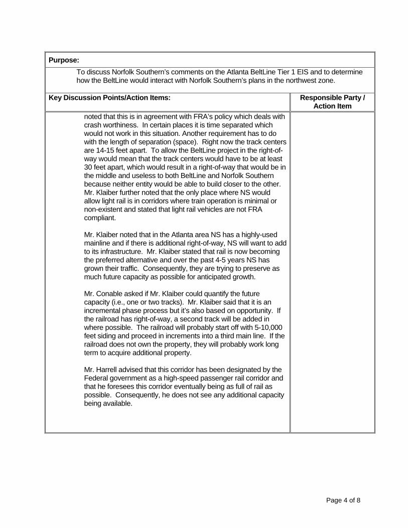
Purpose: To discuss Norfolk Southern’s comments on the Atlanta BeltLine Tier 1 EIS and to determine how the BeltLine would interact with Norfolk Southern’s plans in the northwest zone.
Key Discussion Points/Action Items: Responsible Party /
Action Item noted that this is in agreement with FRA’s policy which deals with crash worthiness. In certain places it is time separated which would not work in this situation. Another requirement has to do with the length of separation (space). Right now the track centers are 14-15 feet apart. To allow the BeltLine project in the right-of-way would mean that the track centers would have to be at least 30 feet apart, which would result in a right-of-way that would be in the middle and useless to both BeltLine and Norfolk Southern because neither entity would be able to build closer to the other. Mr. Klaiber further noted that the only place where NS would allow light rail is in corridors where train operation is minimal or non-existent and stated that light rail vehicles are not FRA compliant. Mr. Klaiber noted that in the Atlanta area NS has a highly-used mainline and if there is additional right-of-way, NS will want to add to its infrastructure. Mr. Klaiber stated that rail is now becoming the preferred alternative and over the past 4-5 years NS has grown their traffic. Consequently, they are trying to preserve as much future capacity as possible for anticipated growth. Mr. Conable asked if Mr. Klaiber could quantify the future capacity (i.e., one or two tracks). Mr. Klaiber said that it is an incremental phase process but it’s also based on opportunity. If the railroad has right-of-way, a second track will be added in where possible. The railroad will probably start off with 5-10,000 feet siding and proceed in increments into a third main line. If the railroad does not own the property, they will probably work long term to acquire additional property. Mr. Harrell advised that this corridor has been designated by the Federal government as a high-speed passenger rail corridor and that he foresees this corridor eventually being as full of rail as possible. Consequently, he does not see any additional capacity being available.
Page 4 of 8

Purpose: To discuss Norfolk Southern’s comments on the Atlanta BeltLine Tier 1 EIS and to determine how the BeltLine would interact with Norfolk Southern’s plans in the northwest zone.
Key Discussion Points/Action Items: Responsible Party /
Action Item Mr. Harrell stated that Norfolk Southern will be willing to work with BeltLine on the off-railroad alternatives. Mr. Klaiber said NS does not have a restriction prohibiting an elevated structure next to their right-of-way. The only restriction is the vehicle type (light rail). Crash walls or detection devices can be used but are not preferable options for NS. Mr. Harrell asked what the advantage would be for a fixed rail street-car operation in lieu of a rubber-tire transit operation. Mr. Conable replied streetcar is preferred because redevelopment tends to follow rail projects. These types of projects have been pretty successful in the northwest part of the country. Further, Ted Williams advised that previous studies looked at the possibility of a rubber-tire option and presented it to the public. However, it was not compatible with the City’s plans and did not fare well with public preference so it was not advanced to this phase of study. Mr. Conable asked if the Norfolk Southern representatives could share information on expansion plans. Mr. Klaiber stated that he will check with the engineers to see if there is anything specific but cautioned that if there is any information it will probably be very conceptual at this point. Mr. Harrell said that he knows there will not be anything in writing on Howell Junction, just discussions over the years. Mr. Conable asked if he could submit the information in the next two weeks to meet the Study’s timeline for resubmission of the EIS to FTA and he agreed. Mr. Conable asked if there were other entities beside those mentioned already that had plans to use the railroad corridors. Mr. Harrell said not that they were aware of. Mr. Conable then asked if NS had agreements in place with any of the entities who planned to use the corridor and Mr. Harrell advised that they have an agreement with Amtrak whereby they can add certain kinds of service. Mr. Conable asked if NS would be willing to continue discussing proposed alignment options in their corridor once the Tier 1 is completed and the BeltLine moves into the next phase of study. Mr. Harrell and Mr. Klaiber felt that NS would be willing to continue the dialog with Atlanta BeltLine and stated that they would inform them if an agreement were ever reached with CSX regarding Howell Junction or if a task force was developed to study the area.
Page 5 of 8

Purpose: To discuss Norfolk Southern’s comments on the Atlanta BeltLine Tier 1 EIS and to determine how the BeltLine would interact with Norfolk Southern’s plans in the northwest zone.
Key Discussion Points/Action Items: Responsible Party /
Action Item Mr. Harrell advised that they received the TIGER 1 grant for the Crescent Corridor which is Norfolk Southern’s growth plan. The Crescent Corridor includes the NS track segment being considered by the Atlanta BeltLine. It is basically an intermodal rail interstate, which will hopefully get some of the truck traffic off the interstate. This is a capacity and speed improvement project. Mr. Conable asked if the NS “pillars” for shared-use negotiations (uncompromised safety, capacity for current and future needs, no subsidization by NS, and liability protection) remained the same. Mr. Harrell said yes; however crossings are not really an issue it is just a matter of clearance, design, and if there is a future expansion need that may be impacted like at Howell Junction. Mr. Conable asked if there are any plans to expand Inman Yard. Mr. Klaiber explained that it depends on the traffic flow and how they develop. Inman yard has turned into an intermodal operation. Mr. Harrell said for the most part it is operating as a “piggy-back” yard and there are no immediate plans to expand. Mr. Conable asked if NS has an idea of how much passenger rail traffic can be accommodated in the Western Truck without impacting Norfolk Southern’s operations. Mr. Harrell said that in order to run passenger service through the area, the state would have to look at adding an additional track (4th mainline). Mr. Conable asked what the physical separation requirement is for light rail. Mr. Klaiber replied that it is a FRA policy. Norfolk Southern starts at 25 feet and FRA adds additional footage. Mr. Klaiber advised that NS does not like censors, crash walls or passenger stations inside of their right-of-way. Mr. Harrell asked if the BeltLine Tier 1 EIS could proceed if the CSX & NS alignments were taken out of the Northwest zone. Mr. Conable responded that one of FTA’s comments was that discussion was needed with the railroads, because if the Project cannot be in their corridors we may not have a project with logical termini. So FTA views the project’s logical termini as inclusive of the NW part of the loop.
Page 6 of 8

Purpose: To discuss Norfolk Southern’s comments on the Atlanta BeltLine Tier 1 EIS and to determine how the BeltLine would interact with Norfolk Southern’s plans in the northwest zone.
Key Discussion Points/Action Items: Responsible Party /
Action Item Mr. Conable asked if NS is looking at freight bypasses. Mr. Harrell advised that at the present time there are two routes, one on the east side and one on the west side that has been preserved for possible bypasses around Atlanta. Each bypass currently contains portions that are out of service right now and both of them would require a fair amount of upgrading to put them into service. NS is not currently looking at putting them into service right now because demand does not warrant it. NS looks at the bypasses as additional capacity too in addition to running through the middle of Atlanta. Mr. Harrell noted that there are no plans to rationalize (short line) any additional tracks or take tracks out of the system. Tracks may be taken out of service but NS will retain them. Ted Williams asked if NS had any comments on the typical cross sections noted in the draft EIS and mentioned in the letter sent to Mr. Harrell. Mr. Klaiber advised that at this stage, NS typically doesn’t get into the details in terms of cross section design parameters because there is no project being moved forward and the NS design engineers are inundated with other efforts. Ted Williams asked if there has been any study of the grade separation at Howell Junction. Mr. Klaiber replied that to his knowledge there is nothing on paper. Mr. Harrell then stated that if there is a joint task force developed to look at the Howell Junction area, NS would be willing to participate.
Next Steps • Mr. Harrell asked the team to draft a letter for NS signature that
states that the railroad met with us and that they are willing to continue to dialog with us in the future.
• Jim Klaiber will check with the engineering team to see if there are any plans for expansion and provide these within two weeks.
• Mr. Conable will forward the meeting minutes from today to Mr. Harrell and Mr. Klaiber for review and comment.
C: Document Control
Next Meeting Date: TB D
Page 7 of 8

M A R T A G E N E R A L P L A N N I N G C O N S U L T A N T S E R V I C E S
BELTLINE CORRIDOR ENVIRONMENTAL STUDY
MEETING GROUP: MARTA/ABI/CSX Coordination ORDER NO: 2008-07 PROJECT CODE: BEL TASK NO: 7.8 DATE & TIME: November 10, 2010 LOCATION: Conference Call ATTENDEES: See List Below
MEETING NOTES
Purpose: To discuss CSX comments on the Atlanta BeltLine Tier 1 EIS and to determine how the BeltLine would interact with CSX’s plans in the northwest zone.
Key Discussion Points/Action Items: Responsible Party /
Action Item 1. Introductions/Agenda Review
Meeting attendees: • Craig Camuso, Regional Vice President, State Government
Relations, CSX • Keith Brinker, Manager, Environmental Remediation, CSX • Chris Maffett, Director, Networkology, CSX • Mark Holder, Director, Public Agency Services, CSX • Marty Marchaterre, Consultant, CSX • Nate Conable, Director of Transit and Transportation, Atlanta
BeltLine, Inc. • Paul Vespermann, Director of Real Estate, Atlanta BeltLine,
Inc. • Leslie Roche, Environmental Task Leader for BeltLine EIS,
AECOM • Scott Johnson, Project Engineer for BeltLine EIS, AECOM • Marla Jones, Document Control Manager, MARTA General
Planning Consultant As a part of the agenda review, Nate Conable advised that the objective of the meeting is to discuss CSX’s comments
RFP P5413 / Contract No. 200703566 Rev.1.050508 Page 1 of 8

Purpose: To discuss CSX comments on the Atlanta BeltLine Tier 1 EIS and to determine how the BeltLine would interact with CSX’s plans in the northwest zone.
Key Discussion Points/Action Items: Responsible Party /
Action Item on the Atlanta BeltLine Tier 1 DEIS and to determine how the BeltLine would interact with CSX’s plans in the northwest zone.
Northwest Zone Alignment Overview The discussion began with a description of the proposed CSX transit alignment in the northwest zone of the BeltLine by Nate Conable. Nate advised that one of the key issues to be addressed is the section of the alignment that runs from Howell Junction north to the Lindbergh Center area. The project has a couple of alternatives in this area. One alternative is inside of the CSX corridor and the other is outside of the CSX corridor (parallel alignment). Both alignments have variations associated with them. For the trail alignments the project has both the inside and outside alignments with an option associated with the outside alignment. Following are questions, answers, and comments relative to the proposed alignment: Question: When you talk about the activity at Howell Junction, is the plan to run along the right-of-way in that area? (Craig Camuso) Response: One option is to go over Howell Junction and other option is to use the existing Marietta Blvd. Bridge. (Nate Conable) Question: Are you aware that one of the initiatives that GDOT is undertaking is to study grade separation at Howell Junction? (Craig Camuso) Response: We know there has been some discussion but are not aware of any preliminary work towards that end. (Nate Conable) Question: Do you know how the grade separation would conceptually be designed? (Nate Conable)
Page 2 of 8

Purpose: To discuss CSX comments on the Atlanta BeltLine Tier 1 EIS and to determine how the BeltLine would interact with CSX’s plans in the northwest zone.
Key Discussion Points/Action Items: Responsible Party /
Action Item Response: No. There has been a lot of discussion but no written documentation as of yet. (Craig Camuso)
Question: Do any of your plans involve running on existing CSX tracks? (Craig Camuso) Response: No. Our plans involve running parallel incorporating enough distance to promote safety. (Nate Conable) Question: Does parallel mean within the right-of-way? (Craig Camuso) Response: We have both options on the table right now (inside and outside of right-of-way). Our preferred option is to work out an arrangement with CSX whereby we can operate within your right-of-way, particularly where it is key to mitigating property impacts. Question: About four years ago CSX tried to reconstruct the wooden trestle to a steel structure in the Tanyard Creek area to incorporate some designs that we felt would be beneficial to the BeltLine. In doing so, we went through a great deal of public involvement to discuss our plans. There was a lot of opposition from the community and we were not allowed to reconstruct that bridge. What has been the response from the residents in that area in regard to possible property impacts due to your proposed alignments? (Craig Camuso) Response: We haven’t highlighted this discussion with the residents yet because we wanted to get a sense of what the concerns, needs, and issues were for CSX first before speaking to the public. We understand that this community has been problematic in the past but we believe that there has been some good will created due the construction of the trail in that area. The community loves the trail and makes good use of it. We are hoping to build upon that good will in the future. Question: Where is the study in the NEPA process and what will the next
Page 3 of 8

Purpose: To discuss CSX comments on the Atlanta BeltLine Tier 1 EIS and to determine how the BeltLine would interact with CSX’s plans in the northwest zone.
Key Discussion Points/Action Items: Responsible Party /
Action Item steps will be? (Keith Brinker).
Response: We are currently in the process of responding to FTA’s comments on the Administrative Draft EIS. One of their comments dealt specifically with the need for coordination between the project team and the railroads to ensure that we have received feedback on how the proposed alignments might impact the railroads’ operations. Once all comments have been addressed, the Administrative Draft EIS will be resubmitted to FTA. We anticipate resubmitting the document in the middle of December. Assuming things go well, we will publish our Notice of Availability in late January, hold the public hearing in February, then obtain a ROD (record of decision) by late summer or fall. (Nate Conable) Comment Given the concept of utilizing either the NS or CSX right-of-way, the timeframe needed to get the coordination and possible concurrence needed from either railroad seems to be aggressive for obtaining an approved EIS. (Keith Brinker)
Question What issues are giving you the sense that our schedule does not allot enough time? (Nate Conable) Response There needs to be additional discussions with the CSX operating group. I don’t think you want to go through your EIS process without the two affected railroads in agreement with your options. (Keith Brinker) Comment I fully agree. The more we can accomplish in terms of coordination and buy-in on the alternatives that we have in the EIS by CSX, the better it is for us. However, from a business perspective for ABI, one of the issues that we are facing is that this is a 22-mile project but it will be built in phases over time. We took a Tier 1 approach to clear some of the high level issues. If the Tier 1 doesn’t get completed in a timely manner, it prevents
Page 4 of 8
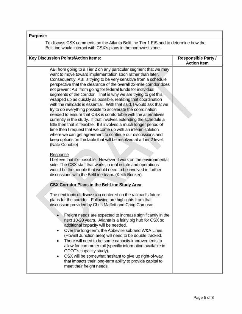
Purpose: To discuss CSX comments on the Atlanta BeltLine Tier 1 EIS and to determine how the BeltLine would interact with CSX’s plans in the northwest zone.
Key Discussion Points/Action Items: Responsible Party /
Action Item ABI from going to a Tier 2 on any particular segment that we may want to move toward implementation soon rather than later. Consequently, ABI is trying to be very sensitive from a schedule perspective that the clearance of the overall 22-mile corridor does not prevent ABI from going for federal funds for individual segments of the corridor. That is why we are trying to get this wrapped up as quickly as possible, realizing that coordination with the railroads is essential. With that said, I would ask that we try to do everything possible to accelerate the coordination needed to ensure that CSX is comfortable with the alternatives currently in the study. If that involves extending the schedule a little then that is feasible. If it involves a much longer period of time then I request that we come up with an interim solution where we can get agreement to continue our discussions and keep options on the table that will be resolved at a Tier 2 level. (Nate Conable) Response I believe that it’s possible. However, I work on the environmental side. The CSX staff that works in real estate and operations would be the people that would need to be involved in further discussions with the BeltLine team. (Keith Brinker) CSX Corridor Plans in the BeltLine Study Area The next topic of discussion centered on the railroad’s future plans for the corridor. Following are highlights from that discussion provided by Chris Maffett and Craig Camuso:
• Freight needs are expected to increase significantly in the next 10-20 years. Atlanta is a fairly big hub for CSX so additional capacity will be needed.
• Over the long-term, the Abbeville sub and W&A Lines (Howell Junction area) will need to be double tracked.
• There will need to be some capacity improvements to allow for commuter rail (specific information available in GDOT’s capacity study).
• CSX will be somewhat hesitant to give up right-of-way that impacts their long-term ability to provide capital to meet their freight needs.
Page 5 of 8

Purpose: To discuss CSX comments on the Atlanta BeltLine Tier 1 EIS and to determine how the BeltLine would interact with CSX’s plans in the northwest zone.
Key Discussion Points/Action Items: Responsible Party /
Action Item • There may be a possibility of using some of the CSX
right-of-way as long as the railroad’s needs for capacity are met and efficiency and safety are not compromised.
• CSX may be able to work with the BeltLine project on touchdown points for the proposed bridge alignment going through the Howell Junction area. Consideration would be based on where the touchdown points are and if they impacted in future realignments that would be needed to facilitate freight movements. Also, the touchdown points would have to be in concert with Norfolk Southern.
NW Zone Alternatives Nate Conable began this portion of the meeting by reiterating to CSX that it has always been the intention of the BeltLine Study to involve CSX in the development of alignments. This was initially done by inviting CSX to participate on the Stakeholder Advisory Committee. Nate then asked what documents were needed now to facilitate the railroad’s review and comment on the alternative alignments in the northwest zone. In response Craig Camuso noted that there has been open dialog about the BeltLine project through the years but until this point there has not been a route to comment on. Craig stated that there is not a lot of right-of-way in the northwest area of the CSX corridor so it will be interesting to see the proposed alignments. Craig said he believes it would be good to see any type of basic engineering; however the Assistant Chief Engineer would be the one to determine what should be provided. Other highlights of this discussion include: • CSX would like to be included on any further discussion with
SHPO as it pertains to the Section 106 Evaluation of the corridor as a potential historic resource.
• Nate Conable will provide the Cultural Resources document to CSX to review so that they can provide feedback to ensure that is it appropriately set in the railroad’s context.
• CSX noted that they have a huge safety concern with at- grade pedestrian trails crossing over active freight lines and advised that the BeltLine project team may want to consider pedestrian bridges in areas where there is active freight lines.
Page 6 of 8

Purpose: To discuss CSX comments on the Atlanta BeltLine Tier 1 EIS and to determine how the BeltLine would interact with CSX’s plans in the northwest zone.
Key Discussion Points/Action Items: Responsible Party /
Action Item Railroad Questionnaire Discussion This portion of the meeting was used to discuss/clarify the answers previously provided by CSX in response to the railroad questionnaire given to them on behalf of the BeltLine EIS management team. Following are key issues from that discussion:
• CSX does not have any concrete plans as of yet for double tracking in the northwest corridor and will probably not share that information when it is available.
• If in the future, if it is determined that CSX’s needs for capacity are met and efficiency and safety are not compromised, they will be willing to continue discussing the possibility of the BeltLine project operating in their right-of-way but they cannot guarantee or commit to anything.
• For planning purposes, the BeltLine EIS team should assume that CSX will be double tracking through their northwest corridor.
• There is currently no commitment or agreement in place for another entity to use the CSX right-of-way in the northwest corridor.
• There are restrictions of modes with freight operations in the corridor but the specifics would have to be answered by Chuck Washington.
• CSX will review the BeltLine EIS team’s responses to FTA’s comments regarding railroad coordination to ensure that they accurately reflect the position taken by CSX.
• The four pillars have remained the same • CSX is not aware of any projects with LRT or Streetcar
operating within their right-of-way. • There are currently no plans to expand any of the CSX yards
in the northwest corridor but they reserve the right to do so in the future.
• The BeltLine EIS team will need to speak with the CSX Real Estate Department to determine if there are any plans to expand the A&WP in the southeast area.
• CSX chose not to answer the question regarding whether or not they are actively pursuing bypass lines.
Page 7 of 8

Page 8 of 8
Purpose: To discuss CSX comments on the Atlanta BeltLine Tier 1 EIS and to determine how the BeltLine would interact with CSX’s plans in the northwest zone.
Key Discussion Points/Action Items: Responsible Party /
Action Item Next Steps • The CSX team will meet internally to determine how they wish to
move forward with coordination activities. In the meantime, Nate Conable advised that the BeltLine EIS team will provide CSX with conceptual engineering work, a draft operation plan, and typical sections that represent where the alignment parallels the CSX facilities. Nate asked that the CSX team be mindful as they consider coordination activities that the BeltLine EIS team is under time constraints to get the EIS document back to FTA.
C: Document Control
Next Meeting Date: TB D

RFP P5413 / Contract No. 200703566 Rev.1.050508 Page 1 of 3
M A R T A G E N E R A L P L A N N I N G C O N S U L T A N T S E R V I C E S
BELTLINE CORRIDOR ENVIRONMENTAL STUDY
MEETING GROUP: MARTA/ABI/GDOT Coordination ORDER NO: 2008-07 PROJECT CODE: BEL TASK NO: 7.8 DATE & TIME: November 1, 2010 LOCATION: GDOT Offices ATTENDEES: Erik Steavens – GDOT; Adelee Le Grand – AECOM; Marla Jones, LKG-
CMC; Johnny Dunning - MARTA MEETING NOTES
Purpose: To discuss Norfolk Southern’s comments on the Atlanta BeltLine Tier 1 EIS and to
Key Discussion Points/Action Items: Responsible Party / Action Item
1. Project Update Adelee Le Grand began the meeting with an explanation of the process for resubmittal of the DEIS to FTA. She also discussed the project’s remaining tasks and associated timeline to reach a Record of Decision. Adelee noted that in addition to the alignments proposed to run inside of the railroads’ right-of-way, the team is also considering two off-railroad alignments so that the project will still have logical termini in the event that that the railroads won’t allow the project to operate in their right-of-way. Adelee advised that there will be a series of public meetings to present the off-railroad alternatives and noted that there is a possibility that the DEIS may only contain the off-railroad alternatives when it is resubmitted to FTA. Johnny Dunning stated that even if the off-railroad alternatives are selected, it will still require extensive coordination with the railroads, including the issue of crossing Howell Junction. Eric Steavens replied that when dealing with the Howell Junction area the team should speak with Steve Stancil of the Building Authority because

Purpose: To discuss Norfolk Southern’s comments on the Atlanta BeltLine Tier 1 EIS and to
Key Discussion Points/Action Items: Responsible Party / Action Item
the state owns some of the right-of-way in that area (the western Atlantic portion). Consequently, the solution may not be as difficult as it appears. Eric noted that the state leased the right-of-way to CSX which he believes will expire in 2017 or 2019. If this section of the BeltLine is timed to move forward around the time the lease with CSX expires, the project may be able to negotiate its plans so that they are incorporated into the state’s next lease agreement for the land in the Howell Junction area.
In reference to the NS option, Eric Steavens recommended that the project team contact Siemens, SRTA Jacoby, and Amtrak because:
• At Northside Drive there is a Siemens building that is for sale that has some rail frontage
• SRTA has some property in the area • There is a strip along a fence that Jacoby has vacant • Amtrak has looked at the possibility of placing its station over
in the Atlantic Station area to get off the mains Adelee Le Grand advised that there are three options for getting out of the NE alignment and in to Lindbergh that will not be resolved in this study. Eric Steavens noted that if a flyover is not involved in any of the options there will need to be some discussion with GDOT and the City about doing signal pre-emption. Eric recommended that the team follow-up with Todd Long, Glenn Bowman, and Keith Golden of GDOT to discuss program, planning, signalization, permitting and overall environmental issues. The team continued discussing various aspects of the alignment around the BeltLine loop. Adelee Le Grand asked Eric Steavens if there are other projects or studies (besides the Atlanta to Chattanooga study) relative to GDOT’s intermodal plans within the BeltLine study area that the team should be aware of. In response Eric noted the NS corridor, Howell Junction, MMPT and discussions concerning improvements to Inman and Tilford yards. Adelee then asked if the state was to do a lease agreement for the BeltLine project how long would the agreement be?
Page 2 of 3

Page 3 of 3
Purpose: To discuss Norfolk Southern’s comments on the Atlanta BeltLine Tier 1 EIS and to
Key Discussion Points/Action Items: Responsible Party / Action Item
Eric Steavens responded that it legally depends on who the lease agreement is with. If it is with a non-profit then the length of the agreement would be significantly less than if the lease were government to government. For FTA, you have to secure the lease for 40 years in order for FTA to feel comfortable. Adelee then asked about the status of the property owned by GDOT on the SE side near Glenwood. Eric advised that the property has been rendered useless so GDOT would be willing to abandon it.
Next Steps • Adelee Le Grand will forward draft meeting minutes to Eric
Steavens for review and comment so that they can be incorporated into the DEIS
• The BeltLine EIS project team will set up a meeting with Todd Long, Glenn Bowman and Keith Golden to discuss other coordination issues.
C: Document Control
Next Meeting Date: TB D

RFP P5413 / Contract No. 200703566 Rev.1.050508 Page 1 of 3
M A R T A G E N E R A L P L A N N I N G C O N S U L T A N T S E R V I C E S
BELTLINE CORRIDOR ENVIRONMENTAL STUDY
MEETING GROUP: MARTA/ABI/GBA Coordination ORDER NO: 2008-07 PROJECT CODE: BEL TASK NO: 7.8 DATE & TIME: February 4, 2011 LOCATION: Georgia Building Authority Offices ATTENDEES: Steve Stancil, Frank Smith, Marvin Woodward, – Georgia Building Authority;
J. Wade, - SPC; Adelee Le Grand – AECOM; Marla Jones – LKG-CMC; Johnny Dunning – MARTA; Paul Vespermann – ABI
MEETING NOTES
Purpose: To discuss coordination issues within the BeltLine Corridor
Key Discussion Points/Action Items: Responsible Party / Action Item
1. Johnny Dunning began the meeting with an overview of the BeltLine Tier 1 EIS study and noted that in addition to the alignments proposed to run inside of the railroads’ right-of-way, the team is also considering two off-railroad alignments in the Northwest Zone so that the project will still have logical termini in the event that that the railroads won’t allow the project to operate in their right-of-way. Johnny advised that coordination meetings have been held with both CSX and Norfolk Southern and it appears that the project will not be able to operate inside of the Norfolk Southern right-of-way. Johnny then reviewed the alternative map for the NW Zone.
Project Overview
J. Dunning stated that even if the off-railroad alternatives are selected, it will still require extensive coordination with the railroads, including the issue of crossing Howell Junction, which is a critical component of the Norfolk Southern off-railroad alternative. J. Dunning asked Steve Stancil if the Georgia Building Authority has any projects, studies or plans for the Northwest Zone of the BeltLine corridor that could be shared with the BeltLine EIS team.
None

Page 2 of 3
Purpose: To discuss coordination issues within the BeltLine Corridor
Key Discussion Points/Action Items: Responsible Party / Action Item
The following highlights were derived from information provided by Steve Stancil: • There has been a lot of discussion about commuter rail in the
Western Atlantic Corridor but no specific plans as of yet. In reference to Howell Junction, Steve noted that any fly-over 20 feet above the rail would have to be approved by the General Assembly because the State of Georgia owns the air rights.
• The State leases right-of-way to CSX in the Howell Junction area and this lease expires in 2019.
• The State has property for sale around Murphy Avenue (old
State Farmers Market) that may be of some interest to the BeltLine. If interested, BeltLine should contact Frank Smith after the General Assembly (around May or June).
None
The following highlights were derived from information provided by the BeltLine Project Team members in response to questions that were asked:
• The team anticipates receiving a Tier 1 Record of Decision
(ROD) by the end of this year. • Station locations are very conceptual at this point • The transit and trail alignment width is 57 feet except in portions
of the Northwest Zone where the transit and trail may be separated in accordance with the alternative.
• The CSX alternative connects to Piedmont Hospital and the
new Westside Park. • The Norfolk Southern alternative is adjacent to the railroad’s
right-of-way and will be more in-street running. At the end of the discussion Adelee Le Grand advised that FTA has expressed the need for coordination between the project team, the railroads and other appropriate parties and asked if the Georgia
None

Page 3 of 3
Purpose: To discuss coordination issues within the BeltLine Corridor
Key Discussion Points/Action Items: Responsible Party / Action Item
Building Authority will be willing to continue discussions. In response, Marvin Woodward stated that GBA would be willing to participate in future discussions. Next Steps • Adelee Le Grand advised that meeting notes would be
developed from today’s discussions and forwarded to Steve Stancil for review and comment before finalizing them.
J. Dunning will forward draft meeting notes to
Steve Stancil for review and comment
C: Document Control
Next Meeting Date: TB D

BeltLine EISAgency Acceptance/Decline
Accepted Invitation Authorization Date Recd
US Army Corp of Engineers(USACE) Edward Kertis 08/11/08U.S. Environmental Protection Agency (EPA), Region 4 Heinz J. Mueller 08/20/08Center for Disease Control and Prevention (CDC) Julie Gerberding 08/14/08Federal Railroad Administration (FRA) Wendy Messenger 07/08/09National Park Service (NPS) David Vela 08/26/08Georgia Department of Natural Resources (DNR) Floodplain Management Office Collis Brown 08/01/08Georgia Department of Natural Resources-(DNR) State Historic PreservationDivision (SHPO)
Amanda Shraner 08/04/08Georgia Department of Natural Resources (DNR) -Office of the Commissioner Jim Ussery 08/01/08Georgia Department of Transportaton (GDOT) Michael Thomas 08/01/08Georgia Environmental Facilities Authority (GEFA) Chris Clark 08/01/08Atlanta Regional Commission (ARC) David Emory 08/12/08Fulton County Department of Environment and Community Development (E&CD) Debra Jennings 07/31/08DeKalb County Planning & Development Department (P&DD) Patrick Ejike 08/06/08City of Atlanta Department of Parks, Recreation and Community Affairs (DPRCA)
Dianne Harnell Cohen 07/31/08City of Atlanta Department of Planning and Community Development (DPCD) Steve Cover 08/05/08
Declined Invitation Authorization Date Recd
Natural Resource Conservation Service (NRCS) [Federal Agency] James Tillman 08/12/08Georgia Office of Homeland Security [State Agency] Charles Dawson 08/08/08Atlanta Development Authority (ADA) [City of Atlanta Agency] Peggy McCormick 08/07/08
10/27/2009BeltLine Agency Acceptance_Decline.xls
July 25, 2008
____(Participating Agency Name and Address)
Subject: Invitation to become a Participating Agency on the Atlanta BeltLine Environmental Review Process
Dear ___(name of agency rep),
The Federal Transit Administration (FTA), in cooperation with the Metropolitan Atlanta Rapid Transit Authority (MARTA), and Atlanta BeltLine Inc. (ABI), is preparing a Tier 1 Environmental Impact Statement (EIS) for the Atlanta BeltLine in the City of Atlanta, GA. The EIS is being prepared in accordance with the National Environmental Policy Act (NEPA) and the Georgia Environmental Policy Act (GEPA).
The Atlanta BeltLine is a proposed new transit and trails system that will form an approximate 22-mile loop within the City of Atlanta. The Tier 1 analysis will serve as a basis for establishing the general alignment of the transit and trail corridor along the entire 22-mile loop. Conceptual locations of stations, trail connections, and other facilities will be determined, as will the choice of transit technology. The scope of analysis in the Tier 1 EIS will be appropriate to the level of detail necessary to make informed decisions after receiving input from the public and the reviewing agencies. The intent of the Tier 1 EIS and these decisions is to support future ROW preservation along the entire 22-mile loop.
The transit and trails elements are intricately tied to one another and require iterative and concurrent development, analysis and consideration up to the Tier 1 decisions on alignment, conceptual design and technology. Once these decisions are made and the Tier 1 EIS is completed, future Tier 2 analyses can focus on design refinements.
In accord with Section 6002 of the Safe, Accountable, Flexible, Efficient, Transportation Equity Act: A Legacy for Users (SAFETEA-LU), Cooperating and Participating Agencies may be identified and invited to be involved in the NEPA process. A Cooperating Agency is any federal, state or local agency or Native American tribe that has jurisdiction by law or special expertise with respect to any environmental impact involved in a proposed project or project alternative. A Participating Agency is any federal, state or local agency or Native American tribe that has an interest in the project.
Your agency has been identified as an agency that might have an interest in the project. With this letter, we extend to your agency an invitation to become a Participating Agency in the development of the EIS for the Atlanta BeltLine project.
Pursuant to Section 6002 of SAFETEA-LU, Participating Agencies are responsible for identifying, as early as practicable, any issues of concern regarding the project’s potential environmental or socio-economic impact. As a Participating Agency, your agency will be given the opportunity to provide input and comment on the purpose and need and the range of alternatives. In addition, we will ask you to:
Provide input on the methodologies and level of detail required in the analysis of

alternatives. Participate in coordination meetings and joint field reviews as appropriate. Provide timely review and comment on the pre-draft or pre-final environmental
documents to reflect the views and concerns of your agency on the adequacy of the document, alternatives considered, and the anticipated impacts and mitigation.
Please sign in the appropriate location on the attachment accepting this invitation to become a Participating Agency prior to August 5, 2008. Please return the response form by fax (404) 848-5132 or by mail to Don Williams, Manager Regional Planning and Analysis, Metropolitan Atlanta Rapid Transit Authority, 2424 Piedmont Road, NE Atlanta, GA 30324-3330. If your agency should decline, please state your reason for declining. According to SAFETEA-LU Section 6002, agencies electing to decline the invitation must also indicate the reason:
Have no jurisdiction or authority with respect to the project; Have no expertise or information relevant to the project; and Do not intend to submit comments on the project.
A NEPA Scoping Meeting will be held for agencies on August 12, 2008 from 9:00 am –11:00 am at MARTA’s Headquarters located at the above address. We invite you to participate. Please take the MARTA North-South line to the Lindbergh Station. The building is located just north of the station. If you drive, you may park at no cost in the garage located west of the building. We also ask that you reserve space on your calendar for a follow up meeting on August 22, 2008 from 9:00 am – 11:00 am.
The Scoping Document will be forwarded to you prior to the August 12 meeting. If you have any questions or would like to discuss the project in more detail or your agency’s role and responsibilities, please contact Don Williams, Manager Regional Planning and Analysis (404) 848-4422.
Thank you for cooperation and interest in this project.
Sincerely,
Johnny Dunning DirectorTransit System Planning Metropolitan Atlanta Rapid Transit Authority
I CONCUR in our agency’s role as a Participating Agency on the Atlanta BeltLine Project under SAFETEA-LU 6002:
____________________________ _______________________________ Print or Type Name Title
____________________________ _______________________________ Signature Date
I DECLINE FOR THE FOLLOWING REASONS (check appropriate reason(s)):
_____ Have no jurisdiction or authority with respect to the project _____ Have no expertise or information relevant to the project _____ Do not intend to submit comments on the project
____________________________ _______________________________ Print or Type Name Title
____________________________ _______________________________ Signature Date
Please mail or fax response by August 5, 2008 to:
Mail:Don Williams Manager Regional Planning and Analysis Metropolitan Atlanta Rapid Transit Authority 2424 Piedmont Road NEAtlanta, GA 30324-3330
Fax:(404) 848-5132
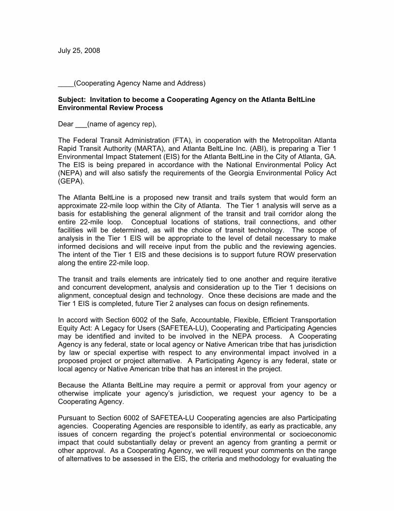
July 25, 2008
____(Cooperating Agency Name and Address)
Subject: Invitation to become a Cooperating Agency on the Atlanta BeltLine Environmental Review Process
Dear ___(name of agency rep),
The Federal Transit Administration (FTA), in cooperation with the Metropolitan Atlanta Rapid Transit Authority (MARTA), and Atlanta BeltLine Inc. (ABI), is preparing a Tier 1 Environmental Impact Statement (EIS) for the Atlanta BeltLine in the City of Atlanta, GA. The EIS is being prepared in accordance with the National Environmental Policy Act (NEPA) and will also satisfy the requirements of the Georgia Environmental Policy Act (GEPA).
The Atlanta BeltLine is a proposed new transit and trails system that would form an approximate 22-mile loop within the City of Atlanta. The Tier 1 analysis will serve as a basis for establishing the general alignment of the transit and trail corridor along the entire 22-mile loop. Conceptual locations of stations, trail connections, and other facilities will be determined, as will the choice of transit technology. The scope of analysis in the Tier 1 EIS will be appropriate to the level of detail necessary to make informed decisions and will receive input from the public and the reviewing agencies. The intent of the Tier 1 EIS and these decisions is to support future ROW preservation along the entire 22-mile loop.
The transit and trails elements are intricately tied to one another and require iterative and concurrent development, analysis and consideration up to the Tier 1 decisions on alignment, conceptual design and technology. Once these decisions are made and the Tier 1 EIS is completed, future Tier 2 analyses can focus on design refinements.
In accord with Section 6002 of the Safe, Accountable, Flexible, Efficient Transportation Equity Act: A Legacy for Users (SAFETEA-LU), Cooperating and Participating Agencies may be identified and invited to be involved in the NEPA process. A Cooperating Agency is any federal, state or local agency or Native American tribe that has jurisdiction by law or special expertise with respect to any environmental impact involved in a proposed project or project alternative. A Participating Agency is any federal, state or local agency or Native American tribe that has an interest in the project.
Because the Atlanta BeltLine may require a permit or approval from your agency or otherwise implicate your agency’s jurisdiction, we request your agency to be a Cooperating Agency.
Pursuant to Section 6002 of SAFETEA-LU Cooperating agencies are also Participating agencies. Cooperating Agencies are responsible to identify, as early as practicable, any issues of concern regarding the project’s potential environmental or socioeconomic impact that could substantially delay or prevent an agency from granting a permit or other approval. As a Cooperating Agency, we will request your comments on the range of alternatives to be assessed in the EIS, the criteria and methodology for evaluating the

alternatives, the scope of issues to be addressed as well as any other issues you identify as important. We expect your agency’s involvement to entail only those areas under its jurisdiction. In addition we ask you to:
Provide input on the methodologies and level of detail required in the analysis of alternatives.
Participate in coordination meetings and joint field reviews as appropriate. Provide timely review and comment on the pre-draft or pre-final environmental
documents to reflect the views and concerns of your agency on the adequacy of the document, alternatives considered, and the anticipated impacts and mitigation.
Please sign in the appropriate location on the attachment accepting this invitation to become a Cooperating Agency prior to August 5, 2008. Please return the response form by fax (404) 848-5132 or by mail to Don Williams, Manager, Regional Planning and Analysis, Metropolitan Atlanta Rapid Transit Authority, 2424 Piedmont Road, NE Atlanta, GA 30324-3330. If you do not accept this invitation, your Agency may become a Participating Agency as defined by Section 6002 of SAFETEA-LU. A NEPA Scoping Meeting will be held for agencies on August 12, 2008 from 9:00 am – 11:00 am at MARTA’s Headquarters located at the above address. We invite you to participate. Please take MARTA’s North-South line to the Lindbergh Station. The building is located just north of the station. If you drive, you may park at no cost in the garage located to the west of the building. We also ask that you reserve space on your calendar for a follow up meeting on August 22, 2008 from 9:00 am – 11:00 am.
The Scoping Document will be forwarded to you prior to the meeting on the 12th. If you have any questions or would like to discuss the project in more detail or your agency’s role and responsibilities, please contact Don Williams at (404) 848-4422.
Thank you for your cooperation and interest in this project.
Sincerely,
Johnny Dunning DirectorTransit System Planning Metropolitan Atlanta Rapid Transit Authority

I CONCUR in our agency’s role as a Cooperating Agency on the Atlanta BeltLine Project under SAFETEA-LU 6002:
____________________________ _______________________________ Print or Type Name Title
____________________________ _______________________________ Signature Date
Please mail or fax response by August 5, 2008 to:
Mail:Don Williams Manager Regional Planning and Analysis Metropolitan Atlanta Rapid Transit Authority 2424 Piedmont Road NEAtlanta, GA 30324-3330
Fax:(404) 848-5132


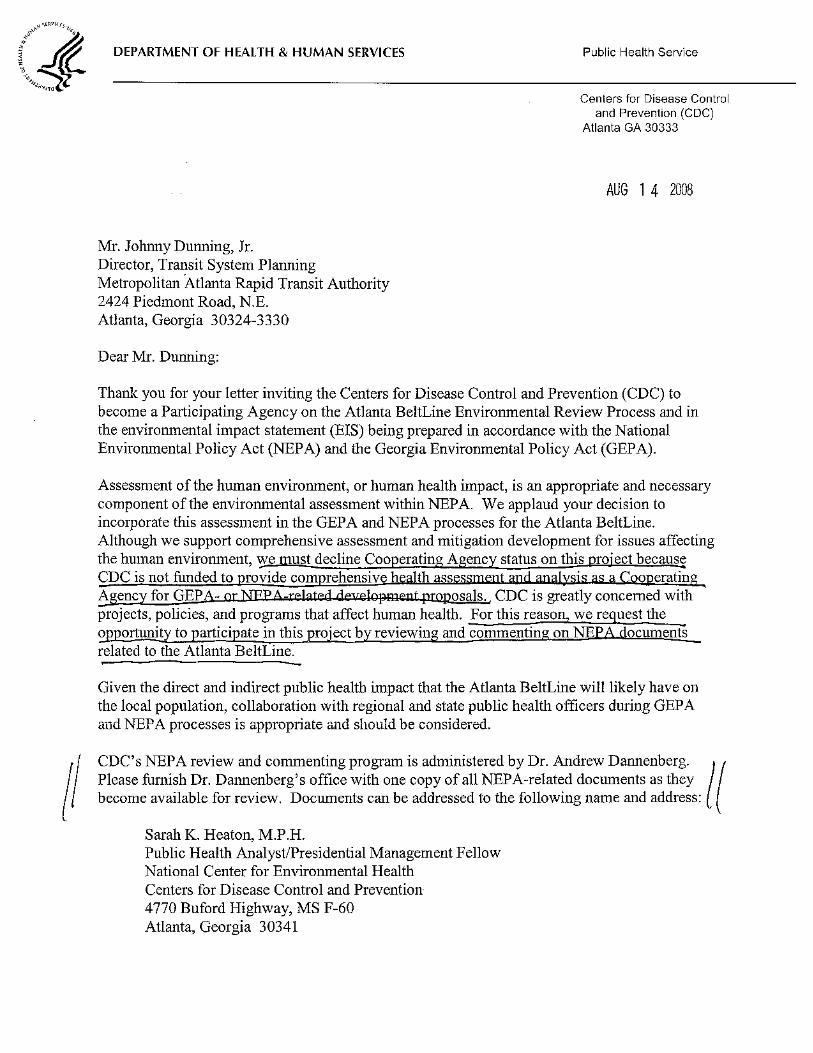


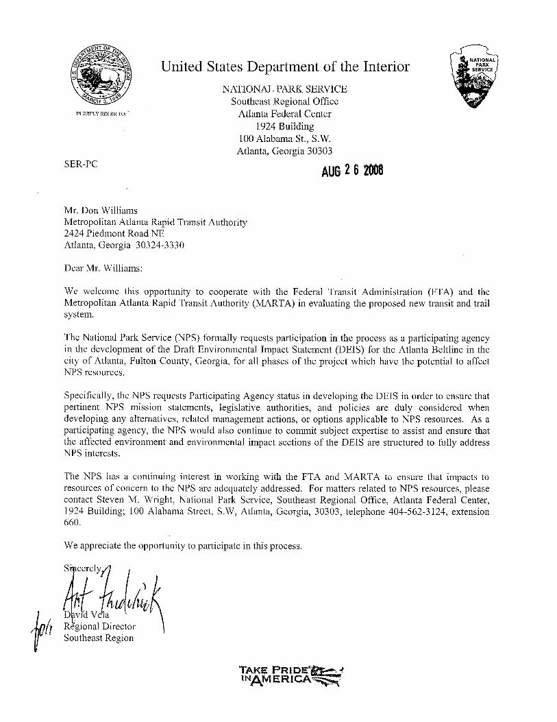


(DeKalb County)
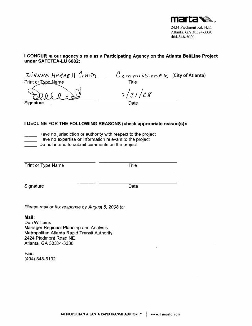
(City of Atlanta)

(City of Atlanta)


Atlanta BeltLine Corridor Environmental Study D April 2012
Appendix D - Data Tables and Figures

Atlanta BeltLine Corridor Environmental Study April 2012
Page Left Intentionally Blank

2.0 Alternatives Considered Section 2.1 Alternatives Development Process
Atlanta BeltLine Corridor Environmental Study D-1
Appendix D: Data Tables and Figures Appendix Figure 2.1-1: Inner Core BeltLine Alternatives Analysis – B3 Alternative

2.0 Alternatives Considered Section 2.1 Alternatives Development Process
Atlanta BeltLine Corridor Environmental Study D-2
Appendix Figure 2.1-2a: Transit and Trails Alternatives Identified During Scoping (Northeast Zone)
Source: AECOM/JJG Joint Venture

2.0 Alternatives Considered Section 2.1 Alternatives Development Process
Atlanta BeltLine Corridor Environmental Study D-3
Appendix Figure 2.2-2b: Transit and Trails Alternatives Identified During Scoping (Southeast Zone)
Source: AECOM/JJG Joint Venture

2.0 Alternatives Considered Section 2.1 Alternatives Development Process
Atlanta BeltLine Corridor Environmental Study D-4
Appendix Figure 2.2-2c: Transit and Trails Alternatives Identified During Scoping (Southwest Zone)
Source: AECOM/JJG Joint Venture

2.0 Alternatives Considered Section 2.1 Alternatives Development Process
Atlanta BeltLine Corridor Environmental Study D-5
Appendix Figure 2.2-2d: Transit and Trails Alternatives Identified During Scoping (Northwest Zone)
Source: AECOM/JJG Joint Venture

2.0 Alternatives Considered Section 2.2 No-Build Alternative
Atlanta BeltLine Corridor Environmental Study D-6
Appendix Table 2.2-1: Other Envision6 RTP/TIP Projects that Interface with the Atlanta BeltLine
Project Type Location Status Project Description Roadway Maintenance / Operations
Multi-Jurisdictional Programmed I-75 / I-85 (downtown connector) resurfacing and guardrail upgrade
Fixed Guideway Transit Capital
Multi-Jurisdictional Programmed
Commuter rail service – Atlanta / Griffin / Macon (stations and park-and-ride lots for Lovejoy section) Lindbergh Center / Emory bus high-speed premium transit service
Long Range I-20 east BRT
City of Atlanta Long Range Atlanta Streetcar - phase 2 north
Atlanta Streetcar - phase 2 south
Arterial BRT Multi-Jurisdictional Programmed SR 13 (Buford Highway) arterial BRT
Multi-Jurisdictional Long Range Memorial Drive BRT
Studies Multi-Jurisdictional Programmed
I-75 / I-575 Northwest Corridor - general obligation bond funds for preliminary engineering I-75/I-575 Northwest Corridor - GRV bond funds for preliminary engineering I-75 / I-575 Northwest Corridor - bond funds (backed by anticipated toll revenue) for preliminary engineering I-75 / I-575 Northwest Corridor - bond funds (backed by anticipated 5309 New Starts allocations) for preliminary engineering
Transit Facilities Multi-Jurisdictional Programmed
I-75 / I-575 Northwest Corridor - general obligation bond funds for I-75 BRT I-75 / I-575 Northwest Corridor - GRV bond funds for I-75 BRT I-75 / I-575 Northwest Corridor - 5309 New Starts Funds for I-75 BRT
Roadway Operational Upgrades
City of Atlanta Programmed US 78 / 278 (Donald Lee Hollowell Parkway)
Roadway Capacity City of Atlanta Long Range University Avenue
Pedestrian Facility City of Atlanta Programmed Ralph David Abernathy Boulevard pedestrian and intersection improvements
Multi-Use Bike / Pedestrian Facility
City of Atlanta Programmed Marietta Boulevard pedestrian improvements
Bridge Upgrade City of Atlanta Programmed US 19 / SR 9 (Peachtree Rd, CSX RR)
Source: ARC, 2007, Envision6 RTP and TIP

2.0 Alternatives Considered Section 2.2 No-Build Alternative
Atlanta BeltLine Corridor Environmental Study D-7
Appendix Figure 2.2-2: No-Build Alternative Projects
Source: Atlanta Regional Commission 2007
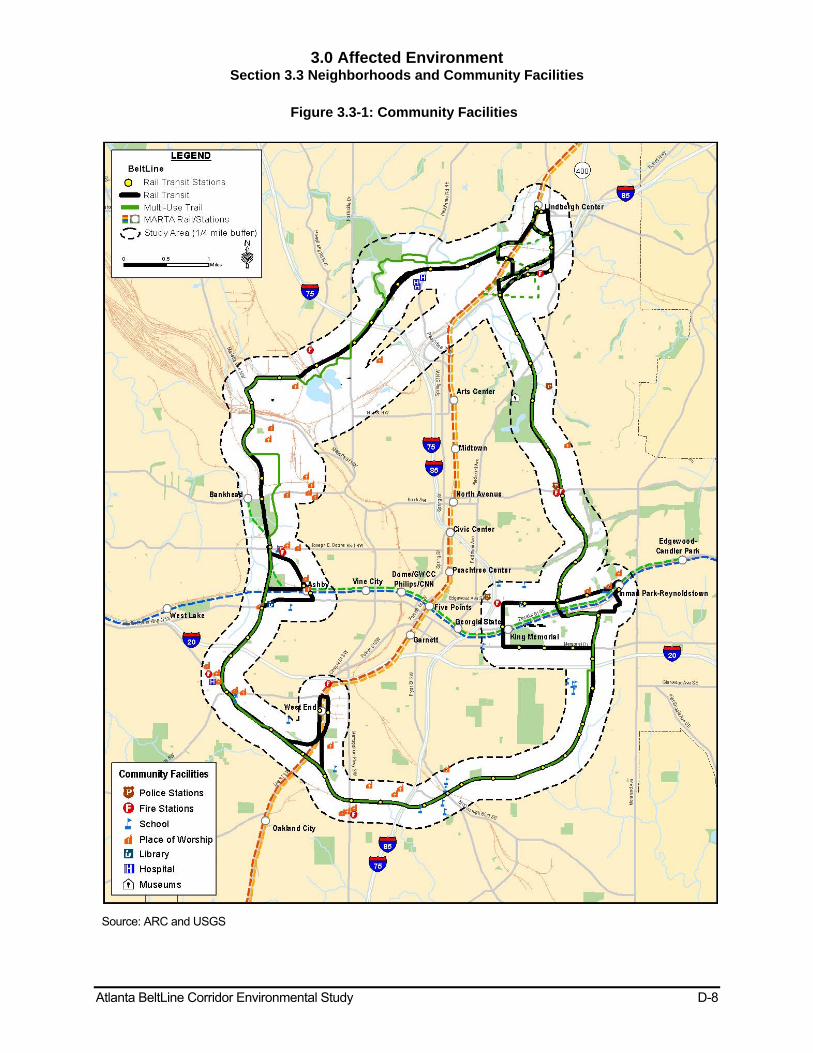
3.0 Affected Environment Section 3.3 Neighborhoods and Community Facilities
Atlanta BeltLine Corridor Environmental Study D-8
Figure 3.3-1: Community Facilities
Source: ARC and USGS

3.0 Affected Environment Section 3.3 Neighborhoods and Community Facilities
Atlanta BeltLine Corridor Environmental Study D-9
Table 3.3-1: Community Facilities
Northeast Zone Atlanta Botanical Gardens Hope Elementary School Atlanta Bureau of Fire Station #4 Inman Middle School Atlanta Bureau of Fire Station #29 Inman Park United Methodist Church Atlanta Fulton Public Library Martin Luther King, Jr. Branch Martin Luther King, Jr. Community Center Atlanta Police Dept Midtown Precinct New Mount Sinai Baptist Church Atlanta Police Dept Zone 5 Mini Precinct Saint Paul’s Lutheran Church Atlanta School (The) Virginia Avenue Baptist Church East Atlanta Primitive Baptist Church Walden Middle School Grady High School
Southeast Zone Adair Park Church Jessie Mae Jones Elementary School Atlanta Charter Middle School Jessie Mae Jones Middle School Atlanta Bureau of Fire Station #20 New Hope Baptist Church Atlanta Healing Temple Nur Private Academy Atlanta Youth Academies Oglethorpe Elementary School Capitol View United Methodist Church Saint John AME Church Carver High School Saint Malachi Baptist Church Cook Elementary School Slater Elementary School Early Church of God in Christ Southside Comprehensive High School Gateway Diversion Center Tech High Elementary School Guice Elementary United Baptist Church
Southwest Zone Atlanta Bureau of Fire Station #17 Pilgrim Travelers Baptist Church Atlanta Bureau of Fire Station #7 St Mary’s Overcoming Church of God Pentecostal Atlanta Fulton Public Library Washington Park-McPheeters Library
West End Academy
Booker T. Washington High School West End Church of Christ Brown Middle School Westhills Presbyterian Church Calvary United Methodist Church Westhills Senior Citizens Center Hinsley Temple Church of God in Christ Kipp Ways Academy Elementary School
Northwest Zone Atlanta Bureau of Fire Station #16 Longley Avenue Christian Church Atlanta Bureau of Fire Station #23 Loring Heights Baptist Church Bellwood Church New Saint James Baptist Church Centenary United Methodist Church Northwest Baptist Church Emmanuel Church of God Pentecostal Church Number 2 Fulton County Drug Court Human Services Dept Piedmont Hospital Fulton County Jail Saint Paul’s Church Grace Temple Church Shepherd Center, Inc. Heavenly Jerusalem Missionary Baptist Church Temple of God
Herndon Elementary School Temple of Israel Church

3.0 Affected Environment Section 3.6 Cultural Resources and Archaeological Resources
Atlanta BeltLine Corridor Environmental Study D-10
Figure 3.6-1a: Archaeological Sensitivity Areas (Northeast Zone)
Sources: NRHP, GRHP, AUDC, and ARC.

3.0 Affected Environment Section 3.6 Cultural Resources and Archaeological Resources
Atlanta BeltLine Corridor Environmental Study D-11
Figure 3.6-1b: Archaeological Sensitivity Areas (Southeast Zone)
Sources: NRHP, GRHP, AUDC, and ARC.

3.0 Affected Environment Section 3.6 Cultural Resources and Archaeological Resources
Atlanta BeltLine Corridor Environmental Study D-12
Figure 3.6-1c: Archaeological Sensitivity Areas (Southwest Zone)
Sources: NRHP, GRHP, AUDC, and ARC.

3.0 Affected Environment Section 3.6 Cultural Resources and Archaeological Resources
Atlanta BeltLine Corridor Environmental Study D-13
Figure 3.6-1d: Archaeological Sensitivity Areas (Northwest Zone)
Sources: NRHP, GRHP, AUDC, and ARC.

3.0 Affected Environment Section 3.7 Parks and Recreational Resources
Atlanta BeltLine Corridor Environmental Study D-14
Table 3.7-1: Parks and Recreational Resources
Park Name Address Classification Total Park
Acreage
Acreage within
150-foot buffer
Acreage within ¼
mile study area
Northeast Zone Ansley Park Maddox Drive / East Park Lane NE Neighborhood Park 6.11 - 1.34
Avery-East Park Lane Triangle Avery Drive / East Park Lane NE Garden Park 0.05 - 0.05
Beverly-Avery Triangle Beverly Road / Montgomery Ferry Drive NE
Garden Park 0.08 - 0.08
Beverly-Polo Triangle Beverly Road / Polo Drive NE Garden Park 0.02 - 0.02
Delta Park Edgewood Avenue /Delta Place NE Garden Park 0.22 0.22 0.22
Dobbs Park Community Park 0.18 - 0.18
Freedom Park Moreland Avenue / North Avenue Regional Park 120.26 1.55 55.56
Maddox-Avery Triangle Maddox Drive /East Park Lane NE Garden Park 0.05 - 0.05
McClatchey Park Avery Drive /Westminster Drive NE Neighborhood Park 4.91 - 4.91Montgomery Ferry-Golf Circle Triangle
Montgomery Ferry Road / Golf Circle NE Garden Park 0.02 - 0.02
Historic Fourth Ward Park Morgan Street / Dallas Street Neighborhood Park 17.79 0.91 16.21
Piedmont-Avery Triangle Piedmont Road / Elliot Circle NE Garden Park 0.04 - 0.04
Piedmont Heights Park 400 Park Drive NE Garden Park 0.03 - 0.03
Piedmont Park 400 Park Drive NE Regional Park 170.95 7.42 117.52
Prado-Piedmont Beauty Spot The Prado /Piedmont Road NE Garden Park 0.12 - 0.12
Selena S. Butler Park* 98 William Holmes Borders Drive NE Neighborhood Park 3.63 1.46 3.63
Smith Park 1571 Piedmont Avenue NE / 1547 Monroe Drive
Garden Park 0.41 - 0.41
Springvale Park Euclid Avenue / Waverly Way NE Neighborhood Park 4.27 0.57 4.27
Southeast Zone Adair Park I 742 Catherine Street SW Neighborhood Park 6.22 - 6.22
Adair Park II 866 Murphy Avenue SW Neighborhood Park 10.01 1.40 10.01
Bonnie Brae Park Tift Avenue /Bonnie Brae Avenue SW Garden Park 0.22 - 0.22
Boulevard Crossing 1179 Boulevard SE Neighborhood Park 22.01 0.77 21.58
Cabbagetown Park 701 Kirkwood Avenue SE Neighborhood Park 3.66 - 3.66
Daniel Stanton Park 213 Haygood Avenue SE Neighborhood Park 8.12 1.20 8.12
Dill Avenue Park Manford Road / Mellview Avenue SE Garden Park 0.09 - 0.09
Esther Peachey Lefever Park Wylie Street /Powell Street SE Block Park 0.70 - 0.70
Hill Triangle Hill Street / Memorial Drive SE Garden Park 0.07 - 0.07
Lang-Carson Park* 100 Flat Shoals Avenue SE Neighborhood Park 3.20 - 3.20
Manigault Street Playlot 1000 Manigault Street SE Community Park 0.22 - 0.22
Rawson-Washington Park Connally Street / Kelly Street NE Neighborhood Park 4.48 - 0.14
South Atlanta Park Gammon Street SE / Bisbee Avenue Neighborhood Park 5.53 - 1.15
Southwest Zone Atwood Street Park Atwood Street /White Street SW Garden Park 0.05 - 0.05
Enota Place Playlot Enota Place / Sells Avenue SW Block Park 0.16 - 0.16
Gordon-White Park Gordon Street / White Street SW Garden Park 1.85 0.08 1.85
Green Leaf Circle Next to 202 Napoleon Drive SW (off Westview Drive)
Garden Park 0.99 0.29 0.99
Napoleon Circle Napoleon Drive SW Garden Park 0.05 0.05 0.05
Queen and White Beauty Spot Queen Street / White Street SW Garden Park 0.04 - 0.04
Rose Circle Park Rose Circle / White Street SW Community Park 2.85 0.036 2.85
Rose Circle Triangle Rose Circle / Lee Street SW Garden Park 0.21 0.21 0.21

3.0 Affected Environment Section 3.7 Parks and Recreational Resources
Atlanta BeltLine Corridor Environmental Study D-15
Park Name Address Classification Total Park
Acreage
Acreage within
150-foot buffer
Acreage within ¼
mile study area
South Gordon Triangle South Gordon Street / Ralph David Abernathy Boulevard SW
Garden Park 0.01 0.01 0.01
Stafford Street Circle 14 Stafford Street NW (near Oleander Street NW)
Garden Park 0.04 - 0.04
Stafford Street Park Stafford Street / Jasper Street SW Garden Park 0.12 0.12 0.12
Willard and Gordon Park Willard Avenue / S. Gordon Street Garden Park 0.07 - 0.07
Northwest Zone
25th Street Beauty Spot 25th Street, Alden Avenue/ Standish Ave NW
Garden Park 0.11 - 0.11
Ardmore Park Ardmore Road off Collier Road Block Park 1.68 0.45 1.68
Ashby Circle Playlot Ashby Circle off Mayson Turner Road NW Block Park 0.87 - 0.87
Ashby Triangle Ashby Circle NW / Ashby Terrace NW Garden Park 0.04 - 0.04
Bobby Jones Golf Course 384 Woodward Way NW Community Park 149 11.65 74.35
Knight Park 1194 Church Street NW Neighborhood Park 2.68 - 2.68
Loring Heights Park Loring Drive / Garden Lane NW Neighborhood Park 1.94 - 1.94
Maddox Park 1115 Donald Lee Hollowell Parkway NW / Marietta Boulevard
Community Park 53.16 19.48 53.16
Mayson Turner-Ashby Street Triangle
Joseph E. Lowery Boulevard NW / Lena Street (at Ashby MARTA rail station)
Community Park 1.27 1.27 1.27
Peachtree Hills Park* 308 Peachtree Hills Avenue NE Neighborhood Park 7.51 - 7.00
Spring Valley Park Spring Valley Road /Meredith Drive Conservation Park 3.55 - 1.86
Tanyard Creek Park Collier Road /Walthall Drive NW Community Park 16.82 11.17 16.82
Washington Park* 102 Ollie Street /Lena Street Community Park 19.92 5.22 19.92
*Denotes a recreation center in the park Source: City of Atlanta Department of Parks, Recreation, & Cultural Affairs

3.0 Affected Environment Section 3.7 Parks and Recreational Resources
Atlanta BeltLine Corridor Environmental Study D-16
Figure 3.7-1a: Parks (Northeast Zone)
Source: City of Atlanta, Office of Parks, Recreation & Cultural Affairs

3.0 Affected Environment Section 3.7 Parks and Recreational Resources
Atlanta BeltLine Corridor Environmental Study D-17
Figure 3.7-1b: Parks (Southeast Zone)
Source: City of Atlanta, Office of Parks, Recreation & Cultural Affairs

3.0 Affected Environment Section 3.7 Parks and Recreational Resources
Atlanta BeltLine Corridor Environmental Study D-18
Figure 3.7-1c: Parks (Southwest Zone)
Source: City of Atlanta, Office of Parks, Recreation & Cultural Affairs

3.0 Affected Environment Section 3.7 Parks and Recreational Resources
Atlanta BeltLine Corridor Environmental Study D-19
Figure 3.7-1d: Parks (Northwest Zone)
Source: City of Atlanta, Office of Parks, Recreation & Cultural Affairs

3.0 Affected Environment Section 3.9 Contaminated and Hazardous Materials
Atlanta BeltLine Corridor Environmental Study D-20
Table 3.9-1a: Preliminary Contaminated Sites and/or Hazardous Materials Sites Within 300-Foot Buffer Area (Northeast Zone)
Final REC ID
No.
EDR Ref. No.
Site Name/Owner Address/Location Database(s) Facility/Case ID No. Comments/Area of Concern(s)
NE-1 8 MARTA LINDBERGH STATION (NNP)
2420 PIEDMONT ROAD NE
TIER 2 FATR200724KS4708BQFG Date Tier 2 Signed: 2/20/2008.
NE-2 6 MARTA HEADQUARTERS 2424 PIEDMONT ROAD NE
RCRA-CESQG GAD981268691 Conditionally Exempt Small Quantity Generator. No violations found.
FINDS 1000395161 FINDS provides a single point of access for sites regulated or monitored by the EPA.
8 MARTA WACHOVIA (HQ ANNEX)
2400 PIEDMONT ROAD NE
TIER 2 FATR20073J9LNK00X45Q Date Tier 2 Signed: 2/20/2008. LUST 600198 5/14/2003 and 06/16/1998: Confirmed
Releases-No Further Action (NFA). UST 600198 (1) 500-gal diesel and (2) 10,000-gal gas
USTs removed. NE-3 10 HOME DEPOT HD0176 515 GARSON
DRIVE RCRA-NonGen GAR000037796 Non-Generators do not presently generate
hazardous waste. No Violations Found. 10 SAM’S CLUB #6643 515 GARSON
DRIVE NE ICIS 04-2000-0161 Civil Judicial Action. FINDS 1007465126 FINDS provides a single point of access for
sites regulated or monitored by the EPA. NE-4 7 LINDBERGH DRIVE &
PEACHTREE HILLS AVENUE
Corner of Lindbergh Dr and Peachtree Hills
UST 10000784 Status not reported.
7 MONOCLONAL TECHNOLOGY
Peachtree Hills at Lindbergh Dr
SPILLS S101530561† Spill Date: 01/10/1995.
NE-5 9 ALLIED READYMIX INC-PLANT #63
469 PEACHTREE HILLS AVENUE
UST 09060530 11/06/2002: Removed (1) 8,000-gal. Diesel UST.
LUST 09060530 11/20/2002, Confirmed Release-NFA. ICIS 04-2003-2011 EPCRA 325 Action For Penalty. SPILLS S103538486† Cement Dust, Nancy and Peachtree Creeks. FINDS 1004462248 FINDS provides a single point of access for
sites regulated or monitored by the EPA. NA ALLIED READYMIX, INC. AIRS 041312100023 State Facility Identifier: 312100023.
NE-6 17 READY MIX USA, LLC 340 Armour Dr NE FINDS 1010462741 AFS - AIRS Facility. 17 FLEET TRANSPORT CO
INC 340 ARMOUR DRIVE
LUST 600184 10/7/1993 and 12/3/1996: Confirmed releases-NFA.
UST 600184 Removed (1) 6,500-gal gas and (1) 10,000-gal Diesel USTs. Date not provided.
RCRA-NonGen GAD042875856 Non-Generators do not presently generate hazardous waste. No violations found.
FINDS 1000223652 FINDS provides a single point of access for

3.0 Affected Environment Section 3.9 Contaminated and Hazardous Materials
Atlanta BeltLine Corridor Environmental Study D-21
Final REC ID
No.
EDR Ref. No.
Site Name/Owner Address/Location Database(s) Facility/Case ID No. Comments/Area of Concern(s)
sites regulated or monitored by the EPA. 17 (CSX YARD) 340
ARMOUR DRIVE NE 340 ARMOR DRIVE NE
HMIRS 98010710 12/16/1997: 20 gals of Sulfuric Acid spilled. SPILLS S102329069† Spill Date: 06/13/1996. Ferric Chloride. HMIRS 97020863 11/8/1997: 500 gals of Sulfuric Acid. HMIRS 96061282 06/13/1996: 3,375 gals of Ferric Chloride.
Bottom center of rail car (GATX 61121) began leaking.
HMIRS 94090015 8/15/1994: 10 gal of Ferric Chloride. Discharge line on rail car cracked internally near top of car.
ERNS 96495582 6/13/1996: Rail car developed a crack on car. NE-7 17 SIGNAL MOUNTAIN
CEMENT COMPANY 348 Armour Dr AIRS 041312100179 State Facility Identifier: 312100179.
FINDS 1005831059 FINDS provides a single point of access for sites regulated or monitored by the EPA.
GENERAL PORTLAND INC
348 Armour Dr AIRS 041312100501 State Facility Identifier: 312100501. FINDS 1004463157 FINDS provides a single point of access for
sites regulated or monitored by the EPA. BUZZI UNICEM USA 348 Armour Dr NE TIER 2 FATR20074VZWDY0027TL Date Tier 2 Signed: 1/10/2008.
NE-8 17 Lafarge Bldg Materials INC 342 Armour Dr UST 600857 (2) 10,000-gal diesel USTs in use. Armour Dr Concrete Plant 342 Armour Dr TIER 2 FATR200724KSU5002WZW Date Tier 2 Signed: 2/15/2008.
NE-9 15 MARTA ARMOUR DEMO PROJECT
468 ARMOUR CIRCLE NE
RCRA-NonGen GAD984321539 Non-Generators do not presently generate hazardous waste. No violations found.
FINDS 1000860306 FINDS provides a single point of access for sites regulated or monitored by the EPA.
NA MARTA RAIL SERVICE FACILITY (CN451)
ARMOUR CIRCLE GA NON-HSI S105174708† Report Date: 10/1/2001. Contamination: Lead.
NE-10 16 500 PLASAMOUR DRIVE 500 PLASAMOUR DRIVE
ERNS 2005632652 12/13/2005: 10 or more gallons of gear oil entered a storm drain and a sheen reached Peachtree Creek next to the facility.
NA MARTA 500 PLASAMOUR DRIVE
TIER 2 FATR20075N42XK00EE3L. Date Tier 2 Signed: 2/20/2008. SPILLS S107493179† Date Recieved 12/14/2005: 16 gallons of
Gear Oil spilled into Peachtree Creek. NE-11 16 490 PLASAMOUR 490 PLASAMOUR
DRIVE SPILLS S105712481† Spill Date: 02/25/2001. 395 gallons of sewage
spilled into Peachtree Creek. NE-12 16 GRACO INC 460 PLASAMOUR
DRIVE RCRA-NonGen GAD045473121 Non-Generators do not presently generate
hazardous waste. No violations found. NE-12 16 FINDS 1000176469 FINDS provides a single point of access for
sites regulated or monitored by the EPA. NE-13 20 ATLANTA SEWER DEPT 500 PLASTER SPILLS S104000870† Spill Date: 01/22/1999. Raw Sewage,

3.0 Affected Environment Section 3.9 Contaminated and Hazardous Materials
Atlanta BeltLine Corridor Environmental Study D-22
Final REC ID
No.
EDR Ref. No.
Site Name/Owner Address/Location Database(s) Facility/Case ID No. Comments/Area of Concern(s)
AVENUE Peachtree Creek. NE-14 19 FORMER PLASTER GAS
& FOOD 496 PLASTER AVENUE
LUST 09000379 7/21/1989: Confirmed Release Received-NFA.
FINDS 1006790353 FINDS provides a single point of access for sites regulated or monitored by the EPA.
UST 9000379 (4) 4,000-gal gas USTs and (2) 500 waste oil USTs removed in 7/1989. (3) 10,000-gal gas, (1) 10,000-gal diesel, (1) 500-gal used oil USTs installed 9/1989.
SHELL GAS STATION FIELD SURVEY NA Field recon indicated current operating gas station with multiple USTs and pump dispensers.
NE-15 19 MARTA EP&E DEMOLITION
1428 MAYSON STREET
RCRA-NonGen GAR000030908 Small Quantity Generator. No violations found.
FINDS 1007219396 FINDS provides a single point of access for sites regulated or monitored by the EPA.
NE-16 19 GEORGIA POWER 1420 MAYSON STREET NE
SPILLS S104252727† Spill Date: 07/19/1999, 1 gallon into Storm Drain.
ERNS 99641596 07/19/1999: Vandalism / overhead pole-mounted transformer. 30 gal spilled. 1 gal in Creek.
NE-17 19 K&M INCORPORATED 441 Armour Pl NE SPILLS S101534866† Spill Date: 01/23/1991, Peachtree Creek. NE-18 19 LAW ENGINEERING 396 PLASTERS
AVENUE SPILLS S108468854† 1/22/2007: Spill report of 1/2 to 5 grams of
Mercury. RCRA-SQG GAD981269640 Small Quantity Generator. No violations
found. ERNS 2007824369 1/22/2007: 6 Grams of Mercury spilled. FINDS 1000112498 FINDS provides a single point of access for
sites regulated or monitored by the EPA. NE-19 19 CERTIFIED PARTS AND
SERVICE COMPANY 1386 MAYSON STREET NE
RCRA-NonGen GAD004811246 Small Quantity Generator. No violations found.
FINDS 1000411585 FINDS provides a single point of access for sites regulated or monitored by the EPA.
NE-20 24 215 OTTLEY DRIVE NE 215 Ottley Dr NE HMIRS 2005030677 3/9/2005: Spillage. NE-21 24 NATIONAL STARCH &
CHEMICAL CORP 195 Ottley Dr NE UST 600002 06/01/1988: Removed (1) 7,500-gal heating
oil UST. GA NON-HSI S105872311† Information not provided.
24 PEACH STATE VALET 195 OTTLEY DRIVE NE
CERC-NFRAP 0401301 Not on the NPL. Preliminary Assessment (PA) 05/20/1986 - NFRAP.
RCRA-NonGen GAD001884220 Non-Generators do not presently generate

3.0 Affected Environment Section 3.9 Contaminated and Hazardous Materials
Atlanta BeltLine Corridor Environmental Study D-23
Final REC ID
No.
EDR Ref. No.
Site Name/Owner Address/Location Database(s) Facility/Case ID No. Comments/Area of Concern(s)
hazardous waste. No violations found. FINDS 1000259928 FINDS provides a single point of access for
sites regulated or monitored by the EPA. NE-22 NA ACTIVE/FORMER RR
TRACKS ACTIVE/FORMER RR TRACKS
FIELD SURVEY NA Former railroad operations; potential for former and undocumented spills and releases. Potential polychlorinated biphenyls (PCBs), metals, semi-volatile organic compounds (SVOCs), herbicides and pesticides, lead-based paint and asbestos containing building materials on/in relic equipment or structures.
NE-23 28 Ansley Mall Shopping Ctr. PIEDMONT AVENUE @ MONROE DRIVE
GA NON-HSI S103439746† Ground Water Pathway Score: 8.1. 29 ATLANTA SEWER DEPT SPILLS S104001296† Spill Date: 04/16/1999. Sewage, Clear Creek. 29 CITY OF ATLANTA SPILLS S104885239† Spill Date: 04/04/1996. Raw Sewage, Clear
Creek. SPILLS S104885222† Spill Date: 01/26/1999. Raw Sewage, Clear
Creek. 29 ANSLEY MALL
CLEANERS 1544 PIEDMONT ROAD
RCRA-CESQG GAD984321604 Conditionally Exempt Small Quantity Generator. No Violations Found.
DRYCLEANERS 404153 Sic Code: 721201. FINDS 1004687315 FINDS provides a single point of access for
sites regulated or monitored by the EPA. 29 CITY OF ATLANTA 1544 PIEDMONT
AVENUE NE SPILLS S104885465† Spill Date: 07/14/1997. 3,000 gals sewage in
Tanyard Creek. SPILLS S104884949† Sewage, Tanyard Creek.
29 PIER 1 IMPORTS 1544 Piedmont Ave FINDS 1004460269 National Compliance Data Base. 29 The Laundry Lounge Inc. 1544 Piedmont Ave
#406 DRYCLEANERS 405365 Annual Perc Usage in Gallons: 65.
NE-24 32 PIEDMONT CLEANING CENTER
1510-A-B Piedmont Rd
DRYCLEANERS 405669 Annual Perc Usage in Gallons: 139.9.
NE-25 32 WEST DISTRIBUTOR SALES/ASSOCIATE
1491 PIEDMONT AVENUE NE
LUST 00600860 10/8/1993: Confirmed Release-NFA. UST 00600860 10/07/1993: Removed (1) 2,000-gal diesel
UST and (1) 6,000-gal diesel USTs. FIELD SURVEY NA 08/17/2008 Field survey indicated property is
vacant. NE-26 33 DIXIE PLYWOOD CO OF
ATLANTA 268 WESTMINSTER DRIVE
UST 600573 5/27/1987: (1) 2,000-gal diesel UST removed. FIELD SURVEY NA 08/17/2008 Field survey indicated property is
storage center. NE-27 34 ABANDONED
INDUSTRIAL SITE 586 WORCHESTER DRIVE
LUST 09060301 8/26/1993 and 02/09/1993: Confirmed Releases-NFA.

3.0 Affected Environment Section 3.9 Contaminated and Hazardous Materials
Atlanta BeltLine Corridor Environmental Study D-24
Final REC ID
No.
EDR Ref. No.
Site Name/Owner Address/Location Database(s) Facility/Case ID No. Comments/Area of Concern(s)
UST 09060301 3/2/1994: Gas UST Removed. FIELD SURVEY NA 08/17/2008 Field survey indicated
redevelopment started. NE-28 38 1024 MONROE DRIVE 1024 Monroe Dr. GA NON-HSI S108782039† Contamination: Carbon disulfide. NE-29 NA Corridor BeltLine Property Monroe Dr – 10th St. BROWNFIELDS S107780974† Response Actions Planned (Non-HSI). NE-30 40 E L THOMPSON & SON
INC 600 VIRGINIA AVENUE NE
LUST 00600691 1/22/1996: Confirmed Release-NFA UST 00600691 11/22/1995: (1) 2,000-gal gas UST removed.
NE-31 40 Virginia Highlands Community
609 VIRGINIA AVENUE
GA NON-HSI S109016322† Report Date: 2/15/2008.
NE-32 41 GA POWER CO METRO TMC
930 PONCE DE LEON PLACE NE
LUST 00600736 7/8/1994: Confirmed Release-NFA. UST 00600736 Removed (1) 10,000-gal diesel and (1)
10,000-gal gas USTs. Date not provided. GA NON-HSI 1000349226 Contamination: Benzo(b)fluoranthene. RCRA-NonGen GAD000612515 Handler: Non-Generators do not presently
generate hazardous waste. No violations found.
FINDS 1000349226 FINDS provides a single point of access for sites regulated or monitored by the EPA.
43 GA POWER CO CENTRAL DISTRICT HQTRS
890 PONCE DE LEON PLACE
LUST 00600728 1/4/1996: Confirmed Release-NFA. UST 00600728 5/23/1990: (1) 6,000-gal gas UST removed.
08/14/1992, (1) 550-gal used oil UST removed. 02/08/1994, (1) 10,000-gal gas UST removed. 05/23/1990, (1) 10,000-gal diesel UST removed. 01/15/1996, (1) 6,000-gal gas UST closed in place.
CERC-NFRAP 0401247 Not on the NPL. Preliminary Assessment Completed: 09/01/1982. NFRAP.
GA NON-HSI 1000349209 Report Date: Not reported. RCRA-NonGen GAD000612507 Handler: Non-Generators do not presently
generate hazardous waste. No violations found.
FINDS 1000349209 FINDS provides a single point of access for sites regulated or monitored by the EPA.
NE-33 45 DIVERSIFIED METAL FABRICATORS
665 PYLANT STREET NE
FINDS 1007213420 FINDS provides a single point of access for sites regulated or monitored by the EPA.
RCRA-NonGen GAR000017400 Handler: Non-Generators do not presently generate hazardous waste. No violations found.
NE-34 48 LITHOPLATES INC 742 PONCE DE LEON PLACE
RCRA-NonGen GAD003272275 Handler: Non-Generators do not presently generate hazardous waste. No violations

3.0 Affected Environment Section 3.9 Contaminated and Hazardous Materials
Atlanta BeltLine Corridor Environmental Study D-25
Final REC ID
No.
EDR Ref. No.
Site Name/Owner Address/Location Database(s) Facility/Case ID No. Comments/Area of Concern(s)
found. FINDS 1000243717 FINDS provides a single point of access for
sites regulated or monitored by the EPA. NE-35 48 DAVIS & DAVIS INC 726 PONCE DE
LEON PLACE NE LUST 00600431 11/10/1998: Suspected Release-NFA.
11/19/1998: Confirmed Release-NFA. UST 00600431 11/10/1998: (1) 1,000-gal gas UST removed. FIELD SURVEY NA 08/17/2008 Field durvey indicated property
under demolition. NE-36 50 THE HOME DEPOT #0159 650 PONCE DE
LEON TIER 2 FATR20077a390cfba04b Date Tier 2 Signed: 02/25/2008. RCRA-SQG GAR000037697 Small Quantity Generator. No violations
found. FINDS 1007733215 FINDS provides a single point of access for
sites regulated or monitored by the EPA. 50 MIDTOWN PLACE 650 PONCE DE
LEON AVENUE NE LUST 09060782 09/08/1999: Confirmed Release-NFA. UST 09060782 08/05/1999: Removed (1) 3,000-gal used oil
UST. NE-37 50 SEARS ROEBUCK & CO
INC 675 PONCE DE LEON AVENUE NE
AIRS 041312100094 State Facility Identifier: 312100094. FINDS 1004462373 FINDS provides a single point of access for
sites regulated or monitored by the EPA. 50 CITY OF
ATLANTA/BUREAU OF MOTOR
RCRA-NonGen GAR000022848 Handler: Non-Generators do not presently generate hazardous waste. No violations found.
LUST 9060297 9/16/2005: Suspected Release-NFA. 08/06/1993: Confirmed Release-NFA.
UST 9060297 12/1/1993: Removed (1) gas UST and installed (2) 12,000-gal gas USTs.
FINDS 1004688266 FINDS provides a single point of access for sites regulated or monitored by the EPA.
50 J & M TRUCK KLEEN SPILLS S101531351† Spill Date: 01/26/1993 Hazardous Material. GA NON-HSI Not Provided Contamination: Vinyl Chloride.
NE-38 51 FORD FACTORY SQUARE SITE
699 PONCE DE LEON AVENUE
GA NON-HSI S104819395† Contamination: Tetrachloroethene; Trichloroethene; Cis-1,2-dichloroethylene.
51 A CLEANER IMAGE 699 PONCE DE LEON AVENUE SUITE 17
RCRA-NonGen GAD981270671 Handler: Non-Generators do not presently generate hazardous waste. No violations found.
FINDS 1000279663 FINDS provides a single point of access for sites regulated or monitored by the EPA.
NE-39 54 ATLANTA UNIBODY COLLISION CNT
545 N ANGIER AVENUE NE
RCRA-NonGen GAD981236268 Handler: Non-Generators do not presently generate hazardous waste. No violations

3.0 Affected Environment Section 3.9 Contaminated and Hazardous Materials
Atlanta BeltLine Corridor Environmental Study D-26
Final REC ID
No.
EDR Ref. No.
Site Name/Owner Address/Location Database(s) Facility/Case ID No. Comments/Area of Concern(s)
found. FIELD SURVEY NA Field survey on 8/17/2008 indicated buildings
demolished. FINDS 1000153225 FINDS provides a single point of access for
sites regulated or monitored by the EPA. NE-40 57 GA POWER/CENTRAL
DIST OP HQ 760 RALPH MCGILL BOULEVARD NE
LUST 00600727 8/29/2000: Suspected Release-NFA. 08/09/1993, Confirmed Release-NFA.
UST 00600727 (1) 10,000-gal diesel UST in use. (1) 6,000-gal gas UST in use. 02/28/1994: (1) 10,000-gal gas UST removed.
RCRA-NonGen GAD981222748 Handler: Non-Generators do not presently generate hazardous waste. No violations found.
FINDS 1000349295 FINDS provides a single point of access for sites regulated or monitored by the EPA.
TIER 2 FATR200725M35D0CP931 Date Tier 2 Signed: 02/25/2008. NE-41 55 A T & T 820 RALPH
MCGILL BOULEVARD
FINDS 1000100619 FINDS provides a single point of access for sites regulated or monitored by the EPA.
RCRA-NonGen GAD980581631 Handler: Non-Generators do not presently generate hazardous waste. No violations found.
NE-42 55 NATIONAL HEALTHCARE LINEN
821 RALPH MCGILL BOULEVARD
FINDS 1001218370 FINDS provides a single point of access for sites regulated or monitored by the EPA.
RCRA-NonGen GAR000007005 Handler: Non-Generators do not presently generate hazardous waste. No violations found.
NE-43 NA SHEARER TRACT 768 / 777 Highland Ave. NE (800 East Ave.)
GA NON-HSI S105872232† Report Date: 10/1/2007. Contamination: Arsenic.
NE-44 63 TAMAX LLC 240 N HIGHLAND AVENUE
RCRA-NonGen GAR000046987 Handler: Non-Generators do not presently generate hazardous waste. No violations found.
FINDS 1010436700 FINDS provides a single point of access for sites regulated or monitored by the EPA.
SPILLS S105711765† Spill Date: 10/11/2000, Burning Metal. FIELD SURVEY NA 08/17/2008 Field survey indicated
condominiums present. NE-45 62 FORMER PATTERSON
LUMBER COMPANY 768 HIGHLAND AVENUE
SPILLS S105229689† Call Date: 12/17/2001. Alleged discharge from approximately 150 abandoned drums.
UST 600686 6/29/1993: Removed (1) 1,000-gal gas UST.

3.0 Affected Environment Section 3.9 Contaminated and Hazardous Materials
Atlanta BeltLine Corridor Environmental Study D-27
Final REC ID
No.
EDR Ref. No.
Site Name/Owner Address/Location Database(s) Facility/Case ID No. Comments/Area of Concern(s)
NE-46 65 BLACKBOX 154 KROG STREET GA NON-HSI S106678167† Report Date: 4/4/2004. Contamination: Tetrachloroethene and Lead.
FIELD SURVEY NA 08/17/2008 field visit indicate property has been converted to residences/commerical.
NE-47 69 200 KROG STREET SITE 200 KROG STREET LUST 09060859 2/1/2002: Confirmed Release-NFA. UST 9060859 8/10/2001:(1) 2,000-gal gas UST removed. FIELD SURVEY NA 08/17/2008 Field survey indicated property
has been converted to residential. NE-48 69 AUTOMATIC ICEMAKING
CO 700 LAKE AVENUE NE
LUST 09060766 4/21/1999: Confirmed Release-NFA. UST 9060766 3/30/1999: Removed (1) 1,000-gal gas UST.
NE-49 69 FORMER ATLANTA STOVE WORKS
112 KROG STREET GA NON-HSI S104819397† Report Date: 11/1/1998. Contamination: Cis-1,2-dichloroethylene.
NE-50 72 AUBURN AVENUE WAREHOUSE
659 AUBURN AVENUE
GA NON-HSI S103439756† Report Date: 7/1/1998. Contamination: vinyl chloride.
NE-51 75 AC WHITE TRANSFER 628-666 Edgewood Ave.
GA NON-HSI S108630940† Report Date: 5/7/2007. Contamination: Tetrachloroethylene.
75 A C WHITE TRANSFER/STRG CO INC
20 AIRLINE STREET NE
UST 600493 12/12/1988: (1) 3,000-gal diesel UST and (1) 3,000-gal gas UST removed. 04/01/2007: (1) 560-gal used oil UST removed.
UST 00600493 4/16/2007: Confirmed Release-NFA. NE-52 75 ATLANTA METAL AND
BATTERY 75 AIRLINE STREET SE
BROWNFIELDS S108891726† Response Actions Planned (Non-HSI). SPILLS 1002870534 2/2/2000: Material not known. FINDS GAD042101428 FINDS provides a single point of access for
sites regulated or monitored by the EPA. AIRS 041312100090 State Facility Identifier: 312100090. CERC-NFRAP 406645 Not on the NPL. Preliminary Assessment
Completed: 04/14/1998, NFRAP. FIELD SURVEY NA 08/17/2008 Field Visit indicated property is
vacant. NE-53 75 ARAMARK UNIFORM
SERVICES 670 DEKALB AVENUE
RCRA-SQG GAD078118494 Small Quantity Generator. No violations found.
LUST 00600608 1/8/1991, 01/29/1991: Confirmed Releases-NFA.
UST 600608 09/01/1989: Removed (1) 8,000-gal gas UST and (1) 14,000-gal diesel UST. (2) other USTs closed in place.
FINDS 1000404037 FINDS provides a single point of access for sites regulated or monitored by the EPA.
GA NON-HSI Not Provided Ground Water Pathway Score: 9.1.

3.0 Affected Environment Section 3.9 Contaminated and Hazardous Materials
Atlanta BeltLine Corridor Environmental Study D-28
Final REC ID
No.
EDR Ref. No.
Site Name/Owner Address/Location Database(s) Facility/Case ID No. Comments/Area of Concern(s)
SHWS 10704 Regulated Substances:Tetrachloroethene, Naphthalene; Cumene; trans-1,2-Dichloroethene;Xylenes; Trichloroethene; Dichloroethylene, N.O.S.
SERVISCO INC FINDS 1000433354 FINDS provides a single point of access for sites regulated or monitored by the EPA.
RCRA-NonGen GAD981224918 Handler: Non-Generators do not presently generate hazardous waste. No violations found.
NA ARAMARK-DEKALB AVENUE SITE
670 AND 690 DEKALB AVENUE
BROWNFIELDS S108256293† Issue Date: 10/17/2005. Response Actions Completed (HSI Properties).
FIELD SURVEY NA 08/17/2008 Field survey indicated property is vacant.
NE-54 75 DEKALB AVENUE LOFTS 746 DEKALB AVENUE
UST 9060765 (1) 1,000-gal gas UST permenantly out of use.
NE-55 76 NATIONAL ENGINES & PARTS CO
820 DEKALB AVENUE NE
FINDS 1000259931 FINDS provides a single point of access for sites regulated or monitored by the EPA.
RCRA-NonGen GAD057299935 Handler: Non-Generators do not presently generate hazardous waste. No violations found.
NE-56 76 OIL SPILL 840 DEKALB AVENUE
SPILLS S102602549† Spill Date: 02/19/1996. Transformer Oil into Storm Drain.
NE-57 NA LEVEL 3 COMMUNICATIONS
874 DeKalb St. – Bldg. #1
TIER 2 FATR200726DKQ700EX9B Date Tier 2 Signed: 2/11/2008.
76 WILTEL COMMUNICATIONS
874 DEKALB AVENUE
FINDS 1007151870 ICIS (Integrated Compliance Information System).
NE-58 76 SPRINT COMMUNICATIONS COMPANY LP
890 DEKALB AVENUE NE
UST 9060075 5/1/2001: Removed 1,000-gal Diesel UST. 03/06/2001: (1) 2,000-gal Diesel UST in use.
FINDS 1006796165 FINDS provides a single point of access for sites regulated or monitored by the EPA.
TIER 2 FATR20071YS5HR01H5LY Date Tier 2 Signed: 1/31/2008. LUST 09060075 5/8/2001: Confirmed Release-NFA.
NE-59 74 BATHROOM DESIGNS 964 DEKALB AVENUE
FINDS 1004464017 FINDS provides a single point of access for sites regulated or monitored by the EPA.
AIRS 041312100815 State Facility Identifier: 312100815. NE-60 71 1055 DEKALB AVENUE
NE 1055 DEKALB AVENUE NE
ERNS 2003707840 Incident date: 12/11/2003. Transportation Accident. 15 gals of Fuel Oil.
SPILLS S106123297† Incident date: 12/11/2003. Transportation Accident. 15 gals of Fuel Oil.
71 MARTA INMAN PARK 1055 DEKALB TIER 2 FATR200724KRAC075M3G Date Tier 2 Signed: 2/20/2008.

3.0 Affected Environment Section 3.9 Contaminated and Hazardous Materials
Atlanta BeltLine Corridor Environmental Study D-29
Final REC ID
No.
EDR Ref. No.
Site Name/Owner Address/Location Database(s) Facility/Case ID No. Comments/Area of Concern(s)
STATION (EEM) AVENUE NE NE-61 77 RYDER INTERNATIONAL
LOGISTICS 173 Boulevard SE (CSX RAIL YARD)
SPILLS S102329136† Spill Date: 09/05/1996, Diesel.
77 CSX TRANSPORTATION 173 Boulevard @ CSX Transportation
SPILLS 1001531235 Spill Date: 06/17/1999, Oily Water.
NE-62 25 CITY OF ATLANTA 2000 Monroe PL NE SPILLS S104885476 3/9/2000: Raw Sewage in Peachtree Creek. NE-63 25 WATL STUDIO 1 MONROE PLACE TIER 2 FATR20085NWS8N00FR3N Date Tier 2 Signed: 2/26/2009. NE-64 25 ANACOMP INC 2115 MONROE
DRIVE NE RCRA-NonGen GAD984298018 No violations found. FINDS 110005696755 FINDS provides a single point of access for
sites regulated or monitored by the EPA. NE-65 25 EXXON CO USA 46687 2195 MONROE
DRIVE RCRA-NonGen GAD984315457 No violations found. FINDS 110005702196 FINDS provides a single point of access for
sites regulated or monitored by the EPA. J C - E T (MONROE) LLC 2195 MONROE
DRIVE NE @ I-85 LUST 00600901 1/27/1992 and 9/19/1994: Confirmed
Releases-NFA. UST 600901 03/14/1988: Removed (3) 6,000-gal Gas
USTs; (1) 550-gal Used Oil UST; (1) 1,000-gal and (1) 550-gal Other USTs.
UST 600901 Currently in-use: (1) 12,000-gal (1) 10,000-gal, and (1) 6,000-gal Gas USTs; (1) 6,000-gal Diesel UST.
NE-66 19 PLASTER BRIDGE ASSOCIATES
2120 PLASTER BRIDGE ROAD
SPILLS S107493035 11/2/2005: 94 ppb of Methylene Chloride found inside building during Phase II investigation.
GA NON-HSI Not Provided Report Date: 11/1/2005. Contamination: Lead, Methylene Chloride.
NE-67 16 CAROLINA LUMBER & SUPPLY CO
2135 PLASTER BRIDGE ROAD NE
LUST 00600694 12/11/1998: Confirmed Release-NFA. UST 600694 11/1/1998: Removed (1) 500-gal Gas UST.
NE-68 16 CAYESTEEL 2145 PLASTER BRIDGE ROAD NE
LUST 00600020 6/7/1996: Confirmed Release-NFA. UST 600020 05/14/1996: Removed (1) 2,000-gal Gas
UST. NE-69 10 KERR-MCGEE #6003 2125 Piedmont Rd LUST 00600795 3/10/2009: Confirmed Release-NFA. NE-70 10 ROLLINS, INC 2170 PIEDMONT
ROAD NE RCRA-NonGen GAR000039438 No violations found. FINDS 110013660494 FINDS provides a single point of access for
sites regulated or monitored by the EPA. UST 600303 1/1/1989: Removed (1) 8,000-gal, (2) 10,000-
gal, (1) 4,000-gal Gas USTs. 07/06/1989: (1) 8,000-gal Gas UST currently in-use.

3.0 Affected Environment Section 3.9 Contaminated and Hazardous Materials
Atlanta BeltLine Corridor Environmental Study D-30
Final REC ID
No.
EDR Ref. No.
Site Name/Owner Address/Location Database(s) Facility/Case ID No. Comments/Area of Concern(s)
ORKIN EXTERMINATING COMPANY, INC.
FINDS 110011797421 FINDS provides a single point of access for sites regulated or monitored by the EPA.
DETTELBACH PESTICIDE CORP.
FINDS 110011864606 FINDS provides a single point of access for sites regulated or monitored by the EPA.
NE-71 2 PIEDMONT ROAD SITE 2399 Piedmont Rd. GA NON-HSI S104819446 Contamination: Not reported. NE-72 2 Professional Cleaners 2405 Piedmont Rd. DRYCLEANERS S109506142 Selected SIC Code: 721201. NE-73 2 EXXON RAS 46888 635 LINDBERGH
DRIVE FINDS 110005692330 FINDS provides a single point of access for
sites regulated or monitored by the EPA. RCRA-NonGen GAD984289728 Facility has received notices of violations. LUST 00601132 7/31/2002: Suspected Release-No Further
Action (NFA). 6/14/1991, 11/5/1998 and 8/23/2002: Confirmed Releases-NFA.
UST 601132 (1) 10,000-gal, (1) 12,000-gal, (1) 8,000-gal Gas USTs currently in-use. 08/12/1998: Removed (1) 1,000-gal Used Oil UST.
CITY OF ATLANTA SPILLS S104888773 Sewage into Peachtree Creek. Date not provided.
SPILLS S102602494† Spill date: 10/18/1995.

3.0 Affected Environment Section 3.9 Contaminated and Hazardous Materials
Atlanta BeltLine Corridor Environmental Study D-31
Table 3.9-1b: Preliminary Contaminated Sites and/or Hazardous Materials Sites Within 300-Foot Buffer Area (Southeast Zone)
Final REC
ID No.
EDR Ref. No.
Site Name/Owner Address/Location Database(s) Facility/Case ID No. Comments/Area of Concern(s)
SE-1 3 VACANT LOT 1124/1164 DEKALB AVENUE
UST 9060405 11/25/1994: Removed 1,000-gal Gas and 8,000-gal Diesel UST.
FIELD SURVEY NA 1124 DeKalb Ave is currently Inman Station Townhomes. 1164 DeKalb Ave appears to be vacant/wooded lot adjacent to Roger Jordan Auto Repair.
SE-2 13 GIANT FOOD MARKET 29 MORELAND AVENUE
UST 10000508 03/11/2003: (1) 8,000-gal Gas UST Currently In Use.
Orphan GA NON-HSI S108310381† Report Date: Dec 2006. Contamination: Tetrachloroethene.
FIELD SURVEY N/A Site is an Active Citgo Gas Station. SE-3 13 BIG H FOOD STORE #52 10 MORELAND
AVENUE FINDS 110013634031 FINDS provides a single point of access for
sites regulated or monitored by the EPA. 13 UST 9044102 As of 4/1/1999: (3) 6,000-gal Gas USTs
Currently In Use. FIELD SURVEY NA Site is currently abandoned.
SE-4 14 JOHN T BENTON 19 WEATHERBY STREET SE
UST 600422 Removed (1) 1,000-gal Diesel, (1) 500-gal Diesel, (1) 6,000-gal Gas, (1) 8,000-gal Empty, (1) 2,000-gal Empty, (1) 5,000-gal Diesel USTs (Date Unknown).
UST 600422 08/21/2001: (1) 10,000-gal Diesel UST and (1) 10,000-gal Gas UST upgraded and In Use.
FINDS 110013493941 FINDS provides a single point of access for sites regulated or monitored by the EPA.
FIELD SURVEY NA Abandoned; pump island present, black surface staining.
SE-5 17 GEORGE JOHNS 64 Flat Shoals Ave. (Corner of Wiley)
SPILLS S102329046† Spill Date: 05/02/1996 - Mineral Spirits.
SE-6 NA STEIN STEEL Between Flat Shoals Ave & Kenyon St.
FIELD SURVEY NA Active site; drums, maintenance garage, surface staining observed.
SE-7 18 878 FULTON TERRACE SE 878 FULTON TERRACE SE
FINDS 110037171271 FINDS provides a single point of access for sites regulated or monitored by the EPA.
FIELD SURVEY NA Abandoned building. SE-8 NA VACANT LOT; COMMERCIAL Across from 232
Holtzclaw St FIELD SURVEY NA Apparent former industrial/distribution
property. SE-9 19 BELLSOUTH 248 CHESTER LUST 00601047 9/28/1993: Confirmed Release-NFA.

3.0 Affected Environment Section 3.9 Contaminated and Hazardous Materials
Atlanta BeltLine Corridor Environmental Study D-32
Final REC
ID No.
EDR Ref. No.
Site Name/Owner Address/Location Database(s) Facility/Case ID No. Comments/Area of Concern(s)
TELECOMMUNICATIONS/ CHESTER AVE SOC F1169 /CENTRAL OFFICE
AVENUE SE UST 601047 9/23/1993: Removed (1) 12,000-gal Gas UST. 02/07/2002: Removed (1) 7,500-gal Diesel UST.
UST 9060352 3/19/1992: Removed (1) 7,500-gal Diesel UST.
BST ATLNGACA F1169 FINDS 110032747598 FINDS provides a single point of access for sites regulated or monitored by the EPA.
RCRA-NonGen GAR000001529 Historic activities include LQG and SQG at Site.
SE-10 19 LEGGETT & PLATT INCORPORATED - MAST
905 MEMORIAL DRIVE, SE
TIER 2 FATR20082SJSZ9002J45 Date Tier 2 Signed: 01/14/2009. Showcase, Partition, Shelving, and Locker Manufacturing.
FINDS 110001420506 FINDS provides a single point of access for sites regulated or monitored by the EPA.
RCRA-CESQG GAD061422507 Conditionally Exempt Small Quantity Generator.
UST 9000626 7/5/1990: Removed (4) 4,000-gal Gas, (2) 8,000-gal Hazardous Substance, (1) 500-gal Used Oil, (2) 8,000-gal Other, (2) 2,000-gal Empty USTs. 01/04/1991: (1) 1,000-gal Diesel, (2) 1,000-gal Gas USTs Currently In-Use.
MASTERACK AIRS 041312100546 State Facility Identifier: 312100546. SE-11 27 Sterling Engine Products
Pioneer Plastics 915 GLENWOOD AVENUE SE
HIST FTTS Not Reported Final Order Date: 03/31/1988. Violations(s): PCB Use, Labelling, Records Maintenance.
PIONEER PLASTICS CORP FINDS 110001764653 FINDS provides a single point of access for sites regulated or monitored by the EPA.
LUST 00600239 3/18/1992: Confirmed Release NFA-Remediation.
UST 600239 3/1/1998: Removed (1) 1,000-gal Gas UST. RCRA-NonGen GAD984273490 Non-Generators do not presently generate
hazardous waste. FIELD SURVEY NA Currently operated as US Electric.
SE-12 25 Glenwood Concrete Plant 885 GLENWOOD AVENUE SE
TIER 2 FATR20085N3YU205CBJP Date Tier 2 Signed: 2/20/2009. WILLIAMS BROS/CONCRETE PLANT #2
UST 600158 11/1/1993: Removed (1) 10,000-gal Diesel UST.
LAFARGE GLENWOOD AVE CONCRETE PLANT
FINDS 110022447716 FINDS provides a single point of access for sites regulated or monitored by the EPA.
AIRS 041312100522 State Facility Identifier: 312100522. LAFARGE GENERAL FINDS 110009356268 FINDS provides a single point of access for

3.0 Affected Environment Section 3.9 Contaminated and Hazardous Materials
Atlanta BeltLine Corridor Environmental Study D-33
Final REC
ID No.
EDR Ref. No.
Site Name/Owner Address/Location Database(s) Facility/Case ID No. Comments/Area of Concern(s)
MAINTENANCE SHOP sites regulated or monitored by the EPA. LUST 09060087 5/5/2000: Confirmed Release-NFA. UST 9060087 11/22/1999: Removed (1) 3,000-gal Other, (3)
1,000-gal Other, (1) 750-gal Used Oil, (1) 150-gal Used Oil USTs.
TIER 2 FATR20085NJ43L00SL7N Date Tier 2 Signed: 2/24/2009. RCRA-CESQG GAD981230436 Conditionally Exempt Small Quantity
Generator. BLUE CIRCLE WILLIAMS BROTHERS
AIRS 041312100073 State Facility Identifier: 312100073. FINDS 110001751015 FINDS provides a single point of access for
sites regulated or monitored by the EPA. SE-13 25 BLUE CIRCLE WILLIAMS
BROTHERS 864 GLENWOOD AVENUE, I-20
FINDS 110001424968 FINDS provides a single point of access for sites regulated or monitored by the EPA.
AIRS 041312100708 State Facility Identifier: 312100708. FIELD SURVEY NA Currently operated as Lafarge Corporation.
SE-14 NA FORMER RAILROAD ALIGNMENT
FORMER RAILROAD ALIGNMENT
FIELD SURVEY NA Former railroad operations; potential for former & undocumented spills and releases. Potential polychlorinated biphenyls (PCBs), metals, semi-volatile organic compounds (SVOCs), herbicides and pesticides, lead-based paint and asbestos containing building materials on/in relic equipment or structures.
SE-15 57 Helig Meyers Furniture/Sterchi 650 Hamilton Ave. UST 601280 5/15/1996: Removed (1) 550-gal Gas UST. SE-16 54 BOULEVARD COLD
STORAGE 1015 BOULEVARD SE
FINDS 110018917341 FINDS provides a single point of access for sites regulated or monitored by the EPA.
TIER 2 FATR20086CY1YF004WAY Date Tier 2 Signed: 1/30/2009. SE-17 74 CITY OF ATLANTA 360 ENGLEWOOD
AVENUE SE SPILLS S102272915† 7/21/1992: Quanity and location not reported. SPILLS S102272951† 12/15/1992: Quanity and location not
reported. SPILLS S102272952† 12/17/1992 Sewage into South River. SPILLS S102272874† 4/7/1992: Sewage into Proctor Creek. SPILLS S102272995† 03/20/1995: Sewage into Peachtree Creek. SPILLS S103538479† Sewage into Nancy Creek. Date not provided.
64 T.W. OWENS TRUCKING CO. 1100 HILL STREET SPILLS S101538552† Spill Date: 10/22/92. Gasoline/Fuel Oil into Storm Drain.
71 BMTS HILL ST/SATELLITE STATION
1146 HILL STREET LUST 00600285 6/17/1999: Confirmed Release-NFA. FINDS 110013488742 FINDS provides a single point of access for
sites regulated or monitored by the EPA. UST 600285 12/1/1998: Removed (2) 6,000-gal Gas, (1)

3.0 Affected Environment Section 3.9 Contaminated and Hazardous Materials
Atlanta BeltLine Corridor Environmental Study D-34
Final REC
ID No.
EDR Ref. No.
Site Name/Owner Address/Location Database(s) Facility/Case ID No. Comments/Area of Concern(s)
20,000-gal Diesel, (2) 3,000-gal Other, (1) 500-gal Gas USTs.
UST 600285 4/30/1999: (1) 20,000-gal Diesel, (1) 12,000-gal Gas, (1) 3,000-gal Other USTs Currently In Use.
FIELD SURVEY NA Large property, occupying most of area between Englewood Ave (south), Hill Street (west), and proposed BeltLine (north). Apparently all are a part of the City of Atlanta property. A UST island is locate on smaller area, adjacent to Hill Street.
SE-18 75 METRO CARBONATION SALES & SERVICE
410 ENGLEWOOD AVENUE
UST 600042 10/1/1991: Removed (1) 10,000-gal Gas UST.
FIELD SURVEY NA Rescue All Ministries currently present on property.
SE-19 75 WINNING IMAGE 430 ENGLEWOOD AVENUE SE
RCRA-NonGen GAD984318162 Historically Conditionally Exempt Small Quantity Generator.
FINDS 110005703756 FINDS provides a single point of access for sites regulated or monitored by the EPA.
FIELD SURVEY NA Building currently abandoned. SE-20 75 DIXIE HAULING 450 ENGLEWOOD
AVENUE SPILLS S101537999† Spill Date: 09/28/1992. Gasoline/Fuel Oil. FIELD SURVEY NA Property is currently a vacant lot.
SE-21 75 ROYAL AIRLINE LINEN OF ATLANTA
460 ENGLEWOOD AVENUE SE
RCRA-NonGen GAR000020495 Historically CESQG, SQG, and LQG. Facility Has Received Notices of Violations.
FINDS 110016751031 FINDS provides a single point of access for sites regulated or monitored by the EPA.
FIELD SURVEY NA Property currently operates as National Dust. SE-22 75 CITY WIDE WRECKER
SERVICE 480 ENGLEWOOD AVENUE
LUST 10001296 3/29/2007: Confirmed Release-NFA. UST 10001296 Status: Not reported.
SE-23 75 B P S CORES INC 504 ENGLEWOOD AVENUE SE
RCRA-NonGen GAD981269350 Historically Small Quantity Generator. B P S ALLIED FINDS 110029199515 FINDS provides a single point of access for
sites regulated or monitored by the EPA. FIELD SURVEY NA Property is currently a vacant lot.
SE-24 75 SOUTHEAST ENGINES 502 ENGLEWOOD AVENUE
RCRA-NonGen GAD984322727 Facility Has Received Notices of Violations. FINDS 110005706156 FINDS provides a single point of access for
sites regulated or monitored by the EPA. 75 SOUTHEAST ENGINES &
PARTS INC 500 ENGLEWOOD AVENUE
RCRA-NonGen GAR000008284 Historically Small Quantity Generator. FINDS 110005711603 FINDS provides a single point of access for
sites regulated or monitored by the EPA.

3.0 Affected Environment Section 3.9 Contaminated and Hazardous Materials
Atlanta BeltLine Corridor Environmental Study D-35
Final REC
ID No.
EDR Ref. No.
Site Name/Owner Address/Location Database(s) Facility/Case ID No. Comments/Area of Concern(s)
FIELD SURVEY NA Property is currently a vacant lot. SE-25 75 GEORGIA TRUCKING
COMPANY 540 ENGELWOOD AVENUE
UST 600690 2/2/2006: Removed (2) Diesel USTs (size unknown).
LUST 00600690 2/15/2006: Confirmed Release-NFA. FINDS 110013489233 FINDS provides a single point of access for
sites regulated or monitored by the EPA. FIELD SURVEY NA Property is currently a vacant lot.
SE-26 61 FLOWERS BAKERY OF ATLANTA, LLC
1039 GRANT STREET
FINDS 110006814910 FINDS provides a single point of access for sites regulated or monitored by the EPA.
UST 10001398 Status: Not reported. AIRS 041312100704 State Facility Identifier: 312100704. FIELD SURVEY NA Abandoned building present at property and
adjoining property. SE-27 61 DEAN FOODS 385 GRANT
CIRCLE SUITE B FINDS 110015750347 FINDS provides a single point of access for
sites regulated or monitored by the EPA. PET DAIRY 385 GRANT
CIRCLE SE SPILLS S102230744† Spill Date: 06/23/1996. Ammonia.
FRENCH’S ICE CREAM ERNS 93326687 Spill Date: 06/18/1993. 3,500 lbs of Ammonia. LAND O SUN DAIRIES INCORPORATED
FINDS 110000525496 FINDS provides a single point of access for sites regulated or monitored by the EPA.
385 GRANT CIRCLE FINDS 110037167179 FINDS provides a single point of access for sites regulated or monitored by the EPA.
FIELD SURVEY NA Address appears to now be 375 Grant Circle. SE-28 NA PROLIANCE 400 GRANT
CIRCLE FIELD SURVEY NA Current industrial site bordering proposed
Atlanta BeltLine. SE-29 68 US PLATING & BUMPER
SERVICE INC 78 MILTON AVENUE, SE
AIRS 041312100650 State Facility Identifier: 312100650. FINDS 110001422283 FINDS provides a single point of access for
sites regulated or monitored by the EPA. CERC-NFRAP 0405958 01/16/1994: Preliminary Assessment
Completed. U.S. PLATING BURN SITE SHWS 10264 This site has a known release of Chromium in
soil at levels exceeding the reportable quantity. Other substances on site: Nickel; Carbon disulfide; Barium; Lead; Cyanides and Arsenic.
BROWNFIELDS S103224252† Cleanup Completed: 6/15/2005. FIELD SURVEY NA Current vacant lot.
SE-30 68 SMITH PLANING MILL 72 MILTON AVENUE SE
FINDS 110001764617 FINDS provides a single point of access for sites regulated or monitored by the EPA.
AIRS 041312100529 State Facility Identifier: 312100529.

3.0 Affected Environment Section 3.9 Contaminated and Hazardous Materials
Atlanta BeltLine Corridor Environmental Study D-36
Final REC
ID No.
EDR Ref. No.
Site Name/Owner Address/Location Database(s) Facility/Case ID No. Comments/Area of Concern(s)
LAWRENCE SMITH PLY MILL INC
FINDS 110013568914 FINDS provides a single point of access for sites regulated or monitored by the EPA.
UST 9060466 (1) Diesel UST currently in use. Date and size not reported.
FIELD SURVEY NA Current vacant lot. SE-31 68 UNKNOWN LUST 79 MILTON
AVENUE SE SPILLS S102444143† Spill Date: 12/17/1996. Gasoline. FIELD SURVEY NA Property identified as City of Atlanta Dept. of
General Services Transportion/Logistics SE-32 NA JB DISTRIBUTION
COMPANY 95 Milton Ave. FIELD SURVEY NA Apparent automotive/truck repair facility.
SE-33 72 STANDARD TRUCKING CO 125 MILTON AVENUE SE
RCRA-NonGen GAD981275241 No violations found. FINDS 110005688522 FINDS provides a single point of access for
sites regulated or monitored by the EPA. RCRA-NonGen GAD981276165 Historically Small Quantity Generator. LUST 00600904 10/7/1991: Confirmed Release-Cleanup
Initiated. 6/14/2005: Confirmed Release-Cleanup Initiated.
UST 600904 Removed (1) 8,000-gal Diesel, (1) 8,000-gal Other, (1) 11,000-gal Gas USTs (Date Unknown). 06/02/2005: Removed (1) 12,000-gal Diesel UST.
113 MILTON AVENUE SE 113 MILTON AVENUE SE
FINDS 110037166009 FINDS provides a single point of access for sites regulated or monitored by the EPA.
118 MILTON AVENUE SE 118 MILTON AVENUE SE
FINDS 110037166107 FINDS provides a single point of access for sites regulated or monitored by the EPA.
108 MILTON AVENUE SE 108 MILTON AVENUE SE
FINDS 110037165901 FINDS provides a single point of access for sites regulated or monitored by the EPA.
FIELD SURVEY NA Abandoned building. Monitoring wells present. Apparent all one contiguous property.
SE-34 NA ABANDONED BUILDING 140 MILTON AVENUE
FIELD SURVEY NA Former apparent tractor trailer storage facility.
SE-35 73 MIDTOWN BAKERS 1155 Hank Aaron Dr US Brownfields 1006882115 Completed date: 6/30/1998. SE-36 73 TEXACO FOOD MART 1169 HANK AARON
DRIVE LUST 10000669 6/16/2004: Confirmed Release-NFA. UST 10000669 07/25/2007: Removed (1) 12,000-gal Gas, (1)
8,000-gal Gas, (1) 4,000-gal Diesel USTs. FIELD SURVEY NA Site currently vacant. Ridge Avenue is now a
cul de sac. SE-37 NA VACANT LOT Across from Ridge FIELD SURVEY NA Apparent former industrial/distribution
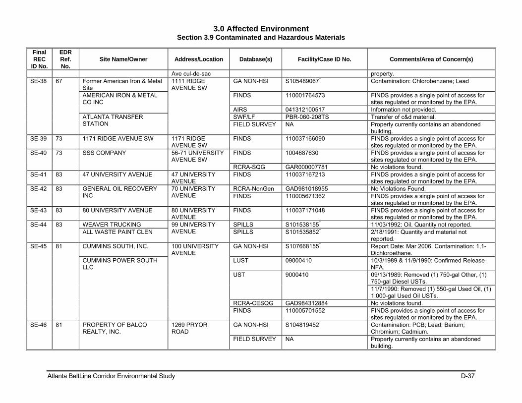
3.0 Affected Environment Section 3.9 Contaminated and Hazardous Materials
Atlanta BeltLine Corridor Environmental Study D-37
Final REC
ID No.
EDR Ref. No.
Site Name/Owner Address/Location Database(s) Facility/Case ID No. Comments/Area of Concern(s)
Ave cul-de-sac property. SE-38 67 Former American Iron & Metal
Site 1111 RIDGE AVENUE SW
GA NON-HSI S105489067† Contamination: Chlorobenzene; Lead
AMERICAN IRON & METAL CO INC
FINDS 110001764573 FINDS provides a single point of access for sites regulated or monitored by the EPA.
AIRS 041312100517 Information not provided. ATLANTA TRANSFER STATION
SWF/LF PBR-060-208TS Transfer of c&d material. FIELD SURVEY NA Property currently contains an abandoned
building. SE-39 73 1171 RIDGE AVENUE SW 1171 RIDGE
AVENUE SW FINDS 110037166090 FINDS provides a single point of access for
sites regulated or monitored by the EPA. SE-40 73 SSS COMPANY 56-71 UNIVERSITY
AVENUE SW FINDS 1004687630 FINDS provides a single point of access for
sites regulated or monitored by the EPA. RCRA-SQG GAR000007781 No violations found.
SE-41 83 47 UNIVERSITY AVENUE 47 UNIVERSITY AVENUE
FINDS 110037167213 FINDS provides a single point of access for sites regulated or monitored by the EPA.
SE-42 83 GENERAL OIL RECOVERY INC
70 UNIVERSITY AVENUE
RCRA-NonGen GAD981018955 No Violations Found. FINDS 110005671362 FINDS provides a single point of access for
sites regulated or monitored by the EPA. SE-43 83 80 UNIVERSITY AVENUE 80 UNIVERSITY
AVENUE FINDS 110037171048 FINDS provides a single point of access for
sites regulated or monitored by the EPA. SE-44 83 WEAVER TRUCKING 99 UNIVERSITY
AVENUE SPILLS S101538155† 11/03/1992: Oil. Quantity not reported.
ALL WASTE PAINT CLEN SPILLS S101535852† 2/18/1991: Quantity and material not reported.
SE-45 81 CUMMINS SOUTH, INC. 100 UNIVERSITY AVENUE
GA NON-HSI S107668155† Report Date: Mar 2006. Contamination: 1,1-Dichloroethane.
CUMMINS POWER SOUTH LLC
LUST 09000410 10/3/1989 & 11/9/1990: Confirmed Release-NFA.
UST 9000410 09/13/1989: Removed (1) 750-gal Other, (1) 750-gal Diesel USTs. 11/7/1990: Removed (1) 550-gal Used Oil, (1) 1,000-gal Used Oil USTs.
RCRA-CESQG GAD984312884 No violations found. FINDS 110005701552 FINDS provides a single point of access for
sites regulated or monitored by the EPA. SE-46 81 PROPERTY OF BALCO
REALTY, INC. 1269 PRYOR ROAD
GA NON-HSI S104819452† Contamination: PCB; Lead; Barium; Chromium; Cadmium.
FIELD SURVEY NA Property currently contains an abandoned building.

3.0 Affected Environment Section 3.9 Contaminated and Hazardous Materials
Atlanta BeltLine Corridor Environmental Study D-38
Final REC
ID No.
EDR Ref. No.
Site Name/Owner Address/Location Database(s) Facility/Case ID No. Comments/Area of Concern(s)
SE-47 81 3156 CLAIRE GSM 1275 PRYOR ROAD
TIER 2 FATR22008FAWS0147350 Date Tier 2 Signed: 1/16/2009. 1275 PRYOR ROAD SPILLS S105229682† 12/12/2001: Spill of Paint and Oil at Sandy's
Body Shop. FIELD SURVEY NA Property is currently vacant.
SE-48 NA VACANT LOT/COMMERCIAL South of tracks on Pryor Rd.
FIELD SURVEY NA Apparent former industrial/distribution property.
SE-49 76 GREAT DANE TRAILERS INC 660 UNIVERSITY AVENUE, SW
FINDS 110001425459 FINDS provides a single point of access for sites regulated or monitored by the EPA.
AIRS 041312100733 State Facility Identifier: 312100733. SE-50 77 FREIGHT DIRECT 554 UNIVERSITY
AVENUE SW SPILLS S101643910† 9/2/1994: Anti-Freeze into Storm Drain. SPILLS S102602026† 9/2/1994: Anti-Freeze into Storm Drain. FIELD SURVEY NA Property currently operates as Metro Truck
and Tire Service. Abandoned building and monitoring wells observed on site.
SE-51 78 BROWN TRANSPORT CORP 352 UNIVERSITY AVENUE SW
FINDS 110009354992 FINDS provides a single point of access for sites regulated or monitored by the EPA.
LUST 00600903 9/18/2000: Confirmed Release-NFA. UST 600903 (1) 10,000-gal Gas, (2) 12,000-gal Diesel, (2)
10,000-gal Diesel, (1) 12,000-gal Other, (1) 10,000-gal Other, (1) 2,000-gal Used Oil USTs Currently In Use (Date Unknown).
RCRA-NonGen GAD033512153 Facility Has Received Notices of Violations. SOUTHERN FREIGHT FINDS 110005664147 FINDS provides a single point of access for
sites regulated or monitored by the EPA. RCRA-NonGen GA0000959080 No violations found.
SE-52 79 278 UNIVERSITY AVENUE 278 UNIVERSITY AVENUE
FINDS 110037167133 FINDS provides a single point of access for sites regulated or monitored by the EPA.
CAPITAL FORD TRUCK SALES INC
290 UNIVERSITY AVENUE SW
RCRA-NonGen GAD981220486 No violations found. FINDS 110005674948 FINDS provides a single point of access for
sites regulated or monitored by the EPA. FIELD SURVEY NA 290 University Ave is now Sampson Food, an
active site. Captial Ford contains an abandoned building between Sampson Food and Brown Trucking.
SE-53 79 BAGGETT TRANSPORTATION/CAPITOL S
260 UNIVERSITY AVENUE SW
FINDS 110013660476 FINDS provides a single point of access for sites regulated or monitored by the EPA.
LUST 00600307 1/8/1992: Confirmed Release-NFA. UST 600307 12/20/1991: Removed (2) 6,000-gal Diesel,
(1) 1,000-gal Used Oil, (1) 10,000-gal Diesel

3.0 Affected Environment Section 3.9 Contaminated and Hazardous Materials
Atlanta BeltLine Corridor Environmental Study D-39
Final REC
ID No.
EDR Ref. No.
Site Name/Owner Address/Location Database(s) Facility/Case ID No. Comments/Area of Concern(s)
USTs. 06/15/1973: (1) 5,000-gal Other UST Closed In-Ground.
SOUTHEASTERN STAGES INC
UST 9060839 8/30/2000: (1) 15,000-gal Diesel UST Currently In-Use.
Orphan TIER 2 FATR20086BSFU8002RBG Date Tier 2 Signed: 2/19/2009. SE-54 76 FAST FILL FOODMART 1241
METROPOLITAN PARKWAY
FINDS 110013507311 FINDS provides a single point of access for sites regulated or monitored by the EPA.
UST 600792 1/1/1987: Removed (3) 8,000-gal Gas USTs. (1) 15,000-gal Gas UST Permanently Out of Use. 01/05/1999: (3) 8,000-gal Gas USTs Currently In Use. Site is an active Chevron Gas Station.
SE-55 76 CHEVRON FOOD MART 1217 METROPOLITAN PARKWAY
UST 10001026 As of 10/01/2005: (1) 15,000-gal Gas, (1) 10,000-gal Gas, (1) 5,000-gal Diesel USTs in use.
FIELD SURVEY NA Site is an active Texaco Gas Station. SE-56 85 1275 METROPOLITAN
PARKWAY SW 1275 METROPOLITAN PARKWAY SW
FINDS 110037166205 FINDS provides a single point of access for sites regulated or monitored by the EPA.
FIELD SURVEY NA Current vacant lot. An abandoned auto repair facility is adjacent and south of 1275 Metropolitan Parkway.
SE-57 NA DIXIE PULP AND PAPER 1240 Metropolitan Pkwy
FIELD SURVEY NA Active industrial property.
SE-58 63 J & W PALLET & DRUM CO 1121 ALLENE AVENUE
CERCLIS 0407788 08/22/2008: Administrative order on consent. ICIS 04-2008-3772 CERCLA 122h Agrmt For Cost Recovery. FINDS 110009357695 FINDS provides a single point of access for
sites regulated or monitored by the EPA. RCRA-NonGen GAD984310797 No violations found.
SE-59 NA FORMER INDUSTRIAL BUILDING
Allene Ave. (S. of Proposed Atlanta BeltLine)
FIELD SURVEY NA Abandoned building present on property.
SE-60 49 SNAPFINGER WWT PLANT 981 Allene Ave SW SPILLS S101643846† Spill Date: 05/21/1994. Anionic Polyacrylic. SE-61 63 HARMON BROTHERS
CHARTER SERVICE 1160 ALLENE AVENUE SW
FINDS 1011854335 FINDS provides a single point of access for sites regulated or monitored by the EPA.
UST 9060535 As of 12/02/1998: (1) 10,000-gal Diesel, (1) 4,000-gal Gas, (1) 2,000-gal Gas, (1) 1,000-gal Kerosene USTs in use.

3.0 Affected Environment Section 3.9 Contaminated and Hazardous Materials
Atlanta BeltLine Corridor Environmental Study D-40
Final REC
ID No.
EDR Ref. No.
Site Name/Owner Address/Location Database(s) Facility/Case ID No. Comments/Area of Concern(s)
FINDS 110013571599 FINDS provides a single point of access for sites regulated or monitored by the EPA.
LUST 09060535 1/7/1999: Confirmed Release-NFA. FIELD SURVEY NA Abandoned building; monitoring wells, drums,
staining present. SE-62 63 SPRINT COMMUNICATIONS
COMPANY LP 1190 ALLENE AVENUE
FINDS 110013543638 FINDS provides a single point of access for sites regulated or monitored by the EPA.
UST 9060043 10/5/2000: (1) 10,000-gal Diesel and (1) 6,000-gal Diesel USTs Currently In Use .
Sprint - Atlanta, GA LD Switch TIER 2 FATR20081YS66402BJ5Y Date Tier 2 Signed: 1/31/2009. SE-63 63 ESB INC 1246 ALLENE
AVENUE SW ICIS 110001750999 Program ID: CERCLIS GAD078105749.
Enforcement Action Type: CERCLA 106 AO For Resp Action/Imm Haz.
SHWS 10778 This site has a known release of Lead in soil at levels exceeding the reportable quantity. Investigations are being conducted to determine how much cleanup in necessary for source materials, soil, and groundwater.
ESB INC 1214 ALLENE AVENUE SW
CERCLIS 401568 Removal Only Site (No Site Assessment Work Needed). Alias Name: EXIDE,INC.
FINDS 110001750999 FINDS provides a single point of access for sites regulated or monitored by the EPA.
RCRA-CESQG GAD078105749 Facility Has Received Notices of Violations. SE-64 47SW CUSTOM AUTO PARTS 902 MURPHY
AVENUE FINDS 110001971322 FINDS provides a single point of access for
sites regulated or monitored by the EPA. FIELD SURVEY NA Active site; address appears to be 982
Murphy Ave. SE-65 49SW Unpaint Corporation Property 920 Murphy Ave. BROWNFIELDS S107031932† Cleanup Completed: 6/9/2005. SE-66 47SW EXHIBITS PLUS INC 900 MURPHY
AVENUE FINDS 110001418975 FINDS provides a single point of access for
sites regulated or monitored by the EPA. AIRS 041312100757 State Facility Identifier: 312100757. FIELD SURVEY NA Abandoned building.
SE-67 47SW ABANDONED DRUMS 895 MURPHY AVENUE
SPILLS S101533152† Spill Date: 10/19/1993. Substance Unknown. FIELD SURVEY NA Abandoned building.
CHURCHILL INC 892 MURPHY AVENUE
FINDS 110001421827 FINDS provides a single point of access for sites regulated or monitored by the EPA.
AIRS 041312100231 State Facility Identifier: 312100231. FIELD SURVEY NA Abandoned building 892 & 884 Murphy
Street.
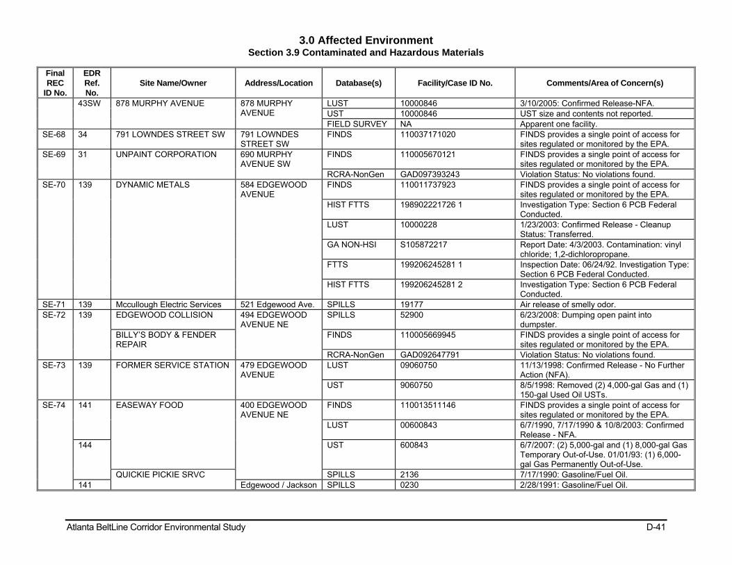
3.0 Affected Environment Section 3.9 Contaminated and Hazardous Materials
Atlanta BeltLine Corridor Environmental Study D-41
Final REC
ID No.
EDR Ref. No.
Site Name/Owner Address/Location Database(s) Facility/Case ID No. Comments/Area of Concern(s)
43SW 878 MURPHY AVENUE 878 MURPHY AVENUE
LUST 10000846 3/10/2005: Confirmed Release-NFA. UST 10000846 UST size and contents not reported. FIELD SURVEY NA Apparent one facility.
SE-68 34 791 LOWNDES STREET SW 791 LOWNDES STREET SW
FINDS 110037171020 FINDS provides a single point of access for sites regulated or monitored by the EPA.
SE-69 31 UNPAINT CORPORATION 690 MURPHY AVENUE SW
FINDS 110005670121 FINDS provides a single point of access for sites regulated or monitored by the EPA.
RCRA-NonGen GAD097393243 Violation Status: No violations found. SE-70 139 DYNAMIC METALS 584 EDGEWOOD
AVENUE FINDS 110011737923 FINDS provides a single point of access for
sites regulated or monitored by the EPA. HIST FTTS 198902221726 1 Investigation Type: Section 6 PCB Federal
Conducted. LUST 10000228 1/23/2003: Confirmed Release - Cleanup
Status: Transferred. GA NON-HSI S105872217 Report Date: 4/3/2003. Contamination: vinyl
chloride; 1,2-dichloropropane. FTTS 199206245281 1 Inspection Date: 06/24/92. Investigation Type:
Section 6 PCB Federal Conducted. HIST FTTS 199206245281 2 Investigation Type: Section 6 PCB Federal
Conducted. SE-71 139 Mccullough Electric Services 521 Edgewood Ave. SPILLS 19177 Air release of smelly odor. SE-72 139 EDGEWOOD COLLISION 494 EDGEWOOD
AVENUE NE SPILLS 52900 6/23/2008: Dumping open paint into
dumpster. BILLY’S BODY & FENDER REPAIR
FINDS 110005669945 FINDS provides a single point of access for sites regulated or monitored by the EPA.
RCRA-NonGen GAD092647791 Violation Status: No violations found. SE-73 139 FORMER SERVICE STATION 479 EDGEWOOD
AVENUE LUST 09060750 11/13/1998: Confirmed Release - No Further
Action (NFA). UST 9060750 8/5/1998: Removed (2) 4,000-gal Gas and (1)
150-gal Used Oil USTs. SE-74 141 EASEWAY FOOD 400 EDGEWOOD
AVENUE NE FINDS 110013511146 FINDS provides a single point of access for
sites regulated or monitored by the EPA. LUST 00600843 6/7/1990, 7/17/1990 & 10/8/2003: Confirmed
Release - NFA. 144 UST 600843 6/7/2007: (2) 5,000-gal and (1) 8,000-gal Gas
Temporary Out-of-Use. 01/01/93: (1) 6,000-gal Gas Permanently Out-of-Use.
QUICKIE PICKIE SRVC SPILLS 2136 7/17/1990: Gasoline/Fuel Oil. 141 Edgewood / Jackson SPILLS 0230 2/28/1991: Gasoline/Fuel Oil.

3.0 Affected Environment Section 3.9 Contaminated and Hazardous Materials
Atlanta BeltLine Corridor Environmental Study D-42
Final REC
ID No.
EDR Ref. No.
Site Name/Owner Address/Location Database(s) Facility/Case ID No. Comments/Area of Concern(s)
St SE-75 144 HOON J KIM/FLEET OIL CO
#211 346 EDGEWOOD AVENUE NE
UST 601296 3/22/1993: Removed (3) 6,000-gal Gas USTs.
SE-76 Orphan 15 HILLIARD STREET 15 HILLIARD STREET
BROWNFIELDS S109504912 Cleanup Plan Date: 2/5/2009. GA NON-HSI Not Provided Report Date: 2/3/2009.
SE-77 Orphan ANTOINE GRAVES ANNEX 110 Hilliard St GA NON-HSI S109016332 Report Date: 2/5/2009. Contamination - Lead. SE-78 Orphan GRAVES HIGH RISE 126 Hilliard St GA NON-HSI S109016333 Report Date:1/20/2009. Contamination -
Lead. SE-79 149 FORMER GRADY HOMES 100 BELL STREET FINDS 110005720648 FINDS provides a single point of access for
sites regulated or monitored by the EPA. RCRA-LQG GAR000025205 Owner/operator name: City of Altanta Housing
Authority. No Violations Found. Waste Name: Lead.
SE-80 151 380 DECATUR STREET 380 DECATUR STREET
BROWNFIELDS S109350683 Cleanup Plan Date: 10/14/2008. Contamination: Chloroform.
GA NON-HSI Not Provided Report Date: 10/23/2008. SE-81 151 US CONTRACTING 349 DECATUR
STREET FINDS 110005663228 FINDS provides a single point of access for
sites regulated or monitored by the EPA. RCRA-NonGen GA0000000083 No violations found. RCRA-NonGen GAR000000083 No violations found.
FRONTIER COMMUNICATIONS INTERNATIONAL
FINDS 110013567336 FINDS provides a single point of access for sites regulated or monitored by the EPA.
LUST 09060499 1/13/2006: Confirmed Release-NFA. SE-82 151 DECATUR STREET
PROPERTY 317-349 DECATUR STREET
GA NON-HSI S107150840 Report Date: 6/5/2005. Contamination: Tetrachloroethene and Lead.
SE-83 151 229 GRANT STREET 229 Grant St BROWNFIELDS S106780264 Cleanup Completed: 12/23/1999. 227-229 Grant St DEL SHWS S104550862 Delist Date: 2/2/2005.
SE-84 151 T MARZETTI CO ATLANTA DIVISION
261 GRANT STREET
UST 600634 11/1/1998: (1) 8,300-gal Other and (1) 6,000-gal Gas USTs Closed In-Place.
FINDS 110022448038 FINDS provides a single point of access for sites regulated or monitored by the EPA.
261 GRANT STREET SPILLS S106488069 06/29/2004: Sulfuric Acid release to air. SE-85 151 HARP TRANSMISSION 350 MEMORIAL
DRIVE FINDS 110005279929 FINDS provides a single point of access for
sites regulated or monitored by the EPA. RCRA-SQG GA0000135566 No violations found.
SE-86 151 MILLION CAB CO INC 359 MEMORIAL DRIVE S E
UST 440528 (1) 5,000-gal empty UST Permanently Out-of-Use.
SE-87 151 FORMER GASOLINE STATION SITE
363 MEMORIAL DRIVE SE
LUST 10000843 3/9/2005: Confirmed Release-NFA. UST 10000843 Tank ID not reported.

3.0 Affected Environment Section 3.9 Contaminated and Hazardous Materials
Atlanta BeltLine Corridor Environmental Study D-43
Final REC
ID No.
EDR Ref. No.
Site Name/Owner Address/Location Database(s) Facility/Case ID No. Comments/Area of Concern(s)
SE-88 151 SEWELL SUPPLY CO 273 OAKLAND AVENUE
LUST 00600064 7/17/1997: Confirmed Release-NFA. UST 600064 3/1/1990: Removed (1) 1,000-gal Gas and (1)
500-gal Empty UST. 273 OAKLAND AVENUE FINDS 110037167124 FINDS provides a single point of access for
sites regulated or monitored by the EPA. SE-89 151 EXPRESS CLEANERS 415 Memorial Dr SE
# A DRYCLEANERS S109505595 Primary SIC code: 721201.
SE-90 151 FRED E RIMER CO INC 307 CHEROKEE AVENUE SE
LUST 09060761 2/18/1999: Confirmed Release-NFA. UST 9060761 1/28/1993: (2) 500-gal Gas USTs Closed-in-
Place. SE-91 151 CALAMITY JANE LLC
(FORMER SERVICE STATION)
437 MEMORIAL DRIVE
LUST 10001313 4/2/2007: Confirmed Release-NFA. GA NON-HSI S108475724 Report Date: 3/7/2007. Contamination:
Trichloroethene. UST 10001313 Tank ID Not Reported.
SE-92 157 LARKIN COILS 519 MEMORIAL DRIVE
RCRA-SQG GAD003274255 No violations found. SHWS 10088 Trichloroethene; Chloroform; Carbon
tetrachloride; Tetrachlorethene; Dichloroethylene; N.O.S.; 1,1,2,-Trichloroethane; Carbon disulfide; and Dichloromethane detected in groundwater.
FINDS 110001323522 FINDS provides a single point of access for sites regulated or monitored by the EPA.
CERC-NFRAP 0401318 Site Inspection completed on 07/28/1989. GA NON-HSI Not Provided Contamination: Not reported.
SE-93 157 VETERANS RADIATOR SHOP
533 MEMORIAL DRIVE, SE
SPILLS S101535949 5/28/1991: Unidentified Hazardous Material. FINDS 110001765741 FINDS provides a single point of access for
sites regulated or monitored by the EPA. SPILLS S1005525348 12/16/2003: Radiator shop reportedly
dumping anti-freeze into ditch. ERNS 2003708197 SE-94 157 563 MEMORIAL DRIVE 563 MEMORIAL
DRIVE LUST 10000593 3/10/2004 & 8/17/2006: Confirmed Release-
NFA. UST 10000593 Status Not Reported.
SE-95 157 BLESSIN TIRE SHOP 600 MEMORIAL DRIVE SE
LUST 09060833 4/18/2000: Confirmed Release-NFA. UST 9060833 (1) Diesel UST Upgrade Repair Not Marked.
Date not provided. SE-96 157 FORMER PHILLIPS 66 603 MEMORIAL
DRIVE LUST 09060653 8/7/1997: Confirmed Release-NFA. UST 9060653 2/1/1997: Removed (2) 2,000-gal and (1)
4,000-gal Gas USTs. SE-97 157 AUTO GALLERY 674 MEMORIAL FINDS 110006398996 FINDS provides a single point of access for

3.0 Affected Environment Section 3.9 Contaminated and Hazardous Materials
Atlanta BeltLine Corridor Environmental Study D-44
Final REC
ID No.
EDR Ref. No.
Site Name/Owner Address/Location Database(s) Facility/Case ID No. Comments/Area of Concern(s)
DRIVE sites regulated or monitored by the EPA. RCRA-SQG GAR000014589 Facility Has Received Notices of Violations.
SE-98 153 CURTIN BODY SHOP 710 MEMORIAL DRIVE SE
FINDS 110005702695 FINDS provides a single point of access for sites regulated or monitored by the EPA.
RCRA-CESQG GAD984316513 No violations found. SE-99 153 TOTAL DISTRIBUTION SVC
INC 736 MEMORIAL DRIVE SE
LUST 00600218 8/24/1995: Confirmed Release-NFA. UST 600218 4/24/1995: Removed (2) 10,000-gal, (1)
1,000-gal Gas USTs. SE-100
153 GENERAL GMC TRUCKS INC 745 MEMORIAL DRIVE SE
FINDS 110005675288 FINDS provides a single point of access for sites regulated or monitored by the EPA.
RCRA-NonGen GAD981221013 No violations found. SE-101
153 Atlanta Dairies Cooperative 777 MEMORIAL DRIVE
AIRS S107749812 State Facility Identifier: 312100083. ATLANTA DAIRY LLC LUST 09060030 7/5/1991: Confirmed Release-NFA.
UST 9060030 5/14/1990: Removed (2) 8,000-gal Gas, (1) 500-gal Gas, (1) 8,000-gal Diesel, (1) 500-gal Used Oil USTs. 08/01/2007: Installed (1) 15,000-gal Diesel UST.
SPILLS 30286 11/10/2004: Ammonia spill caused by vandalism.
FLAGSHIP ATLANTA DAIRY, LLC
FINDS 110000357550 FINDS provides a single point of access for sites regulated or monitored by the EPA.
SPILLS S1000153235 5/22/1997: 100 gals of diesel fuel. Clean up the same day.
RCRA-NonGen GAD981246044 No violations found. TIER 2 FATR20086BB66S002XPR Date Tier 2 Signed: 2/12/2009.
ATLANTA DAIRIES 777 Memorial Dr SE SPILLS S104884706 10/24/1991: Hazardous Material. NEW ATLANTA DAIRIES 777 Memorial Dr.
(Parking Lot) SPILLS S101530768 6/7/1995: Diesel Fuel Spill. Quanity not
reported. ATLANTA FLAGSHIP DAIRY, LLC
777 AND 833 Memorial Dr. SE
GA NON-HSI S107668145 Report Date: 3/6/2006. Contamination: Tetrachloroethene.
SE-102
153 NEXTRAN TRUCK CENTER ATLANTA
780 MEMORIAL DRIVE SE
RCRA-SQG GAD981266307 No violations found. FINDS 110005282568 FINDS provides a single point of access for
sites regulated or monitored by the EPA. UST 600238 4/6/1990: Removed (1) 550-gal Used Oil
UST. SE-103
153 APD TRANSMISSION PARTS INC
824 MEMORIAL DRIVE SE
FINDS 110005684768 FINDS provides a single point of access for sites regulated or monitored by the EPA.
UST 9060026 3/1/1986: (1) UST removed. Size and contents not provided.

3.0 Affected Environment Section 3.9 Contaminated and Hazardous Materials
Atlanta BeltLine Corridor Environmental Study D-45
Final REC
ID No.
EDR Ref. No.
Site Name/Owner Address/Location Database(s) Facility/Case ID No. Comments/Area of Concern(s)
RCRA-NonGen GAD981265903 No violations found. 824-846 MEMORIAL DRIVE 824-846 Memorial
Dr BROWNFIELDS S108517874 Cleanup Completed: 3/18/2008.
Orphan FORMER APD TRANSMISSION
824-846 Memorial Dr
GA NON-HSI Not Provided Report Date: 5/8/2008. Contamination - Lead.
SE-104
153 Commercial Office/Warehouse Property
841-845 Memorial Dr
GA NON-HSI S106854556 Report Date: 2/5/2005. Contamination: cis-1,2-Dichloroethene.
SE-105
153 POLAR BOY INC 878 MEMORIAL DRIVE SE
LUST 04440453 2/15/2001: Confirmed Release-NFA. UST 4440453 8/12/1988: Removed (1) 1,000-gal Gas UST.
a.k.a. UNOCAL. 878 MEMORIAL DRIVE GA NON-HSI S105037281† Report Date: Jan 2001. Contamination:
Styrene, Soil Releases. SE-106
153 TIRE MOUNTAIN 269 CHESTER AVENUE
BROWNFIELDS S108118639 Cleanup Completed : 8/8/2007. GA NON-HSI N/A Report Date: 1/15/2008. Contamination: 1,1-
dichloroethene, Trichloroethene. SE-107
153 CHESTER AVENUE SITE 225 CHESTER AVENUE
GA NON-HSI S107668149† Report Date: April 2006. Contamination: Trichloroethylene.
SE-108
153 MALONE DISPLAYS INC 215 CHESTER AVENUE SE
UST 9060065 2/15/1990: Removed (1) 10,000-gal Gas UST.
SE-109
153 199 CHESTER AVENUE SE 199 CHESTER AVENUE SE
FINDS 110037166982 FINDS provides a single point of access for sites regulated or monitored by the EPA.
SE-110
153 878 FULTON TERRACE SE 878 FULTON TERRACE SE
FINDS 110037171271 FINDS provides a single point of access for sites regulated or monitored by the EPA.
SE-111
153 LEGGETT & PLATT INCORPORATED - MAST
905 MEMORIAL DRIVE, SE
TIER 2 FATR20082SJSZ9002J45 Date Tier 2 Signed: 01/14/2009. a.k.a. Showcase, Partition, Shelving, and Locker Manufacturing.
FINDS 110001420506 FINDS provides a single point of access for sites regulated or monitored by the EPA.
RCRA-CESQG GAD061422507 Conditionally Exempt Small Quantity Generator.
UST 9000626 7/5/1990: Removed (4) 4,000-gal Gas, (2) 8,000-gal Hazardous Substance, (1) 500-gal Used Oil, (2) 8,000-gal Other, & (2) 2,000-gal Empty USTs. 01/04/1991: (1) 1,000-gal Diesel, (2) 1,000-gal Gas USTs Currently In-Use.
MASTERACK AIRS 041312100546 State Facility Identifier: 312100546. SE-112
O3 ARAMARK-DEKALB AVENUE SITE
670 AND 690 DEKALB AVENUE
BROWNFIELDS S108256293 Cleanup Plan Completed: 10/17/05; residential

3.0 Affected Environment Section 3.9 Contaminated and Hazardous Materials
Atlanta BeltLine Corridor Environmental Study D-46
Table 3.9-1c: Preliminary Contaminated Sites and/or Hazardous Materials Sites Within 300-Foot Buffer Area (Southwest Zone)
Final REC ID
No.
EDR Ref. No.
Site Name/Owner Address/Location Database(s) Facility/Case ID No. Comments/Area of Concern(s)
SW-1 24 V.T. USED TIRES 715 WEST Whitehall St
GA NON-HSI S105174723† Report Date: Sep 2001. Contamination: Not Reported.
SW-2 NA WEST END AUTOMOTIVE SW Corner Beecher and Lee St.s
FIELD SURVEY NA Automotive repair facility.
SW-3 39 MIKE HINDMAN 819 Lee St SW SPILLS S101643954† Spill Date: 07/19/1994. Motor Oil. SW-4 44 FORMER LEE STREET
STATION 889 LEE STREET LUST 10000114 8/21/2002: Confirmed Release-Monitoring Only.
UST 10000114 1/1/1981: (1) 10,000-gal Gas UST Closed in Place.
FIELD SURVEY NA Site is a vacant lot. SW-5 50 918 LEE STREET SW 918 LEE STREET
SW FINDS 110037165509 FINDS provides a single point of access for sites
regulated or monitored by the EPA. FIELD SURVEY NA Site is a vacant lot.
SW-6 49 THE RIGHT STUFF STORE #80
923 LEE STREET FINDS 110013482935 FINDS provides a single point of access for sites regulated or monitored by the EPA.
BOOKWORLD USA LLC DBA AKS CHEVRON
LUST 00601121 5/22/1996: Confirmed Release-NFA Remediation.
UST 601121 12/1/1985: (2) 10,000-gal Gas, (1) 8,000-gal Gas, (1) 8,000-gal Diesel and (1) 4,000-gal Kerosene USTs Currently in Use.
SW-7 50 Excellent Foods Warehouse
933 LEE STREET SW
SPILLS S102918642† Anhydrous Ammonia Release.
ALTERMAN COLD STORAGE
LUST 09060811 1/25/2000: Confirmed Release-NFA. UST 9060811 10/1/1999: Removed (1) 8,000-gal Diesel, (1)
8,000-gal Gas, (1) 6,000-gal Gas USTs. West End Cold Storage SPILLS S101644270† 7/18/1995: Ammonia Release. GES EXPOSITION SVCS FINDS
933-A LEE STREET FINDS 110005706067 FINDS provides a single point of access for sites regulated or monitored by the EPA.
RCRA-NonGen GAD984322586 No violations found. SW-8 NA COMMERICIAL
WAREHOUSE BUILDINGS WHITE STREET FIELD SURVEY NA This property did not show up on database
search. However, locations and descriptions similar to those included below which could not be located via current address.
41 ADM TRUCKING 818 ASHBY STREET
UST 600191 Removed: (1) 10,000-gal Gas, (1) 10,000-gal Diesel USTs (date unknown).
46 IRCC OF GEORGIA (FORMERLY PURITAN)
916 ASHBY STREET
GA NON-HSI S105872224† Report Date: Jun 2000. Contamination: Vinyl Chloride, Lead.
INDUSTRIAL RECOVERY CAPITAL COMP
LUST 09060829 2/25/2000: Confirmed Release-NFA. UST 9060829 1/5/2000: Removed (1) 8,000-gal Gas UST.

3.0 Affected Environment Section 3.9 Contaminated and Hazardous Materials
Atlanta BeltLine Corridor Environmental Study D-47
Final REC ID
No.
EDR Ref. No.
Site Name/Owner Address/Location Database(s) Facility/Case ID No. Comments/Area of Concern(s)
48 1008 WHITE STREET 1008 WHITE STREET
FINDS 110037165812 FINDS provides a single point of access for sites regulated or monitored by the EPA.
FIELD SURVEY NA Comercial office/warehouse with various businesses.
SW-8 continued
41 AIRPORT DELIVERY SERVICE (ADS MOVING)
858 ASHBY STREET NW
SPILLS S104874415† Spill Date: 08/18/2000, Diesel.
W.E. MARSHALL PETROLEUM PRODUCTS
SPILLS S104548807† Spill Date: 06/26/2000, Waste Oil. SPILLS S104874368† Spill Date: 06/23/2000, Waste Oil.
41 836 ASHBY STREET, NW 836 ASHBY STREET, NW
ERNS 92261685 03/22/1992: Unknown liquids from MOPAC into Peachtree Creek.
MOPAC PLANT & BUILDING SERVICES
SPILLS S101536617† Spill date: 03/22/1992, Unknown liquids into Peachtree Creek.
FINDS 110005714566 FINDS provides a single point of access for sites regulated or monitored by the EPA.
RCRA-CESQG GAR000013516 No violations found. 46 SIGNAL DELIVERY SRVC 925 ASHBY
STREET SPILLS S101533551† Spill Date: 06/05/1991: Gasoline/Fuel Oil into
Storm Drain. 46 981 ASHBY STREET 981 Ashby St LUST 10000434 9/8/2003: Confirmed Release-NFA.
SW-9 36 1135 WHITE STREET SW 1135 WHITE STREET SW
FINDS 110037166027 FINDS provides a single point of access for sites regulated or monitored by the EPA.
34 1100 WHITE STREET 1100 WHITE STREET SW
ERNS 92291362 Spill date: 09/08/1992: 250 gals of Diesel. ATLANTA CARRIER CENTER LLC
LUST 09000617 11/28/2000: Confirmed Release-NFA. UST 9000617 07/15/1990: Removed (1) 8,000-gal Other, (1)
6,000-gal Other, (1) 1,000-gal Other, (1) 550-gal Other USTs.
ATLANTA CARRIER CENTER LLC
UST 9000617 4/1/2000: Removed (1) 20,000-gal Diesel UST.
PENSKE TRANSPORTATION SERVICE
FINDS 110005712782 FINDS provides a single point of access for sites regulated or monitored by the EPA.
RCRA-NonGen GAR000010454 No violations found. SW-10 31 SUPERMARKET
DISTRIBUTION SERVICES
1200 WHITE STREET SW
FINDS 110005700955 FINDS provides a single point of access for sites regulated or monitored by the EPA.
RCRA-NonGen GAD984311803 No Violations Found. ADVANCED FOOD SPILLS S101531449† Spill Date: 02/18/1993, Gasoline/Fuel Oil into
Storm Drain. FIELD SURVEY NA Property currently identified as Czarnoski Events.
SW-11 54 952 DONNELLY AVENUE SW
952 DONNELLY AVENUE SW
FINDS 110037165554 FINDS provides a single point of access for sites regulated or monitored by the EPA.
SW-12 54 Level 3 Communications 953 DONNELLY TIER 2 FATR20084X5AY002TFLX Date Tier 2 Signed: 1/9/2009.

3.0 Affected Environment Section 3.9 Contaminated and Hazardous Materials
Atlanta BeltLine Corridor Environmental Study D-48
Final REC ID
No.
EDR Ref. No.
Site Name/Owner Address/Location Database(s) Facility/Case ID No. Comments/Area of Concern(s)
LLC AVENUE SW-13 58 MCI - ATGXGA 999 LEE STREET TIER 2 FATR200823VS8605WMBT Date Tier 2 Signed: 01/13/2009.
WORLDCOM FINDS 110005720452 FINDS provides a single point of access for sites regulated or monitored by the EPA.
RCRA-NonGen GAR000023259 No violations found. SW-14 54 CONSTRUCTION
HAULING INC 948 DONNELLY AVENUE
FINDS 110005683778 FINDS provides a single point of access for sites regulated or monitored by the EPA.
RCRA-NonGen GAD981261662 No violations found. J&L ASSOCIATES INC LUST 09060560 12/3/1998: Confirmed Release-NFA.
UST 9060560 10/01/1998: Removed (1) 10,000-gal Diesel and (1) 2,500-gal Gas USTs.
SW-15 52 988 DONNELLY AVENUE SW
988 DONNELLY AVENUE SW
FINDS 110037165581 FINDS provides a single point of access for sites regulated or monitored by the EPA.
SW-16 42 BELCA FOOD SERVICES 1101 DONNELLY AVENUE SW
SPILLS S104884791† Spill Date: 08/18/1994. Anhydrous Ammonia. SPILLS S101527557† Spill Date: 08/18/1994. Anhydrous Ammonia.
1101 DONNELLY AVENUE SW
FINDS 110037165974 FINDS provides a single point of access for sites regulated or monitored by the EPA.
FIELD SURVEY NA Abandoned building. SW-17 51 1035 DONNELLY AVENUE
PARTNERSHIP 1035 DONNELLY AVENUE
UST 7060001 3/11/1993: Removed (1) 8,000-gal Diesel UST.
TERRY ENTERPRISES INC
FINDS 110005720755 FINDS provides a single point of access for sites regulated or monitored by the EPA.
RCRA-NonGen GAR000025312 No violations found. SW-18 NA FORMER RAILROAD
ALIGNMENT FORMER RAILROAD ALIGNMENT
FIELD SURVEY NA Former railroad operations; potential for former and undocumented spills and releases. Potential polychlorinated biphenyls (PCBs), metals, semi-volatile organic compounds (SVOCs), herbicides and pesticides, lead-based paint and asbestos containing building materials on/in relic equipment or structures.
SW-19 18 GEORGIA FOOD MART 1355 R D ABERNATHY BOULEVARD
FINDS 110013527344 FINDS provides a single point of access for sites regulated or monitored by the EPA.
LUST 00601184 4/16/1992: Confirmed Release-NFA Remediation.
UST 601184 4/17/1985: (3) 12,000-gal Gas USTs. FIELD SURVEY NA Active gas station; monitoring wells present.
SW-20 NA AUTO TRANSMISSION FACILITY/COMMERCIAL BUILDINGS
Intersection of Ralph Gordon and Cascade Rd.
FIELD SURVEY NA Based upon field conditions, potential exists to be former Chevron Station #43020.

3.0 Affected Environment Section 3.9 Contaminated and Hazardous Materials
Atlanta BeltLine Corridor Environmental Study D-49
Table 3.9-1d: Preliminary Contaminated Sites and/or Hazardous Materials Sites Within 300-Foot Buffer Area (Northwest Zone)
Final REC ID
No.
EDR Ref. No.
Site Name/Owner Address/Location Database(s) Facility/Case ID No. Comments/Area of Concern(s)
NW-1 143 MUELLER PROPERTY NEWCASTLE STREET & MLK JR DRIVE
FINDS 110013414153 FINDS provides a single point of access for sites regulated or monitored by the EPA.
UST 9000316 (1) UST permanently out of use. Date and contents not provided.
NW-2 143 BP OIL CO 3 ASHBY STREET FINDS 110005692633 FINDS provides a single point of access for sites regulated or monitored by the EPA.
RCRA-NonGen GAD984290288 No violations found. BP #24031/GULF #640847 3 JOSEPH E
LOWRY BOULEVARD
LUST 09000445 11/8/1989: Confirmed Release-No Further Action (NFA).
UST 9000445 As of 09/01/1998: (3) 10,000-gal Gas USTs and (1) 10,000-gal Diesel UST currently in use.
NW-3 140 BP #24030/GULF #270645 825 MLK JR DRIVE UST 600829 (4) 3,000-gal Gas USTs removed. Date not provided.
NW-4 130 ASHBY ST AMOCO FOOD SHOP
949 MAYSON TURNER ROAD
FINDS 110005698655 FINDS provides a single point of access for sites regulated or monitored by the EPA.
RCRA-NonGen GAD984301887 No violations found. BP/AMOCO #6337 180 GA &
CENTRAL FINDS 110013518737 FINDS provides a single point of access for
sites regulated or monitored by the EPA. LUST 00600953 12/21/1999, 7/9/2002, 1/2/2004, 4/9/2004,
5/7/2004, 10/29/2004: Suspected Releases-NFA.
LUST 00600953 6/30/2005: Confirmed Release-Cleanup Initiated.
LUST 00600953 6/28/2004, 8/30/2004: Suspected Releases. UST 600953 5/2/2006: Removed (4) 10,000-gal Gas USTs
NW-5 129 RESIDENCE 139 STAFFORD STREET NW
FINDS 110006366280 FINDS provides a single point of access for sites regulated or monitored by the EPA.
RCRA-NonGen GAR000008060 No violations found. NW-6 127 1055 OLLIE CIRCLE 1055 OLLIE
CIRCLE SPILLS S105597801† 9/21/2002: spill no. 18985, unknown quantity of
raw sewage. NW-7 125 1099 WASHINGTON
HEIGHTS TER NW 1099 Washington Heights Terrace NW
FINDS 110037165965 FINDS provides a single point of access for sites regulated or monitored by the EPA.
NW-8 118 BMTS/MADDOX PARK SATELLITE STATION
1120 NORTH AVENUE NW
UST 600281 As of 3/30/1999: (1) 20,000-gal Diesel, (1) 12,000-gal Gas, (1) 1,000-gal Used Oil USTs currently in use. 10/1/1998: Removed (1) 6,000-gal Empty, (2) 6,000-gal Gas, (1) 20,000-gal Diesel, (1) 3,000-gal Oil, (1) 500-gal Used Oil USTs.

3.0 Affected Environment Section 3.9 Contaminated and Hazardous Materials
Atlanta BeltLine Corridor Environmental Study D-50
Final REC ID
No.
EDR Ref. No.
Site Name/Owner Address/Location Database(s) Facility/Case ID No. Comments/Area of Concern(s)
FINDS 110013488804 FINDS provides a single point of access for sites regulated or monitored by the EPA.
LUST 600281 7/29/1993: Confirmed Release-Monitoring Only NFA. 6/8/1993: Confirmed Release-Monitoring Only NFA.
118 NORTH AVENUE CSO 1150 North Ave. TIER 2 FATR2008252V5302DJV4 Date Tier 2 Signed: 2/25/2009. 118 1151 NORTH AVENUE NW 1151 NORTH
AVENUE NW FINDS 110037166054 FINDS provides a single point of access for
sites regulated or monitored by the EPA. NW-9 115 DRUM FIND Bankhead / Marietta
Blvd. SPILLS S101532832† 12/23/1993: Contents, type and size not
provided. NW-10 115 CSX RAILROAD 860 Marietta Blvd.
(between Bankhead) SPILLS S101528317† 7/19/1994: Gravel mixed with oil. Amount not
provided. 103 860 Marietta Blvd.
NW in front of Bldg. ERNS 94382498 7/19/1994: Caller states that the material was
dumped from the rail car. NW-11 114 MARTA: BANKHEAD
PARCEL No. 05000 GA NON-HSI S103439826† Contamination: Tetrachloroethylene; Acetone;
Chloroform; Methylene Chloride; cis-1,2-Dichloroethene
NW-12 109 Britt Carpet Laying Co Inc. 673 Rice St. NW UST 600672 4/9/1989: Removed (1) 3,000-gal Gas UST. NW-13 109 SMITH EQUIPMENT CO 751 RICE STREET
NW FINDS 110005685507 FINDS provides a single point of access for
sites regulated or monitored by the EPA. RCRA-NonGen GAD981268212 No violations found.
NW-14 109 1210 LOVELESS AVENUE 1210 LOVELESS AVENUE
FINDS 110037166161 FINDS provides a single point of access for sites regulated or monitored by the EPA.
NW-15 101 FULTON COUNTY CENTRAL MAINTENANCE
895 MARIETTA BOULEVARD
RCRA-SQG GAD984313932 No violations found. FINDS 110009357784 FINDS provides a single point of access for
sites regulated or monitored by the EPA. UST 9060122 As of 12/01/1998: (2) 12,000-gal Gas, (1)
12,000-gal Diesel, (1) 2,000-gal Kerosene, (3) 2,000-gal Other, (1) 4,000-gal Other USTs in use. 3/11/2003: (1) 6,000-gal Used Oil UST temporarily out of use. 3/1/1999: Removed (1) 2,000-gal Other UST.
LUST 09060122 4/1/1999: Confirmed Release-NFA. NW-15 continued
101 FULTON COUNTY JAIL 901 RICE STREET AST A100331007 (1) 30,000-gal above ground storage tank in use.
FINDS 110013481464 FINDS provides a single point of access for sites regulated or monitored by the EPA.

3.0 Affected Environment Section 3.9 Contaminated and Hazardous Materials
Atlanta BeltLine Corridor Environmental Study D-51
Final REC ID
No.
EDR Ref. No.
Site Name/Owner Address/Location Database(s) Facility/Case ID No. Comments/Area of Concern(s)
LUST 09060773 10/15/2003: Confirmed Release-NFA. UST 9060773 7/3/2003: Removed (1) 15,000-gal Diesel UST.
As of 8/22/2003: (1) 15,000-gal Diesel UST currently in use.
CITY OF ATLANTA 901 RICE STREET SPILLS S104885172† 12/4/1999: Spill into Proctor Creek. 101 902 RICE STREET 902 RICE STREET FINDS 110037165484 FINDS provides a single point of access for
sites regulated or monitored by the EPA. NW-16 103 829 MARIETTA
BOULEVARD NW 829 MARIETTA BOULEVARD NW
FINDS 110037171146 FINDS provides a single point of access for sites regulated or monitored by the EPA.
NW-17 109 FORMER AZS CORP 762 MARIETTA BOULEVARD NW
GA NON-HSI S104819398† Contamination: Not reported. AZS CORP SURFACE IMPOUNDMENTS
RCRA-SQG GAD981237225 Facility has received multiple notices of violations.
FINDS 110013761143 FINDS provides a single point of access for sites regulated or monitored by the EPA.
RCRA-TSDF GAD981237225 Handler is engaged in the treatment, storage or disposal of hazardous waste.
CORRACTS GAD981237225 CORRACTS Action Dates from 1/9/1985 to 9/8/2006.
FTTS Not Provided Final Order Date: 11/30/1995. Proposed Penalty: $145,000. Final Assessment: $55,000.
HIST FTTS Not Provided Final Order Date: 11/30/1995. Proposed Penalty: $145,000. Final Assessment: $55,000.
AZS CORP TSCA Not Provided Facility manufactures or imports multiple toxic chemicals on the TSCA list.
CARGILL INC TSCA 115-77-5 Facility manufactures or imports toxic chemicals on the TSCA list: 1,3-Propanediol, 2,2-bis(hydroxymethyl)-Pentaerythritol.
CERCLIS 401497 CERCLIS Report indicates that, "Compliance with RCRA post-closure requirements is questionable with this facility."
FINDS 110003603459 FINDS provides a single point of access for sites regulated or monitored by the EPA.
CORRACTS GAD057288144 CORRACTS activity began 11/8/1991. CERC-NFRAP 0401497 Not on the NPL. GA NON-HSI Not Provided Report Date: 3/1/1995. Contamination:
Methylene Chloride. RCRA-NonGen GAD057288144 Facility has received notices of violations. NY MANIFEST GAD057288144 32,900 lbs of Methyl Methacrylater (L,T)
transported and incinerated.
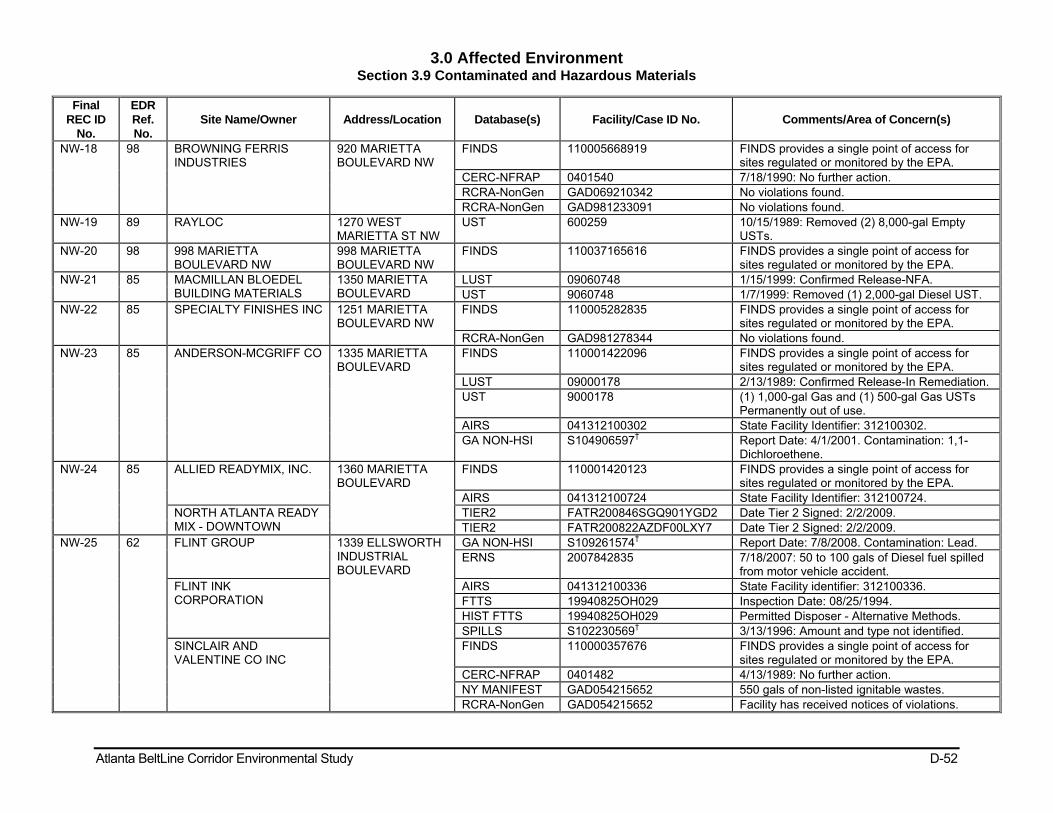
3.0 Affected Environment Section 3.9 Contaminated and Hazardous Materials
Atlanta BeltLine Corridor Environmental Study D-52
Final REC ID
No.
EDR Ref. No.
Site Name/Owner Address/Location Database(s) Facility/Case ID No. Comments/Area of Concern(s)
NW-18 98 BROWNING FERRIS INDUSTRIES
920 MARIETTA BOULEVARD NW
FINDS 110005668919 FINDS provides a single point of access for sites regulated or monitored by the EPA.
CERC-NFRAP 0401540 7/18/1990: No further action. RCRA-NonGen GAD069210342 No violations found. RCRA-NonGen GAD981233091 No violations found.
NW-19 89 RAYLOC 1270 WEST MARIETTA ST NW
UST 600259 10/15/1989: Removed (2) 8,000-gal Empty USTs.
NW-20 98 998 MARIETTA BOULEVARD NW
998 MARIETTA BOULEVARD NW
FINDS 110037165616 FINDS provides a single point of access for sites regulated or monitored by the EPA.
NW-21 85 MACMILLAN BLOEDEL BUILDING MATERIALS
1350 MARIETTA BOULEVARD
LUST 09060748 1/15/1999: Confirmed Release-NFA. UST 9060748 1/7/1999: Removed (1) 2,000-gal Diesel UST.
NW-22 85 SPECIALTY FINISHES INC 1251 MARIETTA BOULEVARD NW
FINDS 110005282835 FINDS provides a single point of access for sites regulated or monitored by the EPA.
RCRA-NonGen GAD981278344 No violations found. NW-23 85 ANDERSON-MCGRIFF CO 1335 MARIETTA
BOULEVARD FINDS 110001422096 FINDS provides a single point of access for
sites regulated or monitored by the EPA. LUST 09000178 2/13/1989: Confirmed Release-In Remediation. UST 9000178 (1) 1,000-gal Gas and (1) 500-gal Gas USTs
Permanently out of use. AIRS 041312100302 State Facility Identifier: 312100302. GA NON-HSI S104906597† Report Date: 4/1/2001. Contamination: 1,1-
Dichloroethene. NW-24 85 ALLIED READYMIX, INC. 1360 MARIETTA
BOULEVARD FINDS 110001420123 FINDS provides a single point of access for
sites regulated or monitored by the EPA. AIRS 041312100724 State Facility Identifier: 312100724.
NORTH ATLANTA READY MIX - DOWNTOWN
TIER2 FATR200846SGQ901YGD2 Date Tier 2 Signed: 2/2/2009. TIER2 FATR200822AZDF00LXY7 Date Tier 2 Signed: 2/2/2009.
NW-25 62 FLINT GROUP 1339 ELLSWORTH INDUSTRIAL BOULEVARD
GA NON-HSI S109261574† Report Date: 7/8/2008. Contamination: Lead. ERNS 2007842835 7/18/2007: 50 to 100 gals of Diesel fuel spilled
from motor vehicle accident. FLINT INK CORPORATION
AIRS 041312100336 State Facility identifier: 312100336. FTTS 19940825OH029 Inspection Date: 08/25/1994. HIST FTTS 19940825OH029 Permitted Disposer - Alternative Methods. SPILLS S102230569† 3/13/1996: Amount and type not identified.
SINCLAIR AND VALENTINE CO INC
FINDS 110000357676 FINDS provides a single point of access for sites regulated or monitored by the EPA.
CERC-NFRAP 0401482 4/13/1989: No further action. NY MANIFEST GAD054215652 550 gals of non-listed ignitable wastes. RCRA-NonGen GAD054215652 Facility has received notices of violations.

3.0 Affected Environment Section 3.9 Contaminated and Hazardous Materials
Atlanta BeltLine Corridor Environmental Study D-53
Final REC ID
No.
EDR Ref. No.
Site Name/Owner Address/Location Database(s) Facility/Case ID No. Comments/Area of Concern(s)
OVERNIGHT TRANSPORTATION
SPILLS S104548587† 1/6/2000: Spill into storm drains. Quantity and material not provided.
NW-26 68 REYNOLDS ALUMINUM SUPPLY CO
1441 ELLSWORTH IND DRIVE NW
UST 600056 5/25/1987: Removed (1) 10,000-gal Empty UST.
NW-27 63 1415 Howell Mill Rd. 1415 Howell Mill Rd. BROWNFIELDS S108988947† Cleanup Plan Date: 1/28/2008. NW-28 63 SUNBELT RENTALS PC
#055 1450 HOWELL MILL ROAD
SPILLS S106487807† 04/27/2004: A diesel taste was reported in the water fountain.
SPILLS S106487735† 04/13/2004: Diesel fuel was spilled on 04/12/2004 and into storm drain.
TIER2 FATR20085MND60001TTF Date Tier 2 Signed: 2/2/2009. FINDS 110037166278 FINDS provides a single point of access for
sites regulated or monitored by the EPA. NW-29 63 1465 HOWELL MILL ROAD
PROPERTY 1465 HOWELL MILL ROAD
GA NON-HSI S108782045† Report Date: 10/7/2007. Contamination: Trichloroethene.
NW-30 63 S J AUTOMOTIVE INC 1491 HOWELL MILL ROAD
FINDS 110005680539 FINDS provides a single point of access for sites regulated or monitored by the EPA.
RCRA-NonGen GAD981237506 No violations found. NW-31 66 CITY OF ATLANTA 711 Trabert Ave. SPILLS S102272916† 7/21/92: spill no. 0123, unknown material,
quantity, affected media. NW-32 66 VINTAGE MILL WORKS 670 Trabert Ave. GA NON-HSI S104819477† Ground water pathway score: 3.25; PCE. NW-33 63 782 TRABERT AVENUE
NW 782 Trabert Ave. NW
FINDS 110037170995 FINDS provides a single point of access for sites regulated or monitored by the EPA.
NW-34 65 613 TRABERT AVENUE NW
613 Trabert Ave. NW
FINDS 110037170548 FINDS provides a single point of access for sites regulated or monitored by the EPA.
NW-35 54 CECIL MALONE CO 696 Antone St. NW UST 9060044 4/18/1990: Removed (3) 1,000-gal Gas USTs. NW-36 54 WOOSTER PROPERTY 644 Antone St. NW GA NON-HSI S104819480† Contamination: Not reported. NW-37 58 ESSELTE PENDAFLEX -
DYMO DIVISION 1590 NORTHSIDE DRIVE NW
FINDS 110005669213 FINDS provides a single point of access for sites regulated or monitored by the EPA.
RCRA-NonGen GAD075939082 No violations found. NW-38 58 BMTS NORTHSIDE DRIVE
SERVICE CENTER 1540 NORTHSIDE DRIVE NW
FINDS 110013499026 FINDS provides a single point of access for sites regulated or monitored by the EPA.
LUST 00600284 6/30/1998: Confirmed Release-NFA. UST 600284 8/26/1998: Removed (1) 12,000-gal Gas UST.
6/28/1998: Installed (1) 12,000-gal Used Oil, (1) 12,000-gal Diesel, (1) 12,000-gal Gas USTs. 6/28/1998: Removed (1) 12,000-gal Gas, (1) 5,000-gal Empty, (1) 6,000-gal Empty, (1) 500-gal Used Oil, (1) 1,000-gal Other USTs.
CITY OF ATLANTA RCRA-SQG GAD981240898 Facility has received notices of violations.

3.0 Affected Environment Section 3.9 Contaminated and Hazardous Materials
Atlanta BeltLine Corridor Environmental Study D-54
Final REC ID
No.
EDR Ref. No.
Site Name/Owner Address/Location Database(s) Facility/Case ID No. Comments/Area of Concern(s)
FINDS 110005680806 FINDS provides a single point of access for sites regulated or monitored by the EPA.
SPILLS 1000440385 6/19/1997: 1,200 gals sewage spill. NW-39 58 POTTER & RAYFIELD 1570 NORTHSIDE
DRIVE FINDS 110001421596 FINDS provides a single point of access for
sites regulated or monitored by the EPA. MICRO VIEW SPILLS S101643808† 8/17/1994: Aqueous Ammonia.
AIRS 41312100046 State Facility Identifier: 312100046. NW-40 58 400 NORTHSIDE CIRCLE
NW 400 NORTHSIDE CIRCLE NW
FINDS 110037167188 FINDS provides a single point of access for sites regulated or monitored by the EPA.
NW-41 50 LECRAW JULIAN & COMPANY (STE 200)
1575 NORTHSIDE DRIVE NW
FINDS 110009358998 FINDS provides a single point of access for sites regulated or monitored by the EPA.
RCRA-NonGen GAR000013235 No violations found. JULIAN LECRAW & CO INC/ WINTERSET APT (PO BOX 4208)
FTTS 199512135687 Inspection Date: 12/13/1995. HIST FTTS 199512135687 Investigation Type: Section 6 PCB Federal
Conducted. USF&G FINDS 110009358854 FINDS provides a single point of access for
sites regulated or monitored by the EPA. RCRA-NonGen GAR000010322 No violations found.
200-400 Atlanta Tech Ctr. FINDS 110009358694 FINDS provides a single point of access for sites regulated or monitored by the EPA.
RCRA-NonGen GAR000009043 No violations found. Atlanta Tech Ctr. GA NON-HSI S104819360† Contamination: Not reported. 700 Atlanta Tech Ctr. GA NON-HSI S104819348† Contamination: Not reported. COLOR EXPRESS INC (STE 475)
FINDS 110009358408 FINDS provides a single point of access for sites regulated or monitored by the EPA.
RCRA-NonGen GAR000004994 No violations found. SPAUSCHUS ASSOCIATES INC
FINDS 110005698021 FINDS provides a single point of access for sites regulated or monitored by the EPA.
RCRA-NonGen GAD984300350 No violations found. NW-42 41 UNKNOWN 1593 Walthall Ct. SPILLS S102273301† Spill Date: 4/13/1993. NW-43 33 BIOMED SOUTHEAST COLLIER ROAD @
ARDMORE ROAD SPILLS S101530621† 2/25/1995: diesel spill to nearby stormdrain and
creek. NW-44 15 COLONIAL HOMES 240 COLONIAL
HOMES DRIVE SPILLS S105229614† 11/20/2001: Draining swimming pool water into
stormdrain which discharges to nearby stream. BROWNFIELDS S105229614† 4/6/2006: Cleanup completed 17 acres. GA NON-HSI S105229614† Report Date: 3/5/2005: Contaminants: Vinyl
Chloride and PCE. NW-45 11 KISS CLEANERS 2140 PEACHTREE
ROAD NW # 250B DRYCLEANER 664443173 Dry cleaning and laundry services.

3.0 Affected Environment Section 3.9 Contaminated and Hazardous Materials
Atlanta BeltLine Corridor Environmental Study D-55
Final REC ID
No.
EDR Ref. No.
Site Name/Owner Address/Location Database(s) Facility/Case ID No. Comments/Area of Concern(s)
NW-46 11 TRITON FACILITY 2166 PEACHTREE ROAD
LUST 09000351 2/10/1989: Confirmed release - cleanup intitiated.
UST 9000351 One UST permanently out of use, unknown contents and capacity.
BUCKHEAD BROOKWOOD ASSOC LP
FINDS 110005707388 FINDS provides a single point of access for sites regulated or monitored by the EPA.
RCRA-NonGen GAR000000398 No violations found. NW-47 11 NATIONSBANK OF GA
AND ELLIOTT GOLDS 75 BENNETT STREET
GA NON-HSI S105872226† Report Date: 3/1/1994.
NW-48 11 2105 TULA STREET NW 2105 TULA STREET NW
FINDS 110037167044 FINDS provides a single point of access for sites regulated or monitored by the EPA.
LUST 10000200 12/10/2002: Confirmed release - NFA. NW-49 11 BENNETT STREET, LTD. 2110 Peachtree St GA NON-HSI S104240223† Ground water pathway score: 3.25. NW-50 11 PALMERS FOOD STORE 2060 PEACHTREE
ROAD NW FINDS 110013518452 FINDS provides a single point of access for
sites regulated or monitored by the EPA. LUST 00600959 4/5/1995: Confirmed release - NFA. UST 600959 5/22/1978: (4) 10,000-gal Gas USTs installed.
NW-51 11 CLC ENTERPRISES INC/PROPOSED TGI
2065 PEACHTREE STREET NE
LUST 09060299 10/6/1993: Confirmed release - NFA. UST 9060299 9/28/1993: (2) 4,500-gal Gas USTs removed.
NW-52 20 CITY OF ATLANTA 385 CAMDEN ROAD
SPILLS S104885110† 4/26/1999: unknown quantity raw sewage discharged to Peachtree Creek.
NW-53 13 260 KINSEY COURT NE 260 KINSEY COURT NE
SPILLS S108118143† 8/2/2006: spill no. 40777, unknown quantity of material.
NW-55 35 COMPASS COLLECTIVE 165 OTTLEY DRIVE FINDS 110005718697 FINDS provides a single point of access for sites regulated or monitored by the EPA.
RCRA-CESQG GAR000020479 No violations found. NW-56 30 215 OTTLEY DRIVE NE 215 OTTLEY DRIVE
NE HMIRS 2005030677 3/9/2005: spill, unknown quanity and material.
NW-57 30 NATIONAL STARCH & CHEMICAL CORP
195 OTTLEY DRIVE NE
UST 600002 6/1/1988: Removed (1) 7,500-gal Heating Oil UST.
FINDS 110002101546 FINDS provides a single point of access for sites regulated or monitored by the EPA.
CERC-NFRAP 401301 8/1/1980: Discovery; 5/20/1986: PA. RCRA-NonGen GAD001884220 No violations found.
NW-58 O 5 LAFARGE BUILDING MATERIALS, INC.
842 ARMOUR DRIVE
AIRS 041312100607 State Facility ID: 312100607.
NW-61 26 SOUTHERN SIGNATURES INC
201 ARMOUR DRIVE
FINDS 110001752096 FINDS provides a single point of access for sites regulated or monitored by the EPA.
RCRA-NonGen GAD984307298 No violations found.

3.0 Affected Environment Section 3.9 Contaminated and Hazardous Materials
Atlanta BeltLine Corridor Environmental Study D-56
Final REC ID
No.
EDR Ref. No.
Site Name/Owner Address/Location Database(s) Facility/Case ID No. Comments/Area of Concern(s)
AIRS 041312100718 State Facility ID: 312100718. NW-62 21 ATLANTA SEWER DEPT 269 ARMOUR
DRIVE SPILLS S104548744† 4/13/2000: spill no. 5, unknown quantity of raw
sewage into north fork of Peachtree Creek. NW-63 107 FULTON CO
FIRE/BELLWOOD GARAGE
1101 JEFFERSON STREET NW
UST 600534 (1) 2,500-gal Gas UST permanently out of use unknown date; (1) 3,000-gal Gas UST permamently out of use unknown date; 1/1/1981: (1) 12,000-gal Gas UST permanently out of use; (1) 300-gal kerosene UST permanently out of use unknown date.
9060102 2/25/1997: Removed (2) 10,000-gal Diesel USTs and (2) 550-gal Used Oil USTs. 9/25/1990: Removed (1) 8,000-gal Diesel UST, (1) 6,000-gal Diesel UST, abd (1) 6,000-gal Gas UST. 1/1/1990: Removed (1) 550-gal used oil UST.
LUST 09060102 3/24/1999: Confirmed release - NFA; 4/14/1997: Confirmed release - NFA.
NW-64 107 DAVIDSON-KENNEDY CO INC
1090 JEFFERSON STREET NW
UST 600029 4/1/1990: Removed (1) 1,000-gal gas UST. FINDS 110001422390 FINDS provides a single point of access for
sites regulated or monitored by the EPA. AIRS 041312100683 State Facility ID: 312100683.
NW-65 107 1058 JEFFERSON STREET NW
1058 JEFFERSON STREET NW
FINDS 110037165876 FINDS provides a single point of access for sites regulated or monitored by the EPA.
NW-68 99 1075 BAYLOR ST NW 1075 BAYLOR STREET NW
FINDS 110037165885 FINDS provides a single point of access for sites regulated or monitored by the EPA.
NW 76 115 RAYLOC INC 1130 BANKHEAD AVENUE NW
LUST 00600552 3/25/1996: Confirmed Release-No Further Action (NFA).
UST 600552 01/11/1990: Removed (1) 8,000-gal Diesel UST.
NW 77 113 BANKHEAD ENTERPRISES
1080 BANKHEAD AVENUE NW
FINDS 110005675331 FINDS provides a single point of access for sites regulated or monitored by the EPA.
RCRA-NonGen GAD981221062 No violations found. UST 600785 9/15/2000: Removed (1) 8,000-gal Gas UST;
(1) 3,000-gal Diesel UST; (1) 500-gal Used Oil UST; (1) 2,000-gal Diesel UST.
NW-81 91 MEED PACKING CORP 1105 HERNDON STREET NW
SPILLS S102918542† Nitric Oxide. FINDS 110012597573 FINDS provides a single point of access for
sites regulated or monitored by the EPA. RCRA-CESQG GAD000814483 12/16/1987: Generators-General violation,
regulation not reported, 3/21/1989: achieved

3.0 Affected Environment Section 3.9 Contaminated and Hazardous Materials
Atlanta BeltLine Corridor Environmental Study D-57
Final REC ID
No.
EDR Ref. No.
Site Name/Owner Address/Location Database(s) Facility/Case ID No. Comments/Area of Concern(s)
compliance; 1/16/1986: Generators-General violation, regulation not reported, 4/7/1986: achieved compliance.
AIRS 041312100070 State Facility Identifiers: 312100070 and12100070.
UST 670529 11/30/1988: (1) 12,000-gal UST unknown contents removed.
ICIS FRS 110012597573 Enforcement Action ID: 04-2007-1775. SPILLS 2583 9/21/1990: Material, quantity, and affected
media not reported. NW-107 78 NOTTINGHAM - ATLANTA 1303 BOYD
AVENUE NW TSCA 1005931059 Manufacturer: CAS #110-30-5, CAS #61791-
30-8, CAS #61790-60-1, CAS #67762-90-7, CAS #64754-93-4, CAS #68153-66-2, CAS #68910-93-0, CAS #68608-26-4, CAS #70955-35-0.
FINDS 110001751239 FINDS provides a single point of access for sites regulated or monitored by the EPA.
GA NON-HSI GAR000007823 Report Date: 8/1/1999. RCRA-CESQG GAR000007823 No violations found. AIRS 041312100661 State Facility Identifier: 312100661. TIER 2 FATR20083KL81V002W2Q Date Tier 2 signed: 2/27/2009. SPILLS 10440 4/16/2001: Spilled 1,470 gallons: polyether,
distilled fatty acid, non-ionic surfactant. TRIS 30318NTTNG13 No further information provided.
PERFORMANCE PROCESS, INC
FINDS 110038270830 FINDS provides a single point of access for sites regulated or monitored by the EPA.
SPILLS S102602494† Spill date: 10/18/1995.
Note: Information is preliminary and locations should be considered approximate. All sites were reviewed and verified using the Google Earth® or similar geo-referencing program. However, field verification, except where noted, of all sites is required for more accurate locations. †: State and/or Federal case identifying numbers are provided. EDR's report numbers were used when State or Federal case numbers not known. NA: No EDR Reference Number provided. Information obtained from the Orphan Sites List from the respective EDR DataMap™ Corridor Study or via Field Survey. Sources: 1. EDR DataMap™ Corridor Study, Inquiry Numbers: 02244958.3r, dated June 17, 2008, 02517938.1r, dated June 15, 2009, 02517938.2r, dated June 16, 2009, and 02558078.1r dated August 10, .2009. 2: Information obtained from the United States Environmental Protection Agency’s Multisystem Envirofacts Query Form (http://www.epa.gov/enviro/html/multisystem.html) accessed and reviewed on June 18, 2008. 3: Information obtained from the United States Environmental Protection Agency’s Superfund Information Systems Superfund Site Information website (http://cfpub.epa.gov/supercpad/cursites/srchrslt.cfm?Start=51&sortby=site) accessed and reviewed on July 21, 2008. 4: Information obtained from the GEPD Application for Limitation of Liability under the Georgia Hazardous Site Reuse and Redevelopment Act Response Actions (Non-HIS and HSI Properties) dated 05/05/2008.

3.0 Affected Environment Section 3.10 Utilities
Atlanta BeltLine Corridor Environmental Study D-58
Table 3.10-1: Electrical Facilities
Zone Electric Facility Location
Northeast
Underground primary and network electrical lines cross or run parallel to the railroad ROW and in-street segments between the MARTA Orange Line at Lindbergh Center and the MARTA Blue and Green Lines.
Railroad ROW crossings occur at Monroe Drive (network line) and Ralph McGill Boulevard.
Lines run parallel within the railroad ROW in the vicinity of Monroe Drive and Ponce De Leon Avenue, Ralph McGill Boulevard and Freedom Parkway, Freedom Parkway and John Wesley Dobbs Avenue.
Along the in-street alignment, both at Edgewood Avenue and network lines cross along Boulevard.
Southeast
Underground primary and network electrical lines cross or run parallel to the GDOT railroad ROW and in-street segments of the Build Alternatives between MARTA Blue and Green Lines and the MARTA Orange Line.
Along the railroad ROW, crossings occur on the westbound ramp to I-20 and eastbound ramp from I-20, between I-20 and Sanders Avenue, Ormewood Avenue, and Murphy Street.
Lines run parallel within the railroad ROW along Memorial Drive and I-20, between Sanders Avenue and Glenwood Avenue, south of Confederate Avenue, and west of Murphy Avenue.
Along the in-street alignment of the Preferred Alternatives, underground primary and network electrical lines run along Memorial Drive and the ROW of Ralph David Abernathy Boulevard near the MARTA Orange Line and Norfolk Southern railroad ROWs.
Southwest
Between the MARTA Orange Line and MARTA Blue and Green Line under Lena Street
Underground primary lines cross or run parallel to the CSX ROW
In-street segments of the Preferred Alternatives at two locations. Along the railroad ROW, there is a crossing north of Lawton Street and a line running along the CSX ROW between Mayson Turner Road and Westmoor Drive
Along the in-street alignments of the Preferred Transit Alternative, underground primary lines run along the Mayson Turner Road ROW between Martin Luther King Jr. Drive and Harwell Street.
Northwest
Between MARTA Blue and Green Line under Lena Street and MARTA Orange Line at Lindbergh Center
Underground primary and network electrical lines cross or run parallel to the CSX ROW
Along in-street segments of the Preferred Transit Alternative at 21 locations.
A primary line runs along the existing CSX Line near Archer Way and Temple Street.
A network line crosses the CSX ROW west of the Rice Street and Marietta Boulevard intersection. In the same vicinity, primary lines run parallel to the CSX ROW.
Along the in-street portion, primary lines run parallel to Marietta Boulevard for a short distance north of Niles Avenue.
In the Lindbergh Center area of the northwest zone, primary electrical lines cross the in-street Preferred Transit Alternative along Garson Drive at Plasters Avenue west of Armour Drive, and at Lindbergh Way near the MARTA ROW. Primary line runs along Piedmont Road between I-85 and Lindbergh Way.
Potential electrical utility impacts exist along the Preferred Transit Alternative between West Marietta Boulevard and Lindbergh Center.
Along the proposed alignments of the Preferred Transit Alternative utilizing the CSX rail corridor, primary lines run inside of the CSX ROW in several locations: south of Kennesaw Drive, west of Northside Drive through 26th Street near I-75, and east and west of Peachtree Road.
Network lines cross on Peachtree Road and run along the alignment west of Peachtree Road.

3.0 Affected Environment Section 3.10 Utilities
Atlanta BeltLine Corridor Environmental Study D-59
Table 3.10-2: Communication Facilities
Zone Communication Facility Location
Northeast
Railroad ROW at Irwin Street
Between I-85 and Parkway Drive to DeKalb Avenue
South of Wylie Street
Edgewood Avenue between Grant Street and Delta Place
Grant Street between Edgewood Avenue and the CSX railroad ROW
Southeast
Wylie Street between Boulevard and Walthall Street
Glenwood Memorial Connector between Memorial Drive and Glenwood Avenue as well as under Memorial Drive
GDOT railroad ROW between Lawton Street and Glenwood Avenue
In-street portion of the Preferred Alternatives on Allene Avenue (potential conflict at this latter location would be avoided, if possible, as a large relocation effort would be needed)
Southwest In-street portion of the Preferred Alternatives on Lee Street
GDOT and CSX railroad ROW between Simpson Street and Lawton Street
Northwest
CSX ROW for a ¼-mile between Armour Drive and Peachtree Hills Road
Joseph E. Lowery Boulevard as they cross the proposed alignment of the Preferred Transit Alternative
CSX ROW between south of North Street and Foster Place
ROW between Hornady Street and Finley Street that runs along the shared Norfolk Southern and CSX railroad ROW parallel to Jefferson Street
Jefferson Street and across the ROW near Joseph E. Lowery Boulevard
Lindbergh Center area along Armour Drive and in the vicinity of the concrete plant, crossing the CSX ROW
The Preferred Alternatives at the Amour Drive and Plasters Road intersection
Monroe Drive west of Armour Drive
Table 3.10-3: Natural Gas Facilities
Zone Natural Gas Location
Northeast Occurs in-street along Montgomery Ferry Drive, Piedmont Avenue, Monroe Drive, Virginia Avenue, Lake
Avenue, Edgewood Avenue, and DeKalb Avenue
Crosses under the former railroad ROW between I-85 and DeKalb Avenue
Southeast Occurs in-street along Wylie Street, Kirkwood Avenue, Memorial Drive, Glenwood Avenue, Ormewood Avenue, East Confederate Avenue, Boulevard, Milton Avenue, Ridge Avenue, Allene Avenue, and Murphy Avenue
Southwest Occurs in-street along Ralph David Abernathy Boulevard, Hunter Place, Harwell Street, and Lena Street
Northwest Occurs in-street along Joseph E. Lowery Boulevard, parallel to and west of Archer Way, Jefferson Street, West Marietta Street, Howell Road, and Northside Drive

3.0 Affected Environment Section 11 Air Quality
Atlanta BeltLine Corridor Environmental Study D-60
Table 3.11-1: National and Georgia Ambient Air Quality Standards
Pollutant Standard Type Averaging Period Standard Valuea
Carbon Monoxide (CO) Primary and Secondary b Primary and Secondary
8-hour average 1-hour average
9 ppm (10 mg/m3)c 35 ppm (40 mg/m3)
Nitrogen Dioxide (NO2) Primary and Secondary Annual arithmetic mean 0.053 ppm (100 µg/m3) c
Ozone (O3) Primary and Secondary 8-hour average 0.075 ppm (155 µg/m3) d
Sulfur Dioxide (SO2) Primary Primary Secondary
Annual arithmetic mean 24-hour averagef 3-hour average
0.03 ppm (80 µg/m3) 0.14 ppm (365 µg/m3) 0.5 ppm (1300 µg/m3)
Particulate Matter (PM10) Primary and Secondary 24-hour average 150 µg/m3 e
Particulate Matter (PM2.5) Primary and Secondary Annual arithmetic mean 24-hour average
15 µg/m3 35 µg/m3
Lead (Pb) Primary and Secondary Rolling 3-month averagef Quarterly average
0.15 µg/m3 1.5 µg/m3
a: Short-term standards (1 to 24 hours) are not to be exceeded more than once per calendar year. b: Former national secondary standards for carbon monoxide have been repealed. c: Concentrations are shown in parts per million (ppm), milligrams per cubic meter (mg/m3) or micrograms per cubic meter (�g/m3). Georgia utilizes the 2nd maximum measured concentration to determine conformance with the NAAQS. d: Maximum daily one-hour (eight-hour) average. The ozone standard is attained when the expected number of days with maximum hourly (eight-hourly) average concentrations above the value of the standard, averaged over a three year period, is less than or equal to one. Georgia utilizes the 2nd maximum measured concentration to determine conformance with the NAAQS. The O3 criterion was updated by the EPA on May 27, 2008 from 0.08 to 0.075 ppm. Georgia utilizes the fourth maximum measured concentration to determine conformance with the NAAQS. Georgia also sets a less-stringent standard of 0.085 ppm as compared to the federal standard of 0.075 ppm. e: For each particle size, the annual PM standard is met when the three-year average of the annual mean concentration is less than or equal to the value of the standard. The 24-hour PM10 (PM2.5) standard is met when the three-year average of the annual 99th (98th) percentile values of the daily average concentrations is less than or equal to the value of the standard. Georgia utilizes the 2nd maximum measured concentration for PM10 and the 98th percentile values for PM2.5 to determine conformance with the NAAQS. f: National standards are block averages rather than moving averages. g: Final rule signed October 15, 2008. Source: 40 CFR 50, National Primary and Secondary Ambient Air Quality Standards.

3.0 Affected Environment Section 11 Air Quality
Atlanta BeltLine Corridor Environmental Study D-61
Table3.11-2: Recently Monitored Ambient Air Quality in the Region
Criteria Averaging 2005 2006 2007 2008
Pollutant Period NAAQS 4th
Maxa #Day >Stdb
4th
Max #Day >Std
4th
Max #Day >Std
4th
Max #Day >Std
Ozone (O3)
8-hour 0.075 0.092 20 0.092 21 0.098 22 0.084 12
Site ppm Confederate Avenue, Atlanta (Fulton County)
8-hour 0.075 0.087 12 0.096 24 0.096 24 0.096 24
Site ppm South DeKalb, Decatur (DeKalb County)
1st Maxa
2nd Maxa
1st Max
2nd Max
1st Max
2nd Max
1st Max
2nd Max
Carbon Monoxide (CO)
1-hour 35.0 -- 2.6 -- 3.2 -- 2.1 -- 2.1
8-hour 9.0 -- 1.8 -- 1.8 -- 1.4 -- 1.2
Site ppm 4434 Roswell Road, Atlanta, Atlanta (Fulton County)
Sulfur Dioxide (SO2)
3-hour 0.03 0.053 0.051 0.074 0.073 0.077 0.067 0.044 0.041
24-hour 0.14 0.02 0.019 0.019 0.018 0.021 0.018 0.019 0.015
Annual 0.5 0.003 -- 0.003 -- 0.003 -- 0.003 --
Site ppm Georgia Institute of Technology, Ford ES&T Building,311 Ferst Street, Atlanta (Fulton County)
Particulate Matter (PM10)
24-hour 150 -- 47 -- 42 -- 47 -- 146
Site µg/m3 Fulton County Health Department, 99 Butler Street SE, Atlanta (Fulton County)
24-hour 150 -- 57 -- 53 -- 89 -- 46
Site µg/m3 Georgia Institute of Technology, Ford ES&T Building,311 Ferst Street, Atlanta (Fulton County)
Ann. Mean
#Day >Stdb
Ann. Mean
#Day >Std
Ann. Mean
#Day >Std
Ann. Mean
#Day >Std
Nitrogen Dioxide (NO2)
Annual 0.053 0.017 0 0.018 0 0.017 0 0.015 0
Site ppm Georgia Institute of Technology, Ford ES&T Building, 311 Ferst Street, Atlanta (Fulton County)
98th
%ilea 3-yra Mean
98th
%ile 3-yr
Mean 98th
%ile 3-yr
Mean 98th
%ile 3-yr
Mean
Particulate Matter (PM2.5)
24-hour 35 34.3 -- 32 -- 30.8 -- 34.9 --
Annual 15 -- 15.86 -- 15.30 -- 16.05 -- 15.72
Site µg/m3 E. Rivers School, 8 Peachtree Battle Avenue NW, Atlanta (Fulton County)
a The concentrations used to determine attainment with the NAAQS are reported (e.g., 4th highest 8-hour ozone concentration). b The number of days that the pollutant standard was exceeded. Source: U.S. Environmental Protection Agency AIRData website (http://www.epa.gov/air/data/geosel.html).

3.0 Affected Environment Section 3.15 Biological Resources
Atlanta BeltLine Corridor Environmental Study D-62
Table3.15-1: Listed Plant and Animal Species in Fulton County
Species Name Type of Species Listing Zone Where Species Observed
Bachman’s Sparrow – Aimophila aestivalis
Bird State Protected Southwest - found approximately two miles south of the project site
Bald Eagle – Haliaeetus leucocephalus
Bird Federally & State Protected NA
Barren Strawberry – Waldsteinia lobata
Plant State Protected – Threatened NA
Bay Star-vine – Schisandra glabra Plant State Protected – Threatened
Northeast - found in three unspecified locations near the project site: 1.5 miles northeast of the project site, 2.5 miles east of the project site, and an occurrence 3 miles east of the project site
Bluestripe Shiner – Cyprinella callitaenia
Fish State Protected – Threatened NA
Chattahoochee Crayfish – Cambarus howardi
Aquatic Arthropod
State Protected Northeast - found approximately two miles east of the project site in Peachtree Creek
Cherokee Darter – Etheostoma scotti
Fish Federally & State Protected – Threatened
NA
Delicate Spike – Elliptio arctata Mussel State Protected NA Georgia Aster – Symphyotrichum georgianum
Plant Federally Protected – CandidateNorthwest - found approximately 2.5 miles northwest of project site.
Gulf Moccasinshell – Medionidus penicillatus
Mussel Federally & State Protected – Endangered
NA
Highscale Shiner – Notropis hypsilepis
Fish State Protected – Threatened NA
Mountain Witch-alder – Fothergilla major
Plant State Protected NA
Peregrine Falcon – Falco peregrinus
Bird State Protected Northeast - found approximately two miles southwest of the project site
Pink Ladyslipper – Cypripedium acaule
Plant State Protected Southwest - found approximately 2.5 miles southwest of the project site
Shinyrayed Pocketbook – Hamiota subangulata
Mussel Federally & State Protected – Endangered
NA
Sweet Pinesap – Monotropsis odorata
Plant State Protected NA
Source: GADNR, www.gadnr.org site accessed June 2008; USFWS, www.fws.gov site accessed June 2008

3.0 Affected Environment Section 3.16 Geologic Resources
Atlanta BeltLine Corridor Environmental Study D-63
Table 3.16-1: Soil Types
Soil Series Soil Characteristics Cecil Deep, well-drained, moderately permeable, red soils formed in residuum weathered from
granite, gneiss, and schist. Found on ridgetops and side slopes. Cartecay-Toccoa
The Cartecay Series is somewhat poorly drained, moderately rapidly permeable soils that formed in thick loamy alluvial sediments. Found on nearly level flood plains in narrow valleys of streams in the Piedmont Plateau and adjoining Major Land Resource Area (MLRA) where streams flow from the Piedmont. Toccoa is moderately well drained to well-drained, moderately rapidly permeable soils formed in loamy and sandy alluvium from igneous and metamorphic rocks in the Piedmont and Upper Coastal Plain valleys. Found on flood plains and natural levees.
Congaree Deep, well- to moderately well drained, moderately permeable loamy soils that formed in fluvial sediments. Found on flood plains or at the base of slopes.
Congaree- Cartecay
The Congaree Series is deep, well- to moderately well drained, moderately permeable loamy soils that formed in fluvial sediments. Found on flood plains or at the base of slopes. The Cartecay is somewhat poorly drained, moderately rapidly permeable soils that formed in thick loamy alluvial sediments. Found on nearly level flood plains in narrow valleys of streams in the Piedmont Plateau and adjoining MLRAs where streams flow from Piedmont.
Rion Very deep, well drained, moderately permeable soils that formed in material mostly weathered from acid crystalline rocks of the Piedmont Uplands. Found on gently sloping to very steep Piedmont uplands.
Wickham Very deep, well drained, moderately permeable soils on stream terraces in the Piedmont and Coastal Plain and marine terraces in the Lower Coastal Plain terraces. The soil formed in fluvial and marine sediments. These soils are found on stream terraces in the Piedmont and Coastal Plain and marine terraces in the Lower Coastal Plain.
Source: (http://ortho.ftw.nrcs.usda.gov/cgi-bin/osd/osdname.cgi 2009).

3.0 Affected Environment Section 3.16 Geologic Resources
Atlanta BeltLine Corridor Environmental Study D-64
Figure 2.16-1: Geologic Formations

6.0 Preliminary Section 4(f) Evaluation Section 6.3 Affected Environment
Atlanta BeltLine Corridor Environmental Study D-65
Table 6.3-1: Potential Effects to Parks and Recreational Resources
Park Name Relation to Atlanta BeltLine Route Potential Effects Total Park Acreage
Acreage within 150
feet?
Possible ROW
Need? Northeast Zone
Piedmont Park
Transit (existing rail tracks) and trail are adjacent to the resource Access provided by all Transit and Trail Alternatives
Direct effects unlikely; Proximity effects such as noise / vibration from transit service Improved bicycle and pedestrian connectivity to the park; Consistent with the Piedmont Park Master Plan expansion plans
170.95 Yes No
Delta Park Transit is adjacent to the resource (on-street) Access provided by all Transit and Trail Alternatives
Direct effects unlikely 0.22 Yes No
Historic Fourth Ward Park
Transit is adjacent to the resource (on-street) Access provided by all Transit and Trail Alternatives
Direct effects unlikely 17.79 Yes No
Freedom Park
Transit (existing rail tracks) and trail pass through the narrow trail portion of the park (within existing rail ROW) Access provided by all Transit and Trail Alternatives
Potential direct effects due to transit and trail crossing the existing Freedom Park trail system; Effects could include noise / vibration, disturbance to park trail, and connectivity to Freedom Park and the Freedom Park Trail
120.26 Yes No
Selena S. Butler Park* Transit is adjacent to the resource (on-street) Access provided by all Transit and Trail Alternatives
Direct effects unlikely 3.63 Yes No
Springvale Park Transit is adjacent to the resource (on-street) Access provided by all Transit and Trail Alternatives
Direct effects unlikely 4.27 Yes No
Southeast Zone
Adair Park II
Transit is adjacent to the resource (existing rail tracks); Access provided by all Transit and Trail Alternatives
Direct effect unlikely
10.01 Yes No
Boulevard Crossing Transit is adjacent to the resource (on-street) Access provided by all Transit and Trail Alternatives
Direct effects unlikely 22.01 Yes No

6.0 Preliminary Section 4(f) Evaluation Section 6.3 Affected Environment
Atlanta BeltLine Corridor Environmental Study D-66
Daniel Stanton Park
Transit (existing rail tracks) and trail are adjacent to the resource; Access provided by all Transit and Trail Alternatives
Direct effect unlikely; Improved bicycle and pedestrian connectivity to the park is a positive direct effect
8.12 Yes No
Southwest Zone
Gordon-White Park
Transit (existing rail tracks) and trail are near (across White Street) to the resource Access provided by all Transit and Trail Alternatives
Improved bicycle and pedestrian connectivity, though safety of pedestrians and bicyclists crossing White Street is an important consideration
1.85 Yes No
Green Leaf Circle
Transit (existing rail tracks) and trail are adjacent to the resource Access provided by all Transit and Trail Alternatives
Proximity effects such as noise / vibration from transit service Improved bicycle and pedestrian connectivity to the park
0.99 Yes No
Napoleon Circle
Transit (existing rail tracks) and trail are near the resource Access provided by all Transit and Trail Alternatives
Direct effect unlikely
0.05 Yes No
Rose Circle Park Transit is adjacent to the resource; Access provided by all Transit and Trail Alternatives
Proximity effects such as noise / vibration from transit service 2.85 Yes No
Rose Circle Triangle Transit is adjacent to the resource (on-street); Access provided by all Transit and Trail Alternatives
Proximity effects such as noise / vibration from transit service. 0.21 Yes No
South Gordon Triangle
Transit (existing rail tracks) and trail are adjacent to the resource Access provided by all Transit and Trail Alternatives
Direct effect unlikely
0.01 Yes No
Stafford Street Park
Transit (existing rail tracks) and trail are adjacent to the resource Access provided by all Transit and Trail Alternatives
Proximity effects such as noise / vibration from transit service; Improved bicycle and pedestrian connectivity to the park
0.12 Yes No
Northwest Zone
Preferred Transit Alternative
Ardmore Park Transit (existing rail tracks) adjacent to the resource Transit access to the park provided
Proximity effects such as noise / vibration from transit service 1.68 Yes No

6.0 Preliminary Section 4(f) Evaluation Section 6.3 Affected Environment
Atlanta BeltLine Corridor Environmental Study D-67
Bobby Jones Golf Course
Transit is not adjacent to Bobby Jones Golf Course
N/A 149 No No
Maddox Park Transit (on existing rail ROW) adjacent to the resource, along the park’s eastern edge Transit access to the park provided
Proximity effects such as noise / vibration from transit service 53.16 Yes No
Mayson Turner-Ashby Street Triangle
Transit (on-street) adjacent to the resource Transit access to the park provided.
Proximity effects such as noise / vibration from transit service Narrow ROW on Mayson-Turner Road NW could lead to ROW acquisition from the park
1.27 Yes No
Tanyard Creek Park Transit (existing rail tracks) adjacent to the resource Transit access to the park provided.
Proximity effects such as noise / vibration from transit service 16.82 Yes No
Washington Park* Transit (on and off-street) adjacent to the resource Transit access to the park provided.
Proximity effects such as noise / vibration from transit service 19.92 Yes No
Preferred. Trail Alternative
Ardmore Park Trail adjacent to the resource (existing rail tracks)Trail access to the park provided
Improved bicycle and pedestrian connectivity to the park
1.68 Yes No
Bobby Jones Golf Course
Trail adjacent to the resource Trail access to the park provided
Improved bicycle and pedestrian connectivity to the park
149 Yes No
Maddox Park Trail adjacent to the resource (existing rail ROW)Trail access to the park provided
Improved bicycle and pedestrian connectivity to the park
53.16 Yes No
Mayson Turner-Ashby Street Triangle
Trail is not adjacent of near the resource N/A 1.27 No No
Tanyard Creek Park
Trail extends through the middle of the resource Improved bicycle and pedestrian connectivity to the park This option would likely require ROW from the park
16.82
Yes (both sides of the
trail alignment)
No
Washington Park* Trail adjacent to the resource (existing rail tracks)Trail access to the park provided
Improved bicycle and pedestrian connectivity to the park
19.92 Yes No
*Denotes a recreation center in the park Source: City of Atlanta Department of Parks, Recreation & Cultural Affairs

6.0 Preliminary Section 4(f) Evaluation Section 6.3 Affected Environment
Atlanta BeltLine Corridor Environmental Study D-68
Table 6.3-2: Potentially Impacted Cultural Resources
Property Name Status Northeast Zone
Martin Luther King Jr. Historic District Listed
Inman Park Historic District Listed
Ansley Park Historic District Listed
Piedmont Park Historic District Listed
Piedmont Heights Historic District Eligible
Atlanta’s Historic Apartment Complexes Eligible
Krog Street-Southern Railway Historic District Eligible
Ponce de Leon-Ralph McGill Historic District Eligible
Pylant-Drewry-Greenwood Historic District Eligible
Eifrid Building Eligible
Historic Railroad Resources of the Atlanta BeltLine Eligible
1904 Monroe Drive Eligible
441 Armour Drive Eligible
Atlanta Fire Department Station #29 Eligible
Orkin-Rollins Building Eligible
2131 Old Plasters Bridge Road Commercial Building Eligible
Trust Company Bank Building Eligible
Old Fourth Ward Archaeological Sensitivity Area Sensitive
Inman Park Archaeological Sensitivity Area Sensitive
Plaster Farmstead Archaeological Sensitivity Area Sensitive
Battle of Atlanta Site – 9Fu77 Sensitive Southeast Zone
Adair Park Historic District Listed
Cabbagetown Historic District Listed
Oakland Cemetery Listed
Reynoldstown Historic District Listed
Great Atlantic & Pacific Tea Company Listed
Grant Park North Historic District Listed
Murphy Triangle Historic District AUDC Significant
Nextran Truck Center AUDC Significant
Ormewood Park AUDC Significant
Pittsburgh Plate Glass AUDC Significant
Adair Park / Pittsburgh Industrial-Commercial District Potentially Eligible
Boulevard Industrial District Potentially Eligible
Grant Park Extension Residential District Potentially Eligible
Grant Park North Addition Residential District Potentially Eligible
Martin Luther King Jr. Drive Industrial District Potentially Eligible
Memorial Drive – Woodward Avenue Historic District Potentially Eligible
Memorial Drive Industrial District Potentially Eligible
Mercer Street / Berne Street Historic District Potentially Eligible
South Atlanta Industrial-Commercial District Potentially Eligible
University Avenue Industrial-Commercial District Potentially Eligible
Cabbagetown Archaeological Sensitivity Area Sensitive

6.0 Preliminary Section 4(f) Evaluation Section 6.3 Affected Environment
Atlanta BeltLine Corridor Environmental Study D-69
Property Name Status Reynoldstown Archaeological Sensitivity Area Sensitive
Atlanta Asphalt Company Archaeological Sensitivity Area Sensitive
Atlanta Cotton Company Archaeological Sensitivity Area Sensitive
Oakland Cemetery Site (9Fu106) Sensitive Southwest Zone
West End Historic District Listed
Westview Historic District AUDC Significant
Ashview Heights AUDC Significant
Stafford Park Historic District Potentially Eligible
Just Us Residential Historic District Potentially Eligible
Westview Archaeological Sensitivity Area Sensitive
Confederate Defensive Line Archaeological Sensitivity Area Sensitive
Northwest Zone Historic Railroad Resources of the Atlanta BeltLine1 Eligible
Atlanta’s Historic Apartment Complexes1 Eligible
Howell Interlocking Historic District Listed
Howell Station Historic District Listed
Berkeley Park Historic District Listed
Brookwood Hills Historic District Listed
King Plow Company Listed
Peachtree Hills Residential Historic District Eligible
Loring Heights Residential Historic District AUDC District
Ardmore Park Residential Historic District AUDC Significant
Collier Hills Residential Historic District AUDC Significant
Brookwood Hills Addition Residential Historic District Potentially Eligible
Jefferson Street Industrial District Potentially Eligible
Maddox Park Potentially Eligible
Mead Corporation Industrial District Potentially Eligible
West Marietta Street Commercial District Potentially Eligible
Bishop Street Industrial –Commercial District Potentially Eligible
Bobby Jones Golf Course Potentially Eligible
Northside / Trabert / Howell Mill Industrial Commercial District Potentially Eligible
Archaeological Sites and Areas of Archaeological Sensitivity Maddox Park Dump (9Fu114) Archaeological Site Eligible
Federal Position near Elliot’s Mill Archaeological Sensitivity Area
Potentially Eligible
Federal Advance Positions of August 7, 1864 Potentially Eligible
Federal Siege Lines Potentially Eligible
Elliot’s Mill Potentially Eligible
Howell Station Community Potentially Eligible
Colliers Mill Archaeological Site (9Fu548) Potentially Eligible
Prehistoric Sensitivity Areas Potentially Eligible
Metal Works Manufacturing Potentially Eligible
Atlanta Paper Company Potentially Eligible
Western and Atlantic Railroad Potentially Eligible
Deavenport Antebellum Farmstead Potentially Eligible

6.0 Preliminary Section 4(f) Evaluation Section 6.3 Affected Environment
Atlanta BeltLine Corridor Environmental Study D-70
Property Name Status Thrasher Antebellum Farmstead Potentially Eligible
Atlanta Water Works Potentially Eligible
Foundry Potentially Eligible
Narjo Timber Company site Potentially Eligible 1Resource occurs in more than one zone.

Atlanta BeltLine Corridor Environmental Study E April 2012
Appendix E - Public Involvement

Atlanta BeltLine Corridor Environmental Study April 2012
Page Left Intentionally Blank
Atlanta BeltLine Corridor Environmental Study E-1
Appendix E – Public Participation 1.1 Public Participation Plan Summary
The objective of the public participation program is to invite and encourage the public to learn about and become involved in the BeltLine Corridor Environmental Study. The development of the Public Involvement and Agency Coordination Plan (PIAC) ensured ongoing public involvement throughout the course of the project using a variety of tools and techniques. The PIAC Plan describes how the public, local and state agencies, and decision-makers will take part in the identification, development, and implementation of the proposed transit and multi-use trails system in the BeltLine Corridor.
Key objectives of the public involvement efforts are to facilitate public understanding, to solicit input on the BeltLine Corridor transit and trails alternatives, and to identify potential consequences of alternative courses of action relative to the transportation, social, environmental and economic context. Use of the varying public involvement techniques outlined in the PIAC Plan invited and encouraged the public, federal, state, and local agencies the opportunity to review and comment on key project milestone decisions and to provide MARTA and ABI with the benefit of public insight throughout the project planning and development process.
The PIAC Plan was developed in accordance with Section 6002 of Public Law 104-59 “Safe, Accountable, Flexible, Efficient Transportation Equity Act: A Legacy for Users” (SAFETEA-LU), which mandates the development of a coordination plan for all projects for which an EIS is prepared under NEPA. It stipulates opportunity be provided for involvement by the public and agencies.
Public involvement activities are ongoing throughout the Tier 1 EIS process. To date, there were three major decision points in this EIS process where significant involvement from the public and agencies was crucial. Those decision points came during the Fall 2008 Scoping process to develop the Goals and Objectives for the Tier 1 EIS; Spring 2009 public workshops series to determine the conceptual right-of-way for transit and trails and identify possible station locations, transit stops, and trail locations and during the Fall of 2009 to present progress-to-date and solicit feedback from the public on the analysis of potential transit and trails routes.
Sections 1.2 and 1.3 provide a detailed summary of the involvement of the public, concerned agencies, and specially formed committees for the Tier 1 EIS. A full report of comments received during Scoping is included in the Scoping Summary Report, a full report of the public workshops is available through the Public and Committee Workshops April-June 2009 report and a full report of the public meetings is available through the Public and Committee Meetings November 2009 report.
The public, committees, and agencies are engaged on an ongoing basis during the Tier 1 EIS to provide timely and current feedback, and to ensure that the EIS process is consistent with federal policy, as well as, ABI’s Community Engagement Framework (CEF) and MARTA’s Public Participation Plan regarding public participation. A copy of public involvement outreach activities, including public, committee, and agency meetings is included in the PIAC Plan (shown in Section 1.2 Public Involvement: Scoping, Workshops, Meetings and Section 1.2.2.5 Fall 2009 Public Meetings.
Section 3.4 describes the handling of Environmental Justice (EJ) throughout the Tier 1 EIS process. The guidance defines an EJ population as low-income or minority. Focused

Atlanta BeltLine Corridor Environmental Study E-2
outreach to EJ communities allowed equal voice to community members around the BeltLine. An asterisk in the following sections marks designated EJ communities.
This section is organized to describe the key elements of the Public Participation Plan:
• Public Involvement: Scoping, Workshops, Meetings, Hearings and Target Audience Briefings
• Agency Involvement: Coordination, Committee, and Meetings
• Communication Tools
1.2 Public Involvement: Scoping, Workshops, Meetings Hearings and Target Audience Briefings
Public involvement activities consist of organizing and working with the public, using ABI’s Community Engagement Framework (CEF) created by City of Atlanta Resolution 06-R-1576 and MARTA’s public participation plan to promote the Tier 1 EIS and to provide progress updates and presentations to a variety of target audiences.
The CEF includes a 5-part community engagement framework designed to keep the public informed and actively engaged in the BeltLine’s creation so that it reflects the aspirations of its many neighborhoods and communities. The CEF consists of:
• Tax Allocation District Advisory Committee (TADAC) – This committee makes recommendations on projects funded from tax allocation proceeds.
• BeltLine Affordable Housing Advisory Board (BAHAB) – The Board receives 15% of TAD monies to ensure that available and affordable housing is planned for the BeltLine corridor.
• Quarterly Updates for the public – ABI provides these two-hour sessions to update the public and respond to inquiries on recent BeltLine developments.
• Community Engagement Advocate Office – This office is responsible for informing the community on current BeltLine issues and to ensure the active and meaningful engagement of the community in matters related to the BeltLine through the Community Engagement Framework (CEF).
• Atlanta BeltLine Study Groups – These monthly groups are open to everyone in each of the five geographic zones in the BeltLine project area. The goal is to engage each community in discussions about how the BeltLine can embody the aspirations of its residents for parks, transportation, trails, green space, and other amenities.
MARTA’s public participation plan and resources are also critical to the success of the PIAC plan. This includes its extensive contact database, transit advocacy groups with which it works on a continuous basis, and special advisory committees.
1.2.1 Public Scoping Meetings MARTA, in partnership with ABI, conducted a number of Public Scoping meetings during the Scoping process, which began on July 25, 2008 and ended on September 22, 2008. The forums included eight formal Public Scoping meetings as well as other briefings with neighborhood and business organizations to inform the public, interest groups, and involved agencies about the BeltLine Corridor Environmental Study, the alternatives

Atlanta BeltLine Corridor Environmental Study E-3
under consideration, and other related issues. The goal was to encourage active participation from the public and agencies early in the decision-making process.
1.2.1.1 Formal Public Scoping Meetings
MARTA, in partnership with ABI, conducted eight formal Public Scoping meetings, two in each of the four quadrants of the study area. The Public Scoping meetings were conducted in accordance with NEPA guidelines 40 CFR Parts 1500-1508 and 23 CFR Part 771. All public meetings locations were compliant with the Americans with Disabilities Act (ADA) and accessible by public transportation. Table 1 lists the Public Scoping meeting locations, dates, and number of attendees.
Table 1: Scoping Meetings - Locations, Dates, and Attendance
Study Area Zone Location Date/Time Number of Attendees
Northeast The Trolley Barn 963 Edgewood Ave NE Atlanta, GA 30307
August 19, 2008 1:00 - 3:00 pm 17
August 19, 2008 6:00 - 8:00 pm 17
North/Northwest Trinity Presbyterian Church 3003 Howell Mill Road NW Atlanta, GA 30327
August 19, 2008 1:00 - 3:00 pm 13
August 19, 2008 6:00 - 8:00 pm 13
Southeast
Georgia Hill Neighborhood Center 250 Georgia Ave. SE Atlanta, GA 30312
August 21, 2008 1:00 - 3:00 pm 8
August 21, 2008 6:00 - 8:00 pm
13
Southwest/Westside Central United Methodist Church 503 Mitchell Street SW Atlanta, GA 30314
August 21, 2008 1:00 - 3:00 pm
9
August 21, 2008 6:00 - 8:00 pm
12
Total Attendance 102
Format and Content
Each of the formal Public Scoping meetings followed the same format. At each meeting location, attendees signed-in upon arrival and each received a Scoping Information Package. Each meeting location included an “open house” area with information boards displayed. MARTA and ABI staff were available to answer questions. The information boards illustrated the BeltLine Corridor; a tiered EIS process overview; the Tier 1 EIS goals and objectives; and the proposed transit and trails alignments.
Each meeting included a formal presentation. The presentation at each session was identical and included an overview of the project background and Purpose and Need; a summary of the environmental process; an overview of the No Build and Build Alternatives; and a summary of the key issues associated with project implementation. Following the presentation, members of the public had the opportunity to voice their opinions on the Tier 1 EIS and the proposed project. Attendees had the option of either completing the comment form, contained in the Scoping Package, at the meeting and dropping it in a comment box or mailing it in prior to the close of the comment period. A record of all attendees and participants occurred, as well as the addition of individuals to the overall Tier 1 EIS mailing list and database.
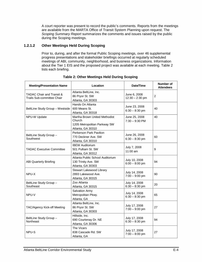
Atlanta BeltLine Corridor Environmental Study E-4
A court reporter was present to record the public’s comments. Reports from the meetings are available from the MARTA Office of Transit System Planning upon request. The Scoping Summary Report summarizes the comments and issues raised by the public during the Scoping meetings.
1.2.1.2 Other Meetings Held During Scoping
Prior to, during, and after the formal Public Scoping meetings, over 46 supplemental progress presentations and stakeholder briefings occurred at regularly scheduled meetings of ABI, community, neighborhood, and business organizations. Information about the Tier 1 EIS and the proposed project was available at each meeting. Table 2 lists each briefing.
Table 2: Other Meetings Held During Scoping
Meeting/Presentation Name Location Date/Time Number of Attendees
TADAC Chair and Transit & Trails Sub-committee Chair
Atlanta BeltLine, Inc. 86 Pryor St. SW Atlanta, GA 30303
June 6, 2008 12:30 – 2:30 pm 2
BeltLine Study Group – Westside Hands On Atlanta 600 Means St. Atlanta, GA 30318
June 23, 2008 6:30 – 8:30 pm 40
NPU-W Update Martha Brown United Methodist Church 1205 Metropolitan Parkway SW Atlanta, GA 30310
June 25, 2008 7:30 – 9:30 PM
40
BeltLine Study Group – Southwest
Perkerson Park Pavilion 770 Deckner Ave. SW Atlanta, GA 30310
June 26, 2008 6:30 – 8:30 pm 60
TADAC Executive Committee IBEW Auditorium 501 Pulliam St. SW Atlanta, GA 30312
July 7, 2008 11:00 am
9
ABI Quarterly Briefing Atlanta Public School Auditorium 130 Trinity Ave. SW Atlanta, GA 30303
July 10, 2008 6:00 – 8:00 pm 94
NPU-X Stewart Lakewood Library 2893 Lakewood Ave. Atlanta, GA 30315
July 14, 2008 7:00 – 9:00 pm 90
BeltLine Study Group – Southeast
Zoo Atlanta Atlanta, GA 30315
July 14, 2008 6:30 – 8:30 pm 20
NPU-V Salvation Army Metropolitan Pkwy. Atlanta, GA
July 14, 2008 6:30 – 8:30 pm 65
TAC/Agency Kick-off Meeting Atlanta BeltLine, Inc. 86 Pryor St. SW Atlanta, GA 30303
July 17, 2008 7:00 – 9:00 pm 27
BeltLine Study Group – Northeast
Hillside, Inc. 690 Courtenay Dr. NE Atlanta, GA 30306
July 17, 2008 6:30 – 8:30 pm 94
NPU-S The Vicars 838 Cascade Rd. SW Atlanta, GA
July 17, 2008 7:00 – 8:00 pm 27

Atlanta BeltLine Corridor Environmental Study E-5
Meeting/Presentation Name Location Date/Time Number of Attendees
Georgia Stand-Up IBEW Auditorium 501 Pulliam St. SW Atlanta, GA 30312
July 18, 2008 12:00 – 2:30 pm 53
NPU-F Hillside, Inc. 690 Courtenay Dr. NE Atlanta, GA 30306
July 21, 2008 7:00 – 9:00 pm 45
NPU-D Agape Community Center 2351 Bolton Rd. Atlanta, GA 30318
July 22, 2008 7:00 – 9:00 pm 17
NPU-J Atlanta Job Corps 239 W. Lake Dr. NW Atlanta, GA 30314
July 22, 2008 7:00 – 9:00 pm 30
Stakeholder Advisory Committee Kick-off Meeting
MARTA 2424 Piedmont Rd. Atlanta, GA 30324
July 22, 2008 6:00 – 8:00 pm 27
Georgia Stand-up IBEW Auditorium 501 Pulliam St. SW Atlanta, GA 30312
August 15, 2008 12:00 – 2:30 pm 58
BeltLine Study Group – Westside Hands On Atlanta 600 Means St. Atlanta, GA 30318
August 25, 2008 6:30 – 8:30 pm 53
BeltLine Study Group – Southwest
Emmaus House Study Hall 1010 Crews St. Atlanta, GA 30315
August 28, 2008 6:30 – 8:30 pm 35
Sustainable Atlanta Roundtable All Saints Episcopal Church 634 W. Peachtree St. NW Atlanta, GA 30308
September 5, 2008 7:30 – 9:30 am 90
BeltLine Study Group - Northside Piedmont Hospital McRae Auditorium 1984 Peachtree Rd. NW Atlanta, GA 30309
September 8, 2008 6:30 – 8:30 pm 25
NPU-X Stewart Lakewood Library 2893 Lakewood Ave. Atlanta, GA 30315
September 8, 2008 7:00 – 9:00 pm 64
NPU-V Dunbar Center 477 Windsor St. Atlanta, GA 30312
September 8, 2008 7:00 - 9:00 pm 43
Morningside Lenox Park' Monthly Meeting
Morningside Presbyterian Church 1411 N. Morningside Dr. NE Atlanta, GA 30306
September 8, 2008 7:30 – 9:30 pm 22
NPU-T Shrine of the Black Madonna 950 Ralph David Abernathy Blvd. Atlanta, GA 30310
September 10, 2008 7:30 – 9:30 pm
40
The Focus (Community Television Program)
860 Hank Aaron Dr. Atlanta, GA 30315
September 11, 2008 6:00 pm N/A
BeltLine Study Group – Northeast
Hillside, Inc. 690 Courtenay Dr. NE Atlanta, GA 30306
September 11, 2008 6:30 – 8:30 pm
64

Atlanta BeltLine Corridor Environmental Study E-6
Meeting/Presentation Name Location Date/Time Number of Attendees
Buckhead Business Association Anthony’s Restaurant 3109 Piedmont Rd. Atlanta, GA 30305
September 11, 2008 7:30 – 9:30 pm
66
Peoplestown Revitalization Corporation
Rick McDivitts Youth Center 30 Haygood Ave. Atlanta, GA. 30315
September 13, 2008 10:30 am
75
Booker T. Washington Community Assoc.
Booker T. Washington High School 45 Whitehouse Dr. Atlanta, GA 30314
September 15, 2008 6:30 – 8:30 pm
17
Reynoldstown Civic Improvement League
100 Flat Shoals Ave. SE Atlanta, GA 30316
September 15, 2008 7:00 – 9:00 pm
24
NPU-F Hillside, Inc. 690 Courtenay Dr. NE Atlanta, GA 30306
September 15, 2008 7:00 – 9:00 pm
48
NPU-Y John Birdine Facility 215 Lakewood Way, SW Atlanta, GA 30315
September 15, 2008 7:00 – 9:00 pm
37
Blandtown Neighborhood Assoc. Milk & Honey Restaurant 1082 Huff Rd. Atlanta, GA 30318
September 16, 2008 2:30 – 4:30 pm
18
Fourth Ward Neighbors Inc. Highland Bakery 655 Highland Ave. Atlanta, GA 30312
September 16, 2008 7:00 – 9:00 pm
29
NPU-K Washington Park Natatorium 102 Ollie St. NW Atlanta, GA 30314
September 16, 2008 7:00 – 9:00 pm
27
Grant Park Neighborhood Assoc. Georgia Hill Center 250 Georgia Ave. Atlanta, GA 30312
September 16, 2008 7:30 - 9:30 pm
63
Atlanta Housing Association of Neighborhood-based Developers (AHAND)
Chamblee – Senior Residential 3522 Blair Circle Chamblee, GA 30319
September 18, 2008 12:00 – 2:00 pm
23
NPU-G English Park Recreation Center 1340 Bolton Rd. NW Atlanta, GA 30331
September 18, 2008 7:00 – 9:00 pm
27
Georgia STAND-UP Alliance Meeting
IBEW Auditorium 501 Pulliam St. SW Atlanta, GA 30312
September 19, 2008 12:00 – 2:00 pm,
47
Veranda at Carver Hills 217 Thirkeld Ave. Atlanta, GA 30315
September 22, 2008 3:00 pm 20
NPU-M
Martin Luther King, Jr. Community Ctr. 70 Boulevard Atlanta, GA 30312
September 22, 2008 6:30 – 8:30 pm
48
Underwood Hills Neighborhood Assoc.
Northside Church of God 1736 Harper St. NW Atlanta, GA 30318
September 22, 2008 7:00 - 9:00 pm
22

Atlanta BeltLine Corridor Environmental Study E-7
Meeting/Presentation Name Location Date/Time Number of Attendees
TAC/SAC Meeting MARTA 2424 Piedmont Rd. Atlanta, GA 30324
December 8, 2008 5:30 – 7:30 pm
33
Target Audience Update NPU-J
Atlanta Job Corps Center 239 West Lake Dr. Atlanta, GA 30314
January 27, 2009 7:00 – 9:00 pm
70
Total 1928+
Comments Received
The formal comment period for Public and Agency Scoping began July 25, 2008 and ended on September 22, 2008. Throughout the Tier 1 EIS process, comments received during Scoping have been reviewed, considered, and used to shape the alternatives and evaluation process. The conceptual transit and trails alignments included in the Tier 1 Draft EIS reflect the comments received during the formal comment period (summarized in the Final Scoping Summary Report).
Several hundred people submitted comments on the BeltLine Corridor Environmental Study and the proposed project. Often, there were multiple comments expressed by individual respondents. Table 3 shows the distribution of the comments received by medium.
There were approximately 947 comments submitted from 341 people. Of the comments, 769 were from comment forms distributed during Public Scoping meetings and briefings and provided on the BeltLine project website at that time, www.itsmarta.com/newsroom/ beltline.html (the current project websites are www.itsmarta.com/Beltline-Corr.aspx and www.beltline.org/BeltLineBasics/TransitTrailsandTransportation/EnvironmentalImpactStudyEIS/tabid/2936/Default.aspx.
Table 3: Comments Received by Medium
Medium Number of Comments Received
Scoping Meetings: 173
Oral Comments (117)
Comment Forms (56)
Target Audience Briefings / Post-Scoping Meetings: 543
Fax 24
Letter 16
Website/Email: 189
Other: 2
Total: 947
The following sections provide an overall summary of the comments received during Scoping, organized by the following subject areas:

Atlanta BeltLine Corridor Environmental Study E-8
Purpose and Need and Goals and Objectives Several comments supported the purpose of and need for the BeltLine and the goals and objectives contained within the Purpose and Need statement. Those commenting felt that the proposed project would be beneficial to Atlanta residents for several reasons, including:
• Enhanced mobility, accessibility and community connectivity
• Improved quality of life and health
• Improved livability within the city
• Preservation of the historical neighborhoods, parks and significant activity centers encircling Atlanta
• Reduced energy dependence and reliance on automobiles
• Improved air quality due to reduced emissions
• Economic development and neighborhood revitalization
• Improved pedestrian and bicycling environment
Alternatives Comments received during Scoping that related to the project alternatives are summarized below.
• Mode - The majority of those that commented expressed the need to get residents out of their cars and on to transit. Most of those that commented expressed interest in either streetcar or light rail. However, some recommend bus as the preferred mode.
• Alignment - Comments relating to the proposed alignment expressed concern for the alignment configuration and positioning of proposed stations. Comments regarding the alignment are summarized below:
- The proposed loop configuration of the eastern end of the proposed alignment is inefficient. The time on the train to go from Grant Park to City Hall East on Ponce de Leon Avenue would increase by 15 to 20 minutes. The loop seems short-sighted and ill-conceived.
- The proposed BeltLine alignment and MARTA East-West heavy rail line would intersect with a perfectly designed rail station and rail-oriented development creating a seamless integration of the two lines.
- The proposed 2.25 miles of new on-street rail would be difficult to design.
- The proposed rail line would be out of context in terms of both land use and transportation south along Moreland Avenue and along Wylie Street.
- The entirety of the Mason/Northeast BeltLine right-of-way acquisition should be reserved for public purposes and any excess space in the section between Piedmont Avenue and the I-85 corridor should be reserved for public purposes such as park space, a library branch, or other public use.
- The BeltLine transit service would do little to augment ridership or the Atlanta regional network in the Edgewood Retail District due the two existing MARTA stations and the myriad of bus connections.

Atlanta BeltLine Corridor Environmental Study E-9
• Transit Stops - The following recommendations were provided concerning transit stops for the BeltLine:
- Provide stops at Piedmont Avenue and Garson Drive and Turner Field.
- Create a station west of Krog Tunnel to be a transit hub for a new transit-oriented development near Hulsey Yard redevelopment.
- Connect the BeltLine to a new MARTA station between the King Memorial and Inman Park/Reynoldstown MARTA Stations rather than routing the alignment to the Inman Park/Reynoldstown MARTA Station.
- Transit stop locations should provide BeltLine access from the north, center, and south sections of the Piedmont Heights neighborhood.
- A transit station opposite Monroe Place Apartments on Monroe Drive seems appropriate.
- An additional station should be located in the vicinity of Wimbledon Drive or Rock Springs Road to facilitate access from the core of the neighborhood. This solution would complement the proposed station at Ansley Mall and negate the need for a station at Montgomery Ferry Road.
• Trails - Comments regarding the proposed BeltLine trails related to connectivity to existing parks and recreation areas and the health and safety of trail users. The comments are summarized below:
- Since transit would be implemented in stages, construct trail segments first in areas scheduled for later phases of transit.
- Public recreation trails absent hazardous traffic are desperately needed.
- Putting the trail system next to the rail lines is smart as far as land use, but unless the transit mode has low-to-zero emissions, it could have an impact on the health of those using the trail system.
- Use BeltLine space as opportunities for environmental education (station posters, planted signs, etc.) Use BeltLine to educate folks on the history, landmarks, places of interest in different communities.
- Prefer the trail not be paved.
- Promote healthy choices for transportation via transit/trails and the ability to walk with help to decrease obesity.
- We must streamline rail paths allowing bikes, feet, and buses to be secondary modes to feed people outward.
- Include Waterworks Park at Huff Road and Howell Mill Road as part of the first phase of implementation.
- Trail access should be available opposite Monroe Place Apartments on Monroe Drive along with an access point in the vicinity of Wimbledon (Road) or Rock Springs (Road) to facilitate access from the core of the neighborhood. On the south on Piedmont Heights, trail access should be available from the Ansley Mall.
- The trail should be located on the predominantly residential side of the highway to take advantage of the high number of existing residences, which will not have access to the trail if it is located on the northern/industrial side of the highway. This proposed location would insure highest use from the outset of construction.

Atlanta BeltLine Corridor Environmental Study E-10
- Would like to see the BeltLine trail options remain adjacent as they come south from Lindbergh Center station on Piedmont Road (under I-85) and then turn westerly along Monroe Circle and Monroe Drive to connect with the BeltLine right-of-way at the northern end of the Ansley Golf Course.
- Put the trail system south of I-85 where people live.
- Construction of a bicycle and pedestrian trail system in the proposed BeltLine right-of-way from I-85 through the entire Subarea 6 BeltLine right-of-way will help ensure the most expedient and highest use of the public component of the proposed BeltLine right-of-way and help mitigate access issues due to potential development.
Mobility Some of the key issues regarding mobility concerned the potential for impacts to traffic and pedestrian circulation. It was suggested that congestion and pedestrian traffic at major points along the BeltLine be considered because the proposed project may cause additional traffic problems. Further, it was recommended that during design of the proposed project, MARTA must minimize at-grade motor vehicle crossings on the transit route.
Environmental Quality Many residents that submitted comments were concerned about the potential effects of the proposed BeltLine Corridor project on environmental resources. It was recommended that consideration of environmental impacts contain a very specific scope of studies that identify and measure current baseline conditions for air quality, noise, vibration, hazardous material location, animal habitat, visual impacts, historic resources, archaeological resources and water resource quality. More detail on the specific topics is presented below:
• Air Quality - Many residents see the proposed BeltLine project as a potential improvement to Atlanta’s current air quality conditions.
• Brownfields and Hazardous Materials - Some comments questioned whether there were sufficient funding mechanisms in place to remediate the volume of old industrial sites on the south side of the BeltLine Corridor.
• Cultural Resources - Many comments expressed concern that the proposed alignment could have detrimental effects on historic structures and archaeological resources located along the alignment and requested that an assessment of the potential impacts on historic sites and buildings should be done before project initiation.
• Cumulative Impacts - The potential impacts of the proposed BeltLine Corridor project need to be considered in the context of their cumulative impacts over both time and space.
• Environmental Justice - Many comments suggested evaluating how the proposed BeltLine Corridor project would affect environmental justice (low-income and minority) communities.
• Land Use - Some comments questioned whether the city has sufficient development controls in place through its zoning and subdivision power to assure control of the right-of-way for both development and transit purposes within the BeltLine Corridor. It was recommended that development should occur where a viable and appropriate public/private framework is the basis of design and the public domain is clearly

Atlanta BeltLine Corridor Environmental Study E-11
designed and defined in such a way that reinforces those elements of the city that create a safe, walkable, transit-oriented community. Further, it was recommended that the outcomes of the Tier 1 EIS should be consistent with local plans.
• Other comments suggested that the proposed transit and trail elements of the proposed BeltLine Corridor project are out of context in terms of both land use and transportation. Further, it was felt that certain areas would be allowed to be developed so densely that they would in turn create a traffic problem rather than alleviate it. The Tier 1 EIS should provide a timeline for when and how much development is likely to occur that might be served by the BeltLine and address impacts in the context of development trends.
• Natural Resources - Some residents requested that an evaluation of the potential effects of the proposed project on animals, including threatened and endangered species, which live along the proposed alignment; animal habitat; and vegetation be conducted. Some were concerned that the construction of the proposed project could cause the destruction of trees and vegetation along the right-of-way.
• Noise and Vibration - Many of the comments received related to the noise and vibration impacts of the proposed project on property located within the BeltLine Corridor. People were interested in noise reduction strategies, as well as how the proposed project would be constructed to minimize noise and vibration during the construction phase, as well as after completion.
• Parks and Recreation - Several comments stated that the proposed BeltLine Corridor project would improve existing greenspace. However, some felt that the proposed project would show no regard for Piedmont Park and its expansion and that the proposed project would heighten development at the expense of greenspace.
• Utilities - Some citizens expressed concern that planning for a new park and associated high-density mixed-use development in the BeltLine Corridor would only increase the conflicts between the public and nuisances caused by the City’s antiquated way of dealing with sewage. Several parks and trail areas along the BeltLine Corridor intersect or could potentially be negatively impacted by combined sewer outflow (CSO) facilities.
• Visual and Aesthetics - Several citizens noted the uniquely beautiful characteristics of neighborhoods along the BeltLine Corridor and expressed concern about the general impacts the proposed project would have on the visual and aesthetic appeal of the area. These included landscaping along the alignment and lighting at the proposed transit stations.
• Water Resources - There were many comments received regarding area water resources, which includes stormwater, ground water, and surface waters. Some residents requested information on how stormwater runoff will be managed once the proposed project is completed. Others wanted to know how the proposed project would impact the water supply.
Ridership In some of the comments received, inquiries were made into whether any ridership forecasts and timeline projections would be developed for the whole of the proposed BeltLine Corridor project so that citizens can gain a clearer understanding about what is likely to happen and when.

Atlanta BeltLine Corridor Environmental Study E-12
Safety and Security Several commenters were concerned that the proposed BeltLine Corridor project would attract additional crime and vagrants, especially along the proposed trail system. Many also noted that preventing accidents and injuries at crossing locations and during construction is an important issue.
Construction Impacts Citizens submitted comments regarding the construction activities associated with the proposed project and their potential effects on the following:
• Project phasing and duration of construction
• Management of dust and debris
• Stormwater runoff
• Access and parking
• Commute time and traffic congestion
• Public transportation
• Pedestrian circulation and safety
• Contaminated soils
• Noise and vibration
• Visual and aesthetics
• Parklands and recreation areas
• Safety and security, including emergency management
Costs and Financial Plan There were general concerns expressed about insufficient funding options for the proposed BeltLine Corridor project that would limit future progress of the project or the ability to operate and maintain the system. Others felt existing funding sources would compete with other needed projects.
The comments below summarize those received regarding funding sources for the proposed transit and trail system being evaluated in the BeltLine Corridor Environmental Study:
• Consider the financing strategy as part of its analysis and findings of the Tier 1 EIS
• Consider DERA (Diesel Emissions Reduction Act) and CMAQ (Congestion Mitigation and Air Quality) funds that are currently held by the Georgia Environmental Protection Division
• Restrict TAD Bonds proceeds to transit, trails, or greenspace not private sector assistance
• Consider local, state, and federal funds
• Consider a sales tax or a gasoline tax
• Consider a minimal or no Atlanta subsidy

Atlanta BeltLine Corridor Environmental Study E-13
• Consider funding from the private sector, through mechanisms such as station sponsorship
• Consider anything except property taxes
• Consider a small tax that will be added to the tax bill and a small fee to ride, such as 50 or 75 cents
General Project Opposition or Support There were many comments that expressed support for the proposed project and the effort to ease traffic congestion and improve access throughout the BeltLine Corridor. They expressed support for both the proposed transit and trail elements and the benefits they would provide to those living along the alignment, including:
• Increasing mobility reducing congestion by getting people out of their cars
• Helping to save gas
• Connecting parks and neighborhoods
• Stimulating investment and increasing property values for those who live or work around the stations
• Improving general public health by increasing walkability that comes with public transit and improving air quality
• Providing the city an opportunity to take advantage of all of the unused rail lines that need to be used
There were several comments that expressed opposition to the proposed project. The respondents were skeptical of the benefits of the BeltLine Corridor and questioned whether the proposed project was worth the cost. The comments opposing the proposed project included the following reasons for their lack of support:
• Property impacts for those adjacent to the alignment
• Impacts of development on parks and affordable housing
• Traffic delays and flow
• The project would not be cost-effective
A number of attendees at Public Scoping meetings and others offering comments indicated their awareness of planning and project development activity for only one modal concept (either transit or the trail system), as a result of participation in distinct planning activities by MARTA, ABI and community partners over the past several years.
Project Administration and Process Many respondents requested specific information about the Study and the proposed project including:
• Who is serving as the lead agency for the project and who are the cooperating agencies; are the NEPA and GEPA processes being followed?
• Who approves the Tier 1 EIS?
• What are the roles of MARTA and ABI?

Atlanta BeltLine Corridor Environmental Study E-14
• Who will be the operator of the BeltLine?
• Has the existing rail line been formally decommissioned by the Federal Railroad Administration?
• Who will be making the final decisions?
There were several comments regarding insufficient information in the Scoping Document provided and frustration over the planning process for the proposed project. It was suggested that communities should be given the opportunity to review and comment on the design of development projects in their area.
Comments also recommended that planning for infrastructure improvements be implemented concurrently (i.e., at the time of or before) with significant development. Individuals suggested that when considering possible transportation investments, MARTA and ABI should rely on the emerging Connect Atlanta plan and the Transit Planning Board (TPB) Concept 3 plan and place the BeltLine Corridor Environmental Study in the context of the city-wide vision. The comments further noted that there should be greater emphasis on transit and parks rather than on auto-oriented developments.
Still others wanted to know how the purchase process of any right-of-way acquisition would comply with federal standards.
Scoping Meeting Advertisement and Notice
Advertisement of the Public Scoping meetings appeared in the following venues:
Newspapers • Atlanta Journal-Constitution (August 9, 2008; August 17, 2008)
• Atlanta Daily World (August 14-20, 2008)
Project Website The BeltLine project website at www.itsmarta.com/Beltline-Corr.aspx advertised the meetings. ABI also provided a link to the project website at: www.beltline.org/BeltLineBasics/TransitTrailsandTransportation/EnvironmentalImpactStudyEIS/tabid/2936/Default.aspx
Other Announcements A Study Update/Flyer printed in English and Spanish and distributed through the contact database, hand-distributed at neighborhood meetings, and placed on the BeltLine project websites (www.itsmarta.com/Beltline-Corr.aspx; and www.beltline.org/BeltLineBasics/TransitTrailsandTransportation/EnvironmentalImpactStudyEIS/tabid/2936/Default.aspx) advertised the meetings.
1.2.2 Public Workshops 1.2.2.1 Citywide Conversation on Transit and Trails
MARTA and ABI conducted a Citywide Conversation on Transit and Trails on April 2, 2009, from 6:00-8:00 PM at the All Saints Episcopal Church (634 West Peachtree Street NW, Atlanta, GA 30308), inviting members of the SAC, and open to the public at large. The purpose of the meetings was to inform the community of the status of the BeltLine Corridor Environmental Study and to prepare them for the upcoming Public Workshops.

Atlanta BeltLine Corridor Environmental Study E-15
Format and Content
The Citywide Conversation on Transit and Trails included a discussion of the overall BeltLine project, the BeltLine Corridor Environmental Study, and the environmental study interface with Subarea Master Planning efforts. However, the presentation and subsequent conversation focused on the Evaluation Criteria and upcoming public workshops.
Following the presentation, the attendees (61 in total) divided into groups to review the Preliminary Evaluation Criteria and associated Performance Measures. The purpose of this exercise was to get a consensus that the right evaluation criteria and performance measures were in use and to insure that there was not an omission of important information. Breakout discussion topics included:
• Study purpose and need
• Goals and objectives of the project
• Existing conditions in the corridor
• Study update
• Evaluation criteria and outcomes
Provided below are the list of questions asked during the meeting, as well as the feedback received from the breakout session.
Comments Received
The following highlights the questions received from participants:
• What is the definition of a stakeholder?
• Are you doing a conceptual design for the entire corridor?
• Whether or not the BeltLine has the population density to support transit in terms of projected population and employment numbers?
• What is the study area width?
• What is the projected timeline of implementation for various segments of the BeltLine?
• The conceptual level of planning raises issues of discontinuity of BeltLine transit with MARTA rail. Will this be addressed in the EIS?
• How are citywide transit projects prioritized in terms of meeting competing transit service needs?
• Will issues of noise be addressed?
• What is the process of public engagement in this study? How are the communities going to address the conceptual matters and how are you going to resolve those issues through this process so that the community and your plan work well together?
Breakout Group Feedback The following is a combined list in order of preference voted on by the groups. Each Evaluation Criteria was prioritized by the Performance Measures that ranked highest among the community.

Atlanta BeltLine Corridor Environmental Study E-16
• Local services and infill stations could be joined for connectivity with pedestrians and bicyclists
Accessibility and Connectivity
• How do you get people to leave their cars at home?
• The trail will help serve the need to ‘meander’ while the transit would help get to destinations more directly
• How do we deal with where the other sub areas join?
• Neighborhood/shorter trips to destinations
• Connection points with existing versus future activity
• Have nodes for regional connectivity -- # of nodes at employment centers
• Have places where system connects to streets
• Connections to destinations for employment, retail, grocery shopping
• Consider multi-modal connectivity
• Ensure accessibility to jobs
• Must be a connection between people living and working along the BeltLine
• Address trips to work and other places, i.e. there is a lack of grocery stores in the Southwest corridor
• As much as we want people to use public transportation, not having large associated parking lots is still very important
• Disabled population – include in considerations
• Comprehensive sidewalk development needed, designed and implemented
• Trail Access Points - how ordinary people will get on the trail
• Pedestrians and bicycles should be incorporated in this criteria, versus having two separate criteria
• Put transit and trails where people live
• ROW Pres.: PATH, TPL, Georgia Conservancy, Zoning
• Extent of future connectivity brought by transit
• What are the recreational aspects of the trail
• Focus on quality of life – the rest will follow
Community Fit
• Consider compatibility, benefits to community
• Define impacts – displacements versus benefits, attract future businesses/residents
• Ensure community cohesion
• To be compatible with the community, what are the benefits to the people
• Concern with security, lighting, site specificity, fit of stations

Atlanta BeltLine Corridor Environmental Study E-17
• Security in using transit and trails
• Must get public input for community fit
• Neighborhood Connection (performance measure)
• We should be mapping as to where people are going
• Security of adjacent properties
• Accessibility to 1st responders
• Prevention of catastrophic incident/impact to adjacent properties
• Experience – get input from people who know about this
Pedestrian and Bicycle Compatibility
• At-grade access for bikes
• Safety and lighting need to be considered
• This category is a duplicate of Connectivity and Mobility
• Bike-friendly
• Combine first 4 measures with Accessibility/Connectivity; move last 2 measures to Community
• Displacement from Right of Way needs or development
Equity
• Geographic equity with socio-economic equity
• Prioritize the need of the people versus looking at how they would ‘benefit’
• Look at cost effectiveness in a different way – connecting people to jobs, grocery stores
• Serve seniors and disabled – make sure ADA compliant
• Must be able to accommodate ADA requirements
• Make sure transit and trails are safe enough to use
• See how BRT connection by MARTA would work
• Can Equity be combined with other headings
• Equity – connections covered under other criteria
• Consider speed of mobility
Mobility
• Combine mobility with accessibility and connectivity
• Consider frequency of service
• Should be able to be both a local access and express service
• Reduction needed in Vehicle Miles Traveled and Vehicle Trips

Atlanta BeltLine Corridor Environmental Study E-18
• Consider funding and where it will come from
Cost Efficiency and Effectiveness
• How economically sustainable is the project
• Should economics be the driving factor; or serving a population – what are the priorities?
• Consider cost of maintenance
• Add Preservation of Single Family Neighborhoods and other transit connections
• What is the impact of the certain kinds of transit technology on the environment?
Environmental Quality
• Consider noise, visual impact, pollution, vibration
Land Use and Economic Development
• Should have a different feel and quality than the rest of MARTA
• Reminder -- BeltLine was originally about connecting neighborhoods rather than spurring development.
• Let the neighborhoods speak for themselves
Public Input
• Think of what they need, not how we think they can benefit
• Need to aggressively involve the public.
Support of Other Planning Initiatives
• Should be coordination with other planning initiatives
• Support planned land use.
• Use previous models for comparison
Additional Comments • Evaluation Criteria categories could be reduced or combined; There is duplicate
measure in numerous criteria, i.e. collapse criteria
• Add Ridership as category – what is the feasibility for people riding public transit as defined in the redevelopment study. if people don’t ride public transit the whole concept disintegrates
• Add Timeframe to criteria – when can we have funding and have the BeltLine accessible to the neighborhoods we are connecting
• Add Options Available for Changing Conditions to criteria
• Focus of study area should take into account the TAD, not just the ½-mile buffer.
• Do not minimize the importance of safety – if people feel intimidated they won’t walk, bicycle, or ride public transit
• Consolidate the existing 10 Evaluation Criteria into the 4:

Atlanta BeltLine Corridor Environmental Study E-19
- Connectivity: Mobility, Accessibility and Connectivity, Pedestrian/Bike Compatibility
- Community Support: Equity, Planning Initiatives, Community Fit, and Public Involvement
- Cost Efficiency: Cost effectiveness and Economic Development/Land Use
- Environmental Quality: As is
• Consolidate the Performance Measures – These could also be consolidated and weighted accordingly. Add a measure of the costs to acquire land or easements for competing alternatives. Also, provide separate measures for acres of wetlands impacted and number of stream crossings. These have different environmental effects.
1.2.2.2 Spring 2009 Public Workshop Series
MARTA and ABI conducted five formal public workshops, one in each of the study group areas: southeast, northeast, southwest, and two geographic areas forming the northwest zone (westside and northside). Public workshops were held between April 13, 2009 and May 4, 2009 to engage the public in identifying potential transit and trails alternatives considered for the project. Promotion of the workshops took place throughout the study area to involve the public, some of whom were previously involved in BeltLine planning efforts, through MARTA and ABI outreach methods. Others participated because of a host of outreach strategies designed to reach community, transit and trail users, and stakeholders of the future transit and trails project. These activities resulted in small group hands-on workshops attended by approximately 105 individuals.
The formal Public Workshops were conducted in accordance with NEPA guidelines. All public meetings locations were compliant with the Americans with Disabilities Act (ADA) and accessible by public transportation. Table 4 lists the Public Workshops locations, dates, and number of attendees.
Format and Content
The first portion of each of the public workshops provided an opportunity for the participants to view a series of display boards and a continuous video that described the various transit and trails improvement options identified in previous studies for the BeltLine. A short presentation followed that described the overall Tier 1 EIS process, results of previous studies, and the purpose of the workshop. After the presentation, participants formed smaller discussion groups for an interactive exercise focused on identifying potential modifications or additions to the alternative service types, alignments, and station locations previously identified for the BeltLine project. Each breakout group included a staff facilitator to lead the discussion, access to an interactive video screen that displayed maps of the proposed project alignment and stations, and a staff person to document the comments and suggestions offered by the group.
Following the breakout session, a representative for each group presented a short summary regarding the key points raised by their group.

Atlanta BeltLine Corridor Environmental Study E-20
Table 4: Public Workshops – Locations, Dates, and Attendance
Study Area Quadrant Location Date/Time Number of Attendees
Southeast Study Group Trees Atlanta, Inc. 225 Chester Ave. SE Atlanta, GA 30316
April 13, 2009 6:30 pm – 8:30 pm 22
Northeast Study Group Morningside Baptist Church 1700 Piedmont Ave. NE Atlanta, GA 30324
April 16, 2009 6:30 pm – 8:30 pm 29
Southwest Study Group
West Hunter Baptist Church 1040 Ralph David Abernathy Boulevard SW Atlanta, GA 30310
April 23, 2009 6:30 pm – 8:30 pm 20
Westside Study Group Atlanta Humane Society 981 Howell Mill Road NW Atlanta, GA 30318
April 27, 2009 6:30 pm – 8:30 pm 15
Northside Study Group
Piedmont Hospital – McRae Auditorium 1984 Peachtree Rd. NE Atlanta, GA 30309
May 4, 2009 6:30 pm – 8:30 pm 19
Total Attendance 105
Comments Received
The comments received are recorded and summarized in Section 1.2.2.3 below.
Public Workshop Advertisement
Advertisement for the Public Workshop meetings appeared in the following venues:
Project Website The ABI website advertised the meetings at www.beltline.org/BeltLineBasics/TransitTrailsandTransportation/EnvironmentalImpactStudyEIS/tabid/2936/Default.aspx
Other Announcements A Study Update/Flyer and distributed through the contact database, hand-distributed at neighborhood meetings, churches, community centers, grocery stores, libraries, businesses and other high traffic locations, and placed on the BeltLine project website (www.itsmarta.com/Beltline-Corr.aspx; and www.beltline.org/BeltLineBasics/TransitTrailsandTransportation/EnvironmentalImpactStudyEIS/tabid/2936/Default.aspx) advertised the meetings.
1.2.2.3 Spring 2009 Public Workshop Extension
To gain additional feedback from the public, there was an extension on the public workshop comment period to June 12, 2009. Additional opportunities to engage the public in identifying potential transit and trail alternatives occurred during twelve public and community organization presentations (see Table 5 below). Through intensified efforts to engage the public in identifying opportunities and impacts for the transit and trails design, community forums already in place, such as libraries, and office complex and mall food courts received an abbreviated version of the presentation. These activities resulted in attendance of approximately 502 individuals.

Atlanta BeltLine Corridor Environmental Study E-21
Format and Content
At the presentations and one-on-one engagements, individuals had an opportunity to view a series of display boards that described the Tier 1 EIS process, the types of service considered, the environmental project goals, the overall BeltLine concept, and the study area map. In this informal context, individuals heard a brief overview of the BeltLine study and gave their comments. Staff documented the comments and suggestions offered. Provided in summary below, as well as the Public and Committee Workshops April-June 2009 report, is a report of the issues raised during the Public Workshops.
Table 5: Public Workshop Extension – Locations, Dates, and Attendance
Public Workshop Extension Location Date/Time Number of Attendees
AHAND (Atlanta Housing Association of Neighborhood-Based Developers)*
The Salvation Army Ray & Joan Kroc Corps Community Center 967 Dewey Street SW Atlanta, GA 30310
May 21, 2009 12:00 – 2:00 pm
28
Martin Luther King, Jr. Library 409 John Wesley Dobbs Ave. Atlanta, GA 30312
May 26, 2009 2:00 – 4:30 pm
27
Colony Square Food Court 1197 Peachtree St. Atlanta, GA 30309
May 26, 2009 11:30 – 2:00 pm
22
West End Library* 525 Peeples St. Atlanta, GA 30314
May 27, 2009 10:00 – 11:30 am
12
Dogwood Branch Library* 1838 Donald Lee Hollowell Pkwy; Atlanta, GA 30318
May 27, 2009 12:00 – 2:00 pm
18
Atlanta Fulton County Central Library
One Margaret Mitchell Square Atlanta, GA 30303
May 29, 2009 12:00 – 3:00 pm
75
Just Us Neighborhood Association*
1125 Morris Brown Drive Atlanta, GA 30314
June 3, 2009 6:15 – 8:15 pm
12
The Mall West End* 850 Oak Street SW Atlanta, GA 30310
June 4, 2009 1:45 – 3:45 pm
40
Wheat Street Baptist Church 18 Wm. Holmes Borders Dr. SE Atlanta, GA 30312
June 7, 2009 7:00 pm
8
Concerned Black Clergy* Vickers Community Center (Community Church of God) 838 Cascade Road SW Atlanta, GA 30311
June 8, 2009 9:30 – 11:30 am
140
NPU – X* Stewart-Lakewood Library 2893 Lakewood Ave. Atlanta, GA 30315
June 8, 2009 7:00 – 9:00 pm
75
Villages @ Carver YMCA* 1600 Pryor Road Atlanta, GA 30315
June 9, 2009 4:00 – 6:00 pm
45
Total Attendance 502
*denotes EJ community
Comments Received
Recorded and considered in the refinement of alternatives were the comments and suggestions from the five Public Workshops. The sections below summarize the comments made during the workshops regarding transit service type, transit alignments, station locations, and trails alignments.

Atlanta BeltLine Corridor Environmental Study E-22
Participants gave their feedback on what type of service they would like to see for their community, which included:
Transit Service Type
• Designing for greater connectivity along the BeltLine
• Promoting economic development at stations and maximizing access to service by providing more frequent stations
• Connecting efficiently to MARTA rail and planned new transit services
• Allowing for mixed traffic and exclusive right-of-way operations
• Using a streetcar, light rail, or rubber tire (neighborhood connector service) type vehicles
• Providing more locally oriented service over existing heavy rail (speed, station spacing, transfers, etc.)
• Using intelligent technology, such as ”next-bus” signage
• Considering impacts of lighting and noise on adjacent properties
After reviewing a series of maps showing potential transit alignments community members had the following to say:
Transit Alignment
• Use natural turf along/in between the tracks
• Avoid impacts to existing trees; plant trees along right-of-way
• Connect density centers and recreation opportunities
• Consider redevelopment benefits in selecting alignment
• Provide direct access to major trip destinations (activity centers, employment, density, etc.) and origins
• Provide neighborhood-oriented pedestrian access
• Apply cost-effectiveness criteria, but don‘t sacrifice quality design due to right-of-way or impact constraints
• Use auto travel times as a means to determine the most important alignments for transit service
Placement of potential transit stations also elicited the following input:
Transit Station
• Provide better connections to schools
• Locate at major intersections to provide access to MARTA bus
• Design small stations proportionate in scale to neighborhoods
• Assess need for parking at BeltLine stations
• Restrict smoking at stations

Atlanta BeltLine Corridor Environmental Study E-23
• Consider MARTA infill stations at Armour Yard, Miami Circle, south of West End MARTA station, and Joseph E. Boone Boulevard
• Provide connections to all MARTA stations near the BeltLine
Potential alignment of trails brought about a selection of comments:
Trails
• Locate main transit and trails within the same corridor as much as possible
• Provide more connector trails to adjacent neighborhoods
• Connect schools, universities, and parks
• Ensure a safe environment along trails; alignments should go through active and visible areas
• Provide amenities (restrooms, benches, lockers, etc.), wayfinding, and security features
• Provide some soft surface trail segments
• Separate bicycle and pedestrian traffic
• Consider 24-hour access
• Include opportunities for art display
The Public and Committee Workshops April-June 2009 presents a fully summary of issues raised by the public during the Public Workshops.
Public Workshop Extension Advertisements
The advertisements are the same as described in Section 1.2.2.2 above.

Atlanta BeltLine Corridor Environmental Study E-24
Figure 1: Public Workshops – Comments Received
Source: MARTA and Atlanta BeltLine, Inc.

Atlanta BeltLine Corridor Environmental Study E-25
1.2.2.4 Spring 2009 Post Public Workshop Meetings
The project sponsors continued to introduce the Tier 1 EIS to new audiences and to update audiences that were formerly briefed. During regularly scheduled meetings of community groups and organizations, the project sponsors provided updates to the community to create awareness of the study and to help promote future public meetings. Public comments and input were included in the project record and considered based on the impact to the project.
Table 6 provides a list of post workshop briefings.
Comments Received
Recorded and considered in the refinement of alternatives were the comments and suggestions from post Public Workshop meetings. The sections below highlight a summary of the comments made during the public meetings and presentations regarding transit service type, transit alignments, station locations, and trails alignments.
Transit Service Type • Slower train speed inside communities
• Regional and service on main streets travel at faster speeds
• Service at all stops need not be the same; variations within communities
• Hop on/off trolley at some points
• Efficient cars that are clean and environmentally friendly
• Multiple entry/exits
Transit Alignment • Have easy access to more densely populated neighborhoods
Transit Station • Closely spaced stations in walking distance
• More stations to avoid taking the bus
• Available parking at stations
Trails • Should run parallel to transportation element
• Accommodate foot and bicycle traffic
• Do not spend money on the trails for only a few people
• Attracts crime
• Separate bicycle and pedestrian traffic
• Safety

Atlanta BeltLine Corridor Environmental Study E-26
Table 6: Post Public Workshop Presentations – Locations, Dates, and Attendance
Post Workshop Meetings Location Date/Time
Number of Attendees
Wheat Street Baptist Church*
18 Wm. Holmes Borders Dr. SE Atlanta, GA 30312
June 17, 2009 7:00 pm
27
Concerned Black Clergy (Nation of Islam, Women in the Struggle, GA Dept of HR-Office of Healthy Behaviors)*
Vickers Community Center (Community Church of God) 838 Cascade Road SW Atlanta, GA 30311
June 22, 2009 9:30 – 11:30 am
3
Harland Boys & Girls Club*
Harland Boys & Girls Club 434 Peeples St. SW Atlanta, GA 30310
July 15, 2009 4:00 – 6:15 pm
25
The West End Coalition Group, Inc., Westview Lofts*
1530 Ralph David Abernathy Blvd. Atlanta, GA 30319
July 21, 2009 7:30 to 8:30 pm
17
East Atlanta Village Farmers Market*
1231 Glenwood Ave. SE Atlanta, GA 30316
July 23, 2009 4:00 – 6:00 pm
26
Metro Atlanta Boys & Girls Club
1191 Donnelly Ave. Atlanta, GA 30312
July 24, 2009 11:30 – 1:30 pm
25
College Town Community Association*
387 Joseph E. Lowery Blvd. SW Atlanta, GA 30310
July 30, 2009 6:00 – 7:00 pm
19
The West End Merchants Coalition
Citizens’ Bank 562 Lee St. Atlanta, GA 30310
July 30, 2009 7:30 – 8:30 am
24
458 Café Edge* 458 Edgewood Ave. Atlanta, GA 30312
July 31, 2009 10:30 –11:30 am
32
Samaritan House of Atlanta*
302 Decatur St. Atlanta, GA 30312
July 31, 2009 9:00 – 10:30 am
30
Westview Community Organization*
Calvary United Methodist Church 1471 Ralph David Abernathy Blvd. Atlanta, GA 303010
August 3, 2009 7:00 – 8:00 pm
16
Peoplestown Revitalization Corporation
Emmaus House 1017 Hank Aaron Drive Atlanta, GA 30315
August 8, 2009 10:00 – 11:15 am
26
Atlanta Planning Advisory Board (APAB)*
Atlanta City Hall 55 Trinity Avenue Atlanta, GA 30303
August 15, 2009 10:00 – 12:00 pm
35
Omega Holiness Church*
621 Memorial Drive Atlanta, GA 30312
August 30, 2009 11:30 – 2:30 PM
19
West End Neighborhood Development Association (WEND)*
West End Library 515 Peeples St. SW Atlanta, GA 30310
September 1, 2009 7:00 – 8:00 PM
35
Sierra Club Episcopal Church of the Epiphany 2089 Ponce de Leon Avenue NE Atlanta, GA 30307
September 8, 2009 7:00 – 9:00 pm
23
Spelman College* Spelman College 350 Spelman Lane Atlanta, GA 30314-3773
September 14, 2009 4:00 – 6:00 pm
75
Total Attendance 457 *denotes Environmental Justice Community

Atlanta BeltLine Corridor Environmental Study E-27
1.2.2.5 Fall 2009 Public Meetings
MARTA, in partnership with ABI, conducted five formal Public Meetings, one in each study area. The Public Scoping meetings were conducted in accordance with NEPA guidelines 40 CFR Parts 1500-1508 and 23 CFR Part 771. All public meetings locations were compliant with the Americans with Disabilities Act (ADA) and accessible by public transportation. A list of the Public Meeting locations, dates, and number of attendees are listed in Table 7.
In addition, ABI, in conjunction with MARTA, held a Quarterly Briefing on November 23, 2009. The BeltLine Corridor Environmental Study was one of the agenda items. The project boards were on display during the Open House segment of the briefing, with staff available t discuss the project. The display boards highlighted the alternatives evaluated and findings. ABI Staff presented an abbreviated version of the Fall Meeting Series presentation. Approximately 74 individuals attended the meeting.
Format and Content
The first portion of each of the public meetings provided an opportunity for the participants to view a series of display boards and videos that described and demonstrated the various transit and trail improvement options. Given below is list of boards that were on display during the open house:
• Purpose of Workshop
• Trails Alternatives
• Transit Alternatives
• Constraints to Transit Alternatives
• Performance Measures – BeltLine Activity Center
• Underutilized Industrial Land
• Development Capacity of Underutilized/Undeveloped Land
• Potential Impacts to Water Resources for Trails
• Potential Impacts to Water Resources for Transit
• Alternative Evaluation by Goal – Trails
• Alternative Evaluation by Goal – Transit
• Performance Measures – Best Performing Alternatives
• BeltLine Transit and Trail Elements – Transit Feature
• Regional Transit Vision
The video presentation highlighted potential transit and trail features and provided a “birds-eye view” of the corridor. Also included was the evaluation of alternatives and the resulting recommended alternatives for the BeltLine. A presentation followed describing the meeting purpose, overall study process and results of the evaluation process. After the presentation, the participants broke into smaller discussion groups for an interactive exercise to obtain feedback on the evaluation results for the BeltLine. Each breakout group included two consultant team members: one to facilitate the discussion and the

Atlanta BeltLine Corridor Environmental Study E-28
other to document group feedback. The following maps were provided for each breakout group to use as resource material in the discussion:
• Transit Alternatives
• Trails Alternatives
• Alternative Evaluation by Goal – Transit
• Alternative Evaluation by Goal – Trails
• Best Performing Alternatives
Table 7: Fall 2009 Public Meetings - Locations, Dates, and Attendance
Meeting / Presentation
Name Location Date / Time
Number of
Attendees Purpose Information
Presented
Northside Study Group- Public Meeting
Piedmont Hospital
McRae Auditorium
1984 Peachtree Rd. NW
Atlanta, GA 30309
November 2, 2009 6:30 – 8:30 PM
10
Solicit public input on service types and project alignments and to discuss next steps
• Meeting Agenda
• Power point presentation
• Study area meeting schedule
• Frequently Asked Questions
• Comment Form
• Project business card
• Project boards/maps
Southeast Study Group- Public Meeting
Trees Atlanta 225 Chester Ave. SE Atlanta, GA 30316
November 9, 2009 6:30 – 8:30 PM
17
Northeast Study Group- Public Meeting
Hillside, Inc.
690 Courtenay Drive NE/ 1301 Monroe Drive NE
Atlanta, GA 30306
November 12, 2009 6:30 – 8:30 PM
15
Westside Study Group– Public Meeting
Atlanta Community Food Bank
732 Joseph E. Lowery Boulevard NW
Atlanta, GA 30318
November 16, 2009 6:30 – 8:30 PM
14
Southwest Study Group– Public Meeting
West Hunter Street Baptist Church
1040 Ralph David Abernathy Boulevard SW
Atlanta, GA 3031
November 17, 2009 6:30 – 8:30 PM
18
The breakout discussion solicited comments on the following topics:
• Definition of alternatives and evaluation process
• Overall reaction to the scoring of the alternatives
• Input on the evaluation of those performance measures that most distinguish between alternatives
• Consistency of alternatives with project goals
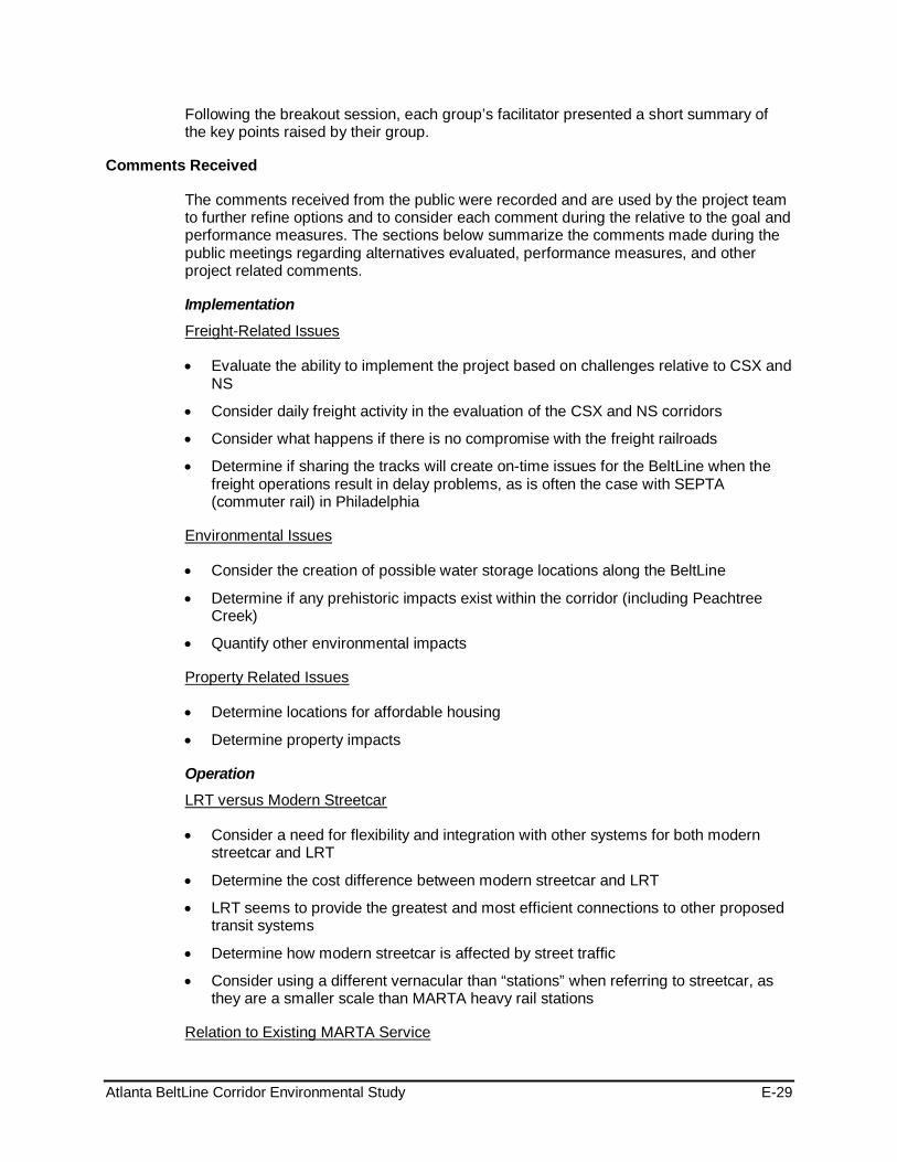
Atlanta BeltLine Corridor Environmental Study E-29
Following the breakout session, each group’s facilitator presented a short summary of the key points raised by their group.
Comments Received
The comments received from the public were recorded and are used by the project team to further refine options and to consider each comment during the relative to the goal and performance measures. The sections below summarize the comments made during the public meetings regarding alternatives evaluated, performance measures, and other project related comments.
Implementation
• Evaluate the ability to implement the project based on challenges relative to CSX and NS
Freight-Related Issues
• Consider daily freight activity in the evaluation of the CSX and NS corridors
• Consider what happens if there is no compromise with the freight railroads
• Determine if sharing the tracks will create on-time issues for the BeltLine when the freight operations result in delay problems, as is often the case with SEPTA (commuter rail) in Philadelphia
• Consider the creation of possible water storage locations along the BeltLine
Environmental Issues
• Determine if any prehistoric impacts exist within the corridor (including Peachtree Creek)
• Quantify other environmental impacts
• Determine locations for affordable housing
Property Related Issues
• Determine property impacts
Operation
• Consider a need for flexibility and integration with other systems for both modern streetcar and LRT
LRT versus Modern Streetcar
• Determine the cost difference between modern streetcar and LRT
• LRT seems to provide the greatest and most efficient connections to other proposed transit systems
• Determine how modern streetcar is affected by street traffic
• Consider using a different vernacular than “stations” when referring to streetcar, as they are a smaller scale than MARTA heavy rail stations
Relation to Existing MARTA Service

Atlanta BeltLine Corridor Environmental Study E-30
• Determine if the potential for 24-hour MARTA rail service (including the BeltLine) would affect freight railroad negotiations
• Improve connectivity to MARTA, including MARTA’s bus service
• Weigh the financial advantage for ABI constructing BeltLine transit versus expanding MARTA heavy rail services in the corridor, and determine if funding and operations for the BeltLine would be different from MARTA
• Consider involving Atlanta Police Department to monitor crime along the BeltLine
Safety
• Identify solutions to rail transit & bicycle street traffic potential conflicts and safety issues
Alignment Preference
• Preference for tunnel alignment alternative under Hulsey Yard
Transit Alignment Preference
• Consider alternatives and conceptual station locations that support projected population growth, including students
• General satisfaction with Best Performing Alternative
• Consider having both trail alignment options
• Preference for CSX alternative – it connects well with Howell Station and provides greater opportunity for development, and aligns well with the trail alignments
• Preference for a connection to MARTA, which would improve access to employment centers, boost MARTA ridership, and serve transit-dependent riders
• Emphasize manner in which BeltLine connects with MARTA and how it promotes connectivity/mobility in Atlanta (good connections to Lindbergh Center, King Memorial, Inman Park/Reynoldstown, West End, Ashby and Bankhead MARTA stations)
• The current eastern alignment hits closer to existing population; however, the western route would stimulate development where the amphitheater and mixed-use housing is currently planned
• Preference for BeltLine connection to King Memorial – provides better accessibility to landmarks such as the King Center, etc.
• An infill station at West End is less of a priority over the BeltLine serving the West End MARTA station directly
• The Marietta alignment provides better access to Westside Park (consider parking issues) than Howell Junction alignment
• The NS alignment has fewer environmental impacts than the CSX alignment
• Consider a second BeltLine or another transit service in the other corridor (NS or CSX, whichever is not picked)
• Consider advancing both Trail Alternatives A and B
Trail Alignment Preference

Atlanta BeltLine Corridor Environmental Study E-31
• Build Trail A first, but follow up with Trail B to provide multiple levels of connectivity
• The alignment on the Westside along Lena Street would improve visibility in the area in comparison to the existing wooded area along the former railroad corridor
• Trails align better with CSX alignment
• Trail A appears to have issues in utilizing the active freight corridor, while Trail B has better neighborhood connectivity
• Consider mixing and matching trail alternatives
• Determine if trails are designed for recreational purposes or work trips
Performance Measures
• Consider use of a 10-point scale rather than a 25-point scale
General Scoring/Methodology
Goal 1: Contribute to an integrated regional multi-modal transportation network that promotes seamless intermodal connectivity, increases community access to the existing transit and trail networks and improves reliability of personal travel
Goals/Objectives
• Need to link parks (emphasize access to Westside Park)
• Improve connectivity among neighborhoods
• NS alignment’s proximity to Atlantic Station should be valued and scored higher under Goal 1
• Consider Infill MARTA stations versus MARTA station connectivity alternatives
• Consider trip purposes as a performance measure (i.e. work/tourist/recreation)”
Goal 2: Manage and encourage the growth and economic development of the City, region and state by providing transit and transportation improvements to areas designated for growth
• CSX alignment presents more land redevelopment potential than NS alignment
Goal 3: Preserve and revitalize neighborhoods and business districts through context sensitive design of transit and trails, increased accessibility to mobility options and provision of affordable housing and transportation, and other community benefits
• No Comments Received
Goal 4: Provide a cost-effective and efficient transportation investment
• Ensure that cost effectiveness takes into consideration existing and planned transit services
Goal 5: Provide a transit, bicycle and pedestrian friendly environment
• Separating the trails from auto traffic is not as important as getting people to where they are going

Atlanta BeltLine Corridor Environmental Study E-32
Goal 6: Provide transit, bicycle and pedestrian connectivity among communities, and between communities and existing and planned recreational opportunities.
• Provide access to schools and libraries
Goal 7: Minimize adverse impacts to the environment and foster positive environmental impacts
• Why are there factors minimizing effects to parks when part of the BeltLine concept is to improve access to existing and planned parks?
• Consider the impact of vibration and noise with the addition of BeltLine transit along with CSX
Goal 8: Ensure consideration of public input throughout project planning and development
• No Comments Received
Other Project Considerations
• Address concerns raised in northwest (Tanyard Creek/Bobby Jones Golf Course area) and southwest zone
Transit Alignment
• Needs easy connectivity to transfer from one system to another
• Consider MARTA Infill station along East/West Line at Krog Street
Transit Stations
• Consider church as possible station site along the Southside overpass at Metropolitan Parkway
• Consider station at the Atlanta University Center (a major trip generator)
• Consider station at Lucille Street and Adena Park
• Consider station at the Bankhead MARTA station
• Avoid trails that are secluded and may present safety and security concerns, specifically trails that diverge from transit
Trails
• Connect BeltLine to other trails such as Washington Park trail and Freedom Parkway
• Take into account that trail connections are safer running alongside transit and not crossing over roadways and driveways
• Concern with pedestrian safety at transit crossings
• Consider pedestrian access at multiple points
• Minimize curb cuts when traveling near or on-street
• Consider flattest bicycle trail possible

Atlanta BeltLine Corridor Environmental Study E-33
Public Meeting Advertisement
Promotion of the workshops took place throughout the study area to involve the public, some of whom were previously involved in BeltLine planning efforts, through MARTA and ABI outreach methods. Others participated because of a host of outreach strategies designed to reach community. Advertisement for the Public Meeting meetings appeared in the on the project website and through a Study Update/ Flyer distributed through the contact database, and hand-distributed at neighborhood meetings, churches, community centers, grocery stores, libraries, businesses and other high traffic locations
1.2.2.6 Fall 2010 Public Workshops
MARTA and ABI held a public meeting at the Northside Study Group Meeting location on December 6, 2010, shown in Table 8 to gather feedback from the communities potentially affected by the additional alternatives in the northwest portion of the Atlanta BeltLine.
Table 8: Fall 2010 Public Workshop - Location, Date, and Attendance
Meeting Name L ocation Date / Time Number of Attendees
Northside Study Group- Public Meeting
Piedmont Hospital McRae Auditorium 1984 Peachtree Rd. NW Atlanta, GA 30309
December 6, 2010 6:30 – 8:30 PM 38
Format and Content
Participants signed-in upon arrival and were given an opportunity to review the project boards and speak to the project team prior to the start of the meeting. During the formal meeting, the project team discussed the study process, provided updates, and gave an overview of the alternatives.
The attendees participated in a small group exercise to discuss the alternatives and later reconvened in the large group to summarize their discussion.
Comments Received
Attendees were divided into three groups, staffed with a facilitator and scribe, to engage in participatory discussions focusing on the findings of the alternative evaluation specific to the transit and trail alternatives in the Northwest Zone. The discussion solicited comments pertaining to the following topics:
Congestion and Traffic • The viability of using Deering Road for in-street due to existing heavy congestion.
• Transit on Deering Road would change the character of the street from local to regional thoroughfare.
• If traffic is pushed from streets with in-street running for NS; it could add to heavy congestion on Collier Road.
• Is there an option to run in-street on a dedicated lane?
• It is important to note that in-street running does not always exacerbate congestion.
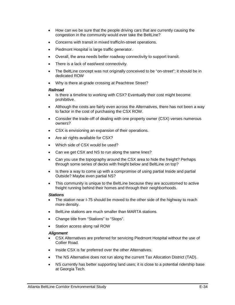
Atlanta BeltLine Corridor Environmental Study E-34
• How can we be sure that the people driving cars that are currently causing the congestion in the community would ever take the BeltLine?
• Concerns with transit in mixed traffic/in-street operations.
• Piedmont Hospital is large traffic generator.
• Overall, the area needs better roadway connectivity to support transit.
• There is a lack of east/west connectivity.
• The BeltLine concept was not originally conceived to be “on-street”; it should be in dedicated ROW
• Why is there at-grade crossing at Peachtree Street?
Railroad • Is there a timeline to working with CSX? Eventually their cost might become
prohibitive.
• Although the costs are fairly even across the Alternatives, there has not been a way to factor in the cost of purchasing the CSX ROW.
• Consider the trade-off of dealing with one property owner (CSX) verses numerous owners?
• CSX is envisioning an expansion of their operations.
• Are air rights available for CSX?
• Which side of CSX would be used?
• Can we get CSX and NS to run along the same lines?
• Can you use the topography around the CSX area to hide the freight? Perhaps through some series of decks with freight below and BeltLine on top?
• Is there a way to come up with a compromise of using partial Inside and partial Outside? Maybe even partial NS?
• This community is unique to the BeltLine because they are accustomed to active freight running behind their homes and through their neighborhoods.
Stations • The station near I-75 should be moved to the other side of the highway to reach
more density.
• BeltLine stations are much smaller than MARTA stations.
• Change title from “Stations” to “Stops”.
• Station access along rail ROW
Alignment • CSX Alternatives are preferred for servicing Piedmont Hospital without the use of
Collier Road.
• Inside CSX is far preferred over the other Alternatives.
• The NS Alternative does not run along the current Tax Allocation District (TAD).
• NS currently has better supporting land uses; it is close to a potential ridership base at Georgia Tech.
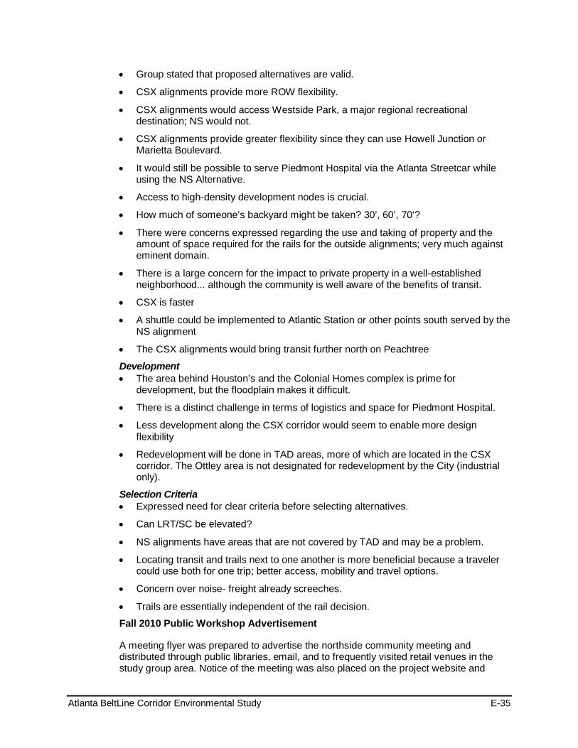
Atlanta BeltLine Corridor Environmental Study E-35
• Group stated that proposed alternatives are valid.
• CSX alignments provide more ROW flexibility.
• CSX alignments would access Westside Park, a major regional recreational destination; NS would not.
• CSX alignments provide greater flexibility since they can use Howell Junction or Marietta Boulevard.
• It would still be possible to serve Piedmont Hospital via the Atlanta Streetcar while using the NS Alternative.
• Access to high-density development nodes is crucial.
• How much of someone’s backyard might be taken? 30’, 60’, 70’?
• There were concerns expressed regarding the use and taking of property and the amount of space required for the rails for the outside alignments; very much against eminent domain.
• There is a large concern for the impact to private property in a well-established neighborhood... although the community is well aware of the benefits of transit.
• CSX is faster
• A shuttle could be implemented to Atlantic Station or other points south served by the NS alignment
• The CSX alignments would bring transit further north on Peachtree
Development • The area behind Houston’s and the Colonial Homes complex is prime for
development, but the floodplain makes it difficult.
• There is a distinct challenge in terms of logistics and space for Piedmont Hospital.
• Less development along the CSX corridor would seem to enable more design flexibility
• Redevelopment will be done in TAD areas, more of which are located in the CSX corridor. The Ottley area is not designated for redevelopment by the City (industrial only).
Selection Criteria • Expressed need for clear criteria before selecting alternatives.
• Can LRT/SC be elevated?
• NS alignments have areas that are not covered by TAD and may be a problem.
• Locating transit and trails next to one another is more beneficial because a traveler could use both for one trip; better access, mobility and travel options.
• Concern over noise- freight already screeches.
• Trails are essentially independent of the rail decision.
Fall 2010 Public Workshop Advertisement
A meeting flyer was prepared to advertise the northside community meeting and distributed through public libraries, email, and to frequently visited retail venues in the study group area. Notice of the meeting was also placed on the project website and

Atlanta BeltLine Corridor Environmental Study E-36
notices emailed to SAC and TAC members to share the meeting notice with their contacts.
1.3 2011 Public Hearing and Public Comment Period The Public Hearings and comment period for the Tier 1 Draft EIS was held from July 29, 2011 to September 17, 2011. The final series of meetings were held to present the recommendations resulting from the input of the public, Agency, Technical Advisory and Stakeholder Advisory Committees, as required by the federal guidelines.
Format and Content
The public hearing meeting was designed to review findings and recommendations over the course of the Study. The hearings were presided over by MARTA and ABI. Using a project video, the project team was able to present the public’s selection for the preferred alternatives followed by a question and answer session and a comment period. A neutral third-party facilitator was enlisted to solicit and receive public comments and a court recorder documented the comments. Table 9 shows the meeting locations, date and time, and number of attendees.
Table 9: Public Hearing Meetings
Meeting Name Location Date/Time Number of Attendees
Public Hearing (2) All Saints’ Episcopal Church 634 W. Peachtree Street Atlanta, GA 30308
August 16, 2011 1:00 – 3:00 pm 6:00 – 8:00 pm
39
Public Hearing (2) Hagar CTM 19 Joseph E. Lowery Blvd. NW Atlanta, GA 30314
August 18, 2011 1:00 – 3:00 pm 6:00 – 8:00 pm
22
Comments Received
The comments received through the court reporter during the Formal Public Hearings are summarized in Appendix F: Comments Received During Public Comment Period along with the other comments received during the Public Comment Period.
Additional Outreach Before and During the Public Comment Period
The public comment period to comment on the preferred alternatives was extended through September 17, 2011. A variety of meeting and public involvement strategies were used to update the public on the status of the project and to invite the public to the upcoming Public Hearings. Table 10 outlines the outreach activities leading up to the Public Hearings.
Comments Received
In addition to the promoting the public hearings through email notices and posted alerts on the project website, Peak Democracy, an on-line forum was established to solicit feedback from the public. Including comments received through the on-line forum, thirty-three (33) comments were received in writing during the comment period. The thirty-three (comments and responses are included in Appendix F: Comments Received During Public Comment Period

Atlanta BeltLine Corridor Environmental Study E-37
Table 10: Public Hearing Promotion: Locations, Date/Time, and Attendance
Meeting / Presentation Name Location Date / Time Number of
Attendees
MARTA Elderly & Disabled Advisory Committee - Chair
MARTA Annex Piedmont Road, 30324
July 12, 2011 9:30 AM ~25
Atlanta Planning Advisory Board City Hall, Room 2, Atlanta July 16, 2011 10:00 AM 40
Neighborhood Planning Unit - F Emailed NPU July 18, 2011 7:00 PM --
Neighborhood Planning Unit - Y John Burdine Facility 215 Lakewood Way, SW 30315
July 18, 2011 7:00 PM 30
Neighborhood Planning Unit - K CA Scott Recreational Center 1665 MLK Jr Dr, 30314
July 19, 2011
6:30 PM 13
Neighborhood Planning Unit - G Emailed NPU July 21, 2011 7:00 PM --
Neighborhood Planning Unit - S The Vicars, 838 Cascade Rd, SW July 21, 2011 7:00 PM 55 +
Neighborhood Planning Unit - M Helene S Mills Sr. Facility 515 John Wesley Dobbs Ave. 30312
July 25, 2011 6:30 PM HB
Neighborhood Planning Unit - D Agape Community Center 2351 Bolton Road NW 30318
July 26, 2011 7:30 PM HB
TADAC Committee ABI Offices, 86 Pryor Street July 26, 2011 4:00 PM 40
Neighborhood Planning Unit - J Atlanta Job Corp, 239 W. Lake Dr. NW 30314 July 26, 2011 7:00 PM 35
Neighborhood Planning Unit - W Emailed NPU July 27, 2011 7:30 PM --
Neighborhood Planning Unit - N Emailed NPU July 28, 2011 7:00 PM --
Neighborhood Planning Unit - E Peachtree Christian Church 1580 Peachtree St, NW 30309
August 2, 2011 6:30 PM ~40
Neighborhood Planning Unit - V Emailed NPU August 8, 2011 7:00 PM --
Neighborhood Planning Unit - B Emailed NPU August 8, 2011 7:00 PM --
Neighborhood Planning Unit - X Stewart Lakewood Library 2893 Lakewood Ave, 30315
August 8, 2011 7:00 PM 30
Neighborhood Planning Unit - L English Avenue Neighborhood Association 781 Wheeler Street, Suite 11
August 9, 2011 7:00 PM ~ 45
Neighborhood Planning Unit - T KIPP Strive Academy 1445 Lucile Ave, Atlanta, GA 30310
August 10, 2011 7:00 PM 48
Public Hearing Advertisements
Advertisement of the Public Hearings appeared in the following venues:
• Newspapers: Atlanta Journal-Constitution (August 8, 2011; August 10, 2011), Atlanta Daily World (August 11, 2011) and Mundo Hispanico (Spanish – August 11, 2011)
• Project Websites
Other Announcements: A meeting flyer and Study Fact Sheet (Newsletter #6) were printed to advertise the public hearings and the newsletter was distributed through public

Atlanta BeltLine Corridor Environmental Study E-38
libraries, email, and to frequently visited retail venues in the study group area. Notice of the meeting was also placed on the project websites and notices emailed to SAC and TAC members to share the meeting notice with their contacts, shown in Table 11.
Table 11: Additional Public Hearing Promotion: Locations, Date/Time, and Attendance
Additional Public Hearing Promotional Emails Sent / Organizations Date
SAC/TAC July 26, 2011
ABI Contact Database July 13, 2011
Georgia State University August 8, 2011
Georgia Institute of Technology August 8, 2011
Emory University August 8, 2011
Atlanta University Center August 8, 2011
TAC August 8, 2011
MARTA Contact Database August 9, 2011
1.4 Agency Involvement: Coordination, Committees, and Meetings There was an identification and invitation to participate in the Tier 1 EIS to any Federal, state, and local agencies that may have jurisdiction by law, special expertise, or other interest in the environmental review process and its outcomes. SAFETEA-LU requires the identification of Lead, Cooperating, and Participating agencies in the development of an EIS. The Lead agencies for the BeltLine Tier 1 EIS include FTA, MARTA, and the Atlanta BeltLine Inc. Under SAFETEA-LU, Lead Agencies must perform the functions that they have traditionally performed in preparing an EIS in accord with 23 CFR 771 and 40 CFR parts 1500-1508.
According to CEQ regulations, 40 CFR 1508.5, a Cooperating Agency is any federal agency, other than a Lead Agency, that has jurisdiction by law or special expertise with respect to any environmental impact involved in a proposed project or project alternative. Participating Agencies are those with an interest in the project, invited to comment on the environmental documentation produced as part of the project. Section 1.4.1 shows a list of agencies by category designation of Lead, Cooperating, or Participating.
Formation of three committees supported the development of the Tier 1 EIS: the Stakeholder Advisory Committee, the Technical Advisory Committee, and Agency Coordination. Descriptions of the agency coordination, committees, and meetings are provided below.
1.4.1 Agency Coordination Federal, state, and local agencies received invitations to provide comments regarding possible concerns or considerations for the resource areas under their authority. Below is a list of the agencies. Resource agencies received letters requesting their participation in the process.

Atlanta BeltLine Corridor Environmental Study E-39
Agency Membership
Co-Lead Agency - Atlanta BeltLine, Inc. (ABI) - Metropolitan Atlanta Rapid Transit Authority (MARTA) - Federal Highway Administration (FHWA) - Federal Transit Administration (FTA)
Cooperating Agency - U.S. Army Corps of Engineers (USACE) - U.S. Environmental Protection Agency (EPA) - U.S. Fish and Wildlife Service (USFWS)
Participating Agency
- Centers for Disease Control and Prevention (CDC)
Participating Agency – Federal
- Federal Emergency Management Agency (FEMA) (Regulatory Floodways) - Federal Railroad Administration (FRA) - National Park Service (NPS) - U.S. Department of Housing and Urban Development (HUD) - U.S. Department of the Interior (USDO) Office of Environmental Policy & Compliance - U.S. Geological Survey (USGS), Environmental Affairs Program
- National Railroad Passenger Corp. (AMTRAK)
Participating Agency – Interstate
- Georgia Department of Natural Resources (DNR) - Non-Game Conservation
Participating Agency – State
- Georgia Department of Natural Resources (DNR) Environmental Protection Division - Georgia Department of Natural Resources (DNR) Floodplain Management Office - Georgia Department of Natural Resources (DNR) Historic Preservation Division - Georgia Department of Natural Resources (DNR) Office of the Commissioner - Georgia Department of Transportation (GDOT) - Georgia Emergency Management Agency (GEMA) - Georgia Environmental Facilities Authority (GEFA) - Georgia Forestry Commission (GFC)
- Atlanta Regional Commission (ARC)
Participating Agency – Regional
- Atlanta Regional Transportation Board (ARTIB) - Georgia Regional Transportation Authority (GRTA)
- Atlanta Housing Authority (AHA)
Participating Agency – City of Atlanta
- City of Atlanta Department of Parks, Recreation and Community Affairs (DPRCA) - City of Atlanta Department of Planning and Community Development (DPCD)

Atlanta BeltLine Corridor Environmental Study E-40
- City of Atlanta Department of Public Works (DPW)
- DeKalb County Planning & Development Department (P&DD)
Participating Agency – DeKalb County
- Atlanta-Fulton County Emergency Management Agency (AFCEMA)
Participating Agency – Fulton County
- Fulton County Department of Environment and Community Development (E&CD) - Fulton County Department of Parks and Recreation (P&R) - Fulton County Department of Public Works (DPW)
1.4.2 Technical Advisory Committee (TAC) The TAC is composed of representatives of organizations and agencies that have a specific interest and/or responsibility in the BeltLine Corridor or that have shown special interest in the redevelopment of the corridor. It included individuals with technical environmental skills and background. The role of TAC is to provide advice and input regarding methodology and the scoping process and specific guidance on technical matters. By nature of their technical expertise, in some cases there was an invitation to agencies to serve on both the Agency Coordination Group and the Technical Advisory Committee.
TAC Member Organizations
- Federal Highway Administration (FHWA)
Federal
- Federal Transit Administration (FTA) - U. S. Environmental Protection Agency - Brownfields (EPA) - U.S. Army Corps of Engineers (USACE) - U.S. Department of Housing and Urban Development (HUD)
- Georgia Department of Natural Resources (DNR) Environmental Protection Division (EPD)
State
- Georgia Department of Natural Resources (DNR) Floodplain Management Office - Georgia Department of Natural Resources (DNR) Historic Preservation Division
(SHPO) - Georgia Department of Transportation (GDOT)
- Atlanta BeltLine, Inc. (ABI)
Local/Regional
- Atlanta Bicycle Coalition (ABC) - Atlanta Board of Education - Atlanta Housing Authority (AHA) - Atlanta Planning Advisory Board (APAB) - Atlanta Police Department (APD)

Atlanta BeltLine Corridor Environmental Study E-41
- Atlanta Regional Commission (ARC) - Atlanta University Center Consortium - Atlanta Urban Design Commission (AUDC) - Buckhead Area Transportation Management Association (BATMA) - Central Atlanta Progress (CAP) - Citizens for Progressive Transit (CfPT) - City of Atlanta Department of Parks, Recreation and Community Affairs (DPRCA) - City of Atlanta Department of Planning and Community Development (DPCD) - City of Atlanta Department of Public Works (DPW) - City of Atlanta Office of Sustainability - CSX Intermodal - Emory University - Fulton County Department of Public Works (DPW) - Georgia Institute of Technology (Georgia Tech) - Georgia Regional Transportation Authority (GRTA) - Georgia State University (GSU) - Metro Atlanta Chamber of Commerce - Metropolitan Atlanta Rapid Transit Authority (MARTA) - Midtown Alliance - Norfolk Southern Corporation (NSC) - Pedestrians Educating Drivers on Safety (PEDS) - The PATH Foundation - Trust for Public Land, Georgia Office (TPL) - Upper Chattahoochee Riverkeeper (UCR)
1.4.3 Stakeholder Advisory Committee (SAC) The Stakeholder Advisory Committee (SAC), composed of representatives from a variety of area organizations, serves a key role in encouraging public participation. A Stakeholder Advisory Committee provided ongoing assistance to the project, especially in the outreach component. Representatives from a variety of area organizations, such as the TADAC, MARTA’s network of citizen and business organizations, faith-based organizations, community-based organizations, and advocacy groups composed the SAC. The SAC provided input and comments on the project findings, and played a key role in generating participation from the public at large. Below is a list of SAC members:
SAC Member Organizations
- Atlanta BeltLine Inc. (ABI) - Atlanta Planning Advisory Board - Atlanta Transit Riders' Union - BeltLine Network - Clean Air Campaign - Coalition for the Peoples' Agenda - Environmental Justice Resource Center @ CAU - Georgia Conservancy - Georgia Power Company

Atlanta BeltLine Corridor Environmental Study E-42
- Georgia Stand Up - Georgians for Better Transportation - Governor's Council on Developmental Disabilities - MARTA Elderly & Disabled Advisory Committee – Chair - MARTA Elderly & Disabled Advisory Committee – Vice Chair - MARTA Elderly & Disabled Advisory Committee – Accessibility - MARTA Elderly & Disabled Advisory Committee – Customer Focus - MARTA Elderly & Disabled Advisory Committee-Membership and Resource - Metropolitan Atlanta Rapid Transit Authority (MARTA) - Neighborhood Planning Unit – B - Neighborhood Planning Unit – C - Neighborhood Planning Unit – D - Neighborhood Planning Unit – E - Neighborhood Planning Unit – F & TADAC Committee Environmental Task Force - Neighborhood Planning Unit – G - Neighborhood Planning Unit – J - Neighborhood Planning Unit – K - Neighborhood Planning Unit – L - Neighborhood Planning Unit – M - Neighborhood Planning Unit – N - Neighborhood Planning Unit – S - Neighborhood Planning Unit – T - Neighborhood Planning Unit – V - Neighborhood Planning Unit – W - Neighborhood Planning Unit – X - Neighborhood Planning Unit – Y - Panache Communications Group - Piedmont Healthcare - Piedmont Park Conservancy - Shepherd Center - Sierra Club-Georgia Chapter - Southface Energy Institute - TADAC Committee - The King Center - University Community Development Corp. (UCDC) - Urban Land Institute (ULI) (Smart Growth Solutions) - Virginia Highland Civic Association
1.4.4 Agency / TAC Meetings and Outreach 1.4.4.1 Agency / TAC Scoping Meeting
MARTA, in partnership with ABI, invited interested agencies and the TAC to participate in three meetings in the early stage of the Tier 1 EIS (listed in Table 12). One meeting

Atlanta BeltLine Corridor Environmental Study E-43
served as the kick-off meeting to introduce the Tier 1 EIS and the proposed project. The other two meetings occurred during the Public Scoping period.
An Agency Scoping meeting, held by MARTA in partnership with ABI, convened on August 12, 2008 to discuss the BeltLine Corridor Environmental Study Scoping Informational Packet in preparation for the Tier 1 EIS. An additional Agency Scoping meeting held on August 22, 2008 discussed the results of the Public Scoping meetings.
The August 12, 2008 meeting provided an overview of the Tier 1 EIS and allowed the participants to comment and ask questions on the project alternatives and its potential impacts. Attendees received Scoping materials. Meeting dates, locations, and number of attendees for the Agency Scoping meetings are contained in Table 12.
On August 22, 2008, interested agencies and the TAC reconvened to respond to the Scoping materials provided at the August 12 meeting. There was also a synopsis of comments made during the formal Public Scoping meetings. The Scoping Summary Report lists comments of note mentioned during the meeting and responses to the request for comment.
Table 12: Agency / TAC Scoping Meetings
Meeting/Presentation Name Location Date/Time Number of Attendees
Agency / TAC Kick-off Meeting Atlanta BeltLine, Inc., 86 Pryor Street SW Atlanta, GA 30309
July 17, 2008 11:30 – 1:30 pm 27
Agency / TAC Scoping Meeting MARTA 2424 Piedmont Road Atlanta, GA 30324
August 12, 2008 9:00 – 11:00 am 19
Agency / TAC Scoping Meeting Atlanta BeltLine, Inc. 86 Pryor Street SW Atlanta, GA 30303
August 22, 2008 9:00 – 11:00 am 19
Format and Content
At the Agency Scoping meetings, attendees reviewed presentation materials provided at the Public Scoping meetings. After a review of the project and Beltline background, participants had the opportunity to comment on the Tier 1 EIS and advise MARTA and ABI of their issues of concern. The Scoping Summary Report discusses these comments in detail, as well as the responses to comments received.
Comments Received
Below is a summary of the comments solicited from participants during the August 12, 2008 Scoping Meeting.
Purpose and Need and Goals and Objectives Agency representatives provided the following comments on the BeltLine Corridor Environmental Study Purpose and Need statement:
• Context - Consider the proposed project in the context of present and future transit need.

Atlanta BeltLine Corridor Environmental Study E-44
• Consistency with Regional Plans - Ensure the BeltLine Corridor Environmental Study is consistent with the following plans in the Atlanta region:
- the Transit Planning Board’s (TPB) Concept 3 Regional Transit Vision;
- the ARC Envision6 Regional Transportation Plan; and
- Connect Atlanta, Atlanta’s Comprehensive Transportation Plan (CTP).
• Need for the Project - Comments regarding the need for a project in the BeltLine Corridor included:
- Develop a discrete problem statement that focuses on the problems that the BeltLine Corridor Environmental Study will address.
- Establish the need for the proposed trail system. Is there a lack of or insufficient supply of recreational facilities to support a need for the trail elements of the proposed BeltLine Corridor project?
- Air quality in the Atlanta region is a definite purpose and need for the proposed BeltLine Corridor Study.
• Goals and Objectives - Add “project connectivity to the rest of the region” under goal number 5. There is a perception that the proposed BeltLine Corridor project is only for the City of Atlanta.
Alternatives • Alignment - The conceptual MARTA Armour Yard and Simpson Road heavy rail infill
stations are located at points of intersection of the proposed BeltLine and could serve as important regional transfer centers in the future. Coordination regarding ongoing MARTA infill station planning activities will be an important consideration as the Study proceeds into more detailed alignment analysis.
• Station and Maintenance Facilities - Questions and comments regarding potential transit stations and maintenance facilities included:
- Will station locations and maintenance facilities be considered in the Tier 1 EIS?
- The Tier 1 EIS should address access to and from the proposed station to connecting bicycle facilities.
- It is important to ensure that multi-use facilities are designed to accommodate safe travel by cyclists and pedestrians and that they safely interface with existing and proposed transit and roadway facilities.
• Mode - Consider treating bicycle and pedestrian travel as separate modes in order to reflect the different needs of the two groups.
• Trails - Provide additional detail regarding the characteristics of the proposed multi-use trail (width, amenities, etc.). Similar detail should be provided for the sections that will not be in the existing ROW (e.g., on-street facilities).
Connectivity • It is important to think about both positive and negative impacts of connectivity.
Environmental Quality • Air Quality - The air quality analysis should compare a build versus no build scenario
and show presumable air quality benefits, mitigation of potential releases of air toxins after project completion and compliance with air quality standards.

Atlanta BeltLine Corridor Environmental Study E-45
• Brownfields and Hazardous Materials - Provide a methodology of how Brownfields and hazardous materials/wastes located within the Study area will be treated. The methodology should include: the identification and characterization of hazardous/contaminated sites; safety plans and procedures, including use of pesticides/herbicides; worker training; spill prevention; and a containment and countermeasures plan.
• Community and Neighborhood Impacts - The Tier 1 EIS should provide special consideration and planning for the following:
- Pedestrian infrastructure, including sidewalks that are continuous, accessible, safe and aesthetically pleasing; adequate pedestrian crossings that are convenient and easily identified by motorists.
- Sufficiently marked, continuous lanes and infrastructure needs for bicyclists.
- Americans with Disabilities Act (ADA) accessibility compliance for all project areas.
- Consideration of beneficial and adverse long-term land use impacts, including the potential influx of people into the area as a result of a proposed project and associated impacts.
- Special demographic considerations - e.g., hospitals, nursing homes, day care centers, schools.
- Special consideration and appropriate mitigation for necessary relocation and other potential adverse impacts to residential areas, community cohesion and community services.
• Environmental Justice - Describe the potential impacts of the proposed BeltLine Corridor project on minority groups and low-income groups residing within the Study area.
• Historic and Cultural Resources - Historic and cultural resources located within the Study area should be considered.
• Land Use - The proposed BeltLine Corridor project is depicted on the ARC Urban Growth Policy Map (UGPM). The UGPM and an associated Development Matrix provide guidance for the appropriate design and scale of development that should occur with infrastructure availability to efficiently meet the forecasted population and growth of the Atlanta region. The UGPM envisions that the station areas of the BeltLine will become “transit villages” on a scale with other fixed guideway transit areas, which would be a mixed-use, walkable area with transit-supportive residential density.
• Noise - Identify projected elevated noise levels at sensitive receptors - i.e., residential, schools, hospitals - and appropriate mitigation plans during and after construction.
• Parks and Recreation - The following comments/questions were made regarding parks and recreation facilities located within the BeltLine Study area: - Does a representative from either the National Park Service or the USDOI need
to be consulted as part of the BeltLine Corridor Environmental Study? - Outside of the recreational aspects identified, impacts to National Parks that exist
in the BeltLine Study area are of concern. - There needs to be a distinct definition of greenspace and trail.

Atlanta BeltLine Corridor Environmental Study E-46
• Utilities - Solid waste generation, reduction and disposal should be considered in the Tier 1 EIS.
• Water Resources - Special consideration should be made to the water quality/quantity, including private and public potable water supply; ground and surface water resources; ground and surface water contamination; compliance with water quality and wastewater treatment standards; potential contamination of underlying aquifers; and contamination of the food chain.
• Mitigation - Mitigation plans that protect the environment and promote public health should be described in the Tier 1 EIS wherever warranted.
Construction Impacts Some agency representatives recommended that the Study would need to comply with appropriate criteria and guidelines to ensure worker safety and health during construction. It was further recommended that during construction, proper mitigation measures should be implemented to control runoff and dust.
Costs and Financial Plan Regarding project costs and potential funding sources for the proposed BeltLine Corridor project, the following agency comments were received:
• If a new regional sales tax or some kind of new funding resource were to be pursued in the Tier 1 phase establishing the BeltLine as a locally funded project, how would the NEPA process be impacted?
• BeltLine planning activities should anticipate a variety of possible funding scenarios, and preserving funding flexibility should be a key objective throughout the EIS process.
Project Administration and Process • More certainty will be needed with regard to the transit right-of-way to ensure that
private development can move forward and plan effectively for transit service or bike/pedestrian facilities when they become available.
• During the BeltLine Corridor Environmental Study, coordination and collaboration with public health professionals in the Fulton County Department of Health and Wellness and the Georgia Department of Human Resources (Division of Public Health), and with local academic institutions including Emory University (Rollins School of Public Health), Georgia State University (Institute of Public Health), Georgia Institute of Technology (Center for Quality Growth and Regional Development), and Morehouse College (Public Health Sciences Institute) should be made to accomplish adequate health analysis and development of appropriate mitigation measures.
• Recommendations from the Health Impact Assessment (HIA) that was conducted on the proposed BeltLine Corridor project by the Center for Quality Growth and Regional Development at the Georgia Institute of Technology should be considered in the EIS process.
1.4.4.2 Agency / TAC and Client Group Meeting on the EER and the Evaluation Criteria
MARTA, in partnership with ABI, held a meeting on March 23, 2009 with interested agencies and the TAC to review and discuss the results of the analysis of existing

Atlanta BeltLine Corridor Environmental Study E-47
conditions, recap the Environmental Effects Report, review and discuss the proposed Evaluation Criteria, and to prepare for upcoming public workshop.
Format and Content
The Agency / TAC meeting began with a viewing of project display boards. There was a discussion on the purpose of the meeting followed by a presentation on key project milestones, highlights of the Environmental Effects Report and Evaluation Criteria, and discussion on the upcoming public workshops, and the next steps in the study process.
Following the presentation, the attendees formed two groups to review the Evaluation Criteria, specifically the Performance Measures. The purpose of this exercise was to get a consensus that the Performance Measures aligned with the Goals and Objectives of the project, and any revisions or additions to the Evaluation Criteria.
1.4.4.3 Additional TAC / Agency Meetings on Alternative Alignments
Atlanta Development Authority (ADA) Workshop
A project workshop, held on May 28, 2009, provided an opportunity for the Atlanta Development Authority (ADA) staff and Atlanta’s Economic Development Sub-Cabinet to review and comment on the alternatives considered for the BeltLine project.
Agency / TAC Workshop
A TAC workshop took place on June 2, 2009 to review and comment on the alternatives considered.
MARTA Workshop
MARTA staff participated in a workshop on July 9, 2009 to review and comment on the alternatives considered.
Format and Content
Workshops with ADA, TAC, and MARTA followed a format that was similar to the public workshops including a brief presentation and interactive breakout group exercise focused on soliciting comments and suggestions relative to the project alignments, station locations, and service types considered for the BeltLine project. The Public and Committee Workshops April-June 2009 report includes the meeting notes for the Agency / TAC and ADA meetings. The MARTA Workshop was documented separately. Table 14 shows the meetings held with the Agency and TAC in Phases 2 and 3.
Section 1.2.2.2 provides a summary of the input received following the Public Workshops.
1.4.4.4 Additional Agency / TAC Meetings on Alternatives Evaluation
Agency / TAC
An Agency / TAC meeting was held on November 2, 2009 to review the results of the analysis of the transit and trails alternatives, how committee and public comments were incorporated into the analysis and to solicit comments and issues from attendees.
Atlanta BeltLine Corridor Environmental Study E-48
ADA Economic Development Sub-Cabinet
A project meeting held on November 12, 2009 provided an opportunity for the Sub-Cabinet to review and comment on the alternatives considered and the evaluation process for the BeltLine project. The Sub-Cabinet includes representatives from various City of Atlanta departments, including Department of Public Works, Planning and Community Development, Police, Fire, Watershed Management, Parks, among others.
Format and Content
The meetings with Agency / TAC and ADA followed a format that was similar to the public meetings including an open house section with a series of project display boards and video that described and demonstrated the various transit and trails options.
Notification and Advertisements for Technical Advisory and Agency Committee Workshops
Committee members received email notices two weeks prior to the meetings. Within two days of the meetings, committee members were telephoned to confirm attendance.
1.4.4.5 TAC/Agency/SAC Meeting
A TAC/Agency Meeting was held on August 2, 2011 to review the Atlanta BeltLine DEIS findings, address questions and finalize a strategy for communicating the findings with the public at the DEIS Public Hearings scheduled for August 16th and 18th. In preparation for the meeting, committee members were asked to review key elements of the study and be prepare comments and input. Participants were given a link for the documents to the project website at
Format and Content
www.itsmarta.com/uploadedFiles/About_MARTA/Planning/Beltline_Corr/Atlanta_BeltLine_DEIS_FTA.pdf
Workshops with ADA, TAC, and MARTA followed a format that was similar to the public workshops including a brief presentation and interactive breakout group exercise focused on soliciting comments and suggestions relative to the project alignments, station locations, and service types considered for the BeltLine project.
1.4.5 SAC Meetings and Outreach 1.4.5.1 Formal Stakeholder Advisory Committee Kick-off Meeting
The kick-off meeting for the Stakeholder Advisory Committee, held by ABI in partnership with MARTA on July 22, 2008, introduced the project, the environmental process, and project milestones, and discussed the role of the SAC. There was also encouragement of the SAC to solicit community participation throughout the Tier 1 EIS.
Format and Content
Upon arrival, SAC members had an opportunity to view a series of display boards and ask questions of the project team. A presentation followed that described the overall study process, overview of the project, and a question and answer period. The project team outlined the next steps prior to adjourning.

Atlanta BeltLine Corridor Environmental Study E-49
1.4.5.2 Stakeholder Advisory Committee Scoping Meeting
MARTA in partnership with ABI, invited the SAC to participate, along with the public, in a series of Scoping meetings. In preparation for the meetings, the Stakeholder Advisory Committee assisted in promoting the series of meetings by distributing meeting notices both electronically and in hard copy within their community, organizations, and area of influence.
Format and Content
At the SAC Scoping meeting, attendees reviewed presentation materials. After a review of the project and BeltLine background, participants had the opportunity to comment on the Tier 1 EIS and advise MARTA and ABI of their issues of concern. The Scoping Summary Report discusses these comments. Table 13 presents the scoping related SAC meetings.
Table 13: SAC Kick-off, Scoping, and Public Workshop Meetings
Meeting/Presentation Name Location Date/Time Number of Attendees
SAC Kick-off Meeting MARTA 2424 Piedmont Road Atlanta, GA 30324
July 22, 2008 11:30 – 1:30 pm 27
TAC/SAC Meeting MARTA 2424 Piedmont Road Atlanta, GA 30324
December 8, 2008 5:30 – 7:30 pm 33
*The attendance reported includes participants from all committees
1.4.5.3 Stakeholder Advisory Committee / Public Workshops
SAC members received email invitations to participate, along with the public, in at least one of five public meetings held April 13 – May 4, 2009.
Format and Content
Workshops including a brief presentation and interactive breakout group exercise focused on soliciting comments and suggestions relative to the project alignments, station locations, and service types considered for the BeltLine project. The Public and Committee Workshops April-June 2009 report includes the meeting notes from each of these meetings. Section 1.2.2 describes the Public Workshops in more detail.
1.4.5.4 Additional SAC Meetings on Alternative Alignments
SAC Workshop
A SAC workshop, sponsored by ABI in partnership with MARTA, took place on June 2, 2009 to review and comment on the alternatives considered.
Format and Content
A workshop with the SAC followed a format that was similar to the public workshops including a brief presentation and interactive breakout group exercise focused on soliciting comments and suggestions relative to the project alignments, station locations, and service types considered for the BeltLine project. The Public and Committee Workshops April-June 2009 report includes the meeting notes from the meeting. Table

Atlanta BeltLine Corridor Environmental Study E-50
14 shows the workshop held with the SAC in Phases 2 and 3, as well as future meetings scheduled.
1.4.5.5 Additional SAC Meetings on Alternatives Evaluated
A SAC meeting, held by ABI in partnership with MARTA, was held on November 2, 2009 to review the results of the analysis of the transit and trails alternatives, how committee and public comments were incorporated into the analysis and to solicit comments and issues from attendees.
Section 1.4.6 provides a summary of the input received following the Public Workshops.
Table 14: Agency, TAC, SAC, and Additional Meetings in Phases 2 and 3
Organization Location Date/Time Number of Attendees
TAC/Agency ABI Offices 86 Pryor St. SW Atlanta, GA 30303
March 23, 2009 11:30 am – 1:00 pm
26
ADA Workshop ABI Offices 86 Pryor St. SW Atlanta, GA 30303
May 28, 2009 9:00 am – 11:00 am
29
TAC /Agency/ SAC Workshop
ATT, Midtown 2 Auditorium 725 W. Peachtree St. NE Atlanta, GA 30308
June 2, 2009 11:30 – 1:30 pm 6:00 – 8:00 pm
35
MARTA Workshop MARTA Annex Building 2424 Piedmont Road NW Atlanta, GA 30324
July 9, 2009 2:00 – 4:00 pm
15
TAC/Agency MARTA Headquarters 2424 Piedmont Road NW Atlanta, GA 30324
August 18, 2009 11:30 am – 1:30 pm
24
SAC MARTA Headquarters 2424 Piedmont Road NW Atlanta, GA 30324
August 18, 2009 6:00 – 8:00 pm
10
TAC/Agency ABI Offices 86 Pryor St. SW Atlanta, GA 30303
November 2, 2009 11:30 am – 1:00 pm
28
SAC MARTA Headquarters 2424 Piedmont Road NW Atlanta, GA 30324
November 2, 2009 4:30 – 6:00 pm
10
ADA Economic Development Sub Cabinet
ABI Offices 86 Pryor St. SW Atlanta, GA 30303
November 12, 2009 9:00 am – 11:00 am
13
TAC /Agency ABI Offices 86 Pryor St. SW Atlanta, GA 30303
November 30, 2010 11:30 – 1:30 pm
20
SAC MARTA Headquarters 2424 Piedmont Road NW Atlanta, GA 30324
November 30, 2010 6:00 – 8:00 pm
14
TADAC ABI Offices 86 Pryor St. SW Atlanta, GA 30303
July 26, 2011 4:00 – 6:00 pm
17

Atlanta BeltLine Corridor Environmental Study E-51
Organization Location Date/Time Number of Attendees
TAC / Agency/SAC All Saints Episcopal Church 634 W. Peachtree Street NW Atlanta, GA 30308
August 2, 2011 4:00 – 6:00 pm
30
1.4.5.6 Notification for Stakeholder Advisory Committee Meetings
Stakeholder Advisory Committee members are notified of meetings by way of email notices and telephone notification two weeks prior to the meetings. Within two days of the meetings, phone call reminders encouraged members to attend the meeting.
1.4.6 Spring 2009 Post Public Workshop Agency / TAC and SAC Meetings Comments Received Described below is a broad summary of comments and input received from TAC, SAC, and Agency meetings and workshops following the Public Workshops.
Service Service Type and Characteristics – Participants were asked to provide feedback on the basic types of transit service, local service or regional service desired. The group was also asked about preferences regarding the type of service vehicle, access to the system and travel time once on the vehicle. Following is the list of the comments and questions received:
• Development drives the types of destinations travelers wish to access; local service best drives economic development
• Travelers are time-sensitive, and timeliness and availability are key factors in attracting and retaining ridership:
- Frequency of service
- Periods of operation – 24-hour or late-night service
- Travel time through the corridor
• Regardless of service type, the system should be designed to maximize ridership potential
• Local service type is more in line with the original intent of the project
• Shuttle system would not be convenient for users
• Transit design should provide for a user-friendly system
• Transit design should provide for multiple community connections
• Transit design should maximize opportunities for access
• Transit system should place users closer to destinations and activity areas
• More stations versus fewer stations is preferable
• Do not use the term ―regional to describe transit system; Beltline is a local service to complement the existing MARTA system
• Fare collection system should be determined

Atlanta BeltLine Corridor Environmental Study E-52
• Local service type is preferable for the entire corridor; do not mix local service with regional service; a hybrid system should not be considered
• Transit system design analysis should weigh options against time saved when compared to driving a car
• Limit the number of station locations in undeveloped sections of the corridor; instead use stations to encourage redevelopment
• Strong preference for local service; regional is bad term and not desired
• No parking at BeltLine stations
• Some parking at those MARTA stations that connect to BeltLine
• Access to MARTA and other regional transit is important
• Include express transit service with skip stops
• Wants more stops, less like MARTA heavy rail
• Tie service frequency to centers, density, jobs and activities
• Some stations serve major centers while others serve smaller more local
• Wants the ability to bypass stations
• Maximize ridership
• Use feeder services to support faster regional travel
• Consider skip-stop operations during peak periods, or other hybrid local/regional operations
• Apply cost-effectiveness criteria
• One-half (½) mile station spacing seems appropriate for the Beltline
• Consider a mix of service types depending on time of day and peak hours
• Consider bypassing some stations during peak hours to provide faster service
• Consider different types of transit technologies in the corridor (i.e., Portland, Organ provides an example of streetcar and light rail sharing tracks
• Character of the Beltline transit system should be different from the existing MARTA heavy rail transit system in terms of speed, station spacing, and transfers
• Vehicle speed should respond to the surrounding neighborhood conditions
• Seamless transitions from Beltline to MARTA heavy rail stations
• Minimize impacts to the community
• Provide service for other than work trips
• Concern about frequency of service based on type of vehicles, location of stations
• Create the stations, but activate as needed – not all active right away
• Prefers streetcar; its more adaptable and cost-effective to operate
• Provide neighborhood-oriented access, part of original BeltLine transit concept
• Consider impact to DeKalb Avenue-Moreland Avenue interchange

Atlanta BeltLine Corridor Environmental Study E-53
• Travel time important for travelers going through/across zones in BeltLine Corridor
• Consider ―skip-stops and other hybrid local-regional options
• Minimize pedestrian access time
Neighborhoods/Areas of Interest – After describing the general alignment, participants were asked to describe service that would compliment/fit specific neighborhoods/areas.
• Connect to recreation opportunities
Areas of Interest – The group was also asked to identify specific areas of interest/concern.
• Atlanta University Center
• Fort McPherson
• Piedmont Hospital
• Midtown
• Ansley Park/Monroe Drive area
• Little 5 Points
• Miami Circle (north of Lindbergh Center)
• Westside Park
• Retail and medical centers
o Ansley Mall
o Piedmont Park area at Virginia/Monroe
o Amsterdam Walk
o Howell Mill near I-75
• Northside Drive
• Monroe Drive near I-85/Buford Highway Connector
Corridor-wide
• Right-of-way impacts
• Need for better east-west connectivity
• Accessibility to both major trip destinations (activity centers, employment) and trip origins
• More direct access to major activity centers along BeltLine Corridor (ex. Piedmont Hospital)
• Connections needed to all MARTA heavy rail stations near BeltLine (ex. Bankhead Station)
• Connect to existing and planned transit services
• Integration with surrounding land use

Atlanta BeltLine Corridor Environmental Study E-54
• Quality design (do not sacrifice in the interest of minimizing right-of-way or avoiding impacts)
West End Station
• Consider an in-fill MARTA heavy rail station between West End Station and Oakland City Station versus a spur connection to West End Station
• Compare cost of infill station versus cost of spur connection
• A through loop may be better than a spur in and out
• Accessibility for students in the Atlanta University Center
• Consider an alignment option using Metropolitan Avenue and across Ralph David Abernathy Boulevard to West End Station
• Backing in and out of West End MARTA Station creates safety and operational concerns
Bankhead Station
• Provide a direct connection or walkable connection Bankhead Station
• Enhance sidewalks along Donald Lee Hollowell Parkway to provide a pedestrian connection from the Beltline corridor to Bankhead Station. This is approximately 1,500 linear feet and would be about a five to six minute walk
Westside Park
• Consider an alternate transit alignment to provide closer access to Westside Park
• Consider an alternate transit alignment to provide access into the center of Westside Park
• Consider using the existing Georgia Power right-of-way as a route to provide access to Westside Park
Inman Park/Reynoldstown Station
• Consider locating the transit alignment along Edgewood Avenue versus DeKalb Avenue
• Transit alignment should provide better access to the Inman Park neighborhood and Little Five Points commercial district
• Transit alignment should continue south along Moreland Avenue to Memorial Drive versus the alignment using Wylie Street
• BeltLine Corridor Environmental Study A-1.2-31 June 2009
• The transit alignment should not extend to provide service to East Atlanta
• Consider an east bound alignment from Inman Park/Reynoldstown MARTA Station using the northbound Moreland Avenue ramp to turn southbound onto Moreland Avenue with an in-creased turning radii
• Could have a tunnel transit alignment connecting the north and south Inman Park/ Reynolds- town MARTA Station parking lots

Atlanta BeltLine Corridor Environmental Study E-55
• Consider an alignment along Moreland Ave via Euclid Avenue with access to Little 5 Points
Ashby Station
• Lena Street has a limited right-of-way width so consider using Martin Luther King, Jr. Drive to connect Beltline to Ashby Station
Inman Park/Reynoldstown Station
• The BeltLine alignment and connection to MARTA should consider the possibility of an infill heavy rail station as part of redevelopment at Hulsey Yard
• Consider Edgewood Avenue as a possible BeltlLine Alignment
Northeast
• Lindbergh area, Emory
• Frequency of Service
• Trail connections, between Lindbergh Center area and nearby neighborhoods (Piedmont Heights, Peachtree Hills)
• Connection along Piedmont Road in Armour area may be the best for operations and development
• Connection along Piedmont Road in Armour area may be the best for operations and development
Northwest
• The Marietta Boulevard alignment does not have much residential planned, so it might not be the best for transit
• Direct connections to Atlantic Station are desirable
• Crossing railroad right-of-way between Marietta and Blandtown Huff BeltLine stations Southeast
• Bus connection to Grant Park and Zoo may be needed
Transit The facilitator asked about the features of the proposed transit that are of interest to the group. A video clip was used to facilitate the discussion and to highlight key aspects of transit features. Features of transit include areas such as vehicle type, attractiveness, size, exclusive and in-street operations, stations, and station locations. Other features included passenger boarding, pedestrian, and automobile crossing. The following sections list the comments, questions, and suggestions that regarding the proposed transit features, alignment and stations.
Transit Features and Alignment
• Could the trail spur west of Westside Park from Donald L. Hollowell Parkway be an alternative transit line
• How to connect with northwest alignment to the north
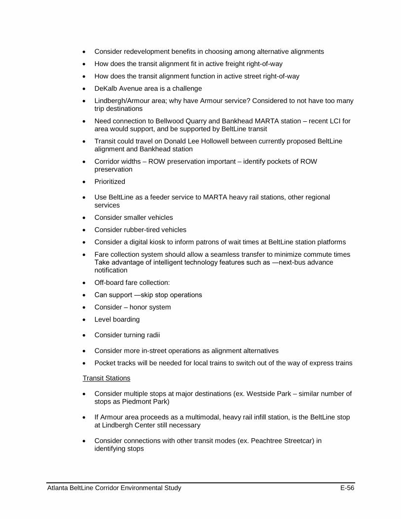
Atlanta BeltLine Corridor Environmental Study E-56
• Consider redevelopment benefits in choosing among alternative alignments
• How does the transit alignment fit in active freight right-of-way
• How does the transit alignment function in active street right-of-way
• DeKalb Avenue area is a challenge
• Lindbergh/Armour area; why have Armour service? Considered to not have too many trip destinations
• Need connection to Bellwood Quarry and Bankhead MARTA station – recent LCI for area would support, and be supported by BeltLine transit
• Transit could travel on Donald Lee Hollowell between currently proposed BeltLine alignment and Bankhead station
• Corridor widths – ROW preservation important – identify pockets of ROW preservation
• Prioritized
• Use BeltLine as a feeder service to MARTA heavy rail stations, other regional services
• Consider smaller vehicles
• Consider rubber-tired vehicles
• Consider a digital kiosk to inform patrons of wait times at BeltLine station platforms
• Fare collection system should allow a seamless transfer to minimize commute times Take advantage of intelligent technology features such as ―next-bus advance notification
• Off-board fare collection:
• Can support ―skip stop operations
• Consider – honor system
• Level boarding
• Consider turning radii
• Consider more in-street operations as alignment alternatives
• Pocket tracks will be needed for local trains to switch out of the way of express trains
• Consider multiple stops at major destinations (ex. Westside Park – similar number of stops as Piedmont Park)
Transit Stations
• If Armour area proceeds as a multimodal, heavy rail infill station, is the BeltLine stop at Lindbergh Center still necessary
• Consider connections with other transit modes (ex. Peachtree Streetcar) in identifying stops

Atlanta BeltLine Corridor Environmental Study E-57
• Consider infill stations at Armour or Miami Circle and south of West End MARTA Station
• Use trail to support community connections to BeltLine stops
• Minimize need for long travel distances from stations
• Near development
• Near activity centers
• Walking access versus park-ride
• BeltLine station location planning should be coordinated with BeltLine sub-area planning and existing MARTA patron data
• Consider infill stations at Armour, Murphy Triangle (south of West End)
Trails Participants were asked about plans to use the trail and trail features and its functions. Possible functions and features included walking, running, or biking trail, amenities along the trail, street crossings, ramps, pedestrian bridges, tunnels, and alignment. The following sections list the comments, questions, and suggestions made regarding the proposed trail connections and alignment.
Trail Features and Alignment
• Provide proper amenities for bicyclists (ex. lockers, storage) throughout corridor
• Provide stopping areas for pedestrians including benches, restrooms
• How does the trail alignment fit along active street right-of-way
• Width – preserve existing open spaces and not focus solely on developing new
• Separate bicycle and pedestrian traffic
• Establish measures and features for safety and security
• Adequate lighting
• Provide restrooms
• Proper maintenance of trail and amenities
• Provide opportunities for artists; apply revenue from art commissions to support operations
• Consider funding options
• Stream crossings/flood zones
• Appropriate signage and way-finding features
• Identify multiple-trail options, including more visible trails near streets and neighborhoods
• Provide 24-hour access

Atlanta BeltLine Corridor Environmental Study E-58
• Consider existing closing times for transit services and public parks
• Provide dirt-trail options for runners
• Avoid tunnels
• Maintain ADA compliant paths along trail to/from MARTA bus stops
• Trails too close to transit may be undesirable
General Comments and Questions • Transit alignment should connect density centers to capture as many riders as
possible
• Name stations after each of 45 neighborhoods
• Transit alignment should connect density centers to capture as many riders as possible
• MARTA infill – greater connectivity between BeltLine and heavy rail
• Concern about expense
• Service is good for Emory, SW of Lindbergh
• MARTA modeled this from previous study—relying on that for this process
• Need input from the users
• Public outreach in the northeast
1.4.7 Fall 2009 Agency / TAC and SAC Comments Received Described below is a summary of comments and input received from Agency / TAC and SAC meetings:
Alternatives Evaluated
Implementation
Freight-Related Issues • Evaluate the ability to implement the project based on challenges relative to CSX and
NS
• Consider that CSX interest will wane between now and 2019 in Howell Junction area
• Consider the use of three tracks
Property Related Issues • Determine property impacts
• Consider the feasibility of requiring residents and businesses in the NW zone that might be selling their properties to provide full disclosure to the buyer so that the buyer would be obligated to allow future easements, etc
Operation
LRT versus Modern Streetcar • Decide between dedicated lanes or shared lanes (along Marietta Blvd)

Atlanta BeltLine Corridor Environmental Study E-59
Relation to Existing MARTA Service • Think about the projected customer of the BeltLine
• Think about the client (FTA) and its funding sources
Performance Measures
General Scoring/Methodology • Consider weighting performance measures
Goals/Objectives Goal 1: Contribute to an integrated regional multi-modal transportation network that promotes seamless intermodal connectivity, increases community access to the existing transit and trail networks and improves reliability of personal travel
• Consider using ¼ mile versus ½ mile buffer when assessing activity center connectivity
• Be mindful not to mask employment or job centers as “economic development”
Goal 2: Manage and encourage the growth and economic development of the City, region and state by providing transit and transportation improvements to areas designated for growth
• Since the TAD boundaries are somewhat based along the CSX alignment, determine if the measure necessarily favors CSX versus the NS alignment
• Provide actual data for “underutilized areas”
Goal 3: Preserve and revitalize neighborhoods and business districts through context sensitive design of transit and trails, increased accessibility to mobility options and provision of affordable housing and transportation, and other community benefits
• No Comments Received
Goal 4: Provide a cost-effective and efficient transportation investment
• No Comments Received
Goal 5: Provide a transit, bicycle and pedestrian friendly environment
• No Comments Received
Goal 6: Provide transit, bicycle and pedestrian connectivity among communities, and between communities and existing and planned recreational opportunities.
• No Comments Received
Goal 7: Minimize adverse impacts to the environment and foster positive environmental impacts
• Lessen impact to those areas identified on water resources maps

Atlanta BeltLine Corridor Environmental Study E-60
• Revise “minimizing acres of existing park land…” to make it more affirmative, i.e. “maximize use of BeltLine trails or new trails…” or “maximize use of new park land as well as connectivity to existing park land…”
Goal 8: Ensure consideration of public input throughout project planning and development
• No Comments Received
Other Project Considerations
Transit Stations • Define decision for station locations
Trails • Take into account that trail connections are safer running alongside transit and not
crossing over roadways and driveways
• Concern with pedestrian safety at transit crossings
• Consider how current and recent construction of trails fit into EIS process
• Gain input from PATH and bicycle community
1.5 Communication Tools Utilization of a variety of collateral materials and communication tools helped to inform and solicit input from the public and agencies. The communication tools complimented and supplemented the outreach effort. These tools include:
• Stakeholder Contact Database
• Project Website and Email
• Newsletter
• Study Update
• Telephone Hotline and Business Card
• Media Relations
• Comment Form
1.5.1 Stakeholder Contact Database The project team developed a master database, which expanded over the course of the project. The database listed interested individuals and groups who desired to keep informed of the progress of the study. The database aided in promoting participation at public meetings and to notifying the public of key updates to the project website.
The database includes over 700 entries of individuals representing the public, property owners adjacent to the proposed transit and trails alignments, neighborhood planning units, committees, agencies, elected and public officials, civic and community groups, public interest groups, faith-based organizations, and the business community.
Updates to the stakeholder contact database were ongoing throughout the term of the Tier 1 EIS.

Atlanta BeltLine Corridor Environmental Study E-61
1.5.2 Project Website and Email MARTA hosted a website for the BeltLine Corridor Environmental Study at www.itsmarta.com/Beltline-Corr.aspx.
The ABI/BeltLine Partnership website also links to the project website at http://www.beltline.org/BeltLineBasics/TransitTrailsandTransportation/EnvironmentalImpactStudyEIS/tabid/2936/Default.aspx. ABI also issues blast emails regarding meetings and other events.
The intent of the MARTA website is to provide information and solicit input on the project. It contains a synopsis of the project, frequently asked questions, the Tier 1 EIS schedule, newsletters, and study updates. It also contains Tier 1 EIS reports, links to previous relevant studies, as well as contact information and how citizens can get involved. A comment form is available on the project website. During the project, recording and responding to emailed comments occurred when appropriate. Update of the Comment Summary Database for the project happened as new comments arrived.
The BeltLine Corridor Environmental Study website contained up-to-date information to enable interested parties to electronically access the same information and updates provided in displays at public meetings, in brochures, and through mailers.
1.5.3 Newsletter The team produced and distributed seven newsletters during the project. These publications address major accomplishments in the Tier 1 EIS as well as upcoming events. Distribution both electronically and in hard copy made the publications easily accessible to a greater range of people. The newsletters are available on the BeltLine project website (www.itsmarta.com/Beltline-Corr.aspx; and www.beltline.org/BeltLine Basics/TransitTrailsandTransportation/EnvironmentalImpactStudyEIS/tabid/2936/Default.aspx). Table 15 provides a summary of the Tier 1 EIS Newsletters.
Table 15: Tier 1 EIS Newsletters
Publication Date Lead Story
Newsletter August 2008 Continuing to Lay the Groundwork for Transit & Trails
Newsletter April 2009 BeltLine Corridor Environmental Study Completes its First Milestone
Newsletter August 2009 Public Workshops Bring More Options to the Table
Newsletter (web only) October 2009 Environmental Effects Report Wrap-Up
Newsletter March 2010 Fall 2009 Public Meetings Wrap-Up & Where We Go From Here
Newsletter July 2011 Fact Sheet - Wrapping Up the BeltLine EIS Study
Newsletter TBD Results from DEIS Public Hearings
1.5.4 Study Update Six study updates are scheduled during the course of the Tier 1 EIS. These are brief summaries of specific developments, primarily of a technical nature, that have been

Atlanta BeltLine Corridor Environmental Study E-62
completed. These updates will be written in easy to understand language and will be suitable for distribution in hard copy and electronically. Table 16 provides a summary of the Tier 1 EIS Study Updates.
1.5.5 Telephone Hotline and Business Card A telephone hotline number allowed interested individuals to contact the Tier 1 EIS team with questions and/or comments regarding the BeltLine Corridor Environmental Study. The number, (404) 524-2070, links to a recorded message in English and Spanish and remained accessible throughout the course of the Tier 1 EIS. The Hotline number appears in all printed information materials and on the project website (www.itsmarta.com/Beltline-Corr.aspx; and www.beltline.org/BeltLineBasics/ TransitTrailsandTransportation/EnvironmentalImpactStudyEIS/tabid/2936/Default.aspx). A business card created specifically for the project contains all the contact information, including the website addresses, and hotline number.
Table 16: Tier 1 EIS Study Updates
Publication Date Lead Story
Study Update August 2008 Public Meetings Scheduled
Study Update October 2008 Initial Public Involvement Phase Nearing Completion
Study Update June 2009 Spring Activities
Study Update September 2009 Evaluation Criteria
Study Update (web only) October 2009 Trails
Executive Summary of Environmental Study
TBD Tier 1 EIS Wrap-up
The procedure for collecting and responding to messages left on the Hotline is contained in the PIAC Plan. The Tier 1 EIS team logs and responds to all telephone inquiries. There was encouragement to make formal comments and send written comments via letters, emails, or by using comment cards. There is a complete copy of the telephone logs.
1.5.6 Media Relations Media coverage aided in advertising the study and as a tool to encourage public participation in the development of the Tier 1 EIS. The PIAC Plan contains more than 50 media outlets covered including:
• Printed media
• Radio
• Television
• Colleges and universities
• Community outlets

Atlanta BeltLine Corridor Environmental Study E-63
1.5.7 Comment Form Comment forms, in English and Spanish, are part of the BeltLine Corridor Environmental Study public outreach program. The comment forms solicit responses that pertain to a variety of specific issues as well as general input on the Tier 1 EIS.
Availability of the comment forms occurred at all meetings and on the project webpage.
Distribution of the first comment forms took place at the Public Scoping meetings, while the second was made available through the BeltLine project website (www.itsmarta.com/newsroom/beltline.html).

Atlanta BeltLine Corridor Environmental Study April 2012
Page Left Intentionally Blank

Atlanta BeltLine Corridor Environmental Study F April 2012
Appendix F - Comments Received during Public Comment Period

Atlanta BeltLine Corridor Environmental Study April 2012
Page Left Intentionally Blank

Appendix F- Comments Received During the Public Comment Period Page 1
Atlanta BeltLine DEIS Public Comments & Responses The total of all comments received during the DEIS comment period was 33. The comments came from the following sources: (14) from the Public Hearing, (8) from the project website, (7) from Peak Democracy, (2) from MARTA email, (1) from the Project Hotline, and (1) from the Comment Form. Note that the three (3) comments received from the project email were from one individual and another individual commented twice; each comment was counted as one (1) comment each. Each of the comments could be grouped into 13 general categories as described below.
• Documentation Request: Request for information or draft document. • Planning Process: Comments that relate to the EIS planning process and previous or
ongoing planning efforts around the Atlanta BeltLine project. • Environmental Justice/ Public Involvement Process: Requests for further outreach, or
comments related to types of outreach included in the planning process. • Agency Coordination: Requests for ongoing and additional agency coordination. • Opposed to the Project: Comments in opposition to the Atlanta BeltLine project as a
whole. • General Support for the Project: Comments in support for the Atlanta BeltLine and the
planning efforts surrounding the project. • Support for a Specific Technology or Alignment: Comments in support of LRT or SC;
comments in support of specific trail and transit alignments reviewed in the Tier 1 EIS process.
• Alternate Technology or Alignment Suggestions: Suggestions of alternative technologies to LRT or SC, alternative alignments for transit or trail, or additional trail connections and MARTA station connections.
• Community Impacts: Comments from neighborhood associations, or comments about general community impacts.
• Environmental Impacts: Comments about the quality of the existing environment or comments concerning potential impacts of the project
• Cost Estimates/ Funding: Request for cost estimates and comments regarding funding sources.
• Agency Comments: Official comments from affected agencies. Specific content of the contents can be grouped into the other general categories.
• No Comment: Agency or association decided to not make an official comment. Each comment is recorded below with details of its source, date, and general category. The Project Sponsors provided responses to each comment received, Comment Record: 2011-01 Comment by: Johnny Wilson Email: [email protected] Date received: 07/25/11 Source: Category: Documentation Request, EJ/PI Process
“I am writing to obtain a copy of the study conducted by the Federal Transit Administration (FTA), in cooperation with the Metropolitan Atlanta Rapid Transit Authority (MARTA), in partnership with Atlanta BeltLine, Inc. (ABI), that examine that role that NEPA process played in: (1) Identifying the role, function, prescription and scope of work performed by citizens in pre-planning, drafting or writing of a Tier 1 Draft Environmental Impact Statement (DEIS)
Comment

Appendix F- Comments Received During the Public Comment Period Page 2
(2)Identified the role, function and scope of work performed by NEPA in ensuring citizen advocacy and planning.”
Thank you for your interest in the BeltLine Corridor Environmental Study. You may find copies of the Tier 1 DEIS at http://www.itsmarta.com/beltline-documents.aspx and www.beltline.org.
Response
Comment Record: 2011-02 Comment by: Not Shown Email: N/A Date received: 08/12/11 Source: [email protected] Category: Support for a Specific Technology or Alignment
“Survey Questions/Responses: 1) What do you think about the project in general? Fine 2) If you have been involved in previous BeltLine Studies, how would you describe your experience? Fine 3) Do you have any concerns relative to the environmental effects of building transit and trails in the BeltLine Corridor" If so please specify. No 4) What are your preferences regarding transit technology or the type of transit that should be implemented in the BeltLine Corridor? Modern Streetcar”
Comment
Thank you for your responses. Response
Comment Record: 2011-03 Comment by: Johnny Wilson Email: [email protected] Date received: 08/1/11 Source: [email protected] Category: EJ/PI Process
“I want to thank you for the response to my inquiry to access those documents or resources via the electronic telecommunication vehicle (e-mail), to display the orientation or testimony of those involved with the construction or development of a “proposed plan" to address transportation land use and decision-making. While the effort is to be commendable, there is still, an enormous problem with the testimony.
Comment
The main problem is apparent and found ever-so-present in the writing of the "abstract" whereby the reader is introduced immediately to a litany of words, concepts or phrases designed to identify who is doing the business of crafting the scheme or design for the transportation plan. In fact we read "has prepared”, “decisions made" or "is to improve' as cues to demonstrate the absent of the individual or the general public with specific or direct involvement in the planning, research, writing and editing of the plan. Moreover, after a careful reading of each of the documents as listed in the response, I come away with the view that citizen participation and involvement is limited to: (1) Sitting in a room,

Appendix F- Comments Received During the Public Comment Period Page 3
(2) Going to a lecture/workshop, meeting, (3) Receiving a document, (4) Being shown what has been sketched or drafted (5) Awaiting their comment on a plan after it has been written by those holding the meeting. Now, should the question be raised that the aforementioned items (1-5) are an offense to NEPA and the Environmental Justice Acts? Is this the definition upon which we are to view "Public" and "Participation? What does NEPA and Environmental Justice say about public participation? Let's investigate. Public Participation Under NEPA 1. Scoping. CEQ regulations require “scoping” following the publication of a notice of intent to prepare an EIS, but before the EIS is prepared. CEQ regulations define scoping as “an early and open process for determining the scope of issues to be addressed and for identifying the significant issues related to a proposed action” (40 CFR 1501.7). In general, scoping has three broad purposes: identifying public and agency concerns with a proposed action, defining issues and alternatives to be examined in detail, and saving time by ensuring that relevant issues are identified early and drive the analyses (see 40 CFR1500.4 (g), 1500.5(d)). A public meeting is held during scoping, with notice of the meeting made in the Federal Register, local newspapers, and utilizing other means of announcing public meetings, depending on case-specific circumstances. 2. Public review of EISs and EAs. As with scoping, CEQ and EPA NEPA regulations clearly specify the means by which the public is involved in reviewing draft and final EISs. EPA regulations require at least one public meeting on all draft EISs (40 CFR 6.400(c)). The meeting is generally announced in the Federal Register and in local newspapers and by other means. Regulations also provide other means of soliciting comments and information. Comments must be solicited from other appropriate federal, tribal, state, and local agencies, and from the public, specifically including a request for comments from “those persons or organizations who may be interested or affected” (40 CFR 1503.1(a) (4). 3. Public review of RODs and FONSIs. Records of Decision on EISs must be disseminated to all those who commented No public review is required prior to or after issuance of the ROD. Findings of No Significant Impact on EAs, in contrast, must be made available for public review before they become effective (40 CFR 6.400(d)), and this involves at least local notice and advertising. The FONSI and “attendant publication” must state that comments disagreeing with the decision may be submitted, and any such comments must be considered by EPA (40 CFR 6.400(d). 4. Mechanisms to Enhance Participation The public participation provision in Executive Order 12898 and its accompanying memorandum are designed to ensure that there is adequate and effective communication between federal decision makers and affected low-income communities and minority communities. Moreover, in Section 5-5 we discover that public participation provision in Executive Order 12898m, Section 5-5 and its accompanying memorandum are designed to ensure that there is adequate and effective communication between federal decision makers and affected low income communities and minority communities. This is consistent with NEPA mandate to involve the public by 1. The public may submit recommendations to Federal agencies relating to the incorporation of environmental justice principles into Federal agency programs or policies.

Appendix F- Comments Received During the Public Comment Period Page 4
2. Each Federal agency shall convey such recommendations to the Working Group. (b) Each Federal agency may, whenever practicable and appropriate, translate crucial public documents, notices, and hearings relating to human health or the environment for limited English speaking populations. 3. Each Federal agency shall work to ensure that public documents, notices, and hearings relating to human health or the environment are concise, understandable, and readily accessible to the public. 4. The Working Group shall hold public meetings, as appropriate, for the purpose of fact-finding, receiving public comments, and conducting inquiries concerning environmental justice. The Working Group shall prepare for public review a summary of the comments and recommendations discussed at the public meetings.” Response
This is a welcomed opportunity to share with you the many ways that the public has been involved in the Atlanta BeltLine Corridor Environmental Study since this project began. This will represent a brief overview of the public involvement and public decision points that are outlined in Chapter 8 and throughout the DEIS Report.
We appreciate and share your concern that this project must have at its core and throughout the process, public input. In addition to the public, which I will cover here, the project structure includes three oversight advisory committees, the Stakeholder Advisory Committee, Technical Advisory Committee and the Agency Group. The Stakeholder Advisory Committee consists of community and transit advocates, neighborhood and community representatives and community organizations. The Technical Advisory Committee consists of city and county planning, service and government organizations and regional planning and government organizations. Finally, a comprehensive list of federal, state, local, city and county organizations formed the Agency oversight committee. Each of the three committees meets at key milestones and decision points to comment, guide, and critique and to advise on the impact of the study, input from various sources and data gathered. These three groups also assist in promoting public involvement throughout the process. Further and separate from committee meetings, the public participated in a series of meetings in late summer 2008, spring of 2009 and winter 2010 and actively engaged in crafting alignment ideas for transit and trails, potential station locations and offered feedback on environmental and other aspects of the study. These sessions resulted in key and substantial ideas, presented by the public and determined the type of and characteristics of service and preferred alignments. During these sessions, the public actually presented ideas which are the basis for the transit and trails alignments in the DEIS. MARTA and ABI have provided several opportunities for public input throughout the study via public meetings held in each geographical section of the study area. During public meetings, participants were asked about their preferences and their feedback was passed to the technical team to incorporate into the analysis study. Public meetings are designed to be data collection sessions and are structured in most cases in small hands-on workshop style settings to ensure that input from all participants was heard. The Scoping Meetings, as called for in the regulations, was one of such series meetings held throughout the study areas. All meetings, feedback, results and documentation are well documented in the DEIS.
Appendix F- Comments Received During the Public Comment Period Page 5
Not only was the public able to participate in public meetings, MARTA and ABI sought out invitations to attend Neighborhood Planning Unit (NPU) meetings, community meetings, planning meetings, public meetings held in locations such as libraries and food courts and in transit stations. One-on-one individual briefings of organizations representing large constituents were also held. A project email was established to receive public input and an email database was created to notify the public of the meeting and opportunities to participate. Project fact sheets and newsletters were distributed at public and community locations throughout the service area. These are just a few of the ways that MARTA and ABI structured the project from the start to ensure that the public has the opportunity to participate in the project. You will find a comprehensive list of the all of the public outreach activities provided in the DEIS. MARTA and ABI are committed to meeting the purpose and intent of the requirements of the National Environmental Policy Act and the Council on Environmental Quality. The Atlanta BeltLine Tier 1 EIS process is being implemented according to the regulations and guidance of the FTA and CEQ to assure fair and meaningful public involvement. The DEIS is the culmination of the work that MARTA, ABI and the community have conducted for the Atlanta BeltLine transit and trails. The preliminary alignments express the public desires for transit and trails, and strive to avoid or minimize environmental concerns heard from the public participation during initial design and project development. Important to note is that while the project is in the wrap-up stage for the early phase Tier 1 analysis, Tier 2 will provide you and the public with further opportunity for public involvement in crafting the future for the Atlanta BeltLine. Thank you for your interest and inquiry and the opportunity for us to share the many ways that the public was involved. Please be assured that at the very core of this project is public involvement. If you have any specific questions, concerns and comments as you review the DEIS, you are invited to share your comments and let us know how we can ensure that you are fully privy to the work and approach that has been underway. The written public comment period for the Tier 1 DEIS will extend through September 17, 2011. We were pleased to have been able to provide you with a schedule of the final set of Public Hearings and hope that you had an opportunity to participate in one of the four meetings. Nevertheless, the written comment period will provide you with an opportunity to review and comment on the DEIS. You will find a wealth of information as well as project videos on the project websites where you are encouraged to review and to have your input known and considered even at this stage of the process. It is not too late to participate in a meaningful way in this process and have an impact on revitalizing the Atlanta’s community for years to come. Even at this stage of the process we are developing ways for the public to participate. An online forum has been established on the ABI website, run by Peak Democracy, regarding the DEIS for the Atlanta BeltLine transit and trails. In order to comment, you will be asked for your name and home address. This information is only used to identify statements from residents in and near Atlanta so that users know which comments are from local residents. You can choose whether or not you want to show your name on your comment. The forum link is: http://beltline.org/BeltLineBasics/TransitTrailsandTransportation/EnvironmentalImpactStudyEIS/DraftEnvironmentalImpactStatement/tabid/4051/Default.aspx. Also, a project video, referenced above, can be found online at http://eis.beltline.org/Default.aspx#videos. You can watch the full 21-minute video or just sections of it.

Appendix F- Comments Received During the Public Comment Period Page 6
Comment Record: 2011-04 Comment by: Michelle Marcus Email: N/A Date received: 08/1/11 Source: Public Hearing 1-3pm Category: Documentation Request, Community Impacts
“Requested DEIS documentation that addressed the following question that she posed during the Q/A session: “I was wondering what feedback you had gotten from the neighborhoods in the Northwest area where the different alternatives are being decided, what meetings had occurred and what feedback you had gotten from those committees?”
Comment
Northside and Westside Study Group workshops were held in April and May 2009 to discuss and identify alternative service plans, alignments and preliminary station locations in the Northwest Zone. These small group working sessions were interactive. Public workshops were held in June 2009. Input heard at these workshops included preference for frequent stations and locally oriented service, efficient connections to MARTA and other transit services, in-street as well as exclusive right-of-way operations, direct access to activity centers and major trip destinations, and neighborhood-oriented pedestrian access. Post Public Workshop meetings in the summer of 2009 yielded additional input to the alternatives development and evaluation process that reinforced the preferences heard in the workshops themselves.
Response
The Northside and Westside Study Groups met again in Fall 2009 and had discussion sessions regarding use of freight-railroad corridors, environmental and property-related issues, operations, mode, safety, and relationship of the Atlanta BeltLine to MARTA rail service. Preferences and rationale for transit and trail alignments in the Northwest Zone varied. Chapter 8 and Appendix E of the DEIS provide more discussion of the foregoing workshops, meetings, and their outcomes. Three workshops were held in the Fall 2010 to focus primarily on changes to alternatives in the northwest area. A meeting was held with the TAC/Agency Committee, a second meeting with the Stakeholder Advisory Committee and the final meeting with the Northside Study Group and Public Meeting. A copy of the meeting summary was given to Ms. Marcus. Preferences and rationale for transit and trail alignments in the Northwest Zone varied. A copy of the report of these workshops is available on the project website; Chapter 8 and Appendix E of this FEIS provide more discussion of the foregoing workshops, meetings, and their outcomes. Comment Record: 2011-05 Comment by: Johnny Wilson Email: [email protected] Date received: 08/1/11 Source: [email protected] Category: EJ/PI Process
“I am writing to thank you for the brief array of information that you sent explaining your position regarding the role that the term, concept, phrase "public in-put or participation" will play in conjunction with DWA Beltline activities. After a careful review of your analysis, I am struck by several matters and I pose them in the passages listed below.
Comment

Appendix F- Comments Received During the Public Comment Period Page 7
For the sake of clarity, is it your understanding that: (a) (1) The wording and language written into National Environmental Policy Act (NEPA) and Executive Order 12898 Federal Actions to Address Environmental Justice in Minority Populations and low Income Populations specifically defines "public input" as occurring only when an individual physically leave their home to journey to a special location to participate in a public gathering, read material being circulated, raising of the hand to pose questions and that somehow this activity in its mile form satisfies the condition of NEPA and Executive Order 12898? (b) (2) "Public meetings...designed to be data collection sessions and are structured in most cases in small hands-on workshop style settings to ensure that input from all participants was heard" meet the terms and conditions of Section 3-3. of Executive Order 12898,entitled Research Data Collection and Analysis?. (c) (3) Public meetings...designed to be data collection sessions and are structured in most cases in small hands-on workshop style settings to ensure that input from all participants was heard. The Scoping Meetings, as called for in the regulations, was one of such series meetings held throughout the study areas. (d) (4) By the "public ...participate in public meetings, MARTA and sought out invitations to attend Neighborhood Planning Unit (NPU) meetings, community meetings, planning meetings, public meetings held in locations such as libraries, food courts and in transit stations", mean that in the aftermath, a policy will be crafted to reflect which interest: (A) Stakeholders hosting the event (B) Those stakeholders who pose an environmental policy question based on their understanding of NEPA and Environmental Justice Act12898? (e) (5) After "One-on-one individual briefings of organizations representing large constituents were held"... and after" the public participated/...engaged in crafting alignment ideas for transit and trails", should the public participant requirement: (1) (a) Serve as both an advisor and an overseer of DWA BeltLine activities given that you are asking the citizens of the state of Georgia to vote to give you millions of dollars to support your project activities? (2) (b) Determine specific responsibilities for defining their role given that you are asking the public to give, make available, funds on the 2012 ballot to support DWA Beltline activities? (3) (c) Should those in attendance at the meetings along with property owners being asked to give up, make available funds to support DWA BeltLine activities insist upon the hiring of a Public Participation Specialist or Coordinator that will have the responsibilities for carrying out those ideas, suggestions articulated by the general public regarding transportation service deliver?”
(a) No, it is not our understanding that NEPA, implementing CEQ regulations and/or E.O. 12898 defines "public input" as described. The above-mentioned statutory and policy framework directs agencies and sponsors of federal actions to strive for public involvement, particularly fair and meaningful public participation of low-income, minority and indigenous populations. The
Response

Appendix F- Comments Received During the Public Comment Period Page 8
precise manner in which public involvement will be sought is guided by the language of NEPA, CEQ regulations (40 C.F.R. § 1506.6) and guidance provided by CEQ or EPA on NEPA regulations or environmental justice considerations (e.g., EPA's Action Development Process, Interim Guidance on Considering Environmental Justice During the Development of an Action, July 2010) . (b) Section 3-4 of E.O. 12898 provides that: "(a) Environmental human health research, whenever practicable and appropriate, shall include diverse segments of the population in epidemiological and clinical studies, including segments at high risk from environmental hazards, such as minority populations, low-income populations and workers who may be exposed to substantial environmental hazards. (b) Environmental human health analyses, whenever practicable and appropriate, shall identify multiple and cumulative exposures. (c) Federal agencies shall provide minority populations and low-income populations the opportunity to comment on the development and design of research strategies. The "public meetings" described above were not designed to satisfy the terms and conditions of E.O. 12898 § 3-3. Instead, Section 3.4.3 of the Tier 1 DEIS presents locations of minority and low-income populations in the study area using readily available demographic data and CEQ guidance for identifying such populations. This information enabled public involvement activities to recognize and strive to engage all populations. During Tier 2 analysis of the Atlanta BeltLine, further data collection and engagement with all potentially affected populations will be undertaken to avoid or minimize effects and prescribe effective mitigation strategies as needed. (c and d) A CEQ Memorandum regarding guidance on NEPA regulations explains that, "[t]he CEQ regulations direct federal agencies which have made a decision to engage in a public scoping process. Public hearings or meetings, although often held, are not required; instead the manner in which public input will be sought is left to the discretion of the agency." 48 Fed. Reg. 34,263 (19830029. In this instance, public involvement during the Tier 1 EIS process included diverse means of two-way communication, including project-specific scoping meetings, work sessions, workshops, meetings, public hearings, newsletters, web-based communications, and other tools identified in Chapter 8 of the Tier 1 DEIS. In addition, the project sponsors made themselves and their consultants available to entities interested in having them attend or participate in events or meetings sponsored by those entities. The purposes of diverse communications are to strive to give as many people in the community an opportunity to be involved in learning about the project, shaping the project, and making their interests, concerns and preferences known. (e) Atlanta BeltLine Response: Over the last five years as a part of Atlanta BeltLine’s legislatively established Community Engagement Framework, the public has embraced and owned their role as a stakeholder in the process of planning and implementing the Atlanta BeltLine whether it is providing input for determining alignment for transit and trails or for land use and park master planning efforts. This Framework consists of six components that include:
1. A Tax Allocation District Advisory Committee that primarily makes recommendations on projects funded from bond proceeds;
2. A BeltLine Affordable Housing Advisory Board that primarily makes recommendations on the goals and policies related to the use of the BeltLine Affordable Housing Trust Fund;

Appendix F- Comments Received During the Public Comment Period Page 9
3. A Community Representative on the Atlanta BeltLine Board of Directors that holds the same term, duties and responsibilities equal to every other board member;
4. A Community Engagement Advocate that informs the community on current Atlanta BeltLine issues and ensures active and meaningful participation in Atlanta BeltLine matters;
5. A Formal Community Reporting that is convened for the public quarterly to report the status of the most significant aspects of Atlanta BeltLine’s progress; and
6. A Community Participation Framework that ensures that Neighborhood Planning Units, neighborhood groups, concerned organizations and individuals have the opportunity to have direct input on Atlanta BeltLine planning, design, and implementation within geographically defined Study Groups.
In addition, as the community needs of the Atlanta BeltLine have grown, we expanded the Framework to include a forum called Citywide Conversations that provides community education and dialogue when new concepts and ideas related to the planning, design and implementation of the Atlanta BeltLine are introduced. With an understanding of Atlanta BeltLine’s comprehensive Community Engagement Framework above, we provide the following answers to the sub-questions below:
a) Public participants can expect to serve as advisors to Atlanta BeltLine activities because we currently have members of the community serving on both of our advisory boards as well as our Board of Directors, shaping policy and project outcomes over the last five years (see components 1-3 above).
b) Public participants define their role as a standard part of any Atlanta BeltLine participation process from the beginning, typically by shaping project goals, determining guiding principles, providing feedback and validating final outcomes within our Study Groups (see component 6 above).
c) Public participants have the support of adopted legislation that requires Atlanta BeltLine to have a Community Engagement Advocate to represent and protect the ideas and interests identified by the public in this planning process for transportation delivery and all planning processes (see component 4 above).
Comment Record: 2011-06 Comment by: Ted Brodek Email: N/A Date received: 08/16/11 Source: Public Hearing 1-3pm Category: Opposed to the Project, EJ/PI Process, Cost/Estimates/ Funding
“Thank you for allowing public comment. My comments are more general than technical. Comment
(a) Because generally I am opposed to the entire beltline and have been for quite a while. I spoke at one of these events before in the Candler Park Lake area.

Appendix F- Comments Received During the Public Comment Period Page 10
(b) Basically, I think that the planning of this whole concept is just another step in systematic Atlanta basic racist planning process because again it's favoring an in-town gentrification program as opposed to looking at what people really need to be able to get from and back to jobs. I know that Atlanta beltline is not responsible for the TIA concept, and the East Line for MARTA, but MARTA is a partner in this. This is basically geared towards where people are placing their emphasis. My thinking is that the beltline should be scrapped. (c) Six hundred million dollars from the pocket of taxpayers and an aggressive tax is a totally wrong approach to really developing proper transit. I'm certainly in favor of mass transit, but at this point, I will urge everyone to vote against that tax. I think there will be a lot of opposition to it. (d) The second point I want to make is MARTA could ask Emory to pay for the Emory extension from Lindbergh to Emory. Emory has a huge endowment. It's Coca-Cola. It's big money. They could pay that $600 million, $700 million without even a hiccup rather than expecting tax payers to do something. Thank you.”
(a, c and d) Thank you for letting us know your preferences regarding the BeltLine, and your suggestions.
Response
(b) One of the objectives of the ARC’s Plan 2040 Regional Transportation Plan, of which the transportation component of the Atlanta BeltLine is a part, is to “Increase mobility options for people and goods.” To achieve this regional objective, transit projects are proposed and planned for in areas that are currently underserved by public transit. Atlanta BeltLine would help the city achieve this objective given its circulator type service through the many diverse communities in the four zones. Other projects assisting in achieving this objective in the City of Atlanta include the Peachtree Streetcar, which will connect the King Center to the Centennial Olympic Park; the Clifton Corridor connecting Lindbergh MARTA Station to the Avondale MARTA station; high capacity rail service from DeKalb to Downtown Atlanta; and high capacity transit service along SR 400 from the North Springs MARTA Station to Windward Parkway. An extensive public involvement process has been or will be implemented as part of the project development process. Section 3.2.2.2 of the Tier 1 DEIS acknowledged the risk of escalating home values associated with the larger Atlanta BeltLine redevelopment project, of which the transportation components assessed in this Tier 1 EIS are a part. Recognizing this vulnerability, the TAD reserves 15 percent of its bond fund for use in creating affordable housing around the Atlanta BeltLine. Neighborhood land use and zoning activities are the purview of the City, which strives for community preservation while planning for positive economic development. Comment Record: 2011-07 Comment by: Angel Proventud Email: N/A Date received: 08/16/11 Source: Public Hearing 1-3pm Category: Environmental Impacts
“I wanted to comment, I am actually a freight train conductor in the CSX corridor. The esthetics of that corridor are amazingly beautiful. There's waterfalls over the creek system which of course has an impact. There's also a lot of space back there, so with come creative construction
Comment

Appendix F- Comments Received During the Public Comment Period Page 11
it could be really beautiful and there's enough space. And instead of having a highway and rail corridor to look around, it could become this nice wooded area between Piedmont Hospital and Lindberg. So that would be part of that comment. Also, on the trail, running through that area would be a great major environmental kind of experience for the Atlanta resident to have again, versus the connector and the Norfolk Southern. I don't speak for CSX as a spokesperson or anything, but it's just my personal choice on the matter. Thank you.”
Thank you for indicating your preference for a CSX corridor alternative; we concur that the natural resources in that corridor could be visual and experiential benefits for Atlanta BeltLine users.
Response
Comment Record: 2011-08 Comment by: Kristy Gillmann Email: N/A Date received: 08/16/11 Source: Public Hearing 1-3pm Category: Community Impacts
“I am president of The Peachtree Hills Civic Association and I want to commend the beltline organization for where you guys have come from over the last couple of years. We were heavily involved in the Peachtree Creek situation, watching that very carefully because the area is that we've been asking questions about is the area that Angel speaks of. We are very concerned about the Peachtree Creek area. So my comment is really to be very very judicious and very very sensitive to the neighborhoods that impacts, with details when the time comes. I think a lot of things were handled poorly in the past and I am very hopeful and encouraged that moving forward there will be a lot more community and personal involvement because we do live there. You guys look at a map isn't the same thing as walking there, and having your kids play in it. So, please keep that, especially when you are literally in people's backyards, it makes such a difference. Thank you.”
Comment
Thank you for acknowledging the diligent efforts of the project sponsors to seek, hear, and consider stakeholder and community opinions, input in crafting the alternatives, and concerns. We intend to continue this effort as the project advances.
Response
Comment Record: 2011-09 Comment by: Mike Dobbins Email: N/A Date received: 08/16/11 Source: Public Hearing 6-8 pm Category: Planning Process, Community Impacts
“I have really several comments about the process. Comment
(a) It's interesting to me, for example, that 10.9 million dollars and three and half years later we don't really have any more specificity about alignment than we had actually at the time of the first feasibility study that Econ (phonetic) did whenever back in the day. So from the EIS point of view it seems to me that it's extremely important to have a timeline when the premises on which this process was based might happen. I don't have a timeline and we don't know what kind of developments are going to happen when it gets to actually create a demand for transit ridership.

Appendix F- Comments Received During the Public Comment Period Page 12
(b) My second comment or question is the whole issue of connectivity, which, again, gets involved in the time of travel. So I don't know whether you guys have done any estimate on how long it would take to get to where most of the people are trying to get, which is downtown, midtown, or Buckhead using a Beltline that goes around those areas that doesn't get you to them and requires a transfer. And, of course, there will be headways on both the Beltline and its travel speed and the wait time at MARTA for other systems and travel time. So it seems to me it's really important to have some understanding of that. The whole idea of ridership projection, I think we generally know that the heaviest concentrations of jobs, of housing, of events, of universities, of activities and cultural events, occur downtown and midtown. So I would ask all of us to say, well, would I take something that goes around those to get to them? And these are premise kinds of issues. (c) Then there's the issue of priority. If we have needs for transit, then it seems like we ought to have all of those, what Concept Three suggested, which one would actually meet the most need now? And I'm not sure we would come up with a Beltline. (d) One thing that we haven't discussed tonight, but the Beltline and the transportation round table are actually considering, what people in rooms like this six, seven years suggested, we need to get from the east side to the west side corridor of the city. The current plan for the Beltline is actually to begin to do that, to actually carry lines up North Avenue or 10th Street, whatever, which actually responds to a need that was identified repeatedly by a Beltline transit feasibility panel several years ago, six years ago. So that's a good step that we're actually beginning to consider a transit connectivity that gets people to where they want to go. (e) The issue of neighborhoods like Brookwood Hills, and Loring Park, and so on, it's not at all clear -- one minute to go -- it's not at all clear that this project was generated from the point of view of conserving, enhancing, and strengthening existing neighborhoods. It sort of landed on them and now they're reacting to it all around the Let's see, I think that will about do it. I think it's interesting the comment about whether there was an earlier line that they had going all the way to Moreland and then back around again. I remember that one. Now we're talking about a bridge across I-20 and Glenwood Park and Bill Kennedy Way. (f) So just bringing some specificity, some modification, some estimates of cost, some estimate of when the transit part of this thing is actually likely to occur would be very helpful for all of us, and it seems like seven years on we ought to have some idea, some notion, so we have some way of evaluating whether this thing is, to pun a little bit, on track or not, and whether it really meets the travel needs in this region or in the city at the present time. Thank you.”
(a) Considerable conceptual engineering work has been undertaken during the Tier 1 DEIS to develop feasible potential alignments for the Atlanta BeltLine transit and trails. During this time, refinements were made in many geographic areas to assure that the typical section of the alignments could be built on, alongside, over, under, or around existing roadways, railroads, utilities, and land uses. This work resulted in the multiple alternative alignments of the single BeltLine concept that was the culmination of MARTAs previous 2007 Detailed Screening Analysis.
Response
The Tier 1 EIS process will conclude in 2012 with a preferred alignment for transit and trails. At that point, the project sponsors can proceed with the detailed Tier 2 analysis involving

Appendix F- Comments Received During the Public Comment Period Page 13
engineering and environmental analyses, supported by continued public and agency involvement. (b) The Atlanta BeltLine would serve as one component of Atlanta’s transportation network. Its utility is that it would provide enhanced transit service to activity centers, TADs, neighborhoods, and underserved areas; it would link to existing MARTA heavy rail and bus networks. Existing MARTA heavy rail plays its part by providing the premium, highest capacity service to more dense population and employment centers such as downtown, midtown and Buckhead. An effective transit network relies upon the use of different transportation options and routes, each tailored to best serve a community’s character and travel patterns. Transportation options will be chosen by the individual traveler according to their origin/destination points, trip purpose, and other factors, (c) Concept 3 focuses on overall transportation needs planning in the Atlanta region. Implementation occurs at the individual project level as sponsor interest and funding allow. The Atlanta BeltLine transportation components have been in the active planning stages by the project sponsors for approximately eight years. At the same time, substantial land use planning activity has been underway by the City. These activities combined with federal funding have set the Atlanta BeltLine project in motion, in some cases ahead of other Concept 3 projects. (d) The Atlanta BeltLine is one of a number of transportation projects that will help people in the City of Atlanta get where they want and need to go. It is intended to respond to the need for better intercommunity connections among the four zones in the study area. However, as with any individual project, the Atlanta BeltLine cannot resolve all transportation issues in Atlanta. Other projects, such as those in Concept 3 are intended to collectively with Atlanta BeltLine provide improved mobility and a variety of transportation options. (e) In accordance with project goals, the project sponsors have and will continue to strive to preserve the communities through or along which the Atlanta BeltLine would pass, by avoiding or minimizing potential impacts, supporting neighborhood cohesion, mobility and access. (f) The preliminary capital cost of the Atlanta BeltLine transit is estimated to be approximately between $1.3 and $1.6 billion for streetcar, and between $100 and $130 million for trails. The expected date of the first phase of transit implementation is 2016. Comment Record: 2011-10 Comment by: Marcus Sharpe Email: N/A Date received: 08/16/11 Source: Public Hearing 6-8 pm Category: Alternate Technology or Alignment Suggestion
“Good evening, everybody. I wanted to say my main concern is the loop. So there are about fifty stations, I believe, fifty, fifty-five stations, and with the stations, with the fifty stations the streetcar does make sense because it's very close. But my concern would be Atlanta is a very populated city. It's about 5.6 million people. It's going to grow, and I think that the light rail, which I know that is referred to as the streetcar, the light rail actually might benefit in the longer run, although there are some, you know, with light rails, rights of ways, and things of that sort. But in considering light rails, Seattle is actually considering something I know it seems like a light, light rail. It's called Fast Streetcar. That might be helpful to look at that technology as well. And I'm trying to think of what else I had. Also, if they can, I think that maybe ten stations should be cut.
Comment

Appendix F- Comments Received During the Public Comment Period Page 14
I think fifty is over kill. I know everybody wants everything to be accessible, but it has to be efficient. I don't know what the ridership projection is. If the ridership projection is high, which I think it will, I think the demand will be there, then that's the reason why I think light rail or something that's a little more frequent than the streetcar is more important. And I do feel -- I've spoken to Mr. Dunning about it briefly, and I know the decision has already been made, but there are some technologies that are coming in the next few years that could fill in the gaps if they decide to cut down on stations. I don't know if anybody has heard of PRT, but I think it will be a technology sky train, which I had talked to my friends over at -- they're working with NASA right now – and they're building the first test track, so I think technology, sort of as a sky train, or PRT, could fill in the gaps in the future and integrate with the Atlanta Beltline. So I urge the planners to really consider a high capacity light rail or fast streetcar to get people around Atlanta quicker. Thank you.”
We thank you for your thoughts on technology and ridership. The number of proposed Atlanta BeltLine stations ranges from 46 to 55 stations depending on the alignment alternative selected. As a result of various BeltLine public outreach processes, public input was received regarding potential locations and the quantity of stations desired for the BeltLine. The quantity and locations of stations reflect desires for the Atlanta BeltLine to operate as a neighborhood circulator, while also balancing the need to optimize travel times. As the project advances more detailed analyses will refine station locations and the operating plan. The operating plan defines transit operating characteristics such as headways, station stopping patterns, and hours of service.
Response
Regarding other transit modes such as Fast Streetcar in Seattle, Skytrain, and PRT, our alternatives evaluation as well as the preceding 2007 Alternatives Screening Report considered numerous potential modes for the Atlanta BeltLine. In the Tier 1 DEIS, Modern Streetcar and LRT were advanced as they are the best performing modes. In Tier 2 analysis, the performance of various vehicles within the preferred mode as well as operation plans will be examined to optimize Atlanta BeltLine operations. Comment Record: 2011-11 Comment by: Jonathan Miller Email: N/A Date received: 08/16/11 Source: Public Hearing 6-8 pm Category: Community Impacts
“I am a resident of Inman Park. My house is about a quarter of a block from the Hulsey Yards. So as I've been following this project for five, seven, six, eight -- I don't even remember how many years -- I've always thought that it's going to be very difficult to get across DeKalb Avenue. I still think it's a problem. I don't know how it's going to be done, but I can't wait for it to be done. This is the coolest thing I can think of to happen to Atlanta. And I hoped when I came tonight there would be a few more specifics about my little section of the Beltline. I understand that it just doesn't happen that quickly. One thing I did learn tonight from the video was that we need a facility. I would suggest, and this is just off the top of my head, that maybe Hulsey Yards could be home to that facility. It kind of goes with my general comment that I believe my neighborhood, like Inman Park, Reynoldstown, and Cabbagetown, I think my neighbors can't wait for this to happen. We don't know how it's going to work, but we want it to work and we want it to work in our neighborhood. Thank you.”
Comment

Appendix F- Comments Received During the Public Comment Period Page 15
Thank you for letting us know you support the Atlanta BeltLine. The BeltLine will need a facility to store and maintain the transit vehicle fleet. The Hulsey yard site is an attractive location for the Atlanta BeltLine facility; however this site is currently used by the CSX railroad as an active intermodal yard facility. Use of such a facility for the Atlanta BeltLine is potentially possible, but will require negotiation with and agreement from CSX. Look forward to more opportunities for community involvement in crafting the design of the Atlanta BeltLine in the future Tier 2 analysis.
Response
Comment Record: 2011-12 Comment by: Cary Aiken Email: N/A Date received: 08/16/11 Source: Public Hearing 6-8 pm Category: Community Impacts, Support for a Specific Technology or Alignment
“I've been very involved in the Beltline from its inception, attending the meetings at city council that created the tax allocation district, and subsequent to that I've served on the study groups, and I've attended the TDAC meetings, and many of the corridor meetings, and public hearings, such as this, throughout the process, including the original transportation planning that brought us to this point and the draft environmental impact statement.
Comment
(a) My preference for the mode of transportation would be the streetcar for the following reasons: One, would be the least impact on the permeability between neighborhoods, so that it would not be like the current MARTA systems that sort of divides neighborhoods, because of the tracks and because of the overbuilt nature of the stations. I thought the gentleman who spoke tonight about the vast streetcar technology that's coming on was very salient to this and had I would certainly encourage looking at that as an alternative. I think it needs to be fun, because precisely because as was mentioned also this evening, the destinations are not really the major destinations that people have, such as the art center, or Emory University where the need is to go east west, but going around the city in sort of an indirect way. If this is not fun, then it's going to lose a major component, which I think will attract tourists and recreational users in particular, since it connects many parks, as opposed to business or cultural institutions. (b) For the alternatives, I would prefer transit on the west side, the A and B, the Howell Mill junction, because it had less taking, in terms of properties, and was more in the railroad corridor. (c) And along those same lines, I think the trail alternative for Howell junction would be my preference. (d) As far as environmental impacts in my neighborhood, my area, which is in the northeast, I would encourage the Beltline to continue with its original idea of keeping the open space adjacent to the Park Tavern at the corner of 10th and Monroe, and not to develop that into a ten story hotel, as was proposed by the Beltline in our area, in the sub-area six. The negative impact that would be occurred should that property at that 10th and Monroe changed in its zoning category, and also some small parcels that are currently R-4, if those are changed to commercial then that will have a negative impact on the single family neighborhood, which is adjacent to the Beltline there at that intersection. And there have been people, one person in particular, has purchased many parcels there as an attempt to aggregate those and then turn those into commercial. The Beltline would give them very good grounds for that change, which

Appendix F- Comments Received During the Public Comment Period Page 16
would have a negative impact. And one of the primary tenets of the Beltline is to preserve single family neighborhoods, so I would encourage the Beltline in general against that, as well as making a large impact with putting a terminal there, that that might even be moved just to the other side of Monroe where it's going to be a higher density, rather than so much right in the park land. I appreciate this opportunity to make a comment. Thank you.”
(a, b and c) Thank you for letting us know your preference for SC as well as transit and trail alternatives.
Response
(d) We appreciate your land use concerns and encourage you to voice them to the City who is leading land use and zoning planning This Tier 1 DEIS evaluates the potential impacts of the Atlanta BeltLine transit and trails project. The scope of this Tier 1 DEIS does not propose or legislate land-use or zoning changes. Atlanta City government has the responsibility of implementing the Zoning Ordinance, Comprehensive Development Plan, and future land use map. Comment Record: 2011-13 Comment by: John Guest Email: N/A Date received: 08/16/11 Source: Public Hearing 6-8 pm Category: Community Impacts, Supports Specific Technology or Alignment
(a) “I'm a native Atlantan and I live on 26th Street in the old Brookwood neighborhood. And we have been struggling with this city for years, not just transportation. This Beltline has created some possible benefits down the trail, but some huge potential to destroy our neighborhoods. And it's not in the way the goals and the objectives are written, are structured. It's the way the city implements the use of the SAP power that they're given under special administrative permits to administer the way things happen. We, in our little eighty-four house neighborhood, have been a mixed neighborhood, from the standpoint of having some RG-3 along with our 4 zoning and individual houses, along with some apartments and condos. But when the Beltline came along, the Beltline reaches into our neighborhood half way and comes to the north side of 25th Street. So because anything built on the north side of 25th Street falls within the realm of the SAP it doesn't go for variances. The NPU has no say in it, and, as a result, the first permit multifamily housing in the Beltline happened to be in our area. And what the city did is they cobbled together the worst, to us, of normal zoning and Beltline requirements to create new condos or the opportunity for new condos that would be within ten feet of the street, whereas, everything else had a forty foot set back. It required the superwide sidewalks where we had a small, four foot neighborhood sidewalk. It was designed to create that sort of environment in an urban place like Peachtree Street. But in a single family and small community neighborhood it destroys the character, and we were unable to get the Beltline or the City of Atlanta to make the zoning fit the neighborhood, which is one of the goals stated in the Beltline ordinance, is that they try to maintain the character of neighborhoods. So here they were on the first try destroying it. The economy came to our salvation in that the fellow couldn't afford to build it. But that's not to say, since it's already passed, the approval of this, that he could sell it to somebody else who can afford to build it in the future. So, for one, I want to get the Beltline to stop crushing, or have the potential for crushing, individual and historic neighborhoods.
Comment
(b) Secondly, the idea that the federal government has proposed and the Beltline is looking at of putting the Beltline through the railroad gulch, as opposed to putting it north of Piedmont Hospital, down through Bennett Street and around there, makes no sense, particularly when you have to engage Deering Road in the equation. Deering Road is a bottleneck now. They will

Appendix F- Comments Received During the Public Comment Period Page 17
have to condemn apartments and they will create more of a mess than we have now at Deering Road and Peachtree. This is just unconscionable that they would consider such a move, particularly if they went to the trouble to do an environmental impact study they would be smart enough to see that. But, further, to put a streetcar down Peachtree Street, which is not part of the Beltline, but is part of the midtown mile affect. It's all blended into this. I have trouble with that because I have ridden streetcars down Peachtree Street. It was an experience I would not like to have to repeat in this life. It was all that was available at the time. You know, we've worked long and hard to get our vista going down Peachtree Street to be a modern urban community, to bury the power lines, to get things underground. With a streetcar they're looking at putting wires overhead and ruining the vista again. The tracks and rail and road are a problem for traffic, not to mention streetcars. So those are the two elements of this all coming together right where I live that I would really like to see the city take another look at and find a better solution. (c) I do hope, and I'm sorry I did not get to see the presentation, but it was my understanding or my hope, that tonight they would be presenting the fact that they finally convinced the federal government that the original track for the Beltline was the preferred track and that's the one that would work the best. From what I've heard from my friends, they are still fully considering putting it through the railroad gulch and down by the Amtrak station, and it will not work. Running streetcars up Deering won't work. Running them across the street into the parking lot of the stores and through the – I don't know what they'll do with the condominiums on the other side they will have to cut through. I guess they'll condemn them. But it's just a very shortsighted route with none of the amenities that were designed into the TAD overlay district. And, in fact, if they use that route the TAD -- Our mayor at the time pushed very hard to get the TAD approved, the tax allocation district, for the Beltline. If they succeed in moving the route to the southern most route, the Beltline will physically be outside the TAD, outside the tax allocation district, for the Beltline. That makes absolutely no sense. So you'll have all of this development, and if taxes changed on this area north of us and north of the allocated area for the BeltLine. And that's about my comments. I'm sorry I rambled. That's it.”
(a) See response to Comment 2011-12(b). Response
(b) Thank you for letting us know your concerns regarding the alignment alternatives. In the F-Atlantic Station LRT/SC Alternatives, the Atlanta BeltLine would be along Deering Road east of Mecaslin Street to Peachtree Street. The existing curb line would likely be maintained; impacts to apartments or other structures along Deering Road would be unlikely. Proposed SC or LRT operation along Deering Road would typically resemble that of a bus in terms of vehicle size, and frequency of service. During Tier 2 analysis, detailed analysis will more closely analyze potential traffic impacts along Deering Road. Regarding the transit power source and preservation of existing views, the Atlanta BeltLine would cross Peachtree Street and not travel along it. Consequently, visual changes will be minimized. Streetcar vehicles typically operate with power supply from a single, thin overhead wire, which is a proven and reliable method of power supply. The project sponsors are monitoring the development of alternative power supply technologies that engage wireless power output; at present none of these technologies is proven to be reliable for transit use. During Tier 2 analysis, further consideration of the type and configuration of power supply will be considered. (c) Thank you for letting us know your preferences. The Tier 1 DEIS indicates the performance of each transit alignment alternative in terms of its ability to provide service within TAD areas

Appendix F- Comments Received During the Public Comment Period Page 18
(Table 2-2). Tier 1 DEIS identified the D-Marietta Boulevard LRT/SC Alternatives as the best performing transit alternative and not the F – Atlantic Station LRT/SC Alternatives; it is not a preferred alternative in that document. Comment Record: 2011-14 Comment by: Steve Williams Email: N/A Date received: 08/18/11 Source: Public Hearing 1-3 pm Category: General Support for Project, Support for a Specific Technology or Alignment
“I live in Southwest Atlanta. I have a couple comments. One is, as I mentioned earlier, Comment
(a) I would like to see vendor meetings and vendor support to bringing more local business because I think that will help more employment at the local level. (b) I would like to see if MARTA could consider maybe putting a maintenance facility on the south side because there's a lot of inexpensive land available and you could bring some jobs there as well. (c) And also I would like to see some work done under the Lee Street Bridge to make that little part more accessible. I think the rest of the trail is pretty good. (d) And I support the streetcars for the transportation.”
(a) Please see the response to Comment 16. Response
(b) The project sponsors will consider and evaluate potential locations for a maintenance facility during Tier 2 analysis. In addition to spatial requirements and operational needs, land availability, zoning and potential for localized job creation will be considered. (c) The Atlanta BeltLine trail would use the abandoned railroad corridor under Lee Street, Murphy Avenue, the MARTA rail line, and freight railroad tracks. Access through this area is currently provided through a tunnel structure designed for freight trains; it is potentially not suitable for pedestrian use. However, as it is a goal of the Atlanta BeltLine to improve access in and around the corridor, future Tier 2 analysis will study this location more closely. (d) Thank you for letting us know your preference for SC. Comment Record: 2011-15 Comment by: James Morgan Email: N/A Date received: 08/18/11 Source: Public Hearing 1-3 pm Category: Community Impacts, EJ/ PI Process
“I'm a resident here and my comment is mainly for the youth in my community and the community as well that being as though they don't have a voice or they're not even aware of things that go on around them that there be an outreach for some of them to be able to participate in this great opportunity here and gain knowledge of employment and things of that nature. That's the only main comment I had for that. I believe in high school the younger people should start being able to get involved with things of this nature for their future as well. And mainly that's what I'm commenting about. Keep in mind and be conscious of the youth in our community to be involved with these type of projects so that they have something positive to give in their lives instead of negative things and ignorance and crime and things of that nature.
Comment

Appendix F- Comments Received During the Public Comment Period Page 19
I'm quite sure many of them would love if someone went out towards them and reached out to them and, you know, nurtured them in to this type of environment where we have a more better, safer society and community to live in as well. Thank you.”
The project sponsors have strived during the Tier 1 DEIS to provide opportunities for as many people to be involved in developing the Atlanta BeltLine as possible. During future Tier 2 analysis, this effort will be continued and will consider ways to involve youth to give them and the community a greater sense of project ownership.
Response
Comment Record: 2011-16 Comment by: Wendy Brown Email: N/A Date received: 08/18/11 Source: Public Hearing 6-8 pm Category: Community Impacts
“I'm very, very, interested in what goes on in the Atlanta community. My thing is to eradicate homelessness and that's why I feel if this is to impact the economy and we have a lot of homelessness and joblessness here in Atlanta, this is a project that's going to need a lot of money to run this project, but you also have a lot of ability for jobs on many different levels and I feel there should be a mandate for whatever area it is in that within a certain parameter of that particular corridor that an x-amount of people from that neighborhood must be employed, paid employees of whatever is going on. If it's supposed to be so much for the community then let's get the community literally involved in it. I think there should be a mandate that has no holes in it that has to be met. Thank you.”
Comment
ABI has a program in place which was mandated by the city. It is a jobs training program in which we work with the Atlanta Workforce Development Agency to train people living in the Atlanta BeltLine neighborhoods, and give them the skills that would allow them to have jobs working on constructing the Atlanta BeltLine and/or working on the other construction projects. ABI also has, in many projects that we fund through the Atlanta BeltLine Tax Allocation District, a First Source Jobs Policy, which requires our contractors to make efforts to reach out and try to hire folks from the community when they're bringing people on to do the projects.
Response
Comment Record: 2011-17 Comment by: Anthony Jewell Email: N/A Date received: 08/18/11 Source: Public Hearing 6-8 pm Category: Support for a Specific Technology or Alignment
(a) “I'm actually a student of AUC, Atlanta resident, born and raised, but my input in on the BeltLine project. I believe it's a very good alternative, a great project to get something like this in the Atlanta area. I've been looking for something like this since I was little riding on the Marta system myself,
Comment
(b) but my comment mainly pertains to, I believe, the Northeast Corridor that's being -- Northwest. Okay. I'm sorry. Personally, I believe the best alternative for that would probably be (no answer given), even though it may be a little bit more noisy, it may be a little less cost efficient, but instead of street cars, maybe a little light rail because the main thing I'm thinking about is running along Piedmont Hospital, maybe Atlantic Station as well, so maybe a little bit

Appendix F- Comments Received During the Public Comment Period Page 20
too sluggish especially for, like, the population and also the congestion of traffic that goes throughout those major points in that travel area so a little bit more speed. And also capacity, that's another thing that I think about along that area down there in that region so I believe the light rail surface streetcar may be a good alternative even if you have to negotiate a little bit more. I know there's are active rail lines based on the freight that runs, but I mean if that doesn't work out, the streetcars work well too, but that's how I look at it.”
Thank you for letting us know your preferences for mode and alignment alternatives. Response
Comment Record: 2011-18 Comment by: Julia Hood Email: N/A Date received: 08/18/11 Source: Public Hearing 6-8 pm Category: Support for a Specific Technology or Alignment
“I haven't read the document or anything so this is just when I look at the map in the Northwest it seems that the Norfolk Southern Rail you'd be able to pick up the Tech students and it seems like you would have a young group that's perhaps more likely to be using transit than the folks coming in from Perimeter, folks coming in for four years that don't want to buy a car when they don't need a car and they don't live in Atlanta or they're coming in for something else. Anyhow, you all were probably already planning to do this, but to have pull cords. Unlike MARTA where the train stops at every single station, if you have 50 stations, if there's no one to drop off or pick up to have a mechanism in place so you're not stopping 50 times on the line. That's it.”
Comment:
Thank you for letting us know your alignment alternative preference. During Tier 2 analysis station and operating plan details will be developed in consultation with the public. At that time, the utility of on-demand stop service within the study area will be considered.
Response
Comment Record: 2011-19 Comment by: Paul Jones Email: N/A Date received: 09/07/11 Source: Project Hotline Category: Cost Estimates/ Funding
(a) Message from the BeltLine Hotline from Wednesday, September 7, 2:04 pm: Comment
Paul Jones, 404-378-6481, has three questions concerning the BeltLine: 1. What is the cost for ROW needs? 2. DEIS (2 questions – no specifics left) (b) During a follow-up telephone conversation with Mr. Jones on 9/19/2011, he clarified his request for information as follows: 1. Requested a hard copy of the DEIS document. 2. What is the estimated cost of ROW for the entire project or by phase?
(a) Mr. Jones was directed to the East Atlanta Library Branch to view a copy of the DEIS. Response
(b) The Tier 1 DEIS contains a preliminary and highly conceptual assessment of right-of-way (ROW) needs for the Atlanta BeltLine (Chapter 3.2). The assessment determined the land area

Appendix F- Comments Received During the Public Comment Period Page 21
and quantity of structures located within the limits of the typical sections of the conceptual Atlanta BeltLine alignments. Preliminary ROW cost for the Atlanta BeltLine’s best performing alignment (CSX Marietta Boulevard Alternative) is approximately $64.5 million. This sum includes both the transit and trail components; it is subject to refinement during future phases of the project as design advances. The preliminary ROW cost does not include allowances for the purchase or use of privately owned railroad ROW; further negotiation with the railroads would be required to determine this cost in a future phase of the project. Comment Record: 2011-20 Comment by: Jim Stokes Email: [email protected] Date received: 08/18/11 Source: [email protected] Category: Community Impacts
On behalf of the Brookwood Hills Community Club (BWH), I am submitting the following comments on the Tier 1 Draft Environmental Impact Statement. BWH has continuously been a strong supporter of the BeltLine and believes that it is very important to the future of Atlanta. Our comments relate to those portions of the Draft EIS that may impact BWH.
Comment
With respect to the trail alternatives shown on page 3 of the Atlanta BeltLine Corridor Environmental Study Fact Sheet, we support the Marietta Boulevard Trail Alternative. We could also support the On-Street Alternative so long as it does not invade or impact the Conservation Area covered by BWH's Conservation Easement with the City of Atlanta. We oppose the alternative shown as the red dotted line on the page 3 map because it would have very substantial adverse environmental impacts on the Conservation Area. With respect to the transit alternatives shown on page 2 of the Fact Sheet, based on what we currently understand, and subject to seeing the final design details, we believe that we could support the Marietta Boulevard Transit Alternative if it is located to the north of the CSX Rail Corridor running east from Peachtree Street. We oppose that Alternative or other Alternatives located in or south of the CSX Rail Corridor running east from Peachtree Street. We also oppose the Atlantic Station Alternative. Each of these alternatives would have very substantial adverse impacts on homes in BWH. The map on page 2 of the Fact Sheet also appears to show a rail transit station in the backyards of some of our BWH neighbors. We oppose any station that would be located on or impact properties in BWH or Peachtree Hills. Thank you for your consideration.
Thank you for letting us know your trail and transit alignment preferences. In the Tier 1 DEIS, station locations are conceptual. During Tier 2 analysis, station and operating plan details will be developed in consultation with the public.
Response
Comment Record: 2011-21 Comment by: Craig Camuso Email: [email protected] & Keith Brinker Date received: 08/18/11 Source: [email protected] Category: Agency Comments, Agency Coordination

Appendix F- Comments Received During the Public Comment Period Page 22
Comment
Please accept the following comments from CSX Transportation, Inc. (CSXT) with regard to the Atlanta Beltline Tier 1 Draft Environmental Impact Statement (DEIS) review process. Due to the importance of Atlanta to our overall rail network, CSXT cannot consider any project alternatives that would compromise our ability to move freight rail safely and efficiently through an already heavily congested network of rail lines. Freight rail has been and will continue to be an important part of moving goods into and through the city of Atlanta. It is a viable environmental, safe and efficient solution to the city’s transportation challenges. CSXT operates more than 1,650 miles of railroad in Georgia including an active rail system in the Atlanta area, which serves as a gateway for freight trains entering from five different directions. It is also the home to the company’s Tilford Yard, a major classification yard in the northwest part of the city. Tilford Yard processes 1,200 rail cars a day for freight rail transportation for the Atlanta area and freight rail transportation both to and from cities such as New Orleans, Charlotte, Cincinnati, Nashville and points beyond. We also operate two intermodal facilities (IMF) in metro Atlanta, including Hulsey Yard on the east part of the city and Fairburn IMF to the south. These intermodal facilities will continue to grow as Georgia prepares to move more freight to and from its ports by rail in the coming years. It is with these significant facts that we firmly believe any transit alternatives that run either within or adjacent to the CSXT right-of-way pose a serious risk of negatively affecting these five rail lines or spokes which enter Atlanta from Chattanooga, Augusta, Atlanta, LaGrange and Waycross. Therefore, this project could inhibit our ability to respond to the needs of our customers not only in the specific region, but also the nation. Recent census figures showed an increase in the number of people who have moved to the Atlanta region. With an average annual freight consumption of 40 tons per person, the amount of products that will be moved into the area will continue to increase each year, and a significant portion of that will be moved by freight rail. CSXT continues to have serious concerns about the Tier 1 DEIS, which are summarized below. 1) Concerns for Use Either Directly or Indirectly of CSXT Right-of-Way. We have been consistent in our position that any project potentially involving passenger rail or trails within the entire width of right-of-way controlled by CSXT must be addressed through our four principles of uncompromised safety; capacity for current and future needs; no subsidization by the company; and liability protection. These principles are crucial to consideration for any transit alternative. The northwest, southeast and southwest zones of the plan include proposals located on CSXT-controlled right-of-way. In addition, the proposed corridors adjacent to CSXT right-of-way in the northwest zone give us serious concern with regard to the principles due to indirect or cumulative impacts. These concerns will persist until and even after more complete engineering designs are made available.
We agree that coordination with CSX and other potentially affected stakeholders must continue in conjunction with design and evaluation of the BeltLine.
Response
2) Safety. Since the DEIS does not articulate an adequate engineered design of any of the

Appendix F- Comments Received During the Public Comment Period Page 23
proposed corridors or the appropriate and required horizontal and vertical clearances necessary between freight rail and the other transportation modes, CSXT maintains its position that safety is not properly addressed in the DEIS. Safety should be more closely considered before any preferred alternative is selected, as opposed to subsequent to the choice of a preferred alternative. The Federal Railroad Administration (FRA) has recognized that operations involving heavy rail and light rail equipment must have considerable and appropriate safeguards to assure a safe network. Furthermore, CSXT is concerned that access to our tracks for routine and emergency maintenance and other activities will be unacceptably constrained. There must be significant separation distance to allow for maintenance vehicles to access the tracks, and with several constrained areas and pinch points already in existence, we believe the safety of these vehicles and our ability to get to the tracks, coupled with the need for maximum separation between the track and any trail or transit line, will be negatively compromised. Therefore, the additional design considerations should be part of the DEIS and not postponed to later studies.
We agree that considerable safety analysis remains to be done as design moves forward to assure CSX and other stakeholders, as well as MARTA, of the viability of heavy rail in its existing location and of future light rail and streetcar operations.
Response
As a transportation operator, MARTA is equally concerned about the safety of its service operations and facilities; safety is a primary concern for MARTA. MARTA developed the conceptual alignment alternatives presented in the Tier 1 EIS using the typical section, horizontal and vertical dimensions that are standards in light rail and streetcar design and operations. Allowances have been made beyond those typical dimensions to add a level of conservatism. That said, MARTA concurs with CSX that considerable coordination must be had with CSX's design, operational, and safety representatives to determine what specific dimensions and clearances are appropriate from CSX's perspective. This work can happen in Tier 1 or Tier 2 because both are phases of a single NEPA process. (See response to comment 4 below). 3) Limited CSXT Involvement in Process. To date, CSXT has had minimal involvement in the NEPA process, and we were not requested to be actively engaged in the development and assessment of project alternatives, especially with regard to those selected on the northwest zone of the Atlanta BeltLine project. Even though the Atlanta BeltLine could pose significant negative impacts upon CSXT operations in three of the four project zones, coordination with CSXT by MARTA and ABI did not occur until an FTA request in the fall of 2010. Any of the alternatives along and within the CSXT right-of-way could have significant adverse impacts on the entire freight rail network. In Section 2.5.4, the DEIS states that “[d]evelopment of typical cross sections for transit and trail alternatives along the active mainline railroad corridors of the northwest zone requires intensive cooperation and interaction between the railroads and MARTA” but to date this cooperation and interaction has not occurred. We believe it is incumbent upon FTA and MARTA that in-depth discussions be held with CSXT in the Tier 1 process rather than waiting until the Tier 2 process, to ensure both current and future freight rail can be moved safely and efficiently. Response

Appendix F- Comments Received During the Public Comment Period Page 24
CSX was invited in July 2008 to be a Technical Advisory Committee (TAC) member for the Tier 1 EIS project and was sent notices to the ten TAC meetings that have been held during the course of the study. Further, ABI representatives met with CSX officials on October 22, 2009 and the project team held a Conference Call with CSX on November 10, 2010 to discuss the Tier 1 EIS progress and to review alternatives in the Northwest Zone. The BeltLine DEIS process has occurred over a number of years and is proceeding slowly because of the tiered EIS approach. MARTA is committed to on-going coordination with CSX and anticipates an active, working dialog with CSX in Tier 2. See response to comment 4 below. 4) Tier 1 DEIS does not Comply with NEPA Guidelines and Process. The discussion of the effects on freight rail corridors in Section 3.1.5.2 only identifies that Build Alternatives sharing CSXT corridors have “the potential to affect active existing and future freight operations and infrastructure.” CSXT questions the thoroughness and adequacy of the effects analysis on freight rail in the Tier 1 DEIS. It is reasonably foreseeable that alternatives along or within CSXT controlled right-of-way could have significant adverse impacts on safety and severely limit capacity for future growth of CSXT infrastructure and operations to accommodate freight rail needs. These reasonably foreseeable impacts should be addressed in the Tier 1 DEIS and not be postponed until the Tier 2 process. CSXT also does not believe the Tier 1 DEIS complies with NEPA guidelines and processes because it leaves the assessments of secondary and cumulative impacts until the Tier 2 stage. The Tier 1 DEIS must fully consider the potential, direct, indirect and cumulative impact on freight railroad infrastructure and operations.
Tier 1 is not the end of the NEPA process; it is not complete without Tier 2. It is always possible to revert to a Tier 1 alignment or technology if Tier 2 analysis demonstrates that the decisions made in Tier 1 are infeasible or unreasonable during Tier 2 analysis. The point of Tier 1 is to establish that there is justifiable purpose in and need for building a BeltLine in the general configuration shown (on or off a freight alignment) depending on detailed analysis in Tier 2. This process has demonstrated there is generally support for a BeltLine concept even when there continue to be stakeholder and public concerns.
Response
5) CSXT is an Integral Part of the Transportation Network. CSXT rejects the Tier 1 DEIS Need Section characterization of its freight rail lines and right-of-way as a “major physical barrier” that breaks up the “continuity of the transportation network.” Originally, our rail corridors were at the edge of the City but over time neighborhoods and businesses grew up along our rail lines. We do not appreciate being labeled a barrier or a problem in the Tier 1 DEIS and in the public videos. CSXT’s rail lines and intermodal facilities are an integral part of the transportation network delivering essential goods and materials in and around the Atlanta area in a safe and environmentally friendly manner which thereby helps to reduce additional traffic and congestion on the already overcrowded highway system.
The public has stated this on a number of occasions in a number of different communities in the BeltLine study area. The public does not always understand or appreciate that the goods and materials they are accustomed to having arrive on transportation corridors.
Response
MARTA did not intend to portray the freight railroads as being major problems, or to offend CSX. It is true that originally the railroad was the focal point of community life and industry.

Appendix F- Comments Received During the Public Comment Period Page 25
However, today the focal point of public attention is more on their access, mobility, and cohesion of their communities. 6) CSXT Formally Requests to be a Consulting Party for the Section 106 Process. CSXT was not invited to be a consulting party as part of the Section 106 process even though the Historic Railroads of Atlanta BeltLine, which includes CSXT resources, has been determined eligible for the National Register of Historic Places. CSXT has a demonstrated legal and economic interest in the potential historic eligibility of railroad resources in the Atlanta BeltLine as a property owner and operator of freight rail services and therefore, should be a consulting party (see 36 CFR 800.2 and 800.3). This eligibility determination has the potential to affect CSXT operations, maintenance, and future plans as the DEIS states the Historic Railroad resources “is comprised of numerous elements including railroad ROW, track, ballast, bridges, culverts, retaining walls, and other related features.” It is impossible for CSXT to comment on this eligibility determination and potential effects as CSXT has repeatedly requested but has never been provided a copy of the Cultural Resources Reconnaissance Technical Memorandum (2009). If you have any questions concerning CSXT’s comments on the Tier 1 DEIS, please contact at (904) 359-2228 or via e-mail at [email protected].
The Section 106 process has just begun for BeltLine. When the GA SHPO has had an opportunity to review the reconnaissance survey report and addendum for BeltLine, MARTA will proceed to the next step which is inviting and meeting with Consulting Parties. CSX will certainly be among those invited to be such a party; MARTA understands that as a property owner, CSX will want to participate in discussions regarding its corridor being considered historic and other matters.
Response
Comment Record: 2011-22 Comment by: Joshuah Mello Email: [email protected] Date received: 09/16/11 Source: [email protected] Category: Agency Comments, Alternate Technology/ Alignment Suggestions
Comment

Appendix F- Comments Received During the Public Comment Period Page 26

Appendix F- Comments Received During the Public Comment Period Page 27
Thank you for your support of the Atlanta BeltLine project. Response
(1) The project sponsors are also looking forward to evaluating the connectivity areas and
identifying preferred connectivity area alternatives; this will occur in Tier 2 analysis. (2) At that time, both transit and trail connectivity alternatives will be considered. The
suggested trail alignment in the vicinity of I-85 is one of a number of ideas that will be explored in coordination with the Office of Planning staff and other interested parties
(3) The project sponsors appreciate the City’s suggestion of a connectivity alignment serving the Oakland City MARTA Station. In the study of connectivity alternatives during Tier 2, a full range of potential alignments such as the City’s suggestion to serve the Oakland City MARTA Station will be considered.
(4) The idea to use of the Proctor Creek Line for light rail or streetcar service evidences the City’s engagement in envisioning future transit services, a mindset MARTA very much appreciates. As the BeltLine advances through the Tier 2 planning process and beyond, this issue can be addressed in the finalization of the transit and trail connectivity alternatives.
(5) Tier 2 will include focused study of stations, such as the suggested Krog Street infill station.
Appendix F- Comments Received During the Public Comment Period Page 28
(6) The Tier I EIS analysis was based on a conceptual level of engineering for each alternative. As this engineering is developed in more detail at the Tier 2 level for the Preferred Alternative the evaluation will consider how it best connect to the proposed transit service to Arts Center MARTA via 17th Street
Comment Record: 2011-23 Comment by: Kristy Gillmann Email: [email protected] Date received: 09/17/11 Source: [email protected] Category: Community Impacts
On behalf of the Peachtree Hills Civic Association (PHCA), I am submitting the following comments on the Tier 1 Draft Environmental Impact Statement. PHCA has continuously been a strong supporter of the BeltLine and believes that it is very important to the future of Atlanta. Our comments relate to those portions of the Draft EIS that may impact our neighboring community, Brookwood Hills (BWH) and possibly, Peachtree Hills.
Comment
With respect to the trail alternatives shown on page 3 of the Atlanta BeltLine Corridor Environmental Study Fact Sheet, we support the Marietta Boulevard Trail Alternative. We could also support the On-Street Alternative so long as it does not invade or impact the Conservation Area covered by BWH's Conservation Easement with the City of Atlanta. We oppose the alternative shown as the red dotted line on the page 3 map because it would have very substantial adverse environmental impacts on the Conservation Area. The Conservation Area of BWH has been discussed many times previously with Beltline organizers and planners because of our concern that this area may be adversely impacted. It is vital to the BWH community and since Peachtree Hills lies just north of the creek and rail area bordering BWH, we are also very concerned that planning in or around the Conservation area be discussed in detail, thoughtfully, with representatives from BWH and PHCA. With respect to the transit alternatives shown on page 2 of the Fact Sheet, based on what we currently understand, and subject to seeing the final design details, we believe that we could support the Marietta Boulevard Transit Alternative if it is located to the north of the CSX Rail Corridor running east from Peachtree Street as long as possible, however not to invade or impact private residences of Peachtree Hills. We also oppose the Atlantic Station Alternative. This alternative would have very substantial adverse impacts on homes in BWH. The map on page 2 of the Fact Sheet also appears to show a rail transit station in the backyards of some of the BWH neighbors. We oppose any station that would be located on or impact properties in BWH or Peachtree Hills. Thank you for your consideration.
Thank you for your support of the Atlanta BeltLine and letting us know your transit and trail preferences. The project sponsors have strived to avoid impacts to the Conservation Area of BWH in the conceptual design for the Tier 1 EIS. During Tier 2 analysis, a greater level of alignment and station design will be developed and assessed in consultation with the public.
Response
Comment Record: 2011-24

Appendix F- Comments Received During the Public Comment Period Page 29
Comment by: Michelle Marcus Email: [email protected] Date received: 09/16/11 Source: [email protected] Category: EJ/ PI Process
The Atlanta BeltLine Tax Allocation District Advisory Committee (TADAC) appreciates Comment
this opportunity to comment on the Atlanta BeltLine Tier 1 Draft Environmental Impact Statement (DEIS). We respectfully submit the following comments: The DEIS uses a unique set of objectives and metrics that address community values. Performance measures addressed aspects of environmental justice and human health that had been identified through prior rounds of community engagement and analysis of the BeltLine project, in addition to standard environmental measures. Specifically, it included goals and evaluation criteria related to access and mobility, economic development, community development, and support for transportation modes of pedestrian, bicycle and transit. These aspects had been identified as unique problems of health and welfare in the area of the BeltLine, and their inclusion may support a better project outcome. This practice should set a standard for future environmental impact assessment. However, measurement of these goals may not be as vigorously defined as more traditional metrics. These evaluation criteria should undergo ongoing development and refinement in the Tier 2 study and in the federal environmental impact assessment process. For instance, one metric (Goal 1.g) was “Maximize low-income population within ½ mile of proposed stations.” While it is an extremely worthwhile goal to ensure that low-income populations have access to the BeltLine, it would be deleterious if the BeltLine primarily served economically segregated areas because lower-income households will benefit from access to higher-income parts of the region that may offer better jobs and services. Thus, this metric could be clarified to assess the most beneficial economic impact for residents in the BeltLine study area. This is one example; other criteria could be improved from the same scrutiny. However, they are probably adequate for purposes of the BeltLine Tier 1 DEIS. Some concerns regarding the quality of community engagement arose during the study. TADAC felt that there had been extensive engagement during the initial scoping meetings, but that participation during the evaluation phase was insufficient. They felt the purpose and scheduling of these meetings may not have been clearly and widely publicized; the meetings were primarily listed in the beltline.org event calendar and materials or details about the information that would be presented at the meetings was not provided. TADAC was concerned that the results of community engagement meetings were not being reported to the public in a timely or effective manner. Community concerns or questions which arose repeatedly did not receive a resolution or response; for example, questions about the connection to the Bankhead MARTA station were not answered directly, although favorability toward this connection did play a role in supporting the recommended alignment in the DEIS. Presentations were made to TADAC on occasion, with a question and answer period which was extremely useful. However, TADAC did not think the Stakeholder Advisory Committee (SAC), on which TADAC held five seats, was being used effectively. Meetings were held with the SAC prior to each round of public meetings. The EIS team would present their latest work to the SAC and then the SAC would be asked to comment on it. Participants from TADAC did not think the SAC meetings provided enough time to consider the information or to consult with the stakeholder populations they were appointed to represent. Meetings with the SAC were typically held one week or less before the public meetings; participants from TADAC did not feel this was

Appendix F- Comments Received During the Public Comment Period Page 30
adequate time for them to use reliable methods (community meetings, newsletters) to brief relevant stakeholders about the specific content of the meetings and thus the importance of attending them. Finally, TADAC did not think the meeting materials (such as slide presentations, maps, or charts) were published in a timely manner; these materials were distributed at the meetings but often were not available online for several months after the meetings. Some information was available in newsletters about the EIS process, but the information in them was limited and only produced sporadically. In between meetings, no status updates were released. For instance, no newsletters were released in 2010. These concerns were brought to the attention of the EIS team, and a meeting was held with representatives of TADAC and the EIS team. This meeting resulted in seven recommendations from TADAC to the EIS team. Three of these recommendations were largely satisfied – some improvements in availability of information and materials on the website, implementation of the “Peak Democracy” system prior to the DEIS public comment period, and better communication with TADAC representatives. Recommendations for interim updates and meetings did not appear to receive action. Outcome is unknown in response to a recommendation to review and borrow strategies from exemplary public engagement processes conducted by other agencies in the area. The Atlanta BeltLine is unique in the use of innovative decision-making processes that govern its development. In particular, its enabling legislation designated that a community benefits plan, an equitable development plan, and a decision support tool should be used in its planning and implementation. The Atlanta BeltLine has many elements that are not typically found in a transit project or trail project. Therefore, the findings and decisions produced in the DEIS should be evaluated as one component of this larger decision-making system. During the funding and implementation of the BeltLine’s transportation components, the Federal Transit Administration, MARTA, City of Atlanta, Atlanta Development Authority, Atlanta BeltLine Inc., and other interested agencies should always consider the spirit as well as the words of the DEIS, and ensure that the progress of the BeltLine is compatible with all of these overarching goals and objectives – for environment, health, equity, and community – in nature, design, and timing. In summary, TADAC recommends the following: • (a) Continue to use these performance measures in the future, with further refinement • (b) Be advised that community engagement could have been and should become more
robust • (c) Thoroughly review participation in the DEIS public comment period to ensure it is
representative of the affected stakeholder population • (d) Focus on resolving recurring community concerns in Tier 2 EIS • (e) Work with local citizen groups (such as Georgia STAND-UP, Civic League) to identify
best community engagement strategies in Tier 2 EIS • (f) Approve the evaluation and decision • (g) Utilize the results of the EIS in harmony with other decision-making procedures as
defined in the BeltLine enabling legislation
(a and b) Thank you for recognizing the project-area specific analysis the project sponsors undertook in the Tier 1 DEIS. During Tier 2 analysis, these performance measures will be refined and new performance measures will likely be added to reflect the higher level of engineering and analysis to be undertaken. Likewise, the more detailed level of analysis will necessitate a rigorous public and agency engagement process.
Response:

Appendix F- Comments Received During the Public Comment Period Page 31
(c, d, e) The project sponsors have considered each and every comment received during the DEIS public comment period. Further, we have considered the comments in the context of what we have heard from the stakeholders and public since the beginning of the Tier 1 EIS process. In this overall context, we observe consistency in what we have heard throughout the study area. We believe the key messages are:
• The Atlanta BeltLine is generally favored although concerns remain related to design details that would be addressed in Tier 2 analysis;
• Mobility and access needs exist and will get worse in the future; • The preservation of neighborhoods, communities, quality of life, and the environment is
paramount; and • The transportation elements considered in this EIS process should support the Atlanta
BeltLine enabling legislation and vision of equitable benefits throughout the study area. (f) The project sponsors are committed to completing this Tier 1 EIS process so as to enable Tier 2 analysis to begin. (g) The results of the Tier 1 EIS support the following decisions: technology, general alignment and right-of-way needs. Other decision making procedures defined in the BeltLine enabling legislation will be used for the purposes defined for those tools. As these tools are still under development at this time, it is unknown whether these procedures can be used in harmony with the results of the Tier 1 EIS. Comment Record: 2011-25 Comment by: Joyce Stanley Email: [email protected] Date received: 09/16/11 Source: MARTA Category: No Comment CommentThe Department of the Interior (Department) has reviewed the DEIS for the Federal Transit Administration Tier 1 – Atlanta Beltline City of Atlanta. We have no comments at this time.
Comment noted. Response
Comment Record: 2011-26 Comment by: Terry Bond Email: N/A Date received: 08/23/11 Source: Peak Democracy Category: General Support for Project
The Beltline is a transportation initiative that is long overdue. I applaud the efforts to integrate greenspace, trails, and mass transit to create an extended livable community which incorporates so much of the city. This type of thinking should be the blueprint for other cities to follow. However, we are still a long way from the type of mass transit system Atlanta needs if we are ever to be the true world-class city that we profess to be.
Comment
Thank you for your support of the Atlanta BeltLine and the efforts of the project sponsors. Response

Appendix F- Comments Received During the Public Comment Period Page 32
Comment Record: 2011-27 Comment by: Not shown Email: N/A Date received: 08/18/11 Source: Peak Democracy Category: Community Impacts, Support for a Specific Technology or Alignment
I like the Marietta Blvd option for transit and trails for the NW sector, in which I live. I can understand that there would need to be a great deal of work in making that section of road environmentally capable of dealing with high numbers of pedestrians, but I think that more than the other options, it frames growth for the area very well, and anticipates the traffic that will be brought into the area by the Westside Park, and would help curb the sort of traffic and parking problems that hit Midtown whenever something is going on at Piedmont Park. I think that if Atlanta were to complete an Atlantic Station route, it would need to be in addition to, not as an alternative to the Marietta Blvd. track. As to the light-rail vs. streetcar options, I don't think that I could answer without knowing how frequently either of these would be progressing through the neighborhoods. If the streetcars would be coming through far more frequently to address more clients, what would that do to traffic and noise? I don't really think that you need to worry about ridership being low - I tend to think that the problem will go the other way, with ridership being higher than you anticipate it, and so if you build light-rail, you probably will fill the trains frequently, but not have to run trains every 2 minutes. If you run streetcars, it seems like the rider experience could be hampered by not enough seats, and eventually, that would spoil people's desire to use the service at all. So, it all depends on more details on those alternatives. From what I've read thus far, I'd go with Light-rail, but would be happy with Streetcars as well.
Comment
Thank you for letting us know your mode, transit and trail preferences. We also appreciate your thoughts about an Atlantic Station route.
Response
Comment Record: 2011-28 Comment by: Not shown Email: N/A Date received: 08/16/11 Source: Peak Democracy Category: General Support for Project, Community Impacts
I am thrilled that Atlanta is making an effort to bring various communities through public transit. The question is if enough will use it so it will thrive. I know that is why you are doing a study about the needs of the people and the costs of different ways to meet them. I am afraid that a transit system for recreation such as shopping and events is good, but what will these neighborhoods be like in the future? It is hot in Atlanta. If these neighborhoods are filled with parents, they will not want to take a bus or train with the kids and carry all sorts of things in this heat. If they are using it to get to work, that is great for the people inside the city (question being what time you stop the train- after happy hour?). I am single. I have no car due to a disability and always will. I want to live in a thriving city where I can get around. I am afraid that people will only use this half of the time and the other half, like MARTA - will not use it at all. Can it be used to connect the night-life to prevent drunk-driving? Would that help to keep it going? I was hoping in the future that it would become a faster track- but I see the rails/paths do not look like they are meant for speed at all. I still think this is a great idea. We all know that everyone is always in a hurry though- and that is why we use the car. We have too many things to carry when we shop that is why we use the car. The kids are with us in this heat- that is why we use the car. How can we beat the car? I say faster is better to avoid the traffic. Also- accommodating the customers with certain services to solve as many inconveniences regarding
Comment

Appendix F- Comments Received During the Public Comment Period Page 33
public transit would be a good way of indirectly marketing. When riding transit- one cannot lock their belongings away in a car and shop at one area and then another. People in Atlanta are not just going to change. We need to make transit convenient for them. I wish that some shopping areas had places to lock up belongings so that if one is shopping over time during the day, the bags don't accumulate over time and weigh people down. Is there another place like this we can model some shopping centers after? MARTA is conveniently located by Lenox, but I went from KMart to Lenox to the Grocery while in graduate school and was weighed down and wished there was a locker in Lenox to hold my things. Other people could go from place to place and store it in there car as they shopped while I carried everything I bought. Some people would not be strong enough to hold everything I had. Some people would be embarrassed to go from a dollar store to a fancy shopping center with those bags showing. I was hot and exhausted. People will use their cars to shop. I want the beltline. I want public transit. I also want it to run like in a big city- so I can get to as many places as possible, as fast as possible, with very flexible hours. It would help me with finding a job tremendously. I don't agree with putting the trains on the streets when the streets may only get more congested in the future. I don't mind putting them adjacent to the street or on a track or on an existing track. The accidents would be less likely. Depending on the type of tracks, the speed may be able to be increased in the future. Even though it has the right of way- a street car does not seem that different than a bus to me. Trains can create rails/paths that are alternatives/faster routes than existing streets/roads if needed yet be close to them. So- how can we succeed? Beat the car by choosing rail that is fast enough that it will beat the car off of the street with speed and routes needed. I vote to get off of the street. Find accommodations to make it just as convenient, if not more to use public transit than to use a car. Make sure the trains run fast and frequent enough so that a car is not needed to get somewhere because it is faster than waiting for, taking a train and walking to and from the destination. There are many other issues, I know (involving security and other subject matter). I know we cannot meet all of these needs- but we must try or the car will win again. That is all that I have right now. Thank you for working on all of these issues.
Thank you for your support of the Atlanta BeltLine project and letting us know your preferences. During Tier 2 analysis, the project sponsors will assess means to optimize service, thereby attracting the most ridership possible.
Response
Comment Record: 2011-29 Comment by: Alex Munoz Email: N/A Date received: 08/15/11 Source: Peak Democracy Category: General Support for Project
As a life-long Atlanta resident (except for about 8 years during the 90's) one of the things I was most excited about upon moving back in-town (I am in my mid 40's) from the 'burbs was what was going on with the BeltLine. I know that everyone won't get exactly what everyone wants. It'd be great to get access to the train station so that, theoretically, I could get from my front door to other cities by rail. I echo the first comment and his observations of the Lenox Square cut-through (man, that was a long time ago!); let's not do anything that dumps tons of cars into an environment not made for it. This was one of the problems we observed living out in the suburbs and would hate see happen in-town. Having said all of that, keep going! It's great to see the progress.
Comment
Thank you for your support of the Atlanta BeltLine project. Response

Appendix F- Comments Received During the Public Comment Period Page 34
Comment Record: 2011-30 Comment by: Not shown Email: N/A Date received: 08/15/11 Source: Peak Democracy Category: General Support for Project, Support for a Specific Technology or Alignment
Here are some initial thoughts about these alternatives: (1) I am totally on board with the street car idea over light rail. It looks nice, and it seems like a lower cost and more flexible option for city transit. (2) As a resident in the NW study area who would like to use the Beltline, I would be much more likely to use it if it included a link to Atlantic Station. One of my major concerns about the Beltline is ridership. In order to get people to use this thing (and in the near term, to get people to want to pay increased taxes to build out the Beltline), I think the plans need to include some stops with obvious "daily draws" for people to use them. The east side Beltline proposals seem to do this well (stops at Piedmont Park, Inman Park, etc.) But I fear that the Marietta Boulevard proposals may have too many currently undeveloped stops on its line to get people to use the streetcar in its early years. The Atlantic station line would be much closer to some of the denser neighborhoods on the Westside (Home Park, Georgia Tech, Howell Mill and Marietta Street corridors and Atlantic Station, of course). At the same time, the line would still serve to spur development, especially as it moves southward. Having said that, I do see the value in the Marietta options since they connect to Bankhead and the Westside Park. But this seems like an excellent opportunity to link Atlantic Station up to the wider transit network of Atlanta. (3) As for the trails, why can't we build 2 or three of them in the NW quadrant? I understand this costs money, but it's nowhere near as expensive as the transit component. And I'm not someone who thinks the trails need to be just one single loop around the city. We're much more likely to get better ridership if we have different trails lending into different neighborhoods, right? Since the NW neighborhood forces a rail/trail split anyway, I think you should take this as an opportunity to give trail walkers and riders a few path options. And on that note, why isn't there a trail proposal linking Atlantic Station to the BeltLine? That seems like a majorly missed opportunity here.
Comment
Thank you for your support of the Atlanta BeltLine project and letting us know your preferences. Response
Comment Record: 2011-31 Comment by: Not shown Email: N/A Date received: 09/17/11 Source: Peak Democracy Category: Community Impacts
We are concerned about the potential light rail designs along Piedmont Road. Not certain whether its impact along Piedmont Road and to Peachtree Battle Creek has been adequately considered/discussed. It appears this may be a future consideration, but wanted to voice the concern.
Comment
Future Tier 2 analysis will consider the potential effects of the preferred transit and trails alternatives, including potential effects along Piedmont Road and Peachtree Battle Creek.
Response

Appendix F- Comments Received During the Public Comment Period Page 35
Comment Record: 2011-32 Comment by: Andrew McBurney Email: N/A Date received: 09/15/11 Source: Peak Democracy Category: Alternate Technology or Alignment Suggestions
Environmental Impact Studies (EISs) are required to consider "every reasonable and feasible alternative," are they not? Then why was Heavy-Rail-Transit (HRT) (like the existing MARTA rail) never even mentioned as an alternative?
Comment
HRT works best in cities that already have it, on grade-separated right-of-ways (freeways or railroad tracks), and where you want to have a few big developments (instead of storefront by storefront redevelopment)... i.e., Atlanta's Beltline. It is more expensive to build HRT new, but in Atlanta HRT may actually be cheaper. We already have the cars and maintenance facilities for HRT, which are some of the major costs of building rail. While you might have to build a couple of extra bridges or tunnels, you could integrate an HRT Beltline with the rest of the MARTA system, so you would not need to build new MARTA stations to connect to the Beltline. Undoubtedly HRT on the Beltline provides the best service to transit users. For all its merits, I argue that HRT *must* be (at least) considered as an alternative for Atlanta's Beltline.
Early feasibility studies examined various transit modes prior to arriving at SC or LRT. Because of the need for the Atlanta BeltLine to travel on both railroad right-of-way and in-street, only modes that can easily make that transition survived. A fixed guide-way dependent mode like heavy rail cannot be adapted to the Atlanta BeltLine corridor without significant impacts to nearby neighborhoods, roadways and utility infrastructure.
Response
Comment Record: 2011-33 Comment by: Heinz Muller, EPA Email: N/A Date received: 09/21/11 Source: Email Category: Agency Comments, Environmental Impacts
Comment
Appendix F- Comments Received During the Public Comment Period Page 36

Appendix F- Comments Received During the Public Comment Period Page 37

Appendix F- Comments Received During the Public Comment Period Page 38

Appendix F- Comments Received During the Public Comment Period Page 39

Appendix F- Comments Received During the Public Comment Period Page 40

Appendix F- Comments Received During the Public Comment Period Page 41
Thank you for your strong support of the Atlanta BeltLine. We appreciate your support of the project goal to add transportation options and trail systems. We also thank you for your reasoned preference for transit alternatives D or F. The project sponsors recognize and have acknowledged in the DEIS that issues such as noise, water resources, and socioeconomics will need to be evaluated in greater detail during Tier 2 analysis. This step will be taken to assure that the Atlanta BeltLine project is advanced in a manner that maximizes transportation and quality of life benefits while avoiding or minimizing adverse impacts and effectively mitigating unavoidable impacts.
Response
Comment Record: 2011-33 Comment by: John S. Sherman Email: N/A Date received: 12/16/11 Source: Letter from Fulton County Taxpayers Foundation, Inc. Category: Cost Estimates/ Funding Comment

Appendix F- Comments Received During the Public Comment Period Page 42

Appendix F- Comments Received During the Public Comment Period Page 43
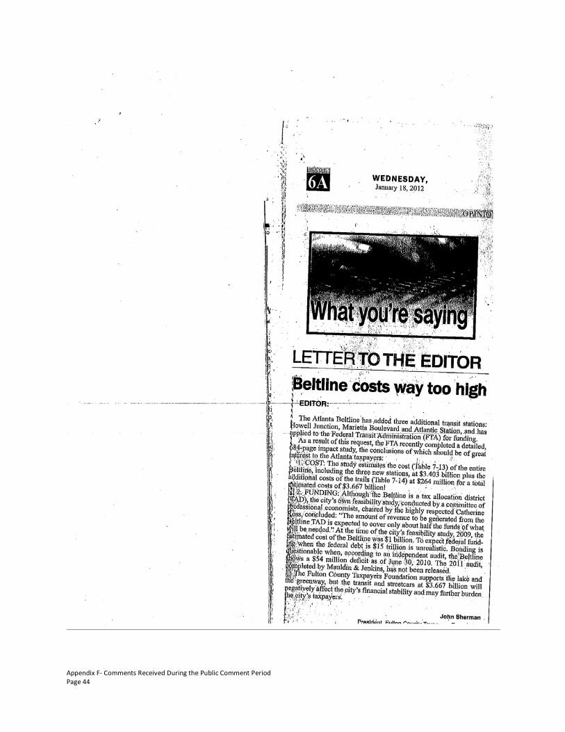
Appendix F- Comments Received During the Public Comment Period Page 44

Appendix F- Comments Received During the Public Comment Period Page 45
Response

Appendix F- Comments Received During the Public Comment Period Page 46

Appendix F- Comments Received During the Public Comment Period Page 47

Appendix F- Comments Received During the Public Comment Period Page 48

Appendix F- Comments Received During the Public Comment Period Page 49
Following are MARTA and ABI’s responses. (1) The preliminary capital cost estimates for the transit alternatives considered in the DEIS are reported, by alternative, in Section 7.3 of the Tier 1 DEIS. Only one of the six alternatives and one of the trail alternatives will likely be constructed. The preferred transit alternative is now estimated and reported in the Tier 1 FEIS to cost approximately $1.6 billion; the preferred trail alternative is now estimated to cost approximately $100 million. Costs will be refined and reported during the Tier 2 analysis. (2) Only one of the three transit alternatives (Howell Station, Marietta Boulevard, or Atlantic Station) will likely be constructed. Right-of-way cost estimates are included in the estimated costs in the Tier 1 EIS and are preliminary. Right-of-way costs will be refined and reported during the Tier 2 analysis. (3) This comment incorrectly attributes several DEIS statements of condition in Section 1.2 to the proposed Atlanta BeltLine. The statements refer to existing conditions. Regarding the second quote, the DIES text actually reads, “discontinuous local roadway, bicycle and pedestrian networks and super block development patterns. “Regarding the third quote, “The BeltLine provides service to the Central Business District rather than circulation to thither activity centers in the City” the DEIS actually reads, “The existing rail and bus transit network provides limited coverage and connectivity in the study area and is focused primarily on providing service to the Central Business District rather than circulation within the study area or to other activity centers in the city.” Regarding the fourth quote, the DEIS actually reads, “At the same time, non-motorized access options are also limited as a result of discontinuous or absent links in the City’s pedestrian and bicycle network, making walk access to activity centers and the rail and bus system challenging.” (4) The project sponsors realize securing funding to implement the Atlanta BeltLine is a challenge. However, the Tax Allocation District (TAD), which was established for the Atlanta BeltLine, has performed strongly since its inception and is considered stable. In addition, federal transportation funding sources are being considered. As City General Funds will not be used for the project, the City budget will not affect the Atlanta BeltLine. Alternative funding sources are being investigated by the project sponsors and a realistic implementation plan will be developed. The project sponsors are optimistic that funding needs for the Atlanta BeltLine can be met, enabling the project to complement the catalytic effect it is already having on investment and development.

Atlanta BeltLine Corridor Environmental Study April 2012
Page Left Intentionally Blank

Atlanta BeltLine Corridor Environmental Study G April 2012
Appendix G - Distribution List

Atlanta BeltLine Corridor Environmental Study April 2012
Page Left Intentionally Blank

Atlanta BeltLine Corridor Environmental Study G-1
APPENDIX G – DISTRIBUTION LIST
Agency Contact Address
Co-Lead Agency
Atlanta BeltLine, Inc. (ABI) Mr. Nate Conable 86 Pryor Street SW Suite 300 Atlanta, GA 30303
Federal Highway Administration (FHWA) Ms. Jennifer Giersch 61 Forsyth Street SW Suite 17T100 Atlanta, GA 30303
Federal Transit Administration (FTA) Mr. Keith Melton 230 Peachtree Street, NW Suite 800 Atlanta, GA 30303
Metropolitan Atlanta Rapid Transit Authority (MARTA) Ms. Cheryl King 2424 Piedmont Road, NE
Atlanta, GA 30324
Cooperating Agency
U.S. Army Corps of Engineers (USACE) Mr. Edward Johnson 1590 Adamson Parkway Suite 200 Morrow, GA 30260
U.S. Environmental Protection Agency (EPA) Mr. Heinz Mueller 61 Forsyth Street Atlanta, GA 30303
U.S. Fish and Wildlife Service (USFWS) Mr. Pete Pattavina 105 West Park Drive Suite D Athens, GA 30606
Participating Agency – Federal
Centers for Disease Control and Prevention (CDC)
Mr. Andrew Dannenberg
4700 Buford Highway MS F-60 Atlanta, GA 30341
Federal Emergency Management Agency (FEMA) (Regulatory Floodways) Mr. Brad Loar 3003 Chamblee-Tucker Road
Atlanta, GA 30341
Federal Railroad Administration (FRA) Mr. Richard Cogswell 1200 New Jersey Avenue SE Washington, DC 20590
National Park Service (NPS) Ms. Christine Arato
Atlanta Federal Center 1924 Building, 100 Alabama Street SW Atlanta, GA 30303
U.S. Department of Housing and Urban Development (HUD) Mr. Juan Roman
Five Points Plaza Building, 40 Marietta Street NW Atlanta, GA 30303
U.S. Department of the Interior (USDO) Office of Environmental Policy & Compliance Mr. Gregory Hogue
75 Spring Street SW Suite 1144 Atlanta, GA 30303
U.S. Geological Survey (USGS), Environmental Affairs Program Mr. Ed Martin
3039 Amweiler Road Suite 130 Atlanta, GA 30360
Participating Agency – Interstate
National Railroad Passenger Corp. (AMTRAK) Mr. Jeff Mann 400 South West Street
Raleigh, NC 27601
Participating Agency – State
Georgia Department of Natural Resources (DNR) Environmental Protection Division Mr. Brian Koehler P.O. Box 3250
Cartersville, GA 30120

Atlanta BeltLine Corridor Environmental Study G-2
Agency Contact Address
Georgia Department of Natural Resources (DNR) Floodplain Management Office Mr. Alan Giles
7 Martin Luther King Drive Suite 440 Atlanta, GA 30334
Georgia Department of Natural Resources (DNR) Historic Preservation Division Ms. Betsy Shirk
254 Washington Street SW Ground Level Atlanta, GA 30303
Georgia Department of Natural Resources (DNR) Non-Game Conservation Ms. Katrina Morris 2065 U.S. Highway 278 SE
Social Circle, GA 30025
Georgia Department of Natural Resources (DNR) Office of the Commissioner Mr. Jim Ussery
2 Martin Luther King Jr. Drive SE Suite 1152E Tower Atlanta, GA 30334
Georgia Department of Transportation (GDOT) Ms. Carol Comer
600 W. Peachtree Street NW 16th Floor Atlanta, GA 30308
Georgia Emergency Management Agency (GEMA) Mr. Dan Stowers 935 East Confederate Avenue
Atlanta, GA 30316
Georgia Environmental Facilities Authority (GEFA) Mr. Curt Soper
233 Peachtree Street NE Harris Tower, Suite 900 Atlanta, GA 30308
Georgia Forestry Commission (GFC) Mr. Robert Farris P.O. Box 819 Macon, GA 31202
Participating Agency – Regional
Atlanta Regional Commission (ARC) Mr. Emerson Bryan 40 Courtland Street NE Atlanta, GA 30303
Atlanta Regional Transportation Board (ARTIB) Mr. John Crocker 2424 Piedmont Road NE
Atlanta, GA 30324
Georgia Regional Transportation Authority (GRTA) Mr. Shaun Green
245 Peachtree Center Avenue NE Suite 800 Atlanta, GA 30303
Participating Agency – City of Atlanta
Atlanta Housing Authority (AHA) Mr. Barney Simms 230 John Wesley Dobbs Avenue Atlanta, GA 30303
City of Atlanta Department of Parks, Recreation and Community Affairs (DPRCA) Mr. George Dusenbury
233 Peachtree Street NE Suite 1700 Atlanta, GA 30303
City of Atlanta Department of Planning and Community Development (DPCD) Mr. James Shelby
55 Trinity Avenue Suite 1450 Atlanta, GA 30303
City of Atlanta Department of Public Works (DPW) Mr. Richard Mendoza
55 Trinity Avenue Suite 4700 Atlanta, GA 30303
City of Atlanta Mayor’s Office Mr. Tom Weyandt 55 Trinity Avenue Suite 2400 Atlanta, GA 30303
Participating Agency – DeKalb County
Atlanta-Fulton County Emergency Management Agency (AFCEMA) Ms. Pansy Ricks 5440 Fulton Industrial Boulevard
Atlanta, GA 30336
DeKalb County Planning & Sustainability Department (P&SD) Mr. Gary Cornell 330 W. Ponce de Leon Avenue
Decatur, GA 30030
Participating Agency – Fulton County

Atlanta BeltLine Corridor Environmental Study G-3
Agency Contact Address
Fulton County Department of Environment and Community Development (E&CD) Ms. Debra Jennings 5440 Fulton Industrial Boulevard
Atlanta, GA 30336
Fulton County Department of Parks and Recreation (P&R) Ms. Lisa Carter
141 Pryor Street Suite 6001 Atlanta, GA 30303
Fulton County Department of Public Works (DPW) Mr. Roussan Francois
141 Pryor Street Suite 6001 Atlanta, GA 30303
Technical Advisory Committee (TAC) Organizations
CSX Intermodal Mr. Carl Matter 6700 McLarin Road Fairburn, GA 30213
Norfolk Southern Corporation Mr. Michael Miller 1200 Peachtree Street NE 12th Floor Atlanta, GA 30309
Atlanta Bicycle Coalition (ABC) Ms. Rebecca Serna 233 Mitchell Street Atlanta, GA 30303
Atlanta Board of Education Mr. Howard Grant 130 Trinity Avenue Atlanta, GA 30303
Atlanta Housing Authority (AHA) Mr. Bakari Brooks 230 John Wesley Dobbs Avenue Atlanta, GA 30303
Atlanta University Center Consortium Ms. Marilyn Jackson P.O. Box 92527 Atlanta, GA 30314
Atlanta Urban Design Commission (AUDC) Mr. Doug Young 55 Trinity Avenue Suite 3400 Atlanta, GA 30303
Buckhead Area Transportation Management Association (BATMA) Ms. Denise Starling
3340 Peachtree Road NE Suite 1640 Atlanta, GA 30326
Central Atlanta Progress (CAP) Ms. Angie Laurie 50 Hurt Plaza SE Suite 110 Atlanta, GA 30303
Citizens for Progressive Transit (CDFPT) Mr. Shelby Mayes 235 Peachtree Street Suite 400 Atlanta, GA 30303
City of Atlanta Office of Sustainability Ms. Mandy Mahoney 55 Trinity Avenue Atlanta, GA 30303
Emory University Ms. Adel Clements 1945 Star Vine Way Decatur, GA 30033
Georgia Institute of Technology (Georgia Tech) Mr. Michael Hunter
790 Atlantic Drive NW SEB 225 Atlanta, GA 30332
Georgia State University (GSU) Mr. Mark Becker P.O. Box 3999 Atlanta, GA 30302
Metro Atlanta Chamber of Commerce Mr. Chuck Meadows 235 Andrew Young International Boulevard NW Atlanta, GA 30303
Midtown Alliance Ms. Shannon Powell 999 Peachtree Street Suite 730 Atlanta, GA 30309
The PATH Foundation Mr. Ed McBrayer 1389 Peachtree Street #202 Atlanta, GA 30324

Atlanta BeltLine Corridor Environmental Study G-4
Agency Contact Address
Pedestrians Educating Drivers on Safety (PEDS) Ms. Sally Flocks 1389 Peachtree Street #202
Atlanta, GA 30303
Trust for Public Land, Georgia Office (TPL) Ms. Helen Tapp 600 West Peachtree Street NW Suite 1840 Atlanta, GA 30308
U. S. Environmental Protection Agency - Brownsfields (EPA) Ms. Olga Perry 61 Forsyth Street SW
Atlanta, GA 30303
Stakeholder Advisory Committee (SAC) Organizations
Ardmore Park Homeowners, NPU-E Mr. Tom Gordon 1866 Anjaio Road NW Atlanta, GA 30303
Atlanta Planning Advisory Board Ms. Drewnell Thomas 460 Joseph E. Lowery Boulevard Atlanta, GA 30314
Atlanta Transit Riders' Union Mr. Terence Courtney 542 Moreland Avenue SE Atlanta, GA 30316
BeltLine Network Ms. Liz Coyle 1117 St. Charles Place Atlanta, GA 30306
BeltLine TADAC Mr. Monty Bruell 1405 Womack Avenue East Point, GA 30344
Clean Air Campaign Mr. Mark Telling 55 Park Place NE Suite 250 Atlanta, GA 30303
Coalition for the Peoples' Agenda Ms. Helen Butler 100 Auburn Avenue Suite 102 Atlanta, GA 30303
Environmental Justice Resource Center @ CAU Mr. Robert Bullard 223 James P. Brawley Drive
Atlanta, GA 30314
Georgia Conservancy Ms. Katherine Moore 817 W. Peachtree Street Suite 200 Atlanta, GA 30308
Georgia Power Company Mr. Steven Foster 241 Ralph McGill Boulevard Suite 10190 Atlanta, GA 30308
Georgia Stand Up Ms. Deborah Scott 501 Pulliam Street SW Suite 500 Atlanta, GA 30312
Georgians for Better Transportation Mr. Danny Shepard P.O. Box 190758 Atlanta, GA 31119
The King Center Mr. Steve Klein 449 Auburn Avenue NE Atlanta, GA 30312
MARTA Elderly & Disabled Advisory Committee - Chair Mr. Robert Smith
3901 Campbellton Road SW Apt. A2 Atlanta, GA 30331
MARTA Elderly & Disabled Advisory Committee - Vice Chair Ms. Teresa Coachman 2373 Crestdale Road SE
Atlanta, GA 30316
Neighborhood Planning Unit – C Mr. Tony Casadonte 238 Peachtree Circle Atlanta, GA 30309
Neighborhood Planning Unit – D Mr. Jim Martin 764 Verner Street Atlanta, GA 30318
Neighborhood Planning Unit – E Ms. Penelope Cheroff
238 Peachtree Circle Atlanta, GA 30309

Atlanta BeltLine Corridor Environmental Study G-5
Agency Contact Address
Neighborhood Planning Unit – F Ms. Diane Olansky 1805 Lenox Road Atlanta, GA 30306
Neighborhood Planning Unit – F Ms. Jane Rawlings 2116 Lenox Road Atlanta, GA 30324
Neighborhood Planning Unit – G Ms. Olga Reynolds 2680 Mango Circle NW Atlanta, GA 30318
Neighborhood Planning Unit – J Ms. Pearl Johnson P.O. Box 92632 Atlanta, GA 30314
Neighborhood Planning Unit – K Ms. Christi Jackson 977 Westmoor Drive Atlanta, GA 30314
Neighborhood Planning Unit – L Ms. Makeda Johnson 604 Delbridge Avenue Atlanta, GA 30314
Neighborhood Planning Unit – M Mr. Forest Coley P.O. Box 89307 Atlanta, GA 30312
Neighborhood Planning Unit – N Ms. Anna Copello 648 Linwood Avenue NE Atlanta, GA 30306
Neighborhood Planning Unit – S Mr. Lev Sterling P.O. Box 11496 Atlanta, GA 30310
Neighborhood Planning Unit – T Ms. Nia Knowles 505 Hopkins Street Atlanta, GA 30310
Neighborhood Planning Unit – V Mr. LaShawn Hoffman P.O. Box 11348 Atlanta, GA 30310
Neighborhood Planning Unit – W Mr. Edward Gilgor 1388 May Avenue Atlanta, GA 30316
Neighborhood Planning Unit – X Mr. Ruben Burnley 2488 Spring Garden Drive Atlanta, GA 30315
Neighborhood Planning Unit – Y Mr. Paul McMurray 1411 Eric Street Atlanta, GA 30315
Panache Communications Group Ms. Sandra Walker 586 Frazier Street NE Atlanta, GA 30312
Piedmont Healthcare Ms. Holly Snow 2001 Peachtree Road NE Suite 230 Atlanta, GA 30309
Piedmont Park Conservancy Ms. Yvette Bowden P.O. Box 7795 Atlanta, GA 30357
Shepard Center Ms. Wilma Bunch 2020 Peachtree Road Atlanta, GA 30309
Sierra Club-Georgia Chapter Ms. Nancy Wylie 1401 Peachtree Street Suite 345 Atlanta, GA 30309
Southface Energy Institute Mr. Tyler Jones 241 Pine Street NE Atlanta, GA 30308
TADAC, APAB, NPU – E, NPU – M Mr. Jim Schneider
161 Mangum Street SW Suite 203 Atlanta, GA 30313
TADAC Executive Committee Mr. Eugene Bowens, Sr.
2499 Harvel Drive NW Atlanta, GA 30318-7409
University Community Development Corp. (UCDC) Mr. Pete Hayley 160 Euharlee St. SW
Atlanta, GA 30314

Atlanta BeltLine Corridor Environmental Study G-6
Agency Contact Address
Urban Land Institute (ULI) (Smart Growth Solutions) Ms. Lisa McCard
300 Galleria Parkway, SE Suite 100 Atlanta, GA 30318
Virginia Highland Civic Association Ms. Pamela Papner 854 Highland Terrace Atlanta, GA 30306
Other Organizations/Agencies
U.S. Congressman John Lewis Mr. Benjamin Spears 100 Peachtree Street NW Suite 1920 Atlanta, GA 30303
U.S. Senator Johnny Isakson Mr. Trey Kilpatrick
One Overton Park 3625 Cumberland Boulevard Suite 970 Atlanta, GA 30339
U.S. Senator Saxby Chambliss Ms. Sara Baska 100 Galleria Parkway Suite 1340 Atlanta, GA 30339
Georgia State Clearinghouse Ms. Barbara Jackson 270 Washington Street, SW 8th Floor Atlanta, Georgia 30334
Georgia State Properties Commission Mr. Steve Stancil 1 Martin Luther King, Jr. Drive Atlanta, GA 30334
State Road and Tollway Authority Ms. Gena Evans 47 Trinity Ave SW # 4 Atlanta, GA 30334-9006
City of Atlanta Mayor Kasim Reed 55 Trinity Avenue SW Atlanta, Georgia 30303
City of Atlanta President Ceasar C. Mitchell
55 Trinity Avenue SW Suite 2900 Atlanta, GA 30303-3584
City of Atlanta Ms.Carla Smith 55 Trinity Avenue SW Suite 2900 Atlanta, GA 30303-3584
City of Atlanta – District 2 Councilmember Kwanza Hall
55 Trinity Avenue SW Suite 2900 Atlanta, GA 30303-3584
City of Atlanta – District 3 Councilmember Ivory Lee Young Jr.
55 Trinity Avenue SW Suite 2900 Atlanta, GA 30303-3584
City of Atlanta – District 4 Councilmember Cleta Winslow
55 Trinity Avenue SW Suite 2900 Atlanta, GA 30303-3584
City of Atlanta – District 5 Councilmember Natalyn Mosby Archibong
55 Trinity Avenue SW Suite 2900 Atlanta, GA 30303-3584
City of Atlanta – District 6 Councilmember Alex Wan
55 Trinity Avenue SW Suite 2900 Atlanta, GA 30303-3584
City of Atlanta – District 7 Councilmember Howard Shook
55 Trinity Avenue SW Suite 2900 Atlanta, GA 30303-3584
City of Atlanta – District 8 Councilmember Yolanda Adrean
55 Trinity Avenue SW Suite 2900 Atlanta, GA 30303-3584

Atlanta BeltLine Corridor Environmental Study G-7
Agency Contact Address
City of Atlanta – District 9 Councilmember Felicia A. Moore
55 Trinity Avenue SW Suite 2900 Atlanta, GA 30303-3584
City of Atlanta – District 10 Councilmember Clarence T. Martin
55 Trinity Avenue SW Suite 2900 Atlanta, GA 30303-3584
City of Atlanta – District 11 Councilmember Keisha Bottoms
55 Trinity Avenue SW Suite 2900 Atlanta, GA 30303-3584
City of Atlanta – District 12 Councilmember Joyce Sheperd
55 Trinity Avenue SW Suite 2900 Atlanta, GA 30303-3584
City of Atlanta – Post 1 At Large Councilmember Michael Julian Bond
55 Trinity Avenue SW Suite 2900 Atlanta, GA 30303-3584
City of Atlanta – Post 2 At Large Councilmember Aaron Watson
55 Trinity Avenue SW Suite 2900 Atlanta, GA 30303-3584
City of Atlanta – Post 3 At Large Councilmember H. Lamar Willis
55 Trinity Avenue SW Suite 2900 Atlanta, GA 30303-3584
City of Atlanta Department of Watershed Management Mr. Dexter White 55 Trinity Avenue SW
Atlanta, GA 30303-3584
Depositories- Regional
Fulton County Government Department of Health 99 Jesse Hill Drive, 4th Floor
Atlanta, GA 30303
Urban Land Institute 300 Galleria Parkway, SE Suite 100 Atlanta, GA 30318
Depositories- Downtown
Atlanta BeltLine Inc. 86 Pryor Street SW Suite 200 Atlanta, GA 30303
Atlanta Housing Authority 230 John Wesley Dobbs Avenue Atlanta, GA 30303
Atlanta Regional Commission 40 Courtland Street NE Atlanta, GA 30303
Auburn Avenue Research Library 101 Auburn Avenue NE Atlanta, GA 30303
Central Atlanta Progress (Atlanta Downtown Improvement District and the Downtown Transportation Management Association)
50 Hurt Plaza Suite 110 Atlanta, GA 30303
Central Library One Margaret Mitchell Square Atlanta, GA 30303
City of Atlanta Bureau of Planning 55 Trinity Street SW Suite 3350 Atlanta, GA 30303
Fulton County Government Center Department of Public Works 141 Pryor Street SW
Atlanta, GA 30303

Atlanta BeltLine Corridor Environmental Study G-8
Agency Contact Address
Depositories- Northside
Buckhead Area Transportation Management Association
3340 Peachtree Road Suite 1640 Atlanta, GA 30326
Buckhead Library Branch 269 Buckhead Avenue NE Atlanta, GA 30305
Midtown Alliance 999 Peachtree Street Suite 730 Atlanta, GA 30309
MARTA 2424 Piedmont Road, NE Atlanta, GA 30324
Peachtree Library Branch 1315 Peachtree Street NE Atlanta, GA 30309
Depositories- Northwest
Martin Luther King, Jr. Library Branch 409 John Wesley Dobbs Avenue Atlanta GA 30312
Ponce de Leon Library Branch 980 Ponce de Leon Avenue NE Atlanta GA 30306
Depositories- Southeast
East Atlanta Library Branch 400 Flat Shoals Avenue SE Atlanta, GA 30316
Georgia Hill Library Branch 250 Georgia Avenue SE Atlanta, GA 30312
Kirkwood Library Branch 11 Kirkwood Road SE Atlanta GA 30317
Thomasville Heights Library Branch 1700 Thomasville Drive SE Atlanta, GA 30315
Depositories- Southwest
Georgia Stand Up 501 Pulliam Street SW Atlanta, GA 30312
Southwest Library Branch 3665 Cascade Road SW Atlanta, GA 30331
Stewart-Lakewood Library Branch 2893 Lakewood Avenue SW Atlanta, GA 30315
West End Library Branch 525 Peeples Street SW Atlanta, GA 30310
Depositories- Westside
Dogwood Library Branch 1838 Donald Lee Hollowell Parkway Atlanta, GA 30318
Washington Park Library Branch 1116 Martin Luther King, Jr. Drive Atlanta, GA 30314

Atlanta BeltLine Corridor Environmental Study H April 2012
Appendix H - Acronyms and Glossary

Atlanta BeltLine Corridor Environmental Study April 2012
Page Left Intentionally Blank

Atlanta BeltLine Corridor Environmental Study H-1
APPENDIX H – ACROYNMS AND GLOSSARY OF TERMS
Acronyms µg Microgram AASHTO American Association of State Highway and Transportation Officials ABI Atlanta BeltLine, Inc. ACM Asbestos Containing Materials ADA Americans with Disabilities Act ADA Atlanta Development Authority ADAC Atlanta Decorative Arts Center AECOM AECOM (name of project consultant, not an acronym) AHERA Asbestos Hazard Emergency Response Act AIRS Permitted Facility & Emissions Listing ARC Atlanta Regional Commission ASAP Atlanta Strategic Action Plan – (City of Atlanta’s Comprehensive Plan) ASTM American Society for Testing and Materials AUDC Atlanta Urban Design Commission BACT Best Available Control Technologies BAHAB BeltLine Affordable Housing Advisory Board BOCA Building Officials and Code Administrators International, Inc. BRT Bus Rapid Transit BTU British Thermal Unit CAAA Clean Air Act Amendments of 1990 CBD Central Business District CCTV Closed Circuit Television CDP Comprehensive Development Plan CEF Community Engagement Framework CEQ Council on Environmental Quality CERCLA Comprehensive Environmental Response, Compensation, and Liability Act CERCLIS Comprehensive Environmental Response, Compensation, and Liability Information
System CESQG Conditionally Exempt Small Quantity Generator CFR Code of Federal Regulations CO Carbon monoxide CMAQ Congestion Mitigation and Air Quality Improvement Program CORRACTS Corrective Action Report CSO Combined Sewer Overflow CTP Comprehensive Transportation Plan CSX CSX railroad CSXT CSX Transportation dBA A-weighted decibel

Atlanta BeltLine Corridor Environmental Study H-2
DCA Georgia State Department of Community Affairs DEIS Draft Environmental Impact Statement DERA Diesel Emissions Reduction Act DNR Georgia Department of Natural Resources DMU Diesel Multiple Unit EDR Environmental Data Resources, Inc. EIS Environmental Impact Statement EO Executive Order ERNS Emergency Response Notification System FHWA Federal Highway Administration FIFRA Federal Insecticide, Fungicide, & Rodenticide Act FINDS Facility Index System/Facility Registry System FLUM Future Land Use Map FOIA Freedom of Information Act FRA Federal Rail Administration FTA Federal Transit Administration FTTS FIFRA & TSCA Tracking System GA State of Georgia GADNR Georgia Department of Natural Resources GDOT Georgia Department of Transportation GEPA Georgia Environmental Protection Act GEPD Georgia Environmental Protection Division GHBS Georgia Historic Bridge Survey GIS Geographic information system(s) GRHP Georgia Register of Historic Places GRTA Georgia Regional Transportation Authority HABS Historic American Building Survey HAER Historic American Engineering Record HBW Home-Based Work Trips HIST FTTS FIFRA/TSCA Tracking System Administrative Case Listing HIA Health Impact Assessment HMIRS Hazardous Materials Information Reporting System HOV High Occupancy Vehicle HRSR Historic Resources Survey Report ICIS Integrated Compliance Information System IESNA Illuminating Engineering Society of North America LBP Lead-based paint LCI Livable Centers Initiative LD Landmark District LIENS CERCLA Lien Information LOS Level of Service

Atlanta BeltLine Corridor Environmental Study H-3
LQG Large Quantity Generator LRT Light Rail Transit LUST Leaking Underground Storage Tank MARTA Metropolitan Atlanta Rapid Transit Authority MLRA Major Land Resource Area MMPT Multi-Modal Passenger Terminal N/A Not applicable NAAQS National Ambient Air Quality Standards NAHRGIS Natural, Archaeological and Historic Resources Geographical Information System NE Northeast NEPA National Environmental Policy Act NESHAPS National Emission Standards for Hazardous Air Pollutants NFPA National Fire Protection Association NFRAP No Further Remedial Action Planned NHPA National Historic Preservation Act NonGen Non Generator NOx Nitrogen oxides NO2 Nitrogen dioxide NOI Notice of Intent NRCS Natural Resources Conservation Service NRHP National Register of Historic Places NS Norfolk Southern Corporation NW Northwest O3 Ozone PA Preferred Alternative PADS PCB Activity Database System Pb Lead PCBs Poly-Chlorinated Biphenyls PIAC Public Involvement and Agency Coordination PM10 Particulate matter with a diameter of 10 micrometers and smaller PM2.5 Particulate matter with a diameter of 2.5 micrometers and smaller ppm Parts per million RCRA Resource Conservation Recovery Act RDP Regional Development Plan REC Recognized Environmental Condition ROW Right-of-Way RMS Root mean square RTD Regional Transportation District (Denver, CO) RTP Regional Transportation Plan SAC Stakeholder Advisory Committee SAC Steering Agency Committee

Atlanta BeltLine Corridor Environmental Study H-4
SAFETEA-LU Safe, Accountable, Flexible, Efficient Transportation Equity Act: A Legacy for Users SC Streetcar SE Southeast SHPO State Historic Preservation Officer SHWS State Hazardous Site Inventory SIP State Implementation Plan SOX Sulfur oxides SO2 Sulfur dioxide SPI Special Public Interest District SPILLS Spills Information Oil or Hazardous Material Spills or Releases SQG Small Quantity Generator SR State Route SSMP Safety and Security Management Plan SSTS Section 7 Tracking System SW Southwest SWF/LF Solid Waste Disposal Facilities/Landfill TAC Technical Advisory Committee TAD Tax Allocation District TADAC Tax Allocation District Advisory Committee TIP Transportation Improvement Plan TIB Transit Implementation Board TIER 2 A listing of facilities which store or manufacture hazardous materials and submit a
chemical inventory report TMDL Total Maximum Daily Load TPB Transit Planning Board TRIS Toxic Release Inventory System TSCA Toxic Substances Control Act TSDF Transporters, Storage and Disposal Facility TSM Transportation Systems Management UGPM Urban Growth Policy Map UP Union Pacific Railroad USACE United States Army Corps of Engineers USC United States Code USDA United States Department of Agriculture USDOT U.S. Department of Transportation USEPA United States Environmental Protection Agency USFWS United States Fish and Wildlife Service USGS United States Geological Survey UST Underground Storage Tank V/C Volume-to-Capacity Ratio VdB Vibration decibel

Atlanta BeltLine Corridor Environmental Study H-5
VOC Volatile organic compounds VHT Vehicle Hours Traveled VMT Vehicle Miles Traveled

BeltLine Corridor Environmental Study H-6
Glossary of Commonly Used Terms 100-year floodplain – The area that will be inundated by the flood event having a 1-percent chance of being equaled or exceeded in any given year. In this document the 100-year floodplain refers to designated areas established by Flood Insurance Rate Maps produced by the National Flood Insurance Program.
303(d) List – See Section 303(d).
abandoned right-of-way – Railroad right-of-way that is no longer used by a railroad operator. The Federal Surface Transportation Board reviews and approves requests for railroad right-of-way abandonment.
accessibility – A measure of the degree of difficulty in reaching other locations, goods, services or activities from a given site. It is influenced by changes in travel time, safety, vehicle operating costs, transportation mode, and local and regional land use conditions.
adverse effect – In the context of cultural resources reviewed in this report, the term is defined in Section 106 of the National Historic Preservation Act (36 CFR 800.5(a)(1)). An adverse effect to a historic property occurs when the project under consideration would potentially alter any characteristic that qualifies the property for inclusion in the National Register of Historic Places in a manner that would diminish the integrity of the property.
affected environment – Ambient conditions of the relevant study area at the time an Environmental Effects Report is prepared.
alignment – The ground plan of a railway, trail, roadway or other fixed route.
ambient air – A physical and chemical measure of the concentration of various chemicals in the outside air, usually determined over a specific time period (e.g., one hour, eight hours).
at-grade – Occurring at the same ground-level elevation, especially in reference to a crossing point or intersection of two separate transportation facilities (e.g. road, sidewalk, bicycle path, railroad, etc.).
attainment area – An area where the quality of air is as good as or better than the National Ambient Air Quality Standards that are defined in the Federal Clean Air Act. An area may be an attainment area for one pollutant and a non-attainment area for others.
BeltLine Tax Allocation District (TAD) – A special tax district created in 2005 by the Atlanta City Council, the Atlanta Public School Board, and the Fulton County Commission. It comprises a 6,500-acre area along the BeltLine corridor. Subsequent growth in property tax revenue above the 2005 revenue from the area will be used to fund public improvements within the TAD. The majority of the BeltLine TAD funds will be used to invest in land acquisition, multi-use trails, greenspace, transit, transportation improvements, and affordable workforce housing and Atlanta Public Schools projects. Some BeltLine TAD funds will be used for developer infrastructure, primarily for environmental brownfield cleanup, or to jump-start development in underdeveloped areas. The TAD will expire in 2031.
boardings, passenger – The count of passengers embarking onto a transit vehicle or route for the purposes of measuring ridership or fare revenue.

BeltLine Corridor Environmental Study H-7
British Thermal Unit (BTU) – The amount of heat energy required to raise the temperature of one pound of liquid water by one degree from 60° to 61°Fahrenheit at a constant pressure of one atmosphere
brownfield – Real property, of which the expansion, redevelopment, or reuse may be complicated by the presence or potential presence of a hazardous substance, pollutant, or contaminant.
bus rapid transit (BRT) – A local or regional bus transit line that operates on a fully or partially exclusive lane from other traffic. It may also utilize other measures such as priority traffic signals to avoid delays from traffic lights and congestion. BRT systems typically have stops that are more widely spaced than local bus routes and that may incorporate more amenities such as covered stations, boarding platforms and off-board payment.
carbon monoxide (CO) – A colorless and odorless gas that is a product of incomplete combustion. In most areas, motor vehicles are responsible for the major portion of ambient CO levels. CO is absorbed by the lungs and reacts with hemoglobin to reduce the oxygen carrying capacity of the blood. At low concentrations, CO has been shown to aggravate the symptoms of cardiovascular disease. It can cause headaches and nausea, and at sustained high concentration levels, can lead to coma and death.
centerline – The line corresponding to the central geometric axis of a railroad track, road, trail or other transportation corridor. It is typically used as the reference point for measurements of track dimensions and location.
channel, stream – An open conduit either naturally or artificially created which periodically or continuously contains moving water.
Civil Rights Act of 1964 – Title VI of this federal act provides that that no person shall, on the grounds of race, color, national origin and sex, be discriminated against in federally funded programs or activities. Environmental impact statements are required to demonstrate consideration of project compliance with Title VI.
Clean Air Act Amendments of 1990 (CAAA) – A strategy by the Federal government to address the problem of urban smog. It requires states and the Federal government to reduce emissions from automobiles, trucks, buses, ships, barges, and consumer products, and to meet air quality standards. It particularly addresses the urban problems of ozone, carbon monoxide (CO), and particulate matter (PM-10). It established a process for the designation of “attainment” and “nonattainment” areas by the U.S. Environmental Protection Agency. The CAAA also required that official regional transportation plans “conform” to the State Implementation Plan (see definition below) for federal air quality standards. The USDOT reviews regional transportation plans and makes a conformity determination.
clear-span – A bridge span that does not have any physical obstructions such as support columns underneath.
community facility – Public or publicly-funded facilities, such as police and fire protection facilities, emergency medical response facilities, hospitals, schools, and libraries, as well as private facilities such as hospitals and schools.
conformity determination – See Clean Air Act Amendments of 1990.

BeltLine Corridor Environmental Study H-8
Connectivity Alternative – An alignment option considered in the Tier 1 EIS in a location identified as having critical design options. In these locations, the Tier 1 EIS Build Alternative includes multiple connectivity alternatives. These are different from the Transit Concepts (see below), which are alignment alternatives for the overall BeltLine loop.
contributing property/structure – A property or structure which contributes to the historical integrity of a designated historic district or property.
Council on Environmental Quality (CEQ) – The federal office that oversees implementation of the Federal National Environmental Policy Act of 1969 (see below) and coordinates other federal environmental efforts.
critical habitat – Defined under the Federal Endangered Species Act of 1973 as areas within a listed species’ current range (at the time of listing) that contain the physical or biological features that are essential to that species’ conservation or that for some reason require special management and areas outside the species’ current range that the Secretary of the Interior determines to be essential to its conservation.
cross-section – The cross-sectional configuration of a transportation corridor (railway, trail, roadway, etc.) that specifies typical widths for tracks/travel lanes, related facilities, buffer areas and total right-of-way.
cultural resource – Defined as both architectural and archaeological resources and typically including resources such as buildings, structures, religious properties, cemeteries, and Native American tribal areas. The historic significance of these types of resources is determined by applying the criteria set forth in the National Register of Historic Places Evaluation Criteria.
cumulative impacts – Changes to the environment that are caused by an action in combination with other past, present and future human actions. In simplest terms, analyzing cumulative effects means considering and accounting for the impacts of a proposed action in the context of the existing transportation system and improvements to it that are reasonably foreseeable in the vicinity. Also referred to as incremental effects.
de minimis – See Section 4(f).
determination of eligibility – Decision made by the State Historic Preservation Office (SHPO) regarding whether a historic building or district is eligible for listing in the National Register of Historic Places.
designated use (waterway) – In accordance with the Federal Clean Water Act, the State of Georgia classifies all waters into categories of intended use, which accordingly have different water quality standards. Examples of designated uses include drinking water supply, fishing, and recreation.
effects – Synonymous with impacts of a proposed action; includes both beneficial and detrimental outcomes.
endangered – A species whose prospects for survival within the state are in immediate danger based on a loss of habitat, over-exploitation, predation, competition, or disease. An endangered species requires immediate attention or extinction will likely follow. The Federal government maintains a list of designated endangered species in accordance with the Endangered Species Act of 1973.

BeltLine Corridor Environmental Study H-9
environmental impact statement – A document required by the National Environmental Policy Act of 1969 (see below) for any proposed major federal action that may significantly affect the environment (defined as a Class III action). The purpose of the EIS is to provide full and open evaluation of environmental issues and alternatives, and to inform decision-makers and the public of reasonable alternatives that could avoid or minimize adverse impacts and enhance the quality of the environment.
environmental justice – Executive Order (EO) 12898, “Federal Actions to Address Environmental Justice in Minority Populations and Low-Income Populations,” provides for equal protection from environmental hazards and fair treatment for all people regardless of race, ethnicity, or economic status, with respect to the development, implementation, and enforcement of environmental laws, regulations, and policies. Fair treatment implies that no population of people bear an unequal share of negative environmental impacts of pollution or environmental hazard resulting from industrial, municipal, and commercial operations or the execution of federal, state, or local policies.
ephemeral stream – A stream that has flowing water only during, and for a short duration after, precipitation events in a typical year. Ephemeral stream beds are located above the water table year-round. Groundwater is not a source of water for the stream. Runoff from rainfall is the primary source of water for stream flow.
fixed guideway transit – An exclusive travel way used by a particular mode of public transportation.
floodplain – A nearly flat plain along the course of a stream or river that is naturally subject to flooding. In this document, the term floodplain generally refers to one of the Flood Hazard Areas defined by the National Flood Insurance Program and mapped in a Flood Insurance Rate Map.
fugitive dust – Dust that leaves a property during construction, demolition, or other induced activity and that can alter the air quality at a given location.
geographic information system(s) (GIS) – A computerized mapping system that includes database and analytical capabilities.
Georgia Ambient Air Quality Standards – See Georgia Air Quality Control Act of 1967.
Georgia Air Quality Control Act of 1967 – An act of the Georgia General Assembly that together with the Federal Clean Air Act, provides the basis for state air quality programs as implemented by the Environmental Protection Division of the Georgia Department of Natural Resources. It established the Georgia Ambient Air Quality Standards.
Georgia Environmental Policy Act of 1991 – An act of the Georgia General Assembly that establishes a process for environmental review and disclosure of potential environmental impacts by proposed state actions.
Georgia Register of Historic Places – The Georgia Register is the state's official list of historic buildings, structures, sites, objects, and districts that provides recognition of a property's architectural, historical, or archaeological significance to the state. The Georgia Register program is administered by the Historic Preservation Division (HPD) of the Department of Natural Resources. It identifies properties for planning purposes and ensures that these properties will be taken into account in the planning of state assisted projects and preservation efforts.
grade crossing – An intersection where a roadway crosses a railway at the same elevation.

BeltLine Corridor Environmental Study H-10
greenway – A linear corridor of parkland, open space or other type of natural or vegetated land that usually contains a trail or pathway. Greenways can have different functions, including open space, recreational corridor, wildlife corridor or natural buffer.
groundwater recharge area – An area with a critical replenishing effect on groundwater aquifers, especially those used for drinking water.
habitat – The area or environment where an organism or ecological community normally lives or occurs.
hazardous material – Any toxic substance or explosive, corrosive, combustible, poisonous, or radioactive material that poses a risk to the public’s health, safety or property.
headway – The scheduled time between transit vehicle runs operating on a particular transit route.
heavy rail – An electric railway with capacity for a heavy volume of traffic and characterized by exclusive rights-of-way, high speed and rapid acceleration. The existing MARTA rail system comprises heavy rail lines. Heavy rail is different from commuter rail and light rail systems.
Historic District – A concentration of sites, buildings, structures, or objects that are listed or eligible for listing on the National and Georgia Register of Historic Places.
hydric – Having high water content.
hydrocarbon (HC) – A type of chemicals that belongs to a larger group of chemicals known as volatile organic compounds (VOC), which include a wide variety of organic compounds emitted principally from the storage, handling and use of fossil fuels. HC are compounds of hydrogen and carbon only, while VOC may contain other elements. Hydrocarbons contribute to the formation of ground-level ozone. See also Volatile Organic Compounds.
hydrophytic vegetation – Plant life growing in water or in earth that is at least periodically deficient in oxygen as a result of excessive water content.
impaired stream – A stream with water quality that does not support its designated use as defined by the State of Georgia in accordance with Section 303(d) of the Federal Clean Water Act.
indirect effects – Effects that would be caused by a Proposed State Action but that would occur later in time or farther removed in distance but that are still reasonably foreseeable.
interlocking – An arrangement of railroad signals and switches with special operating procedures, typically located at critical sites such as a crossing of two railroads, drawbridge, junction, or entrance/exit to a terminal or yard.
intermittent stream – A stream that has flowing water during certain times of the year, when groundwater provides water for stream flow. During dry periods, intermittent streams may not have flowing water. Runoff from rainfall is a supplemental source of water for stream flow.
intermodal – Referring to connections between or integration of two or more transportation modes (e.g., bus, train, automobile, etc.).

BeltLine Corridor Environmental Study H-11
invasive species – A species that is non-native to the ecosystem under consideration and whose introduction causes or is likely to cause economic harm, environmental harm, or harm to human health.
jurisdictional wetland – A wetland that is regulated by Section 404 of the federal Clean Water Act.
jurisdictional stream – A stream that is regulated by Section 404 of the federal Clean Water Act.
land use – Classification providing information on land cover and the types of human activity occurring on a parcel of land, such as “commercial,” “industrial,” “residential,” or “open space.”
level of service (LOS) – A letter grade designation used to describe given roadway conditions with “A” being at or close to free-flow conditions and “F” being at or close to over-saturation of the roadway; usually based on the progression of vehicles through the green phase of a signal, driver discomfort/frustration, lost travel time, and fuel consumption.
Light Rail Transit (LRT) – An electric-powered rail system characterized by its ability to operate single- or multiple-car trains along exclusive rights-of-way, in subways, on aerial structures, or on streets with mixed traffic. It is able to board and discharge passengers at station platforms or at street, track, or car floor level. Some types of light rail transit systems may be referred to as streetcar, trolley, or tramway systems.
Limits of Disturbance (LOD) – The likely “footprint” or physical extent of the proposed project.
Locally Preferred Alternative - A transit alternative that is technically feasible and supported by local residents, stakeholders, and elected officials. It is determined through a detailed technical study and comments received through the associated public involvement process.
low-income – Any household with income at or below the U.S. Bureau of the Census poverty thresholds.
Major Land Resource Area (MLRA) – A classification of a geographic area of the United States based on its physiographic geologic, climatic, water, soil, and land use characteristics. The MLRA geographic database is maintained by the Natural Resources Conservation Service of the U.S. Department of Agriculture.
migratory birds – bird species that embark on regular seasonal journeys on an annual basis for purposes such as breeding or feeding or in response to weather conditions. Migratory birds are protected under the federal Migratory Bird Treaty Act.
minority – As recognized by Federal law, a member of one of the following races: (1) Black or African American, (2) American Indian or Alaska Native, (3) Asian, (4) Native Hawaiian or other Pacific Islander, (5) Hispanic or Latino Origin.
mitigation – Action necessary to reduce, minimize or eliminate an impact to the affected environment by the proposed project.
mixed-use – Combination of land uses, such as residential uses combined with office, retail, public, entertainment, or even manufacturing uses.

BeltLine Corridor Environmental Study H-12
mobility – The degree to which a person is able to move about; it is determined by a person’s economic situation in addition to any physical disabilities she or he may possess.
multi-use trail – A trail designed for a variety of non-motorized transportation modes and recreational uses, including walking, jogging, bicycling, and in-line skating as permitted by the facility’s design and regulations.
National Ambient Air Quality Standards (NAAQS) – Nationwide air quality standards established by the U.S. Environmental Protection Agency (EPA) in accordance with the federal Clean Air Act Amendments of 1990 that apply to six principal types of pollutants.
National Flood Insurance Program – A program of the Federal Emergency Management Agency (FEMA) that provides flood insurance to participating communities, issues floodplain management regulations, and identifies and maps floodplains
National Historic Landmark – A place that is designated by the US Department of the Interior as possessing exceptional value or quality in illustrating and interpreting the heritage of the United States. The National Park Service administers the National Historic Landmarks program for the Secretary of the Interior. Only 3% of properties listed in the National Register of Historic Places are designated as National Historic Landmarks.
National Environmental Policy Act of 1969 (NEPA) – Federal legislation that establishes an umbrella process for coordinating compliance with each law through the preparation of an Environmental Impact Statement (EIS) for all major federal actions significantly affecting the environment. Other special purpose statutes and procedures may apply as well, depending on specific circumstances, e.g., protective measures for historic properties, wetlands, floodplains, etc. If related environmental review requirements apply, they are to be undertaken as part of the NEPA compliance process. NEPA is the primary law governing the environmental protection process undertaken by the sub-agencies of the US Department of Transportation in reviewing federally funded transportation projects.
National Register of Historic Places (NRHP or National Register) – A federal list of buildings, sites, districts or other properties that have a historic significance. The National Register of Historic Places is maintained by the Keeper of the National Register.
National Wetlands Inventory (NWI) – A geospatial database of wetlands maintained by the Division of Habitat and Resource Conservation of the U.S. Fish and Wildlife Service.
neighborhood – A contiguous residential area with distinct characteristics or boundaries.
nitrogen oxides (NOx) – When combustion temperatures are extremely high, as in motor vehicle engines, atmospheric nitrogen may combine with oxygen to form various oxides of nitrogen. These pollutants, generally referred to as NOx, are inorganic gases formed by combination of oxygen with nitrogen from the air. Of these, nitric oxide (NO) and nitrogen dioxide (NO2) are the most significant compounds. Nitric oxide is a colorless and odorless gas. It is relatively harmless to humans and quickly converts to NO2. NO2, like VOCs, is of concern primarily because of its role in the formation of ozone. NO is produced in much greater quantities than NO2, but oxidizes to NO2 in the atmosphere. NO2 causes detrimental effects to the bronchial system.
No Build Alternative – The future condition of the study area in the absence of the proposed project. The No Build Alternative serves as a benchmark against which the potential impacts of other alternatives can be compared. It assumes that no improvements will be made with the exception of

BeltLine Corridor Environmental Study H-13
other committed projects and periodic maintenance and minor enhancements needed to maintain safe operation.
non-contributing – See “contributing resource.”
ozone (O3) – A gas found in two different layers of earth's atmosphere: in the stratosphere (beginning seven to ten miles above earth's surface) and the troposphere (beginning at earth's surface and extending up to the stratosphere). In the stratosphere, ozone occurs naturally and provides a protective layer shielding earth from harmful ultraviolet radiation. In the troposphere, ozone is a major component of photochemical smog and can harm the respiratory systems of humans and other animals. It is a prevalent and widespread criteria pollutant that is regulated by the U.S. Environmental Protection Agency in accordance with the Clean Air Act. Ozone in the troposphere is produced by complex chemical reactions involving nitrogen oxides, which are among the primary pollutants emitted by combustion sources; hydrocarbons, released into the air through the combustion, handling and processing of petroleum products; and sunlight. This report is concerned with potential effects of the proposed state action on tropospheric ozone emissions and ambient levels.
palustrine – Relating to a system of inland, nontidal wetlands characterized by the presence of trees, shrubs, and emergent vegetation (vegetation that is rooted below water but grows above the surface). Palustrine wetlands range from permanently saturated or flooded land (as in marshes, swamps, and lake shores) to land that is wet only seasonally (as in vernal pools).
particulate matter (PM10 and PM2.5) – Particle pollution is a complex mixture of extremely small particles and liquid droplets. Particle pollution is made up of a number of components, including acids (such as nitrates and sulfates), organic chemicals, metals, and soil or dust particles. The US Environmental Protection Agency regulates two categories of particle pollution: fine particles (PM2.5), which are 2.5 micrometers in diameter and smaller; and inhalable coarse particles (PM10) which are smaller than 10 micrometers. (A micrometer is 1/1000th of a millimeter; there are 25,400 micrometers in an inch.)
peak period – The primary morning and afternoon/evening commute periods, the hours of which are defined differently according to the agency or study purpose.
perennial stream – A stream that has flowing water year-round during a typical year. The water table is located above the stream bed for most of the year. Groundwater is the primary source of water for stream flow. Runoff from rainfall is a supplemental source of water for stream flow.
Phase I Archaeological Survey – The first step in a cultural resource archaeology investigation. The Phase I Survey assesses the potential presence and locations of potential archaeological sites within a study area using background research and field reconnaissance.
Phase I Environmental Site Assessment (ESA) – Generally considered the first step in the process of environmental due diligence to identify potential or existing environmental contamination. The Phase I ESA typically addresses both the underlying land as well as physical improvements to the property and primarily examines potential uses, activities, and/or structures that can generate soil and groundwater contamination. Standards for performing a Phase I ESA have been promulgated by the USEPA and are based in part on ASTM Standard E1527-05. Actual sampling of soil, air, groundwater and/or building materials is typically not conducted during a Phase I ESA.
Phase II Environmental Site Assessment – The collection of soil, air, groundwater and/or building material samples to further identify site conditions and to better quantify the potential contamination

BeltLine Corridor Environmental Study H-14
that may exist at a site, right-of-way, or area of concern based upon the findings of a Phase I Environmental Site Assessment or other sources of suspected or known contamination. Work would be completed in conjunction with local, State of Georgia, and USEPA regulatory requirements and agencies.
Piedmont Physiographic Province – The physiographic province in which the study area is located. A physiographic province is a region in which the landforms are similar in geologic structure and differ significantly from the landform patterns in adjacent regions. The Georgia Piedmont is characterized by a rolling surface with slopes of minimal relief and stream valleys of greater depth and steeper slopes.
project sponsors – The Metropolitan Atlanta Rapid Transit Authority (MARTA) and the Atlanta BeltLine, Inc. (ABI) are the project sponsors for the BeltLine project environmental study being conducted in compliance with the National Environmental Policy Act.
protected species – An organism that is legally protected because it is considered endangered or threatened to become endangered, or one of special concern. Protection may be granted at the federal, state or local levels.
Public Involvement and Agency Coordination (PIAC) Plan – Section 6002 of Public Law 104-59, the Safe, Accountable, Flexible, Efficient Transportation Equity Act: A Legacy for Users, mandates the development of a coordination plan for all projects for which an Environmental Impact Statement is prepared under National Environmental Policy Act. It stipulates that the planning process provide opportunities for involvement by the public and agencies. For the BeltLine project, the PIAC plan describes how the public, local and state government agencies, and decision-makers will take part in the identification, development, and implementation of the proposed transit and multi-use trails system.
Recognized Environmental Conditions (RECs) – A term defined by ASTM International, originally known as the American Society for Testing and Materials (ASTM). It is defined under ASTM E1527 - 05 Standard Practice for Environmental Site Assessments: Phase I Environmental Site Assessment Process. “The presence or likely presence of any hazardous substances or petroleum products on a property under conditions that indicate an existing release, a past release, or a material threat of a release of any hazardous substances or petroleum products into structures on the property or into the ground, ground water, or surface water of the property. The term includes hazardous substances or petroleum products even under conditions in compliance with laws. The term is not intended to include de minimis conditions that generally do not present a material risk of harm to public health or the environment and that generally would not be the subject of an enforcement action if brought to the attention of appropriate governmental agencies. Conditions determined to be de minimis are not recognized environmental conditions.”
ridership – The number of people using a public transportation system during a given time period.
right-of-way (ROW) – A public or private area that allows for passage of people or goods, including, but not limited to, railways, freeways, streets, bicycle paths, alleys, trails and walkways. A public right-of-way is dedicated or deeded to the public entity for use under the control of a public agency.
riparian buffer – A strip of naturally vegetated land along a stream. The vegetation along the banks and in the adjacent floodplain area is characterized by plants that associate with waterways and nearby moist soils. Riparian buffers protect water quality and other natural functions of the stream by filtering storm water runoff, stabilizing stream banks, moderating water temperatures, and providing habitat for wildlife.
BeltLine Corridor Environmental Study H-15
runoff – The part of precipitation, snow melt, or irrigation water that runs off the land into streams and lakes. It can carry pollutants from the air and land into receiving waters.
Safety and Security Management Plan (SSMP) – A plan required by the Federal Transit Administration (FTA) for major capital transit projects as a condition for Federal financial assistance. The SSMP explains how the funding recipient will perform safety and management activities defined in FTA guidelines.
Scoping Process – Scoping is the first step in the environmental review process and involves using public and agency participation to develop possible solutions and identify issues regarding a proposed project. Scoping also helps determine needs, objectives, resources and constraints within the study area. The formal Public Scoping Process for the BeltLine Corridor Environmental Study began with the publication in the Federal Register of a Notice of Intent (NOI) to prepare a Tier 1 Environmental Impact Statement (EIS) on July 24, 2008 (Volume 73, No. 143). The Scoping Summary Report summarized the initial public and agency input that was gathered during the project scoping period from July 24, 2008 through September 22, 2008.
secondary effects – Effects which are caused by the action and are later in time or farther removed in distance, but are still reasonably foreseeable. Secondary effects may include growth-inducing effects and other effects related to changes in the pattern of land use, population density or growth rate, and related effects on air and water and on other natural systems, including ecosystems. Also referred to as indirect effects.
Section 4(f) –A provision of the Department of Transportation Act (DOT Act) of 1966 which stipulates that DOT agencies cannot approve the use of land from publicly owned parks, recreational areas, wildlife and waterfowl refuges, or public and private historical sites unless the following conditions apply: there is no feasible and prudent alternative to the use of land, and the action includes all possible planning to minimize harm to the property resulting from use. In 2005, the provision was modified so that the U.S. Department of Transportation (DOT) may determine that certain uses of Section 4(f) land would have de minimis impacts and would have no adverse effect on the protected resource. When this is the case, and the responsible official(s) with jurisdiction over the resource agrees in writing, compliance with Section 4(f) is greatly simplified.
Section 106 – A provision of the National Historic Preservation Act of 1966 that requires consideration of historic and archaeological properties and resources in Federal actions. Section 106 requires Federal agencies to assess potential effects of proposed actions on historic resources and provide opportunity for comment by the Advisory Council on Historic Preservation.
Section 303(d) – A provision of the federal Clean Water Act of 1977 that requires states to assess the conditions of their waters to determine where water quality is impaired (does not fully meet standards) or threatened (is likely to violate standards in the near future). The result of this review is the 303(d) list of impaired waters within the state, which must be submitted to the EPA every other year. Section 303(d) also requires states to prioritize and target water bodies on their list for development of water quality improvement strategies.
Section 404 – A provision of the federal Clean Water Act of 1977 which establishes a program to regulate the discharge of dredged or fill material into waters of the United States. Proposed impacts to waters of the U.S., including wetlands, streams and other open water bodies, are regulated by this provision.
Section 404 Permit – A permit issued in accordance with Section 404 of the Clean Water Act of 1977. The permitting program is administered by the U.S. Army Corps of Engineers.

BeltLine Corridor Environmental Study H-16
sensitive receiver / receptor – A land use that would receive noise or vibration caused by a project. The type of the land use in question (e.g., residences, schools, libraries, laboratories, etc.) is generally sensitive to noise and vibration effects.
sensitive view – An outdoor area that is visible by sensitive viewers (see below).
sensitive viewer – A person who may be impacted by a change in the local outdoor visual and aesthetic environment at a given location.
siding – A length of railroad track parallel to the main track that has a switch at both ends to allow trains to enter at one end and exit at the other. Sidings function to allow trains to pass one another or to access adjacent facilities such as industrial operations.
significant – Term used regarding the magnitude of potential effects or impacts of projects regulated by the Georgia Environmental Policy Act. A proposed action is considered in both context and intensity to determine whether or not the action would likely significantly impact a habitat, neighborhood, species or other resource in the study area.
sole source aquifer – An underground water supply designated by the Environmental Protection Agency (EPA) as the "sole or principal” source of drinking water for an area.
station platform – The area where passengers board and disembark from a train or subway vehicle.
State Historic Preservation Office (SHPO) – A state administrative agency responsible for carrying out consultation in accordance with the National Historic Preservation Act of 1966, as amended, and other state historic preservation regulations.
State Implementation Plan (SIP) – A state plan for the establishment, regulation, and enforcement of Federal air pollution standards. It is reviewed and approved by the US Environmental Protection Agency in accordance with the Clean Air Act Amendments of 1990.
storm water – Runoff water that is generated by a rain event. Storm water discharges include runoff from land, pavements, building rooftops and other surfaces. Storm water runoff can accumulate a variety of pollutants such as oil and grease, chemicals, nutrients, metals, and bacteria as it travels across land before discharging into surface and other receiving waters. Heavy surges in storm water runoff can cause other negative effects, including flooding and erosion, to streams and adjacent low-lying areas, especially in urbanized watersheds.
Stream Buffer Variance – A variance granted to the stream buffer requirements of the Georgia Erosion and Sedimentation Act of 1975. In certain circumstances, when encroachment on a required stream buffer cannot be avoided, the Georgia Environmental Protection Division (EPD) may grant a variance permitting construction to encroach into the stream buffer. Provisions of the variance require documentation of erosion control measures and mitigation practices to minimize buffer impacts.
streetcar – A streetcar is a form of rail transit that generally refers to a type of light rail transit which uses smaller vehicles than typical light rail transit systems and generally operates as single-car trains. Modern Streetcars are capable of operating in mixed traffic and along exclusive fixed-rail guideways.

BeltLine Corridor Environmental Study H-17
sulfur oxides (SOx) – A class of compounds of which sulfur dioxide (SO2) and sulfur trioxide (SO3) are of great importance. The health effects of SOX include respiratory illness, damage to the respiratory tract, and aggravation of respiratory diseases such as asthma, bronchitis and emphysema. Additionally, atmospheric reactions of SO2 generate sulfuric acid, which is the main constituent of acid rain. Motor fuels, particularly diesel fuel, contain small amounts of sulfur that are oxidized and emitted in vehicle exhaust.
Tax Allocation District (TAD) – See BeltLine Tax Allocation District.
terminus/termini – The end points of a transportation line or the districts/towns in which they are located.
Tier 1 Environmental Impact Statement (EIS) - A written statement, required by Section 102 (2) (C) of the NEPA for projects that involve a federal action such as funding. The Tier 1 EIS serves to provide information about significant environmental impacts and informs decision-makers and the public of practical alternatives that would prevent or minimize adverse impacts or improve the quality of the human environment.
Title VI – See Civil Rights Act of 1964.
transit-dependent population – Defined by the Federal Transit Administration as persons in one or more of the following categories: 1) without private transportation, 2) elderly (over age 65), 3) youths (under age 18), or 4) persons below poverty or median income levels defined by the U.S. Census Bureau.
Transit Concept –One of the two overall transit alignment alternatives being studied as part of the Build Alternative of the BeltLine project. These are different from Connectivity Alternatives (see above), which are alternative transit alignment segments in specific locations.
Transportation Improvement Program (TIP) – A prioritized list of regional transportation projects and proposed funding to be implemented in stages over several (3 to 5) years. The projects are selected from those proposed in the systems management element and the long-range element of the regional transportation planning process. This program is required as a condition for the region to receive federal transit and highway grants.
transportation systems management (TSM) – Different actions and activities designed to make an existing transportation system more efficient.
turbidity – A cloudy water quality condition due to suspended silt or organic matter.
underground storage tank (UST) – A tank located at least partially underground and designed to hold gasoline, other petroleum products or chemicals.
uplands – Land that is well-drained and rarely, if ever, inundated.
vegetated buffer/vegetative buffer – A vegetated upland or wetland area next to rivers, streams, lakes, or other open waters which separates the open water from developed areas and agricultural land. Vegetated buffers provide a variety of aquatic habitat functions and help improve or maintain local water quality. A vegetated buffer can be established by maintaining an existing vegetated area or by restoring a cleared or degraded area. See also riparian buffer.

BeltLine Corridor Environmental Study H-18
vehicle miles traveled (VMT) – The number of miles traveled by an automobile per individual within a given area.
visual resource – A local resource, such as a structure or outdoor setting, valued for its visual or aesthetic qualities.
volatile organic compound (VOC) – A wide variety of organic compounds emitted principally from the storage, handling and use of fossil fuels. They are produced by incomplete combustion of hydrocarbon fuels and also by their evaporation. Because there are many hundreds of different compounds, VOC display a wide range of properties. Some, such as benzene, are carcinogenic while others are harmless to health. VOC contribute to the formation of ground-level ozone.
volume-to-capacity ratio (V/C) – A conventional measure for comparing roadway demand (traffic volumes) with roadway carrying capacity, which is based on the number of lanes, road speed and other aspects of the roadway’s design.
waste water – The water and wastes from homes, businesses, institutions and infrastructure facilities that enter pipes and are transported to treatment plants for treatment and disposal.
Waters of the United States – All waters defined under the Clean Water Act 40 CFR 230.3(s) and subject to US Army Corps of Engineers jurisdiction. Waters of the United States include those which are currently used, or were used in the past, or may be susceptible to use in interstate or foreign commerce, including all waters which are subject to the ebb and flow of the tide. The definition includes all impoundments, tributaries of and wetlands adjacent to such waters.
wetland – Tidal area or swamp with water saturated soil characteristics and associated vegetation that meets certain criteria. Filling and development of such areas are regulated by federal and state agencies. The Clean Water Act defines the term wetlands as "those areas that are inundated or saturated by surface or groundwater at a frequency and duration sufficient to support, and that under normal circumstances do support, a prevalence of vegetation typically adapted for life in saturated soil conditions. Wetlands generally include swamps, marshes, bogs and similar areas."
wye – A”y”-shaped segment of railroad track that allows trains to turn around.
zone – A division of the study area used for analysis purposes in the BeltLine environmental study. The study area is divided into four zones in this report: southwest, southeast, northeast and northwest.
Atlanta BeltLine Corridor Environmental Study I April 2012
Appendix I - List of Preparers

Atlanta BeltLine Corridor Environmental Study April 2012
Page Left Intentionally Blank

Atlanta BeltLine Corridor Environmental Study I-1
Appendix I - List of Preparers
Federal Transit Administration Name: B. Keith Melton Title: Community Planner Name: Brian Smart Title: Environmental Protection Specialist Name: Jamie Pfister Title: Director of Planning and Program Development
MARTA Name: Johnny Dunning, Jr. Title: Senior Director, Transit System Planning Name: Janide Sidifall Title: Senior Regional Planner
ABI Name: Nathan Conable, AICP Title: Director of Transit and Transportation
AECOM Name: Ravi Amin, EIT Title: Transportation Engineer Role: Utility Analysis and ROW Evaluation Years of Experience: 6 Name: Susan T. Anderson, AICP Title: Senior Environmental Planner Role: Section 4(f) Evaluation Years of Experience: 15 Name: Harry Boxler, AICP Title: Senior Transportation Planner Role: Alternatives Considered Years of Experience: 16 Name: Samantha Castro, LEED Green Associate Title: Planner Role: Public Involvement Years of Experience: 6 Name: Robin Cailloux, AICP Title: Planner Role: Land Use, Zoning, Local Plans Years of Experience: 8 Name: David Cheeney Title: Senior Transportation Planner Role: Transportation, Systems and Facilities, Construction Effects, Safety and Security Years of Experience: 30 Name: Lance Comas Title: Senior Environmental Scientist

Atlanta BeltLine Corridor Environmental Study I-2
Role: Hazardous/Contaminated Materials Years of Experience: 20 Name: Lou Costa Title: Senior Transportation Planner Role: Secondary and Cumulative Effects Years of Experience: 38 Name: Lee Farmer Title: Transportation Planner Role: Neighborhoods and Community Facilities; Visual and Aesthetic Resources (Section Author) Years of Experience: 7 Name: Kimber Green Title: Project Coordinator Years of Experience: 20 Name: Christina Grier Title: Senior Planner Role: Socioeconomics and Environmental Justice Analysis Years of Experience: 10 Name: Thomas Herzog Title: Senior Transportation Consultant Role: Air Quality, Noise and Vibration Years of Experience: 15 Name: Meredith Judy Title: Transportation Planner Role: Parks and Recreational Resources (Section Author) Years of Experience: 8 Name: Adelee M. Le Grand, AICP Title: Associate Vice President Role: Project Manager Years of Experience: 18 Name: Mark Lippert, AICP Title: GIS Analyst Role: GIS Analysis and Graphics Years of Experience: 13 Name: Jason Mumford, PE, AICP Title: Transportation Engineer Role: Utility Analysis and ROW Evaluation Years of Experience: 16

Atlanta BeltLine Corridor Environmental Study I-3
Name: William Pugh, AICP Title: Environmental Planner Role: Right-of-Way (Section Author), Transportation Systems Analysis Years of Experience: 7 Name: Leslie Roche, AICP Title: Principal Environmental Planner Role: EIS Coordinator Years of Experience: 26 Name: Madhusudan Reddy V. Title: GIS Analyst Role: GIS Analysis and Graphics Years of Experience: 9 Name: Garrick Rose, AICP Title: Transportation Planner Role: Water, Biological and Geological Resources Years of Experience: 13 Name: Derek Scott Title: Transportation Planner Role: Environmental Task Leader Name: Alan Tabachnick Title: National Director of Cultural Resources Role: Cultural Resources Task Manager Years of Experience: 23
DW&A Name: Marian Clements Title: Senior Associate Role: Public Involvement Team Task Leader Years of Experience: 26
Name: Theodore Williams Title: Partner Role: Deputy Project Manager Years of Experience: 37
Holland & Knight Name: Jeffrey Boothe Title: Principal Role: Legal and Legislative Document Review (GEPA and
NEPA) Years of Experience: 25
LKG-CMC Name: Marla Kennerly-Jones Title: Document Control Manager Role: Document Control Years of Experience: 8

Atlanta BeltLine Corridor Environmental Study I-4
Tunnell-Spangler-Walsh & Associates
Name: Tom Walsh Title: Principal in Charge for Trail Design and Development Years of Experience: 30 Name: Ryan Jenkins Title: Project Manager for Trail Design and Development Years of Experience: 10
Name: Judy Kasperovich Title: Landscape Architect for Trail Design and Development Years of Experience: 6

Atlanta BeltLine Corridor Environmental Study J April 2012
Appendix J - References

Atlanta BeltLine Corridor Environmental Study April 2012
Page Left Intentionally Blank

Atlanta BeltLine Corridor Environmental Study J-1
Appendix J - List of Reference Material
Adair, David et. Al. 2008. Historic Resources Survey Report. Atlanta Beltline Northeast Quadrant, Atlanta, Fulton County, Georgia. Report prepared for the Metropolitan Atlanta Rapid Transit Authority.
Albright, Brian, John Lawrence, Paul Schopp, Alan Tabachnick. 2009. Cultural Resources Reconnaissance Technical Memorandum, Atlanta BeltLine Corridor, Fulton County, Georgia. Report prepared for the Metropolitan Atlanta Rapid Transit Authority.
Alex Garvin & Associates, Inc. December 2004. BeltLine Emerald Necklace: Atlanta’s New Public Realm. Prepared for the Trust for Public Land. Available at: http://www.tpl.org/tier3_cd.cfm?content_item_id=22739&folder_id=249
Anderson, David, R. Ledbetter and L. O’Steen. 1990 Paleoindian Period Archaeology of Georgia. Georgia Archaeological Research Design Paper No. 6. University of Georgia Laboratory of Archaeology Series Report Number 28. University of Georgia, Athens.
Anonymous. 1875. Map illustrating the military operations in front of Atlanta, Ga. From the passage of Peach Tree Creek, July 19th 1864, to the commencement of the movement upon the enemy's lines of communication, south of Atlanta, August 26th 1864 Compiled by authority of the Hon. the Secretary of War in the Office of the Chief of Engineers, U.S.A., 1875. Julius Bien & Company, New York City, New York.
Atlanta Regional Commission. GIS Regional Data. Available at: http://www.atlantaregional.com/html/4716.aspx
Atlanta BeltLine, Inc., (ongoing). Atlanta BeltLine Subarea Master Plans. Atlanta Region Transit Planning Board, August 2008. Concept 3.
ABI, 2008. BeltLine Affordable Housing Trust Fund Policy. Available online at: http://beltline.org/AffordableHousing/AffordableHousing/tabid/3716/Default.aspx#policy
Atlanta Regional Commission, (ongoing). Livable Centers Initiative, various plans.
Atlanta Regional Commission, June 2007. Atlanta Region Bicycle Transportation and Pedestrian Walkways Plan.
Atlanta Regional Commission, September 26, 2007. Envision6, 2030 Regional Transportation Plan and FY 2008-2013 Transportation Improvement Program.
Atlanta Regional Commission, 2007. Regional Development Plan.
Atlanta Regional Commission, February 2008. Atlanta Regional Freight Mobility Plan.
BeltLine Transit Panel. 2005. The Atlanta Beltline: Transit Feasibility White Paper. Prepared for the Atlanta Development Authority. Available at:: http://www.cqgrd.gatech.edu/PDFs/FINAL_panel_paper_9.29.05.pdf
BeltLine Steering Committee. Atlanta BeltLine Tax Allocation District Feasibility Study. Available at: http://www.atlantaga.gov/client_resources/government/development%20authority/beltlinefeasibilitystudy_final.pdf

Atlanta BeltLine Corridor Environmental Study J-2
Center for Transportation Analysis. 2008. Transportation Energy Data Book, 28th Edition. Oak Ridge National Laboratory.
City of Atlanta, 1992. City of Atlanta Greenway Trail Corridor Plan.
City of Atlanta, September 2004. The Plan for a Walkable Atlanta.
City of Atlanta, December 2008. Connect Atlanta Plan.
City of Atlanta, April 2008, Atlanta Strategic Action Plan.
City of Atlanta, Department of Planning and Community Development, August 2009. Future Land Use Map.
City of Atlanta, Department of Planning and Community Development, August 2009. Zoning Ordinance and Zoning Map.
City of Atlanta, Department of Planning and Community Development; Fulton County, Tax Assessor; and Atlanta Regional Commission, August 2009. Existing Land Use data.
Clinton, B. 1994. Executive Order 12898 of February 11, 1994. Federal Actions to Address Environmental Justice in Minority Populations and Low-Income Populations. Federal Register 59, No. 32 (14 February). Available at: http://www.epa.gov/fedrgstr/eo/eo12898.pdf
Council on Environmental Quality. 1997. Environmental Justice Guidance under the National Environmental Policy Act. Available at: http://ceq.hss.doe.gov/nepa/regs/ej/ej.pdf
Council on Environmental Quality. Regulations for Implementing NEPA. 40 CFR 1500-1508. Available at: http://www.nepa.gov/nepa/regs/ceq/toc_ceq.htm
EDAW, Urban Collage, Grice & Associates, Huntley Partners, Troutman Sanders LLP, Gravel, Inc... 2005. Atlanta BeltLine Redevelopment Plan. Prepared for the Atlanta Development Authority. Available at: http://www.atlantada.com/adaInitiatives/BeltLineRedevelopPlan.jsp
Environmental Data Resources, Inc., June 17, 2008. DataMap™ Corridor Study, Inquiry Number: 02244958.3r.
Environmental Data Resources, Inc., June 15, 2009. DataMap™ Corridor Study, Inquiry Number: 02517938.1r.
Environmental Data Resources, Inc., June 16, 2009. DataMap™ Corridor Study, Inquiry Number: 02517938.2r.
Environmental Data Resources, Inc., August 10, 2009. DataMap™ Corridor Study, Inquiry Number: 02558078.1r.
Federal Railroad Administration. May 26, 1999. Procedures for Considering Environmental Impacts (FRA Docket No EP-1, Notice 5.
Federal Transit Administration. 1999. Technical Guidance on Section 5309 New Starts Criteria.
Federal Transit Administration. May 2006. Transit Noise and Vibration Impact Assessment, FTA-VA-90-1003-06, U.S. Department of Transportation, Office of Planning and Environment, Washington, DC.

Atlanta BeltLine Corridor Environmental Study J-3
Georgia Power website: www.georgiapower.com
Georgia Department of Natural Resources, Environmental Protection Division, July 1, 1991. Georgia Environmental Policy Act Guidelines.
Georgia Department of Transportation (GDOT), June 12, 2003. Commuter Rail [Online]. http://wwwb.dot.ga.gov/dot/plan-prog/intermodal/rail/reports/rpt/commuterrail.shtml (accessed September 4, 2009)
Georgia Department of Transportation (GDOT), June 26, 2006. Freight Rail in Georgia [Online]. http://wwwb.dot.ga.gov/dot/plan-prog/intermodal/rail/freight.shtml (accessed September 8, 2009)
Georgia Department of Transportation (GDOT), September 4, 2002, Intercity Rail Program [Online]. http://wwwb.dot.ga.gov/dot/plan-prog/intermodal/rail/reports/rpt/intercityrail.shtml (accessed September 4, 2009)
Georgia Environmental Protection Division, May 5, 2008. Application for Limitation of Liability Under the Georgia Hazardous Site Reuse and Redevelopment Act Response Actions (Non-HSI and HSI Properties).
Georgia Environmental Protection Division, April 9, 2009. Application for Limitation of Liability Under the Georgia Hazardous Site Reuse and Redevelopment Act Response Actions (Non-HSI and HSI Properties).
Gravel, R.A. 1999. Belt Line – Atlanta Design of Infrastructure as a Reflection of Public Policy. Master’s Thesis, Georgia Institute of Technology. Available at: http://smartech.gatech.edu/handle/1853/7400
Higgins et al 2003, Rock formations of the southwest zone are of the Wahoo Creek, Stonewall Gneiss and the Clarkston Formation
Immergluck, D. 2007. The BeltLine and Rising Home Prices: Residential Appreciation Near the Beltline Tax Allocation District and Policy Recommendations to Minimize Displacement. Prepared for Georgia Stand Up. Available at: www.communitybenefits.org/downloads/The%20Beltline%20and%20Rising%20Home%20Prices.pdf
Immergluck. D. 2007. Large-Scale Redevelopment Initiatives and Home Values: The Case of the Atlanta Beltline Project. Available at: http://mpra.ub.uni-muenchen.de/8613/
Institute on Race and Poverty. 2006. Determining Equity in Access to Recent Dramatic Job Growth in the Atlanta Region. A report to the Rockefeller Foundation from the Institute on Race & Poverty. Available at: www.irpumn.org.
Joseph, J.W., T.M. Hamby, and C.S. Long. 2004. Historical Archaeology in Georgia. Georgia Archaeology Research Design Paper No. 14. University of Georgia Laboratory of Archaeology Series, Report Number 39. University of Georgia, Athens.
Kah, S. and Allen, D. 2006. “Strategies for Urban Regeneration The Atlanta BeltLine: A Public Discussion” in Georgia Tech College of Architecture. Fall 2006 Newsletter. Available at: http://www.coa.gatech.edu/news/symposiaarchives/DeansSymposium2006.pdf

Atlanta BeltLine Corridor Environmental Study J-4
Lewis, Greg. 2002. The Geography of the Household Type in Atlanta Region. Census Issue 3. Prepared by the Georgia State University, Andrew Young School of Policy Studies, Fiscal Research Program.
Metropolitan Atlanta Rapid Transit Authority, March 2004. BeltLine Baseline Conditions Assessment Report.
Metropolitan Atlanta Rapid Transit Authority. March 2005. Inner Core Feasibility Wrap-Up Report, Inner Core BeltLine/C-Loop Transit Feasibility Study
Metropolitan Atlanta Rapid Transit Authority, August 2006. Rail Freight Analysis Report, Inner Core BeltLine/C-Loop Alternatives Analysis. Poe, Orlando Metcalfe. c. 1864 Map illustrating the siege of Atlanta, Ga., by the U.S. forces under command of Maj. Gen. W.T. Sherman, from the passage of Peach Tree Creek, July 19th 1864, to the commencement of the movement upon the enemy's lines of communication south of Atlanta, August 26, 1864. United States War Department, Engineer Bureau, [Washington, D.C.]
Metropolitan Atlanta Rapid Transit Authority. 2007. BeltLine Inner Core Alternatives Analysis: Detailed Screening Results. Available at: http://www.itsmarta.com/
Minority Soil Series 2009. Available at:: http://ortho.ftw.nrcs.usda.gov/cgi-bin/osd/osdname.cgi
NEPA guidelines 40 CFR Parts 1500-1508 and 23 CFR Part 771
Public Law 104-59 “Safe, Accountable, Flexible, Efficient Transportation Equity Act: A Legacy for Users” (SAFETEA-LU)
Reshwan, J.S. 2007. Crossing the Threshold of Urban Mobility and Redevelopment: Using Tax Allocation Districts to Develop the Atlanta Beltline, 23 Ga. St. U. L. Rev. 681 (2007). Available at: http://dspace.gsu.edu/handle/2197/620
Ross, C. L. and West, H. 2007. Atlanta BeltLine Health Impact Study. Available at: http://www.cqgrd.gatech.edu/PDFs/BLHIA_report2007updated.pdf
Sanborn Map Company. 1911-1925. Insurance Maps of Atlanta, Georgia, Published in Four Volumes. Sanborn Map Company, New York City, New York.
Sanborn Map Company. 1931-1932. Insurance Maps of Atlanta, Georgia. Sanborn Map Company, New York City, New York.
Sanborn Map Company. 1924-1962. Insurance Maps of Atlanta, Georgia. Sanborn Map Company, New York City, New York
Seaman, B.A. 2005. An Analysis of the Fiscal Impacts of the Atlanta Beltline Tax Allocation District (TAD). Prepared for Atlanta Development Authority. Available at: http://www.beltline.org/ResourceLibrary/ReportsandStudies/tabid/1820/Default.aspx
Silliman, Garrett. 2008. Phase I Archaeological Survey of the Proposed Atlanta BeltLine Corridor Northeast Quadrant, Fulton County, Georgia. Reported prepared for the Metropolitan Atlanta Rapid Transit Authority, by AECOM and Edwards-Pitman Environmental, Inc.
Sole Source Aquifer, Section 1424(e) of the Safe Drinking Water Act of 1974

Atlanta BeltLine Corridor Environmental Study J-5
Stanyard, William F. 2003. Archaic Period Archaeology of Northern Georgia. Georgia Archaeology Research Design Paper No. 13. University of Georgia Laboratory of Archaeology Series Report No. 38. University of Georgia, Athens.
U.S. Census Bureau. 2000. Census 2000. Available at: http://www.census.gov/
U.S. Department of Justice. 1964. Title VI of the Civil Rights Act of 1964 42 U.S.C. § 2000d et seq. Available at: http://www.usdoj.gov/crt/cor/coord/titlevistat.php
United States Environmental Protection Agency (USEPA), November 15, 1990. Clean Air Act Amendments of 1990. 40 CFR 50.
United States Environmental Protection Agency (USEPA), June 18, 2008. Multisystem Envirofacts Query Form. (http://www.epa.gov/enviro/html/multisystem.html)
United States Environmental Protection Agency (USEPA), July 21, 2008. Superfund Information Systems Superfund Site Information. (http://cfpub.epa.gov/supercpad/cursites/srchrslt.cfm?Start=51&sortby=site)
United States Environmental Protection Agency (USEPA), October 15, 2008. National Primary and Secondary Ambient Air Quality Standards. 40 CFR 50.
United States Environmental Protection Agency (USEPA), June 22, 2009. Superfund Information Systems Superfund Site Information. (http://cfpub.epa.gov/supercpad/cursites/srchrslt.cfm?Start=51&sortby=site)
Wallace Roberts & Todd, LLC. September 2009. Draft Project Greenspace Technical Report. Prepared for Atlanta’s Project Greenspace
Water Quality, Section 303(d) of the Clean Water Act
Wetlands, USEPA and USACE, 40 Federal Register, 37, 125-126, 37128-29. July 19, 1977