Embed Size (px)
Citation preview

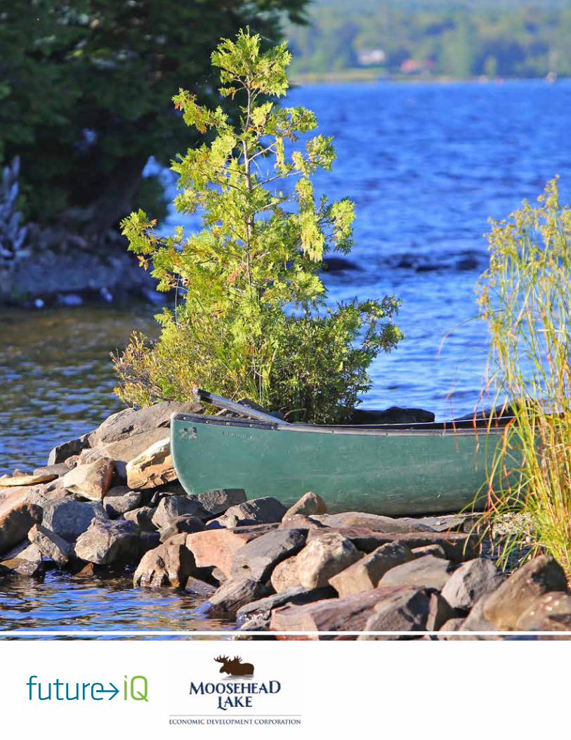
MOOSEHEAD LAKE REGION
ASSET INVENTORY AND ASSESSMENT
This report presents an inventory an assessment of the natural, cultural, built, and experiential assets of the Moosehead Lake Region, Maine, USA
April 2017
Moosehead Lake Region Asset Inventory and Assessment
This report presents an inventory and assessment of the natural, cultural, built, and experiential assets of the Moosehead Lake Region, Maine, USA
This report has been prepared by Future iQ as part of the development of the Moosehead Lake Region Strategic
Action Plan, and presents a baseline inventory of natural, man-made, and cultural assets, and an assessment
bolstered by input from the Future Think-Tank workshop with the Moosehead Lake Region community.
April 2017
PREPARED BY:
Moosehead Lake Region Asset Inventory and Assessment Report Prepared by Future iQ as part of the Moosehead Lake Region Strategic Action Plan
3
TABLE OF CONTENTS1.0 The Region .....................................................................................................................................4
2.0 Inventory .......................................................................................................................................5
2.1 Natural Assets ..........................................................................................................................5
2.1.1 The Land ..........................................................................................................................5
2.1.2 Moosehead Lake ...............................................................................................................6
2.1.3 Topography ........................................................................................................................7
2.1.4 Trails and Access ...............................................................................................................7
2.2 Built Assets ..............................................................................................................................8
2.2.1 Getting Around the Region ..................................................................................................8
2.2.2 Development Infrastructure .................................................................................................8
2.2.3 Community Assets ..............................................................................................................9
2.3 Cultural Assets ......................................................................................................................... 10
2.3.1 Land Use and Zoning ........................................................................................................ 10
2.3.1.1 2009 Moosehead Lake Region Concept Plan ............................................................. 10
2.3.1.2 Greenville Zoning ................................................................................................... 12
2.3.2 Region Stakeholder Groups ............................................................................................... 13
3.0 Experiential Assets ........................................................................................................................ 15
3.1 Regional Branding Process Survey Results ................................................................................ 15
3.2 Future iQ Think Tank Seasonal Experience Brainstorm ................................................................ 16
4.0 Discussion and Conclusion............................................................................................................. 17
5.0 About Future iQ ............................................................................................................................ 18
6.0 Moosehead Lake Region Economic Development Corporation .......................................................... 20
7.0 Acknowledgements ....................................................................................................................... 20
8.0 Appendix 1: Summary Table of Moosehead Lake Region Branding Process Questionnaire .................. 21
9.0 Appendix 2: Asset Inventory Maps .................................................................................................. 24
Moosehead Lake Region Asset Inventory and Assessment Report Prepared by Future iQ as part of the Moosehead Lake Region Strategic Action Plan
4
INSERT SECTION TITLE HERE
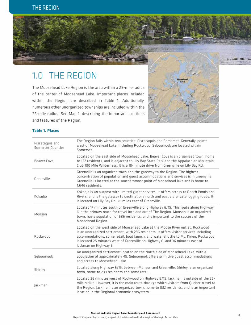
1.0 THE REGIONThe Moosehead Lake Region is the area within a 25-mile radius
of the center of Moosehead Lake. Important places included
within the Region are described in Table 1. Additionally,
numerous other unorganized townships are included within the
25-mile radius. See Map 1, describing the important locations
and features of the Region.
Table 1. Places
Piscataquis and Somerset Counties
The Region falls within two counties: Piscataquis and Somerset. Generally, points west of Moosehead Lake, including Rockwood, Seboomook are located within Somerset.
Beaver CoveLocated on the east side of Moosehead Lake, Beaver Cove is an organized town, home to 122 residents, and is adjacent to Lily Bay State Park and the Appalachian Mountain Club 100 Mile Wilderness. It is a 10-minute drive from Greenville on Lily Bay Rd.
Greenville
Greenville is an organized town and the gateway to the Region. The highest concentration of population and guest accommodations and services is in Greenville. Greenville is located at the southernmost point of Moosehead lake and is home to 1,646 residents.
KokadjoKokadjo is an outpost with limited guest services. It offers access to Roach Ponds and Rivers, and is the gateway to destinations north and east via private logging roads. It is located on Lily Bay Rd, 26 miles east of Greenville.
Monson
Located 17 minutes south of Greenville along Highway 6/15. This route along Highway 6 is the primary route for travel into and out of The Region. Monson is an organized town, has a population of 686 residents, and is important to the success of the Moosehead Region.
Rockwood
Located on the west side of Moosehead Lake at the Moose River outlet, Rockwood is an unorganized settlement, with 296 residents. It offers visitor services including accommodations, some retail, boat launch, and water shuttle to Mt. Kineo. Rockwood is located 25 minutes west of Greenville on Highway 6, and 36 minutes east of Jackman on Highway 6.
SeboomookAn unorganized settlement located on the North side of Moosehead Lake, with a population of approximately 45, Seboomook offers primitive guest accommodations and access to Moosehead Lake.
ShirleyLocated along Highway 6/15, between Monson and Greenville, Shirley is an organized town, home to 233 residents and some retail.
Jackman
Located 36 minutes west of Rockwood on Highway 6/15, Jackman is outside of the 25-mile radius. However, it is the main route through which visitors from Quebec travel to the Region. Jackman is an organized town, home to 832 residents, and is an important location in the Regional economic ecosystem.
THE REGION
Moosehead Lake Region Asset Inventory and Assessment Report Prepared by Future iQ as part of the Moosehead Lake Region Strategic Action Plan
5
INSERT SECTION TITLE HERE
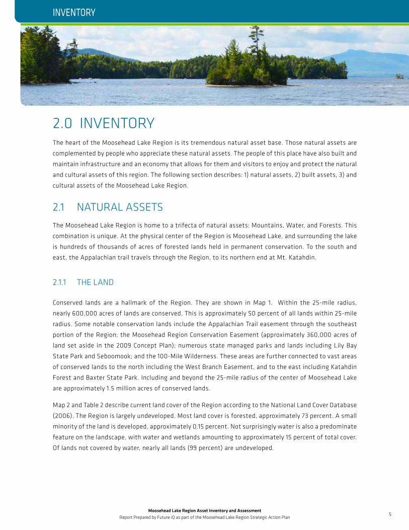
2.0 INVENTORY The heart of the Moosehead Lake Region is its tremendous natural asset base. Those natural assets are
complemented by people who appreciate these natural assets. The people of this place have also built and
maintain infrastructure and an economy that allows for them and visitors to enjoy and protect the natural
and cultural assets of this region. The following section describes: 1) natural assets, 2) built assets, 3) and
cultural assets of the Moosehead Lake Region.
2.1 NATURAL ASSETS The Moosehead Lake Region is home to a trifecta of natural assets: Mountains, Water, and Forests. This
combination is unique. At the physical center of the Region is Moosehead Lake, and surrounding the lake
is hundreds of thousands of acres of forested lands held in permanent conservation. To the south and
east, the Appalachian trail travels through the Region, to its northern end at Mt. Katahdin.
2.1.1 THE LAND
Conserved lands are a hallmark of the Region. They are shown in Map 1. Within the 25-mile radius,
nearly 600,000 acres of lands are conserved. This is approximately 50 percent of all lands within 25-mile
radius. Some notable conservation lands include the Appalachian Trail easement through the southeast
portion of the Region; the Moosehead Region Conservation Easement (approximately 360,000 acres of
land set aside in the 2009 Concept Plan); numerous state managed parks and lands including Lily Bay
State Park and Seboomook; and the 100-Mile Wilderness. These areas are further connected to vast areas
of conserved lands to the north including the West Branch Easement, and to the east including Katahdin
Forest and Baxter State Park. Including and beyond the 25-mile radius of the center of Moosehead Lake
are approximately 1.5 million acres of conserved lands.
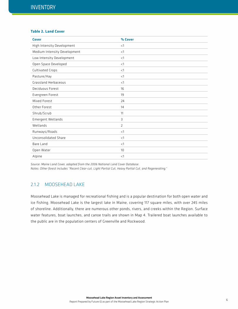
Map 2 and Table 2 describe current land cover of the Region according to the National Land Cover Database
(2006). The Region is largely undeveloped. Most land cover is forested, approximately 73 percent. A small
minority of the land is developed, approximately 0.15 percent. Not surprisingly water is also a predominate
feature on the landscape, with water and wetlands amounting to approximately 15 percent of total cover.
Of lands not covered by water, nearly all lands (99 percent) are undeveloped.
INVENTORY
Moosehead Lake Region Asset Inventory and Assessment Report Prepared by Future iQ as part of the Moosehead Lake Region Strategic Action Plan
6
INSERT SECTION TITLE HERE
Table 2. Land Cover
Cover % Cover
High Intensity Development <1
Medium Intensity Development <1
Low Intensity Development <1
Open Space Developed <1
Cultivated Crops <1
Pasture/Hay <1
Grassland Herbaceous <1
Deciduous Forest 16
Evergreen Forest 19
Mixed Forest 24
Other Forest 14
Shrub/Scrub 11
Emergent Wetlands 3
Wetlands 2
Runways/Roads <1
Unconsolidated Share <1
Bare Land <1
Open Water 10
Alpine <1
Source: Maine Land Cover, adapted from the 2006 National Land Cover Database. Notes: Other forest includes “Recent Clear-cut, Light Partial Cut, Heavy Partial Cut, and Regenerating.”
2.1.2 MOOSEHEAD LAKE
Moosehead Lake is managed for recreational fishing and is a popular destination for both open water and
ice fishing. Moosehead Lake is the largest lake in Maine, covering 117 square miles, with over 245 miles
of shoreline. Additionally, there are numerous other ponds, rivers, and creeks within the Region. Surface
water features, boat launches, and canoe trails are shown in Map 4. Trailered boat launches available to
the public are in the population centers of Greenville and Rockwood.
INVENTORY
Moosehead Lake Region Asset Inventory and Assessment Report Prepared by Future iQ as part of the Moosehead Lake Region Strategic Action Plan
7
INSERT SECTION TITLE HERE
2.1.3 TOPOGRAPHY
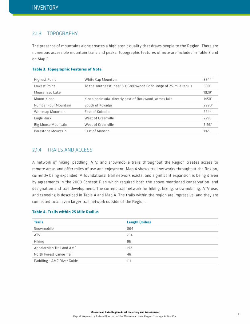
The presence of mountains alone creates a high scenic quality that draws people to the Region. There are
numerous accessible mountain trails and peaks. Topographic features of note are included in Table 3 and
on Map 3.
Table 3. Topographic Features of Note
Highest Point White Cap Mountain 3644’
Lowest Point To the southeast, near Big Greenwood Pond, edge of 25-mile radius 500’
Moosehead Lake 1029’
Mount Kineo Kineo peninsula, directly east of Rockwood, across lake 1450’
Number Four Mountain South of Kokadjo 2890’
Whitecap Mountain East of Kokadjo 3644’
Eagle Rock West of Greenville 2290’
Big Moose Mountain West of Greenville 3196’
Borestone Mountain East of Monson 1923’
2.1.4 TRAILS AND ACCESS
A network of hiking, paddling, ATV, and snowmobile trails throughout the Region creates access to
remote areas and offer miles of use and enjoyment. Map 4 shows trail networks throughout the Region,
currently being expanded. A foundational trail network exists, and significant expansion is being driven
by agreements in the 2009 Concept Plan which required both the above-mentioned conservation land
designation and trail development. The current trail network for hiking, biking, snowmobiling, ATV use,
and canoeing is described in Table 4 and Map 4. The trails within the region are impressive, and they are
connected to an even larger trail network outside of the Region.
Table 4. Trails within 25 Mile Radius
Trails Length (miles)
Snowmobile 864
ATV 734
Hiking 96
Appalachian Trail and AMC 192
North Forest Canoe Trail 46
Paddling - AMC River Guide 111
INVENTORY

Moosehead Lake Region Asset Inventory and Assessment Report Prepared by Future iQ as part of the Moosehead Lake Region Strategic Action Plan
8
INSERT SECTION TITLE HERE
2.2 BUILT ASSETS The built assets of a region are those assets in which humans have invested. They are how goods are
delivered to market, the private and public buildings, the infrastructure for managing human impact on the
landscape, and the community infrastructure that people rely on day-to-day. The built assets of the Region
are shown in Maps 5-11, Map 5 shows the regional zoning, and Maps 6-11 show different areas of the Region.
2.2.1 GETTING AROUND THE REGION
The main elements of the transportation network are shown in Map 1. The main route into the Region,
HWY 6/15, is also the main route to travel along the western side of the lake, from Greenville, through
Rockwood, to Jackman. The main route along the eastern side of the lake is Lily Bay Rd, from Greenville to
Lily Bay, then onto Kokadjo by way of Baxter State Park Rd.
The Moosehead Lake Region Scenic Byway Partnership Plan is currently in development. The process is
being guided by the Maine Department of Transportation and the Eastern Maine Development Corporation.
The local planning stakeholder group is the Corridor Advocacy Group. This plan focuses on a stretch of
highway, designated as the Moosehead Lake Scenic Byway, starting in the east at Kokadjo along Baxter
State Park Road, through Greenville, to the west along Highway 6/15 to Rockwood, and on to Jackman.
The focus of this planning effort is increasing tourism activity in the greater Moosehead Lake Region with
resource conservation and byway enhancement being equally important.
Strategic themes in this plan include improving road infrastructure to allow for visitors to turn off at
important or interesting locations, creating a dedicated lane for bicycles; and implementing interpretative
programming and preservation of cultural and natural assets. Specific implementation plan areas include
infrastructure, advertising, signage, and interpretation.
2.2.2 DEVELOPMENT INFRASTRUCTURE
Much of the region operates on well and septic systems. The Maine Water Company provides water service in
Greenville, parts of Little Moose Township, and Greenville Junction. The Moosehead sanitary district serves
the built areas of Greenville. From downtown, sewer and water are similarly provided to the western edge of
Greenville along HWY 6/15. To the east and north of downtown, sewer and water are available along Lily Bay
Rd to approximately Birch Point Rd. Map 7 shows the location of sewer and water infrastructure.
More about the location and number of public (non-public ownership) and private wells is available through
the State of Maine.
The Central Maine Power Co. owned by Energy East provides electricity to the Region. The following
areas are serviced: Greenville, Moosehead, Rockwood, Jackman, Ogontz, Beaver Cove, and Kokadjo. Points
north of these communities on either side of the lake are not served by electricity. Three phase power is
available in Greenville along Moosehead Lake Road, in the industrial park, on to Rockwood, and along a
portion of Lily Bay Road in the Village.
INVENTORY
Moosehead Lake Region Asset Inventory and Assessment Report Prepared by Future iQ as part of the Moosehead Lake Region Strategic Action Plan
9
INSERT SECTION TITLE HERE
2.2.3 COMMUNITY ASSETS
Greenville is home to Nickerson Elementary and Greenville Middle/High Schools. The next nearest schools
to the south (25 miles on HWY 6) are in Guilford including an elementary, middle and high school. The
next nearest school to the west (50 miles on HWY 6/15) is Forest Hills Consolidated school in Jackman.
The Shaw Public Library, located in Greenville, offers traditional services including loaning their book
collection, interlibrary loan, and computer work stations and printers. Through the library’s high-speed
internet connection, a WiFi network operates throughout Downtown Greenville. The next nearest libraries
are in Jackman and Parkman (adjacent to Guilford).
Charles A Dean Memorial Hospital, located in Greenville serves the Moosehead Region. C.A. Dean is a 25-
bed critical access hospital providing acute, skilled, and nursing facility beds. Jackman and Guilford are the
next nearest locations to be served by hospitals and clinic facilities. Jackman and Dover-Foxcroft are the
nearest nursing home facilities outside of Greenville.
C.A. Dean Hospital operates an ambulance service for the Moosehead Lake Region. There are fire
departments in Greenville, Shirley, and Jackman. Greenville, the Piscataquis County Sheriff, the Somerset
County Sheriff, and the Maine State Police provide law enforcement in the Region.
The Maine Department of Agriculture, Conservation and Forestry Bureau of Parks and Lands is currently
in the process of finalizing a first-ever Moosehead Lake Region Management Plan for lands in their
management. This document outlines numerous units of land, including: public reserved lands (31,187
acres), undeveloped state park lands (1,780 acres), and conservation easements managed by the Bureau.
Big Squaw Mountain Ski Area is located 15 minutes west of Greenville off HWY 6/15 on Ski Resort Road. It
attracts people from Quebec, Bar Harbor, and the Coastal Region. Formerly, the ski area was operated by a
private party, stabilizing the winter tourism economy. Now, a non-profit operates the lower portion of the
ski area. During the holiday season of 2016/17 it attracted 300-500/day. It is known for its unique terrain
and unobstructed views of Moosehead Lake. The location of Big Squaw Mountain is described in Map 8.
The Greenville industrial park is owned by the Town of Greenville and covers 85 acres. Thirty acres of land
are available for division into lots and development. It is not served by public water and sewer. In the park
is rail siding and three-phase power. A shuttered steam plant, with a 15-MW biomass boiler, is adjacent
to the industrial park.
A business incubator, owned by the Moosehead Lake Region Economic Development Corporation is located
at 76 Spruce Street. It is a 10,000-square foot steel building currently under lease.
Located in Greenville is the Greenville Airport. In 2015, a master plan update was completed for the airport.
The plan includes short, mid, and long-term projects for improvement and expansion suggested to be
paid for with federal grant dollars. The improvements are intended to better serve the existing users,
as current conditions do not meet design standards. Expansion is intended to serve an increased based
aircraft count (from 27 in 2015 to 55 in 2035, 104%), and annual operations (from 7,580 in 2015 to 10,614
in 2035, 40%).
INVENTORY
Moosehead Lake Region Asset Inventory and Assessment Report Prepared by Future iQ as part of the Moosehead Lake Region Strategic Action Plan
10
INSERT SECTION TITLE HERE
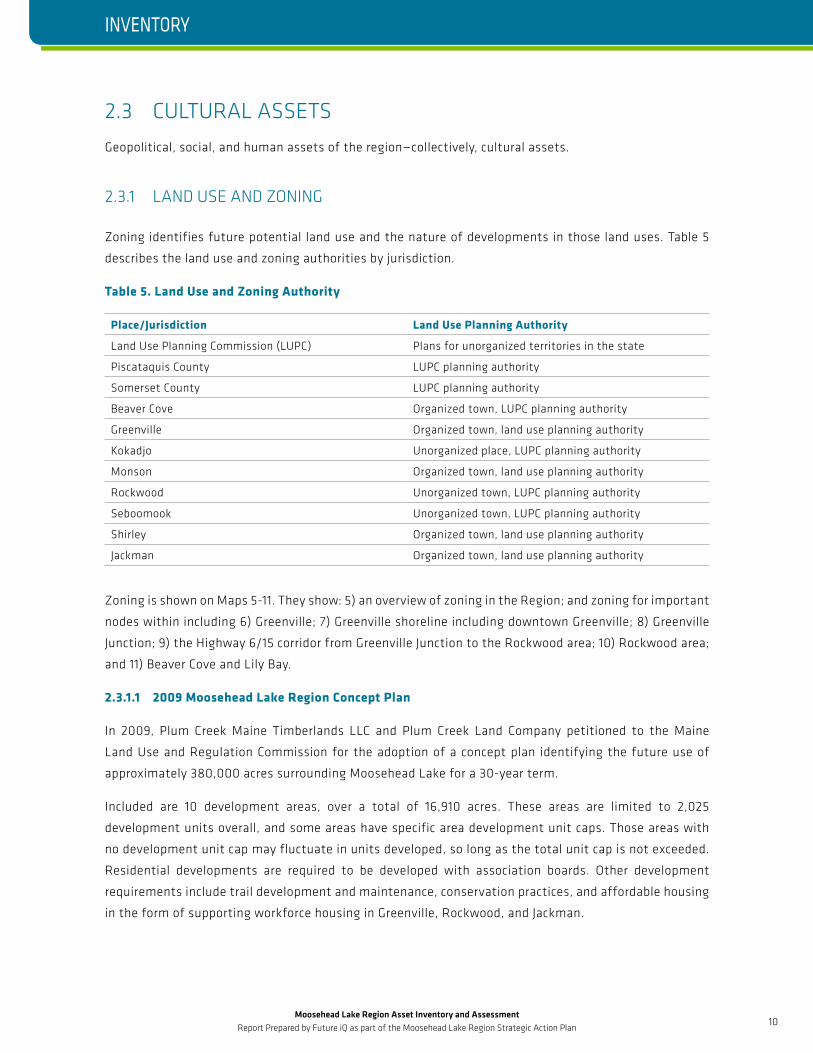
2.3 CULTURAL ASSETSGeopolitical, social, and human assets of the region—collectively, cultural assets.
2.3.1 LAND USE AND ZONING
Zoning identifies future potential land use and the nature of developments in those land uses. Table 5
describes the land use and zoning authorities by jurisdiction.
Table 5. Land Use and Zoning Authority
Place/Jurisdiction Land Use Planning Authority
Land Use Planning Commission (LUPC) Plans for unorganized territories in the state
Piscataquis County LUPC planning authority
Somerset County LUPC planning authority
Beaver Cove Organized town, LUPC planning authority
Greenville Organized town, land use planning authority
Kokadjo Unorganized place, LUPC planning authority
Monson Organized town, land use planning authority
Rockwood Unorganized town, LUPC planning authority
Seboomook Unorganized town, LUPC planning authority
Shirley Organized town, land use planning authority
Jackman Organized town, land use planning authority
Zoning is shown on Maps 5-11. They show: 5) an overview of zoning in the Region; and zoning for important
nodes within including 6) Greenville; 7) Greenville shoreline including downtown Greenville; 8) Greenville
Junction; 9) the Highway 6/15 corridor from Greenville Junction to the Rockwood area; 10) Rockwood area;
and 11) Beaver Cove and Lily Bay.
2.3.1.1 2009 Moosehead Lake Region Concept Plan
In 2009, Plum Creek Maine Timberlands LLC and Plum Creek Land Company petitioned to the Maine
Land Use and Regulation Commission for the adoption of a concept plan identifying the future use of
approximately 380,000 acres surrounding Moosehead Lake for a 30-year term.
Included are 10 development areas, over a total of 16,910 acres. These areas are limited to 2,025
development units overall, and some areas have specific area development unit caps. Those areas with
no development unit cap may fluctuate in units developed, so long as the total unit cap is not exceeded.
Residential developments are required to be developed with association boards. Other development
requirements include trail development and maintenance, conservation practices, and affordable housing
in the form of supporting workforce housing in Greenville, Rockwood, and Jackman.
INVENTORY
Moosehead Lake Region Asset Inventory and Assessment Report Prepared by Future iQ as part of the Moosehead Lake Region Strategic Action Plan
11
INSERT SECTION TITLE HERE
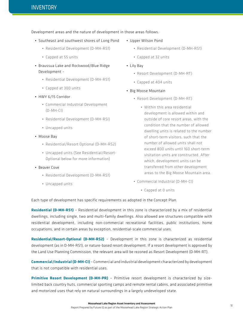
Development areas and the nature of development in those areas follows.
• Southeast and southwest shores of Long Pond
• Residential Development (D-MH-RS1)
• Capped at 55 units
• Braussua Lake and Rockwood/Blue Ridge
Development –
• Residential Development (D-MH-RS1)
• Capped at 300 units
• HWY 6/15 Corridor
• Commercial Industrial Development
(D-MH-CI)
• Residential Development (D-MH-RSI)
• Uncapped units
• Moose Bay
• Residential/Resort Optional (D-MH-RS2)
• Uncapped units (See Residential/Resort-
Optional below for more information)
• Beaver Cove
• Residential Development (D-MH-RS1)
• Uncapped units
• Upper Wilson Pond
• Residential Development (D-MH-RS1)
• Capped at 32 units
• Lily Bay
• Resort Development (D-MH-RT)
• Capped at 404 units
• Big Moose Mountain
• Resort Development (D-MH-RT)
• Within this area residential
development is allowed within and
outside of core resort areas, with the
condition that the number of allowed
dwelling units is related to the number
of short-term visitors, such that the
number of allowed units shall not
exceed 800 units until 160 short-term
visitation units are constructed. After
which, development units can be
transferred from other development
areas to the Big Moose Mountain area.
• Commercial Industrial (D-MH-CI)
• Capped at 0 units
Each type of development has specific requirements as adopted in the Concept Plan.
Residential (D-MH-RS1) – Residential development in this zone is characterized by a mix of residential
dwellings, including single, two and multi-family dwellings. Also allowed are structures compatible with
residential development, including non-commercial recreational facilities, public institutions, home
occupations, and in certain areas by exception, residential-scale commercial uses.
Residential/Resort-Optional (D-MH-RS2) – Development in this zone is characterized as residential
development (as in D-MH-RS1), or nature-based resort development. If a resort development is approved by
the Land Use Planning Commission, the relevant area will be rezoned as Resort Development (D-MH-RT).
Commercial/Industrial (D-MH-CI) – Commercial and industrial development characterized by development
that is not compatible with residential uses.
Primitive Resort Development (D-MH-PR) – Primitive resort development is characterized by size-
limited back country huts, commercial sporting camps and remote rental cabins, and associated primitive
and motorized uses that rely on natural surroundings in a largely undeveloped state.
INVENTORY
Moosehead Lake Region Asset Inventory and Assessment Report Prepared by Future iQ as part of the Moosehead Lake Region Strategic Action Plan
12
INSERT SECTION TITLE HERE
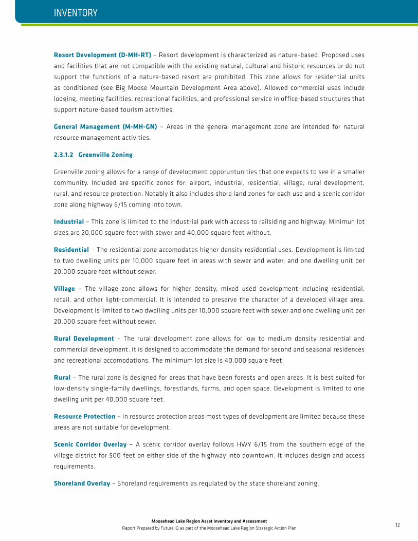
Resort Development (D-MH-RT) – Resort development is characterized as nature-based. Proposed uses
and facilities that are not compatible with the existing natural, cultural and historic resources or do not
support the functions of a nature-based resort are prohibited. This zone allows for residential units
as conditioned (see Big Moose Mountain Development Area above). Allowed commercial uses include
lodging, meeting facilities, recreational facilities, and professional service in office-based structures that
support nature-based tourism activities.
General Management (M-MH-GN) – Areas in the general management zone are intended for natural
resource management activities.
2.3.1.2 Greenville Zoning
Greenville zoning allows for a range of development opporuntunities that one expects to see in a smaller
community. Included are specific zones for: airport, industrial, residential, village, rural development,
rural, and resource protection. Notably it also includes shore land zones for each use and a scenic corridor
zone along highway 6/15 coming into town.
Industrial – This zone is limited to the industrial park with access to railsiding and highway. Minimun lot
sizes are 20,000 square feet with sewer and 40,000 square feet without.
Residential – The residential zone accomodates higher density residential uses. Development is limited
to two dwelling units per 10,000 square feet in areas with sewer and water, and one dwelling unit per
20,000 square feet without sewer.
Village – The village zone allows for higher density, mixed used development including residential,
retail, and other light-commercial. It is intended to preserve the character of a developed village area.
Development is limited to two dwelling units per 10,000 square feet with sewer and one dwelling unit per
20,000 square feet without sewer.
Rural Development – The rural development zone allows for low to medium density residential and
commercial development. It is designed to accommodate the demand for second and seasonal residences
and recreational accomodations. The minimum lot size is 40,000 square feet.
Rural – The rural zone is designed for areas that have been forests and open areas. It is best suited for
low-density single-family dwellings, forestlands, farms, and open space. Development is limited to one
dwelling unit per 40,000 square feet.
Resource Protection – In resource protection areas most types of development are limited because these
areas are not suitable for development.
Scenic Corridor Overlay – A scenic corridor overlay follows HWY 6/15 from the southern edge of the
village district for 500 feet on either side of the highway into downtown. It includes design and access
requirements.
Shoreland Overlay – Shoreland requirements as requlated by the state shoreland zoning.
INVENTORY
Moosehead Lake Region Asset Inventory and Assessment Report Prepared by Future iQ as part of the Moosehead Lake Region Strategic Action Plan
13
INSERT SECTION TITLE HERE
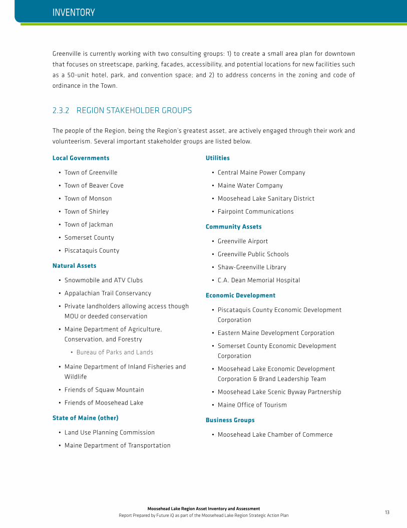
Greenville is currently working with two consulting groups: 1) to create a small area plan for downtown
that focuses on streetscape, parking, facades, accessibility, and potential locations for new facilities such
as a 50-unit hotel, park, and convention space; and 2) to address concerns in the zoning and code of
ordinance in the Town.
2.3.2 REGION STAKEHOLDER GROUPS
The people of the Region, being the Region’s greatest asset, are actively engaged through their work and
volunteerism. Several important stakeholder groups are listed below.
Local Governments
• Town of Greenville
• Town of Beaver Cove
• Town of Monson
• Town of Shirley
• Town of Jackman
• Somerset County
• Piscataquis County
Natural Assets
• Snowmobile and ATV Clubs
• Appalachian Trail Conservancy
• Private landholders allowing access though
MOU or deeded conservation
• Maine Department of Agriculture,
Conservation, and Forestry
• Bureau of Parks and Lands
• Maine Department of Inland Fisheries and
Wildlife
• Friends of Squaw Mountain
• Friends of Moosehead Lake
State of Maine (other)
• Land Use Planning Commission
• Maine Department of Transportation
Utilities
• Central Maine Power Company
• Maine Water Company
• Moosehead Lake Sanitary District
• Fairpoint Communications
Community Assets
• Greenville Airport
• Greenville Public Schools
• Shaw-Greenville Library
• C.A. Dean Memorial Hospital
Economic Development
• Piscataquis County Economic Development
Corporation
• Eastern Maine Development Corporation
• Somerset County Economic Development
Corporation
• Moosehead Lake Economic Development
Corporation & Brand Leadership Team
• Moosehead Lake Scenic Byway Partnership
• Maine Office of Tourism
Business Groups
• Moosehead Lake Chamber of Commerce
INVENTORY
Moosehead Lake Region Asset Inventory and Assessment Report Prepared by Future iQ as part of the Moosehead Lake Region Strategic Action Plan
14
INSERT SECTION TITLE HERE
One example of the people of the Region engaged in promoting the Moosehead Lake Region is the
Moosehead Lake Economic Development Corporation undertaking a branding initiative in 2015. The
Development Corporation hired Roger Brooks International, Inc. who worked with local stakeholders to
develop a branding and marketing plan. Results include action steps—downtown façade rehabilitation,
consistent signage throughout Moosehead Lake communities, master planning, and programing in
downtown Greenville—with a suggested budget of 7 million dollars.
The goals of this branding effort and the plan are:
• Put Moosehead Lake “on the map” as a terrific place to live, raise a family, own a business, and to visit;
• Differentiate Moosehead Lake from the other 490+ communities in Maine - and throughout New England;
• Encourage families to move to Moosehead Lake;
• Develop a year-round, sustainable economy (tourism based);
• Bring back the prosperity and population that was here in the early 70s.
INVENTORY
Moosehead Lake Region Asset Inventory and Assessment Report Prepared by Future iQ as part of the Moosehead Lake Region Strategic Action Plan
15
INSERT SECTION TITLE HERE
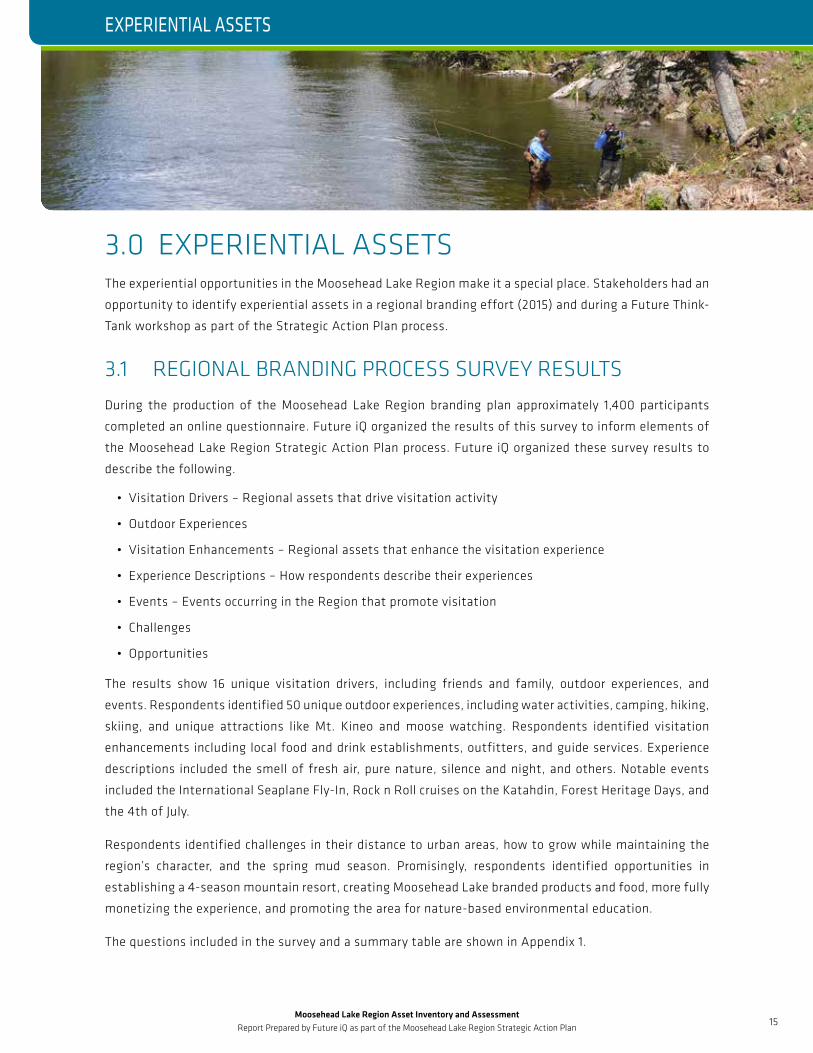
3.0 EXPERIENTIAL ASSETSThe experiential opportunities in the Moosehead Lake Region make it a special place. Stakeholders had an
opportunity to identify experiential assets in a regional branding effort (2015) and during a Future Think-
Tank workshop as part of the Strategic Action Plan process.
3.1 REGIONAL BRANDING PROCESS SURVEY RESULTSDuring the production of the Moosehead Lake Region branding plan approximately 1,400 participants
completed an online questionnaire. Future iQ organized the results of this survey to inform elements of
the Moosehead Lake Region Strategic Action Plan process. Future iQ organized these survey results to
describe the following.
• Visitation Drivers – Regional assets that drive visitation activity
• Outdoor Experiences
• Visitation Enhancements – Regional assets that enhance the visitation experience
• Experience Descriptions – How respondents describe their experiences
• Events – Events occurring in the Region that promote visitation
• Challenges
• Opportunities
The results show 16 unique visitation drivers, including friends and family, outdoor experiences, and
events. Respondents identified 50 unique outdoor experiences, including water activities, camping, hiking,
skiing, and unique attractions like Mt. Kineo and moose watching. Respondents identified visitation
enhancements including local food and drink establishments, outfitters, and guide services. Experience
descriptions included the smell of fresh air, pure nature, silence and night, and others. Notable events
included the International Seaplane Fly-In, Rock n Roll cruises on the Katahdin, Forest Heritage Days, and
the 4th of July.
Respondents identified challenges in their distance to urban areas, how to grow while maintaining the
region’s character, and the spring mud season. Promisingly, respondents identified opportunities in
establishing a 4-season mountain resort, creating Moosehead Lake branded products and food, more fully
monetizing the experience, and promoting the area for nature-based environmental education.
The questions included in the survey and a summary table are shown in Appendix 1.
EXPERIENTIAL ASSETS
Moosehead Lake Region Asset Inventory and Assessment Report Prepared by Future iQ as part of the Moosehead Lake Region Strategic Action Plan
16
INSERT SECTION TITLE HEREEXPERIENTIAL ASSETS
3.2 FUTURE IQ THINK TANK SEASONAL EXPERIENCE BRAINSTORMThe Moosehead Lake Regional Economic Development Corporation hosted a Future Think-Tank workshop
facilitated by Future iQ on March 9 and 10, 2017 in Greenville as part of the Regional Strategic Action Plan
process. During this workshop attendees participated in a seasonal experience brainstorming exercise
with the objective of identifying assets unique to Moosehead. A complete review of the Think-Tank is
available in the Moosehead Lake Region Future Think-Tank report.
Stakeholders identified primary assets associated with each season stemming from unique nature-based
and cultural experiences.
Summer Primary Assets
• Mt. Kineo
• Katahdin – Boat
• Wildlife
• Appalachian Trail
• Lake – water quality and size
• Night Sky
• Thoreau’s local history
Fall Primary Assets
• Public Access to private land
• Foliage – Foliage/water interaction
• Hunting
• Fishing
• Canoeing/Kayaking
• Fly-in
• Heritage – Katahdin Iron Works – Historical
Winter Primary Assets
• Snowmobiling
• Skiing
• Snow shoeing
• Ice fishing
• Site to site experience
Several potential growth opportunities and big ideas are outlined in the Think-Tank report stemming from
these assets and further elaborated upon in the Moosehead Lake Region Strategic Plan.
Moosehead Lake Region Asset Inventory and Assessment Report Prepared by Future iQ as part of the Moosehead Lake Region Strategic Action Plan
17
INSERT SECTION TITLE HERE
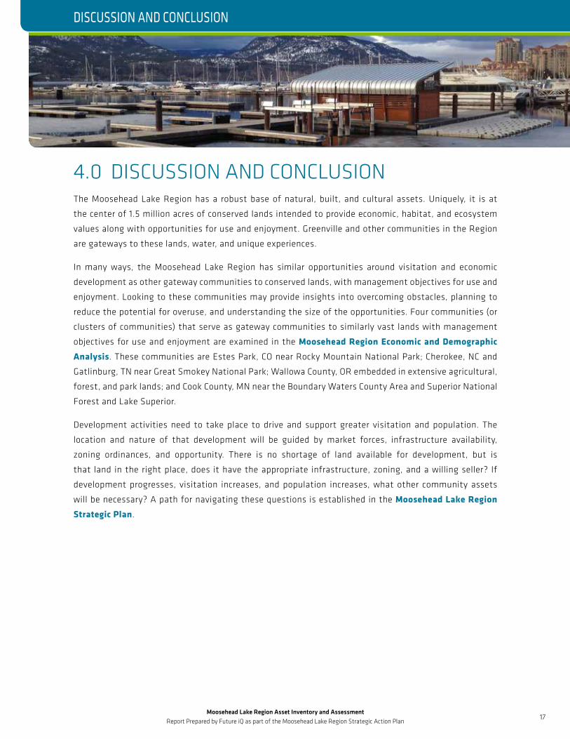
4.0 DISCUSSION AND CONCLUSIONThe Moosehead Lake Region has a robust base of natural, built, and cultural assets. Uniquely, it is at
the center of 1.5 million acres of conserved lands intended to provide economic, habitat, and ecosystem
values along with opportunities for use and enjoyment. Greenville and other communities in the Region
are gateways to these lands, water, and unique experiences.
In many ways, the Moosehead Lake Region has similar opportunities around visitation and economic
development as other gateway communities to conserved lands, with management objectives for use and
enjoyment. Looking to these communities may provide insights into overcoming obstacles, planning to
reduce the potential for overuse, and understanding the size of the opportunities. Four communities (or
clusters of communities) that serve as gateway communities to similarly vast lands with management
objectives for use and enjoyment are examined in the Moosehead Region Economic and Demographic
Analysis. These communities are Estes Park, CO near Rocky Mountain National Park; Cherokee, NC and
Gatlinburg, TN near Great Smokey National Park; Wallowa County, OR embedded in extensive agricultural,
forest, and park lands; and Cook County, MN near the Boundary Waters County Area and Superior National
Forest and Lake Superior.
Development activities need to take place to drive and support greater visitation and population. The
location and nature of that development will be guided by market forces, infrastructure availability,
zoning ordinances, and opportunity. There is no shortage of land available for development, but is
that land in the right place, does it have the appropriate infrastructure, zoning, and a willing seller? If
development progresses, visitation increases, and population increases, what other community assets
will be necessary? A path for navigating these questions is established in the Moosehead Lake Region
Strategic Plan.
DISCUSSION AND CONCLUSION
Moosehead Lake Region Asset Inventory and Assessment Report Prepared by Future iQ as part of the Moosehead Lake Region Strategic Action Plan
18
INSERT SECTION TITLE HERE
5.0 ABOUT FUTURE IQ Future iQ is a market leader in the development and application of scenario planning; network analysis,
industry and regional analysis, and community engagement and capacity building. The company specializes
in applying innovative tools and approaches to assist organizations, regions and industries shape their
economic and community futures. With over a decade of business experience, the company has grown to
have a global clientele spanning three continents.
To learn more about this report, or about Future iQ and our recent projects visit www.future-iq.com or
contact us by email at [email protected]
REPORT PREPARED BY:
MARCUS GRUBBS, MURP, AICP, PLANNING SPECIALIST
Marcus Grubbs holds a Master Degree in Urban and Regional Planning and a
Bachelor Degree in Environmental Studies. Marcus has extensive project
management experience with an interest in scenario-based planning and regional
economics. Marcus recently served as non-metropolitan regional government
representative to The State of Minnesota Statewide Geospatial Advisory Board
and is a current member of the Minnesota Chapter of the American Planning
Association and the American Institute of Certified Planners; chairs a non-
profits policy committee; and participates in the Big Brother program.
LEHNA MALMKVIST, MANAGING DIRECTOR, FUTURE IQ CANADA
Lehna works within multi-disciplinary teams across a wide range of projects,
and uses her skills to ensure that innovative, whole-system approaches are
integrated into projects. Lehna is an accomplished facilitator who uses her
expertise to guide planning processes to develop a common understanding of
fundamental issues and create solutions as a unified team.
ABOUT FUTURE IQ
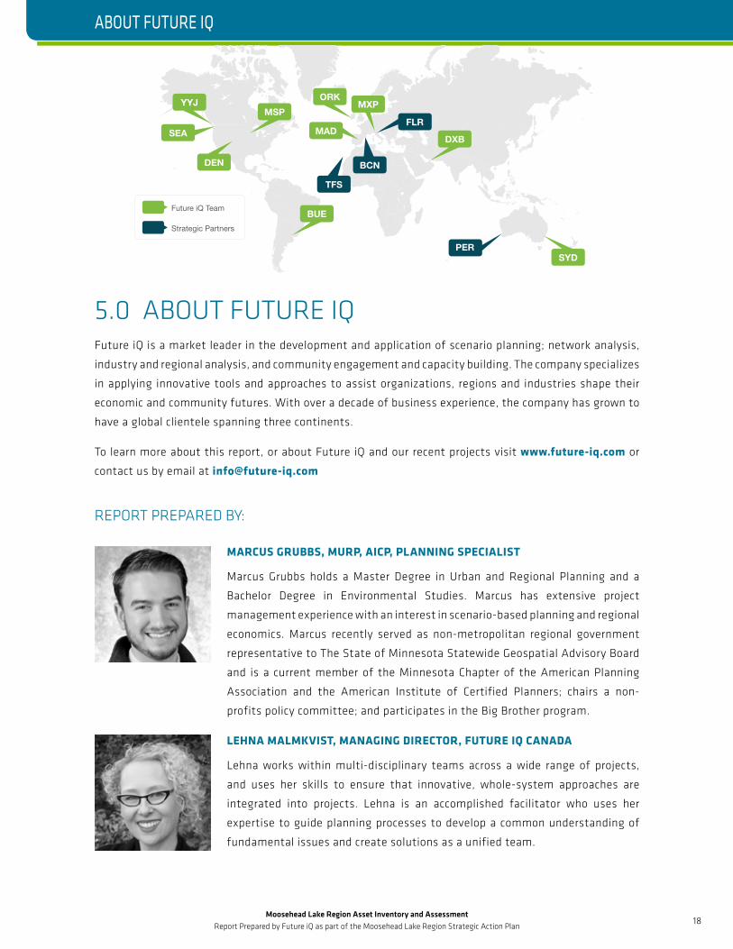
Future iQ Team
Strategic Partners
MSP
BUE
MXP
DXB
ORKYYJ
SYD
BCN
TFS
SEA MADFLR
DEN
PER

Moosehead Lake Region Asset Inventory and Assessment Report Prepared by Future iQ as part of the Moosehead Lake Region Strategic Action Plan
19
INSERT SECTION TITLE HERE
JIM HAGUEWOOD
Jim specializes in stakeholder and community engagement that utilizes asset
based principles and tools such as SMART strategies. With a career in the
tourism and hospitality industry, Jim’s focus and impact has been in regional
community economic development initiatives in more than five areas in
North America in the past decade. He served as President of the Port Angeles
Downtown Association, and as Board Member of 7 Cedars Resort & Casino of the
Jamestown S’Klallam Tribe.
DAVID BEURLE, CEO, FUTURE IQ
As CEO of Future iQ, David specializes in creating future planning approaches for
the use in regional, community and organizational settings. David has worked in
the field of organizational and regional economic and community planning for
over 20 years. His work in community and economic development has earned his
work international, national and state awards.
FOR MORE DETAILS, AND TO ACCESS COPIES OF ADDITIONAL REPORTS, PLEASE VISIT:
www.future-iq.com or www.mooseheadlakeedc.com
ABOUT FUTURE IQ
MOOSEHEAD LAKE REGION
ECONOMIC AND DEMOGRAPHIC ANALYSIS
This report presents an analysis of the economic and demographic trends in the Moosehead Lake Region, Maine USA
February 2017
SCENARIO-BASED FUTURE THINK-TANK WORKSHOP
March 2017
MOOSEHEAD LAKE REGION
FROM MOOSEHEAD LAKE REGION THINK-TANK
March 2017
APPENDIX 1 ACTION MAPPING
FROM MOOSEHEAD LAKE REGION ASSET INVENTORY AND ASSESSMENT
April 2017
APPENDIX 2: ASSET INVENTORY MAPS
MOOSEHEAD LAKE REGION
ASSET INVENTORY AND ASSESSMENT
This report presents an inventory an assessment of the natural, cultural, built, and experiential assets of the Moosehead Lake Region, Maine, USA
April 2017
Moosehead Lake Region
Economic and Demographic
Analysis February 2017
Moosehead Lake Region
Scenario-Based Future Think-
Tank Workshop March 2017
Appendix 1: Action Mapping From
Moosehead Lake Region Think-Tank March 2017
Moosehead Lake Region
Asset Inventory and Assessment
April 2017
Appendix 2: Asset
Inventory Maps
April 2017
Moosehead Lake Region Asset Inventory and Assessment Report Prepared by Future iQ as part of the Moosehead Lake Region Strategic Action Plan
20
INSERT SECTION TITLE HERE
6.0 MOOSEHEAD LAKE REGION ECONOMIC DEVELOPMENT CORPORATIONThe MLREDC is a Greenville, Maine-based 501(c)(3) non-profit corporation. Established in 2013 by local
business and community leaders, the MLREDC was formed from a critical need to grow the local economy,
reverse population decline, and increase prosperity for area residents through development of a year-round
sustainable economy. Over the MLREDC’s first three years, all of its work and significant accomplishments
have been driven by its all- volunteer board—made up of business, nonprofit, and community leaders—and
MLREDC project consultants. Members have donated thousands of hours of their time.
The mission of the MLREDC is to grow and sustain local businesses, attract and create new jobs, and
enhance the economy of the Moosehead Lake Region. The MLREDC’s vision is that “The Moosehead
Lake Region will enjoy a robust, diversified and sustainable economy that leverages the region’s unique
character, heritage and spectacular natural resources.”
2017 MLREDC Board of Directors
• Luke Muzzy, President - Senior Land Asset
Manager, Weyerhaeuser
• Drew Watson, Co-Preseident - Owner, Symonds
Appraisal Services
• Amanda Hunt, Vice President - Owner/Founder,
Northwoods Camp Rentals
• Steve Levesque, Secretary - Former economic
development commissioner, administration of
Maine Gov. Angus King
• Geno Murry, Treasurer - CEO, C.A. Dean Hospital
• Craig Watt - Co-owner, Indian Hill Trading Post
• Paula St. Laurent - Branch Manager, Camden
National Bank
• Donna Moreland - Destination Development
Specialist, Maine Office of Tourism
• Joe Diangelo - Owner/Broker, Century 21 Moose
Country Realtors
• William M. Fletcher, Esq. - Partner, Fletcher,
Selser & Devine
• Angela Arno - Executive Director, Moosehead
Lake Chamber of Commerce
• Karin Tilberg - Forest Society of Maine
7.0 ACKNOWLEDGEMENTSAppreciation is extended to the entire MLREDC team, and personnel from the Maine Land Use Planning
Commission, the Maine Bureau of Parks and Lands, and the Musson Group.
Thank you to all the workshop participants, who brought such enthusiasm, good humor and robust
thinking to the workshop conversation about the future of the regional economy.
MOOSEHEAD LAKE REGION ECONOMIC DEVELOPMENT CORPORATION / ACKNOWLEDGEMENTS
Moosehead Lake Region Asset Inventory and Assessment Report Prepared by Future iQ as part of the Moosehead Lake Region Strategic Action Plan
21
INSERT SECTION TITLE HERE
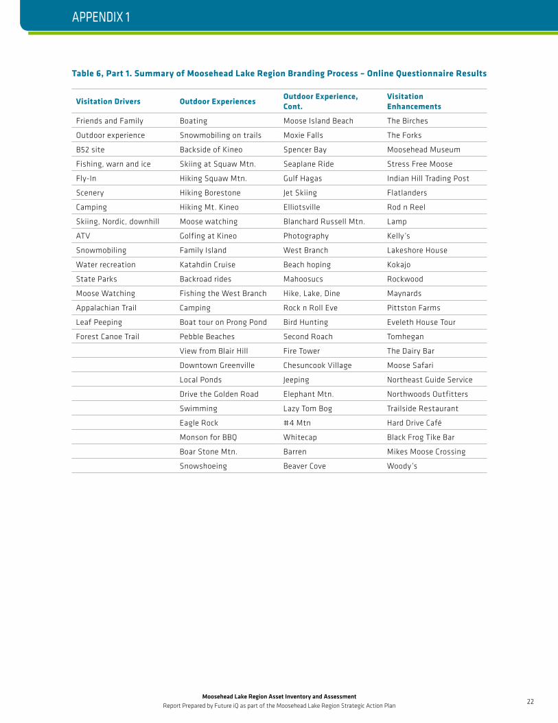
8.0 APPENDIX 1: SUMMARY TABLE OF MOOSEHEAD LAKE REGION BRANDING PROCESS QUESTIONNAIREDuring the production of the Moosehead Lake Region branding plan approximately 1,400 participants
completed an online questionnaire. The survey asked respondents to answer the following questions.
• If you live on Moosehead Lake, or the immediate area, when friends and family visit you, where do you
take them while they are visiting? (The “must see” or “must do” activities – other than staying home.)
• If you live in the Moosehead Lake Region, where do YOU go to hang out on weekends or during the
evening hours (other than home)? Another town? If so, where? Or to a certain place?
• What do you think are the Moosehead Lake Region’s three greatest assets? Please list them in order.
Don’t include “people” – we know the people are a great asset.
• What do you think the three biggest challenges, or negatives are about the Moosehead Lake Region?
Don’t include “local politics” or “the people.”
• What could or should be done in the Moosehead Lake Region to get people to spend more time and
money here?
• What do you think the Moosehead Lake Region should be known for that will set it apart from every
other community or region in Maine?
Future iQ organized the results of this survey to inform elements of the Moosehead Region Strategic Plan
process. Future iQ organized these survey results to describe the following.
• Visitation Drivers – Regional assets that drive visitation activity
• Outdoor Experiences
• Visitation Enhancements – Regional assets that enhance the visitation experience
• Experience Descriptions – How respondents describe their experiences
• Events – Events occurring in the Region that promote visitation
• Challenges
• Opportunities
Table 6 summarizes the results of this survey.
APPENDIX 1
Moosehead Lake Region Asset Inventory and Assessment Report Prepared by Future iQ as part of the Moosehead Lake Region Strategic Action Plan
22
INSERT SECTION TITLE HERE
Table 6, Part 1. Summary of Moosehead Lake Region Branding Process – Online Questionnaire Results
Visitation Drivers Outdoor ExperiencesOutdoor Experience, Cont.
Visitation Enhancements
Friends and Family Boating Moose Island Beach The Birches
Outdoor experience Snowmobiling on trails Moxie Falls The Forks
B52 site Backside of Kineo Spencer Bay Moosehead Museum
Fishing, warn and ice Skiing at Squaw Mtn. Seaplane Ride Stress Free Moose
Fly-In Hiking Squaw Mtn. Gulf Hagas Indian Hill Trading Post
Scenery Hiking Borestone Jet Skiing Flatlanders
Camping Hiking Mt. Kineo Elliotsville Rod n Reel
Skiing, Nordic, downhill Moose watching Blanchard Russell Mtn. Lamp
ATV Golfing at Kineo Photography Kelly ’s
Snowmobiling Family Island West Branch Lakeshore House
Water recreation Katahdin Cruise Beach hoping Kokajo
State Parks Backroad rides Mahoosucs Rockwood
Moose Watching Fishing the West Branch Hike, Lake, Dine Maynards
Appalachian Trail Camping Rock n Roll Eve Pittston Farms
Leaf Peeping Boat tour on Prong Pond Bird Hunting Eveleth House Tour
Forest Canoe Trail Pebble Beaches Second Roach Tomhegan
View from Blair Hill Fire Tower The Dairy Bar
Downtown Greenville Chesuncook Village Moose Safari
Local Ponds Jeeping Northeast Guide Service
Drive the Golden Road Elephant Mtn. Northwoods Outfitters
Swimming Lazy Tom Bog Trailside Restaurant
Eagle Rock #4 Mtn Hard Drive Café
Monson for BBQ Whitecap Black Frog Tike Bar
Boar Stone Mtn. Barren Mikes Moose Crossing
Snowshoeing Beaver Cove Woody’s
APPENDIX 1
Moosehead Lake Region Asset Inventory and Assessment Report Prepared by Future iQ as part of the Moosehead Lake Region Strategic Action Plan
23
INSERT SECTION TITLE HERE
Table 6, Part 2. Summary of Moosehead Lake Region Branding Process – Online Questionnaire Results
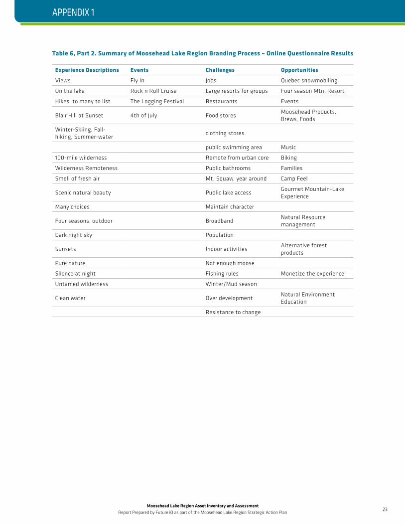
Experience Descriptions Events Challenges Opportunities
Views Fly In Jobs Quebec snowmobiling
On the lake Rock n Roll Cruise Large resorts for groups Four season Mtn. Resort
Hikes, to many to list The Logging Festival Restaurants Events
Blair Hill at Sunset 4th of July Food storesMoosehead Products, Brews, Foods
Winter-Skiing, Fall- hiking, Summer-water
clothing stores
public swimming area Music
100-mile wilderness Remote from urban core Biking
Wilderness Remoteness Public bathrooms Families
Smell of fresh air Mt. Squaw, year around Camp Feel
Scenic natural beauty Public lake accessGourmet Mountain-Lake Experience
Many choices Maintain character
Four seasons, outdoor BroadbandNatural Resource management
Dark night sky Population
Sunsets Indoor activitiesAlternative forest products
Pure nature Not enough moose
Silence at night Fishing rules Monetize the experience
Untamed wilderness Winter/Mud season
Clean water Over developmentNatural Environment Education
Resistance to change
APPENDIX 1
Moosehead Lake Region Asset Inventory and Assessment Report Prepared by Future iQ as part of the Moosehead Lake Region Strategic Action Plan
24
INSERT SECTION TITLE HERE
9.0 APPENDIX 2: ASSET INVENTORY MAPSA series of maps are referenced throughout this Moosehead Lake Asset Inventory and Assessment
document. These maps are listed here and follow as part of Appendix 2.
Map 1: The Moosehead Lake Region, Maine—Project Area and Conserved Lands
• The location of important places, conservation lands, and transportation routes
Map 2: Land Cover
• National Land Cover database land cover for the Region
Map 3: Topography and Hydrography
• Major topographic features of the Region and the major surface hydrology
Map 4: Trails
• Hiking, biking, snowmobiling, ATV, and canoe trails
Map 5: Regional Zoning
• Unorganized Territory, 2009 Concept Plan, and Greenville zoning
Map 6: Greenville
• Greenville zoning, parcels, locations of interest
Map 7: Greenville Shoreline
• Downtown Greenville and adjacent areas, zoning, sewer and water, and locations of interest
Map 8: Greenville Junction
• Greenville Junction Township zoning and locations of interest
Map 9: Highway 6/15 Corridor
• Highway 6/15 corridor from Greenville Junction to Rockwood area, zoning, and locations of interest
Map 10: Rockwood Area
• Rockwood area zoning, parcels, and locations of interest
Map 11: Beaver Cove and Lily Bay
• Beaver Cove and Lily Bay area zoning, parcels, and locations of interest
APPENDIX 2