Embed Size (px)
Citation preview
SURVEYS IN
COMMERCIAL TRANSACTIONS
Presented At:
Georgia TIP's
Atlanta, Georgia
February 18, 2005
Presented By:
Kelly Anne Miles
Smith, Gilliam, Williams & Miles, P.A. Gainesville, Georgia
Page 1
TABLE OF CONTENTS
Why Get a Survey??................................................................................. ..…….Page 2
Which Type of Survey is Needed.............................................................. ..…….Page 2 a. Boundary Survey ......................................................................…….Page 2 b. As Built Survey .......................................................................……..Page 3 c. ALTA/ASCM Land Title Survey ............................................. ….Pages 3-4
What is an ALTA/ASCM Land Title Survey??.......................................... …..Pages 4-6
How to Get an ALT A Survey.................................................................... …….Page 7
What are the Title Insurance Issues........................................................... ……Pages 7
a. Current Survey ........................................................................ ….Pages 7-8 b. Gap Indemnity.........................................................................……..Page 8 c. "Marked" Commitment .......................................................... …….. Page 8 d. Endorsements...........................................................................…….Page 8
(i) Tax Parcel ................................................................ ……Page 8 (ii) Access...................................................................... ……Page 9 (iii) Survey...................................................................... ……Page 9 (iv) Commercial Comprehensive ..................................... .Pages 9-10
Is a Zoning Endorsement Needed??............................................................. ….Page 10
Which Legal Description to Use on Policy..................................................Pages 10-11
Appendices: A ..................... Minimum Standard Detail Requirements for ALT A Survey B ..................... Accuracy Standards for ALTA Survey C ..................... Optional Services Table A D ..................... Request for ALTA Survey E...................... ALTA Checklist F ......................Gap Indemnity G ..................... "Marked" Commitment H ..................... Tax Parcel Endorsement I....................... Access Endorsement J ...................... Survey Endorsement K ..................... Commercial Comprehensive Endorsement
Page 2
1. WHY GET A SURVEY?
Obtaining the appropriate survey for a commercial transaction is critical. The
dollars invested and loaned in the commercial setting are generally far greater than in
the residential transactions. This means there is more to lose—both for the buyer and
the lender—by failing to obtain a survey.
Obtaining a survey ensures your client's protection in any real estate transaction.
A survey shows rights of way, easements, encroachments, access to public roads,
boundary lines, drives and alleys, improvements, flood zones, and a conglomerate of
other factors that are necessary to insure that your client is dealing with clean real
estate. A current survey will be necessary to get title insurance that covers matters of
survey.
2. WHICH TYPE SURVEY IS NEEDED?
a. Boundary Survey
Rarely, if ever, will a mere boundary survey be used in the commercial
setting. The boundary survey simple shows the boundary lines of the
property and does not show any improvements, structures, or other
important matters of title. This type of survey does require field work by
the surveyor to verify or find existing monuments marking the property
lines. All corners should be marked. Of course, all surveys begin as
boundary surveys.
Page 3 b.
As built Survey:
The as built survey will show the location of all structures on the property
as well as all visible encroachments, and any fences, hedges, or walls on or
within five feet of both sides of the boundary lines. If there is visible
surface evidence of utilities, then this also will be shown. The key term
here is "visible". What the as built survey does not show are the
encroachments, easements, or other matters that are not visible. The as
built survey is also not subject to any uniform accuracy standards or
minimum criteria. Some as built surveys will show only the buildings and
not parking spaces (which may be essential for the buyer to obtain the
necessary zoning or permits). Most importantly, the as built survey does
not certify that it meets any required standards and is poses risks for the
title insurance company if it is required to insure as to matters of survey.
With the usually larger sums of money involved in commercial
transactions, an as built survey is not usually the type of survey that should
be recommended.
c ALTA/ACSM Land Title Survey:
This is the survey that you will most often need in a commercial
transaction. An ALTA/ACSM survey is the most comprehensive type of
survey that can be obtained. This type of survey will reflect all of the
elements of the boundary and as built survey plus additional evidence of
Page 4
possession or use which could be adverse to the interests of the purchaser
or lender. The ALTA/ACSM shows non visible encroachments or
encumbrances. Most important, it certifies matters of survey to the
affected parties whose names are indicated on the survey. While it is the
more costly of the surveys, it offers the most protection and can be relied
upon by the title insurance company in issuing insurance which covers
matters of survey.
3. WHAT IS AN ALTA/ACSM LAND TITLE SURVEY?
An ALTA/ACSM survey is a boundary survey prepared in accordance with a
minimum set of standards which were jointly prepared and adopted by the ALTA/ACSM
(American Land Title Association and American Congress on Surveying and Mapping).
This survey has stringent requirements and criteria that are specifically designed to meet
the needs of lenders, corporations, and title companies when dealing with commercial
properties. The ALTA standards are a nationwide uniform set of standards oftentimes
referred to as "the Cadillac of surveys." ALTA/ACSM recognized in adopting these
standards that title insurance companies are entitled to rely on the survey furnished to
them being of appropriate professional quality, both as to completeness and accuracy. See
Appendix A for Minimum Standard Detail Requirements for ALTA/ACSM Land Title
Surveys 1999. See Appendix Bfor Accuracy Standards for ALTA-ACSM Land Title
Surveys.
PageS
An ALTA survey shows improvements, easements, rights-of-way, and other
elements impacting ownership of land. It is most often prepared for commercial
properties since it provides the title company with the information required to insure the
title to the land and improvements to the high degree that a commercial development may
require. In addition to the minimum standards required, there are also certain optional
elements that can be delineated on the survey upon request. It is important that the
request to the surveyor provide a clear scope of the services your client needs concerning
that particular piece of real estate. See Appendix Cfor Optional Services Table A.
Before an ALTA survey can be completed, the surveyor will need a current title
commitment. The surveyor will rely on the commitment for the legal description and the
legal description of any encumbrances to the property (exceptions). These encumbrances
will be shown graphically and a note indicating the nature of the encumbrance should be
included on the survey. The surveyor and title company must work closely together to
show the matters affecting the ownership of the land and improvements in a
comprehensive manner. This is especially important since the title insurance company is
usually asked to insure title to the land without exceptions as to the many matters which
might be discoverable from survey and inspection and not be evidenced by public records.
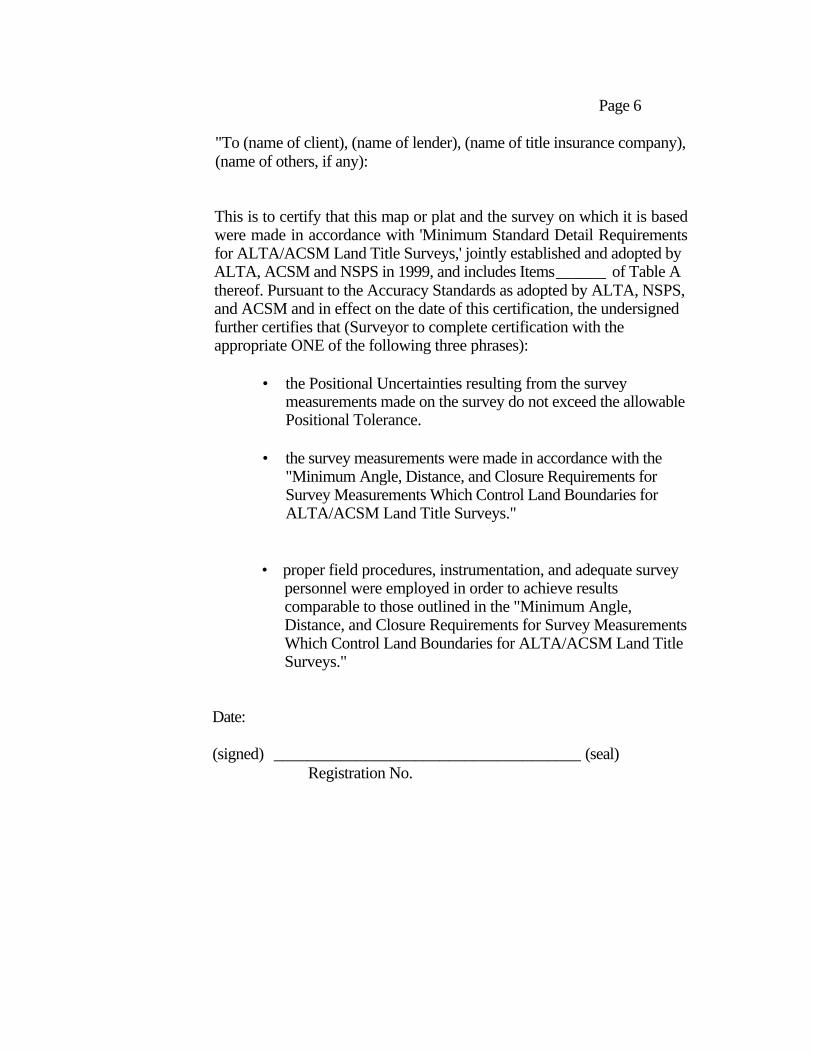
The ALTA survey must be certified by the surveyor. The certification language
must include the names of all affected parties, including as appropriate the buyer, seller,
title company, and lender. When all of the minimum standard detail requirements have
been met by the surveyor, the following certification shall be made on the plat:
Page 6
"To (name of client), (name of lender), (name of title insurance company), (name of others, if any):
This is to certify that this map or plat and the survey on which it is based were made in accordance with 'Minimum Standard Detail Requirements for ALTA/ACSM Land Title Surveys,' jointly established and adopted by ALTA, ACSM and NSPS in 1999, and includes Items______ of Table A thereof. Pursuant to the Accuracy Standards as adopted by ALTA, NSPS, and ACSM and in effect on the date of this certification, the undersigned further certifies that (Surveyor to complete certification with the appropriate ONE of the following three phrases):
• the Positional Uncertainties resulting from the survey measurements made on the survey do not exceed the allowable Positional Tolerance.
• the survey measurements were made in accordance with the "Minimum Angle, Distance, and Closure Requirements for Survey Measurements Which Control Land Boundaries for ALTA/ACSM Land Title Surveys."
• proper field procedures, instrumentation, and adequate survey personnel were employed in order to achieve results comparable to those outlined in the "Minimum Angle, Distance, and Closure Requirements for Survey Measurements Which Control Land Boundaries for ALTA/ACSM Land Title Surveys."
Date:
(signed) _____________________________________ (seal) Registration No.
Page 7
4. HOW TO GET AN ALTA SURVEY.
The client must request the ALTA survey in writing. Remember that the person
giving the written authorization for the surveyor to proceed is the person who will be
responsible for payment of the survey. Therefore, it is very important that the buyer (in
most instances) be the person signing the request and the request should specify that the
buyer is the responsible party for the payment. Otherwise, if the attorney signs the
request and the transaction falls through, then the attorney would be responsible for the
costs of the survey---- and these surveys are not cheap! See Appendix D for a sample
Request form.
Attached to your request should be complete copies of the record description of
the property, any record easements benefiting the property, the record easements or
servitudes and covenants affecting the property, and any other documents containing
desired appropriate information affecting the property being surveyed. Traditionally it
was the responsibility of the surveyor to discover this written evidence but now, the
burden is placed on the party requesting the survey. The rational for this shift is the
belief that the title companies have more expertise in searching for encumbrances than
surveyors.
5. WHAT ARE THE TITLE INSURANCE ISSUES?
a. Current Survey: The survey should be current. If it is not current then the
title policy should limit it's coverage as to matters of survey up to the date shown on the
Page 8
survey. Be sure to use the date when the last field survey was done and not a revision
date that simply was for a name revision on the plat. Review the survey to make sure it
complies with the minimum requirements for an ALTA survey. See Appendix Efor a
Checklist. Note that this does not include any optional items requested to be shown on
the survey.
b. Gap Indemnity: You should always get the seller and buyer to sign a Gap
Indemnity Agreement. See Appendix F for a sample of the Gap Indemnify Agreement.
This will assist the title insurance company in the event there are any recorded liens or
encumbrances between the date that your title search is good through and the date of the
insured deed.
c. "Marked" Commitment: Most lenders in a commercial transaction will
require a "marked" copy of the commitment. This simply means that you will prepare
your commitment as usual but then "mark" it at closing by deleting all requirements in
Schedule B, Section 1, the standard exceptions if Schedule B, Section 2, and updating the
time of coverage to the date and time of filing the insured deed. See Appendix Gfor a
sample "marked" commitment.
d. Endorsements: There are various endorsements to the title policy particular
to matters of survey that may be requested or that you may want to recommend to your
client, whether the client is the lender or the buyer. These include the following:
(!) Tax Parcel Endorsement: This endorsement insures that the
insured property is taxed as a separate parcel by the taxing
authority and is not taxed together with any other real property.
Page 9
See Appendix H for a sample of this endorsement for a lender's policy.
(ii) Access Endorsement: This endorsement insures against loss or
damage if the insured land does not abut and have rights to ingress and
egress from a publicly maintained road. You will need to verify with the
appropriate county office that the roads which abut the property as shown
on the survey are county maintained, public, and physically open roads.
See Appendix I for a sample of this endorsement for a lender's policy.
(ill) Survey Endorsement: This endorsement provides insurance against
any loss or damage sustained if the land shown on the survey obtained
is not the same as the land described in the insured deed. You will
need to actually attach a copy of the survey to the endorsement and
identify the survey within the endorsement. See Appendix J for a
sample of this endorsement for a lender's policy.
(iv) Commercial Comprehensive Endorsement This endorsement
will be the most common requested in a commercial transaction.
As far as matters of survey, it insures against present violations of
covenants, any encroachments not specifically described on
Schedule B of the policy, and damage to existing building
Page 10
improvements located or encroaching upon the portion of the land subject
to any easement identified on Schedule B of the policy. Of course, this
endorsement does not provide coverage relating to any environmental
protection. See Appendix Kfor a sample of this endorsement for an
owner's title policy.
6. IS A ZONING ENDORSEMENT NEEDED?
A title insurance policy DOES NOT cover matters of zoning unless a zoning
endorsement is attached. A zoning endorsement requires additional investigation and
certainly adds much more potential liability for the title company. There is an additional
premium charged for this endorsement as well as additional attorney's fees for the time it
takes to verify the information needed to issue this added title coverage. However, for
there to truly be a comprehensive title policy, a zoning endorsement is essential.
7. WHICH LEGAL DESCRIPTION TO USE ON POLICY
As is most often the case, the legal description contained on the current
survey will differ from the legal description in the vesting deed into the Seller.
When this occurs, the title policy should insure the legal description based on the
current survey. However, the Seller may not be willing to execute a warranty
deed taken from the current survey. If he does, then the Seller's right to proceed
against the prior grantor may be limited since there are two different legal
descriptions. Also, if the Seller uses the same legal in his vesting deed then he
Page 11
could recover under his owner's title policy (assuming he got one). The solution
is to get the seller to sign a warranty deed using the same legal description
contained in the vesting deed into him and also to execute a quitclaim deed using
the legal from the current survey. Of course, the title examiner must determine
that the two descriptions actually describe the same property.
APPENDIX A
Minimum Standard Detail Requirements For ALTA Survey
Minimum Standard Detail Requirements
for
ALTA/ACSM Land Title Surveys
AMERICAN LAND TITLE ASSOCIATION
as adopted by
American Land Title Association
American Congress on Surveying & Mapping
National Society of Professional Surveyors
1999
AMERICAN LAND TITLE ASSOCIATION
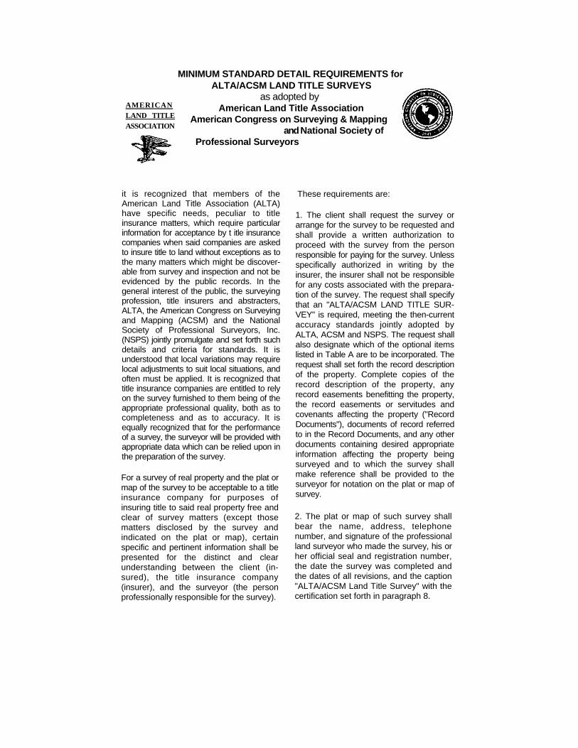
MINIMUM STANDARD DETAIL REQUIREMENTS for ALTA/ACSM LAND TITLE SURVEYS
as adopted by American Land Title Association
American Congress on Surveying & Mapping and National Society of
Professional Surveyors
it is recognized that members of the American Land Title Association (ALTA) have specific needs, peculiar to title insurance matters, which require particular information for acceptance by t itle insurance companies when said companies are asked to insure title to land without exceptions as to the many matters which might be discover-able from survey and inspection and not be evidenced by the public records. In the general interest of the public, the surveying profession, title insurers and abstracters, ALTA, the American Congress on Surveying and Mapping (ACSM) and the National Society of Professional Surveyors, Inc. (NSPS) jointly promulgate and set forth such details and criteria for standards. It is understood that local variations may require local adjustments to suit local situations, and often must be applied. It is recognized that title insurance companies are entitled to rely on the survey furnished to them being of the appropriate professional quality, both as to completeness and as to accuracy. It is equally recognized that for the performance of a survey, the surveyor will be provided with appropriate data which can be relied upon in the preparation of the survey.
For a survey of real property and the plat or map of the survey to be acceptable to a title insurance company for purposes of insuring title to said real property free and clear of survey matters (except those matters disclosed by the survey and indicated on the plat or map), certain specific and pertinent information shall be presented for the distinct and clear understanding between the client (in-sured), the title insurance company (insurer), and the surveyor (the person professionally responsible for the survey).
These requirements are:
1. The client shall request the survey or arrange for the survey to be requested and shall provide a written authorization to proceed with the survey from the person responsible for paying for the survey. Unless specifically authorized in writing by the insurer, the insurer shall not be responsible for any costs associated with the prepara-tion of the survey. The request shall specify that an "ALTA/ACSM LAND TITLE SUR-VEY" is required, meeting the then-current accuracy standards jointly adopted by ALTA, ACSM and NSPS. The request shall also designate which of the optional items listed in Table A are to be incorporated. The request shall set forth the record description of the property. Complete copies of the record description of the property, any record easements benefitting the property, the record easements or servitudes and covenants affecting the property ("Record Documents"), documents of record referred to in the Record Documents, and any other documents containing desired appropriate information affecting the property being surveyed and to which the survey shall make reference shall be provided to the surveyor for notation on the plat or map of survey.
2. The plat or map of such survey shall bear the name, address, telephone number, and signature of the professional land surveyor who made the survey, his or her official seal and registration number, the date the survey was completed and the dates of all revisions, and the caption "ALTA/ACSM Land Title Survey" with the certification set forth in paragraph 8.
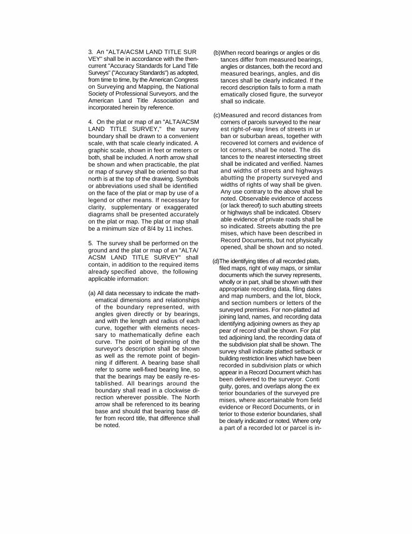
3. An "ALTA/ACSM LAND TITLE SUR VEY" shall be in accordance with the then- current "Accuracy Standards for Land Title Surveys" ("Accuracy Standards") as adopted, from time to time, by the American Congress on Surveying and Mapping, the National Society of Professional Surveyors, and the American Land Title Association and incorporated herein by reference.
4. On the plat or map of an "ALTA/ACSM LAND TITLE SURVEY," the survey boundary shall be drawn to a convenient scale, with that scale clearly indicated. A graphic scale, shown in feet or meters or both, shall be included. A north arrow shall be shown and when practicable, the plat or map of survey shall be oriented so that north is at the top of the drawing. Symbols or abbreviations used shall be identified on the face of the plat or map by use of a legend or other means. If necessary for clarity, supplementary or exaggerated diagrams shall be presented accurately on the plat or map. The plat or map shall be a minimum size of 8/4 by 11 inches.
5. The survey shall be performed on the ground and the plat or map of an "ALTA/ ACSM LAND TITLE SURVEY" shall contain, in addition to the required items already specified above, the following applicable information:
(a) All data necessary to indicate the math-ematical dimensions and relationships of the boundary represented, with angles given directly or by bearings, and with the length and radius of each curve, together with elements neces-sary to mathematically define each curve. The point of beginning of the surveyor's description shall be shown as well as the remote point of begin-ning if different. A bearing base shall refer to some well-fixed bearing line, so that the bearings may be easily re-es-tablished. All bearings around the boundary shall read in a clockwise di-rection wherever possible. The North arrow shall be referenced to its bearing base and should that bearing base dif-fer from record title, that difference shall be noted.
(b) When record bearings or angles or dis tances differ from measured bearings, angles or distances, both the record and measured bearings, angles, and dis tances shall be clearly indicated. If the record description fails to form a math ematically closed figure, the surveyor shall so indicate.
(c) Measured and record distances from corners of parcels surveyed to the near est right-of-way lines of streets in ur ban or suburban areas, together with recovered lot corners and evidence of lot corners, shall be noted. The dis tances to the nearest intersecting street shall be indicated and verified. Names and widths of streets and highways abutting the property surveyed and widths of rights of way shall be given. Any use contrary to the above shall be noted. Observable evidence of access (or lack thereof) to such abutting streets or highways shall be indicated. Observ able evidence of private roads shall be so indicated. Streets abutting the pre mises, which have been described in Record Documents, but not physically opened, shall be shown and so noted.
(d) The identifying titles of all recorded plats, filed maps, right of way maps, or similar documents which the survey represents, wholly or in part, shall be shown with their appropriate recording data, filing dates and map numbers, and the lot, block, and section numbers or letters of the surveyed premises. For non-platted ad joining land, names, and recording data identifying adjoining owners as they ap pear of record shall be shown. For plat ted adjoining land, the recording data of the subdivision plat shall be shown. The survey shall indicate platted setback or building restriction lines which have been recorded in subdivision plats or which appear in a Record Document which has been delivered to the surveyor. Conti guity, gores, and overlaps along the ex terior boundaries of the surveyed pre mises, where ascertainable from field evidence or Record Documents, or in terior to those exterior boundaries, shall be clearly indicated or noted. Where only a part of a recorded lot or parcel is in-
eluded in the survey, the balance of the lot or parcel shall be indicated.
(e) All evidence of monuments shall be shown and noted to indicate which were found and which were placed. All evidence of monuments found beyond the surveyed premises on which establishment of the comers of the surveyed premises are de pendent, and their application related to the survey shall be indicated.
(f) The character of any and all evidence of possession shall be stated and the loca tion of such evidence carefully given in relation to both the measured boundary lines and those established by the record. An absence of notation on the survey shall be presumptive of no observable evidence of possession.
(g) The location of all buildings upon the plot or parcel shall be shown and their locations defined by measurements perpendicular to the boundaries. If there are no buildings erected on the prop erty being surveyed, the plat or map shall bear the statement, "No buildings." Proper street numbers shall be shown where available.
(h) All easements evidenced by a Record Document which have been delivered to the surveyor shall be shown, both those burdening and those benefitting the property surveyed, indicating re-cording information. If such an ease-ment cannot be located, a note to this effect shall be included. Observable evi-dence of easements and/or servitudes of all kinds, such as those created by roads; rights-of-way; water courses; drains; telephone, telegraph, or electric lines; water, sewer, oil or gas pipelines on or across the surveyed property and on adjoining properties if they appear to affect the surveyed property, shall be located and noted. If the surveyor has knowledge of any such easements and/ or servitudes, not observable at the time the present survey is made, such lack of observable evidence shall be noted. Surface indications, if any, of under-ground easements and/or servitudes shall also be shown.
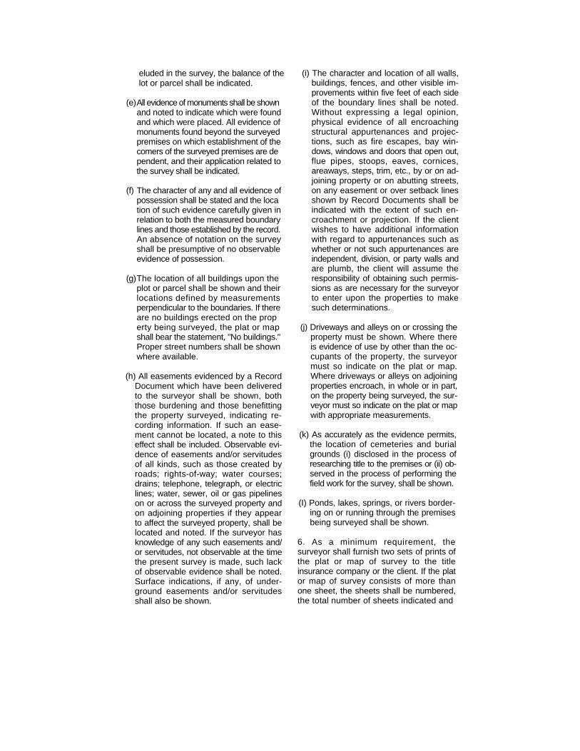
(i) The character and location of all walls, buildings, fences, and other visible im-provements within five feet of each side of the boundary lines shall be noted. Without expressing a legal opinion, physical evidence of all encroaching structural appurtenances and projec-tions, such as fire escapes, bay win-dows, windows and doors that open out, flue pipes, stoops, eaves, cornices, areaways, steps, trim, etc., by or on ad-joining property or on abutting streets, on any easement or over setback lines shown by Record Documents shall be indicated with the extent of such en-croachment or projection. If the client wishes to have additional information with regard to appurtenances such as whether or not such appurtenances are independent, division, or party walls and are plumb, the client will assume the responsibility of obtaining such permis-sions as are necessary for the surveyor to enter upon the properties to make such determinations.
(j) Driveways and alleys on or crossing the property must be shown. Where there is evidence of use by other than the oc-cupants of the property, the surveyor must so indicate on the plat or map. Where driveways or alleys on adjoining properties encroach, in whole or in part, on the property being surveyed, the sur-veyor must so indicate on the plat or map with appropriate measurements.
(k) As accurately as the evidence permits, the location of cemeteries and burial grounds (i) disclosed in the process of researching title to the premises or (ii) ob-served in the process of performing the field work for the survey, shall be shown.
(I) Ponds, lakes, springs, or rivers border-ing on or running through the premises being surveyed shall be shown.
6. As a minimum requirement, the surveyor shall furnish two sets of prints of the plat or map of survey to the title insurance company or the client. If the plat or map of survey consists of more than one sheet, the sheets shall be numbered, the total number of sheets indicated and
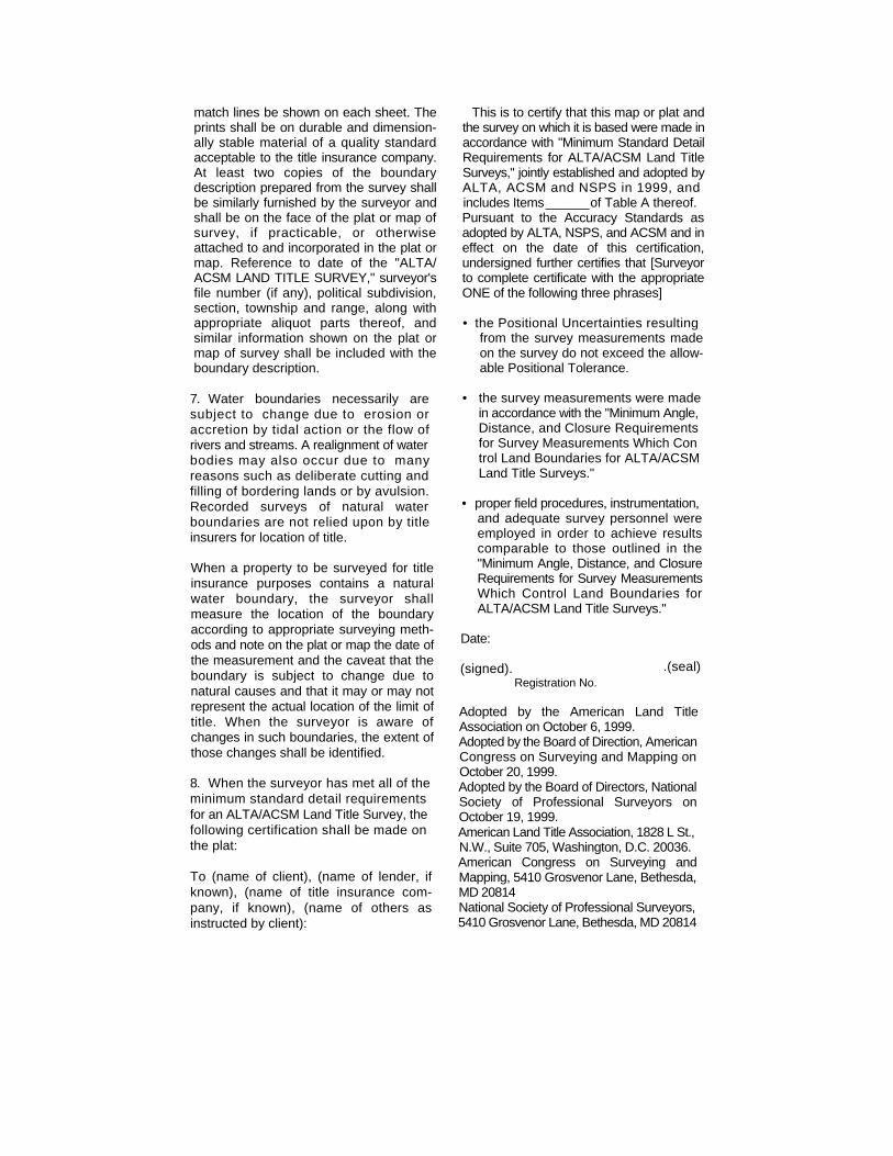
match lines be shown on each sheet. The prints shall be on durable and dimension-ally stable material of a quality standard acceptable to the title insurance company. At least two copies of the boundary description prepared from the survey shall be similarly furnished by the surveyor and shall be on the face of the plat or map of survey, if practicable, or otherwise attached to and incorporated in the plat or map. Reference to date of the "ALTA/ ACSM LAND TITLE SURVEY," surveyor's file number (if any), political subdivision, section, township and range, along with appropriate aliquot parts thereof, and similar information shown on the plat or map of survey shall be included with the boundary description.
7. Water boundaries necessarily are subject to change due to erosion or accretion by tidal action or the flow of rivers and streams. A realignment of water bodies may also occur due to many reasons such as deliberate cutting and filling of bordering lands or by avulsion. Recorded surveys of natural water boundaries are not relied upon by title insurers for location of title.
When a property to be surveyed for title insurance purposes contains a natural water boundary, the surveyor shall measure the location of the boundary according to appropriate surveying meth-ods and note on the plat or map the date of the measurement and the caveat that the boundary is subject to change due to natural causes and that it may or may not represent the actual location of the limit of title. When the surveyor is aware of changes in such boundaries, the extent of those changes shall be identified.
8. When the surveyor has met all of the minimum standard detail requirements for an ALTA/ACSM Land Title Survey, the following certification shall be made on the plat:
To (name of client), (name of lender, if known), (name of title insurance com-pany, if known), (name of others as instructed by client):
This is to certify that this map or plat and the survey on which it is based were made in accordance with "Minimum Standard Detail Requirements for ALTA/ACSM Land Title Surveys," jointly established and adopted by ALTA, ACSM and NSPS in 1999, and includes Items______of Table A thereof. Pursuant to the Accuracy Standards as adopted by ALTA, NSPS, and ACSM and in effect on the date of this certification, undersigned further certifies that [Surveyor to complete certificate with the appropriate ONE of the following three phrases]
• the Positional Uncertainties resulting from the survey measurements made on the survey do not exceed the allow-able Positional Tolerance.
• the survey measurements were made in accordance with the "Minimum Angle, Distance, and Closure Requirements for Survey Measurements Which Con trol Land Boundaries for ALTA/ACSM Land Title Surveys."
• proper field procedures, instrumentation, and adequate survey personnel were employed in order to achieve results comparable to those outlined in the "Minimum Angle, Distance, and Closure Requirements for Survey Measurements Which Control Land Boundaries for ALTA/ACSM Land Title Surveys."
Date:
(signed). Registration No.
Adopted by the American Land Title Association on October 6, 1999. Adopted by the Board of Direction, American Congress on Surveying and Mapping on October 20, 1999. Adopted by the Board of Directors, National Society of Professional Surveyors on October 19, 1999. American Land Title Association, 1828 L St., N.W., Suite 705, Washington, D.C. 20036. American Congress on Surveying and Mapping, 5410 Grosvenor Lane, Bethesda, MD 20814 National Society of Professional Surveyors, 5410 Grosvenor Lane, Bethesda, MD 20814
.(seal)
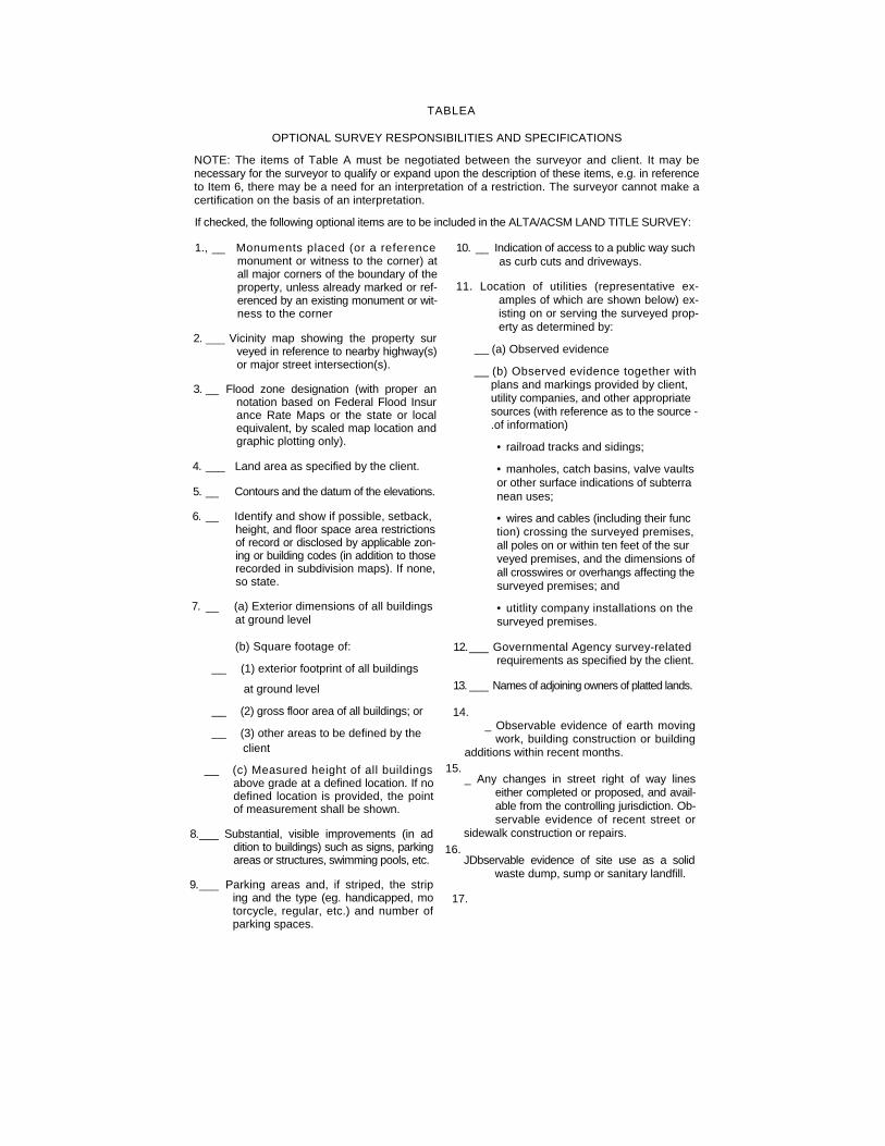
TABLEA
OPTIONAL SURVEY RESPONSIBILITIES AND SPECIFICATIONS NOTE: The items of Table A must be negotiated between the surveyor and client. It may be necessary for the surveyor to qualify or expand upon the description of these items, e.g. in reference to Item 6, there may be a need for an interpretation of a restriction. The surveyor cannot make a certification on the basis of an interpretation. If checked, the following optional items are to be included in the ALTA/ACSM LAND TITLE SURVEY:
1., __ Monuments placed (or a reference monument or witness to the corner) at all major corners of the boundary of the property, unless already marked or ref-erenced by an existing monument or wit-ness to the corner
2. ___ Vicinity map showing the property sur veyed in reference to nearby highway(s) or major street intersection(s).
3. __ Flood zone designation (with proper an notation based on Federal Flood Insur ance Rate Maps or the state or local equivalent, by scaled map location and graphic plotting only).
4. ___ Land area as specified by the client.
5. __ Contours and the datum of the elevations.
6. __ Identify and show if possible, setback, height, and floor space area restrictions of record or disclosed by applicable zon-ing or building codes (in addition to those recorded in subdivision maps). If none, so state.
7. __ (a) Exterior dimensions of all buildings at ground level
(b) Square footage of: __ (1) exterior footprint of all buildings
at ground level __ (2) gross floor area of all buildings; or __ (3) other areas to be defined by the
client __ (c) Measured height of all buildings
above grade at a defined location. If no defined location is provided, the point of measurement shall be shown.
8.___ Substantial, visible improvements (in ad dition to buildings) such as signs, parking areas or structures, swimming pools, etc.
9.___ Parking areas and, if striped, the strip ing and the type (eg. handicapped, mo torcycle, regular, etc.) and number of parking spaces.
10. __ Indication of access to a public way such as curb cuts and driveways.
11. Location of utilities (representative ex-amples of which are shown below) ex-isting on or serving the surveyed prop-erty as determined by:
__ (a) Observed evidence __ (b) Observed evidence together with
plans and markings provided by client, utility companies, and other appropriate sources (with reference as to the source -.of information) • railroad tracks and sidings;
• manholes, catch basins, valve vaults or other surface indications of subterra nean uses;
• wires and cables (including their func tion) crossing the surveyed premises, all poles on or within ten feet of the sur veyed premises, and the dimensions of all crosswires or overhangs affecting the surveyed premises; and
• utitlity company installations on the surveyed premises.
12.___ Governmental Agency survey-related requirements as specified by the client.
13. ___ Names of adjoining owners of platted lands.
14. _ Observable evidence of earth moving
work, building construction or building additions within recent months.
_ Any changes in street right of way lines either completed or proposed, and avail-able from the controlling jurisdiction. Ob-servable evidence of recent street or
sidewalk construction or repairs.
JDbservable evidence of site use as a solid waste dump, sump or sanitary landfill.
15.
16.
17.
APPENDIX B
Accuracy Standards For ALTA Survey
Accuracy Standards for ALTA-ACSM Land Title Surveys
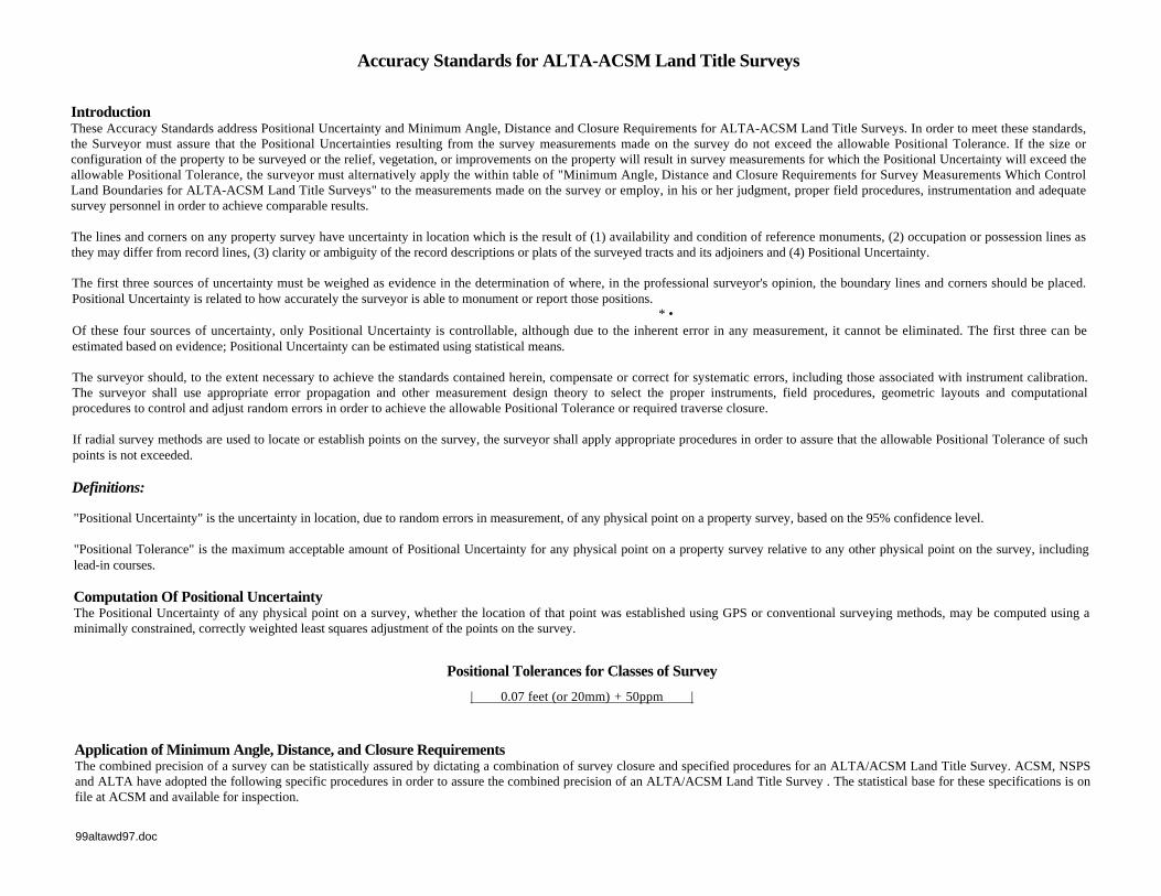
Introduction These Accuracy Standards address Positional Uncertainty and Minimum Angle, Distance and Closure Requirements for ALTA-ACSM Land Title Surveys. In order to meet these standards, the Surveyor must assure that the Positional Uncertainties resulting from the survey measurements made on the survey do not exceed the allowable Positional Tolerance. If the size or configuration of the property to be surveyed or the relief, vegetation, or improvements on the property will result in survey measurements for which the Positional Uncertainty will exceed the allowable Positional Tolerance, the surveyor must alternatively apply the within table of "Minimum Angle, Distance and Closure Requirements for Survey Measurements Which Control Land Boundaries for ALTA-ACSM Land Title Surveys" to the measurements made on the survey or employ, in his or her judgment, proper field procedures, instrumentation and adequate survey personnel in order to achieve comparable results.
The lines and corners on any property survey have uncertainty in location which is the result of (1) availability and condition of reference monuments, (2) occupation or possession lines as they may differ from record lines, (3) clarity or ambiguity of the record descriptions or plats of the surveyed tracts and its adjoiners and (4) Positional Uncertainty.
The first three sources of uncertainty must be weighed as evidence in the determination of where, in the professional surveyor's opinion, the boundary lines and corners should be placed. Positional Uncertainty is related to how accurately the surveyor is able to monument or report those positions.
* • Of these four sources of uncertainty, only Positional Uncertainty is controllable, although due to the inherent error in any measurement, it cannot be eliminated. The first three can be estimated based on evidence; Positional Uncertainty can be estimated using statistical means.
The surveyor should, to the extent necessary to achieve the standards contained herein, compensate or correct for systematic errors, including those associated with instrument calibration. The surveyor shall use appropriate error propagation and other measurement design theory to select the proper instruments, field procedures, geometric layouts and computational procedures to control and adjust random errors in order to achieve the allowable Positional Tolerance or required traverse closure.
If radial survey methods are used to locate or establish points on the survey, the surveyor shall apply appropriate procedures in order to assure that the allowable Positional Tolerance of such points is not exceeded.
Definitions:
"Positional Uncertainty" is the uncertainty in location, due to random errors in measurement, of any physical point on a property survey, based on the 95% confidence level.
"Positional Tolerance" is the maximum acceptable amount of Positional Uncertainty for any physical point on a property survey relative to any other physical point on the survey, including lead-in courses.
Computation Of Positional Uncertainty The Positional Uncertainty of any physical point on a survey, whether the location of that point was established using GPS or conventional surveying methods, may be computed using a minimally constrained, correctly weighted least squares adjustment of the points on the survey.
Positional Tolerances for Classes of Survey
| 0.07 feet (or 20mm) + 50ppm |
Application of Minimum Angle, Distance, and Closure Requirements The combined precision of a survey can be statistically assured by dictating a combination of survey closure and specified procedures for an ALTA/ACSM Land Title Survey. ACSM, NSPS and ALTA have adopted the following specific procedures in order to assure the combined precision of an ALTA/ACSM Land Title Survey . The statistical base for these specifications is on file at ACSM and available for inspection.
99altawd97.doc
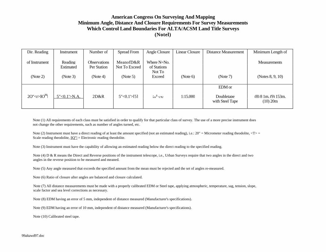
American Congress On Surveying And Mapping Minimum Angle, Distance And Closure Requirements For Survey Measurements
Which Control Land Boundaries For ALTA/ACSM Land Title Surveys (Notel)
Dir. Reading Instrument Number of Spread From Angle Closure Linear Closure Distance Measurement Minimum Length of
of Instrument Reading Observations MeanofD&R Where N=No. Measurements Estimated Per Station Not To Exceed of Stations Not To
(Note 2) (Note 3) (Note 4) (Note 5) Exceed (Note 6) (Note 7) (Notes 8, 9, 10)
EDM or
2Q"<r>|lOM| 5"<0.1'>N.A. 2D&R 5"<0.1'>[5] ion VN 1:15,000 Doubletape (8) 8 1m, (9) 153m, with Steel Tape (10) 20m
Note (1) All requirements of each class must be satisfied in order to qualify for that particular class of survey. The use of a more precise instrument does not change the other requirements, such as number of angles turned, etc.
Note (2) Instrument must have a direct reading of at least the amount specified (not an estimated reading), i.e.: 20" = Micrometer reading theodolite, <T> = Scale reading theodolite, |lQ"| = Electronic reading theodolite.
Note (3) Instrument must have the capability of allowing an estimated reading below the direct reading to the specified reading.
Note (4) D & R means the Direct and Reverse positions of the instrument telescope, i.e., Urban Surveys require that two angles in the direct and two angles in the reverse position to be measured and meaned.
Note (5) Any angle measured that exceeds the specified amount from the mean must be rejected and the set of angles re-measured.
Note (6) Ratio of closure after angles are balanced and closure calculated.
Note (7) All distance measurements must be made with a properly calibrated EDM or Steel tape, applying atmospheric, temperature, sag, tension, slope, scale factor and sea level corrections as necessary.
Note (8) EDM having an error of 5 mm, independent of distance measured (Manufacturer's specifications).
Note (9) EDM having an error of 10 mm, independent of distance measured (Manufacturer's specifications).
Note (10) Calibrated steel tape.
99altawd97.doc

APPENDIX C
Optional Services Table A
APPENDIX D
Request For ALTA Survey
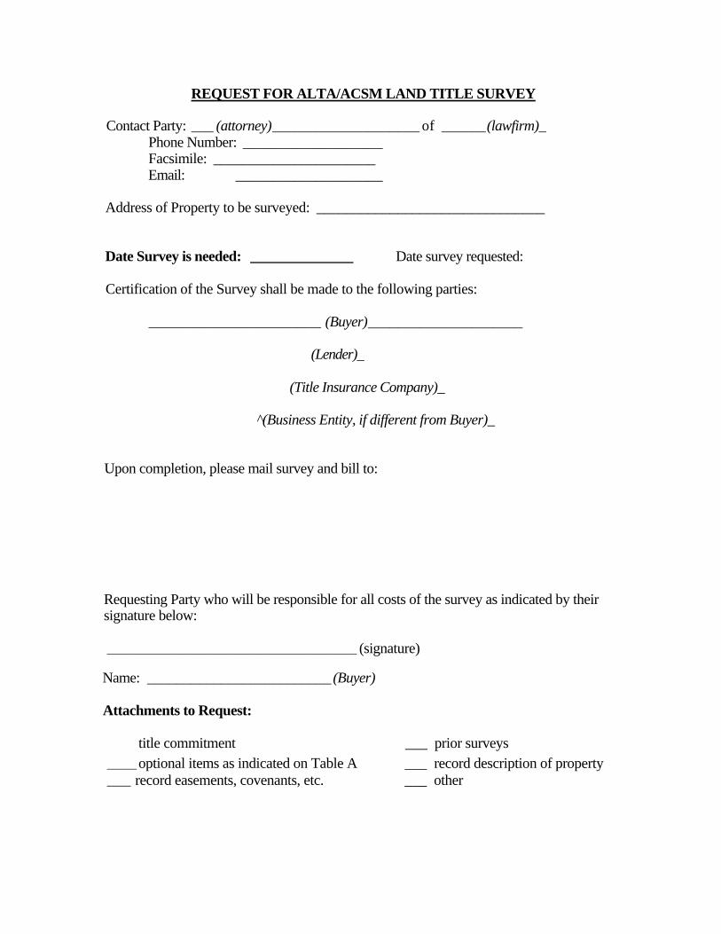
REQUEST FOR ALTA/ACSM LAND TITLE SURVEY
Contact Party: ___ (attorney)____________________ of ______(lawfirm)_ Phone Number: ___________________ Facsimile: ______________________ Email: ____________________
Address of Property to be surveyed: _______________________________
Date Survey is needed: ______________ Date survey requested:
Certification of the Survey shall be made to the following parties:
_____________________________ (Buyer)_____________________
(Lender)_
(Title Insurance Company)_
^(Business Entity, if different from Buyer)_
Upon completion, please mail survey and bill to:
Requesting Party who will be responsible for all costs of the survey as indicated by their signature below:
__________________________________________ (signature)
Name: _________________________ (Buyer)
Attachments to Request:
title commitment ___ prior surveys
_____ optional items as indicated on Table A ___ record description of property ____ record easements, covenants, etc. ___ other
APPENDIX E
ALTA Checklist
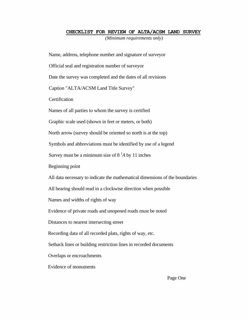
CHECKLIST FOR REVIEW OF ALTA/ACSM LAND SURVEY (Minimum requirements only)
Name, address, telephone number and signature of surveyor
Official seal and registration number of surveyor
Date the survey was completed and the dates of all revisions
Caption "ALTA/ACSM Land Title Survey"
Certification
Names of all parties to whom the survey is certified
Graphic scale used (shown in feet or meters, or both)
North arrow (survey should be oriented so north is at the top)
Symbols and abbreviations must be identified by use of a legend
Survey must be a minimum size of 8 1A by 11 inches
Beginning point
All data necessary to indicate the mathematical dimensions of the boundaries
All bearing should read in a clockwise direction when possible
Names and widths of rights of way
Evidence of private roads and unopened roads must be noted
Distances to nearest intersecting street
Recording data of all recorded plats, rights of way, etc.
Setback lines or building restriction lines in recorded documents
Overlaps or encroachments
Evidence of monuments
Page One
Evidence of possession
Location of all buildings with measurements perpendicular to the boundaries or if there are no buildings then the survey must state "No buildings"
Proper street numbers
All easements evidenced by record documents
Visible evidence of easements or servitudes of all kinds
Surface indications of any underground easements
Location of all walls/fences/improvements within 5 feet of each side of boundary
Driveways and alleys
Location of cemeteries and burial grounds
Ponds, lakes, etc.
If survey is more than one sheet, each must be numbered and total number shown
Surveyor's file number, if any
political subdivision, land lot, district
Page Two
APPENDIX F
GAP Indemnity
GAP INDEMNITY AGREEMENT
This Agreement is made and entered into this ____ day of__________ , 200 by and between________________________hereinafter referred to as "Indemnitor" and Stewart Title Guaranty Company hereinafter referred to as "STGC" and its agents.
Indemnitor is the owner of that certain real property hereinafter referred to as "the property" described by the commitments and reports, hereinafter referred to as "the reports" listed on the attached Exhibit "A".
Indemnitor is contemplating selling or encumbering the property and has requested STGC and its agents to issue policies of title insurance in connection therewith:
For and in consideration of STGC and its agents issuing the policies without taking exception to any instruments first appearing of record creating any interest in the property after the effective date of the reports and prior to the effective date of the policies of title insurance to be issued under the reports hereinafter referred to as "Gap Interests," Indemnitor agrees to promptly defend, remove, bond or otherwise dispose of any objectionable matter of title which may appear of record within the "Gap Interests" and Indemnitor does hereby agree to hold and save STGC and its agents harmless, and to protect and indemnify STGC and its agents from any and against any and all liabilities or claims of liability, losses, costs, charges, expenses and damages of any kind or character whatsoever, including, but not limited to reasonable attorneys fees incurred or sustained by STGC and its agents by reason of or arising out of "Gap Interests" which STGC or its agents incur or sustain directly or indirectly under any policies of title insurance issued pursuant to this Gap Indemnity Agreement.
BY:

APPENDIX G
"Marked" Commitment