Embed Size (px)
Citation preview
RU-13-01-0022-131221/BACKGROUNDER
Bharatmala Pariyojana – ‘Road’ to country’s infrastructure development
Slew of Expressways/Highways underway in Uttar Pradesh
(Ministry of Road Transport & Highways)1
December 13, 2021
“Many modern and wide roads like the Poorvanchal Expressway, Bundelkhand
Expressway, Ganga Expressway, Gorakhpur Link Expressway, Ballia Link Expressway
are being built throughout UP. And this is just the beginning of the modern infrastructure
of modern UP.”2
- Prime Minister Narendra Modi
Introduction
Though India has about 62.16 lakh kilometres of road network, which is the second largest in
the world in terms of length, it was important to re-define road development and have a
macro approach while planning expansion of the national highways network. Former Prime
Minister Shri Atal Bihari Vajpayee had initiated the execution of high-quality road network
projects in modern India two decades ago. His efforts for the connectivity of the country and
the people are the strong foundation of present-day India. From Pradhan Mantri Gram Sadak
Yojana to the Golden Quadrangle – North-East, East-West and North-South-East-West
Corridors, his vision and development efforts for both, rural as well as urban areas, has been
the guiding spirit. Prime Minister Narendra Modi consolidated on that vision and created
records including highest per day and per week pace of National Highway construction
across the country.
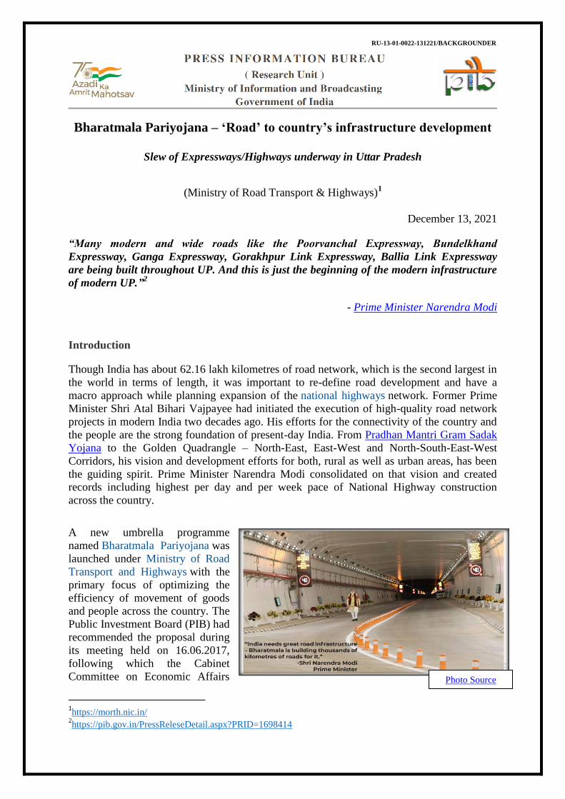
A new umbrella programme
named Bharatmala Pariyojana was
launched under Ministry of Road
Transport and Highways with the
primary focus of optimizing the
efficiency of movement of goods
and people across the country. The
Public Investment Board (PIB) had
recommended the proposal during
its meeting held on 16.06.2017,
following which the Cabinet
Committee on Economic Affairs
1https://morth.nic.in/
2https://pib.gov.in/PressReleseDetail.aspx?PRID=1698414
Photo Source

(CCEA) had approved the Phase-I of the Bharatmala Pariyojana.
The Bharatmala Pariyojana envisages development of about 26,000 km length of Economic
Corridors, which along with Golden Quadrilateral (GQ) and North-South and East-West (NS-
EW) Corridors are expected to carry majority of the freight traffic on roads. Further, about
8,000 km of Inter-corridors and about 7,500 km of feeder routes have been identified for
improving effectiveness of Economic Corridors, GQ and NS-EW Corridors. The programme
envisages development of ring roads, bypasses and elevated corridors to decongest the traffic
passing through cities and enhance logistic efficiency. 28 cities have been identified for ring
roads and 125 choke points & 66 congestion points have been identified for their
improvements. Further, in order to reduce congestion on proposed Corridors, enhance logistic
efficiency and reduce logistics costs of freight movements, 35 locations have been identified
for development of Multimodal Logistics Parks.
Need for the Umbrella Scheme
● Inadequacy in optimization of National Highway network & Road network due to resource
constraints and absence of a national plan. ● Lack of integrated planning in the connectivity of major corridors and ports with hinterland. ● Presence of Congestion Points, with multiple points of local congestion present even on
already developed corridors. ● Lack of accident response infrastructure.
Salient features of the Project
Bharatmala focuses on enhanced effectiveness of already built infrastructure, multi-modal
integration, bridging infrastructure gaps for seamless movement and integrating National and
Economic Corridors. There are six key features of the programme:
i. Economic Corridors: Integrating the economic corridors facilitates larger
connectedness between economically important production and consumption centers.
ii. Inter-corridor and Feeder routes: This would ensure first mile and last mile
connectivity.
Source

iii. National Corridor Efficiency Improvement: Through this, the greater actionable
goal is to undertake lane expansion and decongestion of existing National Corridors.
iv. Border and International connectivity roads: Better border road infrastructure
would ensure greater manoeuvrability, while also boosting trade with neighbouring
countries.
v. Coastal and Port connectivity roads: Port-led economic development is further
boosted through connectivity to coastal areas, encouraging both tourism and industrial
development.
vi. Green-field Expressways: Expressways have higher traffic configuration and choke
points would benefit from green-field expressways.
Amongst the major projects completed under Bharatmala Pariyojana are the Eastern
Peripheral Expressway, Delhi-Meerut Expressway, Narmada Bridge, Chenani – Nashri
Tunnel and the Dhaula-Sadia Bridge.
It may be seen that Uttar Pradesh, being home to the largest portion of population in the
country, has been one of the core beneficiaries of Bharatmala Pariyoana. From national
highways to expressways,
the state is setting new
standards in road
connectivity. Uttar Pradesh
has a road network of
299,604 km, out of which
174,451 km is under State
Public Works Department
(PWD). The roads under
PWD comprise 7,550 km of
National Highways (NHs),
7,530 km of State
Highways (SHs), 5,761 km
of Major District Roads
(MDRs), 3,254 km of Other
District Roads (ODRs) and
138,702 km of Village
Roads (VRs).3
Between 2007 and 2017, strategically important project of Yamuna Expressway was
constructed & the Lucknow-Agra Expressway4 was initiated. Since 2017, The Agra
expressway has been made fully operational along inauguration of Purvanchal Expressway
and initiation of Bundelkhand Expressway, Ganga Expressway, Gorakhpur Link Expressway
and Ballia Link Expressway.5
3http://uppwd.gov.in/pdf/UPCRNDP-SECPO.pdf
4https://upeida.up.gov.in/en/page/agra-lucknow-expressway
5One year for polls, Yogi Adityanath govt’s focus is on completing expressways | Cities News,The Indian
Express
Photo Source
Expressways would lead a holistic development of the state bringing about socio-economic
prosperity:
● A good network of roads is the first and foremost requirement for development. It not
only makes it easier to transport goods and services but also saves on time as well as
costs.
● With the construction of these Expressways, accelerated convenient mode of
transportation shall be available in the State and will connect it with the National Capital
and other adjoining states.
● Expressways would lead to socio-economic development of the areas covered.
Agriculture, commerce, tourism and other industrial development will also get a fillip.
● Industrial Training Institutes, educational institutes, medical institutes, new townships and
other various commercial set ups shall be developed, especially near adjacent areas of
these Expressways which will result into more opportunities for employment in the state.
The overall social/economic development in the state will get a boost.
Major Expressways in the State:6
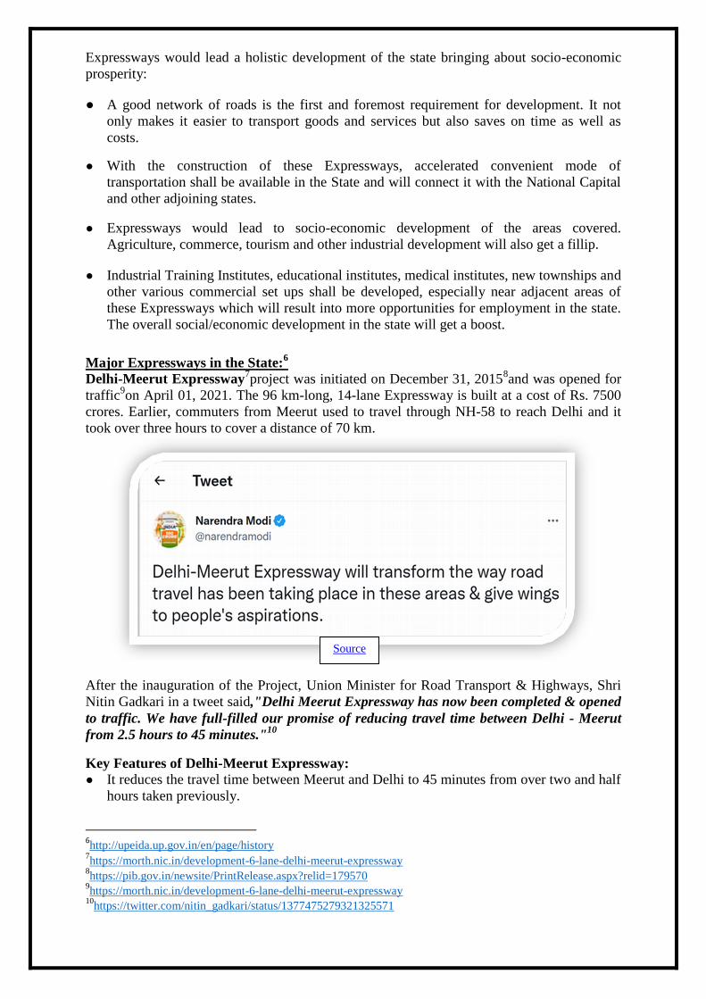
Delhi-Meerut Expressway7project was initiated on December 31, 2015
8and was opened for
traffic9on April 01, 2021. The 96 km-long, 14-lane Expressway is built at a cost of Rs. 7500
crores. Earlier, commuters from Meerut used to travel through NH-58 to reach Delhi and it
took over three hours to cover a distance of 70 km.
After the inauguration of the Project, Union Minister for Road Transport & Highways, Shri
Nitin Gadkari in a tweet said,"Delhi Meerut Expressway has now been completed & opened
to traffic. We have full-filled our promise of reducing travel time between Delhi - Meerut
from 2.5 hours to 45 minutes."10
Key Features of Delhi-Meerut Expressway:
● It reduces the travel time between Meerut and Delhi to 45 minutes from over two and half
hours taken previously.
6http://upeida.up.gov.in/en/page/history
7https://morth.nic.in/development-6-lane-delhi-meerut-expressway
8https://pib.gov.in/newsite/PrintRelease.aspx?relid=179570
9https://morth.nic.in/development-6-lane-delhi-meerut-expressway
10https://twitter.com/nitin_gadkari/status/1377475279321325571
Source

● The expressway also reduces the travel time of commuters from Muzaffarnagar,
Saharanpur, Haridwar and Dehradun to Delhi. ● It reduces the traffic congestion at Muradnagar, Ghaziabad and Mohan Nagar.
Agra-Lucknow Expressway11
is a 302.222 Km-long, six-lane (Expandable to 08 lanes)
Access Controlled (Greenfield) Expressway with eight-lane wide structures for future
expansion of the expressway to 08 lanes. The expressway starts at Agra inner ring road,
passes through Firozabad,
Mainpuri, Etawah, Auraiya,
Kannauj, Kanpur Nagar, Hardoi,
Unnao districts and ends on SH-
40 in Lucknow. It has facilitated a
high-speed corridor, connecting
state capital Lucknow to Agra in
western Uttar Pradesh and further
to the National Capital, New
Delhi through Yamuna
Expressway. The travel time
between Agra and Lucknow has
reduced considerably to three
hours and further to New Delhi
via Yamuna Expressway to five
and half hours. The reduction in
travel time has resulted in
substantial savings in the consumption of fuel and a reduction in carbon footprint.
Interchanges for exit/entry into the expressway have been provided at crossing with major
roads.
Key Features of Agra-Lucknow Expressway:
● Interchanges for major roads; underpasses for vehicles, pedestrians & animals. ● Service road, staggered on both sides of
Expressway all along the expressway, except
at major bridges, RoBs. ● Wayside amenities with provision for toilet
locks, petrol pumps, service stations,
restaurants & shopping arcades, etc. at four
locations - two each on either side of
Expressway. ● Provision of the airstrip for landing and
taking off of fighter planes in case of an
emergency. Advanced Traffic Management
System comprising Electronic Call Boxes
(ECB), Digital Message Screens, Video
Monitoring & Incident Detection System,
GPS-based Ambulance Service, etc. Response time of the security team and an
ambulance is four to eleven minutes. ● Use of Green Energy (Solar) for all illumination purposes. ● Development of green belt on both sides and the median of Expressway and rainwater
harvesting arrangements.
11
https://upeida.up.gov.in/en/page/agra-lucknow-expressway
Photo source
Photo Source

● Development of Mandi's at two places (Kannauj & Mainpuri) with access from the
Expressway. ● Fastag facility.
Purvanchal Expressway12
is a
341-kilometre long Expressway
which is strategically significant
and a prime example of world-
class infrastructure. It starts from
village Chaudsarai located on the
Lucknow-Sultanpur road (NH-
731) and ends at village Hydaria
located on National Highway No.
31, 18 kilometres east of UP-
Bihar border. The Expressway is
six-lane wide which can be
expanded to eight-lane in future.
Constructed at an estimated cost
of about Rs 22500 crore, the
Purvanchal Expressway will give
a boost to the economic
development of eastern part of
Uttar Pradesh especially the
districts of Lucknow, Barabanki, Amethi, Ayodhya, Sultanpur, Ambedkar Nagar, Azamgarh,
Mau and Ghazipur. It has been developed by the Uttar Pradesh Expressways Industrial
Development Authority (UPEIDA). Prime Minister Narendra Modi had laid the foundation
stone of the project on 14th
July, 201813
and it was inaugurated on 16th
November 202114
by
Prime Minister himself at Kurebhar Airstrip in Sultanpur district of UP. A 3.2 km-long
airstrip has also been constructed on the Expressway in Sultanpur district to enable landing
and take-off of Indian Air Force fighter planes in case of an emergency.
12
https://upeida.up.gov.in/en/page/the-purvanchal-expressway 13
https://pib.gov.in/Pressreleaseshare.aspx?PRID=1538649 14
https://pib.gov.in/PressReleaseIframePage.aspx?PRID=1772308
Photo Source
Source

Key Features of Purvanchal Expressway:
● Width of Expressway: Six-Lane wide, expandable to Eight-Lane. (15 m on each side,
total 30 m with a median of 5.50 m.) ● Width of Right Of Way (ROW): One Hundred and Twenty (120) m wide land corridor ● Service Road: 3.75 m black top in a staggered manner on either side of Expressway to
facilitate easy movement for the inhabitants of adjacent villages, total length-402 km ● Airstrip: 3.20 km-long & 34 metres-wide Cement Concrete Emergency Airstrip for IAF ● Fuel Stations: Eight (one in each Wayside Amenities) ● CNG Stations: Four ● Tree Plantations: 4.50 lakh trees
being planted in the ROW of
Expressway. ● Rain Water Harvesting: RWH pits
constructed as required by
geological conditions in the ROW
at every 500 metres. ● Lighting: Lighting arrangement
made on interchanges, flyovers,
major & minor bridges and
underpasses with solar backup. ● Design Speed of Highway:
Expressway has been designed for
speed 120 km/hr and Speed Limit
has been fixed at 100 km/hr. ● The work of setting up of eight
toilet blocks on Purvanchal
Expressway is in progress. ● UPEIDA has been authorized by the government to make industrial hubs on both sides of
this Expressway. In the situation of an accident on Purvanchal Expressway, a total of 16
ambulances will be available in each of the packages.
Source
Photo Source
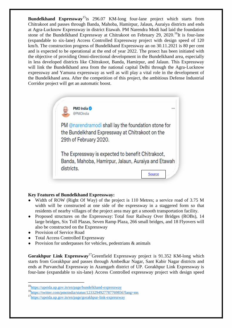
Bundelkhand Expressway15
is 296.07 KM-long four-lane project which starts from
Chitrakoot and passes through Banda, Mahoba, Hamirpur, Jalaun, Auraiya districts and ends
at Agra-Lucknow Expressway in district Etawah. PM Narendra Modi had laid the foundation
stone of the Bundelkhand Expressway at Chitrakoot on February 29, 2020.16
It is four-lane
(expandable to six-lane) Access Controlled Expressway project with design speed of 120
km/h. The construction progress of Bundelkhand Expressway an on 30.11.2021 is 80 per cent
and is expected to be operational at the end of year 2022. The proect has been initiated with
the objective of providing Omni-directional development in the Bundelkhand area, especially
in less developed districts like Chitrakoot, Banda, Hamirpur, and Jalaun. This Expressway
will link the Bundelkhand area from the national capital Delhi through the Agra-Lucknow
expressway and Yamuna expressway as well as will play a vital role in the development of
the Bundelkhand area. After the competition of this project, the ambitious Defense Industrial
Corridor project will get an automatic boost.
Key Features of Bundelkhand Expressway:
● Width of ROW (Right Of Way) of the project is 110 Metres; a service road of 3.75 M
width will be constructed at one side of the expressway in a staggered form so that
residents of nearby villages of the project area may get a smooth transportation facility.
● Proposed structures on the Expressway: Total four Railway Over Bridges (ROBs), 14
large bridges, Six Toll Plazas, Seven Ramp Plaza, 266 small bridges, and 18 Flyovers will
also be constructed on the Expressway
● Provision of Service Road
● Total Access Controlled Expressway ● Provision for underpasses for vehicles, pedestrians & animals
Gorakhpur Link Expressway17
Greenfield Expressway project is 91.352 KM-long which
starts from Gorakhpur and passes through Ambedkar Nagar, Sant Kabir Nagar districts and
ends at Purvanchal Expressway in Azamgarh district of UP. Gorakhpur Link Expressway is
four-lane (expandable to six-lane) Access Controlled expressway project with design speed
15
https://upeida.up.gov.in/en/page/bundelkhand-expressway 16
https://twitter.com/pmoindia/status/1233294927787769856?lang=ms 17
https://upeida.up.gov.in/en/page/gorakhpur-link-expressway
Source

of 120 km/h. This Expressway is under construction and expected to be operational in the
year 2023. Its approved project cost is Rs. 5876.67 crores (including cost of land). Project has
been divided into two packages for implementation. Work is under progress since February
2020. 96.19 per cent land, out of the total required land for the project has been acquired till
October 2021. Environmental approval and NOC from the Department of Forest are in
process. The Gorakhpur Link Expressway will provide faster connectivity and better
commuter experience as well as help in getting the population of affected areas closer. It
would also bolster efforts to convey and carry the cultural and commercial values from
Gorakhpur to Azamgarh and vice-versa.
Key Features of Gorakhpur Link Expressway:
● Width of ROW (Right Of Way): 110 Metres ● Carriageway: Four lanes (expandable upto six lanes) ● Provision of Service Road expected on major bridges ● Total Access Controlled Expressway ● Provision for underpasses for vehicles, pedestrians and animals
Ganga Expressway18
is a project of 594 KM approximately. This fully access-controlled
Ganga Expressway is proposed to start from N.H. 334, in Meerut district and will end at
Prayagraj bye-pass of (N.H.-2) in district Prayagraj. It will be of six lanes (expandable up to
eight lanes). Width of ROW (Right of Way) of the Expressway is proposed as 120 metres,
service road of 3.75 M width will be constructed at one side of the expressway in the
staggered form so that residents of nearby villages of the project area may get smooth
transportation facility.
Ballia Link Expressway19
project is a eight-lane Access Controlled Expressway which will
start from Eastern Peripheral Expressway near village Sirsi in Greater Noida and pass
through Gautam Budh Nagar to State Highway No.34 near Phephana in Ballia district of UP.
Estimated length of the Expressway is approximately 952 kms and the estimated cost is
approximately Rs. 30,000 crore. The project has been developed on Design-Build-Finance-
Operate (DBFO) basis on PPP Model.
Implementation of Pradhan Mantri Gram Sadak Yojana in Uttar Pradesh:20
Besides initiating national and state highway proects, there has been emphasis on building
rural roads under the Pradhan Mantri Gram Sadak Yojana (PMGSY). As of December 09,
2021, a total number of 20,540 road works have been cleared in Uttar Pradesh and 18,565
road works have been completed under PMGSY. The PMGSY was launched as a one-time
special intervention, with the objective to provide rural connectivity, by way of a single all-
weather road, to the eligible unconnected habitations of designated population size (500+ in
plain areas and 250+ in North-Eastern States, Himalayan States, Deserts and Tribal Areas as
per 2001 census) in the core network for uplifting the socio-economic condition of the rural
population. Hence, the primary objective of the Scheme was to provide all-weather road
connectivity to eligible un-connected habitations. No physical targets in terms of kilometres
or financial targets or allocations were fixed for states. The fund allocation to states has been
made in subsequent years commensurate with the value of projects sanctioned to states.21
18
https://upeida.up.gov.in/en/page/ganga-expressway 19
http://upeida.up.gov.in/post/en/proposed-plans-project-3 20
https://ruraldiksha.nic.in/RuralDashboard/PMGSY_NEW.aspx 21
https://pib.gov.in/PressReleseDetailm.aspx?PRID=1656170

Source
The Cabinet Committee on Economic Affairs chaired by the Prime Minister Shri Narendra
Modi on November 17, 202122
gave its approval to the proposals of the Ministry of Rural
Development for continuation of Pradhan Mantri Gram Sadak Yojana-I and II up to
September, 2022 for completion of balance road and bridge works. The CCEA also approved
continuation of Road Connectivity Project for Left Wing Extremism Affected Areas
(RCPLWEA) up to March, 202323
.
Source
Key features of PMGSY: ● Decentralized and evidence-based planning; standards and specifications as per Indian
Road Congress (IRC) and Rural Roads Manual, ● Dedicated implementation mechanism at central, state and district level, scrutiny of
Detailed Project Reports (DPRs) at multiple levels. ● Strong IT backbone for monitoring and implementation of the programme, three-tier
quality management system, unbroken flow of funds, inbuilt mechanism for consultation
with public representatives at planning, selection of roads and monitoring stages, etc.24
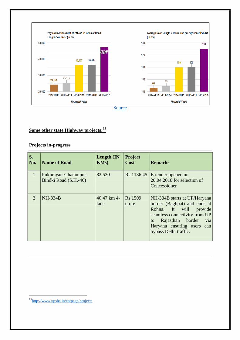
As per the dashboard of Ministry of Rural Development, progress of Pradhan Mantri Gram
Sadak Yojana (PMGSY) as on 08.12.2021in Uttar Pradesh is mentioned below:
22
https://www.pib.gov.in/PressReleasePage.aspx?PRID=1772578 23
https://pib.gov.in/PressReleasePage.aspx?PRID=1772579 24
https://pib.gov.in/PressReleaseIframePage.aspx?PRID=1737394
Source
Some other state Highway projects:25
Projects in-progress
S.
No. Name of Road
Length (IN
KMs)
Project
Cost Remarks
1 Pukhrayan-Ghatampur-
Bindki Road (S.H.-46)
82.530 Rs 1136.45 E-tender opened on
20.04.2018 for selection of
Concessioner
2 NH-334B 40.47 km 4-
lane
Rs 1509
crore
NH-334B starts at UP/Haryana
border (Baghpat) and ends at
Rohna. It will provide
seamless connectivity from UP
to Rajasthan border via
Haryana ensuring users can
bypass Delhi traffic.
25
http://www.upsha.in/en/page/projects

Completed Project
S.
No. Name of road
Length
(IN
KMs)
Project
Cost
Commercial
operation Date
Concession
Period
Name of
Concessioner
1 Muzaffarnagar-
Saharanpur
Road (SH-59)
52.95 752.88 17.03.2018/16.06.2018 23 Years M/s Devband
Highways
Pvt. Ltd.
Lucknow.
Video References:
1. https://www.youtube.com/watch?v=wT63WinTDxg
2. https://www.youtube.com/watch?v=3dCPcccNA6k
3. https://www.youtube.com/watch?v=Kiij9kQAIVg
4. https://www.youtube.com/watch?v=VJDH0pQQw4g
5. https://www.youtube.com/watch?v=MRU3uIj0hdA
References: 1. https://pib.gov.in/PressReleseDetail.aspx?PRID=1698414
2. https://nhai.gov.in/#/
3. http://upeida.up.gov.in/
4. http://www.upsha.in/en/page/projects
5. http://www.upsha.in/
6. http://uppwd.gov.in/pdf/UPCRNDP-SECPO.pdf
7. https://pib.gov.in/PressReleaseIframePage.aspx?PRID=1737394
8. https://pib.gov.in/PressReleasePage.aspx?PRID=1772579
9. https://ruraldiksha.nic.in/RuralDashboard/PMGSY_NEW.aspx
10. https://pib.gov.in/PressReleasePage.aspx?PRID=1780624
11. https://pib.gov.in/PressReleaseIframePage.aspx?PRID=1638545
Further Reading: 1. https://www.news18.com/news/opinion/the-roadmap-of-yogi-adityanaths-expressway-projects-
3904466.html
2. https://www.financialexpress.com/infrastructure/uttar-pradeshs-infra-on-expressway-drive/2382822/
3. https://theprint.in/india/governance/in-yogis-up-expressways-are-scripting-silent-transformation-in-state-
known-for-poor-road-infra/638384/
4. https://indianexpress.com/article/cities/lucknow/one-year-for-polls-yogi-adityanath-govts-focus-is-on-
completing-expressways-7235029/
5. https://www.timesnownews.com/business-economy/industry/article/all-you-need-to-know-about-ganga-
expressway-lucknow-kanpur-expressway-and-other-2-key-road-projects-of-uttar-pradesh/812871
Tweets: 1. https://twitter.com/nitin_gadkari/status/1377475279321325571
2. https://twitter.com/narendramodi/status/1460259110843080705
3. https://twitter.com/pmoindia/status/1233294927787769856?lang=ms
4. https://twitter.com/narendramodi/status/682514751398789120
5. https://twitter.com/pmoindia/status/1233294927787769856?lang=ms
AG/HP/SA/PS/JA


