Embed Size (px)
Citation preview
BINH THUAN PROVINCIAL PEOPLE’S COMMITTEE
PROVINCIAL DEPARTMENT OF AGRICULTURE AND RURAL DEVELOMENT
PMU OF DAM REPAIR AND SAFETY IMPROVEMENT
---------------o0o----------------
REPORT
ENVIRONMENTAL AND SOCIAL IMPACT ASSESSMENT (ESIA) (Updated according to Official Letter No. 760/CPO-WB8 dated 8/6/2018 of
The Central Project Office)
Subproject: Repair and Improvement for Safety of Song Quao Reservoir,
Binh thuan Province
VietNam dam rehabilitation and safety improvement project (WB8)
Binh Thuan, 8/2019
Pub
lic D
iscl
osur
e A
utho
rized
Pub
lic D
iscl
osur
e A
utho
rized
Pub
lic D
iscl
osur
e A
utho
rized
Pub
lic D
iscl
osur
e A
utho
rized
BINH THUAN PROVINCIAL PEOPLE’S COMMITTEE
PROVINCIAL DEPARTMENT OF AGRICULTURE AND RURAL DEVELOMENT
PMU OF DAM REPAIR AND SAFETY IMPROVEMENT
---------------o0o----------------
REPORT
ENVIRONMENTAL AND SOCIAL IMPACT ASSESSMENT (ESIA) (Updated according to Official Letter No. 760/CPO-WB8 dated 8/6/2018 of
The Central Project Office)
Subproject: Repair and Improvement for Safety of Song Quao Reservoir,
Binh Thuan Province
VietNam dam rehabilitation and safety improvement project (WB8)
SubProject Owner PMU OF DAM REPAIR AND SAFETY
IMPROVEMENT
Consultant Organisation INSTITUTE FOR WATER AND
ENVIROMENT
Binh Thuan, 8/2019
i
EXECUTIVE SUMMARY
1. Background. The repair and improvement of Song Quao Dam in Binh Thuan province is one
of the subprojects being proposed for funding under the World Bank-assisted Dam
Rehabilitation and Safety Improvement Project (DRSIP). The objectives of the subproject are: (i)
to enhance the flood protection function of the reservoir; and to ensure the safety and stability of
the dam headworks in order to protect downstream communities and their assets, consistent with
the objectives of Vietnam’s dam safety program.
2. Song Quao reservoir is located in Ham Tri commune of Ham Thuan Bac district, about 41
km from the coast. It was built in 1988 and completed in 1997. In the dry season, Song Quoa is
supplied water through the Dan Sach stream which takes water from La Nga River basin to
supply irrigation water to 8,120 ha of paddy field and for domestic use. The catchment area of
the reservoir is 296 sq. km. The capacity of the reservoir is 73 million cubic meters.
3. The head works and ancillary works of Song Quao reservoir include the following
components:
- Earth fill dams: The dams consist of two main dams and 4 sub-dams. It is a homogeneous
earth dam with a cut-off trench.
- Main dams: The length of the left dam is 470 m while the length of the right dam is
416m. The elevation of the dam crest is 92.0 m. The maximum height of dam is 40m.
The width at the top is 6.0 m.
- Auxiliary Dams:
o Auxiliary Dams 1, 2 and 3 have a total length of 525 m and a maximum height of 25
m.
o Auxiliary Dam 4 has with elevation equal to natural elevation of 90.80 m, so it also
serves as an emergency spillway in case of large flood.
- Intake: The intake is located in sub dam 1 and is a 2 m x 2.5 m reinforced concrete box
culvert.
- Spillway: The spillway is a reinforced concrete structure with 3 curves gates (dimension
6 m x 8 m) and connected to a chute.
- Dan Sach weir: The weir purpose is to supply water for Song Quao reservoir from the
Dan Sach stream as well as to enable discharge of water into Dan Sach stream to prevent
Son Quao reservoir from overflowing.
4. The current dam is at risk: The asphalt and concrete used to reinforce the dam has
deteriorated. Portions of the dam crest have peeled off and experiencing subsidence. The
downstream ledge has also deteriorated and has sustained damaged at some segments. The
concrete section of the dam face has been mostly cracked, particularly along the crest. Due to
waves, the upstream slope of the dam has sagged and the stone pavement has become uneven.
The dam slope appeared curved, rugged and aesthetically less pleasing. The downstream slope
has been eroded by surface water, while the ditches and up/down thresholds are mostly damaged.
Due to the impact of rainfall, both upstream and downstream slopes of the Dan Sach Weir have
been eroded with bushy plants growing on the dam body. There is seepage and deep erosion at
downstream slope. The permeability observation system through dam body and base is not
functional, making it impossible to observe the saturation inside the dam body.
ii
5. The downstream area is the fertile delta of Ham Thuan Bac with high population density. The
area is traversed by main traffic routes such as North-South railway, National highway 1A. The
area is about 8-10km from the construction site and about 20 km far from Phan Thiet city. The
communes along Quao River will be impacted directly by flood. These include seven (7)
communes with 4 ethnic groups of Kinh, Gialay, Khơ me, Tày. The estimated number
households within the dam’s downstream impact area are 4,963.
6. Description of project’s activities: The proposed rehabilitation works include (i) works on the
dam structures (i.e. main dams and sub dams) namely the reinforcement of the dam crests with
concrete, restoration of the downstream and upstream slopes; and installation of seepage
monitoring equipment; (ii) construction of a second spillway with reinforced concrete; (iii)
works on the Dan Sach weir which involve covering the weir and upstream slope with reinforced
concrete, construction of a regulating culvert at the starting point of the diversion canal in order
to prevent flood from Dan Sach river from flowing into Quao river; and, (iv) some repairs and
upgrading on the construction routes and on the Management Road with total length of 5.12 km.
7. Environmental and social screening: The Song Quao Reservoir sub-project falls under
Environment Category A under the World Bank classification. The dam is by definition a “large”
dam under World Bank's OP/BP 4.37 classification and therefore the subproject would require
the review and supervision of Panel of Expert and must prepare a Dam Safety Plan. The area is
not located within or near any sensitive environment or natural habitat and there are no structures
or sites in the area of cultural and historical significance that will be impacted by the
rehabilitation. In the subproject area, ethnic minorities account for about 6 % of the households.
The communes of Ham Tri and Thuan Hoa are inhabited by six ethnic groups, including the
Kinh, Cham, Co Ho, Ra-giai, Gia Rai and Tay. However, no ethnic minority households will be
affected by land acquisition. The ethnic minorities are in the downstream influence area of the
dam and will be benefited from better flood management and dam safety improvements.
8. Environmental and Social Impacts: The subproject will ensure safety of downstream
communities in the delta, protecting them from floods and possible breach of the dam. The
farming communities within the irrigation service area will be benefited from a stable and
reliable supply of irrigation water. The negative impacts of the subproject include:
9. Loss of land and dwellings. The implementation of the subproject will temporarily acquired
37.000 m2 and permanently acquired 75,795.3 m2, of which 62,765 m2 of land belonging to Song
Quao Protection Forest Management Board; 1,407.3m2 of land belonging to People's Committee
of Thuan Hoa and Ham Tri commune and 11623.3m2 of land belonging to the households. No
households will be acquired of residential land and no households will be resettlement. No ethnic
minorities have been affected by land acquisition. A Resettlement Action Plan (RAP) has been
prepared in consultation with those affected.
10. Impacts of construction activities. The negative impacts of construction activities are as
follows:
- Temporary increased in sedimentation of the waterways during rainy days due to
earthmoving activities-Massive earthmoving will be required including extraction of
more than 50,000 cubic meters at the designated burrow pit. These will have high
potentials for increased sedimentation of the waterways, including the reservoir.
- Increase in dusts nuisance within the construction site and along construction routes;
- Increase in noise levels within the construction site;
- Interruption in water supply during the repair works affecting agricultural production in
irrigation service areas and domestic water supply;
iii
- Possible damage of existing roadways due to heavy equipment traffic particularly the
hauling of embankment materials;
- Increase health and safety risks among local residents near the dam and along
construction routes due to exposure to construction-related hazards;
- Domestic and hazardous waste (The peak number of equipment and workers in the
construction site: 220 workers, 58 equipment). The amount of domestic wastes (i.e.
wastewater and solid waste) will not be significant but these would require standard
containment (i.e. septic tank, soak pit), collection and disposal (i.e. solid wastes to the
landfill). The air emissions from the equipment also will not be significant. Hazardous
materials will also require imposition of standards industry practice of storage and
containment in case of spillage.
11. Long term impacts. The following are long term negative impacts, expected to be felt
beyond the completion of the subproject:
- Loss of vegetation and impacts to terrestrial flora and fauna - The subproject will involve
significant vegetation removal and topsoil stripped. Terrestrial fauna will loss part of
their habitat particularly in the burrow pits area. Birds, insects and rodents will most
likely migrate to nearby areas. There are however no rare plants and animals to be
conserved in these areas.
- Land and soil degradation – This could occur at the construction sites and vicinities due
to loss of vegetation, alteration of landscape due to excavation, compaction, construction
spoils, litters and wastes. This impact is particularly severe in the burrow pits area.
- Increased use of pesticides - The improved irrigation water supply is also expected to
promote intensive agricultural production in the service area thereby increasing use of
pesticides.
12. Mitigation Measures. An Environmental Management Plan (ESMP) has been developed as
part of this ESIA report to address these impacts. The ESMP requires the
adoption/implementation of the various other safeguards instruments which have been prepared
for the sub-project such as, the Resettlement Action Plan/Compensation Plan, Gender
Development Plan, Public Consultation, Participation and Communication Strategy and,
Grievance and Redress Mechanism. Other measures in the ESMP include:
- Implementation of the construction strategies and plans to minimize water supply
interruptions to the service areas, namely: Careful and optimal scheduling and timing, use
of cofferdams to allow construction without draining the reservoir; Provision of
alternative sources such as the plan to use water from 812-Chau Ta Canal. All these in
close consultation with the affected farmers to minimize cropping disruptions
- Implementation of Resettlement Action Plan (RAP): Repairing and upgrading the Song
Quao reservoir will temporarily acquisition 37,000m2 of land for waste dumps, storage of
soil, stone sites, construction roads, construction sites; permanent acquisition is 75,795.3
m2 of land, of which, land for perennial crops is 1,828.4 m2; land for planting annual
trees is 9,794.4m2; protected forest land is 62,765 m2 (including: poor forest land is
30,500 m2, non-forest land and land of rivers and streams is 32,265 m2); land of rivers
and canals is 1,339.7m2 and land traffic is 67.6 m2. No residential land is relocated and
no resettlement households. The number of trees are cut down or moved to other areas of
about 526 dragon fruit pillars, 30 cashew trees, 15 mango trees, 50 banana trees, 20
spondias pinnata trees. The total cost of compensation and resettlement assistance is
VND 853,909,560 (Eight hundred and fifty three million, nine hundred and nine
thousand, five hundred and sixty Vietnamese dongs). Implementation of the Ethnic
Minority Development Plan (EMDP): There are 12 ethnic minority groups in the
subproject area (in which Cham, Co Ho and Raglai are ethnic minorities living in the area
iv
for a long time. There may be adverse impacts on ethnic minorities during the
construction period. Ethnic minority development activities include: i) training on
agricultural development; ii) training on business skills; iii) Guidelines on traffic safety
and prevention of social evils. Total budget for development activities is
2,790,000,000VND.
- Impose good housekeeping practices at the construction site in terms of storage of
materials, disposal of construction spoils to a properly sited landfill, regular sprinkling of
roads in residential areas during dry days. All these to be incorporated in Contractor's
own Environmental and Occupational Health and Safety Plan (CEOHSP) together with
standard construction EHS practices such as wearing of PPEs, provision of adequate
water and sanitation facilities at campsite, waste management including domestic
wastewater and hazardous waste, medical screening of workers, installation of fences and
warning signs at dangerous areas and good community relations.
- Proper operation of the burrow pit, including the careful stockpiling of materials away
from water channels and runoff and providing silt traps on strategic sections.
- Requiring the contractor to undertake site clearing, cleaning and restoration after
completion of works, including the leveling of stockpiled surface soils in the burrow pit
area and returning the ground for people to continue farming.
- Installation of a Dam Management Unit and the preparation of Emergency Preparedness
Plan as recommended in the Dam Safety Assessment Report.
- Introduction and promotion by MARD of the Integrated Pest Management (IPM)
technologies and approaches among the farming communities within the irrigation
service areas.
- Adoption and setting up of a Grievance Redress Procedure.
- Adoption of Chance Archaeological Find Procedure
- Adoption of Unexploded Ordnance Procedure
13. Consultation: Consultant and Project owner hold two consultations; the first was conducted
on February 03, 2015 at Binh Thuan DARD with 23 participants including representative of
departments, agencies of province, district, communes in sub-project area to communicate about
sub-project; Consultation measures meeting was carried out on February 05-13, 2015 in phases
at CPC’s headquarter with participant participated 129 persons (21% of total participant is
women), the social unions of: people's Committees, Fatherland Front Committees commune,
veterans, Women's Unions, youth Unions, farmers' associations, cooperatives, village leaders,
the affected households in the areas, consultation of agreement for implementation of subproject,
identifying affected scope and objects. The second consultation was carried out on March 12th,
2015 at headquarters of Thuan Hoa CPC, Ham Tri CPC, Ham Thuan Bac district with 133
participants including local authority and social organization, leaders of villages, representatives
of affected households to inform the negative impacts of sub-project on environment, social and
mitigation measures. Results: 100% participants support the implementation of sub-project and
proposed mitigation measures. In addition, the affected households recommend: (i) The material
transport vehicle have to operate in night time to avoid the impact to local people. The vehicle
have to cover during material carrying., watering road surface to reduce dust; (ii) Develop a plan
and train local people to respond the case of releasing water at spillway no. 2; (iii) A plan of
evacuation, protection for assets of 20 households of Ham Tri commune in case of flood; (iv)
The auxiliary areas and camping site have to locate in dam corridor to avoid land acquisition and
compensation and flooding event. The Binh Thuan Irrigation Company has committed to follow
the proposed mitigation measures mentioned in the ESIA.
14. The Ethnic Minority Development Plan (EMDP): There are 12 ethnic groups in the Sub -
project area, the Cham, Co Ho and Raglai are ethnic groups living in the area for a long time,
other minority groups have very few people living with the local community, there is no cultural
v
activities bring own identity. There will not water cut during construction, but the subprojects
with ethnic minorities may have adverse impacts on ethnic minorities during the construction
period. The consultation with EM in the FPIC manner shows that there is broad community
support from EM peoples for the subproject implementation. These EM development activities
include: i) Training on agriculture development; ii) Training on business skills; iii) Guidance on
traffic safety and prevention of social evils. Total budget for these Development activities is
2,790,000,000VND. EMDP will be further updated on the basis of the detailed design of the
subproject.
15. Risk of dam broken failure: Although the risk of dam failure is greatly reduced and dam’s
capacity to accommodate floods is enhanced by the subproject, the risk of catastrophic failure
remains significant because of the magnitude the potential impacts downstream. Close to
200,000 hectares of farmlands are at risk at the downstream. Infrastructure would be damaged:
155km of asphalt road; 50km irrigation canals; 15 schools; 7 health care centers, 13 CPC office
buildings; 1 Domestic water supply works and 100 km power line. Affected land area including:
12,900 ha agricultural land and100 ha aquaculture land. If the Quao River overflows, the number
of people to be affected would be staggering. An upgraded management system would be needed
as well an Emergency Response Plan would need to be installed.
16. Budget allocation: Both ODA fund and Counterpart fund of Vietnam Government are used
for sub-project investment. The total subproject cost is estimated at VND 199,960,000,000. The
total estimated cost of the ESMP implementation is VND 2,387,000,000.
vi
TABLE OF CONTENTS
EXECUTIVE SUMMARY ......................................................................................................................... I
TABLE OF CONTENTS ......................................................................................................................... VI
LIST OF TABLES ................................................................................................................................ VIII
LIST OF FIGURES ................................................ IX
CHAPTER 1: INTRODUCTION ............................................................................................................. 1
1.1 Background ............................................................................................................................................. 1
1.2 Approaches and methodology for environment assessment ................................................................... 1
1.3 Objectives and methodology for social assessment ................................................................................ 3
1.4. Subproject owner and investment cost: ................................................................................................ 4
1.5 Consultant organization .......................................................................................................................... 4
CHAPTER II: SUBPROJECT DESCRIPTION ..................................................................................... 5
2.1 Overview ................................................................................................................................................ 5
2.2 Location of Subproject Activities ........................................................................................................... 5
2.3 The proposed works ................................................................................................................................ 6
2.3.1 Main Dams .................................................................................................................................. 6
2.3.2 Auxiliary Dam (Sub-dam) No.1 and No. 3 ................................................................................. 8
2.3.3. Water flows discharge to Song Quao reservoir ........................................................................ 9
2.3.4 New construction of spillway No. 2 .......................................................................................... 10
2.3.5 Construction and management road .......................................................................................... 10
2.3.6 Construction of Management House ......................................................................................... 11
2.3.7 Ancillary and temporary facilities for use in the construction .................................................. 14
2.3.8 Transportation of soil, rock, construction materials .................................................................. 16
2.3.9 Machineries and equipment to be used during construction ..................................................... 17
2.3.10. The construction schedule ...................................................................................................... 18
CHAPTER IV: BASELINE ENVIRONMENTAL AND SOCIAL CONDITIONS........................... 20
4.1. The present hydrology and ecology of the Song Quao Reservoir and its receiving water channel ..... 20
4.2 Meteorology and Climate ..................................................................................................................... 21
4.3 Topography ........................................................................................................................................... 22
4.4 Water environment ............................................................................................................................... 22
4.5 Air Environment ................................................................................................................................... 24
4.6 Soil Environment .................................................................................................................................. 24
4.7 Biology environment ............................................................................................................................ 25
4.8 Socio-economic and cultural characteristics ......................................................................................... 25
4.8.1 General characteristics .............................................................................................................. 25
4.8.2 Demography ............................................................................................................................. 27
4.8.3 Occupation ................................................................................................................................ 28
4.8.4. Income and living standard ...................................................................................................... 28
4.8.5 Income generating activities are variable .................................................................................. 29
4.8.6 Changes of living condition ...................................................................................................... 30
4.8.7 Education ................................................................................................................................... 30
4.8.8 Land use .................................................................................................................................... 31
4.8.9 Health and health care system ................................................................................................... 32
4.8.10 Housing and sanitation ............................................................................................................ 33
4.8.11 Water supply ........................................................................................................................... 34
4.8.12 Ethnic minorities ..................................................................................................................... 35
4.8.13 Gender analysis ....................................................................................................................... 35
CHAPTER V. IMPACT ASSESSMENT ............................................................................................... 40
5.1 Environmental and Social Screening .................................................................................................... 40
vii
5.2 Positive Impacts .................................................................................................................................... 41
5.3 Negative Impacts .................................................................................................................................. 42
5.3.1 Impacts due to Permanent and Temporary Land Use by the Subproject .................................. 42
5.3.2 Impacts of Construction Activities ............................................................................................ 42
5.3.3. Long term negative impacts and issues .................................................................................... 50
5.4 Negative impacts and issues that need to be addressed ....................................................................... 51
CHAPTER VI: ANALYSIS OF ALTERNATIVES ............................................................................. 53
6.1 Without subproject................................................................................................................................ 53
6.2 With subproject ..................................................................................................................................... 53
CHAPTER VII: ENVIRONMENTAL AND SOCIAL MANAGEMENT PLAN .............................. 55
7.1 Related Instruments .............................................................................................................................. 55
7.2 Mitigation Plan ..................................................................................................................................... 55
7.3 Monitoring Plan .................................................................................................................................... 60
7.4 Institutional Arrangement and Capacity Building ................................................................................ 62
7.5 Budget ................................................................................................................................................... 63
CHAPTER VIII: CONSULTATION AND INFORMATION DISCLOSURE .................................. 65
8.1 Consultation Objectives ........................................................................................................................ 65
8.2 Social impact assessment consultation ................................................................................................. 65
8.3 Environmental impact assessment consultation ................................................................................... 67
8.3.1 Previous completed public consultation activities .................................................................... 67
8.3.2 Content of consultation ............................................................................................................. 68
8.3.3 The response from community consultation ............................................................................. 71
8.4 ESIA disclosure .................................................................................................................................... 74
REFERENCES ......................................................................................................................................... 76
APPENDIX ............................................................................................................................................... 77
APPENDIX A – ENVIRONMENT ........................................................................................................... 78
APPENDIX A1 – DRAWING OF THE MAIN WORKS ......................................................................... 79
APPENDIX A2: MAPS .............................................................................................................................. 84
APPENDIX A3: POLICIES, INSTITUTIONAL AND REGULATIONS ................................................ 86
APPENDIX A4: ENVIRONMENTAL AND SOCIAL SCREENING RESULTS ................................... 91
APPENDIX A5- DIAGRAM OF SAMPLING AND MONITORINGENVIRONMENT ...................... 101
APPENDIX A6 - ANALYSIS RESULTS OF ENVIRONMENT QUALITY ........................................ 103
APPENDIX A7: COMMUNITY CONSULTATION MINUTES ........................................................... 120
APPENDIX A8- ENVIRONMENTAL SPECIFICATIONS (FOR INCLUSION IN BIDDING AND
CONSTRUCTION CONTRACTS) ..................................................................................................... 134
APPENDIX A9- CHANCE FIND PROCEDURES ................................................................................. 150
APPENDIX A10- ADOPTION OF UNEXPLODED ORDNANCE PROCEDURE .............................. 154
APPENDIX A11- EMERGENCY PREPAREDNESS PLAN ................................................................. 160
APPENDIX A12- INTEGRATED PEST MANAGEMENT (IPM) ........................................................ 168
APPENDIX A13- SOME PICTURE OF CURRENT STATUS OF SUBPROJECT AREA .................. 174
APPENDIX B1 – METHODOLOGICAL NOTE .................................................................................... 182
APPENDIX B2 - PUBLIC HEALTH MANAGEMENT PLAN ............................................................. 188
APPENDIX B4 - GENDER ACTION PLAN .......................................................................................... 199
APPENDIX B5 - GRIEVANCE REDRESS MECHANISM ................................................................... 204
APPENDIX B6 - INFORMATION DISCLOSURE, ACCOUNTABILITY AND MONITORING....... 212
viii
LIST OF TABLES
Table 2.1: Items to be repaired and upgraded under the subproject ........................................................... 11
Table 2.2: Technical Parameters of current construction before and after upgrade ................................... 13
Table 2.3: Description of ancillary structures ............................................................................................ 15
Table 2.4: Items for materials transportation ............................................................................................. 16
Table 2.5: Construction equipment for repaired and upgraded Song Quao reservoir ................................ 17
Table 4. 1: Summary of climate conditions in the areas in 5 year at Song Quao area 21
Table 4.2: Socio-economic situation .......................................................................................................... 26
Table 4.3: Demographic characteristics ..................................................................................................... 27
Table 4.4: Self-assessment of living standard of households ..................................................................... 28
Table 4.5: The education level of the households’ members ..................................................................... 30
Table 4.6: Sickness situation ...................................................................................................................... 32
Table 4.7: Clinic facilities .......................................................................................................................... 32
Table 5. 1: Summary of workload during construction phase 43
Table 5.2: Estimated dust generated ........................................................................................................... 44
Table 5.3: Estimated emissions generated.................................................................................................. 46
Table 5.4: Estimates of domestic solid waste ............................................................................................. 46
Table 5.5: Discharge and concentration of pollutants in wastewater ......................................................... 47
Table 5.6: Estimates of domestic solid waste ............................................................................................. 47
Table 5.7: Estimates of domestic wastewater............................................................................................. 48
Table 5.8: Estimated amount of dirt in domestic wastewater (Calculated for 100 people) ........................ 48
Table 5.9: Estimated amount of waste oil generated .................................................................................. 49
Table 7 - 1: Impacts/issues, mitigation measures and unit responsible for their implementation 55
Table 7 - 2: Environmental quality parameters to be monitored ................................................................ 61
Table 7 - 3: Estimated budget for environmental monitoring .................................................................... 62
Table 7 - 4: Proposed training program on environmental and social safeguards ..................................... 63
Table 7 - 5: Estimated cost of mitigation measures ................................................................................... 63
Table 8 - 1: The contents of public consultation 65
Table 8 - 2: Response of social issues ........................................................................................................ 66
Table 8 - 3: Summary of community consultation activities for completing ESIA ................................... 68
Table 8 - 4: Summaries feedback form consultant rounds ......................................................................... 72
ix
LIST OF FIGURES
Figure 2.1: Geographical location and subproject beneficiary area ............................................................. 6
Figure 2.2:Dam crest of Song Quao Reservoir under deterioration and degrade ........................................ 7
Figure 2.3 Subsidence of the main dam - Song Quao Reservoir ................................................................. 7
Figure 2. 4: Seriously damaged surface of the main dam - Song Quao Reservoir ....................................... 7
Figure 2. 5: Peeled surface of the main dam - Song Quao Reservoir ........................................................... 7
Figure 2.6: Peeled pavestone of the subdam upstream slope ....................................................................... 8
Figure 2.7: Subdam downstream slope eroded by rain ................................................................................ 8
Figure 2.8: Subdam downstream slope subsiding and sagging .................................................................... 8
Figure 2.9: Damanged drainage ditch (subdam downstream slope) ............................................................ 8
Figure 2.10. Song Quao reservoir network .................................................................................................. 9
Figure 2.11: Service road for main dam, spillway and sub – dam 1 .......................................................... 11
Figure 2.12: Service road for sub – dam 3 ................................................................................................. 11
Figure 4. 1: Map of river network of the subproject .................................................................................. 22
Figure 4.2: Topographic map of the subproject ......................................................................................... 22
Figure 4.3: Vegetation at downstream of Song Quao reservoir at sub dam 1 ............................................ 25
Figure 4.4: Vegetation at downstream at main dam of Song Quao reservoir............................................. 25
Figure 4.5: Level of food shortage in the past 12 months .......................................................................... 28
Figure 4.6: Land use right certificate ......................................................................................................... 31
Figure 4.7: House types .............................................................................................................................. 33
Figure 4.8: Water use situation ................................................................................................................... 34
1
CHAPTER 1: INTRODUCTION
1.1 Background
The repair and improvement of Song Quao Dam in Binh Thuan province is one of the
subprojects being proposed for funding under the World Bank-assisted Dam Rehabilitation and
Safety Improvement Project (DRSIP). The DRSIP is a six-year program aimed at supporting
Vietnam’s Dam Safety Program. It will, among others, fund rehabilitation and safety upgrading
of structures of priority irrigation dams in 31 provinces of the Northern, Central and Highland
regions. The Song Quao Dam has been identified as a priority and is included in the first 12
subprojects to be implemented during the first year of the DRSIP. As part of the World Bank’s
requirement for the approval of the assistance to DRSIP, the Government of Vietnam is asked to
undertake Environmental and Social Impact Assessment (ESIA) for the 12 first year subprojects,
including Song Quao. The 12 ESIAs will be used as basis for developing an Environmental and
Social Management Framework for all future rehabilitation and safety upgrading works to be
funded under DRSIP.
The ESIA was undertaken following the guidelines and requirements of the World Bank’s
Environmental Assessment Policy (OP/BP 4.01) and in compliance with the requirements of
Vietnam’s Law of Environmental Protection (LEP).
1.2 Approaches and methodology for environment assessment
Objective of environmental impact assessment:
• The general objectives of ESIA is to carry out the environmental and social assessment of
this specific sub-project, including the preparation of the relevant safeguards instruments
that are required by the Government of the Socialist Republic of Vietnam and the World
Bank.
• The specific objectives of ESIA include: (i) Assessing the social and environmental
impacts of the proposed rehabilitation head works on the Song Quao Reservoir; (ii)
formulating environmental and social management plan (ESMP) and monitoring plan
(ESMoP) including appropriate monitoring, supervision and reporting mechanisms; and
(iii) Creating communication channels to allow local communities to involve the decision
making process.
Scope of environmental impact assessment: Areas of influence of the Subproject: There are two
affected areas that could be considered:
• The construction sites - The areas of influence by the proposed sub-project
implementation: the main construction area at the dam, intake culvert, spill way; borrow
pits and quarries, construction materials storage areas, machinery and equipment parking
areas, temporary and permanent waste and wastewater disposal sites, construction
workers camps, access road areas to the dam sites, borrow pits and quarries, disposal
sites, the reservoir including the boundaries affected by water levels in the reservoirs,
downstream channels, etc; and,
• The benefited areas – There are the areas that would benefit from the sub-project,
including Ham Tri, Thuan Hoa, Ma Lam, Ham Chinh, Phu Long (Ham Thuan Bac
district) and Phu Hai ward (Phan Thiet city).
The assessments covered activities in the entire subproject cycle, i.e. from preparation (site
clearance), through the actual construction period and to operation phase of the rehabilitated
dam. The baseline characterization of the subproject area included all aspects of the
2
environment: the land, the air, the water and social environments. The following aspects were
covered:
a) physical environment (water resources, hydrology, air/water/soil pollution, erosion and
sedimentation, drainage, safety for stakeholders and existing infrastructure, taking into
account the baseline conditions such as climate, geography, topography, air qualities),
b) historical, cultural and archaeological issues;
c) biological systems such as flora and fauna, natural habitats, aquatic life, etc. and,
d) social environmental (socio-economic and social aspects such as health and health care,
job and incomes, gender issues, social safety and stability, accessibility to basic services
such as water and power supply, health and education etc.).
The baseline characterization also covered present safety risk profile of the dam particularly in
terms of the present conditions of the dam and reservoir as well as past incidences involving
natural calamities and safety issues.
Approaches: The ESIA relied on the proposed repair and upgrading works which was prepared
based on the Dam Safety Assessment undertaken as part of the DRSIP project preparation, the
Feasibility Study and the Dam Safety Report in determining the activities that are the sources of
impacts. The proposed works and the dam site underwent an Environmental and Social
Screening to determine ineligible items under the World Bank Safeguards Policies as well as
determine the scope of the ESIA and other required instruments. The ESIA also use current
social and environmental regulations in determining the significance of the impacts and in
identifying compliance/mitigation measures. The Government’s environmental standards/criteria
provided reference levels for environmental quality parameters. Efforts were made to quantify
environmental and social impacts as possible using available methods.
Method: The data and information were collected through a combination of secondary research
and field survey, including site inspection and collection and analyses of environmental samples.
• Survey and field investigation: Consultancy Unit conducted 2 field surveys: (1st phase)
from February 3rd, 2015 to February 13th, 2015 and from February 16, 2015 to February
24, 2015.
• Sociological survey: interview 105 households( who were affected directly and
indirectly, benefit) Ham Tri, Thuan Hoa, Ma Lam, Ham Chinh, Phu Long ( Ham Thuan
Bac district) and Phu Hai ward ( Phan Thiet city) and 23 local leaders in the level of
commune/ ward and city.
• Statistical method: Data collection, processing and analysis: (i) the meteorological,
hydrological and environmental data for many years in the project area; (ii) The reports
and data on the socio-economic and gender in 3 consecutive years of Ham Tri, Thuan
Hoa, Ma Lam, Ham Chinh, Phu Long ( Ham Thuan Bac district) and Phu Hai ward (
Phan Thiet city)
• Inherited method: Inherit the research results of the relevant projects.
• Expert method: Consultancy unit participated and organized the meeting, the exposure to
take comments on proposed measures to mitigate the negative impacts of the subproject
of environmental experts, sociological experts, dam safety experts and gender experts.
• Analytic and synthetic method: Analyze and synthesize the impact of the project on the
components of the natural environment and socio-economic at the operational area of the
project.
• Rapid assessment method: Use the pollution factors of the World Health Organization
(WHO) to estimate the amount of waste and pollution forecasting.
3
• Comparison method: the impacts are evaluated by comparison with the norms and
standards for the quality of soil, water, noise, air and other relevant environmental
standards.
• Matrix method: To compare each activity of the project with each parameter or
environmental and social component (air, water, health, economic, etc.) to assess the
relationship of cause-consequences of the subproject implementation
The proposed rehabilitation and upgrading works underwent consultations with the local
communities and stakeholders as part of the ESIA process. The consultations have provided
additional issues to be addressed in the ESIA. The results of the Consultations are provided in
Appendix A7.
1.3 Objectives and methodology for social assessment
Objectives: The purpose of this social assessment (SA), conducted in an integral manner with
environmental assessment for this subproject, is two-fold. First, it examined the potential impacts
of the subproject –positive and adverse impact –on the basis of planned project activities.
Second, its findings inform the design of measures addressing identified potential adverse impact
and proposing community development activities that are relevant to the project development
goal. For identified adverse impact that could not be avoided, consultation with local people,
governmental agencies, project stakeholders, etc., were carried out to ensure affected peoples
will be appropriately compensated for, and supported in a manner that their socio-economic
activities will be promptly and fully restored to the pre-project level, at least, and that their
livelihoods will not be worse off, in the long run, as a result of the subproject.
A gender analysis was also done as part of the ESIA to understand underlying gender dimensions
(from project impact perspective) to enable gender mainstreaming to promote gender equality,
and enhance further the development effectiveness of the subproject, and the project as a whole.
Depending on the magnitude of the identified potential project impact, and the project
development objective, a gender action plan and gender monitoring plan were prepared (please
see these plans in the Appendix B4 of this ESIA).
Methodology: To ensure all potential impact could be identified during project preparation, the
SA was conducted through series of consultations with various project stakeholders. A particular
focus was maintained on households who are potentially affected (both positively and
adversely). The research techniques employed for this SA include 1) review of secondary data,
2) field observations; 3) focus groups discussions/ community meetings, 4) key informant
interview, and 5) households survey. Number of households participated in consultation are 151
households, of which 18 affected households in case of resettlement ( socio – economic survey
combination with base damage inventory) and 133 households who are befinited and affected by
releasing water by project (socio – economic survey), 73 households at Ham Tri commune and
60 households at Thuan Hoa commune. In 18 affected households, there are 10 households who
are lost their house and 8 households who are lost production land.
In section V, we will present the findings of the SA (positive and positive impact), including the
result of the gender analysis. In section VI, we will briefly state the results of SA, along with the
recommendations on the basis of the SA results. Please note that a gender action plan and gender
monitoring plan are presented at Appendix B4 of this ESIA), and the public health intervention
plan and public consultation and communication plan were presented at Appendix B2 and B3,
respectively). A Grievance Redress Mechanism procedure is presented at Appendix B5
4
1.4. Subproject owner and investment cost:
Subproject owner: PMU of dam Repair and Safety Improvement, Binh Thuan Province
Address: 17 Thu Khoa Han, Phan Thiet City, Binh Thuan Province.
Tel: 0252. 3833672 Fax: 0252. 3833672
Total investment cost: Total cost for the project implementation: VND 199,960,000,000.
Of which implementation costs for each items are summarized in Table 1.1:
Table 1.1: Summary of costs for major items
No. Contents Value (VND)
1 Cost of construction 149,199,000,000
2 Cost of equipment 743,000,000
3
Site clearance and compensation (including reforestation
cost 784,201,217 VND) 2,000,000,000
4 Cost of project management 1,937,000,000
5 Cost of consultant 16,648,000,000
6
Other cost (including environmental management cost
2,387,000,000 VND) 7,426,000,000
7 Reserve cost 22,007,000,000
Total 199,960,000,000
Source: Investment project report (2017)
1.5 Consultant organization
Organization name: Institute for Water and Environment (IWE)
Contact person: Dr. Doan Tuan, Doan
Position held: Director
Address: 165/2, Chua Boc street, Dong Da district, Hanoi
Tel: 84-43563.4809
Fax: 84-43563.4809
Table 1.2: List of expert involve to ESIA report
No Name Qualification ESIA’s position
1 Nguyen Duc Phong Msc of hydrology Team leader
2 Bui Thi Ban Mai Msc of environment Environmental expert
3 Nguyen Thanh Hung Doctor of hyfrology Hydrology expert
4 Vu The Hai Doctor of water
resources
Dam safety expert
5 Dang Thi Bao Khanh Master of social Social expert
6 Nguyen Xuan Thanh Doctor of biology Biological expert
7 Doi Van Manh Engineer of water
resources
Secretary, translator
8 Truong Thi Tam Msc of environment Assistant staff
5
CHAPTER II: SUBPROJECT DESCRIPTION
2.1 Overview
The Song Quao Dam is located approximately at Longitude: 11010’23’’N and Latitude:
10808’26’’E in Ham Tri Commune or Ham Thuan Bac District. The reservoir was constructed
during 1988 to 1997 and has been in operation since then. It is currently managed by the Binh
Thuan Irrigation Works and Exploitation Company. The Song Quao reservoir is year round
regulation reservoir. In dry season, water is supplemented from Dan Sach River under La Nga
Basin in order to ensure irrigation water supply for 8,120 ha of paddy fields at P=75% and for
domestic use. The Song Quao reservoir is a level II construction. The area of the Song Quao
catchment is 296 km2. Its water storage capacity is 73 million cubic meters. The surface area of
the lake corresponding with normal water level, is 6.8 sq km. The crest elevation of the main
dam is +92.7m. The maximum height of the dam is 40m.
According to the investment plan, the objectives of the proposed investment on Song Quao
Reservoir are as follows: (1) To repair, improve and modernize the dam’s construction works to
ensure absolute safety and long-term stability in the context of increasingly complex change in
climate; and, (2) To improve the social and economic effectiveness of the dam to exploit and
sustainable develop water resources and to limit the damage caused by the flow in the basin of
the Cai river (Phan Thiet).
The rehabilitation is intended to: (a) improve and upgrade the headworks of the reservoir to
improve safety, protecting residents, their assets and community infrastructure downstream; and
(b) to improve availability of irrigation water to the 8,120 hectares of farms from current 75% to
85%.
2.2 Location of Subproject Activities
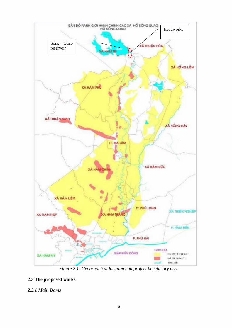
The headworks complex is located on the Quao River, in Ham Tri commune, Ham Thuan Bac
District. The site is about 35km away from the confluence with Cai River, 0.6km away from
NR28 (Phan Thiet – Di Linh) and about 41km away from the estuary. The subproject beneficiary
area is the largest delta area of Binh Thuan Province, spanning from Ham Tri commune to Phan
Thiet City. Elevations of the beneficiary area are quite different: from elevation +50m to the
West-Northwest progressively down to elevation+5 – 10m to the East – Southeast. The total
natural area is around 20,724ha (see figure 2.1).
Downstream area is a fertile delta of Ham Thuan Bac with high population density and there are
main traffic route such as North - South railway, National highway 1A, and it is about 8 -10km
far from construction and 20 km far from Phan Thiet city. The communes along Quao river will
be impacted directly by flood, of which some households living in flood releasing corridor will
be affected directly. According to the survey in 2015, the affected area due to releasing water
from Song Quao reservoir includes 7 communes with 4 ethnic groups of Kinh, Gialay, Khơ me,
Tày. Total estimated households to be affected directly are approximately 4,963 households.
6
Figure 2.1: Geographical location and project beneficiary area
2.3 The proposed works
2.3.1 Main Dams
Sông Quao
reservoir
Headworks
7
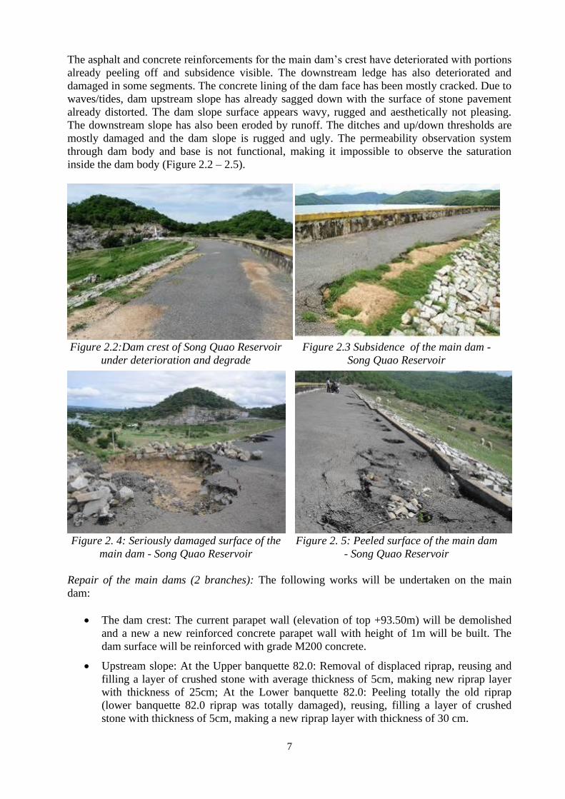
The asphalt and concrete reinforcements for the main dam’s crest have deteriorated with portions
already peeling off and subsidence visible. The downstream ledge has also deteriorated and
damaged in some segments. The concrete lining of the dam face has been mostly cracked. Due to
waves/tides, dam upstream slope has already sagged down with the surface of stone pavement
already distorted. The dam slope surface appears wavy, rugged and aesthetically not pleasing.
The downstream slope has also been eroded by runoff. The ditches and up/down thresholds are
mostly damaged and the dam slope is rugged and ugly. The permeability observation system
through dam body and base is not functional, making it impossible to observe the saturation
inside the dam body (Figure 2.2 – 2.5).
Figure 2.2:Dam crest of Song Quao Reservoir
under deterioration and degrade
Figure 2.3 Subsidence of the main dam -
Song Quao Reservoir
Figure 2. 4: Seriously damaged surface of the
main dam - Song Quao Reservoir
Figure 2. 5: Peeled surface of the main dam
- Song Quao Reservoir
Repair of the main dams (2 branches): The following works will be undertaken on the main
dam:
• The dam crest: The current parapet wall (elevation of top +93.50m) will be demolished
and a new a new reinforced concrete parapet wall with height of 1m will be built. The
dam surface will be reinforced with grade M200 concrete.
• Upstream slope: At the Upper banquette 82.0: Removal of displaced riprap, reusing and
filling a layer of crushed stone with average thickness of 5cm, making new riprap layer
with thickness of 25cm; At the Lower banquette 82.0: Peeling totally the old riprap
(lower banquette 82.0 riprap was totally damaged), reusing, filling a layer of crushed
stone with thickness of 5cm, making a new riprap layer with thickness of 30 cm.
8
• Downstream slope: Removal of top soil with thickness of 30 cm, refilling with fertile top
soil and planting of grass for strengthening. Building of a drainage system on slope
surface with reinforced cells (5x5) m grade M 150.
• Downstream banquette: Extending the structure to 6m and covering the surface with
Grade I crushed stone with thickness of 25 cm.
• Drainage grid system on slope surface and terrace: Demolition of the old riprap and
replacing with a new one with concrete grade M 150 casting in place.
2.3.2 Auxiliary Dam (Sub-dam) No.1 and No. 3
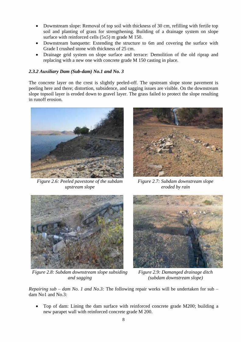
The concrete layer on the crest is slightly peeled-off. The upstream slope stone pavement is
peeling here and there; distortion, subsidence, and sagging issues are visible. On the downstream
slope topsoil layer is eroded down to gravel layer. The grass failed to protect the slope resulting
in runoff erosion.
Figure 2.6: Peeled pavestone of the subdam
upstream slope
Figure 2.7: Subdam downstream slope
eroded by rain
Figure 2.8: Subdam downstream slope subsiding
and sagging
Figure 2.9: Damanged drainage ditch
(subdam downstream slope)
Repairing sub – dam No. 1 and No.3: The following repair works will be undertaken for sub –
dam No1 and No.3:
• Top of dam: Lining the dam surface with reinforced concrete grade M200; building a
new parapet wall with reinforced concrete grade M 200.
9
• Upstream slope: Removal of the displaced riprap, reusing the stones and refilling with a
layer of crushed stone with average thickness of 5cm, making new riprap layer with
thickness of 25cm remaining crushed stone layer.
• Downstream slope: Scraping of about 30-cm of the surface soil and replacing it with new
fertile soil; planting of grass to stabilize the slope; and, construction of a drainage system
on the slope surface using reinforced cells (5x5) m grade M 150.
• Downstream banquette (sub - dam 1): re – filling to width of 4 m, covering banquette’s
surface with Grade I crushed stone (thickness of 25 cm).
• Drainage grid system on slope surface, terrace: demolishing the old riprap, make a new
one by concrete grade M 150 casting in place.
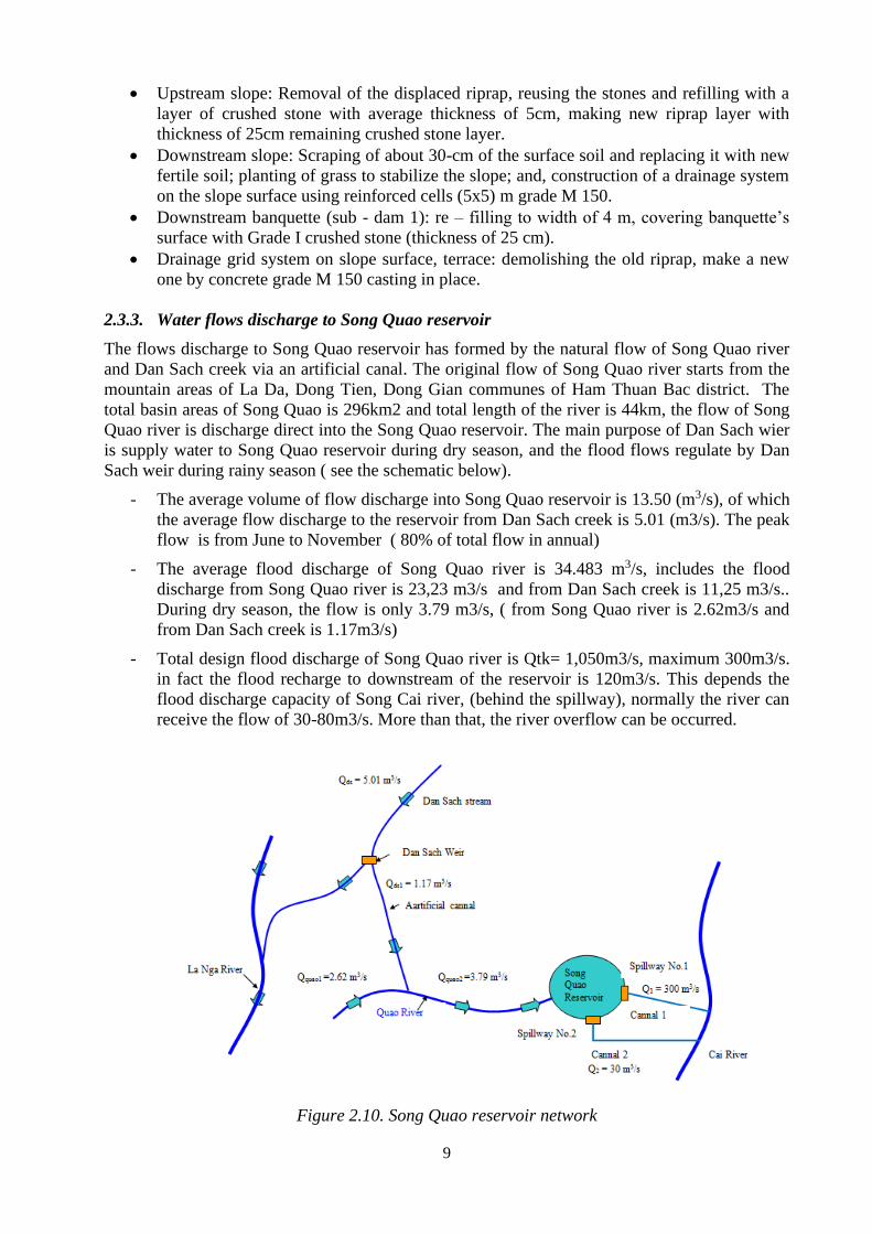
2.3.3. Water flows discharge to Song Quao reservoir
The flows discharge to Song Quao reservoir has formed by the natural flow of Song Quao river
and Dan Sach creek via an artificial canal. The original flow of Song Quao river starts from the
mountain areas of La Da, Dong Tien, Dong Gian communes of Ham Thuan Bac district. The
total basin areas of Song Quao is 296km2 and total length of the river is 44km, the flow of Song
Quao river is discharge direct into the Song Quao reservoir. The main purpose of Dan Sach wier
is supply water to Song Quao reservoir during dry season, and the flood flows regulate by Dan
Sach weir during rainy season ( see the schematic below).
- The average volume of flow discharge into Song Quao reservoir is 13.50 (m3/s), of which
the average flow discharge to the reservoir from Dan Sach creek is 5.01 (m3/s). The peak
flow is from June to November ( 80% of total flow in annual)
- The average flood discharge of Song Quao river is 34.483 m3/s, includes the flood
discharge from Song Quao river is 23,23 m3/s and from Dan Sach creek is 11,25 m3/s..
During dry season, the flow is only 3.79 m3/s, ( from Song Quao river is 2.62m3/s and
from Dan Sach creek is 1.17m3/s)
- Total design flood discharge of Song Quao river is Qtk= 1,050m3/s, maximum 300m3/s.
in fact the flood recharge to downstream of the reservoir is 120m3/s. This depends the
flood discharge capacity of Song Cai river, (behind the spillway), normally the river can
receive the flow of 30-80m3/s. More than that, the river overflow can be occurred.
Figure 2.10. Song Quao reservoir network
10
Receiver canals - There are two reciver cannals behide spillway:
- No.1: In case of discharging flood water out of Song Quao reservoir, the flow goes freely
to the spillway via the the current reciever cannal behide spillway which is L =50m and
B0 20m, which is connected to the Song Cai river with total length of 42km. Cross
section of Song cai river is 100m, maximum volumetric of flow is 120m3/s, and not dry-
up in dry season. With the large capacity, the river can receive the flood discharge from
Song Quoa reservir with Q= 60-80m3/s, shrubs and small tree at area behind the spillway
- No.2. (new construction): Excavate 2 km of canal with 15m wide passing downstream of
the main dam to enter start of discharge canal No 1. The discharge line behind the
spillway No.2 does not intersect with important works as well as not through residential
areas.
Song Cai rever receive water from these canals which finally transport water to the sea. In
2003, with flood discharge 300m3/s, water overflow the receiver canal and damaged to 80 ha
of arable land of MA Lam town.
The ecology system in reciever canal: only common species srap, fish, shrubs. There are no
rare species or dangered species that need to be reserved. Around the flood discharge corridor,
there are 20 local household of Ham Tri commune living, but the impacts generating by flood
discharge can be managed.
Ecological system in the reservoir: The aquatic life found the rivers consists of common crab,
snails and fish species, there are no endemic, rare or endangered species. Aquaculture is not
allowed to practice in the reservoir and along the flood discharge corridor. The tourist activity in
the reservoir is also not permitted, there are not rare species, turtle, etc. Only few freshwater fish
(common fish species) living in the reservoir
2.3.4 New construction of spillway No. 2
To ensure the safety of reservoirs under extreme conditions (under Article 3.2.4 of QCVN 04-05:
2012), the consultant has proposed upgrading works of the Song Quao from level II to level I.
Therefore, in order to ensure dam stability conditions under Categories I, expanding the scale of
spillway is necessary. The solution is to build new spillway no. 2 in order to ensure water
drainage in case of large flood (decreasing designed flood water level corresponding flood with
frequency of P = 1% under the old design of works grade II, still ensure dam stability without
increasing height of dam), to ensure safety for downstream areas. This is also the beneficiary
area of subproject, including 7 communes in downstream area (Ham Thuan Bac district with area
of 39, 815 ha). The scale of spillway no. 2 as follows:
• Spillway with gate: 01 curve gate (bxh) = (8x5) m operated by hydraulic cylinder,
reinforced concrete structure.
• Works on corridor behind spillway: 02 discharge culvert, ensuring safety water releasing
with discharge of 30 cu.m/s reinforced concrete structure.
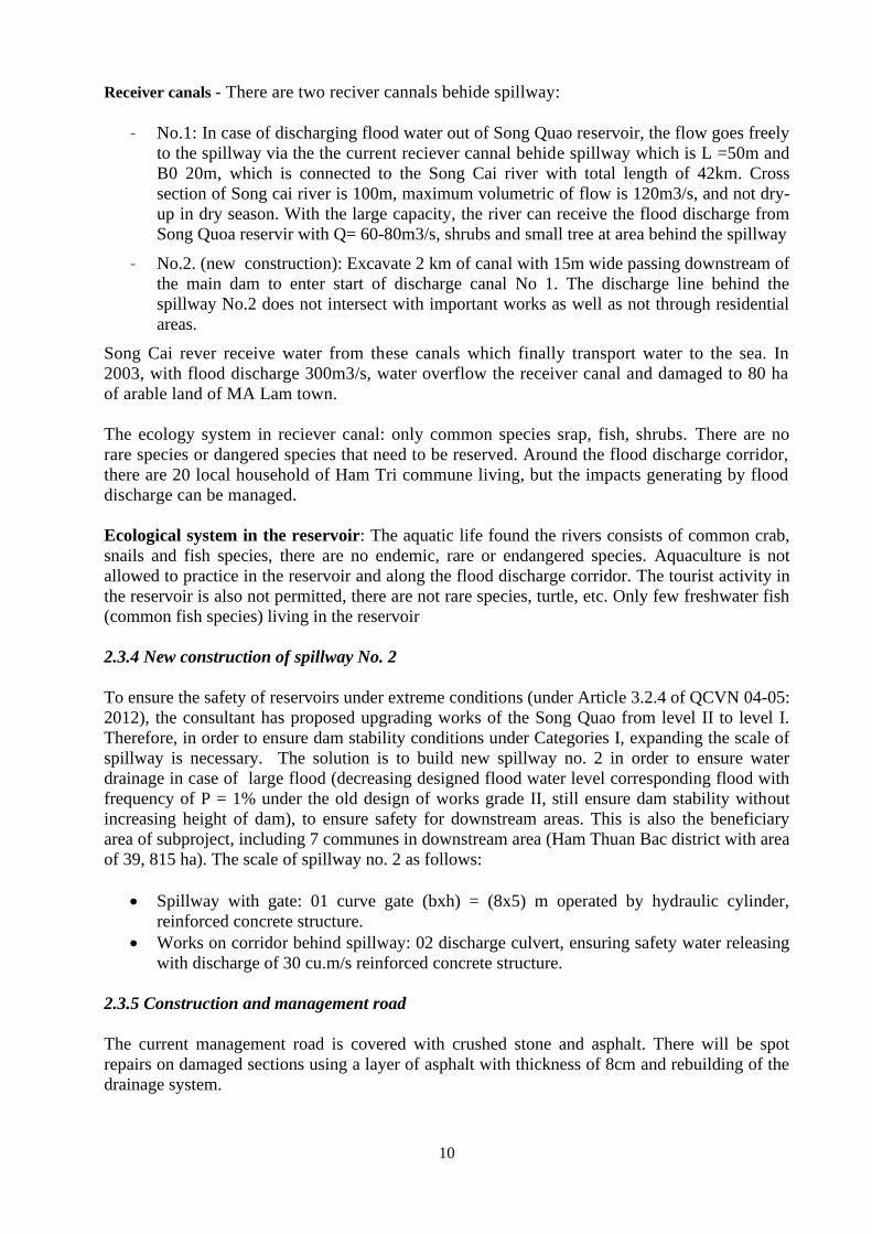
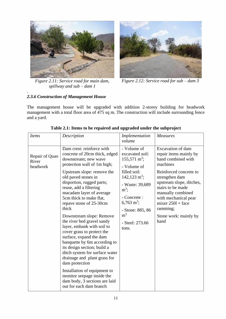
2.3.5 Construction and management road
The current management road is covered with crushed stone and asphalt. There will be spot
repairs on damaged sections using a layer of asphalt with thickness of 8cm and rebuilding of the
drainage system.
11
Figure 2.11: Service road for main dam,
spillway and sub – dam 1
Figure 2.12: Service road for sub – dam 3
.
2.3.6 Construction of Management House
The management house will be upgraded with addition 2-storey building for headwork
management with a total floor area of 475 sq m. The construction will include surrounding fence
and a yard.
Table 2.1: Items to be repaired and upgraded under the subproject
Items Description Implementation
volume
Measures
Repair of Quao
River
headwork
Dam crest: reinforce with
concrete of 20cm thick, edged
downstream; new wave
protection wall of 1m high;
Upstream slope: remove the
old paved stones in
disportion, rugged parts;
reuse, add a filtering
macadam layer of average
5cm thick to make flat,
repave stone of 25-30cm
thick
Downstream slope: Remove
the river bed gravel sandy
layer, embank with soil to
cover grass to protect the
surface, expand the dam
banquette by 6m according to
its design section; build a
ditch system for surface water
drainage and plant grass for
dam protection
Installation of equipment to
monitor seepage inside the
dam body, 3 sections are laid
out for each dam branch
- Volume of
excavated soil:
155,571 m3;
- Volume of
filled soil:
142,123 m3;
- Waste: 39,689
m3;
- Concrete :
6,763 m3;
- Stone: 885, 86
m3
- Steel: 273.66
tons.
Excavation of dam
repair items mainly by
hand combined with
machines
Reinforced concrete to
strengthen dam
upstream slope, ditches,
stairs to be made
manually combined
with mechanical pear
mixer 250l + face
ramming;
Stone work: mainly by
hand
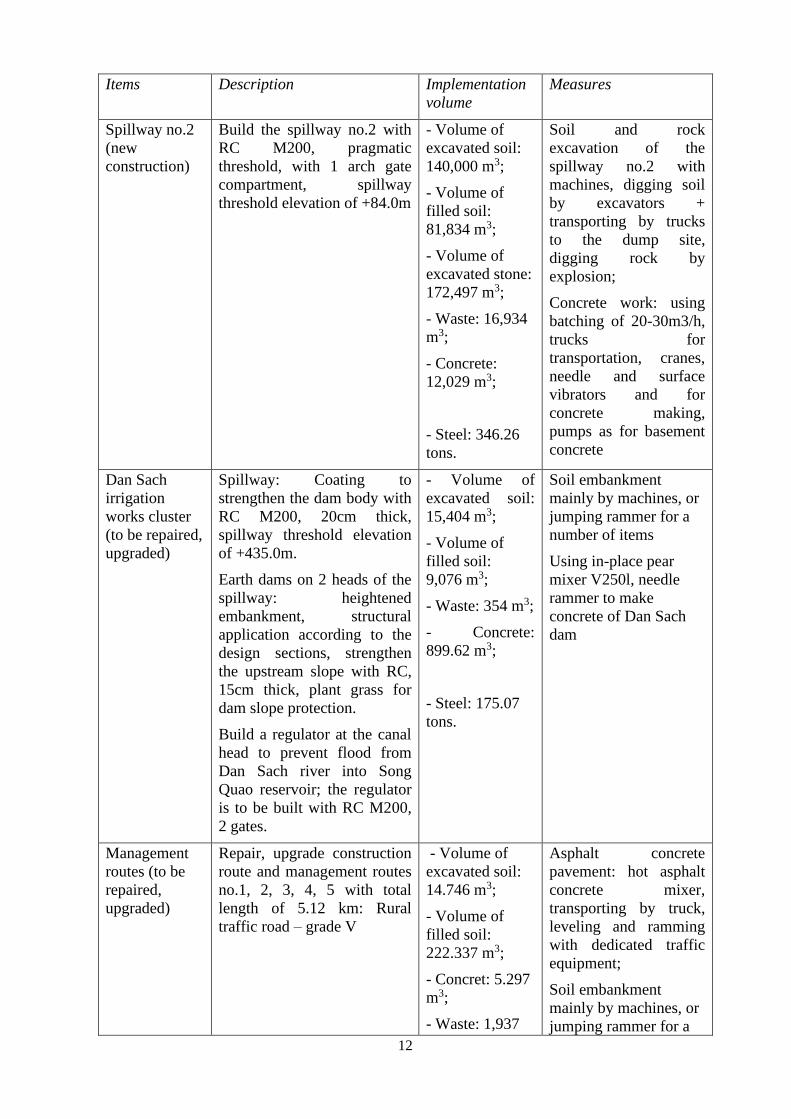
12
Items Description Implementation
volume
Measures
Spillway no.2
(new
construction)
Build the spillway no.2 with
RC M200, pragmatic
threshold, with 1 arch gate
compartment, spillway
threshold elevation of +84.0m
- Volume of
excavated soil:
140,000 m3;
- Volume of
filled soil:
81,834 m3;
- Volume of
excavated stone:
172,497 m3;
- Waste: 16,934
m3;
- Concrete:
12,029 m3;
- Steel: 346.26
tons.
Soil and rock
excavation of the
spillway no.2 with
machines, digging soil
by excavators +
transporting by trucks
to the dump site,
digging rock by
explosion;
Concrete work: using
batching of 20-30m3/h,
trucks for
transportation, cranes,
needle and surface
vibrators and for
concrete making,
pumps as for basement
concrete
Dan Sach
irrigation
works cluster
(to be repaired,
upgraded)
Spillway: Coating to
strengthen the dam body with
RC M200, 20cm thick,
spillway threshold elevation
of +435.0m.
Earth dams on 2 heads of the
spillway: heightened
embankment, structural
application according to the
design sections, strengthen
the upstream slope with RC,
15cm thick, plant grass for
dam slope protection.
Build a regulator at the canal
head to prevent flood from
Dan Sach river into Song
Quao reservoir; the regulator
is to be built with RC M200,
2 gates.
- Volume of
excavated soil:
15,404 m3;
- Volume of
filled soil:
9,076 m3;
- Waste: 354 m3;
- Concrete:
899.62 m3;
- Steel: 175.07
tons.
Soil embankment
mainly by machines, or
jumping rammer for a
number of items
Using in-place pear
mixer V250l, needle
rammer to make
concrete of Dan Sach
dam
Management
routes (to be
repaired,
upgraded)
Repair, upgrade construction
route and management routes
no.1, 2, 3, 4, 5 with total
length of 5.12 km: Rural
traffic road – grade V
- Volume of
excavated soil:
14.746 m3;
- Volume of
filled soil:
222.337 m3;
- Concret: 5.297
m3;
- Waste: 1,937
Asphalt concrete
pavement: hot asphalt
concrete mixer,
transporting by truck,
leveling and ramming
with dedicated traffic
equipment;
Soil embankment
mainly by machines, or
jumping rammer for a
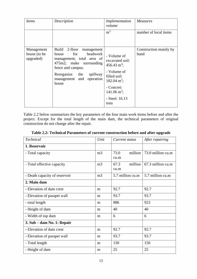
13
Items Description Implementation
volume
Measures
m3 number of local items
Management
house (to be
upgraded)
Build 2-floor management
house for headwork
management, total area of
475m2; make surrounding
fence and campus.
Reorganize the spillway
management and operation
house
- Volume of
excavated soil:
456.43 m3;
- Volume of
filled soil:
182.04 m3;
- Concret:
141.06 m3;
- Steel: 16.13
tons
Construction mainly by
hand
Table 2.2 below summarizes the key parameters of the four main work items before and after the
project. Except for the total length of the main dam, the technical parameters of original
construction do not change after the repair.
Table 2.2: Technical Parameters of current construction before and after upgrade
Technical Unit Current status After repairing
1. Reservoir
- Total capacity m3 73.0 million
cu.m
73.0 million cu.m
- Total effective capacity m3 67.3 million
cu.m
67.3 million cu.m
- Death capacity of reservoir m3 5.7 million cu.m 5.7 million cu.m
2. Main dam
- Elevation of dam crest m 92.7 92.7
- Elevation of parapet wall m 93.7 93.7
- total length m 886 923
- Height of dam m 40 40
- Width of top dam m 6 6
3. Sub – dam No. 1: Repair
- Elevation of dam crest m 92.7 92.7
- Elevation of parapet wall m 93.7 93.7
- Total length m 150 150
- Height of dam m 25 25
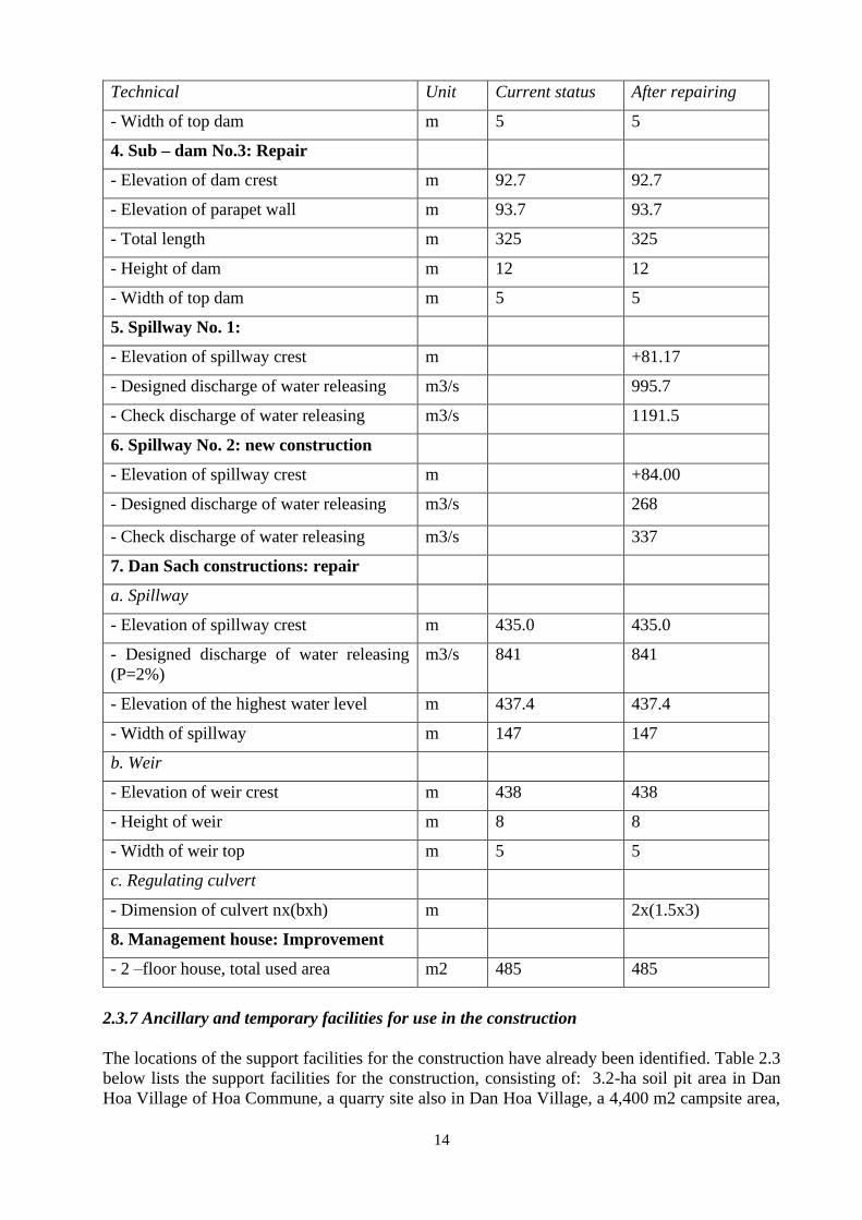
14
Technical Unit Current status After repairing
- Width of top dam m 5 5
4. Sub – dam No.3: Repair
- Elevation of dam crest m 92.7 92.7
- Elevation of parapet wall m 93.7 93.7
- Total length m 325 325
- Height of dam m 12 12
- Width of top dam m 5 5
5. Spillway No. 1:
- Elevation of spillway crest m +81.17
- Designed discharge of water releasing m3/s 995.7
- Check discharge of water releasing m3/s 1191.5
6. Spillway No. 2: new construction
- Elevation of spillway crest m +84.00
- Designed discharge of water releasing m3/s 268
- Check discharge of water releasing m3/s 337
7. Dan Sach constructions: repair
a. Spillway
- Elevation of spillway crest m 435.0 435.0
- Designed discharge of water releasing
(P=2%)
m3/s 841 841
- Elevation of the highest water level m 437.4 437.4
- Width of spillway m 147 147
b. Weir
- Elevation of weir crest m 438 438
- Height of weir m 8 8
- Width of weir top m 5 5
c. Regulating culvert
- Dimension of culvert nx(bxh) m 2x(1.5x3)
8. Management house: Improvement
- 2 –floor house, total used area m2 485 485
2.3.7 Ancillary and temporary facilities for use in the construction
The locations of the support facilities for the construction have already been identified. Table 2.3
below lists the support facilities for the construction, consisting of: 3.2-ha soil pit area in Dan
Hoa Village of Hoa Commune, a quarry site also in Dan Hoa Village, a 4,400 m2 campsite area,
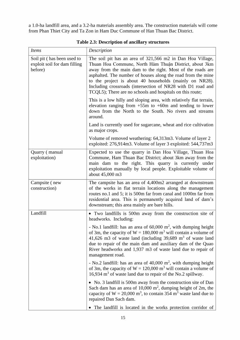
15
a 1.0-ha landfill area, and a 3.2-ha materials assembly area. The construction materials will come
from Phan Thiet City and Ta Zon in Ham Duc Commune of Han Thuan Bac District.
Table 2.3: Description of ancillary structures
Items Description
Soil pit ( has been used to
exploit soil for dam filling
before)
The soil pit has an area of 321,566 m2 in Dan Hoa Village,
Thuan Hoa Commune, North Hàm Thuận District, about 3km
away from the main dam to the right. Most of the roads are
asphalted. The number of houses along the road from the mine
to the project is about 40 households (mainly on NR28).
Including crossroads (intersection of NR28 with D1 road and
TCQL5); There are no schools and hospitals on this route;
This is a low hilly and sloping area, with relatively flat terrain,
elevation ranging from +55m to +60m and tending to lower
down from the North to the South. No rivers and streams
around.
Land is currently used for sugarcane, wheat and rice cultivation
as major crops.
Volume of removed weathering: 64,313m3. Volume of layer 2
exploited: 276,914m3. Volume of layer 3 exploited: 544,737m3
Quarry ( manual
exploitation)
Expected to use the quarry in Dan Hoa Village, Thuan Hoa
Commune, Ham Thuan Bac District; about 3km away from the
main dam to the right. This quarry is currently under
exploitation manually by local people. Exploitable volume of
about 45,000 m3
Campsite ( new
construction)
The campsite has an area of 4,400m2 arranged at downstream
of the works in flat terrain locations along the management
routes no.1 and 5; it is 500m far from canal and 1000m far from
residential area. This is permanently acquired land of dam’s
downstream; this area mainly are bare hills.
Landfill • Two landfills is 500m away from the construction site of
headworks. Including:
- No.1 landfill: has an area of 60,000 m2, with dumping height
of 3m, the capacity of W = 180,000 m3 will contain a volume of
41,626 m3 of waste land (including 39,689 m3 of waste land
due to repair of the main dam and auxiliary dam of the Quao
River headworks and 1,937 m3 of waste land due to repair of
management road.
- No.2 landfill: has an area of 40,000 m2, with dumping height
of 3m, the capacity of W = 120,000 m3 will contain a volume of
16,934 m3 of waste land due to repair of the No.2 spillway.
• No. 3 landfill is 500m away from the construction site of Dan
Sach dam has an area of 10,000 m2, dumping height of 2m, the
capacity of W = 20,000 m3, to contain 354 m3 waste land due to
repaired Dan Sach dam.
• The landfill is located in the works protection corridor of
16
downstream dam, which is directly managed by the lake
management unit.
• These sites are currently empty land so no compensation for
land acquisition and does not affect crops
Materials assembly area Located next to D2 road, 500m away from the main dam to the
right; Area of 324,000m2; it is 500m far from canal and 1000m
far from residential area. This is permanently acquired land of
dam’s downstream; this area mainly is bare hills.
Place of construction
materials supply
Construction materials shall be supplied by dealers in Phan
Thiet City and Ta Zon (Ham Duc commune, Ham Thuan Bac
district). The transportation distance to the construction site is
27-30 km.
The materials are transported through provincial road No.28
NR, passing through residential area with 1,306 households
living along the road, Commune People's Committee and 5
primary schools: Ham Thang, Ham Chinh, Ma Lam, Ham Tri
and Thuan Hoa and follow management road to the
construction site.
Source: Feasibility Study – Subproject for improved safety of Song Quao Reservoir (2015)
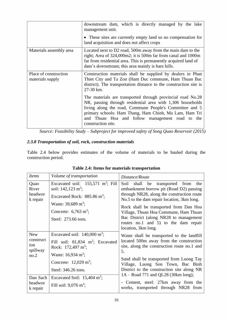
2.3.8 Transportation of soil, rock, construction materials
Table 2.4 below provides estimates of the volume of materials to be hauled during the
construction period.
Table 2.4: Items for materials transportation
Items Volume of transportation Distance/Route
Quao
River
headwor
k repair
Excavated soil: 155,571 m3; Fill
soil: 142,123 m3;
Excavated Rock: 885.86 m3;
Waste: 39,689 m3;
Concrete: 6,763 m3;
Steel: 273.66 tons.
Soil shall be transported from the
embankment borrow pit (Road D2) passing
through NR28, along the construction route
No.5 to the dam repair location, 3km long.
Rock shall be transported from Dan Hoa
Village, Thuan Hoa Commune, Ham Thuan
Bac District (along NR28 to management
routes no.1 and 5) to the dam repair
location, 3km long.
Waste shall be transported to the landfill
located 500m away from the construction
site, along the construction route no.1 and
5.
Sand shall be transported from Luong Tay
Village, Luong Son Town, Bac Binh
District to the construction site along NR
1A – Road 771 and QL28 (30km long);
- Cement, steel: 27km away from the
works, transported through NR28 from
New
construct
ion
spillway
no.2
Excavated soil: 140,000 m3;
Fill soil: 81,834 m3; Excavated
Rock: 172,497 m3;
Waste: 16,934 m3;
Concrete: 12,029 m3;
Steel: 346.26 tons.
Dan Sach
headwor
k repair
Excavated Soil: 15,404 m3;
Fill soil: 9,076 m3;
17
Items Volume of transportation Distance/Route
Waste: 354 m3;
Concrete: 899.62 m3
Steel: 175.07 tons
Phan Thiet City.
Manage
ment
house
Excavated soil: 456.43 m3;
Fill soil: 182.04 m3;
Concrete: 141.06 m3;
Steel: 16.13 tons
Manage
ment
road and
managem
ent road
Excavated soil: 14,746 m3;
Fill soil: 222,337 m3;
Concrete: 5,297 m3;
Waste: 1,937 m3
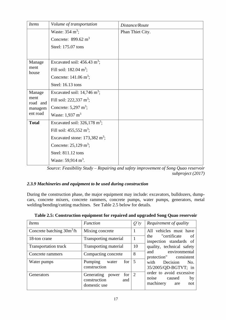
Total Excavated soil: 326,178 m3;
Fill soil: 455,552 m3;
Excavated stone: 173,382 m3;
Concrete: 25,129 m3;
Steel: 811.12 tons
Waste: 59,914 m3.
Source: Feasibility Study – Repairing and safety improvement of Song Quao reservoir
subproject (2017)
2.3.9 Machineries and equipment to be used during construction
During the construction phase, the major equipment may include: excavators, bulldozers, dump-
cars, concrete mixers, concrete rammers, concrete pumps, water pumps, generators, metal
welding/bending/cutting machines. See Table 2.5 below for details.
Table 2.5: Construction equipment for repaired and upgraded Song Quao reservoir
Items Function Q’ty Requirement of quality
Concrete batching 30m3/h Mixing concrete 1 All vehicles must have
the "certificate of
inspection standards of
quality, technical safety
and environmental
protection" consistent
with Decision No.
35/2005/QD-BGTVT; in
order to avoid excessive
noise caused by
machinery are not
18-ton crane Transporting material 1
Transportation truck Transporting material 10
Concrete rammers Compacting concrete 8
Water pumps Pumping water for
construction
5
Generators Generating power for
construction and
domestic use
2
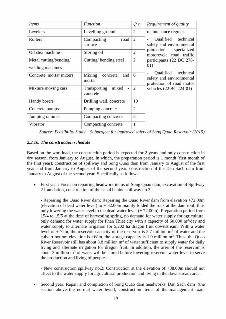
18
Items Function Q’ty Requirement of quality
Levelers Levelling ground 2 maintenance regular.
- Qualified technical
safety and environmental
protection specialized
motorcycle road traffic
participants (22 BC 278-
01)
- Qualified technical
safety and environmental
protection of road motor
vehicles (22 BC 224-01)
Rollers Compacting road
surface
2
Oil stex machine Storing oil 2
Metal cutting/bending/
welding machines
Cutting/ bending steel 2
Concrete, mortar mixers Mixing concrete and
mortar
6
Mixture moving cars Transporting mixed -
concrete
2
Handy borers Drilling wall, concrete 10
Concrete pumps Pumping concrete 2
Jumping rammer Compacting concrete 5
Vibrator Compacting concrete 1
Source: Feasibility Study – Subproject for improved safety of Song Quao Reservoir (2015)
2.3.10. The construction schedule
Based on the workload, the construction period is expected for 2 years and only construction in
dry season, from January to August. In which, the preparation period is 1 month (first month of
the first year); construction of spillway and Song Quao dam from January to August of the first
year and from January to August of the second year; construction of the Dan Sach dam from
January to August of the second year. Specifically as follows:
• First year: Focus on repairing headwork items of Song Quao dam, excavation of Spillway
2 foundation, construction of the canal behind spillway no.2.
- Repairing the Quao River dam: Repairing the Quao River dam from elevation +72.00m
(elevation of dead water level) to + 82.00m mainly folded the rock at the dam roof, thus
only lowering the water level to the dead water level (+ 72.00m). Preparation period from
15/4 to 15/5 at the time of harvesting spring, no demand for water supply for agriculture,
only demand for water supply for Phan Thiet city with a capacity of 60,000 m3/day and
water supply to alternate irrigation for 5,202 ha dragon fruit downstream. With a water
level of + 72m, the reservoir capacity of the reservoir is 5.7 million m3 of water and the
culvert bottom elevation is +68m, the storage capacity is 1.9 million m3. Thus, the Quao
River Reservoir still has about 3.8 million m3 of water sufficient to supply water for daily
living and alternate irrigation for dragon fruit. In addition, the area of the reservoir is
about 3 million m3 of water will be stored before lowering reservoir water level to serve
the production and living of people.
- New construction spillway no.2: Construction at the elevation of +88.00m should not
affect to the water supply for agricultural production and living in the downstream area;
• Second year: Repair and completion of Song Quao dam headworks, Dan Sach dam (the
section above the normal water level), construction items of the management road,
19
management house, should not affect to water supply for agriculture and living in the
downstream.
20
CHAPTER IV: BASELINE ENVIRONMENTAL AND SOCIAL CONDITIONS
4.1. The present hydrology and ecology of the Song Quao Reservoir and its receiving water
channel
The Song Quao Reservoir locate at the upper reaches of the Quao River and has two main water
sources: the Quao River and the Dan Sach River. The combined annual flow into the reservoir is
10.29m3/s (5.64 m3/s from Quao and 4.65 m3/s from Dan Sach). The reservoir covers a surface
area of 6.8 sq km at normal water level and has a maximum water storage capacity of 73.0
million cubic meters. The combined catchment area of the reservoir is 416 sq km (296 sq km for
Quao and 120 sq km for Dan Sach). The intake lies at an elevation of +68m just below the dead
water elevation and has a design discharge rate of 13.5 cu.m/s. The reservoir has an arch-shaped
valve gate surface spillway which discharges into a tributary to the downstream of the main
Quao River, serving as the flood discharge corridor.
The flood discharge corridor is two (2) kilometres long with a discharge flow of about 120
cu.m/s and discharge from the spillway and about 150cu.m/s with discharge from spillway.
Along the flood discharge corridor are a few households which could be impacted by severe
flood flow but not under normal spillway release scenario.
Song Quao is part of the bigger Phan Thiet - Cai River basin. This river system lies between 2
districts of Ham Thuan Bac and Tanh Linh, originated from Di Linh Plateau at elevation 700m.
The river flows in northwest - southeast director through the jungle, then in north - south
direction through the Ham Thuan Bac plain to Phu Hai estuary (Phan Thiet) which is about
2.5km away from Phan Thiet Town. There are total 13 rivers in the basin, including 4 primary
rivers, 6 secondary rivers and one tertiary river in addition to the main river. The average
network density of the entire river system is 0.51km/ km2, including 1.05km/km2 as the largest
and 0.11km/ km2 as the smallest.
Binh Thuan is one of the driest provinces in the country with annual rainfall of only 1,024
millimetres, just half the southern region's average. In particular, the districts in the north,
including Bac Binh and Ham Thuan Bac where the Song Quao Reservoir basin is located, are the
driest, while the south often gets heavy rains and floods.
The flow regimes of rivers and streams in the subproject area generally follow two seasons:
flood and dry seasons. The flood season starts in June and ends in November, with flow
accounting for up 75%-80% of the total annual flow. The dry season normally starts in
December and lasts up to May. The transition from flood to dry season is normally only about a
month during which river water drops rapidly. This is because the rivers are short and has steep
slopes while the vegetation in watershed is already sparse and continues to be depleted.
Flood flow regime: The flood regime is a consequence of rainfall and topographic and
geomorphology features of the river basin and the river itself. The precipitation in Binh Thuan is
typically short (sometimes lasting only up to July) but with high intensity and covers a small
area. The maximum flood discharge of Song Quao is 300 m3/s recorded in year 2003 as
measured from the overflow.
Low flow regime: The dry season normally starts in December and ends in May. In January and
February, rainfall is very little throughout the province. It rains only in some places at a low rate
of 5-10mm/month. In March, there is almost no rain in the region. By April when southwest
monsoon starts blowing alternately and early storms could occur sporadically with monthly
rainfall of approximately 100 mm/month. In May, June, July when there is greater rainfall to
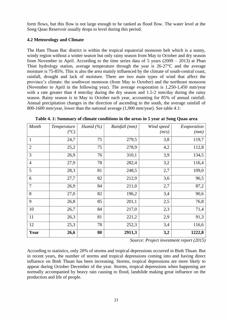
21
form flows, but this flow is not large enough to be ranked as flood flow. The water level at the
Song Quao Reservoir usually drops to level during this period.
4.2 Meteorology and Climate
The Ham Thuan Bac district is within the tropical equatorial monsoon belt which is a sunny,
windy region without a winter season but only rainy season from May to October and dry season
from November to April. According to the time series data of 5 years (2009 – 2013) at Phan
Thiet hydrology station, average temperature through the year is 26-27°C and the average
moisture is 75-85%. This is also the area mainly influenced by the climate of south-central coast,
rainfall, drought and lack of moisture. There are two main types of wind that affect the
province’s climate: the southwest monsoon (from May to October) and the northeast monsoon
(November to April in the following year). The average evaporation is 1,250-1,450 mm/year
with a rate greater than 4 mm/day during the dry season and 1.5-2 mm/day during the rainy
season. Rainy season is in May to October each year, accounting for 85% of annual rainfall.
Annual precipitation changes in the direction of ascending to the south, the average rainfall of
800-1600 mm/year, lower than the national average (1,900 mm/year). See table 4.1:
Table 4. 1: Summary of climate conditions in the areas in 5 year at Song Quao area
Month Temperature
(oC)
Humid (%) Rainfall (mm) Wind speed
(m/s)
Evaporation
(mm)
1 24,7 75 279,5 3,8 119,7
2 25,2 75 278,9 4,2 112,8
3 26,9 76 310,1 3,9 134,5
4 27,9 78 282,4 3,2 116,4
5 28,3 81 248,5 2,7 109,0
6 27,7 82 212,9 3,6 96,5
7 26,9 84 211,0 2,7 87,2
8 27,0 82 196,2 3,4 90,6
9 26,8 85 201,1 2,5 76,8
10 26,7 84 217,0 2,3 71,4
11 26,3 81 221,2 2,9 91,3
12 25,3 78 252,3 3,4 116,6
Year 26,6 80 2911,3 3,2 1222,8
Source: Project investment report (2015)
According to statistics, only 20% of storms and tropical depressions occurred in Binh Thuan. But
in recent years, the number of storms and tropical depressions coming into and having direct
influence on Binh Thuan has been increasing. Storms, tropical depressions are more likely to
appear during October December of the year. Storms, tropical depressions when happening are
normally accompanied by heavy rain causing to flood, landslide making great influence on the
production and life of people.
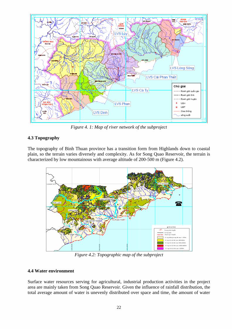
22
Figure 4. 1: Map of river network of the subproject
4.3 Topography
The topography of Binh Thuan province has a transition form from Highlands down to coastal
plain, so the terrain varies diversely and complexity. As for Song Quao Reservoir, the terrain is
characterized by low mountainous with average altitude of 200-500 m (Figure 4.2).
92
17
80
° 58' E
88
90
35
° 38' E
79
07
99
° 38' E
82
35
44
° 58' E
85
62
90
° 18' E
1226532° 04' N
1193173° 45' N
1259890° 23' N
.
S«ng suèi
Trung t©m huyÖn
Ranh g ií i huyÖn
g h i c h ó
Vï ng nói cã ®é cao >1500m
Vï ng nói cã ®é cao 500-1000m
Vï ng nói cã ®é cao 300-500m
Vï ng ®ång b»ng ®é cao < 100m
Vï ng nói cã ®é cao 1000-1500m
(
b ¶ n ®å ®Þa h ×n h t Øn h b ×n h t h u Ën
Figure 4.2: Topographic map of the subproject
4.4 Water environment
Surface water resources serving for agricultural, industrial production activities in the project
area are mainly taken from Song Quao Reservoir. Given the influence of rainfall distribution, the
total average amount of water is unevenly distributed over space and time, the amount of water
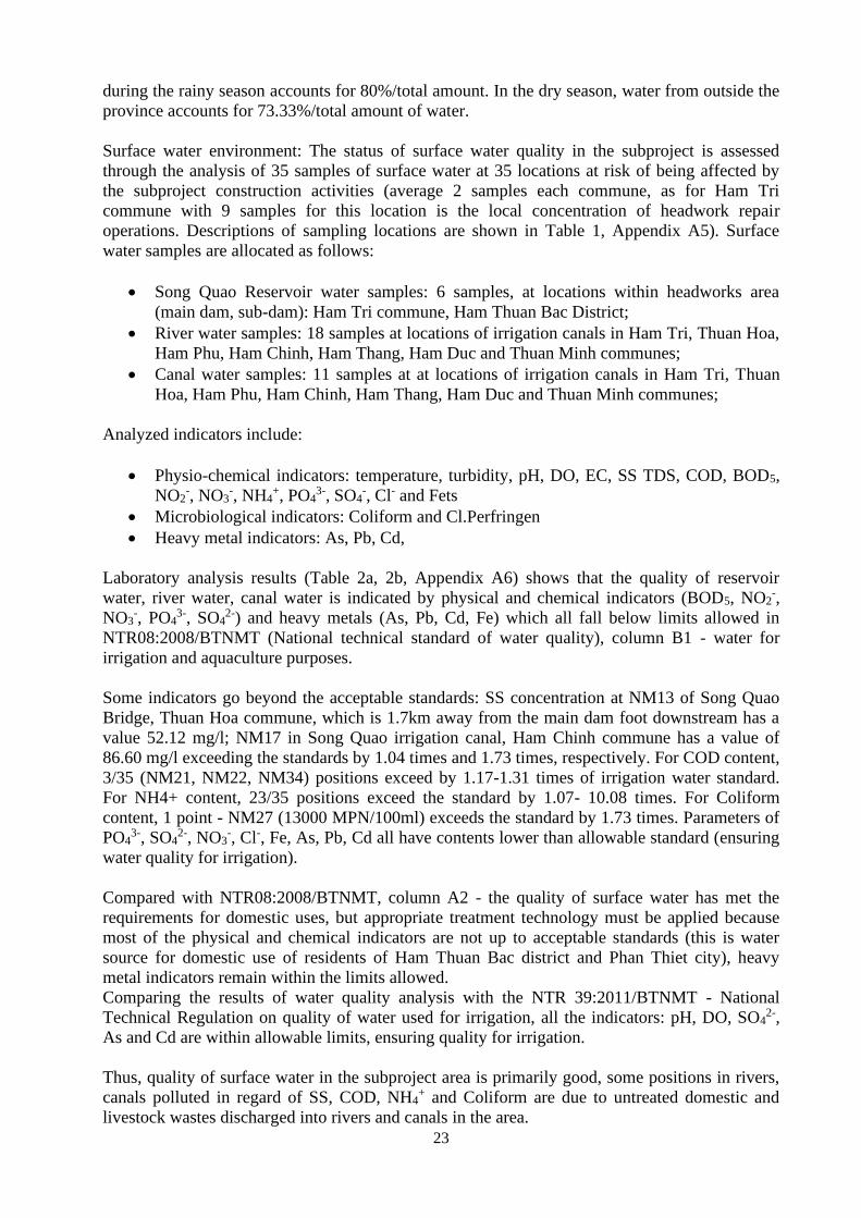
23
during the rainy season accounts for 80%/total amount. In the dry season, water from outside the
province accounts for 73.33%/total amount of water.
Surface water environment: The status of surface water quality in the subproject is assessed
through the analysis of 35 samples of surface water at 35 locations at risk of being affected by
the subproject construction activities (average 2 samples each commune, as for Ham Tri
commune with 9 samples for this location is the local concentration of headwork repair
operations. Descriptions of sampling locations are shown in Table 1, Appendix A5). Surface
water samples are allocated as follows:
• Song Quao Reservoir water samples: 6 samples, at locations within headworks area
(main dam, sub-dam): Ham Tri commune, Ham Thuan Bac District;
• River water samples: 18 samples at locations of irrigation canals in Ham Tri, Thuan Hoa,
Ham Phu, Ham Chinh, Ham Thang, Ham Duc and Thuan Minh communes;
• Canal water samples: 11 samples at at locations of irrigation canals in Ham Tri, Thuan
Hoa, Ham Phu, Ham Chinh, Ham Thang, Ham Duc and Thuan Minh communes;
Analyzed indicators include:
• Physio-chemical indicators: temperature, turbidity, pH, DO, EC, SS TDS, COD, BOD5,
NO2-, NO3
-, NH4+, PO4
3-, SO4-, Cl- and Fets
• Microbiological indicators: Coliform and Cl.Perfringen
• Heavy metal indicators: As, Pb, Cd,
Laboratory analysis results (Table 2a, 2b, Appendix A6) shows that the quality of reservoir
water, river water, canal water is indicated by physical and chemical indicators (BOD5, NO2-,
NO3-, PO4
3-, SO42-) and heavy metals (As, Pb, Cd, Fe) which all fall below limits allowed in
NTR08:2008/BTNMT (National technical standard of water quality), column B1 - water for
irrigation and aquaculture purposes.
Some indicators go beyond the acceptable standards: SS concentration at NM13 of Song Quao
Bridge, Thuan Hoa commune, which is 1.7km away from the main dam foot downstream has a
value 52.12 mg/l; NM17 in Song Quao irrigation canal, Ham Chinh commune has a value of
86.60 mg/l exceeding the standards by 1.04 times and 1.73 times, respectively. For COD content,
3/35 (NM21, NM22, NM34) positions exceed by 1.17-1.31 times of irrigation water standard.
For NH4+ content, 23/35 positions exceed the standard by 1.07- 10.08 times. For Coliform
content, 1 point - NM27 (13000 MPN/100ml) exceeds the standard by 1.73 times. Parameters of
PO43-, SO4
2-, NO3-, Cl-, Fe, As, Pb, Cd all have contents lower than allowable standard (ensuring
water quality for irrigation).
Compared with NTR08:2008/BTNMT, column A2 - the quality of surface water has met the
requirements for domestic uses, but appropriate treatment technology must be applied because
most of the physical and chemical indicators are not up to acceptable standards (this is water
source for domestic use of residents of Ham Thuan Bac district and Phan Thiet city), heavy
metal indicators remain within the limits allowed.
Comparing the results of water quality analysis with the NTR 39:2011/BTNMT - National
Technical Regulation on quality of water used for irrigation, all the indicators: pH, DO, SO42-,
As and Cd are within allowable limits, ensuring quality for irrigation.
Thus, quality of surface water in the subproject area is primarily good, some positions in rivers,
canals polluted in regard of SS, COD, NH4+ and Coliform are due to untreated domestic and
livestock wastes discharged into rivers and canals in the area.
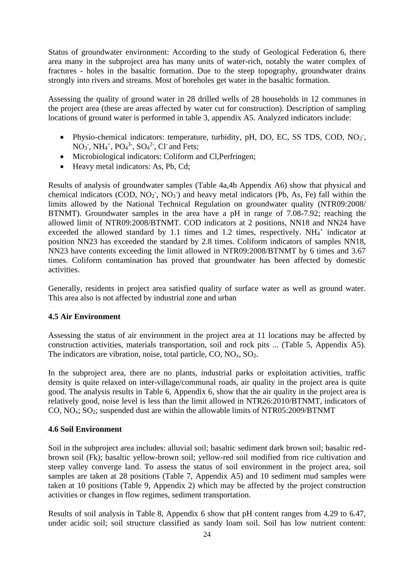
24
Status of groundwater environment: According to the study of Geological Federation 6, there
area many in the subproject area has many units of water-rich, notably the water complex of
fractures - holes in the basaltic formation. Due to the steep topography, groundwater drains
strongly into rivers and streams. Most of boreholes get water in the basaltic formation.
Assessing the quality of ground water in 28 drilled wells of 28 households in 12 communes in
the project area (these are areas affected by water cut for construction). Description of sampling
locations of ground water is performed in table 3, appendix A5. Analyzed indicators include:
• Physio-chemical indicators: temperature, turbidity, pH, DO, EC, SS TDS, COD, NO2-,
NO3-, NH4
+, PO43-, SO4
2-, Cl- and Fets;
• Microbiological indicators: Coliform and Cl,Perfringen;
• Heavy metal indicators: As, Pb, Cd;
Results of analysis of groundwater samples (Table 4a,4b Appendix A6) show that physical and
chemical indicators (COD, NO2-, NO3
-) and heavy metal indicators (Pb, As, Fe) fall within the
limits allowed by the National Technical Regulation on groundwater quality (NTR09:2008/
BTNMT). Groundwater samples in the area have a pH in range of 7.08-7.92; reaching the
allowed limit of NTR09:2008/BTNMT. COD indicators at 2 positions, NN18 and NN24 have
exceeded the allowed standard by 1.1 times and 1.2 times, respectively. NH4+ indicator at
position NN23 has exceeded the standard by 2.8 times. Coliform indicators of samples NN18,
NN23 have contents exceeding the limit allowed in NTR09:2008/BTNMT by 6 times and 3.67
times. Coliform contamination has proved that groundwater has been affected by domestic
activities.
Generally, residents in project area satisfied quality of surface water as well as ground water.
This area also is not affected by industrial zone and urban
4.5 Air Environment
Assessing the status of air environment in the project area at 11 locations may be affected by
construction activities, materials transportation, soil and rock pits ... (Table 5, Appendix A5).
The indicators are vibration, noise, total particle, CO, NOx, SO2.
In the subproject area, there are no plants, industrial parks or exploitation activities, traffic
density is quite relaxed on inter-village/communal roads, air quality in the project area is quite
good. The analysis results in Table 6, Appendix 6, show that the air quality in the project area is
relatively good, noise level is less than the limit allowed in NTR26:2010/BTNMT, indicators of
CO, NOx; SO2; suspended dust are within the allowable limits of NTR05:2009/BTNMT
4.6 Soil Environment
Soil in the subproject area includes: alluvial soil; basaltic sediment dark brown soil; basaltic red-
brown soil (Fk); basaltic yellow-brown soil; yellow-red soil modified from rice cultivation and
steep valley converge land. To assess the status of soil environment in the project area, soil
samples are taken at 28 positions (Table 7, Appendix A5) and 10 sediment mud samples were
taken at 10 positions (Table 9, Appendix 2) which may be affected by the project construction
activities or changes in flow regimes, sediment transportation.
Results of soil analysis in Table 8, Appendix 6 show that pH content ranges from 4.29 to 6.47,
under acidic soil; soil structure classified as sandy loam soil. Soil has low nutrient content:
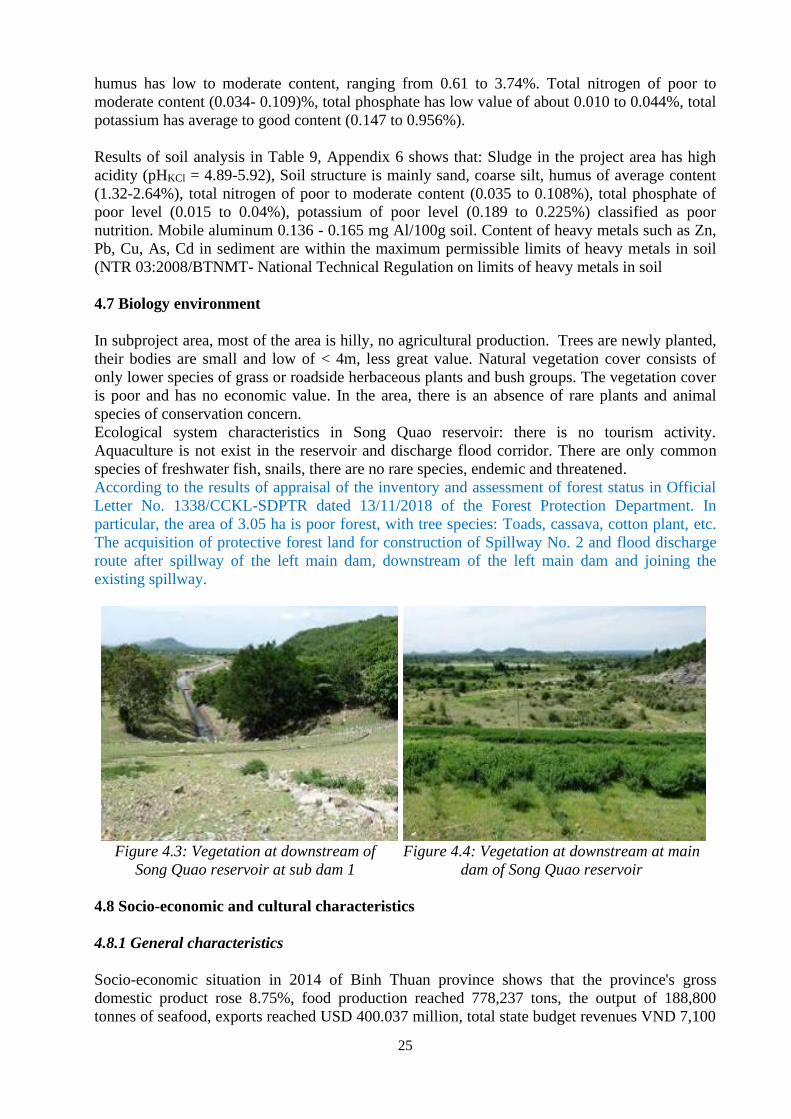
25
humus has low to moderate content, ranging from 0.61 to 3.74%. Total nitrogen of poor to
moderate content (0.034- 0.109)%, total phosphate has low value of about 0.010 to 0.044%, total
potassium has average to good content (0.147 to 0.956%).
Results of soil analysis in Table 9, Appendix 6 shows that: Sludge in the project area has high
acidity (pHKCl = 4.89-5.92), Soil structure is mainly sand, coarse silt, humus of average content
(1.32-2.64%), total nitrogen of poor to moderate content (0.035 to 0.108%), total phosphate of
poor level (0.015 to 0.04%), potassium of poor level (0.189 to 0.225%) classified as poor
nutrition. Mobile aluminum 0.136 - 0.165 mg Al/100g soil. Content of heavy metals such as Zn,
Pb, Cu, As, Cd in sediment are within the maximum permissible limits of heavy metals in soil
(NTR 03:2008/BTNMT- National Technical Regulation on limits of heavy metals in soil
4.7 Biology environment
In subproject area, most of the area is hilly, no agricultural production. Trees are newly planted,
their bodies are small and low of < 4m, less great value. Natural vegetation cover consists of
only lower species of grass or roadside herbaceous plants and bush groups. The vegetation cover
is poor and has no economic value. In the area, there is an absence of rare plants and animal
species of conservation concern.
Ecological system characteristics in Song Quao reservoir: there is no tourism activity.
Aquaculture is not exist in the reservoir and discharge flood corridor. There are only common
species of freshwater fish, snails, there are no rare species, endemic and threatened.
According to the results of appraisal of the inventory and assessment of forest status in Official
Letter No. 1338/CCKL-SDPTR dated 13/11/2018 of the Forest Protection Department. In
particular, the area of 3.05 ha is poor forest, with tree species: Toads, cassava, cotton plant, etc.
The acquisition of protective forest land for construction of Spillway No. 2 and flood discharge
route after spillway of the left main dam, downstream of the left main dam and joining the
existing spillway.
Figure 4.3: Vegetation at downstream of
Song Quao reservoir at sub dam 1
Figure 4.4: Vegetation at downstream at main
dam of Song Quao reservoir
4.8 Socio-economic and cultural characteristics
4.8.1 General characteristics
Socio-economic situation in 2014 of Binh Thuan province shows that the province's gross
domestic product rose 8.75%, food production reached 778,237 tons, the output of 188,800
tonnes of seafood, exports reached USD 400.037 million, total state budget revenues VND 7,100
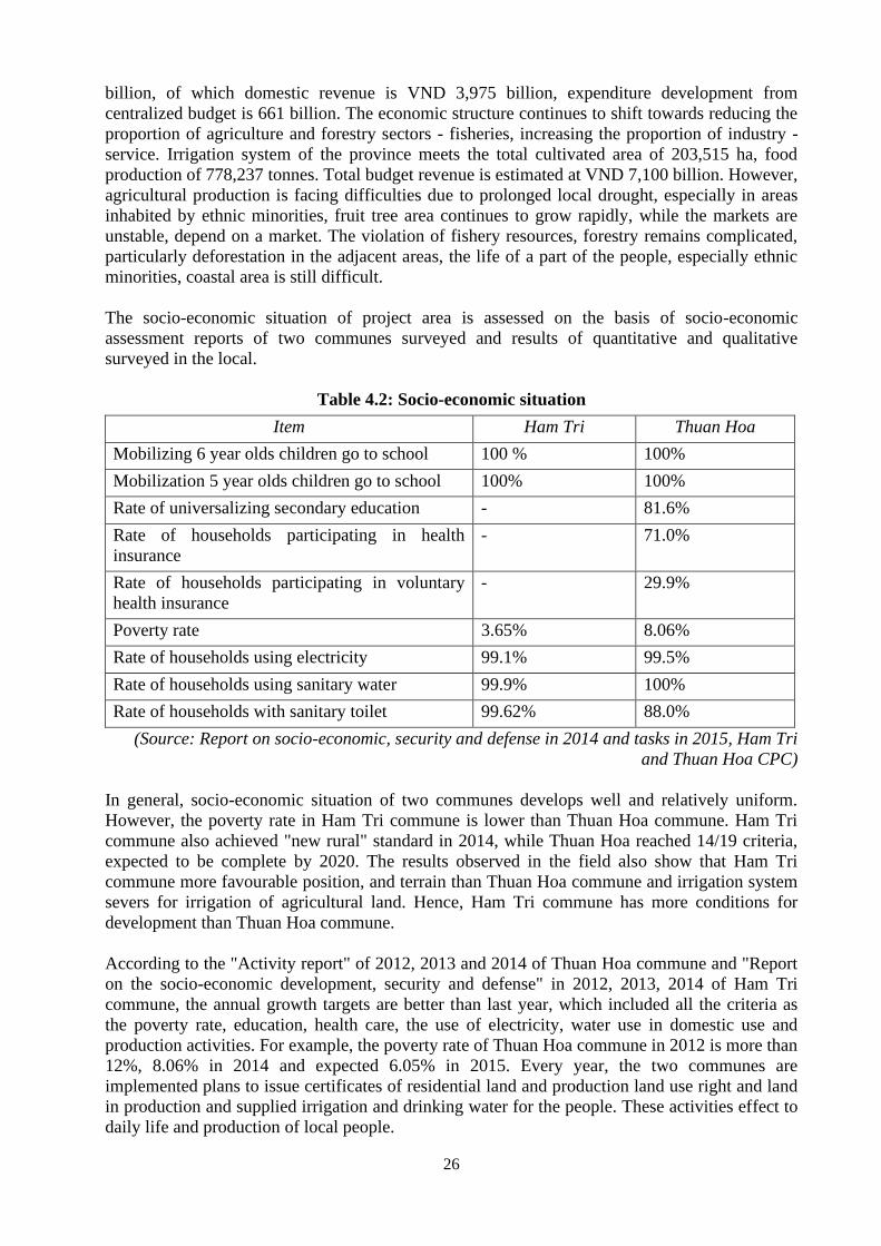
26
billion, of which domestic revenue is VND 3,975 billion, expenditure development from
centralized budget is 661 billion. The economic structure continues to shift towards reducing the
proportion of agriculture and forestry sectors - fisheries, increasing the proportion of industry -
service. Irrigation system of the province meets the total cultivated area of 203,515 ha, food
production of 778,237 tonnes. Total budget revenue is estimated at VND 7,100 billion. However,
agricultural production is facing difficulties due to prolonged local drought, especially in areas
inhabited by ethnic minorities, fruit tree area continues to grow rapidly, while the markets are
unstable, depend on a market. The violation of fishery resources, forestry remains complicated,
particularly deforestation in the adjacent areas, the life of a part of the people, especially ethnic
minorities, coastal area is still difficult.
The socio-economic situation of project area is assessed on the basis of socio-economic
assessment reports of two communes surveyed and results of quantitative and qualitative
surveyed in the local.
Table 4.2: Socio-economic situation
Item Ham Tri Thuan Hoa
Mobilizing 6 year olds children go to school 100 % 100%
Mobilization 5 year olds children go to school 100% 100%
Rate of universalizing secondary education - 81.6%
Rate of households participating in health
insurance
- 71.0%
Rate of households participating in voluntary
health insurance
- 29.9%
Poverty rate 3.65% 8.06%
Rate of households using electricity 99.1% 99.5%
Rate of households using sanitary water 99.9% 100%
Rate of households with sanitary toilet 99.62% 88.0%
(Source: Report on socio-economic, security and defense in 2014 and tasks in 2015, Ham Tri
and Thuan Hoa CPC)
In general, socio-economic situation of two communes develops well and relatively uniform.
However, the poverty rate in Ham Tri commune is lower than Thuan Hoa commune. Ham Tri
commune also achieved "new rural" standard in 2014, while Thuan Hoa reached 14/19 criteria,
expected to be complete by 2020. The results observed in the field also show that Ham Tri
commune more favourable position, and terrain than Thuan Hoa commune and irrigation system
severs for irrigation of agricultural land. Hence, Ham Tri commune has more conditions for
development than Thuan Hoa commune.
According to the "Activity report" of 2012, 2013 and 2014 of Thuan Hoa commune and "Report
on the socio-economic development, security and defense" in 2012, 2013, 2014 of Ham Tri
commune, the annual growth targets are better than last year, which included all the criteria as
the poverty rate, education, health care, the use of electricity, water use in domestic use and
production activities. For example, the poverty rate of Thuan Hoa commune in 2012 is more than
12%, 8.06% in 2014 and expected 6.05% in 2015. Every year, the two communes are
implemented plans to issue certificates of residential land and production land use right and land
in production and supplied irrigation and drinking water for the people. These activities effect to
daily life and production of local people.
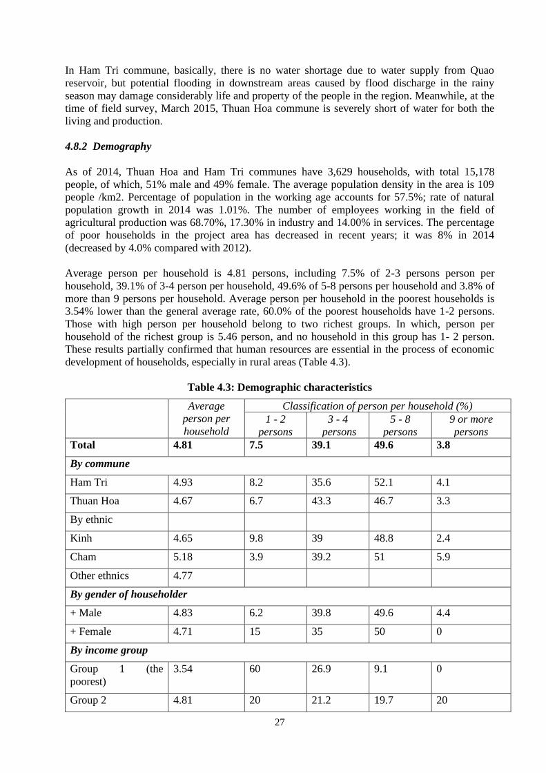
27
In Ham Tri commune, basically, there is no water shortage due to water supply from Quao
reservoir, but potential flooding in downstream areas caused by flood discharge in the rainy
season may damage considerably life and property of the people in the region. Meanwhile, at the
time of field survey, March 2015, Thuan Hoa commune is severely short of water for both the
living and production.
4.8.2 Demography
As of 2014, Thuan Hoa and Ham Tri communes have 3,629 households, with total 15,178
people, of which, 51% male and 49% female. The average population density in the area is 109
people /km2. Percentage of population in the working age accounts for 57.5%; rate of natural
population growth in 2014 was 1.01%. The number of employees working in the field of
agricultural production was 68.70%, 17.30% in industry and 14.00% in services. The percentage
of poor households in the project area has decreased in recent years; it was 8% in 2014
(decreased by 4.0% compared with 2012).
Average person per household is 4.81 persons, including 7.5% of 2-3 persons person per
household, 39.1% of 3-4 person per household, 49.6% of 5-8 persons per household and 3.8% of
more than 9 persons per household. Average person per household in the poorest households is
3.54% lower than the general average rate, 60.0% of the poorest households have 1-2 persons.
Those with high person per household belong to two richest groups. In which, person per
household of the richest group is 5.46 person, and no household in this group has 1- 2 person.
These results partially confirmed that human resources are essential in the process of economic
development of households, especially in rural areas (Table 4.3).
Table 4.3: Demographic characteristics
Average
person per
household
Classification of person per household (%)
1 - 2
persons
3 - 4
persons
5 - 8
persons
9 or more
persons
Total 4.81 7.5 39.1 49.6 3.8
By commune
Ham Tri 4.93 8.2 35.6 52.1 4.1
Thuan Hoa 4.67 6.7 43.3 46.7 3.3
By ethnic
Kinh 4.65 9.8 39 48.8 2.4
Cham 5.18 3.9 39.2 51 5.9
Other ethnics 4.77
By gender of householder
+ Male 4.83 6.2 39.8 49.6 4.4
+ Female 4.71 15 35 50 0
By income group
Group 1 (the
poorest)
3.54 60 26.9 9.1 0
Group 2 4.81 20 21.2 19.7 20
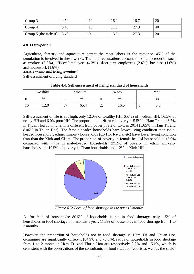
28
Group 3 4.74 10 26.9 16.7 20
Group 4 5.48 10 11.5 27.3 40
Group 5 (the richest) 5.46 0 13.5 27.3 20
4.8.3 Occupation
Agriculture, forestry and aquaculture attract the most labors in the province. 45% of the
population is involved in these works. The other occupations account for small proportion such
as workers (5.9%), officers/employees (4.3%), short-term employees (2.6%), business (1.6%)
and housework (1.6%).
4.8.4. Income and living standard
Self-assessment of living standard
Table 4.4: Self-assessment of living standard of households
Wealthy Medium Needy Poor
n % n % n % n %
16 12.0 87 65.4 22 16.5 8 6.0
Self-assessment of life is not high, only 12.0% of wealthy HH, 65.4% of medium HH, 16.5% of
needy HH and 6.0% poor HH. The proportion of self-rated poverty is 5.5% in Ham Tri and 6.7%
in Thuan Hoa commune. It is different from poverty rate of CPC in 2014 (3.65% in Ham Tri and
8.06% in Thuan Hoa). The female-headed households have lower living condition than male-
headed households; ethnic minority households (Co Ho, Ra-giai,etc) have lower living condition
than than the Kinh and Cham. The proportion of poverty in female-headed household is 15.0%
compared with 4.4% in male-headed households; 23.2% of poverty in ethnic minority
households and 10.5% of poverty in Cham households and 1.2% in Kinh HHs.
Figure 4.5: Level of food shortage in the past 12 months
As for food of households: 80.5% of households is not in food shortage, only 1.5% of
households in food shortage in 4 months a year, 11.3% of households in food shortage from 1 to
2 months.
However, the proportion of households not in food shortage in Ham Tri and Thuan Hoa
communes are significantly different (84.9% and 75.0%), ratios of households in food shortage
from 1 to 2 month in Ham Tri and Thuan Hoa are respectively 8.2% and 15.0%, which is
consistent with the observations of the consultants on food situation reports as well as the socio-
29
economic situation of the two communes. Food shortages also differ significantly correlated to
gender and ethnicity of the household head. The proportion of female-headed households fall
into food insecurity is higher than male-headed households (5.0% and 0.9% of food shortage
over 4 months; 25.0% versus 3.5% of food shortage in 3 to 4 months). Only 50.0% of female-
headed HHs has enough to eat (not lack of food), this ratio of male-headed HHs is 85.8%.
Similarly with the ethnic minority households, no Kinh HH is in food shortage in four months,
while that proportion of Cham households and other ethnic groups (Co Ho, Ra-giai, etc ) is
respectively 2.6% and 7.7%. Specifically, only 38.5% (1/3) of other ethnic households has
enough food, nearly 2/3 of the remaining is in food shortage from 1 to 4 months.
Thus, gender and ethnicity of the householder has certain influences to the food situation of the
HH. Food situation of the HHs reflects the results of economic development, according to the
evaluation results, we can see the main issues of concern is accessibility to support programs
aimed at economic development of local households, for example, accessibility to economic
information, knowledge production and business development, loans or land resources for
groups of people in the locality. It should be noted to the characteristics of the family
relationship of the population in the area: The Kinh households are under patriarchy and men
serve as householder, while Cham, Ra-giai and Co Ho, HHs are under matriarchy and women
are householders. Participation in community activities such as public meeting to hear the
information dissemination, knowledge is often assigned to the men, while the women, especially
minority women, are not really "confident" in participating in this activity, and this more or less
restricted access to their information, including economic information as well as the opportunity
to access knowledge in economic development. Regarding access to loans, there are not too
many differences in opportunity. All those who have been consulted have the same general
opinion that the loan is based on the agreement of both spouses; however the householder retains
a higher decision. As for land and other resources, according to the policy on land, the ethnic
minority households in the province are provided 1 ha of agricultural land to produce, the poor
get grant money to buy one cow worth 7 millions (Program 135). Besides, the local authorities
performed relatively well the Land Law 2003 on the granting of land use right certificates with
the name of the husband and wife, which facilitates more benefits for both genders in access to
land resources.
4.8.5 Income generating activities are variable
Agriculture, trade / services, handicraft, salary / wages, savings / offerings and assistance for
social-assisted HH. Fluctuation of the total average annual income of households is quite large
(from 520 million to 9 million VND). Consultants divided into five income groups, including:
Group 1 below 41 million VND; Group 2 from 41 to 76 million VND; Group 3 from 76 million
to 107 million VND; Group 4 from 107 million to 178 million VND; and Group 5 with more
than 178 million VND. The majority of households’ economic development are agriculture, even
the trade / service household or salaried workers also work towards the agriculture development
by purchasing more land or invest in fruit as eligible for financing. People are very interested in
the development of dragon fruit and consider this to help them out of poverty, but one hectare of
dragon fruit needs investment of 70 to 80 million VND, and supply of water and other activities.
For the households in Ham Tri commune, investment opportunities are relatively easier than
Thuan Hoa commune for more abundant irrigation water, although they still have concerns about
the difficulties during the flood discharge. This reflects the urgency of the rehabilitation of
irrigation systems in the area.
The correlation between income groups and geographical areas, the proportion of households
with incomes below 41 million VND in Ham Tri is 12.3% and 28.3% in Thuan Hoa. 45% of all
female-headed households have an average income of less than 41 million VND a year, whereas
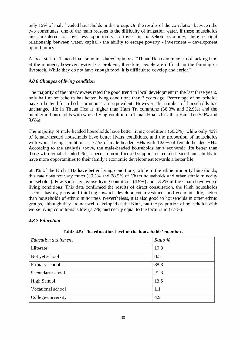
30
only 15% of male-headed households in this group. On the results of the correlation between the
two communes, one of the main reasons is the difficulty of irrigation water. If these households
are considered to have less opportunity to invest in household economy, there is tight
relationship between water, capital - the ability to escape poverty - investment – development
opportunities.
A local staff of Thuan Hoa commune shared opinions: "Thuan Hoa commune is not lacking land
at the moment, however, water is a problem; therefore, people are difficult in the farming or
livestock. While they do not have enough food, it is difficult to develop and enrich".
4.8.6 Changes of living condition
The majority of the interviewees rated the good trend in local development in the last three years,
only half of households has better living conditions than 3 years ago, Percentage of households
have a better life in both communes are equivalent. However, the number of households has
unchanged life in Thuan Hoa is higher than Ham Tri commune (38.3% and 32.9%) and the
number of households with worse living condition in Thuan Hoa is less than Ham Tri (5.0% and
9.6%).
The majority of male-headed households have better living conditions (60.2%), while only 40%
of female-headed households have better living conditions, and the proportion of households
with worse living conditions is 7.1% of male-headed HHs with 10.0% of female-headed HHs.
According to the analysis above, the male-headed households have economic life better than
those with female-headed. So, it needs a more focused support for female-headed households to
have more opportunities to their family's economic development towards a better life.
68.3% of the Kinh HHs have better living conditions, while in the ethnic minority households,
this rate does not vary much (39.5% and 38.5% of Cham households and other ethnic minority
households). Few Kinh have worse living conditions (4.9%) and 13.2% of the Cham have worse
living conditions. This data confirmed the results of direct consultation, the Kinh households
"seem" having plans and thinking towards development investment and economic life, better
than households of ethnic minorities. Nevertheless, it is also good to households in other ethnic
groups, although they are not well developed as the Kinh, but the proportion of households with
worse living conditions is low (7.7%) and nearly equal to the local ratio (7.5%).
4.8.7 Education
Table 4.5: The education level of the households’ members
Education attainment Ratio %
Illiterate 10.8
Not yet school 8.3
Primary school 38.8
Secondary school 21.8
High School 13.5
Vocational school 1.1
College/university 4.9
31
Educational attainment in primary and secondary school accounts for higher percentage than
other education groups (38.8% and 21.8%). The ratio of children dropping out of school in the
province is not high (18.0%). Both communes have made universal primary education and 100%
of 5 year old children went to preschool. However, the issues related to education may be
summarized as follows:
The school system in good Ham Tri is better than Thuan Hoa due to non-government projects
funded;
All households of ethnic minorities are entitled to the allowance for children to go to school, but
the number of children dropping out of school has fallen into the households of ethnic minorities,
Co Ho and Ra-giai.
Universal primary education has been made for children born after 2005, so the status of
illiterate children born before 2004 is still happen.
Boys drop out of school than girls, the main reason is playing preference, attracted by the issues
related to social evils such as shops, electronic games ...
4.8.8 Land use
Total productive land of HHs: According to socio-economic reports in 2014, total productive
land of Ham Tri commune is 3,223.8 ha and of Thuan Hoa commune is 3,196.7 ha. Over 93% of
households have productive land in the local. Land use right certificate (LURC) and
representative person. LURC are granted for land user, also confirms the ability to access
resources such as land and other resources that the certificate is regarded as a condition (e.g.,
financial resources). Consultations on the issue: "Who is representative person of LURC?" show
that the HHs has agreement on it, either Kinh or ethnic minority. Moreover, the purchase, sale,
mortgage must be signed by both spouses. Thereby, it can affirm equality in access to resources
in the province.
As reported by the CPCs, every year, the commune submitted to the district plan for the issuance
of LURC for local people (including residential land and productive land). Thus, the ratio of
lacking LURC is not high: 16.5% of residential land; 6.8% of productive land.
Figure 4.6: Land use right certificate
The proportion of LURC possession in households headed by men and women are equal. But
there are significant differences between ethnic groups with the Kinh and Cham. 46.2% of other
ethnic groups do not have a LURC in comparison with 18.4% of Cham and 11.0% of Kinh. This
is also the group with worse living conditions and economic conditions than the other two
32
groups. So, the absence of LURC is one of the reasons for this group struggling economic
development.
4.8.9 Health and health care system
Sickness situation: Within one year, more than two thirds of interviewees said that they have
sickness, the common health problems include:
Table 4.6: Sickness situation
Sickness Ratio (%)
Yes No
Flu 49.0 51.1
Respiratory 12.2 87.8
Cold fever - 100.0
Malaria 2.0 98.0
Liver 2.0 98.0
Poisoning - 100.0
Injury 4.1 95.9
Health insurance: 83.5% of respondents have insured, 15.8% have no health insurance. Number
of households accounted for 87.8% Kinh have health insurance, the number of households was
76.3% and the Cham ethnic people is 76.9%. Under the health insurance law, the minority of the
economic difficulties in the area of social support enjoyed by the health insurance. Thus the rate
of 70% of ethnic minorities in areas of health insurance is still seen and there are many objects
that were omitted.
Clinic facilities: 83.5% of respondents have insured, 15.8% have no health insurance. Number of
households accounted for 87.8% Kinh have health insurance, the number of households was
76.3% and the Cham ethnic people is 76.9%. Under the health insurance law, the minority of the
economic difficulties in the area of social support enjoyed by the health insurance. Thus the rate
of 70% of ethnic minorities in areas of health insurance is still seen and there are many objects
that were omitted.
Table 4.7: Clinic facilities
Clinic facilities Ratio (%)
Yes No
Commune clinic 30.6 69.4
Inter-communal clinic - 100.0
District hospital 42.9 57.1
Provincial hospital 32.7 67.3
Central hospital 4.1 95.9
Private clinic 4.1 95.9
Pharmacy 24.5 75.5
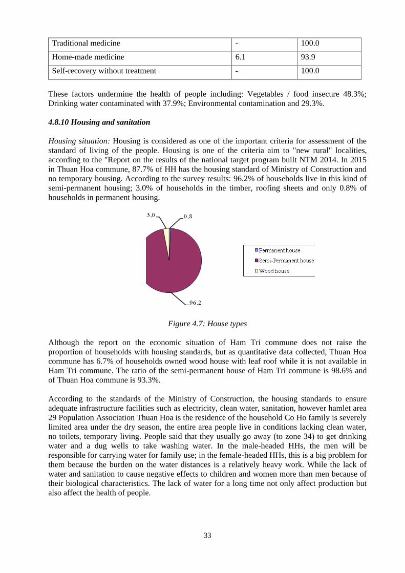
33
Traditional medicine - 100.0
Home-made medicine 6.1 93.9
Self-recovery without treatment - 100.0
These factors undermine the health of people including: Vegetables / food insecure 48.3%;
Drinking water contaminated with 37.9%; Environmental contamination and 29.3%.
4.8.10 Housing and sanitation
Housing situation: Housing is considered as one of the important criteria for assessment of the
standard of living of the people. Housing is one of the criteria aim to "new rural" localities,
according to the "Report on the results of the national target program built NTM 2014. In 2015
in Thuan Hoa commune, 87.7% of HH has the housing standard of Ministry of Construction and
no temporary housing. According to the survey results: 96.2% of households live in this kind of
semi-permanent housing; 3.0% of households in the timber, roofing sheets and only 0.8% of
households in permanent housing.
Figure 4.7: House types
Although the report on the economic situation of Ham Tri commune does not raise the
proportion of households with housing standards, but as quantitative data collected, Thuan Hoa
commune has 6.7% of households owned wood house with leaf roof while it is not available in
Ham Tri commune. The ratio of the semi-permanent house of Ham Tri commune is 98.6% and
of Thuan Hoa commune is 93.3%.
According to the standards of the Ministry of Construction, the housing standards to ensure
adequate infrastructure facilities such as electricity, clean water, sanitation, however hamlet area
29 Population Association Thuan Hoa is the residence of the household Co Ho family is severely
limited area under the dry season, the entire area people live in conditions lacking clean water,
no toilets, temporary living. People said that they usually go away (to zone 34) to get drinking
water and a dug wells to take washing water. In the male-headed HHs, the men will be
responsible for carrying water for family use; in the female-headed HHs, this is a big problem for
them because the burden on the water distances is a relatively heavy work. While the lack of
water and sanitation to cause negative effects to children and women more than men because of
their biological characteristics. The lack of water for a long time not only affect production but
also affect the health of people.
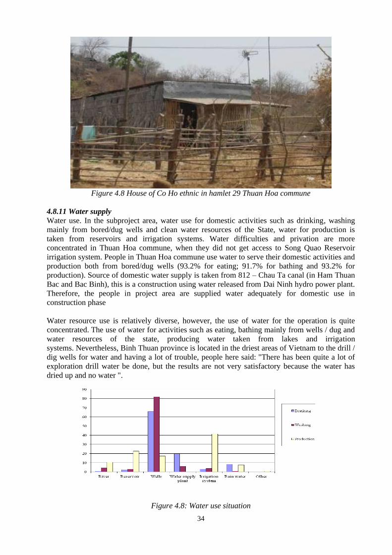
34
Figure 4.8 House of Co Ho ethnic in hamlet 29 Thuan Hoa commune
4.8.11 Water supply
Water use. In the subproject area, water use for domestic activities such as drinking, washing
mainly from bored/dug wells and clean water resources of the State, water for production is
taken from reservoirs and irrigation systems. Water difficulties and privation are more
concentrated in Thuan Hoa commune, when they did not get access to Song Quao Reservoir
irrigation system. People in Thuan Hoa commune use water to serve their domestic activities and
production both from bored/dug wells (93.2% for eating; 91.7% for bathing and 93.2% for
production). Source of domestic water supply is taken from 812 – Chau Ta canal (in Ham Thuan
Bac and Bac Binh), this is a construction using water released from Dai Ninh hydro power plant.
Therefore, the people in project area are supplied water adequately for domestic use in
construction phase
Water resource use is relatively diverse, however, the use of water for the operation is quite
concentrated. The use of water for activities such as eating, bathing mainly from wells / dug and
water resources of the state, producing water taken from lakes and irrigation
systems. Nevertheless, Binh Thuan province is located in the driest areas of Vietnam to the drill /
dig wells for water and having a lot of trouble, people here said: "There has been quite a lot of
exploration drill water be done, but the results are not very satisfactory because the water has
dried up and no water ".
Figure 4.8: Water use situation
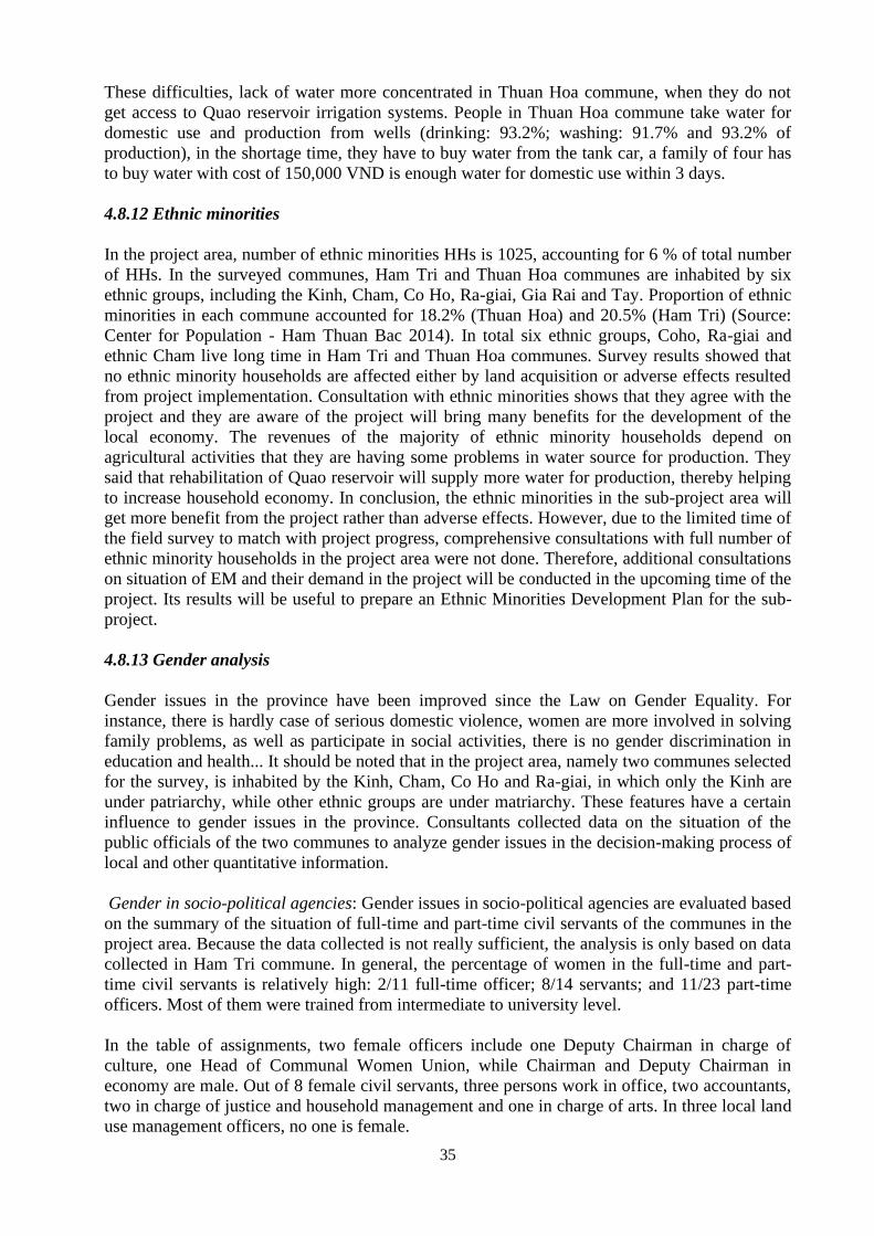
35
These difficulties, lack of water more concentrated in Thuan Hoa commune, when they do not
get access to Quao reservoir irrigation systems. People in Thuan Hoa commune take water for
domestic use and production from wells (drinking: 93.2%; washing: 91.7% and 93.2% of
production), in the shortage time, they have to buy water from the tank car, a family of four has
to buy water with cost of 150,000 VND is enough water for domestic use within 3 days.
4.8.12 Ethnic minorities
In the project area, number of ethnic minorities HHs is 1025, accounting for 6 % of total number
of HHs. In the surveyed communes, Ham Tri and Thuan Hoa communes are inhabited by six
ethnic groups, including the Kinh, Cham, Co Ho, Ra-giai, Gia Rai and Tay. Proportion of ethnic
minorities in each commune accounted for 18.2% (Thuan Hoa) and 20.5% (Ham Tri) (Source:
Center for Population - Ham Thuan Bac 2014). In total six ethnic groups, Coho, Ra-giai and
ethnic Cham live long time in Ham Tri and Thuan Hoa communes. Survey results showed that
no ethnic minority households are affected either by land acquisition or adverse effects resulted
from project implementation. Consultation with ethnic minorities shows that they agree with the
project and they are aware of the project will bring many benefits for the development of the
local economy. The revenues of the majority of ethnic minority households depend on
agricultural activities that they are having some problems in water source for production. They
said that rehabilitation of Quao reservoir will supply more water for production, thereby helping
to increase household economy. In conclusion, the ethnic minorities in the sub-project area will
get more benefit from the project rather than adverse effects. However, due to the limited time of
the field survey to match with project progress, comprehensive consultations with full number of
ethnic minority households in the project area were not done. Therefore, additional consultations
on situation of EM and their demand in the project will be conducted in the upcoming time of the
project. Its results will be useful to prepare an Ethnic Minorities Development Plan for the sub-
project.
4.8.13 Gender analysis
Gender issues in the province have been improved since the Law on Gender Equality. For
instance, there is hardly case of serious domestic violence, women are more involved in solving
family problems, as well as participate in social activities, there is no gender discrimination in
education and health... It should be noted that in the project area, namely two communes selected
for the survey, is inhabited by the Kinh, Cham, Co Ho and Ra-giai, in which only the Kinh are
under patriarchy, while other ethnic groups are under matriarchy. These features have a certain
influence to gender issues in the province. Consultants collected data on the situation of the
public officials of the two communes to analyze gender issues in the decision-making process of
local and other quantitative information.
Gender in socio-political agencies: Gender issues in socio-political agencies are evaluated based
on the summary of the situation of full-time and part-time civil servants of the communes in the
project area. Because the data collected is not really sufficient, the analysis is only based on data
collected in Ham Tri commune. In general, the percentage of women in the full-time and part-
time civil servants is relatively high: 2/11 full-time officer; 8/14 servants; and 11/23 part-time
officers. Most of them were trained from intermediate to university level.
In the table of assignments, two female officers include one Deputy Chairman in charge of
culture, one Head of Communal Women Union, while Chairman and Deputy Chairman in
economy are male. Out of 8 female civil servants, three persons work in office, two accountants,
two in charge of justice and household management and one in charge of arts. In three local land
use management officers, no one is female.
36
Thus, although the percentage of women involved in the communal government system is not
low, but women do not get the position to make decisions on either economic or politic issues.
Besides, the persons in the right position to make decisions at the local are Kinh ethnic
(Secretary of the Party, Chairman and two Deputy Chairmans of the CPC).
In general, local government officials (both women and men), members of socio-politic
associations and people said that the situation of women's participation in socio-politics has
improved. Results of data analysis show that the improvement is only in terms of quantity, but in
essence, women remains lower than men in positions of significant decisions in the local and this
affects participation in the decision making process as well as the benefited opportunities of
women. This problem should be included in gender action plan to improve the status of women
in political participation.
Participation in activities of family and community: It is clear that there is a division of labor by
gender in the project area. Although generally women and men are involved in all activities,
there are activities that are mostly undertaken by men (61.7% afforestation; 81.3% forest
production; 57.1% aquaculture), and housework, home care are undertaken by women (childcare
56.5%; 59.4% cleaning house; 60.9% cooking). The labor division by gender in the sub-project
is not so different as analysis of the gender division of labor in Vietnam today. Women are
involved in the production, reproduction and caring while men are mainly engaged in production
activities.
The community activities such as community meetings, training on production, activities of
political organizations are participated by both men and women, approximately 50% for each.
The remaining participation rate of men is higher than women (39.1 community meetings,
training on production of 45.5%, and the activities of political organizations, 43.6%). Thus, men
are occupied key role in participating in community activities. And this reflects the restrictions
on women's access to information, knowledge, including information, knowledge production,
and economic development family.
There is a link between the active group in the division of labor by gender is as follows: When
women have to spend too much time on the care and reproduce, they will not have time for
production and operation community, moreover, the limited knowledge and information due to
lack of time to participate in community activities makes it difficult to engage in productive
activities. Meanwhile, the only new production activities to generate income and assume that it is
more important activities. Clearly, inequality is happening in the province within the division of
labor by gender. For issues related to the project activities such as consultations with people,
organizing publicity, counting activities, and compensation unequality makes women more
vulnerable when not have the opportunity to participate.
Women do not generate income, lack of knowledge, lack of information so they are limited in
participation in the decision-making in the family. The survey results have proven for this and
can say it is an obvious consequence of gender inequality in the division of labor. Although the
proportion of women and men participate in deciding the issue of family in 60.0% (decision
expenditures 69.2 big family, decided to study / career 79.5 of children; investment decisions and
production activities 65.4%), but the proportion of men decided to work in the family is still
higher than women, for instance investing in the Exported to nearly one third (27.1%) men
decided, while only 7.5% are women.
Female householder and gender issues in family: In female-headed households, the involvement
of equality between husband and wife in the care and production, the rate of female participation
37
in community meetings and social and political organizations than men (35.0% community
meeting for women compared with 5.0% of men and participate in the political and social
organization of 30.0% compared with 15.0% women, men), in the this case, women have access
to information than men. During the consultation process, consultants questioned the invitation
of community discussions on issues related to land, projects or activities that produce the
responses that often will invite all households - Affordable here is why one is led to the head of
the household will have more opportunities to access information.
Female-headed households also play a decisive role in the family than men. About decided to
spend large family headed women, 70% decided by the couple and 30% is decided by his wife,
men do not participate in the decision in this matter. On the issue of choosing a career, the
proportion of women than men decision was 30.0% and 10.0%; Women who decide to invest in
production accounted for 35.0% compared with 10.0% of men.
Gender equality in ethnic minorities: In which Kinh and ethnic other (Co Ho, Ragiai, etc) equal
than group care in the production and care. In other ethnic groups (Co Ho, Ragiai, etc), women
and men share the responsibility for the care, manufacturing and community groups is higher
than the Kinh and Cham. For example, in reforestation activities, participation rates of
households respectively: ethnic households (Co Ho, Ragiai, etc) 62.5%, 37.9% and Kinh
households Care 32.1%. This is an activity that either spouse to join alone or men make, no
single women perform, but nearly 2/3 of other ethnic households (Co Ho, out- period,etc.) have
both male and female participants, this confirms the shared work evenly among heterosexual
families in other ethnic groups (Co Ho, Ragiai,etc). Child care activities, respectively ratio:
46.2%; 48.1%; and 32.4%, although in this activity, women in all ethnic groups are assumed to
be the main, however, this ratio also shows the different ethnic (Co Ho, Ragiai, etc) and Kinh
have shared more than the protection of ethnic Cham. Regarding participation in community
activities, the ethnic group with high participation rate than other ethnic groups (Co Ho,
Ragiai,etc) and the Cham group, in other ethnic groups (Co Ho, Ragiai,etc.) the percentage of
women participating in community activities than men, while the other two groups, male
participation rate than females. For example in community meetings: Percentage join two of the
Kinh, Cham and other ethnic groups (Co Ho, Ragiai, etc) were: 54.9%, 50.0% and 46.2 %. The
proportion of women participating in the meeting were: 3.7%, 7.9% and 38.5%. The proportion
of men participating in the meeting were: 41.5%, 42.1% and 15.4%. In the decision, the couple
Kinh and ethnic groups (Co Ho, Ragiai, etc) joined more than households who care, for example:
Decision large expenditures in the family (The Economics 74.4%, 55.3% and the Cham ethnic
76.9%).
Thus, although the characteristics of family relationships between different ethnic groups (e.g.,
the Co Ho, Ragiai relatively similar Cham are patriarchal gender issues but not identical and
whether matriarchy but Cham women still disadvantaged compared to other ethnic groups.
4.9. Past Incidences and Management Responses
Past incidences: The following are past incidences in the system:
• In 2000, due to flood drainage, approximately 3 hectares of rice and 2.0 ha of shrimp
were lost in Phu Hai ward, Phan Thiet City:
• From 29/8 to 02/9/2011, in Ham Thuan Bac district heavy rain combined with flood
drainage of Song Quao Reservoir caused local flooding damaging approximately 1,360ha
plants of people (593ha of rice, 221ha of dragon and perennial trees and 546ha of
vegetables); 6,000m of rural roads and about 214m3 of landslide canals. The cause was
due to heavy rainfall running into Song Quao Reservoir at the flow of 30m3/sec. To
38
ensure the safety of the reservoir, the management unit conducted flood drainage at 30-
50m3/sec.
• In 2013, 80ha (rice + dragon fruit + crops) was lost in Ma Lam Town – Ham Thuan Bac
District due to flood drainage of Song Quao reservoir.
• In October 2014: in Binh Thuan Province, continuous rain for days flood drainage of
Song Quao Reservoir made hundreds of hectares of dragon fruits in Ham Thuan Bac
district flooded, causing significant damage to farmers. According to estimates, the Ham
Thuan Bac district had more than 400 hectares of rice and dragon fruits flooded locally.
Causes of flooding were determined as by long heavy rain and flood drainage of Song
Quao Reservoir. Muong Cai, Cha Giang canals and Bridge No. 6 were filled; Ben Loi
and Phu Long Bridges (under 1A Highway expansion project) under unfinished
construction also made up congested flow. Water from upstream not being drained out in
time caused to local flooding.
• Drought, As of 21/7/2008, Ham Thuan Bac district had undergone 41 days of harsh
drought. This has been the longest drought in Binh Thuan in the last 27 years. Major
water source to irrigate for more than 8,000ha of summer-autumn crops in Ham Thuan
Bac district and domestic use water for Phan Thiet city residents was from Song Quao
Reservoir which was already in lack of about 67 million m3;
• Area of rice dried of drought focuses on some key communes as Ham Chinh (700ha),
Ham Liem (600ha), Hong Son (600ha), and Ham Thang (268ha); the the rest is rice area
of Hong Liem, Thuan Hoa, Ham Tri, Ham Phu and Thuan Minh communes. The ravages
of drought which lasted for days in Ham Thuan Bac also affected on 1,300ha of crops in
Hong Liem, Thuan Hoa, Thuan Minh communes and Ma Lam Town.
Remedies and management responses: The following are the remedies or management
responses:
• To overcome the effects of floods, Phu Hai Ward, Phan Thiet city has restructured
production towards greater economic benefits, people no longer growed rice and
aquaculture but switched to inshore fishery because this is an estuary area, adjacent to the
sea. Dredging measures were taken to clear congestion canals, to reduce local flooding
situation.
• Drought prevention plan, focusing on fully use of existing water in Song Quao and Suoi
Da reservoirs, including surface water, ground water in rivers, ponds, wells to increase
water for rice drought prevention. When water level in Song Quao reservoir goes down to
elevation 70.00m, excavators shall be used to dredge sluice canals for increased amount
of irrigation water; Encouraging local people to convert less active/uncertain rice
production area into hybrid maize, cotton, beans, etc. in early crops
Problems to be solved in subproject implementation: Incidents mentioned above, partly due to
extreme weather events, but mostly due to damaged and degraded headwork, affecting the
reservoir safety and capacity to supply water for downstream area no longer responsive to the
design. Specifically as follows:
• At the main dam to the left and right abutment, asphalt concrete laid for crest
reinforcement has deteriorated, much peeling and subsidence appeared on the dam crest,
and downstream ledge has been deteriorated or damaged in some segments. Due to
waves, dam upstream slope has slagged down, stone pavement is of distortion, dam slope
is waved, rugged and less beautiful looking. The downstream slope has many positions
eroded by surface water, ditches and up/down thresholds mostly under damage; the dam
slope is rugged and less beautiful looking. In rainy season, there is water infiltrated into
39
gravel sandy slope reinforcement layer forming seepage flowing on the dam body earth
slope causing to soil erosion of the dam body;
• At Sub-dam No. 1: Concrete at crest was peeling, on upstream slope, MN zone pavestone
was sagging and subsidence, downstream slope was being eroded;
• At Sub-dam No.3: Concrete at crest was slightly peeling, cracking along the dam at 5-
7mm wide, 3-4m long. Pavestone on upstream slope was peeling; sagging and
subsidence. On the downstream slope, topsoil layer was eroded to gravel layer, grass
cannot survive leading to erosion of downstream slope due to rain water impacts. Also in
rainy season, downstream of the dam is always flooded making raised saturation inside
the dam body, affecting the dam stability
• At Dan Sach Headwork: Non-spillway part of dam: (2 earth dam segments, 2 spillway
abutments): Due to the impact of rainfall, the dam up/downstream slopes are annually
eroded and degraded with bushy plants growing on the dam body. There is seepage and
deep erosion at downstream to the left.
The above mentioned shortcomings will be addressed in the proposed subproject.
40
CHAPTER V. IMPACT ASSESSMENT
5.1 Environmental and Social Screening
The subproject underwent Environmental and Social Screening to identify any ineligible items
and identify other requirements under the World Bank safeguards policies. The screening also
helped determine the scope of the assessment.
Environmental Screening. The proposed rehabilitation works are not going to result increased
water storage capacity of the reservoir and therefore will not increase the area to be inundated.
The area is not located within or near any sensitive environment or natural habitat and there are
no structures or sites in the area of cultural and historical significance that will be impacted by
the rehabilitation. The Song Quao Reservoir sub-project falls under Environment Category A
under the World Bank classification (Appendix A4, Table 3.1). The dam is by definition a
“large” dam under World Bank's OP/BP 4.37 classification and therefore the subproject would
require the review and supervision of Panel of Expert and must prepare a Dam Safety Plan.
Involuntary Resettlement Screening. The repair and upgrading works would require acquisition
of lands for permanent and temporary use. The area of temporarily acquired land is 37,000 m2 of
public land. The area of permanent acquired land is 75,795.3 m2, of which: The land under
management of the Quao River Protection Forest Management Board is 62,765 m2; as a result of
flood control recalculated according to the new standard, the peak flood level exceeded
breakwater wall. Therefore, it is necessary to build a spillway No. 2 to increase flood drainage
capacity and reduce water levels to increase safety for the project. The acquisition of land for
spillway No. 2 and the discharge route after the spillway is mainly land in the irrigation work
protection corridor; The acquisition of protective forest land has 62,765 m2; the area of 30.500
m2 is poor forest, with tree species: Toads, cassava, cotton plant,.. have less economic value;
land under management of the People's Committee of Thuan Hoa and Ham Tri is 1,407.3 m2;
land of households is 11,623.3 m2. No household has to residential land acquisition and no
resettlement households. A Resettlement Action Plan which details the compensation and
relocation of the affected households according to the World Bank’s Involuntary Resettlement
Policy (OP/BP 4.12) has been prepared.
Ethnic Minorities Screening. In the subproject area, ethnic minorities account for about 6 % of
the households. The communes of Ham Tri and Thuan Hoa are inhabited by six ethnic groups,
including the Kinh, Cham, Co Ho, Ra-giai, Gia Rai and Tay. The survey conducted however
indicates that there will be no ethnic minority households to be affected by land acquisition. The
ethnic minorities are in the downstream influence area of the dam and will be benefited from
better flood management and dam safety improvements. Consultation with ethnic minorities
shows that they agree with the project and they are aware of the project will bring many benefits
for the development of the local economy. The revenues of the majority of ethnic minority
households depend on agricultural activities that they are having some problems in water source
for production. They said that rehabilitation of Quao reservoir will supply more water for
production, thereby helping to increase household economy. In conclusion, the ethnic minorities
in the sub-project area will get more benefit from the project rather than adverse effects. Due to
the limited time of the field survey, comprehensive consultations with full number of ethnic
minority households in the project area were not yet done. A follow up consultation will be
conducted with the ethnic minority for the development of an Ethnic Minorities Development
Plan (EMDP) for the sub-project.
41
Additional Safeguard Instruments Required. Based on the issues and potential impacts of the
Subproject the following instruments are deemed required as part of the Safeguards preparation:
• Environmental Specifications in the Bid Documentation (Appendix A8)
• Chance Find Procedure (Appendix A9)
• UXO Protocol (Appendix A10)
• Emergency and Quick Response Plan (Appendix A11)
• IPM Implementation Plan (Appendix A12)
• Public Consultation, Participation and Communication Strategy (Appendix B2)
• Gender Development Plan (Appendix B4)
• Grievance and Redress Mechanisms (Appendix B5)
• Resettlement Action Plan (RAP)
• Ethnic Minorities Development Plan (to be developed with the ethnic minority
communities during the subproject preparation)
5.2 Positive Impacts
The Subproject will improve the efficiency of the Song Quao Reservoir and will bring about
positive environmental and socio-economic impacts to local communities as follows:
1. Improvement of safety: The proposed rehabilitation particularly the construction of the
additional spillway No. 2 and the installation of a control culvert at the channel from the
Dan Sach Weir will improve the flood handling capacity of the reservoir reducing the
risk of overtopping and catastrophic breach during extreme flood scenarios. The repairs
and reinforcements will strengthen the dam structure, fortifying it against natural
calamities. These improvements in safety will benefit residents and farmers in 7
communes (i.e., Thuan Hoa, Ham Chinh, Ham Thang, Ham Tri communes, Phu Long
Town, Ma Lam Town and Phu Hai Ward - Phan Thiet City) of Ham Thuan Bac district.
2. The repair and upgrades will ensure continued viability of the reservoir and improve the
reliability of irrigation water supply to about 8,500 hectares of farmlands, aquaculture
ponds and water supply of about 20,000 cu.m/day to the Phan Thiet Water Plant to
supply domestic water needs of Phan Thiet City.
3. The repair and upgrading works will improve the access to the sites as well as the
aesthetics and overall landscape of the reservoir area providing a tourist attraction for
locals and visitors.
4. The repair of the access roads will facilitate daily movements of local people especially
those who using the road to commute to and from their work places and to access social
services such as schools, health centers and market.
5. The continued viability of the reservoir will ensure continued year round regulation of the
hydrologic flow of the Quao and Dan Sach rivers, moderating the otherwise extreme flow
regimes of flood and dry seasons. This condition improves the availability of water in the
vicinity of the reservoir, helping to maintain local humidity and soil moisture, thereby
encouraging various organisms to thrive. The reservoir also continues to provide habitat
to many aquatic organisms. All these have the net effect of promoting biodiversity.
6. The presence of the reservoir will encourage local authorities to implement programs to
reduce the rate of denudation and/or improve the forest cover of the watershed.
7. The economic impact of the continued viability of the reservoir is undeniable. Aside from
paddy rice and aquaculture, the other main source of income in sub-project area is dragon
fruit production which requires water. The people in Thuan Hoa Commune recognize that
the main limiting factor for increase production is the lack of water.
42
8. The increased availability of water in the region will benefit the women, children, elderly
and persons with disabilities. The benefits are significant with single women households
or elderly who will no longer spend most of the day fetching water at long distances from
their dwellings. Moreover, the lack of water is the cause hygiene-related diseases which
affect women and children more than men. Sufficient water for domestic purposes and
production will increase time available to the people to participate in social activities.
5.3 Negative Impacts
5.3.1 Impacts due to Permanent and Temporary Land Use by the Subproject
Loss of lands, crops and dwellings - Land area is acquisition for upgrading works includes 2
types: (i) Temporarily acquired 37,000 m2 of land for the auxiliary construction facilities such as
burrow pits, waste dumps, camp for workers and material stockyard; (ii) Permanent acquired of
75,795.3 m2, of which: land for perennial crops is 1.828,4 m2; other land for planting annual
trees is 9,794.4m2; protected forest land is 62,765 m2; land of rivers and canals is 1,339.7 m2;
land for transport is 67.6m2. However, the impact of land acquisition is considered to be small if
fully implementation of the regulations on compensation and support of the project, details areas
follows:
- For households, the area of 11,623.3m2 is acquired belong to 7 households, mainly land for
planting annual trees and perennial crops, the land acquisition does not affect the production and
life of people, by the households still have much land for production.
- The acquisition of 62,765 m2 of protective forest land, including: poor forest land is 30,500 m2,
The acquisition of protective forest land accounts for a small proportion of the total area of
protective forest land and mainly poor forest with little economic value such as: Toads, cassava,
cotton plant,.. have less economic value (The adverse impact of acquisition of protective forest
land is negligible); non-forest land is 30,864.7 m2 and land of rivers and streams is 1,400.3 m2.
Song Quao spillway area is a young forest with trees: Shorea siamensis, Xylia xylocarpa,
Dipterocarpus tuberculatus, Cratoxylon ligustrinum, Spondias pinnata,... diameter 10-15 cm,
about 6-7 m high. Dan Sach dam area is mainly a shrub, a regeneration forest. The area of the
protection forest is affected about 3,05 ha, which is very small compared to the total area of
18,000 ha in the protection forest area, which is far from residential areas and the security and
defense areas, thus affect negligible to environmental and social. It does not affect the security,
national defense and works safety and downstream area.
In additional, in the sub-project areas, 526 dragon fruit pillars, 30 cashew nut trees, 15 mango
trees, 20 spondias pinnata trees and 50 banana trees, will be affected. Most of affected dragon
fruits pillars are 2-year old and recently are main income of people in Ham Thuan Bac.
5.3.2 Impacts of Construction Activities
There are a number of social and environmental impacts which could occur during the
rehabilitation and upgrading of the dam. These impacts could come from the activities in six
places: (1) the burrow pit (soil pit) area in Dan Hoa Village, (2) the quarry also in Dan Hoa
Village, (3) the landfill; (4) the workers campsite, (5) the materials storage area and (6) the
management road. The impacts are assessed below based on the resources to be mobilised and
the scale of works to be undertaken in the subproject (Table 5.1).
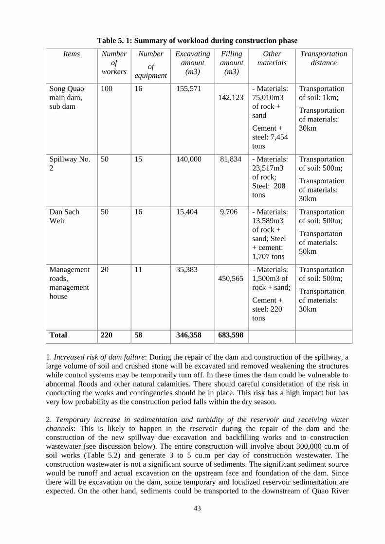
43
Table 5. 1: Summary of workload during construction phase
Items Number
of
workers
Number
of
equipment
Excavating
amount
(m3)
Filling
amount
(m3)
Other
materials
Transportation
distance
Song Quao
main dam,
sub dam
100 16 155,571
142,123
- Materials:
75,010m3
of rock +
sand
Cement +
steel: 7,454
tons
Transportation
of soil: 1km;
Transportation
of materials:
30km
Spillway No.
2
50 15 140,000 81,834 - Materials:
23,517m3
of rock;
Steel: 208
tons
Transportation
of soil: 500m;
Transportation
of materials:
30km
Dan Sach
Weir
50 16 15,404 9,706 - Materials:
13,589m3
of rock +
sand; Steel
+ cement:
1,707 tons
Transportation
of soil: 500m;
Transportaton
of materials:
50km
Management
roads,
management
house
20 11 35,383
450,565
- Materials:
1,500m3 of
rock + sand;
Cement +
steel: 220
tons
Transportation
of soil: 500m;
Transportation
of materials:
30km
Total 220 58 346,358 683,598
1. Increased risk of dam failure: During the repair of the dam and construction of the spillway, a
large volume of soil and crushed stone will be excavated and removed weakening the structures
while control systems may be temporarily turn off. In these times the dam could be vulnerable to
abnormal floods and other natural calamities. There should careful consideration of the risk in
conducting the works and contingencies should be in place. This risk has a high impact but has
very low probability as the construction period falls within the dry season.
2. Temporary increase in sedimentation and turbidity of the reservoir and receiving water
channels: This is likely to happen in the reservoir during the repair of the dam and the
construction of the new spillway due excavation and backfilling works and to construction
wastewater (see discussion below). The entire construction will involve about 300,000 cu.m of
soil works (Table 5.2) and generate 3 to 5 cu.m per day of construction wastewater. The
construction wastewater is not a significant source of sediments. The significant sediment source
would be runoff and actual excavation on the upstream face and foundation of the dam. Since
there will be excavation on the dam, some temporary and localized reservoir sedimentation are
expected. On the other hand, sediments could be transported to the downstream of Quao River
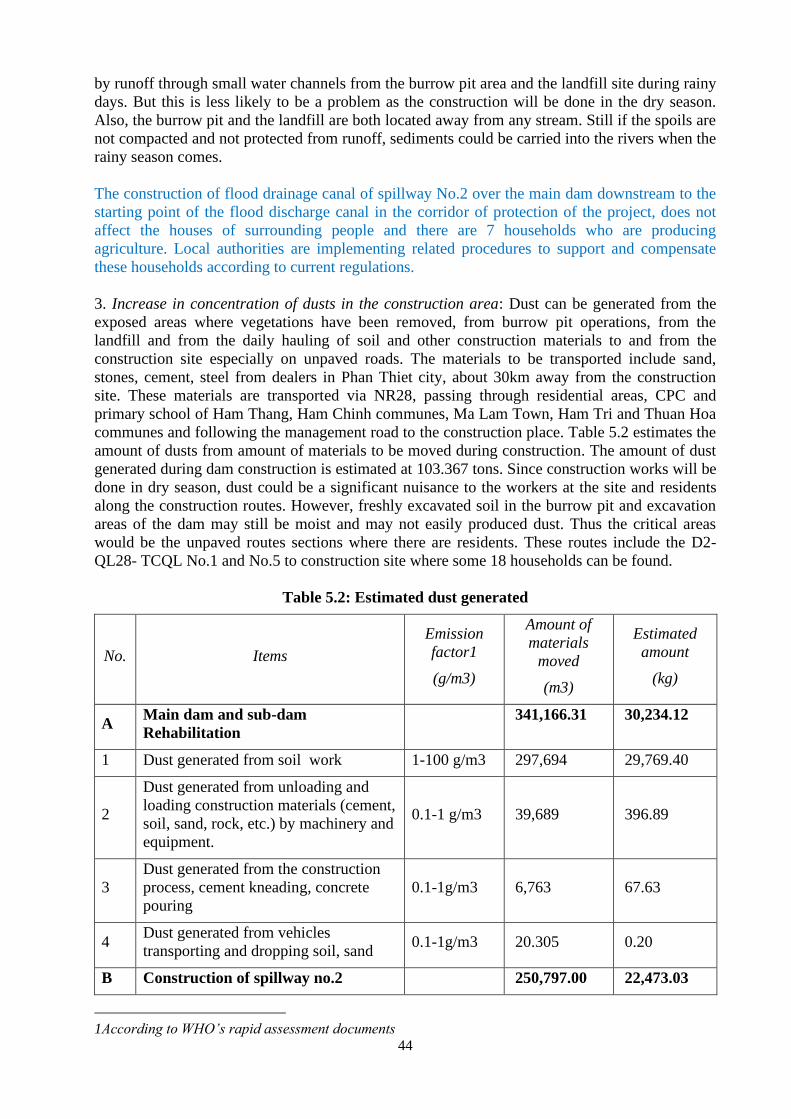
44
by runoff through small water channels from the burrow pit area and the landfill site during rainy
days. But this is less likely to be a problem as the construction will be done in the dry season.
Also, the burrow pit and the landfill are both located away from any stream. Still if the spoils are
not compacted and not protected from runoff, sediments could be carried into the rivers when the
rainy season comes.
The construction of flood drainage canal of spillway No.2 over the main dam downstream to the
starting point of the flood discharge canal in the corridor of protection of the project, does not
affect the houses of surrounding people and there are 7 households who are producing
agriculture. Local authorities are implementing related procedures to support and compensate
these households according to current regulations.
3. Increase in concentration of dusts in the construction area: Dust can be generated from the
exposed areas where vegetations have been removed, from burrow pit operations, from the
landfill and from the daily hauling of soil and other construction materials to and from the
construction site especially on unpaved roads. The materials to be transported include sand,
stones, cement, steel from dealers in Phan Thiet city, about 30km away from the construction
site. These materials are transported via NR28, passing through residential areas, CPC and
primary school of Ham Thang, Ham Chinh communes, Ma Lam Town, Ham Tri and Thuan Hoa
communes and following the management road to the construction place. Table 5.2 estimates the
amount of dusts from amount of materials to be moved during construction. The amount of dust
generated during dam construction is estimated at 103.367 tons. Since construction works will be
done in dry season, dust could be a significant nuisance to the workers at the site and residents
along the construction routes. However, freshly excavated soil in the burrow pit and excavation
areas of the dam may still be moist and may not easily produced dust. Thus the critical areas
would be the unpaved routes sections where there are residents. These routes include the D2-
QL28- TCQL No.1 and No.5 to construction site where some 18 households can be found.
Table 5.2: Estimated dust generated
No. Items
Emission
factor1
(g/m3)
Amount of
materials
moved
(m3)
Estimated
amount
(kg)
A Main dam and sub-dam
Rehabilitation
341,166.31 30,234.12
1 Dust generated from soil work 1-100 g/m3 297,694 29,769.40
2
Dust generated from unloading and
loading construction materials (cement,
soil, sand, rock, etc.) by machinery and
equipment.
0.1-1 g/m3 39,689 396.89
3
Dust generated from the construction
process, cement kneading, concrete
pouring
0.1-1g/m3 6,763 67.63
4 Dust generated from vehicles
transporting and dropping soil, sand 0.1-1g/m3 20.305 0.20
B Construction of spillway no.2 250,797.00 22,473.03
1According to WHO’s rapid assessment documents
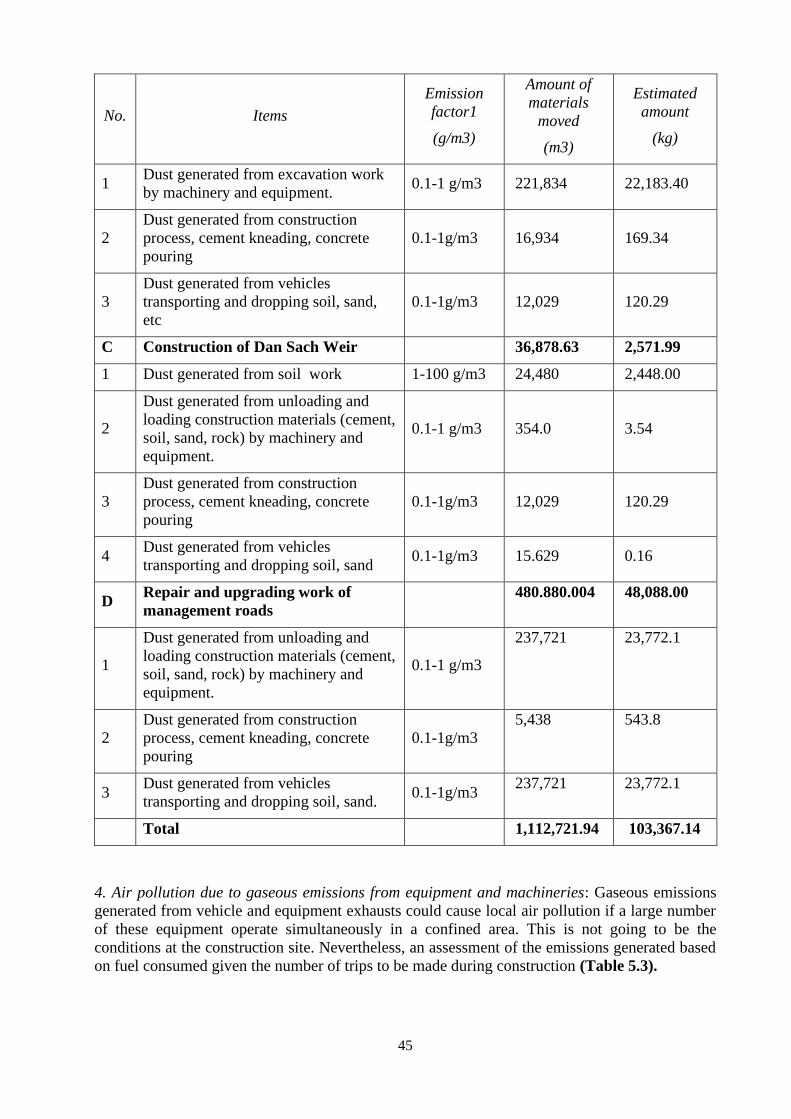
45
No. Items
Emission
factor1
(g/m3)
Amount of
materials
moved
(m3)
Estimated
amount
(kg)
1 Dust generated from excavation work
by machinery and equipment. 0.1-1 g/m3 221,834 22,183.40
2
Dust generated from construction
process, cement kneading, concrete
pouring
0.1-1g/m3 16,934 169.34
3
Dust generated from vehicles
transporting and dropping soil, sand,
etc
0.1-1g/m3 12,029 120.29
C Construction of Dan Sach Weir 36,878.63 2,571.99
1 Dust generated from soil work 1-100 g/m3 24,480 2,448.00
2
Dust generated from unloading and
loading construction materials (cement,
soil, sand, rock) by machinery and
equipment.
0.1-1 g/m3 354.0 3.54
3
Dust generated from construction
process, cement kneading, concrete
pouring
0.1-1g/m3 12,029 120.29
4 Dust generated from vehicles
transporting and dropping soil, sand 0.1-1g/m3 15.629 0.16
D Repair and upgrading work of
management roads
480.880.004 48,088.00
1
Dust generated from unloading and
loading construction materials (cement,
soil, sand, rock) by machinery and
equipment.
0.1-1 g/m3
237,721 23,772.1
2
Dust generated from construction
process, cement kneading, concrete
pouring
0.1-1g/m3
5,438 543.8
3 Dust generated from vehicles
transporting and dropping soil, sand. 0.1-1g/m3
237,721 23,772.1
Total 1,112,721.94 103,367.14
4. Air pollution due to gaseous emissions from equipment and machineries: Gaseous emissions
generated from vehicle and equipment exhausts could cause local air pollution if a large number
of these equipment operate simultaneously in a confined area. This is not going to be the
conditions at the construction site. Nevertheless, an assessment of the emissions generated based
on fuel consumed given the number of trips to be made during construction (Table 5.3).
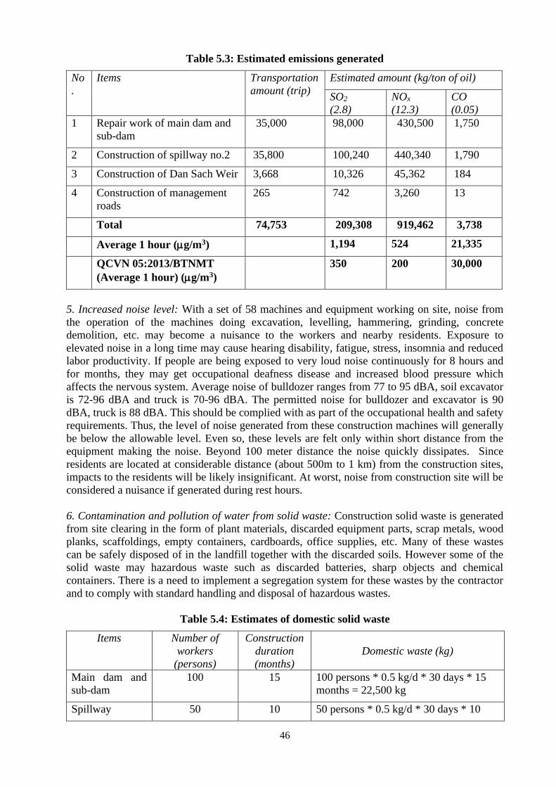
46
Table 5.3: Estimated emissions generated
No
.
Items Transportation
amount (trip)
Estimated amount (kg/ton of oil)
SO2
(2.8)
NOx
(12.3)
CO
(0.05)
1 Repair work of main dam and
sub-dam
35,000 98,000 430,500 1,750
2 Construction of spillway no.2 35,800 100,240 440,340 1,790
3 Construction of Dan Sach Weir 3,668 10,326 45,362 184
4 Construction of management
roads
265 742 3,260 13
Total 74,753 209,308 919,462 3,738
Average 1 hour (g/m3) 1,194 524 21,335
QCVN 05:2013/BTNMT
(Average 1 hour) (g/m3)
350 200 30,000
5. Increased noise level: With a set of 58 machines and equipment working on site, noise from
the operation of the machines doing excavation, levelling, hammering, grinding, concrete
demolition, etc. may become a nuisance to the workers and nearby residents. Exposure to
elevated noise in a long time may cause hearing disability, fatigue, stress, insomnia and reduced
labor productivity. If people are being exposed to very loud noise continuously for 8 hours and
for months, they may get occupational deafness disease and increased blood pressure which
affects the nervous system. Average noise of bulldozer ranges from 77 to 95 dBA, soil excavator
is 72-96 dBA and truck is 70-96 dBA. The permitted noise for bulldozer and excavator is 90
dBA, truck is 88 dBA. This should be complied with as part of the occupational health and safety
requirements. Thus, the level of noise generated from these construction machines will generally
be below the allowable level. Even so, these levels are felt only within short distance from the
equipment making the noise. Beyond 100 meter distance the noise quickly dissipates. Since
residents are located at considerable distance (about 500m to 1 km) from the construction sites,
impacts to the residents will be likely insignificant. At worst, noise from construction site will be
considered a nuisance if generated during rest hours.
6. Contamination and pollution of water from solid waste: Construction solid waste is generated
from site clearing in the form of plant materials, discarded equipment parts, scrap metals, wood
planks, scaffoldings, empty containers, cardboards, office supplies, etc. Many of these wastes
can be safely disposed of in the landfill together with the discarded soils. However some of the
solid waste may hazardous waste such as discarded batteries, sharp objects and chemical
containers. There is a need to implement a segregation system for these wastes by the contractor
and to comply with standard handling and disposal of hazardous wastes.
Table 5.4: Estimates of domestic solid waste
Items Number of
workers
(persons)
Construction
duration
(months)
Domestic waste (kg)
Main dam and
sub-dam
100 15 100 persons * 0.5 kg/d * 30 days * 15
months = 22,500 kg
Spillway 50 10 50 persons * 0.5 kg/d * 30 days * 10
47
months = 7,500 kg
Dan Sach dam 50 15 50 persons * 0.5 kg/d * 30 days * 15
months = 11,250 kg
Road 40 5 40 persons * 0.5 kg/d * 30 days *
5months = 3,000 kg
Total 44,250 kg
7. Contamination and pollution from construction wastewater: Construction wastewater is
generated mostly from the activities such as concrete mixing, vehicle washing, machine and
equipment cleaning, and construction material preparation. The estimation volume of
construction wastewater at each site is from 3 to 5 cu.m per day. Construction wastewater
contains high suspended solid, inorganic matter and debris, low pH. The main impacts of this
wastewater is sedimentation of the reservoir and local water channels. But due to the expected
volume, this impact is deemed not significant. The impacts in terms of other water quality
parameters are also insignificant. According to the research of Centre of environmental
engineering of Ha Noi University of construction, the discharge and concentration of pollutant
factors in wastewater are shown in table 5.5:
Table 5.5: Discharge and concentration of pollutants in wastewater
No. Type of wastewater Discharge
(m3/day)
COD
(mg/l)
Lubricant
(mg/l) SS (mg/l)
1 Wastewater from machinery
sanitation 5.0 50 - 80 1.0 – 2.0 150 – 200
QCVN 24:2009/BTNMT (B) 6.3 100 5 100
(Source: Center of Urban Environmental Engineering and Industrial Park – Hanoi University of
Construction)
8. Domestic waste and wastewater from workers’ camps: There maximum number of workers
and staff in the construction site would be approximately 240 (Table 5.6). The calculation of
domestic waste and wastewater generated by workers was based on 0.5 kg of solid waste per day
and 48 liters of wastewater per day per person. According to the construction schedule, the
construction periods for the items have been identified and the corresponding number of
workers, domestic solid waste and wastewater are presented in Table 5.5 and 5.6 below. Based
on these calculations, at the peak of construction activities, the subproject will be generating
about 120 kg of domestic solid waste daily and about 11.52 cubic meters of domestic wastewater
per day. This is significant amount of waste generation. Improper management of such waste
may pose health risks to workers and cause environmental pollution. However, this should easily
be handled through standard garbage collection and disposal system and portable toilets or septic
tank plus soak pit or pond systems. Domestic waste collection and disposal should be carried out
properly under a Project-approved plan following local environmental and sanitary regulations.
Table 5.6: Estimates of domestic solid waste
Items Number of
workers
(persons)
Construction
duration
(months)
Domestic waste (kg)
Main dam and
sub-dam
100 15 100 persons * 0.5 kg/d * 30 days * 15
months = 22,500 kg
48
Spillway 50 10 50 persons * 0.5 kg/d * 30 days * 10
months = 7,500 kg
Dan Sach dam 50 15 50 persons * 0.5 kg/d * 30 days * 15
months = 11,250 kg
Road 40 5 40 persons * 0.5 kg/d * 30 days *
5months = 3,000 kg
Total 240 44,250 kg
Table 5.7: Estimates of domestic wastewater
Items Number of
workers
(persons)
Construction
duration
(months)
Domestic wastewater (kg)
Main dam and
sub-dam
100 15 100 persons * 48L/d * 30 days * 15
months = 2,160 m3
Spillway 50 10 50 persons * 48L/d * 30 days * 10
months = 720 m3
Dan Sach dam 50 15 50 persons * 48L/d * 30 days * 15
months = 1,080 m3
Road 40 5 40 persons * 48L/d * 30 days * 5months
= 288 m3
Total 240 4,248 m3
Domestic wastewater, if not properly treated, may pollute sources of surface water in the area.
However, domestic wastewater are biodegradable aerobically or anaerobically and, if not
properly collected and treated according to stipulated regulations, may affect the surface water
quality (due to washing) and groundwater (due to endosmosis). These impacts can be easily
overcome or mitigated.
Table 5.8: Estimated amount of dirt in domestic wastewater (Calculated for 100 people)
No. Items Unit Q’ty2
Estimated amount of
pollutants in domestic
wastewater (g/day)
1 BOD5 g/person.day 45 – 54 4500 – 5400
2 SS g/ person.day 72 – 102 7200 – 10200
3 TSS g/ person.day 70 – 145 7000 – 14500
4 NO3- g/ person.day 6 – 12 600 – 1200
5 Coliform MPN/100 ml NT 106 – 109 100x106 - 100x109
The subproject will manage the waste and wastewater from workers camp through contractor’s
contractual obligations.
2 Source: Environmental management in developing countries, volume 1
49
9. Hazardous Waste Generation: The main hazardous waste from construction is waste oil. It is
estimated that at the peak of construction activities a total of 58 units of equipment will need
lubrication and fuel oil. Assuming each unit will generate 18 liters of waste oil per month, the
amount of oil potentially released into the environment will be 12,330 litres of waste oil/month.
This is a significant amount. Although it is difficult to restrict the contamination level of waste
oil, if collected properly, impacts that may cause to the environment can be minimized. The total
amount of waste oil generated per construction site is presented in Table 5.9
Table 5.9: Estimated amount of waste oil generated
Items Number of
equipment
Construction
duration
(months)
Waste oil (l)
Main dam and
sub-dam
16 15 16 items * 18L/ month * 15 months = 4320
Spillway 15 10 15 items * 18L/ month * 10 months = 2700
Dan Sach dam 16 15 16 items * 18L/ month * 15 months = 4320
Road 11 5 11 items * 18L/ month * 5months = 990
Total 58 12,330 liters/month
11. Construction activities may cause damage to rural roads and infrastructures. The transport
of construction materials, soil and rocks and stones to and from the construction sites will pass
through some weak segments of the roads or bridges which could be damaged. Segments that
could sustain damage are the route from construction site to the burrow pit and to the landfill site
as well as to the Quarry in Dan Hoa Village. Hauling trucks for soil materials will be restricted to
7-ton trucks while the hauling for construction materials from Phan Thiet City where roads have
higher capacities would allow the use of up to 10-ton trucks. These restrictions should minimize
damage to existing roadway. However, some damage will still be expected and hence contractor
should be required to inspect the construction routes and undertake repairs or temporary detours
if required of the construction routes, especially on the local roads. Roads should be restored to
good conditions after construction.
12. Traffic congestion/disruptions. During construction, big concentration of workers (220) as
well as vehicles (16 equipment and 52,171 turns of 7-10-ton trucks) will cause traffic jams,
especially at the intersection with NR28, affecting the traveling and production of people in two
communes of Ham Tri and Thuan Hoa. This impact is assessed as high and needs mitigation
measures;
13. Potential conflicts between construction workers and local people. Construction activities
will reach a peak in the dry season. Many workers of up to 240 at the same time are expected to
avail of the local services such as food and entertainment. However, the infrastructures and
facilities in the subproject area, such as roads, service facilities may become congested and
unable to meet the demand. This may cause conflicts between workers and local people if
measures of workers administration are not available. Daily contacts with migrant workers and
local residents could easily generate petty misunderstanding which may lead to group conflicts.
14. Increased health and safety risks for workers and local residents due to exposure to
construction related health and safety hazards: Construction activities, including daily traffic of
heavy equipment pose risks to the local communities. In particular, deep excavations,
modification/obstruction of passageways, construction litters, demolished barrier railings,
50
improperly disposed wastes, lack of sanitation at the camp site are safety hazards not only to
workers but also to the local residents. There is also a risk of diseases transmission from workers
to local people (and vice versa). As assessed by health sector, percentage of spread able diseases
like respiratory diseases, diarrhea, skin diseases, HIV and hepatitis tend to be higher in rural
areas. In addition, migrant workers could bring in pathogens which locals. These impacts are
assessed as high and detailed assessment is required for remedies or mitigation measures.
15. Interruption in Water Supply: The repair works at the dam, particularly the repair of the
intake works and the spillway despite being scheduled during the dry season when water level in
reservoir is lowest, would still require draining of water below death water level of +72m and
thus, water supply for domestic use and agricultural production would not be assured at this time.
Considering the number of people to be affected (i.e., households in Phan Thiet City and 8,500
hectares of farms), this impact if not addressed would make the subproject not feasible. The
project owner has prepared a plan of tapping alternative water supply for project area by using
water taken from 812-Chau Ta canal of Bac Binh district and Ham Thuan Bac district, which
comes from the Dai Ninh Hydro Power Plant in order to ensure production for 8,500 ha of farm
lands under the Song Quao irrigation service area while at the same time, supplying for 12,000
ha of arable land of the southern communes of Bac Binh district (Song Binh, Song Luy, Tan
Binh), and the northern communes of Ham Thuan Bac district (Thuan Hoa, Hong Son, Hong
Liem). Water supply for domestic use and production for communes along canal and Phan Thiet
city will also be ensured.
16. Impact on the biological environment: Trees cut, weathered soil stripped ay affect the
ecosystem in the soil due to habitat loss and habitat of birds and destruction of vegetation by
topsoil stripping topsoil and soil utilization. However, the project area does not have any kinds of
rare plants/animals to be conserved and the areas to be cleared are mostly barren hills (i.e.
burrow pit) and agricultural lands (i.e. landfill). In terms of impact to the aquatic environment
the only significant source of impact would be the sedimentation and turbidity from the dam
construction (i.e. spillway No 2 construction and intake and dam repairs). Even this impact will
be localized in the section of the reservoir which is close to the construction works. Aquatic
species in other sections of the reservoir will not be affected. Impacts on the downstream will not
be significant as discussed above because of construction will be done in the dry season (i.e. no
runoff) and both burrow pit and landfill are at a considerable distance from any major stream.
The release of water from the reservoir during the construction is expected to be benign and will
not reach a severe flood release scenario, which means it can easily be handled by the flood
release corridor and the downstream of Quao River.
5.3.3. Long term negative impacts and issues
The following are the long term negative impacts and issues:
1. Land and soil degradation due to construction footprint- The construction activities could
leave behind an ugly landscape, deformed land with lots of pot holes and boulders, altered
drainage, degraded and contaminated soil with lots of litters of wastes and discarded materials
making the land unsuitable for other uses. This could occur in the campsite, material stockyard,
burrow pit, landfill areas. In the burrow pit area, about 32 hectares of surface soil will be scraped
and piled on the side. The land surface will then be filled with mounds and pits as embankment
soils are removed and transported to the construction site. Standard restorations of mining pit
will be applied wherein the top soil will be levelled, returning the ground for people to continue
farming. At disposal sites (landfill), the ground could be filled with mounds of materials which
could render the area unsuitable for any productive uses. These impacts are assessed to be
significant and would need to be addressed.
51
4. Possible long term increase in use the use of pesticide. Although there planned rehabilitation
works will not increase the irrigated area, the stable more available irrigation water will increase
crop production intensities in the Song Quao service area thereby resulting in increased use of
agrochemicals such as pesticides. Usage of fertilizers and pesticides is popular in Vietnam and in
particular the sub-project area. Improper usage and handling of agrochemicals may harm the
environment and cause affects the health of farmers and consumers. A plan to implement an
Integrated Pest Management in the area has been prepared.
2. Risk of flood and catastrophic failure. Although the risk of dam failure is greatly reduced and
dam’s capacity to accommodate floods is enhanced by the subproject, the risk of catastrophic
failure remains significant because of the magnitude the potential impacts downstream. Close to
200,000 hectares of farmlands are at risk at the Ham Tri Commune alone. If the Quao River
overflows, the number of people to be affected would be staggering. An upgraded management
system would be needed as well an Emergency Response Plan would need to be installed. This
issue should be addressed as part of the non-structural component of the DRSIP.
3. Long-term sedimentation problem from the watershed: Due to the steep slopes of the
catchment area and the rapidly depleting forest cover, the erosion and sedimentation rates are
high both in the Song Quao catchment and in the Dan Sach catchment. The reservoir
sedimentation therefore remains a problem in the long-term. A program of watershed
rehabilitation in collaboration with the authorities in charge is highly recommended coupled with
good sedimentation monitoring system at the reservoir.
5.3.4. Other Issues
1. Possibility of use of explosives in the construction of Spillway No. 2. Blasting may be used in
the construction of the Spillway No. 2 foundation. This would have concerns on safety and
unpredictable impacts and hence would require compliance with regulations, particularly
Drilling and Blasting of Rock Excavation (NTR 04-04:2012/BNNPTN).
2. The need for complaint resolution and feedback system. There will likely be complaints
against the subproject, damage compensation claims, or allegations of unfair treatment. There is
a need for a grievance redress mechanism to be set up before the start of the construction and
shall remain operational until after one year from completion of the works.
3. Possibility of finding archaeological artefacts. The excavation activities could also encounter
archaeological artefacts or paleontological fossils.
4. UXO clearance activities – As with many areas of the country, there is a possibility of
encountering unexploded ordnance which are remnants from the war. During the process of
securing land use clearance, the project owner should also undertake UXO clearance, if the site
to be used, has not been issued UXO clearance.
5. Cross-cutting gender issues. The benefits may accrue differently between gender groups.
Likewise, the negative impacts/costs may unfair be borne by one gender group.
5.4 Negative impacts and issues that need to be addressed
Based on the above assessments, the following are the significant impacts and issues that need to
be addressed:
52
• Loss of lands and crops due to permanent acquisition and temporary land use
requirements of the subproject
Impacts of construction
• Temporary increased risk of dam failure during construction due repair and construction
works being done which may weaken the dam structure
• Temporary increase in sedimentation and turbidity of the reservoir due to works on the
upstream face of the dam and the construction of new spillway
• Generation of dusts at the burrow pit and quarry in Dan Hoa Village, at the landfill area
and the routes to and from these sites
• Noise hazard to workers
• Domestic waste and wastewater from workers’ camps
• Hazardous construction wastes
• Possible damage to existing roads
• Traffic congestion/disruptions due to construction heavy equipment traffic
• Possible conflicts between construction workers and local people
• Increased health and safety risks for workers and local residents due to exposure to
construction related health and safety hazards
• Possible interruption in water supply due to the draining of the reservoir during repair of
dam, construction of the new spillway and repair of the intake.
Long term negative impacts and issues
• Possible land and soil degradation on temporarily used lands due to construction footprint
in the form of land deformation, altered drainage, holes, compaction, contamination of
wastes, etc., which make land unsuitable for productive uses
• Possible long term increase in use the use of pesticide due to intensified agricultural
production in the irrigation service area of Song Quao
• Residual risk of dam failure remains significant due to high potential magnitude of
impact
• Long-term sedimentation problem due to steep slopes of catchment basin and continued
degradation of the watershed
Other Issues
• Use of explosives (blasting) in the construction of the spillway No. 2 foundation
• Possible complaints against the subproject by local resident or any stakeholder
• Possibility of finding archaeological artefacts the excavation areas
• Possibility of encountering unexploded ordnance which are remnants from the war in the
burrow pit area.
• Cross-cutting gender issues
• Use of alternative water source from a hydroelectric dam which may be covered by the
World Bank Safety of Dam Policy
• Presence of ethnic minorities among the beneficiary population but no Ethnic Minority
Development Plan has been prepared yet.
53
CHAPTER VI: ANALYSIS OF ALTERNATIVES
6.1 Without subproject
Song Quao reservoir has been operated for more than 20 years, it brings high economic
efficiency to the local resident and improves social conditions. Recently, the headwork was
damaged and degraded. Without project, the risk of dam failure is high and is a threat to the life
and local infrastructures, livelihood development of the commune along Song Quao. According
to the result from field survey 2015, the risk due to dam failure will impact to 7 communes, 4
ethnic minority groups, about 4,963 households living in the local will be impacted. Thus, the
implementation of sub-project is to ensure and safe for the people living in downstream areas of
the dam, to provide reliable irrigation service to 8,120 ha of arable land of the local,
modernization operational management, improve ecology systems condition and freshwater
aquatic cultivation combination.
6.2 With subproject
Selecting the alternative of the dam embankment repair
Upstream slope repair: the first option, an about 45,900 m3 of riprap material have to remove and
replace by new material. The potential impact on reservoir due to upstream slope repairing will
be counted to sedimentation, impact on aquatic ecosystem, turbidity of water as well as
surrounding environment protection. The alternative solution is focus only damaged sections and
the removed material will be reused, accounting for 50% or 22,900 m3 of removing material
from upstream slope.
The second alternative solution was selected, because it less impacts to water quality, the
existing ecological system in the reservoir, and the existing environmental condition in
downstream areas.
Selecting location of spillway No.2:
According to original plans, the second spillway is located at the South bank of the reservoir,
4km towards the West direction of the main dam. The volume of flood flow will discharge to
Tram streamline (total length of 12km), is a right branch of River Cai. With such a long flood
discharge corridors, the risk of receiver overflow will cause the dramatic damage to 4,963
households, including 7 communes and 4 ethnic minority groups living in downstream areas.
Moreover, the large volume of excavation material (56.000m3), land acquisition to serve the
works leading negative impacts to environment and social of the local.
Therefore, the selected alternative for location of spillway no. 2 is located between spillway no.1
and no.3, the water release from spillway will discharge to a streamlines of Song Quao. The
streamline has a total length of 2 km. The flood discharge corridor is across to spillway no.3 and
the national high way no.28. Around the corridor, there are a few local households stay. The
volume of excavation material just required about 23,000m3, less and acquisition to serve the
works, hence the negative impacts to environment and resident are reduce in comparison with
the first option.
The selected alternative of water supply from other sources:
The dam embankment and spillway no.2 construction activities require to drainage water below
the range of reservoir function, during this period, the flow water to downstream is can not
54
continued, therefore water-cut off impacts to 39,000 ha of arable land owned by 22,100
households living in Thuan Hoa, Ham Tri, Ma Lam, Ham Chinh, Ham Thang, Phu Long
communes and Phu Hai ward; and it also impacts directly to water supply for domestic use of
Phan Thiet city.
However, apart from arranging reasonable construction time so as not to affect the production
and supply of domestic water for the downstream area, the project owner developed a plan to
supply water for downstream area by taking water from canal 812-Chau Ta of Bac Binh and
Ham Thuan Bac districts, this flow comes from Dai Ninh hydro power plant, also it can provide
water to 8,500 ha of arable land of Bac Binh and Ham Thuan Bac districts. In addition, the
sources of water can support to 12,000 ha of arable land owned by households in Bac Binh
district (Song Binh, Song Luy, Tan Binh communes), Ham Thuan Bac (Thuan Hoa, Hong Son,
Hong Liem communes) and Song Quao’s irrigated areas. Therefore, the impact of water cut-off
is no longer consideration and not the big problem to cultivation and to local residents.
The selected alternatives of acquiring and not acquiring 62.765 m2 of protective forest land:
In order to select alternatives of protective forest land, the local authorities are carrying out
procedures to change the purpose of land use to other purposes and reforestation with acacia tree
in protective forest land area in Hong Son communes and others protective forest land in the
region.
According to regulations, when acquiring of natural forest, it is necessary to apply alternative
forest planting measures; According to the Clause 1, Article 21 of the Forestry Law No.
16/2017/QH14, the alternatives forest area must be equal to 3 times of natural forest area (equal
to 3.05 ha x 3 times = 9.15ha). Currently, Binh Thuan PPC issued decision no. 941/QD-UBND
dated April 16, 2019 approving a plan to replant protection fprest with an area of 9.15 hectares
on the forest land of sub-zone 238 in Ham Duc commune, Ham Thuan district managed by the
Hong Phu Forest Protection Management Board.
55
CHAPTER VII: ENVIRONMENTAL AND SOCIAL MANAGEMENT PLAN
The purpose of this Environmental and Social Management Plan (ESMP) is to address all the
significant environmental and social impacts and issues with feasible mitigation measures that
are discussed and agreed with the subproject owner, identifying requirements including a
reference to other safeguards instruments, specifying a monitoring strategy or plan, and defining
responsibilities for the measures implementation as well as monitoring. The ESMP will serve as
a common reference for all those involved in the implementation of the subproject.
7.1 Related Instruments
The ESMP requires the adoption/implementation of the various other safeguards instruments
which have been prepared for the sub-project such as, the Resettlement Action
Plan/Compensation Plan (RAP) (Separate Document), Gender Development Plan (GDP)
(Appendix B4), Public Consultation, Participation and Communication Strategy (Appendix B3);
Grievance and Redress Mechanism (Appendix B5); Chance Find Procedure (Appendix A9).
7.2 Mitigation Plan
The mitigation plan is contained in Table 7.1.
Since most of the impacts are construction-related and contractors will be generally the ones in
control of the construction site, contractors are required to prepare their own Contractor’s
Environmental and Occupational Health and Safety Plan (CEOHSP) which incorporates all
construction-related measures in the ESMP and industry Health, Safety and Environment (HSE)
standards and good practices, including good housekeeping at construction site, waste
management, provision of adequate water and sanitation facilities, provision of safety
corridors/passageways, installation of barrier fences around dangerous areas and wearing of
PPEs. The CEOSHP will be reviewed and approved by the CPO before construction can
commence in the site.
Table 7 - 1: Impacts/issues, mitigation measures and unit responsible for their
implementation
Impacts/Issues Mitigation Measures Responsibility
- Loss of land and
crops:
Temporary acquisition
of 37,000 m2 of land
for waste dumps, rock
and soil storage sites,
construction roads,
construction sites;
- Permanent acquisition
of 75,795.3 m2 of land,
of which land for
perennial crops is
1,828.4 m2; other land
for planting annual
trees is 9,794.9m2;
• For temporary acquired of land, it is
necessary to prepare a compensation plan for
crops in accordance with the resettlement
policy framework of the project and after the
completion of the project, must return the site
and compensation for land rehabilitation
costs.
• For permanently acquired of land, a plan for
compensation of land and crops should be
prepared in accordance with the resettlement
policy framework of the project.
• For the acquired area of protection forest
(PF) (30,500 m2), Binh Thuan PPC isued
decision No. 941/QD-UBND dated April 16,
2016 approving a plan to replant for the area
• People’s
Committee of
Binh Thuan
province.
• People’s
Committee of
Ham Thuan Bac
district;
• People’s
Committee and
Fatherland Front
Committee of
Thuan Hoa and
Ham Tri
commune
56
protected forest land is
62,765 m2 (including:
poor forest land is
30,500 m2, non-forest
land is 30,864.7 m2 and
land of rivers and
streams is 1,400.3 m2);
land of rivers and
canals is 1,339.7 m2;
land for traffic is 67.6
m2
- The number of trees
are cut down or move
to other places around:
526 dragon fruit pillars,
30 cashew nut trees, 15
mango trees, 50 banana
fruit trees, 20 spondias
pinnata trees.
of the PF to be acquired. Replanted PF areas
is 3.05 hectares x 3 times = 9.15 hectares.
Expenditure to replant PR is 784,201,217
VND from investment cost of Song Quao
reservoir paid by the project. The agency
implementing forest planting is the Forest
Protection and Development Fund of Binh
Thuan province.
• The additional planting plan has been
identified in detail in RAP, as follows: The
area of replacement forest is 9.15 ha on the
forest land of small zone 238 in Ham Duc
commune, Ham Thuan distric is managed by
the Hong Phu Forest Protection Management
Board. Type of plant is Eucalyptus, planting
time and care: 03 years, starting from 2019 to
2021.
• Assist households to restore their lives and
creating new livelihoods. The results of direct
consultations with local people show that
households with permanent land acquisition
are able to arrange new livelihoods without
having to face difficulties in production land
and not affect their life.
• Community
Monitoring
Board
• Provincial
Project
Management
Unit (PPMU)
Potential conflicts
between migrant
workers and local
residents
Register the workers to local community
Contract obligate the use of local labour for
manual work
Set up a Grievance Redress Mechanism for
conflict resolution
Contractor to always coordinate with host
communities and undertake good community
relations program
Contractor,
Provincial Project
Management Unit
(PPMU)
Cross-cutting gender
issues: 4/18 households
affected by land
acquisition are headed
by women (accounting
for 23.5%) while 1
household headed by
single woman raising
two small children who
also going to lose
nearly 70% of
productive land.
• Implement the Gender Development Plan
(GDP)
• Ensure that the RAP includes provides full
compensation to women households and
provides livelihood support for single
women headed households and other
vulnerable groups.
PPMU,
Land and soil
degradation in the
burrow pit, landfill and
workers camp areas
• Retain fertile top soil for reinstatement at
the borrow pit, disposal areas and other
disturbed areas;
Contractor under
supervision of the
PPMU
57
• Minimise volume of waste by collecting and
use cut down trees for beneficial purpose;
• Minimize litter by adopting good
housekeeping and waste disposal at
construction sites
Increased level of dust
at burrow pit area (Dan
Hoa Village) and
construction routes
• Watering construction site surfaces as
necessary
• Water vegetation covers around the site as
necessary
• Watering of critical segments of
construction routes,
• Cover the material storages areas
• Cover the truck during transporting (avoid
the materials falling down on road).
• Cover soil and material at the storages areas
Contractor under
supervision of
PPMU
Noise and vibration
hazard to workers • The transportation vehicles, equipment
must be maintained periodically.
• All vehicles transport materials have to
avoid their activities in rush hours and at
night time
Contractor under
the supervision of
PPMU
Domestic solid waste
and wastewater
generation from camp
• Build adequate sanitation facility at the
camp, including septic tank toilet and
drainage to ensure there is no stagnant
water surrounding the camp
• Provide sufficient containers with lids for
temporary storage of domestic waste
(40kg/d) from the camp
• Arrange for regular waste collection and
disposal
Contractor under
the supervision of
PPMU
Hazardous waste
generation • Collecting and handling wasted oil
following the hazardous material
management regulation
• Waste oil are stored in safe containers and
away from workers camp
• Waste oil containers are stored on water-
proof base and protected with roof,
warning signs and restrict access
• Contact the recycle company for hazardous
material management
• Return wasted oil to fuel supplier
• Do not maintain or repair vehicles at the
sites, but in workshop or service business
Contractor under
the supervision of
PPMU
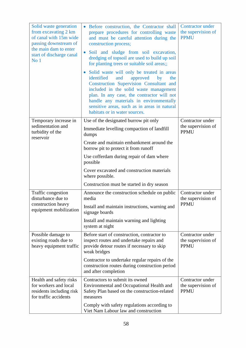
58
Solid waste generation
from excavating 2 km
of canal with 15m wide
passing downstream of
the main dam to enter
start of discharge canal
No 1
• Before construction, the Contractor shall
prepare procedures for controlling waste
and must be careful attention during the
construction process;
• Soil and sludge from soil excavation,
dredging of topsoil are used to build up soil
for planting trees or suitable soil areas;;
• Solid waste will only be treated in areas
identified and approved by the
Construction Supervision Consultant and
included in the solid waste management
plan. In any case, the contractor will not
handle any materials in environmentally
sensitive areas, such as in areas in natural
habitats or in water sources.
Contractor under
the supervision of
PPMU
Temporary increase in
sedimentation and
turbidity of the
reservoir
Use of the designated burrow pit only
Immediate levelling compaction of landfill
dumps
Create and maintain embankment around the
borrow pit to protect it from runoff
Use cofferdam during repair of dam where
possible
Cover excavated and construction materials
where possible.
Construction must be started in dry season
Contractor under
the supervision of
PPMU
Traffic congestion
disturbance due to
construction heavy
equipment mobilization
Announce the construction schedule on public
media
Install and maintain instructions, warning and
signage boards
Install and maintain warning and lighting
system at night
Contractor under
the supervision of
PPMU
Possible damage to
existing roads due to
heavy equipment traffic
Before start of construction, contractor to
inspect routes and undertake repairs and
provide detour routes if necessary to skip
weak bridges
Contractor to undertake regular repairs of the
construction routes during construction period
and after completion
Contractor under
the supervision of
PPMU
Health and safety risks
for workers and local
residents including risk
for traffic accidents
Contractors to submit its owned
Environmental and Occupational Health and
Safety Plan based on the construction-related
measures
Comply with safety regulations according to
Viet Nam Labour law and construction
Contractor under
the supervision of
PPMU
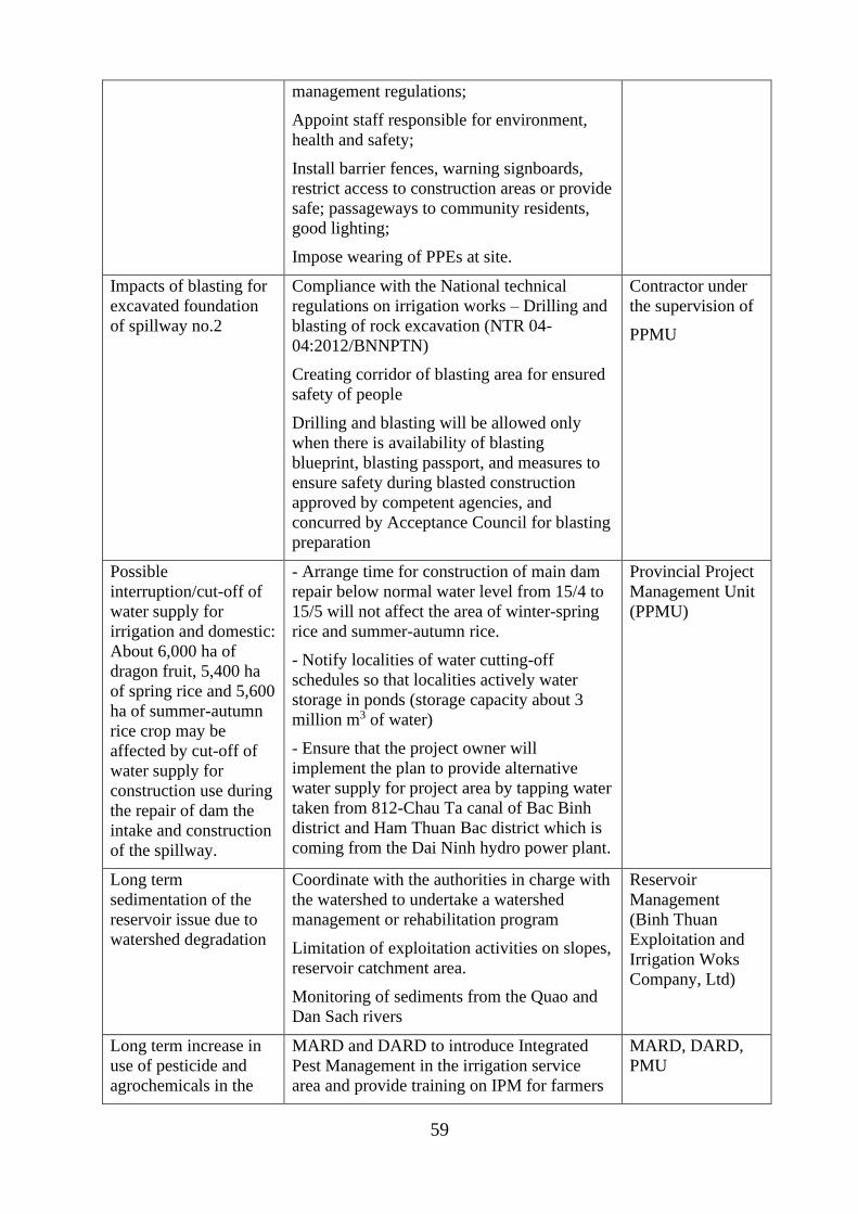
59
management regulations;
Appoint staff responsible for environment,
health and safety;
Install barrier fences, warning signboards,
restrict access to construction areas or provide
safe; passageways to community residents,
good lighting;
Impose wearing of PPEs at site.
Impacts of blasting for
excavated foundation
of spillway no.2
Compliance with the National technical
regulations on irrigation works – Drilling and
blasting of rock excavation (NTR 04-
04:2012/BNNPTN)
Creating corridor of blasting area for ensured
safety of people
Drilling and blasting will be allowed only
when there is availability of blasting
blueprint, blasting passport, and measures to
ensure safety during blasted construction
approved by competent agencies, and
concurred by Acceptance Council for blasting
preparation
Contractor under
the supervision of
PPMU
Possible
interruption/cut-off of
water supply for
irrigation and domestic:
About 6,000 ha of
dragon fruit, 5,400 ha
of spring rice and 5,600
ha of summer-autumn
rice crop may be
affected by cut-off of
water supply for
construction use during
the repair of dam the
intake and construction
of the spillway.
- Arrange time for construction of main dam
repair below normal water level from 15/4 to
15/5 will not affect the area of winter-spring
rice and summer-autumn rice.
- Notify localities of water cutting-off
schedules so that localities actively water
storage in ponds (storage capacity about 3
million m3 of water)
- Ensure that the project owner will
implement the plan to provide alternative
water supply for project area by tapping water
taken from 812-Chau Ta canal of Bac Binh
district and Ham Thuan Bac district which is
coming from the Dai Ninh hydro power plant.
Provincial Project
Management Unit
(PPMU)
Long term
sedimentation of the
reservoir issue due to
watershed degradation
Coordinate with the authorities in charge with
the watershed to undertake a watershed
management or rehabilitation program
Limitation of exploitation activities on slopes,
reservoir catchment area.
Monitoring of sediments from the Quao and
Dan Sach rivers
Reservoir
Management
(Binh Thuan
Exploitation and
Irrigation Woks
Company, Ltd)
Long term increase in
use of pesticide and
agrochemicals in the
MARD and DARD to introduce Integrated
Pest Management in the irrigation service
area and provide training on IPM for farmers
MARD, DARD,
PMU
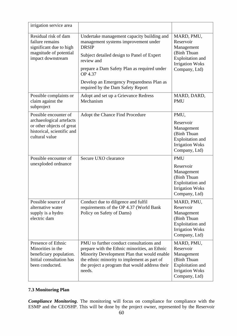
60
irrigation service area
Residual risk of dam
failure remains
significant due to high
magnitude of potential
impact downstream
Undertake management capacity building and
management systems improvement under
DRSIP
Subject detailed design to Panel of Expert
review and
prepare a Dam Safety Plan as required under
OP 4.37
Develop an Emergency Preparedness Plan as
required by the Dam Safety Report
MARD, PMU,
Reservoir
Management
(Binh Thuan
Exploitation and
Irrigation Woks
Company, Ltd)
Possible complaints or
claim against the
subproject
Adopt and set up a Grievance Redress
Mechanism
MARD, DARD,
PMU
Possible encounter of
archaeological artefacts
or other objects of great
historical, scientific and
cultural value
Adopt the Chance Find Procedure PMU,
Reservoir
Management
(Binh Thuan
Exploitation and
Irrigation Woks
Company, Ltd)
Possible encounter of
unexploded ordnance
Secure UXO clearance PMU
Reservoir
Management
(Binh Thuan
Exploitation and
Irrigation Woks
Company, Ltd)
Possible source of
alternative water
supply is a hydro
electric dam
Conduct due to diligence and fulfil
requirements of the OP 4.37 (World Bank
Policy on Safety of Dams)
MARD, PMU,
Reservoir
Management
(Binh Thuan
Exploitation and
Irrigation Woks
Company, Ltd)
Presence of Ethnic
Minorities in the
beneficiary population.
Initial consultation has
been conducted.
PMU to further conduct consultations and
prepare with the Ethnic minorities, an Ethnic
Minority Development Plan that would enable
the ethnic minority to implement as part of
the project a program that would address their
needs.
MARD, PMU,
Reservoir
Management
(Binh Thuan
Exploitation and
Irrigation Woks
Company, Ltd)
7.3 Monitoring Plan
Compliance Monitoring. The monitoring will focus on compliance for compliance with the
ESMP and the CEOSHP. This will be done by the project owner, represented by the Reservoir
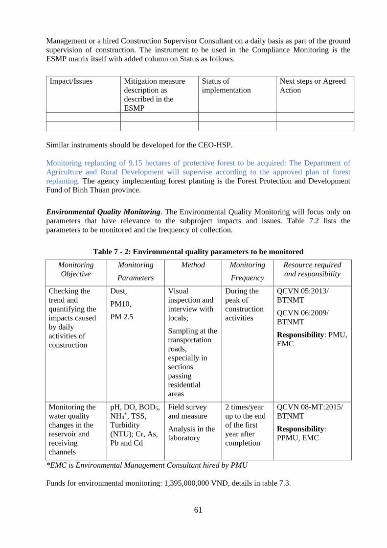
61
Management or a hired Construction Supervisor Consultant on a daily basis as part of the ground
supervision of construction. The instrument to be used in the Compliance Monitoring is the
ESMP matrix itself with added column on Status as follows.
Impact/Issues Mitigation measure
description as
described in the
ESMP
Status of
implementation
Next steps or Agreed
Action
Similar instruments should be developed for the CEO-HSP.
Monitoring replanting of 9.15 hectares of protective forest to be acquired: The Department of
Agriculture and Rural Development will supervise according to the approved plan of forest
replanting. The agency implementing forest planting is the Forest Protection and Development
Fund of Binh Thuan province.
Environmental Quality Monitoring. The Environmental Quality Monitoring will focus only on
parameters that have relevance to the subproject impacts and issues. Table 7.2 lists the
parameters to be monitored and the frequency of collection.
Table 7 - 2: Environmental quality parameters to be monitored
Monitoring
Objective
Monitoring
Parameters
Method Monitoring
Frequency
Resource required
and responsibility
Checking the
trend and
quantifying the
impacts caused
by daily
activities of
construction
Dust,
PM10,
PM 2.5
Visual
inspection and
interview with
locals;
Sampling at the
transportation
roads,
especially in
sections
passing
residential
areas
During the
peak of
construction
activities
QCVN 05:2013/
BTNMT
QCVN 06:2009/
BTNMT
Responsibility: PMU,
EMC
Monitoring the
water quality
changes in the
reservoir and
receiving
channels
pH, DO, BOD5,
NH4+, TSS,
Turbidity
(NTU); Cr, As,
Pb and Cd
Field survey
and measure
Analysis in the
laboratory
2 times/year
up to the end
of the first
year after
completion
QCVN 08-MT:2015/
BTNMT
Responsibility:
PPMU, EMC
*EMC is Environmental Management Consultant hired by PMU
Funds for environmental monitoring: 1,395,000,000 VND, details in table 7.3.
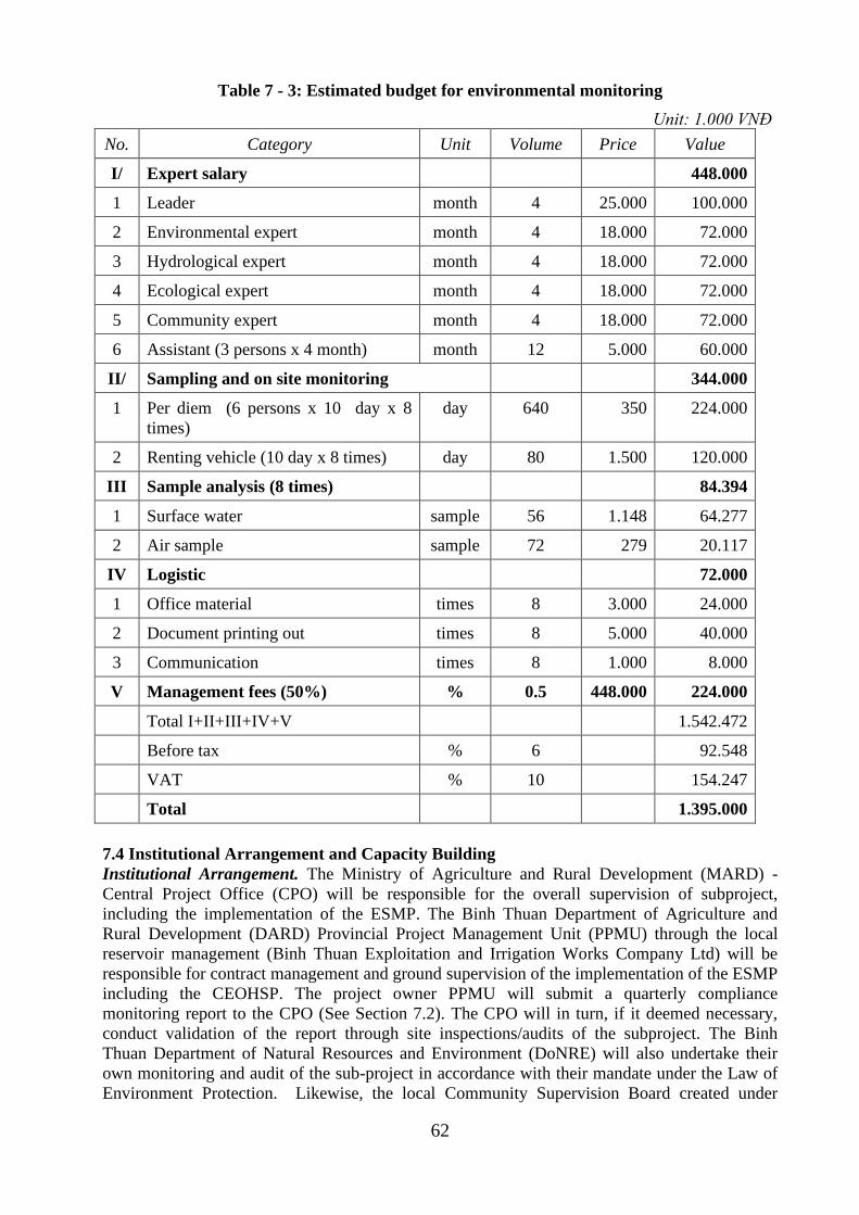
62
Table 7 - 3: Estimated budget for environmental monitoring
Unit: 1.000 VNĐ
No. Category Unit Volume Price Value
I/ Expert salary 448.000
1 Leader month 4 25.000 100.000
2 Environmental expert month 4 18.000 72.000
3 Hydrological expert month 4 18.000 72.000
4 Ecological expert month 4 18.000 72.000
5 Community expert month 4 18.000 72.000
6 Assistant (3 persons x 4 month) month 12 5.000 60.000
II/ Sampling and on site monitoring 344.000
1 Per diem (6 persons x 10 day x 8
times)
day 640 350 224.000
2 Renting vehicle (10 day x 8 times) day 80 1.500 120.000
III Sample analysis (8 times) 84.394
1 Surface water sample 56 1.148 64.277
2 Air sample sample 72 279 20.117
IV Logistic 72.000
1 Office material times 8 3.000 24.000
2 Document printing out times 8 5.000 40.000
3 Communication times 8 1.000 8.000
V Management fees (50%) % 0.5 448.000 224.000
Total I+II+III+IV+V 1.542.472
Before tax % 6 92.548
VAT % 10 154.247
Total 1.395.000
7.4 Institutional Arrangement and Capacity Building
Institutional Arrangement. The Ministry of Agriculture and Rural Development (MARD) -
Central Project Office (CPO) will be responsible for the overall supervision of subproject,
including the implementation of the ESMP. The Binh Thuan Department of Agriculture and
Rural Development (DARD) Provincial Project Management Unit (PPMU) through the local
reservoir management (Binh Thuan Exploitation and Irrigation Works Company Ltd) will be
responsible for contract management and ground supervision of the implementation of the ESMP
including the CEOHSP. The project owner PPMU will submit a quarterly compliance
monitoring report to the CPO (See Section 7.2). The CPO will in turn, if it deemed necessary,
conduct validation of the report through site inspections/audits of the subproject. The Binh
Thuan Department of Natural Resources and Environment (DoNRE) will also undertake their
own monitoring and audit of the sub-project in accordance with their mandate under the Law of
Environment Protection. Likewise, the local Community Supervision Board created under
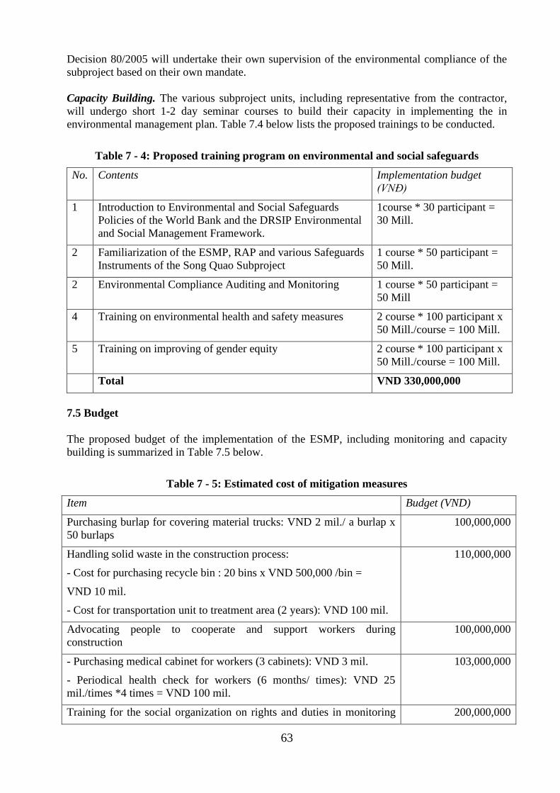
63
Decision 80/2005 will undertake their own supervision of the environmental compliance of the
subproject based on their own mandate.
Capacity Building. The various subproject units, including representative from the contractor,
will undergo short 1-2 day seminar courses to build their capacity in implementing the in
environmental management plan. Table 7.4 below lists the proposed trainings to be conducted.
Table 7 - 4: Proposed training program on environmental and social safeguards
No. Contents Implementation budget
(VNĐ)
1 Introduction to Environmental and Social Safeguards
Policies of the World Bank and the DRSIP Environmental
and Social Management Framework.
1course * 30 participant =
30 Mill.
2 Familiarization of the ESMP, RAP and various Safeguards
Instruments of the Song Quao Subproject
1 course * 50 participant =
50 Mill.
2 Environmental Compliance Auditing and Monitoring 1 course * 50 participant =
50 Mill
4 Training on environmental health and safety measures 2 course * 100 participant x
50 Mill./course = 100 Mill.
5 Training on improving of gender equity 2 course * 100 participant x
50 Mill./course = 100 Mill.
Total VND 330,000,000
7.5 Budget
The proposed budget of the implementation of the ESMP, including monitoring and capacity
building is summarized in Table 7.5 below.
Table 7 - 5: Estimated cost of mitigation measures
Item Budget (VND)
Purchasing burlap for covering material trucks: VND 2 mil./ a burlap x
50 burlaps
100,000,000
Handling solid waste in the construction process:
- Cost for purchasing recycle bin : 20 bins x VND 500,000 /bin =
VND 10 mil.
- Cost for transportation unit to treatment area (2 years): VND 100 mil.
110,000,000
Advocating people to cooperate and support workers during
construction
100,000,000
- Purchasing medical cabinet for workers (3 cabinets): VND 3 mil.
- Periodical health check for workers (6 months/ times): VND 25
mil./times *4 times = VND 100 mil.
103,000,000
Training for the social organization on rights and duties in monitoring 200,000,000
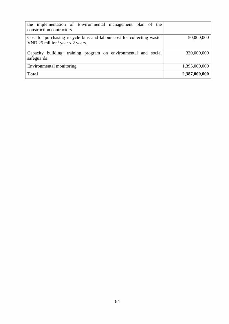
64
the implementation of Environmental management plan of the
construction contractors
Cost for purchasing recycle bins and labour cost for collecting waste:
VND 25 million/ year x 2 years.
50,000,000
Capacity building: training program on environmental and social
safeguards
330,000,000
Environmental monitoring 1,395,000,000
Total 2,387,000,000
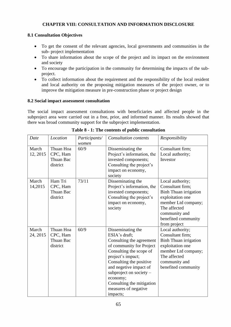
65
CHAPTER VIII: CONSULTATION AND INFORMATION DISCLOSURE
8.1 Consultation Objectives
• To get the consent of the relevant agencies, local governments and communities in the
sub- project implementation
• To share information about the scope of the project and its impact on the environment
and society
• To encourage the participation in the community for determining the impacts of the sub-
project.
• To collect information about the requirement and the responsibility of the local resident
and local authority on the proposing mitigation measures of the project owner, or to
improve the mitigation measure in pre-construction phase or project design
8.2 Social impact assessment consultation
The social impact assessment consultations with beneficiaries and affected people in the
subproject area were carried out in a free, prior, and informed manner. Its results showed that
there was broad community support for the subproject implementation.
Table 8 - 1: The contents of public consultation
Date Location Participants/
women
Consultation contents Responsibility
March
12, 2015
Thuan Hoa
CPC, Ham
Thuan Bac
district
60/9 Disseminating the
Project’s information, the
invested components;
Consulting the project’s
impact on economy,
society
Consultant firm;
Local authority;
Investor
March
14,2015
Ham Tri
CPC, Ham
Thuan Bac
district
73/11 Disseminating the
Project’s information, the
invested components;
Consulting the project’s
impact on economy,
society
Local authority;
Consultant firm;
Binh Thuan irrigation
exploitation one
member Ltd company;
The affected
community and
benefited community
from project
March
24, 2015
Thuan Hoa
CPC, Ham
Thuan Bac
district
60/9 Disseminating the
ESIA’s draft;
Consulting the agreement
of community for Project
Consulting the scope of
project’s impact;
Consulting the positive
and negetive impact of
subproject on society –
economy;
Consulting the mitigation
measures of negative
impacts;
Local authority;
Consultant firm;
Binh Thuan irrigation
exploitation one
member Ltd company;
The affected
community and
benefited community
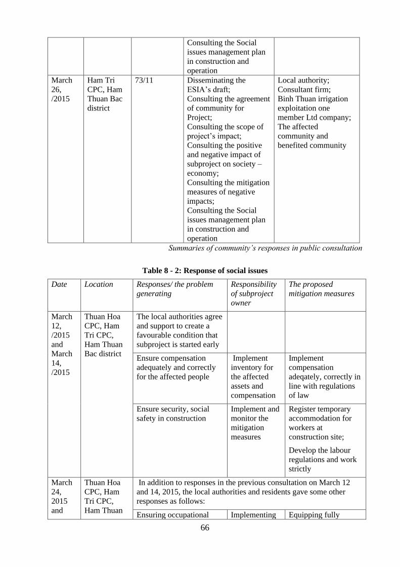
66
Consulting the Social
issues management plan
in construction and
operation
March
26,
/2015
Ham Tri
CPC, Ham
Thuan Bac
district
73/11 Disseminating the
ESIA’s draft;
Consulting the agreement
of community for
Project;
Consulting the scope of
project’s impact;
Consulting the positive
and negative impact of
subproject on society –
economy;
Consulting the mitigation
measures of negative
impacts;
Consulting the Social
issues management plan
in construction and
operation
Local authority;
Consultant firm;
Binh Thuan irrigation
exploitation one
member Ltd company;
The affected
community and
benefited community
Summaries of community’s responses in public consultation
Table 8 - 2: Response of social issues
Date Location Responses/ the problem
generating
Responsibility
of subproject
owner
The proposed
mitigation measures
March
12,
/2015
and
March
14,
/2015
Thuan Hoa
CPC, Ham
Tri CPC,
Ham Thuan
Bac district
The local authorities agree
and support to create a
favourable condition that
subproject is started early
Ensure compensation
adequately and correctly
for the affected people
Implement
inventory for
the affected
assets and
compensation
Implement
compensation
adeqately, correctly in
line with regulations
of law
Ensure security, social
safety in construction
Implement and
monitor the
mitigation
measures
Register temporary
accommodation for
workers at
construction site;
Develop the labour
regulations and work
strictly
March
24,
2015
and
Thuan Hoa
CPC, Ham
Tri CPC,
Ham Thuan
In addition to responses in the previous consultation on March 12
and 14, 2015, the local authorities and residents gave some other
responses as follows:
Ensuring occupational Implementing Equipping fully
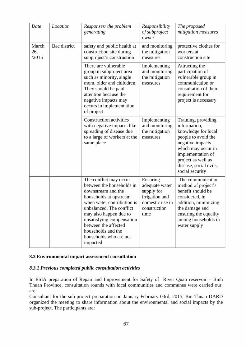
67
Date Location Responses/ the problem
generating
Responsibility
of subproject
owner
The proposed
mitigation measures
March
26,
/2015
Bac district safety and public health at
construction site during
subproject’s construction
and monitoring
the mitigation
measures
protective clothes for
workers at
construction site
There are vulnerable
group in subproject area
such as minority, single
mom, older and childdren.
They should be paid
attention because the
negative impacts may
occurs in implementation
of project
Implementing
and monitoring
the mitigation
measures
Attracting the
participation of
vulnerable group in
communication or
consultation of their
requirement for
project is necessary
Construction activities
with negative impacts like
spreading of disease due
to a large of workers at the
same place
Implementing
and monitoring
the mitigation
measures
Training, providing
information,
knowledge for local
people to avoid the
negative impacts
which may occur in
implementation of
project as well as
disease, social evils,
social security
The conflict may occur
between the households in
downstream and the
households at upstream
when water contribution is
unbalanced. The conflict
may also happen due to
unsatisfying compensation
between the affected
households and the
households who are not
impacted
Ensuring
adequate water
supply for
irrigation and
domestic use in
construction
time
The communication
method of project’s
benefit should be
considered, in
addition, minimizing
the damage and
ensuring the equality
among households in
water supply
8.3 Environmental impact assessment consultation
8.3.1 Previous completed public consultation activities
In ESIA preparation of Repair and Improvement for Safety of River Quao reservoir – Binh
Thuan Province, consultation rounds with local communities and communes were carried our,
are:
Consultant for the sub-project preparation on January February 03rd, 2015, Bin Thuan DARD
organized the meeting to share information about the environmental and social impacts by the
sub-project. The participants are:
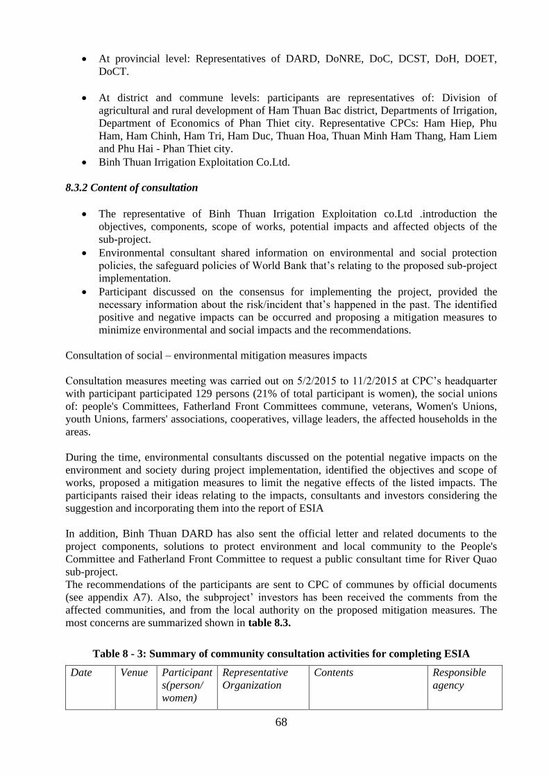
68
• At provincial level: Representatives of DARD, DoNRE, DoC, DCST, DoH, DOET,
DoCT.
• At district and commune levels: participants are representatives of: Division of
agricultural and rural development of Ham Thuan Bac district, Departments of Irrigation,
Department of Economics of Phan Thiet city. Representative CPCs: Ham Hiep, Phu
Ham, Ham Chinh, Ham Tri, Ham Duc, Thuan Hoa, Thuan Minh Ham Thang, Ham Liem
and Phu Hai - Phan Thiet city.
• Binh Thuan Irrigation Exploitation Co.Ltd.
8.3.2 Content of consultation
• The representative of Binh Thuan Irrigation Exploitation co.Ltd .introduction the
objectives, components, scope of works, potential impacts and affected objects of the
sub-project.
• Environmental consultant shared information on environmental and social protection
policies, the safeguard policies of World Bank that’s relating to the proposed sub-project
implementation.
• Participant discussed on the consensus for implementing the project, provided the
necessary information about the risk/incident that’s happened in the past. The identified
positive and negative impacts can be occurred and proposing a mitigation measures to
minimize environmental and social impacts and the recommendations.
Consultation of social – environmental mitigation measures impacts
Consultation measures meeting was carried out on 5/2/2015 to 11/2/2015 at CPC’s headquarter
with participant participated 129 persons (21% of total participant is women), the social unions
of: people's Committees, Fatherland Front Committees commune, veterans, Women's Unions,
youth Unions, farmers' associations, cooperatives, village leaders, the affected households in the
areas.
During the time, environmental consultants discussed on the potential negative impacts on the
environment and society during project implementation, identified the objectives and scope of
works, proposed a mitigation measures to limit the negative effects of the listed impacts. The
participants raised their ideas relating to the impacts, consultants and investors considering the
suggestion and incorporating them into the report of ESIA
In addition, Binh Thuan DARD has also sent the official letter and related documents to the
project components, solutions to protect environment and local community to the People's
Committee and Fatherland Front Committee to request a public consultant time for River Quao
sub-project.
The recommendations of the participants are sent to CPC of communes by official documents
(see appendix A7). Also, the subproject’ investors has been received the comments from the
affected communities, and from the local authority on the proposed mitigation measures. The
most concerns are summarized shown in table 8.3.
Table 8 - 3: Summary of community consultation activities for completing ESIA
Date Venue Participant
s(person/
women)
Representative
Organization
Contents Responsible
agency
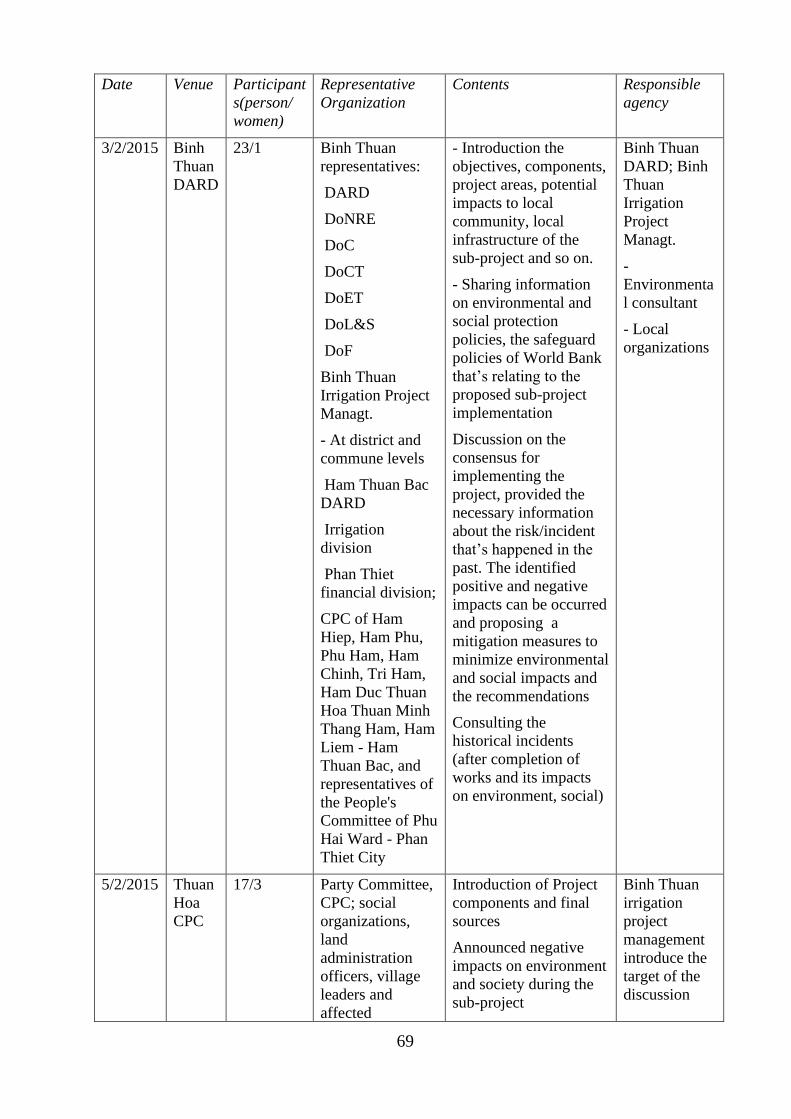
69
Date Venue Participant
s(person/
women)
Representative
Organization
Contents Responsible
agency
3/2/2015 Binh
Thuan
DARD
23/1 Binh Thuan
representatives:
DARD
DoNRE
DoC
DoCT
DoET
DoL&S
DoF
Binh Thuan
Irrigation Project
Managt.
- At district and
commune levels
Ham Thuan Bac
DARD
Irrigation
division
Phan Thiet
financial division;
CPC of Ham
Hiep, Ham Phu,
Phu Ham, Ham
Chinh, Tri Ham,
Ham Duc Thuan
Hoa Thuan Minh
Thang Ham, Ham
Liem - Ham
Thuan Bac, and
representatives of
the People's
Committee of Phu
Hai Ward - Phan
Thiet City
- Introduction the
objectives, components,
project areas, potential
impacts to local
community, local
infrastructure of the
sub-project and so on.
- Sharing information
on environmental and
social protection
policies, the safeguard
policies of World Bank
that’s relating to the
proposed sub-project
implementation
Discussion on the
consensus for
implementing the
project, provided the
necessary information
about the risk/incident
that’s happened in the
past. The identified
positive and negative
impacts can be occurred
and proposing a
mitigation measures to
minimize environmental
and social impacts and
the recommendations
Consulting the
historical incidents
(after completion of
works and its impacts
on environment, social)
Binh Thuan
DARD; Binh
Thuan
Irrigation
Project
Managt.
-
Environmenta
l consultant
- Local
organizations
5/2/2015 Thuan
Hoa
CPC
17/3 Party Committee,
CPC; social
organizations,
land
administration
officers, village
leaders and
affected
Introduction of Project
components and final
sources
Announced negative
impacts on environment
and society during the
sub-project
Binh Thuan
irrigation
project
management
introduce the
target of the
discussion
70
Date Venue Participant
s(person/
women)
Representative
Organization
Contents Responsible
agency
households implementation
Discussion on the issue
that happened in the
past
Discussed on mitigation
measures - Official
feedbacks
People’s Committee of
communes and
Fatherland front
committee gave
feedback in official
writing.
Environmenta
l consultant
introduce
environmental
management
plan including
mitigation
measures,
implementatio
n plan and the
potential
impacts on
environment
and society in
construction
and operation
phase
CPC and
community
discussed on
the mitigation
measure and
impacts of the
Project,
appraisal or
not appraisal
to the
implementatio
n of the
Project
Official
feedback and
consultant
document.
6/2/2015 Ham
Chinh
CPC
13/3 Party Committee,
CPC; social
organizations,
land
administration
officers, village
leaders and
affected
households
9/2/2015 Ma
lam
town
CPC
18/3 Party Committee,
CPC; social
organizations,
land
administration
officers, village
leaders and
affected
households
10/2/201
5
Ham
thang
CPC
11/3 Party Committee,
CPC; social
organizations,
land
administration
officers, village
leaders and
affected
households
11/2/201
5
Phu
Hai
ward-
Phan
Thiet
city
CPC
13/3 Party Committee,
CPC; social
organizations,
land
administration
officers, village
leaders and
affected
households
12/2/201
5
Phu
Long
CPC
10/2 Party Committee,
CPC; social
organizations,
land
administration
officers, village
leaders and
affected
71
Date Venue Participant
s(person/
women)
Representative
Organization
Contents Responsible
agency
households
13/2/201
5
Ham
Tri
CPC
23/2 Party Committee,
CPC; social
organizations,
land
administration
officers, village
leaders and
affected
households
8.3.3 The response from community consultation
The results of community consultation are (See Table 8.4):
1. All participants participated in the meeting agreed to implement the sub-project, because
it will be ensured to handle the of River Quao sub-project, in good condition. The sub-
project implementation also reduces the risks for local residents in the rainy season, and
protect to 4963 households in water release corridor areas (Investment report 2015);
2. The discussed negative impacts on the environment and society are: the affected
household, People's Committee and Fatherland Front Committee agreed that the negative
effects could be harmed to the environment and society such as the land acquisition, dust
and noise increasing, the health safe, security, environmental sanitation in construction
areas,, impacts to irrigation areas in construction phase, local road damage due to
material and wastes transportation etc., have to limit in order to keep a good environment
and social conditions.
3. The proposed mitigation measures to reduce negative impact on environment: The
transporting materials should avoid night time operation to reduce impact to local
resident activities
4. After receiving consultations of the commune People's Committee and Fatherland Front
in areas due to the impacts of the sub-project of Repair and enhance the safety of Song
Quao reservoir, Ham Thuan Bac- Binh Thuan. Binh Thuan Irrigation exploitation
commitments to:
• Commit to pay the compensation of affected local infrastructures, road in accordance
with the policy of the World Bank and the Government of Vietnam
• Commit to follow the proposed mitigation measures that mentioned in ESIA report of
the sub-project
• Commit to keep good contact with local authority to manage worker on site and
reduce conflict between worker and local resident, reduce traffic accidences in the
local, etc.
• Commit to ensure the local traffic condition in good condition
• Ensure sufficient water supply to resident and irrigation
• Commit to follow the National laws and regulations on environmental protection.
72
The public consultation document, the recommendations of the CPC's, the commitment of Binh
Thuan irrigation project management Unit response to report on the evaluation of environmental
and social impacts are in the appendix.
Table 8 - 4: Summaries feedback form consultant rounds
Date Venue Feedback and comment Project owner
responsible
Mitigation measures
16/2/2015 Thuan Hoa
People’s
Committee
headquarter
- Scope of impact:
Agricultural production
area; residential are near
construction site
- the affected objects:
People living near
construction site, tree,
crop(dragon tree + rice)
will be affected during
repairing dam due to
lack of water
- Impact on social
security and order,
environmental sanitation
because construction
site is near commune
Mitigation
measures of
environmental
pollution and
ensuring
security and
order should be
available in
construction
phase
- Arranging suitable
accommodation for
workers and staffs,
and management plan
for workers should be
considered to ensure
their health.
- A plan of close
collaboration between
construction site and
civil unit , local
authority and local
people should be
available to ensure
security,
environmental
sanitation of
surrounding
environment
17/2/2015 Ham Chinh
People’s
Committee
headquarter
- Scope of impact:
Arable production area,
the area along NR 28,
the villages at low –
lying land along Cai
river
- The affected objects:
The people living along
NR 28, arable land, tree,
crop ( dragon tree +
crop) will be affected
during repairing
reservoir due to lack of
water
The negative impacts on
environment:
- Impact on daily life of
local people living along
NR 28 due to noise and
dust generating material
truck, causing damage
The dust
mitigation
measure for
local people
living along NR
28 should be
available;
Ensuring water
supply for
irrigation in
repairing time
The measures such as
covering material
truck, transporting at
night to avoid impact
of daily life of people
should be considered;
The local people must
be announced timely
in case of releasing
water in order to
protect their assets
73
to local road due to
transportation of
material
- Lack of water in arable
production area during
repairing reservoir
- People and arable
production land along
Cai river will be
affected in case of
releasing water
18/2/2015 Ma Lam
CPC
headquarter
- Affected areas:
agricultural areas, the
areas along the QL 28
and resident areas along
river Cai
- Deficit water for
irrigation
- Water release effect to
agricultural areas and
the fruit tree plantation
of river Cai areas
Ensuring water
supply for
irrigation in
repairing time
- The material
transport vehicle have
to operate in night
time to avoid the
impact to local people.
The vehicle have to
cover during material
carrying., watering
road surface to reduce
dust
- Notice the
downstream areas
about water release
19/2/2015 Ham Thang
CPC
headquarter
- Scope of impact:
agricultural areas, the
areas along the QL 28
and resident areas along
river Cai
- The affected objects:
+ Local resident,
infrastructure along to
QL 28 by noise, and
dust generating from
material transportation
+ effect to irrigation
during construction
phase
+ Water release effect to
agricultural areas and
the fruit tree plantation
of river Cai areas
Ensuring water
supply for
irrigation in
repairing time
Building a
proper water
releasing plan
- The material
transport vehicle have
to operate in night
time to avoid the
impact to local people.
The vehicle have to
cover during material
carrying., watering
road surface to reduce
dust
- Notice the
downstream areas
about water release
20/2/2015 Phu Hai
ward
People’s
Committee
headquarter
Habour safety Informing early
to local people
in case of
releasing water
- Notice the
downstream areas
about water release
and ships, vessel in
docking place safety
74
– Phan Thiet
city
23/2/2015 Phu Long
town
People’s
Committee
headquarter
Deficit water for
irrigation in
construction phase
Ensuring water
supply for
irrigation in
repairing time
Use alternative water
resources to irrigation
during repair and
improve the reservoir
24/2/2015 Ham Tri
CPC
headquarter
- Affected areas:
agricultural areas, the
areas along the QL 28
and resident areas along
river Cai
- Local security,
environmental sanitation
because the construction
site located nearby the
resident areas of the
commune
- In case of releasing
water at spillway no. 2,
it may cause flood to
households living along
water releasing corridor
(20 households of Ham
Tri commune)
Reduce dust
generating
along QL 28
due to material
transportation
Have to develop
a security plan
to reduce
impacts to the
commune.
- The auxiliary areas
and camping site have
to locate in dam
corridor to avoid land
acquisition and
compensation and
flooding event
- Develop a plan of
worker
accommodation and
management to ensure
safety and worker
health
- The material
transport vehicle have
to operate in night
time to avoid the
impact to local people.
The vehicle have to
cover during material
carrying., watering
road surface to reduce
dust
- Develop a plan and
train local people to
respond the case of
releasing water at
spillway no. 2;
- A plan of
evacuation, protection
for assets of 20
households in case of
flood
8.4 ESIA disclosure
As per the World Bank’s policy on access to information and OP 4.01, the draft ESIA report in
Vietnamese language was locally disclosed on the project website and at subproject sites
accessible to locally-affected people and local NGOs, and the English version was disclosed on
the Bank external website in 2015 prior to subproject appraisal.

75
This updated ESIA report shall be locally disclosed on the project website and at subproject sites
accessible to locally-affected people and local NGOs. The English version shall also be disclosed
on the Bank external website.
76
REFERENCES
1. Project investment report “Repairing and safety improvement of Song Quao reservoir –
Binh Thuan province”;
2. Stratergy environmental impact assessment of project “ Irrigation development planning
of Binh Thuan province from 2011-2020”;
3. Department of Natural Resources and Environment of Binh Thuan province:
“Environmental current status report of Binh Thuan from 2005-2009”, 2010;
4. Department of planning and investment of Binh Thuan province, “Overall planning of
social – economic development of Binh Thuan province by 2020”.
5. Truong Manh Tien, “Environment monitoring”, Hanoi national university publisher,
2006;
6. Nguyen Dinh Hoe, “Environment and sustainable development”, Hanoi eduction
publisher, 2006;
7. Statistic year book of Binh Thuan province, 2013;
8. Environmental Assessment Guidelines, Asian Development Bank, 2003.
9. Environmental Assessment Sourcebook, Volume II, Sectoral Guidelines, Environment,
World Bank, Washington D.C, 1991
10. P.A. Economopolous, Assessment of Sources of Water, Solid, Air and Land Pollution
Sources, WHO, Geneva, 1993
77
APPENDIX
APPENDIX A – ENVIRONMENT
Appendix A1- Drawing of the main works
Appendix A2-Types of Map
Appendix A3- Policyframework, institution and regulation
Appendix A4- Environmental and social screening
Appendix A5- Diagram of sampling and monitoringenvironment
Appendix A6-Analysis results of environmentalsamples
Appendix A7- Publicconsultation minutes
Appendix A8- Environmental Specifications (for inclusion in bidding and construction contracts)
Appendix A9- Chance Find Procedures
Appendix A10- Adoption of unexploded ordnance procedure
Appendix A11- Emergency preparedness plan
Appendix A12- Integrated Pest Management (IPM)
Appendix A13- Pictures of current status of subproject area
APPENDIX B – SOCIAL
Appendix B1- Methodogical note
Appendix B2- Public Health intervention Plan
Appendix B3 – Public consultation, participation and communication strategy
Appendix B4- Gender action plan
Appendix B5- Grievance redress mechanism
Appendix B6- Information disclosure, accountability and monitoring
78
APPENDIX A – ENVIRONMENT
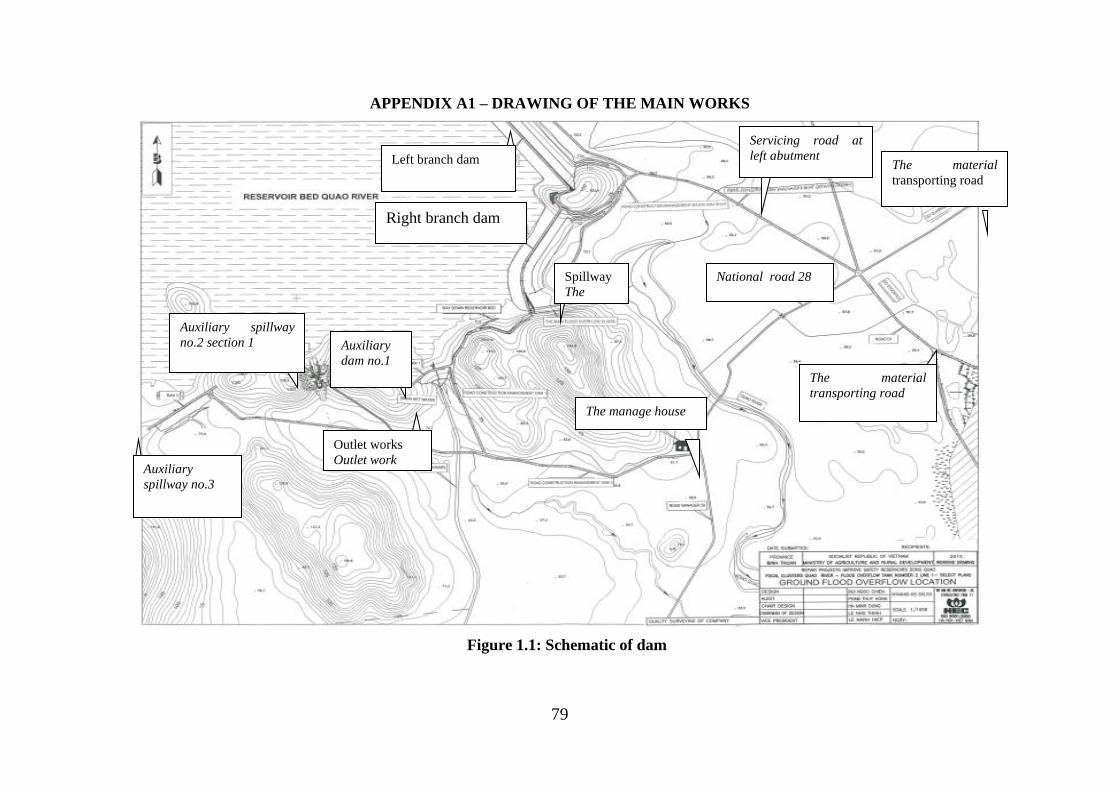
79
APPENDIX A1 – DRAWING OF THE MAIN WORKS
Figure 1.1: Schematic of dam
Auxiliary spillway
no.2 section 1
Spillway
The
spillway
Right branch dam
The manage house
The material
transporting road
The material
transporting road
Auxiliary
dam no.1
Outlet works
Outlet work
National road 28
Auxiliary
spillway no.3
Left branch dam
Servicing road at
left abutment
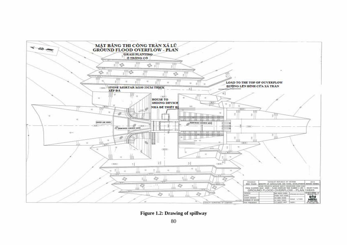
80
Figure 1.2: Drawing of spillway
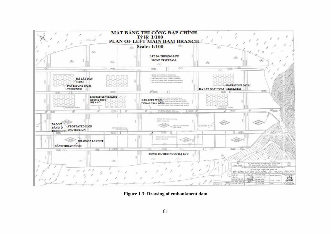
81
Figure 1.3: Drawing of embankment dam
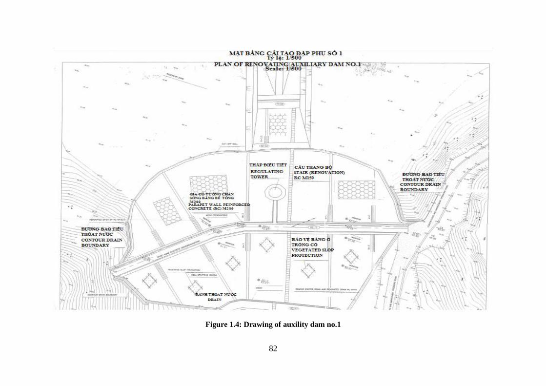
82
Figure 1.4: Drawing of auxility dam no.1
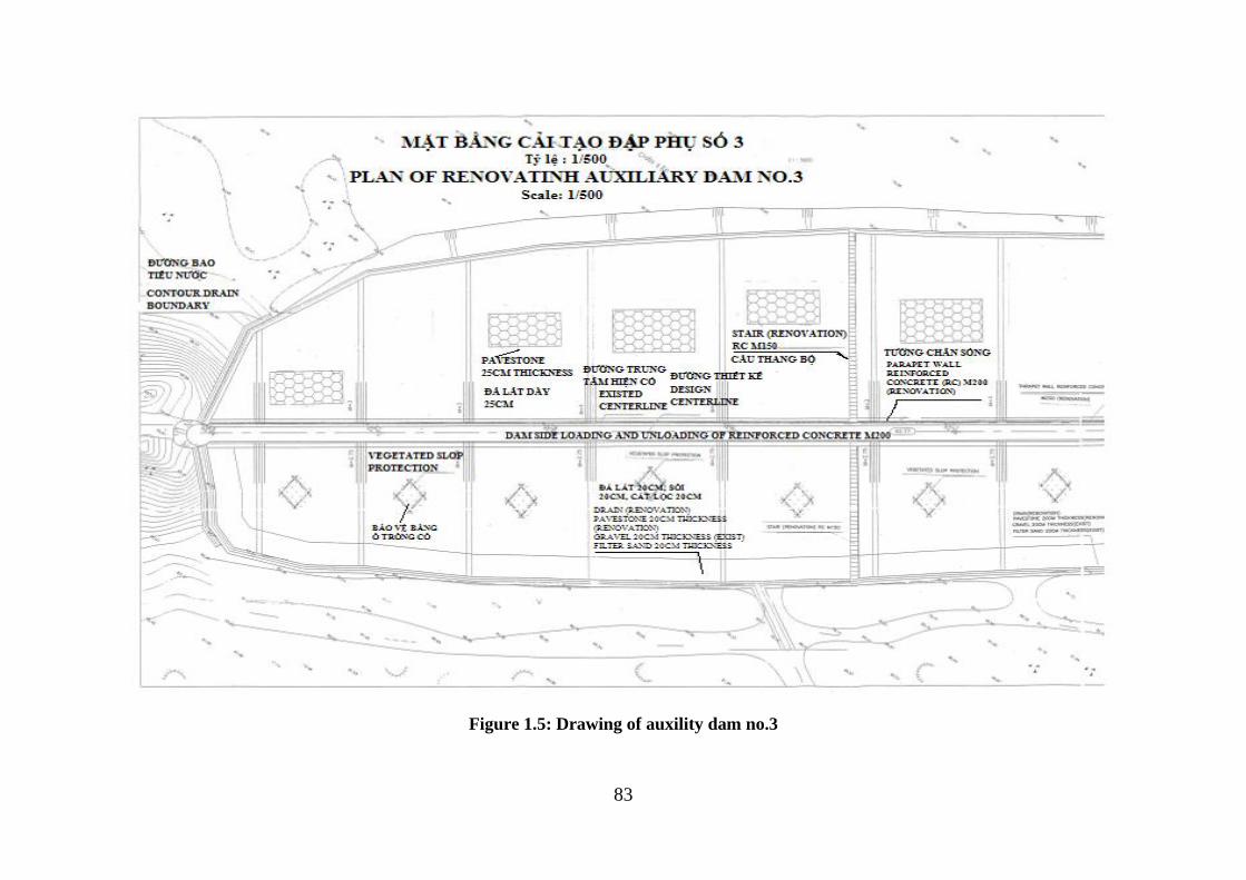
83
Figure 1.5: Drawing of auxility dam no.3
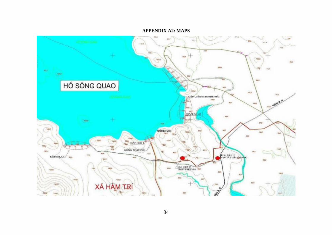
84
APPENDIX A2: MAPS
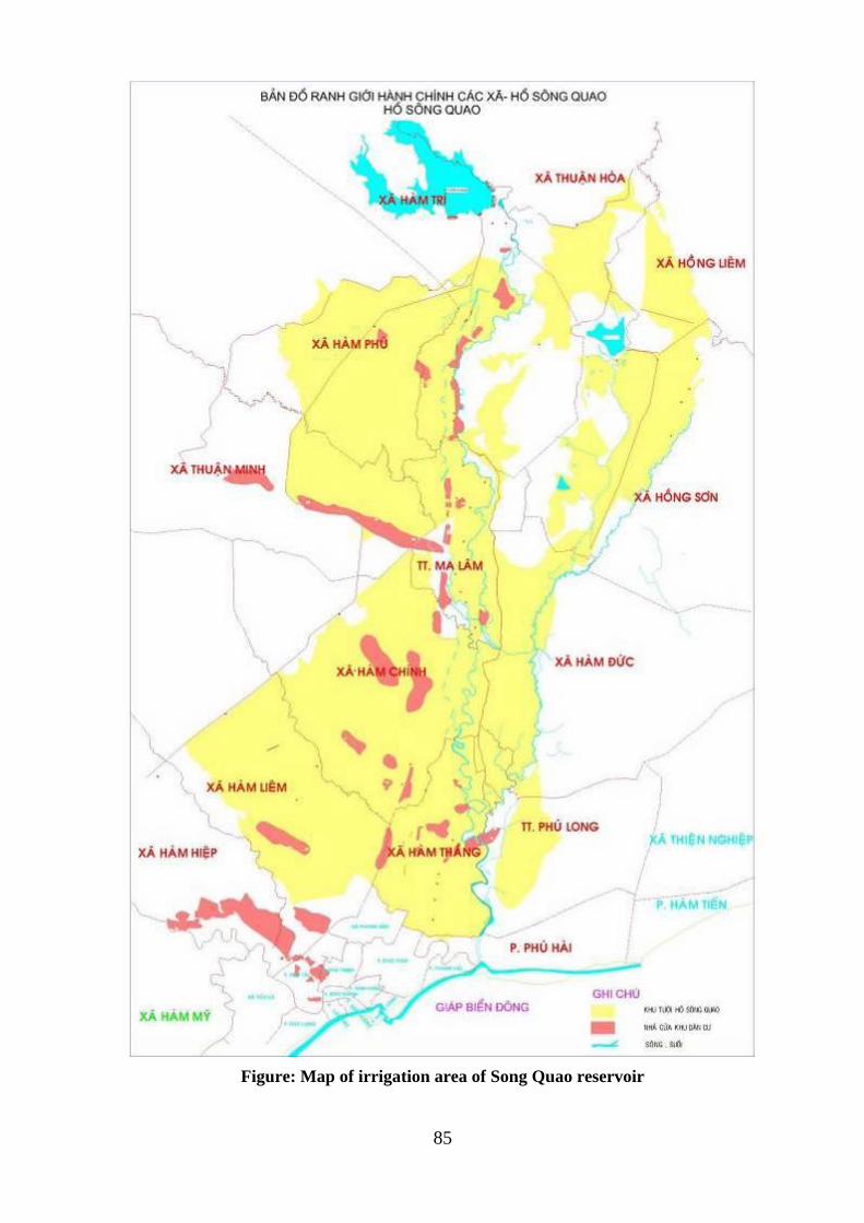
85
Figure: Map of irrigation area of Song Quao reservoir
86
APPENDIX A3: POLICIES, INSTITUTIONAL AND REGULATIONS
Applicable National policies, legal and administrative frameworks
i) Environment
• Law of environmental protection no. 55/2014/QH13, on Regulating Strategic Environmental
Assessment, Environmental Impact Assessment and Environmental Protection Commitment.
Environmental report should be carried out simultaneously with the establishment of
investment projects (Feasibility study report).
• Decree no.18/2015/ND-CP on dated 02/14/2015 regulations on environmental protection
planning, strategic environmental assessment, environmental impact assessment and
environmental protection plan.
• Circular no. 27/2015/TT-BTNMT on dated 5/29/2015 on Strategic Environmental
Assessment, Environmental Impact Assessment and Environmental Protection Plan
• Directive no.26/CT-TTg on dated 25/08/2014 regards on to implement the Law of
Environmental Protection.
• Circular no.01/2012/TT-BTNMT, March 16/2012 regarding regulation on the establishment,
evaluation, approval and inspection and certification of the implementation of environmental
protection projects in detail, establishment and registration schemes for simple environmental
protection.
• Decree no.29/2011/ND-CP dated April 18/2011 regarding regulations on strategic
environmental assessment, environmental impacts assessment and environmental protection
commitments.
• Circular no.16/2009/TT-BTNMT on dated 07/10/2009 by the Ministry of Natural Resources
and Environment, regarding regulations, national technical regulations on the environment,
air quality and a number of toxic substances in the ambient air.
• Decision no.22/2006/QD-BTNMT on dated 25/12/2006 by the Ministry of Natural Resources
and Environment regarding on the applying the set of Vietnam standards environmental.
ii) Land use and land acquisition
• Land law no.45/2013/QH13 approved by National Assembly of the Socialist Republic of
Vietnam Assembly on date 29/11//2013.
• Decree no.43/2014/ND-CP on dated 05/15/2014 regarding on implementing of the Land law
2013.
• Decree no.44/2014 /ND-CP on dated 15/05/2014 regulating method of valuation of land;
construction, land price adjustment; specific land valuation and land valuation advisory.
• Decree no.47/2014/ND-CP on dated 05/15/2014 concerning on the provisions on
compensation, support and resettlement due to land acquisition.
• Decree no.37/2014/ND-CP dated 30/06/2014 giving more detail information of
compensation, support and resettlement when the land acquisition.
• Circular no.23/2014/TT-BTNMT 05/19/2014 regarding on regulations of land use rights,
owners house and properties on land.
iii) Construction
• Construction Law no.50/2014/QH13 on 08.18.2014 approved by the National Assembly of
the Socialist Republic of Vietnam.
• Decree no.15/2013/ND-CP dated 02/06/2013 on the construction quality management.
• Decree no.207/2013/ND-CP dated 11/12/2013 on supplementation some articles of Decree
no.48/2010/ND-CP of May 7/2010 of the Government on the construction contract.
• Decree no.12/2009/ND-CP dated 10/02/2009 on the construction projects management and
87
investment.
iv) Water resources, forest protection, cultural and heritages, biodiversity
• Law of Water resources, approved by Vietnam Assembly on 21/06/2012.
• Decree no.42/2012/ND-CP dated 11/05/2012 by Government on the management and use of
land for paddy rice cultivation
• Decree no.112/2008/ND-CP dated 20/10/2008 by Government on the integration of
management, protection and exploitation of hydropower reservoirs and irrigations.
• Decree no.120/2008/ND-CP dated 01/12/2008 by Government on the river basins
management
• Decree no.149/2004/ND-CP dated 27/07/2004 by Government regulates the license of
exploration, use of water resources and wastewater discharge into water resources.
• Law of Forest Protection and Development no.29/2004/QH11 approved by the National
Assembly of the Socialist Republic of Vietnam on 03/12/2004.
• Decree no.23/2006/ND-CP dated 03/03/2006 of the Government regarding on the Law of
Forest Protection and Development implementation.
• Decision no.57/QD-TTg dated 09/01/2012 approved by Vietnam Prime Minister to forests
plan protection and development by 2011-2020.
• Cultural Heritage Law no.28/2001/QH10 approved by the National Assembly of the Socialist
Republic of Vietnam on 07.12.2001.
• Biodiversity Law no.28/2008/QH12 approved by the National Assembly of the Socialist
Republic of Vietnam on 13/01/2008. Chapter III Conservation and sustainable development
of natural ecosystems, and Chapter IV Conservation and development of wildlife.
v) Dam safety regulations
• Circular no.34/2010/TT-BTC by the Ministry of Industry and Trade dated October 7/2010
regarding regulations on dam safety management of hydropower projects
• Decree no. 72 /NĐ-CP on date 07/05/2007 of the government of Vietnam on dam safety
management. According to the decree, a big dam is the dam with the height calculating from
the floor face to the top of the dam equal to or greater than 15 meters or dam of water
reservoirs with the scale of capacity equal to or greater than 3,000,000 m3 (three million
cubic meters). Small dam is the dam with the height calculating from the floor face to the top
of the dam smaller than 15 meters and creating water reservoirs with the scale of capacity
smaller than 3,000,000m3 (three million cubic meters). The works relating to water reservoirs
include: water intake, outlet works, flood discharge works, Locks. Dam owners are
organizations and individuals owning dams to harness the benefits of water reservoirs or
assigned to manage, operate and harness water reservoirs by the competent state agencies.
The Ministry of Agriculture and Rural Development takes responsibility before the
Government for the implementation of state management of dam safety. The Ministry of
Industry presides over and coordinates with ministries, branches and relative localities to
appraise, approve or submit to the Prime Minister for approval of the process of operating
hydropower reservoirs. The provincial-level People's Committees implement its state
management on dam safety in the areas.
• Document no. 1852/BNN-TCTL on dated 10.06.2014 of the Minister of Agriculture and
Rural Development on urgent repairs financial to ensure safe water reservoirs
vi) Resettlement policies
88
• Decision no.52/2012/QD-TTg, dated November 16/2012, on the support policies on
employment and vocational training to farmers whose agricultural land has been recovered
by the State.
• Decree no.84/2007/ND-CP of the Government of Vietnam on revision of issuing LURC,
land acquisition, implementation of land use right, procedure for compensation, resettlement
when land acquired by State and grievance redress
• Circular no.37/2014/TT-BTNMT dated 30 June 2014, regulating compensation, assistance
and resettlement when the State acquires land.
• Circular no.37/2014/TT-BTNMT dated 30 June 2014, regulating compensation, assistance
and resettlement when the State acquires land.
• Other regulations or administrative decisions related to resettlement plan to be issued by
HCMC People’s Committee in relation to the Land Law 2014, and its relevant decrees and
circulars.
• Decree no.69/2009/ND-CP of government, dated 13 August 2009 on regulating additional
planning of land use, land prices, land acquisition, compensation, assistance and
resettlement.
vii) Gender policies
• Law 73/2006/QH11 On gender equality the national assembly of the socialist republic of
Vietnam 10th session of the xi legislature Published Date 29/ 11/2006
• Decree no.07/2007/ND-CP of January 12/2007 detailing and guiding the implementation Of
A Number Of Articles Of The Law On Legal Aid
• Decree No. 70/2001/ND-CP Of October 3, 2001 Detailing The Implementation Of The
Marriage And Family Law
• Decree no. 55/2009/ND-CP on sanctioning of administrative violations of gender equality.
• Decree No. 48/2009/ND-CP providing for measures to assure gender equality.
• Circular No. 191/2009/TT-BTC dated 1/10/2009 guiding the management and use of funds
for gender equality activities and activities for the advancement of women. The circular was
issued in time to meet the requirements of the Law on Gender Equality in ensuring financial
resources for equality activities.
• Circular No 07/2011/TT-BTP dated 31/3/2011 issued by Minister of Justice providing
guidance on gender equality in legal aid activities.
• Decision No. 2351/QĐ-TTg dated 24/12/2010 of the Government Prime Minister approving
the National Strategy on Gender Equality (NSGE) period 2011-2020
viii) Indigenous Peoples and Minority group development policies
• Decision no.1956/2009/QD-TTg, dated November 17/2009, by the Prime Minister
approving the Master Plan on vocational training for rural labours by 2020
• Decree no.82/2010/ND-CP of government, dated 20 July 2010 on teaching and learning of
ethnic minority languages in schools.
• Resolution no.30a/2008/NQ-CP of government, dated 27 Dec. 2008 on support program for
rapid and sustainable poverty reduction for 61 poorest districts.
• Decision no.74/2008/QD-TTg of the Prime Minister dated 9-June-2008 on support
productive land and residential land for poor ethnic minority households in Mekong Delta
area.
89
• Decree no.60/2008/NĐ-CP dated 9-May-2008 of the government on the functions, tasks,
authorities and structure of the Committee for Ethnic Minorities Affair.
• Decision no.06/2007/QD-UBDT dated 12-January-2007 of the Committee for Ethnic
Minorities Affair on the strategy of media for the program 135-phase 2.
• Decree no.70/2001/ND-CP: all documents registering family assets and land use rights must
be in the names of both husband and wife.
ix) National policies and planning of reducing poverty
• Decision no.33/2007/QD-TTg of the Prime Minister dated 20-July-2007 on the policy of
assistance to improve knowledge of laws as a program of 135, phase 2.
• Circular no.06 dated 20-September-2007 of the Committee for Ethnic Minorities Affair
guidance on the assistance for services, improved livelihood of people, and technical
assistance for improving the knowledge on the laws according the decision 112/2007/QD-
TTg.
• Decision no.05/2007/QD-UBDT dated 06-September-2007 of the Committee for Ethnic
Minorities Affair on its acceptance for three regions of ethnic minorities and mountainous
areas based on development status.
x) The policies relate to the subproject implementation issuing by local authority
• Decision No. 2918 / QD-BNN-TCTL 29/10/2010 of the Minister of Agriculture and Rural
Development approved the project "Repairing and upgrading Quao River reservoirs and
irrigation dams Dan Sach, Binh Thuan Province".
• Pursuant to project documents "Repairing and upgrading Quao River reservoirs and
irrigation dams Dan Sach, Binh Thuan Province" was approved by Decision No. 2918 / QD-
BNN-TCTL dated 29/10 / 2010 of the Minister of Agriculture and Rural Development
xi) National standards
a) Water:
• QCVN 01:2009/BYT: National technique regulations on drinking-water quality
• QCVN 02:2009/BYT: National technique regulations on running water quality
• QCVN 08:2008/BTNMT: National technical regulation on surface water quality.
• QCVN 09:2008/BTNMT: National technical regulation on underground water quality
• QCVN 14:2008/BTNMT: National technical regulation on domestic wastewater
• QCVN 39:2011/BTNMT: National technical regulation on Water Quality for irrigated
agriculture
b) Air quality:
• QCVN 05:2008/BTNMT: Air quality – Surrounding air quality criterions
• QCVN 06:2008/BTNMT: Air quality – maximum permitted concentration of noxious
substances in the surrounding air.
• QCVN 07:2008/BTNMT: Air quality – Threatening of noxious substances in the air
• TCVN 6438:2001: Maximum permission limit of discarding dismissed gases.
c) Soil environment
• QCVN 03:2008/BTNMT: National technique regulations on permitted limit of hard metal in
land
• QCVN 43:2012/BTNMT: National technical regulation on sediment quality
d) Solid waste management:
• TCVN 6696:2009: Solid waste – garbage cleaning. Common requirements for environmental
protection
90
• QCVN 07:2009: National technique regulations on clarifying harmful waste.
e) Vibration and Noise:
• Technique regulations on vibration (replacing TCVN 6962:2001 – Vibration caused by
construction work and factories – maximum permitted level in environment in public areas
and residence zones)
• QCVN 26:2010/BTNMT – National technique regulations on noise (replacing TCVN
5948:1999 Acoustics – Noise caused by transportation moving when speeding up – permitted
calculation level).
f) Health and labor safety:
Decision No. 3733/2002/QĐ-BYT of Ministry of Health dated October 10th 2002 about applying
article 21 on labor health and relating safety criterions for microclimate, noise, vibration, chemicals
– permitted level in work place
91
APPENDIX A4: ENVIRONMENTAL AND SOCIAL SCREENING RESULTS
Table 4.1: Environmental and social eligibility screening of the sub-project
Belong to Category A Screening Criteria
Screening Questions Yes/No Remarks
1. Does the subproject have the potential to cause significant adverse impacts to natural or
critical natural habitats?
Leads to loss or degradation of sensitive
Natural Habitats defined as: land and water
areas where (i) the ecosystems' bio-logical
communities are formed largely by native
plant and animal species, and (ii) human
activity has not essentially modified the
area's primary ecological functions
No Acacia mangium, short term cultivation
crops: ground nut, maize, cassava, paddy
rice. It is not impact to local natural
species or natural habitats
- Leads to loss or degradation of Critical
natural habitat, i.e.: bio-diversity
conservation; and sites that are critical for
rare, vulnerable, migratory, or endangered
species.
No Conservation areas, protect areas are not
exist in the project areas. In upper stream
of the reservoir. There is only secondary
product forest, the main plant here are
Acacia mangium. In the areas does not
have critical natural habitats or
vulnerable species following CITES
2. Does the subproject have the potential to cause significant adverse impacts to physical
cultural resources?
Leads to loss or degradation of physical
cultural resources, defined as movable or
immovable objects, sites, structures, groups
of structures, and natural features and
landscapes that have archaeological,
paleontological, historical, architectural,
religious, aesthetic, or other cultural
significance. They may be located in urban
or rural settings, above or below ground, or
under water. Their cultural interest may be
at the local, provincial or national level, or
within the international community.
No
- Potentially results in a contravention of
national legislation, or national obligations
under relevant international environmental
treaties and agreements, including the
UNESCO World Heritage Convention or
affect sites with known and important
tourism or scientific interest.
No The project implementation following
and accordance with National and
international law, regulations
3. Does the subproject have the potential to cause significant adverse impacts on the lands and
related natural resources used by ethnic minorities?
Potentially result in impacts on lands or
territories that are traditionally owned, or
customarily used or occupied, and where
access to natural resources is vital to the
sustainability of cultures and livelihoods of
minority peoples. Potentially impact the
No Indigenous/Ethnic minorities group is not
impacted by the subproject
implementation
92
Screening Questions Yes/No Remarks
cultural and spiritual values attributed to
such lands and resources or impact natural
resources management and the long-term
sustainability of the affected resources.
4. Does the subproject have the potential to cause significant adverse effects to populations
subject to physical displacement?
Leads to physical displacement of
populations dependent upon lands or use of
specific use of resources that would be
difficult to replace or restore? Otherwise
lead to difficult issues in the ability of the
subproject to restore livelihoods?
Yes Temporarily acquisition 37.000m2 of
land for waste dumps, storage of soil,
stone sites, construction roads,
construction sites; permanent acquisition
is 75.795,3 m2 of land, of which, the land
acquired by households is 11,623.3 m2 of
7 households, mainly land for planting
annual trees and perennial crops, the land
acquisition does not affect the production
and life of people, by the households still
have much land for production.
No residential land is acquired and no
relocated households.
5 . Does the subproject entail the construction of a large dam?
Does the subproject require construction of a
dam that is:
• 15 meters or more in height
• between 10 and 15 meters in height with
special design complexities--for
example, an unusually large flood-
handling requirement, location in a zone
of high seismicity, foundations that are
complex and difficult to prepare, or
retention of toxic materials.
• under 10 meters in height but expected
to become large dams during the
operation of the subproject?
Yes - The crest of embankment is 40 m in
height it belong to >25-70m interval, type
II
- The total volume of Quao reservoir: 73
x 106m3
Does the operation of the subproject rely on
the performance of:
• an existing dam or a dam under
construction (DUC);
• power stations or water supply systems
that draw directly from a reservoir
controlled by an existing dam or a DUC.
diversion dams or hydraulic structures
downstream from an existing dam or a
DUC, where failure of the upstream dam
could cause extensive damage to or failure
of the new World Bank-financed structure
and irrigation or water supply projects that
will depend on the storage and operation of
an existing dam or a DUC for their supply
of water and could not function if the dam
failed
No the operation of the subproject are not
rely on the performance of these question
93
Screening Questions Yes/No Remarks
6 . Does the subproject entail the procurement or use of pesticides?
Do the formulations of the products fall in
World Health Organization classes IA and
IB, or are there formulations of products in
Class II?,
No The sub-project is not use the
procurement or use of pesticides
7. Does the subproject have the potential to cause irreversible impacts or impacts that are not
easily mitigated?
Leads to loss of aquifer recharge areas,
affects the quality of water storage and
catchments responsible for potable water
supply to major population centers.
No Quao reservoir beyond ensuring water
supply to irrigate 8120 ha at P = 75%
ensure water supply for the population
remaining project area
A lead to any impacts such that the duration
of the impacts is relatively permanent,
affects an extensive geographic area or
impacts have a high intensity.
No Impact during Summer crops cultivation
period due to drainage water to construct
embankment and outlet works
8. . Does the subproject have the potential to result in a broad diversity of significant adverse
impacts?
Multiple sites in different locations affected
each of which could cause significant losses
of habitat, resources, land or deterioration of
the quality of resources.
Yes - Land acquisition for material
exploitation 6ha. During this activity,
removing the top layer of land is
required. It can affect to soil
environment, site vegetation covers and
air quality.
- Land acquisition for camping site
construction. Solid waste and
wastewater are generating in this
activities and impact to physical
environmental.
- Access road operation with 845,4 m
in length, increasing noise, dust and
traffic condition in the local will
happen in this task
- However , it can be limited
Potential, significant adverse impacts likely
to extend beyond the sites or facilities for
the physical works.
Yes - Repairing and upgrading the
construction combined management
roads No. 1, 2, 3, 4 and 5 with a total
length of 5.12 km. Addition to the
construction combined management
roads No. 6 to the spillway with 300m
long
- Damage to the road from QL28 to dam
- Rapid construction worker up to 50
workers. The construction activities could
dramatically affect the existing
infrastructure and community services,
contradictions arise.
However , it can be limited
Trans-boundary impacts (other than minor
alterations to an ongoing waterway activity).
No The project implementing without inland
water way transportation activities
Need for new access roads, tunnels, canals, No - The construction must dig peeling layer
94
Screening Questions Yes/No Remarks
power transmission corridors, pipelines, or
borrow and disposal areas in currently
undeveloped areas.
surface earth dams and mines extract the
dam embankment material so it should
have waste dump
However, these effects can be reversed or
mitigated
Interruption of migratory patterns of
wildlife, animal herds or pastoralists,
nomads or semi-nomads.
No The project implementing areas don’t
have wildlife
9.Is the subproject unprecedented
Unprecedented at the national level? No Several similar projects have been
executed
Unprecedented at the provincial level? No Several similar projects have been
executed. This is the first t project funded
by WB in the local
10. Is the project highly contentious and likely to attract the attention of NGOs or civil society
nationally or internationally?
Considered risky or likely to have highly
controversial aspects.
No The project is just focus on repair,
upgrades the appurtenant structures, and
therefore is not effect to local
communities and their living
environment.
Likely to lead to protests or people wanting
to demonstrate or prevent its construction.
No The consensus and agreement of local
authority and community to approve the
sub-project implementation.
Table 4.2: Potential Environmental and Social Impacts to be addressed
No
Does the subproject
entail these
environmental
impacts?
No Low Medium High Not
known Remarks
1. Encroachment on
historical/cultural
areas
x Do not encroachment on
historical/cultural areas
2. Encroachment on
an ecosystem (e.g.
natural habitat
sensitive or
protected area,
national park,
nature reserve
etc....)
x The proposed sub-project is not
effect to natural habitats,
vulnerable areas, national park or
bio conservation areas.
3. Disfiguration of
landscape and
increased waste
generation.
x - Site clearance and open access
road will increase localized air
quality and landscape
- Construction activities:
excavation, landfill, wasted earth
and rock disposal, concrete work,
etc., increasing noise, dust and
construction debris, waste
generation.
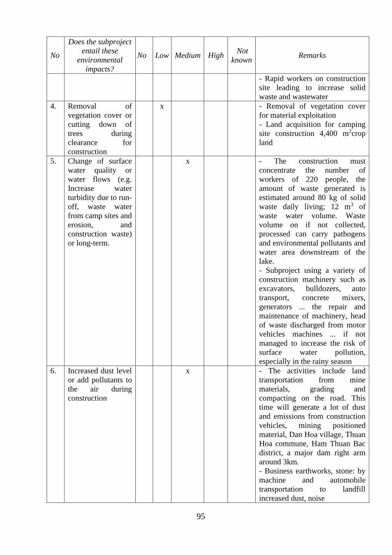
95
No
Does the subproject
entail these
environmental
impacts?
No Low Medium High Not
known Remarks
- Rapid workers on construction
site leading to increase solid
waste and wastewater
4. Removal of
vegetation cover or
cutting down of
trees during
clearance for
construction
x - Removal of vegetation cover
for material exploitation
- Land acquisition for camping
site construction 4,400 m2crop
land
5. Change of surface
water quality or
water flows (e.g.
Increase water
turbidity due to run-
off, waste water
from camp sites and
erosion, and
construction waste)
or long-term.
x - The construction must
concentrate the number of
workers of 220 people, the
amount of waste generated is
estimated around 80 kg of solid
waste daily living; 12 m3 of
waste water volume. Waste
volume on if not collected,
processed can carry pathogens
and environmental pollutants and
water area downstream of the
lake.
- Subproject using a variety of
construction machinery such as
excavators, bulldozers, auto
transport, concrete mixers,
generators ... the repair and
maintenance of machinery, head
of waste discharged from motor
vehicles machines ... if not
managed to increase the risk of
surface water pollution,
especially in the rainy season
6. Increased dust level
or add pollutants to
the air during
construction
x - The activities include land
transportation from mine
materials, grading and
compacting on the road. This
time will generate a lot of dust
and emissions from construction
vehicles, mining positioned
material, Dan Hoa village, Thuan
Hoa commune, Ham Thuan Bac
district, a major dam right arm
around 3km.
- Business earthworks, stone: by
machine and automobile
transportation to landfill
increased dust, noise
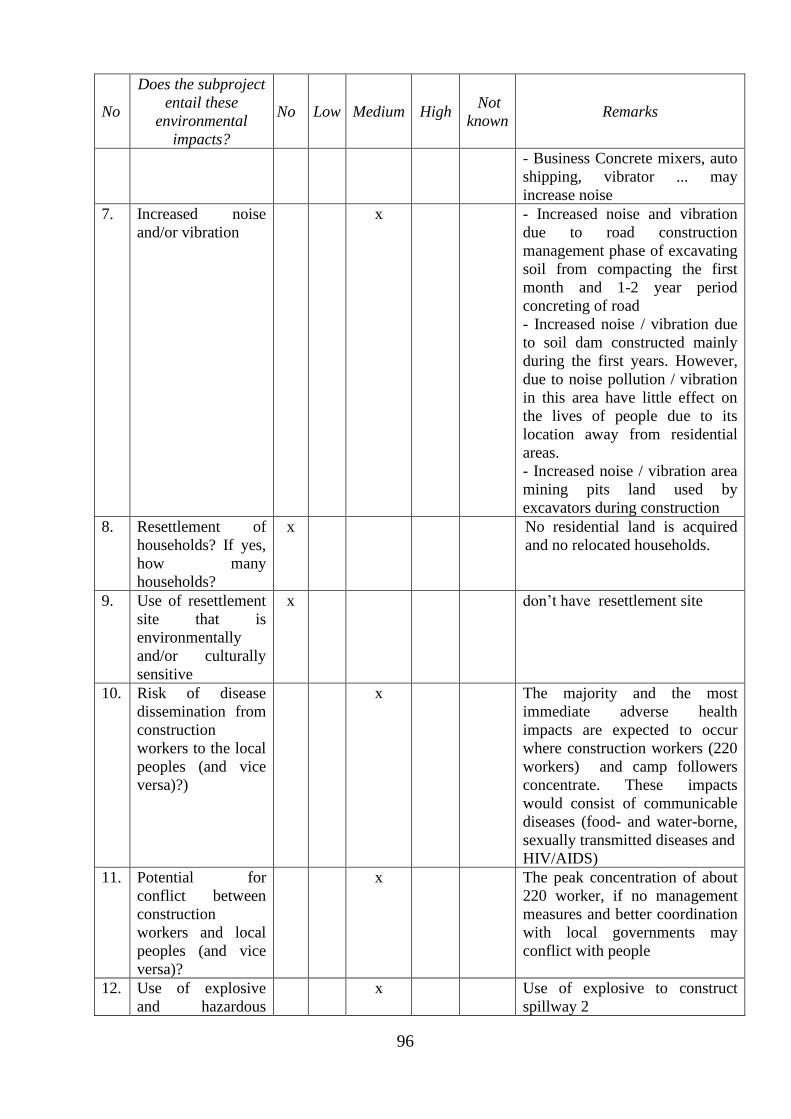
96
No
Does the subproject
entail these
environmental
impacts?
No Low Medium High Not
known Remarks
- Business Concrete mixers, auto
shipping, vibrator ... may
increase noise
7. Increased noise
and/or vibration
x - Increased noise and vibration
due to road construction
management phase of excavating
soil from compacting the first
month and 1-2 year period
concreting of road
- Increased noise / vibration due
to soil dam constructed mainly
during the first years. However,
due to noise pollution / vibration
in this area have little effect on
the lives of people due to its
location away from residential
areas.
- Increased noise / vibration area
mining pits land used by
excavators during construction
8. Resettlement of
households? If yes,
how many
households?
x No residential land is acquired
and no relocated households.
9. Use of resettlement
site that is
environmentally
and/or culturally
sensitive
x don’t have resettlement site
10. Risk of disease
dissemination from
construction
workers to the local
peoples (and vice
versa)?)
x The majority and the most
immediate adverse health
impacts are expected to occur
where construction workers (220
workers) and camp followers
concentrate. These impacts
would consist of communicable
diseases (food- and water-borne,
sexually transmitted diseases and
HIV/AIDS)
11. Potential for
conflict between
construction
workers and local
peoples (and vice
versa)?
x The peak concentration of about
220 worker, if no management
measures and better coordination
with local governments may
conflict with people
12. Use of explosive
and hazardous
x Use of explosive to construct
spillway 2
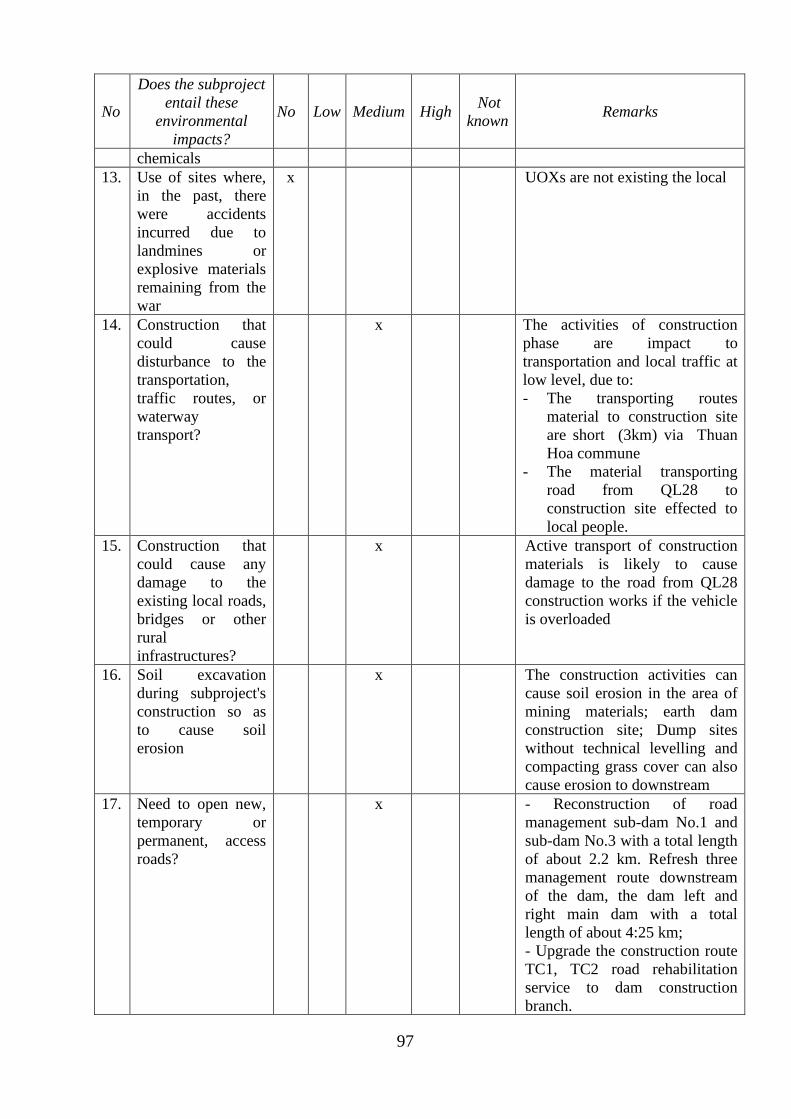
97
No
Does the subproject
entail these
environmental
impacts?
No Low Medium High Not
known Remarks
chemicals
13. Use of sites where,
in the past, there
were accidents
incurred due to
landmines or
explosive materials
remaining from the
war
x UOXs are not existing the local
14. Construction that
could cause
disturbance to the
transportation,
traffic routes, or
waterway
transport?
x The activities of construction
phase are impact to
transportation and local traffic at
low level, due to:
- The transporting routes
material to construction site
are short (3km) via Thuan
Hoa commune
- The material transporting
road from QL28 to
construction site effected to
local people.
15. Construction that
could cause any
damage to the
existing local roads,
bridges or other
rural
infrastructures?
x Active transport of construction
materials is likely to cause
damage to the road from QL28
construction works if the vehicle
is overloaded
16. Soil excavation
during subproject's
construction so as
to cause soil
erosion
x The construction activities can
cause soil erosion in the area of
mining materials; earth dam
construction site; Dump sites
without technical levelling and
compacting grass cover can also
cause erosion to downstream
17. Need to open new,
temporary or
permanent, access
roads?
x - Reconstruction of road
management sub-dam No.1 and
sub-dam No.3 with a total length
of about 2.2 km. Refresh three
management route downstream
of the dam, the dam left and
right main dam with a total
length of about 4:25 km;
- Upgrade the construction route
TC1, TC2 road rehabilitation
service to dam construction
branch.
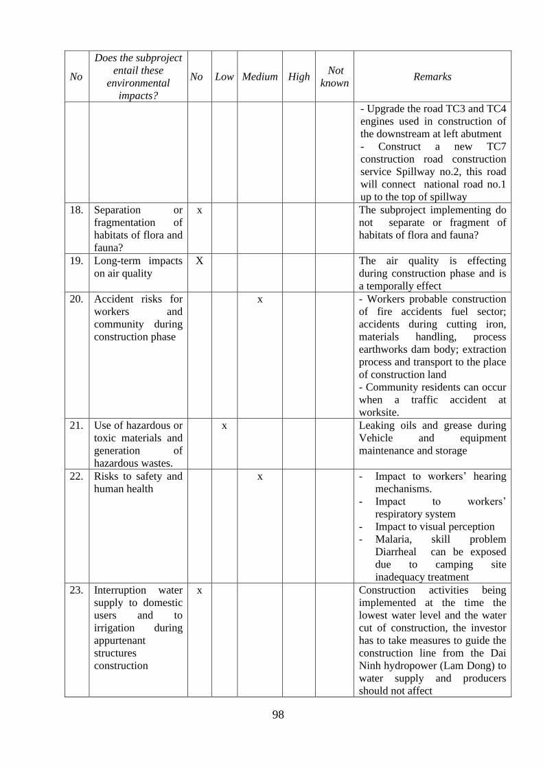
98
No
Does the subproject
entail these
environmental
impacts?
No Low Medium High Not
known Remarks
- Upgrade the road TC3 and TC4
engines used in construction of
the downstream at left abutment
- Construct a new TC7
construction road construction
service Spillway no.2, this road
will connect national road no.1
up to the top of spillway
18. Separation or
fragmentation of
habitats of flora and
fauna?
x The subproject implementing do
not separate or fragment of
habitats of flora and fauna?
19. Long-term impacts
on air quality
X The air quality is effecting
during construction phase and is
a temporally effect
20. Accident risks for
workers and
community during
construction phase
x - Workers probable construction
of fire accidents fuel sector;
accidents during cutting iron,
materials handling, process
earthworks dam body; extraction
process and transport to the place
of construction land
- Community residents can occur
when a traffic accident at
worksite.
21. Use of hazardous or
toxic materials and
generation of
hazardous wastes.
x Leaking oils and grease during
Vehicle and equipment
maintenance and storage
22. Risks to safety and
human health
x - Impact to workers’ hearing
mechanisms.
- Impact to workers’
respiratory system
- Impact to visual perception
- Malaria, skill problem
Diarrheal can be exposed
due to camping site
inadequacy treatment
23. Interruption water
supply to domestic
users and to
irrigation during
appurtenant
structures
construction
x Construction activities being
implemented at the time the
lowest water level and the water
cut of construction, the investor
has to take measures to guide the
construction line from the Dai
Ninh hydropower (Lam Dong) to
water supply and producers
should not affect
99
No
Does the subproject
entail these
environmental
impacts?
No Low Medium High Not
known Remarks
24. Increase flooding
level and reservoir
sedimentation
x The subproject implementing do
not Increase flooding level and
reservoir sedimentation because
it do not change the elevation of
spillway
Does the subproject entail land acquisition or restriction of access to resources?
25. Permanent or
temporary loss of
land or resources
for any families,
resettlement
x - Temporally land acquisition of
3.7ha arable land, for material
pits exploitation, camping site,
storage and disposal areas.
- Permanent acquisition is
75.795,3 m2 of land, of which,
land for perennial crops is
1,828.4 m2; land for planting
annual trees is 9,794.9m2;
protected forest land is 62,765
m2; land of rivers and canals is
1,339.7 m2 and land traffic is
67.6 m2.
26. Use land that is
currently occupied
or regularly used
for productive
purposes (e.g.,
gardening, farming,
pasture, fishing
locations, forests)
x No
27.
.
Displacement of
individuals,
families or
businesses
x
28. Temporary or
permanent loss of
crops, fruit trees or
household
infrastructure
x - The number of trees cut down
or moved to other areas is about
526 dragon fruit pillars, 30
cashew trees, 15 mango trees, 50
banana trees and 20 spondias
pinnata trees.
- No housing and structures
affected
29. Involuntary
restriction of access
by people to legally
designated parks
and protected areas
x Neither public parks nor
conservation areas had been
found
If the answer to any of the questions 25-29 is “Yes”, please consult the ESMF; preparation of a
Resettlement Plan (RP) is likely required.
Are ethnic minority peoples present in the subproject area?
100
No
Does the subproject
entail these
environmental
impacts?
No Low Medium High Not
known Remarks
30. Ethnic minority
groups are living
within the
boundaries of, or
nearby, the
subproject.
x 8 household at Thuan Hoa
commune, Ham Thuan Bac
district
31. Members of these
ethnic minority
groups in the area
potentially could
benefit or be
harmed from the
project.
x No
If the answer to questions 30 or 31 is “Yes”, please consult the ESMF; and preparation of an
Ethnic Minority Development Plan (EMDP is likely required.
Does the subproject entail construction of or depend upon a dam?
32. Involve the
construction of a
large dam?
x The crest of embankment is 40 m
in height it belong to >25-70m
interval, type II
33. Depend on water
supplied from an
existing dam or
weir or a dam under
construction?
x Depend on water supplied from
Dan Sach dam
If the answer to question 32 or 33 is “Yes”, please consult the ESMF; a Dam Safety Report (DSR)
will likely be required.
101
APPENDIX A5- DIAGRAM OF SAMPLING AND MONITORINGENVIRONMENT
Figure 1: Map location sampling of environment samples
102
Figure 2: Map location sampling of environment samples
103
APPENDIX A6 - ANALYSIS RESULTS OF ENVIRONMENT QUALITY
1. Describe the sampling location
Table 1: The monitoring location of surface water
No Symbol Location Coordinates Description
I/ Water in lake
1 NM 1 Water on auxility spillway no.1 N 11°09'54.4"
E 108°08'22.9"
Sunny, no flow, green
water
2 NM 2 Water on auxility spillway no.3 N 11°09'47.1"
E 108°07'50.9"
Sunny, no flow, green
water
3 NM 3 Water on the right abutment 11°10'00.3"N
108°08'33.3"E Sunny, green water
4 NM4 Water on the left abutment N 11°10'14.5"
E 108°08'36.7" Sunny, green water
5 NM5 Water on the embankment dam N 11°10'04.5"
E 108°08'44.9" Sunny, green water,
6 NM 6 Water on auxility spillway no.2 N 11°10'18.1"
E 108°08'37.4" Sunny, green water,
7 NM 7 Water on the auxility dam N 11°09'39.8"
E 108°08'41.1"
Sunny, blue water, no
flow, no dirt, no trash
II/ Water on canals
1 NM8
Water on canal which located in the
auxility dam no.1, Ham Tri
commune
N 11°09'45.9"
E 108°08'25.8"
Sunny, slight flow,
freshwater
2 NM 9 The downstream of Quao reservoir N 11o09'47,56''
E108o08'33,23''
Sunny, slight flow, no
garbage, no dirt
3 NM 11 Water on Thuan Hoa canal at
Thuan Hoa commune
N 11°09'59.9"
E 108°09'03.5"
Sunny, blue water,
medium flows, no
garbage, no dirt
4
NM 12
Quao reservoir, Trang bridge - Ham
Phu commune- Ham Thuan Bac
district
N 11o07'6,66''
E108o06'27.33''
Sunny, slight flow,
no trash, green water
5 NM 17 Quao irrigation canal at Ham Chinh
commune
N 11o02'57.40''
E 108o06'06.56''
Sunny, low flow, blue
water, no garbage
6 NM 23 Cha Giang canal, An Hiep village,
Ham Thang commune
N 10°58'33.8"
E 108°07'08.6"
Sunny, slight flow, no
trash, blue water
7 NM 30 N11canal at Thuan Minh commune N 11°05'46.4"
E 108°04'54.6"
Sunny, medium flow,
green water
8 NM 31 N13 canal at Thuan Minh commune
N 11°04'52.2"
E 108°04'53.2"
Sunny, medium flow,
green water
9 NM 32 N9 canal, Ham Phu commune N 11°06'35.9"
E 108°05'26.3"
Sunny, medium flow,
green water
10 NM 33 Canal No.3, Ham Phu commune N 11°07'12.5"
E 108°05'53.0"
Sunny, medium flow,
green water, no
garbage
104
No Symbol Location Coordinates Description
11 NM 35 water on bridge no.8 at Ham Chinh
commune N 11°01'33.0"
E 108°04'43.3"
Sunny, medium flow,
green water, no
garbage
III/ Water on river
1 NM 10
Water on Cai river at the bottom of
embankment dam, Thuan Hoa
commune
N 11°09'58.4"
E 108°08'49.9"
Sunny, blue water,
medium flow, no
garbage, no dirt
2 NM 13 Water on Cai river at the Quao
bridge, Thuan Hoa commune
N 11o09'43.57''
E108o08'50.9''
Sunny, slight flow,
not garbage
3 NM 14 Water on Cai river at Sen bridge,
Ma Lam town
N 11o03'21,66''
E108o07'36,82''
unny, medium flow,
green water, no trash
4 NM 15 Water on Cai river at Phu Hai
commune
N 10o56'53.078''
E108o08'33.15''
Sunny, , the flow of
the ocean, blue water,
less trash
5 NM 16 Water on Cai river at Kim Long
dam, Ham Tri commune
N 11o05'44.15''
E 108o08'01.39'
Sunny, low flow,
green water, no trash
6 NM 18 Water on Cai river at Thay Nghe
dam, Ham Chinh commune
N 11o00'16.12'
E 108o06'56.29''
Sunny, medium flow,
green water, no trash
7 NM 19 Water on Cai river at Tam Hung
bridge dam, Ham Chinh commune
N 11o01'55.58''
E108o08'43.24’'
Sunny, low flow,
green water,
8 NM 20 Water on Cai river at Ham Tri
commune
N 11o06'47.26''
E 108o08'00.63''
Sunny, low flow, no
dirt, blue water
9 NM 21 Water on Cai river at Ham Thang
commune
N 10o58'21.7''
E 108o08'29.8''
Sunny, low flow, blue
water, less trash, grass
riverside
10 NM 22 Water on Cai river at Cha Giang
dam, Ham Thang commune
N 10°58'49.3"
E 108°07'13.7"
Sunny, light flow,
blue water,
11 NM 24
Nước sông Cái tại Đập Ô Xuyên,
TT Ma Lâm
Water on Cai river at O Xuyen, Ma
Lam town
N 11°04'05.5"
E 108°07'36.7"
Sunny, low flow,
green water, grass
riverside
12 NM 25
Nước sông sau đập Vai Ré, TT Ma
lâm
Water on river after Vai Re dam,
Ma Lam town
N 11°04'55.0"
E 108°07'38.7"
Sunny, medium flow,
green water, grass
riverside
13 NM 26 Water on Cai river at Cau Quan
wharf, Phu Hai commune
N 10°56'26.9"
E 108°08'23.2" Sunny, medium flow
14 NM 27 Cai estuarie, Phu Hai commune N 10°56'05.5"
E 108°08'21.9"
Many boats moored,
litter, light flow, tidal
influences
15 NM 29 Water on Can no.2 river, Ham Duc
commune
N 11°01'59.7"
E 108°09'32.9"
Sunny, low flow, with
coastal vegetation
16 NM 34 Sieng Giang dam, Ham Duc
commune
N 11°01'19.6"
E 108°09'28.4"
Sunny, low flow, blue
water, no garbage
105
Table 2: The monitoring location of ground water
No Symbol Location Coordinates Description
Water in wells
1 NN 2
The located water in wells at Mr. Son
household, Dan Hoa village, Thuan
Hoa commune
N 11°11'10.8"
E 108°09'33.4"
Freshwater, slight
sulfur smell
2 NN 3
The located water in wells at Mrs.
Ngoc household, Lam Giang village,
Ham Tri commune
N 11°07'08.1"
E 108°07'55.7"
Freshwater ,
odorless
3 NN 8 The located water in wells at Mrs. Doi
household, Ham Chinh commune
N 11°03'21.9"
E 108°07'36.5"
Freshwater ,
odorless
4 NN 10
The located water in wells at Mr. Lam
household, An Hiep village, Ham
Chinh commune
N 10°58'07.2"
E 108°06'54.5"
Freshwater ,
odorless
5 NN 11 The located water in wells at Mr.Ly
household, Ma Lam town
N 11°04'57.5"
E 108°07'50.5"
Freshwater ,
odorless
6 NN 12 The located water in wells at Mr.Chan
household, Ma Lam town
N 11°03'55.2"
E 108°07'40.4"
Freshwater ,
odorless
7 NN 13 The located water in wells at Mr.Binh
household, Phu Long town
N 10°58'58.9"
E 108°09'04.8"
Freshwater ,
odorless
8 NN 14 The located water in wells at
Mr.Minh household, Phu Long town
N 10°58'09.1"
E 108°08'41.9"
Freshwater ,
odorless
9 NN 16
The located water in wells at Mr.
Sang household, Xuan Phong village,
Ham Hiep commune
N 10°56'41.9"
E 108°05'10.7"
Freshwater ,
odorless
10 NN 17
The located water in wells at Mr.
Thuan household, Hoa Thanh village,
Ham Duc commune
N 11°02'06.4"
E 108°09'57.0"
Freshwater ,
odorless
11 NN 18
The located water in wells at Mr.
Khang household, Ham Duc
commune
N 11°02'06.4"
E 108°09'57.0"
Freshwater ,
odorless
12 NN 19
The located water in wells at Mrs. Sau
household, Long Hiep village, Hong
Son commune
N 11°03'43.7"
E 108°11'16.6"
Freshwater ,
odorless
13 NN 20
The located water in wells at Mr.
Hung household, Long Giang village,
Hong Son commune
N 11°04'47.6"
E 108°12'00.4"
Freshwater ,
odorless
14 NN 21
The located water in wells at Mr.
Chuong household, Hong Lien
commune
N 11°07'35.2"
E 108°12'22.9"
Freshwater ,
odorless
15 NN 24 The located water in wells at Mr. Qúy
household, Ham Phu commune
N 11°05'48.0"
E 108°07'49.1"
Freshwater ,
odorless
16 NN 28
The located water in wells at Mr.
Thanh household, Ham Lien
commune
N 10°58'26.7"
E 108°06'29.6"
Freshwater ,
odorless
Water in drilling wells
106
No Symbol Location Coordinates Description
17 NN 1
The located water in drilling wells at
Mr. Minh household, Thuan Hoa
commune
N 1o09;41.31’’
E108o11’47.05’’
Freshwater, slight
sulfur smell.
18 NN 4
The located water in drilling wells at
Mr. Tuan household, Phu Thai
village, Ham Tri commune
N 1o07’55.13’’
E108o06’51.94’’
Freshwater,
odorless, with
alum
19 NN 5
The located water in drilling wells at
Mr. Hau household, Gia Dam village,
Ham Tri commune
N 11°08'18.7"
E 108°08'57.2"
Freshwater ,
odorless
20 NN 6
The located water in drilling wells at
Mr. Van household, Ham Chinh
commune
N 11o00’33.34’’
E 108o07’52.15’’
Freshwater ,
odorless
21 NN 7
The located water in drilling wells at
Mr. Tung household, Ham Chinh
commune
N 11°01'29.7"
E 108°06'38.2"
Freshwater ,
odorless
22 NN 9
The located water in drilling wells at
Mr. Chau household, Ung Chiem
village, Ham Thang commune
N 10o59’03.53’’
E 108o07’53.45’’
Freshwater ,
odorless
23 NN 15
The located water in drilling wells at
Mr. Minh household, Phu Xuan
village, Ham Hiep commune
N 10°57'13.7"
E 108°03'51.6"
Freshwater ,
odorless
24 NN 22
The located water in drilling wells at
Mr. Khang household, Hong Liem
commune
N 11°09'34.5"
E 108°11'45.5"
Freshwater ,
odorless
25 NN 23
The located water in drilling wells at
Mr. Binh household, Ham Phu
commune
N 11°05'59.9"
E 108°06'17.0"
Freshwater ,
odorless
26 NN 25 The located water in drilling wells at
Mrs. Khuyen, Thuan Minh commune
N 11°04'25.1"
E 108°05'23.3"
Freshwater ,
odorless
27 NN 26
The located water in drilling wells at
Mrs. Hieu household, Thaun Minh
commune
N 11°03'50.5"
E 108°06'31.7"
Freshwater ,
odorless
28 NN 27
The located water in drilling wells at
Mr. Can household, Tan Binh
village, Ham Lien commune
N 10°58'39.1"
E 108°04'39.8"
Freshwater ,
odorless
Table 3: The monitoring location of air quality
No Symbol Location Coordinates Description
1 KK1 crest of dam, Ham Tri
commune
N 11o10'12.9''
E108o08'36.7''
Sunny, low wind,
no dust
2 KK2 Crest of right abutment N 11°10'28.3"
E 108°08'29.2"
Sunny, low wind,
no dust
3 KK3 Crest of auxility dam no.1,
Ham Tri commune
N 11o09’53.8’’
E 108o08'24.0’
Sunny, low wind,
no dust
4 KK4 Crest of auxility dam no.3,
Ham Tri commune
N 11o09’48.1’’
E 108o07’54.5’
Sunny, low wind,
no dust
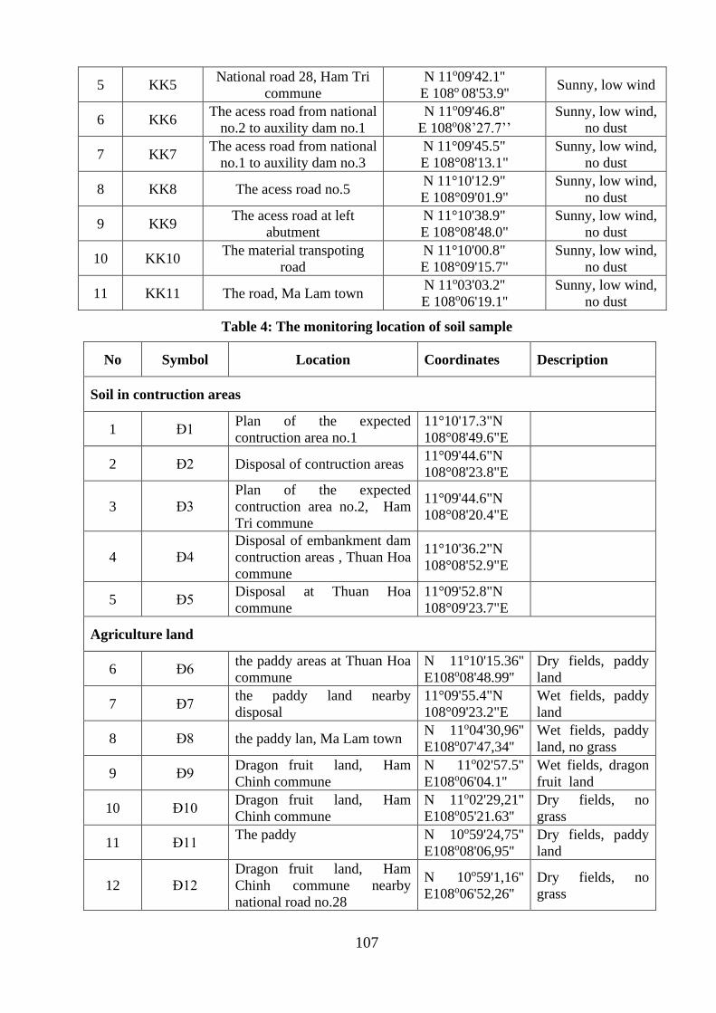
107
5 KK5 National road 28, Ham Tri
commune
N 11o09'42.1''
E 108o 08'53.9'' Sunny, low wind
6 KK6 The acess road from national
no.2 to auxility dam no.1
N 11o09'46.8''
E 108o08’27.7’’
Sunny, low wind,
no dust
7 KK7 The acess road from national
no.1 to auxility dam no.3
N 11°09'45.5"
E 108°08'13.1"
Sunny, low wind,
no dust
8 KK8 The acess road no.5 N 11°10'12.9"
E 108°09'01.9"
Sunny, low wind,
no dust
9 KK9 The acess road at left
abutment
N 11°10'38.9"
E 108°08'48.0"
Sunny, low wind,
no dust
10 KK10 The material transpoting
road
N 11°10'00.8"
E 108°09'15.7"
Sunny, low wind,
no dust
11 KK11 The road, Ma Lam town N 11o03'03.2''
E 108o06'19.1''
Sunny, low wind,
no dust
Table 4: The monitoring location of soil sample
No Symbol Location Coordinates Description
Soil in contruction areas
1 Đ1 Plan of the expected
contruction area no.1
11°10'17.3"N
108°08'49.6"E
2 Đ2 Disposal of contruction areas 11°09'44.6"N
108°08'23.8"E
3 Đ3
Plan of the expected
contruction area no.2, Ham
Tri commune
11°09'44.6"N
108°08'20.4"E
4 Đ4
Disposal of embankment dam
contruction areas , Thuan Hoa
commune
11°10'36.2"N
108°08'52.9"E
5 Đ5 Disposal at Thuan Hoa
commune
11°09'52.8"N
108°09'23.7"E
Agriculture land
6 Đ6 the paddy areas at Thuan Hoa
commune
N 11o10'15.36''
E108o08'48.99''
Dry fields, paddy
land
7 Đ7 the paddy land nearby
disposal
11°09'55.4"N
108°09'23.2"E
Wet fields, paddy
land
8 Đ8 the paddy lan, Ma Lam town N 11o04'30,96''
E108o07'47,34''
Wet fields, paddy
land, no grass
9 Đ9 Dragon fruit land, Ham
Chinh commune
N 11o02'57.5''
E108o06'04.1''
Wet fields, dragon
fruit land
10 Đ10 Dragon fruit land, Ham
Chinh commune
N 11o02'29,21''
E108o05'21.63''
Dry fields, no
grass
11 Đ11 The paddy
N 10o59'24,75''
E108o08'06,95''
Dry fields, paddy
land
12 Đ12
Dragon fruit land, Ham
Chinh commune nearby
national road no.28
N 10o59'1,16''
E108o06'52,26''
Dry fields, no
grass
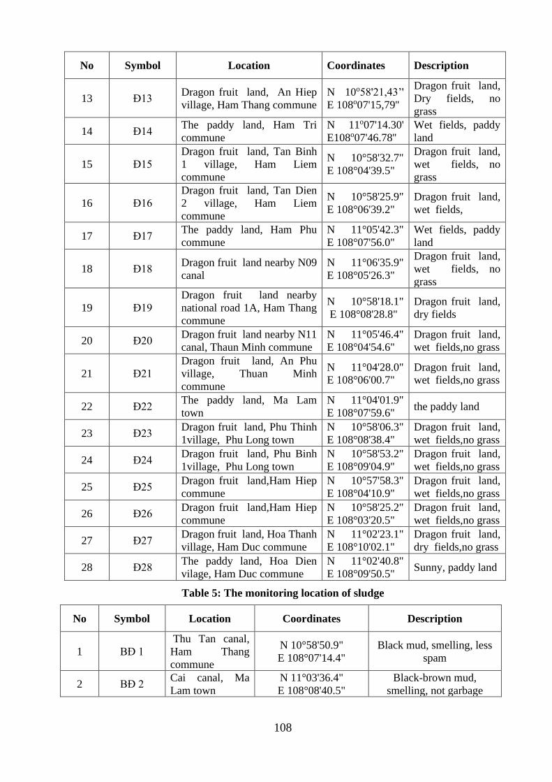
108
No Symbol Location Coordinates Description
13 Đ13 Dragon fruit land, An Hiep
village, Ham Thang commune
N 10o58'21,43’'
E 108o07'15,79''
Dragon fruit land,
Dry fields, no
grass
14 Đ14 The paddy land, Ham Tri
commune
N 11o07'14.30'
E108o07'46.78''
Wet fields, paddy
land
15 Đ15
Dragon fruit land, Tan Binh
1 village, Ham Liem
commune
N 10°58'32.7"
E 108°04'39.5"
Dragon fruit land,
wet fields, no
grass
16 Đ16
Dragon fruit land, Tan Dien
2 village, Ham Liem
commune
N 10°58'25.9"
E 108°06'39.2"
Dragon fruit land,
wet fields,
17 Đ17 The paddy land, Ham Phu
commune
N 11°05'42.3"
E 108°07'56.0"
Wet fields, paddy
land
18 Đ18 Dragon fruit land nearby N09
canal
N 11°06'35.9"
E 108°05'26.3"
Dragon fruit land,
wet fields, no
grass
19 Đ19
Dragon fruit land nearby
national road 1A, Ham Thang
commune
N 10°58'18.1"
E 108°08'28.8"
Dragon fruit land,
dry fields
20 Đ20 Dragon fruit land nearby N11
canal, Thaun Minh commune
N 11°05'46.4"
E 108°04'54.6"
Dragon fruit land,
wet fields,no grass
21 Đ21
Dragon fruit land, An Phu
village, Thuan Minh
commune
N 11°04'28.0"
E 108°06'00.7"
Dragon fruit land,
wet fields,no grass
22 Đ22 The paddy land, Ma Lam
town
N 11°04'01.9"
E 108°07'59.6" the paddy land
23 Đ23 Dragon fruit land, Phu Thinh
1village, Phu Long town
N 10°58'06.3"
E 108°08'38.4"
Dragon fruit land,
wet fields,no grass
24 Đ24 Dragon fruit land, Phu Binh
1village, Phu Long town
N 10°58'53.2"
E 108°09'04.9"
Dragon fruit land,
wet fields,no grass
25 Đ25 Dragon fruit land,Ham Hiep
commune
N 10°57'58.3"
E 108°04'10.9"
Dragon fruit land,
wet fields,no grass
26 Đ26 Dragon fruit land,Ham Hiep
commune
N 10°58'25.2"
E 108°03'20.5"
Dragon fruit land,
wet fields,no grass
27 Đ27 Dragon fruit land, Hoa Thanh
village, Ham Duc commune
N 11°02'23.1"
E 108°10'02.1"
Dragon fruit land,
dry fields,no grass
28 Đ28 The paddy land, Hoa Dien
vilage, Ham Duc commune
N 11°02'40.8"
E 108°09'50.5" Sunny, paddy land
Table 5: The monitoring location of sludge
No Symbol Location Coordinates Description
1 BĐ 1
Thu Tan canal,
Ham Thang
commune
N 10°58'50.9"
E 108°07'14.4"
Black mud, smelling, less
spam
2 BĐ 2 Cai canal, Ma
Lam town
N 11°03'36.4"
E 108°08'40.5"
Black-brown mud,
smelling, not garbage
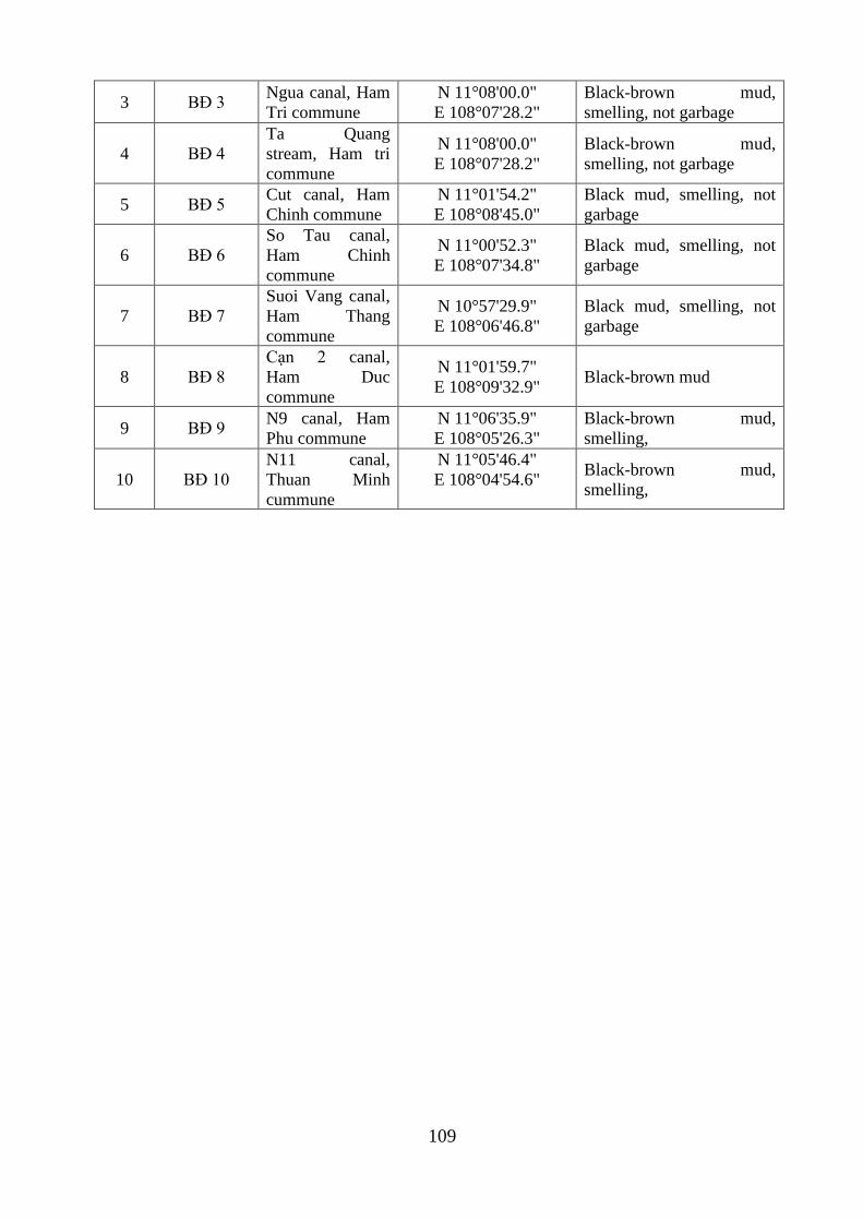
109
3 BĐ 3 Ngua canal, Ham
Tri commune
N 11°08'00.0"
E 108°07'28.2"
Black-brown mud,
smelling, not garbage
4 BĐ 4
Ta Quang
stream, Ham tri
commune
N 11°08'00.0"
E 108°07'28.2"
Black-brown mud,
smelling, not garbage
5 BĐ 5 Cut canal, Ham
Chinh commune
N 11°01'54.2"
E 108°08'45.0"
Black mud, smelling, not
garbage
6 BĐ 6
So Tau canal,
Ham Chinh
commune
N 11°00'52.3"
E 108°07'34.8"
Black mud, smelling, not
garbage
7 BĐ 7
Suoi Vang canal,
Ham Thang
commune
N 10°57'29.9"
E 108°06'46.8"
Black mud, smelling, not
garbage
8 BĐ 8
Cạn 2 canal,
Ham Duc
commune
N 11°01'59.7"
E 108°09'32.9" Black-brown mud
9 BĐ 9 N9 canal, Ham
Phu commune
N 11°06'35.9"
E 108°05'26.3"
Black-brown mud,
smelling,
10 BĐ 10
N11 canal,
Thuan Minh
cummune
N 11°05'46.4"
E 108°04'54.6"
Black-brown mud,
smelling,
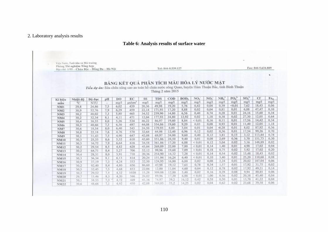
110
2. Laboratory analysis results
Table 6: Analysis results of surface water
111
112
113
Table 7: Analysis results of ground water
114
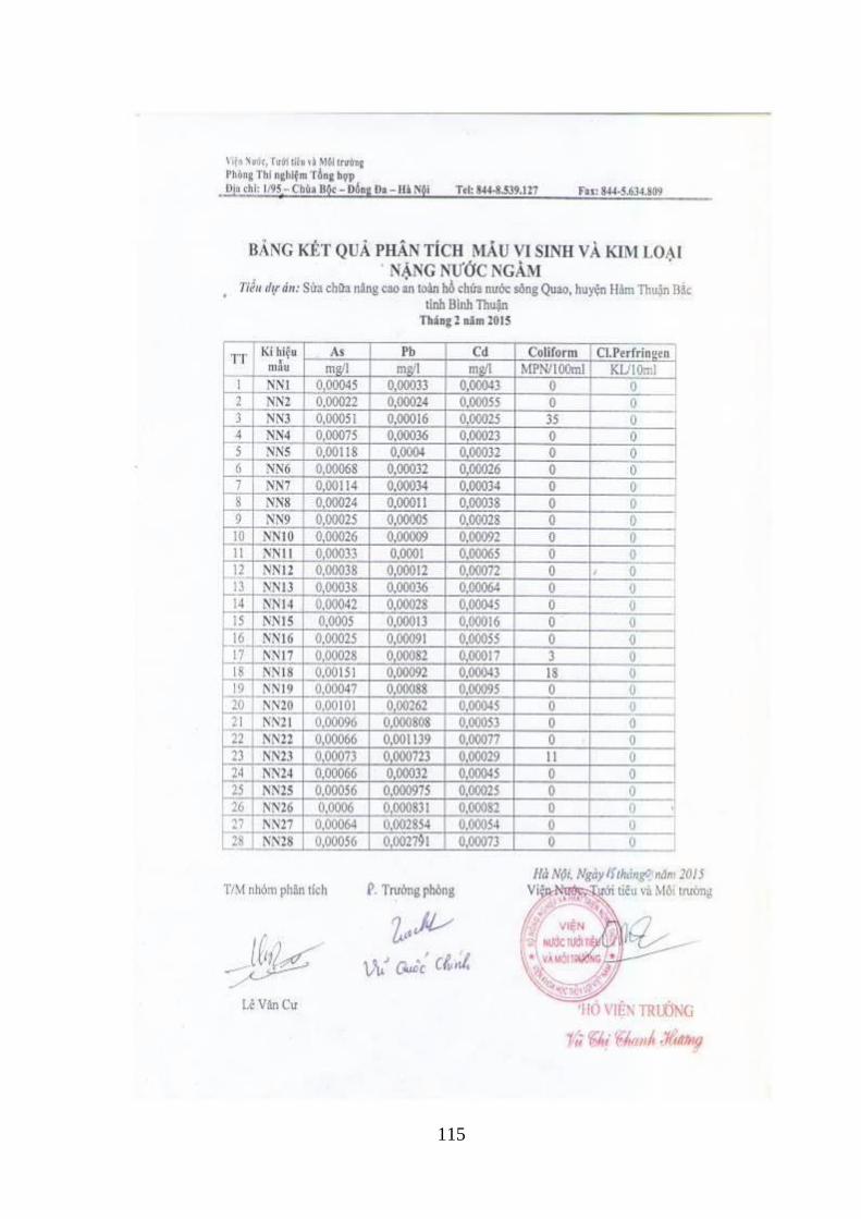
115
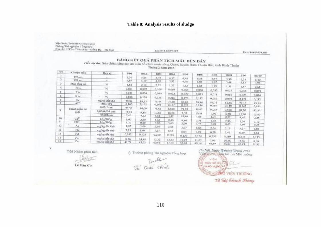
116
Table 8: Analysis results of sludge
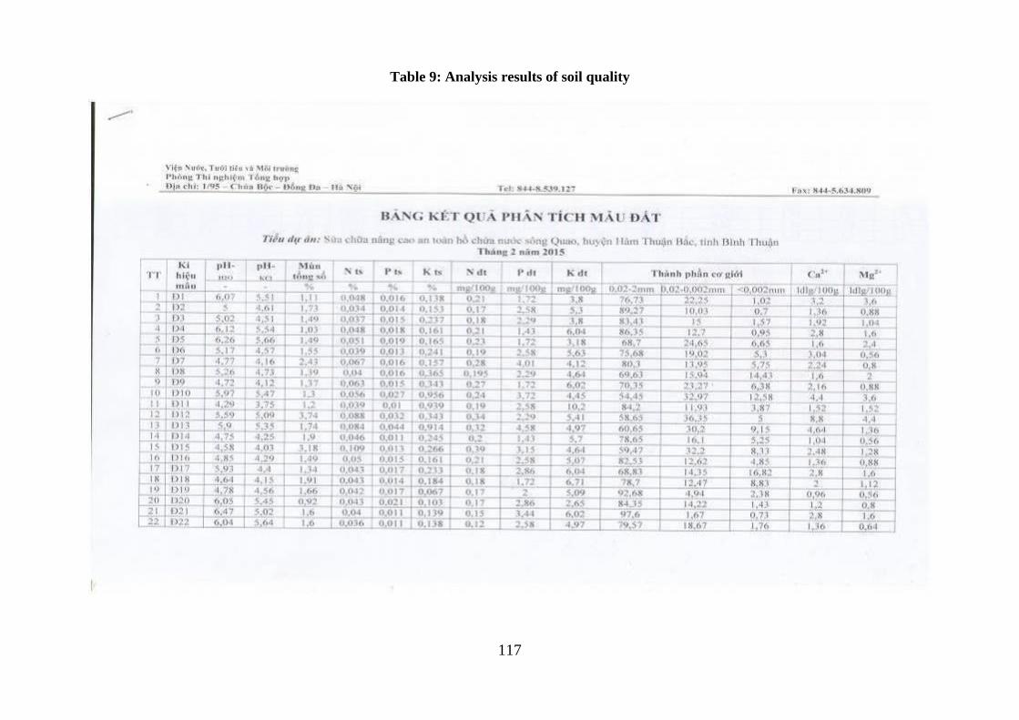
117
Table 9: Analysis results of soil quality
118
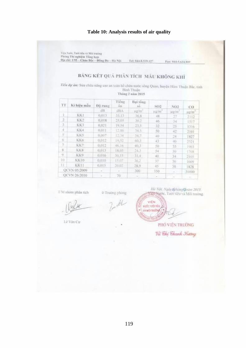
119
Table 10: Analysis results of air quality
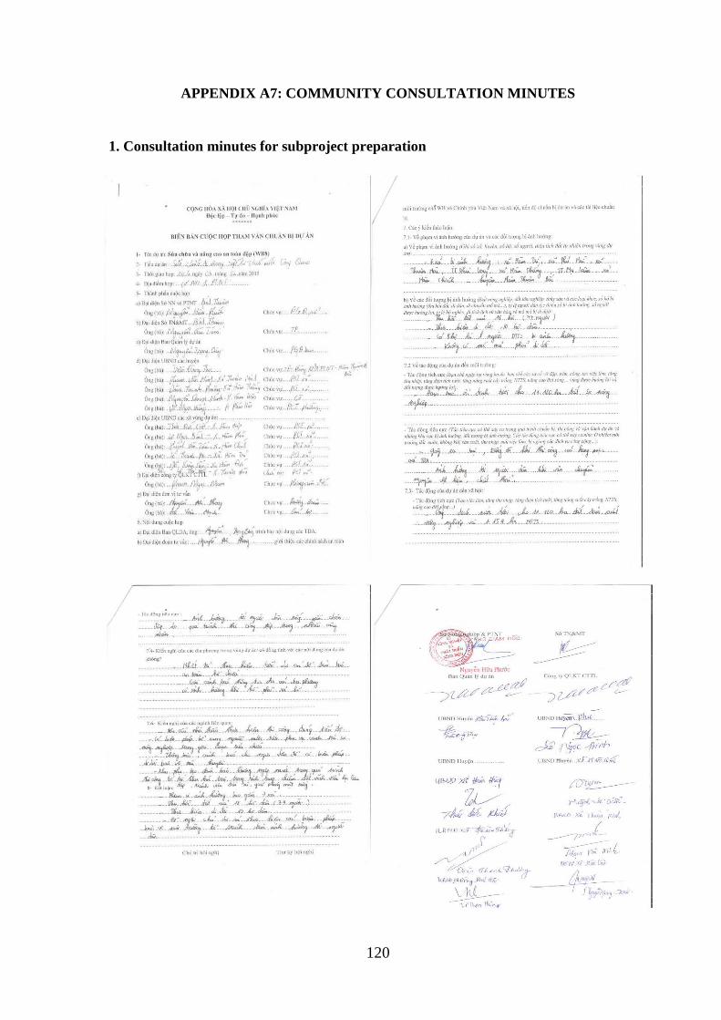
120
APPENDIX A7: COMMUNITY CONSULTATION MINUTES
1. Consultation minutes for subproject preparation
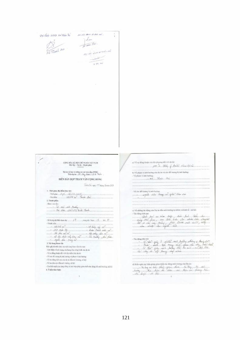
121
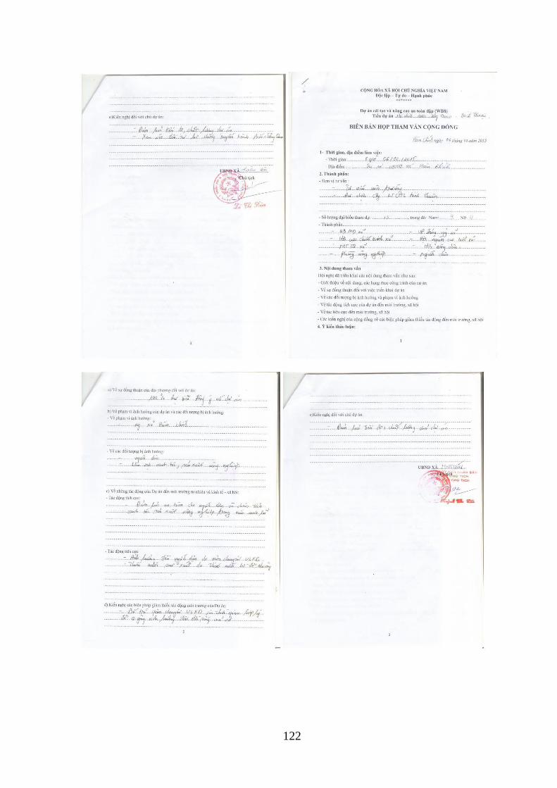
122
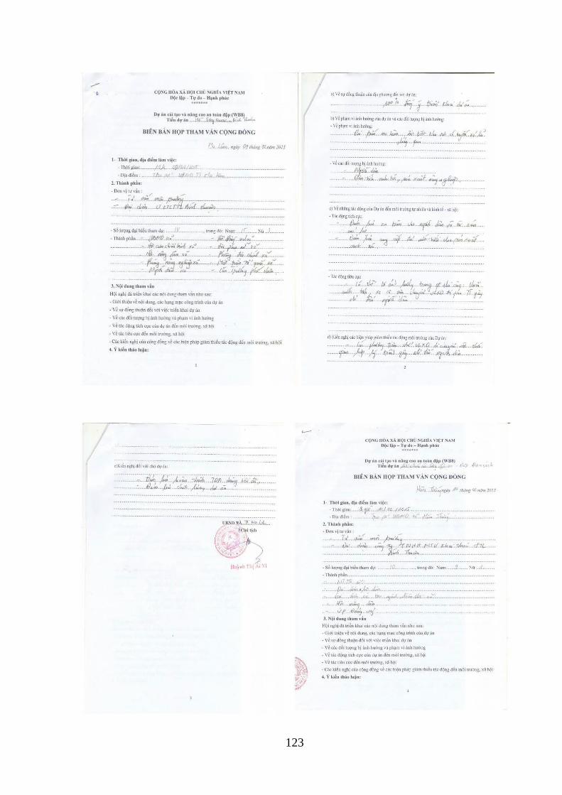
123
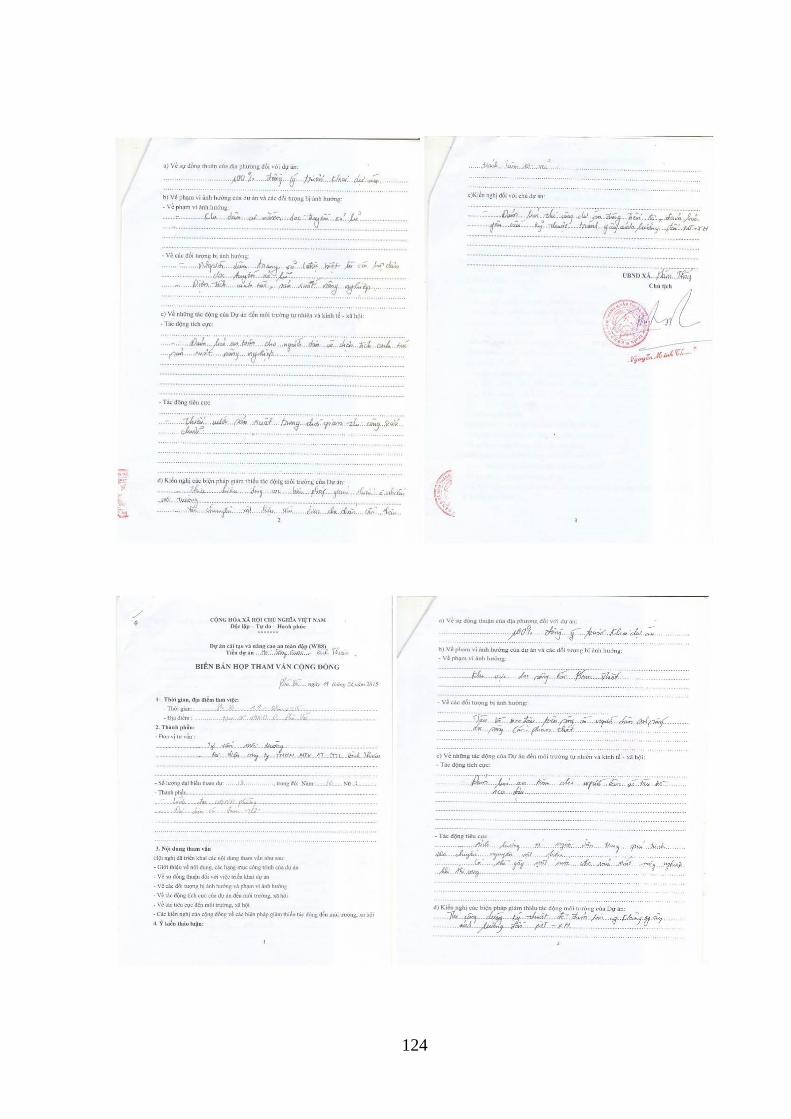
124
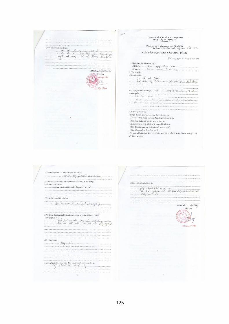
125
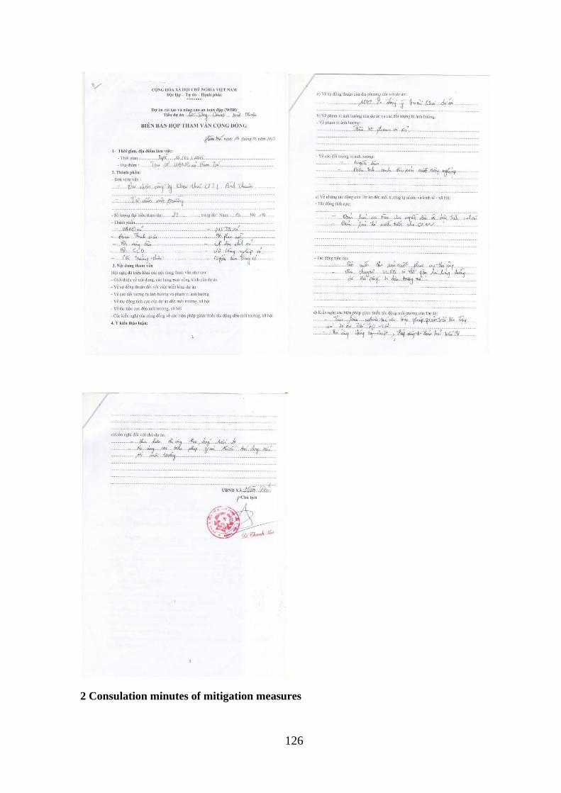
126
2 Consulation minutes of mitigation measures
127
128
129
130
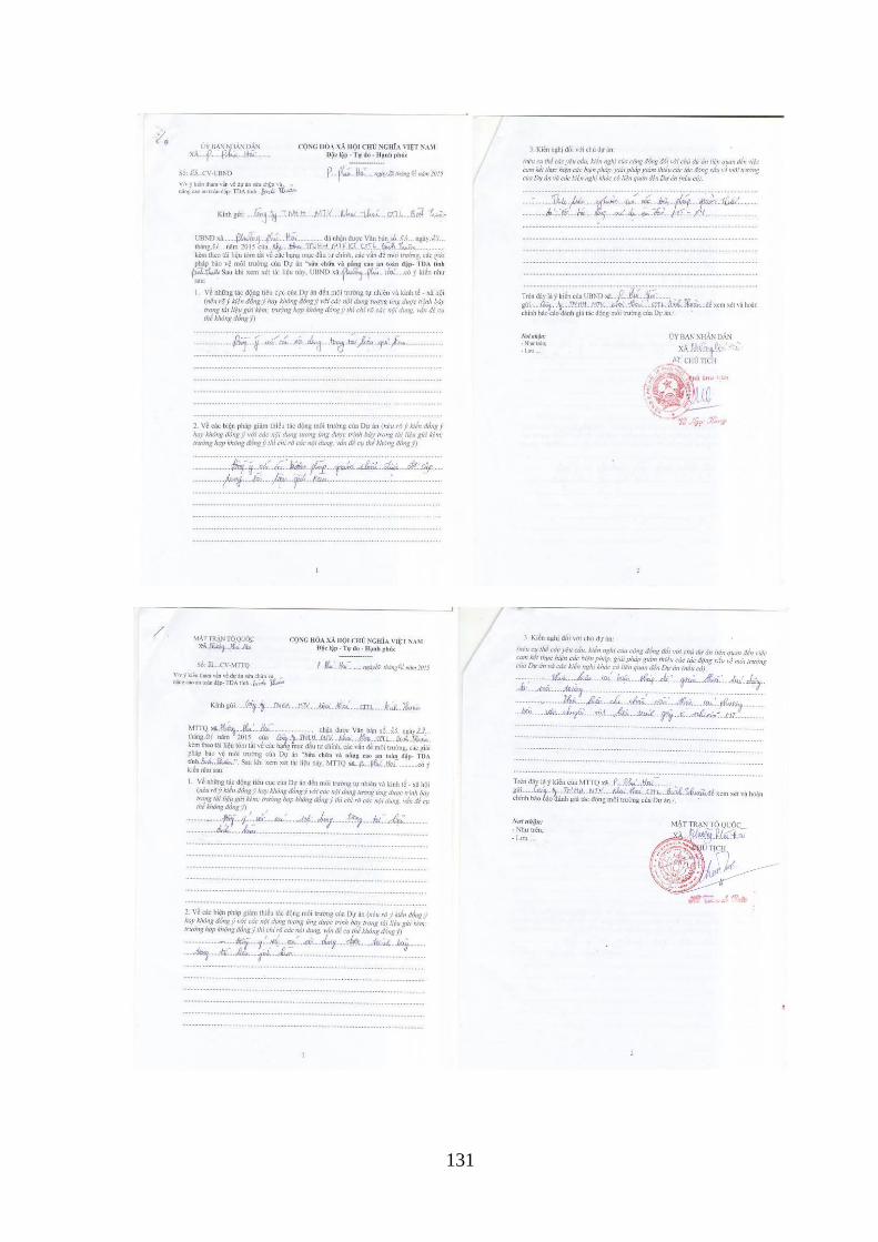
131
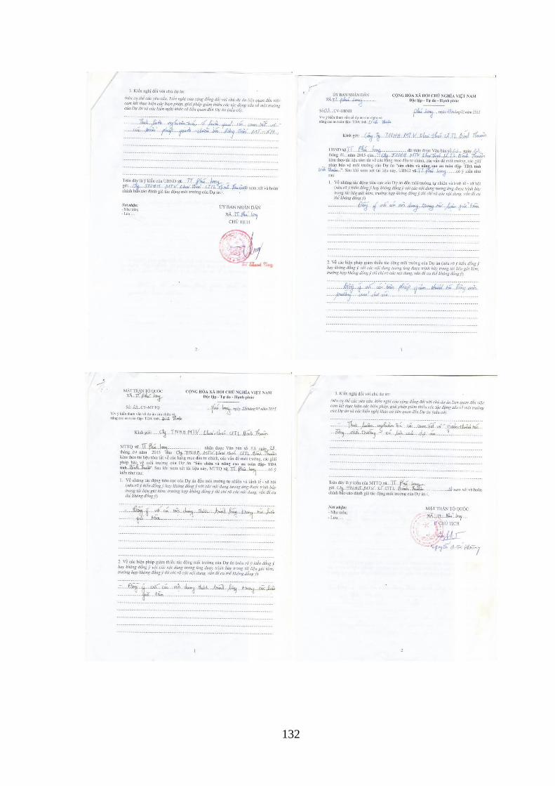
132
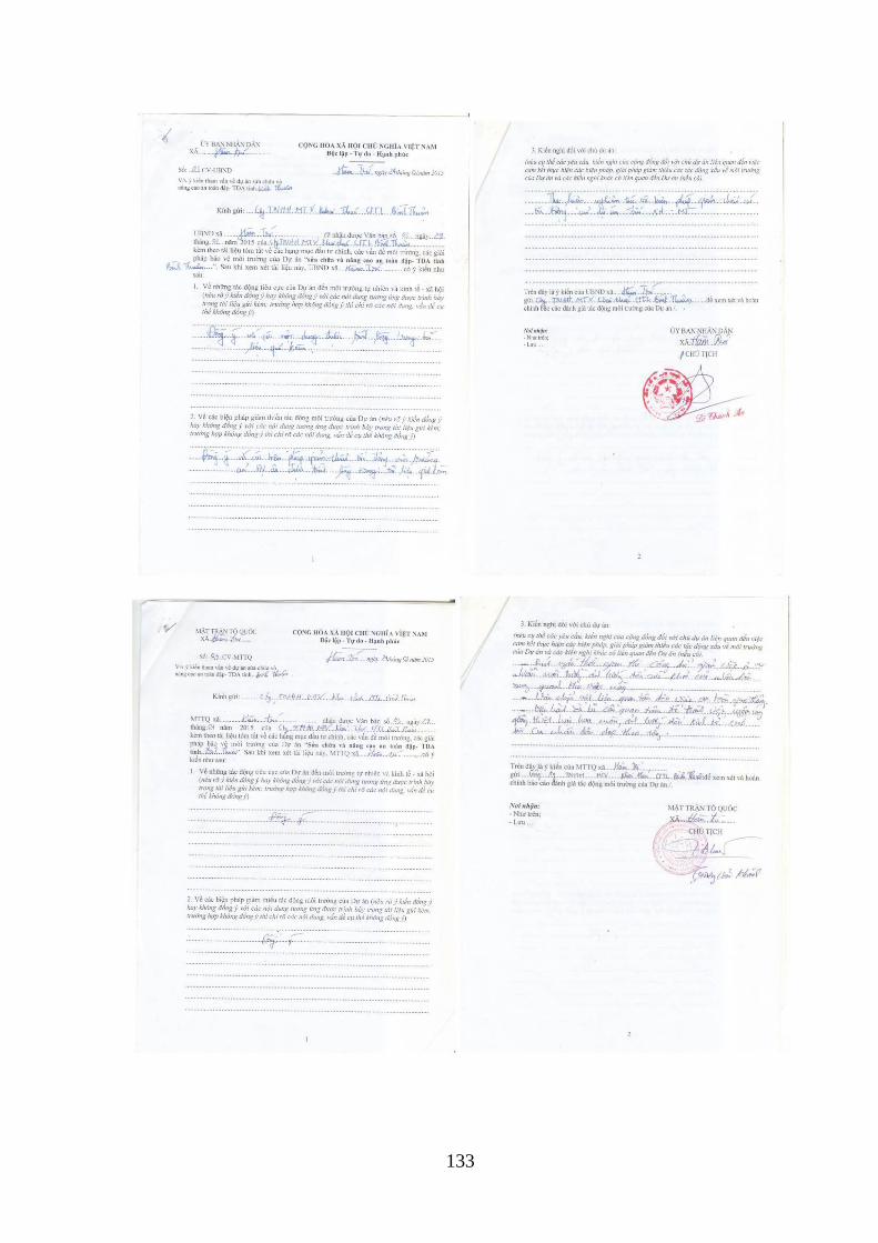
133
134
APPENDIX A8- ENVIRONMENTAL SPECIFICATIONS (FOR INCLUSION IN
BIDDING AND CONSTRUCTION CONTRACTS)
Before starting the construction, the Contractor shall prepare an Environmental Sanitation,
Safety and Health Plan (OHSEP) for submission to the PPMU/CPO for approval. OHSEP will
include specific measures to meet the requirements listed below:
Construction Camp Management Plan
General Requirements
The Contractor shall, wherever possible, locally recruit the available workforce and shall
provide appropriate training as necessary. The Contractor shall consider all aspects of
workforce management and address potential ethnic tensions between workers and the local
communities, increased risk of prostitution and communicable diseases, theft, alcohol abuse,
market distortion due to temporary inputs to local economy and other local tensions such as
unemployment, ethnicity and divergent cultural values.
The following general measures shall be considered for construction camps:
1. The construction camp site will have to be approved by the local authority.
2. The Contractor shall present the design of the camps including details of all buildings,
facilities and services for approval no later than 1 months prior to commencement of any
construction work. Approvals and permits shall be obtained in accordance with
applicable laws, applicable standards and environmental requirements for the building
and infrastructure work for each camp area.
3. The Contractor shall provide adequate and suitable facilities for washing clothes and
utensils for the use of contract labor employed therein.
4. Camp site selection and access roads shall be located so as to avoid clearing of major
trees and vegetation as feasible, and to avoid aquatic habitats.
5. Camp areas shall be located to allow effective natural drainage and landscaped so as to
avoid erosion.
6. The Contractor shall provide suitable, safe and comfortable accommodation for the
workforce.
7. The Contractor shall provide adequate lavatory facilities (toilets and washing areas) for
the number of workers expected on site, plus visitors. Toilet facilities should also be
provided with adequate supplies of clean or potable water, soap, and toilet paper.
Separate and adequate bathing facilities shall be provided for the use of male and female
workers. Such facilities shall be conveniently accessible and shall be kept in clean and
hygienic conditions at all times.
8. The Contractor shall implement effective sediment and erosion control measures during
construction and operation of the construction work camps in accordance with the
environmental requirements as stipulated by the EMP and SESIA, especially near rivers.
9. The Contractor shall provide recreational facilities to the workforce. Such facilities will
help mitigate against potential conflict and impact on the local population as the incentive
to go outside the camp will be reduced.
10. The Contractor shall provide safe potable water for food preparation, drinking and
bathing.
135
11. The Contractor shall install and maintain a temporary septic tank system for any
residential labor camp, without causing pollution of nearby watercourses. Wastewater
should not be disposed into any water bodies without treatment, in accordance to
applicable Vietnamese standards.
12. The Contractor shall establish a method and system for temporary storage and disposal or
recycling of all solid wastes generated by the labor camp and/or base camp.
13. The Contractor shall not allow the use of fuel wood for cooking or heating in any labor
camp or base camp and provide alternate facilities using other fuels.
14. The Contractor shall ensure that site offices, depots, and workshops are located in
appropriate areas as approved by the appropriate the Dam Safety Project environmental
officer or the Supervisory Engineer.
15. The Contractor shall ensure that storage areas for diesel fuel and lubricants are not
located within 100 meters of watercourses, and are operated so that no pollutants enter
watercourses, either overland or through groundwater seepage, especially during periods
of rain. A ditch shall be constructed around the area with an approved settling pond/oil
trap at the outlet.
16. Areas for the storage of fuel or lubricants and for a maintenance workshop shall be
fenced and have a compacted/impervious floor to prevent the escape of accidental
spillage of fuel and or lubricants from the site. Surface water drainage from fenced areas
shall be discharged through purpose designed and constructed oil traps. Empty fuel or oil
drums may not be stored on site. Waste lubricants shall be recycled, and not disposed to
land or adjacent water bodies.
17. The Contractor shall ensure that site offices, depots, and workshops are located in
appropriate areas as agreed by local authorities and approved by the Dam Safety Project
or supervisory engineer. They shall not be located within 200 meters of existing
residential settlements.
18. Concrete batching plants shall not be located within 500 m of any residence, community
or work place.
19. The Contractor shall provide medical and first aid facilities at each camp area; and
20. All medical related waste shall be disposed off in proper containers, or dealt with
accordingly with established procedures for safe disposal.
Security
Security measures shall be put into place to ensure the safe and secure running of the camp
and its residents. As a minimum, these security measures should include:
1. Access to the camp shall be limited to the residing workforce, construction camp
employees, and those visiting personnel on business purposes.
2. Prior approval from the construction camp manager shall be required for visitor access to
the construction camp.
3. Adequate, day-time night-time lighting shall be provided.
4. A perimeter security fence at least 2m in height shall be constructed from appropriate
materials; and
5. Provision and installation in all buildings of firefighting equipment and portable fire
extinguishers.
136
Maintenance of Camp Facilities
The following measures shall be implemented to ensure that the construction camp and its
facilities will be organized and maintained to acceptable and appropriate standards:
1. A designated camp cafeteria shall be established under strict sanitary and hygiene
conditions.
2. Designated meal times shall be established.
3. Cooking or preparation of food shall be prohibited in accommodation quarters;
4. Designated rest times shall be established.
5. Designated recreational hours shall be put in place.
6. Smoking shall be prohibited in the workplace.
7. Procedures shall be implemented to maintain the condition of the construction camp and
facilities and ensure adequate cleanliness and hygiene.
8. The latrines and urinals shall be adequately lighted and shall be maintained in a clean
sanitary condition at all times.
9. Water shall be provided in or near the latrines and urinals by storage in drums; and
10. A complaint register to receive and respond to complaints from the construction camp
residents regarding facilities and services provided.
Code of Conduct
A major concern during a construction of a project is the potentially negative impacts of the
workforce interactions with the local communities. For that reason, a Code of Conduct shall
be established to outline the importance of appropriate behavior, drug and alcohol abuse, and
compliance with relevant laws and regulations. Each employee shall be informed of The Code
of Conduct and bound by it while in the employment of the Client or its Contractors. The
Code of Conduct shall be available to local communities at the project information centers or
other place easily accessible to the communities. The Code of Conduct shall address the
following measures (but not limited to them):
1. All workers and subcontractors shall abide by the laws and regulations of Vietnam.
2. Illegal substances, weapons and firearms shall be prohibited.
3. Pornographic material and gambling shall be prohibited.
4. Fighting (physical or verbal) shall be prohibited.
5. Workers shall not be allowed to hunt, fish or trade in wild animals.
6. No consumption of bush meat shall be allowed in camp.
7. No pets shall be allowed in camp.
8. Creating nuisances and disturbances in or near communities shall be prohibited.
9. Disrespecting local customs and traditions shall be prohibited.
10. Smoking shall be prohibited in the workplace.
11. Maintenance of appropriate standards of dress and personal hygiene shall be in effect.
12. Maintenance of appropriate hygiene standards in accommodation quarters shall be set
in place.
137
13. Residing camp workforce visiting the local communities shall behave in a manner
consistent with the Code of Conduct; and
14. Failure to comply with the Code of Conduct, or the rules, regulations, and procedures
implemented at the construction camp will result in disciplinary actions.
Construction Impact Management Plan
In order to reduce the impact of the construction activities on local communities and the
environment, the Construction Contractor shall implement the following Sub-Plans in
accordance with the following stipulations:
Erosion and Sedimentation
Site activities shall be carefully managed in order to avoid site erosion and sedimentation of
downstream waterways. In order to minimize negative erosion impacts in the project area, the
following activities shall be carried out by the Contractor:
1. Erosion and sedimentation shall be controlled during the construction. Areas of the site
not disturbed by construction activities shall be maintained in their existing state.
2. Disturb as little ground area as possible, stabilize these areas as soon as possible, control
drainage through the area, and trap sediment onsite. Install erosion control barriers around
perimeter of cuts, disposal pits, and roadways.
3. Slope works and earth moving/excavation shall be conducted in order to minimize
exposure of the soil surface both in terms of area and duration. Temporary soil erosion
control and slope protection works shall be carried out in sequence to construction.
4. Conserve topsoil with its leaf litter and organic matter, and reapply this material to local
disturbed areas to promote the growth of local native vegetation.
5. Apply local, native grass seed and mulch to barren erosive soil areas or closed
construction surfaces.
6. Apply erosion control measures before the rainy season begins, preferably immediately
following construction. Install erosion control measures as each construction site is
completed.
7. In all construction sites, install sediment control structures where needed to slow or
redirect runoff and trap sediment until vegetation is re-established. Sediment control
structures include windrows of slash, rock berms, sediment catchment basins, straw bales,
brush fences, and silt fences.
8. Control water flow through construction sites or disturbed areas with ditches, berms,
check structures, live grass barriers, and rock.
9. The ground surface at the construction site offices shall be concreted or asphalted in order
to minimize soil erosion.
10. Erosion control measures shall be maintained until vegetation is successfully re-
established.
11. Water shall be sprayed as needed on dirt roads, cuts, fill material and stockpiled soil to
reduce wind-induced erosion and dust.
Particulate Emissions and Dust
The Contractor shall propose methods and actions to control dust resulting from construction
related activities, including quarry sites, crushing and concrete batching plants, earthworks
138
including road construction, embankment and channel construction, haulage of materials and
construction work camps. In particular the Contractor shall undertake the following:
1. Minimize production of dust and particulate materials at all times, to avoid impacts on
surrounding communities, and especially to vulnerable people (children, elderly people).
2. Time removal of vegetation to prevent large areas from becoming exposed to wind.
3. Place screens around construction areas to minimize dust proliferation, paying particular
attention to areas close to local communities.
4. Spray water as needed on dirt roads, cut areas and soil stockpiles or fill material. Spraying
shall be carried out in dry and windy days, at least twice a day (morning and afternoon).
The frequency of spraying near local communities shall be increased as needed.
5. Pave access roads with gravel in the sections which near the communities and other
sensitive receptors to reduce generation of air-borne dust.
6. Provide an adequate ventilation system and other measures to control concentration of air
pollutants within tunnels.
7. Transportation of materials by vehicles and construction of access roads shall be properly
designed. For example, the access road can be constructed and paved by concrete/asphalt,
or laid with small graded rocks, prior to major earthworks which may require
transportation of substantial amount of materials on-site and off-site.
8. Ensure adequate maintenance of all vehicles. Construction plant/vehicles that generate
serious air pollution and those which are poorly maintained shall not be allowed on site.
9. Transport of chemicals or materials such as cement, sand and lime shall be covered
entirely with clean impervious material to ensure that these materials shall be contained.
Overflow of material shall be avoided; and
10. The exhaust gases from construction machinery and vehicles are accepted. However, the
engines shall be inspected and adjusted as required to minimize pollution levels.
Noise
To minimize noise the Contractor shall:
1. Maintain all construction-related traffic on project access roads at established speed limits.
2. Maintain all on-site vehicle speeds at or below 30 kph, or otherwise designated.
3. To the extent possible, maintain noise levels associated with all machinery and equipment
at or below 90db.
4. In sensitive areas (including residential neighborhoods, hospitals, rest homes, schools,
etc.) more strict noise abatement measures may need to be implemented to prevent
undesirable noise levels.
5. Apply proper measures to minimize disruptions from vibration or noise coming from
construction activities.
6. Design a transportation schedule for entry of construction materials to minimize the
adverse impact on residents, as well as the traffic on the existing roads. The transportation
vehicles shall be required to slow down and banned from using horns when passing
sensitive areas. Transportation during peak hours should be minimized. The Contractor
shall provide the transportation route in advance to the Engineering Supervisor.
139
7. Maintain the construction equipment in its best operating conditions and lowest noise
levels possible.
8. Use temporary noise barriers to minimize the noise caused by construction equipment;
9. Provide hearing protection to workers who must work with highly noisy machines such as
piling, explosion, mixing, etc., for noise control and workers protection.
10. Areas for the storage of fuel or lubricants fenced and have a compacted/impervious floor
or other surface to prevent the escape of accidental spillage of fuel and/or lubricants from
the site. Surface water drainage from fenced areas shall be discharged through an oil
skimmer or other appropriate device to remove hydrocarbons. Empty fuel or oil drums
may not be stored on site. Proper MSDS labeling shall be in place and training provided to
workers handling these materials.
11. The construction supervision team shall be equipped with portable noise detection devices
to monitor the noise level at the sensitive receptors.
12. Materials leaving the construction site shall be transported during non-peak hours in order
to minimize traffic noise due to the increase in traffic volumes.
13. Use of properly designed silencers, mufflers, acoustically dampened panels and acoustic
sheds or shields, etc. shall be made. Mufflers and other noise control devices shall be
repaired or replaced if defective.
14. Use of electric-powered equipment when applicable instead of diesel-powered or
pneumatic-powered equipment.
15. Equipment known to emit a strong noise intensity in one direction, shall when possible, be
oriented to direct noise away from nearby sensitive receptors.
16. Machines and equipment that may be in intermittent use shall be shut down between work
periods or throttled down to a minimum operation.
Explosion control
The Contractor shall establish and implement a blasting control plan to ensure that the
following procedures are implemented:
1. The Contractor shall give advance warning to the community and / or local residents of the
possibility of being affected by noise caused by activities such as blasting and to minimize
such activities;
2. In sensitive areas (including residential areas, clinics, hospitals, motels, schools, etc.),
more restrictive measures may be required to avoid excessive noise;
3. Not to blast within 200m of residential area or local community;
4. Do not perform blasting in adverse weather conditions;
5. Before blasting, water on the surface of the blasting area should be watered to increase
humidity. Shields and sandbags will be placed on the surface of the mine blasting area at
each explosion site for rock and dust fires;
6. Before conducting blasting, conduct a detailed survey in the surrounding residential areas
to assess the impact of blasting (such as the potential for damage to buildings or
infrastructure caused by vibration). traps, impacts on animals, local people, etc.);
7. Do not blast during night time unless approved by the local authorities and the Supervision
consultan beforehand;
8. Everyone must stay away from blasting positions at least 200m;
9. Except for blasting equipment, all electrical equipment must be switched off within 50m
of the blasting site, before and during blasting; and
140
10. The volume of explosive must be stored safely and must be inspected weekly.
Earthworks, Cut and Fill Slopes
The contractor shall ensure that the following procedures are undertaken:
1. All earthworks shall be properly controlled, especially during the rainy season.
2. The Contractor shall maintain stable cut and fill slopes at all times and cause the least
possible disturbance to areas outside the prescribed limits of the works.
3. The Contractor shall complete cut and fill operations to final cross-sections at any one
location as soon as possible and preferably in one continuous operation to avoid partially
completed earthworks, especially during the rainy season.
4. In order to protect any cut or fill slopes from erosion, in accordance with drawings, cut off
drains and toe-drains shall be provided at the top and bottom of slopes and be planted with
grass or other plant cover. Cut off drains should be provided above high cuts to minimize
water runoff and slope erosion.
5. Any excavated cut or unsuitable material shall be disposed of in designated disposal areas
as agreed to by the Supervisory Engineer, and
6. Disposal sites should not be located where they can cause future slides, interfere with
agricultural land or any other properties, or cause runoff from the landfill towards any
watercourse. Drains may need to be dug within and around the landfills, as directed by the
Supervisory Engineer.
Stockpiles and Borrow Pits
The Contractor shall prepare and overall Stockpiles and Borrow Pits Management Plan for the
total works. Operation of a new borrowing area, on land, in a river, or in an existing area,
shall be subject to prior approval of the Environmental Supervisor, and the operation shall
cease if so instructed by the Supervisory Engineer.
Borrow pits shall be prohibited where they might interfere with the natural or designed
drainage patterns. River locations shall be prohibited if they might undermine or damage
riverbanks, or carry too much fine material downstream.
The location of crushing plants shall be subject to the approval of the Supervisory Engineer,
and not be adjacent to environmentally sensitive areas, or to existing residential settlements,
and shall be operated with approved fitted dust control devices.
Rock or gravel taken from a river shall be far enough removed to limit the depth of material
removed to one-tenth of the width of the river at any one location, and not to disrupt the river
flow, or damage or undermine the riverbanks.
The Plan shall include:
1. A map showing the extent of the area to be developed.
2. A method statement defining the proposed working methods.
3. The proposed access and haulage routes between the borrow pits and the destination for
the extracted materials.
4. A justification for the quantities of materials to be extracted, an estimation of the waste
material to be generated and disposal details for such waste materials.
5. Details of the measures taken to minimize the borrow pit areas and their visual impact
on the surrounding area, and
141
6. Details of the measures to be taken for the long-term rehabilitation of the borrow pit
areas in order to avoid situations that could constitute a threat to health and safety and
cause environmental degradation.
In general terms, the Contractor shall:
1. Identify and demarcate locations for stockpiles and borrow pits, ensuring that they are
15 meters away from critical areas such as steep slopes, erosion-prone soils, and areas
that drain directly into sensitive water bodies.
2. Limit extraction of material to approved and demarcated borrow pits.
3. Stockpile topsoil when first opening the borrow pit. After all usable borrow has been
removed, the previously stockpiled topsoil should be spread back over the borrow area
and graded to a smooth, uniform surface, and adequately sloped for drainage. On steep
slopes, benches or terraces may have to be established to help control erosion.
4. Excess overburden should be stabilized and re-vegetated. Where appropriate, organic
debris and overburden should be spread over the disturbed site to promote re-
vegetation. Natural re-vegetation is preferred to the best extent practicable.
5. Existing drainage channels in areas affected by the operation should be kept free of
overburden.
6. Once the job is completed, all construction -generated debris should be removed from
the site to an approved disposal location.
7. The Contractor shall ensure that all borrow pits used are left in an appropriate
condition with stable side slopes, re-establishment of vegetation, restoration of natural
water courses, avoidance of flooding of the excavated areas wherever possible so no
stagnant water bodies are created which could breed mosquitoes, and
8. When the borrow pits or the local depressions created by the construction activities
cannot be refilled or reasonably drained, the Contractor shall consult with the local
community to determine their preference for reuse such as fish farming or other
community purposes.
Disposal of Construction Waste
The Contractor shall carry out the following activities:
1. Establish and enforce daily site clean-up procedures, including maintenance of
adequate disposal facilities for construction debris.
2. Debris generated due to the dismantling of the existing structures shall be suitably
reused, to the best extent feasible (e.g. as fill materials for embankments). The
disposal of remaining debris shall be carried out only at sites identified and approved
by the Supervisory Engineer. The Contractor should ensure that these sites (a) are not
located within designated forest areas; (b) do not impact natural drainage courses; and
(c) do not impact endangered/rare flora. Under no circumstances shall the Contractor
dispose of any material in environmentally sensitive areas.
3. In the event any debris or silt from the sites is deposited on adjacent land, the
Contractor shall immediately remove such, debris or silt and restore the affected area
to its original state to the satisfaction of Supervisory Engineer.
4. All arrangements for transportation during construction including provision,
maintenance, dismantling and clearing debris, where necessary, will be considered
142
incidental to the work and should be planned and implemented by the contractor as
approved and directed by the Supervisory Engineer.
5. Consult with local communities, if any, living close to spoil disposal sites that may be
affected. The consultation shall provide local stakeholders with detailed information of
the potential spoil disposal site, and provide an opportunity for them to express their
opinions and concerns with the proposed plans. Information and feedback from the
consultation process shall be incorporated into the final design for each spoil disposal
site.
6. Include provisions for incorporating the most appropriate stabilization techniques for
each disposal site.
7. Assess risk of any potential impact regarding leaching of spoil material on surface
water.
8. Include an appropriate analysis to determine that the selected spoil disposal sites do
not cause unwanted surface drainage, and
9. Stabilize spoil disposal sites to avoid erosion in accordance with the requirements of
the Landscape and Re-vegetation Plan.
Demolition of Existing Infrastructure
The Contractor shall implement adequate measures during demolition of existing
infrastructure to protect workers and public from falling debris and flying objects. Among
these measures, the Contractor shall:
1. Set aside a designated and restricted waste drop or discharge zones, and/or a chute for
safe movement of wastes from upper to lower levels.
2. Conduct sawing, cutting, grinding, sanding, chipping or chiseling with proper guards
and anchoring as applicable.
3. Maintain clear traffic ways to avoid driving of heavy equipment over loose scrap.
4. Use of temporary fall protection measures in scaffolds and out edges of elevated work
surfaces, such as hand rails and toe boards to prevent materials from being dislodged.
5. Evacuate all work areas during blasting operations, and use blast mats or other means
of deflection to minimize fly rock or ejection of demolition debris if work is
conducted in proximity to people or structures.
6. Provide all workers with safety glasses with side shields, face shields, hard hats, and
safety shoes.
Other Management Plans
The contractor shall be responsible for preparing the following management plans in
accordance with the stipulated terms of reference:
Waste Management Plan
During the construction stage, the Contractor shall prepare a Waste Management Plan before
commencement of project works. The Plan shall include:
Water and Wastewater
▪ A review of the preliminary site drainage design prepared during the detailed design.
143
▪ An update of the preliminary design based on the actual construction program and site
specific conditions (e.g. the geographical conditions, location of slopes and the nature
of construction work).
▪ Detailed design including drawings, location maps, specifications of drainage
collection channels and wastewater treatment facilities.
▪ Proposed discharge locations and treatment standards.
▪ A detailed implementation program of the proposed drainage system.
▪ As part of the design of the site drainage system, surface runoff within the
construction site shall be diverted in order to avoid flushing away soil material and the
water is treated by device such as sediment trap before discharge.
▪ Domestic sewage from site offices, toilets and kitchen shall either be collected by a
licensed waste collector or treated by on-site treatment facilities. Discharge of treated
wastewater must comply with the discharge limits according to Vietnamese
legislation.
▪ A Wastewater treatment device such as a sediment tank can be installed near each of
the constructions activities that may generate wastewater. Alternatively, sedimentation
ponds can be constructed on-site to settle out excessive suspended solids (SS) before
discharging into a discharge outlet.
▪ Retaining walls and sandbags barriers shall be constructed surrounding the bored
piling machine in order to trap bentonite and wastewater within the piling location.
The collected spent bentonite or the wastewater shall be pumped for treatment before
discharge.
▪ Prior to the rainy season, all exposed surfaces and slopes shall be properly covered or
landscaping shall be provided to minimize run-off of sediment laden. Slope protection
can be carried out in sequence to construction and in advance of the rainy season.
▪ Drainage control devices such as sediment traps shall be installed at each discharge
outlet, and they shall be cleaned regularly, and
▪ Chemical toilets can be provided on each work site employing 5 workers or more.
▪ At least one toilet shall be installed per 25 workers. Domestic sewage collected from
the site office and chemical toilets shall be cleaned up on regular basis. Only licensed
waste collectors shall be employed for this disposal. The sludge shall be treated
according to the requirements of the Contractor’s Waste Management Plan.
Solid Wastes
Waste such as those listed below are expected due to construction activities:
▪ Surplus excavated materials requiring disposal due to earth moving activities and
slope cutting.
▪ Disposal of used lumber for trenching works, scaffolding steel material, site hoarding,
packaging materials, containers of fuel, lubricant and paint.
▪ Waste generated by demolition of existing houses / buildings affected by the project or
breaking of existing concrete surfaces.
▪ Waste from on-site wastewater treatment facility (e.g. treatment of bentonite from
tunneling works by sedimentation process), and
144
▪ Domestic waste generated by construction workers, construction campsite and other
facilities.
The above wastes must be properly controlled through the implementation of the following
measures:
▪ Minimize the production of waste that must be treated or eliminated.
▪ Identify and classify the type of waste generated. If hazardous or chemical wastes are
generated, proper procedures must be taken regarding their storage, collection,
transportation and disposal. (See Emergency Plan for Hazardous Materials and
Chemical Waste Management Plan).
▪ Identify and demarcate disposal areas clearly indicating the specific materials that can
be deposited in each, and
▪ Control placement of all construction waste (including earth cuts) to approved disposal
sites (>300 m from rivers, streams, lakes, or wetlands). Collect and recycle and
dispose where necessary in authorized areas all of garbage, metals, used oils, and
excess material generated during construction, incorporating recycling systems and the
separation of materials.
The Contractor shall make a commitment to waste recycling and re-use methods in
consideration of the following;
▪ A method statement on waste recycling, re-use and minimization of waste generation.
▪ Excavated material shall be re-used on-site or the nearby road segment / other projects
as far as possible in order to minimize the quantity of material to be disposed of.
▪ Recyclable materials such as wooden plates for trench works, steel, scaffolding
material, site holding, packaging material, etc. shall be collected and separated on-site
from other waste sources. Collected recyclable material shall be re-used for other
projects or sold to waste collector for recycling, and
▪ Collected waste shall be disposed of properly through a licensed waste collector.
Pollution Prevention Plan
Emergency Plan for Hazardous Materials
If the construction site is expected to have or suspected of having hazardous materials
(chemicals, asbestos, hydrocarbons, or other similar hazardous materials), the Contractor will
be required to prepare a Hazardous Waste Management Plan and Emergency Response Plan
to be approved by the Environmental Supervisor. Removal and disposal of existing hazardous
wastes in project sites should only be performed by specially trained personnel following
national or provincial requirements, or internationally recognized procedures.
The Contractor shall:
▪ Make the Hazardous Waste Management Plan available to all persons involved in
operations and transport activities.
▪ Hazardous waste (or chemical waste) shall be properly stored, handled and disposed of
in accordance with the local legislative requirements. Hazardous waste shall be stored
at designed location and warning signs shall be posted.
▪ Inform the Environmental Supervisor, or Construction Supervisor of any accidental
spill or incident in accordance with the plan.
145
▪ Prepare a companion Emergency Response Plan outlining all procedures to be
undertaken in the event of a spilled or unplanned release.
▪ Initiate a remedial action following any spill or incident; and
▪ Provide a report explaining the reasons for the spill or incident, remedial action taken,
consequences/damage from the spill, and proposed corrective actions. The Emergency
Plan for Hazardous Materials shall be subsequently updated and submitted to the PEO
for no objection.
Chemical Waste
During construction there will be a potential for pollution to adjacent habitat areas and
watercourses caused by chemical wastes such as spent waste oil, spent lubricant,
contaminated soil material due to leakage of hydraulic oil, fuel from construction plant or
vehicles, etc. The following measures shall be put into place in order to minimize the damage
caused by chemical waste:
▪ All refueling of heavy equipment and machinery shall be undertaken by a service
vehicle to prevent any spillage or contamination by chemical wastes such as
maintenance oils, lubricants, etc.
▪ All the fuel and hazardous material storage shall be adequately enclosed to prevent
any spillage problems.
▪ Storm water runoff from open workshops, repair areas, and enclosed storage areas
shall be collected and treated in hydrocarbon separation pits/tanks before discharge to
drains and waterways.
▪ All explosives shall be transported, stored and handled in accordance with applicable
laws and good design engineering and constructions practices. The contractor shall
provide details of proposed storage and security arrangements.
Maintenance of Construction Equipment
The Contractor shall:
▪ Identify and demarcate equipment maintenance areas (>15m from rivers, streams,
lakes or wetlands). Fuel storage shall be located in proper areas and approved by the
PEO.
▪ Ensure that all equipment maintenance activities, including oil changes, are conducted
within demarcated maintenance areas; never dispose spent oils on the ground, in water
courses, drainage canals or in sewer systems, and
▪ All spills and collected petroleum products shall be disposed of in accordance with
standard environmental procedures/guidelines. Fuel storage and refilling areas shall be
located at least 100m from all cross drainage structures and important water bodies or
as directed by the PEO.
Vegetation Clearing and Salvage
Clearing of Construction Areas
Areas proposed for clearing shall be included in the Vegetation Clearing and Salvage Plan.
Only those proposed areas shall be cleared in accordance with the Plan and approved by the
Engineering Supervisor. The Vegetation Clearing and Salvage Plan shall consider the existing
usage of the project land to allow its existing usage to continue as long as is practicable,
146
without interference with the Contractor’s activities. Vegetation shall not be disturbed in those
areas not submitted with the Plan.
The Contractor shall also arrange to coordinate with local communities as part of the
Livelihoods Development Plan to clear the reservoir area.
The following measures shall be implemented:
▪ Large or significant trees in camp areas and access roads should be preserved
wherever possible.
▪ The application of chemicals for vegetation clearing shall be minimized. To the best
extent possible, non-residual chemicals shall be selected and with negligible adverse
effects on human health.
▪ Herbicides use in the project shall be shown to be effective against the target
vegetation species, have minimum effect on the natural environment, and be
demonstrated to be safe for inhabitants and domestic animals in the treated areas, as
well for personnel applying them.
▪ The design of roads, including temporary and permanent access roads shall avoid crop
areas where reasonable and practical.
Landscape, Visual impacts and Re-vegetation
The construction program of the project shall be executed in phases, particularly in those
locations where severe or high landscape and visual impacts are expected.
The following measures shall be implemented:
▪ Construction shall be programmed in sequence so that the scale of earth moving
activities and area of exposed surface can be minimized.
▪ Re-vegetation shall start at the earliest opportunity. Appropriate local species of
vegetation shall be used.
▪ The requirement of compensatory planting shall be included in the design and project
contract. A Master Landscaping Plan and requirements of ecological monitoring or
survey during different stages of the project shall be prepared during the design stage
that shall be implemented during the construction and maintained during operation.
▪ Facilities and structures shall be located according to the terrain and geographical
features of the project site.
▪ Restoration, of cleared areas such as borrow pits no longer in use, disposal areas,
construction roads, construction camp areas, stockpiles areas, working platforms and
any areas temporarily occupied during construction of the project works shall be
accomplished using landscaping, adequate drainage and re-vegetation.
▪ Existing trees and plants within the construction boundaries shall be tagged to indicate
whether the trees are to be retained transplanted or removed. Transplantation of
existing trees affected by the project works shall be carried out prior to the
commencement of construction.
▪ Excavations shall avoid damage to the root systems. Mitigation measures are also
required to prevent damage to trunks and branches of trees.
▪ Temporary hoarding barriers shall be of a recessive visual appearance in both color
and form.
147
▪ Upon completion of the construction, the affected areas shall be immediately restored
to their original condition, including the re-creation of natural and rocky shoreline,
footpath and re-establishment of disturbed vegetation.
▪ At the highly visually sensitive zones, construction may be scheduled where possible
at the low tourist seasons.
▪ Construction trucks shall operate at night when possible and kept cleaned and covered
when shipping bulk materials.
▪ Construction sites shall be surrounded with fence if located at the scenery zones to
avoid direct visual sights of the construction sites.
▪ There shall not be construction camps in scenic areas.
▪ Random disposal of solid waste in scenic areas shall be strictly prohibited.
▪ All mixing stations and concrete batching plants shall not be located near rivers or in
scenic areas. The stockpiles shall be located in hidden areas, and outside of the sight
from tourists;
▪ Use the existing roads as access road if possible to minimize the need for new access
roads which lead to damage existing landforms and vegetation.
▪ Land use for agricultural activity prior to use for construction activities shall be, as
much as possible, restored to a state to allow the same agricultural activity to continue.
▪ Spoil heaps and excavated slopes shall be re-profiled to stable batters, and grassed to
prevent erosion.
▪ Topsoil stripped from the work areas shall be used for landscaping works, and
▪ Watercourses, which have been temporarily diverted by the construction activities,
shall be restored to their former flow paths.
Site Restoration
▪ At the completion of construction work, all construction camp facilities shall be
dismantled and removed from the site and the whole site restored to a similar
condition to that prior to the commencement of the works, or to a condition agreed to
with local authorities and communities.
▪ Remedial actions that cannot be effectively carried out during construction shall be
carried out on completion of the restoration works (and before issuance of the
acceptance of completion of works).
Various activities to be carried out for site restoration are:
▪ The construction campsite shall be grassed and trees cut replaced with saplings of
similar tree species.
▪ All affected areas shall be landscaped and any necessary remedial works shall be
undertaken without delay, including grassing and reforestation.
▪ Water courses shall be cleared of debris and drains and culverts checked for clear flow
paths.
▪ All sites shall be cleaned of debris and all excess materials properly disposed.
▪ Borrow pits shall be restored.
148
▪ Oil and fuel contaminated soil shall be removed and transported and buried in waste
disposal areas.
▪ Saplings planted shall be handed over to the community or the land owner for further
maintenance and watering, and
▪ Soak pits and septic tanks shall be covered and effectively sealed off.
Safety during Construction
The Contractor’s responsibilities include the protection of every person and nearby property
from construction accidents. The Contractor shall be responsible for complying with all
national and local safety requirements and any other measures necessary to avoid accidents,
including the following:
▪ Present details regarding maximum permissible vehicular speed on each section of
road.
▪ Establish safe sight distance in both construction areas and construction camp sites;
▪ Place signs around the construction areas to facilitate traffic movement, provide
directions to various components of the works, and provide safety advice and warning.
All signs shall be in English and Vietnamese language and be constructed according to
Vietnamese specifications.
▪ Estimate maximum concentration of traffic (number of vehicles/hour).
▪ Use selected routes to the project site, as agreed with the PEO, and appropriately sized
vehicles suitable to the class of roads in the area, and restrict loads to prevent damage
to local roads and bridges used for transportation purposes.
▪ Be held responsible for any damage caused to local roads and bridges due to the
transportation of excessive loads, and shall be required to repair such damage to the
approval of the PEO.
▪ Not use any vehicles, either on or off road with grossly excessive, exhaust or noise
emissions. In any built up areas, noise mufflers shall be installed and maintained in
good condition on all motorized equipment under the control of the Contractor.
▪ Maintain adequate traffic control measures throughout the duration of the Contract and
such measures shall be subject to prior approval of the PEO.
▪ Carefully and clearly mark pedestrian-safe access routes.
▪ If school children are in the vicinity, include traffic safety personnel to direct traffic
during school hours.
▪ Maintain a supply for traffic signs (including paint, easel, sign material, etc.), road
marking, and guard rails to maintain pedestrian safety during construction.
▪ Conduct safety training for construction workers prior to beginning work.
▪ Provide personal protective equipment and clothing (goggles, gloves, respirators, dust
masks, hard hats, steel-toed boots, etc.) for construction workers and enforce their use.
▪ Provide post Material Safety Data Sheets for each chemical present on the worksite.
▪ Require that all workers read, or are read, all Material Safety Data Sheets. Clearly
explain the risks to them and their partners, especially when pregnant or planning to
start a family. Encourage workers to share the information with their physicians, when
relevant.
149
▪ Ensure that the removal of asbestos-containing materials or other toxic substances be
performed and disposed of by specially trained workers.
▪ During heavy rains or emergencies of any kind, suspend all work; and
▪ Brace electrical and mechanical equipment to withstand seismic events during the
construction.
Environmental Training for Construction Workers
During construction there will be a potential for workers to damage protected areas and
waterways adjacent to camps and work areas. The Contractor shall prepare an Environmental
Training Plan for all construction workers: the Plan shall address the following items:
▪ All Contractor’s employees shall be required to comply with environmental protection
procedures and they shall be able to provide evidence that they attended the training
sessions detailed in the Plan.
▪ The Plan shall educate all construction workers on the following issues but not limited
to them: fire arm possession, traffic regulations, illegal logging and collection of non-
timber forestry products, non disturbance of resettlement communities, hunting and
fishing restrictions, waste management, erosion control, health and safety issues, all
prohibited activities, the Code of Conduct requirements and disciplinary procedures,
and general information on the environment in which they will be working and living;
▪ Establishment of penalties for those who violate the rules; and
▪ Proposed methods for conducting the training program, which shall include formal
training sessions, posters, data in newsletters, signs in construction and camp areas
and ‘tool box’ meetings.
150
APPENDIX A9- CHANCE FIND PROCEDURES
1 General
There are a number of historical sites and/or sites with a cultural value in each of the
provinces. These sites have been well-protected by local communities and government. No
proposed investments will affect any of the known cultural sites. Projects will be screened for
impacts on PCR based on the list provided in Annex-C, C1.
As stated in the World Bank Physical Cultural Resources (PCR) Safeguard Policy Guidebook,
The PCR policy applies to projects having any one or more of the following three features:
• Projects involving significant excavations, demolition, movement of earth,
flooding or other major environmental changes
• Projects located within or in the vicinity of a recognized PCR conservation area or
heritage site
• Projects designed to support the management or conservation of PCR
The sub-projects under the Dam Rehabilitation and Safety Project will involve significant
excavation works, movement of earth and temporary flooding. The provinces have religious
institutions, sites of archaeological importance, old academic institutions, public libraries,
community centers, which can be considered PCRs. However, the sub-project area of
influence may or may not intersect these regions (since the sub-projects are generic in nature,
actual locations of most of them still undetermined). Therefore a generic impact assessment of
Physical Cultural Resources is outlined in this section.
2 Guidance on identification of PCR
In the context of project, the probable examples of PCR may be the following:
• Human made: Religious buildings such as temples, mosques, churches,
exemplary indigenous or vernacular architecture Buildings, or the remains of
buildings of architectural or historic interest, Historic or architecturally important
townscapes Archaeological sites (unknown or known, excavated or unexcavated),
Commemorative monuments
• Natural: historic trees, natural landscapes of outstanding aesthetic quality
• Combined man-made or natural: Sites used for religious or social functions such
as weddings, funerals, or other traditional community activities (community
centers), burial grounds, family graves, cultural landscapes
• Movable: registered or unregistered artifacts in temples or mosques, paintings,
statues of important historical figures, religious artifacts, cultural artifacts etc.
3 Assessment of Probable Impacts due to Activities
Below is a list of project activities or features under the context of the project which may
commonly give rise to negative impacts on PCR, divided into two periods: construction phase
and operational phase.
Construction phase:
• Establishment of work camps:
151
- Vandalism, theft and illegal export of movable PCR, and of pieces of monumental PCR
accessible directly or indirectly to migrant laborers,
- Desecration of sacred sites.
• Excavation, construction and soil compaction:
- Direct physical damage to natural, manmade and buried PCR on site
• Construction traffic:
- Vibration, soil, air and water pollution causing damage to natural or manmade PCR on
site.
- Noise pollution can interfere with the use and enjoyment of PCR such as tourist
destinations, historic buildings, religious establishments and cemeteries.
• Mobilization of heavy construction equipment:
- Damage to natural or manmade PCR on site
- Soil compaction, damaging buried PCR (archaeological) onsite, and damaging pipelines
and drains serving built PCR in the vicinity.
• Flooding and Inundation:
- Submergence or destruction of human-made, natural or buried PCR.
- Barrier to access of all types of PCR.
- Raised water table can lead to damage to all types of PCR.
- Damage to aesthetics of scenic landscapes.
• Waste disposal or landfill: Burial or damage to natural, buried or underwater PCR.
Operation phase:
• Access Roads:
- Increased human traffic enjoying improved access to PCR of public interest leading to
increased wear and damage, sacrilege of sacred sites, theft and vandalism of movable
and, breakable PCR.
- New highways cutting off access to living-culture PCR by residents of settlements on
other side of the highway.
- Increased air pollution and vibration from traffic causing damage to man-made PCR,
particularly monuments and buildings.
- Increased noise pollution interfering with enjoyment of people in tourist destinations,
historic buildings, religious establishments and cemeteries.
- In scenic areas, obtrusive highways having a negative visual impact on the landscape.
- Roads and bridges which themselves constitute PCR being damaged by increased
traffic.
- Positive impacts may also occur, through the discovery of hitherto unknown sites and
artifacts and generation of tourism.
• Induced development:
152
- Induced development leading to increased wear and damage, sacrilege of sacred sites,
theft and vandalism of movable and breakable PCR, and damage to the aesthetics of
scenic landscapes and townscapes.
• Area development:
- Changes in demography or settlement patterns leading to abandonment and neglect of
older residential areas/settlement containing built PCR such as vernacular architecture.
- Developments which are out-of-character with their surroundings diminishing the
aesthetic value of the settlements, decline in property values and ultimately, neglect of
built PCR in the area.
- Damage to the aesthetics of scenic landscapes.
4 Guidelines for Archaeological Impact Assessment
To reduce the possibility of damaging archaeological objects, in case they are found while
undertaking excavation works for different types of constructions, the PPMU will
immediately ask an authorized archaeological unit or at least an archaeologist to monitor the
site periodically. The archaeologist, according to the Rules and Regulation of the Government
of Vietnam will study, make inventory and record it for the future.
4.1 Tasks:
The key tasks of the archaeologist are:
- Conduct archaeological impact assessment where necessary.
- Execute sampling excavation and assess the significance of the materials found, propose
mitigation measures to safeguard buried archaeology or erected/surface remains and
suggest future research activity.
- Assess risks to these archaeological materials by the proposed infrastructure and suggest
changes to the infrastructural works.
- Identify suitable mitigation measures and prepare management plan.
4.2 Investigation
Archaeological impact assessment in the project area and its vicinity to identify impacted
sites/remains in relation to the infrastructural work proposed. A team of experts need to
conduct an extensive study and survey at the sub-project areas. The objective of this survey
will also be to develop proposal of appropriate mitigation measures to be undertaken to
safeguard the buried or surface archaeology. The other objective is to suggest for changes, if
any, to the proposed infrastructure works which could better assure the safeguarding of
archaeological materials of cultural and historical significance and also suggest for future
archaeological research and excavation of the buried archaeology.
The team can adopt three different methods for this purpose:
- Examination of available cartographic and other photographic records.
- Review of available literature, reports of archaeological researches and explorations
conducted at the project sites and surrounding areas.
- Through site inspection to unveil the historical facts.
- On-site interaction with local people and to investigate clues if any in their traditions
and legends.
153
5 Chance Find Procedures
The project works could impact sites of social, sacred, religious, or heritage value. “Chance
find” procedures would apply when those sites are identified during the design phase or
during the actual construction period.
Cultural property includes monuments, structures, works of art, or sites of significant points
of view, and are defined as sites and structures having archaeological, historical, architectural,
or religious significance, and natural sites with cultural values. This includes cemeteries,
graveyards and graves.
In the event of finding of properties of cultural value during construction, the following
procedures for identification, protection from theft, and treatment of discovered artifacts
should be followed and included in standard bidding document.
- Immediately stop the construction activities in the area of the chance find
- Delineate the discovered site or area
- Secure the site to prevent any damage or loss of removable objects.
- Notify the supervisory Engineer who in turn will notify the responsible local authorities
- Responsible local authorities and the relevant Ministry would be in charge of protecting
and preserving the site before deciding on subsequent appropriate procedures.
- Decisions on how to handle the finding shall be taken by the responsible authorities and
the relevant Ministry. This could include changes in the layout (such as when finding an
irremovable remain of cultural or archeological importance), conservation, restoration and
salvage.
- Implementation of the authority decision concerning the management of the finding shall
be communicated in writing by the relevant Ministry of Culture, Sport and Tourist
- Construction work could resume only after permission is given from the responsible local
authorities and the relevant Ministry concerning safeguard of the heritage.
- The World Bank needs to be notified by PMU on the issues and actions taken.
- These procedures must be referred to as standard provisions in construction contracts.
During project supervision, the Site Engineer shall monitor the above regulations relating
to the treatment of any chance find encountered.
- Relevant findings will be recorded in World Bank Supervision Reports and the overall
effectiveness of the project’s cultural property mitigation, management, and activities will
be assessed.
154
APPENDIX A10- ADOPTION OF UNEXPLODED ORDNANCE PROCEDURE
MINISTRY OF DEFENSE
--------
SOCIALIST REPUBLIC OF VIETNAM
Independence - Freedom - Happiness
---------------
No.: 146/2007/TT-BQP Hanoi, September 11, 2007
CIRCULAR
GUIDING THE IMPLEMENTATION OF DECISION NO. 96/2006/QD-TTg DATED MAY
04, 2006 OF THE PRIME MINISTER ON MANAGEMENT AND IMPLEMENTATION
OF BOMB, MINE AND EXPLOSIVE MATERIALS
In furtherance of Decision No. 96/2006/QD-TTg dated May 04, 2006 of the Prime Minister
on management and implementation of bomb, mine and explosive materials. After reaching a
consensus with the Ministries and sectors concerned, the Ministry of Defense provides the
guidance on implementation as follows:
I. GENERAL REGULATION
1.Scope
This Circular provides guidance on implementation of bomb, mine and explosive materials
nationwide, construction investment projects using state capital (development investment
capital from the state budget, state development investment credit capital, credit capital
guaranteed by the state and other state investment capital) and other capital sources; projects
(non-project) with foreign involvement and for the purpose of investigation, survey and
research related to the existence of bomb, mine and explosive materials after war.
2. Subjects of application.
This Circular applies to the Ministries, sectors, People’s Committee of provinces and centrally
affiliated cities, investors, project management committees, units, businesses, national social
organizations, international organizations, foreign non-governmental organizations and
domestic or foreign individuals having activities related to the bomb, mine and explosive
materials in the territory of Vietnam.
3. Responsibility for management and implementation organization
3.1. The duties and responsibility of the Ministry of Finance in management and
implementation of bomb, mine and explosive material disposal comply with the provisions in
Article 1 and 2. The duties and responsibility of the Ministries, sectors, localities and
investors comply with the provisions in Article 4 of Decision No. 96/2006/QD-TTg dated
May 04, 2006 of the Prime Minister.
3.2. The Ministry of Defense develops and implements the plan for investigation and survey
to make a map of bomb, mine and explosive material pollution on a national scale and in
detail to communal level. The Ministries, sectors, People’s Committee of provinces and cities,
towns, districts and communes will coordinate with the investigation and survey force to
implement and provide relevant information correctly and objectively to complete the plan.
The plan result must make a map of areas still polluted with bombs, mines and explosive
material in detail to communal level, assess the level of residual bombs, mines and explosive
155
materials in each area and nationwide in service of the planning of social-economic
development of the central and local governments as a basis for consultation and
implementation of bomb, mine and explosive material disposal for construction works or
projects.
3.3. Due to the particularly dangerous nature, the bomb, mine and explosive material disposal
is implemented by the method of assigning tasks to specialized sapper units and qualified
military businesses for implementation under the Decision No. 49/2007/QD-TTg dated April
11, 2007 of the Prime Minister on the special cases of appointment of contractors specified at
Point dd, Clause 1, Article 101 of the Law on Construction.
3.4. The commander of units performing the bomb, mine and explosive material disposal will
take the main responsibility for the result and safety for the projects and works during the
construction and operation related to the issues of bomb, mine and explosive material disposal
within the scope of assigned tasks.
4. Scope of activities of bomb, mine and explosive material disposal
4.1. As an item in the content of site clearance of an investment project.
4.2. As an independent project only performing a content of bomb, mine and explosive
material disposal for the site clearance for general purpose.
4.3. Area, depth and safety corridor of bomb, mine and explosive material disposal for project
will comply with Decision No. 95/2003/QD-BQP dated August 7, 2003 of the Minister of
Defense on issuing the "Technical process of detection and disposal of bombs, mines and
explosive materials" (referred to as area of bomb, mine and explosive material disposal ).
4.4. The underground bomb, mine and explosive material disposal specified in this Circular is
only applied in case of depth up to 15m. In case of over 15 m deep, the separate process and
norm issued by the Ministry of Defense will be followed.
5. The regulations and policies on treatment, allowance and subsidy to cadres and soldiers
directly involved in tasks of bomb, mine and explosive material disposal will comply with the
state current regulations.
II. PROCESS OF IMPLEMENTATION OF BOMB, MINE AND EXPLOSIVE
MATERIAL DISPOSAL
1. Stages of implementation
The bomb, mine and explosive material disposal is conducted in accordance with the order of
implementation of basic capital construction investment projects defined by the Government
including two stages:
- Preparing the estimate of bomb, mine and explosive material disposal during the stage of
preparation for investment.
- Implementing the bomb, mine and explosive material disposal during the stage of project
implementation.
2. Formulation of estimate of bomb, mine and explosive material disposal during the stage of
preparation for investment.
The investor will, based on the area of bomb, mine and explosive material disposal for the
project (specified at Point 4.3, Section 4, Part I) and the norm and unit price of bomb, mine
and explosive material disposal for 1 ha of area (specified in Annex 01) of this Circular to
perform the following:
156
- Calculation of investment capital (estimate) of item of bomb, mine and explosive
material disposal of the project or for an independent project of only bomb, mine and
explosive material disposal
- Aggregation of estimated capital into the total investment of project or total
investment for an independent project of bomb, mine and explosive material disposal.
- Submission of project for approval.
3. Implementation of bomb, mine and explosive material disposal during the stage of project
implementation
The bomb, mine and explosive material disposal during the stage of project implementation is
conducted with the following steps:
3.1. Step 1: Preparing the contents of request for bomb, mine and explosive material disposal
After the investment project is approved, the investor prepares the contents of written request
for bomb, mine and explosive material disposal, including:
- Project name
- Location
- Investor
- Area of bomb, mine and explosive material disposal
- Capital
- Progress requirement
3.2. Step 2: Sending the written request for bomb, mine and explosive material disposal to the
following address:
- For projects with the area of bomb, mine and explosive material disposal smaller or equal to
30 ha, the written request will be sent to the High Command of Military Zone conducting the
investment project for settlement.
- For projects with the area of bomb, mine and explosive material disposal smaller or larger
than 30 ha, the written request will be sent to the Department of Warfare of the General Staff
for settlement.
3.3. Step 3: Assigning tasks to units of bomb, mine and explosive material disposal
- Commander of Military Zone will, based on the request of the investor, pollution degree of
bomb, mine and explosive materials at the area of project, decide to assign tasks to a qualified
unit or business to conduct the survey and make technical performance plan – estimate and
implementation of bomb, mine and explosive material disposal.
- The Head of Department of Warfare / General Staff will, based on investor’s request,
pollution degree of bomb, mine and explosive material disposal at the project area, deal with
the procedures and prepare decision for report to the Ministry of Defense to assign tasks to a
qualified unit or business to conduct the survey and make technical performance plan –
estimate; assign tasks to the performing unit. For construction projects and works with large
area of bomb, mine and explosive material disposal and requirement of urgent progress, two
or many units will be assigned to perform the tasks to ensure the progress.
3.4. Step 4. Assessing and approving the technical performance plan – estimate
157
After making the technical performance plan – estimate of bomb, mine and explosive material
disposal, the assigned unit or business will send dossier to:
- Commander of Military Zone to assess and approve the technical performance plan –
estimate of projects with area of bomb, mine and explosive material disposal smaller than or
equal to 30 ha carried out by units or businesses under its management.
- Commander of sapper to assess and approve the technical performance plan – estimate of
projects with area of bomb, mine and explosive material disposal smaller and greater than 30
ha carried out by businesses under the management of Ministry of Defense and make a report
to the Ministry of Defense for approval
4. Signing of contract for implementation of bomb, mine and explosive material disposal
Based on the decision on task assignment of the Ministry of Defense or Military Zones, the
investor will sign contract with the units and businesses assigned tasks for implementation,
payment and finalization.
5. Performance
5.1. After the task performance contract is signed, the unit directly performing tasks must
make a performance plan for report to the superior management level for approval.
5.2. The performing unit will notify in writing the bomb, mine and explosive material
disposal to the local military agency in the area of project for uniform implementation and
management of area.
5.3. When receiving notice, the units and agencies concerned will create conditions for the
assigned unit to carry out the bomb, mine and explosive material disposal and destroy bombs,
mines and explosive materials conveniently, quickly and ensure the safety and construction
progress of the project.
6. Acceptance an handover
After the completion of bomb, mine and explosive material disposal for the project (or each
stage), the performing unit will make a report to the investor for organization of acceptance,
payment and finalization on the basis of approved technical performance plan – estimate for
the investor to receive, protect and put the site into use. The dossier of result of bomb, mine
and explosive material disposal is kept with project documents.
7. Inspection and report
The superior management level of the assigned unit will inspect the result of performance
quality at the site. For key projects, the Ministry of Defense will assign the Command of
sapper to coordinate with competent authorities for inspection organization in case of
necessity.
Every quarter, 06 months or one year, the units carrying out the bomb, mine and explosive
material disposal will report the result of implementation to the Command of sapper for
aggregated report to the Ministry of Defense and the Prime Minister as prescribed.
III. FUND FOR BOMB, MINE AND EXPLOSIVE MATERIAL DISPOSAL
1. For projects using state budget, the compliance with the provisions in Clause 2, Article 3 of
Decision No. 96/2006/QD-TTg dated May 4, 2006 of the Prime Minister is as follows:
1.1. Expenditure of allowance for the performing force with the fee of 60,000
dong/person/day under the Decision No.122/2007/QD-TTg dated July 27, 2007 of the Prime
158
Minister on a number of benefits for servicemen and national defense workers and officials
directly carrying out the bomb, mine and explosive material disposal.
1.2. Expenditure of materials, labor and machine shift is based on the estimate norm bomb,
mine and explosive material disposal issued together with Decision No. 177/2007/QĐD-
BQP dated July 30, 2007 of the Minister of Defense.
1.3. The equipment for performance which the army does not have and must leased from
outside must be fully and correctly calculated under current regulations.
1.4. Unit price of machine shift based on the quotation of machine shift and equipment used
for bomb, mine and explosive material disposal is issued together with Decision
No. 177/2005/QD-BQP dated November 04, 2005 and No.80/2007/QD-BQP dated May 03,
2007 of the Minister of Defense.
1.5. Other expenditures are calculated under current regulations.
1.6. Not calculating the pre-calculated taxable incomes and other taxes (except for leased
equipment).
2. For projects using other capital sources
To comply with the provisions in Clause 3, Article 3 of Decision No. 96/2006/QD-TTg dated
June 04, 2006 of the Prime Minister; the unit price of bomb, mine and explosive material
disposal is fully and correctly calculated under current regulations.
3. Method of fund guarantee
The fund guaranteed for bomb, mine and explosive material disposal is taken from the fund of
project as an expenditure in the total investment of each project or total investment of
independent project of bomb, mine and explosive material disposal. The investor will make a
payment or finalize fund directly for units under contract.
IV. WORK OF BOMB, MINE AND EXPLOSIVE MATERIAL DISPOSAL FOR
PROJECTS (OR NON-PROJECT) WITH FOREIGN INVOLVEMENT
1. Foreign countries, international organizations, foreign non-governmental organizations,
foreign individuals or Vietnamese people living abroad and other organizations and
individuals having activities to support the development, humanitarian aid in the field of
bomb, mine and explosive material disposal in the territory of Vietnam and meet the
requirement of the law and regulations of Vietnam are all given the favorable conditions for
implementation.
The aid from foreign countries in the field of bomb, mine and explosive material disposal
includes the main forms as follows:
- Aid through programs and projects.
- Non-project aid and support (aid not under the program, project; giving aid in the form
of goods, materials, equipment, finance….)
The Ministry of Defense will coordinate with the Ministries, sectors and localities concerned
to receive the supporting sources and remedy the consequences of bombs, mines and
explosive materials in Vietnam.
2. The receipt of official development assistance (ODA) to remedy the consequences of
bombs, mines and explosive materials left over from war will comply with Decree
No. 131/2006/ND-CP dated November 09, 2006 of the Prime Minister issuing the Regulation
on management and use of ODA.
159
3. The receipt of aid from the non-governmental organizations (NGO) will comply with
Decision No. 64/2001/QD-TTgdated April 26, 2001 of the Prime Minister issuing the
Regulation on management and use of aid from the non-governmental organizations (NGO).
4. The participation in the bomb, mine and explosive material disposal as the international
duties assigned by the Government on the basis of international agreements in which Vietnam
is contracting party.
V. IMPLEMENTATION ORGANIZATION
1. This Circular takes effect 15 days after its publication in the Gazette.
The previous regulations on management and implementation of bomb, mine and explosive
material disposal in contradiction with the provisions of Decision No. 96/2006/QD-TTg of the
Prime Minister and the guidelines in this Circular are invalidated.
2. For projects with the items of bomb, mine and explosive material disposal approved before
the effective date of this Circular but not under the performance, their expenditure estimate
will be adjusted according to this Circular. For the projects of bomb, mine and explosive
material disposal still not finished, the volume completed (based on the construction diary
confirmed by the investor’s supervisor) as of May 25, 2006 will be entitled to the expenditure
as prescribed before the effective date of the Prime Minister’s Decision No. 96/2006/QD-
TTg; the volume of performance as of May 26, 2006 to the point of time this Circular takes
effect will comply with the Official Dispatch No. 5972/BQP dated November 13, 2006 of the
Ministry of Defense. The volume of performance after the effective date of this Circular is
adjusted under the provisions of this Circular.
3. The Ministries, sectors, People’s Committes at all levels and project investors will, based
on the provisions in Decision No. 96/2006/QD-TTg of the Prime Minister and the guidelines
of this Circular, organize the implementation.
Any difficulty arising during the implementation of this Circular should be promptly reported
to the Ministry of Defense for consideration and settlement./.
FOR THE MINISTER
DEPUTY MINISTER
GENERAL
Nguyen Khac Nghien
160
APPENDIX A11- EMERGENCY PREPAREDNESS PLAN
1. OVERVIEW OF EMERGENCY PREPAREDNESS PLAN
The existence of large dams and reservoirs at the upstream of the residential areas requires the
preparation of an emergency preparedness Plan relating to the professional for each dam. The
purpose of the emergency preparedness Plan aims to assist the authorities responsible for
public safety issues in order to take the proper and necessary measures for preventing injury
and minimizing material damages by the accidents predicted in case of occurring the dam
failures.
Each dam, reservoir and risk-containing area have its own characteristics, and so each
emergency preparedness Plan shall be prepared taking into account the specific conditions of
such work. However, there are some general issues need to be mentioned for each work in
need of the emergency preparedness Plan.
So far, the Consultant has yet to determine the guidelines of Vietnam on the issue of the
requirements for the preparation of emergency preparedness Plan or the directives such as the
responsibilities relating to the preparation and implementation of emergency preparedness
Plan shall be handed over to anyone.
Finally, an sample estimation for making the emergency preparedness Plan has also been
created. It is more difficult to determine the problem of benefit. Generally, it should be
considered that if the dam safety management is better and the emergency preparedness Plan
is made for all existing dams, the average number of accidents caused by the floods shall be
reduced.
2. GENERAL REQUIREMENTS FOR EMERGENCY PREPAREDNESS PLAN
To turn an emergency preparedness Plan into a useful tool for prevention of disasters and
mitigation of disasters, it is necessary to have the certaintly legal tools in order to allow the
relevant authorities responsible for the formulation and implementation of emergency
preparedness Plans to implement their necessary powers. These powers shall be decentralized
and specified for the urgent conditions relating to legislation. If the current law is proved to be
insufficient for this purpose, it is necessary to consider the adjustment of the legal framework.
In principle, the organizations responsible for the management and the operation and
maintenance of a certain dam shall also have the primary responsibility for making the
emergency preparedness Plan. These organizations should have the reasonable knowledge
relating to the risks associated with dams and reservoirs of a certain work. In case of project
for supporting the water resources of Vietnam, the hydraulic works management and
exploitation Companies shall take primary responsibility for the formulation and
implementation of emergency preparedness Plans for each certain work .
The provincial People’s Comitees, where the dams are located in, shall be able to play a
supervisory role. Other relevant authorities can also be entrusted to set out the rules and
regulations, and to make, implement, inspect and promote the emergency preparedness Plans.
The preparation of an emergency preparedness Plan in detail for a dam and reservoir requires
the proper maps, data relating to river, dam, topography, hydrology, rural and urban
infrastructure, population and the physical assets at risk, etc as well as the special skills and
computer programs to assess the potential impacts of various risk scenarios. These tools are
not available in the hydraulic works management and exploitation Companies and before
making the emergency preparedness Plans of such Companies, it is necessary to have a
certain investment and extensive preparation. There are many methods for dealing with this
issue, and they can support the hydraulic works management and exploitation Companies
161
through the National Dam Safety Authority expected or relevant professional Consultants or
institutes.
Since there is no (extensive) emergency preparedness Plan for most of the dams and
reservoirs, the costs related to the preparation and implementation of emergency preparedness
Plans funded by the budget have not been allocated.
If additional resources for the budget can not be from the people, then it is predicted that the
relevant authorities shall take advantage as much as possible the existing resources such as
human resources, equipment and telecommunication and communication devices etc. This
would require a very detailed plan and the close coordination among the telecommunication
and communication actions.
The emergency preparedness Plan should be updated annually and submitted to the Provincial
People’s Committee for approval.
3. OVERVIEW OF EMERGENCY PREPAREDNESS PLAN FOR SONG QUAO
Song Quao reservoir downstream basin is populated area and farming area with high
economic value. Based on the Work location and characteristics of the terrain, is can be seen
that communes of Han Tri, Hong Liem, Hong Son, Ham Chinh, Ham Duc and Ham Thang of
Ham Thuan district as well as some wards of Phan Thiet city are severely affected. As
reported by the management unit, due to the phenomenon of sediment in the flow bed, flow is
obstructed by trees as well as other residential activities leading to heavy flooding when
spillway discharges with amount smaller than design level, for example: in 2003 the spillway
discharged floods at 300 m3/s, much smaller than the design flood. The failures to Song Quao
reservoir made the dam break, causing huge damage, loss to people and facilities, so it is
necessary to have a available EPP plan to deal with the situations in case of emergency to
Song Quao reservoir.
4. OVERVIEW
After completion, the work is expected to hand over to the company of irrigation work
management and use for management, this company is responsible for preparing the
emergency preparedness Plan for the relevant dams and reservoirs. The emergency
preparedness Plan must be prepared on the basis of close cooperation with the provincial
authorities responsible for flood prevention, and shall be submitted the Provincial People’s
Commitee for approval. This plan must be updated and the submited for approval once a year
before the flood season.
An outline of the emergency preparedness Plan, with its form is the list of items to be checked
with a series of headers relating to the Emergency Preparedness Plan and the actions required.
The list of items to be checked can be used for making the emergency preparedness Plan in
the future. In general, the following main activities are particularly noticeable upon making
(emergency) plans for potential problems of dam.
5. STRENGTHEN SUPERVISION OF HYDRAULIC WORKS MANAGEMENT
AND EXPLOITATION COMPANY
The Emergency Preparedness Plan should be started with the detailed guidelines on
monitoring the dam and ancillary works of the hydraulic work management and exploitation
company’s employees, especially the monitoring in the periods of extreme rain in the basin or
in the case of the reservoir water level rising. The guidelines should detail the special points in
need of observe, especially in the case of rapidly rising the reservoir water level. The work of
monitoring consist of the regualar observe of seepage along the dam foot and in any position
162
along the dam in the place where is expected that the seepage shall only occur upon the high
reservoir water level. Depending on the number of parameters, for example:
- The heavy and widespread rainfall in the basin for a prolonged period;
- The rainfall in the basin of water collected in a short period;
- The water level of the reservoir and the rising of water level in the reservoir;
- The increase of seepage; or
- The cloudy seepage in the downstream slope or at the dam foot;
- The movement of the dam crest and the downstream of dam.
The hydraulic work management and exploitation company should calculate a reasonable
alarming level in more detail, and adjust according to the actual situation.
6. DEFINITIONS AND NOTICE OF ALARMING LEVEL
For each alarming level or a specific situation, it is necessary to initiate the measures that
would be widely deployed in the future when the conditions become deteriorated and the
situation becomes more serious. These measures shall start with the internal information of
the hydraulic work management and exploitation company, and increase in terms of intensity
along with increase of the severity of the situation, for example:
- The hydraulic work management and exploitation company’s management
department must be continuously informed;
- Suspend the annual leave of a certain number of staff of the hydraulic work
management and exploitation company;
- Police and local rescue forces must be in alarming condition;
- Some certain staff and operators with the devices transferred to the dam or other
locations;
- Notify through local media and radio stations;
- The officials of Provincial Poeple’s Commitee, the military, the public work
department and other departments must be in alarming condition, and must be instructed;
- Mobilize support units (firefighting forces, the army, the red cross society) and
equipment;
- Public information and ensure that everyone is informed;
- Block some certain routes, stop or strengthen bus and train;
- Mobilize helicopters, boats and other transport equipment;
- Prepare shelter;
- Request removal for the most dangerous areas;
- Request the enture removal;
- Notify the emergency situation.
The alarming level should be clearly defined, and the definition should be distributed to all
staff and agencies concerned immediately after the approval of emergency preparedness Plan.
The people need to be fully aware of the alarming levels which shall be clearly informed to
them by sirens or similar things. After consulted by the local authorities, the hydraulic work
163
management and exploitation company shall be guided to achieve the best results for alarming
people.
7. DATA COLLECTION
To establish an emergency preparedness Plan, firstly the hydraulic work management and
exploitation Company require detailed maps of the entire region which can be affected. The
buildings, roads, bridges, high and low areas, dam banks, canals, etc must be presented on the
map. Especially for the preparation of dam failure analysis, it is necessary to have the detailed
information, including cross section of the river basin, the main obstacles for the progress of a
flood wave in the flow of the river or the mudflats, sunken areas can temporarily act as
reservoirs, dykes, water dividing roads, ditches, creeks and other topographical factors which
can affect flood wave. The terrain maps must extend beyond the project area in order to
determine the approach road and areas and works (such as schools and community halls)
which can be used as a place for shelter and a place of relocation for the victims of the flood.
The hospitals near the flooded areas must be identified and be informed on the tasks which
they may have in the event of injury from broken dam problem.
8. BROKEN FAILURE ANALYSIS
It is necessary to conduct a dam failure analysis to map the boundaries of the area may be
affected by the flood. The analysis is recommended to conduct many different conditions such
as assumtion of the normal water level, the full reservoir water level with maximum flood
load, a quickly open hole in the dam body, a lot of preliminary cases such as an alluvial
flooded, and the relatively dry conditions, high surface water flows at the same time from the
river tributaries in the downstream.
Moreover, the computer programs, upon analyzing dam failure, can be run on multi
coefficient of roughness and possible measures to reduce or otherwise affect flood conditions
in some certain locations such as decrease of flooding speed near the residential areas, or
lifting to the roads to access or exit some certain areas.
The impact of the obstacles in the flow of a river or mudflats should also be evaluated in the
regulatory view to limit the flooding level on the river, not only in the catastrophic cases but
also for “normal” extreme point floods. The implementation of most possible measures to
minimize the impact of extreme point flood discharge cannot be conducted in the short term,
it must be used as tools for planning and policy for the river basin in the future, or it must be
gradually implemented.
9. FLOODING MAP
Dam failure analysis must identify clearly the most dangerous areas in case of occurring
disaster. Results of the analysis shall be presented on the flooding maps, describe the possible
depth, flood velocity (as a sign of potentially dangerous conditions), the progression of waves
interrupted in the basin, and mention the time for salvage activity.
When a preliminary dam failure analysis may briefly indicate above mentioned flooding
parameters, sooner or later the dam failure analysis shall be upgraded under the same relevant
and better conditions. Especially the influence of the embankment (slightly) improved which
is used for road, railway, irrigation canal, flood prevention, sediment piles along the canal, is
also notable. In such locations, the maximum flood velocity can also increase making it
impossible to access the embankment or the roads and causing the landslides destroying a part
or whole of this embankments. A network of high obstacles in sunken areas may divert flood
flows and cause more serious conditions at the locations where these conditions are not
desired.
164
The flooding maps for selected conditions must be available to submit to the important
agencies relating to the physical planning of the area, and submit to the relevant authorities
relating to the salvage activities if possible (province, city, police, firefighting, hospital,
military, etc.). Such maps need to be updated and redistributed in cases of determining the
conditions with the important changes. Number of agencies and organizations receive such
maps (and other information) depend on the severity of the conditions, and generally depend
on the water collecting function of the reservoirs, the dam height and areas directly affected.
10. ORGANIZATIONAL ISSUE
Although the hydraulic work management and exploitation Company shall be responsible for
preparing and maintaining an emergency preparedness Plan, most of the activities after a
catastrophic event shall be carried out by other agencies and organizations. The task of the
hydraulic work management and exploitation Company for the dams and reservoirs is that
preventing the critical situations. It is assumed occurrance of emergency case, the hydraulic
work management and exploitation Company shall take all primary measures possible to
avoid a disaster. As long as the conditions become more serious, the hydraulic work
management and exploitation Company shouldn’t wait for beeing warned and assigned by the
higher levels. In case of occuring those conditions, it is necessary to clearly define the person
who is responsible for their own job. A detailed plan with an extended information system
must be continuously sustained until occurence of disaster.
Firstly the hydraulic work management and exploitation Company must prepare an
Emergency Preparedness Plan for the internal purposes in the flood conditions and in case
where the expression of the dam shall require more attention. The internal organization of the
hydraulic work management and exploitation Company shall immediately deal with at the
first alarming level, and inform higher authorities about the concerns and the consequences in
case of occurence.
In the next alarming higher level, it is possible to need the support of other organizations, and
a responsibility can be transferred to such organizations. For these cases, it is necessary to
have a detailed planning, and the information shall be ready for the necessary actions. It is
necessary to be aware that in the bad weather condition, there would have no electricity, the
roads can be flooded, the telephone line can be damaged, and the publication of print,
photocopy of maps and planing documents or other directives cannot be implemented.
When the situation become serious, the functional authority of the province shall implement
all their responsibilities, and shall need to be provided the plan for the actions to be
implemented, which were established in the previous stage. These plans should include
organizational issues for emergency activities expected, and should state clearly the
responsible lines and communication for all activities and actions decentralized (but well-
coordinated), depending on the specific situation.
The competent authority under the emergency preparedness Plan responsible for a number of
activities and certain inputs in any alarming phase should be fully informed for any changes
of the emergency preparedness Plan. And similar to the organizations designated to support
activities such as means of transportation, equipment, material resources and other inputs
required in the case of occurring disaster.
11. PROCEDURES
In the lowest alarming level, the relatively simple internal application procedure of of the
hydraulic work management and exploitation Company shall remain in effect as action
procedure for the monitor and management of dam and ancillary works. When the situation
become worse, and the next alarming level starts, the normal operating procedure of the
165
hydraulic work management and exploitation Company shall be supplemented and replaced
by a new procedure focusing on the implementation of the emergency preparedness Plan.
The management guidelines of main dam shall be valid, and the dam management shall be
implemented by the experts of the hydraulic work management and exploitation Company as
specified in the procedure of the hydraulic work management and exploitation Company for
that year. Other agencies have no right to make temporary decision where spillway gate or
other inlet or outlet gates shall be opened or not.
The procedure for the higher alarming level shall transfer the entire responsibility for the
implementation of emergency preparedness Plan to the higher authority levels (preferably
PPC). These procedures shall be clearly allocated for the responsibility and the right for the
certain agencies with the cooperation or support of emergency activities.
The mergency preparedness Plan should include the clear organization plans for easily
following the levels of emergency activities. These plans should also include the main
telecommunication and communication lines and procedures in need of following for some
certain activities, for example requesting the central government to help and requesting the
military forces for more support.
In case where the situation become deteriorated, and the displacement becomes the only
option, the area to be relocated shall be protected by the police or other armed forces. The
emergency preparedness Plan also proposes some provisions for these conditions, and they
shall be discussed with the executive agencies which are responsible for maintaining order
and rules. The last provisions should include arrangements for taking the necessary forces
(such as the red cross society and similar forces) to the higher residential area in the heart of
flooded areas.
12. COMMUNICATION
Communication is a vital part of any emergency plan. In the very special conditions, most of
the means of communication can be damaged. The emergency preparedness Plan should take
into account this fact, and identify the means of communication that can be used in the
emergency conditions.
The normal telephone lines and mobile phones can not be used in extremely emergency
conditions. The communication via radio can solve somehow of the problem. In this regard,
the mobilization of police and the amred forces involved in making emergency preparedness
Plan is vital.
First of all, the communications between the field of dam and the headquarters of the
hydraulic work management and exploitation Company must be ensured safety. These
communication lines must be active at all times, and the information about the water level of
reservoir can be read at the hydraulic work management and exploitation Company’s
headquarters at any time. During the regular dam inspections, the dam safety inspector must
pay attention to the means of communication established for each dam (or saddle dam).
Secondly, the communication with higher levels should be well structured. When the dam’s
situation become deteriorated, and when the responsibilities are beyond the capacity of the
hydraulic work management and exploitation Company, a higher authority must be able to
smoothly receive the responsibilities (or part) and continue to cooperate in the implementation
of the emergency preparedness Plan. In such situation, the means of communication are in
need of capacity of receiving multiple incoming calls.
166
The contacts and communication procedures must be clearly and fully documented. All
agencies, where have primary responsibility for making emergency plan, shall be received a
copy of these procedures as well as the directives and supporting guidances.
13. THE TRAINING AND EXERCISE OF EMERGENCY PREPAREDNESS PLAN
An emergency preparedness Plan shall include the training and exercise of a selected number
of components in the emergency preparedness Plan. It is best to have a need analysis as the
basis for the program. The exercise program must be prepared in conjunction with other
relevant agencies. The training and exercise shall focus on the components that the parties
concerned are not familiar.
14. THE PARTICIPATION AND INFORMATION OF COMMUNITY
The main beneficiaries of the emergency preparedness plan are the general population who
can be affected by the risks of an incident which can occur on the dam. In order to achieve
their full cooperation, then the raising of public awareness and support received from the
public are essential.
The emergency preparedness Plan must mention the issue of public awareness as an important
content, because of the lack of public awareness and support and involvement of the public,
all emergency preparedness Plans shall become useless.
After established and approved the draft of the emergency preparedness Plan by the
Provincial People’s Commitee, the public must be informed about the characteristics of the
dam, the risks can occur, the measures are implemented and plans are prepared to avoid the
negative impacts or mitigate the consequences. For this purpose, the types of information
shall be conveyed to the public through the media such as posters and informing to the
students, information on Televisions, announcing in the local newspapers and other mass
media.
15. LEGISLATION
After all the plans are established, it is necessary to analyze whether the proposed measures
have been backed by a full legal framework or not. In case where the legal system is
somehow defective, requesting the competent authority to immediately start adjusting the
current law in order to allow the implementation of essential measures. The legislation shall
give the authority with the rights to take necessary measures in order to deal with the
emergency conditions.
16. REPORT
The emergency preparedness Plan should also include requirements for annual report on its
objectives, the process of implementation and the problems encountered. The People’s
Committee of the provinces and the Ministry of Agriculture and Rural Development need this
information to be able to identify what is a common problem to be solved, and learn from the
hydraulic work management and exploitation Companies. The experience gained is to draw in
an adjusted approach for the problem of establish and implementation of the emergency
preparedness plans.
The annual reports should be brief and include:
- The plans of the previous year;
-The training and practice has been carried out, the results and recommendations for
upgrade and improvements;
- The adjustments required for the emergency preparedness Plan of next year;
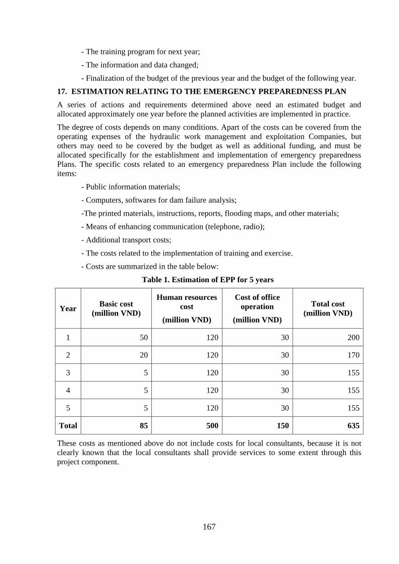
167
- The training program for next year;
- The information and data changed;
- Finalization of the budget of the previous year and the budget of the following year.
17. ESTIMATION RELATING TO THE EMERGENCY PREPAREDNESS PLAN
A series of actions and requirements determined above need an estimated budget and
allocated approximately one year before the planned activities are implemented in practice.
The degree of costs depends on many conditions. Apart of the costs can be covered from the
operating expenses of the hydraulic work management and exploitation Companies, but
others may need to be covered by the budget as well as additional funding, and must be
allocated specifically for the establishment and implementation of emergency preparedness
Plans. The specific costs related to an emergency preparedness Plan include the following
items:
- Public information materials;
- Computers, softwares for dam failure analysis;
-The printed materials, instructions, reports, flooding maps, and other materials;
- Means of enhancing communication (telephone, radio);
- Additional transport costs;
- The costs related to the implementation of training and exercise.
- Costs are summarized in the table below:
Table 1. Estimation of EPP for 5 years
Year Basic cost
(million VND)
Human resources
cost
(million VND)
Cost of office
operation
(million VND)
Total cost
(million VND)
1 50 120 30 200
2 20 120 30 170
3 5 120 30 155
4 5 120 30 155
5 5 120 30 155
Total 85 500 150 635
These costs as mentioned above do not include costs for local consultants, because it is not
clearly known that the local consultants shall provide services to some extent through this
project component.
168
APPENDIX A12- INTEGRATED PEST MANAGEMENT (IPM)
1. Objectives
a, General objectives
Strengthening flora protection at local level, reducing pesticide use in the field, improving the
efficiency of prevention, managing well pesticide and pesticide use process to reduce the risk
of contamination pesticides on the environment and affect human health
b, Specific objectives
• Support of the Department of Plant Protection of Binh Thuan provinces in
strengthening pest management and pesticide management in accordance with the
national action plan on food hygiene and safety, food security, adaptation to climate
change and the concerned international conventions that the Government has
approved.
• Strengthening environmental protection, food safety through strengthening the role of
predators; reduce pesticide residues to ensure food hygiene and safety, reduce
environmental pollution (water, land, air).
• Improving farmers' knowledge: distinguish the major pests, secondary; identify
predators and their role in the field, clearly understand the effect of two colors of
pesticides, property use, know how to survey pest and use threshold control;
understand and apply pest control measures in IPM to increase income for farmers.
2 Basic principles of IPM framework
The following principles will be applied to the sub-projects of Binh Thuan province likely to
increase the use of fertilizers and pesticides on 130ha cultivation land:
a. "Prohibited list": As defined in the screening criteria in Environmental and social
Management Framework (ESMF), the project will not finance the purchase of pesticides
in large quantities and hence do not trigger OP4.09. However, if there is a serious
infestation of pests in the region, the project will support to buy small quantities of
pesticides. The acquisition, pesticides, storage and transportation will be subjected to the
provisions of the Government and without objection of the Bank, the purchase of
pesticides can be done. The list of banned pesticides will not be used and circulated.
b. IPM program and project support: supporte and implementation of IPM program is part
of the EMP for the sub-project. Support project will include technical assistance
(consulting) to perform the non-chemical options, and priority support for agricultural
extension services, including additional operating costs. The bank support fee for
integrated prevention program of the sub-project and will be required or approved an
independent program or as a part of ESMP. A proposed budget has been allocated for the
implementation of IPM programs for the downstream areas of the project area. Detailed
planning work will be completed through consultation close to farmers, local
authority/PCP organization.
c. The project will apply IPM programs as a method to minimize the potential negative
impact of the increased use of fertilizers and chemicals. However, the improvement of
knowledge and experience in the use of fertilizers and chemicals are through research
surveys and training courses in the work as well as selecting safe use of non-chemicals,
other techniques, is being investigated and/or applied in Vietnam. National IPM Program
169
has also summarized the results of the implementation and the lessons of experience. The
project will apply National IPM program results and detailed technical guidance.
d. IPM Program subproject can be set up to support the implementation of the Government's
policy and objectives focusing on reducing the use of chemical fertilizers and pesticides.
e. In normal conditions, if pesticide use is considered to be a necessary option, only
pesticides registered with the government and the international recognition in use and
project will also provide technical and economic information for chemicals use demand. It
should consider the options in the management of not harmful chemicals and can also
reduce reliance on the use of pesticides. The measures will be incorporated into the project
design to reduce risks related to the handling and use of pesticides to allowed possible
level and managed by users.
f. The planning and implementation of mitigation measures and other activities will be
carried out closely with the authorities, powers and stakeholders, including suppliers of
chemicals, to facilitate cooperation and understanding each other.
3. The approach of IPM
Focus more on the risks of abuse and excessive use chemical of plant protection products. The
concerned plant are rice, vegetables, tea etc. these plants tend to be sprayed more of
pesticides.
Focus on community education, the initial survey will be incorporated into the task with the
aim of clarifying the root cause of the abuse and excessive use of plant protection products
and the associated risks. Support the capacity building of the instructor (trainer) IPM. The
current program will need to be reviewed and new modules will be supplemented to increase
the portion related to reducing the risk of plant protection products. The training program will
be enriched with the integration of many activities such as System Rice Intensification
(System Rice Intensification - SRI), minimum tillage (minimum tillage), production
community and use of bio-products replacing plant protection chemicals the training
activities, the application will be made in the wide area application of the model.
To perform this content, it should perform the following steps:
• Step 0: Hiring consultants: A group of consultants (IPM consultants) will be hired to
assist PMU in implementing IPM programs including ensurring results and
cooperation among the agencies, farmers, and other stakeholders. The task for the
consultant will be implemented at an early stage of project implementation.
• Step 1: Set up the basic requirements of the register the program of farmers. This step
should be implemented as soon as possible with appropriate questionnaire to establish
base in 2013 for the use of fertilizers and of pesticides in the project area. Consultation
with key agencies in the conduct of training, registration of participating farmers.
• Step 2: Set program goals and prepare a work plan. Based on the results from the
questionnaire and consultation at Step 1, work plan and schedule will be prepared,
including budgeting and implementation object. The work plan will be submitted to
the PMU and approved by the World Bank for review and comment.
• Step 3: Implementation and annual review. After approval of the work plan, the
activities will be implemented. Implementation progress will be included in the project
progress reports. An annual evaluation report will be implemented by PMU and Sub-
Department of Plant Protection.
170
• Step 4: Evaluate the impact. An independent consultant will be hired to carry out the
impact assessment. This is to assess the performance of the project and to provide
lessons. PMU will hire a national consultant to perform impact assessment of IPM the
program
4. The contents of the sub-projects
(i) Collection of information and selection of solutions
Before implementing IPM program, consultants must have the original investigation to have
the necessary information such as:
o Survey to collect data on: staple crops have economic significance in the project area:
seeds, crop, growth characteristics, and farming techniques.
o Survey to collect data on soil conditions, pedology, local climate.
o Investigate the situation of the pest, harmful rule arises, their economic damage
causing on the major crops in the project area.
o Investigate the role of natural enemies parasitic of pests on the major crops in the
project area.
o Investigate the actual situation of pest control measures, pesticide use and their effect
at the local.
o Investigate the socio-economic conditions, income, technical knowledge, and
practices.
On the basis of these findings, a proposal to evaluate IPM measures will apply on specific
crops in regions and localities implement the project through the following measures:
o Cultivation methods: Soil, field sanitation, crop rotation, intercropping, crop seasons,
reasonable sowing and planting density, rational use of fertilizers; appropriate caring
measures.
o Using seed: the tradition seed and the proposed seed in use.
o The biological measures: taking advantage of available natural enemies in the field,
using probiotics.
o Determination of the level of harm and prevention threshold.
o Chemical measures: safe using with natural enemies, the economic threshold; 4
correct use of medicines.
(ii) Develop of demonstration models IPM
This section done by the Department of Crop Production, based on soil characteristics,
climate, farming skills. Department of Crop Production will propose to the TDA of pilot field
for agricultural development with the highly effective main crops. IPM activities in the pilot
field will serve for sightseeing and guidance of practice.
Some of the main contents when building the IPM in the pilot field, as follows:
o Construction of demonstration models for applying IPM measures proposed above.
o Building model involved by the people with the guidance of technical staff.
o In the model, there need to build nuclear farmers, group leader.
o In addition to technical assistance there should be support materials, for households
participating in demonstration models.
171
o Compiling IPM guiding documentation for major crops: rice, vegetables ...
o Scale of model: depending on crops, specific economic conditions, models were
constructed using different scales: 5-10 ha / model.
(iii) Coaching and training of IPM staff
TOT (Training of trainers) and Farmer Field School (FFS):
• Each sub-project will organize workshops and staff training of IPM. The content of the
training includes:
o Distinguish the major and secondary pests.
o Identify the natural enemies of pests and diseases in the field.
o Investigate methods to detect worms and diseases.
o Understand the impact of two pesticides, using appropriate pesticides.
o The techniques pest control under IPM principles.
o Advanced farming techniques.
• The understanding must be trained in theory and practical application in the field. The
contents above can be trained under thematic groups: farming thematic, identification
thematic and detection methods of pests and their natural enemies, the thematic of IPM
techniques in production.
• Training object: The technical staff of the Department of Agriculture, Sub-department of
plant protection, agricultural extension of districts, communes, and cooperatives. These
students will train to the farmers in the project area, the implementing of models.
• The size of each class is from 20 to 30 students, held in each district. Learning time in
each stage. According to the thematic training session, each session may last 3-5 days on
both theory and practice.
• Lecturer: hire experts from University/Research institute/Agricultural Extension Center...
(iv) Coaching and training of farmers
Training of Farmers (TOF) follows Farmer Field School (FFS):
o Method: Combine theoretical training and base on practical fields of farmers and
demonstration model on demonstration IMP in the pilot field.
o Contents are the same as IMP staff training.
o Participants: participating farmers, farmers who direct implement the models and
farmers outside if interested.
o Classes are organized in each commune.
o Lecturer: staffs attended TOT classes
(v) Evaluate and visit the field based on of demonstration models and field applied of IPM
following the models of farmers
Visit the coast conference, farmers performing the demonstration models are reporters. The
farmers implement the model directly with the participants; visiting farmers will calculate,
compare economic performance and identify lessons, limitations and the work being done
and not being done
172
(vi) Scientific seminar, evaluation of result and exchange of experience and information,
expand the model
Invite experts in related fields participating in the assessment, analysis and additional
evaluation, perfecting the processes; the mass media, the propaganda extension organization,
expansion and transfer the result, the technical advances to farmers, and production areas with
similar conditions
5. The expected results and activities of the project
The project is expected to achieve the following results:
• The risk of food safety and the environment are minimized through the implementation of
existing regulations in business management and use of plant protection products and
other provisions in national policy and the implementation.
• The capacity of Ham Thuan Bac PPD, farmer trainers are enhanced meeting training
work, IPM training and IPM practice advocacy are maintained.
• Support for farmer groups after learning IPM to continue experiment to determine the
application technical advances more effectively in production and popular in the
community.
• Support for strengthening commune locality, strengthening pesticide management
including the implementation and enforcement of legislation controlling plant protection
products. Construction and distribution of a short list of specific plant protection products
proposed use for rice and safe vegetables production.
6- Implementation of IPM programs
Currently, Vietnam is implementing the national IPM program, so sub-projects requires
coordinated planning and integration of the IPM program of the project with the National IPM
program to perform more effectively within of each sub-project.
• Binh Thuan Project Management Unit PPMU:
o Developing and implementing IPM program.
o To be responsible for the preparation of periodic reports on the implementation and
submitting to CPO, WB. Final plan and budget will be completed and discussed with
the CPO. All documents will be stored in the project file.
• Binh Thuan Sub-Department of Plant Protection:
o Provide policy and technical guidelines for the implementation of the IPM program.
o Join in IPM model building.
o Join coaching and staff training IPM.
• Ham Thuan Bac Plant Protection Station
o Coordinate with IPM staff to implement coaching and trained of farmers
implemented IPM through the approach and provide of knowledge, support for of
farmers on the safe use of pesticides when necessary.
o Guide the list of banned pesticides
o Examine the distribution facility providing pesticides to ensure the provision of safe
pesticides for farmers
• People’s committee
173
Organizing for farmers decided to maintain the routine IPM was formed from a training
course by organizing IMP-clubs or groups of farmers with the different levels of organization
and structure, along with many activities (including the integration of the contents of cattle,
credit, market access, etc,.)
• Households in the project area:
o Implementing IPM program has trained.
o The members of the IPM club support together to develop agricultural activities.
They also play a central role in the task of organizing community IPM program and
general agricultural planning of commune and district as well.
• Environmental Safety Monitoring Consultant
o Monitoring the implementation of IPM program of sub-projects.
o Guides local PMU in the implementation.
o To recommend measures to improve the efficiency of implementation of IPM
program of sub-projects.
7- Funds for implementation of IPM program
Funding estimates of the sub-projects implement IPM program includes the following
categories:
- Funds for coaching and IPM staff training: Calculated for the classes held in each
district = unit price x number of district of each sub-project.
- Funds for coaching and training of farmers: Calculated for the organization of class in
each commune = unit price x number of commune in each sub-project.
- Funds held assessment and the shore tours based on demonstration models and field
applying IPM following models of farmers. Each district held a conference for shore
tours in 1 day.
- Scientific conference, evaluating results, information and experiences exchange,
expanding the model. Each District held a scientific conference.
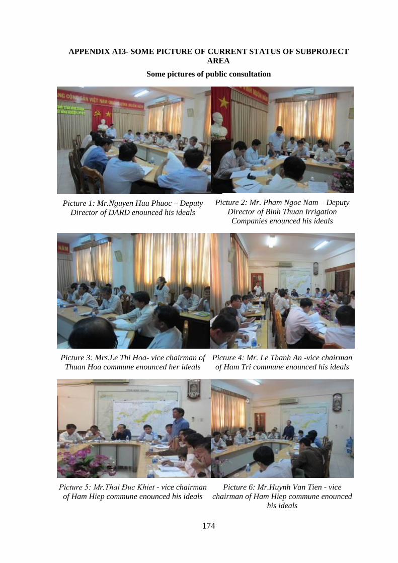
174
APPENDIX A13- SOME PICTURE OF CURRENT STATUS OF SUBPROJECT
AREA
Some pictures of public consultation
Picture 1: Mr.Nguyen Huu Phuoc – Deputy
Director of DARD enounced his ideals
Picture 2: Mr. Pham Ngoc Nam – Deputy
Director of Binh Thuan Irrigation
Companies enounced his ideals
Picture 3: Mrs.Le Thi Hoa- vice chairman of
Thuan Hoa commune enounced her ideals
Picture 4: Mr. Le Thanh An -vice chairman
of Ham Tri commune enounced his ideals
Picture 5: Mr.Thai Đuc Khiet - vice chairman
of Ham Hiep commune enounced his ideals
Picture 6: Mr.Huynh Van Tien - vice
chairman of Ham Hiep commune enounced
his ideals
175
Picture 7: Mr.Tran Dang Thu - expert of ARD
enounced his ideals
Picture 8: Mr.Nguyen Van Tam– Binh Thuan
DONRE enounced his ideals
Picture 9: Mr. Nguyen Minh Duy –Department
of Construction enounced his ideals
Picture 10: Mr. Vo Ngoc Hung - vice
chairman of Phu Hai commune enounced his
ideals
Picture 11: Public consultation at Thuan Hoa
commune
Picture 12: Public consultation at Thuan
Hoa commune
176
Picture 13: Public consultation at Ham Thang
CPC offices
Picture 14: Public consultation at Ma Lam
town
Picture 15: Public consultation at Ma Lam
CPC offices - Ham Thuan Bac district
Picture 16: Public consultation at Ham
Thang CPC offices – Ham Thuan Bac district
Picture 17: Public consultation at Ham Thang
CPC offices
Picture 18: Public consultation at Phu Hai
CPC offices – Phan Thiet city
177
Picture 19: Public consultation at Ham
TriCPC offices– Ham Thuan Bac district
Picture 20: Public consultation at Phu Hai
CPC offices – Phan Thiet city
Pictures of sampling, field surveying
Picture 21: Taking water in the end of Cai
river –Phu Hai commune– Phan Thiet city
Picture 22: Taking water in canal (behind the
power house of Quao reservoir)
Picture 23: Taking water in canal of Quao
river
Picture 24: Taking water at Kim Long dam
178
Pictures of status of Quao reservoir subproject areas
Picture 25: the spillway of Quao reservoir
Picture 26: upstream slope of Quao
reservoir
Picture 27: the service road of of Quao
reservoir
Picture 28: downstream slope of Quao
reservoir
Picture 29: part of Cai river through Phu
Hai commune
Picture 30: part of Cai river through Ham
Chinh commune
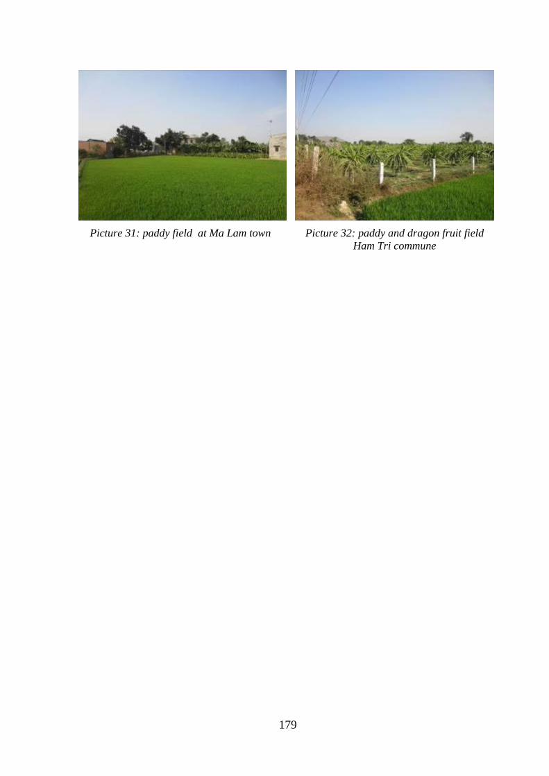
179
Picture 31: paddy field at Ma Lam town
Picture 32: paddy and dragon fruit field
Ham Tri commune
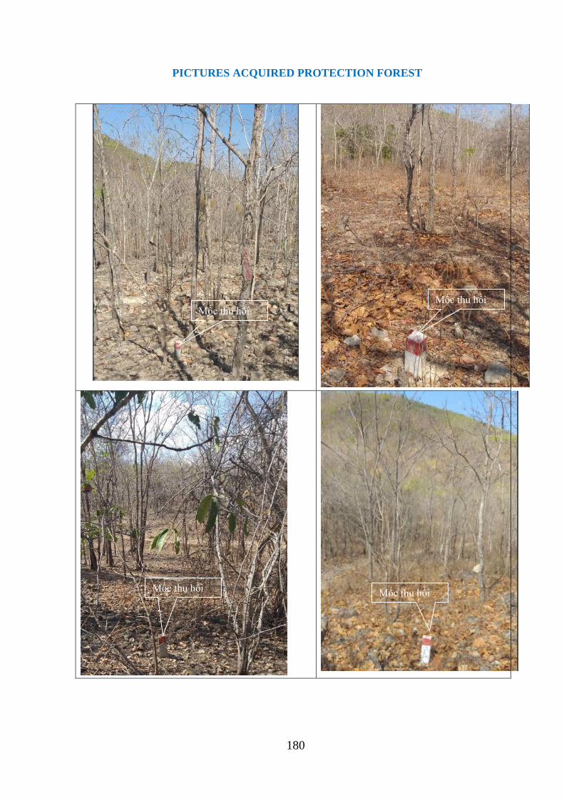
180
PICTURES ACQUIRED PROTECTION FOREST
Mốc thu hồi Mốc thu hồi
Mốc thu hồi Mốc thu hồi

181
APPENDIX B – SOCIAL
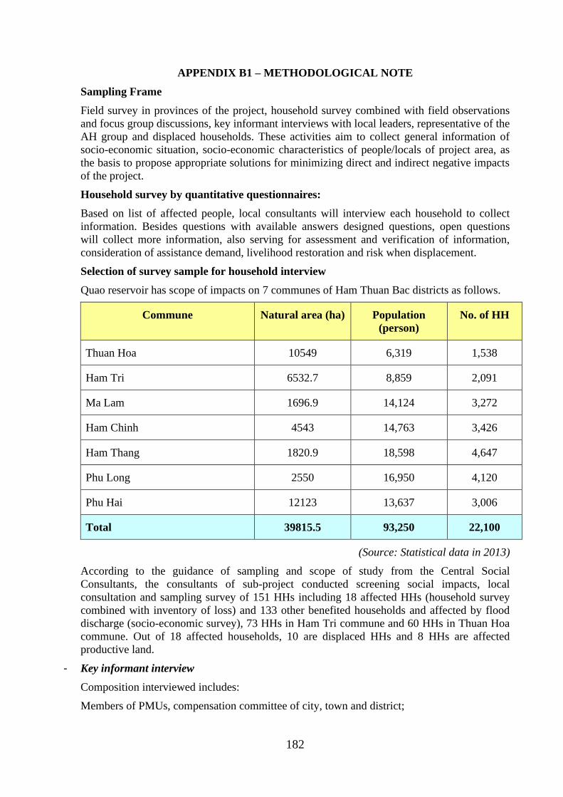
182
APPENDIX B1 – METHODOLOGICAL NOTE
Sampling Frame
Field survey in provinces of the project, household survey combined with field observations
and focus group discussions, key informant interviews with local leaders, representative of the
AH group and displaced households. These activities aim to collect general information of
socio-economic situation, socio-economic characteristics of people/locals of project area, as
the basis to propose appropriate solutions for minimizing direct and indirect negative impacts
of the project.
Household survey by quantitative questionnaires:
Based on list of affected people, local consultants will interview each household to collect
information. Besides questions with available answers designed questions, open questions
will collect more information, also serving for assessment and verification of information,
consideration of assistance demand, livelihood restoration and risk when displacement.
Selection of survey sample for household interview
Quao reservoir has scope of impacts on 7 communes of Ham Thuan Bac districts as follows.
Commune Natural area (ha) Population
(person)
No. of HH
Thuan Hoa 10549 6,319 1,538
Ham Tri 6532.7 8,859 2,091
Ma Lam 1696.9 14,124 3,272
Ham Chinh 4543 14,763 3,426
Ham Thang 1820.9 18,598 4,647
Phu Long 2550 16,950 4,120
Phu Hai 12123 13,637 3,006
Total 39815.5 93,250 22,100
(Source: Statistical data in 2013)
According to the guidance of sampling and scope of study from the Central Social
Consultants, the consultants of sub-project conducted screening social impacts, local
consultation and sampling survey of 151 HHs including 18 affected HHs (household survey
combined with inventory of loss) and 133 other benefited households and affected by flood
discharge (socio-economic survey), 73 HHs in Ham Tri commune and 60 HHs in Thuan Hoa
commune. Out of 18 affected households, 10 are displaced HHs and 8 HHs are affected
productive land.
- Key informant interview
Composition interviewed includes:
Members of PMUs, compensation committee of city, town and district;
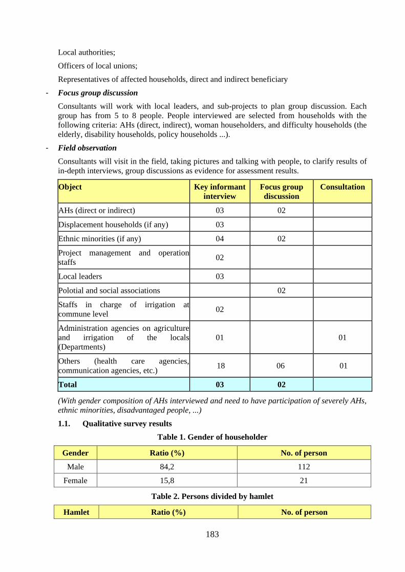
183
Local authorities;
Officers of local unions;
Representatives of affected households, direct and indirect beneficiary
- Focus group discussion
Consultants will work with local leaders, and sub-projects to plan group discussion. Each
group has from 5 to 8 people. People interviewed are selected from households with the
following criteria: AHs (direct, indirect), woman householders, and difficulty households (the
elderly, disability households, policy households ...).
- Field observation
Consultants will visit in the field, taking pictures and talking with people, to clarify results of
in-depth interviews, group discussions as evidence for assessment results.
Object Key informant
interview
Focus group
discussion
Consultation
AHs (direct or indirect) 03 02
Displacement households (if any) 03
Ethnic minorities (if any) 04 02
Project management and operation
staffs 02
Local leaders 03
Polotial and social associations 02
Staffs in charge of irrigation at
commune level 02
Administration agencies on agriculture
and irrigation of the locals
(Departments)
01 01
Others (health care agencies,
communication agencies, etc.) 18 06 01
Total 03 02
(With gender composition of AHs interviewed and need to have participation of severely AHs,
ethnic minorities, disadvantaged people, ...)
1.1. Qualitative survey results
Table 1. Gender of householder
Gender Ratio (%) No. of person
Male 84,2 112
Female 15,8 21
Table 2. Persons divided by hamlet
Hamlet Ratio (%) No. of person
184
Lam Giang 29,3 39
Phu Thai 21,1 28
Phu Hoa 4,5 6
Dan Tri 23,3 31
Dan Hoa 9,0 12
Dan Le 2,3 3
Dan Hiep 10,5 14
Table 3. Persons divided by communes
Commune Ratio (%) No. of person
Ham Tri 54,9 73
Thuan Hoa 45,5 60
Table 4. Person per household
No. of person Ratio (%)
1 0,8
2 6,8
3 9,8
4 29,3
5 30,1
6 9,8
7 2,3
8 7,5
9 2,3
10 1,5
Table 5. Occupation of household members
Occupation Ratio (%)
Laborless 2,0
Agriculture, forestry & fishery 45,0
Business, service 1,6
Employee of state 4,3
Student 12,8
Worker 5,9
Housework 1,6
Retirement 0,4
185
Short-term employee 2,6
Jobless 0,9
Table 6. Education of HH members
Education Ratio (%)
Illiterate 10,8
Primary school 38,8
Secondary school 21,8
High School 13,5
Vocational school 1,1
College/ university 4,9
Not yet school 8,3
Table 7. Housing type
Type Ratio (%) House
Permanent house 0,8 1
Semi-Permanent house 96,2 128
Wood house 3,0 4
Table 8. LURC
LURC availability Productive land Residential land
Yes 93,2 83,5
No 6,8 16,5
Table 9. Water use
Water sources Water use
Drinking Washing Production
River 0,8 4,5 10,5
Reservoir 2,3 3,0 22,6
Bore hole 65,9 82,0 17,3
Water supply plant 19,7 6,0 41,4
Irrigation system 3,0 3,8 7,5
Rain water 8,3 0,8 0,8
Table 10. Toilet types
Toilet types Ratio (%) Toilet
No toilet 0,8 1
186
Septic toilet 72,9 97
Two-compartment 15,8 21
Simple toilet 9,8 13
Water surface toilet 0,8 1
Table 11. Living condition
Living condition Ratio (%) HH
Wealthy 12,0 16
Medium 65,4 87
Needy 16,5 22
Poor 6,0 8
Table 12. School dropout children
School dropout children Ratio (%) No. of children
Yes 18,0 24
No 82,0 109
Table 13. Reason of school dropout
Reason Male (%) Female (%)
Economic difficulties 27,3 15,8
Production 13,6 10,5
Not interested 40,9 15,8
Low learning capacity 22,7
Difficult traveling - 5,3
No need high education -
Table 14. Common sickness
Common sickness Ratio (%) No. of person
Flu 49,0 24
Respiratory 12,2 6
Cold fever -
Malaria 2,0 1
Liver 2,0 1
Poison -
Injury 4,1 2
Table 15. Health insurance
187
Health insurance Ratio (%) No. of person
Yes 83,5 111
No 15,8 21
Table 16. Loan sources
Loan sources Ratio (%) HH
Friends 2,2 2
Lender 3,2 3
Credit fund 9,8 9
Social policy bank 66,7 62
Other banks 2,2 2
Program 2,2 2
Poverty fund -
Associations 4,3 4
Table 17. Number of households benefited by the project
No. Commune
Population, ethnic minorities Poverty
ratio No. of
benefited
households Population
(person)
No.
of
HH
EM
and
ratio
No.
of
EM
Ratio of
agri-
culture
HHs (%)
(%)
1 Thuan Hoa 5482 1429 13.63 747 87.74 8.66 1211
2 Ham Tri 8677 2081 25.63 2224 89.57 3.31 1864
3 Ham Phu 8482 2011 11.84 1004 94.16 4.57 1894
4 Ma Lam 14630 3588 10.12 1481 62.07 2.14 2227
5 Ham
Chinh 14398 3523 0.15 22 84.76 3.54 2989
6 Ham Liem 11297 3048 0.18 20 75.39 2.98 2298
7 Hong
Liem 10093 3347 0.31 31 89.82 3.44 2108
8 Ham
Thang 19153 4646 0 0 53.94 1.91 2506
188
APPENDIX B2 - PUBLIC HEALTH MANAGEMENT PLAN
1 The necessity of the construction of puplic health management plan
The activities of the subproject will generate impacts on the surroundings quality: air, water
and soil environment, in addition it may arise disease. All these factors will affect directly 40
workers, the entire population around the project area (45 households) and households along
the transport route (80 households). The consequence of these effects lead to increase
occupational accidents, traffic accidents, diseases related to respiratory and intestinal system
and eyes.
There are 125 households and 40 workers will directly contact with sources of pollution and
disease from the activities of the project, although subproject have had measures to limit
pollution such as dust, emissions, wastewater and epidemics, but there are potential impacts
that we do not see immediately, so need to take measures for early detection of disease and
sources of disease. The plan indicates the measures to minimize and prevent those impacts.
2 Objective
To control and prevent diseases, raise awareness of the people and the workers to protect
health yourself; help people access fully medical services. Organize regularly medical
examination to detect early disease due to impacts of the subproject; to build treatment plans
for incidents related to diseases, occupational accidents and traffic.
3 Measure and content of public health management
- To train and raise awareness, prevent impacts on health
- Organize regularly medical examination for workers and people in the subproject region
- Build plan to minimize the impact on public health
- Build plan to prevent and treat diseases
4 Role and responsibility of agencies, organizations and individuals
Department of Agriculture and Rural Development (DARD)/ Project Management Unit
(PMU):
- DARD and PMU are responsible for building materials about public health safety training.
- Coordinate all levels of authorities in Thuan Hoa and Ham Tri commune (local
authorities, Fatherland Front, Women's Union, Farmers’ Union, Youth Union, hamlet
representative) organize propagandic activities about health safety.
Department of Health, Ham Thuan Bac Preventive Medicine Center
- To train and raise awareness for all basic levels, contractors and residents about
prevention measures and treatments of diseases;
- Check the medical examination process;
- To direct promptly when epidemics appear, resolving incidents related to public health.
People’s Committee, Social Organizations
- To direct, guide and organize the health safety work; to coordinate closely with contractor,
Department of Health and Preventive Medicine Center when epidemics appear.
Health Station: To pPrepare the medical examination plan and guide water pollution
treatment, epidemic prevention and treatment.
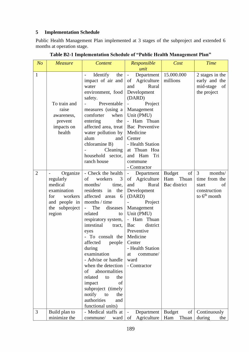
189
5 Implementation Schedule
Public Health Management Plan implemented at 3 stages of the subproject and extended 6
months at operation stage.
Table B2-1 Implementation Schedule of “Public Health Management Plan”
No Measure Content Responsible
unit
Cost Time
1
To train and
raise
awareness,
prevent
impacts on
health
- Identify the
impact of air and
water
environment, food
safety.
- Preventable
measures (using a
comforter when
entering the
affected area, treat
water pollution by
alum and
chloramine B)
- Cleaning
household sector,
ranch house
- Department
of Agriculture
and Rural
Development
(DARD)
- Project
Management
Unit (PMU)
- Ham Thuan
Bac Preventive
Medicine
Center
- Health Station
at Thuan Hoa
and Ham Tri
commune
- Contractor
15.000.000
millions
2 stages in the
early and the
mid-stage of
the project
2 - Organize
regularly
medical
examination
for workers
and people in
the subproject
region
- Check the health
of workers 3
months/ time,
residents in the
affected areas 6
months / time
- The diseases
related to
respiratory system,
intestinal tract,
eyes
- To consult the
affected people
during
examination
- Advise or handle
when the detection
of abnormalities
related to the
impact of
subproject (timely
notify to the
authorities and
functional units)
- Department
of Agriculture
and Rural
Development
(DARD)
- Project
Management
Unit (PMU)
- Ham Thuan
Bac district
Preventive
Medicine
Center
- Health Station
at commune/
ward
- Contractor
Budget of
Ham Thuan
Bac district
3 months/
time from the
start of
construction
to 6th month
3 Build plan to
minimize the
- Medical staffs at
commune/ ward
- Department
of Agriculture
Budget of
Ham Thuan
Continuously
during the
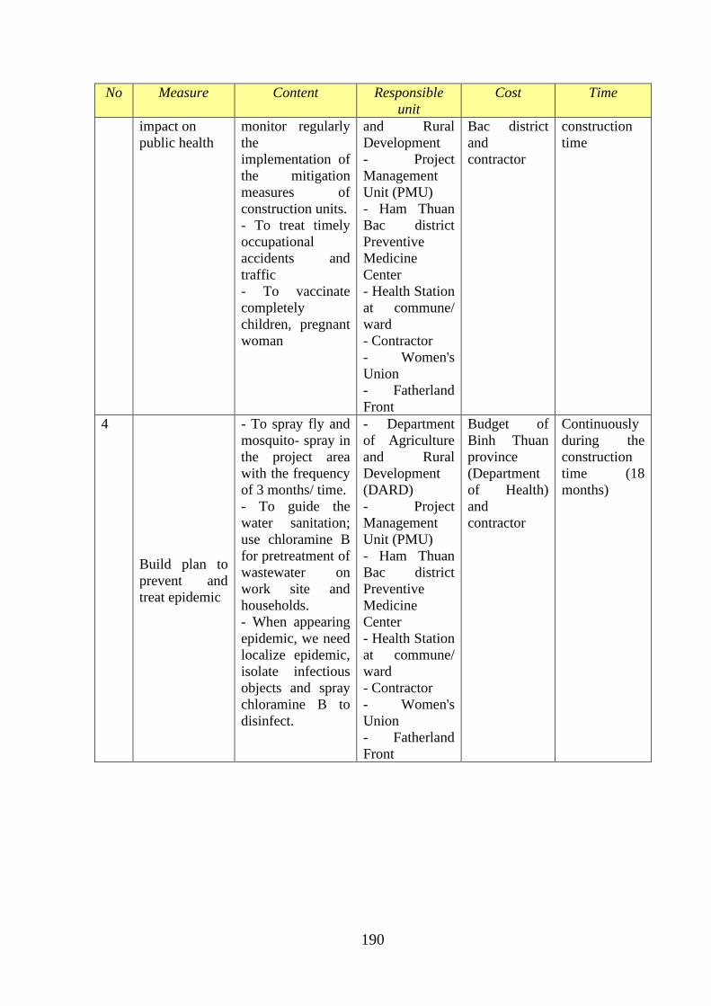
190
No Measure Content Responsible
unit
Cost Time
impact on
public health
monitor regularly
the
implementation of
the mitigation
measures of
construction units.
- To treat timely
occupational
accidents and
traffic
- To vaccinate
completely
children, pregnant
woman
and Rural
Development
- Project
Management
Unit (PMU)
- Ham Thuan
Bac district
Preventive
Medicine
Center
- Health Station
at commune/
ward
- Contractor
- Women's
Union
- Fatherland
Front
Bac district
and
contractor
construction
time
4
Build plan to
prevent and
treat epidemic
- To spray fly and
mosquito- spray in
the project area
with the frequency
of 3 months/ time.
- To guide the
water sanitation;
use chloramine B
for pretreatment of
wastewater on
work site and
households.
- When appearing
epidemic, we need
localize epidemic,
isolate infectious
objects and spray
chloramine B to
disinfect.
- Department
of Agriculture
and Rural
Development
(DARD)
- Project
Management
Unit (PMU)
- Ham Thuan
Bac district
Preventive
Medicine
Center
- Health Station
at commune/
ward
- Contractor
- Women's
Union
- Fatherland
Front
Budget of
Binh Thuan
province
(Department
of Health)
and
contractor
Continuously
during the
construction
time (18
months)
191
APPENDIX B3: PUBLIC CONSULTATION, PARTICIPATION AND
COMMUNITCATION STRATEGY
1 The necessity of the construction of communication plan
The communication and public consultation plan is done throughout from the establishment
of the investment project to the project operation. This helps local communities and managers
to understand and visualize the entire impacts (positive, negative) to provide mitigation
measures the impact on the natural environment and society, especially vulnerable objects
include children, the elderly, women and sensitive ecosystem.
Information from communication and public consultation plan help managers, local
authorities, monitoring unit to give decisions quickly or change timely decisions or plans
during the project implementation.
2 Objective
To publish information about sub-project and provide all materials on the action plan to
government at various levels, social organizations, unions and resident in sub-project areas.
To consult local communities and organizations for the plan will be made for each stage of
the project. The feedback helps the investors and the management level to improve plans to
meet practical needs prior to the implementation of the action plan.
3 Contents
- Information on the subproject and policies of interest will be disseminated to people by
Project Management Unit (PMU);
- Environmental and Social Management Plan: (i) the PMU and consultancy units provide
information of impacts and mitigation measures; (ii) To consult the local authorities and
social organizations, unions, people around the project area.
- Resettlement Action Plan: Provides information about land acquisition, resettlement,
compensation cost apply framework and support policies of the subproject and the
provisions of Binh ThuanProvince and government at various levels, affected people
- Gender Action Plan: provides information about gender equality for the local authorities
and social organizations, unions, people around the project area.
- Public Health Management Plan: provides information on the solutions, disease
prevention plan, medical examination periodically.
- Social security, traffic safety, social evils: provide information about law, legal education
for workers, people around the subproject area.
- Dam Safety: disseminate plans when occurring dam safety incidents in the construction
process and the rainy season.
- Operate mining and flood discharge: provide information and detailed plans for the flood
discharge to people around the project area and downstream area; make protection plan
for the people, the buildings in downstream of the dam.
4 Forms of communication, community consultation
In order to organize the effective communication activities, need understand the basic
elements of the communication process and public relations of them.
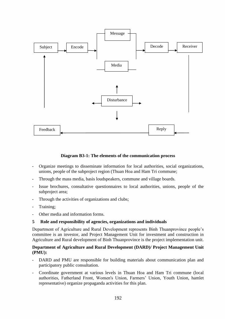
192
Diagram B3-1: The elements of the communication process
- Organize meetings to disseminate information for local authorities, social organizations,
unions, people of the subproject region (Thuan Hoa and Ham Tri commune;
- Through the mass media, basis loudspeakers, commune and village boards.
- Issue brochures, consultative questionnaires to local authorities, unions, people of the
subproject area;
- Through the activities of organizations and clubs;
- Training;
- Other media and information forms.
5 Role and responsibility of agencies, organizations and individuals
Department of Agriculture and Rural Development represents Binh Thuanprovince people’s
committee is an investor, and Project Management Unit for investment and construction in
Agriculture and Rural development of Binh Thuanprovince is the project implementation unit.
Department of Agriculture and Rural Development (DARD)/ Project Management Unit
(PMU):
- DARD and PMU are responsible for building materials about communication plan and
participatory public consultation.
- Coordinate government at various levels in Thuan Hoa and Ham Tri commune (local
authorities, Fatherland Front, Women's Union, Farmers’ Union, Youth Union, hamlet
representative) organize propaganda activities for this plan.
Subject Encode
Message
Media
Decode Receiver
Disturbance
Feedback Reply
193
People’s Committee, Social Organizations
- To direct, guide and organize the propaganda activities and disseminate contents of
communication, participatory public consultation.
- Direct news agencies, local propaganda agencies to spend the appropriate time for
disseminating plans and the impact of the subproject.
Land Clearance Committee
- Provide information about land acquisition, resettlement, compensation cost apply
framework and support policies of the subproject and the provisions of Binh
ThuanProvince and government at various levels, the affected people.
Health Station: disseminate information on the disease prevention plan, medical examination
periodically, solutions when having epidemic.
6 Implementation Schedule
The communication plan and participatory public consultation implemented under stages of
the subproject; to provide completely information for local people and government at various
levels.
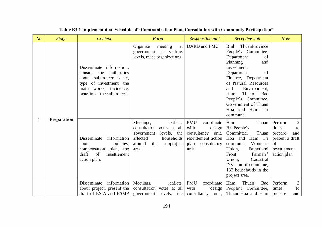
194
Table B3-1 Implementation Schedule of “Communication Plan, Consultation with Community Participation”
No Stage Content Form Responsible unit Receptive unit Note
1 Preparation
Disseminate information,
consult the authorities
about subproject: scale,
type of investment, the
main works, incidence,
benefits of the subproject.
Organize meeting at
government at various
levels, mass organizations.
DARD and PMU Binh ThuanProvince
People’s Committee,
Department of
Planning and
Investment,
Department of
Finance, Department
of Natural Resources
and Environment,
Ham Thuan Bac
People’s Committee,
Government of Thuan
Hoa and Ham Tri
commune
Disseminate information
about policies,
compensation plan, the
draft of resettlement
action plan.
Meetings, leaflets,
consultation votes at all
government levels, the
affected households
around the subproject
area.
PMU coordinate
with design
consultancy unit,
resettlement action
plan consultancy
unit.
Ham Thuan
BacPeople’s
Committee, Thuan
Hoa and Ham Tri
commune, Women's
Union, Fatherland
Front, Farmers’
Union, Cadastral
Division of commune,
133 households in the
project area.
Perform 2
times: to
prepare and
present a draft
of
resettlement
action plan
Disseminate information
about project, present the
draft of ESIA and ESMP
Meetings, leaflets,
consultation votes at all
government levels, the
PMU coordinate
with design
consultancy unit,
Ham Thuan Bac
People’s Committee,
Thuan Hoa and Ham
Perform 2
times: to
prepare and
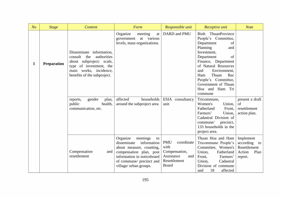
195
No Stage Content Form Responsible unit Receptive unit Note
1 Preparation
Disseminate information,
consult the authorities
about subproject: scale,
type of investment, the
main works, incidence,
benefits of the subproject.
Organize meeting at
government at various
levels, mass organizations.
DARD and PMU Binh ThuanProvince
People’s Committee,
Department of
Planning and
Investment,
Department of
Finance, Department
of Natural Resources
and Environment,
Ham Thuan Bac
People’s Committee,
Government of Thuan
Hoa and Ham Tri
commune
reports, gender plan,
public health,
communication, etc.
affected households
around the subproject area
ESIA consultancy
unit
Tricommune,
Women's Union,
Fatherland Front,
Farmers’ Union,
Cadastral Division of
commune/ precinct,
133 households in the
project area.
present a draft
of
resettlement
action plan.
Compensation and
resettlement
Organize meetings to
disseminate information
about measure, counting,
compensation plan, post
information in noticeboard
of commune/ precinct and
village/ urban groups.
PMU coordinate
with
Compensation,
Assistance and
Resettlement
Board
Thuan Hoa and Ham
Tricommune People’s
Committee, Women's
Union, Fatherland
Front, Farmers’
Union, Cadastral
Division of commune
and 18 affected
Implement
according to
Resettlement
Action Plan
report.
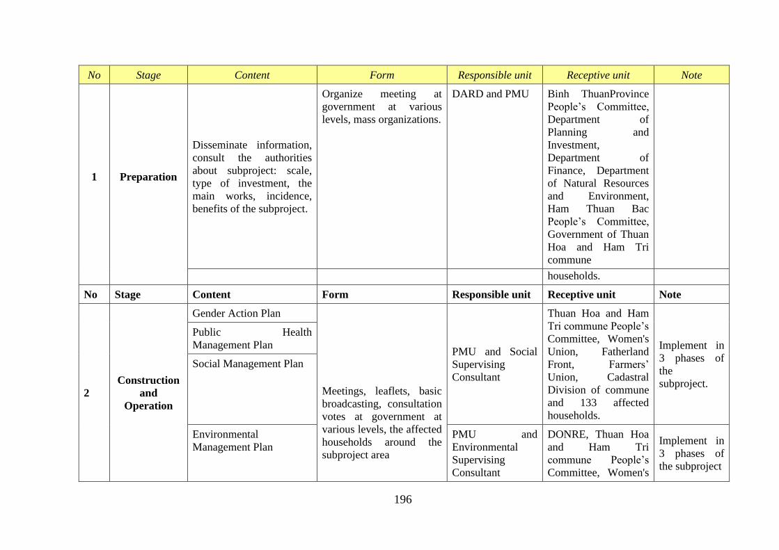
196
No Stage Content Form Responsible unit Receptive unit Note
1 Preparation
Disseminate information,
consult the authorities
about subproject: scale,
type of investment, the
main works, incidence,
benefits of the subproject.
Organize meeting at
government at various
levels, mass organizations.
DARD and PMU Binh ThuanProvince
People’s Committee,
Department of
Planning and
Investment,
Department of
Finance, Department
of Natural Resources
and Environment,
Ham Thuan Bac
People’s Committee,
Government of Thuan
Hoa and Ham Tri
commune
households.
No Stage Content Form Responsible unit Receptive unit Note
2
Construction
and
Operation
Gender Action Plan
Meetings, leaflets, basic
broadcasting, consultation
votes at government at
various levels, the affected
households around the
subproject area
PMU and Social
Supervising
Consultant
Thuan Hoa and Ham
Tri commune People’s
Committee, Women's
Union, Fatherland
Front, Farmers’
Union, Cadastral
Division of commune
and 133 affected
households.
Implement in
3 phases of
the
subproject.
Public Health
Management Plan
Social Management Plan
Environmental
Management Plan
PMU and
Environmental
Supervising
Consultant
DONRE, Thuan Hoa
and Ham Tri
commune People’s
Committee, Women's
Implement in
3 phases of
the subproject
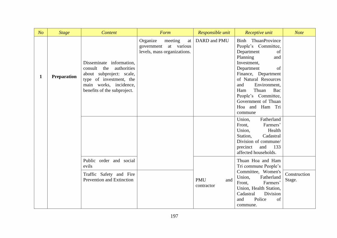
197
No Stage Content Form Responsible unit Receptive unit Note
1 Preparation
Disseminate information,
consult the authorities
about subproject: scale,
type of investment, the
main works, incidence,
benefits of the subproject.
Organize meeting at
government at various
levels, mass organizations.
DARD and PMU Binh ThuanProvince
People’s Committee,
Department of
Planning and
Investment,
Department of
Finance, Department
of Natural Resources
and Environment,
Ham Thuan Bac
People’s Committee,
Government of Thuan
Hoa and Ham Tri
commune
Union, Fatherland
Front, Farmers’
Union, Health
Station, Cadastral
Division of commune/
precinct and 133
affected households.
Public order and social
evils
PMU and
contractor
Thuan Hoa and Ham
Tri commune People’s
Committee, Women's
Union, Fatherland
Front, Farmers’
Union, Health Station,
Cadastral Division
and Police of
commune.
Traffic Safety and Fire
Prevention and Extinction
Construction
Stage.
198
Monitoring Assessment: PMU make a monitoring report of communication plan and
participatory public consultation to control communication content, synthesize feedback from
the Supervising Consultant Unit, local government, social organizations, unions and citizens
to supplement or amend policies and measures of the management plan to suit each stage of
the subproject.
Implementation Cost
The implementation cost of this plan is integrated with other plans (communication content
and methods will be acquired and build by other plans. Social Management Plan chairs other
plans related to social issue. Cost of this phase focuses primarily for broadcasting and
organizations, the expected cost is 100,000 million (fifty million VND) in 24 months.
199
APPENDIX B4 - GENDER ACTION PLAN
1. Principles of gender action plan
- Project opportunities and equal sharing of benefits between women and men;
- Systematic measures aimed at reducing gender inequalities in the project area in the
activities related to dam safety improvement;
- Approach with poor women;
- Collect data on gender analysis including monitoring and evaluation designed by
stakeholders;
- Create favorable environment to support the capacity building and the participation of
women at all the operational phase of the project on gender beside ethnic minorities
development plan;
- Promote presence of women in decision-making bodies at all levels.
2. Base for building gender action plan
- The legal documents of Vietnam and the donor's policies;
- Results of gender analysis in the locality of the project;
- The specific activities in the implementation of project components.
3. Outputs
- Raising awareness on gender for local government leaders and the local population;
- Raising awareness of local people, including women and men about the positive and
negative impacts of project;
- Ensure the involvement of women (at least 30%) in the community’s supervisor group;
- Ensure the involvement of women (at least 30%) in the consultation activities of the
project;
- Ensuring the participation of women, men in the locality in the communication activities
in order to minimize the negative impact of the project;
- Ensuring equality of access, benefit for women and men in the community for programs
to reduce the adverse impact on health during project execution;
- Ensuring equality of access, benefit for women and men in livelihood support programs,
especially among single women, poor women, women from ethnic minorities.
4. Gender action plan
Action Goal Responsibility Time
Component 1: Dam Safety Rehabilitation
(i) Detailed design,
supervision and
quality control of
rehabilitation
works for
prioritized dams
and associated
infrastructure
- Project information is announced
publicly for the local people,
including detailed design drawings
construction site, construction time. It
should ensure that the information to
women and vulnerable groups;
- Establishment of community’s
supervisors, which ensures that at
least 30% of members are women;
PMU/ project
coordinators are
responsible that these
terms will be specified
in the contract;
commune officials
will submit
contractors a list of
people who want to
During
construction
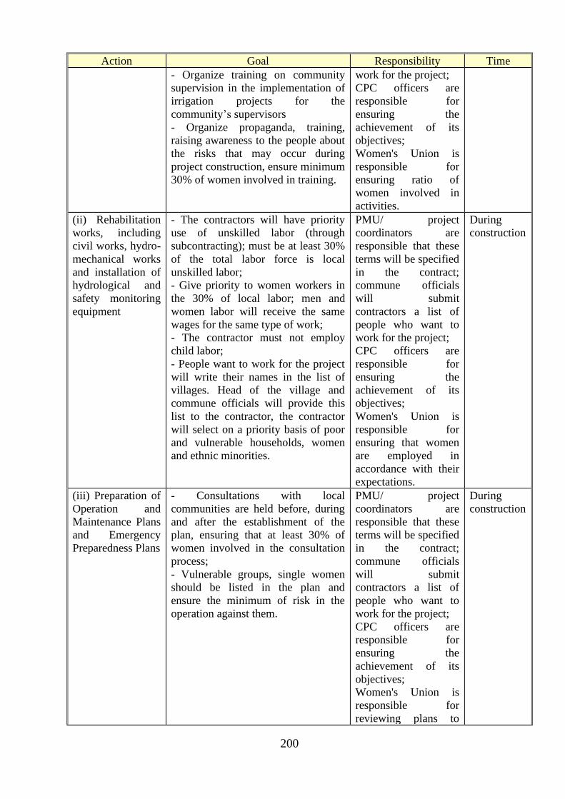
200
Action Goal Responsibility Time
- Organize training on community
supervision in the implementation of
irrigation projects for the
community’s supervisors
- Organize propaganda, training,
raising awareness to the people about
the risks that may occur during
project construction, ensure minimum
30% of women involved in training.
work for the project;
CPC officers are
responsible for
ensuring the
achievement of its
objectives;
Women's Union is
responsible for
ensuring ratio of
women involved in
activities.
(ii) Rehabilitation
works, including
civil works, hydro-
mechanical works
and installation of
hydrological and
safety monitoring
equipment
- The contractors will have priority
use of unskilled labor (through
subcontracting); must be at least 30%
of the total labor force is local
unskilled labor;
- Give priority to women workers in
the 30% of local labor; men and
women labor will receive the same
wages for the same type of work;
- The contractor must not employ
child labor;
- People want to work for the project
will write their names in the list of
villages. Head of the village and
commune officials will provide this
list to the contractor, the contractor
will select on a priority basis of poor
and vulnerable households, women
and ethnic minorities.
PMU/ project
coordinators are
responsible that these
terms will be specified
in the contract;
commune officials
will submit
contractors a list of
people who want to
work for the project;
CPC officers are
responsible for
ensuring the
achievement of its
objectives;
Women's Union is
responsible for
ensuring that women
are employed in
accordance with their
expectations.
During
construction
(iii) Preparation of
Operation and
Maintenance Plans
and Emergency
Preparedness Plans
- Consultations with local
communities are held before, during
and after the establishment of the
plan, ensuring that at least 30% of
women involved in the consultation
process;
- Vulnerable groups, single women
should be listed in the plan and
ensure the minimum of risk in the
operation against them.
PMU/ project
coordinators are
responsible that these
terms will be specified
in the contract;
commune officials
will submit
contractors a list of
people who want to
work for the project;
CPC officers are
responsible for
ensuring the
achievement of its
objectives;
Women's Union is
responsible for
reviewing plans to
During
construction
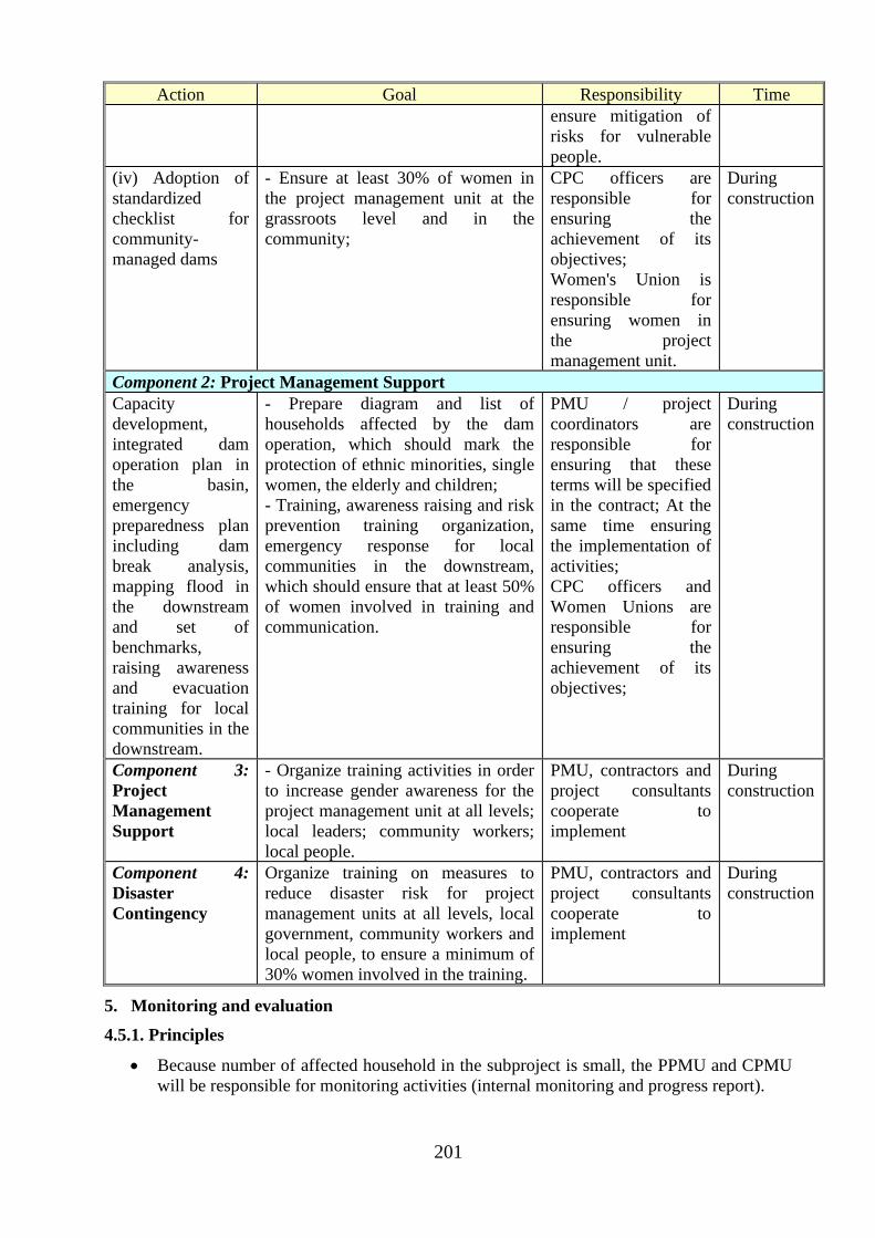
201
Action Goal Responsibility Time
ensure mitigation of
risks for vulnerable
people.
(iv) Adoption of
standardized
checklist for
community-
managed dams
- Ensure at least 30% of women in
the project management unit at the
grassroots level and in the
community;
CPC officers are
responsible for
ensuring the
achievement of its
objectives;
Women's Union is
responsible for
ensuring women in
the project
management unit.
During
construction
Component 2: Project Management Support
Capacity
development,
integrated dam
operation plan in
the basin,
emergency
preparedness plan
including dam
break analysis,
mapping flood in
the downstream
and set of
benchmarks,
raising awareness
and evacuation
training for local
communities in the
downstream.
- Prepare diagram and list of
households affected by the dam
operation, which should mark the
protection of ethnic minorities, single
women, the elderly and children;
- Training, awareness raising and risk
prevention training organization,
emergency response for local
communities in the downstream,
which should ensure that at least 50%
of women involved in training and
communication.
PMU / project
coordinators are
responsible for
ensuring that these
terms will be specified
in the contract; At the
same time ensuring
the implementation of
activities;
CPC officers and
Women Unions are
responsible for
ensuring the
achievement of its
objectives;
During
construction
Component 3:
Project
Management
Support
- Organize training activities in order
to increase gender awareness for the
project management unit at all levels;
local leaders; community workers;
local people.
PMU, contractors and
project consultants
cooperate to
implement
During
construction
Component 4:
Disaster
Contingency
Organize training on measures to
reduce disaster risk for project
management units at all levels, local
government, community workers and
local people, to ensure a minimum of
30% women involved in the training.
PMU, contractors and
project consultants
cooperate to
implement
During
construction
5. Monitoring and evaluation
4.5.1. Principles
• Because number of affected household in the subproject is small, the PPMU and CPMU
will be responsible for monitoring activities (internal monitoring and progress report).
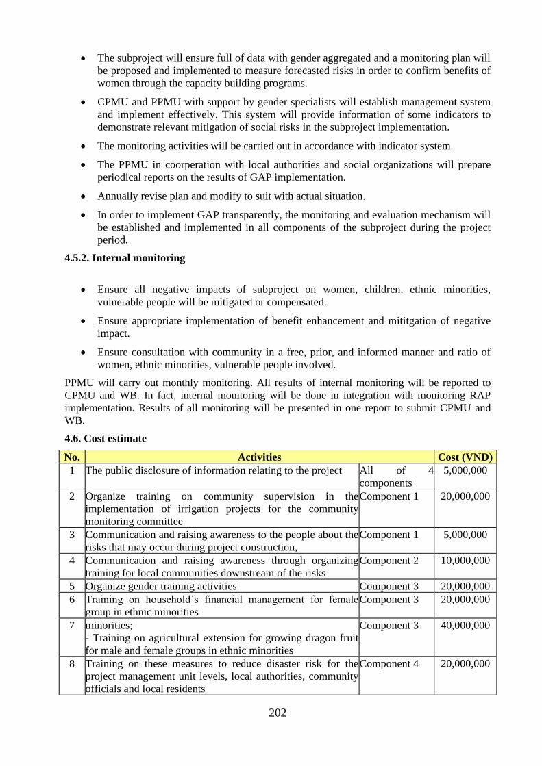
202
• The subproject will ensure full of data with gender aggregated and a monitoring plan will
be proposed and implemented to measure forecasted risks in order to confirm benefits of
women through the capacity building programs.
• CPMU and PPMU with support by gender specialists will establish management system
and implement effectively. This system will provide information of some indicators to
demonstrate relevant mitigation of social risks in the subproject implementation.
• The monitoring activities will be carried out in accordance with indicator system.
• The PPMU in coorperation with local authorities and social organizations will prepare
periodical reports on the results of GAP implementation.
• Annually revise plan and modify to suit with actual situation.
• In order to implement GAP transparently, the monitoring and evaluation mechanism will
be established and implemented in all components of the subproject during the project
period.
4.5.2. Internal monitoring
• Ensure all negative impacts of subproject on women, children, ethnic minorities,
vulnerable people will be mitigated or compensated.
• Ensure appropriate implementation of benefit enhancement and mititgation of negative
impact.
• Ensure consultation with community in a free, prior, and informed manner and ratio of
women, ethnic minorities, vulnerable people involved.
PPMU will carry out monthly monitoring. All results of internal monitoring will be reported to
CPMU and WB. In fact, internal monitoring will be done in integration with monitoring RAP
implementation. Results of all monitoring will be presented in one report to submit CPMU and
WB.
4.6. Cost estimate
No. Activities Cost (VND)
1 The public disclosure of information relating to the project All of 4
components
5,000,000
2 Organize training on community supervision in the
implementation of irrigation projects for the community
monitoring committee
Component 1 20,000,000
3 Communication and raising awareness to the people about the
risks that may occur during project construction,
Component 1 5,000,000
4 Communication and raising awareness through organizing
training for local communities downstream of the risks
Component 2 10,000,000
5 Organize gender training activities Component 3 20,000,000
6 Training on household’s financial management for female
group in ethnic minorities
Component 3 20,000,000
7 minorities;
- Training on agricultural extension for growing dragon fruit
for male and female groups in ethnic minorities
Component 3 40,000,000
8 Training on these measures to reduce disaster risk for the
project management unit levels, local authorities, community
officials and local residents
Component 4 20,000,000

203
Total: 140,000,000
204
APPENDIX B5 - GRIEVANCE REDRESS MECHANISM
1 World Bank requirement OP 4.12
The concepts of social risk management and social license to operate have become an integral
part of doing business in emerging markets. These dimensions of a company’s social and
environmental strategy can be achieved with effective stakeholder engagement, based on active
participation of and feedback from groups affected by the company’s operations. A mechanism
to address affected communities’ concerns and complaints a grievance mechanism is an
important pillar of the stakeholder engagement process, since it creates opportunities for
companies and communities to identify problems and discover solutions together.
A Grievance redress mechanism (GRM) is an integral element in project management that
intends to seek feedback from beneficiaries and resolve of complaints on project activities and
performance.
The DRSIP Resettlement Policy Framework (RPF) requires each sub-project to establish a
Grievance Redress Mechanism (GRM) for the main purpose of addressing resettlement-related
claims, clarifications, concerns or complaints (Please refer to RPF part VIII for the details of
establishing the GRM at the sub-project and provincial levels.)
Since the GRM is required for all sub-projects, including those that are not identified to have
involuntary resettlement issues, the same mechanism to be established under the RPF will be
utilized for all project-related grievances. A national grievance committee mirroring that of the
provincial committees will therefore be set up to handle project-related complaints/clarifications
that cannot be handled by or are beyond the provincial committee's mandate and capacity. In
addition, a Grievance Officer shall be designated at each local dam management units (LDMUs),
at the PPMUs and at the CPO who will perform the following functions:
• Receive, record and promptly acknowledge receipt of all grievances
• Conduct preliminary screening of grievances for the purpose of sorting out those that
does not concern the Project and for determining the appropriate Project unit/office or
committee to refer or forward the grievance to
• Maintain a database of grievances and monitor/track their status
• Periodically inform the complainants of the status of their
complaints/claims/clarifications
• Prepare periodic report on the grievances, including pending grievances, to the Project
Management.
To ensure that the GRM requirements are complied with in every sub-project, the sub-project
owner (i.e. local dam/reservoir management units) and the PPMU will adopt their own GRM
Procedure based on the Template provided in Annex 8– Generic Sub-project Grievance Redress
Procedures for the PPMU. The adopted procedure will be included in the Sub-project document
package that will be submitted to the CPO for review and clearance.
2 IFC approaches
Grievance mechanisms are an important part of IFC’s approach to requirements related to
community engagement by clients under the Policy and Performance Standards on Social and
Environmental Sustainability. Where it is anticipated that a new project or existing company
operations will involve ongoing risk and adverse impacts on surrounding communities, the client
will be required to establish a grievance mechanism to receive and facilitate resolution of the
affected communities’ concerns and complaints about the client’s environmental and social
performance. The grievance mechanism should be scaled to risks and adverse impacts of the
205
project, address concerns promptly, use an understandable and transparent process that is
culturally appropriate and readily accessible to all segments of the affected communities, and do
so at no cost to communities and without retribution. The mechanism should not impede access
to judicial and administrative remedies. The client will inform the affected communities about
the mechanism in the course of its community engagement process.
A grievance mechanism should be able to deal with most of the community issues that are
covered by IFC’s Performance Standards. Grievance mechanism requirements in relation to
affected communities are explicitly stated with regard to security personnel, land acquisition and
adverse impacts on indigenous peoples. Additional guidance is provided in the corresponding
Guidance Notes.
IFC client companies will be asked to design the mechanism according to the extent of risks and
adverse impacts of the project. Impacts on communities are evaluated within the Social and
Environmental Assessment for a project.4 Based on the results of this assessment, IFC’s project
sponsors may be required to develop or improve their social and environmental management and
community engagement, and to include appropriate steps in their action plans. However, all
issues arising over the life of a project cannot be anticipated and pre-empted during the
assessment process. While an upfront comprehensive social and environmental assessment can
serve to reduce the likelihood and volume of grievances in the future, the need for a mechanism
to address community grievances will always exist.
IFC views grievance management as one of the pillars of stakeholder engagement for all clients.
Grievance mechanisms inform and complement but do not replace other forms of stakeholder
engagement. Stakeholder engagement also includes stakeholder identification and analysis,
information disclosure, stakeholder consultation, negotiations and partnerships, stakeholder
involvement in project monitoring, and reporting to stakeholders.5 If strategically applied
throughout the project life, an integrated range of stakeholder engagement approaches can help
build trust, contribute to maintaining broad community support for the project, and ultimately
help companies promote the long-term viability of their investments.
As part of the Performance Standards framework, the Compliance Advisor Ombudsman (CAO)
responds to complaints from affected communities around IFC-financed projects, and thereby
serves as an independent accountability body for IFC.
This Note is based on IFC’s experience in applying its Performance Standards and is no
prescriptive in its approach. It should be used in conjunction with Performance Standards and
IFC Guidance Notes, which contain basic requirements to be followed when developing
grievance management procedures under the IFC Policy and Performance Standards framework.
However, this document does not intend to duplicate existing IFC social and environmental
policy requirements.
2.1 At the sub-project level
A project-level grievance mechanism for affected communities is a process for receiving,
evaluating, and addressing project related grievances from affected communities at the level of
the company, or project. In the context of relatively large projects, this mechanism may also
address grievances against contractors and subcontractors.
Project-level grievance mechanisms offer companies and affected communities an alternative to
external dispute resolution processes (legal or administrative systems or other public or civic
mechanisms). These grievance mechanisms differ from other forms of dispute resolution in that
they offer the advantage of a locally based, simplified, and mutually beneficial way to settle
issues within the framework of the company community relationship, while recognizing the right
of complainants to take their grievances to a formal dispute body or other external dispute
resolution mechanisms. It should be noted, however, that complex issues that arise from high
206
environmental and social impacts are seldom resolved in a relatively simple way. In such cases,
projects should anticipate involvement of various third parties in the resolution process to
achieve solutions with affected communities. These include, but are not limited to, various
national and international mediation bodies, independent mediators and facilitators with sector
and country specific expertise, and independent accountability mechanisms of public sector
financiers.
2.2 Benefited communities and responsible
A project’s grievance mechanism should be specifically designed with a focus on local
communities affected by the project. The task of understanding who will be potentially affected
by project operations, and who will therefore use the company grievance mechanism to raise
complaints, is not always straightforward and depends on the project’s particular circumstances.
Thus, it is beneficial to review who may be affected by the project, and the nature of the potential
impact, during the broader stakeholder analysis phase of the Social and Environmental
Assessment.
The focus of the grievance mechanism on the needs of affected communities is substantiated by
the fact that they are directly, and in some cases significantly, affected by project operations but
often lack viable options or capacity for raising their concerns through formal structures such as
the courts.
For a grievance mechanism to be effective, all project stakeholders need to understand and
support its purpose. Affected communities must be aware of and understand the grievance
mechanism’s benefits to them. Other stakeholder groups need to understand why the grievance
mechanism is not open to them or their issues and concerns (such as commercial or political
disputes) and be informed of the avenues available to them to raise their complaints.
A company’s grievance mechanism and its overall community engagement strategy are linked
and should be mutually reinforcing. A transparent and legitimate process that is the product of a
joint effort between the company and the community enhances their relationship, improves
communication, and increases trust. When grievance mechanisms are designed with the
participation of all affected groups and enjoy their support, the process is able to address
concerns effectively and in a manner that is mutually beneficial to companies and communities.
Properly designed and implemented grievance management processes can benefit both the
company and communities by increasing the likelihood of resolving minor disputes quickly,
inexpensively, and fairly with solutions that reasonably satisfy both sides. Grievance
mechanisms can also help identify and resolve issues before they are elevated to formal dispute
resolution methods, including the courts.
Recognizing and dealing with affected communities’ issues early can benefit the company by
reducing operational and reputation risks that may result from leaving such issues unresolved.
These risks can have a significant and direct business impact. Protests, road and bridge
blockages, violence, suspension of operations, and plant closures are just a few examples of how
the unsatisfactory handling of community concerns can directly affect a business’s bottom line.
A grievance mechanism also gives the company access to important information about the
project’s external environment, and can help the business identify and correct weaknesses in its
management systems or production processes
For companies as well as communities, escalation of conflict to courts and other formal tribunals
can be lengthy and costly, and will not necessarily deliver satisfactory results for either party.
For companies, the negative publicity can cause even greater damage. By creating a project-level
structure, the company can address the source of the problem more efficiently. For example:
• Project level mechanisms offer locally tailored solutions and, unlike many government
mechanisms, can cater to local needs and incorporate provisions to accommodate
207
different groups within communities especially the disadvantaged (such as women,
minorities, marginalized groups).
• Where government mechanisms are slow, ineffective, and costly, communities may
welcome an opportunity to voice their complaints and receive free, locally based, speedy,
and satisfactory resolution.
2.3 The role of third party
Third parties such as nongovernmental organizations, community-based organizations, local
governments, local community and religious organizations and councils can sometimes be
involved in companies’ grievance mechanisms. They can serve as process organizers, places to
bring a complaint to be passed on to the company, or as facilitators, witnesses, advisors, or
mediators. In some cases, it may be beneficial to place part of the responsibility for the process
on external entities formed within the communities themselves or acceptable to them while the
company maintains ultimate responsibility and accountability for the process. Third parties can
help increase the level of trust from communities as well as overcome certain limitations of
project-level mechanisms, such as lack of transparency, insufficient company resources, possible
conflict of interest, and biases, provided that they themselves are perceived to be unbiased and
impartial relative to both the company and the communities.
To have an effective project level grievance mechanism, companies need to understand the roles
of third parties before engaging them. For example:
• Community self-governance structures (such as village councils, elders councils, tribal
councils). Take these into account when developing a grievance mechanism—to ensure
cultural appropriateness, community involvement in decision making, and efficient and
effective use of existing community resources
• Local and international NGOs. Identify those that are active in the area of project or company
operations, learn about their interactions with the affected communities, determine what
contribution they can make to effective resolution, and discuss options for an NGO to
administer the project’s grievance mechanism or a part thereof. Sometimes NGOs can also
represent local communities and help them build their capacity to understand the process and
its benefits, participate in decision making, and articulate grievances and bring them to the
attention of companies. Such organizations can be viewed as a voice of communities, and
companies should be prepared to deal with grievances brought by NGOs on behalf of
communities
• Local government authorities. Communities sometimes bring their project-related complaints
to local governments. In cases where this is the established practice, consider partnering with
local authorities to facilitate receipt of grievances from communities. Local governments can
also be a resource to help companies resolve complaints, since local authorities may have an
established relationship with the communities. They can participate as third parties and
advisors in company-initiated resolution processes.
3 Vietnam Grievance Redress Mechanism
The grievance redress mechanism (GRM) is an integral project management element that intends
to seek feedback from beneficiaries and resolve of complaints on project activities and
performance. The mechanism will ensure that (i) the public within the project influence are
aware of their rights to access, and shall have access to, the mechanism free of administrative
and legal charges; (ii) that these rights and interests are protected from poor project performance,
especially of beneficiaries and/or affected persons; and (iii) concerns arising from project
performance in all phases are addressed effectively.
3.1 Access
208
CPO, PPMUs, and the relevant local dam management will make the public aware of the GRM
through public awareness campaigns, training and capacity building in I-SUPPORT. Any person
who has feedback or complaints regarding the performance or activities of the project and its
subprojects during pre-implementation, implementation and operation phases, shall have access
to the GRM mechanism.
Contact details in support of the mechanism will be publicly disclosed and posted in the offices
of concerned communities and in strategic places of the project’s area of influence. These will
also be incorporated in DRSIP information materials, such as Project brochures, flyers and
posters.
3.2 Grievance Officer
The CPO and the PPMUs shall each designate and train one of their officers to be a Grievance
Officer for project-related issues. The GOs will be responsible for the initial screening of
feedbacks and complaints, as well as, the organization of preliminary meetings with concerned
parties to establish the critical path to resolution. A registry of feedback or grievances received
will be maintained by the GOs for reporting to PCO. Feedback/grievance registries will be
consolidated by the CPO for discussions on how to further enhance DRSIP implementation.
3.3 Grievance Investigation and Resolution Process
Households or groups of households wishing to provide feedback and/or complain about the
effects of PRDP activities on their property, production system, economic well-being, spiritual
life, environmental quality, or any other assets of their lives shall make their complaint using the
standard complaint form provided by the GO through the local dam management. The Grievance
Investigation and Resolution procedure is outlined in Annex
Complaints relating to any matter of the Project will be settled through negotiations aimed at
achieving consensus. The complaint will pass through three stages before it can be filed to the
court. The Enforcement Body will incur all administrative and legal fees relating to complaint
handling.
The complaints relating to the Project shall be settled in compliance with Article 138 of the Land
Law 2003; Article 28 of the Law on Complaints; Article 63 and 64 of Decree No.84/2007/ND-
CP; Clause 2 of Article 40 of Decree No.69/2009 and regulations on complaints in Decree
No.75/2012/ND-CP dated 20/11/2012. According to Clause 2 in Article 138 of the Land Law
2003 and 2015:
(i) In case of complaints against administrative decisions and administrative actions on land
management first settled by the Chairman of the People's Committees of districts, towns
and cities under the province, without contentment of the complainant, the complaints can
be filed to the People's Court or appealed to the Chairman of the People's Committees of
provinces and centrally-run cities. In case of appeal to the Chairman of the People's
Committees of provinces and cities under central authority, the decision of the Chairman of
the People's Committees of provinces and cities under central authority is the final one.
(ii) In case of complaints against administrative decisions and administrative actions on land
management first will be settled by the Chairman of the People's Committees of districts,
towns and cities under the province, without contentment of the complainant, the
complaints can be filed to the People's Court.
(iii) The time limit for complaints against administrative decisions and administrative actions
on Land Management is thirty (30) days after the date of receipt of the administrative
decision or being informed of that administrative decision. Within 45 days from the date of
receipt of the first complaint resolution decision, the complainant, if disagree, can make an
appeal to the state authority or the People's Court.
209
In terms of complaint settlement, in Law on Complaints, Article 14: Rights and obligations of
the person competent to settle first-time complaints:
(i) The person competent to settle first-time complaints should:
• Ask the complainant, relevant agencies, organizations and individuals to provide
information, documents and evidence within 07 days of the request as a basis for
complaint settlement
• Determine to employ or cancel the emergency measures as defined in Article 35 of
this Law
(ii) The person competent to settle first-time complains should perform the following
obligations:
• To receive the complaint and issue a notice in writing to the complainant, agencies,
organizations, or individuals entitled to appeal and the state inspection agencies at the
same level of acceptance of resolving complaints against administrative decisions and
actions
• To settle the complaints against administrative decisions and actions if required by the
complainant
• To open a dialogue with the complainant and agencies, organizations and individuals
concerned
• To decide complaint settlement and be responsible before the law for settlement
results. In case of complaints from authorized agencies, organizations and individuals,
the results shall be notified to agencies, organizations and individuals in accordance
with law
• To provide information, documents and evidence relating to the complaint for the
complainant when they are required by the complainant for second-time settlement or
appeal to the People’s Court.
(iii) To compensate for first-time settlement and damages due to administrative decisions and
actions in accordance with regulations on the State responsibilities.
(iv) The person competent to settle first-time complaints should perform their rights and
obligations as stipulated by Law.
In terms of announcement of complaint settlement decision: In Article 12 of Decree
No.75/2012/ND-CP dated October 3rd, 2012 of the Government detailing the implementation of
some articles of the Law on Complaint.
(i) Within 15 days from the date of decision of complaint settlement, the person competent to
settle the complaint for the second time shall announce the complaint settlement decision
by one of the forms specified in Clause 2 in Article 41 of the Law on Complaints.
(ii) In case of announcement at a meeting, the attendees of the meeting must include: the
person issuing the complaint settlement decision, the complainant or their representatives,
the person subject to complaint and agencies, organizations and individuals concerned.
Before conducting a public meeting, the person competent to settle complaints must send a
notice to agencies, organizations and individuals involved 3 days in advance.
(iii) The announcement of complaint settlement decision shall be made on the mass media
(television, radio, printed and electronic newspaper). If the agency of the person competent
to settle complaints has their own portal or website, the complaint settlement decision
should be made public on this portal or website. The minimum number of announcement is
02 times on radio, television, and printed publications. The period of announcement on
210
electronic publications, portals or websites should be at least 15 days from the date of
notification.
(iv) In case of notice at the office or the Reception Room of agencies and organizations
competent to settle complaints, the period for the notice of complaint settlement decision to
be posted up is at least 15 days.
Assure that the mechanism described above is pragmatic and acceptable to PAPs, consultation
with local authorities and affected communities about this mechanism is needed, particularly
consultation with vulnerable groups. The procedure for complaint settlement consists of 4 stages
as below:
(i) The first stage in the Communal People’s Committee: An aggrieved APs may bring
his/her complaint to the One Door Department of the Commune/Ward People’s
Committee, in writing or verbally. The member of CPC/WPC at the One Door Department
will be responsible to notify the CPC/WPC leaders about the complaint for solving. The
Chairman of the CPC/WPC will meet personally with the aggrieved APs and will have 30
days following the receiving date of the complaint to resolve it. The CPC/WPC secretariat
is responsible for documenting and keeping file of all complaints handled by the
CPC/WPC.
(ii) The second stage in the District People’s Committee: If after 30 days the aggrieved
affected household does not hear from the CPC, or if the APs is not satisfied with the
decision taken on his/her complaint, the APs may bring the case, either in writing or
verbally, to any member of the DPC or the DRC of the district. The DPC in turn will have
30 days following the receiving date of the complaint to resolve the case. The DPC is
responsible for documenting and keeping file of all complaints that it handles and will
inform the DRC of district of any decision made. Affected households can also bring their
case to Court if they wish.
(iii) The third stage in the Provincial People’s Committee: If after 30 days the aggrieved
PAP does not hear from the DPC, or if the PAP is not satisfied with the decision taken on
his/her complaint, the PAP may bring the case, either in writing or verbally, to any member
of the PPC or lodge an administrative case to the District People’s Court for solution. The
PPC has 45 days within which to resolve the complaint to the satisfaction of all concerned.
The PPC secretariat is also responsible for documenting and keeping file of all complaints
that it handles. Affected households can also bring their case to Court if they want.
(iv) The final phase, the arbitration by the Court: If after 45 days following the lodging of
the complaint with the PPC, the aggrieved PAP does not hear from the PPC, or if he/she is
not satisfied with the decision taken on his/her complaint, the case may be brought to a
court of law for adjudication. Decision by the court will be the final decision.
Decision on solving the complaints must be sent to the aggrieved APs and concerned
parties and must be posted at the office of the People’s Committee where the complaint is
solved. After three days, the decision/result on solution is available at commune/ward level
and after seven days at district level.
In order to minimize complaints to the provincial level, PMU will cooperate with the
District Resettlement Committee to participate in and consult on settling complaints.
Personnel: The Environmental and Resettlement staff assigned by PMU will formulate and
maintain a database of the APs’ grievances related to the Project including information
such as nature of the grievances, sources and dates of receipt of grievances, names and
addresses of the aggrieved PAPs, actions to be taken and current status.
211
In case of verbal claims, the reception board will record these inquiries in the grievance
form at the first meeting with affected people.
The independent monitoring Consultant will be responsible for checking the procedures for
and resolutions of grievances and complaints. The independent monitoring Consultant may
recommend further measures to be taken to redress unresolved grievances. During
monitoring the grievance redress procedures and reviewing the decisions, the independent
monitoring agency should closely cooperate with the Vietnam Fatherland Front as well as
its members responsible for supervising law enforcement related to appeals in the area.
The grievance resolution process for the Project, including the names and contact details of
Grievance Focal Points and the Grievance Facilitation Unit (GFU), will be disseminated
through information brochures and posted in the offices of the People’s Committees at the
communes and districts and PMU.
At the same time, an escrow account for resettlement payments should be used when
grievance is resolving to avoid excessive delay of the project while ensuring compensation
payment after the grievance has been resolved.
To ensure that the grievance mechanism described above are practical and acceptable by
APs, it were consulted with local authorities and communities taking into account of
specific cultural attributes as well as traditional-cultural mechanisms for raising and
resolving complaints and conflicting issues. The ethnic minority objects and efforts were
also identified and determined which are culturally acceptable ways to find the solution.
212
APPENDIX B6 - INFORMATION DISCLOSURE, ACCOUNTABILITY AND
MONITORING
1. Consultation and announcement
The main objectives of information announcement and public consultation is to ensure the
participation of affected communities, households, local governments and organizations
concerned in sharing the Project information, consulting the selection of technical plans,
planning impacts on land, income and assets on land... The announcement is an important
contribution in accerlerating the Project progress during implementation and preparation, as well
as when the project is put into operation with the consensus of the community, government, and
PMU. This will minimize the possibility of conflicts and other risks and increase the investment
efficiency and social significance of the Project.
The public consultation and announcement should ensure:
• The local authorities as well as the representatives of the people affected shall be
involved in the project planning and decision making process. The PMU shall work
closely with the commune/district during the implementation of the Project. The
involvement of the people affected in the implementation process shall be remained by
asking the commune/district to invite the representatives of the affected people to be a
part of the Council on Compensation and Resettlement as well as in resettlement
activities.
• All information about the items and activities planned for the Project should be shared to
the people affected.
• The demands and priorities of the affected people, as well as their responses to the
proposed policies and activities, should be collected.
• The affected people should be fully informed of the decisions influencing directly their
income and lives, and can be involved in activities and making decisions on issues
directly affecting them.
• The transparency in all activities relating to land acquisition, compensation, resettlement
and rehabilitation should be ensured.
• For the World Bank, those people affected by the project should be fully informed and
consulted on resettlement and compensation plans. Consultation is the starting point for
all activities related to resettlement. The people affected by resettlement may be afraid
that their livelihoods and community relations can be affected, or their rights can not be
guaranteed. Being involved in resettlement planning and management helps to alleviate
these fears and bring the affected people the opportunity to participate in decisions that
affect their lives. The implementation of resettlement without consultation may lead to an
inappropriate strategy and ultimate ineffectiveness. Without consultation, the affected
people may have negative reactions to the project, causing social problems, significant
delay or even cancellation in completion of goals, thereby increasing the costs. As a
result, with consultation, the initial resistance can be translated into the constructive
participation.
• For Vietnam, a further key step in strengthening democracy at grass-roots level is the
Directive No.30-CT/TW of the Central Committee of the Communist Party of Vietnam in
"Building and implementing regulations on grassroots democracy" and the Decree
No.79/2003/ND-CP also on this issue. The key point of this legislation is the famous
slogan, which is "People know, people discuss, people do and people inspect." The
Ordinance No.34/2007/PL-UBTVQH11 has addressed the matters that should be
213
consulted by local governments and communities before decision-making by the
authorities, including building compensation and resettlement plans relating to the project
and works in the commune/ward. The Clause 2 in Article 39 of the Law on Land 2003
requires the announcement of resettlement issues such as reasons, land acquisition plans,
relocation plans, overall compensation plans, and land clearance to the people affected.
• Thus, consultation and participation is an innovation in the implementation of projects in
Vietnam. This policy will address the shortcomings in the implementation of the projects,
as both the locals and the person in charge of project implementation are inexperienced in
this field.
• The following points should be noted to encourage the participation of stakeholders in the
consultation process of the project:
• Identify and attract all stakeholders, especially people living in the project area and those
affected (men, women, the poor, ethnic minorities...), in the process of consultation and
participation;
• Develop participatory strategies for Project planning, implementation, monitoring and
evaluation.
• Develop the topics and content needed for promotion and popularization campaigns, as
well as negotiation procedures for the affected people on their benefits.
• Attract stakeholders in decision making at all stages of the project (e.g. design plans,
compensation methods, implementation schedule, etc...).
• Establish a schedule for completion of activities such as campaigns to provide
information, the extents and forms of compensation, benefits, location and relocation
plan.
• Develop procedures for complaint settlement.
• The public consultation should be regularly carried out for the units in charge of
preparation and detailed design of the project categories. This helps to ensure the
participation of communities in the proposed designs and limit the adverse impacts on the
community. This also helps works to be friendlier with the community and users.
• The consultation should also be performed with related parties, including the units to be
in charge of management and operation of works to ensure that they are consulted and
commented on the designs.
• During the construction stage, the Project owner should announce promotion in mass
media regarding construction activities and expected schedule, measures to support the
people affected and the procedure for receipt of feedbacks from the community. The
affected persons shall be informed of the Project policies and procedures to ensure no
many changes in their future lives. In case of any questions about the Project, they can
inform and obtain the support from the PMU.
The content and method of public consultation / announcement is as follows:
Items Method of public
consultation/announcement
Period Person in
charge
1. Detailed design
drawings: Alignment
alternatives
Meeting with the government of
the ward/commune and relevant
units; the representatives of the
affected households.
Survey and
design
stages
the
Consulta
nt, PMU
214
2. Land acquisition,
clearance and
compensation.
The ward/communal staff,
together with PMU staff, shall
consult with APs for initial
assessments.
Land acquisition and
compensation plans shall be
developed and discussed with
APs before submission to
authorities for decision.
Policy announcement and
explanation shall be made in
meetings with APs.
Prior-
implementa
tion stage
the
Communal
People’s
Committee,
PMU
3. Project
implementation
progress, monitoring
mechanism and
accountability
Meetings in residential blocks,
posters and notices in public
The
commence
ment stage
and during
implementa
tion stage
the
Communal
People’s
Committee,
PMU
4. Employment and
wages of local labor.
Meeting between the
Construction unit, local
authorities/supervision board and
the local
Prior-
constructio
n stage
The
construction
contractor,
local authority
and the
community
5. Potential adverse
impacts and
mitigation measures
Combined with Item 2 and 3
above
Prior and
during
implementa
tion stage.
PMU,
construction
contractor, the
communal
people’s
committee
2 Social accountability
The announcement of the proposed plans of the Project to the affected people and stakeholders
during community consultation and field survey by the social assessment consultants is to make
a paradigm for continuing public information during the project implementation. Moreover, as
required at all public meetings, the affected always wish for meetings to regularly exchange
information with PMU at the headquarters of CPC where the community will suffer from
impacts during project implementation. Therefore, reports on resettlement plans and
environmental management plans should reflect the responsibility of PMU in ensuring the
regular announcement of information to the public.
In addition to regular meetings between the PMU and the affected communities in CPC offices,
the public meetings in all communes where public consultation has been conducted have
identified the need to establish the tight connection for easy and quick contact with the PMU.
The best way is to provide the phone number and address of the PMU in charge in all locations
of the Project’s items and the headquarters of all the communes of the entire Project’s
components.
3. Participatory supervision
215
In order for the project components to ensure its effecicney and necessasity, it is neccessary to
have a monitoring plan with the participation of stakeholders such as the Department of Natural
Resources and Environment, Department of Construction, Department of Planning and
Investment, Department of Transport ... After completion, the direct management and operation
agency/ unit of the project items should be involved in the design and construction proceses.
Together with the independent monitoring unit of the project, there should have a community-
level supervision division to monitor project activities, especially activities related to
resettlement, sanitation and the construction of various items. The supervision division will
include representatives of local authorities, representatives of organizations such as the Women's
Union, Fatherland Front, Veterans, Association, representatives of local people... This The
supervision division in collaboration with independent monitoring unit of the Project will
monitor the project activities based on indicators of social safety. Indicators of rehabilitation,
production, environmental sanitation, traffic will be built to serve the monitoring plan of the
Project. The grasping reality will help community supervision division report information related
to the project progress, problems arisen during the project implementation to the PMU for
promptly actions. The responsibility of this division is to collect feedback from the people and
competent authorities as well as from the PMU. At the same time, people are also involved in the
supervision, safety guarantee and sanitation in the construction phase.
The Community supervision division should be involved in the training plan on strengthening
monitoring and evaluation of project activities, training on monitoring activity skills as a part of
the participatory monitoring plan of the Project.
It is noted that the Resolution 80/ CP on community supervision for construction works in
localities should be applied.


