Embed Size (px)
Citation preview
Contact and Missionization at Tayasal, Peten,Guatemala
Timothy W. Pugh1, Jose Romulo Sanchez2 and Yuko Shiratori3
1Queens College of the City University of New York, Flushing, New York, 2Centro Universitario del Peten, SantaElena, Peten, Guatemala, 3Graduate Center of the City University of New York, New York, New York
Until their conquest by the Spanish in 1697, many Itza Maya occupied a large village at Tayasal, Peten,Guatemala. After the conquest, two missions were built there. The village and missions are located within2 km of modern Flores, which was once Nojpeten, the Itza capital, and later the Spanish presidio (fortifiedadministrative center). Our excavations uncovered the San Bernabe mission on the Tayasal peninsula anddefined the Late Postclassic-period (A.D. 1400–1525) occupation of the site. San Bernabe was establishedin the early 18th century as part of Spanish efforts to control indigenous populations in Peten. Our researchdemonstrates that the Late Postclassic settlement was larger than indicated by previous research andsupported a relatively large ceremonial architectural group. Evidence of indigenous practices wasrecovered from deposits within the mission, though many elements of Itza religion found in the LatePostclassic group were absent from the mission settlement. These data provide additional evidence ofreligious syncretism in colonial situations.
Keywords: Maya, Postclassic, cultural contact, missions, colonialism
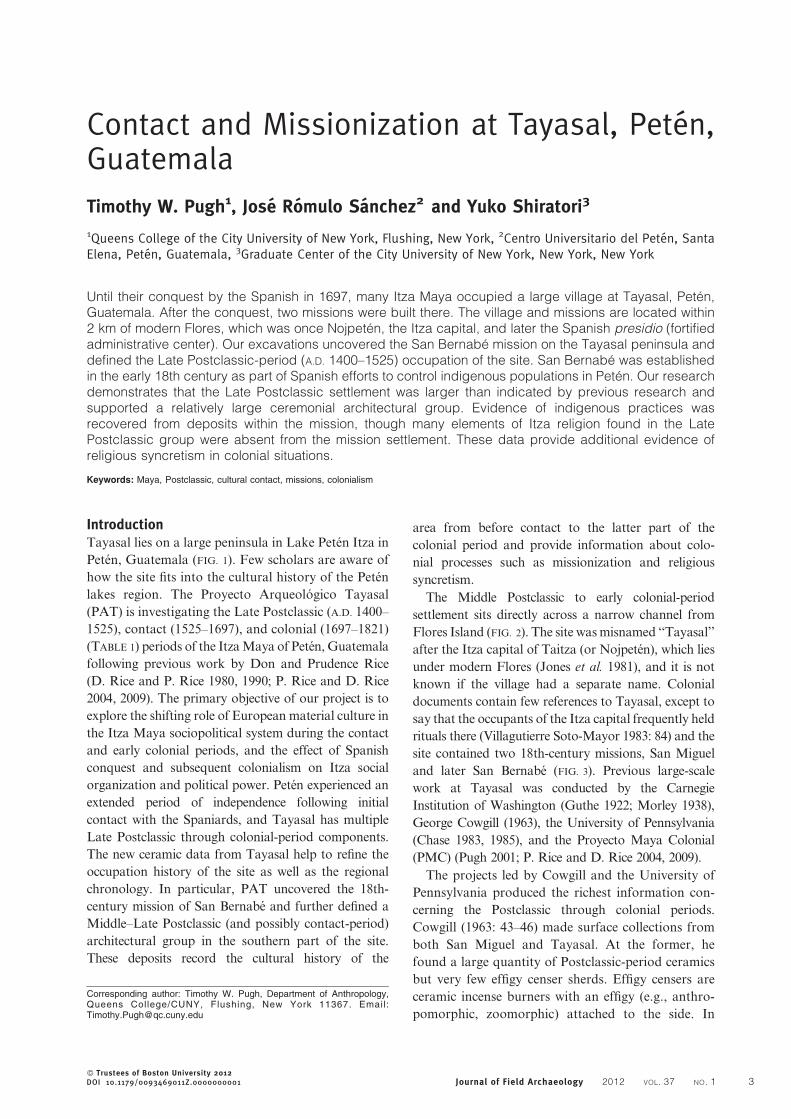
IntroductionTayasal lies on a large peninsula in Lake Peten Itza in
Peten, Guatemala (FIG. 1). Few scholars are aware of
how the site fits into the cultural history of the Peten
lakes region. The Proyecto Arqueologico Tayasal
(PAT) is investigating the Late Postclassic (A.D. 1400–
1525), contact (1525–1697), and colonial (1697–1821)
(TABLE 1) periods of the Itza Maya of Peten, Guatemala
following previous work by Don and Prudence Rice
(D. Rice and P. Rice 1980, 1990; P. Rice and D. Rice
2004, 2009). The primary objective of our project is to
explore the shifting role of European material culture in
the Itza Maya sociopolitical system during the contact
and early colonial periods, and the effect of Spanish
conquest and subsequent colonialism on Itza social
organization and political power. Peten experienced an
extended period of independence following initial
contact with the Spaniards, and Tayasal has multiple
Late Postclassic through colonial-period components.
The new ceramic data from Tayasal help to refine the
occupation history of the site as well as the regional
chronology. In particular, PAT uncovered the 18th-
century mission of San Bernabe and further defined a
Middle–Late Postclassic (and possibly contact-period)
architectural group in the southern part of the site.
These deposits record the cultural history of the
area from before contact to the latter part of the
colonial period and provide information about colo-
nial processes such as missionization and religious
syncretism.
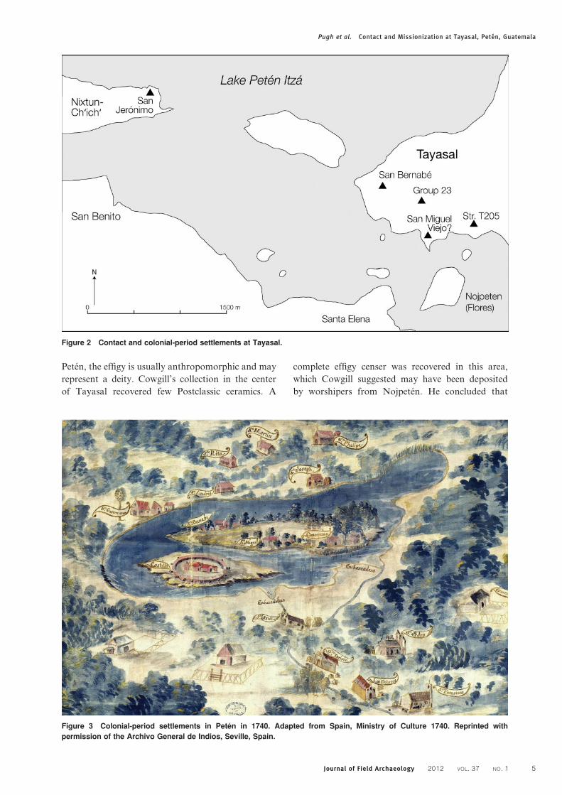
The Middle Postclassic to early colonial-period
settlement sits directly across a narrow channel from
Flores Island (FIG. 2). The site was misnamed ‘‘Tayasal’’
after the Itza capital of Taitza (or Nojpeten), which lies
under modern Flores (Jones et al. 1981), and it is not
known if the village had a separate name. Colonial
documents contain few references to Tayasal, except to
say that the occupants of the Itza capital frequently held
rituals there (Villagutierre Soto-Mayor 1983: 84) and the
site contained two 18th-century missions, San Miguel
and later San Bernabe (FIG. 3). Previous large-scale
work at Tayasal was conducted by the Carnegie
Institution of Washington (Guthe 1922; Morley 1938),
George Cowgill (1963), the University of Pennsylvania
(Chase 1983, 1985), and the Proyecto Maya Colonial
(PMC) (Pugh 2001; P. Rice and D. Rice 2004, 2009).
The projects led by Cowgill and the University of
Pennsylvania produced the richest information con-
cerning the Postclassic through colonial periods.
Cowgill (1963: 43–46) made surface collections from
both San Miguel and Tayasal. At the former, he
found a large quantity of Postclassic-period ceramics
but very few effigy censer sherds. Effigy censers are
ceramic incense burners with an effigy (e.g., anthro-
pomorphic, zoomorphic) attached to the side. In
Corresponding author: Timothy W. Pugh, Department of Anthropology,Queens College/CUNY, Flushing, New York 11367. Email:[email protected]
� Trustees of Boston University 2012DOI 10.1179/0093469011Z.0000000001 Journal of Field Archaeology 2012 VOL. 37 NO. 1 3
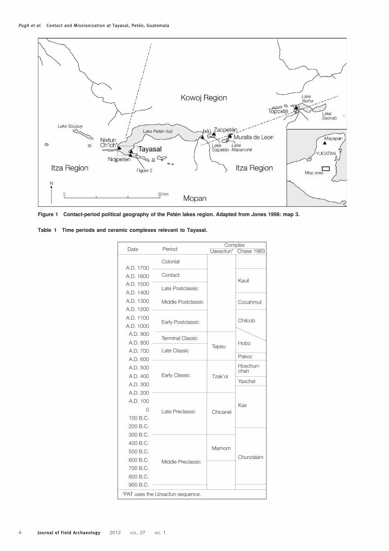
Table 1 Time periods and ceramic complexes relevant to Tayasal.
A.D. 1700
A.D. 1600
A.D. 1500
A.D. 1400
A.D. 1300
A.D. 1200
A.D. 1100
A.D. 1000
A.D. 900
A.D. 800
A.D. 700
A.D. 600
A.D. 500
A.D. 400
A.D. 300
A.D. 200
A.D. 100
0
100 B.C.
200 B.C.
300 B.C.
400 B.C.
500 B.C.
600 B.C.
700 B.C.
800 B.C.
900 B.C.
Colonial
Contact
Late Postclassic
Middle Postclassic
Early Postclassic
Terminal Classic
Late Classic
Early Classic
Late Preclassic
Middle Preclassic
*PAT uses the Uzxactun sequence.
Chunzalam
Hoxchun-chan
Yaxchel
Kax
Chilcob
Pakoc
Hobo
Kauil
Cocahmut
Mamom
Chicanel
Tzak’ol
Tepeu
Date PeriodComplex
Uaxactun* Chase 1983
Figure 1 Contact-period political geography of the Peten lakes region. Adapted from Jones 1998: map 3.
Pugh et al. Contact and Missionization at Tayasal, Peten, Guatemala
4 Journal of Field Archaeology 2012 VOL. 37 NO. 1
Peten, the effigy is usually anthropomorphic and may
represent a deity. Cowgill’s collection in the center
of Tayasal recovered few Postclassic ceramics. A
complete effigy censer was recovered in this area,
which Cowgill suggested may have been deposited
by worshipers from Nojpeten. He concluded that
Figure 3 Colonial-period settlements in Peten in 1740. Adapted from Spain, Ministry of Culture 1740. Reprinted with
permission of the Archivo General de Indios, Seville, Spain.
Figure 2 Contact and colonial-period settlements at Tayasal.
Pugh et al. Contact and Missionization at Tayasal, Peten, Guatemala
Journal of Field Archaeology 2012 VOL. 37 NO. 1 5
Postclassic settlements existed along the shoreline,
but there was little occupation inland and the local
residents likely worshiped at temples on the island
capital (Cowgill 1963: 46–48).
The work conducted by the University of Pen-
nsylvania and reported in Arlen Chase’s dissertation
and other publications (Chase 1976, 1979, 1982, 1983,
1985; A. Chase and D. Chase 1983) made critical
contributions to our knowledge of Tayasal. Never-
theless, the ceramic chronology was preliminary and
has since been revised. At that time, many believed
that the Paxcaman ceramic group (a kind of red
slipped pottery that is highly distinctive because its
paste has snail inclusions) faded at the beginning of
the Late Postclassic period, when it was eclipsed by
the Topoxte ceramic group, which has a whitish paste
with a distinctive soft feel (Cowgill 1963: 127; Chase
1976: 166, 1982, 1983: 1281–1282). In fact, Cowgill
(1963: 125) questioned whether the Paxcaman cera-
mic group had any connection with the Itza. As
documented below and elsewhere, the Paxcaman
group continued into the colonial period (Jones et al.
1981: 452–453). The faulty chronological placement
of Paxcaman ceramics led to the conclusion that
Tayasal as well as Flores had little Late Postclassic
occupation and that the Topoxte islands in Lake
Yaxha were the most likely site of the Itza capital
(Chase 1976: 166, 1983: 1281–1282).
In 1996, the PMC, directed by Rice and Rice, briefly
surveyed Tayasal and further defined the Postclassic
buildings in Group 23, which were initially identified
by the University of Pennsylvania (FIGS. 2, 4). A few
years later, Fredy Ramırez (2004) excavated in
Structures T95 and T99 recovering evidence of intense
Postclassic-period ceremonial activity in the group.
The findings of these earlier projects, especially those
of the University of Pennsylvania, allowed the PAT to
quickly locate the mission of San Bernabe and probably
the mission of San Miguel. Thus, our research builds on
the established foundations, with updated knowledge
of Late Postclassic material culture and ethnohistorical
data compiled by Grant Jones (1998). Furthermore,
the emphasis is not only on the Itza, but the history of
the colonial encounter that occurred on the Tayasal
peninsula between A.D. 1525 and 1821. Tayasal reveals
indigenous responses to Spanish strategies of power.
Although the conquest of Peten and establishment
of missions occurred late in the colonial period, and
Spanish colonial strategies changed dramatically from
first contact to the end of the colonial period, it is clear
that native religious practices persisted and were
incorporated into Catholic practice.
The Itza, Contact, and MissionizationContact and colonialism in the Peten lakes region
never involved unified Maya interacting with unified
Spaniards—both groups had internal factions that
endured after the conquest in 1697. The Late
Postclassic period of Peten ended in March 1525
when Hernan Cortes passed through central Peten on
his way to Honduras to capture the rebellious
Cristobal de Olid. In Peten, Cortes met with the
Itza ruler, Ajaw Kan Ek’, thereby initiating the
contact period. Maya interactions with the Spaniards
did not have a dramatic impact until 1618 when Friar
Juan de Orbita desecrated an Itza sacred object,
catalyzing Itza efforts to drive the Spaniards from
nearby areas (Jones 1998: 58–59). Nevertheless, from
1525 until 1697 some Spanish-style material culture
such as glass beads, machetes, and weapons entered
Peten and there were occasional direct interactions.
Throughout the contact period, individuals identi-
fied as Ajaw Kan Ek’ (ajaw ‘‘lord’’; Kan was the
ruler’s matronym and Ek’ his patronym) ruled the
Itza. Ajaw Kan Ek’ was the political head and his
parallel cousin (father’s brother’s son) named Aj K’in
Kan Ek’ was the religious leader of the Itza. The
Kan Ek’ cousins formed the central unit of a five-
part social system, which was ruled from Nojpeten.
Under the dominion of Nojpeten were four cardinally
located (at least conceptually) provinces, each ruled
by a pair of lords, one junior and the other senior. In
addition to Ajaw Kan Ek’, Aj K’in Kan Ek’, and the
eight lords, there were 13 leaders of various towns.
These 23 individuals formed the Itza ruling council
headed by Ajaw Kan Ek’ and Aj K’in Kan Ek’ (Jones
1998: 60–107). Late Postclassic Itza social organiza-
tion was likely similar to that of the contact period,
though it was certainly not static as the region was
rife with internal conflicts, expansionism, and alliances.
The Itza were not the only inhabitants of the Peten
lakes region (FIG. 1). They dominated a group called
the Mopan to the south. Their principal rivals, the
Kowoj, occupied the northeastern lakes area, though
the exact nature of the relationship between the Kowoj
and Itza is unclear. Aj Kowoj, the Kowoj ruler, was
allied with Ajaw B’atab’ K’in Kante’, the uncle of
Ajaw Kan Ek’ and ruler of the northern Itza province,
and attacked and burned part of Flores Island in 1695.
The two groups claimed slightly different ethnic
histories: the Itza claimed to have migrated to Peten
from Chichen Itza in central Yucatan, Mexico, and the
Kowoj came from Mayapan, in northern Yucatan.
Recent research has revealed that the Paxcaman
ceramic group is linked to the Itza and the Topoxte
ceramic group corresponds with the Kowoj (Cecil
2009a: 231–236; Pugh and Rice 2009a: 92).
Before the conquest, the Itza and Kowoj con-
structed different types of ceremonial groups, though
the buildings in each group were similar. Both
incorporated open halls, raised shrines, and orator-
ios. Open, or colonnaded halls are long, narrow
Pugh et al. Contact and Missionization at Tayasal, Peten, Guatemala
6 Journal of Field Archaeology 2012 VOL. 37 NO. 1
buildings, generally incorporating a bench and medial
feature such as a shrine or niche; they were used as
council houses (Carmack 1981: 192). Raised shrines
are composed of a small superstructure on a low
platform; they had a variety of functions, although
many were mortuary shrines (Pugh 2003a: 945), as
seems to be the case at Tayasal. Oratorios are small
temples on low platforms, although their precise use
remains unknown. The open hall, raised shrine, and
oratorio form an arrangement defined as the ‘‘basic
ceremonial group’’ at Mayapan (Proskouriakoff 1962:
90). Open halls appear to be the focal points and define
the medial axes of these groups, which are common in
the Itza region (FIG. 4: Structures T99A, T99B, and
T100). The Kowoj constructed a second type of group,
also defined at Mayapan: the ‘‘temple assemblage’’
(Pugh 2003b: 945). This assemblage is a specialized
version of the basic ceremonial group that includes a
temple (Proskouriakoff 1962: 91), which defines the
medial axis. Both types of ceremonial groups dis-
appeared after the conquest as indigenous religions
were prohibited and missions became the focal points
of communities.
The missionization of the Americas involved
competition among religious orders—such as the
Franciscans and Dominicans, known as ‘‘regular
clergy’’ or ‘‘regulars’’—as well as the secular clergy.
In the northern Maya area, the Franciscan order
initially enjoyed an advantage because of close ties
with Cortes (Restall 2003: 14–15); they were the first
to preach at Nojpeten as part of Cortes’ visit in 1525.
They did not play a strong role after the conquest of
Peten in 1697; however, Franciscan Friar Juan de
Orbita visited Nojpeten in 1616 or 1617, returning
with Friar Bartolome de Fuensalida in 1618 to
dedicate the settlement to San Pablo (Jones 1998:
300). Orbita destroyed a statue, which he thought was
an idol representing a horse left by Cortes, and this
event turned the Itza against the two Franciscans
and the Spaniards in general. The missionaries were
forced to flee Nojpeten on their next visit in 1619. To
counter Spanish expansion, the Itza initiated a period
of militarism and borrowed some Spanish methods of
control, such as resettling dispersed populations into
communities to facilitate ‘‘labor exploitation and
conversion’’ (Deagan 2003: 5).
As detailed in Jones (1998), on March 13, 1697,
Spaniards under the command of Ursua y Arizmendi
attacked and seized the Itza capital. After the con-
quest, Ursua ordered his men to destroy the nu-
merous idols of Nojpeten and established a presidio,
or fortified administrative center, on the site. Following
the conquest, the Spaniards failed to gain control over
anything other than Flores Island. This weakness, in
addition to a devastating epidemic, left the embroiled
area with internecine conflicts and threats of revolt.
To control the local populations, the Spaniards
attempted to relocate them to a series of missions
surrounding the lakes. They constructed the first of
these missions, Arcangel San Miguel (San Miguel), in
May 1702 on the Tayasal peninsula (FIG. 3) and made
AjChan, an indigenous elite and occasional ally, the
leader of the community to attract Maya settlers. The
Spaniards founded other missions in the area, both
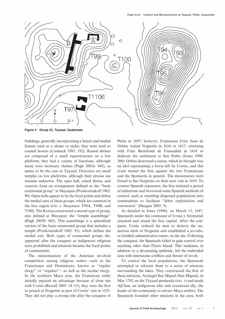
Figure 4 Group 23, Tayasal, Guatemala.
Pugh et al. Contact and Missionization at Tayasal, Peten, Guatemala
Journal of Field Archaeology 2012 VOL. 37 NO. 1 7
voluntarily and forcibly, some of which survive as
modern communities. Although the community of
San Miguel did not play a role in the resistance of
1704, AjChan and other inhabitants deserted the
mission, which prompted the Spaniards to station
extra soldiers there.
San Bernabe was established by at least 1712 on the
Tayasal peninsula west of San Miguel (FIG. 3). In
1712, its population was recorded as 126 individuals
compared to 410 at San Miguel (Jones 1998: table
15.4). Initially, neither mission had resident clergy,
although both were close enough to the presidio for
frequent visits. Aside from censuses, there are few
records of the lives of the inhabitants of San Bernabe,
although around 1755 an individual from San
Bernabe with the Kowoj patronym attempted to
rally a group of Maya to overthrow the Spaniards. A
1766 census records a population of 37 for the
mission, excluding children (Jones 1998: table 15.5).
The decrease in population likely resulted from
indigenous flight and a high ‘‘infant and child
mortality rate’’ (Jones 1998: 415). San Bernabe was
not listed as a parish in 1819 (Schwartz 1990: 47).
Post-conquest evangelization efforts were led by
secular clergy and the Mercederian order, which had
friars at the presidio from 1699 until 1704, after
which secular clergy staffed the missions. Thus,
although the Franciscans and Dominicans estab-
lished a presence in the area prior to the conquest,
they did not retain influence in the Peten lakes region.
The Dominicans were ordered to leave all of Peten in
1716 and the Franciscans, who had long been in
conflict with ecclesiastical authorities, were excluded
from post-conquest Peten.
Group 23To better understand long-term Maya/Spanish inter-
actions at Tayasal, we sampled several locations
including a Late Postclassic and possible contact-
period ceremonial group (Group 23) and San
Bernabe (FIG. 2). The ceremonial core of Group 23
occupies the middle of a probable Late Preclassic-
period (300 B.C.–A.D. 200) E-Group, or observatory
group defined by Structures T93–T96 (Chase 1983:
367) and is bordered on the north by Late–Terminal
Classic-period (A.D. 600–900) elite residential groups
(TABLE 1; FIG. 4). The architectural layout incorpo-
rates these spaces as well as Late–Terminal Classic
monuments.
Group 23 comprises multiple structures on a large
basal platform (3106210 m). This T-shaped plat-
form varies in height, but averages approximately
8 m tall and is oriented 9u189 east of true north. Built
on a natural rise, the platform construction fill ranges
from more than 6.5 m deep near the edges to just a
few meters deep in the center. Most of the fill
incorporates Chicanel (Late Preclassic) pottery,
though Mamom (late Middle Preclassic) pottery is
present in some areas. Late Classic through Late
Postclassic materials are generally limited to the
upper 50 cm of the platform fill.
Project mapping revealed that the central portion
of the Postclassic complex of Group 23 is a basic
ceremonial group (FIG. 4). An east-facing open hall
(Structure T99B) with end rooms on its north and
south sides has a raised shrine (Structure T100)
centered upon and facing into it. An oratorio stands
perpendicular to the north side of the hall, facing
south possibly toward a small shrine. Although not
clearly depicted on earlier site plans, Structure T99B
dates to the Middle–Late Postclassic period (Chase
1983: 1276–1277). The University of Pennsylvania
did not excavate this building, but it was surveyed by
the PMC in 1996, and Ramırez’s (2004) excavations
revealed what the 1996 surveys had suggested:
Structure T99B was an open hall occupied in the
Late Postclassic period. The building contained
concentrations of effigy censer sherds and a burial
in a seated position intruded upon one of the stairway
balustrades. The dual stairway was bordered by two
balustrades and divided in the middle by a third
balustrade. In front of the central balustrade stood a
blank stela base, Stela 5 (Ramırez 2004: 23–27).
The University of Pennsylvania excavations of
Structure T100 revealed that it was vaguely rectan-
gular in plan, though its eastern side was bowed
giving it a ‘‘pseudo-pentagonal form’’ (Chase 1983:
371, 1985: fig. 5). The shrine was constructed, then
renovated on top of an earlier building of unknown
form though probably Postclassic in date. After this
earlier building was dismantled the shrine was built,
centered upon a cist burial. The burial was seated,
flexed, and covered with mortar. The individual faced
west toward the open hall, also corresponding with
the orientation of the shrine. Abundant censer sherds
were strewn upon and around Structure T100
indicating its use in ritual activities and possibly the
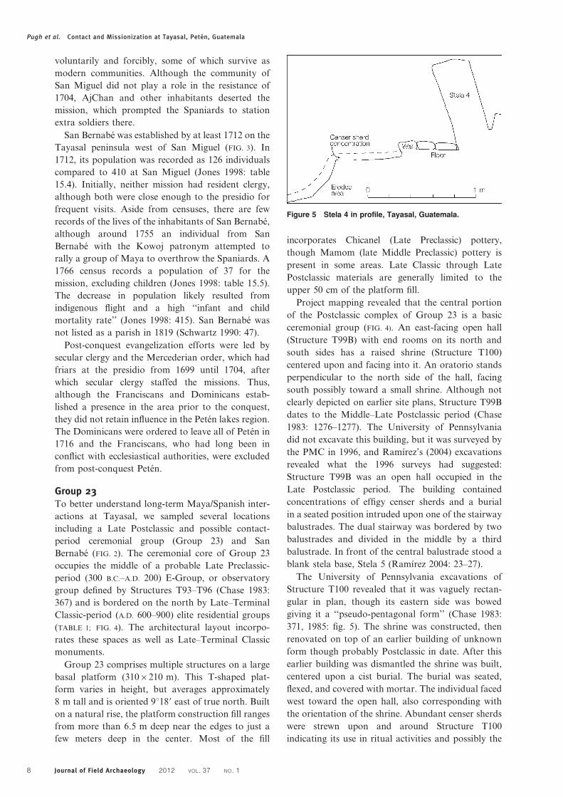
Figure 5 Stela 4 in profile, Tayasal, Guatemala.
Pugh et al. Contact and Missionization at Tayasal, Peten, Guatemala
8 Journal of Field Archaeology 2012 VOL. 37 NO. 1
veneration of the interred individual. The placement
of this individual in the central shrine suggests the
person was an ancestor (McAnany 1995: 60–63).
The Postclassic occupants reset Classic-period
carved Stela 3 a few meters northeast of Structure
T100. The stela shows the lower legs and feet of a
standing individual on the front of the monument
and glyphs are inscribed on its side, one of which is
an Ik’ emblem glyph. An Ik’ emblem glyph is also
associated with the site of Motul de San Jose (Marcus
1976: 68, 183–190) and could signify ‘‘wind’’ or a
day name, although Alexandre Tokovinine (personal
communication 2010) has suggested that it may refer
to the ancient name of Lake Peten Itza and a polity
associated with the lake and Tayasal.
Structures T94 and T95Structures T94 and T95 are two small constructions
on the 5.5 m-tall platform that defines the eastern
edge of the ceremonial core of Group 23 (FIG. 4).
Although the high platform may once have served as
the eastern structure in a Late Preclassic E-Group
(Chase 1983: 367), it also played an important role
during the Late Postclassic period. On the western
edge of L-shaped Structure T94, overlooking the
Postclassic group, stands the base of Stela 4 (FIG. 5)
with the broken upper fragments littering the
adjacent slope. The above-ground portion of Stela 4
experienced surface spalling, caused by the heat of
agricultural fires, which probably also contributed to
its fragmentation and collapse. Below the ground
surface, relief carving was preserved on the base that
depicts the ankles and sandaled feet of a standing
figure. The stela appears to have been reset into
a Terminal Classic plaster floor during the Late
Postclassic period. The Postclassic construction in-
cluded a pavement of flat limestones overlying the
plaster floor. These stones were bordered by a row of
rectangular-shaped, soft limestones.
The peculiar placement of the stela prompted
excavations around it and the nearby slope. These
areas contained large quantities of composite (parti-
cularly Gotas Composite, Mumul Composite, and La
Justa Composite) censers and a moderate frequency
of Patojo Modeled: Patojo Variety effigy censer
sherds, an assemblage similar to that recovered from
Structure T94. Composite censers are hourglass or
chalice-shaped vessels with spike, button, and other
appliques. Gotas Composite, the most common
variety of composite censer in the stela deposit, was
identified as being produced in the Late Postclassic,
and possibly contact period (P. Rice 2009: 288).
Larger and more concentrated sherds were located
adjacent to Stela 4 indicating that this was the focal
area of use; most sherds lay west of the row of
cut soft limestones. The excavations also revealed
concentrations of Augustine Red and Paxcaman Red
sherds as well as a number of small obsidian and
chert side-notched points. Similar points were found
in both ceremonial and domestic areas of Late Post-
classic through contact-period Zacpeten, a Kowoj
site on nearby Lake Salpeten. The points were often
associated with censer sherds in Group 23 suggesting
that they played a role in ceremonial activities.
Structure T95 is the central structure of the eastern
part of the possible E-Group (FIG. 4). Ramırez (2004:
25) determined that its Postclassic component faced
west toward Structure T100 and into Structure T99B.
Its size suggests that it was also a raised shrine. The
shrine incorporated the upper portion of a stela,
possibly part of Stela 3 or 4. A large Lamat or Ek’
glyph is carved on a stela fragment. Lamat and Ek’
can refer to ‘‘star,’’ a day name, or the surname Ek’
(Schele and Mathews 1998: 244–245), although its
position seems to suggest that it signifies ‘‘war’’
(‘‘star-war’’) (Aldana 2005: 305–313). Ramırez also
recovered a lead ball with a diameter of 16–17 mm in
the excavation of Structure T95. Lead balls of this
size were used in several types of firearms from the
arquebus to the flintlock (Deagan 2002: table 13.1).
Metal objects, including a lead ball, were cached
along the central axes of Groups A and C at Zacpeten
(Pugh 2009: 378–381). Given that Structures T100
and T95 define the central axis of Group 23 at
Tayasal, the lead ball was also likely intentionally
placed along this axis.
Structures T97 and T1106Just southwest of the basic ceremonial group stand
Structures T97 and T1106, which were initially
thought to be residences. They face one another
and are just 2 m apart. Structure T1106 is oriented to
the south and has benches. Artifacts were concen-
trated behind Structure T1106 and included small
projectile points and a large quantity of Postclassic
sherds, some from tripod vessels. Structure T97 faces
north and has an L-shaped bench. Artifacts concen-
trated behind and to the west of the structure
included faunal remains, ceramic figurines, and Post-
classic tripod vessel sherds. A burial between the two
structures contained a seated adult facing north; the
only associated artifact was an obsidian blade near
the pelvis. Above the burial was a concentration of
Mumul Composite and Patojo Modeled censer
sherds. Part of the concentration continues beneath
the floor ballast of Structure T97, indicating that the
burial predates the construction of this building.
Structures T97 and T1106 are the proper size and
form to be classified as oratorios, however, their
layout relative to one another is somewhat anom-
alous. Their proximity suggests that they probably
shared a single, perishable roof. If occupied at the
Pugh et al. Contact and Missionization at Tayasal, Peten, Guatemala
Journal of Field Archaeology 2012 VOL. 37 NO. 1 9
same time, individuals seated on the two benches
would have faced each other. The layout could
indicate some sort of duality, although the artifacts
inside the structure do not reveal the nature of that
relationship.
Summary of Group 23Middle Postclassic to contact-period deposits at
Tayasal are focused on the southern portion of the
peninsula directly opposite Flores Island. These
deposits represent a village (Chase 1983: 1221) with
at least two large ceremonial groups. In addition to
Group 23, a second ceremonial group lies on a
platform in the southern part of the peninsula in
eastern San Miguel, opposite Flores Island. This
group includes an open hall, a raised shrine, and a
surrounding community, although the open hall was
mostly destroyed by the modern construction of a
water tank.
The lack of Mayapan-style temple assemblages
densely surrounded by residences, as defined at
Topoxte and Zacpeten (D. Rice 1988: 236), led
earlier researchers to suggest a Late Postclassic hiatus
at Tayasal (Chase 1983: 1223). Like the Topoxte
ceramic group, temple assemblages are found in the
Kowoj area in Peten, but have not been encountered
in the Itza region (Pugh 2003b: 419). Group 23
contains a basic ceremonial group, a layout shared
with Mayapan (Proskouriakoff 1962: 90). The
apparent lack of residences surrounding the Group
23 ceremonial assemblage may reflect the invisibility
of domestic structures to surface detection.
The paucity of effigy censer sherds from the
University of Pennsylvania excavations also contrib-
uted to the conclusion that the area was not directly
impacted by contact with northern Yucatan during
the Early and Middle Postclassic periods (Chase
1983: 1280–1281). These earlier excavations, how-
ever, may have missed deposits of effigy censers, in
which case part of the problem is sampling error.
Ramırez (2004: 23) encountered abundant Patojo
Modeled censers in his excavations in Structure
T99A, and the 2010 excavations revealed a moderate
frequency of these sherds. Nevertheless, Tayasal does
not contain the quantity of effigy censers seen
elsewhere in Peten, particularly in the Kowoj area,
and the sherds that are present lack the variability
observed at Zacpeten. Patojo Modeled is the only
censer type with a high frequency of occurrence at
Tayasal and Pitufo Modeled is rare (n54). A possible
cause of this relatively small assemblage is the
destruction of idols after the conquest (P. Rice
2009: 277) and the proximity of Tayasal to the
presidio. Another possible explanation is Cowgill’s
(1963: 46) observation that the site lacks Postclassic
temples; at Zacpeten the majority of effigy censers
rested inside or near temples (Pugh and Rice 2009b:
169). The lack of temples and infrequency of effigy
censers at Tayasal do not preclude ritual or religious
activities, since there is much ceremonial architecture
and Spanish documents record the existence of
temples and deity effigies at Nojpeten (Avendano
1987 [1696]: 33–34). Instead, this evidence suggests
that effigy censers and temples—and possibly inter-
actions with represented deities—were more
restricted/centralized in this region than among the
Kowoj. Another possibility is that effigy censers were
discarded in a location undetected by excavations;
censer sherds were collected and placed in special
locations at Zacpeten (Pugh and Rice 2009b: 149–
150).
Tayasal ceremonialism involved composite censers
in a variety of forms. Composite censers were used
for ancestor veneration and rituals focused upon
reused stelae. The high relative frequencies of Gotas
Composite censer sherds and near absence of effigy
censers other than Patojo Modeled indicate that
Group 23 was occupied during the Late Postclassic
period and perhaps later. The group was abandoned
during the colonial period, but the position of the
lead ball in Structure T95 suggests that the object
may have been intentionally cached, indicating
deposition during the contact period. The lack of
additional European artifacts in Group 23 implies
that it was abandoned during the early part of the
contact period.
Stelae are documented in four contexts at Group
23, including Stelae 3, 4, and 5, as well as the
fragments found in Structure T95. Stela 3 was reset
near Structure T100, a Late Postclassic-period raised
shrine; Structure T95 also has the form of a raised
shrine. Stela 4 was reset into the edge of Structure
T94, a building of unknown significance. Stela 5 was
reset in front of and centered on the stairway of the
open hall. The reuse of monuments at Tayasal may
be associated with raised shrines—similar to Stela 4
of Zacpeten, which was encountered in the wall of a
shrine (Pugh and Rice 2009a: 103), and Ixlu where
stelae were incorporated into a raised shine. Debate
exists about whether Stela 1 in Group 23 at Tayasal
was set in the Terminal Classic or Postclassic period,
but the former seems to be the case (Chase 1983: 476–
478).
In most cases, the reused monuments at Tayasal
were placed along the main axis of the ceremonial
group. The reuse of Classic-period stelae during the
Postclassic period has been noted at multiple sites in
the southern lowlands (Graham 1994: 113, 129;
Hammond and Bobo 1994: 26–32; Pendergast 1981:
51; Satterthwaite 1958: 75–76). Chan Chen, a site
near Santa Rita in Belize, contains a reset Late
Classic stela with an altar partially composed of stela
Pugh et al. Contact and Missionization at Tayasal, Peten, Guatemala
10 Journal of Field Archaeology 2012 VOL. 37 NO. 1
fragments to its south along with Postclassic censers
and offerings (Sidrys 1983: 115–122). Similar stelae
placements occurred in the colonial period and have
been interpreted as revitalization of the indigenous
past (Hammond and Bobo 1994: 31), including two
stelae and associated caches placed in the nave of a
mission church burned during Itza expansion into
Belize (Graham 2011: 213–218; Jones 1998: 53;
Pendergast 1998: 60).
Both the Late Postclassic Itza and Kowoj moved
and reset Classic-period stelae into ceremonial build-
ings. Reuse of ancient stelae by the Itza has been
documented at Tayasal and Ixlu, and at Zacpeten
and Topoxte for the Kowoj. The Tayasal stelae could
also signify Itza appropriation of place through the
prominent reuse of past objects. Although the Itza
were present in Peten during the Terminal Classic
period, they also participated in a migration stream
from the northern lowlands (Schele and Mathews
1998: 202–204). Consequently, the conspicuous pla-
cement of stelae likely reflects efforts to reinforce Itza
connections with Tayasal’s past. The Kowoj exhib-
ited similar behaviors in an effort to connect them-
selves with the ancient history of Peten.
In sum, Group 23 comprises a basic ceremonial
group surrounded by domestic structures, most of
which are invisible on the surface. The group also
contains two oratorios in a configuration that has not
been described previously in Peten. Ceremonial acti-
vities are marked by the use of small projectile points,
a variety of composite censers, and Patojo Modeled
effigy censers.
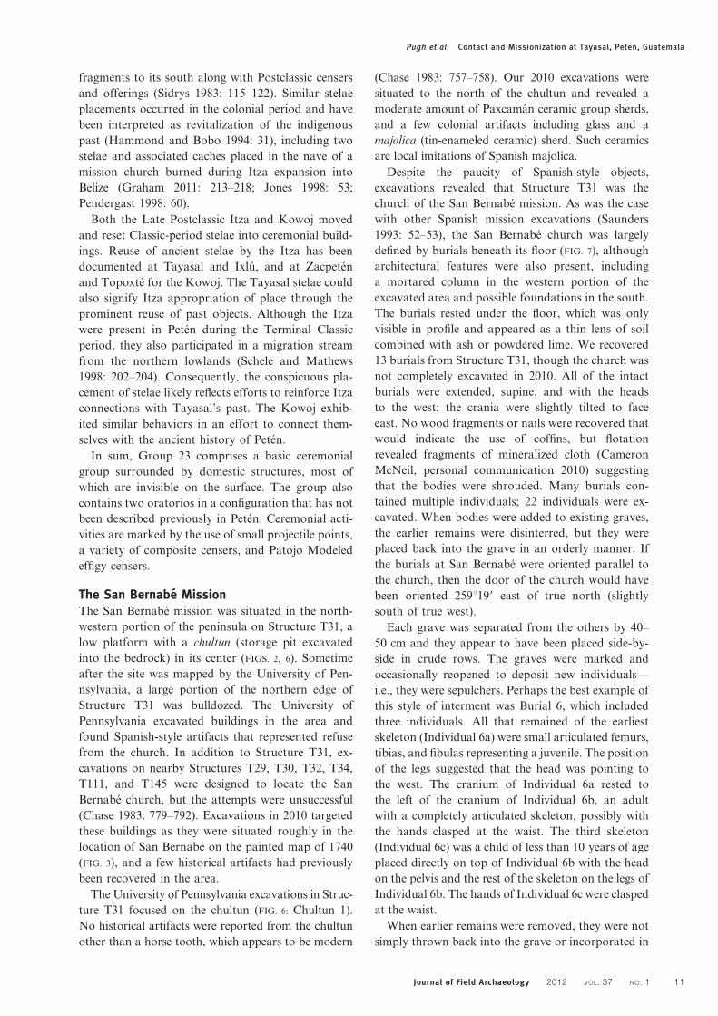
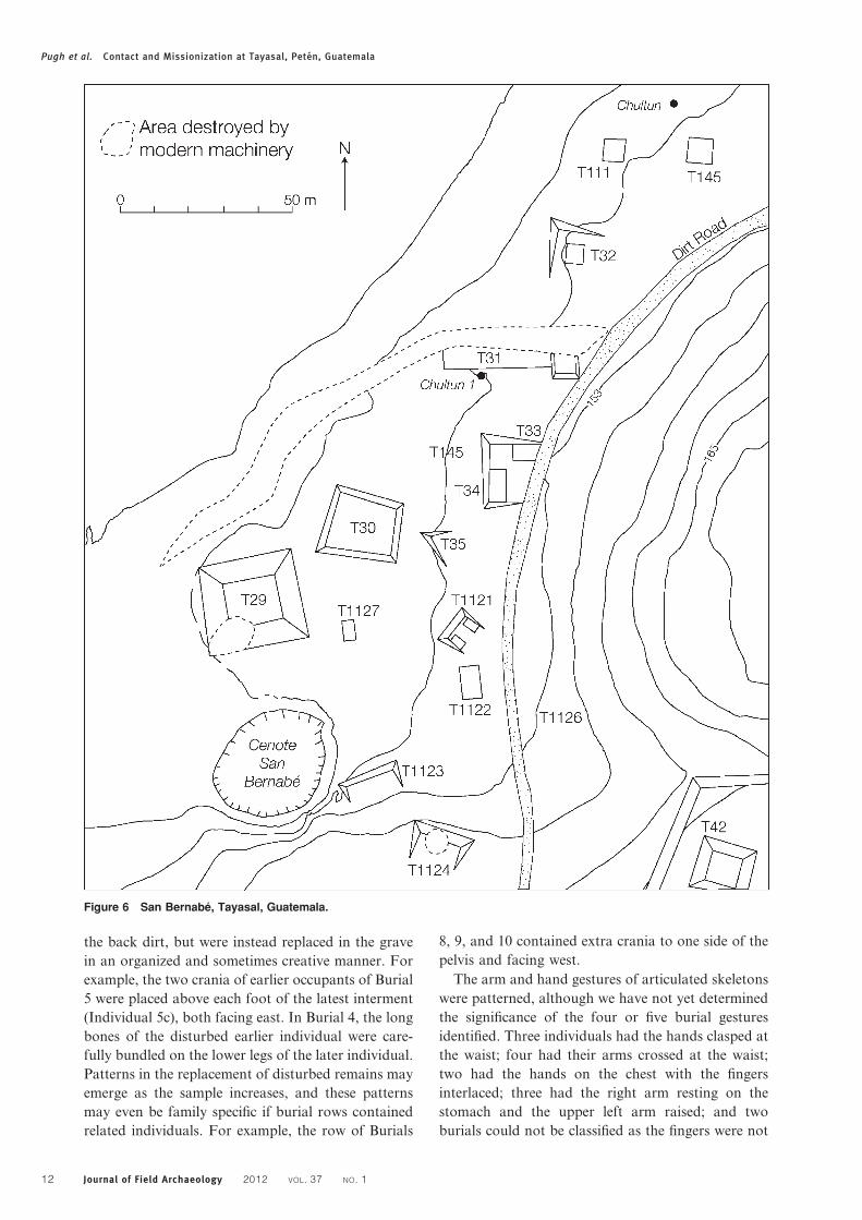
The San Bernabe MissionThe San Bernabe mission was situated in the north-
western portion of the peninsula on Structure T31, a
low platform with a chultun (storage pit excavated
into the bedrock) in its center (FIGS. 2, 6). Sometime
after the site was mapped by the University of Pen-
nsylvania, a large portion of the northern edge of
Structure T31 was bulldozed. The University of
Pennsylvania excavated buildings in the area and
found Spanish-style artifacts that represented refuse
from the church. In addition to Structure T31, ex-
cavations on nearby Structures T29, T30, T32, T34,
T111, and T145 were designed to locate the San
Bernabe church, but the attempts were unsuccessful
(Chase 1983: 779–792). Excavations in 2010 targeted
these buildings as they were situated roughly in the
location of San Bernabe on the painted map of 1740
(FIG. 3), and a few historical artifacts had previously
been recovered in the area.
The University of Pennsylvania excavations in Struc-
ture T31 focused on the chultun (FIG. 6: Chultun 1).
No historical artifacts were reported from the chultun
other than a horse tooth, which appears to be modern
(Chase 1983: 757–758). Our 2010 excavations were
situated to the north of the chultun and revealed a
moderate amount of Paxcaman ceramic group sherds,
and a few colonial artifacts including glass and a
majolica (tin-enameled ceramic) sherd. Such ceramics
are local imitations of Spanish majolica.
Despite the paucity of Spanish-style objects,
excavations revealed that Structure T31 was the
church of the San Bernabe mission. As was the case
with other Spanish mission excavations (Saunders
1993: 52–53), the San Bernabe church was largely
defined by burials beneath its floor (FIG. 7), although
architectural features were also present, including
a mortared column in the western portion of the
excavated area and possible foundations in the south.
The burials rested under the floor, which was only
visible in profile and appeared as a thin lens of soil
combined with ash or powdered lime. We recovered
13 burials from Structure T31, though the church was
not completely excavated in 2010. All of the intact
burials were extended, supine, and with the heads
to the west; the crania were slightly tilted to face
east. No wood fragments or nails were recovered that
would indicate the use of coffins, but flotation
revealed fragments of mineralized cloth (Cameron
McNeil, personal communication 2010) suggesting
that the bodies were shrouded. Many burials con-
tained multiple individuals; 22 individuals were ex-
cavated. When bodies were added to existing graves,
the earlier remains were disinterred, but they were
placed back into the grave in an orderly manner. If
the burials at San Bernabe were oriented parallel to
the church, then the door of the church would have
been oriented 259u199 east of true north (slightly
south of true west).
Each grave was separated from the others by 40–
50 cm and they appear to have been placed side-by-
side in crude rows. The graves were marked and
occasionally reopened to deposit new individuals—
i.e., they were sepulchers. Perhaps the best example of
this style of interment was Burial 6, which included
three individuals. All that remained of the earliest
skeleton (Individual 6a) were small articulated femurs,
tibias, and fibulas representing a juvenile. The position
of the legs suggested that the head was pointing to
the west. The cranium of Individual 6a rested to
the left of the cranium of Individual 6b, an adult
with a completely articulated skeleton, possibly with
the hands clasped at the waist. The third skeleton
(Individual 6c) was a child of less than 10 years of age
placed directly on top of Individual 6b with the head
on the pelvis and the rest of the skeleton on the legs of
Individual 6b. The hands of Individual 6c were clasped
at the waist.
When earlier remains were removed, they were not
simply thrown back into the grave or incorporated in
Pugh et al. Contact and Missionization at Tayasal, Peten, Guatemala
Journal of Field Archaeology 2012 VOL. 37 NO. 1 11
the back dirt, but were instead replaced in the grave
in an organized and sometimes creative manner. For
example, the two crania of earlier occupants of Burial
5 were placed above each foot of the latest interment
(Individual 5c), both facing east. In Burial 4, the long
bones of the disturbed earlier individual were care-
fully bundled on the lower legs of the later individual.
Patterns in the replacement of disturbed remains may
emerge as the sample increases, and these patterns
may even be family specific if burial rows contained
related individuals. For example, the row of Burials
8, 9, and 10 contained extra crania to one side of the
pelvis and facing west.
The arm and hand gestures of articulated skeletons
were patterned, although we have not yet determined
the significance of the four or five burial gestures
identified. Three individuals had the hands clasped at
the waist; four had their arms crossed at the waist;
two had the hands on the chest with the fingers
interlaced; three had the right arm resting on the
stomach and the upper left arm raised; and two
burials could not be classified as the fingers were not
Figure 6 San Bernabe, Tayasal, Guatemala.
Pugh et al. Contact and Missionization at Tayasal, Peten, Guatemala
12 Journal of Field Archaeology 2012 VOL. 37 NO. 1
preserved, although one may have been in a prayer
position with the hands on the chest and the other
may have had the fingers clasped at the waist.
Offerings and personal possessions were rare in the
excavated burials at San Bernabe, as at Tancah
(Miller 1982: 34) and Lamanai, but unlike at Tipu
(Graham et al. 1989: 1258–1259; Smith et al. 1994). A
small, blue glass bead recovered from Burial 12 at
San Bernabe was the only Spanish artifact placed as a
grave good. Burial 12 also contained a small obsidian
projectile point. It is possible that it was accidently
incorporated into the grave fill, but because no other
points were found in Structure T31 other than in the
columnar cache, it was likely a grave good. Several
burials contained fragments of obsidian blades near
the head and neck; obsidian blades are common in
Postclassic-period burials (Smith 1962: 232–253). No
shroud pins were recovered, even though small
fragments of mineralized cloth in the soil surrounding
Burial 2 suggest that a shroud once covered the
remains (Cameron McNeil, personal communication
2010).
The column (32 cm diameter) to the west of the
burials most likely supported the roof, and its base
was encased in mortared masonry. Abundant wood
remained in the mortar post mold along with a small
fragment of unidentified iron. The mortar bore im-
pressions of the wood indicating that the low
masonry mold was built around the standing column.
We were unable to determine the depth of the column
owing to the discovery of ground water after ex-
cavating the upper 78 cm of the post.
An oval feature to the north of the column was
initially identified as a trash pit, but was later deter-
mined to be a dedicatory cache. The pit contained
mammal and fish bones (Carolyn Freiwald, personal
communication 2011), freshwater snail shells (Pomacea
flagellata and Pachychilus spp.), marine shells, a
small obsidian projectile point, Paxcaman Red ceramic
sherds, and a nearly complete Picu Incised: Thub
Variety ceramic drum (FIG. 8). The soil of the feature
contained abundant fish scales suggesting the place-
ment of whole fish, possibly as symbols of Christianity.
The cache seems to have had an aquatic theme, though
the drum does not fit into this theme. Ceramic drums
have been recovered elsewhere in Peten including the
two contact-period temples at Zacpeten (Pugh and
Rice 2009b: 164). These instruments were played during
temple ceremonies. The drum and rattle also became
emblematic of the 20-year calendar cycle during the
Late Postclassic and contact periods (Roys 1967: 77–
78). It is not uncommon for percussion instruments to
represent the points of calendrical transition they help
to mediate (Needham 1967: 611).
The columnar dedicatory cache demonstrates
religious syncretism at San Bernabe. For the Maya,
such offerings helped activate ceremonial spaces.
Activation imbues them with life or spiritual essence
and also signifies that spaces were appropriate for
ceremonial activity, generally through their connec-
tion with deities (McGee 1998: 42–46). The column
helped support the roof of the church and, therefore,
Figure 7 Burials beneath Structure T31, Tayasal, Guatemala: plan view. Drawing by J. Bracken and T. Pugh.
Figure 8 Picu Incised ceramic drum, Structure T31, Tayasal,
Guatemala.
Pugh et al. Contact and Missionization at Tayasal, Peten, Guatemala
Journal of Field Archaeology 2012 VOL. 37 NO. 1 13
represented the world tree or axis mundi, which
played a central role in Maya cosmology and ritual
practices. World trees also symbolized house posts
that both separated and connected the earth and sky
at the four corners and center of the cosmos (Taube
1988: 155, 172; Thompson 1970: 195–196). The cache
adjacent to the post evokes the otherworld, especially
in light of the aquatic-themed contents. The fish and
freshwater snails also suggest sustenance and fertility.
The missions at Lamanai, Belize, and Tipu also
contained caches, though many were deposited after
the Spanish lost control of the area (Pendergast 1998:
60–61).
Structure T30Structure T30 is a low platform standing 42 m
southwest of the church (Structure T31) (FIG. 6).
Prior to excavation, no superstructure was visible on
the platform but excavations revealed a circular,
0.22 m-tall building (Structure T30a) with a diameter
of 5.17 m (FIG. 9). The wall was composed of three
courses of worked, soft limestone. Although the top
of the building and walls were not plastered, a well-
preserved, thick plaster-surfaced floor extended from
the base of the walls surrounding the structure. The
construction fill of the platform suggests that it was
originally built during the Late Preclassic period, but
the area was reused from the Terminal Classic
through the colonial period and was part of the San
Bernabe mission.
Circular structures were common during the Late
Preclassic period in the Maya lowlands and like such
buildings at other sites (Aimers et al. 2000), Structure
T30a was reused for the placement of burials and
offerings during later periods. It did not contain any
material that revealed its function during the Late
Preclassic period; however, Aimers and colleagues
(2000: 82) argue that circular structures were used for
public rituals. Terminated artifacts (ritually broken
or destroyed to release their vital force) recovered
from excavations in nearby Structure T34 (FIG. 6)
(described below) may support this position. A sig-
nificant amount of material attests to the function of
this structure during the Terminal Classic period.
Some of the deposits from this period appear to be
oriented along the cardinal directions. A large, flat,
circular stone, which is probably a displaced chultun
lid, sits directly on the plaster floor 1 m west of
Structure T30a. The western orientation of this stone
relative to the circular structure suggests a directional
pattern.
A burial (Feature T30-1) was placed to the south of
Structure T30a, on top of the plaster floor. It
contained one individual with the head to the east,
resting on the back in a tightly flexed position with
the legs and head tilted to the right. Some remains
were missing, including parts of the pelvis, legs, arms,
and hands. These appear to have been removed
in antiquity, a frequent practice among the Maya
(McAnany 1995: 60–63), as several phalanges were
found under a miniature lidded ceramic vessel—
probably Terminal Classic in date—indicating good
conditions of preservation.
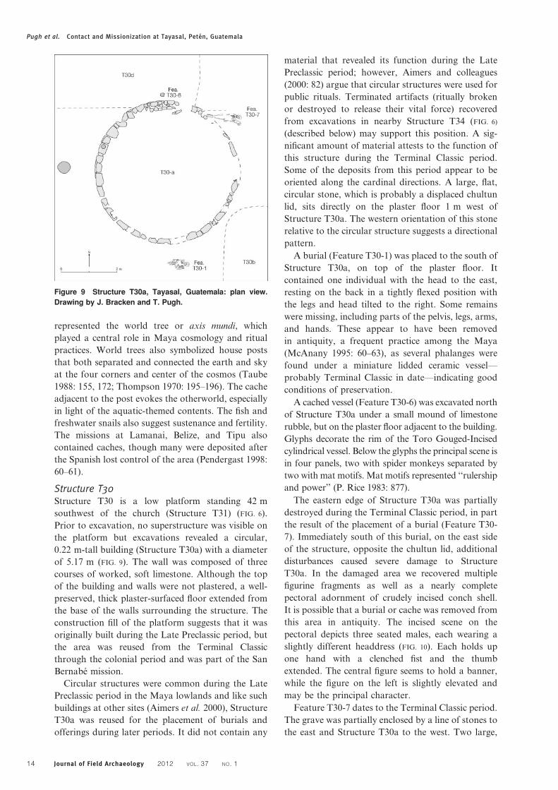
A cached vessel (Feature T30-6) was excavated north
of Structure T30a under a small mound of limestone
rubble, but on the plaster floor adjacent to the building.
Glyphs decorate the rim of the Toro Gouged-Incised
cylindrical vessel. Below the glyphs the principal scene is
in four panels, two with spider monkeys separated by
two with mat motifs. Mat motifs represented ‘‘rulership
and power’’ (P. Rice 1983: 877).
The eastern edge of Structure T30a was partially
destroyed during the Terminal Classic period, in part
the result of the placement of a burial (Feature T30-
7). Immediately south of this burial, on the east side
of the structure, opposite the chultun lid, additional
disturbances caused severe damage to Structure
T30a. In the damaged area we recovered multiple
figurine fragments as well as a nearly complete
pectoral adornment of crudely incised conch shell.
It is possible that a burial or cache was removed from
this area in antiquity. The incised scene on the
pectoral depicts three seated males, each wearing a
slightly different headdress (FIG. 10). Each holds up
one hand with a clenched fist and the thumb
extended. The central figure seems to hold a banner,
while the figure on the left is slightly elevated and
may be the principal character.
Feature T30-7 dates to the Terminal Classic period.
The grave was partially enclosed by a line of stones to
the east and Structure T30a to the west. Two large,
Figure 9 Structure T30a, Tayasal, Guatemala: plan view.
Drawing by J. Bracken and T. Pugh.
Pugh et al. Contact and Missionization at Tayasal, Peten, Guatemala
14 Journal of Field Archaeology 2012 VOL. 37 NO. 1
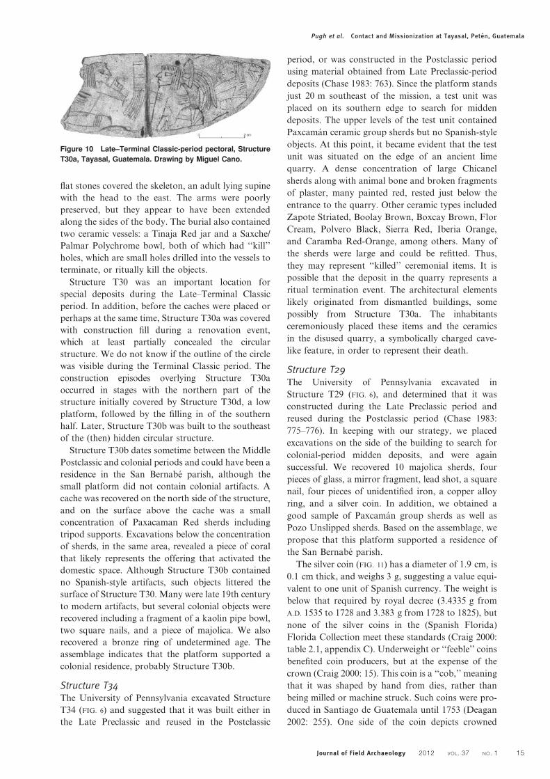
flat stones covered the skeleton, an adult lying supine
with the head to the east. The arms were poorly
preserved, but they appear to have been extended
along the sides of the body. The burial also contained
two ceramic vessels: a Tinaja Red jar and a Saxche/
Palmar Polychrome bowl, both of which had ‘‘kill’’
holes, which are small holes drilled into the vessels to
terminate, or ritually kill the objects.
Structure T30 was an important location for
special deposits during the Late–Terminal Classic
period. In addition, before the caches were placed or
perhaps at the same time, Structure T30a was covered
with construction fill during a renovation event,
which at least partially concealed the circular
structure. We do not know if the outline of the circle
was visible during the Terminal Classic period. The
construction episodes overlying Structure T30a
occurred in stages with the northern part of the
structure initially covered by Structure T30d, a low
platform, followed by the filling in of the southern
half. Later, Structure T30b was built to the southeast
of the (then) hidden circular structure.
Structure T30b dates sometime between the Middle
Postclassic and colonial periods and could have been a
residence in the San Bernabe parish, although the
small platform did not contain colonial artifacts. A
cache was recovered on the north side of the structure,
and on the surface above the cache was a small
concentration of Paxacaman Red sherds including
tripod supports. Excavations below the concentration
of sherds, in the same area, revealed a piece of coral
that likely represents the offering that activated the
domestic space. Although Structure T30b contained
no Spanish-style artifacts, such objects littered the
surface of Structure T30. Many were late 19th century
to modern artifacts, but several colonial objects were
recovered including a fragment of a kaolin pipe bowl,
two square nails, and a piece of majolica. We also
recovered a bronze ring of undetermined age. The
assemblage indicates that the platform supported a
colonial residence, probably Structure T30b.
Structure T34The University of Pennsylvania excavated Structure
T34 (FIG. 6) and suggested that it was built either in
the Late Preclassic and reused in the Postclassic
period, or was constructed in the Postclassic period
using material obtained from Late Preclassic-period
deposits (Chase 1983: 763). Since the platform stands
just 20 m southeast of the mission, a test unit was
placed on its southern edge to search for midden
deposits. The upper levels of the test unit contained
Paxcaman ceramic group sherds but no Spanish-style
objects. At this point, it became evident that the test
unit was situated on the edge of an ancient lime
quarry. A dense concentration of large Chicanel
sherds along with animal bone and broken fragments
of plaster, many painted red, rested just below the
entrance to the quarry. Other ceramic types included
Zapote Striated, Boolay Brown, Boxcay Brown, Flor
Cream, Polvero Black, Sierra Red, Iberia Orange,
and Caramba Red-Orange, among others. Many of
the sherds were large and could be refitted. Thus,
they may represent ‘‘killed’’ ceremonial items. It is
possible that the deposit in the quarry represents a
ritual termination event. The architectural elements
likely originated from dismantled buildings, some
possibly from Structure T30a. The inhabitants
ceremoniously placed these items and the ceramics
in the disused quarry, a symbolically charged cave-
like feature, in order to represent their death.
Structure T29The University of Pennsylvania excavated in
Structure T29 (FIG. 6), and determined that it was
constructed during the Late Preclassic period and
reused during the Postclassic period (Chase 1983:
775–776). In keeping with our strategy, we placed
excavations on the side of the building to search for
colonial-period midden deposits, and were again
successful. We recovered 10 majolica sherds, four
pieces of glass, a mirror fragment, lead shot, a square
nail, four pieces of unidentified iron, a copper alloy
ring, and a silver coin. In addition, we obtained a
good sample of Paxcaman group sherds as well as
Pozo Unslipped sherds. Based on the assemblage, we
propose that this platform supported a residence of
the San Bernabe parish.
The silver coin (FIG. 11) has a diameter of 1.9 cm, is
0.1 cm thick, and weighs 3 g, suggesting a value equi-
valent to one unit of Spanish currency. The weight is
below that required by royal decree (3.4335 g from
A.D. 1535 to 1728 and 3.383 g from 1728 to 1825), but
none of the silver coins in the (Spanish Florida)
Florida Collection meet these standards (Craig 2000:
table 2.1, appendix C). Underweight or ‘‘feeble’’ coins
benefited coin producers, but at the expense of the
crown (Craig 2000: 15). This coin is a ‘‘cob,’’ meaning
that it was shaped by hand from dies, rather than
being milled or machine struck. Such coins were pro-
duced in Santiago de Guatemala until 1753 (Deagan
2002: 255). One side of the coin depicts crowned
Figure 10 Late–Terminal Classic-period pectoral, Structure
T30a, Tayasal, Guatemala. Drawing by Miguel Cano.
Pugh et al. Contact and Missionization at Tayasal, Peten, Guatemala
Journal of Field Archaeology 2012 VOL. 37 NO. 1 15
pillars (the Pillars of Hercules) and on the reverse is a
Jerusalem Cross with the lion and castle of the shield
of Castilla y Leon. Letters between the pillars read
SVL TR, which when completely stamped would
have read PLV SVL TRA or Plus Ultra, the national
motto of Spain, and Latin for ‘‘further beyond.’’
Below SVL is the last digit in the coin’s date, which
could either be a 0 or an 8; the rest of the date is
illegible. The position above the TRA in Plus Ultra is
often occupied by the assayer’s initial (Craig 2000:
149), which in this case is a ‘‘V,’’ however, we do not
know the name of the mint. The coin is a salient
artifact in that it demonstrates that San Bernabe was
part of the Spanish economic system.
North of Structure T31Although the University of Pennsylvania recovered a
substantial colonial deposit north of Structure T31
(FIG. 6), the 2010 excavations recovered only a few
historical objects in this area including a majolica
sherd and a piece of glass. Our excavations were
focused northeast of the mission and it is possible
that the community gravitated to the northwest as the
earlier project found evidence of late occupation in
that area (Chase 1983: 1224).
San Bernabe SummaryThe San Bernabe mission was built on the north-
western tip of the Tayasal peninsula over a Late
Preclassic component that experienced significant
reuse in the Late–Terminal Classic period. If the brush
were cleared, the colonial-period inhabitants could
have seen the San Jeronimo mission (A.D. 1702–1734)
across tacross the lake at Nixtun Ch’ich’ (FIG. 2),
2.6 km to the northwest, and San Miguel was an easy
walk to the southeast. Although San Bernabe was a
Spanish mission probably managed by secular clergy,
it reflects many Maya practices. Its inhabitants
probably included Itza, Kowoj, other Maya groups,
and some people of Spanish heritage. We do not know
how the walls or roof of the church were constructed,
but the building included substantial wooden columns
with mortared masonry molds, which are not a typical
Maya construction style. Nevertheless, the columns
were dedicated by a cache at their base—a Maya
practice. The church, part Spanish and part Maya,
stood at the center of the San Bernabe parish.
In the 18th century, European governments became
increasingly aware of the connection between human
burials and disease (Jenner 2005: 615–616). The
Spanish crown decreed that burial locations would
be moved away from churches and towns, though
these rules were not strongly enforced until the early
19th century (Giffords 2007: 70, 409) after many Latin
American nations had already gained independence.
The burials recovered in the 2010 excavations define
part of the floor area of the San Bernabe mission
church. The actual floor is visible in vertical profiles as
a lens of ashy soil. Future excavations may locate
additional burials outside the walls of the mission as at
Tipu (Graham 2011: 232; Jacobi 2000: 14).
All of the burials recovered from the San Bernabe
church in 2010 had their heads to the west and feet
to the east, similar to the burials of Lamanai, Tipu,
Tancah, and Spanish Florida (Graham 2011: 233;
Jacobi 2000: 185; Miller 1982: table 3); although not all
burials in Spanish colonial missions were similarly
positioned (Saunders 1993: fig. 2.9). The orientation
was generally determined by the location of the altar
(Jacobi 2000: 102–103). Most of the burials recovered
from Structure T1, the possible location of the original
church of San Miguel, also had their heads to the west
(Chase 1983: 856–858). The burials of San Bernabe
differ from those of Structure T1 as the latter were
buried in nailed coffins whereas the former may have
been wrapped in shrouds, though no shroud pins were
recovered. Shrouds were also a common burial
practice at Tipu and in Spanish Florida (Graham
2011: 233; Jacobi 2000: 185). San Miguel was occupied
for a longer period than San Bernabe; therefore, it is
possible that the San Miguel burials are later than
those from San Bernabe, accounting for the avail-
ability of nails. Chase (1983: 861) also argued that the
San Miguel burials dated to the 19th century. Church
inhumations, western orientations, and a lack of grave
goods were typical Christian burial practices in
Medieval Europe (Muller-Wille 1993: 10).
Reuse of graves for subsequent interments within
the church suggests the use of sepulchers (Jacobi
2000: 34; Stojanowski 2005: 166) and is consistent
with burial practices in the cemetery of the second
church at Lamanai (Graham 2011: 208). Rules
guiding the placement of bodies in sepulchers vary;
one would expect a strong tendency toward biological
relationships. Previous research on human remains
recovered from Spanish missions suggests that rows
of burials within the mission contain related indivi-
duals (Stojanowski 2005: 175–176). It is also noted
that particular burial locations inside and outside the
church were reserved for individuals of a particular
status or varied in price (Giffords 2007: 70; Jacobi
2000: 172–176).
We recovered majolica sherds and other Spanish-
style objects in the excavations at San Bernabe,
adding to those collected by the University of Pen-
nsylvania. The majority, if not all, of these objects
were manufactured in the Americas (Deagan 2002:
31–33; Erdman Cornavaca 2003: 121–177). The in-
frequency of majolica indicates that indigenous cera-
mics were utilized for most purposes. In addition, the
low frequencies of composite and effigy censer sherds
at San Bernabe suggests that censers were not used
during the colonial period.
Pugh et al. Contact and Missionization at Tayasal, Peten, Guatemala
16 Journal of Field Archaeology 2012 VOL. 37 NO. 1
ConclusionsThe recent data from Tayasal provide new insights into
the Late Postclassic to contact-period Itza Maya.
Specifically, they offer a refined chronology for the
Paxcaman ceramic group, which was once thought to
have disappeared around A.D. 1450 when it was re-
placed by Topoxte ceramics (uncommon at Tayasal).
Owing to the low frequencies of Topoxte ceramics and
censers, Tayasal was thought to have experienced
reduced settlement in the Late Postclassic period
(Chase 1983: 1223). The new data indicate that the
Topoxte ceramic group did appear later, sometime after
A.D. 1200, but that it represents a technological style
related to the Kowoj (Cecil 2009a: 227), explaining its
infrequency in the Itza region. Furthermore, the Picu
Incised drum included in a dedicatory cache at San
Bernabe, in addition to abundant Paxcaman sherds
throughout the surrounding community, confirm that
this ceramic style persisted into the 18th century, since
it was in use while the mission was occupied. The
duration of the Topoxte ceramic group, however,
remains unclear. Although small deposits were found
in mission contexts at both Nixtun-Ch’ich’ and
Tayasal, Zacpeten, which was abandoned in the early
17th century, and Tipu, abandoned at the beginning of
the 18th century, contain the latest evidence of
significant use of Topoxte ceramics (Cecil 2009a:
231–236, 2009b: 248–252; Jones 1998: 408).
The Paxcaman ceramic group is not diagnostic for
the Postclassic period because data from Tayasal
indicate its use into the colonial period. Conse-
quently, many of the Paxcaman ceramics recovered
from modern San Miguel could represent colonial-
period refuse. On the other hand, the platform at San
Miguel with polychrome murals, Structure T380
(Chase 1983: 868–877), dates to the Middle–Late
Postclassic period, indicating that the area was occupied
at this time. It is possible that the Paxcaman sherds that
Cowgill encountered ‘‘a kilometer or two east of San
Miguel’’ (Cowgill 1963: 48) could represent either a
Postclassic village or the colonial settlement of
Concepcion, which was located in this area.
The Itza and Kowoj shared many ritual practices:
both reused Classic-period stelae, possibly in an
effort to connect the present with the past. They also
exhibit architectural similarities, though the Itza of
Tayasal lacked temples and, therefore, temple assem-
blages. The two groups differed in the use of effigy
censers, which are less common at Itza Tayasal than
at Kowoj Zacpeten or Topoxte.
The only European object recovered from a
contact-period context at Tayasal was a lead ball. A
single artifact does not substantiate solid conclusions,
but its location is consistent with other metal objects
cached at 17th-century Zacpeten, where they appear
to have been regarded as religious objects. Metal
objects may have been considered to be special, likely
because of their rarity and exotic nature. Further-
more, they may have been linked to Spanish military
power (Pugh 2009). Indigenous projectile points
found as offerings in Structure T94 may have been
linked to indigenous militarism. It is possible that
firearm projectiles were categorically associated with
stone projectile points. In the San Bernabe mission
community, Spanish-style objects do not appear to
have held the same religious or political significance
as the lead ball, since they were deposited in secular
middens. It is likely that the value of exotic goods
changed over the contact and colonial periods as they
became more common.
The new Tayasal data indicate that some Maya
religious practices continued at the San Bernabe
mission. Similar evidence was documented at Tipu
and Lamanai, although these sites are situated in an
area that was only marginally under Spanish control
(Graham et al. 1989: 1255–1257). San Bernabe is
located 1.25 km from the presidio and less than a
kilometer from San Miguel, and probably received
regular visits from a priest; thus, it was under more
direct Spanish influence. Effigy censer sherds were
not common at San Bernabe, but caching was. Small
chert and obsidian projectile points—the distribution
of which overlapped with censers in Group 23—were
also absent from the San Bernabe mission, with the
exception of obsidian points in two burials. We know
little about Itza and Kowoj burial practices during
the Late Postclassic and contact periods, except that
seated burials were common and urn burials have
been found on Flores Island. The burial in Structure
T1106 contained an obsidian blade near the pelvis.
Although the burials were arranged in Spanish style,
extended, supine, and resting in rows and sepulchers,
the obsidian points and blade fragments reflect Itza
practices. Many of the individuals interred beneath
the church lived through the conquest of 1697 and
likely preserved traditional cultural practices.
Tayasal was a place of contact, but not one of
cohabitation with the Spanish. Priests visited Tayasal,
soldiers were sometimes stationed there, and Spanish
currency circulated, but otherwise it was an Itza Maya
Figure 11 Real cob, Structure T29, Tayasal, Guatemala.
Pugh et al. Contact and Missionization at Tayasal, Peten, Guatemala
Journal of Field Archaeology 2012 VOL. 37 NO. 1 17
settlement. The Spaniards resided in the presidio,
though they incorporated many indigenous elements
into their lifestyles. Emblazoned on the coin recovered
from the San Bernabe parish were the words ‘‘Plus
Ultra,’’ the motto of Charles V, which became synon-
ymous with Spanish colonial expansion (Padron 2002:
31; Rosenthal 1971: 227–228). Nevertheless, the coin was
minted in the Americas, perhaps in Guatemala, with
local silver. Eighteenth-century Tayasal was a similar
hybrid, although the Spaniards may have imagined that
their colonial influence made a more profound impres-
sion. Religious and social syncretism are evident at
Tayasal, where the inhabitants of San Bernabe main-
tained many aspects of their pre-conquest lifeways but
integrated Spanish practices.
AcknowledgmentsThis research was supported by the National Science
Foundation (BCS-0917918 and BCS-1037927) and
the Wenner-Gren Foundation. We thank Arlen
Chase, Elizabeth Graham, and one anonymous re-
viewer for their comments, as well as Prudence Rice
for her suggestions. We are grateful to the community
of San Miguel, the Centro Universitario del Peten,
and the Instituto de Antropologıa e Historia,
Guatemala for their help. We would also like to
acknowledge Bryan Carlo, Evelyn Chan, Sulma
Cortez, Francisco Enriquez, Nixon Esquivel,
Carolyn Freiwald, Byron Hernandez, Pablo Lizano,
Elsa Lopez, Erdozain Lopez, Cameron McNeil,
Marta Perea, and Miriam Salas for their hard work
in the field and laboratory.
Timothy W. Pugh (Ph.D. 2001, Southern Illinois
University at Carbondale) is Associate Professor of
Anthropology at Queens College and the Graduate Center
of the City University of New York. He is the Director of
the PAT and has conducted fieldwork in Guatemala,
Honduras, Belize, the Midwestern and Southeastern U.S.,
and Guam with research interests in architecture, ritual,
cultural contact, and the colonial process.
Jose Romulo Sanchez (M.A. 2009, Southern Illinois
University at Carbondale) is an Instructor of
Anthropology at the Centro Universitario del Peten,
Guatemala. He is the Co-director of the PAT and has
conducted fieldwork in Guatemala and Honduras with
research interests in cultural contact and the colonial
process.
Yuko Shiratori (M.A. 2004, State University of New
York, Albany) is a Doctoral Candidate at the
Graduate Center of the City University of New York.
She has conducted fieldwork in Guatemala, Honduras,
Belize, Mexico, and Japan with interests in ceramics,
trade, and cultural contact.
ReferencesAldana, G. 2005. ‘‘Agency and the ‘Star War’Glyph: A Historical
Reassessment of Classic Maya Astrology and Warfare,’’Ancient Mesoamerica 16: 305–320.
Aimers, J. J., T. G. Powis, and J. J. Awe. 2000. ‘‘Preclassic RoundStructures of the Upper Belize River Valley,’’ Latin AmericanAntiquity 11: 71–86.
Avendano y Loyola, A. 1987 [1696]. Relation of Two Trips toPeten: Made for the Conversion of the Heathen Ytzaex andCehache. C. Bowditch and G. Rivera, trans. Culver City, CA:Labyrinthos.
Carmack, R. M. 1981. The Quiche Mayas of Utatlan: The Evolutionof a Highland Guatemala Kingdom. Norman: University ofOklahoma Press.
Cecil, L. G. 2009a. ‘‘Technological Styles of the Kowoj,’’ in P. M.Rice and D. S. Rice, eds., The Kowoj: Identity, Migration, andPolitics in Late Postclassic Peten, Guatemala. Boulder:University Press of Colorado, 221–237.
Cecil, L. G. 2009b. ‘‘Kowoj Worldview: A View from Tipu,’’ inL. G. Cecil and T. W. Pugh, eds., Maya Worldviews atConquest. Boulder: University Press of Colorado, 239–260.
Chase. A. F. 1976. ‘‘Topoxte and Tayasal: Ethnohistory inArchaeology,’’ American Antiquity 41: 154–167.
Chase. A. F. 1979. ‘‘Regional Development in the Tayasal-Paxcaman Zone, El Peten, Guatemala: A PreliminaryStatement,’’ Ceramica de Cultura Maya 11: 86–119.
Chase. A. F. 1982. ‘‘Con Manos Arriba: Tayasal andArchaeology,’’ American Antiquity 47: 167–171.
Chase. A. F. 1983. A Contextual Consideration of the Tayasal-Paxcaman Zone, El Peten, Guatemala. Ph.D. dissertation,University of Pennsylvania, Philadelphia, PA. Ann Arbor:UMI Microfilms.
Chase, A. F. 1985. ‘‘Postclassic Peten Interaction Spheres: TheView From Tayasal,’’ in A. Chase and P. Rice, eds., TheLowland Maya Postclassic. Austin: University of Texas Press,184–205.
Chase, A. F., and D. Z. Chase. 1983. La Ceramica de la ZonaTayasal-Paxcaman, Lago Peten Itza, Guatemala. Philadelphia:The University Museum, University of Pennsylvania.
Cowgill, G. L. 1963. ‘‘Postclassic Period Culture in the Vicinity ofFlores, Peten, Guatemala,’’ unpublished Ph.D. dissertation,Harvard University, Cambridge, MA.
Craig, A. K. 2000. Spanish Colonial Silver Coins in the FloridaCollection. Gainesville: University Press of Florida.
Deagan, K. A. 2002. Artifacts of the Spanish Colonies of Florida andthe Caribbean, 1500–1800, Vol. 2: Personal Possessions.Washington, D.C.: Smithsonian Institution Press.
Deagan, K. A. 2003. ‘‘Colonial Origins and Colonial Transformationsin Spanish America,’’ Historical Archaeology 37: 3–13.
Erdman Cornavaca, D. E. 2003. Leon Viejo, Nicaragua: ACommunity of Contact. Ph.D. dissertation, University ofCalifornia, Los Angeles. Ann Arbor: UMI Microfilms.
Giffords, G. F. 2007. Sanctuaries of Earth, Stone, and Light: TheChurches of Northern New Spain, 1530–1821. Tucson: TheUniversity of Arizona Press.
Graham, E. 1994. The Highlands of the Lowlands: Environment andArchaeology in the Stann Creek District, Belize, CentralAmerica. Monographs in World Archaeology No. 19.Madison, WI: Prehistory Press.
Graham, E. 2011. Maya Christians and Their Churches inSixteenth-Century Belize. Gainesville: University Press ofFlorida.
Graham, E., D. M. Pendergast, and G. D. Jones. 1989. ‘‘On theFringes of Conquest: Maya-Spanish Contact in ColonialBelize,’’ Science 246: 1254–1259.
Guthe, C. E. 1922. ‘‘Report on the Excavations at Tayasal,’’Carnegie Institution of Washington Yearbook 21: 318–319.
Hammond, N., and M. R. Bobo. 1994. ‘‘Pilgrimage’s Last Mile:Late Maya Monument Veneration at La Milpa, Belize,’’ WorldArchaeology 26: 19–34.
Jacobi, K. P. 2000. Last Rites for the Tipu Maya: GeneticStructuring of a Colonial Cemetery. Tuscaloosa: TheUniversity of Alabama Press.
Jenner, M. S. R. 2005. ‘‘Death, Decomposition andDechristianisation? Public Health and Church Burial inEighteenth-Century England,’’ English Historical Review 120:615–632.
Jones, G. D. 1998. The Conquest of the Last Maya Kingdom. PaloAlto, CA: Stanford University Press.
Pugh et al. Contact and Missionization at Tayasal, Peten, Guatemala
18 Journal of Field Archaeology 2012 VOL. 37 NO. 1
Jones, G. D., D. S. Rice, and P. M. Rice. 1981. ‘‘The Location ofTayasal: A Reconsideration in Light of Peten MayaEthnohistory and Archaeology,’’ American Antiquity 46: 530–547.
McAnany, P. A. 1995. Living With the Ancestors: Kinship andKingship in Ancient Maya Society. Austin: University of TexasPress.
McGee, R. J. 1998. ‘‘The Lacandon Incense Burner RenewalCeremony: Termination and Dedication Ritual among theContemporary Maya,’’ in S. B. Mock, ed., The Sowing and theDawning: Termination, Dedication, and Transformation in theArchaeological and Ethnographic Record. Albuquerque:University of New Mexico Press, 41–46.
Marcus, J. 1976. Emblem and State in the Classic Maya Lowlands:An Epigraphic Approach to Territorial Organization.Washington, D.C.: Dumbarton Oaks.
Miller, A. G. 1982. On the Edge of the Sea: Mural Painting atTancah-Tulum, Quintana Roo, Mexico. Washington, D.C.:Dumbarton Oaks.
Morley, S. G. 1938. The Inscriptions of Peten. Washington, D.C.:Carnegie Institution of Washington.
Muller-Wille, M. 1993. Death and Burial in Medieval Europe.Stockholm: Almqvist & Wiksell International.
Needham, R. P. 1967. ‘‘Percussion and Transition,’’ Man 2: 606–614.
Padron, R. 2002. ‘‘Mapping Plus Ultra: Cartography, Space, andHispanic Modernity,’’ Representations 79: 28–60.
Pendergast, D. M. 1981. ‘‘Lamanai, Belize: Summary of ExcavationResults, 1974–1980,’’ Journal of Field Archaeology 8: 29–53.
Pendergast, D. M. 1998. ‘‘Intercession with the Gods: Caches andTheir Significance at Altun Ha and Lamanai, Belize,’’ in S. B.Mock, ed., The Sowing and the Dawning: Termination,Dedication, and Transformation in the Archaeological andEthnographic Record. Albuquerque: University of NewMexico Press, 55–63.
Proskouriakoff. T. 1962. ‘‘Civic and Religious Structures ofMayapan,’’ in H. E. D. Pollock, R. L. Roys, T.Proskouriakoff, and A. L. Smith, eds., Mayapan, Yucatan,Mexico. Washington, D.C.: Carnegie Institution ofWashington Publications, 87–164.
Pugh, T. W. 2001. Architecture, Ritual, and Social Identity at LatePostclassic Zacpeten, Peten, Guatemala: Identification of theKowoj. Ph.D. Dissertation, Southern Illinois University atCarbondale, IL. Ann Arbor: UMI Microfilms.
Pugh, T. W. 2003a. ‘‘A Cluster and Spatial Analysis of CeremonialArchitecture at Late Postclassic Mayapan,’’ Journal ofArchaeological Science 30: 941–953.
Pugh, T. W. 2003b. ‘‘The Exemplary Center of the Late PostclassicKowoj Maya,’’ Latin American Antiquity 14: 408–430.
Pugh, T. W. 2009. ‘‘Contagion and Alterity: Kowoj MayaAppropriations of European Objects,’’ American Anthropologist111: 373–386.
Pugh, T. W., and P. M. Rice. 2009a. ‘‘Zacpeten and the Kowoj:Field Methods and Chronologies,’’ in P. M. Rice and D. S.Rice, eds., The Kowoj: Identity, Migration, and Politics in LatePostclassic Peten, Guatemala. Boulder: University Press ofColorado, 85–122.
Pugh, T. W., and P. M. Rice. 2009b. ‘‘Kowoj Ritual Performanceand Societal Representation at Zacpeten,’’ in P. M. Rice andD. S. Rice, eds., The Kowoj: Identity, Migration, and Politics inLate Postclassic Peten, Guatemala. Boulder: University Press ofColorado, 141–172.
Ramırez Baldizon, F. A. 2004. ‘‘Investigacion del Grupo 23, en elGrupo Principal del Sitio Arqueologico Tayasal,’’ unpublishedM.A. thesis, Universidad de San Carlos de Guatemala, SantaElena, Peten, Guatemala.
Restall, M. 2003. Seven Myths of the Spanish Conquest. Oxford:Oxford University Press.
Rice, D. S. 1988. ‘‘Classic to Postclassic Maya HouseholdTransition in the Central Peten, Guatemala,’’ in R. R. Wilk
and W. Ashmore, eds., Household and Community in theMesoamerican Past. Albuquerque: University of New MexicoPress, 227–248.
Rice, D. S., and P. M. Rice. 1980. ‘‘The Northeast PetenRevisited,’’ American Antiquity 45: 432–454.
Rice, D. S., and P. M. Rice. 1990. ‘‘Reconstructions of PopulationSize in the Central Peten,’’ in T. P. Culbert and D. S. Rice, eds.,Precolumbian Population History in the Maya Lowlands.Albuquerque: University of New Mexico Press, 123–148.
Rice, P. M. 1983. ‘‘Serpents and Styles in Peten PostclassicPottery,’’ American Anthropologist 85: 866–880.
Rice, P. M. 2009. ‘‘Incense Burners and Other Ritual Ceramics,’’ inP. M. Rice and D. S. Rice, eds., The Kowoj: Identity,Migration, and Politics in Late Postclassic Peten, Guatemala.Boulder: University Press of Colorado, 276–312.
Rice, P. M., and D. S. Rice. 2004. ‘‘Late Classic-to-PostclassicTransformations in the Peten Lakes Region, Guatemala,’’ inA. A. Demarest, P. M. Rice, and D. S. Rice, eds., The TerminalClassic in the Maya Lowlands: Collapse, Transition, andTransformation. Boulder: University Press of Colorado, 125–139.
Rice, P. M., and D. S. Rice, eds. 2009. The Kowoj: Identity,Migration, and Geopolitics in Late Postclassic Peten,Guatemala. Boulder: University Press of Colorado.
Rosenthal, E. 1971. ‘‘Plus Ultra, Non Plus Ultra, and theColumnar Device of Emperor Charles V,’’ Journal of theWarburg and Courtauld Institutes 34: 204–228.
Roys, R. L. 1967. The Book of Chilam Balam of Chumaye1.Norman: University of Oklahoma Press.
Satterthwaite, L. 1958. The Problem of Abnormal Stela Placementsat Tikal and Elsewhere, Tikal Report No. 3. Philadelphia: TheUniversity Museum of Pennsylvania, 62–83.
Saunders, R. 1993. ‘‘The Missions of Santa Maria and SantaCatalina de Amelia,’’ in B. G. McEwan, ed., The SpanishMissions of La Florida. Gainesville: University Press ofFlorida, 35–61.
Schele, L., and P. Mathews. 1998. The Code of Kings: TheLanguage of Seven Sacred Maya Temples and Tombs. NewYork: Scribner.
Schwartz, N. B. 1990. Forest Society: A Social History of Peten,Guatemala. Philadelphia: University of Pennsylvania Press.
Sidrys, R. V. 1983. Archaeological Investigations in Northern Belize,Central America. Monograph 27. Los Angeles: Institute ofArchaeology, University of California.
Smith, A. L. 1962. ‘‘Residential and Associated Structures atMayapan,’’ in H. E. D. Pollock, R. Roys, T. Proskouriakoff,and A. Smith, eds., Mayapan, Yucatan, Mexico. CarnegieInstitute of Washington Publication No. 619. Washington,D.C.: Carnegie Institute.
Smith, M. T., E. Graham, and D. M. Pendergast. 1994. ‘‘EuropeanBeads from Spanish Colonial Lamanai and Tipu, Belize,’’Beads: Journal of the Society of Bead Researchers 6: 27–49.
Spain, Ministry of Culture. 1740. AGI, Mapas y Planos,Guatemala 26, ‘‘Mapa de la Provincia del Peten y del castillode su nombre.’’
Stojanowski, C. M. 2005. ‘‘Biological Structure of the San Pedroand San Pablo de Patale Mission Cemetery,’’ SoutheasternArchaeology 24: 165–179.
Taube, K. A. 1988. The Ancient Maya New Year Festival: TheLiminal Period in Maya Ritual and Cosmology. Ph.D. disserta-tion, Yale University, New Haven, CT. Ann Arbor: UMIMicrofilms.
Thompson, J. E. S. 1970. Maya History and Religion. Norman:University of Oklahoma Press.
Villagutierre Soto-Mayor, J. 1983. History of the Conquest of theProvince of the Itza, Subjugation and Events of the Lacandonand Other Nations of Uncivilized Indians in the Lands from theKingdom of Guatemala to the Provinces of Yucatan in NorthAmerica. R. D. Wood, trans., F. Comparato, ed. Culver City,CA: Labyrinthos.
Pugh et al. Contact and Missionization at Tayasal, Peten, Guatemala
Journal of Field Archaeology 2012 VOL. 37 NO. 1 19


