Embed Size (px)
Citation preview
1t
05 TRJBHUVAN I.JNIVERSITY
INSTITUTE OF ENGINEERING
Examination Control Division2075 Bhadra
{{{/
- Engineering Geol II (c8553)
Candidates are required to give their answerc in their own words as far as practicable.
Attempt 4II questions,
The figures in the margin indicate Full Mqrhs.Assume suitable data if necessory.
Point out major components ofI,
2.
What are the parameters of Engineering Geology?engineering geological map.
b) What axe the engineering geological parameters shouldaligrrment selection? Describe'
5. a) Define hazard, risk and danger. How GLOF occurred?
[1.5+1.5]
Mention geological
be considered in canal
tsl
[1+2]
What is an aquifer? Describe Darcy's law with suitable diagram.
factors for formation of hydrogeological condition. [0.5+t.s+l]siwalik3. Define discontinuity. What are the major engineering geological problems in the
zone? [+2]4. a) How do you differentiate between geophysical and geotechnical exploration in site
investingations? Describe. [3]
c)
6- a)
b) Describe mechanism of mass movemenl What are the measures for mitigation ofgeological hazards? [1+4J
Describe elastic rebound theory. Describe intensity and magnitude of earthquake. [1+l]
What are the parameters for RMR-system? How do you calculate RQD in the rock out
crops? [3+U
Three boreholes A, B, C were drilled in a flat terrain to investigate depth of bedrock.
Borehole a lies N 45"W from borehole B at a distance of 900 m and borehole C lies S
20"E from borehole B at a distance of 700 m. A Sandstone bedrock is eucountered in'following depth of each borehole.
Borehole A: Top (-350 m), Bottom (-410 m)
Borehole B: Top (-310 m), Bottorn (-370 m)
Boretrole C: ToP (-390 m), Bottom (-450 m)
Find out attitude of sandstone bedrock with true thickness.
How do you define reserve? Differentiate between total resowce and undiscovered
resoluce.tl.**
[3+3]
b)
7.ll+21
*05 TRIBHWA}I TINIVERSITY
INSTITUTE OF ENGINEERING
Examination Control Division2075 Baisakh
Exam.
Level BE FuIl Marks 40
Programme BCE Pass Marks l6Year lPart [/[ Time I % hrs.
J.
4.
Subject: -Engineering Geology II (C8553)
,/ Candidates are required to give their answers in their own words as far as practicable.
'/ Attempt All questions.'/ The figures in the margin indicate Full Wrks.,/ Assume suitable data if necessary.
1. What are the rock forming minerals? Mention civil engineering significance of calcite'w.r.t' reservoir site selection. tz+ll
2. Outline the major engineering Geological problems of Siwalik and Higher Himalayazone. What are the mitigation measures of erosion? Describe. u+1+11
Describe relation between hydralic gradient and hydralic conductivity in groundwatermovement. How an artesian formed?
a) What do you mean by geophysical exploration?
b) For hydropower project, tunnel alignment have to be selected. The overburdenmaterial depth is confirmed from drilling of three boreholes, where top of the bedrockis encountered as follow.
Location of borehole Depths of bedrock at
From BH + I - BH + 2. at distance of 1000malong N32'E
From BH * I - BH + 3 at distance of 800 m alongS73"E
BH+ 1 BH*2 BH*3-200 m -300 m -500 m
5. a)
Select suitable alignment of tunnel, w.r.t. attitude of bedrock.
What is the mechanism of mass movement? What are the cbnsequences of GLoF asgeologicalhazard, describe. 13+21
How do you differentiate hazard and risk? Describe relative hazard. 13+21
How do you select support type for underground opening? Describe with justification. t4IWhat are the support sysliem and excavation method of poor rock class according toRMR system? Mention. t3+3IWhat are the requiremerlls for selection of borrow area for construction materialexploration? Mention. Describe types of resource. tl]The attitude of sandstone,bedrock is N44"W / 36o. The difference of top and bottomof bedrock is 82 m. Calculate the reserve of aggregate in2.7 km strike tength and0.62km. dip length of rock qua:ry site. t}l
* rl.rlr
12+rl
t3l
t5l
b)
6. a)
b)
7. a)
b)
*
05 TRIBHUVAN UNIVERSITY
INSTITUTE OF ENGINEERING
Examination Control Division2074 Bhadra
r'{,/r'
l.
2.
Subjecl; - Engineering Geology II (cEss3)
Candidates are required to give their answers in their own words as far as practicable.Attempt All questions.The ligures in the margin indicate Full Malb;Assume suitable data if necessary.
How engineering Geological Map prepared? Mention the components of engineeringGeological map.
What are the geological problems of Lesser Himalaya and Terai zone? What arePreventive measure for landslide? Describe.
What are the geological factors for formation of hydrogeological condition? How dodifferentiate aquifer and confining bed?
3.
ll+21
the
u+l+tlyou
[1+2]
t3lHow do you
[2+1.5+1.5]
Describe
[2+3)
4. a) Describe direct method of sub-surface site investigation.
b) What are the geological consideration for selection of road and dam site.investigate the foundation site for building and bridge? Mention in brief.
5. a) How GLOF occured? What are the types of movement according to varne?in brief.
b) Classifr engineering evaluation of hazard. How absolute hazard assessment carriedout? Describe. p+21
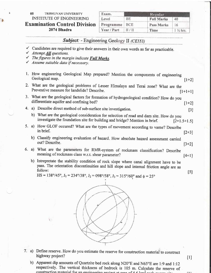
6. a) what are the parameters for RMR-system of rockmass classification? Describemeaning of rockmass class w.r.t. shear parameter? [4+l ]
b) Intrepretate the stability condition of rock slope where canal alignment have to bepass. The orientation discontinuities and hill slope and internal friction angle are asfollow:HS: 138145", Jr :234"138o,Jz:098o/58o0 J3:315"/60.o and 0:25o
t5l
7. a)
b)
Define reserve. How do you estimate the reserve for construction material to constructhighway project?
Apparent dip amounts of Quartzite bed rock along N20oE and N65oE are I :9 and l:12respectively. The vertical thickness of bedrock is 105 m. Calculate the reserve ofconstntction maferinl fnr qn enoincpr"inr, ,^r-..ionf or o-o^ ^f I e t^2 -^^t- ^--^--- -:1^
tll
lTRIBHWAN TJNIVERSITY
INSTITUTE OF ENGINEERTNG
Examination Control Division2073 Bhadra
I l-,9:gl Full Marks
Pass MarksTime
BCE
Subjecf - Engineering Geology II (C8553)
,/ Candidates are required to give their answers in their own words as far as practicable.{ Attempt All questions,
'/ Tke figures in the margin indicate Full Marks./ Assume suitable data if necessary.
1. Define engineering geological map. Mention engineering significancew.r.t hydropower project when sediment analysis has been carried out,
of quartz mineral
2. Define discontinuity. Outline major engineering problerns of lesser Himalaya.
3. Differentiate aquifer and confining bed. Mention geological factors for formationhydrogeolo gical conditions.
4. a) What are the purposesexploration.
of site investigation? Describe geophysical and geotechnical
b) Describe the geological consideration for reservoir site selection.
5. a) Define Hazwd and risk. Describe mechanism of mass movement.
b) Describe parts of landslide with labelled diagram. Mention types of movement withreference to vame's classification.
6. a) Three boreholes A, B and C were drilled for limestone reserve calculation. Bore holeA lies at 600 m distance due N28'E from borehole B. Bore hole C lies at 400mdistance dues S 10oW from bore hole B. The top and bottom of limestone bed wasencountered at the following depth of given bore holes.
Bore hole Top (m) Bottom (m)A 240 260B 220 280C 240 300
Calculate the tnre thickness of limestone bed.
b) What are the conditions of plane failure of rock slope.
c) What are the parameters of Q-system for rockmass classification?
d) How do you calculate RQD from drill core method?
7 . Define reserve. Calculate reserve for aggregate of quartzite bedrockthickness 300 m at S 72"W143" and in an ii"a of 437 km2.
u.s+1.51
u+21
of[1+l]
12+41
t3l
[2+2]
[2+3]
t2l
l2ltzl
having verticalt3l
t5l
***
05 TRTBHUVAI.TUNiVERSITY
INS.UrUrp oF ENGINEERING
Examination Control DiYision2072Wagh '1,*,
{
Nett' Bueli (21\66 r.t I-:tfcl' Iittch)Exam.BE FullMarksLevel
fiBCE PassMarksProgrammell %hrs.TimeII/trYear / Part
Sabject: Geology ll (C8553)
{ Ca4didates are required to give their answers in{ AttlmPt lllquestions.,/ dni4"^ in the'margin indicate Full fuIarks.
/ Aisume suitable data if necessary-
their own words as far as practicable.
-t+*-d\,
f ,Write of engineering geological system.
Mention themirigation.
major engineering geological problems in the lesser Himalaya with
3. Describe the different bpes of aquifer system of Nepal.
4. a) 'What is site investigation? Mention the different types of site investigation.i
f;; What are tle engineering geological factors to be considered for dam site selection?,.'' .'c) Describc the various geological problems occur during tunnel construction.
hazard'v+-
t:
'I
in tr{epal? Differentiate between intensit-v-
b) Describe the geological hazard in Nepaf due to GLOF.. . -
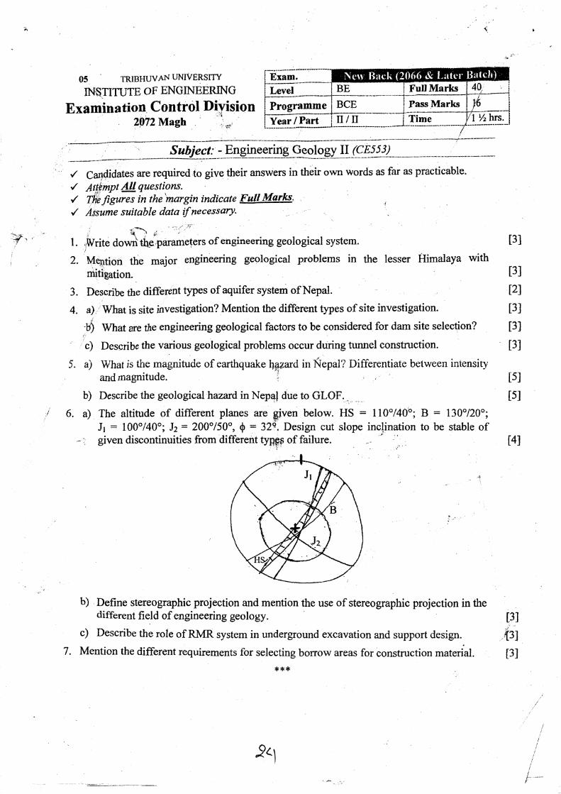
i 6. a) The altitude of different planes are given below. HS : ll0"/40:"; B : 130"/20o;
' Jr = 100"/40o; Jz = 200"150", 0 = 32e, Design cut slope inclination to be stable of- i given discontinuities from different URpp of failure. -. ' .,,
I
2.
t3l
lsI
tsI
t3l
t21
t3l
t3l
t3l
5. a) Whatis the magnitude of earthquakeandmagnitude.
t41
.t
b) Define stereographic projection and mention the use of stereographic projection in thedifferent field of engineering geology.
c) Describe the role of RMR system in underground excavation and support design.
7. Mention the different requirements for selecting borrow areas for construction material.
*,f *
13I
.{31
t3l
pll
I 93
05 TRIBHUVAN LNIVERSITY
INSTITUTE OF ENGINEERIN G
Examination Control Division2072 Ashwin
Exam.
LeveI BE Full Marks 40
Programme BCE Pass Marks 16
Year / Part II/u Time I )'z hrs.
:r r; '
. ,'.,,i,, Subject: - Engineering Geology II (CESS|).l*ri+-..--.-
-----+r' Candidates are required to give their answers in theii own words as far as practicable.{ Attempt All questions.'/ I+refigures in'the margin indicate Full Marksi./:: Assume suitable data if necessary.,,,
:: .. ':l,t .. . .i: r.
I. Write rnain tasks for EGS in'detailed design phase of civil engineering projects.
2. Describe mitigation measures of geological problems in Himalaya.
4. a) Describe geological criteria for selection of road alignment.
)verbreak?b) [now do you explain factor ofoverbreak?
c) Describe geophysical exploration
5. a),-t
What is factor of safety? Describe strerlgth of earthquake.
bls How vame classified landslide? Explaig,
formdation of
t3I
t3l
t21
t3I
t3I
t3l
12+21
i3l
ll.s+1.sI
l2l[1+l]
t21
t41
t
r
Ifiji
1
Differentiale harzard and risk.
6. What are the meaning of Rock mass
How do you measured RQD in rock
ci* Mention conditions for wedge failure
d) Three bore holes were drilled to
cr*
a)1-rr
b}'
from RMR-system?
dpifled core samples?
rock.mass.
as 210 m. Thebedrock.
7 . How do you estimate:re:Sen e for constructfon materials from soil and rock strata?l\ ***,
hydroelectric .project. The apparentAttitude of Quartzite bed was 220"13
t3I
23
. 05 TRJBHWAI{TJNIVERSITY
INSTITUTE OF ENGINEERING
Examination Control Division207I Bhadra
Exam. l{cgular' / I}lcliLevel BE FuIl Marlrs 40
Programme BCE Pass Marks I6Year / Part u/II Time l%tvs.
Subject: - Engineering Geology II (cE553)
r' Candidates are required to give their answers in their own words as far as practicable.'/ Attempt l!!questions.{ Thefigures in the margin indicate FuA Morlcs.{ Assume suitable data if necessary.
). Describe about the preparatlon of engineerlng geobgical map in the ffeld? , : t3]2. S/hd is the engineering significance of mqior discontinuities system of the Nepal Himalaya? [3J
-3. How Darq/s Law describes ground water movement? Describe characteristlcs of conffning
beds? ( 1+r)
y Describe maln purposes of site investigation? How do you make the site investigation belowtheground surface? {2+3}
5. Define overbreak. Describe geologicalparameters forevaluation of bridge site selectbn ?(1+3!
6, Deffne intensity and magnitude of the earthquake. Explain the differerrt types of waves
generated during earthquake. [2+3J
L What is mass rnovememf? Explain whyNepal Himalaya is very proreto LandsUde. [+4]8/ What are dlfferences between intact Rock and Rock Mass? Explain about the importance of
Rock quallty designation (RqDl in Rock Mass classification system based on Rock Mass Rating
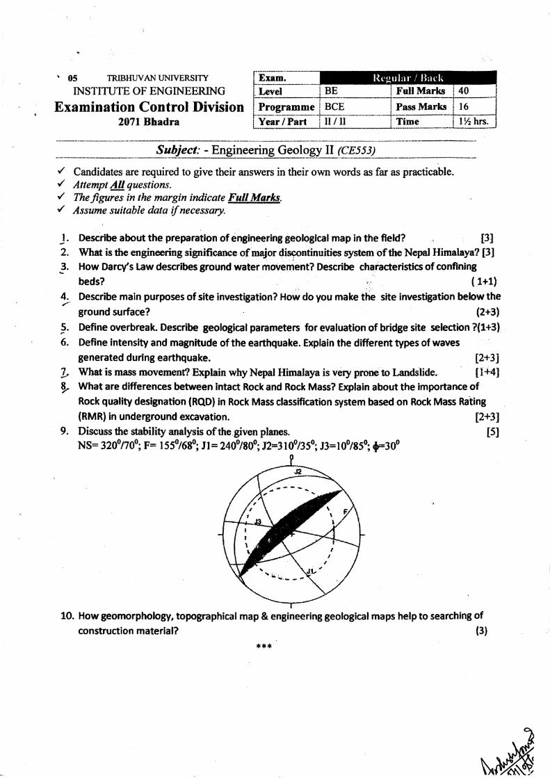
{RMR) in underground excavation. 12+319. Discuss fte stability analysis of the given planes. t5l
NS= 3200/700; p: tss0/680; Jl= 2400/80o3t2=3l0ot35o; J3=100/850; {1300
1O. How geomorphology, topographical map & engineering geological maps help to searching of(3)construction material?
***
,a
\ii
05 TRIBHUVAN UNIVERSITY
INSTITUTE OF ENGINEERING
Examination Control Division2070 Bhadra
Exam. l{cgu l:u'Level BE Full Marks 40
Programme BCE Pass Marks t6Year / Part II/II Time 1%hrs.
I
Subject: - Engineering Geology II (C8553)
{ Candidates are required to give their answers in their own words as far as practicable.{ Attempt All questtons./ Thefigures in the margin indicate Full Mqrks.y' Assume surtable data if necessary.
l. Describe the engineering significance ofthe rock forming minerals. t3l2. Describe types of aquifer with suitable diagram. What are the different engineering geological
problems in the Terai zone of the Nepal Himalaya? [2+3]3. Define Rock Mass Rating (RMR). Discuss the different type and methods of site investigation for
the road in the Nepal Himalaya [2+4]4. How mass movements occur? Classify the lendslide according to varnes (1978). 12+41
5. Explain the different effece of earthquake and GLOF in the Nepalese contelil. [3+2J6. What is rock mass? Describe the rock mass classification based on Q-system and discuss its
implication forthe tunnel support design. 12+41
7. Discuss the differ€nt conditions for plane failure in the rock slope. 121
8. Three boreholes A, B and C were drilled for limestone rcserue calculation. Bort hole A lies at
60Om distance dw N280E from borchole B. Borehole C lies at 40Om distance due SI00W fiom
borehole B. The top and bottom of limestone bed was encountered at the following depth of give
boreholes.
Borehole Top (m) Bottom (m)
A 204 260
B 220 280
c 240 3000
Calculate the true thickness of the limestone bed.
9. Discuss the use of tomgraphic map and geological map for the survey of aggregates.
{.**
t4l
t3I
05 TRIBHUVAN UNIVERSITY
INSTITUTE OF ENGINEERING
Examination Control Division2070 Magh
Exam. Nerv llack (2066 ct Later Batclt)Level BE Full Marks 40
Programme BCE Pass Marks 16
Year / Part il/II Time l%hrs.
Subiect: - Engineering Geology II (CE553)
{ Candidates are required to give their answers in their own words as far as practicable.,/ Attempt 4llquestions.'/ fhefigures in the margin indicate Fult Marks.y' Assume suitable data if necessary.
l. Define engineering geological map. What are the main parameters for evaluation of engineering
geological s)6tem? [1+2]
2. Describe the importance of Darcy's law in groundwater movement Elplain the engineering
significance ofmajor discontinuities system oftheNepal Himalaya. [2+3]
3. Describe the different tJ/pes and mettrods of site investigation and write down the different
engineering geological parameters for the bridge site selection. [3+3]
4. Define Mass movement l)ifferentiate between landslide and debris flow. t2+21
5. Describe the mechanism rrf an earthquake. What are the differences between magniurde and
12+41intensity of an earthquake?
6. Mention the differenttlpcs of rock mass classification system. How do you measune RQD fum
given drillcore samples?.:] l2Y7. Define reserve. Describe the use of engineering geological map for the construction material
survey. ll+21
8. The apparent dip amount of an inclined bed is l:12 and l:16 alongN30"W andNlOoWrespectively. Calcularc the true dip amount and dircction. t4I
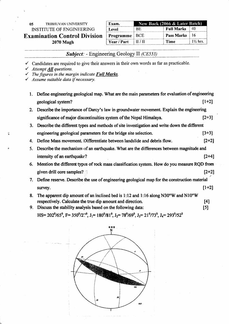
9. Discuss the stability analysis based on the following data: tslHS= 2o2o rc50, p= 35oo n:0, J r= I 800/8 I
0, I z= 7 80 1690, Jr: 2f n30, ! r 2930 I s20
t
I
^dt
05 TRIBHUVA}I UNIVERSITY
INSTITUTE OF ENGINEERING
Examination Control2069 Bhadra
Exam. Ilegular'(2066 et L:ttet' Butclr)Level BE Full IVIarks 40
Programme BCE Pass Marks l6Year / Part u/tl Time lYrhrs.
Subiect: Geology (CE553)
r' Candidates are required to give their answers in their own words as far as practicable.r' Afiempt All questions.r' Thefigures in the margin tndicate Fatl Martcs.{ Assume suitable data if necessary.
t. Describe the engineering significance of the rock forming minerals.
2. Highlight the major discontinuities system of Nepal Himalaya and their engineeringsignificance.
3. What are different aquifer system in terai, hills and mountains ofNepal?
4. a) What are the engineering geological factors to be assessed for the tunnel siteselection?
b) Write down the documentation process for this task.
5. a) How do you differentiate P-wave and S-wave? Describe strength of earthquake.
b) Define mass movement. Describe causes of landslide.
6. a) Bore B in an oil field is 5000 feet due north of bore hole A and bore hole C is 10,000feet due east of bore hole A. The tops and bottoms of a key sandstone bed are reachedat the following altitudes relative to sea leveling the three holes: A, -2500 and -2700feet; B, -2800 and J000 feet; and C, -3000 and -3200 feet. What is the auitude ofthe sandstone and how thick is it?
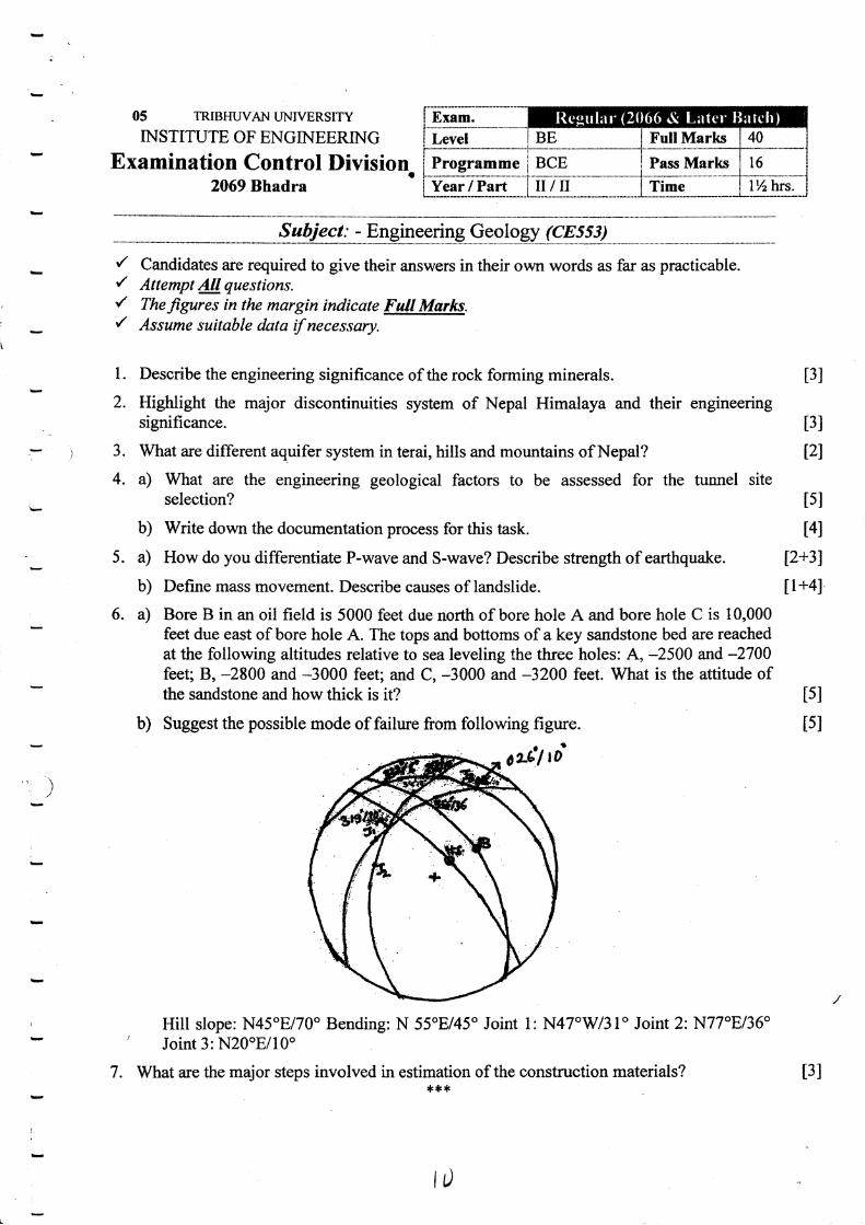
b) Suggest the possible mode of failure from following figure.
ae*,,lo'
Hill slope: N45oE/70o Bending: N 55"E/45o Joint l:N47"W31" Joint 2:N77"8/36"' Joint 3: N20oE/10"
7. What are the major steps involved in estimation of the construction materials?*+*
t3l
t3l
tzt
tsl
t4l
[2+31
[1+4I
tsI
tsl
)
l,
t3I
E..i
{_rE
' J::(:,1:
!
I
r-d&
+i,
-;i
-ii,-k$
:#tt
-#'ilC
-.il;f,
?
'-rt
ir.
:i)
ij
iE'
b;1.*''fi
{'.*4,E
at.iavi
] ,*:i.:' .iE'
'. ;'ii
'/ Candidates are rEquired to give theii answers in their own words as far as practicable./ Attempt Alt question:s.
'/ fhefi.grr6 i, the margin inclicate Fttll fuIarks./ Assume suitable data if necessary.
1. Define over break. Describe direct methods of surface investigation with reference to
2. Describe river channel morphology. Describe geological factors for formation of aquifer' system in mountain t1.5+2.5)
3. Write down the mechanisms of mass movem'ent. Discuss the conkol measures againstlandslide
'4.. Describe condition of toppling failure.
05 TRIBHWAN UMVERSITY
INSTITUTE OF ENGIMERING
Examination C ontrol.Division2068 Bhadra
.'
Exam. ResularLevel BE FUII Marks 40.
Programme BCE Pass Marks 16
Year / Part II /iI Time 1 % hrs.
ll+41
t3l5. What are main parameters of Engineering Geological System? Describe major geological
hazards in the Higher Himalayan Zone. t1.5+2.51
6. Bore hole A is 700rn due north of bore hole B and bore hole C is 600m due west of borehole B. The tops and bottoms .of a rock layer are reached at the following altitudesrelative to the sea level in three holes. t6]
Bore hole A : -410m and -430m
Bore hole C : -430m and -450ni .
Find the attitude and thickness of the rock layer.
7. Define rock mas3. Discuss geo'-mechanics classification of rock mass. [l+4]...-.,....1,.: .,.-. .- _
8. What is engineering geological maps? Describe the importance of engineering geologicalmaps in selection of burrow area.
9. Write short notes on:'a)
Ground water movementb) Mechanism of Earthquake
)>12.s+2.s1( l2x2)
I
!
I
:
***
i
I
!