Embed Size (px)
Citation preview

Overview
Great Zimbabwe’s waterInnocent Pikirayi,1* Federica Sulas,1,2 Tendai Treddah Musindo,1,3
Acquiline Chimwanda,4 Joseph Chikumbirike,5 Ezekia Mtetwa,6
Bongumenzi Nxumalo1 and Munyaradzi Elton Sagiya7
Once a thriving center with commercial links to the Indian Ocean, what remainsof Great Zimbabwe is its monumental architecture. Its rise and decline have longbeen linked to environmental changes in southern Zimbabwe, beginning in thesecond half of the 13th century with agropastoralists thriving in the region’swell-watered granite hills and valleys, and culminating in a vast urban and trad-ing society. Later, c.1550 AD, it is argued, drying climate, land overexploitation,and changing regional trading patterns would lead to the decline of Great Zim-babwe. A review of this model is necessary since Great Zimbabwe and commu-nities living around it survive in a region constantly threatened by water crises.However, we still know very little on the forms and uses of water and how thesehave influenced its development and demise. This article offers a multilayeredreview of available information on water, including new records on environmen-tal sequences, modern water sources, and provisioning models from in andaround Great Zimbabwe. The integration of both old and new datasets allows usto follow the history of people-water interaction from early times to the present.We argue that understanding of the local environment was vital in managingboth water excesses and shortages in the past, and show that some of this knowl-edge survives among indigenous communities linked to the site and living in thesurrounding landscape. While nearby Masvingo town has persistently livedunder water-emergency conditions, farmers around Great Zimbabwe mitigateshortfalls of modern water provision through a balanced and mutually vitalinteraction with natural water resources such as springs and soil moisture. © 2016
Wiley Periodicals, Inc.
How to cite this article:WIREs Water 2016. doi: 10.1002/wat2.1133
INTRODUCTION
The interplay between water, environment, andsocieties is a long-standing topic of global
archaeology, particularly within research on the riseand demise of past civilizations from the floodplainsof the Harappan cultures in India to the hydraulicengineering of ancient Mesoamerica.1–4 The topichas almost polarized debates on the role of watercrises and climate change in the development of Afri-ca’s earliest state societies. On the Zimbabwe pla-teau, Great Zimbabwe developed a state system thatdominated the region up to the late 19th century(Figures 1 and 2). It was once thought that GreatZimbabwe came to an end during the 15th centuryas a result of environmental degradation.5,6
*Correspondence to: [email protected] of Anthropology and Archaeology, University ofPretoria, Pretoria, South Africa2ISEM-CNR, Cagliari, Italy3Department of Archaeology and Museum Studies, GreatZimbabwe University, Masvingo, Zimbabwe4Department of Archaeology, Cultural Heritage and MuseumStudies, Midlands State University, Gweru, Zimbabwe5School of Geosciences, Evolutionary Studies Institute and Centreof Excellence in Palaeosciences, University of the Witwatersrand,Johannesburg, South Africa6Department of Archaeology and Ancient History, Uppsala Uni-versity, Uppsala, Sweden7Great Zimbabwe Conservation Centre, National Museums andMonuments of Zimbabwe (NMMZ), Masvingo, Zimbabwe
Conflict of interest: The authors have declared no conflicts of inter-est for this article.
© 2016 Wiley Per iodica ls , Inc.

However, this hypothesis has been rejected by scho-lars such as Tom Huffman7,8 who argued that thestate had a tributary system from distant areas,which would have supported it in the event of eco-logical and other environment-related catastrophes.Others9,10 have explained Great Zimbabwe’s declineas a result of political overextension, as its sphere ofinfluence lost out to other regional polities. For a sys-tem heavily dependent on its hinterland for resourcesand commodities such as grain, gold, and ivory,political disruptions would have hampered such net-works and, consequently, would have led to a declineof the state, rather than environmental change.7
What role, if any, environmental dynamics played inthe rise and demise of Great Zimbabwe remains anopen question. A few, important studies have dis-cussed the importance of favorable environmentalconditions, such as good soils and pastures to sustainearly farming and herding on Zimbabwe traditionsites in general, but also at Great Zimbabwe.11–13
However, detailed, site-specific information on past(and present) environmental conditions are stillvery few and far between. Indeed, cultural models onthe development of Iron Age settlement in southernZimbabwe rely on regional and continental climaticand environmental sequences to provide the contextfor local archaeological and historical records.
Research on the long-term history of water-people relations in this region,14 and throughoutAfrica in general, has given little consideration onhow their interplay has shaped history, the short-and long-term consequences, and whether such his-tory may be the key toward unlocking present-dayissues and future challenges related to watercrises.15,16 This is a compelling task, and a particu-larly pressing one throughout the continent. In Zim-babwe, water scarcity is increasingly becoming oneof the major problems as rainfall is the main sourceof water that sustains human communities and theenvironment. Indeed, the area within and aroundGreat Zimbabwe has been experiencing unpredicta-ble rainfall with local streams often drying wellbefore the new rain season. Local people are nowcompeting with both wildlife and livestock for availa-ble water.
Research on water-people history is thus of fun-damental importance to develop knowledge of thepast as well as to contribute historical and contextualinformation for present and future purposes. In linewith this view, this article takes water as a keyresource at Great Zimbabwe and its environs, bothpast and present, and it reviews available knowledgein the light of new, recent findings concerning theforms and distribution of water sources for the
FIGURE 1 | Map showing the location of Great Zimbabwe with closed-up map of river/stream networks (prepared by B. Nxumalo).
Overview wires.wiley.com/water
© 2016 Wiley Per iodicals , Inc.

settlement which functioned as an urban center. Suchan exercise allows us to begin framing pre-urbanenvironmental systems in the region, the relationshipsbetween settlements and their contemporary land-scapes over time, and ways in which past commu-nities may have dealt with changing environmentalconditions. We also examine how modern commu-nities continue to subsist in these landscapes despitecontinuing environmental deterioration. In anattempt to move beyond a critical appraisal of whatis known about Great Zimbabwe’s water as anarchaeological or historical issue, this review appliesan historical ecology approach to engage and inte-grate records from archaeology, history, geosciences,ethnography, and development literature.17–19
Studies across different environments and periodshave illustrated the potential of historical ecologyresearch to investigate the long-term history ofwater–landscape–people relations.20–24
WATER AND SOCIAL COMPLEXITY
Long-held views about the development of socialcomplexity and urbanism have centered on the argu-ments that without intensification of resource usesand consequent significant investments, high yieldscannot be achieved, food supply will not be suffi-cient, and starvation and wider calamity will eventu-ally ensue.25–27 However, these claims often depend
Great Enclosure
500 m
Countour line at 1000 m
Old stream/river course
Road
M U T I R I K W I L A K E
O a t l a n d F a r m
MORGENSTER
Hill Complex
Little Zimbawe (11 km)
Water Gate
Ch
i po
po
Ch
i si k
an
a
Mu
tirikw
i Riv
er
BOROMA
D A I TA I
M U N G W I N I
Spring (active/perennial)
Dhaka (clay) pit
Ny
an
ga
N e m a n w aG r o w t h P o i n t
Valley Enclosures
M U N Z V I R U
To
kw
e R
ive
r c
atc
hm
en
t
FIGURE 2 | Map of Great Zimbabwe showing the location of ‘dhaka pits’ in the core part of the settlement, the springs mapped duringsurvey, and some of the villages and communities mentioned in the text (prepared by F. Sulas).
WIREs Water Great Zimbabwe’s water
© 2016 Wiley Per iodica ls , Inc.

on data aggregated from different scale studies withregional/continental climate sequences used in con-junction with, and to explain, site-specific archaeo-logical and historical records. The resultingscenarios, despite severe data aggregation and scalingproblems, often feature a central disaster narrative—precisely as it is the case for contemporary dramaticscenarios of droughts and famines in highly degradedAfrican landscapes.28–30
Archaeologists have long observed the central-ity of water, both in terms of access and managementof the resource, among ancient societies, from fora-gers to agriculturalists and state societies.31,32 For along time, large-scale, complex water managementstrategies have been considered as a prerequisite forsocietal development. These include, for example,complex irrigation infrastructure in northern Ethio-pia and engineered flood control at Dujiangyan inChina. In both cases, water management narrativeshave been appealing and have held firm for sometime, although the scattered data at the core of sucharguments are now being questioned.33–35 In thisarticle, we draw from available, multiple records tooffer a framework for assessing the role of water inthe rise, demise, and legacies of the ancient urbancenter of Great Zimbabwe.
THE GREAT ZIMBABWELANDSCAPE
Great Zimbabwe lies in the southern section of theZimbabwe escarpment (GPS ref: 20� 160 22.6400S,30� 560200E, 1150–1250 m above sea level; Figure 1).This escarpment falls within the African crystallineBasement Complex with predominant granites andimportant aquifers.36 The granodiorite hills define awatershed with several microcatchments and drainedby streams toward the Mutirikwi and Tugwi rivers.These rivers flow south-eastwards into the RundeRiver, which in turn joins the Indian Ocean-boundSave River. The regional climate is tropical, with dis-tinct hot-dry, hot-wet, and warm-dry seasons. Rain-fall arrives in October and persists to April orMay,13 although it is highly variable, and often lead-ing to winter drought.37 Much of the rainfall aroundGreat Zimbabwe comes in the form of mist, locallyknown as guti, brought in by southeast winds.9,13
The vegetation is mixed savannah, dominated byBrachystegia or Julbernardia, or miombo woodland.Brachystegia and varieties of acacia vegetationcover the hillsides and adjoining valleys. Some 10 kmwest of Great Zimbabwe are greenstone schiststrending southwest/northeast—where pre-European
gold workings have been recorded.38,39 The weather-ing of granodiorites has been exploited since theearly second millennium AD, as stone could easily beshaped into building materials and used in the con-struction of residences, known as zimbabwe(or houses of stone).9,40
While we can expect that the general geologicaland geomorphological settings have not changed dra-matically over the last 2000 years, the landscapemust have witnessed considerable transformation inthe vegetation, water resources, and soils since GreatZimbabwe’s heyday. Indeed, climatic and environ-mental settings, and their changes through time, havealways played a significant role in explaining theflourishing, development, and demise of human set-tlement at Great Zimbabwe.41 Early records indicatesettlement in the Great Zimbabwe landscape pre-1300 AD, possibly linked to movement of peoplefrom adjacent regions,7,42,43 triggered by increasinglydrier climatic conditions. Sustained by riverine agri-culture, cattle herding, and diversified trading net-works, Great Zimbabwe would have grown as anurban capital, thriving for about two and a half cen-turies. Then, with cooler conditions at the onset ofthe Little Ice Age,44–49 together with changing tradenetworks in the region, Great Zimbabwe woulddecline in the mid-15th century.5,6,9 Environmentalinformation at the core of this model comes fromregional and continental climatic sequences,6,47–50
and localized proxies for southern Zimbabwe are stillfew and far between. In addition, archaeologicaldebates on the rise and demise of Great Zimbabwehave been polarized around issues of monumentalarchitecture and trade for over a century,40,51–57 andmore recently on function and use of space,46,54–57
leaving little more than assumptions on the formsand uses of water, and how these have changed overtime. As discussed below, some early scholars havenoted the presence of water holes and drainage fea-tures at the site, but these have never been followedup. A little consideration has also been afforded towater supply for farming purposes such as, for exam-ple, irrigation. This is, perhaps, linked to early claimsthat dismissed the presence of any form of irriga-tion;58 and, no further research in this direction hasfollowed.
Today, Great Zimbabwe’s cultural landscape(Figure 3) lies in a region constantly threatened bywater crises.59 The main regional water supply isLake Mutirikwi which is the largest inland reservoirin Zimbabwe. Three main models of water provision-ing have been recorded in the area: governmental,private, and communal. As detailed below, these dif-ferent ways of managing and supplying water reflect
Overview wires.wiley.com/water
© 2016 Wiley Per iodicals , Inc.

both different stakeholders as well as diverse formsof water. We see that, for example, natural springsare the main source of water for rural communities,which share access and management of these sources.But springs are not simply a source of water. Rather,they are also a source and resource of the past wheretraditions of lineage, ownership, and ancestry areembedded. In contrast, governmental provision ofwater by means of boreholes with mixed results, aswe shall see, appears far less dependent on, and inte-grated into, the local landscape and its resources. Inthis respect, the strategies employed by private busi-ness, including tertiary institutions, established in thesurrounding area as early as the end of the 19th cen-tury and still functioning today, do provide impor-tant examples on the ways in which resources can beinvested in sourcing, distributing, and preservingwater for different needs while taking into accountmicroecological conditions over time.
Lake Mutirikwi is now under increasing pres-sure from growing urbanization in Masvingo, sugar-cane irrigation downstream, and rural communitiesliving on its shores. Indeed, its water levels havedropped dramatically since 2013 prompting localauthorities to lobby for reserving water for domesticconsumption only, while depriving the sugarcanefarmers. Given the challenges associated with highwater demand in the region, there is need to
understand the impact of climate change and humanactivities responsible for low water levels at present.
New ongoing research on the links betweenwater and ancient societies at Great Zimbabwesought to develop an integrative historical ecologyapproach which brings together techniques from thehumanities, geosciences, and social sciences. Using acombination of geoarchaeological techniques, histori-cal, and ethnographic surveys, this research has beenmapping and characterizing soil, water, and vegeta-tion resources across different land scape units in andaround Great Zimbabwe.
WATER MANAGEMENTAll around (Great) Zimbabwe is far too watered tobe pleasant; long stretches of unhealthy swamps fillup valleys; rivers and streams are plentiful, and thevegetation consequently rich (Ref 60, p. 55).
Early Records and Oral Historieson WaterReferences to water use at Great Zimbabwe have sofar been very limited, mostly focusing on the Chisi-kana spring and rainmaking.56,59,61 The Chisikanaspring, immediately west of the Ridge Ruins(Figures 4 and 5), has captured the attention of
FIGURE 3 | View of the Great Enclosure at Great Zimbabwe and surrounding vegetation (photo by I. Pikirayi).
WIREs Water Great Zimbabwe’s water
© 2016 Wiley Per iodica ls , Inc.
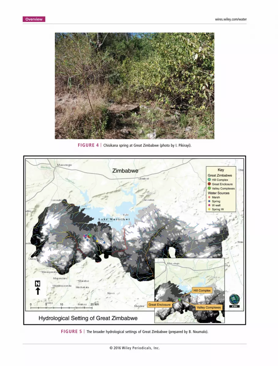
FIGURE 4 | Chisikana spring at Great Zimbabwe (photo by I. Pikirayi).
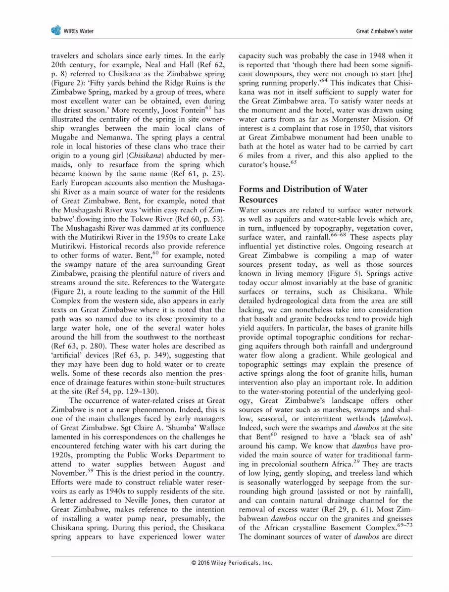
FIGURE 5 | The broader hydrological settings of Great Zimbabwe (prepared by B. Nxumalo).
Overview wires.wiley.com/water
© 2016 Wiley Per iodicals , Inc.
travelers and scholars since early times. In the early20th century, for example, Neal and Hall (Ref 62,p. 8) referred to Chisikana as the Zimbabwe spring(Figure 2): ‘Fifty yards behind the Ridge Ruins is theZimbabwe Spring, marked by a group of trees, wheremost excellent water can be obtained, even duringthe driest season.’ More recently, Joost Fontein61 hasillustrated the centrality of the spring in site owner-ship wrangles between the main local clans ofMugabe and Nemanwa. The spring plays a centralrole in local histories of these clans who trace theirorigin to a young girl (Chisikana) abducted by mer-maids, only to resurface from the spring whichbecame known by the same name (Ref 61, p. 23).Early European accounts also mention the Mushaga-shi River as a main source of water for the residentsof Great Zimbabwe. Bent, for example, noted thatthe Mushagashi River was ‘within easy reach of Zim-babwe’ flowing into the Tokwe River (Ref 60, p. 53).The Mushagashi River was dammed at its confluencewith the Mutirikwi River in the 1950s to create LakeMutirikwi. Historical records also provide referenceto other forms of water. Bent,60 for example, notedthe swampy nature of the area surrounding GreatZimbabwe, praising the plentiful nature of rivers andstreams around the site. References to the Watergate(Figure 2), a route leading to the summit of the HillComplex from the western side, also appears in earlytexts on Great Zimbabwe where it is noted that thepath was so named due to its close proximity to alarge water hole, one of the several water holesaround the hill from the southwest to the northeast(Ref 63, p. 280). These water holes are described as‘artificial’ devices (Ref 63, p. 349), suggesting thatthey may have been dug to hold water or to createwells. Some of these records also mention the pres-ence of drainage features within stone-built structuresat the site (Ref 54, pp. 129–130).
The occurrence of water-related crises at GreatZimbabwe is not a new phenomenon. Indeed, this isone of the main challenges faced by early managersof Great Zimbabwe. Sgt Claire A. ‘Shumba’ Wallacelamented in his correspondences on the challenges heencountered fetching water with his cart during the1920s, prompting the Public Works Department toattend to water supplies between August andNovember.59 This is the driest period in the country.Efforts were made to construct reliable water reser-voirs as early as 1940s to supply residents of the site.A letter addressed to Neville Jones, then curator atGreat Zimbabwe, makes reference to the intentionof installing a water pump near, presumably, theChisikana spring. During this period, the Chisikanaspring appears to have experienced lower water
capacity such was probably the case in 1948 when itis reported that ‘though there had been some signifi-cant downpours, they were not enough to start [the]spring running properly.’64 This indicates that Chisi-kana was not in itself sufficient to supply water forthe Great Zimbabwe area. To satisfy water needs atthe monument and the hotel, water was drawn usingwater carts from as far as Morgenster Mission. Ofinterest is a complaint that rose in 1950, that visitorsat Great Zimbabwe monument had been unable tobath at the hotel as water had to be carried by cart6 miles from a river, and this also applied to thecurator’s house.65
Forms and Distribution of WaterResourcesWater sources are related to surface water networkas well as aquifers and water-table levels which are,in turn, influenced by topography, vegetation cover,surface water, and rainfall.66–68 These aspects playinfluential yet distinctive roles. Ongoing research atGreat Zimbabwe is compiling a map of watersources present today, as well as those sourcesknown in living memory (Figure 5). Springs activetoday occur almost invariably at the base of graniticsurfaces or terrains, such as Chisikana. Whiledetailed hydrogeological data from the area are stilllacking, we can nonetheless take into considerationthat basalt and granite bedrocks tend to provide highyield aquifers. In particular, the bases of granite hillsprovide optimal topographic conditions for rechar-ging aquifers through both rainfall and undergroundwater flow along a gradient. While geological andtopographic settings may explain the presence ofactive springs along the foot of granite hills, humanintervention also play an important role. In additionto the water-storing potential of the underlying geol-ogy, Great Zimbabwe’s landscape offers othersources of water such as marshes, swamps and shal-low, seasonal, or intermittent wetlands (dambos).Indeed, such were the swamps and dambos at the sitethat Bent60 resigned to have a ‘black sea of ash’around his camp. We know that dambos have pro-vided the main source of water for traditional farm-ing in precolonial southern Africa.29 They are tractsof low lying, gently sloping, and treeless land whichis seasonally waterlogged by seepage from the sur-rounding high ground (assisted or not by rainfall),and can contain natural drainage channel for theremoval of excess water (Ref 29, p. 61). Most Zim-babwean dambos occur on the granites and gneissesof the African crystalline Basement Complex.69–73
The dominant sources of water of dambos are direct
WIREs Water Great Zimbabwe’s water
© 2016 Wiley Per iodica ls , Inc.

precipitation, subsurface through-flow from inter-fluves, overland flow from interfluves, and overbankflow from river channel.74 Dambos are distinctivefeatures of miombo regions that are found in season-ally waterlogged shallow valley depressions. Theclearance of miombo woodlands for farming has twoglobal implications: the release of carbon from thesoil and biomass into the atmosphere; and, thechanges in increased reflectance of solar radiationand decreased surface roughness which, if extensiveenough, could result in increased atmospheric insta-bility and a decrease in the formation of rain.75,76
Marshes and dambos are also visible today at andaround Great Zimbabwe, and great expanses arefound in the surrounding landscape. These include,for example, three major marshy areas located imme-diately to the east of the Great Enclosure and to thesouthwest and west of the Hill Complex (Ref 11,pp. 712–713, Figure 2), and those in the environs ofBoroma village about 5 km southeast of the site(Figure 5). Probably, past dambo soils providerecords of past rainfall regimes and local environ-mental conditions if recharged through direct precipi-tation and through-flow from interfluves andregionally, and by overland and overbank flow. Mostof the taxa identified in archaeological assemblagesfrom Great Zimbabwe76 are associated with a river-ine habitat and/or areas with high moisture contentor water-table levels.77 These findings are supportedby preliminary observations of local soil sequences inand around Great Zimbabwe.
Soil SurveySurveys at Great Zimbabwe have recorded twomain soil/sediment types. The first is a red coarseto medium sandy clayey loam originating fromweathering of granite material through both alluvialand colluvial processes. Under relatively stable envi-ronmental conditions and vegetation cover, this rede-posited material begun to aggrade and may formincipient terra rossa type of soils, which are typicallyfound in granite/basalt dominated landscapes world-wide from the Mediterranean basin to the East Afri-can coast.78 The second type is a dark brown finesandy silty loam, associated with aggrading colluvialmaterial, which shows much richer organic contentand anthropogenic inclusions. This soil type is alsomost commonly associated with local archaeologicalcontexts and has been observed in buried deposits.Of particular interest, here are preliminary observa-tions originating from the investigations of a numberof circular depressions at the base of granite hillswithin the main archaeological area at Great
Zimbabwe, which have not been investigated before.These features are usually referred to as ‘dhaka pits’(Figures 2 and 6) because they are thought to havebeen associated with quarrying of clay for the con-struction of houses at the site.40 Soil profiles recordedwithin these features reveal the presence of thick(ca 20–30 cm), organic-rich dark brown to blacksand silty loam deposits with evidence for changingsoil moisture and water-table levels about 30–40 cmbelow the ground, as illustrated by the presence ofmottling (manganese and iron).
Vegetation MappingSpecies diversity of vegetation around Great Zim-babwe has been affected by the management regimeof the monument.56 Historically, vegetation was con-sidered a major problem for the stone structures fromaesthetical and conservation viewpoints. This is rein-forced by the work of Richard N. Hall51 who wasconcerned partly with the clearance of vegetation.Thus, clearing of vegetation at Great Zimbabwe hashad a lasting effect on local species composition. Inaddition, the area around Great Zimbabwe has beenfor a long time inhabited by the Nemanwa, Charum-bira, and Mugabe peoples who have trees they con-sider important in communicating with theirancestors,56 some of which are within the present-day designated monument. The overall picture of themodern vegetation at Great Zimbabwe is informedby Theodore Bent,60 Carl Mauch,79 WebberNdoro,56 and James H. Bannerman.13 More recently,Joseph Chikumbirike76 conducted a detailed study ofboth modern vegetation and archaeological plantremains at Great Zimbabwe and surrounding areas.This research shows that different types of taxa thatare associated with high moisture or water contentand indicators of high water table are currentlyfound at Great Zimbabwe, the majority occurring onmarshland, swamps, and on river or stream banks.These types of species include: Parinari curatellifoliaPlanch, Combretum erythrophyllum (Burch), Brideliamicrantha (Hochst) Baill, Phyllanthus reticulatusPoir, Philenoptera violacea, Acacia schweinfurthiiBrenan and Exell, Acacia sieberiana Keay and Bre-nan, Moraceae Ficus burkei (Miq.) Miq, Ficus capen-sis, Ficus sur Forssk, Ficus sycomorus L, Syzygiumcordatum Hochs.ex C.Krauss, Syzygium guineense(Wild) DC, Olea africana L, Papilionaceae Erythriniacaffra Thunb and Mimusops zeyheri Sond. A recentstudy of archaeological charcoal assemblages fromGreat Zimbabwe shows a miombo vegetation similarto the one present today,76 suggesting also somedegree of climate stability over time. In addition,
Overview wires.wiley.com/water
© 2016 Wiley Per iodicals , Inc.

there is evidence for exploitation of approximately30 tree species during the occupation of the site. Inthe early 1980s, Bannerman13 did show that the orig-inal miombo woodland to the north of Great Zim-babwe had been significantly altered by landclearance before its present use. Presumably, this wasone of the field areas during the 14th century. Futureresearch needs to establish whether such clearance ofmiombo woodlands in the past within the town lim-its of Great Zimbabwe, was a soil moisture manage-ment strategy aimed toward expanding areas forcultivation, or not. Miombo vegetation is character-ized by wet and dry climates in sub-Saharan Africa,with mean annual rainfall in associated biomes ran-ging 650–1400 mm.80–82
Water Usage in the PresentWe also investigated modern water usage within theGreat Zimbabwe landscape through informal inter-views with residents from the nine villages in the areaas well as representatives of rural council authoritiesbased at Nemanwa, the Zimbabwe National WaterAuthority (ZINWA)’s Great Zimbabwe water supplystation, and Morgenster Mission (Figure 5). The pop-ulation for the landscape, based on the 2012 censusand figures from the mission and the rural districtauthorities, is about 10,000 people. Water provision-ing scenarios at present-day Great Zimbabwe andthe varied establishments around it take three majorforms, which are not mutually exclusive: govern-ment, private, and communal. The government pro-visioning model concerns the water supplied and soldto particular consumers by ZINWA, the nationalauthority responsible for the provision of safe tape
water to the nation. Great Zimbabwe falls underZINWA’s Runde Catchment Area which controls awater supply station, some 200 m away from theWorld Heritage Site, and a Research Centre in chargeof reticulating water from Mutirikwi Dam and Che-bopopo Reservoir before retailing it to bulk and indi-vidual consumers around Great Zimbabwe. Atpresent, there is no full record of how many indivi-duals consume ZINWA’s water. The station controls614 water-meters which supply water on a monthlybasis and are divided in two types: bulk and house-hold meters. Consumers with bulk meters includeGreat Zimbabwe Monument, and private and publicbusiness, such as hotels and lodges, local municipalhouses, craft and training centers, local health cen-ters, and schools. Bulk consumers may have severalwater meters scattered across their premises, whichmakes it difficult for ZINWA to keep full records ofmonthly provisions for such consumers. ZINWA’sestimates of individual household consumption ratesrange between 20 and 30 m3 in average, with highpeaks reaching 100 m3 and lowest readings of 1 m3.The 2012 Census Report features an average familysize between four and five individuals. By simple cal-culation, an individual in a household consumesabout 6 and 7 m3 per month (Figure 7).
Much of the water supplied by ZINWA toresidents of the Nemanwa Growth Point, GreatZimbabwe and hotels is largely for cooking, drink-ing, washing, and gardening. The water pipe networkmanaged by ZINWA, however, is unreliable withobsolete pipelines experiencing frequent breakdownsbetween the purification plant and the main line ofsupply. To circumvent this problem, ZINWA hasresorted to water rationing, where certain households
FIGURE 6 | Composite image with view of ‘dhaka’ pit located at the bottom of the Hill Complex and soil profile log (prepared by F. Sulas).Scale bar: 10 cm.
WIREs Water Great Zimbabwe’s water
© 2016 Wiley Per iodica ls , Inc.

of the Nemanwa Growth Point receive water duringsome days before switching to the others. However,some households rarely receive water such as thoselocated on the eastern side of the settlement wherethe terrain is higher. In order to mitigate chronicwater problems, some consumers have resorted tosetting up their own water storage tanks and to sink-ing boreholes. Great Zimbabwe Monument, forexample, now holds several 5000-L water tanks thatare filled up when there is a water flow, while numer-ous lodge owners have drilled boreholes from whichthey source water when ZINWA rations run out. Inaddition, some local residents obtain their waterfrom natural springs within the area of the NemanwaGrowth Point and surrounding villages, many ofwhich rarely run dry. ZINWA sank two boreholes,one at Nemanwa Clinic and another near ChirichogaHigh School to alleviate acute water shortages inthe local settlement. However, water from the bore-holes, especially at the clinic, is unsafe for drinkingbecause it is greasy and rusty. This raises the needto reconceptualize notions of water availability andsafety.
Private water provision model concerns severalhotels present in the landscape and the MorgensterMission (Figure 5). Established in 1891, MorgensterMission hosts about 5000 people and provides anideal case study to illustrate insurance strategies andself-reliability in water provisioning outsidegovernment-directed initiatives. The mission has ateacher training college, hospital, primary and highschools, and a special needs school for deaf pupils.The complex has a dedicated water utility depart-ment which manages supplies from ChamatandaDam and the perennial Munzviru River. The first
represents the oldest source of water for the missionsince at least 1911, when records indicate waterbeing fetched from there using a water cart.83 Themission has endured to maintain the dam even afterimplementing connections to the Munzviru River,following the devastating drought of 1992. Accord-ing to the mission superintendent, there has neverbeen a case of water shortage at the mission since theinstallation of facilities supplying water from Munz-viru River, where water is pumped into two bigreservoirs at a rate of 22 m3 per hour. In addition,natural springs provide alternative sources of water,such as the perennial spring located at MorgensterHigh School. Indeed, during dry periods before thesetting up of water connections to the MunzviruRiver, springs supplied water to the mission. Beforethe 1992 drought, informants reported the dryingout of springs dating back to the 1950s, and werenot clear why this was the case. However, eucalyptustrees were very common then and they may havenegatively impacted on water-table levels. Sinkingboreholes as a way of averting water shortagesappears to have been problematic since the mission’searly days. Modern water survey machines also failedto locate any aquifers. Recently, however, a boreholedrilled in a location selected by a local farmer usingdousing, a traditional method for water sourcing,produced enough water which the teacher trainingcollege relies on.
The third water provision model is a communalone, concerning rural populations with no access towater supplied by ZINWA or private institutions. Inthe nine villages covered by the study, no boreholehas ever been drilled to supplement water fromsprings, access to some of which is shared betweenneighboring villages. With a total population of 1389people exploiting 15 perennial natural springs, thespring-individual ratio is 1:93 compared to therecommended government standard of 1:250. Cur-rently, villagers use water from natural springs fordrinking, cooking, and bathing, and there is somedistinction in the way these are used. In the village ofDaitai (Figure 5), for example, non-perennial springsare used for livestock. Lack of boreholes in the vil-lages, more specifically the difficulty of locating suita-ble aquifers for drilling, may be associated with thelocal geology, which hampers groundwater survey-ing. Local communities around Great Zimbabwebelieve that their water is engineered on their behalfby mermaids. This narrative is buttressed by stricttaboos which are observed at all natural springs suchas restrictions on the use of metal water containers,sooty pots, and soap around springs. According tovillagers, these taboos are paying dividends and it
0
2 000
4 000
6 000
8 000
10 000
12 000
14 000
16 000
Wa
ter
su
pp
ly
Water availability and use at Great Zimbabwe
Quantity (m3)
FIGURE 7 | Statistics of water supply by the Great Zimbabwewater station between July and December 2014. This amountsto 75 564 m3 (Compiled by E. Mtetwa)
Overview wires.wiley.com/water
© 2016 Wiley Per iodicals , Inc.

appears the mermaids are happy because springs con-tinue to flow.
While the region has experienced serious waterscarcity in recent years, discussions with the GreatZimbabwe water supply station technician revealedthat water scarcity is not primarily about drought.Even when water is available in Lake Mutirikwi andsubsidiary sources under ZINWA, it is the availabil-ity to the consumer that plays a key role.
TOWARD AN INTEGRATED WATERHISTORY OF GREAT ZIMBABWE
Why some sites have sustained human settlementover long periods of time and others have experi-enced decline of land and water resources and, even-tually were abandoned, is often the product of acomplex history mediated by ecological, social, eco-nomic, political, and cultural factors. Making linksbetween dynamic ecological processes and changingsocial institutions is key to the enquiry. Fields andsoils are influenced by social processes over time, justas social actors and their institutions are shaped andconditioned by ecological settings.
In an effort to bring research forward, reviewsof available records together with new observationsallow putting forward a number of considerations onthe history of water at Great Zimbabwe. On onehand, mapping of both present and past vegetationcover indicates that some of the plants found atGreat Zimbabwe are associated with high abundanceof water or soil moisture. This finds some support inthe soil sequences investigated, which show recordsof changing soil moisture levels over time. On theother hand, a review of written and oral historyrecords indicates that springs present today in andaround the site have been active for at least a genera-tion. This reflects high water-storing capacity of theunderlying geology, in an increasingly dry environ-ment. The presence and nature of the so-called dhakapits are intriguing, yet they require full investigations.As mentioned, these features have been linked toquarrying of clay for building purposes. The pitsresulting from quarrying activities would then havecaptured and stored rainwater. From oral traditions,these were used to store water long after streams haddried up. Indeed, informal interviews with locals alsorecorded that people used to go fishing in those largeholes. Among the taboos was that one should con-sume all that he or she would have caught beforegoing back there for fishing, otherwise all the fishcaught would go bad. The buried soils and sedimentsrecorded through test excavations in some of these
pits are mainly composed of very fine sands, silts,and substantial organic matter—a composition simi-lar to that usually observed in peats, with clay onlypresent in small amounts. The profiles investigated,though, bear evidence of significant water-holdingcapacity and seasonally perched water tables.Whether or not the pits were first dug to quarry clayis an issue requiring far more detailed informationthan currently is available. Future research in thisdirection may include, for example, mineralogicaland chemical analyses on the clays from both the pitdeposits and the building material used on site. Whatwe can say with some degree of confidence is that theavailable environmental records and oral traditionsdo suggest that these features have stored water inthe past and may have supplied water for people andanimals.
Scattered marshes, swamps, and soil moisturelevels provide further evidence for relatively highwater tables in and around Great Zimbabwe. In pasturban landscapes, as Sinclair (Ref 12, p. 607),emphasizes with reference to Great Zimbabwe, andarguably applicable to other premodern urban cen-ters across the globe, open green areas would havebeen important for maintaining ecosystem servicesand sustaining resilience, food security, and capacityfor the settlement system to deal with crisis andadversity. Several open green areas are still present atand around Great Zimbabwe such as, for example,along the western pediment of the Hill Complex. Siz-able, green open areas, within less than 5 km fromthe ruins, are generally found to the south and south-west in the environs of the villages of Boroma,Mungwini, Daitai, and Morgenster Mission(Figure 4). In some cases, such as Boroma and Mung-wini, these areas are also marked by the presence ofactive springs which have been supplying water forgenerations, according to local informants.
A critical overview of cross-disciplinary datafrom recent research raises issues concerning long-held views about the development of social complex-ity in the region and, more generally, in southernAfrica. First, archaeological research indicates farlonger time frames for human settlement at GreatZimbabwe11 before the rise of the capital as well asbeyond its decline. Second, new site-specific palaeo-vironmental data questions the occurrence, impactof, and responses to, climate shifts across severalAfrican precolonial state societies.12,34,84–86 There isnow sound evidence from the lower Limpopo valleyfor a long-lasting grassland vegetation stability andresilience to droughts, whereas riparian forestappears to have been more vulnerable to climate fluc-tuations. This is indicated by records of increase in
WIREs Water Great Zimbabwe’s water
© 2016 Wiley Per iodica ls , Inc.

riparian taxa under wetter and warmer conditions,while decline occurred during dry and cool periods.84
As mentioned earlier, the development of social com-plexity and urbanism have long been linked to inten-sification of resource use and consequent significantinvestments. These claims are seldom substantiatedand often depend on data aggregated from small-scale studies, or estimated during imaginative map-ping and modeling exercise. At Great Zimbabwe, theways in which water is sourced, managed, and sup-plied today illustrate a diversified and complex sys-tem where governmental, private, and communalagents operate mutually influencing each other’sdependence and access to water. One importantobservation is that the three models of water provi-sion recorded appear to have different degrees offlexibility and adaptability to changing climatic, dem-ographic, and economic conditions. Governmentalwater provision, for example, is severely hamperedby infrastructure decay and management challengeswhich limit its ability to both monitor water supplyand avoid water loss. In some way, Morgenster Mis-sion offers a success story of water availability anduse. The mission has exploited and maintained adiversity of water insurance strategies that include adam, natural springs, rivers, and boreholes. This suc-cess has benefited from a rapprochement of localknowledge systems and modern techniques of waterprovisioning. The three models of water provision-ing, thus, offer opportunities for hypothesizingaspects of water availability and use at Great Zim-babwe. One wonders how much of an impedimentor a resource granite outcrops were to water harvest-ing and management strategies during the GreatZimbabwe period. A question also arises on theantiquity of some of the natural springs that areknown to have supplied whole villages during theworst of droughts. Furthermore, we know very littleabout aspects of power and the politics of inclusionand exclusion over water between elites and com-moners. The present-day scenarios described abovereveal the various configurations of access to waterand control right from Lake Mutirikwi. Three mod-els of water provisions have been recorded in andaround Great Zimbabwe: a governmental model reg-ulating the supply and sell of water to registered cos-tumers and it operates mainly through boreholes; aprivate model implemented by hotels, businesses, andother private institutions, such as Morgenster Mis-sion, which centers around the maintenance of dams,reservoirs, and connected pipelines; and a communalmodel adopted by rural communities with no accessto governmental provision and rely on naturalsprings. How were issues of power configured along
the lines of water in the past? These and many otherquestions require varied methods and theoreticalapparatus for handling water as a research object inantiquity.
CONCLUSIONS
A review of available data on water together withpreliminary observations from ongoing researchoffers the opportunities to begin unfolding the his-tory of water at Great Zimbabwe. The history of thelocal vegetation is consistent with a water-rich land-scape capable of supporting miombo vegetationwhich has been in place since the rise of GreatZimbabwe. This is partly confirmed by soil recordsindicating minor soil moisture changes and generallyhigh water-table levels, which are associated withunderground and surface water as well as vegetationcover. Great Zimbabwe’s underground may have thecapacity to store significant amounts of water, asindicated by the presence of springs, located at thebase of granitic domes. Indeed, basalt and granitebedrocks tend to provide high-yield aquifers. Someof the springs have been active for at least a genera-tion, as indicated by oral history. The fact that thesesprings are still active after the damming of theMutirikwi River may well reflect the high water-storing capacity of the underlying geology despitedecreased water discharge into the system. Scatteredmarshes, swamps, and soil moisture levels, as indi-cated in the soil profiles investigated, provide furtherevidence for relatively high water tables in and aroundGreat Zimbabwe. Soil sequences of the so called‘dhaka pits’ are dominated by organic-rich darkbrown to black sand silty loam which resemble a peattype of sediment.
In terms of modern and future water provision,local authorities such as ZINWA are weary ofrumors that the sugar plantation projects in the aridregions further south have a monopoly and priorityover the use of water from Lake Mutirikwi. There is,in fact, a limit to what can be drained from the lakefor irrigation downstream. This limit is not primarilyfor ensuring sufficient water supplies for the localcommunities but, rather, for protecting aquaticlife in the lake. In this scenario, the near to comple-tion Tokwe Mukosi Dam may serve as a panacea towater woes for sugar plantations in Chiredzi furtherdownstream, with Lake Mutirikwi solely supplyingwater to residents of Masvingo and adjacent farms.
We are part of a global community that is nowexperiencing water scarcity in economic terms, andthe consequences for this are evident12,85,86—droughts, famines, largely unpredictable rainfall,
Overview wires.wiley.com/water
© 2016 Wiley Per iodicals , Inc.

occasional flooding, and related disasters. Indicationsare that there is a long human environmental historyconnected with these consequences—as alluded to inour interpretation of the past around topics of natureand early forms of urbanism, statehood, and col-lapse. Present-day conditions underline the fragilityof local economies and the need to employ long-termhistorical data to model local events. This followsdecades of unsuccessful development policies thathave failed to mitigate water crises and land degrada-tion. In Zimbabwe, for example, several state-sponsored interventions, such as the introductionof plough/mechanized agriculture or irrigation,designed to increase productivity and conserve soil
resources, have fallen short of expectations and areunsustainable on a long-term basis.87 Land use is notonly a function of the physical properties of fields,but it is also shaped by historical processes and localcultural values. Thus, there is need for high qualityand reliable datasets to test, modify, and prove themany former assumptions made about the sustaina-bility of highly populated, semi-arid landscapes.Our review illustrates one way research integratingmultiple techniques and applying multiscalar datasetscan help reframing understandings of the past in thecontexts of that past but also, crucially, approachesto historical landscapes in the view of present andfuture challenges.
ACKNOWLEDGMENTS
Our field research at Great Zimbabwe would not have been possible without the full logistical support andresearch insights offered by Lovemore Mandima and Godfrey Mahachi, to whom we extend our sincerethanks. Likewise, we are greatly indebted to the local communities who welcomed us and shared their knowl-edge with us, in particular Chief Murinye and Boroma community, Chief Charumbira and HeadmanNemanwa, Muchachari community, Chief Mugabe and Mungwini community, and the Daitai community. Wethank all participants of the Geoarchaeology Field Schools and those who joined us in the field for short visits.We are particularly grateful to Munyaradzi Manyanga from the University of Zimbabwe for his constructivecomments and insights. Edward Matenga guided us to a spring near Chebopopo Reservoir, mentioned in late19th century literature. The staff of NMMZ Lodges offered excellent hospitality. Research at Great Zimbabweis part of the South African National Research Foundation (NRF) funded Blue Skies Initiative project entitled‘Collapse of Ancient Societies: Crisis and resilience in three spheres—Mapungubwe, Great Zimbabwe, andAksum’ (project number 81694). Last but not least, we are very grateful to Vernon Scarborough, Kirk French,and two anonymous reviewers for offering insightful and constructive feedback on an early draft, which hasassisted us in improving and completing this article.
FURTHER READINGWhitlow JR. Landuse, population pressure and rock outcrops in the tribal areas of Zimbabwe. Zimbabwe Agric J 1980a,77:3–12.
REFERENCES1. Wyatt AR. The scale and organization of ancient Maya
water management. Wiley Interdiscip Rev Water 2014,1:449–467. doi:10.1002/wat2.1042.
2. Neely JA, Aiuvalasit MJ, Clause VA. New light on theprehistoric Purrón Dam Complex: small corporategroup collaboration in the Tehuacán Valley, Puebla,New México. J Field Archaeol 2015, 40:347–364.
3. Scarborough VL. Flow of Power: Ancient Water Sys-tems and Landscapes. Santa Fe, NM: SAR Press; 2003.
4. Madella M, Fuller D. Palaeoecology of the HarappanCivilisation of South Asia: a reconsideration. Quat SciRev 2006, 25:1283–1301.
5. Garlake PS. Pastoralism and Zimbabwe. J Afr Hist1978, 19:479–493.
6. Holmgren K, Öberg H. Climate change in southernand eastern Africa during the past millennium and itsimplications for societal development. Environ DevSustain 2006, 8:185–195.
7. Huffman TN. Handbook to the Iron Age: The Archae-ology of Pre-Colonial Farming Societies in SOUTH-ERN AFRICA. Scottsville: University of KwaZulu-Natal Press; 2007.
8. Huffman TN. Mapungubwe and Great Zimbabwe:The origin and spread of social complexity in southernAfrica. J Anthropol Archaeol 2009, 28:37–54.
WIREs Water Great Zimbabwe’s water
© 2016 Wiley Per iodica ls , Inc.

9. Pikirayi I. The Zimbabwe Culture: Origins andDecline of Southern Zambezian States. Walnut Creek,NY and Oxford: Altamira Press; 2001.
10. Pikirayi I. The demise of Great Zimbabwe, AD1420–1550: an environmental re-appraisal. In:Green A, Leech R, eds. Cities in the World,1500–2000. Leeds: Maney Publishing; 2006, 31–47.
11. Sinclair P, Pikirayi I, Pwiti G, Soper R. Urban trajec-tories on the Zimbabwean Plateau. In: Shaw T,Sinclair P, Andah B, Okpoko A, eds. The Archaeologyof Africa. Food, Metals and Towns. London: Routle-dge; 1993, 705–731.
12. Sinclair PJJ, Nordquist G, Herschend F, Isendahl C,eds. The Urban Mind: Cultural and EnvironmentalDynamics. Uppsala: Uppsala Universitet; 2010.
13. Bannerman JH. Ecological and other factors in the riseand fall of the Zimbabwe state. In: Paper Presented tothe Conference on Zimbabwe History, University ofZimbabwe, Harare, 23–27 August, 1982. Available at:http://opendocs.ids.ac.uk/opendocs/handle/123456789/4523#.Veb9V5eaTD-. (Accessed September 2, 2015).
14. Nilsson A, Hammer A. Study of water resources inZimbabwe. Publication in Water ResourcesNo. 3, Swedish International Development Agency(Sida), Department for Natural Resources and theEnvironment, Stockholm, 1996.
15. Adams AM. Wasting the Rain: Rivers, People and Pla-nning in Africa. London: Earthscan; 1992.
16. Lomborg B, ed. Global Crises, Global Solutions. Cam-bridge: Cambridge University Press; 2004.
17. Crumley CL, ed. Historical Ecology. Santa Fe, NM:School of American Research Press; 1998.
18. Balée W. The research programme of historical ecol-ogy. Annu Rev Anthropol 2006, 35:75–98.
19. Lane P. Possibilities for a post-colonial archaeology insub-Saharan Africa: indigenous and useable pasts.World Archaeol 2011, 43:7–25.
20. Butzer KW. Ecology in the long view: settlement his-tories, agrosystemic strategies and ecological perfor-mances. J Field Archaeol 1996, 23:141–150.
21. Nelson MC, Kintigh K, Abbott DR, Anderies JM. Thecross-scale interplay between social and biophysicalcontext and the vulnerability of irrigation-dependentsocieties: archaeology’s long term perspective. Ecol Soc2010, 15:31.
22. Lucero LS, Gunn JD, Scarborough VL. Climate changeand classic Maya water management. Water 2011,3:479–494. doi:10.3390/w3020479.
23. Barthel S, Isendahl C. Urban gardens, agriculture, andwater management: Sources of resilience for long-termfood security in cities. Ecol Econ 2013, 86:224–234.
24. Petty AM, Isendahl C, Brenkert-Smith H,Goldstein DJ, Rhemtulla JM, Rahman SA,Kumasi TC. Applying historical ecology to naturalresource management institutions: Lessons from two
case studies of landscape fire management. Glob Envi-ron Change 2015, 31:1–10.
25. Fitzhugh B, Habu B. Beyond Foraging and Collecting:Evolutionary Change in Hunter-Gatherer SettlementSystems. New York: Springer; 2002.
26. Tainter J. Collapse of Complex Societies. Cambridge:Cambridge University Press; 1988.
27. Testart A. The significance of food storage amonghunter-gatherers: residence patterns, population densi-ties, and social inequalities. Curr Anthropol 1982,23:523–537.
28. Illife J. Famine in Zimbabwe, 1890–1960. Gweru:Mambo Press; 1990.
29. Scoones I. Landscapes, fields and soils: understandingthe history of soil fertility management in SouthernZimbabwe. J South Afr Stud 1997, 23:615–634.
30. Scoones I, Chibudu C, Chikura S, Jeranyama P,Machaka D, Machanja W, Mavedzenge B,Mombeshora B, Mudhara M, Mudziwo C,et al. Hazards and Opportunities: Farming Livelihoodsin Dryland Africa, Lessons from Zimbabwe. Londonand Atlantic Highlands, NJ: ZED Books; 1996.
31. Mitchell WP. The hydraulic hypothesis: A reappraisal.Curr Anthropol 1973, 14:512–534.
32. Harrower MJ. Geographic Information Systems (GIS)hydrological modeling in archaeology: an examplefrom the origins of irrigation in Southwest Arabia(Yemen). J Archaeol Sci 2010, 37:1447–1452.
33. Hassan F. Water History of Our Times. Paris:UNESCO; 2011.
34. Sulas F. Aksum: Water and urbanisation in northernEthiopia. In: Tvedt T, Ostigard T, eds. A History ofWater, Series 3, 1. From Jericho to Cities in the Seas.London: IB Tauris; 2014, 171–195.
35. Mithen S. Thirst: Water and Power in the AncientWorld. Cambridge, MA: Harvard UniversityPress; 2012.
36. Titus R, Beekman H, Adams S, Strachan L, eds. Thebasement aquifers of Southern Africa. Water ResearchCommission Report No. TT 428–09. Water ResearchCommission, Gezina South Africa, 2009.
37. Cole MM. The Savannas, Biogeography and Geobot-any. New York: Academic Press; 1986.
38. Phimister IR. Ancient mining near Great Zimbabwe.J South Afr Inst Min Metall 1974, 74:233–237.
39. Phimister IR. Precolonial gold mining in SouthernZambesia: a reassessment. Afr Soc Res 1976, 21:1–30.
40. Garlake PS. Great Zimbabwe. London: Thames andHudson; 1973.
41. Hannaford M, Bigg GR, Jones JM, Staub M,Phimister I. Climate variability and societal dynamicsin pre-colonial Southern African History(AD 900–1840): a synthesis and critique. Environ Hist2014, 20:411–445.
Overview wires.wiley.com/water
© 2016 Wiley Per iodicals , Inc.

42. Smith J, Lee-Thorp J, Hall S. Climate change and agro-pastroalist settlement in the Shashe-Limpopo RiverBasin, Southern Africa. South Afr Archaeol Bull 2007,62:115–125.
43. Huffman TN. Mapungubwe: Ancient African Civiliza-tion on the Limpopo. Johannesburg: Wits UniversityPress; 2005.
44. Huffman TN. Archaeological evidence for climatechange during the last 2000 years in southern Africa.Q Int 1996, 33:55–60.
45. Huffman TN. Climate change during the Iron Age inthe Shashe-Limpopo Basin, southern Africa. J ArchaeolSci 2008, 35:2032–2047.
46. Huffman TN. Intensive El Niño and the IronAge of South-eastern Africa. J Archaeol Sci 2010,27:2572–2586.
47. Tyson PD, Lindesay JA. The climate of the last2000 years in southern Africa. Holocene 1992,2:271–278.
48. Tyson PD, Karlén W, Holmgren K, Heiss GA. The Lit-tle Ice Age and medieval warming in South Africa. SAfr J Sci 2000, 96:121–126.
49. Tyson PD, Lee-Thorp J, Holmgren K, Thackeray JF.Changing gradients of climate change in southernAfrica during the past millennium: implications forpopulation movements. Clim Change 2002,52:129–135.
50. Holmgren K, Lee-Thorp JA, Cooper GR, Lundblad K,Partridge TC, Scott L, Sithaldeen R, Talma AS,Tyson PD. Persistent millennial-scale climatic variabil-ity over the past 25,000 years in Southern Africa.Quat Sci Rev 2003, 22:2311–2326.
51. Hall RN. Great Zimbabwe. London: Methuen; 1905.
52. Caton-Thompson G. The Zimbabwe Culture: Ruinsand Reactions. Oxford: Clarendon; 1931.
53. Summers R. Ancient Ruins and Vanished Civilisationsof Southern Africa. Cape Town: TV. Bulpin; 1971.
54. Ndoro W. The Preservation of Great Zimbabwe: YourMonument Our Shrine. Rome: ICCROM; 2005.
55. Huffman TN. Social Complexity in Southern Africa.Afr Archaeol Rev 2015, 32:71–91.
56. Chirikure S, Pikirayi I. Inside and outside the dry stonewalls: revisiting the material culture of Great Zim-babwe. Antiquity 2008, 82:1–18.
57. Pikirayi I, Chirikure S. Debating Great Zimbabwe.Azania 2011, 46:221–230.
58. Huffman TN. Rise and Fall of Zimbabwe. J Afr Hist1972, 13:353–366.
59. Fontein J. Remaking Mutirikwi: Landscape Water andBelonging in Southern Zimbabwe. Oxford: James Cur-rey; 2015.
60. Bent JT. The Ruined Cities of Mashonaland. London:Longmans; 1896.
61. Fontein J. The Silence of Great Zimbabwe: ContestedLandscapes and the Power of Heritage. London andHarare: UCL Press and Weaver Press; 2006.
62. Hall RN, Neal WG. The Ancient Ruins of Rhodesia.London: Methuen; 1902.
63. Hall RN. Great Zimbabwe, Mashonaland, Rhodesia:An Account of Two Years’ Examination Work in1902–4 on Behalf of the Government of Rhodesia.London: Methuen; 1905.
64. Great Zimbabwe Conservation Centre File L3/12/46.
65. Great Zimbabwe Conservation Centre File L3/26.
66. Mugabe FT, Mtetwa G, Chivizhe JB. Opportunitiesand constraints of using runoff water in semi-arid Zim-babwe: an exploratory survey in Musikavanhu com-munal lands. Midlands State University J Sci AgricTechnol 2006, 1:63–71.
67. Mugabe FT, Hodnett M, Senzanje A. Comparativehydrological behaviour of two small catchments insemi-arid Zimbabwe. J Arid Environ 2007a,69:599–616.
68. Mugabe FT, Hodnett M, Senzanje A. Effect of tempo-ral rainfall distribution and soil type on soil moistureand runoff generation in semi-arid Zimbabwe. NordicHydrol 2007b, 38:249–263.
69. Whitlow JR. Agricultural potential in Zimbabwe: afactorised survey. Zimbabwe Agric J 1980b,77:97–106.
70. Whitlow JR. Environmental constraints and popula-tion pressures in the tribal areas of Zimbabwe. Zim-babwe Agric J 1980c, 77:73–181.
71. Whitlow JR. Vlei cultivation in Zimbabwe: reflectionson the past or a play with a difference. ZimbabweAgric J 1983, 80:123–135.
72. von der Heyden CJ. The hydrology and hydrogeologyof dambos: a review. Prog Phys Geogr 2004,28:544–564.
73. von der Heyden CJ, New MG. The role of a dambo inthe hydrology of a catchment and the river networkdownstream. Hydrol Earth Syst Sci 2003, 7:339–357.
74. Bullock, A. The role of dambos in determiningriver flow regimes in Zimbabwe. J Hydrol 1992,134:349–372.
75. Xue Y, Shukla J. The influence of land surface proper-ties on Sahel climate. Part I: desertification. J Climate1993, 6:2232–2245.
76. Chikumbirike J. Archaeological and palaeoecologicalimplications of charcoal assemblages dated to the Hol-ocene from Great Zimbabwe and its hinterland. Doc-toral dissertation, University of Witwatersrand,Johannesburg, 2014.
77. Chimwanda A. An archaeological and ethnographicdocumentation of water sources around Great Zim-babwe. MA dissertation, Midlands State University,Gweru, Zimbabwe, 2015.
WIREs Water Great Zimbabwe’s water
© 2016 Wiley Per iodica ls , Inc.

78. Verheye W, de la Rosa D. Mediterranean Soils, inLand Use and Land Cover. Encyclopedia of Life Sup-port Systems (EOLSS). Eolss Publishers, Oxford.Available at: http://www.eolss.net (Accessed December21, 2005).
79. Burk E, ed. The Journals of Carl Mauch. Salisbury:National Archives of Rhodesia; 1969.
80. White F. The Vegetation of Africa. Natural ResourcesResearch 20. Paris: UNESCO; 1983.
81. Frost P. The ecology of the miombo. In: Campbell B,ed. The Miombo in Transition: Woodlands and Wel-fare in Africa. Bogor: Center for International ForestryResearch; 1996, 11–57.
82. Troueta V, Esperb J, Beeckmand H. Climate/growthrelationships of Brachystegia spiciformis from themiombo woodland in south central Africa. Dendro-chronologia 2010, 28:161–171.
83. Wallace ST. Zimbabwe: The Mysterious SouthernRhodesia Ruins. Salisbury: The High Commission ofSouthern Rhodesia; 1936.
84. Ekblom A, Gilson L, Notelid M. A historicalecology of the Limpopo and Kruger National Parks
and Lower Limpopo Valley. J Archaeol Anc Hist2011, 1:1–29.
85. Manyanga M. Resilient Landscapes: Socio-environmental dynamics in the Shashi-LimpopoBasin, southern Zimbabwe, c. AD 800 to the present.Cape Town: South Africa Archaeological Society;Studies in Global Archaeology 11, Uppsala Universitet,Uppsala, 2007.
86. Manyanga M, Pikirayi I, Ndoro W. Copying with dry-land environments: preliminary results from Mapun-gubwe and Zimbabwe phase sites in the Mateke Hills,south-eastern Zimbabwe. In: Leslie M, Maggs T, eds.Africa Naissance, the Limpopo Valley 1000 YearsAgo. The South African Archaeological Society Good-win Series, vol. 8. 2000, 69–77.
87. Hagmann J, Murwira K. Indigenous soil andwater conservation in Southern Zimbabwe: a studyof techniques, historical changes and recent develop-ments under participatory research and extension.Research Report 13, Conservation Tillage Project,Institute of Agricultural Engineering, Harare, Zim-babwe, 1994.
Overview wires.wiley.com/water
© 2016 Wiley Per iodicals , Inc.


