Embed Size (px)
Citation preview
The environmental impact assessment is a document of the borrower. The views expressed herein do not necessarily represent those of ADB’s Board of Directors, Management, or staff, and may be preliminary in nature.
Environmental Management Plan
Environmental Management Plan Project Number: 41627-04 December 2009
IND: Himachal Pradesh Clean Energy Development Investment Program – Tranche 3
Prepared by: Himalayan Forest Research Institute in association with Mantec Consultants Pvt. Ltd. for Himachal Pradesh Power Corporation Ltd.
ENVIRONMENT MANAGEMENT PLAN
FOR
INTEGRATED KASHANG HYDROELECTRIC PROJECT (243 MW) OF HIMACHAL PRADESH
PREPARED BY:
HIMALAYAN FOREST RESEARCH INSTITUTE
(Indian Council of Forestry Research & Education) Conifer Campus, Panthaghati SHIMLA-171 009 (H.P.) E-mail: [email protected]
IN ASSOCIATION WITH
MANTEC CONSULTANTS PVT. LTD.
805, VISHAL BHAWAN, 95, NEHRU PLACE, NEW DELHI-110 019 PH – 011-26429294/5/6, FAX – 26842531/26463665
E-mail: [email protected], [email protected]
October 2008
Environment Management Plan for Integrated Kashang HEP
Page 1 of 12
Table of Contents
TABLE OF CONTENTS SL. NO. CONTENTS PAGE NO.
CHAPTER 1: CATCHMENT AREA TREATMENT PLAN 01-66
1.1 Introduction 01
1.2 Objectives 02
1.3 Catchment Area 05
1.3.1 Basin Characteristics 05
1.3.2 Free Draining Catchment 11
1.4 Topography 12
1.5 Soil 16
1.6 Methodology Used for the Study 16
1.6.1 Landuse – Landcover Classification 18
1.6.2 Slope Map Preparation 20
1.6.3 Soil Loss Using Silt Yield Index (SYI) Method 23
1.7 Catchment Area Treatment Plan 27
1.7.1 Erosion and Landuse 28
1.7.2 Activities to be Undertaken 37
1.8 Treatment of Individual Sub-Watersheds 40
1.8.1 Micro Watersheds Rogle [1A2C5 (1)] and Dolo Dagri [1A2C5(2)
40
1.8.2 Micro Watershed Larsa [1A2C5(3)] 45
1.8.3 Micro Watershed Lappo [1A2C5(4)] 46
1.9 Cost Analysis of Different Works Under Plan 49
1.9.1 Biological Measures 49
1.9.2 Engineering Measures 55
1.10 Treatment of Impact Area 57
1.11 Treatment of Private Land 58
1.12 Cost of Other Components of CAT Plan 59
1.12.1 Implementation of Support Infrastructure Cost 59
1.12.2 Fuelwood Saving Devices 60
Environment Management Plan for Integrated Kashang HEP
Page 2 of 12
Table of Contents
1.12.3 Training and Extension Programme 60
1.12.4 Provision for Formulation of Micro Plans 60
1.12.5 Provision for Proper Documentation 61
1.12.6 Gender Support 61
1.12.7 Funds for Education Related Medicinal Plant Sector 61
1.12.8 Monitoring of Silt 61
1.12.9 Development of Eco-tourism 62
1.12.10 Provision for Floristic Survey 62
1.12.11 Eco-Force 62
1.12.12 Provision of Monitoring and Evaluation 63
1.12.13 Provision for Providing Environment Services 63
1.13 Institutional Mechanism 63
1.13.1 Role of Project Proponent 63
1.13.2 CAT Implementation 64
1.13.3 Project Monitoring and Reporting Procedure 64
1.14 Summary of Cost of Works 64-65
CHAPTER 2: RESETT
LEMENT AND REHABILITATION PLAN
1-19
Part-I: Gives Information About Project Covering 1
2.1 Resettlement and Rehabilitation (R & R) Schemes for Project Affected Families of Integrated Kashang Hydroelectric Project
2.2 Objectives 2
2.3 Basic Issues and Need for R & R Plan 3
2.4 Relief Rehabilitation Strategies 3
2.5 Definitions 4
2.5.1 Family 4
2.5.2 Project Affected Family (PAF) 5
2.5.2(a) Project Affected Family Landless 5
2.5.2(b) Project Affected Family Rendered Houseless 5
2.5.2(c) Project Affected Family Rendered Landless 5
Environment Management Plan for Integrated Kashang HEP
Page 3 of 12
Table of Contents
2.5.3 Main Project Affected Family 6
2.5.4 Project Affected Area 6
2.5.5 Project Affected Zone 6
2.5.6 Agricultural Labourer 6-0
3 Part-3: Social Impact Assessment 9-10
4 Part-4: Resettlement of Grant 11-13
5 Part-5: Employment 14-16
6 Part-6: R & R Benefits for PAFs Belongings to ST & SC 17
7 Part-7: Other Benefits 18
8 Part-8: Infrastructure Development 19
CHAPTER 3: COMPENSATORY AFFORESTATION SCHEME 01-05
3.1 General 01
3.1.1 Land requirement of the Project 01
3.2 Methodology and Components 03
3.2.1 Seedling Requirements 03
3.2.2 Nursery Development 04
3.2.3 Fencing and Closure 04
3.2.4 Beating Up 04
3.3 Cost Estimates for Plantation Per Ha Land 04
3.4 Payment of Net Present Value of Land Transferred 04
3.5 Cost Estimate of Compensatory Afforestation Works 05
CHAPTER: 4 GREEN BELT DEVELOPMENT PLAN 01-06
4.1 Introduction 01
4.2 Development of Greenbelt 01
4.3 Guidelines and Techniques for Green Belt Development 02
4.3.1 Size of Nursery 02
4.32 Nursery Site Selection 02
4.3.3 Transportation 03
4.34 Fertilizer Application 03
4.3.5 Soil and Soil Fertility 03

Environment Management Plan for Integrated Kashang HEP
Page 4 of 12
Table of Contents
4.3.6 Water Supply and Drainage 03
4.3.7 Species to be Planted 03
4.3.8 Precautions During Plantation 04
4.4 Green Belt Development 04
4.4.1 Road side plantation 04
4.4.2 Green Belt around Trench Weir Site / Power House 05
4.4.3 Green Belt around Residential area and Office Complex 05
4.5 Cost Estimate of Green Belt Development 05
CHAPTER 5: WILDLIFE MANAGEMENT AND BIODIVERSITY
CONSERVATION PLAN
01-16
5.1 General 01
5.2 Status of Wildlife Sanctuary 01
5.2.1 Name and Location 01
5.2.2 Boundaries 02
5.2.3 Geology and terrain 02
5.2.4 Climate and Rainfall 02
5.2.5 Water Sources 02
5.2.6 Flora of the sanctuary 03
5.2.7 Fauna of the sanctuary 04
5.2.8 Summary of Threats to Wildlife Conservation: 06
5.2.9 Socio-economic Analysis: 06
5.3 Wildlife Management and Development Plan for the Lippa Asrang Wildlife Sanctuary
07
5.4 Wildlife Management and Conservation 08
5.4.1 Habitat Improvement: 08
5.4.2 Support to Pheasant conservation and breeding program at Sarahan:
09
5.4.3 Soil Stabilization and Bio- engineering works 09
5.4.4 Promotion of Non-Conventional Energy Sources 09
5.4.5 Support to sustainable mountain livelihoods 09
Environment Management Plan for Integrated Kashang HEP
Page 5 of 12
Table of Contents
5.5 Rural infrastructure and community development 12
5.5.1 Infrastructure development 12
5.5.2 Community development 12
5.6 Eco-Tourism and Environmental Awareness 13
5.6.1 Eco-tourism 13
5.6.2 Environment Awareness Centre 13
5.7 Capacity Building and Skill-Up Gradation 13
5.8 Research and Monitoring 13
CHAPTER 6: MUCK MANAGEMENT PLAN 01-20
6.1 General 01
6.2 Quantity of Muck Generated and its Consumptive Use 04
6.3 Description of Muck Disposal Sites 06
6.3.1 Muck Disposal Site D-1 06
6.3.2 Muck Disposal Sites D-2, D-3 and D-11 07
6.3.3 Muck Disposal Site D-4 07
6.3.4 Muck Disposal Site D-5, D-6 and D-7 07
6.3.5 Muck Disposal Site D-8 12
6.3.6 Muck Disposal Site D-9 and D-10 12
6.3.7 Muck Disposal Site D-12 12
6.3.8 Muck Disposal Site D-13 12
6.4 Implementation of Engineering and Biological Measures Engineering Measures
12
6.4.1 Engineering Measures 15
6.4.2 Biological Measures 15
6.5 Species for Plantation 18
6.6 Cost Estimate for Muck Disposal Plan 19
6.7 Rate Analysis 20
CHAPTER 7: RESTORATION PLAN FOR QUARRY SITES 01-08
7.1 General 01
7.2 Details of Quarry Sites 02
Environment Management Plan for Integrated Kashang HEP
Page 6 of 12
Table of Contents
7.2.1 Quarry Site No-1, Near Intake (Stage-1) 02
7.2.2 Quarry Site No-2 Near Jangi 02
7.2.3 Stone/Boulder 03
7.2.4 Soil (Earth) 03
7.2.5 Coarse Aggregate 04
7.2.6 Fine Aggregate 04
7.3 Environmental Impacts 06
7.4 Treatment Measures for Restoration 06
7.4.1 Biological Measures 06
7.4.2 Barbed Wire Fencing 07
7.4.3 Engineering Measures 07
7.5 Cost Estimate for Restoration of Borrow Areas 07
CHAPTER 8: LANDSCAPE AND RESTORATION PLAN 01-01
8.1 Introduction 01
CHAPTER 9: HEALTH MANAGEMENT PLAN 01-06
9.1 Introduction 01
9.2 Likely Impacts on Human Health due to the Project 03
9.3 Proposed Health Management Plan 03
9.3.1 Awareness Programme 03
9.3.2 Establishment of Project Hospital 05
9.3.3 Malaria Control and Vaccination Programme 06
9.4 Cost Estimate for Health Management Plan 06
CHAPTER 10: PROVISION FOR SUBSIDIZED FUEL 01-03
10.1 Introduction 01
10.2 Provision of Subsidized Fuel for Labourers 01
10.2.1 Subsidy on LPG 02
10.3 Subsidy on Kerosene 02
10.4 Electricity Supply 03
CHAPTER 11: SOLID WASTE MANAGEMENT PLAN 01-08
11.1 Introduction 01
Environment Management Plan for Integrated Kashang HEP
Page 7 of 12
Table of Contents
11.2 Responsibility Project Authority 01
11.2.1 Collection of Municipal Solid Wastes 02
11.2.2 Segregation of Municipal Solid Wastes 02
11.2.3 Storage of Municipal Solid Wastes. 02
11.2.4 Transportation of Municipal Solid Wastes 03
11.2.5 Processing of Solid Wastes 03
11.2.6 Disposal of Municipal Solid Wastes. 03
11.2.7 Municipal Waste From Residential Areas 03
11.3 Solid Waste from Labour Colony 05
11.4 Bio-Medical Wastes from Hospitals 06
11.5 Solid Waste Management in Villages Near Reservoir 07
CHAPTER 12: DISASTER MANAGEMENT PLAN 01-13 12.1 Introduction 01 12.2 Project Brief 01 12.3 Disaster Analysis of Vulnerable Components 02 12.3.1 Trench Weir 03 12.3.2 Underground Water Conductor System. 04 12.3.3 Power House Complex 05 12.4 Possible Danger due to Storage of Explosive 05 12.5 Precautionary/Safety Measures and Accident Risks. 06 12.5.1 Precaution and Safety measure. 06 12.5.2 Accident Risks From Construction Activities. 06 12.6 Disaster Management Plan 06 12.6.1 Power House Safety And Maintenance Manual 07 12.6.2 Emergency Action Plan (EAP) 08 12.6.3 Administration and Procedural Aspects 08 12.6.4 Preventive Action 09 12.6.5 Communication System 10 12.6.6 Evacuations Plans 10 12.6.7 Evacuation Team 10 12.6.8 Public Awareness for Disaster Mitigation 11 12.6.9 Notifications 11
Environment Management Plan for Integrated Kashang HEP
Page 8 of 12
Table of Contents
12.6.10 Notification Procedures 12 12.6.11 Management after Disaster 12 12.6.12 Communication between Different Projects 13 12.7 Cost Estimate 13 CHAPTER 13: ENVIRONMENTAL MONITORING PLAN 01-08 13.1 The Need 01 13.2 Areas Of Concern 01 13.2.1 Air Quality Monitoring and Management 02 13.2.2 Noise Quality Monitoring and Management 02 13.2.3 Water Quality Monitoring and Management 03 13.3 Ecosystem Studies 06 CHAPTER-14: SUMMARY IMPACTS AND CONCLUSIONS 1-15 14 General 1 14.1 Impacts and Mitigation Measures 1-11 14.2 Cost of Implementing Environment Management Plan 12 Annexure-1: Proforma for Monthly Statement of Muck/ Debris
Proposal
Annexure-2: Proceedings of meeting held for presentation of Draft EIA & EMP Reports
01-06
Annexure-3: Proceedings of the Public Hearing Meeting and Action taken thereon
01-07
Environment Management Plan for Integrated Kashang HEP
Page 9 of 12
Table of Contents
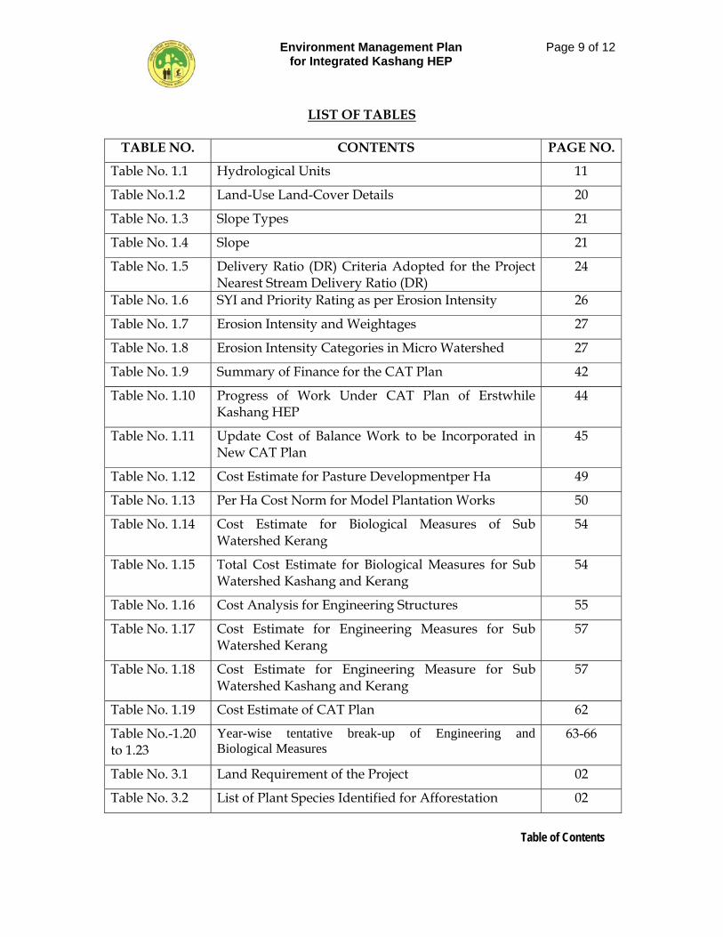
LIST OF TABLES
TABLE NO. CONTENTS PAGE NO.
Table No. 1.1 Hydrological Units 11
Table No.1.2 Land-Use Land-Cover Details 20
Table No. 1.3 Slope Types 21
Table No. 1.4 Slope 21
Table No. 1.5 Delivery Ratio (DR) Criteria Adopted for the Project Nearest Stream Delivery Ratio (DR)
24
Table No. 1.6 SYI and Priority Rating as per Erosion Intensity 26
Table No. 1.7 Erosion Intensity and Weightages 27
Table No. 1.8 Erosion Intensity Categories in Micro Watershed 27
Table No. 1.9 Summary of Finance for the CAT Plan 42
Table No. 1.10 Progress of Work Under CAT Plan of Erstwhile Kashang HEP
44
Table No. 1.11 Update Cost of Balance Work to be Incorporated in New CAT Plan
45
Table No. 1.12 Cost Estimate for Pasture Developmentper Ha 49
Table No. 1.13 Per Ha Cost Norm for Model Plantation Works 50
Table No. 1.14 Cost Estimate for Biological Measures of Sub Watershed Kerang
54
Table No. 1.15 Total Cost Estimate for Biological Measures for Sub Watershed Kashang and Kerang
54
Table No. 1.16 Cost Analysis for Engineering Structures 55
Table No. 1.17 Cost Estimate for Engineering Measures for Sub Watershed Kerang
57
Table No. 1.18 Cost Estimate for Engineering Measure for Sub Watershed Kashang and Kerang
57
Table No. 1.19 Cost Estimate of CAT Plan 62
Table No.-1.20 to 1.23
Year-wise tentative break-up of Engineering and Biological Measures
63-66
Table No. 3.1 Land Requirement of the Project 02
Table No. 3.2 List of Plant Species Identified for Afforestation 02
Environment Management Plan for Integrated Kashang HEP
Page 10 of 12
Table of Contents
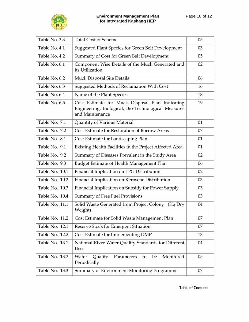
Table No. 3.3 Total Cost of Scheme 05
Table No. 4.1 Suggested Plant Species for Green Belt Development 03
Table No. 4.2 Summary of Cost for Green Belt Development 05
Table No. 6.1 Component Wise Details of the Muck Generated and its Utilization
02
Table No. 6.2 Muck Disposal Site Details 06
Table No. 6.3 Suggested Methods of Reclamation With Cost 16
Table No. 6.4 Name of the Plant Species 18
Table No. 6.5 Cost Estimate for Muck Disposal Plan Indicating Engineering, Biological, Bio-Technological Measures and Maintenance
19
Table No. 7.1 Quantity of Various Material 01
Table No. 7.2 Cost Estimate for Restoration of Borrow Areas 07
Table No. 8.1 Cost Estimate for Landscaping Plan 01
Table No. 9.1 Existing Health Facilities in the Project Affected Area 01
Table No. 9.2 Summary of Diseases Prevalent in the Study Area 02
Table No. 9.3 Budget Estimate of Health Management Plan 06
Table No. 10.1 Financial Implication on LPG Distribution 02
Table No. 10.2 Financial Implication on Kerosene Distribution 03
Table No. 10.3 Financial Implication on Subsidy for Power Supply 03
Table No. 10.4 Summary of Free Fuel Provisions 03
Table No. 11.1 Solid Waste Generated from Project Colony (Kg Dry Weight)
04
Table No. 11.2 Cost Estimate for Solid Waste Management Plan 07
Table No. 12.1 Reserve Stock for Emergent Situation 07
Table No. 12.2 Cost Estimate for Implementing DMP 13
Table No. 13.1 National River Water Quality Standards for Different Uses
04
Table No. 13.2 Water Quality Parameters to be Monitored Periodically
05
Table No. 13.3 Summary of Environment Monitoring Programme 07
Environment Management Plan for Integrated Kashang HEP
Page 11 of 12
Table of Contents
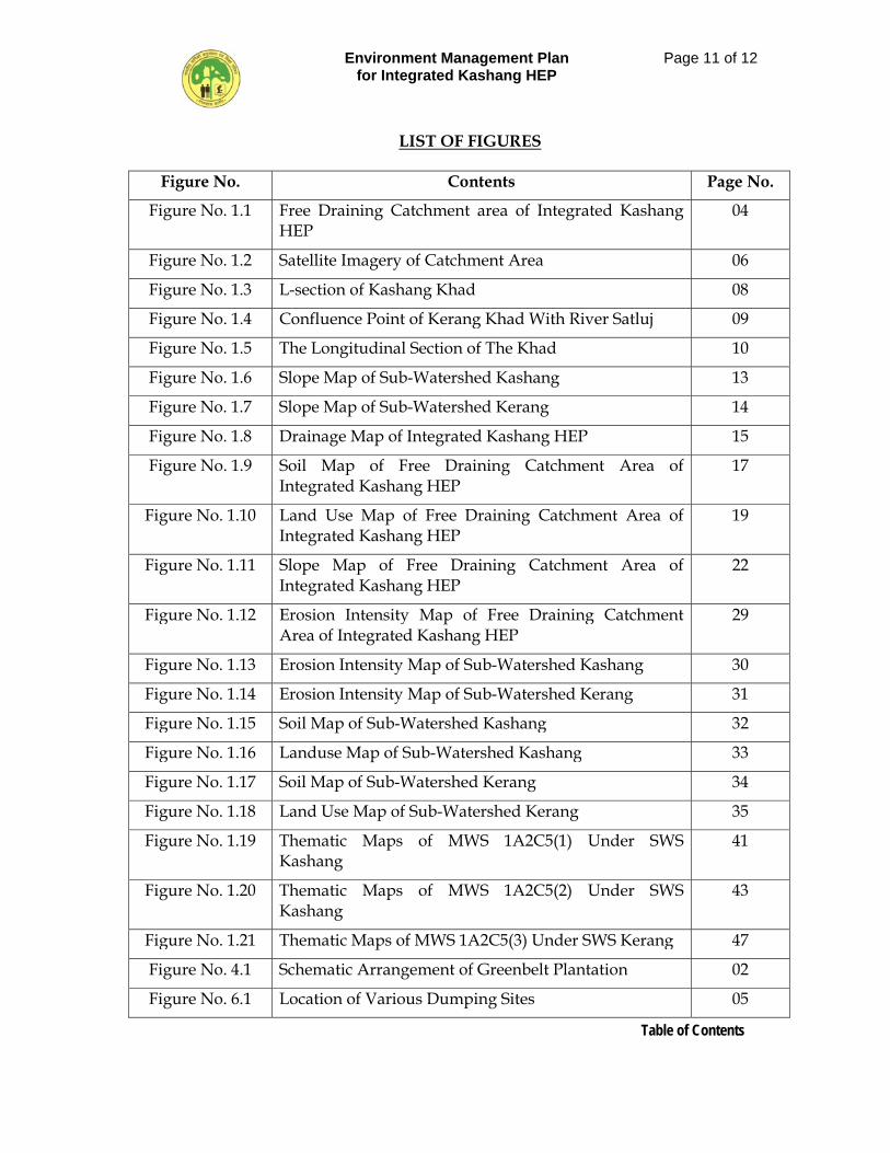
LIST OF FIGURES
Figure No. Contents Page No.
Figure No. 1.1 Free Draining Catchment area of Integrated Kashang HEP
04
Figure No. 1.2 Satellite Imagery of Catchment Area 06
Figure No. 1.3 L-section of Kashang Khad 08
Figure No. 1.4 Confluence Point of Kerang Khad With River Satluj 09
Figure No. 1.5 The Longitudinal Section of The Khad 10
Figure No. 1.6 Slope Map of Sub-Watershed Kashang 13
Figure No. 1.7 Slope Map of Sub-Watershed Kerang 14
Figure No. 1.8 Drainage Map of Integrated Kashang HEP 15
Figure No. 1.9 Soil Map of Free Draining Catchment Area of Integrated Kashang HEP
17
Figure No. 1.10 Land Use Map of Free Draining Catchment Area of Integrated Kashang HEP
19
Figure No. 1.11 Slope Map of Free Draining Catchment Area of Integrated Kashang HEP
22
Figure No. 1.12 Erosion Intensity Map of Free Draining Catchment Area of Integrated Kashang HEP
29
Figure No. 1.13 Erosion Intensity Map of Sub-Watershed Kashang 30
Figure No. 1.14 Erosion Intensity Map of Sub-Watershed Kerang 31
Figure No. 1.15 Soil Map of Sub-Watershed Kashang 32
Figure No. 1.16 Landuse Map of Sub-Watershed Kashang 33
Figure No. 1.17 Soil Map of Sub-Watershed Kerang 34
Figure No. 1.18 Land Use Map of Sub-Watershed Kerang 35
Figure No. 1.19 Thematic Maps of MWS 1A2C5(1) Under SWS Kashang
41
Figure No. 1.20 Thematic Maps of MWS 1A2C5(2) Under SWS Kashang
43
Figure No. 1.21 Thematic Maps of MWS 1A2C5(3) Under SWS Kerang 47
Figure No. 4.1 Schematic Arrangement of Greenbelt Plantation 02
Figure No. 6.1 Location of Various Dumping Sites 05
Environment Management Plan for Integrated Kashang HEP
Page 12 of 12
Table of Contents
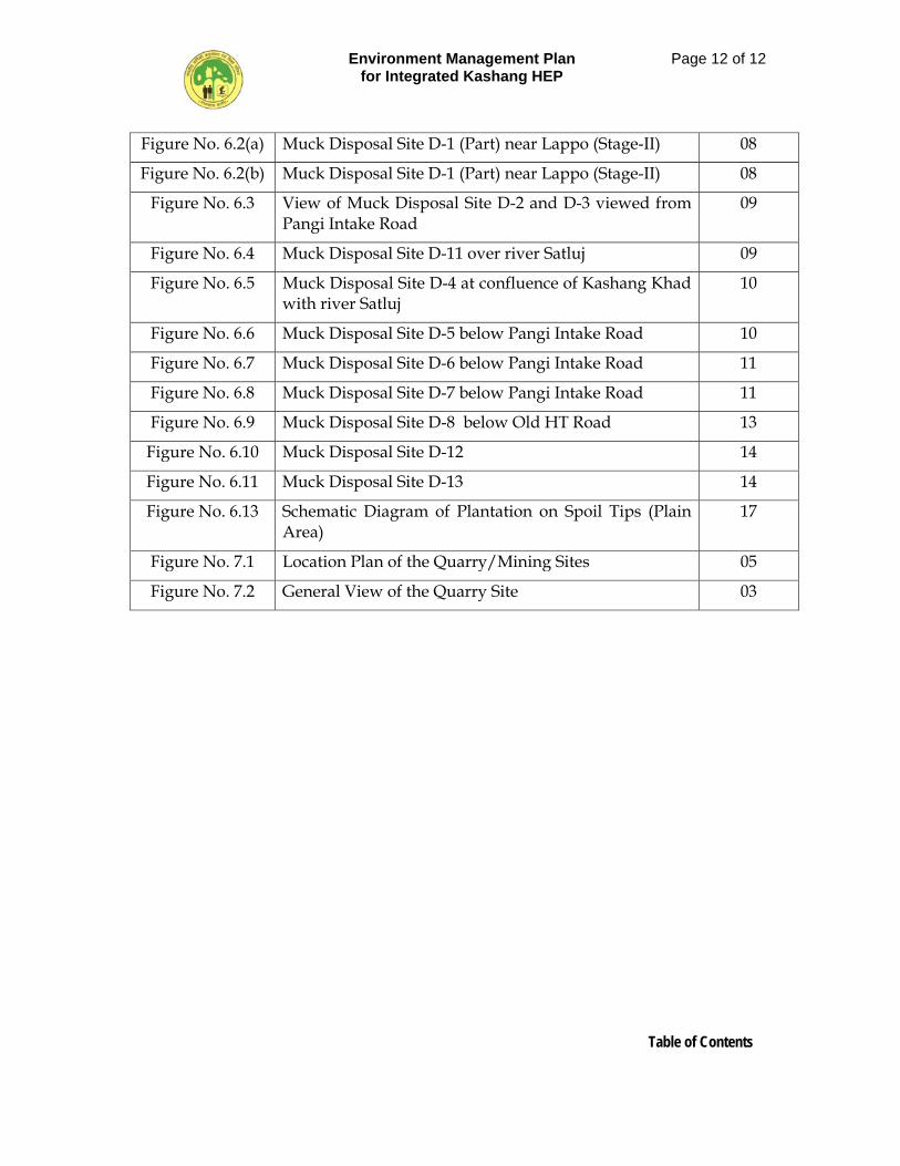
Figure No. 6.2(a) Muck Disposal Site D-1 (Part) near Lappo (Stage-II) 08
Figure No. 6.2(b) Muck Disposal Site D-1 (Part) near Lappo (Stage-II) 08
Figure No. 6.3 View of Muck Disposal Site D-2 and D-3 viewed from Pangi Intake Road
09
Figure No. 6.4 Muck Disposal Site D-11 over river Satluj 09
Figure No. 6.5 Muck Disposal Site D-4 at confluence of Kashang Khad with river Satluj
10
Figure No. 6.6 Muck Disposal Site D-5 below Pangi Intake Road 10
Figure No. 6.7 Muck Disposal Site D-6 below Pangi Intake Road 11
Figure No. 6.8 Muck Disposal Site D-7 below Pangi Intake Road 11
Figure No. 6.9 Muck Disposal Site D-8 below Old HT Road 13
Figure No. 6.10 Muck Disposal Site D-12 14
Figure No. 6.11 Muck Disposal Site D-13 14
Figure No. 6.13 Schematic Diagram of Plantation on Spoil Tips (Plain Area)
17
Figure No. 7.1 Location Plan of the Quarry/Mining Sites 05
Figure No. 7.2 General View of the Quarry Site 03
Environment Management Plan for Integrated Kashang HEP
Page 1 of 65
Chapter-1: Catchment Area Treatment Plan
CHAPTER 1
CATCHMENT AREA TREATMENT PLAN 1.1 INTRODUCTION
Land and water resources have optimum interaction and synergetic effect if developed in scientific and rational manner. In a larger sense land is represented by soil, which is usually susceptible to erosion due to various meteorological conditions such as total annual precipitation, snowfall, intensity of precipitation, wind velocity and directions, extent of vegetal cover and the topography of the catchment. The erosion of top soil from land reduces its fertility and the vegetation growth and increases sedimentation. Sedimentation of reservoir is a function of soil erosion rate of the river catchment area. It impinges upon the useful capacity of reservoir, water quality and the availability of water for its designated use as also life of various components of project using the water. Thus, no water resources scheme of medium and major classification can be successful by keeping in seclusion from it the most interactive gradient of nature i.e. land. Therefore, it becomes imperative to evolve a plan based on scientific approach to prevent soil erosion to the extent possible. The study of erosion and sediment yield from catchments is of utmost importance as the deposition of sediment in reservoir reduces its capacity, thus affecting the water availability for the designated use. The eroded sediment from catchment when deposited on streambeds and banks causes braiding of river reach. The removal of top fertile soil from catchment also adversely affects the agricultural production. Another important factor that adds to the sediment load, and which contributes to soil degradation is grazing pressure. A large number of cattle, sheep, and goats graze the pastures during summer season continuously for about six months. Due to this pressure, the productivity of these pastures is also declining further. The lack of proper vegetal cover is a factor to cause degradation and thereby results in severe run off/soil erosion, and subsequently premature siltation of the reservoir. Thus, a well-designed Catchment Area Treatment (CAT) Plan is essential to suitably address the above-mentioned adverse cause and the process of soil erosion. The catchment area treatment involves the understanding of the erosion characteristics of the terrain and suggesting remedial measures to reduce the erosion rate. For this reason the catchment of the directly draining rivers, streams, tributaries, etc. are treated and the cost is included in the project cost.
Environment Management Plan for Integrated Kashang HEP
Page 2 of 65
Chapter-1: Catchment Area Treatment Plan
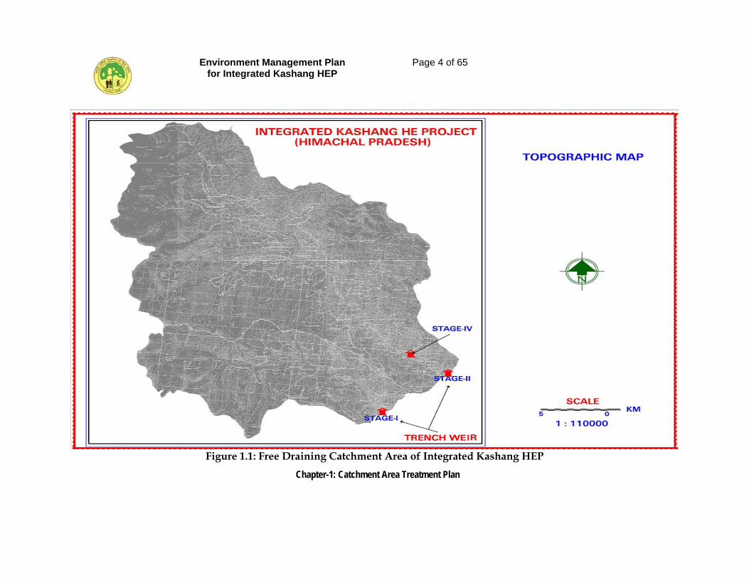
Watershed is the basic unit of a catchment. Watershed is a natural hydrological and geographic unit of specific spatial extent characterized by surface run-off confined to a defined course at a particular point. The boundary of the watershed is delineated by the line of water divide in a basin with reference to specific point drainage. The pre-requisite for a watershed management is the collection of multipronged data e.g., geology, geomorphology, topography, soil, landuse/landcover, climate, hydrology, drainage pattern, etc. The catchment of the Integrated Kashang HEP comprises of two absolute and contiguous sub-watershed Kashang and Kerang Khads which have been further subdivided into two micro watersheds each. The multipronged data generated from various published sources and actual data collected from these watersheds on the above-mentioned parameters forming the basis of the Action Plan for catchment Treatment is presented here. As a part of the EIA study for the proposed “Integrated Kashang HEP”, a Catchment Area Treatment (CAT) plan for the free draining and directly draining catchment area (Figure 1.1) has been prepared for areas with high soil erosion intensity. The CAT Plan targets towards overall improvement in the environmental conditions of the region. All the activities are aimed at treating the degraded and potential areas of severe soil erosion. The plan provides benefits due to biological and engineering measures, and its utility in maintaining the ecosystem health. The plan with objectives addresses issues such as prevention of gully erosion, enhancing the forest cover for increasing soil holding capacity; and reducing total sediment flow in the reservoir and flowing waters.
1.2 OBJECTIVES
Integrated watershed management is aimed at minimizing the rate of sediment flow in the streams being harnessed for hydro power generation. The main aim of the Catchment Area Treatment Plan is to rejuvenate various potential and degraded ecosystems in the catchment area for longevity of the underground balancing reservoir storage capacity. For this purpose the action plan has been prepared with the following objectives:
1. To facilitate the hydrological functioning of the catchment and to augment the quality of water of the river and its tributaries.
2. Conservation of soil cover and to reduce soil erosion, floods and siltation of the river and its tributaries and consequent reduction of siltation in the reservoir of the project.
Environment Management Plan for Integrated Kashang HEP
Page 3 of 65
Chapter-1: Catchment Area Treatment Plan
3. Demarcation of the priority of watersheds for treatment on the basis of soil erosion intensity in the catchment area.
4. Rehabilitation of degraded forest areas through afforestation and facilitating natural regeneration of plants.
5. Mitigation of landslide, landslip and rock falls.
6. Soil conservation through biological and engineering measures to reduce sediment load in river and tributaries incidentally improving the quality of water
7. To meet the livelihood requirement of local people and broaden livelihood options.
8. Employment generation and community participation
9. Ecosystem conservation resulting from increased vegetal cover and water retaining properties of soil.
10. To run rural employment and economic upliftment programmes in the rural areas for poverty alleviation through medicinal plants.
11. Promotion of non-conventional energy device to reduce pressure on forest.
12. Promotion of community based eco-tourism with a little expenditure on maintaining designated path eco-treks and overnight camping facilities.
Environment Management Plan for Integrated Kashang HEP
Page 4 of 65
Chapter-1: Catchment Area Treatment Plan
Figure 1.1: Free Draining Catchment Area of Integrated Kashang HEP
Environment Management Plan for Integrated Kashang HEP
Page 5 of 65
Chapter-1: Catchment Area Treatment Plan
1.3 CATCHMENT AREA
The free draining catchment area of Kashang Khad upto proposed trench weir site of Stage-I at village Dolo Dogri is 124.03 sq km and lies between El 5938 m to 2820 m above msl. Out of 124.03 sq km catchment 30.96 sq km is snow bound. The free draining catchment of Kerang Khad up to the proposed trench weir site of Stage-II at village Lappo is 400.04 sq km and lies between El. 5848 m to 2870 m above msl, out of which 96.95 sq km is snow bound. The sub watershed Kerang also houses Lippa – Asrang Wildlife Sanctuary extending over 30.89 sq km area. As per nomenclature contained in Watershed Atlas of India, Edition 1990, the catchmetn area under study lies in Water Resources Region-1, Basin-A, Catchment IA2, Sub catchment 1A2C watersheds IA2C5 Kashang and Kerang streams, falling totally in district Kinnaur of Himachal Pradesh. Catchment Area Treatment Plan has been formulated for the free draining cathcment. The satellite data subset of IRS LISS-III Gen: 22 November 2007, path-96, Row-48 of the free draining cathcment is presented in Figure 1.2.
1.3.1 Basin Characteristics
The integrated Kashang HEP basically involves augmentation of comparatively higher discharges of Kerang Khad into Kashang Khad for utilizing comparatively steeper slope available in Kashang Khad upto its confluence with River Satluj, thereby utilizing 828.45 m gross head reckoned from intake point of Stage-I up to centerline of machine (El. 1999.20 m). In view of the proposed integration basin characteristics of each of these Khads/Stream is discussed.
1.3.1.1 Basin Characteristic of Kashang Khad
Kashang Khad, a right bank tributary of River Satluj is a typical hill rivulet mostly felt by snow melt and have steep gradient with typical “step-pools bed configuration.” The river emnates from . Piddhang glaciers (El.5914 m) on north and Pingting glacies (El. 5938 m) on south with Chikim Dhar and Mukim Dhar on the west forming boundary with Bhabha Catchment. The khad runs for 18 km before its confluence with River Satluj as is depicted in the longitudinal section of the Khad shown in Fig 1.3, which clearly marks a steep bed slope of about 1:5 in the reach of the stream below the intake point. The basin is characterized by mountainous terrain with steep hill slopes in the lower reaches and has mountain chain with ice capped summits. Rogle, Pinagting and Skarishul glaciers are some of the glaciers contributing snow melt in the basin.
Environment Management Plan for Integrated Kashang HEP
Page 6 of 65
Chapter-1: Catchment Area Treatment Plan
Figure 1.2: Satellite Imagery of Catchment Area
Environment Management Plan for Integrated Kashang HEP
Page 7 of 65
Chapter-1: Catchment Area Treatment Plan
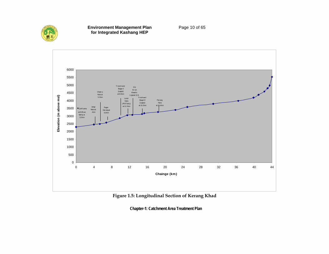
1.3.1.2 Basin Characteristic of Kashang Khad. Kerang Khad is also a right bank tributary of River Satluj and is a typical hill rivulet mostly fed by snow melt and have steep gradient with typical “step-pools bed configuration.” The river emnates near Larsa way Pass at El. 5692 m. above msl. on north. The glaciers on the north and north-west constitute the boundary with famous Pin Valley in District Lahul and Spiti. On the eastern side of the basin lies the Catchment of Ropa gad. The khad which is locally known as Taiti Garang is joined by small rivulets like Suti Garang, Gumjang Garang, Chippang Garang, Homgar Garang Wari Khad in upper reaches and has Porang and Pager Garang tributaries in the lower reaches. Pager Garang joins Kerang Khad near village Lippa about 3 km d/s of intake point of Stage-II. The Khad runs for 44 km before its confluence with River Satluj which is shown in Figure 1.4. The longitudinal section of the Khad, shown in Figure 1.5, manifests that from the intake point of Satge-II to the confluence with River Satluj the bed slope of Kerang Khad is 1:17.2 only. This, coupled with poor geology of proposed power house near its confluence with River Satluj, has necessiated addition of Kearang water into Kashang water conductor system through a low level Kerang-Kashang link tunnel. The terrain as a whole is characterized by long uninterrupted mountain chains with snow capped summits, longitudinal valleys and rolling foothills.
Environment Management Plan for Integrated Kashang HEP
Page 8 of 65
Chapter-1: Catchment Area Treatment Plan
Chairge (km)
Off taking point of FIS jangi Phase - II
at 8 km
Trench weir Stage II
(Dolo Dogri) at 4 km
.Corfhone
at 0.0 km
0
500
1000
1500
2000
2500
3000
3500
4000
4500
0 2 4 6 8 10 12 14 16 18
Elev
atio
(m a
bove
msl
)
Figure 1.3: L-Section of Kashang Khad
Environment Management Plan for Integrated Kashang HEP
Page 9 of 65
Chapter-1: Catchment Area Treatment Plan
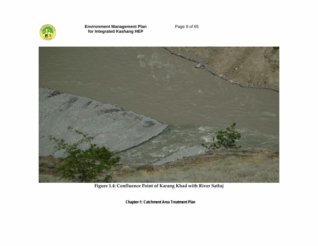
Figure 1.4: Confluence Point of Karang Khad with River Satluj
Environment Management Plan for Integrated Kashang HEP
Page 10 of 65
Chapter-1: Catchment Area Treatment Plan
Jangi Nala at
4 km
Chakr a Nala at5.3 km
Pager Gar ang at
6.8 km
Tr ench wier
Stage-II (Lappo)at 9.8 km
Local Nala
(FIS Toktu) at 11.5 km
FIS Kir an
Khad to Lippoat 12.6
Tr ech wei r Stage IV (Lappo)
at 15.3 km
Par ang Nala
at 18.4 km.Conf luena
wi th River Satluj at0.0 km
0
500
1000
1500
2000
2500
3000
3500
4000
4500
5000
5500
6000
0 4 8 12 16 20 24 28 32 36 40 44
Chainge (km)
Elev
atio
n (m
abo
ve m
sl)
Figure 1.5: Longitudinal Section of Kerang Khad
Environment Management Plan for Integrated Kashang HEP
Page 11 of 65
Chapter-1: Catchment Area Treatment Plan
1.3.2 Free Draining Catchment
The basin of Kashang Khad upto the proposed intake point at Dolo Dogri at longitude 78º17’30” and latitude 31º37’30” constitutes the sub watershed Kashang with a free draining catchment of 124.03 sq km. The basin of Kerang Khad upto the proposed intake point (Stage-II) at longitude 78º21’30.4” and latitude 31º39’21.3” constitutes the sub watershed Kerang with a free draining catchment of 400.04 sq km. And a directly draining catchment of 53 sq km as the intake point of Stage-IV, at Toktu is upstream of it. In view of the overlapping catchment of Stage-II & Stage-IV and considering the fact that the Stage-IV is also part and parcel of the integrated project one complete sub-watershed upto intake point of Stage-II has been conceptualized for the purpose of making CAT plan for Kerang sub watershed. The two sub-watersheds Kashang and Kerang have been further sub divided into two micro-watershed the aerial extents of which is apportioned in Table 1.1.
Table 1.1: Hydrological Units.
S.No Name of Sub Watershed
Name of Micro
watershed
Micro-watershed
code
Area (Sq.km)
1 Kashang Rogle Dolo Dogri
1A2C5 (1) 1A2C5 (2)
86.85 37.18
Total Sub-Watershed Kashang 124.03 2 Kerang Larsa
Lappo 1A2C5 (3) 1A2C5 (4)
295.55 104.49
Total Sub Watershed Kerans 400.04 Grand Total 524.07
1.3.2.1 Micro Watershed Rogle [(1A2C5 (1)] The micro-watershed which constitutes 70.02% of the total free draining catchment of Kashang Khad at intake site has a geographical area of 86.85 sq km out of which 30.92 sq km has been imaged as snow bound as per satellite image dated 22.11. 2007. Open forest and scrub or scattered vegetation constitutes about 16.47% of the total geographical area of the micro-watershed. Piddhang glacier, El 5914 m a msl; Pingting glacier, El 5938 m a msl and Skarishul glaciers mark their presence in this micro-watershed.
1.3.2.2 Micro-watershed Dolo Dogri [1A2C5 (2)]
The micro-watershed, which constitutes 29.98% of the free draining catchment of Kashang Khad at intake point, has a geographical area of 37.18 sq km. out of which 0.04 sq km has been imaged as snow bound as per satellite image dated 22.11.2007. The predominant land use is open forest (19.84 sq km) followed by dense vegetation (14.81 sq km). Kashang Khad is met with some of first and second order streams from both banks.
Environment Management Plan for Integrated Kashang HEP
Page 12 of 65
Chapter-1: Catchment Area Treatment Plan
1.3.2.3 Micro-watershed Larsa [(1A2C5 (3)]
The micro-watershed, which constitutes 73.88% of the total free draining catchment of Kerang Khad at intake site of Stage-II at Lappo, has a geographical area of 295.55 sq km. Out of this 95.78 sq km has been imaged as snow bound as per satellite image dated 22.11.2007. Dense vegetation, open forest and scrubs jointly constitute about 35.86% of the total geographical area of the micro watershed. The micro-watershed also houses part of Lippa-Asrang wildlife sanctuary. Kerang, Khad which is locally named as Taiti Garang meets some rivulets like Suti Garang, Gumjang Garang, chippand and Homgar Garang emanating from surrounding glaciers.
1.3.2.4 Micro-watershed Lappo [(1A2C(4)]
The micro-watershed, which constitutes 26.12% of the total free draining catchment of Kerang Khad at intake site of Stage-II, at Lappo, has a geographical area of 104.49 sq km out of which 1.17 sq km has been imaged as snow bound as per settalite image dated 22.11. 2007. The predominant land use is dense forest (54.96 sq km) followed by open forest (28.45 sq km). Kerang Khad is met with Porang Khad upstream of intake point of stage-IV. Another local Nala, from which Toktu Flow Irrigation Scheme off-takes, also meets it d/s of Asrang village.
1.4 TOPOGRAPHY
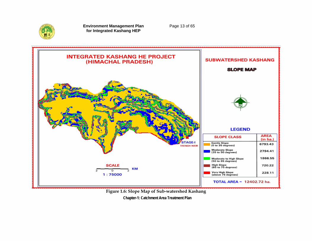
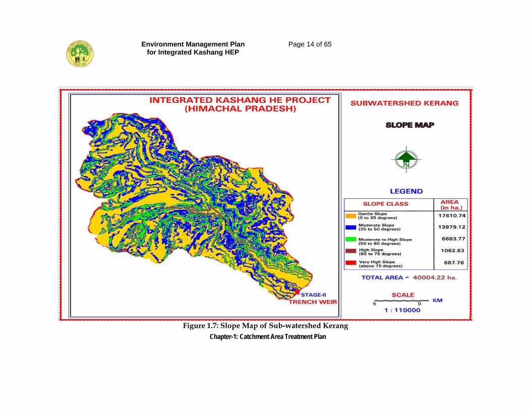
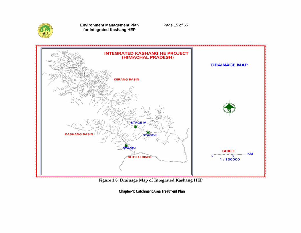
The Integrated Kashang HEP lies in the border district Kinnaur of Himachal Pradesh and physiographically the area is covered under sub division of Western Himachal in series of long uninterrupted mountain chains with snow capped summits, longitudinal valley and rolling foothills. A number of brooks, streams originate from the glaciers. The topography of the catchment area is of steep to extremely steep hills. On the western side of Kashang and Kerang Khads are less steep hills. The eastern sides have steep hills, rocky area with sparsely dense vegetation. In the lower reaches of both the Khads, there are steep hills on both sides. At some locations open mixed type forest/grassland pastures are seem. The higher reaches of the sub watershed have alpine vegetation and barren areas. There is glacial flow in the upper reaches of both the streams. The elevation of free drainage catchment ranges from 2830 m to 5938 m above msl and from 2870 m to 5849m above msl in sub watershed Kashang and Kerang respectively. The slope maps of both sub watershed are presented in Figure 1.6 and Figure 1.7 and the drainage map is shown in Figure 1.8.
Environment Management Plan for Integrated Kashang HEP
Page 13 of 65
Chapter-1: Catchment Area Treatment Plan
Figure 1.6: Slope Map of Sub-watershed Kashang
Environment Management Plan for Integrated Kashang HEP
Page 14 of 65
Chapter-1: Catchment Area Treatment Plan
Figure 1.7: Slope Map of Sub-watershed Kerang
Environment Management Plan for Integrated Kashang HEP
Page 15 of 65
Chapter-1: Catchment Area Treatment Plan
Figure 1.8: Drainage Map of Integrated Kashang HEP
Environment Management Plan for Integrated Kashang HEP
Page 16 of 65
Chapter-1: Catchment Area Treatment Plan
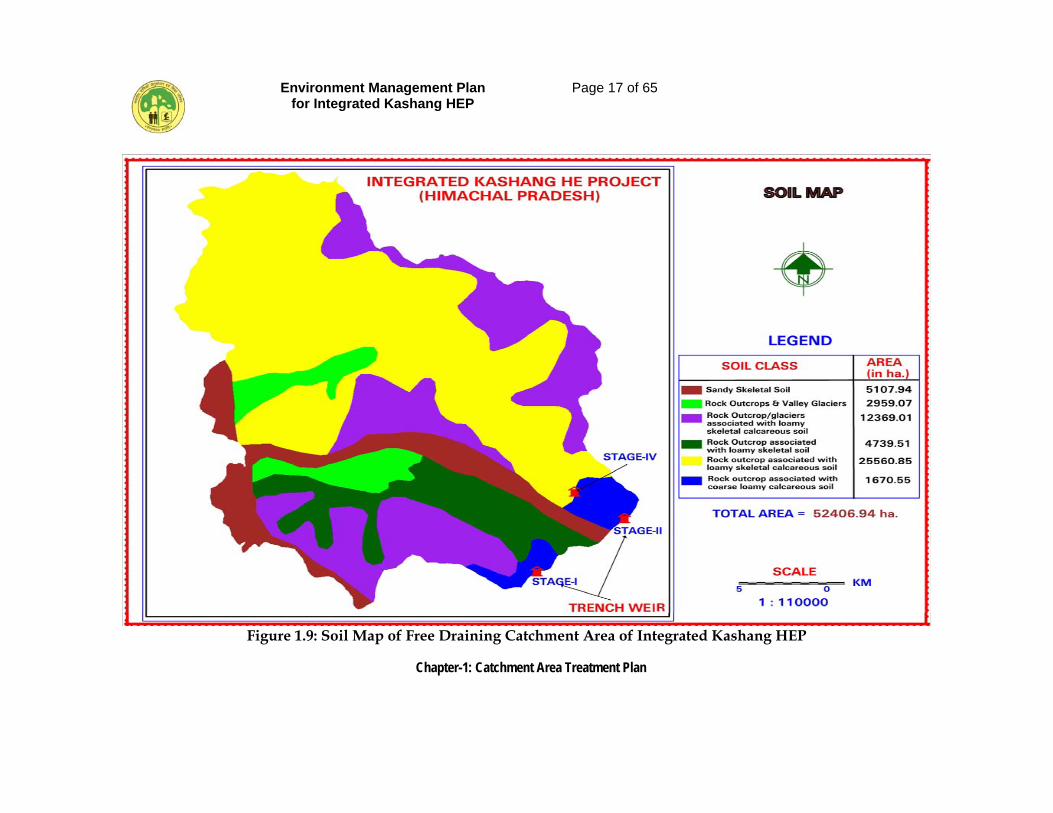
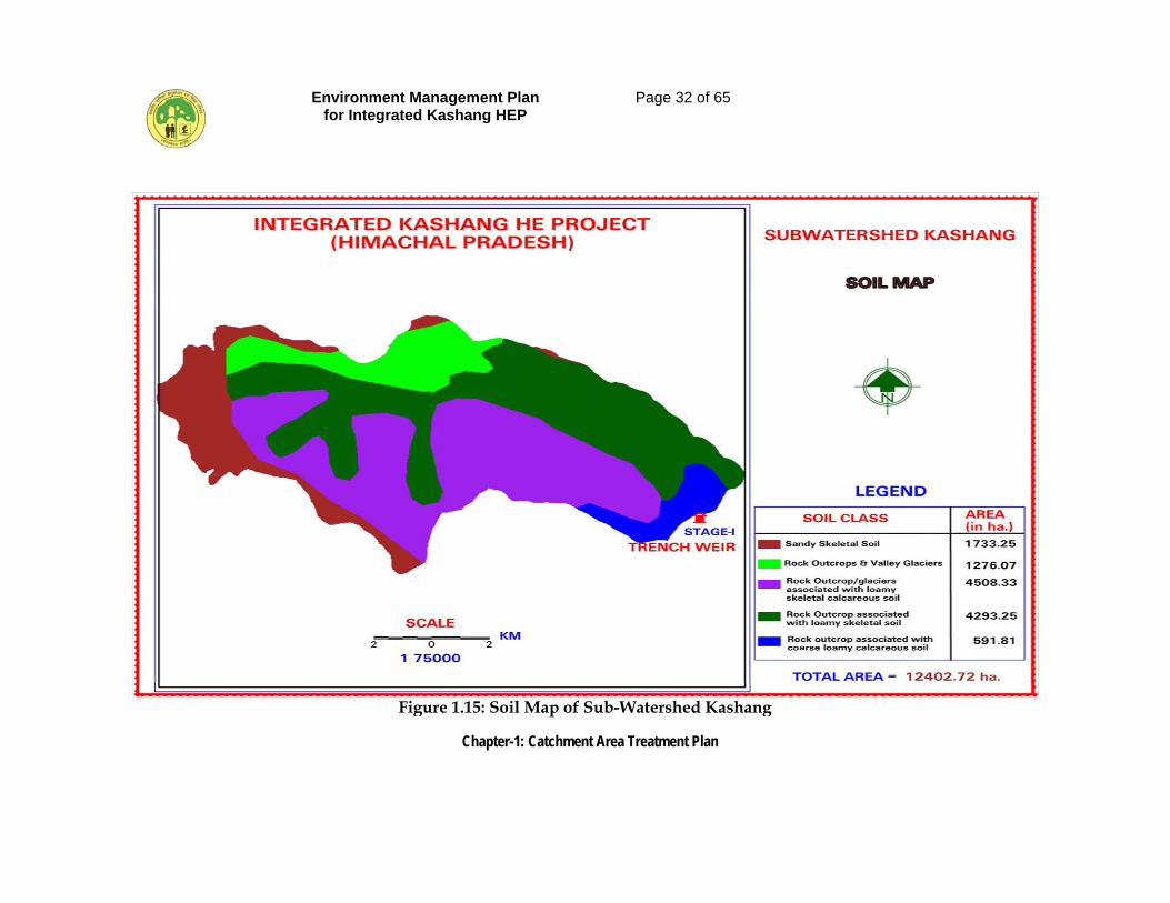
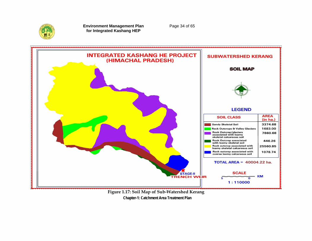
1.5 SOIL
The soil in the area belongs to Soil of Greater Himalayas. The soil of summit and ridge tops and glacier valleys are shallow, excessively drained, sandy-skeltial soil with severe erosion. Taxonomically such soils belong to sub order-Otrthents; Great group-cryorthents and sub group-Lithic cryorthents.
The soils of side/reposed slope belong to sub group Typic Cryorthents and are medium deep (50-100 cm) excessively drained, loamy skeltial, calcareous soil on very steep group with loamy surface, severe erosion. At some places the soil belongs to sub group Lithic cryorthents and are shallow, coarse loamy calcareous soil on steep slope with loamy surface associated with severe erosion and strong stoniness. The fluvial valley which extends to some distance in Kerang Khad, shows loamy skeltial soil belonging to Typic Eutrochrepts sub group. The soils are medium deep (50-100 cm), mesic, loamy skeltical on very gentle slopes and have moderate erosion. The soil map of catchment is presented in Figure 1.9.
1.6 METHODOLOGY USED FOR THE STUDY
The Digital Satellite data of IRS P6 LISS-III (2006) acquired from NRSA was evaluated on ERDAS Imagine Software. The standard False Colour Composite (FCC) has been generated by assigning blue, green and red colors to visible green, visible red and near infrared bands respectively. Expressing image pixel addresses in terms of a map coordinate base is often referred to as geo-coding. As various thematic layers were to be overlaid for this project, all the layers were geo-referenced to real world coordinates. The 1:50,000 scale topo-sheets of the directly draining catchment area were used for the purpose of geo-referencing. A large number of Geodetic Control Points (GCPs) were selected for reasonably accurate geo- referencing/geo-coding. A map projection system (real world) was also defined.
Histogram of the scene under study has been generated to check the range of spectral values present in the scene. In order to use total grey level range and to optimize the contrast, the actual grey level ranges of three bands were linearly stretched independently. The zoomed images were studied wherever necessary. The interpretation key necessary for identifying different features has been developed systematically on the basis of image characteristics and associated elements viz. shape, size, shadow, pattern, color/tone, texture, association, location and available ground truth. Among these characteristics shape, size, shadow and pattern are basically dependent on the scale of the image whereas the color/tone and texture depends upon the brightness, contrast and resolution of the image. Various land units were identified, delineated and the map was validated.
Environment Management Plan for Integrated Kashang HEP
Page 17 of 65
Chapter-1: Catchment Area Treatment Plan
Figure 1.9: Soil Map of Free Draining Catchment Area of Integrated Kashang HEP
Environment Management Plan for Integrated Kashang HEP
Page 18 of 65
Chapter-1: Catchment Area Treatment Plan
Detailed field survey was conducted for study of soil characteristics, and erosion prone areas and landslides in the catchment area. The vulnerable and problematic areas were identified in different physiographic zones in the entire catchment area. The data was generated on physiography, land-use/land-cover, lithology, geomorphological structure, drainage pattern, slope characteristics, landslides/slips, etc. These data sets were used for preparation of the thematic maps, calculation of sediment yield index and Erosion Intensity Units in the catchment area according to the following procedures:
1.6.1 Landuse – Landcover Classification
• Prior to ground truthing, the satellite data was classified using unsupervised classification technique. Further after collecting ground truth details maximum likelihood classification based supervised classification method was used with remote sensing image data.
• After the supervised classification procedure, a land-use map was
prepared which the team at field verified, and any errors or omissions were identified.
• A reclassification of the land-use categories implementing the details and
corrections was done. The reclassification output was used for the preparation of the final land-use classification map. This map after due verification was then composed and printed for different layers and purposes.
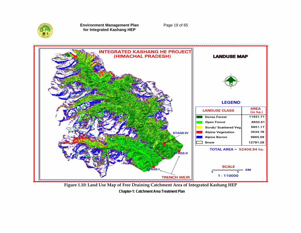
• The Landuse map of Study and Free draining Catchment area is presented
in Figure 1.10. The Land-use Land-cover details for free-draining catchment and its sub watershed is presented in Table 1.2.
Environment Management Plan for Integrated Kashang HEP
Page 19 of 65
Chapter-1: Catchment Area Treatment Plan
Figure 1.10: Land Use Map of Free Draining Catchment Area of Integrated Kashang HEP
Environment Management Plan for Integrated Kashang HEP
Page 20 of 65
Chapter-1: Catchment Area Treatment Plan
Table 1.2: Land-use Land-cover Details
S. N
o.
Sub
Wat
ersh
ed /
Mic
ro W
ater
shed
Land
U
se/
Land
C
lass
, sq
km
Tota
l Are
a, s
q. k
m.
% o
f sub
-wat
ersh
ed
Den
se
Fore
st
Ope
n Fo
rest
Scru
bs /
scat
tere
d ve
geta
tion/
ag
ricu
lture
Alp
ine
vege
tatio
n
Alp
ine
Barr
en
Snow
/Gla
cie
r
Kashang
1. 1A2C5(1) 6.98 7.33 7.06 10.19 24.37 30.42 86.85 70.02
2. 1A2C5(2) 14.81 19.84 1.73 0.40 0.36 0.04 37.18 29.98 Total Sub-watershed
(Kashang) 21.79 27.17 8.79 10.59 24.73 30.96 124.03 100.00
Kerang
1. 1A2C5(3) 42.58 32.71 30.72 23.76 70.00 95.78 295.55 73.88
2 1A2C5(4) 54.96 28.45 17.00 0.99 1.92 1.17 104.49 26.12 Total Sub-watershed
(Kerang) 97.54 61.16 47.72 24.75 71.92 96.95 400.04 100.00
Grand Total 119.33 88.86 56.51 35.25 96.65 127.91 524.07
1.6.2 Slope Map Preparation
• Slope is a measure of change in the value of altitudes over distance, which can be expressed in degrees or as a percent. The first step in generation of slope map is to create surface using the elevation values stored in the form of contours or points. Surface is a representation of geographic information as a set of continuous data in which the map features are not spatially discrete, i.e., between any two locations, there are no clear or well defined breaks between possible values of the map feature. Models, built from regularly or irregularly spaced sample points on the surface can represent surfaces.
• Slope map of the catchment area was prepared using the elevation
information for the area from contour heights. Toposheets of the scale 1:50,000 were collected for the entire directly draining catchment area. These toposheets were then manually pasted together to form a seamless mosaic of the area and the directly drained catchment boundary for the proposed “Integrated Kashang Hydroelectric Project” was marked on them.
Environment Management Plan for Integrated Kashang HEP
Page 21 of 65
Chapter-1: Catchment Area Treatment Plan
• After marking the catchment area, all the contours on the toposheet were
digitized. The output of the digitization procedure was the contours as well as points contours in form of x, y and z points (x, y location and z their elevation). All this information was in real world coordinates (latitude, longitude and elevation in meters above sea level).
• A Digital Terrain Model (DTM) of the area was then prepared, which was used to derive a slope map. The slope was divided in classes of slope percentages.
• The slope of a watershed plays an important role in controlling the soil and water retention thereby affecting the land-use capability. The percentage of the slope in a watershed determines the soil erosion susceptibility and forms the basis for classifying different segments of the watershed into suitable capability classes for formulating suitable soil erosion conservation measures. Broadly the following slope classes and ranges as per norms of All India Soil and Land Use Survey (AISLUS) were adopted for the present study. The slope types are presented in Table 1.3.
Table 1.3: Slope Types
Slope Rank Slope Range (%) Description 1. 0-35 Very gentle slope 2. 35-45 Gentle slope 3. 45.55 Moderate slope 4. 55-80 Steep slope 5. Above 80 Very steep slope
The slope map of the free draining catchment is presented in Figure 1.11. The slope details are as presented under Table 1.4.
Table 1.4: Slope
S. No.
Sub Watershed
/ Micro Watershed
Code
Slope 0-35% 35-45% 45-55% 55-80% >80% Total
(Area in Sq km)
Area % Area % Area % Area % Area % Kashang
1. 1A2C5(1) 53.26 61.32 14.57 16.78 11.48 13.22 5.39 6.21 2.15 2.47 86.85 2. 1A2C5(2) 14.67 39.46 13.37 35.96 7.18 19.31 1.82 4.90 0.14 0.37 37.18
Total Sub-watershed (Kashang)
67.93 54.77 27.94 22.53 18.66 15.05 7.21 2.81 2.29 1.84 124.03
Kerang 1. 1A2C5(3) 139.97 47.36 102.31 34.62 42.39 14.34 5.02 1.70 5.86 1.98 295.55 2 1A2C5(4) 36.15 34.60 37.48 35.87 24.25 23.21 5.60 5.36 1.01 0.96 104.49
Total Sub-watershed (Kerang)
176.12 44.03 139.79 34.94 66.64 16.66 10.62 2.65 6.87 1.72 400.04
Grand Total 244.05 46.57 167.73 32.00 85.30 16.28 17.83 3.40 9.16 1.75 524.07
Environment Management Plan for Integrated Kashang HEP
Page 22 of 65
Chapter-1: Catchment Area Treatment Plan
Figure 1.11: Slope Map of Free Draining Catchment Area of Integrated Kashang HEP
Environment Management Plan for Integrated Kashang HEP
Page 23 of 65
Chapter-1: Catchment Area Treatment Plan
1.6.3 Soil Loss Using Silt Yield Index (SYI) Method
• The Silt Yield Index Model (SYI), considering sedimentation as product of erosivity, erodibility and aerial extent was conceptualized by AISLUS as early as 1969 and has been in operational use since then to meet the requirements of prioritization of smaller hydrologic units within river valley project catchment areas.
• Methodology for the calculation of sediment yield index developed by All
India Soil and Land Use Survey (Department of Agriculture, Govt. of India) was followed in this study.
(i) Erosion Intensity and Delivery Ratio
• Determination of erosion intensity unit is primarily based upon the
integrated information on soil characters, physiography, slope, landuse/land-cover, lithology and structure. This is achieved through superimposition of different thematic map overlays. Based upon the field data collected during the field survey and published data, weightage value and delivery ratio were assigned to each erosion intensity unit. The composite map for delineating different erosion intensity units was prepared through superimposition of the maps showing soil types, slope and land-use/landcover.
• This thematic mapping of erosion intensity for entire catchment was done using the overlay and union techniques. Based on ground truth conducted during field work and published data, weightage and delivery ratio was assigned to each erosion intensity unit. The composite erosion intensity map was then superimposed on the drainage map with subwatershed boundaries to evolve Composite Erosion Intensity Unit (CEIU) for individual sub-watershed.
• Each element of erosion intensity unit is assigned a weightage value. The cumulative weightage values of the erosion intensity units represent approximately the relative comparative erosion intensity within the watersheds. A basic factor of K = 10 was used in determining the cumulative weightage values. The value of 10 indicates an equilibrium condition between erosion and deposition. Any value of K (10+X) is suggestive of erosion intensity in an ascending order whereas the value of K (10-X) is suggestive of deposition intensity in descending order.
• The delivery ratios were calculated for each composite erosion intensity unit. The delivery ratio suggests the percentage of eroded material that finally finds entry into the reservoir or river/stream. Total area of different erosion intensity classes (composite erosion intensity unit) in each watershed was then calculated.
Environment Management Plan for Integrated Kashang HEP
Page 24 of 65
Chapter-1: Catchment Area Treatment Plan
• The delivery ratio is generally governed by the type of material, soil erosion, relief length ratio, cover conditions, distance from the nearest stream, etc. However, in the present study the delivery ratios to the erosion intensity units were assigned upon their distance from the nearest stream (being the most important factor responsible for delivery of the sediments) according to the following scheme. The delivery ratio criteria adopted for the study is presented in Table 1.5.
Table 1.5: Delivery Ratio (DR) Criteria Adopted for the Project Nearest Stream Delivery Ratio (DR)
Sl. No.
Nearest Stream Distance (Km.) Delivery Ratio
1. 0 - 0.9 1.00 2. 1.0 - 2.0 0.90 3. 2.1 - 5.0 0.80 4. 5.1 - 15.0 0.70 5. 15.1 - 30.0 0.50
(ii) Sediment Yield Index (SYI) and Prioritization of Sub-Watersheds
• The erosivity determinants are the climatic factors and soil and land attributes that have direct or reciprocal bearing on the unit of the detached soil material. The relationship can be expressed as:
• The SYI is defined as the Yield per unit area and SYI value for hydrologic unit is obtained by taking the weightage arithmetic mean over the entire area of the hydrologic unit by using suitable empirical equation.
• Prioritization of Watersheds/ Sub-watersheds within the vast catchments is based on the Silt Yield Indices (SYI) of the smaller units. The boundary values or range of SYI values for different priority categories are arrived at by studying the frequency distribution of SYI values and locating the suitable breaking points. The watersheds/sub watersheds are subsequently rated into various categories corresponding to their respective SYI values.
• The application of SYI model for prioritization of sub-watersheds in the catchment areas involves the evaluation of Climatic factors comprising total precipitation, its frequency and
intensity Geomorphic factors comprising land forms, physiography, slope and
drainage characteristics, Surface cover factors governing the flow hydraulics Management factors.
Environment Management Plan for Integrated Kashang HEP
Page 25 of 65
Chapter-1: Catchment Area Treatment Plan
• The data on climatic factors were obtained for different locations in the
catchment area from the meteorological stations whereas the field investigations were carried for estimating the other attributes.
• The various steps involved in the application of model are
Preparation of a framework of sub-watersheds through systematic delineation
Rapid reconnaissance surveys on 1:50,000 scale leading to the generation of a map indicating erosion-intensity mapping units.
Computing Silt Yield Index for individual watersheds/sub watersheds. Grading of watersheds/ sub-watersheds into very high, high medium,
low and very low priority categories. Assignment of weightage values to various mapping units based on
relative silt-yield potential. • The area of each of the mapping units is computed and silt yield indices of
individual sub-watersheds are calculated using the following equations:
Silt Yield Index SYI = Σ (Ai x Wi x Di) x 100 / Aw, where i = 1 to n Where, Ai = Area of ith unit (EIMU) Wi = Weightage value of ith mapping unit Di = Delivery ratio n = No. of mapping units Aw = Total area of sub-watershed
The SYI values for classification of various categories of erosion intensity rates were taken for the present study as:
Sl. No. Priority Category SYI Range 1. Very High > 1300 2. High 1200-1299 3. Medium 1100-1199 4. Low 1000-1099 5. Very low < 1000
(Refer pp 27-28 of AISLUS Bulletin-9) Accordingly after excluding the area of snow/glaciers from the total geographical area of micro watersheds to the Sediment Yield Index (SYI) was calculated for 4 micro-watersheds and they were categorized into five erosion ranking classes i.e., very High, High, moderate, and low according to priorities. These prioritized watersheds would require treatment according to their priority ranking for soil conservation measures. The details are given in Table 1.6.
Environment Management Plan for Integrated Kashang HEP
Page 26 of 65
Chapter-1: Catchment Area Treatment Plan
Table 1.6: SYI and Priority Rating as per Erosion Intensity
MWS Code
Erosion Intensity
Class Area, ha. Weightage Weightage
x Area DR Grass Silt (EXF) SYI Priority
A B C D E F G H I 1A2C5(1) Negligible 611.13 10.0 6111.30 1.0 6111.30
1050.0 Low
Slight 1742.27 11.0 19164.97 0.9 17248.47 Moderate 721.09 13.0 9374.17 0.9 8436.75 Severe 65.62 18.0 1181.16 0.9 1063.04
Very Severe 14.67 20.0 293.40 0.9 264.06
Total 3154.78 1A2C5(2) Negligible 1386.08 10.0 13860.80 1.0 13860.80
1069.0 Low
Slight 2008.31 11.0 22091.41 1.0 22091.41 Moderate 276.43 13.0 3593.59 0.9 3234.23 Severe 15.74 18.0 283.32 0.8 226.66
Very Severe 0.00 20.0 0.8 0.00
Total 3686.56 20914.90 1A2C5(3) Negligible 2091.49 10.0 66093.61 1.0 20914.90
1135.0 Medium
Slight 6008.51 11.0 42001.70 0.9 59484.25 Moderate 3230.90 13.0 21863.88 0.9 37801.53 Severe 1214.66 18.0 10529.60 0.9 19677.49
Very Severe 526.48 20.0 1.0 10529.60
Total 13072.04 1A2C5(4) Negligible 2430.84 10.0 24308.40 0.9 21877.56
1121.0 Medium
Slight 4339.86 11.0 47738.46 0.9 42964.61 Moderate 2084.02 13.0 27092.26 0.9 24383.03 Severe 744.72 18.0 13404.96 1.0 13404.96
Very Severe 564.07 20.0 11281.43 1.0 11281.40
Total 10163.51 Note:- Total area under micro watershed does not include the area under permanent snow/glaciers.
Environment Management Plan for Integrated Kashang HEP
Page 27 of 65
Chapter-1: Catchment Area Treatment Plan
1.7 CATCHMENT AREA TREATMENT PLAN
It is known that there are mainly five categories of Land uses for which a proper treatment plan should be developed. First is the Agricultural Land as this activity can never be eliminated. It is also known that agricultural activities, if faulty result in heavy loss of fertile soil. Second being open forest land in particular for obvious conservation reasons. Third is scrub or degraded land, which contributes heavily to the silt load and possibilities exists to bring this area under pastures and other plantation to meet the local demand of fuel, fodder and NTFP and thus decreasing the biotic pressure on the forests and leading to environment friendly approach of sustainable development. The fourth and most important category is Barren land because with practically no vegetal cover, the area produces huge amount of silt load. The fifth is dense forest land where in at few places soil conservation measures are required. For treatment of catchment, the areas that require treatment have been delineated from the Composite Erosion Intensity Unit Map. The sum of weightages was reclassified as per the Table 1.7 below to further subdivide the area as per the erosion intensity classes. The Weightages for Landuse, Slope and Soil were summed to get the Erosion Intensity Classes.
Table 1.7 Erosion Intensity and Weightages
Erosion Intensity Class Sum of Weightages
Very severe (E5) 12 to 14 Severe (E4) 9 to 11 Moderate (E3) 6 to 8 Low (E2) 4 to 5 Negligible (E1) 0 to 3 The vulnerability of catchment in terms of soil erosion intensity is presented in Figure 1.12 and the statistics is presented in Table 1.8.
Table 1.8: Erosion Intensity Categories in Micro Watershed
Sl. No.
Sub-watershed Erosion Intensity Class / Area in ha
MWS Code Negligible Slight Moderate Severe Very
Severe Total
Area, ha Sub Watershed Kashang 1. 1A2C5(1) 611.12 1742.27 721.09 65.62 14.67 3154.77 2. 1A2C5(2) 1386.08 2008.31 276.43 15.74 0.00 3686.56
Total S.W. Kashang
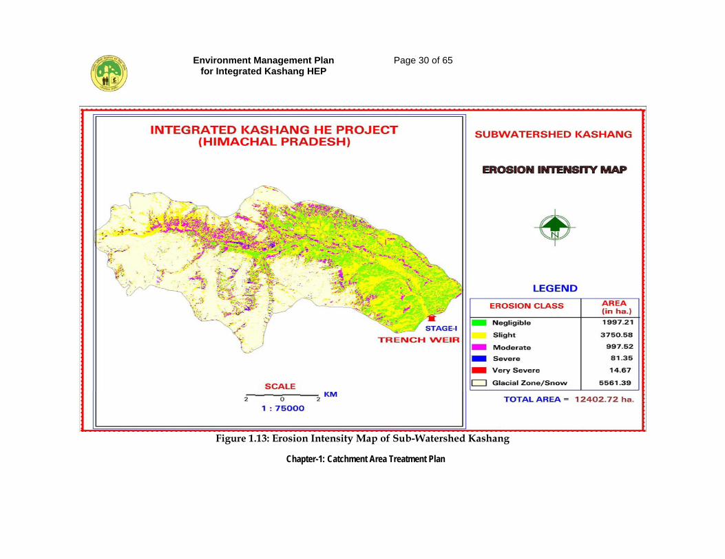
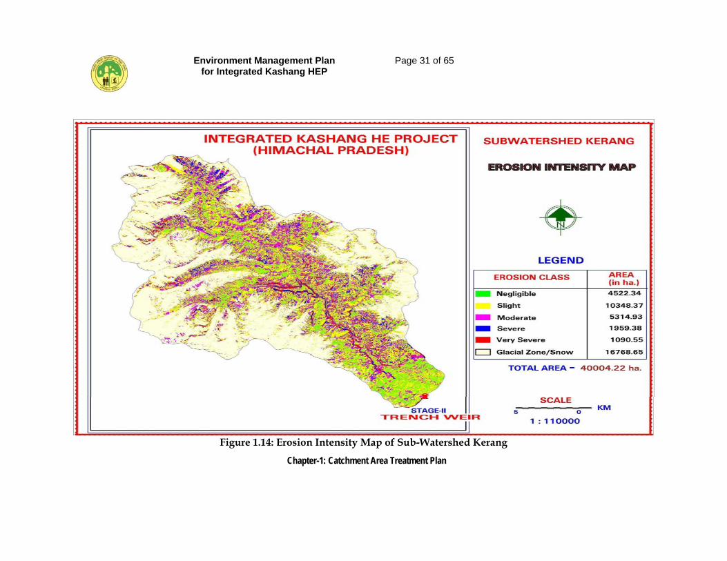
1997.20 3750.58 997.52 81.36 14.67 6841.33
Environment Management Plan for Integrated Kashang HEP
Page 28 of 65
Chapter-1: Catchment Area Treatment Plan
Sub Watershed Kerang 1. 1A2C5(3) 2091.49 6008.51 3230.90 2084.02 526.48 13941.40 2. 1A2C5(4) 2430.84 4339.86 1214.66 744.72 564.07 9294.15
Total S.W. Kerang
4522.33 10348.37 4445.56 2828.74 1090.55 23235.55
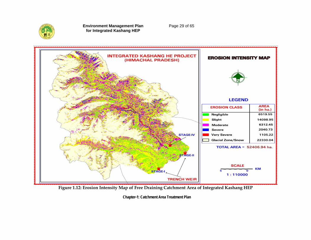
Grand Total 6519.53 14098.95 5443.08 2910.10 1105.22 30076.88
The two micro watershed viz. 1A2C5(1) and 1A2C5(2) falling under the sub watershed Kashang have been categorized as low priority on the basis of SYI and have 81.36 ha and 14.67 ha area under severe and very severe erosion intensity class. The other two micro-watershed viz. 1A2C5(3) and 1A2C5(4) falling under the sub-watershed Kerang have been categorized as medium priority on the bases of SYI and have 2828.74 ha and 1090.55 ha area under severe and very severe erosion intensity class. The erosion intensity map of Kashang and Kerang sub watershed is shown in Figure 1.13 and Figure 1.14. In the light of the fact that MoEF, New Delhi, vide its letter dated 15-11-2002, has already accorded environment clearance for erstwhile Kashang hydroelectric project to be built in sub watershed Kashang and as per their instruction dated 12-12-2007 regarding incorporating of CAT plan of the erstwhile Kashang HEP (now Stage-I) in the new EMP for the integrated project, the provision of earlier approved CAT plan for Stage-I shall be made mutatis mutandis integral part of the present CAT plan involving sub watershed Kerang, too. Areas which are inaccessible i.e. areas with more than 55 degree slope, and area under permanent snow / glaciers and areas above tree line having natural eco-system with little human interference shall be excluded to arrive at those areas where appropriate treatment measures can be undertaken.
1.7.1 Erosion and Landuse
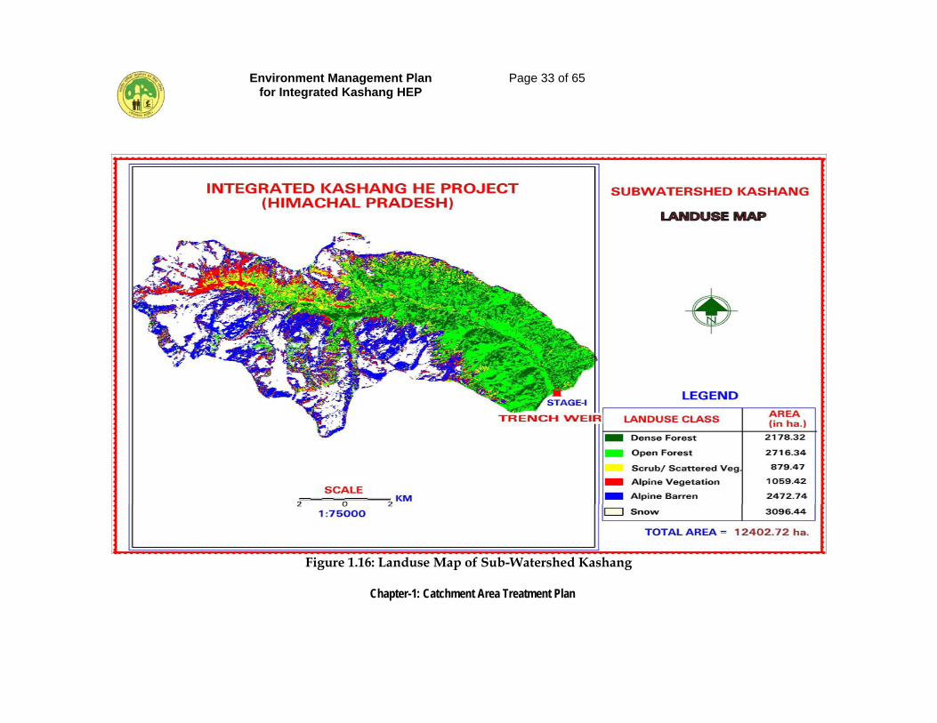
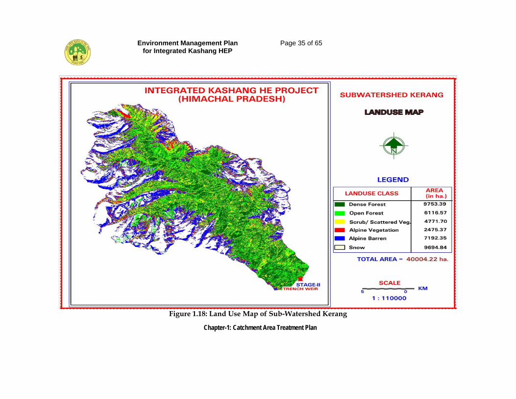
The erosion acts differently in different land-use types. It is important to understand the nature of erosion in a particular land-use class to further plan for treatment. The soil and land use maps of sub watershed Kashang are presented in Figure 1.15 and Figure 1.16. The soil and land use map of sub watershed Kerang are presented in Figure 1.17 and Figure 1.18.
Environment Management Plan for Integrated Kashang HEP
Page 29 of 65
Chapter-1: Catchment Area Treatment Plan
Figure 1.12: Erosion Intensity Map of Free Draining Catchment Area of Integrated Kashang HEP
Environment Management Plan for Integrated Kashang HEP
Page 30 of 65
Chapter-1: Catchment Area Treatment Plan
Figure 1.13: Erosion Intensity Map of Sub-Watershed Kashang
Environment Management Plan for Integrated Kashang HEP
Page 31 of 65
Chapter-1: Catchment Area Treatment Plan
Figure 1.14: Erosion Intensity Map of Sub-Watershed Kerang
Environment Management Plan for Integrated Kashang HEP
Page 32 of 65
Chapter-1: Catchment Area Treatment Plan
Figure 1.15: Soil Map of Sub-Watershed Kashang
Environment Management Plan for Integrated Kashang HEP
Page 33 of 65
Chapter-1: Catchment Area Treatment Plan
Figure 1.16: Landuse Map of Sub-Watershed Kashang
Environment Management Plan for Integrated Kashang HEP
Page 34 of 65
Chapter-1: Catchment Area Treatment Plan
Figure 1.17: Soil Map of Sub-Watershed Kerang
Environment Management Plan for Integrated Kashang HEP
Page 35 of 65
Chapter-1: Catchment Area Treatment Plan
Figure 1.18: Land Use Map of Sub-Watershed Kerang
Environment Management Plan for Integrated Kashang HEP
Page 36 of 65
Chapter-1: Catchment Area Treatment Plan
1.7.1.1 Scrub / Scattered Vegetation / Agricultural Land About 879.47 ha and 4771.7 ha areas respectively pertaining to sub watersheds Kashang and Kerang constituting about 7.1% and 11.9% respectively of their free-draining catchment comes under this category. In the free draining catchment well-planned and developed terraces were seen only in the areas under the apple orchards. Almost 30% of the terraces are properly stabilized by using the stones which itself will manage to reduce the erosion. In general at places the sheet and rill type of soil erosion predominates with few gullies in early stage of its development. Very few measures have been undertaken by the Forest Deptt. in respect of conserving soil of scrub / scattered vegetating area under their control. In agriculture areas tendency exists to interrupt the natural drainage due to faulty agricultural practices. Runoff often exceeds the safe velocity on long slope lengths. It is suggested to improve and alter the design of agricultural terraces, which mostly follow the faulty agricultural practices. It is more required in view of allotment of govt. land to villagers for raising orchards. Agroforestry practices proposed to be introduced, Contour hedgerow technology of agricultural practice need to be followed. Temporary and semi permanent soil conservation structures like brushing dams, wiring woven dams, gabion check dams etc. are suggested.
1.7.1.2 Barren Areas Under the waste land category sub watersheds Kashang and Kerang have 2482.74 ha and 7192.35 ha areas i.e. about 20% and 18% respectively of their free draining catchment. Waste land is characterized by highly degraded land surface and rock outcrops. Very little or no vegetation cover exists. Huge gullies, frequent land slips and high to extreme high erosion rates are other prominent features. Most of these areas are in upper reaches of sub watershed therefore only engineering measures are proposed.
1.7.1.3 Alpine Vegetation
Around 1059.42 ha and 2475.37 ha area respectively in sub watershed Kashang and Kerang constitute under this land-use category in their free draining catchment. These areas (LPG 60-120 days) exist in the upper reaches are characterized by highly degraded land surface. Very little and only seasonal vegetation cover exists. Huge gullies, frequent land slips and high to extreme high erosion rates are other prominent features. Stream bank protection work is suggested for such land-use category undergoing erosion. Pasture plantation and natural rejuvenation can also be done.

Environment Management Plan for Integrated Kashang HEP
Page 37 of 65
Chapter-1: Catchment Area Treatment Plan
1.7.1.4 Light Vegetation / Open Forest Open forest area has a spread of 2716.34 ha and 6116.57 ha area of sub watershed Kashang and Kerang in their free draining catchment. Forest crown density ranges from 0-40% or on average 20% crown density can be assumed to be present in the area. Soils have relatively good water holding capacity, humus and nutrients and have moderate to high erosion rates on steeper slopes. Therefore, rill erosion predominates which in due course leads to scrub lands formation with gullies. Plantation is suggested so as to increase the crown density by 20% in whole of the area.
1.7.1.5 Dense Vegetation Dense vegetation covers about 2178.32 ha and 9753.39 ha areas i.e. 17.6% and 24.4% respectively of sub watershed Kashang and Kerang in their free draining catchment. Forest crown density ranges above 40%. Soils are very good in water holding capacity, humus and nutrients with no erosion but due to steeper slopes small area requires soil conservation measures. Under this model only soil conservation measures have been proposed.
1.7.1.6 Snow Cover Areas
Snow cover / glaciers areas approximately cover 3096.44 ha and 9694.84 ha areas i.e. 25% and 24.2% respectively of sub watershed Kashang and Kerang. Neither any engineering nor any biological measures is possible and therefore, none of these is suggested.
1.7.2 Activities To Be Undertaken 1.7.2.1 Engineering Measure
• Check dams and Retaining Walls Check dams are useful in arresting further erosion of depressions, channels and gullies on the denuded landslides. In addition, retaining walls would be constructed to provide support at the base of threatened slopes. • Slope Modification by stepping or terracing The slope stability increases considerably by grading it. The construction of steps or terraces to reduce the slope gradient is one of the measures. • Bench Terracing The area under moderate to steep slopes would be subjected to bench terracing. The local people would be convinced to follow this type of terracing for comparatively better yield and with minimum threat to erosion. Moreover, in number of habitations in the catchment such practices are already visible. While making bench terraces, care will have to be taken not to disturb the topsoil by spreading earth from the lower terraces to higher terraces. The vertical intervals between terraces will not be more than 1.5 m
Environment Management Plan for Integrated Kashang HEP
Page 38 of 65
Chapter-1: Catchment Area Treatment Plan
and cutting depth may be kept at 50 cm. The minimum average width of the terrace would be kept from 4 to 5 m in order to enable usage of prolong hinge. The shoulder bunds of 30 x 15 cm would also be provided. Staggered channels will drain off the excess water from the terraces.
• Gully Control –Check Dams Gullies are mainly formed on account of physiography, soil type and heavy biotic interference in an area. The scouring of streams at their peak flows and sediment-laden run-off cause gullies. The gullies would be required to be treated with engineering /mechanical as well as vegetative methods. Check dams would be constructed in some of the areas to promote growth of vegetation that will consequently lead to the stabilization of slopes/area and prevention of further deepening of gullies and erosion. Different types of check dams would be required for different condition comprised of different materials depending upon the site conditions and the easy availability of material (stones) at local level and transport accessibility. The types of check dam recommended for treatment are:
• Stream Bank Protection Stream bank erosion is caused by a variety of reasons such as destruction of vegetative cover, mass movement on unstable bank slopes, undermining of top portion of lower bank by turbulent flow and sliding of slopes when saturated with water. The stream bank protection would include wire crates and vegetative spurs.
• Contour Staggered Trenches Contour staggered trenches are mainly provided to trap the silt, reduce runoff and improve percolation. This is also done to prepare a fertile base for plantation.
• Landslides Control Rainfall pattern of the area, water seepage coupled with geological formation results in landslides. Water plays an important role in triggering of landslides and mass wasting processes along with other factors such as slope and nature of soil/land-cover/land-use. However, most of the landslides are caused by human negligence. Road construction, overgrazing of hill slopes, felling of trees for timber, fuel, and fodder and upslope extension of cultivation are some of main causes of landslides. Critical land slide zones would be identified and treated with a mix of biological and engineering measures.
• Catch-water Drains Among the most effective, practical and least expensive measures of landslide hazard management is the construction of catch-water drains for run-off and surface waters in the identified hazard-prone zone so that no or little water is able to infiltrate into the ground. All the streams and minor water courses
Environment Management Plan for Integrated Kashang HEP
Page 39 of 65
Chapter-1: Catchment Area Treatment Plan
would be diverted around the crown of the slide or the potentially hazardous area through catch water drains with a adequate gradient. The catch water drain when provided avoids the runoff to pass over such vulnerable areas and water is guided through these drains provided on foothill or along the katcha/pucca roads. The ground surface of threatened area is leveled out to eliminate all depressions where water can accumulate.
1.7.2.2 Biological Measures • Restoration of Degraded Areas In critically degraded areas, plantation of locally useful diverse and indigenous plant species such as timber plantation species, fodder species, conifers, fuel wood species, grasses, shrubs, legumes, medicinal and aromatic plants would be undertaken. For raising plantation, nurseries would be developed over a total area of 6 ha.
• Afforestation This will include raising of multi-tier mixed vegetation of suitable local species in the steep and sensitive catchment areas of rivers/streams with the objective of keeping such areas under permanent vegetative cover. Furthermore, degraded areas would also be brought under some vegetation cover by way of timber plantation. • Fodder plantation To overcome the problem of scarce availability of the fodder, it is proposed to bring a substantial area under fodder plantation with suitable fast growing species.
• Plantation of horticulture crops Under this treatment plan suitable horticultural crop species like, apple, peach, rose apple and dry fruits like chilgoza, almond and walnuts shall be planted in select areas adjacent to the villages. These plants would be distributed to families residing in villages within the catchment with the objective of supplementing their income.
• Pasture Development As there are degraded patches of pastures in the area, this measure will be adopted to encourage development of new and healthy pasture areas for the use of cattle rearers. Under this treatment suitable species of grasses and tree fodder, and leguminous plant species shall be planted in the land area earmarked for this purpose.
Effective fencing would also be provided for protection of saplings. Before any new area is taken up eradication of weeds and unpalatable grass species is equally important. It is recommended that some parts of the pastures should be closed for seeding purpose only.
Environment Management Plan for Integrated Kashang HEP
Page 40 of 65
Chapter-1: Catchment Area Treatment Plan
• Non-Timber Forest Producelant (NTFP) Cultivation In keeping with Himachal Pradesh forestry sector Medical Plants Policy, 2006 and with a view to conserve and augment the state’s rich medicinal plant resources in its natural habitat through adaptive and participatory management of the local people, cultivation of high priority medicinal plant species shall also be undertaken. Thrust shall be made to organic cultivation of medicinal plants.
1.8 TREATMENT OF INDIVIDUAL SUB-WATERSHEDS IN FREE
DRAINING CATCHMENT (EFFECTIVE) UNDER THE PROJECT
The area and type of treatment to be undertaken is based upon the stream drainage pattern, extent of forest cover, accessibility of the area, land-use, soil profile and slope. The areas with very severe erosion intensity having very steep slopes and which are inaccessible would be left alone for natural rejuvenation. Areas under high erosion intensity category also have been earmarked for treatment owing to local condition and degradation factors. The details of micro watershed-wise treatment measures are described below:
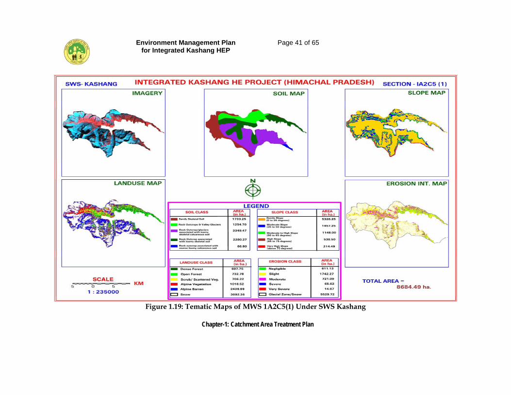
1.8.1 Micro watersheds Rogle [1A2C5 (1)] and Dolo Dagri [1A2C5(2)]
These two micro watersheds comprise the Sub watershed Kashang. The free draining catchment area upto trench weir site at Dolo Dogri is 124.03 sq km. The micro watershed Rogle, the upper catchment of the sub watershed Kashang has an area of 86.85 sq km and is shown in Figure 1.19. The predominant land use in this micro watersheds is snow / glacier (30.92 sq km) followed by Alpine barren (24.375 sq km), Alpine vegetation (10.18 sq km) and open forest (7.33 sq km) etc. the area requiring treatment under very severe and sever erosion intensity is only 14.67 ha and 65.62 ha only.
Environment Management Plan for Integrated Kashang HEP
Page 41 of 65
Chapter-1: Catchment Area Treatment Plan
Figure 1.19: Tematic Maps of MWS 1A2C5(1) Under SWS Kashang
Environment Management Plan for Integrated Kashang HEP
Page 42 of 65
Chapter-1: Catchment Area Treatment Plan
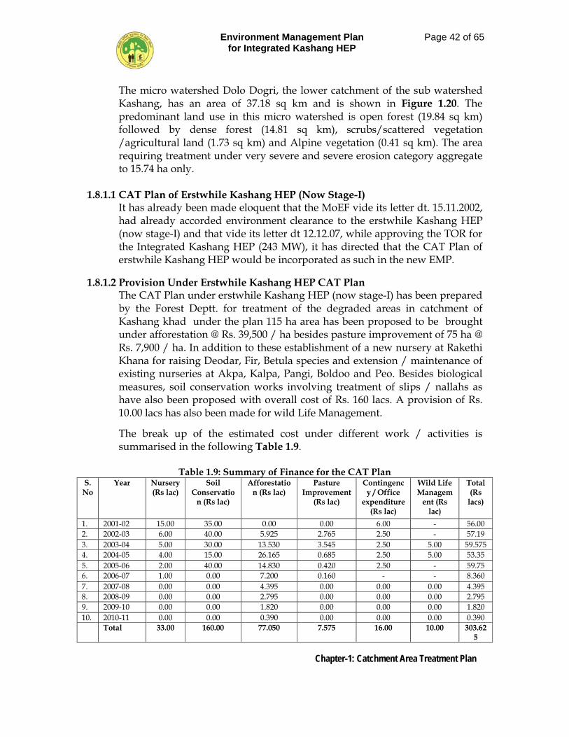
The micro watershed Dolo Dogri, the lower catchment of the sub watershed Kashang, has an area of 37.18 sq km and is shown in Figure 1.20. The predominant land use in this micro watershed is open forest (19.84 sq km) followed by dense forest (14.81 sq km), scrubs/scattered vegetation /agricultural land (1.73 sq km) and Alpine vegetation (0.41 sq km). The area requiring treatment under very severe and severe erosion category aggregate to 15.74 ha only.
1.8.1.1 CAT Plan of Erstwhile Kashang HEP (Now Stage-I)
It has already been made eloquent that the MoEF vide its letter dt. 15.11.2002, had already accorded environment clearance to the erstwhile Kashang HEP (now stage-I) and that vide its letter dt 12.12.07, while approving the TOR for the Integrated Kashang HEP (243 MW), it has directed that the CAT Plan of erstwhile Kashang HEP would be incorporated as such in the new EMP.
1.8.1.2 Provision Under Erstwhile Kashang HEP CAT Plan
The CAT Plan under erstwhile Kashang HEP (now stage-I) has been prepared by the Forest Deptt. for treatment of the degraded areas in catchment of Kashang khad under the plan 115 ha area has been proposed to be brought under afforestation @ Rs. 39,500 / ha besides pasture improvement of 75 ha @ Rs. 7,900 / ha. In addition to these establishment of a new nursery at Rakethi Khana for raising Deodar, Fir, Betula species and extension / maintenance of existing nurseries at Akpa, Kalpa, Pangi, Boldoo and Peo. Besides biological measures, soil conservation works involving treatment of slips / nallahs as have also been proposed with overall cost of Rs. 160 lacs. A provision of Rs. 10.00 lacs has also been made for wild Life Management.
The break up of the estimated cost under different work / activities is summarised in the following Table 1.9.
Table 1.9: Summary of Finance for the CAT Plan
S.No
Year Nursery (Rs lac)
Soil Conservatio
n (Rs lac)
Afforestation (Rs lac)
Pasture Improvement
(Rs lac)
Contingency / Office
expenditure (Rs lac)
Wild Life Managem
ent (Rs lac)
Total (Rs
lacs)
1. 2001-02 15.00 35.00 0.00 0.00 6.00 - 56.00 2. 2002-03 6.00 40.00 5.925 2.765 2.50 - 57.19 3. 2003-04 5.00 30.00 13.530 3.545 2.50 5.00 59.575 4. 2004-05 4.00 15.00 26.165 0.685 2.50 5.00 53.35 5. 2005-06 2.00 40.00 14.830 0.420 2.50 - 59.75 6. 2006-07 1.00 0.00 7.200 0.160 - - 8.360 7. 2007-08 0.00 0.00 4.395 0.00 0.00 0.00 4.395 8. 2008-09 0.00 0.00 2.795 0.00 0.00 0.00 2.795 9. 2009-10 0.00 0.00 1.820 0.00 0.00 0.00 1.820 10. 2010-11 0.00 0.00 0.390 0.00 0.00 0.00 0.390 Total 33.00 160.00 77.050 7.575 16.00 10.00 303.62
5
Environment Management Plan for Integrated Kashang HEP
Page 43 of 65
Chapter-1: Catchment Area Treatment Plan
Figure 1.20: Tematic Maps of MWS 1A2C5(2) Under SWS Kashang
Environment Management Plan for Integrated Kashang HEP
Page 44 of 65
Chapter-1: Catchment Area Treatment Plan
1.8.1.3 Progress achieved under CAT Plan of erstwhile Kashang HEP The project proponent have stated to have deposited, by end of March 2008, a sum of Rs 175 lacs in CAMPA against the estimated CAT Plan cost of Rs 303.625 lacs. The work under the CAT plan is being carried out under the administrative control of Rampur Forest Circle. The progress of work carried out under the CAT Plan during FY. 2005-06 and 2006-07 has been gathered from the office of project officer-cum-D.F.O, Kinnaur Forest Division and is being summarized under various head of activities in Table. 1.10.
Table 1.10: Progress of work under CAT Plan of erstwhile Kashang HEP
S.No Components Year 2005-06 Year 2006-07 Total
Physical Financial (Rs lac)
Physical Financial (Rs lac)
Physical Financial (Rs lac)
A. Nurseries (i) Establishment of
new nursery 1 ha
7.0
- - 1 ha
7.00
(ii) Improvement / Extension of old Nurseries
0.7 ha
1.50
- - 0.7 ha
1.50
(iii) Maintenance of old Nurseries
4 No 4.50 6 6.50 10 No 11.00
B. Soil Conservation works
12 No 11.61 - 14.647 - 26.257
C.
(i) (ii)
Afforestation New Plantation Maintenance
5 ha -
1.975 -
5 ha 5 ha
1.975 0.560
10 ha 5 ha
3.95 0.56
D. Pasture Improvement
- - - 1.709 - 5.734
Total 30.61 25.391 56.001 1.8.1.4 Balance works under CAT Plan of Erstwhile Kashang HEP.
The balance work left to be executed under the approved CAT Plan after deducting the progress achieved under different component of activities and their updated cost as per present norms is given in Table 1.11.

Environment Management Plan for Integrated Kashang HEP
Page 45 of 65
Chapter-1: Catchment Area Treatment Plan
Table 1.11: Update Cost of Balance Work to be incorporated in new CAT Plan
S. No
Component Provision under
approved CAT Plan (Rs
lacs)
Progress achieved (Rs lac)
Cost of balance work
(Rs lacs)
Update cost of balance
work
1. Nurseries 33.00 19.50 13.50 20 2. Soil conservation works 160.00 26.257 133.743 186.688 3. Afforestation (a) New Plantation (115 ha) 115 / 45.425 10 ha /
3.95 41.475 49.35
(b) Maintenance 11 ha / 31.625 5 ha / 0.56
31.065 29.70
4. (a) Pasture Improvement (75 ha)
75 ha / 6.31 - 6.31 30.675
(b) Maintenance 75 ha / 1.265 - 1.265 6.825 5. Wild Life management 10.00 - 10.00 13.33 6. Operational Support 16.00 5.734 10.266 56.569 Total 303.625 56.001 247.624 342.137
1.8.2 Micro watershed Larsa [1A2C5(3)]
The micro watershed Larsa is the upper catchment of sub watershed Kerang Khad which is locally known as Taiti Garang. It has a geographical area of 295.55 sq km and is shown in Figure 1.21. A few small glacial streams viz. Suti Garang, Gumjang Garang, Chippang Garang, Homgar Garang and Wari Khad drain through this micro watershed. The predominant land use in this micro watershed is snow / glacier (95.78 sq km) followed by Alpine barren (70 sq km), dense vegetation (42.58 sq km) open vegetation (32.71 sq km) and Scrub / Scattered vegetation (30.72 sq km). Neither there is any village / settlement nor any agricultural land in this micro watershed. In fact the area under alpine barren and alpine vegetation also remains under snow from month of December to May. The area under very severe and severe erosion intensity is 526.48 ha and 1214.66 ha respectively and is mostly in glacier valleys and along the glacial- fluvial valleys where mild slope of scree and morain material with shallow depth is predominant. The treatment measures suggested for the micro watershed are hard engineering measures to check erosion from banks of the river and check dams on small rivulets. The catchment area lies above 4200 m, therefore no biological measures are proposed; however some of the engineering measures shall be resorted to as elucidated below.
B. Engineering Measures 1. Wire crate check Dams 25 Nos. 2. Wire crate boulder spurs 20 Nos.
Environment Management Plan for Integrated Kashang HEP
Page 46 of 65
Chapter-1: Catchment Area Treatment Plan
1.8.3 Micro watershed Lappo [1A2C5(4)]
The micro watershed is the lower catchment of sub watershed Kerang and has a geographical are of 104.44 sq km and is shown in Figure 1.22. The general altitude in the micro watershed varies from El. 2870 m to 4200 m. Lappo, Asrang and Toktu are the main villages /settlement / hamlets in the micro watershed which has predominant land use of dense forest (54.96 sq km) followed by open forest (28.45 sq km), scrubs / scattered vegetation including area under agricultural and settlement (17 sq km), Alpine barren (1.93 sq km). The slope map shows that approx 35 % and 37 % of the area has slope ranging from 00 -350 and 350 & 450 respectively. The area under very severe erosion intensity is 286.20 ha and 564.07 ha., respectively and mostly lies along the banks of river and side / reposed slopes. The treatment measures for accessible areas suggested for the micro watershed are:
A. BIOLOGICAL MEASURES Area in Hectare 1. Afforestation 150.00 2. Timber Plantation 75.0 3. Fodder Plantation 75.00 4. NTFP Cultivation 20.00 5. Pasture Development 110.00 430.00 B. ENGINEERING MEASURES 1. DRSM check dams 300 Nos. 2. Wire crate check dams 175 Nos. 3. Wire crate boulder spurs 80 Nos. 4. Bench terracing 20 ha 5. Contour staggered trenches. 20 ha 6. Catch water drain 1.0 km
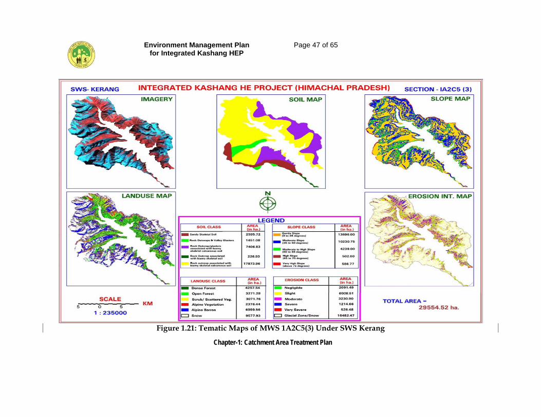
Environment Management Plan for Integrated Kashang HEP
Page 47 of 65
Chapter-1: Catchment Area Treatment Plan
Figure 1.21: Tematic Maps of MWS 1A2C5(3) Under SWS Kerang
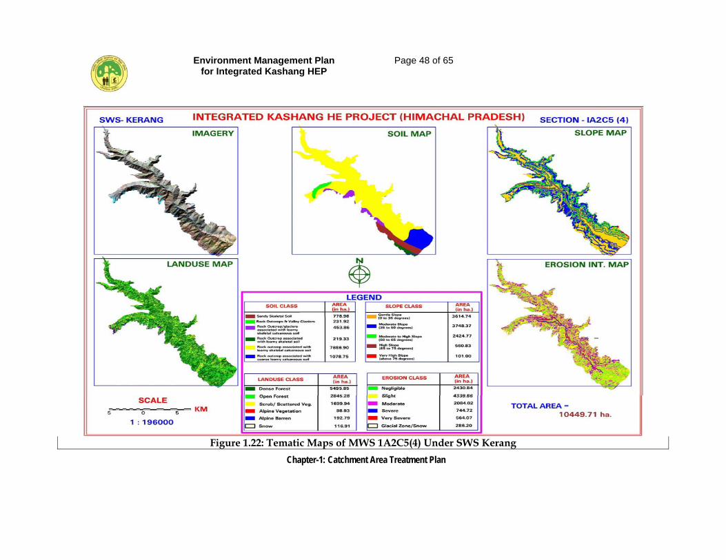
Environment Management Plan for Integrated Kashang HEP
Page 48 of 65
Chapter-1: Catchment Area Treatment Plan
Figure 1.22: Tematic Maps of MWS 1A2C5(4) Under SWS Kerang
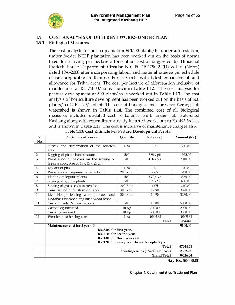
Environment Management Plan for Integrated Kashang HEP
Page 49 of 65
Chapter-1: Catchment Area Treatment Plan
1.9 COST ANALYSIS OF DIFFERENT WORKS UNDER PLAN 1.9.1 Biological Measures
The cost analysis for per ha plantation @ 1500 plants/ha under afforestation, timber fodder NTFP plantation has been worked out on the basis of norms fixed for arriving per hectare afforestation cost as suggested by Himachal Pradesh Forest Department Circular No. Ft. 15-1790-2 (D)-Vol V (Norm) dated 19-6-2008 after incorporating labour and material rates as per schedule of rate applicable in Rampur Forest Circle with latest enhancement and allowance for Tribal areas. The cost per hectare of afforestation inclusive of maintenance at Rs. 75000/ha as shown in Table 1.12. The cost analysis for pasture development at 500 plant/ha is worked out in Table 1.13. The cost analysis of horticulture development has been worked out on the basis of 500 plants/ha @ Rs. 70/- plant. The cost of biological measures for Kerang sub watershed is shown in Table 1.14. The combined cost of all biological measures includes updated cost of balance work under sub watershed Kashang along with expenditure already incurred works out to Rs. 495.56 lacs and is shown in Table 1.15. The cost is inclusive of maintenance charges also.
Table 1.13: Cost Estimate For Pasture Development Per Ha
S. No.
Particulars of works Quantity Rate (Rs.) Amount (Rs.)
1 Survey and demarcation of the selected area.
1 ha L. S. 300.00
2 Digging of pits in hard stratum 500 3.91/pit 1955.00 3 Preparation of patches for the sowing of
legume appr. Size of 45 x 45 x 25 cm 500 4.02/Na 2010.00
4 Lay out of pits 1 ha 140 140.00 5 Preparation of legume plants in 45 cm3 200 Rmt. 9.65 1930.00 6 Planting of legume plants 500 6.70/No 3350.00 7 Sowing of legume plants 500 1.20/No 600.00 8 Sowing of grass seeds in trenches 200 Rmt. 1.05 210.00 9 Construction of brush wood fence 300 Rmt. 12.90 3870.00 10 Live Hedge fencing with lpomaea and
Dodonaca viscose along bush wood fence 300 Rmt. 10.90 3270.00
11 Cost of plants (Nursery – cost) 500 10.00 5000.00 12 Cost of legume seed 10 Kg 200.00 2000.00 13 Cost of grass seed 10 Kg 380.00 3800.00 14 Wooden post fencing cost 1 ha 10109.61 10109.61 Total 3854461 Maintenance cost for 5 years @
Rs. 3300 for first year, Rs. 2100 for second year, Rs. 1300 for third year and Rs. 1200 for every year thereafter upto 5 yrs
9100.00
Total 47644.61 Contingencies (5% of total cost) 2382.23 Grand Total 50026.84
Say Rs. 50000.00
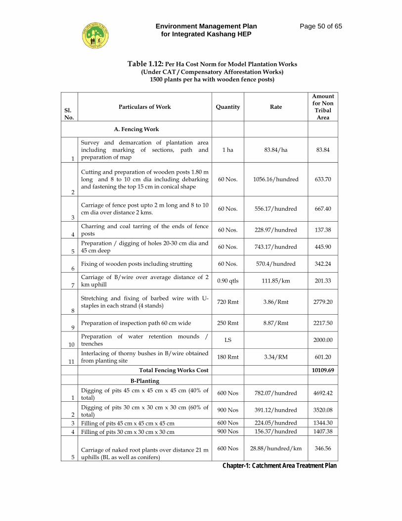
Environment Management Plan for Integrated Kashang HEP
Page 50 of 65
Chapter-1: Catchment Area Treatment Plan
Table 1.12: Per Ha Cost Norm for Model Plantation Works (Under CAT / Compensatory Afforestation Works)
1500 plants per ha with wooden fence posts)
Sl. No.
Particulars of Work Quantity Rate
Amount for Non Tribal Area
A. Fencing Work
1
Survey and demarcation of plantation area including marking of sections, path and preparation of map
1 ha 83.84/ha 83.84
2
Cutting and preparation of wooden posts 1.80 m long and 8 to 10 cm dia including debarking and fastening the top 15 cm in conical shape
60 Nos. 1056.16/hundred 633.70
3
Carriage of fence post upto 2 m long and 8 to 10 cm dia over distance 2 kms. 60 Nos. 556.17/hundred 667.40
4 Charring and coal tarring of the ends of fence posts 60 Nos. 228.97/hundred 137.38
5 Preparation / digging of holes 20-30 cm dia and 45 cm deep 60 Nos. 743.17/hundred 445.90
6 Fixing of wooden posts including strutting 60 Nos. 570.4/hundred 342.24
7 Carriage of B/wire over average distance of 2 km uphill 0.90 qtls 111.85/km 201.33
8
Stretching and fixing of barbed wire with U-staples in each strand (4 stands) 720 Rmt 3.86/Rmt 2779.20
9 Preparation of inspection path 60 cm wide 250 Rmt 8.87/Rmt 2217.50
10 Preparation of water retention mounds / trenches LS 2000.00
11 Interlacing of thorny bushes in B/wire obtained from planting site 180 Rmt 3.34/RM 601.20
Total Fencing Works Cost 10109.69
B-Planting
1 Digging of pits 45 cm x 45 cm x 45 cm (40% of total)
600 Nos 782.07/hundred 4692.42
2 Digging of pits 30 cm x 30 cm x 30 cm (60% of total)
900 Nos 391.12/hundred 3520.08
3 Filling of pits 45 cm x 45 cm x 45 cm 600 Nos 224.05/hundred 1344.30 4 Filling of pits 30 cm x 30 cm x 30 cm 900 Nos 156.37/hundred 1407.38
5 Carriage of naked root plants over distance 21 m uphills (BL as well as conifers)
600 Nos 28.88/hundred/km 346.56
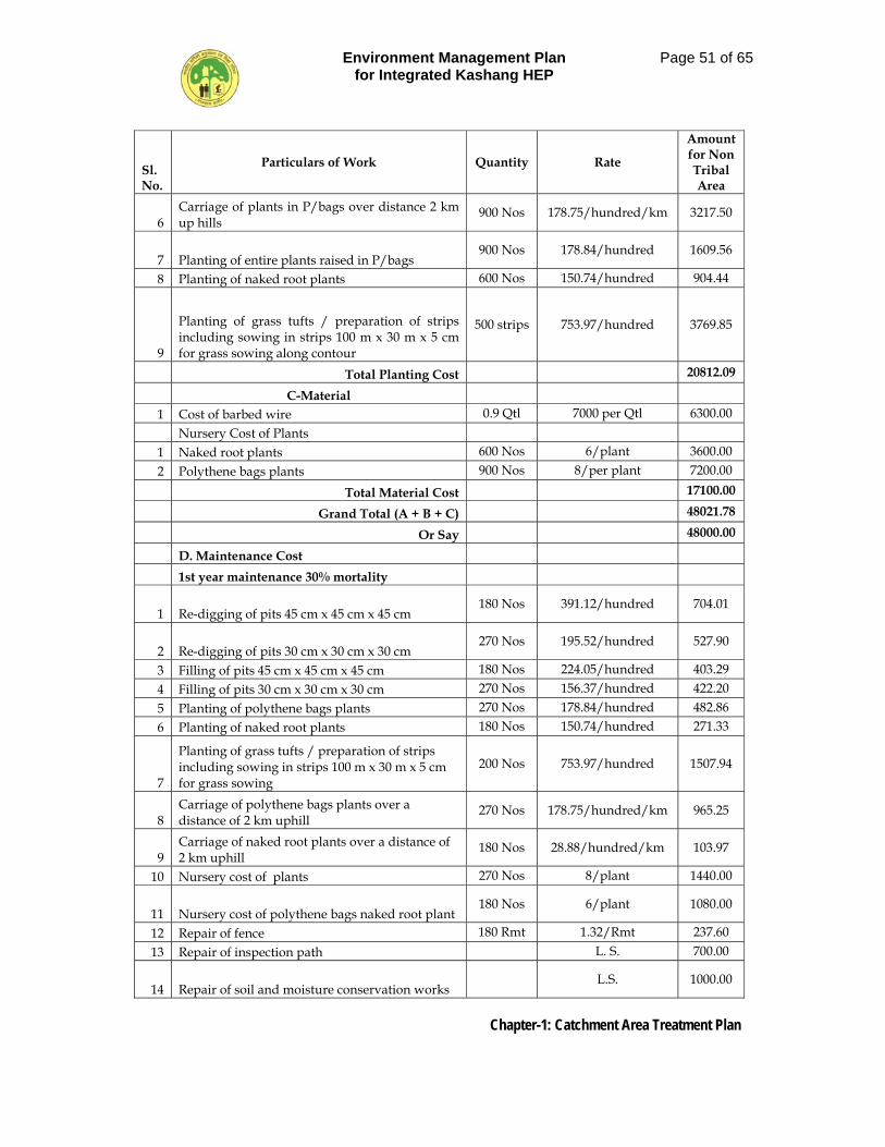
Environment Management Plan for Integrated Kashang HEP
Page 51 of 65
Chapter-1: Catchment Area Treatment Plan
Sl. No.
Particulars of Work Quantity Rate
Amount for Non Tribal Area
6 Carriage of plants in P/bags over distance 2 km up hills
900 Nos 178.75/hundred/km 3217.50
7 Planting of entire plants raised in P/bags 900 Nos 178.84/hundred 1609.56
8 Planting of naked root plants 600 Nos 150.74/hundred 904.44
9
Planting of grass tufts / preparation of strips including sowing in strips 100 m x 30 m x 5 cm for grass sowing along contour
500 strips 753.97/hundred 3769.85
Total Planting Cost 20812.09
C-Material 1 Cost of barbed wire 0.9 Qtl 7000 per Qtl 6300.00
Nursery Cost of Plants 1 Naked root plants 600 Nos 6/plant 3600.00 2 Polythene bags plants 900 Nos 8/per plant 7200.00
Total Material Cost 17100.00
Grand Total (A + B + C) 48021.78
Or Say 48000.00
D. Maintenance Cost
1st year maintenance 30% mortality
1 Re-digging of pits 45 cm x 45 cm x 45 cm 180 Nos 391.12/hundred 704.01
2 Re-digging of pits 30 cm x 30 cm x 30 cm 270 Nos 195.52/hundred 527.90
3 Filling of pits 45 cm x 45 cm x 45 cm 180 Nos 224.05/hundred 403.29 4 Filling of pits 30 cm x 30 cm x 30 cm 270 Nos 156.37/hundred 422.20 5 Planting of polythene bags plants 270 Nos 178.84/hundred 482.86 6 Planting of naked root plants 180 Nos 150.74/hundred 271.33
7
Planting of grass tufts / preparation of strips including sowing in strips 100 m x 30 m x 5 cm for grass sowing
200 Nos 753.97/hundred 1507.94
8 Carriage of polythene bags plants over a distance of 2 km uphill
270 Nos 178.75/hundred/km 965.25
9 Carriage of naked root plants over a distance of 2 km uphill
180 Nos 28.88/hundred/km 103.97
10 Nursery cost of plants 270 Nos 8/plant 1440.00
11 Nursery cost of polythene bags naked root plant 180 Nos 6/plant 1080.00
12 Repair of fence 180 Rmt 1.32/Rmt 237.60 13 Repair of inspection path L. S. 700.00
14 Repair of soil and moisture conservation works L.S. 1000.00
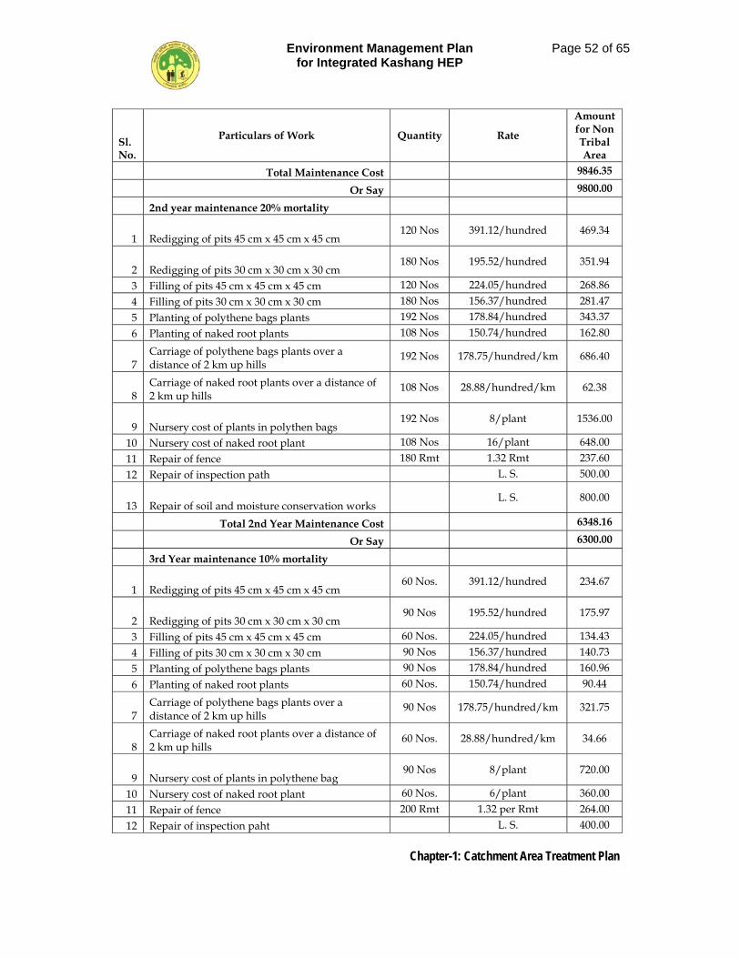
Environment Management Plan for Integrated Kashang HEP
Page 52 of 65
Chapter-1: Catchment Area Treatment Plan
Sl. No.
Particulars of Work Quantity Rate
Amount for Non Tribal Area
Total Maintenance Cost 9846.35
Or Say 9800.00
2nd year maintenance 20% mortality
1 Redigging of pits 45 cm x 45 cm x 45 cm 120 Nos 391.12/hundred 469.34
2 Redigging of pits 30 cm x 30 cm x 30 cm 180 Nos 195.52/hundred 351.94
3 Filling of pits 45 cm x 45 cm x 45 cm 120 Nos 224.05/hundred 268.86 4 Filling of pits 30 cm x 30 cm x 30 cm 180 Nos 156.37/hundred 281.47 5 Planting of polythene bags plants 192 Nos 178.84/hundred 343.37 6 Planting of naked root plants 108 Nos 150.74/hundred 162.80
7 Carriage of polythene bags plants over a distance of 2 km up hills
192 Nos 178.75/hundred/km 686.40
8 Carriage of naked root plants over a distance of 2 km up hills
108 Nos 28.88/hundred/km 62.38
9 Nursery cost of plants in polythen bags 192 Nos 8/plant 1536.00
10 Nursery cost of naked root plant 108 Nos 16/plant 648.00 11 Repair of fence 180 Rmt 1.32 Rmt 237.60 12 Repair of inspection path L. S. 500.00
13 Repair of soil and moisture conservation works L. S. 800.00
Total 2nd Year Maintenance Cost 6348.16
Or Say 6300.00
3rd Year maintenance 10% mortality
1 Redigging of pits 45 cm x 45 cm x 45 cm 60 Nos. 391.12/hundred 234.67
2 Redigging of pits 30 cm x 30 cm x 30 cm 90 Nos 195.52/hundred 175.97
3 Filling of pits 45 cm x 45 cm x 45 cm 60 Nos. 224.05/hundred 134.43 4 Filling of pits 30 cm x 30 cm x 30 cm 90 Nos 156.37/hundred 140.73 5 Planting of polythene bags plants 90 Nos 178.84/hundred 160.96 6 Planting of naked root plants 60 Nos. 150.74/hundred 90.44
7 Carriage of polythene bags plants over a distance of 2 km up hills
90 Nos 178.75/hundred/km 321.75
8 Carriage of naked root plants over a distance of 2 km up hills
60 Nos. 28.88/hundred/km 34.66
9 Nursery cost of plants in polythene bag 90 Nos 8/plant 720.00
10 Nursery cost of naked root plant 60 Nos. 6/plant 360.00 11 Repair of fence 200 Rmt 1.32 per Rmt 264.00 12 Repair of inspection paht L. S. 400.00
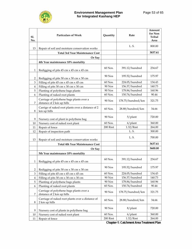
Environment Management Plan for Integrated Kashang HEP
Page 53 of 65
Chapter-1: Catchment Area Treatment Plan
Sl. No.
Particulars of Work Quantity Rate
Amount for Non Tribal Area
13 Repair of soil and moisture conservation works L. S. 800.00
Total 3rd Year Maintenance Cost 3837.61
Or Say
4th Year maintenance 10% mortality
1 Redigging of pits 45 cm x 45 cm x 45 cm 60 Nos. 391.12/hundred 234.67
2 Redigging of pits 30 cm x 30 cm x 30 cm 90 Nos 195.52/hundred 175.97
3 Filling of pits 45 cm x 45 cm x 45 cm 60 Nos. 224.05/hundred 134.43 4 Filling of pits 30 cm x 30 cm x 30 cm 90 Nos 156.37/hundred 140.73 5 Planting of polythene bags plants 90 Nos 178.84/hundred 160.96 6 Planting of naked root plants 60 Nos. 150.74/hundred 90.44
7 Carriage of polythene bags plants over a distance of 2 km up hills
90 Nos 178.75/hundred/km 321.75
8 Carrige of naked root plants over a distance of 2 km up hills
60 Nos. 28.88/hundred/km 34.66
9 Nursery cost of plant in polythene bag 90 Nos 5/plant 720.00
10 Nursery cost of naked root plant 60 Nos. 6/plant 360.00 11 Repair of fence 200 Rmt 1.32/Rmt 264.00 12 Repair of inspection path L. S. 300.00
13 Repair of soil and moisture conservation works L. S. 700.00
Total 4th Year Maintenance Cost 3637.61
Or Say 3600.00
5th Year maintenance 10% mortality
1 Redigging of pits 45 cm x 45 cm x 45 cm 60 Nos. 391.12/hundred 234.67
2 Redigging of pits 30 cm x 30 cm x 30 cm 90 Nos 195.52/hundred 175.97
3 Filling of pits 45 cm x 45 cm x 45 cm 60 Nos. 224.05/hundred 134.43 4 Filling of pits 30 cm x 30 cm x 30 cm 90 Nos 156.37/hundred 140.73 5 Planting of polythene bags plants 90 Nos 178.84/hundred 160.96 6 Planting of naked root plants 60 Nos. 150.74/hundred 90.44
7 Carriage of polythene bags plants over a distance of 2 km up hills
90 Nos 178.75/hundred/km 321.75
8 Carriage of naked root plants over a distance of 2 km up hills
60 Nos. 28.88/hundred/km 34.66
9 Nursery cost of plants in polythene bag 90 Nos 8/plant 720.00
10 Nursery cost of naked root plant 60 Nos. 6/plant 360.00 11 Repair of fence 200 Rmt 1.32/Rmt 264.00
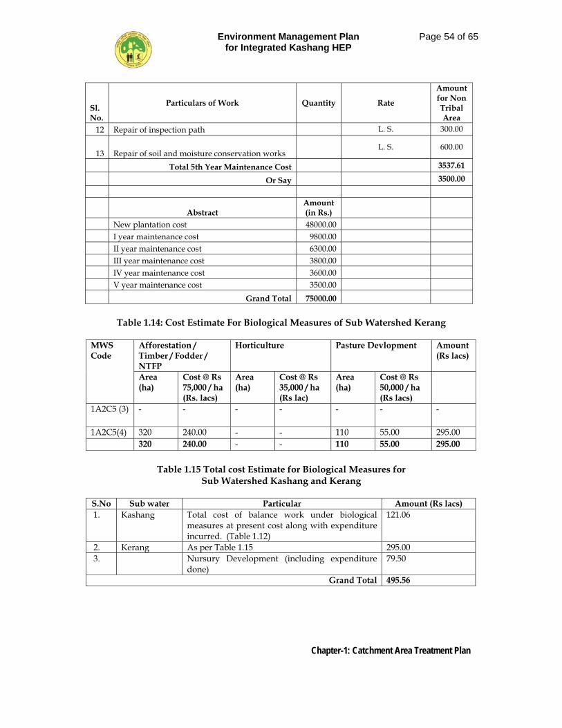
Environment Management Plan for Integrated Kashang HEP
Page 54 of 65
Chapter-1: Catchment Area Treatment Plan
Sl. No.
Particulars of Work Quantity Rate
Amount for Non Tribal Area
12 Repair of inspection path L. S. 300.00
13 Repair of soil and moisture conservation works L. S. 600.00
Total 5th Year Maintenance Cost 3537.61
Or Say 3500.00
Abstract Amount (in Rs.)
New plantation cost 48000.00 I year maintenance cost 9800.00 II year maintenance cost 6300.00 III year maintenance cost 3800.00 IV year maintenance cost 3600.00 V year maintenance cost 3500.00 Grand Total 75000.00
Table 1.14: Cost Estimate For Biological Measures of Sub Watershed Kerang
MWS Code
Afforestation / Timber / Fodder / NTFP
Horticulture Pasture Devlopment Amount (Rs lacs)
Area (ha)
Cost @ Rs 75,000 / ha (Rs. lacs)
Area (ha)
Cost @ Rs 35,000 / ha (Rs lac)
Area (ha)
Cost @ Rs 50,000 / ha (Rs lacs)
1A2C5 (3) - - - - - - -
1A2C5(4) 320 240.00 - - 110 55.00 295.00 320 240.00 - - 110 55.00 295.00
Table 1.15 Total cost Estimate for Biological Measures for
Sub Watershed Kashang and Kerang
S.No Sub water Particular Amount (Rs lacs) 1. Kashang Total cost of balance work under biological
measures at present cost along with expenditure incurred. (Table 1.12)
121.06
2. Kerang As per Table 1.15 295.00 3. Nursury Development (including expenditure
done) 79.50
Grand Total 495.56
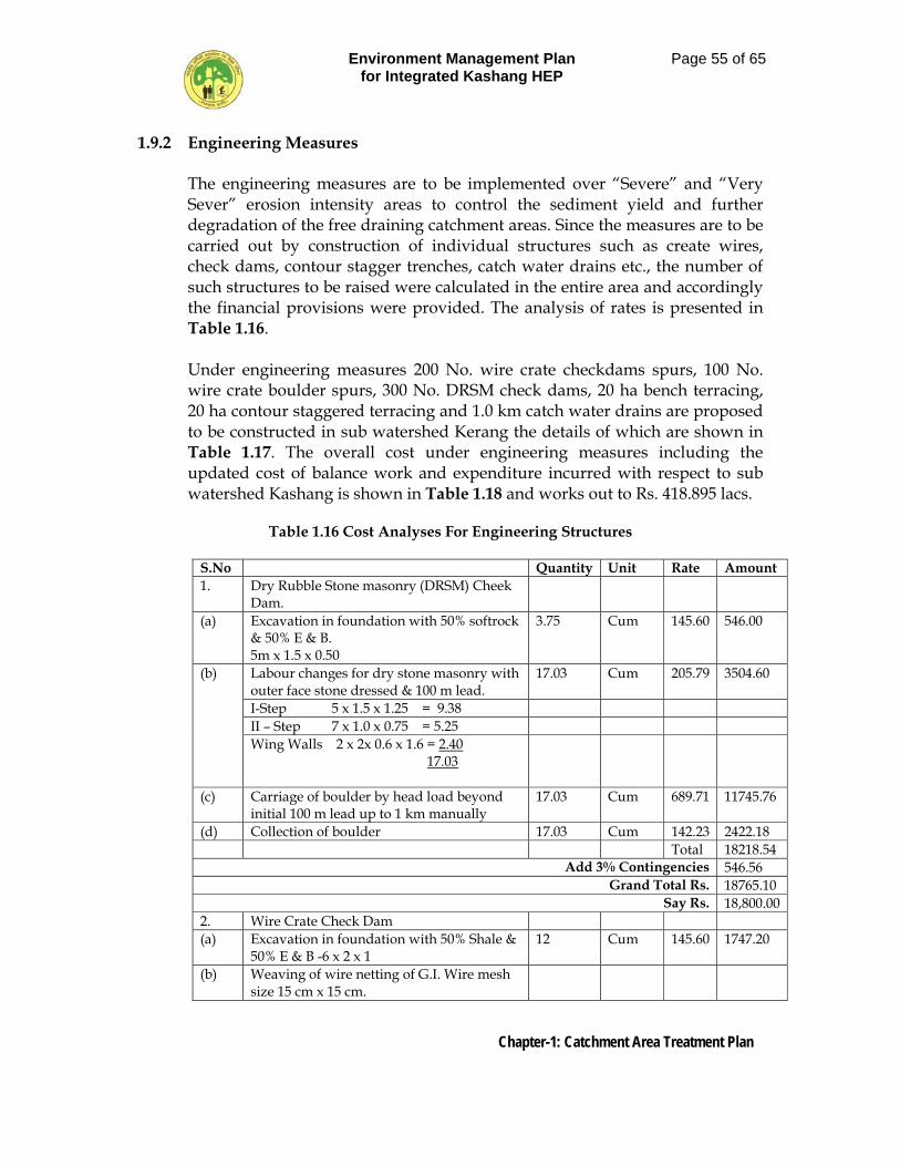
Environment Management Plan for Integrated Kashang HEP
Page 55 of 65
Chapter-1: Catchment Area Treatment Plan
1.9.2 Engineering Measures The engineering measures are to be implemented over “Severe” and “Very Sever” erosion intensity areas to control the sediment yield and further degradation of the free draining catchment areas. Since the measures are to be carried out by construction of individual structures such as create wires, check dams, contour stagger trenches, catch water drains etc., the number of such structures to be raised were calculated in the entire area and accordingly the financial provisions were provided. The analysis of rates is presented in Table 1.16. Under engineering measures 200 No. wire crate checkdams spurs, 100 No. wire crate boulder spurs, 300 No. DRSM check dams, 20 ha bench terracing, 20 ha contour staggered terracing and 1.0 km catch water drains are proposed to be constructed in sub watershed Kerang the details of which are shown in Table 1.17. The overall cost under engineering measures including the updated cost of balance work and expenditure incurred with respect to sub watershed Kashang is shown in Table 1.18 and works out to Rs. 418.895 lacs.
Table 1.16 Cost Analyses For Engineering Structures
S.No Quantity Unit Rate Amount 1. Dry Rubble Stone masonry (DRSM) Cheek
Dam.
(a) Excavation in foundation with 50% softrock & 50% E & B. 5m x 1.5 x 0.50
3.75 Cum 145.60 546.00
(b) Labour changes for dry stone masonry with outer face stone dressed & 100 m lead.
17.03 Cum 205.79 3504.60
I-Step 5 x 1.5 x 1.25 = 9.38 II – Step 7 x 1.0 x 0.75 = 5.25 Wing Walls 2 x 2x 0.6 x 1.6 = 2.40 17.03
(c) Carriage of boulder by head load beyond initial 100 m lead up to 1 km manually
17.03 Cum 689.71 11745.76
(d) Collection of boulder 17.03 Cum 142.23 2422.18 Total 18218.54
Add 3% Contingencies 546.56 Grand Total Rs. 18765.10
Say Rs. 18,800.00 2. Wire Crate Check Dam (a) Excavation in foundation with 50% Shale &
50% E & B -6 x 2 x 1 12 Cum 145.60 1747.20
(b) Weaving of wire netting of G.I. Wire mesh size 15 cm x 15 cm.
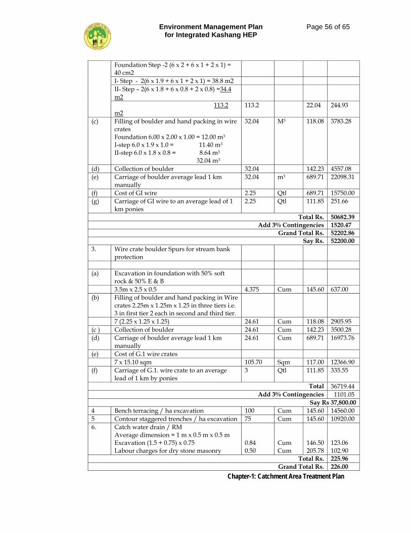
Environment Management Plan for Integrated Kashang HEP
Page 56 of 65
Chapter-1: Catchment Area Treatment Plan
Foundation Step -2 (6 x 2 + 6 x 1 + 2 x 1) = 40 cm2
I- Step - 2(6 x 1.9 + 6 x 1 + 2 x 1) = 38.8 m2 II- Step – 2(6 x 1.8 + 6 x 0.8 + 2 x 0.8) =34.4 m2
113.2 m2
113.2 22.04 244.93
(c) Filling of boulder and hand packing in wire crates Foundation 6.00 x 2.00 x 1.00 = 12.00 m3 I-step 6.0 x 1.9 x 1.0 = 11.40 m3 II-step 6.0 x 1.8 x 0.8 = 8.64 m3 32.04 m3
32.04 M3 118.08 3783.28
(d) Collection of boulder 32.04 142.23 4557.08 (e) Carriage of boulder average lead 1 km
manually 32.04 m3 689.71 22098.31
(f) Cost of GI wire 2.25 Qtl 689.71 15750.00 (g) Carriage of GI wire to an average lead of 1
km ponies 2.25 Qtl 111.85 251.66
Total Rs. 50682.39 Add 3% Contingencies 1520.47
Grand Total Rs. 52202.86 Say Rs. 52200.00
3. Wire crate boulder Spurs for stream bank protection
(a) Excavation in foundation with 50% soft
rock & 50% E & B
3.5m x 2.5 x 0.5 4.375 Cum 145.60 637.00 (b) Filling of boulder and hand packing in Wire
crates 2.25m x 1.25m x 1.25 in three tiers i.e. 3 in first tier 2 each in second and third tier.
7 (2.25 x 1.25 x 1.25) 24.61 Cum 118.08 2905.95 (c ) Collection of boulder 24.61 Cum 142.23 3500.28 (d) Carriage of boulder average lead 1 km
manually 24.61 Cum 689.71 16973.76
(e) Cost of G.1 wire crates 7 x 15.10 sqm 105.70 Sqm 117.00 12366.90 (f) Carriage of G.1. wire crate to an average
lead of 1 km by ponies 3 Qtl 111.85 335.55
Total 36719.44 Add 3% Contingencies 1101.05
Say Rs 37,800.00 4 Bench terracing / ha excavation 100 Cum 145.60 14560.00 5 Contour staggered trenches / ha excavation 75 Cum 145.60 10920.00 6. Catch water drain / RM
Average dimension = 1 m x 0.5 m x 0.5 m Excavation (1.5 + 0.75) x 0.75 Labour charges for dry stone masonry
0.84 0.50
Cum Cum
146.50 205.78
123.06 102.90
Total Rs. 225.96 Grand Total Rs. 226.00
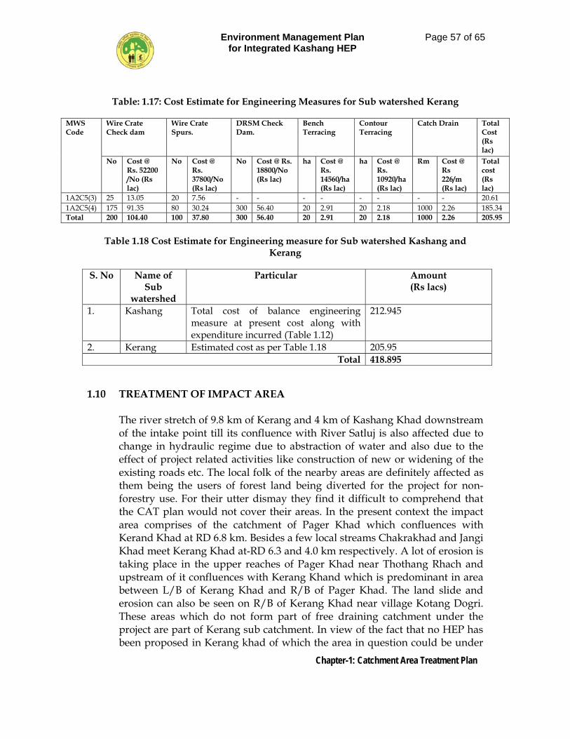
Environment Management Plan for Integrated Kashang HEP
Page 57 of 65
Chapter-1: Catchment Area Treatment Plan
Table: 1.17: Cost Estimate for Engineering Measures for Sub watershed Kerang
MWS Code
Wire Crate Check dam
Wire Crate Spurs.
DRSM Check Dam.
Bench Terracing
Contour Terracing
Catch Drain Total Cost (Rs lac)
No Cost @ Rs. 52200 /No (Rs lac)
No Cost @ Rs. 37800/No (Rs lac)
No Cost @ Rs. 18800/No (Rs lac)
ha Cost @ Rs. 14560/ha (Rs lac)
ha Cost @ Rs. 10920/ha (Rs lac)
Rm Cost @ Rs 226/m (Rs lac)
Total cost (Rs lac)
1A2C5(3) 25 13.05 20 7.56 - - - - - - - - 20.61 1A2C5(4) 175 91.35 80 30.24 300 56.40 20 2.91 20 2.18 1000 2.26 185.34 Total 200 104.40 100 37.80 300 56.40 20 2.91 20 2.18 1000 2.26 205.95
Table 1.18 Cost Estimate for Engineering measure for Sub watershed Kashang and
Kerang
S. No Name of Sub
watershed
Particular Amount (Rs lacs)
1. Kashang Total cost of balance engineering measure at present cost along with expenditure incurred (Table 1.12)
212.945
2. Kerang Estimated cost as per Table 1.18 205.95 Total 418.895
1.10 TREATMENT OF IMPACT AREA
The river stretch of 9.8 km of Kerang and 4 km of Kashang Khad downstream of the intake point till its confluence with River Satluj is also affected due to change in hydraulic regime due to abstraction of water and also due to the effect of project related activities like construction of new or widening of the existing roads etc. The local folk of the nearby areas are definitely affected as them being the users of forest land being diverted for the project for non-forestry use. For their utter dismay they find it difficult to comprehend that the CAT plan would not cover their areas. In the present context the impact area comprises of the catchment of Pager Khad which confluences with Kerand Khad at RD 6.8 km. Besides a few local streams Chakrakhad and Jangi Khad meet Kerang Khad at-RD 6.3 and 4.0 km respectively. A lot of erosion is taking place in the upper reaches of Pager Khad near Thothang Rhach and upstream of it confluences with Kerang Khand which is predominant in area between L/B of Kerang Khad and R/B of Pager Khad. The land slide and erosion can also be seen on R/B of Kerang Khad near village Kotang Dogri. These areas which do not form part of free draining catchment under the project are part of Kerang sub catchment. In view of the fact that no HEP has been proposed in Kerang khad of which the area in question could be under
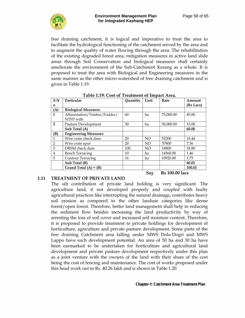
Environment Management Plan for Integrated Kashang HEP
Page 58 of 65
Chapter-1: Catchment Area Treatment Plan
free draining catchment, it is logical and imperative to treat the area to facilitate the hydrological functioning of the catchment served by the area and to augment the quality of water flowing through the area. The rehabilitation of the existing degraded forest area, mitigation measures in active land slide areas through Soil Conservation and biological measures shall certainly ameliorate the environment of the Sub-Catchment Kerang as a whole. It is proposed to treat the area with Biological and Engineering measures in the same manner as the other micro-watershed of free draining catchment and is given in Table 1.19.
Table 1.19: Cost of Treatment of Impact Area. S.No
Particular Quantity Unit Rate Amount (Rs Lacs)
(A) Biological Measures. 1 Affarestation/Timber/Fodder/
NTFP with 60 ha 75,000.00 45.00
2 Pasture Development 30 ha 50,000.00 15.00 Sub Total (A) 60.00
(B) Engineering Measures 1 Wire crate check dam 20 NO 52200 10.44 2 Wire crate spur 20 NO 37800 7.56 3 DRSM check dam 100 NO 18800 18.80 4 Bench Terracing 10 ha 14560.00 1.46 5 Contour Terracing 16 ha 10920.00 1.75 Sub Total (B) 40.01
Grand Total (A) + (B) 100.01 Say Rs 100.00 lacs
1.11 TREATMENT OF PRIVATE LAND The silt contribution of private land holding is very significant. The agriculture land, if not developed properly and coupled with faulty agricultural practices like interrupting the natural drainage, contributes heavy soil erosion as compared to the other landuse categories like dense forest/open forest. Therefore, better land management shall help in reducing the sediment flow besides increasing the land productivity by way of arresting the loss of soil cover and increased soil moisture content. Therefore, it is proposed to provide treatment to private holdings for development of horticulture, agriculture and private pasture development. Some parts of the free draining Catchment area falling under MWS Dolo-Dogri and MWS Lappo have such development potential. An area of 50 ha and 30 ha have been earmarked to be undertaken for horticulture and agricultural land development and private pasture development respectively under this plan as a joint venture with the owners of the land with their share of the cost being the cost of fencing and maintenance. The cost of works proposed under this head work out to Rs. 40.26 lakh and is shown in Table 1.20.
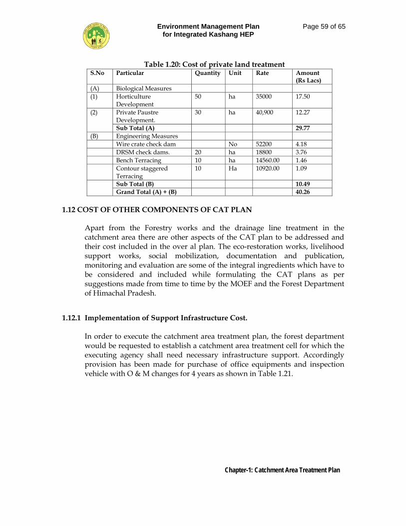
Environment Management Plan for Integrated Kashang HEP
Page 59 of 65
Chapter-1: Catchment Area Treatment Plan
Table 1.20: Cost of private land treatment S.No Particular Quantity Unit Rate Amount
(Rs Lacs) (A) Biological Measures (1) Horticulture
Development 50 ha 35000 17.50
(2) Private Paustre Development.
30 ha 40,900 12.27
Sub Total (A) 29.77 (B) Engineering Measures Wire crate check dam No 52200 4.18 DRSM check dams. 20 ha 18800 3.76 Bench Terracing 10 ha 14560.00 1.46 Contour staggered
Terracing 10 Ha 10920.00 1.09
Sub Total (B) 10.49 Grand Total (A) + (B) 40.26
1.12 COST OF OTHER COMPONENTS OF CAT PLAN
Apart from the Forestry works and the drainage line treatment in the catchment area there are other aspects of the CAT plan to be addressed and their cost included in the over al plan. The eco-restoration works, livelihood support works, social mobilization, documentation and publication, monitoring and evaluation are some of the integral ingredients which have to be considered and included while formulating the CAT plans as per suggestions made from time to time by the MOEF and the Forest Department of Himachal Pradesh.
1.12.1 Implementation of Support Infrastructure Cost.
In order to execute the catchment area treatment plan, the forest department would be requested to establish a catchment area treatment cell for which the executing agency shall need necessary infrastructure support. Accordingly provision has been made for purchase of office equipments and inspection vehicle with O & M changes for 4 years as shown in Table 1.21.
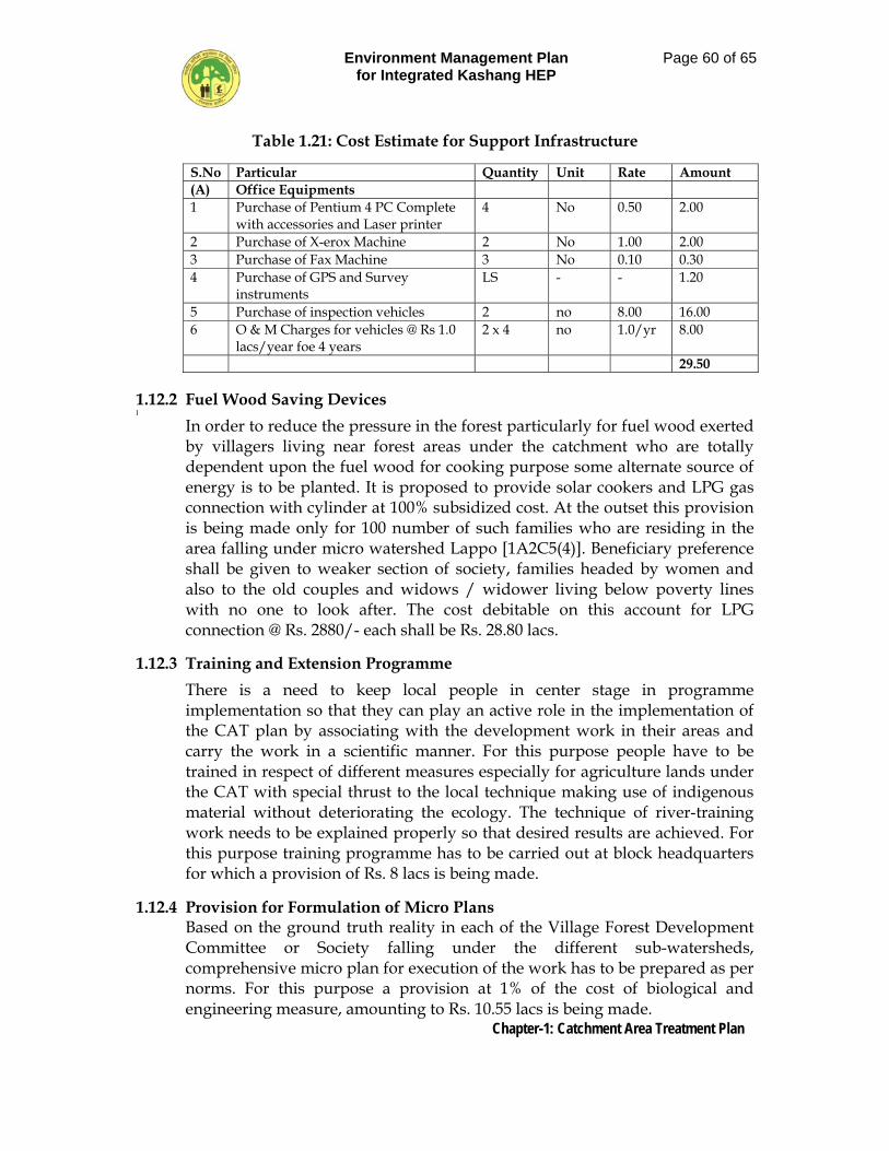
Environment Management Plan for Integrated Kashang HEP
Page 60 of 65
Chapter-1: Catchment Area Treatment Plan
Table 1.21: Cost Estimate for Support Infrastructure
1.12.2 Fuel Wood Saving Devices ]
In order to reduce the pressure in the forest particularly for fuel wood exerted by villagers living near forest areas under the catchment who are totally dependent upon the fuel wood for cooking purpose some alternate source of energy is to be planted. It is proposed to provide solar cookers and LPG gas connection with cylinder at 100% subsidized cost. At the outset this provision is being made only for 100 number of such families who are residing in the area falling under micro watershed Lappo [1A2C5(4)]. Beneficiary preference shall be given to weaker section of society, families headed by women and also to the old couples and widows / widower living below poverty lines with no one to look after. The cost debitable on this account for LPG connection @ Rs. 2880/- each shall be Rs. 28.80 lacs.
1.12.3 Training and Extension Programme
There is a need to keep local people in center stage in programme implementation so that they can play an active role in the implementation of the CAT plan by associating with the development work in their areas and carry the work in a scientific manner. For this purpose people have to be trained in respect of different measures especially for agriculture lands under the CAT with special thrust to the local technique making use of indigenous material without deteriorating the ecology. The technique of river-training work needs to be explained properly so that desired results are achieved. For this purpose training programme has to be carried out at block headquarters for which a provision of Rs. 8 lacs is being made.
1.12.4 Provision for Formulation of Micro Plans Based on the ground truth reality in each of the Village Forest Development Committee or Society falling under the different sub-watersheds, comprehensive micro plan for execution of the work has to be prepared as per norms. For this purpose a provision at 1% of the cost of biological and engineering measure, amounting to Rs. 10.55 lacs is being made.
S.No Particular Quantity Unit Rate Amount (A) Office Equipments 1 Purchase of Pentium 4 PC Complete
with accessories and Laser printer 4 No 0.50 2.00
2 Purchase of X-erox Machine 2 No 1.00 2.00 3 Purchase of Fax Machine 3 No 0.10 0.30 4 Purchase of GPS and Survey
instruments LS - - 1.20
5 Purchase of inspection vehicles 2 no 8.00 16.00 6 O & M Charges for vehicles @ Rs 1.0
lacs/year foe 4 years 2 x 4 no 1.0/yr 8.00
29.50
Environment Management Plan for Integrated Kashang HEP
Page 61 of 65
Chapter-1: Catchment Area Treatment Plan
1.12.5 Provision for Proper Documentation
Emphasis should be laid on the visual publicity of the work proposed under the plan and work carried out on annual basis so that transparency is maintained and the proper documentation of the work is also carried out for future reference and testing the efficacy of the work in due course of time. On this count a provision @ 0.5% of the cost of biological and engineering measures amounting to Rs. 5.28 lacs is being made. The documentation would inter alia include implementation report, progress reports, photography, videography etc. Publication for public awareness would be made and distributed to concerned panchayat and Village Forest Development Committees / Societies.
1.12.6 Gender Support
By far the women folk are more industrious than man in the hills. There is a need to keep them in center stage in programme implementation so that they can play an active role in the preservation of ecology as well as the socio-economic development of the area. Proper training with respect to work related to NTFP cultivation, animal husbandry, gardening and farm works etc. shall be imparted for which a provision of Rs. 5.0 lacs is being made.
1.12.7 Funds for Educational Activities related to Medicinal Plant Sector
In keeping with the provision under para 4.6.2 of Himachal Pradesh Forestry Sector medicinal Plants Policy, 2006, a provision of Rs. 6.0 lacs is being earmarked for various conservation and educational activities related to medicinal plant sector.
1.12.8 Monitoring of Silt
The Success of implementation of a CAT Plan can be fathomed by the increase in vegetal cover over hill slopes and the enhancement in forest canopy. Various engineering and biological measures have been aimed at treating the degraded and potential areas of severe to very severe soil erosion by increasing the soil holding capacity and thus reducing the sediment flow in the flowing water. Therefore, for recording soil and silt data at regular interval one small laboratory / observatory each shall be established at Dolo Dogri and Lappo where the regular discharges of the streams shall also be monitored. For establishing these a provision of Rs. 15.00 lacs is being made.
Environment Management Plan for Integrated Kashang HEP
Page 62 of 65
Chapter-1: Catchment Area Treatment Plan
1.12.9 Development of Eco-Tourism
The trekking routes such as Larsa way pass along Taiti Garang with camping facilities can help to boost eco-tourism in the area. Concept of “Homesteads” can be promoted. Such host families who are enterprising and having reasonable traditional accommodation in the village en-route to good eco-treks can accommodate tourists on payment basis. Some financial support to rural people can boost the activity. Involvement of local youths can fetch them self employment avenues by providing services like guides, porters and making arrangement for boarding and lodging of eco-tourists. Thus poor families can get wage earning by porter or other small works. Eco-tourism societies can be formulated under the overall control of the special purpose vehicle (SPY) for anchoring the eco-tourism activities. There is a lot of scope for eco-tourists for beholding the nature in its wild virgin and pristine glory and catching the everlasting enthralling moments in their mind while enjoying and learning the nature. In keeping with the Revised Policy on Development of Eco-tourism in Himachal Pradesh, 2005, and guideline issued by the Forest Deptt, H.P., vide letter No. Ft-48-124/94 (FCA), one percent of the CAT plan should be earmarked for eco-tourism purposes. However, a provision of Rs 20.00 lacs is being made on this count as it seems to be meaningful and purposeful for establishing a certain asset.
1.12.10 Provision for Floristic Surrey
Though adequate provision of Rs 20 lacs & 15 lacs have already been provided in environment monitoring plan for ecosystem monitoring including environmental studies respectively during construction and post constructional stage, yet a provision of Rs 4.0 lacs is being made for carrying out floristic survey of the area after complete of implementation CAT plan i.e. immediately after the fifth year of maintenance.
1.12.11 Eco- Force
The concept of Eco-Task Force (ETF) scheme was initiated by the Ministry of Defence in 1980 with a view to involve ex-service men in afforestation and eco-development schemes in for flung and difficult places to under take restoration of degraded eco-systems through afforestation, soil conservation and water resource management techniques. Under the scheme the establishment and operational expenditure on Eco-Task Force or Eco- Battalion raised by the Ministry of Defence is reimbursed by Ministry while the input such as sapling, fencing etc. as also the professional and managerial guidance is provided by the concerned State Forest Departments.
Environment Management Plan for Integrated Kashang HEP
Page 63 of 65
Chapter-1: Catchment Area Treatment Plan
The state of Himachal Pradesh has also raised 133 Infantry Battalion TA (Ecological) in March 2006 with sole purpose of generation of employment opportunities for ex-servicemen of the state though afforestation and soil conservation work. The Eco- Battalion is engaged in Satluj basin in the task of rim plantation in Tatapani area of Karsog Forest Division. There are a number of on-going and proposed HEP in Satluj basin whose CAT plan are either being implemented or being formulated. In the light of the fact that the state has already mooted a proposal for raising two more Eco-Battalions one each for Ravi and Beas catchment financial resources are to be pooled to support the existing Batallion and the two more Batallions to be raised. The integrated Kashang HEP (243 MW) also lies in Satluj basin. Therefore, with a view to pool in resources to support ETF, a provision at 5% of cost of biological and engineering measures amounting to Rs 52.75 lacs is being made on this account in the CAT Plan.
1.12.12 Provision for Monitoring and Evaluation
In keeping with broad guide lines for preparing and implementation of CAT plans, issued by the Forest Depurtment, Himachal Pradesh, vide letter Ft. 48-124 / 94 (FCA, a provision towards monitoring and evaluation activities @ 5% has to be earmarked on this count. Therefore, a provision if Rs 52.75 lac is being made on this count.
1.12.13 Provision for providing Environmental Services. In Keeping with the guide lines issued in this direction, a provision @ 10% of
the cost of works under CAT shall have to be earmarked on this count. Therefore a provision of Rs 105.47 lacs is being made under this sub-head.
1.13 NSTITUTIONAL MECHANISM 1.13.1 Role of Project Proponent
The forest department would implement the Catchment Area Treatment plan. The joint inspection group would be formalized which would include officers from State Forest Department and Officials from the Environment Group at HPPCL. The management will have liaison with the forest officials as far as the financial disbursement is concerned. The soil conservation and afforestation program would evolve employment opportunities. Thus, people’s participation should be encouraged and would involve mobilization of manpower for such activities. Experts and professionals competent enough in operationalizing the plan need to be consulted from time to time.
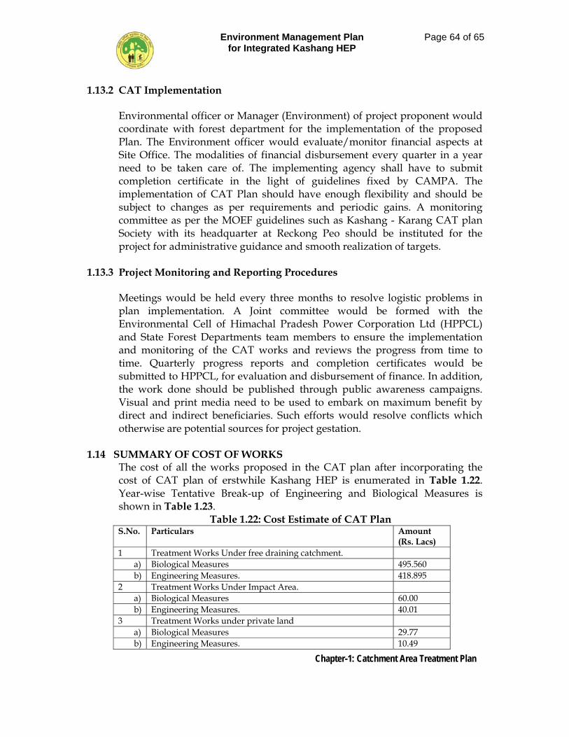
Environment Management Plan for Integrated Kashang HEP
Page 64 of 65
Chapter-1: Catchment Area Treatment Plan
1.13.2 CAT Implementation
Environmental officer or Manager (Environment) of project proponent would coordinate with forest department for the implementation of the proposed Plan. The Environment officer would evaluate/monitor financial aspects at Site Office. The modalities of financial disbursement every quarter in a year need to be taken care of. The implementing agency shall have to submit completion certificate in the light of guidelines fixed by CAMPA. The implementation of CAT Plan should have enough flexibility and should be subject to changes as per requirements and periodic gains. A monitoring committee as per the MOEF guidelines such as Kashang - Karang CAT plan Society with its headquarter at Reckong Peo should be instituted for the project for administrative guidance and smooth realization of targets.
1.13.3 Project Monitoring and Reporting Procedures
Meetings would be held every three months to resolve logistic problems in plan implementation. A Joint committee would be formed with the Environmental Cell of Himachal Pradesh Power Corporation Ltd (HPPCL) and State Forest Departments team members to ensure the implementation and monitoring of the CAT works and reviews the progress from time to time. Quarterly progress reports and completion certificates would be submitted to HPPCL, for evaluation and disbursement of finance. In addition, the work done should be published through public awareness campaigns. Visual and print media need to be used to embark on maximum benefit by direct and indirect beneficiaries. Such efforts would resolve conflicts which otherwise are potential sources for project gestation.
1.14 SUMMARY OF COST OF WORKS The cost of all the works proposed in the CAT plan after incorporating the cost of CAT plan of erstwhile Kashang HEP is enumerated in Table 1.22. Year-wise Tentative Break-up of Engineering and Biological Measures is shown in Table 1.23.
Table 1.22: Cost Estimate of CAT Plan S.No. Particulars Amount
(Rs. Lacs) 1 Treatment Works Under free draining catchment.
a) Biological Measures 495.560 b) Engineering Measures. 418.895
2 Treatment Works Under Impact Area. a) Biological Measures 60.00 b) Engineering Measures. 40.01
3 Treatment Works under private land a) Biological Measures 29.77 b) Engineering Measures. 10.49
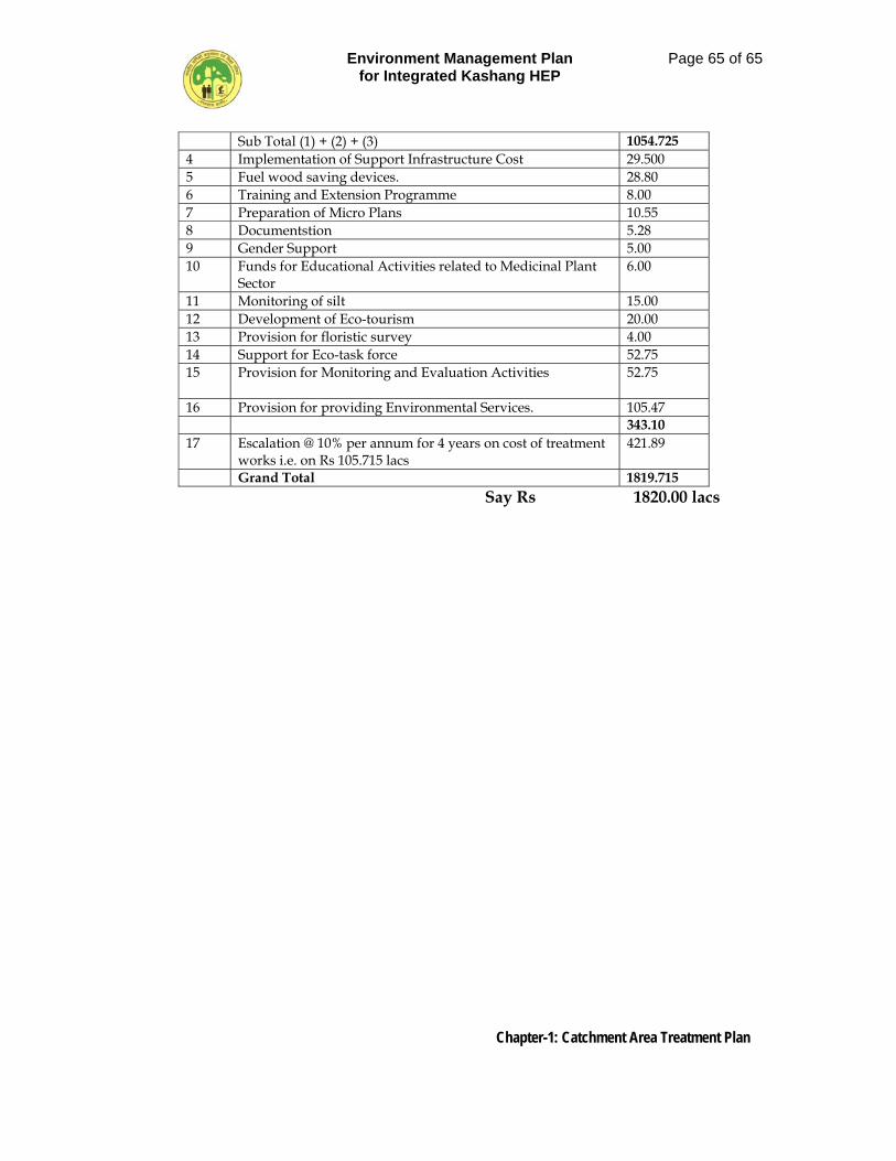
Environment Management Plan for Integrated Kashang HEP
Page 65 of 65
Chapter-1: Catchment Area Treatment Plan
Sub Total (1) + (2) + (3) 1054.725 4 Implementation of Support Infrastructure Cost 29.500 5 Fuel wood saving devices. 28.80 6 Training and Extension Programme 8.00 7 Preparation of Micro Plans 10.55 8 Documentstion 5.28 9 Gender Support 5.00 10 Funds for Educational Activities related to Medicinal Plant
Sector 6.00
11 Monitoring of silt 15.00 12 Development of Eco-tourism 20.00 13 Provision for floristic survey 4.00 14 Support for Eco-task force 52.75 15 Provision for Monitoring and Evaluation Activities 52.75
16 Provision for providing Environmental Services. 105.47 343.10 17 Escalation @ 10% per annum for 4 years on cost of treatment
works i.e. on Rs 105.715 lacs 421.89
Grand Total 1819.715 Say Rs 1820.00 lacs
Environment Management Plan for Integrated Kashang HEP
Page 1 of 19
Chapter-2: Resettlement and Rebahiliatation Plan
PART-I
Gives Information About Project Covering:
01. The draft rehabilitation and resettlement scheme or plan shall contain the following particulars, namely: -
(a). The extent of land to be acquired for the project and the name(s) of the affected village (s).
(b). A village-wise list of the affected persons, family-wise, and the extent and nature of land and immovable property owned or held in their possession in the affected area and the extent and nature of such land and immovable property which they are likely to lose or have lost, indicating the survey numbers thereof.
(c). A list of agricultural labourers in such area and the names of such persons whose livelihood depends on agricultural activities.
(d). A list of persons who have lost or are likely to lose their employment or livelihood or who have been or likely to be alienated wholly or substantially from their main sources of trade, business, occupation or vocation consequent to the acquisition of land for the project or involuntary displacement due to any other cause.
(e). A list of non-agricultural labourers, including artisans.
(f). A list of affected landless families, including those without homestead land and below poverty line families.
(g). A list of vulnerable affected persons.
(h). A list of occupiers, if any.
(i). A list of public utilities and government buildings which are affected or likely to be affected.
(j). Details of public and community properties, assets and infrastructure.
(k). A list of benefits and packages which are to be provided to the affected families.
Environment Management Plan for Integrated Kashang HEP
Page 2 of 19
Chapter-2: Resettlement and Rebahiliatation Plan
(l). Details of the extent of land available in the resettlement area for resettling and for allotment of land to the affected families.
(m). Details of the amenities and infrastructural facilities which are to be provided for resettlement.
(n). The time schedule for shifting and resettling the displaced persons in the resettlement area or areas: and
(o). Such other particulars as the Administrator for Rehabilitation and Resettlement may consider necessary.
RESETTLEMENT AND REHABILITATION SCHEME FOR PROJECT AFFECTED FAMILIES OF INTEGRATED KASHANG HYDRO ELECTRIC PROJECT
2.1. Kashang Hydro Electric Project would require land, some of which is being acquired from private persons. The construction of the project will also involve under ground works, transportation of large quantities of material, more than usual activity in the area and therefore, all this is likely to have an impact on the lives of people living in the area. H.P. Power Corporation Limited would like to improve the life of people living in the area besides mitigating any hardships that may arise due to the construction of the project. A scheme for Resettlement and Rehabilitation of the persons affected on this account has been prepared. This has been prepared by taking into consideration the R&R Policy notified by Govt. of HP vide notification No. Rev (PD)F(5)-1/1999 dated 27/04/2006 National Rehabilitation and Resettlement Policy 2007 and National Hydro Policy 2008.
2.2. OBJECTIVE
1. To compensate the families affected adversely be construction of the project.
2. To improve the quality of life of the people of the area through better infrastructure, sustainable income and better skills and generally contribute to and be a part of the development of the area and the people.
3. To create a good will for the organization and have a good long term relationship.
4. To ensure that rights of individual and society particularly those belonging to the weaker section of the society are adequately protected.
Environment Management Plan for Integrated Kashang HEP
Page 3 of 19
Chapter-2: Resettlement and Rebahiliatation Plan
2.3 BASIC ISSUES AND NEED FOR R&R PLAN.
Where as efforts are made to minimize the land acquired and not displace too many families, some times it becomes unavoidable. When this happens it is important that the affected family get due care and attention.
Acquisition of land generally induces change in land use pattern and can disturb the economic base. The R&R Action Plan is therefore formulated with an objective to resettle the families rendered landless or affected families whose land/house/shop is acquired and to rehabilitate them in such a manner that they improve or at least regain their previous standard of living, earning capacity and production level. Besides, it is imperative that the transition gap is to be reduced to the minimum possible extent.
With proper resettlement and rehabilitation plan, an amicable relationship with PAFs can be maintained which is essential for efficient operation of the project. It is generally seen that the displacement during acquisition of land is involuntary and the PAFs have to face a new social setup. During such transition period, the rural economic environment is generally transformed into higher cost of living and reduction in traditional sources of income. In general, PAFs face difficulty to cope with the new environment set up. Domestic changes in the land use patterns substantially alter the agro based rural economy and lifestyle of affected families.
2.4. RELIEF REHABILITATION STRATEGIES: -
* Suitable and adequate compensation to ensure replacement of the assets lost or acquired.
* Guidance and counseling education through scholarships, sponsorships guidance for better living conditions and better livelihood including training in the area of common occupations like agriculture, horticulture etc.
* General Development of the Project area by building or improving infrastructure such as roads, footpaths, bridges, water supply, irrigation through public participation and community development works etc.
* Creating opportunities of employment for local people through self employment schemes or indirect employment in project activities.
Environment Management Plan for Integrated Kashang HEP
Page 4 of 19
Chapter-2: Resettlement and Rebahiliatation Plan
* Maintaining a friendly contact with the public through regular meetings, Public Information Centre, printed material, PAF identity card, functions etc.
* Providing direct help to the people in extreme hardship.
2.4.1 This Scheme may be called the Resettlement and Rehabilitation Scheme of Himachal Pradesh Power Corporation Limited for the project affected families of Kashang Hydro Electric Project (hereinafter called R&R Scheme for Kashang Hydro Electric Project).
2.4.2 It shall extend to the whole of area affected or likely to be affected as a result of construction of Kashang Hydro Electric Project within Tehsil Kalpa of Kinnaur district of Himachal Pradesh. Panchayat will be taken as a unit and all Panchayats where either land is acquired or where underground works are undertaken will constitute in the Project affected area.
2.4.3. The Commissioner for Resettlement & Rehabilitation appointed by the State Government for supervising the relief and welfare works of various Projects in Himachal Pradesh would also be the Commissioner for welfare of the affected population so that the welfare works are carried out under his/her directions and guidance.
2.4.4 The Deputy Commissioner, Kinnaur in whose jurisdication the project affected area falls, will be the Administrator for Welfare of the area so that the Relief and Welfare works are carried out and controlled under his supervision.
2.5. Definitions:
2.5.1. Family
‘Family’ means husband/wife of the person who is entered as owner/co-owner of the land in the revenue record, their children including step or adopted children, grand children and includes his/her parents and those brothers and sisters who are living jointly with him/her as per entries of Panchayat Parivar Register as on date of notification under section-4 of the Land Acquisition Act, 1894.
Explanation:
Only the Panchayat Parivar Register Entry, as it stood on the date of notification under section-4 of the land Acquisition Act, 1894, shall be taken into account for the purpose of separate family for rehabilitation benefits as well as for consideration of employment.
Environment Management Plan for Integrated Kashang HEP
Page 5 of 19
Chapter-2: Resettlement and Rebahiliatation Plan
2.5.2. Project Affected Family (PAF)
(i) A family whose primary place of residence or other property or source of livelihood is adversely affected by the acquisition of land for a project or involuntary displacement for any other reason; or
(ii) Any tenure holder, tenant, lessee or owner of other property, who on account of acquisition of land (including plot in the abadi or other property) in the affected area or otherwise, has been involuntarily displaced from such land or other property; or
(iii). Any agricultural or non-agricultural labourer, landless person (not having homestead land, agricultural land, or either homestead or agricultural land), rural artisan, small trader or self-employed person, who has been residing or engaged in any trade, business, occupation or vocation continuously for a period of not less than three years preceding the date of declaration of the affected area, and who has been deprived of earning his livelihood or alienated wholly or substantially from the main source of his trade, business, occupation or vocation because of the acquisition of land in the affected area or being involuntarily displaced for any other reason.
2.5.2. (a) PROJECT AFFECTED FAMILY RENDERED LANDLESS
The PAF rendered landless means that family whose whole agricultural land is acquired for the project or in whose case balance agriculture land left after acquisition is less than 5 bighas for this purpose agriculture land held by all such persons and their family members shall be taken into account. Person losing land on acquisition of building and land appurtenant there to shall not be treated as landless Project Affected Family. The landless PAF shall be duly certified by the Deputy Commissioner, Kinnaur. To arrive at balance land, with a family, land hold by them outside the project affected area will also be considered.
2.5.2. (b) PROJECT AFFECTED FAMILY RENDERED HOUSELESS.
The Project Affected family rendered houseless means the family whose dwelling house is acquired for the project, which shall be duly certified by the Deputy Commissioner Kinnaur.
2.5.2 (c) In addition to above two categories, there will be Project Affected Families who will be rendered landless as well as houseless s per
Environment Management Plan for Integrated Kashang HEP
Page 6 of 19
Chapter-2: Resettlement and Rebahiliatation Plan
definitions given above. Such case shall be eligible for benefits of project affected families rendered landless and project families rendered houseless which shall be duly certified by the Deputy Commissioner, Kinnaur.
2.5.3. “MAIN PROJECT AFFECTED FAMILY”
Main Project Affected Family is Project Affected Family whose land or house/buildings acquired for the project.
2.5.4. PROJECT AFFECTED AREA: -
Project Affected area means area as notified by the Project authority or where land is acquired for construction of any component of the project infrastructures, township, offices construction facilities, welfare facilities etc land where under ground works are taken up. Unit for declaring Project Affected Area would be Panchayat.
2.5.5. PROJECT AFFECTED ZONE
Project Affected zone means zone as notified by the project authority or project affected area plus the area surrounding this project affected area where impact of the project on the lives of people is considerable even if no direct project activity is taking place in these surrounding areas. Unit for declaring this would be Panchayat.
Explanation
Project Affected Area will consist of only Panchayat where project work actually takes place (both on surface and under ground). Adjoining Panchayat may also be affected due to high vehicular traffic, blasting or dust etc. These Panchayat can be included in the Project effected Zone. The thumb rule would be area located ½ to 1 Km beyond the project affected area.
2.5.6. “Agricultural labourer” means a person primarily resident in the affected area for a period of not less than three years immediately before the declaration of the affected area who does not hold any land in the affected area but who earns his livelihood principally by manual labour on agricultural land therein immediately before such declaration and who has been deprived of his livelihood.
Environment Management Plan for Integrated Kashang HEP
Page 7 of 19
Chapter-2: Resettlement and Rebahiliatation Plan
(VII) “Agricultural land” includes lands being used for the purpose of
(i) Agriculture or horticulture.
(ii) Dairy farming, poultry farming, piscicultue, breeding of livestock or nursery growing medicinal herbs.
(iii) Raising of crops, grass or garden produce; and
(iv) Land used by an agriculturist for the grazing of cattle, but does not include land used for cutting of wood only.
(VIII). “Appropriate Government” means:
The State Government.
(IX). Project Authority
Himachal Pradesh Power Corporation Limited.
(X). “BPL family” The below poverty line (BPL) families shall be those as defined by the Planning Commission of India from time to time and included in a BPL list for the time being in force.
(XI). “Commissioner for Rehabilitation and Resettlement” means the Commissioner for Rehabilitation and Resettlement appointed by the State Government not below the rank of Commissioner or of equivalent rank of that Government.
(XII). “DDP block” means a block identified under the Desert Development
Programme of the Government of India.
(XIII). “Holding” means the total land held by a person as an occupant or tenant or as both.
(XIV). “Khatedar” means a person whose name is included in the revenue records of the parcel of land under reference.
(XV). “Land acquisition” or “acquisition of land” means acquisition of land under the Land Acquisition Act, 1894 (1 of 1894), as amended from time to time, or any other law of the Union or a State for the time being in force.
Environment Management Plan for Integrated Kashang HEP
Page 8 of 19
Chapter-2: Resettlement and Rebahiliatation Plan
(XVI). “Marginal farmer” means a cultivator with an un-irrigated land holding up to one hectare or irrigated land holding up to half hectare.
(XVII). “Non-agricultural labourer” means a person who is not an agricultural labourer but is primarily residing in the affected area for a period of not less than three years immediately before the declaration of the affected area and who does not hold any land under the affected area but who earns his livelihood principally by manual labour or as a rural artisan immediately before such declaration and who has been deprived of earning his livelihood principally by manual labour or as such artisan in the affected area.
(XVIII). “Notification” means a notification published in the Gazette of India or, as the case may be the Gazette of a State.
(XIX). “Occupiers” means members of the Scheduled Tribes in possession of forest land prior to the 13th day of December, 2005.
(XX). “Resettlement area” means any area so declared.
(XXI). “Small farmer” means a cultivator with an un-irrigated land holding up to two hectares or with an irrigated land holding up to one hectare, but more than the holding of a marginal farmer.
Environment Management Plan for Integrated Kashang HEP
Page 9 of 19
Chapter-2: Resettlement and Rebahiliatation Plan
PART-III
Social Impact Assessment
3.1. A social Impact Assessment study will be carried out in the project affected area through an independent, professional agency in order to determine the impact that the project can have or the people, their live, the community and the society. This study will be done before the start of work on main project components.
3.2 The study will cover impact on public and community properties (particularly common grazing grounds, forest right), available infrastructure like roads, water supply, irrigation schools, medical facilities, fairs and festivals power supply, places of worship, burial and cremation grounds etc access to adjoining villages across the water source being dammed or diverted, livelihood, sources, reduction in land and other natural etc.
3.3. Public hearing will be done along with the public hearing for EIA or separately. This R&R Plan will be appropriately modified if need is felt after the SIA report is obtained.
3.4. Base Line Survey:
A base line survey will be conducted in the project affected area which will inter-alia cover:
(i). Information about families living in the area, their occupation, income, education, housing available and dependence on common resources.
(ii). Available infrastructure and resources.
(iii). Land holdings
(iv). Members of the family who are permanently residing, engaged in any trade, business, occupation or vocation in the affected area.
(v). Families who are likely to lose, or have lost, their house, agricultural land, employment or are alienated wholly or substantially from the main source of their trade, business, occupation or vocation.
Environment Management Plan for Integrated Kashang HEP
Page 10 of 19
Chapter-2: Resettlement and Rebahiliatation Plan
(vi). Agricultural labourers and non-agricultural labourers.
(vii). Families belonging to the Scheduled Caste or Scheduled Tribe categories.
(viii). Vulnerable persons such as the disabled, destitute, orphans, widows, unmarried girls, abandoned women, or persons above fifty years of age, who are not provided or cannot immediately be provided with alternative livelihood, and who are not otherwise covered as part of family.
(ix). Families that are landless (not having homestead land, agricultural land, or either homestead or agricultural land) and below poverty line, but residing continuously for a period of not less than three years in the affected area preceding the date of declaration of the affected area: and
(x). Scheduled Tribes families who are or were having possession of forest lands in the affected area prior to the 13th day of December, 2005.
Environment Management Plan for Integrated Kashang HEP
Page 11 of 19
Chapter-2: Resettlement and Rebahiliatation Plan
Part-IV
Sanction of welfare grant, or facilities and grant to the PAF rendered land less or house less or both.
4 Resettlement Grant:
4.1. The PAF rendered landless on account of acquisition of land shall be eligible for landless grant in the following manner.
(i). Family whose land before acquisition was more than 5 bighas and is left with one biswa or no agriculture land after acquisition, Rs. 2.50 Lac lump sum.
(ii). Family whose land before acquisition was less than five bighas and is left with one biswa or no agriculture land after acquisition, Rs. 1.50 Lac lump sum.
(iii). Family whose land holding is left with more than one biswa and less than 2-10-0 bighas of land after acquisition, Rs. 1.00 Lac lump sum.
(iv). Family whose land holding is left with more that 2-10-0 and less than five bighas of land after acquisition, Rs. 75,000/- lump sum
(v). Family whose cattle shed is acquired in the project area, shall get one time financial assistance of Rs. 10, 000/- in no case the grant shall exceed Rs. 25,000/- per family.
4.2. Each PAF rendered landless as well as houseless (both) or houseless will be provided an independent house with a built up plinth area of 150 sqm. Alternatively, PAF can also be offered a plot of size 250 sqm. which allows construction of built up house of 150 sqm. plinth area plus construction cost of the house @ Rs. 4000 per sqm. (limited to 150 sqm. plinth area).
A family which does not opt for house/plot but constructs a house at own cost with a plinth area of 150 sqm or more shall be paid the construction cost of the house @ Rs. 5000 per sqm (upto a plinth area of 150 sqm maximum). Options from such families will be asked at an appropriate time. In case any of such family constructs house of less than 150 sqm. Plinth area on his own plot or plot offered by the Project then amount to be given will be worked out on pro-rata basis.
Environment Management Plan for Integrated Kashang HEP
Page 12 of 19
Chapter-2: Resettlement and Rebahiliatation Plan
4.3. Displaced shopkeepers will be given shops in allotment in the market comples of the Project Township wherever the Project constructs such market places. In addition, they will be entitled to one time displacement grant of Rs. 20,000/-. The commercial premises/shops allotted to such displaced shopkeepers shall be utilized by them or their successors in interest for bonafide use only. In case the project is unable to provide shops, displaced shopkeepers shall get financial assistance of Rs. 2,00,000/- cash.
4.4. Infrastructure facilities in the Rehabilitation colony will include water supply, sewage, drainage, electricity, streets community centre, green area, park and approach path/roads at the project cost.
4.5.. Transportation at the project cost will be provided for physical movement of all the PAFs and displaced shopkeepers and there houses hold good / shop goods, as soon as the houses /shop get constructed in the rehabilitation colony or in some other location chosen by the PAF or a sum of Rs 20000 in lump sum shall be paid , for which option will be invited from the affected families /shop keepers.
4.6. Stamp duty and other fees payable for registration shall be borne by the project Authority Rehabilitation grant shall be provided by the project Authorities and placed at the disposal of the Deputy Commissioner, for disbursement to the eligible PAFs.
4.7. Transitional/Subsistence Allowance based on 25X12 days minimum wages to each Project Affected family will be paid if the family has become houseless and has to shift house or become landless and has to shift livelihood to a different location or change livelihood or has been involuntarily displaced.
4.8. Whereas it is not possible to provide land in exchange of land acquired but in case some agricultural land is available for distribution, upto 5 bighas land will be given to each PAF by giving priority to landless. This land will be given only to such PAF’s who are primarily dependent on agriculture and the livelihood is substantially effected by land acquisition. In no case will land to be given in excess of that acquired. Giving of agricultural land will not be a right and will be only a welfare measure to given only if possible.
If it is not possible to give land, a financial assistance at the rate of Rs. 50,000/- per bigha of land acquired will be paid as an additional assistance to the project affected family for purchasing land. This assistance will only be given if the Project Affected Family is able to prove that this will be utilized to purchased land of a value more than the money paid to the Project Affected Family under this clause (clause-4.8).
Environment Management Plan for Integrated Kashang HEP
Page 13 of 19
Chapter-2: Resettlement and Rebahiliatation Plan
If waste land or degraded land is allotted under this clause, then a land development charge of Rs. 15,000/- per bigha will be paid. The PAF’s who are allotted land or these who purchase agricultural land will also get Rs. 10.000/- cash for agricultural production.
4.9. Each PAF which is displaced and has Cattle will be given Rs. 20,000/- for construction of cattle shed.
4.10. Each PAF who is a artisan, small trader or self employed person and has been displaced shall get a one time financial assistance of Rs. 50,000/- for construction of working shed or shop.
4.11. The families who have to shift house due to the project will be provided temporary accommodation at project cost for 3 to 6 months depending on their need.
Note: All the above grants shall be in addition to the compensation paid under Land Acquisition Act, 1894.
Environment Management Plan for Integrated Kashang HEP
Page 14 of 19
Chapter-2: Resettlement and Rebahiliatation Plan
PART-5
Employment
5.1. One member of each Project Affected Family rendered landless will be provided employment by the Project Authority in the category of skilled/semiskilled/unskilled workmen subject to fulfilling the requisite criteria/qualification and as and when any fresh recruitment is done in these categories, it would be ensured that land oustees eligible for employment as mentioned above are given chance first and normal recruitment would be made only if none are eligible & willing from amongst them. However, persons who are allotted shops shall not be eligible for benefit of employment and vice versa.
The following criteria will be adhered to by the Deputy Commissioner concerned for providing of preference while sponsoring the names for employment to the Project Authority.
(i). Affected families whose entire land has been acquired.
(ii). Affected families who have become landless on account of acquisition of land by the project.
(iii). Other affected families.
Within these categories preference will be given on the basis of quantum of land acquired. Those who lose more land will come first.
5.2. The main PAF who have not been provided employment will be given a special rehabilitation/employment grant equivalent to 1000 days of minimum wage for labour per family.
5.3. Annuity policy will be arranged for each vulnerable PAF (disabled, destitute, orphans, widows, unmarred girls, abandoned women, or persons above fifty years of age, who are not provided or cannot immediately be provided with alternative livelihood and who are not otherwise covered as part of a family which will provide a pension of Rs. 10,00/- per month to the family starting from a date 5 years after the date of implementations of this plan and will continue for 10 years after that date.
Environment Management Plan for Integrated Kashang HEP
Page 15 of 19
Chapter-2: Resettlement and Rebahiliatation Plan
5.4. Secondary Employment
The PAF’s will be provided help to get employment other than direct employment in the project in the following manners: -
5.4.1. Merit scholarship scheme for the wards of Project Affected Families (PAFs) and other residents of project affected zone who may be pursuing vocational or professional course will be introduced by the Project Authorities as per scheme to be drafted by the Project Authority in consultation with Government of Himachal Pradesh. The Project authorities will also consider getting some special seats in ITI’s for the project affected families and other residents of the project affected zone. Some schemes to provide apprenticeship or on the job training to increase the employability of the residents of the project affected zone will also be started. Merit Scholarship scheme for school going students of project affected zone will be started.
5.4.2. The Project Authorities will also consider award of petty contracts to the cooperatives of eligible families on preferential basis so that some may be engaged in such jobs. Further, the Project Authorities will advise their contractor to engage eligible persons from amongst effected families on a preferential basis wherever possible during construction stage. Other employment opportunities like hiring vehicles from PAF’s will also be made available. Normally all contracts upto a value of Rs. 5 Lakh will be given to PAF’s and if PAF’s area not available to families living in the project affected zone. All vehicles hired by the project will be from PAF’s and if not available from PAF’s then from residents of Project Affected Zone. The new vehicles hired from PAF’s may be hired for 3+1 years.
5.4.3. The Project Affected Families will be assisted to start various suitable self-employment occupations, which include dairy farming, poultry, weaving, bakery, handicraft, cottage industries unit/shops and taxis, trucks, buses. The Project Authority will provide a grant of Rs. 50,000/- per family toward seed capital. The grant will be given once only.
“only those families who have not been provide with direct employment in the Project or have not been allotted any shop will be eligible for this grant.”
Families residing in the project affected area other then PAF’s can also be considered for this on merit and if they are needy.
Environment Management Plan for Integrated Kashang HEP
Page 16 of 19
Chapter-2: Resettlement and Rebahiliatation Plan
Explanation:
The Deputy Commissioner, will certify the effect on source of livelihood in case of rural artisans, small traders and self employed persons for eligibility of the grant.
5.4.4. The PAF’s and other fishermen having fishing rights in the river will also get fishing rights in the reservoir.
5.4.5. If any manpower is obtained by the project authorities throughout soursing at any time during construction or running of the project for services like house keeping, gardening, typing, maintenance, computer work, office help etc first opportunity will be given to PAF’s as contractors and also as personal hired by contractor for their jobs. If PAF’s are not willing then other residents of project affected zone may be considered.
Environment Management Plan for Integrated Kashang HEP
Page 17 of 19
Chapter-2: Resettlement and Rebahiliatation Plan
Part 6
R&R Benefits For PAFs belongings to ST & SC
6.1. In case of families loose access to forest due to projects a special plan will be formulated for development of alternate fuel, fodder and no timber forest produce.
6.2. Each PAF of ST followed by SC categories shall be given preference in allotment of land if any land is available for allotment of PAF’s.
6.3. Each ST family will get an addition one time financial assistance of 500 days minimum wages for labour for loss of customary right’s or usage of forest produce.
6.4. ST. PAF’s will be resettled as far as possible in the same schedule area in a compound block so that they can retain their ethnic, linguistic and cultural identity.
6.5.1. The resettlement area prominently inhabited by S.T.s shall get 1000 Sqm. land free of cost for community and religious gatherings
6.6 The ST’s families resettled out of the district will get 25% higher resettlement grant.
Environment Management Plan for Integrated Kashang HEP
Page 18 of 19
Chapter-2: Resettlement and Rebahiliatation Plan
Part 7
Other Benefits
7.1 Each PAF’s will be provided 100 units of free electricity per month for a period of 10 years from the date of commissioning of the project. If the consumption of the PAF is less then that then the difference will be compensated in cash.
7.2 Medical funds :
A medical fund will be created for the PAF’s . this fund will be need for providing treatment to the member of PAF’s in hardship due to illness or extreme illness or accident cases . medicines may also be provided to other residents in the area .
7.3 Free medical treatment will be provided to PAF’s at the project medical facility.
7.4 Medical camps will be organized at various places in the project affected zone from time to time
7.5 In order to help the families living in the project affected zone and to improve their skills in their occupation Agriculture, horticulture and animal husbandry training and awareness camp will be organized by the project authorities from time to time training camps on other subjects like finance and accounts, how to run small business, alternative for self employment etc .will also be organized from time to time.
7.6 If it is felt that the fuel supply of the local residence is affected due to construction of the project, a scheme will be formulated to provide alternative fuel or fuel saving devices to the families whose fuel supply is affected
7.7 Each PAF will be given an identity card which will have names of the all members of the PAF’s
7.8 The projects authorities will set up one or more Projects Information Officers for providing information and guidance to the local people particularly the PAF’s
7.9 Projects authorities will set up a cultural funds for providing grants for organizing local fairs, festivals and functions
Environment Management Plan for Integrated Kashang HEP
Page 19 of 19
Chapter-2: Resettlement and Rebahiliatation Plan
Part 8
Infrastructure Development
Construction of the project is a major development activity for the area. It will be ensured that the available infrastructure in the area improves with the project.
8.1. If any available infrastructure is damaged due to the project, it will be restored. This includes water supply, irrigation, roads, paths, schools, places of worship, community building etc.
8.2. The local people will be allowed use of the infrastructure created primarily for the project like roads, bridges, Schools, etc.
8.3. A fund under the name LADF will be created for development of infrastructure in the project affected area. The Project authorities will contribute 1.5% of the project cost towards the funds. This fund will be administered by a local area development committee in accordance with the orders of the appropriate Government. 80% of the funds available in LADF will be divided amongst the Panchayats falling within the Project affected area on the basis of a formula giving equal weightage to 3 criteria i.e.
(i). Number of project affected families.
(ii). Area acquired.
(iii). Extent of underground works and disturbance in the area.
The remaining 20% funds may be used for common works or for works in the project affected zone or for completion of incomplete works.
8.4. After the project starts generating power, 2% of the power generated, may be dedicated for LADF. 1% will be contributed out of 12% free power to the State Government and 1% will come from the remaining 88%. This fund will also be used for maintenance of the infrastructure.
8.5. The project authorities will also build infrastructure over and above LADF on their own which will benefit local population.
Environment Management Plan for Integrated Kashang HEP
Page 1 of 5
Chapter-3: Compensatory Afforestation Scheme
CHAPTER-3
COMPENSATORY AFFORESTATION SCHEME 3.1 GENERAL
The compensatory afforestation scheme would be implemented through Forest Department of Himachal Pradesh as per integrated afforestation programme. This includes activities like soil conservation works, fencing, protection, awareness, monitoring and evaluation along with maintenance for a period of five years.
In the hills, trees and other vegetation cover have an important role in the conservation of ecosystem. Due to increase in the demand of fuel wood, fodder and grazing, the pressure in the project area adds to the loss of forests due to project development. The vacant land devoid of trees exists in the region. It is very essential to create more resources for fuel wood to check further degradation in the area where most of the human and livestock population stays. This shall provide vegetal cover to barren slopes to check soil erosion and cater to the increasing demand of fuel wood and fodder. The plan envisages afforestation on the following model of plantation scheme.
The plantation of vacant land would be carried out depending on plant species. Soil binding species are proposed to be planted @ 1500 plants per ha. Similarly, broad –leaved species meant mainly for their fodder and fuel wood utility shall be planted at the rate of 1500 plants per ha. Fuel wood species will be planted with fodder species. As there is great pressure of grazing, it is proposed to raise mixed plantation of fuel wood and fodder together. Each plantation shall have at least 20-30 % of fodder species and 40 – 50% fuel wood species including few timber species.
3.1.1 Land requirement of the Project
For construction of the project 85.7456 ha of land is required which comprises of 61.8999 ha of forest land and 23.8357 ha of private land. Break up of the forest land and private land required for different stages of project including colonies and office, roads, muck disposal sites and quarry of borrow areas is given in Table-3.1.
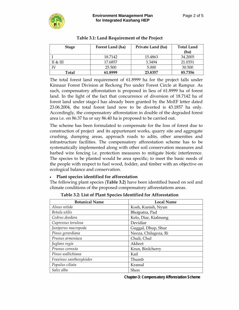
Environment Management Plan for Integrated Kashang HEP
Page 2 of 5
Chapter-3: Compensatory Afforestation Scheme
Table 3.1: Land Requirement of the Project
Stage Forest Land (ha) Private Land (ha) Total Land (ha)
I 18.7142 15.4863 34.2005 II & III 17.6857 3.3494 21.0351 IV 25.500 5.000 30.500
Total 61.8999 23.8357 85.7356
The total forest land requirement of 61.8999 ha for the project falls under Kinnaur Forest Division at Reckong Peo under Forest Circle at Rampur. As such, compensatory afforestation is proposed in lieu of 61.8999 ha of forest land. In the light of the fact that concurrence of diversion of 18.7142 ha of forest land under stage-I has already been granted by the MoEF letter dated 23.06.2004, the total forest land now to be diverted is 43.1857 ha only. Accordingly, the compensatory afforestation in double of the degraded forest area i.e. on 86.37 ha or say 86.40 ha is proposed to be carried out.
The scheme has been formulated to compensate for the loss of forest due to construction of project and its appurtenant works, quarry site and aggregate crushing, dumping areas, approach roads to adits, other amenities and infrastructure facilities. The compensatory afforestation scheme has to be systematically implemented along with other soil conservation measures and barbed wire fencing i.e. protection measures to mitigate biotic interference. The species to be planted would be area specific; to meet the basic needs of the people with respect to fuel wood, fodder, and timber with an objective on ecological balance and conservation.
• Plant species identified for afforestation The following plant species (Table 3.2) have been identified based on soil and climate conditions of the proposed compensatory afforestations areas.
Table 3.2: List of Plant Species Identified for Afforestation
Botanical Name Local Name Alnus nitida Kosh, Kunish, Nyun Betula utilis Bhojpatra, Pad Cedrus deodara Kelo, Diar, Kialmang Cupressus torulosa Devidiar Juniperus macropoda Guggal, Dhup, Shur Pinus gerardiana Neoza, Chilagoza, Ri Prunus armeniaca Chuli, Chul Juglans regia Akhrot Prunus cornuta Krun, Birdcherry Pinus wallichiana Kail Fraxinus xanthoxyloides Thumb Populus ciliata Kramal Salix alba Shon
Environment Management Plan for Integrated Kashang HEP
Page 3 of 5
Chapter-3: Compensatory Afforestation Scheme
Beside, the above tree species, the shrub species identified for plantations are; Cotoneaster bacillaris, Colutea nepalensis, Elaeagnus umbellata, Spiraea canescens and Rosa webbiana.
3.2 METHODOLOGY AND COMPONENTS
The degraded forest land has large portion of barren hill slopes, and is devoid of trees observed from field studies. Soil working and plantation along contours conserves soil and enhances moisture regime and adverse effects of surface run – off is reduced considerably. Pits along contour reduce velocity of water, increase moisture and seepage of water in soil and reduce loss resulting in better growth of plants. Hence soil works and plantation shall be strictly followed along the contours.
In afforestation areas for digging pits along the contours, it is necessary to first align contour lines with the contour template and then pits should be dug along the contour lines, Generally, 30 x 30 x 45 cm size pits are dug in 60% of the area and 45 m x 45 m x 45 m size in 40% of the area leaving a space of 1.5 m between two consecutive pits or depending on the species to be planted. Then the soil is collected after removing pebbles and weeds, the pit is half refilled with soil mixed with humus or fertilizer. For digging 1500 pits per ha pits are dug 15 cm uphill from the contour. The spacing of pits along contour trenches should not be closer than 1.5 m.
In afforestation areas working should be started in May and completed by September in context of cold desert areas otherwise should be started in October and completed by March. It is important that the filling of trenches should not be left to be done along with plantation during rains to avoid soil wash. Extreme care should be taken in transporting plants to avoid any damage. Plantation should be done well in time during rains and few species that get leafless in winter can be planted during winter rains. The plants in the pits near contour trenches get more moisture and grow fast. Raising vegetative barrier of hedges has been found very useful not only for soil and water conservation but also for fuel wood production.
3.2.1 Seedling Requirements
During the first year of the scheme implementation the seedling are to be obtained from the existing nurseries of Forest Department and in due course of time some new nurseries should be developed near the compensatory afforestation areas to meet the requirement of plant seedlings for compensatory afforestation.
Environment Management Plan for Integrated Kashang HEP
Page 4 of 5
Chapter-3: Compensatory Afforestation Scheme
3.2.2 Nursery Development
Nurseries would be developed with 6 to 8 seedbeds each and 6-8 beds for potted plants. On an average 1.5 ha of land is required for nursery development. Nursery sapling would be developed for species identified for compensatory afforestation scheme. The Nursery development works should be started from the first year so that they are able to suffice the needs of supply of plant sapling from second year or so. The Nursery area should be near to the road plantation areas and should have irrigation facilities.
3.2.3 Fencing and Closure
A minimum block plantation in a compact area of 5 ha. or as available would be undertaken by providing wooden post fencing including watch and ward for assuring protection from biotic interference.
3.2.4 Beating Up
In case of longer spells of draught, sites with adverse natural conditions, some mortality of plants is bound to occur requiring beating of dead. Considering mortality rates varying from 30% to 10% after firest year plantation to 5th year. Beating up should be done as actually required. In southern slopes where moisture stress is more the requirement of replacement may be more.
3.3 COST ESTIMATES FOR PLANTATION PER HA LAND
Based on average of 5 ha plot of 250 m x 200 m, per ha cost model for afforestation of degraded forest land, as suggested by the Himachal Pradesh Forest Department No. FT 15-1790-2(D)-Vol V (Norm) Shimla, dated 19-06-2008, cost of compensatory afforestation per ha has been worked out after incorporating 25% hike in rates for Tribal / difficult areas as mentioned in foot note of Forest Department order dated 19-06-2008.
3.4 PAYMENT OF NET PRESENT VALUE OF LAND TRANSFERRED
In the wake of MoEF New Delhi Circular F. No. 5-1 / 98-FC (Pt-II), dated 17/18 September,2003, in pursuant to the order issued by the Hon’ble Supreme Court of India, the State Government shall have to charge from the user agency the Net Present Value (NPV) of lard to be converted for non-forestry purposes under the Forest (Conservation) Act, 1980, depending upon the quantity / density and type of species, with in the range specified there in. In the present context the value of NPV of the forest land in question has been assessed as Rs. 412.30 lacs. After realizing the amount the state Government shall transfer these funds to CAMPA for utilization and improvement of the environment.
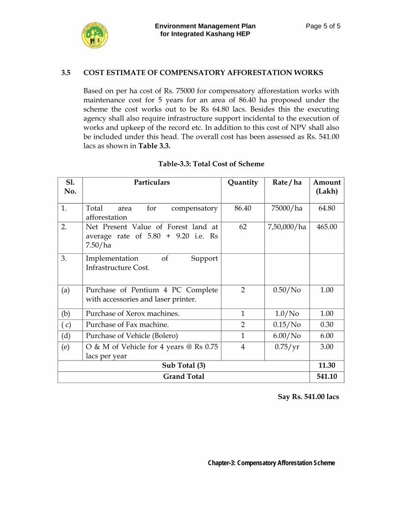
Environment Management Plan for Integrated Kashang HEP
Page 5 of 5
Chapter-3: Compensatory Afforestation Scheme
3.5 COST ESTIMATE OF COMPENSATORY AFFORESTATION WORKS
Based on per ha cost of Rs. 75000 for compensatory afforestation works with maintenance cost for 5 years for an area of 86.40 ha proposed under the scheme the cost works out to be Rs 64.80 lacs. Besides this the executing agency shall also require infrastructure support incidental to the execution of works and upkeep of the record etc. In addition to this cost of NPV shall also be included under this head. The overall cost has been assessed as Rs. 541.00 lacs as shown in Table 3.3.
Table-3.3: Total Cost of Scheme
Sl. No.
Particulars Quantity Rate / ha Amount (Lakh)
1. Total area for compensatory afforestation
86.40 75000/ha 64.80
2. Net Present Value of Forest land at average rate of 5.80 + 9.20 i.e. Rs 7.50/ha
62 7,50,000/ha 465.00
3. Implementation of Support Infrastructure Cost.
(a) Purchase of Pentium 4 PC Complete with accessories and laser printer.
2 0.50/No 1.00
(b) Purchase of Xerox machines. 1 1.0/No 1.00 ( c) Purchase of Fax machine. 2 0.15/No 0.30 (d) Purchase of Vehicle (Bolero) 1 6.00/No 6.00 (e) O & M of Vehicle for 4 years @ Rs 0.75
lacs per year 4 0.75/yr 3.00
Sub Total (3) 11.30 Grand Total 541.10
Say Rs. 541.00 lacs
Environment Management Plan for Integrated Kashang HEP
Page 1 of 6
Chapter-4: Green Belt Development Plan
CHAPTER 4
GREEN BELT DEVELOPMENT PLAN 4.1 INTRODUCTION
In order to mitigate and minimize the environmental impacts arising due to construction of project from air pollution, noise pollution, soil erosion etc. the Greenbelt development around the project sites can provide the best solution. The green canopy not only absorbs some of these pollutants but also improves the aesthetic environment. Therefore, a “Green Belt Development Plan” has been proposed around the project area in general and along the project components in particular using the local flora.
4.2 DEVELOPMENT OF GREENBELT
The green belt is proposed to be developed within the project area along the network of approach roads, residential areas, office complex, trench weir sites, power house site and other working areas. The strategy worked out for development of green belt consists of following:
• Broad leaf trees growing above 10 m in height should be planted along the
approach roads and colonies • Plantation of trees should be undertaken in appropriate encircling rows. • Generally local/indigenous fast growing trees shrubs should be planted. • The trees should be protected by plantation of non palatable shrub species
to avoid browsing by animals. • Placement of Bamboo/Iron tree guards be provided to save the plants
The schematic arrangement of greenbelt plantation proposed along the roads and Office/Colony is presented in Figure 4.1 . It is proposed that densification plantation in degraded forest land around the periphery of trench weir, power house and MAT will be taken up besides road side plantation along approach / haul roads. In areas wherever the private land falls along the periphery of the project area the plantation will be done by distributing saplings to villagers, if they are keen to take up plantation in their land.
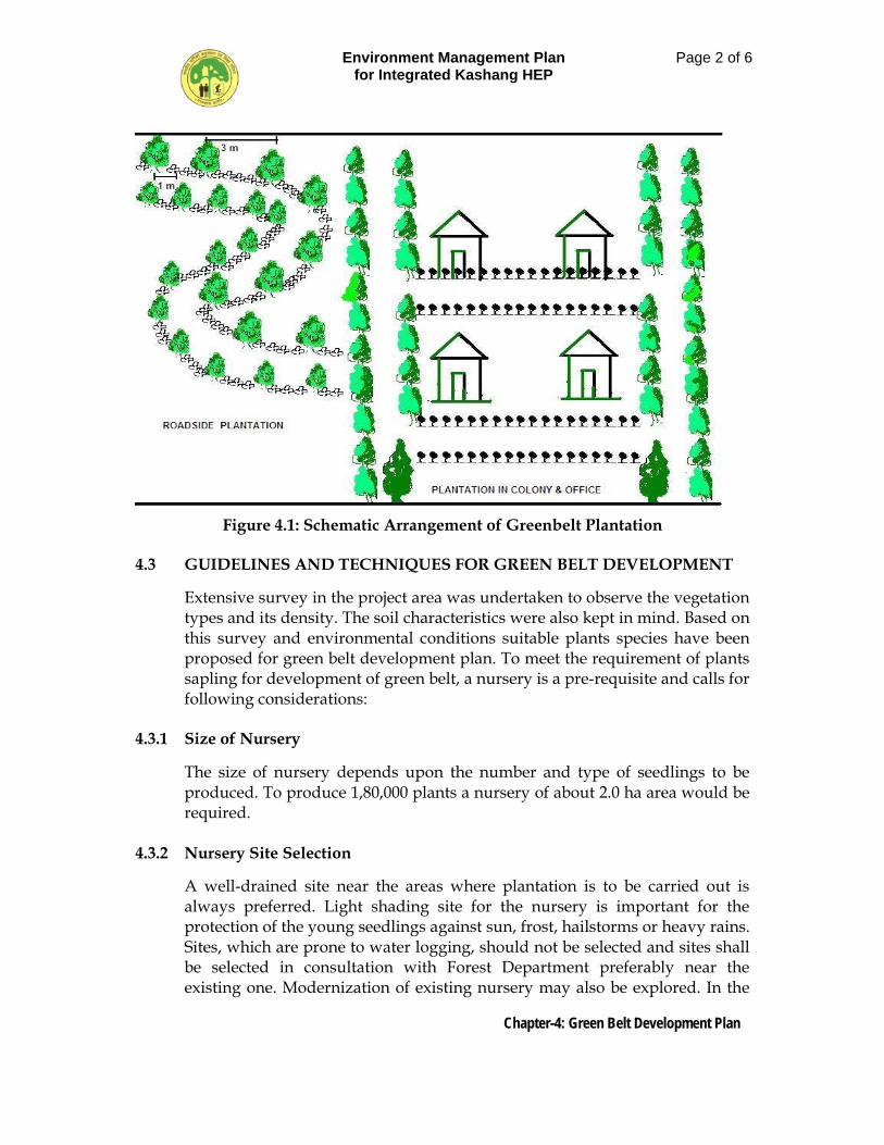
Environment Management Plan for Integrated Kashang HEP
Page 2 of 6
Chapter-4: Green Belt Development Plan
Figure 4.1: Schematic Arrangement of Greenbelt Plantation
4.3 GUIDELINES AND TECHNIQUES FOR GREEN BELT DEVELOPMENT
Extensive survey in the project area was undertaken to observe the vegetation types and its density. The soil characteristics were also kept in mind. Based on this survey and environmental conditions suitable plants species have been proposed for green belt development plan. To meet the requirement of plants sapling for development of green belt, a nursery is a pre-requisite and calls for following considerations:
4.3.1 Size of Nursery
The size of nursery depends upon the number and type of seedlings to be produced. To produce 1,80,000 plants a nursery of about 2.0 ha area would be required.
4.3.2 Nursery Site Selection
A well-drained site near the areas where plantation is to be carried out is always preferred. Light shading site for the nursery is important for the protection of the young seedlings against sun, frost, hailstorms or heavy rains. Sites, which are prone to water logging, should not be selected and sites shall be selected in consultation with Forest Department preferably near the existing one. Modernization of existing nursery may also be explored. In the
Environment Management Plan for Integrated Kashang HEP
Page 3 of 6
Chapter-4: Green Belt Development Plan
present case the modernization of forest nursery at Pangi (0.55 ha), Lippa (0.75 ha) and at Akpa (0.65 ha) is proposed to meet and the demand of 1,80,000 trees under the green belt development plan.
4.3.3 Transportation
The nursery should be readily accessible all the year round in order to facilitate transportation of materials required in the nursery and dispatch of seedlings from the nursery.
4.3.4 Fertilizer Application
The organic fertilizer produced through domestic organic waste coupled with vermin compost can be utilized for the nursery. Farmyard manure (FYM) can also be used but chemical fertilizer should be avoided. The compost / vermin compost proposed to be developed through solid waste management.
4.3.5 Soil and Soil Fertility
The best site for raising the nursery is the area, which has got a thick layer of humus. The fertile and well-drained soil with sandy loam to loamy texture, pH varying from 5.5-7.5 should always the preferred for nursery sites.
4.3.6 Water Supply and Drainage
The site should have perennial water supply. The drainage of soil has important bearing on the health of seedlings.
4.3.7 Species to be Planted
A list of indigenous trees found suitable after identification of species for raising in the nursery and for development of green belt around the project area is given in Table 4.1.
Table 4.1: Suggested Plant Species for Green Belt Development
Botanical Name Local Name Alnus nitida Kosh, Kunish, Nyun Betula utilis Bhojpatra, Pad Cedrus deodara Kelo, Diar, Kialmang Cupressus torulosa Devidiar Juniperus macropoda Guggal, Dhup, Shur Pinus gerardiana Neoza, Chilagoza, Ri Prunus armeniaca Chuli, Chul Juglans regia Akhrot Prunus cornuta Krun, Birdcherry
Environment Management Plan for Integrated Kashang HEP
Page 4 of 6
Chapter-4: Green Belt Development Plan
Pinus wallichiana Kail Fraxinus xanthoxyloides Thumb Populus ciliata Kramal Salix alba Shon
Beside, the above tree species, the shrub species identified for plantations are; Cotoneaster bacillaris, Colutea nepalensis, Elaeagnus umbellata, Spiraea canescens and Rosa webbiana.
4.3.8 Precautions during Plantation
Some important precautions should be taken during the plantation, which are as under:
• Open grazing is practiced in general in the area; therefore, protection should be provided in advance.
• Polyculture should be practiced. Mixture by group should be preferred over intimate mixture.
• Species mentioned should be planted in sufficient numbers so as to increase their population size in the area.
• Multipurpose species should be planted in large numbers, so as to provide direct benefit to people living around.
4.4 GREEN BELT DEVELOPMENT
In order to raise the green belt around project areas, trench weir sites and other components the total requirement of different species of plants will be for 1,80,000 saplings. Since the green belt is to be created over a period of five years the maintenance for a period of five years of nursery and plantation works will be required. The beating up of mortality may be done with the plant stocks proposed to be generated in the nursery over the complete duration of the plan.
4.4.1 Road side plantation
Cost of the plantation has been calculated as per the existing schedule of rate, material cost (plants, FYM, tree guard, etc.) and the total area of treatment. One row each for tree, shrub and bio-fencing has been proposed with a spacing of 3 m x 3 m for trees and 2 m x 2 m for shrubs (to take care of the mortality in the next season). The pit size has been recommended as 45 x 45 x 45 cm for trees and 30 x 30 x 30 cm for shrubs. The cost of pit digging and filling is estimated at Rs. 10 per pit. Input of FYM @ 2 kg/pit has been suggested costing around Rs.5/pit. Cost of plantation including transport has been estimated at Rs. 10/plant making the total cost of planting one tree as Rs. 25. For the protection of trees from the cattle and other losses, thorny
Environment Management Plan for Integrated Kashang HEP
Page 5 of 6
Chapter-4: Green Belt Development Plan
bushes guards are required. Along the approach roads of about 38.8 km length plantation will be done on both sides where ever feasible as such plantation of about 65000 saplings will be done. Plantation along roads must take into account visibility aspects on curves so as to ensure safe driving.
4.4.2 Green Belt around Trench Weir Site / Power House
Plantation at the intake sites and power house sites for about 6 ha has been proposed for control of erosion and siltation of the stream and aesthetic importance. The total cost for planting in 6 ha area @ Rs. 88,125 / ha including establishment charges works out to be Rs. 5.5 lacs.
4.4.3 Green Belt around Residential Area and Office Complex
Plantation around the office complexes is proposed to be done so that greenery is developed. Precaution should be exercised by not planting large size trees around buildings and other similar structures as during winter the sun rays are obstructed by them invariably and much wanted sunshine is impaired. Besides this, it is also proposed to develop green belt around the working areas for trapping the dust and noise. Plantation of avenue, ornamental and fruit trees is proposed in these areas along with the area around office complex. The ornamental, fruit plants will be procured from the local market while the avenue plants will be raised in the project nursery. For providing green belt around residential areas and office complex a provision of Rs. 119.23 lakh has already been made under head M-Plantation in the DPR and it is proposed to plant 1,15,000 trees under the sub head.
4.5 COST ESTIMATE OF GREEN BELT DEVELOPMENT
Table 4.2 Summary of Cost for Green Belt Development
Sl. No.
Component Cost (in Lacs)
1. Modernization of 3 No. existing nursery @ Rs. 3.0 lac each 9.0
2. Maintenance of nursery @ 0.40 lacs/each year for 5 years 6.0
3. Cost of planting of saplings around trench weir site, power house and site for 6 ha @ Rs. 88125/ha
5.29
4. Maintenance cost for 4 years – 2 chowkidars @ Rs. 3000/- per month
2.88
5. Thorny brush wood protection guard for 65000 saplings along road isde @ 7.20/No.
4.68
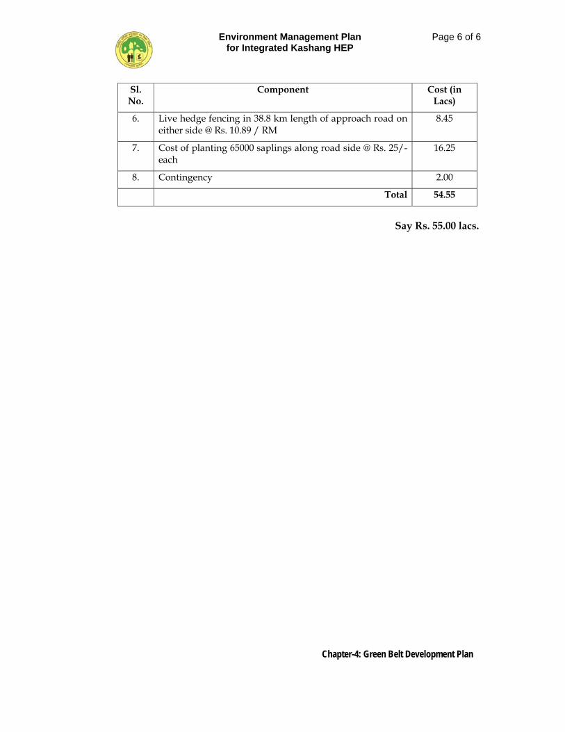
Environment Management Plan for Integrated Kashang HEP
Page 6 of 6
Chapter-4: Green Belt Development Plan
Sl. No.
Component Cost (in Lacs)
6. Live hedge fencing in 38.8 km length of approach road on either side @ Rs. 10.89 / RM
8.45
7. Cost of planting 65000 saplings along road side @ Rs. 25/- each
16.25
8. Contingency 2.00
Total 54.55
Say Rs. 55.00 lacs.
Environment Management Plan for Integrated Kashang HEP
Page 1 of 16
Chapter-5: Wildlife Management and Bio-diversity Conservation Plan
CHAPTER – 5
WILDLIFE MANAGEMENT & BIODIVERSITY CONSERVATION PLAN
5.1 GENERAL
Himalayas one of the youngest and fragile mountain formation supports varied forms of life and unique ecosystems with its snow clad peaks, glaciers, and alpine meadows. The Himalayans have a rich reserve of life forms. Because of sharp zonation in altitude and vegetation, the Himalaya is a treasure with unique biodiversity. The Lippa-Asrang Wildlife Sanctuary under the overall control of Sarahan Wildlife division falls in Moorang Tehsil of Pooh Sub-Division in Kinnaur District. The area falls in the West Himalayan Zone of the Himalayan Mountain Chain. The area is situated in the upper catchment of an important tributary of the Satluj River, the Taiti stream. The area of the sanctuary is 30.89 sq. kms. The altitude ranges from 3000 mtrs. to 5122 mtrs. There are three villages inside the sanctuary area namely, Lippa, Asrang and Toktuo. The prominent species available in the sanctuary includes Snow Leopard, Bharal, Ibex, Brown Bear, Musk deer, Snow partridge, Snow-Cock. The sanctuary falls in high altitude Himalayan zone and there are hardly any trees within the sanctuary boundary. The vegetation is represented by alpine shrubs and juniper bushes. The zone on the lower altitude and cooler aspect has few trees of Deodar, Kail, Chilgoza, Juniper, Salix and Alnus species. This sanctuary has vast stretches of alpine pastures, which serve as store house of important Himalayan medicinal herbs like, Dhoop, Karoo, Patish and most prominently Kuth.
5.2 STATUS OF WILDLIFE SANCTUARY 5.2.1 Name and Location:
The Lippa-Asrang wildlife sanctuary falls in Moorang Tehsil of Pooh Sub-Division in Kinnaur district. It was notified as a sanctuary first in 1962 and then re-notified in March, 1974 vide Himachal Pradesh Government Notification No. 5-11/70-SF dated 27-03-1974. The Lippa-Asrang Wildlife Sanctuary is situated between 28o 31o 40’ 15” and 31o 44o 18” North Latitude and 78o 13’ and 78o 18’ East Longitude. It is under the wildlife administrative control of Sangla Wildlife Range which is a part of Sarahan Wildlife division, about 140 km. away from the sanctuary. The nearest town is Reckong Peo, which is also headquarters of the Kinnaur district. Nearest Rail Head and Airport is at Shimla.
Environment Management Plan for Integrated Kashang HEP
Page 2 of 16
Chapter-5: Wildlife Management and Bio-diversity Conservation Plan
5.2.2 Boundaries
The Lippa-Asrang Wildlife Sanctuary has been notified vide Government of Himachal Pradesh Notification No. 5-11/70-SF dated 27-03-1974. The boundaries of the sanctuary are as under: North: Taiti Gad/stream. West: Prestigious ridge to the West of Balinaren and Nagach Thatchee
extending between Taiti Gad Moltha Thong Dhar. South: Moltha Thong Dhar West: Drimbling Dhar The area of the sanctuary is 30.89 sq. km.
5.2.3 Geology and terrain
The Himalayas are the youngest geological formations in the world and are still in the stage of morphological evolution. The important rock formations are gneiss, granites, quartzite and schist. The area is very dry, mountainous and ecologically fragile. Between Asrang and Lippa to the North of Taiti Khad, the strata mainly consist of granite and gneisses, which are very altered with the consequent formation of China clay. The rapid weathering of granite in the sanctuary appears due to high frequency of frost action and extreme temperature. It gives rise to sandy soil. Schist and gneisses produce clay and granite produces loam, and therefore sandy-clay soil type is most prominent in the sanctuary. The humus layer is not very thick. The soil depth is also not much due to precipitous slopes and coupled with high altitude, tree growth is almost negligible. On steep slopes the erosion due to snow, sliding of glaciers is very high and consequently the fertility of the soil is on lower side. In the buffer zone area, however, soil depth and humus layer is sufficient to sustain tree growth.
5.2.4 Climate and Rainfall
The area has extreme temperature, harsh climate with average to very heavy snowfall and rainfall 22.63 mm. The temperature ranges from – 10o C to 15o C. Winter season is fairly prolonged from mid of November to end of March or early April. Summer is of short duration up to May and rains start in June, which lasts till September. During this period there is also snowfall in higher reaches.
5.2.5 Water Sources
Higher snow clad mountains are mainly the source of water. Taiti stream is the main source of water beside kochi which being equally important, are the main source of water. When the snow starts melting, water is diverted through small check dams to the small irrigation channels. Skillfully constructed wooden siphons are used for direction of water, which reduce the loss of water in transect. As the rainfall is less, snow fed streams play an important role in the water regime of the area.
Environment Management Plan for Integrated Kashang HEP
Page 3 of 16
Chapter-5: Wildlife Management and Bio-diversity Conservation Plan
5.2.6 Flora of the sanctuary
The vegetation is represented by Juniperous shrubs and alpine pastures. There are hardly any trees in the sanctuary area. Eighty seven medicinal plant species have been reported, out of which fifteen are threatened. In the proposed buffer zone, trees of Deodar, Chilgoza and Kail with few broadleaves are present. Based on the eco-system classification of forests by Champion and Seth following forest types are representative of the area; (i) Himalayan Dry Temperate Forests; Type 13/C-IIa Neoza Pine Forests (Pinus gerardiana): Nearly pure crops, locally mixed with Deodar are seen. The forests being open a great deal surface is bare. These are much frequented by men for collection of the Neoza seed, which has got a ready made. Upper storey consists of Pinus gerardiana and occasionally Cedrus deodara. In the second storey Fraxinus xanthoxyloides is common. Among the shrubs Artimesia maritima, Daphne oleoides, Ephedra gerardiana, Lonicera hypoleuca common.
Type 13/C-IIb dry deodar forests: This type has pure coniferous forest along the open slopes, broadleaved trees being confined to mostly ravines. It varies from the complete canopied forests to very open forests of low branching trees depending upon moisture factors. The Deodar tends to be gregarious and forms nearly pure crops. On drier situations, it is found mixed with Pinus gerardiana but open mixed crops are common especially in the more arid tracts where the Pine extends much higher up the slopes. Blue-Pine is frequently present and may occur as a pure crop over limited areas, especially at the higher elevations. The undergrowth varies in type and density considerably in pure or mixed forests and also according to the dryness of the locality. The common shrubs and herbs are Plectranthus spp., Indigofera gerardiana, Fragaria vesca and Viola serpens, etc. When Kail is dominant, Desmodium tiliaefolium, Asparagus filicinus and Salvia glutinosa are more in evidence. (ii) Moist Alpine scrub;
15/C-3 Alpine pastures: Extensive alpine pastures form a characteristic feature of the tract just above the tree line. The limit of their altitudinal distribution is between 3600-4550 m. elevation, the upper limit extending even to the perpetual snowline. The slopes are usually gentle and bear a thick mat of alpine grasses. The areas remain snow bound from November to April. The common herbs are Primula glomerata, Anemone obtusilova, Iris spp., Gentiana kurroo, Jurinea macrocephala , Aconitum heterophyllum, etc. The common Agropyron spp. Brachypodium sylvaticum, B. japonica, Poa spp., Dactylis glomerata and Millium effusum, etc.
Environment Management Plan for Integrated Kashang HEP
Page 4 of 16
Chapter-5: Wildlife Management and Bio-diversity Conservation Plan
(iii) Dry Alpine Scrub: It is very open xerophytic formation. The annual precipitation is always below 350 mm, which is obtained in the form of winter snow. There is not much area available for grazing owing to inaccessibility and ruggedness of the terrain. The vegetation consists of dwarf trailing shrubs such as Juniperus communis, Artemisia maritime, Caragana brevispina, Ephedra gerardiana, Lonicera hispida, etc.
Type-16/E-I dwarf juniper scrub: This type occurs on very dry sites exposed to intense isolation during the short growing season. The annual precipitation is mostly in the form of snow and may not exceed 250 mm., the soil is very dry sandy and loose and easily transported by wind. Scattered herbs occur but grasses are absent. The vegetation consists of Juniperus communis, about 0.6 m high in more or less compact patches of a few square meters at 2900 m. to 4250 m. Juniperus indica, with low spreading branches up to 30 cm., having average height of 1.5 m occur in dense patches up to 0.2 hectares in extent, at an altitude of 2900 m to 4200 m.
5.2.7 Fauna of the sanctuary
The main wildlife species found in Lippa-Asrang Wildlife Sanctuary are Snow leopard, Musk Deer, Bharal, Ibex, Himalayan Tahr, Leopard Cat, Weasals etc. Among birds, main species are namely, Monal, Snow-Cock, Koklash , Partridge, Chukore, Jungle Crow, Eagle, Sparrow Hawk and other smaller birds are also found. Brief description about main species of the sanctuary is as under;
Snow Leopard (Panthera uncia): This animal of yellow grey colour with dark spots all over the body and long bushy tail is the main predator found in the Lippa-Asrang Wildlife Sanctuary up to 5500 m. It is nocturnal. It is distinctive in the shortness of its muzzle, high forehead and vertical chin. The spots are unbroken on head and lower parts of the limbs and break up into rosettes on the body. It usually resides above the tree-line i.e. 12000-13000 feet above sea level. It prays upon Sheep, Goats, Ibex, Blue-Sheep, rodents and is known to follow the movement of grazing herds. It is the main predator species in the food chain. Recently its number has been dwindling in wild and requires urgent attention to protect this species and its habitat. There have been instances where snow leopard has attacked domestic animals, causing considerable loss and thereby in direct conflict with man. Habitat improvement is of utmost importance so as to improve prey base for long term survival
Environment Management Plan for Integrated Kashang HEP
Page 5 of 16
Chapter-5: Wildlife Management and Bio-diversity Conservation Plan
Musk Deer (Moschus moschiferus): Locally this animal is known as “Musbapha”. In the past, it has been hunted for its precious “Musk-Pod”, which in fact is an abdominal gland found only in the male animal. A solitary and secretive animal, it is found between 2900-4000 m. elevation in the sanctuary. No systematic and detailed wildlife survey has been carried out for this species in the past as there are hardly any trees in the sanctuary area are necessary for refuge of the animals. However direct and indirect evidence of the animal in the sanctuary has been reported.It feeds on grass, lichens, leaves and flowers. Musk deerholds a place between the deer and the antelop and is regarded as the underdeveloped form of the deer. It is hornless and has a gall bladder. Bharal (Pseudois nayaur): This Himalayan Blue Sheep is seen mostly above 3000 m. In structure and habitat it holds a place intermediate between sheep and goat, as grazing on open grassy undulating slopes and like goat can climb to precipitous cliffs, inaccessible mountains when disturbed. It prefers undulating ground and is a splendid climber on stiff rocky terrain having considerable speed. Between trees and snowline, the Bharal finds their food in the occasional patches of coarse grass, moss and dwarf shrubs. It may occur in small group to big flock numbering up to two hundred occasionally. Ibex (Capra ibex): This is common animal of the Pin Valley National Park. The locals call it Kin or Tangrol. An ibex is heavily built sturdy Goat with large horns. It occurs in the higher elevation above the tree line. It is found in herds and is hunted for soft woolly under fur. Brown Bear (Ursus arctos): Its heavier built and brown coat will suffice to distinguish it from the Black Bear. The coat is dark rich brown during summer and luxuriant before the onset of winter. It inhabits bare open peaks high above and along the tree-line. During early summer, they graze on newly grown grass and hunt voles and marmots. They also kill Sheep, Goat and Ponies during summer. During fruiting season, it feeds on berries and wild fruits. It hibernates during winter. Thar (Hemitragus jemlahicus): These heavily build wild Goat with short curving horns inhabits steep cliffs in the forest terrain. Locally, it is known as Meshi. Thar is found in most inaccessible ground in the Himalayas. It inhabits precipitous terrain along towering cliff, rocks and dense scrub. Found in herds, its number in the wild is declining and urgent protection measures are required.
Environment Management Plan for Integrated Kashang HEP
Page 6 of 16
Chapter-5: Wildlife Management and Bio-diversity Conservation Plan
Leopard Cat (Felis benga lensis): It is about the size of a domestic cat but rather having longer legs. It looks like a miniature panther. There are four distinct bands running from the crown over the neck. They have a pair of horizontal check strips. It is nocturnal and prays on small birds and animals. Hollow in the tree are its favorite shelter. It preys upon small birds and animals and is nocturnal. Instances of its inbreeding with domestic cat have been observed.
The Himalayan Weasal (Mustela sibirica): It has been seen several times in thatches all over the sanctuary. It mostly inhabits stone walls raised by the shephered to protect their Sheep and Goats. This small animal, 60 cms in size, is known for inflicting damage on the pheasants. In the Himalayas it lives in temperate and alpine pastures upto16000 feet showing remarkable adaptability.
5.2.8 Summary of Threats to Wildlife Conservation:
Biotic pressure and habitat destruction are main threats to the wildlife conservation in the sensitive Himalayan region. The domestic animals compete with the wild dwindling population of the Himalayan species in alpine pastures resulting overgrazing, which has led to the degradation of pastures. Due to biotic pressure coupled with less precipitation and inhospitable terrain, the free migration of the wild species is restricted to the pockets in the Himalayas leading to inbreeding. Rehabilitation of the degraded areas, habitat improvement and corridor protection will also lead to the enrichment of biodiversity of the region.
5.2.9 Socio-economic Analysis:
Villagers have right of grazing, fuel-wood collection, timber, minor forest produce collection, etc. Unsustainable pressure on the natural resources has lead to the degradation of the area in many parts of the sanctuary. Lippa, Asrang and Toktuo, having population of 1600, are situated within the sanctuary. Porang Dogri, where these people migrate seasonally is also situated within the sanctuary area. Agriculture is the chief source of livelihood of the people of Lippa-Asrang. They usually get only one crop in the year, due to high altitude and harsh winter. They grow barley, wheat and vegetables. The farmers have to make the living out of infertile, shallow and stony land holdings.
At the onset of winter, they move down to lower elevations to sell some of their indigenous items like wool which add to their source of livelihood. They also grow Kuth, Peas and other vegetables as a cash crop. Animal husbandry is another occupation, which adds to the marginal income of the local population. Kuth is also being cultivated locally. Chilgoza Pine’s (Pinus gerardiana) seeds are highly valued and add to the economy. The hostile terrain and unfriendly climatic conditions restrict developmental activities and living is generally harsh under these conditions.
Environment Management Plan for Integrated Kashang HEP
Page 7 of 16
Chapter-5: Wildlife Management and Bio-diversity Conservation Plan
5.3 WILDLIFE MANAGEMENT AND DEVELOPMENT PLAN FOR THE LIPPA ASRANG WILDLIFE SANCTUARY
Objectives:
This plan envisages the conservation of biodiversity and sustenance of mountain livelihood as long term goals. A plan for conserving the biodiversity of the area, ecological rehabilitation of the tract by pasture development and enrichment, afforestation and land stabilization measures, improving water regime, control of illicit poaching are some of the steps to protect and conserve the biodiversity of the area.
Eco-development of the area in addition of aforementioned factors will
include sustaining mountain livelihoods, community development, eco-tourism promotion and protection of cultural values. To achieve these goals, the objectives of the plan are as under:
i. To improve the habitat and protect the species found in the sanctuary
ii. To support pheasant conservation and breeding program at Sarahan iii. Carrying out soil stabilization works in erosion prone areas by
constructing bio-engineering/engineering structures to consume and reduce soil erosion
iv. Promotion of LPG and non-conventional energy to resources so as to reduce pressure on natural resources
v. To support livelihood enhancing components so as to reduce the dependence of the local population on natural resources
vi. To undertake rural infrastructure and community development works in the area so as to get their involvement in biodiversity conservation
vii. To promote eco-tourism and generate awareness regarding environmental values among local masses especially school children
viii. To build capacity and impart professional training to the sanctuary staff. ix. To establish research and monitoring mechanism for effective
implementation and achievement of plan components The priority will be to conserve and protect the biodiversity of the sanctuary. The eco-development to promote and sustain the livelihood support systems, promotion of eco-tourism and creating environmental awareness will be the other key areas requiring varied management efforts to achieve the long term goal. In order to achieve the above objectives, activities under following components based on the objectives outlined above are required to be implemented.
Environment Management Plan for Integrated Kashang HEP
Page 8 of 16
Chapter-5: Wildlife Management and Bio-diversity Conservation Plan
5.4 WILDLIFE MANAGEMENT AND CONSERVATION:
Himalayas representing very fragile ecosystems, inhabits unique faunal and floral species. The key stone species sustaining the critical natural food web require appropriate management strategy and effective implementation of the plan. The tough rugged mountains with harsh climatic conditions and less working season during the year, makes the natural resource management more challenging. The management inputs have to be appropriate so as to allow nature to function within natural parameters. The preference of key stone species of the sanctuary has to be analyzed for habitat manipulation and management intervention. The following activities are proposed for the management and conservation of biodiversity of the Lippa-Asrang wildlife sanctuary:
5.4.1 Habitat Improvement: 5.4.1.1 Pasture improvement and afforestation ; Improvement of alpine pastures and
planting of indigenous useful species will be undertaken. Rotational grazing in alpine pastures and stocking by genetically superior and improved varieties of grass involving stakeholders will decrease overgrazing and pasture degradation. Alpine grass species like, Poa alpina, P. versicolor, Chrysopogon echinulatum, Bothrochoea, Agrostis gigantea, Bromus gracillimus, B. inermis and legumes such as Melilotus alba and Medicago falcata will be taken up for pasture improvement. Weed control will also be factored in while carrying out pasture improvement activities. As the area is mostly situated in alpine pasture zone, planting of useful species i.e. Populus ciliata, Fraxinus xanthoxyloides, Pinus gerardiana, etc. will be restricted to the lower end along moist portions.
5.4.1.2 Creation of water resources: Construction of water ponds and check- dams
at appropriate places will help in augmentation of the water regime. Diversion of water to northern facing slopes and thereby
5.4.1.3 Soil conservation measures: Himalayas are prone to landslides due to
precipitous terrain and shallow soil depth. Construction of Bio-engineering/ engineering structures to arrest the soil erosion and land degradation will help in stabilization of the strata. Soil conservation along steep slopes improves water regime, which is conducive to support vegetation and thereafter get stabilized.
5.4.1.4 Strengthening the protection mechanism: Wild populations are to be
protected against poaching for which support in the form of equipment and training will be required. Wildlife health initiation by inoculating local cattle to minimize the spread of diseases to the wild population required support.
Environment Management Plan for Integrated Kashang HEP
Page 9 of 16
Chapter-5: Wildlife Management and Bio-diversity Conservation Plan
5.4.2 Support to Pheasant conservation and breeding program at Sarahan: Some species are on verge of extinction and for protecting them ex-situ efforts are required. A pheasantry to support conservation and breeding of western Tragopon has been established at wildlife divisional headquarters at Sarahan. In it birds are being bread in capacity for ultimately releasing them in natural habitat for establishing viable populations in the wild. Other rare and endangered species can be taken up for captive conservation and breeding program on priority basis for which the funds in addition to the existing conservation efforts are proposed under this plan.
5.4.3 Soil Stabilization and Bio- engineering works; To arrest soil erosion for
improvement of moisture regime and productivity, construction of bio-engineering /engineering structures on private land has to be carried out. Check-dams, spurs (preferably vegetative) and check walls at appropriate places as per requirement will be constructed.
5.4.4 Promotion of Non-Conventional Energy Sources: Energy saving devices
like improved Chullahs/ Solar Cookers, Crematoriums, Solar Lanterns/ Lights, LPG, Gobar Gas Plants, etc. will be introduced in the villages located within and outside the protected area to reduce the requirement of fuel-wood and minimise over dependency of villagers on wood. The activities will be demand driven and location specific.
5.4.5 Support to sustainable mountain livelihoods
Himalayas are also referred to as Living Mountain due to high population concentration as compared to other mountainous regions of the world. However, at the altitude rise and we approach high Himalayan Ranges the density of population decreases whereas the dependency on natural resources of the people increases. The area falls in the tribal belt of the state and requires additional efforts to enhance and sustain livelihood delivery systems. In this plan following issues will help in sustaining the livelihoods of the local population.
5.4.5.1 Livestock and Fodder Improvement: The aim is to improve productive
potential through improvement of fodder, management practices and genetic upgrading of the livestock. It will also contribute towards restoration of health, vigour and purity of the production environment. As targeted support to nomadic groups, this subcomponent will include implementation of Development Plans which are aimed at better flock management, improved animal health care and promotion of income generating activities for the migratory graziers. Special emphasis will be given on reducing man – animal conflict in the area and due compensation will be paid to the farmers for loss of human and cattle life and agriculture
Environment Management Plan for Integrated Kashang HEP
Page 10 of 16
Chapter-5: Wildlife Management and Bio-diversity Conservation Plan
produce done by wild animals after identifying mutually agreeable criteria. Livestock health will be improved by completing existing practices with additional support in terms of medicines, de-worming, vaccination, veterinary, aid-kits and organizing veterinary health camps on a regular basis making use of the existing veterinary facilities. Support will also be provided for activities like nutritive food for rearing young calves by complementing the existing system in place. Based on the need, support will be provided in terms of facilities for artificial insemination as well as natural breeding by strengthening the existing veterinary services already available in the area.
5.4.5.2 Fodder Production and Community Woodlots: Agro-forestry, silvi-pasture and alpine pasture development in the degraded land will be encouraged. Mini-Kits will be provided to facilitate quality fodder and fuel-wood production. Improved planting material of grass and other local potential fodder crops will be encouraged on the field boundaries. Community woodlots through panchayats will be created and managed on PFM principles on community / forest lands. Existing community management practices in the region will be supported in the natural resource management sector. Innovation in existing forestry and wildlife management practices will be adopted and promoted. Fodder will be the main focus in all forestry based plantations to attract the community participation. Stall feeding will be encouraged by providing one time subsidy/ support for (a) renovation of cattle shed (b) construction of livestock sheds, only for the poorest of the poor and (c) chaff cutters. Conservation and value addition of fodder will be encouraged through encouraging practices of hay and silage making and quality will be improved by demonstrating and encouraging Urea-Molasses treatment of crop residues.
5.4.5.3 Water Harvesting Structures: Depending on the local potential and suitable terrain, water resources will be developed for livelihood enhancement in the surrounding of Lippa-Asrang Wildlife Sanctuary. Depending on the physiographic and local conditions, the component will include following indicative activities: Developing new and improving existing water resources; Construction of village ponds, tanks, check-dams; Support and encouragement for roof water harvesting and irrigation; Efficient use of water by improving conveyance systems, channels and
kuhls, sprinkler and drip irrigation.
The issue of developing new and improving existing water resources gain special significance in dry cold desert areas to promote vegetation to produce soil. The catchment is to be rehabilitated for recharging the natural water delivery mechanism. Efforts to conserve water have to be taken well in time as there is no conceivable substitute for such natural services.
Environment Management Plan for Integrated Kashang HEP
Page 11 of 16
Chapter-5: Wildlife Management and Bio-diversity Conservation Plan
5.4.5.4 Agriculture and Allied Sector: Agriculture and allied activities are the main stay of the mountain communities’ livelihoods. Strategic investments will be made to create on-farm based livelihood opportunities and income generation through improved agriculture, horticulture, forestry, poultry, bee-keeping, livestock and other farm based activities. Based on local potential and demand, high value crops, aromatic and medicinal plants and horticulture will be introduced and provision for its grading, processing, storage, branding, packaging and marketing will be facilitated by the project and will co-finance private sector entrepreneurs/ NGOs (on a one time subsidy basis). Propagation of Neoza (Pinus gerardiana) which is endemic to cold desert and medicinal plants promotion will also enhance the economy of the area. Activities that will be carried out under this sub-component can be categorized into two focus area; (i) farming systems development and extension support, and (ii) value addition and marketing.
5.4.5.5 Support to Farming System and Extension Support: Investments will be made to enhance farm input services and extension, which includes appropriate technologies generation and dissemination, provision for improved quality of seeds, integrated pest management, vermin-composting, soil testing and support for introduction of high value crops on market demand, medicinal and aromatic crops especially in locations where water resources are created for supplemental irrigation. Finances from the project will be directed towards introduction or further development of decentralized, collaborative technology generation and dissemination activities in villages inside the sanctuary. The mobilization will ensure greater farmer involvement in planning and implementation of extension and adaptive programs. The implementation of this sub-component will tactically depend on the nature of collaboration between the project and other line departments responsible for agriculture and allied sectors; and public-private partnership with private sector and NGO service providers. Introduction of innovative agricultural, livestock and poultry production systems would be actively promoted.
Demonstration, field days, exposure visits, mass-media, development of local resource persons and master trainers and wherever feasible information technology will be used as extension tools. The precise nature of demonstrations, training programme and other interventions will be detailed out in the project implementation plan. Substantial capacity building and training of extension staff of line departments and farmers would be undertaken to employer producers and link them with multi sources of information and markets.
5.4.5.6 Value Addition and Farming: Value addition and marketing is critical for ensuring sustainable economic growth in the mountains. Providing private entrepreneurs with an enabling environment, efforts will made to create a congenial environment for promoting private entities. Finances (on a one-
Environment Management Plan for Integrated Kashang HEP
Page 12 of 16
Chapter-5: Wildlife Management and Bio-diversity Conservation Plan
time subsidy basis) will be made available to assist potential entrepreneurs to establish sustainable backward linkages with producers and producer groups, identify business opportunities, identify domestic and export markets through market surveys, trade fairs, etc. prepare marketing and business plans, and also access investment funds from GOI sponsored schemes and commercial banks. Basically the value-addition element will cover investment on product diversification, processing, grading storage, packaging, branding, credit linkages and marketing.
5.5 Rural infrastructure and community development
5.5.1 Infrastructure development; This sub-component covers construction of footpaths and small bridges to improve the accessibility to market and other public institutions for small and isolated habitations where conventional road construction is not feasible either due to topographical or economic considerations. It will also contribute towards improvement in the availability of potable water and rural health and sanitation. Public Health Centers and Aganwadis will be strengthened.
The project will prepare plans showing paths, foot-bridges, and culverts required and indicating how these provide access to each habitation to nearby roads or market centers. These plans would be prepared in such a way that they complement the existing master plans for rural roads prepared under the Prime Minister Gram Sadak Yojna (PMGSY). The traditional bridle paths, existing in many areas, will also be included in the plans. These plans will be finalized in consultation with the Panchayats and local communities. The component will also include construction of ropeways in identified areas to transport agriculture produce or other goods from the area of production to nearby roads (for onward transport to the marketing centers). Several of the roads in the project area require slope treatment and other improvements to check soil erosion and environmental degradation. Soil conservation activities on the rural infrastructure should be undertaken so that the main dam, roads as well as environment could be saved from further degradation. Use of appropriate plantation and drainage improvement would be promoted for this purpose. Ridge to valley approach will be adopted for catchment treatment.
5.5.2 Community development; Local institutions like, Panchayats, Self Help
Groups, Yuvak and Mahila Mandals will be strengthened. Exposure and study tours of local groups to places and institutions, which demonstrate innovative ideas/ models to improve their living standards, will be planned. This will widen their knowledge and enhance their understanding of natural resources resulting in developing site specific solutions to sustain mountain livelihood and retain cultural heritage.
Environment Management Plan for Integrated Kashang HEP
Page 13 of 16
Chapter-5: Wildlife Management and Bio-diversity Conservation Plan
5.6 ECO-TOURISM AND ENVIRONMENTAL AWARENESS
5.6.1 Eco-tourism; Himalayas are well known for trekking and mountain expeditions. Sighting of wildlife species i.e. as Blue-Sheep and Ibex along well defined trails inside the sanctuary can boost the tourism in the area. Local youths can get employment by acting as local Guides. Organizing trekking expeditions is another field having good adventure tourism potential. Local youth will be imparted training in this field in places which are well-developed having expertise in similar areas, like Leh (Jammu & Kashmir).
5.6.2 Environment Awareness Centre: Environmental Awareness Centre is proposed to be established at appropriate place, preferably at district Headquarters, which is not far off from the sanctuary, for general environmental awareness. With children as target group, centre will act as knowledge center about environmental values. This will inculcate the sense of belongingness among them helping in environmental protection and understanding the biodiversity richness of the Himalayas. The centre will also develop publicity material, organize environmental awareness meetings and workshops.
5.7 CAPACITY BUILDING AND SKILL-UP GRADATION
For quality management inputs, the capacity of the field staff deployed will be enhanced with appropriate training inputs in relevant fields at regular intervals.
Exposure visits and on field study tours to the well managed protected areas like Pin Valley National Park in Spiti, High Altitude Hemis National Park in Ladakh and high altitude well managed sanctuaries will be organized. Besides training in wildlife management field staff will also be sent to human and social development management courses.
5.8 RESEARCH AND MONITORING
As is well known that Himalayan biodiversity is not well studied at present. Research parameters are to be prioritized to study the habitat preferences of the species found in the sanctuary and accordingly devise and apply the management practices in the sanctuary. Research and monitoring is an important part of natural resource management. It has become more significant today as more species are being added to the endangered list. A mechanism to monitor and evaluate the objectives proposed under the plan will be established in the beginning for effective implementation. Monitoring wildlife population trends, non timber forest produce shall be taken up on priority. Research will also be required to uplift the socioeconomic condition of the local population for harmony between man and nature. An Implementation and monitoring committee is proposed to be constituted for implementation, monitoring and evaluation of the project components under the chairmanship of the divisional Forest Officer, wildlife Division Sarahan. The committee shall have local Panchayat Pradhan, two reputed NGOs, representatives of Mahila Mandals and Youth clubs as members. The committee will meet once in each quarter in the sanctuary area.
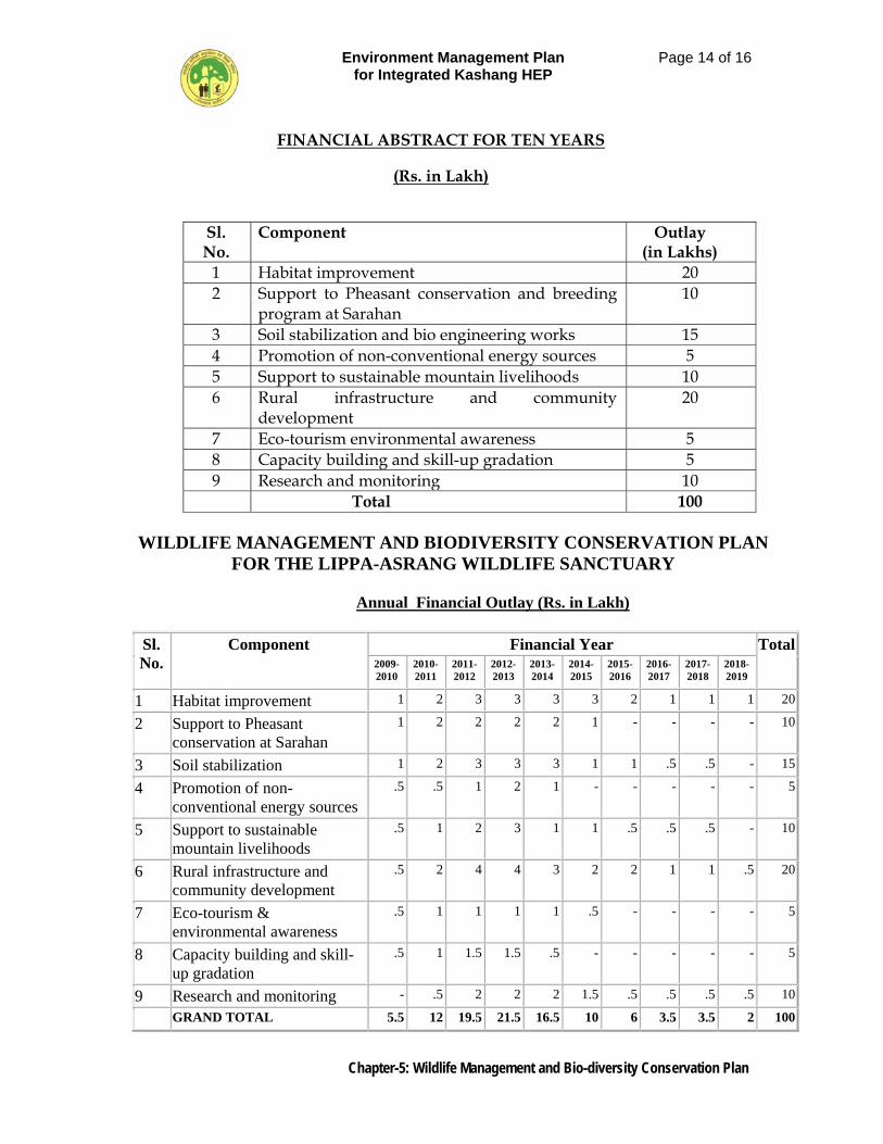
Environment Management Plan for Integrated Kashang HEP
Page 14 of 16
Chapter-5: Wildlife Management and Bio-diversity Conservation Plan
FINANCIAL ABSTRACT FOR TEN YEARS
(Rs. in Lakh)
Sl. No.
Component Outlay (in Lakhs)
1 Habitat improvement 20 2 Support to Pheasant conservation and breeding
program at Sarahan 10
3 Soil stabilization and bio engineering works 15 4 Promotion of non-conventional energy sources 5 5 Support to sustainable mountain livelihoods 10 6 Rural infrastructure and community
development 20
7 Eco-tourism environmental awareness 5 8 Capacity building and skill-up gradation 5 9 Research and monitoring 10
Total 100
WILDLIFE MANAGEMENT AND BIODIVERSITY CONSERVATION PLAN FOR THE LIPPA-ASRANG WILDLIFE SANCTUARY
Annual Financial Outlay (Rs. in Lakh)
Sl. No.
Component Financial Year Total2009-2010
2010-2011
2011-2012
2012-2013
2013-2014
2014-2015
2015-2016
2016-2017
2017-2018
2018-2019
1 Habitat improvement 1 2 3 3 3 3 2 1 1 1 20
2 Support to Pheasant conservation at Sarahan
1 2 2 2 2 1 - - - - 10
3 Soil stabilization 1 2 3 3 3 1 1 .5 .5 - 15
4 Promotion of non-conventional energy sources
.5 .5 1 2 1 - - - - - 5
5 Support to sustainable mountain livelihoods
.5 1 2 3 1 1 .5 .5 .5 - 10
6 Rural infrastructure and community development
.5 2 4 4 3 2 2 1 1 .5 20
7 Eco-tourism & environmental awareness
.5 1 1 1 1 .5 - - - - 5
8 Capacity building and skill-up gradation
.5 1 1.5 1.5 .5 - - - - - 5
9 Research and monitoring - .5 2 2 2 1.5 .5 .5 .5 .5 10
GRAND TOTAL 5.5 12 19.5 21.5 16.5 10 6 3.5 3.5 2 100
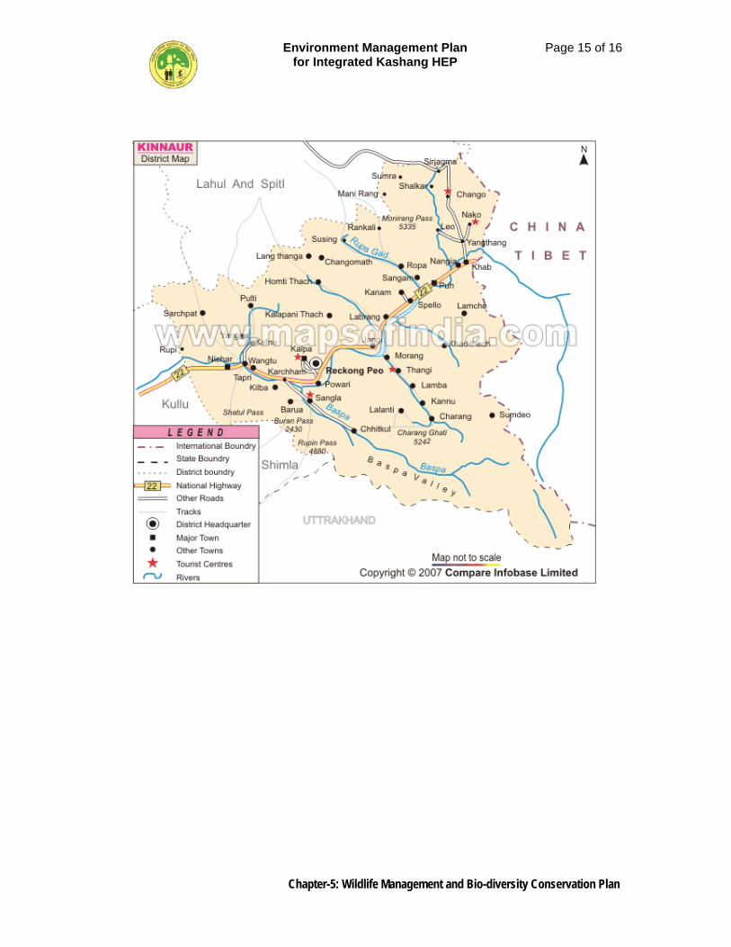
Environment Management Plan for Integrated Kashang HEP
Page 15 of 16
Chapter-5: Wildlife Management and Bio-diversity Conservation Plan
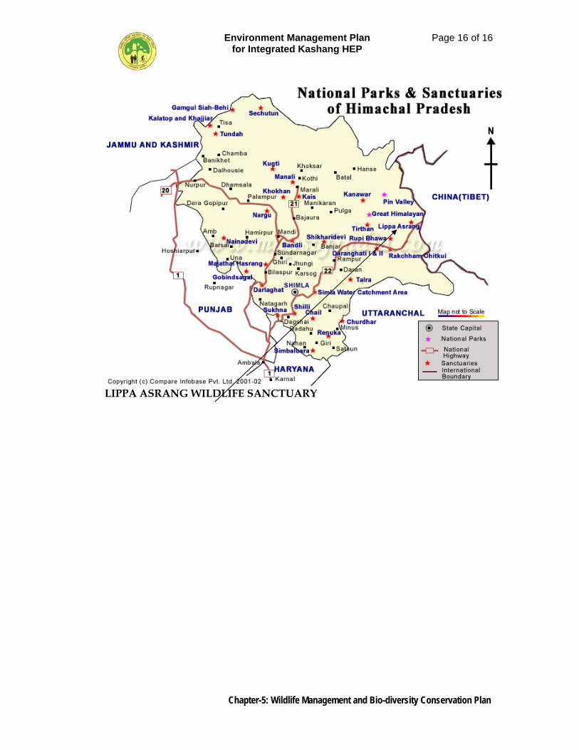
Environment Management Plan for Integrated Kashang HEP
Page 16 of 16
Chapter-5: Wildlife Management and Bio-diversity Conservation Plan
LIPPA ASRANG WILDLIFE SANCTUARY
Environment Management Plan for Integrated Kashang HEP
Page 1 of 24
Chapter-6: Muck Management Plan
CHAPTER – 6
MUCK MANAGEMENT PLAN
6.1 GENERAL
For construction of different components of the project substantial surface and underground excavation in over burden and rock for intake structure tunnel, balancing reservoir and powerhouse etc. would be required. The excavation shall result in large quantity of excavated material i.e. muck which shall have to be evacuated, disposed off and roller compacted or laid on mild slopes pari-passu with the excavation work, to such designated areas where the muck piles do not substantially interfere with either environment / ecology or the river flow regime and cause turbidity impairing the quality of water. The disposal of muck has to be scientifically planned keeping in view the pecuniary aspects necessitating nearness to the generating component of work, which understandably reduce the travel time of dumpers, interference to surface flow and ground water aquifer, disposition of habitation are a few aspects borne in mind in evolving a muck management plan. The Hydro Power policy, 2006 of Himachal Pradesh government under Chapter-V para (XXIV) lays down that the company shall use such material for the project activities as may be found suitable for construction and the remaining material shall be allowed to be used by other development departments like PWD, I & PH etc. Even the private crusher owners etc and private users shall also be allowed to use such material from the site free of cost. In the present case it is proposed of utilize about 25% of the excavated material on the project activities and about 10% of the muck generated through free-of-cost lifting by other Government agencies and private users. The balance 65% shall have to be disposed off away from sites so as to make available the clear site for construction activities. The balance muck shall be properly stacked and roller compacted or laid on slopes and treated to mix and match with the surrounding environ with least change in landscape. Based on the quantities of surface and underground excavation including 10% over break as contained in DPR a muck management plan, therefore, has been formulated to manage the disposal of muck and restore such areas from further degradation of the environment. During construction of the project huge quantities of excavation will be carried out from the underground and open air components and shall be either roller compacted to provide stable terraces for erection of labour camps, job facilities and storage area, or dumped in designated areas to provide stable slopes as per details given in Table 6.1.
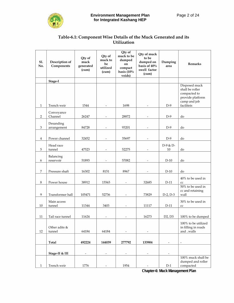
Environment Management Plan for Integrated Kashang HEP
Page 2 of 24
Chapter-6: Muck Management Plan
Table-6.1: Component Wise Details of the Muck Generated and its Utilization
Sl. No.
Description of Components
Qty of muck
generated (cum)
Qty of muck to
be utilized (cum)
Qty of muck to be
dumped on
compact basis (10%
voids)
Qty of muck to be
dumped on basis of 40% swell factor
(cum)
Dumping area Remarks
Stage-I
1 Trench weir 1544 - 1698 - D-9
Disposed muck shall be roller compacted to provide platform camp and job faciliteis
2 Conveyance Channel 26247 - 28872 - D-9 do
3 Desanding arrangement 84728 - 93201 - D-9 do
4 Power channel 32452 - 35697 - D-9 do
5 Head race tunnel 47523 - 52275 -
D-9 & D-10 do
6 Balancing reservoir 51893 - 57082 - D-10 do
7 Pressure shaft 16302 8151 8967 - D-10 do
8 Power house 38912 15565 - 32685 D-11 40% to be used in cc
9 Transformer hall 105471 52736 - 73829 D-2, D-3
50% to be used in cc and retaining wall
10 Main access tunnel 11344 3403 - 11117 D-11
30% to be used in cc
11 Tail race tunnel 11624 - - 16273 D2, D3 100% to be dumped
12 Other adits & tunnel 64184 64184 - -
100% to be utilized in filling in roads and ..walls
Total 492224 144039 277792 133904 - -
Stage-II & III - - - - -
1 Trench weir 1776 - 1954 - D-1
100% muck shall be dumped and roller compacted
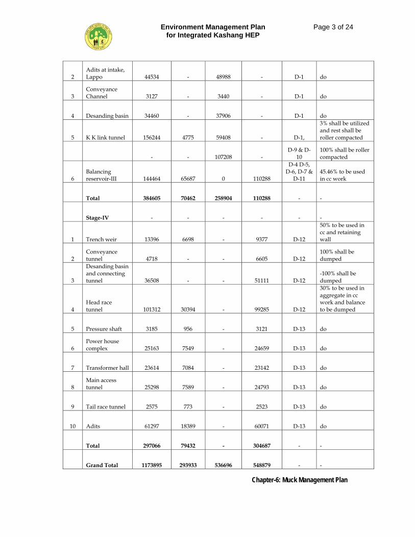
Environment Management Plan for Integrated Kashang HEP
Page 3 of 24
Chapter-6: Muck Management Plan
2 Adits at intake, Lappo 44534 - 48988 - D-1 do
3 Conveyance Channel 3127 - 3440 - D-1 do
4 Desanding basin 34460 - 37906 - D-1 do
5 K K link tunnel 156244 4775 59408 - D-1,
3% shall be utilized and rest shall be roller compacted
- - 107208 - D-9 & D-
10 100% shall be roller compacted
6 Balancing reservoir-III 144464 65687 0 110288
D-4 D-5, D-6, D-7 &
D-11 45.46% to be used in cc work
Total 384605 70462 258904 110288 - -
Stage-IV - - - - - -
1 Trench weir 13396 6698 - 9377 D-12
50% to be used in cc and retaining wall
2 Conveyance tunnel 4718 - - 6605 D-12
100% shall be dumped
3
Desanding basin and connecting tunnel 36508 - - 51111 D-12
-100% shall be dumped
4 Head race tunnel 101312 30394 - 99285 D-12
30% to be used in aggregate in cc work and balance to be dumped
5 Pressure shaft 3185 956 - 3121 D-13 do
6 Power house complex 25163 7549 - 24659 D-13 do
7 Transformer hall 23614 7084 - 23142 D-13 do
8 Main access tunnel 25298 7589 - 24793 D-13 do
9 Tail race tunnel 2575 773 - 2523 D-13 do
10 Adits 61297 18389 - 60071 D-13 do
Total 297066 79432 - 304687 - -
Grand Total 1173895 293933 536696 548879 - -
Environment Management Plan for Integrated Kashang HEP
Page 4 of 24
Chapter-6: Muck Management Plan
6.2 QUANTITY OF MUCK GENERATED AND ITS CONSUMPTIVE USE
It is eloquent from Table 6.1 that 1173895 cum of muck will be generated due to excavation, out of which 229749 cum is proposed to be re-utilized as construction material for consumptive use in non wearing surface like back fill, shotoreting and plumb concrete in construction of water conductor system like HRT, balancing reservoir, pressure shaft, MAT, TRT, other adits and in development works. Besides this 64184 cum muck obtained from excavation of other adits and tunnels shall be fully utilized in construction of approach roads/haul roads, thus the total quantity of muck to be utilized on works aggregates to 2,93,933 cum leaving the remaining 8,79,962 cum quantity to be disposed off at thirteen various sites besides allowing for disposal of approx 88000 cum quantity through free of cost lifting by other Govt. development agencies and individuals. Thus the total disposal of muck at the designated sites shall be to the tune of 7,91,962 cum. The disposed muck at three sites viz. D-1, D-9 and D-10 shall be roller compacted to develop terrace for erecting labour camps, site offices, storage yards and other job facilities. Therefore, 3,99,904 cum quantity of muck to be dumped and managed in these three sites have been adopted on compact basis whereas the balance muck quantity 3,92,058 cum which works out to 5,48,879 cum with 40% swell factor shall be disposed on slopes of hill at identified ten dumping locations well supported at base by suitable retaining structures. Subsequently all the spoil tips (muck disposal sites) will be developed by taking up plantation through bio-technological method to generate a thick forest canopy over them. The location of various dumping sites is depicted in Figure-6.1.
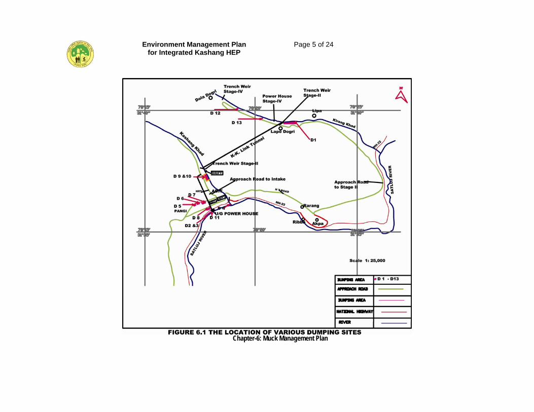
Environment Management Plan for Integrated Kashang HEP
Page 5 of 24
Chapter-6: Muck Management Plan
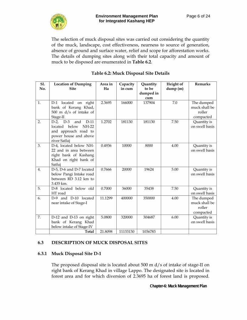
Environment Management Plan for Integrated Kashang HEP
Page 6 of 24
Chapter-6: Muck Management Plan
The selection of muck disposal sites was carried out considering the quantity of the muck, landscape, cost effectiveness, nearness to source of generation, absence of ground and surface water, relief and scope for afforestation works. The details of dumping sites along with their total capacity and amount of muck to be disposed are enumerated in Table 6.2.
Table 6.2: Muck Disposal Site Details
Sl. No.
Location of Dumping Site
Area in Ha
Capacity in cum
Quantity to be
dumped in cum
Height of dump (m)
Remarks
1. D-1 located on right bank of Kerang Khad, 500 m d/s of intake of Stage-II
2.3695 166000 137904 7.0 The dumped muck shall be
roller compacted
2. D-2, D-3 and D-11 located below NH-22 and approach road to power house and above river Satluj
1.2702 181130 181130 7.50 Quantity is on swell basis
3. D-4, located below NH-22 and in area between right bank of Kashang Khad on right bank of Satluj
0.4936 10000 8000 4.00 Quantity is on swell basis
4. D-5, D-6 and D-7 located below Pangi Intake road between RD 3.12 km to 3.435 km.
0.7666 20000 19624 5.00 Quantity is on swell basis
5. D-8 located below old HT road
0.7000 36000 35438 7.50 Quantity is on swell basis
6. D-9 and D-10 located near intake of Stage-I
11.1299 400000 350000 4.00 The dumped muck shall be
roller compacted
7. D-12 and D-13 on right bank of Kerang Khad below intake of Stage-IV
5.0800 320000 304687 6.00 Quantity is on swell basis
Total 21.8098 11133130 1036783
6.3 DESCRIPTION OF MUCK DISPOSAL SITES 6.3.1 Muck Disposal Site D-1
The proposed disposal site is located about 500 m d/s of intake of stage-II on right bank of Kerang Khad in village Lappo. The designated site is located in forest area and for which diversion of 2.3695 ha of forest land is proposed.
Environment Management Plan for Integrated Kashang HEP
Page 7 of 24
Chapter-6: Muck Management Plan
The dimension of the proposed site is 312 m long and 68 m average width and with 7 m average height it has capacity to hold 1,66,000 cum of muck against which 1,37,904 cum quantity obtained from excavation of trench weir, adits at intake, conveyance channel, descending basin and part of excavation of K-K Tunnel, Stage-III to the tune of 54,007 cum shall be disposed off and properly retained. The general view of the site is shown in Figure 6.2(a) and Figure 6.2(b).
6.3.2 Muck Disposal Sites D-2, D-3 and D-11
All these sites are located below approach road to power house area which in turn is located below NH-22 and are about 8 km distance from Reckong Peo. The site D-2 and D-3 are contiguous while D-11 is 400 m from power house. All these sites are overlooking river Satluj and have a combined capacity of holding 1, 81,130 cum of muck to be brought from excavation of power house, transformer hall, MAT, TRT and part of excavation of balancing reservoir. Diversion of 1.2702 ha of forest land for these sites has already been sanctioned. The general view of the site is shown in Figure 6.3 and Figure 6.4.
6.3.3 Muck Disposal Site D-4
The site is located below NH-22 and is below the road bridge in an area covered between right bank of River Satluj and Keshang Khad. The dimensions of the proposed site are 80 m x 50 m and with an average height of 4.0 m of dump, the storing capacity works out to 8000 cum. The site is designated to receive part muck from balancing reservoir. The Diversion of 0.4936 ha of forest land for the site has already been sanctioned. The general view of the site is shown in Figure 6.5.
6.3.4 Muck Disposal Site D-5, D-6 and D-7 These sites are located below Pangi – Intake road of Stage-I in between RD 3.12 km to 3.435 km and have dimensions 87.5 m x 40 m, 77.5 m x 30 m and 45 m x 45 m respectively. With an average height of 5 m of dump, the combined capacity is about 20000 cum. The site is about 3.5 km from intake and lies in forest. The diversion of 0.7666 ha of forest land for these sites has already been sanctioned. The general view of these sites is shown in Figure 6.6, Figure 6.7 & Figure 6.8.
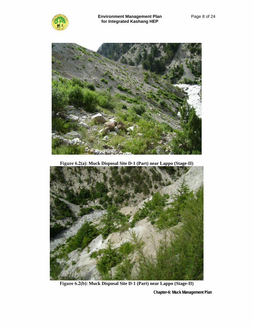
Environment Management Plan for Integrated Kashang HEP
Page 8 of 24
Chapter-6: Muck Management Plan
Figure 6.2(a): Muck Disposal Site D-1 (Part) near Lappo (Stage-II)
Figure 6.2(b): Muck Disposal Site D-1 (Part) near Lappo (Stage-II)
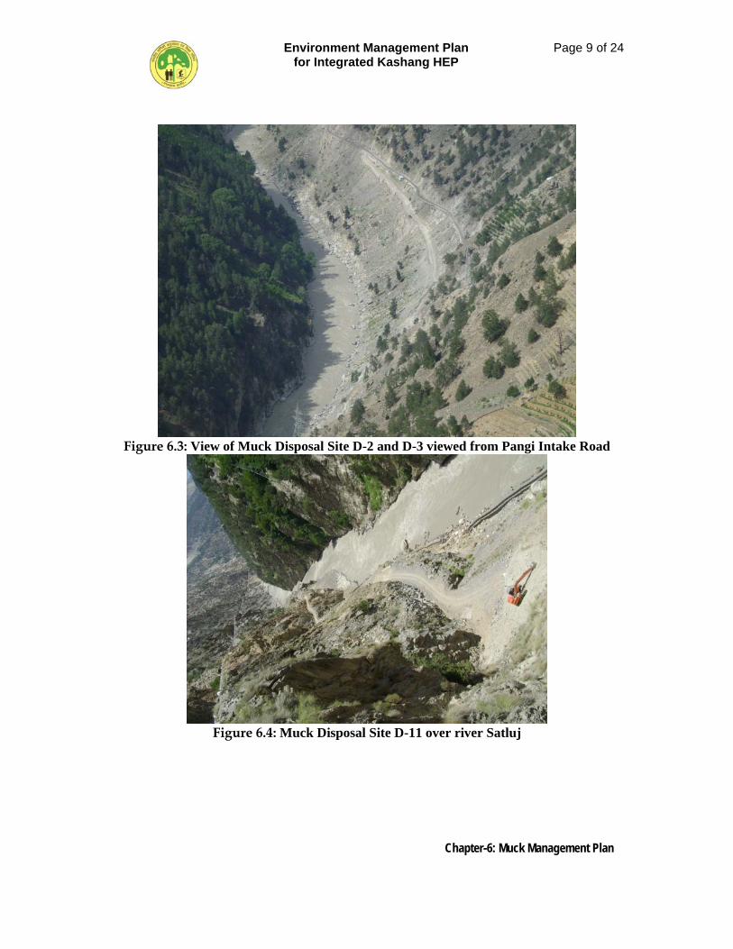
Environment Management Plan for Integrated Kashang HEP
Page 9 of 24
Chapter-6: Muck Management Plan
Figure 6.3: View of Muck Disposal Site D-2 and D-3 viewed from Pangi Intake Road
Figure 6.4: Muck Disposal Site D-11 over river Satluj
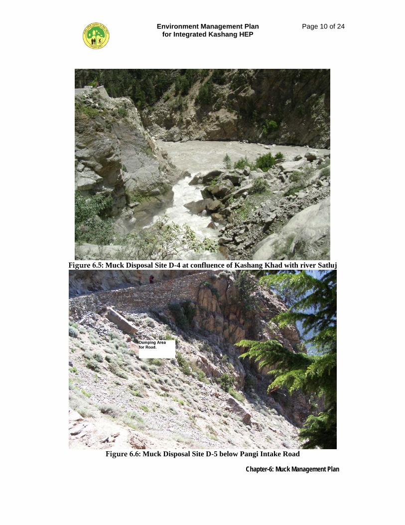
Environment Management Plan for Integrated Kashang HEP
Page 10 of 24
Chapter-6: Muck Management Plan
Figure 6.5: Muck Disposal Site D-4 at confluence of Kashang Khad with river Satluj
Figure 6.6: Muck Disposal Site D-5 below Pangi Intake Road
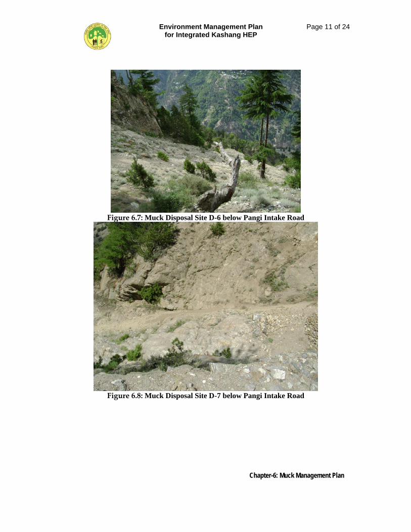
Environment Management Plan for Integrated Kashang HEP
Page 11 of 24
Chapter-6: Muck Management Plan
Figure 6.7: Muck Disposal Site D-6 below Pangi Intake Road
Figure 6.8: Muck Disposal Site D-7 below Pangi Intake Road
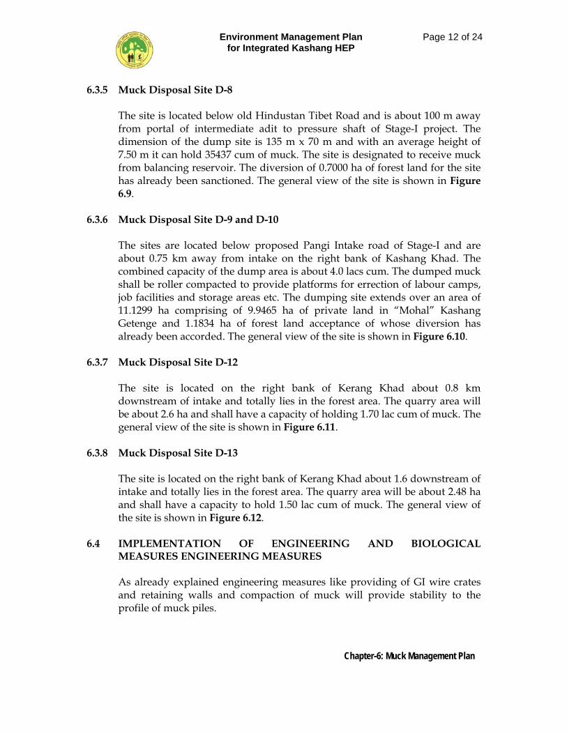
Environment Management Plan for Integrated Kashang HEP
Page 12 of 24
Chapter-6: Muck Management Plan
6.3.5 Muck Disposal Site D-8 The site is located below old Hindustan Tibet Road and is about 100 m away from portal of intermediate adit to pressure shaft of Stage-I project. The dimension of the dump site is 135 m x 70 m and with an average height of 7.50 m it can hold 35437 cum of muck. The site is designated to receive muck from balancing reservoir. The diversion of 0.7000 ha of forest land for the site has already been sanctioned. The general view of the site is shown in Figure 6.9.
6.3.6 Muck Disposal Site D-9 and D-10
The sites are located below proposed Pangi Intake road of Stage-I and are about 0.75 km away from intake on the right bank of Kashang Khad. The combined capacity of the dump area is about 4.0 lacs cum. The dumped muck shall be roller compacted to provide platforms for errection of labour camps, job facilities and storage areas etc. The dumping site extends over an area of 11.1299 ha comprising of 9.9465 ha of private land in “Mohal” Kashang Getenge and 1.1834 ha of forest land acceptance of whose diversion has already been accorded. The general view of the site is shown in Figure 6.10.
6.3.7 Muck Disposal Site D-12 The site is located on the right bank of Kerang Khad about 0.8 km downstream of intake and totally lies in the forest area. The quarry area will be about 2.6 ha and shall have a capacity of holding 1.70 lac cum of muck. The general view of the site is shown in Figure 6.11.
6.3.8 Muck Disposal Site D-13
The site is located on the right bank of Kerang Khad about 1.6 downstream of intake and totally lies in the forest area. The quarry area will be about 2.48 ha and shall have a capacity to hold 1.50 lac cum of muck. The general view of the site is shown in Figure 6.12.
6.4 IMPLEMENTATION OF ENGINEERING AND BIOLOGICAL
MEASURES ENGINEERING MEASURES As already explained engineering measures like providing of GI wire crates and retaining walls and compaction of muck will provide stability to the profile of muck piles.
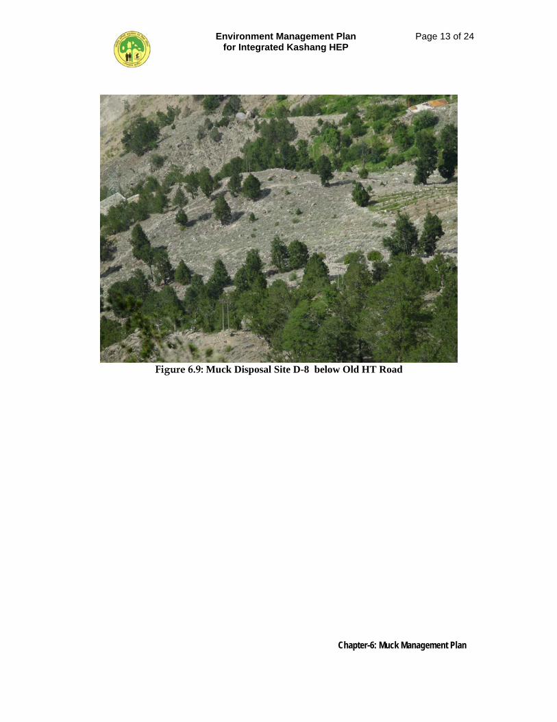
Environment Management Plan for Integrated Kashang HEP
Page 13 of 24
Chapter-6: Muck Management Plan
Figure 6.9: Muck Disposal Site D-8 below Old HT Road
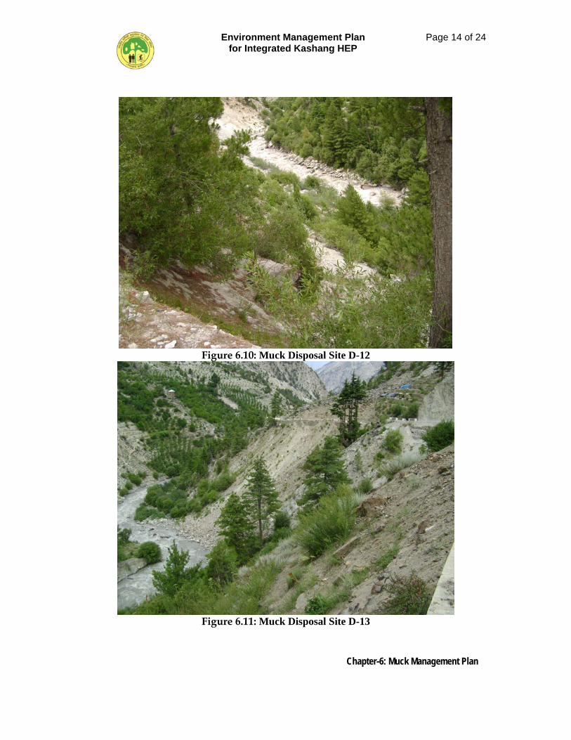
Environment Management Plan for Integrated Kashang HEP
Page 14 of 24
Chapter-6: Muck Management Plan
Figure 6.10: Muck Disposal Site D-12
Figure 6.11: Muck Disposal Site D-13
Environment Management Plan for Integrated Kashang HEP
Page 15 of 24
Chapter-6: Muck Management Plan
6.4.1 Engineering Measures It has been observed that after excavation the disposal of muck creates problem as it is susceptible to scattering unless the muck disposal yards are supported with engineering measures such as retaining structures, crate walls and gabions. In the present case out of thirteen sites nine muck disposal sites viz. D-1, D-9, D-10, D-2, D-3, D-4 & D-11, D-12 & D-13 are proposed to be located near the river / stream banks and therefore, needs proper handling to avoid spilling of muck into the river water while dumping and in the post dumping stages. The muck disposal sites have to be developed from below the ground level by providing two rows of 3 m x 1.5 x 1.5 plum concrete (30%) launching blocks in front of 6 m high stone masonary (cm 1:4) retaining wall with 1:4 slope in respect of dump sites D-2, D-3, D-4 & D-11 all situated below NH-22 and one row of 3 m x 1.5 m x 1.5 m plum concrete (30%) launching blocks in front of 6 m high stone masonary retaining wall with 1:4 slope in respect of dump sites D-12, D-13 and D-1, D-9 and D-10 situated on the right bank of Kerang and Kashang Khad respectively. Proper weap holes with inverted filter behind shall be provided at a spacing of 1.5 m c/c. It is proposed to develop dumping sites D-12 and D-13 into terraces and restored by laying of soil on top, digging of pits and planting of saplings. The dump sites D-5, D-6, D-7 and D-8 are not immediately located over river section and therefore, shall have to be developed from below by providing boulder wire crates of 8 SWG wire with 10 cm x 10 cm mesh size and in dimension 2.25 m x 1.25 m x 1.25 m. It is proposed to provide tiers of boulder wire crates with 0.4 m berm width. After placing of first tier of crates at the toe of muck disposal site, the muck brought in dumpers shall be dumped and manually spread behind the crates in such a manner that rock mass is properly stacked behind the crates with minimum of voids. The slope surface shall be developed by turfing.
6.4.2 Biological Measures Biological measures, however, require special efforts as the muck disposed in disposal yards will in general be devoid of nutrients and soil contents to support vegetation. The selection of soil for spreading over such an area would require nutrient profiling of soil for different base elements. Suitable ad mixture of nutrients would be done before placing the soil on the top surface of muck disposal areas to have administered growth of forest canopy.
6.4.2.1 Plantation Technique
In view of the peculiar site conditions particularly the soil conditions, the planting technique for all the categories of the plants has to be very site specific and suited to the stress conditions as anticipated and discussed
Environment Management Plan for Integrated Kashang HEP
Page 16 of 24
Chapter-6: Muck Management Plan
above. The planting substrates would need to be considerably improved to support the plants in their initial stages of establishment. The moisture retention capability, availability of nutrients and soil aeration, permeability and porosity would require intervention and assistance. Multistoried and multipurpose plantations are proposed to be raised on the muck dumping sites as also in road side strips using grasses, shrubs and bushes in the under storey and trees in the upper storey. Nursery raised grass slips, seedlings of shrubs & bushes and trees species would be planted in the area combined with grass sowing in patches. In addition, cuttings of bushes and shrubs can also be planted to supplement the nursery raised stock but this would substitute requirement of raising the nursery of these species. Intimate mixture of species would be avoided right at the planning stage and would be strictly followed during planting. Each patch should contain maximum of two species. Grasses would be mixed by groups in rows, shrubs and bushes by group again in rows. Grass slip planting and grass seed sowing would be done in strips at 0.10 m x 0.10 m spacing in the prepared staggered patches of 1 m x 0.5 m with a depth of 0.30 m. Soil mixture would be used while filling the patches. Balance dug up soil/muck will be stacked along the patch on the downhill side for rain water tapping and enhanced percolation in the patch. Number of such patches in each hectare is proposed at 500. Shrubs and bushes would be planted in elongated strips of 1.5 m x 0.5 m with a depth of 0.45m. Soil mixture would be used while filling the patches. Balance dug up soil/muck will be stacked along the patch on the downhill side for water tapping and better percolation in the patch. These would be staggered throughout the area numbering 500 per hectare. Each patch would have two row of planting with staggered spacing between plants in a row as 15 cm and distance between rows as 15 cm. Planting of trees would be done in contour staggered pits of 0.60 m x 0.60 m x 0.60 m size numbering 800 per hectare. Out of these 800 plants, about 200 plants per hectare are meant for planting along the periphery of the area. If the periphery gets filled up with lesser numbers, the remainder would be planted in the core/main area. Soil mixture would be used while filling the pits. Balance dug up soil/muck will be stacked on downhill side of the pit for trapping the rain water and allowing it to percolate in the pit. It is proposed to use soil mixture in the pits & patches consisting of soil imported from nearby areas mixed with compost or human or vermin-compost or all of these. The ratio for the mix would be 5 parts:
Environment Management Plan for Integrated Kashang HEP
Page 17 of 24
Chapter-6: Muck Management Plan
Compost/manure 2 parts: Sand 2 part: and humus or vermin-compost 1 part. This will make nutrients really available for the plants in the preliminary stages and also help increase soil aeration, porosity & permeability and improved moisture available for the plants. The stabilization sites from the time of execution of biological measures would be protected with barbed wire fencing on 2m. high RCC posts and provided with inspection paths. Since the muck dumping sites are being provided with either RCC walls or the wire crate (gabion) wall on the valley side (towards river) which is not negotiable by animals and human being, fencing would not be required along the entire perimeter. Hence, it would be done on the vulnerable sections i.e. towards the hillside only. The proposed costs include nursery costs for initial planting and also for mortality replacement. The biological measures shall be taken up towards the end of construction. The plantations would be maintained for a period of 5 years by irrigating the plantation during dry seasons, mortality replacement and repair of fencing & inspection paths with in the area. The task of irrigation would be performed by the watch & ward (chowkidar/rakha) provided in the cost estimate. Although the sites would be either leveled or finished in a grade, yet due to rains and sliding etc, it tends to develop rills and gulley causing acceleration in the rate of erosion. As such, while carrying out plantation; suitable soil conservation measures would also be taken.
Environment Management Plan for Integrated Kashang HEP
Page 18 of 24
Chapter-6: Muck Management Plan
6.5 SPECIES FOR PLANTATION Afforestation with suitable plant species of high ecological and economic value and adaptable to local conditions will be undertaken at the rate of 1500 plants per hectare in accordance with canopy cover requirement. The major plant species which can be used in the area are given in Table 6.4.
Table 6.4: Name of the Plant Species
Botanical Name Local Name Alnus nitida Kosh, Kunish, Nyun Betula utilis Bhojpatra, Pad Cedrus deodara Kelo, Diar, Kialmang Cupressus torulosa Devidiar Juniperus macropoda Guggal, Dhup, Shur Pinus gerardiana Neoza, Chilagoza, Ri Prunus armeniaca Chuli, Chul Juglans regia Akhrot Prunus cornuta Krun, Birdcherry Pinus wallichiana Kail Fraxinus xanthoxyloides Thumb Populus ciliata Kramal Salix alba Shon
Beside, the above tree species, the shrub species identified for plantations are; Cotoneaster bacillaris, Colutea nepalensis, Elaeagnus umbellata, Spiraea canescens and Rosa webbiana.
6.6 REGULATION MECHANISM FOR MUCK LIFTING BY OTHER USERS.
The muck generated at a particular project location shall be classified by the Engineer-in-charge as usable/non usable and both categories shall be stacked separately and the later category shall be disposed off at designated sites. Out of usable lot, after earmarking the quantity to be utilized as project work, the balance quantity shall be notified with respect to its quantum, location of availability. On receiving written request from other users viz. interested Development Departments / private users, the Engineer-in-charge shall issue permit to them to lift the authorized quantities within certain stipulated period failing which it will be deemed that concerned party is not interested in lifting the usable muck which shall be disposed off in the area designated as non-usable muck. In has already been mentioned that free-of-cost facility for using muck by private users has been provided in view of the Himachal Pradesh Hrdro Power Policy, 2006. But, in order to obviate the situation where this , bonafide
Environment Management Plan for Integrated Kashang HEP
Page 19 of 24
Chapter-6: Muck Management Plan
facility may not lead to a free-for-all situation at their leisure, the operational requirements of the project warrant a need to evolve a regulatory mechanism by means of which the objective is achieved with project work progress uninhibited.
6.6.1 Guidelines for Regulation Mechanism
The lifting of usable muck by the other users viz. government department, private stone crushers and private individuals, henceforth called as user agency shall be regulated in the following manner. • The other agencies and the private users shall be bound to comply the
timing for lifting of muck which shall be mentioned in the permit issued and fixed with due consideration to normal functioning of the project.
• The user agency shall abide by the traffic rules and shall operate their
vehicles in such a manner that the permissible noise level is not exceeded and also the fugitive emission from their vehicles shall be within the limit.
• The authorized lifted muck from the area shall be the property of the using
agencies who shall be entirely responsible for its safe stacking / disposal at their end.
• The arrangements and the cost of loading / unloading and transportation shall be totally borne by the using agency who shall have to pay the entry fee of Rs. 15/- per truck per entry and Rs. 5.00 per trolley or canters as part recovery of regulation charges as fixed by the project authorities from time to time.
• The project authorities shall erect a barrier to regulate the traffic flow to
and fro the muck piles site. Entry of all vehicles passing the barrier and the information regarding quantities lifted by various users shall be properly arrayed in a register in a most transparent manner and shall be liable to be made public by the project authorities, if required.
• Any tax or levy charges in any form levied by Government or local bodies on the lifted material shall be borne by the user agency.
• On the commencement of the rehabilitation of the muck dumping area,
neither any free of cost lifting nor digging of the compacted muck shall be allowed.
• The decision of the project authorities, in context of any matter related to
free-of-cost lifting of muck or arising from it, shall be final and binding on all parties.
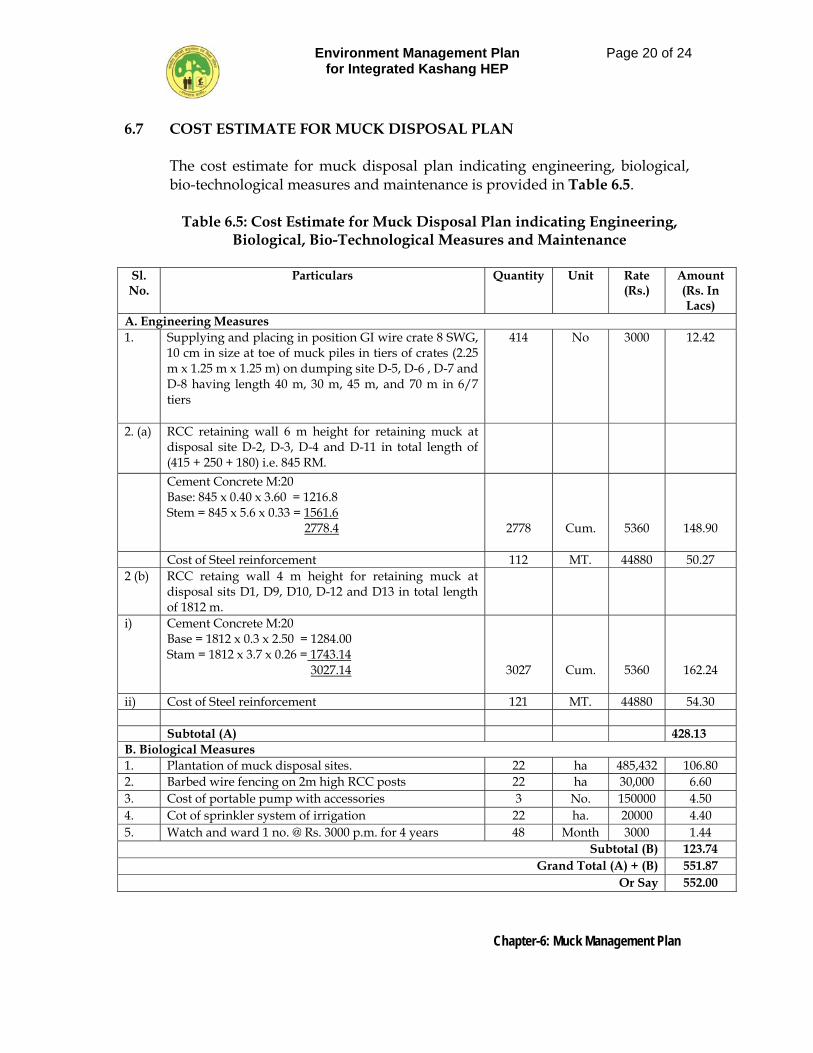
Environment Management Plan for Integrated Kashang HEP
Page 20 of 24
Chapter-6: Muck Management Plan
6.7 COST ESTIMATE FOR MUCK DISPOSAL PLAN The cost estimate for muck disposal plan indicating engineering, biological, bio-technological measures and maintenance is provided in Table 6.5.
Table 6.5: Cost Estimate for Muck Disposal Plan indicating Engineering,
Biological, Bio-Technological Measures and Maintenance
Sl. No.
Particulars Quantity Unit Rate (Rs.)
Amount (Rs. In Lacs)
A. Engineering Measures 1. Supplying and placing in position GI wire crate 8 SWG,
10 cm in size at toe of muck piles in tiers of crates (2.25 m x 1.25 m x 1.25 m) on dumping site D-5, D-6 , D-7 and D-8 having length 40 m, 30 m, 45 m, and 70 m in 6/7 tiers
414 No 3000 12.42
2. (a) RCC retaining wall 6 m height for retaining muck at disposal site D-2, D-3, D-4 and D-11 in total length of (415 + 250 + 180) i.e. 845 RM.
Cement Concrete M:20 Base: 845 x 0.40 x 3.60 = 1216.8 Stem = 845 x 5.6 x 0.33 = 1561.6 2778.4
2778
Cum.
5360
148.90
Cost of Steel reinforcement 112 MT. 44880 50.27 2 (b) RCC retaing wall 4 m height for retaining muck at
disposal sits D1, D9, D10, D-12 and D13 in total length of 1812 m.
i) Cement Concrete M:20 Base = 1812 x 0.3 x 2.50 = 1284.00 Stam = 1812 x 3.7 x 0.26 = 1743.14 3027.14
3027
Cum.
5360
162.24
ii) Cost of Steel reinforcement 121 MT. 44880 54.30 Subtotal (A) 428.13 B. Biological Measures 1. Plantation of muck disposal sites. 22 ha 485,432 106.80 2. Barbed wire fencing on 2m high RCC posts 22 ha 30,000 6.60 3. Cost of portable pump with accessories 3 No. 150000 4.50 4. Cot of sprinkler system of irrigation 22 ha. 20000 4.40 5. Watch and ward 1 no. @ Rs. 3000 p.m. for 4 years 48 Month 3000 1.44
Subtotal (B) 123.74 Grand Total (A) + (B) 551.87
Or Say 552.00
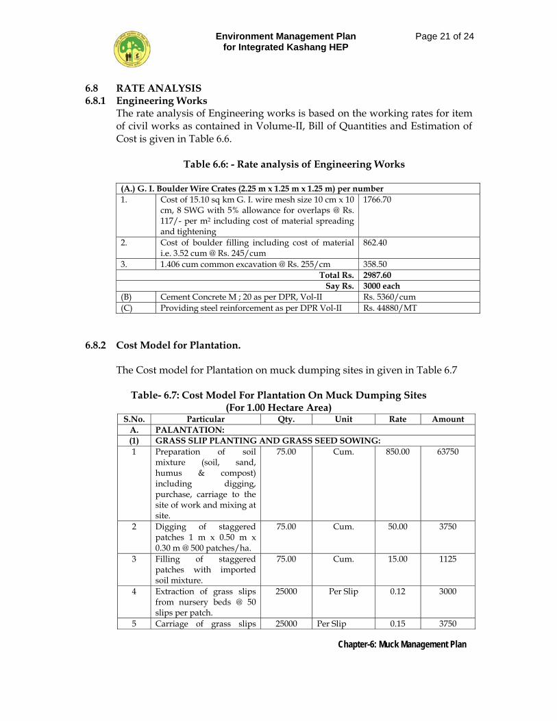
Environment Management Plan for Integrated Kashang HEP
Page 21 of 24
Chapter-6: Muck Management Plan
6.8 RATE ANALYSIS 6.8.1 Engineering Works
The rate analysis of Engineering works is based on the working rates for item of civil works as contained in Volume-II, Bill of Quantities and Estimation of Cost is given in Table 6.6.
Table 6.6: - Rate analysis of Engineering Works
(A.) G. I. Boulder Wire Crates (2.25 m x 1.25 m x 1.25 m) per number 1. Cost of 15.10 sq km G. I. wire mesh size 10 cm x 10
cm, 8 SWG with 5% allowance for overlaps @ Rs. 117/- per m2 including cost of material spreading and tightening
1766.70
2. Cost of boulder filling including cost of material i.e. 3.52 cum @ Rs. 245/cum
862.40
3. 1.406 cum common excavation @ Rs. 255/cm 358.50 Total Rs. 2987.60
Say Rs. 3000 each (B) Cement Concrete M ; 20 as per DPR, Vol-II Rs. 5360/cum (C) Providing steel reinforcement as per DPR Vol-II Rs. 44880/MT
6.8.2 Cost Model for Plantation.
The Cost model for Plantation on muck dumping sites in given in Table 6.7
Table- 6.7: Cost Model For Plantation On Muck Dumping Sites (For 1.00 Hectare Area)
S.No. Particular Qty. Unit Rate Amount A. PALANTATION: (1) GRASS SLIP PLANTING AND GRASS SEED SOWING: 1 Preparation of soil
mixture (soil, sand, humus & compost) including digging, purchase, carriage to the site of work and mixing at site.
75.00 Cum. 850.00 63750
2 Digging of staggered patches 1 m x 0.50 m x 0.30 m @ 500 patches/ha.
75.00 Cum. 50.00 3750
3 Filling of staggered patches with imported soil mixture.
75.00 Cum. 15.00 1125
4 Extraction of grass slips from nursery beds @ 50 slips per patch.
25000 Per Slip 0.12 3000
5 Carriage of grass slips 25000 Per Slip 0.15 3750
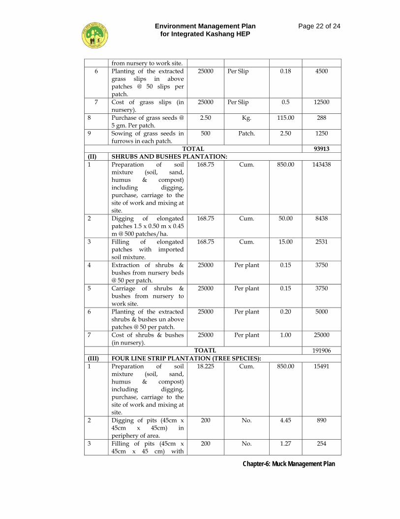
Environment Management Plan for Integrated Kashang HEP
Page 22 of 24
Chapter-6: Muck Management Plan
from nursery to work site. 6 Planting of the extracted
grass slips in above patches @ 50 slips per patch.
25000 Per Slip 0.18 4500
7 Cost of grass slips (in nursery).
25000 Per Slip 0.5 12500
8 Purchase of grass seeds @ 5 gm. Per patch.
2.50 Kg. 115.00 288
9 Sowing of grass seeds in furrows in each patch.
500 Patch. 2.50 1250
TOTAL 93913 (II) SHRUBS AND BUSHES PLANTATION: 1 Preparation of soil
mixture (soil, sand, humus & compost) including digging, purchase, carriage to the site of work and mixing at site.
168.75 Cum. 850.00 143438
2 Digging of elongated patches 1.5 x 0.50 m x 0.45 m @ 500 patches/ha.
168.75 Cum. 50.00 8438
3 Filling of elongated patches with imported soil mixture.
168.75 Cum. 15.00 2531
4 Extraction of shrubs & bushes from nursery beds @ 50 per patch.
25000 Per plant 0.15 3750
5 Carriage of shrubs & bushes from nursery to work site.
25000 Per plant 0.15 3750
6 Planting of the extracted shrubs & bushes un above patches @ 50 per patch.
25000 Per plant 0.20 5000
7 Cost of shrubs & bushes (in nursery).
25000 Per plant 1.00 25000
TOATL 191906 (III) FOUR LINE STRIP PLANTATION (TREE SPECIES): 1 Preparation of soil
mixture (soil, sand, humus & compost) including digging, purchase, carriage to the site of work and mixing at site.
18.225 Cum. 850.00 15491
2 Digging of pits (45cm x 45cm x 45cm) in periphery of area.
200 No. 4.45 890
3 Filling of pits (45cm x 45cm x 45 cm) with
200 No. 1.27 254
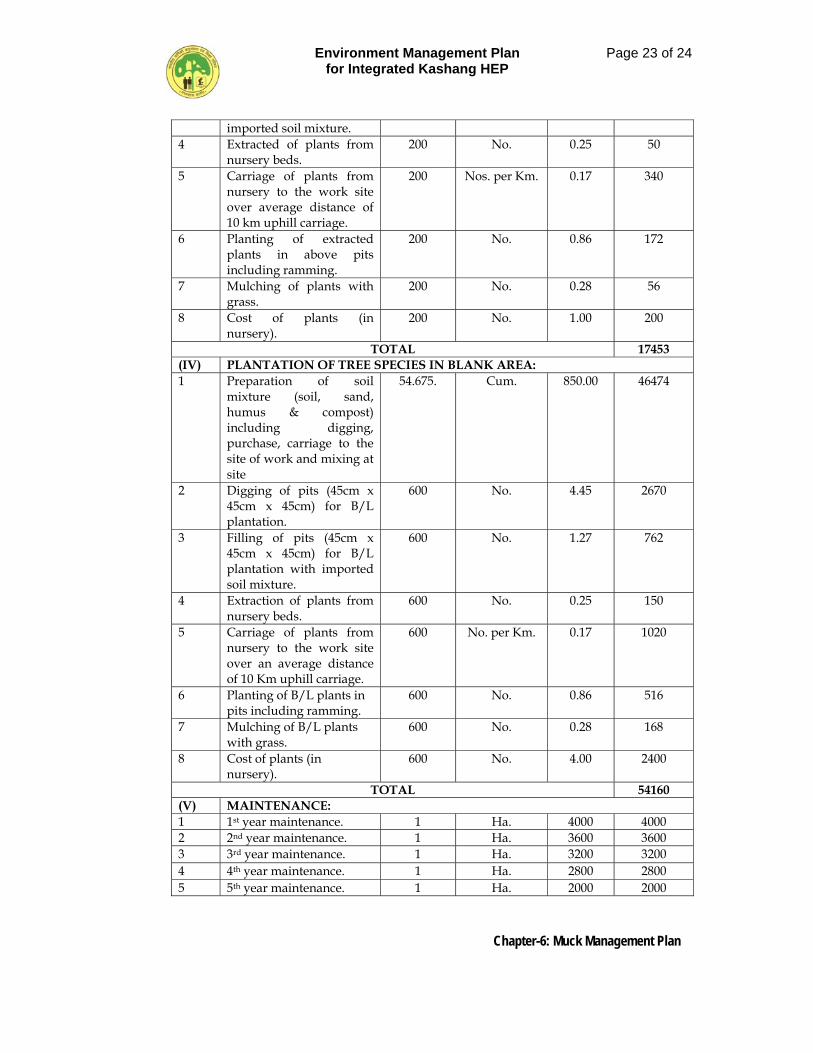
Environment Management Plan for Integrated Kashang HEP
Page 23 of 24
Chapter-6: Muck Management Plan
imported soil mixture. 4 Extracted of plants from
nursery beds. 200 No. 0.25 50
5 Carriage of plants from nursery to the work site over average distance of 10 km uphill carriage.
200 Nos. per Km. 0.17 340
6 Planting of extracted plants in above pits including ramming.
200 No. 0.86 172
7 Mulching of plants with grass.
200 No. 0.28 56
8 Cost of plants (in nursery).
200 No. 1.00 200
TOTAL 17453 (IV) PLANTATION OF TREE SPECIES IN BLANK AREA: 1 Preparation of soil
mixture (soil, sand, humus & compost) including digging, purchase, carriage to the site of work and mixing at site
54.675. Cum. 850.00 46474
2 Digging of pits (45cm x 45cm x 45cm) for B/L plantation.
600 No. 4.45 2670
3 Filling of pits (45cm x 45cm x 45cm) for B/L plantation with imported soil mixture.
600 No. 1.27 762
4 Extraction of plants from nursery beds.
600 No. 0.25 150
5 Carriage of plants from nursery to the work site over an average distance of 10 Km uphill carriage.
600 No. per Km. 0.17 1020
6 Planting of B/L plants in pits including ramming.
600 No. 0.86 516
7 Mulching of B/L plants with grass.
600 No. 0.28 168
8 Cost of plants (in nursery).
600 No. 4.00 2400
TOTAL 54160 (V) MAINTENANCE: 1 1st year maintenance. 1 Ha. 4000 4000 2 2nd year maintenance. 1 Ha. 3600 3600 3 3rd year maintenance. 1 Ha. 3200 3200 4 4th year maintenance. 1 Ha. 2800 2800 5 5th year maintenance. 1 Ha. 2000 2000
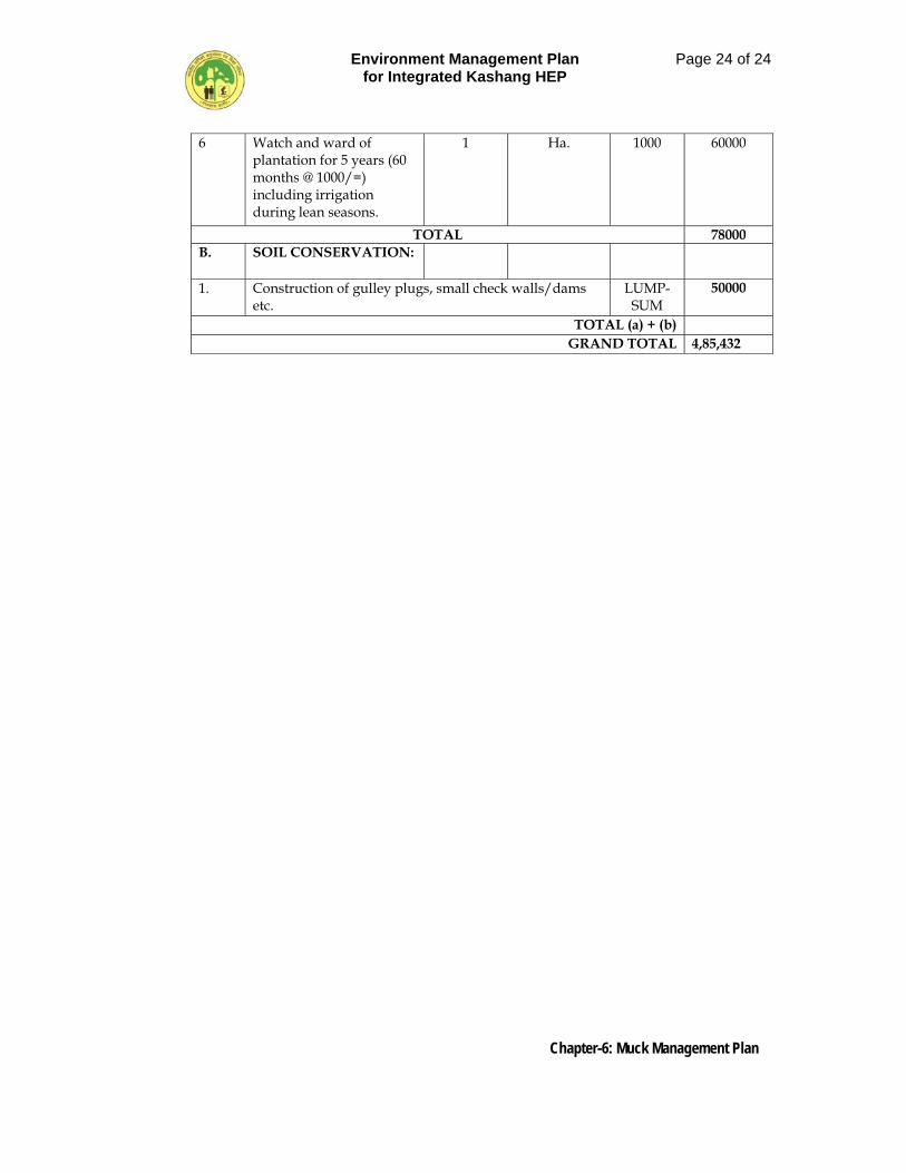
Environment Management Plan for Integrated Kashang HEP
Page 24 of 24
Chapter-6: Muck Management Plan
6 Watch and ward of plantation for 5 years (60 months @ 1000/=) including irrigation during lean seasons.
1 Ha. 1000 60000
TOTAL 78000 B. SOIL CONSERVATION:
1. Construction of gulley plugs, small check walls/dams etc.
LUMP-SUM
50000
TOTAL (a) + (b) GRAND TOTAL 4,85,432
Environment Management Plan for Kashang HEP
Page 1 of 8
Chapter-7: Restoration Plan for Quarry Sites
CHAPTER – 7
RESTORATION PLAN FOR QUARRY SITES 7.1 GENERAL
The integrated Kashang HEP mainly involves construction of drop type trench weir, conveyance channel, descending basin , power channel, underground water conductor system involving Head Race Tunnel, Balancing Reservoir, Pressure Shaft, Underground Powerhouse and Transformer Hall, Main access Tunnel, Tail Race Tunnel and other adits and tunnels. For the construction of such components huge quantities of concrete work, structural steel work, shotcreting and grouting and fixing of precast lagging is involved for which construction material like coarse and fine aggregates, boulder, stones and earth for backfilling are required besides cement, structural steel and reinforcement steel. The quantities of construction material like stone, sand and aggregate for various uses and their potential quarry/mining sites are mentioned in Table 7.1.
Table 7.1: Quantity of Various Material
S. No Material Quantity
(lac m3) Quarry/ Mining Sites.
1 Fine aggregate for c.c 2.29 River deposit at Akpa quarry and from crushing of muck.
2 Coarse aggregate 4.0 Quarry site-1 (U/S of intake of Stage-I) and excavated material from underground excavation.
3 Boulder/Stone 0.20 Quarry site-I (U/S of intake of Stage-I)
4 Soil 0.11 Private land at Kashang Get enge (intake area.)
Total 6.60
Excavation of construction material entails land acquisition and management of quarry areas at a later date to maintain the environment in its natural state. Therefore, during material survey/investigation it was realized that the quarry areas may be identified in river plain as far as possible and also the material excavated from different components be utilized. In view of this aspect the river shoal along River Satluj near Akpa and another site u/s of intake of Stage-I on Kashang Khad have been identified and evaluated based on the parameters suiting to the requirement.
Environment Management Plan for Kashang HEP
Page 2 of 8
Chapter-7: Restoration Plan for Quarry Sites
7.2 DETAILS OF QUARRY SITES
In construction of the project 6.49 lac Cum aggregate/stone material is required. To meet this demand stream/river bed shoals in Kashang, Kerang and River Satluj were investigated. It is also proposed that the excavated material derived from the underground and open surface works will be utilized to a maximum and about 2.94 lac cum excavated material will therefore, be used out of the total quantity of 11.74 lac cum excavated material. The coarse aggregate obtained through crushing of excavated muck shall be utilized in non-wearing concrete works like back fill concrete in water conductor system like HRT, balancing reservoir, pressure shaft, MAT, TRT and other adits and also in shotcreting and grouting works for which 2.3 lac cum quantity is required. The lining and structural concrete shall be made from aggregates obtained from quarry No-1 and 2. The location plan of the two quarry/mining sites is depicted in Figure 7.1 and details of different kind of material and quarry areas are described below.
7.2.1 Quarry Site No-1, Near Intake (Stage-1)
About 300m u/s of the intake point of Stage-I and in the right bank of Kashang Khad a rock quarry site comprising of migmatite gneiss has been identified by the project proponents. The quarry area involves 3.2558 ha of forest land the division of which for non-forestry purpose has already been accorded by the MOEF. Against a demand of 1.70 lacs cum. aggregate /boulder, the quarry is likely to yield 2.5 lac cum of rock mass which can be crushed into suitable size of coarse aggregate besides sand. The aggregate from the quarry shall be used in lining, structural concrete, mass concrete works such as in HRT, Balancing Reservoirs, Powerhouse Transformer Hall, K-K link tunnel. Desanding basin and also in intake. The quarry site at present is not approachable by road but a road from Pangi village to intake is under construction and shall be extended upto quarry area for which 0.6801 ha of forest land has already been obtained. The distance of the quarry site from Reckong Peo shall be about 16 km. The distance of the nearest village, school and the cremation ground is about 1.0 km, 1.2 km and 1. 8 km. respectively from the site.
7.2.2 Quarry Site No-2 Near Jangi
The quarry site located on right bank of River Satluj in river bed in “Mauja” Jangi under Tehsil Moorang is an extensive shoal deposit being functional since long. It is located below NH-22 at a distance of 24 km from Reckong Peo, the district headquarter of Kinnaur. Quarry lies in the forest area and for its diversion of forest land to the tune of 3.47340 ha has already been sanctioned. The quarry which comprises of coarse to fine sand intermixed with shingle and gravel is likely to yield 0.6 lac cum of sand and shingle on
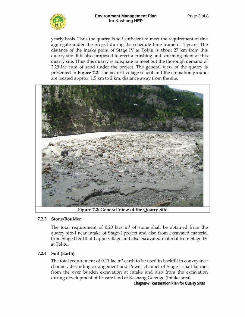
Environment Management Plan for Kashang HEP
Page 3 of 8
Chapter-7: Restoration Plan for Quarry Sites
yearly basis. Thus the quarry is self sufficient to meet the requirement of fine aggregate under the project during the schedule time frame of 4 years. The distance of the intake point of Stage IV at Toktu is about 27 km from this quarry site. It is also proposed to erect a crushing and screening plant at this quarry site. Thus this quarry is adequate to meet out the thorough demand of 2.29 lac cum of sand under the project. The general view of the quarry is presented in Figure 7.2. The nearest village school and the cremation ground are located approx. 1.5 km to 2 km. distance away from the site.
Figure 7.2: General View of the Quarry Site
7.2.3 Stone/Boulder
The total requirement of 0.20 lacs m3 of stone shall be obtained from the quarry site-I near intake of Stage-I project and also from excavated material from Stage II & III at Lappo village and also excavated material from Stage-IV at Toktu.
7.2.4 Soil (Earth)
The total requirement of 0.11 lac m3 earth to be used in backfill in conveyance channel, desanding arrangement and Power channel of Stage-I shall be met from the over burden excavation at intake and also from the excavation during development of Private land at Kashang Getenge (Intake area)
Environment Management Plan for Kashang HEP
Page 4 of 8
Chapter-7: Restoration Plan for Quarry Sites
7.2.5 Coarse Aggregate
Out of the total requirement of 4.0 lacs m3 of coarse aggregate 2.30 lac m3 shall be obtained from excavation of Diversion weir Powerhouse, Transformer house, Pressure Shaft, Balancing, reservoir and the balance 1.70 lac m3 shall be obtained from quarry site-I near intake of stage-I.
7.2.6 Fine Aggregate
The total requirement of approximately 2.29 lacs m3 of fine aggregate shall be met out form river bed quarry situated on right bank River Satluj and also from the crushed sand obtained during crushing processing and screening of rock mass obtained from Quarrty No-I at intake of Stage-I. The distance of the proposed quarry site from Reckong Peo is about 24 km and is well connected through all weather road. The quarry lies under Tehsil Moorang.
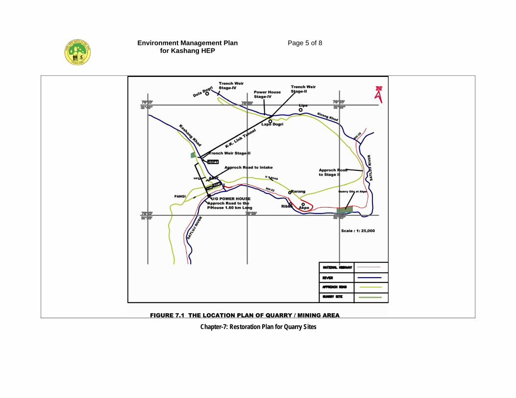
Environment Management Plan for Kashang HEP
Page 5 of 8
Chapter-7: Restoration Plan for Quarry Sites
Environment Management Plan for Kashang HEP
Page 6 of 8
Chapter-7: Restoration Plan for Quarry Sites
7.3 ENVIRONMENTAL IMPACTS
The impacts of excavation of construction materials such as rock mass/boulder and sand for construction of hydroelectric projects on environment depend on excavation process, local hydrological conditions, climate, rock types, size and type of operations and topography. Impacts also vary with stage of development at quarry sites e.g. development of working platforms has a less impact compared to the excavation of aggregates and sand. Physical changes in the soil, water and air associates with environment impacts would be due to excavation and degradation of land aground the quarry and on biota around it. Maximum excavated material from the proposed under ground works shall be utilized together with rock mass/stone obtained from Quarry No-1. The rock face areas do not require any major restoration measures. However, keeping in view that due to blasting etc. the rock features along the joint surfaces may get weak or disturbed, for overcoming which some rock bolting and shotcrete measures along the exposed face are proposed to be done. The river shoal areas fall in the river bed/plain, as such no restoration measures are proposed for them. The river shoal at Jangi quarry site will be restored during the flood season as it falls within the river coarse of River Satluj. Therefore, the river bed quarry activity shall not lead to any negative impact either during the functioning of the quarry or at a later date. Blasting shall not be allowed in the river bed. Copious use of sprinkler shall be resorted to stock piles of aggregate and the washing of the aggregate shall be first allowed to settle in the setting tanks before disposing into river. As a dust arrester G.C sheet shield shall be erected on the valley side of portion of NH-22 situated over the quarry site.
7.4 TREATMENT MEASURES FOR RESTORATION
The biological and engineering measures proposed to be implemented for restoration of Quarry No-I near intake of Stage-I and preventive measures in respect of Quarry No-2 are as follows.
7.4.1 Biological Measures
Under the biological measures plantation over an area of 3.26 ha as per the suitability of the area will be conducted to bring the diverted area under rock quarry No-I at intake under forest cover after the quarry is no more needed. In addition to plantation seeding of local plant species will also be done to enhance natural regeneration. The plantation technique and the rate of plantation shall be adopted as in the case of biological treatment of muck disposal sites by plantation.
Environment Management Plan for Kashang HEP
Page 7 of 8
Chapter-7: Restoration Plan for Quarry Sites
7.4.2 Barbed Wire Fencing
The area of rock quarry site will be fenced on first occasion to ward off animals from entering the quarry area and later to protect the plantation from grazing and to enhance natural regeneration.
7.4.3 Engineering Measures
For the reclamation of the quarry sites, the following engineering measures are proposed for restoration of quarry site.
7.4.3.1 Filling and Leveling
Required filling and leveling of earth in the rock quarry area will be conducted to support vegetation. Drains will be constructed in the quarry area to flush out the unwanted water.
7.4.3.2 Protective Shield
In 670 m length of the NH-22 overlooking the River Satluj river bed quarry site, proper G.C Sheet Shielding shall be erected to safeguard against fugitive dust particles.
7.5 COST ESTIMATE FOR RESTORATION OF BORROW AREAS
The details of the expenditure likely to be incurred on the implementation of biological and engineering measures to be adopted is placed in Table 7.2.
Table-7.2: Cost estimate for restoration of borrow areas
SI. No.
Item of Work Qty. Unit Rate (Rs.) Amount (Rs. Las)
1 Rock bolting 25 mm dia in jointed/fissured surface
250 m. 1110 2.78
2 Shot Creting (50 mm) 200 m2 545 1.09
3 Levelling and filling of area after use in rock quarry at intake of Stage-I
30000 Cum 125 3.75
4 Construction of drains 100 M 1100 1.10
5 Stone masonry (1:6) in retaining wall of 4 m height in 200 m
880 Cum 1345 11.84
6 Barbed wire fencing on 2 m high RCC posts
3.25 ha 30000 0.975
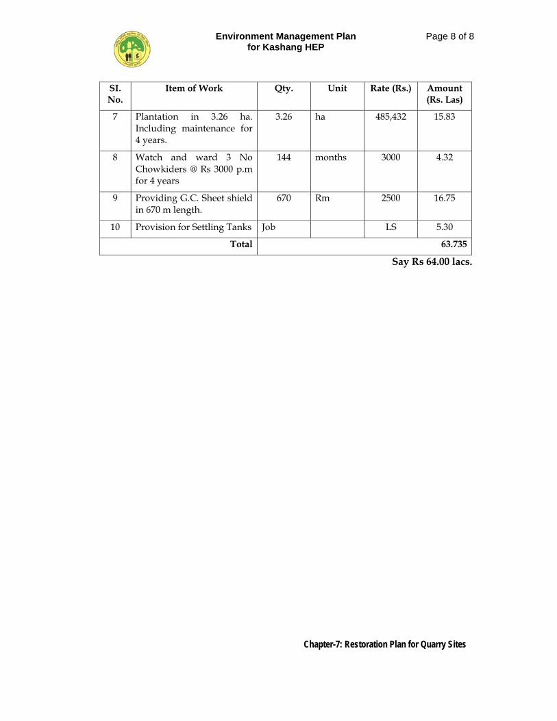
Environment Management Plan for Kashang HEP
Page 8 of 8
Chapter-7: Restoration Plan for Quarry Sites
SI. No.
Item of Work Qty. Unit Rate (Rs.) Amount (Rs. Las)
7 Plantation in 3.26 ha. Including maintenance for 4 years.
3.26 ha 485,432 15.83
8 Watch and ward 3 No Chowkiders @ Rs 3000 p.m for 4 years
144 months 3000 4.32
9 Providing G.C. Sheet shield in 670 m length.
670 Rm 2500 16.75
10 Provision for Settling Tanks Job LS 5.30
Total 63.735
Say Rs 64.00 lacs.
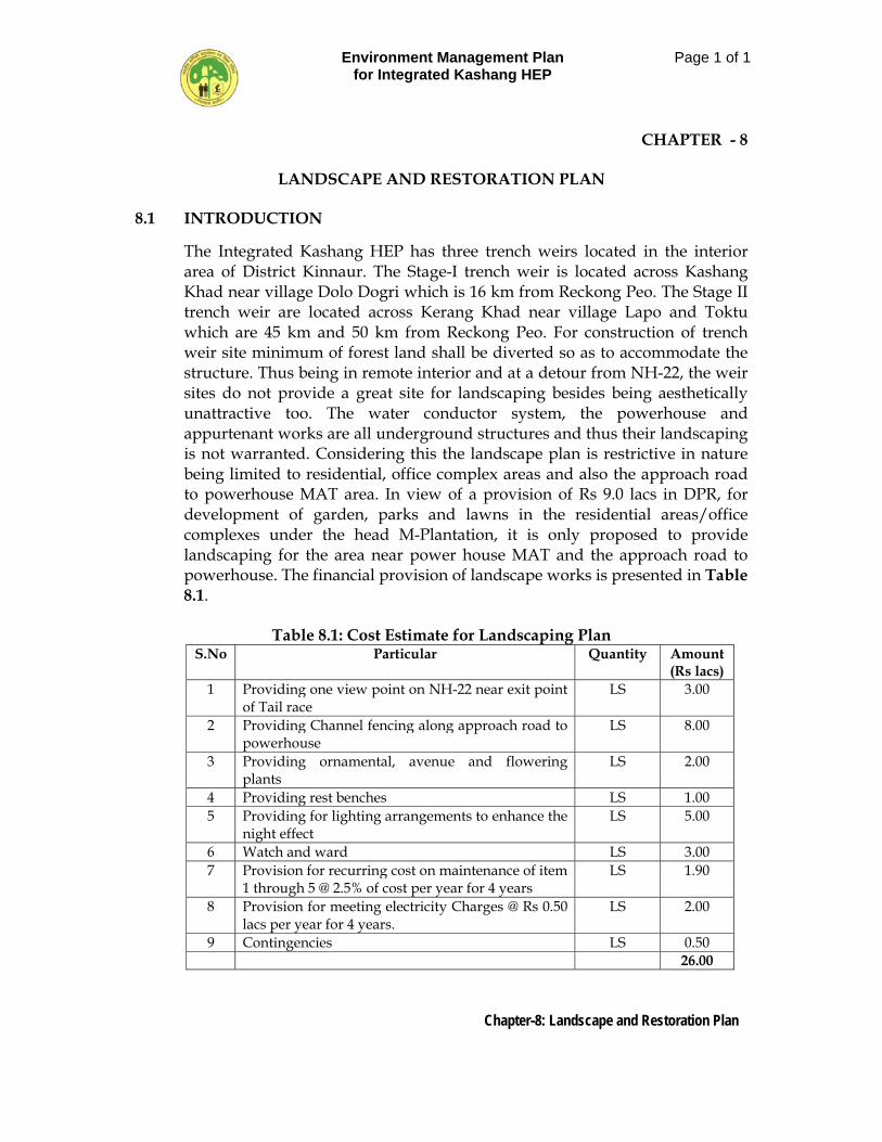
Environment Management Plan for Integrated Kashang HEP
Page 1 of 1
Chapter-8: Landscape and Restoration Plan
CHAPTER - 8
LANDSCAPE AND RESTORATION PLAN 8.1 INTRODUCTION
The Integrated Kashang HEP has three trench weirs located in the interior area of District Kinnaur. The Stage-I trench weir is located across Kashang Khad near village Dolo Dogri which is 16 km from Reckong Peo. The Stage II trench weir are located across Kerang Khad near village Lapo and Toktu which are 45 km and 50 km from Reckong Peo. For construction of trench weir site minimum of forest land shall be diverted so as to accommodate the structure. Thus being in remote interior and at a detour from NH-22, the weir sites do not provide a great site for landscaping besides being aesthetically unattractive too. The water conductor system, the powerhouse and appurtenant works are all underground structures and thus their landscaping is not warranted. Considering this the landscape plan is restrictive in nature being limited to residential, office complex areas and also the approach road to powerhouse MAT area. In view of a provision of Rs 9.0 lacs in DPR, for development of garden, parks and lawns in the residential areas/office complexes under the head M-Plantation, it is only proposed to provide landscaping for the area near power house MAT and the approach road to powerhouse. The financial provision of landscape works is presented in Table 8.1.
Table 8.1: Cost Estimate for Landscaping Plan
S.No Particular Quantity Amount (Rs lacs)
1 Providing one view point on NH-22 near exit point of Tail race
LS 3.00
2 Providing Channel fencing along approach road to powerhouse
LS 8.00
3 Providing ornamental, avenue and flowering plants
LS 2.00
4 Providing rest benches LS 1.00 5 Providing for lighting arrangements to enhance the
night effect LS 5.00
6 Watch and ward LS 3.00 7 Provision for recurring cost on maintenance of item
1 through 5 @ 2.5% of cost per year for 4 years LS 1.90
8 Provision for meeting electricity Charges @ Rs 0.50 lacs per year for 4 years.
LS 2.00
9 Contingencies LS 0.50 26.00
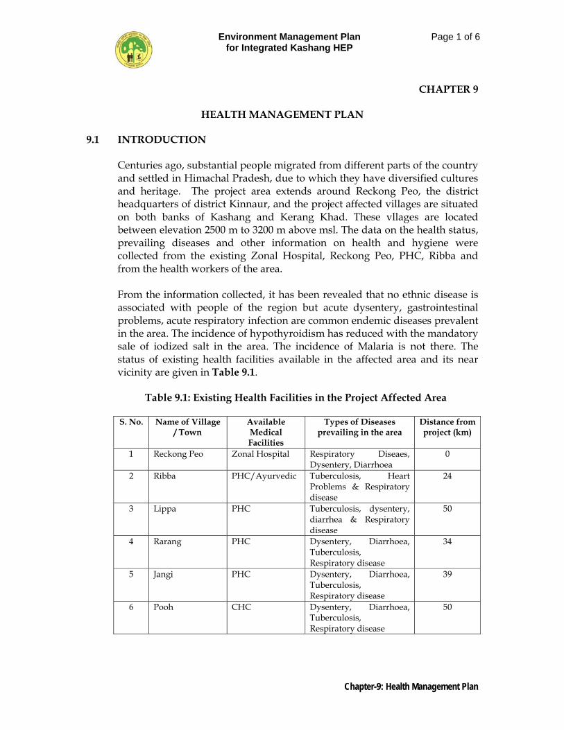
Environment Management Plan for Integrated Kashang HEP
Page 1 of 6
Chapter-9: Health Management Plan
CHAPTER 9
HEALTH MANAGEMENT PLAN
9.1 INTRODUCTION
Centuries ago, substantial people migrated from different parts of the country and settled in Himachal Pradesh, due to which they have diversified cultures and heritage. The project area extends around Reckong Peo, the district headquarters of district Kinnaur, and the project affected villages are situated on both banks of Kashang and Kerang Khad. These vllages are located between elevation 2500 m to 3200 m above msl. The data on the health status, prevailing diseases and other information on health and hygiene were collected from the existing Zonal Hospital, Reckong Peo, PHC, Ribba and from the health workers of the area. From the information collected, it has been revealed that no ethnic disease is associated with people of the region but acute dysentery, gastrointestinal problems, acute respiratory infection are common endemic diseases prevalent in the area. The incidence of hypothyroidism has reduced with the mandatory sale of iodized salt in the area. The incidence of Malaria is not there. The status of existing health facilities available in the affected area and its near vicinity are given in Table 9.1.
Table 9.1: Existing Health Facilities in the Project Affected Area
S. No. Name of Village
/ Town Available Medical Facilities
Types of Diseases prevailing in the area
Distance from project (km)
1 Reckong Peo Zonal Hospital Respiratory Diseaes, Dysentery, Diarrhoea
0
2 Ribba PHC/Ayurvedic Tuberculosis, Heart Problems & Respiratory disease
24
3 Lippa PHC Tuberculosis, dysentery, diarrhea & Respiratory disease
50
4 Rarang PHC Dysentery, Diarrhoea, Tuberculosis, Respiratory disease
34
5 Jangi PHC Dysentery, Diarrhoea, Tuberculosis, Respiratory disease
39
6 Pooh CHC Dysentery, Diarrhoea, Tuberculosis, Respiratory disease
50
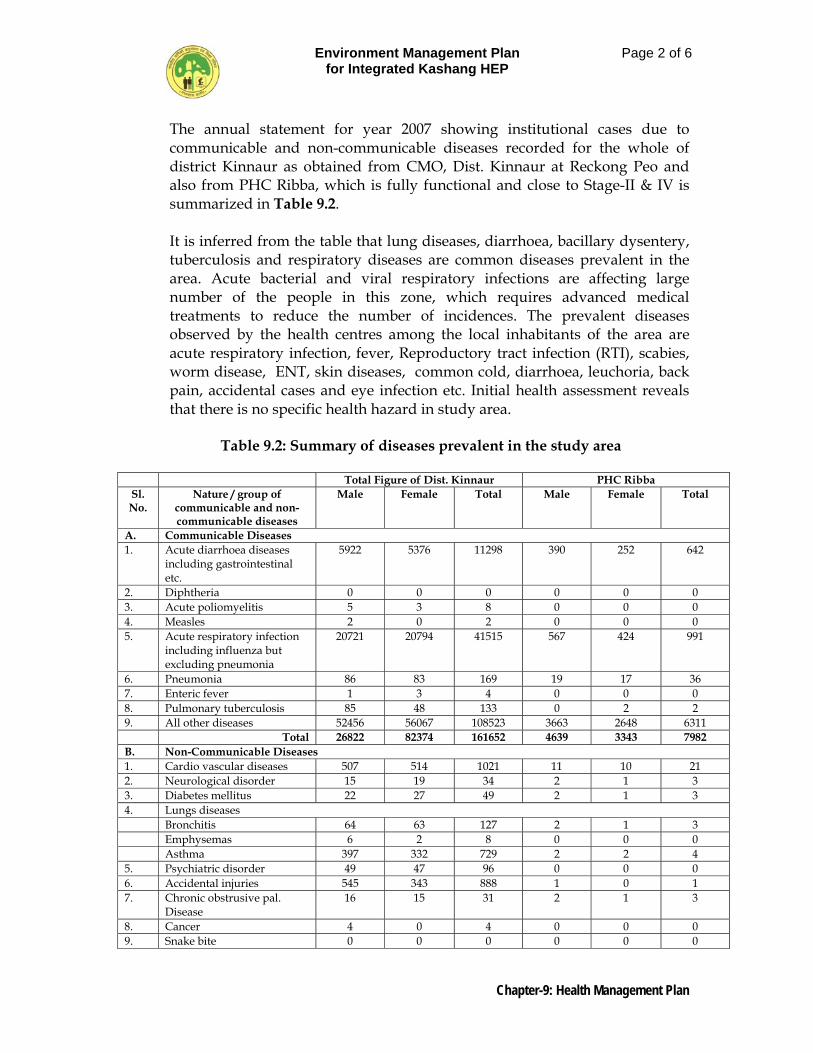
Environment Management Plan for Integrated Kashang HEP
Page 2 of 6
Chapter-9: Health Management Plan
The annual statement for year 2007 showing institutional cases due to communicable and non-communicable diseases recorded for the whole of district Kinnaur as obtained from CMO, Dist. Kinnaur at Reckong Peo and also from PHC Ribba, which is fully functional and close to Stage-II & IV is summarized in Table 9.2. It is inferred from the table that lung diseases, diarrhoea, bacillary dysentery, tuberculosis and respiratory diseases are common diseases prevalent in the area. Acute bacterial and viral respiratory infections are affecting large number of the people in this zone, which requires advanced medical treatments to reduce the number of incidences. The prevalent diseases observed by the health centres among the local inhabitants of the area are acute respiratory infection, fever, Reproductory tract infection (RTI), scabies, worm disease, ENT, skin diseases, common cold, diarrhoea, leuchoria, back pain, accidental cases and eye infection etc. Initial health assessment reveals that there is no specific health hazard in study area.
Table 9.2: Summary of diseases prevalent in the study area
Total Figure of Dist. Kinnaur PHC Ribba
Sl. No.
Nature / group of communicable and non-communicable diseases
Male Female Total Male Female Total
A. Communicable Diseases 1. Acute diarrhoea diseases
including gastrointestinal etc.
5922 5376 11298 390 252 642
2. Diphtheria 0 0 0 0 0 0 3. Acute poliomyelitis 5 3 8 0 0 0 4. Measles 2 0 2 0 0 0 5. Acute respiratory infection
including influenza but excluding pneumonia
20721 20794 41515 567 424 991
6. Pneumonia 86 83 169 19 17 36 7. Enteric fever 1 3 4 0 0 0 8. Pulmonary tuberculosis 85 48 133 0 2 2 9. All other diseases 52456 56067 108523 3663 2648 6311 Total 26822 82374 161652 4639 3343 7982 B. Non-Communicable Diseases 1. Cardio vascular diseases 507 514 1021 11 10 21 2. Neurological disorder 15 19 34 2 1 3 3. Diabetes mellitus 22 27 49 2 1 3 4. Lungs diseases Bronchitis 64 63 127 2 1 3 Emphysemas 6 2 8 0 0 0 Asthma 397 332 729 2 2 4 5. Psychiatric disorder 49 47 96 0 0 0 6. Accidental injuries 545 343 888 1 0 1 7. Chronic obstrusive pal.
Disease 16 15 31 2 1 3
8. Cancer 4 0 4 0 0 0 9. Snake bite 0 0 0 0 0 0
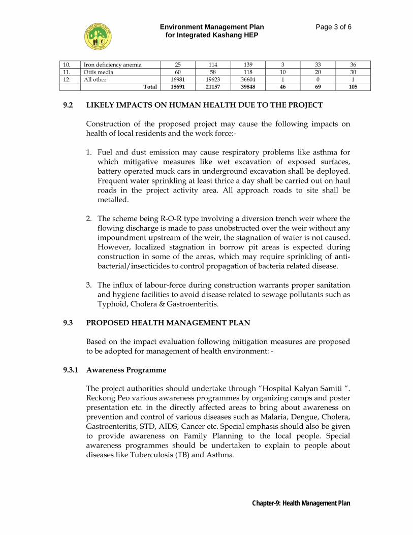
Environment Management Plan for Integrated Kashang HEP
Page 3 of 6
Chapter-9: Health Management Plan
10. Iron deficiency anemia 25 114 139 3 33 36 11. Ottis media 60 58 118 10 20 30 12. All other 16981 19623 36604 1 0 1 Total 18691 21157 39848 46 69 105 9.2 LIKELY IMPACTS ON HUMAN HEALTH DUE TO THE PROJECT
Construction of the proposed project may cause the following impacts on health of local residents and the work force:-
1. Fuel and dust emission may cause respiratory problems like asthma for
which mitigative measures like wet excavation of exposed surfaces, battery operated muck cars in underground excavation shall be deployed. Frequent water sprinkling at least thrice a day shall be carried out on haul roads in the project activity area. All approach roads to site shall be metalled.
2. The scheme being R-O-R type involving a diversion trench weir where the
flowing discharge is made to pass unobstructed over the weir without any impoundment upstream of the weir, the stagnation of water is not caused. However, localized stagnation in borrow pit areas is expected during construction in some of the areas, which may require sprinkling of anti-bacterial/insecticides to control propagation of bacteria related disease.
3. The influx of labour-force during construction warrants proper sanitation
and hygiene facilities to avoid disease related to sewage pollutants such as Typhoid, Cholera & Gastroenteritis.
9.3 PROPOSED HEALTH MANAGEMENT PLAN
Based on the impact evaluation following mitigation measures are proposed to be adopted for management of health environment: -
9.3.1 Awareness Programme
The project authorities should undertake through “Hospital Kalyan Samiti “. Reckong Peo various awareness programmes by organizing camps and poster presentation etc. in the directly affected areas to bring about awareness on prevention and control of various diseases such as Malaria, Dengue, Cholera, Gastroenteritis, STD, AIDS, Cancer etc. Special emphasis should also be given to provide awareness on Family Planning to the local people. Special awareness programmes should be undertaken to explain to people about diseases like Tuberculosis (TB) and Asthma.
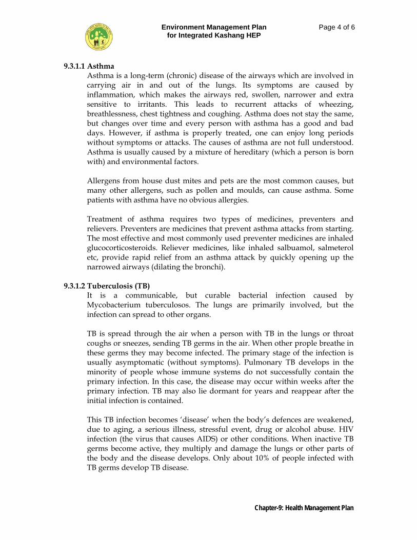
Environment Management Plan for Integrated Kashang HEP
Page 4 of 6
Chapter-9: Health Management Plan
9.3.1.1 Asthma Asthma is a long-term (chronic) disease of the airways which are involved in carrying air in and out of the lungs. Its symptoms are caused by inflammation, which makes the airways red, swollen, narrower and extra sensitive to irritants. This leads to recurrent attacks of wheezing, breathlessness, chest tightness and coughing. Asthma does not stay the same, but changes over time and every person with asthma has a good and bad days. However, if asthma is properly treated, one can enjoy long periods without symptoms or attacks. The causes of asthma are not full understood. Asthma is usually caused by a mixture of hereditary (which a person is born with) and environmental factors. Allergens from house dust mites and pets are the most common causes, but many other allergens, such as pollen and moulds, can cause asthma. Some patients with asthma have no obvious allergies. Treatment of asthma requires two types of medicines, preventers and relievers. Preventers are medicines that prevent asthma attacks from starting. The most effective and most commonly used preventer medicines are inhaled glucocorticosteroids. Reliever medicines, like inhaled salbuamol, salmeterol etc, provide rapid relief from an asthma attack by quickly opening up the narrowed airways (dilating the bronchi).
9.3.1.2 Tuberculosis (TB)
It is a communicable, but curable bacterial infection caused by Mycobacterium tuberculosos. The lungs are primarily involved, but the infection can spread to other organs. TB is spread through the air when a person with TB in the lungs or throat coughs or sneezes, sending TB germs in the air. When other prople breathe in these germs they may become infected. The primary stage of the infection is usually asymptomatic (without symptoms). Pulmonary TB develops in the minority of people whose immune systems do not successfully contain the primary infection. In this case, the disease may occur within weeks after the primary infection. TB may also lie dormant for years and reappear after the initial infection is contained. This TB infection becomes ‘disease’ when the body’s defences are weakened, due to aging, a serious illness, stressful event, drug or alcohol abuse. HIV infection (the virus that causes AIDS) or other conditions. When inactive TB germs become active, they multiply and damage the lungs or other parts of the body and the disease develops. Only about 10% of people infected with TB germs develop TB disease.
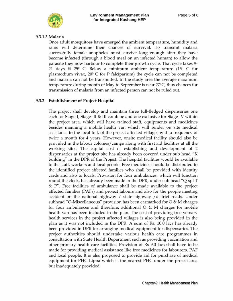
Environment Management Plan for Integrated Kashang HEP
Page 5 of 6
Chapter-9: Health Management Plan
9.3.1.3 Malaria Once adult mosquitoes have emerged the ambient temperature, humidity and rains will determine their chances of survival. To transmit malaria successfully female anopheles must survive long enough after they have become infected (through a blood meal on an infected human) to allow the parasite they now harbour to complete their growth cycle. That cycle takes 9-21 days @ 250 C. Below a minimum ambient temperature (150 C for plasmodium vivax, 200 C for P falciparium) the cycle can not be completed and malaria can not be transmitted. In the study area the average maximum temperature during month of May to September is near 270C, thus chances for transmission of malaria from an infected person can not be ruled out.
9.3.2 Establishment of Project Hospital
The project shall develop and maintain three full-fledged dispensaries one each for Stage-I, Stage=II & III combine and one exclusive for Stage-IV within the project area, which will have trained staff, equipments and medicines besides manning a mobile health van which will render on site medical assistance to the local folk of the project affected villages with a frequency of twice a month for 4 years. However, onsite medical facility should also be provided in the labour colonies/camps along with first aid facilities at all the working sites. The capital cost of establishing and development of 2 dispensaries at the project site has already been covered under sub head “K building” in the DPR of the Project. The hospital facilities would be available to the staff, workers and local people. Free medicines should be distributed to the identified project affected families who shall be provided with identity cards and also to locals. Provision for four ambulances, which will function round the clock, has already been made in the DPR, under sub head “Q-spl T & P”. Free facilities of ambulance shall be made available to the project affected families (PAFs) and project labours and also for the people meeting accident on the national highway / state highway /district roads. Under subhead “O-Miscellaneous” provision has been earmarked for O & M charges for four ambulances and therefore, additional O & M charges for mobile health van has been included in the plan. The cost of providing free vetnary health services in the project affected villages is also being provided in the plan as it was not included in the DPR. A sum of Rs. 10.0 lacs has already been provided in DPR for arranging medical equipment for dispensaries. The project authorities should undertake various health care programmes in consultation with State Health Department such as providing vaccination and other primary health care facilities. Provision of Rs 9.0 lacs shall have to be made for providing medical assistance like free medicines for labourers, PAF and local people. It is also proposed to provide aid for purchase of medical equipment for PHC Lippa which is the nearest PHC under the project area but inadequately provided.
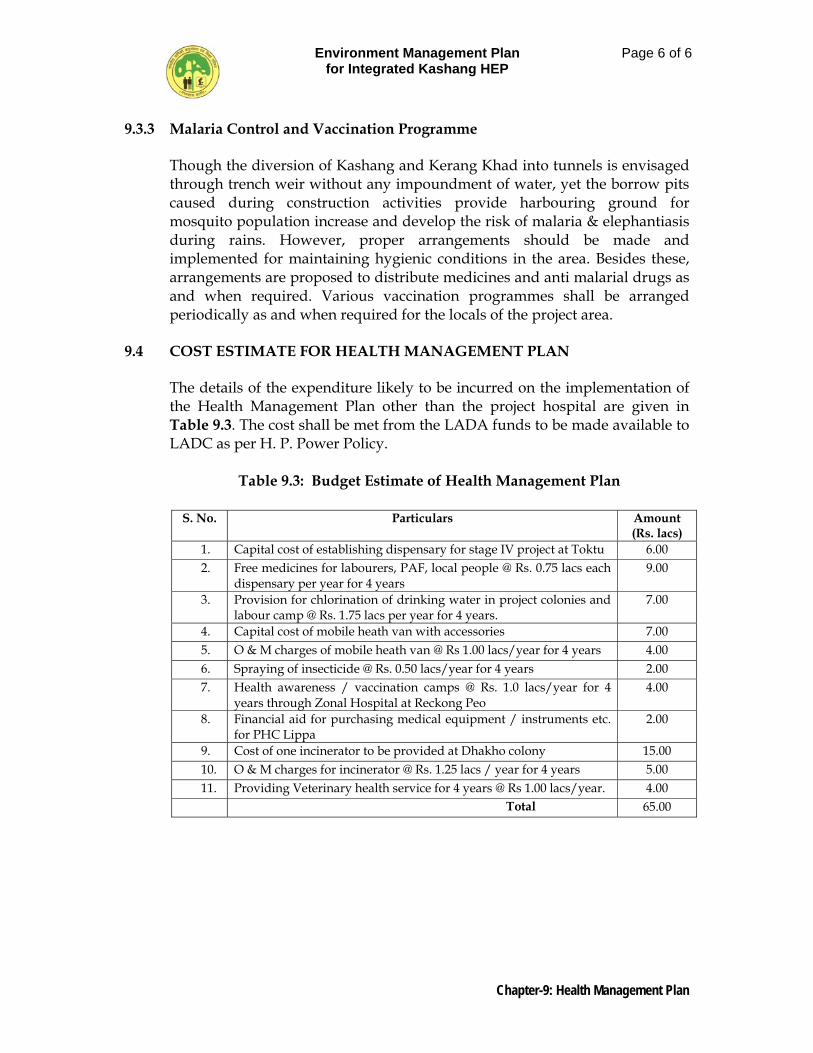
Environment Management Plan for Integrated Kashang HEP
Page 6 of 6
Chapter-9: Health Management Plan
9.3.3 Malaria Control and Vaccination Programme
Though the diversion of Kashang and Kerang Khad into tunnels is envisaged through trench weir without any impoundment of water, yet the borrow pits caused during construction activities provide harbouring ground for mosquito population increase and develop the risk of malaria & elephantiasis during rains. However, proper arrangements should be made and implemented for maintaining hygienic conditions in the area. Besides these, arrangements are proposed to distribute medicines and anti malarial drugs as and when required. Various vaccination programmes shall be arranged periodically as and when required for the locals of the project area.
9.4 COST ESTIMATE FOR HEALTH MANAGEMENT PLAN
The details of the expenditure likely to be incurred on the implementation of the Health Management Plan other than the project hospital are given in Table 9.3. The cost shall be met from the LADA funds to be made available to LADC as per H. P. Power Policy.
Table 9.3: Budget Estimate of Health Management Plan
S. No. Particulars Amount (Rs. lacs)
1. Capital cost of establishing dispensary for stage IV project at Toktu 6.00 2. Free medicines for labourers, PAF, local people @ Rs. 0.75 lacs each
dispensary per year for 4 years 9.00
3. Provision for chlorination of drinking water in project colonies and labour camp @ Rs. 1.75 lacs per year for 4 years.
7.00
4. Capital cost of mobile heath van with accessories 7.00 5. O & M charges of mobile heath van @ Rs 1.00 lacs/year for 4 years 4.00 6. Spraying of insecticide @ Rs. 0.50 lacs/year for 4 years 2.00 7. Health awareness / vaccination camps @ Rs. 1.0 lacs/year for 4
years through Zonal Hospital at Reckong Peo 4.00
8. Financial aid for purchasing medical equipment / instruments etc. for PHC Lippa
2.00
9. Cost of one incinerator to be provided at Dhakho colony 15.00 10. O & M charges for incinerator @ Rs. 1.25 lacs / year for 4 years 5.00 11. Providing Veterinary health service for 4 years @ Rs 1.00 lacs/year. 4.00
Total 65.00
Environment Management Plan for Integrated Kashang HEP
Page 1 of 3
Chapter-10: Provision for Subsidized Fuel
CHAPTER 10
PROVISION FOR SUBSIDIZED FUEL
10.1 INTRODUCTION
The execution of the integrated Kashang HEP and appurtenant works there under have been proposed to be carried out contractually to be completed in 48 months time. Infrastructure facilities shall be developed pari passu with the construction activities. With the commencement of construction activities the deployment of labour force comprising of skilled / semi skilled / unskilled will take place and at a given point of time 1200 workforce shall be engaged. The skilled manpower to the tune of 360 persons shall be imported from other parts of the country while the other class shall be deployed locally. The temporary labour camps will be established at suitable location in the project area. The fuel need of the labourers/ workers has to be attended in an organized manner otherwise the labour may resort to indiscriminate felling of trees and shrubs owing to their cost free and easy availability at leisure. Consequent deforestation if continued shall adversely affect the ecosystem, therefore, pre-emptive action plan has to be devised to meet the fuel needs of workers especially those residing in the labour camps. These objects can be best accomplished by mandatory banning of the use of fuel wood in the labour camps besides complying the following obligatory steps: - • In every contract document mandatory clause should be made for the
contractors to provide community kitchen facilities to labourers who reside without family and also to ensure supply of LPG fuel to the labourers living with families in camps failing which the contractor shall solely be held responsible and liable for penalty and or remedial action.
• Establishing a LPG godown and a state owned kerosene oil depot within
the township of project complex at Dhakho.
• Providing free electricity for domestic purpose to the labourers residing in laboure camps.
10.2 ALTERANTE TO FUELWOOD
The fuel shall be required by the labour for cooking purpose, warming the rooms during cold months and also for warming water. In natural course, if the workforce is allowed to manage these at their will, the first choice shall be the free and readily available natural and conventional resources i.e. fuel wood. Thus pressure due to immigrating labour using fuelwood extracted free from the local forest shall increase in alarming proportion which may lead to complete denudation of forest in nearby pockets. Therefore, to avoid
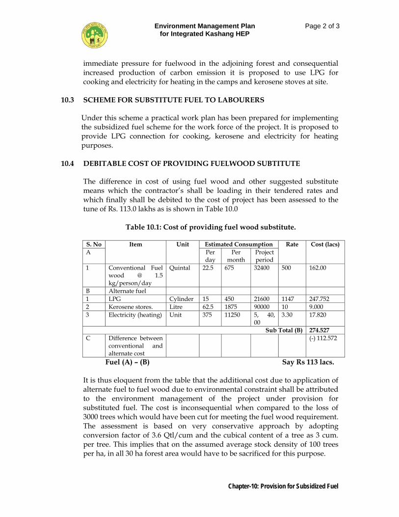
Environment Management Plan for Integrated Kashang HEP
Page 2 of 3
Chapter-10: Provision for Subsidized Fuel
immediate pressure for fuelwood in the adjoining forest and consequential increased production of carbon emission it is proposed to use LPG for cooking and electricity for heating in the camps and kerosene stoves at site.
10.3 SCHEME FOR SUBSTITUTE FUEL TO LABOURERS
Under this scheme a practical work plan has been prepared for implementing the subsidized fuel scheme for the work force of the project. It is proposed to provide LPG connection for cooking, kerosene and electricity for heating purposes.
10.4 DEBITABLE COST OF PROVIDING FUELWOOD SUBTITUTE
The difference in cost of using fuel wood and other suggested substitute means which the contractor’s shall be loading in their tendered rates and which finally shall be debited to the cost of project has been assessed to the tune of Rs. 113.0 lakhs as is shown in Table 10.0
Table 10.1: Cost of providing fuel wood substitute.
S. No Item Unit Estimated Consumption Rate Cost (lacs) A Per
day Per
month Project period
1 Conventional Fuel wood @ 1.5 kg/person/day
Quintal 22.5 675 32400 500 162.00
B Alternate fuel 1 LPG Cylinder 15 450 21600 1147 247.752 2 Kerosene stores. Litre 62.5 1875 90000 10 9.000 3 Electricity (heating) Unit 375 11250 5, 40,
00 3.30 17.820
Sub Total (B) 274.527 C Difference between
conventional and alternate cost
(-) 112.572
Fuel (A) – (B) Say Rs 113 lacs.
It is thus eloquent from the table that the additional cost due to application of alternate fuel to fuel wood due to environmental constraint shall be attributed to the environment management of the project under provision for substituted fuel. The cost is inconsequential when compared to the loss of 3000 trees which would have been cut for meeting the fuel wood requirement. The assessment is based on very conservative approach by adopting conversion factor of 3.6 Qtl/cum and the cubical content of a tree as 3 cum. per tree. This implies that on the assumed average stock density of 100 trees per ha, in all 30 ha forest area would have to be sacrificed for this purpose.
Environment Management Plan for Integrated Kashang HEP
Page 3 of 3
Chapter-10: Provision for Subsidized Fuel
10.3.1 Provision For LPG
It is proposed to establish a gas agency within the premises of project Head Quarters at Dhakho, which will cater to the requirement of gas for cooking purposes of the employees and workmen/ labourer. Each workman family can refill 1 (one) cylinder after every 30 or more days depending on actual consumption. About 1200 work force (skilled/unskilled) would be engaged temporarily during peak construction period. Out of this 360 workers shall be skilled and the balance 940 workers shall be semi-skilled/ unskilled. It is expected that 50% of the work force locally available from the adjacent areas and shall manage to work at site by making to and fro journey from their home. Thus, out of 600 numbers about 300 workmen shall reside in colonies with their families and rest 300 in bachelor accommodations like dormitories/ field camps. The requirement of gas cylinder per month has been worked out on the basis of one cylinder per month for workmen living in family accommodations and one cylinder for a group of 3 workers living in dormitories/ labour camps. The total requirement of LPG cylinders for stipulated 4 year project period @ 15 cylinders / day works to 21600 numbers.
10.3.2 Provision For Kerosene Kerosene is an easily available fuel having less operational hazards. With the
help of the state Government a kerosene depot shall be opened for the distribution of kerosene oil to labourers. The requirement of Kerosence has been worked out as 17.5 Litre/day for 300 labours who shall reside in bachelor accommodation and 45 Liter/day for 300 labours who shall reside in family accommodation. Thus the total requirement shall be to the tune of 90,000 Litres.
10.3.3 Provision for Electricity
Electricity supply should be arranged for lighting purpose to the tune of two 100 W bulbs per family and provision of street light should be made in the labour colony at the contractors cost. The electricity for heating purposes shall be provide at 0.25 unit/day for each of 300 workers residing in bachelors accommodation and one unit/day for each of 300 workers residing in family accommodations. Thus the total consumption per day on this count shall be 375 units and the overall consumption during 48 month shall be 5,40,0000 units.
Environment Management Plan for Integrated Kashang HEP
Page 1 of 8
Chapter-11: Solid Waste Management Plan
CHAPTER 11
SOLID WASTE MANAGEMENT PLAN 11.1 INTRODUCTION
During the construction phase of the project, there will be an influx of technical staff, labourers and other service providers into the project area. The proposed project has also envisaged four colonies to house 600 project employees including personal for other utility services with their families. Sewage and solid waste will be generated from the colonies. It is very essential that from the planning stage, sewerage management and solid waste disposal facilities should be conceptualized to maintain the health of the people and the environment. The main sources of wastes in case of the proposed project can be divided into following categories:
Municipal waste from residential areas. Solid wastes from labour camps Bio-medical wastes from Dispensary.
Since most of the dam operations shall be automated or mechanized, very few people shall be staying in the project during the operation phase. The solid waste is primary problem during the construction phase of the project. Solid waste generated from temporary and permanent colonies in construction as well as operation phase requires special management to dispose off as warranted under the Municipal Solid Wastes (Management and Handling) Rules 2000.
11.2 RESPONSIBILITY PROJECT AUTHORITY
The project authority shall, within the territorial area of the project complex/ colony , be responsible for the implementation of the provision of Municipal Solid Wastes ( Management and Handling ) Rules, 2000 issued by MoEF New Delhi vide so 908 (E) dated 25, September, 2000, and for any infrastructure development for collection , storage, segregation, transportation, processing and disposal of municipal solid wastes.
Any municipal solid waste generated in the project complex/ project colony/ labour colony, shall be managed and handled in accordance with the compliance criteria and the procedure laid down in Schedule –II of under rules 6 (1) and (3), 7 (1) of notification dated 25 September, 2000. The management plan has, therefore, been framed taking into consideration compliance criteria against each parameter as set out under Schedule-II , Some of which are described in the foregoing paragraphs.

Environment Management Plan for Integrated Kashang HEP
Page 2 of 8
Chapter-11: Solid Waste Management Plan
11.2.1 Collection of Municipal Solid Wastes
The project authorities shall prohibit littering of solid wastes in the area under their control by resorting to following:-
Organising house to house collection of solid waste on regular pre-
informed timing and scheduling through any of the methods, like community bin collection (Central bin).
Devising collection of wastes from office complexes, hotels and
commercial areas.
Avoiding mixing of Bio-medical wastes with municipal solid wastes.
Collected waste from residential areas shall be transferred to community bin by hand-driven containerised carts or other small vehicle. Horticulture and construction / demolition wastes or debris shall be separately collected and disposed off.
Waste like dry leaves shall not be burnt.
Collection of wastes from vegetable and fruit shops and meat shops and
also dry leaves collected from avenues/ parks, which are biodegradable in nature to be finally disposed off through aerobic composting in composting units of size 8 m x 2.5 m build from bricks. The compost thus obtained shall be used for development of flower beds and avenue plantation around colonies and office areas and also in biological measures to be adopted in respect of soil tips developed at muck disposal sites.
11.2.2 Segregation of Municipal Solid Wastes
The project authority shall organize awareness programmes to encourage the generators of wastes and to ensure community participation in waste segregation. For this purpose regular meeting at quarterly intervals shall be arranged with representative of resident of colonies.
11.2.3 Storage of Municipal Solid Wastes.
The project authority shall establish and maintain storage facilities in such a manner as they do not create unhygienic and insanitary conditions around it. Following criteria shall be taken into account while establishing and maintaining storage facilities.
Environment Management Plan for Integrated Kashang HEP
Page 3 of 8
Chapter-11: Solid Waste Management Plan
Storage facilities of bins shall have ‘easy to operate ‘design for handling, transfer and transportation of waste. Bins for storage of bio-degradable wastes shall be painted green, those for storage of recyclable wastes shall be painted white and those for storage of other wastes shall be painted black.
Manual handling of waste shall be prohibited. If unavoidable due to constraints, manual handling shall be carried out under proper precaution with due care for safety of workers.
11.2.4 Transportation of Municipal Solid Wastes
Vehicles used for transportation of wastes shall be covered. Wastes should not be visible to public, nor exposed to open environment preventing their scattering. Transportation vehicles shall be so designed that multiple handling of waste, prior to final disposal, is avoided.
11.2.5 Processing of Solid Wastes
The project authorities shall adopt suitable technology or combination of such technologies to make use of wastes so as to minimize burden on landfill. Following criteria shall be adopted: -
The biodegradable wastes shall be processed by composting, verm-icomposting anaerobic digestion for stabilization of wastes.
Mixed waste containing recoverable resources shall follow the route to recycling. Incineration can also be used for processing wastes.
11.2.6 Disposal of Municipal Solid Wastes.
Land filling shall be restricted to non-biodegradable inert waste and other waste that are not suitable for recycling or for biological processing. Some area under muck disposal sites proposed at Beari and downstream of Jataun Barrage shall be earmarked for land fills.
11.2.7 Municipal Waste From Residential Areas
The project colonies will be constructed at Pangi and Dhakho for Stage-I, at Lappo for Stage-II and III and at Toktu for Stage-IV integrated Kashang HEP. The colonies will have about 144 family accommodation, 136 bachelor’s accommodation besides 32 number floating population. The total expected population in the project colony will be 600 persons. In the colony, use of plastic bags be discouraged and use of biodegradable cotton and jute bags be encouraged. The average solid waste generated in the colony has been assumed to be approx 0.75 kg [dry-weight]/ per person/day. Thus, the solid waste generated by 600 persons in the project colony on average daily, weekly, monthly and annual basis is given in the Table 11.1.
Environment Management Plan for Integrated Kashang HEP
Page 4 of 8
Chapter-11: Solid Waste Management Plan
All households need to be instructed to sort their wastes and store the food, biodegradable and non-biodegradable wastes viz. bottles, cans etc in separate containers. Two numbers of doorstep waste collectors per house will be arranged and given to each family. A handcart shall be deployed to collect the wastes from the doorsteps daily. Table 11.1: Solid Waste Generated from Project Colony (kg dry weight)
Garbage
Generation Per Day
(kg) Per Week
(kg) Per Month
(kg) Per Year
(kg) Per Person 0.75 5.25 22.5 270.00 By 600 persons 450 3150 13500 162000
The collected biodegradable wastes will be disposed off at a suitable landfill site, to be developed. The area will be properly fenced to avoid animals to feed on the wastes. The organic waste collected will be suitably processed to form compost. The compost thus produced shall be utilized in parks and plantation area around colony. The recyclable (non- biodegradable) wastes can be collected at a place and can be incinerated at regular interval of time. Apart from this, there will be provision for cleaning the streets of the colony to keep the surrounding area clean. Considering water requirement of about 70 litre / head / day in hilly areas and on an average a person generates about 50 lit. of sewage per day and therefore, about 30,000 lit. /day of domestic sewage along with other waste are expected to be generated from the colony. In the light of the fact that conventional septic tank system, which is too expensive and requires a large volume of water for flushing and is also riddled with problems like periodic cleaning and disposal of sludge, flush compost toilet which requires only 1.5-2.0 litres of water for flushing as against 12 to 14 liters in case of former shall be resorted to. Flush toilet is eco-friendly, technically appropriate, socio-culturally acceptable and economically affordable. Flush compost toilet shall be adopted in residential area. For inspection houses / office areas Thermophillic Aerobic Composter which requires only 6 to 10 days to make compost from any biodegradable waste, without any manual handing during composting shall be adopted. Provision of Rs. 34.50 lacs and Rs. 53.82 lacs have been earmarked under the sub-head “O-Miscellaneous” as the capital cost of sewerage disposal and storm water drainage and O & M charges respectively.
Environment Management Plan for Integrated Kashang HEP
Page 5 of 8
Chapter-11: Solid Waste Management Plan
11.3 SOLID WASTE FROM LABOUR COLONY
As per Hydro Power Policy, 2006, the executing agency shall ensure employment to bonafide Himachalies in all the unskilled / skilled and other non-executive categories of staff with the contractors and sub-contractors as may be required for implementation of the project. If it is not possible to recruit 100% staff from Himachalis for justifiable reasons, then not less than 70% of the total employees from bonafide Himachalis persons shall be adhered to. About 1200 workers (labour and staff) would be engaged temporarily during peak construction period. Out of this approx. 360 workers shall be skilled and the balance 840 workers shall be semi skilled / unskilled. It is expected that 50% of the total work force shall be locally available from adjacent areas and thus labour colony shall be designed to house 600 workforce. It is proposed to provide family residences to 300 workers while the balances shall remain in bachelor accommodation. The labour colonies shall be located at Dolo Dogri, Powari, Lapo and Tokto project sites. Around 300 labourers are expected to reside in the labour colonies with their families and 300 numbers in bachelor accommodation at any given time, during the peak construction phase of the project. Proper care has to be taken to manage the solid waste generated from the labour colony for a population of 1500 residential persons and 100 floating population i.e. for 1600 persons. It is estimated that total solid waste generation per day by labour population residing in the labour colony would be approximately 1200 kg dry weight. This would be to 36000 kg dry weight, and 432000 kg dry weight per month and per annum respectively. For maintaining the cleanliness and of the labour colony and to restrict from disposing the solid waste into the river, this solid waste management plan has been formulated. No dumping of solid waste should be allowed near any water body or nalla. For solid waste collection 8 iron storage vats, each of 5 cum capacity will be located at convenient dumping locations in the colonies. Each vat will have the capacity of holding 500 kg dry weight of garbage, which will be emptied at regular time intervals and the biodegradable waste will be transported to the landfill sites. Use of plastic bags need to be totally banned in the labour colony. Periodical awareness should also be provided in order to avoid use of plastic bags. Proper sanitary facilities would also be provided at the labour colonies. The standard municipal designs for community sanitation facilities in hill areas have been taken into consideration while formulating the sanitation scheme for the labour colony. Flush compost toilets shall be provided for 300 residence of workforce besides six community latrines of five-seater unit each
Environment Management Plan for Integrated Kashang HEP
Page 6 of 8
Chapter-11: Solid Waste Management Plan
with three bathrooms should be constructed at appropriate locations at a cost of Rs. 10.0 lacs per unit having a total cost of Rs. 60.00 lacs. The financial provision for this purpose has been provided in cost estimate for solid waste management Table 11.2.
Generally, from landfill, there is little risk for generation of methane, due to the decay of vegetable matters, as it slowly diffuses at low concentration through the covering material. The most serious risk from sanitary landfill is that of pollution from leachates. Hence, the bed of the disposal sites should be covered with an impervious material so as to ensure that leachate does not lead to soil and water pollution. During long dry periods the surface of a sanitary landfill can become dusty, causing discomfort to locals in and around such sites. Covering of the disposed material would prevent entrainment of fugitive emissions as well. Paper and other material also flies off the landfill area due to wind currents. This often creates a nuisance in the immediate vicinity of the landfill site. The landfill site, therefore, needs to be skirted with wire fence of about 3 m high with paper catchers to avoid fly of papers. Once the landfill operation is complete, the entire landfill site is to be suitably capped by an impervious material like clay. To ward off entries of dogs and moneys, the landfill site shall have welded wire fencing all around. Proper provision for water storage in sufficient quantities will be needed to maintain hygienic environment. Septic tanks of appropriate size be constructed and care be taken to avoid mixing of wastewater and sewage with local water body especially during rainy season. Apart from the municipal solid waste in labour colony of project area, a lot of waste is expected to be generated on account of construction activities mainly consisting of cement bags, iron scrap, packing material, etc. It is expected that most of the iron scrap and packing material would be recycled since it has reuse value apart from monetary values and hence, it is proposed that stipulations should be imposed on suppliers and contractors to take away the scrap and packing materials. Apart from above, about substantial cement will be required for constructional works. Since cement is supplied in 50 Kg plastic bags. As a result large number of plastic bags would require proper disposal through annual public auction with a provision of monthly disposal of such bags. Iron scraps have a resale value and therefore these shall be auctioned to steel re-rollers.
11.4 BIO-MEDICAL WASTES FROM HOSPITALS
Three dispensaries, one each at Dhakho, Lapo and Toktu are proposed in the project area hence the hospital waste management should be considered in priority. All kinds of hospital waste is considered as hazardous waste. Hospital waste is generated during the diagnosis, treatment or immunization
Environment Management Plan for Integrated Kashang HEP
Page 7 of 8
Chapter-11: Solid Waste Management Plan
of human beings. It may include waste like scrap, anatomical waste, culture media, discarded medicines, chemical waste, syringes, swabs, bandages, body fluids, human excreta, etc. This waste is highly infectious and can be serious threat to human health if not managed in a scientific and discriminate manner. It is expected that in Integrated Kashang Project, generation of such hazardous waste will be very less. For the purpose of management, special type of collection container and incinerator should be placed near the hospital for proper collection and disposal of hospital waste. All kind of hospital waste should be incinerated or buried at isolated, identified sites. Any kind of hospital waste should not be either recycled or reused. Incinerator is also a legal requirement for hospital waste management as such the non biodegradable waste generated from colony as well as hospital can be scientifically disposed. One incinerator must be installed at suitable site in Dhakho colony for reduction of total volume of non-biodegradable solid waste including bio-medical waste.
11.5 SEWAGE MANAGEMENT IN NEARBY VILLAGES.
In the context of reduced flow, during operational stage, in Kashang and Kerang Khads due to abstraction of water for power generation, it is essential to minimize such pollutants like sewage etc. which are presently directly drained into the Khads. Viewing this Sewage Treatment Plants should be provided for 5 villages viz. Dolo Dogri, Toktu, Asrang, Lapo and Lippa. The capital cost of construction shall be approximately Rs. 50.0 lakhs met from LADA funds allocated under the DPR for utilization through bonafide Local Area Development Committee (LADC) entrusted to function as specified clause 4.16 of the annexure IX of the Hydro Power Policy, 2006.
11.6 COST ESTIMATE FOR SOILD WASTE MANAGEMENT.
The over all cost estimate for the management plan is shown in Table 11.2.
Table 11.2.Cost Estimate for Solid Waste Management Plan
S. No.
Description Qty. Unit Rate
(Rs lac)
Amount
(Rs. lac)
1. Flush composit toilets for labour colony
300 No 0.05 15.00
2. Community toilet with 5 seats with Effluent Treatment system
6 No 10.00 60.00
3. Cleaning worker for 4 years (12 x 12 x 4)
576 Man months
0.03 17.28
4. Door step plastic dustbin 40 litre capacity @ 2 No/family including
1120 No 0.003 3.36
Environment Management Plan for Integrated Kashang HEP
Page 8 of 8
Chapter-11: Solid Waste Management Plan
S. No.
Description Qty. Unit Rate
(Rs lac)
Amount
(Rs. lac)
one time replacement
5. Waste collection handcarts including one time replacement
32 No 0.03 0.96
6. Landfill R&M LS 30.00
7. Implements such as. Brooms, spade etc and R&M
LS 2.00
8. Anti malarial and anti insecticides equipments & spraying material
LS 1.00
9. Iron storage vat (3.1 m x 1.25 m x 1.25 m)
8 No 1.0 8.00
10. Maintenance of 2 Trucks @ Rs 0.30 / month for 72 months
96 Months 0.3 28.80
11. O & M charges of incinerator @ Rs. 1.0 lacs / year for four years for one incinerator
2 No. 4.00 8.00
12. Developing simple composting unit with size 7.5 m x 2.2 m, three chambered build from brick
1 No. 1.50 1.50
13. Contingency LS 2.00
Total 177.90
Say Rs 178.00
Environment Management Plan for Integrated Kashang HEP
Page 1 of 13
Chapter-12: Disaster Management Plan
CHAPTER – 12
DISASTER MANAGEMENT PLAN 12.1 INTRODUCTION
Any hydroelectric project if not designed on the sound principles of design after detail investigations in respect of hydrology, geology, seismicity etc., could spell a large scale calamity. Thus there are inherent risk to the project like improper investigation, planning, designing and construction which ultimately lead to human catastrophe. Though through detailed field investigations it has been ensured that all components of project are founded on firm rock foundation, designed for suitable seismic design parameters and the trench weirs of stage I, II, & III have been designed for a PMF of 100,315 and 300 cumecs capacity respectively, yet in view of that uncertain element of “Force Mejure” the eventuality of a disaster can not be ignored but a rescue plant has to be devised for confronting an exigency without being caught in vast realm of unpreparedness. A disaster is an unwarranted, untoward and emergent situation that culminates into heavy toll of life and property and is a calamity sometimes caused by “force mejure” and also by human error. The identification of all types to disaster in any proposed project scenario involves the critical review of the project vis-vis the study of historical past incidents/disasters in the similar situations. The evolution of disaster management plan dwells on various aspects as provision of evacuation paths, setting up of alarms and warning systems, establishing communicating system besides delineating an Emergency Response Organization with an Effective Response System. Keeping in view the grievous affects a disaster can cause on human or animal population, loss of property and environment in and around the areas of impact. Therefore, it is essential to assess the possibility of such failures in context to the present project and components formulate a contingent plan.
12.2 PROJECT BRIEF
The proposed Integrated Kashang HEP, conceived as R-O-R scheme with no impoundment of water involved due to placing of trench weirs, comprises of four stages described briefly as below.
Environment Management Plan for Integrated Kashang HEP
Page 2 of 13
Chapter-12: Disaster Management Plan
Stage-I (65 MW): Comprises diversion of Kashang Khad through a vertical drop trench weir (near Dolo Dogri at El. 2829m) to underground water conductor system comprising of 2.0 km long HRT connected with an underground balancing reservoir (54000 Cum capacity) and 1.4 km long pressure shaft to an underground powerhouse (located an right bank of Satluj) developing a head of approx. 830m to generate 65 MW. Stage – II: Consists of diversion of tail water of Stage – IV, from Kerang Khad (near Lappo village at El. 2872m) to an underground water conductor system (6.3 km. long k-k link) leading into the underground reservoir of Stage-I would be fed through trench weir on Kerang Stream. Stage-III: Consists of augmentation of generating capacity of Stage –I power house using additional waters of Kerang (brought by Stage-II) over 830 m. head already available in Kashang Stage-I powerhouse for generation of additional power of 130 MW. Stage-IV: It is more or less an independent scheme harnessing the power potential of Kerang Khad well upstream of the diversion site of stage-II. The trench weir of this Scheme will be located near Toktu at El. 3150m. In this scheme a head of approx. 300m would be utilized through 5 km long underground tunnel leading to an underground powerhouse (48 MW capacity) whose tail race would be connected to the k-k link water conductor system.
12.3 DISASTER ANALYSIS OF VULNERABLE COMPONENTS
It is clear that the Scheme has been conceptualized as Run-of-the River type hydroelectric project with no open surface reservoir or water impoundment within the river banks. Also there does not exists any hydroelectric project upstream of the proposed Integrated Scheme and thus, these are no hazard involved to the Scheme from the failure of any upstream project also. Thus if any disaster may happen it could be due to failure of one or more components of the proposed scheme though the chances of which are remote but can not be ruled out. The vulnerable components and their possible chances of failure are described here under.
Environment Management Plan for Integrated Kashang HEP
Page 3 of 13
Chapter-12: Disaster Management Plan
12.3.1 Trench Weir
Trench weir type diversion weirs have been retained against conventional barrage or weir/dam type structure which obstruct either due to gates resting at the sill level or due to raised structure, masonry or concrete, above the river bed. The trench weir structure dose not obstructs the flow and is provided almost at the river bed level and in a width which is Khad’s natural width during high flow season. The design of trench weir based on recommendation in CBIP Publication Number 175 tilled “ Standardization of Civil Works for Micro/Mini Hydro Schemes. The tresh rack provided over the drop weir is given a slope of 1:5 and the natural slope of the river on the upstream and downstream of weir axis are maintained unless they are very flat. The weir structure, including its upstream and downstream projection works, is provided a uniform width in substantial length. Depending upon the design discharge the depth of trench varies from 70 cm to design depth towards the diversion bank. In the present case all the trench weir have their bed slope from left to right. The walls/bed of trench weir is made in rich concrete (M-25) on the upstream side of trench weir in the entire channel width upstream. The protection blocks of c.c are also provided on the d/s. These blocks shall have stones embedded to protrude 15 cm above the concrete surface to reduce the velocity of flowing water. The size of the block is so designed to avoid dislodging during design flood. A cut off wall is provided at the end of u/s and d/s protection. Wing wall is also provided at the upstream end to channelise the flow.
The structural design of the trench weir is such that due to no static head any failure due to uplift is ruled out more so as there is no static head difference on u/s and d/s of weir site. The provision of upstream and downstream cut off wall at the end of u/s and downstream bed protection shall minimize any progression or retrogression of the bed. Thus failure due to piping is also naught. The failure of c.c block protection due to suction during high flood are there but the adopted gigantic size of cc blocks also puts it to minimal. The damage to any cc bed block shall jeopardize the safety of structure to such an extent that an alarming situation is called for. The damage can be addressed after receding of flood and even during flood for which temporary measures can also be resorted to. Thus the weir as such does not pose any threat causing disaster.
Environment Management Plan for Integrated Kashang HEP
Page 4 of 13
Chapter-12: Disaster Management Plan
12.3.2 Underground Water Conductor System.
The underground water conductor system of stage-I comprises of 2 km long D-shaped (3m x 4.11m), 20 cm thick lined HRT for a nominal discharge of 11.45 cumecs at 2.0m/sec velocity; 204m tong D-Shaped (10m x 13/15m) balancing reservoir (54000 um capacity) connected to 2.6m diameter 1400 m long pressure shaft with 16 to 45 mm thick steel linear. The water conductor system of stage-II comprises of 6.3 km long, 20 cm thick cc lined, D-Shaped (3.5m x 4.5) with a bed slope of l in 1025, HRT designed for a nominal discharge of 18.3 cumecs at 2.13 m/sec. nominal velocity. The water conductor system of stage-IV comprises of 5 km long, 20cm thick c.c. lined, D-Shaped (3m x 3.15m) with a bed slope of lin 1000m, HRT designed for a nominal discharge of 18.5 cumecs at 2.1 m/s nominal velocity and a pressure shaft 375m long, 2.1m in diameter with 16-25mm thick steel liner connected to a surge shaft (Surface). The tunnels have been designed for both free and pressure (full) flow conditions, depending upon the in flow and operational conditions. The tunnels are allowed to be slightly pressured in part length twice daily when the balancing reservoir are full. The HRT, after entering into the bedrock, will have, in general a good rock cover varying from 5m in initial reaches to about 150-250m near balancing reservoir in case of HRT for stage-I and the cover varies from 10 m to 1300m in case of k-k link tunnel except for box section near Kashang khad crossing.
No major stream cuts are present across the tunnel alignment, only dry gullys are present having steep gradient. Snow moves along these gullys during winter. The rock to be encountered is good and competent. An outcrop of massive granite has been observed along the link tunnel alignment. Thus though the alignment of the underground works passes through sound and competent rocks and no stream crosses through their alignments and that adequate provision of permanent steel supports (Ribs)_ have been made for weaker reaches, strengthening measures like rock bolting (25 mm dia) have also been provided. The chances of HRT caving in due to subsidence of rock are remote but can not be ruled out. But this type of failure may affect generation or stop it but in no way it can herald disaster. The damage control measures can be taken in short interval as all the underground works are approachable easily. The chimney formation or caving of any portion of tunnel may lead to any immediate untoward situation but it is not a disaster per se. To prevent any seepage or leakage from underground water conductor system, the structural lining of rich grade concrete has been provided. Besides this
Environment Management Plan for Integrated Kashang HEP
Page 5 of 13
Chapter-12: Disaster Management Plan
provision for cement grouting behind the lining has also been made. In such a scenario, seepage or leakage is highly unlikely incidence. However, in case of such happening and any resultant loss caused by it to the land or property, the project proponent shall either restore the damages at their cost or pay damages as may be decided by the competent authority.
12.3.3 Power House Complex
Both the power house of stage-I and IV are located in an underground a cavern 87m x 16m x 29.9m and 62.8m x 16m x 29.2m respectively and shall house machine hall, control block, erecting boy. The transformer hall cavern for stage-I is proposed to be located 35m downstream of the machine hall, the center line of the transformer hall would coincide with the center line of exploration cross drift. The transformer hall cavern for stage-IV power house shall be located 25m d/s of machine hall. 6-8m long rock bolts of 32mm diameter with mechanical end anchorage shall be placed in 2m x 2m grid on the crown and for side walls of the two openings. For the opening walls common to the rock pillar, the bolt length shall be increased to 8-10m. The gneisses in power house area are generally sound and the rock quality is fair with Q values ranging from 6 to 9 in most of the length of the drift. The chances of structural disaster are least. The power house discharges into River Satluj through 324m (combined) length of tail race tunnel with outlet sill at El. 1992m. above msl. Therefore, in the worst scenario when the water level of River Satluj crosses El. 2000m the flow in tail race will be affected reducing the generation. To avoid any situation arising due to unforeseen and abnormal rise in water level of River Satluj due to force mejure reasons, the flooding situation in the power house can happen but to avoid such a situation draft tube gates have been provided. Thus no situation leading to a disaster can be visualized in respect of Powerhouse complex, too. For back up power adequate captive power arrangement shall be provided in powerhouse area. Extensive arrangement of power extinguisher shall also be made for meeting any threat due to fire.
12.4 POSSIBLE DANGER DUE TO STORAGE OF EXPLOSIVE
Adequate safety zone shall be provided as per statutory requirements while locating the magazines. The magazine shall be constructed as per plan approved by Department of Explosives. The storage of some detonating/priming materials/devices will be done in a 5 T magazine provided for storage of primers, detonators, fuses etc.
Environment Management Plan for Integrated Kashang HEP
Page 6 of 13
Chapter-12: Disaster Management Plan
The explosive magazine will be designed in a manner that normally chances of fire inside the magazine are ruled out. However, the following precaution will be taken:
• Clearance of dried vegetation within 20 meter of Magazine house • Installation of lightening arresters on the magazine to prevent
damages • Provision of fire extinguishers, water and sand filled buckets. • Keeping a safety zone margin around the magazine as per the
guidelines given in schedule VIII of the Explosives Rule, 1983. 12.5 PRECAUTIONARY/SAFETY MEASURES AND ACCIDENT RISKS. 12.5.1 Precaution and Safety measure.
• All relevant provision of the Explosive Acts, Factories Act, 1948 and the Building and Other Construction Works (regulation of Employment and Condition of Service) Act, 1996 will be adhered to adequate safety measures for construction works during excavation and handing of wastes/materials at site will be taken up.
• Adequate illumination and ventilation will be provided in tunnels and the underground power plant.
• Emergency lightening System will be provided in the tunnels and during construction and in the power plant for construction/post construction phases.
12.5.2 Accident Risks from Construction Activities.
• During construction, lighting devices and safety signals devices will be installed to ensure safe construction.
• To minimize road accidents, road safety education will be imparted to drivers running construction vehicles and they should be bound to observe Traffic rules and regulations.
• Accident due to blasting can be avoided during controlled blasting by regulating the blasting time and providing effective signal and guarding. Prior to blasting the site should be thoroughly inspected.
• Accident due to electric fire can be avoided by checking regularly the electric equipments.
• Road accidents can also be minimized by resorting to regular servicing and inspection of construction vehicle/HEMM. etc.
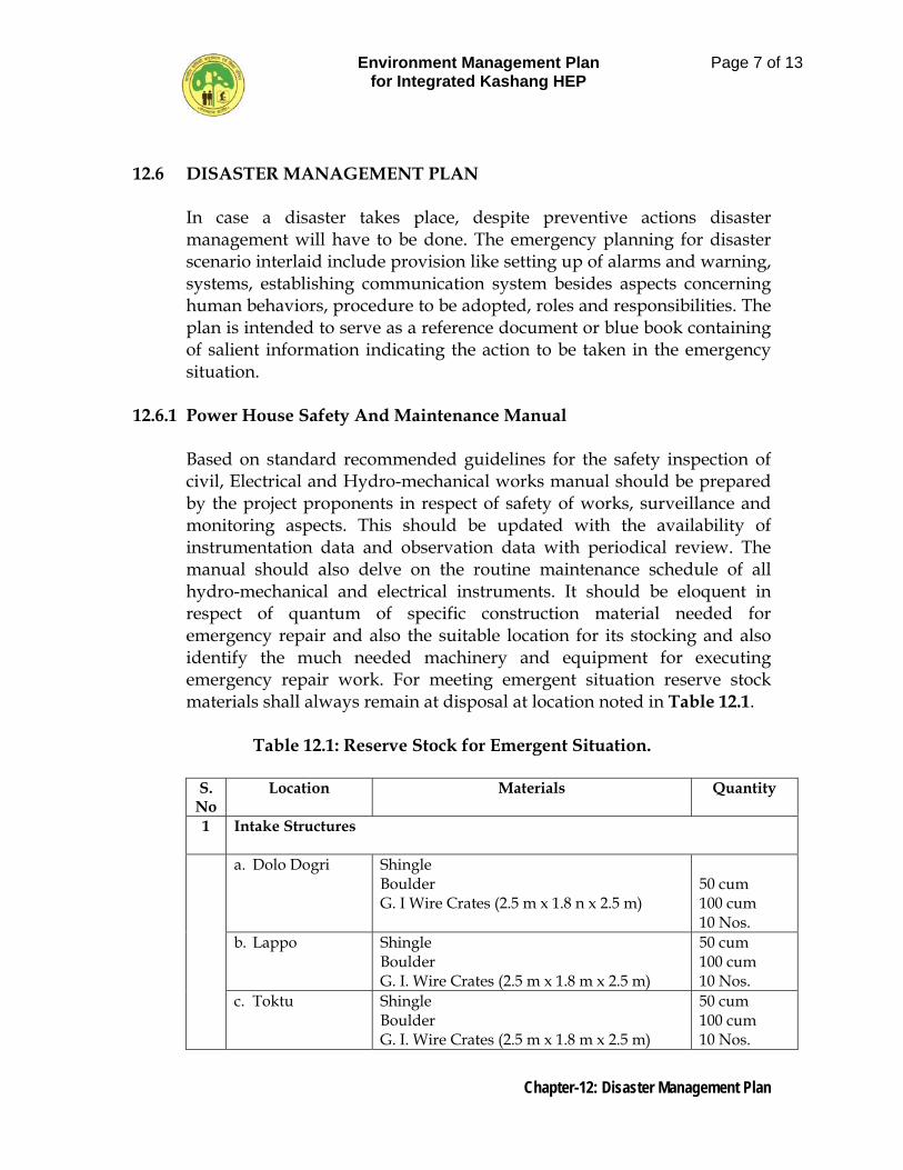
Environment Management Plan for Integrated Kashang HEP
Page 7 of 13
Chapter-12: Disaster Management Plan
12.6 DISASTER MANAGEMENT PLAN
In case a disaster takes place, despite preventive actions disaster management will have to be done. The emergency planning for disaster scenario interlaid include provision like setting up of alarms and warning, systems, establishing communication system besides aspects concerning human behaviors, procedure to be adopted, roles and responsibilities. The plan is intended to serve as a reference document or blue book containing of salient information indicating the action to be taken in the emergency situation.
12.6.1 Power House Safety And Maintenance Manual
Based on standard recommended guidelines for the safety inspection of civil, Electrical and Hydro-mechanical works manual should be prepared by the project proponents in respect of safety of works, surveillance and monitoring aspects. This should be updated with the availability of instrumentation data and observation data with periodical review. The manual should also delve on the routine maintenance schedule of all hydro-mechanical and electrical instruments. It should be eloquent in respect of quantum of specific construction material needed for emergency repair and also the suitable location for its stocking and also identify the much needed machinery and equipment for executing emergency repair work. For meeting emergent situation reserve stock materials shall always remain at disposal at location noted in Table 12.1.
Table 12.1: Reserve Stock for Emergent Situation.
S.
No Location Materials Quantity
1 Intake Structures
a. Dolo Dogri
Shingle Boulder G. I Wire Crates (2.5 m x 1.8 n x 2.5 m)
50 cum 100 cum 10 Nos.
b. Lappo Shingle Boulder G. I. Wire Crates (2.5 m x 1.8 m x 2.5 m)
50 cum 100 cum 10 Nos.
c. Toktu
Shingle Boulder G. I. Wire Crates (2.5 m x 1.8 m x 2.5 m)
50 cum 100 cum 10 Nos.
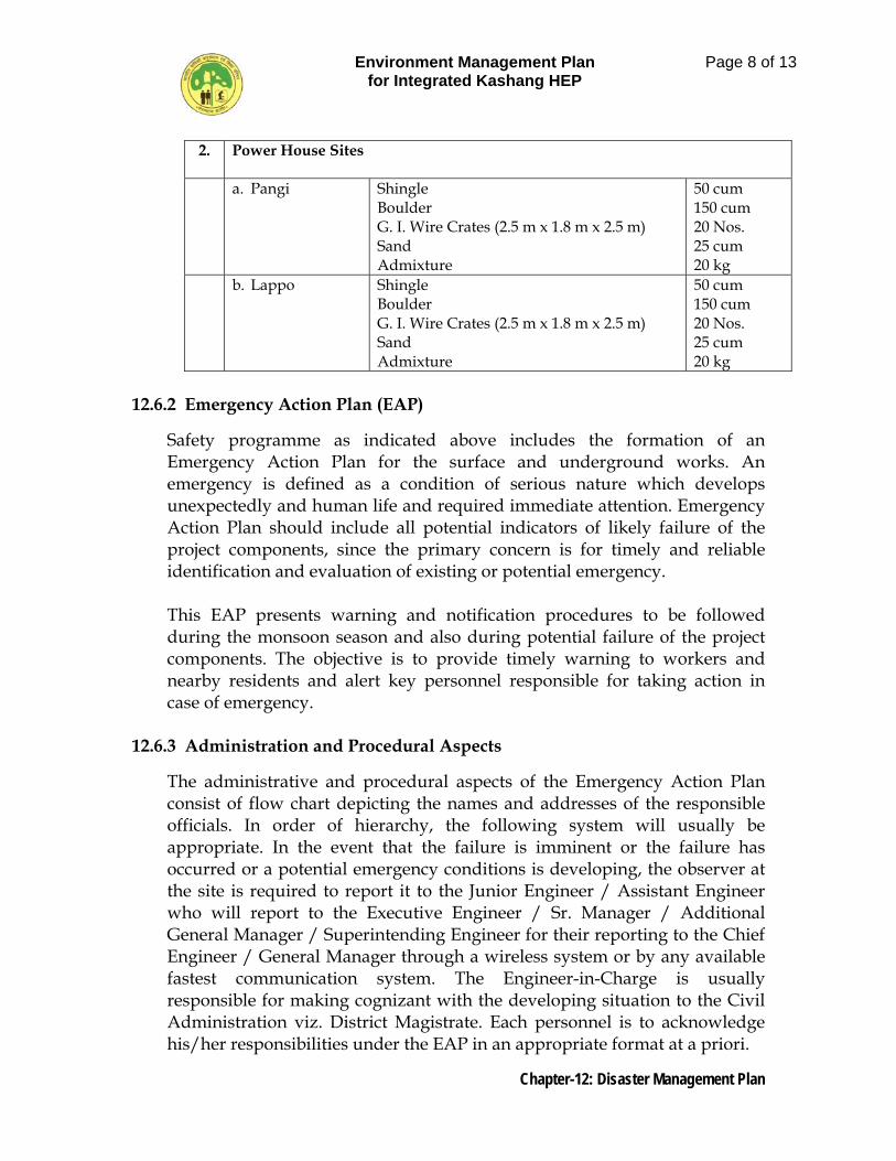
Environment Management Plan for Integrated Kashang HEP
Page 8 of 13
Chapter-12: Disaster Management Plan
2. Power House Sites
a. Pangi
Shingle Boulder G. I. Wire Crates (2.5 m x 1.8 m x 2.5 m) Sand Admixture
50 cum 150 cum 20 Nos. 25 cum 20 kg
b. Lappo
Shingle Boulder G. I. Wire Crates (2.5 m x 1.8 m x 2.5 m) Sand Admixture
50 cum 150 cum 20 Nos. 25 cum 20 kg
12.6.2 Emergency Action Plan (EAP)
Safety programme as indicated above includes the formation of an Emergency Action Plan for the surface and underground works. An emergency is defined as a condition of serious nature which develops unexpectedly and human life and required immediate attention. Emergency Action Plan should include all potential indicators of likely failure of the project components, since the primary concern is for timely and reliable identification and evaluation of existing or potential emergency.
This EAP presents warning and notification procedures to be followed during the monsoon season and also during potential failure of the project components. The objective is to provide timely warning to workers and nearby residents and alert key personnel responsible for taking action in case of emergency.
12.6.3 Administration and Procedural Aspects
The administrative and procedural aspects of the Emergency Action Plan consist of flow chart depicting the names and addresses of the responsible officials. In order of hierarchy, the following system will usually be appropriate. In the event that the failure is imminent or the failure has occurred or a potential emergency conditions is developing, the observer at the site is required to report it to the Junior Engineer / Assistant Engineer who will report to the Executive Engineer / Sr. Manager / Additional General Manager / Superintending Engineer for their reporting to the Chief Engineer / General Manager through a wireless system or by any available fastest communication system. The Engineer-in-Charge is usually responsible for making cognizant with the developing situation to the Civil Administration viz. District Magistrate. Each personnel is to acknowledge his/her responsibilities under the EAP in an appropriate format at a priori.
Environment Management Plan for Integrated Kashang HEP
Page 9 of 13
Chapter-12: Disaster Management Plan
The technical aspects of the EAP consist of preventive action to be taken with regards to the structural safety of the components of project. For this purpose, providing an adequate and easy access to the potential damage site is a necessity. All the works should be properly illuminated for effective operations during right time. Whenever increased leakages, movement of masonry rock, gate failure, rapid rise or fall of the level in the khad, rise in the level of khad beyond the maximum working level, or wave overrunning the side of trench weir are observed, the personnel on duty is required to inform immediately to the Junior Engineer (JE) / Assistant Engineer (AE) for initiation the execution of EAP. They are required to inform the Engineer-in-Charge and the local administrative authorities. It is desirable if the downstream inhabitants are warned using siren, if available, so as to make them aware the likely imminent danger. The other preventive measures may include availability of sufficient number of sandbags and other reserve stock at several selected downstream locations and logs (for holding and sandbags) and at the trench weir site, one tractor, lanterns and rope. Areas from where the labour can be mobilized should be chalked out at a priority. In addition to these, public participation in the process of execution of the EAP may further help in amelioration the adverse impacts of the likely disaster for this, it is necessary that the public should be aware of its responsibilities.
12.6.4 Preventive Action
Once the likelihood of an emergency situation is suspected, action has to be initiated to prevent a failure. The point at which each situation reaches an emergency status shall be specified and at that stage the vigilance and surveillance shall be upgraded both in respect of time and level. At this stage a thorough inspection of the works should be carried out to locate any visible sign(s) of distress.
Engineers responsible for preventive action should identify sources of equipment needed for repair, materials, labour and expertise for use during an emergency. The amount and type of material required for emergency repairs should be determined for each dam, depending upon its characteristics, design, construction history and past behavior. It is desirable to stockpile suitable construction materials at an appropriate site. The anticipated need of equipment should be evaluated and if these are not available at the work site, the exact location and availability of this equipment should be determined and specified. The sources/agencies must
Environment Management Plan for Integrated Kashang HEP
Page 10 of 13
Chapter-12: Disaster Management Plan
have necessary instructions for assistance during emergency. Due to the inherent uncertainties about their effectiveness, preventive actions should usually be carried out simultaneously with appropriate notification on alert situation or a warning situation.
12.6.5 Communication System
An effective communication system between all stages of the integrated project and a downstream warning system are absolutely essential for the success of an emergency preparedness plan. Since Stage-I and IV power house have to run in tandem, there should be a proper communication system / hot line connecting these.
12.6.6 Evacuations Plans
Emergency Action Plan includes evacuation plans and procedures for implementation based on locals needs. These could be:
- Demarcation / prioritization of areas to be evacuated. - Notification procedures and evacuation instructions. - Safe routes, transport and traffic control. - Safe areas/shelters. - Functions and responsibilities of members of evacuation team.
Any precarious situation during floods will be communicated either by an alert situation or by an alert situation followed by a warning situation. An alert situation would indicate that although failure of flooding is not imminent, a more serious situation could occur unless conditions improve. A warning situation would indicate that flooding is imminent as a result of an impending failure of the work component / structure. It would normally include an order for evacuation of delineated inundation areas. The project area is located in a very remote and for flung area of district Kinnaur of Himachal Pradesh. In case of any emergent situation, if any project personnel or workmen or a patient is to be immediately evacuated by air lifting to a far located Medical Institute, then there are no means. Viewing this aspect it is proposed to establish a helipad near intake of stage-I where suitable land can be readily made available from already acquired land. The helipad area shall be properly developed and fenced for which a provision of Rs 20 lacs is being made in the plan.
Environment Management Plan for Integrated Kashang HEP
Page 11 of 13
Chapter-12: Disaster Management Plan
12.6.7 Evacuation Team
It will comprise of following official / Representative:
- District Magistrate (D. M.) / his Nominated officer (To peacefully relocate the people to places at higher elevation with state administration).
- Engineer in charge of the project (Team Leader) - Superintendent of Police (S. P.) / Nominated Police Officer (To
maintain law and order) - Chief Medical Officer (C. M. O.) of the area (To tackle morbidity of
affected people) - Sarpanch/Affected village Representative to execute the resettlement
operation with the aid of state machinery and project proponents. - Sub committees at village level
The Engineer-in-Charge will be responsible for the entire operation including prompt determination of the flood situation time to time. Once the red alert is declared the whole state machinery will come into swing and will start evacuating people in the inundation areas delineated in the inundation maps. For successful execution, annually demo exercise will be done. D. M. is to monitor the entire operation.
12.6.8 Public Awareness for Disaster Mitigation
In addition, guidelines that have to be followed by the inhabitants of labour camps / job facility areas, in the event of flood, which form part of public awareness for disaster mitigation may also include following:
1. Listen to the radio for advance information and advice. 2. Disconnect all electrical appliances and move all valuable personal and
household goods beyond the reach of floodwater, if one is warned or if one suspects that flood waters may enter the house.
3. Move vehicles, farm animals and movables goods to the higher place nearby.
4. Keep sources of water pollution i.e. insecticides out of the reach of water.
5. Turn off electricity and gas one has to leave the house. 6. Lock all outside doors and windows if one has to leave the house. 7. Do not enter floodwaters.
Environment Management Plan for Integrated Kashang HEP
Page 12 of 13
Chapter-12: Disaster Management Plan
8. Never wander around a flood area.
12.6.9 Notifications
Notification procedures are an integral part of any emergency action plan. Separate procedures should be established for slowly and rapidly developing situations and failure. Notifications would include communication of either an alert situation or an alert situation followed by a warning situation. An alert situation would indicate that although failure or flooding is not imminent, a more serious situation could occur unless conditions improve. A warning situation would indicate that flooding is imminent. It would normally include an order for evacuation of delineated inundation areas.
12.6.10Notification Procedures
Copies of the EAP that also includes the above described inundation map are displayed at prominent locations, in the rooms and locations of the personnel named in the notification chart. For a regular watch on the flood level situation, it is necessary that the flood cells be manned by two or more people so that an alternative person is available for notification round the clock. For speedy and unhindered communication, a wireless system is a preferable mode of communication. Telephones may be kept for back up, wherever available. It is also preferred that the entire flood cells, if more that one, are tuned in the same wireless channel. It will ensure communication from the trench weir sites to the control rooms. The communication can be established by messenger service in the absence of such modes of communication.
12.6.11Management after Disaster
It is to be accepted that in the event of disaster, even with maximum efforts, the loss of human lives, livestock and property would be inevitable. Under such a scenario, a massive effort would be used by various government agencies to provide various relief measures to the evacuees. Formulation of a plan delineating such measures is beyond the scope of work of this document. However, some of the measures which need to be implemented are listed as below:-
• Provision of various food items and shelter to the evacuees. • Provision of fuel for various evacuees.
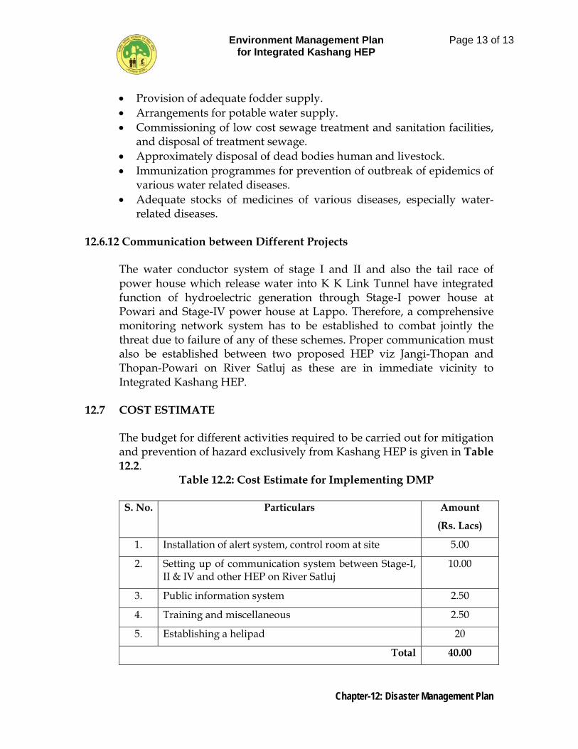
Environment Management Plan for Integrated Kashang HEP
Page 13 of 13
Chapter-12: Disaster Management Plan
• Provision of adequate fodder supply. • Arrangements for potable water supply. • Commissioning of low cost sewage treatment and sanitation facilities,
and disposal of treatment sewage. • Approximately disposal of dead bodies human and livestock. • Immunization programmes for prevention of outbreak of epidemics of
various water related diseases. • Adequate stocks of medicines of various diseases, especially water-
related diseases.
12.6.12 Communication between Different Projects
The water conductor system of stage I and II and also the tail race of power house which release water into K K Link Tunnel have integrated function of hydroelectric generation through Stage-I power house at Powari and Stage-IV power house at Lappo. Therefore, a comprehensive monitoring network system has to be established to combat jointly the threat due to failure of any of these schemes. Proper communication must also be established between two proposed HEP viz Jangi-Thopan and Thopan-Powari on River Satluj as these are in immediate vicinity to Integrated Kashang HEP.
12.7 COST ESTIMATE
The budget for different activities required to be carried out for mitigation and prevention of hazard exclusively from Kashang HEP is given in Table 12.2.
Table 12.2: Cost Estimate for Implementing DMP
S. No. Particulars Amount
(Rs. Lacs)
1. Installation of alert system, control room at site 5.00
2. Setting up of communication system between Stage-I, II & IV and other HEP on River Satluj
10.00
3. Public information system 2.50
4. Training and miscellaneous 2.50
5. Establishing a helipad 20
Total 40.00
Environment Management Plan for Integrated Kashang HEP
Page 1 of 9
Chapter-13: Environmental Monitoring Plan
CHAPTER 13
ENVIRONMENTAL MONITORING PLAN 13.1 THE NEED
Sustainability of water resource project depends on continuous monitoring. Monitoring is an integral part of any environmental assessment process. Water resource development project create a new environment with complex inter-relationships between people and natural resources. The magnitude of changes being created due to alteration of landscape, water, air and noise quality and other environmental parameters can be quantified and evaluated only by conducting monitoring of various parameters during different phases of project construction and operation. The monitoring and evaluation of environmental parameters indicates potential changes occurring on the environment which paves the way for implementation of rectifying measures wherever required to maintain the status of the natural environment. Evaluation is also a very effective tool to judge the effectiveness or deficiency of the measures adopted and provides insight for future corrections.
13.2 AREAS OF CONCERN
Incase of hydro power projects the changes relating to water, aquatic biota, air, noise, biodiversity of the area and compensatory afforestation programmes need special attention from monitoring point of view during project construction as well post construction stages to judge the efficacy of measures implemented for conservation of environment.
Environmental Monitoring The overall impact assessment of the proposed project was carried out and management plans have been framed based on the severity of impacts in different areas. During the EIA study it has been observed that the air quality and water quality are not going to be affected significantly and only, temporary changes in these parameters are expected. The preventive/ curative reduce measure to reduce the ill effects of construction activities on these parameters have been suggested under various plans. A holistic approach has been adapted for monitoring of air, noise and water related factors under different heads with suitable financial provisions for their implementation.
Environment Management Plan for Integrated Kashang HEP
Page 2 of 9
Chapter-13: Environmental Monitoring Plan
13.2.1 Air Quality Monitoring and Management
Pollutant which may be generated during the construction phase of the project will alter the local environment temporally and shall subside once the major constructional activities are over. It is assumed that during the construction phase of the project, concentration of pollutant like SO2, NOx and CO2 may exceed the threshold limit especially in underground work which is to be controlled by use of ventilator fans. It should be made mandatory on the part of the contractors that they use the required equipment for monitoring gaseous pollutants in and around the project and submit a detailed report every fortnight to the project authorities for evaluation and monitoring purposes. The air quality in and around the project area can be improved by the application of following practices / methods.
Excavation work may be carried out by pre-splitting and controlled blasting techniques
Control blasting be carried out as far as possible and use of explosive
also be bare minimum.
The type of explosive used in blasting may be selected as per the requirement.
To settle down the dust in project area especially around crushing
plants, excessive use of water sprinklers is the best method. The work of Air Quality Monitoring may be assigned to either Himachal Pradesh Pollution Control Board or any other agency approved by MoEF. For this a lump-sum provision of Rs. 4.20 Lacs for 4 & 3 years during construction and operation phases respectively shall be sufficient to cater to the quarterly monitoring of air quality parameters such as SO2, NOx, CO, SPM etc. The sample site should be
Three trench weir sites at Dolo Dogri, Lapo and Toktu Power house site at Powari Reckong Peo
The total financial implication of this plan stands as Rs 2.10 Lacs.
13.2.2 Noise Quality Monitoring and Management
The level of noise will definitely rise above threshold level in the project area due to different type of construction activities: blasting for tunnels, powerhouse, dam etc, movement of heavy and small vehicles and the
Environment Management Plan for Integrated Kashang HEP
Page 3 of 9
Chapter-13: Environmental Monitoring Plan
crushing plants. All these activities will generate high noise and vibrations which can cause health hazards among the labours, local inhabitants and wildlife present in the area. Therefore, it would be most appropriate if following measures are rigorously applied during construction phase of the project.
Continuous monitoring of sound level within the project area.
Extensive plantation to be carried out in the project area as plants absorb sound and make a barrier for its travel to long distances.
Pre split and controlled blasting.
Provision of Air muffs to workers working in underground excavation works.
Compulsory Periodic Maintenance of high earth movers, batching and crushing plants.
Monitoring and measuring the sound level can be again assigned to either Himachal Pradesh Pollution Control Board or any other external agency. The financial implication for monitoring of noise pollution is proposed for every three months during construction phase of four years and post construction phase for three years. The total financial implication for construction and post-construction phase works out to Rs. 2.00 lacs and Rs. 1.50 lacs respectively only.
13.2.3 Water Quality Monitoring and Management
Water is one of most precious natural resources. Human beings are highly dependent on water for various purposes such as domestic needs, sanitation irrigation, industry, and disposal of wastes etc. The catchment of Kashang and Kerang Khad and its tributaries does not host any industry. Thus the stream water is almost free from major industrial chemical pollutants. Besides this, the catchment is sparsely populated with small chunks of agricultural fields. Therefore, the water of river bears some load of silt mainly from glacier melt i.e. moraine deposit and domestic wastes. Further, due to congregation of labours during the construction phase the water quality in this stretch may get deteriorated if proper sanitation facilities are not provided to them. The probable water pollutants which may cause pollution during the construction phase of this project are:
Suspended solids Biodegradable organic matters Pathogens and vectors Nutrients Dissolved inorganic solids
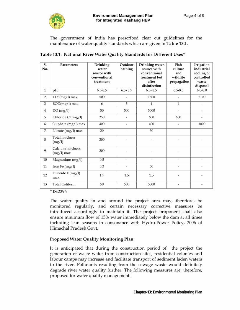
Environment Management Plan for Integrated Kashang HEP
Page 4 of 9
Chapter-13: Environmental Monitoring Plan
The government of India has prescribed clear cut guidelines for the maintenance of water quality standards which are given in Table 13.1.
Table 13.1: National River Water Quality Standards for Different Uses*
S. No.
Parameters Drinking water
source with conventional
treatment
Outdoor bathing
Drinking water source with
conventional treatment but
after disinfection
Fish culture
and wildlife
propagation
Irrigation industrial cooling or controlled
waste disposal
1 pH 6.5-8.5 6.5- 8.5 6.5- 8.5 6.5-8.5 6.0-8.0
2 TDS(mg/l) max 500 - 1500 - 2100
3 BOD(mg/l) max 6 5 4 4 -
4 DO (mg/l) 50 500 5000 - -
5 Chloride Cl (mg/l) 250 - 600 600 -
6 Sulphate (mg/l) max 400 - 400 - 1000
7 Nitrate (mg/l) max 20 - 50 - -
8 Total hardness (mg/l) 300 - - - -
9 Calcium hardness (mg/l) max 200 - - - -
10 Magnesium (mg/l) 0.5 - - - -
11 Iron Fe (mg/l) 0.3 - 50 - -
12 Fluoride F (mg/l) max 1.5 1.5 1.5 - -
13 Total Coliform 50 500 5000 - -
* IS:2296
The water quality in and around the project area may, therefore, be monitored regularly, and certain necessary corrective measures be introduced accordingly to maintain it. The project proponent shall also ensure minimum flow of 15% water immediately below the dam at all times including lean seasons in consonance with Hydro-Power Policy, 2006 of Himachal Pradesh Govt. Proposed Water Quality Monitoring Plan
It is anticipated that during the construction period of the project the generation of waste water from construction sites, residential colonies and labour camps may increase and facilitate transport of sediment laden waters to the river. Pollutants resulting from the sewage waste would definitely degrade river water quality further. The following measures are, therefore, proposed for water quality management:
Environment Management Plan for Integrated Kashang HEP
Page 5 of 9
Chapter-13: Environmental Monitoring Plan
Sufficient water should be supplied to the labour camps and residential colonies
Water should be treated before use to prevent pathogenic and coli
form organisms
Sewage waste be released in river only after proper treatment
It is proposed that the sediment laden water from different project components may be collected in sedimentation tanks/water tanks to dislodge the sediments before releasing the sediment free water to river/streams. An adequate solid waste management practices be adopted in colonies and labour camps as suggested in solid waste management plan. It would be eco-friendly if sewage water after disposal of solid waste may be used in watering of parks and gardens. In addition to this periodical monitoring of water for its physico-chemical and bacteriological parameters may be conducted quarterly at the specified sites mentioned under Table 13.3 during the complete life time of the project. The financial provision of Rs 8.40 lacs however has been provided for the period of four years from the date of project execution and for 3 years post-construction. The water quality parameters to be monitored quarterly are shown in Table 13.2.
Table 13.2: Water Quality parameters to be monitored periodically
pH Electrical Conductivity DO Phosphates Turbidity BOD Nitrates Water Temperature COD Sulphates TDS Free CO2 Fluorides Total hardness Alkalinity Iron Magnesium Chlorides Manganese Calcium Total Coliform E-Coli Monitoring of Incidences of Water-Related Diseases Identification of water related diseases, adequacy of local vector control and curative measures, status of public health are some of the parameters which need close monitoring. The monitoring of water related vectors may be executed in collaboration with State Health Department and data so generated may also be preserved by them for future reference. For monitoring twice a year for four years during construction and three years post-construction a provision of Rs. 3.0 lacs and 1.50 lacs respectively has been made.
Environment Management Plan for Integrated Kashang HEP
Page 6 of 9
Chapter-13: Environmental Monitoring Plan
13.3 Monitoring of Erosion and Siltation.
During the construction period, the project proponent shall monitor twice a year during summer, and post monsoon the silt load at intake points and also near confluence of Kashang and Kerang Khads with river Satluj. Besides this the stability of river banks shall be closely monitored. After Completion of the project, the project proponent shall monitor the daily silt load of the tapped streams at their intake point and work out yearly silt load in Ha.m/year/100 sq km of the catchment area and keep a record of it. On these counts a financial provision of Rs 6.0 lacs for monitoring during construction alone is being made as the post construction daily monitoring of silt load is the requirement for running the machines and the responsibility rests with the project proponent.
13.4 ECOSYSTEM STUDIES
Efficacy of conservation measures implemented in catchment area treatment plan such as afforestation and soil conservation measures, and their effects on flora, terrestrial fauna, aquatic fauna (fish migration) are the aspects which should be evaluated and monitored under the head monitoring of ecosystem. The findings of this study should be made available to authority implementing CAT plan, restoration of muck disposal and quarry areas, reservoir rim treatment on periodic basis so as to make necessary change if need arise and the implementation more meaningful during construction and operation phase of the project. Since, the study is subject specific, services of expert agencies will be required to carry out the same. Therefore, the financial provisions of Rs. 10.00 Lacs has been made and provided in the final cost estimate of environmental monitoring plan. This fund will also take care of the expenditure for other studies which are required by the regulating authority from time to time and also cater the need of expenditures incurred on public awareness programmes for environmental conservation.
13.5 MONITORING OF MUCK DISPOSAL. It has already been made eloquent in the relevant muck management plan that the excavated material shall be evacuated from site with suitable usable muck to be utilized in project works by the project proponents and also allowed to be used by private users and the non-usable muck is to be used by private users and the non-usable muck is to be disposed off on designated areas so as not be interfere with the either environment/ecology or the river flow regime. Thus these is an imperative need to monitor regularly the quantum of muck generated and its disposal for which purpose the project proponent shall furnish monthly statement of muck/debris disposal to HPSEP & PCB in the proforma enclosed as annexure-I
Environment Management Plan for Integrated Kashang HEP
Page 7 of 9
Chapter-13: Environmental Monitoring Plan
13.6 MONITORING OF MINIMUM FLOW.
During operational phase minimum release of water as prescribed immediately downstream of diversion structures shall be monitored daily by the project proponent who is bound to submit monthly statement to HPSEP & PCB in the proforma enclosed as annexure-2. In view of shoal formation on the outer curve of Kerang Khad just downstream of confluence of Pager Khad with it, the abstraction of water from Kerang Khad has to be either suspended or reduced for causing the flushing of new layers of silt deposited near village Lippa. This is necessary for the convenience of the local populace and conservation of environment.
13.7 SHARING OF MONITORING RESULTS.
The results of monitoring of various environment attributes either during or post construction would be shared by the monitoring agency, whosoever including State Pollution Control Board, with the project proponents and other agencies of the Government as and when required. Monitoring agency may disseminate the results in any other forms.
13.8 COST OF ENVIRONMENT MONITORING PROGRAMME.
The total cost of environment monitoring plan works out to Rs 46 lacs and is given in Table 13.3.
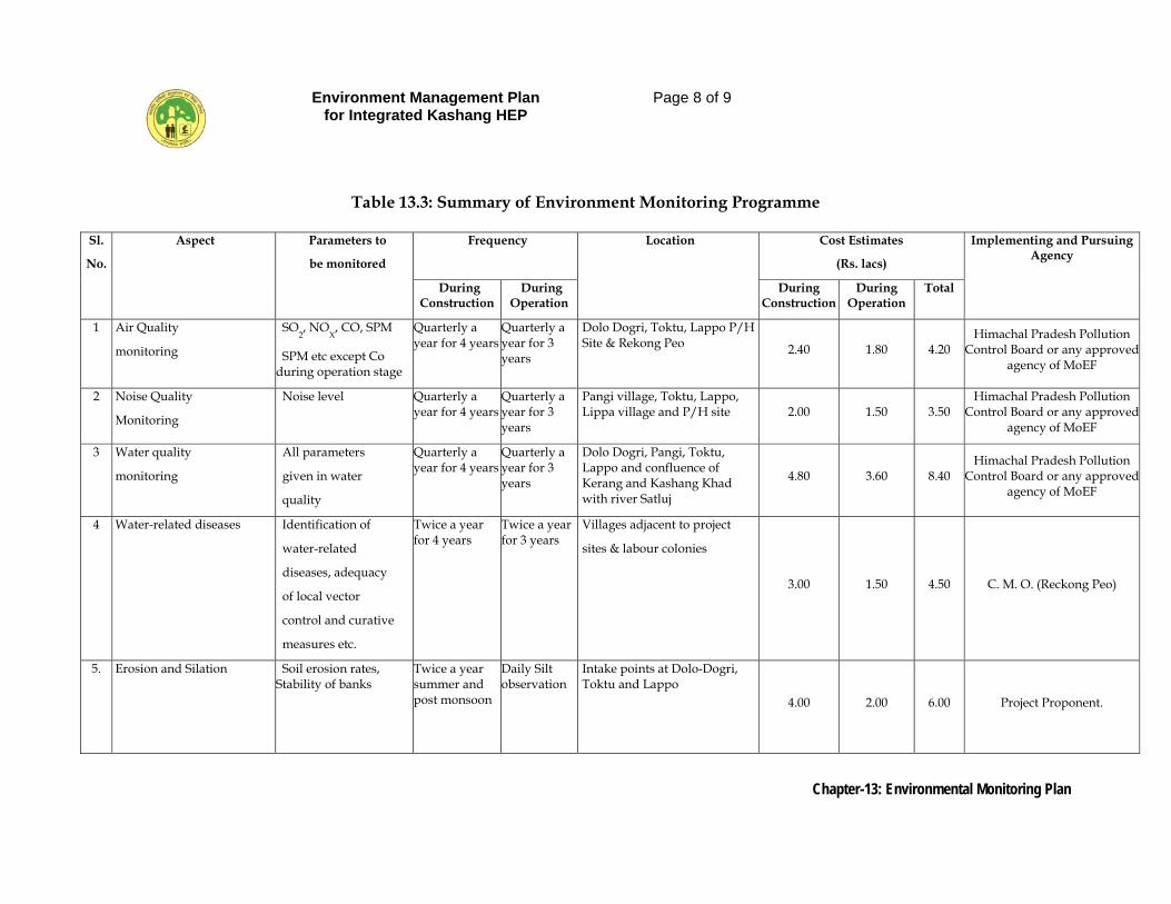
Environment Management Plan for Integrated Kashang HEP
Page 8 of 9
Chapter-13: Environmental Monitoring Plan
Table 13.3: Summary of Environment Monitoring Programme
Sl.
No.
Aspect Parameters to
be monitored
Frequency Location Cost Estimates
(Rs. lacs)
Implementing and Pursuing Agency
During Construction
During Operation
During Construction
During Operation
Total
1 Air Quality
monitoring
SO2, NO
X, CO, SPM
SPM etc except Co during operation stage
Quarterly a year for 4 years
Quarterly a year for 3 years
Dolo Dogri, Toktu, Lappo P/H Site & Rekong Peo 2.40 1.80 4.20
Himachal Pradesh Pollution Control Board or any approved
agency of MoEF
2 Noise Quality
Monitoring
Noise level Quarterly a year for 4 years
Quarterly a year for 3 years
Pangi village, Toktu, Lappo, Lippa village and P/H site 2.00 1.50 3.50
Himachal Pradesh Pollution Control Board or any approved
agency of MoEF
3 Water quality
monitoring
All parameters
given in water
quality
Quarterly a year for 4 years
Quarterly a year for 3 years
Dolo Dogri, Pangi, Toktu, Lappo and confluence of Kerang and Kashang Khad with river Satluj
4.80 3.60 8.40 Himachal Pradesh Pollution
Control Board or any approved agency of MoEF
4 Water-related diseases Identification of
water-related
diseases, adequacy
of local vector
control and curative
measures etc.
Twice a year for 4 years
Twice a year for 3 years
Villages adjacent to project
sites & labour colonies
3.00 1.50 4.50 C. M. O. (Reckong Peo)
5. Erosion and Silation Soil erosion rates, Stability of banks
Twice a year summer and post monsoon
Daily Silt observation
Intake points at Dolo-Dogri, Toktu and Lappo
4.00 2.00 6.00 Project Proponent.
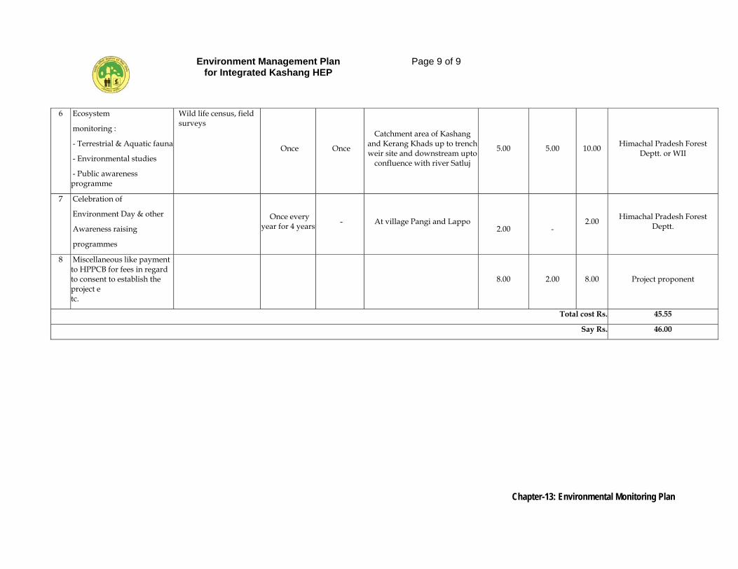
Environment Management Plan for Integrated Kashang HEP
Page 9 of 9
Chapter-13: Environmental Monitoring Plan
6 Ecosystem
monitoring :
- Terrestrial & Aquatic fauna
- Environmental studies
- Public awareness programme
Wild life census, field surveys
Once Once
Catchment area of Kashang and Kerang Khads up to trench weir site and downstream upto
confluence with river Satluj
5.00 5.00 10.00 Himachal Pradesh Forest Deptt. or WII
7 Celebration of
Environment Day & other
Awareness raising
programmes
Once every year for 4 years - At village Pangi and Lappo
2.00
- 2.00 Himachal Pradesh Forest
Deptt.
8 Miscellaneous like payment to HPPCB for fees in regard to consent to establish the project e tc.
8.00 2.00 8.00 Project proponent
Total cost Rs. 45.55
Say Rs. 46.00
Environment Management Plan for Integrated Kashang HEP
Page 1 of 15
Chapter-14: Summary of Impacts and Conclusions
CHAPTER - 14
SUMMARY OF IMPACTS AND CONCLUSIONS 14.0 GENERAL
The power situation in the Northern Grid and replacement of GHG emitting thermal power sources with clear hydro-power is a necessity for the nation and also for the state. In the overall context, impacts of this project on the environment have been proposed to be mitigated at a considerable cost to the project.
14.1 IMPACTS & MITIGATION MEASURES
The material requirement of the project entails quarrying at 2 sites one being rock quarry near intake of Stage-I and the other river shoal deposit near Jangi with stone crushing units. The rock quarry, area at intake Stage-I, would be reclaimed/rehabilitated by adopting biotechnical measures at project cost. The crusher would comply with the regulation on reducing noise and dust emission erecting diaphragm walls and use of water sprinklers.
Most of the machineries and equipments would be operating underground except transportation vehicles and DG sets. All machinery and vehicles are either electricity or diesel operated; as such SPM levels would not rise as ash contents are absent. DG set is only a standby arrangement to be run only is case of electricity breakdown. It would be located at tunnel & adit portals, which are away from habitations. Hence, its on air and noise environment would be negligible.
Combustion of fuel (diesel) emits SO2. There may be short-term SO2 increase, on assumption that all equipments operate at a common point & common time. Even that would be quite low (less than 04 µg/m3). Hence, no major adverse impact is anticipated on air quality.
Noise environment is not likely to be affected much due to project construction. Habitations are about 1 to 2 kms away and most of the project activities are underground. The baseline for noise is (49 dB – 56 dB day time) and (36 dB – 42 dB night time) attributable to river turbulence. The expected rise in noise levels would be around 2 or 3 dB. After passing through a range of noise absorbing barriers like air, building, and vegetation it would diminish to tolerable limits. Thus, no increase in noise
Environment Management Plan for Integrated Kashang HEP
Page 2 of 15
Chapter-14: Summary of Impacts and Conclusions
levels is anticipated as a result of various activities, during the project construction phase. In operation phase, water abstraction would reduce the noise significantly.
Dust emission from project’s roads would be minimized by laying grits, ramming & compaction with regular water sprinkling. Besides, Project would be raising multi-tiered plantations (grasses, bushes, shrubs and trees) along its roads not only to stabilize it but also reduce silt flow and reduce other adverse environmental impacts like noise and air pollution. The adverse impacts (on air, water and noise levels) of the over ground operation are negligible. Since most of the project components (HRT, Surge, Powerhouse, TRT, slits, MAT) are underground, excavated muck and debris to the tune of 11.74 lakh cubic meters would be generated. About 3.82 lakh cubic meters would be used up (2.94 lakh m3 by Project + 0.88 lakh m3 by others). Balance muck of 9.89 lakh m3 (after swell) is proposed to be dumped at 13 designated sites having combined capacity 11.13 lakh m3 on 21.18 ha area. Average height of dump would be less than 6 m. Suitable biotechnical measures are prescribed for stabilizing the muck dumping sites at project cost.
The biotic pressure of land being acquired by the Project (total 85.74 ha, of which forest land is 61.90 ha) is likely to shift to adjoining areas and may result in curtailment of rights’ usage of local communities. Project is funding compensatory afforestation over double the forestland acquired and CAT Plan (Rs. 1820 lakh) to address this impact besides paying the NPV for environment improvement.
To avoid impact of laying separate transmission lines for each of HEPs planned in the valley, only single corridor is being laid by the state utility with common transmission line. The diversion of water is through vertical drop trench weir leading to no impoundment of water.
There is no impact on ground water foreseen as the tunnels are to be lined watertight and more than 150-200 m deep below ground surface for Stage-I & IV tunnels and upto 1400 m for k-k link tunnel. However, the water sources as also buildings have been documented and in case of damage, the project proponents have committed to restore the same or make alternative arrangements. Since no effluents are being discharged by the project, surface water would remain unaffected.
Environment Management Plan for Integrated Kashang HEP
Page 3 of 15
Chapter-14: Summary of Impacts and Conclusions
About 4 kms and 9.8 km of river stretches would be affected due to water abstraction caused by reduced flows due to Stage-I and II / IV. A minimum downstream discharge of 0.30 cumes and 0.67 cumes being 15% of inflow of lean season flow immediately below the intake of Stage-I and II respectively would be maintained. Some 0.33 cumecs get added during lean season by side streams in affected stretch of Kerang Khad. Thus, total downstream discharge would be about 1.0 cumecs, which would suffice for environmental and local needs. Moreover, people are not dependent on the river water. This measure will facility longitudinal connectivity of the natural aquatic system. As such, no adverse impact is foreseen. An electronic flow-measuring device to be installed by the project would facilities monitoring. The sewage from the labour camps would be disposed in septic tanks and effluents from the project colony would be treated in STPs being installed by the project. However, water quality and effluent discharge would be monitored during construction and operation phases and suitable remedial measures taken should the need arise. During construction phase, there would be labour immigration (average 1200 no.), which may burden the local environment in terms of increased fuel wood need for cooking and heating. This impact would be obviated by providing alternate sources of cooking and heating such as LPG, kerosene heaters and electricity at Project cost. Project induced additional population is likely to generate municipal waste also. The Project through aegis of LADC funds would be supporting the local body to tackle this problem. Water requirement of projects workers & staff would be met by the project with its own resources and its own cost by tapping some springs / streams. The water quality is good and requires minimal treatment. To cater to the increased health related needs, the Project (through LADC funds), would be supporting strengthening and upgrading PHC at Lippa. First-aid facilities would be provided at each major construction site. Besides, Project would arrange visit of medical staff when needed. To take care of domestic animals of project affected villages, visit of veterinary doctor shall be arranged.
Environment Management Plan for Integrated Kashang HEP
Page 4 of 15
Chapter-14: Summary of Impacts and Conclusions
If unchecked, workers tend to indulge in hunting, fishing, collection of honey and other Non-Timber Forest Produce from the adjoining forests. The base line survey does indicate presence of Lippa-Asrang Wildlife Sanctuary (30.89 sq km) about 500 m from intake of Stage-IV in Moorang Tehsil of Pooh Sub Division in Kinnaur district. The prominent species of wildlife found in the area include snow Leopard, Bharal, Ibex, Brown Bear, Musk dear Himalayan Thar, Leopard Cart, Weasals etc. and among birds monal, snow-cock, Koklash, Patridge, Chukore, Jungle Crow Eagle, Sparrow Hawk etc. Hence, the threat of poaching is not ruled out. However, unauthorized game and wild produce gathering poses a threat, which may also bring the workers in conflict with local communities. Forests are located near the project sites, therefore, laws and rules would be strictly enforced by the project proponent and his contracting agencies. Birds and animals found in the project area are used to human habitation and disturbances. As such, operation of construction equipment, movements and blasting is not likely to cause any major impact on fauna. Moreover, using delayed blasting technique minimizes impact. Besides these a wild Life Management and conservation of bio-diversity of Lippa-Asrang Wildlife Sanctuary, costing Rs.100 lakhs has also been formulated. Land acquired for the project would be cleared of vegetation (trees). In lieu afforestation over 123.8 ha is being funded by the project besides paying commercial cost of tress. In addition, the project proponent shall pay NPV amounting to Rs 465 lakh for amelioration of the environment. Socio-economic conditions in the area are such that the impact of the project would only be marginal. Area already experiences influx of migratory labour particularly Nepali as orchard and farm hands. The impact due to temporary immigration of works and staff for the project in social and economic life of local people shall be neither significant nor permanent. Increased law and order maintenance need is being addressed by establishing a Police Station/Chowki at Project cost. Project would adhere to the provision in recent Hydro-Power Policy regarding employment and would give preference to PAFs. Plenty of casual employment would be generated through subsidiary plans, schemes and funds like CAT Plan, Muck Stabilization works, Compensatory Afforestaion, LADC fund etc. Livelihood options may be enhanced through LADC funds provided in the DPR.
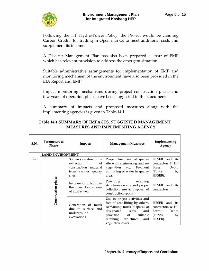
Environment Management Plan for Integrated Kashang HEP
Page 5 of 15
Chapter-14: Summary of Impacts and Conclusions
Following the HP Hydro-Power Policy, the Project would be claiming Carbon Credits for trading in Open market to meet additional costs and supplement its income. A Disaster Management Plan has also been prepared as part of EMP which has relevant provision to address the emergent situation. Suitable administrative arrangements for implementation of EMP and monitoring mechanism of the environment have also been provided in the EIA Report and EMP. Impact monitoring mechanisms during project construction phase and few years of operation phase have been suggested in this document. A summary of impacts and proposed measures along with the implementing agencies is given in Table-14.1.
Table 14.1 SUMMARY OF IMPACTS, SUGGESTED MANAGEMENT MEASURES AND IMPLEMENTING AGENCY
S.N. Parameters & Phase Impacts Management Measures Implementing
Agency
1.
LAND ENVIRONMENT
C
onst
ruct
ion
phas
e
Soil erosion due to the extraction of construction material from various quarry sites.
Proper treatment of quarry site with engineering and re-vegetation etc. Frequent Sprinkling of water in quarry area.
HPSEB and its contractors & HP Forest Deptt. (Funds by HPSEB).
Increase in turbidity in the river downstream of intake weir
Providing retaining structures on site and proper collection, use & disposal of construction spoils.
HPSEB and its contractors.
Generation of muck due to surface and underground excavations.
Use in project activities and free of cost lifting by others. Remaining muck disposal at designated sites and provision of suitable retaining structures and vegetative cover.
HBSEB and its contractors & HP Forest Deptt. (Funds by HPSEB).
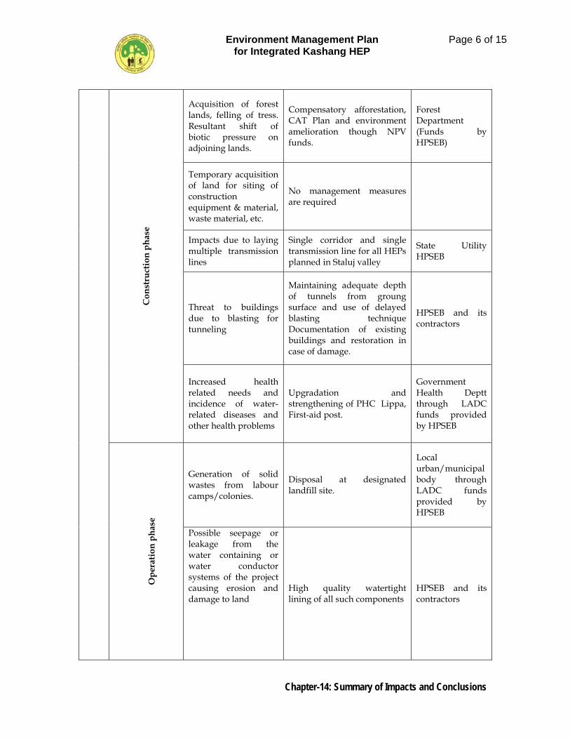
Environment Management Plan for Integrated Kashang HEP
Page 6 of 15
Chapter-14: Summary of Impacts and Conclusions
Con
stru
ctio
n ph
ase
Acquisition of forest lands, felling of tress. Resultant shift of biotic pressure on adjoining lands.
Compensatory afforestation, CAT Plan and environment amelioration though NPV funds.
Forest Department (Funds by HPSEB)
Temporary acquisition of land for siting of construction equipment & material, waste material, etc.
No management measures are required
Impacts due to laying multiple transmission lines
Single corridor and single transmission line for all HEPs planned in Staluj valley
State Utility HPSEB
Threat to buildings due to blasting for tunneling
Maintaining adequate depth of tunnels from groung surface and use of delayed blasting technique Documentation of existing buildings and restoration in case of damage.
HPSEB and its contractors
Increased health related needs and incidence of water-related diseases and other health problems
Upgradation and strengthening of PHC Lippa, First-aid post.
Government Health Deptt through LADC funds provided by HPSEB
O
pera
tion
phas
e
Generation of solid wastes from labour camps/colonies.
Disposal at designated landfill site.
Local urban/municipal body through LADC funds provided by HPSEB
Possible seepage or leakage from the water containing or water conductor systems of the project causing erosion and damage to land
High quality watertight lining of all such components
HPSEB and its contractors
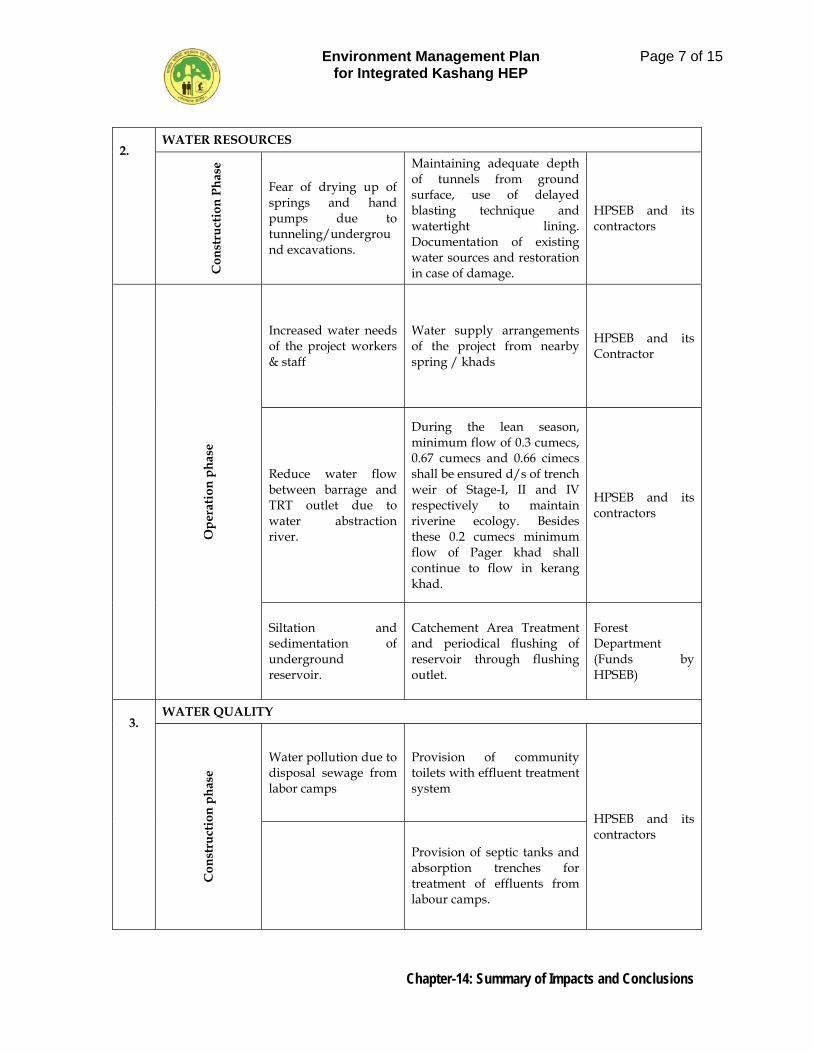
Environment Management Plan for Integrated Kashang HEP
Page 7 of 15
Chapter-14: Summary of Impacts and Conclusions
2.
WATER RESOURCES
C
onst
ruct
ion
Phas
e
Fear of drying up of springs and hand pumps due to tunneling/underground excavations.
Maintaining adequate depth of tunnels from ground surface, use of delayed blasting technique and watertight lining. Documentation of existing water sources and restoration in case of damage.
HPSEB and its contractors
Ope
ratio
n ph
ase
Increased water needs of the project workers & staff
Water supply arrangements of the project from nearby spring / khads
HPSEB and its Contractor
Reduce water flow between barrage and TRT outlet due to water abstraction river.
During the lean season, minimum flow of 0.3 cumecs, 0.67 cumecs and 0.66 cimecs shall be ensured d/s of trench weir of Stage-I, II and IV respectively to maintain riverine ecology. Besides these 0.2 cumecs minimum flow of Pager khad shall continue to flow in kerang khad.
HPSEB and its contractors
Siltation and sedimentation of underground reservoir.
Catchement Area Treatment and periodical flushing of reservoir through flushing outlet.
Forest Department (Funds by HPSEB)
3.
WATER QUALITY
Con
stru
ctio
n ph
ase
Water pollution due to disposal sewage from labor camps
Provision of community toilets with effluent treatment system
HPSEB and its contractors
Provision of septic tanks and absorption trenches for treatment of effluents from labour camps.
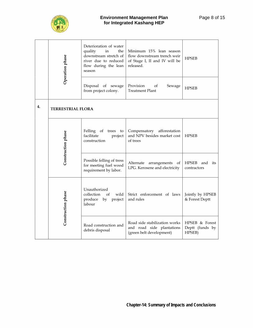
Environment Management Plan for Integrated Kashang HEP
Page 8 of 15
Chapter-14: Summary of Impacts and Conclusions
Ope
ratio
n ph
ase
Deterioration of water quality in the downstream stretch of river due to reduced flow during the lean season
Minimum 15% lean season flow downstream trench weir of Stage I, II and IV will be released.
HPSEB
Disposal of sewage from project colony.
Provision of Sewage Treatment Plant HPSEB
4. TERRESTRIAL FLORA
Con
stru
ctio
n ph
ase Felling of trees to
facilitate project construction
Compensatory afforestation and NPV besides market cost of trees
HPSEB
Possible felling of tress for meeting fuel wood requirement by labor.
Alternate arrangements of LPG. Kerosene and electricity
HPSEB and its contractors
Con
stru
ctio
n ph
ase Unauthorized
collection of wild produce by project labour
Strict enforcement of laws and rules
Jointly by HPSEB & Forest Deptt
Road construction and debris disposal
Road side stabilization works and road side plantations (green belt development)
HPSEB & Forest Deptt (funds by HPSEB)
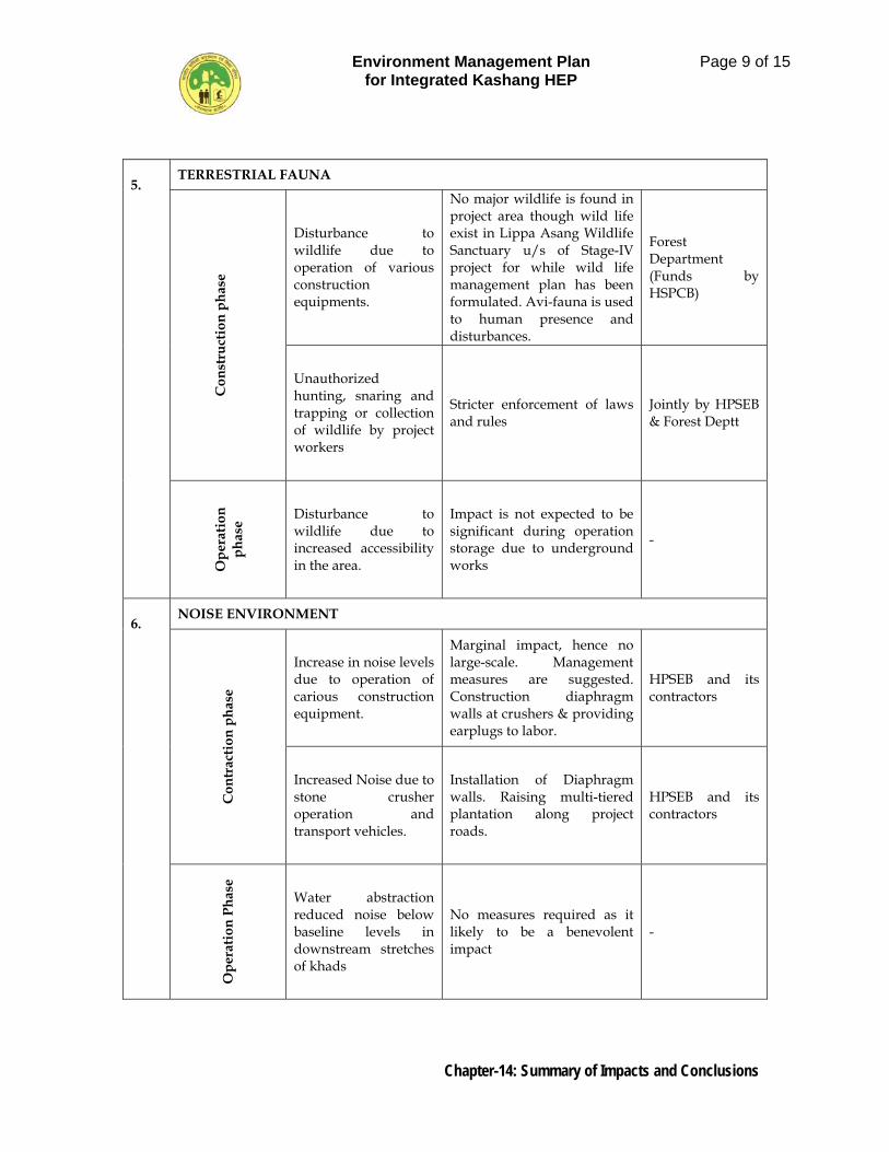
Environment Management Plan for Integrated Kashang HEP
Page 9 of 15
Chapter-14: Summary of Impacts and Conclusions
5.
TERRESTRIAL FAUNA
C
onst
ruct
ion
phas
e Disturbance to wildlife due to operation of various construction equipments.
No major wildlife is found in project area though wild life exist in Lippa Asang Wildlife Sanctuary u/s of Stage-IV project for while wild life management plan has been formulated. Avi-fauna is used to human presence and disturbances.
Forest Department (Funds by HSPCB)
Unauthorized hunting, snaring and trapping or collection of wildlife by project workers
Stricter enforcement of laws and rules
Jointly by HPSEB & Forest Deptt
Ope
ratio
n ph
ase
Disturbance to wildlife due to increased accessibility in the area.
Impact is not expected to be significant during operation storage due to underground works
-
6.
NOISE ENVIRONMENT
Con
trac
tion
phas
e
Increase in noise levels due to operation of carious construction equipment.
Marginal impact, hence no large-scale. Management measures are suggested. Construction diaphragm walls at crushers & providing earplugs to labor.
HPSEB and its contractors
Increased Noise due to stone crusher operation and transport vehicles.
Installation of Diaphragm walls. Raising multi-tiered plantation along project roads.
HPSEB and its contractors
Ope
ratio
n Ph
ase
Water abstraction reduced noise below baseline levels in downstream stretches of khads
No measures required as it likely to be a benevolent impact
-
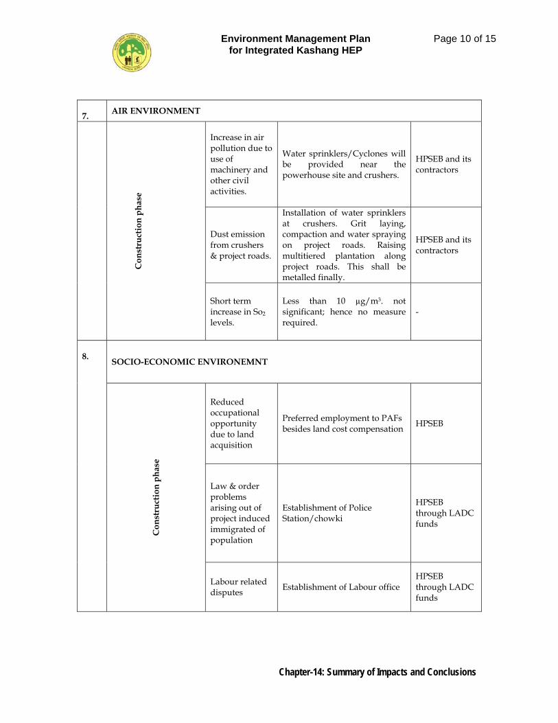
Environment Management Plan for Integrated Kashang HEP
Page 10 of 15
Chapter-14: Summary of Impacts and Conclusions
7. AIR ENVIRONMENT
C
onst
ruct
ion
phas
e Increase in air pollution due to use of machinery and other civil activities.
Water sprinklers/Cyclones will be provided near the powerhouse site and crushers.
HPSEB and its contractors
Dust emission from crushers & project roads.
Installation of water sprinklers at crushers. Grit laying, compaction and water spraying on project roads. Raising multitiered plantation along project roads. This shall be metalled finally.
HPSEB and its contractors
Short term increase in So2 levels.
Less than 10 µg/m3. not significant; hence no measure required.
-
8. SOCIO-ECONOMIC ENVIRONEMNT
Con
stru
ctio
n ph
ase
Reduced occupational opportunity due to land acquisition
Preferred employment to PAFs besides land cost compensation HPSEB
Law & order problems arising out of project induced immigrated of population
Establishment of Police Station/chowki
HPSEB through LADC funds
Labour related disputes Establishment of Labour office
HPSEB through LADC funds
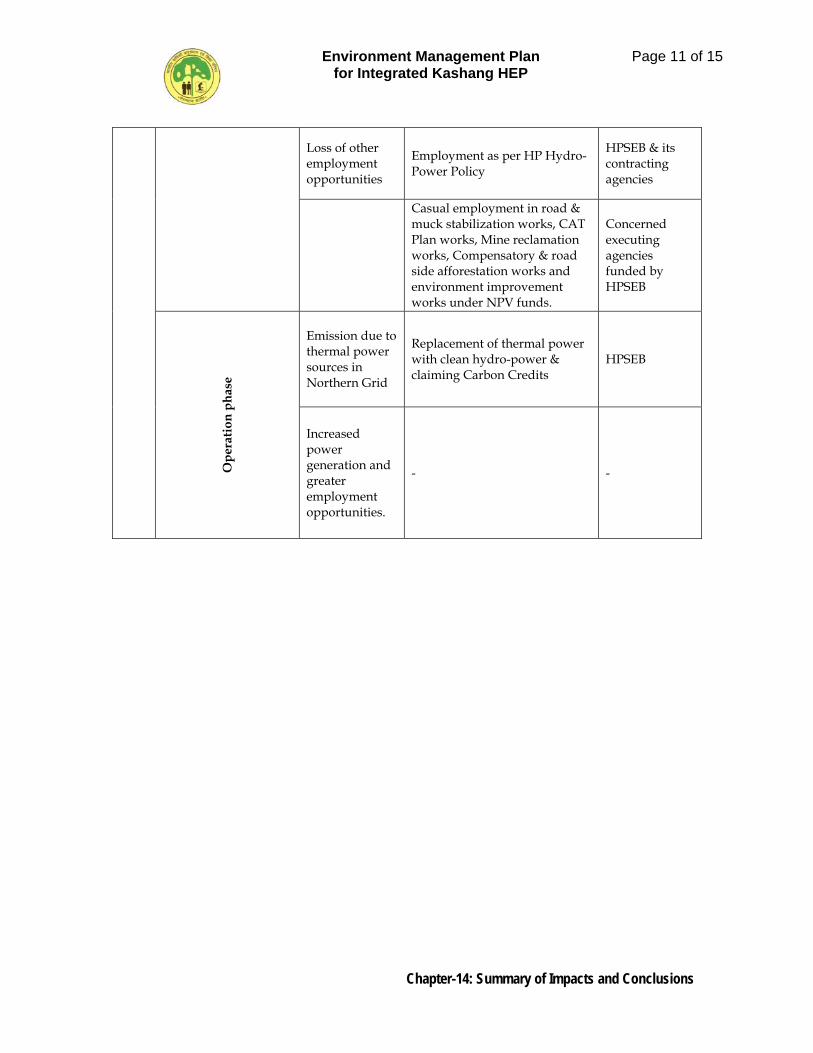
Environment Management Plan for Integrated Kashang HEP
Page 11 of 15
Chapter-14: Summary of Impacts and Conclusions
Loss of other employment opportunities
Employment as per HP Hydro-Power Policy
HPSEB & its contracting agencies
Casual employment in road & muck stabilization works, CAT Plan works, Mine reclamation works, Compensatory & road side afforestation works and environment improvement works under NPV funds.
Concerned executing agencies funded by HPSEB
Ope
ratio
n ph
ase
Emission due to thermal power sources in Northern Grid
Replacement of thermal power with clean hydro-power & claiming Carbon Credits
HPSEB
Increased power generation and greater employment opportunities.
- -
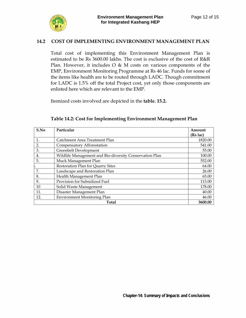
Environment Management Plan for Integrated Kashang HEP
Page 12 of 15
Chapter-14: Summary of Impacts and Conclusions
14.2 COST OF IMPLEMENTING ENVIRONMENT MANAGEMENT PLAN Total cost of implementing this Environment Management Plan is
estimated to be Rs 3600.00 lakhs. The cost is exclusive of the cost of R&R Plan. However, it includes O & M costs on various components of the EMP, Environment Monitoring Programme at Rs 46 lac. Funds for some of the items like health are to be routed through LADC. Though commitment for LADC is 1.5% off the total Project cost, yet only those components are enlisted here which are relevant to the EMP.
Itemized costs involved are depicted in the table. 15.2.
Table 14.2: Cost for Implementing Environment Management Plan
S.No Particular Amount (Rs lac)
1. Catchment Area Treatment Plan 1820.00 2. Compensatory Afforestation 541.00 3. Greenbelt Development 55.00 4. Wildlife Management and Bio-diversity Conservation Plan 100.00 5. Muck Management Plan 552.00
6. Restoration Plan for Quarry Sites 64.00 7. Landscape and Restoration Plan 26.00 8. Health Management Plan 65.00 9. Provision for Subsidized Fuel 113.00 10 Solid Waste Management 178.00 11. Disaster Management Plan 40.00 12. Environment Monitoring Plan 46.00
Total 3600.00
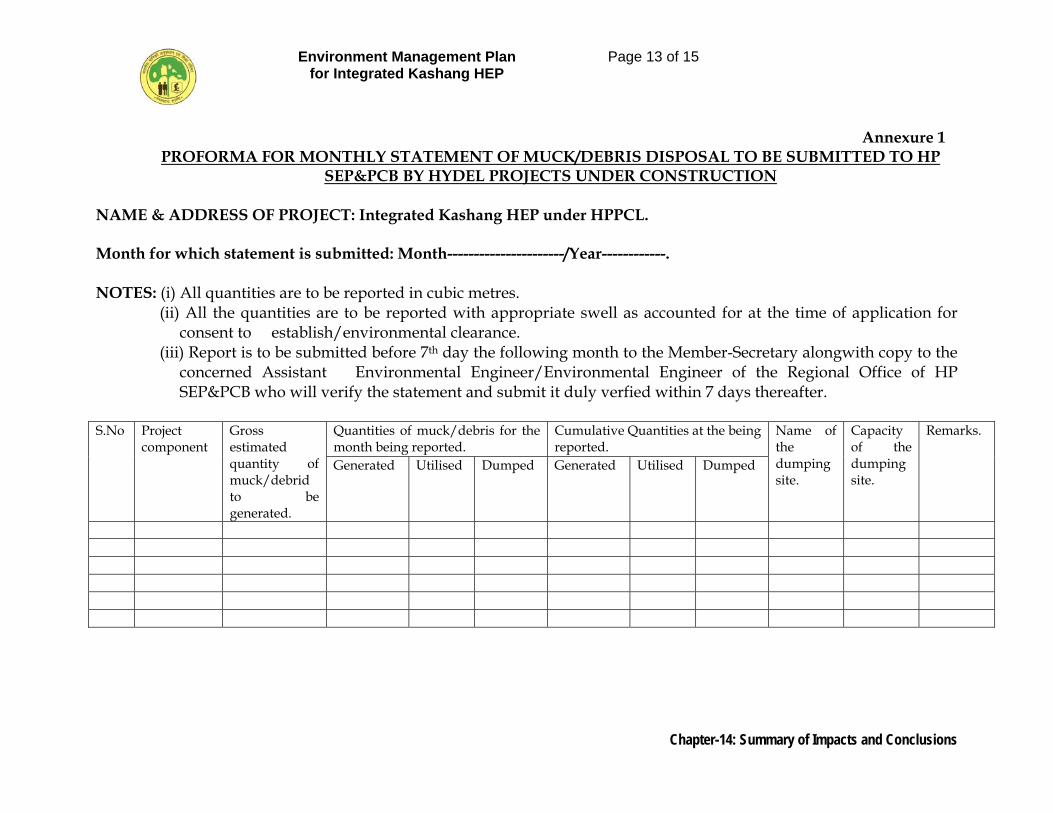
Environment Management Plan for Integrated Kashang HEP
Page 13 of 15
Chapter-14: Summary of Impacts and Conclusions
Annexure 1 PROFORMA FOR MONTHLY STATEMENT OF MUCK/DEBRIS DISPOSAL TO BE SUBMITTED TO HP
SEP&PCB BY HYDEL PROJECTS UNDER CONSTRUCTION NAME & ADDRESS OF PROJECT: Integrated Kashang HEP under HPPCL. Month for which statement is submitted: Month----------------------/Year------------. NOTES: (i) All quantities are to be reported in cubic metres.
(ii) All the quantities are to be reported with appropriate swell as accounted for at the time of application for consent to establish/environmental clearance.
(iii) Report is to be submitted before 7th day the following month to the Member-Secretary alongwith copy to the concerned Assistant Environmental Engineer/Environmental Engineer of the Regional Office of HP SEP&PCB who will verify the statement and submit it duly verfied within 7 days thereafter.
S.No Project
component Gross estimated quantity of muck/debrid to be generated.
Quantities of muck/debris for the month being reported.
Cumulative Quantities at the being reported.
Name of the dumping site.
Capacity of the dumping site.
Remarks.
Generated Utilised Dumped Generated Utilised Dumped
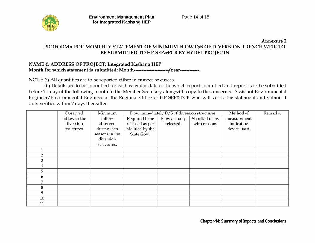
Environment Management Plan for Integrated Kashang HEP
Page 14 of 15
Chapter-14: Summary of Impacts and Conclusions
Annexure 2 PROFORMA FOR MONTHLY STATEMENT OF MINIMUM FLOW D/S OF DIVERSION TRENCH WEIR TO
BE SUBMITTED TO HP SEP&PCB BY HYDEL PROJECTS NAME & ADDRESS OF PROJECT: Integrated Kashang HEP Month for which statement is submitted: Month----------------------/Year------------.
NOTE: (i) All quantities are to be reported either in cumecs or cusecs. (ii) Details are to be submitted for each calendar date of the which report submitted and report is to be submitted before 7th day of the following month to the Member-Secretary alongwith copy to the concerned Assistant Environmental Engineer/Environmental Engineer of the Regional Office of HP SEP&PCB who will verify the statement and submit it duly verifies within 7 days thereafter. Observed
inflow in the diversion structures.
Minimum inflow
observed during lean
seasons in the diversion structures.
Flow immediately D/S of diversion structures Method of measurement
indicating device used.
Remarks. Required to be released as per Notified by the
State Govt.
Flow actually released.
Shortfall if any with reasons.
1 2 3 4 5 6 7 8 9
10 11
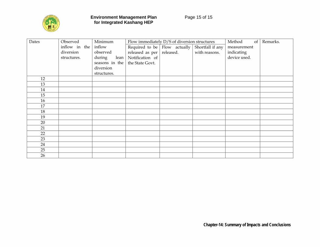
Environment Management Plan for Integrated Kashang HEP
Page 15 of 15
Chapter-14: Summary of Impacts and Conclusions
Dates Observed inflow in the diversion structures.
Minimum inflow observed during lean seasons in the diversion structures.
Flow immediately D/S of diversion structures Method of measurement indicating device used.
Remarks. Required to be released as per Notification of the State Govt.
Flow actually released.
Shortfall if any with reasons.
12 13 14 15 16 17 18 19 20 21 22 23 24 25 26
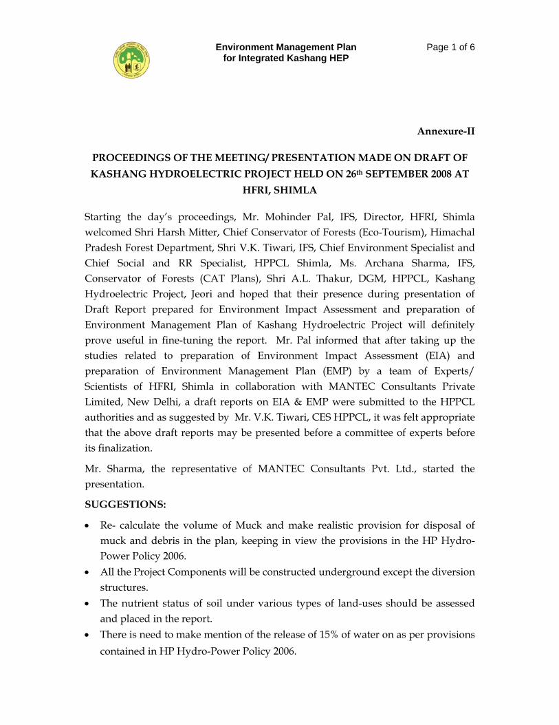
Environment Management Plan for Integrated Kashang HEP
Page 1 of 6
Annexure-II
PROCEEDINGS OF THE MEETING/ PRESENTATION MADE ON DRAFT OF KASHANG HYDROELECTRIC PROJECT HELD ON 26th SEPTEMBER 2008 AT
HFRI, SHIMLA
Starting the day’s proceedings, Mr. Mohinder Pal, IFS, Director, HFRI, Shimla welcomed Shri Harsh Mitter, Chief Conservator of Forests (Eco-Tourism), Himachal Pradesh Forest Department, Shri V.K. Tiwari, IFS, Chief Environment Specialist and Chief Social and RR Specialist, HPPCL Shimla, Ms. Archana Sharma, IFS, Conservator of Forests (CAT Plans), Shri A.L. Thakur, DGM, HPPCL, Kashang Hydroelectric Project, Jeori and hoped that their presence during presentation of Draft Report prepared for Environment Impact Assessment and preparation of Environment Management Plan of Kashang Hydroelectric Project will definitely prove useful in fine-tuning the report. Mr. Pal informed that after taking up the studies related to preparation of Environment Impact Assessment (EIA) and preparation of Environment Management Plan (EMP) by a team of Experts/ Scientists of HFRI, Shimla in collaboration with MANTEC Consultants Private Limited, New Delhi, a draft reports on EIA & EMP were submitted to the HPPCL authorities and as suggested by Mr. V.K. Tiwari, CES HPPCL, it was felt appropriate that the above draft reports may be presented before a committee of experts before its finalization.
Mr. Sharma, the representative of MANTEC Consultants Pvt. Ltd., started the presentation.
SUGGESTIONS:
• Re- calculate the volume of Muck and make realistic provision for disposal of muck and debris in the plan, keeping in view the provisions in the HP Hydro-Power Policy 2006.
• All the Project Components will be constructed underground except the diversion structures.
• The nutrient status of soil under various types of land-uses should be assessed and placed in the report.
• There is need to make mention of the release of 15% of water on as per provisions contained in HP Hydro-Power Policy 2006.
Environment Management Plan for Integrated Kashang HEP
Page 2 of 6
Mr. Harsh Mitter IFS suggested that lean period discharge will be showed in the EIA Report, 15 % of which will be maintained by the Project. Mr. Thakur said that it has been observed that the water is 2-3 cumecs in the month of January. Intervening in the discussion, Mr. Harsh Mitter enquired about the unit of discharge of water during summer. Responding to query, the consultants informed that it is 40 cumecs during summer and about 5-6 cumecs during winters. Shri Mohinder Pal informed that the norms fixed in the Hydro- policy and accepted by the HPSEB, that the minimum discharge of water must be up to 15% shall be strictly adopted but if it is zero due to freezing of streams in certain climatic conditions, even then we are not violating the norms.
Shri V.K. Tewari enquired about the downstream discharge of water available from other streams joining Kerang or Kashang before their eventual confluence with main Sutlej River. He added that as per the discussion with the local people, it has been observed that whatever silt is brought by Pijjar Khad that gets deposited at the confluence point with Kerang Khad, is cleared by the flow of water from Kerang Khud. Hence, it is suggested that sufficient water is required for clearing of silt in summer months for saving village Lippa. It should be very clearly mentioned in the EMP that the Operation (O&M) Manual of the project must include prescription on this account and the project should ensure its implementation.
• Provision for clearing of silt even by closing the project for 1 or 2 days for the survival of the local populace and conservation of environment. HPPCL should give assurance to this effect to the local people as also make a mention in the Environment Public Hearing. There should be provision for this in the Management Plan beside in the O&M Manual. To ensure implementation of this commitment it is necessary that the Operation Staff on commissioning is given a presentation on this aspect of project management.
• The Consultants agreed to look into the matter and provision for minimizing the silt will be made in the final report worded suitably.
• Since HPPCL has tied up financial assistance from the ADB and the requirement of ADB to hold at least two public/stakeholder consultations is a determining factor for grant of financial assistance. The first one may be informal and the
Environment Management Plan for Integrated Kashang HEP
Page 3 of 6
second one has to be formal which may be in the form of Environment Public Hearing. Maintain all records of formal and information discussions and place them as Annexure to the EIA EMP Document for future reference and use.
• Shri Mohinder Pal informed that we have already planned a public consultations meeting with local people and local Panchayats in the month of October.
• Need for separate plan for management of wildlife in the project area has already been taken care and a separate chapter is being incorporated in the EMP.
• Mr. Mohinder Pal informed that a separate budget of Rs. 1 Crore has been kept for Wild-life conservation program, in the plan.
• The catchment area of 396 sq km of Kashang Khad is too small for the amount being envisaged to be set aside for CAT plan interventions. Therefore, CES HPPCL suggested taking the area falling between diversion and TRT Outlet or up to the confluence of Kashang with River Sutlej, if there is any scope/ possibility for which there is enough scope both in Kashang and in Kerang. Further suggestion came for treating the area up to Pangi Village and propose some watershed activities up to Pangi village. Shri Mohinder Pal assured that if there is any possibility of more intervention, we will definitely include the same in the plan or otherwise give reasons for not including the same in the plan. However, it was clarified by HPPCL that area inclusion should be done without exceeding the normative provision/cost ceiling.
• CES HPPCL stressed that the works remaining to be executed from the already approved and under implementation CAT Plan of Kashang HEP should be included in the new CAT Plan at the new approved norm/rate of works.
• Shri Mohinder Pal informed that from financial point of view there is scope of taking watershed activities in each year. Ms. Archana Sharma informed the house that Government of Himachal Pradesh is planning to make a plan for the entire river basins.
• Shri V.K. Tiwari suggested that the no amount can be shown in lump-sum it must have clearly defined activities against each allocation of funds.
• Shri Tiwari confirmed that the EMP being prepared is taking new schedule of rates for calculation of the budget for various activities. It was informed that the new rates notified on 19th June 2008 are being applied in this regard.
Environment Management Plan for Integrated Kashang HEP
Page 4 of 6
• Ms. Archana Sharma informed the house that as per latest decision taken by
HPFD, The CAT plan should be 2.5% of the project cost. Out of this, there must be provision of 10% funds for PES related activities, 1% for eco-tourism and 5% for eco-task force. Shri V.K. Tiwari pointed out there is no provision for Payment of Environmental Services (PES). Shri Mohinder Pal desired to know whether these percentages are of the total project costs or of only of cost of Civil works of the project and requested CF (Projects) that the percentage of budget to be kept for different activities that is being finalized by the HPFD, may be timely supplied to HPPCL and HFRI, in the form of proper order or notification for taking future planning.
• Shri V.K. Tiwari explained some technicalities in sub-total and its relation with percentage. He further suggested that there must be provision for fencing of the treated area in the plan.
• CCF Eco-Tourism said that there must be a provision of Rs. 20 Lacs minimum for taking up the Eco-tourism activity in the project area. In response, Shri Tiwari informed that only 1% of total project cost can be kept for development of eco-tourism in the project area.
• Shri V.K. Tiwari also informed that Government has also decided that if 17.5% departmental charges are charged then the User Agency is entitled to seek Utilization Certificate before releasing next installment of CAT Plan funds. It was informed by the consultants that this provision has been made in the EMP as per the available instructions. Shri Tiwari also suggested to have a relook at this component and make sub-total (break-up) of Administrative Cost in the Report with a changed nomenclature of this cost such as “Implementation Support Infrastructure Cost” and whatever is to be given in “Kind” should also be mentioned as such in the ‘remarks’ column.
• Shri Manoj Bhaik, CF, HFRI informed that due to additional work in project related activities, the staff will be overburdened. In response, Shri Tiwari suggested to outsource the work on contractual basis besides recruiting the staff for project period of 5-7 years otherwise it will be a liability of the government for another 25-30 years.
Environment Management Plan for Integrated Kashang HEP
Page 5 of 6
• Shri Tiwari also suggested including a component of “Implementation Support
Infrastructure Cost” and “Monitoring of Silt Load”. Shri V.K. Tiwari suggested to make table of responsibilities and mentioning HPPCL & its contractors instead of HPPCL alone, during construction and operation stages of the Project. He further suggested to prepare plan for muck management and provision for establishment of Regulatory Mechanism for free of cost lifting of muck permitted to all in the Muck Management Plan, provision for Composting Unit and farm yard manure and treatment of soil, etc. and suggested to prohibit use of Chemical fertilizers.
• He also suggested including grass species as planting material and detailed cost may be worked out. Provisions for watering of plantation as drip irrigation are not possible in these locations.
• Provision for construction of drainage system in quarry sites. Provision for veterinary Health Services and provision of Mobile-Van for these services.
• Provision for treatment of private land as there is not much forest land left near the project site.
• Provision for supply of cost free 100 units of electricity for 10 years for affected families.
• Provision for smaller geysers as solar system will not be as successful as the same is in lower hills because numbers of sunny days are very less in the project area.
• Provision for separate system of sewage and waste management for staff colonies. Provision of Police Post, which should be in the project colony and office of Labor Inspector, which should also be in the premises of the project office.
• Provision of staff and labour hostel, should be planned in such a way that after the completion of the project these assets can be utilized by the local authorities as Panchayat Bhawan and Community Centre, etc.
Mr. Tiwari stressed the need of proper mechanism of monitoring of EMP Implementation of the project. He has also suggested including the component of CDM. He further suggested monitoring only vital parameters instead of going for whole spectrum of parameters, which can be clubbed with each other. Shri Tiwari informed that as per ADB instructions, monitoring report is required to be submitted after every six month. Therefore, he has suggested submitting monthly monitoring/ evaluation report to HPPCL and six monthly report to ADB so that corrective
Environment Management Plan for Integrated Kashang HEP
Page 6 of 6
measures wherever required could be taken in time. He further informed that ADB is placing these monitoring reports on their website for a month or so besides 120 days’ public disclosure and we must be ready for facing quarries from worldwide experts. Shri Mohinder Pal suggested that parameters for effective monitoring/ evaluation of the project shall be identified and suggested.
Shri Tiwari enquired from the consultant organization about the water quality during recent observation. In response, Mr. Sharma informed that it is “A” at this stage. Shri Tiwari suggested adding component of evaluation of water quality in health management plan and depending upon the values of ‘coliform’ found in the water samples, suitable disinfection treatment should be prescribed. Shri Tiwari also informed that the responsibility of monitoring of silt during implementation of the project will lie with HPPCL.
Shri Mohinder Pal informed that a team of Scientists from HFRI is visiting the locations. The team will also collect socioeconomic data including meeting/ interviews of the project areas.
Shri Mohinder Pal informed that we will submit the final report after incorporating above suggestions in letter and spirit including R & R Plan. Shri Tiwari informed that we have already prepared the R & R Plan.
Shri Tiwari reiterated that the approved TORs of GOI MoEF (EAC) must be re-confirmed in the EMP report indicating which TOR clause is incorporated at what page in the form of a table to be annexed in the report.
At the end, Shri Mohinder Pal, Director, HFRI, thanked all the experts present during the presentation and hoped that their suggestions will definitely be proved useful in fine tuning and finalization the EIA & EMP of Kashang Hydroelectric Project. He assured the HPPCL authorities that the above documents will be submitted within a month’s time after incorporation of relevant suggestions.
Environment Management Plan for Integrated Kashang HEP
Page 1 of 7
Annexure-III
Proceedings of the Environmental Public Consultation held on 16/10/2008 at Pangi Village, Vikas Khand - Kalpa of Kinnaur District of Himachal Pradesh to Set-up 243 MW Integrated Kashang
Hydroelectric Project, Kinnaur District, Himachal Pradesh and Action taken thereon. HPSEB with help of HFRI, Shimla organized a public consultation meeting on 16/10/2008 at Pangi village to know the public view point about this project. Public consultation meeting is bottom up approach in this project. It is one of the tools to reflect the views of the general public as well as those concerned with the project ranging from central and local government organizations to commercial and industrial sectors of the society as a whole. It is an important tool of information dissemination during the planning stage of the project. At the outset participants were briefed regarding the objective of the public consultation meeting by the representative of the HPSEB and HFRI and about salient features of the project and likely benefits provided by the proponents. Proceedings were, thereafter, left open for discussion and raising issues pertaining to the project. People present were requested to freely express their views on various issues relevant to the project Minutes of Meeting: The public Consultation meeting started at schedule time. The minute of meeting are enumerated as under: 11.40 AM to 12.10 PM: Gram Pradhan of Pangi village inaugurated the meeting and explained the purpose of meeting. Thereafter he introduced all the official present in the meeting to the villagers and invite Shri A.L Thakur (SE, Kashang Project) to give an overview of the project. 12.10 PM to 1.00 PM: Shri A.L.Thakur gave brief description of the project. 01-0 P.M to 1.30 PM: Shri P.S Negi gave information about the EMP and CAT Plan Thereafter the participants were requested to ask questions and express their views on various issues relevant to the project. Questionnaires were also filled by the people present during the meeting. Main issues raised are given below:
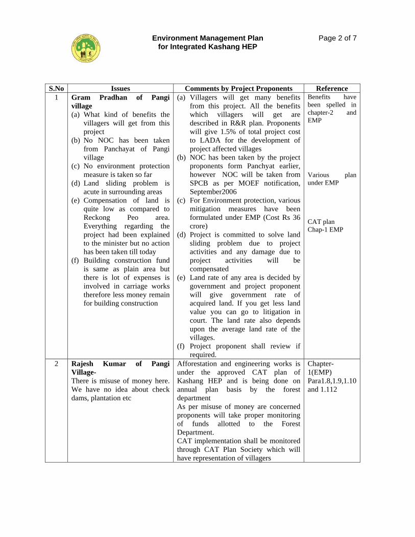
Environment Management Plan for Integrated Kashang HEP
Page 2 of 7
S.No Issues Comments by Project Proponents Reference 1 Gram Pradhan of Pangi
village (a) What kind of benefits the
villagers will get from this project
(b) No NOC has been taken from Panchayat of Pangi village
(c) No environment protection measure is taken so far
(d) Land sliding problem is acute in surrounding areas
(e) Compensation of land is quite low as compared to Reckong Peo area. Everything regarding the project had been explained to the minister but no action has been taken till today
(f) Building construction fund is same as plain area but there is lot of expenses is involved in carriage works therefore less money remain for building construction
(a) Villagers will get many benefits from this project. All the benefits which villagers will get are described in R&R plan. Proponents will give 1.5% of total project cost to LADA for the development of project affected villages
(b) NOC has been taken by the project proponents form Panchyat earlier, however NOC will be taken from SPCB as per MOEF notification, September2006
(c) For Environment protection, various mitigation measures have been formulated under EMP (Cost Rs 36 crore)
(d) Project is committed to solve land sliding problem due to project activities and any damage due to project activities will be compensated
(e) Land rate of any area is decided by government and project proponent will give government rate of acquired land. If you get less land value you can go to litigation in court. The land rate also depends upon the average land rate of the villages.
(f) Project proponent shall review if required.
Benefits have been spelled in chapter-2 and EMP Various plan under EMP CAT plan Chap-1 EMP
2 Rajesh Kumar of Pangi Village- There is misuse of money here. We have no idea about check dams, plantation etc
Afforestation and engineering works is under the approved CAT plan of Kashang HEP and is being done on annual plan basis by the forest department As per misuse of money are concerned proponents will take proper monitoring of funds allotted to the Forest Department. CAT implementation shall be monitored through CAT Plan Society which will have representation of villagers
Chapter-1(EMP) Para1.8,1.9,1.10 and 1.112
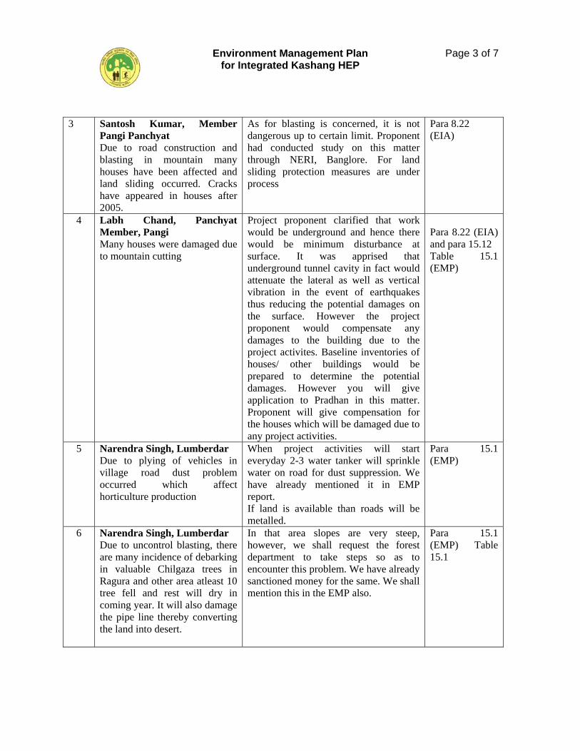
Environment Management Plan for Integrated Kashang HEP
Page 3 of 7
3 Santosh Kumar, Member Pangi Panchyat Due to road construction and blasting in mountain many houses have been affected and land sliding occurred. Cracks have appeared in houses after 2005.
As for blasting is concerned, it is not dangerous up to certain limit. Proponent had conducted study on this matter through NERI, Banglore. For land sliding protection measures are under process
Para 8.22 (EIA)
4 Labh Chand, Panchyat Member, Pangi Many houses were damaged due to mountain cutting
Project proponent clarified that work would be underground and hence there would be minimum disturbance at surface. It was apprised that underground tunnel cavity in fact would attenuate the lateral as well as vertical vibration in the event of earthquakes thus reducing the potential damages on the surface. However the project proponent would compensate any damages to the building due to the project activites. Baseline inventories of houses/ other buildings would be prepared to determine the potential damages. However you will give application to Pradhan in this matter. Proponent will give compensation for the houses which will be damaged due to any project activities.
Para 8.22 (EIA) and para 15.12 Table 15.1 (EMP)
5 Narendra Singh, Lumberdar Due to plying of vehicles in village road dust problem occurred which affect horticulture production
When project activities will start everyday 2-3 water tanker will sprinkle water on road for dust suppression. We have already mentioned it in EMP report. If land is available than roads will be metalled.
Para 15.1 (EMP)
6 Narendra Singh, Lumberdar Due to uncontrol blasting, there are many incidence of debarking in valuable Chilgaza trees in Ragura and other area atleast 10 tree fell and rest will dry in coming year. It will also damage the pipe line thereby converting the land into desert.
In that area slopes are very steep, however, we shall request the forest department to take steps so as to encounter this problem. We have already sanctioned money for the same. We shall mention this in the EMP also.
Para 15.1 (EMP) Table 15.1
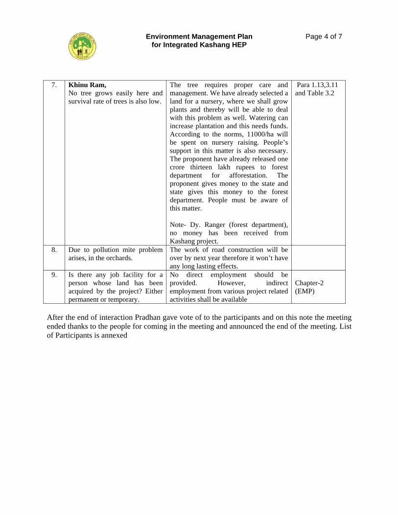
Environment Management Plan for Integrated Kashang HEP
Page 4 of 7
After the end of interaction Pradhan gave vote of to the participants and on this note the meeting ended thanks to the people for coming in the meeting and announced the end of the meeting. List of Participants is annexed
7. Khinu Ram, No tree grows easily here and survival rate of trees is also low.
The tree requires proper care and management. We have already selected a land for a nursery, where we shall grow plants and thereby will be able to deal with this problem as well. Watering can increase plantation and this needs funds. According to the norms, 11000/ha will be spent on nursery raising. People’s support in this matter is also necessary. The proponent have already released one crore thirteen lakh rupees to forest department for afforestation. The proponent gives money to the state and state gives this money to the forest department. People must be aware of this matter. Note- Dy. Ranger (forest department), no money has been received from Kashang project.
Para 1.13,3.11 and Table 3.2
8. Due to pollution mite problem arises, in the orchards.
The work of road construction will be over by next year therefore it won’t have any long lasting effects.
9. Is there any job facility for a person whose land has been acquired by the project? Either permanent or temporary.
No direct employment should be provided. However, indirect employment from various project related activities shall be available
Chapter-2 (EMP)
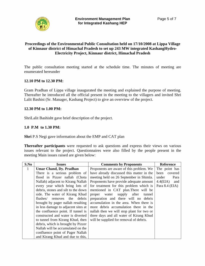
Environment Management Plan for Integrated Kashang HEP
Page 5 of 7
Proceedings of the Environmental Public Consultation held on 17/10/2008 at Lippa Village
of Kinnaur district of Himachal Pradesh to set up 243 MW integrated KashangHydro-Electricity Project, Kinnaur district, Himachal Pradesh
The public consultation meeting started at the schedule time. The minutes of meeting are enumerated hereunder 12.10 PM to 12.30 PM: Gram Pradhan of Lippa village inaugurated the meeting and explained the purpose of meeting. Thereafter he introduced all the official present in the meeting to the villagers and invited Shri Lalit Bashist (Sr. Manager, Kashang Project) to give an overview of the project. 12.30 PM to 1.00 PM: ShriLalit Bashisht gave brief description of the project. 1.0 P.M to 1.30 PM: Shri P.S Negi gave information about the EMP and CAT plan Thereafter participants were requested to ask questions and express their views on various issues relevant to the project. Questionnaires were also filled by the people present in the meeting Main issues raised are given below: S.No Issues Comments by Proponents Reference 1 Umar Chand, Dy. Pradhan
There is a serious problem of flood in Pizzer nallah (Chota Nallah) adjacent to Kirang Nallah every year which bring lots of debris, stones and silt to the down side. The water of Kirang Khud flushes/ removes the debris brought by pager nallah resulting in less damage to adjacent sites at the confluence point. If tunnel is constructed and water is diverted to tunnel from Kirang Khud, then debris, which is brought by Pizzer Nallah will be accumulated on the confluence point of Pager Nallah and Kirang Khud and due to this,
Proponents are aware of this problem. We have already discussed this matter in the meeting held on 26 September in Shimla. Proponents have provide adequate amount for treatment for this problem which is mentioned in CAT plan.There will be proper water supply after tunnel preparation and there will no debris accumulation in the area. When there is more debris accumulation there in the nallah then we will stop plant for two or three days and all water of Kirang Khud will be supplied for removal of debris.
The point has been covered under Para 4.4(EIA) and Para 8.4 (EIA)
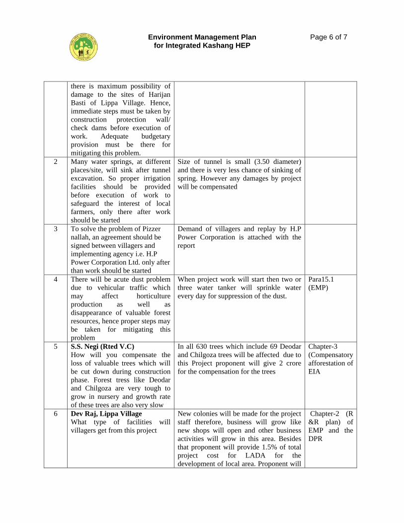
Environment Management Plan for Integrated Kashang HEP
Page 6 of 7
there is maximum possibility of damage to the sites of Harijan Basti of Lippa Village. Hence, immediate steps must be taken by construction protection wall/ check dams before execution of work. Adequate budgetary provision must be there for mitigating this problem.
2 Many water springs, at different places/site, will sink after tunnel excavation. So proper irrigation facilities should be provided before execution of work to safeguard the interest of local farmers, only there after work should be started
Size of tunnel is small (3.50 diameter) and there is very less chance of sinking of spring. However any damages by project will be compensated
3 To solve the problem of Pizzer nallah, an agreement should be signed between villagers and implementing agency i.e. H.P Power Corporation Ltd. only after than work should be started
Demand of villagers and replay by H.P Power Corporation is attached with the report
4 There will be acute dust problem due to vehicular traffic which may affect horticulture production as well as disappearance of valuable forest resources, hence proper steps may be taken for mitigating this problem
When project work will start then two or three water tanker will sprinkle water every day for suppression of the dust.
Para15.1 (EMP)
5 S.S. Negi (Rted V.C) How will you compensate the loss of valuable trees which will be cut down during construction phase. Forest tress like Deodar and Chilgoza are very tough to grow in nursery and growth rate of these trees are also very slow
In all 630 trees which include 69 Deodar and Chilgoza trees will be affected due to this Project proponent will give 2 crore for the compensation for the trees
Chapter-3 (Compensatory afforestation of EIA
6 Dev Raj, Lippa Village What type of facilities will villagers get from this project
New colonies will be made for the project staff therefore, business will grow like new shops will open and other business activities will grow in this area. Besides that proponent will provide 1.5% of total project cost for LADA for the development of local area. Proponent will
Chapter-2 (R &R plan) of EMP and the DPR
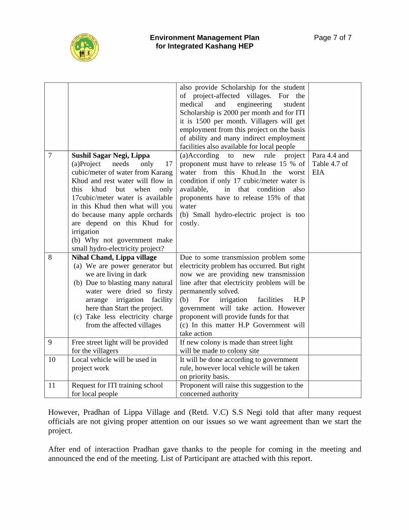
Environment Management Plan for Integrated Kashang HEP
Page 7 of 7
also provide Scholarship for the student of project-affected villages. For the medical and engineering student Scholarship is 2000 per month and for ITI it is 1500 per month. Villagers will get employment from this project on the basis of ability and many indirect employment facilities also available for local people
7 Sushil Sagar Negi, Lippa (a)Project needs only 17 cubic/meter of water from Karang Khud and rest water will flow in this khud but when only 17cubic/meter water is available in this Khud then what will you do because many apple orchards are depend on this Khud for irrigation (b) Why not government make small hydro-electricity project?
(a)According to new rule project proponent must have to release 15 % of water from this Khud.In the worst condition if only 17 cubic/meter water is available, in that condition also proponents have to release 15% of that water (b) Small hydro-electric project is too costly.
Para 4.4 and Table 4.7 of EIA
8 Nihal Chand, Lippa village (a) We are power generator but
we are living in dark (b) Due to blasting many natural
water were dried so firsty arrange irrigation facility here than Start the project.
(c) Take less electricity charge from the affected villages
Due to some transmission problem some electricity problem has occurred. But right now we are providing new transmission line after that electricity problem will be permanently solved. (b) For irrigation facilities H.P government will take action. However proponent will provide funds for that (c) In this matter H.P Government will take action
9 Free street light will be provided for the villagers
If new colony is made than street light will be made to colony site
10 Local vehicle will be used in project work
It will be done according to government rule, however local vehicle will be taken on priority basis.
11 Request for ITI training school for local people
Proponent will raise this suggestion to the concerned authority
However, Pradhan of Lippa Village and (Retd. V.C) S.S Negi told that after many request officials are not giving proper attention on our issues so we want agreement than we start the project. After end of interaction Pradhan gave thanks to the people for coming in the meeting and announced the end of the meeting. List of Participant are attached with this report.
HIMALAYAN FOREST RESEARCH INSTITUTE (Indian Council of Forestry Research & Education)
Conifer Campus, Panthaghati SHIMLA-171 009 (H.P.)
Contact us at: Telephone: 0177 – 2626778 FAX: 0177 – 2626779 E-Mail: [email protected] Website: www.hfri.icfre.org


![jkti=] fgekpy izns'k - Rajpatra of Himachal Pradesh](https://img.pdfslide.net/doc/110x75/6333bca53108fad7760f316e/jkti-fgekpy-iznsk-rajpatra-of-himachal-pradesh-1682140886.jpg)