Embed Size (px)
Citation preview
HIMACHAL PRADESH ROAD & INFRASTRUCTURE
DEVELOPMENT CORPORATION LIMITED (Government of Himachal Pradesh Undertaking)
(An ISO 9001:2008 QMS & ISO 14001:2004 EMS conforming company)
Himachal Pradesh State Roads
Transformation Program (HPSRTP) (Under Funding Assistance of the World Bank)
Raghunathpura-Mandi-Harpura-Bharari
(Km 0.000 to Km 2.74)
Environment and Social Impact Assessment
Appendices Volume
October 2021
Report Prepared by: Deccan Consulting Engineers Private Limited (Independent ESIA Consultant to HPRIDCL)
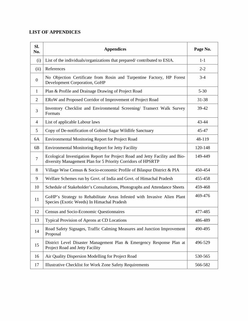
LIST OF APPENDICES
Sl. No. Appendices Page No.
(i) List of the individuals/organizations that prepared/ contributed to ESIA. 1-1
(ii) References 2-2
0 No Objection Certificate from Rosin and Turpentine Factory, HP Forest Development Corporation, GoHP
3-4
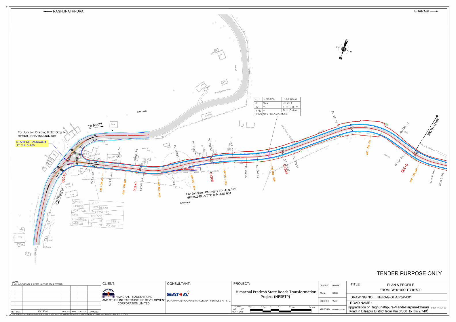
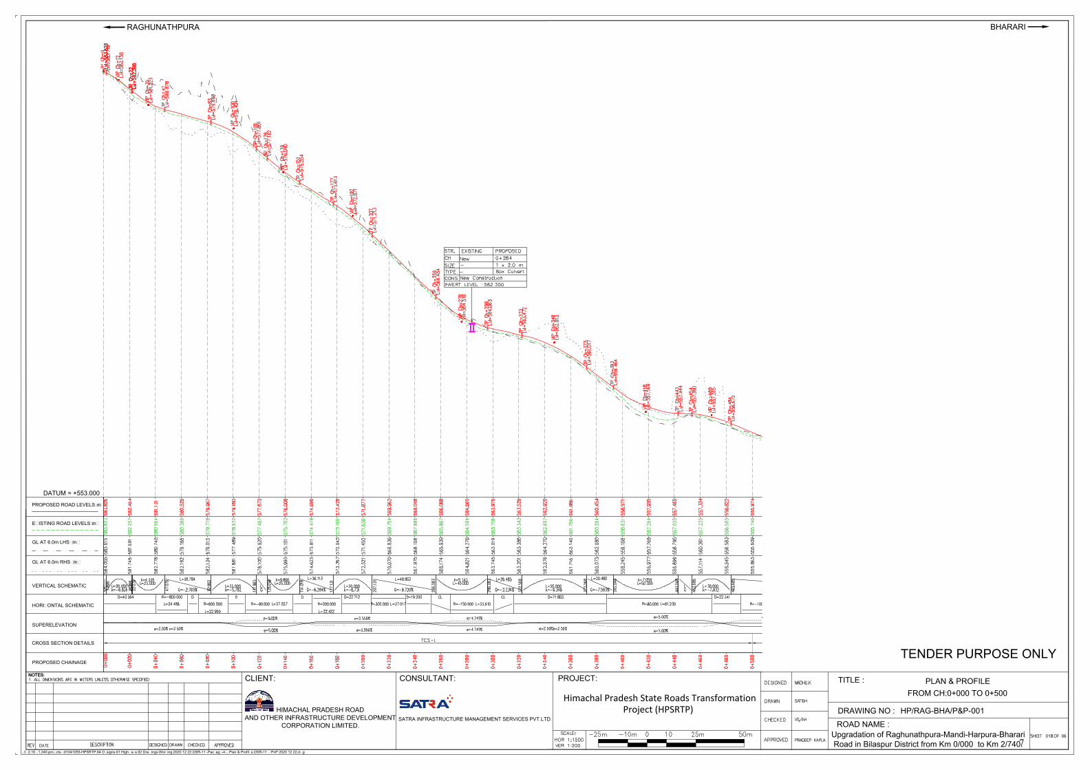
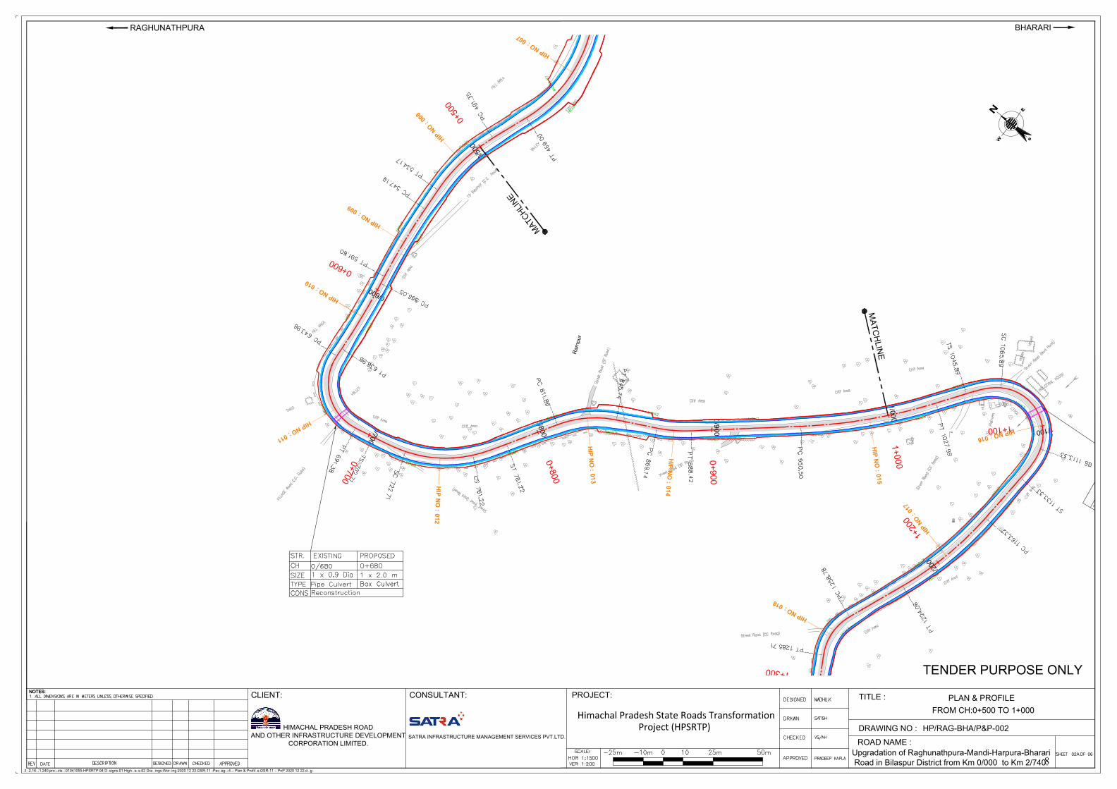
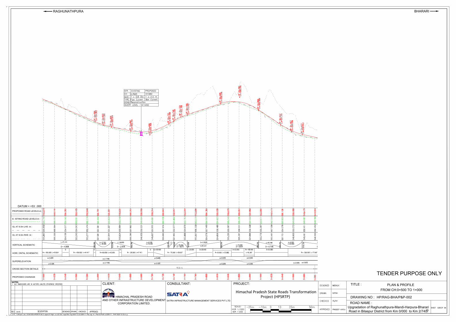
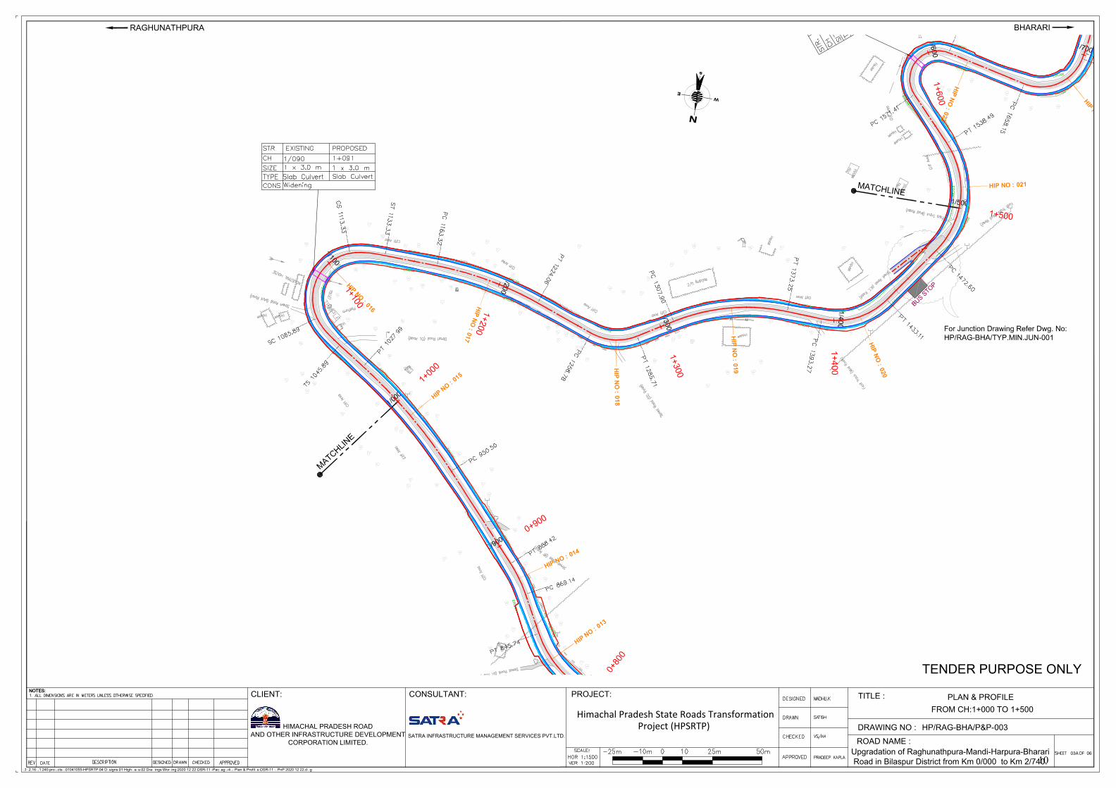
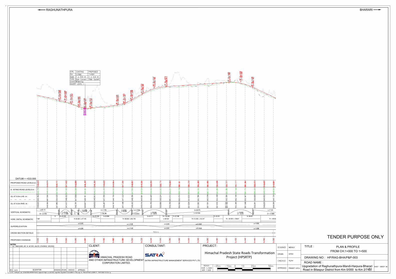
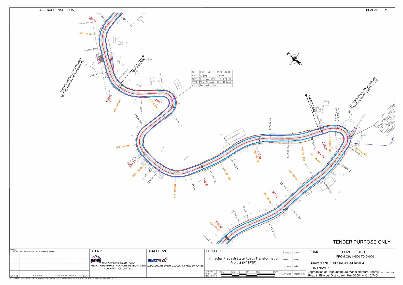
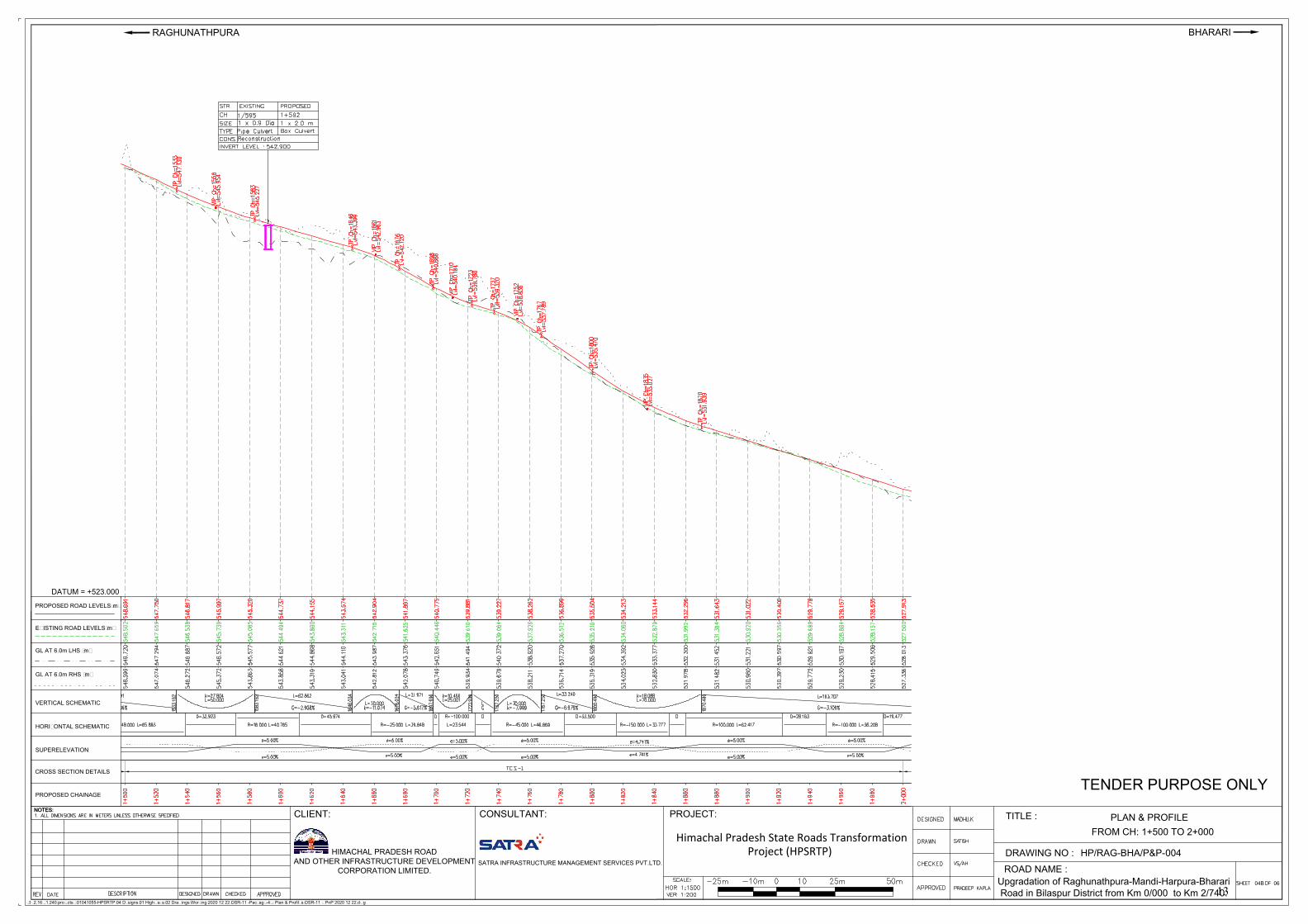
1 Plan & Profile and Drainage Drawing of Project Road 5-30
2 ERoW and Proposed Corridor of Improvement of Project Road 31-38
3 Inventory Checklist and Environmental Screening/ Transect Walk Survey Formats
39-42
4 List of applicable Labour laws 43-44
5 Copy of De-notification of Gobind Sagar Wildlife Sanctuary 45-47
6A Environmental Monitoring Report for Project Road 48-119
6B Environmental Monitoring Report for Jetty Facility 120-148
7 Ecological Investigation Report for Project Road and Jetty Facility and Bio-diversity Management Plan for 5 Priority Corridors of HPSRTP
149-449
8 Village Wise Census & Socio-economic Profile of Bilaspur District & PIA 450-454
9 Welfare Schemes run by Govt. of India and Govt. of Himachal Pradesh 455-458
10 Schedule of Stakeholder’s Consultations, Photographs and Attendance Sheets 459-468
11 GoHP’s Strategy to Rehabilitate Areas Infested with Invasive Alien Plant Species (Exotic Weeds) In Himachal Pradesh
469-476
12 Census and Socio-Economic Questionnaires 477-485
13 Typical Provision of Aprons at CD Locations 486-489
14 Road Safety Signages, Traffic Calming Measures and Junction Improvement Proposal
490-495
15 District Level Disaster Management Plan & Emergency Response Plan at Project Road and Jetty Facility
496-529
16 Air Quality Dispersion Modelling for Project Road 530-565
17 Illustrative Checklist for Work Zone Safety Requirements 566-582
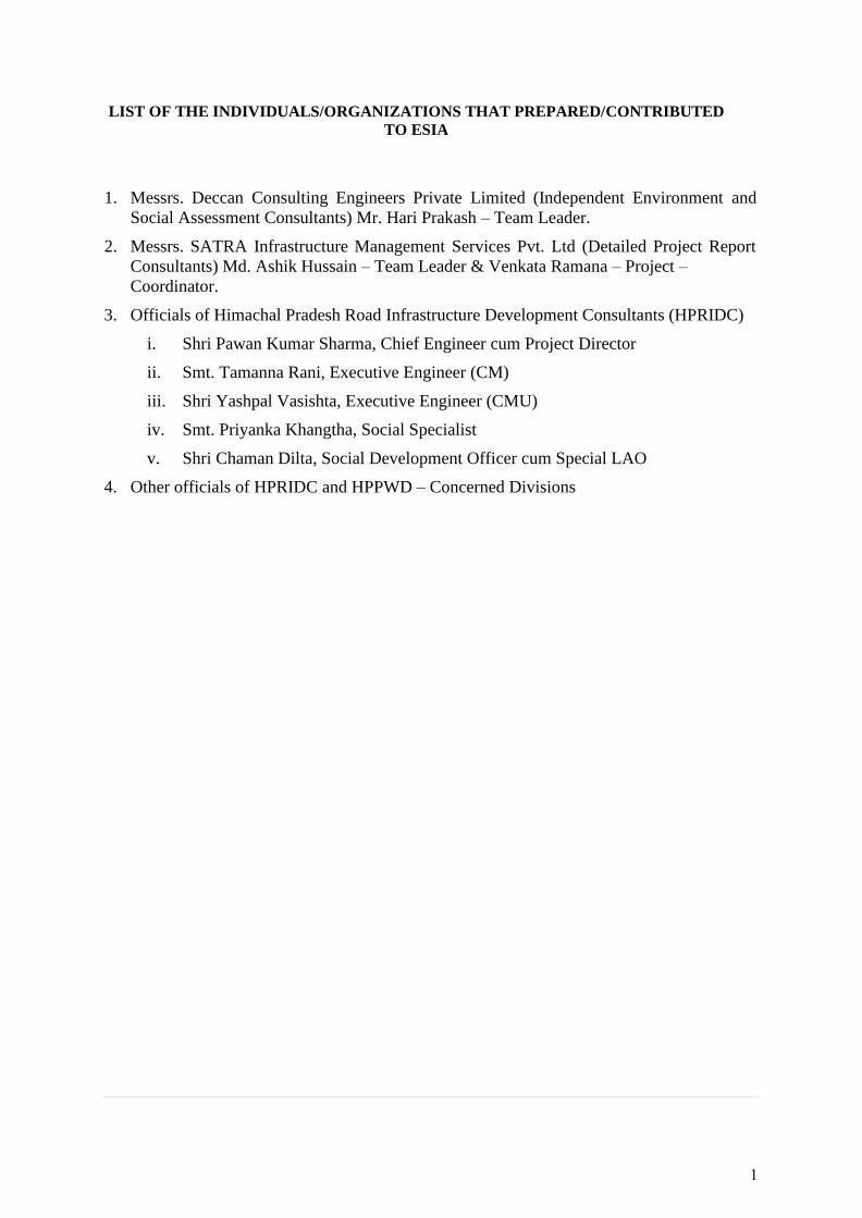
LIST OF THE INDIVIDUALS/ORGANIZATIONS THAT PREPARED/ CONTRIBUTED
TO ESIA
1. Messrs. Deccan Consulting Engineers Private Limited (Independent Environment and
Social Assessment Consultants) Mr. Hari Prakash – Team Leader.
2. Messrs. SATRA Infrastructure Management Services Pvt. Ltd (Detailed Project Report
Consultants) Md. Ashik Hussain – Team Leader & Venkata Ramana – Project –
Coordinator.
3. Officials of Himachal Pradesh Road Infrastructure Development Consultants (HPRIDC)
i. Shri Pawan Kumar Sharma, Chief Engineer cum Project Director
ii. Smt. Tamanna Rani, Executive Engineer (CM)
iii. Shri Yashpal Vasishta, Executive Engineer (CMU)
iv. Smt. Priyanka Khangtha, Social Specialist
v. Shri Chaman Dilta, Social Development Officer cum Special LAO
4. Other officials of HPRIDC and HPPWD – Concerned Divisions
1
REFERENCES
1. Primary Census Abstract, Census of India, 2011
2. Amenities- District Household Census, Census of India, 2011
3. The World Bank Environment and Social Framework, 2016
4. Right to Fair Compensation and Transparency in Land Acquisition, Rehabilitation and
Resettlement, 2013
5. Gender Statistics, HP, DoES, Shimla
6. Resettlement Action Plan for Himachal Pradesh State Roads Project – I
7. Environment Management Plan for Himachal Pradesh State Roads Project – I
8. Himachal Pradesh Roadside Land Control Act, 1968
9. The Himachal Pradesh Roads Infrastructure Protection Act 2002 (and Rules 2004)
10. Environment and Social Management Framework, Himachal Pradesh Horticulture
Development Project
11. Project Appraisal Document (Draft) of Himachal Pradesh State Roads Transformation
Program, The World Bank, 2019
2
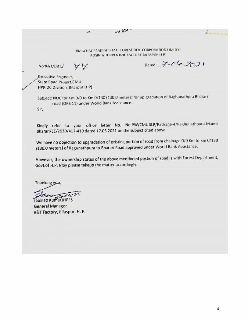
APPENDIX-0
No Objection Certificate from Rosin and Turpentine
Factory, HP Forest Development Corporation, GoHP
3
4
APPENDIX-1
Plan & Profile and Drainage Drawing of Project Road
5
0
/
0
0
0
0/100
0/200
0
/3
0
0
0
/4
0
0
0
/
5
0
0
E
R
O
W
E
R
O
W
E
R
O
W
E
R
O
W
ER
OW
E
R
O
W
E
R
O
W
E
R
O
W
E
R
O
W
E
R
O
W
E
R
O
W
E
R
O
W
ER
OW
E
R
O
W
E
R
O
W
E
R
O
W E
R
O
W
E
R
O
W
0+
000
0+
100
0
+
2
0
0
0
+
3
0
0
0
+
5
0
0
H
IP
N
O
:
002
H
IP
N
O
:
0
0
4
For J
unction D
raw
ing R
efe
r D
wg. N
o:
HP
/RA
G-B
HA
/TY
P.M
IN.J
UN
-001
HIP
N
O
:
001
HIP
N
O :
003
HIP
N
O
:
005
H
IP
N
O
:
0
0
6
H
IP
N
O
:
0
0
7
H
I
P
N
O
:
0
0
8
0+
000
For Junction Drawing Refer Dwg. No:
HP/RAG-BHA/MAJ.JUN-001
NOTES:
\\192.168.1.240\projects$\01041055-HPSRTP\04 Designs\01 Highways\02 Drawings\Working\2020 12 22\OSR-11 -Package-4\9 Plan & Profiles\OSR-11 _ PnP 2020 12 22.dwg
NOTES:
PROJECT:
Himachal Pradesh State Roads TransformationProject (HPSRTP)
BHARARI
SATRA INFRASTRUCTURE MANAGEMENT SERVICES PVT.LTD.
HIMACHAL PRADESH ROAD
AND OTHER INFRASTRUCTURE DEVELOPMENT
CORPORATION LIMITED.
PLAN & PROFILE
TITLE :
DRAWING NO :
06
ROAD NAME :
TENDER PURPOSE ONLY
HP/RAG-BHA/P&P-
Upgradation of Raghunathpura-Mandi-Harpura-Bharari
Road in Bilaspur District from Km 0/000 to Km 2/740.
RAGHUNATHPURA
CLIENT: CONSULTANT:
FROM CH:0+000 TO 0+500
START OF PACKAGE-4
AT CH : 0+000
01A
001
6
VERTICAL SCHEMATIC
HORIZONTAL SCHEMATIC
EXISTING ROAD LEVELS(m)
PROPOSED ROAD LEVELS(m)
GL AT 6.0m LHS (m)
GL AT 6.0m RHS (m)
CROSS SECTION DETAILS
PROPOSED CHAINAGE
SUPERELEVATION
PROPOSED ROAD LEVELS(m)
NOTES:
\\192.168.1.240\projects$\01041055-HPSRTP\04 Designs\01 Highways\02 Drawings\Working\2020 12 22\OSR-11 -Package-4\9 Plan & Profiles\OSR-11 _ PnP 2020 12 22.dwg
NOTES:
PROJECT:
Himachal Pradesh State Roads TransformationProject (HPSRTP)
BHARARI
SATRA INFRASTRUCTURE MANAGEMENT SERVICES PVT.LTD.
HIMACHAL PRADESH ROAD
AND OTHER INFRASTRUCTURE DEVELOPMENT
CORPORATION LIMITED.
PLAN & PROFILE
TITLE :
DRAWING NO :
06
ROAD NAME :
TENDER PURPOSE ONLY
HP/RAG-BHA/P&P-
Upgradation of Raghunathpura-Mandi-Harpura-Bharari
Road in Bilaspur District from Km 0/000 to Km 2/740.
RAGHUNATHPURA
CLIENT: CONSULTANT:
DATUM = +553.000
FROM CH:0+000 TO 0+500
01B
001
7
NOTES:
\\192.168.1.240\projects$\01041055-HPSRTP\04 Designs\01 Highways\02 Drawings\Working\2020 12 22\OSR-11 -Package-4\9 Plan & Profiles\OSR-11 _ PnP 2020 12 22.dwg
NOTES:
PROJECT:
Himachal Pradesh State Roads TransformationProject (HPSRTP)
BHARARI
SATRA INFRASTRUCTURE MANAGEMENT SERVICES PVT.LTD.
HIMACHAL PRADESH ROAD
AND OTHER INFRASTRUCTURE DEVELOPMENT
CORPORATION LIMITED.
PLAN & PROFILE
TITLE :
DRAWING NO :
06
ROAD NAME :
TENDER PURPOSE ONLY
HP/RAG-BHA/P&P-
Upgradation of Raghunathpura-Mandi-Harpura-Bharari
Road in Bilaspur District from Km 0/000 to Km 2/740.
RAGHUNATHPURA
CLIENT: CONSULTANT:
FROM CH:0+500 TO 1+000
02A
002
8
VERTICAL SCHEMATIC
HORIZONTAL SCHEMATIC
EXISTING ROAD LEVELS(m)
PROPOSED ROAD LEVELS(m)
GL AT 6.0m LHS (m)
GL AT 6.0m RHS (m)
CROSS SECTION DETAILS
PROPOSED CHAINAGE
SUPERELEVATION
NOTES:
\\192.168.1.240\projects$\01041055-HPSRTP\04 Designs\01 Highways\02 Drawings\Working\2020 12 22\OSR-11 -Package-4\9 Plan & Profiles\OSR-11 _ PnP 2020 12 22.dwg
NOTES:
PROJECT:
Himachal Pradesh State Roads TransformationProject (HPSRTP)
BHARARI
SATRA INFRASTRUCTURE MANAGEMENT SERVICES PVT.LTD.
HIMACHAL PRADESH ROAD
AND OTHER INFRASTRUCTURE DEVELOPMENT
CORPORATION LIMITED.
PLAN & PROFILE
TITLE :
DRAWING NO :
06
ROAD NAME :
TENDER PURPOSE ONLY
HP/RAG-BHA/P&P-
Upgradation of Raghunathpura-Mandi-Harpura-Bharari
Road in Bilaspur District from Km 0/000 to Km 2/740.
RAGHUNATHPURA
CLIENT: CONSULTANT:
DATUM = +538.000
FROM CH:0+500 TO 1+000
02B
002
9
NOTES:
\\192.168.1.240\projects$\01041055-HPSRTP\04 Designs\01 Highways\02 Drawings\Working\2020 12 22\OSR-11 -Package-4\9 Plan & Profiles\OSR-11 _ PnP 2020 12 22.dwg
NOTES:
PROJECT:
Himachal Pradesh State Roads TransformationProject (HPSRTP)
BHARARI
SATRA INFRASTRUCTURE MANAGEMENT SERVICES PVT.LTD.
HIMACHAL PRADESH ROAD
AND OTHER INFRASTRUCTURE DEVELOPMENT
CORPORATION LIMITED.
PLAN & PROFILE
TITLE :
DRAWING NO :
06
ROAD NAME :
TENDER PURPOSE ONLY
HP/RAG-BHA/P&P-
Upgradation of Raghunathpura-Mandi-Harpura-Bharari
Road in Bilaspur District from Km 0/000 to Km 2/740.
RAGHUNATHPURA
CLIENT: CONSULTANT:
FROM CH:1+000 TO 1+500
03A
003
10
VERTICAL SCHEMATIC
HORIZONTAL SCHEMATIC
EXISTING ROAD LEVELS(m)
PROPOSED ROAD LEVELS(m)
GL AT 6.0m LHS (m)
GL AT 6.0m RHS (m)
CROSS SECTION DETAILS
PROPOSED CHAINAGE
SUPERELEVATION
NOTES:
\\192.168.1.240\projects$\01041055-HPSRTP\04 Designs\01 Highways\02 Drawings\Working\2020 12 22\OSR-11 -Package-4\9 Plan & Profiles\OSR-11 _ PnP 2020 12 22.dwg
NOTES:
PROJECT:
Himachal Pradesh State Roads TransformationProject (HPSRTP)
BHARARI
SATRA INFRASTRUCTURE MANAGEMENT SERVICES PVT.LTD.
HIMACHAL PRADESH ROAD
AND OTHER INFRASTRUCTURE DEVELOPMENT
CORPORATION LIMITED.
PLAN & PROFILE
TITLE :
DRAWING NO :
06
ROAD NAME :
TENDER PURPOSE ONLY
HP/RAG-BHA/P&P-
Upgradation of Raghunathpura-Mandi-Harpura-Bharari
Road in Bilaspur District from Km 0/000 to Km 2/740.
RAGHUNATHPURA
CLIENT: CONSULTANT:
DATUM = +533.000
FROM CH:1+000 TO 1+500
03B
003
11
NOTES:
\\192.168.1.240\projects$\01041055-HPSRTP\04 Designs\01 Highways\02 Drawings\Working\2020 12 22\OSR-11 -Package-4\9 Plan & Profiles\OSR-11 _ PnP 2020 12 22.dwg
NOTES:
PROJECT:
Himachal Pradesh State Roads TransformationProject (HPSRTP)
BHARARI
SATRA INFRASTRUCTURE MANAGEMENT SERVICES PVT.LTD.
HIMACHAL PRADESH ROAD
AND OTHER INFRASTRUCTURE DEVELOPMENT
CORPORATION LIMITED.
PLAN & PROFILE
TITLE :
DRAWING NO :
06
ROAD NAME :
TENDER PURPOSE ONLY
HP/RAG-BHA/P&P-
Upgradation of Raghunathpura-Mandi-Harpura-Bharari
Road in Bilaspur District from Km 0/000 to Km 2/740.
RAGHUNATHPURA
CLIENT: CONSULTANT:
FROM CH: 1+500 TO 2+000
04A
004
12
VERTICAL SCHEMATIC
HORIZONTAL SCHEMATIC
EXISTING ROAD LEVELS(m)
PROPOSED ROAD LEVELS(m)
GL AT 6.0m LHS (m)
GL AT 6.0m RHS (m)
CROSS SECTION DETAILS
PROPOSED CHAINAGE
SUPERELEVATION
NOTES:
\\192.168.1.240\projects$\01041055-HPSRTP\04 Designs\01 Highways\02 Drawings\Working\2020 12 22\OSR-11 -Package-4\9 Plan & Profiles\OSR-11 _ PnP 2020 12 22.dwg
NOTES:
PROJECT:
Himachal Pradesh State Roads TransformationProject (HPSRTP)
BHARARI
SATRA INFRASTRUCTURE MANAGEMENT SERVICES PVT.LTD.
HIMACHAL PRADESH ROAD
AND OTHER INFRASTRUCTURE DEVELOPMENT
CORPORATION LIMITED.
PLAN & PROFILE
TITLE :
DRAWING NO :
06
ROAD NAME :
TENDER PURPOSE ONLY
HP/RAG-BHA/P&P-
Upgradation of Raghunathpura-Mandi-Harpura-Bharari
Road in Bilaspur District from Km 0/000 to Km 2/740.
RAGHUNATHPURA
CLIENT: CONSULTANT:
DATUM = +523.000
FROM CH: 1+500 TO 2+000
04B
004
13
NOTES:
\\192.168.1.240\projects$\01041055-HPSRTP\04 Designs\01 Highways\02 Drawings\Working\2020 12 22\OSR-11 -Package-4\9 Plan & Profiles\OSR-11 _ PnP 2020 12 22.dwg
NOTES:
PROJECT:
Himachal Pradesh State Roads TransformationProject (HPSRTP)
BHARARI
SATRA INFRASTRUCTURE MANAGEMENT SERVICES PVT.LTD.
HIMACHAL PRADESH ROAD
AND OTHER INFRASTRUCTURE DEVELOPMENT
CORPORATION LIMITED.
PLAN & PROFILE
TITLE :
DRAWING NO :
06
ROAD NAME :
TENDER PURPOSE ONLY
HP/RAG-BHA/P&P-
Upgradation of Raghunathpura-Mandi-Harpura-Bharari
Road in Bilaspur District from Km 0/000 to Km 2/740.
RAGHUNATHPURA
CLIENT: CONSULTANT:
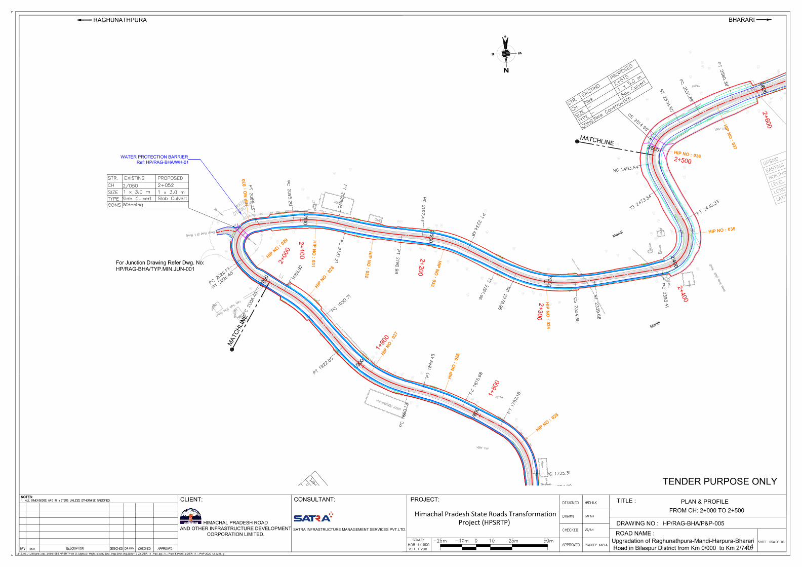
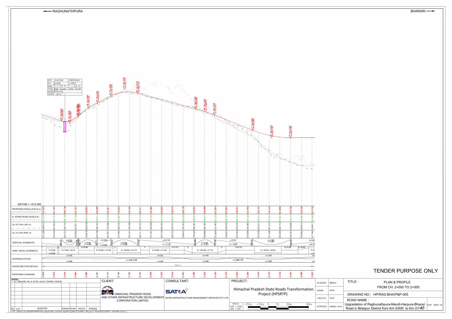
FROM CH: 2+000 TO 2+500
05A
005
14
VERTICAL SCHEMATIC
HORIZONTAL SCHEMATIC
EXISTING ROAD LEVELS(m)
PROPOSED ROAD LEVELS(m)
GL AT 6.0m LHS (m)
GL AT 6.0m RHS (m)
CROSS SECTION DETAILS
PROPOSED CHAINAGE
SUPERELEVATION
NOTES:
\\192.168.1.240\projects$\01041055-HPSRTP\04 Designs\01 Highways\02 Drawings\Working\2020 12 22\OSR-11 -Package-4\9 Plan & Profiles\OSR-11 _ PnP 2020 12 22.dwg
NOTES:
PROJECT:
Himachal Pradesh State Roads TransformationProject (HPSRTP)
BHARARI
SATRA INFRASTRUCTURE MANAGEMENT SERVICES PVT.LTD.
HIMACHAL PRADESH ROAD
AND OTHER INFRASTRUCTURE DEVELOPMENT
CORPORATION LIMITED.
PLAN & PROFILE
TITLE :
DRAWING NO :
06
ROAD NAME :
TENDER PURPOSE ONLY
HP/RAG-BHA/P&P-
Upgradation of Raghunathpura-Mandi-Harpura-Bharari
Road in Bilaspur District from Km 0/000 to Km 2/740.
RAGHUNATHPURA
CLIENT: CONSULTANT:
DATUM = +513.000
FROM CH: 2+000 TO 2+500
05B
005
15
NOTES:
\\192.168.1.240\projects$\01041055-HPSRTP\04 Designs\01 Highways\02 Drawings\Working\2020 12 22\OSR-11 -Package-4\9 Plan & Profiles\OSR-11 _ PnP 2020 12 22.dwg
NOTES:
PROJECT:
Himachal Pradesh State Roads TransformationProject (HPSRTP)
BHARARI
SATRA INFRASTRUCTURE MANAGEMENT SERVICES PVT.LTD.
HIMACHAL PRADESH ROAD
AND OTHER INFRASTRUCTURE DEVELOPMENT
CORPORATION LIMITED.
PLAN & PROFILE
TITLE :
DRAWING NO :
06
ROAD NAME :
TENDER PURPOSE ONLY
HP/RAG-BHA/P&P-
Upgradation of Raghunathpura-Mandi-Harpura-Bharari
Road in Bilaspur District from Km 0/000 to Km 2/740.
RAGHUNATHPURA
CLIENT: CONSULTANT:
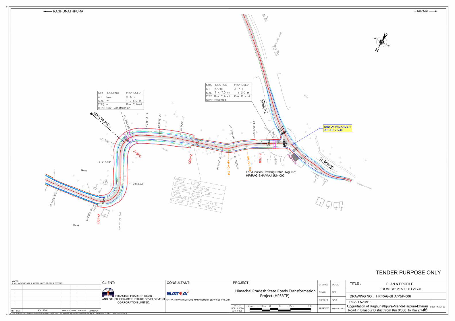
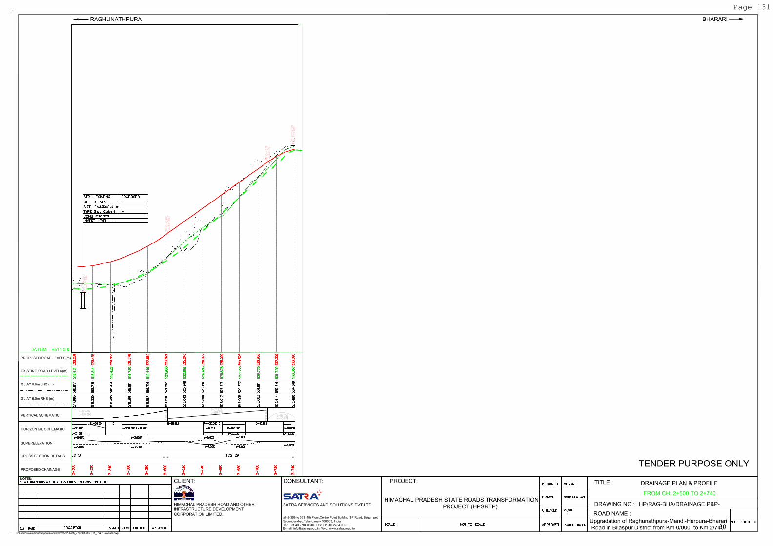
FROM CH: 2+500 TO 2+740
END OF PACKAGE-4
AT CH : 2+740
06A
006
16
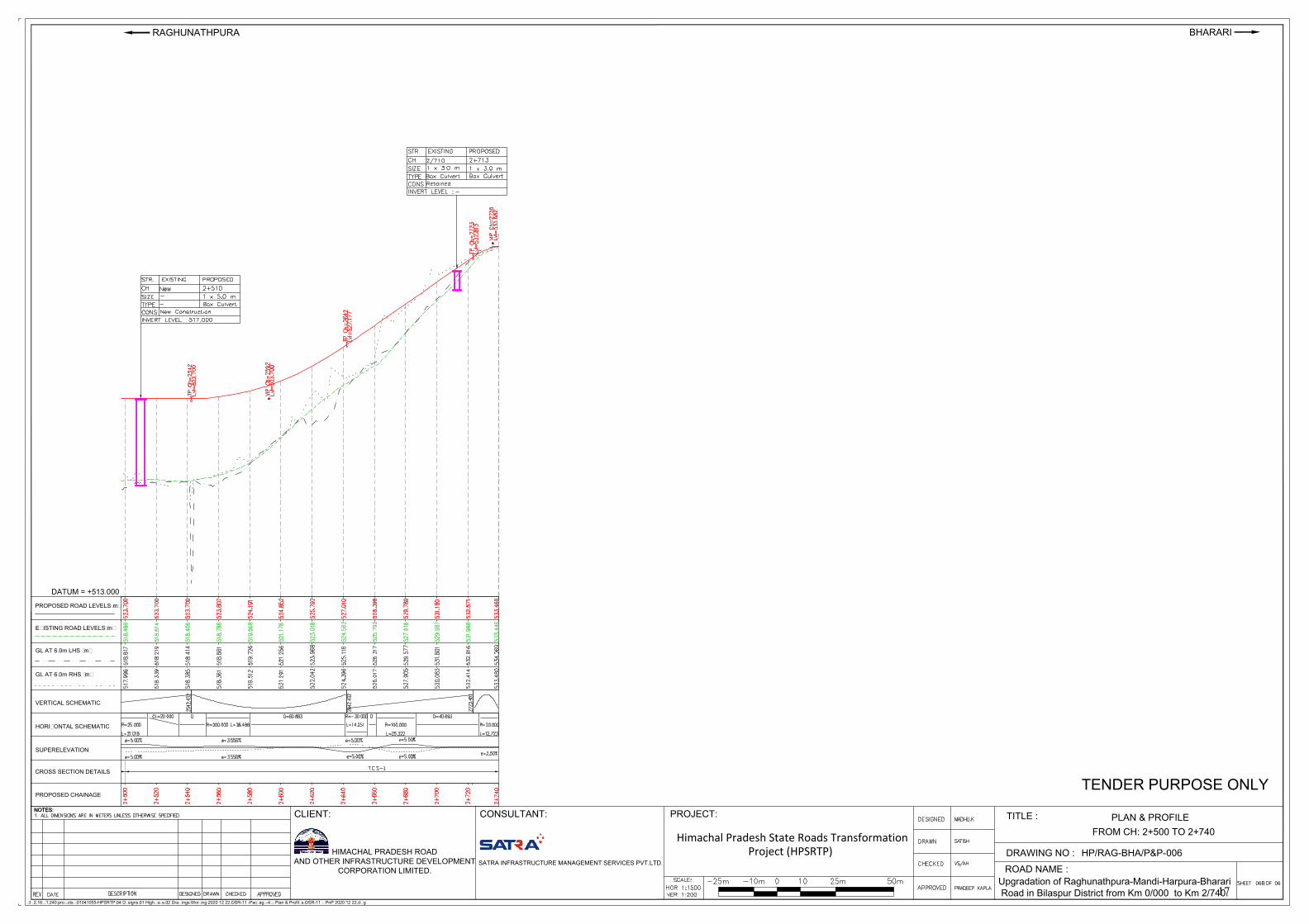
VERTICAL SCHEMATIC
HORIZONTAL SCHEMATIC
EXISTING ROAD LEVELS(m)
PROPOSED ROAD LEVELS(m)
GL AT 6.0m LHS (m)
GL AT 6.0m RHS (m)
CROSS SECTION DETAILS
PROPOSED CHAINAGE
SUPERELEVATION
NOTES:
\\192.168.1.240\projects$\01041055-HPSRTP\04 Designs\01 Highways\02 Drawings\Working\2020 12 22\OSR-11 -Package-4\9 Plan & Profiles\OSR-11 _ PnP 2020 12 22.dwg
NOTES:
PROJECT:
Himachal Pradesh State Roads TransformationProject (HPSRTP)
BHARARI
SATRA INFRASTRUCTURE MANAGEMENT SERVICES PVT.LTD.
HIMACHAL PRADESH ROAD
AND OTHER INFRASTRUCTURE DEVELOPMENT
CORPORATION LIMITED.
PLAN & PROFILE
TITLE :
DRAWING NO :
06
ROAD NAME :
TENDER PURPOSE ONLY
HP/RAG-BHA/P&P-
Upgradation of Raghunathpura-Mandi-Harpura-Bharari
Road in Bilaspur District from Km 0/000 to Km 2/740.
RAGHUNATHPURA
CLIENT: CONSULTANT:
DATUM = +513.000
FROM CH: 2+500 TO 2+740
06B
006
17
DRAINAGE DRAWINGS
18
Khansara
Khansara
0
/
0
0
0
0/100
0/200
0
/3
0
0
0
/4
0
0
0
/
5
0
0
T
o
B
i
l
a
s
p
u
r
T
o
N
a
u
n
i
L
C
P
R
-1
L
-6
R
-2
E
R
O
W
EROW
E
R
O
W
ER
OW
E
R
O
W
E
R
O
W
E
R
O
W
E
R
O
W
E
R
O
W
EROW
E
R
O
W
EROW
E
R
O
W
E
R
O
W
E
R
O
W
E
R
O
W
E
N
s
W
For
Junction D
raw
ing R
efe
r D
wg. N
o:
HP
/RA
G-B
HA
/TY
P.M
IN.J
UN
-001
H
IP
N
O
:
002
H
IP
N
O
:
0
0
4
HIP
N
O
:
001
HIP
N
O :
003
HIP
N
O
:
005
H
IP
N
O
:
0
0
6
H
IP
N
O
:
0
0
7
H
I
P
N
O
:
0
0
8
0+
000
0+
100
0
+
2
0
0
0
+
3
0
0
0
+
4
0
0
0
+
5
0
0
For J
unctio
n D
raw
ing R
efe
r Dw
g. N
o:
HP
/RA
G-B
HA
/MA
J.J
UN
-001
F
o
r J
u
n
c
tio
n
D
ra
w
in
g
R
e
fe
r D
w
g
. N
o
:
H
P
/R
A
G
-B
H
A
/T
Y
P
.M
IN
.J
U
N
-0
0
1
E
N
D
O
F
B
R
E
A
S
T
W
A
L
L
@
C
H
:
0
+
3
8
0
L
H
S
S
T
A
R
T
O
F
B
R
E
A
S
T
W
A
L
L
@
C
H
:
0
+
3
4
0
L
H
S
S
T
A
R
T
O
F
B
R
E
A
S
T
W
A
L
L
@
C
H
:
0
+
4
4
0
L
H
S
ST
AR
T O
F T
OE
W
AL
L
@C
H:0+
250 R
HS
E
N
D
O
F
T
O
E
W
A
L
L
@
C
H
:
0
+
3
2
0
R
H
S
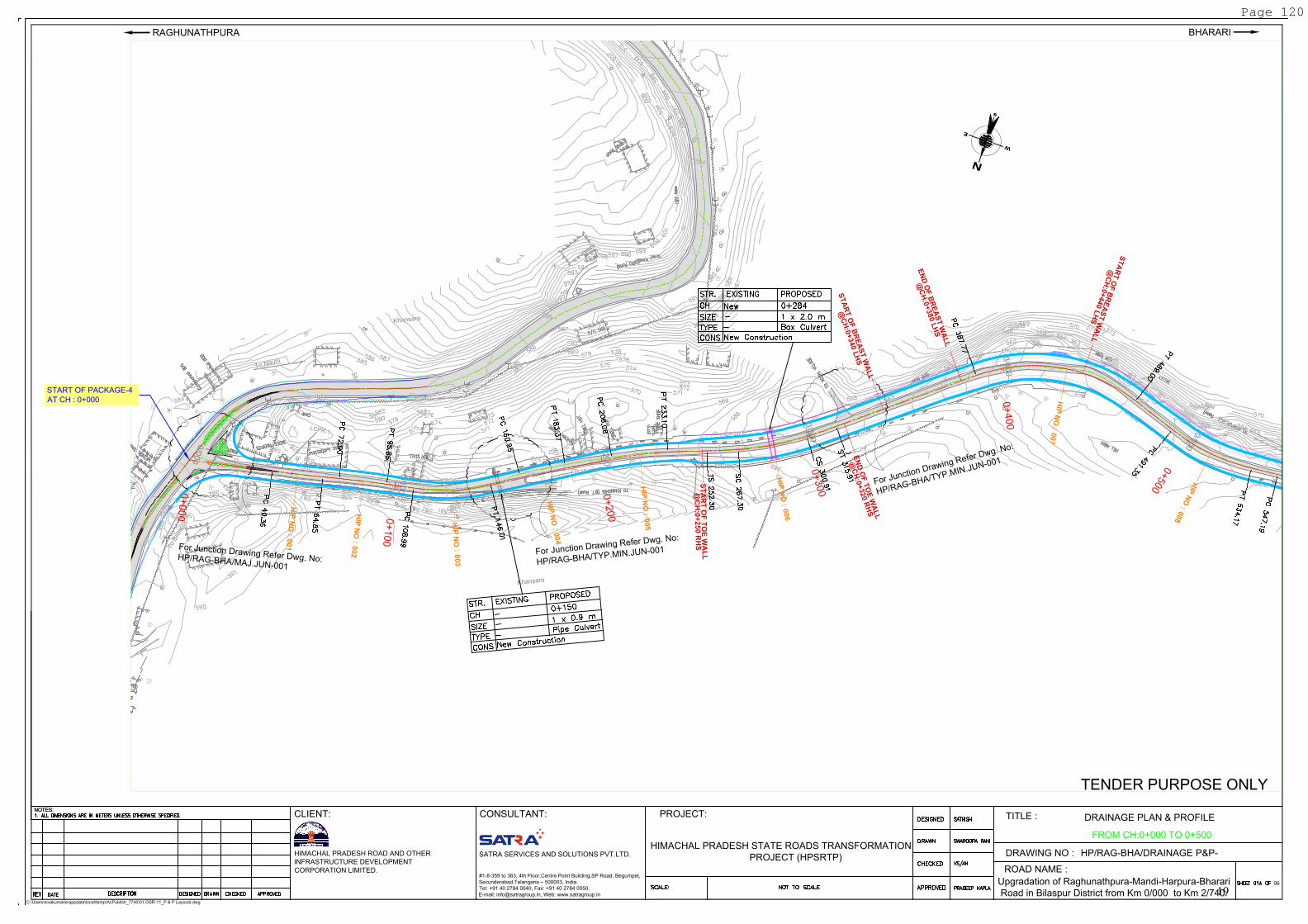
NOTES:
C:\Users\sivakumarie\appdata\local\temp\AcPublish_7740\01.OSR-11_P & P Layouts.dwg
NOTES:
PROJECT:
BHARARI
SATRA SERVICES AND SOLUTIONS PVT.LTD.
HIMACHAL PRADESH ROAD AND OTHER
INFRASTRUCTURE DEVELOPMENT
CORPORATION LIMITED.
DRAINAGE PLAN & PROFILE
TITLE :
DRAWING NO :
06
ROAD NAME :
TENDER PURPOSE ONLY
HP/RAG-BHA/DRAINAGE P&P-
Upgradation of Raghunathpura-Mandi-Harpura-Bharari
Road in Bilaspur District from Km 0/000 to Km 2/740.
RAGHUNATHPURA
CLIENT: CONSULTANT:
#1-8-359 to 363, 4th Floor,Centre Point Building,SP Road, Begumpet,
Secunderabad,Telangana – 500003, India.
Tel: +91 40 2784 0040, Fax: +91 40 2784 0050,
E-mail: [email protected], Web: www.satragroup.in
HIMACHAL PRADESH STATE ROADS TRANSFORMATION
PROJECT (HPSRTP)
FROM CH:0+000 TO 0+500
START OF PACKAGE-4
AT CH : 0+000
Page 120
19
VERTICAL SCHEMATIC
HORIZONTAL SCHEMATIC
EXISTING ROAD LEVELS(m)
PROPOSED ROAD LEVELS(m)
GL AT 6.0m LHS (m)
GL AT 6.0m RHS (m)
CROSS SECTION DETAILS
PROPOSED CHAINAGE
SUPERELEVATION
PROPOSED ROAD LEVELS(m)
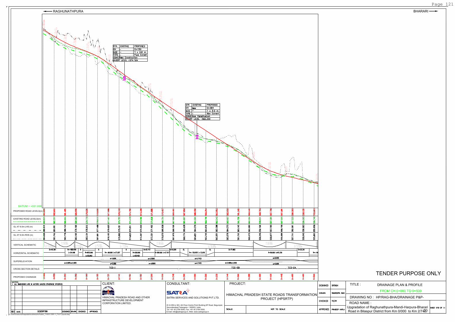
NOTES:
C:\Users\sivakumarie\appdata\local\temp\AcPublish_7740\01.OSR-11_P & P Layouts.dwg
NOTES:
PROJECT:
BHARARI
SATRA SERVICES AND SOLUTIONS PVT.LTD.
HIMACHAL PRADESH ROAD AND OTHER
INFRASTRUCTURE DEVELOPMENT
CORPORATION LIMITED.
DRAINAGE PLAN & PROFILE
TITLE :
DRAWING NO :
06
ROAD NAME :
TENDER PURPOSE ONLY
HP/RAG-BHA/DRAINAGE P&P-
Upgradation of Raghunathpura-Mandi-Harpura-Bharari
Road in Bilaspur District from Km 0/000 to Km 2/740.
RAGHUNATHPURA
CLIENT: CONSULTANT:
#1-8-359 to 363, 4th Floor,Centre Point Building,SP Road, Begumpet,
Secunderabad,Telangana – 500003, India.
Tel: +91 40 2784 0040, Fax: +91 40 2784 0050,
E-mail: [email protected], Web: www.satragroup.in
HIMACHAL PRADESH STATE ROADS TRANSFORMATION
PROJECT (HPSRTP)
DATUM = +551.000
FROM CH:0+000 TO 0+500
Page 121
20
R
a
m
p
u
r
0
/
5
0
0
0
/
6
0
0
0
/
7
0
0
0
/
8
0
0
0/900
1
/0
0
0
1
/1
0
0
1
/
2
0
0
E
R
O
W
E
R
O
W
E
R
O
W
E
R
O
W
E
R
O
W
E
R
O
W
E
R
O
W
E
R
O
W
ER
OW
E
R
O
W
E
R
O
W
E
R
O
W
E
R
O
W
E
R
O
W
E
R
O
W
E
R
O
W
E
R
O
W
E
R
O
W
E
R
O
W
ER
O
W
ER
OW
E
R
O
W
E
R
O
W
E
R
O
W
E
R
O
W
EN
sW
HIP
N
O :
014
H
IP
N
O
:
0
1
6
H
I
P
N
O
:
0
0
7
H
I
P
N
O
:
0
0
8
H
I
P
N
O
:
0
0
9
H
I
P
N
O
:
0
1
0
H
I
P
N
O
:
0
1
1
HIP
N
O :
012
HIP
N
O :
013
H
IP
N
O
:
0
1
5
H
I
P
N
O
:
0
1
7
H
I
P
N
O
:
0
1
8
0
+
5
0
0
0
+
6
0
0
0
+
7
0
0
0
+
8
0
0
0+
900
1
+
0
0
0
1+
100
1
+
2
0
0
1+
300
For J
unctio
n D
raw
ing R
efe
r Dw
g. N
o:
HP
/RA
G-B
HA
/TY
P.M
IN.J
UN
-001
For Junction Drawing Refer Dwg. No:
HP/RAG-BHA/TYP.MIN.JUN-001
For Junctio
n D
raw
ing R
efer D
w
g. N
o:
H
P
/R
A
G
-B
H
A
/T
Y
P
.M
IN
.JU
N
-001
F
o
r
J
u
n
c
t
i
o
n
D
r
a
w
i
n
g
R
e
f
e
r
D
w
g
.
N
o
:
H
P
/
R
A
G
-
B
H
A
/
T
Y
P
.
M
I
N
.
J
U
N
-
0
0
1
E
N
D
O
F
B
R
E
A
S
T
W
A
L
L
@
C
H
:
0
+
5
8
0
L
H
S
E
N
D
O
F
B
R
E
A
S
T
W
A
L
L
@
C
H
:
1
+
0
7
0
L
H
S
E
N
D
O
F
B
R
E
A
S
T
W
A
L
L
@
C
H
:
1
+
1
7
0
L
H
S
E
N
D
O
F
B
R
E
A
S
T
W
A
L
L
@
C
H
:1+
310 L
H
S
S
T
A
R
T
O
F
B
R
E
A
S
T
W
A
L
L
@
C
H
:
0
+
4
4
0
L
H
S
S
T
A
R
T
O
F
B
R
E
A
S
T
W
A
L
L
@
C
H
:
0
+
6
4
0
L
H
S
S
T
A
R
T
O
F
B
R
E
A
S
T
W
A
L
L
@
C
H
:1+
100 L
H
S
S
T
A
R
T
O
F
B
R
E
A
S
T
W
A
L
L
@
C
H
:
1
+
2
0
0
L
H
S
S
T
A
R
T
O
F
T
O
E
W
A
L
L
@
C
H
:
0
+
6
8
0
R
H
S
E
N
D
O
F
T
O
E
W
A
L
L
@
C
H
:0
+
7
3
0
R
H
S
NOTES:
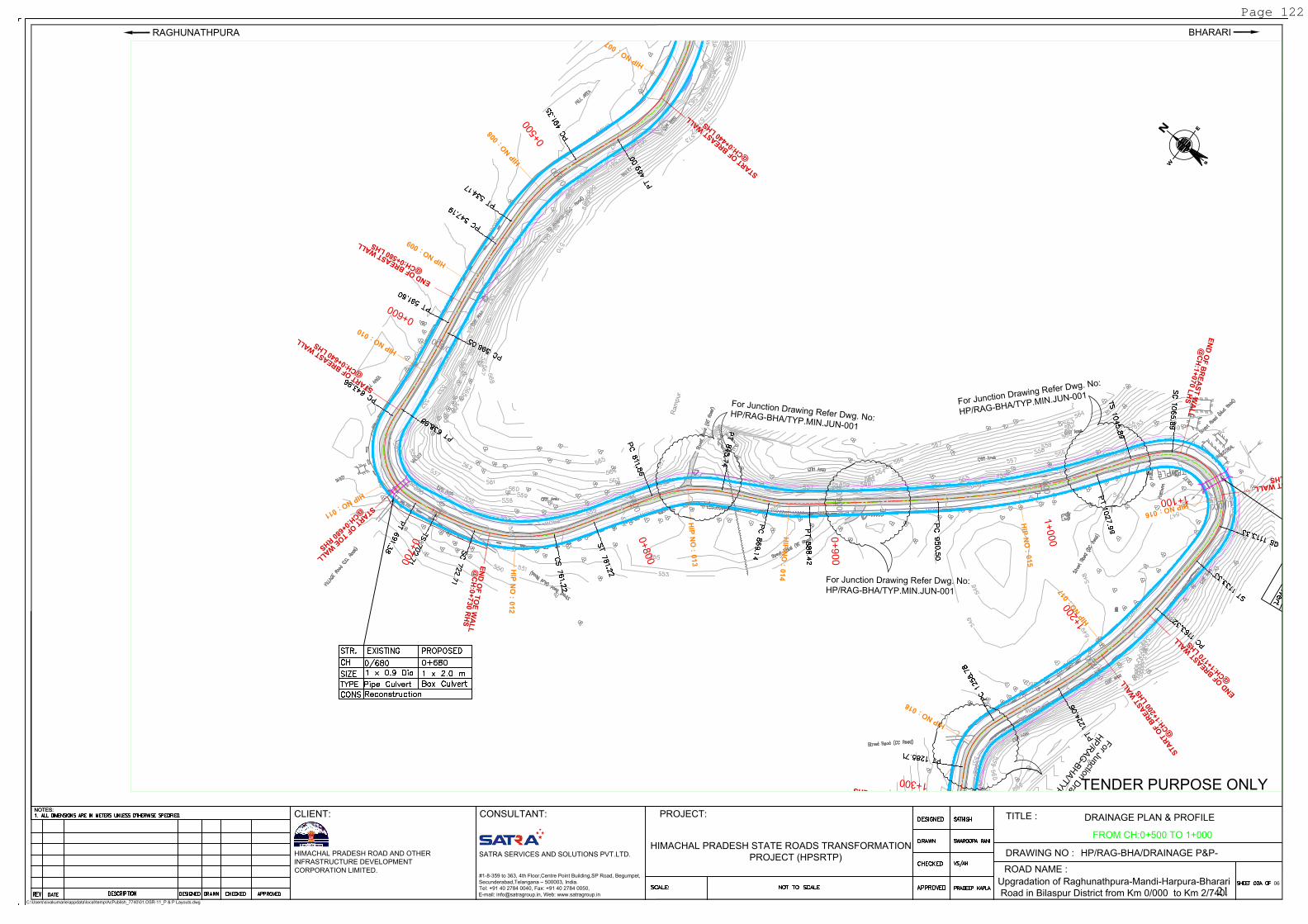
C:\Users\sivakumarie\appdata\local\temp\AcPublish_7740\01.OSR-11_P & P Layouts.dwg
NOTES:
PROJECT:
BHARARI
SATRA SERVICES AND SOLUTIONS PVT.LTD.
HIMACHAL PRADESH ROAD AND OTHER
INFRASTRUCTURE DEVELOPMENT
CORPORATION LIMITED.
DRAINAGE PLAN & PROFILE
TITLE :
DRAWING NO :
06
ROAD NAME :
TENDER PURPOSE ONLY
HP/RAG-BHA/DRAINAGE P&P-
Upgradation of Raghunathpura-Mandi-Harpura-Bharari
Road in Bilaspur District from Km 0/000 to Km 2/740.
RAGHUNATHPURA
CLIENT: CONSULTANT:
#1-8-359 to 363, 4th Floor,Centre Point Building,SP Road, Begumpet,
Secunderabad,Telangana – 500003, India.
Tel: +91 40 2784 0040, Fax: +91 40 2784 0050,
E-mail: [email protected], Web: www.satragroup.in
HIMACHAL PRADESH STATE ROADS TRANSFORMATION
PROJECT (HPSRTP)
FROM CH:0+500 TO 1+000
Page 122
21
VERTICAL SCHEMATIC
HORIZONTAL SCHEMATIC
EXISTING ROAD LEVELS(m)
PROPOSED ROAD LEVELS(m)
GL AT 6.0m LHS (m)
GL AT 6.0m RHS (m)
CROSS SECTION DETAILS
PROPOSED CHAINAGE
SUPERELEVATION
NOTES:
C:\Users\sivakumarie\appdata\local\temp\AcPublish_7740\01.OSR-11_P & P Layouts.dwg
NOTES:
PROJECT:
BHARARI
SATRA SERVICES AND SOLUTIONS PVT.LTD.
HIMACHAL PRADESH ROAD AND OTHER
INFRASTRUCTURE DEVELOPMENT
CORPORATION LIMITED.
DRAINAGE PLAN & PROFILE
TITLE :
DRAWING NO :
06
ROAD NAME :
TENDER PURPOSE ONLY
HP/RAG-BHA/DRAINAGE P&P-
Upgradation of Raghunathpura-Mandi-Harpura-Bharari
Road in Bilaspur District from Km 0/000 to Km 2/740.
RAGHUNATHPURA
CLIENT: CONSULTANT:
#1-8-359 to 363, 4th Floor,Centre Point Building,SP Road, Begumpet,
Secunderabad,Telangana – 500003, India.
Tel: +91 40 2784 0040, Fax: +91 40 2784 0050,
E-mail: [email protected], Web: www.satragroup.in
HIMACHAL PRADESH STATE ROADS TRANSFORMATION
PROJECT (HPSRTP)
DATUM = +536.000
FROM CH:0+500 TO 1+000
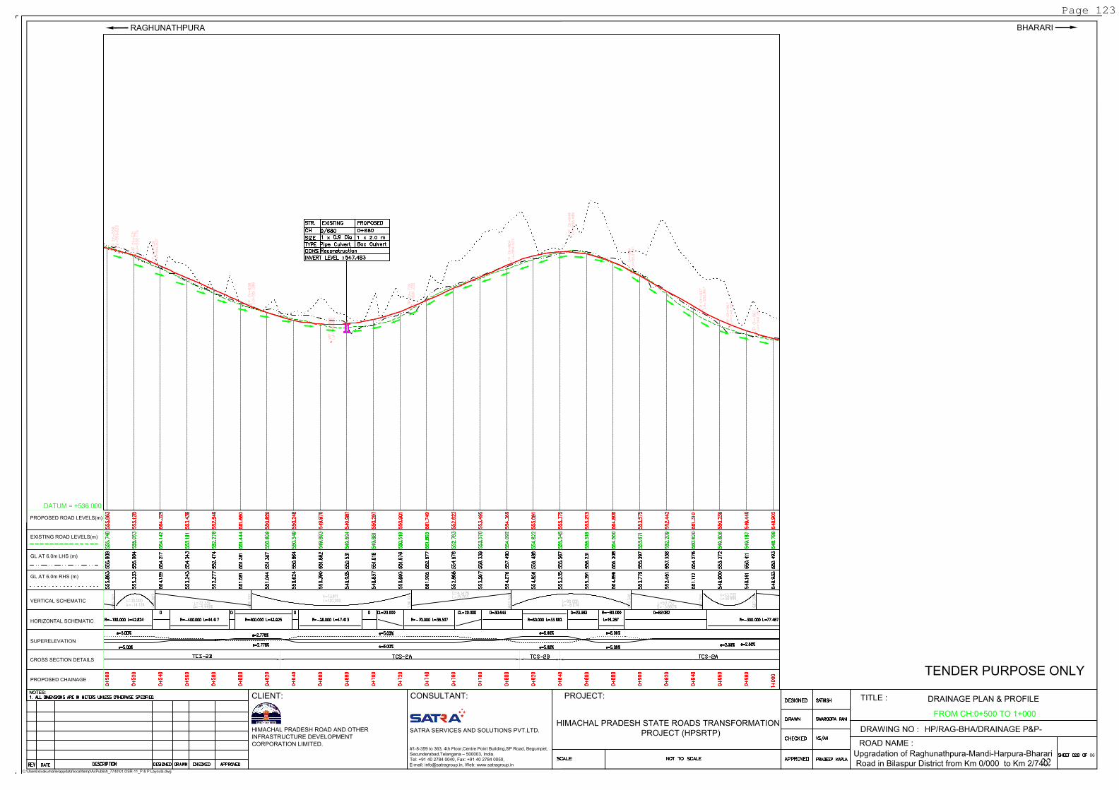
Page 123
22
0
/
9
0
0
1
/
0
0
0
1
/
1
0
0
1
/
2
0
0
1
/
3
0
0
1/400
1/500
1
/6
0
0
1
/
7
0
0
E
R
O
W
E
R
O
W
E
R
O
W
E
R
O
W
E
R
O
W
E
R
O
W
E
R
O
W
E
R
O
W
E
R
O
W
E
R
O
W
E
R
O
W
E
R
O
W
E
R
O
W
E
R
O
W
E
R
O
W
E
R
O
W
E
R
O
W
E
R
O
W
E
R
O
W
E
R
O
W
E
R
O
W
E
R
O
W
E
R
O
W
E
R
O
W
E
R
O
W
E
R
O
W
E
N
s
W
For Junction Drawing Refer Dwg. No:
HP/RAG-BHA/TYP.MIN.JUN-001
H
I
P
N
O
:
0
1
4
H
I
P
N
O
:
0
1
6
HIP
N
O :
019
H
I
P
N
O
:
0
2
0
H
I
P
N
O
:
H
I
P
N
O
:
0
1
3
H
I
P
N
O
:
0
1
5
H
I
P
N
O
:
0
1
7
HIP
N
O :
018
HIP N
O :
021
H
I
P
N
O
:
0
2
2
0
+
8
0
0
0
+
9
0
0
1
+
0
0
0
1
+
1
0
0
1
+
2
0
0
1
+
3
0
0
1+
400
1
+
5
0
0
1
+
6
0
0
F
o
r
J
u
n
c
t
i
o
n
D
r
a
w
i
n
g
R
e
f
e
r
D
w
g
.
N
o
:
H
P
/
R
A
G
-
B
H
A
/
T
Y
P
.
M
I
N
.
J
U
N
-
0
0
1
F
o
r
J
u
n
c
t
i
o
n
D
r
a
w
i
n
g
R
e
f
e
r
D
w
g
.
N
o
:
H
P
/
R
A
G
-
B
H
A
/
T
Y
P
.
M
I
N
.
J
U
N
-
0
0
1
F
o
r
J
u
n
c
t
i
o
n
D
r
a
w
i
n
g
R
e
f
e
r
D
w
g
.
N
o
:
H
P
/
R
A
G
-
B
H
A
/
T
Y
P
.
M
I
N
.
J
U
N
-
0
0
1
For Junctio
n D
raw
ing R
efer D
w
g. N
o:
H
P
/R
A
G
-B
H
A
/T
Y
P
.M
IN
.JU
N
-001
E
N
D
O
F
B
R
E
A
S
T
W
A
L
L
@
C
H
:
1
+
0
7
0
L
H
S
E
N
D
O
F
B
R
E
A
S
T
W
A
L
L
@
C
H
:1
+
1
7
0
L
H
S
E
N
D
O
F
B
R
E
A
S
T
W
A
L
L
@
C
H
:
1
+
3
1
0
L
H
S
E
N
D
O
F
B
R
E
A
S
T
W
A
L
L
@
C
H
:
1
+
5
6
0
L
H
S
S
T
A
R
T
O
F
B
R
E
A
S
T
W
A
L
L
@
C
H
:
1
+
1
0
0
L
H
S
S
T
A
R
T
O
F
B
R
E
A
S
T
W
A
L
L
@
C
H
:
1
+
2
0
0
L
H
S
S
T
A
R
T
O
F
B
R
E
A
S
T
W
A
L
L
@
C
H
:1
+
3
8
0
L
H
S
S
T
A
R
T
O
F
B
R
E
A
S
T
W
A
L
L
B
U
S
S
T
O
P
S
T
A
R
T
O
F
T
O
E
W
A
L
L
@
C
H
:
1
+
4
7
0
R
H
S
E
N
D
O
F
T
O
E
W
A
L
L
@
C
H
:
1
+
6
6
0
R
H
S
NOTES:
C:\Users\sivakumarie\appdata\local\temp\AcPublish_7740\01.OSR-11_P & P Layouts.dwg
NOTES:
PROJECT:
BHARARI
SATRA SERVICES AND SOLUTIONS PVT.LTD.
HIMACHAL PRADESH ROAD AND OTHER
INFRASTRUCTURE DEVELOPMENT
CORPORATION LIMITED.
DRAINAGE PLAN & PROFILE
TITLE :
DRAWING NO :
06
ROAD NAME :
TENDER PURPOSE ONLY
HP/RAG-BHA/DRAINAGE P&P-
Upgradation of Raghunathpura-Mandi-Harpura-Bharari
Road in Bilaspur District from Km 0/000 to Km 2/740.
RAGHUNATHPURA
CLIENT: CONSULTANT:
#1-8-359 to 363, 4th Floor,Centre Point Building,SP Road, Begumpet,
Secunderabad,Telangana – 500003, India.
Tel: +91 40 2784 0040, Fax: +91 40 2784 0050,
E-mail: [email protected], Web: www.satragroup.in
HIMACHAL PRADESH STATE ROADS TRANSFORMATION
PROJECT (HPSRTP)
FROM CH:1+000 TO 1+500
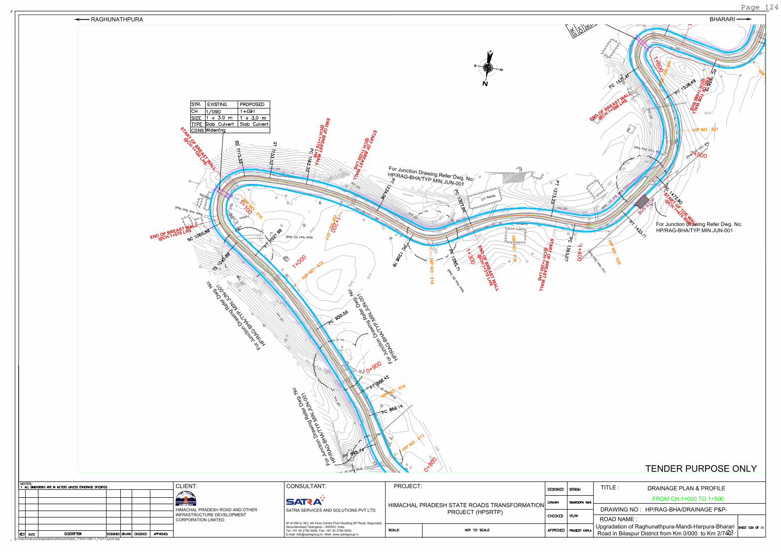
Page 124
23
VERTICAL SCHEMATIC
HORIZONTAL SCHEMATIC
EXISTING ROAD LEVELS(m)
PROPOSED ROAD LEVELS(m)
GL AT 6.0m LHS (m)
GL AT 6.0m RHS (m)
CROSS SECTION DETAILS
PROPOSED CHAINAGE
SUPERELEVATION
NOTES:
C:\Users\sivakumarie\appdata\local\temp\AcPublish_7740\01.OSR-11_P & P Layouts.dwg
NOTES:
PROJECT:
BHARARI
SATRA SERVICES AND SOLUTIONS PVT.LTD.
HIMACHAL PRADESH ROAD AND OTHER
INFRASTRUCTURE DEVELOPMENT
CORPORATION LIMITED.
DRAINAGE PLAN & PROFILE
TITLE :
DRAWING NO :
06
ROAD NAME :
TENDER PURPOSE ONLY
HP/RAG-BHA/DRAINAGE P&P-
Upgradation of Raghunathpura-Mandi-Harpura-Bharari
Road in Bilaspur District from Km 0/000 to Km 2/740.
RAGHUNATHPURA
CLIENT: CONSULTANT:
#1-8-359 to 363, 4th Floor,Centre Point Building,SP Road, Begumpet,
Secunderabad,Telangana – 500003, India.
Tel: +91 40 2784 0040, Fax: +91 40 2784 0050,
E-mail: [email protected], Web: www.satragroup.in
HIMACHAL PRADESH STATE ROADS TRANSFORMATION
PROJECT (HPSRTP)
DATUM = +531.000
FROM CH:1+000 TO 1+500
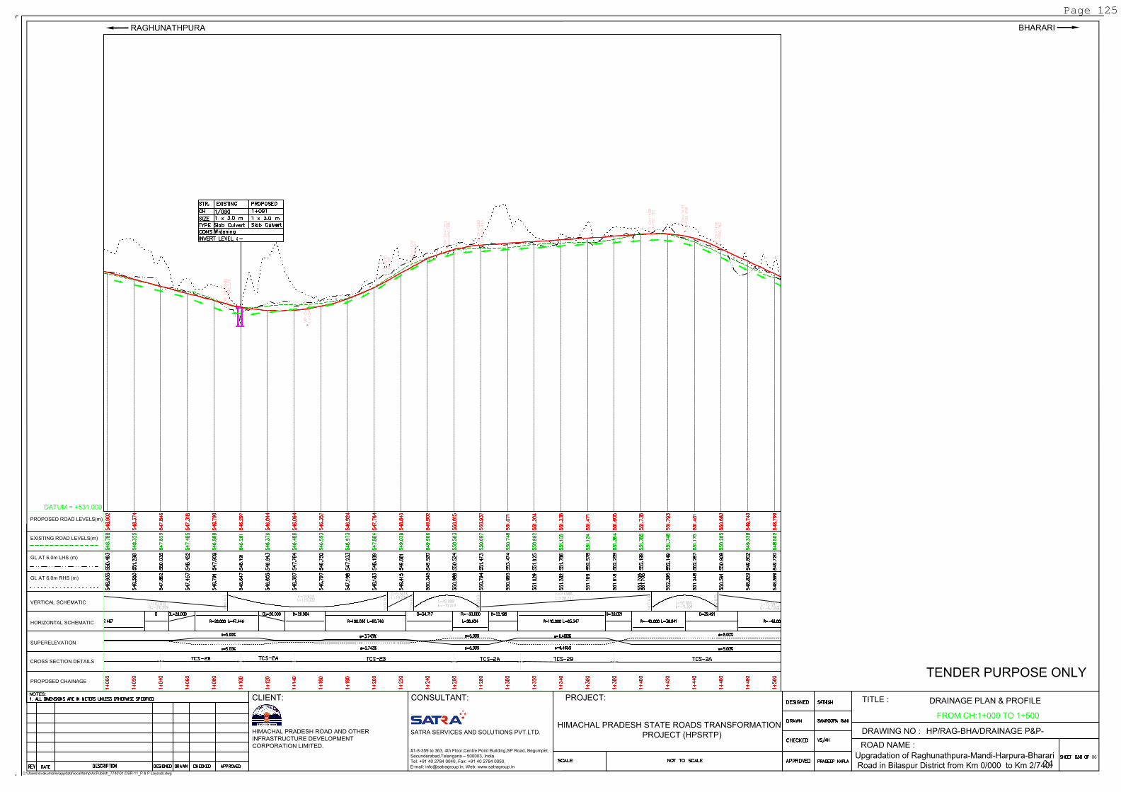
Page 125
24
R
S
1
/
4
0
0
1
/
5
0
0
1
/6
0
0
1
/
7
0
0
1
/
8
0
0
1
/9
0
0
2
/
0
0
0
2
/
1
0
0
2
/
2
0
0
2
/
3
0
0
E
R
O
W
E
R
O
W
E
R
O
W
E
R
O
W
E
R
O
W
E
R
O
W
E
R
O
W
E
R
O
W
EROW
EROW
E
R
O
W
E
R
O
W
E
R
O
W
E
R
O
W
E
R
O
W
E
R
O
W
E
R
O
W
E
R
O
W
E
R
O
W
E
R
O
W
E
R
O
W
E
R
O
W
EROW
E
R
O
W
E
R
O
W
E
R
O
W
E
R
O
W
E
R
O
W
EN
sW
F
o
r
J
u
n
c
t
i
o
n
D
r
a
w
i
n
g
R
e
f
e
r
D
w
g
.
N
o
:
H
P
/
R
A
G
-
B
H
A
/
T
Y
P
.
M
I
N
.
J
U
N
-
0
0
1
F
o
r
J
u
n
c
t
i
o
n
D
r
a
w
i
n
g
R
e
f
e
r
D
w
g
.
N
o
:
H
P
/
R
A
G
-
B
H
A
/
T
Y
P
.
M
I
N
.
J
U
N
-
0
0
1
H
IP
N
O
:
020
H
I
P
N
O
:
0
2
4
H
IP
N
O
:
0
2
7
H
IP
N
O
:
0
2
3
H
IP
N
O
:
0
2
8
H
I
P
N
O
:
0
3
0
H
I
P
N
O
:
0
2
1
H
I
P
N
O
:
0
2
2
HIP
N
O :
025
H
I
P
N
O
:
0
2
6
HIP
N
O :
029
H
I
P
N
O
:
0
3
1
H
I
P
N
O
:
0
3
2
H
I
P
N
O
:
0
3
3
H
I
P
N
O
:
0
3
4
1
+
4
0
0
1
+
5
0
0
1+
600
1
+
7
0
0
1
+
8
0
0
1
+
9
0
0
2
+
0
0
0
2
+
1
0
0
2
+
2
0
0
2
+
3
0
0
EN
D O
F B
RE
AS
T W
AL
L
@C
H:1+
560 L
HS
E
N
D
O
F
B
R
E
A
S
T
W
A
L
L
@
C
H
:
1
+
8
4
0
L
H
S
E
N
D
O
F
B
R
E
A
S
T
W
A
L
L
@
C
H
:
1
+
9
9
0
L
H
S
S
T
A
R
T
O
F
B
R
E
A
S
T
W
A
L
L
@
C
H
:
1
+
6
3
0
L
H
S
ST
AR
T O
F B
RE
AS
T W
AL
L
@C
H:1+
960 L
HS
S
T
A
R
T
O
F
B
R
E
A
S
T
W
A
L
L
@
C
H
:
2
+
1
7
0
L
H
S
B
U
S
S
T
O
P
S
T
A
R
T
O
F
T
O
E
W
A
L
L
@
C
H
:
1
+
4
7
0
R
H
S
S
T
A
R
T
O
F
T
O
E
W
A
L
L
@
C
H
:
2
+
0
1
0
R
H
S
E
N
D
O
F
T
O
E
W
A
L
L
@
C
H
:
1
+
6
6
0
R
H
S
E
N
D
O
F
T
O
E
W
A
L
L
@
C
H
:
2
+
0
5
0
R
H
S
NOTES:
C:\Users\sivakumarie\appdata\local\temp\AcPublish_7740\01.OSR-11_P & P Layouts.dwg
NOTES:
PROJECT:
BHARARI
SATRA SERVICES AND SOLUTIONS PVT.LTD.
HIMACHAL PRADESH ROAD AND OTHER
INFRASTRUCTURE DEVELOPMENT
CORPORATION LIMITED.
DRAINAGE PLAN & PROFILE
TITLE :
DRAWING NO :
06
ROAD NAME :
TENDER PURPOSE ONLY
HP/RAG-BHA/DRAINAGE P&P-
Upgradation of Raghunathpura-Mandi-Harpura-Bharari
Road in Bilaspur District from Km 0/000 to Km 2/740.
RAGHUNATHPURA
CLIENT: CONSULTANT:
#1-8-359 to 363, 4th Floor,Centre Point Building,SP Road, Begumpet,
Secunderabad,Telangana – 500003, India.
Tel: +91 40 2784 0040, Fax: +91 40 2784 0050,
E-mail: [email protected], Web: www.satragroup.in
HIMACHAL PRADESH STATE ROADS TRANSFORMATION
PROJECT (HPSRTP)
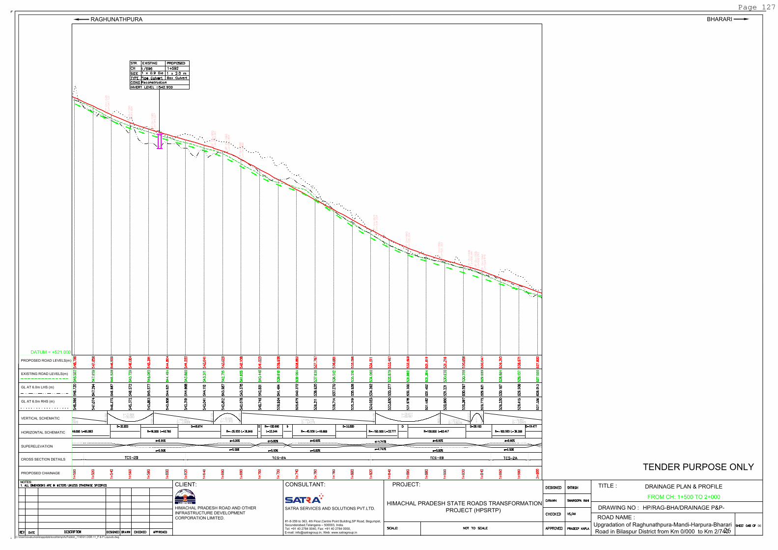
FROM CH: 1+500 TO 2+000
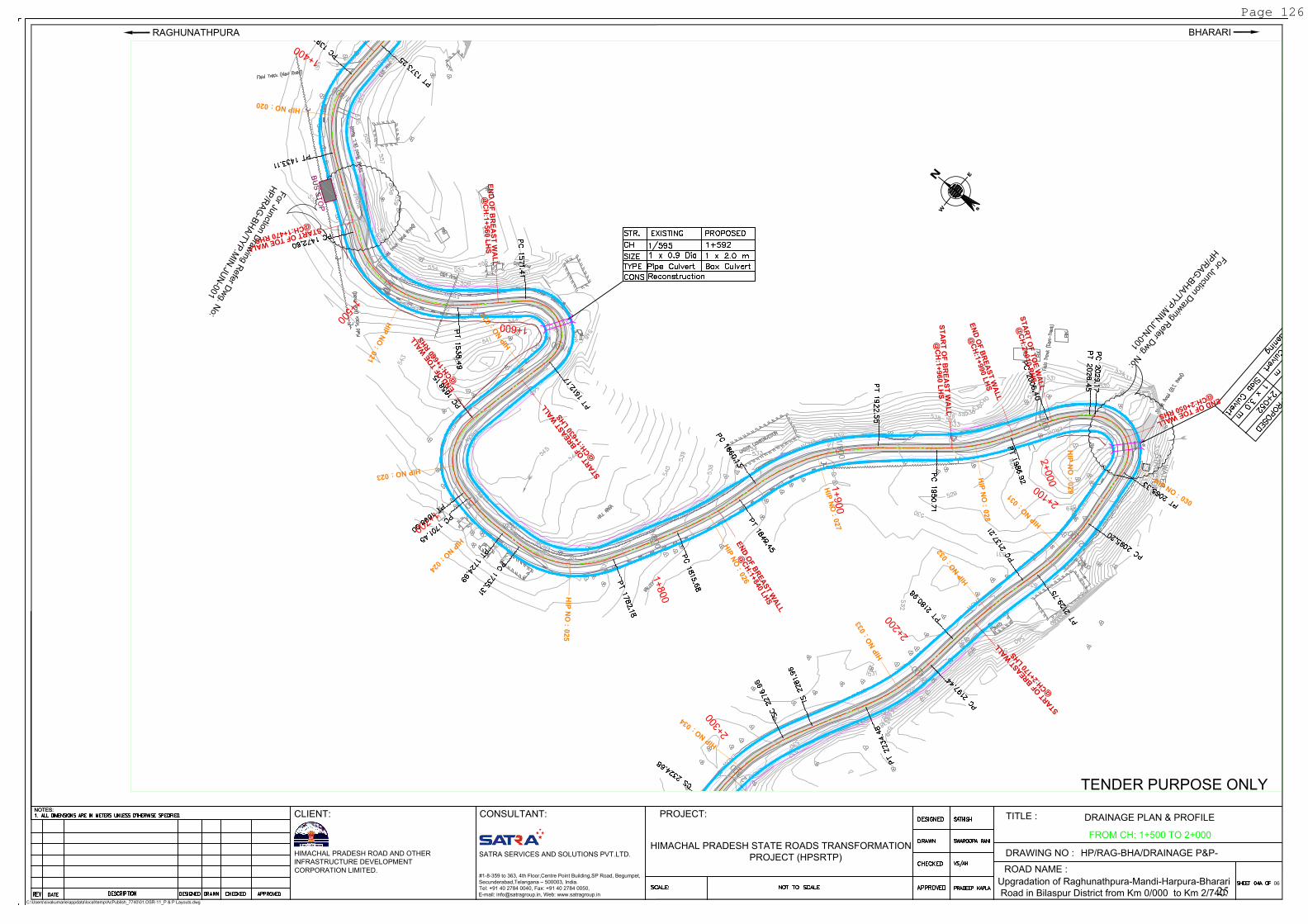
Page 126
25
VERTICAL SCHEMATIC
HORIZONTAL SCHEMATIC
EXISTING ROAD LEVELS(m)
PROPOSED ROAD LEVELS(m)
GL AT 6.0m LHS (m)
GL AT 6.0m RHS (m)
CROSS SECTION DETAILS
PROPOSED CHAINAGE
SUPERELEVATION
NOTES:
C:\Users\sivakumarie\appdata\local\temp\AcPublish_7740\01.OSR-11_P & P Layouts.dwg
NOTES:
PROJECT:
BHARARI
SATRA SERVICES AND SOLUTIONS PVT.LTD.
HIMACHAL PRADESH ROAD AND OTHER
INFRASTRUCTURE DEVELOPMENT
CORPORATION LIMITED.
DRAINAGE PLAN & PROFILE
TITLE :
DRAWING NO :
06
ROAD NAME :
TENDER PURPOSE ONLY
HP/RAG-BHA/DRAINAGE P&P-
Upgradation of Raghunathpura-Mandi-Harpura-Bharari
Road in Bilaspur District from Km 0/000 to Km 2/740.
RAGHUNATHPURA
CLIENT: CONSULTANT:
#1-8-359 to 363, 4th Floor,Centre Point Building,SP Road, Begumpet,
Secunderabad,Telangana – 500003, India.
Tel: +91 40 2784 0040, Fax: +91 40 2784 0050,
E-mail: [email protected], Web: www.satragroup.in
HIMACHAL PRADESH STATE ROADS TRANSFORMATION
PROJECT (HPSRTP)
DATUM = +521.000
FROM CH: 1+500 TO 2+000
Page 127
26
RS
M
a
n
d
i
M
a
n
d
i
1
/
8
0
0
1
/
9
0
0
2
/
0
0
0
2/100
2/200
2/300
2
/
4
0
0
2
/5
0
0
2
/
6
0
0
E
R
O
W
E
R
O
W
E
R
O
W
E
R
O
W
E
R
O
W
E
R
O
W
E
R
O
W
E
R
O
W
E
R
O
W
E
R
O
W
E
R
O
W
E
R
O
W
E
R
O
W
ER
OW
E
R
O
W
E
R
O
W
E
R
O
W
E
R
O
W
ER
O
W
E
R
O
W
E
R
O
W
E
R
O
W
E
R
O
W
ER
OW
E
R
O
W
E
R
O
W
E
N
s
W
For Junction Drawing Refer Dwg. No:
HP/RAG-BHA/TYP.MIN.JUN-001
H
I
P
N
O
:
0
2
7
H
I
P
N
O
:
0
2
8
H
IP
N
O
:
030
H
I
P
N
O
:
0
2
5
H
I
P
N
O
:
0
2
6
H
I
P
N
O
:
0
2
9
HIP
N
O :
031
H
IP
N
O
:
0
3
2
H
IP
N
O
:
0
3
3
HIP
N
O :
034
H
IP
N
O
:
035
H
IP
N
O
:
0
3
6
H
I
P
N
O
:
0
3
7
1
+
8
0
0
1
+
9
0
0
2
+
0
0
0
2+
100
2+
200
2
+
3
0
0
2
+
4
0
0
2+
500
2
+
6
0
0F
o
r
J
u
n
c
t
i
o
n
D
r
a
w
i
n
g
R
e
f
e
r
D
w
g
.
N
o
:
H
P
/
R
A
G
-
B
H
A
/
M
A
J
.
J
U
N
-
0
0
2
F
o
r
J
u
n
c
t
io
n
D
r
a
w
in
g
R
e
f
e
r
D
w
g
.
N
o
:
H
P
/
R
A
G
-
B
H
A
/
T
Y
P
.
M
I
N
.
J
U
N
-
0
0
1
V
I
E
W
P
O
I
N
T
L
O
C
A
T
I
O
N
E
N
D
O
F
B
R
E
A
S
T
W
A
L
L
@
C
H
:
1
+
8
4
0
L
H
S
E
N
D
O
F
B
R
E
A
S
T
W
A
L
L
@
C
H
:
1
+
9
9
0
L
H
S
EN
D O
F B
RE
AS
T W
AL
L
@C
H:2+
310 L
HS
S
T
A
R
T
O
F
B
R
E
A
S
T
W
A
L
L
@
C
H
:1
+
6
3
0
L
H
S
S
T
A
R
T
O
F
B
R
E
A
S
T
W
A
L
L
@
C
H
:
1
+
9
6
0
L
H
S
ST
A
R
T O
F B
R
EA
ST
W
A
LL
@
C
H
:2+
170 L
H
S
S
T
A
R
T
O
F
T
O
E
W
A
L
L
@
C
H
:
2
+
0
1
0
R
H
S
E
N
D
O
F
T
O
E
W
A
L
L
@
C
H
:
2
+
0
5
0
R
H
S
NOTES:
C:\Users\sivakumarie\appdata\local\temp\AcPublish_7740\01.OSR-11_P & P Layouts.dwg
NOTES:
PROJECT:
BHARARI
SATRA SERVICES AND SOLUTIONS PVT.LTD.
HIMACHAL PRADESH ROAD AND OTHER
INFRASTRUCTURE DEVELOPMENT
CORPORATION LIMITED.
DRAINAGE PLAN & PROFILE
TITLE :
DRAWING NO :
06
ROAD NAME :
TENDER PURPOSE ONLY
HP/RAG-BHA/DRAINAGE P&P-
Upgradation of Raghunathpura-Mandi-Harpura-Bharari
Road in Bilaspur District from Km 0/000 to Km 2/740.
RAGHUNATHPURA
CLIENT: CONSULTANT:
#1-8-359 to 363, 4th Floor,Centre Point Building,SP Road, Begumpet,
Secunderabad,Telangana – 500003, India.
Tel: +91 40 2784 0040, Fax: +91 40 2784 0050,
E-mail: [email protected], Web: www.satragroup.in
HIMACHAL PRADESH STATE ROADS TRANSFORMATION
PROJECT (HPSRTP)
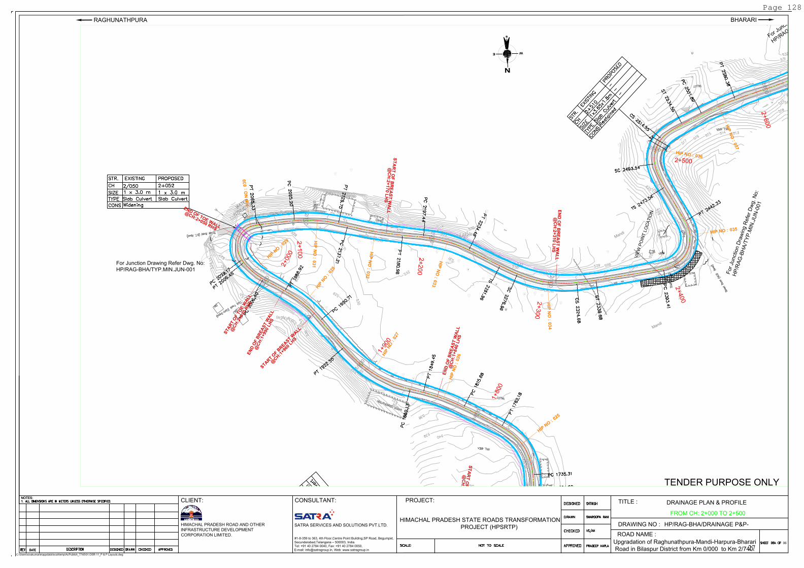
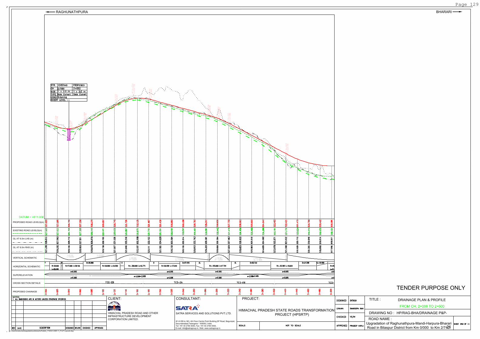
FROM CH: 2+000 TO 2+500
Page 128
27
VERTICAL SCHEMATIC
HORIZONTAL SCHEMATIC
EXISTING ROAD LEVELS(m)
PROPOSED ROAD LEVELS(m)
GL AT 6.0m LHS (m)
GL AT 6.0m RHS (m)
CROSS SECTION DETAILS
PROPOSED CHAINAGE
SUPERELEVATION
NOTES:
C:\Users\sivakumarie\appdata\local\temp\AcPublish_7740\01.OSR-11_P & P Layouts.dwg
NOTES:
PROJECT:
BHARARI
SATRA SERVICES AND SOLUTIONS PVT.LTD.
HIMACHAL PRADESH ROAD AND OTHER
INFRASTRUCTURE DEVELOPMENT
CORPORATION LIMITED.
DRAINAGE PLAN & PROFILE
TITLE :
DRAWING NO :
06
ROAD NAME :
TENDER PURPOSE ONLY
HP/RAG-BHA/DRAINAGE P&P-
Upgradation of Raghunathpura-Mandi-Harpura-Bharari
Road in Bilaspur District from Km 0/000 to Km 2/740.
RAGHUNATHPURA
CLIENT: CONSULTANT:
#1-8-359 to 363, 4th Floor,Centre Point Building,SP Road, Begumpet,
Secunderabad,Telangana – 500003, India.
Tel: +91 40 2784 0040, Fax: +91 40 2784 0050,
E-mail: [email protected], Web: www.satragroup.in
HIMACHAL PRADESH STATE ROADS TRANSFORMATION
PROJECT (HPSRTP)
DATUM = +511.000
FROM CH: 2+000 TO 2+500
Page 129
28
R
S
Mandi
Mandi
2
/4
0
0
2
/
5
0
0
2
/6
0
0
2/700
2/728
T
o
N
a
u
n
i
T
o
B
h
a
r
a
r
i
E
R
O
W
E
R
O
W
E
R
O
W
E
R
O
W
E
R
O
W
E
R
O
W
E
R
O
W
E
R
O
W
E
R
O
W
E
R
O
W
E
N
s
W
HIP
N
O :
038
H
IP
N
O
:
0
3
9
H
I
P
N
O
:
0
3
5
H
I
P
N
O
:
0
3
6
H
IP
N
O
:
037
2+
400
2
+
5
0
0
2
+
6
0
0
2+
700
For
Junctio
n D
raw
ing R
efe
r D
wg. N
o:
HP
/RA
G-B
HA
/MA
J.JU
N-0
02
F
o
r
J
u
n
c
t
i
o
n
D
r
a
w
i
n
g
R
e
f
e
r
D
w
g
.
N
o
:
H
P
/
R
A
G
-
B
H
A
/
T
Y
P
.
M
I
N
.
J
U
N
-
0
0
1
V
I
E
W
P
O
I
N
T
L
O
C
A
T
I
O
N
E
N
D
O
F
B
R
E
A
S
T
W
A
L
L
@
C
H
:
2
+
3
1
0
L
H
S
S
T
A
R
T
O
F
B
R
E
A
S
T
W
A
L
L
@
C
H
:2
+
6
7
0
L
H
S
B
U
S
S
T
O
P
NOTES:
C:\Users\sivakumarie\appdata\local\temp\AcPublish_7740\01.OSR-11_P & P Layouts.dwg
NOTES:
PROJECT:
BHARARI
SATRA SERVICES AND SOLUTIONS PVT.LTD.
HIMACHAL PRADESH ROAD AND OTHER
INFRASTRUCTURE DEVELOPMENT
CORPORATION LIMITED.
DRAINAGE PLAN & PROFILE
TITLE :
DRAWING NO :
06
ROAD NAME :
TENDER PURPOSE ONLY
HP/RAG-BHA/DRAINAGE P&P-
Upgradation of Raghunathpura-Mandi-Harpura-Bharari
Road in Bilaspur District from Km 0/000 to Km 2/740.
RAGHUNATHPURA
CLIENT: CONSULTANT:
#1-8-359 to 363, 4th Floor,Centre Point Building,SP Road, Begumpet,
Secunderabad,Telangana – 500003, India.
Tel: +91 40 2784 0040, Fax: +91 40 2784 0050,
E-mail: [email protected], Web: www.satragroup.in
HIMACHAL PRADESH STATE ROADS TRANSFORMATION
PROJECT (HPSRTP)
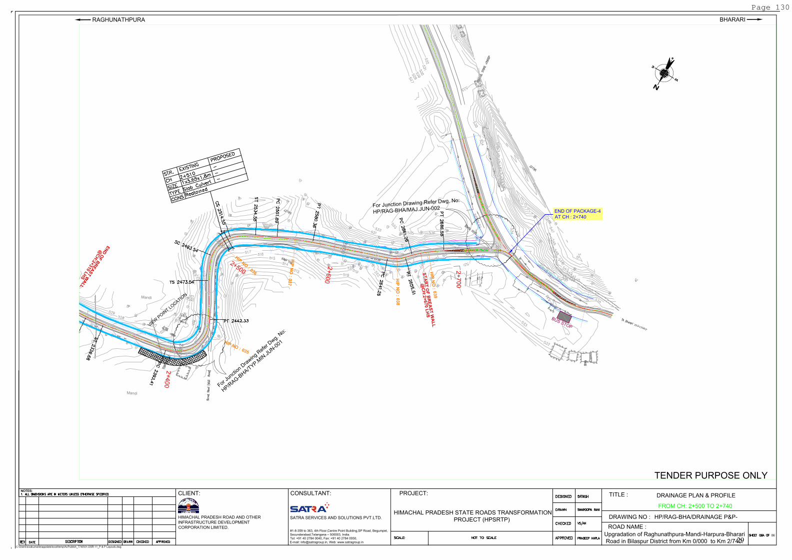
FROM CH: 2+500 TO 2+740
END OF PACKAGE-4
AT CH : 2+740
Page 130
29
VERTICAL SCHEMATIC
HORIZONTAL SCHEMATIC
EXISTING ROAD LEVELS(m)
PROPOSED ROAD LEVELS(m)
GL AT 6.0m LHS (m)
GL AT 6.0m RHS (m)
CROSS SECTION DETAILS
PROPOSED CHAINAGE
SUPERELEVATION
NOTES:
C:\Users\sivakumarie\appdata\local\temp\AcPublish_7740\01.OSR-11_P & P Layouts.dwg
NOTES:
PROJECT:
BHARARI
SATRA SERVICES AND SOLUTIONS PVT.LTD.
HIMACHAL PRADESH ROAD AND OTHER
INFRASTRUCTURE DEVELOPMENT
CORPORATION LIMITED.
DRAINAGE PLAN & PROFILE
TITLE :
DRAWING NO :
06
ROAD NAME :
TENDER PURPOSE ONLY
HP/RAG-BHA/DRAINAGE P&P-
Upgradation of Raghunathpura-Mandi-Harpura-Bharari
Road in Bilaspur District from Km 0/000 to Km 2/740.
RAGHUNATHPURA
CLIENT: CONSULTANT:
#1-8-359 to 363, 4th Floor,Centre Point Building,SP Road, Begumpet,
Secunderabad,Telangana – 500003, India.
Tel: +91 40 2784 0040, Fax: +91 40 2784 0050,
E-mail: [email protected], Web: www.satragroup.in
HIMACHAL PRADESH STATE ROADS TRANSFORMATION
PROJECT (HPSRTP)
DATUM = +511.000
FROM CH: 2+500 TO 2+740
Page 131
30
APPENDIX-2
ERoW and Proposed Corridor of Improvement of
Project Road
31
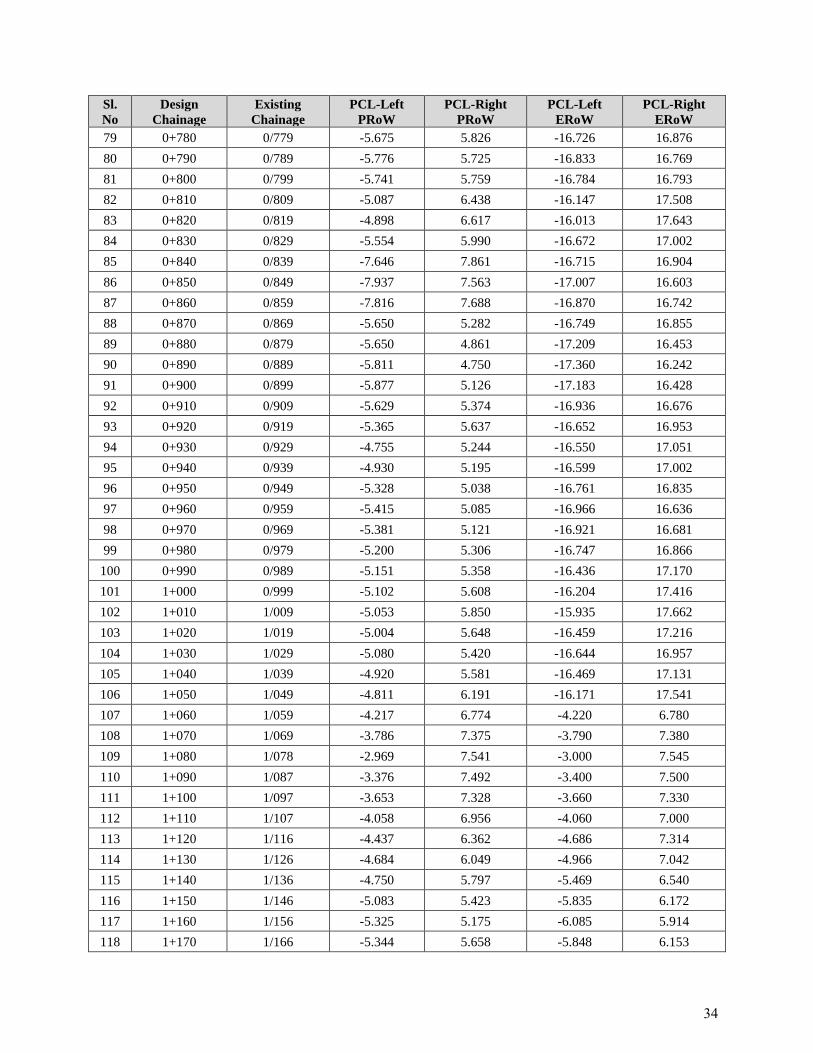
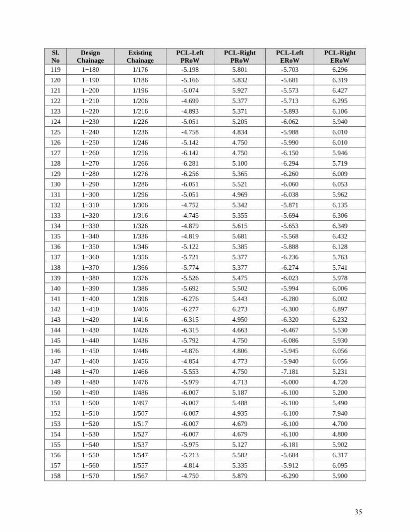
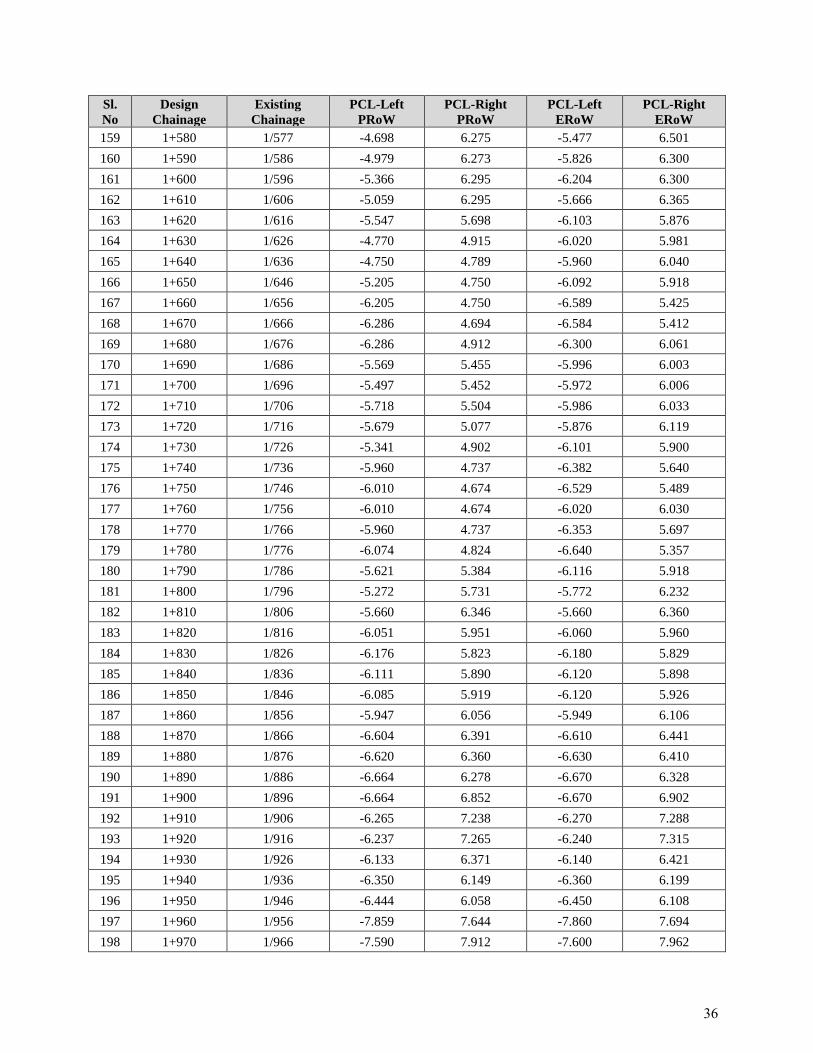
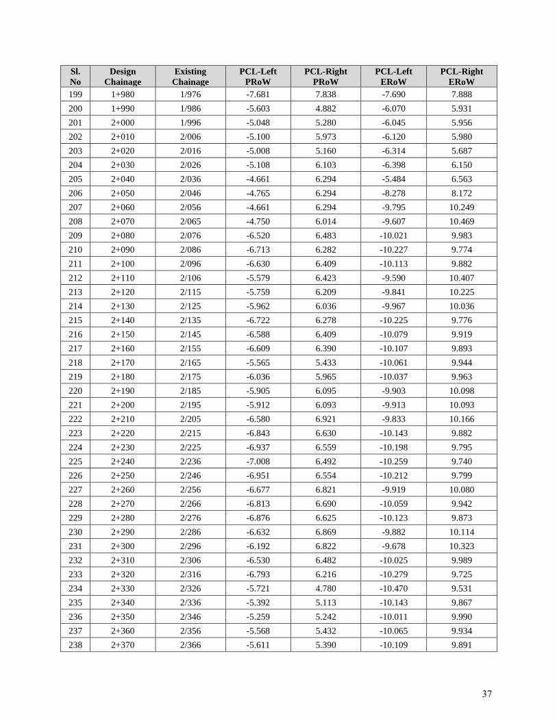
Appendix-2 ERoW and Proposed Corridor of Improvement of Project Road
Sl.
No
Design
Chainage
Existing
Chainage
PCL-Left
PRoW
PCL-Right
PRoW
PCL-Left
ERoW
PCL-Right
ERoW
1 0+000 0/000 -9.214 5.916 -9.300 5.920
2 0+010 0/009 -9.214 5.916 -9.300 5.920
3 0+020 0/019 -9.214 5.178 -9.300 5.907
4 0+030 0/029 -9.214 5.005 -9.300 6.002
5 0+040 0/039 -4.998 5.019 -5.963 6.037
6 0+050 0/049 -5.000 5.050 -5.933 6.066
7 0+060 0/059 -5.000 4.373 -5.974 6.026
8 0+070 0/069 -5.000 4.350 -6.095 5.905
9 0+080 0/079 -5.000 4.350 -6.007 5.991
10 0+090 0/089 -5.000 4.350 -6.082 5.918
11 0+100 0/099 -5.323 4.378 -5.961 6.039
12 0+110 0/109 -5.658 4.344 -6.091 5.909
13 0+120 0/119 -5.942 4.062 -6.407 5.599
14 0+130 0/129 -6.238 3.766 -6.748 5.261
15 0+140 0/138 -6.522 3.476 -6.605 5.406
16 0+150 0/148 -7.828 3.674 -7.830 5.670
17 0+160 0/159 -7.921 3.579 -8.193 3.786
18 0+170 0/169 -8.071 3.424 -8.374 3.645
19 0+180 0/179 -6.611 3.219 -8.132 3.869
20 0+190 0/189 -6.217 3.473 -7.720 4.294
21 0+200 0/199 -5.817 4.047 -7.120 4.943
22 0+210 0/209 -6.843 5.661 -6.900 5.670
23 0+220 0/219 -6.648 5.853 -6.700 5.860
24 0+230 0/229 -6.395 6.107 -6.400 6.150
25 0+240 0/239 -7.570 7.433 -7.580 7.450
26 0+250 0/249 -7.660 7.340 -7.670 7.350
27 0+260 0/259 -7.748 7.251 -7.750 7.260
28 0+270 0/269 -8.135 7.361 -8.140 7.370
29 0+280 0/279 -8.212 7.279 -8.250 7.280
30 0+290 0/289 -8.292 7.206 -8.300 7.210
31 0+300 0/299 -8.231 7.266 -8.250 7.270
32 0+310 0/309 -7.997 7.504 -8.000 7.510
33 0+320 0/319 -7.843 7.650 -7.850 7.800
34 0+330 0/329 -6.492 6.009 -15.836 14.912
35 0+340 0/339 -6.604 5.896 -17.160 16.440
36 0+350 0/349 -6.642 5.858 -17.194 16.407
37 0+360 0/359 -6.917 6.081 -17.201 16.398
38 0+370 0/369 -7.083 5.920 -17.408 16.201
32
Sl.
No
Design
Chainage
Existing
Chainage
PCL-Left
PRoW
PCL-Right
PRoW
PCL-Left
ERoW
PCL-Right
ERoW
39 0+380 0/379 -6.996 6.010 -17.312 16.302
40 0+390 0/389 -8.852 8.653 -16.921 16.686
41 0+400 0/399 -8.323 9.182 -16.407 17.202
42 0+410 0/409 -8.362 9.132 -16.457 17.137
43 0+420 0/419 -10.008 10.961 -16.391 17.212
44 0+430 0/429 -10.266 10.798 -16.575 17.125
45 0+440 0/439 -11.881 9.483 -18.252 15.935
46 0+450 0/449 -8.212 5.780 -18.134 15.613
47 0+460 0/459 -7.495 6.499 -17.440 16.369
48 0+470 0/469 -7.032 6.968 -16.833 16.767
49 0+480 0/479 -6.323 6.178 -16.871 16.729
50 0+490 0/489 -6.383 6.117 -16.930 16.670
51 0+500 0/499 -6.269 6.235 -16.784 16.812
52 0+510 0/509 -6.028 6.475 -16.543 17.045
53 0+520 0/519 -6.270 6.230 -16.810 16.780
54 0+530 0/529 -6.471 6.025 -17.010 16.595
55 0+540 0/539 -6.589 6.412 -16.896 16.711
56 0+550 0/549 -6.529 6.471 -16.836 16.767
57 0+560 0/559 -6.466 6.534 -16.762 16.838
58 0+570 0/569 -5.116 5.386 -16.657 16.951
59 0+580 0/579 -5.198 5.302 -16.742 16.857
60 0+590 0/589 -5.287 5.213 -16.831 16.768
61 0+600 0/599 -6.773 6.726 -16.835 16.766
62 0+610 0/609 -6.661 6.838 -16.698 16.903
63 0+620 0/619 -6.751 6.751 -16.804 16.805
64 0+630 0/629 -7.099 6.901 -16.941 16.657
65 0+640 0/639 -7.175 6.833 -16.998 16.645
66 0+650 0/649 -7.164 6.919 -16.986 16.779
67 0+660 0/659 -6.250 5.883 -16.381 17.222
68 0+670 0/669 -6.250 5.573 -16.677 17.055
69 0+680 0/679 -6.250 5.124 -17.176 16.524
70 0+690 0/689 -6.250 4.750 -17.277 16.413
71 0+700 0/699 -5.388 5.332 -16.461 17.147
72 0+710 0/709 -5.078 5.048 -16.782 16.867
73 0+720 0/719 -5.868 5.629 -16.910 16.709
74 0+730 0/729 -5.896 5.604 -16.944 16.663
75 0+740 0/739 -5.834 5.634 -16.873 16.764
76 0+750 0/749 -5.650 5.604 -16.691 16.945
77 0+760 0/759 -5.650 5.770 -16.518 17.080
78 0+770 0/769 -5.257 5.743 -16.540 17.058
33
Sl.
No
Design
Chainage
Existing
Chainage
PCL-Left
PRoW
PCL-Right
PRoW
PCL-Left
ERoW
PCL-Right
ERoW
79 0+780 0/779 -5.675 5.826 -16.726 16.876
80 0+790 0/789 -5.776 5.725 -16.833 16.769
81 0+800 0/799 -5.741 5.759 -16.784 16.793
82 0+810 0/809 -5.087 6.438 -16.147 17.508
83 0+820 0/819 -4.898 6.617 -16.013 17.643
84 0+830 0/829 -5.554 5.990 -16.672 17.002
85 0+840 0/839 -7.646 7.861 -16.715 16.904
86 0+850 0/849 -7.937 7.563 -17.007 16.603
87 0+860 0/859 -7.816 7.688 -16.870 16.742
88 0+870 0/869 -5.650 5.282 -16.749 16.855
89 0+880 0/879 -5.650 4.861 -17.209 16.453
90 0+890 0/889 -5.811 4.750 -17.360 16.242
91 0+900 0/899 -5.877 5.126 -17.183 16.428
92 0+910 0/909 -5.629 5.374 -16.936 16.676
93 0+920 0/919 -5.365 5.637 -16.652 16.953
94 0+930 0/929 -4.755 5.244 -16.550 17.051
95 0+940 0/939 -4.930 5.195 -16.599 17.002
96 0+950 0/949 -5.328 5.038 -16.761 16.835
97 0+960 0/959 -5.415 5.085 -16.966 16.636
98 0+970 0/969 -5.381 5.121 -16.921 16.681
99 0+980 0/979 -5.200 5.306 -16.747 16.866
100 0+990 0/989 -5.151 5.358 -16.436 17.170
101 1+000 0/999 -5.102 5.608 -16.204 17.416
102 1+010 1/009 -5.053 5.850 -15.935 17.662
103 1+020 1/019 -5.004 5.648 -16.459 17.216
104 1+030 1/029 -5.080 5.420 -16.644 16.957
105 1+040 1/039 -4.920 5.581 -16.469 17.131
106 1+050 1/049 -4.811 6.191 -16.171 17.541
107 1+060 1/059 -4.217 6.774 -4.220 6.780
108 1+070 1/069 -3.786 7.375 -3.790 7.380
109 1+080 1/078 -2.969 7.541 -3.000 7.545
110 1+090 1/087 -3.376 7.492 -3.400 7.500
111 1+100 1/097 -3.653 7.328 -3.660 7.330
112 1+110 1/107 -4.058 6.956 -4.060 7.000
113 1+120 1/116 -4.437 6.362 -4.686 7.314
114 1+130 1/126 -4.684 6.049 -4.966 7.042
115 1+140 1/136 -4.750 5.797 -5.469 6.540
116 1+150 1/146 -5.083 5.423 -5.835 6.172
117 1+160 1/156 -5.325 5.175 -6.085 5.914
118 1+170 1/166 -5.344 5.658 -5.848 6.153
34
Sl.
No
Design
Chainage
Existing
Chainage
PCL-Left
PRoW
PCL-Right
PRoW
PCL-Left
ERoW
PCL-Right
ERoW
119 1+180 1/176 -5.198 5.801 -5.703 6.296
120 1+190 1/186 -5.166 5.832 -5.681 6.319
121 1+200 1/196 -5.074 5.927 -5.573 6.427
122 1+210 1/206 -4.699 5.377 -5.713 6.295
123 1+220 1/216 -4.893 5.371 -5.893 6.106
124 1+230 1/226 -5.051 5.205 -6.062 5.940
125 1+240 1/236 -4.758 4.834 -5.988 6.010
126 1+250 1/246 -5.142 4.750 -5.990 6.010
127 1+260 1/256 -6.142 4.750 -6.150 5.946
128 1+270 1/266 -6.281 5.100 -6.294 5.719
129 1+280 1/276 -6.256 5.365 -6.260 6.009
130 1+290 1/286 -6.051 5.521 -6.060 6.053
131 1+300 1/296 -5.051 4.969 -6.038 5.962
132 1+310 1/306 -4.752 5.342 -5.871 6.135
133 1+320 1/316 -4.745 5.355 -5.694 6.306
134 1+330 1/326 -4.879 5.615 -5.653 6.349
135 1+340 1/336 -4.819 5.681 -5.568 6.432
136 1+350 1/346 -5.122 5.385 -5.888 6.128
137 1+360 1/356 -5.721 5.377 -6.236 5.763
138 1+370 1/366 -5.774 5.377 -6.274 5.741
139 1+380 1/376 -5.526 5.475 -6.023 5.978
140 1+390 1/386 -5.692 5.502 -5.994 6.006
141 1+400 1/396 -6.276 5.443 -6.280 6.002
142 1+410 1/406 -6.277 6.273 -6.300 6.897
143 1+420 1/416 -6.315 4.950 -6.320 6.232
144 1+430 1/426 -6.315 4.663 -6.467 5.530
145 1+440 1/436 -5.792 4.750 -6.086 5.930
146 1+450 1/446 -4.876 4.806 -5.945 6.056
147 1+460 1/456 -4.854 4.773 -5.940 6.056
148 1+470 1/466 -5.553 4.750 -7.181 5.231
149 1+480 1/476 -5.979 4.713 -6.000 4.720
150 1+490 1/486 -6.007 5.187 -6.100 5.200
151 1+500 1/497 -6.007 5.488 -6.100 5.490
152 1+510 1/507 -6.007 4.935 -6.100 7.940
153 1+520 1/517 -6.007 4.679 -6.100 4.700
154 1+530 1/527 -6.007 4.679 -6.100 4.800
155 1+540 1/537 -5.975 5.127 -6.181 5.902
156 1+550 1/547 -5.213 5.582 -5.684 6.317
157 1+560 1/557 -4.814 5.335 -5.912 6.095
158 1+570 1/567 -4.750 5.879 -6.290 5.900
35
Sl.
No
Design
Chainage
Existing
Chainage
PCL-Left
PRoW
PCL-Right
PRoW
PCL-Left
ERoW
PCL-Right
ERoW
159 1+580 1/577 -4.698 6.275 -5.477 6.501
160 1+590 1/586 -4.979 6.273 -5.826 6.300
161 1+600 1/596 -5.366 6.295 -6.204 6.300
162 1+610 1/606 -5.059 6.295 -5.666 6.365
163 1+620 1/616 -5.547 5.698 -6.103 5.876
164 1+630 1/626 -4.770 4.915 -6.020 5.981
165 1+640 1/636 -4.750 4.789 -5.960 6.040
166 1+650 1/646 -5.205 4.750 -6.092 5.918
167 1+660 1/656 -6.205 4.750 -6.589 5.425
168 1+670 1/666 -6.286 4.694 -6.584 5.412
169 1+680 1/676 -6.286 4.912 -6.300 6.061
170 1+690 1/686 -5.569 5.455 -5.996 6.003
171 1+700 1/696 -5.497 5.452 -5.972 6.006
172 1+710 1/706 -5.718 5.504 -5.986 6.033
173 1+720 1/716 -5.679 5.077 -5.876 6.119
174 1+730 1/726 -5.341 4.902 -6.101 5.900
175 1+740 1/736 -5.960 4.737 -6.382 5.640
176 1+750 1/746 -6.010 4.674 -6.529 5.489
177 1+760 1/756 -6.010 4.674 -6.020 6.030
178 1+770 1/766 -5.960 4.737 -6.353 5.697
179 1+780 1/776 -6.074 4.824 -6.640 5.357
180 1+790 1/786 -5.621 5.384 -6.116 5.918
181 1+800 1/796 -5.272 5.731 -5.772 6.232
182 1+810 1/806 -5.660 6.346 -5.660 6.360
183 1+820 1/816 -6.051 5.951 -6.060 5.960
184 1+830 1/826 -6.176 5.823 -6.180 5.829
185 1+840 1/836 -6.111 5.890 -6.120 5.898
186 1+850 1/846 -6.085 5.919 -6.120 5.926
187 1+860 1/856 -5.947 6.056 -5.949 6.106
188 1+870 1/866 -6.604 6.391 -6.610 6.441
189 1+880 1/876 -6.620 6.360 -6.630 6.410
190 1+890 1/886 -6.664 6.278 -6.670 6.328
191 1+900 1/896 -6.664 6.852 -6.670 6.902
192 1+910 1/906 -6.265 7.238 -6.270 7.288
193 1+920 1/916 -6.237 7.265 -6.240 7.315
194 1+930 1/926 -6.133 6.371 -6.140 6.421
195 1+940 1/936 -6.350 6.149 -6.360 6.199
196 1+950 1/946 -6.444 6.058 -6.450 6.108
197 1+960 1/956 -7.859 7.644 -7.860 7.694
198 1+970 1/966 -7.590 7.912 -7.600 7.962
36
Sl.
No
Design
Chainage
Existing
Chainage
PCL-Left
PRoW
PCL-Right
PRoW
PCL-Left
ERoW
PCL-Right
ERoW
199 1+980 1/976 -7.681 7.838 -7.690 7.888
200 1+990 1/986 -5.603 4.882 -6.070 5.931
201 2+000 1/996 -5.048 5.280 -6.045 5.956
202 2+010 2/006 -5.100 5.973 -6.120 5.980
203 2+020 2/016 -5.008 5.160 -6.314 5.687
204 2+030 2/026 -5.108 6.103 -6.398 6.150
205 2+040 2/036 -4.661 6.294 -5.484 6.563
206 2+050 2/046 -4.765 6.294 -8.278 8.172
207 2+060 2/056 -4.661 6.294 -9.795 10.249
208 2+070 2/065 -4.750 6.014 -9.607 10.469
209 2+080 2/076 -6.520 6.483 -10.021 9.983
210 2+090 2/086 -6.713 6.282 -10.227 9.774
211 2+100 2/096 -6.630 6.409 -10.113 9.882
212 2+110 2/106 -5.579 6.423 -9.590 10.407
213 2+120 2/115 -5.759 6.209 -9.841 10.225
214 2+130 2/125 -5.962 6.036 -9.967 10.036
215 2+140 2/135 -6.722 6.278 -10.225 9.776
216 2+150 2/145 -6.588 6.409 -10.079 9.919
217 2+160 2/155 -6.609 6.390 -10.107 9.893
218 2+170 2/165 -5.565 5.433 -10.061 9.944
219 2+180 2/175 -6.036 5.965 -10.037 9.963
220 2+190 2/185 -5.905 6.095 -9.903 10.098
221 2+200 2/195 -5.912 6.093 -9.913 10.093
222 2+210 2/205 -6.580 6.921 -9.833 10.166
223 2+220 2/215 -6.843 6.630 -10.143 9.882
224 2+230 2/225 -6.937 6.559 -10.198 9.795
225 2+240 2/236 -7.008 6.492 -10.259 9.740
226 2+250 2/246 -6.951 6.554 -10.212 9.799
227 2+260 2/256 -6.677 6.821 -9.919 10.080
228 2+270 2/266 -6.813 6.690 -10.059 9.942
229 2+280 2/276 -6.876 6.625 -10.123 9.873
230 2+290 2/286 -6.632 6.869 -9.882 10.114
231 2+300 2/296 -6.192 6.822 -9.678 10.323
232 2+310 2/306 -6.530 6.482 -10.025 9.989
233 2+320 2/316 -6.793 6.216 -10.279 9.725
234 2+330 2/326 -5.721 4.780 -10.470 9.531
235 2+340 2/336 -5.392 5.113 -10.143 9.867
236 2+350 2/346 -5.259 5.242 -10.011 9.990
237 2+360 2/356 -5.568 5.432 -10.065 9.934
238 2+370 2/366 -5.611 5.390 -10.109 9.891
37
Sl.
No
Design
Chainage
Existing
Chainage
PCL-Left
PRoW
PCL-Right
PRoW
PCL-Left
ERoW
PCL-Right
ERoW
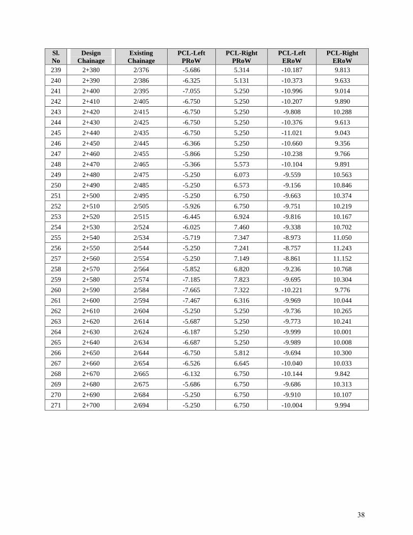
239 2+380 2/376 -5.686 5.314 -10.187 9.813
240 2+390 2/386 -6.325 5.131 -10.373 9.633
241 2+400 2/395 -7.055 5.250 -10.996 9.014
242 2+410 2/405 -6.750 5.250 -10.207 9.890
243 2+420 2/415 -6.750 5.250 -9.808 10.288
244 2+430 2/425 -6.750 5.250 -10.376 9.613
245 2+440 2/435 -6.750 5.250 -11.021 9.043
246 2+450 2/445 -6.366 5.250 -10.660 9.356
247 2+460 2/455 -5.866 5.250 -10.238 9.766
248 2+470 2/465 -5.366 5.573 -10.104 9.891
249 2+480 2/475 -5.250 6.073 -9.559 10.563
250 2+490 2/485 -5.250 6.573 -9.156 10.846
251 2+500 2/495 -5.250 6.750 -9.663 10.374
252 2+510 2/505 -5.926 6.750 -9.751 10.219
253 2+520 2/515 -6.445 6.924 -9.816 10.167
254 2+530 2/524 -6.025 7.460 -9.338 10.702
255 2+540 2/534 -5.719 7.347 -8.973 11.050
256 2+550 2/544 -5.250 7.241 -8.757 11.243
257 2+560 2/554 -5.250 7.149 -8.861 11.152
258 2+570 2/564 -5.852 6.820 -9.236 10.768
259 2+580 2/574 -7.185 7.823 -9.695 10.304
260 2+590 2/584 -7.665 7.322 -10.221 9.776
261 2+600 2/594 -7.467 6.316 -9.969 10.044
262 2+610 2/604 -5.250 5.250 -9.736 10.265
263 2+620 2/614 -5.687 5.250 -9.773 10.241
264 2+630 2/624 -6.187 5.250 -9.999 10.001
265 2+640 2/634 -6.687 5.250 -9.989 10.008
266 2+650 2/644 -6.750 5.812 -9.694 10.300
267 2+660 2/654 -6.526 6.645 -10.040 10.033
268 2+670 2/665 -6.132 6.750 -10.144 9.842
269 2+680 2/675 -5.686 6.750 -9.686 10.313
270 2+690 2/684 -5.250 6.750 -9.910 10.107
271 2+700 2/694 -5.250 6.750 -10.004 9.994
38
APPENDIX-3
Inventory Checklist and Environmental Screening/
Transect Walk Survey Formats
39
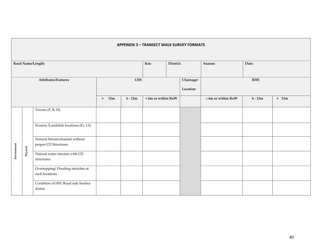
APPENDIX 3 – TRANSECT WALK SURVEY FORMATS
Road Name/Length: Km: District: Season: Date:
Attributes/Features LHS Chainage/
Location
RHS
12m 6 ‐ 12m < 6m or within RoW < 6m or within RoW 6 ‐ 12m 12m
Environment
Physical
Terrain (P, R, H)
Erosion /Landslide locations (Er, LS)
Natural Stream/channel without proper CD Structures
Natural water streams with CD structures
Overtopping/ Flooding stretches at such locations
Condition of Hill /Road side Surface drains
40
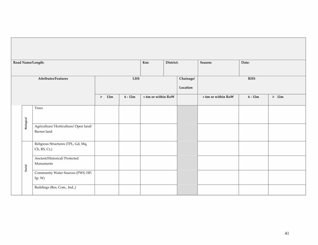
Road Name/Length: Km: District: Season: Date:
Attributes/Features LHS Chainage/
Location
RHS
12m 6 ‐ 12m < 6m or within RoW < 6m or within RoW 6 ‐ 12m 12m
Biological
Trees
Agriculture/ Horticulture/ Open land/ Barren land
Social
Religious Structures (TPL, Gd, Mq, Ch, RS, Cr,)
Ancient/Historical/ Protected Monuments
Community Water Sources (PWS, HP, Sp. W)
Buildings (Res, Com., Ind.,)
41
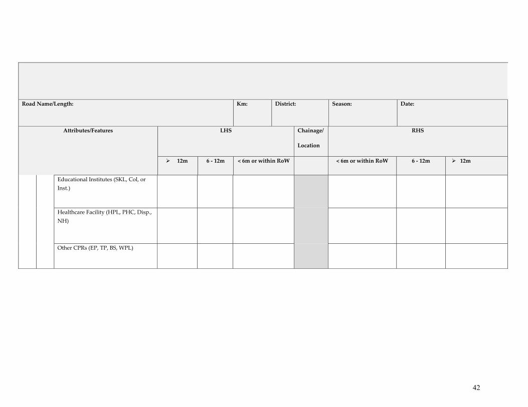
Road Name/Length: Km: District: Season: Date:
Attributes/Features LHS Chainage/
Location
RHS
12m 6 ‐ 12m < 6m or within RoW < 6m or within RoW 6 ‐ 12m 12m
Educational Institutes (SKL, Col, or Inst.)
Healthcare Facility (HPL, PHC, Disp., NH)
Other CPRs (EP, TP, BS, WPL)
42

APPENDIX-4
List of applicable Labour laws
43
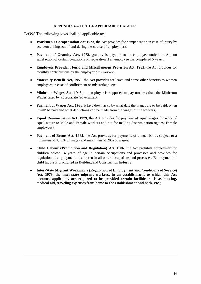
APPENDIX 4 – LIST OF APPLICABLE LABOUR
LAWS The following laws shall be applicable to:
Workmen's Compensation Act 1923, the Act provides for compensation in case of injury by
accident arising out of and during the course of employment;
Payment of Gratuity Act, 1972, gratuity is payable to an employee under the Act on
satisfaction of certain conditions on separation if an employee has completed 5 years;
Employees Provident Fund and Miscellaneous Provision Act, 1952, the Act provides for
monthly contributions by the employer plus workers;
Maternity Benefit Act, 1951, the Act provides for leave and some other benefits to women
employees in case of confinement or miscarriage, etc.;
Minimum Wages Act, 1948, the employer is supposed to pay not less than the Minimum
Wages fixed by appropriate Government;
Payment of Wages Act, 1936, it lays down as to by what date the wages are to be paid, when
it will' be paid and what deductions can be made from the wages of the workers);
Equal Remuneration Act, 1979, the Act provides for payment of equal wages for work of
equal nature to Male and Female workers and not for making discrimination against Female
employees);
Payment of Bonus Act, 1965, the Act provides for payments of annual bonus subject to a
minimum of 83.3% of wages and maximum of 20% of wages;
Child Labour (Prohibition and Regulation) Act, 1986, the Act prohibits employment of
children below 14 years of age in certain occupations and processes and provides for
regulation of employment of children in all other occupations and processes. Employment of
child labour is prohibited in Building and Construction Industry;
Inter-State Migrant Workmen’s (Regulation of Employment and Conditions of Service)
Act, 1979, the inter-state migrant workers, in an establishment to which this Act
becomes applicable, are required to be provided certain facilities such as housing,
medical aid, traveling expenses from home to the establishment and back, etc.;
44
APPENDIX-5
Copy of De-notification of Gobind Sagar Wildlife
Sanctuary
45
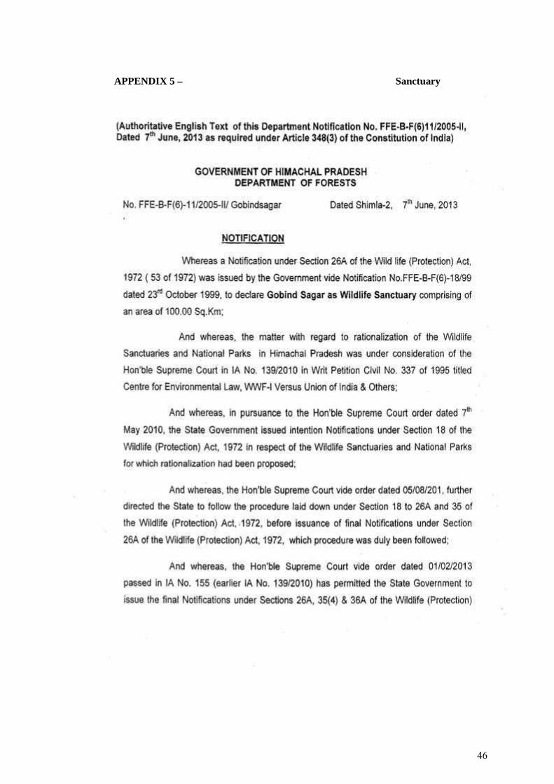
APPENDIX 5 – Sanctuary
46
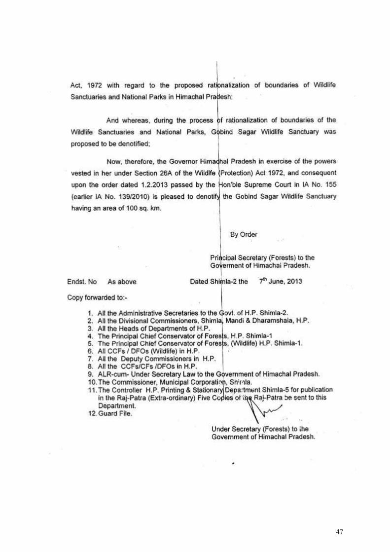
47
APPENDIX 6A
Environmental Monitoring Report for Project Road
48
BASELINE ENVIRONMENTAL MONITORING
FOR
5 STATE ROADS UNDER TRANCHE I- HPSRTP
IN
HIMACHAL PRADESH
For
DECCAN CONSULTING ENGINEERS PRIVATE LIMITED New Delhi
MARCH - MAY 2020
BY
ECO LABORATORIES & CONSULTANTS PRIVATE LIMITED (An ISO 9001: 2015, EMS ISO 14001: 2015 & OHSAS 45001: 2018 certified Company
MOEF&CC, QCI-NABL, QCI-NABET, PPCB, HPHC and CPWD approved Laboratory)
ECO Bhawan, E-207, Industrial Area, Phase VIIIB, Sector-74, Mohali-160071, Punjab (India) Telefax: 0172-4616225, Website: www.ecoparyavaran.org
49
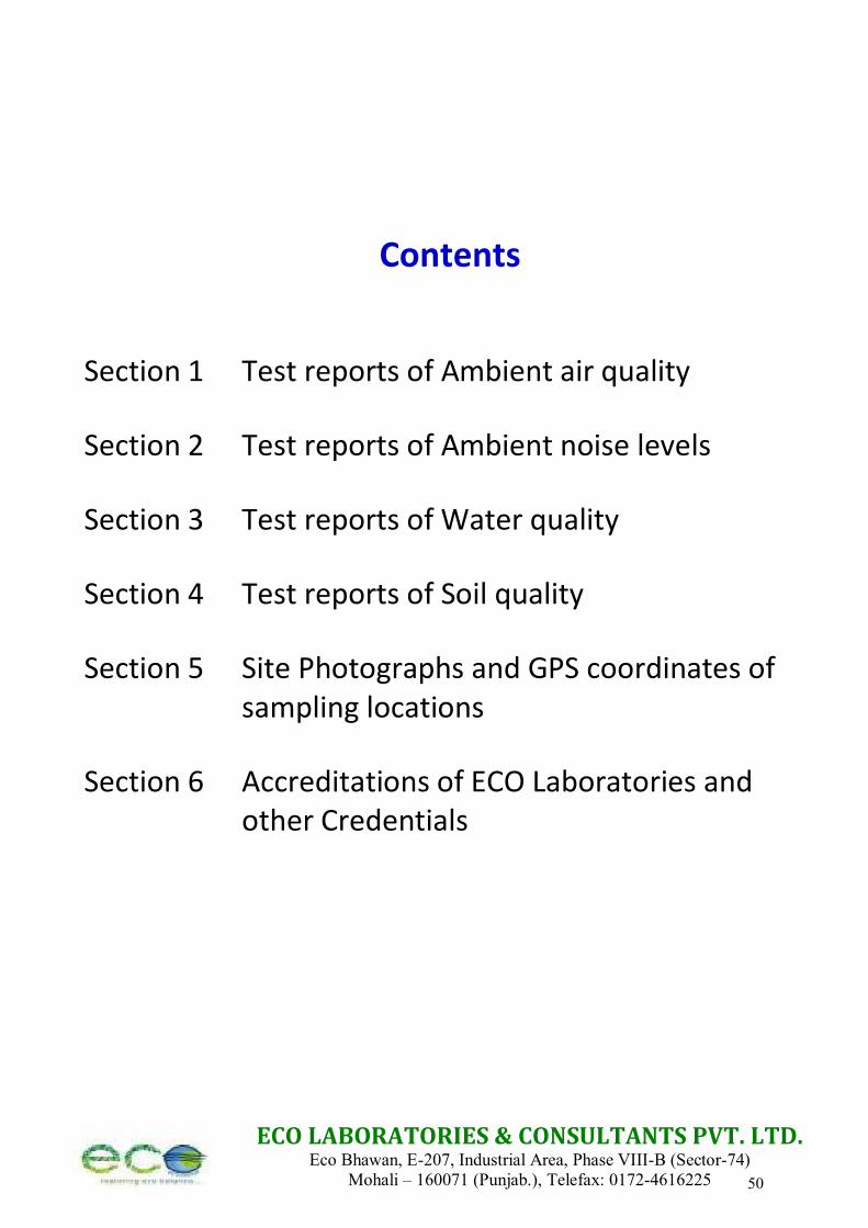
ECO LABORATORIES & CONSULTANTS PVT. LTD. Eco Bhawan, E-207, Industrial Area, Phase VIII-B (Sector-74)
Mohali – 160071 (Punjab.), Telefax: 0172-4616225
Contents
Section 1 Test reports of Ambient air quality
Section 2 Test reports of Ambient noise levels
Section 3 Test reports of Water quality
Section 4 Test reports of Soil quality
Section 5 Site Photographs and GPS coordinates of sampling locations
Section 6 Accreditations of ECO Laboratories and other Credentials
50
ECO LABORATORIES & CONSULTANTS PVT. LTD. Eco Bhawan, E-207, Industrial Area, Phase VIII-B (Sector-74)
Mohali – 160071 (Punjab.), Telefax: 0172-4616225
Section 1
Test reports of Ambient air quality
51
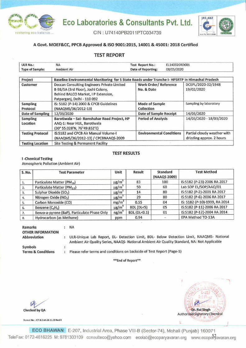
52
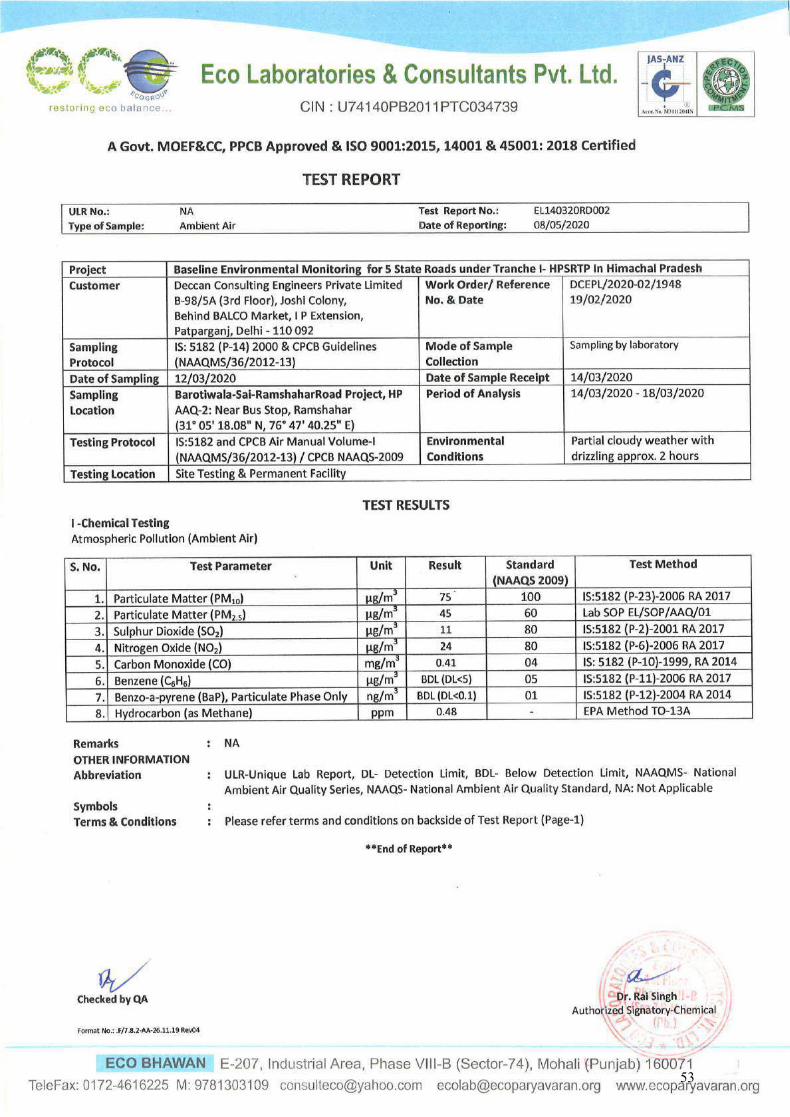
53
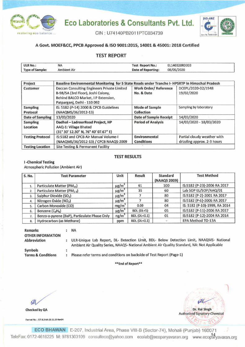
54
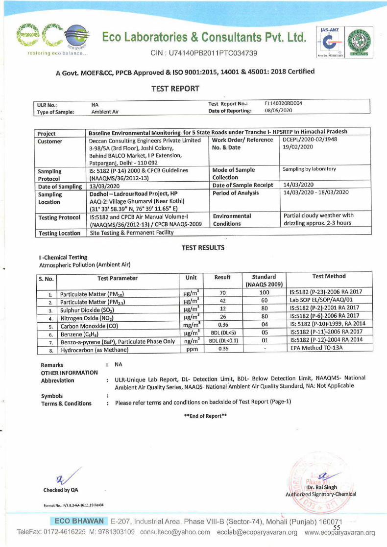
55
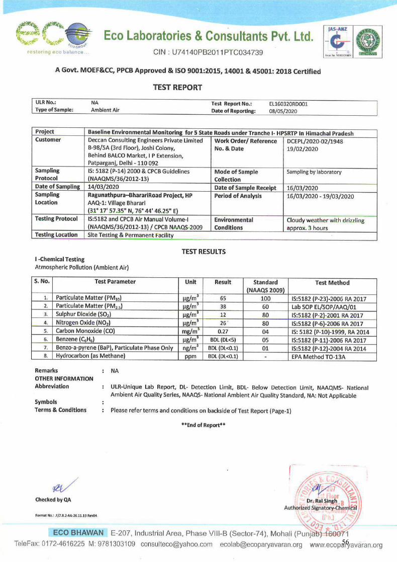
56

57

58
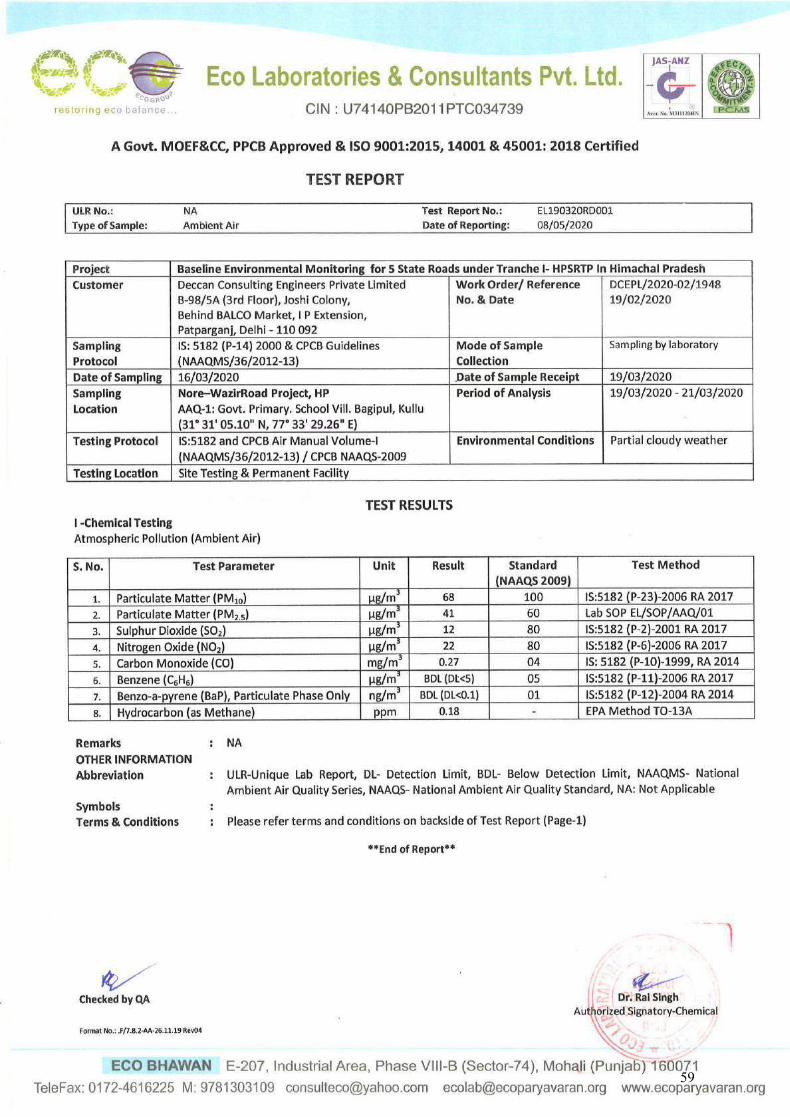
59
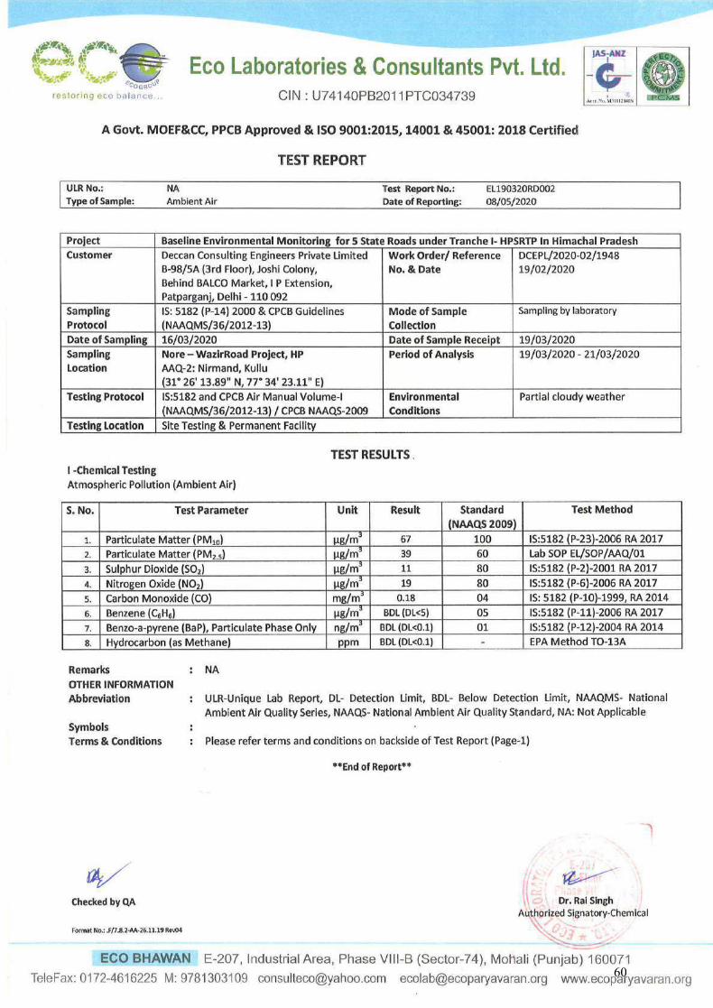
60
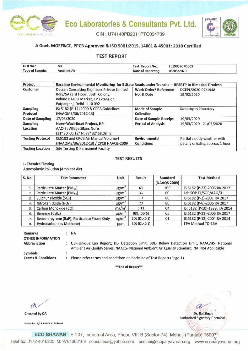
61
ECO LABORATORIES & CONSULTANTS PVT. LTD. Eco Bhawan, E-207, Industrial Area, Phase VIII-B (Sector-74)
Mohali – 160071 (Punjab.), Telefax: 0172-4616225
Section 2
Test reports of Ambient noise levels
62
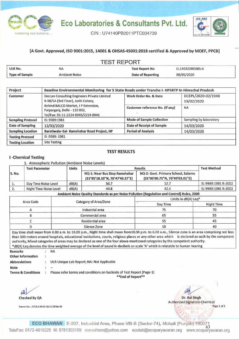
63
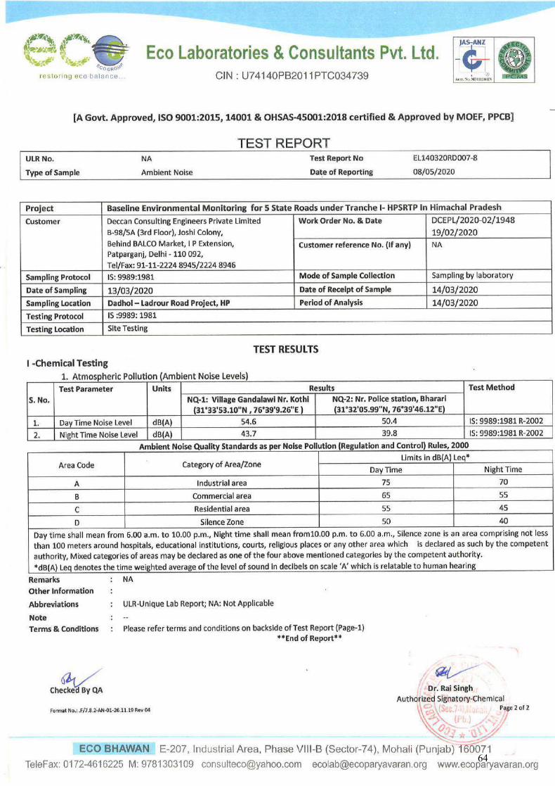
64
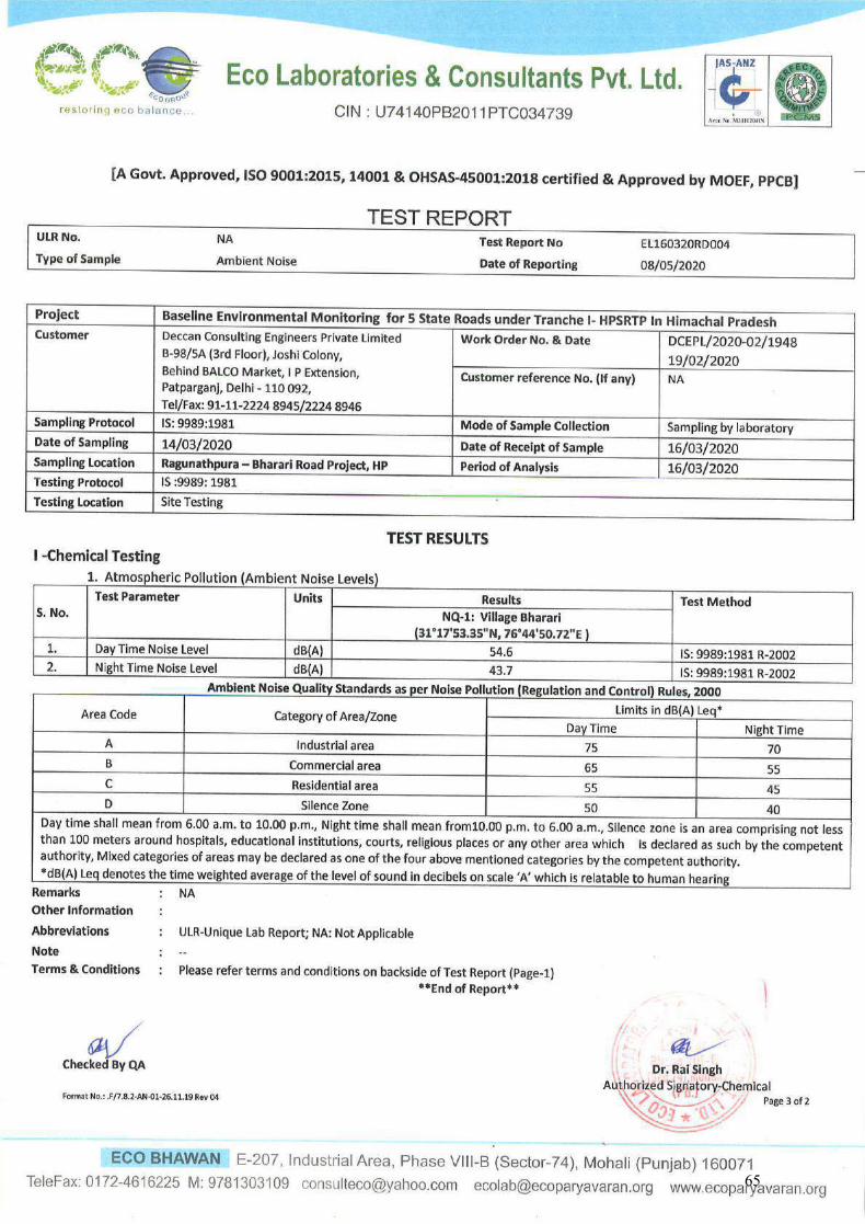
65
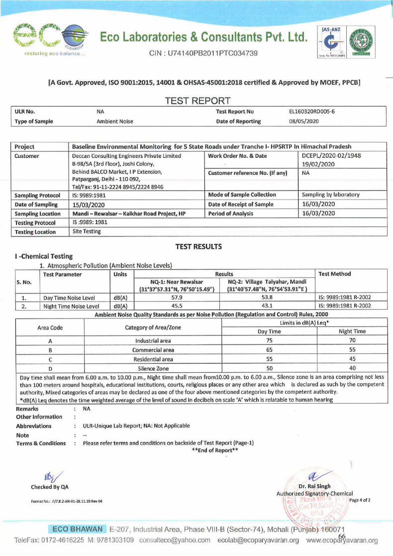
66
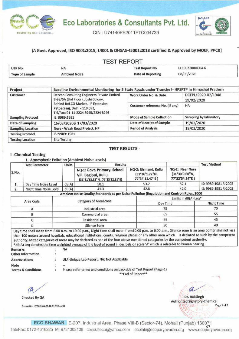
67
ECO LABORATORIES & CONSULTANTS PVT. LTD. Eco Bhawan, E-207, Industrial Area, Phase VIII-B (Sector-74)
Mohali – 160071 (Punjab.), Telefax: 0172-4616225
Section 3
Test reports of Water quality
68
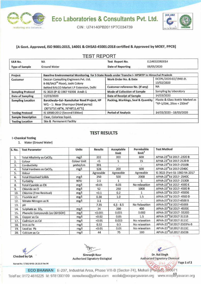
69
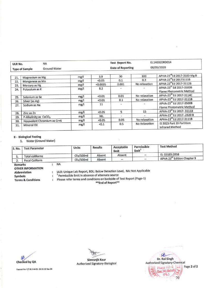
70
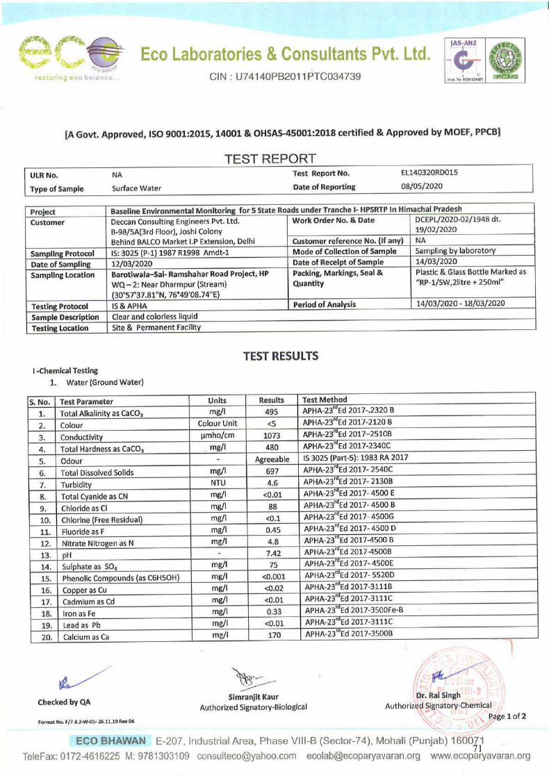
71
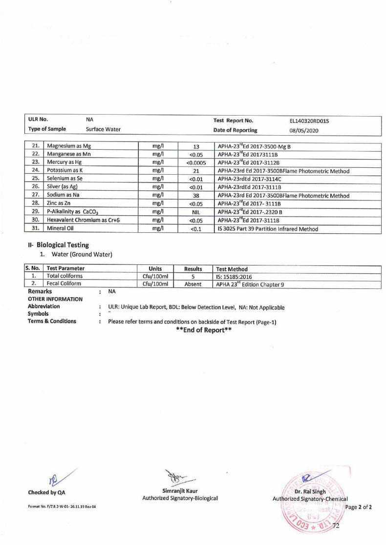
72
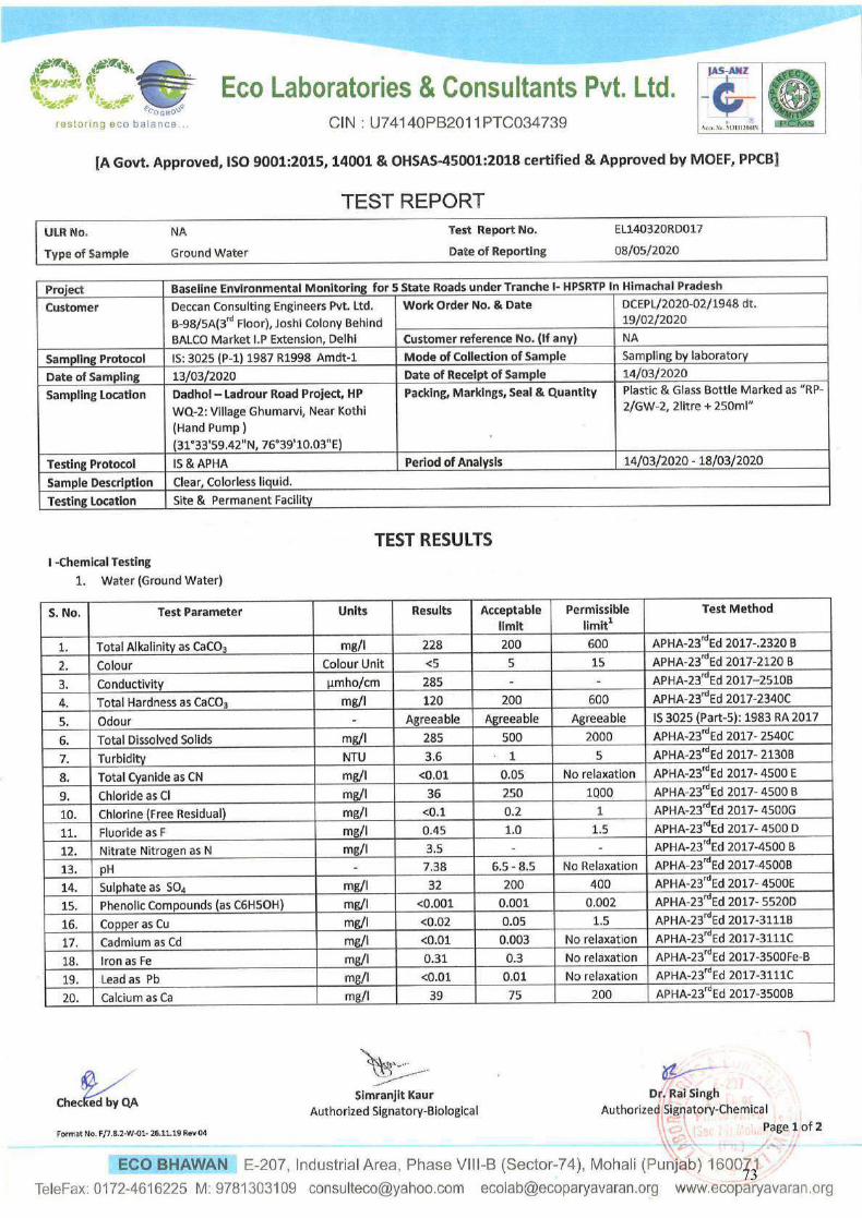
73
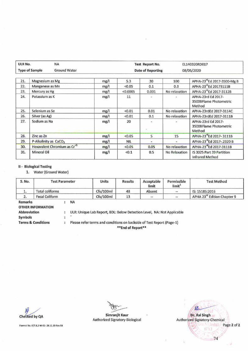
74
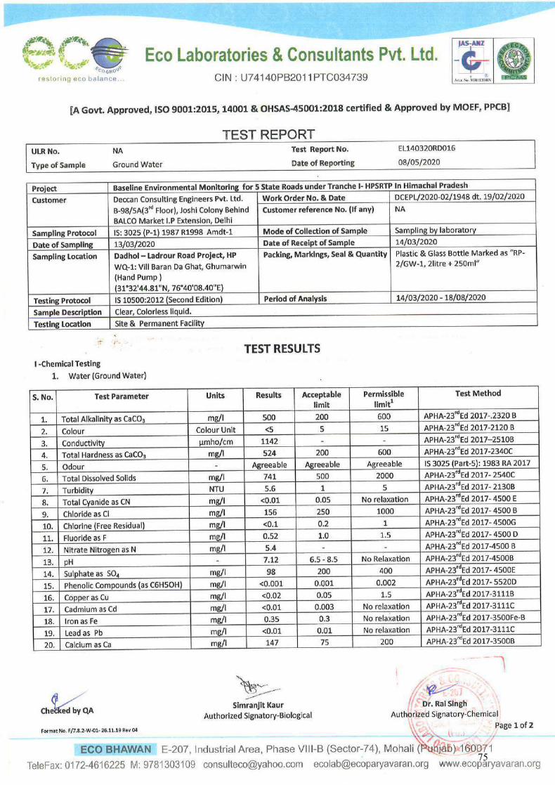
75
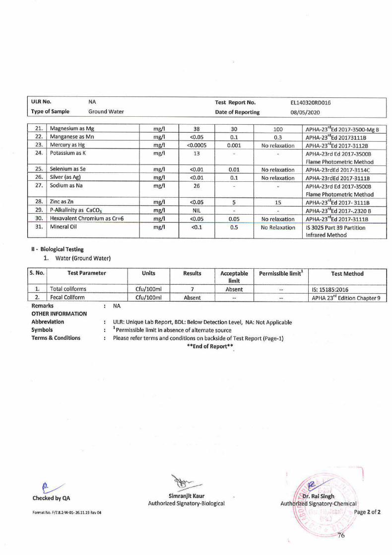
76
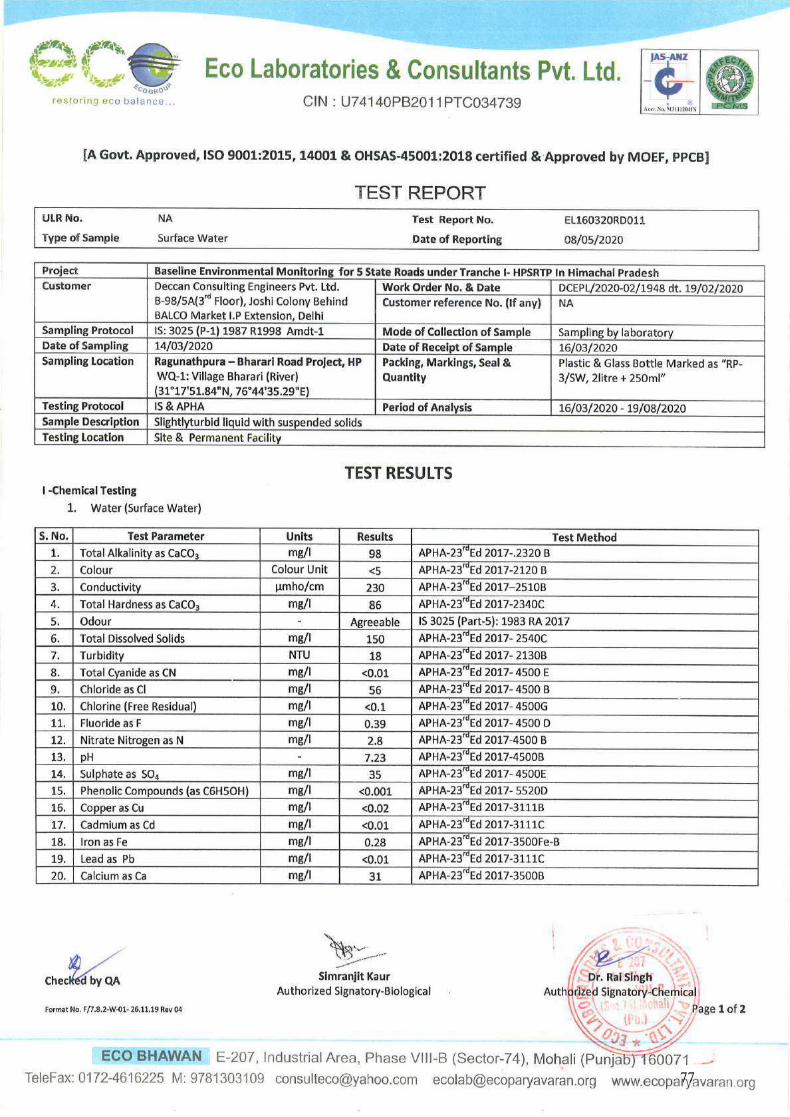
77
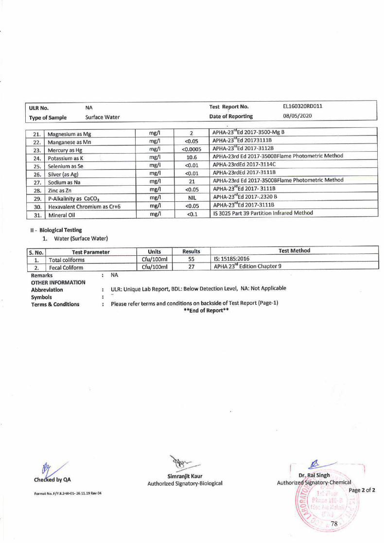
78
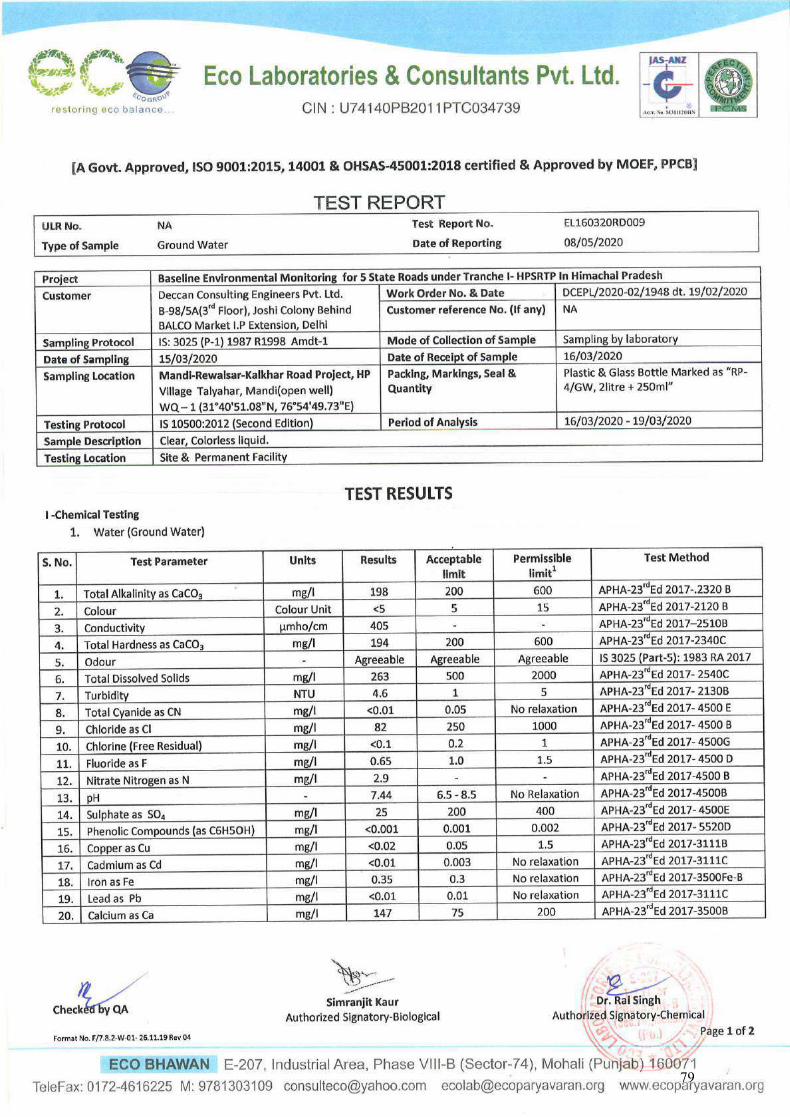
79
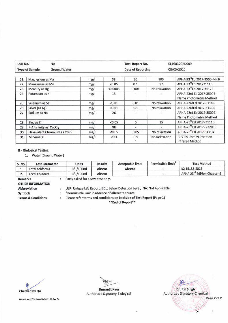
80
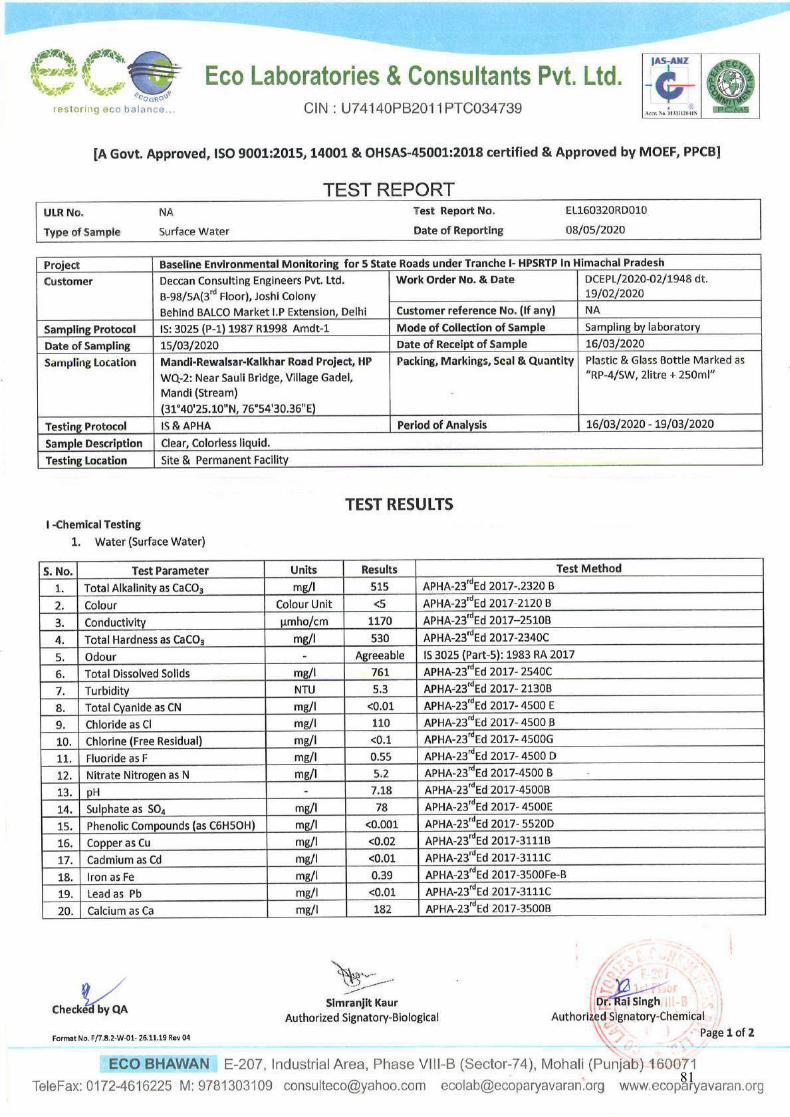
81
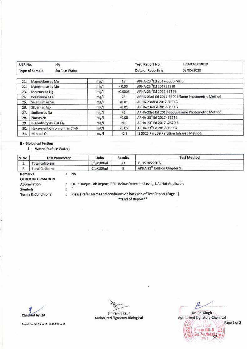
82
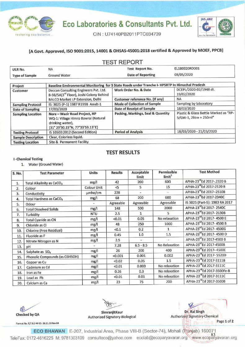
83
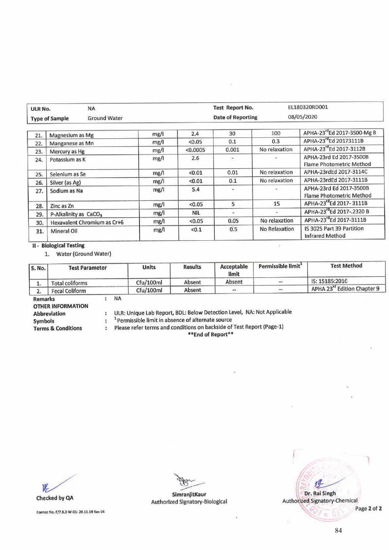
84
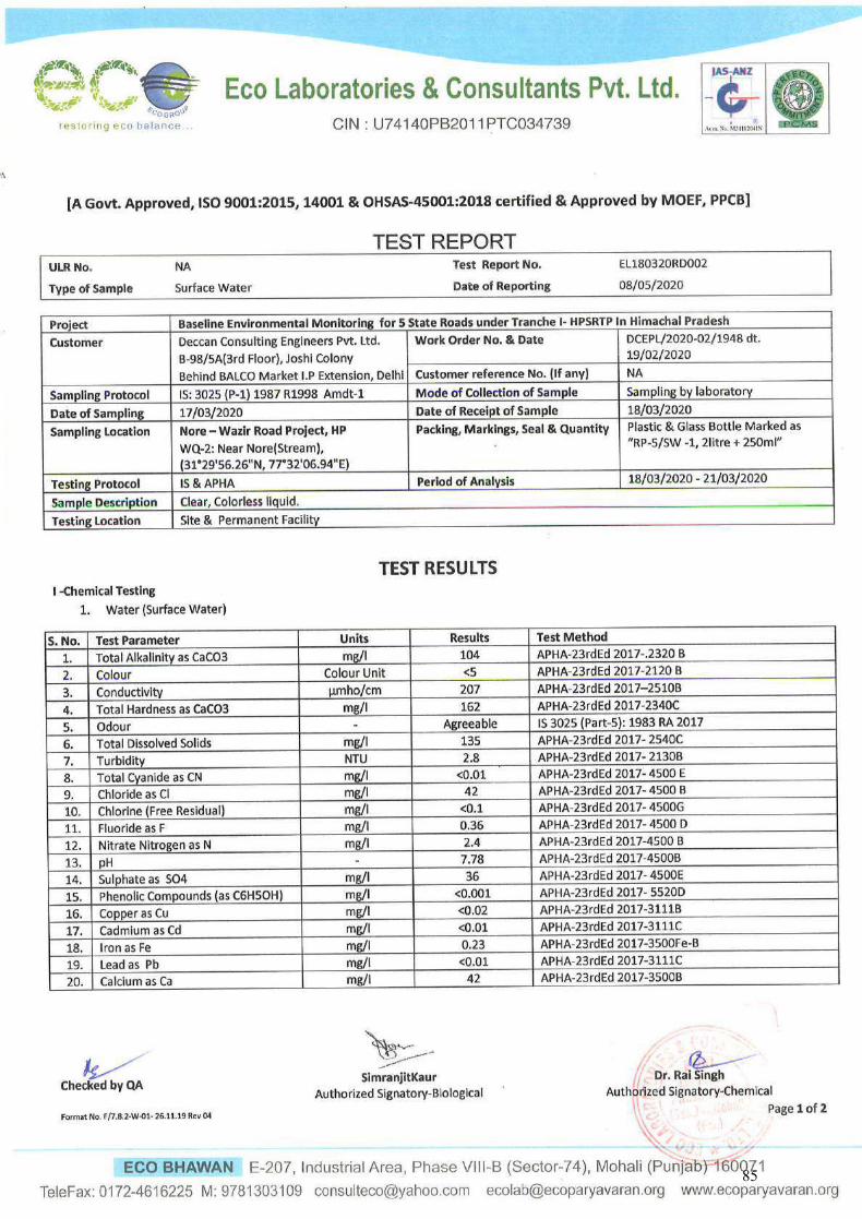
85
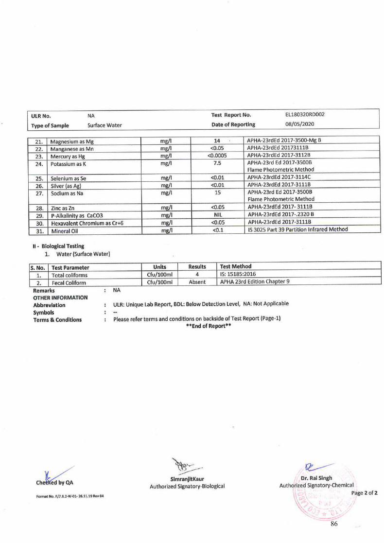
86
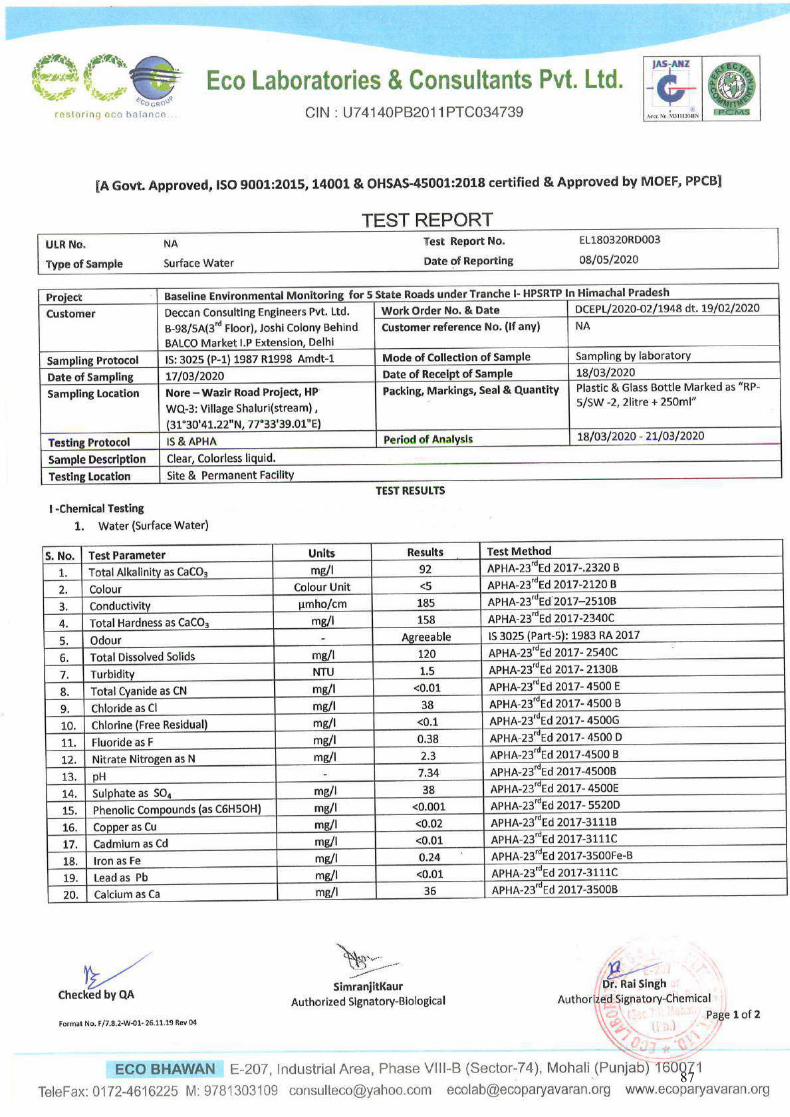
87
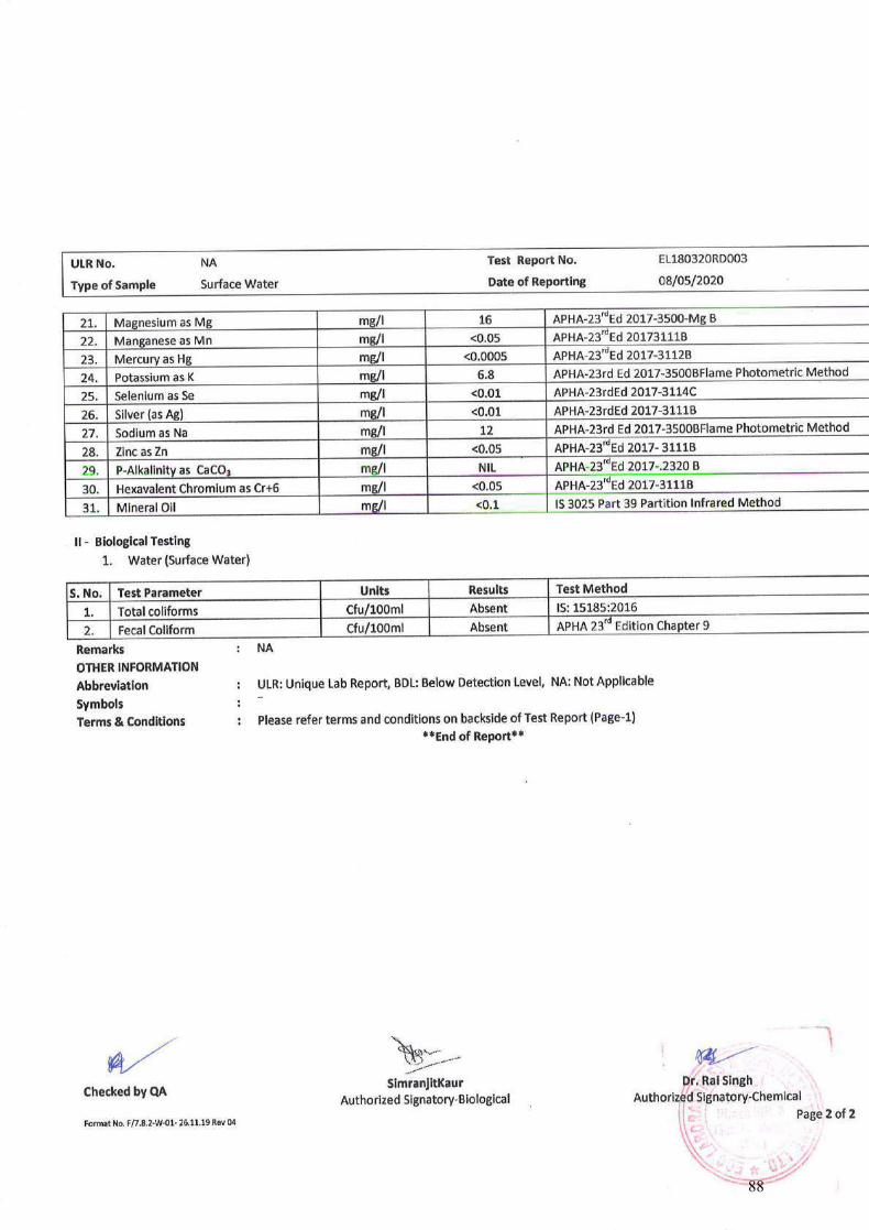
88
ECO LABORATORIES & CONSULTANTS PVT. LTD. Eco Bhawan, E-207, Industrial Area, Phase VIII-B (Sector-74)
Mohali – 160071 (Punjab.), Telefax: 0172-4616225
Section 4
Test reports of Soil quality
89
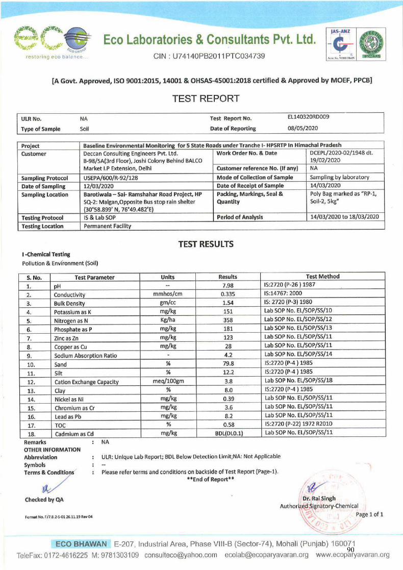
90
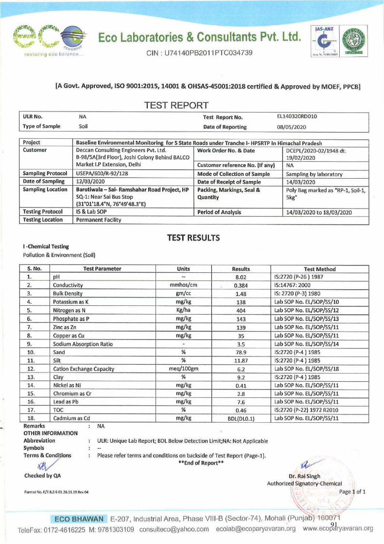
91
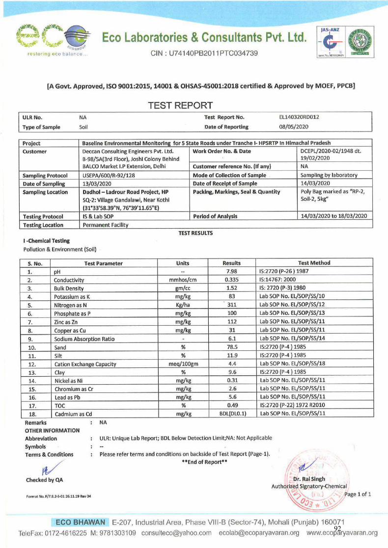
92
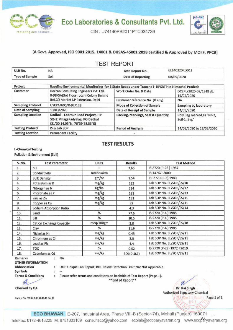
93
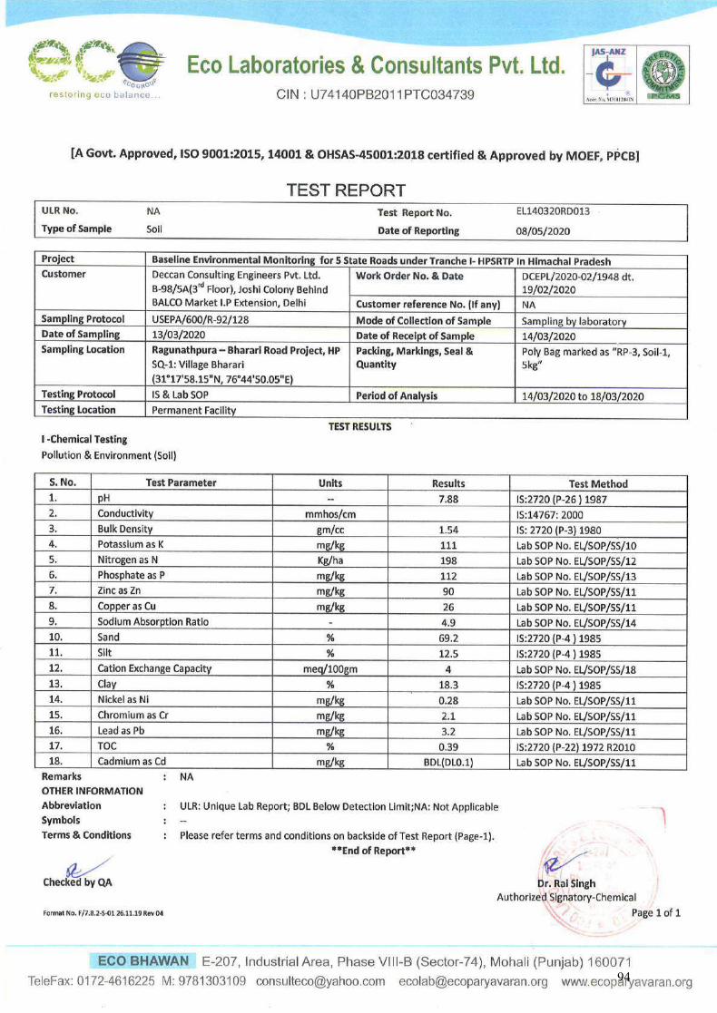
94
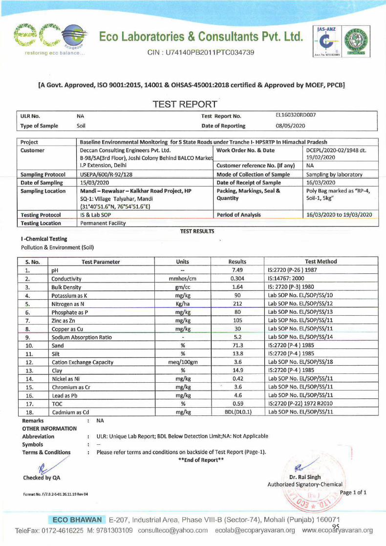
95
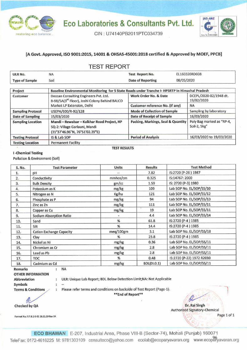
96
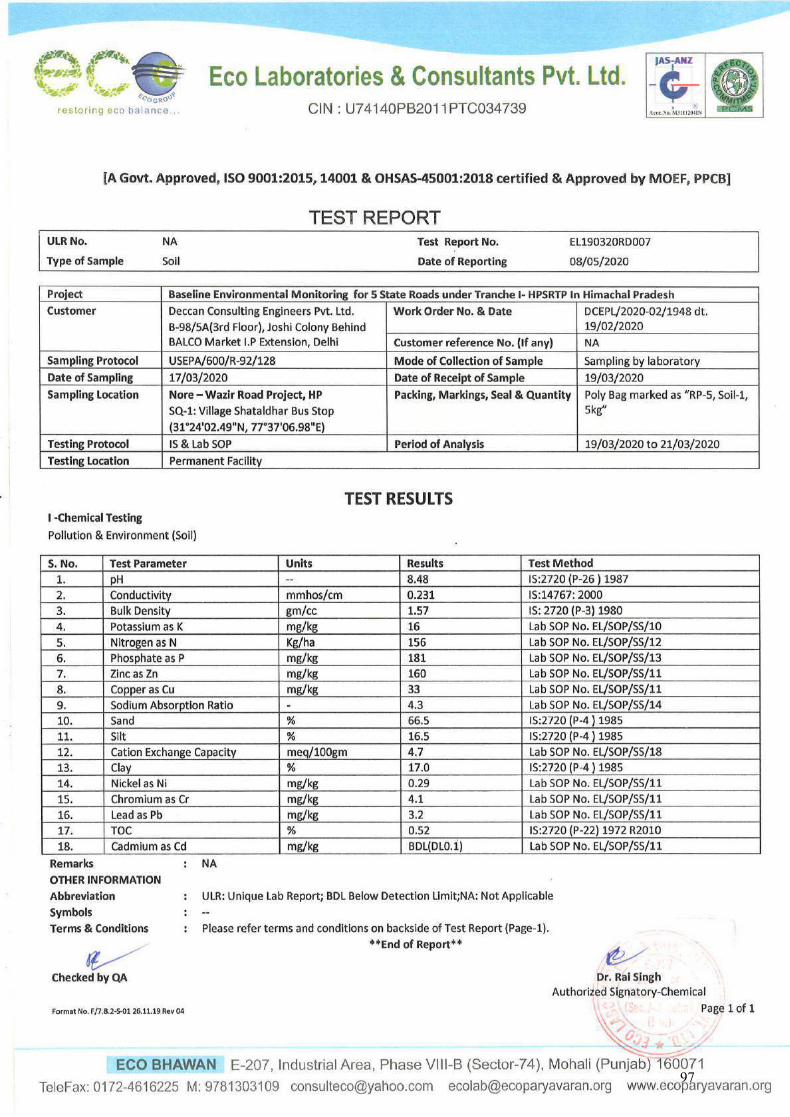
97
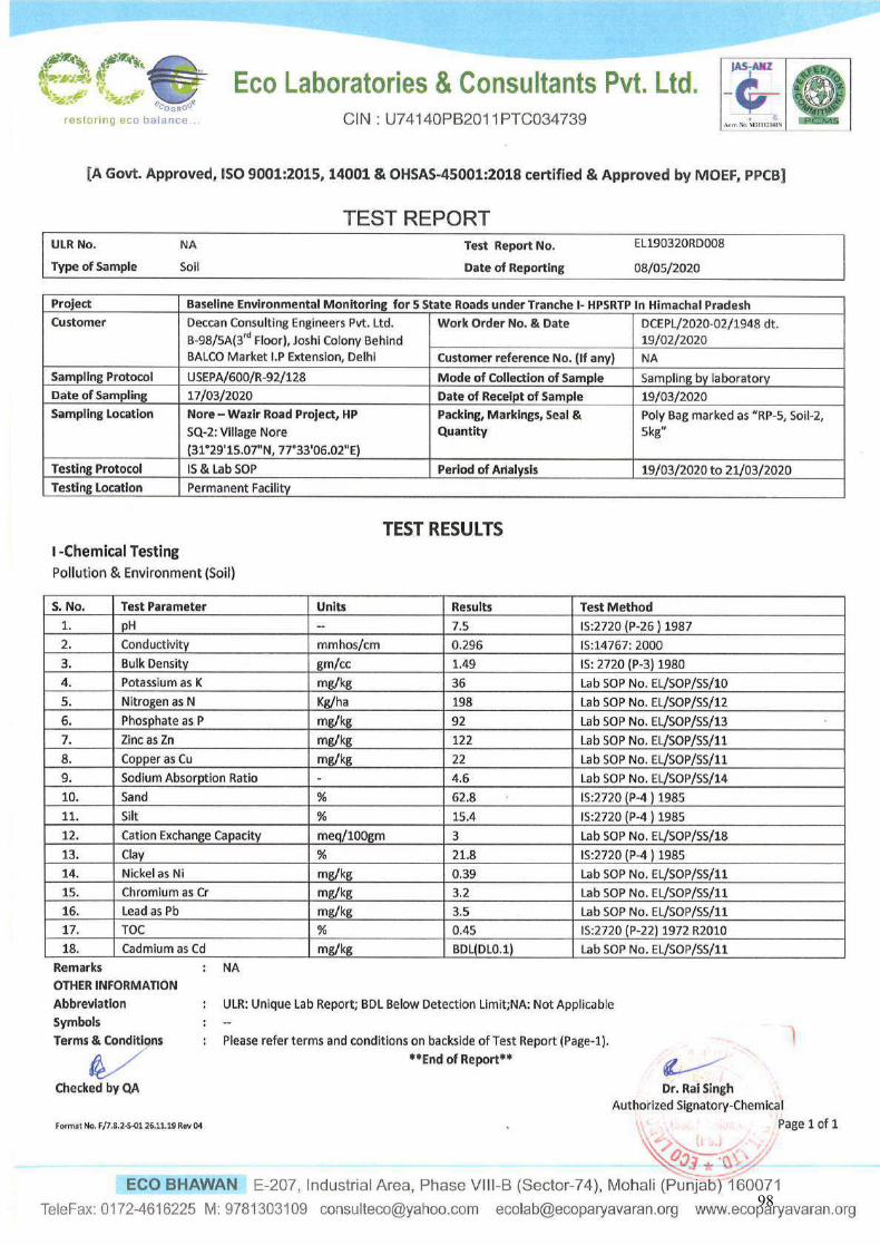
98
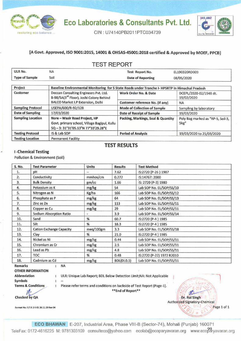
99
ECO LABORATORIES & CONSULTANTS PVT. LTD. Eco Bhawan, E-207, Industrial Area, Phase VIII-B (Sector-74)
Mohali – 160071 (Punjab.), Telefax: 0172-4616225
Section 5
Site Photographs and GPS coordinate of sampling locations
100
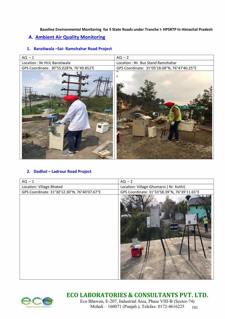
Baseline Environmental Monitoring for 5 State Roads under Tranche I- HPSRTP In Himachal Pradesh
ECO LABORATORIES & CONSULTANTS PVT. LTD. Eco Bhawan, E-207, Industrial Area, Phase VIII-B (Sector-74)
Mohali – 160071 (Punjab.), Telefax: 0172-4616225
A. Ambient Air Quality Monitoring
1. Barotiwala –Sai- Ramshahar Road Project
AQ – 1 AQ – 2
Location : Nr HUL Barotiwala Location : Nr. Bus Stand Ramshahar
GPS Coordinate: 30°55.028'N, 76°49.852'E GPS Coordinate: 31°05'18.08"N, 76°47'40.25"E
2. Dadhol – Ladrour Road Project
AQ – 1 AQ – 2
Location: Village Bhated Location: Village Ghumarvi ( Nr. Kothi)
GPS Coordinate: 31°30'12.30"N, 76°40'07.67"E GPS Coordinate: 31°33'58.39"N, 76°39'11.65"E
101
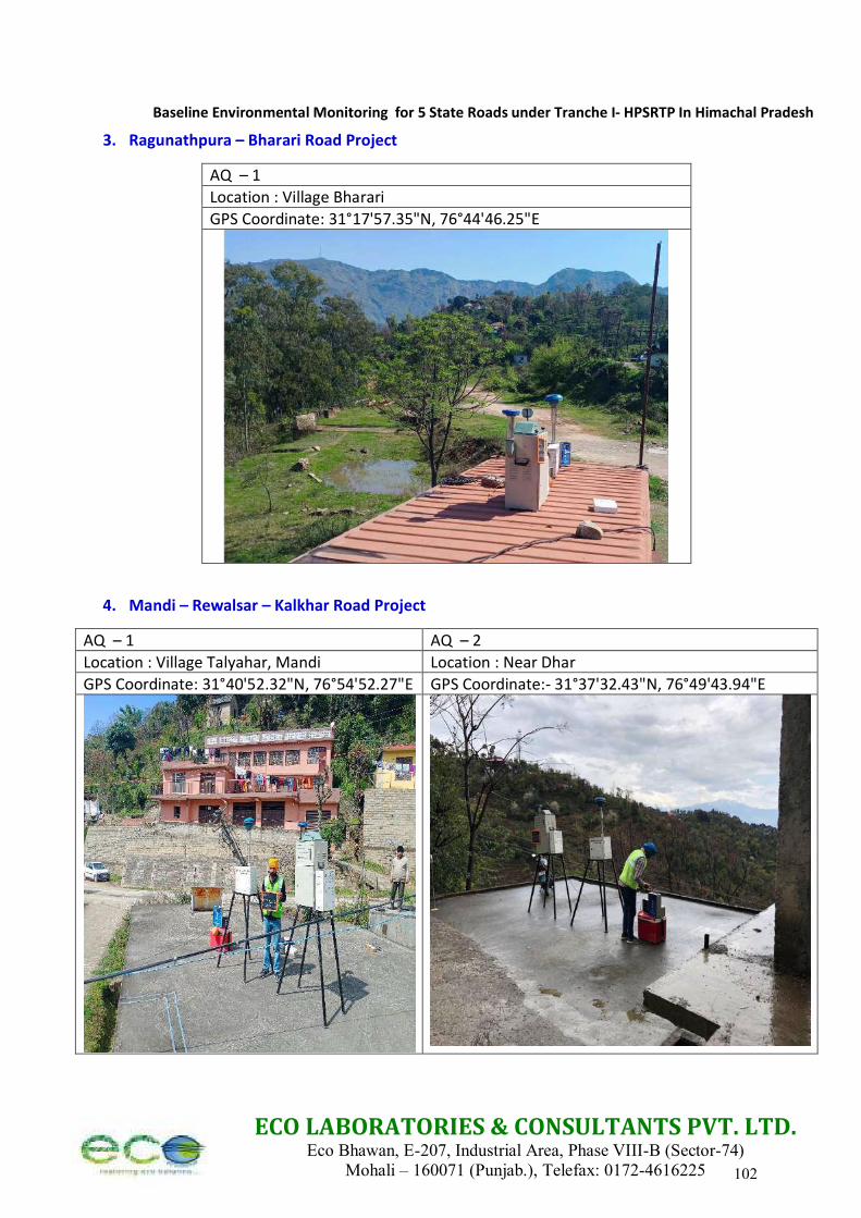
Baseline Environmental Monitoring for 5 State Roads under Tranche I- HPSRTP In Himachal Pradesh
ECO LABORATORIES & CONSULTANTS PVT. LTD. Eco Bhawan, E-207, Industrial Area, Phase VIII-B (Sector-74)
Mohali – 160071 (Punjab.), Telefax: 0172-4616225
3. Ragunathpura – Bharari Road Project
AQ – 1
Location : Village Bharari
GPS Coordinate: 31°17'57.35"N, 76°44'46.25"E
4. Mandi – Rewalsar – Kalkhar Road Project
AQ – 1 AQ – 2
Location : Village Talyahar, Mandi Location : Near Dhar
GPS Coordinate: 31°40'52.32"N, 76°54'52.27"E GPS Coordinate:- 31°37'32.43"N, 76°49'43.94"E
102
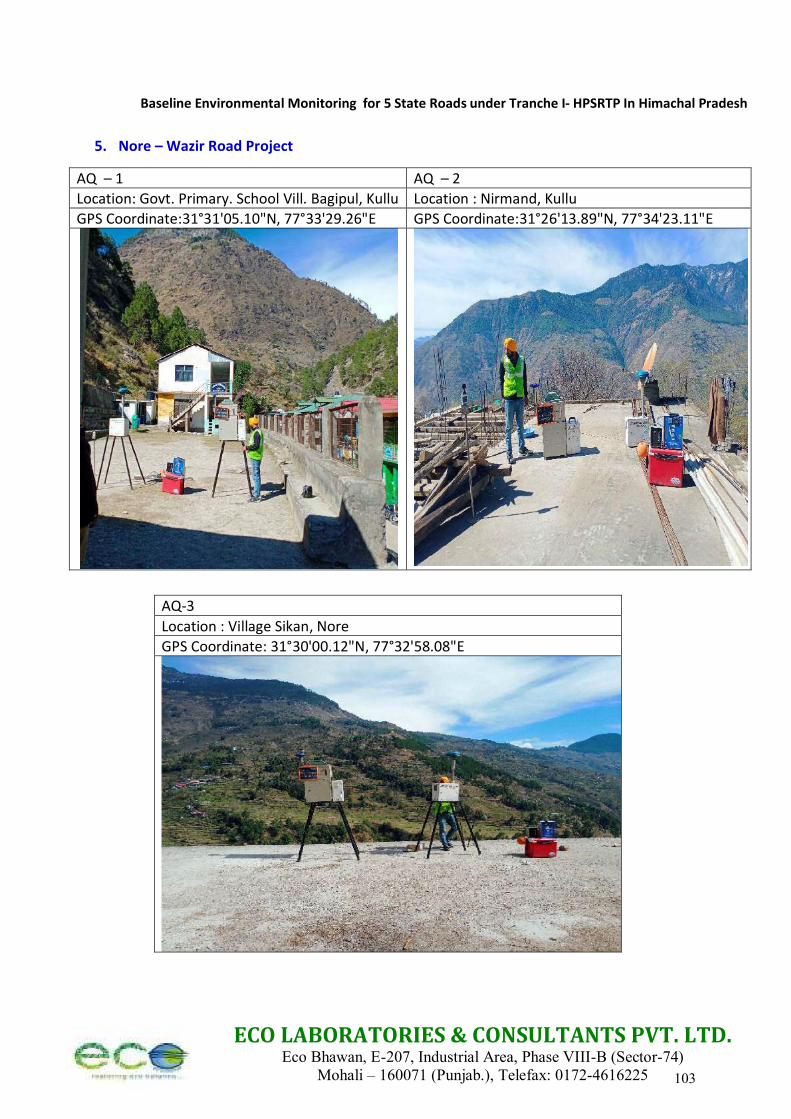
Baseline Environmental Monitoring for 5 State Roads under Tranche I- HPSRTP In Himachal Pradesh
ECO LABORATORIES & CONSULTANTS PVT. LTD. Eco Bhawan, E-207, Industrial Area, Phase VIII-B (Sector-74)
Mohali – 160071 (Punjab.), Telefax: 0172-4616225
5. Nore – Wazir Road Project
AQ – 1 AQ – 2
Location: Govt. Primary. School Vill. Bagipul, Kullu Location : Nirmand, Kullu
GPS Coordinate:31°31'05.10"N, 77°33'29.26"E GPS Coordinate:31°26'13.89"N, 77°34'23.11"E
AQ-3
Location : Village Sikan, Nore
GPS Coordinate: 31°30'00.12"N, 77°32'58.08"E
103
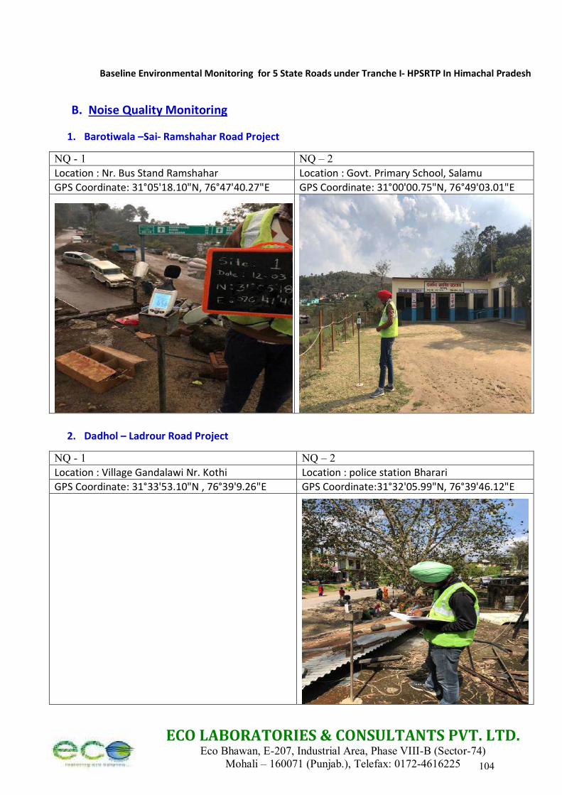
Baseline Environmental Monitoring for 5 State Roads under Tranche I- HPSRTP In Himachal Pradesh
ECO LABORATORIES & CONSULTANTS PVT. LTD. Eco Bhawan, E-207, Industrial Area, Phase VIII-B (Sector-74)
Mohali – 160071 (Punjab.), Telefax: 0172-4616225
B. Noise Quality Monitoring
1. Barotiwala –Sai- Ramshahar Road Project
NQ - 1 NQ – 2
Location : Nr. Bus Stand Ramshahar Location : Govt. Primary School, Salamu
GPS Coordinate: 31°05'18.10"N, 76°47'40.27"E GPS Coordinate: 31°00'00.75"N, 76°49'03.01"E
2. Dadhol – Ladrour Road Project
NQ - 1 NQ – 2
Location : Village Gandalawi Nr. Kothi Location : police station Bharari
GPS Coordinate: 31°33'53.10"N , 76°39'9.26"E GPS Coordinate:31°32'05.99"N, 76°39'46.12"E
104
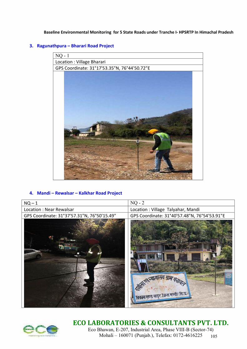
Baseline Environmental Monitoring for 5 State Roads under Tranche I- HPSRTP In Himachal Pradesh
ECO LABORATORIES & CONSULTANTS PVT. LTD. Eco Bhawan, E-207, Industrial Area, Phase VIII-B (Sector-74)
Mohali – 160071 (Punjab.), Telefax: 0172-4616225
3. Ragunathpura – Bharari Road Project
4. Mandi – Rewalsar – Kalkhar Road Project
NQ – 1 NQ - 2
Location : Near Rewalsar Location : Village Talyahar, Mandi
GPS Coordinate: 31°37'57.31"N, 76°50'15.49" GPS Coordinate: 31°40'57.48"N, 76°54'53.91"E
NQ - 1 Location : Village Bharari
GPS Coordinate: 31°17'53.35"N, 76°44'50.72"E
105
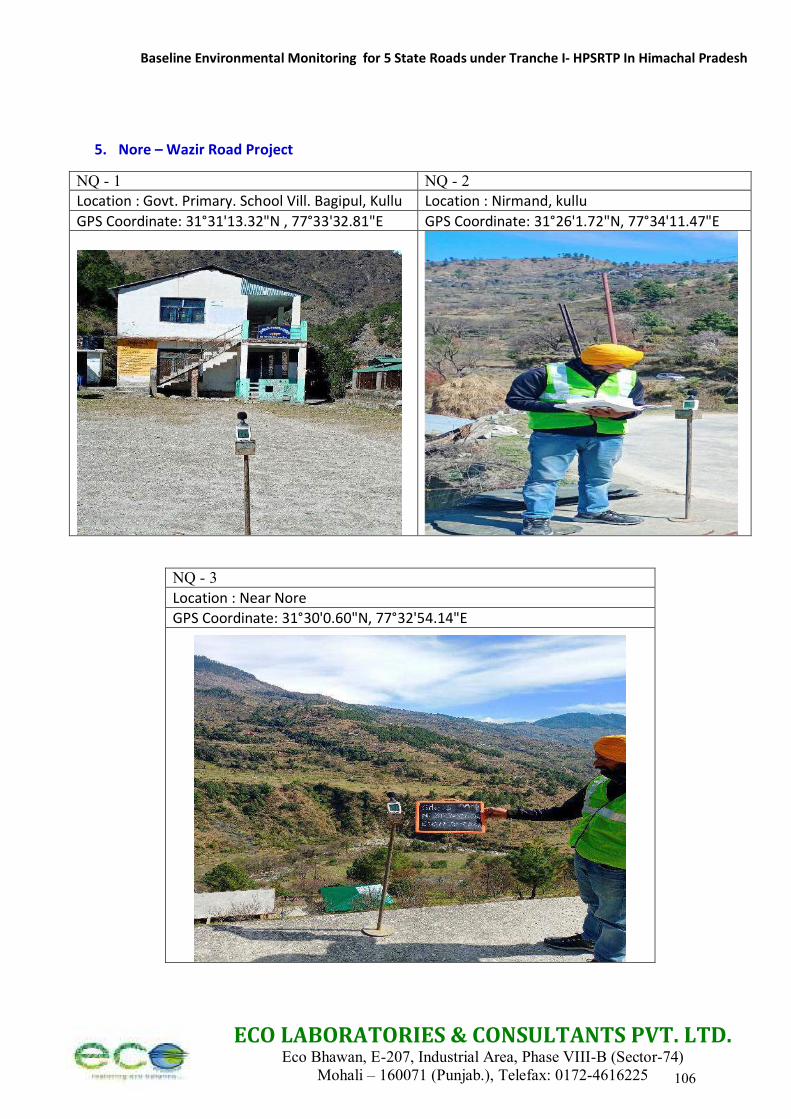
Baseline Environmental Monitoring for 5 State Roads under Tranche I- HPSRTP In Himachal Pradesh
ECO LABORATORIES & CONSULTANTS PVT. LTD. Eco Bhawan, E-207, Industrial Area, Phase VIII-B (Sector-74)
Mohali – 160071 (Punjab.), Telefax: 0172-4616225
5. Nore – Wazir Road Project
NQ - 1 NQ - 2 Location : Govt. Primary. School Vill. Bagipul, Kullu Location : Nirmand, kullu
GPS Coordinate: 31°31'13.32"N , 77°33'32.81"E GPS Coordinate: 31°26'1.72"N, 77°34'11.47"E
NQ - 3
Location : Near Nore
GPS Coordinate: 31°30'0.60"N, 77°32'54.14"E
106
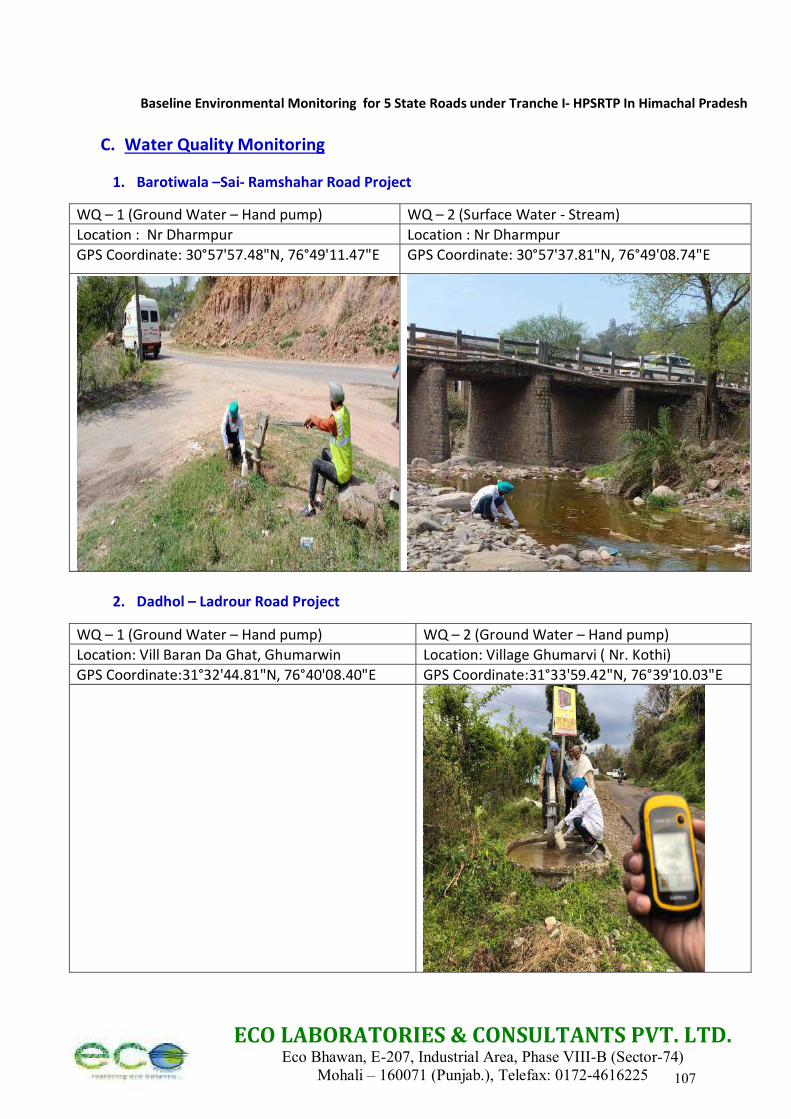
Baseline Environmental Monitoring for 5 State Roads under Tranche I- HPSRTP In Himachal Pradesh
ECO LABORATORIES & CONSULTANTS PVT. LTD. Eco Bhawan, E-207, Industrial Area, Phase VIII-B (Sector-74)
Mohali – 160071 (Punjab.), Telefax: 0172-4616225
C. Water Quality Monitoring
1. Barotiwala –Sai- Ramshahar Road Project
WQ – 1 (Ground Water – Hand pump) WQ – 2 (Surface Water - Stream)
Location : Nr Dharmpur Location : Nr Dharmpur
GPS Coordinate: 30°57'57.48"N, 76°49'11.47"E GPS Coordinate: 30°57'37.81"N, 76°49'08.74"E
2. Dadhol – Ladrour Road Project
WQ – 1 (Ground Water – Hand pump) WQ – 2 (Ground Water – Hand pump)
Location: Vill Baran Da Ghat, Ghumarwin Location: Village Ghumarvi ( Nr. Kothi)
GPS Coordinate:31°32'44.81"N, 76°40'08.40"E GPS Coordinate:31°33'59.42"N, 76°39'10.03"E
107
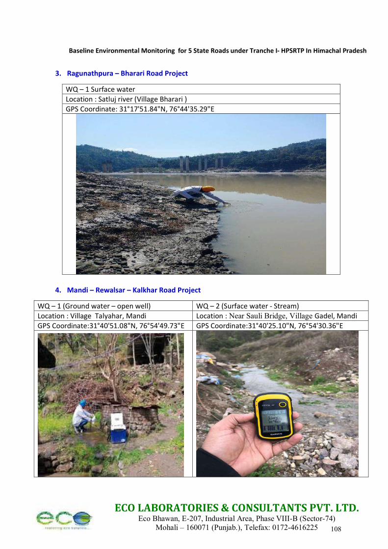
Baseline Environmental Monitoring for 5 State Roads under Tranche I- HPSRTP In Himachal Pradesh
ECO LABORATORIES & CONSULTANTS PVT. LTD. Eco Bhawan, E-207, Industrial Area, Phase VIII-B (Sector-74)
Mohali – 160071 (Punjab.), Telefax: 0172-4616225
3. Ragunathpura – Bharari Road Project
WQ – 1 Surface water
Location : Satluj river (Village Bharari )
GPS Coordinate: 31°17'51.84"N, 76°44'35.29"E
4. Mandi – Rewalsar – Kalkhar Road Project
WQ – 1 (Ground water – open well) WQ – 2 (Surface water - Stream)
Location : Village Talyahar, Mandi Location : Near Sauli Bridge, Village Gadel, Mandi
GPS Coordinate:31°40'51.08"N, 76°54'49.73"E GPS Coordinate:31°40'25.10"N, 76°54'30.36"E
108
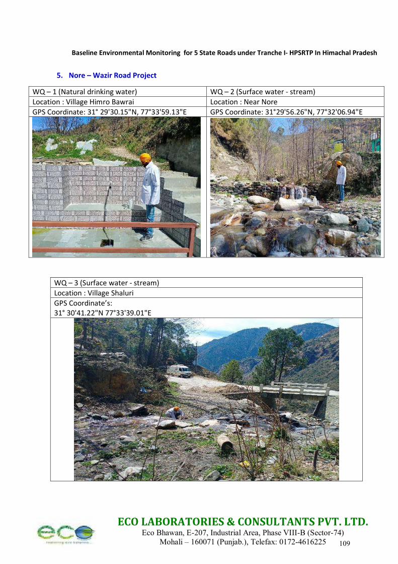
Baseline Environmental Monitoring for 5 State Roads under Tranche I- HPSRTP In Himachal Pradesh
ECO LABORATORIES & CONSULTANTS PVT. LTD. Eco Bhawan, E-207, Industrial Area, Phase VIII-B (Sector-74)
Mohali – 160071 (Punjab.), Telefax: 0172-4616225
5. Nore – Wazir Road Project
WQ – 1 (Natural drinking water) WQ – 2 (Surface water - stream)
Location : Village Himro Bawrai Location : Near Nore
GPS Coordinate: 31° 29'30.15"N, 77°33'59.13"E GPS Coordinate: 31°29'56.26"N, 77°32'06.94"E
WQ – 3 (Surface water - stream)
Location : Village Shaluri
GPS Coordinate’s: 31° 30'41.22"N 77°33'39.01"E
109
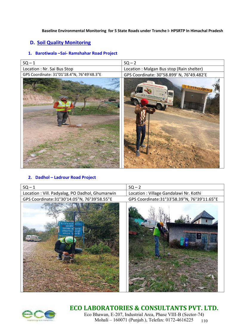
Baseline Environmental Monitoring for 5 State Roads under Tranche I- HPSRTP In Himachal Pradesh
ECO LABORATORIES & CONSULTANTS PVT. LTD. Eco Bhawan, E-207, Industrial Area, Phase VIII-B (Sector-74)
Mohali – 160071 (Punjab.), Telefax: 0172-4616225
D. Soil Quality Monitoring
1. Barotiwala –Sai- Ramshahar Road Project
SQ – 1 SQ – 2
Location : Nr. Sai Bus Stop Location : Malgan Bus stop (Rain shelter) GPS Coordinate: 31°01'18.4"N, 76°49'48.3"E GPS Coordinate: 30°58.899’ N, 76°49.482’E
2. Dadhol – Ladrour Road Project
SQ – 1 SQ – 2
Location : Vill. Padyalag, PO Dadhol, Ghumarwin Location : Village Gandalawi Nr. Kothi
GPS Coordinate:31°30'14.05"N, 76°39'58.55"E GPS Coordinate:31°33'58.39"N, 76°39'11.65"E
110
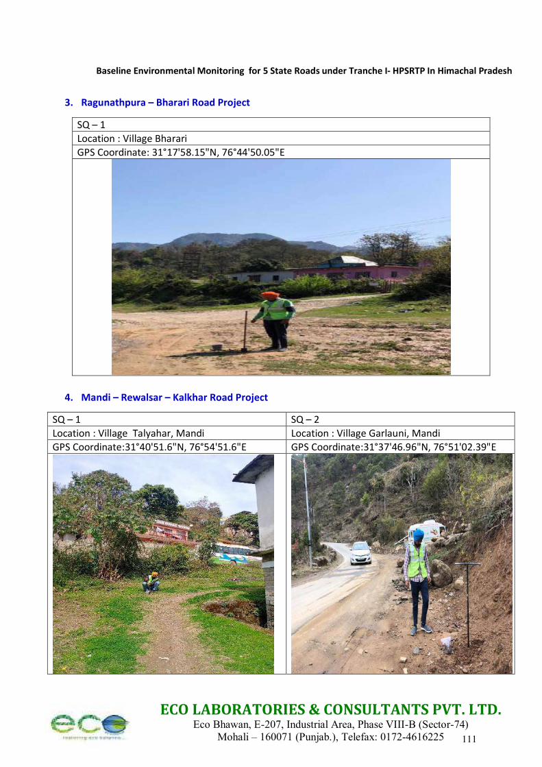
Baseline Environmental Monitoring for 5 State Roads under Tranche I- HPSRTP In Himachal Pradesh
ECO LABORATORIES & CONSULTANTS PVT. LTD. Eco Bhawan, E-207, Industrial Area, Phase VIII-B (Sector-74)
Mohali – 160071 (Punjab.), Telefax: 0172-4616225
3. Ragunathpura – Bharari Road Project
SQ – 1
Location : Village Bharari
GPS Coordinate: 31°17'58.15"N, 76°44'50.05"E
4. Mandi – Rewalsar – Kalkhar Road Project
SQ – 1 SQ – 2
Location : Village Talyahar, Mandi Location : Village Garlauni, Mandi
GPS Coordinate:31°40'51.6"N, 76°54'51.6"E GPS Coordinate:31°37'46.96"N, 76°51'02.39"E
111
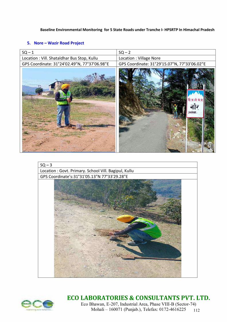
Baseline Environmental Monitoring for 5 State Roads under Tranche I- HPSRTP In Himachal Pradesh
ECO LABORATORIES & CONSULTANTS PVT. LTD. Eco Bhawan, E-207, Industrial Area, Phase VIII-B (Sector-74)
Mohali – 160071 (Punjab.), Telefax: 0172-4616225
5. Nore – Wazir Road Project
SQ – 1 SQ – 2
Location : Vill. Shataldhar Bus Stop, Kullu Location : Village Nore
GPS Coordinate: 31°24'02.49"N, 77°37'06.98"E GPS Coordinate: 31°29'15.07"N, 77°33'06.02"E
SQ – 3
Location : Govt. Primary. School Vill. Bagipul, Kullu
GPS Coordinate’s:31°31'05.13"N 77°33'29.28"E
112
Baseline Environmental Monitoring for 5 State Roads under Tranche I- HPSRTP In Himachal Pradesh
ECO LABORATORIES & CONSULTANTS PVT. LTD. Eco Bhawan, E-207, Industrial Area, Phase VIII-B (Sector-74)
Mohali – 160071 (Punjab.), Telefax: 0172-4616225
Section 6
Accreditations of ECO Laboratories and other Credentials
113

ECO LABORATORIES & CONSULTANTS PVT. LTD. Eco Bhawan, E-207, Industrial Area, Phase VIII-B (Sector-74)
Mohali – 160071 (Punjab.), Telefax: 0172-4616225
NABL Accreditation
114
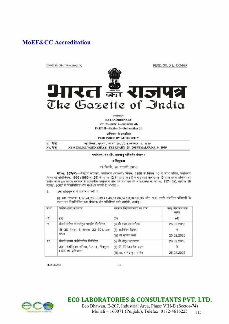
ECO LABORATORIES & CONSULTANTS PVT. LTD. Eco Bhawan, E-207, Industrial Area, Phase VIII-B (Sector-74)
Mohali – 160071 (Punjab.), Telefax: 0172-4616225
MoEF&CC Accreditation
115

ECO LABORATORIES & CONSULTANTS PVT. LTD. Eco Bhawan, E-207, Industrial Area, Phase VIII-B (Sector-74)
Mohali – 160071 (Punjab.), Telefax: 0172-4616225 116

ECO LABORATORIES & CONSULTANTS PVT. LTD. Eco Bhawan, E-207, Industrial Area, Phase VIII-B (Sector-74)
Mohali – 160071 (Punjab.), Telefax: 0172-4616225
ISO Certifications
117
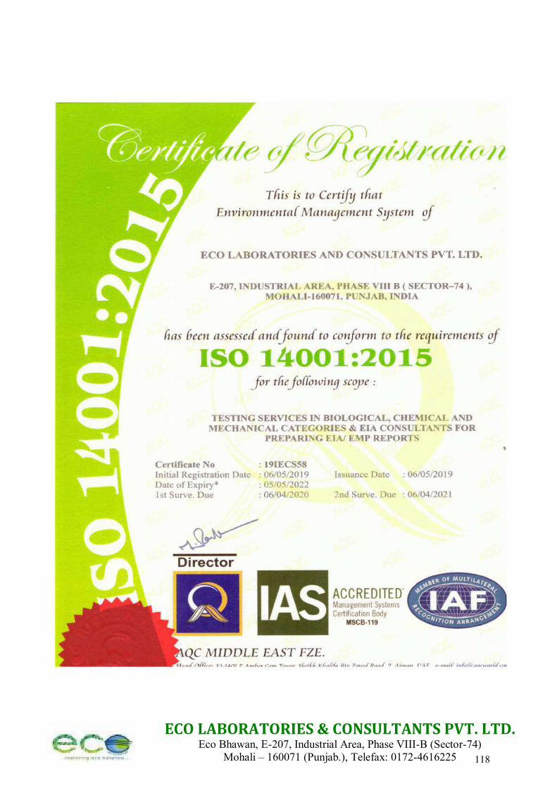
ECO LABORATORIES & CONSULTANTS PVT. LTD. Eco Bhawan, E-207, Industrial Area, Phase VIII-B (Sector-74)
Mohali – 160071 (Punjab.), Telefax: 0172-4616225 118

ECO LABORATORIES & CONSULTANTS PVT. LTD. Eco Bhawan, E-207, Industrial Area, Phase VIII-B (Sector-74)
Mohali – 160071 (Punjab.), Telefax: 0172-4616225
Submitted by:
Dr. Rai Singh (DGM Environment) Eco Laboratories and Consultants Pvt. Ltd. (Mohali, Punjab) Telefax: 0172-4616225, Mob: 8054443192/ 7790836537 Email: [email protected]
119
APPENDIX-6B
Environmental Monitoring Report for Jetty Facility
120
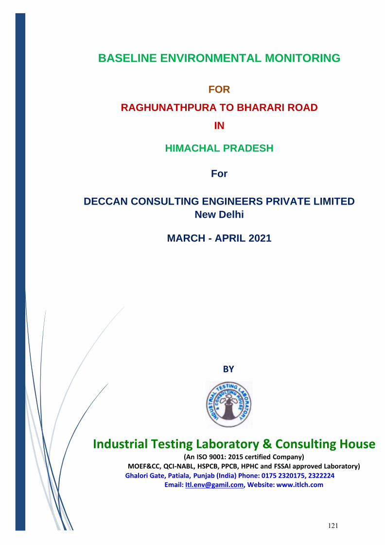
BASELINE ENVIRONMENTAL MONITORING
FOR
RAGHUNATHPURA TO BHARARI ROAD
IN
HIMACHAL PRADESH
For
DECCAN CONSULTING ENGINEERS PRIVATE LIMITED
New Delhi
MARCH - APRIL 2021
BY
Industrial Testing Laboratory & Consulting House (An ISO 9001: 2015 certified Company)
MOEF&CC, QCI-NABL, HSPCB, PPCB, HPHC and FSSAI approved Laboratory)
Ghalori Gate, Patiala, Punjab (India) Phone: 0175 2320175, 2322224 Email: [email protected], Website: www.itlch.com
121
Content
Section Description
Section-1 AAQM Reports
Section-2 Noise Level Monitoring Reports
Section-3 Water Quality Analysis Reports
Section-4 Soil Quality Analysis Reports
Section-5 Site Photographs with GPS Coordinates and Sampling Location
Section-6 Credentials of ITL&CH
Industrial Testing Laboratory & Consulting House Ghalori Gate, Patiala, Punjab (India) Phone: 0175 2320175, 2322224
Website: www.itlch.com 122
Industrial Testing Laboratory & Consulting House Ghalori Gate, Patiala, Punjab (India) Phone: 0175 2320175, 2322224
Website: www.itlch.com
Section - I
AMBIENT AIR QUALITY MONITORING REPORTS
123
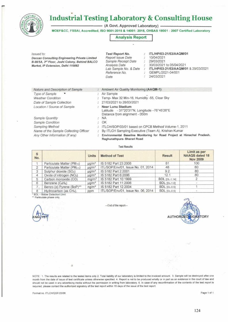
124
Industrial Testing Laboratory & Consulting House Ghalori Gate, Patiala, Punjab (India) Phone: 0175 2320175, 2322224
Website: www.itlch.com
Section - II
NOISE LEVEL MONITORING REPORTS
125
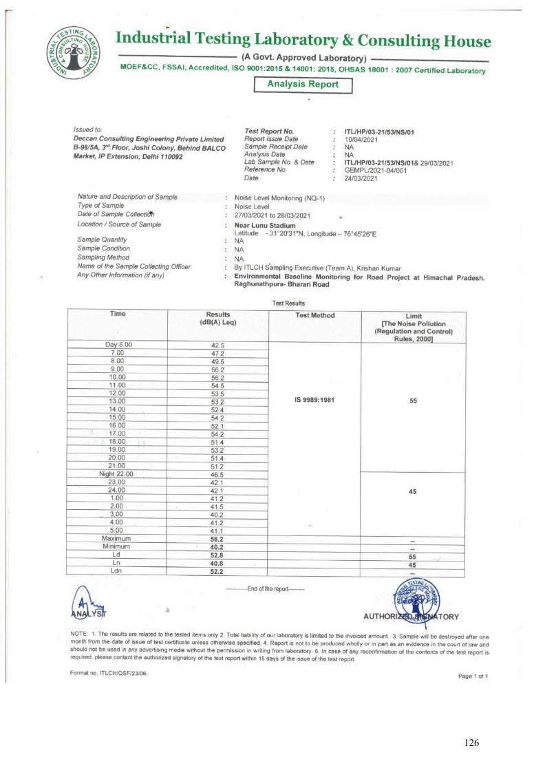
126
Industrial Testing Laboratory & Consulting House Ghalori Gate, Patiala, Punjab (India) Phone: 0175 2320175, 2322224
Website: www.itlch.com
Section - III
WATER QUALITY ANALYSIS REPORT
127
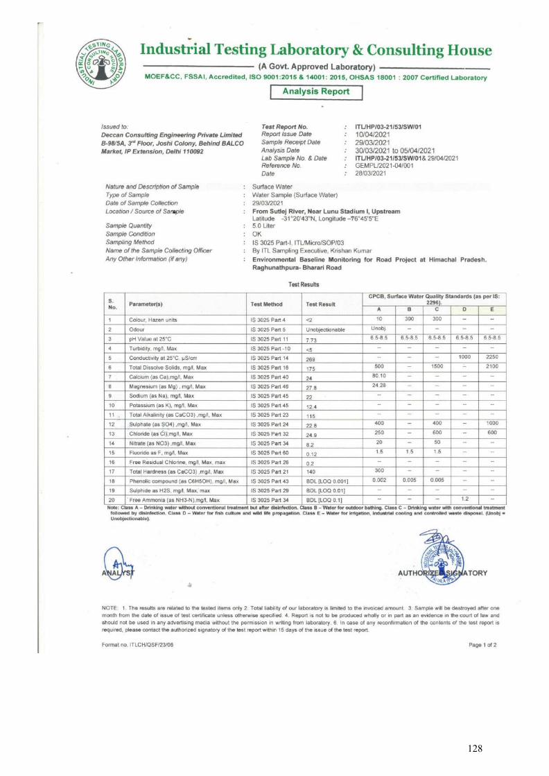
128
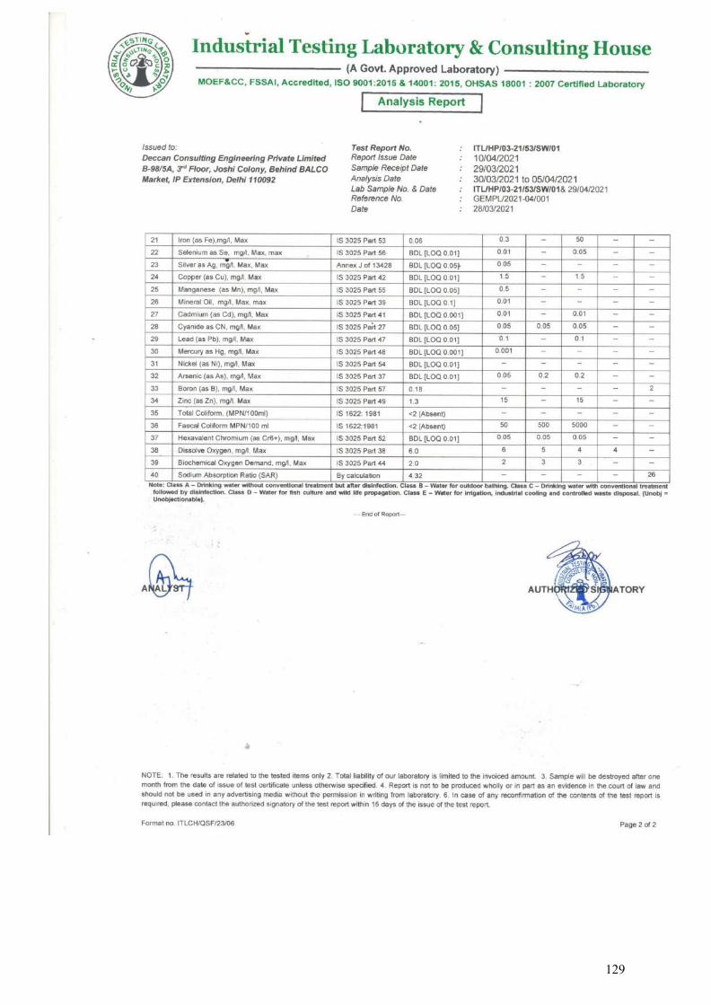
129
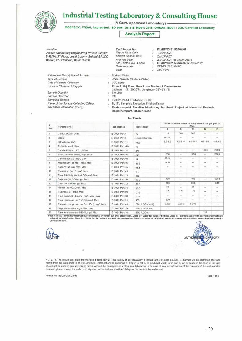
130
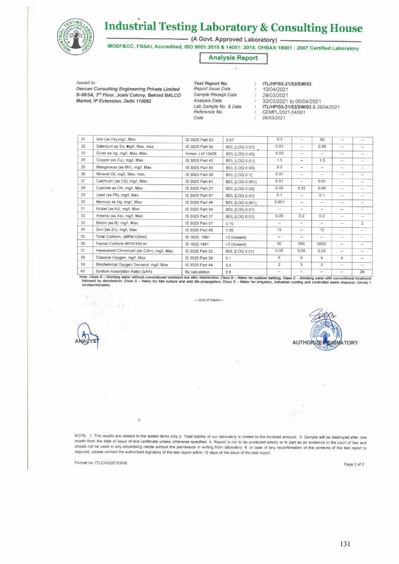
131
Industrial Testing Laboratory & Consulting House Ghalori Gate, Patiala, Punjab (India) Phone: 0175 2320175, 2322224
Website: www.itlch.com
Section - IV
SOIL QUALITY ANALYSIS REPORTS
132
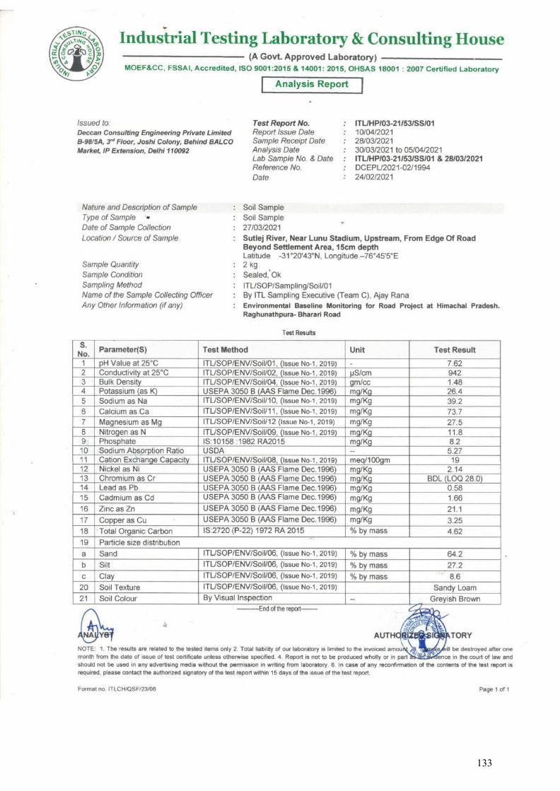
133
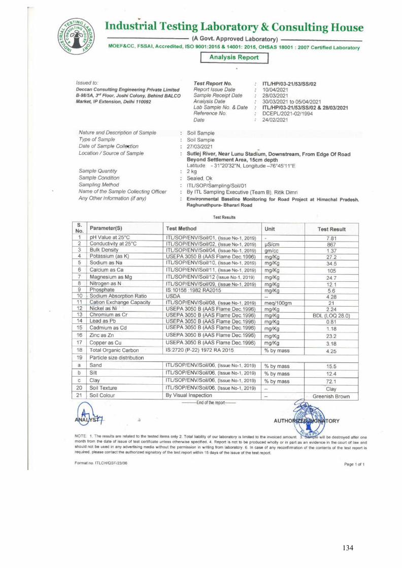
134
Industrial Testing Laboratory & Consulting House Ghalori Gate, Patiala, Punjab (India) Phone: 0175 2320175, 2322224
Website: www.itlch.com
Section - V
SITE PHOTOGRAPHS WITH GPS COORDINATE & SAMPLING
LOCATIONS
❖ AMBIENT AIR MONITORING ❖ NOISE LEVEL MONITORING ❖ SOIL SAMPLING ❖ WATER SAMPLING
135
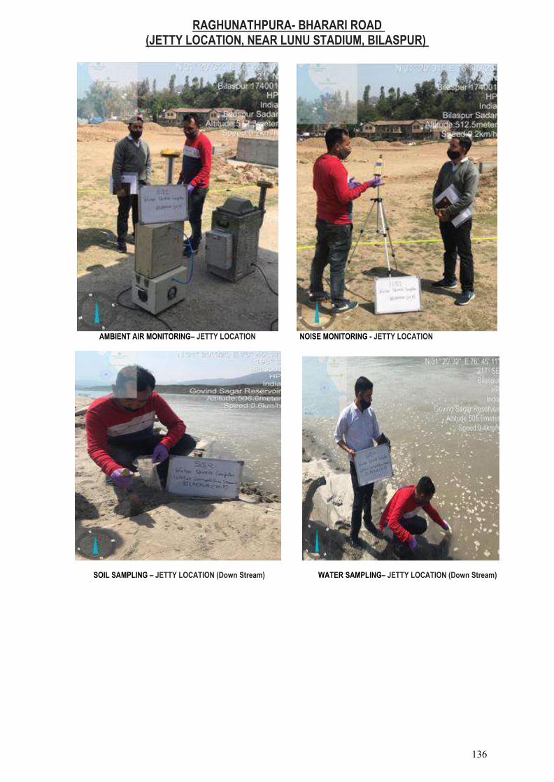
RAGHUNATHPURA- BHARARI ROAD (JETTY LOCATION, NEAR LUNU STADIUM, BILASPUR)
AMBIENT AIR MONITORING– JETTY LOCATION NOISE MONITORING - JETTY LOCATION
SOIL SAMPLING – JETTY LOCATION (Down Stream) WATER SAMPLING– JETTY LOCATION (Down Stream)
136

Industrial Testing Laboratory & Consulting House Ghalori Gate, Patiala, Punjab (India) Phone: 0175 2320175, 2322224
Website: www.itlch.com
Section - V
Credentials of Industrial Testing Laboratory & Consulting House
137

138
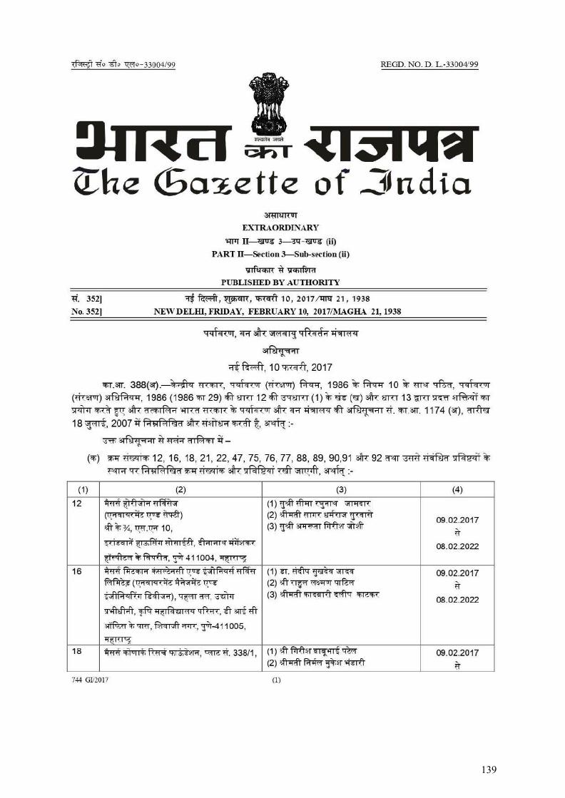
139
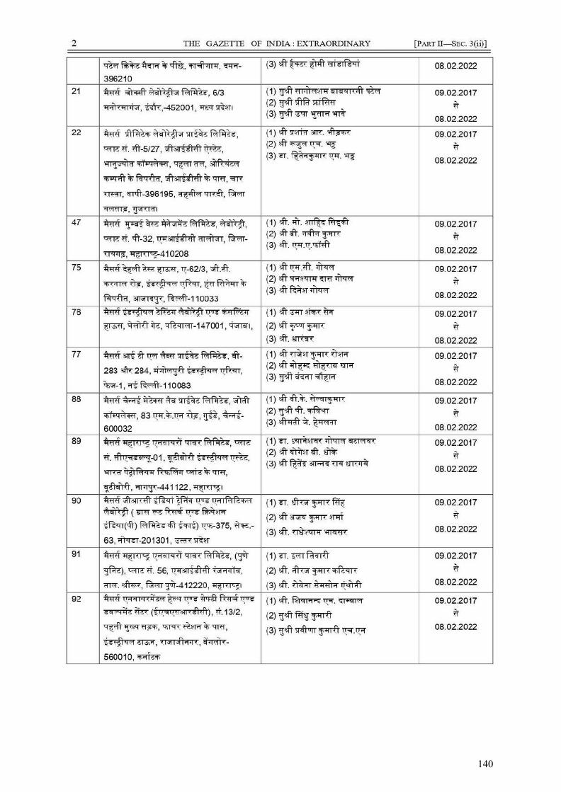
140
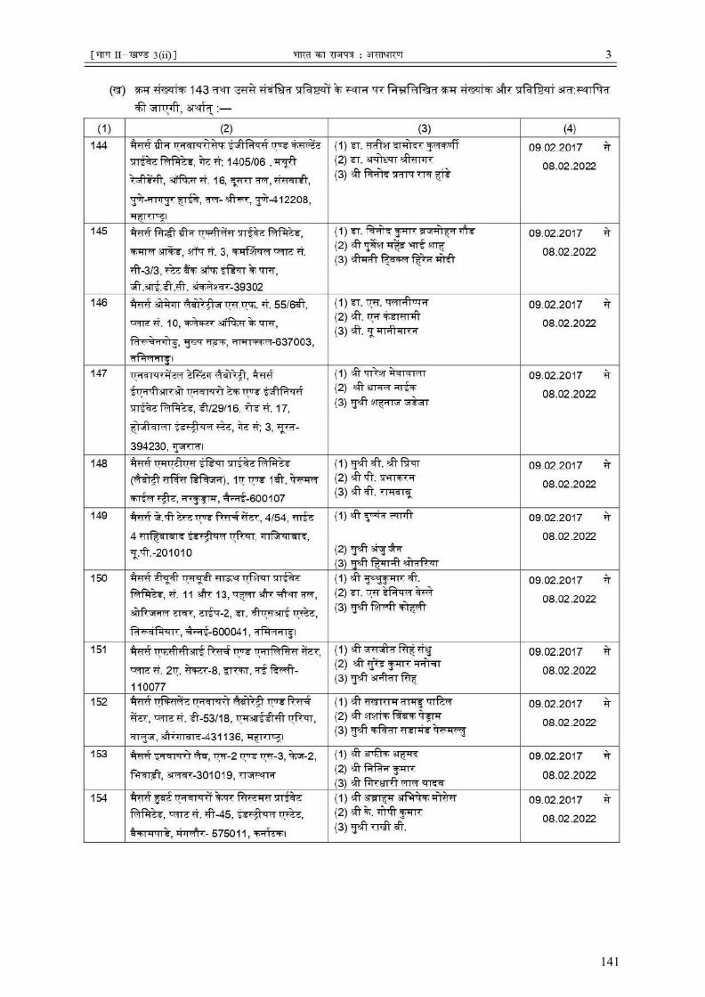
141
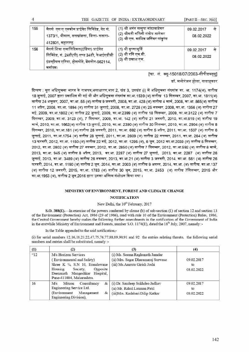
142
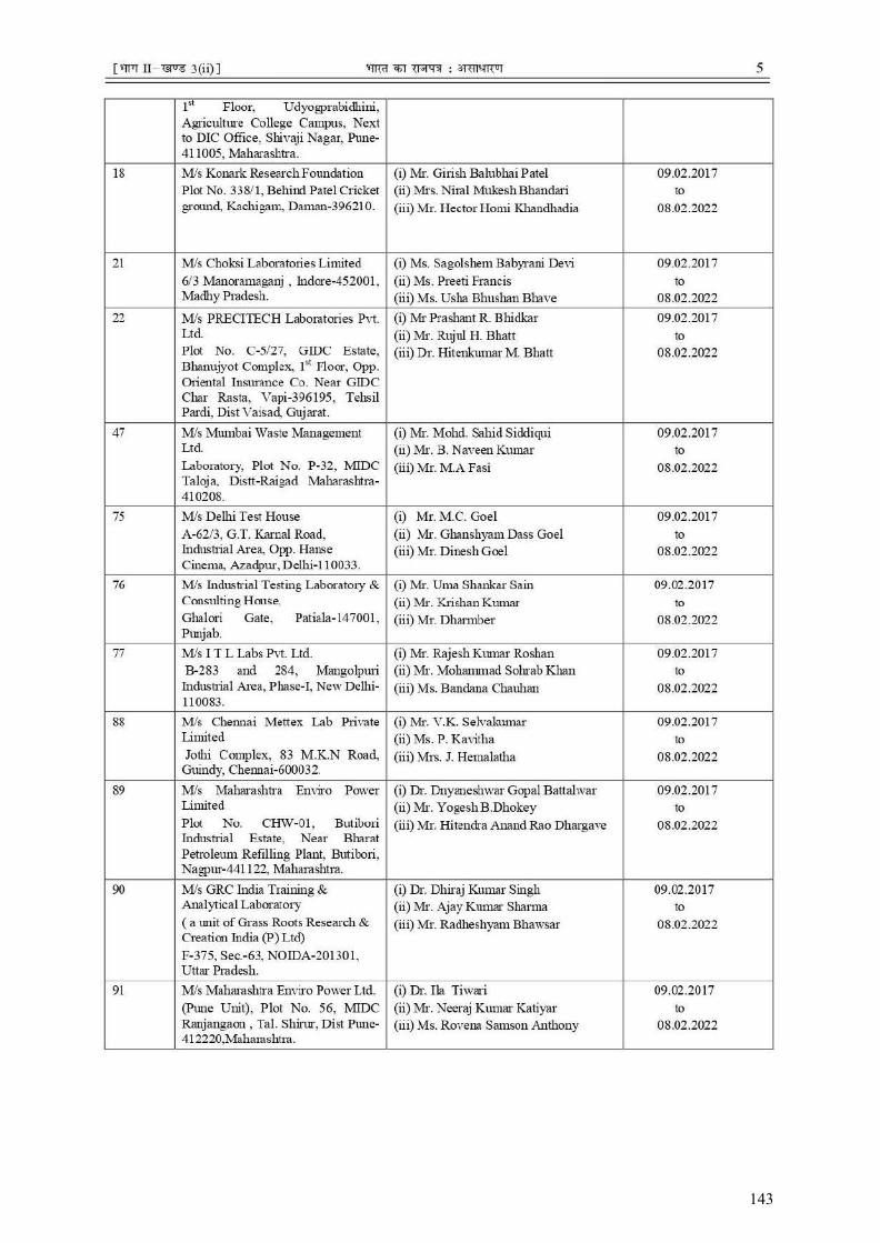
143
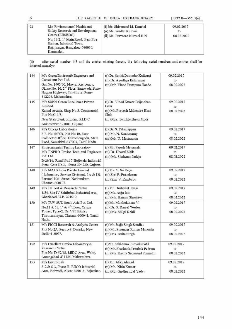
144

145
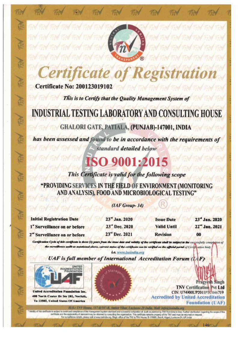
146

147
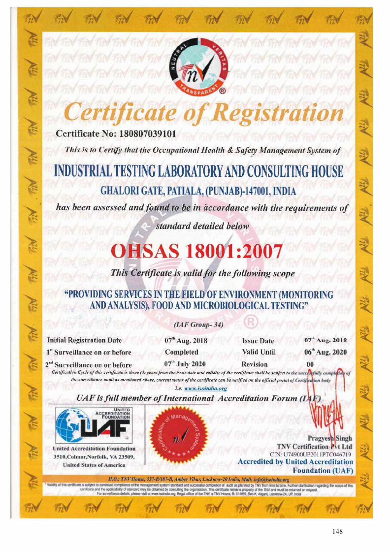
148
APPENDIX-7
Ecological Investigation Report for Project Road
and Jetty Facility
149
Biological Environment
Biodiversity Impact Assessment study of the present project/road corridor was carried out to ensure
ecological sustainability in the project area. Present biodiversity study includes- generate baseline
information on biodiversity; to understand the ecological status; to predict the probable impacts due
to the proposed up gradation/widening of road corridors; and to suggest possible remedial and
mitigation measures. Present primary study was carried out in the month of September 2019.
1. Forest Ecosystem
Himachal Pradesh encompasses tropical to temperate forests, alpine meadows and snow, high
biodiversity and endemism, oaks-centered biodiversity, predominance of evergreen forests with a
one year life span. The state has a wide ecological range because of relatively larger variation in
altitude, latitude and rainfall and its seasonality.
Based on the interpretation of satellite date pertaining to Oct-Dec. 2015, the forest cover in the state
is 15,100 Km which is 27.12% of the state’s geographical area. In terms of forest canopy density
classes, the state has 3,110 Km2 under very dense forest, 6,705 Km2 under moderately dense forest
and 5,285 Km2 under open forest present in the state (ISFR, 2017).
Forest type mapping using satellite data has been undertaken by Forest Survey of India with reference to
Champion & Seth’s classification and as per this assessment, the state has 38 forest types which belong
to 8 forest type groups, viz. Tropical Moist Deciduous, Tropical Dry Deciduous, Subtropical Pine,
Himalayan Moist Temperate, Himalayan Dry Temperate, Sub Alpine Forests, Moist Alpine Scrub and Dry
Alpine Scrub (ISFR, 2011).
150
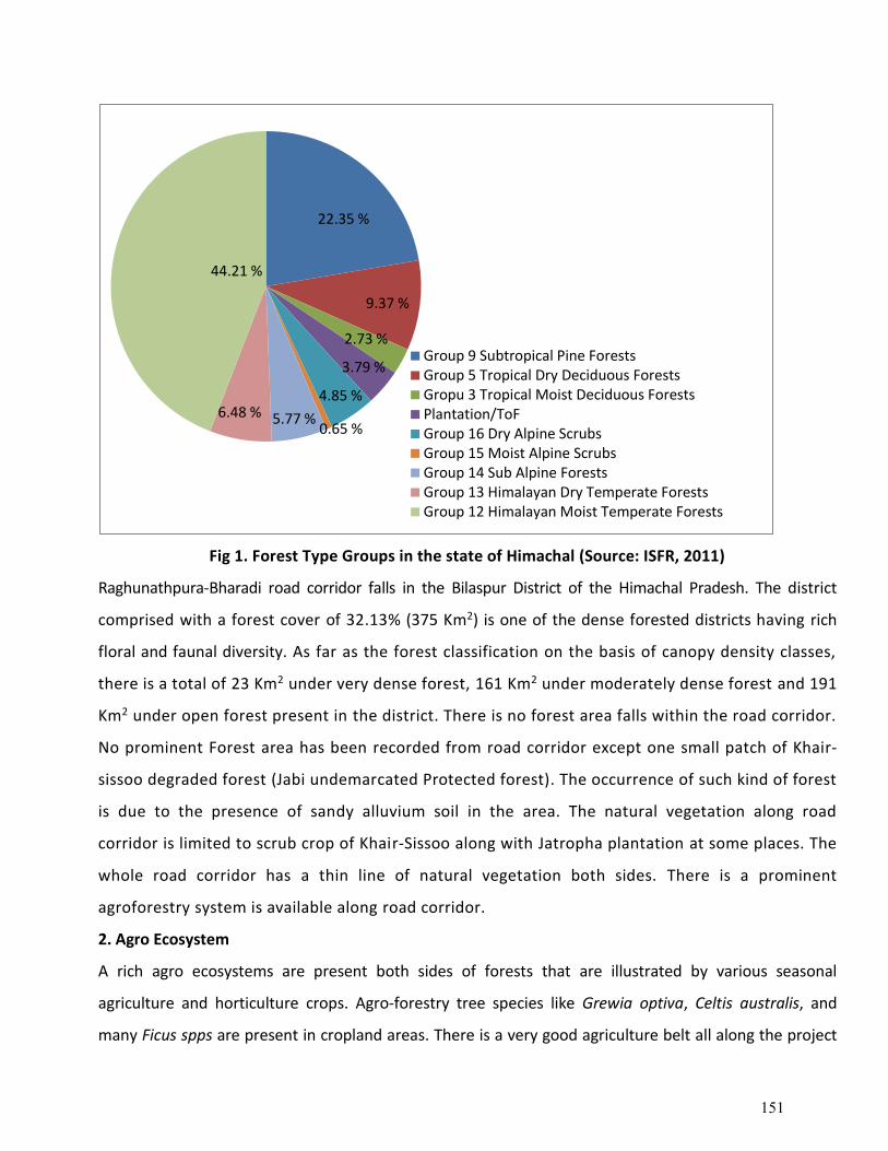
Fig 1. Forest Type Groups in the state of Himachal (Source: ISFR, 2011)
Raghunathpura-Bharadi road corridor falls in the Bilaspur District of the Himachal Pradesh. The district
comprised with a forest cover of 32.13% (375 Km2) is one of the dense forested districts having rich
floral and faunal diversity. As far as the forest classification on the basis of canopy density classes,
there is a total of 23 Km2 under very dense forest, 161 Km2 under moderately dense forest and 191
Km2 under open forest present in the district. There is no forest area falls within the road corridor.
No prominent Forest area has been recorded from road corridor except one small patch of Khair-
sissoo degraded forest (Jabi undemarcated Protected forest). The occurrence of such kind of forest
is due to the presence of sandy alluvium soil in the area. The natural vegetation along road
corridor is limited to scrub crop of Khair-Sissoo along with Jatropha plantation at some places. The
whole road corridor has a thin line of natural vegetation both sides. There is a prominent
agroforestry system is available along road corridor.
2. Agro Ecosystem
A rich agro ecosystems are present both sides of forests that are illustrated by various seasonal
agriculture and horticulture crops. Agro-forestry tree species like Grewia optiva, Celtis australis, and
many Ficus spps are present in cropland areas. There is a very good agriculture belt all along the project
22.35 %
9.37 %
2.73 %
3.79 %
4.85 %
0.65 %5.77 %6.48 %
44.21 %
Group 9 Subtropical Pine ForestsGroup 5 Tropical Dry Deciduous ForestsGropu 3 Tropical Moist Deciduous ForestsPlantation/ToFGroup 16 Dry Alpine ScrubsGroup 15 Moist Alpine ScrubsGroup 14 Sub Alpine ForestsGroup 13 Himalayan Dry Temperate ForestsGroup 12 Himalayan Moist Temperate Forests
151
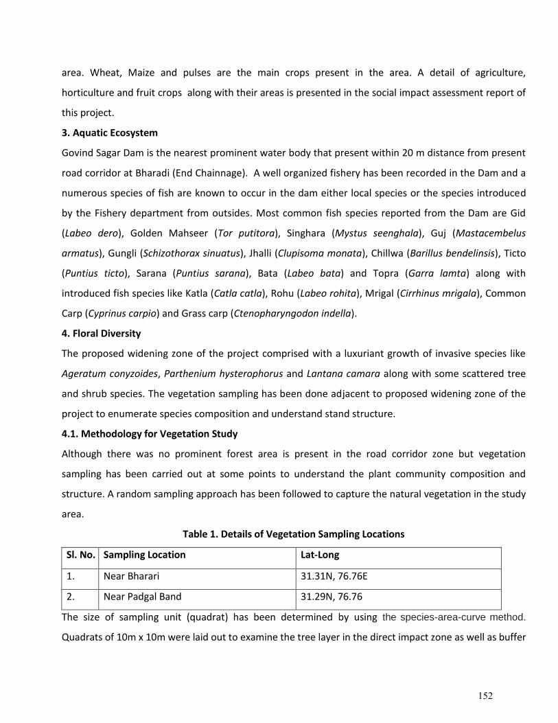
area. Wheat, Maize and pulses are the main crops present in the area. A detail of agriculture,
horticulture and fruit crops along with their areas is presented in the social impact assessment report of
this project.
3. Aquatic Ecosystem
Govind Sagar Dam is the nearest prominent water body that present within 20 m distance from present
road corridor at Bharadi (End Chainnage). A well organized fishery has been recorded in the Dam and a
numerous species of fish are known to occur in the dam either local species or the species introduced
by the Fishery department from outsides. Most common fish species reported from the Dam are Gid
(Labeo dero), Golden Mahseer (Tor putitora), Singhara (Mystus seenghala), Guj (Mastacembelus
armatus), Gungli (Schizothorax sinuatus), Jhalli (Clupisoma monata), Chillwa (Barillus bendelinsis), Ticto
(Puntius ticto), Sarana (Puntius sarana), Bata (Labeo bata) and Topra (Garra lamta) along with
introduced fish species like Katla (Catla catla), Rohu (Labeo rohita), Mrigal (Cirrhinus mrigala), Common
Carp (Cyprinus carpio) and Grass carp (Ctenopharyngodon indella).
4. Floral Diversity
The proposed widening zone of the project comprised with a luxuriant growth of invasive species like
Ageratum conyzoides, Parthenium hysterophorus and Lantana camara along with some scattered tree
and shrub species. The vegetation sampling has been done adjacent to proposed widening zone of the
project to enumerate species composition and understand stand structure.
4.1. Methodology for Vegetation Study
Although there was no prominent forest area is present in the road corridor zone but vegetation
sampling has been carried out at some points to understand the plant community composition and
structure. A random sampling approach has been followed to capture the natural vegetation in the study
area.
Table 1. Details of Vegetation Sampling Locations
Sl. No. Sampling Location Lat-Long
1. Near Bharari 31.31N, 76.76E
2. Near Padgal Band 31.29N, 76.76
The size of sampling unit (quadrat) has been determined by using the species-area-curve method.
Quadrats of 10m x 10m were laid out to examine the tree layer in the direct impact zone as well as buffer
152
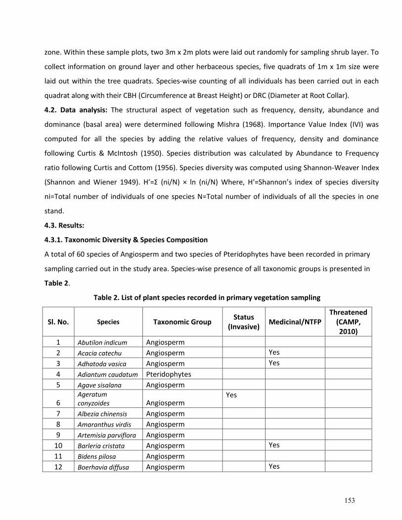
zone. Within these sample plots, two 3m x 2m plots were laid out randomly for sampling shrub layer. To
collect information on ground layer and other herbaceous species, five quadrats of 1m x 1m size were
laid out within the tree quadrats. Species-wise counting of all individuals has been carried out in each
quadrat along with their CBH (Circumference at Breast Height) or DRC (Diameter at Root Collar).
4.2. Data analysis: The structural aspect of vegetation such as frequency, density, abundance and
dominance (basal area) were determined following Mishra (1968). Importance Value Index (IVI) was
computed for all the species by adding the relative values of frequency, density and dominance
following Curtis & McIntosh (1950). Species distribution was calculated by Abundance to Frequency
ratio following Curtis and Cottom (1956). Species diversity was computed using Shannon-Weaver Index
(Shannon and Wiener 1949). H′=Σ (ni/N) × ln (ni/N) Where, H′=Shannon’s index of species diversity
ni=Total number of individuals of one species N=Total number of individuals of all the species in one
stand.
4.3. Results:
4.3.1. Taxonomic Diversity & Species Composition
A total of 60 species of Angiosperm and two species of Pteridophytes have been recorded in primary
sampling carried out in the study area. Species-wise presence of all taxonomic groups is presented in
Table 2.
Table 2. List of plant species recorded in primary vegetation sampling
Sl. No. Species Taxonomic Group Status
(Invasive) Medicinal/NTFP
Threatened (CAMP, 2010)
1 Abutilon indicum Angiosperm
2 Acacia catechu Angiosperm Yes
3 Adhatoda vasica Angiosperm Yes
4 Adiantum caudatum Pteridophytes
5 Agave sisalana Angiosperm
6 Ageratum conyzoides Angiosperm
Yes
7 Albezia chinensis Angiosperm
8 Amaranthus virdis Angiosperm
9 Artemisia parviflora Angiosperm
10 Barleria cristata Angiosperm Yes
11 Bidens pilosa Angiosperm
12 Boerhavia diffusa Angiosperm Yes
153
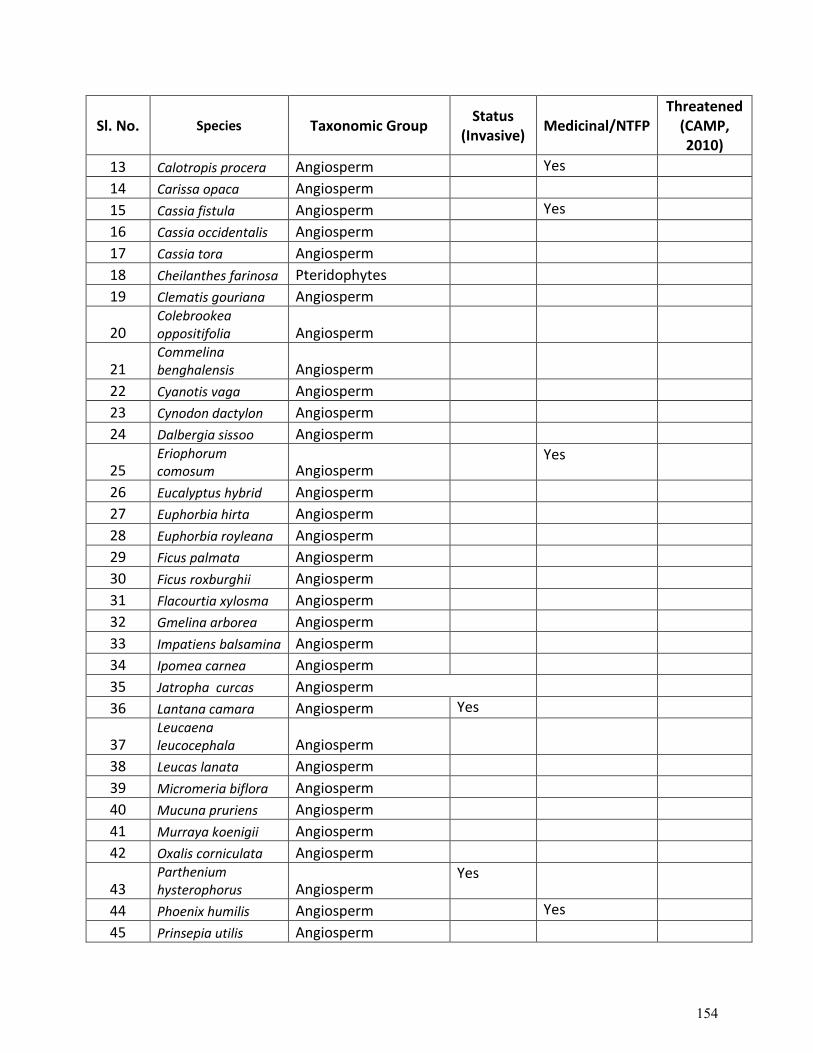
Sl. No. Species Taxonomic Group Status
(Invasive) Medicinal/NTFP
Threatened (CAMP, 2010)
13 Calotropis procera Angiosperm Yes
14 Carissa opaca Angiosperm
15 Cassia fistula Angiosperm Yes
16 Cassia occidentalis Angiosperm
17 Cassia tora Angiosperm
18 Cheilanthes farinosa Pteridophytes
19 Clematis gouriana Angiosperm
20 Colebrookea oppositifolia Angiosperm
21 Commelina benghalensis Angiosperm
22 Cyanotis vaga Angiosperm
23 Cynodon dactylon Angiosperm
24 Dalbergia sissoo Angiosperm
25 Eriophorum comosum Angiosperm
Yes
26 Eucalyptus hybrid Angiosperm
27 Euphorbia hirta Angiosperm
28 Euphorbia royleana Angiosperm
29 Ficus palmata Angiosperm
30 Ficus roxburghii Angiosperm
31 Flacourtia xylosma Angiosperm
32 Gmelina arborea Angiosperm
33 Impatiens balsamina Angiosperm
34 Ipomea carnea Angiosperm
35 Jatropha curcas Angiosperm
36 Lantana camara Angiosperm Yes
37 Leucaena leucocephala Angiosperm
38 Leucas lanata Angiosperm
39 Micromeria biflora Angiosperm
40 Mucuna pruriens Angiosperm
41 Murraya koenigii Angiosperm
42 Oxalis corniculata Angiosperm
43 Parthenium hysterophorus Angiosperm
Yes
44 Phoenix humilis Angiosperm Yes
45 Prinsepia utilis Angiosperm
154
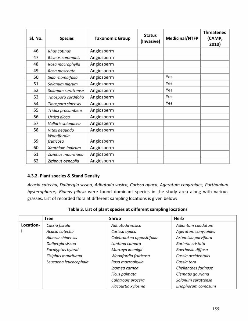
Sl. No. Species Taxonomic Group Status
(Invasive) Medicinal/NTFP
Threatened (CAMP, 2010)
46 Rhus cotinus Angiosperm
47 Ricinus communis Angiosperm
48 Rosa macrophylla Angiosperm
49 Rosa moschata Angiosperm
50 Sida rhombifolia Angiosperm Yes
51 Solanum nigrum Angiosperm Yes
52 Solanum surattense Angiosperm Yes
53 Tinospora cordifolia Angiosperm Yes
54 Tinospora sinensis Angiosperm Yes
55 Tridax procumbens Angiosperm
56 Urtica dioca Angiosperm
57 Vallaris solanacea Angiosperm
58 Vitex negundo Angiosperm
59 Woodfordia fruticosa Angiosperm
60 Xanthium indicum Angiosperm
61 Ziziphus mauritiana Angiosperm
62 Ziziphus oenoplia Angiosperm
4.3.2. Plant species & Stand Density
Acacia catechu, Dalbergia sissoo, Adhatoda vasica, Carissa opaca, Ageratum conyzoides, Parthanium
hysterophoros, Bidens pilosa were found dominant species in the study area along with various
grasses. List of recorded flora at different sampling locations is given below:
Table 3. List of plant species at different sampling locations
Tree Shrub Herb
Location-I
Cassia fistula
Acacia catechu
Albezia chinensis
Dalbergia sissoo
Eucalyptus hybrid
Ziziphus mauritiana
Leucaena leucocephala
Adhatoda vasica
Carissa opaca
Colebrookea oppositifolia
Lantana camara
Murraya koenigii
Woodfordia fruticosa
Rosa macrophylla
Ipomea carnea
Ficus palmata
Calotropis procera
Flacourtia xylosma
Adiantum caudatum
Ageratum conyzoides
Artemisia parviflora
Barleria cristata
Boerhavia diffusa
Cassia occidentalis
Cassia tora
Cheilanthes farinose
Clematis gouriana
Solanum surattense
Eriophorum comosum
155
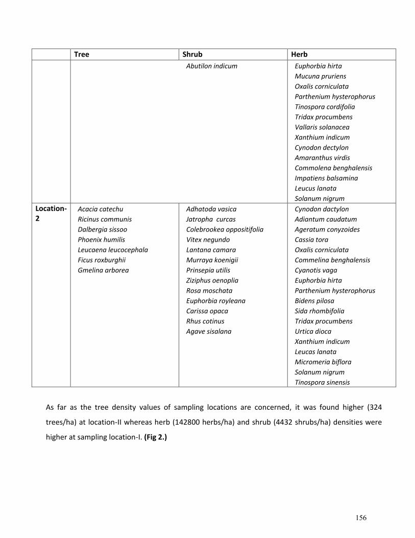
Tree Shrub Herb
Abutilon indicum
Euphorbia hirta
Mucuna pruriens
Oxalis corniculata
Parthenium hysterophorus
Tinospora cordifolia
Tridax procumbens
Vallaris solanacea
Xanthium indicum
Cynodon dectylon
Amaranthus virdis
Commolena benghalensis
Impatiens balsamina
Leucus lanata
Solanum nigrum
Location-2
Acacia catechu
Ricinus communis
Dalbergia sissoo
Phoenix humilis
Leucaena leucocephala
Ficus roxburghii
Gmelina arborea
Adhatoda vasica
Jatropha curcas
Colebrookea oppositifolia
Vitex negundo
Lantana camara
Murraya koenigii
Prinsepia utilis
Ziziphus oenoplia
Rosa moschata
Euphorbia royleana
Carissa opaca
Rhus cotinus
Agave sisalana
Cynodon dactylon
Adiantum caudatum
Ageratum conyzoides
Cassia tora
Oxalis corniculata
Commelina benghalensis
Cyanotis vaga
Euphorbia hirta
Parthenium hysterophorus
Bidens pilosa
Sida rhombifolia
Tridax procumbens
Urtica dioca
Xanthium indicum
Leucas lanata
Micromeria biflora
Solanum nigrum
Tinospora sinensis
As far as the tree density values of sampling locations are concerned, it was found higher (324
trees/ha) at location-II whereas herb (142800 herbs/ha) and shrub (4432 shrubs/ha) densities were
higher at sampling location-I. (Fig 2.)
156
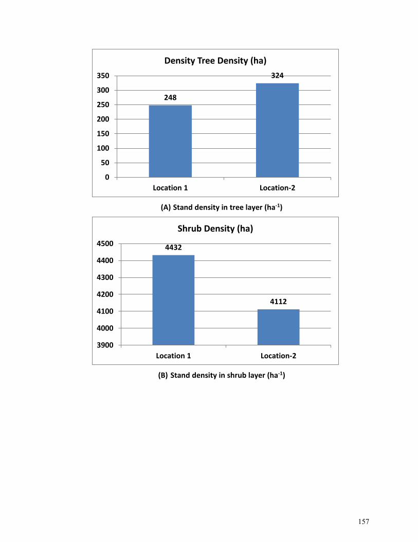
(A) Stand density in tree layer (ha-1)
(B) Stand density in shrub layer (ha-1)
248
324
0
50
100
150
200
250
300
350
Location 1 Location-2
Density Tree Density (ha)
4432
4112
3900
4000
4100
4200
4300
4400
4500
Location 1 Location-2
Shrub Density (ha)
157
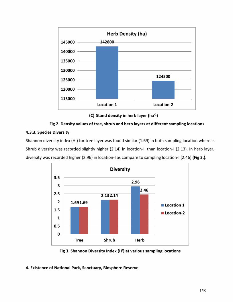
(C) Stand density in herb layer (ha-1)
Fig 2. Density values of tree, shrub and herb layers at different sampling locations
4.3.3. Species Diversity
Shannon diversity index (H’) for tree layer was found similar (1.69) in both sampling location whereas
Shrub diversity was recorded slightly higher (2.14) in location-II than location-I (2.13). In herb layer,
diversity was recorded higher (2.96) in location-I as compare to sampling location-I (2.46) (Fig 3.).
Fig 3. Shannon Diversity Index (H') at various sampling locations
4. Existence of National Park, Sanctuary, Biosphere Reserve
142800
124500
115000
120000
125000
130000
135000
140000
145000
Location 1 Location-2
Herb Density (ha)
1.69
2.13
2.96
1.69
2.142.46
0
0.5
1
1.5
2
2.5
3
3.5
Tree Shrub Herb
Diversity
Location 1
Location-2
158
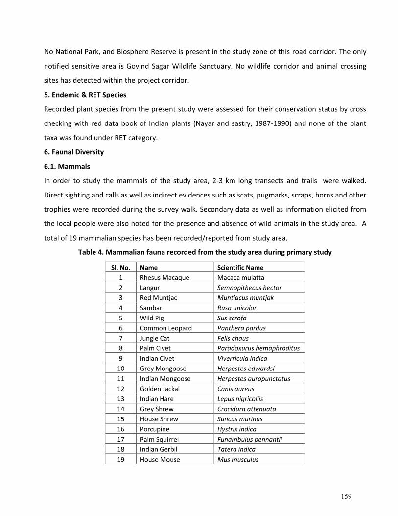
No National Park, and Biosphere Reserve is present in the study zone of this road corridor. The only
notified sensitive area is Govind Sagar Wildlife Sanctuary. No wildlife corridor and animal crossing
sites has detected within the project corridor.
5. Endemic & RET Species
Recorded plant species from the present study were assessed for their conservation status by cross
checking with red data book of Indian plants (Nayar and sastry, 1987-1990) and none of the plant
taxa was found under RET category.
6. Faunal Diversity
6.1. Mammals
In order to study the mammals of the study area, 2-3 km long transects and trails were walked.
Direct sighting and calls as well as indirect evidences such as scats, pugmarks, scraps, horns and other
trophies were recorded during the survey walk. Secondary data as well as information elicited from
the local people were also noted for the presence and absence of wild animals in the study area. A
total of 19 mammalian species has been recorded/reported from study area.
Table 4. Mammalian fauna recorded from the study area during primary study
Sl. No. Name Scientific Name
1 Rhesus Macaque Macaca mulatta
2 Langur Semnopithecus hector
3 Red Muntjac Muntiacus muntjak
4 Sambar Rusa unicolor
5 Wild Pig Sus scrofa
6 Common Leopard Panthera pardus
7 Jungle Cat Felis chaus
8 Palm Civet Paradoxurus hemaphroditus
9 Indian Civet Viverricula indica
10 Grey Mongoose Herpestes edwardsi
11 Indian Mongoose Herpestes auropunctatus
12 Golden Jackal Canis aureus
13 Indian Hare Lepus nigricollis
14 Grey Shrew Crocidura attenuata
15 House Shrew Suncus murinus
16 Porcupine Hystrix indica
17 Palm Squirrel Funambulus pennantii
18 Indian Gerbil Tatera indica
19 House Mouse Mus musculus
159
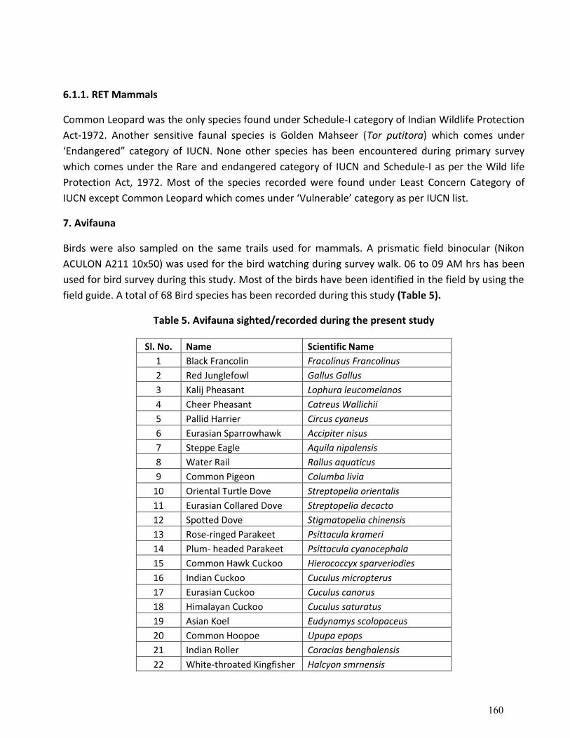
6.1.1. RET Mammals
Common Leopard was the only species found under Schedule-I category of Indian Wildlife Protection
Act-1972. Another sensitive faunal species is Golden Mahseer (Tor putitora) which comes under
‘Endangered” category of IUCN. None other species has been encountered during primary survey
which comes under the Rare and endangered category of IUCN and Schedule-I as per the Wild life
Protection Act, 1972. Most of the species recorded were found under Least Concern Category of
IUCN except Common Leopard which comes under ‘Vulnerable’ category as per IUCN list.
7. Avifauna
Birds were also sampled on the same trails used for mammals. A prismatic field binocular (Nikon
ACULON A211 10x50) was used for the bird watching during survey walk. 06 to 09 AM hrs has been
used for bird survey during this study. Most of the birds have been identified in the field by using the
field guide. A total of 68 Bird species has been recorded during this study (Table 5).
Table 5. Avifauna sighted/recorded during the present study
Sl. No. Name Scientific Name
1 Black Francolin Fracolinus Francolinus
2 Red Junglefowl Gallus Gallus
3 Kalij Pheasant Lophura leucomelanos
4 Cheer Pheasant Catreus Wallichii
5 Pallid Harrier Circus cyaneus
6 Eurasian Sparrowhawk Accipiter nisus
7 Steppe Eagle Aquila nipalensis
8 Water Rail Rallus aquaticus
9 Common Pigeon Columba livia
10 Oriental Turtle Dove Streptopelia orientalis
11 Eurasian Collared Dove Streptopelia decacto
12 Spotted Dove Stigmatopelia chinensis
13 Rose-ringed Parakeet Psittacula krameri
14 Plum- headed Parakeet Psittacula cyanocephala
15 Common Hawk Cuckoo Hierococcyx sparveriodies
16 Indian Cuckoo Cuculus micropterus
17 Eurasian Cuckoo Cuculus canorus
18 Himalayan Cuckoo Cuculus saturatus
19 Asian Koel Eudynamys scolopaceus
20 Common Hoopoe Upupa epops
21 Indian Roller Coracias benghalensis
22 White-throated Kingfisher Halcyon smrnensis
160
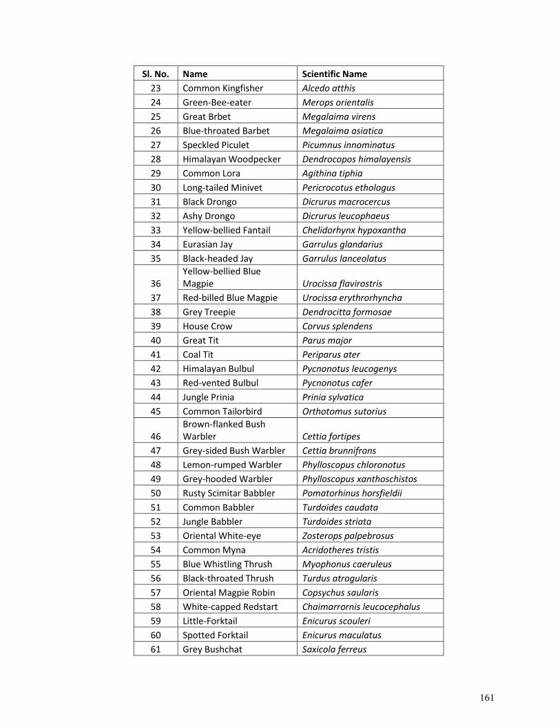
Sl. No. Name Scientific Name
23 Common Kingfisher Alcedo atthis
24 Green-Bee-eater Merops orientalis
25 Great Brbet Megalaima virens
26 Blue-throated Barbet Megalaima asiatica
27 Speckled Piculet Picumnus innominatus
28 Himalayan Woodpecker Dendrocopos himalayensis
29 Common Lora Agithina tiphia
30 Long-tailed Minivet Pericrocotus ethologus
31 Black Drongo Dicrurus macrocercus
32 Ashy Drongo Dicrurus leucophaeus
33 Yellow-bellied Fantail Chelidorhynx hypoxantha
34 Eurasian Jay Garrulus glandarius
35 Black-headed Jay Garrulus lanceolatus
36 Yellow-bellied Blue Magpie Urocissa flavirostris
37 Red-billed Blue Magpie Urocissa erythrorhyncha
38 Grey Treepie Dendrocitta formosae
39 House Crow Corvus splendens
40 Great Tit Parus major
41 Coal Tit Periparus ater
42 Himalayan Bulbul Pycnonotus leucogenys
43 Red-vented Bulbul Pycnonotus cafer
44 Jungle Prinia Prinia sylvatica
45 Common Tailorbird Orthotomus sutorius
46 Brown-flanked Bush Warbler Cettia fortipes
47 Grey-sided Bush Warbler Cettia brunnifrons
48 Lemon-rumped Warbler Phylloscopus chloronotus
49 Grey-hooded Warbler Phylloscopus xanthoschistos
50 Rusty Scimitar Babbler Pomatorhinus horsfieldii
51 Common Babbler Turdoides caudata
52 Jungle Babbler Turdoides striata
53 Oriental White-eye Zosterops palpebrosus
54 Common Myna Acridotheres tristis
55 Blue Whistling Thrush Myophonus caeruleus
56 Black-throated Thrush Turdus atrogularis
57 Oriental Magpie Robin Copsychus saularis
58 White-capped Redstart Chaimarrornis leucocephalus
59 Little-Forktail Enicurus scouleri
60 Spotted Forktail Enicurus maculatus
61 Grey Bushchat Saxicola ferreus
161
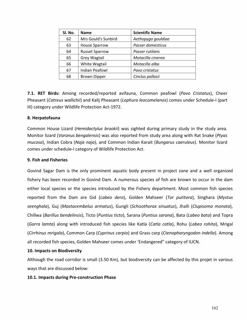
Sl. No. Name Scientific Name
62 Mrs Gould's Sunbird Aethopyga gouldiae
63 House Sparrow Passer domesticus
64 Russet Sparrow Passer rutilans
65 Grey Wagtail Motacilla cinerea
66 White Wagtail Motacilla alba
67 Indian Peafowl Pavo cristatus
68 Brown Dipper Cinclus pallasii
7.1. RET Birds: Among recorded/reported avifauna, Common peafowl (Pavo Cristatus), Cheer
Pheasant (Catreus wallichii) and Kalij Pheasant (Lophura leocomelanos) comes under Schedule-I (part
III) category under Wildlife Protection Act-1972.
8. Herpatofauna
Common House Lizard (Hemidactylus brookii) was sighted during primary study in the study area.
Monitor lizard (Varanus bengalensis) was also reported from study area along with Rat Snake (Ptyas
mucosa), Indian Cobra (Naja naja), and Common Indian Karait (Bungarus caeruleus). Monitor lizard
comes under schedule-I category of Wildlife Protection Act.
9. Fish and Fisheries
Govind Sagar Dam is the only prominent aquatic body present in project zone and a well organized
fishery has been recorded in Govind Dam. A numerous species of fish are known to occur in the dam
either local species or the species introduced by the Fishery department. Most common fish species
reported from the Dam are Gid (Labeo dero), Golden Mahseer (Tor putitora), Singhara (Mystus
seenghala), Guj (Mastacembelus armatus), Gungli (Schizothorax sinuatus), Jhalli (Clupisoma monata),
Chillwa (Barillus bendelinsis), Ticto (Puntius ticto), Sarana (Puntius sarana), Bata (Labeo bata) and Topra
(Garra lamta) along with introduced fish species like Katla (Catla catla), Rohu (Labeo rohita), Mrigal
(Cirrhinus mrigala), Common Carp (Cyprinus carpio) and Grass carp (Ctenopharyngodon indella). Among
all recorded fish species, Golden Mahseer comes under ‘Endangered” category of IUCN.
10. Impacts on Biodiversity
Although the road corridor is small (3.50 Km), but biodiversity can be affected by this projet in various
ways that are discussed below:
10.1. Impacts during Pre-construction Phase
162
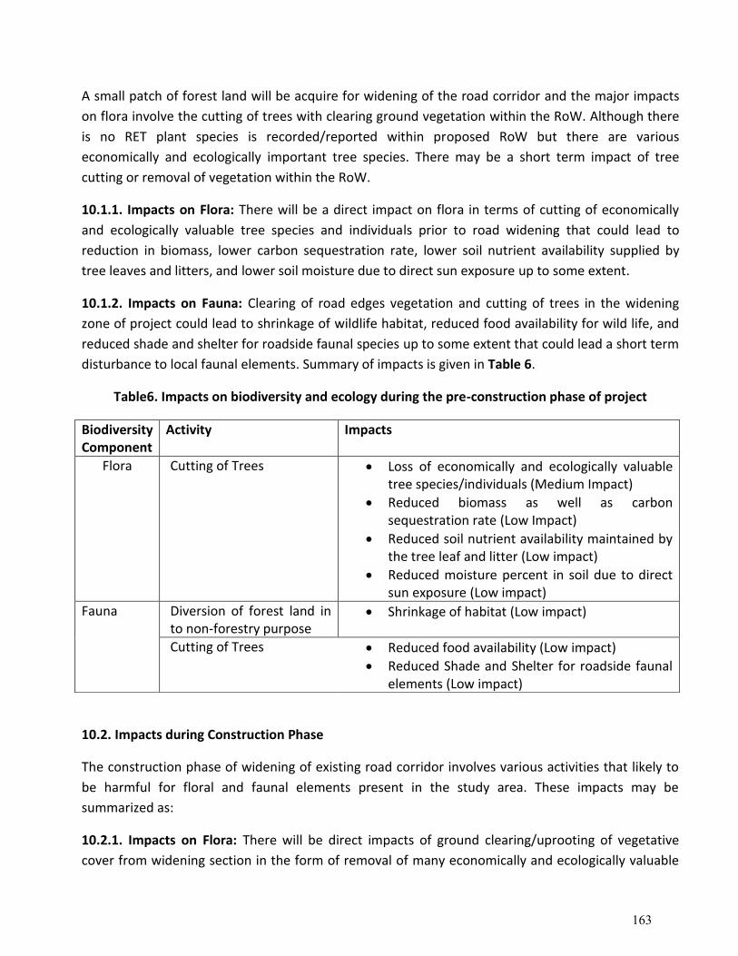
A small patch of forest land will be acquire for widening of the road corridor and the major impacts
on flora involve the cutting of trees with clearing ground vegetation within the RoW. Although there
is no RET plant species is recorded/reported within proposed RoW but there are various
economically and ecologically important tree species. There may be a short term impact of tree
cutting or removal of vegetation within the RoW.
10.1.1. Impacts on Flora: There will be a direct impact on flora in terms of cutting of economically
and ecologically valuable tree species and individuals prior to road widening that could lead to
reduction in biomass, lower carbon sequestration rate, lower soil nutrient availability supplied by
tree leaves and litters, and lower soil moisture due to direct sun exposure up to some extent.
10.1.2. Impacts on Fauna: Clearing of road edges vegetation and cutting of trees in the widening
zone of project could lead to shrinkage of wildlife habitat, reduced food availability for wild life, and
reduced shade and shelter for roadside faunal species up to some extent that could lead a short term
disturbance to local faunal elements. Summary of impacts is given in Table 6.
Table6. Impacts on biodiversity and ecology during the pre-construction phase of project
10.2. Impacts during Construction Phase
The construction phase of widening of existing road corridor involves various activities that likely to
be harmful for floral and faunal elements present in the study area. These impacts may be
summarized as:
10.2.1. Impacts on Flora: There will be direct impacts of ground clearing/uprooting of vegetative
cover from widening section in the form of removal of many economically and ecologically valuable
Biodiversity Component
Activity Impacts
Flora Cutting of Trees • Loss of economically and ecologically valuable tree species/individuals (Medium Impact)
• Reduced biomass as well as carbon sequestration rate (Low Impact)
• Reduced soil nutrient availability maintained by the tree leaf and litter (Low impact)
• Reduced moisture percent in soil due to direct sun exposure (Low impact)
Fauna Diversion of forest land in to non-forestry purpose
• Shrinkage of habitat (Low impact)
Cutting of Trees • Reduced food availability (Low impact)
• Reduced Shade and Shelter for roadside faunal elements (Low impact)
163
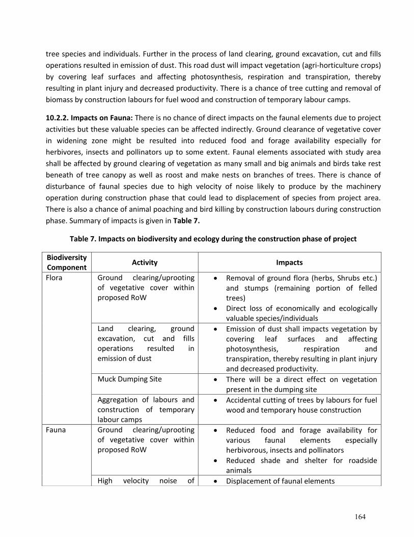
tree species and individuals. Further in the process of land clearing, ground excavation, cut and fills
operations resulted in emission of dust. This road dust will impact vegetation (agri-horticulture crops)
by covering leaf surfaces and affecting photosynthesis, respiration and transpiration, thereby
resulting in plant injury and decreased productivity. There is a chance of tree cutting and removal of
biomass by construction labours for fuel wood and construction of temporary labour camps.
10.2.2. Impacts on Fauna: There is no chance of direct impacts on the faunal elements due to project
activities but these valuable species can be affected indirectly. Ground clearance of vegetative cover
in widening zone might be resulted into reduced food and forage availability especially for
herbivores, insects and pollinators up to some extent. Faunal elements associated with study area
shall be affected by ground clearing of vegetation as many small and big animals and birds take rest
beneath of tree canopy as well as roost and make nests on branches of trees. There is chance of
disturbance of faunal species due to high velocity of noise likely to produce by the machinery
operation during construction phase that could lead to displacement of species from project area.
There is also a chance of animal poaching and bird killing by construction labours during construction
phase. Summary of impacts is given in Table 7.
Table 7. Impacts on biodiversity and ecology during the construction phase of project
Biodiversity Component
Activity Impacts
Flora
Ground clearing/uprooting of vegetative cover within proposed RoW
• Removal of ground flora (herbs, Shrubs etc.) and stumps (remaining portion of felled trees)
• Direct loss of economically and ecologically valuable species/individuals
Land clearing, ground excavation, cut and fills operations resulted in emission of dust
• Emission of dust shall impacts vegetation by covering leaf surfaces and affecting photosynthesis, respiration and transpiration, thereby resulting in plant injury and decreased productivity.
Muck Dumping Site • There will be a direct effect on vegetation present in the dumping site
Aggregation of labours and construction of temporary labour camps
• Accidental cutting of trees by labours for fuel wood and temporary house construction
Fauna
Ground clearing/uprooting of vegetative cover within proposed RoW
• Reduced food and forage availability for various faunal elements especially herbivorous, insects and pollinators
• Reduced shade and shelter for roadside animals
High velocity noise of • Displacement of faunal elements
164
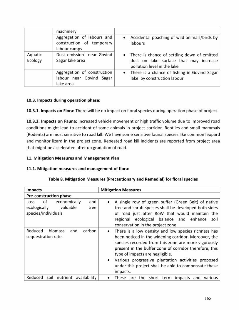
10.3. Impacts during operation phase:
10.3.1. Impacts on Flora: There will be no impact on floral species during operation phase of project.
10.3.2. Impacts on Fauna: Increased vehicle movement or high traffic volume due to improved road
conditions might lead to accident of some animals in project corridor. Reptiles and small mammals
(Rodents) are most sensitive to road kill. We have some sensitive faunal species like common leopard
and monitor lizard in the project zone. Repeated road kill incidents are reported from project area
that might be accelerated after up gradation of road.
11. Mitigation Measures and Management Plan
11.1. Mitigation measures and management of flora:
Table 8. Mitigation Measures (Precautionary and Remedial) for floral species
Impacts Mitigation Measures
Pre-construction phase
Loss of economically and ecologically valuable tree species/individuals
• A single row of green buffer (Green Belt) of native tree and shrub species shall be developed both sides of road just after RoW that would maintain the regional ecological balance and enhance soil conservation in the project zone
Reduced biomass and carbon sequestration rate
• There is a low density and low species richness has been noticed in the widening corridor. Moreover, the species recorded from this zone are more vigorously present in the buffer zone of corridor therefore, this type of impacts are negligible.
• Various progressive plantation activities proposed under this project shall be able to compensate these impacts.
Reduced soil nutrient availability • These are the short term impacts and various
machinery
Aggregation of labours and construction of temporary labour camps
• Accidental poaching of wild animals/birds by labours
Aquatic Ecology
Dust emission near Govind Sagar lake area
• There is chance of settling down of emitted dust on lake surface that may increase pollution level in the lake
Aggregation of construction labour near Govind Sagar lake area
• There is a chance of fishing in Govind Sagar lake by construction labour
165
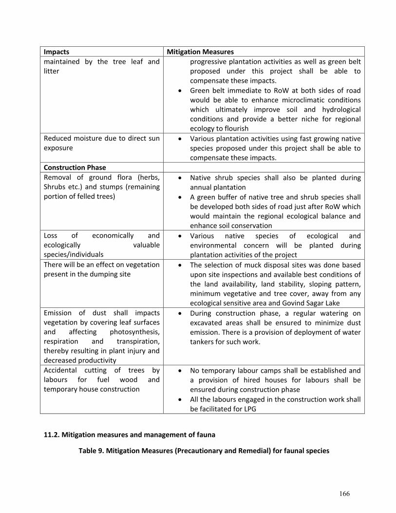
Impacts Mitigation Measures
maintained by the tree leaf and litter
progressive plantation activities as well as green belt proposed under this project shall be able to compensate these impacts.
• Green belt immediate to RoW at both sides of road would be able to enhance microclimatic conditions which ultimately improve soil and hydrological conditions and provide a better niche for regional ecology to flourish
Reduced moisture due to direct sun exposure
• Various plantation activities using fast growing native species proposed under this project shall be able to compensate these impacts.
Construction Phase
Removal of ground flora (herbs, Shrubs etc.) and stumps (remaining portion of felled trees)
• Native shrub species shall also be planted during annual plantation
• A green buffer of native tree and shrub species shall be developed both sides of road just after RoW which would maintain the regional ecological balance and enhance soil conservation
Loss of economically and ecologically valuable species/individuals
• Various native species of ecological and environmental concern will be planted during plantation activities of the project
There will be an effect on vegetation present in the dumping site
• The selection of muck disposal sites was done based upon site inspections and available best conditions of the land availability, land stability, sloping pattern, minimum vegetative and tree cover, away from any ecological sensitive area and Govind Sagar Lake
Emission of dust shall impacts vegetation by covering leaf surfaces and affecting photosynthesis, respiration and transpiration, thereby resulting in plant injury and decreased productivity
• During construction phase, a regular watering on excavated areas shall be ensured to minimize dust emission. There is a provision of deployment of water tankers for such work.
Accidental cutting of trees by labours for fuel wood and temporary house construction
• No temporary labour camps shall be established and a provision of hired houses for labours shall be ensured during construction phase
• All the labours engaged in the construction work shall be facilitated for LPG
11.2. Mitigation measures and management of fauna
Table 9. Mitigation Measures (Precautionary and Remedial) for faunal species
166
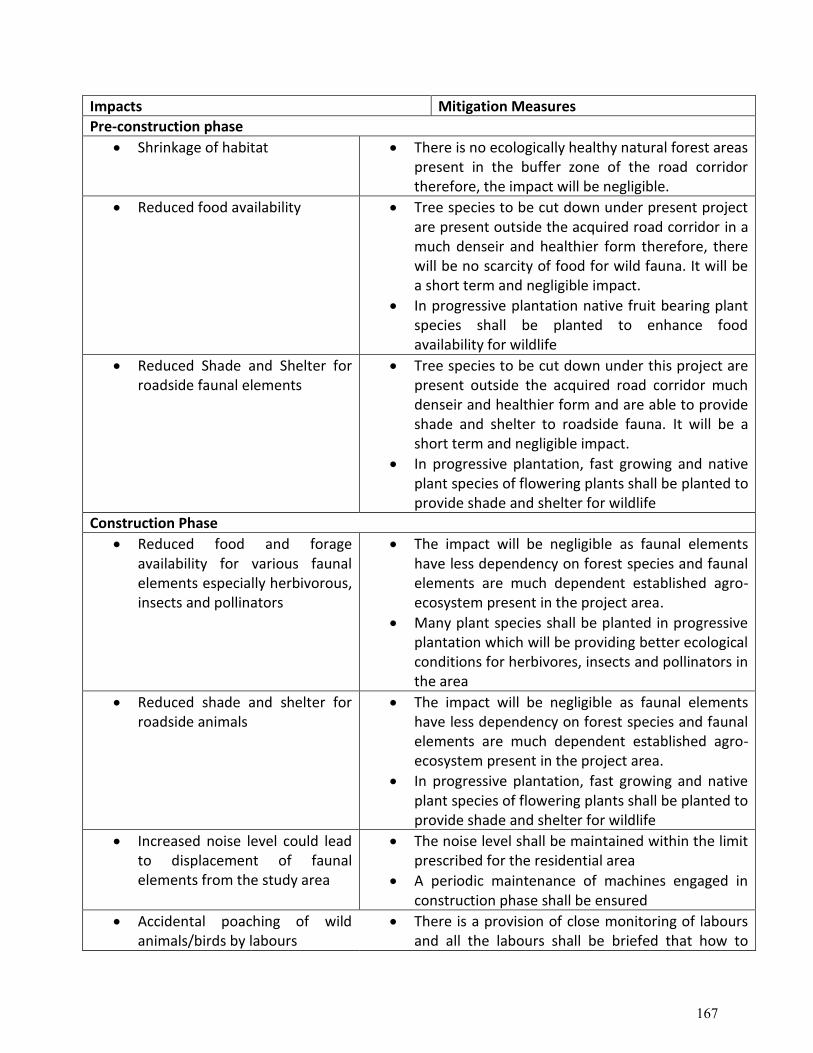
Impacts Mitigation Measures
Pre-construction phase
• Shrinkage of habitat • There is no ecologically healthy natural forest areas present in the buffer zone of the road corridor therefore, the impact will be negligible.
• Reduced food availability • Tree species to be cut down under present project are present outside the acquired road corridor in a much denseir and healthier form therefore, there will be no scarcity of food for wild fauna. It will be a short term and negligible impact.
• In progressive plantation native fruit bearing plant species shall be planted to enhance food availability for wildlife
• Reduced Shade and Shelter for roadside faunal elements
• Tree species to be cut down under this project are present outside the acquired road corridor much denseir and healthier form and are able to provide shade and shelter to roadside fauna. It will be a short term and negligible impact.
• In progressive plantation, fast growing and native plant species of flowering plants shall be planted to provide shade and shelter for wildlife
Construction Phase
• Reduced food and forage availability for various faunal elements especially herbivorous, insects and pollinators
• The impact will be negligible as faunal elements have less dependency on forest species and faunal elements are much dependent established agro-ecosystem present in the project area.
• Many plant species shall be planted in progressive plantation which will be providing better ecological conditions for herbivores, insects and pollinators in the area
• Reduced shade and shelter for roadside animals
• The impact will be negligible as faunal elements have less dependency on forest species and faunal elements are much dependent established agro-ecosystem present in the project area.
• In progressive plantation, fast growing and native plant species of flowering plants shall be planted to provide shade and shelter for wildlife
• Increased noise level could lead to displacement of faunal elements from the study area
• The noise level shall be maintained within the limit prescribed for the residential area
• A periodic maintenance of machines engaged in construction phase shall be ensured
• Accidental poaching of wild animals/birds by labours
• There is a provision of close monitoring of labours and all the labours shall be briefed that how to
167
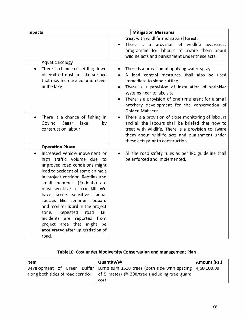
Impacts Mitigation Measures
treat with wildlife and natural forest.
• There is a provision of wildlife awarenessprogramme for labours to aware them aboutwildlife acts and punishment under these acts.
Aquatic Ecology
• There is chance of settling downof emitted dust on lake surfacethat may increase pollution levelin the lake
• There is a provision of applying water spray
• A load control measures shall also be usedimmediate to slope cutting
• There is a provision of Installation of sprinklersystems near to lake site
• There is a provision of one time grant for a smallhatchery development for the conservation ofGolden Mahseer
• There is a chance of fishing inGovind Sagar lake byconstruction labour
• There is a provision of close monitoring of laboursand all the labours shall be briefed that how totreat with wildlife. There is a provision to awarethem about wildlife acts and punishment underthese acts prior to construction.
Operation Phase
• Increased vehicle movement orhigh traffic volume due toimproved road conditions mightlead to accident of some animalsin project corridor. Reptiles andsmall mammals (Rodents) aremost sensitive to road kill. Wehave some sensitive faunalspecies like common leopardand monitor lizard in the projectzone. Repeated road killincidents are reported fromproject area that might beaccelerated after up gradation ofroad.
• All the road safety rules as per IRC guideline shallbe enforced and implemented.
Table10. Cost under biodiversity Conservation and management Plan
Item Quantity/@ Amount (Rs.)
Development of Green Buffer along both sides of road corridor
Lump sum 1500 trees (Both side with spacing of 5 meter) @ 300/tree (including tree guard cost)
4,50,000.00
168
Item Quantity/@ Amount (Rs.)
One time grant for a small hatchery development for mahsheer conservation
Management authority, Govind Sagar Dam Authourity
5,00,000.00
Progressive plantation at various sites (up to 3 years)
Lump-sum 1000 per year @Rs. 100/plant 3,00,000.00
Creation of biodiversity conservation awareness among villagers and construction workers
02 awareness meetings cum workshop (one at Raghunathpura and one for construction workers) @ 30,000 each
60,000.00
Total (Thirteen Lakh ten thousand only) 13,10,000.00
Table 11. List of plant species recommended for plantation
Sl. No. Name Scientific Name Nature
1 Amaltash Cassia fistula Tree
2 Amla Emblica officinalis Tree
3 Baheda Terminalia bellerica Tree
4 Darek Melia azedarach Tree
5 Tun Toona ciliata Tree
6 Jamun Syzygium cumini Tree
7 Kachnar Bauhinia variegata Tree
8 Bans Dendrocalamus strictus Shrub
9 Sahtoot Morus alba Tree
10 Shisham Dalbergia sissoo Tree
11 Silver oak Grevillea robusta Tree
12 Khiral Celtis australis Tree
13 Tiamali Ficus roxburghii Tree
14 Neem Azadirachta indica Tree
15 Peepal Ficus religiosa Tree
16 Champa Michelia chmpaca Tree
17 Mehul Pyrus pashia Tree
18 Buel Grawia optiva Tree
18 Gulmohar Delonix regia Tree
19 Gandhela Murraya koenigii Shrub
20 Trimal Zanthoxylum armatum Shrub
21 Gudhal Hibiscus rosa-sinensis Shrub
22 Rambans Agave americana Shrub
23 Leucaena leucocephala Tree
169
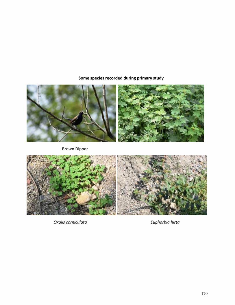
Some species recorded during primary study
Brown Dipper
Oxalis corniculata Euphorbia hirta
170
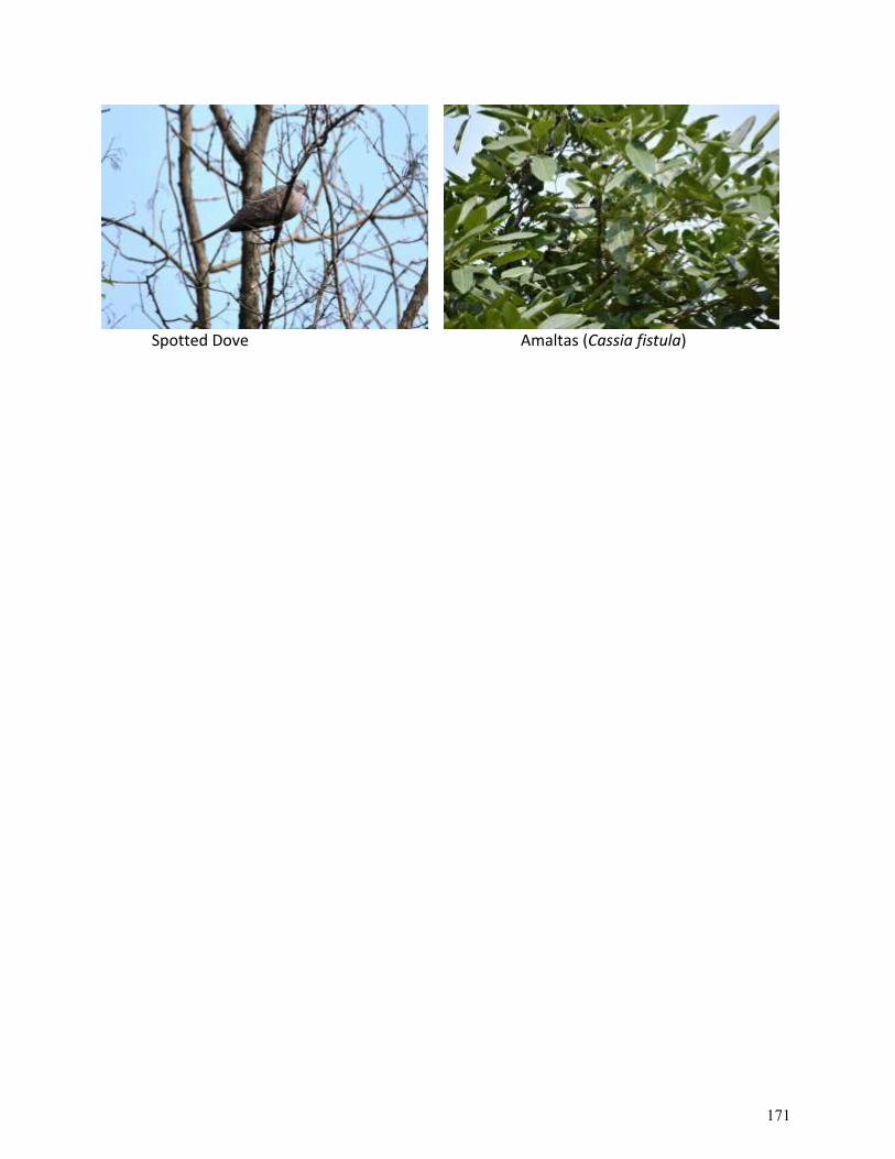
Spotted Dove Amaltas (Cassia fistula)
171
Prepared By: PL Chauhan, I.F.S. (Retd.), SAGE HIMALAYA CONSULTANCY
Website: https://sagehimalaya.com/
DRAFT REPORT
Biodiversity Impact Assessment(BIA) and Mitigation Plan(MP)
CLIENT:Chief Engineer-cum-Project Director
State Roads Project, Himachal Pradesh Road and Other Infrasture Development Corporation Ltd.Nirman Bhawan, Nigam Vihar, Shimla - 171002, Himachal Pradesh
Fax:0177-2620663, Tel: 0177-2627602, Email: [email protected]
172
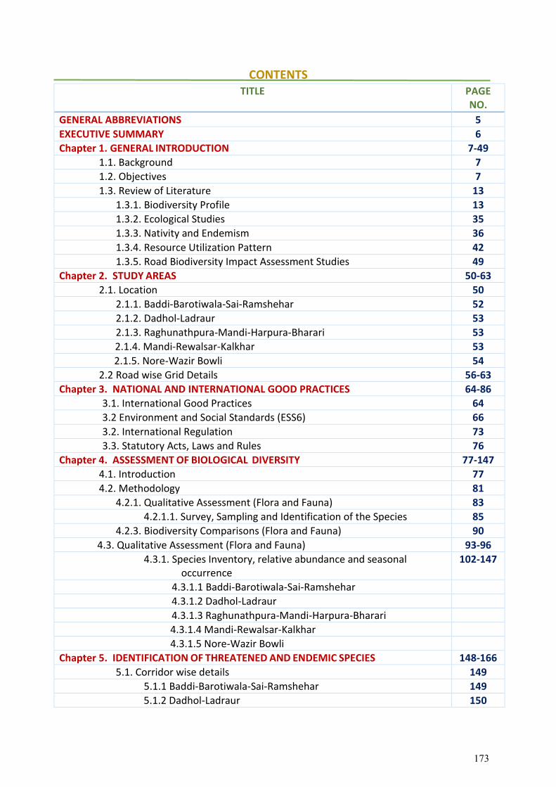
CONTENTS TITLE PAGE
NO.
GENERAL ABBREVIATIONS 5
EXECUTIVE SUMMARY 6
Chapter 1. GENERAL INTRODUCTION 7-49
1.1. Background 7
1.2. Objectives 7
1.3. Review of Literature 13
1.3.1. Biodiversity Profile 13
1.3.2. Ecological Studies 35
1.3.3. Nativity and Endemism 36
1.3.4. Resource Utilization Pattern 42
1.3.5. Road Biodiversity Impact Assessment Studies 49
Chapter 2. STUDY AREAS 50-63
2.1. Location 50
2.1.1. Baddi-Barotiwala-Sai-Ramshehar 52
2.1.2. Dadhol-Ladraur 53
2.1.3. Raghunathpura-Mandi-Harpura-Bharari 53
2.1.4. Mandi-Rewalsar-Kalkhar 53
2.1.5. Nore-Wazir Bowli 54
2.2 Road wise Grid Details 56-63
Chapter 3. NATIONAL AND INTERNATIONAL GOOD PRACTICES 64-86
3.1. International Good Practices 64
3.2 Environment and Social Standards (ESS6) 66
3.2. International Regulation 73
3.3. Statutory Acts, Laws and Rules 76
Chapter 4. ASSESSMENT OF BIOLOGICAL DIVERSITY 77-147
4.1. Introduction 77
4.2. Methodology 81
4.2.1. Qualitative Assessment (Flora and Fauna) 83
4.2.1.1. Survey, Sampling and Identification of the Species 85
4.2.3. Biodiversity Comparisons (Flora and Fauna) 90
4.3. Qualitative Assessment (Flora and Fauna) 93-96
4.3.1. Species Inventory, relative abundance and seasonal occurrence
102-147
4.3.1.1 Baddi-Barotiwala-Sai-Ramshehar
4.3.1.2 Dadhol-Ladraur
4.3.1.3 Raghunathpura-Mandi-Harpura-Bharari
4.3.1.4 Mandi-Rewalsar-Kalkhar
4.3.1.5 Nore-Wazir Bowli
Chapter 5. IDENTIFICATION OF THREATENED AND ENDEMIC SPECIES 148-166
5.1. Corridor wise details 149
5.1.1 Baddi-Barotiwala-Sai-Ramshehar 149
5.1.2 Dadhol-Ladraur 150
173
5.1.3 Raghunathpura-Mandi-Harpura-Bharari 151
5.1.4 Mandi-Rewalsar-Kalkhar 152
5.1.5 Nore-Wazir Bowli 153
5.2 Human Wildlife Conflicts 163
Chapter 6. STAKEHOLDER CONSULTATION 167-182
6.1 Baddi-Barotiwala-Sai-Ramshehar 167
6.2 Dadhol-Ladraur 172
6.3 Raghunathpura-Mandi-Harpura-Bharari 173
6.4 Mandi-Rewalsar-Kalkhar 175
6.5 Nore-Wazir Bowli 178
Chapter 7. IMPACTS OF ROAD PROJECTS ON BIODIVERSITY 183-186
7.1. Introduction 183
7.2. Impacts of Roads on Fauna 184
Chapter 8. MITIGATION & CONSERVATION STRATEGIES 187-193
8.1 Mitigation Measures 187
8.2 Conservation Measures 187
8.3 Components for Biodiversity Conservation 188
8.4 Smart and Green Infrastructure 189
8.5 Wildlife Corridor 189
8.5.1 Overpass 189
8.5.2 Underpass 190
8.5.3 Fencing 190
8.5.4 Invasive Alien Species 191
Chapter 9. BIODIVERSITY CONSERVATION COMPONENTS 194-228
9.1 Habitat Improvement 194
9.2 Socio-economic activities 194
9.3 Regulatory measures 194
9.4 Scope for roadside plantation and methodology 194
9.5 Soil and Moisture Conservation (SMC) Activities 195
9.6 Annual Plan of Operations 202
ANNEXURE 229-242
i. Field Visits and meetings 229-232
ii. Core Team 233
iii. Technical Specification for Plantation 234
iv. Cost norms 235-242
APPENDIX
List of flora and fauna along corridors 243-265
174
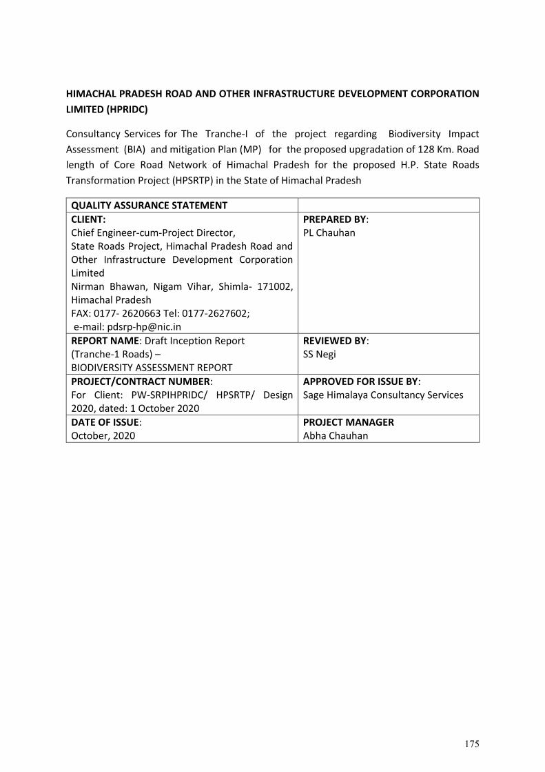
HIMACHAL PRADESH ROAD AND OTHER INFRASTRUCTURE DEVELOPMENT CORPORATION
LIMITED (HPRIDC)
Consultancy Services for The Tranche-I of the project regarding Biodiversity Impact
Assessment (BIA) and mitigation Plan (MP) for the proposed upgradation of 128 Km. Road
length of Core Road Network of Himachal Pradesh for the proposed H.P. State Roads
Transformation Project (HPSRTP) in the State of Himachal Pradesh
QUALITY ASSURANCE STATEMENT
CLIENT: Chief Engineer-cum-Project Director, State Roads Project, Himachal Pradesh Road and Other Infrastructure Development Corporation Limited Nirman Bhawan, Nigam Vihar, Shimla- 171002, Himachal Pradesh FAX: 0177- 2620663 Tel: 0177-2627602; e-mail: [email protected]
PREPARED BY: PL Chauhan
REPORT NAME: Draft Inception Report (Tranche-1 Roads) – BIODIVERSITY ASSESSMENT REPORT
REVIEWED BY: SS Negi
PROJECT/CONTRACT NUMBER: For Client: PW-SRPIHPRIDC/ HPSRTP/ Design 2020, dated: 1 October 2020
APPROVED FOR ISSUE BY: Sage Himalaya Consultancy Services
DATE OF ISSUE: October, 2020
PROJECT MANAGER Abha Chauhan
175
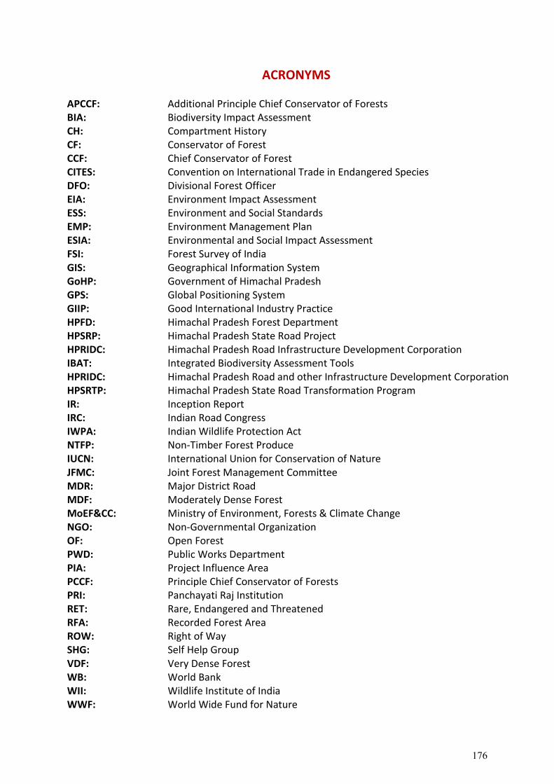
ACRONYMS
APCCF: Additional Principle Chief Conservator of Forests BIA: Biodiversity Impact Assessment CH: Compartment History CF: Conservator of Forest CCF: Chief Conservator of Forest CITES: Convention on International Trade in Endangered Species DFO: Divisional Forest Officer EIA: Environment Impact Assessment ESS: Environment and Social Standards EMP: Environment Management Plan ESIA: Environmental and Social Impact Assessment FSI: Forest Survey of India GIS: Geographical Information System GoHP: Government of Himachal Pradesh GPS: Global Positioning System GIIP: Good International Industry Practice HPFD: Himachal Pradesh Forest Department HPSRP: Himachal Pradesh State Road Project HPRIDC: Himachal Pradesh Road Infrastructure Development Corporation IBAT: Integrated Biodiversity Assessment Tools HPRIDC: Himachal Pradesh Road and other Infrastructure Development Corporation HPSRTP: Himachal Pradesh State Road Transformation Program IR: Inception Report IRC: Indian Road Congress IWPA: Indian Wildlife Protection Act NTFP: Non-Timber Forest Produce IUCN: International Union for Conservation of Nature JFMC: Joint Forest Management Committee MDR: Major District Road MDF: Moderately Dense Forest MoEF&CC: Ministry of Environment, Forests & Climate Change NGO: Non-Governmental Organization OF: Open Forest PWD: Public Works Department PIA: Project Influence Area PCCF: Principle Chief Conservator of Forests PRI: Panchayati Raj Institution RET: Rare, Endangered and Threatened RFA: Recorded Forest Area ROW: Right of Way SHG: Self Help Group VDF: Very Dense Forest WB: World Bank WII: Wildlife Institute of India WWF: World Wide Fund for Nature
176
GENERAL ABBREVIATIONS
The Government of Himachal Pradesh has completed/implemented the World Bank- funded Himachal Pradesh State Roads Project Phase-I (HPSRP-I) and thereafter state has planned through the Government of India to implement Himachal Pradesh State Roads Transformation Program (HPSRTP) for the overall economic development of the state. Under this project, State Road Network of 650 Km length is proposed to be upgraded and 1350 Km for periodical maintenance besides other institutional & development activities. Upgradation of 650 Km road length will be carried out in 3 Tranches i.e Tranche-I=130 Km, Tranche-II=220 Km and Tranche-III=300 Km. the various project preparatory studies are being carried simultaneously. The Tranche-I of the project requires a Biodiversity Impact Assessment (BIA) study along with the assessment of forestry and wildlife concerned for the proposed up-gradation of 128 Km. Road length. The preliminary studies and consultations held along the proposed Tranche-I roads with various stakeholders indicated that the Forestry and Wildlife component is one of the most important concerns /impacts due to the implementation of the project.
The purpose of this draft Biodiversity Impact Assessment (BIA) & Mitigation Plan (MP) Report related to Tranche-I of the TOR as follows: -
1. The main objectives of the draft BIA and MP is to establish a decision-support tool to help biodiversity inclusive linear road development planning and implementation. It targets at safeguarding that the development schemes unite biodiversity considerations and are legally compliant. This report also includes mitigation strategies for the conservation of biodiversity (with the aim of no net loss of biodiversity) and to ensure sustainable ecosystem services.
2. The overall aim is to assess the status and trends of biodiversity along the Project Influence Area (PIA) which are essential for sustainable development strategies. In order to achieve this, the Consultant conducted a rapid assessment along the project road to gauge the potential resources derived from biodiversity in the area. Based on the existing knowledge on the current state of biodiversity in the area, and gathering the primary data to predict potential impacts of the development proposal on biodiversity, and to recommend mitigating strategies to minimize impacts on biodiversity.
3. This report also analyses existing policies in Indian Constitution, which safeguards Indian forests and biodiversity; state-level policies and forest clearances are also reviewed. The approach recommends policy level amendments to ease plantation regulations for allowing local communities to maintain ecosystem services. This will permit biodiversity conservation in the broader context of sustainable development of the ecosystem.
177
EXECUTIVE SUMMARY
Biodiversity can be defined as the variability of living organisms within the ecological complexes in which they exist. India is one of the 17 identified mega-diverse countries in the world. However, increasing human interferences such as linear/highway construction result in biodiversity and habitat degradations. Habitat fragmentation on the ecosystem has accelerated biodiversity loss, having severe social and economic implications for humankind.
Himachal Pradesh is situated in the lap of north-western Himalaya and harbours one of the richest biodiversity of mountain landscapes having distinctive biodiversity. Out of 47,000 plant species found in the country, as many as 3295 species (7.32%) are reported in Himachal Pradesh, and out of 91,000 species of animals, Himachal Pradesh harbours 5721 species, amounting to about 6.28% of Indian fauna, which shows the richness of faunal resources of the State considering its small geographical area, which is only about 1.7% of the country. The ecosystem lies in the inner Shiwalik and the outer Himalayas, varying from 360 m to 2000 m. The composition of floral diversity is mainly affected by soil, moisture conditions, elevation, aspect, and numerous rights of users.
Keeping in view of the high forest percentage and rich floral and faunal diversity of Himachal Pradesh, the GoHP and the World Bank is concerned about the negative impact that road development on the biodiversity of the area, which might be the direct impact or indirect and short-term or long-term. Integrating forests and wildlife concerns into road project road planning at an early stage can limit the adverse impacts on biodiversity, wildlife habitat as improper practices could often result in irreversible adverse impacts leading to local extinctions of species.
A rapid Biodiversity Impact Assessment (BIA) has been carried out, to assess the probable impact of road construction and to minimize any direct and indirect bearings of road development/improvement on biodiversity. Collection and analysis of the biodiversity (forestry and wildlife) data relating to the 128 km road length was carried out, prioritized under Tranche-I of HPSRTP.
This BIA report also recommends short-term and long-term strategies at the governmental and the policy level to minimize the impacts of the linear infrastructure of biodiversity. Along with public awareness and pro biodiversity behaviour with the involvement of local communities, a futuristic strategy can harmonize ecology and the economy.
Amongst 384 economically important floral species explored along the project influence area, 314 are used as medicine, 105 wild edible/food, 97 fodder, 51 fuel, 21 religious, 05 each dye & fibre, 07 for making timber and agricultural tools. A total of 384 species of vascular plants i.e., Angiosperms (100 families, 278 genera & 374 species), Gymnosperms (01 family, 02 genera & 03 species) and Pteridophytes (05 families, 05 genera & 07 species) were recorded. Of the total species, 71 species were trees, 97 shrubs, 209 herbs & 07 pteridophytes.
After investigating Faunal diversity, the threatened species found were 8 butterflies, 3 reptiles, 8 birds and wildlife like Himalayan Brown Bear, Snow Leopard, Himalayan Lynx, Kashmir Stag, Himalayan Ibex, Himalayan Thar etc.
178
Chapter 1. GENERAL INTRODUCTION
1.1. Background
Project Background and Context of the Assignment: - The World Bank funded
Himachal Pradesh State Roads Project Phase-I (HPSRP-I) planned through Government of
India to implement Himachal Pradesh State Roads Transformation Program (HPSRTP) for
the overall economic development of the state. The road corridor of 650 Km length is
proposed to be upgraded under this project. The upgradation of 650 Km road length will be
carried out in 3 Tranches i.e. Tranche-I=130 Km, Tranche-II = 220 Km and Tranche-III=300
Km. The Tranche-I of the project require Biodiversity Impact Assessment (BIA) study along
with assessment of forestry and wildlife concerned for the proposed upgradation of 130 Km
Road length. The preliminary studies and consultations held along the proposed Tranche-I
roads with various stakeholders indicated that Forestry and Wildlife component as one
of the most important concerns /impacts due to implementation of the project.
1.2. Objectives
Biodiversity Impact Assessment (BIA) and Mitigation Plan (MP) after assessing forest, wildlife and socio-economic components for the upgradation of 128 Km; Tranche I roads of HPSRTP. The following are the objectives of this Consultancy Services:-
1. To protect and conserve biodiversity & habitats. 2. To assess the impacts during construction, post construction of the project roads on
forest, wildlife and wildlife habitat. 3. To identify areas of forestry/wildlife –traffic conflict that could create fatal accidents
or loss of wildlife or forest resources during construction & post construction of project roads.
4. To identify areas of wildlife crossings, its species and reason for crossings for each location need to be explored.
5. To workout/evolve modified/improved Cross-Drainage (CD) structures or bridges as mitigation measures for wildlife crossings.
6. To evolve innovative long-term and short-term road strategies or plans to mitigate/reduce the forestry/wildlife –traffic conflicts/collisions for a safe road network.
7. Prepare road wise concrete proposal with budgetary requirements, unit rate analysis to integrate into the engineering plans for building or integrating such plans to the contractors work during implementation of the project.
Description of Services (A) Secondary data collection 1. Collection and analysis of all policies (Environmental Policy, Forest Policy, Wildlife
Policy, etc of State and Central Governments), reports and documents relating to
179
the past and present activities and the proposed forestry and wildlife management directly /indirectly relevant to the State of Himachal Pradesh.
2. National and international good practices in Forestry and Wildlife Management and related issues are to be collected and integrated into the studies.
3. Collection and analysis of the data relating to wildlife -traffic collision/accidents in the whole state.
4. Forest working plans, forest boundary survey sheets, etc relevant to each specific road need to be collected and analysed.
5. Collection and listing of baseline biodiversity data on flora and fauna seen along all project roads (128 km). A baseline survey of plant and animal wealth having agricultural and economic value shall also be conducted.
(B) Primary data generation and consultation 1. The Consultant‘s Biodiversity (forestry and wildlife) Specialist needs to prepare
specific survey formats for all surveys including the collection of data during various community consultations and stakeholder consultations.
2. Meeting and consultations with all relevant Forest/Wildlife officials and NGOs in the State. All meetings shall be minted or documented along with digital photographs to integrate into the EIA/EMP reports that will have to be prepared for each road.
3. Making adequate site visits for surveys and investigations along the selected project roads as necessary for the completion of the Forestry and Wildlife studies.
4. Method - some primary surveys to be undertaken. This should include as a first step expert interviews of e.g. forest dept staff using a standard questionnaire. Second, interviews of villagers again using a standard questionnaire. Thereafter and having identified some locations or corridors where fauna is more prevalent, interviews with truck/bus drivers and then pug mark/dung surveys must be undertaken as appropriate.
5. Identification of rare and endangered species inhabiting near the project roads. Evaluation of current status and management practices of identified endangered species (flora and fauna) along the project roads. Quantify the impacts due to project roads. Suggestions for their effective and successful conservation and sound management along the project roads.
6. Describe characteristics including breeding and nesting requirements, life cycle features and others, etc.
7. Conducting interviews with various stakeholders (local communities, Forest officials, etc) of the project along the proposed project roads or in the PIA districts. All such meetings shall be properly documented. Public awareness about the benefits and importance of biodiversity and capacity issues shall also be studied.
8. As a part of the studies, consultant need to consult WWF, IUCN, MOEF, World Bank, IRC, Forest/Wildlife Research Institute in Dehradun to record their views and to collect necessary relevant secondary data.
180
(C) Analysis of the collected data and preparation of various plans 1 Based on the various studies, find out areas of Forestry/wildlife –traffic conflict that
could create fatal accidents or loss of wildlife or forest resources during the construction and post-construction scenario of the highways project (of improved or higher standards).
2 A brainstorming Workshop will be conducted at Shimla inviting all stakeholders/experts in the Forestry and wildlife sector that has been identified during the course of this study. This workshop will come up with concrete recommendations (long term and short term sectoral (Forest/wildlife sector) and cross-sectoral (Forest sector and Road sectoral) plans for the preservation and conservation of forest and wildlife in the State of Himachal Pradesh. Timing of the workshop should be before the draft report is submitted to firm up all the study recommendations for the long-term healthy existence of these two sectors. Evolve innovative long-term and short-term road sector strategies or plans to mitigate /minimize or to avoid such collisions thus minimizing or avoiding accidents involving wildlife and human beings.
3 Identify areas of wildlife crossings, their species, and the reason for crossings for each location need to be explored. The scope of using modified/improved Cross- Drainage (CD) structures or bridges as a mitigation measure can be looked into. If some specific structures for wildlife crossings are required provide all details to design such structures with the help of AutoCAD software. This design needs to be reviewed by HPRIDC and certified. Prepare road-wise concrete proposal with budgetary requirements, unit rate analysis to integrate into the engineering plans for building or integrating such plans to the contractor's work during the implementation of the project.
4 Prepare road-wise concrete proposal with budgetary requirements, unit rate analysis to integrate into the engineering plans for building or integrating such plans to the contractor's work during the implementation of the project.
5 Evolve long-term action plans to reduce the Forest/ Wildlife-traffic conflicts for a safe road network without any major loss of human beings or forestry and wildlife resources.
6 List various forestry/tree cutting and other biodiversity-related clearances and the procedures to be adopted for obtaining timely clearances from State Forestry and Wildlife departments and also from GOI-MOEF.
7 Recommendations - the report must disaggregate between (i) what the project can/must do with respect to planning/design/construction/operation of roads and within this category (a) general measures for the project as a whole and (b) specific measures for particular locations; and (ii) what other measures may be taken outside the RIDC/PWD by other Government of HP departments or Non-Government stakeholders.
Expected Outcomes: 1 Identification of rare and endangered species inhabiting near the project roads.
181
2 Collection and analysis of the biodiversity (forestry and wildlife) data relating to all PIA (Project Influence Areas) districts of the 128 km road length prioritized under Tranche-I of HPSRTP.
3 Collection and analysis of all policies (Environmental Policy, Forest Policy, Wildlife Policy, etc of State and Central Governments), reports and documents relating to the past and present activities and the proposed forestry and wildlife management directly/indirectly relevant to the State of Himachal Pradesh.
4 National and International good practices in Forestry and Wildlife Management and related issues are to be collected and integrated into the studies.
5 Collection and analysis of the data relating to wildlife-traffic collision/accidents in the whole state.
6 Meeting and consultations with all relevant Forest/Wildlife officials and NGOs in the state.
7 Describe characteristics including breeding and nesting requirements, lifecycle features and others, etc.
Requirement for Biodiversity Impact Assessment Keeping in view of the high forest percentage and rich floral and faunal diversity of
the state, GoHP and the World Bank is concerned about the negative impact that road development might have on the biodiversity of the area, which might have direct or indirect impact for short term and long term. Integrating forests and wildlife concerns into road project road planning at an early stage can limit the adverse impacts on biodiversity, particularly wildlife, wildlife habitat as improper practices could often result in irreversible adverse impacts leading to local extinctions of species. Keeping the above-mentioned context in mind and to minimize any of the direct and indirect impacts of road development/improvement on biodiversity, a rapid Biodiversity Impact Assessment (BIA) has been carried out with the following objectives.
1 To assess the impacts on forest, wildlife, wildlife habitat due to the proposed project. To identify and establish the probable road crossing locations of wildlife animals Likely to be Human-Animal Conflicts.
2 To prepare a multi propose mitigation plan with the details of strategies and measures to address forestry and wildlife concerns in the project.
182
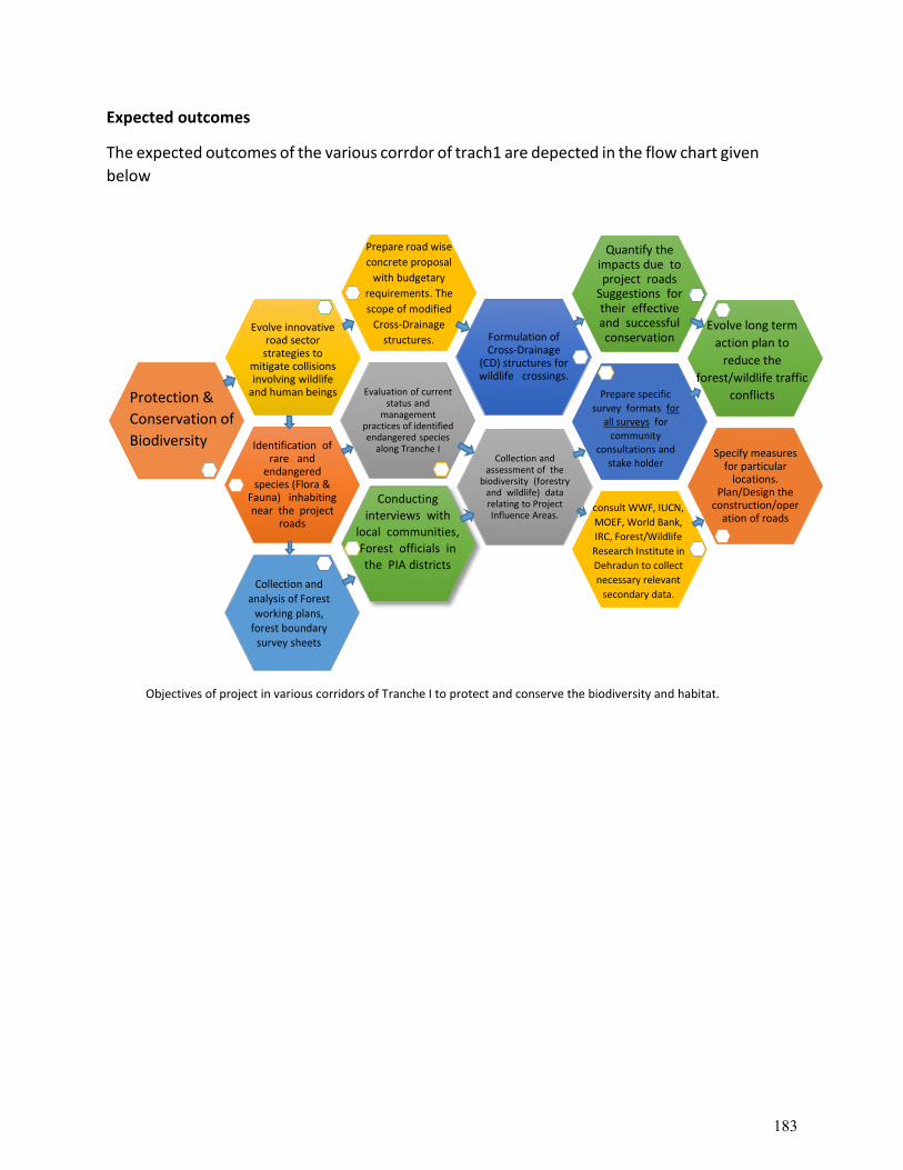
Expected outcomes
The expected outcomes of the various corrdor of trach1 are depected in the flow chart given
below
Objectives of project in various corridors of Tranche I to protect and conserve the biodiversity and habitat.
Identification of rare and
endangered species (Flora &
Fauna) inhabiting near the project
roads
Evaluation of current status and
management practices of identified endangered species
along Tranche I
Evolve innovative road sector strategies to
mitigate collisions involving wildlife
and human beings
Formulation of Cross-Drainage
(CD) structures for wildlife crossings.
Quantify the impacts due to project roads
Suggestions for their effective and successful conservation
Specify measures for particular
locations. Plan/Design the
construction/operation of roads
Collection and assessment of the
biodiversity (forestry and wildlife) data relating to Project Influence Areas.
Prepare road wise
concrete proposal
with budgetary
requirements. The
scope of modified
Cross-Drainage
structures.
Protection &
Conservation of
Biodiversity
Collection and analysis of Forest
working plans, forest boundary
survey sheets
Prepare specific
survey formats for all surveys for
community consultations and
stake holder consultations.
Conducting interviews with
local communities, Forest officials in the PIA districts
consult WWF, IUCN,
MOEF, World Bank,
IRC, Forest/Wildlife
Research Institute in
Dehradun to collect
necessary relevant
secondary data.
Evolve long term
action plan to
reduce the
forest/wildlife traffic
conflicts
183
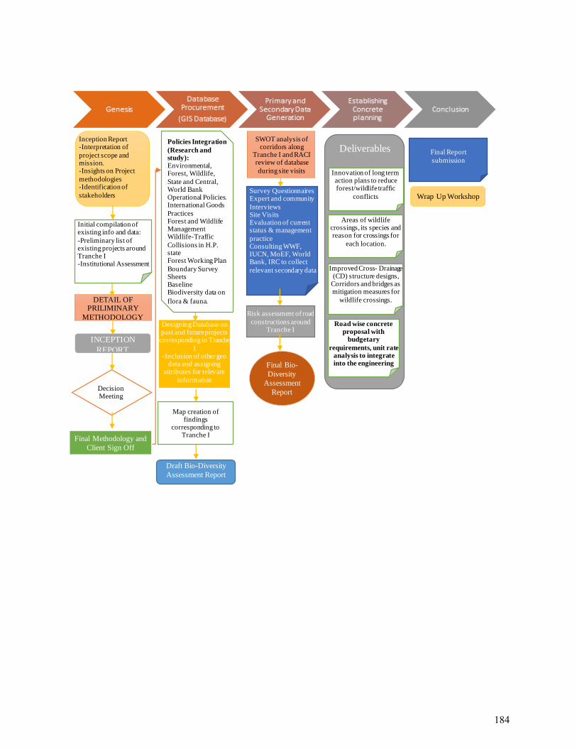
Draft Bio-Diversity
Assessment Report
Survey Questionnaires Expert and community
Interviews Site Visits Evaluation of current status & management
practice Consulting WWF, IUCN, MoEF, World Bank, IRC to collect
relevant secondary data
Final Bio-
Diversity
Assessment
Report
Final Report
submission
DETAIL OF PRILIMINARY
METHODOLOGY
INCEPTION
REPORT
Decision Meeting
Final Methodology and
Client Sign Off
Designing Database on past and future projects
corresponding to Tranche
I -Inclusion of other geo
data and assigning attributes for relevant
information
Map creation of findings
corresponding to Tranche I
Risk assessment of road
constructions around Tranche I
Initial compilation of existing info and data:
-Preliminary list of existing projects around Tranche I -Institutional Assessment
Inception Report -Interpretation of
project scope and mission. -Insights on Project
methodologies -Identification of
stakeholders
Policies Integration
(Research and study): Environmental, Forest, Wildlife,
State and Central, World Bank Operational Policies. International Goods
Practices Forest and Wildlife Management Wildlife-Traffic
Collisions in H.P. state Forest Working Plan
Boundary Survey Sheets Baseline Biodiversity data on
flora & fauna.
SWOT analysis of corridors along
Tranche I and RACI review of database
during site visits
Deliverables
Areas of wildlife crossings, its species and reason for crossings for
each location.
Improved Cross- Drainage (CD) structure designs,
Corridors and bridges as mitigation measures for
wildlife crossings.
Road wise concrete proposal with
budgetary
requirements, unit rate analysis to integrate into the engineering
plans.
Innovation of long term action plans to reduce forest/wildlife traffic
conflicts
Wrap Up Workshop
184
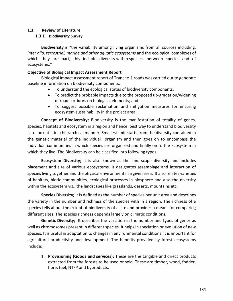
1.3. Review of Literature
1.3.1 Biodiversity Survey
Biodiversity is “the variability among living organisms from all sources including, inter alia, terrestrial, marine and other aquatic ecosystems and the ecological complexes of which they are part; this includes diversity within species, between species and of ecosystems.”
Objective of Biological Impact Assessment Report Biological Impact Assessment report of Tranche-1 roads was carried out to generate
baseline information on biodiversity components.
To understand the ecological status of biodiversity components.
To predict the probable impacts due to the proposed up-gradation/widening of road corridors on biological elements; and
To suggest possible reclamation and mitigation measures for ensuring ecosystem sustainability in the project area.
Concept of Biodiversity; Biodiversity is the manifestation of totality of genes,
species, habitats and ecosystem in a region and hence, best way to understand biodiversity
is to look at it in a hierarchical manner. Smallest unit starts from the diversity contained in
the genetic material of the individual organism and then goes on to encompass the
individual communities in which species are organized and finally on to the Ecosystem in
which they live. The Biodiversity can be classified into following types.
Ecosystem Diversity; It is also known as the land-scape diversity and includes
placement and size of various ecosystems. It designates assemblage and interaction of
species living together and the physical environment in a given area. It also relates varieties
of habitats, biotic communities, ecological processes in biosphere and also the diversity
within the ecosystem viz., the landscapes like grasslands, deserts, mountains etc.
Species Diversity; It is defined as the number of species per unit area and describes
the variety in the number and richness of the species with in a region. The richness of a
species tells about the extent of biodiversity of a site and provides a means for comparing
different sites. The species richness depends largely on climatic conditions.
Genetic Diversity; It describes the variation in the number and types of genes as
well as chromosomes present in different species. It helps in speciation or evolution of new
species. It is useful in adaptation to changes in environmental conditions. It is important for
agricultural productivity and development. The benefits provided by forest ecosystems
include:
1. Provisioning (Goods and services); These are the tangible and direct products extracted from the forests to be used or sold. These are timber, wood, fodder, fibre, fuel, NTFP and byproducts.
185
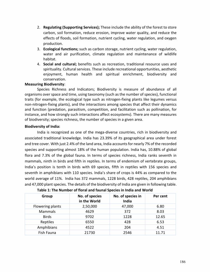
2. Regulating (Supporting Services); These include the ability of the forest to store
carbon, soil formation, reduce erosion, improve water quality, and reduce the
effects of floods, soil formation, nutrient cycling, water regulation, and oxygen
production.
3. Ecological functions; such as carbon storage, nutrient cycling, water regulation, water and air purification, climate regulation and maintenance of wildlife habitat.
4. Social and cultural; benefits such as recreation, traditional resource uses and spirituality. Cultural services. These include recreational opportunities, aesthetic enjoyment, human health and spiritual enrichment, biodiversity and conservation.
Measuring Biodiversity: Species Richness and Indicators; Biodiversity is measure of abundance of all
organisms over space and time, using taxonomy (such as the number of species), functional traits (for example, the ecological type such as nitrogen-fixing plants like legumes versus non-nitrogen-fixing plants), and the interactions among species that affect their dynamics and function (predation, parasitism, competition, and facilitation such as pollination, for instance, and how strongly such interactions affect ecosystems). There are many measures of biodiversity; species richness, the number of species in a given area.
Biodiversity of India:
India is recognized as one of the mega-diverse countries, rich in biodiversity and
associated traditional knowledge. India has 23.39% of its geographical area under forest
and tree cover. With just 2.4% of the land area, India accounts for nearly 7% of the recorded
species and supporting almost 18% of the human population. India has, 10.88% of global
flora and 7.3% of the global fauna. In terms of species richness, India ranks seventh in
mammals, ninth in birds and fifth in reptiles. In terms of endemism of vertebrate groups,
India’s position is tenth in birds with 69 species, fifth in reptiles with 156 species and
seventh in amphibians with 110 species. India’s share of crops is 44% as compared to the
world average of 11%. India has 372 mammals, 1228 birds, 428 reptiles, 204 amphibians
and 47,000 plant species. The details of the biodiversity of India are given in following table.
Table 1: The Number of floral and faunal Species in India and World
Group No. of species in the World
No. of species in India
Per cent
Flowering plants 2,50,000 47,000 6.80
Mammals 4629 372 8.03
Birds 9702 1228 12.65
Reptiles 6550 428 6.53
Amphibians 4522 204 4.51
Fish Fauna 21730 2546 11.71
186
Figure 1. Number of floral and faunal Species in India and world
Biodiversity of Himachal Pradesh
Himachal Pradesh is bestowed with distinctive floral and faunal biodiversity having
aesthetic, cultural, commercials and genetic values. Himachal Pradesh is one of the
biodiversity hotspots, has 8 forest types and 38 sub-types as per Champion and Seth’s
Classification in western Himalayan States. Himachal Pradesh is one of the western
Himalayan states and it covers broad altitudinal range from 350m to 6816m msl. The State
has great diversity in the biological resources because of its varied topography, geological
formations, altitudinal ranges, and climatic conditions.
The biodiversity elements in the State varied from tropical, sub-tropical, temperate,
sub-alpine and alpine types. 95% of the floral and faunal species available in the State are
endemic and 5% of the other species existing are of exotic nature. The state of Himachal
Pradesh is one of the biodiversity hotspots. There are 8 forest types and 38 sub-types as per
Champion and Seth’s classification. The climate of Himachal Pradesh varies from semi-
tropical to semi-arctic. The varied physiographic and climatic conditions have given rise to
diverse natural ecosystems such as forests, grasslands and pastures, rivers, lakes, wetlands
and glaciers. Himachal Pradesh is bestowed with 3295 species of plants and 5721 species
animals (Kaisth and Sharma). Along with the bio-climatic conditions, the biodiversity of the
state is also shaped by the livelihood options followed in the state such as agriculture,
horticulture and livestock mixed farming system, apple orchards and pastoralism. The
culture and traditional knowledge of biodiversity is demonstrated by large number of
sacred forests and groves, sacred wetlands and number of other biodiversity conservation
traditions associated with the livelihood practices of the local communities.
2,50,000
4629 9702 6550 452221730
47,000
372 1228 428 204 2546
0
50,000
1,00,000
1,50,000
2,00,000
2,50,000
3,00,000
Flowering plants Mammals Birds Reptiles Amphibians Fish Fauna
No. of speciesin the World
No. of species in India
187
More than 95 % of the species are endemic to Himachal Pradesh and Western Himalayan Flora. About 150 species are exotic. The details of floral and Faunal Diversity of Himachal Pradesh are given below.
Table 2: The floral and faunal biodiversity of Himachal Pradesh
S. No. Biodiversity component Number of the species
A. Floral Diversity
1. Total Plant Species 3295
2. Angiosperm 3120
3. Gymnosperm 13
4. Pteridophytes 124
5. Orchids 38
B. Faunal Diversity
1. Total Species 5881
2. Mammals 107
3. Birds 626
4. Reptiles 14
5. Amphibians 44
6. Fishes 83
7. Arthropods 4543
8. Other lower animals 464 (Source: H.P. State Biodiversity Board, Shimla)
FLORAL DIVERSITY
Floral diversity in the State is described under forest vegetation, medicinal and aromatic plants, diversity in agricultural crops including cereal crops, wild fruits and wild ornamental plants. Out of the total 47,000 plant species found in the country as many as 3,295 species are reported from Himachal Pradesh. The vegetation is a blend of Ban oak Forest, Moist Temperate Deciduous Forest, Himalayan Alpine Pastures and Rhododendron Scrub Forest. Coniferous forest dominates the mid and high hills with Oaks in depressions. In the foothills, forests are dry deciduous with sal as the predominant species. In dry localities chir pine occur as the dominant species. Himachal Pradesh is a reservoir of medicinal plants. The State is rich in medicinal herbal plant wealth and people in the villages in same pockets are dependent on the medicinal herbal plant wealth for their livelihood.
Table 3: Floral diversity of Himachal Pradesh
S. No. Biodiversity component Number of species
Floral Diversity
1 Angiosperm 3120
2 Gymnosperm 13
3 Pteridophytes 124
4 Orchids 38
5 Threatened* 58 Total Plant Species 3295
188
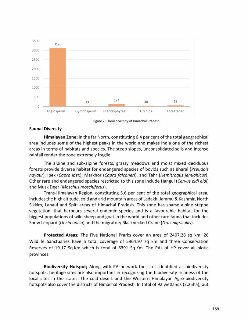
Figure 2: Floral diversity of Himachal Pradesh
Faunal Diversity
Himalayan Zone; in the far North, constituting 6.4 per cent of the total geographical area includes some of the highest peaks in the world and makes India one of the richest areas in terms of habitats and species. The steep slopes, unconsolidated soils and intense rainfall render the zone extremely fragile.
The alpine and sub-alpine forests, grassy meadows and moist mixed deciduous forests provide diverse habitat for endangered species of bovids such as Bharal (Pseudois nayaur), Ibex (Capra ibex), Markhor (Capra falconeri), and Tahr (Hemitragus jemlahicus). Other rare and endangered species restricted to this zone include Hangul (Cervus eldi eldi) and Musk Deer (Moschus moschiferus).
Trans-Himalayan Region, constituting 5.6 per cent of the total geographical area, includes the high altitude, cold and arid mountain areas of Ladakh, Jammu & Kashmir, North Sikkim, Lahaul and Spiti areas of Himachal Pradesh. This zone has sparse alpine steppe vegetation that harbours several endemic species and is a favourable habitat for the biggest populations of wild sheep and goat in the world and other rare fauna that includes Snow Leopard (Uncia uncia) and the migratory Blacknecked Crane (Grus nigricollis).
Protected Areas; The Five National Prarks cover an area of 2407.28 sq km, 26
Wildlife Sanctuaries have a total coverage of 5964.97 sq km and three Conservation
Reserves of 19.17 Sq.Km which is total of 8391 Sq.Km. The PAs of HP cover all biotic
provinces.
Biodiversity Hotspot; Along with PA network the sites identified as biodiversity
hotspots, heritage sites are also important in recognizing the biodiversity richness of the local sites in the states. The cold desert and the Western Himalayan Agro-biodiversity hotspots also cover the districts of Himachal Pradesh. In total of 92 wetlands (2.25ha), out
3120
13124 38 58
0
500
1000
1500
2000
2500
3000
3500
Angiosperm Gymnosperm Pteridophytes Orchids Threatened
189
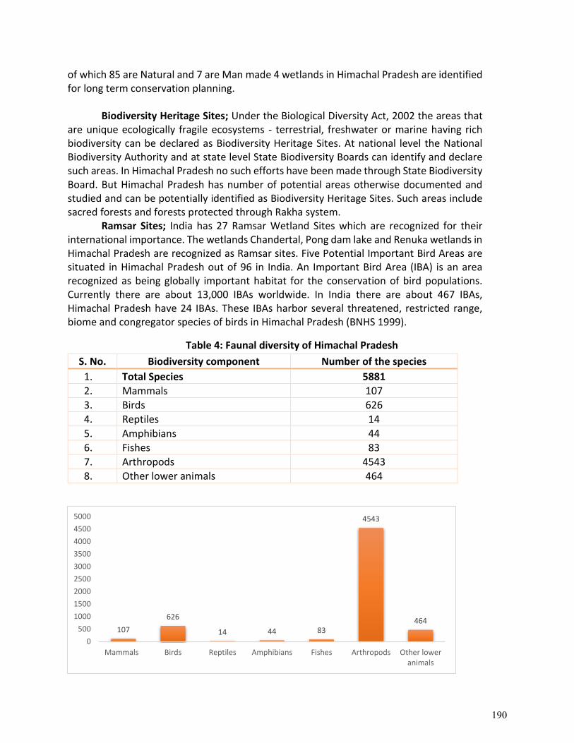
of which 85 are Natural and 7 are Man made 4 wetlands in Himachal Pradesh are identified for long term conservation planning.
Biodiversity Heritage Sites; Under the Biological Diversity Act, 2002 the areas that
are unique ecologically fragile ecosystems - terrestrial, freshwater or marine having rich biodiversity can be declared as Biodiversity Heritage Sites. At national level the National Biodiversity Authority and at state level State Biodiversity Boards can identify and declare such areas. In Himachal Pradesh no such efforts have been made through State Biodiversity Board. But Himachal Pradesh has number of potential areas otherwise documented and studied and can be potentially identified as Biodiversity Heritage Sites. Such areas include sacred forests and forests protected through Rakha system.
Ramsar Sites; India has 27 Ramsar Wetland Sites which are recognized for their international importance. The wetlands Chandertal, Pong dam lake and Renuka wetlands in Himachal Pradesh are recognized as Ramsar sites. Five Potential Important Bird Areas are situated in Himachal Pradesh out of 96 in India. An Important Bird Area (IBA) is an area recognized as being globally important habitat for the conservation of bird populations. Currently there are about 13,000 IBAs worldwide. In India there are about 467 IBAs, Himachal Pradesh have 24 IBAs. These IBAs harbor several threatened, restricted range, biome and congregator species of birds in Himachal Pradesh (BNHS 1999).
Table 4: Faunal diversity of Himachal Pradesh
S. No. Biodiversity component Number of the species
1. Total Species 5881
2. Mammals 107
3. Birds 626
4. Reptiles 14
5. Amphibians 44
6. Fishes 83
7. Arthropods 4543
8. Other lower animals 464
107
626
14 44 83
4543
464
0
500
1000
1500
2000
2500
3000
3500
4000
4500
5000
Mammals Birds Reptiles Amphibians Fishes Arthropods Other loweranimals
190
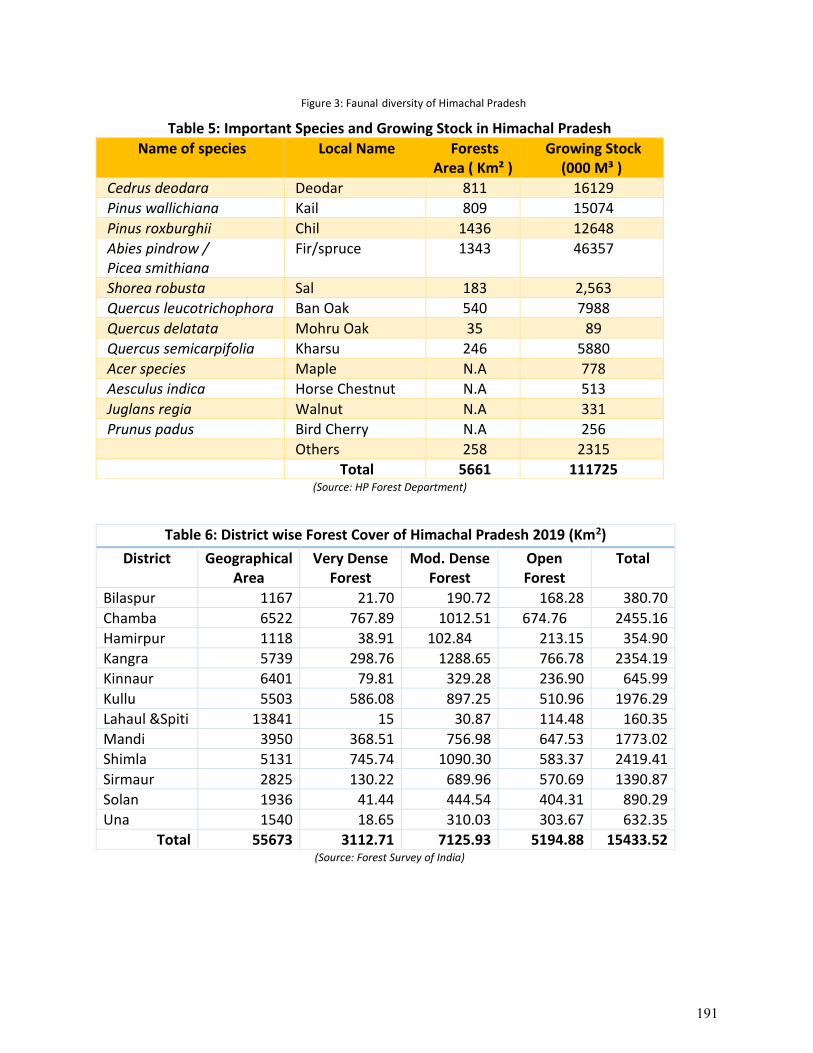
Figure 3: Faunal diversity of Himachal Pradesh
Table 5: Important Species and Growing Stock in Himachal Pradesh
Name of species Local Name Forests Area ( Km² )
Growing Stock (000 M³ )
Cedrus deodara Deodar 811 16129
Pinus wallichiana Kail 809 15074
Pinus roxburghii Chil 1436 12648
Abies pindrow / Picea smithiana
Fir/spruce 1343 46357
Shorea robusta Sal 183 2,563
Quercus leucotrichophora Ban Oak 540 7988
Quercus delatata Mohru Oak 35 89
Quercus semicarpifolia Kharsu 246 5880
Acer species Maple N.A 778
Aesculus indica Horse Chestnut N.A 513
Juglans regia Walnut N.A 331
Prunus padus Bird Cherry N.A 256
Others 258 2315
Total 5661 111725 (Source: HP Forest Department)
Table 6: District wise Forest Cover of Himachal Pradesh 2019 (Km2)
District Geographical Area
Very Dense Forest
Mod. Dense Forest
Open Forest
Total
Bilaspur 1167 21.70 190.72 168.28 380.70
Chamba 6522 767.89 1012.51 674.76 2455.16
Hamirpur 1118 38.91 102.84 213.15 354.90
Kangra 5739 298.76 1288.65 766.78 2354.19
Kinnaur 6401 79.81 329.28 236.90 645.99
Kullu 5503 586.08 897.25 510.96 1976.29
Lahaul &Spiti 13841 15 30.87 114.48 160.35
Mandi 3950 368.51 756.98 647.53 1773.02
Shimla 5131 745.74 1090.30 583.37 2419.41
Sirmaur 2825 130.22 689.96 570.69 1390.87
Solan 1936 41.44 444.54 404.31 890.29
Una 1540 18.65 310.03 303.67 632.35
Total 55673 3112.71 7125.93 5194.88 15433.52 (Source: Forest Survey of India)
191
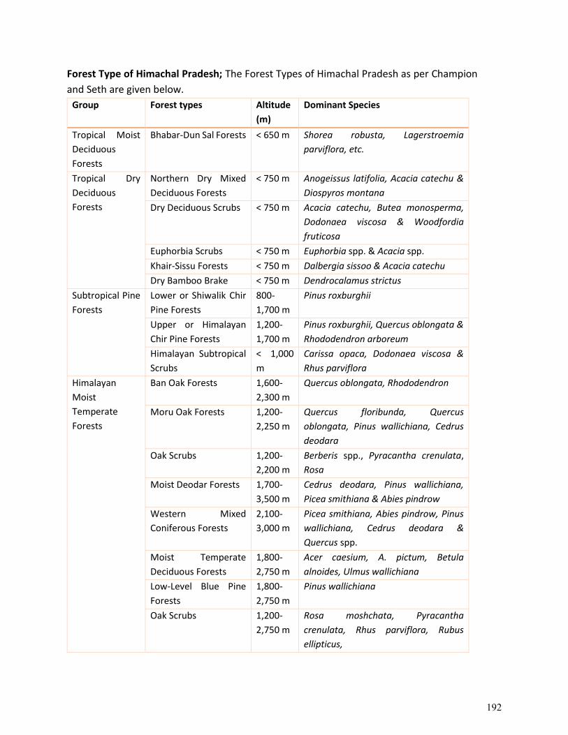
Forest Type of Himachal Pradesh; The Forest Types of Himachal Pradesh as per Champion
and Seth are given below.
Group Forest types Altitude
(m)
Dominant Species
Tropical Moist
Deciduous
Forests
Bhabar-Dun Sal Forests < 650 m Shorea robusta, Lagerstroemia
parviflora, etc.
Tropical Dry
Deciduous
Forests
Northern Dry Mixed
Deciduous Forests
< 750 m Anogeissus latifolia, Acacia catechu &
Diospyros montana
Dry Deciduous Scrubs < 750 m Acacia catechu, Butea monosperma,
Dodonaea viscosa & Woodfordia
fruticosa
Euphorbia Scrubs < 750 m Euphorbia spp. & Acacia spp.
Khair-Sissu Forests < 750 m Dalbergia sissoo & Acacia catechu
Dry Bamboo Brake < 750 m Dendrocalamus strictus
Subtropical Pine
Forests
Lower or Shiwalik Chir
Pine Forests
800-
1,700 m
Pinus roxburghii
Upper or Himalayan
Chir Pine Forests
1,200-
1,700 m
Pinus roxburghii, Quercus oblongata &
Rhododendron arboreum
Himalayan Subtropical
Scrubs
< 1,000
m
Carissa opaca, Dodonaea viscosa &
Rhus parviflora
Himalayan
Moist
Temperate
Forests
Ban Oak Forests 1,600-
2,300 m
Quercus oblongata, Rhododendron
Moru Oak Forests 1,200-
2,250 m
Quercus floribunda, Quercus
oblongata, Pinus wallichiana, Cedrus
deodara
Oak Scrubs 1,200-
2,200 m
Berberis spp., Pyracantha crenulata,
Rosa
Moist Deodar Forests 1,700-
3,500 m
Cedrus deodara, Pinus wallichiana,
Picea smithiana & Abies pindrow
Western Mixed
Coniferous Forests
2,100-
3,000 m
Picea smithiana, Abies pindrow, Pinus
wallichiana, Cedrus deodara &
Quercus spp.
Moist Temperate
Deciduous Forests
1,800-
2,750 m
Acer caesium, A. pictum, Betula
alnoides, Ulmus wallichiana
Low-Level Blue Pine
Forests
1,800-
2,750 m
Pinus wallichiana
Oak Scrubs 1,200-
2,750 m
Rosa moshchata, Pyracantha
crenulata, Rhus parviflora, Rubus
ellipticus,
192
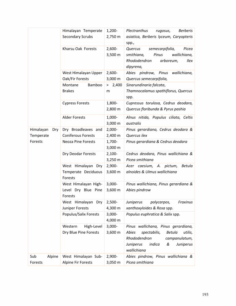
Himalayan Temperate
Secondary Scrubs
1,200-
2,750 m
Plectranthus rugosus, Berberis
asiatica, Berberis lyceum, Caryopteris
spp.,
Kharsu Oak Forests 2,600-
3,500 m
Quercus semecarpifolia, Picea
smithiana, Pinus wallichiana,
Rhododendron arboreum, Ilex
dipyrena,
West Himalayan Upper
Oak/Fir Forests
2,600-
3,000 m
Abies pindrow, Pinus wallichiana,
Quercus semecarpifolia,
Montane Bamboo
Brakes
> 2,400
m
Sinarundinaria falcata,
Thamnocalamus spathiflorus, Quercus
spp.
Cypress Forests 1,800-
2,800 m
Cupressus torulosa, Cedrus deodara,
Quercus floribunda & Pyrus pashia
Alder Forests 1,000-
3,000 m
Alnus nitida, Populus ciliata, Celtis
australis
Himalayan Dry
Temperate
Forests
Dry Broadleaves and
Coniferous Forests
2,000-
2,400 m
Pinus gerardiana, Cedrus deodara &
Quercus ilex
Neoza Pine Forests 1,700-
3,000 m
Pinus gerardiana & Cedrus deodara
Dry Deodar Forests 2,100-
3,250 m
Cedrus deodara, Pinus wallichiana &
Picea smithiana
West Himalayan Dry
Temperate Deciduous
Forests
2,900-
3,600 m
Acer caesium, A. pictum, Betula
alnoides & Ulmus wallichiana
West Himalayan High-
Level Dry Blue Pine
Forests
3,000-
3,600 m
Pinus wallichiana, Pinus gerardiana &
Abies pindrow
West Himalayan Dry
Juniper Forests
2,500-
4,300 m
Juniperus polycarpos, Fraxinus
xanthoxyloides & Rosa spp.
Populus/Salix Forests 3,000-
4,000 m
Populus euphratica & Salix spp.
Western High-Level
Dry Blue Pine Forests
3,000-
3,600 m
Pinus wallichana, Pinus gerardiana,
Abies spectabilis, Betula utilis,
Rhododendron campanulatum,
Juniperus indica & Juniperus
wallichiana
Sub Alpine
Forests
West Himalayan Sub-
Alpine Fir Forests
2,900-
3,050 m
Abies pindrow, Pinus wallichiana &
Picea smithiana
193
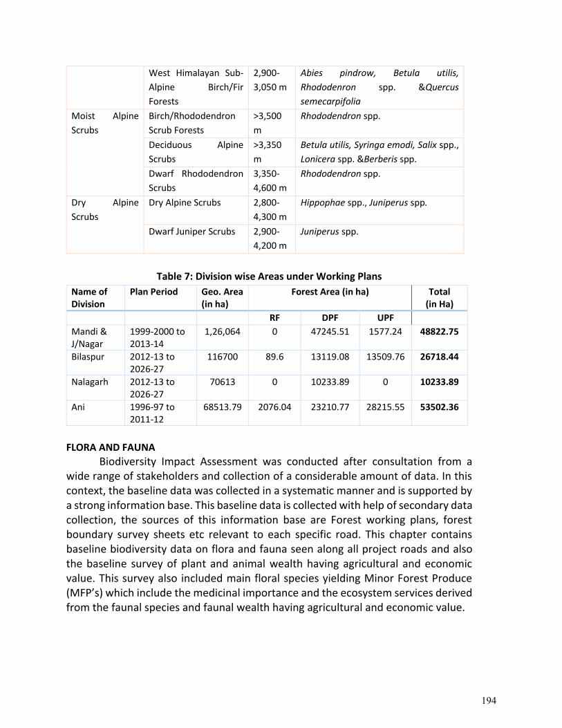
West Himalayan Sub-
Alpine Birch/Fir
Forests
2,900-
3,050 m
Abies pindrow, Betula utilis,
Rhododenron spp. &Quercus
semecarpifolia
Moist Alpine
Scrubs
Birch/Rhododendron
Scrub Forests
>3,500
m
Rhododendron spp.
Deciduous Alpine
Scrubs
>3,350
m
Betula utilis, Syringa emodi, Salix spp.,
Lonicera spp. &Berberis spp.
Dwarf Rhododendron
Scrubs
3,350-
4,600 m
Rhododendron spp.
Dry Alpine
Scrubs
Dry Alpine Scrubs 2,800-
4,300 m
Hippophae spp., Juniperus spp.
Dwarf Juniper Scrubs 2,900-
4,200 m
Juniperus spp.
Table 7: Division wise Areas under Working Plans
Name of Division
Plan Period Geo. Area (in ha)
Forest Area (in ha) Total (in Ha)
RF DPF UPF
Mandi & J/Nagar
1999-2000 to 2013-14
1,26,064 0 47245.51 1577.24 48822.75
Bilaspur 2012-13 to 2026-27
116700 89.6 13119.08 13509.76 26718.44
Nalagarh 2012-13 to 2026-27
70613 0 10233.89 0 10233.89
Ani 1996-97 to 2011-12
68513.79 2076.04 23210.77 28215.55 53502.36
FLORA AND FAUNA
Biodiversity Impact Assessment was conducted after consultation from a wide range of stakeholders and collection of a considerable amount of data. In this context, the baseline data was collected in a systematic manner and is supported by a strong information base. This baseline data is collected with help of secondary data collection, the sources of this information base are Forest working plans, forest boundary survey sheets etc relevant to each specific road. This chapter contains baseline biodiversity data on flora and fauna seen along all project roads and also the baseline survey of plant and animal wealth having agricultural and economic value. This survey also included main floral species yielding Minor Forest Produce (MFP’s) which include the medicinal importance and the ecosystem services derived from the faunal species and faunal wealth having agricultural and economic value.
194
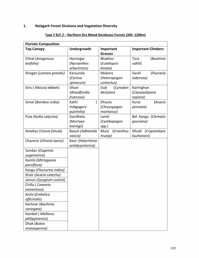
1. Nalagarh Forest Divisions and Vegetation Diversity
Type 5 B/C 2 – Northern Dry Mixed Deciduous Forests (300 -1200m)
Floristic Composition
Top Canopy Undergrowth Important Grasses
Important Climbers
Chhal (Anogeissus latifolia)
Harsingar (Nyctanthes arbortristis)
Bhabhar (Eulaliopsis binata)
Tour (Bauhinia vahlli)
Jhingan (Lannea grandis) Karaunda (Carissa spinarum)
Mokora (Heteropogon contortus)
Sarali (Pueraria tuberosa)
Siris ( Albizzia lebbek) Dhavi (Woodfordia fruticosa)
Dub (Cynodon dectylon)
Kairinghan (Caesasalipinia sepiara)
Simal (Bombox ceiba) Kathi ( Indigogera pulchella)
Dhaulu (Chrysopogon montanus)
Kurar (Acacia pennata)
Pula (Kydia calycina) Gandhela (Murraya koenigii)
Lamb (Cymbopogon spp.)
Bel kangu (Clematis gouriana)
Amaltas (Cassia fistula) Basuti (Adhatoda vasica)
Munj (Erianthus munja)
Dhudi (Crypotolepis buchanani)
Chamror (Ehretia laevis) Keor (Holarrhena antidysenterica)
Sandan (Ougeinia ougeinensis)
Kaimb (Mitragyana parviflora)
Kangu (Flacourtia indica)
Khair (Acacia catechu)
Jamun (Syzygium cumini)
Chilla ( Casearia tomentosa)
Amla (Embelica officinalis)
Kachnar (Bauhinia variegata)
Kambel ( Mallotus philippinensis)
Dhak (Butea monosperma)
195
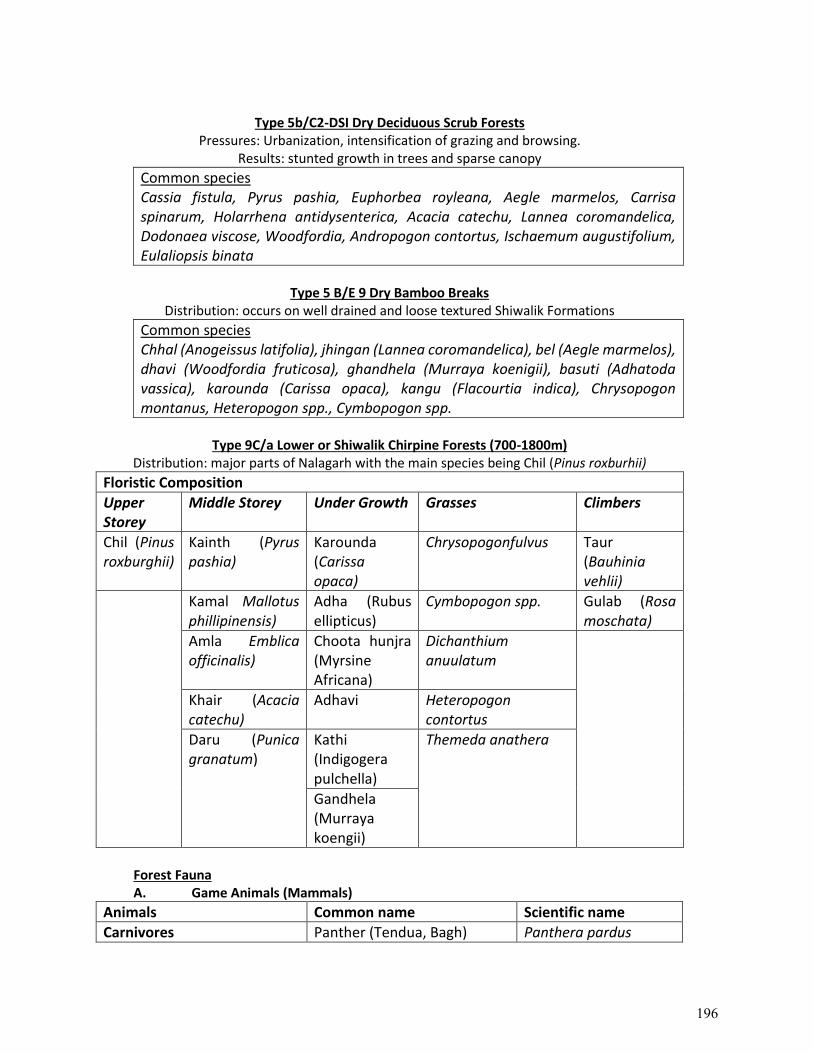
Type 5b/C2-DSI Dry Deciduous Scrub Forests
Pressures: Urbanization, intensification of grazing and browsing. Results: stunted growth in trees and sparse canopy
Common species Cassia fistula, Pyrus pashia, Euphorbea royleana, Aegle marmelos, Carrisa spinarum, Holarrhena antidysenterica, Acacia catechu, Lannea coromandelica, Dodonaea viscose, Woodfordia, Andropogon contortus, Ischaemum augustifolium, Eulaliopsis binata
Type 5 B/E 9 Dry Bamboo Breaks
Distribution: occurs on well drained and loose textured Shiwalik Formations
Common species Chhal (Anogeissus latifolia), jhingan (Lannea coromandelica), bel (Aegle marmelos), dhavi (Woodfordia fruticosa), ghandhela (Murraya koenigii), basuti (Adhatoda vassica), karounda (Carissa opaca), kangu (Flacourtia indica), Chrysopogon montanus, Heteropogon spp., Cymbopogon spp.
Type 9C/a Lower or Shiwalik Chirpine Forests (700-1800m)
Distribution: major parts of Nalagarh with the main species being Chil (Pinus roxburhii)
Floristic Composition
Upper Storey
Middle Storey Under Growth Grasses Climbers
Chil (Pinus roxburghii)
Kainth (Pyrus pashia)
Karounda (Carissa opaca)
Chrysopogonfulvus Taur (Bauhinia vehlii)
Kamal Mallotus phillipinensis)
Adha (Rubus ellipticus)
Cymbopogon spp. Gulab (Rosa moschata)
Amla Emblica officinalis)
Choota hunjra (Myrsine Africana)
Dichanthium anuulatum
Khair (Acacia catechu)
Adhavi Heteropogon contortus
Daru (Punica granatum)
Kathi (Indigogera pulchella)
Themeda anathera
Gandhela (Murraya koengii)
Forest Fauna A. Game Animals (Mammals)
Animals Common name Scientific name
Carnivores Panther (Tendua, Bagh) Panthera pardus
196
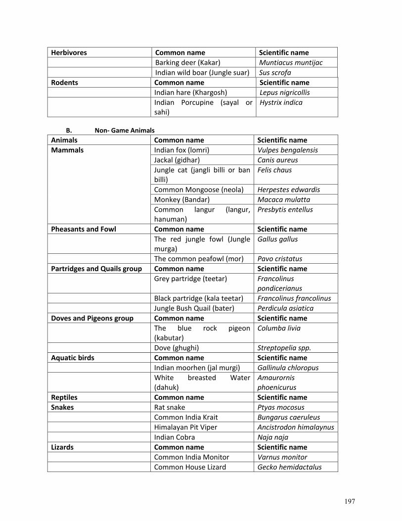
Herbivores Common name Scientific name
Barking deer (Kakar) Muntiacus muntijac
Indian wild boar (Jungle suar) Sus scrofa
Rodents Common name Scientific name
Indian hare (Khargosh) Lepus nigricollis
Indian Porcupine (sayal or sahi)
Hystrix indica
B. Non- Game Animals
Animals Common name Scientific name
Mammals Indian fox (lomri) Vulpes bengalensis
Jackal (gidhar) Canis aureus
Jungle cat (jangli billi or ban billi)
Felis chaus
Common Mongoose (neola) Herpestes edwardis
Monkey (Bandar) Macaca mulatta
Common langur (langur, hanuman)
Presbytis entellus
Pheasants and Fowl Common name Scientific name
The red jungle fowl (Jungle murga)
Gallus gallus
The common peafowl (mor) Pavo cristatus
Partridges and Quails group Common name Scientific name
Grey partridge (teetar) Francolinus pondicerianus
Black partridge (kala teetar) Francolinus francolinus
Jungle Bush Quail (bater) Perdicula asiatica
Doves and Pigeons group Common name Scientific name
The blue rock pigeon (kabutar)
Columba livia
Dove (ghughi) Streptopelia spp.
Aquatic birds Common name Scientific name
Indian moorhen (jal murgi) Gallinula chloropus
White breasted Water (dahuk)
Amaurornis phoenicurus
Reptiles Common name Scientific name
Snakes Rat snake Ptyas mocosus
Common India Krait Bungarus caeruleus
Himalayan Pit Viper Ancistrodon himalaynus
Indian Cobra Naja naja
Lizards Common name Scientific name
Common India Monitor Varnus monitor
Common House Lizard Gecko hemidactalus
197
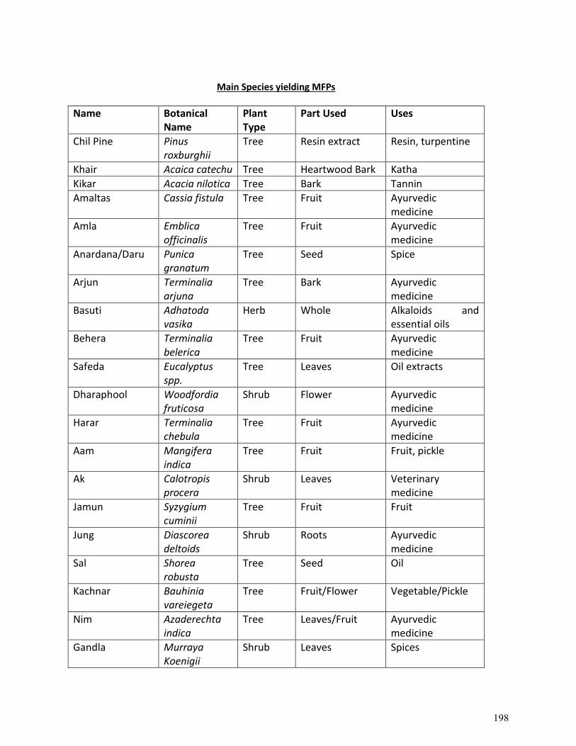
Main Species yielding MFPs
Name Botanical Name
Plant Type
Part Used Uses
Chil Pine Pinus roxburghii
Tree Resin extract Resin, turpentine
Khair Acaica catechu Tree Heartwood Bark Katha
Kikar Acacia nilotica Tree Bark Tannin
Amaltas Cassia fistula Tree Fruit Ayurvedic medicine
Amla Emblica officinalis
Tree Fruit Ayurvedic medicine
Anardana/Daru Punica granatum
Tree Seed Spice
Arjun Terminalia arjuna
Tree Bark Ayurvedic medicine
Basuti Adhatoda vasika
Herb Whole Alkaloids and essential oils
Behera Terminalia belerica
Tree Fruit Ayurvedic medicine
Safeda Eucalyptus spp.
Tree Leaves Oil extracts
Dharaphool Woodfordia fruticosa
Shrub Flower Ayurvedic medicine
Harar Terminalia chebula
Tree Fruit Ayurvedic medicine
Aam Mangifera indica
Tree Fruit Fruit, pickle
Ak Calotropis procera
Shrub Leaves Veterinary medicine
Jamun Syzygium cuminii
Tree Fruit Fruit
Jung Diascorea deltoids
Shrub Roots Ayurvedic medicine
Sal Shorea robusta
Tree Seed Oil
Kachnar Bauhinia vareiegeta
Tree Fruit/Flower Vegetable/Pickle
Nim Azaderechta indica
Tree Leaves/Fruit Ayurvedic medicine
Gandla Murraya Koenigii
Shrub Leaves Spices
198
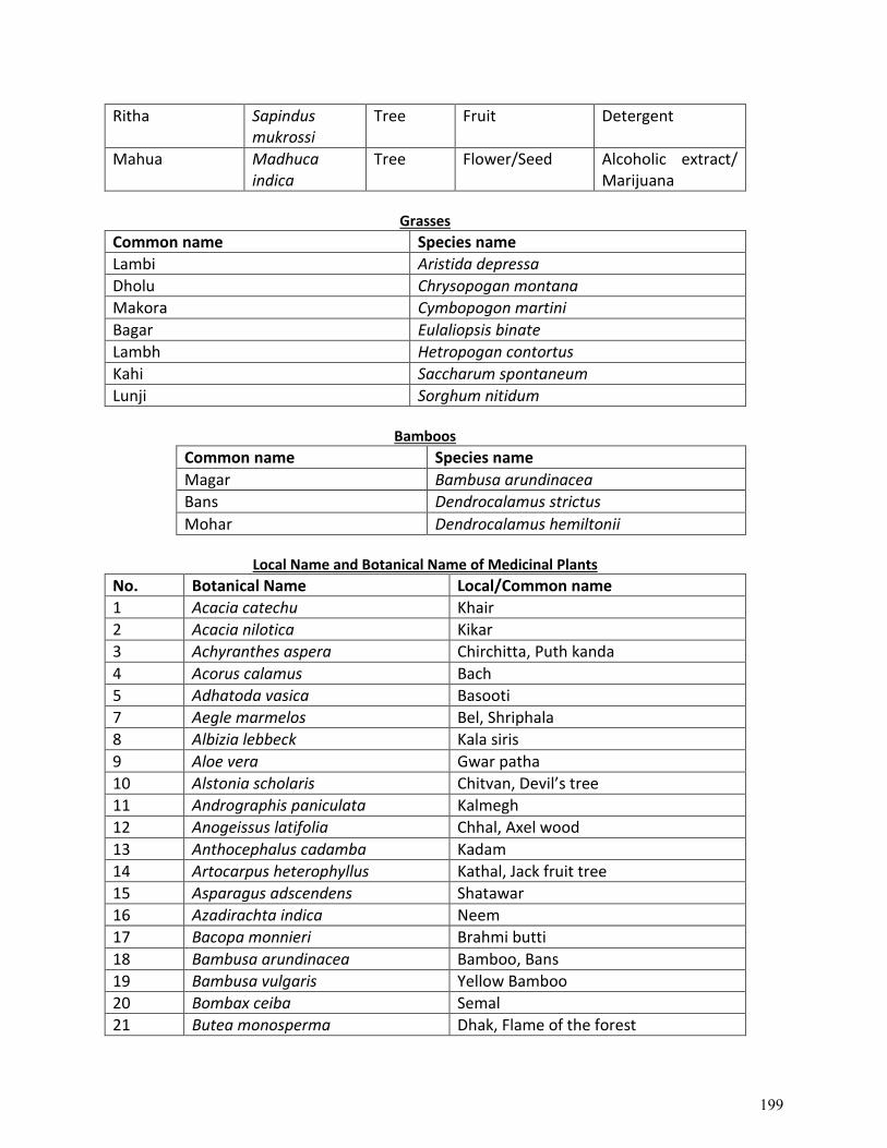
Ritha Sapindus mukrossi
Tree Fruit Detergent
Mahua Madhuca indica
Tree Flower/Seed Alcoholic extract/ Marijuana
Grasses
Common name Species name
Lambi Aristida depressa
Dholu Chrysopogan montana
Makora Cymbopogon martini
Bagar Eulaliopsis binate
Lambh Hetropogan contortus
Kahi Saccharum spontaneum
Lunji Sorghum nitidum
Bamboos
Common name Species name
Magar Bambusa arundinacea
Bans Dendrocalamus strictus
Mohar Dendrocalamus hemiltonii
Local Name and Botanical Name of Medicinal Plants
No. Botanical Name Local/Common name
1 Acacia catechu Khair
2 Acacia nilotica Kikar
3 Achyranthes aspera Chirchitta, Puth kanda
4 Acorus calamus Bach
5 Adhatoda vasica Basooti
7 Aegle marmelos Bel, Shriphala
8 Albizia lebbeck Kala siris
9 Aloe vera Gwar patha
10 Alstonia scholaris Chitvan, Devil’s tree
11 Andrographis paniculata Kalmegh
12 Anogeissus latifolia Chhal, Axel wood
13 Anthocephalus cadamba Kadam
14 Artocarpus heterophyllus Kathal, Jack fruit tree
15 Asparagus adscendens Shatawar
16 Azadirachta indica Neem
17 Bacopa monnieri Brahmi butti
18 Bambusa arundinacea Bamboo, Bans
19 Bambusa vulgaris Yellow Bamboo
20 Bombax ceiba Semal
21 Butea monosperma Dhak, Flame of the forest
199
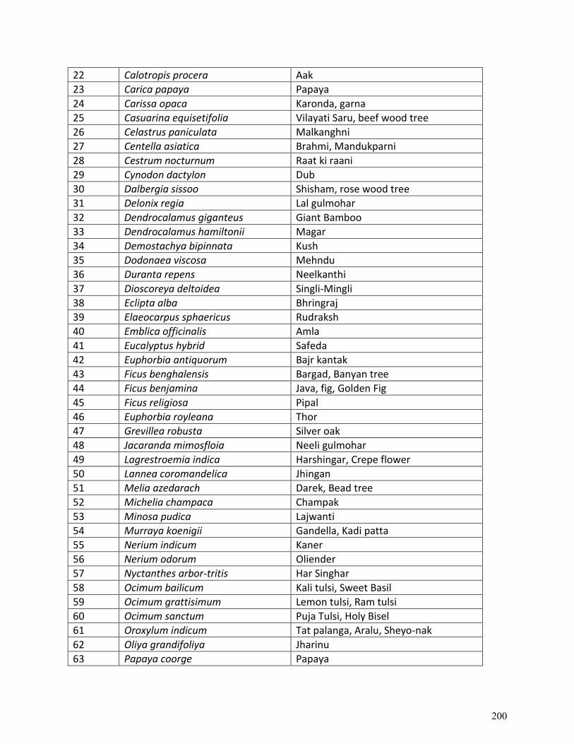
22 Calotropis procera Aak
23 Carica papaya Papaya
24 Carissa opaca Karonda, garna
25 Casuarina equisetifolia Vilayati Saru, beef wood tree
26 Celastrus paniculata Malkanghni
27 Centella asiatica Brahmi, Mandukparni
28 Cestrum nocturnum Raat ki raani
29 Cynodon dactylon Dub
30 Dalbergia sissoo Shisham, rose wood tree
31 Delonix regia Lal gulmohar
32 Dendrocalamus giganteus Giant Bamboo
33 Dendrocalamus hamiltonii Magar
34 Demostachya bipinnata Kush
35 Dodonaea viscosa Mehndu
36 Duranta repens Neelkanthi
37 Dioscoreya deltoidea Singli-Mingli
38 Eclipta alba Bhringraj
39 Elaeocarpus sphaericus Rudraksh
40 Emblica officinalis Amla
41 Eucalyptus hybrid Safeda
42 Euphorbia antiquorum Bajr kantak
43 Ficus benghalensis Bargad, Banyan tree
44 Ficus benjamina Java, fig, Golden Fig
45 Ficus religiosa Pipal
46 Euphorbia royleana Thor
47 Grevillea robusta Silver oak
48 Jacaranda mimosfloia Neeli gulmohar
49 Lagrestroemia indica Harshingar, Crepe flower
50 Lannea coromandelica Jhingan
51 Melia azedarach Darek, Bead tree
52 Michelia champaca Champak
53 Minosa pudica Lajwanti
54 Murraya koenigii Gandella, Kadi patta
55 Nerium indicum Kaner
56 Nerium odorum Oliender
57 Nyctanthes arbor-tritis Har Singhar
58 Ocimum bailicum Kali tulsi, Sweet Basil
59 Ocimum grattisimum Lemon tulsi, Ram tulsi
60 Ocimum sanctum Puja Tulsi, Holy Bisel
61 Oroxylum indicum Tat palanga, Aralu, Sheyo-nak
62 Oliya grandifoliya Jharinu
63 Papaya coorge Papaya
200
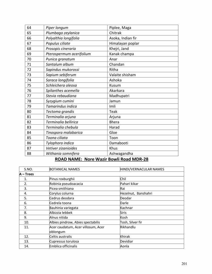
64 Piper longum Piplee, Maga
65 Plumbago zeylanica Chitrak
66 Polyalthia longifolia Asoka, Indian fir
67 Populus ciliate Himalayan poplar
68 Prosopis cineraria Khejri, Jand
69 Pterospermum acerifolium Kanak champa
70 Punica granatum Anar
71 Santalum album Chandan
72 Sapindus mukorossi Ritha
73 Sapium sebiferum Valaite shisham
74 Saraca longifolia Ashoka
75 Schleichera oleosa Kusum
76 Spilanthes acemella Akarkara
77 Stevia rebaudiana Madhupatri
78 Syzygium cumini Jamun
79 Tamarindus indica Imli
80 Tectoma grandis Teak
81 Terminalia arjuna Arjuna
82 Terminalia bellirica Bhera
83 Terminalia chebula Harad
84 Tinospora malabarica Gloe
85 Toona ciliata Toon
86 Tylophora indica Damabooti
87 Vetiver zizanioides Khus
88 Withania somnifera Ashwagandha
ROAD NAME: Nore Wazir Bowli Road MDR-28
S.NO. BOTANICAL NAMES HINDI/VERNACULAR NAMES
A – Trees
1. Pinus roxburghii Chil
2. Robinia pseudoacacia Pahari kikar
3. Picea smithiana Rai
4. Corylus colurna Hezelnut, Banshahri
5. Cedrus deodara Deodar
6. Cedrela toona Darle
7. Bauhinia variegata Kachnar
8. Albizzia lebbek Siris
9. Alnus nitida Kosh
10. Albies pindrow, Abies spectabilis Tosh, Silver fir
11. Acer caudatum, Acer villosum, Acer oblongum
Rikhandlu
12. Celtis australis Khirak
13. Cupressus torulosa Devidiar
14. Emblica officinalis Aonla
201
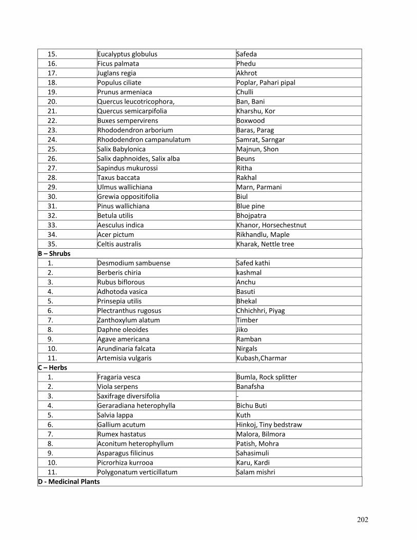
15. Eucalyptus globulus Safeda
16. Ficus palmata Phedu
17. Juglans regia Akhrot
18. Populus ciliate Poplar, Pahari pipal
19. Prunus armeniaca Chulli
20. Quercus leucotricophora, Ban, Bani
21. Quercus semicarpifolia Kharshu, Kor
22. Buxes sempervirens Boxwood
23. Rhododendron arborium Baras, Parag
24. Rhododendron campanulatum Samrat, Sarngar
25. Salix Babylonica Majnun, Shon
26. Salix daphnoides, Salix alba Beuns
27. Sapindus mukurossi Ritha
28. Taxus baccata Rakhal
29. Ulmus wallichiana Marn, Parmani
30. Grewia oppositifolia Biul
31. Pinus wallichiana Blue pine
32. Betula utilis Bhojpatra
33. Aesculus indica Khanor, Horsechestnut
34. Acer pictum Rikhandlu, Maple
35. Celtis australis Kharak, Nettle tree
B – Shrubs
1. Desmodium sambuense Safed kathi
2. Berberis chiria kashmal
3. Rubus biflorous Anchu
4. Adhotoda vasica Basuti
5. Prinsepia utilis Bhekal
6. Plectranthus rugosus Chhichhri, Piyag
7. Zanthoxylum alatum Timber
8. Daphne oleoides Jiko
9. Agave americana Ramban
10. Arundinaria falcata Nirgals
11. Artemisia vulgaris Kubash,Charmar
C – Herbs
1. Fragaria vesca Bumla, Rock splitter
2. Viola serpens Banafsha
3. Saxifrage diversifolia -
4. Geraradiana heterophylla Bichu Buti
5. Salvia lappa Kuth
6. Gallium acutum Hinkoj, Tiny bedstraw
7. Rumex hastatus Malora, Bilmora
8. Aconitum heterophyllum Patish, Mohra
9. Asparagus filicinus Sahasimuli
10. Picrorhiza kurrooa Karu, Kardi
11. Polygonatum verticillatum Salam mishri
D - Medicinal Plants
202
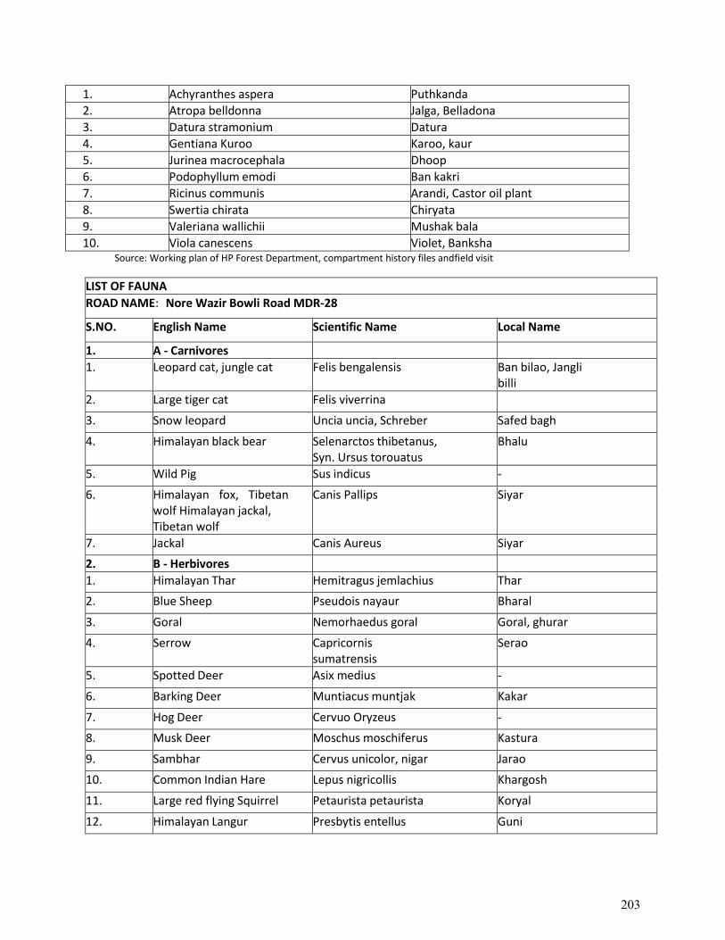
1. Achyranthes aspera Puthkanda
2. Atropa belldonna Jalga, Belladona
3. Datura stramonium Datura
4. Gentiana Kuroo Karoo, kaur
5. Jurinea macrocephala Dhoop
6. Podophyllum emodi Ban kakri
7. Ricinus communis Arandi, Castor oil plant
8. Swertia chirata Chiryata
9. Valeriana wallichii Mushak bala
10. Viola canescens Violet, Banksha Source: Working plan of HP Forest Department, compartment history files and field visit
LIST OF FAUNA
ROAD NAME: Nore Wazir Bowli Road MDR-28
S.NO. English Name Scientific Name Local Name
1. A - Carnivores
1. Leopard cat, jungle cat Felis bengalensis Ban bilao, Jangli billi
2. Large tiger cat Felis viverrina
3. Snow leopard Uncia uncia, Schreber Safed bagh
4. Himalayan black bear Selenarctos thibetanus, Syn. Ursus torouatus
Bhalu
5. Wild Pig Sus indicus -
6. Himalayan fox, Tibetan wolf Himalayan jackal, Tibetan wolf
Canis Pallips Siyar
7. Jackal Canis Aureus Siyar
2. B - Herbivores
1. Himalayan Thar Hemitragus jemlachius Thar
2. Blue Sheep Pseudois nayaur Bharal
3. Goral Nemorhaedus goral Goral, ghurar
4. Serrow Capricornis sumatrensis
Serao
5. Spotted Deer Asix medius -
6. Barking Deer Muntiacus muntjak Kakar
7. Hog Deer Cervuo Oryzeus -
8. Musk Deer Moschus moschiferus Kastura
9. Sambhar Cervus unicolor, nigar Jarao
10. Common Indian Hare Lepus nigricollis Khargosh
11. Large red flying Squirrel Petaurista petaurista Koryal
12. Himalayan Langur Presbytis entellus Guni
203
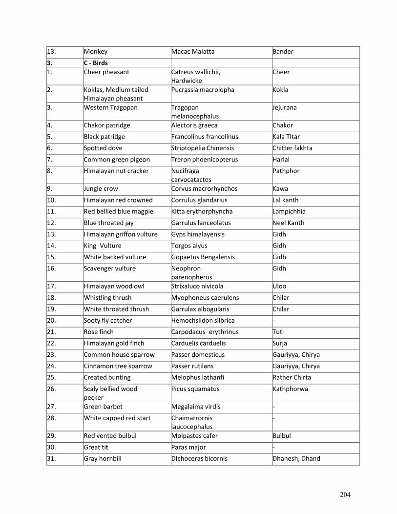
13. Monkey Macac Malatta Bander
3. C - Birds
1. Cheer pheasant Catreus wallichii, Hardwicke
Cheer
2. Koklas, Medium tailed Himalayan pheasant
Pucrassia macrolopha Kokla
3. Western Tragopan Tragopan melanocephalus
Jejurana
4. Chakor patridge Alectoris graeca Chakor
5. Black patridge Francolinus francolinus Kala TItar
6. Spotted dove Striptopelia Chinensis Chitter fakhta
7. Common green pigeon Treron phoenicopterus Harial
8. Himalayan nut cracker Nucifraga carvocatactes
Pathphor
9. Jungle crow Corvus macrorhynchos Kawa
10. Himalayan red crowned Corrulus glandarius Lal kanth
11. Red bellied blue magpie Kitta erythorphyncha Lampichhia
12. Blue throated jay Garrulus lanceolatus Neel Kanth
13. Himalayan griffon vulture Gyps himalayensis Gidh
14. King Vulture Torgos alyus Gidh
15. White backed vulture Gopaetus Bengalensis Gidh
16. Scavenger vulture Neophron parenopherus
Gidh
17. Himalayan wood owl Strixaluco nivicola Uloo
18. Whistling thrush Myophoneus caerulens Chilar
19. White throated thrush Garrulax albogularis Chilar
20. Sooty fly catcher Hemochslidon silbrica -
21. Rose finch Carpodacus erythrinus Tuti
22. Himalayan gold finch Carduelis carduelis Surja
23. Common house sparrow Passer domesticus Gauriyya, Chirya
24. Cinnamon tree sparrow Passer rutilans Gauriyya, Chirya
25. Created bunting Melophus lathanfi Rather Chirta
26. Scaly bellied wood pecker
Picus squamatus Kathphorwa
27. Green barbet Megalaima virdis -
28. White capped red start Chaimarrornis laucocephalus
-
29. Red vented bulbul Molpastes cafer Bulbul
30. Great tit Paras major -
31. Gray hornbill DIchoceras bicornis Dhanesh, Dhand
204
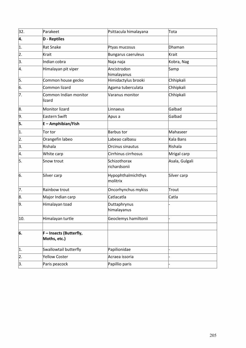
32. Parakeet Psittacula himalayana Tota
4. D - Reptiles
1. Rat Snake Ptyas mucosus Dhaman
2. Krait Bungarus caeruleus Krait
3. Indian cobra Naja naja Kobra, Nag
4. Himalayan pit viper Ancistrodon himalayanus
Samp
5. Common house gecko Himidactylus brooki Chhipkali
6. Common lizard Agama tuberculata Chhipkali
7. Common Indian monitor lizard
Varanus monitor Chhipkali
8. Monitor lizard Linnaeus Galbad
9. Eastern Swift Apus a Galbad
5. E – Amphibian/Fish
1. Tor tor Barbus tor Mahaseer
2. Orangefin labeo Labeao calbasu Kala Bans
3. Rishala Orcinus sinautus Rishala
4. White carp Cirrhinus cirrhosus Mrigal carp
5. Snow trout Schizothorax richardsonii
Asala, Gulgali
6. Silver carp Hypophthalmichthys molitrix
Silver carp
7. Rainbow trout Oncorhynchus mykiss Trout
8. Major Indian carp Catlacatla Catla
9. Himalayan toad Duttaphrynus himalayanus
-
10. Himalayan turtle Geoclemys hamiltonii -
6. F – Insects (Butterfly, Moths, etc.)
1. Swallowtail butterfly Papilionidae -
2. Yellow Coster Acraea issoria -
3. Paris peacock Papillio paris -
205
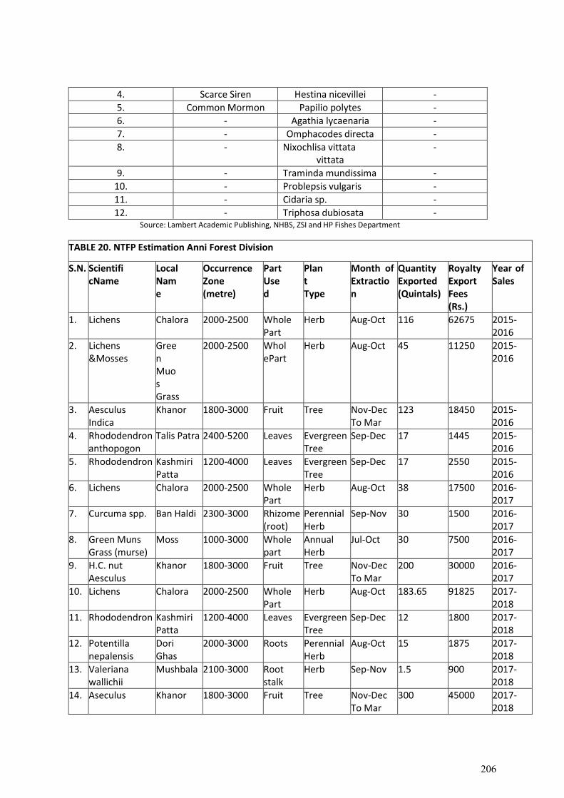
4. Scarce Siren Hestina nicevillei -
5. Common Mormon Papilio polytes -
6. - Agathia lycaenaria -
7. - Omphacodes directa -
8. - Nixochlisa vittata vittata
-
9. - Traminda mundissima -
10. - Problepsis vulgaris -
11. - Cidaria sp. -
12. - Triphosa dubiosata - Source: Lambert Academic Publishing, NHBS, ZSI and HP Fishes Department
TABLE 20. NTFP Estimation Anni Forest Division
S.N. Scientific Name
Local Name
Occurrence Zone (metre)
Part Used
Plant Type
Month of Extraction
Quantity Exported (Quintals)
Royalty Export Fees (Rs.)
Year of Sales
1. Lichens Chalora 2000-2500 Whole Part
Herb Aug-Oct 116 62675 2015- 2016
2. Lichens & Mosses
Green Muos Grass
2000-2500 Whole Part
Herb Aug-Oct 45 11250 2015- 2016
3. Aesculus Indica
Khanor 1800-3000 Fruit Tree Nov-Dec To Mar
123 18450 2015- 2016
4. Rhododendron anthopogon
Talis Patra 2400-5200 Leaves Evergreen Tree
Sep-Dec 17 1445 2015- 2016
5. Rhododendron Kashmiri Patta
1200-4000 Leaves Evergreen Tree
Sep-Dec 17 2550 2015- 2016
6. Lichens Chalora 2000-2500 Whole Part
Herb Aug-Oct 38 17500 2016- 2017
7. Curcuma spp. Ban Haldi 2300-3000 Rhizome (root)
Perennial Herb
Sep-Nov 30 1500 2016- 2017
8. Green Muns Grass (murse)
Moss 1000-3000 Whole part
Annual Herb
Jul-Oct 30 7500 2016- 2017
9. H.C. nut Aesculus
Khanor 1800-3000 Fruit Tree Nov-Dec To Mar
200 30000 2016- 2017
10. Lichens Chalora 2000-2500 Whole Part
Herb Aug-Oct 183.65 91825 2017- 2018
11. Rhododendron Kashmiri Patta
1200-4000 Leaves Evergreen Tree
Sep-Dec 12 1800 2017- 2018
12. Potentilla nepalensis
Dori Ghas
2000-3000 Roots Perennial Herb
Aug-Oct 15 1875 2017- 2018
13. Valeriana wallichii
Mushbala 2100-3000 Root stalk
Herb Sep-Nov 1.5 900 2017- 2018
14. Aseculus Khanor 1800-3000 Fruit Tree Nov-Dec To Mar
300 45000 2017- 2018
206
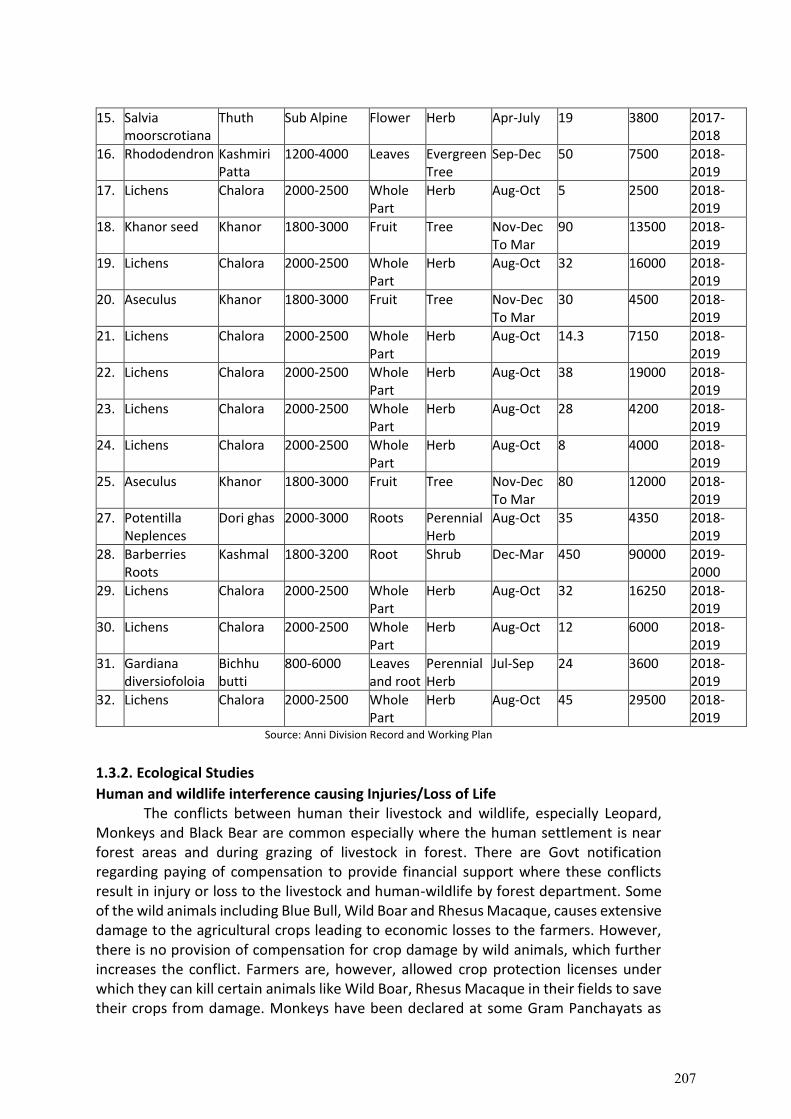
15. Salvia moorscrotiana
Thuth Sub Alpine Flower Herb Apr-July 19 3800 2017- 2018
16. Rhododendron Kashmiri Patta
1200-4000 Leaves Evergreen Tree
Sep-Dec 50 7500 2018- 2019
17. Lichens Chalora 2000-2500 Whole Part
Herb Aug-Oct 5 2500 2018- 2019
18. Khanor seed Khanor 1800-3000 Fruit Tree Nov-Dec To Mar
90 13500 2018- 2019
19. Lichens Chalora 2000-2500 Whole Part
Herb Aug-Oct 32 16000 2018- 2019
20. Aseculus Khanor 1800-3000 Fruit Tree Nov-Dec To Mar
30 4500 2018- 2019
21. Lichens Chalora 2000-2500 Whole Part
Herb Aug-Oct 14.3 7150 2018- 2019
22. Lichens Chalora 2000-2500 Whole Part
Herb Aug-Oct 38 19000 2018- 2019
23. Lichens Chalora 2000-2500 Whole Part
Herb Aug-Oct 28 4200 2018- 2019
24. Lichens Chalora 2000-2500 Whole Part
Herb Aug-Oct 8 4000 2018- 2019
25. Aseculus Khanor 1800-3000 Fruit Tree Nov-Dec To Mar
80 12000 2018- 2019
27. Potentilla Neplences
Dori ghas 2000-3000 Roots Perennial Herb
Aug-Oct 35 4350 2018- 2019
28. Barberries Roots
Kashmal 1800-3200 Root Shrub Dec-Mar 450 90000 2019- 2000
29. Lichens Chalora 2000-2500 Whole Part
Herb Aug-Oct 32 16250 2018- 2019
30. Lichens Chalora 2000-2500 Whole Part
Herb Aug-Oct 12 6000 2018- 2019
31. Gardiana diversiofoloia
Bichhu butti
800-6000 Leaves and root
Perennial Herb
Jul-Sep 24 3600 2018- 2019
32. Lichens Chalora 2000-2500 Whole Part
Herb Aug-Oct 45 29500 2018- 2019
Source: Anni Division Record and Working Plan
1.3.2. Ecological Studies
Human and wildlife interference causing Injuries/Loss of Life The conflicts between human their livestock and wildlife, especially Leopard,
Monkeys and Black Bear are common especially where the human settlement is near forest areas and during grazing of livestock in forest. There are Govt notification regarding paying of compensation to provide financial support where these conflicts result in injury or loss to the livestock and human-wildlife by forest department. Some of the wild animals including Blue Bull, Wild Boar and Rhesus Macaque, causes extensive damage to the agricultural crops leading to economic losses to the farmers. However, there is no provision of compensation for crop damage by wild animals, which further increases the conflict. Farmers are, however, allowed crop protection licenses under which they can kill certain animals like Wild Boar, Rhesus Macaque in their fields to save their crops from damage. Monkeys have been declared at some Gram Panchayats as
207
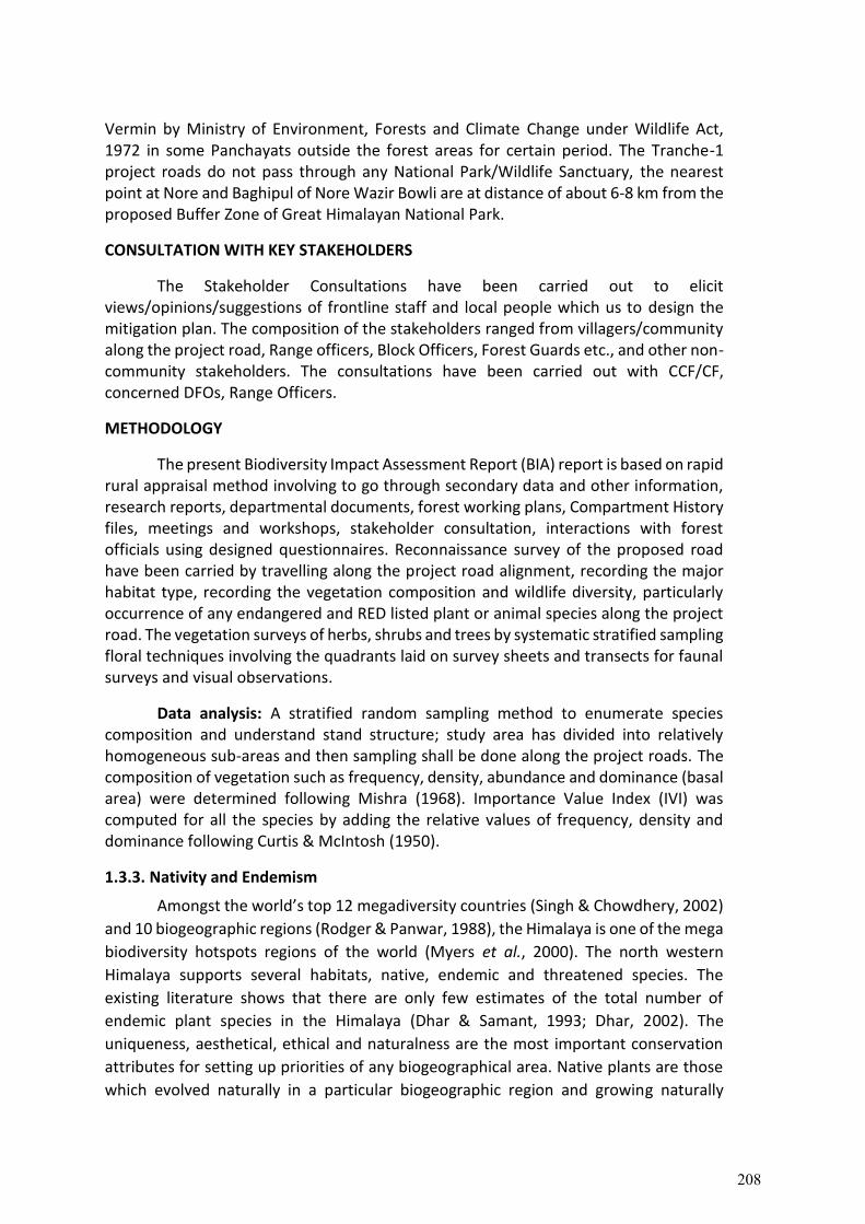
Vermin by Ministry of Environment, Forests and Climate Change under Wildlife Act, 1972 in some Panchayats outside the forest areas for certain period. The Tranche-1 project roads do not pass through any National Park/Wildlife Sanctuary, the nearest point at Nore and Baghipul of Nore Wazir Bowli are at distance of about 6-8 km from the proposed Buffer Zone of Great Himalayan National Park.
CONSULTATION WITH KEY STAKEHOLDERS
The Stakeholder Consultations have been carried out to elicit views/opinions/suggestions of frontline staff and local people which us to design the mitigation plan. The composition of the stakeholders ranged from villagers/community along the project road, Range officers, Block Officers, Forest Guards etc., and other non-community stakeholders. The consultations have been carried out with CCF/CF, concerned DFOs, Range Officers.
METHODOLOGY
The present Biodiversity Impact Assessment Report (BIA) report is based on rapid rural appraisal method involving to go through secondary data and other information, research reports, departmental documents, forest working plans, Compartment History files, meetings and workshops, stakeholder consultation, interactions with forest officials using designed questionnaires. Reconnaissance survey of the proposed road have been carried by travelling along the project road alignment, recording the major habitat type, recording the vegetation composition and wildlife diversity, particularly occurrence of any endangered and RED listed plant or animal species along the project road. The vegetation surveys of herbs, shrubs and trees by systematic stratified sampling floral techniques involving the quadrants laid on survey sheets and transects for faunal surveys and visual observations.
Data analysis: A stratified random sampling method to enumerate species composition and understand stand structure; study area has divided into relatively homogeneous sub-areas and then sampling shall be done along the project roads. The composition of vegetation such as frequency, density, abundance and dominance (basal area) were determined following Mishra (1968). Importance Value Index (IVI) was computed for all the species by adding the relative values of frequency, density and dominance following Curtis & McIntosh (1950).
1.3.3. Nativity and Endemism
Amongst the world’s top 12 megadiversity countries (Singh & Chowdhery, 2002)
and 10 biogeographic regions (Rodger & Panwar, 1988), the Himalaya is one of the mega
biodiversity hotspots regions of the world (Myers et al., 2000). The north western
Himalaya supports several habitats, native, endemic and threatened species. The
existing literature shows that there are only few estimates of the total number of
endemic plant species in the Himalaya (Dhar & Samant, 1993; Dhar, 2002). The
uniqueness, aesthetical, ethical and naturalness are the most important conservation
attributes for setting up priorities of any biogeographical area. Native plants are those
which evolved naturally in a particular biogeographic region and growing naturally
208
before humans introduced plants from distant places. Nativity of the species indicates
first record/origin of the species (Anonymous, 1883-1970). Endemic (Greek word where
en = in; demos = region) is a term used to indicate that a plant or animal is restricted in
its geographical range or to a particular region. It encompasses taxonomic units of any
rank or taxa usually isolated by geographical, ecological and temporal barriers (Nayar,
1996). The richness of the native and endemic species denotes the high conservation
value of a system. The biogeographic provinces with high diversity of native and endemic
are the indicators of the pristine ecosystems with least disturbance, whereas low
richness of the sensitive biodiversity elements indicates high disturbance and opening
the way for the invasion of non-natives (Dhar & Samant, 1993; Samant et al., 2002). In
the Himalayan context, studies on various aspects of endemism viz., endemism in the
families (Vir et al.,1989 a&b; Dhar & Samant, 1993); habitats and communities (Joshi &
Samant, 2004) for determination of conservation priorities (Dhar, 2002); endemism in
wild edibles (Samant & Dhar, 1997); sacred plants (Pant, 2005); essential oil yielding
medicinal plants (Samant & Palni, 2000); medicinal plants (Samant et al., 1998a) and
fodder species (Samant et al., 2007) are available.
The native and endemic species play an important role in assessing the
conservation value of any habitat, community and ecosystem, and for making a strategy
and action plan for conservation and management of a particular biogeographic region
including protected area like Biosphere Reserve. High percentage of native and endemic
species indicates the high conservation value of that particular biogeographic region.
Invasions and endemism represent the two most extreme conditions of the possible
geographical distribution of species. Non-natives are species that have spread far
beyond their original distribution (Huston, 1994). Invasions of species beyond their
native range constitute a global change of major concern for the conservation
programmes. Invasive species threaten biodiversity, change ecosystem functioning
(Levine et al., 2003) and have economic costs. Conservation of native biological diversity
is a major area of concern, as invasive non-indigenous species contributes to the demise
of native species. These invasive non-indigenous species are an ongoing threat to the
persistence of native assemblages because they can suppress native species, infect them
with diseases to which they have no resistance, outcompete them or alter ecosystem
functions, making it difficult and expensive to return the ecosystem to its prior, often
more desirable condition (Vitousek et al., 1997). It is the well-established fact that the
areas with high percentage of native and endemic species indicate the high conservation
value of that particular area. But, due to habitat degradation and over exploitation of
such species, their richness is decreasing rapidly (Samant et al., 2006). Anthropogenic
pressures including felling, excessive lopping, over grazing, etc. causing habitat
degradation and over exploitation of such species. The richness of these species has
been decreasing rapidly and non-natives have been proliferating fast due to their hardy
nature. Such anthropogenic activities have drastically changed the composition of
habitats, communities and ecosystem of a particular biogeographic region (Samant et
al., 2002). Introduction of the non-native has drastically changed the ecosystem
property due to direct competition with the native and endemic species or directly
209
alternating the ecosystem properties (Vitousek, 1986). Further, severe exotic
disturbances dramatically affected succession and led to exotic annual communities
with low native species richness (Huston, 1994).
The nativity of a species denotes its origin or first record (Anonymous, 1883-1970). The nativity of the species has been identified following Anonymous (1883-1970), Samant & Dhar (1997). The species having their origin from Himalayan region have been considered as natives. In case of pteridophytes the species distributed in the Himalayan Region only, have been considered as native to the Himalayan region, whereas remaining species have been considered as non-natives (Samant et al., 2010).
Endemism of the species has been identified based on distribution of the species (Dhar & Samant, 1993). The species restricted to the IHR have been considered as endemic whereas those with extended distribution to neighbouring countries/states (i.e., Himalayan regions of Afghanistan, Pakistan, Tibet, Nepal, Bhutan and adjacent states of the IHR) were considered as near endemic to the IHR. The distribution pattern of the native and endemic species has been identified based on the survey and occurrence of the species along an altitudinal gradient and within habitats (Samant et al., 2001). In general, of the total 403 species reported from the different corroder, 112 species were identified native to the Himalayan Region and remaining species were non-natives. Among the natives, 31.25% species were near endemic, 0.01% species endemic. Some of the notable native species were Cyathula capitata, Deeringia amaranthoides, Pistacia integerrima, Bupleurum hamiltonii, B. tenue, Pimpinella diversifolia, Sauromatum venosum, Asparagus adscendens, A. filicinus, Begonia picta, Euonymsus pendulus, Coriaria nepalensis, Osbeckia stellata, Jasminum dispermum, etc.; near endemic species Marsdenia roylei, Ainsliaea aptera, Gerbera gossypina, Senecio graciliflorus, Impatiens scabrida, Berberis aristata, B. lycium, Caryopteris foetida, Viburnum cotinifolium, Gypsophila cerastiodes, Elaeagnus conferta, Juglans regia, Hedychium spicatum, Salvia lanata, S. nubicola, Bergenia ligulata, Ulmus villosa, Daphne papyracea, Pinus roxburghii, P. wallichiana, Viola canescens, etc. Only one species i.e., Scrophularia himalensis was endemic to the IHR.
Habitat and distribution Habitat and distribution of native and endemic species is presented. shady moist
habitat showed maximum richness of native (93 spp.), non-native (225 spp.), endemic (01 sp.) and near-endemic (25 spp.) species; followed by dry, native (79 spp.), non-native (212 spp.), endemic (01 sp.) and near-endemic ( 26 spp.); degraded, native (51 spp.), non-native (181 spp.), endemic (01 sp.) and near-endemic (16 spp.); riverine, native (47 spp.), non-native (119 spp.), endemic (01 sp.) and near-endemic (17 spp.); shrubbery, native (26 spp.), non-native (62 spp.), endemic (01 sp.) and near-endemic (09 spp.), etc., The remaining habitats showed comparatively less number of native, non-native, endemic and near endemic species.
210
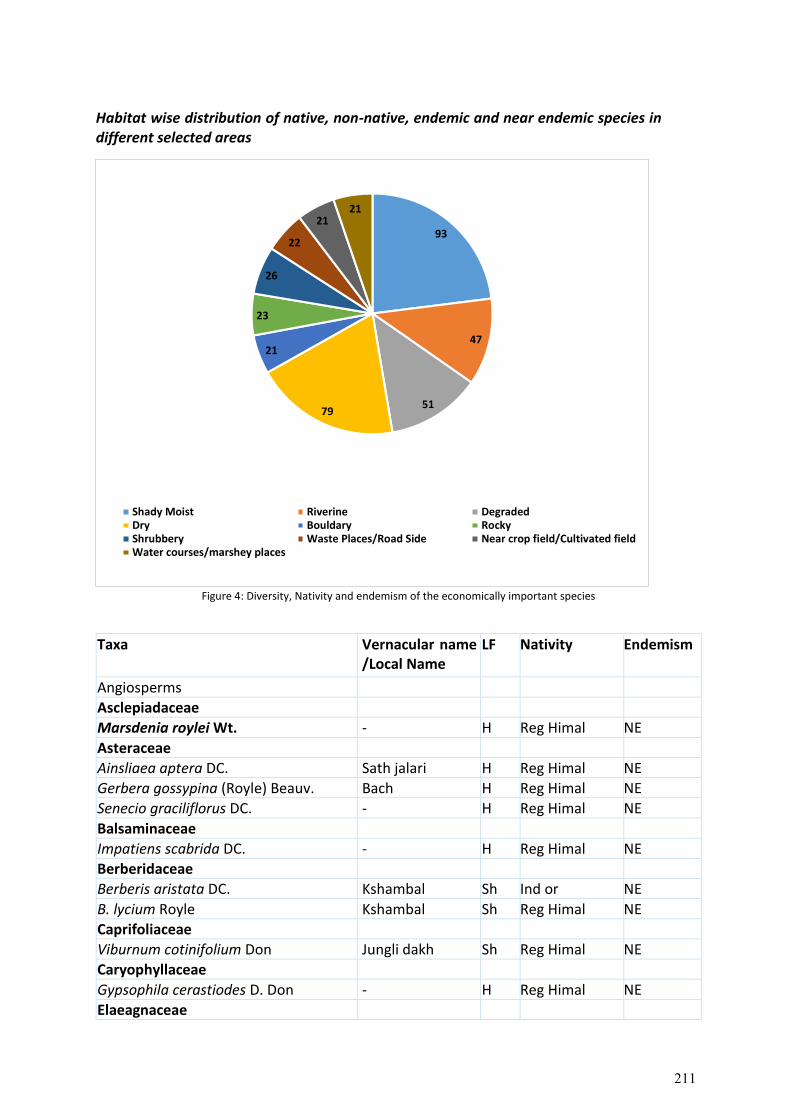
Habitat wise distribution of native, non-native, endemic and near endemic species in different selected areas
Figure 4: Diversity, Nativity and endemism of the economically important species
Taxa Vernacular name /Local Name
LF Nativity Endemism
Angiosperms
Asclepiadaceae
Marsdenia roylei Wt. - H Reg Himal NE
Asteraceae
Ainsliaea aptera DC. Sath jalari H Reg Himal NE
Gerbera gossypina (Royle) Beauv. Bach H Reg Himal NE
Senecio graciliflorus DC. - H Reg Himal NE
Balsaminaceae
Impatiens scabrida DC. - H Reg Himal NE
Berberidaceae
Berberis aristata DC. Kshambal Sh Ind or NE
B. lycium Royle Kshambal Sh Reg Himal NE
Caprifoliaceae
Viburnum cotinifolium Don Jungli dakh Sh Reg Himal NE
Caryophyllaceae
Gypsophila cerastiodes D. Don - H Reg Himal NE
Elaeagnaceae
93
47
5179
21
23
26
22
2121
Shady Moist Riverine DegradedDry Bouldary RockyShrubbery Waste Places/Road Side Near crop field/Cultivated fieldWater courses/marshey places
211
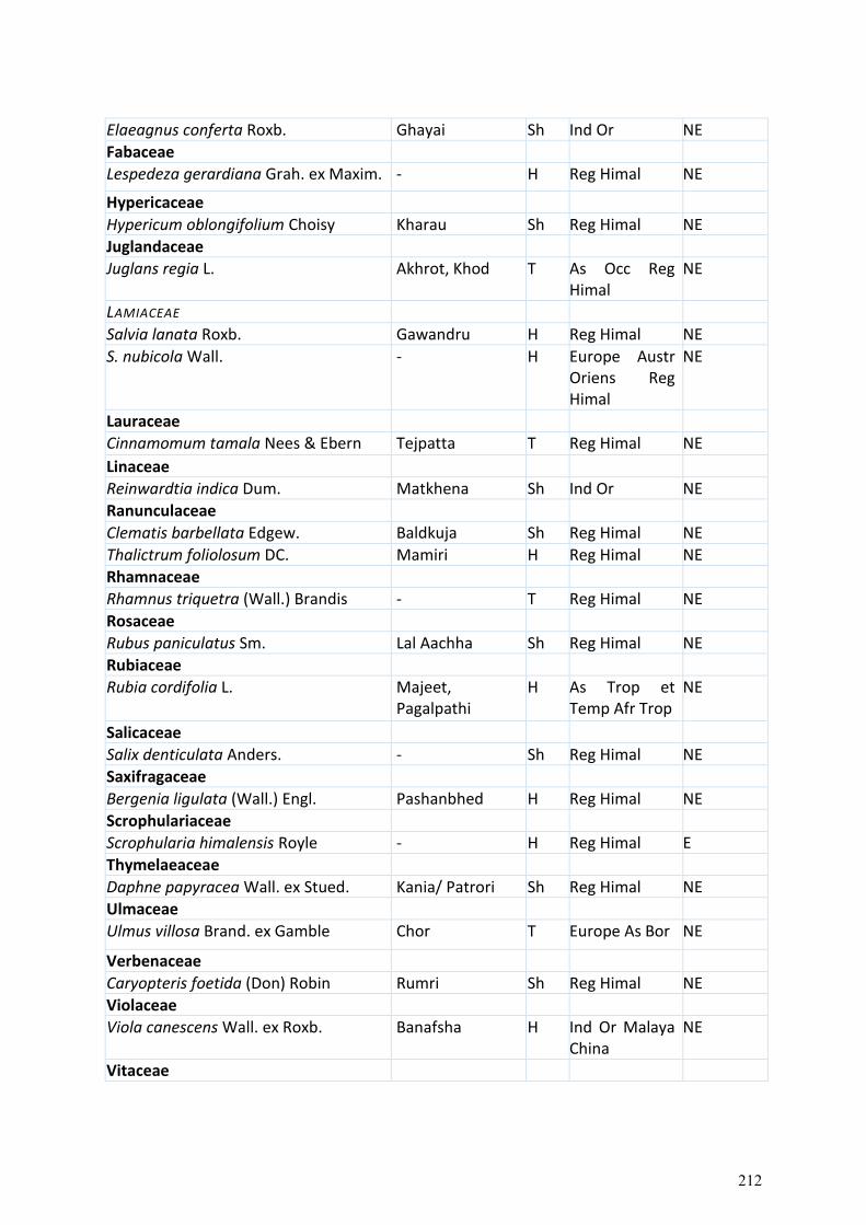
Elaeagnus conferta Roxb. Ghayai Sh Ind Or NE
Fabaceae
Lespedeza gerardiana Grah. ex Maxim. - H Reg Himal NE
Hypericaceae
Hypericum oblongifolium Choisy Kharau Sh Reg Himal NE
Juglandaceae
Juglans regia L. Akhrot, Khod T As Occ Reg Himal
NE
LAMIACEAE
Salvia lanata Roxb. Gawandru H Reg Himal NE
S. nubicola Wall. - H Europe Austr Oriens Reg Himal
NE
Lauraceae
Cinnamomum tamala Nees & Ebern Tejpatta T Reg Himal NE
Linaceae
Reinwardtia indica Dum. Matkhena Sh Ind Or NE
Ranunculaceae
Clematis barbellata Edgew. Baldkuja Sh Reg Himal NE
Thalictrum foliolosum DC. Mamiri H Reg Himal NE
Rhamnaceae
Rhamnus triquetra (Wall.) Brandis - T Reg Himal NE
Rosaceae
Rubus paniculatus Sm. Lal Aachha Sh Reg Himal NE
Rubiaceae
Rubia cordifolia L. Majeet, Pagalpathi
H As Trop et Temp Afr Trop
NE
Salicaceae
Salix denticulata Anders. - Sh Reg Himal NE
Saxifragaceae
Bergenia ligulata (Wall.) Engl. Pashanbhed H Reg Himal NE
Scrophulariaceae
Scrophularia himalensis Royle - H Reg Himal E
Thymelaeaceae
Daphne papyracea Wall. ex Stued. Kania/ Patrori Sh Reg Himal NE
Ulmaceae
Ulmus villosa Brand. ex Gamble Chor T Europe As Bor NE
Verbenaceae
Caryopteris foetida (Don) Robin Rumri Sh Reg Himal NE
Violaceae
Viola canescens Wall. ex Roxb. Banafsha H Ind Or Malaya China
NE
Vitaceae
212
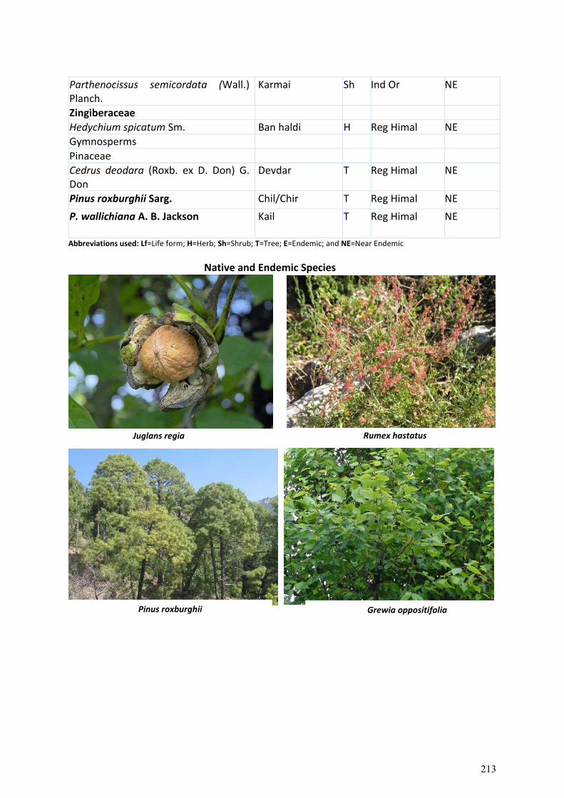
Juglans regia Rumex hastatus
Parthenocissus semicordata (Wall.) Planch.
Karmai Sh Ind Or NE
Zingiberaceae
Hedychium spicatum Sm. Ban haldi H Reg Himal NE
Gymnosperms
Pinaceae
Cedrus deodara (Roxb. ex D. Don) G. Don
Devdar T Reg Himal NE
Pinus roxburghii Sarg. Chil/Chir T Reg Himal NE
P. wallichiana A. B. Jackson Kail T Reg Himal NE
Abbreviations used: Lf=Life form; H=Herb; Sh=Shrub; T=Tree; E=Endemic; and NE=Near Endemic
Native and Endemic Species
Grewia oppositifolia Pinus roxburghii
213

1.3.4. Resource Utilization Pattern
A total of 403 species of vascular plants i.e., Angiosperms (105 families, 285 genera & 393 species), Gymnosperms (01 family, 02 genera & 03 species) and Pteridophytes (05 families, 05 genera & 07 species) were recorded in 05 different slected areas i.e; Baddi-Barotiwala-Sai-Ramshar Road, Dhadol-Ladrour Road, Raghunathpura-Mandi-Harpura-Bharai Road, Mandi-Rewalsar-Kalkhar Road, and Nore-Wazir-Bowli Road in different districts of Himachal Pradesh. Of the total species, 79 species were trees, 105 shrubs, 209 herbs & 07 pteridophytes.
Table 8. Taxonomic description of floristic diversity in corridors
Taxonomic Group Families Genera Species Herbs Shrubs Trees
Angiosperms 105 285 393 209 105 79
Gymnosperms 01 02 03 - - 03
Pteridophytes 05 05 07 07 - -
Total 111 292 403 216 105 82
Among families, Asteraceae (31 spp.); Fabaceae (25 spp.); Poaceae and Lamiaceae (17 spp., each); Rosaceae (12 spp.); Apiaceae (11 spp.); Anacardiaceae, Acanthaceae and Euphorbiaceae (10 spp., each); Caesalpiniaceae, Moraceae and Solanaceae (09 spp., each); Rubiaceae (08 spp.); Polygonaceae and Ranunculaceae (07
Cannabis sativa
Berberis lycium
Pyrus pashia
Rhododendron arboreum
214
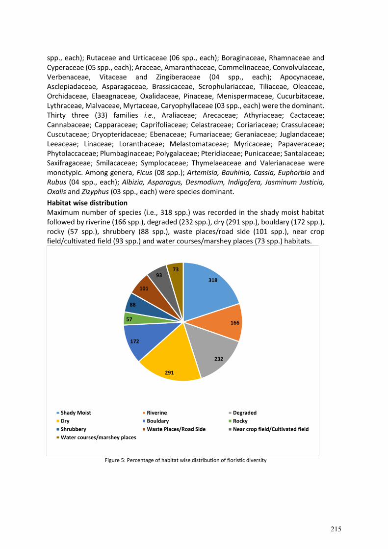
spp., each); Rutaceae and Urticaceae (06 spp., each); Boraginaceae, Rhamnaceae and Cyperaceae (05 spp., each); Araceae, Amaranthaceae, Commelinaceae, Convolvulaceae, Verbenaceae, Vitaceae and Zingiberaceae (04 spp., each); Apocynaceae, Asclepiadaceae, Asparagaceae, Brassicaceae, Scrophulariaceae, Tiliaceae, Oleaceae, Orchidaceae, Elaeagnaceae, Oxalidaceae, Pinaceae, Menispermaceae, Cucurbitaceae, Lythraceae, Malvaceae, Myrtaceae, Caryophyllaceae (03 spp., each) were the dominant. Thirty three (33) families i.e., Araliaceae; Arecaceae; Athyriaceae; Cactaceae; Cannabaceae; Capparaceae; Caprifoliaceae; Celastraceae; Coriariaceae; Crassulaceae; Cuscutaceae; Dryopteridaceae; Ebenaceae; Fumariaceae; Geraniaceae; Juglandaceae; Leeaceae; Linaceae; Loranthaceae; Melastomataceae; Myricaceae; Papaveraceae; Phytolaccaceae; Plumbaginaceae; Polygalaceae; Pteridiaceae; Punicaceae; Santalaceae; Saxifragaceae; Smilacaceae; Symplocaceae; Thymelaeaceae and Valerianaceae were monotypic. Among genera, Ficus (08 spp.); Artemisia, Bauhinia, Cassia, Euphorbia and Rubus (04 spp., each); Albizia, Asparagus, Desmodium, Indigofera, Jasminum Justicia, Oxalis and Zizyphus (03 spp., each) were species dominant.
Habitat wise distribution Maximum number of species (i.e., 318 spp.) was recorded in the shady moist habitat followed by riverine (166 spp.), degraded (232 spp.), dry (291 spp.), bouldary (172 spp.), rocky (57 spp.), shrubbery (88 spp.), waste places/road side (101 spp.), near crop field/cultivated field (93 spp.) and water courses/marshey places (73 spp.) habitats.
Figure 5: Percentage of habitat wise distribution of floristic diversity
318
166
232
291
172
57
88
101
9373
Shady Moist Riverine Degraded
Dry Bouldary Rocky
Shrubbery Waste Places/Road Side Near crop field/Cultivated field
Water courses/marshey places
215
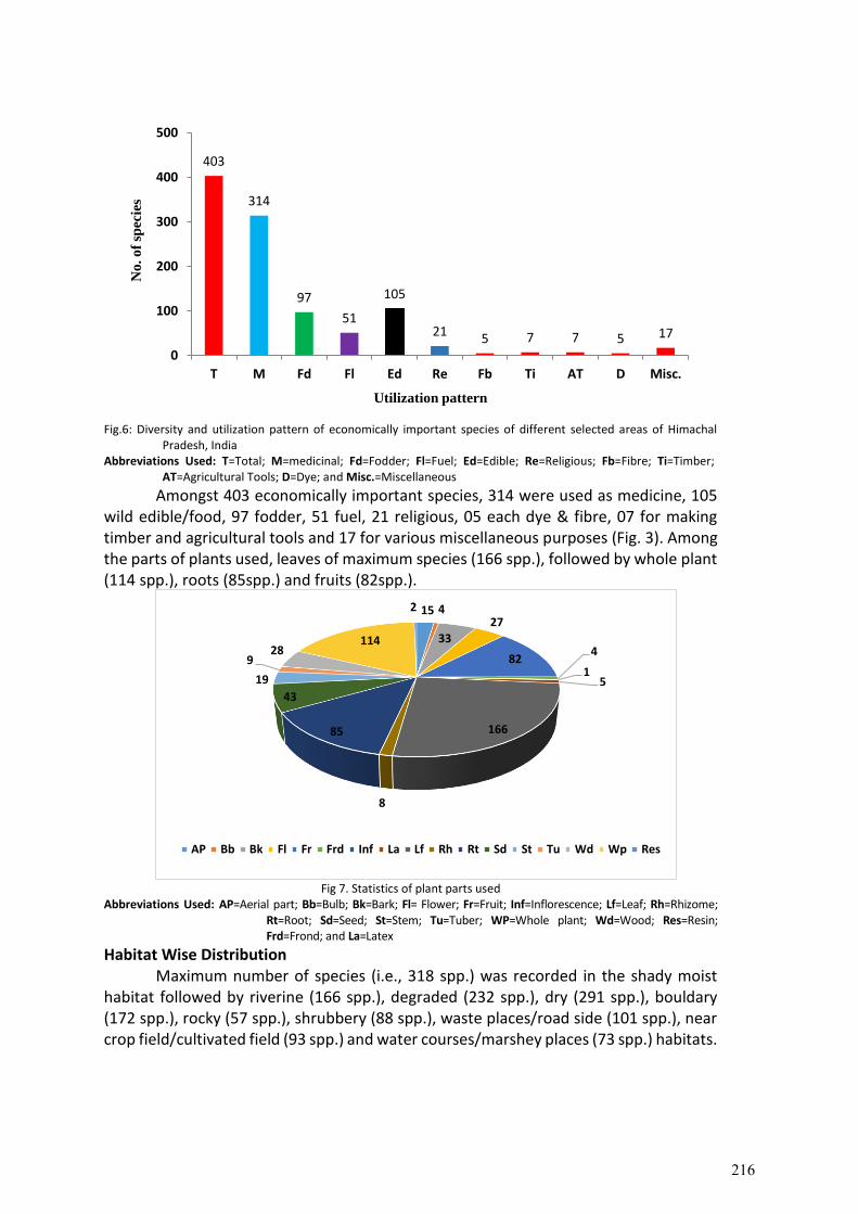
Fig.6: Diversity and utilization pattern of economically important species of different selected areas of Himachal
Pradesh, India Abbreviations Used: T=Total; M=medicinal; Fd=Fodder; Fl=Fuel; Ed=Edible; Re=Religious; Fb=Fibre; Ti=Timber;
AT=Agricultural Tools; D=Dye; and Misc.=Miscellaneous
Amongst 403 economically important species, 314 were used as medicine, 105 wild edible/food, 97 fodder, 51 fuel, 21 religious, 05 each dye & fibre, 07 for making timber and agricultural tools and 17 for various miscellaneous purposes (Fig. 3). Among the parts of plants used, leaves of maximum species (166 spp.), followed by whole plant (114 spp.), roots (85spp.) and fruits (82spp.).
Fig 7. Statistics of plant parts used
Abbreviations Used: AP=Aerial part; Bb=Bulb; Bk=Bark; Fl= Flower; Fr=Fruit; Inf=Inflorescence; Lf=Leaf; Rh=Rhizome; Rt=Root; Sd=Seed; St=Stem; Tu=Tuber; WP=Whole plant; Wd=Wood; Res=Resin; Frd=Frond; and La=Latex
Habitat Wise Distribution Maximum number of species (i.e., 318 spp.) was recorded in the shady moist
habitat followed by riverine (166 spp.), degraded (232 spp.), dry (291 spp.), bouldary (172 spp.), rocky (57 spp.), shrubbery (88 spp.), waste places/road side (101 spp.), near crop field/cultivated field (93 spp.) and water courses/marshey places (73 spp.) habitats.
403
314
97
51
105
21 5 7 7 5 17
0
100
200
300
400
500
T M Fd Fl Ed Re Fb Ti AT D Misc.
No
. o
f sp
ecie
s
Utilization pattern
15 4
33
27
824
15
166
8
85
43
19
928
114
2
AP Bb Bk Fl Fr Frd Inf La Lf Rh Rt Sd St Tu Wd Wp Res
216
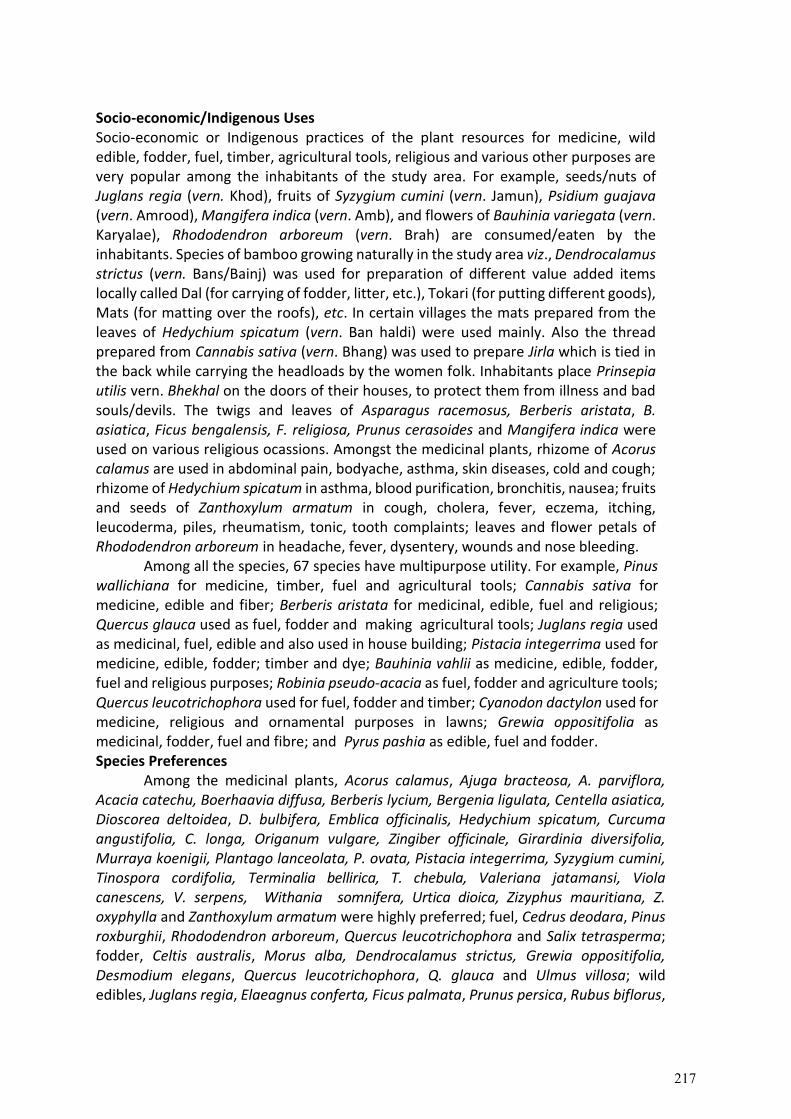
Socio-economic/Indigenous Uses Socio-economic or Indigenous practices of the plant resources for medicine, wild edible, fodder, fuel, timber, agricultural tools, religious and various other purposes are very popular among the inhabitants of the study area. For example, seeds/nuts of Juglans regia (vern. Khod), fruits of Syzygium cumini (vern. Jamun), Psidium guajava (vern. Amrood), Mangifera indica (vern. Amb), and flowers of Bauhinia variegata (vern. Karyalae), Rhododendron arboreum (vern. Brah) are consumed/eaten by the inhabitants. Species of bamboo growing naturally in the study area viz., Dendrocalamus strictus (vern. Bans/Bainj) was used for preparation of different value added items locally called Dal (for carrying of fodder, litter, etc.), Tokari (for putting different goods), Mats (for matting over the roofs), etc. In certain villages the mats prepared from the leaves of Hedychium spicatum (vern. Ban haldi) were used mainly. Also the thread prepared from Cannabis sativa (vern. Bhang) was used to prepare Jirla which is tied in the back while carrying the headloads by the women folk. Inhabitants place Prinsepia utilis vern. Bhekhal on the doors of their houses, to protect them from illness and bad souls/devils. The twigs and leaves of Asparagus racemosus, Berberis aristata, B. asiatica, Ficus bengalensis, F. religiosa, Prunus cerasoides and Mangifera indica were used on various religious ocassions. Amongst the medicinal plants, rhizome of Acorus calamus are used in abdominal pain, bodyache, asthma, skin diseases, cold and cough; rhizome of Hedychium spicatum in asthma, blood purification, bronchitis, nausea; fruits and seeds of Zanthoxylum armatum in cough, cholera, fever, eczema, itching, leucoderma, piles, rheumatism, tonic, tooth complaints; leaves and flower petals of Rhododendron arboreum in headache, fever, dysentery, wounds and nose bleeding. Among all the species, 67 species have multipurpose utility. For example, Pinus wallichiana for medicine, timber, fuel and agricultural tools; Cannabis sativa for medicine, edible and fiber; Berberis aristata for medicinal, edible, fuel and religious; Quercus glauca used as fuel, fodder and making agricultural tools; Juglans regia used as medicinal, fuel, edible and also used in house building; Pistacia integerrima used for medicine, edible, fodder; timber and dye; Bauhinia vahlii as medicine, edible, fodder, fuel and religious purposes; Robinia pseudo-acacia as fuel, fodder and agriculture tools; Quercus leucotrichophora used for fuel, fodder and timber; Cyanodon dactylon used for medicine, religious and ornamental purposes in lawns; Grewia oppositifolia as medicinal, fodder, fuel and fibre; and Pyrus pashia as edible, fuel and fodder. Species Preferences
Among the medicinal plants, Acorus calamus, Ajuga bracteosa, A. parviflora, Acacia catechu, Boerhaavia diffusa, Berberis lycium, Bergenia ligulata, Centella asiatica, Dioscorea deltoidea, D. bulbifera, Emblica officinalis, Hedychium spicatum, Curcuma angustifolia, C. longa, Origanum vulgare, Zingiber officinale, Girardinia diversifolia, Murraya koenigii, Plantago lanceolata, P. ovata, Pistacia integerrima, Syzygium cumini, Tinospora cordifolia, Terminalia bellirica, T. chebula, Valeriana jatamansi, Viola canescens, V. serpens, Withania somnifera, Urtica dioica, Zizyphus mauritiana, Z. oxyphylla and Zanthoxylum armatum were highly preferred; fuel, Cedrus deodara, Pinus roxburghii, Rhododendron arboreum, Quercus leucotrichophora and Salix tetrasperma; fodder, Celtis australis, Morus alba, Dendrocalamus strictus, Grewia oppositifolia, Desmodium elegans, Quercus leucotrichophora, Q. glauca and Ulmus villosa; wild edibles, Juglans regia, Elaeagnus conferta, Ficus palmata, Prunus persica, Rubus biflorus,
217

R. ellipticus, R. paniculatus and Syzygium cumini; agricultural tools, leucotrichophora, Q. glauca, Pinus roxburghii, Symplocos chinensis, Robinia pseudo-acacia and Dalbergia sissoo; and timber, Cedrus deodara, Juglans regia, Pinus roxburghii and Pinus wallichiana were the highly preferred species. Quercus leucotrichophora was the dominant multipurpose tree species and it was heavily lopped as fodder, fuel wood and to prepare agricultural implements throughout the study area from the higher altitude villages. Among the preferred medicinal plants, whole plant of Valeriana jatamansi, rhizome of Hedychium spicatum, roots of Acorus calamus and Berberis lycium were traded by the inhabitants.
218
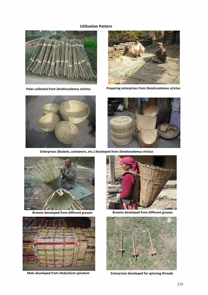
Brooms developed from different grasses
Poles collected from Dendrocalamus strictus
Brooms developed from different grasses
Mats developed from Hedychium spicatum Enterprises developed for spinning threads
Utilization Pattern
Preparing enterprises from Dendrocalamus strictus
Enterprises (Baskets, containers, etc.) developed from Dendrocalamus strictus
219
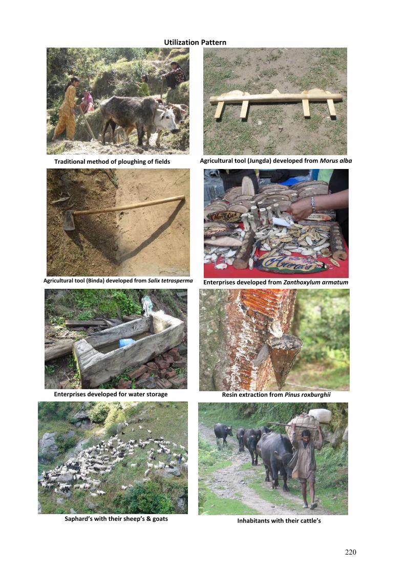
Enterprises developed for water storage
Traditional method of ploughing of fields Agricultural tool (Jungda) developed from Morus alba
Agricultural tool (Binda) developed from Salix tetrasperma Enterprises developed from Zanthoxylum armatum
Resin extraction from Pinus roxburghii
Saphard’s with their sheep’s & goats Inhabitants with their cattle’s
Utilization Pattern
220
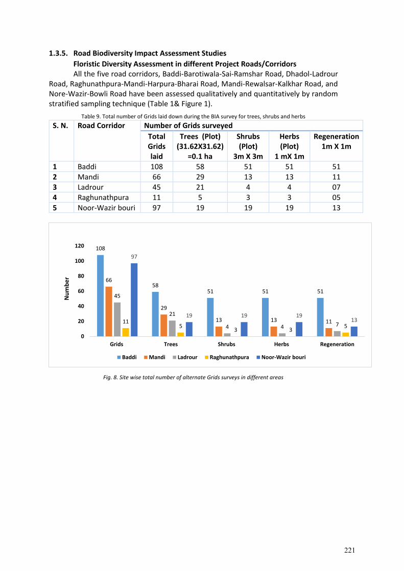
1.3.5. Road Biodiversity Impact Assessment Studies
Floristic Diversity Assessment in different Project Roads/Corridors All the five road corridors, Baddi-Barotiwala-Sai-Ramshar Road, Dhadol-Ladrour Road, Raghunathpura-Mandi-Harpura-Bharai Road, Mandi-Rewalsar-Kalkhar Road, and Nore-Wazir-Bowli Road have been assessed qualitatively and quantitatively by random stratified sampling technique (Table 1& Figure 1).
Table 9. Total number of Grids laid down during the BIA survey for trees, shrubs and herbs
S. N. Road Corridor Number of Grids surveyed
Total Grids laid
Trees (Plot) (31.62X31.62)
=0.1 ha
Shrubs (Plot)
3m X 3m
Herbs (Plot)
1 mX 1m
Regeneration 1m X 1m
1 Baddi 108 58 51 51 51
2 Mandi 66 29 13 13 11
3 Ladrour 45 21 4 4 07
4 Raghunathpura 11 5 3 3 05
5 Noor-Wazir bouri 97 19 19 19 13
Fig. 8. Site wise total number of alternate Grids surveys in different areas
108
5851 51 51
66
29
13 13 11
45
21
4 4 7115
3 35
97
19 19 1913
0
20
40
60
80
100
120
Grids Trees Shrubs Herbs Regeneration
Nu
mb
er
Baddi Mandi Ladrour Raghunathpura Noor-Wazir bouri
221
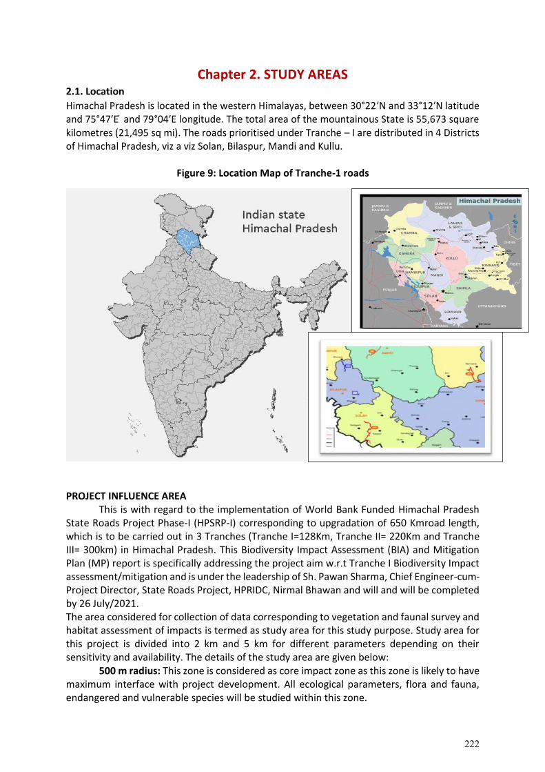
Chapter 2. STUDY AREAS 2.1. Location
Himachal Pradesh is located in the western Himalayas, between 30°22′N and 33°12′N latitude and 75°47′E ́ and 79°04′E longitude. The total area of the mountainous State is 55,673 square kilometres (21,495 sq mi). The roads prioritised under Tranche – I are distributed in 4 Districts of Himachal Pradesh, viz a viz Solan, Bilaspur, Mandi and Kullu.
Figure 9: Location Map of Tranche-1 roads
PROJECT INFLUENCE AREA
This is with regard to the implementation of World Bank Funded Himachal Pradesh State Roads Project Phase-I (HPSRP-I) corresponding to upgradation of 650 Kmroad length, which is to be carried out in 3 Tranches (Tranche I=128Km, Tranche II= 220Km and Tranche III= 300km) in Himachal Pradesh. This Biodiversity Impact Assessment (BIA) and Mitigation Plan (MP) report is specifically addressing the project aim w.r.t Tranche I Biodiversity Impact assessment/mitigation and is under the leadership of Sh. Pawan Sharma, Chief Engineer-cum-Project Director, State Roads Project, HPRIDC, Nirmal Bhawan and will and will be completed by 26 July/2021. The area considered for collection of data corresponding to vegetation and faunal survey and habitat assessment of impacts is termed as study area for this study purpose. Study area for this project is divided into 2 km and 5 km for different parameters depending on their sensitivity and availability. The details of the study area are given below:
500 m radius: This zone is considered as core impact zone as this zone is likely to have maximum interface with project development. All ecological parameters, flora and fauna, endangered and vulnerable species will be studied within this zone.
222
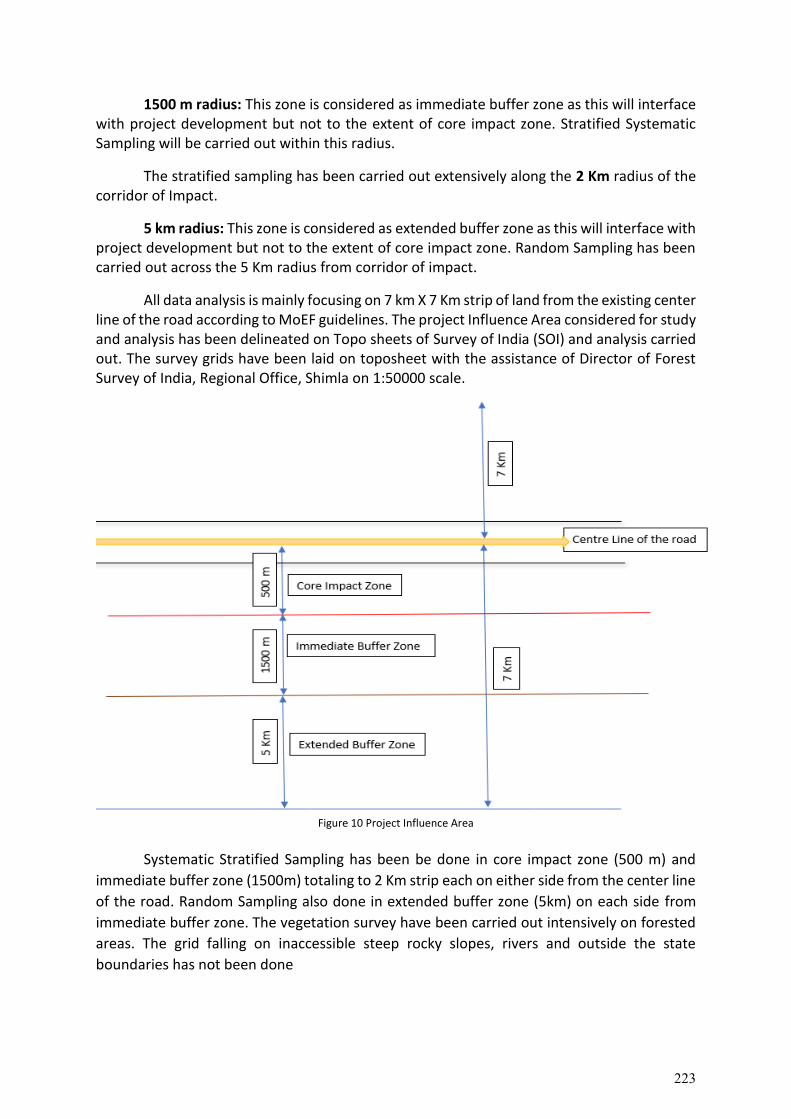
1500 m radius: This zone is considered as immediate buffer zone as this will interface with project development but not to the extent of core impact zone. Stratified Systematic Sampling will be carried out within this radius.
The stratified sampling has been carried out extensively along the 2 Km radius of the corridor of Impact.
5 km radius: This zone is considered as extended buffer zone as this will interface with project development but not to the extent of core impact zone. Random Sampling has been carried out across the 5 Km radius from corridor of impact.
All data analysis is mainly focusing on 7 km X 7 Km strip of land from the existing center line of the road according to MoEF guidelines. The project Influence Area considered for study and analysis has been delineated on Topo sheets of Survey of India (SOI) and analysis carried out. The survey grids have been laid on toposheet with the assistance of Director of Forest Survey of India, Regional Office, Shimla on 1:50000 scale.
Figure 10 Project Influence Area
Systematic Stratified Sampling has been be done in core impact zone (500 m) and
immediate buffer zone (1500m) totaling to 2 Km strip each on either side from the center line
of the road. Random Sampling also done in extended buffer zone (5km) on each side from
immediate buffer zone. The vegetation survey have been carried out intensively on forested
areas. The grid falling on inaccessible steep rocky slopes, rivers and outside the state
boundaries has not been done
223
2.1.1. Baddi-Barotiwala-Sai-Ramshehar
The corridor road (45 km), Baddi-Sai-Ramshahr (Chainage 11+ 500 to Km 44+726) passes through 31 habitations mainly Baddi, Sai, Taller and Ramshehar villages. These locations do not have any schedule V areas or tribal households. The baseline biodiversity profile of project falls in Nalagarh sub division of Solan District and the influence area covers 15 km width. The biodiversity profile includes main attributes like physiography, drainage, geology, soil, hydrogeology, land use, flora, fauna, forest/vegetation cover, climate, water quality and vulnerability of the project region among others. The project road is located on hilly terrain with hill and valley.
The road corridor passes along forest areas and agricultural lands. A total 5 km (approx.) of road length at five locations is aligned adjacent to existing forest. Enumeration of trees number of trees with in a RoW on each side of the road was conducted and numbers of trees were found to be 1766. The terrain of project area is hilly and there are no perennial surface water sources/bodies other than seasonal streams and springs. There are no National Park, Wildlife Sanctuary, Biosphere Reserve and any other notified sensitive area within the 15 Km radius of project road. Three demarcated forests are involved and the area proposed for transfer under Forest Conservation Act 1980 is 1.33 ha. Rest of the land falls under shamalat community government land and private land. Communities largely depend on the piped water supply besides on springs, locally calls ‘Chasma’. In Solan district, millets are the most dominant agricultural crop, which can also be seen in cultivable lands along the project road. No notified/protected Archaeological or Historical monuments exists within corridor of impact. Ramshahr fort, which has a historical value but not protected by state/Central Govt is situated at 3 km away from project road end point. A total of 17 common property resources like hand pumps, religious places, educational institutes, bus stops along the project road have are involved.
The total population of Solan district is around 5.80 lakhs and constitutes 8.5% of the state population. Out of the total population of the district 82.39 per cent lives in rural areas while 17.60 per cent lives in urban areas. Women in these villages are engaged in activities such as cultivation, Dairy, Poultry, Sheep rearing, household work, and agriculture labour.
The Local people are apprehensive that an improved road will lead to vehicles moving at greater speeds, leading to accidents; apprehensive about the timely payment of assistance and compensation; replacement cost of the structure. Landslide prone areas were a major concern and communities wanted the project to address this issue; roadside water sources (seasonal stream or springs) must be protected from any damages. Women opined that majority of the people living along the project corridor depends on water tank/ hand pump for drinking water and widening of the road may cause fall in water table. Water shortage is one of the major problems facing all women. They also indicated concerns over construction workers from outside the area might lead to possible harm by killing wild animals and birds and raised their security issues in their habitations.
The local stakeholders raised the need for: avoiding damage to trees, crops, agricultural land due to sliding of road muck, land slips, soil conservation, water drainage etc. The Nallahs to be channelized, water pond facility for wildlife and local animals. Improved road should have proper provisions of retaining walls to avoid landslides.
224
2.1.2. Dadhol-Ladraur
The Dadhol-Ladrour road is 13.500 Km and is designated as OSR-9 (Other State Road)
is one of the five priority corridors proposed for upgradation. The project road traverses
entirely within Bharari tehsil of Bilaspur district and connects to SH-32 at Ladrour and ends to
National Highway (NH-103) at Dadhol. The altitude of project corridor ranges between 697-
981 m above mean sea level. The existing pavement condition of the project road is in distress
condition at several intermediate stretches, except for some initial stretch.
The project road passes through 15 villages of Bharari sub-tehsil and the adjacent
tehsil is Ghumarwin tehsil. Some of the villages along the project road are Padyalag, Gahar,
Gatwar, Ladhyani, Bharari, Mihara and Ladrour. These locations do not have any schedule V
areas or tribal households. The Socio-economic data from secondary sources has been
collected and analysed from Bharari sub-tehsil and Ghumarwin tehsil and it has been called
as “project influence area”. The total population of Bilaspur district with 381,956 comprising
192764 (50.46%) males and 189192 (49.53%) females. Out of the total population of the
district 93.42 per cent are in rural areas while mere 6.58 per cent are in urban areas. The
literacy rate of district is 84.59% of these 91.16% are males and 77.97% are females. The
density of population of the project influence area/district works out to about 327 persons
per km2 in the district. The average household size for the project affected population is 3.6.
The work participation rate is 37.26 per cent in the study most of them are engaged into
commercial activity of trade/business, petty shop, services (44.69 %) followed by agriculture,
non-agriculture labour (24.24%), household industries consists 0.76 percent.
2.1.3. Raghunathpura-Mandi-Harpura-Bharari
The baselines data collected from stakeholder consultation via structured
questionnaire state that the average annual temperature of the area is 18.9 °C ranging
between 10 ℃ to 41 ℃ and the rainfall recorded is 1078 mm, the elevation is ranging
between 278m to 400m. The potentials risk due to road construction were risk for wild
animals, habitat fragmentation of land and water ecosystem disturbance on climate and air
pollution. The nature of exploitation (extent of forest produce extracted) recorded to be 2.43
to 5.43 metric cube which included fuel wood, fodder and chill needles for cow shed. As we
enter Raghunathpura, the area is near R&T Factory (Rosen and Turpentine manufacturing
unit). Agriculture land with 30°- 45° degree slope and moderate vegetation. Many stray cattle
are seen on the Bilaspur-Chandigarh road prone to road accident. According to the
observations recorded after stakeholder consultation and field visits, Plantation and Soil
conservation activities over 10 ha area required. The mitigation recommendations for
minimum harm to stray animals is provided in this report.
2.1.4. Mandi-Rewalsar-Kalkhar
The baseline data recorded by local communities and government stakeholders state
that the temperature of the area lies between 16.1 °C to 40° , the elevation recorded is
between 760m to 765m with rainfall of about 1876 mm annually. The participants have noted
225
that the Self-Help Groups (SHG’s) along the road corridor are active in fire protection
volunteering work. Potentials risks due to road construction were observed as degradation of
natural water resources, increase in human-animal conflict. The nature of exploitation (extent
of forest produce extracted) mainly as fuelwood, fodder ranging between 10% to 20% of
exploitation from the forest. As we enter Mandi, the slope is recorded between 30-45 degree
and the area is mainly of human habitation/shops on both side of the existing road. Towards
Kalkhar, there are 3 Densely populated forests viz a viz DPF Kukrain (Sundernagar), DPF
Jabkadhan and DPF Jalpara (both are situated in Garloni). The area can mostly be reclaimed
by plantation along the road, further explained in this report.
2.1.5. Nore-Wazir Bowli
The baseline data recorded by local communities and government stakeholders state
that the temperature of the area lies between 0 to 32℃, the elevation recorded is between
1000 m to 2200 m with rainfall of between 900 mm to 2306 mm annually. The nature of
exploitation (extent of forest produce extracted) in this corridor are predominantly fuelwood,
fodder, timber, NTFP, excessive grazing. The occurrence of forest fire during summer season
is frequent in chir-pine forest, causing damage to biodiversity. The natural springs, khadd,
nala and water sources which are reported by local stakeholders are in Arsoo (depleted),
Tangoor (depleted), Himra Bawdi (depleted), Jaurupani (depleted), Buini (depleted), Akani
Khad (Pajenda vill.), Kurpan khadd, Dogri dhar, Bajir Bawdi, Averi, Sabosur, Reumi,
Dhanurdhar bawdi, Shadar - natural spring, Thans - natural spring, Bagipul (depleting),
Chennai Khad, Pajenda (depleted), Sarlu, Kullla paani, Baagi naala (depleted), rollu
village(Manmade), sunner village bawdi (Manmade), Nagadi nala and Bai nalla. The depleting
water sources need to be augmented for thriving wildlife habitat, further detailed in this
report.
2.2 Grid Distribution
The sample plots were laid out following systematic sampling scheme. The systematic
sampling was based on the system of grids of latitude and longitude or distance, say
1kmx1km, basis. The size of grid was ascertained using area along both side of the concerned
road and optimum sample size and sample grids be selected. It may be all grids of 25''X25''size
taken few recording data (approximately one plot per 0.56 km2, alternate grids of 25''X25''
size (approximately one plot per 1.11 km2). The survey was carried abiding National Working
Plan Code– 2014. Sample plots systematically laid out which is indicated on the Survey of India
topographic sheet (toposheet) on the scale of 1:50,000.
226
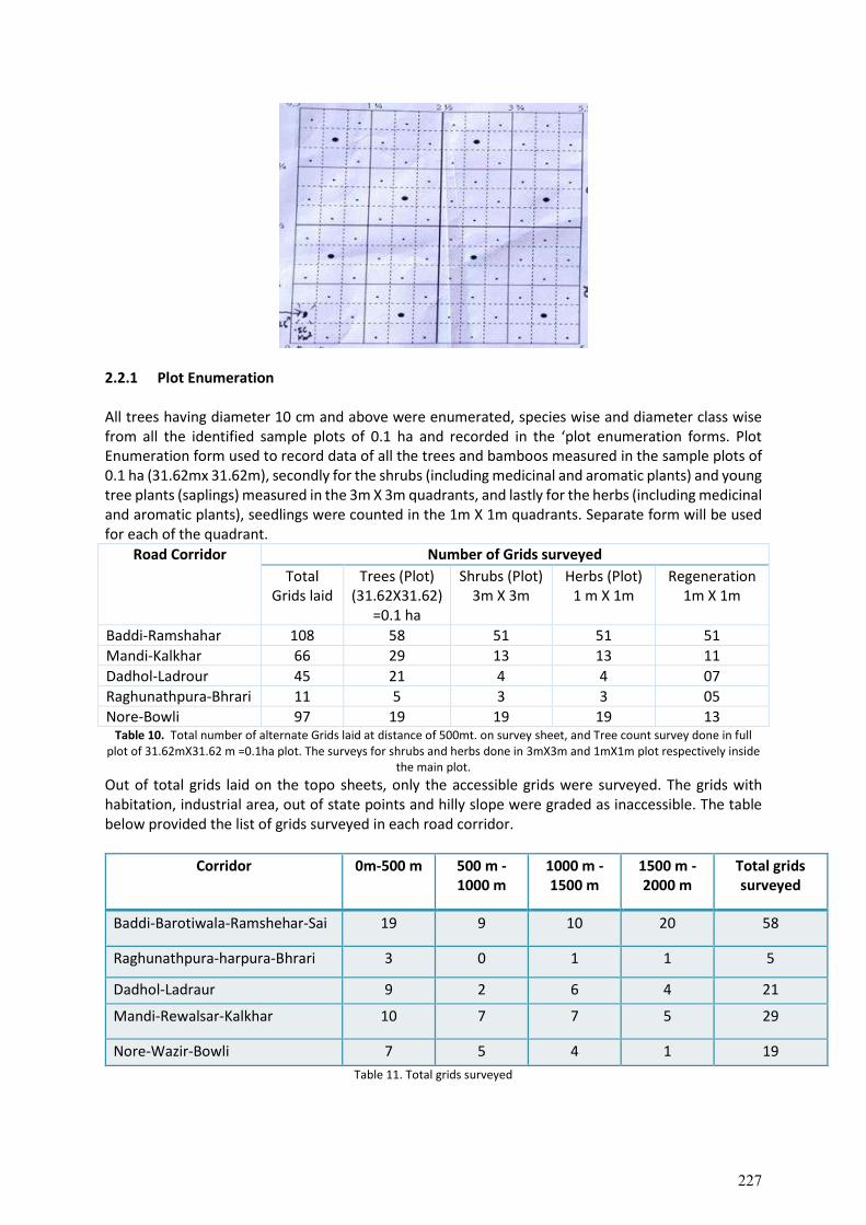
2.2.1 Plot Enumeration All trees having diameter 10 cm and above were enumerated, species wise and diameter class wise from all the identified sample plots of 0.1 ha and recorded in the ‘plot enumeration forms. Plot Enumeration form used to record data of all the trees and bamboos measured in the sample plots of 0.1 ha (31.62mx 31.62m), secondly for the shrubs (including medicinal and aromatic plants) and young tree plants (saplings) measured in the 3m X 3m quadrants, and lastly for the herbs (including medicinal and aromatic plants), seedlings were counted in the 1m X 1m quadrants. Separate form will be used for each of the quadrant.
Road Corridor Number of Grids surveyed
Total Grids laid
Trees (Plot) (31.62X31.62)
=0.1 ha
Shrubs (Plot) 3m X 3m
Herbs (Plot) 1 m X 1m
Regeneration 1m X 1m
Baddi-Ramshahar 108 58 51 51 51
Mandi-Kalkhar 66 29 13 13 11
Dadhol-Ladrour 45 21 4 4 07
Raghunathpura-Bhrari 11 5 3 3 05
Nore-Bowli 97 19 19 19 13 Table 10. Total number of alternate Grids laid at distance of 500mt. on survey sheet, and Tree count survey done in full
plot of 31.62mX31.62 m =0.1ha plot. The surveys for shrubs and herbs done in 3mX3m and 1mX1m plot respectively inside the main plot.
Out of total grids laid on the topo sheets, only the accessible grids were surveyed. The grids with habitation, industrial area, out of state points and hilly slope were graded as inaccessible. The table below provided the list of grids surveyed in each road corridor.
Corridor 0m-500 m 500 m -1000 m
1000 m -1500 m
1500 m -2000 m
Total grids surveyed
Baddi-Barotiwala-Ramshehar-Sai 19 9 10 20 58
Raghunathpura-harpura-Bhrari 3 0 1 1 5
Dadhol-Ladraur 9 2 6 4 21
Mandi-Rewalsar-Kalkhar 10 7 7 5 29
Nore-Wazir-Bowli 7 5 4 1 19
Table 11. Total grids surveyed
227
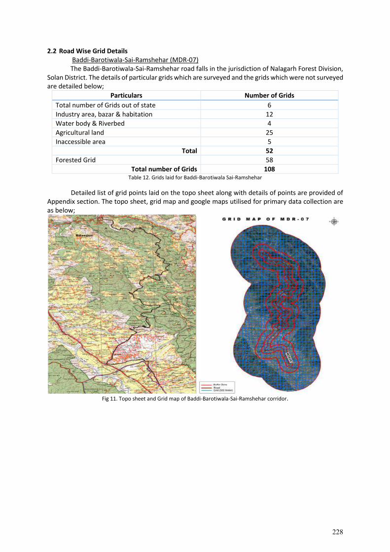
2.2 Road Wise Grid Details Baddi-Barotiwala-Sai-Ramshehar (MDR-07) The Baddi-Barotiwala-Sai-Ramshehar road falls in the jurisdiction of Nalagarh Forest Division,
Solan District. The details of particular grids which are surveyed and the grids which were not surveyed are detailed below;
Particulars Number of Grids
Total number of Grids out of state 6
Industry area, bazar & habitation 12
Water body & Riverbed 4
Agricultural land 25
Inaccessible area 5
Total 52
Forested Grid 58
Total number of Grids 108 Table 12. Grids laid for Baddi-Barotiwala Sai-Ramshehar
Detailed list of grid points laid on the topo sheet along with details of points are provided of Appendix section. The topo sheet, grid map and google maps utilised for primary data collection are as below;
Fig 11. Topo sheet and Grid map of Baddi-Barotiwala-Sai-Ramshehar corridor.
228
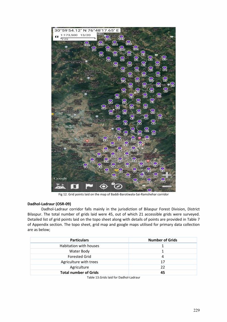
Fig 12. Grid points laid on the map of Baddi-Barotiwala-Sai-Ramshehar corridor
Dadhol-Ladraur (OSR-09) Dadhol-Ladraur corridor falls mainly in the jurisdiction of Bilaspur Forest Division, District
Bilaspur. The total number of grids laid were 45, out of which 21 accessible grids were surveyed. Detailed list of grid points laid on the topo sheet along with details of points are provided in Table 7 of Appendix section. The topo sheet, grid map and google maps utilised for primary data collection are as below;
Particulars Number of Grids
Habitation with houses 1
Water Body 1
Forested Grid 4
Agriculture with trees 17
Agriculture 22
Total number of Grids 45 Table 13.Grids laid for Dadhol-Ladraur
229
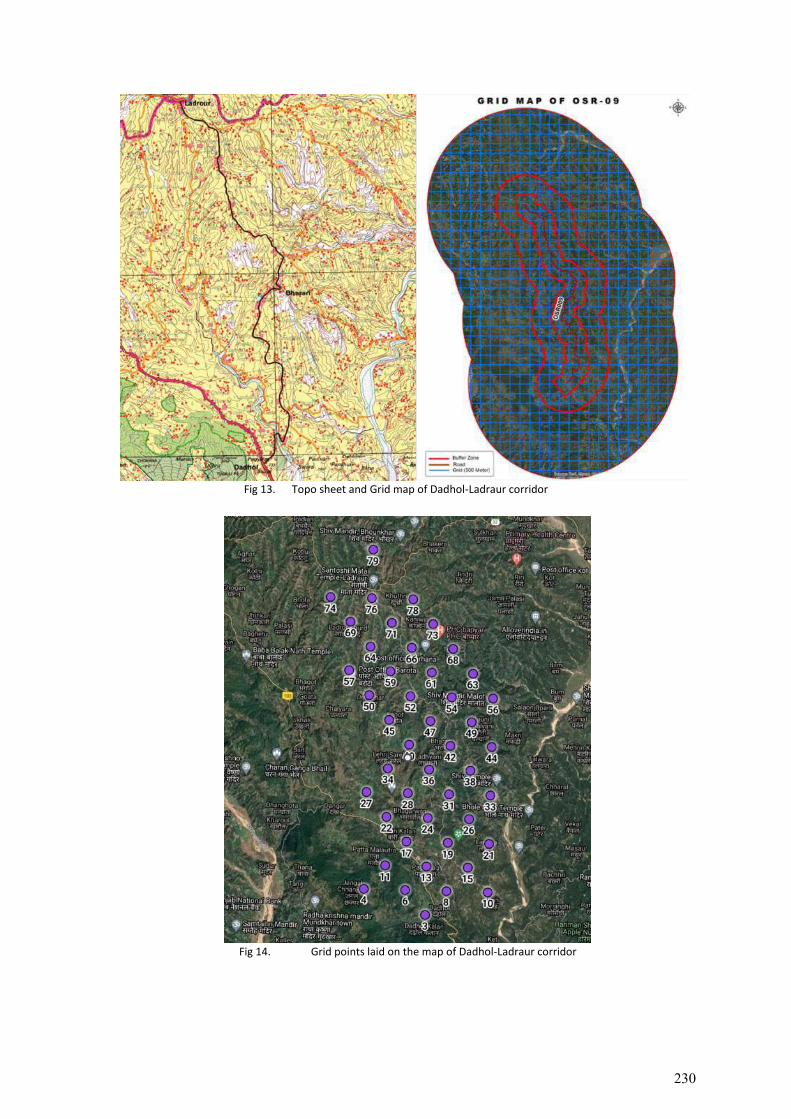
Fig 13. Topo sheet and Grid map of Dadhol-Ladraur corridor
Fig 14. Grid points laid on the map of Dadhol-Ladraur corridor
230
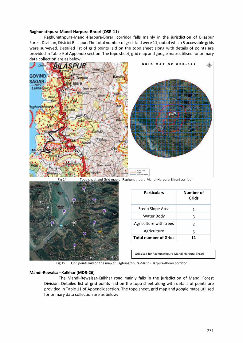
Raghunathpura-Mandi-Harpura-Bhrari (OSR-11) Raghunathpura-Mandi-Harpura-Bhrari corridor falls mainly in the jurisdiction of Bilaspur
Forest Division, District Bilaspur. The total number of grids laid were 11, out of which 5 accessible grids were surveyed. Detailed list of grid points laid on the topo sheet along with details of points are provided in Table 9 of Appendix section. The topo sheet, grid map and google maps utilised for primary data collection are as below;
Fig 14. Topo sheet and Grid map of Raghunathpura-Mandi-Harpura-Bhrari corridor
Fig 15. Grid points laid on the map of Raghunathpura-Mandi-Harpura-Bhrari corridor
Mandi-Rewalsar-Kalkhar (MDR-26) The Mandi-Rewalsar-Kalkhar road mainly falls in the jurisdiction of Mandi Forest
Division. Detailed list of grid points laid on the topo sheet along with details of points are provided in Table 11 of Appendix section. The topo sheet, grid map and google maps utilised for primary data collection are as below;
Particulars Number of Grids
Steep Slope Area 1
Water Body 3
Agriculture with trees 2
Agriculture 5
Total number of Grids 11
Grids laid for Raghunathpura-Mandi-Harpura-Bhrari
231
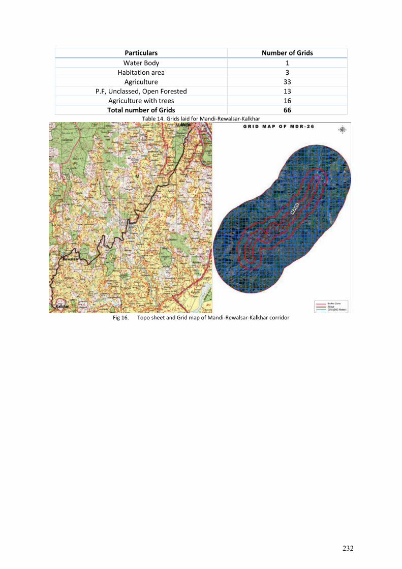
Particulars Number of Grids
Water Body 1
Habitation area 3
Agriculture 33
P.F, Unclassed, Open Forested 13
Agriculture with trees 16
Total number of Grids 66 Table 14. Grids laid for Mandi-Rewalsar-Kalkhar
Fig 16. Topo sheet and Grid map of Mandi-Rewalsar-Kalkhar corridor
232
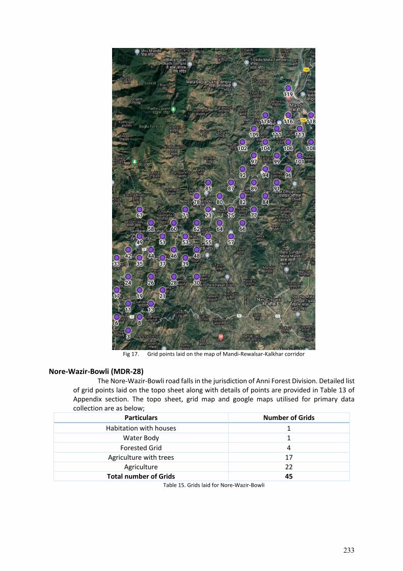
Fig 17. Grid points laid on the map of Mandi-Rewalsar-Kalkhar corridor
Nore-Wazir-Bowli (MDR-28) The Nore-Wazir-Bowli road falls in the jurisdiction of Anni Forest Division. Detailed list
of grid points laid on the topo sheet along with details of points are provided in Table 13 of Appendix section. The topo sheet, grid map and google maps utilised for primary data collection are as below;
Particulars Number of Grids
Habitation with houses 1
Water Body 1
Forested Grid 4
Agriculture with trees 17
Agriculture 22
Total number of Grids 45 Table 15. Grids laid for Nore-Wazir-Bowli
233
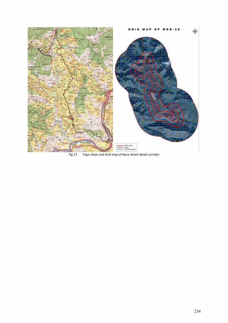
Fig 17. Topo sheet and Grid map of Nore-Wazir-Bowli corridor
234
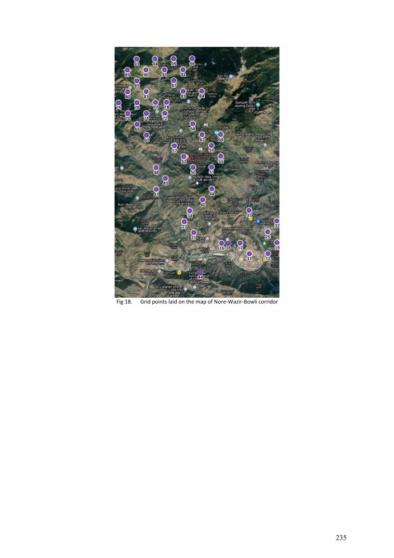
Fig 18. Grid points laid on the map of Nore-Wazir-Bowli corridor
235
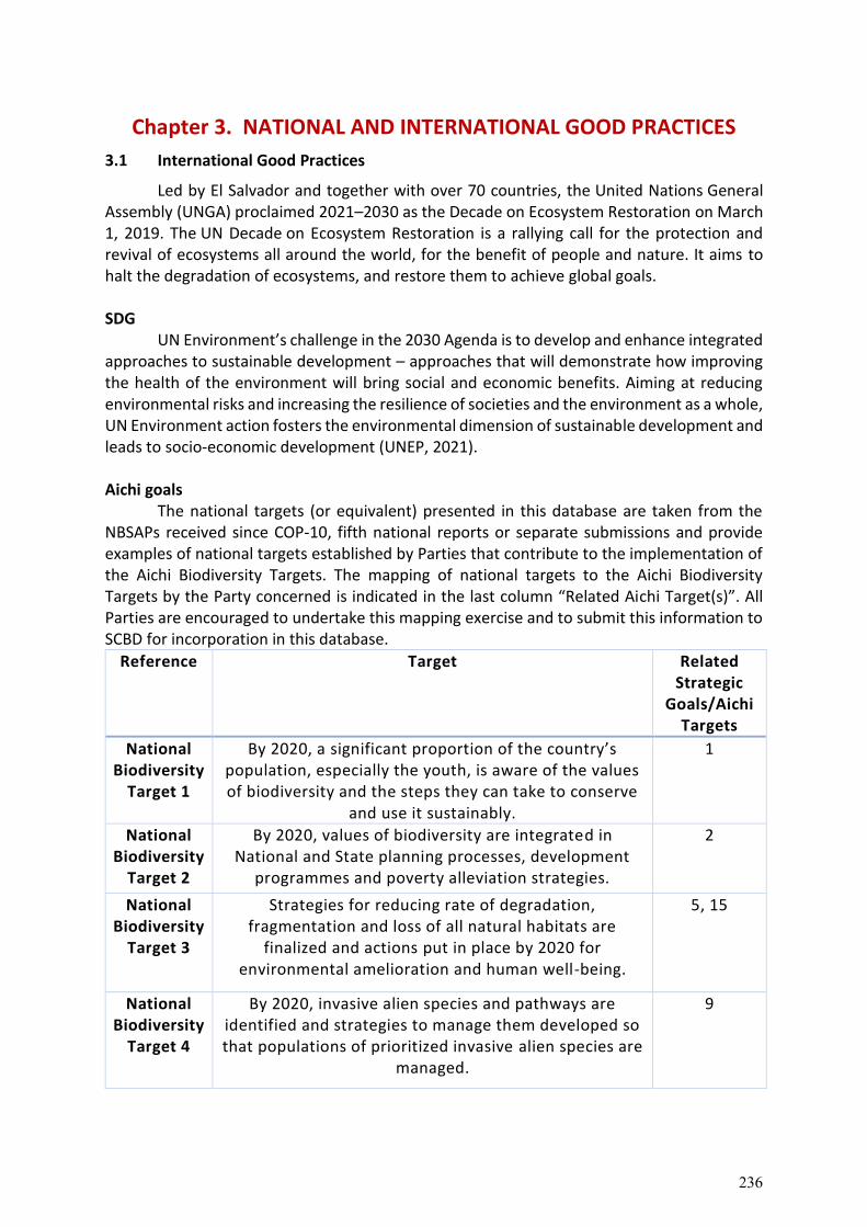
Chapter 3. NATIONAL AND INTERNATIONAL GOOD PRACTICES
3.1 International Good Practices
Led by El Salvador and together with over 70 countries, the United Nations General Assembly (UNGA) proclaimed 2021–2030 as the Decade on Ecosystem Restoration on March 1, 2019. The UN Decade on Ecosystem Restoration is a rallying call for the protection and revival of ecosystems all around the world, for the benefit of people and nature. It aims to halt the degradation of ecosystems, and restore them to achieve global goals. SDG
UN Environment’s challenge in the 2030 Agenda is to develop and enhance integrated approaches to sustainable development – approaches that will demonstrate how improving the health of the environment will bring social and economic benefits. Aiming at reducing environmental risks and increasing the resilience of societies and the environment as a whole, UN Environment action fosters the environmental dimension of sustainable development and leads to socio-economic development (UNEP, 2021). Aichi goals
The national targets (or equivalent) presented in this database are taken from the NBSAPs received since COP-10, fifth national reports or separate submissions and provide examples of national targets established by Parties that contribute to the implementation of the Aichi Biodiversity Targets. The mapping of national targets to the Aichi Biodiversity Targets by the Party concerned is indicated in the last column “Related Aichi Target(s)”. All Parties are encouraged to undertake this mapping exercise and to submit this information to SCBD for incorporation in this database.
Reference Target Related Strategic
Goals/Aichi Targets
National Biodiversity
Target 1
By 2020, a significant proportion of the country’s population, especially the youth, is aware of the values of biodiversity and the steps they can take to conserve
and use it sustainably.
1
National Biodiversity
Target 2
By 2020, values of biodiversity are integrated in National and State planning processes, development
programmes and poverty alleviation strategies.
2
National Biodiversity
Target 3
Strategies for reducing rate of degradation, fragmentation and loss of all natural habitats are
finalized and actions put in place by 2020 for environmental amelioration and human well-being.
5, 15
National Biodiversity
Target 4
By 2020, invasive alien species and pathways are identified and strategies to manage them developed so that populations of prioritized invasive alien species are
managed.
9
236
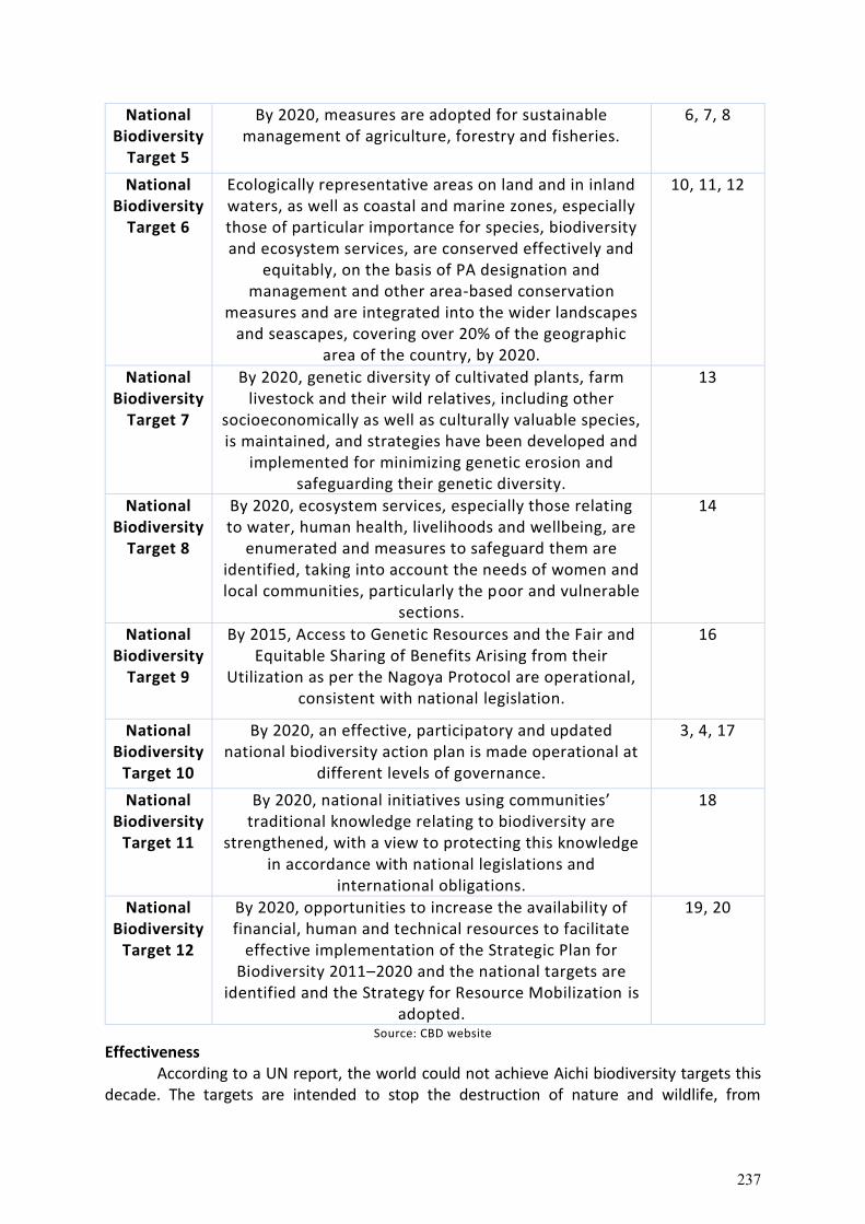
National Biodiversity
Target 5
By 2020, measures are adopted for sustainable management of agriculture, forestry and fisheries.
6, 7, 8
National Biodiversity
Target 6
Ecologically representative areas on land and in inland waters, as well as coastal and marine zones, especially those of particular importance for species, biodiversity and ecosystem services, are conserved effectively and
equitably, on the basis of PA designation and management and other area-based conservation
measures and are integrated into the wider landscapes and seascapes, covering over 20% of the geographic
area of the country, by 2020.
10, 11, 12
National Biodiversity
Target 7
By 2020, genetic diversity of cultivated plants, farm livestock and their wild relatives, including other
socioeconomically as well as culturally valuable species, is maintained, and strategies have been developed and
implemented for minimizing genetic erosion and safeguarding their genetic diversity.
13
National Biodiversity
Target 8
By 2020, ecosystem services, especially those relating to water, human health, livelihoods and wellbeing, are
enumerated and measures to safeguard them are identified, taking into account the needs of women and local communities, particularly the poor and vulnerable
sections.
14
National Biodiversity
Target 9
By 2015, Access to Genetic Resources and the Fair and Equitable Sharing of Benefits Arising from their
Utilization as per the Nagoya Protocol are operational, consistent with national legislation.
16
National Biodiversity
Target 10
By 2020, an effective, participatory and updated national biodiversity action plan is made operational at
different levels of governance.
3, 4, 17
National Biodiversity
Target 11
By 2020, national initiatives using communities’ traditional knowledge relating to biodiversity are
strengthened, with a view to protecting this knowledge in accordance with national legislations and
international obligations.
18
National Biodiversity
Target 12
By 2020, opportunities to increase the availability of financial, human and technical resources to facilitate
effective implementation of the Strategic Plan for Biodiversity 2011–2020 and the national targets are
identified and the Strategy for Resource Mobilization is adopted.
19, 20
Source: CBD website
Effectiveness According to a UN report, the world could not achieve Aichi biodiversity targets this
decade. The targets are intended to stop the destruction of nature and wildlife, from
237
addressing pollution to protecting coral reefs (Guardian and Earth Org, 2020). At the moment, committing to the Aichi targets is voluntary and non-compulsory, and results from each party are self-reported to the CBD. Because these agreements are non-binding, the path to translating and implementing targets into national legislation is unclear. 3.2. Environment and Social Standards (ESS6)
1. ESS6 recognizes that protecting and conserving biodiversity and sustainably managing living natural resources are fundamental to sustainable development. Biodiversity is defined as the variability among living organisms from all sources including, inter alia, terrestrial, marine and other aquatic ecosystems and the ecological complexes of which they are a part; this includes diversity within species, between species, and of ecosystems. Biodiversity often underpins ecosystem services valued by humans. Impacts on biodiversity can therefore often adversely affect the delivery of ecosystem services.
2. ESS6 recognizes the importance of maintaining core ecological functions of habitats, including forests, and the biodiversity they support. Habitat is defined as a terrestrial, freshwater, or marine geographical unit or airway that supports assemblages of living organisms and their interactions with the non-living environment. All habitats support complexities of living organisms and vary in terms of species diversity, abundance and importance.
3. This ESS also addresses sustainable management of primary production and harvesting of living natural resources.
4. ESS6 recognizes the need to consider the livelihood of project-affected parties, including Indigenous Peoples, whose access to, or use of, biodiversity or living natural resources may be affected by a project. The potential, positive role of project affected parties, including Indigenous peoples, in biodiversity conservation and sustainable management of living natural resources is also considered.
Objectives • To protect and conserve biodiversity and habitats. • To apply the mitigation hierarchy4 and the precautionary approach in the design and
implementation of projects that could have an impact on biodiversity. • To promote the sustainable management of living natural resources. • To support livelihoods of local communities, including Indigenous Peoples, and
inclusive economic development, through the adoption of practices that integrate conservation needs and development priorities.
Scope of application
1. The applicability of this ESS is established during the environmental and social assessment described in ESS1.
2. Based on the environmental and social assessment, the requirements of this ESS are applied to all projects that potentially affect biodiversity or habitats, either positively or negatively, directly or indirectly, or that depend upon biodiversity for their success.
3. This ESS also applies to projects that involve primary production and/or harvesting of living natural resources.
238
Requirements A. General
1. The environmental and social assessment as set out in ESS1 will consider direct,
indirect and cumulative project-related impacts on habitats and the biodiversity they support. This assessment will consider threats to biodiversity, for example habitat loss, degradation and fragmentation, invasive alien species, overexploitation, hydrological changes, nutrient loading, pollution and incidental take, as well as projected climate change impacts. It will determine the significance of biodiversity or habitats based on their vulnerability and irreplaceability at a global, regional or national level and will also take into account the differing values attached to biodiversity and habitats by project-affected parties and other interested parties.
2. The Borrower will avoid adverse impacts on biodiversity and habitats. When avoidance of adverse impacts is not possible, the Borrower will implement measures to minimize adverse impacts and restore biodiversity in accordance with the mitigation hierarchy provided in ESS1 and with the requirements of this ESS. The Borrower will ensure that competent biodiversity expertise is utilized to conduct the environmental and social assessment and the verification of the effectiveness and feasibility of mitigation measures. Where significant risks and adverse impacts on biodiversity have been identified, the Borrower will develop and implement a Biodiversity Management Plan.
Assessment of risks and impacts
1. Through the environmental and social assessment, the Borrower will identify the potential project related risks to and impacts on habitats and the biodiversity that they support. In accordance with the mitigation hierarchy, the Borrower will make the initial assessment of project risks and impacts without taking into account the possibility of biodiversity offsets. 6 The assessment undertaken by the Borrower will include identification of the types of habitats potentially affected and consideration of potential risks to and impacts on the ecological function of the habitats. The assessment will encompass any areas of potential biodiversity importance that may be affected by the project, whether or not they are protected under national law. The extent of the assessment will be proportionate to the risks and impacts, based on their likelihood, significance and severity, and will reflect the concerns of project affected parties and other interested parties.
2. The Borrower’s assessment will include characterization of baseline conditions to a
degree that is proportional and specific to the anticipated risk and significance of impacts. In planning and undertaking environmental and social assessment related to the biodiversity baseline, the Borrower will follow relevant GIIP utilizing desktop review, consultation with experts, and field-based approaches, as appropriate. Where further investigations are needed to evaluate the significance of potential impacts, the Borrower will carry out additional investigation and/or monitoring before undertaking any project related activities, and before taking irrevocable decisions about project design that could cause significant adverse impacts to potentially affected habitats and the biodiversity that they support. 12. Where the environmental and social assessment has identified potential risks and impacts on biodiversity or habitats, the
239
Borrower will manage those risks and impacts in accordance with the mitigation hierarchy and GIIP. The Borrower will adopt a precautionary approach and apply adaptive management practices in which the implementation of mitigation and management measures are responsive to changing conditions and the results of project monitoring
Conservation of biodiversity and habitats
1. “Habitat” is defined as a terrestrial, freshwater, or marine geographical unit or airway that supports assemblages of living organisms and their interactions with the non-living environment. Habitats vary in their significance for conserving globally, regionally and nationally important biodiversity, their sensitivity to impacts, and in the significance different stakeholders attribute to them. Because, in most instances, habitat loss, degradation or fragmentation represents the greatest threat to biodiversity, much of the focus of biodiversity conservation actions is on maintaining or restoring suitable habitats.
2. This ESS requires a differentiated risk management approach to habitats based on their sensitivity and values. This ESS addresses all habitats, categorized as ‘modified habitat’, ‘natural habitat’, and ‘critical habitat’, along with ‘legally protected and internationally and regionally recognized areas of biodiversity value’ which may encompass habitat in any or all of these categories.
3. For the protection and conservation of habitats and the biodiversity they support, the mitigation hierarchy includes biodiversity offsets. Offsets will be considered as a last resort, only if significant residual adverse impacts remain after all technically and financially feasible avoidance, minimization, and restoration measures have been considered.
4. A biodiversity offset will be designed and implemented to achieve measurable, additional, and long term conservation outcomes that can reasonably be expected to result in no net loss8 and preferably a net gain9 of biodiversity. In the case of an offset used as mitigation for residual adverse impacts on any area of critical habitat, a net gain is required. The design of a biodiversity offset will adhere to the like-for-like or better” principle10 and will be carried out in alignment with GIIP.
5. When a Borrower is considering the development of an offset as part of the mitigation strategy, stakeholders and qualified experts with demonstrated knowledge in offset design and implementation will be involved. The Borrower will demonstrate the long-term technical and financial feasibility of undertaking the offset. When offsets are proposed for residual adverse impacts on critical habitat, the Borrower will engage one or more independent internationally recognized experts to advise as to whether the proposed offset is feasible and whether, in their professional opinion, it can be reasonably expected to result in a sustainable net gain of biodiversity values for which the critical habitat was designated.
6. Certain residual adverse impacts cannot be offset, particularly if the affected area is unique and irreplaceable from a biodiversity standpoint. In such cases, the Borrower will not undertake the project unless it is redesigned to avoid the need for such offset, and to meet the requirements of this ESS.
240
Modified habitat
1. Modified habitats are areas that may contain a large proportion of plant and/or animal species of non-native origin, and/or where human activity has substantially modified an area’s primary ecological functions and species composition. 11 Modified habitats may include, for example, areas managed for agriculture, forest plantations, reclaimed12 coastal zones, and reclaimed wetlands.
2. This ESS applies to those areas of modified habitat that include significant biodiversity
value, as determined by the environmental and social assessment required in ESS1. The Borrower will avoid or minimize impacts on such biodiversity and implement mitigation measures as appropriate.
Natural habitat
1. Natural habitats are areas composed of viable assemblages of plant and/or animal species of largely native origin, and/or where human activity has not essentially modified an area’s primary ecological functions and species composition.
2. If natural habitats are identified as part of the assessment, the Borrower will seek to
avoid adverse impacts on them in accordance with the mitigation hierarchy. Where natural habitats have the potential to be adversely affected by the project, the Borrower will not implement any project-related activities unless: (a) There are no technically and financially feasible alternatives; and (b) Appropriate mitigation measures are put in place, in accordance with the mitigation hierarchy, to achieve no net loss and, where feasible, preferably a net gain of biodiversity over the long term. When residual impacts remain despite best efforts to avoid, minimize and mitigate impacts, and where appropriate and supported by relevant stakeholders, mitigation measures may include biodiversity offsets adhering to the principle of “like-for-like or better.”
Critical Habitat
1. Critical habitat is defined as areas with high biodiversity importance or value, including: a) habitat of significant importance to Critically Endangered or Endangered species,
as listed in the IUCN Red List of threatened species or equivalent national approaches;
b) habitat of significant importance to endemic or restricted-range species; c) habitat supporting globally or nationally significant concentrations of migratory
or congregatory species; d) highly threatened or unique ecosystems; e) Ecological functions or characteristics that are needed to maintain the viability of
the biodiversity values described above in (a) to (d). 2. In areas of critical habitat, the Borrower will not implement any project activities that
have potential adverse impacts unless all of the following conditions are met:
241
a) No other viable alternatives within the region exist for development of the project in habitats of lesser biodiversity value;
b) All due process required under international obligations or national law that is a prerequisite to a country granting approval for project
c) activities in or adjacent to a critical habitat has been complied with; d) The potential adverse impacts, or likelihood of such, on the habitat will not lead
to measurable net reduction or negative change in those biodiversity values for which the critical habitat was designated;
e) The project is not anticipated to lead to a net reduction in the population13 of any Critically Endangered, Endangered, or restricted-range species, over a reasonable time period;14
f) The project will not involve significant conversion or significant degradation of critical habitats. In circumstances where the project involves new or renewed forestry or agricultural plantations, it will not convert or degrade any critical habitat;
g) The project’s mitigation strategy will be designed to achieve net gains of those biodiversity values for which the critical habitat was designated; and
h) A robust and appropriately designed, longterm biodiversity monitoring and evaluation program aimed at assessing the status of the critical habitat is integrated into the Borrower’s management program.
3. Where a Borrower has satisfied the conditions set out in paragraph 24, the project’s mitigation strategy will be described in a Biodiversity Management Plan and set out in the legal agreement (including the ESCP). Legally protected and internationally recognized areas of high biodiversity value
4. Where the project occurs within or has the potential to adversely affect an area that is legally protected,15 designated for protection, or regionally or internationally recognized,16 the Borrower will ensure that any activities undertaken are consistent with the area’s legal protection status and management objectives. The Borrower will also identify and assess potential project-related adverse impacts and apply the mitigation hierarchy so as to prevent or mitigate adverse impacts from projects that could compromise the integrity, conservation objectives or biodiversity importance of such an area.
5. The Borrower will meet the requirements of paragraphs 13 through 25 of this ESS, as applicable. In addition, the Borrower will: a) Demonstrate that the proposed development in such areas is legally permitted; b) Act in a manner consistent with any government recognized management plans
for such areas; c) Consult and involve protected area sponsors and managers, project-affected
parties including Indigenous Peoples, and other interested parties on planning, designing, implementing, monitoring, and evaluating the proposed project, as appropriate; and
d) Implement additional programs, as appropriate, to promote and enhance the conservation aims and effective management of the area.
242
Invasive alien species
1. Intentional or accidental introduction of alien, or non-native, species of flora and fauna into areas where they are not normally found can be a significant threat to biodiversity, since some alien species can become invasive, spreading rapidly and destroying or out-competing native species.
2. The Borrower will not intentionally introduce any new alien species (not currently
established in the country or region of the project) unless this is carried out in accordance with the existing regulatory framework for such introduction. Notwithstanding the above, the Borrower will not deliberately introduce any alien species with a high risk of invasive behaviour regardless of whether such introductions are permitted under the existing regulatory framework. All introductions of alien species will be subject to a risk assessment (as part of the Borrower’s environmental and social assessment) to determine the potential for invasive behaviour. The Borrower will implement measures to avoid the potential for accidental or unintended introductions including the transportation of substrates and vectors (such as soil, ballast, and plant materials) that may harbour alien species.
3. Where alien species are already established in the country or region of the proposed
project, the Borrower will exercise diligence in not spreading them into areas in which they have not already become established. Where feasible, the Borrower will take measures to eradicate such species from the natural habitats over which the Borrower has management control.
Sustainable management of living natural resources
1. The Borrower with projects involving primary production and harvesting of living natural resources will assess the overall sustainability of these activities, as well as their potential impacts on local, nearby or ecologically linked habitats, biodiversity and communities, including Indigenous Peoples.
2. The Borrower will manage living natural resources in a sustainable manner, through
the application of good management practices and available technologies. Where such primary production practices are codified in standards that are globally, regionally, or nationally recognized, particularly for industrial-scale operations, the Borrower and the Bank will agree on the standards to be applied. In the absence of relevant standards for the particular living natural resources in the country concerned, the Borrower will apply GIIP.
3. For projects involving small-scale producers,17 the Borrower will require producers to
operate in a sustainable manner and to gradually improve their practices where such opportunities exist. Where the project consists of a large number of small producers in the same geographical area, the Borrower will assess the potential for cumulative risks and impacts.
243
4. Where the project includes commercial agriculture and forestry plantations (particularly projects involving land clearing or afforestation), the Borrower will locate such projects on land that is already converted or highly degraded (excluding any land that has been converted in anticipation of the project). In view of the potential for plantation projects to introduce invasive alien species and threaten biodiversity, such projects will be designed to prevent and mitigate these potential threats to natural habitats. When the Borrower invests in production forestry in natural forests, these forests will be managed sustainably.
5. Where projects involve harvesting of living natural resources, the Borrower will
require that these resources are managed in a sustainable manner. In particular, forests and aquatic systems are principal providers of these resources, and need to be managed as specified below. a) For projects involving industrial-scale commercial forest harvesting operations,
the Borrower will ensure such operations are certified under an independent forest certification system18 or adhere to a time-bound phased action plan acceptable to the Bank for achieving certification to such a system.
b) For projects involving forest harvesting operations conducted by small-scale producers, by local communities under community forest management, or by such entities under joint forest management arrangements, where such operations are not directly associated with an industrial-scale operation, the Borrower will ensure that they: i. have achieved a standard of sustainable forest management developed with
the meaningful participation of project affected parties including Indigenous Peoples, consistent with the principles and criteria of sustainable forest management, even if not formally certified; or
ii. adhere to a timebound action plan to achieve such a standard. The action plan will be developed with the meaningful participation of project-affected parties and be acceptable to the Bank. The Borrower will ensure that all such operations are monitored with the meaningful participation of project-affected parties.
c) For projects involving industrial-scale harvesting of fish populations and all other types of marine and freshwater organisms, the Borrower will demonstrate that their activities are being undertaken in a sustainable manner, consistent with the principles and criteria for sustainable harvesting.
6. For projects that do not involve primary production or harvesting of living natural resources and entail salvage logging, for example in areas to be inundated, the Borrower will limit cleared areas to a minimum and justified by the project’s technical requirements, and that relevant national legislation is being followed. 37. The Borrower involved in the industrial production of crops and animal husbandry will follow GIIP to avoid or minimize adverse risks or impacts. The Borrower involved in large-scale commercial farming, including breeding, rearing, housing, transport, and slaughter of animals for meat or other animal products (such as milk, eggs, wool) will employ GIIP19 in animal husbandry techniques, with due consideration for religious and cultural principles.
244
B. Primary suppliers
1. Where a Borrower is purchasing natural resource commodities, including food, timber and fiber, that are known to originate from areas where there is a risk of significant conversion or significant degradation of natural or critical habitats, the Borrower’s environmental and social assessment will include an evaluation of the systems and verification practices used by the primary suppliers.
2. The Borrower will establish systems and verification practices which will:
a) identify where the supply is coming from and the habitat type of the source area; b) where possible, limit procurement to those suppliers that can demonstrate21 that
they are not contributing to significant conversion or degradation of natural or critical habitats; and
c) where possible and within a reasonable period, shift the Borrower’s primary suppliers to suppliers that can demonstrate that they are not significantly adversely impacting these areas.
3. The ability of the Borrower to fully address these risks will depend upon the
Borrower’s level of control or influence over its primary suppliers. UN Carbon Credit
The ultimate goal of carbon credits is to reduce the emission of greenhouse gases into the atmosphere. A road constructed with materials that discharge low or no pollutants, its concentration and are environment friendly is known as a Green Highway (Attahiru et al., 2019). This concept will play a major role in eliminating poisonous emissions w.r.t biodiversity, flora, and fauna habitat damages. It is recommended to utilize this principle to conserve biodiversity and animal habitats.
Road construction and transport are the key measures that cause the huge Green House Gases emissions. To reduce carbon emissions released from the construction industry and to improve the physical properties of engineering materials, carbon-neutral materials are potentially used in green highways (Nader, 2009). As the amounts of CO2 emissions are increasing in the atmosphere, the idea and support for carbon-neutral green highways are increasing (Rebeiz et al., 1991). The United Nations started a ‘Carbon Credit’ campaign, whereby any nation that decreases their CO2 emissions by a certain amount will be granted a credit, which can be used to barter for goods. Himachal Pradesh can generate economic benefits if green principles are utilized for the up-gradation of roads under HPSRTP.
Hence, it is highly recommended that green roads and highways are constructed to reduce CO2 emissions and Green House Gases if constructed properly with carbon- neutral materials.
3.3. International Regulation
Most of the time, many of us behave as if the ongoing destruction of biodiversity and the natural ecosystems has no effect on our wellbeing. However, conserving biodiversity and its services emerge as essential to human self-interest in the longer term. Bellamy et al., (2000) informs that understanding the ecological consequences of roads and developing ways to mitigate their effects has become a fundamental goal of many conservation biologists.
245
The U.N. Environment Programme World Conservation Monitoring Centre (UNEP-WCMC) is a collaboration centre of the U.N. Environment Programme, based in Cambridge in the United Kingdom (Robinson et al., 2018). UNEP-WCMC has been part of the U.N. Environment Programme since 2000 and is responsible for biodiversity impact assessment and to assist in the policy articulation and implementation. The main aim is to define the Biodiversity Offsets, which are measurable conservation outcomes designed to compensate for adverse and unavoidable impacts of projects, in addition to prevention and mitigation measures already implemented (IUCN, 2021).
Australia
Several countries worldwide have introduced Biodiversity Mitigation Plans, legislation, amendment bills, and movements to curb biodiversity loss. The most effective was Clean Energy Act 2011, introduced by Australia on 1 July 2011. The Australian Government was committed to reducing carbon emissions by 80% below 2000 levels by 2050 and announced its intention to introduce a carbon tax of 23 A$ per tonne of carbon to begin in July 2012 (Mascher et al., 2013). Australia's carbon dioxide emissions from electricity generation hit a 10-year lowest and coal generation down 11% from 2008 to 2009. There were 7% reduced emissions recorded upon the scheme's introduction. (Chapman et al., 2016).
The plan set out to achieve these targets by encouraging Australia's largest emitters to increase energy efficiency and invest in sustainable energy. Unfortunately, the political climate affected the Act as much as the climate affects Biodiversity. This Act was repealed in 2013 under the administration of Tony Abbott (28th Prime Minister of Australia from 2013 to 2015), who identified it as one of his key achievements (Crowley, 2017). Titley (2021) claims that underlying national socio-political factors have emerged as essential determinants of biodiversity conservation consideration, intent and trends from a global perspective.
United Kingdom
Biodiversity Action Plan or (UK BAP) opened for signature at the Rio Earth Summit in 1992, which was the impact of the United Kingdom of the United Nations Convention on Biological Diversity (UNCED) (Bishop et al.,2012). Bishop defines it as a remarkable move that significantly impacted U.K. Policy (House of Commons Environment, Regional Affairs Committee and Transport, 2000). The U.K. plan encompasses "391 Species Action Plans, 45 Habitat Action Plans and 162 Local Biodiversity Action Plan with targeted actions" (Keenan, 2007). This action plan is remarkable because of its extensive detail, clarity of engagement mechanisms, specificity of command of actions, follow-up monitoring program, and its inclusion of migrating. This Act introduced by the U.K. Government provides legislative guidance, coupled with distinctively articulated government vision, assisting the policy to be articulate explicit policy dependencies between the national, regional, and community levels (Memon et al., 2006).
New Zealand
The Local Government Act, 2002 of New Zealand sets local authorities (regional, city, and district councils) to promote sustainable development. Biodiversity is a critical measure of sustainability, with clear environmental, social, economic, and cultural benefits. The local government and some companies also have their own Biodiversity Action Plan. The impact of it was a different outcome than expected. During the implementation, the Government provided less than half the funding to the Department of Internal Affairs in its first year of
246
leading implementation of the Local Government Authority than it did for the Ministry for the Environment for implementing the Resource Management Act (Ericksen et al.,2003). They were transcribing a law that clearly defines who needs to do what, but then tying their hands to do that is nothing more than a deception. However, if the national agency wants a considerable outcome, they need to ensure that local authorities have the requisite capability to implement the demanding decree to complete the deliverable. In several countries, including New Zealand, responsibility has been devolved to the Local Government to respond to community needs within a 'whole-of-government framework' (Memon et al., 2006).
United States of America
Twenty-six years before the international biodiversity convention, the United States of America (USA) had launched a national program to protect threatened species in the form of the Endangered Species Act (ESA) 1973. The legislation created broad authority for analysing and listing species of concern and mandated that Species Recovery Plans be created based on 7000 listed species (e.g., endangered or threatened). As much as this Act seemed promising given that the USA recognized and was determined to act fast, this Act has proven controversial. Only 11 species of more than 1,000 listed were recovered and removed from the list (Brown et al.,1998). Critics of the Act have noted that despite its goal of recovering species, so they are no longer listed; this has rarely happened. In its almost 50-year history, less than fifty species are delisted due to recovery (ECOS, 2021). Evidently, since the passage of the ESA, several species that were listed have gone extinct. Many more that are still listed are at risk of extinction. As of January 2020, the Services indicate that eleven species have been lost to extinction. Indeed, the Act's impact is less than that estimated for generic environmental regulation and global climate change policy, and estimates in this area range from 0.2 percent to 1 percent losses in annual GDP (Brown et al., 1998).
India
The Indian legal framework of the country consists of several acts, notifications, rules, and regulations to protect the environment and wildlife. The most relevant of these in the context of roads and powerlines include the Environmental Impact Assessment (EIA) Notification of 2006 (and its amendments), Forest (Conservation) Act, 1980, Coastal Regulation Zone (CRZ) Notification 2011, and the Wildlife (Protection) Act, 1972 (and its amendments) (Wildlife Institute of India, 2016). The critical elements of the legal framework, the administrative arrangements for the appraisal of EIA reports and decision-making, the procedure for granting forest clearances, and the coordination of different regulatory requirements were also included in their report. This demonstrates that there are regulations in place, their implementation is yet another question which needs answers. The decisions taken at the United Nations Conference on Environment and Development held at the Rio de Janerio in June 1992, in which India participated, calling upon the states to provide adequate access to judicial and administrative proceedings (United Nations Environment Programme, 2015).
As far as Himalayas are concerned, the mountainous area that occupies approximately 70% is fragmented into tiny pieces of habitat, and thus the natural wildlife habitat is severely disconnected (Seo et al.,2021). The linear infrastructures can interfere with animal movement patterns and can lead to changes in species distribution, habitat resource selection and population density and increase wildlife mortality through vehicle collisions (Neumann et al., 2018). In the Himalaya, the existing attempts to conserve biodiversity are inadequate and
247
therefore innovative changes in policies and programmes are called for so as to focus greater attention on people's participation (Dhar et al.,1999).
Solid waste management good practices; The Brazilian government, in 2014, decided that all the unregulated landfills must be shut down. Moreover, individual or entities not complying with policies and are responsible for damage to environment are required to compensate the government for remedial action. The government of Himachal Pradesh can also incorporate such strong policy measures at state level. This will ensure that waste management gets the attention it needs and adequate action can be taken at the instances of non-compliance. It has also been acknowledged by the government the ULBs cannot work in silos. A cluster approach has been proposed to make the projects technically and financially more feasible. The two identified clusters are: Dharamsala cluster - Dharamsala, Kangra, Palampur, Nagrota Bagwan, Jawala ji and Dehra, and Sunder Nagar/ Mandi cluster - Sunder Nagar, Ner Chowk, Mandi and Riwalsar. (Directorate of Urban Develeopment, GoHP, 2015).The segregation of the waste is done at source itself. The financing of the system is through the polluter-pays-policy. The bio-degradable waste management (BMW) systems 1 , in Netherlands, Austria and United Kingdom, focus on building separate collection systems like specific bins which would eventually lead to BMW treatment systems. In addition, some economic instruments like Pay-As-You-Throw (PAYT) and organic waste tax have been used as an incentive so that the residents’ themselves divert BMW from the regular waste. Besides, circular economy through waste collection centres and education through public awareness and local community’s involvement. Building a Material Recovery Facility to create standard operating procedures to mitigate solid waste pollution. The first of its kind is being built in Rakcham, under the vision of Healing Himalayas Foundation (Healing Himalayas, 2021). This centre aims at collection, segregation and treatment of waste of Rakcham Panchayat. A similar model can be followed for the project corridor. The new rules gave the power to the local bodies across India to decide the user fees, however . Municipal authorities will levy user fees for collection, disposal and processing from bulk generators. As per the rules, the generator will have to pay “User Fee” to the waste collector and a “Spot Fine” for littering and non-segregation, the quantum of which will be decided by the local bodies. Also, the new rules have mentioned about the integration of rag pickers, waste pickers and kabaddi walas from the informal sector to the formal sector by the state government. The rules also stipulate zero tolerance for throwing; burning, or burying the solid waste generated on streets, open public spaces outside the generator’s premises, or in the drain, or water bodies. The deputy commissioner, state pollution board and urban development of HP have been asked to oversee such actions.
3.3. National Acts, Rules and Laws
I. Central Policies and Acts on Environmental, Forest and Wildlife
1 The Fisheries Act, 1897 2 The Indian Forest Act, 1927 3 Import and Export (Control) Act, 1947 4 Prevention of Cruelty to Animal Act, 1960 5 The Customs Act, 1962 6 The Wildlife (Protection) Act, 1972 7 Marine Products Export Development Authority Act 1972 8 The Water (Prevention and Control of Pollution) Act, 1974 9 Water (Prevention and Control of Pollution) Cess Act, 1977 10 Forest (Conservation) Act, 1980
248
11 Air (Prevention and control of Pollution) Act 1981 12 Environment (Protection) Act, 1986 13 National Diary Development Board, 1987 14 Rules for the manufacture, use/import/export and storage of hazardous
microorganism/genetically engineered organisms or cells, 1989 15 Noise Pollution (Regulation and Control Act) 1990; 16 Foreign Trade (Development and Regulation) Act, 1992 17 The Biological Diversity Act, 2002 18 Plant Quaratine (Regulation of Import into India) order 2003 19 The Biological Diversity Rules, 2004 20 Forest (Traditional & Forest Dwellers) Rights Act 2005 21 Scheduled Tribes and other Traditional Forest Dwellers (Recognition of Forest
Rights) Act, 2006 22 The National Green Tribunal Act 2010
i. Policy and Laws Concerning CITES
This Appendix contains species that are protected in at least one country, which has asked other CITES Parties for assistance in controlling the trade. Harming endangered species listed in Schedule I of the Act is prohibited throughout India. Hunting species that require special protection (Schedule II), big game (Schedule III), and small game (Schedule IV), is regulated through licensing. A few species classified as vermin (Schedule V), may be hunted without restrictions. The Act prohibits the trade in specified plants (Schedule VI) from an area specified by notification by GOI. The Schedule VI of the Act lists all the six plants of Indian origin included in CITES appendices. Trade in Scheduled animals (Schedule I and Part II of Schedule II) are prohibited under the act. Similarly, the Act disallows trade in all kinds of imported ivory, including that of African elephant. The Act has been amended in 2006 leading to the establishment of the National Tiger Conservation Authority and the Wild Life Crime Control Bureau (WCCB) with a statutory backing.
CITES (the Convention on International Trade in Endangered Species of Wild Fauna and Flora) is an international agreement between governments. Its aim is to ensure that international trade in specimens of wild animals and plants does not threaten the survival of the species. CITES is an international agreement to which States and regional economic integration organizations adhere voluntarily (CITES, 2021). This section includes the policies and laws vis-à-vis CITES in India.
ii. EXIM Policy
Export or import of wild animals and plants, their parts and products is allowed for the purpose of research and exchange between Zoos, subject to licensing by the Director General of Foreign Trade (DGFT). The current policy does not permit commercial import of African ivory in view of the ban imposed by CITES. Import of other derivatives of wildlife is restricted and can be made only with prior permission of DGFT. Import of wild animals as pets is also subject to the provisions of CITES.
iii. Wildlife Crime Control Bureau (WCCB)
To combat the organised Wildlife Crime and illegal trade of Wildlife parts and products, the Wildlife Crime Control Bureau (WCCB) was created in 2007 under the provisions of the Wildlife Protection Act 1972. Wildlife Crime Control Bureau is designated nodal agency
249
for CITES related enforcement. WCCB is a statutory multi-disciplinary body under the MoEFCC. The Bureau has its five regional offices at Delhi (headquarters), Kolkata, Mumbai, Chennai and Jabalpur; and five border units at Ramanathapuram, Gorakhpur, Motihari, Nathula and Moreh. Under the Wild Life (Protection) Act, 1972, WCCB is mandated to collate intelligence related to organized wildlife crime and disseminate the same to State and other enforcement agencies so as to apprehend the criminals. To establish a centralized wildlife crime data bank and co-ordinate actions by various agencies in connection with the enforcement of the provisions of the Act. WCCB is responsible to assist international organizations & foreign authorities to facilitate wildlife crime control and assist State Governments to ensure success in prosecutions related to wildlife crimes. The body is accountable to advise the Government of India on issues relating to wildlife crimes. It also assists and advises the Customs authorities in inspection of the consignments of flora & fauna as per the provisions of Wild Life Protection Act, CITES and EXIM Policy governing such an item.
iv. Conference of the Parties to CITES
Zambia during CoP 18 conference floated a proposal to downlist its elephants to Appendix II of CITES, which in effect would have meant resuming the sale of its ivory stockpile. Governments rejected the proposal to resume international sales of ivory stockpiles. Elephants from the wild will no longer be shipped to zoos and circuses around the globe. A resolution calling for Japan and the European Union to close their legal domestic ivory markets was not adopted at the CoP18. (At least 20,000 elephants are being illegally killed each year in Africa for their ivory.)
India has submitted proposals to the CITES regarding changes to the listing of various wildlife species. The proposals submitted are regarding changes in the listing of the smooth-coated otter, small-clawed otter, Indian star tortoise, Tokay gecko, wedgefish and Indian rosewood. The country seeks to boost the protection of all the five animal species as they are facing a high risk of international trade. For the Indian rosewood, the proposal is to remove the species from CITES Appendix II. India is among the parties proposing the re-listing of the star tortoise from CITES Appendix II to Appendix I. The species faces two threats: loss of habitat to agriculture and illegal harvesting for the pet trade. With regard to the two otter species, India, Nepal and the Philippines have proposed that the listing be moved from CITES Appendix II to Appendix I for the more endangered species. A similar proposal has been made to include the Tokay gecko in Appendix I. India is also supporting proposals, such as the boosting of protection status for tarantulas (large hairy spiders), made by other countries. Star tortoise, Asian small-clawed and smooth-coated otters on 27.08.2019 were included in Appendix I. A complete international ban will be enforced on their trade as part of efforts to boost numbers.
v. Wildlife Legislation
The primary law governing matters related to wildlife in the country is the Wildlife (Protection) Act, 1972. The state of Himachal Pradesh has adopted this Act and its subsequent amendments as the prime legislation to manage and guide wildlife related matters in the state. Protection of forests and wildlife are included in the concurrent list and are incorporated in the Directive principles of state policy of the constitution vide 42nd amendment in year 1976. Article 48A of the constitution mandates that state shall endeavour to protect and improve the environment and safeguard the forests and wildlife. Article 51 A
250
(g) of the constitution says that it shall be fundamental duty of every citizen to protect and improve the natural environment including forests, lakes, rivers and wildlife and have compassion for living creatures. Subject related to wildlife and its conservation in India draws strength from Article 48-A of ‘Directive Principles of State Policy under the Constitution of India, which states that “the state shall endeavour to protect and improve the environment and to safeguard the forests and wildlife of the country”.
The Constitution vide Article 51-A (g), specifying fundamental duties of the citizens of India, states that “it shall be the duty of every citizen of India to protect and improve the natural environment including forests, lakes, rivers, and wildlife and to have compassion for living creatures”.
Maintaining, preserving and protecting the unique biodiversity is challenge to agencies like forest department, police department, State biodiversity board etc Wildlife (Protection) Act 1972, Biological Diversity Act 2002. Further Notifications, Rules, Guidelines and orders of Central and State Govt and orders of Ho’nble Supreme court to protect the biodiversity have been issued from time to time. Hon’ble Supreme Court Order dated 12.12.1996 clarified that No removal of dead, diseased, dying or wind fallen trees , drift wood and grasses etc from any National Park or game sanctuaries. Under Wildlife (Protection) Act there is provisions to appoint Director Wildlife Preservation, Wildlife Warden, Honorary Wildlife Wardens, Constitution of National Board for Wildlife, State Board for Wildlife, Protection of Specified Plants, Declaration of Protected Areas (National Parks, Sanctuaries, Conservation Reserves, Community Reserves), Central Zoo Authority, National Tiger Conservation Authority, Tiger and Other Endangered Species Crime Control Bureau etc. The other managing organizations, rules and bodies includes National Biodiversity Authority, State Biodiversity Board, Biodiversity Management Committees, Biological Diversity Rules 2004, Himachal Pradesh Biological Diversity Rules 2019, Standard Operating Procedure for Disposing the Tiger, Leopard Carcass / Body Parts, Guidelines for Human Leopard conflict management issued by MoEF&CC during 2011etc.
Under Wildlife (Protection) Act there is provisions to appoint Director Wildlife Preservation, Wildlife Warden, Honorary Wildlife Wardens, Constitution of National Board for Wildlife, State Board for Wildlife, Protection of Specified Plants, Declaration of Protected Areas (National Parks, Sanctuaries, Conservation Reserves, Community Reserves), Central Zoo Authority, National Tiger Conservation Authority, Tiger and Other Endangered Species Crime Control Bureau etc. The other managing organizations, rules and bodies includes National Biodiversity Authority, State Biodiversity Board, Biodiversity Management Committees, Biological Diversity Rules 2004, Himachal Pradesh Biological Diversity Rules 2019, Standard Operating Procedure for Disposing the Tiger, Leopard Carcass / Body Parts, Guidelines for Human Leopard conflict management issued by MoEF&CC during 2011etc.
Conservation Reserves, National Parks and Sanctuaries: There are 01 Biosphere Reserve (Cold desert Biosphere Reserve), 05 National Parks, 26 Wildlife Sanctuaries and 3 Conservation Reserves covering 8391 km2 and 15.11% of geographical area of Himachal Pradesh. The Great Himalayan National Park was awarded UNESCO World Heritage Site status in 2014, in recognition of its outstanding significance for biodiversity conservation.
vi) Biological Diversity Act, 2002 Ministry of Environment, Forests and Climate Change, Govt. of India, New Delhi has
enacted Biological Diversity Act, 2002 and Biological Diversity Rules, 2004 for the conservation and sustainable use of the biological resource on equity and gender basis and regulation and
251
management of biodiversity in the Country Biological Diversity Act, 2002 envisages the formulation of various bodies for the regulation and management of biodiversity at three levels namely: National Biodiversity Authority at Notional Level, State Biodiversity Board at the State level and Biodiversity Management Committees at every local body/Panchayats level in the State.
Maintaining, preserving and protecting the unique biodiversity is challenge to agencies like forest department, police department, State biodiversity board etc Wildlife (Protection) Act 1972, Biological Diversity Act 2002. Further Notifications, Rules, Guidelines and orders of Central and State Govt and orders of Ho’nble Supreme court to protect the biodiversity have been issued from time to time. Hon’ble Supreme Court Order dated 12.12.1996 clarified that No removal of dead, diseased, dying or wind fallen trees , drift wood and grasses etc from any National Park or game sanctuaries.
National Biodiversity Authority The National Biodiversity Authority (NBA) was established in 2003 by the Central Government to implement India’s Biological Diversity Act (2002). The NBA is a Statutory body and that performs facilitative, regulatory and advisory function for Government of India on issue of Conservation, sustainable use of biological resource and fair equitable sharing of benefits of use. The Biological diversity Act (2002) mandates implementation of the provisions of the Act through decentralized system with the NBA focusing on advice the Central Government on matters relating to the conservation of biodiversity, sustainable use of its components and equitable sharing of benefits arising out of the utilization of biological resources; advice the State Government in the selection of areas of biodiversity importance to be notified under Sub-Section (1) of Section 37 as heritage sites and measures for the management of such heritage sites. The NBA with its Headquarters in Chennai, Tamil Nadu, India delivers its mandate through a structure that comprises of the Authority, secretariat, SBBs, BMCs and Expert Committees. Since its establishment, NBA has supported creation of SBBs in 28 States, facilitated establishment of around 2,05,794 BMCs, advised notification.
vii) Foreign Trade Policy
Foreign Trade Policy of Government of India and Customs Act, 1962. Harming endangered species listed in Schedule I of the Act is prohibited throughout India. Hunting species that require special protection (Schedule II), big game (Schedule III), and small game (Schedule IV), is regulated through licensing. A few species classified as vermin (Schedule V), may be hunted without restrictions. The Act prohibits the trade in specified plants (Schedule VI) from an area specified by notification by GOI. The Schedule VI of the Act lists all the six plants of Indian origin included in CITES appendices. Trade in Scheduled animals (Schedule I and Part II of Schedule II) are prohibited under the act. Similarly, the Act disallows trade in all kinds of imported ivory, including that of African elephant. The Act has been amended in 2006 leading to the establishment of the National Tiger Conservation Authorityand the Wild Life Crime Control Bureau (WCCB) with a statutory backing.
Foreign Trade Policy (2009-2014) Foreign Trade Policy announced periodically by the Ministry of Commerce contains information regarding the wildlife and wildlife products which are either prohibited or permitted for the purpose of import or export. The policy is decided in consultation with the Management Authority for CITES in India as far as matter relating to wild fauna and flora are concerned and is enforced through the Customs Act, 1962. Foreign Trade (Development and Regulation) Act, 1992 International trade in all wild fauna and flora is regulated jointly through the provisions of the Foreign Trade (Development Regulation) Act
252
1992, No export or import should be made except in accordance with the provisions of this Act. The act empowers GOI to order or make provision for prohibiting/regulating the import or export of any class of goods, which includes wildlife specimen and their products.
Himachal Pradesh State Acts
1. The Himachal Pradesh Private Forests Act, 1954 (6 of 1955)
2. The Himachal Pradesh Private Forests Rules, 1969
3. The Himachal Pradesh (Sale of Timber) Act, 1968 (18 of 1968)
4. The Himachal Pradesh (Sale of Timber) Rules, 1969
5. The Himachal Pradesh Public Premise and Land (Eviction & Rent Recovery) Act, 1971
6. The Himachal Pradesh Public Premise and Land (Eviction and Rent Recovery) Rules, 1971
7. Himachal Pradesh River Rules, 1971 8. Himachal Pradesh Forest Produce Transit (Land Routes) Rules, 1978 repealed and now
amended in 2013
9. The Himachal Pradesh Land Preservation Act, 1978
10. The Himachal Pradesh Land Preservation Rules, 1983
11. The Himachal Pradesh Resin and Resin Products (Regulation of Trade) Act, 1981 (6 of 1981)
12. The Himachal Pradesh Resin and Resin Products (Regulation of Trade) Amendment Act, 2002
13. The Himachal Pradesh Forest Produce (Regulation of Trade) Act, 1982 (5 of 1982)
14. The Himachal Pradesh Forest Produce (Regulation of Trade) Rules, 1982
15. The Himachal Pradesh Private Forests Act, 1954 (6 of 1955)
16. The Himachal Pradesh Private Forests Rules, 1969
17. The Himachal Pradesh (Sale of Timber) Act, 1968 (18 of 1968)
18. The Himachal Pradesh (Sale of Timber) Rules, 1969
19. The Himachal Pradesh Public Premise and Land (Eviction & Rent Recovery) Act, 1971
20. The Himachal Pradesh Public Premise and Land (Eviction and Rent Recovery) Rules, 1971
21. Himachal Pradesh River Rules, 1971 22. Himachal Pradesh Forest Produce Transit (Land Routes) Rules, 1978 repealed and now
amended in 2013
23. The Himachal Pradesh Land Preservation Act, 1978
24. The Himachal Pradesh Land Preservation Rules, 1983
25. The Himachal Pradesh Resin and Resin Products (Regulation of Trade) Act, 1981 (6 of 1981)
253
26. The Himachal Pradesh Resin and Resin Products (Regulation of Trade) Amendment Act, 2002
27. The Himachal Pradesh Forest Produce (Regulation of Trade) Act, 1982 (5 of 1982)
28. The Himachal Pradesh Forest Produce (Regulation of Trade) Rules, 1982
29. The Himachal Pradesh Preservation of Forests and Maintenance of Supplies of Forest Based Essential Commodities Act, 1984 (22 of 1984)
30. The Himachal Pradesh Kutlehar Forest (Acquisition of Management) Act, 1992 (19 of 1992)
31. The Mandi Minor Forest Produce Exploitation and Export Act, 1997 (Vikrami Samvat) (VII of 1997) 1941
32. The Chamba Minor Forest Produce Exploitation and Export Act, 2003 (Vikrami Samvat) 1947
i) Private Forest Act; The main feature of this Act is to provide for the conservation of Private notified Forests. Working plans are mandatory for management of such Private Forests. According to the latest departmental report /data of the year 2018 which has the approval of Government, the total forest area is 37, 94,776 hectares which is 68.16 % of the Geographical area of the State. No area of Private forest is being managed under the HP Private Forest Act, 1954 presently in the State of Himachal Pradesh. Chapter V of the Indian Forest Act, 1927 relates to “Of the control over Forests and Lands not being the Property of Government” This shows that the lands belonging to private individuals are dealt under Chapter V of the Act and thus the provisions of Private Forests are also contained in Section 35 to 38 (Chapter V of IFA, 1927). Similarly, the Private Forests are also managed under The Himachal Pradesh Land Preservation Act, 1978. Area 117 hectare of area is being managed under the Land Preservation Act. Private forests as stated above can also be well managed under section 38 of IFA and Land Preservation Act, 1978 if required.
Similarly, in the Rules made under the HP Private Forest Act, 1954, there is a provision under Rule-7 that the applicant shall sell trees through department or directly to any contractor in case the permission for sale is granted to him. No amendment has been made in these rules after the year 1969 and now the provisions of LPA like 10 year felling programme. Again after coming into existence of HPSFDC in the year 1974, the sale and purchase of timber is regulated under Himachal Pradesh Forest Produce (Regulation of Trade) Act, 1982 by the HP State Forest Development Corporation even from the private lands
The State of Himachal Pradesh, the minor forest produce and its exploitation and export is being regulated under Transit Rules. The Transit Rules have been amended from time to time. Whereas the Government of H.P formulated Himachal Pradesh Forest Produce Transit (Land Routes) Rules, 1978 and now the same has been repealed and new Transit Rules vide Notification No. FFE-B-A (3)-2/2013 Dated Shimla-2, the 26-11-2013 have come into force. These rules deal in every type of forest produce which include the minor forest produce of the State. The species which are exempted from transit pass and those species which require the transit pass are given in Schedule- I and Schedule-III respectively
254
Schedule -1, Annexure –D of these rules speaks about the forest produce obtained from the 24 Plant Species Growing on Private Land and is exempt from the requirement of Transit Pass. [Amended vide No. FFE-B-A (3)-4/2016 dated 20/04/2017.] These species are:
Albizzia spp., Bauhinia spp. Eucalyptus spp., Morus spp. Populus spp., Salix spp. Dendrocalamus strictus/Dendrocalamus Hamiltoni /Bambusa nutans/ B.Bamboos, Saussurea costus (=S. lappa)*, Bunium persicum, Broussountia papyrifera, Alnus nitida, Celtis australis, Celtis tetrendra, Melia azedarach, Ficus species, Toona ciliate, Syzygium cumini, Tectona grandis, Terminalia arjuna, Bombax ceiba, Grewia species, Prunus cerasus, Mallotus philippensis, Mangifera indica, Sapindus mukorossi
Schedule-III of Transit Rules cover about 91 species of NTFT/Minor Forest Produce and their part which is to be exported and the Export Pass is required. Also the Permit/Pass Fee per quintal leviable in lieu of the export pass has been given. Those MFP species which are not included in the list are to be exported after getting transit fee of Rs. 100/- per quintal. Hence almost all the minor forest produce species are covered under the newly framed transit rules.
Export of minor forest produce attracts the provisions of transit rules under section 41 and 42 of IFA for violation of which imprisonment of two years and fine up to 5000/- rupees or both has been given.
ii) Biodiversity Board; Himachal Pradesh State Biodiversity Board was constituted in 2005. Himachal Pradesh state biodiversity rules have been finalized by the board. Salient features of the rules are , Conservation of the biodiversity of the state, Sustainable utilization of the biodiversity resources, Equitable sharing of the benefits derived from biodiversity, Ensuring protection of rights including intellectual property rights over biological resources and associated knowledge, Regulation of the commercial utilization of biodiversity by any Indian or foreign national / Institution / Corporate bodies by granting approval or otherwise and, Advice the government on all matters related to biodiversity conservation and use.
The state Biodiversity Board (SBBs) focus on advice the State Governments, subject to any guidelines issued by the Central Government, on matters relating to the conservation of biodiversity, sustainable use of its components and equitable sharing of the benefits arising out of the utilization of biological resources. The NBA considers requests by granting approval or otherwise for undertaking ant activity referred to in Sections 3,4 and 6 of the Act. The SBBs also regulate by granting of approvals or otherwise upon requests for commercial utilization or bio-survey and bio-utilization of any biological resource by the Indians. The Local Level Biodiversity Management committees (BMCs) are responsible for promoting conservation, sustainable use and documentation of biological diversity including preservation of habitats, conservation of land races, folk varieties and cultivators, domesticated stocks and breeds of animals and microorganisms besides chronicling of knowledge relating to biological diversity.
Biodiversity Board: Himachal Pradesh State Biodiversity Board was constituted in 2005. Himachal Pradesh state biodiversity rules have been finalized by the board. Salient features of the rules are , Conservation of the biodiversity of the state, Sustainable utilization of the biodiversity resources, Equitable sharing of the benefits
255
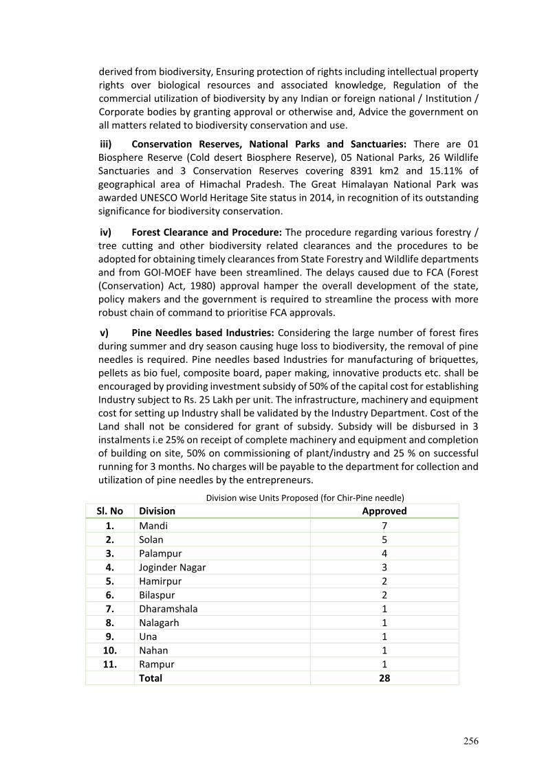
derived from biodiversity, Ensuring protection of rights including intellectual property rights over biological resources and associated knowledge, Regulation of the commercial utilization of biodiversity by any Indian or foreign national / Institution / Corporate bodies by granting approval or otherwise and, Advice the government on all matters related to biodiversity conservation and use.
iii) Conservation Reserves, National Parks and Sanctuaries: There are 01 Biosphere Reserve (Cold desert Biosphere Reserve), 05 National Parks, 26 Wildlife Sanctuaries and 3 Conservation Reserves covering 8391 km2 and 15.11% of geographical area of Himachal Pradesh. The Great Himalayan National Park was awarded UNESCO World Heritage Site status in 2014, in recognition of its outstanding significance for biodiversity conservation.
iv) Forest Clearance and Procedure: The procedure regarding various forestry / tree cutting and other biodiversity related clearances and the procedures to be adopted for obtaining timely clearances from State Forestry and Wildlife departments and from GOI-MOEF have been streamlined. The delays caused due to FCA (Forest (Conservation) Act, 1980) approval hamper the overall development of the state, policy makers and the government is required to streamline the process with more robust chain of command to prioritise FCA approvals.
v) Pine Needles based Industries: Considering the large number of forest fires during summer and dry season causing huge loss to biodiversity, the removal of pine needles is required. Pine needles based Industries for manufacturing of briquettes, pellets as bio fuel, composite board, paper making, innovative products etc. shall be encouraged by providing investment subsidy of 50% of the capital cost for establishing Industry subject to Rs. 25 Lakh per unit. The infrastructure, machinery and equipment cost for setting up Industry shall be validated by the Industry Department. Cost of the Land shall not be considered for grant of subsidy. Subsidy will be disbursed in 3 instalments i.e 25% on receipt of complete machinery and equipment and completion of building on site, 50% on commissioning of plant/industry and 25 % on successful running for 3 months. No charges will be payable to the department for collection and utilization of pine needles by the entrepreneurs.
Division wise Units Proposed (for Chir-Pine needle)
Sl. No Division Approved
1. Mandi 7
2. Solan 5
3. Palampur 4
4. Joginder Nagar 3
5. Hamirpur 2
6. Bilaspur 2
7. Dharamshala 1
8. Nalagarh 1
9. Una 1
10. Nahan 1
11. Rampur 1
Total 28
256
Constrains in setting up of Units: The infrastructure, machinery and equipment cost for setting up of unit shall first be validated by Industry Department and then Forest Department shall grant 50% subsidy. The Industry department validate only when the unit is set up. The entrepreneurs having difficulties in having initial investment / money for purchase of machinery and equipment.
vi) Policy Recommendation and the requirement of Monitoring Committee for existing policy: The questionnaires submitted by local communities of the project road corridors requested our focus on few existing issues which needs to be addressed to avoid biodiversity degradation in the future. This section will include existing policy/schemes with no visible outcomes and will recommend new policy/scheme which will further adhere to the project objectives of biodiversity conservation. a) ‘Assistance to gausadan/gaushala/cow sanctuary scheme’- Launched in 2020.
The Hon’ble Chief Minister announced initiation of 7 cow shelters in 7 districts of the state, which will be run by panchayats, mahila mandals, local bodies and NGOs, who will further benefit from the scheme. Seven cow sanctuaries were installed in seven districts. Under the scheme, Rs 500 per cow, per month would be provided to all cow shelters and sanctuaries having 30 or more cattle as maintenance allowance. The financial incentive would be extended to registered cow centres run even by the panchayats, mahila mandals, local bodies and NGOs, among others. The state has decided to ensure that no one would be allowed to abandon their cattle. In the first cabinet meeting of the government, it was decided to make provision for providing shelter to stray cattle and levying Re 1 cess per bottle of liquor for construction and maintenance of cow shelters. The government further decided to levy cess of Rs 1.50 per bottle of liquor to develop cow sanctuaries.
After stakeholder consultations on the wild-life human conflict along the project corridors, the local communities highlighted the increasing accidents of wild and stray animals on road. To avoid further damage and to reduce human-animal conflict, the gausadan/cow sanctuary scheme should be brought under the provision of definition of forest activity. The scheme should also be monitored from third party monitoring agency consisting of local communities and NGO’s.
b) Solid Waste Management – Waste collection points along the project corridor :
The stakeholders have requested the policymakers to consider building at least one Waste Collection Centre along each project corridor, to maintain and monitor waste management practices and segregate the pollutants. The reported generation of Municipal Solid Waste (MSW) in the State of Himachal Pradesh was estimated to be 304.3 Tons per day (TPD) in 2011 (CPCB, 2012). The state generates 42147 MTA of hazardous waste out of which 84.27% is landfillable , 5.33% is incinerable and 10.39% is recyclable (CPCB, 2009). The reported generation of Municipal Solid Waste (MSW) in the State of Himachal Pradesh was estimated to be 304.3 TPD in 2011 (CPCB, 2012). The per capita waste generation rate in Himachal Pradesh is around 0.413 kg/day. It is also estimated that 60% of the waste generated ends up in landfills.
257
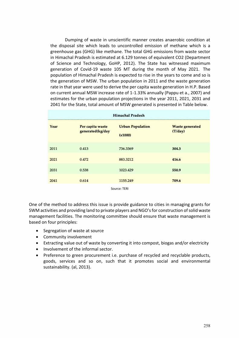
Dumping of waste in unscientific manner creates anaerobic condition at the disposal site which leads to uncontrolled emission of methane which is a greenhouse gas (GHG) like methane. The total GHG emissions from waste sector in Himachal Pradesh is estimated at 6.129 tonnes of equivalent CO2 (Department of Science and Technology, GoHP, 2012). The State has witnessed maximum generation of Covid-19 waste 105 MT during the month of May 2021. The population of Himachal Pradesh is expected to rise in the years to come and so is the generation of MSW. The urban population in 2011 and the waste generation rate in that year were used to derive the per capita waste generation in H.P. Based on current annual MSW increase rate of 1-1.33% annually (Pappu et a., 2007) and estimates for the urban population projections in the year 2011, 2021, 2031 and 2041 for the State, total amount of MSW generated is presented in Table below.
Source: TERI
One of the method to address this issue is provide guidance to cities in managing grants for SWM activities and providing land to private players and NGO’s for construction of solid waste management facilities. The monitoring committee should ensure that waste management is based on four principles:
Segregation of waste at source
Community involvement
Extracting value out of waste by converting it into compost, biogas and/or electricity
Involvement of the informal sector.
Preference to green procurement i.e. purchase of recycled and recyclable products, goods, services and so on, such that it promotes social and environmental sustainability. (al, 2013).
258
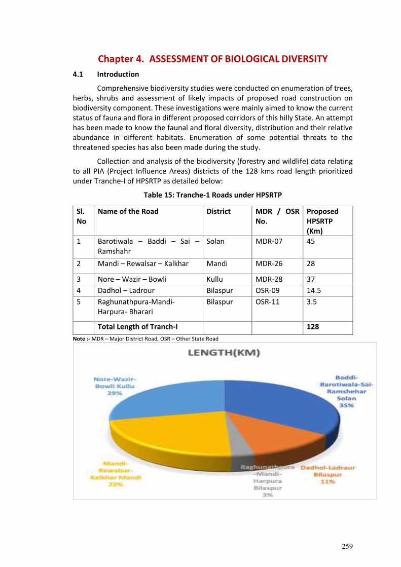
Chapter 4. ASSESSMENT OF BIOLOGICAL DIVERSITY
4.1 Introduction
Comprehensive biodiversity studies were conducted on enumeration of trees, herbs, shrubs and assessment of likely impacts of proposed road construction on biodiversity component. These investigations were mainly aimed to know the current status of fauna and flora in different proposed corridors of this hilly State. An attempt has been made to know the faunal and floral diversity, distribution and their relative abundance in different habitats. Enumeration of some potential threats to the threatened species has also been made during the study.
Collection and analysis of the biodiversity (forestry and wildlife) data relating to all PIA (Project Influence Areas) districts of the 128 kms road length prioritized under Tranche-I of HPSRTP as detailed below:
Table 15: Tranche-1 Roads under HPSRTP
Sl. No
Name of the Road District MDR / OSR No.
Proposed HPSRTP (Km)
1 Barotiwala – Baddi – Sai – Ramshahr
Solan MDR-07 45
2 Mandi – Rewalsar – Kalkhar Mandi MDR-26 28
3 Nore – Wazir – Bowli Kullu MDR-28 37
4 Dadhol – Ladrour Bilaspur OSR-09 14.5
5 Raghunathpura-Mandi-Harpura- Bharari
Bilaspur OSR-11 3.5
Total Length of Tranch-I 128
Note :- MDR – Major District Road, OSR – Other State Road
259
Himachal Pradesh is mainly a hilly state of the Indian Himalayas lying between 30º 22' to 33º 12' North latitude and 75º 47' to 79º 04' East longitude. The physiography of the State is almost mountainous with elevations ranging from 350 to 6500 metres above mean sea level and total area of the state is 55,673 sq km. Its northern border is bounded by Tibet, whereas, in the Northwest, it has a common border with Kashmir and the eastern border of the state is common with the hills of Uttarakhand (Mani, 1981; Chauhan, 1998).
Himachal Pradesh lies in the lap of the Indian Himalayas which are one of the most magnificent complex folded and youngest mountain systems in the world and form a physical barrier between the high plateaus of Tibet and Central Asia, and the Indian plains. They are about 2500 km long, extending from river Indus in the west to the river Brahmputra in the east. Its location and great expansion in latitude and altitude offer a wide variety of habitats, each supporting its own distinctive type of fauna and in particular, the bird diversity and its abundance (Mani, 1981; Martens and Eck, 1995; Mehta and Julka, 2002).
This hilly state is also divided by a general increase in elevation from West to East and from South to North into four biogeographical regions viz., Shiwalik or Outer Himalayas, Lower or Lesser Himalayas, Higher or Greater Himalayas and Trans Himalayas. The Shiwalik ranges are the southern most zone of about 40 to 60 km width, comprising several highly eroded low ridges. A zone of medium to high ranges (about 80 km wide), the Lesser Himalaya runs North of the Shiwalik and parallel to the main range. The Great Himalayan ranges lie just towards the North of the Chandrabhaga river in Lahaul-Spiti and Pangi region of Himachal Pradesh. This range is nearly 24 km wide and comprises the Great peaks rising up to an elevation of over 6000 metres amsl. Spiti area of the state constitutes a separate and distinct unit, i.e. Trans Himalaya. Varied physiographic and climatic factors have given rise to the diverse natural ecosystems/habitats, namely, forests, grasslands and pastures, river, lake and wetlands, glaciers etc. in this region (Mehta and Julka, 2002; Mahabal, 2005; Mehta, 2005).
There are four major agro-climatic zones in Himachal Pradesh which can be broadly be classified as subtropical (low lying hills), subtemperate (mid hills), temperate (high hills) and interior valleys) and cold and dry zones. i) Subtropical Zone This zone comprises of valleys and low lying hills near the plains of Punjab and Haryana. Altitude in this zone varies from 350 to 1000 metres with an annual rainfall between 600 to 1000 mm. This zone is very fertile and can be subjected to intensive cultivation. ii) Subtemperate Zone This zone comprises of midhills and the altitude varies from 1000 to 1500 metres above mean sea level. The climate of this zone is moderate with annual precipitation ranging from 900 to 1000 mm.
260
iii) Temperate High Zone This zone comprises of high hills and interior valley areas with altitudes varying from 1550 to 3000 metres above mean sea level. Annual rainfall varies from 900 to 1000 mm and snowing in winter is a usual feature. iv) Cold and Dry Zone This zone lies between 3000 to 3700 metres above mean sea level. Annual rainfall is scanty and varies from 250 to 400 mm. This zone is extremely cold and minimum temperature on an average comes down to -150 C.
Natural vegetation of the state is classified into six broad types of forests viz., Tropical forests (confined to foothills), represented by two subtypes, namely thorn-scrub of Acacia and Zizyphus, and dry deciduous forests of Shorea robusta; Subtropical forests (500-1800 m), which are further composed of two subtypes i.e. subtropical dry evergreen forests of Terminalia, Albizzia, Olea etc (below 1200 m), and subtropical pine forests of chir pine (Pinus roxburghii) found upto 1800 m; Temperate forests (1500-3000 m) which are also divided into two subtypes i.e. Himalayan moist temperate covers areas between 1500 and 3000 m, where the flora is dominated by oaks (Quercus spp.), deodar (Cedrus deodara), fir (Abies pindrow), blue pine (Pinus wallichiana) and horse chestnut (Aesculus indica), and another is the Himalayan dry temperate subtype of Holm oak (Quercus ilex) and edible pine (Pinus gerardiana) which is best developed at 2000 to 3000 m in the greater Himalayan regions of upper Sutlej valley in Kinnaur district; and Sub-Alpine and Alpine vegetation (above 4000 m) which is dominated by birch and rhododendron and interspersed with high-altitude meadows, found in most parts of Lahoul, Spiti and Kinnaur districts of the state (Mehta, 2005; Narwade et al., 2006).
Himachal Pradesh is also bestowed with several natural freshwater and
brackish water lakes, and a few large man made reservoirs. Natural lakes are distributed among different climatic zones of Himachal Pradesh. Some of prominent among these are: Renuka, Rewalsar, Khajjiar, Manimahesh, Chandertal etc. Some large reservoirs have also been formed due to damming of rivers, e.g. Pong and Govind Sagar. Besides five major rivers which flow through the state i.e. Yamuna, Sutlej, Beas, Ravi and Chenab, there is an intricate network of seasonal and perennial torrential streams. Moreover, pastures encompass an important ecosystem in the state, providing a nutrient rich forage for grazing livestock and wildlife. As much as 31% of the geographical area of Himachal Pradesh is under permanent alpine pastures. Further, the present day agroecosystems in the state, once covered with natural vegetation, are the outcome of permanent changes of the original ecosystems and around 17.5% and 3.4% of the geographical areas of the state are under agriculture and horticulture respectively (Vedwan and Rhodes, 2001; Mehta and Julka, 2002; Narwade et al., 2006).
Seasons in Himachal Pradesh can broadly be divided into three i.e. winter
(October to February), summer (March to June) and monsoon (July to September). Besides, autumn (September to October) and spring (February to March) seasons are also clearly distinguished at lower areas but their individuality goes on decreasing with altitude. Average rainfall in the state stands at 1523 mm, although it varies from a
261
minimum of 300 mm at Lahaul and Spiti to a maximum of 4400 mm at Dharamsala. The temperature in the state varies according to elevation. From the end of February, mercury rises gradually till June, which is generally the hottest month in this region. With the onset of monsoons, there is a gradual fall in temperature. When the monsoon ends by middle of September, temperature falls gradually in the beginning and fairly rapidly after November (Mani, 1981; Vedwan and Rhodes, 2001).
Studies on diversity, distribution, status and relative abundance of faunal and floral elements in different proposed road corridors in Himachal Pradesh have been conducted on the following lines
Site Selection
Various natural and manmade habitats like forests, grasslands and pastures, streams, ponds, human habitations etc., spread over lengths of the proposed road corridors were selected for the present studies as discussed in the Project Influence Area (PIA) chapter.
Sampling Strategies
Data was collected from secondary as well as primary sources. Secondary sources include published research papers, books by R&D institutions, reports of line departments, Working plans of HP Forest Department, State of Environment Report etc.
Both extensive and intensive sampling strategies were adopted for studying the fauna and flora of various sites. These strategies were mainly based upon the principle of exploration of a portion of the individuals in the whole population. Thus, stratified random sampling technique was followed for studying the animals of each area, which involved the division of sites into different strata, based upon vegetation type and habitat (Snedecore and Cochran, 1993). This technique not only allowed collection of the right type of scientific information but also saved time and yielded the faunal data which was very much amenable for mathematical/statistical analysis for the better presentation (Daniels, 1989; Javed, 1996).
Study Design
Faunal and floral explorations were based on both extensive and intensive studies in various sites in each corridor. Direct observations and indirect methods like identification of dung, tracks and other signs etc. were also employed. Extensive studies were mainly based on detailed survey of fauna in different proposed road areas, whereas, intensive studies were based on point count method which is based on the theory of exploration of fauna of predetermined points, spaced at average distance of around 5 kms during the present study.
Besides, keeping in view the hilly and more rugged terrain of the study areas, Piecewise Linear Line transect method was also followed for exploration of data which is based on principal of exploration of fauna on predetermined paths to record the objects on or near the line. This is one of the most commonly used methods for estimating the abundance of fauna populations and is practical, efficient and relatively inexpensive (Burnham et al., 1980). These transects were monitored as open width
262
transects, where fauna was recorded irrespective of their distance from transect. The selection of these methods was based on some earlier studies conducted by workers like Daniels (1989) who successfully used it in Western Ghats; Katti (1989) in Dachigam; Kalsi (1993) in Kalesar reserve forest; Sathya Kumar et al. (1993) in Kedarnath Wildlife Sanctuary; Ahmed (1995) in Ranikhet region of Kumaon Himalaya; Javed (1996) in Dudwa National Park; Sankar Raman (1996) in Mizoram and Mehta et al. (2002) in Ropar Wetland, Punjab. Length of transect was decided on the basis of species area curve. In almost all the cases it stood out at around 1 km. Field identifications were carried out with the help of various field guides.
Analysis and Interpretation of data The data has been analyzed for relative abundance of the species on a relative frequency scale of occurrence depending upon the number of sightings, as developed by McKinnon and Philip (1993). Based upon this, different categories assigned are: Very Common (Encounter rate >60), Common (Encounter rate=40-60), Uncommon (Encounter rate=20-40) and Rare (<20). Similarly, the analysis for whole of the experimental study sites was performed. The relative frequency scale was fixed in such a way so as to include the migrant species sighted seasonally in good numbers (which visited the area for a brief period of time) to their respective category. This method was modified from Narayan et al. (1986).
Similarly, residential status was worked into various categories like resident, winter visitor, summer visitor, etc. on the basis of the presence or absence method. This categorization was based on McKinnon and Philip (1993) and Mehta et al. (2002).
Consultation with Key Stakeholders
This section summarizes public/stakeholder consultations conducted as part of the Biodiversity Impact Assessment for the Project Road. Stakeholder Consultations were carried out to elicit views/opinions/suggestions which can serve as input to the project design. The composition of the stakeholders ranged from villagers/community along the project road, DFOs, Range officers, Wildlife Officers etc., and other non-community stakeholders as listed in Table Stakeholder consultations to be conducted and issues related to impacts on diversity and wildlife due to the roads project to be discussed and inference will be drawn. The consultations were conducted with concerned stakeholder Departments viz. HPFD, HPSBB, FSI, HFRI, ZSI, BSI, Local Panchayat’s, HPRIDC, NGOs etc. The main issues of concern cropped up during the consultation and discussions are considered for the preparation of action plan.
4.2. Methodology
i. Primary data generation and consultation: This include as a first step expert interview of e.g. forest dept staff using a standard questionnaire. Second, interviews of villagers again using a standard questionnaire. Thereafter and having identified some locations or corridors where fauna is more prevalent, interviews with local commuters and the animal scratch, pug mark/dung surveys have been.
263
ii. Survey Sheet and semi-structured Questionnaire/Meetings and Workshops with stakeholders (local communities and, PRI (Panchayati Raj Institute), NGO and field staff of PWD, Forest, Revenue etc.)
iii. All analysis are primarily focusing on the 7km strip of land on each side from centre line of the road according to the MOEF guidelines.
Methodology for Vegetation/Habitat study: Regarding the assessment of floristic diversity, the area of the different sites will be further sub-divided into various altitudes. While carrying out phytosociological study quadrates of size 10mx10m, 3mx3m, and 1mx1m will be laid out for enumerating trees, shrubs, and herbs & regeneration, respectively. The vegetation data will be analyzed for density, frequency, and abundance as per Curtis and McIntosh (1950). The relative values of density, frequency, and dominance will be summed to get the Importance Value Index (IVI) of individual species. The abundance to frequency ratio (A/F) of different species will be determined for eliciting the distribution pattern of the floral elements. This ratio indicates regular (<0.025), random (0.025 to 0.050) and contiguous (>0.050) distribution (Curtis and Cottam, 1956). The plant species diversity will be calculated following Shannon-Wiener Diversity Index (H) (Shannon-Wiener 1963 H= - Σ(Ni/N) ln (Ni/N) i=1
Where Ni = Number of individuals of species i and N= Total number of individuals of all the species Ecological study has been made to know the forest types, flora and faunal composition of the study area which were computed and compared with the satellite and information from other sources like BSI, ZSI, relevant forest department (Wildlife Department) and local NGO’s. Subsequently through extensive field survey, forest types, flora and faunal composition of the study areas were computed and compared with the satellite and other information. The various ecosystems, vegetation, communities, faunal habitats prevalent in the study area were identified though Quadrant method with Random Sampling Technique was adopted to know distribution pattern of the plant species and faunal characteristics both in core and buffer zone. The detailed species characteristics like frequency, abundance & density were computed. Frequency: The frequency of individual species is the number of times the species occurs in the sampling quadrant. It is actually represented as a percentage calculated as follows:
No. of quadrants in which the species occurred Frequency = ———————————————————— X 100
Total no. of quadrants studied It reflects the probability of encountering the species within the sampled area.
264
Density: Density is the measure of dense in the distribution of an individual species within a given area Density of a species is defined as the average number of the species per quadrant and calculated as follows:
Total no. of individuals of the species Density = ——————————————
Total no. of quadrants used in sampling Abundance: It reflects how evenly one species is distributed within the sampling area. Abundance of a species is defined as the number of individuals per quadrant and calculated as follows:
Total no. of individual of the species Abundance = ————————————————————
No. of quadrants in which the species occurred
Biodiversity Assessment The data collected during enumeration such as the number of individuals of each species and the DBH of each tree alternatively shall also be utilized to derive secondary attributes like basal area (BA, m2/ha), density (D, trees per ha) and frequency (F, number of quadrates where trees are present in relation to total plots observed). Relative values of BA, D and F will be calculated. The Importance Value Index (IVI) for the richness of species to be calculated by adding up relative dominance (RBAF), relative density (RD), and relative frequency (RF). However, in the case of shrubs, herbs, saplings, and regeneration, the IVI is calculated based on relative values, i.e. relative frequency, and relative density. It is assumed that the dominance of a species increases with an increasing importance value and that the species with the lowest importance value is the least dominant one. The maximum IVI value is 300 (100 each for RBA, RD, and RF). The basal area and density of the tree species should be converted to a hectare basis.
4.2.1 Qualitative Assessment (Flora)
4.2.1.1 Grid Distribution The sample plots were laid out following systematic sampling scheme. The
systematic sampling was based on the system of grids of latitude and longitude or distance, say 1kmx1km, basis. The size of grid was ascertained using area along both side of the concerned road and optimum sample size and sample grids be selected. It may be all grids of 25''X25''size taken few recording data (approximately one plot per 0.56 km2, alternate grids of 25''X25'' size (approximately one plot per 1.11 km2). The survey was carried abiding National Working Plan Code– 2014. Sample plots systematically laid out which is indicated on the Survey of India topographic sheet (toposheet) on the scale of 1:50,000. 4.2.1.2 Plot Enumeration
All trees having diameter 10 cm and above were enumerated, species wise and diameter class wise from all the identified sample plots of 0.1 ha and recorded in the
265
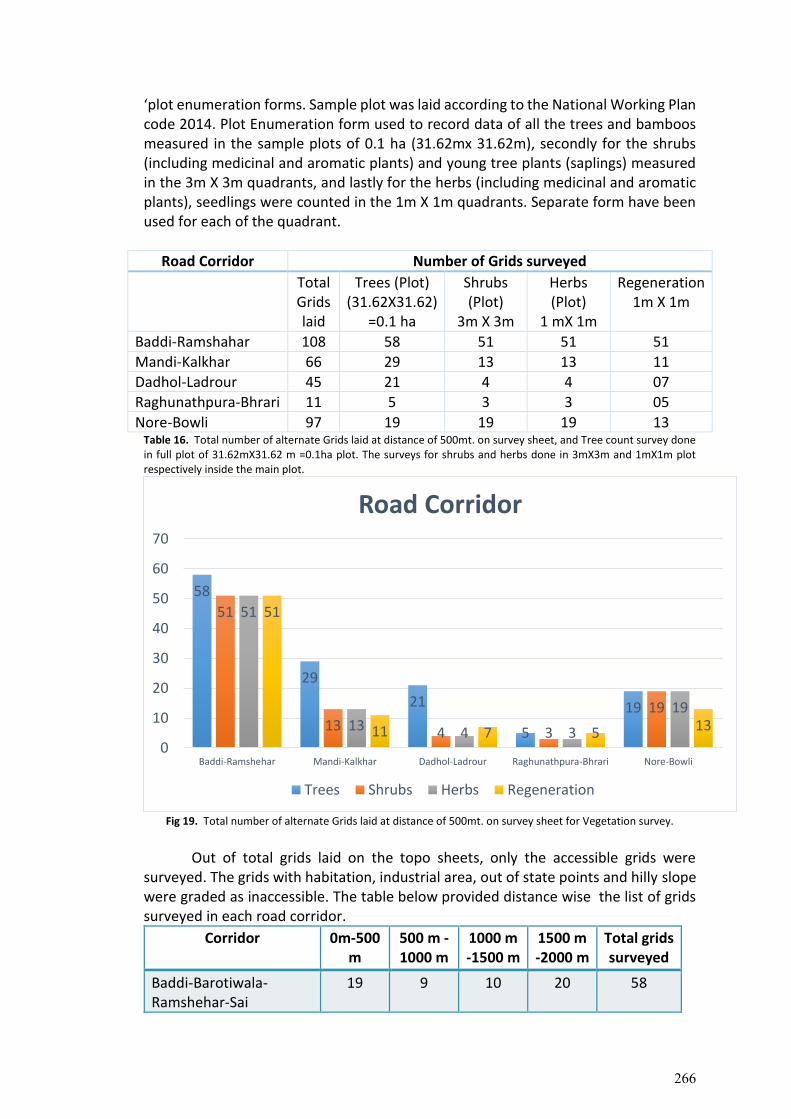
‘plot enumeration forms. Sample plot was laid according to the National Working Plan code 2014. Plot Enumeration form used to record data of all the trees and bamboos measured in the sample plots of 0.1 ha (31.62mx 31.62m), secondly for the shrubs (including medicinal and aromatic plants) and young tree plants (saplings) measured in the 3m X 3m quadrants, and lastly for the herbs (including medicinal and aromatic plants), seedlings were counted in the 1m X 1m quadrants. Separate form have been used for each of the quadrant.
Road Corridor Number of Grids surveyed
Total Grids laid
Trees (Plot) (31.62X31.62)
=0.1 ha
Shrubs (Plot)
3m X 3m
Herbs (Plot)
1 mX 1m
Regeneration 1m X 1m
Baddi-Ramshahar 108 58 51 51 51
Mandi-Kalkhar 66 29 13 13 11
Dadhol-Ladrour 45 21 4 4 07
Raghunathpura-Bhrari 11 5 3 3 05
Nore-Bowli 97 19 19 19 13 Table 16. Total number of alternate Grids laid at distance of 500mt. on survey sheet, and Tree count survey done in full plot of 31.62mX31.62 m =0.1ha plot. The surveys for shrubs and herbs done in 3mX3m and 1mX1m plot respectively inside the main plot.
Fig 19. Total number of alternate Grids laid at distance of 500mt. on survey sheet for Vegetation survey.
Out of total grids laid on the topo sheets, only the accessible grids were
surveyed. The grids with habitation, industrial area, out of state points and hilly slope were graded as inaccessible. The table below provided distance wise the list of grids surveyed in each road corridor.
Corridor 0m-500 m
500 m -1000 m
1000 m -1500 m
1500 m -2000 m
Total grids surveyed
Baddi-Barotiwala-Ramshehar-Sai
19 9 10 20 58
58
29
21
5
19
51
13 4 3
19
51
13 4 3
19
51
11 7 5 13
0
10
20
30
40
50
60
70
Baddi-Ramshehar Mandi-Kalkhar Dadhol-Ladrour Raghunathpura-Bhrari Nore-Bowli
Road Corridor
Trees Shrubs Herbs Regeneration
266
Raghunathpura-harpura-Bhrari
3 0 1 1 5
Dadhol-Ladraur 9 2 6 4 21
Mandi-Rewalsar-Kalkhar 10 7 7 5 29
Nore-Wazir-Bowli 7 5 4 1 19 Table 17. Total grids surveyed.
4.2.1.1 Survey, Sampling and Identification of the Species
Systematic Stratified Sampling was done in the core impact zone (500 m) and immediate buffer zone (1500m) totalling to 2 Km strip each on either side from the centreline of the road. Random Sampling was also done in an extended buffer zone (5km) on each side from the immediate buffer zone. However, no random sampling was done at occurrence of rivers, ridges, or valleys in the immediate buffer zone and extended buffer zone beyond which no influence is predicted.
1.1 Systematic Stratified Sampling A systematic stratified sampling method in core impact and buffer zone was
carried out to enumerate species composition and understand stand structure; study area was divided into relatively homogeneous sub-areas and then sampling shall be done along the project roads. The dictionary meaning of stratified is “arranged in separate layers”, Gallego (2005) argues that stratification should be done when some prior relevant information. The sample units in different strata were close to each other and spatially interconnected, which potentially added value to the ecosystem research when it comes to biodiversity assessment Gallego (2005). The survey was undertaken with the professional expertise of FSI (Forest Survey of India) Senior Technical officer, Mr. B.B Kalia. The size of sampling unit (quadrant) was done by using the species-area-curve method. Quadrants of 10m x 10m were laid out to examine the tree layer in the direct impact zone as well as buffer zone. Within these sample plots, 3m x 3m plots were laid out for sampling shrub layer. To collect information on ground layer and other herbaceous species, five quadrants of 1m x 1m size were laid out within the quadrants. Species-wise enumerations was carried out in each quadrant along, in addition to stratified, random sampling in extended buffer zone along the Grad sect was done.
A total of 403 species of vascular plants i.e., Angiosperms (105 families, 285 genera & 393 species), Gymnosperms (01 family, 02 genera & 03 species) and Pteridophytes (05 families, 05 genera & 07 species) were recorded in 05 different slected areas i.e; Baddi-Barotiwala-Sai-Ramshar Road, Dhadol-Ladrour Road, Raghunathpura-Mandi-Harpura-Bharai Road, Mandi-Rewalsar-Kalkhar Road, and Nore-Wazir-Bowli Road in different districts of Himachal Pradesh. Of the total species, 79 species were trees, 105 shrubs, 209 herbs & 07 pteridophytes. Table 18. Taxonomic description of floristic diversity in 05 different slected areas i.e; Baddi-Barotiwala-Sai-
Ramshar Road, Dhadol-Ladrour Road, Raghunathpura-Mandi-Harpura-Bharai Road, Mandi-Rewalsar-Kalkhar Road, and Nore-Wazir-Bowli Road in different districts of Himachal Pradesh
Taxonomic Group Families Genera Species Herbs Shrubs Trees
267

Angiosperms 105 285 393 209 105 79
Gymnosperms 01 02 03 - - 03
Pteridophytes 05 05 07 07 - -
Total 111 292 403 216 105 82
Among families, Asteraceae (31 spp.); Fabaceae (25 spp.); Poaceae and
Lamiaceae (17 spp., each); Rosaceae (12 spp.); Apiaceae (11 spp.); Anacardiaceae, Acanthaceae and Euphorbiaceae (10 spp., each); Caesalpiniaceae, Moraceae and Solanaceae (09 spp., each); Rubiaceae (08 spp.); Polygonaceae and Ranunculaceae (07 spp., each); Rutaceae and Urticaceae (06 spp., each); Boraginaceae, Rhamnaceae and Cyperaceae (05 spp., each); Araceae, Amaranthaceae, Commelinaceae, Convolvulaceae, Verbenaceae, Vitaceae and Zingiberaceae (04 spp., each); Apocynaceae, Asclepiadaceae, Asparagaceae, Brassicaceae, Scrophulariaceae, Tiliaceae, Oleaceae, Orchidaceae, Elaeagnaceae, Oxalidaceae, Pinaceae, Menispermaceae, Cucurbitaceae, Lythraceae, Malvaceae, Myrtaceae, Caryophyllaceae (03 spp., each) were the dominant. Thirty three (33) families i.e., Araliaceae; Arecaceae; Athyriaceae; Cactaceae; Cannabaceae; Capparaceae; Caprifoliaceae; Celastraceae; Coriariaceae; Crassulaceae; Cuscutaceae; Dryopteridaceae; Ebenaceae; Fumariaceae; Geraniaceae; Juglandaceae; Leeaceae; Linaceae; Loranthaceae; Melastomataceae; Myricaceae; Papaveraceae; Phytolaccaceae; Plumbaginaceae; Polygalaceae; Pteridiaceae; Punicaceae; Santalaceae; Saxifragaceae; Smilacaceae; Symplocaceae; Thymelaeaceae and Valerianaceae were monotypic. Among genera, Ficus (08 spp.); Artemisia, Bauhinia, Cassia, Euphorbia and Rubus (04 spp., each); Albizia, Asparagus, Desmodium, Indigofera, Jasminum Justicia, Oxalis and Zizyphus (03 spp., each) were species dominant. Habitat wise distribution
Maximum number of species (i.e., 318 spp.) was recorded in the shady moist habitat followed by riverine (166 spp.), degraded (232 spp.), dry (291 spp.), bouldary (172 spp.), rocky (57 spp.), shrubbery (88 spp.), waste places/road side (101 spp.), near crop field/cultivated field (93 spp.) and water courses/marshey places (73 spp.) habitats.
268
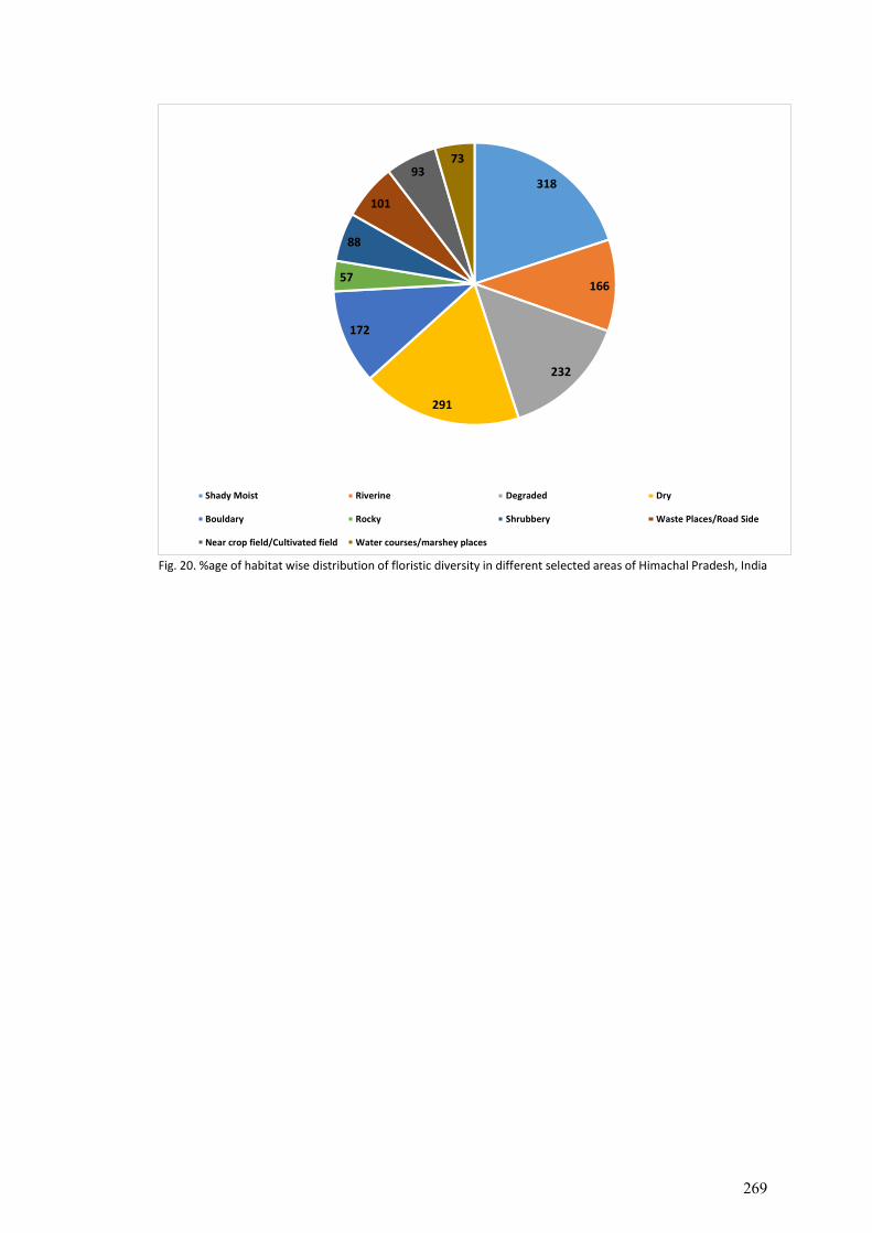
Fig. 20. %age of habitat wise distribution of floristic diversity in different selected areas of Himachal Pradesh, India
318
166
232
291
172
57
88
101
9373
Shady Moist Riverine Degraded Dry
Bouldary Rocky Shrubbery Waste Places/Road Side
Near crop field/Cultivated field Water courses/marshey places
269
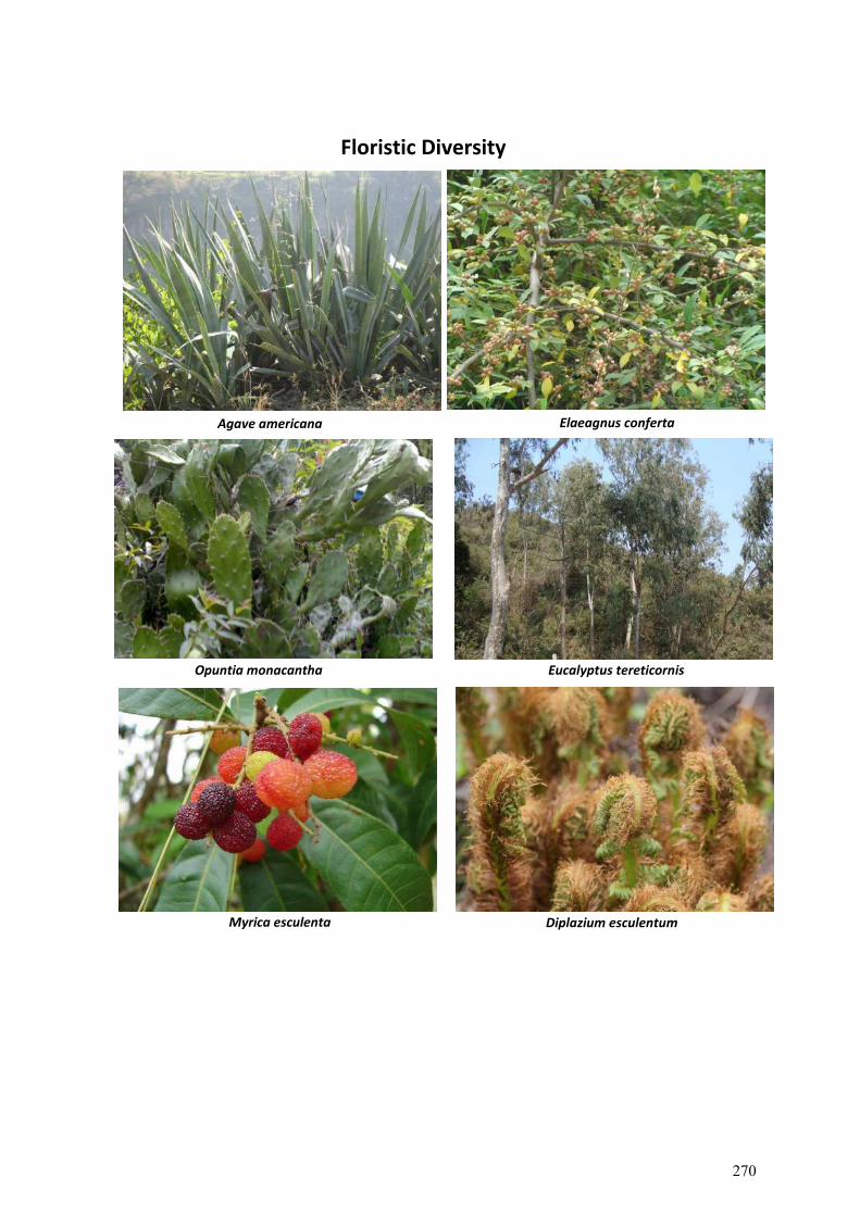
Agave americana Elaeagnus conferta
Eucalyptus tereticornis Opuntia monacantha
Diplazium esculentum Myrica esculenta
Floristic Diversity
270
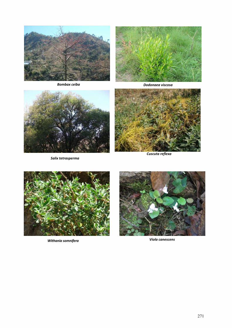
Dodonaea viscosa
Bombax ceiba
Salix tetrasperma Cuscuta reflexa
Withania somnifera Viola canescens
271
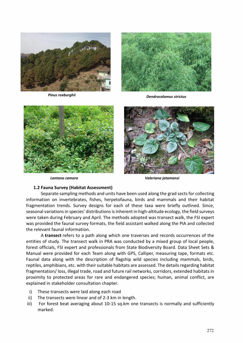
Pinus roxburghii Dendrocalamus strictus
1.2 Fauna Survey (Habitat Assessment) Separate sampling methods and units have been used along the grad sects for collecting information on invertebrates, fishes, herpetofauna, birds and mammals and their habitat fragmentation trends. Survey designs for each of these taxa were briefly outlined. Since, seasonal variations in species’ distributions is inherent in high-altitude ecology, the field surveys were taken during February and April. The methods adopted was transect walk, the FSI expert was provided the faunal survey formats, the field assistant walked along the PIA and collected the relevant faunal information. A transect refers to a path along which one traverses and records occurrences of the entities of study. The transect walk in PRA was conducted by a mixed group of local people, forest officials, FSI expert and professionals from State Biodiversity Board. Data Sheet Sets & Manual were provided for each Team along with GPS, Calliper, measuring tape, formats etc. Faunal data along with the description of flagship wild species including mammals, birds, reptiles, amphibians, etc. with their suitable habitats are assessed. The details regarding habitat fragmentation/ loss, illegal trade, road and future rail networks, corridors, extended habitats in proximity to protected areas for rare and endangered species; human, animal conflict, are explained in stakeholder consultation chapter.
i) These transects were laid along each road ii) The transects were linear and of 2-3 km in length.
iii) For forest beat averaging about 10-15 sq.km one transects is normally and sufficiently marked.
Valeriana jatamansi Lantana camara
272
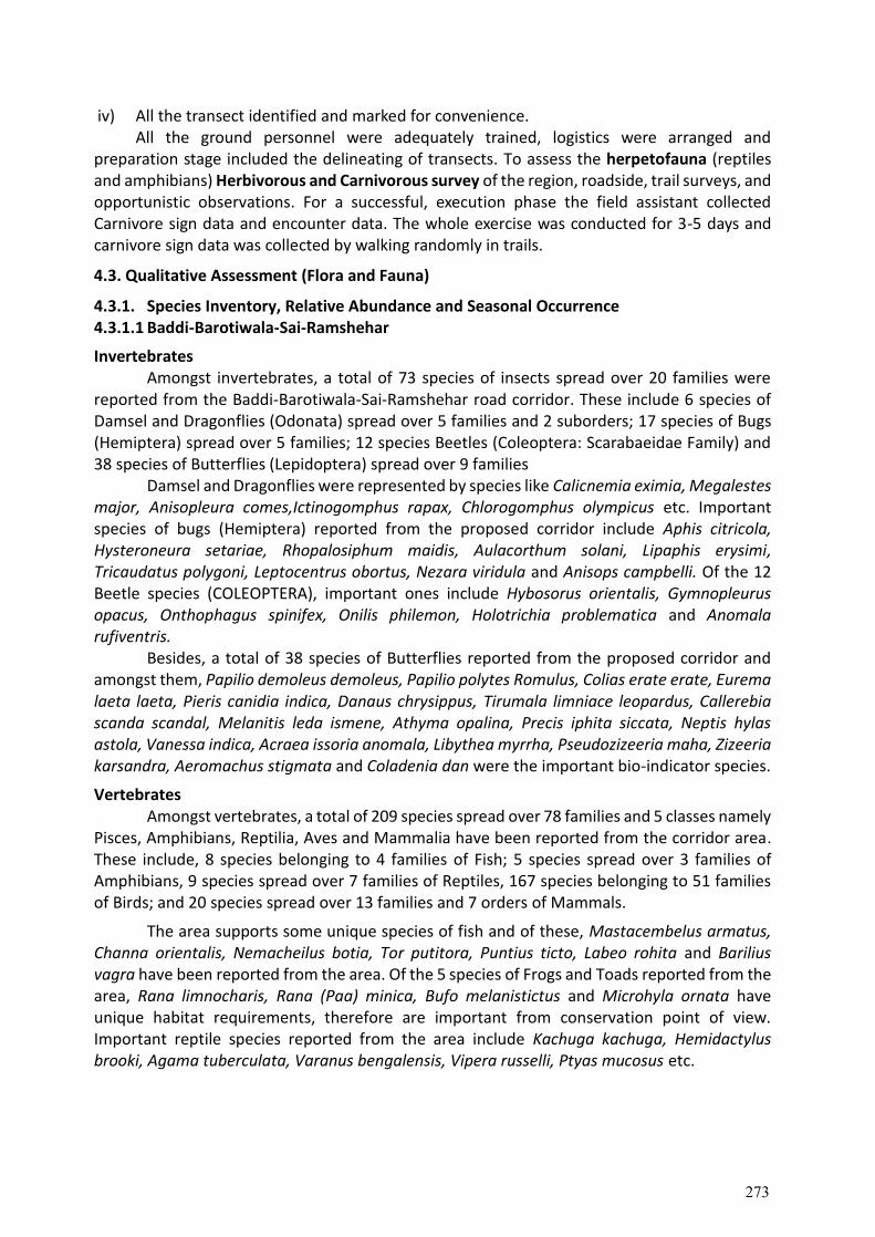
iv) All the transect identified and marked for convenience. All the ground personnel were adequately trained, logistics were arranged and
preparation stage included the delineating of transects. To assess the herpetofauna (reptiles and amphibians) Herbivorous and Carnivorous survey of the region, roadside, trail surveys, and opportunistic observations. For a successful, execution phase the field assistant collected Carnivore sign data and encounter data. The whole exercise was conducted for 3-5 days and carnivore sign data was collected by walking randomly in trails.
4.3. Qualitative Assessment (Flora and Fauna)
4.3.1. Species Inventory, Relative Abundance and Seasonal Occurrence 4.3.1.1 Baddi-Barotiwala-Sai-Ramshehar
Invertebrates Amongst invertebrates, a total of 73 species of insects spread over 20 families were
reported from the Baddi-Barotiwala-Sai-Ramshehar road corridor. These include 6 species of Damsel and Dragonflies (Odonata) spread over 5 families and 2 suborders; 17 species of Bugs (Hemiptera) spread over 5 families; 12 species Beetles (Coleoptera: Scarabaeidae Family) and 38 species of Butterflies (Lepidoptera) spread over 9 families
Damsel and Dragonflies were represented by species like Calicnemia eximia, Megalestes major, Anisopleura comes,Ictinogomphus rapax, Chlorogomphus olympicus etc. Important species of bugs (Hemiptera) reported from the proposed corridor include Aphis citricola, Hysteroneura setariae, Rhopalosiphum maidis, Aulacorthum solani, Lipaphis erysimi, Tricaudatus polygoni, Leptocentrus obortus, Nezara viridula and Anisops campbelli. Of the 12 Beetle species (COLEOPTERA), important ones include Hybosorus orientalis, Gymnopleurus opacus, Onthophagus spinifex, Onilis philemon, Holotrichia problematica and Anomala rufiventris.
Besides, a total of 38 species of Butterflies reported from the proposed corridor and amongst them, Papilio demoleus demoleus, Papilio polytes Romulus, Colias erate erate, Eurema laeta laeta, Pieris canidia indica, Danaus chrysippus, Tirumala limniace leopardus, Callerebia scanda scandal, Melanitis leda ismene, Athyma opalina, Precis iphita siccata, Neptis hylas astola, Vanessa indica, Acraea issoria anomala, Libythea myrrha, Pseudozizeeria maha, Zizeeria karsandra, Aeromachus stigmata and Coladenia dan were the important bio-indicator species.
Vertebrates Amongst vertebrates, a total of 209 species spread over 78 families and 5 classes namely
Pisces, Amphibians, Reptilia, Aves and Mammalia have been reported from the corridor area. These include, 8 species belonging to 4 families of Fish; 5 species spread over 3 families of Amphibians, 9 species spread over 7 families of Reptiles, 167 species belonging to 51 families of Birds; and 20 species spread over 13 families and 7 orders of Mammals.
The area supports some unique species of fish and of these, Mastacembelus armatus, Channa orientalis, Nemacheilus botia, Tor putitora, Puntius ticto, Labeo rohita and Barilius vagra have been reported from the area. Of the 5 species of Frogs and Toads reported from the area, Rana limnocharis, Rana (Paa) minica, Bufo melanistictus and Microhyla ornata have unique habitat requirements, therefore are important from conservation point of view. Important reptile species reported from the area include Kachuga kachuga, Hemidactylus brooki, Agama tuberculata, Varanus bengalensis, Vipera russelli, Ptyas mucosus etc.
273
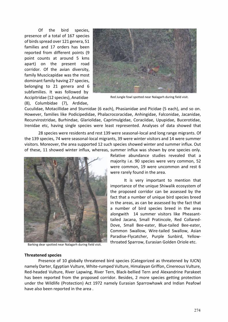
Of the bird species, presence of a total of 167 species of birds spread over 121 genera, 51 families and 17 orders has been reported from different points (9 point counts at around 5 kms apart) on the present road corridor. Of the avian diversity, family Muscicapidae was the most dominant family having 27 species, belonging to 21 genera and 6 subfamilies. It was followed by Accipitridae (12 species), Anatidae (8), Columbidae (7), Ardidae, Cuculidae, Motacillidae and Sturnidae (6 each), Phasianidae and Picidae (5 each), and so on. However, families like Podicipedidae, Phalacrocoracidae, Anhingidae, Falconidae, Jacanidae, Recurvirostridae, Burhindae, Glariolidae, Caprimulgidae, Coraciidae, Upupidae, Bucerotidae, Irenidae etc, having single species were least represented. Analyses of data showed that
28 species were residents and rest 139 were seasonal-local and long range migrants. Of the 139 species, 74 were seasonal-local migrants, 39 were winter visitors and 14 were summer visitors. Moreover, the area supported 12 such species showed winter and summer influx. Out of these, 11 showed winter influx, whereas, summer influx was shown by one species only.
Relative abundance studies revealed that a majority i.e. 90 species were very common, 52 were common, 19 were uncommon and rest 6 were rarely found in the area.
It is very important to mention that importance of the unique Shiwalik ecosystem of the proposed corridor can be assessed by the fact that a number of unique bird species breed in the areas, as can be assessed by the fact that a number of bird species breed in the area alongwith 14 summer visitors like Pheasant-tailed Jacana, Small Pratincole, Red Collared-Dove, Small Bee-eater, Blue-tailed Bee-eater, Common Swallow, Wire-tailed Swallow, Asian Paradise-Flycatcher, Purple Sunbird, Yellow-throated Sparrow, Eurasian Golden Oriole etc.
Threatened species Presence of 10 globally threatened bird species (Categorized as threatened by IUCN)
namely Darter, Egyptian Vulture, White-rumped Vulture, Himalayan Griffon, Cinereous Vulture, Red-headed Vulture, River Lapwing, River Tern, Black-bellied Tern and Alexandrine Parakeet has been reported from the proposed corridor. Besides, 2 more species getting protection under the Wildlife (Protection) Act 1972 namely Eurasian Sparrowhawk and Indian Peafowl have also been reported in the area .
Barking dear spotted near Nalagarh during field visit.
Red Jungle fowl spotted near Nalagarh during field visit.
274
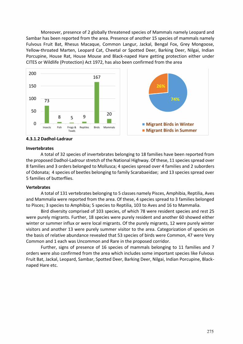
Moreover, presence of 2 globally threatened species of Mammals namely Leopard and Sambar has been reported from the area. Presence of another 15 species of mammals namely Fulvous Fruit Bat, Rhesus Macaque, Common Langur, Jackal, Bengal Fox, Grey Mongoose, Yellow-throated Marten, Leopard Cat, Cheetal or Spotted Deer, Barking Deer, Nilgai, Indian Porcupine, House Rat, House Mouse and Black-naped Hare getting protection either under CITES or Wildlife (Protection) Act 1972, has also been confirmed from the area
4.3.1.2 Dadhol-Ladraur
Invertebrates A total of 32 species of invertebrates belonging to 18 families have been reported from
the proposed Dadhol-Ladrour stretch of the National Highway. Of these, 11 species spread over 8 families and 3 orders belonged to Mollusca; 4 species spread over 4 families and 2 suborders of Odonata; 4 species of beetles belonging to family Scarabaeidae; and 13 species spread over 5 families of butterflies.
Vertebrates A total of 131 vertebrates belonging to 5 classes namely Pisces, Amphibia, Reptilia, Aves and Mammalia were reported from the area. Of these, 4 species spread to 3 families belonged to Pisces; 3 species to Amphibia; 5 species to Reptilia, 103 to Aves and 16 to Mammalia.
Bird diversity comprised of 103 species, of which 78 were resident species and rest 25 were purely migrants. Further, 18 species were purely resident and another 60 showed either winter or summer influx or were local migrants. Of the purely migrants, 12 were purely winter visitors and another 13 were purely summer visitor to the area. Categorization of species on the basis of relative abundance revealed that 53 species of birds were Common, 47 were Very Common and 1 each was Uncommon and Rare in the proposed corridor.
Further, signs of presence of 16 species of mammals belonging to 11 families and 7 orders were also confirmed from the area which includes some important species like Fulvous Fruit Bat, Jackal, Leopard, Sambar, Spotted Deer, Barking Deer, Nilgai, Indian Porcupine, Black-naped Hare etc.
73
8 5 9
167
20
0
50
100
150
200
Insects Fish Frogs &Toads
Reptiles Birds Mammals
74%
26%
Migrant Birds in WinterMigrant Birds in Summer
275
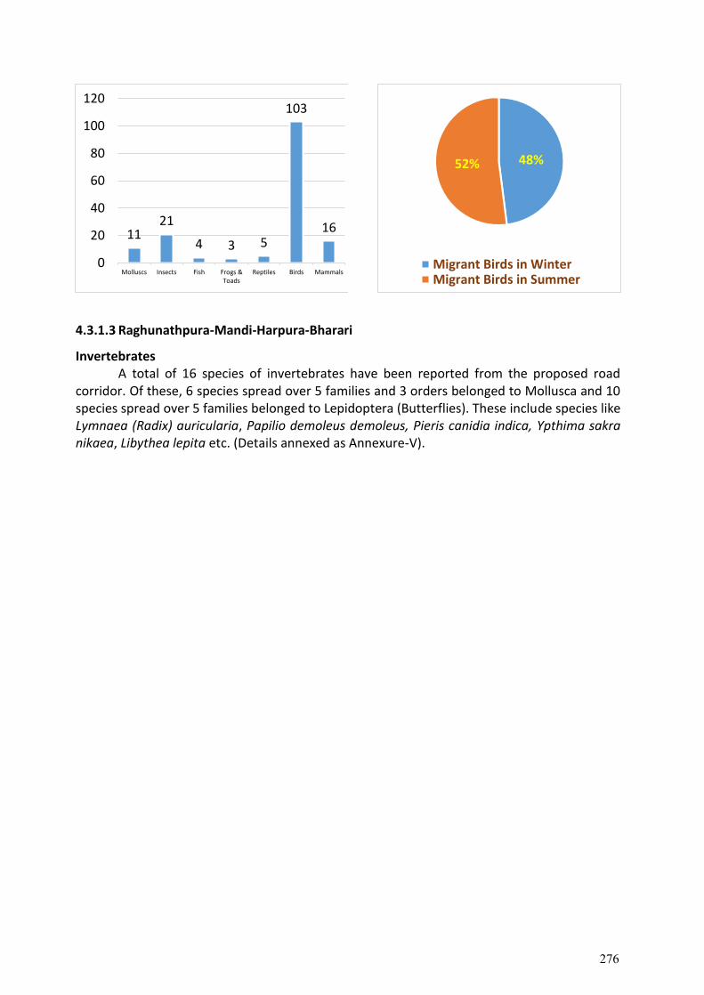
4.3.1.3 Raghunathpura-Mandi-Harpura-Bharari
Invertebrates A total of 16 species of invertebrates have been reported from the proposed road corridor. Of these, 6 species spread over 5 families and 3 orders belonged to Mollusca and 10 species spread over 5 families belonged to Lepidoptera (Butterflies). These include species like Lymnaea (Radix) auricularia, Papilio demoleus demoleus, Pieris canidia indica, Ypthima sakra nikaea, Libythea lepita etc. (Details annexed as Annexure-V).
1121
4 3 5
103
16
0
20
40
60
80
100
120
Molluscs Insects Fish Frogs &Toads
Reptiles Birds Mammals
48%52%
Migrant Birds in WinterMigrant Birds in Summer
276
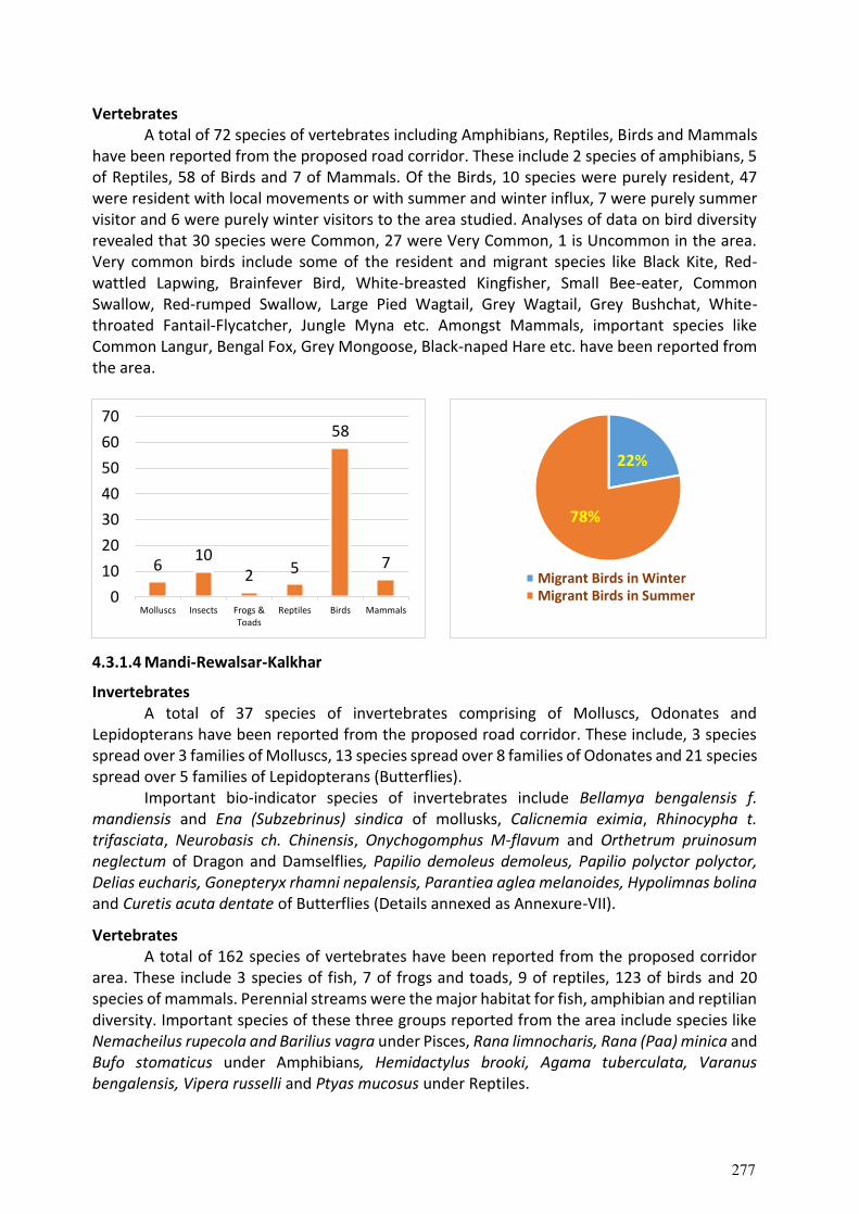
Vertebrates A total of 72 species of vertebrates including Amphibians, Reptiles, Birds and Mammals
have been reported from the proposed road corridor. These include 2 species of amphibians, 5 of Reptiles, 58 of Birds and 7 of Mammals. Of the Birds, 10 species were purely resident, 47 were resident with local movements or with summer and winter influx, 7 were purely summer visitor and 6 were purely winter visitors to the area studied. Analyses of data on bird diversity revealed that 30 species were Common, 27 were Very Common, 1 is Uncommon in the area. Very common birds include some of the resident and migrant species like Black Kite, Red-wattled Lapwing, Brainfever Bird, White-breasted Kingfisher, Small Bee-eater, Common Swallow, Red-rumped Swallow, Large Pied Wagtail, Grey Wagtail, Grey Bushchat, White-throated Fantail-Flycatcher, Jungle Myna etc. Amongst Mammals, important species like Common Langur, Bengal Fox, Grey Mongoose, Black-naped Hare etc. have been reported from the area.
4.3.1.4 Mandi-Rewalsar-Kalkhar
Invertebrates A total of 37 species of invertebrates comprising of Molluscs, Odonates and Lepidopterans have been reported from the proposed road corridor. These include, 3 species spread over 3 families of Molluscs, 13 species spread over 8 families of Odonates and 21 species spread over 5 families of Lepidopterans (Butterflies). Important bio-indicator species of invertebrates include Bellamya bengalensis f. mandiensis and Ena (Subzebrinus) sindica of mollusks, Calicnemia eximia, Rhinocypha t. trifasciata, Neurobasis ch. Chinensis, Onychogomphus M-flavum and Orthetrum pruinosum neglectum of Dragon and Damselflies, Papilio demoleus demoleus, Papilio polyctor polyctor, Delias eucharis, Gonepteryx rhamni nepalensis, Parantiea aglea melanoides, Hypolimnas bolina and Curetis acuta dentate of Butterflies (Details annexed as Annexure-VII).
Vertebrates A total of 162 species of vertebrates have been reported from the proposed corridor area. These include 3 species of fish, 7 of frogs and toads, 9 of reptiles, 123 of birds and 20 species of mammals. Perennial streams were the major habitat for fish, amphibian and reptilian diversity. Important species of these three groups reported from the area include species like Nemacheilus rupecola and Barilius vagra under Pisces, Rana limnocharis, Rana (Paa) minica and Bufo stomaticus under Amphibians, Hemidactylus brooki, Agama tuberculata, Varanus bengalensis, Vipera russelli and Ptyas mucosus under Reptiles.
610
2 5
58
7
0
10
20
30
40
50
60
70
Molluscs Insects Frogs &Toads
Reptiles Birds Mammals
22%
78%
Migrant Birds in WinterMigrant Birds in Summer
277
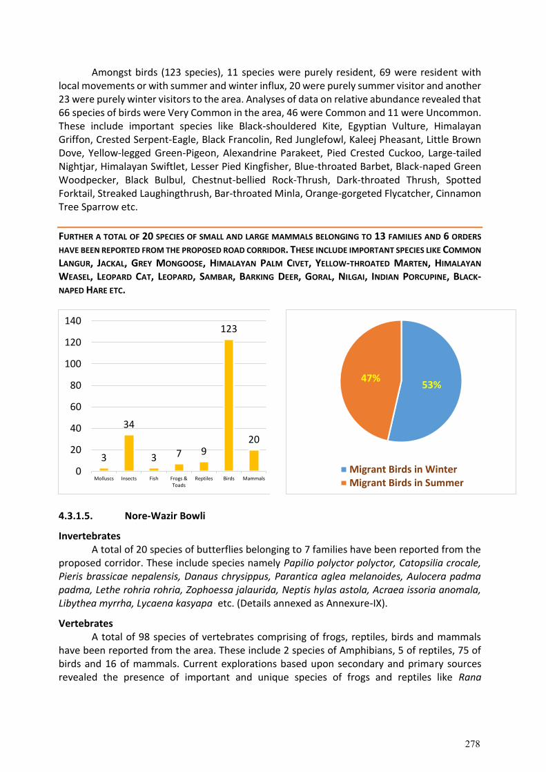
Amongst birds (123 species), 11 species were purely resident, 69 were resident with local movements or with summer and winter influx, 20 were purely summer visitor and another 23 were purely winter visitors to the area. Analyses of data on relative abundance revealed that 66 species of birds were Very Common in the area, 46 were Common and 11 were Uncommon. These include important species like Black-shouldered Kite, Egyptian Vulture, Himalayan Griffon, Crested Serpent-Eagle, Black Francolin, Red Junglefowl, Kaleej Pheasant, Little Brown Dove, Yellow-legged Green-Pigeon, Alexandrine Parakeet, Pied Crested Cuckoo, Large-tailed Nightjar, Himalayan Swiftlet, Lesser Pied Kingfisher, Blue-throated Barbet, Black-naped Green Woodpecker, Black Bulbul, Chestnut-bellied Rock-Thrush, Dark-throated Thrush, Spotted Forktail, Streaked Laughingthrush, Bar-throated Minla, Orange-gorgeted Flycatcher, Cinnamon Tree Sparrow etc.
FURTHER A TOTAL OF 20 SPECIES OF SMALL AND LARGE MAMMALS BELONGING TO 13 FAMILIES AND 6 ORDERS
HAVE BEEN REPORTED FROM THE PROPOSED ROAD CORRIDOR. THESE INCLUDE IMPORTANT SPECIES LIKE COMMON
LANGUR, JACKAL, GREY MONGOOSE, HIMALAYAN PALM CIVET, YELLOW-THROATED MARTEN, HIMALAYAN
WEASEL, LEOPARD CAT, LEOPARD, SAMBAR, BARKING DEER, GORAL, NILGAI, INDIAN PORCUPINE, BLACK-NAPED HARE ETC.
4.3.1.5. Nore-Wazir Bowli
Invertebrates A total of 20 species of butterflies belonging to 7 families have been reported from the
proposed corridor. These include species namely Papilio polyctor polyctor, Catopsilia crocale, Pieris brassicae nepalensis, Danaus chrysippus, Parantica aglea melanoides, Aulocera padma padma, Lethe rohria rohria, Zophoessa jalaurida, Neptis hylas astola, Acraea issoria anomala, Libythea myrrha, Lycaena kasyapa etc. (Details annexed as Annexure-IX).
Vertebrates A total of 98 species of vertebrates comprising of frogs, reptiles, birds and mammals have been reported from the area. These include 2 species of Amphibians, 5 of reptiles, 75 of birds and 16 of mammals. Current explorations based upon secondary and primary sources revealed the presence of important and unique species of frogs and reptiles like Rana
3
34
3 7 9
123
20
0
20
40
60
80
100
120
140
Molluscs Insects Fish Frogs &Toads
Reptiles Birds Mammals
53%47%
Migrant Birds in WinterMigrant Birds in Summer
278
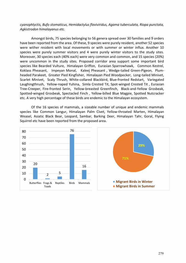
cyanophlyctis, Bufo stomaticus, Hemidactylus flaviviridus, Agama tuberculata, Riopa punctata, Agkistrodon himalayanus etc.
Amongst birds, 75 species belonging to 56 genera spread over 30 families and 9 orders have been reported from the area. Of these, 9 species were purely resident, another 52 species were wither resident with local movements or with summer or winter influx. Another 10 species were purely summer visitors and 4 were purely winter visitors to the study sites. Moreover, 30 species each (40% each) were very common and common, and 15 species (20%) were uncommon in the study sites. Proposed corridor area support some important bird species like Bearded Vulture, Himalayan Griffon, Eurasian Sparrowhawk, Common Kestrel, Koklass Pheasant, Impeyan Monal, Kaleej Pheasant , Wedge-tailed Green-Pigeon, Plum-headed Parakeet, Greater Pied Kingfisher, Himalayan Pied Woodpecker, Long-tailed Minivet, Scarlet Minivet, Scaly Thrush, White-collared Blackbird, Blue-fronted Redstart, Variegated Laughingthrush, Yellow-naped Yuhina, Simla Crested Tit, Spot-winged Crested Tit , Eurasian Tree-Creeper, Fire-fronted Serin, Yellow-breasted Greenfinch, Black-and-Yellow Grosbeak, Spotted-winged Grosbeak, Spectacled Finch , Yellow-billed Blue Magpie, Spotted Nutcracker etc. A very high percentage of these birds are endemic to the Himalayan ecosystem.
Of the 16 species of mammals, a sizeable number of unique and endemic mammals species like Common Langur, Himalayan Palm Civet, Yellow-throated Marten, Himalayan Weasel, Asiatic Black Bear, Leopard, Sambar, Barking Deer, Himalayan Tahr, Goral, Flying Squirrel etc have been reported from the proposed area.
20
2 5
76
16
0
10
20
30
40
50
60
70
80
Butterflies Frogs &Toads
Reptiles Birds Mammals
29%
71%
Migrant Birds in WinterMigrant Birds in Summer
279
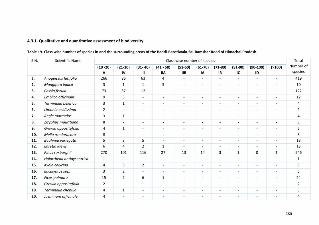
4.3.1. Qualitative and quantitative assessment of biodiversity
Table 19. Class wise number of species in and the surrounding areas of the Baddi-Barotiwala-Sai-Ramshar Road of Himachal Pradesh
S.N. Scientific Name Class wise number of species Total
Number of
species (10 -20)
V
(21-30)
IV
(31- 40)
III
(41 - 50)
IIA
(51-60)
IIB
(61-70)
IA
(71-80)
IB
(81-90)
IC
(90-100)
ID
(>100)
1. Anogeissus latifolia 266 86 63 4 - - - - - - 419
2. Mangifera indica 3 1 1 5 - - - - - - 10
3. Cassia fistula 73 37 12 - - - - - - - 122
4. Emblica officinalis 9 3 - - - - - - - - 12
5. Terminalia belerica 3 1 - - - - - - - - 4
6. Limonia acidissima 2 - - - - - - - - - 2
7. Aegle marmelos 3 1 - - - - - - - - 4
8. Zizyphus mauritiana 8 - - - - - - - - - 8
9. Grewia oppositefolia 4 1 - - - - - - - - 5
10. Melia azedarachta 8 - - - - - - - - - 8
11. Bauhinia variegata 5 3 5 - - - - - - - 13
12. Ehretia laevis 6 4 2 1 - - - - - - 13
13. Pinus roxburghii 270 101 116 27 13 14 3 1 0 1 546
14. Holarrhena antidysentrica 1 - - - - - - - - - 1
15. Kydia calycina 4 3 2 - - - - - - - 9
16. Eucalyptus spp. 3 2 - - - - - - - - 5
17. Ficus palmata 15 2 6 1 - - - - - - 24
18. Grewia oppositefolia 2 - - - - - - - - - 2
19. Terminalia chebula 4 1 - - - - - - - - 5
20. Jasminum officinale 4 - - - - - - - - - 4
280
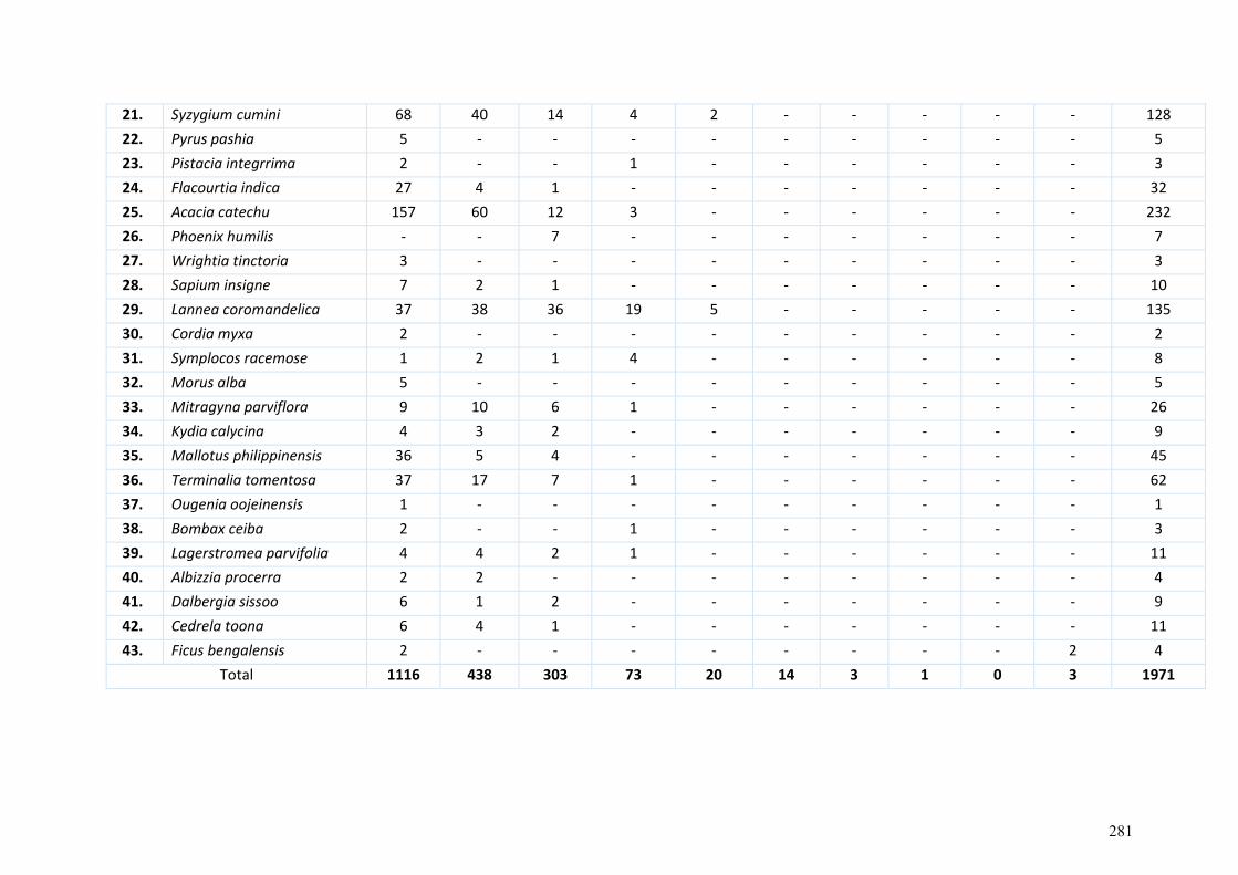
21. Syzygium cumini 68 40 14 4 2 - - - - - 128
22. Pyrus pashia 5 - - - - - - - - - 5
23. Pistacia integrrima 2 - - 1 - - - - - - 3
24. Flacourtia indica 27 4 1 - - - - - - - 32
25. Acacia catechu 157 60 12 3 - - - - - - 232
26. Phoenix humilis - - 7 - - - - - - - 7
27. Wrightia tinctoria 3 - - - - - - - - - 3
28. Sapium insigne 7 2 1 - - - - - - - 10
29. Lannea coromandelica 37 38 36 19 5 - - - - - 135
30. Cordia myxa 2 - - - - - - - - - 2
31. Symplocos racemose 1 2 1 4 - - - - - - 8
32. Morus alba 5 - - - - - - - - - 5
33. Mitragyna parviflora 9 10 6 1 - - - - - - 26
34. Kydia calycina 4 3 2 - - - - - - - 9
35. Mallotus philippinensis 36 5 4 - - - - - - - 45
36. Terminalia tomentosa 37 17 7 1 - - - - - - 62
37. Ougenia oojeinensis 1 - - - - - - - - - 1
38. Bombax ceiba 2 - - 1 - - - - - - 3
39. Lagerstromea parvifolia 4 4 2 1 - - - - - - 11
40. Albizzia procerra 2 2 - - - - - - - - 4
41. Dalbergia sissoo 6 1 2 - - - - - - - 9
42. Cedrela toona 6 4 1 - - - - - - - 11
43. Ficus bengalensis 2 - - - - - - - - 2 4
Total 1116 438 303 73 20 14 3 1 0 3 1971
281
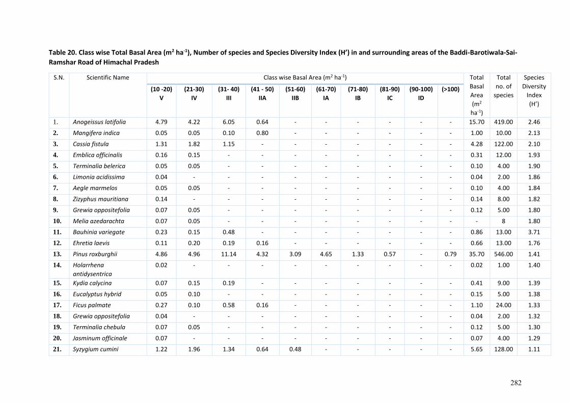
Table 20. Class wise Total Basal Area (m2 ha-1), Number of species and Species Diversity Index (H’) in and surrounding areas of the Baddi-Barotiwala-Sai-
Ramshar Road of Himachal Pradesh
S.N. Scientific Name Class wise Basal Area (m2 ha-1) Total
Basal
Area
(m2
ha-1)
Total
no. of
species
Species
Diversity
Index
(H’)
(10 -20)
V
(21-30)
IV
(31- 40)
III
(41 - 50)
IIA
(51-60)
IIB
(61-70)
IA
(71-80)
IB
(81-90)
IC
(90-100)
ID
(>100)
1. Anogeissus latifolia 4.79 4.22 6.05 0.64 - - - - - - 15.70 419.00 2.46
2. Mangifera indica 0.05 0.05 0.10 0.80 - - - - - - 1.00 10.00 2.13
3. Cassia fistula 1.31 1.82 1.15 - - - - - - - 4.28 122.00 2.10
4. Emblica officinalis 0.16 0.15 - - - - - - - - 0.31 12.00 1.93
5. Terminalia belerica 0.05 0.05 - - - - - - - - 0.10 4.00 1.90
6. Limonia acidissima 0.04 - - - - - - - - - 0.04 2.00 1.86
7. Aegle marmelos 0.05 0.05 - - - - - - - - 0.10 4.00 1.84
8. Zizyphus mauritiana 0.14 - - - - - - - - - 0.14 8.00 1.82
9. Grewia oppositefolia 0.07 0.05 - - - - - - - - 0.12 5.00 1.80
10. Melia azedarachta 0.07 0.05 - - - - - - - - - 8 1.80
11. Bauhinia variegate 0.23 0.15 0.48 - - - - - - - 0.86 13.00 3.71
12. Ehretia laevis 0.11 0.20 0.19 0.16 - - - - - - 0.66 13.00 1.76
13. Pinus roxburghii 4.86 4.96 11.14 4.32 3.09 4.65 1.33 0.57 - 0.79 35.70 546.00 1.41
14. Holarrhena
antidysentrica
0.02 - - - - - - - - - 0.02 1.00 1.40
15. Kydia calycina 0.07 0.15 0.19 - - - - - - - 0.41 9.00 1.39
16. Eucalyptus hybrid 0.05 0.10 - - - - - - - - 0.15 5.00 1.38
17. Ficus palmate 0.27 0.10 0.58 0.16 - - - - - - 1.10 24.00 1.33
18. Grewia oppositefolia 0.04 - - - - - - - - - 0.04 2.00 1.32
19. Terminalia chebula 0.07 0.05 - - - - - - - - 0.12 5.00 1.30
20. Jasminum officinale 0.07 - - - - - - - - - 0.07 4.00 1.29
21. Syzygium cumini 1.22 1.96 1.34 0.64 0.48 - - - - - 5.65 128.00 1.11
282
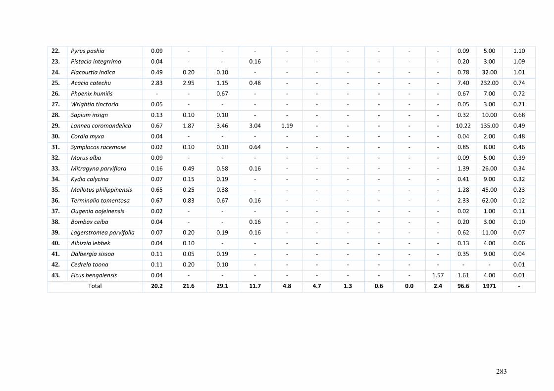
22. Pyrus pashia 0.09 - - - - - - - - - 0.09 5.00 1.10
23. Pistacia integrrima 0.04 - - 0.16 - - - - - - 0.20 3.00 1.09
24. Flacourtia indica 0.49 0.20 0.10 - - - - - - - 0.78 32.00 1.01
25. Acacia catechu 2.83 2.95 1.15 0.48 - - - - - - 7.40 232.00 0.74
26. Phoenix humilis - - 0.67 - - - - - - - 0.67 7.00 0.72
27. Wrightia tinctoria 0.05 - - - - - - - - - 0.05 3.00 0.71
28. Sapium insign 0.13 0.10 0.10 - - - - - - - 0.32 10.00 0.68
29. Lannea coromandelica 0.67 1.87 3.46 3.04 1.19 - - - - - 10.22 135.00 0.49
30. Cordia myxa 0.04 - - - - - - - - - 0.04 2.00 0.48
31. Symplocos racemose 0.02 0.10 0.10 0.64 - - - - - - 0.85 8.00 0.46
32. Morus alba 0.09 - - - - - - - - - 0.09 5.00 0.39
33. Mitragyna parviflora 0.16 0.49 0.58 0.16 - - - - - - 1.39 26.00 0.34
34. Kydia calycina 0.07 0.15 0.19 - - - - - - - 0.41 9.00 0.32
35. Mallotus philippinensis 0.65 0.25 0.38 - - - - - - - 1.28 45.00 0.23
36. Terminalia tomentosa 0.67 0.83 0.67 0.16 - - - - - - 2.33 62.00 0.12
37. Ougenia oojeinensis 0.02 - - - - - - - - - 0.02 1.00 0.11
38. Bombax ceiba 0.04 - - 0.16 - - - - - - 0.20 3.00 0.10
39. Lagerstromea parvifolia 0.07 0.20 0.19 0.16 - - - - - - 0.62 11.00 0.07
40. Albizzia lebbek 0.04 0.10 - - - - - - - - 0.13 4.00 0.06
41. Dalbergia sissoo 0.11 0.05 0.19 - - - - - - - 0.35 9.00 0.04
42. Cedrela toona 0.11 0.20 0.10 - - - - - - - - - 0.01
43. Ficus bengalensis 0.04 - - - - - - - - 1.57 1.61 4.00 0.01
Total 20.2 21.6 29.1 11.7 4.8 4.7 1.3 0.6 0.0 2.4 96.6 1971 -
283
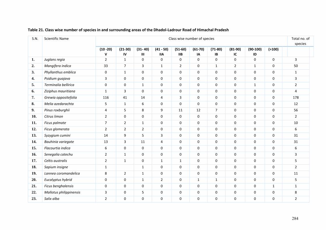
Table 21. Class wise number of species in and surrounding areas of the Dhadol-Ladrour Road of Himachal Pradesh
S.N. Scientific Name Class wise number of species Total no. of
species
(10 -20)
V
(21-30)
IV
(31- 40)
III
(41 - 50)
IIA
(51-60)
IIB
(61-70)
IA
(71-80)
IB
(81-90)
IC
(90-100)
ID
(>100)
1. Juglans regia 2 1 0 0 0 0 0 0 0 0 3
2. Mangifera indica 33 7 3 1 2 0 1 2 1 0 50
3. Phyllanthus emblica 0 1 0 0 0 0 0 0 0 0 1
4. Psidium guajava 3 0 0 0 0 0 0 0 0 0 3
5. Terminalia bellirica 0 0 1 0 0 0 0 0 1 0 2
6. Ziziphus mauritiana 1 3 0 0 0 0 0 0 0 0 4
7. Grewia oppositefolia 116 41 14 4 3 0 0 0 0 0 178
8. Melia azedarachta 5 1 6 0 0 0 0 0 0 0 12
9. Pinus roxburghii 4 5 8 9 11 12 7 0 0 0 56
10. Citrus limon 2 0 0 0 0 0 0 0 0 0 2
11. Ficus palmate 7 2 1 0 0 0 0 0 0 0 10
12. Ficus glomerata 2 2 2 0 0 0 0 0 0 0 6
13. Syzygium cumini 14 9 5 3 0 0 0 0 0 0 31
14. Bauhinia variegate 13 3 11 4 0 0 0 0 0 0 31
15. Flacourtia indica 6 0 0 0 0 0 0 0 0 0 6
16. Senegalia catechu 2 1 0 0 0 0 0 0 0 0 3
17. Celtis australis 2 1 0 1 1 0 0 0 0 0 5
18. Sapium insigne 1
1 0 0 0 0 0 0 0 2
19. Lannea coromandelica 8 2 1 0 0 0 0 0 0 0 11
20. Eucalyptus hybrid 0 0 1 2 0 1 1 0 0 0 5
21. Ficus benghalensis 0 0 0 0 0 0 0 0 0 1 1
22. Mallotus philippinensis 3 0 5 0 0 0 0 0 0 0 8
23. Salix alba 2 0 0 0 0 0 0 0 0 0 2
284
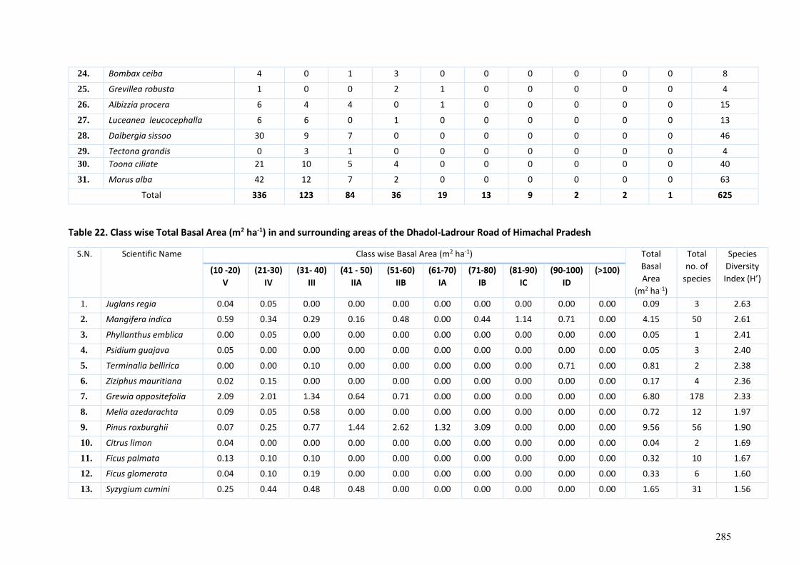
24. Bombax ceiba 4 0 1 3 0 0 0 0 0 0 8
25. Grevillea robusta 1 0 0 2 1 0 0 0 0 0 4
26. Albizzia procera 6 4 4 0 1 0 0 0 0 0 15
27. Luceanea leucocephalla 6 6 0 1 0 0 0 0 0 0 13
28. Dalbergia sissoo 30 9 7 0 0 0 0 0 0 0 46
29. Tectona grandis 0 3 1 0 0 0 0 0 0 0 4
30. Toona ciliate 21 10 5 4 0 0 0 0 0 0 40
31. Morus alba 42 12 7 2 0 0 0 0 0 0 63
Total 336 123 84 36 19 13 9 2 2 1 625
Table 22. Class wise Total Basal Area (m2 ha-1) in and surrounding areas of the Dhadol-Ladrour Road of Himachal Pradesh
S.N. Scientific Name Class wise Basal Area (m2 ha-1) Total
Basal
Area
(m2 ha-1)
Total
no. of
species
Species
Diversity
Index (H’) (10 -20)
V
(21-30)
IV
(31- 40)
III
(41 - 50)
IIA
(51-60)
IIB
(61-70)
IA
(71-80)
IB
(81-90)
IC
(90-100)
ID
(>100)
1. Juglans regia 0.04 0.05 0.00 0.00 0.00 0.00 0.00 0.00 0.00 0.00 0.09 3 2.63
2. Mangifera indica 0.59 0.34 0.29 0.16 0.48 0.00 0.44 1.14 0.71 0.00 4.15 50 2.61
3. Phyllanthus emblica 0.00 0.05 0.00 0.00 0.00 0.00 0.00 0.00 0.00 0.00 0.05 1 2.41
4. Psidium guajava 0.05 0.00 0.00 0.00 0.00 0.00 0.00 0.00 0.00 0.00 0.05 3 2.40
5. Terminalia bellirica 0.00 0.00 0.10 0.00 0.00 0.00 0.00 0.00 0.71 0.00 0.81 2 2.38
6. Ziziphus mauritiana 0.02 0.15 0.00 0.00 0.00 0.00 0.00 0.00 0.00 0.00 0.17 4 2.36
7. Grewia oppositefolia 2.09 2.01 1.34 0.64 0.71 0.00 0.00 0.00 0.00 0.00 6.80 178 2.33
8. Melia azedarachta 0.09 0.05 0.58 0.00 0.00 0.00 0.00 0.00 0.00 0.00 0.72 12 1.97
9. Pinus roxburghii 0.07 0.25 0.77 1.44 2.62 1.32 3.09 0.00 0.00 0.00 9.56 56 1.90
10. Citrus limon 0.04 0.00 0.00 0.00 0.00 0.00 0.00 0.00 0.00 0.00 0.04 2 1.69
11. Ficus palmata 0.13 0.10 0.10 0.00 0.00 0.00 0.00 0.00 0.00 0.00 0.32 10 1.67
12. Ficus glomerata 0.04 0.10 0.19 0.00 0.00 0.00 0.00 0.00 0.00 0.00 0.33 6 1.60
13. Syzygium cumini 0.25 0.44 0.48 0.48 0.00 0.00 0.00 0.00 0.00 0.00 1.65 31 1.56
285
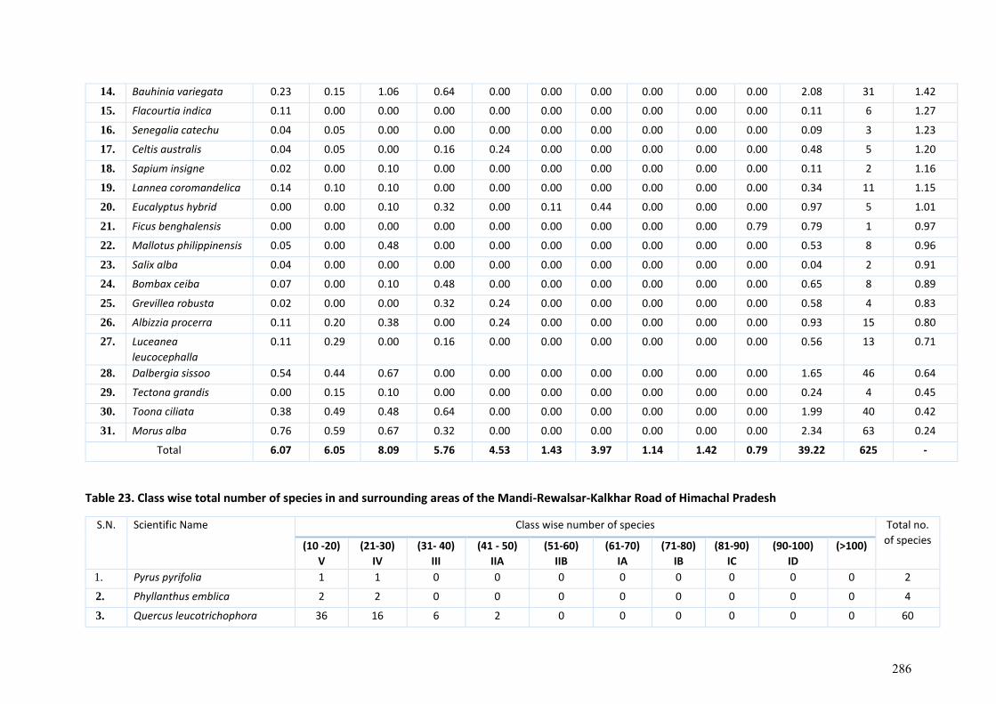
14. Bauhinia variegata 0.23 0.15 1.06 0.64 0.00 0.00 0.00 0.00 0.00 0.00 2.08 31 1.42
15. Flacourtia indica 0.11 0.00 0.00 0.00 0.00 0.00 0.00 0.00 0.00 0.00 0.11 6 1.27
16. Senegalia catechu 0.04 0.05 0.00 0.00 0.00 0.00 0.00 0.00 0.00 0.00 0.09 3 1.23
17. Celtis australis 0.04 0.05 0.00 0.16 0.24 0.00 0.00 0.00 0.00 0.00 0.48 5 1.20
18. Sapium insigne 0.02 0.00 0.10 0.00 0.00 0.00 0.00 0.00 0.00 0.00 0.11 2 1.16
19. Lannea coromandelica 0.14 0.10 0.10 0.00 0.00 0.00 0.00 0.00 0.00 0.00 0.34 11 1.15
20. Eucalyptus hybrid 0.00 0.00 0.10 0.32 0.00 0.11 0.44 0.00 0.00 0.00 0.97 5 1.01
21. Ficus benghalensis 0.00 0.00 0.00 0.00 0.00 0.00 0.00 0.00 0.00 0.79 0.79 1 0.97
22. Mallotus philippinensis 0.05 0.00 0.48 0.00 0.00 0.00 0.00 0.00 0.00 0.00 0.53 8 0.96
23. Salix alba 0.04 0.00 0.00 0.00 0.00 0.00 0.00 0.00 0.00 0.00 0.04 2 0.91
24. Bombax ceiba 0.07 0.00 0.10 0.48 0.00 0.00 0.00 0.00 0.00 0.00 0.65 8 0.89
25. Grevillea robusta 0.02 0.00 0.00 0.32 0.24 0.00 0.00 0.00 0.00 0.00 0.58 4 0.83
26. Albizzia procerra 0.11 0.20 0.38 0.00 0.24 0.00 0.00 0.00 0.00 0.00 0.93 15 0.80
27. Luceanea
leucocephalla
0.11 0.29 0.00 0.16 0.00 0.00 0.00 0.00 0.00 0.00 0.56 13 0.71
28. Dalbergia sissoo 0.54 0.44 0.67 0.00 0.00 0.00 0.00 0.00 0.00 0.00 1.65 46 0.64
29. Tectona grandis 0.00 0.15 0.10 0.00 0.00 0.00 0.00 0.00 0.00 0.00 0.24 4 0.45
30. Toona ciliata 0.38 0.49 0.48 0.64 0.00 0.00 0.00 0.00 0.00 0.00 1.99 40 0.42
31. Morus alba 0.76 0.59 0.67 0.32 0.00 0.00 0.00 0.00 0.00 0.00 2.34 63 0.24
Total 6.07 6.05 8.09 5.76 4.53 1.43 3.97 1.14 1.42 0.79 39.22 625 -
Table 23. Class wise total number of species in and surrounding areas of the Mandi-Rewalsar-Kalkhar Road of Himachal Pradesh
S.N. Scientific Name Class wise number of species Total no.
of species (10 -20)
V
(21-30)
IV
(31- 40)
III
(41 - 50)
IIA
(51-60)
IIB
(61-70)
IA
(71-80)
IB
(81-90)
IC
(90-100)
ID
(>100)
1. Pyrus pyrifolia 1 1 0 0 0 0 0 0 0 0 2
2. Phyllanthus emblica 2 2 0 0 0 0 0 0 0 0 4
3. Quercus leucotrichophora 36 16 6 2 0 0 0 0 0 0 60
286
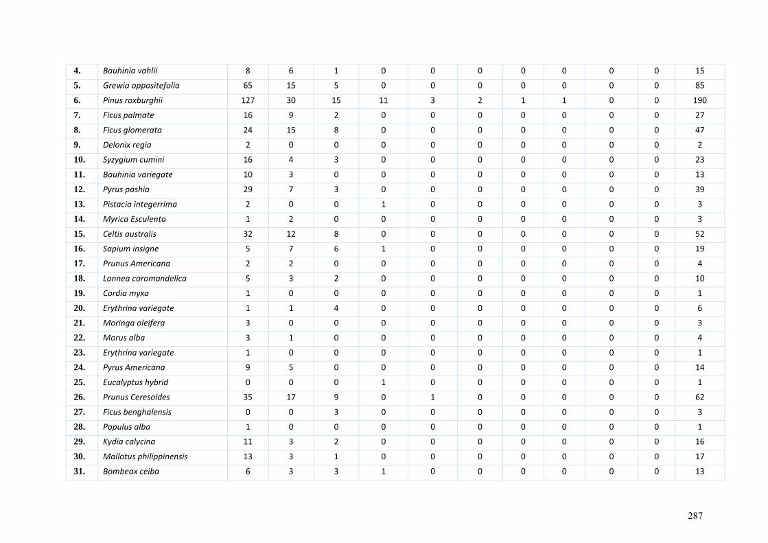
4. Bauhinia vahlii 8 6 1 0 0 0 0 0 0 0 15
5. Grewia oppositefolia 65 15 5 0 0 0 0 0 0 0 85
6. Pinus roxburghii 127 30 15 11 3 2 1 1 0 0 190
7. Ficus palmate 16 9 2 0 0 0 0 0 0 0 27
8. Ficus glomerata 24 15 8 0 0 0 0 0 0 0 47
9. Delonix regia 2 0 0 0 0 0 0 0 0 0 2
10. Syzygium cumini 16 4 3 0 0 0 0 0 0 0 23
11. Bauhinia variegate 10 3 0 0 0 0 0 0 0 0 13
12. Pyrus pashia 29 7 3 0 0 0 0 0 0 0 39
13. Pistacia integerrima 2 0 0 1 0 0 0 0 0 0 3
14. Myrica Esculenta 1 2 0 0 0 0 0 0 0 0 3
15. Celtis australis 32 12 8 0 0 0 0 0 0 0 52
16. Sapium insigne 5 7 6 1 0 0 0 0 0 0 19
17. Prunus Americana 2 2 0 0 0 0 0 0 0 0 4
18. Lannea coromandelica 5 3 2 0 0 0 0 0 0 0 10
19. Cordia myxa 1 0 0 0 0 0 0 0 0 0 1
20. Erythrina variegate 1 1 4 0 0 0 0 0 0 0 6
21. Moringa oleifera 3 0 0 0 0 0 0 0 0 0 3
22. Morus alba 3 1 0 0 0 0 0 0 0 0 4
23. Erythrina variegate 1 0 0 0 0 0 0 0 0 0 1
24. Pyrus Americana 9 5 0 0 0 0 0 0 0 0 14
25. Eucalyptus hybrid 0 0 0 1 0 0 0 0 0 0 1
26. Prunus Ceresoides 35 17 9 0 1 0 0 0 0 0 62
27. Ficus benghalensis 0 0 3 0 0 0 0 0 0 0 3
28. Populus alba 1 0 0 0 0 0 0 0 0 0 1
29. Kydia calycina 11 3 2 0 0 0 0 0 0 0 16
30. Mallotus philippinensis 13 3 1 0 0 0 0 0 0 0 17
31. Bombeax ceiba 6 3 3 1 0 0 0 0 0 0 13
287
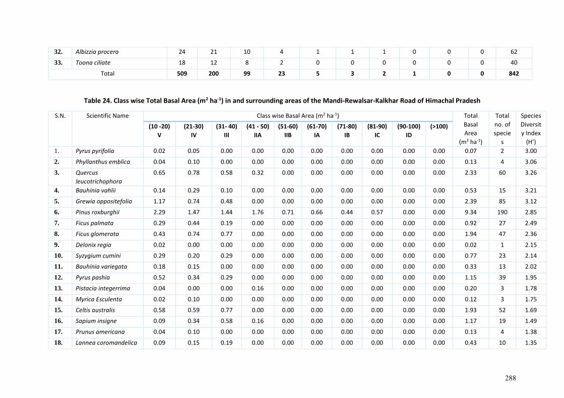
32. Albizzia procera 24 21 10 4 1 1 1 0 0 0 62
33. Toona ciliate 18 12 8 2 0 0 0 0 0 0 40
Total 509 200 99 23 5 3 2 1 0 0 842
Table 24. Class wise Total Basal Area (m2 ha-1) in and surrounding areas of the Mandi-Rewalsar-Kalkhar Road of Himachal Pradesh
S.N. Scientific Name Class wise Basal Area (m2 ha-1) Total
Basal
Area
(m2 ha-1)
Total
no. of
specie
s
Species
Diversit
y Index
(H’)
(10 -20)
V
(21-30)
IV
(31- 40)
III
(41 - 50)
IIA
(51-60)
IIB
(61-70)
IA
(71-80)
IB
(81-90)
IC
(90-100)
ID
(>100)
1. Pyrus pyrifolia 0.02 0.05 0.00 0.00 0.00 0.00 0.00 0.00 0.00 0.00 0.07 2 3.00
2. Phyllanthus emblica 0.04 0.10 0.00 0.00 0.00 0.00 0.00 0.00 0.00 0.00 0.13 4 3.06
3. Quercus
leucotrichophora
0.65 0.78 0.58 0.32 0.00 0.00 0.00 0.00 0.00 0.00 2.33 60 3.26
4. Bauhinia vahlii 0.14 0.29 0.10 0.00 0.00 0.00 0.00 0.00 0.00 0.00 0.53 15 3.21
5. Grewia oppositefolia 1.17 0.74 0.48 0.00 0.00 0.00 0.00 0.00 0.00 0.00 2.39 85 3.12
6. Pinus roxburghii 2.29 1.47 1.44 1.76 0.71 0.66 0.44 0.57 0.00 0.00 9.34 190 2.85
7. Ficus palmata 0.29 0.44 0.19 0.00 0.00 0.00 0.00 0.00 0.00 0.00 0.92 27 2.49
8. Ficus glomerata 0.43 0.74 0.77 0.00 0.00 0.00 0.00 0.00 0.00 0.00 1.94 47 2.36
9. Delonix regia 0.02 0.00 0.00 0.00 0.00 0.00 0.00 0.00 0.00 0.00 0.02 1 2.15
10. Syzygium cumini 0.29 0.20 0.29 0.00 0.00 0.00 0.00 0.00 0.00 0.00 0.77 23 2.14
11. Bauhinia variegata 0.18 0.15 0.00 0.00 0.00 0.00 0.00 0.00 0.00 0.00 0.33 13 2.02
12. Pyrus pashia 0.52 0.34 0.29 0.00 0.00 0.00 0.00 0.00 0.00 0.00 1.15 39 1.95
13. Pistacia integerrima 0.04 0.00 0.00 0.16 0.00 0.00 0.00 0.00 0.00 0.00 0.20 3 1.78
14. Myrica Esculenta 0.02 0.10 0.00 0.00 0.00 0.00 0.00 0.00 0.00 0.00 0.12 3 1.75
15. Celtis australis 0.58 0.59 0.77 0.00 0.00 0.00 0.00 0.00 0.00 0.00 1.93 52 1.69
16. Sapium insigne 0.09 0.34 0.58 0.16 0.00 0.00 0.00 0.00 0.00 0.00 1.17 19 1.49
17. Prunus americana 0.04 0.10 0.00 0.00 0.00 0.00 0.00 0.00 0.00 0.00 0.13 4 1.38
18. Lannea coromandelica 0.09 0.15 0.19 0.00 0.00 0.00 0.00 0.00 0.00 0.00 0.43 10 1.35
288
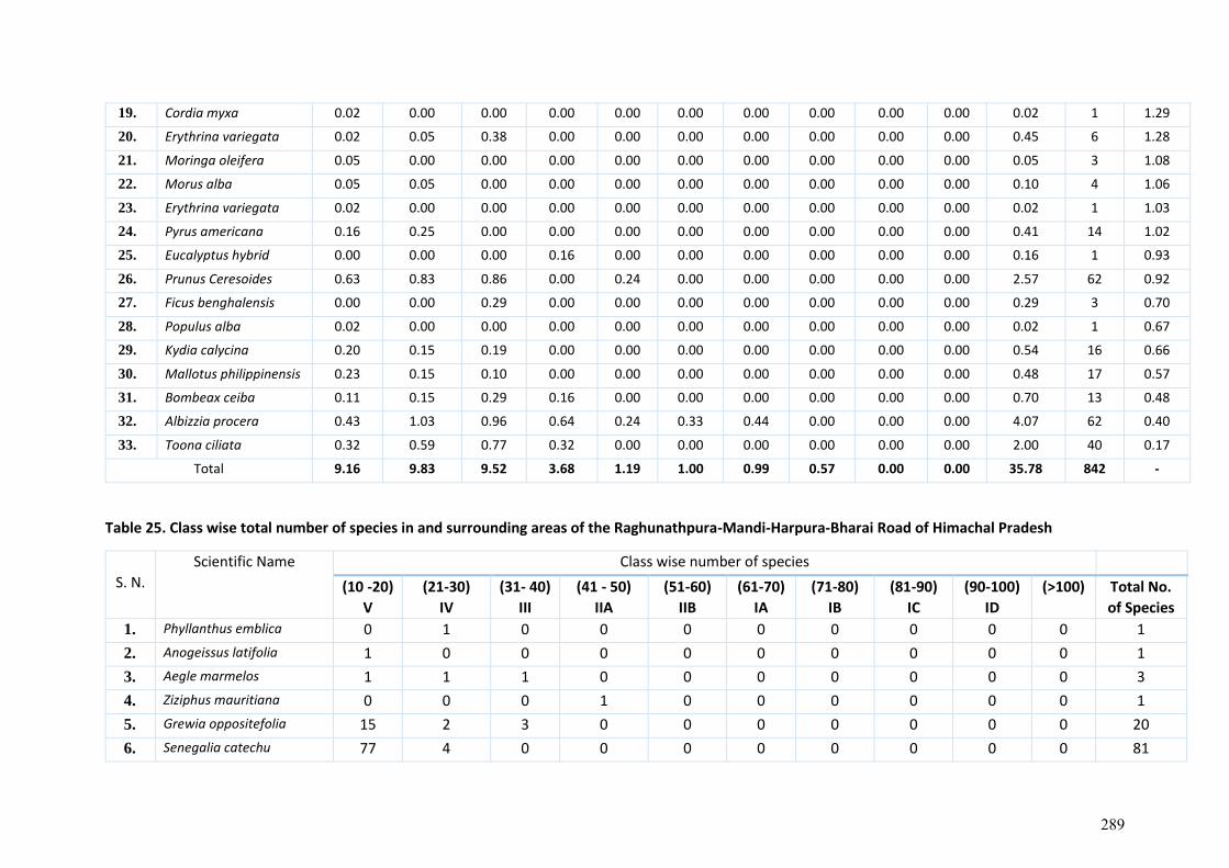
19. Cordia myxa 0.02 0.00 0.00 0.00 0.00 0.00 0.00 0.00 0.00 0.00 0.02 1 1.29
20. Erythrina variegata 0.02 0.05 0.38 0.00 0.00 0.00 0.00 0.00 0.00 0.00 0.45 6 1.28
21. Moringa oleifera 0.05 0.00 0.00 0.00 0.00 0.00 0.00 0.00 0.00 0.00 0.05 3 1.08
22. Morus alba 0.05 0.05 0.00 0.00 0.00 0.00 0.00 0.00 0.00 0.00 0.10 4 1.06
23. Erythrina variegata 0.02 0.00 0.00 0.00 0.00 0.00 0.00 0.00 0.00 0.00 0.02 1 1.03
24. Pyrus americana 0.16 0.25 0.00 0.00 0.00 0.00 0.00 0.00 0.00 0.00 0.41 14 1.02
25. Eucalyptus hybrid 0.00 0.00 0.00 0.16 0.00 0.00 0.00 0.00 0.00 0.00 0.16 1 0.93
26. Prunus Ceresoides 0.63 0.83 0.86 0.00 0.24 0.00 0.00 0.00 0.00 0.00 2.57 62 0.92
27. Ficus benghalensis 0.00 0.00 0.29 0.00 0.00 0.00 0.00 0.00 0.00 0.00 0.29 3 0.70
28. Populus alba 0.02 0.00 0.00 0.00 0.00 0.00 0.00 0.00 0.00 0.00 0.02 1 0.67
29. Kydia calycina 0.20 0.15 0.19 0.00 0.00 0.00 0.00 0.00 0.00 0.00 0.54 16 0.66
30. Mallotus philippinensis 0.23 0.15 0.10 0.00 0.00 0.00 0.00 0.00 0.00 0.00 0.48 17 0.57
31. Bombeax ceiba 0.11 0.15 0.29 0.16 0.00 0.00 0.00 0.00 0.00 0.00 0.70 13 0.48
32. Albizzia procera 0.43 1.03 0.96 0.64 0.24 0.33 0.44 0.00 0.00 0.00 4.07 62 0.40
33. Toona ciliata 0.32 0.59 0.77 0.32 0.00 0.00 0.00 0.00 0.00 0.00 2.00 40 0.17
Total 9.16 9.83 9.52 3.68 1.19 1.00 0.99 0.57 0.00 0.00 35.78 842 -
Table 25. Class wise total number of species in and surrounding areas of the Raghunathpura-Mandi-Harpura-Bharai Road of Himachal Pradesh
S. N.
Scientific Name Class wise number of species
(10 -20) V
(21-30)
IV
(31- 40)
III
(41 - 50)
IIA
(51-60)
IIB
(61-70)
IA
(71-80)
IB
(81-90)
IC
(90-100)
ID
(>100) Total No.
of Species
1. Phyllanthus emblica 0 1 0 0 0 0 0 0 0 0 1
2. Anogeissus latifolia 1 0 0 0 0 0 0 0 0 0 1
3. Aegle marmelos 1 1 1 0 0 0 0 0 0 0 3
4. Ziziphus mauritiana 0 0 0 1 0 0 0 0 0 0 1
5. Grewia oppositefolia 15 2 3 0 0 0 0 0 0 0 20
6. Senegalia catechu 77 4 0 0 0 0 0 0 0 0 81
289
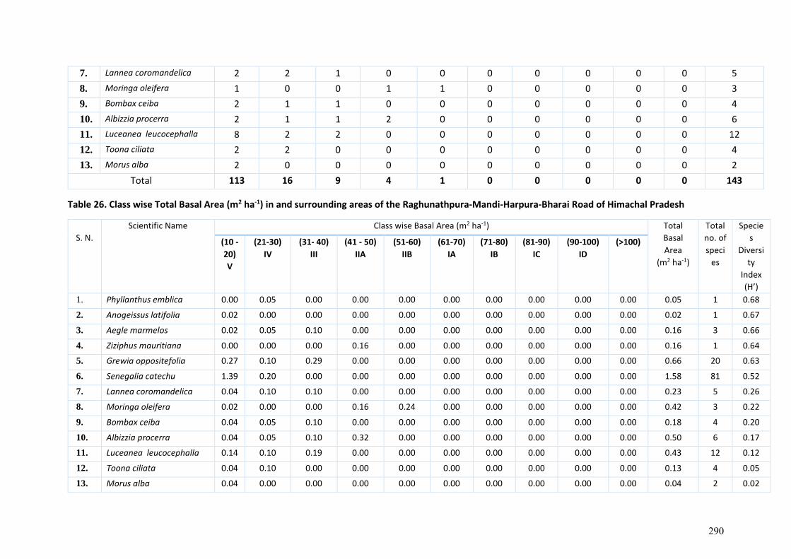
7. Lannea coromandelica 2 2 1 0 0 0 0 0 0 0 5
8. Moringa oleifera 1 0 0 1 1 0 0 0 0 0 3
9. Bombax ceiba 2 1 1 0 0 0 0 0 0 0 4
10. Albizzia procerra 2 1 1 2 0 0 0 0 0 0 6
11. Luceanea leucocephalla 8 2 2 0 0 0 0 0 0 0 12
12. Toona ciliata 2 2 0 0 0 0 0 0 0 0 4
13. Morus alba 2 0 0 0 0 0 0 0 0 0 2
Total 113 16 9 4 1 0 0 0 0 0 143
Table 26. Class wise Total Basal Area (m2 ha-1) in and surrounding areas of the Raghunathpura-Mandi-Harpura-Bharai Road of Himachal Pradesh
S. N.
Scientific Name Class wise Basal Area (m2 ha-1) Total
Basal
Area
(m2 ha-1)
Total
no. of
speci
es
Specie
s
Diversi
ty
Index
(H’)
(10 -
20)
V
(21-30)
IV
(31- 40)
III
(41 - 50)
IIA
(51-60)
IIB
(61-70)
IA
(71-80)
IB
(81-90)
IC
(90-100)
ID
(>100)
1. Phyllanthus emblica 0.00 0.05 0.00 0.00 0.00 0.00 0.00 0.00 0.00 0.00 0.05 1 0.68
2. Anogeissus latifolia 0.02 0.00 0.00 0.00 0.00 0.00 0.00 0.00 0.00 0.00 0.02 1 0.67
3. Aegle marmelos 0.02 0.05 0.10 0.00 0.00 0.00 0.00 0.00 0.00 0.00 0.16 3 0.66
4. Ziziphus mauritiana 0.00 0.00 0.00 0.16 0.00 0.00 0.00 0.00 0.00 0.00 0.16 1 0.64
5. Grewia oppositefolia 0.27 0.10 0.29 0.00 0.00 0.00 0.00 0.00 0.00 0.00 0.66 20 0.63
6. Senegalia catechu 1.39 0.20 0.00 0.00 0.00 0.00 0.00 0.00 0.00 0.00 1.58 81 0.52
7. Lannea coromandelica 0.04 0.10 0.10 0.00 0.00 0.00 0.00 0.00 0.00 0.00 0.23 5 0.26
8. Moringa oleifera 0.02 0.00 0.00 0.16 0.24 0.00 0.00 0.00 0.00 0.00 0.42 3 0.22
9. Bombax ceiba 0.04 0.05 0.10 0.00 0.00 0.00 0.00 0.00 0.00 0.00 0.18 4 0.20
10. Albizzia procerra 0.04 0.05 0.10 0.32 0.00 0.00 0.00 0.00 0.00 0.00 0.50 6 0.17
11. Luceanea leucocephalla 0.14 0.10 0.19 0.00 0.00 0.00 0.00 0.00 0.00 0.00 0.43 12 0.12
12. Toona ciliata 0.04 0.10 0.00 0.00 0.00 0.00 0.00 0.00 0.00 0.00 0.13 4 0.05
13. Morus alba 0.04 0.00 0.00 0.00 0.00 0.00 0.00 0.00 0.00 0.00 0.04 2 0.02
290
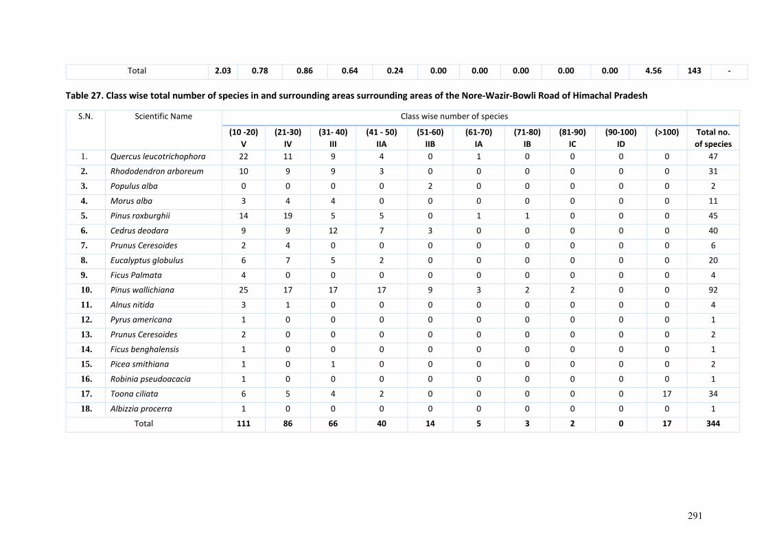
Total 2.03 0.78 0.86 0.64 0.24 0.00 0.00 0.00 0.00 0.00 4.56 143 -
Table 27. Class wise total number of species in and surrounding areas surrounding areas of the Nore-Wazir-Bowli Road of Himachal Pradesh
S.N. Scientific Name Class wise number of species
(10 -20)
V
(21-30)
IV
(31- 40)
III
(41 - 50)
IIA
(51-60)
IIB
(61-70)
IA
(71-80)
IB
(81-90)
IC
(90-100)
ID
(>100) Total no.
of species
1. Quercus leucotrichophora 22 11 9 4 0 1 0 0 0 0 47
2. Rhododendron arboreum 10 9 9 3 0 0 0 0 0 0 31
3. Populus alba 0 0 0 0 2 0 0 0 0 0 2
4. Morus alba 3 4 4 0 0 0 0 0 0 0 11
5. Pinus roxburghii 14 19 5 5 0 1 1 0 0 0 45
6. Cedrus deodara 9 9 12 7 3 0 0 0 0 0 40
7. Prunus Ceresoides 2 4 0 0 0 0 0 0 0 0 6
8. Eucalyptus globulus 6 7 5 2 0 0 0 0 0 0 20
9. Ficus Palmata 4 0 0 0 0 0 0 0 0 0 4
10. Pinus wallichiana 25 17 17 17 9 3 2 2 0 0 92
11. Alnus nitida 3 1 0 0 0 0 0 0 0 0 4
12. Pyrus americana 1 0 0 0 0 0 0 0 0 0 1
13. Prunus Ceresoides 2 0 0 0 0 0 0 0 0 0 2
14. Ficus benghalensis 1 0 0 0 0 0 0 0 0 0 1
15. Picea smithiana 1 0 1 0 0 0 0 0 0 0 2
16. Robinia pseudoacacia 1 0 0 0 0 0 0 0 0 0 1
17. Toona ciliata 6 5 4 2 0 0 0 0 0 17 34
18. Albizzia procerra 1 0 0 0 0 0 0 0 0 0 1
Total 111 86 66 40 14 5 3 2 0 17 344
291

Table 28. Class wise Total Basal Area (m2 ha-1) in and surrounding areas of the Nore-Wazir-Bowli Road of Himachal Pradesh
S.N. Scientific Name Class wise Basal Area (m2 ha-1) Total
Basal
Area
(m2 ha-1)
Total
no. of
species
Species
Diversity
Index (H’) (10 -20)
V
(21-30)
IV
(31- 40)
III
(41 - 50)
IIA
(51-60)
IIB
(61-70)
IA
(71-80)
IB
(81-90)
IC
(90-
100)
ID
(>100)
1. Quercus
leucotrichophora
0.40 0.54 0.86 0.64 0.00 0.33 0.00 0.00 0.00 0.00 2.77 47 1.68
2. Rhododendron
arboreum
0.18 0.44 0.86 0.48 0.00 0.00 0.00 0.00 0.00 0.00 1.97 31 1.49
3. Populus alba 0.00 0.00 0.00 0.00 0.48 0.00 0.00 0.00 0.00 0.00 0.48 2 1.34
4. Morus alba 0.05 0.20 0.38 0.00 0.00 0.00 0.00 0.00 0.00 0.00 0.63 11 1.33
5. Pinus roxburghii 0.25 0.93 0.48 0.80 0.00 0.33 0.44 0.00 0.00 0.00 3.24 45 1.26
6. Cedrus deodara 0.16 0.44 1.15 1.12 0.71 0.00 0.00 0.00 0.00 0.00 3.59 40 0.96
7. Lyonea ovalifolia 0.04 0.20 0.00 0.00 0.00 0.00 0.00 0.00 0.00 0.00 0.23 6 0.79
8. Eucalyptus
globulus
0.11 0.34 0.48 0.32 0.00 0.00 0.00 0.00 0.00 0.00 1.25 20 0.75
9. Ficus Pdmata 0.07 0.00 0.00 0.00 0.00 0.00 0.00 0.00 0.00 0.00 0.07 4 0.64
10. Pinus wallichiana 0.45 0.83 1.63 2.72 2.14 1.00 0.88 1.14 0.00 0.00 10.79 92 0.61
11. Alnus nitida 0.05 0.05 0.00 0.00 0.00 0.00 0.00 0.00 0.00 0.00 0.10 4 0.33
12. Pyrus sp. 0.02 0.00 0.00 0.00 0.00 0.00 0.00 0.00 0.00 0.00 0.02 1 0.24
13. Prunus Ceresoides 0.04 0.00 0.00 0.00 0.00 0.00 0.00 0.00 0.00 0.00 0.04 2 0.23
14. Ficus benghalensis 0.02 0.00 0.00 0.00 0.00 0.00 0.00 0.00 0.00 0.00 0.02 1 0.21
15. Picea smithiana 0.02 0.00 0.10 0.00 0.00 0.00 0.00 0.00 0.00 0.00 0.11 2 0.20
16. Robinia
pseudoacacia
0.02 0.00 0.00 0.00 0.00 0.00 0.00 0.00 0.00 0.00 0.02 1 0.18
17. Toona ciliata 0.11 0.25 0.38 0.32 0.00 0.00 0.00 0.00 0.00 13.36 14.42 34 0.16
18. Albizzia procerra 0.02 0.00 0.00 0.00 0.00 0.00 0.00 0.00 0.00 0.00 0.02 1 0.01
Total 2.01 4.22 6.32 6.40 3.33 1.66 1.32 1.14 0.00 13.36 39.77 344 -
292
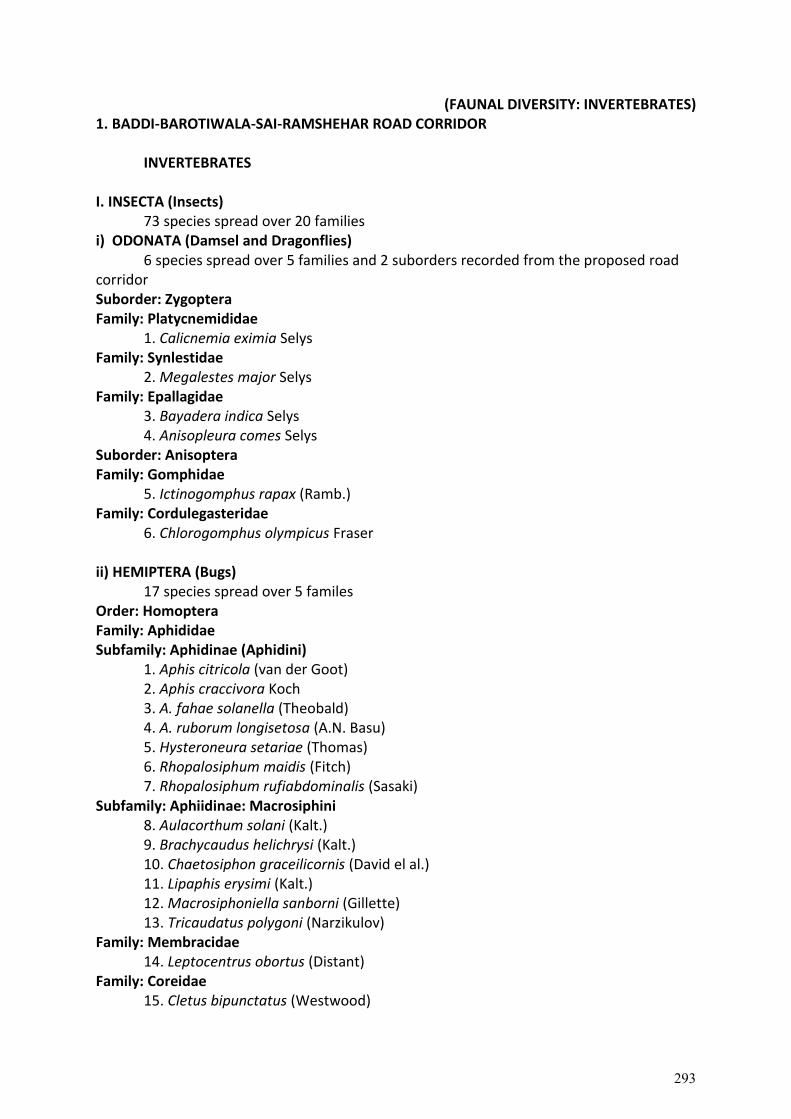
(FAUNAL DIVERSITY: INVERTEBRATES) 1. BADDI-BAROTIWALA-SAI-RAMSHEHAR ROAD CORRIDOR
INVERTEBRATES I. INSECTA (Insects)
73 species spread over 20 families i) ODONATA (Damsel and Dragonflies)
6 species spread over 5 families and 2 suborders recorded from the proposed road corridor Suborder: Zygoptera Family: Platycnemididae
1. Calicnemia eximia Selys Family: Synlestidae
2. Megalestes major Selys Family: Epallagidae
3. Bayadera indica Selys 4. Anisopleura comes Selys
Suborder: Anisoptera Family: Gomphidae
5. Ictinogomphus rapax (Ramb.) Family: Cordulegasteridae
6. Chlorogomphus olympicus Fraser ii) HEMIPTERA (Bugs)
17 species spread over 5 familes Order: Homoptera Family: Aphididae Subfamily: Aphidinae (Aphidini)
1. Aphis citricola (van der Goot) 2. Aphis craccivora Koch 3. A. fahae solanella (Theobald) 4. A. ruborum longisetosa (A.N. Basu) 5. Hysteroneura setariae (Thomas) 6. Rhopalosiphum maidis (Fitch) 7. Rhopalosiphum rufiabdominalis (Sasaki)
Subfamily: Aphiidinae: Macrosiphini 8. Aulacorthum solani (Kalt.) 9. Brachycaudus helichrysi (Kalt.) 10. Chaetosiphon graceilicornis (David el al.) 11. Lipaphis erysimi (Kalt.) 12. Macrosiphoniella sanborni (Gillette) 13. Tricaudatus polygoni (Narzikulov)
Family: Membracidae 14. Leptocentrus obortus (Distant)
Family: Coreidae 15. Cletus bipunctatus (Westwood)
293
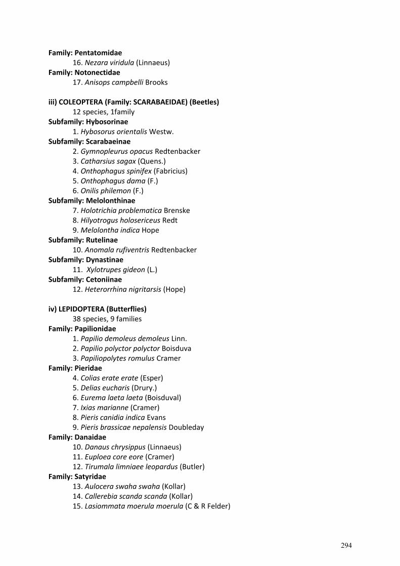
Family: Pentatomidae 16. Nezara viridula (Linnaeus)
Family: Notonectidae 17. Anisops campbelli Brooks
iii) COLEOPTERA (Family: SCARABAEIDAE) (Beetles)
12 species, 1family Subfamily: Hybosorinae
1. Hybosorus orientalis Westw. Subfamily: Scarabaeinae
2. Gymnopleurus opacus Redtenbacker 3. Catharsius sagax (Quens.) 4. Onthophagus spinifex (Fabricius) 5. Onthophagus dama (F.) 6. Onilis philemon (F.)
Subfamily: Melolonthinae 7. Holotrichia problematica Brenske 8. Hilyotrogus holosericeus Redt 9. Melolontha indica Hope
Subfamily: Rutelinae 10. Anomala rufiventris Redtenbacker
Subfamily: Dynastinae 11. Xylotrupes gideon (L.)
Subfamily: Cetoniinae 12. Heterorrhina nigritarsis (Hope)
iv) LEPIDOPTERA (Butterflies)
38 species, 9 families Family: Papilionidae
1. Papilio demoleus demoleus Linn. 2. Papilio polyctor polyctor Boisduva 3. Papiliopolytes romulus Cramer
Family: Pieridae 4. Colias erate erate (Esper) 5. Delias eucharis (Drury.) 6. Eurema laeta laeta (Boisduval) 7. Ixias marianne (Cramer) 8. Pieris canidia indica Evans 9. Pieris brassicae nepalensis Doubleday
Family: Danaidae 10. Danaus chrysippus (Linnaeus) 11. Euploea core eore (Cramer) 12. Tirumala limniaee leopardus (Butler)
Family: Satyridae 13. Aulocera swaha swaha (Kollar) 14. Callerebia scanda scanda (Kollar) 15. Lasiommata moerula moerula (C & R Felder)
294
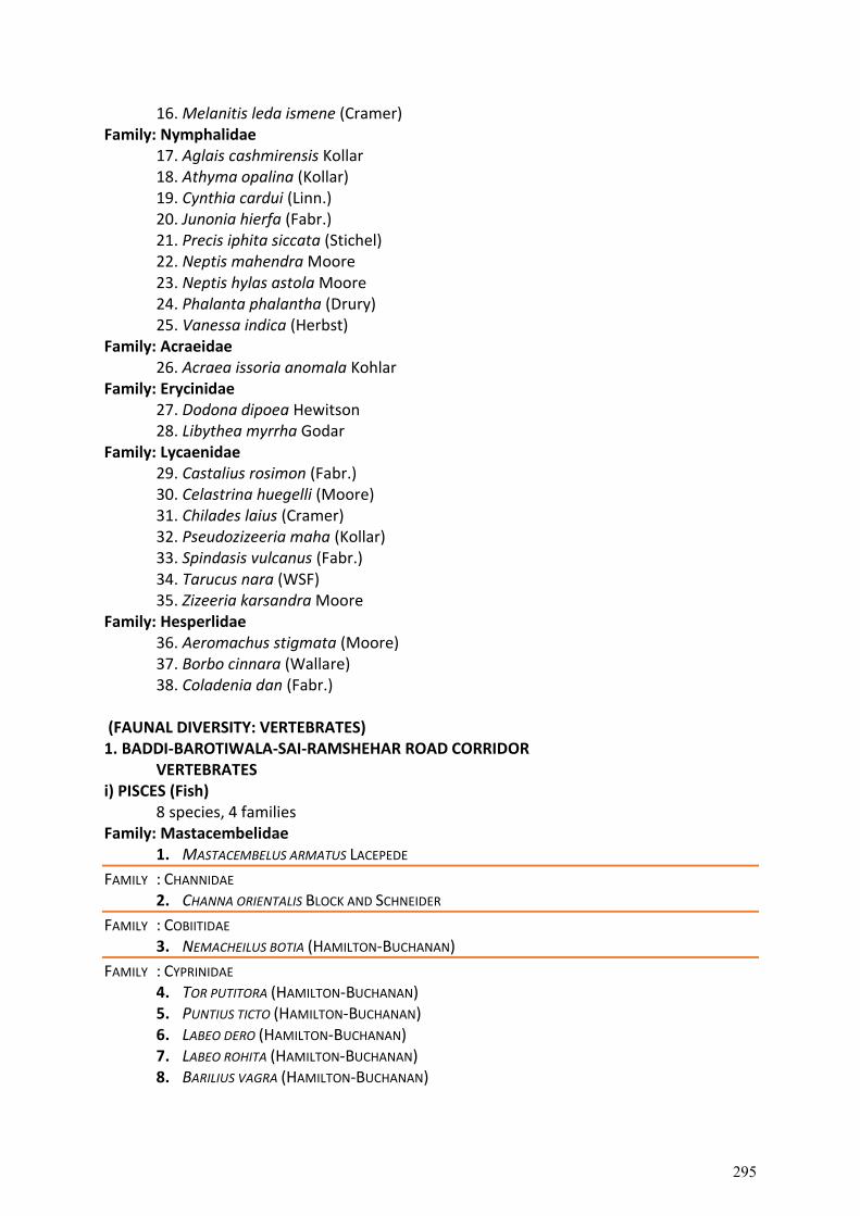
16. Melanitis leda ismene (Cramer) Family: Nymphalidae
17. Aglais cashmirensis Kollar 18. Athyma opalina (Kollar) 19. Cynthia cardui (Linn.) 20. Junonia hierfa (Fabr.) 21. Precis iphita siccata (Stichel) 22. Neptis mahendra Moore 23. Neptis hylas astola Moore 24. Phalanta phalantha (Drury) 25. Vanessa indica (Herbst)
Family: Acraeidae 26. Acraea issoria anomala Kohlar
Family: Erycinidae 27. Dodona dipoea Hewitson 28. Libythea myrrha Godar
Family: Lycaenidae 29. Castalius rosimon (Fabr.) 30. Celastrina huegelli (Moore) 31. Chilades laius (Cramer) 32. Pseudozizeeria maha (Kollar) 33. Spindasis vulcanus (Fabr.) 34. Tarucus nara (WSF) 35. Zizeeria karsandra Moore
Family: Hesperlidae 36. Aeromachus stigmata (Moore) 37. Borbo cinnara (Wallare) 38. Coladenia dan (Fabr.)
(FAUNAL DIVERSITY: VERTEBRATES) 1. BADDI-BAROTIWALA-SAI-RAMSHEHAR ROAD CORRIDOR
VERTEBRATES i) PISCES (Fish)
8 species, 4 families Family: Mastacembelidae
1. MASTACEMBELUS ARMATUS LACEPEDE
FAMILY : CHANNIDAE 2. CHANNA ORIENTALIS BLOCK AND SCHNEIDER
FAMILY : COBIITIDAE 3. NEMACHEILUS BOTIA (HAMILTON-BUCHANAN)
FAMILY : CYPRINIDAE 4. TOR PUTITORA (HAMILTON-BUCHANAN) 5. PUNTIUS TICTO (HAMILTON-BUCHANAN) 6. LABEO DERO (HAMILTON-BUCHANAN) 7. LABEO ROHITA (HAMILTON-BUCHANAN) 8. BARILIUS VAGRA (HAMILTON-BUCHANAN)
295
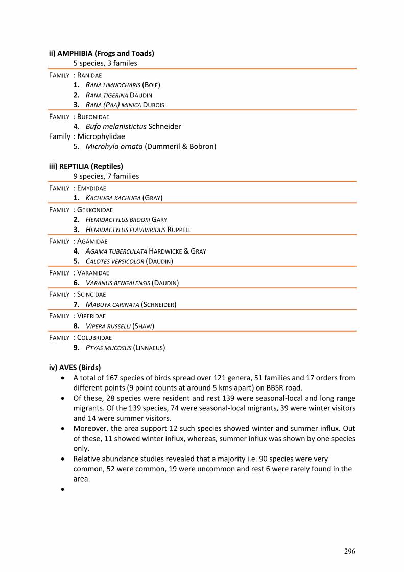
ii) AMPHIBIA (Frogs and Toads) 5 species, 3 familes
FAMILY : RANIDAE 1. RANA LIMNOCHARIS (BOIE) 2. RANA TIGERINA DAUDIN 3. RANA (PAA) MINICA DUBOIS
FAMILY : BUFONIDAE 4. Bufo melanistictus Schneider
Family : Microphylidae 5. Microhyla ornata (Dummeril & Bobron)
iii) REPTILIA (Reptiles)
9 species, 7 families
FAMILY : EMYDIDAE 1. KACHUGA KACHUGA (GRAY)
FAMILY : GEKKONIDAE 2. HEMIDACTYLUS BROOKI GARY 3. HEMIDACTYLUS FLAVIVIRIDUS RUPPELL
FAMILY : AGAMIDAE 4. AGAMA TUBERCULATA HARDWICKE & GRAY 5. CALOTES VERSICOLOR (DAUDIN)
FAMILY : VARANIDAE 6. VARANUS BENGALENSIS (DAUDIN)
FAMILY : SCINCIDAE 7. MABUYA CARINATA (SCHNEIDER)
FAMILY : VIPERIDAE 8. VIPERA RUSSELLI (SHAW)
FAMILY : COLUBRIDAE 9. PTYAS MUCOSUS (LINNAEUS)
iv) AVES (Birds)
A total of 167 species of birds spread over 121 genera, 51 families and 17 orders from different points (9 point counts at around 5 kms apart) on BBSR road.
Of these, 28 species were resident and rest 139 were seasonal-local and long range migrants. Of the 139 species, 74 were seasonal-local migrants, 39 were winter visitors and 14 were summer visitors.
Moreover, the area support 12 such species showed winter and summer influx. Out of these, 11 showed winter influx, whereas, summer influx was shown by one species only.
Relative abundance studies revealed that a majority i.e. 90 species were very common, 52 were common, 19 were uncommon and rest 6 were rarely found in the area.
296

S.No. Taxon Res. St. Rel. Abd.
Order: Podicipediformes
Family: Podicipedidae
1 Little Grebe Tachybaptus ruficollis (Pallas, 1764) R/LM VC
Order: Pelecaniformes
Family: Phalacrocoracidae
2 Little Cormorant Phalacrocorax niger (Vieillot, 1817) R/LM C
Family: Anhingidae
3 Darter Anhinga melanogaster Pennant, 1769 (NT) R/LM Ra
Order: Ciconiiformes
Family: Ardidae
4 Little Egret Egretta garzetta (Linnaeus, 1766) R/LM VC
5 Grey Heron Ardea cinerea Linnaeus, 1758 WV C
6 Purple Heron Ardea purpurea Linnaeus, 1766 R/LM UC
7 Cattle Egret Bubulcus ibis (Linnaeus, 1758) R C
8 Indian Pond-Heron Ardeola grayii (Sykes, 1832) R/LM VC
9 Black-crowned Night-Heron Nycticorax nycticorax (Linnaeus, 1758) R/LM UC
Order: Anseriformes
Family: Anatidae
10 Brahminy Shelduck Tadorna ferruginea (Pallas, 1764) WV UC
11 Gadwall Anas strepera Linnaeus, 1758 WV UC
12 Eurasian Wigeon Anas penelope Linnaeus, 1758 WV UC
13 Spot-billed Duck Anas poecilorhyncha J.R. Forester, 1781 R/LM C
14 Northern Pintail Anas acuta Linnaeus, 1758 WV UC
15 Common Teal Anas crecca Linnaeus, 1758 WV UC
16 Common Pochard Aythya ferina (Linnaeus, 1758) WV UC
17 Tufted Pochard Aythya fuligula (Linnaeus, 1758) WV UC
Order: Falconiformes
Family: Accipitridae
18 Black-shouldered Kite Elanus caeruleus (Desfontaines, 1789) R/LM VC
19 Black Kite Milvus migrans (Boddaert, 1783) R VC
20 Egyptian Vulture Neophron percnopterus (Linnaeus, 1758) (EN) R/LM VC
21 White-rumped Vulture Gyps bengalensis (Gmelin, 1788) (CR) R Ra
22 Himalayan Griffon Gyps himalayensis Hume, 1869 (NT) WV UC
23 Cinereous Vulture Aegypius monachus (Linnaeus, 1766) (NT) WV Ra
24 Red-headed Vulture Sarcogyps calvus (Scopoli, 1786) (CR) R C
25 Short-toed Snake-Eagle Circaetus gallicus (Gmelin, 1788) R Ra
26 Crested Serpent-Eagle Spilornis cheela (Latham, 1790 R/LM C
297
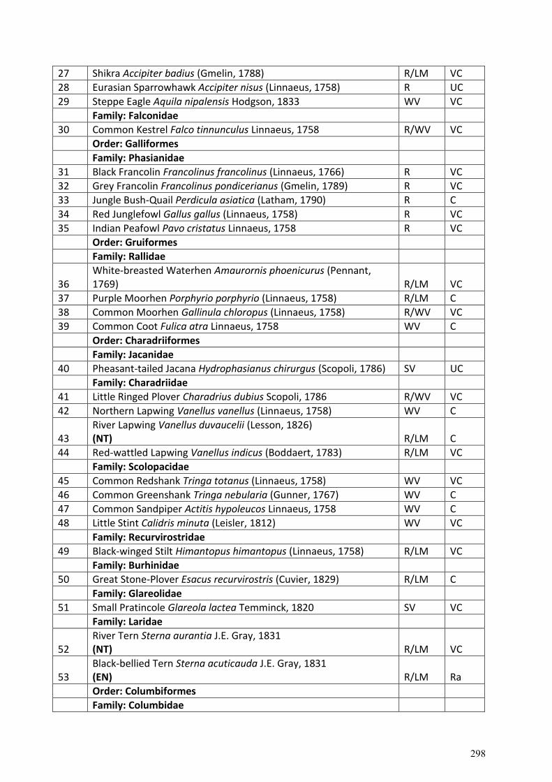
27 Shikra Accipiter badius (Gmelin, 1788) R/LM VC
28 Eurasian Sparrowhawk Accipiter nisus (Linnaeus, 1758) R UC
29 Steppe Eagle Aquila nipalensis Hodgson, 1833 WV VC
Family: Falconidae
30 Common Kestrel Falco tinnunculus Linnaeus, 1758 R/WV VC
Order: Galliformes
Family: Phasianidae
31 Black Francolin Francolinus francolinus (Linnaeus, 1766) R VC
32 Grey Francolin Francolinus pondicerianus (Gmelin, 1789) R VC
33 Jungle Bush-Quail Perdicula asiatica (Latham, 1790) R C
34 Red Junglefowl Gallus gallus (Linnaeus, 1758) R VC
35 Indian Peafowl Pavo cristatus Linnaeus, 1758 R VC
Order: Gruiformes
Family: Rallidae
36 White-breasted Waterhen Amaurornis phoenicurus (Pennant, 1769) R/LM VC
37 Purple Moorhen Porphyrio porphyrio (Linnaeus, 1758) R/LM C
38 Common Moorhen Gallinula chloropus (Linnaeus, 1758) R/WV VC
39 Common Coot Fulica atra Linnaeus, 1758 WV C
Order: Charadriiformes
Family: Jacanidae
40 Pheasant-tailed Jacana Hydrophasianus chirurgus (Scopoli, 1786) SV UC
Family: Charadriidae
41 Little Ringed Plover Charadrius dubius Scopoli, 1786 R/WV VC
42 Northern Lapwing Vanellus vanellus (Linnaeus, 1758) WV C
43 River Lapwing Vanellus duvaucelii (Lesson, 1826) (NT) R/LM C
44 Red-wattled Lapwing Vanellus indicus (Boddaert, 1783) R/LM VC
Family: Scolopacidae
45 Common Redshank Tringa totanus (Linnaeus, 1758) WV VC
46 Common Greenshank Tringa nebularia (Gunner, 1767) WV C
47 Common Sandpiper Actitis hypoleucos Linnaeus, 1758 WV C
48 Little Stint Calidris minuta (Leisler, 1812) WV VC
Family: Recurvirostridae
49 Black-winged Stilt Himantopus himantopus (Linnaeus, 1758) R/LM VC
Family: Burhinidae
50 Great Stone-Plover Esacus recurvirostris (Cuvier, 1829) R/LM C
Family: Glareolidae
51 Small Pratincole Glareola lactea Temminck, 1820 SV VC
Family: Laridae
52 River Tern Sterna aurantia J.E. Gray, 1831 (NT) R/LM VC
53 Black-bellied Tern Sterna acuticauda J.E. Gray, 1831 (EN) R/LM Ra
Order: Columbiformes
Family: Columbidae
298
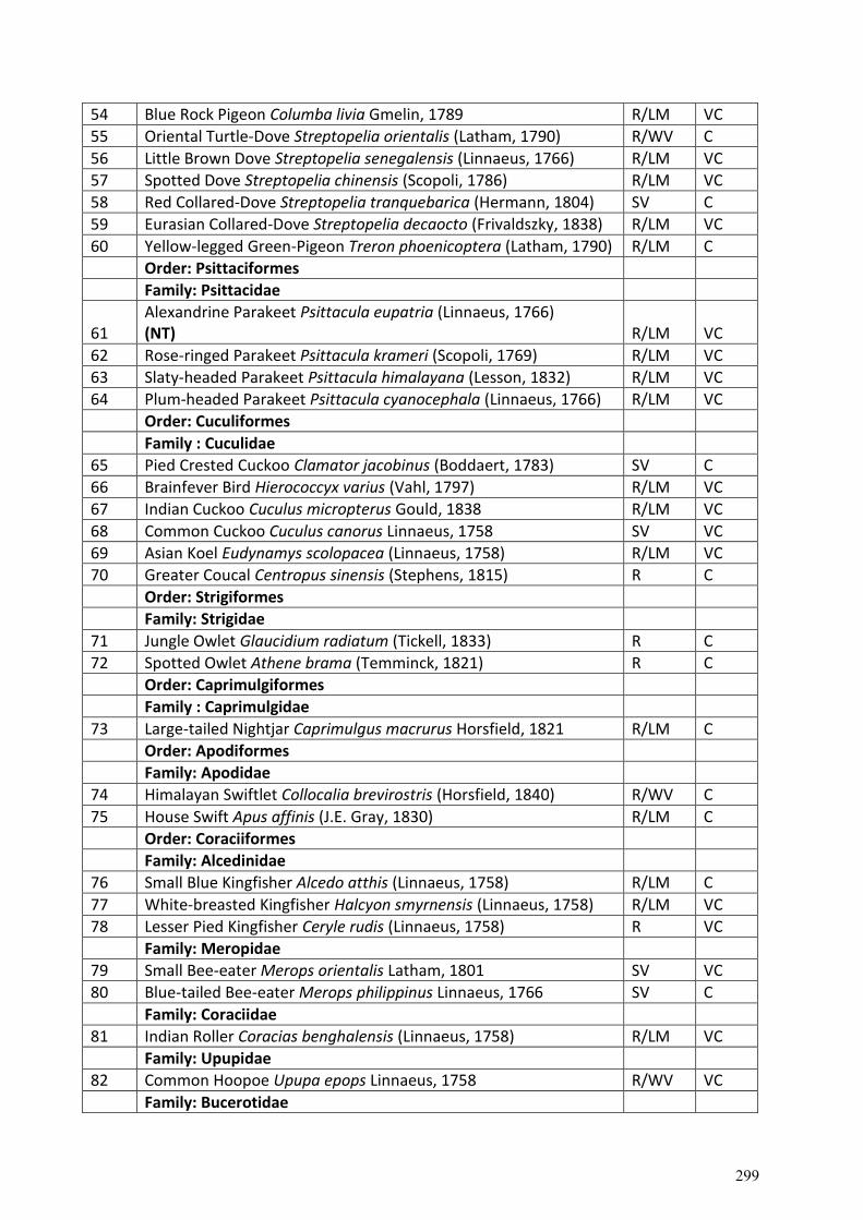
54 Blue Rock Pigeon Columba livia Gmelin, 1789 R/LM VC
55 Oriental Turtle-Dove Streptopelia orientalis (Latham, 1790) R/WV C
56 Little Brown Dove Streptopelia senegalensis (Linnaeus, 1766) R/LM VC
57 Spotted Dove Streptopelia chinensis (Scopoli, 1786) R/LM VC
58 Red Collared-Dove Streptopelia tranquebarica (Hermann, 1804) SV C
59 Eurasian Collared-Dove Streptopelia decaocto (Frivaldszky, 1838) R/LM VC
60 Yellow-legged Green-Pigeon Treron phoenicoptera (Latham, 1790) R/LM C
Order: Psittaciformes
Family: Psittacidae
61 Alexandrine Parakeet Psittacula eupatria (Linnaeus, 1766) (NT) R/LM VC
62 Rose-ringed Parakeet Psittacula krameri (Scopoli, 1769) R/LM VC
63 Slaty-headed Parakeet Psittacula himalayana (Lesson, 1832) R/LM VC
64 Plum-headed Parakeet Psittacula cyanocephala (Linnaeus, 1766) R/LM VC
Order: Cuculiformes
Family : Cuculidae
65 Pied Crested Cuckoo Clamator jacobinus (Boddaert, 1783) SV C
66 Brainfever Bird Hierococcyx varius (Vahl, 1797) R/LM VC
67 Indian Cuckoo Cuculus micropterus Gould, 1838 R/LM VC
68 Common Cuckoo Cuculus canorus Linnaeus, 1758 SV VC
69 Asian Koel Eudynamys scolopacea (Linnaeus, 1758) R/LM VC
70 Greater Coucal Centropus sinensis (Stephens, 1815) R C
Order: Strigiformes
Family: Strigidae
71 Jungle Owlet Glaucidium radiatum (Tickell, 1833) R C
72 Spotted Owlet Athene brama (Temminck, 1821) R C
Order: Caprimulgiformes
Family : Caprimulgidae
73 Large-tailed Nightjar Caprimulgus macrurus Horsfield, 1821 R/LM C
Order: Apodiformes
Family: Apodidae
74 Himalayan Swiftlet Collocalia brevirostris (Horsfield, 1840) R/WV C
75 House Swift Apus affinis (J.E. Gray, 1830) R/LM C
Order: Coraciiformes
Family: Alcedinidae
76 Small Blue Kingfisher Alcedo atthis (Linnaeus, 1758) R/LM C
77 White-breasted Kingfisher Halcyon smyrnensis (Linnaeus, 1758) R/LM VC
78 Lesser Pied Kingfisher Ceryle rudis (Linnaeus, 1758) R VC
Family: Meropidae
79 Small Bee-eater Merops orientalis Latham, 1801 SV VC
80 Blue-tailed Bee-eater Merops philippinus Linnaeus, 1766 SV C
Family: Coraciidae
81 Indian Roller Coracias benghalensis (Linnaeus, 1758) R/LM VC
Family: Upupidae
82 Common Hoopoe Upupa epops Linnaeus, 1758 R/WV VC
Family: Bucerotidae
299
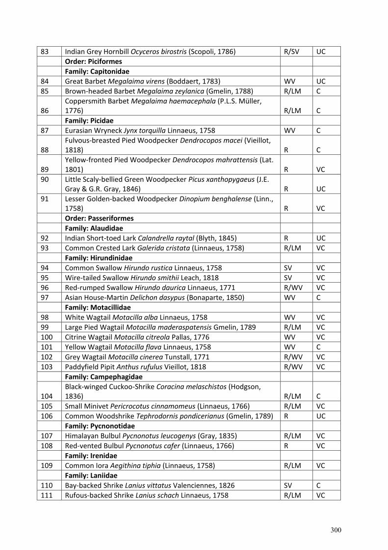
83 Indian Grey Hornbill Ocyceros birostris (Scopoli, 1786) R/SV UC
Order: Piciformes
Family: Capitonidae
84 Great Barbet Megalaima virens (Boddaert, 1783) WV UC
85 Brown-headed Barbet Megalaima zeylanica (Gmelin, 1788) R/LM C
86 Coppersmith Barbet Megalaima haemacephala (P.L.S. Müller, 1776) R/LM C
Family: Picidae
87 Eurasian Wryneck Jynx torquilla Linnaeus, 1758 WV C
88 Fulvous-breasted Pied Woodpecker Dendrocopos macei (Vieillot, 1818) R C
89 Yellow-fronted Pied Woodpecker Dendrocopos mahrattensis (Lat. 1801) R VC
90 Little Scaly-bellied Green Woodpecker Picus xanthopygaeus (J.E. Gray & G.R. Gray, 1846) R UC
91 Lesser Golden-backed Woodpecker Dinopium benghalense (Linn., 1758) R VC
Order: Passeriformes
Family: Alaudidae
92 Indian Short-toed Lark Calandrella raytal (Blyth, 1845) R UC
93 Common Crested Lark Galerida cristata (Linnaeus, 1758) R/LM VC
Family: Hirundinidae
94 Common Swallow Hirundo rustica Linnaeus, 1758 SV VC
95 Wire-tailed Swallow Hirundo smithii Leach, 1818 SV VC
96 Red-rumped Swallow Hirundo daurica Linnaeus, 1771 R/WV VC
97 Asian House-Martin Delichon dasypus (Bonaparte, 1850) WV C
Family: Motacillidae
98 White Wagtail Motacilla alba Linnaeus, 1758 WV VC
99 Large Pied Wagtail Motacilla maderaspatensis Gmelin, 1789 R/LM VC
100 Citrine Wagtail Motacilla citreola Pallas, 1776 WV VC
101 Yellow Wagtail Motacilla flava Linnaeus, 1758 WV C
102 Grey Wagtail Motacilla cinerea Tunstall, 1771 R/WV VC
103 Paddyfield Pipit Anthus rufulus Vieillot, 1818 R/WV VC
Family: Campephagidae
104 Black-winged Cuckoo-Shrike Coracina melaschistos (Hodgson, 1836) R/LM C
105 Small Minivet Pericrocotus cinnamomeus (Linnaeus, 1766) R/LM VC
106 Common Woodshrike Tephrodornis pondicerianus (Gmelin, 1789) R UC
Family: Pycnonotidae
107 Himalayan Bulbul Pycnonotus leucogenys (Gray, 1835) R/LM VC
108 Red-vented Bulbul Pycnonotus cafer (Linnaeus, 1766) R VC
Family: Irenidae
109 Common Iora Aegithina tiphia (Linnaeus, 1758) R/LM VC
Family: Laniidae
110 Bay-backed Shrike Lanius vittatus Valenciennes, 1826 SV C
111 Rufous-backed Shrike Lanius schach Linnaeus, 1758 R/LM VC
300
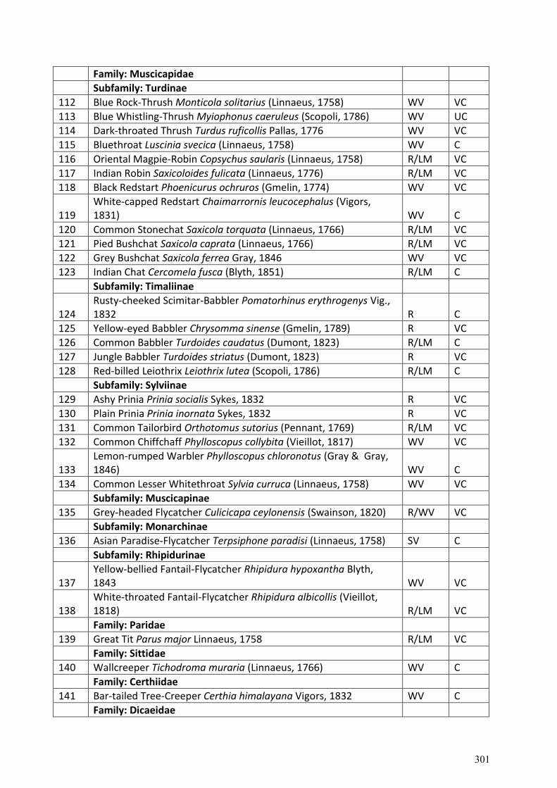
Family: Muscicapidae
Subfamily: Turdinae
112 Blue Rock-Thrush Monticola solitarius (Linnaeus, 1758) WV VC
113 Blue Whistling-Thrush Myiophonus caeruleus (Scopoli, 1786) WV UC
114 Dark-throated Thrush Turdus ruficollis Pallas, 1776 WV VC
115 Bluethroat Luscinia svecica (Linnaeus, 1758) WV C
116 Oriental Magpie-Robin Copsychus saularis (Linnaeus, 1758) R/LM VC
117 Indian Robin Saxicoloides fulicata (Linnaeus, 1776) R/LM VC
118 Black Redstart Phoenicurus ochruros (Gmelin, 1774) WV VC
119 White-capped Redstart Chaimarrornis leucocephalus (Vigors, 1831) WV C
120 Common Stonechat Saxicola torquata (Linnaeus, 1766) R/LM VC
121 Pied Bushchat Saxicola caprata (Linnaeus, 1766) R/LM VC
122 Grey Bushchat Saxicola ferrea Gray, 1846 WV VC
123 Indian Chat Cercomela fusca (Blyth, 1851) R/LM C
Subfamily: Timaliinae
124 Rusty-cheeked Scimitar-Babbler Pomatorhinus erythrogenys Vig., 1832 R C
125 Yellow-eyed Babbler Chrysomma sinense (Gmelin, 1789) R VC
126 Common Babbler Turdoides caudatus (Dumont, 1823) R/LM C
127 Jungle Babbler Turdoides striatus (Dumont, 1823) R VC
128 Red-billed Leiothrix Leiothrix lutea (Scopoli, 1786) R/LM C
Subfamily: Sylviinae
129 Ashy Prinia Prinia socialis Sykes, 1832 R VC
130 Plain Prinia Prinia inornata Sykes, 1832 R VC
131 Common Tailorbird Orthotomus sutorius (Pennant, 1769) R/LM VC
132 Common Chiffchaff Phylloscopus collybita (Vieillot, 1817) WV VC
133 Lemon-rumped Warbler Phylloscopus chloronotus (Gray & Gray, 1846) WV C
134 Common Lesser Whitethroat Sylvia curruca (Linnaeus, 1758) WV VC
Subfamily: Muscicapinae
135 Grey-headed Flycatcher Culicicapa ceylonensis (Swainson, 1820) R/WV VC
Subfamily: Monarchinae
136 Asian Paradise-Flycatcher Terpsiphone paradisi (Linnaeus, 1758) SV C
Subfamily: Rhipidurinae
137 Yellow-bellied Fantail-Flycatcher Rhipidura hypoxantha Blyth, 1843 WV VC
138 White-throated Fantail-Flycatcher Rhipidura albicollis (Vieillot, 1818) R/LM VC
Family: Paridae
139 Great Tit Parus major Linnaeus, 1758 R/LM VC
Family: Sittidae
140 Wallcreeper Tichodroma muraria (Linnaeus, 1766) WV C
Family: Certhiidae
141 Bar-tailed Tree-Creeper Certhia himalayana Vigors, 1832 WV C
Family: Dicaeidae
301
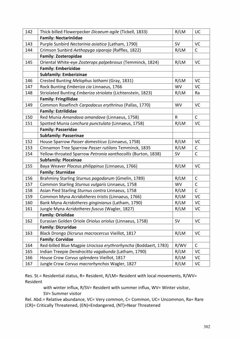
142 Thick-billed Flowerpecker Dicaeum agile (Tickell, 1833) R/LM UC
Family: Nectariniidae
143 Purple Sunbird Nectarinia asiatica (Latham, 1790) SV VC
144 Crimson Sunbird Aethopyga siparaja (Raffles, 1822) R/LM C
Family: Zosteropidae
145 Oriental White-eye Zosterops palpebrosus (Temminck, 1824) R/LM VC
Family: Emberizidae
Subfamily: Emberizinae
146 Crested Bunting Melophus lathami (Gray, 1831) R/LM VC
147 Rock Bunting Emberiza cia Linnaeus, 1766 WV VC
148 Striolated Bunting Emberiza striolata (Lichtenstein, 1823) R/LM Ra
Family: Fringillidae
149 Common Rosefinch Carpodacus erythrinus (Pallas, 1770) WV VC
Family: Estrildidae
150 Red Munia Amandava amandava (Linnaeus, 1758) R C
151 Spotted Munia Lonchura punctulata (Linnaeus, 1758) R/LM VC
Family: Passeridae
Subfamily: Passerinae
152 House Sparrow Passer domesticus (Linnaeus, 1758) R/LM VC
153 Cinnamon Tree Sparrow Passer rutilans Temminck, 1835 R/LM C
154 Yellow-throated Sparrow Petronia xanthocollis (Burton, 1838) SV C
Subfamily: Ploceinae
155 Baya Weaver Ploceus philippinus (Linnaeus, 1766) R/LM VC
Family: Sturnidae
156 Brahminy Starling Sturnus pagodarum (Gmelin, 1789) R/LM C
157 Common Starling Sturnus vulgaris Linnaeus, 1758 WV C
158 Asian Pied Starling Sturnus contra Linnaeus, 1758 R/LM C
159 Common Myna Acridotheres tristis (Linnaeus, 1766) R/LM VC
160 Bank Myna Acridotheres ginginianus (Latham, 1790) R/LM VC
161 Jungle Myna Acridotheres fuscus (Wagler, 1827) R/LM VC
Family: Oriolidae
162 Eurasian Golden Oriole Oriolus oriolus (Linnaeus, 1758) SV VC
Family: Dicruridae
163 Black Drongo Dicrurus macrocercus Vieillot, 1817 R/LM VC
Family: Corvidae
164 Red-billed Blue Magpie Urocissa erythrorhyncha (Boddaert, 1783) R/WV C
165 Indian Treepie Dendrocitta vagabunda (Latham, 1790) R/LM VC
166 House Crow Corvus splendens Vieillot, 1817 R/LM VC
167 Jungle Crow Corvus macrorhynchos Wagler, 1827 R/LM VC
Res. St.= Residential status, R= Resident, R/LM= Resident with local movements, R/WV= Resident
with winter influx, R/SV= Resident with summer influx, WV= Winter visitor,
SV= Summer visitor Rel. Abd.= Relative abundance, VC= Very common, C= Common, UC= Uncommon, Ra= Rare (CR)= Critically Threatened, (EN)=Endangered, (NT)=Near Threatened
302
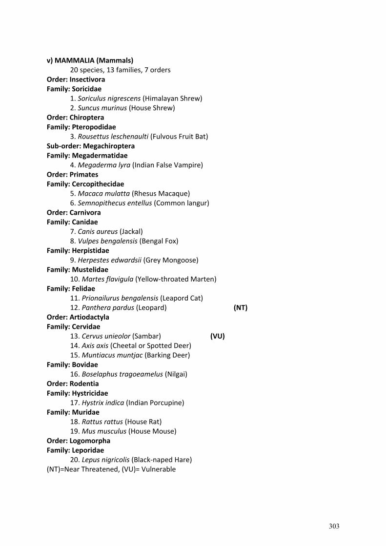
v) MAMMALIA (Mammals)
20 species, 13 families, 7 orders Order: Insectivora Family: Soricidae
1. Soriculus nigrescens (Himalayan Shrew) 2. Suncus murinus (House Shrew)
Order: Chiroptera Family: Pteropodidae
3. Rousettus leschenaulti (Fulvous Fruit Bat) Sub-order: Megachiroptera Family: Megadermatidae
4. Megaderma lyra (Indian False Vampire) Order: Primates Family: Cercopithecidae
5. Macaca mulatta (Rhesus Macaque) 6. Semnopithecus entellus (Common langur) Order: Carnivora Family: Canidae 7. Canis aureus (Jackal)
8. Vulpes bengalensis (Bengal Fox) Family: Herpistidae
9. Herpestes edwardsii (Grey Mongoose) Family: Mustelidae
10. Martes flavigula (Yellow-throated Marten) Family: Felidae
11. Prionailurus bengalensis (Leapord Cat) 12. Panthera pardus (Leopard) (NT)
Order: Artiodactyla Family: Cervidae
13. Cervus unieolor (Sambar) (VU) 14. Axis axis (Cheetal or Spotted Deer) 15. Muntiacus muntjac (Barking Deer)
Family: Bovidae 16. Boselaphus tragoeamelus (Nilgai)
Order: Rodentia Family: Hystricidae
17. Hystrix indica (Indian Porcupine) Family: Muridae
18. Rattus rattus (House Rat) 19. Mus musculus (House Mouse)
Order: Logomorpha Family: Leporidae
20. Lepus nigricolis (Black-naped Hare) (NT)=Near Threatened, (VU)= Vulnerable
303
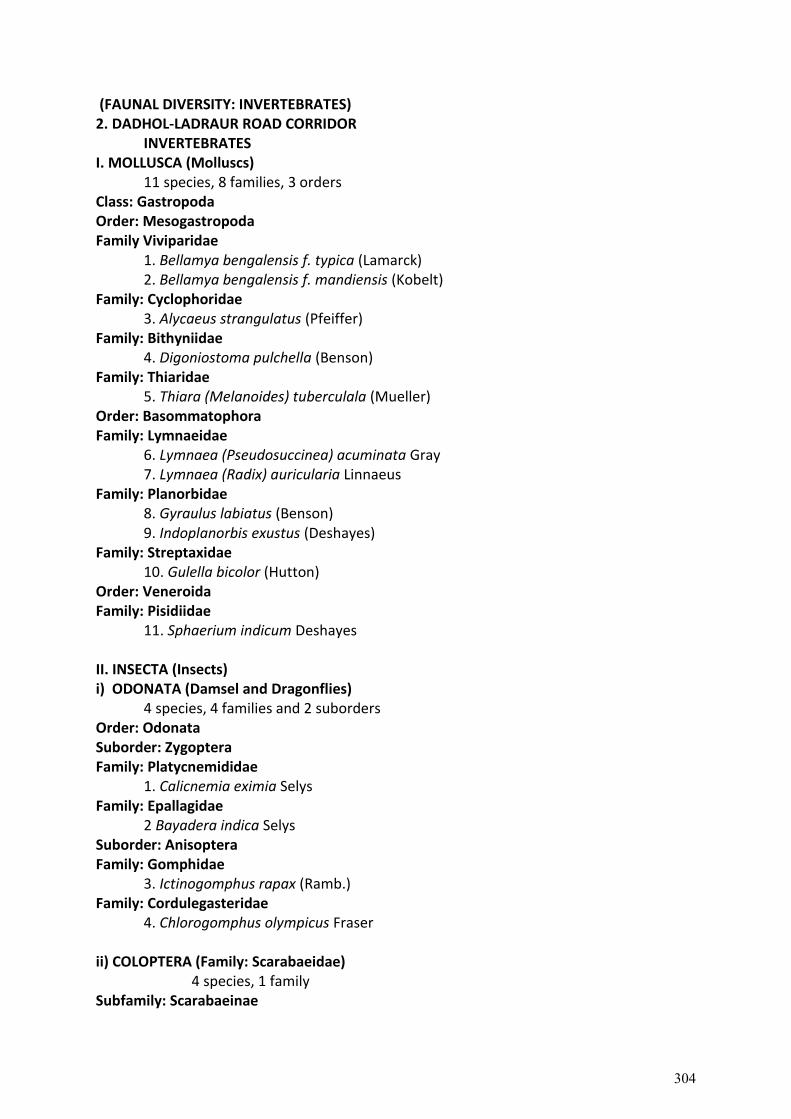
(FAUNAL DIVERSITY: INVERTEBRATES) 2. DADHOL-LADRAUR ROAD CORRIDOR
INVERTEBRATES I. MOLLUSCA (Molluscs)
11 species, 8 families, 3 orders Class: Gastropoda Order: Mesogastropoda Family Viviparidae
1. Bellamya bengalensis f. typica (Lamarck) 2. Bellamya bengalensis f. mandiensis (Kobelt)
Family: Cyclophoridae 3. Alycaeus strangulatus (Pfeiffer)
Family: Bithyniidae 4. Digoniostoma pulchella (Benson)
Family: Thiaridae 5. Thiara (Melanoides) tuberculala (Mueller)
Order: Basommatophora Family: Lymnaeidae
6. Lymnaea (Pseudosuccinea) acuminata Gray 7. Lymnaea (Radix) auricularia Linnaeus
Family: Planorbidae 8. Gyraulus labiatus (Benson) 9. Indoplanorbis exustus (Deshayes)
Family: Streptaxidae 10. Gulella bicolor (Hutton)
Order: Veneroida Family: Pisidiidae
11. Sphaerium indicum Deshayes II. INSECTA (Insects) i) ODONATA (Damsel and Dragonflies)
4 species, 4 families and 2 suborders Order: Odonata Suborder: Zygoptera Family: Platycnemididae
1. Calicnemia eximia Selys Family: Epallagidae
2 Bayadera indica Selys Suborder: Anisoptera Family: Gomphidae
3. Ictinogomphus rapax (Ramb.) Family: Cordulegasteridae
4. Chlorogomphus olympicus Fraser ii) COLOPTERA (Family: Scarabaeidae)
4 species, 1 family Subfamily: Scarabaeinae
304
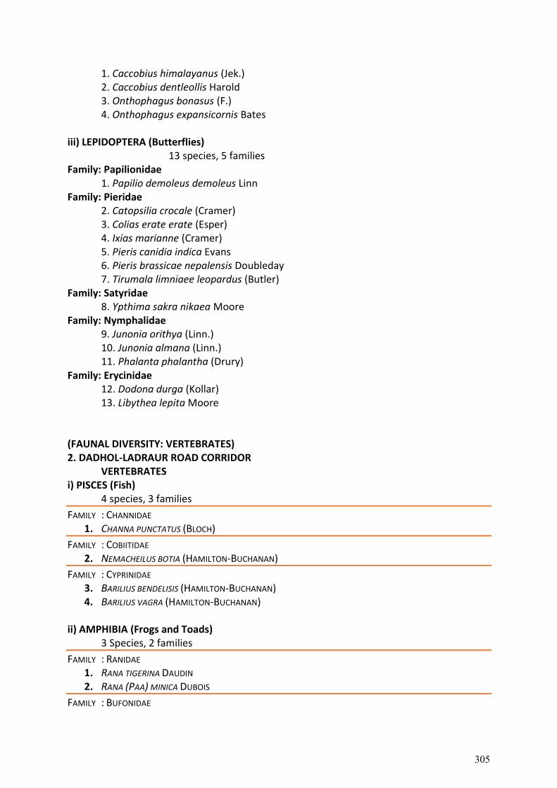
1. Caccobius himalayanus (Jek.) 2. Caccobius dentleollis Harold 3. Onthophagus bonasus (F.) 4. Onthophagus expansicornis Bates
iii) LEPIDOPTERA (Butterflies)
13 species, 5 families Family: Papilionidae
1. Papilio demoleus demoleus Linn Family: Pieridae
2. Catopsilia crocale (Cramer) 3. Colias erate erate (Esper) 4. Ixias marianne (Cramer) 5. Pieris canidia indica Evans 6. Pieris brassicae nepalensis Doubleday 7. Tirumala limniaee leopardus (Butler)
Family: Satyridae 8. Ypthima sakra nikaea Moore
Family: Nymphalidae 9. Junonia orithya (Linn.) 10. Junonia almana (Linn.) 11. Phalanta phalantha (Drury)
Family: Erycinidae 12. Dodona durga (Kollar) 13. Libythea lepita Moore
(FAUNAL DIVERSITY: VERTEBRATES) 2. DADHOL-LADRAUR ROAD CORRIDOR
VERTEBRATES i) PISCES (Fish)
4 species, 3 families
FAMILY : CHANNIDAE 1. CHANNA PUNCTATUS (BLOCH)
FAMILY : COBIITIDAE 2. NEMACHEILUS BOTIA (HAMILTON-BUCHANAN)
FAMILY : CYPRINIDAE 3. BARILIUS BENDELISIS (HAMILTON-BUCHANAN) 4. BARILIUS VAGRA (HAMILTON-BUCHANAN)
ii) AMPHIBIA (Frogs and Toads)
3 Species, 2 families
FAMILY : RANIDAE 1. RANA TIGERINA DAUDIN 2. RANA (PAA) MINICA DUBOIS
FAMILY : BUFONIDAE
305
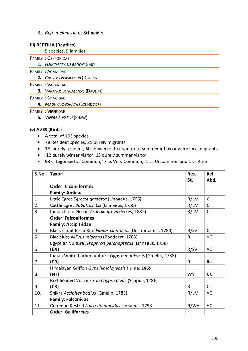
3. Bufo melanistictus Schneider iii) REPTILIA (Reptiles)
5 species, 5 families,
FAMILY : GEKKONIDAE 1. HEMIDACTYLUS BROOKI GARY
FAMILY : AGAMIDAE 2. CALOTES VERSICOLOR (DAUDIN)
FAMILY : VARANIDAE 3. VARANUS BENGALENSIS (DAUDIN)
FAMILY : SCINCIDAE 4. MABUYA CARINATA (SCHNEIDER)
FAMILY : VIPERIDAE 5. VIPERA RUSSELLI (SHAW)
iv) AVES (Birds)
A total of 103 species
78 Resident species, 25 purely migrants
18 purely resident, 60 showed either winter or summer influx or were local migrants
12 purely winter visitor, 13 purely summer visitor
53 categorised as Common,47 as Very Common, 1 as Uncommon and 1 as Rare
S.No. Taxon Res. St.
Rel. Abd.
Order: Ciconiiformes
Family: Ardidae
1. Little Egret Egretta garzetta (Linnaeus, 1766) R/LM C
2. Cattle Egret Bubulcus ibis (Linnaeus, 1758) R/LM C
3. Indian Pond-Heron Ardeola grayii (Sykes, 1832) R/LM C
Order: Falconiformes
Family: Accipitridae
4. Black-shouldered Kite Elanus caeruleus (Desfontaines, 1789) R/SV C
5. Black Kite Milvus migrans (Boddaert, 1783) R VC
6. Egyptian Vulture Neophron percnopterus (Linnaeus, 1758) (EN) R/SV VC
7. Indian White-backed Vulture Gyps bengalensis (Gmelin, 1788) (CR) R Ra
8. Himalayan Griffon Gyps himalayensis Hume, 1869 (NT) WV UC
9. Red-headed Vulture Sarcogyps calvus (Scopoli, 1786) (CR) R C
10. Shikra Accipiter badius (Gmelin, 1788) R/LM VC
Family: Falconidae
11. Common Kestrel Falco tinnunculus Linnaeus, 1758 R/WV VC
Order: Galliformes
306
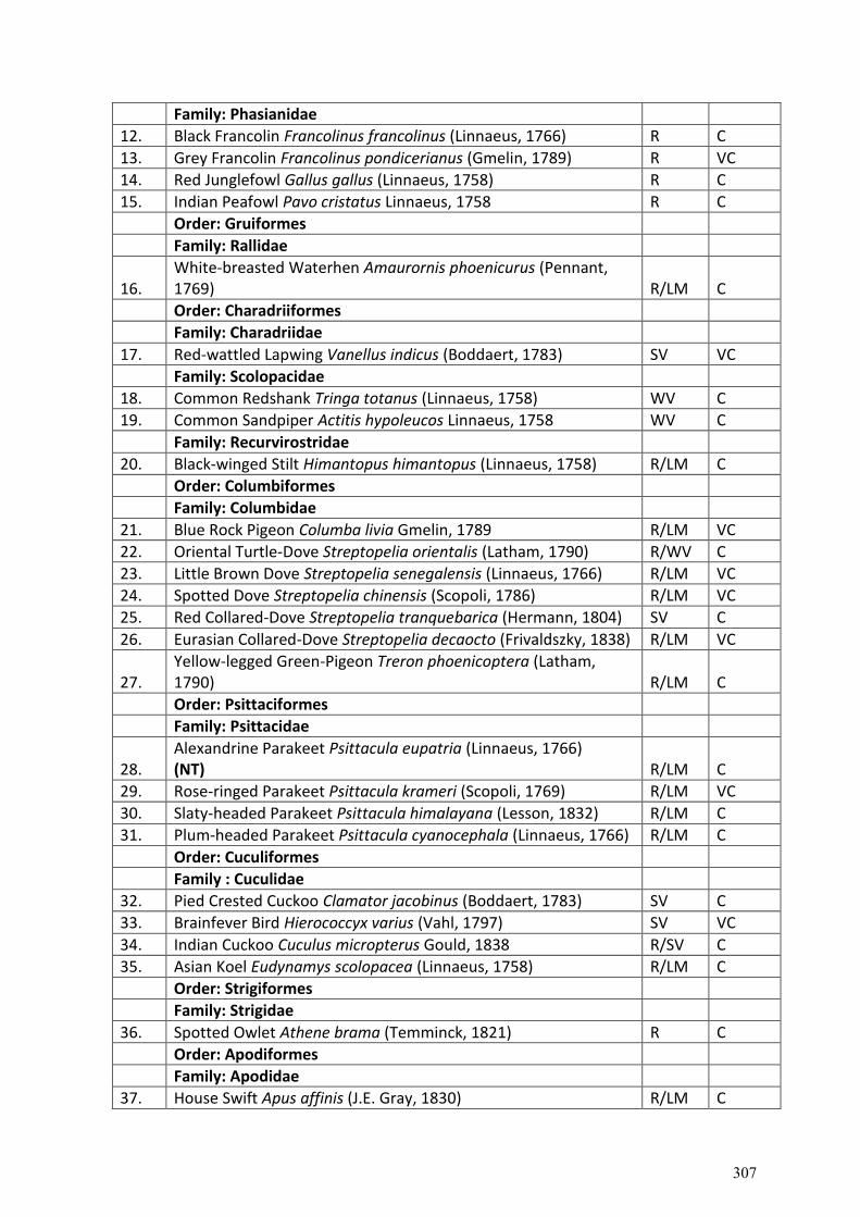
Family: Phasianidae
12. Black Francolin Francolinus francolinus (Linnaeus, 1766) R C
13. Grey Francolin Francolinus pondicerianus (Gmelin, 1789) R VC
14. Red Junglefowl Gallus gallus (Linnaeus, 1758) R C
15. Indian Peafowl Pavo cristatus Linnaeus, 1758 R C
Order: Gruiformes
Family: Rallidae
16. White-breasted Waterhen Amaurornis phoenicurus (Pennant, 1769) R/LM C
Order: Charadriiformes
Family: Charadriidae
17. Red-wattled Lapwing Vanellus indicus (Boddaert, 1783) SV VC
Family: Scolopacidae
18. Common Redshank Tringa totanus (Linnaeus, 1758) WV C
19. Common Sandpiper Actitis hypoleucos Linnaeus, 1758 WV C
Family: Recurvirostridae
20. Black-winged Stilt Himantopus himantopus (Linnaeus, 1758) R/LM C
Order: Columbiformes
Family: Columbidae
21. Blue Rock Pigeon Columba livia Gmelin, 1789 R/LM VC
22. Oriental Turtle-Dove Streptopelia orientalis (Latham, 1790) R/WV C
23. Little Brown Dove Streptopelia senegalensis (Linnaeus, 1766) R/LM VC
24. Spotted Dove Streptopelia chinensis (Scopoli, 1786) R/LM VC
25. Red Collared-Dove Streptopelia tranquebarica (Hermann, 1804) SV C
26. Eurasian Collared-Dove Streptopelia decaocto (Frivaldszky, 1838) R/LM VC
27. Yellow-legged Green-Pigeon Treron phoenicoptera (Latham, 1790) R/LM C
Order: Psittaciformes
Family: Psittacidae
28. Alexandrine Parakeet Psittacula eupatria (Linnaeus, 1766) (NT) R/LM C
29. Rose-ringed Parakeet Psittacula krameri (Scopoli, 1769) R/LM VC
30. Slaty-headed Parakeet Psittacula himalayana (Lesson, 1832) R/LM C
31. Plum-headed Parakeet Psittacula cyanocephala (Linnaeus, 1766) R/LM C
Order: Cuculiformes
Family : Cuculidae
32. Pied Crested Cuckoo Clamator jacobinus (Boddaert, 1783) SV C
33. Brainfever Bird Hierococcyx varius (Vahl, 1797) SV VC
34. Indian Cuckoo Cuculus micropterus Gould, 1838 R/SV C
35. Asian Koel Eudynamys scolopacea (Linnaeus, 1758) R/LM C
Order: Strigiformes
Family: Strigidae
36. Spotted Owlet Athene brama (Temminck, 1821) R C
Order: Apodiformes
Family: Apodidae
37. House Swift Apus affinis (J.E. Gray, 1830) R/LM C
307
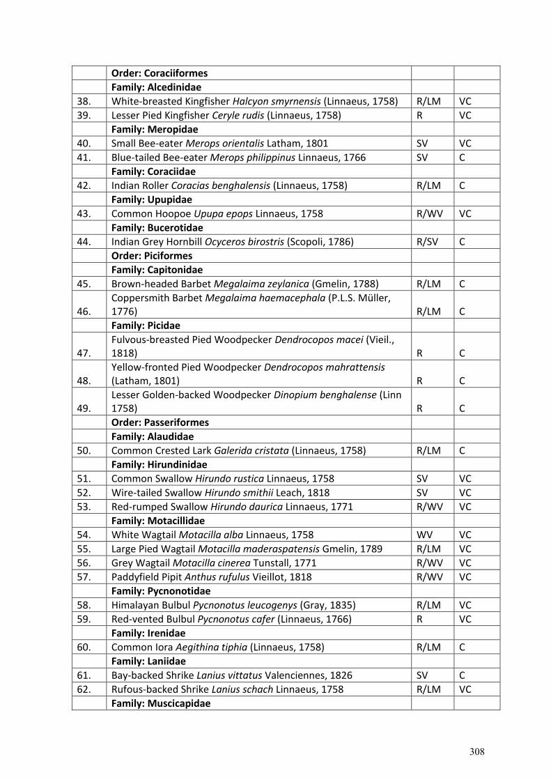
Order: Coraciiformes
Family: Alcedinidae
38. White-breasted Kingfisher Halcyon smyrnensis (Linnaeus, 1758) R/LM VC
39. Lesser Pied Kingfisher Ceryle rudis (Linnaeus, 1758) R VC
Family: Meropidae
40. Small Bee-eater Merops orientalis Latham, 1801 SV VC
41. Blue-tailed Bee-eater Merops philippinus Linnaeus, 1766 SV C
Family: Coraciidae
42. Indian Roller Coracias benghalensis (Linnaeus, 1758) R/LM C
Family: Upupidae
43. Common Hoopoe Upupa epops Linnaeus, 1758 R/WV VC
Family: Bucerotidae
44. Indian Grey Hornbill Ocyceros birostris (Scopoli, 1786) R/SV C
Order: Piciformes
Family: Capitonidae
45. Brown-headed Barbet Megalaima zeylanica (Gmelin, 1788) R/LM C
46. Coppersmith Barbet Megalaima haemacephala (P.L.S. Müller, 1776) R/LM C
Family: Picidae
47. Fulvous-breasted Pied Woodpecker Dendrocopos macei (Vieil., 1818) R C
48. Yellow-fronted Pied Woodpecker Dendrocopos mahrattensis (Latham, 1801) R C
49. Lesser Golden-backed Woodpecker Dinopium benghalense (Linn 1758) R C
Order: Passeriformes
Family: Alaudidae
50. Common Crested Lark Galerida cristata (Linnaeus, 1758) R/LM C
Family: Hirundinidae
51. Common Swallow Hirundo rustica Linnaeus, 1758 SV VC
52. Wire-tailed Swallow Hirundo smithii Leach, 1818 SV VC
53. Red-rumped Swallow Hirundo daurica Linnaeus, 1771 R/WV VC
Family: Motacillidae
54. White Wagtail Motacilla alba Linnaeus, 1758 WV VC
55. Large Pied Wagtail Motacilla maderaspatensis Gmelin, 1789 R/LM VC
56. Grey Wagtail Motacilla cinerea Tunstall, 1771 R/WV VC
57. Paddyfield Pipit Anthus rufulus Vieillot, 1818 R/WV VC
Family: Pycnonotidae
58. Himalayan Bulbul Pycnonotus leucogenys (Gray, 1835) R/LM VC
59. Red-vented Bulbul Pycnonotus cafer (Linnaeus, 1766) R VC
Family: Irenidae
60. Common Iora Aegithina tiphia (Linnaeus, 1758) R/LM C
Family: Laniidae
61. Bay-backed Shrike Lanius vittatus Valenciennes, 1826 SV C
62. Rufous-backed Shrike Lanius schach Linnaeus, 1758 R/LM VC
Family: Muscicapidae
308
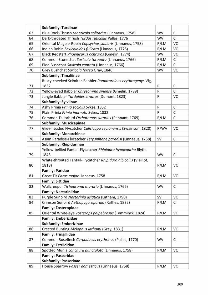
Subfamily: Turdinae
63. Blue Rock-Thrush Monticola solitarius (Linnaeus, 1758) WV C
64. Dark-throated Thrush Turdus ruficollis Pallas, 1776 WV C
65. Oriental Magpie-Robin Copsychus saularis (Linnaeus, 1758) R/LM VC
66. Indian Robin Saxicoloides fulicata (Linnaeus, 1776) R/LM VC
67. Black Redstart Phoenicurus ochruros (Gmelin, 1774) WV VC
68. Common Stonechat Saxicola torquata (Linnaeus, 1766) R/LM C
69. Pied Bushchat Saxicola caprata (Linnaeus, 1766) R/LM C
70. Grey Bushchat Saxicola ferrea Gray, 1846 WV VC
Subfamily: Timaliinae
71. Rusty-cheeked Scimitar-Babbler Pomatorhinus erythrogenys Vig, 1832 R C
72. Yellow-eyed Babbler Chrysomma sinense (Gmelin, 1789) R C
73. Jungle Babbler Turdoides striatus (Dumont, 1823) R VC
Subfamily: Sylviinae
74. Ashy Prinia Prinia socialis Sykes, 1832 R C
75. Plain Prinia Prinia inornata Sykes, 1832 R C
76. Common Tailorbird Orthotomus sutorius (Pennant, 1769) R/LM C
Subfamily: Muscicapinae
77. Grey-headed Flycatcher Culicicapa ceylonensis (Swainson, 1820) R/WV VC
Subfamily: Monarchinae
78. Asian Paradise-Flycatcher Terpsiphone paradisi (Linnaeus, 1758) SV C
Subfamily: Rhipidurinae
79. Yellow-bellied Fantail-Flycatcher Rhipidura hypoxantha Blyth, 1843 WV C
80. White-throated Fantail-Flycatcher Rhipidura albicollis (Vieillot, 1818) R/LM VC
Family: Paridae
81. Great Tit Parus major Linnaeus, 1758 R/LM VC
Family: Sittidae
82. Wallcreeper Tichodroma muraria (Linnaeus, 1766) WV C
Family: Nectariniidae
83. Purple Sunbird Nectarinia asiatica (Latham, 1790) SV VC
84. Crimson Sunbird Aethopyga siparaja (Raffles, 1822) R/LM C
Family: Zosteropidae
85. Oriental White-eye Zosterops palpebrosus (Temminck, 1824) R/LM VC
Family: Emberizidae
Subfamily: Emberizinae
86. Crested Bunting Melophus lathami (Gray, 1831) R/LM VC
Family: Fringillidae
87. Common Rosefinch Carpodacus erythrinus (Pallas, 1770) WV C
Family: Estrildidae
88. Spotted Munia Lonchura punctulata (Linnaeus, 1758) R/LM VC
Family: Passeridae
Subfamily: Passerinae
89. House Sparrow Passer domesticus (Linnaeus, 1758) R/LM VC
309
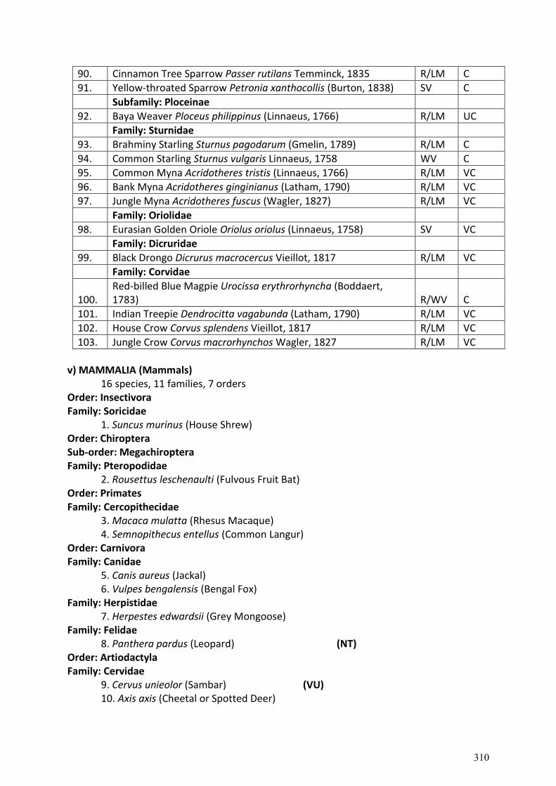
90. Cinnamon Tree Sparrow Passer rutilans Temminck, 1835 R/LM C
91. Yellow-throated Sparrow Petronia xanthocollis (Burton, 1838) SV C
Subfamily: Ploceinae
92. Baya Weaver Ploceus philippinus (Linnaeus, 1766) R/LM UC
Family: Sturnidae
93. Brahminy Starling Sturnus pagodarum (Gmelin, 1789) R/LM C
94. Common Starling Sturnus vulgaris Linnaeus, 1758 WV C
95. Common Myna Acridotheres tristis (Linnaeus, 1766) R/LM VC
96. Bank Myna Acridotheres ginginianus (Latham, 1790) R/LM VC
97. Jungle Myna Acridotheres fuscus (Wagler, 1827) R/LM VC
Family: Oriolidae
98. Eurasian Golden Oriole Oriolus oriolus (Linnaeus, 1758) SV VC
Family: Dicruridae
99. Black Drongo Dicrurus macrocercus Vieillot, 1817 R/LM VC
Family: Corvidae
100. Red-billed Blue Magpie Urocissa erythrorhyncha (Boddaert, 1783) R/WV C
101. Indian Treepie Dendrocitta vagabunda (Latham, 1790) R/LM VC
102. House Crow Corvus splendens Vieillot, 1817 R/LM VC
103. Jungle Crow Corvus macrorhynchos Wagler, 1827 R/LM VC
v) MAMMALIA (Mammals)
16 species, 11 families, 7 orders Order: Insectivora Family: Soricidae
1. Suncus murinus (House Shrew) Order: Chiroptera Sub-order: Megachiroptera Family: Pteropodidae
2. Rousettus leschenaulti (Fulvous Fruit Bat) Order: Primates Family: Cercopithecidae
3. Macaca mulatta (Rhesus Macaque) 4. Semnopithecus entellus (Common Langur)
Order: Carnivora Family: Canidae
5. Canis aureus (Jackal) 6. Vulpes bengalensis (Bengal Fox)
Family: Herpistidae 7. Herpestes edwardsii (Grey Mongoose)
Family: Felidae 8. Panthera pardus (Leopard) (NT)
Order: Artiodactyla Family: Cervidae
9. Cervus unieolor (Sambar) (VU) 10. Axis axis (Cheetal or Spotted Deer)
310
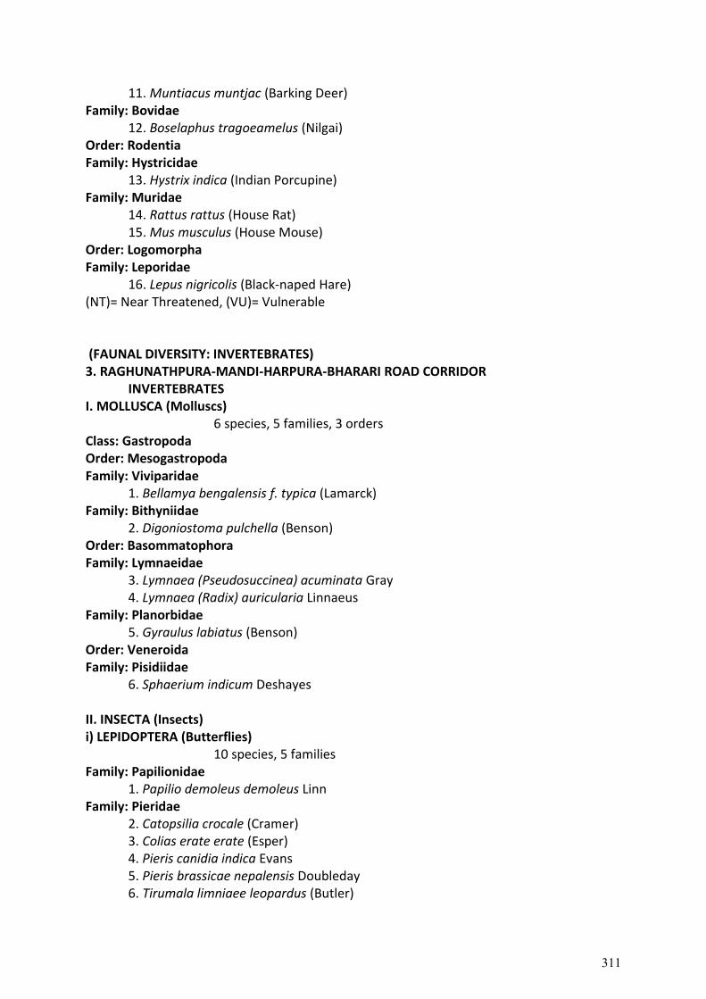
11. Muntiacus muntjac (Barking Deer) Family: Bovidae
12. Boselaphus tragoeamelus (Nilgai) Order: Rodentia Family: Hystricidae
13. Hystrix indica (Indian Porcupine) Family: Muridae
14. Rattus rattus (House Rat) 15. Mus musculus (House Mouse)
Order: Logomorpha Family: Leporidae
16. Lepus nigricolis (Black-naped Hare) (NT)= Near Threatened, (VU)= Vulnerable (FAUNAL DIVERSITY: INVERTEBRATES) 3. RAGHUNATHPURA-MANDI-HARPURA-BHARARI ROAD CORRIDOR
INVERTEBRATES I. MOLLUSCA (Molluscs)
6 species, 5 families, 3 orders Class: Gastropoda Order: Mesogastropoda Family: Viviparidae
1. Bellamya bengalensis f. typica (Lamarck) Family: Bithyniidae
2. Digoniostoma pulchella (Benson) Order: Basommatophora Family: Lymnaeidae
3. Lymnaea (Pseudosuccinea) acuminata Gray 4. Lymnaea (Radix) auricularia Linnaeus
Family: Planorbidae 5. Gyraulus labiatus (Benson)
Order: Veneroida Family: Pisidiidae
6. Sphaerium indicum Deshayes II. INSECTA (Insects) i) LEPIDOPTERA (Butterflies)
10 species, 5 families Family: Papilionidae
1. Papilio demoleus demoleus Linn Family: Pieridae
2. Catopsilia crocale (Cramer) 3. Colias erate erate (Esper) 4. Pieris canidia indica Evans 5. Pieris brassicae nepalensis Doubleday 6. Tirumala limniaee leopardus (Butler)
311
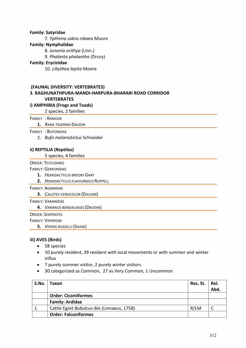
Family: Satyridae 7. Ypthima sakra nikaea Moore
Family: Nymphalidae 8. Junonia orithya (Linn.) 9. Phalanta phalantha (Drury)
Family: Erycinidae 10. Libythea lepita Moore
(FAUNAL DIVERSITY: VERTEBRATES) 3. RAGHUNATHPURA-MANDI-HARPURA-BHARARI ROAD CORRIDOR
VERTEBRATES i) AMPHIBIA (Frogs and Toads)
2 species, 2 families
FAMILY : RANIDAE 1. RANA TIGERINA DAUDIN
FAMILY : BUFONIDAE 2. Bufo melanistictus Schneider
ii) REPTILIA (Reptiles)
5 species, 4 families
ORDER: TESTUDINES FAMILY: GEKKONIDAE
1. HEMIDACTYLUS BROOKI GARY 2. HEMIDACTYLUS FLAVIVIRIDUS RUPPELL
FAMILY: AGAMIDAE 3. CALOTES VERSICOLOR (DAUDIN)
FAMILY: VARANIDAE 4. VARANUS BENGALENSIS (DAUDIN)
ORDER: SERPENTES FAMILY: VIPERIDAE
5. VIPERA RUSSELLI (SHAW)
iii) AVES (Birds)
58 species
10 purely resident, 39 resident with local movements or with summer and winter influx
7 purely summer visitor, 2 purely winter visitors
30 categorized as Common, 27 as Very Common, 1 Uncommon
S.No. Taxon Res. St. Rel. Abd.
Order: Ciconiiformes
Family: Ardidae
1. Cattle Egret Bubulcus ibis (Linnaeus, 1758) R/LM C
Order: Falconiformes
312
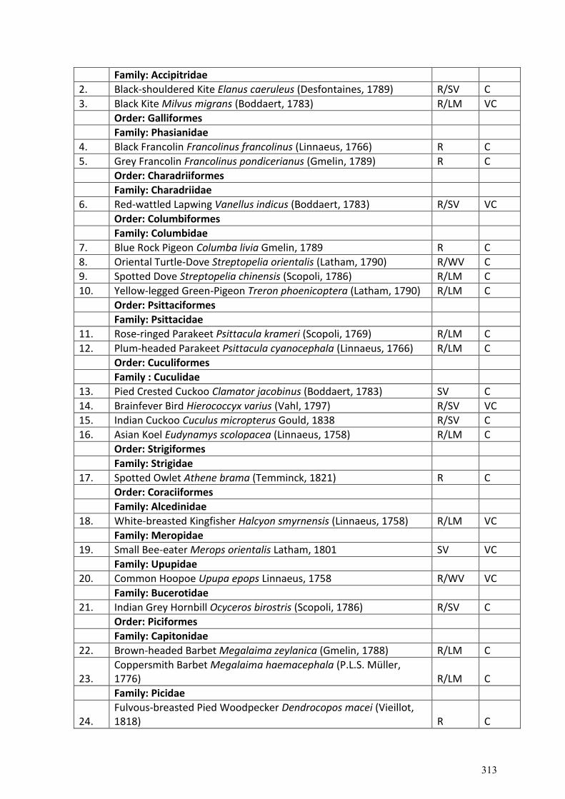
Family: Accipitridae
2. Black-shouldered Kite Elanus caeruleus (Desfontaines, 1789) R/SV C
3. Black Kite Milvus migrans (Boddaert, 1783) R/LM VC
Order: Galliformes
Family: Phasianidae
4. Black Francolin Francolinus francolinus (Linnaeus, 1766) R C
5. Grey Francolin Francolinus pondicerianus (Gmelin, 1789) R C
Order: Charadriiformes
Family: Charadriidae
6. Red-wattled Lapwing Vanellus indicus (Boddaert, 1783) R/SV VC
Order: Columbiformes
Family: Columbidae
7. Blue Rock Pigeon Columba livia Gmelin, 1789 R C
8. Oriental Turtle-Dove Streptopelia orientalis (Latham, 1790) R/WV C
9. Spotted Dove Streptopelia chinensis (Scopoli, 1786) R/LM C
10. Yellow-legged Green-Pigeon Treron phoenicoptera (Latham, 1790) R/LM C
Order: Psittaciformes
Family: Psittacidae
11. Rose-ringed Parakeet Psittacula krameri (Scopoli, 1769) R/LM C
12. Plum-headed Parakeet Psittacula cyanocephala (Linnaeus, 1766) R/LM C
Order: Cuculiformes
Family : Cuculidae
13. Pied Crested Cuckoo Clamator jacobinus (Boddaert, 1783) SV C
14. Brainfever Bird Hierococcyx varius (Vahl, 1797) R/SV VC
15. Indian Cuckoo Cuculus micropterus Gould, 1838 R/SV C
16. Asian Koel Eudynamys scolopacea (Linnaeus, 1758) R/LM C
Order: Strigiformes
Family: Strigidae
17. Spotted Owlet Athene brama (Temminck, 1821) R C
Order: Coraciiformes
Family: Alcedinidae
18. White-breasted Kingfisher Halcyon smyrnensis (Linnaeus, 1758) R/LM VC
Family: Meropidae
19. Small Bee-eater Merops orientalis Latham, 1801 SV VC
Family: Upupidae
20. Common Hoopoe Upupa epops Linnaeus, 1758 R/WV VC
Family: Bucerotidae
21. Indian Grey Hornbill Ocyceros birostris (Scopoli, 1786) R/SV C
Order: Piciformes
Family: Capitonidae
22. Brown-headed Barbet Megalaima zeylanica (Gmelin, 1788) R/LM C
23. Coppersmith Barbet Megalaima haemacephala (P.L.S. Müller, 1776) R/LM C
Family: Picidae
24. Fulvous-breasted Pied Woodpecker Dendrocopos macei (Vieillot, 1818) R C
313
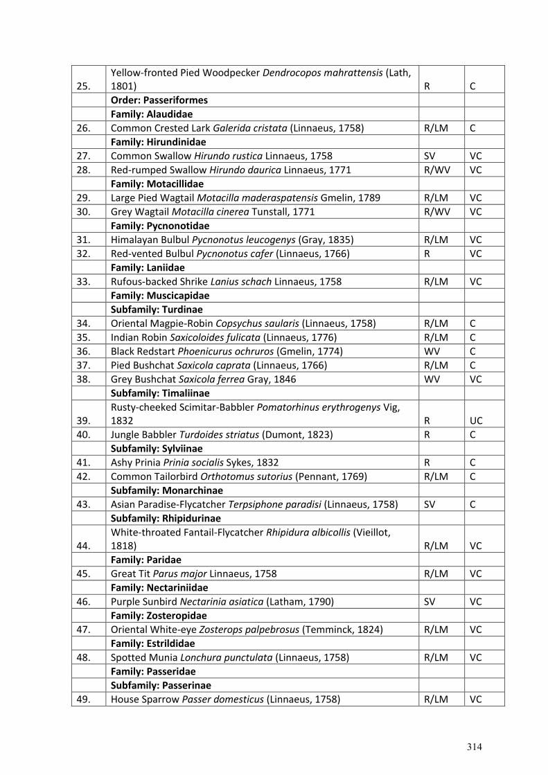
25. Yellow-fronted Pied Woodpecker Dendrocopos mahrattensis (Lath, 1801) R C
Order: Passeriformes
Family: Alaudidae
26. Common Crested Lark Galerida cristata (Linnaeus, 1758) R/LM C
Family: Hirundinidae
27. Common Swallow Hirundo rustica Linnaeus, 1758 SV VC
28. Red-rumped Swallow Hirundo daurica Linnaeus, 1771 R/WV VC
Family: Motacillidae
29. Large Pied Wagtail Motacilla maderaspatensis Gmelin, 1789 R/LM VC
30. Grey Wagtail Motacilla cinerea Tunstall, 1771 R/WV VC
Family: Pycnonotidae
31. Himalayan Bulbul Pycnonotus leucogenys (Gray, 1835) R/LM VC
32. Red-vented Bulbul Pycnonotus cafer (Linnaeus, 1766) R VC
Family: Laniidae
33. Rufous-backed Shrike Lanius schach Linnaeus, 1758 R/LM VC
Family: Muscicapidae
Subfamily: Turdinae
34. Oriental Magpie-Robin Copsychus saularis (Linnaeus, 1758) R/LM C
35. Indian Robin Saxicoloides fulicata (Linnaeus, 1776) R/LM C
36. Black Redstart Phoenicurus ochruros (Gmelin, 1774) WV C
37. Pied Bushchat Saxicola caprata (Linnaeus, 1766) R/LM C
38. Grey Bushchat Saxicola ferrea Gray, 1846 WV VC
Subfamily: Timaliinae
39. Rusty-cheeked Scimitar-Babbler Pomatorhinus erythrogenys Vig, 1832 R UC
40. Jungle Babbler Turdoides striatus (Dumont, 1823) R C
Subfamily: Sylviinae
41. Ashy Prinia Prinia socialis Sykes, 1832 R C
42. Common Tailorbird Orthotomus sutorius (Pennant, 1769) R/LM C
Subfamily: Monarchinae
43. Asian Paradise-Flycatcher Terpsiphone paradisi (Linnaeus, 1758) SV C
Subfamily: Rhipidurinae
44. White-throated Fantail-Flycatcher Rhipidura albicollis (Vieillot, 1818) R/LM VC
Family: Paridae
45. Great Tit Parus major Linnaeus, 1758 R/LM VC
Family: Nectariniidae
46. Purple Sunbird Nectarinia asiatica (Latham, 1790) SV VC
Family: Zosteropidae
47. Oriental White-eye Zosterops palpebrosus (Temminck, 1824) R/LM VC
Family: Estrildidae
48. Spotted Munia Lonchura punctulata (Linnaeus, 1758) R/LM VC
Family: Passeridae
Subfamily: Passerinae
49. House Sparrow Passer domesticus (Linnaeus, 1758) R/LM VC
314
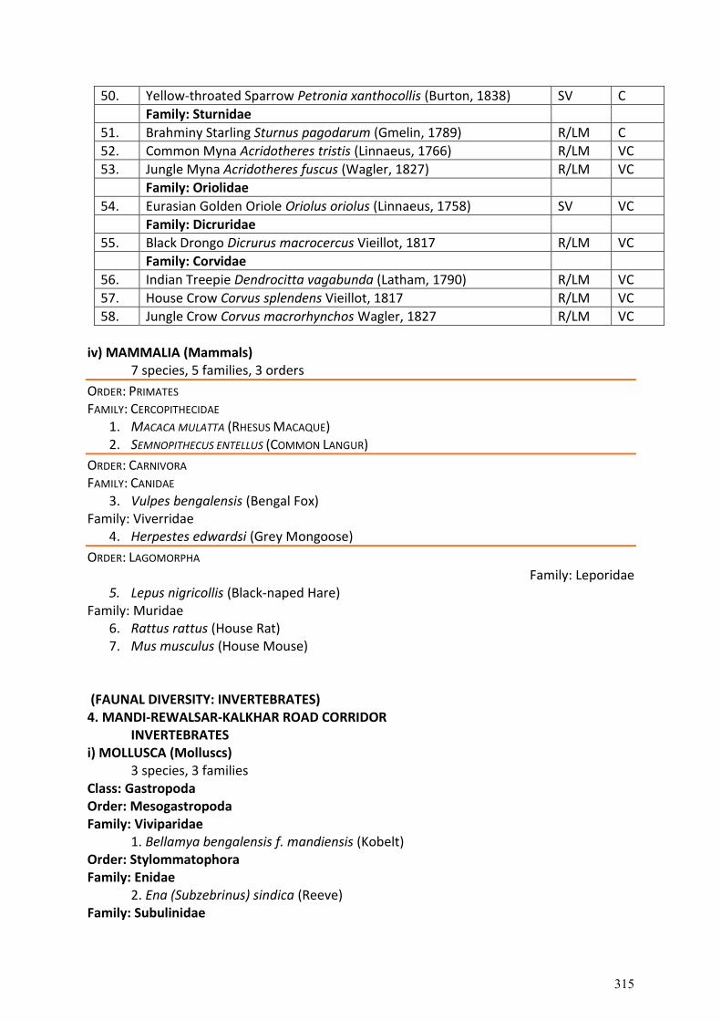
50. Yellow-throated Sparrow Petronia xanthocollis (Burton, 1838) SV C
Family: Sturnidae
51. Brahminy Starling Sturnus pagodarum (Gmelin, 1789) R/LM C
52. Common Myna Acridotheres tristis (Linnaeus, 1766) R/LM VC
53. Jungle Myna Acridotheres fuscus (Wagler, 1827) R/LM VC
Family: Oriolidae
54. Eurasian Golden Oriole Oriolus oriolus (Linnaeus, 1758) SV VC
Family: Dicruridae
55. Black Drongo Dicrurus macrocercus Vieillot, 1817 R/LM VC
Family: Corvidae
56. Indian Treepie Dendrocitta vagabunda (Latham, 1790) R/LM VC
57. House Crow Corvus splendens Vieillot, 1817 R/LM VC
58. Jungle Crow Corvus macrorhynchos Wagler, 1827 R/LM VC
iv) MAMMALIA (Mammals)
7 species, 5 families, 3 orders
ORDER: PRIMATES FAMILY: CERCOPITHECIDAE
1. MACACA MULATTA (RHESUS MACAQUE) 2. SEMNOPITHECUS ENTELLUS (COMMON LANGUR)
ORDER: CARNIVORA FAMILY: CANIDAE
3. Vulpes bengalensis (Bengal Fox) Family: Viverridae
4. Herpestes edwardsi (Grey Mongoose)
ORDER: LAGOMORPHA Family: Leporidae
5. Lepus nigricollis (Black-naped Hare) Family: Muridae
6. Rattus rattus (House Rat) 7. Mus musculus (House Mouse)
(FAUNAL DIVERSITY: INVERTEBRATES) 4. MANDI-REWALSAR-KALKHAR ROAD CORRIDOR
INVERTEBRATES i) MOLLUSCA (Molluscs)
3 species, 3 families Class: Gastropoda Order: Mesogastropoda Family: Viviparidae
1. Bellamya bengalensis f. mandiensis (Kobelt) Order: Stylommatophora Family: Enidae
2. Ena (Subzebrinus) sindica (Reeve) Family: Subulinidae
315
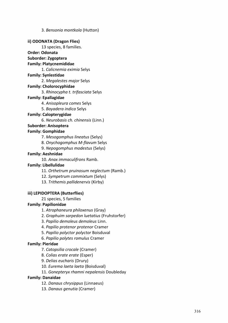
3. Bensonia montkola (Hutton) ii) ODONATA (Dragon Flies)
13 species, 8 families. Order: Odonata Suborder: Zygoptera Family: Platycnemididae
1. Calicnemia eximia Selys Family: Synlestidae
2. Megalestes major Selys Family: Cholorocyphidae
3. Rhinocypha t. trifasciata Selys Family: Epallagidae
4. Anisopleura comes Selys 5. Bayadera indica Selys
Family: Calopterygidae 6. Neurobasis ch. chinensis (Linn.)
Suborder: Anisoptera Family: Gomphidae
7. Mesogomphus lineatus (Selys) 8. Onychogomphus M-flavum Selys 9. Nepogomphus modestus (Selys)
Family: Aeshnidae 10. Anax immaculifrons Ramb.
Family: Libellulidae 11. Orthetrum pruinosum neglectum (Ramb.) 12. Sympetrum commixtum (Selys) 13. Trithemis pallidenervis (Kirby)
iii) LEPIDOPTERA (Butterflies)
21 species, 5 families Family: Papilionidae
1. Atrophaneura philoxenus (Gray) 2. Graphuim sarpedon luetatius (Fruhstorfer) 3. Papilio demoleus demoleus Linn. 4. Papilio protenor protenor Cramer 5. Papilio polyctor polyctor Boisduval 6. Papilio polytes romulus Cramer
Family: Pieridae 7. Catopsilia crocale (Cramer) 8. Colias erate erate (Esper) 9. Delias eucharis (Drury) 10. Eurema laeta laeta (Boisduval) 11. Gonepteryx rhamni nepalensis Doubleday
Family: Danaidae 12. Danaus chrysippus (Linnaeus) 13. Danaus genutia (Cramer)
316
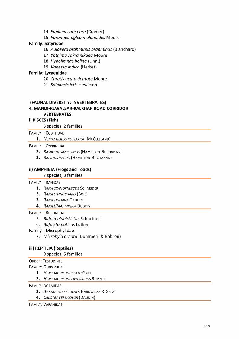
14. Euploea core eore (Cramer) 15. Parantiea aglea melanoides Moore
Family: Satyridae 16. Auloeera brahminus brahminus (Blanchard) 17. Ypthima sakra nikaea Moore 18. Hypolimnas bolina (Linn.) 19. Vanessa indica (Herbst)
Family: Lycaenidae 20. Curetis acuta dentate Moore 21. Spindasis ictis Hewitson
(FAUNAL DIVERSITY: INVERTEBRATES) 4. MANDI-REWALSAR-KALKHAR ROAD CORRIDOR
VERTEBRATES i) PISCES (Fish)
3 species, 2 families
FAMILY : COBIITIDAE 1. NEMACHEILUS RUPECOLA (MCCLELLAND)
FAMILY : CYPRINIDAE 2. RASBORA DANICONIUS (HAMILTON-BUCHANAN) 3. BARILIUS VAGRA (HAMILTON-BUCHANAN)
ii) AMPHIBIA (Frogs and Toads)
7 species, 3 families
FAMILY : RANIDAE 1. RANA CYANOPHLYCTIS SCHNEIDER 2. RANA LIMNOCHARIS (BOIE) 3. RANA TIGERINA DAUDIN 4. RANA (PAA) MINICA DUBOIS
FAMILY : BUFONIDAE 5. Bufo melanistictus Schneider 6. Bufo stomaticus Lutken
Family : Microphylidae 7. Microhyla ornata (Dummeril & Bobron)
iii) REPTILIA (Reptiles)
9 species, 5 families
ORDER: TESTUDINES FAMILY: GEKKONIDAE
1. HEMIDACTYLUS BROOKI GARY 2. HEMIDACTYLUS FLAVIVIRIDUS RUPPELL
FAMILY: AGAMIDAE 3. AGAMA TUBERCULATA HARDWICKE & GRAY 4. CALOTES VERSICOLOR (DAUDIN)
FAMILY: VARANIDAE
317
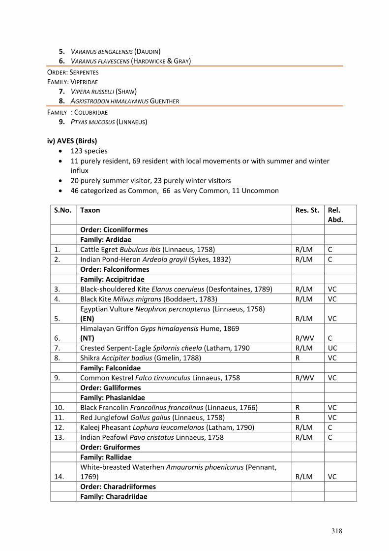
5. VARANUS BENGALENSIS (DAUDIN) 6. VARANUS FLAVESCENS (HARDWICKE & GRAY)
ORDER: SERPENTES FAMILY: VIPERIDAE
7. VIPERA RUSSELLI (SHAW) 8. AGKISTRODON HIMALAYANUS GUENTHER
FAMILY : COLUBRIDAE 9. PTYAS MUCOSUS (LINNAEUS)
iv) AVES (Birds)
123 species
11 purely resident, 69 resident with local movements or with summer and winter influx
20 purely summer visitor, 23 purely winter visitors
46 categorized as Common, 66 as Very Common, 11 Uncommon
S.No. Taxon Res. St. Rel. Abd.
Order: Ciconiiformes
Family: Ardidae
1. Cattle Egret Bubulcus ibis (Linnaeus, 1758) R/LM C
2. Indian Pond-Heron Ardeola grayii (Sykes, 1832) R/LM C
Order: Falconiformes
Family: Accipitridae
3. Black-shouldered Kite Elanus caeruleus (Desfontaines, 1789) R/LM VC
4. Black Kite Milvus migrans (Boddaert, 1783) R/LM VC
5. Egyptian Vulture Neophron percnopterus (Linnaeus, 1758) (EN) R/LM VC
6. Himalayan Griffon Gyps himalayensis Hume, 1869 (NT) R/WV C
7. Crested Serpent-Eagle Spilornis cheela (Latham, 1790 R/LM UC
8. Shikra Accipiter badius (Gmelin, 1788) R VC
Family: Falconidae
9. Common Kestrel Falco tinnunculus Linnaeus, 1758 R/WV VC
Order: Galliformes
Family: Phasianidae
10. Black Francolin Francolinus francolinus (Linnaeus, 1766) R VC
11. Red Junglefowl Gallus gallus (Linnaeus, 1758) R VC
12. Kaleej Pheasant Lophura leucomelanos (Latham, 1790) R/LM C
13. Indian Peafowl Pavo cristatus Linnaeus, 1758 R/LM C
Order: Gruiformes
Family: Rallidae
14. White-breasted Waterhen Amaurornis phoenicurus (Pennant, 1769) R/LM VC
Order: Charadriiformes
Family: Charadriidae
318
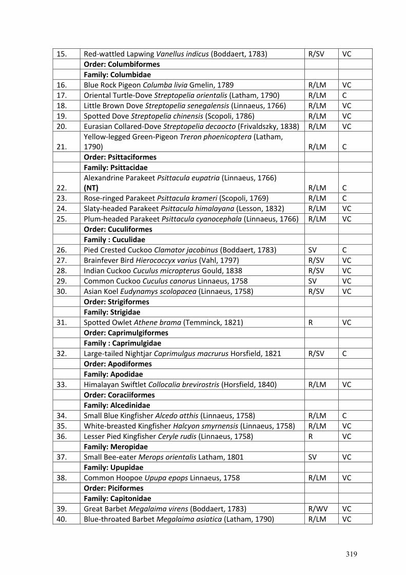
15. Red-wattled Lapwing Vanellus indicus (Boddaert, 1783) R/SV VC
Order: Columbiformes
Family: Columbidae
16. Blue Rock Pigeon Columba livia Gmelin, 1789 R/LM VC
17. Oriental Turtle-Dove Streptopelia orientalis (Latham, 1790) R/LM C
18. Little Brown Dove Streptopelia senegalensis (Linnaeus, 1766) R/LM VC
19. Spotted Dove Streptopelia chinensis (Scopoli, 1786) R/LM VC
20. Eurasian Collared-Dove Streptopelia decaocto (Frivaldszky, 1838) R/LM VC
21. Yellow-legged Green-Pigeon Treron phoenicoptera (Latham, 1790) R/LM C
Order: Psittaciformes
Family: Psittacidae
22. Alexandrine Parakeet Psittacula eupatria (Linnaeus, 1766) (NT) R/LM C
23. Rose-ringed Parakeet Psittacula krameri (Scopoli, 1769) R/LM C
24. Slaty-headed Parakeet Psittacula himalayana (Lesson, 1832) R/LM VC
25. Plum-headed Parakeet Psittacula cyanocephala (Linnaeus, 1766) R/LM VC
Order: Cuculiformes
Family : Cuculidae
26. Pied Crested Cuckoo Clamator jacobinus (Boddaert, 1783) SV C
27. Brainfever Bird Hierococcyx varius (Vahl, 1797) R/SV VC
28. Indian Cuckoo Cuculus micropterus Gould, 1838 R/SV VC
29. Common Cuckoo Cuculus canorus Linnaeus, 1758 SV VC
30. Asian Koel Eudynamys scolopacea (Linnaeus, 1758) R/SV VC
Order: Strigiformes
Family: Strigidae
31. Spotted Owlet Athene brama (Temminck, 1821) R VC
Order: Caprimulgiformes
Family : Caprimulgidae
32. Large-tailed Nightjar Caprimulgus macrurus Horsfield, 1821 R/SV C
Order: Apodiformes
Family: Apodidae
33. Himalayan Swiftlet Collocalia brevirostris (Horsfield, 1840) R/LM VC
Order: Coraciiformes
Family: Alcedinidae
34. Small Blue Kingfisher Alcedo atthis (Linnaeus, 1758) R/LM C
35. White-breasted Kingfisher Halcyon smyrnensis (Linnaeus, 1758) R/LM VC
36. Lesser Pied Kingfisher Ceryle rudis (Linnaeus, 1758) R VC
Family: Meropidae
37. Small Bee-eater Merops orientalis Latham, 1801 SV VC
Family: Upupidae
38. Common Hoopoe Upupa epops Linnaeus, 1758 R/LM VC
Order: Piciformes
Family: Capitonidae
39. Great Barbet Megalaima virens (Boddaert, 1783) R/WV VC
40. Blue-throated Barbet Megalaima asiatica (Latham, 1790) R/LM VC
319
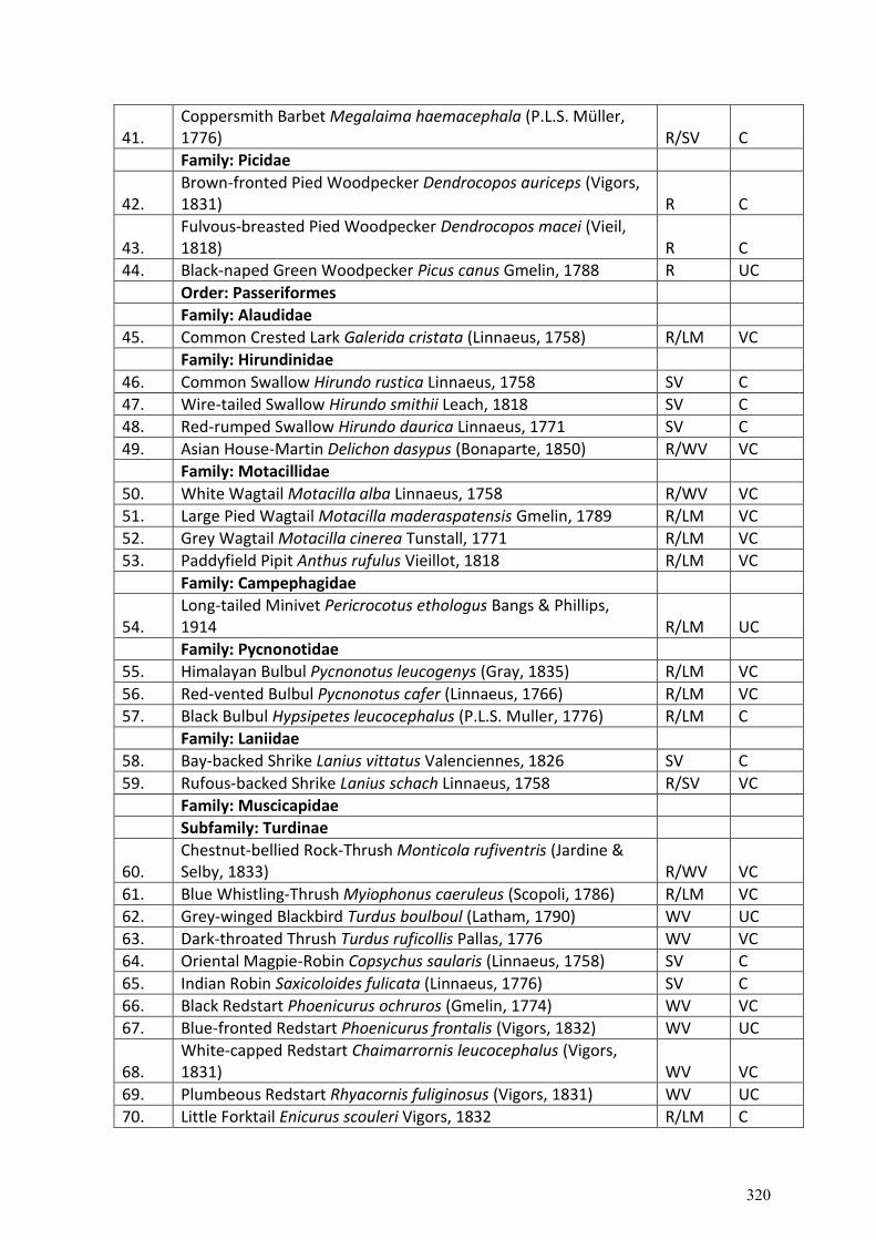
41. Coppersmith Barbet Megalaima haemacephala (P.L.S. Müller, 1776) R/SV C
Family: Picidae
42. Brown-fronted Pied Woodpecker Dendrocopos auriceps (Vigors, 1831) R C
43. Fulvous-breasted Pied Woodpecker Dendrocopos macei (Vieil, 1818) R C
44. Black-naped Green Woodpecker Picus canus Gmelin, 1788 R UC
Order: Passeriformes
Family: Alaudidae
45. Common Crested Lark Galerida cristata (Linnaeus, 1758) R/LM VC
Family: Hirundinidae
46. Common Swallow Hirundo rustica Linnaeus, 1758 SV C
47. Wire-tailed Swallow Hirundo smithii Leach, 1818 SV C
48. Red-rumped Swallow Hirundo daurica Linnaeus, 1771 SV C
49. Asian House-Martin Delichon dasypus (Bonaparte, 1850) R/WV VC
Family: Motacillidae
50. White Wagtail Motacilla alba Linnaeus, 1758 R/WV VC
51. Large Pied Wagtail Motacilla maderaspatensis Gmelin, 1789 R/LM VC
52. Grey Wagtail Motacilla cinerea Tunstall, 1771 R/LM VC
53. Paddyfield Pipit Anthus rufulus Vieillot, 1818 R/LM VC
Family: Campephagidae
54. Long-tailed Minivet Pericrocotus ethologus Bangs & Phillips, 1914 R/LM UC
Family: Pycnonotidae
55. Himalayan Bulbul Pycnonotus leucogenys (Gray, 1835) R/LM VC
56. Red-vented Bulbul Pycnonotus cafer (Linnaeus, 1766) R/LM VC
57. Black Bulbul Hypsipetes leucocephalus (P.L.S. Muller, 1776) R/LM C
Family: Laniidae
58. Bay-backed Shrike Lanius vittatus Valenciennes, 1826 SV C
59. Rufous-backed Shrike Lanius schach Linnaeus, 1758 R/SV VC
Family: Muscicapidae
Subfamily: Turdinae
60. Chestnut-bellied Rock-Thrush Monticola rufiventris (Jardine & Selby, 1833) R/WV VC
61. Blue Whistling-Thrush Myiophonus caeruleus (Scopoli, 1786) R/LM VC
62. Grey-winged Blackbird Turdus boulboul (Latham, 1790) WV UC
63. Dark-throated Thrush Turdus ruficollis Pallas, 1776 WV VC
64. Oriental Magpie-Robin Copsychus saularis (Linnaeus, 1758) SV C
65. Indian Robin Saxicoloides fulicata (Linnaeus, 1776) SV C
66. Black Redstart Phoenicurus ochruros (Gmelin, 1774) WV VC
67. Blue-fronted Redstart Phoenicurus frontalis (Vigors, 1832) WV UC
68. White-capped Redstart Chaimarrornis leucocephalus (Vigors, 1831) WV VC
69. Plumbeous Redstart Rhyacornis fuliginosus (Vigors, 1831) WV UC
70. Little Forktail Enicurus scouleri Vigors, 1832 R/LM C
320
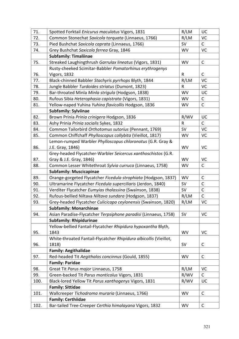
71. Spotted Forktail Enicurus maculatus Vigors, 1831 R/LM UC
72. Common Stonechat Saxicola torquata (Linnaeus, 1766) R/LM VC
73. Pied Bushchat Saxicola caprata (Linnaeus, 1766) SV C
74. Grey Bushchat Saxicola ferrea Gray, 1846 WV VC
Subfamily: Timaliinae
75. Streaked Laughingthrush Garrulax lineatus (Vigors, 1831) WV C
76. Rusty-cheeked Scimitar-Babbler Pomatorhinus erythrogenys Vigors, 1832 R C
77. Black-chinned Babbler Stachyris pyrrhops Blyth, 1844 R/LM VC
78. Jungle Babbler Turdoides striatus (Dumont, 1823) R VC
79. Bar-throated Minla Minla strigula (Hodgson, 1838) WV UC
80. Rufous Sibia Heterophasia capistrata (Vigors, 1831) WV C
81. Yellow-naped Yuhina Yuhina flavicollis Hodgson, 1836 WV C
Subfamily: Sylviinae
82. Brown Prinia Prinia crinigera Hodgson, 1836 R/WV UC
83. Ashy Prinia Prinia socialis Sykes, 1832 R C
84. Common Tailorbird Orthotomus sutorius (Pennant, 1769) SV VC
85. Common Chiffchaff Phylloscopus collybita (Vieillot, 1817) WV VC
86. Lemon-rumped Warbler Phylloscopus chloronotus (G.R. Gray & J.E. Gray, 1846) WV VC
87. Grey-headed Flycatcher-Warbler Seicercus xanthoschistos (G.R. Gray & J.E. Gray, 1846) WV VC
88. Common Lesser Whitethroat Sylvia curruca (Linnaeus, 1758) WV C
Subfamily: Muscicapinae
89. Orange-gorgeted Flycatcher Ficedula strophiata (Hodgson, 1837) WV C
90. Ultramarine Flycatcher Ficedula superciliaris (Jerdon, 1840) SV C
91. Verditer Flycatcher Eumyias thalassina (Swainson, 1838) SV C
92. Rufous-bellied Niltava Niltava sundara (Hodgson, 1837) R/LM C
93. Grey-headed Flycatcher Culicicapa ceylonensis (Swainson, 1820) R/LM VC
Subfamily: Monarchinae
94. Asian Paradise-Flycatcher Terpsiphone paradisi (Linnaeus, 1758) SV VC
Subfamily: Rhipidurinae
95. Yellow-bellied Fantail-Flycatcher Rhipidura hypoxantha Blyth, 1843 WV VC
96. White-throated Fantail-Flycatcher Rhipidura albicollis (Vieillot, 1818) SV C
Family: Aegithalidae
97. Red-headed Tit Aegithalos concinnus (Gould, 1855) WV C
Family: Paridae
98. Great Tit Parus major Linnaeus, 1758 R/LM VC
99. Green-backed Tit Parus monticolus Vigors, 1831 R/WV C
100. Black-lored Yellow Tit Parus xanthogenys Vigors, 1831 R/WV UC
Family: Sittidae
101. Wallcreeper Tichodroma muraria (Linnaeus, 1766) WV C
Family: Certhiidae
102. Bar-tailed Tree-Creeper Certhia himalayana Vigors, 1832 WV C
321
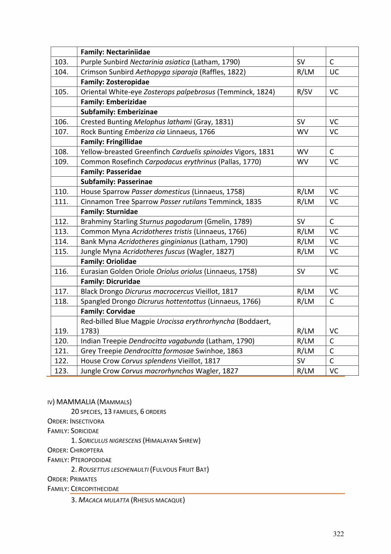
Family: Nectariniidae
103. Purple Sunbird Nectarinia asiatica (Latham, 1790) SV C
104. Crimson Sunbird Aethopyga siparaja (Raffles, 1822) R/LM UC
Family: Zosteropidae
105. Oriental White-eye Zosterops palpebrosus (Temminck, 1824) R/SV VC
Family: Emberizidae
Subfamily: Emberizinae
106. Crested Bunting Melophus lathami (Gray, 1831) SV VC
107. Rock Bunting Emberiza cia Linnaeus, 1766 WV VC
Family: Fringillidae
108. Yellow-breasted Greenfinch Carduelis spinoides Vigors, 1831 WV C
109. Common Rosefinch Carpodacus erythrinus (Pallas, 1770) WV VC
Family: Passeridae
Subfamily: Passerinae
110. House Sparrow Passer domesticus (Linnaeus, 1758) R/LM VC
111. Cinnamon Tree Sparrow Passer rutilans Temminck, 1835 R/LM VC
Family: Sturnidae
112. Brahminy Starling Sturnus pagodarum (Gmelin, 1789) SV C
113. Common Myna Acridotheres tristis (Linnaeus, 1766) R/LM VC
114. Bank Myna Acridotheres ginginianus (Latham, 1790) R/LM VC
115. Jungle Myna Acridotheres fuscus (Wagler, 1827) R/LM VC
Family: Oriolidae
116. Eurasian Golden Oriole Oriolus oriolus (Linnaeus, 1758) SV VC
Family: Dicruridae
117. Black Drongo Dicrurus macrocercus Vieillot, 1817 R/LM VC
118. Spangled Drongo Dicrurus hottentottus (Linnaeus, 1766) R/LM C
Family: Corvidae
119. Red-billed Blue Magpie Urocissa erythrorhyncha (Boddaert, 1783) R/LM VC
120. Indian Treepie Dendrocitta vagabunda (Latham, 1790) R/LM C
121. Grey Treepie Dendrocitta formosae Swinhoe, 1863 R/LM C
122. House Crow Corvus splendens Vieillot, 1817 SV C
123. Jungle Crow Corvus macrorhynchos Wagler, 1827 R/LM VC
IV) MAMMALIA (MAMMALS)
20 SPECIES, 13 FAMILIES, 6 ORDERS ORDER: INSECTIVORA FAMILY: SORICIDAE
1. SORICULUS NIGRESCENS (HIMALAYAN SHREW) ORDER: CHIROPTERA FAMILY: PTEROPODIDAE
2. ROUSETTUS LESCHENAULTI (FULVOUS FRUIT BAT) ORDER: PRIMATES FAMILY: CERCOPITHECIDAE
3. MACACA MULATTA (RHESUS MACAQUE)
322
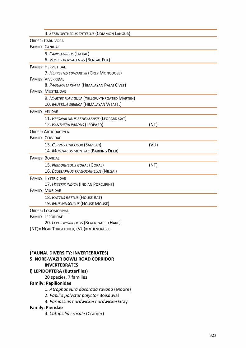
4. SEMNOPITHECUS ENTELLUS (COMMON LANGUR)
ORDER: CARNIVORA FAMILY: CANIDAE
5. CANIS AUREUS (JACKAL) 6. VULPES BENGALENSIS (BENGAL FOX)
FAMILY: HERPISTIDAE 7. HERPESTES EDWARDSII (GREY MONGOOSE)
FAMILY: VIVERRIDAE 8. PAGUMA LARVATA (HIMALAYAN PALM CIVET)
FAMILY: MUSTELIDAE
9. MARTES FLAVIGULA (YELLOW-THROATED MARTEN) 10. MUSTELA SIBIRICA (HIMALAYAN WEASEL)
FAMILY: FELIDAE
11. PRIONAILURUS BENGALENSIS (LEOPARD CAT) 12. PANTHERA PARDUS (LEOPARD) (NT)
ORDER: ARTIODACTYLA FAMILY: CERVIDAE
13. CERVUS UNICOLOR (SAMBAR) (VU) 14. MUNTIACUS MUNTJAC (BARKING DEER)
FAMILY: BOVIDAE
15. NEMORHEDUS GORAL (GORAL) (NT) 16. BOSELAPHUS TRAGOCAMELUS (NILGAI)
FAMILY: HYSTRICIDAE 17. HYSTRIX INDICA (INDIAN PORCUPINE)
FAMILY: MURIDAE
18. RATTUS RATTUS (HOUSE RAT) 19. MUS MUSCULUS (HOUSE MOUSE)
ORDER: LOGOMORPHA FAMILY: LEPORIDAE
20. LEPUS NIGRICOLLIS (BLACK-NAPED HARE) (NT)= NEAR THREATENED, (VU)= VULNERABLE
(FAUNAL DIVERSITY: INVERTEBRATES) 5. NORE-WAZIR BOWLI ROAD CORRIDOR
INVERTEBRATES i) LEPIDOPTERA (Butterflies)
20 species, 7 families Family: Papilionidae
1. Atrophaneura dasarada ravana (Moore) 2. Papilio polyctor polyctor Boisduval 3. Parnassius hardwickei hardwickei Gray
Family: Pieridae 4. Catopsilia crocale (Cramer)
323
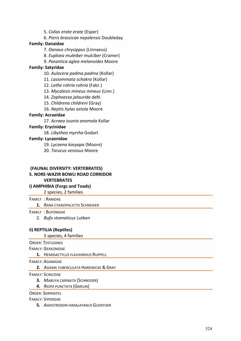
5. Colias erate erate (Esper) 6. Pieris brassicae nepalensis Doubleday
Family: Danaidae 7. Danaus chrysippus (Linnaeus) 8. Euploea muleiber mulciber (Cramer) 9. Parantica aglea melanoides Moore
Family: Satyridae 10. Aulocera padma padma (Kollar) 11. Lasiommata schakra (Kollar) 12. Lethe rohria rohria (Fabr.) 13. Mycalesis mineus mineus (Linn.) 14. Zophoessa jalaurida deN. 15. Childrena childreni (Gray) 16. Neptis hylas astola Moore
Family: Acraeidae 17. Acraea issoria anomala Kollar
Family: Erycinidae 18. Libythea myrrha Godart
Family: Lycaenidae 19. Lycaena kasyapa (Moore) 20. Tarucus venosus Moore
(FAUNAL DIVERSITY: VERTEBRATES) 5. NORE-WAZIR BOWLI ROAD CORRIDOR
VERTEBRATES i) AMPHIBIA (Forgs and Toads)
2 species, 2 families
FAMILY : RANIDAE 1. RANA CYANOPHLYCTIS SCHNEIDER
FAMILY : BUFONIDAE 2. Bufo stomaticus Lutken
ii) REPTILIA (Reptiles)
5 species, 4 families
ORDER: TESTUDINES FAMILY: GEKKONIDAE
1. HEMIDACTYLUS FLAVIVIRIDUS RUPPELL
FAMILY: AGAMIDAE 2. AGAMA TUBERCULATA HARDWICKE & GRAY
FAMILY: SCINCIDAE 3. MABUYA CARINATA (SCHNEIDER) 4. RIOPA PUNCTATA (GMELIN)
ORDER: SERPENTES FAMILY: VIPERIDAE
5. AGKISTRODON HIMALAYANUS GUENTHER
324
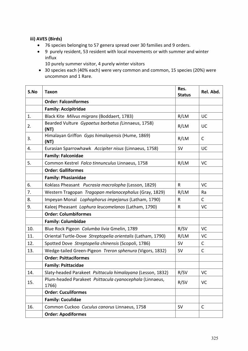
iii) AVES (Birds)
76 species belonging to 57 genera spread over 30 families and 9 orders.
9 purely resident, 53 resident with local movements or with summer and winter influx 10 purely summer visitor, 4 purely winter visitors
30 species each (40% each) were very common and common, 15 species (20%) were uncommon and 1 Rare.
S.No Taxon Res. Status
Rel. Abd.
Order: Falconiformes
Family: Accipitridae
1. Black Kite Milvus migrans (Boddaert, 1783) R/LM UC
2. Bearded Vulture Gypaetus barbatus (Linnaeus, 1758) (NT)
R/LM UC
3. Himalayan Griffon Gyps himalayensis (Hume, 1869) (NT)
R/LM C
4. Eurasian Sparrowhawk Accipiter nisus (Linnaeus, 1758) SV UC
Family: Falconidae
5. Common Kestrel Falco tinnunculus Linnaeus, 1758 R/LM VC
Order: Galliformes
Family: Phasianidae
6. Koklass Pheasant Pucrasia macrolopha (Lesson, 1829) R VC
7. Western Tragopan Tragopan melanocephalus (Gray, 1829) R/LM Ra
8. Impeyan Monal Lophophorus impejanus (Latham, 1790) R C
9. Kaleej Pheasant Lophura leucomelanos (Latham, 1790) R VC
Order: Columbiformes
Family: Columbidae
10. Blue Rock Pigeon Columba livia Gmelin, 1789 R/SV VC
11. Oriental Turtle-Dove Streptopelia orientalis (Latham, 1790) R/LM VC
12. Spotted Dove Streptopelia chinensis (Scopoli, 1786) SV C
13. Wedge-tailed Green-Pigeon Treron sphenura (Vigors, 1832) SV C
Order: Psittaciformes
Family: Psittacidae
14. Slaty-headed Parakeet Psittacula himalayana (Lesson, 1832) R/SV VC
15. Plum-headed Parakeet Psittacula cyanocephala (Linnaeus, 1766)
R/SV VC
Order: Cuculiformes
Family: Cuculidae
16. Common Cuckoo Cuculus canorus Linnaeus, 1758 SV C
Order: Apodiformes
325
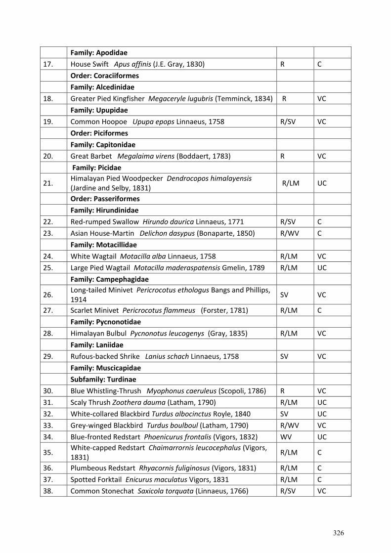
Family: Apodidae
17. House Swift Apus affinis (J.E. Gray, 1830) R C
Order: Coraciiformes
Family: Alcedinidae
18. Greater Pied Kingfisher Megaceryle lugubris (Temminck, 1834) R VC
Family: Upupidae
19. Common Hoopoe Upupa epops Linnaeus, 1758 R/SV VC
Order: Piciformes
Family: Capitonidae
20. Great Barbet Megalaima virens (Boddaert, 1783) R VC
Family: Picidae
21. Himalayan Pied Woodpecker Dendrocopos himalayensis (Jardine and Selby, 1831)
R/LM UC
Order: Passeriformes
Family: Hirundinidae
22. Red-rumped Swallow Hirundo daurica Linnaeus, 1771 R/SV C
23. Asian House-Martin Delichon dasypus (Bonaparte, 1850) R/WV C
Family: Motacillidae
24. White Wagtail Motacilla alba Linnaeus, 1758 R/LM VC
25. Large Pied Wagtail Motacilla maderaspatensis Gmelin, 1789 R/LM UC
Family: Campephagidae
26. Long-tailed Minivet Pericrocotus ethologus Bangs and Phillips, 1914
SV VC
27. Scarlet Minivet Pericrocotus flammeus (Forster, 1781) R/LM C
Family: Pycnonotidae
28. Himalayan Bulbul Pycnonotus leucogenys (Gray, 1835) R/LM VC
Family: Laniidae
29. Rufous-backed Shrike Lanius schach Linnaeus, 1758 SV VC
Family: Muscicapidae
Subfamily: Turdinae
30. Blue Whistling-Thrush Myophonus caeruleus (Scopoli, 1786) R VC
31. Scaly Thrush Zoothera dauma (Latham, 1790) R/LM UC
32. White-collared Blackbird Turdus albocinctus Royle, 1840 SV UC
33. Grey-winged Blackbird Turdus boulboul (Latham, 1790) R/WV VC
34. Blue-fronted Redstart Phoenicurus frontalis (Vigors, 1832) WV UC
35. White-capped Redstart Chaimarrornis leucocephalus (Vigors, 1831)
R/LM C
36. Plumbeous Redstart Rhyacornis fuliginosus (Vigors, 1831) R/LM C
37. Spotted Forktail Enicurus maculatus Vigors, 1831 R/LM C
38. Common Stonechat Saxicola torquata (Linnaeus, 1766) R/SV VC
326
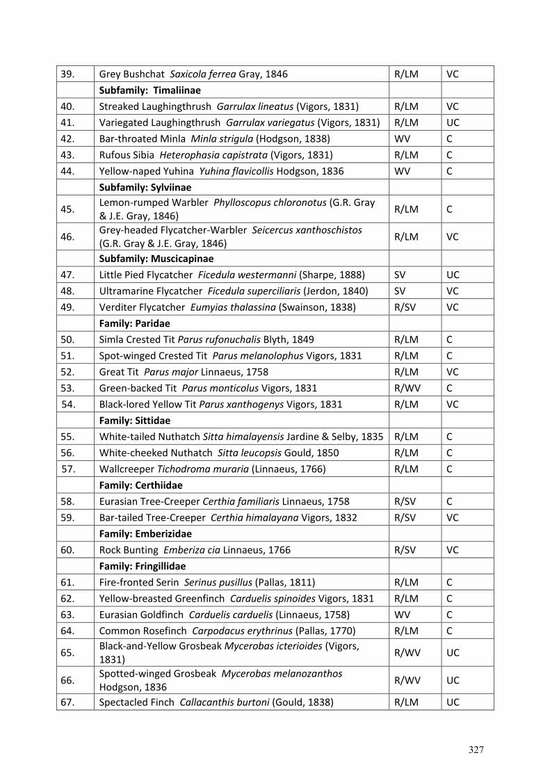
39. Grey Bushchat Saxicola ferrea Gray, 1846 R/LM VC
Subfamily: Timaliinae
40. Streaked Laughingthrush Garrulax lineatus (Vigors, 1831) R/LM VC
41. Variegated Laughingthrush Garrulax variegatus (Vigors, 1831) R/LM UC
42. Bar-throated Minla Minla strigula (Hodgson, 1838) WV C
43. Rufous Sibia Heterophasia capistrata (Vigors, 1831) R/LM C
44. Yellow-naped Yuhina Yuhina flavicollis Hodgson, 1836 WV C
Subfamily: Sylviinae
45. Lemon-rumped Warbler Phylloscopus chloronotus (G.R. Gray & J.E. Gray, 1846)
R/LM C
46. Grey-headed Flycatcher-Warbler Seicercus xanthoschistos (G.R. Gray & J.E. Gray, 1846)
R/LM VC
Subfamily: Muscicapinae
47. Little Pied Flycatcher Ficedula westermanni (Sharpe, 1888) SV UC
48. Ultramarine Flycatcher Ficedula superciliaris (Jerdon, 1840) SV VC
49. Verditer Flycatcher Eumyias thalassina (Swainson, 1838) R/SV VC
Family: Paridae
50. Simla Crested Tit Parus rufonuchalis Blyth, 1849 R/LM C
51. Spot-winged Crested Tit Parus melanolophus Vigors, 1831 R/LM C
52. Great Tit Parus major Linnaeus, 1758 R/LM VC
53. Green-backed Tit Parus monticolus Vigors, 1831 R/WV C
54. Black-lored Yellow Tit Parus xanthogenys Vigors, 1831 R/LM VC
Family: Sittidae
55. White-tailed Nuthatch Sitta himalayensis Jardine & Selby, 1835 R/LM C
56. White-cheeked Nuthatch Sitta leucopsis Gould, 1850 R/LM C
57. Wallcreeper Tichodroma muraria (Linnaeus, 1766) R/LM C
Family: Certhiidae
58. Eurasian Tree-Creeper Certhia familiaris Linnaeus, 1758 R/SV C
59. Bar-tailed Tree-Creeper Certhia himalayana Vigors, 1832 R/SV VC
Family: Emberizidae
60. Rock Bunting Emberiza cia Linnaeus, 1766 R/SV VC
Family: Fringillidae
61. Fire-fronted Serin Serinus pusillus (Pallas, 1811) R/LM C
62. Yellow-breasted Greenfinch Carduelis spinoides Vigors, 1831 R/LM C
63. Eurasian Goldfinch Carduelis carduelis (Linnaeus, 1758) WV C
64. Common Rosefinch Carpodacus erythrinus (Pallas, 1770) R/LM C
65. Black-and-Yellow Grosbeak Mycerobas icterioides (Vigors, 1831)
R/WV UC
66. Spotted-winged Grosbeak Mycerobas melanozanthos Hodgson, 1836
R/WV UC
67. Spectacled Finch Callacanthis burtoni (Gould, 1838) R/LM UC
327
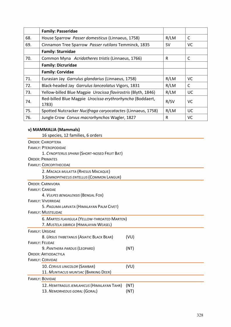
Family: Passeridae
68. House Sparrow Passer domesticus (Linnaeus, 1758) R/LM C
69. Cinnamon Tree Sparrow Passer rutilans Temminck, 1835 SV VC
Family: Sturnidae
70. Common Myna Acridotheres tristis (Linnaeus, 1766) R C
Family: Dicruridae
Family: Corvidae
71. Eurasian Jay Garrulus glandarius (Linnaeus, 1758) R/LM VC
72. Black-headed Jay Garrulus lanceolatus Vigors, 1831 R/LM C
73. Yellow-billed Blue Magpie Urocissa flavirostris (Blyth, 1846) R/LM UC
74. Red-billed Blue Magpie Urocissa erythrorhyncha (Boddaert, 1783)
R/SV VC
75. Spotted Nutcracker Nucifraga caryocatactes (Linnaeus, 1758) R/LM UC
76. Jungle Crow Corvus macrorhynchos Wagler, 1827 R VC
v) MAMMALIA (Mammals)
16 species, 12 families, 6 orders
ORDER: CHIROPTERA FAMILY: PTEROPODIDAE
1. CYNOPTERUS SPHINX (SHORT-NOSED FRUIT BAT) ORDER: PRIMATES FAMILY: CERCOPITHECIDAE
2. MACACA MULATTA (RHESUS MACAQUE) 3 SEMNOPITHECUS ENTELLUS (COMMON LANGUR)
ORDER: CARNIVORA FAMILY: CANIDAE
4. VULPES BENGALENSIS (BENGAL FOX) FAMILY: VIVERRIDAE
5. PAGUMA LARVATA (HIMALAYAN PALM CIVET) FAMILY: MUSTELIDAE
6. MARTES FLAVIGULA (YELLOW-THROATED MARTEN) 7. MUSTELA SIBIRICA (HIMALAYAN WEASEL)
FAMILY: URSIDAE 8. URSUS THIBETANUS (ASIATIC BLACK BEAR) (VU)
FAMILY: FELIDAE 9. PANTHERA PARDUS (LEOPARD) (NT)
ORDER: ARTIODACTYLA FAMILY: CERVIDAE
10. CERVUS UNICOLOR (SAMBAR) (VU) 11. MUNTIACUS MUNTJAC (BARKING DEER)
FAMILY: BOVIDAE
12. HEMITRAGUS JEMLAHICUS (HIMALAYAN TAHR) (NT) 13. NEMORHEDUS GORAL (GORAL) (NT)
328

ORDER: RODENTIA FAMILY: SCIDRIDAE
14. PETAURISTA PETAURISTA (FLYING SQUIRREL) FAMILY: MURIDAE
15. MUS MUSCULUS (HOUSE MOUSE) ORDER: LOGOMORPHA FAMILY: LEPORIDAE
16. LEPUS NIGRICOLLIS (BLACK-NAPED HARE) (VU)= Vulnerable, (NT)= Near Threatened
329
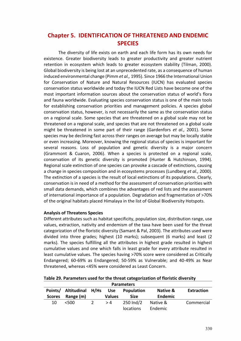
Chapter 5. IDENTIFICATION OF THREATENED AND ENDEMIC
SPECIES
The diversity of life exists on earth and each life form has its own needs for existence. Greater biodiversity leads to greater productivity and greater nutrient retention in ecosystem which leads to greater ecosystem stability (Tilman, 2000). Global biodiversity is being lost at an unprecedented rate, as a consequence of human induced environmental change (Pimm et al., 1995). Since 1966 the International Union for Conservation of Nature and Natural Resources (IUCN) has evaluated species conservation status worldwide and today the IUCN Red Lists have become one of the most important information sources about the conservation status of world’s flora and fauna worldwide. Evaluating species conservation status is one of the main tools for establishing conservation priorities and management policies. A species global conservation status, however, is not necessarily the same as the conservation status on a regional scale. Some species that are threatened on a global scale may not be threatened on a regional scale, and species that are not threatened on a global scale might be threatened in some part of their range (Gardenfors et al., 2001). Some species may be declining fast across their ranges on average but may be locally stable or even increasing. Moreover, knowing the regional status of species is important for several reasons. Loss of population and genetic diversity is a major concern (Grammont & Cuaron, 2006). When a species is protected on a regional scale, conservation of its genetic diversity is promoted (Hunter & Hutchinson, 1994). Regional scale extinction of one species can provoke a cascade of extinctions, causing a change in species composition and in ecosystems processes (Lundberg et al., 2000). The extinction of a species is the result of local extinctions of its populations. Clearly, conservation is in need of a method for the assessment of conservation priorities with small data demands, which combines the advantages of red lists and the assessment of international importance of a population. Degradation and fragmentation of >70% of the original habitats placed Himalaya in the list of Global Biodiversity Hotspots. Analysis of Threatens Species Different attributes such as habitat specificity, population size, distribution range, use values, extraction, nativity and endemism of the taxa have been used for the threat categorization of the floristic diversity (Samant & Pal, 2003). The attributes used were divided into three grades; highest (10 marks); subsequent (6 marks) and least (2 marks). The species fulfilling all the attributes in highest grade resulted in highest cumulative values and one which falls in least grade for every attribute resulted in least cumulative values. The species having >70% score were considered as Critically Endangered; 60-69% as Endangered; 50-59% as Vulnerable; and 40-49% as Near threatened, whereas <45% were considered as Least Concern. Table 29. Parameters used for the threat categorization of floristic diversity
Parameters
Points/ Scores
Altitudinal Range (m)
H/Hs Use Values
Population Size
Native & Endemic
Extraction
10 <500 2 > 4 250 Ind/2 locations
Native & Endemic
Commercial
330
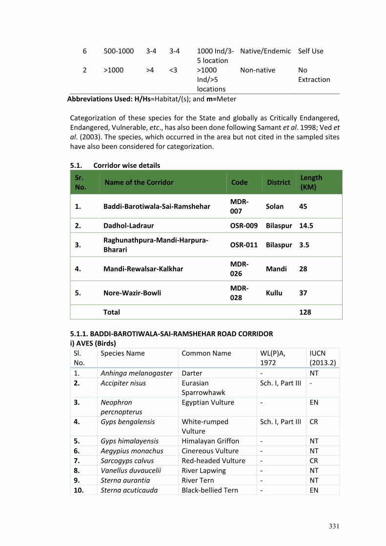
6 500-1000 3-4 3-4 1000 Ind/3-5 location
Native/Endemic Self Use
2 >1000 >4 <3 >1000 Ind/>5 locations
Non-native No Extraction
Abbreviations Used: H/Hs=Habitat/(s); and m=Meter Categorization of these species for the State and globally as Critically Endangered, Endangered, Vulnerable, etc., has also been done following Samant et al. 1998; Ved et al. (2003). The species, which occurred in the area but not cited in the sampled sites have also been considered for categorization. 5.1. Corridor wise details
Sr. No.
Name of the Corridor Code District Length (KM)
1. Baddi-Barotiwala-Sai-Ramshehar MDR-007
Solan 45
2. Dadhol-Ladraur OSR-009 Bilaspur 14.5
3. Raghunathpura-Mandi-Harpura- Bharari
OSR-011 Bilaspur 3.5
4. Mandi-Rewalsar-Kalkhar MDR-026
Mandi 28
5. Nore-Wazir-Bowli MDR-028
Kullu 37
Total 128
5.1.1. BADDI-BAROTIWALA-SAI-RAMSHEHAR ROAD CORRIDOR i) AVES (Birds)
Sl. No.
Species Name Common Name WL(P)A, 1972
IUCN (2013.2)
1. Anhinga melanogaster Darter - NT
2. Accipiter nisus Eurasian Sparrowhawk
Sch. I, Part III -
3. Neophron percnopterus
Egyptian Vulture - EN
4. Gyps bengalensis White-rumped Vulture
Sch. I, Part III CR
5. Gyps himalayensis Himalayan Griffon - NT
6. Aegypius monachus Cinereous Vulture - NT
7. Sarcogyps calvus Red-headed Vulture - CR
8. Vanellus duvaucelii River Lapwing - NT
9. Sterna aurantia River Tern - NT
10. Sterna acuticauda Black-bellied Tern - EN
331
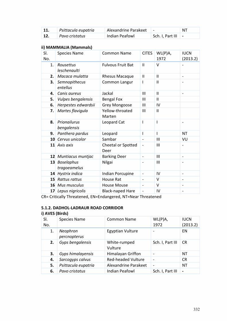
11. Psittacula eupatria Alexandrine Parakeet - NT
12. Pavo cristatus Indian Peafowl Sch. I, Part III -
ii) MAMMALIA (Mammals)
Sl. No.
Species Name Common Name CITES WL(P)A, 1972
IUCN (2013.2)
1. Rousettus leschenaulti
Fulvous Fruit Bat II V -
2. Macaca mulatta Rhesus Macaque II II -
3. Semnopithecus entellus
Common Langur I II -
4. Canis aureus Jackal III II -
5. Vulpes bengalensis Bengal Fox III II
6. Herpestes edwardsii Grey Mongoose III IV
7. Martes flavigula Yellow-throated Marten
III II
8. Prionailurus bengalensis
Leopard Cat I I -
9. Panthera pardus Leopard I I NT
10. Cervus unicolor Sambar - III VU
11. Axis axis Cheetal or Spotted Deer
- III -
12. Muntiacus muntjac Barking Deer - III -
13. Boselaphus tragoeamelus
Nilgai - III -
14. Hystrix indica Indian Porcupine - IV -
15. Rattus rattus House Rat - V -
16. Mus musculus House Mouse - V -
17. Lepus nigricolis Black-naped Hare - IV -
CR= Critically Threatened, EN=Endangered, NT=Near Threatened 5.1.2. DADHOL-LADRAUR ROAD CORRIDOR i) AVES (Birds)
Sl. No.
Species Name Common Name WL(P)A, 1972
IUCN (2013.2)
1. Neophron percnopterus
Egyptian Vulture - EN
2. Gyps bengalensis White-rumped Vulture
Sch. I, Part III CR
3. Gyps himalayensis Himalayan Griffon - NT
4. Sarcogyps calvus Red-headed Vulture - CR
5. Psittacula eupatria Alexandrine Parakeet - NT
6. Pavo cristatus Indian Peafowl Sch. I, Part III -
332
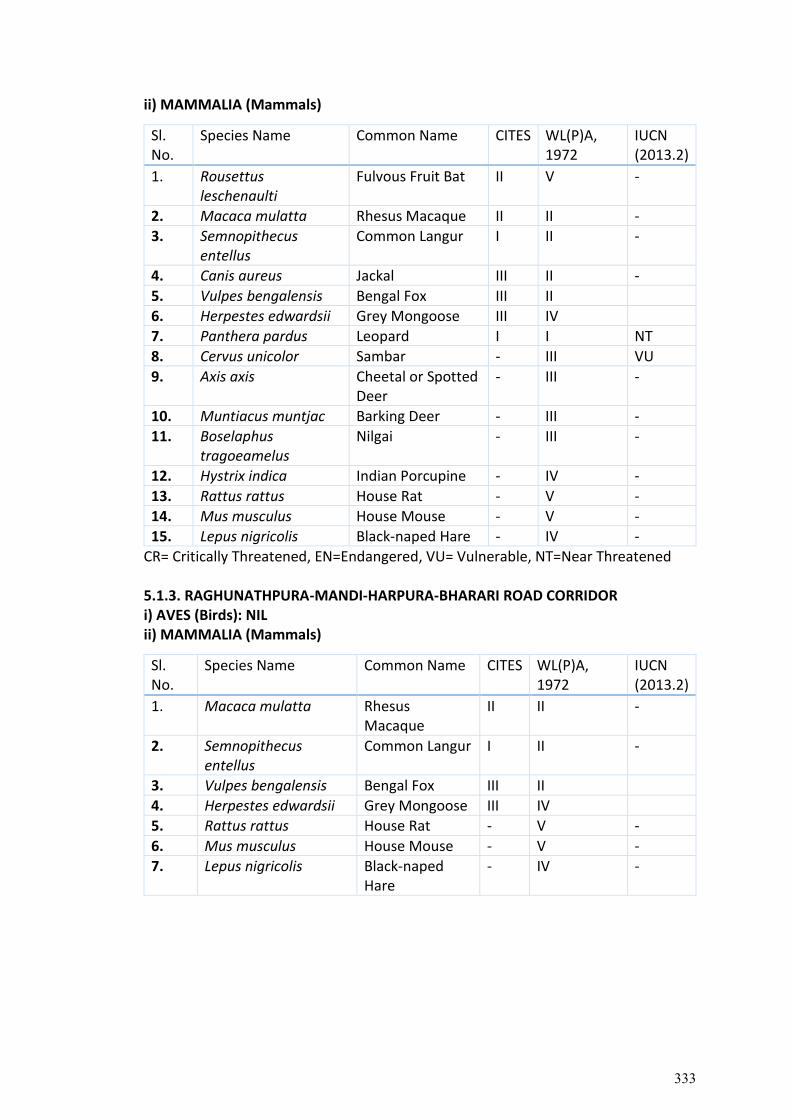
ii) MAMMALIA (Mammals)
Sl. No.
Species Name Common Name CITES WL(P)A, 1972
IUCN (2013.2)
1. Rousettus leschenaulti
Fulvous Fruit Bat II V -
2. Macaca mulatta Rhesus Macaque II II -
3. Semnopithecus entellus
Common Langur I II -
4. Canis aureus Jackal III II -
5. Vulpes bengalensis Bengal Fox III II
6. Herpestes edwardsii Grey Mongoose III IV
7. Panthera pardus Leopard I I NT
8. Cervus unicolor Sambar - III VU
9. Axis axis Cheetal or Spotted Deer
- III -
10. Muntiacus muntjac Barking Deer - III -
11. Boselaphus tragoeamelus
Nilgai - III -
12. Hystrix indica Indian Porcupine - IV -
13. Rattus rattus House Rat - V -
14. Mus musculus House Mouse - V -
15. Lepus nigricolis Black-naped Hare - IV -
CR= Critically Threatened, EN=Endangered, VU= Vulnerable, NT=Near Threatened 5.1.3. RAGHUNATHPURA-MANDI-HARPURA-BHARARI ROAD CORRIDOR i) AVES (Birds): NIL ii) MAMMALIA (Mammals)
Sl. No.
Species Name Common Name CITES WL(P)A, 1972
IUCN (2013.2)
1. Macaca mulatta Rhesus Macaque
II II -
2. Semnopithecus entellus
Common Langur I II -
3. Vulpes bengalensis Bengal Fox III II
4. Herpestes edwardsii Grey Mongoose III IV
5. Rattus rattus House Rat - V -
6. Mus musculus House Mouse - V -
7. Lepus nigricolis Black-naped Hare
- IV -
333
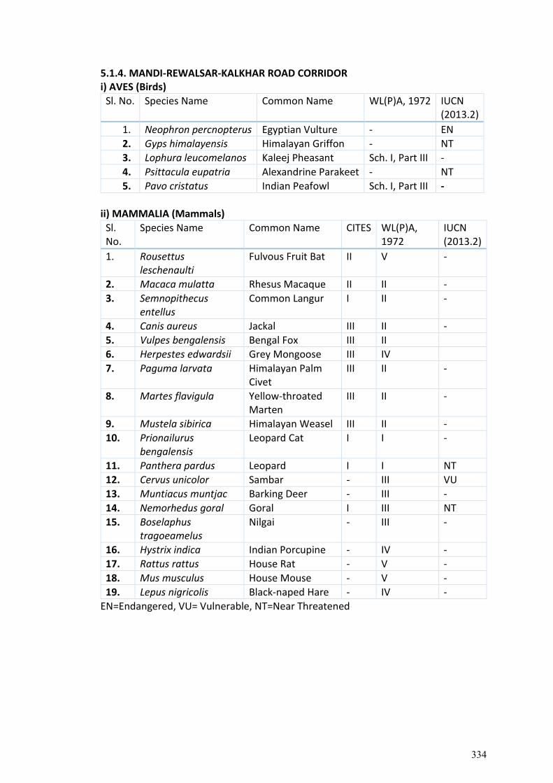
5.1.4. MANDI-REWALSAR-KALKHAR ROAD CORRIDOR i) AVES (Birds)
Sl. No. Species Name Common Name WL(P)A, 1972 IUCN (2013.2)
1. Neophron percnopterus Egyptian Vulture - EN
2. Gyps himalayensis Himalayan Griffon - NT
3. Lophura leucomelanos Kaleej Pheasant Sch. I, Part III -
4. Psittacula eupatria Alexandrine Parakeet - NT
5. Pavo cristatus Indian Peafowl Sch. I, Part III -
ii) MAMMALIA (Mammals)
Sl. No.
Species Name Common Name CITES WL(P)A, 1972
IUCN (2013.2)
1. Rousettus leschenaulti
Fulvous Fruit Bat II V -
2. Macaca mulatta Rhesus Macaque II II -
3. Semnopithecus entellus
Common Langur I II -
4. Canis aureus Jackal III II -
5. Vulpes bengalensis Bengal Fox III II
6. Herpestes edwardsii Grey Mongoose III IV
7. Paguma larvata Himalayan Palm Civet
III II -
8. Martes flavigula Yellow-throated Marten
III II -
9. Mustela sibirica Himalayan Weasel III II -
10. Prionailurus bengalensis
Leopard Cat I I -
11. Panthera pardus Leopard I I NT
12. Cervus unicolor Sambar - III VU
13. Muntiacus muntjac Barking Deer - III -
14. Nemorhedus goral Goral I III NT
15. Boselaphus tragoeamelus
Nilgai - III -
16. Hystrix indica Indian Porcupine - IV -
17. Rattus rattus House Rat - V -
18. Mus musculus House Mouse - V -
19. Lepus nigricolis Black-naped Hare - IV -
EN=Endangered, VU= Vulnerable, NT=Near Threatened
334
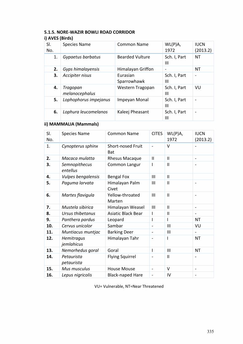
5.1.5. NORE-WAZIR BOWLI ROAD CORRIDOR i) AVES (Birds)
Sl. No.
Species Name Common Name WL(P)A, 1972
IUCN (2013.2)
1. Gypaetus barbatus Bearded Vulture Sch. I, Part III
NT
2. Gyps himalayensis Himalayan Griffon - NT
3. Accipiter nisus Eurasian Sparrowhawk
Sch. I, Part III
-
4. Tragopan melanocephalus
Western Tragopan Sch. I, Part III
VU
5. Lophophorus impejanus Impeyan Monal Sch. I, Part III
-
6. Lophura leucomelanos Kaleej Pheasant Sch. I, Part III
-
ii) MAMMALIA (Mammals)
Sl. No.
Species Name Common Name CITES WL(P)A, 1972
IUCN (2013.2)
1. Cynopterus sphinx Short-nosed Fruit Bat
- V -
2. Macaca mulatta Rhesus Macaque II II -
3. Semnopithecus entellus
Common Langur I II -
4. Vulpes bengalensis Bengal Fox III II
5. Paguma larvata Himalayan Palm Civet
III II -
6. Martes flavigula Yellow-throated Marten
III II -
7. Mustela sibirica Himalayan Weasel III II -
8. Ursus thibetanus Asiatic Black Bear I II -
9. Panthera pardus Leopard I I NT
10. Cervus unicolor Sambar - III VU
11. Muntiacus muntjac Barking Deer - III -
12. Hemitragus jemlahicus
Himalayan Tahr - I NT
13. Nemorhedus goral Goral I III NT
14. Petaurista petaurista
Flying Squirrel - II -
15. Mus musculus House Mouse - V -
16. Lepus nigricolis Black-naped Hare - IV -
VU= Vulnerable, NT=Near Threatened
335
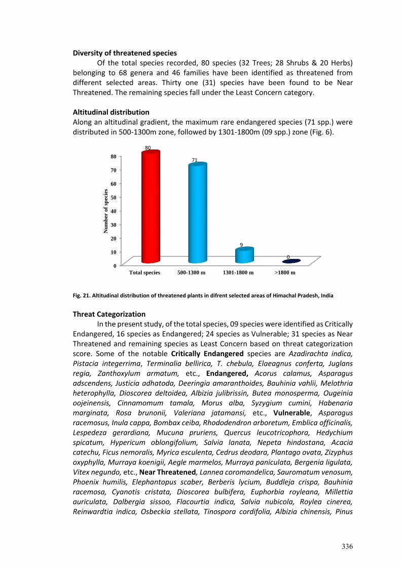
Diversity of threatened species Of the total species recorded, 80 species (32 Trees; 28 Shrubs & 20 Herbs) belonging to 68 genera and 46 families have been identified as threatened from different selected areas. Thirty one (31) species have been found to be Near Threatened. The remaining species fall under the Least Concern category. Altitudinal distribution Along an altitudinal gradient, the maximum rare endangered species (71 spp.) were distributed in 500-1300m zone, followed by 1301-1800m (09 spp.) zone (Fig. 6).
Fig. 21. Altitudinal distribution of threatened plants in difrent selected areas of Himachal Pradesh, India
Threat Categorization
In the present study, of the total species, 09 species were identified as Critically Endangered, 16 species as Endangered; 24 species as Vulnerable; 31 species as Near Threatened and remaining species as Least Concern based on threat categorization score. Some of the notable Critically Endangered species are Azadirachta indica, Pistacia integerrima, Terminalia bellirica, T. chebula, Elaeagnus conferta, Juglans regia, Zanthoxylum armatum, etc., Endangered, Acorus calamus, Asparagus adscendens, Justicia adhatoda, Deeringia amaranthoides, Bauhinia vahlii, Melothria heterophylla, Dioscorea deltoidea, Albizia julibrissin, Butea monosperma, Ougeinia oojeinensis, Cinnamomum tamala, Morus alba, Syzygium cumini, Habenaria marginata, Rosa brunonii, Valeriana jatamansi, etc., Vulnerable, Asparagus racemosus, Inula cappa, Bombax ceiba, Rhododendron arboretum, Emblica officinalis, Lespedeza gerardiana, Mucuna pruriens, Quercus leucotricophora, Hedychium spicatum, Hypericum oblongifolium, Salvia lanata, Nepeta hindostana, Acacia catechu, Ficus nemoralis, Myrica esculenta, Cedrus deodara, Plantago ovata, Zizyphus oxyphylla, Murraya koenigii, Aegle marmelos, Murraya paniculata, Bergenia ligulata, Vitex negundo, etc., Near Threatened, Lannea coromandelica, Sauromatum venosum, Phoenix humilis, Elephantopus scaber, Berberis lycium, Buddleja crispa, Bauhinia racemosa, Cyanotis cristata, Dioscorea bulbifera, Euphorbia royleana, Millettia auriculata, Dalbergia sissoo, Flacourtia indica, Salvia nubicola, Roylea cinerea, Reinwardtia indica, Osbeckia stellata, Tinospora cordifolia, Albizia chinensis, Pinus
0
10
20
30
40
50
60
70
80
Total species 500-1300 m 1301-1800 m >1800 m
80
71
9
0
Nu
mb
er o
f sp
ecie
s
336
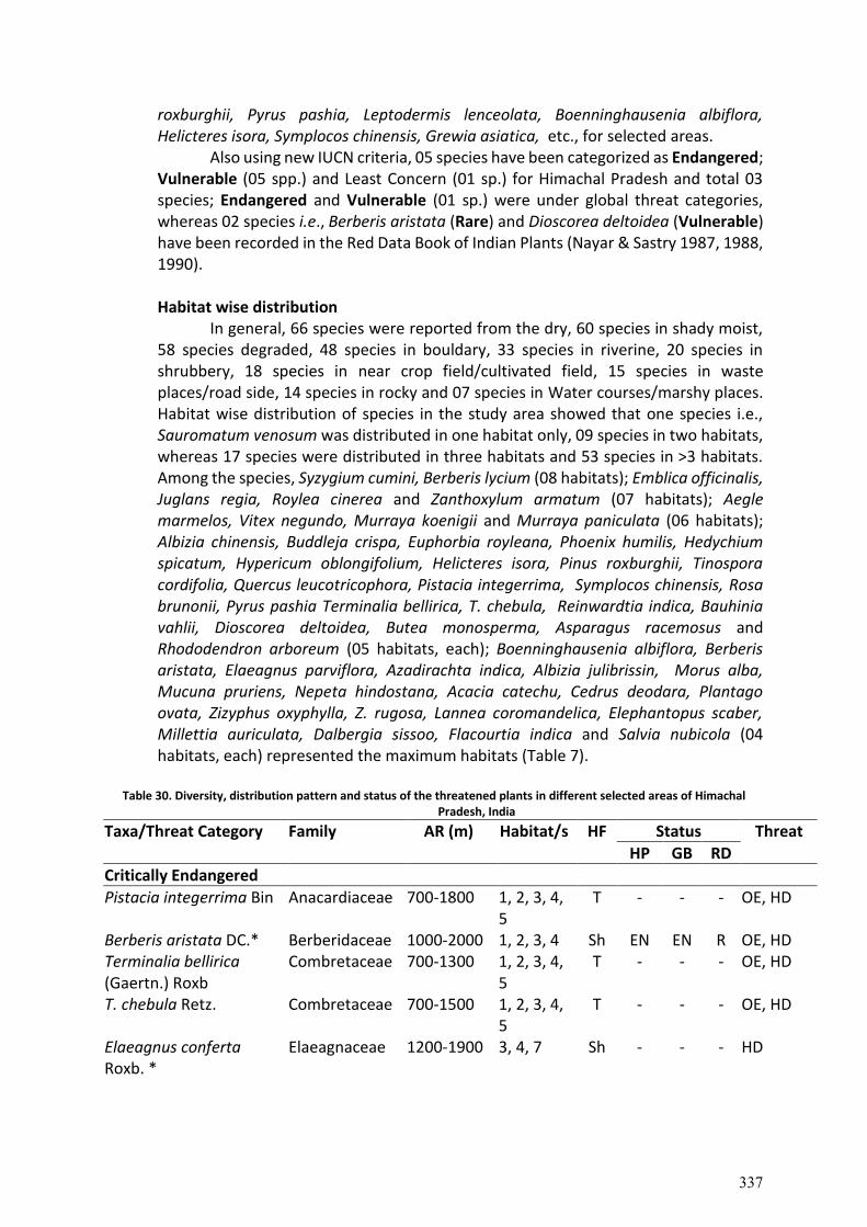
roxburghii, Pyrus pashia, Leptodermis lenceolata, Boenninghausenia albiflora, Helicteres isora, Symplocos chinensis, Grewia asiatica, etc., for selected areas. Also using new IUCN criteria, 05 species have been categorized as Endangered; Vulnerable (05 spp.) and Least Concern (01 sp.) for Himachal Pradesh and total 03 species; Endangered and Vulnerable (01 sp.) were under global threat categories, whereas 02 species i.e., Berberis aristata (Rare) and Dioscorea deltoidea (Vulnerable) have been recorded in the Red Data Book of Indian Plants (Nayar & Sastry 1987, 1988, 1990). Habitat wise distribution In general, 66 species were reported from the dry, 60 species in shady moist, 58 species degraded, 48 species in bouldary, 33 species in riverine, 20 species in shrubbery, 18 species in near crop field/cultivated field, 15 species in waste places/road side, 14 species in rocky and 07 species in Water courses/marshy places. Habitat wise distribution of species in the study area showed that one species i.e., Sauromatum venosum was distributed in one habitat only, 09 species in two habitats, whereas 17 species were distributed in three habitats and 53 species in >3 habitats. Among the species, Syzygium cumini, Berberis lycium (08 habitats); Emblica officinalis, Juglans regia, Roylea cinerea and Zanthoxylum armatum (07 habitats); Aegle marmelos, Vitex negundo, Murraya koenigii and Murraya paniculata (06 habitats); Albizia chinensis, Buddleja crispa, Euphorbia royleana, Phoenix humilis, Hedychium spicatum, Hypericum oblongifolium, Helicteres isora, Pinus roxburghii, Tinospora cordifolia, Quercus leucotricophora, Pistacia integerrima, Symplocos chinensis, Rosa brunonii, Pyrus pashia Terminalia bellirica, T. chebula, Reinwardtia indica, Bauhinia vahlii, Dioscorea deltoidea, Butea monosperma, Asparagus racemosus and Rhododendron arboreum (05 habitats, each); Boenninghausenia albiflora, Berberis aristata, Elaeagnus parviflora, Azadirachta indica, Albizia julibrissin, Morus alba, Mucuna pruriens, Nepeta hindostana, Acacia catechu, Cedrus deodara, Plantago ovata, Zizyphus oxyphylla, Z. rugosa, Lannea coromandelica, Elephantopus scaber, Millettia auriculata, Dalbergia sissoo, Flacourtia indica and Salvia nubicola (04 habitats, each) represented the maximum habitats (Table 7).
Table 30. Diversity, distribution pattern and status of the threatened plants in different selected areas of Himachal Pradesh, India
Taxa/Threat Category Family AR (m) Habitat/s HF Status Threat
HP GB RD
Critically Endangered
Pistacia integerrima Bin Anacardiaceae 700-1800 1, 2, 3, 4, 5
T - - - OE, HD
Berberis aristata DC.* Berberidaceae 1000-2000 1, 2, 3, 4 Sh EN EN R OE, HD Terminalia bellirica (Gaertn.) Roxb
Combretaceae 700-1300 1, 2, 3, 4, 5
T - - - OE, HD
T. chebula Retz. Combretaceae 700-1500 1, 2, 3, 4, 5
T - - - OE, HD
Elaeagnus conferta Roxb. *
Elaeagnaceae 1200-1900 3, 4, 7 Sh - - - HD
337
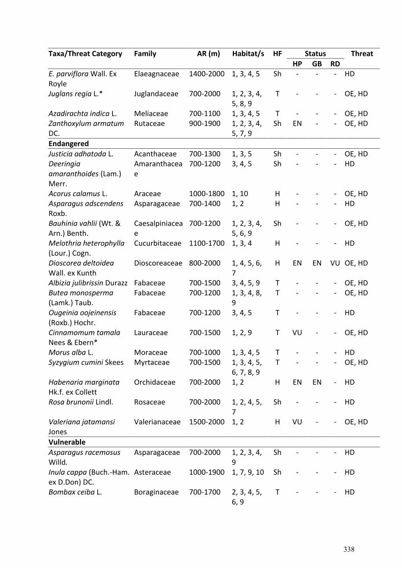
Taxa/Threat Category Family AR (m) Habitat/s HF Status Threat
HP GB RD E. parviflora Wall. Ex Royle
Elaeagnaceae 1400-2000 1, 3, 4, 5 Sh - - - HD
Juglans regia L.* Juglandaceae 700-2000 1, 2, 3, 4, 5, 8, 9
T - - - OE, HD
Azadirachta indica L. Meliaceae 700-1100 1, 3, 4, 5 T - - - OE, HD Zanthoxylum armatum DC.
Rutaceae 900-1900 1, 2, 3, 4, 5, 7, 9
Sh EN - - OE, HD
Endangered
Justicia adhatoda L. Acanthaceae 700-1300 1, 3, 5 Sh - - - OE, HD Deeringia amaranthoides (Lam.) Merr.
Amaranthaceae
700-1200 3, 4, 5 Sh - - - HD
Acorus calamus L. Araceae 1000-1800 1, 10 H - - - OE, HD Asparagus adscendens Roxb.
Asparagaceae 700-1400 1, 2 H - - - HD
Bauhinia vahlii (Wt. & Arn.) Benth.
Caesalpiniaceae
700-1200 1, 2, 3, 4, 5, 6, 9
Sh - - - OE, HD
Melothria heterophylla (Lour.) Cogn.
Cucurbitaceae 1100-1700 1, 3, 4 H - - - HD
Dioscorea deltoidea Wall. ex Kunth
Dioscoreaceae 800-2000 1, 4, 5, 6, 7
H EN EN VU OE, HD
Albizia julibrissin Durazz Fabaceae 700-1500 3, 4, 5, 9 T - - - OE, HD Butea monosperma (Lamk.) Taub.
Fabaceae 700-1200 1, 3, 4, 8, 9
T - - - OE, HD
Ougeinia oojeinensis (Roxb.) Hochr.
Fabaceae 700-1200 3, 4, 5 T - - - HD
Cinnamomum tamala Nees & Ebern*
Lauraceae 700-1500 1, 2, 9 T VU - - OE, HD
Morus alba L. Moraceae 700-1000 1, 3, 4, 5 T - - - HD Syzygium cumini Skees Myrtaceae 700-1500 1, 3, 4, 5,
6, 7, 8, 9 T - - - OE, HD
Habenaria marginata Hk.f. ex Collett
Orchidaceae 700-2000 1, 2 H EN EN - HD
Rosa brunonii Lindl. Rosaceae 700-2000 1, 2, 4, 5, 7
Sh - - - HD
Valeriana jatamansi Jones
Valerianaceae 1500-2000 1, 2 H VU - - OE, HD
Vulnerable
Asparagus racemosus Willd.
Asparagaceae 700-2000 1, 2, 3, 4, 9
Sh - - - HD
Inula cappa (Buch.-Ham. ex D.Don) DC.
Asteraceae 1000-1900 1, 7, 9, 10 Sh - - - HD
Bombax ceiba L. Boraginaceae 700-1700 2, 3, 4, 5, 6, 9
T - - - HD
338
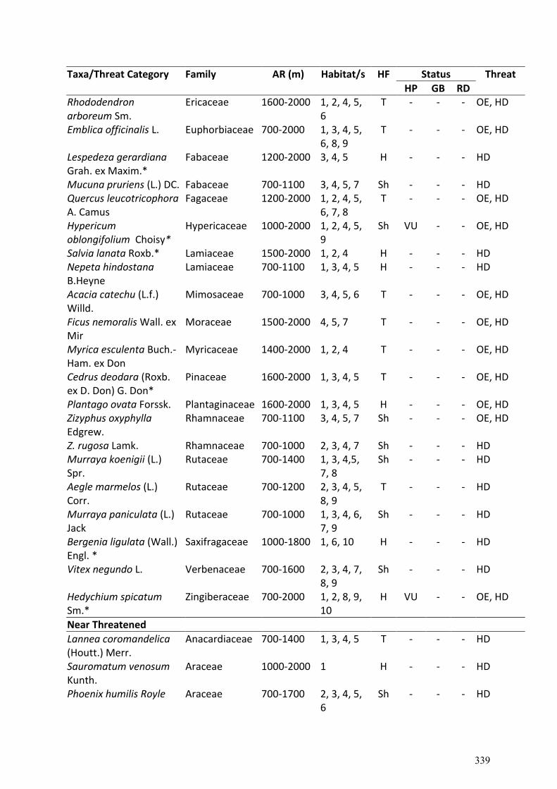
Taxa/Threat Category Family AR (m) Habitat/s HF Status Threat
HP GB RD Rhododendron arboreum Sm.
Ericaceae 1600-2000 1, 2, 4, 5, 6
T - - - OE, HD
Emblica officinalis L. Euphorbiaceae 700-2000 1, 3, 4, 5, 6, 8, 9
T - - - OE, HD
Lespedeza gerardiana Grah. ex Maxim.*
Fabaceae 1200-2000 3, 4, 5 H - - - HD
Mucuna pruriens (L.) DC. Fabaceae 700-1100 3, 4, 5, 7 Sh - - - HD Quercus leucotricophora A. Camus
Fagaceae 1200-2000 1, 2, 4, 5, 6, 7, 8
T - - - OE, HD
Hypericum oblongifolium Choisy*
Hypericaceae 1000-2000 1, 2, 4, 5, 9
Sh VU - - OE, HD
Salvia lanata Roxb.* Lamiaceae 1500-2000 1, 2, 4 H - - - HD Nepeta hindostana B.Heyne
Lamiaceae 700-1100 1, 3, 4, 5 H - - - HD
Acacia catechu (L.f.) Willd.
Mimosaceae 700-1000 3, 4, 5, 6 T - - - OE, HD
Ficus nemoralis Wall. ex Mir
Moraceae 1500-2000 4, 5, 7 T - - - OE, HD
Myrica esculenta Buch.-Ham. ex Don
Myricaceae 1400-2000 1, 2, 4 T - - - OE, HD
Cedrus deodara (Roxb. ex D. Don) G. Don*
Pinaceae 1600-2000 1, 3, 4, 5 T - - - OE, HD
Plantago ovata Forssk. Plantaginaceae 1600-2000 1, 3, 4, 5 H - - - OE, HD Zizyphus oxyphylla Edgrew.
Rhamnaceae 700-1100 3, 4, 5, 7 Sh - - - OE, HD
Z. rugosa Lamk. Rhamnaceae 700-1000 2, 3, 4, 7 Sh - - - HD Murraya koenigii (L.) Spr.
Rutaceae 700-1400 1, 3, 4,5, 7, 8
Sh - - - HD
Aegle marmelos (L.) Corr.
Rutaceae 700-1200 2, 3, 4, 5, 8, 9
T - - - HD
Murraya paniculata (L.) Jack
Rutaceae 700-1000 1, 3, 4, 6, 7, 9
Sh - - - HD
Bergenia ligulata (Wall.) Engl. *
Saxifragaceae 1000-1800 1, 6, 10 H - - - HD
Vitex negundo L. Verbenaceae 700-1600 2, 3, 4, 7, 8, 9
Sh - - - HD
Hedychium spicatum Sm.*
Zingiberaceae 700-2000 1, 2, 8, 9, 10
H VU - - OE, HD
Near Threatened
Lannea coromandelica (Houtt.) Merr.
Anacardiaceae 700-1400 1, 3, 4, 5 T - - - HD
Sauromatum venosum Kunth.
Araceae 1000-2000 1 H - - - HD
Phoenix humilis Royle Araceae 700-1700 2, 3, 4, 5, 6
Sh - - - HD
339
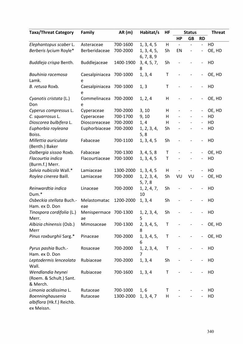
Taxa/Threat Category Family AR (m) Habitat/s HF Status Threat
HP GB RD Elephantopus scaber L. Asteraceae 700-1600 1, 3, 4, 5 H - - - HD Berberis lycium Royle* Berberidaceae 700-2000 1, 3, 4, 5,
6, 7, 8, 9 Sh EN - - OE, HD
Buddleja crispa Benth. Buddlejaceae 1400-1900 3, 4, 5, 7, 8
Sh - - - HD
Bauhinia racemosa Lamk.
Caesalpiniaceae
700-1000 1, 3, 4 T - - - OE, HD
B. retusa Roxb. Caesalpiniaceae
700-1000 1, 3 T - - - HD
Cyanotis cristata (L.) Don
Commelinaceae
700-2000 1, 2, 4 H - - - OE, HD
Cyperus compressus L. Cyperaceae 700-2000 3, 10 H - - - OE, HD C. squarrosus L. Cyperaceae 700-1700 9, 10 H - - - HD Dioscorea bulbifera L. Dioscoreaceae 700-2000 1, 4 H - - - HD Euphorbia royleana Boiss.
Euphorbiaceae 700-2000 1, 2, 3, 4, 5, 8
Sh - - - HD
Millettia auriculata (Benth.) Baker
Fabaceae 700-1100 1, 3, 4, 5 Sh - - - HD
Dalbergia sissoo Roxb. Fabaceae 700-1300 3, 4, 5, 8 T - - - OE, HD Flacourtia indica (Burm.f.) Merr.
Flacourtiaceae 700-1000 1, 3, 4, 5 T - - - HD
Salvia nubicola Wall.* Lamiaceae 1300-2000 1, 3, 4, 5 H - - - HD Roylea cinerea Baill. Lamiaceae 700-2000 1, 2, 3, 4,
5, 7, 8 Sh VU VU - OE, HD
Reinwardtia indica Dum.*
Linaceae 700-2000 1, 2, 4, 7, 10
Sh - - - HD
Osbeckia stellata Buch.-Ham. ex D. Don
Melastomataceae
1200-2000 1, 3, 4 Sh - - - HD
Tinospora cordifolia (L.) Merr.
Menispermaceae
700-1300 1, 2, 3, 4, 5
Sh - - - HD
Albizia chinensis (Osb.) Merr
Mimosaceae 700-1300 2, 3, 4, 5, 8
T - - - OE, HD
Pinus roxburghii Sarg.* Pinaceae 700-2000 1, 3, 4, 5, 6
T - - - OE, HD
Pyrus pashia Buch.-Ham. ex D. Don
Rosaceae 700-2000 1, 2, 3, 4, 7
T - - - HD
Leptodermis lenceolata Wall.
Rubiaceae 700-2000 1, 3, 4 Sh - - - HD
Wendlandia heynei (Roem. & Schult.) Sant. & Merch.
Rubiaceae 700-1600 1, 3, 4 T - - - HD
Limonia acidissima L. Rutaceae 700-1000 1, 6 T - - - HD Boenninghausenia albiflora (Hk.f.) Reichb. ex Meissn.
Rutaceae 1300-2000 1, 3, 4, 7 H - - - HD
340
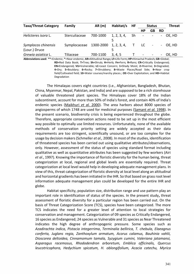
Taxa/Threat Category Family AR (m) Habitat/s HF Status Threat
HP GB RD Helicteres isora L. Sterculiaceae 700-1000 1, 2, 3, 4,
5 Sh - - - OE, HD
Symplocos chinensis (Lour.) Druce
Symplocaceae 1300-2000 1, 2, 3, 4, 5
T LC - - OE, HD
Grewia asiatica L. Tiliaceae 700-1100 3, 4, 5 T - - - OE, HD Abbreviations used: **=Endemic; *=Near endemic; AR=Altitudinal Range; LF=Life Form; HP=Himachal Pradesh; GB=Global;
RD=Red Data Book; T=Tree; Sh=Shrub; H=Herb; Fn=Fern; R=Rare; CR=Critically Endangered; EN=Endangered; VU=Vulnerable; LC=Least Concern; 1=Shady Moist; 2=Riverine; 3=Degraded; 4=Dry; 5=Bouldary; 6=Rocky; 7=Shrubbery; 8=Waste Places/Road Side; 9=Near crop field/Cultivated field; 10=Water courses/marshy places.; OE=Over Exploitation; and HD=Habitat Degradation
The Himalayas covers eight countries (i.e., Afghanistan, Bangladesh, Bhutan,
China, Myanmar, Nepal, Pakistan, and India) and are supposed to be a rich storehouse of valuable threatened plant species. The Himalayas cover 18% of the Indian subcontinent, account for more than 50% of India's forest, and contain 40% of India's endemic species (Maikhuri et al. 2000). The area harbors about 8000 species of angiosperms of which 1748 are used for medicinal purposes (Samant et al. 1998). In the present scenario, biodiversity crisis is being experienced throughout the globe. Therefore, appropriate conservation actions need to be set up in the most efficient way possible to optimally use limited resources. Unfortunately, none of the available methods of conservation priority setting are widely accepted as their data requirements are too stringent, scientifically unsound, or are too complex for the usage by decision makers (Schmeller et al., 2008). In most of the studies, identification of threatened species has been carried out using qualitative attributes/observations, only. However, assessment of the status of species using standard format including qualitative as well as quantitative attributes has been suggested by few workers (Airi et al., 1997). Knowing the importance of floristic diversity for the human being, threat categorization at local, regional and global levels are essentially required. Threat categorization at local level would help in developing adequate management plans. In view of this, threat categorization of floristic diversity at local level along an altitudinal and horizontal gradients has been initiated in the IHR. So that based on grass root level information adequate management plan could be developed for the entire IHR and globe.
Habitat specificity, population size, distribution range and use pattern play an important role in identification of status of the species. In the present study, threat assessment of floristic diversity for a particular region has been carried out. On the basis of Threat Categorization Score (TCS), species have been categorized. The more TCS indicates the need for a greater level of attention to local strategies for conservation and management. Categorization of 09 species as Critically Endangered, 16 species as Endangered; 24 species as Vulnerable and 31 species as Near Threatened indicates the high degree of anthropogenic pressure. Some species such as Azadirachta indica, Pistacia integerrima, Terminalia bellirica, T. chebula, Elaeagnus conferta, Juglans regia, Zanthoxylum armatum, Acorus calamus, Bauhinia vahlii, Dioscorea deltoidea, Cinnamomum tamala, Syzygium cumini, Valeriana jatamansi, Asparagus racemosus, Rhododendron arboretum, Emblica officinalis, Quercus leucotricophora, Hedychium spicatum, H. oblongifolium, Acacia catechu, Myrica
341

esculenta, Cedrus deodara, Plantago ovata, Zizyphus oxyphylla, Aegle marmelos, Murraya koenigii, M. paniculata, Bergenia ligulata, Vitex negundo, Berberis lycium, Dalbergia sissoo, Flacourtia indica and Tinospora cordifolia showed high threats in the study areas, Himachal Pradesh and throughout the Globe hence have high conservation importance. Land use, climate change, nitrogen deposition, biotic exchange and atmospheric carbon dioxide have been the major cause of changes in biodiversity. Moreover, the climate change is not, at the moment, the major threat affecting plants and it is less important than the change in the land use (Sala et al., 2000). Two factors i.e., overexploitation and habitat degradation have been causing decrease in the population of a species throughout globe. 38 species were severely affected by both the factors and 41 species were suffering from habitat degradation. Over exploitation of underground parts i.e., roots/rhizomes/barks/tubers/bulbs of Acorus calamus, Dioscorea deltoidea, Zanthoxylum armatum, Juglans regia, Hedychium spicatum, H. oblongifolium, Acacia catechu, Murraya koenigii, Vitex negundo, Berberis lycium, Tinospora cordifolia, etc. may lead to extinction of these species from their natural habitats. Listing of species like Berberis aristata and Dioscorea deltoidea in the Red Data Book of Indian Plants indicated priority attention for conservation.
342
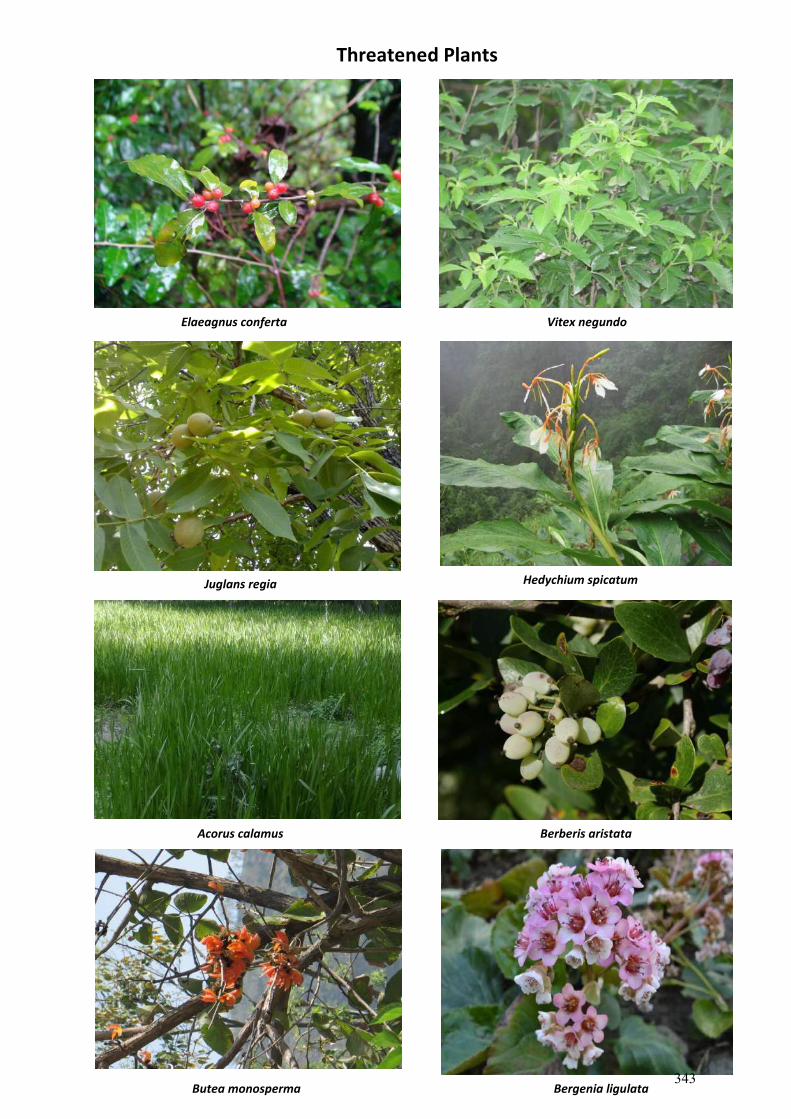
Acorus calamus
Butea monosperma
Juglans regia
Berberis aristata
Vitex negundo Elaeagnus conferta
Threatened Plants
Hedychium spicatum
Bergenia ligulata 343
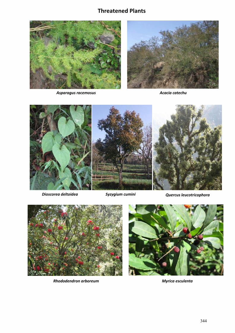
Threatened Plants
Rhododendron arboreum
Syzygium cumini Quercus leucotricophora Dioscorea deltoidea
Myrica esculenta
Asparagus racemosus Acacia catechu
344
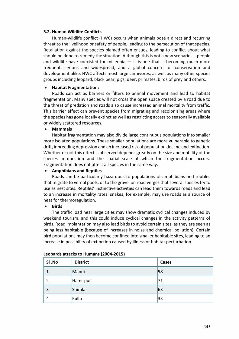
5.2. Human Wildlife Conflicts
Human-wildlife conflict (HWC) occurs when animals pose a direct and recurring threat to the livelihood or safety of people, leading to the persecution of that species. Retaliation against the species blamed often ensues, leading to conflict about what should be done to remedy the situation. Although this is not a new scenario — people and wildlife have coexisted for millennia — it is one that is becoming much more frequent, serious and widespread, and a global concern for conservation and development alike. HWC affects most large carnivores, as well as many other species groups including leopard, black bear, pigs, deer, primates, birds of prey and others.
Habitat Fragmentation: Roads can act as barriers or filters to animal movement and lead to habitat
fragmentation. Many species will not cross the open space created by a road due to the threat of predation and roads also cause increased animal mortality from traffic. This barrier effect can prevent species from migrating and recolonising areas where the species has gone locally extinct as well as restricting access to seasonally available or widely scattered resources.
Mammals Habitat fragmentation may also divide large continuous populations into smaller
more isolated populations. These smaller populations are more vulnerable to genetic drift, inbreeding depression and an increased risk of population decline and extinction. Whether or not this effect is observed depends greatly on the size and mobility of the species in question and the spatial scale at which the fragmentation occurs. Fragmentation does not affect all species in the same way.
Amphibians and Reptiles Roads can be particularly hazardous to populations of amphibians and reptiles
that migrate to vernal pools, or to the gravel on road verges that several species try to use as nest sites. Reptiles’ instinctive activities can lead them towards roads and lead to an increase in mortality rates: snakes, for example, may use roads as a source of heat for thermoregulation.
Birds The traffic load near large cities may show dramatic cyclical changes induced by
weekend tourism, and this could induce cyclical changes in the activity patterns of birds. Road implantation may also lead birds to avoid certain sites, as they are seen as being less habitable (because of increases in noise and chemical pollution). Certain bird populations may then become confined into smaller habitable sites, leading to an increase in possibility of extinction caused by illness or habitat perturbation.
Leopards attacks to Humans (2004-2015)
Sl .No District Cases
1 Mandi 98
2 Hamirpur 71
3 Shimla 63
4 Kullu 33
345
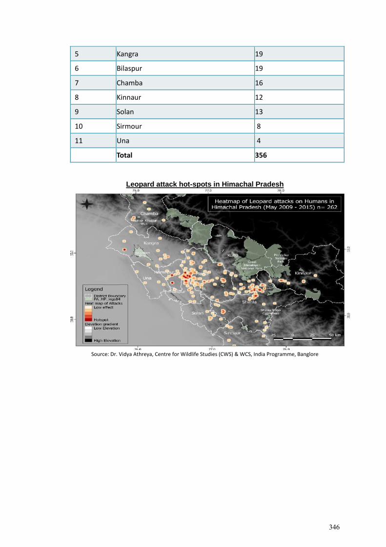
5 Kangra 19
6 Bilaspur 19
7 Chamba 16
8 Kinnaur 12
9 Solan 13
10 Sirmour 8
11 Una 4
Total 356
Leopard attack hot-spots in Himachal Pradesh
Source: Dr. Vidya Athreya, Centre for Wildlife Studies (CWS) & WCS, India Programme, Banglore
346
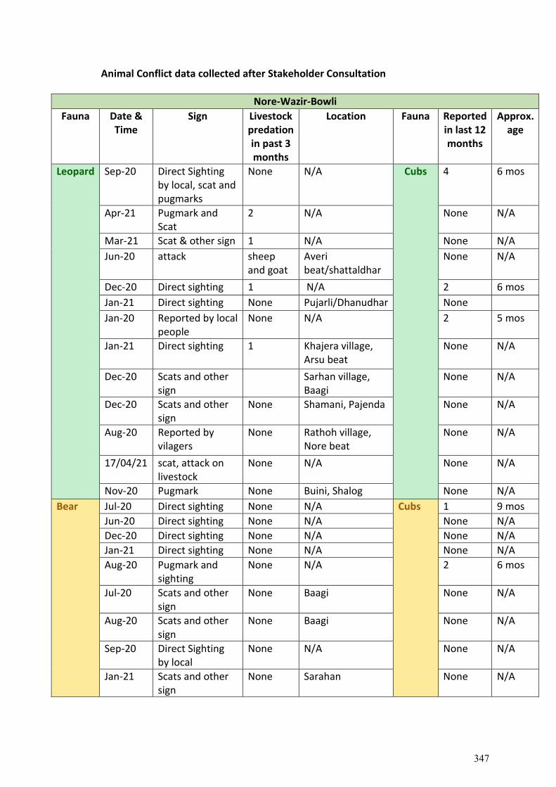
Animal Conflict data collected after Stakeholder Consultation
Nore-Wazir-Bowli
Fauna Date & Time
Sign Livestock predation in past 3 months
Location Fauna Reported in last 12 months
Approx. age
Leopard Sep-20 Direct Sighting by local, scat and pugmarks
None N/A Cubs 4 6 mos
Apr-21 Pugmark and Scat
2 N/A None N/A
Mar-21 Scat & other sign 1 N/A None N/A
Jun-20 attack sheep and goat
Averi beat/shattaldhar
None N/A
Dec-20 Direct sighting 1 N/A 2 6 mos
Jan-21 Direct sighting None Pujarli/Dhanudhar None
Jan-20 Reported by local people
None N/A 2 5 mos
Jan-21 Direct sighting 1 Khajera village, Arsu beat
None N/A
Dec-20 Scats and other sign
Sarhan village, Baagi
None N/A
Dec-20 Scats and other sign
None Shamani, Pajenda None N/A
Aug-20 Reported by vilagers
None Rathoh village, Nore beat
None N/A
17/04/21 scat, attack on livestock
None N/A None N/A
Nov-20 Pugmark None Buini, Shalog None N/A
Bear Jul-20 Direct sighting None N/A Cubs 1 9 mos
Jun-20 Direct sighting None N/A None N/A
Dec-20 Direct sighting None N/A None N/A
Jan-21 Direct sighting None N/A None N/A
Aug-20 Pugmark and sighting
None N/A 2 6 mos
Jul-20 Scats and other sign
None Baagi None N/A
Aug-20 Scats and other sign
None Baagi None N/A
Sep-20 Direct Sighting by local
None N/A None N/A
Jan-21 Scats and other sign
None Sarahan None N/A
347
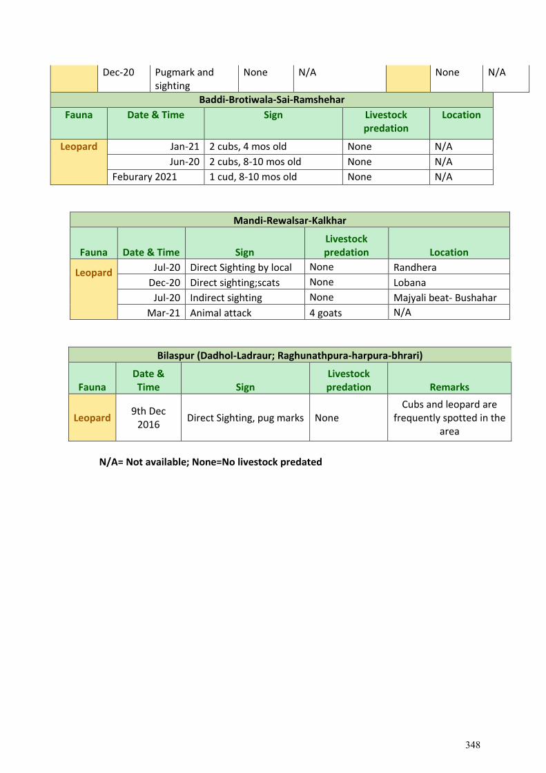
Dec-20 Pugmark and sighting
None N/A None N/A
Baddi-Brotiwala-Sai-Ramshehar
Fauna Date & Time Sign Livestock predation
Location
Leopard Jan-21 2 cubs, 4 mos old None N/A
Jun-20 2 cubs, 8-10 mos old None N/A
Feburary 2021 1 cud, 8-10 mos old None N/A
Mandi-Rewalsar-Kalkhar
Fauna Date & Time Sign Livestock predation Location
Leopard
Jul-20 Direct Sighting by local None Randhera
Dec-20 Direct sighting;scats None Lobana
Jul-20 Indirect sighting None Majyali beat- Bushahar
Mar-21 Animal attack 4 goats N/A
Bilaspur (Dadhol-Ladraur; Raghunathpura-harpura-bhrari)
Fauna Date & Time Sign
Livestock predation Remarks
Leopard 9th Dec
2016 Direct Sighting, pug marks None
Cubs and leopard are frequently spotted in the
area
N/A= Not available; None=No livestock predated
348
Chapter 6. STAKEHOLDER CONSULTATION
This section summarizes public/stakeholder consultations conducted as part of the Biodiversity Impact Assessment for the Project Road. Stakeholder Consultations were carried out to elicit views/opinions/suggestions which can serve as input to the project design. The composition of the stakeholders ranged from villagers/community along the project road, DFOs, Range officers, Wildlife Officers etc., and other non-community stakeholders. The main issues of concern cropped up during the consultation and discussions considered for the preparation of action plan.
To address the research questions, a mixture of qualitative and quantitative methods was used. The composition of the stakeholders ranged from villagers/community along the project road, Dy. Range officers, Range Officers etc., and other non-community stakeholders. The questionnaires for the village/community residents are translated into vernacular language. The key stakeholders who were involved in qualitative analysis.
Along with personal interviews, 60 set of questionnaires were circulated among population directly impacted by the construction, to assess the impacts of road construction along Tranche-I. Out of which, we received a feedback on 50 questionnaires. The the respondents from Mandi-Rewalsar-Kalkhar, Dadhol-Ladraur and Raghunathpura-Harpura-Bhrari were mostly optimistic about the road construction. However, participants from Nore-Wazir-Bowli and Baddi Barotiwala-Ramshehar-Sai observed that road construction will adversely impact the ecosystem services, cause air pollution, downgrade the natural water resources, will damage the wildlife-habitat and cause more accidents of wild and stray animals. Moreover, the participants from Dadhol-Ladraur and Raghunathpura-Harpura-Bhrari indicated a minor distress over the risk of wildlife habitat fragmentation after road construction. The local community belonging to Mandi-Rewalsar-Kalkhar responded that offence towards wildlife may increase due to better connectivity, for which speed breakers and signboard will prove to be a saviour of animals/wildlife along the road. Site wise more detailed analysis of the stakeholder consultation are described below; 6.1. Baddi Barotiwala Ramshehar Sai
The Baddi-Barotiwala-Sai-Ramshahr road is one of the four corridors proposed for upgradation. The road passes through 31 settlements which are predominantly hilly with the major being Baddi, Sai, Taller and Ramshahr village. The land use alongside the road is forest areas and agricultural land. The road is on hilly terrain with hills and valleys on either side of the centreline. The corridor contains springs and seasonal streams along with one perennial water body and a temple along situated at N 311228.20 E 765020.34, altitude 864 m msl. The 15 km radius doesn’t have any national park, wildlife sanctuary or any ecologically sensitive areas.
The baseline data recorded by local communities and government stakeholders state
that the temperature of the area lies between 35 C to 40 , the elevation recorded is between 450m to 901m with rainfall ranging from 800mm to 900mm. The population which is mostly impacted by the road construction are farmers and cattle rearers, which are an important economic activity in the corridor. The respondents recorded that the road construction is important to the overall development of the area, there will be minimum damage to biodiversity which can be further reduces by carrying out plantation and reclamation activities along the corridor of impact. The Nature of exploitation (extent of forest produce extracted)
349
has also been recorded as low, the major forest produces which were extracted by local people are fodder, cattle feed and fuel wood. The existing air, water and land pollution has also increased between 10% to 20%. The invasive alien species growing along the road corridors are Pantherium Species, Lantana and Congress grass. The participants responded to provide mitigation and conservation strategy, recorded with respect to three main points, biodiversity conservation practice, habitat development and plant species recommendation along roadside and in the forest. Biodiversity conservation practice
Dry Check dams to be constructed,
Measure considering exploitation of natural resources in a sustainable manner.
Water resources conservation and augmentation,
Local species plantation
One wildlife corridor should be constructed.
Construction of one Waste Collection Center along corridor, with garbage collector storage bins to be installed within 5 km.
Habitat development
Invasive alien species eradication and plantation of native species in forest (Gullar, Jamun, Bill patra, mango, sita fal, Balam, khinna).
Captive breeding and seed banks to be installed
Control over forest fire. Plantation species recommendation
Roadside Forest
Arjun, kachnar, tuni, neem, pegomiya, mango, bar, jamun, Silver Oak, Jabrinda, Neem, Siris, Bolen, Khair, Haned, Bhira, Amla, Bamboo, Bheda, Amla
Chall, Chil, Amaltas, Arjun, Khair, Pipal, Jamun, Drek
The consultant visited the sites and conducted field interviews with local and government stakeholders. The team recorded point wise data with suggestions for biodiversity conservation and improvements. Bioengineering structures were recommended by stakeholders, one row and two row plantations, soil conservation methods and retaining walls along the muck disposal sites were recorded. The details of observations are listed below;
Site Name General topography Floral Species Faunal Species
Recommendation
Baddi (Near Range Office) N309261.90 E767979.42 414 msl
Agricultural land on both side of existing road. Slop is flat and vegetation is poor. One small bridge about 2-3 km from bazar is crossing over perennial nalla. There have been identified 3-4 spots for muck dumping on private. The width of road shall be 5.5 m.
Dalbergia sissoo, Cassia fistula, Carissa opaca, Murraya koenigii.
Leopard, Peacock, Red Jungle Fowl
One row plantation along both side of road at a distance of 5 m possible. Cassia fistula, Pongamia pinnata, Azadirechta indica, Delonix regia, Gravellia robusta, Terminalia arjuna, Callistomen veminallis, Albizzia procera, Chukrasia velcetina (Mahagony)
350
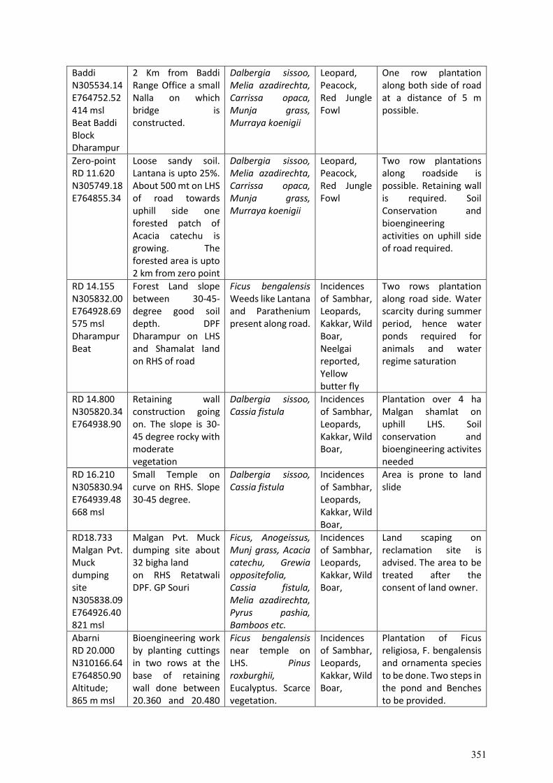
Baddi N305534.14 E764752.52 414 msl Beat Baddi Block Dharampur
2 Km from Baddi Range Office a small Nalla on which bridge is constructed.
Dalbergia sissoo, Melia azadirechta, Carrissa opaca, Munja grass, Murraya koenigii
Leopard, Peacock, Red Jungle Fowl
One row plantation along both side of road at a distance of 5 m possible.
Zero-point RD 11.620 N305749.18 E764855.34
Loose sandy soil. Lantana is upto 25%. About 500 mt on LHS of road towards uphill side one forested patch of Acacia catechu is growing. The forested area is upto 2 km from zero point
Dalbergia sissoo, Melia azadirechta, Carrissa opaca, Munja grass, Murraya koenigii
Leopard, Peacock, Red Jungle Fowl
Two row plantations along roadside is possible. Retaining wall is required. Soil Conservation and bioengineering activities on uphill side of road required.
RD 14.155 N305832.00 E764928.69 575 msl Dharampur Beat
Forest Land slope between 30-45-degree good soil depth. DPF Dharampur on LHS and Shamalat land on RHS of road
Ficus bengalensis Weeds like Lantana and Parathenium present along road.
Incidences of Sambhar, Leopards, Kakkar, Wild Boar, Neelgai reported, Yellow butter fly
Two rows plantation along road side. Water scarcity during summer period, hence water ponds required for animals and water regime saturation
RD 14.800 N305820.34 E764938.90
Retaining wall construction going on. The slope is 30-45 degree rocky with moderate vegetation
Dalbergia sissoo, Cassia fistula
Incidences of Sambhar, Leopards, Kakkar, Wild Boar,
Plantation over 4 ha Malgan shamlat on uphill LHS. Soil conservation and bioengineering activites needed
RD 16.210 N305830.94 E764939.48 668 msl
Small Temple on curve on RHS. Slope 30-45 degree.
Dalbergia sissoo, Cassia fistula
Incidences of Sambhar, Leopards, Kakkar, Wild Boar,
Area is prone to land slide
RD18.733 Malgan Pvt. Muck dumping site N305838.09 E764926.40 821 msl
Malgan Pvt. Muck dumping site about 32 bigha land on RHS Retatwali DPF. GP Souri
Ficus, Anogeissus, Munj grass, Acacia catechu, Grewia oppositefolia, Cassia fistula, Melia azadirechta, Pyrus pashia, Bamboos etc.
Incidences of Sambhar, Leopards, Kakkar, Wild Boar,
Land scaping on reclamation site is advised. The area to be treated after the consent of land owner.
Abarni RD 20.000 N310166.64 E764850.90 Altitude; 865 m msl
Bioengineering work by planting cuttings in two rows at the base of retaining wall done between 20.360 and 20.480
Ficus bengalensis near temple on LHS. Pinus roxburghii, Eucalyptus. Scarce vegetation.
Incidences of Sambhar, Leopards, Kakkar, Wild Boar,
Plantation of Ficus religiosa, F. bengalensis and ornamenta species to be done. Two steps in the pond and Benches to be provided.
351
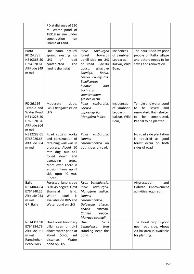
RD at distance of 120 m. Water pond of 18X18 m size under construction on Shamalat Land.
Patta RD 24.785 N310368.50 E764928.61 Altitude 949 m msl
One bauri, natural spring existing on LHS of road constructed. The land is shamalat
Pinus roxburghii forest towards uphill side on LHS of road. Carissa opaca, Murraya koenigii, Behul, Guvva, Eucalyptus, Eulalicarpus binatus and Sacharrum spontaneoum grasses occur
Incidences of Sambhar, Leopards, Kakkar, Wild Boar,
The bauri used by poor people of Patta village and others needs to be saves and renovation.
RD 26.116 Temple and Water Pond N311228.20 E765020.34 Altitude 864 m msl
Moderate slope, Ficus bengalensis on LHS
Pinus roxburghii, Grewia oppositefolia, Mangifera indica
Incidences of Sambhar, Leopards, Kakkar, Wild Boar,
Temple and water pond to be saved and renovated. Rain shelter to be constructed. Peepal to be planted.
N312288.61 E765026.65 Altitude 884 m msl
Road cutting works and construction of retaining wall was in progress. About 50 mtr dug out soil rolled down and damaging trees. More over There is erosion from uphill side upto 40 mtr. (Photo)
Pinus roxburghii, Lannea coromendelica on both sides of road.
No road side plantation is required as good forest occur on both sides of road
Baila N314044.64 E764940.25 Altitude 953 m msl GP, Baila
Forested land slope is 30-45 degree. Govt Shamalat land. Water bauri is available on RHS and Water pond on LHS
Ficus bengalensis, Pinus roxburghii, Mangifera indica, Lannea coromendelica, Dalbergia sissoo, Acacia catechu, Carissa opaca, Murraya koenigii
Afforestation and Habitat improvement activities required.
N314311.90 E764884.79 Altitude 961 m msl Ramshehar Beat/Block
One Forest boundary pillar seen on LHS above water pond at about 50-60 mt distance. Water pond on LHS
One Ficus bengalensis tree standing near the pond.
The forest crop is poor near road side. About 20 ha area is available for planting.
352
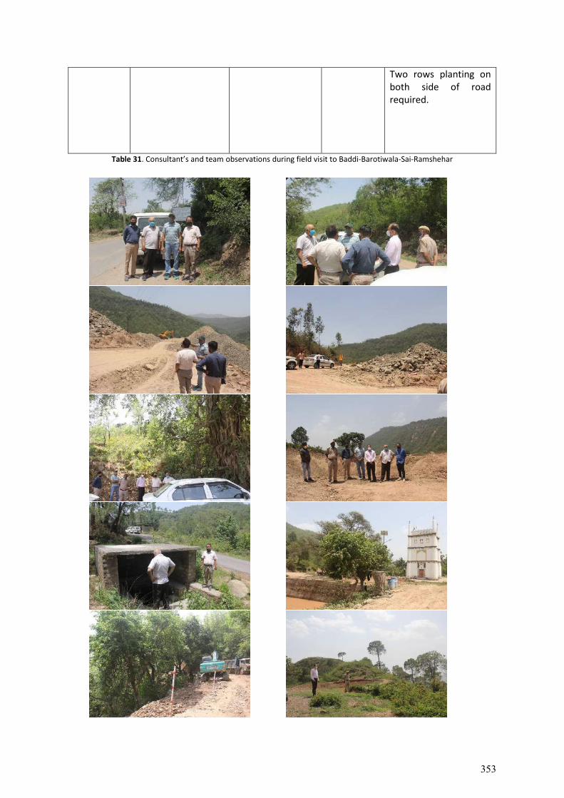
Two rows planting on both side of road required.
Table 31. Consultant’s and team observations during field visit to Baddi-Barotiwala-Sai-Ramshehar
353
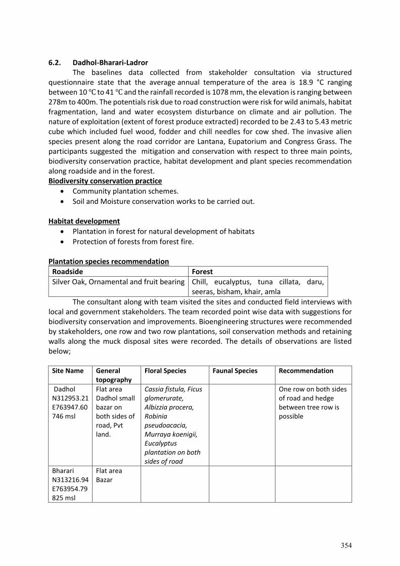
6.2. Dadhol-Bharari-Ladror
The baselines data collected from stakeholder consultation via structured questionnaire state that the average annual temperature of the area is 18.9 °C ranging between 10 ℃ to 41 ℃ and the rainfall recorded is 1078 mm, the elevation is ranging between 278m to 400m. The potentials risk due to road construction were risk for wild animals, habitat fragmentation, land and water ecosystem disturbance on climate and air pollution. The nature of exploitation (extent of forest produce extracted) recorded to be 2.43 to 5.43 metric cube which included fuel wood, fodder and chill needles for cow shed. The invasive alien species present along the road corridor are Lantana, Eupatorium and Congress Grass. The participants suggested the mitigation and conservation with respect to three main points, biodiversity conservation practice, habitat development and plant species recommendation along roadside and in the forest. Biodiversity conservation practice
Community plantation schemes.
Soil and Moisture conservation works to be carried out. Habitat development
Plantation in forest for natural development of habitats
Protection of forests from forest fire. Plantation species recommendation
Roadside Forest
Silver Oak, Ornamental and fruit bearing Chill, eucalyptus, tuna cillata, daru, seeras, bisham, khair, amla
The consultant along with team visited the sites and conducted field interviews with local and government stakeholders. The team recorded point wise data with suggestions for biodiversity conservation and improvements. Bioengineering structures were recommended by stakeholders, one row and two row plantations, soil conservation methods and retaining walls along the muck disposal sites were recorded. The details of observations are listed below;
Site Name General topography
Floral Species Faunal Species Recommendation
Dadhol N312953.21 E763947.60 746 msl
Flat area Dadhol small bazar on both sides of road, Pvt land.
Cassia fistula, Ficus glomerurate, Albizzia procera, Robinia pseudoacacia, Murraya koenigii, Eucalyptus plantation on both sides of road
One row on both sides of road and hedge between tree row is possible
Bharari N313216.94 E763954.79 825 msl
Flat area Bazar
354
Mihar 9.500 km N313314.60 E763945.48 897 msl
GP Marahana Flat topography
Ficus religiosa, Toona ciliate, Jatropha curcus, Grewia oppositefolia, Dalbergia sissoo, Acacia catechu, Mangifera indica, Dendrocalmus strictus, Eucalyptus, Zizyphus spp
Sambhar, Wild Boar, Fox, Langur/Monkeys visit occasionally. Peacock, Red jungle Fowl,
One row plantation possible. One local villager Sh. Karm Chand of Mihara Village told that they demand for good road. They don’t Citrus and other fruit bearing plants from FD.
Ladrour N313456.29 E763835.94 1004 msl
Ladror Bazar Jatropha Nothing is possible
Table 32. Consultant’s and team observation during field visit to Dadhol-Ladraur.
6.3. Raghunathpura- Mandi-Bharari-Harpura Road
The baselines data collected from stakeholder consultation via structured questionnaire state that the average annual temperature of the area is 18.9 °C ranging between 10 ℃ to 41 ℃ and the rainfall recorded is 1078 mm, the elevation is ranging between 278m to 400m. The potentials risk due to road construction were risk for wild animals, habitat fragmentation of land and water ecosystem disturbance on climate and air pollution. The nature of exploitation (extent of forest produce extracted) recorded to be 2.43 to 5.43 metric cube which included fuel wood, fodder and chill needles for cow shed. The invasive alien species present along the road corridor are Lantana, Eupatorium and Congress Grass. The participants suggested the mitigation and conservation with respect to three main points,
355
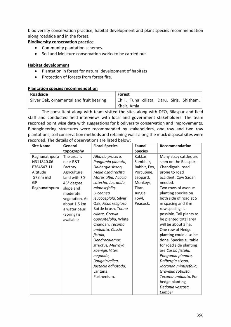
biodiversity conservation practice, habitat development and plant species recommendation along roadside and in the forest. Biodiversity conservation practice
Community plantation schemes.
Soil and Moisture conservation works to be carried out. Habitat development
Plantation in forest for natural development of habitats
Protection of forests from forest fire. Plantation species recommendation
Roadside Forest
Silver Oak, ornamental and fruit bearing Chill, Tuna cillata, Daru, Siris, Shisham, Khair, Amla
The consultant along with team visited the sites along with DFO, Bilaspur and field staff and conducted field interviews with local and government stakeholders. The team recorded point wise data with suggestions for biodiversity conservation and improvements. Bioengineering structures were recommended by stakeholders, one row and two row plantations, soil conservation methods and retaining walls along the muck disposal sites were recorded. The details of observations are listed below;
Site Name General topography
Floral Species Faunal Species
Recommendation
Raghunathpura N311840.06 E764547.11 Altitude 578 m msl GP Raghunathpura
The area is near R&T Factory. Agriculture
land with 30-
45 degree slope and moderate vegetation. At about 1.5 km a water bauri (Spring) is available
Albizzia procera, Pongamia pinnata, Dalbergia sissoo, Melia azadirechta, Morus alba, Acacia catechu, Jacranda mimosefolia, Luceanea leucoceplala, Silver Oak, Ficus religiosa, Bottle brush, Toona ciliate, Grewia oppositefolia, White Chandan, Tecoma undulata, Cassia fistula, Dendrocalamus structus, Murraya koenigii, Vitex negundo, Bougainvellea, Justacia adhotoda, Lantana, Parthenium.
Kakkar, Sambhar, Rabbit, Fox, Porcupine, Leopard, Monkeys, Titar, Jungle Fowl, Peacock,
Many stray cattles are seen on the Bilaspur-Chandigarh road prone to road accident. Cow Sadan needed. Two rows of avenue planting species on both side of road at 5 m spacing and 3 m row spacing is possible. Tall plants to be planted total area will be about 3 ha. One row of Hedge planting could also be done. Species suitable for road side planting are Cassia fistula, Pongamia pinnata, Dalbergia sissoo, Jacranda mimisefolia, Gravellia robusta, Tecoma undulata. For hedge planting Dedonia vescosa, Climber
356
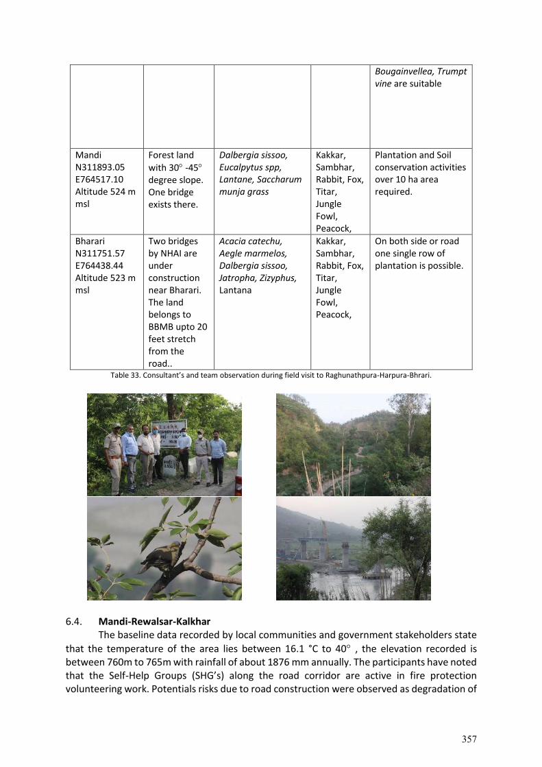
Bougainvellea, Trumpt vine are suitable
Mandi N311893.05 E764517.10 Altitude 524 m msl
Forest land
with 30 -45 degree slope. One bridge exists there.
Dalbergia sissoo, Eucalpytus spp, Lantane, Saccharum munja grass
Kakkar, Sambhar, Rabbit, Fox, Titar, Jungle Fowl, Peacock,
Plantation and Soil conservation activities over 10 ha area required.
Bharari N311751.57 E764438.44 Altitude 523 m msl
Two bridges by NHAI are under construction near Bharari. The land belongs to BBMB upto 20 feet stretch from the road..
Acacia catechu, Aegle marmelos, Dalbergia sissoo, Jatropha, Zizyphus, Lantana
Kakkar, Sambhar, Rabbit, Fox, Titar, Jungle Fowl, Peacock,
On both side or road one single row of plantation is possible.
Table 33. Consultant’s and team observation during field visit to Raghunathpura-Harpura-Bhrari.
6.4. Mandi-Rewalsar-Kalkhar
The baseline data recorded by local communities and government stakeholders state
that the temperature of the area lies between 16.1 °C to 40 , the elevation recorded is between 760m to 765m with rainfall of about 1876 mm annually. The participants have noted that the Self-Help Groups (SHG’s) along the road corridor are active in fire protection volunteering work. Potentials risks due to road construction were observed as degradation of
357
natural water resources, increase in human-animal conflict. The nature of exploitation (extent of forest produce extracted) mainly as fuelwood, fodder ranging between 10% to 20% of exploitation from the forest. The invasive alien species along the road corridor are exponentially growing, the species recorded are Lantana, Eupatorium and Congress Grass. There are natural water sources along the project corridor such as bawri, water ponds, khadds, nalas used by local communities.
Human animal conflict was recorded in the area by local communities and the animals killed during such incidences were Porcupine, Rabbit, Cat, Barking dear, Fox, Leopard, Jackal, Kakar, Snake and Jackal.
Flora Fauna
Kashmal, Aakhe, Bekhal, Tardi, Kadhipata Porcupine, Kakar and Rabit
The participants were asked to provide mitigation and conservation strategy, recorded with respect to three main points, biodiversity conservation practice, habitat development and plant species recommendation along roadside and in the forest. Biodiversity conservation practice
Check dam should be constructed.
Bioengineering plantation and mixed species plantations recommended along the project corridor.
Water resource conservation should be carried out along with construction of man-made water resource.
Retention walls for muck dumping should be constructed. Habitat development
Possibility of wildlife corridor;
Plantation for animal grazing, fodder and fruits
Stabilization of land in slope by undertaking Soil Moisture Conservation (SMC) works
Plantation in forest for natural development of habitats
Shed or small tunnel for animals should be set up in forests.
Plantation species recommendation
Roadside Forest
Bottlebrush, mrinu, ban, silver oak, devdar, vatvriksh, mango, bargad, kachnar, peepal, shehtoot, baan, Devdar, Shady, avenue trees, fruit bearing trees, ornamental plants
Chill, eucalyptus, Tuna cillata, daru, seeras, bisham, khair, amla
The consultant along with team visited the sites and conducted field interviews with local and government stakeholders. The team recorded point wise data with suggestions for biodiversity conservation and improvements. Bioengineering structures were recommended by stakeholders, one row and two row plantations, soil conservation methods and retaining walls along the muck disposal sites were recorded. The details of observations are listed below;
358
Site Name General topography
Floral Species Faunal Species
Recommendation
Kalkhar N313655.07 E764936.32 1293 msl 25.270 km
DPF Kukrain, under Sundernagar Division, Rewalsar bazar upto 1 km. Pvt and Forest land, slope is more than 45 degree
Ficus religiosa, Ficus glomerulata, Morus alba, Siris, Melia azadirechta, Pinus roxburghii, Vitex, Grewia oppositefolia, Bamboo, Jatropha curcus, Erhetia laevis,
Sambhar, Yellow beak Magpie
One row plantation on downhill side of road upto stretch of 5 km possible
Garloni N313821.57 E765040.47 1364 msl
DPF Jabkadhan DPF Jalpara, Pvt land slope is about 45 degree
Pinus roxburghii, Melia azadirechta, Grewia oppositefolia, Mangifera indica, Ficus glomeratus, Bombax ceiba, Toona ciliata, Bamboo, Embelica officinalis, Pinus roxburghii, Euphorbia royalena, Agave spp, Morus alba, Pomegranatum, Sapindus mukrossii, Jatropha curcus, Agave spp, Ipomes,
Sambhar, Yellow beak Magpie
One row plantation on downhill side of road
Randhara N313921.00 E765320.03 912 msl
Randhara beat
Sapindus mukrosii, Bamboos, Dalbergia sissoo, Syzygium cuminii, Mangifera indica, Machillus odoratisimma, Quercus leucotrichophora, Ipomea, Vitix, some weeds Lantana camera, Parethenium
Sambhar, Yellow beak Magpie
One row plantation on downhill side of road
Talehar N314027.42 E765431.52 904 msl
One old arched bridge at Barthi, where new RCC bridge is under construction. Agriculture land on both side of road. Vegetation
Murraya koenigii, Ipomea, Pyrus pashia, Toona ciliate, Ailanthus excelsa
Sambhar, Yellow beak Magpie
One row plantation along road side on downhill side is possible
Mandi N314228.17 E765542.62 765 msl
Slope is between 30-45 degree. Shops on both side of the existing road
No plant species present No plantation except some ornamental medium sized plants.
Table 34. Consultant’s and team observation during field visit to Mandi-Rewalsar-Kalkhar road.
359
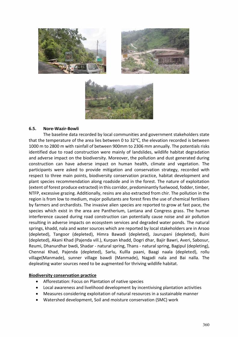
6.5. Nore-Wazir-Bowli
The baseline data recorded by local communities and government stakeholders state that the temperature of the area lies between 0 to 32℃, the elevation recorded is between 1000 m to 2800 m with rainfall of between 900mm to 2306 mm annually. The potentials risks identified due to road construction were mainly of landslides, wildlife habitat degradation and adverse impact on the biodiversity. Moreover, the pollution and dust generated during construction can have adverse impact on human health, climate and vegetation. The participants were asked to provide mitigation and conservation strategy, recorded with respect to three main points, biodiversity conservation practice, habitat development and plant species recommendation along roadside and in the forest. The nature of exploitation (extent of forest produce extracted) in this corridor, predominantly fuelwood, fodder, timber, NTFP, excessive grazing. Additionally, resins are also extracted from chir. The pollution in the region is from low to medium, major pollutants are forest fires the use of chemical fertilisers by farmers and orchardists. The invasive alien species are reported to grow at fast pace, the species which exist in the area are Pantherium, Lantana and Congress grass. The human interference caused during road construction can potentially cause noise and air pollution resulting in adverse impacts on ecosystem services and degraded water ponds. The natural springs, khadd, nala and water sources which are reported by local stakeholders are in Arsoo (depleted), Tangoor (depleted), Himra Bawadi (depleted), Jaurupani (depleted), Buini (depleted), Akani Khad (Pajenda vill.), Kurpan khadd, Dogri dhar, Bajir Bawri, Averi, Sabosur, Reumi, Dhanurdhar bwdi, Shadar - natural spring, Thans - natural spring, Bagipul (depleting), Chennai Khad, Pajenda (depleted), Sarlu, Kullla paani, Baagi naala (depleted), rollu village(Manmade), sunner village bawdi (Manmade), Nagadi nala and Bai nalla. The depleating water sources need to be augmented for thriving wildlife habitat. Biodiversity conservation practice
Afforestation: Focus on Plantation of native species
Local awareness and livelihood development by incentivising plantation activities
Measures considering exploitation of natural resources in a sustainable manner
Watershed development, Soil and moisture conservation (SMC) work
360
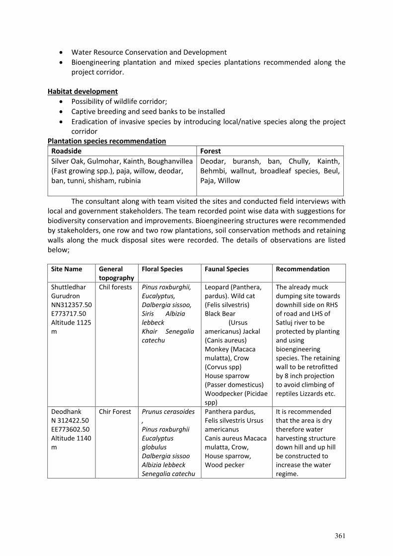
Water Resource Conservation and Development
Bioengineering plantation and mixed species plantations recommended along the project corridor.
Habitat development
Possibility of wildlife corridor;
Captive breeding and seed banks to be installed
Eradication of invasive species by introducing local/native species along the project corridor
Plantation species recommendation
Roadside Forest
Silver Oak, Gulmohar, Kainth, Boughanvillea (Fast growing spp.), paja, willow, deodar, ban, tunni, shisham, rubinia
Deodar, buransh, ban, Chully, Kainth, Behmbi, wallnut, broadleaf species, Beul, Paja, Willow
The consultant along with team visited the sites and conducted field interviews with local and government stakeholders. The team recorded point wise data with suggestions for biodiversity conservation and improvements. Bioengineering structures were recommended by stakeholders, one row and two row plantations, soil conservation methods and retaining walls along the muck disposal sites were recorded. The details of observations are listed below;
Site Name General topography
Floral Species Faunal Species Recommendation
Shuttledhar Gurudron NN312357.50 E773717.50 Altitude 1125 m
Chil forests Pinus roxburghii, Eucalyptus, Dalbergia sissoo, Siris Albizia lebbeck Khair Senegalia catechu
Leopard (Panthera, pardus). Wild cat (Felis silvestris) Black Bear (Ursus americanus) Jackal (Canis aureus) Monkey (Macaca mulatta), Crow (Corvus spp) House sparrow (Passer domesticus) Woodpecker (Picidae spp)
The already muck dumping site towards downhill side on RHS of road and LHS of Satluj river to be protected by planting and using bioengineering species. The retaining wall to be retrofitted by 8 inch projection to avoid climbing of reptiles Lizzards etc.
Deodhank N 312422.50 EE773602.50 Altitude 1140 m
Chir Forest
Prunus cerasoides , Pinus roxburghii Eucalyptus globulus Dalbergia sissoo Albizia lebbeck Senegalia catechu
Panthera pardus, Felis silvestris Ursus americanus Canis aureus Macaca mulatta, Crow, House sparrow, Wood pecker
It is recommended that the area is dry therefore water harvesting structure down hill and up hill be constructed to increase the water regime.
361
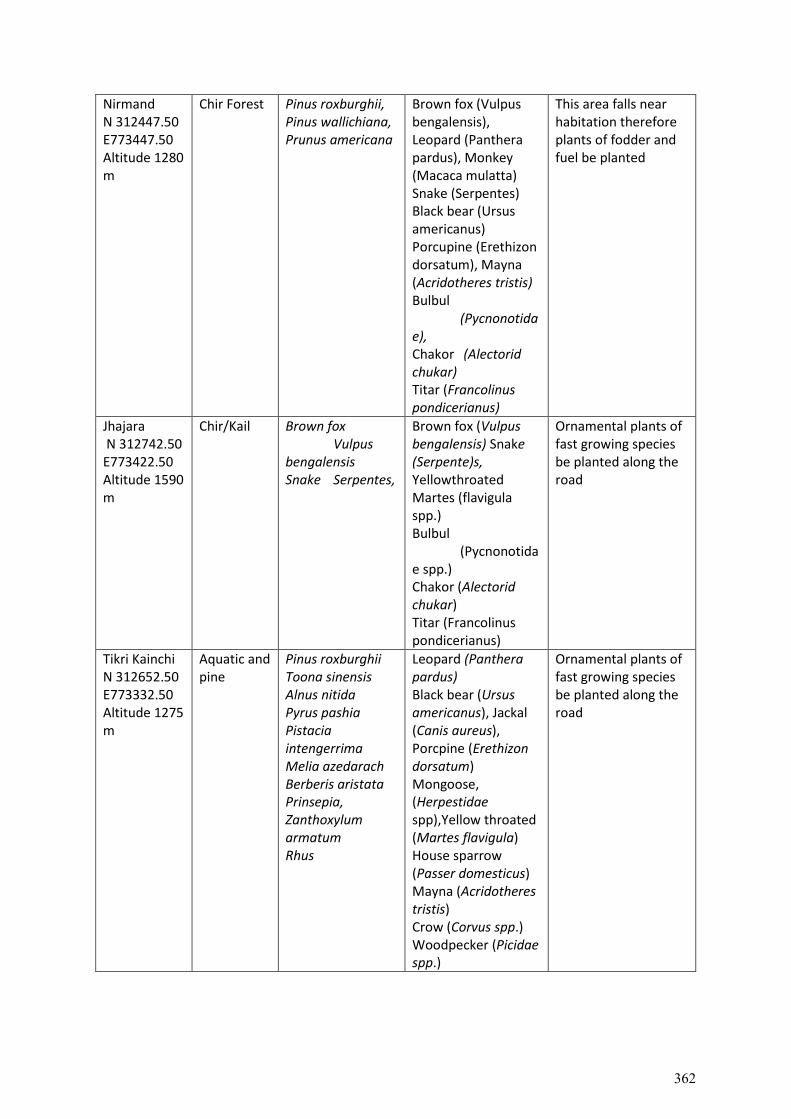
Nirmand N 312447.50 E773447.50 Altitude 1280 m
Chir Forest
Pinus roxburghii, Pinus wallichiana, Prunus americana
Brown fox (Vulpus bengalensis), Leopard (Panthera pardus), Monkey (Macaca mulatta) Snake (Serpentes) Black bear (Ursus americanus) Porcupine (Erethizon dorsatum), Mayna (Acridotheres tristis) Bulbul (Pycnonotidae), Chakor (Alectorid chukar) Titar (Francolinus pondicerianus)
This area falls near habitation therefore plants of fodder and fuel be planted
Jhajara N 312742.50 E773422.50 Altitude 1590 m
Chir/Kail Brown fox Vulpus bengalensis Snake Serpentes,
Brown fox (Vulpus bengalensis) Snake (Serpente)s, Yellowthroated Martes (flavigula spp.) Bulbul (Pycnonotidae spp.) Chakor (Alectorid chukar) Titar (Francolinus pondicerianus)
Ornamental plants of fast growing species be planted along the road
Tikri Kainchi N 312652.50 E773332.50 Altitude 1275 m
Aquatic and pine
Pinus roxburghii Toona sinensis Alnus nitida Pyrus pashia Pistacia intengerrima Melia azedarach Berberis aristata Prinsepia, Zanthoxylum armatum Rhus
Leopard (Panthera pardus) Black bear (Ursus americanus), Jackal (Canis aureus), Porcpine (Erethizon dorsatum) Mongoose, (Herpestidae spp),Yellow throated (Martes flavigula) House sparrow (Passer domesticus) Mayna (Acridotheres tristis) Crow (Corvus spp.) Woodpecker (Picidae spp.)
Ornamental plants of fast growing species be planted along the road
362
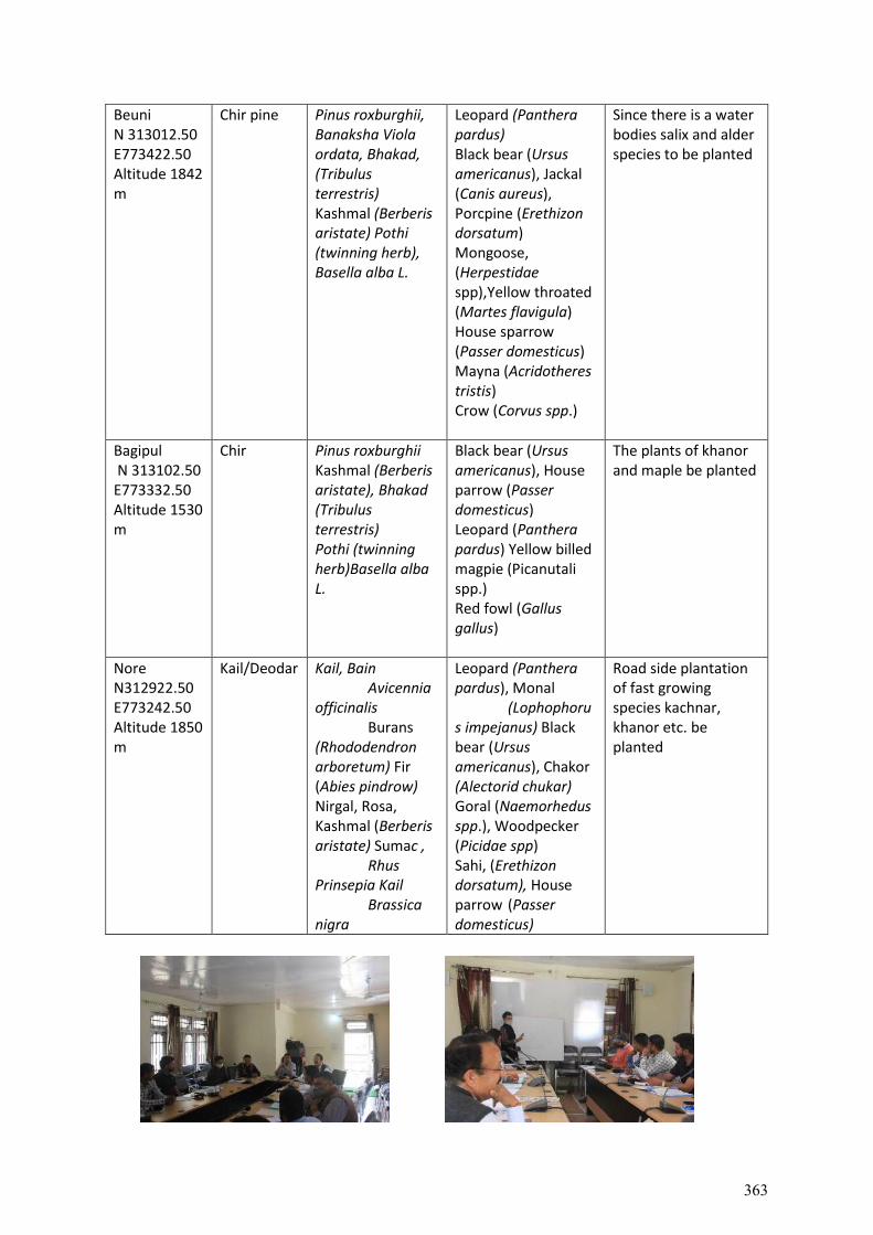
Beuni N 313012.50 E773422.50 Altitude 1842 m
Chir pine Pinus roxburghii, Banaksha Viola ordata, Bhakad, (Tribulus terrestris) Kashmal (Berberis aristate) Pothi (twinning herb), Basella alba L.
Leopard (Panthera pardus) Black bear (Ursus americanus), Jackal (Canis aureus), Porcpine (Erethizon dorsatum) Mongoose, (Herpestidae spp),Yellow throated (Martes flavigula) House sparrow (Passer domesticus) Mayna (Acridotheres tristis) Crow (Corvus spp.)
Since there is a water bodies salix and alder species to be planted
Bagipul N 313102.50 E773332.50 Altitude 1530 m
Chir Pinus roxburghii Kashmal (Berberis aristate), Bhakad (Tribulus terrestris) Pothi (twinning herb)Basella alba L.
Black bear (Ursus americanus), House parrow (Passer domesticus) Leopard (Panthera pardus) Yellow billed magpie (Picanutali spp.) Red fowl (Gallus gallus)
The plants of khanor and maple be planted
Nore N312922.50 E773242.50 Altitude 1850 m
Kail/Deodar Kail, Bain Avicennia officinalis Burans (Rhododendron arboretum) Fir (Abies pindrow) Nirgal, Rosa, Kashmal (Berberis aristate) Sumac , Rhus Prinsepia Kail Brassica nigra
Leopard (Panthera pardus), Monal (Lophophorus impejanus) Black bear (Ursus americanus), Chakor (Alectorid chukar) Goral (Naemorhedus spp.), Woodpecker (Picidae spp) Sahi, (Erethizon dorsatum), House parrow (Passer domesticus)
Road side plantation of fast growing species kachnar, khanor etc. be planted
363
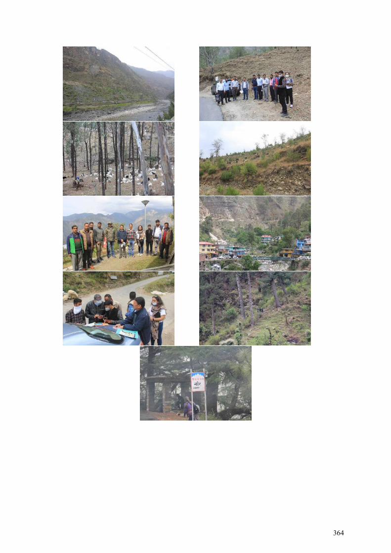
364
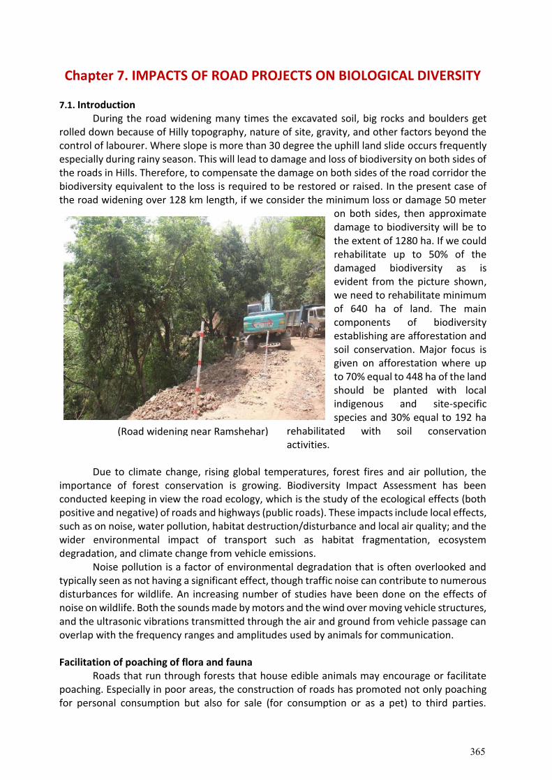
Chapter 7. IMPACTS OF ROAD PROJECTS ON BIOLOGICAL DIVERSITY
7.1. Introduction During the road widening many times the excavated soil, big rocks and boulders get
rolled down because of Hilly topography, nature of site, gravity, and other factors beyond the control of labourer. Where slope is more than 30 degree the uphill land slide occurs frequently especially during rainy season. This will lead to damage and loss of biodiversity on both sides of the roads in Hills. Therefore, to compensate the damage on both sides of the road corridor the biodiversity equivalent to the loss is required to be restored or raised. In the present case of the road widening over 128 km length, if we consider the minimum loss or damage 50 meter
on both sides, then approximate damage to biodiversity will be to the extent of 1280 ha. If we could rehabilitate up to 50% of the damaged biodiversity as is evident from the picture shown, we need to rehabilitate minimum of 640 ha of land. The main components of biodiversity establishing are afforestation and soil conservation. Major focus is given on afforestation where up to 70% equal to 448 ha of the land should be planted with local indigenous and site-specific species and 30% equal to 192 ha
rehabilitated with soil conservation activities.
Due to climate change, rising global temperatures, forest fires and air pollution, the
importance of forest conservation is growing. Biodiversity Impact Assessment has been conducted keeping in view the road ecology, which is the study of the ecological effects (both positive and negative) of roads and highways (public roads). These impacts include local effects, such as on noise, water pollution, habitat destruction/disturbance and local air quality; and the wider environmental impact of transport such as habitat fragmentation, ecosystem degradation, and climate change from vehicle emissions.
Noise pollution is a factor of environmental degradation that is often overlooked and typically seen as not having a significant effect, though traffic noise can contribute to numerous disturbances for wildlife. An increasing number of studies have been done on the effects of noise on wildlife. Both the sounds made by motors and the wind over moving vehicle structures, and the ultrasonic vibrations transmitted through the air and ground from vehicle passage can overlap with the frequency ranges and amplitudes used by animals for communication. Facilitation of poaching of flora and fauna
Roads that run through forests that house edible animals may encourage or facilitate poaching. Especially in poor areas, the construction of roads has promoted not only poaching for personal consumption but also for sale (for consumption or as a pet) to third parties.
(Road widening near Ramshehar)
365
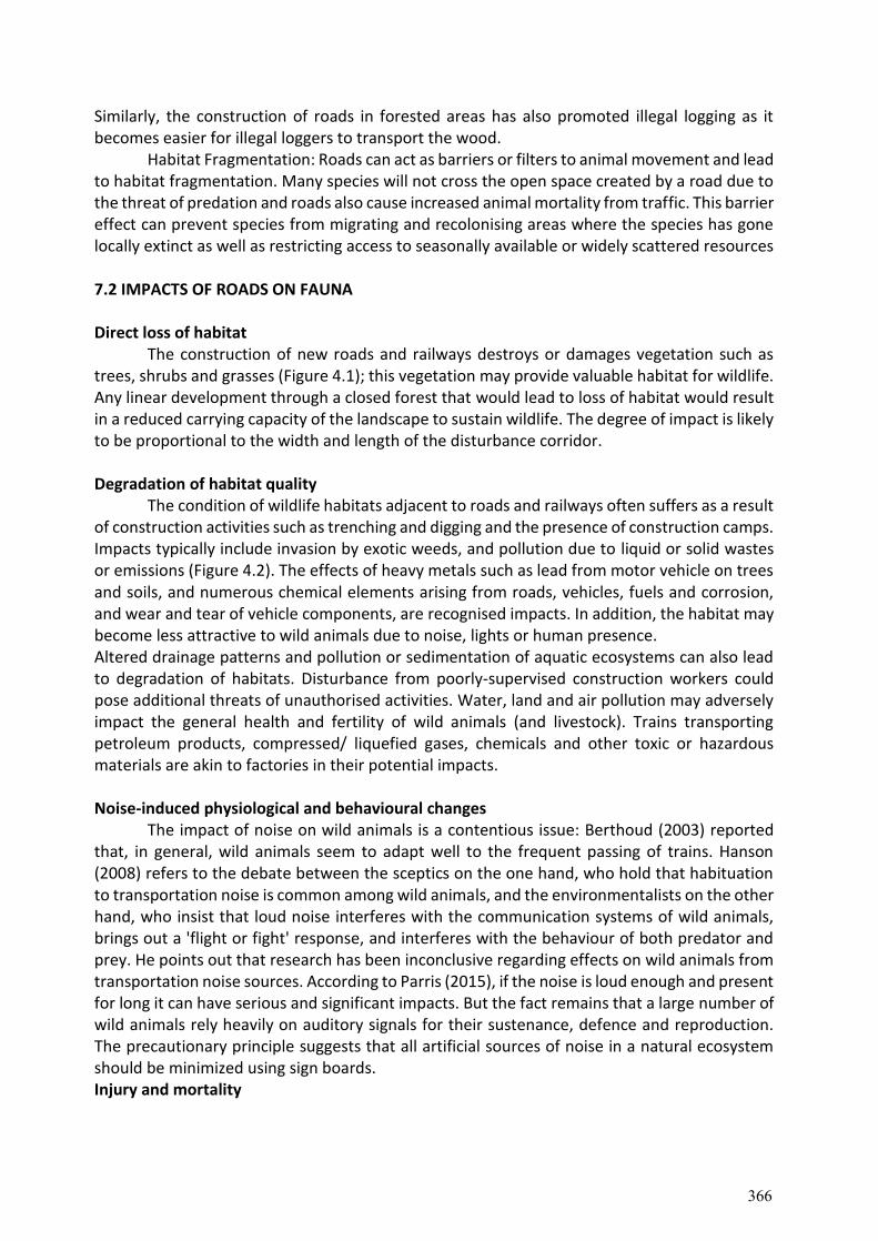
Similarly, the construction of roads in forested areas has also promoted illegal logging as it becomes easier for illegal loggers to transport the wood.
Habitat Fragmentation: Roads can act as barriers or filters to animal movement and lead to habitat fragmentation. Many species will not cross the open space created by a road due to the threat of predation and roads also cause increased animal mortality from traffic. This barrier effect can prevent species from migrating and recolonising areas where the species has gone locally extinct as well as restricting access to seasonally available or widely scattered resources
7.2 IMPACTS OF ROADS ON FAUNA Direct loss of habitat
The construction of new roads and railways destroys or damages vegetation such as trees, shrubs and grasses (Figure 4.1); this vegetation may provide valuable habitat for wildlife. Any linear development through a closed forest that would lead to loss of habitat would result in a reduced carrying capacity of the landscape to sustain wildlife. The degree of impact is likely to be proportional to the width and length of the disturbance corridor. Degradation of habitat quality
The condition of wildlife habitats adjacent to roads and railways often suffers as a result of construction activities such as trenching and digging and the presence of construction camps. Impacts typically include invasion by exotic weeds, and pollution due to liquid or solid wastes or emissions (Figure 4.2). The effects of heavy metals such as lead from motor vehicle on trees and soils, and numerous chemical elements arising from roads, vehicles, fuels and corrosion, and wear and tear of vehicle components, are recognised impacts. In addition, the habitat may become less attractive to wild animals due to noise, lights or human presence. Altered drainage patterns and pollution or sedimentation of aquatic ecosystems can also lead to degradation of habitats. Disturbance from poorly-supervised construction workers could pose additional threats of unauthorised activities. Water, land and air pollution may adversely impact the general health and fertility of wild animals (and livestock). Trains transporting petroleum products, compressed/ liquefied gases, chemicals and other toxic or hazardous materials are akin to factories in their potential impacts. Noise-induced physiological and behavioural changes
The impact of noise on wild animals is a contentious issue: Berthoud (2003) reported that, in general, wild animals seem to adapt well to the frequent passing of trains. Hanson (2008) refers to the debate between the sceptics on the one hand, who hold that habituation to transportation noise is common among wild animals, and the environmentalists on the other hand, who insist that loud noise interferes with the communication systems of wild animals, brings out a 'flight or fight' response, and interferes with the behaviour of both predator and prey. He points out that research has been inconclusive regarding effects on wild animals from transportation noise sources. According to Parris (2015), if the noise is loud enough and present for long it can have serious and significant impacts. But the fact remains that a large number of wild animals rely heavily on auditory signals for their sustenance, defence and reproduction. The precautionary principle suggests that all artificial sources of noise in a natural ecosystem should be minimized using sign boards. Injury and mortality
366
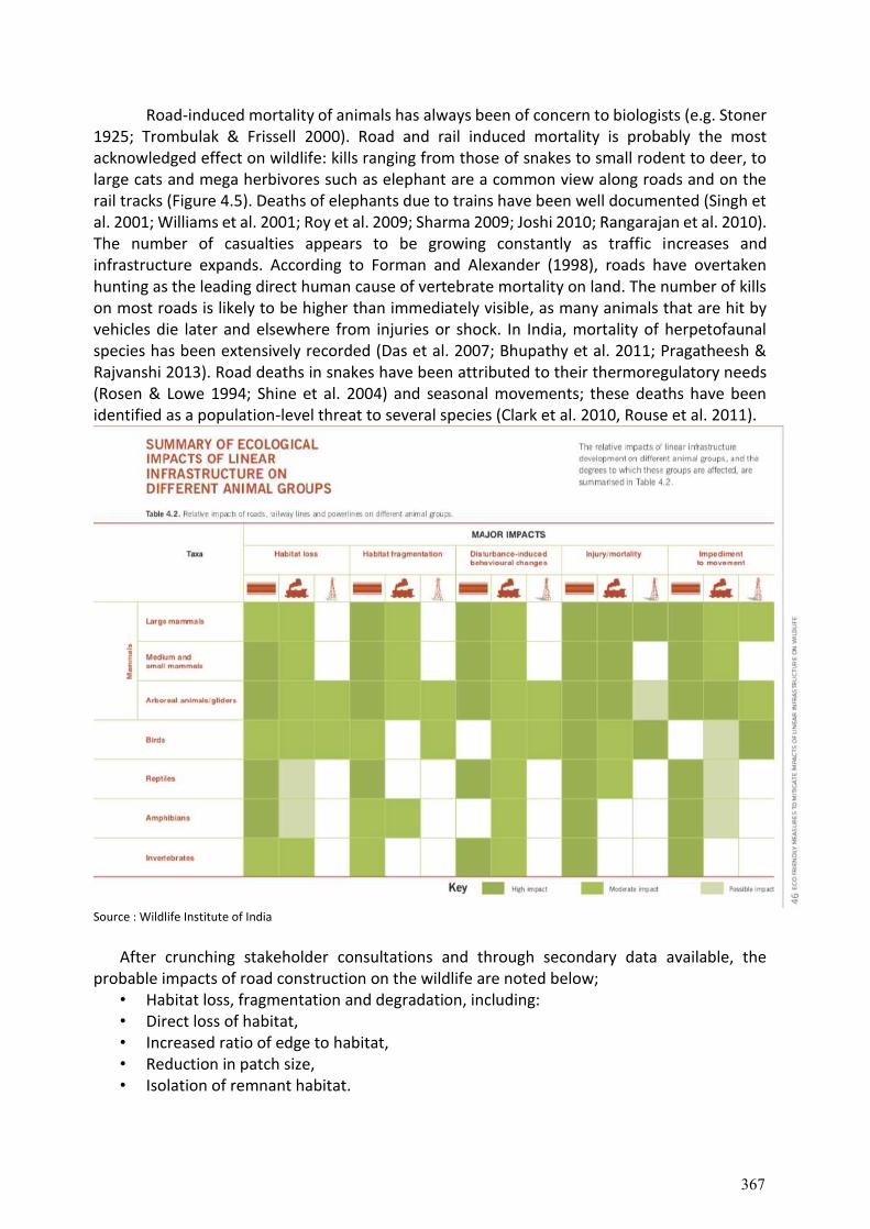
Road-induced mortality of animals has always been of concern to biologists (e.g. Stoner 1925; Trombulak & Frissell 2000). Road and rail induced mortality is probably the most acknowledged effect on wildlife: kills ranging from those of snakes to small rodent to deer, to large cats and mega herbivores such as elephant are a common view along roads and on the rail tracks (Figure 4.5). Deaths of elephants due to trains have been well documented (Singh et al. 2001; Williams et al. 2001; Roy et al. 2009; Sharma 2009; Joshi 2010; Rangarajan et al. 2010). The number of casualties appears to be growing constantly as traffic increases and infrastructure expands. According to Forman and Alexander (1998), roads have overtaken hunting as the leading direct human cause of vertebrate mortality on land. The number of kills on most roads is likely to be higher than immediately visible, as many animals that are hit by vehicles die later and elsewhere from injuries or shock. In India, mortality of herpetofaunal species has been extensively recorded (Das et al. 2007; Bhupathy et al. 2011; Pragatheesh & Rajvanshi 2013). Road deaths in snakes have been attributed to their thermoregulatory needs (Rosen & Lowe 1994; Shine et al. 2004) and seasonal movements; these deaths have been identified as a population-level threat to several species (Clark et al. 2010, Rouse et al. 2011).
Source : Wildlife Institute of India
After crunching stakeholder consultations and through secondary data available, the
probable impacts of road construction on the wildlife are noted below; • Habitat loss, fragmentation and degradation, including: • Direct loss of habitat, • Increased ratio of edge to habitat, • Reduction in patch size, • Isolation of remnant habitat.
367
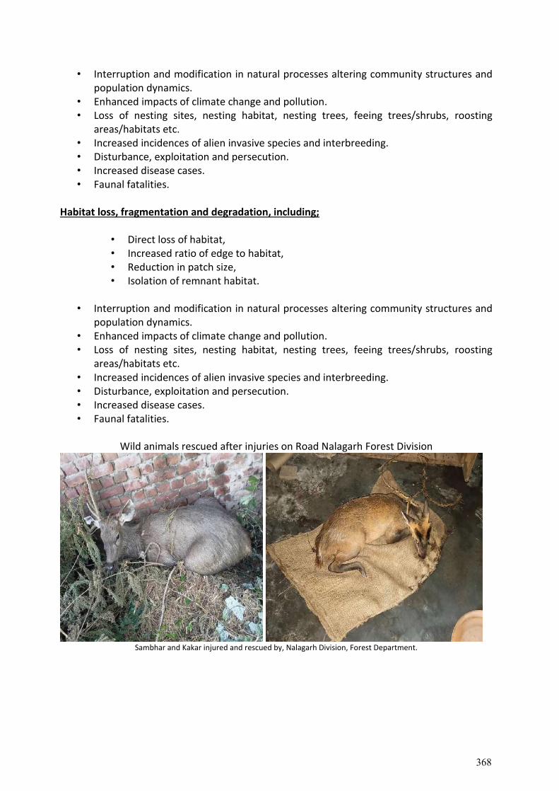
• Interruption and modification in natural processes altering community structures and population dynamics.
• Enhanced impacts of climate change and pollution. • Loss of nesting sites, nesting habitat, nesting trees, feeing trees/shrubs, roosting
areas/habitats etc. • Increased incidences of alien invasive species and interbreeding. • Disturbance, exploitation and persecution. • Increased disease cases. • Faunal fatalities.
Habitat loss, fragmentation and degradation, including;
• Direct loss of habitat, • Increased ratio of edge to habitat, • Reduction in patch size, • Isolation of remnant habitat.
• Interruption and modification in natural processes altering community structures and
population dynamics. • Enhanced impacts of climate change and pollution. • Loss of nesting sites, nesting habitat, nesting trees, feeing trees/shrubs, roosting
areas/habitats etc. • Increased incidences of alien invasive species and interbreeding. • Disturbance, exploitation and persecution. • Increased disease cases. • Faunal fatalities.
Wild animals rescued after injuries on Road Nalagarh Forest Division
Sambhar and Kakar injured and rescued by, Nalagarh Division, Forest Department.
368
Chapter 8. MITIGATION & CONSERVATION STRATEGIES 8.1 Mitigation Measures
Short Term mitigation strategies comprise of informing the decision maker and anticipate biodiversity impacts and the risks associated with the proposed developmental projects.
Long Term mitigation strategies are associated with accomplishing sustainable results by ensuring that the developmental projects do not hamper the biodiversity and its ecological components.
Elements of mitigation includes: 1. Avoid adverse impacts by use of preventative measures 2. Minimise or reduce adverse impacts to ‘as low as practicable’ levels 3. Remedy or compensate for adverse residual impacts, which are unavoidable and
cannot be reduced further.
Governments and individuals alike must remain alert to subtle changes in the biodiversity and climate sensitive ecosystems.
Policy-makers must reduce a society’s fear of change because climate has always and will continue to change, and society has and must continue to adapt.
Adaptation and mitigation strategies also includes specific reports, conferences and workshops designed to produce policies that are to be pursued to minimize, if not prevent, the adverse impacts of global warming on society and on biodiversity.
“Mapping” resiliency in a country in addition to “mapping” vulnerability is useful and important.
Tradeoffs must be made explicit to policymakers for proposed adaptation and mitigation strategies and tactics.
Climate change adaptation and mitigation 1. Adaptation measures need to focus on climate change “hot spots” analysis. 2. Early warning systems, disaster risk management and rural investments: crop
insurance, incentives to adopt better agricultural and land use practices. 3. Building capacity and awareness on biodiversity change adaptation 4. Extension and research services at national level - data collection, monitoring,
analysis and dissemination 5. Soil Carbon Sequestration – potential option for mitigation in forestry.
Climate change and biodiversity 1. Assessment of distribution of biodiversity for food and agriculture both in the
wild and in the fields 2. Assess its vulnerability to climate change 3. Biodiversity distribution mapping with different climate change scenarios.
8.2 Conservation Measures
1. Regular monitoring of habitats with high conservation and socio-economic values; The regular monitoring of the habitats supporting high species richness i.e., forests, shady moist, riverine, dry, degraded ecosystem needs to be monitored regularly.
369
2. People’s participation in Biodiversity conservation; Participation involvement of the local inhabitants in all the activities is urgently required. So that the inhabitants actively take part in the conservation of biodiversity in particular and environment in general.
3. Promotion of conservation education; Training programs, interactive meetings, exposure visits, public hearing and interactive workshops on conservation and sustainable use of biodiversity and overall environment conservation for the inhabitants need to be organized for conservation awareness.
4. Promotion of ex-situ and in-situ conservation of prioritized species
Rehabilitation of the species in natural habitats The developed seedlings of the Critically Endangered, Endangered and Vulnerable species need to be established and maintained in the natural habitats where species were found initially.
Restoration of the degraded habitats The degraded habitats of the study area need to be restored through plantation of grasses initially and later through plantations of the seedlings of the species falling under different categories.
Promotion of Medicinal Plants (MPs) in cultivation The prioritization of the high value medicinal plants for the conservation and socio-economic development of the inhabitants of the areas is an urgent need. The species i.e., Acorus calamus, Dioscorea deltoidea, Zanthoxylum armatum, Juglans regia, Hedychium spicatum, H. oblongifolium, Acacia catechu, Murraya koenigii, Vitex negundo, Berberis lycium and Tinospora cordifolia need to be established under cultivation/plantation. So that local inhabitants could take benefit of these high value resources.
8.3. Components for Biodiversity Conservation
1. Ex-situ and in-situ conservation i) Road side plantations ii) Afforestation on degraded land iii) Reclamation of muck dumping sites iv) Hedge groves plantations
2. Soil and moisture conservation intervention i) Check Dams and gully plugging ii) Trenches along contours iii) Plantation of bio-engineering species iv) Construction of Water Harvesting structures/ Pond
3. Habitat Improvement i. Plantation of fruits, fodder, shrubs and grass species
ii. Eradication of Lantana iii. Creation of water bodies iv. Construction of wildlife corridors v. Support for breeding programme of endangered species
vi. Retrofitting, walls, speed breakers, culverts, bridges 4. Socio-economic activities
i. Agro-forestry ii. Plantation of fruits, fodder of economic species
iii. Road side amenities
370
iv. Stray cattle management v. Vermicomposting
vi. Renovation/Augmentation of existing water ponds, springs and khatis etc.
5. Regulatory activities i. Cautioning sign boards
ii. Avoid blasting during breeding seasons iii. Public Awarenes
8.4. Smart and Green Infrastructure
Green infrastructure may sound like a new or an uncommon term, but it is certainly not a new concept! It has its roots in the founding principle of conservation planning that emphasises preserving and linking natural areas to benefit biodiversity. This approach helps to counter the negative impacts of habitat fragmentation.
Green infrastructure can thus be understood simply as a 'design and develop with nature' concept: it looks at conservation values and actions in concert with land development, growth management and built infrastructure planning (Benedict 2000). It aims to respect and avoid important biodiversity and sensitive habitats, including natural corridors across the landscape. It also aims to maintain, strengthen and restore ecosystems at all spatial scales, thereby ensuring sustained benefits to people from the goods and services they provide. Green infrastructure helps to build robust healthy and enduring landscapes which enable species and their communities to move and adapt (Lucius et al. 2011).
In addition to ecological issues, green infrastructure has to take into account a number of human dimensions such as safety and economic considerations, and ways to utilise the landscape in an optimum way. Human safety is particularly relevant in the planning of roads and railways: wild animal-vehicle collisions have a significant cost for both human and animal populations.
Green infrastructure offers a blueprint for 'smart conservation' (Benedict & McMahon 2002) in the same way that engineering plans provide a blueprint for future roads, railway lines, canals and powerlines. It can create a sound framework for future growth while making sure that significant natural resources will be conserved for future generations. 8.5 CONTRUCTION OF WILDLIFE CORRIDOR 8.5.1 OVERPASSES
Normally keeping in view, the topography hilly terrain, absence of National Park and Sanctuary in the areas and traffic volume, at present, the overhead crossing are not required. However keeping in view, the traffic wildlife causalities of wild animal, the overhead crossings could be an innovation option. Four arched RCC over bridge, one of each along Baddi-Ramshehar (Ratwali/Dharampur), Mandi-Rewalsar(Majhyali and Kukain) and Wazir Bauri-Nore (Bagipul/Kurpan Khad) road corridor respectively are suggested. The bridge is to be enhanced with habitat features such as native vegetation and guiding fencing. The corridor should be site specific, and no standard design is possible for constructing such bridges.
371
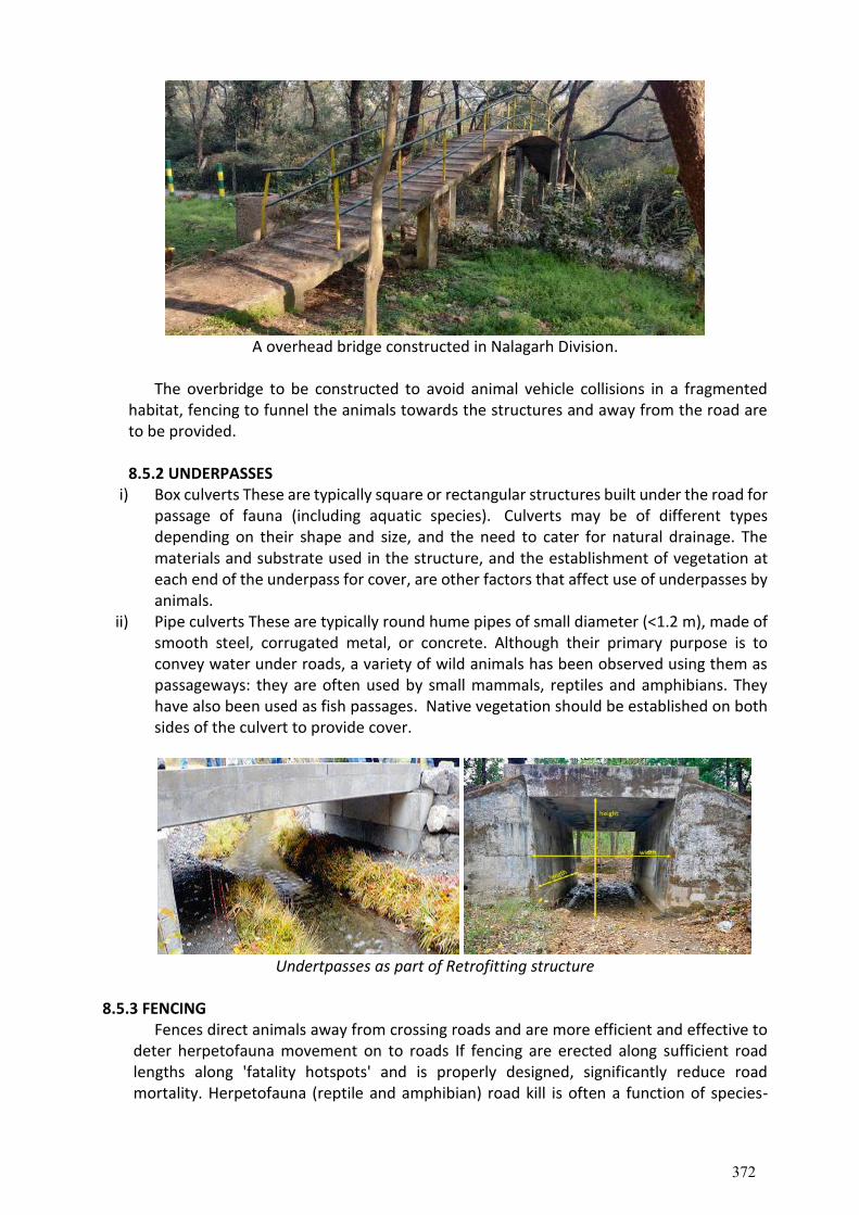
A overhead bridge constructed in Nalagarh Division.
The overbridge to be constructed to avoid animal vehicle collisions in a fragmented
habitat, fencing to funnel the animals towards the structures and away from the road are to be provided. 8.5.2 UNDERPASSES
i) Box culverts These are typically square or rectangular structures built under the road for passage of fauna (including aquatic species). Culverts may be of different types depending on their shape and size, and the need to cater for natural drainage. The materials and substrate used in the structure, and the establishment of vegetation at each end of the underpass for cover, are other factors that affect use of underpasses by animals.
ii) Pipe culverts These are typically round hume pipes of small diameter (<1.2 m), made of smooth steel, corrugated metal, or concrete. Although their primary purpose is to convey water under roads, a variety of wild animals has been observed using them as passageways: they are often used by small mammals, reptiles and amphibians. They have also been used as fish passages. Native vegetation should be established on both sides of the culvert to provide cover.
Undertpasses as part of Retrofitting structure
8.5.3 FENCING
Fences direct animals away from crossing roads and are more efficient and effective to deter herpetofauna movement on to roads If fencing are erected along sufficient road lengths along 'fatality hotspots' and is properly designed, significantly reduce road mortality. Herpetofauna (reptile and amphibian) road kill is often a function of species-
372
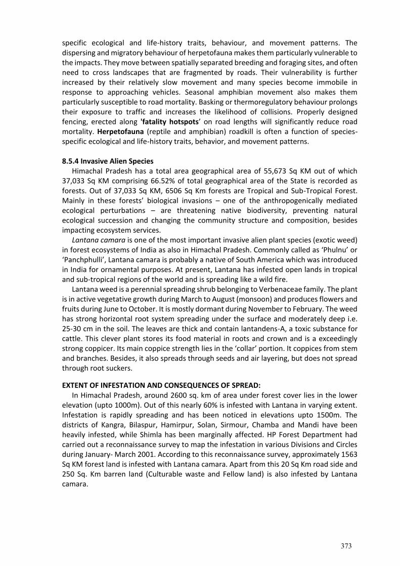
specific ecological and life-history traits, behaviour, and movement patterns. The dispersing and migratory behaviour of herpetofauna makes them particularly vulnerable to the impacts. They move between spatially separated breeding and foraging sites, and often need to cross landscapes that are fragmented by roads. Their vulnerability is further increased by their relatively slow movement and many species become immobile in response to approaching vehicles. Seasonal amphibian movement also makes them particularly susceptible to road mortality. Basking or thermoregulatory behaviour prolongs their exposure to traffic and increases the likelihood of collisions. Properly designed fencing, erected along 'fatality hotspots’ on road lengths will significantly reduce road mortality. Herpetofauna (reptile and amphibian) roadkill is often a function of species-specific ecological and life-history traits, behavior, and movement patterns.
8.5.4 Invasive Alien Species
Himachal Pradesh has a total area geographical area of 55,673 Sq KM out of which 37,033 Sq KM comprising 66.52% of total geographical area of the State is recorded as forests. Out of 37,033 Sq KM, 6506 Sq Km forests are Tropical and Sub-Tropical Forest. Mainly in these forests’ biological invasions – one of the anthropogenically mediated ecological perturbations – are threatening native biodiversity, preventing natural ecological succession and changing the community structure and composition, besides impacting ecosystem services.
Lantana camara is one of the most important invasive alien plant species (exotic weed) in forest ecosystems of India as also in Himachal Pradesh. Commonly called as ‘Phulnu’ or ‘Panchphulli’, Lantana camara is probably a native of South America which was introduced in India for ornamental purposes. At present, Lantana has infested open lands in tropical and sub-tropical regions of the world and is spreading like a wild fire.
Lantana weed is a perennial spreading shrub belonging to Verbenaceae family. The plant is in active vegetative growth during March to August (monsoon) and produces flowers and fruits during June to October. It is mostly dormant during November to February. The weed has strong horizontal root system spreading under the surface and moderately deep i.e. 25-30 cm in the soil. The leaves are thick and contain lantandens-A, a toxic substance for cattle. This clever plant stores its food material in roots and crown and is a exceedingly strong coppicer. Its main coppice strength lies in the ‘collar’ portion. It coppices from stem and branches. Besides, it also spreads through seeds and air layering, but does not spread through root suckers.
EXTENT OF INFESTATION AND CONSEQUENCES OF SPREAD: In Himachal Pradesh, around 2600 sq. km of area under forest cover lies in the lower
elevation (upto 1000m). Out of this nearly 60% is infested with Lantana in varying extent. Infestation is rapidly spreading and has been noticed in elevations upto 1500m. The districts of Kangra, Bilaspur, Hamirpur, Solan, Sirmour, Chamba and Mandi have been heavily infested, while Shimla has been marginally affected. HP Forest Department had carried out a reconnaissance survey to map the infestation in various Divisions and Circles during January- March 2001. According to this reconnaissance survey, approximately 1563 Sq KM forest land is infested with Lantana camara. Apart from this 20 Sq Km road side and 250 Sq. Km barren land (Culturable waste and Fellow land) is also infested by Lantana camara.
373
Description of land Total (area in Ha)
Forest Land 1,50,000
Road sides 2,000
Land classified as barren; culturable wastes & fallow 25,000
Total (Area in ha) 1,77,000
Table 34. Extent of infestation of Lantana camara as per last survey by HPFD
Status of Ianvave alien species Infestation in Forest Areas in Himachal Pradesh
CIRCLE
FOREST AREA UNDER INVASION
Lantana Ageratum Parthenium Eupatorium Total
NAHAN 21,456.99 4,302.51 4,260.73 595.87 595.87
BILASPUR 55,941.55 N/A N/A N/A 55,941.55
MANDI 7,900.00 2,360.00 N/A N/A 10,260.00
HAMIRPUR 12,680.00 N/A N/A N/A 12,680.00
DHARAMSHALA 47,403.00 12,810.00 N/A N/A 60,213.00
SHIMLA 4,060.89 N/A 1,100.00 N/A 5,160.89
RAMPUR N/A N/A N/A N/A N/A
CHAMBA 5,160.89 132.91 68.50 68.50 4,918.58
KULLU 575.70 N/A 575.70 137.25 137.25
WL(SOUTH) 475.06 683.98 683.98 190.50 1,960.98
WL(NORTH) 1,960.98 54.00 N/A 1,239.00 2,453.00
WL (GHNP) N/A N/A N/A N/A N/A
TOTAL 156,284.96 20,343.40 6,324.97 2,248.02 185,201.35
Table 35. Forest Circle-Wise incidence of infestation of invasive alien species on forest lands, In the tropical, sub-tropical and temperate zone invasion of non –native species is quite
frequent. Non-native like, Lantana camara, Parthenium hystrophorus, Eupatorium adenophorus, etc. are invading the forest area and agro forestry systems. Therefore, proper mechanism for the management of these non-natives is urgently required.
• Protection of indigenous plant and animal species through plantations. • Habitat restoration for multiplication of threatened species. Reducing invasive alien
species. Connecting fragmented habitat. • Biodiversity conservation both within and outside road corridor areas. • Rehabilitation of degraded forests, fragmented landscape ecosystem for carbon
sequestration with native plants and recovery of endangered species. • Incentives for conservation and sustainable use of biodiversity and fair and equitable
sharing of benefits of the resources. • Regular monitoring of habitats with high conservation and socio-economic values • People’s participation in Biodiversity conservation • Promotion of conservation education • Promotion of ex-situ and in-situ conservation of prioritized species; • Rehabilitation of the species in natural habitats • Restoration of the degraded habitats • Promotion of Medicinal Plants (MPs) in cultivation
374
• Monitoring and management of the invasive species • Providing alternate feeding and breeding habitats. • Enrichment of fragmented habitats and the links between them. • Improving the nature conservation value of roadside verges. • Modification of corridors for movement of large animals. • Improving the safety of roads. • Long term assessment of impacts and mitigation plans. • Involvement of local communities in socio economic aspects
375
Chapter 9. BIODIVERSITY CONSERVATION COMPONENTS Biodiversity refers to the various life forms that exist on earth, including animals, plants,
microorganisms, and the entire ecosystem they live in. Biodiversity is in the form of biological
resources, including genes, species, organisms, and ecosystems. Thus, the four main levels of
biodiversity are species, genetic, ecosystem, and global biodiversity.
Hence, biodiversity conservation is all about protecting all organisms and species within
their natural habitats with the aim of ensuring intragenerational and intergenerational equity.
Activities such as habitat fragmentation, human disturbance, and habitat loss have to be
adequately curtailed to enrich biodiversity conservation measures. Herein are the types,
importance, and methods of biodiversity conservation.
Components identified for Biodiversity Conservation along project corridor 9.1. Habitat Improvement
i. Plantation of fruits, fodder, shrubs and grass species ii. Eradication of Lantana
iii. Creation of water bodies iv. Construction of wildlife corridors v. Support for breeding programme of endangered species
vi. Retrofitting, walls, speed breakers, culverts, bridges 9.2. Socio-economic activities
i. Agro-forestry ii. Plantation of fruits, fodder of economic species
iii. Road side amenities iv. Stray cattle management v. Vermicomposting
vi. Renovation/Augmentation of existing water ponds, springs and khatis etc.
9.3. Regulatory Measures i. Cautioning sign boards
ii. Avoid blasting during breeding seasons iii. Public Awareness
9.4 Scope for roadside plantation and methodology India is witnessing a major change in infrastructure development vis-a-vis the
transportation network of the country which is National highways and State highways. There is always a conflict between development and environment, therefore, a trade off is necessary to balance the two, so that, development is sustainable. The first adverse consequence of widening and construction of road network from environment point of view, is the inevitable felling of trees and breaking of land along the highways resulting in biodiversity loss, on the hillsides and other fragile environmental settings, much more adverse impacts are expected on the surroundings.
Therefore, it is the responsibility of road agencies to offset the biodiversity loss and other changes resulted into the surroundings. In addition from mitigating the environment losses, road agencies must plan to enhance the aesthetics of highway corridor from all possible angles. Highways shouldn't be looked upon merely as a means of transportation but as a part and parcel of the environmental and socio economic milieu.
376
The land required for roadside plantation and landscape improvement needs to be identified and considered at the stage of project formulation, so as to ensure availability of land before plantation is taken up. The width of the remaining right of way is mostly not sufficient enough to accommodate even a single row of plants, whereas in areas having slope gentle to moderate at least two rows possible for roadside plantation and to ensure longevity of the highways as well. To ensure availability of sufficient width for roadside plantation, the requirement of land should be assessed and included in Forest land diversion and land acquisition plans prepared for highway widening project. The highway design and plantation should be regarded as complementary and tackled as a single planning task in advance.
Number of Plants to be planted per km at spacing of 5m plant to plant in a row and 3m row to row. The plantations should be fenced with Barbed wire and in isolated locations bamboo plant guard are required to put-up to stop grazing menace. Objectives of plantation
1. To improve aesthetics of project corridor 2. To reduce impacts of air pollution (dust) and act as natural sinks 3. To provide shade and glaring from hot roads during summer 4. To arrest soil erosion at the embankment slope 5. Climatic amelioration and moderating wind and incoming radiations 6. Plant species recommended as per altitudinal zone from tropical to temperate
Road Side Plantation Avenue species having aesthetic values, preferably evergreen, shady, flowering species
to be planted. Tall plants having minimum size of 1 m height and collar diameter more than 1 cm, to be planted in a pit of 60x60x60 cm pit at the spacing of 5 mt. Plantation to be done or two staggered rows which will need 200 plants and 400 plants per km. The trees to be protected by tree guard made of Bamboo, wire mesh etc material. Planting to be done during monsoon season. Maintenance to be done to replace the mortality over 3 years. Afforestation on Degraded Land
Local indigenous site specific plant species having fruits, fodder, and ecological value to be planted. Tall plants having minimum size of 1 m height and collar diameter more than 1 cm, to be planted in a pit of 60x60x60 cm pit at the spacing of 5 mt. Plantation to be done in staggered rows which will 400 plants per ha. Planting to be done during monsoon season. The plantation to be protected by erecting 4 strands barbed wire fencing. Maintenance to be done to replace the mortality over 3 years. 9.5 Soil & Moisture Conservation (SMC) Activities A. Nalla / Gully
i. Dry stone Check Dams; Dry stone material with stone course masonry to be used on
wider nalla. Thickness of wall should be minimum90 cm and spill be provided for easy flow of water
ii. Brush wood Check Dams; Where the width of gully is 5-6 m and depth upto 2m two rows of brush wood are used. The sprouting species such as Ipomea, Agave, Vitex negundo etc
iii. Vegetative Palisade; Thick branches of sprouting species are used and erected in holes and tied with rope together in a layer in the gully. The suitable species are Salix, Lannea, Populus, Arunginaria, Ailanthus etc.
iv. Pine needle Check Dams; Dry pine needles tied in a bundles are placed across the gully to retard the direct flow of water.
377
B. Slope Stabilization
1. Contour wattling ; Where slope is upto 66%. Contour trenches to be dug filled with brush
wood of sprouting species eg Salix, Lannea, Ficus, Vitex etc 2. Bamboo cribs; Cribs of Bamboo on inward inclined platform in alternate layers tied with
ropes are laid and filled with soil. Three to four layers to be placed as per slope. 3. Hedge Brush Layer: Branches of Sprouting plant species are laid on inward sloppy
platform and covered with soil. The suitable species are Berberis, Adhotoda, Aagave, Tinospora cordifolia, Ailanthus, Salix, Arundaneria falcata,rundinaria, Thysanolaena maxima (Broom grass), Saccharum munja, Vitivera (Khus), Cymbopogon (Lemon grass) etc.
C. Stabilization of saturation land Slips
Gabion wall combined with vegetation: Stone filled gabion walls have special properties of strength, flexibility and free drainage. It can be used up to 10 meters of height for retaining walls, cascade channels and check dams. Gabions can allow protection for vegetation and vegetation may provide additional stability once gabion walls begin to deteriorate.
1. Diversion / drainage channel to be constructed at the top of slip to divert the flowing water.
2. Gabion dry stone masonry; to be constructed with boulders studded with galvanized wire mesh in layers.
3. Retaining walls; Staggered retaining walls with dry stones with peep holes be constructed in course layers
4. Post planting; Planting with thick live post of Salix, Popular, Lannea etc. to be erected in between the staggered walls. These posts should be placed sufficiently deep upto 30 cm hole.
Requirements • Proper understanding of the slope & underneath soil • Type of failure-slope length, height, causes of failure springs & drainage line • In general height of the slope should govern the height of the gabion wall (Hgw = 0.4 to
0.6 x height of slope) • Depending on the slope type, cascade structures (gabion check dams) are also
appropriate (e.g. long slope but narrow drainage system - debris flow line) • Foundation for the gabion boxes shall be prepared 10 % back slope such that the wall
outer face shall make angle of
10 % with the vertical plane • Special attention should be made to binding the boxes together • Back of the gabion should be filled with gravel materials or geo-textiles to keep the voids
open & drain out the ground water • In cascade type gabion check dams, the distance between the two check dams should
be protected in combination with boulder riprap & vegetation on either side of the slope • Woody cuttings of shrubs & hedge type grass species are suitable for additional
strength. Functions
• Provide stability to the slope where passive support is lost • Catch debris
378
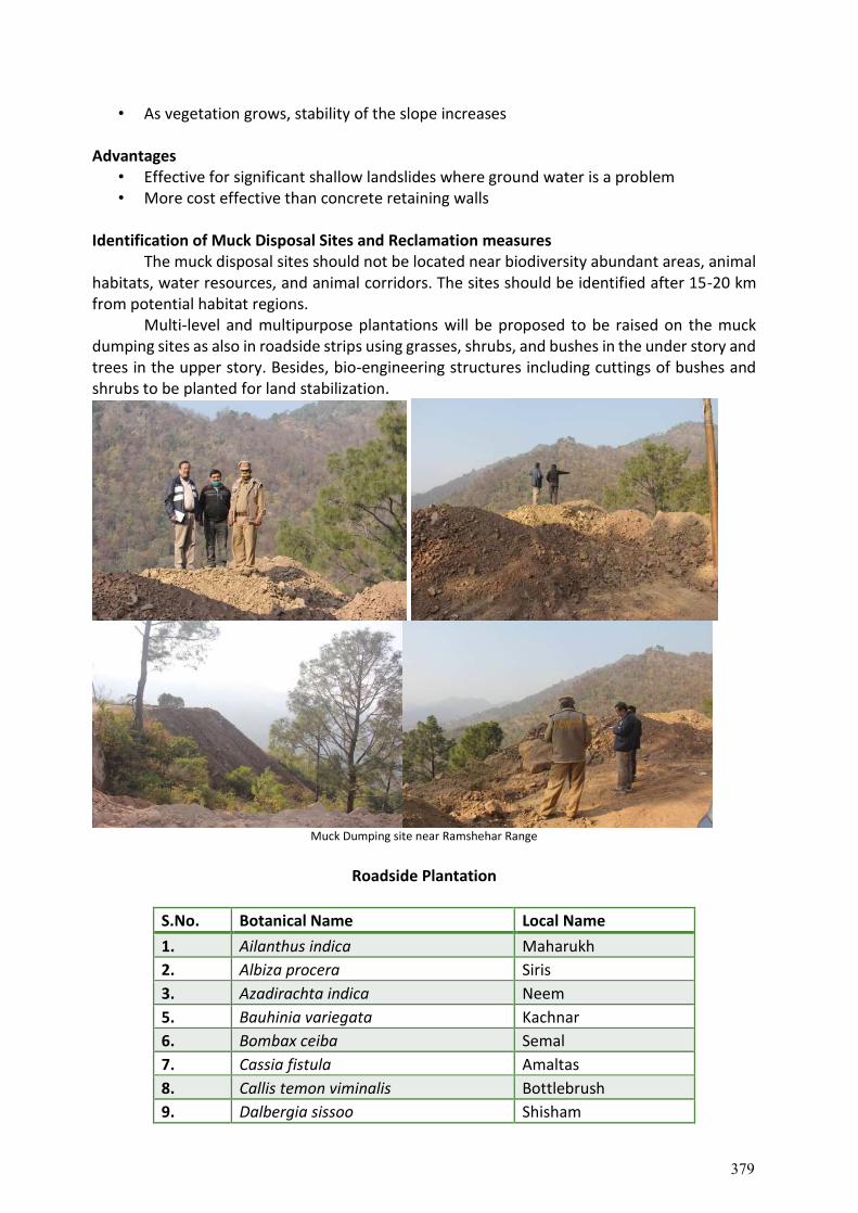
• As vegetation grows, stability of the slope increases Advantages
• Effective for significant shallow landslides where ground water is a problem • More cost effective than concrete retaining walls
Identification of Muck Disposal Sites and Reclamation measures The muck disposal sites should not be located near biodiversity abundant areas, animal habitats, water resources, and animal corridors. The sites should be identified after 15-20 km from potential habitat regions. Multi-level and multipurpose plantations will be proposed to be raised on the muck dumping sites as also in roadside strips using grasses, shrubs, and bushes in the under story and trees in the upper story. Besides, bio-engineering structures including cuttings of bushes and shrubs to be planted for land stabilization.
Muck Dumping site near Ramshehar Range
Roadside Plantation
S.No. Botanical Name Local Name
1. Ailanthus indica Maharukh
2. Albiza procera Siris
3. Azadirachta indica Neem
5. Bauhinia variegata Kachnar
6. Bombax ceiba Semal
7. Cassia fistula Amaltas
8. Callis temon viminalis Bottlebrush
9. Dalbergia sissoo Shisham
379
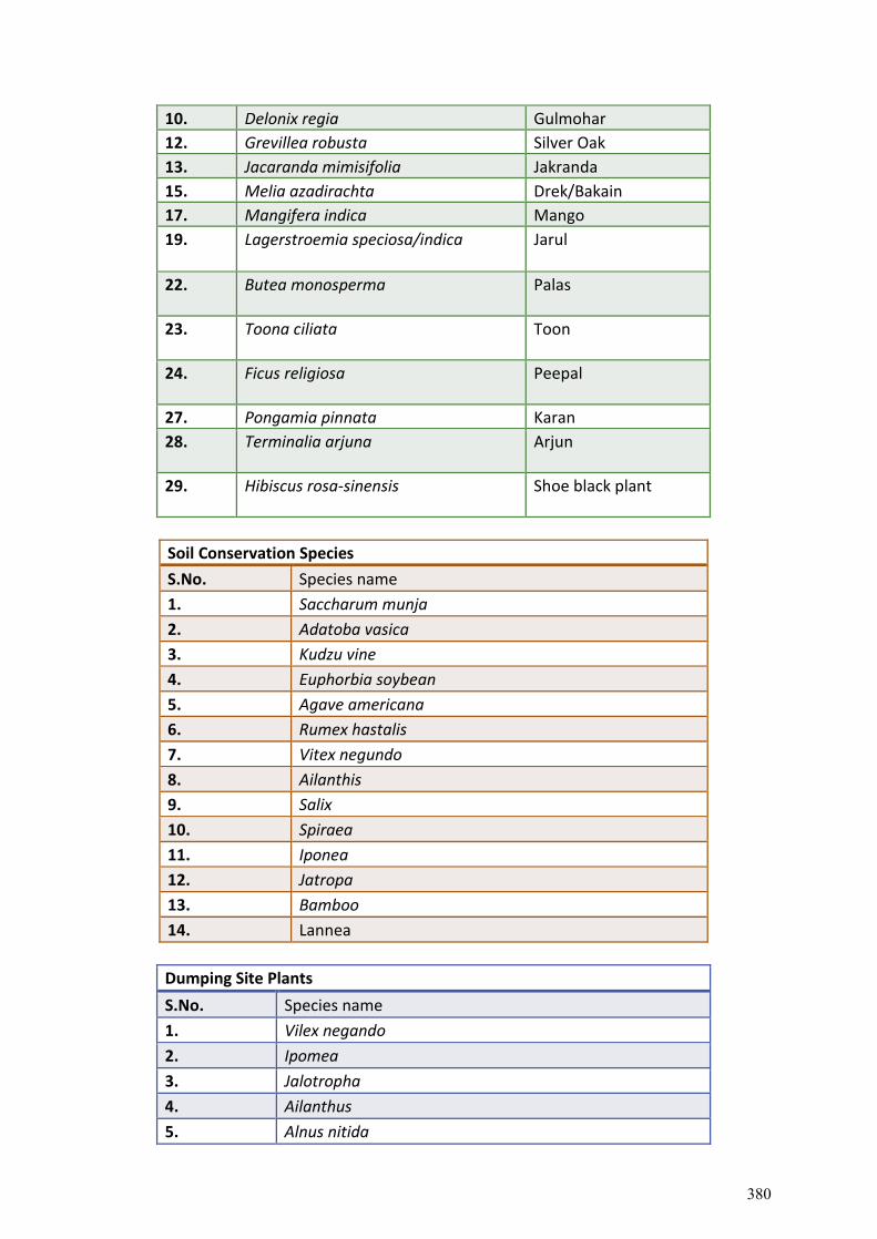
10. Delonix regia Gulmohar
12. Grevillea robusta Silver Oak
13. Jacaranda mimisifolia Jakranda
15. Melia azadirachta Drek/Bakain
17. Mangifera indica Mango
19. Lagerstroemia speciosa/indica Jarul
22. Butea monosperma Palas
23. Toona ciliata Toon
24. Ficus religiosa Peepal
27. Pongamia pinnata Karan
28. Terminalia arjuna Arjun
29. Hibiscus rosa-sinensis Shoe black plant
Soil Conservation Species
S.No. Species name
1. Saccharum munja
2. Adatoba vasica
3. Kudzu vine
4. Euphorbia soybean
5. Agave americana
6. Rumex hastalis
7. Vitex negundo
8. Ailanthis
9. Salix
10. Spiraea
11. Iponea
12. Jatropa
13. Bamboo
14. Lannea
Dumping Site Plants
S.No. Species name
1. Vilex negando
2. Ipomea
3. Jalotropha
4. Ailanthus
5. Alnus nitida
380
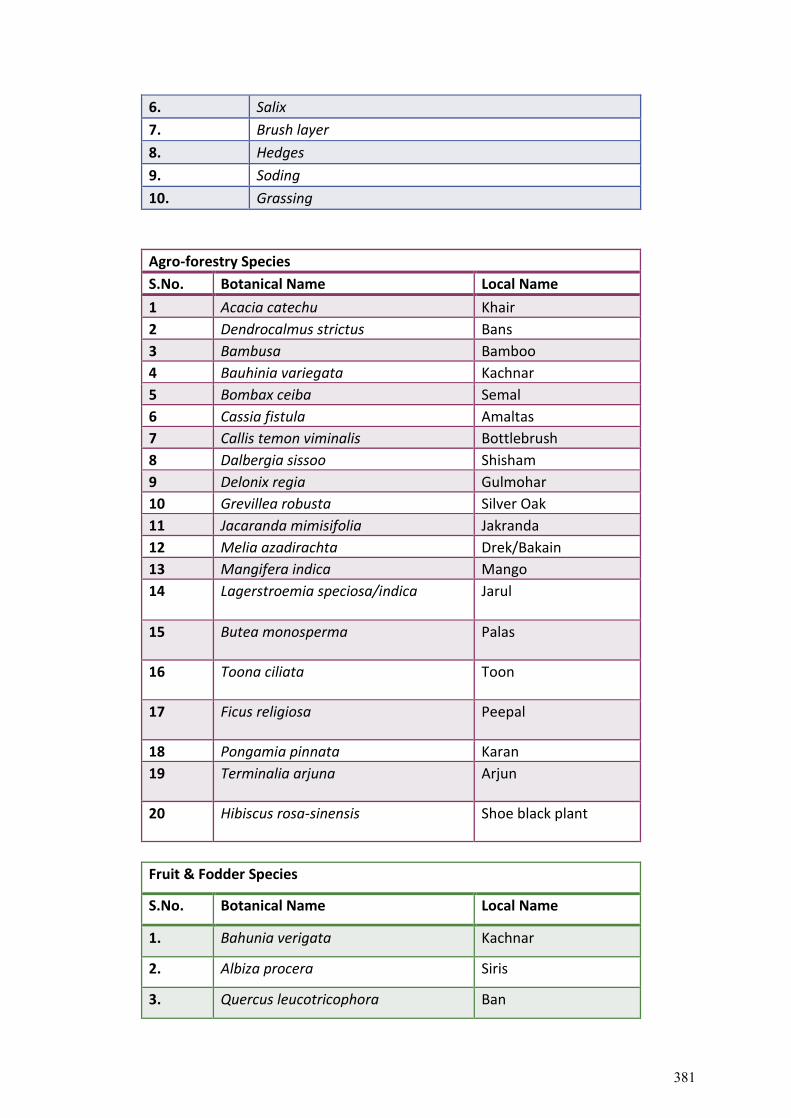
6. Salix
7. Brush layer
8. Hedges
9. Soding
10. Grassing
Agro-forestry Species
S.No. Botanical Name Local Name
1 Acacia catechu Khair
2 Dendrocalmus strictus Bans
3 Bambusa Bamboo
4 Bauhinia variegata Kachnar
5 Bombax ceiba Semal
6 Cassia fistula Amaltas
7 Callis temon viminalis Bottlebrush
8 Dalbergia sissoo Shisham
9 Delonix regia Gulmohar
10 Grevillea robusta Silver Oak
11 Jacaranda mimisifolia Jakranda
12 Melia azadirachta Drek/Bakain
13 Mangifera indica Mango
14 Lagerstroemia speciosa/indica Jarul
15 Butea monosperma Palas
16 Toona ciliata Toon
17 Ficus religiosa Peepal
18 Pongamia pinnata Karan
19 Terminalia arjuna Arjun
20 Hibiscus rosa-sinensis Shoe black plant
Fruit & Fodder Species
S.No. Botanical Name Local Name
1. Bahunia verigata Kachnar
2. Albiza procera Siris
3. Quercus leucotricophora Ban
381
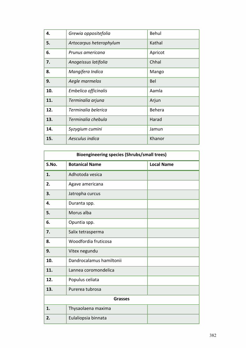
4. Grewia oppositefolia Behul
5. Artocarpus heterophylum Kathal
6. Prunus americana Apricot
7. Anogeissus latifolia Chhal
8. Mangifera Indica Mango
9. Aegle marmelos Bel
10. Embelica officinalis Aamla
11. Terminalia arjuna Arjun
12. Terminalia belerica Behera
13. Terminalia chebula Harad
14. Syzygium cumini Jamun
15. Aesculus indica Khanor
Bioengineering species (Shrubs/small trees)
S.No. Botanical Name Local Name
1. Adhotoda vesica
2. Agave americana
3. Jatropha curcus
4. Duranta spp.
5. Morus alba
6. Opuntia spp.
7. Salix tetrasperma
8. Woodfordia fruticosa
9. Vitex negundu
10. Dandrocalamus hamiltonii
11. Lannea coromondelica
12. Populus celiata
13. Purerea tubrosa
Grasses
1. Thysaolaena maxima
2. Eulaliopsia binnata
382
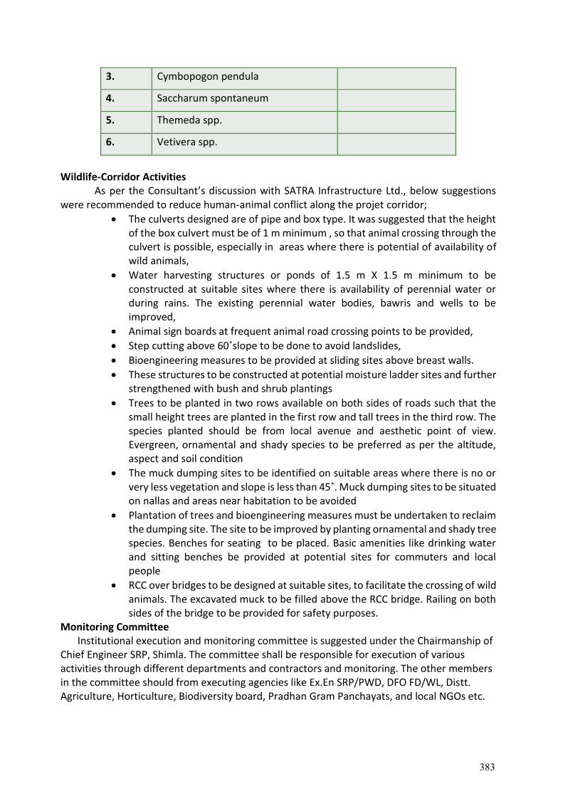
3. Cymbopogon pendula
4. Saccharum spontaneum
5. Themeda spp.
6. Vetivera spp.
Wildlife-Corridor Activities As per the Consultant’s discussion with SATRA Infrastructure Ltd., below suggestions were recommended to reduce human-animal conflict along the projet corridor;
The culverts designed are of pipe and box type. It was suggested that the height of the box culvert must be of 1 m minimum , so that animal crossing through the culvert is possible, especially in areas where there is potential of availability of wild animals,
Water harvesting structures or ponds of 1.5 m X 1.5 m minimum to be constructed at suitable sites where there is availability of perennial water or during rains. The existing perennial water bodies, bawris and wells to be improved,
Animal sign boards at frequent animal road crossing points to be provided,
Step cutting above 60˚slope to be done to avoid landslides,
Bioengineering measures to be provided at sliding sites above breast walls.
These structures to be constructed at potential moisture ladder sites and further strengthened with bush and shrub plantings
Trees to be planted in two rows available on both sides of roads such that the small height trees are planted in the first row and tall trees in the third row. The species planted should be from local avenue and aesthetic point of view. Evergreen, ornamental and shady species to be preferred as per the altitude, aspect and soil condition
The muck dumping sites to be identified on suitable areas where there is no or very less vegetation and slope is less than 45˚. Muck dumping sites to be situated on nallas and areas near habitation to be avoided
Plantation of trees and bioengineering measures must be undertaken to reclaim the dumping site. The site to be improved by planting ornamental and shady tree species. Benches for seating to be placed. Basic amenities like drinking water and sitting benches be provided at potential sites for commuters and local people
RCC over bridges to be designed at suitable sites, to facilitate the crossing of wild animals. The excavated muck to be filled above the RCC bridge. Railing on both sides of the bridge to be provided for safety purposes.
Monitoring Committee Institutional execution and monitoring committee is suggested under the Chairmanship of
Chief Engineer SRP, Shimla. The committee shall be responsible for execution of various activities through different departments and contractors and monitoring. The other members in the committee should from executing agencies like Ex.En SRP/PWD, DFO FD/WL, Distt. Agriculture, Horticulture, Biodiversity board, Pradhan Gram Panchayats, and local NGOs etc.
383
• Implementation Schedules: Timing, frequency, and duration of mitigation measures with overall implementation schedule of the project will be specified.
• Reporting Procedures: Feedback mechanisms to inform the relevant parties on the progress and effectiveness of the mitigatory measures and monitoring itself to be specified
Monitoring Arrangement
To ensure that the proposed mitigatory measures have the intended results and comply with GoI and World Bank requirements, an environmental performance monitoring program to be included in the BMP. Monitoring indicators to be measured for evaluating the performance of each mitigatory measure. Indicators should include principles adopted for alignments, applicable GoI engineering standards for road widening, etc) • Monitoring mechanisms and methodologies • Monitoring frequency • Monitoring locations • Expected cost of monitoring. • Responsibility
9.6. Annual Plan of Operations
For biodiversity conservation different activities have been identified and proposed by the Forest Department, Wildlife Wing and others Stakeholders is enlisted below. The Mitigation Plan to be executed for 4 years and to be monitored periodically as per the timeline framed by monitoring committee is as under.
384
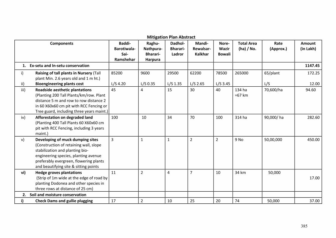
Mitigation Plan Abstract
Components Baddi-Barotiwala-
Sai-Ramshehar
Raghu- Nathpura-
Bharari-Harpura
Dadhol-Bharari- Ladror
Mandi-Rewalsar-
Kalkhar
Nore-Wazir Bowali
Total Area (ha) / No.
Rate (Approx.)
Amount (in Lakh)
1. Ex-setu and In-setu conservation 1147.45
i) Raising of tall plants in Nursery (Tall plant Min. 2.6 years old and 1 m ht.)
ii) Bioengineering plants cost
85200 L/S 4.20
9600 L/S 0.35
29500 L/S 1.35
62200 L/S 2.65
78500 L/S 3.45
265000
65/plant L/S
172.25
12.00
iii) Roadside aesthetic plantations (Planting 200 Tall Plants/km/row. Plant distance 5 m and row to row distance 2 in 60 X60x60 cm pit with RCC Fencing or Tree guard, including three years maint.)
45 4 15 30 40 134 ha =67 km
70,600/ha
94.60
iv) Afforestation on degraded land (Planting 400 Tall Plants 60 X60x60 cm pit with RCC Fencing, including 3 years maint.)
100 10 34 70 100 314 ha 90,000/ ha
282.60
v) Developing of muck dumping sites (Construction of retaining wall, slope stabilization and planting bio-engineering species, planting avenue preferably evergreen, flowering plants and beautifying site & sitting points
3 1 1 2 2 9 No 50,00,000 450.00
vi) Hedge groves plantations (Strip of 1m wide at the edge of road by planting Dodonea and other species in three rows at distance of 25 cm)
11 2 4 7 10 34 km 50,000 17.00
2. Soil and moisture conservation
i) Check Dams and gullie plugging 17 2 10 25 20 74 50,000 37.00
385
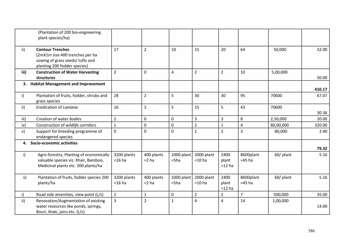
(Plantation of 200 bio-engineering plant species/ha)
ii) Contour Trenches (2mX1m size 400 trenches per ha sowing of grass seeds/ tufts and planting 200 fodder species)
17 2 10 15 20 64 50,000 32.00
iii) Construction of Water Harvesting structures
2 0 4 2 2 10 5,00,000 50.00
3. Habitat Management and Improvement 410.17
i) Plantation of fruits, fodder, shrubs and grass species
28 2 5 30 30 95 70600 67.07
ii) Eredication of Lantana 16 2 5 15 5 43 70600 30.36
iii) Creation of water bodies 2 0 0 3 3 8 2,50,000 20.00
iv) Construction of wildlife corridors 1 0 0 2 1 4 80,00,000 320.00
v) Support for breeding programme of endangered species
0 0 0 1 2 3 80,000 2.40
4. Socio-economic activities 79.32
i) Agro-forestry, Planting of economically valuable species viz. Khair, Bamboo, Medicinal plants etc. 200 plants/ha
3200 plants =16 ha
400 plants =2 ha
1000 plant =5ha
2000 plant =10 ha
2400 plant =12 ha
8600plant =45 ha
60/ plant
5.16
ii) Plantation of fruits, fodder species 200 plants/ha
3200 plants =16 ha
400 plants =2 ha
1000 plant =5ha
2000 plant =10 ha
2400 plant =12 ha
8600plant =45 ha
60/ plant
5.16
i) Road side amenities, view point (L/s) 2 1 0 2 2 7 500,000 35.00
ii) Renovation/Augmentation of existing water resources like ponds, springs, Bouri, khati, jairu etc. (L/s)
3 2 1 4 4 14 1,00,000 14.00
386
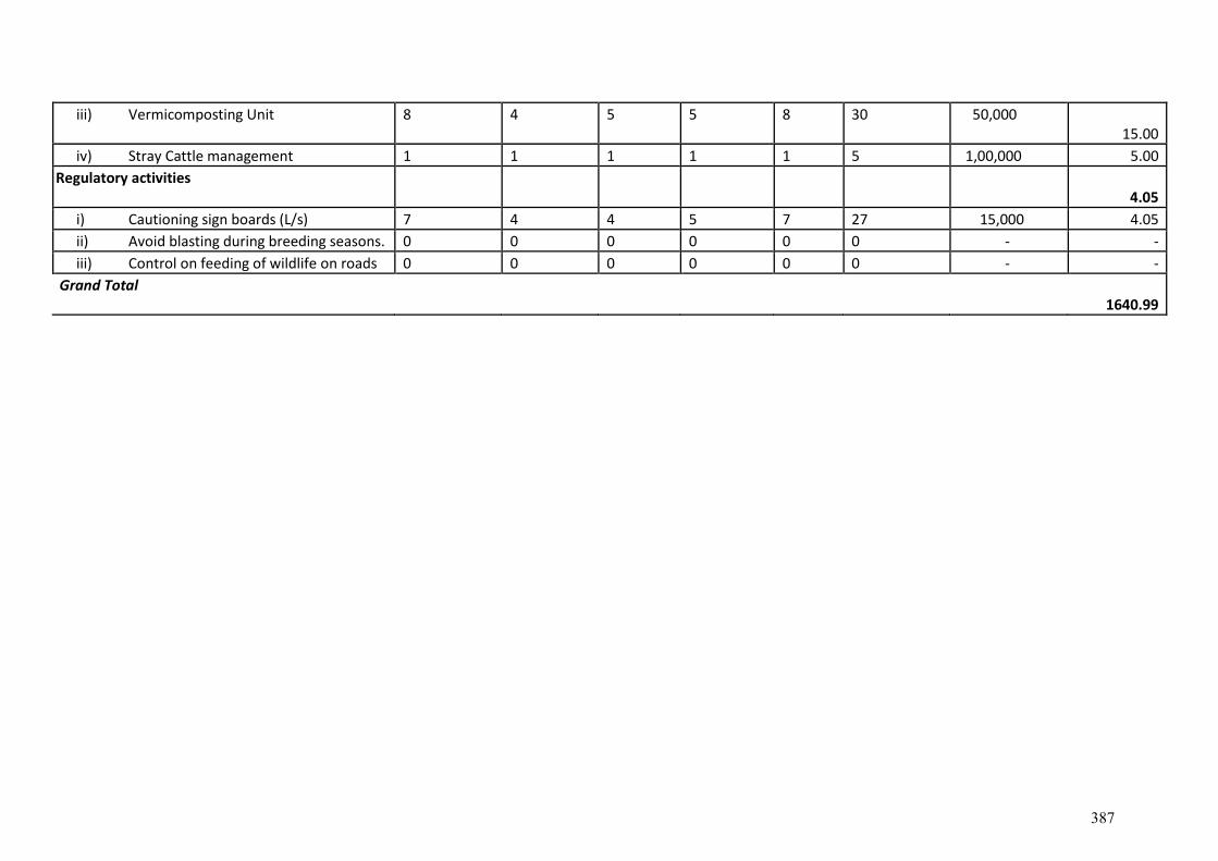
iii) Vermicomposting Unit 8 4 5 5 8 30 50,000 15.00
iv) Stray Cattle management 1 1 1 1 1 5 1,00,000 5.00
Regulatory activities 4.05
i) Cautioning sign boards (L/s) 7 4 4 5 7 27 15,000 4.05
ii) Avoid blasting during breeding seasons. 0 0 0 0 0 0 - -
iii) Control on feeding of wildlife on roads 0 0 0 0 0 0 - -
Grand Total
1640.99
387
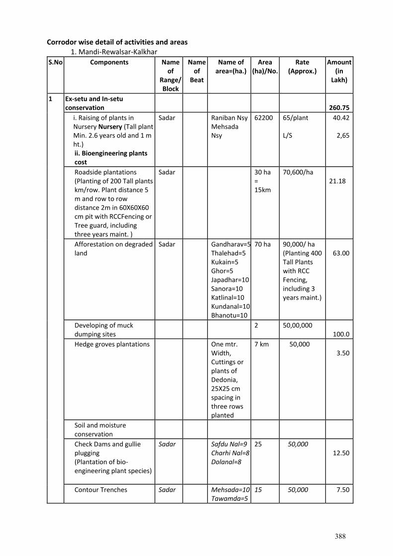
Corrodor wise detail of activities and areas 1. Mandi-Rewalsar-Kalkhar
S.No Components Name of
Range/ Block
Name of
Beat
Name of area=(ha.)
Area (ha)/No.
Rate (Approx.)
Amount (in
Lakh)
1 Ex-setu and In-setu conservation
260.75
i. Raising of plants in Nursery Nursery (Tall plant Min. 2.6 years old and 1 m ht.) ii. Bioengineering plants cost
Sadar Raniban Nsy Mehsada Nsy
62200
65/plant L/S
40.42
2,65
Roadside plantations (Planting of 200 Tall plants km/row. Plant distance 5 m and row to row distance 2m in 60X60X60 cm pit with RCCFencing or Tree guard, including three years maint. )
Sadar 30 ha = 15km
70,600/ha
21.18
Afforestation on degraded land
Sadar Gandharav=5 Thalehad=5 Kukain=5 Ghor=5 Japadhar=10 Sanora=10 Katlinal=10 Kundanal=10 Bhanotu=10
70 ha 90,000/ ha (Planting 400 Tall Plants with RCC Fencing, including 3 years maint.)
63.00
Developing of muck dumping sites
2 50,00,000 100.0
Hedge groves plantations One mtr. Width, Cuttings or plants of Dedonia, 25X25 cm spacing in three rows planted
7 km 50,000 3.50
Soil and moisture conservation
Check Dams and gullie plugging (Plantation of bio-engineering plant species)
Sadar Safdu Nal=9 Charhi Nal=8 Dolanal=8
25 50,000 12.50
Contour Trenches Sadar Mehsada=10 Tawamda=5
15
50,000 7.50
388

(400 trenches per ha sowing of grass seeds/ tufts and planting 200 fodder species)
Construction of Water Harvesting structures/ Pond
Sadar Gaddal Sauli
2 5,00,000 10.00
2 Habitat Improvement 200.07
Plantation of fruits, fodder, shrubs and grass species
Sadar Safru=5 Patron=5 Chamayat=5 Mehsada=10 Gandharav=5
30 70600 21.18
Eredication of Lantana Sadar Banghera=5 Kukain=5 Mehsada=5
15 70600 10.59
Creation of water bodies Sadar Chamayat Tandu Badsu
3 2,50,000 7.50
Construction of wildlife corridors
Sadar Majhyali Kukain
2 80,00,000 160.0
Support for breeding programme of endangered species
Cheer pheasantry, Chail
1 80,000 0.80
Retrofittings, c/o walls, speed breakers, culverts and bridges (L/s)
3 Socio-economic activities 19.90
Agro-forestry (Nursery cost of plant Rs. 65 plus planting cost Rs 60 total=125)
2000 plants =10 ha
60/plant
1.20
Plantation of fruits, fodder and economically valuable species
(Nursery cost of plant Rs. 65 plus planting cost Rs 60 total=125)
2000 plants =10 ha
60/plant 1.20
Road side amenities, view point (L/s)
Sadar Gandharav Gaddal
2 500,000 10.00
Stray Cattle management 1 100000 1.00
Vermicomposting 5 50,000 2.50
Renovation/Augmentation of existing water resources like ponds,
Sadar Mandal Tohal Ghera Majehas
4 1,00,000 4.00
389
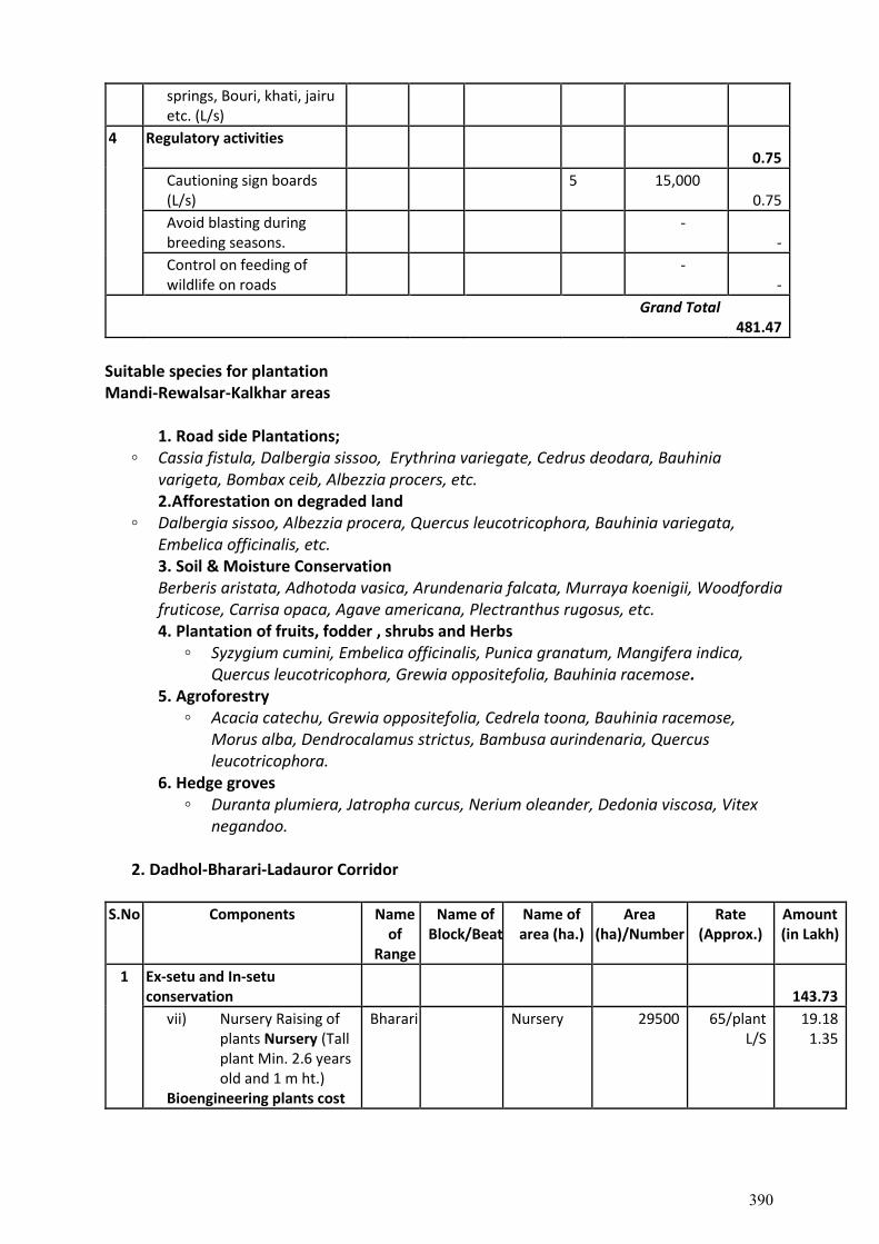
springs, Bouri, khati, jairu etc. (L/s)
4 Regulatory activities 0.75
Cautioning sign boards (L/s)
5 15,000 0.75
Avoid blasting during breeding seasons.
- -
Control on feeding of wildlife on roads
- -
Grand Total 481.47
Suitable species for plantation Mandi-Rewalsar-Kalkhar areas
1. Road side Plantations; ◦ Cassia fistula, Dalbergia sissoo, Erythrina variegate, Cedrus deodara, Bauhinia
varigeta, Bombax ceib, Albezzia procers, etc. 2.Afforestation on degraded land ◦ Dalbergia sissoo, Albezzia procera, Quercus leucotricophora, Bauhinia variegata,
Embelica officinalis, etc. 3. Soil & Moisture Conservation Berberis aristata, Adhotoda vasica, Arundenaria falcata, Murraya koenigii, Woodfordia
fruticose, Carrisa opaca, Agave americana, Plectranthus rugosus, etc. 4. Plantation of fruits, fodder , shrubs and Herbs
◦ Syzygium cumini, Embelica officinalis, Punica granatum, Mangifera indica, Quercus leucotricophora, Grewia oppositefolia, Bauhinia racemose.
5. Agroforestry ◦ Acacia catechu, Grewia oppositefolia, Cedrela toona, Bauhinia racemose,
Morus alba, Dendrocalamus strictus, Bambusa aurindenaria, Quercus leucotricophora.
6. Hedge groves ◦ Duranta plumiera, Jatropha curcus, Nerium oleander, Dedonia viscosa, Vitex
negandoo.
2. Dadhol-Bharari-Ladauror Corridor
S.No Components Name of
Range
Name of Block/Beat
Name of area (ha.)
Area (ha)/Number
Rate (Approx.)
Amount (in Lakh)
1 Ex-setu and In-setu conservation
143.73
vii) Nursery Raising of plants Nursery (Tall plant Min. 2.6 years old and 1 m ht.)
Bioengineering plants cost
Bharari Nursery 29500 65/plant L/S
19.18 1.35
390
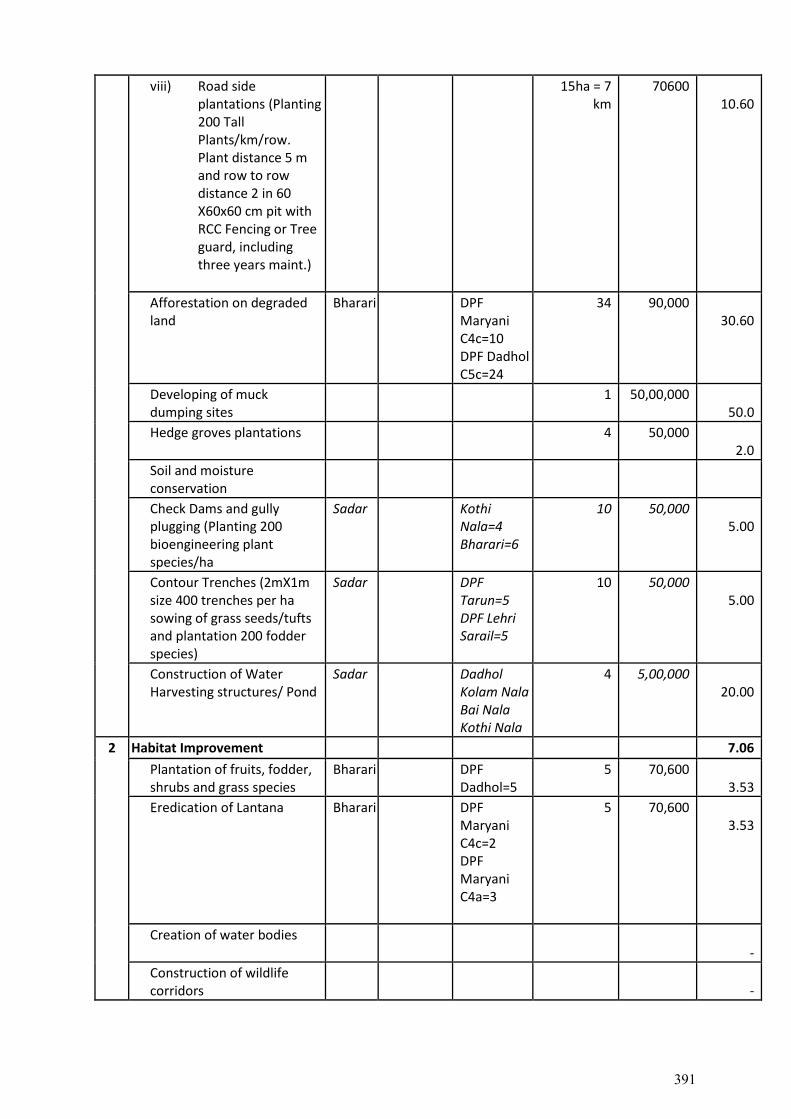
viii) Road side plantations (Planting 200 Tall Plants/km/row. Plant distance 5 m and row to row distance 2 in 60 X60x60 cm pit with RCC Fencing or Tree guard, including three years maint.)
15ha = 7 km
70600 10.60
Afforestation on degraded land
Bharari DPF Maryani C4c=10 DPF Dadhol C5c=24
34 90,000 30.60
Developing of muck dumping sites
1 50,00,000 50.0
Hedge groves plantations 4 50,000 2.0
Soil and moisture conservation
Check Dams and gully plugging (Planting 200 bioengineering plant species/ha
Sadar Kothi Nala=4 Bharari=6
10 50,000 5.00
Contour Trenches (2mX1m size 400 trenches per ha sowing of grass seeds/tufts and plantation 200 fodder species)
Sadar DPF Tarun=5 DPF Lehri Sarail=5
10 50,000 5.00
Construction of Water Harvesting structures/ Pond
Sadar Dadhol Kolam Nala Bai Nala Kothi Nala
4 5,00,000 20.00
2 Habitat Improvement 7.06
Plantation of fruits, fodder, shrubs and grass species
Bharari DPF Dadhol=5
5 70,600 3.53
Eredication of Lantana Bharari DPF Maryani C4c=2 DPF Maryani C4a=3
5 70,600 3.53
Creation of water bodies -
Construction of wildlife corridors
-
391
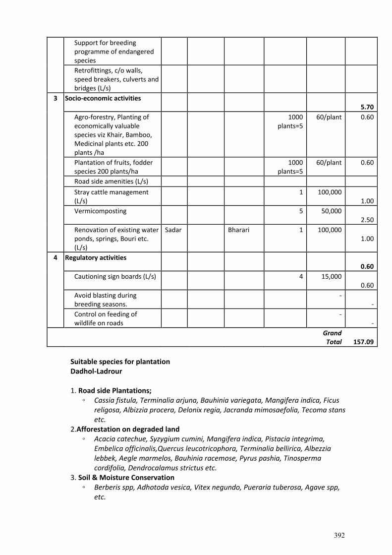
Support for breeding programme of endangered species
Retrofittings, c/o walls, speed breakers, culverts and bridges (L/s)
3 Socio-economic activities 5.70
Agro-forestry, Planting of economically valuable species viz Khair, Bamboo, Medicinal plants etc. 200 plants /ha
1000 plants=5
60/plant 0.60
Plantation of fruits, fodder species 200 plants/ha
1000 plants=5
60/plant 0.60
Road side amenities (L/s)
Stray cattle management (L/s)
1 100,000 1.00
Vermicomposting 5 50,000 2.50
Renovation of existing water ponds, springs, Bouri etc. (L/s)
Sadar Bharari 1 100,000 1.00
4 Regulatory activities 0.60
Cautioning sign boards (L/s) 4 15,000 0.60
Avoid blasting during breeding seasons.
- -
Control on feeding of wildlife on roads
- -
Grand
Total
157.09
Suitable species for plantation Dadhol-Ladrour
1. Road side Plantations; ◦ Cassia fistula, Terminalia arjuna, Bauhinia variegata, Mangifera indica, Ficus
religosa, Albizzia procera, Delonix regia, Jacranda mimosaefolia, Tecoma stans etc.
2.Afforestation on degraded land ◦ Acacia catechue, Syzygium cumini, Mangifera indica, Pistacia integrima,
Embelica officinalis,Quercus leucotricophora, Terminalia bellirica, Albezzia lebbek, Aegle marmelos, Bauhinia racemose, Pyrus pashia, Tinosperma cordifolia, Dendrocalamus strictus etc.
3. Soil & Moisture Conservation ◦ Berberis spp, Adhotoda vesica, Vitex negundo, Pueraria tuberosa, Agave spp,
etc.
392
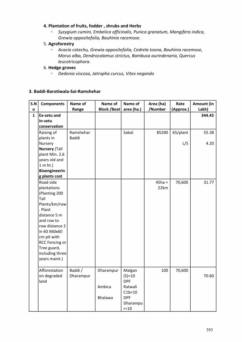
4. Plantation of fruits, fodder , shrubs and Herbs ◦ Syzygium cumini, Embelica officinalis, Punica granatum, Mangifera indica,
Grewia oppositefolia, Bauhinia racemose. 5. Agroforestry
◦ Acacia catechu, Grewia oppositefolia, Cedrela toona, Bauhinia racemose, Morus alba, Dendrocalamus strictus, Bambusa aurindenaria, Quercus leucotricophora.
6. Hedge groves ◦ Dedonia viscosa, Jatropha curcus, Vitex negando
3. Baddi-Barotiwala-Sai-Ramshehar
S.No
Components Name of Range
Name of Block /Beat
Name of area (ha.)
Area (ha) /Number
Rate (Approx.)
Amount (in Lakh)
1 Ex-setu and In-setu conservation
344.45
Raising of plants in Nursery Nursery (Tall plant Min. 2.6 years old and 1 m ht.) Bioengineering plants cost
Ramshehar Baddi
Sabal 85200 65/plant
L/S
55.38
4.20
Road side plantations (Planting 200 Tall Plants/km/row. Plant distance 5 m and row to row distance 2 in 60 X60x60 cm pit with RCC Fencing or Tree guard, including three years maint.)
45ha = 22km
70,600 31.77
Afforestation on degraded land
Baddi / Dharampur
Dharampur Ambica Bhalawa
Malgan (S)=10 DPF Ratwali C1b=10 DPF Dharampur=10
100 70,600 70.60
393
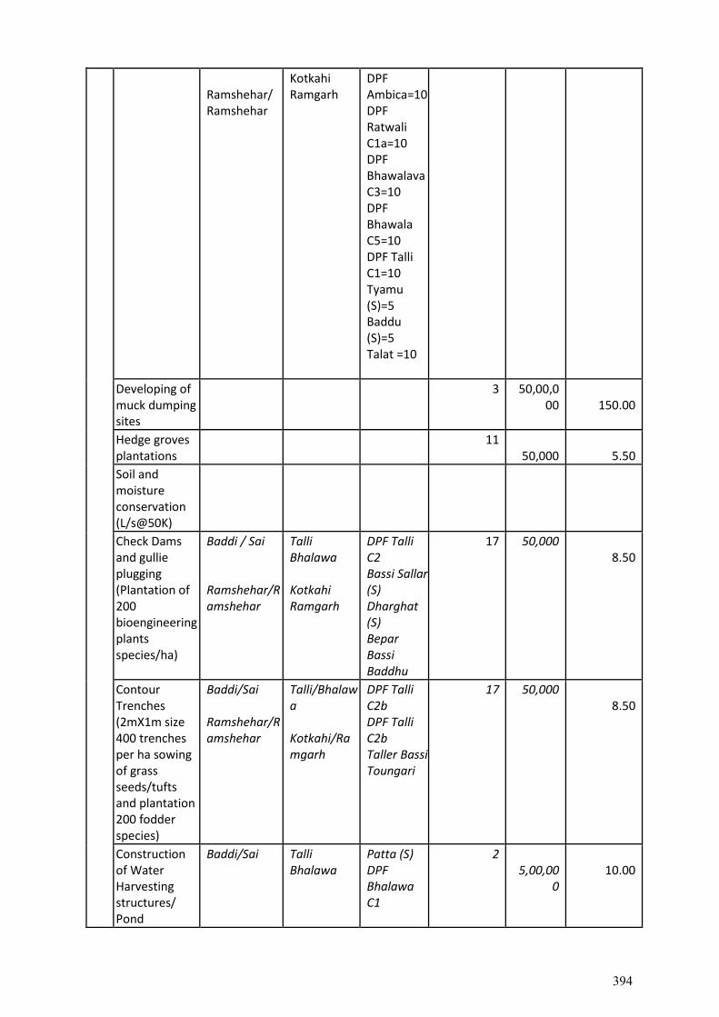
Ramshehar/ Ramshehar
Kotkahi Ramgarh
DPF Ambica=10 DPF Ratwali C1a=10 DPF Bhawalava C3=10 DPF Bhawala C5=10 DPF Talli C1=10 Tyamu (S)=5 Baddu (S)=5 Talat =10
Developing of muck dumping sites
3 50,00,000
150.00
Hedge groves plantations
11 50,000
5.50
Soil and moisture conservation (L/s@50K)
Check Dams and gullie plugging (Plantation of 200 bioengineering plants species/ha)
Baddi / Sai Ramshehar/Ramshehar
Talli Bhalawa Kotkahi Ramgarh
DPF Talli C2 Bassi Sallar (S) Dharghat (S) Bepar Bassi Baddhu
17 50,000 8.50
Contour Trenches (2mX1m size 400 trenches per ha sowing of grass seeds/tufts and plantation 200 fodder species)
Baddi/Sai Ramshehar/Ramshehar
Talli/Bhalawa Kotkahi/Ramgarh
DPF Talli C2b DPF Talli C2b Taller Bassi Toungari
17 50,000 8.50
Construction of Water Harvesting structures/ Pond
Baddi/Sai Talli Bhalawa
Patta (S) DPF Bhalawa C1
2 5,00,00
0
10.00
394
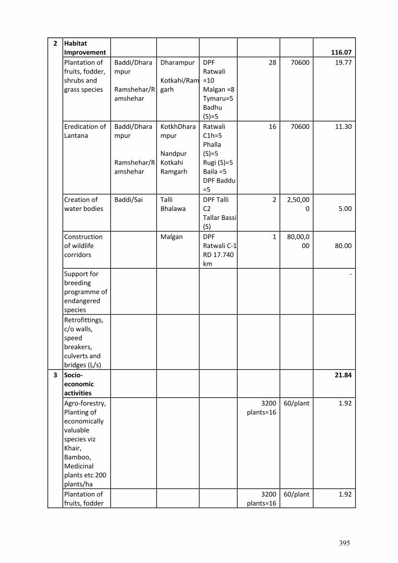
2 Habitat Improvement
116.07
Plantation of fruits, fodder, shrubs and grass species
Baddi/Dharampur Ramshehar/Ramshehar
Dharampur Kotkahi/Ramgarh
DPF Ratwali =10 Malgan =8 Tymaru=5 Badhu (S)=5
28 70600 19.77
Eredication of Lantana
Baddi/Dharampur Ramshehar/Ramshehar
KotkhDharampur Nandpur Kotkahi Ramgarh
Ratwali C1h=5 Phalla (S)=5 Rugi (S)=5 Baila =5 DPF Baddu =5
16 70600 11.30
Creation of water bodies
Baddi/Sai Talli Bhalawa
DPF Talli C2 Tallar Bassi (S)
2 2,50,000
5.00
Construction of wildlife corridors
Malgan DPF Ratwali C-1 RD 17.740 km
1 80,00,000
80.00
Support for breeding programme of endangered species
-
Retrofittings, c/o walls, speed breakers, culverts and bridges (L/s)
3 Socio-economic activities
21.84
Agro-forestry, Planting of economically valuable species viz Khair, Bamboo, Medicinal plants etc 200 plants/ha
3200 plants=16
60/plant 1.92
Plantation of fruits, fodder
3200 plants=16
60/plant 1.92
395
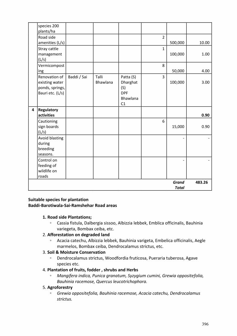
species 200 plants/ha
Road side amenities (L/s)
2 500,000
10.00
Stray cattle management (L/s)
1 100,000
1.00
Vermicomposting
8 50,000
4.00
Renovation of existing water ponds, springs, Bauri etc. (L/s)
Baddi / Sai Talli Bhawlana
Patta (S) Dharghat (S) DPF Bhawlana C1
3 100,000
3.00
4 Regulatory activities
0.90
Cautioning sign boards (L/s)
6 15,000
0.90
Avoid blasting during breeding seasons.
- -
Control on feeding of wildlife on roads
- -
Grand
Total 483.26
Suitable species for plantation Baddi-Barotiwala-Sai-Ramshehar Road areas
1. Road side Plantations; ◦ Cassia fistula, Dalbergia sissoo, Albizzia lebbek, Emblica officinalis, Bauhinia
variegeta, Bombax ceiba, etc. 2. Afforestation on degraded land
◦ Acacia catechu, Albizzia lebbek, Bauhinia varigeta, Embelica officinalis, Aegle marmelos, Bombax ceiba, Dendrocalamus strictus, etc.
3. Soil & Moisture Conservation ◦ Dendrocalamus strictus, Woodfordia fruticosa, Pueraria tuberosa, Agave
species etc. 4. Plantation of fruits, fodder , shrubs and Herbs
◦ Mangifera indica, Punica granatum, Syzygium cumini, Grewia oppositefolia, Bauhinia racemose, Quercus leucotrichophora.
5. Agroforestry ◦ Grewia oppositefolia, Bauhinia racemose, Acacia catechu, Dendrocalamus
strictus.
396
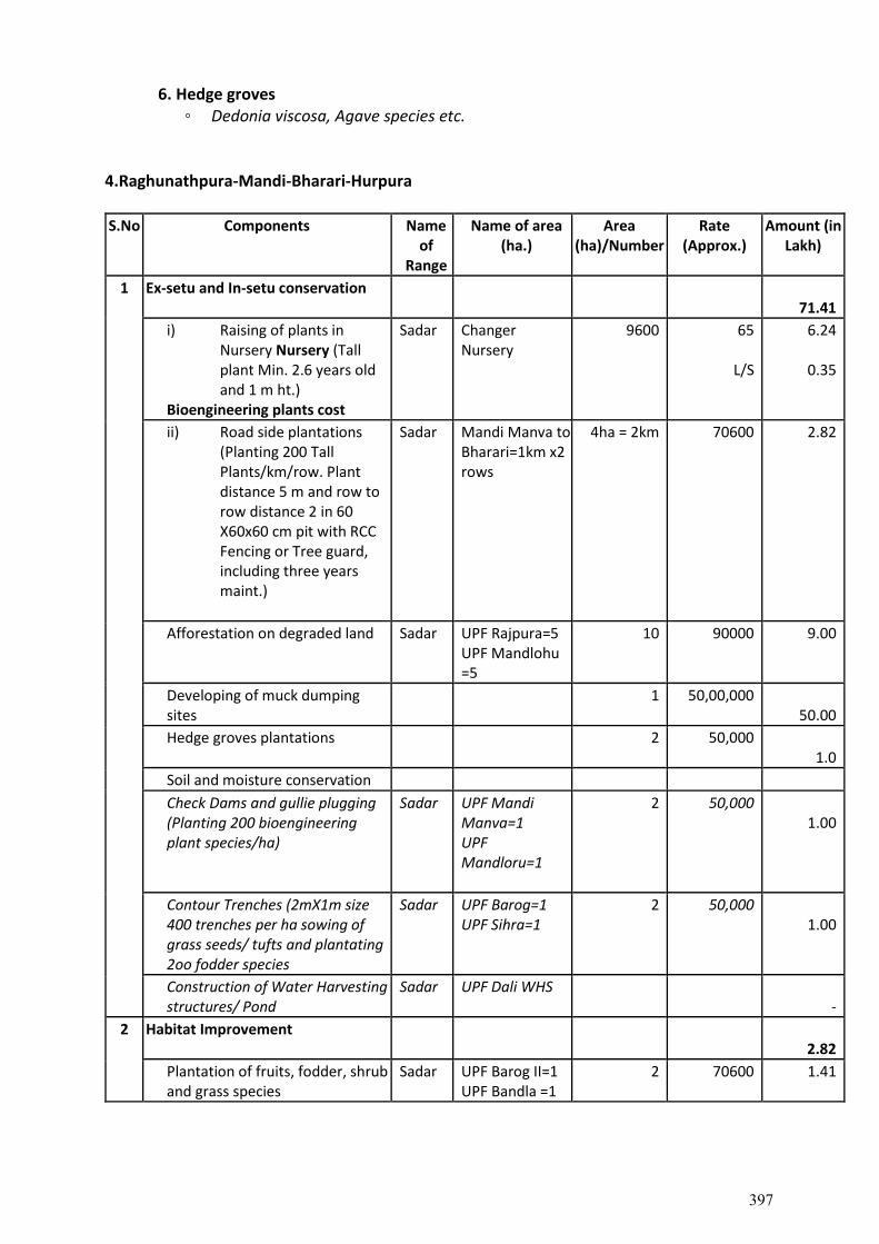
6. Hedge groves ◦ Dedonia viscosa, Agave species etc.
4.Raghunathpura-Mandi-Bharari-Hurpura
S.No Components Name of
Range
Name of area (ha.)
Area (ha)/Number
Rate (Approx.)
Amount (in Lakh)
1 Ex-setu and In-setu conservation 71.41
i) Raising of plants in Nursery Nursery (Tall plant Min. 2.6 years old and 1 m ht.)
Bioengineering plants cost
Sadar Changer Nursery
9600 65
L/S
6.24
0.35
ii) Road side plantations (Planting 200 Tall Plants/km/row. Plant distance 5 m and row to row distance 2 in 60 X60x60 cm pit with RCC Fencing or Tree guard, including three years maint.)
Sadar Mandi Manva to Bharari=1km x2 rows
4ha = 2km 70600 2.82
Afforestation on degraded land Sadar UPF Rajpura=5 UPF Mandlohu =5
10 90000 9.00
Developing of muck dumping sites
1 50,00,000 50.00
Hedge groves plantations 2 50,000 1.0
Soil and moisture conservation
Check Dams and gullie plugging (Planting 200 bioengineering plant species/ha)
Sadar UPF Mandi Manva=1 UPF Mandloru=1
2 50,000 1.00
Contour Trenches (2mX1m size 400 trenches per ha sowing of grass seeds/ tufts and plantating 2oo fodder species
Sadar UPF Barog=1 UPF Sihra=1
2 50,000 1.00
Construction of Water Harvesting structures/ Pond
Sadar UPF Dali WHS
-
2 Habitat Improvement 2.82
Plantation of fruits, fodder, shrub and grass species
Sadar UPF Barog II=1 UPF Bandla =1
2 70600 1.41
397
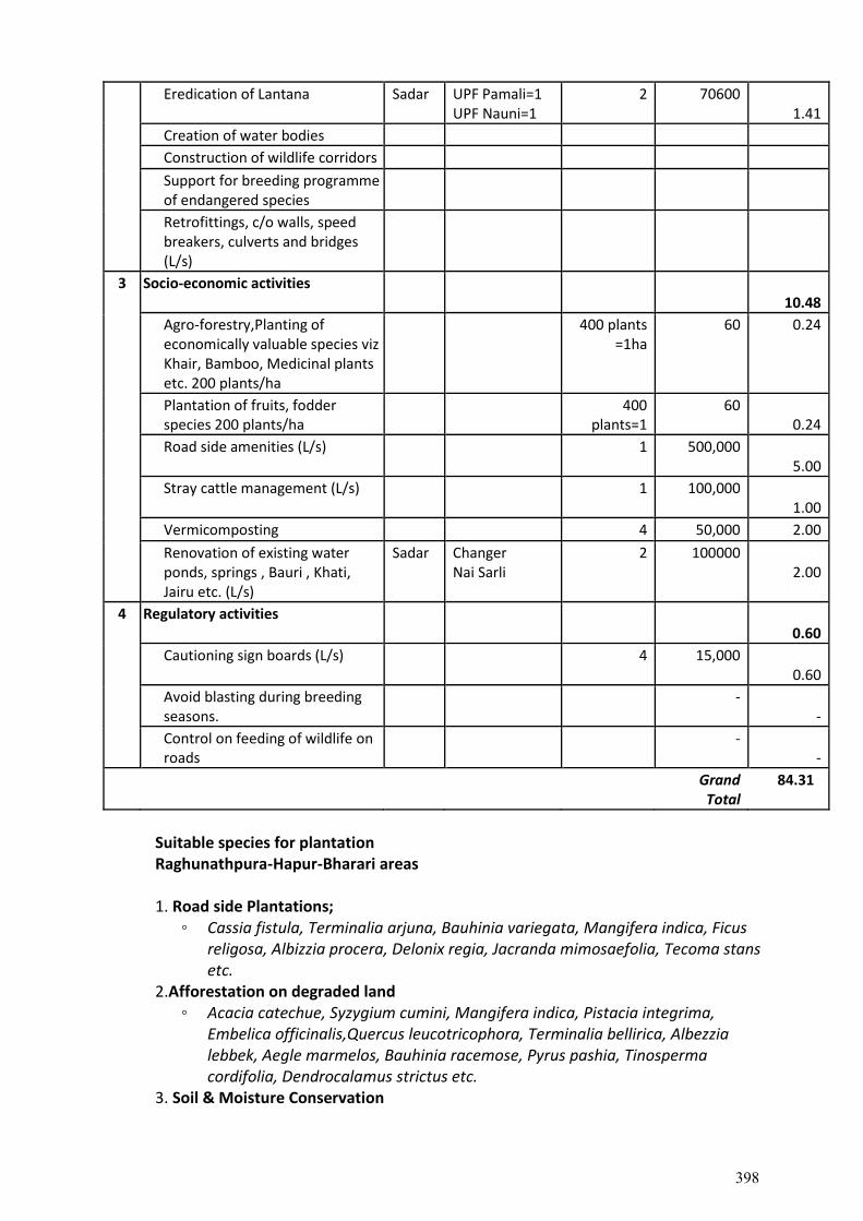
Eredication of Lantana Sadar UPF Pamali=1 UPF Nauni=1
2 70600 1.41
Creation of water bodies
Construction of wildlife corridors
Support for breeding programme of endangered species
Retrofittings, c/o walls, speed breakers, culverts and bridges (L/s)
3 Socio-economic activities 10.48
Agro-forestry,Planting of economically valuable species viz Khair, Bamboo, Medicinal plants etc. 200 plants/ha
400 plants =1ha
60 0.24
Plantation of fruits, fodder species 200 plants/ha
400 plants=1
60 0.24
Road side amenities (L/s) 1 500,000 5.00
Stray cattle management (L/s) 1 100,000 1.00
Vermicomposting 4 50,000 2.00
Renovation of existing water ponds, springs , Bauri , Khati, Jairu etc. (L/s)
Sadar Changer Nai Sarli
2 100000 2.00
4 Regulatory activities 0.60
Cautioning sign boards (L/s) 4 15,000 0.60
Avoid blasting during breeding seasons.
- -
Control on feeding of wildlife on roads
- -
Grand
Total 84.31
Suitable species for plantation Raghunathpura-Hapur-Bharari areas
1. Road side Plantations; ◦ Cassia fistula, Terminalia arjuna, Bauhinia variegata, Mangifera indica, Ficus
religosa, Albizzia procera, Delonix regia, Jacranda mimosaefolia, Tecoma stans etc.
2.Afforestation on degraded land ◦ Acacia catechue, Syzygium cumini, Mangifera indica, Pistacia integrima,
Embelica officinalis,Quercus leucotricophora, Terminalia bellirica, Albezzia lebbek, Aegle marmelos, Bauhinia racemose, Pyrus pashia, Tinosperma cordifolia, Dendrocalamus strictus etc.
3. Soil & Moisture Conservation
398
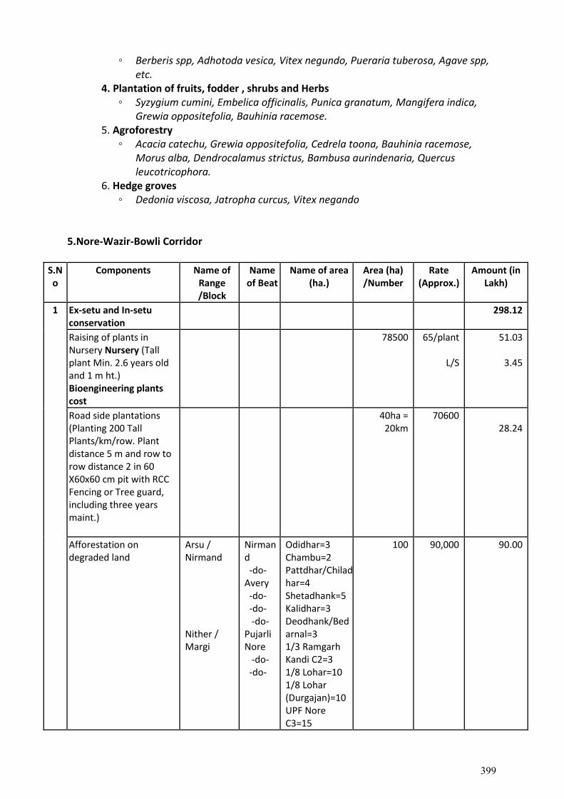
◦ Berberis spp, Adhotoda vesica, Vitex negundo, Pueraria tuberosa, Agave spp, etc.
4. Plantation of fruits, fodder , shrubs and Herbs ◦ Syzygium cumini, Embelica officinalis, Punica granatum, Mangifera indica,
Grewia oppositefolia, Bauhinia racemose. 5. Agroforestry
◦ Acacia catechu, Grewia oppositefolia, Cedrela toona, Bauhinia racemose, Morus alba, Dendrocalamus strictus, Bambusa aurindenaria, Quercus leucotricophora.
6. Hedge groves ◦ Dedonia viscosa, Jatropha curcus, Vitex negando
5.Nore-Wazir-Bowli Corridor
S.No
Components Name of Range /Block
Name of Beat
Name of area (ha.)
Area (ha) /Number
Rate (Approx.)
Amount (in Lakh)
1 Ex-setu and In-setu conservation
298.12
Raising of plants in Nursery Nursery (Tall plant Min. 2.6 years old and 1 m ht.) Bioengineering plants cost
78500 65/plant
L/S
51.03
3.45
Road side plantations (Planting 200 Tall Plants/km/row. Plant distance 5 m and row to row distance 2 in 60 X60x60 cm pit with RCC Fencing or Tree guard, including three years maint.)
40ha = 20km
70600 28.24
Afforestation on degraded land
Arsu / Nirmand Nither / Margi
Nirmand -do- Avery -do- -do- -do- Pujarli Nore -do- -do-
Odidhar=3 Chambu=2 Pattdhar/Chiladhar=4 Shetadhank=5 Kalidhar=3 Deodhank/Bedarnal=3 1/3 Ramgarh Kandi C2=3 1/8 Lohar=10 1/8 Lohar (Durgajan)=10 UPF Nore C3=15
100 90,000 90.00
399
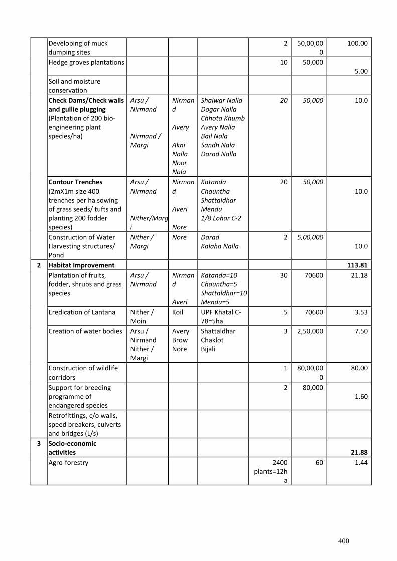
Developing of muck dumping sites
2 50,00,000
100.00
Hedge groves plantations 10 50,000 5.00
Soil and moisture conservation
Check Dams/Check walls and gullie plugging (Plantation of 200 bio-engineering plant species/ha)
Arsu / Nirmand Nirmand / Margi
Nirmand Avery Akni Nalla Noor Nala
Shalwar Nalla Dogar Nalla Chhota Khumb Avery Nalla Bail Nala Sandh Nala Darad Nalla
20 50,000 10.0
Contour Trenches (2mX1m size 400 trenches per ha sowing of grass seeds/ tufts and planting 200 fodder species)
Arsu / Nirmand Nither/Margi
Nirmand Averi Nore
Katanda Chauntha Shattaldhar Mendu 1/8 Lohar C-2
20 50,000 10.0
Construction of Water Harvesting structures/ Pond
Nither / Margi
Nore Darad Kalaha Nalla
2 5,00,000 10.0
2 Habitat Improvement 113.81
Plantation of fruits, fodder, shrubs and grass species
Arsu / Nirmand
Nirmand Averi
Katanda=10 Chauntha=5 Shattaldhar=10 Mendu=5
30 70600 21.18
Eredication of Lantana Nither / Moin
Koil UPF Khatal C-78=5ha
5 70600 3.53
Creation of water bodies Arsu / Nirmand Nither / Margi
Avery Brow Nore
Shattaldhar Chaklot Bijali
3 2,50,000 7.50
Construction of wildlife corridors
1 80,00,000
80.00
Support for breeding programme of endangered species
2 80,000 1.60
Retrofittings, c/o walls, speed breakers, culverts and bridges (L/s)
3 Socio-economic activities
21.88
Agro-forestry 2400 plants=12h
a
60 1.44
400
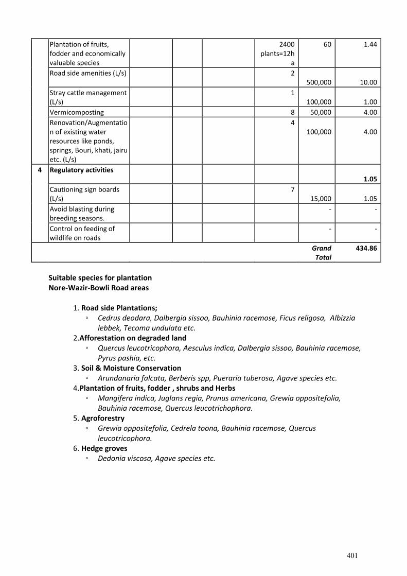
Plantation of fruits, fodder and economically valuable species
2400 plants=12h
a
60 1.44
Road side amenities (L/s) 2 500,000
10.00
Stray cattle management (L/s)
1 100,000
1.00
Vermicomposting 8 50,000 4.00
Renovation/Augmentation of existing water resources like ponds, springs, Bouri, khati, jairu etc. (L/s)
4 100,000
4.00
4 Regulatory activities 1.05
Cautioning sign boards (L/s)
7 15,000
1.05
Avoid blasting during breeding seasons.
- -
Control on feeding of wildlife on roads
- -
Grand
Total 434.86
Suitable species for plantation Nore-Wazir-Bowli Road areas
1. Road side Plantations; ◦ Cedrus deodara, Dalbergia sissoo, Bauhinia racemose, Ficus religosa, Albizzia
lebbek, Tecoma undulata etc. 2.Afforestation on degraded land
◦ Quercus leucotricophora, Aesculus indica, Dalbergia sissoo, Bauhinia racemose, Pyrus pashia, etc.
3. Soil & Moisture Conservation ◦ Arundanaria falcata, Berberis spp, Pueraria tuberosa, Agave species etc.
4.Plantation of fruits, fodder , shrubs and Herbs ◦ Mangifera indica, Juglans regia, Prunus americana, Grewia oppositefolia,
Bauhinia racemose, Quercus leucotrichophora. 5. Agroforestry
◦ Grewia oppositefolia, Cedrela toona, Bauhinia racemose, Quercus leucotricophora.
6. Hedge groves ◦ Dedonia viscosa, Agave species etc.
401
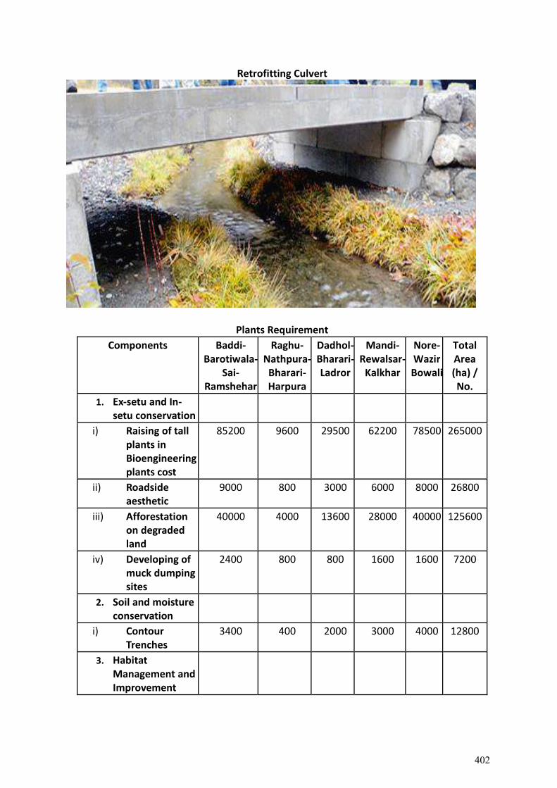
Retrofitting Culvert
Plants Requirement
Components Baddi-Barotiwala-
Sai-Ramshehar
Raghu- Nathpura-
Bharari-Harpura
Dadhol-Bharari- Ladror
Mandi-Rewalsar-
Kalkhar
Nore-Wazir Bowali
Total Area (ha) / No.
1. Ex-setu and In-setu conservation
i) Raising of tall plants in Bioengineering plants cost
85200 9600 29500 62200 78500 265000
ii) Roadside aesthetic
9000 800 3000 6000 8000 26800
iii) Afforestation on degraded land
40000 4000 13600 28000 40000 125600
iv) Developing of muck dumping sites
2400 800 800 1600 1600 7200
2. Soil and moisture conservation
i) Contour Trenches
3400 400 2000 3000 4000 12800
3. Habitat Management and Improvement
402
i) Plantation of fruits, fodder, shrub and grass species
6400 800 2000 6000 6000 21200
ii) Eredication of Lantana
3200 400 1000 3000 1000 8600
4. Socio-economic activities
i) Agro-forestry, Planting of economically valuable species
3200
400
1000
2000
2400
9000
ii) Plantation of fruits, fodder species
3200 400 1000 2000 2400 9000
Total 70800 8000 24400 51600 65400 220200
Three years maintenance, including Average 20% mortality replacement
14160 1600 4880 10320 13080 44040
Grand Total 84960 9600 29280 61920 78480 264240
or say 265000 plants
Cost Norm adopted by Forest Department
Abstract of Per Ha. Norms for raising Normal plantation & maintenance of 5 year old maintenance during the year 2021-22 (Based on basic wage rate ₹300/- per day)
Name of Scheme New Plantation
N/Tribal Tribal-1 Tribal-2
Afforestation/Re-afforestation of Scrub Areas/Protective Afforestation (Soil and Water Conservation)
52100 63800 122900
Enrichment 43900 53500 112700
Dev. Of Pasture & Grazing lands
a) Alpine Pasture
33000 39900 -
b) Low lying grazing lands
39000 47400 -
Maintenance
403
Afforestation/Re-afforestation of Scrub Areas/Soil. And Water Conservation
1st year maintenance
6850 8550 41000
2nd year maintenance
4600 5800 26700
3rd year maintenance
3500 4400 15700
4th & 5th year maintenance
2400 3000 7600
Enrichment
1st year maintenance
5000 6300 29800
2nd year maintenance
3400 4250 19400
3rd year maintenance
2600 3200 11400
4th & 5th year maintenance
1800 2200 5500
Dev. Of Pasture & Grazing lands
a) Alpine Pasture
1st year maintenance
4490 5600 5600
2nd year maintenance
2990 3710 3710
3rd year maintenance
1490 1850 1850
4th & 5th year maintenance
740 920 820
Low lying grazing lands
1st year maintenance
4660 5870 5870
2nd year maintenance
3400 4220 4220
3rd year maintenance
1950 2450 2450
4th & 5th year maintenance
1000 1250 1250
Pr. Chief Conservator of Forests (HoFF) Himachal Pradesh
Himachal Pradesh Forest Department
Norms for Dev. Of Pasture & Grazing Lands for the year 2021-22 (Non-Tribal & Tribal areas) w.e.f.
404
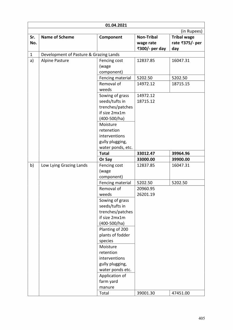
01.04.2021
(in Rupees)
Sr. No.
Name of Scheme Component Non-Tribal wage rate ₹300/- per day
Tribal wage rate ₹375/- per day
1 Development of Pasture & Grazing Lands
a) Alpine Pasture Fencing cost (wage component)
12837.85 16047.31
Fencing material 5202.50 5202.50
Removal of weeds
14972.12 18715.15
Sowing of grass seeds/tufts in trenches/patches if size 2mx1m (400-500/ha)
14972.12 18715.12
Moisture retenetion interventions gully plugging, water ponds, etc.
Total 33012.47 39964.96
Or Say 33000.00 39900.00
b) Low Lying Grazing Lands Fencing cost (wage component)
12837.85 16047.31
Fencing material 5202.50 5202.50
Removal of weeds
20960.95 26201.19
Sowing of grass seeds/tufts in trenches/patches if size 2mx1m (400-500/ha)
Planting of 200 plants of fodder species
Moisture retention interventions gully plugging, water ponds etc.
Application of farm yard manure
Total 39001.30 47451.00
405
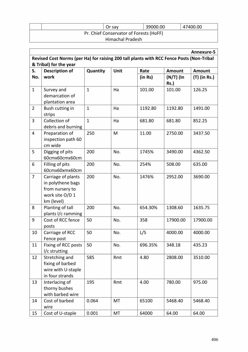
Or say 39000.00 47400.00
Pr. Chief Conservator of Forests (HoFF) Himachal Pradesh
Annexure-5
Revised Cost Norms (per Ha) for raising 200 tall plants with RCC Fence Posts (Non-Tribal & Tribal) for the year
S. No.
Description of work
Quantity Unit Rate Amount Amount
(in Rs) (N/T) (In Rs.)
(T) (in Rs.)
1 Survey and demarcation of plantation area
1 Ha 101.00 101.00 126.25
2 Bush cutting in strips
1 Ha 1192.80 1192.80 1491.00
3 Collection of debris and burning
1 Ha 681.80 681.80 852.25
4 Preparation of inspection path 60 cm wide
250 M 11.00 2750.00 3437.50
5 Digging of pits 60cmx60cmx60cm
200 No. 1745% 3490.00 4362.50
6 Filling of pits 60cmx60xmx60cm
200 No. 254% 508.00 635.00
7 Carriage of plants in polythene bags from nursery to work site O/D 1 km (level)
200 No. 1476% 2952.00 3690.00
8 Planting of tall plants l/c ramming
200 No. 654.30% 1308.60 1635.75
9 Cost of RCC fence posts
50 No. 358 17900.00 17900.00
10 Carriage of RCC Fence post
50 No. L/S 4000.00 4000.00
11 Fixing of RCC posts l/c strutting
50 No. 696.35% 348.18 435.23
12 Stretching and fixing of barbed wire with U-staple in four strands
585 Rmt 4.80 2808.00 3510.00
13 Interlacing of thorny bushes with barbed wire
195 Rmt 4.00 780.00 975.00
14 Cost of barbed wire
0.064 MT 65100 5468.40 5468.40
15 Cost of U-staple 0.001 MT 64000 64.00 64.00
406
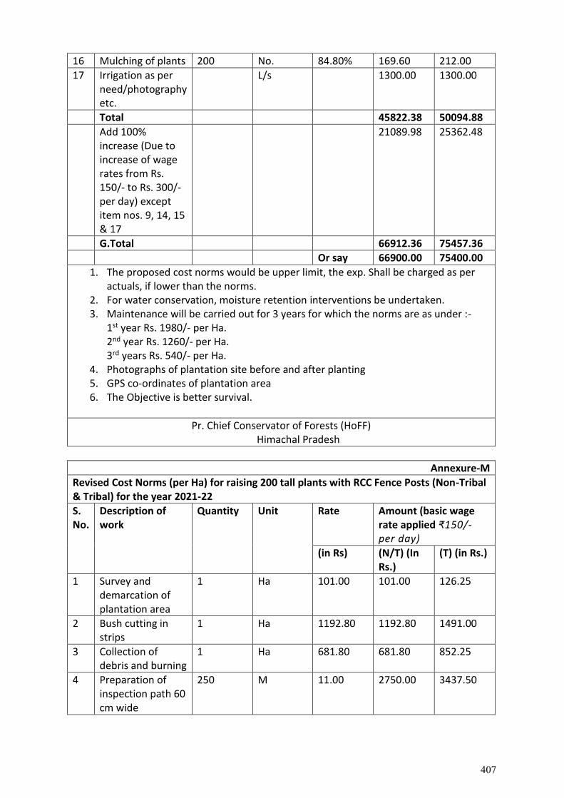
16 Mulching of plants 200 No. 84.80% 169.60 212.00
17 Irrigation as per need/photography etc.
L/s 1300.00 1300.00
Total 45822.38 50094.88
Add 100% increase (Due to increase of wage rates from Rs. 150/- to Rs. 300/- per day) except item nos. 9, 14, 15 & 17
21089.98 25362.48
G.Total 66912.36 75457.36
Or say 66900.00 75400.00
1. The proposed cost norms would be upper limit, the exp. Shall be charged as per actuals, if lower than the norms.
2. For water conservation, moisture retention interventions be undertaken. 3. Maintenance will be carried out for 3 years for which the norms are as under :-
1st year Rs. 1980/- per Ha. 2nd year Rs. 1260/- per Ha. 3rd years Rs. 540/- per Ha.
4. Photographs of plantation site before and after planting 5. GPS co-ordinates of plantation area 6. The Objective is better survival.
Pr. Chief Conservator of Forests (HoFF) Himachal Pradesh
Annexure-M
Revised Cost Norms (per Ha) for raising 200 tall plants with RCC Fence Posts (Non-Tribal & Tribal) for the year 2021-22
S. No.
Description of work
Quantity Unit Rate Amount (basic wage rate applied ₹150/- per day)
(in Rs) (N/T) (In Rs.)
(T) (in Rs.)
1 Survey and demarcation of plantation area
1 Ha 101.00 101.00 126.25
2 Bush cutting in strips
1 Ha 1192.80 1192.80 1491.00
3 Collection of debris and burning
1 Ha 681.80 681.80 852.25
4 Preparation of inspection path 60 cm wide
250 M 11.00 2750.00 3437.50
407
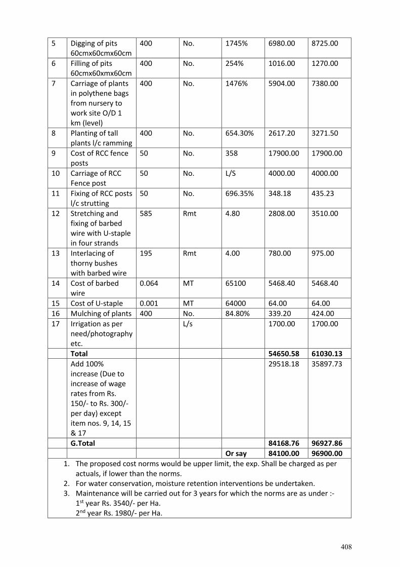
5 Digging of pits 60cmx60cmx60cm
400 No. 1745% 6980.00 8725.00
6 Filling of pits 60cmx60xmx60cm
400 No. 254% 1016.00 1270.00
7 Carriage of plants in polythene bags from nursery to work site O/D 1 km (level)
400 No. 1476% 5904.00 7380.00
8 Planting of tall plants l/c ramming
400 No. 654.30% 2617.20 3271.50
9 Cost of RCC fence posts
50 No. 358 17900.00 17900.00
10 Carriage of RCC Fence post
50 No. L/S 4000.00 4000.00
11 Fixing of RCC posts l/c strutting
50 No. 696.35% 348.18 435.23
12 Stretching and fixing of barbed wire with U-staple in four strands
585 Rmt 4.80 2808.00 3510.00
13 Interlacing of thorny bushes with barbed wire
195 Rmt 4.00 780.00 975.00
14 Cost of barbed wire
0.064 MT 65100 5468.40 5468.40
15 Cost of U-staple 0.001 MT 64000 64.00 64.00
16 Mulching of plants 400 No. 84.80% 339.20 424.00
17 Irrigation as per need/photography etc.
L/s 1700.00 1700.00
Total 54650.58 61030.13
Add 100% increase (Due to increase of wage rates from Rs. 150/- to Rs. 300/- per day) except item nos. 9, 14, 15 & 17
29518.18 35897.73
G.Total 84168.76 96927.86
Or say 84100.00 96900.00
1. The proposed cost norms would be upper limit, the exp. Shall be charged as per actuals, if lower than the norms.
2. For water conservation, moisture retention interventions be undertaken. 3. Maintenance will be carried out for 3 years for which the norms are as under :-
1st year Rs. 3540/- per Ha. 2nd year Rs. 1980/- per Ha.
408
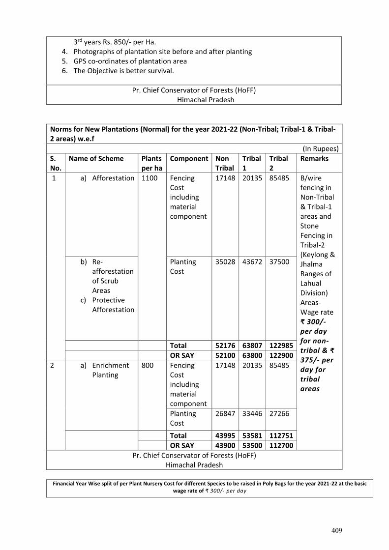
3rd years Rs. 850/- per Ha. 4. Photographs of plantation site before and after planting 5. GPS co-ordinates of plantation area 6. The Objective is better survival.
Pr. Chief Conservator of Forests (HoFF) Himachal Pradesh
Norms for New Plantations (Normal) for the year 2021-22 (Non-Tribal; Tribal-1 & Tribal-2 areas) w.e.f
(In Rupees)
S. No.
Name of Scheme Plants per ha
Component Non Tribal
Tribal 1
Tribal 2
Remarks
1 a) Afforestation 1100 Fencing Cost including material component
17148 20135 85485 B/wire fencing in Non-Tribal & Tribal-1 areas and Stone Fencing in Tribal-2 (Keylong & Jhalma Ranges of Lahual Division) Areas-Wage rate ₹ 300/- per day for non-tribal & ₹ 375/- per day for tribal areas
b) Re-afforestation of Scrub Areas
c) Protective Afforestation
Planting Cost
35028 43672 37500
Total 52176 63807 122985
OR SAY 52100 63800 122900
2 a) Enrichment Planting
800 Fencing Cost including material component
17148 20135 85485
Planting Cost
26847 33446 27266
Total 43995 53581 112751
OR SAY 43900 53500 112700
Pr. Chief Conservator of Forests (HoFF) Himachal Pradesh
Financial Year Wise split of per Plant Nursery Cost for different Species to be raised in Poly Bags for the year 2021-22 at the basic
wage rate of ₹ 300/- per day
409
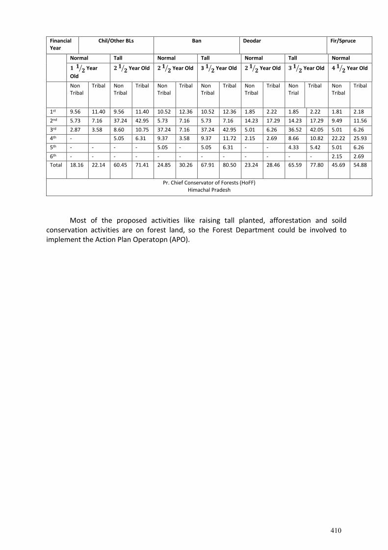
Financial Year
Chil/Other BLs Ban Deodar Fir/Spruce
Normal Tall Normal Tall Normal Tall Normal
𝟏 𝟏𝟐⁄ Year
Old
𝟐 𝟏𝟐⁄ Year Old 𝟐 𝟏
𝟐⁄ Year Old 3 𝟏 𝟐⁄ Year Old 𝟐 𝟏𝟐⁄ Year Old 𝟑 𝟏
𝟐⁄ Year Old 𝟒 𝟏𝟐⁄ Year Old
Non Tribal
Tribal Non Tribal
Tribal Non Tribal
Tribal Non Tribal
Tribal Non Tribal
Tribal Non Trial
Tribal Non Tribal
Tribal
1st 9.56 11.40 9.56 11.40 10.52 12.36 10.52 12.36 1.85 2.22 1.85 2.22 1.81 2.18
2nd 5.73 7.16 37.24 42.95 5.73 7.16 5.73 7.16 14.23 17.29 14.23 17.29 9.49 11.56
3rd 2.87 3.58 8.60 10.75 37.24 7.16 37.24 42.95 5.01 6.26 36.52 42.05 5.01 6.26
4th - 5.05 6.31 9.37 3.58 9.37 11.72 2.15 2.69 8.66 10.82 22.22 25.93
5th - - - - 5.05 - 5.05 6.31 - - 4.33 5.42 5.01 6.26
6th - - - - - - - - - - - - 2.15 2.69
Total 18.16 22.14 60.45 71.41 24.85 30.26 67.91 80.50 23.24 28.46 65.59 77.80 45.69 54.88
Pr. Chief Conservator of Forests (HoFF) Himachal Pradesh
Most of the proposed activities like raising tall planted, afforestation and soild
conservation activities are on forest land, so the Forest Department could be involved to implement the Action Plan Operatopn (APO).
410
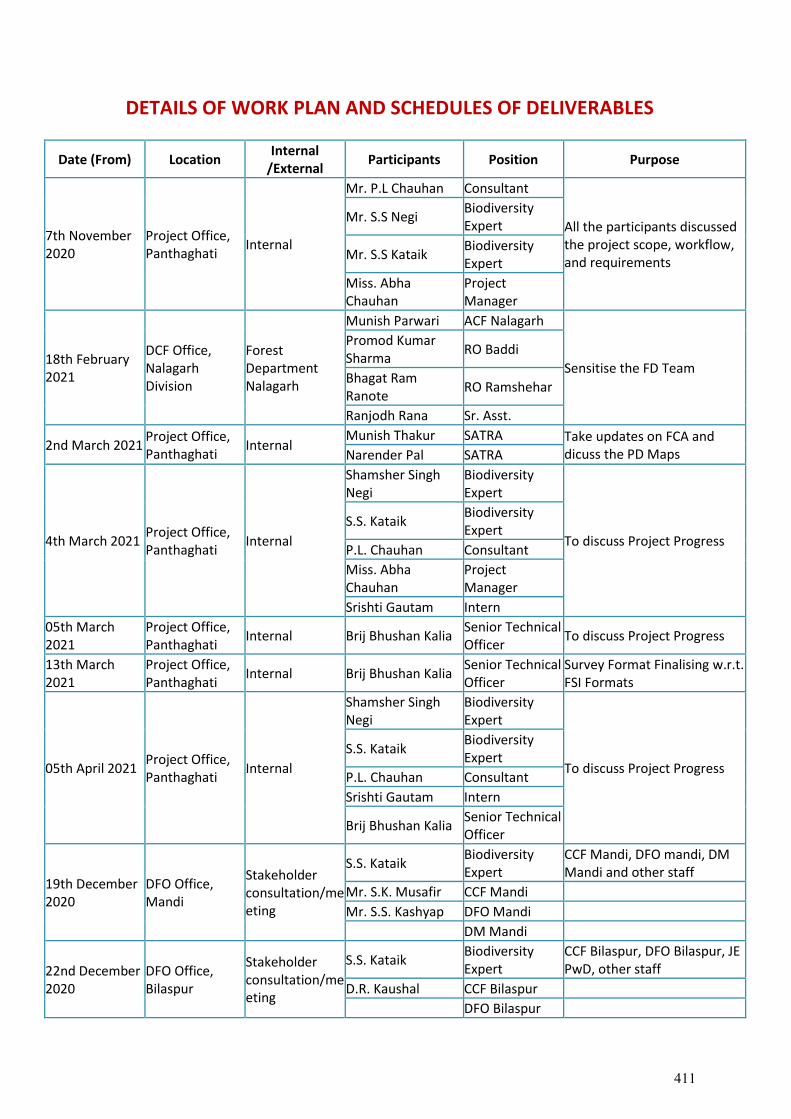
DETAILS OF WORK PLAN AND SCHEDULES OF DELIVERABLES
Date (From) Location Internal
/External Participants Position Purpose
7th November 2020
Project Office, Panthaghati
Internal
Mr. P.L Chauhan Consultant
All the participants discussed the project scope, workflow, and requirements
Mr. S.S Negi Biodiversity Expert
Mr. S.S Kataik Biodiversity Expert
Miss. Abha Chauhan
Project Manager
18th February 2021
DCF Office, Nalagarh Division
Forest Department Nalagarh
Munish Parwari ACF Nalagarh
Sensitise the FD Team
Promod Kumar Sharma
RO Baddi
Bhagat Ram Ranote
RO Ramshehar
Ranjodh Rana Sr. Asst.
2nd March 2021 Project Office, Panthaghati
Internal Munish Thakur SATRA Take updates on FCA and
dicuss the PD Maps Narender Pal SATRA
4th March 2021 Project Office, Panthaghati
Internal
Shamsher Singh Negi
Biodiversity Expert
To discuss Project Progress
S.S. Kataik Biodiversity Expert
P.L. Chauhan Consultant Miss. Abha Chauhan
Project Manager
Srishti Gautam Intern 05th March 2021
Project Office, Panthaghati
Internal Brij Bhushan Kalia Senior Technical Officer
To discuss Project Progress
13th March 2021
Project Office, Panthaghati
Internal Brij Bhushan Kalia Senior Technical Officer
Survey Format Finalising w.r.t. FSI Formats
05th April 2021 Project Office, Panthaghati
Internal
Shamsher Singh Negi
Biodiversity Expert
To discuss Project Progress S.S. Kataik
Biodiversity Expert
P.L. Chauhan Consultant Srishti Gautam Intern
Brij Bhushan Kalia Senior Technical Officer
19th December 2020
DFO Office, Mandi
Stakeholder consultation/meeting
S.S. Kataik Biodiversity Expert
CCF Mandi, DFO mandi, DM Mandi and other staff
Mr. S.K. Musafir CCF Mandi Mr. S.S. Kashyap DFO Mandi DM Mandi
22nd December 2020
DFO Office, Bilaspur
Stakeholder consultation/meeting
S.S. Kataik Biodiversity Expert
CCF Bilaspur, DFO Bilaspur, JE PwD, other staff
D.R. Kaushal CCF Bilaspur DFO Bilaspur
411
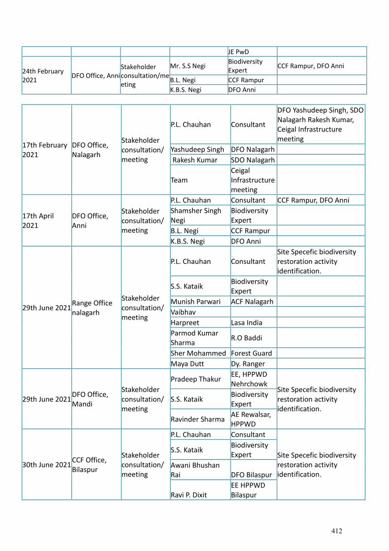
JE PwD
24th February 2021
DFO Office, Anni Stakeholder consultation/meeting
Mr. S.S Negi Biodiversity Expert
CCF Rampur, DFO Anni
B.L. Negi CCF Rampur K.B.S. Negi DFO Anni
17th February 2021
DFO Office, Nalagarh
Stakeholder consultation/meeting
P.L. Chauhan Consultant
DFO Yashudeep Singh, SDO Nalagarh Rakesh Kumar, Ceigal Infrastructure meeting
Yashudeep Singh DFO Nalagarh
Rakesh Kumar SDO Nalagarh
Team Ceigal Infrastructure meeting
17th April 2021
DFO Office, Anni
Stakeholder consultation/meeting
P.L. Chauhan Consultant CCF Rampur, DFO Anni
Shamsher Singh Negi
Biodiversity Expert
B.L. Negi CCF Rampur
K.B.S. Negi DFO Anni
29th June 2021 Range Office nalagarh
Stakeholder consultation/meeting
P.L. Chauhan Consultant Site Specefic biodiversity restoration activity identification.
S.S. Kataik Biodiversity Expert
Munish Parwari ACF Nalagarh
Vaibhav
Harpreet Lasa India
Parmod Kumar Sharma
R.O Baddi
Sher Mohammed Forest Guard
Maya Dutt Dy. Ranger
29th June 2021 DFO Office, Mandi
Stakeholder consultation/meeting
Pradeep Thakur EE, HPPWD Nehrchowk
Site Specefic biodiversity restoration activity identification.
S.S. Kataik Biodiversity Expert
Ravinder Sharma AE Rewalsar, HPPWD
30th June 2021 CCF Office, Bilaspur
Stakeholder consultation/meeting
P.L. Chauhan Consultant
Site Specefic biodiversity restoration activity identification.
S.S. Kataik Biodiversity Expert
Awani Bhushan Rai DFO Bilaspur
Ravi P. Dixit EE HPPWD Bilaspur
412
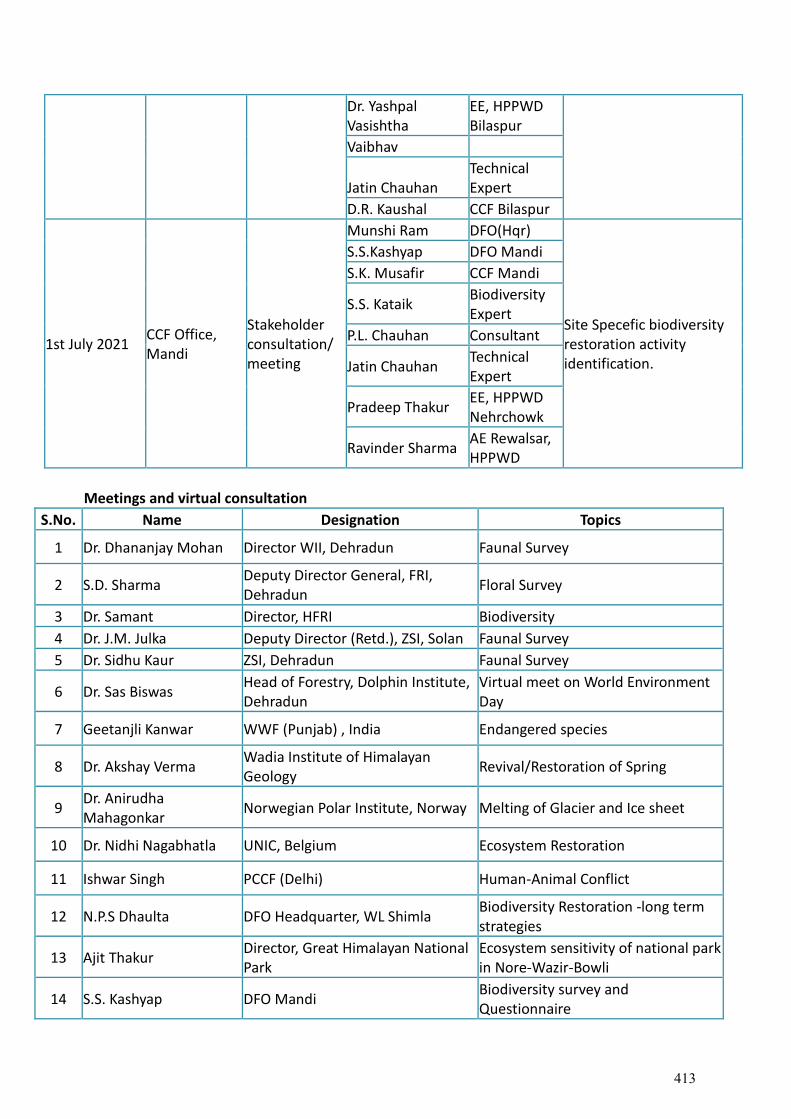
Dr. Yashpal Vasishtha
EE, HPPWD Bilaspur
Vaibhav
Jatin Chauhan Technical Expert
D.R. Kaushal CCF Bilaspur
1st July 2021 CCF Office, Mandi
Stakeholder consultation/meeting
Munshi Ram DFO(Hqr)
Site Specefic biodiversity restoration activity identification.
S.S.Kashyap DFO Mandi
S.K. Musafir CCF Mandi
S.S. Kataik Biodiversity Expert
P.L. Chauhan Consultant
Jatin Chauhan Technical Expert
Pradeep Thakur EE, HPPWD Nehrchowk
Ravinder Sharma AE Rewalsar, HPPWD
Meetings and virtual consultation
S.No. Name Designation Topics
1 Dr. Dhananjay Mohan Director WII, Dehradun Faunal Survey
2 S.D. Sharma Deputy Director General, FRI, Dehradun
Floral Survey
3 Dr. Samant Director, HFRI Biodiversity
4 Dr. J.M. Julka Deputy Director (Retd.), ZSI, Solan Faunal Survey
5 Dr. Sidhu Kaur ZSI, Dehradun Faunal Survey
6 Dr. Sas Biswas Head of Forestry, Dolphin Institute, Dehradun
Virtual meet on World Environment Day
7 Geetanjli Kanwar WWF (Punjab) , India Endangered species
8 Dr. Akshay Verma Wadia Institute of Himalayan Geology
Revival/Restoration of Spring
9 Dr. Anirudha Mahagonkar
Norwegian Polar Institute, Norway Melting of Glacier and Ice sheet
10 Dr. Nidhi Nagabhatla UNIC, Belgium Ecosystem Restoration
11 Ishwar Singh PCCF (Delhi) Human-Animal Conflict
12 N.P.S Dhaulta DFO Headquarter, WL Shimla Biodiversity Restoration -long term strategies
13 Ajit Thakur Director, Great Himalayan National Park
Ecosystem sensitivity of national park in Nore-Wazir-Bowli
14 S.S. Kashyap DFO Mandi Biodiversity survey and Questionnaire
413
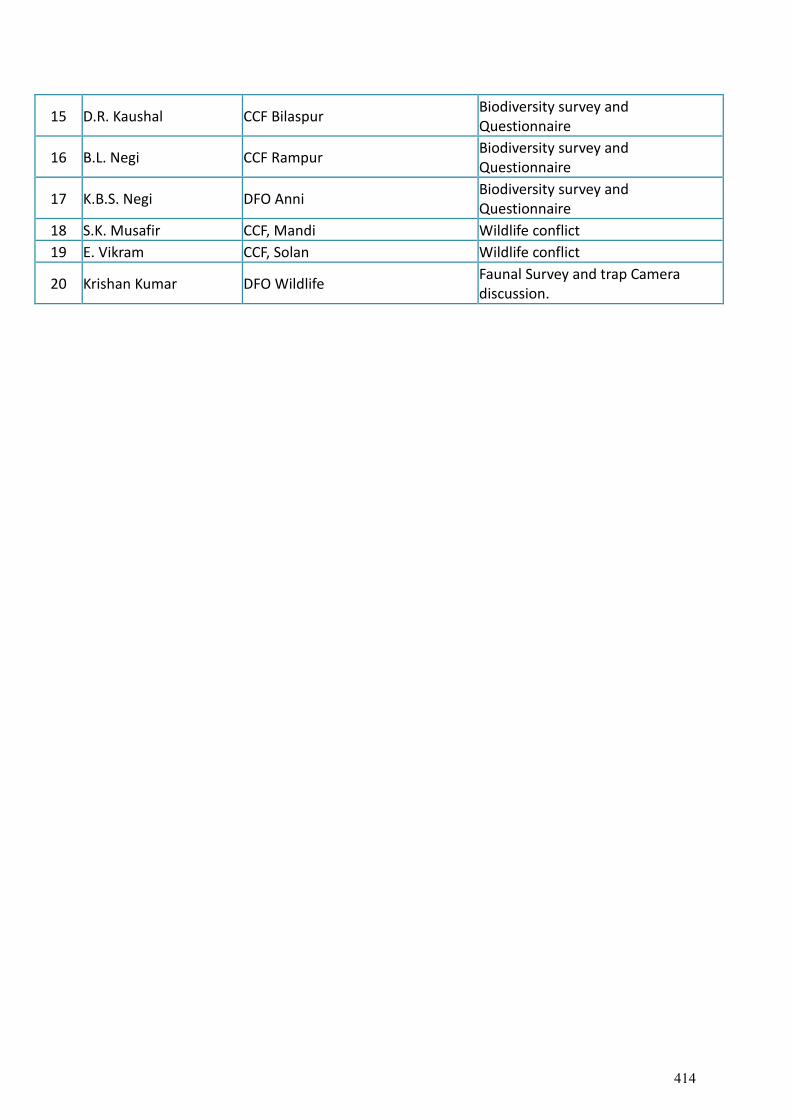
15 D.R. Kaushal CCF Bilaspur Biodiversity survey and Questionnaire
16 B.L. Negi CCF Rampur Biodiversity survey and Questionnaire
17 K.B.S. Negi DFO Anni Biodiversity survey and Questionnaire
18 S.K. Musafir CCF, Mandi Wildlife conflict
19 E. Vikram CCF, Solan Wildlife conflict
20 Krishan Kumar DFO Wildlife Faunal Survey and trap Camera discussion.
414
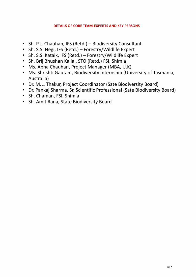
DETAILS OF CORE TEAM-EXPERTS AND KEY PERSONS
• Sh. P.L. Chauhan, IFS (Retd.) – Biodiversity Consultant • Sh. S.S. Negi, IFS (Retd.) – Forestry/Wildlife Expert • Sh. S.S. Kataik, IFS (Retd.) – Forestry/Wildlife Expert • Sh. Brij Bhushan Kalia , STO (Retd.) FSI, Shimla • Ms. Abha Chauhan, Project Manager (MBA, U.K) • Ms. Shrishti Gautam, Biodiversity Internship (University of Tasmania,
Australia) • Dr. M.L. Thakur, Project Coordinator (Sate Biodiversity Board) • Dr. Pankaj Sharma, Sr. Scientific Professional (Sate Biodiversity Board) • Sh. Chaman, FSI, Shimla • Sh. Amit Rana, State Biodiversity Board
415

Technical Specifications for Plantation
A technical specification mandatory during plantation along the widening of road stretches for avenue plantation.
S.No. Item of work Requirement
1. Distance from embarkment 1.0 m away from the toe of embarkment
2. Plant to plant spacing 5m
3. Spacing between the available rows
2m
4. Height of sampling at the time of planting
Minimum 1m to 1.5 m for avenue and 0.6 m for median in alkaline bags with ball of earth intact
5. Survival percentage of plantation
90% at any point of time is required
6. Size of pits 60x60x60 cm bit is required to be dug up for proper growth and root penetration
7. Use of compost and manure
1/3 of volume of pit is to be mixed with manure and refilled before planting as advance work
8. Watering of plants In case of insufficient rains after planting watering must be done and during dry/peak summers, thrice a week irrigation be ensured. About 450 to 650 litres of water is required per plant per year
9. Maintenance of Plants Minimum 3 years of maintenance and causality/mortality replacement be carried out
10. Fencing of Plantation Barbed wire fencing of 4 m distance pole to pole to be done and B/wire fencing row should be compromised of 4 to 5 stands
11. Clearing of weeds/grasses After monsoon removal of weeds/grasses/dried leaves is required so as to avoid the threat of fire hazard.
12. Selection of plant species As per the altitudinal and agro-climatic zone local and native species are to be preferred and recommended for better survival.
13. Plantation along dumping sites/view points and land per eels
Plantation is required to be done to reclaim the dumping sites and develop the landscape with land parcels and viewpoints as per IRC : SP : 84 : 2014 guidelines.
14. Photography/GPS Coordinates and Display board
Documentation of plantation areas before and after plantation along with photographs and geo coordinates should be notes. Display board be erected to record the information for the number of plants, area and species for the purpose of monitoring and evaluation.
15 Mode of payment The payment of the plantation will be based on survival percentage to be assessed by the team constituted by regional officer after plantation activity is over.
416
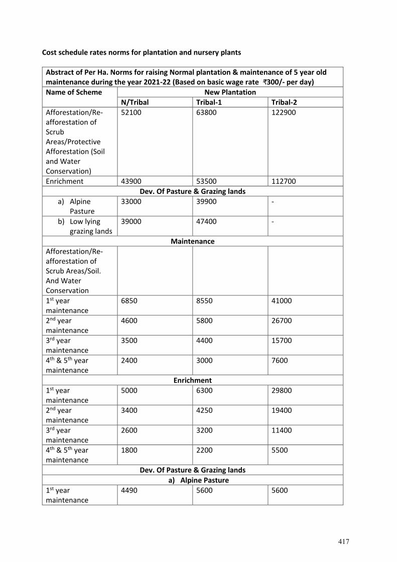
Cost schedule rates norms for plantation and nursery plants
Abstract of Per Ha. Norms for raising Normal plantation & maintenance of 5 year old maintenance during the year 2021-22 (Based on basic wage rate ₹300/- per day)
Name of Scheme New Plantation
N/Tribal Tribal-1 Tribal-2
Afforestation/Re-afforestation of Scrub Areas/Protective Afforestation (Soil and Water Conservation)
52100 63800 122900
Enrichment 43900 53500 112700
Dev. Of Pasture & Grazing lands
a) Alpine Pasture
33000 39900 -
b) Low lying grazing lands
39000 47400 -
Maintenance
Afforestation/Re-afforestation of Scrub Areas/Soil. And Water Conservation
1st year maintenance
6850 8550 41000
2nd year maintenance
4600 5800 26700
3rd year maintenance
3500 4400 15700
4th & 5th year maintenance
2400 3000 7600
Enrichment
1st year maintenance
5000 6300 29800
2nd year maintenance
3400 4250 19400
3rd year maintenance
2600 3200 11400
4th & 5th year maintenance
1800 2200 5500
Dev. Of Pasture & Grazing lands
a) Alpine Pasture
1st year maintenance
4490 5600 5600
417

2nd year maintenance
2990 3710 3710
3rd year maintenance
1490 1850 1850
4th & 5th year maintenance
740 920 820
Low lying grazing lands
1st year maintenance
4660 5870 5870
2nd year maintenance
3400 4220 4220
3rd year maintenance
1950 2450 2450
4th & 5th year maintenance
1000 1250 1250
Pr. Chief Conservator of Forests (HoFF) Himachal Pradesh
Himachal Pradesh Forest Department
Norms for Dev. Of Pasture & Grazing Lands for the year 2021-22 (Non-Tribal & Tribal areas) w.e.f. 01.04.2021
(in Rupees)
Sr. No.
Name of Scheme Component Non-Tribal wage rate ₹300/- per day
Tribal wage rate ₹375/- per day
1 Development of Pasture & Grazing Lands
a) Alpine Pasture Fencing cost (wage component)
12837.85 16047.31
Fencing material 5202.50 5202.50
Removal of weeds
14972.12 18715.15
Sowing of grass seeds/tufts in trenches/patches if size 2mx1m (400-500/ha)
14972.12 18715.12
Moisture retenetion interventions gully plugging, water ponds, etc.
Total 33012.47 39964.96
Or Say 33000.00 39900.00
b) Low Lying Grazing Lands Fencing cost (wage
12837.85 16047.31
418
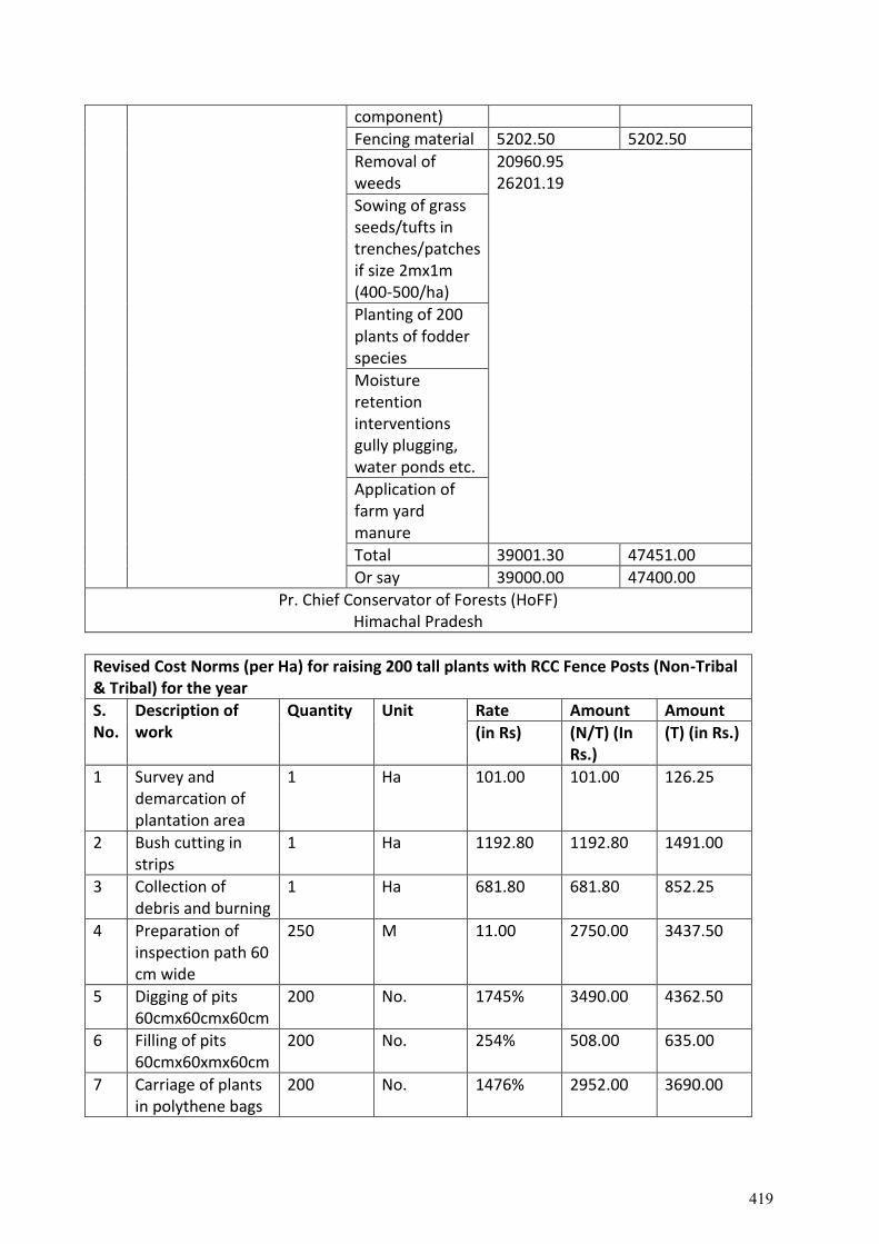
component)
Fencing material 5202.50 5202.50
Removal of weeds
20960.95 26201.19
Sowing of grass seeds/tufts in trenches/patches if size 2mx1m (400-500/ha)
Planting of 200 plants of fodder species
Moisture retention interventions gully plugging, water ponds etc.
Application of farm yard manure
Total 39001.30 47451.00
Or say 39000.00 47400.00
Pr. Chief Conservator of Forests (HoFF) Himachal Pradesh
Revised Cost Norms (per Ha) for raising 200 tall plants with RCC Fence Posts (Non-Tribal & Tribal) for the year
S. No.
Description of work
Quantity Unit Rate Amount Amount
(in Rs) (N/T) (In Rs.)
(T) (in Rs.)
1 Survey and demarcation of plantation area
1 Ha 101.00 101.00 126.25
2 Bush cutting in strips
1 Ha 1192.80 1192.80 1491.00
3 Collection of debris and burning
1 Ha 681.80 681.80 852.25
4 Preparation of inspection path 60 cm wide
250 M 11.00 2750.00 3437.50
5 Digging of pits 60cmx60cmx60cm
200 No. 1745% 3490.00 4362.50
6 Filling of pits 60cmx60xmx60cm
200 No. 254% 508.00 635.00
7 Carriage of plants in polythene bags
200 No. 1476% 2952.00 3690.00
419
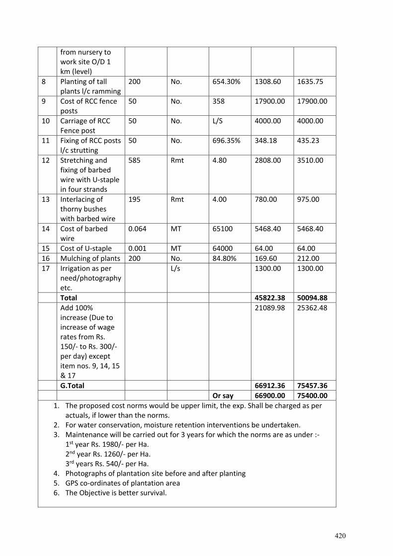
from nursery to work site O/D 1 km (level)
8 Planting of tall plants l/c ramming
200 No. 654.30% 1308.60 1635.75
9 Cost of RCC fence posts
50 No. 358 17900.00 17900.00
10 Carriage of RCC Fence post
50 No. L/S 4000.00 4000.00
11 Fixing of RCC posts l/c strutting
50 No. 696.35% 348.18 435.23
12 Stretching and fixing of barbed wire with U-staple in four strands
585 Rmt 4.80 2808.00 3510.00
13 Interlacing of thorny bushes with barbed wire
195 Rmt 4.00 780.00 975.00
14 Cost of barbed wire
0.064 MT 65100 5468.40 5468.40
15 Cost of U-staple 0.001 MT 64000 64.00 64.00
16 Mulching of plants 200 No. 84.80% 169.60 212.00
17 Irrigation as per need/photography etc.
L/s 1300.00 1300.00
Total 45822.38 50094.88
Add 100% increase (Due to increase of wage rates from Rs. 150/- to Rs. 300/- per day) except item nos. 9, 14, 15 & 17
21089.98 25362.48
G.Total 66912.36 75457.36
Or say 66900.00 75400.00
1. The proposed cost norms would be upper limit, the exp. Shall be charged as per actuals, if lower than the norms.
2. For water conservation, moisture retention interventions be undertaken. 3. Maintenance will be carried out for 3 years for which the norms are as under :-
1st year Rs. 1980/- per Ha. 2nd year Rs. 1260/- per Ha. 3rd years Rs. 540/- per Ha.
4. Photographs of plantation site before and after planting 5. GPS co-ordinates of plantation area 6. The Objective is better survival.
420
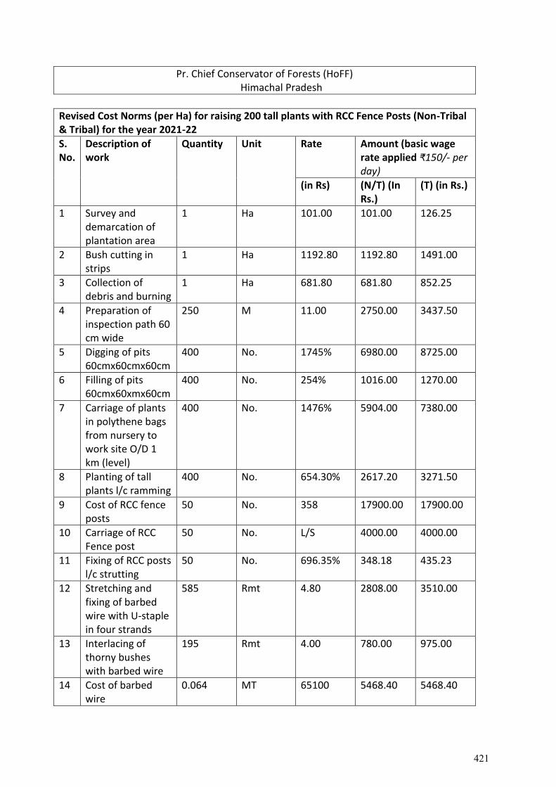
Pr. Chief Conservator of Forests (HoFF) Himachal Pradesh
Revised Cost Norms (per Ha) for raising 200 tall plants with RCC Fence Posts (Non-Tribal & Tribal) for the year 2021-22
S. No.
Description of work
Quantity Unit Rate Amount (basic wage rate applied ₹150/- per day)
(in Rs) (N/T) (In Rs.)
(T) (in Rs.)
1 Survey and demarcation of plantation area
1 Ha 101.00 101.00 126.25
2 Bush cutting in strips
1 Ha 1192.80 1192.80 1491.00
3 Collection of debris and burning
1 Ha 681.80 681.80 852.25
4 Preparation of inspection path 60 cm wide
250 M 11.00 2750.00 3437.50
5 Digging of pits 60cmx60cmx60cm
400 No. 1745% 6980.00 8725.00
6 Filling of pits 60cmx60xmx60cm
400 No. 254% 1016.00 1270.00
7 Carriage of plants in polythene bags from nursery to work site O/D 1 km (level)
400 No. 1476% 5904.00 7380.00
8 Planting of tall plants l/c ramming
400 No. 654.30% 2617.20 3271.50
9 Cost of RCC fence posts
50 No. 358 17900.00 17900.00
10 Carriage of RCC Fence post
50 No. L/S 4000.00 4000.00
11 Fixing of RCC posts l/c strutting
50 No. 696.35% 348.18 435.23
12 Stretching and fixing of barbed wire with U-staple in four strands
585 Rmt 4.80 2808.00 3510.00
13 Interlacing of thorny bushes with barbed wire
195 Rmt 4.00 780.00 975.00
14 Cost of barbed wire
0.064 MT 65100 5468.40 5468.40
421
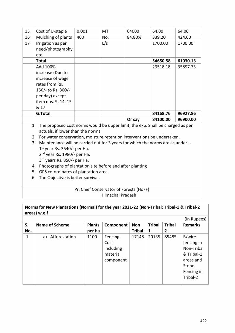
15 Cost of U-staple 0.001 MT 64000 64.00 64.00
16 Mulching of plants 400 No. 84.80% 339.20 424.00
17 Irrigation as per need/photography etc.
L/s 1700.00 1700.00
Total 54650.58 61030.13
Add 100% increase (Due to increase of wage rates from Rs. 150/- to Rs. 300/- per day) except item nos. 9, 14, 15 & 17
29518.18 35897.73
G.Total 84168.76 96927.86
Or say 84100.00 96900.00
1. The proposed cost norms would be upper limit, the exp. Shall be charged as per actuals, if lower than the norms.
2. For water conservation, moisture retention interventions be undertaken. 3. Maintenance will be carried out for 3 years for which the norms are as under :-
1st year Rs. 3540/- per Ha. 2nd year Rs. 1980/- per Ha. 3rd years Rs. 850/- per Ha.
4. Photographs of plantation site before and after planting 5. GPS co-ordinates of plantation area 6. The Objective is better survival.
Pr. Chief Conservator of Forests (HoFF) Himachal Pradesh
Norms for New Plantations (Normal) for the year 2021-22 (Non-Tribal; Tribal-1 & Tribal-2 areas) w.e.f
(In Rupees)
S. No.
Name of Scheme Plants per ha
Component Non Tribal
Tribal 1
Tribal 2
Remarks
1 a) Afforestation 1100 Fencing Cost including material component
17148 20135 85485 B/wire fencing in Non-Tribal & Tribal-1 areas and Stone Fencing in Tribal-2
422
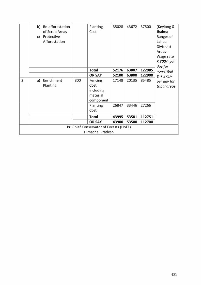
b) Re-afforestation of Scrub Areas
c) Protective Afforestation
Planting Cost
35028 43672 37500 (Keylong & Jhalma Ranges of Lahual Division) Areas-Wage rate ₹ 300/- per day for non-tribal & ₹ 375/- per day for tribal areas
Total 52176 63807 122985
OR SAY 52100 63800 122900
2 a) Enrichment Planting
800 Fencing Cost including material component
17148 20135 85485
Planting Cost
26847 33446 27266
Total 43995 53581 112751
OR SAY 43900 53500 112700
Pr. Chief Conservator of Forests (HoFF) Himachal Pradesh
423
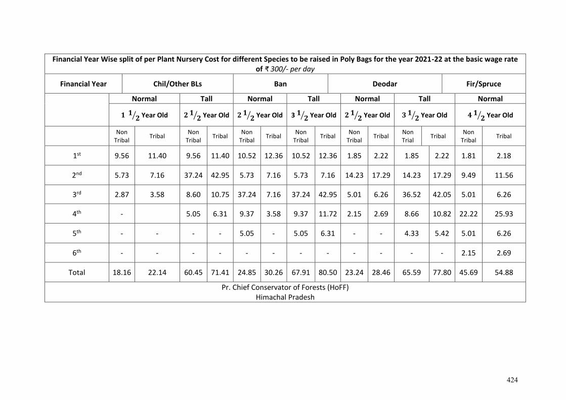
Financial Year Wise split of per Plant Nursery Cost for different Species to be raised in Poly Bags for the year 2021-22 at the basic wage rate of ₹ 300/- per day
Financial Year Chil/Other BLs Ban Deodar Fir/Spruce
Normal Tall Normal Tall Normal Tall Normal
𝟏 𝟏𝟐⁄ Year Old 𝟐 𝟏
𝟐⁄ Year Old 𝟐 𝟏𝟐⁄ Year Old 3 𝟏 𝟐⁄ Year Old 𝟐 𝟏
𝟐⁄ Year Old 𝟑 𝟏𝟐⁄ Year Old 𝟒 𝟏
𝟐⁄ Year Old
Non
Tribal Tribal
Non Tribal
Tribal Non
Tribal Tribal
Non Tribal
Tribal Non
Tribal Tribal
Non Trial
Tribal Non
Tribal Tribal
1st 9.56 11.40 9.56 11.40 10.52 12.36 10.52 12.36 1.85 2.22 1.85 2.22 1.81 2.18
2nd 5.73 7.16 37.24 42.95 5.73 7.16 5.73 7.16 14.23 17.29 14.23 17.29 9.49 11.56
3rd 2.87 3.58 8.60 10.75 37.24 7.16 37.24 42.95 5.01 6.26 36.52 42.05 5.01 6.26
4th - 5.05 6.31 9.37 3.58 9.37 11.72 2.15 2.69 8.66 10.82 22.22 25.93
5th - - - - 5.05 - 5.05 6.31 - - 4.33 5.42 5.01 6.26
6th - - - - - - - - - - - - 2.15 2.69
Total 18.16 22.14 60.45 71.41 24.85 30.26 67.91 80.50 23.24 28.46 65.59 77.80 45.69 54.88
Pr. Chief Conservator of Forests (HoFF) Himachal Pradesh
424

425
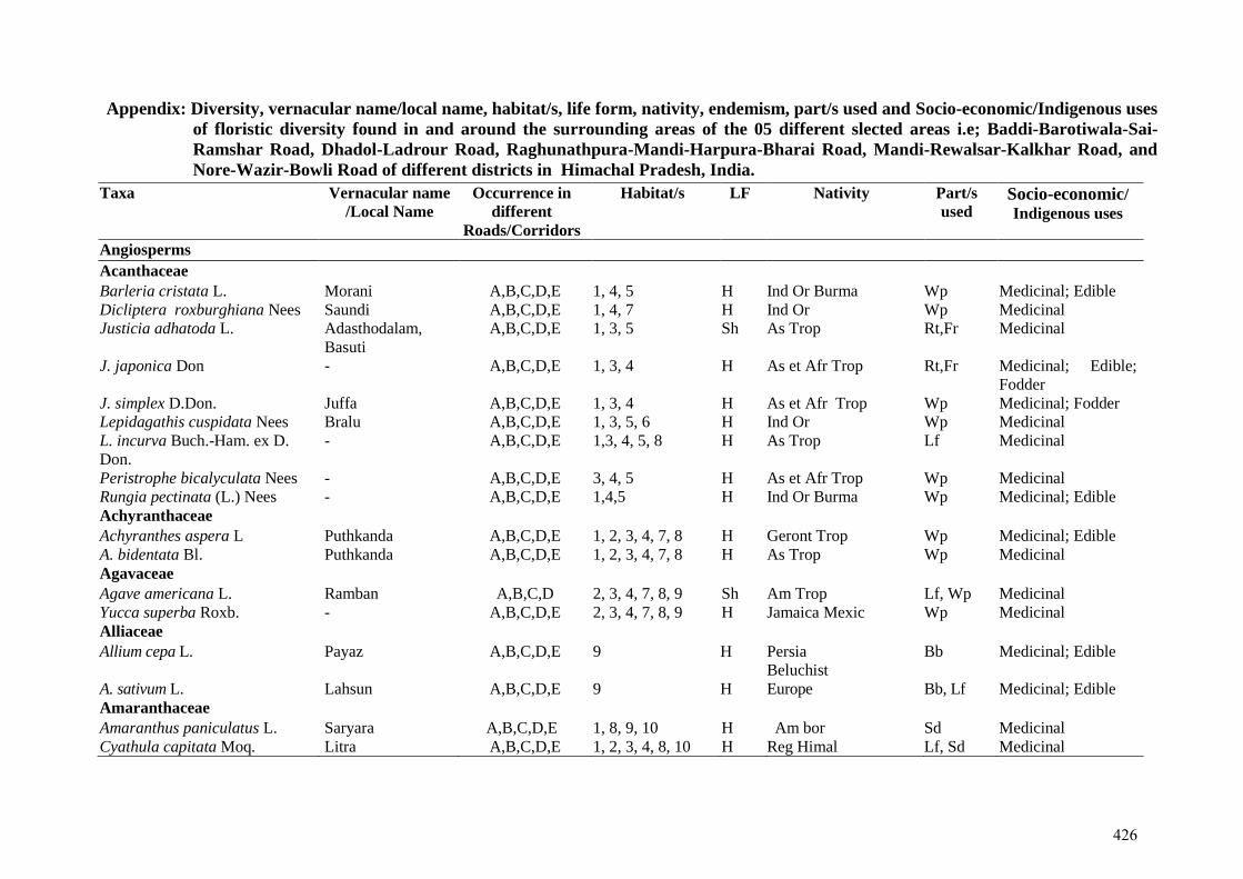
Appendix: Diversity, vernacular name/local name, habitat/s, life form, nativity, endemism, part/s used and Socio-economic/Indigenous uses
of floristic diversity found in and around the surrounding areas of the 05 different slected areas i.e; Baddi-Barotiwala-Sai-
Ramshar Road, Dhadol-Ladrour Road, Raghunathpura-Mandi-Harpura-Bharai Road, Mandi-Rewalsar-Kalkhar Road, and
Nore-Wazir-Bowli Road of different districts in Himachal Pradesh, India.
Taxa Vernacular name
/Local Name Occurrence in
different
Roads/Corridors
Habitat/s LF Nativity Part/s
used Socio-economic/ Indigenous uses
Angiosperms Acanthaceae Barleria cristata L. Morani A,B,C,D,E 1, 4, 5 H Ind Or Burma Wp Medicinal; Edible Dicliptera roxburghiana Nees Saundi A,B,C,D,E 1, 4, 7 H Ind Or Wp Medicinal Justicia adhatoda L. Adasthodalam,
Basuti A,B,C,D,E 1, 3, 5 Sh As Trop Rt,Fr Medicinal
J. japonica Don - A,B,C,D,E 1, 3, 4 H As et Afr Trop Rt,Fr Medicinal; Edible;
Fodder J. simplex D.Don. Juffa A,B,C,D,E 1, 3, 4 H As et Afr Trop Wp Medicinal; Fodder Lepidagathis cuspidata Nees Bralu A,B,C,D,E 1, 3, 5, 6 H Ind Or Wp Medicinal L. incurva Buch.-Ham. ex D.
Don. - A,B,C,D,E 1,3, 4, 5, 8 H As Trop Lf Medicinal
Peristrophe bicalyculata Nees - A,B,C,D,E 3, 4, 5 H As et Afr Trop Wp Medicinal Rungia pectinata (L.) Nees - A,B,C,D,E 1,4,5 H Ind Or Burma Wp Medicinal; Edible Achyranthaceae Achyranthes aspera L Puthkanda A,B,C,D,E 1, 2, 3, 4, 7, 8 H Geront Trop Wp Medicinal; Edible A. bidentata Bl. Puthkanda A,B,C,D,E 1, 2, 3, 4, 7, 8 H As Trop Wp Medicinal Agavaceae Agave americana L. Ramban A,B,C,D 2, 3, 4, 7, 8, 9 Sh Am Trop Lf, Wp Medicinal Yucca superba Roxb. - A,B,C,D,E 2, 3, 4, 7, 8, 9 H Jamaica Mexic Wp Medicinal Alliaceae Allium cepa L. Payaz A,B,C,D,E 9 H Persia
Beluchist Bb Medicinal; Edible
A. sativum L. Lahsun A,B,C,D,E 9 H Europe Bb, Lf Medicinal; Edible Amaranthaceae Amaranthus paniculatus L. Saryara A,B,C,D,E 1, 8, 9, 10 H Am bor Sd Medicinal Cyathula capitata Moq. Litra A,B,C,D,E 1, 2, 3, 4, 8, 10 H Reg Himal Lf, Sd Medicinal
426
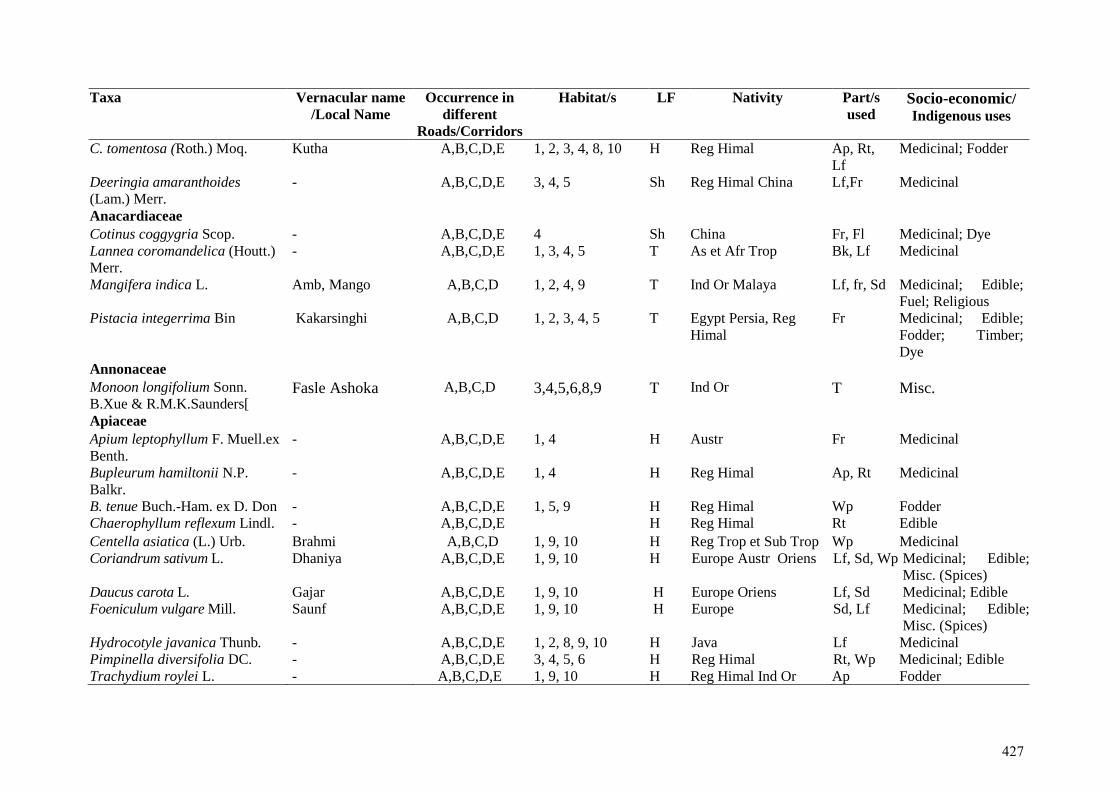
Taxa Vernacular name
/Local Name Occurrence in
different
Roads/Corridors
Habitat/s LF Nativity Part/s
used Socio-economic/ Indigenous uses
C. tomentosa (Roth.) Moq. Kutha A,B,C,D,E 1, 2, 3, 4, 8, 10 H Reg Himal Ap, Rt,
Lf Medicinal; Fodder
Deeringia amaranthoides
(Lam.) Merr. - A,B,C,D,E 3, 4, 5 Sh Reg Himal China Lf,Fr Medicinal
Anacardiaceae Cotinus coggygria Scop. - A,B,C,D,E 4 Sh China Fr, Fl Medicinal; Dye Lannea coromandelica (Houtt.)
Merr. - A,B,C,D,E 1, 3, 4, 5 T As et Afr Trop Bk, Lf Medicinal
Mangifera indica L. Amb, Mango A,B,C,D 1, 2, 4, 9 T Ind Or Malaya Lf, fr, Sd Medicinal; Edible;
Fuel; Religious Pistacia integerrima Bin Kakarsinghi A,B,C,D 1, 2, 3, 4, 5 T Egypt Persia, Reg
Himal Fr Medicinal; Edible;
Fodder; Timber;
Dye Annonaceae Monoon longifolium Sonn.
B.Xue & R.M.K.Saunders[ Fasle Ashoka A,B,C,D 3,4,5,6,8,9 T Ind Or T Misc.
Apiaceae Apium leptophyllum F. Muell.ex
Benth. - A,B,C,D,E 1, 4 H Austr Fr Medicinal
Bupleurum hamiltonii N.P.
Balkr. - A,B,C,D,E 1, 4 H Reg Himal Ap, Rt Medicinal
B. tenue Buch.-Ham. ex D. Don - A,B,C,D,E 1, 5, 9 H Reg Himal Wp Fodder Chaerophyllum reflexum Lindl. - A,B,C,D,E H Reg Himal Rt Edible
Centella asiatica (L.) Urb. Brahmi A,B,C,D 1, 9, 10 H Reg Trop et Sub Trop Wp Medicinal Coriandrum sativum L. Dhaniya A,B,C,D,E 1, 9, 10 H Europe Austr Oriens Lf, Sd, Wp Medicinal; Edible;
Misc. (Spices) Daucus carota L. Gajar A,B,C,D,E 1, 9, 10 H Europe Oriens Lf, Sd Medicinal; Edible Foeniculum vulgare Mill. Saunf A,B,C,D,E 1, 9, 10 H Europe Sd, Lf Medicinal; Edible;
Misc. (Spices) Hydrocotyle javanica Thunb. - A,B,C,D,E 1, 2, 8, 9, 10 H Java Lf Medicinal Pimpinella diversifolia DC. - A,B,C,D,E 3, 4, 5, 6 H Reg Himal Rt, Wp Medicinal; Edible Trachydium roylei L. - A,B,C,D,E 1, 9, 10 H Reg Himal Ind Or Ap Fodder
427
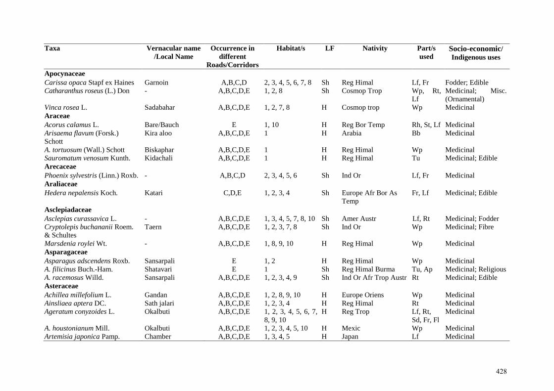
Taxa Vernacular name
/Local Name Occurrence in
different
Roads/Corridors
Habitat/s LF Nativity Part/s
used Socio-economic/ Indigenous uses
Apocynaceae Carissa opaca Stapf ex Haines Garnoin A,B,C,D 2, 3, 4, 5, 6, 7, 8 Sh Reg Himal Lf, Fr Fodder; Edible Catharanthus roseus (L.) Don - A,B,C,D,E 1, 2, 8 Sh Cosmop Trop Wp, Rt,
Lf Medicinal; Misc.
(Ornamental) Vinca rosea L. Sadabahar A,B,C,D,E 1, 2, 7, 8 H Cosmop trop Wp Medicinal Araceae Acorus calamus L. Bare/Bauch E 1, 10 H Reg Bor Temp Rh, St, Lf Medicinal Arisaema flavum (Forsk.)
Schott Kira aloo A,B,C,D,E 1 H Arabia Bb Medicinal
A. tortuosum (Wall.) Schott Biskaphar A,B,C,D,E 1 H Reg Himal Wp Medicinal Sauromatum venosum Kunth. Kidachali A,B,C,D,E 1 H Reg Himal Tu Medicinal; Edible Arecaceae Phoenix sylvestris (Linn.) Roxb. - A,B,C,D 2, 3, 4, 5, 6 Sh Ind Or Lf, Fr Medicinal Araliaceae Hedera nepalensis Koch. Katari C,D,E 1, 2, 3, 4 Sh Europe Afr Bor As
Temp Fr, Lf Medicinal; Edible
Asclepiadaceae Asclepias curassavica L. - A,B,C,D,E 1, 3, 4, 5, 7, 8, 10 Sh Amer Austr Lf, Rt Medicinal; Fodder Cryptolepis buchananii Roem.
& Schultes
Taern A,B,C,D,E 1, 2, 3, 7, 8 Sh Ind Or Wp Medicinal; Fibre
Marsdenia roylei Wt. - A,B,C,D,E 1, 8, 9, 10 H Reg Himal Wp Medicinal Asparagaceae Asparagus adscendens Roxb. Sansarpali E 1, 2 H Reg Himal Wp Medicinal A. filicinus Buch.-Ham. Shatavari E 1 Sh Reg Himal Burma Tu, Ap Medicinal; Religious A. racemosus Willd. Sansarpali A,B,C,D,E 1, 2, 3, 4, 9 Sh Ind Or Afr Trop Austr Rt Medicinal; Edible Asteraceae Achillea millefolium L. Gandan A,B,C,D,E 1, 2, 8, 9, 10 H Europe Oriens Wp Medicinal Ainsliaea aptera DC. Sath jalari A,B,C,D,E 1, 2, 3, 4 H Reg Himal Rt Medicinal Ageratum conyzoides L. Okalbuti A,B,C,D,E 1, 2, 3, 4, 5, 6, 7,
8, 9, 10 H Reg Trop Lf, Rt,
Sd, Fr, Fl Medicinal
A. houstonianum Mill. Okalbuti A,B,C,D,E 1, 2, 3, 4, 5, 10 H Mexic Wp Medicinal Artemisia japonica Pamp. Chamber A,B,C,D,E 1, 3, 4, 5 H Japan Lf Medicinal
428
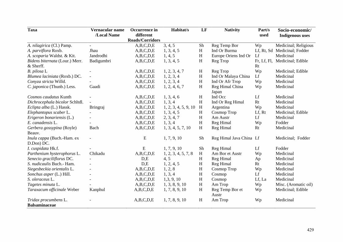
Taxa Vernacular name
/Local Name Occurrence in
different
Roads/Corridors
Habitat/s LF Nativity Part/s
used Socio-economic/ Indigenous uses
A. nilagirica (Cl.) Pamp. - A,B,C,D,E 3, 4, 5 Sh Reg Temp Bor Wp Medicinal; Religious A. parviflora Roxb. Jhau A,B,C,D,E 1, 3, 4, 5 H Ind Or Burma Lf, Rt, Sd Medicinal; Fodder A. scoparia Waldst. & Kit. Jandrodhi A,B,C,D,E 1, 4, 5 H Europe Oriens Ind Or Lf Medicinal Bidens biternata (Lour.) Merr.
& Sherff. Badigumbri A,B,C,D,E 1, 3, 4, 5 H Reg Trop Fr, Lf, Fl,
Rt Medicinal; Edible
B. pilosa L - A,B,C,D,E 1, 2, 3, 4, 7 H Reg Trop Wp Medicinal; Edible Blumea laciniata (Roxb.) DC. - A,B,C,D,E 1, 2, 3, 4 H Ind Or Malaya China Lf Medicinal Conyza stricta Willd. - A,B,C,D,E 1, 2, 3, 4 H Ind Or Afr Trop Wp Medicinal C. japonica (Thunb.) Less. Gaadi A,B,C,D,E 1, 2, 4, 6, 7 H Reg Himal China
Japan Wp Medicinal
Cosmos caudatus Kunth - A,B,C,D,E 1, 3, 4, 6 H Ind Occ Lf Medicinal Dichrocephala bicolor Schltdl. - A,B,C,D,E 1, 3, 4 H Ind Or Reg Himal Rt Medicinal Eclipta alba (L.) Hassk. Bringraj A,B,C,D,E 1, 2, 3, 4, 5, 9, 10 H Argentina Wp Medicinal Elephantopus scaber L. - A,B,C,D,E 1, 3, 4, 5 H Cosmop Trop Lf, Rt Medicinal; Edible Erigeron bonariensis (L.) - A,B,C,D,E 2, 3, 4, 7 H Am Austr Lf Medicinal E. canadensis L. - A,B,C,D,E 1, 3, 4 H Reg Himal Wp Fodder Gerbera gossypina (Royle)
Beauv. Bach A,B,C,D,E 1, 3, 4, 5, 7, 10 H Reg Himal Rt Medicinal
Inula cappa (Buch.-Ham. ex
D.Don) DC. - E 1, 7, 9, 10 Sh Reg Himal Java China Lf Medicinal; Fodder
I. cuspidata Hk.f. - E 1, 7, 9, 10 Sh Reg Himal Lf Fodder Parthenium hysterophorus L. Chikadu A,B,C,D,E 1, 2, 3, 4, 5, 7, 8 H Am Bor et Austr Wp Medicinal Senecio graciliflorus DC. - D,E 4, 5 H Reg Himal Ap Medicinal S. nudicaulis Buch.- Ham. - D,E 1, 2, 4, 5 H Reg Himal Rt Medicinal Siegesbeckia orientalis L. - A,B,C,D,E 1, 2, 8 H Cosmop Trop Wp Medicinal Sonchus asper (L.) Hill. - A,B,C,D,E 1, 3, 4 H Cosmop Lf Medicinal S. oleraceus L. - A,B,C,D,E 1,3, 9, 10 H Cosmop Lf, La Medicinal Tagetes minuta L. - A,B,C,D,E 1, 3, 8, 9, 10 H Am Trop Wp Misc. (Aromatic oil) Taraxacum officinale Weber Kanphul A,B,C,D,E 1, 7, 8, 9, 10 H Reg Temp Bor et
Austr Wp Medicinal; Edible
Tridax procumbens L. - A,B,C,D,E 1, 7, 8, 9, 10 H Am Trop Wp Medicinal Balsaminaceae
429

Taxa Vernacular name
/Local Name Occurrence in
different
Roads/Corridors
Habitat/s LF Nativity Part/s
used Socio-economic/ Indigenous uses
Impatiens balsamina L. Teur A,B,C,D,E 1, 2, 3, 4 H As trop Wp Medicinal I. scabrida DC. - A,B,C,D,E 1, 8, 10 H Reg Himal Sd, Wp Medicinal; Fodder Berberidaceae Berberis aristata DC. Kshambal E 1, 2, 3, 4 Sh Ind or Wp Medicinal; Edible;
Fuel B. lycium Royle Kshambal A,B,C,D,E 1, 3, 4, 5, 6, 7, 8,
9 Sh Reg Himal Rt, Fr Medicinal; Edible;
Fuel Betulaceae Alnus nitida (Spach) Endl. Himalayan alder E 1,2,7,8.9,10 T Ind or Wd Fuel, Fodder Bignoniaceae Begonia picta Sm. Khattu A,B,C,D,E 1, 8, 10 H Reg Himal Wp Medicinal Jacaranda mimosifolia D.Don A,B,C,D 8 T Bolivia to NW
Argentina - Misc.
Tecoma stans (L.) HB. & K. - A,B,C 1, 8, 10 T Mexic Wp Medicinal Boraginaceae Bombax ceiba L. Simbal A,B,C,D 2, 3, 4, 5, 6, 9 T Amer Austr Rt, Bk,
Lf Medicinal
Cynoglossum zeylanicum
Thunb. ex Lehm. - A,B,C,D,E 1, 3, 4, 5 H Ind Or Malaya Lf, Rt Medicinal
Ehretia acuminata R.Br. Bakli/Bakaar/
Banchaula A,B,C,D 1, 3, 4 T As et Austr Trop Bk, Fr,
Wd Medicinal; Edible;
Agricultural Tools E. laevis Roxb. - A,B,C,D 1, 3, 4, 5 T As et Austral Trop Lf, Br,
Fr Medicinal; Edible
Lindelofia longifolia (Benth.)
Baill. - A,B,C,D,E 3, 4, 5 H Reg Himal Lf Medicinal
Brassicaceae Cardamine impatiens L. - A,B,C,D,E 1, 2, 9, 10 H Reg Himal St Medicinal; Edible Capsella bursa-pastoris (L.)
Medik - A,B,C,D,E 1, 2, 4 H Reg Temp Wp Medicinal
Lepidium verginicum L. - A,B,C,D,E 1, 10 H Oriens Wp Medicinal Buddlejaceae Buddleja asiatica Lour. - A,B,C,D,E 1, 3, 4 Sh As Trop Malaya Lf Medicinal; Edible
430
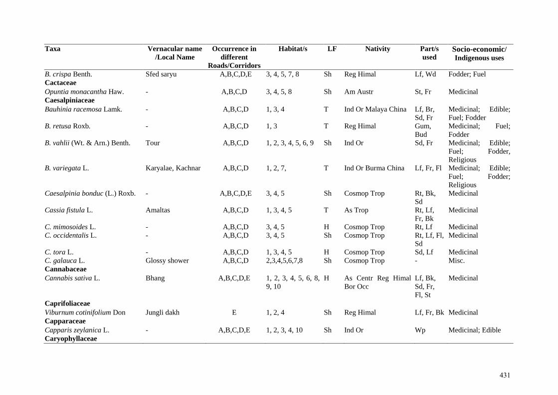
Taxa Vernacular name
/Local Name Occurrence in
different
Roads/Corridors
Habitat/s LF Nativity Part/s
used Socio-economic/ Indigenous uses
B. crispa Benth. Sfed saryu A,B,C,D,E 3, 4, 5, 7, 8 Sh Reg Himal Lf, Wd Fodder; Fuel Cactaceae Opuntia monacantha Haw. - A,B,C,D 3, 4, 5, 8 Sh Am Austr St, Fr Medicinal Caesalpiniaceae Bauhinia racemosa Lamk. - A,B,C,D 1, 3, 4 T Ind Or Malaya China Lf, Br,
Sd, Fr Medicinal; Edible;
Fuel; Fodder B. retusa Roxb. - A,B,C,D 1, 3 T Reg Himal Gum,
Bud Medicinal; Fuel;
Fodder B. vahlii (Wt. & Arn.) Benth. Tour A,B,C,D 1, 2, 3, 4, 5, 6, 9 Sh Ind Or Sd, Fr Medicinal; Edible;
Fuel; Fodder,
Religious B. variegata L. Karyalae, Kachnar
A,B,C,D 1, 2, 7, T Ind Or Burma China Lf, Fr, Fl Medicinal; Edible;
Fuel; Fodder;
Religious Caesalpinia bonduc (L.) Roxb. - A,B,C,D,E 3, 4, 5 Sh Cosmop Trop Rt, Bk,
Sd Medicinal
Cassia fistula L. Amaltas A,B,C,D 1, 3, 4, 5 T As Trop Rt, Lf,
Fr, Bk Medicinal
C. mimosoides L. - A,B,C,D 3, 4, 5 H Cosmop Trop Rt, Lf Medicinal C. occidentalis L. - A,B,C,D 3, 4, 5 Sh Cosmop Trop Rt, Lf, Fl,
Sd Medicinal
C. tora L. - A,B,C,D 1, 3, 4, 5 H Cosmop Trop Sd, Lf Medicinal C. galauca L. Glossy shower A,B,C,D 2,3,4,5,6,7,8 Sh Cosmop Trop - Misc. Cannabaceae Cannabis sativa L. Bhang A,B,C,D,E 1, 2, 3, 4, 5, 6, 8,
9, 10 H As Centr Reg Himal
Bor Occ Lf, Bk,
Sd, Fr,
Fl, St
Medicinal
Caprifoliaceae Viburnum cotinifolium Don Jungli dakh E 1, 2, 4 Sh Reg Himal Lf, Fr, Bk Medicinal Capparaceae Capparis zeylanica L. - A,B,C,D,E 1, 2, 3, 4, 10 Sh Ind Or Wp Medicinal; Edible Caryophyllaceae
431
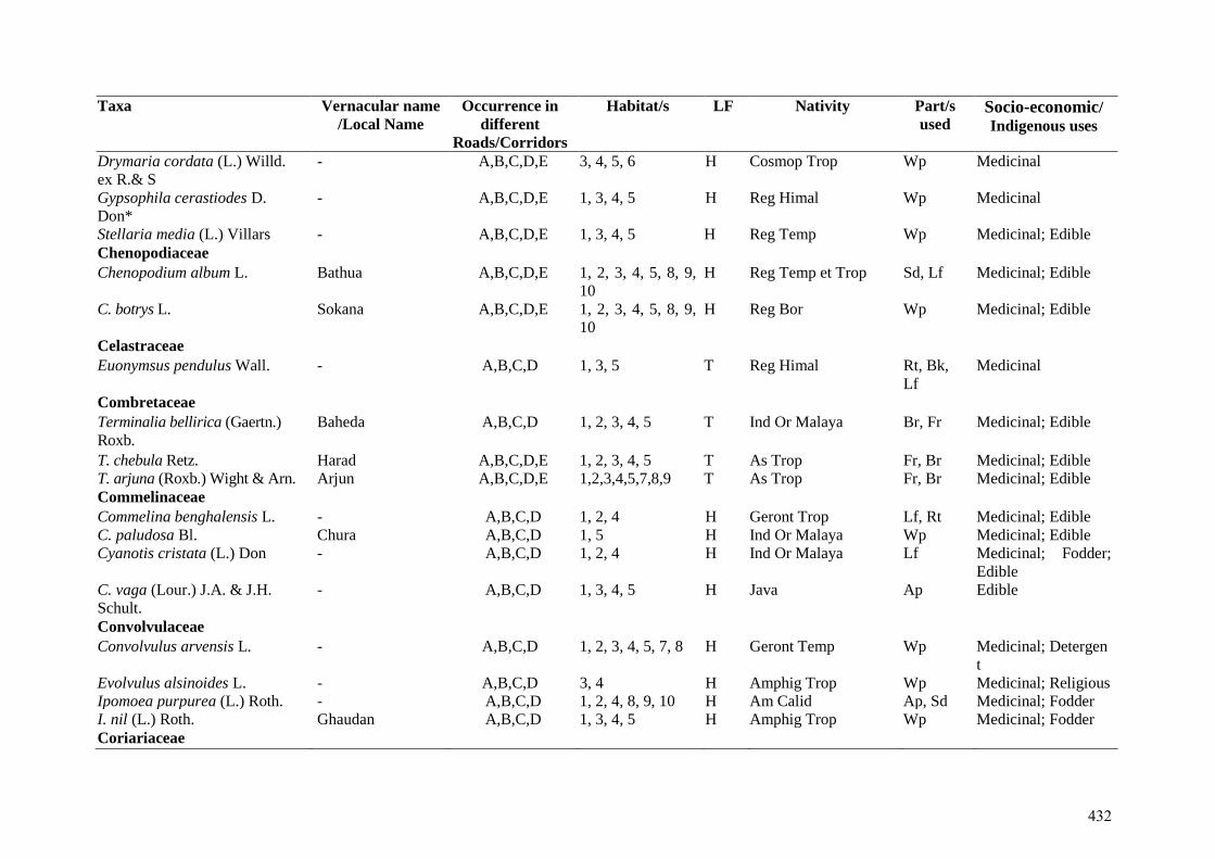
Taxa Vernacular name
/Local Name Occurrence in
different
Roads/Corridors
Habitat/s LF Nativity Part/s
used Socio-economic/ Indigenous uses
Drymaria cordata (L.) Willd.
ex R.& S - A,B,C,D,E 3, 4, 5, 6 H Cosmop Trop Wp Medicinal
Gypsophila cerastiodes D.
Don* - A,B,C,D,E 1, 3, 4, 5 H Reg Himal Wp Medicinal
Stellaria media (L.) Villars - A,B,C,D,E 1, 3, 4, 5 H Reg Temp Wp Medicinal; Edible Chenopodiaceae Chenopodium album L. Bathua A,B,C,D,E 1, 2, 3, 4, 5, 8, 9,
10 H Reg Temp et Trop Sd, Lf Medicinal; Edible
C. botrys L. Sokana A,B,C,D,E 1, 2, 3, 4, 5, 8, 9,
10 H Reg Bor Wp Medicinal; Edible
Celastraceae Euonymsus pendulus Wall. - A,B,C,D 1, 3, 5 T Reg Himal Rt, Bk,
Lf Medicinal
Combretaceae Terminalia bellirica (Gaertn.)
Roxb. Baheda
A,B,C,D 1, 2, 3, 4, 5 T Ind Or Malaya Br, Fr Medicinal; Edible
T. chebula Retz. Harad A,B,C,D,E 1, 2, 3, 4, 5 T As Trop Fr, Br Medicinal; Edible T. arjuna (Roxb.) Wight & Arn. Arjun A,B,C,D,E 1,2,3,4,5,7,8,9 T As Trop Fr, Br Medicinal; Edible Commelinaceae Commelina benghalensis L. - A,B,C,D 1, 2, 4 H Geront Trop Lf, Rt Medicinal; Edible C. paludosa Bl. Chura A,B,C,D 1, 5 H Ind Or Malaya Wp Medicinal; Edible Cyanotis cristata (L.) Don - A,B,C,D 1, 2, 4 H Ind Or Malaya Lf Medicinal; Fodder;
Edible C. vaga (Lour.) J.A. & J.H.
Schult. - A,B,C,D 1, 3, 4, 5 H Java Ap Edible
Convolvulaceae Convolvulus arvensis L. - A,B,C,D 1, 2, 3, 4, 5, 7, 8 H Geront Temp Wp Medicinal; Detergen
t Evolvulus alsinoides L. - A,B,C,D 3, 4 H Amphig Trop Wp Medicinal; Religious Ipomoea purpurea (L.) Roth. - A,B,C,D 1, 2, 4, 8, 9, 10 H Am Calid Ap, Sd Medicinal; Fodder I. nil (L.) Roth. Ghaudan A,B,C,D 1, 3, 4, 5 H Amphig Trop Wp Medicinal; Fodder Coriariaceae
432
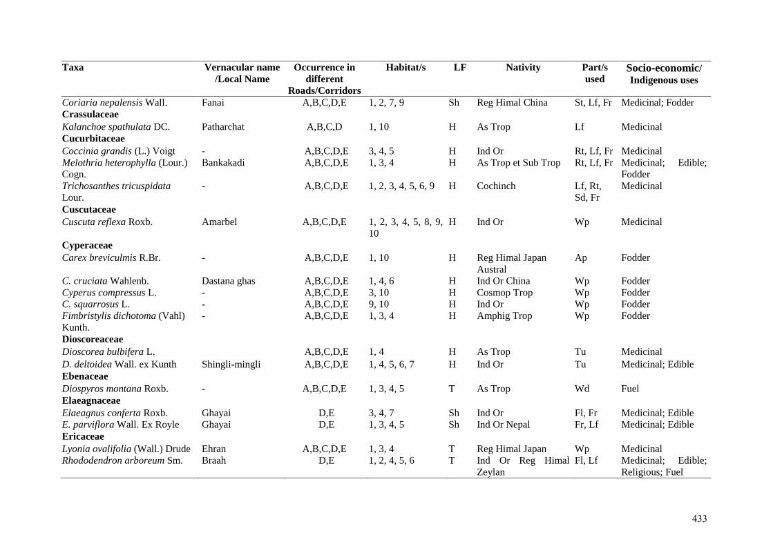
Taxa Vernacular name
/Local Name Occurrence in
different
Roads/Corridors
Habitat/s LF Nativity Part/s
used Socio-economic/ Indigenous uses
Coriaria nepalensis Wall. Fanai A,B,C,D,E 1, 2, 7, 9 Sh Reg Himal China St, Lf, Fr Medicinal; Fodder Crassulaceae Kalanchoe spathulata DC. Patharchat A,B,C,D 1, 10 H As Trop Lf Medicinal Cucurbitaceae Coccinia grandis (L.) Voigt - A,B,C,D,E 3, 4, 5 H Ind Or Rt, Lf, Fr Medicinal Melothria heterophylla (Lour.)
Cogn. Bankakadi A,B,C,D,E 1, 3, 4 H As Trop et Sub Trop Rt, Lf, Fr Medicinal; Edible;
Fodder Trichosanthes tricuspidata
Lour. - A,B,C,D,E 1, 2, 3, 4, 5, 6, 9 H Cochinch Lf, Rt,
Sd, Fr Medicinal
Cuscutaceae Cuscuta reflexa Roxb. Amarbel A,B,C,D,E 1, 2, 3, 4, 5, 8, 9,
10 H Ind Or Wp Medicinal
Cyperaceae Carex breviculmis R.Br. - A,B,C,D,E 1, 10 H Reg Himal Japan
Austral Ap Fodder
C. cruciata Wahlenb. Dastana ghas A,B,C,D,E 1, 4, 6 H Ind Or China Wp Fodder Cyperus compressus L. - A,B,C,D,E 3, 10 H Cosmop Trop Wp Fodder C. squarrosus L. - A,B,C,D,E 9, 10 H Ind Or Wp Fodder Fimbristylis dichotoma (Vahl)
Kunth. - A,B,C,D,E 1, 3, 4 H Amphig Trop Wp Fodder
Dioscoreaceae Dioscorea bulbifera L. A,B,C,D,E 1, 4 H As Trop Tu Medicinal
D. deltoidea Wall. ex Kunth Shingli-mingli A,B,C,D,E 1, 4, 5, 6, 7 H Ind Or Tu Medicinal; Edible Ebenaceae Diospyros montana Roxb. - A,B,C,D,E 1, 3, 4, 5 T As Trop Wd Fuel Elaeagnaceae Elaeagnus conferta Roxb. Ghayai D,E 3, 4, 7 Sh Ind Or Fl, Fr Medicinal; Edible E. parviflora Wall. Ex Royle Ghayai D,E 1, 3, 4, 5 Sh Ind Or Nepal Fr, Lf Medicinal; Edible Ericaceae Lyonia ovalifolia (Wall.) Drude Ehran A,B,C,D,E 1, 3, 4 T Reg Himal Japan Wp Medicinal Rhododendron arboreum Sm. Braah D,E 1, 2, 4, 5, 6 T Ind Or Reg Himal
Zeylan Fl, Lf Medicinal; Edible;
Religious; Fuel
433
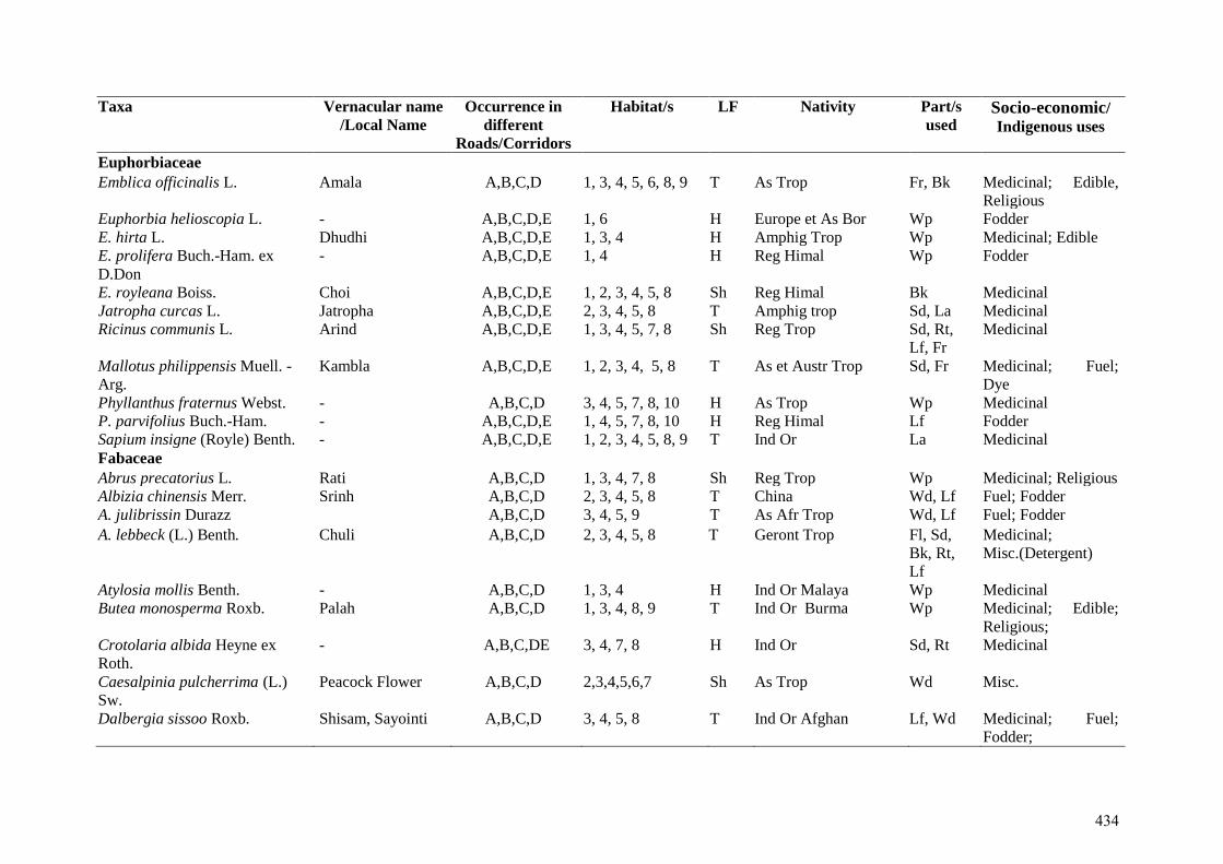
Taxa Vernacular name
/Local Name Occurrence in
different
Roads/Corridors
Habitat/s LF Nativity Part/s
used Socio-economic/ Indigenous uses
Euphorbiaceae Emblica officinalis L. Amala A,B,C,D 1, 3, 4, 5, 6, 8, 9 T As Trop Fr, Bk Medicinal; Edible,
Religious Euphorbia helioscopia L. - A,B,C,D,E 1, 6 H Europe et As Bor Wp Fodder E. hirta L. Dhudhi A,B,C,D,E 1, 3, 4 H Amphig Trop Wp Medicinal; Edible E. prolifera Buch.-Ham. ex
D.Don - A,B,C,D,E 1, 4 H Reg Himal Wp Fodder
E. royleana Boiss. Choi A,B,C,D,E 1, 2, 3, 4, 5, 8 Sh Reg Himal Bk Medicinal Jatropha curcas L. Jatropha A,B,C,D,E 2, 3, 4, 5, 8 T Amphig trop Sd, La Medicinal Ricinus communis L. Arind A,B,C,D,E 1, 3, 4, 5, 7, 8 Sh Reg Trop Sd, Rt,
Lf, Fr Medicinal
Mallotus philippensis Muell. -
Arg. Kambla A,B,C,D,E 1, 2, 3, 4, 5, 8 T As et Austr Trop Sd, Fr Medicinal; Fuel;
Dye Phyllanthus fraternus Webst. - A,B,C,D 3, 4, 5, 7, 8, 10 H As Trop Wp Medicinal P. parvifolius Buch.-Ham. - A,B,C,D,E 1, 4, 5, 7, 8, 10 H Reg Himal Lf Fodder Sapium insigne (Royle) Benth. - A,B,C,D,E 1, 2, 3, 4, 5, 8, 9 T Ind Or La Medicinal Fabaceae Abrus precatorius L. Rati A,B,C,D 1, 3, 4, 7, 8 Sh Reg Trop Wp Medicinal; Religious Albizia chinensis Merr. Srinh A,B,C,D 2, 3, 4, 5, 8 T China Wd, Lf Fuel; Fodder A. julibrissin Durazz A,B,C,D 3, 4, 5, 9 T As Afr Trop Wd, Lf Fuel; Fodder
A. lebbeck (L.) Benth. Chuli A,B,C,D 2, 3, 4, 5, 8 T Geront Trop Fl, Sd,
Bk, Rt,
Lf
Medicinal;
Misc.(Detergent)
Atylosia mollis Benth. - A,B,C,D 1, 3, 4 H Ind Or Malaya Wp Medicinal Butea monosperma Roxb. Palah A,B,C,D 1, 3, 4, 8, 9 T Ind Or Burma Wp Medicinal; Edible;
Religious; Crotolaria albida Heyne ex
Roth. - A,B,C,DE 3, 4, 7, 8 H Ind Or Sd, Rt Medicinal
Caesalpinia pulcherrima (L.)
Sw. Peacock Flower A,B,C,D 2,3,4,5,6,7 Sh As Trop Wd Misc.
Dalbergia sissoo Roxb. Shisam, Sayointi A,B,C,D 3, 4, 5, 8 T Ind Or Afghan Lf, Wd Medicinal; Fuel;
Fodder;
434
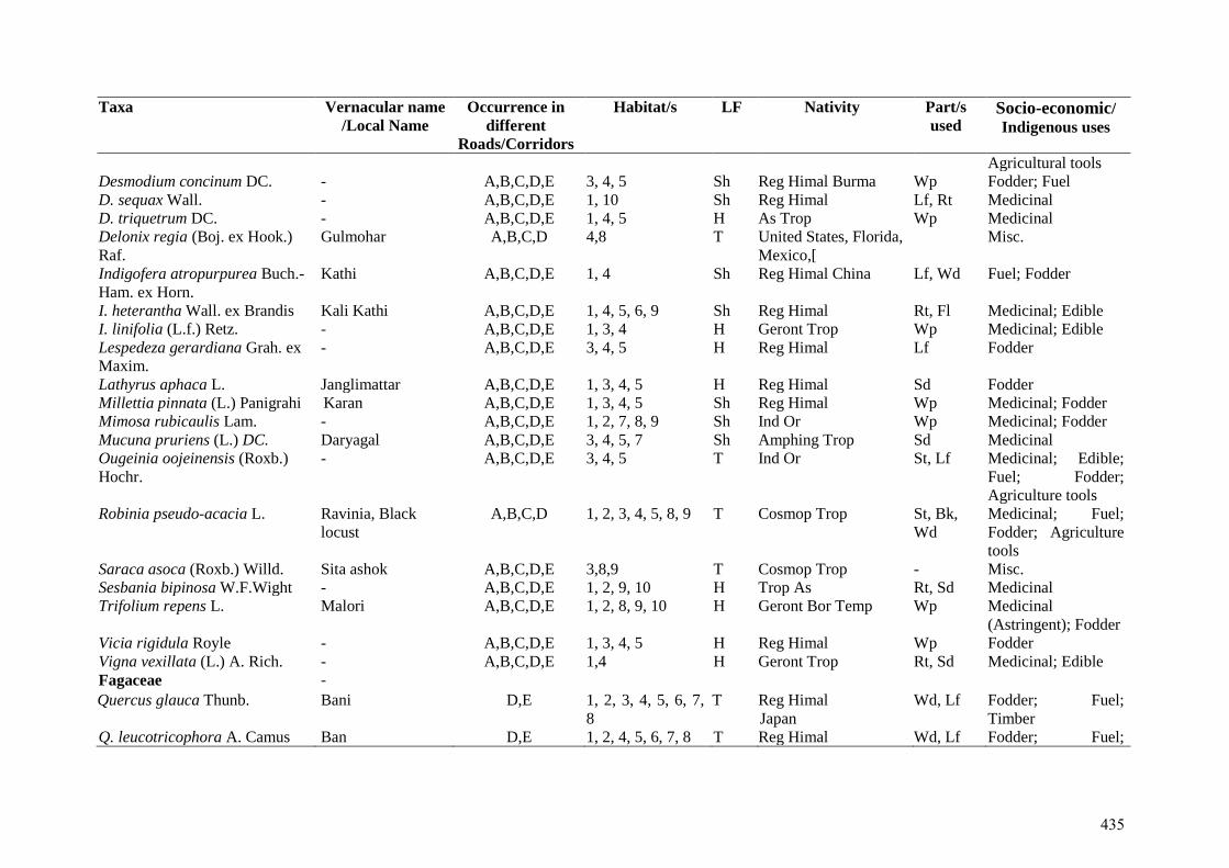
Taxa Vernacular name
/Local Name Occurrence in
different
Roads/Corridors
Habitat/s LF Nativity Part/s
used Socio-economic/ Indigenous uses
Agricultural tools Desmodium concinum DC. - A,B,C,D,E 3, 4, 5 Sh Reg Himal Burma Wp Fodder; Fuel D. sequax Wall. - A,B,C,D,E 1, 10 Sh Reg Himal Lf, Rt Medicinal D. triquetrum DC. - A,B,C,D,E 1, 4, 5 H As Trop Wp Medicinal Delonix regia (Boj. ex Hook.)
Raf. Gulmohar A,B,C,D 4,8 T United States, Florida,
Mexico,[ Misc.
Indigofera atropurpurea Buch.-
Ham. ex Horn. Kathi A,B,C,D,E 1, 4 Sh Reg Himal China Lf, Wd Fuel; Fodder
I. heterantha Wall. ex Brandis Kali Kathi A,B,C,D,E 1, 4, 5, 6, 9 Sh Reg Himal Rt, Fl Medicinal; Edible I. linifolia (L.f.) Retz. - A,B,C,D,E 1, 3, 4 H Geront Trop Wp Medicinal; Edible Lespedeza gerardiana Grah. ex
Maxim. - A,B,C,D,E 3, 4, 5 H Reg Himal Lf Fodder
Lathyrus aphaca L. Janglimattar A,B,C,D,E 1, 3, 4, 5 H Reg Himal Sd Fodder Millettia pinnata (L.) Panigrahi Karan A,B,C,D,E 1, 3, 4, 5 Sh Reg Himal Wp Medicinal; Fodder Mimosa rubicaulis Lam. - A,B,C,D,E 1, 2, 7, 8, 9 Sh Ind Or Wp Medicinal; Fodder Mucuna pruriens (L.) DC. Daryagal A,B,C,D,E 3, 4, 5, 7 Sh Amphing Trop Sd Medicinal Ougeinia oojeinensis (Roxb.)
Hochr. - A,B,C,D,E 3, 4, 5 T Ind Or St, Lf Medicinal; Edible;
Fuel; Fodder;
Agriculture tools Robinia pseudo-acacia L. Ravinia, Black
locust A,B,C,D 1, 2, 3, 4, 5, 8, 9 T Cosmop Trop St, Bk,
Wd Medicinal; Fuel;
Fodder; Agriculture
tools Saraca asoca (Roxb.) Willd. Sita ashok A,B,C,D,E 3,8,9 T Cosmop Trop - Misc. Sesbania bipinosa W.F.Wight - A,B,C,D,E 1, 2, 9, 10 H Trop As Rt, Sd Medicinal Trifolium repens L. Malori A,B,C,D,E 1, 2, 8, 9, 10 H Geront Bor Temp Wp Medicinal
(Astringent); Fodder Vicia rigidula Royle - A,B,C,D,E 1, 3, 4, 5 H Reg Himal Wp Fodder Vigna vexillata (L.) A. Rich. - A,B,C,D,E 1,4 H Geront Trop Rt, Sd Medicinal; Edible Fagaceae - Quercus glauca Thunb. Bani D,E 1, 2, 3, 4, 5, 6, 7,
8 T Reg Himal
Japan Wd, Lf Fodder; Fuel;
Timber Q. leucotricophora A. Camus Ban D,E 1, 2, 4, 5, 6, 7, 8 T Reg Himal Wd, Lf Fodder; Fuel;
435
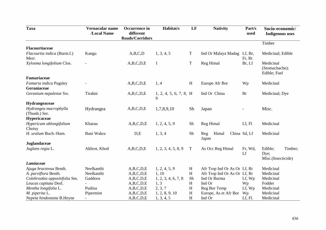
Taxa Vernacular name
/Local Name Occurrence in
different
Roads/Corridors
Habitat/s LF Nativity Part/s
used Socio-economic/ Indigenous uses
Timber Flacourtiaceae Flacourtia indica (Burm.f.)
Merr. Kangu A,B,C,D 1, 3, 4, 5 T Ind Or Malaya Madag Lf, Br,
Fr, Rt Medicinal; Edible
Xylosma longifolium Clos. - A,B,C,D,E 1 T Reg Himal Br, Lf Medicinal
(Stomachache);
Edible; Fuel Fumariaceae Fumaria indica Pugsley - A,B,C,D,E 1, 4 H Europe Afr Bor Wp Medicinal Geraniaceae Geranium nepalense Sw. Tirahni A,B,C,D,E 1, 2, 4, 5, 6, 7, 8,
9 H Ind Or China Rt Medicinal; Dye
Hydrangeaceae Hydrangea macrophylla
(Thunb.) Ser. Hydrangea A,B,C,D,E 1,7,8,9,10 Sh Japan - Misc.
Hypericaceae Hypericum oblongifolium
Choisy Kharau A,B,C,D,E 1, 2, 4, 5, 9 Sh Reg Himal Lf, Fl Medicinal
H. uralum Buch.-Ham. Bani Wakra D,E 1, 3, 4 Sh Reg Himal China
Japan Sd, Lf Medicinal
Juglandaceae Juglans regia L. Akhrot, Khod A,B,C,D,E 1, 2, 3, 4, 5, 8, 9 T As Occ Reg Himal Fr, Wd,
Lf Edible; Timber;
Dye;
Misc.(Insecticide) Lamiaceae Ajuga bracteosa Benth. Neelkanthi A,B,C,D,E 1, 2, 4, 5, 9 H Afr Trop Ind Or As Or Lf, Rt Medicinal A. parviflora Benth. Neelkanthi A,B,C,D,E 1, 10 H Afr Trop Ind Or As Or Lf, Rt Medicinal Colebrookia oppositifolia Sm. Gaddoos A,B,C,D,E 1, 2, 3, 4, 6, 7, 8 Sh Ind Or Burma Lf, Wp Medicinal Leucas capitata Desf. - A,B,C,D,E 1, 3 H Ind Or Wp Fodder Mentha longifolia L. Pudina A,B,C,D,E 2, 3, 7 H Reg Bor Temp Lf, Wp Medicinal M. piperita L. Pipermint A,B,C,D,E 1, 2, 8, 9, 10 H Europe, As et Afr Bor Wp Medicinal Nepeta hindostana B.Heyne - A,B,C,D,E 1, 3, 4, 5 H Ind Or Lf, Fl. Medicinal
436
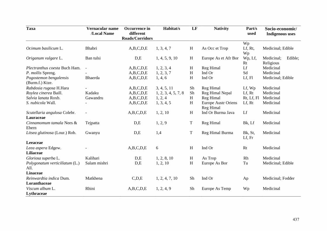
Taxa Vernacular name
/Local Name Occurrence in
different
Roads/Corridors
Habitat/s LF Nativity Part/s
used Socio-economic/ Indigenous uses
Wp Ocimum basilicum L. Bhabri A,B,C,D,E 1, 3, 4, 7 H As Occ et Trop Lf, Rt,
Wp Medicinal; Edible
Origanum vulgare L. Ban tulsi D,E 1, 4, 5, 9, 10 H Europe As et Afr Bor Wp, Lf,
Rt Medicinal; Edible;
Religious Plectranthus coesta Buch Ham. - A,B,C,D,E 1, 2, 3, 4 H Reg Himal Lf Medicinal P. mollis Spreng. - A,B,C,D,E 1, 2, 3, 7 H Ind Or Sd Medicinal Pogostemon bengalensis
(Burm.f.) Ktze. Bhaerda A,B,C,D,E 1, 4, 6 H Ind Or Lf, Fl
Medicinal; Edible
Rabdosia rugosa H.Hara - A,B,C,D,E 3, 4, 5, 11 Sh Reg Himal Lf, Wp Medicinal Roylea cinerea Baill. Kadaku A,B,C,D,E 1, 2, 3, 4, 5, 7, 8 Sh Reg Himal Nepal Lf, Rt Medicinal Salvia lanata Roxb. Gawandru A,B,C,D,E 1, 2, 4 H Reg Himal Rt, Lf, Fl Medicinal S. nubicola Wall. - A,B,C,D,E 1, 3, 4, 5 H Europe Austr Oriens
Reg Himal Lf, Rt Medicinal
Scutellaria angulosa Colebr. - A,B,C,D,E 1, 2, 10 H Ind Or Burma Java Lf Medicinal Lauraceae Cinnamomum tamala Nees &
Ebern Tejpatta D,E 1, 2, 9 T Reg Himal Bk, Lf Medicinal
Litsea glutinosa (Lour.) Rob. Gwanyu D,E 1,4 T Reg Himal Burma Bk, St,
Lf, Fr Medicinal
Leeaceae Leea aspera Edgew. - A,B,C,D,E 6 H Ind Or Rt Medicinal Liliaceae Gloriosa superba L. Kalihari D,E 1, 2, 8, 10 H As Trop Rh Medicinal Polygonatum verticillatum (L.)
All. Salam mishri D,E 1, 2, 10 H Europe As Bor Tu Medicinal; Edible
Linaceae Reinwardtia indica Dum. Matkhena C,D,E 1, 2, 4, 7, 10 Sh Ind Or Ap Medicinal; Fodder Loranthaceae Viscum album L. Rhini A,B,C,D,E 1, 2, 4, 9 Sh Europe As Temp Wp Medicinal Lythraceae
437
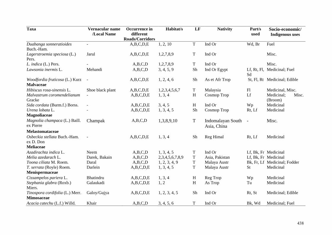
Taxa Vernacular name
/Local Name Occurrence in
different
Roads/Corridors
Habitat/s LF Nativity Part/s
used Socio-economic/ Indigenous uses
Duabanga sonneratioides
Buch.-Ham.
- A,B,C,D,E 1, 2, 10 T Ind Or Wd, Br Fuel
Lagerstroemia speciosa (L.)
Pers. Jarul A,B,C,D,E 1,2,7,8,9 T Ind Or Misc.
L. indica (L.) Pers. - A,B,C,D 1,2,7,8,9 T Ind Or Misc.
Lawsonia inermis L. Mehandi A,B,C,D 3, 4, 5, 9 Sh Ind Or Egypt Lf, Rt, Fl,
Sd Medicinal; Fuel
Woodfordia fruticosa (L.) Kurz - A,B,C,D,E 1, 2, 4, 6 Sh As et Afr Trop St, Fl, Rt Medicinal; Edible Malvaceae Hibiscus rosa-sinensis L. Shoe black plant A,B,C,D,E 1,2,3,4,5,6,7 T Malaysia Fl Medicinal, Misc. Malvastrum coromendelianum
Gracke - A,B,C,D,E 1, 3, 4 H Cosmop Trop Lf Medicinal; Misc.
(Broom) Sida cordata (Burm.f.) Borss. - A,B,C,D,E 3, 4, 5 H Ind Or Wp Medicinal Urena lobata L. - A,B,C,D,E 1, 3, 4, 5 Sh Cosmop Trop Rt, Lf Medicinal Magnoliaceae Magnolia champaca (L.) Baill.
ex Pierre Champak A,B,C,D 1,3,8,9,10 T Indomalayan South
Asia, China
- Misc.
Melastomataceae Osbeckia stellata Buch.-Ham.
ex D. Don - A,B,C,D,E 1, 3, 4 Sh Reg Himal Rt, Lf Medicinal
Meliaceae Azadirachta indica L. Neem A,B,C,D 1, 3, 4, 5 T Ind Or Lf, Bk, Fr Medicinal Melia azedarach L. Darek, Bakain A,B,C,D 2,3,4,5,6,7,8,9 T Asia, Pakistan Lf, Bk, Fr Medicinal Toona ciliata M. Roem. Daral A,B,C,D 1, 2, 3, 4, 9 T Malaya Austr Bk, Fr, Lf Medicinal; Fodder T. serrata (Royle) Roem. Darlein A,B,C,D,E 1, 3, 4, 5 T Malaya Austr St Medicinal Menispermaceae Cissampelos pariera L. Bhatindru A,B,C,D,E 1, 3, 4 H Reg Trop Wp Medicinal Stephania glabra (Roxb.)
Miers. Galaukadi A,B,C,D,E 1, 2 H As Trop Tu Medicinal
Tinospora cordifolia (L.) Merr. Galoy/Gujya A,B,C,D,E 1, 2, 3, 4, 5 Sh Ind Or Rt, St Medicinal; Edible Mimosaceae Acacia catechu (L.f.) Willd. Khair A,B,C,D 3, 4, 5, 6 T Ind Or Bk, Wd Medicinal; Fuel
438
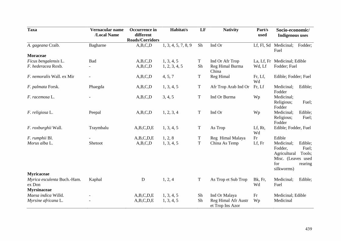
Taxa Vernacular name
/Local Name Occurrence in
different
Roads/Corridors
Habitat/s LF Nativity Part/s
used Socio-economic/ Indigenous uses
A. gageana Craib. Bagharne A,B,C,D 1, 3, 4, 5, 7, 8, 9 Sh Ind Or Lf, Fl, Sd Medicinal; Fodder;
Fuel Moraceae Ficus bengalensis L. Bad A,B,C,D 1, 3, 4, 5 T Ind Or Afr Trop La, Lf, Fr Medicinal; Edible F. hederacea Roxb. - A,B,C,D 1, 2, 3, 4, 5 Sh Reg Himal Burma
China Wd, Lf Fodder; Fuel
F. nemoralis Wall. ex Mir - A,B,C,D 4, 5, 7 T Reg Himal Fr, Lf,
Wd Edible; Fodder; Fuel
F. palmata Forsk. Phaegda A,B,C,D 1, 3, 4, 5 T Afr Trop Arab Ind Or Fr, Lf Medicinal; Edible;
Fodder F. racemosa L. - A,B,C,D 3, 4, 5 T Ind Or Burma Wp Medicinal;
Religious; Fuel;
Fodder F. religiosa L. Peepal A,B,C,D 1, 2, 3, 4 T Ind Or Wp Medicinal; Edible;
Religious; Fuel;
Fodder F. roxburghii Wall. Traymbalu A,B,C,D,E 1, 3, 4, 5 T As Trop Lf, Rt,
Wd Edible; Fodder, Fuel
F. rumphii Bl. - A,B,C,D,E 1, 2, 8 T Reg Himal Malaya Fr Edible Morus alba L. Shetoot A,B,C,D 1, 3, 4, 5 T China As Temp Lf, Fr Medicinal; Edible;
Fodder, Fuel;
Agricultural Tools;
Misc. (Leaves used
for rearing
silkworms) Myricaceae Myrica esculenta Buch.-Ham.
ex Don Kaphal D 1, 2, 4 T As Trop et Sub Trop Bk, Fr,
Wd Medicinal; Edible;
Fuel Myrsinaceae Maesa indica Willd. - A,B,C,D,E 1, 3, 4, 5 Sh Ind Or Malaya Fr Medicinal; Edible Myrsine africana L. - A,B,C,D,E 1, 3, 4, 5 Sh Reg Himal Afr Austr
et Trop Ins Azor Wp Medicinal
439
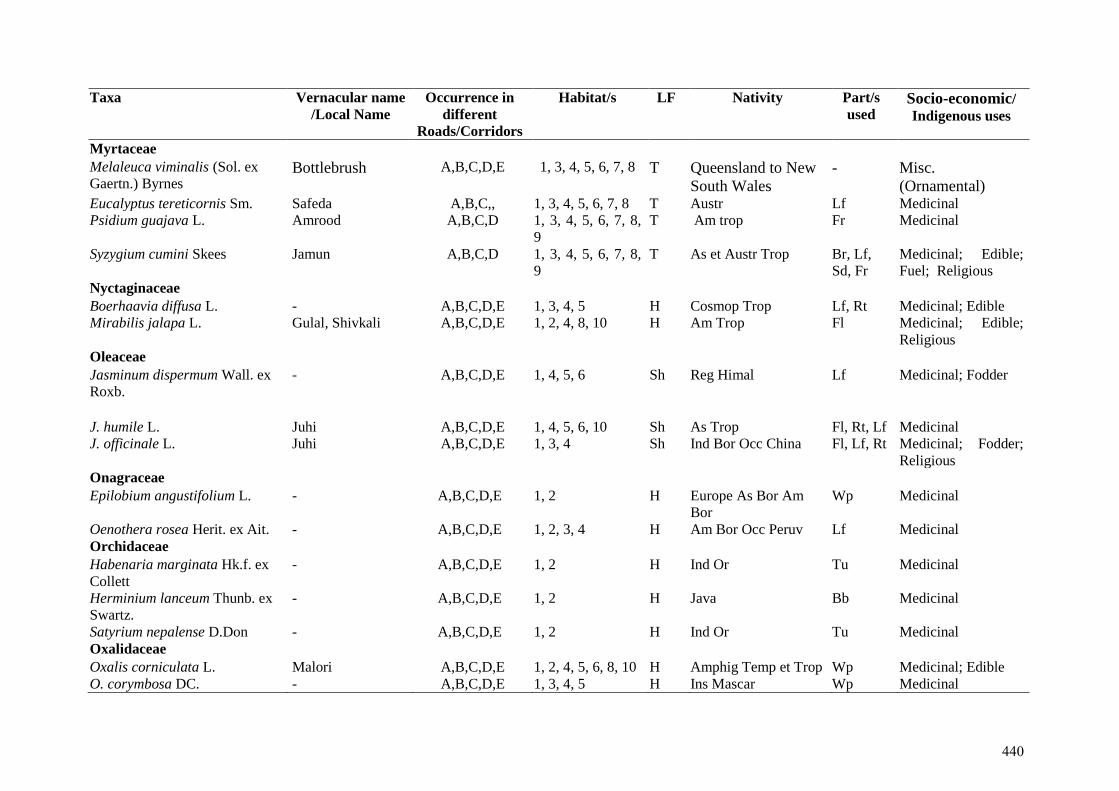
Taxa Vernacular name
/Local Name Occurrence in
different
Roads/Corridors
Habitat/s LF Nativity Part/s
used Socio-economic/ Indigenous uses
Myrtaceae Melaleuca viminalis (Sol. ex
Gaertn.) Byrnes Bottlebrush A,B,C,D,E 1, 3, 4, 5, 6, 7, 8 T Queensland to New
South Wales
- Misc.
(Ornamental) Eucalyptus tereticornis Sm. Safeda A,B,C,, 1, 3, 4, 5, 6, 7, 8 T Austr Lf Medicinal Psidium guajava L. Amrood A,B,C,D 1, 3, 4, 5, 6, 7, 8,
9 T Am trop Fr Medicinal
Syzygium cumini Skees Jamun A,B,C,D 1, 3, 4, 5, 6, 7, 8,
9 T As et Austr Trop Br, Lf,
Sd, Fr Medicinal; Edible;
Fuel; Religious Nyctaginaceae Boerhaavia diffusa L. - A,B,C,D,E 1, 3, 4, 5 H Cosmop Trop Lf, Rt Medicinal; Edible Mirabilis jalapa L. Gulal, Shivkali A,B,C,D,E 1, 2, 4, 8, 10 H Am Trop Fl Medicinal; Edible;
Religious Oleaceae Jasminum dispermum Wall. ex
Roxb.
- A,B,C,D,E 1, 4, 5, 6 Sh Reg Himal Lf Medicinal; Fodder
J. humile L. Juhi A,B,C,D,E 1, 4, 5, 6, 10 Sh As Trop Fl, Rt, Lf Medicinal J. officinale L. Juhi A,B,C,D,E 1, 3, 4 Sh Ind Bor Occ China Fl, Lf, Rt Medicinal; Fodder;
Religious Onagraceae Epilobium angustifolium L. - A,B,C,D,E 1, 2 H Europe As Bor Am
Bor Wp Medicinal
Oenothera rosea Herit. ex Ait. - A,B,C,D,E 1, 2, 3, 4 H Am Bor Occ Peruv Lf Medicinal Orchidaceae Habenaria marginata Hk.f. ex
Collett - A,B,C,D,E 1, 2 H Ind Or Tu Medicinal
Herminium lanceum Thunb. ex
Swartz. - A,B,C,D,E 1, 2 H Java Bb Medicinal
Satyrium nepalense D.Don - A,B,C,D,E 1, 2 H Ind Or Tu Medicinal Oxalidaceae Oxalis corniculata L. Malori A,B,C,D,E 1, 2, 4, 5, 6, 8, 10 H Amphig Temp et Trop Wp Medicinal; Edible O. corymbosa DC. - A,B,C,D,E 1, 3, 4, 5 H Ins Mascar Wp Medicinal
440
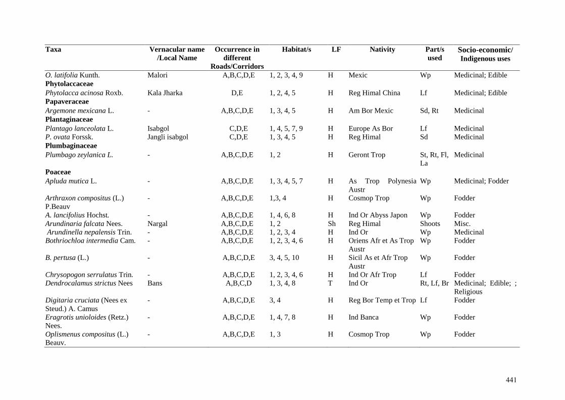
Taxa Vernacular name
/Local Name Occurrence in
different
Roads/Corridors
Habitat/s LF Nativity Part/s
used Socio-economic/ Indigenous uses
O. latifolia Kunth. Malori A,B,C,D,E 1, 2, 3, 4, 9 H Mexic Wp Medicinal; Edible Phytolaccaceae Phytolacca acinosa Roxb. Kala Jharka D,E 1, 2, 4, 5 H Reg Himal China Lf Medicinal; Edible Papaveraceae Argemone mexicana L. - A,B,C,D,E 1, 3, 4, 5 H Am Bor Mexic Sd, Rt Medicinal Plantaginaceae Plantago lanceolata L. Isabgol C,D,E 1, 4, 5, 7, 9 H Europe As Bor Lf Medicinal P. ovata Forssk. Jangli isabgol C,D,E 1, 3, 4, 5 H Reg Himal Sd Medicinal Plumbaginaceae Plumbago zeylanica L. - A,B,C,D,E 1, 2 H Geront Trop St, Rt, Fl,
La Medicinal
Poaceae Apluda mutica L. - A,B,C,D,E 1, 3, 4, 5, 7 H As Trop Polynesia
Austr Wp Medicinal; Fodder
Arthraxon compositus (L.)
P.Beauv - A,B,C,D,E 1,3, 4 H Cosmop Trop Wp Fodder
A. lancifolius Hochst. - A,B,C,D,E 1, 4, 6, 8 H Ind Or Abyss Japon Wp Fodder Arundinaria falcata Nees. Nargal A,B,C,D,E 1, 2 Sh Reg Himal Shoots Misc. Arundinella nepalensis Trin. - A,B,C,D,E 1, 2, 3, 4 H Ind Or Wp Medicinal Bothriochloa intermedia Cam. - A,B,C,D,E 1, 2, 3, 4, 6 H Oriens Afr et As Trop
Austr Wp Fodder
B. pertusa (L.) - A,B,C,D,E 3, 4, 5, 10 H Sicil As et Afr Trop
Austr Wp Fodder
Chrysopogon serrulatus Trin. - A,B,C,D,E 1, 2, 3, 4, 6 H Ind Or Afr Trop Lf Fodder Dendrocalamus strictus Nees Bans A,B,C,D 1, 3, 4, 8 T Ind Or Rt, Lf, Br Medicinal; Edible; ;
Religious Digitaria cruciata (Nees ex
Steud.) A. Camus - A,B,C,D,E 3, 4 H Reg Bor Temp et Trop Lf Fodder
Eragrotis unioloides (Retz.)
Nees. - A,B,C,D,E 1, 4, 7, 8 H Ind Banca Wp Fodder
Oplismenus compositus (L.)
Beauv. - A,B,C,D,E 1, 3 H Cosmop Trop Wp Fodder
441
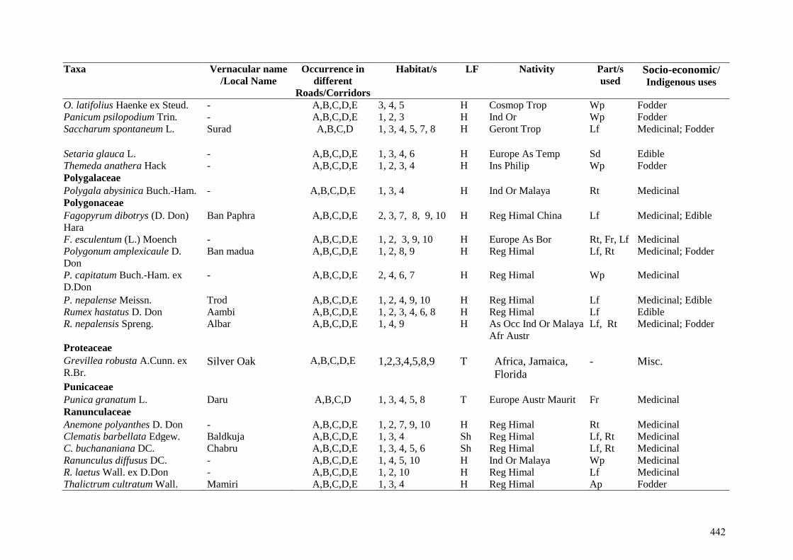
Taxa Vernacular name
/Local Name Occurrence in
different
Roads/Corridors
Habitat/s LF Nativity Part/s
used Socio-economic/ Indigenous uses
O. latifolius Haenke ex Steud. - A,B,C,D,E 3, 4, 5 H Cosmop Trop Wp Fodder Panicum psilopodium Trin. - A,B,C,D,E 1, 2, 3 H Ind Or Wp Fodder Saccharum spontaneum L. Surad A,B,C,D 1, 3, 4, 5, 7, 8 H Geront Trop Lf
Medicinal; Fodder
Setaria glauca L. - A,B,C,D,E 1, 3, 4, 6 H Europe As Temp Sd Edible Themeda anathera Hack - A,B,C,D,E 1, 2, 3, 4 H Ins Philip Wp Fodder Polygalaceae Polygala abysinica Buch.-Ham. - A,B,C,D,E 1, 3, 4 H Ind Or Malaya Rt Medicinal Polygonaceae Fagopyrum dibotrys (D. Don)
Hara Ban Paphra A,B,C,D,E 2, 3, 7, 8, 9, 10 H Reg Himal China Lf Medicinal; Edible
F. esculentum (L.) Moench - A,B,C,D,E 1, 2, 3, 9, 10 H Europe As Bor Rt, Fr, Lf Medicinal Polygonum amplexicaule D.
Don Ban madua A,B,C,D,E 1, 2, 8, 9 H Reg Himal Lf, Rt Medicinal; Fodder
P. capitatum Buch.-Ham. ex
D.Don - A,B,C,D,E 2, 4, 6, 7 H Reg Himal Wp
Medicinal
P. nepalense Meissn. Trod A,B,C,D,E 1, 2, 4, 9, 10 H Reg Himal Lf Medicinal; Edible Rumex hastatus D. Don Aambi A,B,C,D,E 1, 2, 3, 4, 6, 8 H Reg Himal Lf Edible R. nepalensis Spreng. Albar A,B,C,D,E 1, 4, 9 H As Occ Ind Or Malaya
Afr Austr Lf, Rt Medicinal; Fodder
Proteaceae Grevillea robusta A.Cunn. ex
R.Br. Silver Oak A,B,C,D,E 1,2,3,4,5,8,9 T Africa, Jamaica,
Florida
- Misc.
Punicaceae Punica granatum L. Daru A,B,C,D 1, 3, 4, 5, 8 T Europe Austr Maurit Fr Medicinal Ranunculaceae Anemone polyanthes D. Don - A,B,C,D,E 1, 2, 7, 9, 10 H Reg Himal Rt Medicinal Clematis barbellata Edgew. Baldkuja A,B,C,D,E 1, 3, 4 Sh Reg Himal Lf, Rt Medicinal C. buchananiana DC. Chabru A,B,C,D,E 1, 3, 4, 5, 6 Sh Reg Himal Lf, Rt Medicinal Ranunculus diffusus DC. - A,B,C,D,E 1, 4, 5, 10 H Ind Or Malaya Wp Medicinal R. laetus Wall. ex D.Don - A,B,C,D,E 1, 2, 10 H Reg Himal Lf Medicinal Thalictrum cultratum Wall. Mamiri A,B,C,D,E 1, 3, 4 H Reg Himal Ap Fodder
442
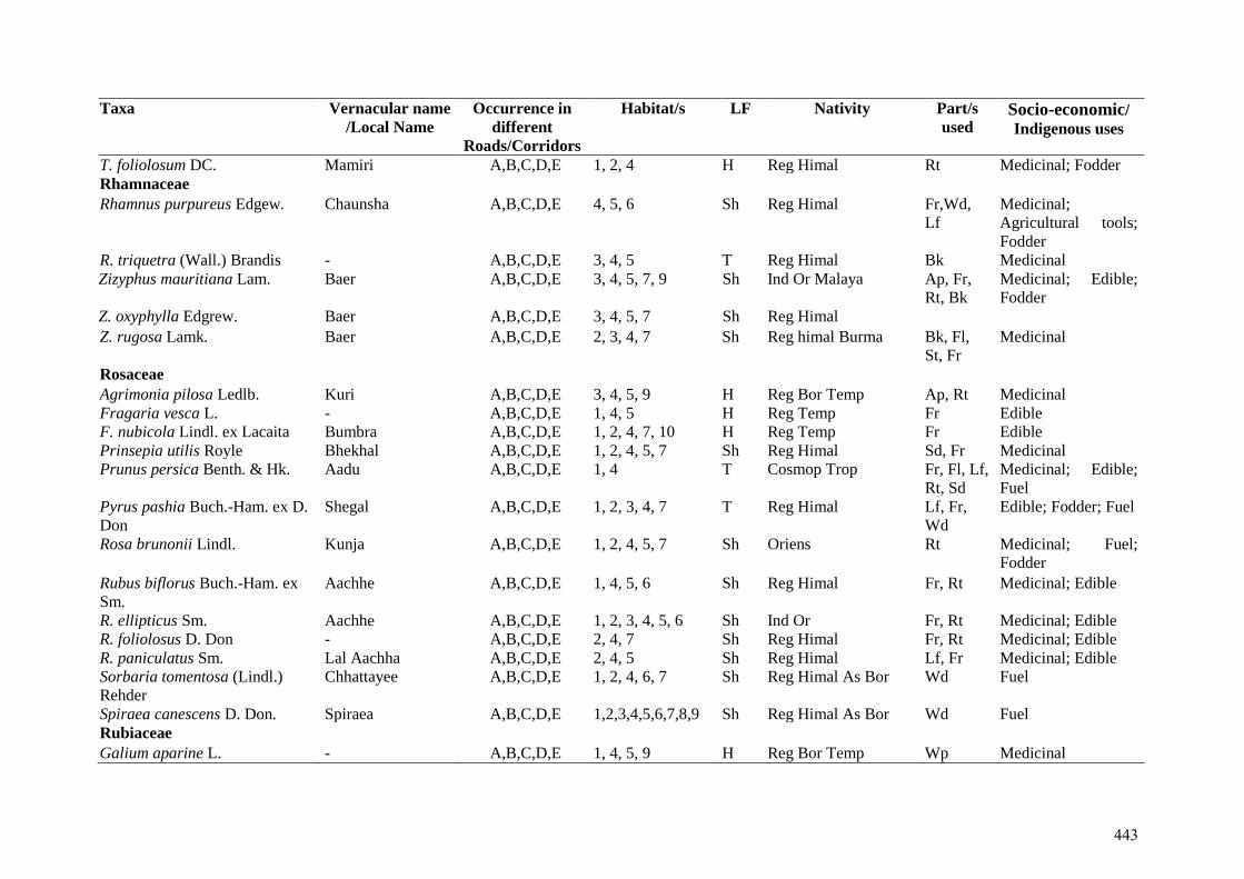
Taxa Vernacular name
/Local Name Occurrence in
different
Roads/Corridors
Habitat/s LF Nativity Part/s
used Socio-economic/ Indigenous uses
T. foliolosum DC. Mamiri A,B,C,D,E 1, 2, 4 H Reg Himal Rt Medicinal; Fodder Rhamnaceae Rhamnus purpureus Edgew. Chaunsha A,B,C,D,E 4, 5, 6 Sh Reg Himal Fr,Wd,
Lf Medicinal;
Agricultural tools;
Fodder R. triquetra (Wall.) Brandis - A,B,C,D,E 3, 4, 5 T Reg Himal Bk Medicinal Zizyphus mauritiana Lam. Baer A,B,C,D,E 3, 4, 5, 7, 9 Sh Ind Or Malaya Ap, Fr,
Rt, Bk Medicinal; Edible;
Fodder Z. oxyphylla Edgrew. Baer A,B,C,D,E 3, 4, 5, 7 Sh Reg Himal Z. rugosa Lamk. Baer A,B,C,D,E 2, 3, 4, 7 Sh Reg himal Burma Bk, Fl,
St, Fr Medicinal
Rosaceae Agrimonia pilosa Ledlb. Kuri A,B,C,D,E 3, 4, 5, 9 H Reg Bor Temp Ap, Rt Medicinal Fragaria vesca L. - A,B,C,D,E 1, 4, 5 H Reg Temp Fr Edible F. nubicola Lindl. ex Lacaita Bumbra A,B,C,D,E 1, 2, 4, 7, 10 H Reg Temp Fr Edible Prinsepia utilis Royle Bhekhal A,B,C,D,E 1, 2, 4, 5, 7 Sh Reg Himal Sd, Fr Medicinal Prunus persica Benth. & Hk. Aadu A,B,C,D,E 1, 4 T Cosmop Trop Fr, Fl, Lf,
Rt, Sd Medicinal; Edible;
Fuel Pyrus pashia Buch.-Ham. ex D.
Don Shegal A,B,C,D,E 1, 2, 3, 4, 7 T Reg Himal Lf, Fr,
Wd Edible; Fodder; Fuel
Rosa brunonii Lindl.
Kunja A,B,C,D,E 1, 2, 4, 5, 7 Sh Oriens Rt Medicinal; Fuel;
Fodder
Rubus biflorus Buch.-Ham. ex
Sm. Aachhe A,B,C,D,E 1, 4, 5, 6 Sh Reg Himal Fr, Rt Medicinal; Edible
R. ellipticus Sm. Aachhe A,B,C,D,E 1, 2, 3, 4, 5, 6 Sh Ind Or Fr, Rt Medicinal; Edible R. foliolosus D. Don - A,B,C,D,E 2, 4, 7 Sh Reg Himal Fr, Rt Medicinal; Edible R. paniculatus Sm. Lal Aachha A,B,C,D,E 2, 4, 5 Sh Reg Himal Lf, Fr Medicinal; Edible Sorbaria tomentosa (Lindl.)
Rehder Chhattayee A,B,C,D,E 1, 2, 4, 6, 7 Sh Reg Himal As Bor Wd Fuel
Spiraea canescens D. Don. Spiraea A,B,C,D,E 1,2,3,4,5,6,7,8,9 Sh Reg Himal As Bor Wd Fuel Rubiaceae Galium aparine L. - A,B,C,D,E 1, 4, 5, 9 H Reg Bor Temp Wp Medicinal
443
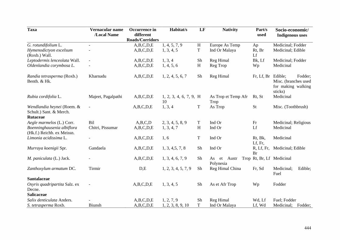
Taxa Vernacular name
/Local Name Occurrence in
different
Roads/Corridors
Habitat/s LF Nativity Part/s
used Socio-economic/ Indigenous uses
G. rotundifolium L. - A,B,C,D,E 1, 4, 5, 7, 9 H Europe As Temp Ap Medicinal; Fodder Hymenodictyon excelsum
(Roxb.) Wall. - A,B,C,D,E 1, 3, 4, 5 T Ind Or Malaya Rt, Br
Lf Medicinal; Edible
Leptodermis lenceolata Wall. - A,B,C,D,E 1, 3, 4 Sh Reg Himal Bk, Lf Medicinal; Fodder Oldenlandia corymbosa L.
- A,B,C,D,E 1, 4, 5, 6 H Reg Trop Wp Medicinal
Randia tetrasperma (Roxb.)
Benth. & Hk. Kharnadu A,B,C,D,E 1, 2, 4, 5, 6, 7 Sh Reg Himal Fr, Lf, Br Edible; Fodder;
Misc. (branches used
for making walking
sticks) Rubia cordifolia L. Majeet, Pagalpathi A,B,C,D,E 1, 2, 3, 4, 6, 7, 9,
10 H As Trop et Temp Afr
Trop Rt, St Medicinal
Wendlandia heynei (Roem. &
Schult.) Sant. & Merch. - A,B,C,D,E 1, 3, 4 T As Trop St Misc. (Toothbrush)
Rutaceae Aegle marmelos (L.) Corr. Bil A,B,C,D 2, 3, 4, 5, 8, 9 T Ind Or Fr Medicinal; Religious Boenninghausenia albiflora
(Hk.f.) Reichb. ex Meissn. Chitri, Pissumar A,B,C,D,E 1, 3, 4, 7 H Ind Or Lf Medicinal
Limonia acidissima L. - A,B,C,D,E 1, 6 T Ind Or Rt, Bk,
Lf, Fr, Medicinal
Murraya koenigii Spr. Gandaela A,B,C,D,E 1, 3, 4,5, 7, 8 Sh Ind Or R, Lf, Fr,
Br Medicinal; Edible
M. paniculata (L.) Jack. - A,B,C,D,E 1, 3, 4, 6, 7, 9 Sh As et Austr Trop
Polynesia Rt, Br, Lf Medicinal
Zanthoxylum armatum DC. Tirmir D,E 1, 2, 3, 4, 5, 7, 9 Sh Reg Himal China Fr, Sd Medicinal; Edible;
Fuel Santalaceae Osyris quadripartita Salz. ex
Decne. - A,B,C,D,E 1, 3, 4, 5 Sh As et Afr Trop Wp Fodder
Salicaceae Salix denticulata Anders. - A,B,C,D,E 1, 2, 7, 9 Sh Reg Himal Wd, Lf Fuel; Fodder S. tetrasperma Roxb. Biunsh A,B,C,D,E 1, 2, 3, 8, 9, 10 T Ind Or Malaya Lf, Wd Medicinal; Fodder;
444
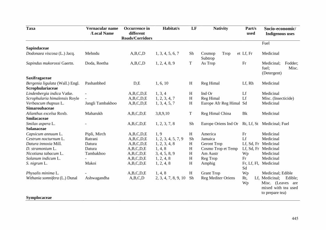
Taxa Vernacular name
/Local Name Occurrence in
different
Roads/Corridors
Habitat/s LF Nativity Part/s
used Socio-economic/ Indigenous uses
Fuel Sapindaceae Dodonaea viscosa (L.) Jacq. Mehndu A,B,C,D 1, 3, 4, 5, 6, 7 Sh Cosmop Trop et
Subtrop Lf, Fr Medicinal
Sapindus mukorossi Gaertn. Doda, Reetha A,B,C,D 1, 2, 4, 8, 9 T As Trop Fr Medicinal; Fodder;
fuel; Misc.
(Detergent) Saxifragaceae Bergenia ligulata (Wall.) Engl. Pashanbhed D,E 1, 6, 10 H Reg Himal Lf, Rh Medicinal Scrophulariaceae Lindenbergia indica Vatke. - A,B,C,D,E 1, 3, 4 H Ind Or Lf Medicinal Scrophularia himalensis Royle - A,B,C,D,E 1, 2, 3, 4, 7 H Reg Himal Lf Misc. (Insecticide) Verbascum thapsus L. Jangli Tambakhoo A,B,C,D,E 1, 3, 4, 5, 7 H Europe Afr Reg Himal Sd Medicinal Simaroubaceae Ailanthus excelsa Roxb. Maharukh A,B,C,D,E 3,8,9,10 T Reg Himal China Bk Medicinal Smilacaceae Smilax aspera L. - A,B,C,D,E 1, 2, 3, 7, 8 Sh Europe Oriens Ind Or Rt, Lf, St Medicinal; Fuel Solanaceae Capsicum annuum L. Pipli, Mirch A,B,C,D,E 1, 9 H America Fr Medicinal Cestrum nocturnum L. Ratrani A,B,C,D,E 1, 2, 3, 4, 5, 7, 9 Sh Jamaica Lf Medicinal Datura innoxia Mill. Datura A,B,C,D,E 1, 2, 3, 4, 8 H Geront Trop Lf, Sd, Fr Medicinal D. stramonium L. Datura A,B,C,D,E 1, 4, 8 H Cosmo Trop et Temp Lf, Sd, Fr Medicinal Nicotiana tabacum L. Tambakhoo A,B,C,D,E 3, 4, 5, 8, 9 H Am Austr Wp Medicinal Solanum indicum L. - A,B,C,D,E 1, 2, 4, 8 H Reg Trop Fr Medicinal S. nigrum L. Makoi A,B,C,D,E 1, 2, 4, 8 H Amphig Fr, Lf, Fl,
Sd Medicinal
Physalis minima L. - A,B,C,D,E 1, 4, 8 H Grant Trop Wp Medicinal; Edible Withania somnifera (L.) Dunal Ashwagandha A,B,C,D 2, 3, 4, 7, 8, 9, 10 Sh Reg Mediter Oriens Rt, Lf,
Wp Medicinal; Edible;
Misc. (Leaves are
mixed with tea used
to prepare tea) Symplocaceae
445
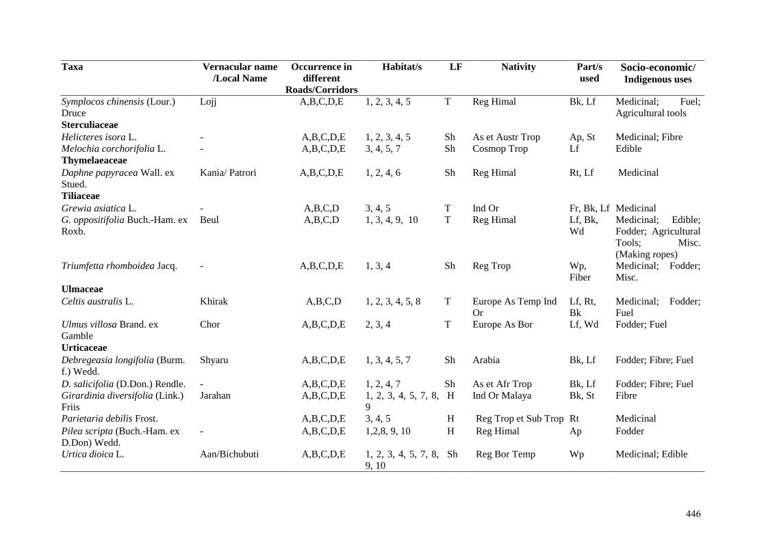
Taxa Vernacular name
/Local Name Occurrence in
different
Roads/Corridors
Habitat/s LF Nativity Part/s
used Socio-economic/ Indigenous uses
Symplocos chinensis (Lour.)
Druce Lojj A,B,C,D,E 1, 2, 3, 4, 5 T Reg Himal Bk, Lf Medicinal; Fuel;
Agricultural tools Sterculiaceae Helicteres isora L. - A,B,C,D,E 1, 2, 3, 4, 5 Sh As et Austr Trop Ap, St Medicinal; Fibre Melochia corchorifolia L. - A,B,C,D,E 3, 4, 5, 7 Sh Cosmop Trop Lf Edible Thymelaeaceae Daphne papyracea Wall. ex
Stued. Kania/ Patrori A,B,C,D,E 1, 2, 4, 6 Sh Reg Himal Rt, Lf Medicinal
Tiliaceae Grewia asiatica L. - A,B,C,D 3, 4, 5 T Ind Or Fr, Bk, Lf Medicinal G. oppositifolia Buch.-Ham. ex
Roxb. Beul A,B,C,D 1, 3, 4, 9, 10 T Reg Himal Lf, Bk,
Wd Medicinal; Edible;
Fodder; Agricultural
Tools; Misc.
(Making ropes) Triumfetta rhomboidea Jacq. - A,B,C,D,E 1, 3, 4 Sh Reg Trop Wp,
Fiber Medicinal; Fodder;
Misc. Ulmaceae Celtis australis L. Khirak A,B,C,D 1, 2, 3, 4, 5, 8 T Europe As Temp Ind
Or Lf, Rt,
Bk Medicinal; Fodder;
Fuel Ulmus villosa Brand. ex
Gamble Chor A,B,C,D,E 2, 3, 4 T Europe As Bor Lf, Wd Fodder; Fuel
Urticaceae Debregeasia longifolia (Burm.
f.) Wedd. Shyaru A,B,C,D,E 1, 3, 4, 5, 7 Sh Arabia Bk, Lf
Fodder; Fibre; Fuel
D. salicifolia (D.Don.) Rendle. - A,B,C,D,E 1, 2, 4, 7 Sh As et Afr Trop Bk, Lf Fodder; Fibre; Fuel Girardinia diversifolia (Link.)
Friis Jarahan A,B,C,D,E 1, 2, 3, 4, 5, 7, 8,
9 H Ind Or Malaya Bk, St Fibre
Parietaria debilis Frost. A,B,C,D,E 3, 4, 5 H Reg Trop et Sub Trop Rt Medicinal
Pilea scripta (Buch.-Ham. ex
D.Don) Wedd. - A,B,C,D,E 1,2,8, 9, 10 H Reg Himal Ap Fodder
Urtica dioica L. Aan/Bichubuti A,B,C,D,E 1, 2, 3, 4, 5, 7, 8,
9, 10 Sh Reg Bor Temp Wp Medicinal; Edible
446
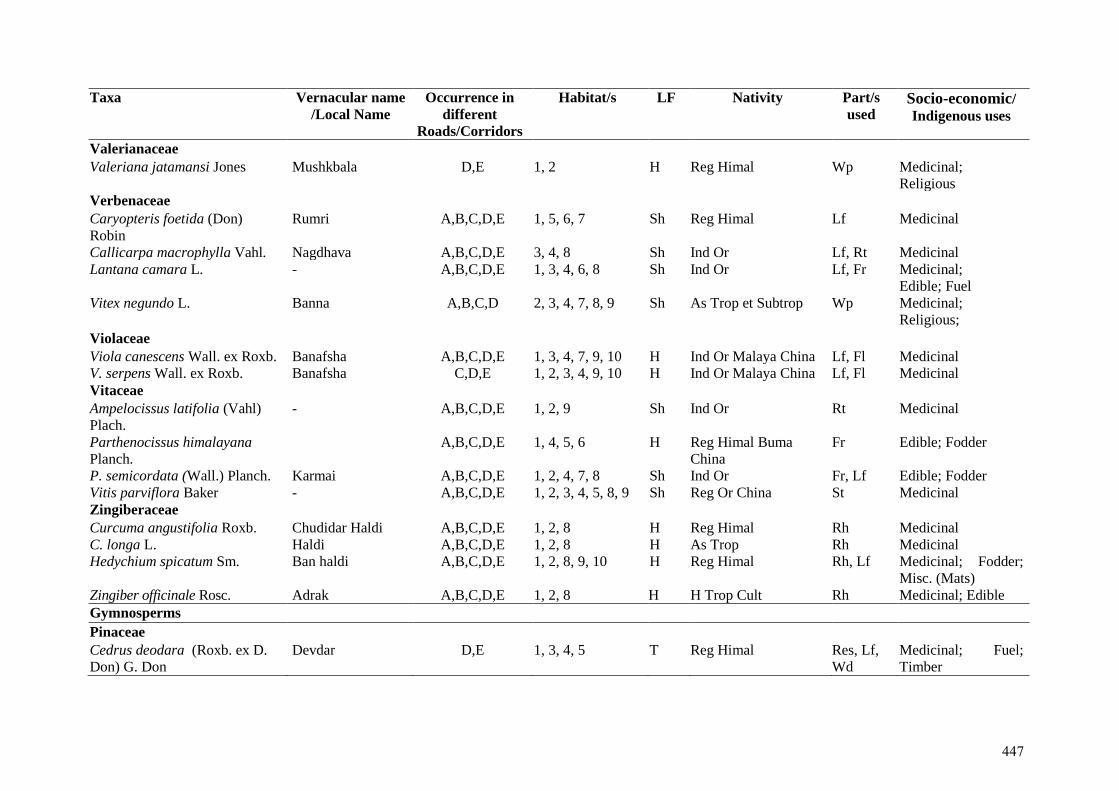
Taxa Vernacular name
/Local Name Occurrence in
different
Roads/Corridors
Habitat/s LF Nativity Part/s
used Socio-economic/ Indigenous uses
Valerianaceae Valeriana jatamansi Jones Mushkbala D,E 1, 2 H Reg Himal Wp Medicinal;
Religious Verbenaceae Caryopteris foetida (Don)
Robin Rumri A,B,C,D,E 1, 5, 6, 7 Sh Reg Himal Lf Medicinal
Callicarpa macrophylla Vahl. Nagdhava A,B,C,D,E 3, 4, 8 Sh Ind Or Lf, Rt Medicinal Lantana camara L. - A,B,C,D,E 1, 3, 4, 6, 8 Sh Ind Or Lf, Fr Medicinal;
Edible; Fuel Vitex negundo L.
Banna A,B,C,D 2, 3, 4, 7, 8, 9 Sh As Trop et Subtrop Wp Medicinal;
Religious;
Violaceae Viola canescens Wall. ex Roxb. Banafsha A,B,C,D,E 1, 3, 4, 7, 9, 10 H Ind Or Malaya China Lf, Fl Medicinal V. serpens Wall. ex Roxb. Banafsha C,D,E 1, 2, 3, 4, 9, 10 H Ind Or Malaya China Lf, Fl Medicinal Vitaceae Ampelocissus latifolia (Vahl)
Plach. - A,B,C,D,E 1, 2, 9 Sh Ind Or Rt Medicinal
Parthenocissus himalayana
Planch. A,B,C,D,E 1, 4, 5, 6 H Reg Himal Buma
China Fr Edible; Fodder
P. semicordata (Wall.) Planch. Karmai A,B,C,D,E 1, 2, 4, 7, 8 Sh Ind Or Fr, Lf Edible; Fodder Vitis parviflora Baker - A,B,C,D,E 1, 2, 3, 4, 5, 8, 9 Sh Reg Or China St Medicinal Zingiberaceae Curcuma angustifolia Roxb. Chudidar Haldi A,B,C,D,E 1, 2, 8 H Reg Himal Rh Medicinal C. longa L. Haldi A,B,C,D,E 1, 2, 8 H As Trop Rh Medicinal Hedychium spicatum Sm. Ban haldi A,B,C,D,E 1, 2, 8, 9, 10 H Reg Himal Rh, Lf Medicinal; Fodder;
Misc. (Mats) Zingiber officinale Rosc. Adrak A,B,C,D,E 1, 2, 8 H H Trop Cult Rh Medicinal; Edible Gymnosperms
Pinaceae Cedrus deodara (Roxb. ex D.
Don) G. Don Devdar D,E 1, 3, 4, 5 T Reg Himal Res, Lf,
Wd Medicinal; Fuel;
Timber
447
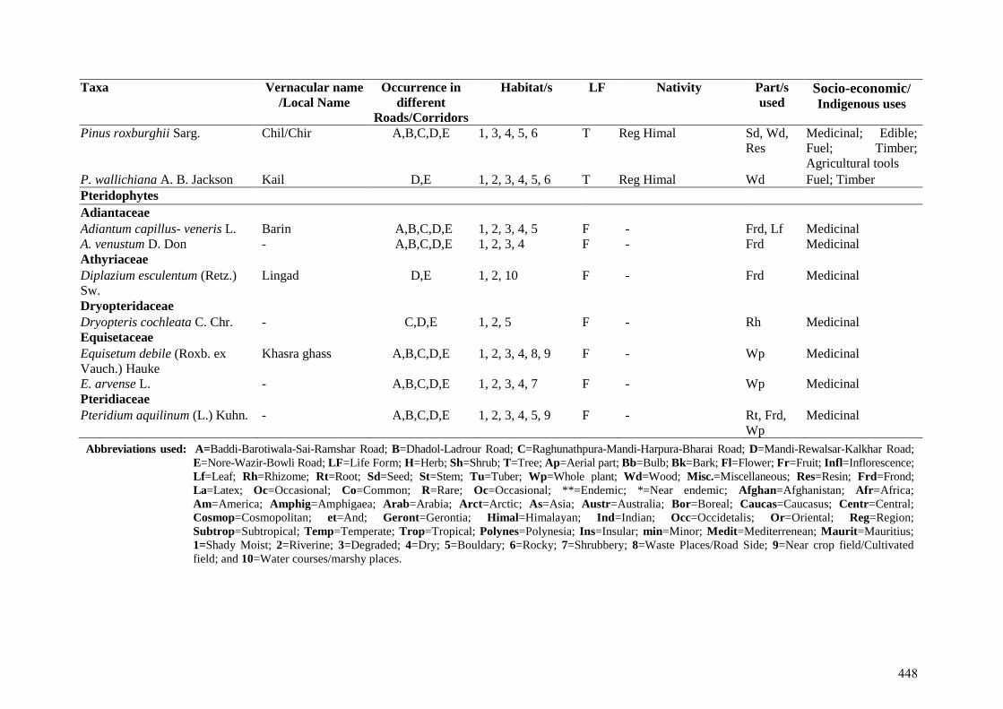
Taxa Vernacular name
/Local Name Occurrence in
different
Roads/Corridors
Habitat/s LF Nativity Part/s
used Socio-economic/ Indigenous uses
Pinus roxburghii Sarg. Chil/Chir A,B,C,D,E 1, 3, 4, 5, 6 T Reg Himal Sd, Wd,
Res
Medicinal; Edible;
Fuel; Timber;
Agricultural tools
P. wallichiana A. B. Jackson Kail D,E 1, 2, 3, 4, 5, 6 T Reg Himal Wd Fuel; Timber Pteridophytes Adiantaceae Adiantum capillus- veneris L. Barin A,B,C,D,E 1, 2, 3, 4, 5 F - Frd, Lf Medicinal A. venustum D. Don - A,B,C,D,E 1, 2, 3, 4 F - Frd Medicinal Athyriaceae Diplazium esculentum (Retz.)
Sw. Lingad D,E 1, 2, 10 F - Frd Medicinal
Dryopteridaceae Dryopteris cochleata C. Chr. - C,D,E 1, 2, 5 F - Rh Medicinal Equisetaceae Equisetum debile (Roxb. ex
Vauch.) Hauke Khasra ghass A,B,C,D,E 1, 2, 3, 4, 8, 9 F - Wp Medicinal
E. arvense L. - A,B,C,D,E 1, 2, 3, 4, 7 F - Wp Medicinal Pteridiaceae Pteridium aquilinum (L.) Kuhn. - A,B,C,D,E 1, 2, 3, 4, 5, 9 F - Rt, Frd,
Wp Medicinal
Abbreviations used: A=Baddi-Barotiwala-Sai-Ramshar Road; B=Dhadol-Ladrour Road; C=Raghunathpura-Mandi-Harpura-Bharai Road; D=Mandi-Rewalsar-Kalkhar Road;
E=Nore-Wazir-Bowli Road; LF=Life Form; H=Herb; Sh=Shrub; T=Tree; Ap=Aerial part; Bb=Bulb; Bk=Bark; Fl=Flower; Fr=Fruit; Infl=Inflorescence;
Lf=Leaf; Rh=Rhizome; Rt=Root; Sd=Seed; St=Stem; Tu=Tuber; Wp=Whole plant; Wd=Wood; Misc.=Miscellaneous; Res=Resin; Frd=Frond;
La=Latex; Oc=Occasional; Co=Common; R=Rare; Oc=Occasional; **=Endemic; *=Near endemic; Afghan=Afghanistan; Afr=Africa;
Am=America; Amphig=Amphigaea; Arab=Arabia; Arct=Arctic; As=Asia; Austr=Australia; Bor=Boreal; Caucas=Caucasus; Centr=Central;
Cosmop=Cosmopolitan; et=And; Geront=Gerontia; Himal=Himalayan; Ind=Indian; Occ=Occidetalis; Or=Oriental; Reg=Region;
Subtrop=Subtropical; Temp=Temperate; Trop=Tropical; Polynes=Polynesia; Ins=Insular; min=Minor; Medit=Mediterrenean; Maurit=Mauritius;
1=Shady Moist; 2=Riverine; 3=Degraded; 4=Dry; 5=Bouldary; 6=Rocky; 7=Shrubbery; 8=Waste Places/Road Side; 9=Near crop field/Cultivated
field; and 10=Water courses/marshy places.
448

Prepared By: PL Chauhan, I.F.S. (Retd.), SAGE HIMALAYA CONSULTANCY
Website: https://sagehimalaya.com/
449
APPENDIX-8
Village Wise Census & Socio-economic Profile of
Bilaspur District & PIA
450
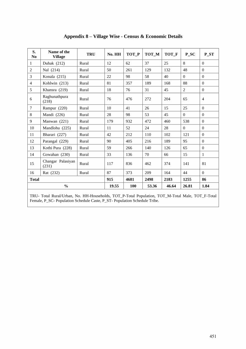
Appendix 8 – Village Wise - Census & Economic Details
S.
No
Name of the
Village TRU No. HH TOT_P TOT_M TOT_F P_SC P_ST
1 Duhak (212) Rural 12 62 37 25 8 0
2 Nal (214) Rural 50 261 129 132 48 0
3 Konala (215) Rural 22 98 58 40 0 0
4 Kohlwin (213) Rural 81 357 189 168 88 0
5 Khansra (219) Rural 18 76 31 45 2 0
6 Raghunathpura
(218) Rural 76 476 272 204 65 4
7 Rampur (220) Rural 10 41 26 15 25 0
8 Mandi (226) Rural 28 98 53 45 0 0
9 Manwan (221) Rural 179 932 472 460 538 0
10 Mandlohu (225) Rural 11 52 24 28 0 0
11 Bharari (227) Rural 42 212 110 102 121 0
12 Parangal (229) Rural 90 405 216 189 95 0
13 Kothi Pura (228) Rural 59 266 140 126 65 0
14 Gowahan (230) Rural 33 136 70 66 15 1
15 Changar Palasiyan
(231) Rural 117 836 462 374 141 81
16 Rat (232) Rural 87 373 209 164 44 0
Total 915 4681 2498 2183 1255 86
% 19.55 100 53.36 46.64 26.81 1.84
TRU- Total Rural/Urban, No. HH-Households, TOT_P-Total Population, TOT_M-Total Male, TOT_F-Total
Female, P_SC- Population Schedule Caste, P_ST- Population Schedule Tribe.
451
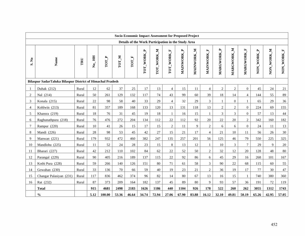
Socio Economic Impact Assessment for Proposed Project
Details of the Work Participation in the Study Area
S.
No
Na
me
TR
U
No
_ H
H
TO
T_
P
TO
T_
M
TO
T_
F
TO
T_
WO
RK
_P
TO
T_
WO
RK
_M
TO
T_
WO
RK
_F
MA
INW
OR
K_
P
MA
INW
OR
K_
M
MA
INW
OR
K_
F
MA
RG
WO
RK
_P
MA
RG
WO
RK
_M
MA
RG
WO
RK
_F
NO
N_
WO
RK
_P
NO
N_
WO
RK
_M
NO
N_
WO
RK
_F
Bilaspur SadarTaluka Bilaspur District of Himachal Pradesh
1 Duhak (212) Rural 12 62 37 25 17 13 4 15 11 4 2 2 0 45 24 21
2 Nal (214) Rural 50 261 129 132 117 74 43 99 60 39 18 14 4 144 55 89
3 Konala (215) Rural 22 98 58 40 33 29 4 32 29 3 1 0 1 65 29 36
4 Kohlwin (213) Rural 81 357 189 168 133 120 13 131 118 13 2 2 0 224 69 155
5 Khansra (219) Rural 18 76 31 45 19 18 1 16 15 1 3 3 0 57 13 44
6 Raghunathpura (218) Rural 76 476 272 204 134 112 22 112 92 20 22 20 2 342 160 182
7 Rampur (220) Rural 10 41 26 15 17 15 2 11 9 2 6 6 0 24 11 13
8 Mandi (226) Rural 28 98 53 45 42 27 15 21 17 4 21 10 11 56 26 30
9 Manwan (221) Rural 179 932 472 460 382 247 135 257 201 56 125 46 79 550 225 325
10 Mandlohu (225) Rural 11 52 24 28 23 15 8 13 12 1 10 3 7 29 9 20
11 Bharari (227) Rural 42 212 110 102 84 62 22 52 50 2 32 12 20 128 48 80
12 Parangal (229) Rural 90 405 216 189 137 115 22 92 86 6 45 29 16 268 101 167
13 Kothi Pura (228) Rural 59 266 140 126 151 80 71 61 58 3 90 22 68 115 60 55
14 Gowahan (230) Rural 33 136 70 66 59 40 19 23 21 2 36 19 17 77 30 47
15 Changar Palasiyan (231) Rural 117 836 462 374 96 82 14 80 67 13 16 15 1 740 380 360
16 Rat (232) Rural 87 373 209 164 182 137 45 89 80 9 93 57 36 191 72 119
Total 915 4681 2498 2183 1626 1186 440 1104 926 178 522 260 262 3055 1312 1743
% 5.12 100.00 53.36 46.64 34.74 72.94 27.06 67.90 83.88 16.12 32.10 49.81 50.19 65.26 42.95 57.05
452
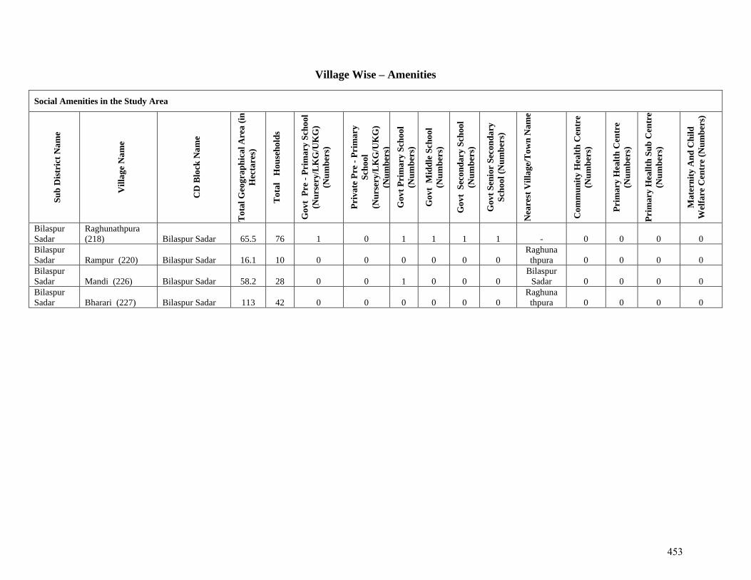
Village Wise – Amenities
Social Amenities in the Study Area
Su
b D
istr
ict
Na
me
Vil
lag
e N
am
e
CD
Blo
ck N
am
e
To
tal
Geo
gra
ph
ica
l A
rea
(in
Hec
tare
s)
To
tal
H
ou
seh
old
s
Go
vt
Pre
- P
rim
ary
Sch
oo
l
(Nu
rser
y/L
KG
/UK
G)
(Nu
mb
ers)
Pri
va
te P
re -
Pri
ma
ry
Sch
oo
l
(Nu
rser
y/L
KG
/UK
G)
(Nu
mb
ers)
Go
vt
Pri
ma
ry S
cho
ol
(Nu
mb
ers)
Go
vt
Mid
dle
Sch
oo
l
(Nu
mb
ers)
Go
vt
Sec
on
da
ry S
choo
l
(Nu
mb
ers)
Go
vt
Sen
ior
Sec
on
da
ry
Sch
oo
l (N
um
ber
s)
Nea
rest
Vil
lag
e/T
ow
n N
am
e
Co
mm
un
ity
Hea
lth
Cen
tre
(Nu
mb
ers)
Pri
ma
ry H
ealt
h C
entr
e
(Nu
mb
ers)
Pri
ma
ry H
eall
th S
ub
Cen
tre
(Nu
mb
ers)
Ma
tern
ity
An
d C
hil
d
Wel
fare
Cen
tre
(Nu
mb
ers)
Bilaspur
Sadar
Raghunathpura
(218) Bilaspur Sadar 65.5 76 1 0 1 1 1 1 - 0 0 0 0
Bilaspur
Sadar Rampur (220) Bilaspur Sadar 16.1 10 0 0 0 0 0 0
Raghuna
thpura 0 0 0 0
Bilaspur
Sadar Mandi (226) Bilaspur Sadar 58.2 28 0 0 1 0 0 0
Bilaspur
Sadar 0 0 0 0
Bilaspur
Sadar Bharari (227) Bilaspur Sadar 113 42 0 0 0 0 0 0
Raghuna
thpura 0 0 0 0
453
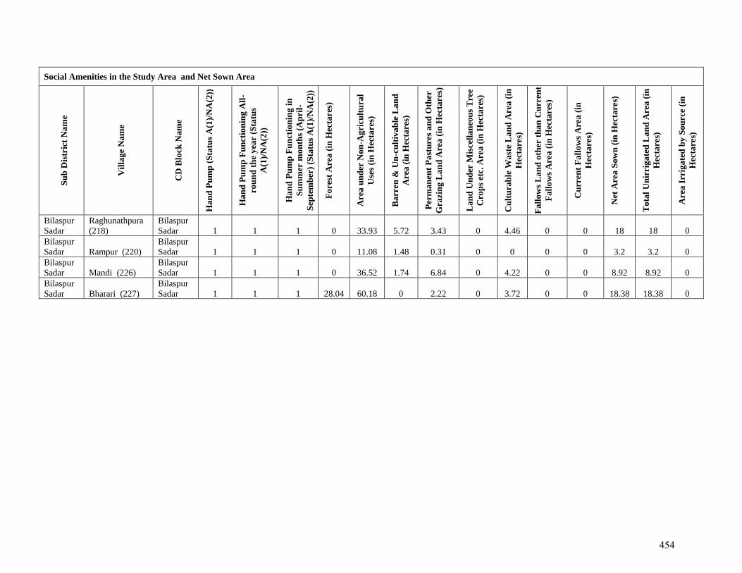
Social Amenities in the Study Area and Net Sown Area
Su
b D
istr
ict
Na
me
Vil
lag
e N
am
e
CD
Blo
ck N
am
e
Ha
nd
Pu
mp
(S
tatu
s A
(1)/
NA
(2))
Ha
nd
Pu
mp
Fu
nct
ion
ing
All
-
rou
nd
th
e y
ear
(Sta
tus
A(1
)/N
A(2
))
Ha
nd
Pu
mp
Fu
nct
ion
ing
in
Su
mm
er m
on
ths
(Ap
ril-
Sep
tem
ber
) (S
tatu
s A
(1)/
NA
(2))
Fo
rest
Are
a (
in H
ecta
res)
Are
a u
nd
er N
on
-Ag
ricu
ltu
ral
Use
s (i
n H
ecta
res)
Ba
rren
& U
n-c
ult
iva
ble
La
nd
Are
a (
in H
ecta
res)
Per
ma
nen
t P
ast
ure
s a
nd
Oth
er
Gra
zin
g L
an
d A
rea
(in
Hec
tare
s)
La
nd
Un
der
Mis
cell
an
eou
s T
ree
Cro
ps
etc.
Are
a (
in H
ecta
res)
Cu
ltu
rab
le W
ast
e L
an
d A
rea
(in
Hec
tare
s)
Fa
llo
ws
La
nd
oth
er t
ha
n C
urr
ent
Fa
llo
ws
Are
a (
in H
ecta
res)
Cu
rren
t F
all
ow
s A
rea
(in
Hec
tare
s)
Net
Are
a S
ow
n (
in H
ecta
res)
To
tal
Un
irri
ga
ted
La
nd
Are
a (
in
Hec
tare
s)
Are
a I
rrig
ate
d b
y S
ou
rce
(in
Hec
tare
s)
Bilaspur
Sadar
Raghunathpura
(218)
Bilaspur
Sadar 1 1 1 0 33.93 5.72 3.43 0 4.46 0 0 18 18 0
Bilaspur
Sadar Rampur (220)
Bilaspur
Sadar 1 1 1 0 11.08 1.48 0.31 0 0 0 0 3.2 3.2 0
Bilaspur
Sadar Mandi (226)
Bilaspur
Sadar 1 1 1 0 36.52 1.74 6.84 0 4.22 0 0 8.92 8.92 0
Bilaspur
Sadar Bharari (227)
Bilaspur
Sadar 1 1 1 28.04 60.18 0 2.22 0 3.72 0 0 18.38 18.38 0
454
APPENDIX-9
Welfare Schemes run by Govt. of India and Govt. of
Himachal Pradesh
455
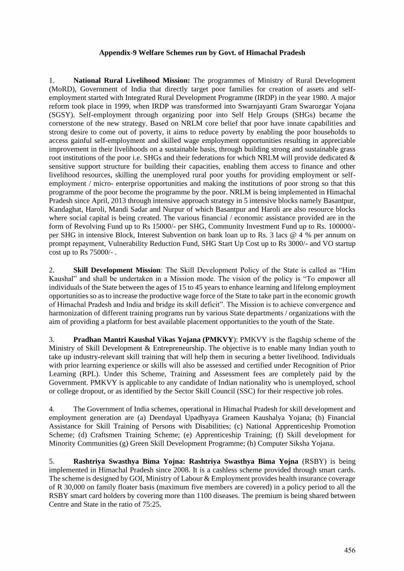
Appendix-9 Welfare Schemes run by Govt. of Himachal Pradesh
1. National Rural Livelihood Mission: The programmes of Ministry of Rural Development
(MoRD), Government of India that directly target poor families for creation of assets and self-
employment started with Integrated Rural Development Programme (IRDP) in the year 1980. A major
reform took place in 1999, when IRDP was transformed into Swarnjayanti Gram Swarozgar Yojana
(SGSY). Self-employment through organizing poor into Self Help Groups (SHGs) became the
cornerstone of the new strategy. Based on NRLM core belief that poor have innate capabilities and
strong desire to come out of poverty, it aims to reduce poverty by enabling the poor households to
access gainful self-employment and skilled wage employment opportunities resulting in appreciable
improvement in their livelihoods on a sustainable basis, through building strong and sustainable grass
root institutions of the poor i.e. SHGs and their federations for which NRLM will provide dedicated &
sensitive support structure for building their capacities, enabling them access to finance and other
livelihood resources, skilling the unemployed rural poor youths for providing employment or self-
employment / micro- enterprise opportunities and making the institutions of poor strong so that this
programme of the poor become the programme by the poor. NRLM is being implemented in Himachal
Pradesh since April, 2013 through intensive approach strategy in 5 intensive blocks namely Basantpur,
Kandaghat, Haroli, Mandi Sadar and Nurpur of which Basantpur and Haroli are also resource blocks
where social capital is being created. The various financial / economic assistance provided are in the
form of Revolving Fund up to Rs 15000/- per SHG, Community Investment Fund up to Rs. 100000/-
per SHG in intensive Block, Interest Subvention on bank loan up to Rs. 3 lacs @ 4 % per annum on
prompt repayment, Vulnerability Reduction Fund, SHG Start Up Cost up to Rs 3000/- and VO startup
cost up to Rs 75000/- .
2. Skill Development Mission: The Skill Development Policy of the State is called as “Him
Kaushal” and shall be undertaken in a Mission mode. The vision of the policy is “To empower all
individuals of the State between the ages of 15 to 45 years to enhance learning and lifelong employment
opportunities so as to increase the productive wage force of the State to take part in the economic growth
of Himachal Pradesh and India and bridge its skill deficit”. The Mission is to achieve convergence and
harmonization of different training programs run by various State departments / organizations with the
aim of providing a platform for best available placement opportunities to the youth of the State.
3. Pradhan Mantri Kaushal Vikas Yojana (PMKVY): PMKVY is the flagship scheme of the
Ministry of Skill Development & Entrepreneurship. The objective is to enable many Indian youth to
take up industry-relevant skill training that will help them in securing a better livelihood. Individuals
with prior learning experience or skills will also be assessed and certified under Recognition of Prior
Learning (RPL). Under this Scheme, Training and Assessment fees are completely paid by the
Government. PMKVY is applicable to any candidate of Indian nationality who is unemployed, school
or college dropout, or as identified by the Sector Skill Council (SSC) for their respective job roles.
4. The Government of India schemes, operational in Himachal Pradesh for skill development and
employment generation are (a) Deendayal Upadhyaya Grameen Kaushalya Yojana; (b) Financial
Assistance for Skill Training of Persons with Disabilities; (c) National Apprenticeship Promotion
Scheme; (d) Craftsmen Training Scheme; (e) Apprenticeship Training; (f) Skill development for
Minority Communities (g) Green Skill Development Programme; (h) Computer Siksha Yojana.
5. Rashtriya Swasthya Bima Yojna: Rashtriya Swasthya Bima Yojna (RSBY) is being
implemented in Himachal Pradesh since 2008. It is a cashless scheme provided through smart cards.
The scheme is designed by GOI, Ministry of Labour & Employment provides health insurance coverage
of R 30,000 on family floater basis (maximum five members are covered) in a policy period to all the
RSBY smart card holders by covering more than 1100 diseases. The premium is being shared between
Centre and State in the ratio of 75:25.
456
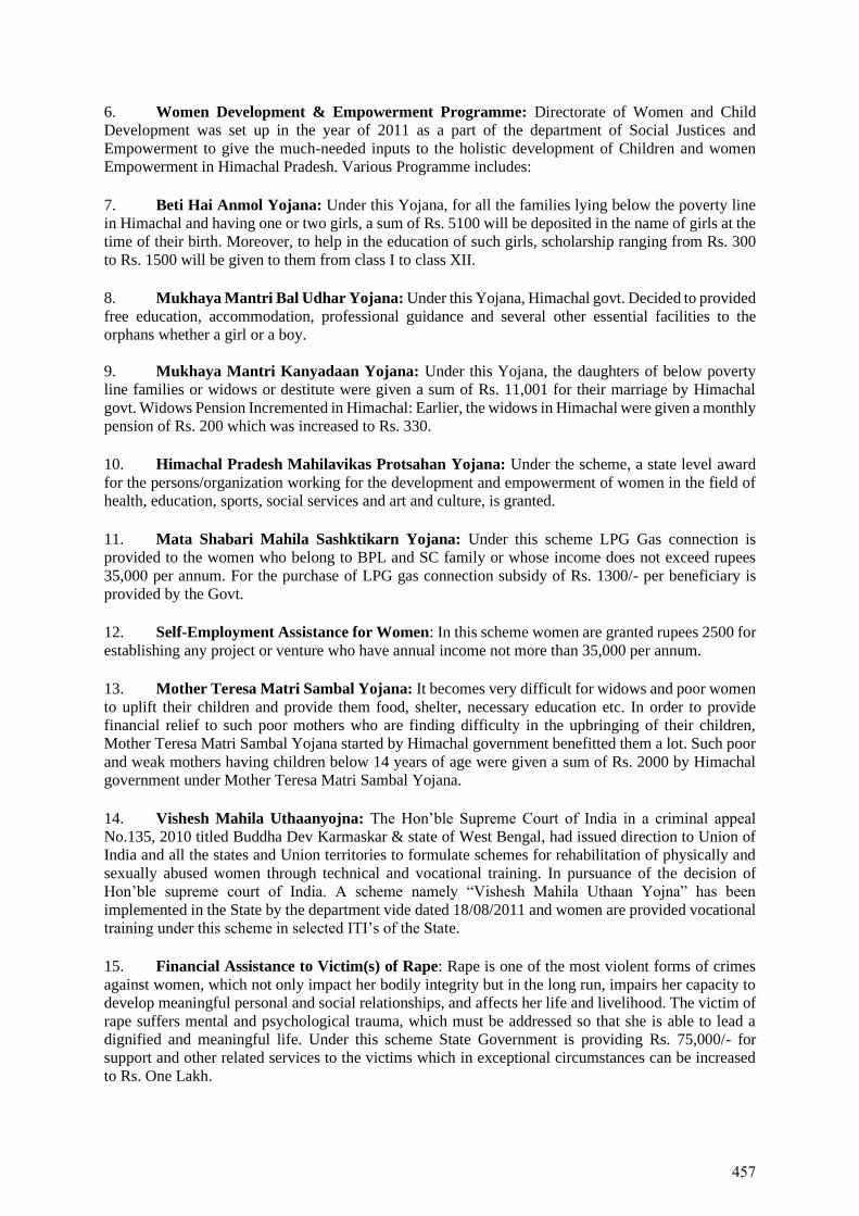
6. Women Development & Empowerment Programme: Directorate of Women and Child
Development was set up in the year of 2011 as a part of the department of Social Justices and
Empowerment to give the much-needed inputs to the holistic development of Children and women
Empowerment in Himachal Pradesh. Various Programme includes:
7. Beti Hai Anmol Yojana: Under this Yojana, for all the families lying below the poverty line
in Himachal and having one or two girls, a sum of Rs. 5100 will be deposited in the name of girls at the
time of their birth. Moreover, to help in the education of such girls, scholarship ranging from Rs. 300
to Rs. 1500 will be given to them from class I to class XII.
8. Mukhaya Mantri Bal Udhar Yojana: Under this Yojana, Himachal govt. Decided to provided
free education, accommodation, professional guidance and several other essential facilities to the
orphans whether a girl or a boy.
9. Mukhaya Mantri Kanyadaan Yojana: Under this Yojana, the daughters of below poverty
line families or widows or destitute were given a sum of Rs. 11,001 for their marriage by Himachal
govt. Widows Pension Incremented in Himachal: Earlier, the widows in Himachal were given a monthly
pension of Rs. 200 which was increased to Rs. 330.
10. Himachal Pradesh Mahilavikas Protsahan Yojana: Under the scheme, a state level award
for the persons/organization working for the development and empowerment of women in the field of
health, education, sports, social services and art and culture, is granted.
11. Mata Shabari Mahila Sashktikarn Yojana: Under this scheme LPG Gas connection is
provided to the women who belong to BPL and SC family or whose income does not exceed rupees
35,000 per annum. For the purchase of LPG gas connection subsidy of Rs. 1300/- per beneficiary is
provided by the Govt.
12. Self-Employment Assistance for Women: In this scheme women are granted rupees 2500 for
establishing any project or venture who have annual income not more than 35,000 per annum.
13. Mother Teresa Matri Sambal Yojana: It becomes very difficult for widows and poor women
to uplift their children and provide them food, shelter, necessary education etc. In order to provide
financial relief to such poor mothers who are finding difficulty in the upbringing of their children,
Mother Teresa Matri Sambal Yojana started by Himachal government benefitted them a lot. Such poor
and weak mothers having children below 14 years of age were given a sum of Rs. 2000 by Himachal
government under Mother Teresa Matri Sambal Yojana.
14. Vishesh Mahila Uthaanyojna: The Hon’ble Supreme Court of India in a criminal appeal
No.135, 2010 titled Buddha Dev Karmaskar & state of West Bengal, had issued direction to Union of
India and all the states and Union territories to formulate schemes for rehabilitation of physically and
sexually abused women through technical and vocational training. In pursuance of the decision of
Hon’ble supreme court of India. A scheme namely “Vishesh Mahila Uthaan Yojna” has been
implemented in the State by the department vide dated 18/08/2011 and women are provided vocational
training under this scheme in selected ITI’s of the State.
15. Financial Assistance to Victim(s) of Rape: Rape is one of the most violent forms of crimes
against women, which not only impact her bodily integrity but in the long run, impairs her capacity to
develop meaningful personal and social relationships, and affects her life and livelihood. The victim of
rape suffers mental and psychological trauma, which must be addressed so that she is able to lead a
dignified and meaningful life. Under this scheme State Government is providing Rs. 75,000/- for
support and other related services to the victims which in exceptional circumstances can be increased
to Rs. One Lakh.
457
16. Indira Gandhi Balika Suraksha Yojana: Under Indira Gandhi Balika Suraksha Yojana, the
families adopting the family planning after the birth of first female child will be given a sum of Rs.
25,000 and those adopting family planning after the birth of two female children will be given a cash
of Rs. 20,000 Himachal Pradesh government has always been industrious when it comes to women
empowerment or to provide services to the women. Yet moving a step ahead, health department of
Himachal Pradesh has launched a free of cost transportation service to the pregnant women to the
hospital for delivery. Either taxi or ambulance will be provided by the health department for carrying
the pregnant women to the nearest medical hospital. Under this scheme, pregnant women of any
category can avail this free transport facility to the hospitals for delivery. Another important feature of
this scheme is that the person accompanying the pregnant women will be allowed to enter inside the
labour room and build the confidence of pregnant women during delivery. Earlier only doctors were
allowed to enter the labour room and no relatives of the pregnant women. This will surely help to get
17. Widow Re-marriage Scheme: The objective of the scheme is to rehabilitate the widows and
under this scheme Rs. 50,000 will be provided as grant to widow(s) on her remarriage.
18. Rashtriya Mahila Kosh (RMK), established in 1993 is a national level organization as an
autonomous body under the aegis of the Ministry of Women and Child Development, for socio-
economic empowerment of women. The operating model currently followed by RMK is that of a
facilitating agency wherein RMK provides loans to NGO-MFIs termed as Intermediary Organizations
(IMO) which on-lend to Self Help Groups (SHGs) of women. RMK extends micro-credit to the women
in the informal sector through a client friendly, without collateral and in a hassle-free manner for income
generation activities. RMK has taken a number of promotional measures to popularize the concept of
micro financing, enterprise development, thrift and credit, formation and strengthening of Women-
SHGs through intermediary organizations.
458

APPENDIX-10
Schedule of Stakeholder’s Consultations,
Photographs and Attendance Sheets
459
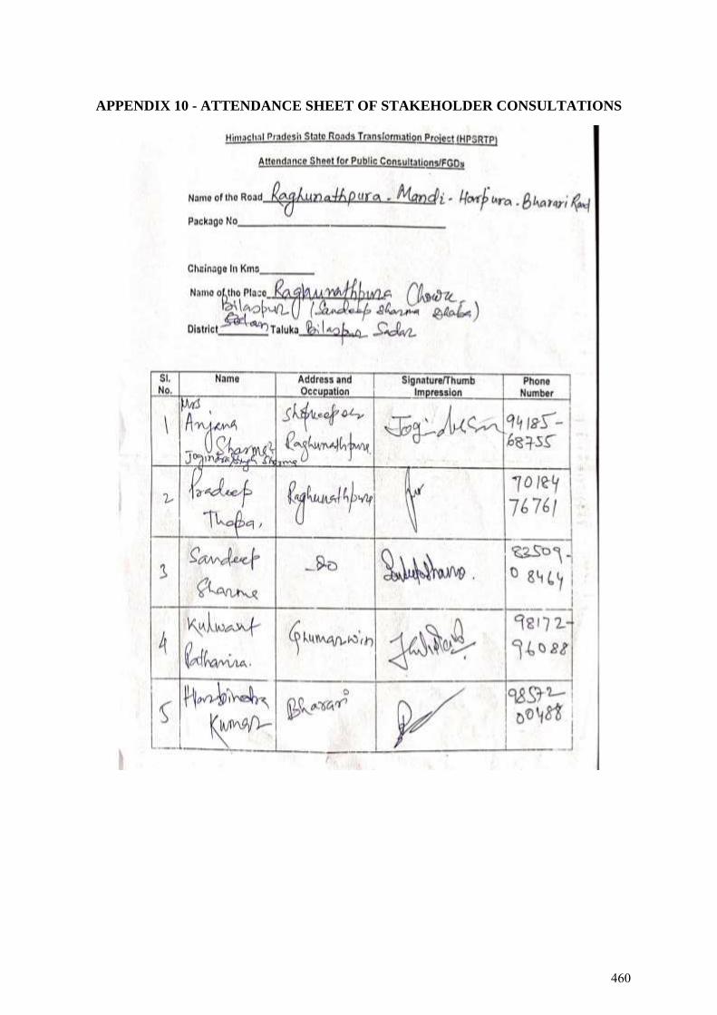
APPENDIX 10 - ATTENDANCE SHEET OF STAKEHOLDER CONSULTATIONS
460
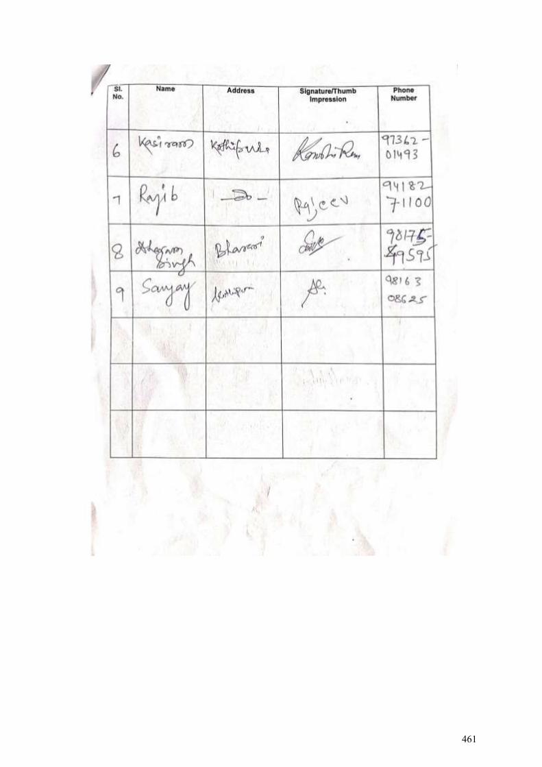
461
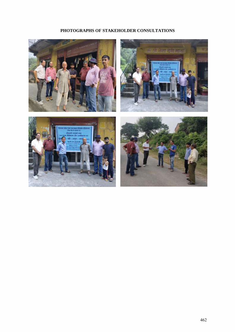
PHOTOGRAPHS OF STAKEHOLDER CONSULTATIONS
462
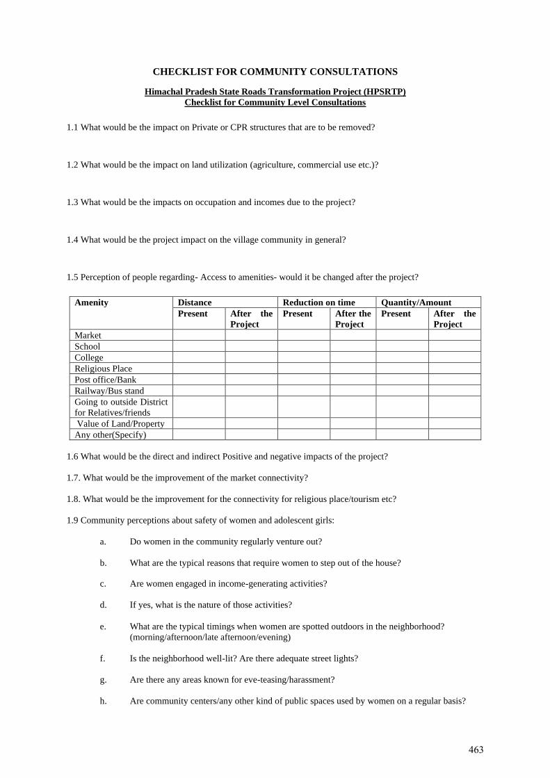
CHECKLIST FOR COMMUNITY CONSULTATIONS
Himachal Pradesh State Roads Transformation Project (HPSRTP)
Checklist for Community Level Consultations
1.1 What would be the impact on Private or CPR structures that are to be removed?
1.2 What would be the impact on land utilization (agriculture, commercial use etc.)?
1.3 What would be the impacts on occupation and incomes due to the project?
1.4 What would be the project impact on the village community in general?
1.5 Perception of people regarding- Access to amenities- would it be changed after the project?
Amenity Distance Reduction on time Quantity/Amount
Present After the
Project
Present After the
Project
Present After the
Project
Market
School
College
Religious Place
Post office/Bank
Railway/Bus stand
Going to outside District
for Relatives/friends
Value of Land/Property
Any other(Specify)
1.6 What would be the direct and indirect Positive and negative impacts of the project?
1.7. What would be the improvement of the market connectivity?
1.8. What would be the improvement for the connectivity for religious place/tourism etc?
1.9 Community perceptions about safety of women and adolescent girls:
a. Do women in the community regularly venture out?
b. What are the typical reasons that require women to step out of the house?
c. Are women engaged in income-generating activities?
d. If yes, what is the nature of those activities?
e. What are the typical timings when women are spotted outdoors in the neighborhood?
(morning/afternoon/late afternoon/evening)
f. Is the neighborhood well-lit? Are there adequate street lights?
g. Are there any areas known for eve-teasing/harassment?
h. Are community centers/any other kind of public spaces used by women on a regular basis?
463
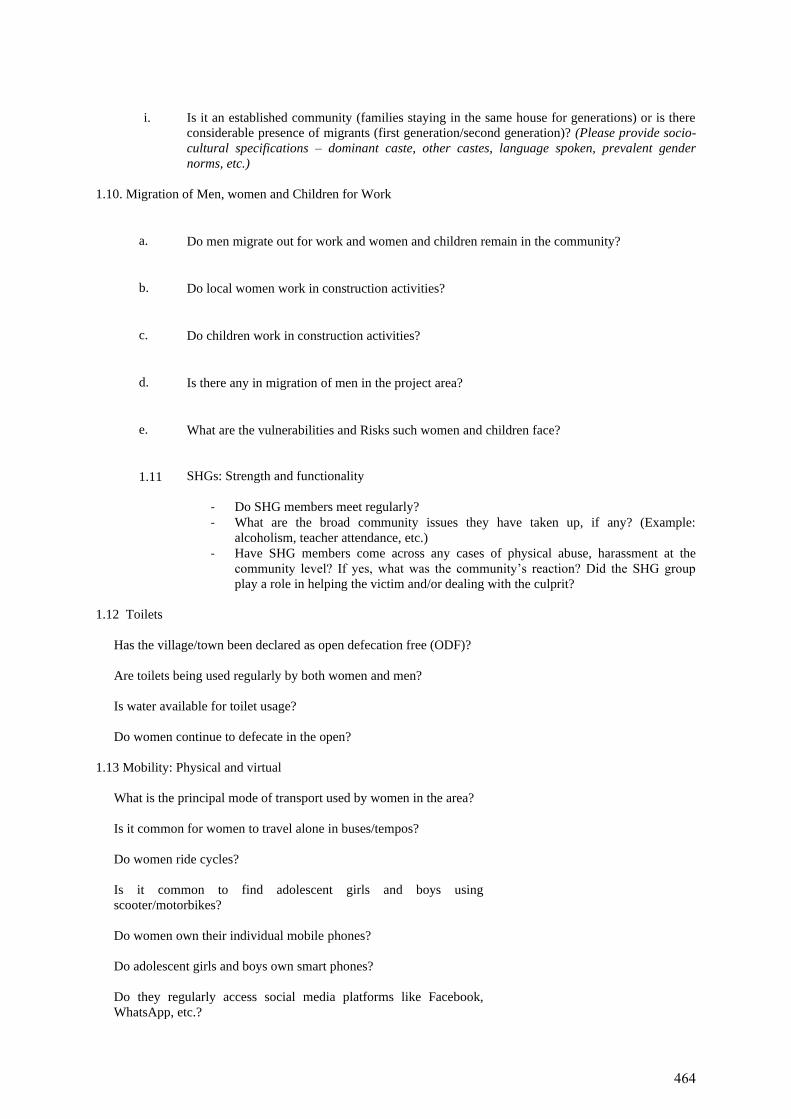
i. Is it an established community (families staying in the same house for generations) or is there
considerable presence of migrants (first generation/second generation)? (Please provide socio-
cultural specifications – dominant caste, other castes, language spoken, prevalent gender
norms, etc.)
1.10. Migration of Men, women and Children for Work
a. Do men migrate out for work and women and children remain in the community?
b. Do local women work in construction activities?
c. Do children work in construction activities?
d. Is there any in migration of men in the project area?
e. What are the vulnerabilities and Risks such women and children face?
1.11 SHGs: Strength and functionality
- Do SHG members meet regularly?
- What are the broad community issues they have taken up, if any? (Example:
alcoholism, teacher attendance, etc.)
- Have SHG members come across any cases of physical abuse, harassment at the
community level? If yes, what was the community’s reaction? Did the SHG group
play a role in helping the victim and/or dealing with the culprit?
1.12 Toilets
Has the village/town been declared as open defecation free (ODF)?
Are toilets being used regularly by both women and men?
Is water available for toilet usage?
Do women continue to defecate in the open?
1.13 Mobility: Physical and virtual
What is the principal mode of transport used by women in the area?
Is it common for women to travel alone in buses/tempos?
Do women ride cycles?
Is it common to find adolescent girls and boys using
scooter/motorbikes?
Do women own their individual mobile phones?
Do adolescent girls and boys own smart phones?
Do they regularly access social media platforms like Facebook,
WhatsApp, etc.?
464
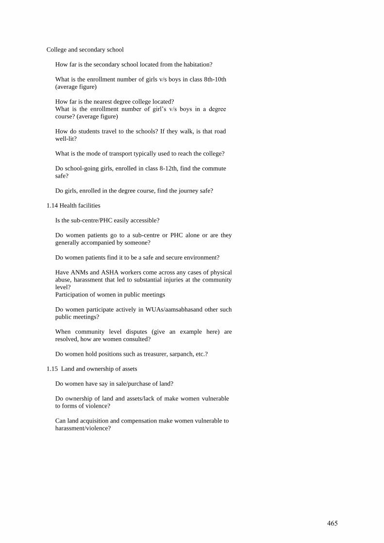
College and secondary school
How far is the secondary school located from the habitation?
What is the enrollment number of girls v/s boys in class 8th-10th
(average figure)
How far is the nearest degree college located?
What is the enrollment number of girl’s v/s boys in a degree
course? (average figure)
How do students travel to the schools? If they walk, is that road
well-lit?
What is the mode of transport typically used to reach the college?
Do school-going girls, enrolled in class 8-12th, find the commute
safe?
Do girls, enrolled in the degree course, find the journey safe?
1.14 Health facilities
Is the sub-centre/PHC easily accessible?
Do women patients go to a sub-centre or PHC alone or are they
generally accompanied by someone?
Do women patients find it to be a safe and secure environment?
Have ANMs and ASHA workers come across any cases of physical
abuse, harassment that led to substantial injuries at the community
level?
Participation of women in public meetings
Do women participate actively in WUAs/aamsabhasand other such
public meetings?
When community level disputes (give an example here) are
resolved, how are women consulted?
Do women hold positions such as treasurer, sarpanch, etc.?
1.15 Land and ownership of assets
Do women have say in sale/purchase of land?
Do ownership of land and assets/lack of make women vulnerable
to forms of violence?
Can land acquisition and compensation make women vulnerable to
harassment/violence?
465
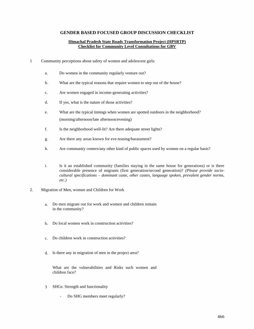
GENDER BASED FOCUSED GROUP DISCUSSION CHECKLIST
Himachal Pradesh State Roads Transformation Project (HPSRTP)
Checklist for Community Level Consultations for GBV
1 Community perceptions about safety of women and adolescent girls:
a. Do women in the community regularly venture out?
b. What are the typical reasons that require women to step out of the house?
c. Are women engaged in income-generating activities?
d. If yes, what is the nature of those activities?
e. What are the typical timings when women are spotted outdoors in the neighborhood?
(morning/afternoon/late afternoon/evening)
f. Is the neighborhood well-lit? Are there adequate street lights?
g. Are there any areas known for eve-teasing/harassment?
h. Are community centers/any other kind of public spaces used by women on a regular basis?
i. Is it an established community (families staying in the same house for generations) or is there
considerable presence of migrants (first generation/second generation)? (Please provide socio-
cultural specifications – dominant caste, other castes, language spoken, prevalent gender norms,
etc.)
2. Migration of Men, women and Children for Work
a. Do men migrate out for work and women and children remain
in the community?
b. Do local women work in construction activities?
c. Do children work in construction activities?
d. Is there any in migration of men in the project area?
What are the vulnerabilities and Risks such women and
children face?
3 SHGs: Strength and functionality
- Do SHG members meet regularly?
466
- What are the broad community issues they have
taken up, if any? (Example: alcoholism, teacher
attendance, etc.)
- Have SHG members come across any cases of
physical abuse, harassment at the community level?
If yes, what was the community’s reaction?
- Did the SHG group play a role in helping the victim
and/or dealing with the culprit?
4 Toilets
Has the village/town been declared as open defecation free
(ODF)?
Are toilets being used regularly by both women and men?
Is water available for toilet usage?
Do women continue to defecate in the open?
5 Mobility: Physical and virtual
What is the principal mode of transport used by women in the
area?
Is it common for women to travel alone in buses/tempos?
Do women ride cycles?
Is it common to find adolescent girls and boys using
scooter/motorbikes?
Do women own their individual mobile phones?
Do they regularly access social media platforms like Facebook,
WhatsApp, etc.?
College and secondary school
How far is the secondary school located from the habitation?
What is the enrollment number of girls v/s boys in class 8th-10th
(average figure)
How far is the nearest degree college located?
What is the enrollment number of girl’s v/s boys in a degree
course? (average figure)
How do students travel to the schools? If they walk, is that road
well-lit?
What is the mode of transport typically used to reach the
college?
Do school-going girls, enrolled in class 8-12th, find the commute
safe?
467
Do girls, enrolled in the degree course, find the journey safe?
6 Health facilities
Is the sub-centre/PHC easily accessible?
Do women patients go to a sub-centre or PHC alone or are they
generally accompanied by someone?
Do women patients find it to be a safe and secure environment?
Have ANMs and ASHA workers come across any cases of
physical abuse, harassment that led to substantial injuries at the
community level?
Participation of women in public meetings
Do women participate actively in WUAs/aamsabhas and other
such public meetings?
When community level disputes (give an example here) are
resolved, how are women consulted?
Do women hold positions such as treasurer, sarpanch, etc.?
7 Land and ownership of assets
Do women have say in sale/purchase of land?
Do ownership of land and assets/lack of make women
vulnerable to forms of violence?
Can land acquisition and compensation make women
vulnerable to harassment/violence?
468
APPENDIX-11
GoHP’s Strategy to Rehabilitate Areas Infested with
Invasive Alien Plant Species (Exotic Weeds) In
Himachal Pradesh
469
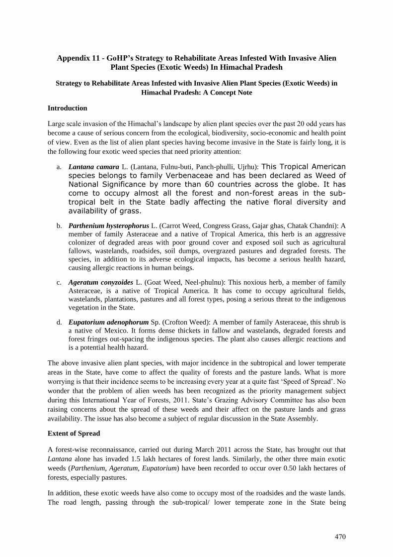
Appendix 11 - GoHP’s Strategy to Rehabilitate Areas Infested With Invasive Alien
Plant Species (Exotic Weeds) In Himachal Pradesh
Strategy to Rehabilitate Areas Infested with Invasive Alien Plant Species (Exotic Weeds) in
Himachal Pradesh: A Concept Note
Introduction
Large scale invasion of the Himachal’s landscape by alien plant species over the past 20 odd years has
become a cause of serious concern from the ecological, biodiversity, socio-economic and health point
of view. Even as the list of alien plant species having become invasive in the State is fairly long, it is
the following four exotic weed species that need priority attention:
a. Lantana camara L. (Lantana, Fulnu-buti, Panch-phulli, Ujrhu): This Tropical American
species belongs to family Verbenaceae and has been declared as Weed ofNational Significance by more than 60 countries across the globe. It hascome to occupy almost all the forest and non-forest areas in the sub-
tropical belt in the State badly affecting the native floral diversity andavailability of grass.
b. Parthenium hysterophorus L. (Carrot Weed, Congress Grass, Gajar ghas, Chatak Chandni): A
member of family Asteraceae and a native of Tropical America, this herb is an aggressive
colonizer of degraded areas with poor ground cover and exposed soil such as agricultural
fallows, wastelands, roadsides, soil dumps, overgrazed pastures and degraded forests. The
species, in addition to its adverse ecological impacts, has become a serious health hazard,
causing allergic reactions in human beings.
c. Ageratum conyzoides L. (Goat Weed, Neel-phulnu): This noxious herb, a member of family
Asteraceae, is a native of Tropical America. It has come to occupy agricultural fields,
wastelands, plantations, pastures and all forest types, posing a serious threat to the indigenous
vegetation in the State.
d. Eupatorium adenophorum Sp. (Crofton Weed): A member of family Asteraceae, this shrub is
a native of Mexico. It forms dense thickets in fallow and wastelands, degraded forests and
forest fringes out-spacing the indigenous species. The plant also causes allergic reactions and
is a potential health hazard.
The above invasive alien plant species, with major incidence in the subtropical and lower temperate
areas in the State, have come to affect the quality of forests and the pasture lands. What is more
worrying is that their incidence seems to be increasing every year at a quite fast ‘Speed of Spread’. No
wonder that the problem of alien weeds has been recognized as the priority management subject
during this International Year of Forests, 2011. State’s Grazing Advisory Committee has also been
raising concerns about the spread of these weeds and their affect on the pasture lands and grass
availability. The issue has also become a subject of regular discussion in the State Assembly.
Extent of Spread
A forest-wise reconnaissance, carried out during March 2011 across the State, has brought out that
Lantana alone has invaded 1.5 lakh hectares of forest lands. Similarly, the other three main exotic
weeds (Parthenium, Ageratum, Eupatorium) have been recorded to occur over 0.50 lakh hectares of
forests, especially pastures.
In addition, these exotic weeds have also come to occupy most of the roadsides and the waste lands.
The road length, passing through the sub-tropical/ lower temperate zone in the State being
470
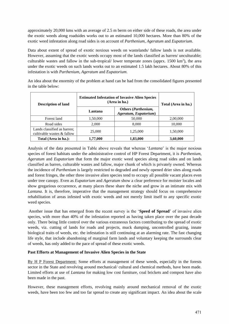
approximately 20,000 kms with an average of 2.5 m berm on either side of these roads, the area under
the exotic weeds along roadsides works out to an estimated 10,000 hectares. More than 80% of the
exotic weed infestation along road sides is on account of Parthenium, Ageratum and Eupatorium.
Data about extent of spread of exotic noxious weeds on wastelands/ fallow lands is not available.
However, assuming that the exotic weeds occupy most of the lands classified as barren/ unculturable;
culturable wastes and fallow in the sub-tropical/ lower temperate zones (apprx. 1500 km2), the area
under the exotic weeds on such lands works out to an estimated 1.5 lakh hectares. About 80% of this
infestation is with Parthenium, Ageratum and Eupatorium.
An idea about the enormity of the problem at hand can be had from the consolidated figures presented
in the table below:
Description of land
Estimated Infestation of Invasive Alien Species
(Area in ha.) Total (Area in ha.)
Lantana Others (Parthenium,
Ageratum, Eupatorium)
Forest land 1,50,000 50,000 2,00,000
Road sides 2,000 8,000 10,000
Lands classified as barren;
cultivable wastes & fallow 25,000 1,25,000 1,50,000
Total (Area in ha.): 1,77,000 1,83,000 3,60,000
Analysis of the data presented in Table above reveals that whereas ‘Lantana’ is the major noxious
species of forest habitats under the administrative control of HP Forest Department, it is Parthenium,
Ageratum and Eupatorium that form the major exotic weed species along road sides and on lands
classified as barren, culturable wastes and fallow, major chunk of which is privately owned. Whereas
the incidence of Parthenium is largely restricted to degraded and newly opened drier sites along roads
and forest fringes, the other three invasive alien species tend to occupy all possible vacant places even
under tree canopy. Even as Eupatorium and Ageratum show a clear preference for moister locales and
show gregarious occurrence, at many places these share the niche and grow in an intimate mix with
Lantana. It is, therefore, imperative that the management strategy should focus on comprehensive
rehabilitation of areas infested with exotic weeds and not merely limit itself to any specific exotic
weed species.
Another issue that has emerged from the recent survey is the ‘Speed of Spread’ of invasive alien
species, with more than 40% of the infestation reported as having taken place over the past decade
only. There being little control over the various extraneous factors contributing to the spread of exotic
weeds, viz. cutting of lands for roads and projects, muck dumping, uncontrolled grazing, innate
biological traits of weeds, etc. the infestation is still continuing at an alarming rate. The fast changing
life style, that include abandoning of marginal farm lands and voluntary keeping the surrounds clear
of weeds, has only added to the pace of spread of these exotic weeds.
Past Efforts at Management of Invasive Alien Species in the State
By H P Forest Department: Some efforts at management of these weeds, especially in the forests
sector in the State and revolving around mechanical/ cultural and chemical methods, have been made.
Limited efforts at use of Lantana for making low cost furniture, coal brickets and compost have also
been made in the past.
However, these management efforts, revolving mainly around mechanical removal of the exotic
weeds, have been too few and too far spread to create any significant impact. An idea about the scale
471
of intervention can be had from the fact that over the past three years, only about 1,700 hectare of
forest area has been tackled under the weed management program.
Moreover, these efforts were largely taken up as one time interventions at weed removal and were not
focused on rehabilitation of the treated area. Most of the past efforts have not yielded desired results
due to lack of focus on long-term follow up system.
Chemical methods (involving mainly application of glyphosate) at control of Lantana/ Parthenium
were abandoned after initial trials due to concerns about their adverse environmental implications.
Associating Lantana removal to use has also not found favour with the local communities, the
outputs/ returns from using cut Lantana for furniture, bricketting or composting being not considered
commensurate with the effort required for its use.
By Other Organisations: The Himachal Pradesh Agriculture University has been working to develop
successful models of managing exotic weeds. It has also been, around Palampur, spearheading
Parthenium eradication campaigns in association with educational institutions and civil society
organisations. However, these campaigns have been too limited to create large scale impact.
Major learning from the past efforts at eradication of invasive alien plant species is that such efforts
need to be integrated with rehabilitation of treated areas and should be of long-term duration for
effective results.
Strategy for Management of Invasive Alien Species on Forest Lands
A two-day workshop was organized by the Himachal Pradesh Forest Department at Sundernagar on
22-23 April 2011 with a view to come out with the following broad outputs –
1) documentation of species-wise/ forest-wise spread of major exotic weed species
2) documentation and review of the past efforts at weed management
3) emergence of a comprehensive strategy to rehabilitate the areas infested with the major weed
species
The workshop was attended by the subject matter experts from within and outside Himachal Pradesh,
forest managers, researchers, academicians, representatives of line departments and representatives of
Civil Society Organisations. The workshop was inaugurated by Mr. Vinay Tandon, Pr. Chief
Conservator of Forests, Himcahal Pradesh. Prof. R. K. Kohli, Chairman Botany Department, Punjab
University and IUFRO Chair on Invasive Alien Species delivered the Key Note address. The highlight
of the technical sessions was forest Circle-wise presentations by the Conservators of Forests, giving
detailed status of exotic weeds on forest lands in their respective circles. The invited subject matter
experts included Prof. N N Angiras (KV, Palampur), Prof. M K Seth (HPU, Shimla), Dr. S S Samant
(G B Pant Institute, Mohal) and Dr. Kuldip Dogra (Research Fellow), who shared their experience
related to the status and management strategies of exotic weeds. Mr. Santosh Kumar, Conservator of
Forests, Chandigarh presented a case study about successful Lantana management interventions in
Sukhna Wildlife Sanctuary. Dr. Anjan Kalia (representing CSO, Palampur) shared his perspective
regarding the need to undertake eradication of Parthenium through ‘people’s movement’.
The two day deliberations on the issue resulted in the emergence of a draft strategy for management
of exotic weeds in the State, highlights of which are presented below:
472
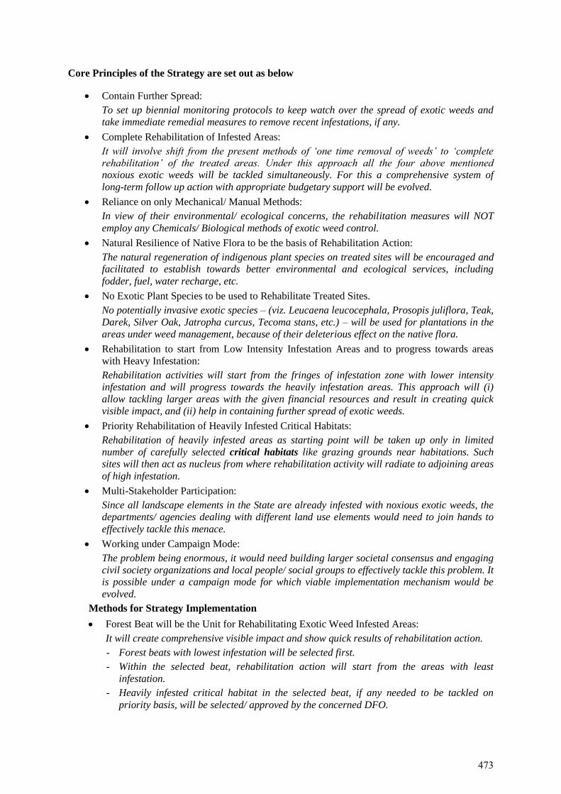
Core Principles of the Strategy are set out as below
• Contain Further Spread:
To set up biennial monitoring protocols to keep watch over the spread of exotic weeds and
take immediate remedial measures to remove recent infestations, if any.
• Complete Rehabilitation of Infested Areas:
It will involve shift from the present methods of ‘one time removal of weeds’ to ‘complete
rehabilitation’ of the treated areas. Under this approach all the four above mentioned
noxious exotic weeds will be tackled simultaneously. For this a comprehensive system of
long-term follow up action with appropriate budgetary support will be evolved.
• Reliance on only Mechanical/ Manual Methods:
In view of their environmental/ ecological concerns, the rehabilitation measures will NOT
employ any Chemicals/ Biological methods of exotic weed control.
• Natural Resilience of Native Flora to be the basis of Rehabilitation Action:
The natural regeneration of indigenous plant species on treated sites will be encouraged and
facilitated to establish towards better environmental and ecological services, including
fodder, fuel, water recharge, etc.
• No Exotic Plant Species to be used to Rehabilitate Treated Sites.
No potentially invasive exotic species – (viz. Leucaena leucocephala, Prosopis juliflora, Teak,
Darek, Silver Oak, Jatropha curcus, Tecoma stans, etc.) – will be used for plantations in the
areas under weed management, because of their deleterious effect on the native flora.
• Rehabilitation to start from Low Intensity Infestation Areas and to progress towards areas
with Heavy Infestation:
Rehabilitation activities will start from the fringes of infestation zone with lower intensity
infestation and will progress towards the heavily infestation areas. This approach will (i)
allow tackling larger areas with the given financial resources and result in creating quick
visible impact, and (ii) help in containing further spread of exotic weeds.
• Priority Rehabilitation of Heavily Infested Critical Habitats:
Rehabilitation of heavily infested areas as starting point will be taken up only in limited
number of carefully selected critical habitats like grazing grounds near habitations. Such
sites will then act as nucleus from where rehabilitation activity will radiate to adjoining areas
of high infestation.
• Multi-Stakeholder Participation:
Since all landscape elements in the State are already infested with noxious exotic weeds, the
departments/ agencies dealing with different land use elements would need to join hands to
effectively tackle this menace.
• Working under Campaign Mode:
The problem being enormous, it would need building larger societal consensus and engaging
civil society organizations and local people/ social groups to effectively tackle this problem. It
is possible under a campaign mode for which viable implementation mechanism would be
evolved.
Methods for Strategy Implementation
• Forest Beat will be the Unit for Rehabilitating Exotic Weed Infested Areas:
It will create comprehensive visible impact and show quick results of rehabilitation action.
- Forest beats with lowest infestation will be selected first.
- Within the selected beat, rehabilitation action will start from the areas with least
infestation.
- Heavily infested critical habitat in the selected beat, if any needed to be tackled on
priority basis, will be selected/ approved by the concerned DFO.
473
- Financial resources available for the purpose under various schemes will be converged
to rehabilitate all areas under the selected beat in the shortest possible time.
• All Noxious Exotic Weed Species will be Tackled Simultaneously:
All the noxious exotic weeds will be tackled simultaneously on the selected area to ensure
complete rehabilitation of the infested areas.
• Method of Removing Exotic Weeds will be as under:
The invasive plant species will be removed by employing only mechanical/ manual methods,
as given below:
- Lantana will be cut by using Cut Root Stock (CRS) method i.e. cutting the bushes below
the soil to prevent coppicing (Annexure-II).
- Other exotic weeds will be uprooted/ cut along the ground.
• The following will be standardized for effective implementation of exotic weed management
initiative:
- Cutting tools/ techniques
- Calendar of rehabilitation activities
- Cost models
• A three year intensive maintenance of the treated areas and periodic follow up (every 3
years?) thereafter will form integral part of the rehabilitation program till the areas gets fully
rehabilitated.
• Local people, through existing community groups, will be actively engaged to participate in
rehabilitation of exotic weed infested areas.
Funding Options
The State Forest Department will explore funding possibilities for this initiative under State CAMPA/
NPV funds; Centrally Sponsored Schemes (‘Control & Eradication of Forest Invasive Species’ under
Intensification of Forest Management Program); Regular Departmental Plantation Schemes; and
MNREGA.
State CAMPA/ NPV: An initial allocation for rehabilitation of 1000 hectares per year under State
CAMPA/ NPV funds has already been made.
CAT Plans: Rehabilitation of areas infested with invasive alien plant species also forms integral part
of some of the CAT Plans (e.g. UHL Stage-III). There is a need to work out the total areas to be
tackled for the purpose under various CAT Plans in the State to know the total extent of areas being
tackled under this budget head.
MNREGA: This scheme offers a great potential for management of exotic weed infested areas.
However, there are certain issues that need to be sorted out for achieving effective results. The major
issues being (a) inclusion of exotic weed removal as integral part of the Panchayat’s annual
development agenda, (b) making available able bodied registered beneficiaries at right time of the
year to handle this strenuous work, often away from the habitations (c) incorporation of nursery
raising as one of the approved activities under the scheme, (d) provision for at least three year
maintenance of the treated areas.
Management of Invasive Alien Species on Non-Forest Lands
As already brought out, a large chunk of non-forest land mass in the State is also facing increasing
invasion of alien plant species. The situation is especially severe along road sides and waste lands/
fallow lands where heavy infestation by noxious exotic weeds has not only resulted in reduction in the
traditional grazing grounds but has also become a cause of serious health hazard.
474
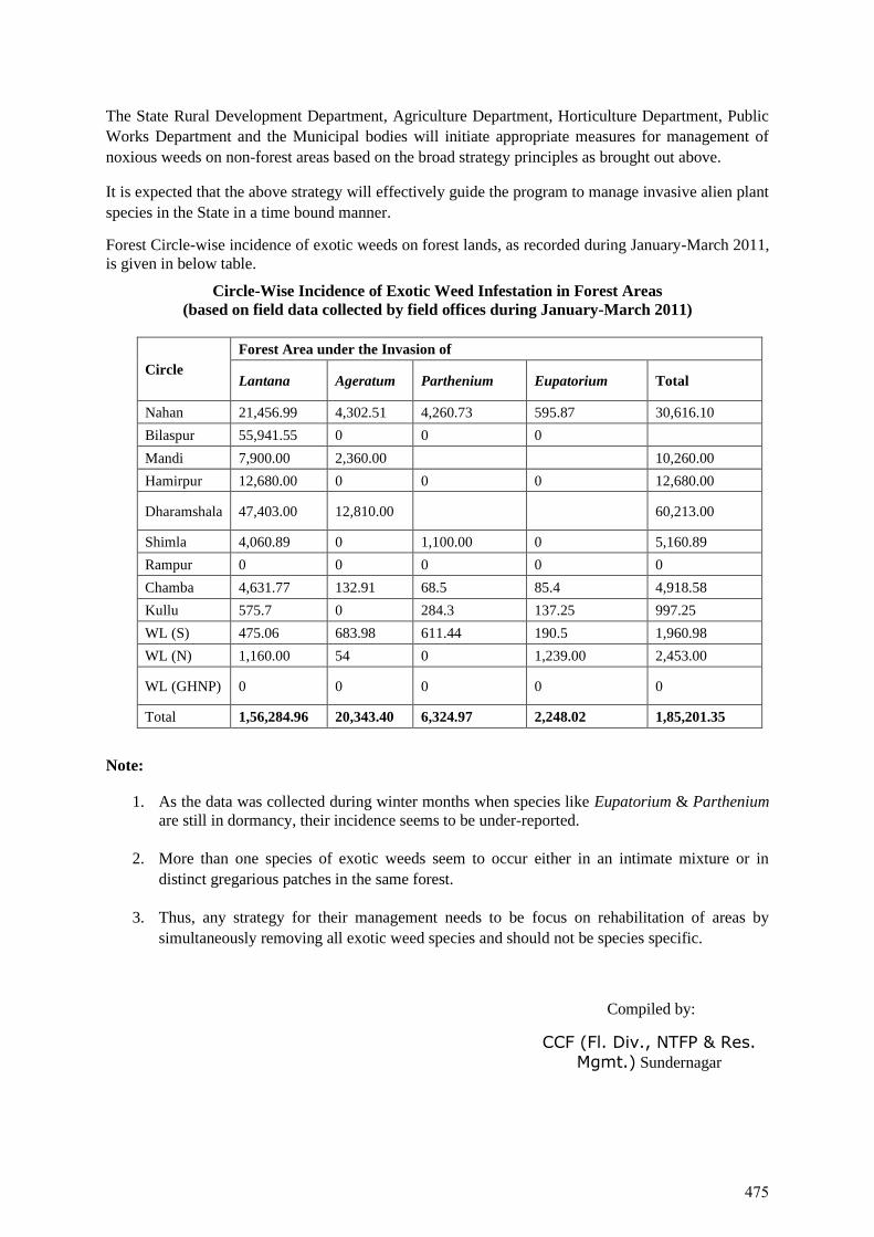
The State Rural Development Department, Agriculture Department, Horticulture Department, Public
Works Department and the Municipal bodies will initiate appropriate measures for management of
noxious weeds on non-forest areas based on the broad strategy principles as brought out above.
It is expected that the above strategy will effectively guide the program to manage invasive alien plant
species in the State in a time bound manner.
Forest Circle-wise incidence of exotic weeds on forest lands, as recorded during January-March 2011,
is given in below table.
Circle-Wise Incidence of Exotic Weed Infestation in Forest Areas
(based on field data collected by field offices during January-March 2011)
Circle
Forest Area under the Invasion of
Lantana Ageratum Parthenium Eupatorium Total
Nahan 21,456.99 4,302.51 4,260.73 595.87 30,616.10
Bilaspur 55,941.55 0 0 0
Mandi 7,900.00 2,360.00 10,260.00
Hamirpur 12,680.00 0 0 0 12,680.00
Dharamshala 47,403.00 12,810.00 60,213.00
Shimla 4,060.89 0 1,100.00 0 5,160.89
Rampur 0 0 0 0 0
Chamba 4,631.77 132.91 68.5 85.4 4,918.58
Kullu 575.7 0 284.3 137.25 997.25
WL (S) 475.06 683.98 611.44 190.5 1,960.98
WL (N) 1,160.00 54 0 1,239.00 2,453.00
WL (GHNP) 0 0 0 0 0
Total 1,56,284.96 20,343.40 6,324.97 2,248.02 1,85,201.35
Note:
1. As the data was collected during winter months when species like Eupatorium & Parthenium
are still in dormancy, their incidence seems to be under-reported.
2. More than one species of exotic weeds seem to occur either in an intimate mixture or in
distinct gregarious patches in the same forest.
3. Thus, any strategy for their management needs to be focus on rehabilitation of areas by
simultaneously removing all exotic weed species and should not be species specific.
Compiled by:
CCF (Fl. Div., NTFP & Res.
Mgmt.) Sundernagar
475
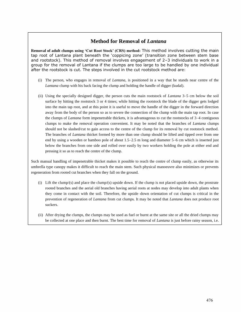
Method for Removal of Lantana
Removal of adult clumps using ‘Cut Root Stock’ (CRS) method: This method involves cutting the main
tap root of Lantana plant beneath the ‘coppicing zone’ (transition zone between stem base
and rootstock). This method of removal involves engagement of 2–3 individuals to work in a
group for the removal of Lantana if the clumps are too large to be handled by one individual
after the rootstock is cut. The steps involved in the cut rootstock method are:
(i) The person, who engages in removal of Lantana, is positioned in a way that he stands near centre of the
Lantana clump with his back facing the clump and holding the handle of digger (kudal).
(ii) Using the specially designed digger, the person cuts the main rootstock of Lantana 3–5 cm below the soil
surface by hitting the rootstock 3 or 4 times; while hitting the rootstock the blade of the digger gets lodged
into the main tap root, and at this point it is useful to move the handle of the digger in the forward direction
away from the body of the person so as to severe the connection of the clump with the main tap root. In case
the clumps of Lantana form impenetrable thickets, it is advantageous to cut the rootstocks of 3–4 contiguous
clumps to make the removal operation convenient. It may be noted that the branches of Lantana clumps
should not be slashed/cut to gain access to the centre of the clump for its removal by cut rootstock method.
The branches of Lantana thicket formed by more than one clump should be lifted and tipped over from one
end by using a wooden or bamboo pole of about 1.5–2.5 m long and diameter 5–6 cm which is inserted just
below the branches from one side and rolled over easily by two workers holding the pole at either end and
pressing it so as to reach the centre of the clump.
Such manual handling of impenetrable thicket makes it possible to reach the centre of clump easily, as otherwise its
umbrella type canopy makes it difficult to reach the main stem. Such physical manoeuvre also minimizes or prevents
regeneration from rooted cut branches when they fall on the ground.
(i) Lift the clump/(s) and place the clump/(s) upside down. If the clump is not placed upside down, the prostrate
rooted branches and the aerial old branches having aerial roots at nodes may develop into adult plants when
they come in contact with the soil. Therefore, the upside–down orientation of cut clumps is critical in the
prevention of regeneration of Lantana from cut clumps. It may be noted that Lantana does not produce root
suckers.
(ii) After drying the clumps, the clumps may be used as fuel or burnt at the same site or all the dried clumps may
be collected at one place and then burnt. The best time for removal of Lantana is just before rainy season, i.e.
when the plants are not in flowering and fruiting.
476

APPENDIX-12
Census and Socio-Economic Questionnaires
477
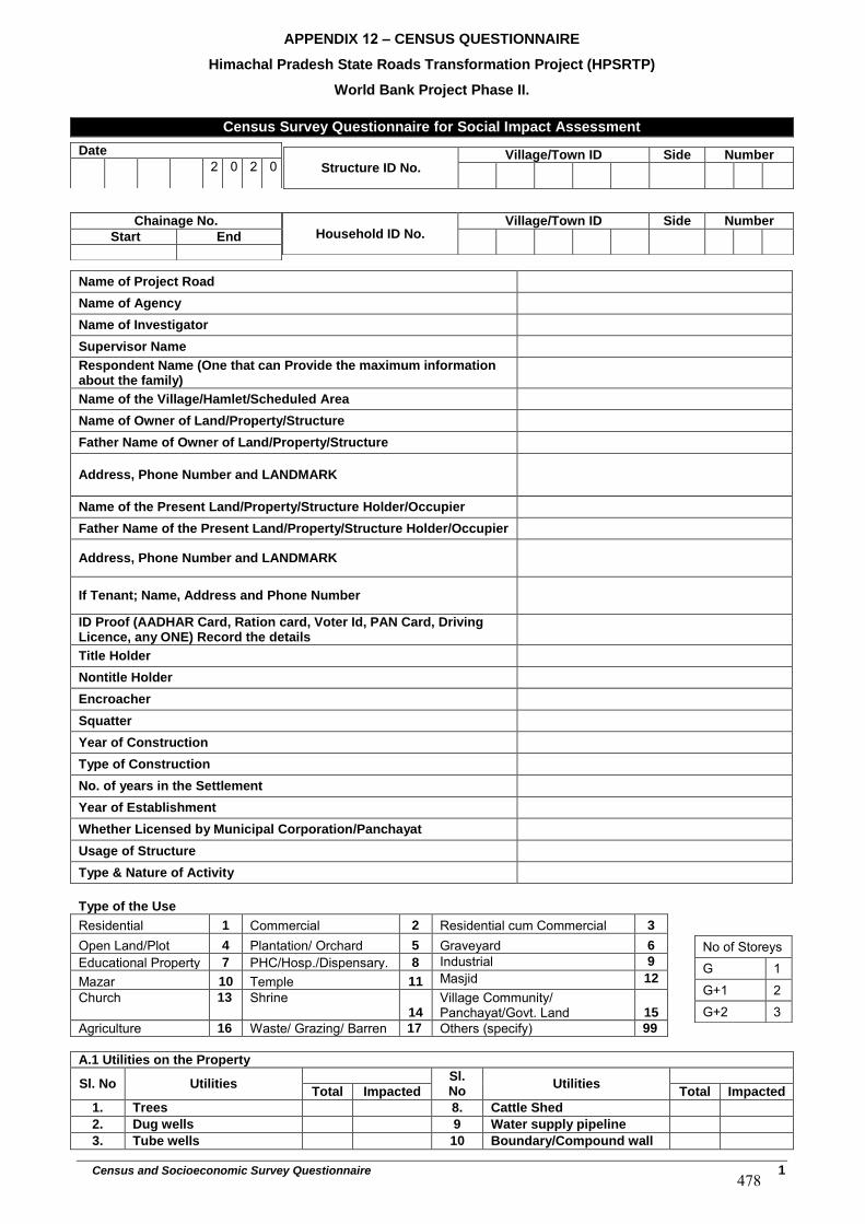
APPENDIX 12 – CENSUS QUESTIONNAIRE
Himachal Pradesh State Roads Transformation Project (HPSRTP)
World Bank Project Phase II.
Census and Socioeconomic Survey Questionnaire 1
Census Survey Questionnaire for Social Impact Assessment
Name of Project Road
Name of Agency
Name of Investigator
Supervisor Name
Respondent Name (One that can Provide the maximum information about the family)
Name of the Village/Hamlet/Scheduled Area
Name of Owner of Land/Property/Structure
Father Name of Owner of Land/Property/Structure
Address, Phone Number and LANDMARK
Name of the Present Land/Property/Structure Holder/Occupier
Father Name of the Present Land/Property/Structure Holder/Occupier
Address, Phone Number and LANDMARK
If Tenant; Name, Address and Phone Number
ID Proof (AADHAR Card, Ration card, Voter Id, PAN Card, Driving Licence, any ONE) Record the details
Title Holder
Nontitle Holder
Encroacher
Squatter
Year of Construction
Type of Construction
No. of years in the Settlement
Year of Establishment
Whether Licensed by Municipal Corporation/Panchayat
Usage of Structure
Type & Nature of Activity
Type of the Use
Residential 1 Commercial 2 Residential cum Commercial 3
Open Land/Plot 4 Plantation/ Orchard 5 Graveyard 6
Educational Property 7 PHC/Hosp./Dispensary. 8 Industrial 9
Mazar 10 Temple 11 Masjid 12
Church 13 Shrine 14
Village Community/ Panchayat/Govt. Land 15
Agriculture 16 Waste/ Grazing/ Barren 17 Others (specify) 99
A.1 Utilities on the Property
Sl. No Utilities Sl. No
Utilities Total Impacted Total Impacted
1. Trees 8. Cattle Shed
2. Dug wells 9 Water supply pipeline
3. Tube wells 10 Boundary/Compound wall
Structure ID No. Village/Town ID Side Number Date
2 0 2 0
Chainage No.
Start End Household ID No. Village/Town ID Side Number
No of Storeys G 1 G+1 2 G+2 3
478
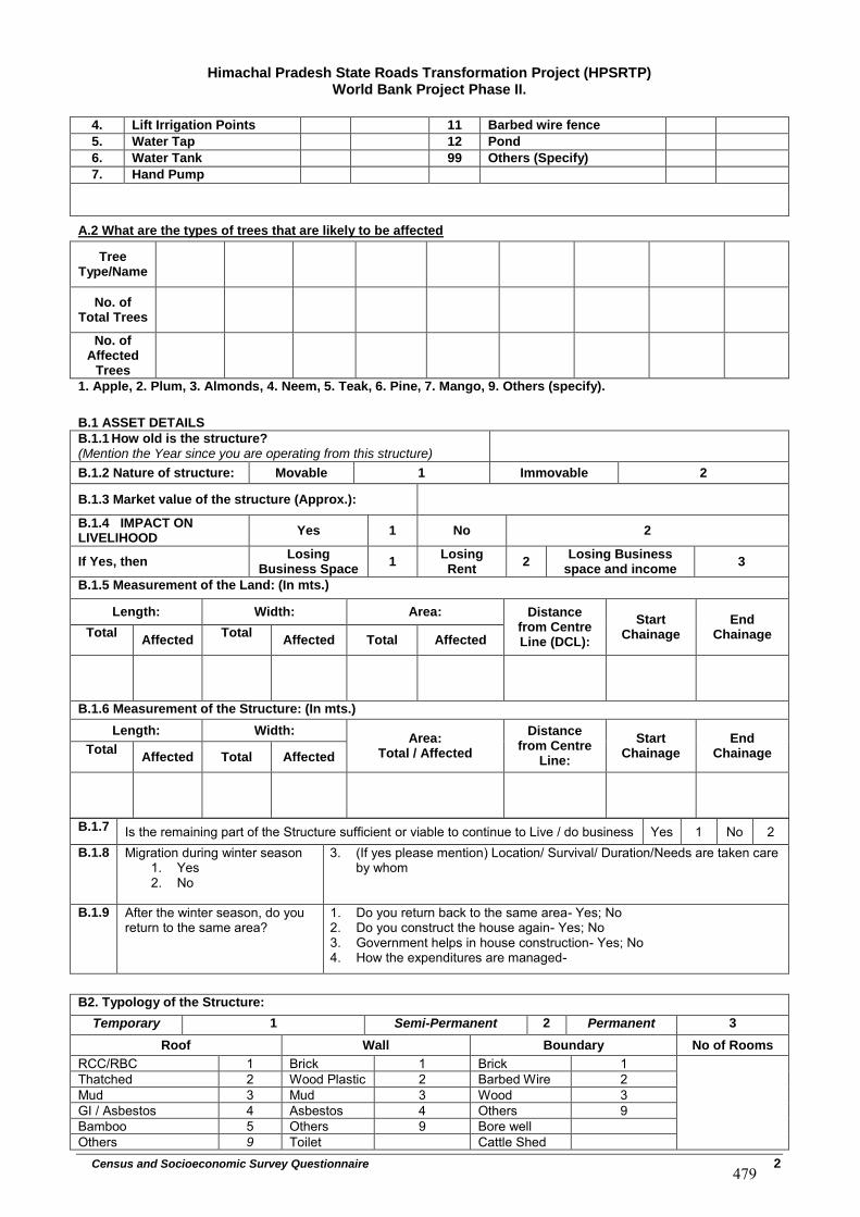
Himachal Pradesh State Roads Transformation Project (HPSRTP) World Bank Project Phase II.
Census and Socioeconomic Survey Questionnaire 2
4. Lift Irrigation Points 11 Barbed wire fence
5. Water Tap 12 Pond
6. Water Tank 99 Others (Specify)
7. Hand Pump
A.2 What are the types of trees that are likely to be affected
Tree Type/Name
No. of Total Trees
No. of Affected
Trees
1. Apple, 2. Plum, 3. Almonds, 4. Neem, 5. Teak, 6. Pine, 7. Mango, 9. Others (specify).
B.1 ASSET DETAILS
B.1.1 How old is the structure? (Mention the Year since you are operating from this structure)
B.1.2 Nature of structure: Movable 1 Immovable 2
B.1.3 Market value of the structure (Approx.):
B.1.4 IMPACT ON LIVELIHOOD
Yes 1 No 2
If Yes, then Losing
Business Space 1
Losing Rent
2 Losing Business
space and income 3
B.1.5 Measurement of the Land: (In mts.)
Length: Width: Area: Distance from Centre Line (DCL):
Start Chainage
End Chainage Total
Affected Total
Affected Total Affected
B.1.6 Measurement of the Structure: (In mts.)
Length: Width: Area:
Total / Affected
Distance from Centre
Line:
Start Chainage
End Chainage Total
Affected Total Affected
B.1.7 Is the remaining part of the Structure sufficient or viable to continue to Live / do business Yes 1 No 2 B.1.8 Migration during winter season
1. Yes2. No
3. (If yes please mention) Location/ Survival/ Duration/Needs are taken careby whom
B.1.9 After the winter season, do you return to the same area?
1. Do you return back to the same area- Yes; No2. Do you construct the house again- Yes; No3. Government helps in house construction- Yes; No4. How the expenditures are managed-
B2. Typology of the Structure:
Temporary 1 Semi-Permanent 2 Permanent 3
Roof Wall Boundary No of Rooms
RCC/RBC 1 Brick 1 Brick 1 Thatched 2 Wood Plastic 2 Barbed Wire 2 Mud 3 Mud 3 Wood 3 GI / Asbestos 4 Asbestos 4 Others 9 Bamboo 5 Others 9 Bore well Others 9 Toilet Cattle Shed
479
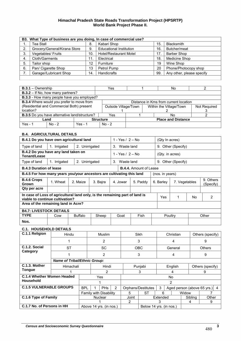
Himachal Pradesh State Roads Transformation Project (HPSRTP) World Bank Project Phase II.
Census and Socioeconomic Survey Questionnaire 3
B.4. AGRICULTURAL DETAILS
B.4.1 Do you have own agricultural land 1 - Yes / 2 – No (Qty In acres)
Type of land 1. Irrigated 2. Unirrigated 3. Waste land 9. Other (Specify)B.4.2 Do you have any land taken on Tenant/Lease
1 - Yes / 2 – No (Qty. in acres)
Type of land 1. Irrigated 2. Unirrigated 3. Waste land 9. Other (Specify)
B.4.3 Duration of lease B.4.4. Amount of LeaseB.4.5 For how many years you/your ancestors are cultivating this land (nos. in years) B.4.6 Crops Grown
1. Wheat 2. Maize 3. Bajra 4. Jowar 5. Paddy 6. Barley 7. Vegetables 9. Others(Specify)
Qty per acre
In case of Loss of agricultural land only, is the remaining part of land is viable to continue cultivation?
Yes 1 No 2
Area of the remaining land in Acre?
B4.7: LIVESTOCK DETAILS
TYPE Cow Buffalo Sheep Goat Fish Poultry Other Nos.
C.1. HOUSEHOLD DETAILS
C.1.1 Religion Hindu Muslim Sikh Christian Others (specify)
1 2 3 4 9 C.1.2. Social Category
ST SC OBC General Others
1 2 3 4 9 Name of Tribal/Ethnic Group:
C.1.3. Mother Tongue
Himachali Hindi Punjabi English Others (specify) 1 2 3 4 9
C.1.4 Whether Women Headed Household
Yes No 1 2
C.1.5 VULNERABLE GROUPS BPL 1 PHs 2 Orphans/Destitutes 3 Aged person (above 65 yrs.) 4 Family with Disability 5 ST 6 Widow 7
C.1.6 Type of Family Nuclear Joint Extended Sibling Other 1 2 3 4 9
C.1.7 No. of Persons in HH Above 14 yrs. (in nos.) Below 14 yrs. (in nos.)
B3. What Type of business are you doing, In case of commercial use?
1. Tea Stall 8. Kabari Shop 15. Blacksmith2. Grocery/General/Kirana Store 9. Educational Institution 16. Butcher/meat3. Vegetables/ Fruits 10. Hotel/Restaurant Motel 17. Barber Shop4. Cloth/Garments 11. Electrical 18. Medicine Shop5. Tailor shop 12 Furniture 19 Wine Shop 6. Pan/ Cigarette Shop 13 Petrol Pump 20 Phone/Photocopy shop 7. Garage//Lubricant Shop 14. Handicrafts 99. Any other, please specify
B.3.1 – Ownership Yes 1 No 2 B.3.2 – If No, how many partners? B.3.3 - How many people have you employed? B.3.4 Where would you prefer to move from (Residential and Commercial Both) present location?
Distance in Kms from current location Outside Village/Town
1 Within the Village/Town
2 Not Required
3 B.3.5 Do you have alternative land/structure? Yes 1 No 2
Land Structure Place and Distance
Yes - 1 No - 2 Yes - 1 No - 2
480
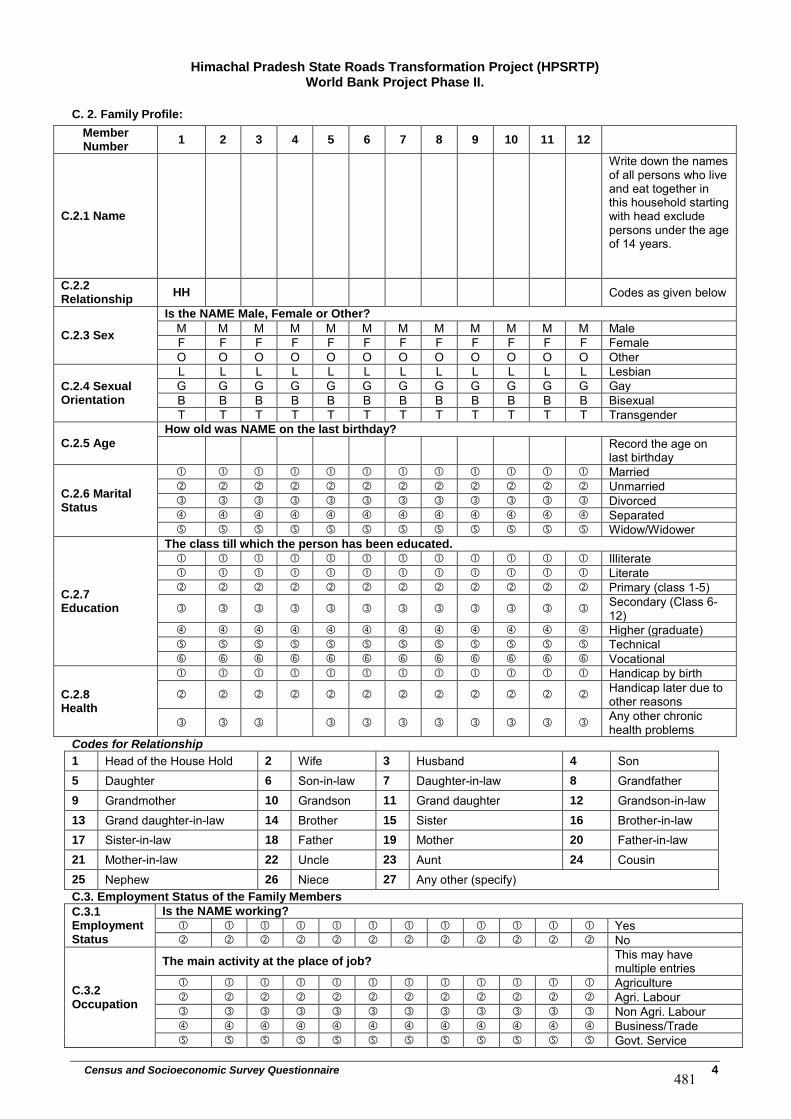
Himachal Pradesh State Roads Transformation Project (HPSRTP) World Bank Project Phase II.
Census and Socioeconomic Survey Questionnaire 4
C. 2. Family Profile:
Member Number
1 2 3 4 5 6 7 8 9 10 11 12
C.2.1 Name
Write down the names of all persons who live and eat together in this household starting with head exclude persons under the age of 14 years.
C.2.2 Relationship
HH Codes as given below
C.2.3 Sex
Is the NAME Male, Female or Other?
M M M M M M M M M M M M Male F F F F F F F F F F F F Female O O O O O O O O O O O O Other
C.2.4 Sexual Orientation
L L L L L L L L L L L L Lesbian G G G G G G G G G G G G Gay B B B B B B B B B B B B Bisexual T T T T T T T T T T T T Transgender
C.2.5 Age
How old was NAME on the last birthday?
Record the age on last birthday
C.2.6 Marital Status
Married Unmarried Divorced Separated Widow/Widower
C.2.7 Education
The class till which the person has been educated.
Illiterate Literate Primary (class 1-5)
Secondary (Class 6-12)
Higher (graduate) Technical Vocational
C.2.8 Health
Handicap by birth
Handicap later due to other reasons
Any other chronic health problems
Codes for Relationship
1 Head of the House Hold 2 Wife 3 Husband 4 Son 5 Daughter 6 Son-in-law 7 Daughter-in-law 8 Grandfather 9 Grandmother 10 Grandson 11 Grand daughter 12 Grandson-in-law 13 Grand daughter-in-law 14 Brother 15 Sister 16 Brother-in-law 17 Sister-in-law 18 Father 19 Mother 20 Father-in-law 21 Mother-in-law 22 Uncle 23 Aunt 24 Cousin 25 Nephew 26 Niece 27 Any other (specify) C.3. Employment Status of the Family Members
C.3.1 Employment Status
Is the NAME working?
Yes No
C.3.2 Occupation
The main activity at the place of job? This may have multiple entries
Agriculture Agri. Labour Non Agri. Labour Business/Trade Govt. Service
481
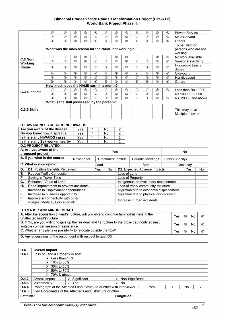
Himachal Pradesh State Roads Transformation Project (HPSRTP) World Bank Project Phase II.
Census and Socioeconomic Survey Questionnaire 5
Private Service Maid Servant Others
C.3.Non-Working Status
What was the main reason for the NAME not working? To be filled for persons who are not working.
No work available Seasonal inactivity
Household family duties
Old/young Handicapped Others
C.3.4 Income
How much does the NAME earn in a month?
Less than Rs.10000 Rs.10000 - 20000 Rs. 20000 and above
C.3.5 Skills
What is the skill possessed by the person?
This may have Multiple answers
D.1 AWARENESS REGARDING HIV/AIDS
Are you aware of the disease Yes 1 No 2 Do you know how it spreads Yes 1 No 2 Is there any HIV/AIDS cases Yes 1 No 2 Is there any Sex-worker nearby Yes 1 No 2 D.2 PROJECT RELATED
A. Are you aware of the proposed project
Yes No
B. If yes what is the source Newspaper Brochures/Leaflets Periodic Meetings Other (Specify) C. What is your opinion Good Bad Can’t say
D. D1. Positive Benefits Perceived Yes No D2. Expected Adverse Impacts Yes No E. Reduce Traffic Congestion Loss of Land F. Saving in Travel Time Loss of Property G. Enhanced Value of Land Indigenous or Involuntary resettlement H. Road Improvement to prevent accidents Loss of trees/ community structure I. Increase in Employment opportunities Migration due to economic displacement J. Increase in business opportunity Migration due to physical displacement K. Improve in connectivity with other
villages, Medical, Education etc. Increase in road accidents
D.3 MAJOR AND MINOR IMPACT
A. After the acquisition of land/structure, will you able to continue faming/business in the unaffected land/structure Yes No
B. If No, are you willing to give up the residual land / structure to the project authority against suitable compensession or assistance Yes No
C. Whether any plans or possibility to relocate outside the RoW Yes No
D. Any sugessions of the respondent with respect to que. D3.
D.4 Overall Impact
D.4.1 Loss of Land & Property or both Less than 10% 10% to 30% 30% to 50% 50% to 70% 70% & above
D.4.2 Overall Impact Significant Non-SignificantD.4.3 Vulnerability Yes NoD.4.4 Photograph of the Affected Land, Structure or other with interviewer Yes 1 No 2 D.4.5 Geo Coordinates of the Affected Land, Structure or other Latitude: Longitude:
482
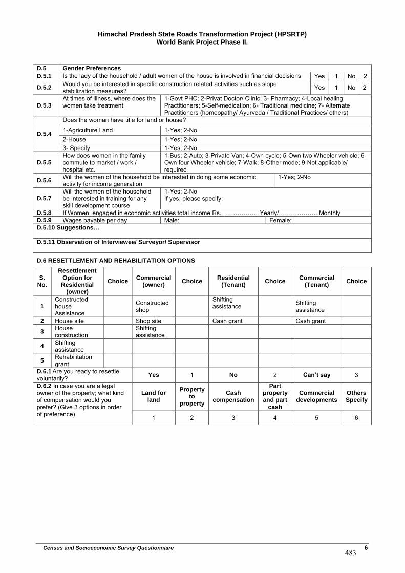
Himachal Pradesh State Roads Transformation Project (HPSRTP) World Bank Project Phase II.
Census and Socioeconomic Survey Questionnaire 6
D.5 Gender Preferences
D.5.1 Is the lady of the household / adult women of the house is involved in financial decisions Yes 1 No 2
D.5.2Would you be interested in specific construction related activities such as slope stabilization measures? Yes 1 No 2
D.5.3At times of illness, where does the women take treatment
1-Govt PHC; 2-Privat Doctor/ Clinic; 3- Pharmacy; 4-Local healing Practitioners; 5-Self-medication; 6- Traditional medicine; 7- Alternate Practitioners (homeopathy/ Ayurveda / Traditional Practices/ others)
D.5.4
Does the woman have title for land or house? 1-Agriculture Land 1-Yes; 2-No 2-House 1-Yes; 2-No 3- Specify 1-Yes; 2-No
D.5.5How does women in the family commute to market / work / hospital etc.
1-Bus; 2-Auto; 3-Private Van; 4-Own cycle; 5-Own two Wheeler vehicle; 6-Own four Wheeler vehicle; 7-Walk; 8-Other mode; 9-Not applicable/ required
D.5.6Will the women of the household be interested in doing some economic activity for income generation
1-Yes; 2-No
D.5.7Will the women of the household be interested in training for any skill development course
1-Yes; 2-No If yes, please specify:
D.5.8 If Women, engaged in economic activities total income Rs. ………………Yearly/………………..Monthly
D.5.9 Wages payable per day Male: Female: D.5.10 Suggestions…
D.5.11 Observation of Interviewee/ Surveyor/ Supervisor
D.6 RESETTLEMENT AND REHABILITATION OPTIONS
S. No.
Resettlement Option for Residential
(owner)
Choice Commercial
(owner) Choice
Residential (Tenant)
Choice Commercial
(Tenant) Choice
1 Constructed house Assistance
Constructed shop
Shifting assistance Shifting
assistance
2 House site Shop site Cash grant Cash grant
3 House construction
Shifting assistance
4 Shifting assistance
5 Rehabilitation grant
D.6.1 Are you ready to resettle voluntarily? Yes 1 No 2 Can’t say 3
D.6.2 In case you are a legal owner of the property; what kind of compensation would you prefer? (Give 3 options in order of preference)
Land for land
Property to
property
Cash compensation
Part property and part
cash
Commercial developments
Others Specify
1 2 3 4 5 6
483
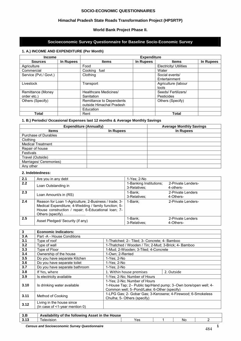
SOCIO-ECONOMIC QUESTIONNAIRES
Himachal Pradesh State Roads Transformation Project (HPSRTP)
World Bank Project Phase II.
Census and Socioeconomic Survey Questionnaire 1
Socioeconomic Survey Questionnaire for Baseline Socio-Economic Survey
1. A.) INCOME AND EXPENDITURE (Per Month)
Income Expenditure
Sources In Rupees Items In Rupees Items In Rupees
Agriculture Food Electricity/ Utilities Commercial Cooking fuel Water Service (Pvt./ Govt.) Clothing Social events/
Entertainment Livestock Transport Agriculture (labour
tools Remittance (Money order etc.)
Healthcare Medicines/ Sanitation
Seeds/ Fertilizers/ Pesticides
Others (Specify) Remittance to Dependents outside Himachal Pradesh
Others (Specify)
Education Total Rent Total
1. B.) Periodic/ Occasional Expenses last 12 months & Average Monthly Savings
Expenditure (Annually) Average Monthly Savings
Items In Rupees In Rupees
Purchase of Durables Clothing Medical Treatment Repair of house Festivals Travel (Outside) Marriages/ Ceremonies) Any other
2. Indebtedness:
2.1 Are you in any debt 1-Yes; 2-No 2.2 Loan Outstanding in 1-Banking Institutions; 2-Private Lenders-
3-Relatives; 4-others- 2.3 Loan Amount/s in (RS) 1-Bank; 2-Private Lenders
3-Relatives; 4-Others- 2.4 Reason for Loan 1-Agriculture; 2-Business / trade; 3-
Medical Expenditure; 4-Wedding / family function; 5- House construction / repair; 6-Educational loan; 7- Others (specify)……………….
1-Bank; 2-Private Lenders-
2.5 Asset Pledged/ Security (if any) 1-Bank; 2-Private Lenders 3-Relatives; 4-Others-
3 Economic Indicators:
3.A Part -A - House Conditions 3.1 Type of roof 1-Thatched; 2– Tiled; 3- Concrete; 4- Bamboo 3.2 Type of wall 1-Thatched / Wooden / Tin; 2-Mud; 3-Brick; 4- Bamboo 3.3 Type of Floor 1-Mud; 2-Wooden; 3-Tiled; 4-Concrete 3.4 Ownership of the house 1-Own; 2-Rented 3.5 Do you have separate Kitchen 1-Yes; 2-No 3.6 Do you have separate toilet 1-Yes; 2-No 3.7 Do you have separate bathroom 1-Yes; 2-No 3.8 If Yes, where 1. Within house premises 2. Outside3.9 Is electricity available 1-Yes; 2-No; Number of Hours
3.10 Is drinking water available 1-Yes; 2-No; Number of Hours 1-House Tap; 2– Public tap/Hand pump; 3–Own bore/open well; 4- Common well; 5–Pond/Lake; 6-Other (specify)
3.11 Method of Cooking 1-LPG Gas; 2- Gobar Gas; 3-Kerosene; 4-Firewood; 6-Smokeless Chulha; 5- Others (specify)
3.12Living in the house since (In case of <1-year mention 0)
3.B Availability of the following Asset in the House
3.13 Television Yes 1 No 2
484
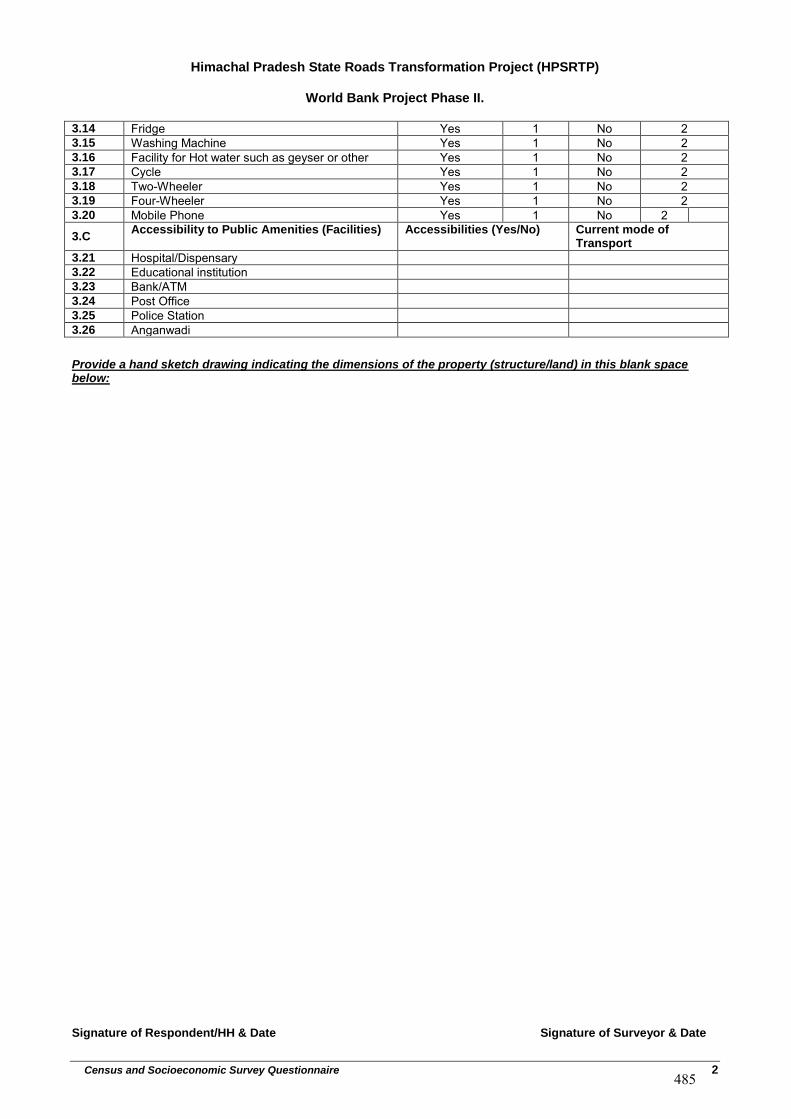
Himachal Pradesh State Roads Transformation Project (HPSRTP)
World Bank Project Phase II.
Census and Socioeconomic Survey Questionnaire 2
3.14 Fridge Yes 1 No 2 3.15 Washing Machine Yes 1 No 2 3.16 Facility for Hot water such as geyser or other Yes 1 No 2 3.17 Cycle Yes 1 No 2 3.18 Two-Wheeler Yes 1 No 2 3.19 Four-Wheeler Yes 1 No 2 3.20 Mobile Phone Yes 1 No 2
3.CAccessibility to Public Amenities (Facilities) Accessibilities (Yes/No) Current mode of
Transport
3.21 Hospital/Dispensary 3.22 Educational institution 3.23 Bank/ATM 3.24 Post Office 3.25 Police Station 3.26 Anganwadi
Provide a hand sketch drawing indicating the dimensions of the property (structure/land) in this blank space below:
Signature of Respondent/HH & Date Signature of Surveyor & Date
485
APPENDIX-13
Typical Provision of Aprons at CD Location
486
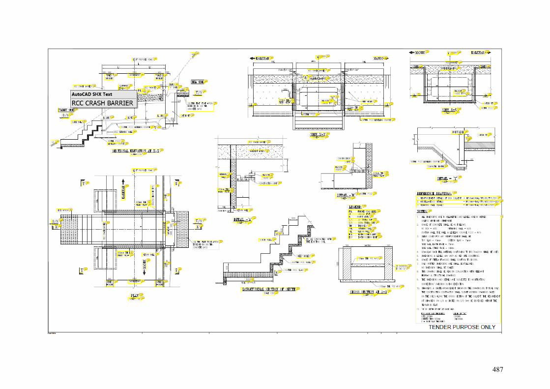
487
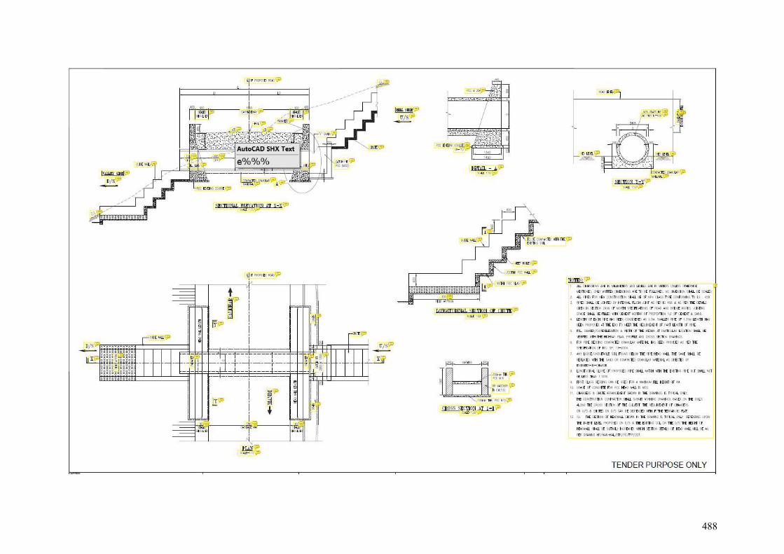
488
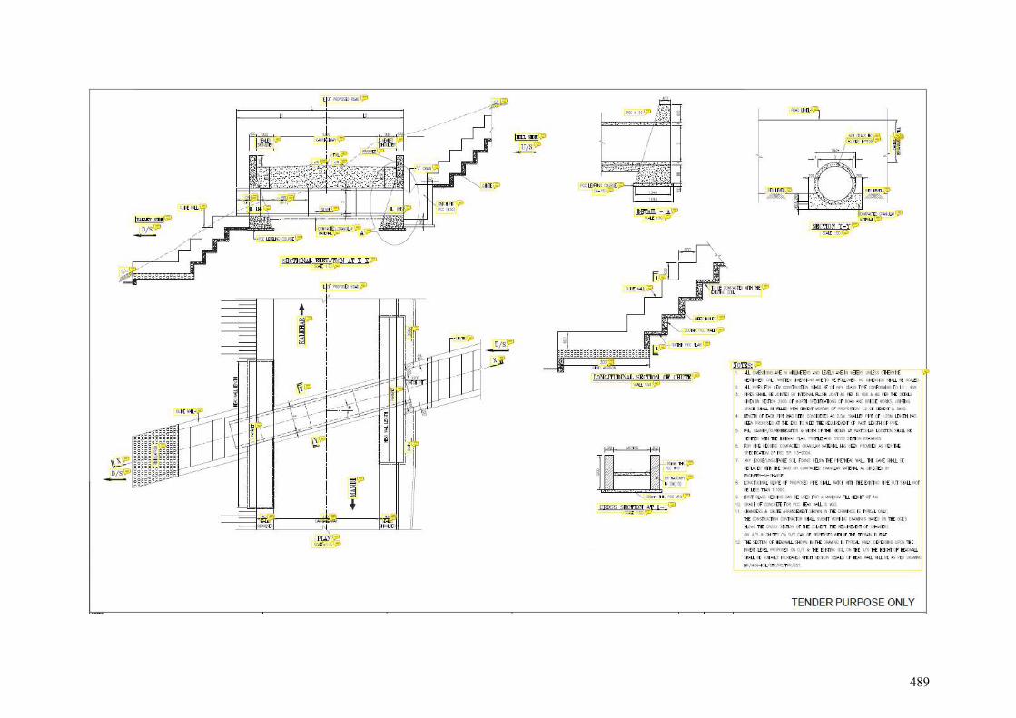
489
APPENDIX-14
Road Safety Signages, Traffic Calming Measures and Junction Improvement Proposal
490
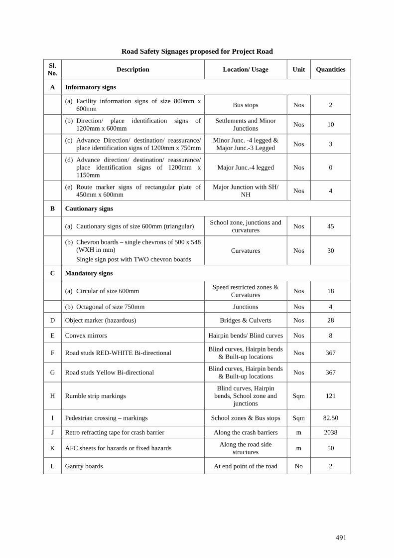
Road Safety Signages proposed for Project Road
Sl. No. Description Location/ Usage Unit Quantities
A Informatory signs
(a) Facility information signs of size 800mm x 600mm Bus stops Nos 2
(b) Direction/ place identification signs of 1200mm x 600mm
Settlements and Minor Junctions Nos 10
(c) Advance Direction/ destination/ reassurance/ place identification signs of 1200mm x 750mm
Minor Junc. -4 legged & Major Junc.-3 Legged Nos 3
(d) Advance direction/ destination/ reassurance/ place identification signs of 1200mm x 1150mm
Major Junc.-4 legged Nos 0
(e) Route marker signs of rectangular plate of 450mm x 600mm
Major Junction with SH/ NH Nos 4
B Cautionary signs
(a) Cautionary signs of size 600mm (triangular) School zone, junctions and curvatures Nos 45
(b) Chevron boards – single chevrons of 500 x 548 (WXH in mm) Single sign post with TWO chevron boards
Curvatures Nos 30
C Mandatory signs
(a) Circular of size 600mm Speed restricted zones & Curvatures Nos 18
(b) Octagonal of size 750mm Junctions Nos 4
D Object marker (hazardous) Bridges & Culverts Nos 28
E Convex mirrors Hairpin bends/ Blind curves Nos 8
F Road studs RED-WHITE Bi-directional Blind curves, Hairpin bends & Built-up locations Nos 367
G Road studs Yellow Bi-directional Blind curves, Hairpin bends & Built-up locations Nos 367
H Rumble strip markings Blind curves, Hairpin
bends, School zone and junctions
Sqm 121
I Pedestrian crossing – markings School zones & Bus stops Sqm 82.50
J Retro refracting tape for crash barrier Along the crash barriers m 2038
K AFC sheets for hazards or fixed hazards Along the road side structures m 50
L Gantry boards At end point of the road No 2
491
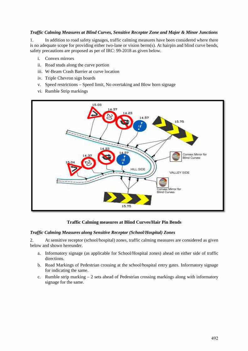
Traffic Calming Measures at Blind Curves, Sensitive Receptor Zone and Major & Minor Junctions
1. In addition to road safety signages, traffic calming measures have been considered where thereis no adequate scope for providing either two-lane or vision berm(s). At hairpin and blind curve bends, safety precautions are proposed as per of IRC: 99-2018 as given below.
i. Convex mirrorsii. Road studs along the curve portioniii. W-Beam Crash Barrier at curve locationiv. Triple Chevron sign boardsv. Speed restrictions – Speed limit, No overtaking and Blow horn signagevi. Rumble Strip markings
Traffic Calming measures at Blind Curves/Hair Pin Bends
Traffic Calming Measures along Sensitive Receptor (School/Hospital) Zones
2. At sensitive receptor (school/hospital) zones, traffic calming measures are considered as givenbelow and shown hereunder.
a. Informatory signage (as applicable for School/Hospital zones) ahead on either side of trafficdirections.
b. Road Markings of Pedestrian crossing at the school/hospital entry gates. Informatory signagefor indicating the same.
c. Rumble strip marking – 2 sets ahead of Pedestrian crossing markings along with informatorysignage for the same.
492
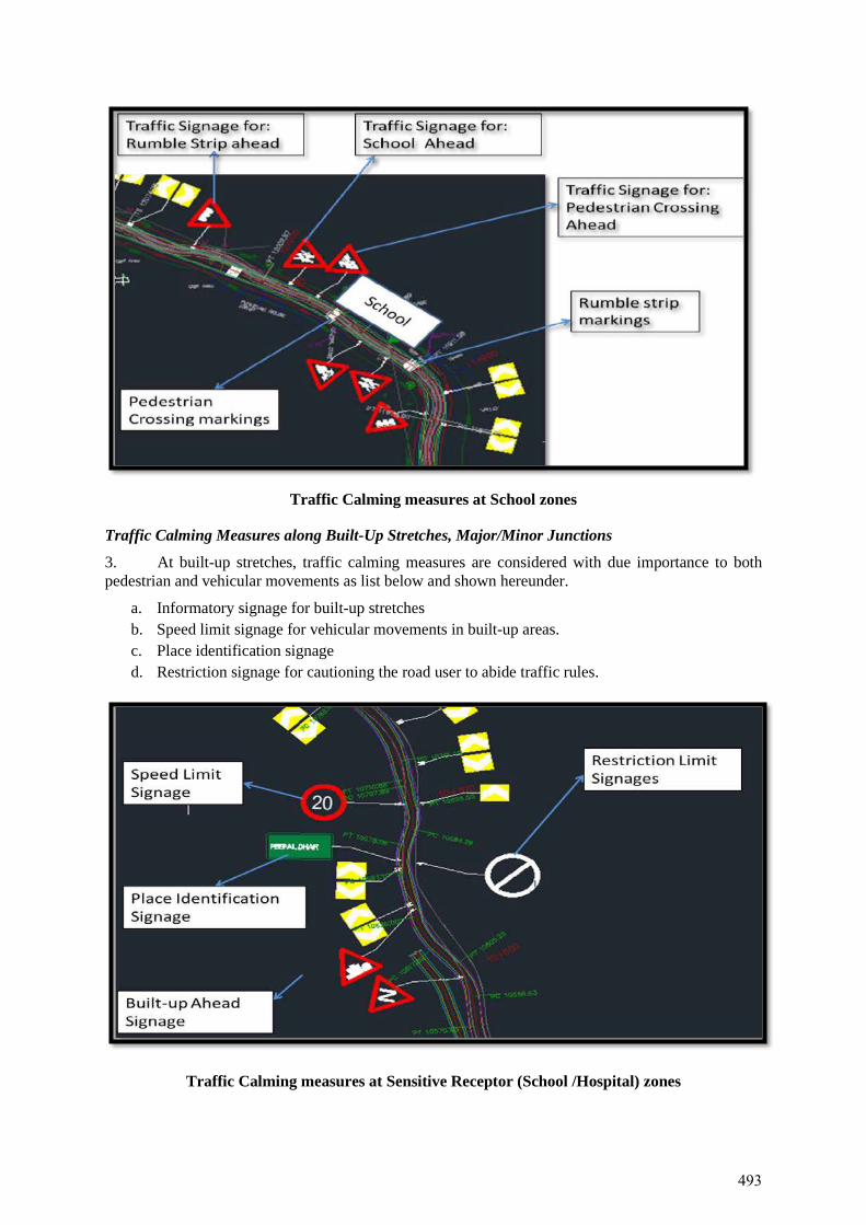
Traffic Calming measures at School zones
Traffic Calming Measures along Built-Up Stretches, Major/Minor Junctions
3. At built-up stretches, traffic calming measures are considered with due importance to bothpedestrian and vehicular movements as list below and shown hereunder.
a. Informatory signage for built-up stretchesb. Speed limit signage for vehicular movements in built-up areas.c. Place identification signaged. Restriction signage for cautioning the road user to abide traffic rules.
Traffic Calming measures at Sensitive Receptor (School /Hospital) zones
493
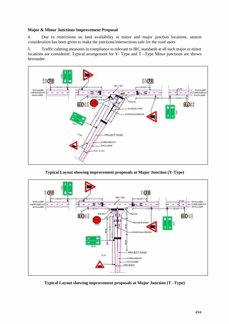
Major & Minor Junctions Improvement Proposal
4. Due to restrictions on land availability at minor and major junction locations, utmostconsideration has been given to make the junctions/intersections safe for the road users 5. Traffic calming measures in compliance to relevant to IRC standards at all such major or minorlocations are considered. Typical arrangement for Y- Type and T –Type Minor junctions are shown hereunder.
Typical Layout showing improvement proposals at Major Junction (Y-Type)
Typical Layout showing improvement proposals at Major Junction (T –Type)
494
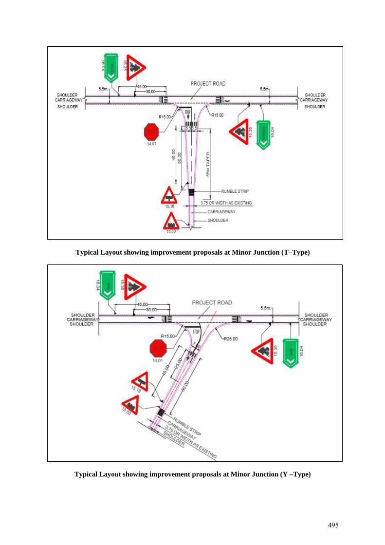
Typical Layout showing improvement proposals at Minor Junction (T–Type)
Typical Layout showing improvement proposals at Minor Junction (Y –Type)
495
APPENDIX-15
Climate Change Disaster Management Plan for Raghunathpura Bharari Road, Bilaspur District
496

Climate Change Disaster Management Plan – Raghunathpura Bharari Road
1. Disaster Management Plan1 of Bilaspur District
Disaster Management has undergone a paradigm shift in recent years from the earlier approach of response to disasters to the current holistic approach of disaster mitigation and preparedness, which yields long term benefits while minimizing damage due to disasters. District Disaster Management Authority working under the ages of Office of the Deputy Commissioner, Bilaspur is primarily responsible for disaster management in District Bilaspur. The District Authority is responsible for planning, coordination and implementation of disaster management and to take such measures for disaster management as provided in the guidelines.
The District Disaster Management Plan (DDMP) for Bilaspur district has been prepared for implementation by the Government and other non-Government agencies who would be involved in execution of the Plan during any disaster in the district. The plan indicates emergency action plans, roles and responsibilities of key personnel and suggests mitigation measures during any natural or manmade disaster, taking into consideration the available resources with various agencies involved. The plan evolves systems to make the plan an effective response mechanism. In short, the plan brings under one roof, various agencies and departments to control any type of disaster.
2. Aims & Objectives of District Disaster Management Plan
The overall aim of District Disaster Management Plan is to facilitate the actions by different stakeholders to prevent/mitigate disaster and climate risk and enhance preparedness and develop capacities for effective disaster management in the district. It further seeks to identify and clarify the roles and responsibilities of the internal and external stakeholders throughout the entire cycle of disaster management, i.e., pre- disaster, during disaster and post disaster phases.
The specific objectives of the DDMP are:
• to identify and map disaster risk, • to strengthen the institutional arrangements in the district by identifying roles and
responsibilities of the different stakeholders, • to facilitate the enhanced level of preparedness of the different stakeholders and develop their
capacities, preparation and implementation of action plan for disaster risk mitigation, strengthen mechanism for early warning, response & relief, guide rehabilitation & recovery and facilitate mechanism for monitoring, evaluation, revision and updation.
• to clarify the Authority, Responsibility and Relationships as to who is responsible for ensuring that the work gets done, distributing and decision-making authority among the team members and the existing organizational units, and establishing formal lines of communication.
• to facilitate the mobilization of resources, funds, personnel, supplies and equipment necessary for doing the required activities.
• to establish the communication and information management system • to facilitate the Monitoring, Evaluation and updation of the plan from time to time.
The District Disaster Management Plan (DDMP) is a guide for achieving the objective related to disaster mitigation, preparedness, response and recovery. This Plan will help in disaster response in a planned way to minimize human, property and environmental loss.
The basic objectives for formulating a Plan are as under:
The basic objective of the District Disaster Management Plan is to protect all the residents of the district and
1 Information abstracted from District Disaster Management Plan, Bilaspur
497
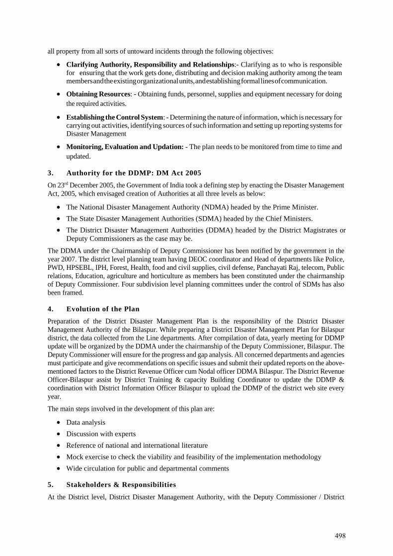
all property from all sorts of untoward incidents through the following objectives:
• Clarifying Authority, Responsibility and Relationships:- Clarifying as to who is responsible for ensuring that the work gets done, distributing and decision making authority among the team members and the existing organizational units, and establishing formal lines of communication.
• Obtaining Resources: - Obtaining funds, personnel, supplies and equipment necessary for doing the required activities.
• Establishing the Control System: - Determining the nature of information, which is necessary for carrying out activities, identifying sources of such information and setting up reporting systems for Disaster Management
• Monitoring, Evaluation and Updation: - The plan needs to be monitored from time to time and updated.
3. Authority for the DDMP: DM Act 2005
On 23rd December 2005, the Government of India took a defining step by enacting the Disaster Management Act, 2005, which envisaged creation of Authorities at all three levels as below:
• The National Disaster Management Authority (NDMA) headed by the Prime Minister. • The State Disaster Management Authorities (SDMA) headed by the Chief Ministers. • The District Disaster Management Authorities (DDMA) headed by the District Magistrates or
Deputy Commissioners as the case may be.
The DDMA under the Chairmanship of Deputy Commissioner has been notified by the government in the year 2007. The district level planning team having DEOC coordinator and Head of departments like Police, PWD, HPSEBL, IPH, Forest, Health, food and civil supplies, civil defense, Panchayati Raj, telecom, Public relations, Education, agriculture and horticulture as members has been constituted under the chairmanship of Deputy Commissioner. Four subdivision level planning committees under the control of SDMs has also been framed.
4. Evolution of the Plan
Preparation of the District Disaster Management Plan is the responsibility of the District Disaster Management Authority of the Bilaspur. While preparing a District Disaster Management Plan for Bilaspur district, the data collected from the Line departments. After compilation of data, yearly meeting for DDMP update will be organized by the DDMA under the chairmanship of the Deputy Commissioner, Bilaspur. The Deputy Commissioner will ensure for the progress and gap analysis. All concerned departments and agencies must participate and give recommendations on specific issues and submit their updated reports on the above-mentioned factors to the District Revenue Officer cum Nodal officer DDMA Bilaspur. The District Revenue Officer-Bilaspur assist by District Training & capacity Building Coordinator to update the DDMP & coordination with District Information Officer Bilaspur to upload the DDMP of the district web site every year.
The main steps involved in the development of this plan are:
• Data analysis • Discussion with experts • Reference of national and international literature • Mock exercise to check the viability and feasibility of the implementation methodology • Wide circulation for public and departmental comments
5. Stakeholders & Responsibilities
At the District level, District Disaster Management Authority, with the Deputy Commissioner / District
498
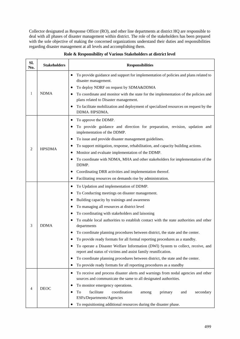
Collector designated as Response Officer (RO), and other line departments at district HQ are responsible to deal with all phases of disaster management within district. The role of the stakeholders has been prepared with the sole objective of making the concerned organizations understand their duties and responsibilities regarding disaster management at all levels and accomplishing them.
Role & Responsibility of Various Stakeholders at district level
Sl. No. Stakeholders Responsibilities
1 NDMA
• To provide guidance and support for implementation of policies and plans related to disaster management.
• To deploy NDRF on request by SDMA&DDMA
• To coordinate and monitor with the state for the implementation of the policies and plans related to Disaster management.
• To facilitate mobilization and deployment of specialized resources on request by the DDMA /HPSDMA.
2 HPSDMA
• To approve the DDMP.
• To provide guidance and direction for preparation, revision, updation and implementation of the DDMP.
• To issue and provide disaster management guidelines.
• To support mitigation, response, rehabilitation, and capacity building actions.
• Monitor and evaluate implementation of the DDMP.
• To coordinate with NDMA, MHA and other stakeholders for implementation of the DDMP.
• Coordinating DRR activities and implementation thereof.
• Facilitating resources on demands rise by administration.
3 DDMA
• To Updation and implementation of DDMP.
• To Conducting meetings on disaster management.
• Building capacity by trainings and awareness
• To managing all resources at district level
• To coordinating with stakeholders and laisoning
• To enable local authorities to establish contact with the state authorities and other departments
• To coordinate planning procedures between district, the state and the center.
• To provide ready formats for all formal reporting procedures as a standby.
• To operate a Disaster Welfare Information (DWI) System to collect, receive, and report and status of victims and assist family reunification.
• To coordinate planning procedures between district, the state and the center.
• To provide ready formats for all reporting procedures as a standby
4 DEOC
• To receive and process disaster alerts and warnings from nodal agencies and other sources and communicate the same to all designated authorities.
• To monitor emergency operations.
• To facilitate coordination among primary and secondary ESFs/Departments/Agencies
• To requisitioning additional resources during the disaster phase.
499
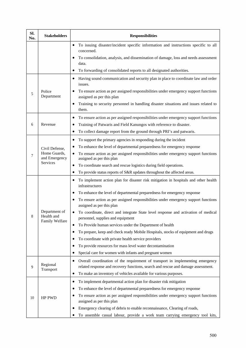
Sl. No. Stakeholders Responsibilities
• To issuing disaster/incident specific information and instructions specific to all concerned.
• To consolidation, analysis, and dissemination of damage, loss and needs assessment data.
• To forwarding of consolidated reports to all designated authorities.
5 Police Department
• Having sound communication and security plan in place to coordinate law and order issues.
• To ensure action as per assigned responsibilities under emergency support functions assigned as per this plan
• Training to security personnel in handling disaster situations and issues related to them.
6 Revenue • To ensure action as per assigned responsibilities under emergency support functions
• Training of Patwaris and Field Kanungos with reference to disaster.
• To collect damage report from the ground through PRI’s and patwaris.
7
Civil Defense, Home Guards, and Emergency Services
• To support the primary agencies in responding during the incident
• To enhance the level of departmental preparedness for emergency response
• To ensure action as per assigned responsibilities under emergency support functions assigned as per this plan
• To coordinate search and rescue logistics during field operations.
• To provide status reports of S&R updates throughout the affected areas.
8 Department of Health and Family Welfare
• To implement action plan for disaster risk mitigation in hospitals and other health infrastructures
• To enhance the level of departmental preparedness for emergency response
• To ensure action as per assigned responsibilities under emergency support functions assigned as per this plan
• To coordinate, direct and integrate State level response and activation of medical personnel, supplies and equipment
• To Provide human services under the Department of health
• To prepare, keep and check ready Mobile Hospitals, stocks of equipment and drugs
• To coordinate with private health service providers
• To provide resources for mass level water decontamination
• Special care for women with infants and pregnant women
9 Regional Transport
• Overall coordination of the requirement of transport in implementing emergency related response and recovery functions, search and rescue and damage assessment.
• To make an inventory of vehicles available for various purposes.
10 HP PWD
• To implement departmental action plan for disaster risk mitigation
• To enhance the level of departmental preparedness for emergency response
• To ensure action as per assigned responsibilities under emergency support functions assigned as per this plan
• Emergency clearing of debris to enable reconnaissance, Clearing of roads,
• To assemble casual labour, provide a work team carrying emergency tool kits,
500
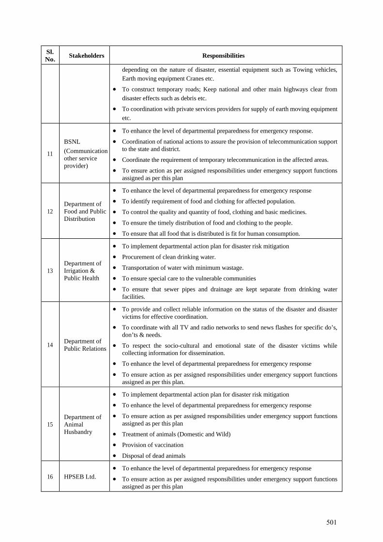
Sl. No. Stakeholders Responsibilities
depending on the nature of disaster, essential equipment such as Towing vehicles, Earth moving equipment Cranes etc.
• To construct temporary roads; Keep national and other main highways clear from disaster effects such as debris etc.
• To coordination with private services providers for supply of earth moving equipment etc.
11
BSNL (Communication other service provider)
• To enhance the level of departmental preparedness for emergency response.
• Coordination of national actions to assure the provision of telecommunication support to the state and district.
• Coordinate the requirement of temporary telecommunication in the affected areas.
• To ensure action as per assigned responsibilities under emergency support functions assigned as per this plan
12 Department of Food and Public Distribution
• To enhance the level of departmental preparedness for emergency response
• To identify requirement of food and clothing for affected population.
• To control the quality and quantity of food, clothing and basic medicines.
• To ensure the timely distribution of food and clothing to the people.
• To ensure that all food that is distributed is fit for human consumption.
13 Department of Irrigation & Public Health
• To implement departmental action plan for disaster risk mitigation
• Procurement of clean drinking water.
• Transportation of water with minimum wastage.
• To ensure special care to the vulnerable communities
• To ensure that sewer pipes and drainage are kept separate from drinking water facilities.
14 Department of Public Relations
• To provide and collect reliable information on the status of the disaster and disaster victims for effective coordination.
• To coordinate with all TV and radio networks to send news flashes for specific do’s, don’ts & needs.
• To respect the socio-cultural and emotional state of the disaster victims while collecting information for dissemination.
• To enhance the level of departmental preparedness for emergency response
• To ensure action as per assigned responsibilities under emergency support functions assigned as per this plan.
15 Department of Animal Husbandry
• To implement departmental action plan for disaster risk mitigation
• To enhance the level of departmental preparedness for emergency response
• To ensure action as per assigned responsibilities under emergency support functions assigned as per this plan
• Treatment of animals (Domestic and Wild)
• Provision of vaccination
• Disposal of dead animals
16 HPSEB Ltd. • To enhance the level of departmental preparedness for emergency response
• To ensure action as per assigned responsibilities under emergency support functions assigned as per this plan
501
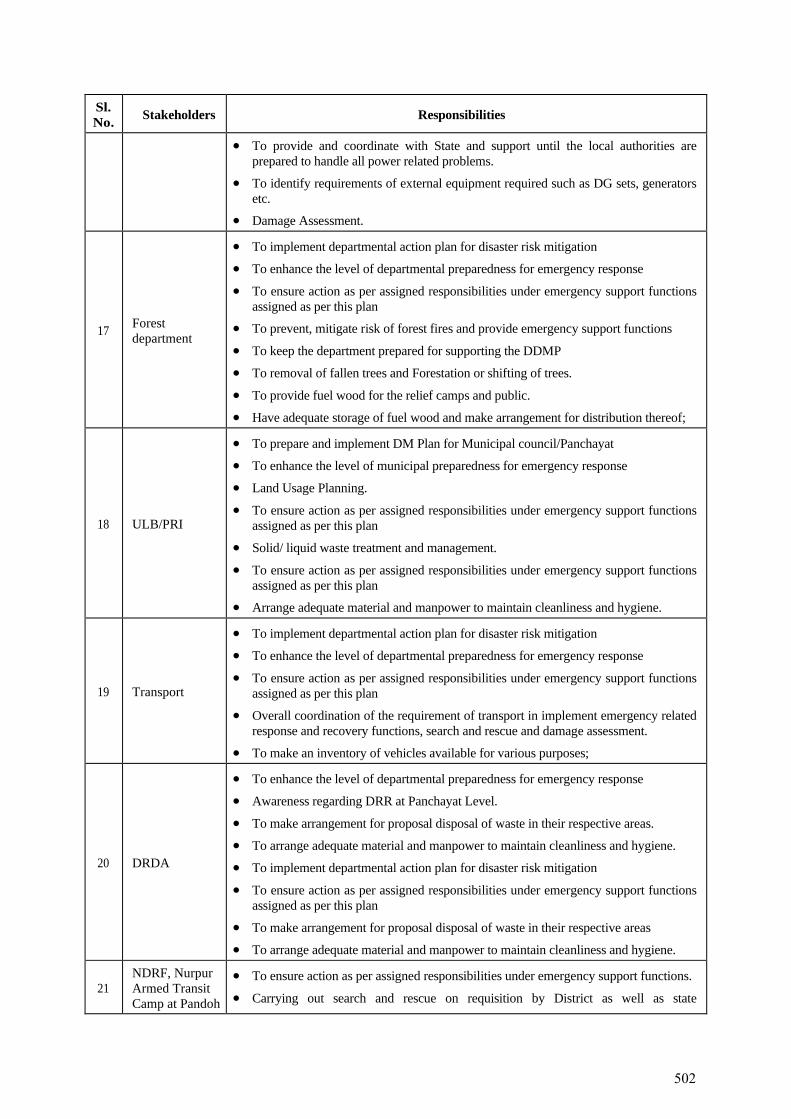
Sl. No. Stakeholders Responsibilities
• To provide and coordinate with State and support until the local authorities are prepared to handle all power related problems.
• To identify requirements of external equipment required such as DG sets, generators etc.
• Damage Assessment.
17 Forest department
• To implement departmental action plan for disaster risk mitigation
• To enhance the level of departmental preparedness for emergency response
• To ensure action as per assigned responsibilities under emergency support functions assigned as per this plan
• To prevent, mitigate risk of forest fires and provide emergency support functions
• To keep the department prepared for supporting the DDMP
• To removal of fallen trees and Forestation or shifting of trees.
• To provide fuel wood for the relief camps and public.
• Have adequate storage of fuel wood and make arrangement for distribution thereof;
18 ULB/PRI
• To prepare and implement DM Plan for Municipal council/Panchayat
• To enhance the level of municipal preparedness for emergency response
• Land Usage Planning.
• To ensure action as per assigned responsibilities under emergency support functions assigned as per this plan
• Solid/ liquid waste treatment and management.
• To ensure action as per assigned responsibilities under emergency support functions assigned as per this plan
• Arrange adequate material and manpower to maintain cleanliness and hygiene.
19 Transport
• To implement departmental action plan for disaster risk mitigation
• To enhance the level of departmental preparedness for emergency response
• To ensure action as per assigned responsibilities under emergency support functions assigned as per this plan
• Overall coordination of the requirement of transport in implement emergency related response and recovery functions, search and rescue and damage assessment.
• To make an inventory of vehicles available for various purposes;
20 DRDA
• To enhance the level of departmental preparedness for emergency response
• Awareness regarding DRR at Panchayat Level.
• To make arrangement for proposal disposal of waste in their respective areas.
• To arrange adequate material and manpower to maintain cleanliness and hygiene.
• To implement departmental action plan for disaster risk mitigation
• To ensure action as per assigned responsibilities under emergency support functions assigned as per this plan
• To make arrangement for proposal disposal of waste in their respective areas
• To arrange adequate material and manpower to maintain cleanliness and hygiene.
21 NDRF, Nurpur Armed Transit Camp at Pandoh
• To ensure action as per assigned responsibilities under emergency support functions.
• Carrying out search and rescue on requisition by District as well as state
502
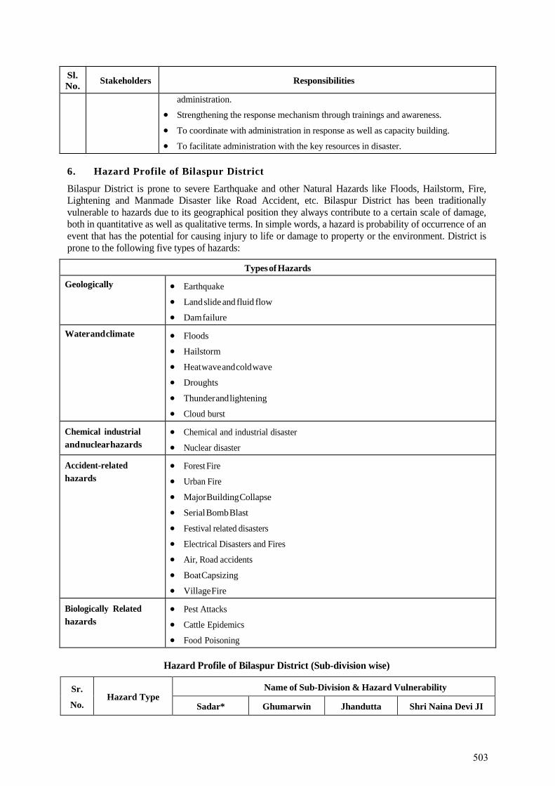
Sl. No. Stakeholders Responsibilities
administration.
• Strengthening the response mechanism through trainings and awareness.
• To coordinate with administration in response as well as capacity building.
• To facilitate administration with the key resources in disaster.
6. Hazard Profile of Bilaspur District
Bilaspur District is prone to severe Earthquake and other Natural Hazards like Floods, Hailstorm, Fire, Lightening and Manmade Disaster like Road Accident, etc. Bilaspur District has been traditionally vulnerable to hazards due to its geographical position they always contribute to a certain scale of damage, both in quantitative as well as qualitative terms. In simple words, a hazard is probability of occurrence of an event that has the potential for causing injury to life or damage to property or the environment. District is prone to the following five types of hazards:
Types of Hazards
Geologically • Earthquake
• Land slide and fluid flow
• Dam failure
Water and climate • Floods
• Hailstorm
• Heat wave and cold wave
• Droughts
• Thunder and lightening
• Cloud burst
Chemical industrial and nuclear hazards
• Chemical and industrial disaster
• Nuclear disaster
Accident-related hazards
• Forest Fire
• Urban Fire
• Major Building Collapse
• Serial Bomb Blast
• Festival related disasters
• Electrical Disasters and Fires
• Air, Road accidents
• Boat Capsizing
• Village Fire
Biologically Related hazards
• Pest Attacks
• Cattle Epidemics
• Food Poisoning
Hazard Profile of Bilaspur District (Sub-division wise)
Sr.
No. Hazard Type
Name of Sub-Division & Hazard Vulnerability
Sadar* Ghumarwin Jhandutta Shri Naina Devi JI
503
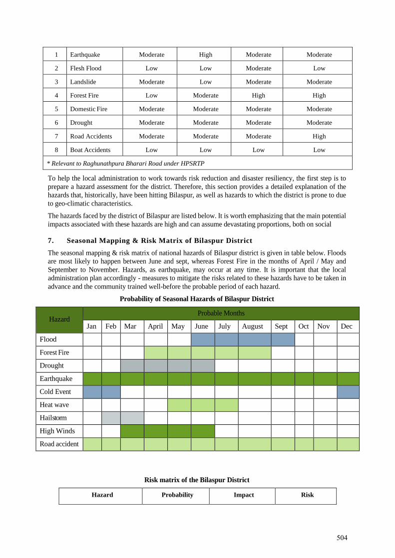
1 Earthquake Moderate High Moderate Moderate
2 Flesh Flood Low Low Moderate Low
3 Landslide Moderate Low Moderate Moderate
4 Forest Fire Low Moderate High High
5 Domestic Fire Moderate Moderate Moderate Moderate
6 Drought Moderate Moderate Moderate Moderate
7 Road Accidents Moderate Moderate Moderate High
8 Boat Accidents Low Low Low Low
* Relevant to Raghunathpura Bharari Road under HPSRTP
To help the local administration to work towards risk reduction and disaster resiliency, the first step is to prepare a hazard assessment for the district. Therefore, this section provides a detailed explanation of the hazards that, historically, have been hitting Bilaspur, as well as hazards to which the district is prone to due to geo-climatic characteristics.
The hazards faced by the district of Bilaspur are listed below. It is worth emphasizing that the main potential impacts associated with these hazards are high and can assume devastating proportions, both on social
7. Seasonal Mapping & Risk Matrix of Bilaspur District
The seasonal mapping & risk matrix of national hazards of Bilaspur district is given in table below. Floods are most likely to happen between June and sept, whereas Forest Fire in the months of April / May and September to November. Hazards, as earthquake, may occur at any time. It is important that the local administration plan accordingly - measures to mitigate the risks related to these hazards have to be taken in advance and the community trained well-before the probable period of each hazard.
Probability of Seasonal Hazards of Bilaspur District
Hazard
Probable Months
Jan Feb Mar April May June July August Sept Oct Nov Dec
Flood
Forest Fire
Drought
Earthquake
Cold Event
Heat wave
Hailstorm
High Winds
Road accident
Risk matrix of the Bilaspur District
Hazard Probability Impact Risk
504

Earthquake Medium High High
Flood Low Low Low
Forest Fire High High High
Drought Low Medium Medium
Landslide Medium Low Low
Road Accidents Medium Low Low
Boat Accidents Low Low Low
Stampede Medium Low Low
8. Government Workforce for Disaster Management
Every department had nominated their Nodal Officer for the Disaster Management and the inventory is updated under the guidance of Nodal Officer. This workforce can act as a resource for disaster management in the district. However, this resource has yet not fully trained and oriented in DM and related issues. Hence their capacity to respond to disasters effectively and prepare a culture of prevention and safety would be less effective.
9. Fire Services and Home Guards
The Home Guards and Fire Services will be assigned an effective role in the field of disaster management. They will be deployed for community preparedness, conduct of mock drill and public awareness. A culture of voluntary reporting to duty stations in the event of any disaster will be promoted. The Fire Services upgraded to acquire multi-hazard rescue capability. The existing set up of these services would be strengthened to take up the new role more effectively.
10. Fire Stations & Fire Fighting Facilities
Bilaspur district has 2 fire stations, to deal with the fire incidents.
11. Home Guard Network
In case of major incidents Home Guards can be pressed to service. In any emergent situation Home Guards are readily available for deployment.
12. Police Stations
Number of Police stations & Police Chowki including details of their staff, list of equipment’s available, details of infrastructure including age or building (when was building made), details of medical facility available, details of food & water supply facility, about how many male & female toilets are there to cope up at the time of any disastrous condition. GIS mapping also in progress to map the available resources in the Bilaspur district.
List of Police Stations of Bilaspur District
Sl. No. Name of Police Station Contact Number
1. Barmana 94180-71662, 01978-244040
2. Bharari 94188-08080, 01978-273026
3. Ghumarwin 94183-38156, 01978-255216
4. Kot Kehloor 98050-81694, 01978-207031
5. Sadar Bilaspur 98161-95702, 01978-222588
6. Swarghat 94180-79051, 01978-284024
505
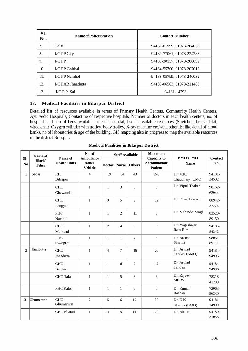
Sl. No. Name of Police Station Contact Number
7. Talai 94181-61999, 01978-264038
8. I/C PP City 94180-77061, 01978-224288
9. I/C PP 94180-30137, 01978-288092
10. I/C PP Golthai 94184-55700, 01978-207012
11. I/C PP Namhol 94188-05799, 01978-240032
12. I/C PAR Jhandutta 94188-06503, 01978-211488
13. I/C P.P. Sai. 94181-14793
13. Medical Facilities in Bilaspur District
Detailed list of resources available in terms of Primary Health Centers, Community Health Centers, Ayurvedic Hospitals, Contact no of respective hospitals, Number of doctors in each health centers, no. of hospital staff, no of beds available in each hospital, list of available resources (Stretcher, first aid kit, wheelchair, Oxygen cylinder with trolley, body trolley, X-ray machine etc.) and other list like detail of blood banks, no of laboratories & age of the building. GIS mapping also in progress to map the available resources in the district Bilaspur.
Medical Facilities in Bilaspur District
SI. No.
Name of Block/ Tehsil
Name of Health Units
No. of Ambulance
/other Vehicle
Staff Available Maximum Capacity to
Accommodate Patient
BMO/C MO Name
Contact No. Doctor Nurse Others
1 Sadar RH Bilaspur
4 19 34 43 270 Dr. V.K. Chaudhary (CMO
94181- 34502
CHC Ghawandal
1 1 3 8 6 Dr. Vipul Thakur 98162- 62944
CHC Panjgain
1 3 5 9 12 Dr. Amit Banyal 88942- 37274
PHC Namhol
1 1 2 11 6 Dr. Mahinder Singh 83520- 89150
CHC Markand
1 2 4 5 6 Dr. Yogeshwari Ram Rav
94185- 84342
PHC Swarghat
1 1 1 7 6 Dr. Archna Sharma
98051- 89111
2 Jhandutta CHC Jhandutta
1 4 7 16 20 Dr. Arvind Tandan (BMO)
94184- 94906
CHC Berthin
1 1 6 7 12 Dr. Arvind Tandan
94184- 94906
CHC Talai 1 1 5 3 6 Dr. Rajeev MBBS
78318- 41280
PHC Kalol 1 1 1 6 6 Dr. Kumar Roshan
72063- 56330
3 Ghumarwin CHC Ghumarwin
2 5 6 10 50 Dr. K K Sharma (BMO)
94181- 14909
CHC Bharari 1 4 5 14 20 Dr. Bhanu 94180- 31055
506
SI. No.
Name of Block/ Tehsil
Name of Health Units
No. of Ambulance
/other Vehicle
Staff Available Maximum Capacity to
Accommodate Patient
BMO/C MO Name
Contact No. Doctor Nurse Others
CHC Kuthera 1 2 4 11 6 Dr. Vikash 94180- 76062
CHC Harlog 1 1 3 14 6 Dr. Sunil Kumar 94189- 65044
14. Institutional Structure at State Level
At the State level, the State Disaster Management Authority constituted under the chairmanship of the Chief Minister and has the responsibility of planning, policies, plans and guidelines for DM and coordinating their implementation for ensuring timely, effective and coordinated response to disasters. The Chief Secretary is the Chief Executive Officer of the SDMA. Besides, the SDMA has seven other members. The SDMA will, inter alia approve the State Plan in accordance with the guidelines laid down by the NDMA, approve DMPs prepared by the departments of the State Government, lay down guidelines to be followed by the departments of the Government of the State for the purpose of integration of measures for prevention of disasters and mitigation in their development plans and projects, coordinate the implementation of the State Plan, recommend provision of funds for mitigation, preparedness measures, review the developmental plans of the different Departments of the State to ensure the integration of prevention, preparedness and mitigation measures and review the measures being taken for mitigation, capacity building and preparedness by the departments. The State Authority shall lay down detailed guidelines for providing standards of relief to persons affected by disaster in the State.
The State Executive Committee (SEC) headed by the Chief Secretary and four other Secretaries as its members shall be there to assist the SDMA in the performance of its functions. The SEC will further provide necessary technical assistance or give advice to District Authorities and local authorities for carrying out their functions effectively, advise the State Government regarding all financial matters in relation to disaster management, examine the construction, in any local area in the State and, if it is of the opinion that the standards laid for such construction for the prevention of disaster is not being or has not been followed, may direct the District authority or the local authority, as the case may be, to take such action as may be necessary to secure compliance of such standards, lay down, review and update State level response plans and guidelines and ensure that the district level plans are prepared, reviewed and updated, ensure that communication systems are in order and the disaster management drills are carried out periodically. The SEC will also provide information to the NDMA relating to different aspects of DM.
507
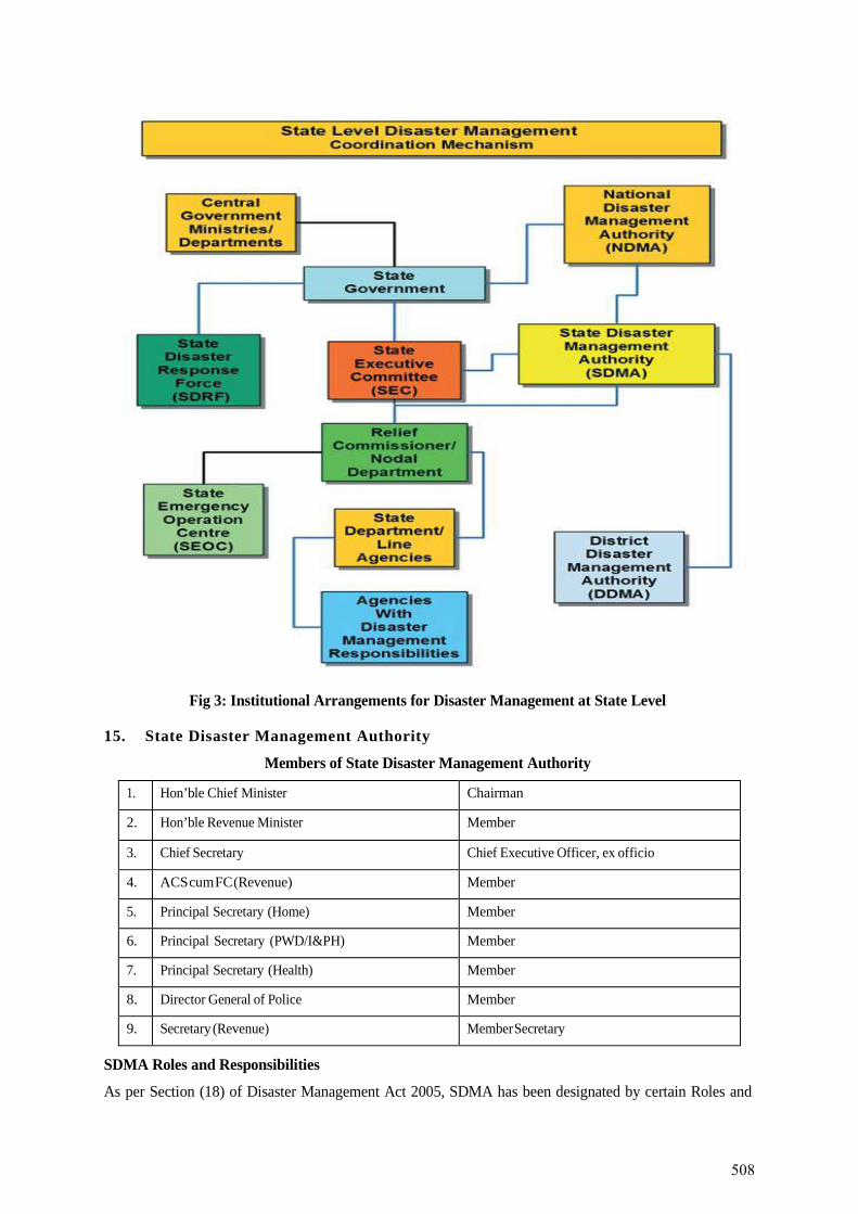
Fig 3: Institutional Arrangements for Disaster Management at State Level
15. State Disaster Management Authority
Members of State Disaster Management Authority
1. Hon’ble Chief Minister Chairman
2. Hon’ble Revenue Minister Member
3. Chief Secretary Chief Executive Officer, ex officio
4. ACS cum FC (Revenue) Member
5. Principal Secretary (Home) Member
6. Principal Secretary (PWD/I&PH) Member
7. Principal Secretary (Health) Member
8. Director General of Police Member
9. Secretary (Revenue) Member Secretary
SDMA Roles and Responsibilities
As per Section (18) of Disaster Management Act 2005, SDMA has been designated by certain Roles and
508
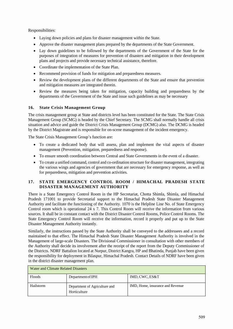
Responsibilities:
• Laying down policies and plans for disaster management within the State. • Approve the disaster management plans prepared by the departments of the State Government. • Lay down guidelines to be followed by the departments of the Government of the State for the
purposes of integration of measures for prevention of disasters and mitigation in their development plans and projects and provide necessary technical assistance, therefore.
• Coordinate the implementation of the State Plan. • Recommend provision of funds for mitigation and preparedness measures. • Review the development plans of the different departments of the State and ensure that prevention
and mitigation measures are integrated therein. • Review the measures being taken for mitigation, capacity building and preparedness by the
departments of the Government of the State and issue such guidelines as may be necessary
16. State Crisis Management Group
The crisis management group at State and districts level has been constituted for the State. The State Crisis Management Group (SCMG) is headed by the Chief Secretary. The SCMG shall normally handle all crisis situation and advice and guide the District Crisis Management Group (DCMG) also. The DCMG is headed by the District Magistrate and is responsible for on-scene management of the incident emergency.
The State Crisis Management Group’s function are:
• To create a dedicated body that will assess, plan and implement the vital aspects of disaster management (Prevention, mitigation, preparedness and response).
• To ensure smooth coordination between Central and State Governments in the event of a disaster. • To create a unified command, control and co-ordination structure for disaster management, integrating
the various wings and agencies of government that are necessary for emergency response, as well as for preparedness, mitigation and prevention activities.
17. STATE EMERGENCY CONTROL ROOM / HIMACHAL PRADESH STATE DISASTER MANAGEMENT AUTHORITY
There is a State Emergency Control Room in the HP Secretariat, Chotta Shimla, Shimla, and Himachal Pradesh 171001 to provide Secretarial support to the Himachal Pradesh State Disaster Management Authority and facilitate the functioning of the Authority. 1070 is the Helpline Line No. of State Emergency Control room which is operational 24 x 7. This Control Room will receive the information from various sources. It shall be in constant contact with the District Disaster Control Rooms, Police Control Rooms. The State Emergency Control Room will receive the information, record it properly and put up to the State Disaster Management Authority instantly.
Similarly, the instructions passed by the State Authority shall be conveyed to the addressees and a record maintained to that effect. The Himachal Pradesh State Disaster Management Authority is involved in the Management of large-scale Disasters. The Divisional Commissioner in consultation with other members of the Authority shall decide its involvement after the receipt of the report from the Deputy Commissioner of the Districts. NDRF Battalion located at Nurpur, District Kangra, HP and Bhatinda, Punjab have been given the responsibility for deployment in Bilaspur, Himachal Pradesh. Contact Details of NDRF have been given in the district disaster management plan.
Water and Climate Related Disasters
Floods Department of IPH IMD, CWC, ES&T
Hailstorm Department of Agriculture and Horticulture
IMD, Home, insurance and Revenue
509
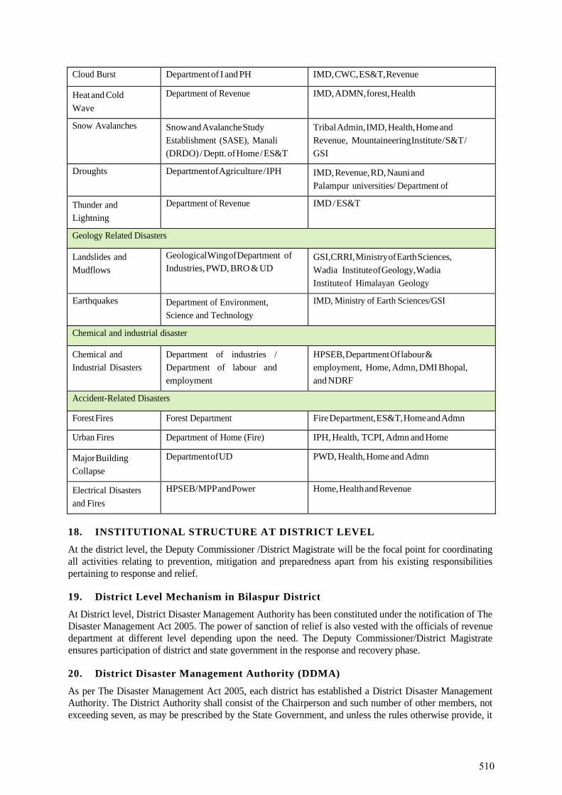
Cloud Burst Department of I and PH IMD, CWC, ES&T, Revenue
Heat and Cold Wave
Department of Revenue IMD, ADMN, forest, Health
Snow Avalanches Snow and Avalanche Study Establishment (SASE), Manali (DRDO) / Deptt. of Home / ES&T
Tribal Admin, IMD, Health, Home and Revenue, Mountaineering Institute / S&T / GSI
Droughts Department of Agriculture / IPH IMD, Revenue, RD, Nauni and Palampur universities/ Department of L d d Thunder and
Lightning Department of Revenue IMD / ES&T
Geology Related Disasters
Landslides and Mudflows
Geological Wing of Department of Industries, PWD, BRO & UD
GSI,CRRI, Ministry of Earth Sciences, Wadia Institute of Geology, Wadia Institute of Himalayan Geology
Earthquakes Department of Environment, Science and Technology
IMD, Ministry of Earth Sciences/GSI
Chemical and industrial disaster
Chemical and Industrial Disasters
Department of industries / Department of labour and employment
HPSEB, Department Of labour & employment, Home, Admn, DMI Bhopal, and NDRF
Accident-Related Disasters
Forest Fires Forest Department Fire Department, ES&T, Home and Admn
Urban Fires Department of Home (Fire) IPH, Health, TCPI, Admn and Home
Major Building Collapse
Department of UD PWD, Health, Home and Admn
Electrical Disasters and Fires
HPSEB/ MPP and Power Home, Health and Revenue
18. INSTITUTIONAL STRUCTURE AT DISTRICT LEVEL
At the district level, the Deputy Commissioner /District Magistrate will be the focal point for coordinating all activities relating to prevention, mitigation and preparedness apart from his existing responsibilities pertaining to response and relief.
19. District Level Mechanism in Bilaspur District
At District level, District Disaster Management Authority has been constituted under the notification of The Disaster Management Act 2005. The power of sanction of relief is also vested with the officials of revenue department at different level depending upon the need. The Deputy Commissioner/District Magistrate ensures participation of district and state government in the response and recovery phase.
20. District Disaster Management Authority (DDMA)
As per The Disaster Management Act 2005, each district has established a District Disaster Management Authority. The District Authority shall consist of the Chairperson and such number of other members, not exceeding seven, as may be prescribed by the State Government, and unless the rules otherwise provide, it
510
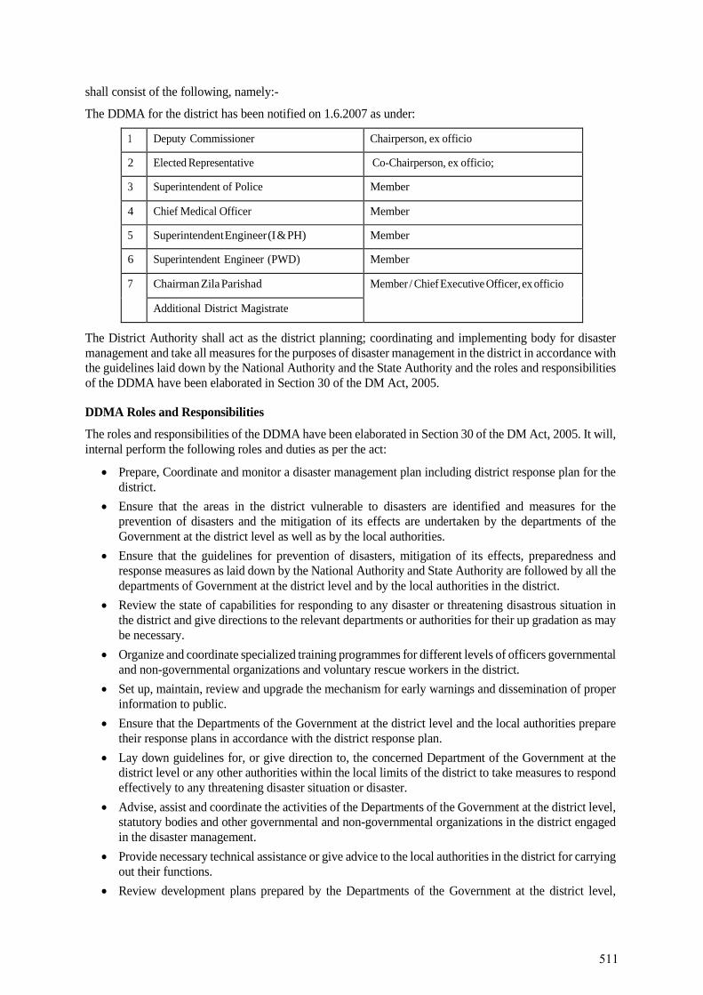
shall consist of the following, namely:-
The DDMA for the district has been notified on 1.6.2007 as under:
1 Deputy Commissioner Chairperson, ex officio
2 Elected Representative Co-Chairperson, ex officio;
3 Superintendent of Police Member
4 Chief Medical Officer Member
5 Superintendent Engineer (I & PH) Member
6 Superintendent Engineer (PWD) Member
7 Chairman Zila Parishad Member / Chief Executive Officer, ex officio
Additional District Magistrate
The District Authority shall act as the district planning; coordinating and implementing body for disaster management and take all measures for the purposes of disaster management in the district in accordance with the guidelines laid down by the National Authority and the State Authority and the roles and responsibilities of the DDMA have been elaborated in Section 30 of the DM Act, 2005.
DDMA Roles and Responsibilities
The roles and responsibilities of the DDMA have been elaborated in Section 30 of the DM Act, 2005. It will, internal perform the following roles and duties as per the act:
• Prepare, Coordinate and monitor a disaster management plan including district response plan for the district.
• Ensure that the areas in the district vulnerable to disasters are identified and measures for the prevention of disasters and the mitigation of its effects are undertaken by the departments of the Government at the district level as well as by the local authorities.
• Ensure that the guidelines for prevention of disasters, mitigation of its effects, preparedness and response measures as laid down by the National Authority and State Authority are followed by all the departments of Government at the district level and by the local authorities in the district.
• Review the state of capabilities for responding to any disaster or threatening disastrous situation in the district and give directions to the relevant departments or authorities for their up gradation as may be necessary.
• Organize and coordinate specialized training programmes for different levels of officers governmental and non-governmental organizations and voluntary rescue workers in the district.
• Set up, maintain, review and upgrade the mechanism for early warnings and dissemination of proper information to public.
• Ensure that the Departments of the Government at the district level and the local authorities prepare their response plans in accordance with the district response plan.
• Lay down guidelines for, or give direction to, the concerned Department of the Government at the district level or any other authorities within the local limits of the district to take measures to respond effectively to any threatening disaster situation or disaster.
• Advise, assist and coordinate the activities of the Departments of the Government at the district level, statutory bodies and other governmental and non-governmental organizations in the district engaged in the disaster management.
• Provide necessary technical assistance or give advice to the local authorities in the district for carrying out their functions.
• Review development plans prepared by the Departments of the Government at the district level,
511
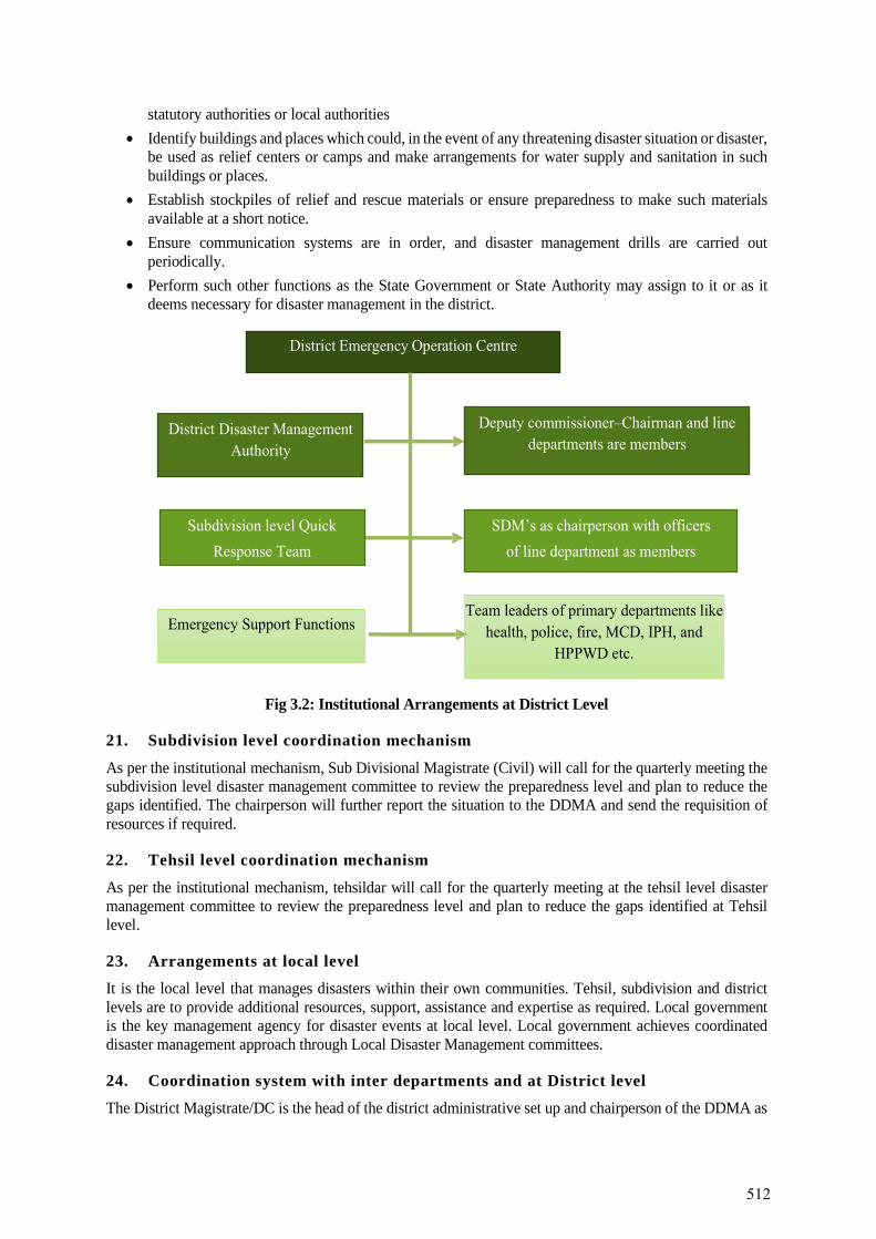
statutory authorities or local authorities • Identify buildings and places which could, in the event of any threatening disaster situation or disaster,
be used as relief centers or camps and make arrangements for water supply and sanitation in such buildings or places.
• Establish stockpiles of relief and rescue materials or ensure preparedness to make such materials available at a short notice.
• Ensure communication systems are in order, and disaster management drills are carried out periodically.
• Perform such other functions as the State Government or State Authority may assign to it or as it deems necessary for disaster management in the district.
Fig 3.2: Institutional Arrangements at District Level
21. Subdivision level coordination mechanism
As per the institutional mechanism, Sub Divisional Magistrate (Civil) will call for the quarterly meeting the subdivision level disaster management committee to review the preparedness level and plan to reduce the gaps identified. The chairperson will further report the situation to the DDMA and send the requisition of resources if required.
22. Tehsil level coordination mechanism
As per the institutional mechanism, tehsildar will call for the quarterly meeting at the tehsil level disaster management committee to review the preparedness level and plan to reduce the gaps identified at Tehsil level.
23. Arrangements at local level
It is the local level that manages disasters within their own communities. Tehsil, subdivision and district levels are to provide additional resources, support, assistance and expertise as required. Local government is the key management agency for disaster events at local level. Local government achieves coordinated disaster management approach through Local Disaster Management committees.
24. Coordination system with inter departments and at District level
The District Magistrate/DC is the head of the district administrative set up and chairperson of the DDMA as
512
per the DM Act, 2005. She / He has been designated as the responsible officer in the district. The heads of different departments in the district will have separate roles to play depending on the nature and kind of disaster. The roles and responsibilities of the members of the DDMA will be decided in advance in consultation with the concerned members.
25. Pre-Disaster coordination
Minimum Annual meetings for review of preparedness and discussing the roles and responsibilities of the line departments, tehsils and Subdivisions. The meeting agenda would be discussing the capacity of each department in terms of SAR equipment’s and manpower and regular updation of the same.
26. Disaster phase coordination
Coordination through phone or any other mode of communication in a disaster phase is not possible hence all the line departments and training institutes in the district should report to the DEOC as soon as the disaster strikes. After loss/damage assessment at the DEOC, the RO (D.C) would direct various stake holders to deploy their resources and task forces in the affected areas. Relief camps would be setup at a pre-defined location.
27. Post disaster coordination
In the post disaster phase, the RO would take updates on the conditions of basic amenities like water, food, roads, law and order etc. from the respective departments. An assessment of relief given and need of rehabilitation would also be taken in the post disaster phase.
28. Coordination mechanism with community
The community will be coordinated through the village disaster management committees. The mentioned committees generally comprise:
29. Frequency of local Committee meetings
Local Committee meetings must be held at least once in every six months at particular time and place decided by the chairperson of the group. In addition, the chairperson of a Local Committee must call a meeting if asked, in writing, to do so by:
• The District Authority for the Disaster district in which the Local Committee is situated; or • At least one-half plus one of the members of the Local Committee. • To help the Local government to prepare a local disaster management plan for its area. • To identify and provide advice to the relevant District Authority about support services required by
the Local Committee to facilitate disaster management and disaster operations in the area. • To ensure the community is aware of ways of mitigating the adverse effects of an event and preparing
for responding to and recovering from a disaster. • To manage disaster operations in the area under policies and procedures decided by the district
Authority. • To provide reports and make recommendations to the relevant District Authority about matters
relating to disaster operations. • To identify and coordinate the use of resources that may be used for disaster operations in the area. • To establish and review communication systems in the Local Committee, and with the relevant
District Authority and other Local Committees in the situation of disaster. • To ensure that information about a disaster in the area is promptly given to the relevant District
Authority, and • To ensure risk management and contingency arrangements of essential services within the Local
government area. Further information about the functions of the Local Authority may be found under sections 41 of the DM Act 2005
513
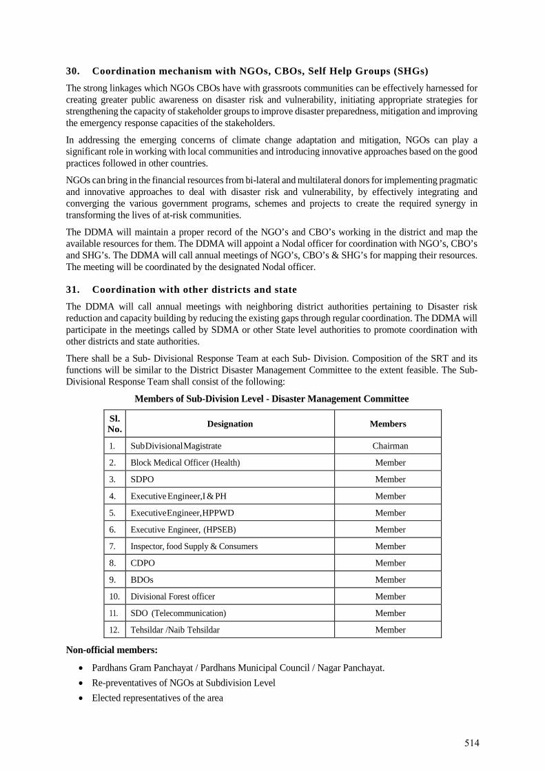
30. Coordination mechanism with NGOs, CBOs, Self Help Groups (SHGs)
The strong linkages which NGOs CBOs have with grassroots communities can be effectively harnessed for creating greater public awareness on disaster risk and vulnerability, initiating appropriate strategies for strengthening the capacity of stakeholder groups to improve disaster preparedness, mitigation and improving the emergency response capacities of the stakeholders.
In addressing the emerging concerns of climate change adaptation and mitigation, NGOs can play a significant role in working with local communities and introducing innovative approaches based on the good practices followed in other countries.
NGOs can bring in the financial resources from bi-lateral and multilateral donors for implementing pragmatic and innovative approaches to deal with disaster risk and vulnerability, by effectively integrating and converging the various government programs, schemes and projects to create the required synergy in transforming the lives of at-risk communities.
The DDMA will maintain a proper record of the NGO’s and CBO’s working in the district and map the available resources for them. The DDMA will appoint a Nodal officer for coordination with NGO’s, CBO’s and SHG’s. The DDMA will call annual meetings of NGO’s, CBO’s & SHG’s for mapping their resources. The meeting will be coordinated by the designated Nodal officer.
31. Coordination with other districts and state
The DDMA will call annual meetings with neighboring district authorities pertaining to Disaster risk reduction and capacity building by reducing the existing gaps through regular coordination. The DDMA will participate in the meetings called by SDMA or other State level authorities to promote coordination with other districts and state authorities.
There shall be a Sub- Divisional Response Team at each Sub- Division. Composition of the SRT and its functions will be similar to the District Disaster Management Committee to the extent feasible. The Sub- Divisional Response Team shall consist of the following:
Members of Sub-Division Level - Disaster Management Committee
Sl. No. Designation Members
1. Sub Divisional Magistrate Chairman
2. Block Medical Officer (Health) Member
3. SDPO Member
4. Executive Engineer, I & PH Member
5. Executive Engineer, HPPWD Member
6. Executive Engineer, (HPSEB) Member
7. Inspector, food Supply & Consumers Member
8. CDPO Member
9. BDOs Member
10. Divisional Forest officer Member
11. SDO (Telecommunication) Member
12. Tehsildar /Naib Tehsildar Member
Non-official members:
• Pardhans Gram Panchayat / Pardhans Municipal Council / Nagar Panchayat. • Re-preventatives of NGOs at Subdivision Level • Elected representatives of the area
514
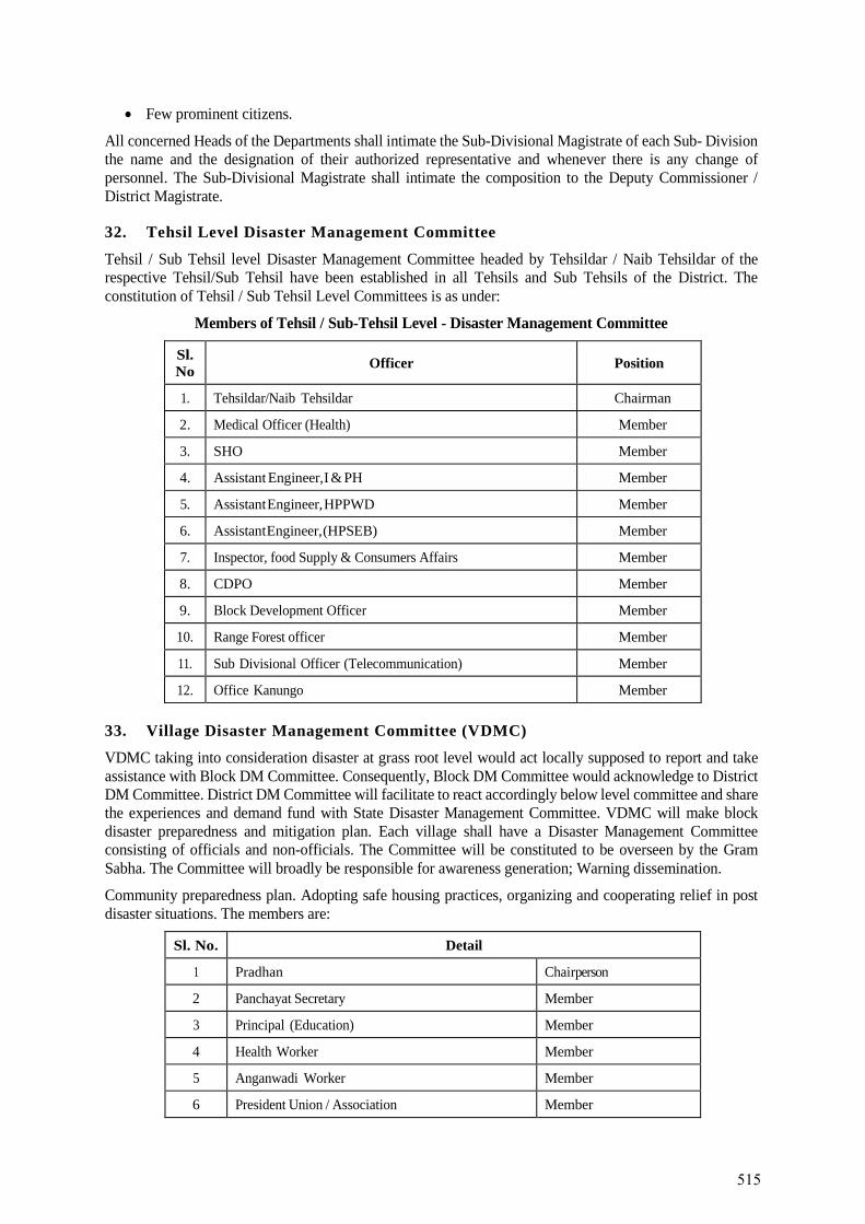
• Few prominent citizens.
All concerned Heads of the Departments shall intimate the Sub-Divisional Magistrate of each Sub- Division the name and the designation of their authorized representative and whenever there is any change of personnel. The Sub-Divisional Magistrate shall intimate the composition to the Deputy Commissioner / District Magistrate.
32. Tehsil Level Disaster Management Committee
Tehsil / Sub Tehsil level Disaster Management Committee headed by Tehsildar / Naib Tehsildar of the respective Tehsil/Sub Tehsil have been established in all Tehsils and Sub Tehsils of the District. The constitution of Tehsil / Sub Tehsil Level Committees is as under:
Members of Tehsil / Sub-Tehsil Level - Disaster Management Committee
Sl. No Officer Position
1. Tehsildar/Naib Tehsildar Chairman
2. Medical Officer (Health) Member
3. SHO Member
4. Assistant Engineer, I & PH Member
5. Assistant Engineer, HPPWD Member
6. Assistant Engineer, (HPSEB) Member
7. Inspector, food Supply & Consumers Affairs Member
8. CDPO Member
9. Block Development Officer Member
10. Range Forest officer Member
11. Sub Divisional Officer (Telecommunication) Member
12. Office Kanungo Member
33. Village Disaster Management Committee (VDMC)
VDMC taking into consideration disaster at grass root level would act locally supposed to report and take assistance with Block DM Committee. Consequently, Block DM Committee would acknowledge to District DM Committee. District DM Committee will facilitate to react accordingly below level committee and share the experiences and demand fund with State Disaster Management Committee. VDMC will make block disaster preparedness and mitigation plan. Each village shall have a Disaster Management Committee consisting of officials and non-officials. The Committee will be constituted to be overseen by the Gram Sabha. The Committee will broadly be responsible for awareness generation; Warning dissemination.
Community preparedness plan. Adopting safe housing practices, organizing and cooperating relief in post disaster situations. The members are:
Sl. No. Detail
1 Pradhan Chairperson
2 Panchayat Secretary Member
3 Principal (Education) Member
4 Health Worker Member
5 Anganwadi Worker Member
6 President Union / Association Member
515
Sl. No. Detail
7 Community Representative Member
8 Community Representative Member
9 Community Representative Member
10 Fair Price Shop Holder Member
34. District Emergency Operation Centre (DEOC), Bilaspur
District Emergency Operation Centre (DEOC), Bilaspur has been established in Deputy Commissioner Office as per the directions received from Himachal Pradesh State Disaster Management Authority (HPSDMA), Shimla. The design, layout, equipment and operation of the DEOC, Bilaspur is as per the EOC Manual prepared at the State level. DEOC, Bilaspur has been equipped with all basic and advance communication and IT infrastructure e.g., EPBAX, Computers, LED sets, Telephone sets, Generator, emergency lights in ready-to-use mode. District Emergency Operation Centre (DEOC) has been established in DC office, Bilaspur and for the smooth running and functioning of DEOC round the clock (24x7) 08 professional have been hired.
Role of Emergency Operation Centre in Normal Time
The Deputy Commissioner of District Bilaspur is empowered to appoint an Administrative Officer as Officer- in-charge of EOC. He will be responsible for the effective functioning of the EOC. Responsibilities of the EOC in charge in normal time Include
• Ensure that all equipment in the EOC is in working condition. • Collection data on routine basis from line departments for disaster management • Develop status reports of preparedness and mitigation activities in the DDMP • Ensure appropriate implementation of District Disaster Management Plan • Maintenance of data bank with regular updating • Activate the trigger mechanism on receipt of disaster warning / occurrence of disaster
Role of Emergency Operation Centre during Disaster
Based on the message received from the forecasting agencies, warning must be issued for the general public and the departments, which play a vital role during emergencies. Issuing correct and timely
warning would be one of the prime responsibilities of EOC. For effective dissemination of warning EOC should have a well- planned line of communication. The DC shall be the competent authority to disseminate a disaster warning. The warning on occurrence of a disaster will also be communicated to:
• All Emergency Support Functions • Members of DDMC-Bilaspur • Hospitals in the disaster area. • Office of Divisional Commissioner • State Relief Commissioner • Emergency Operation Centre in the neighboring districts • National / State Emergency Operation Centre • People’s representatives from the district
Apart from this the District Emergency Operation Centre must arrange desks for the Emergency Support Function in its complex for better coordination and help. Simultaneously the onsite EOCs are to be set up with the help of the district EOC. Further, the occurrence of the disaster would essentially bring into force the following:
• All district level staff from various departments, as required by the Collector, will be under the
516
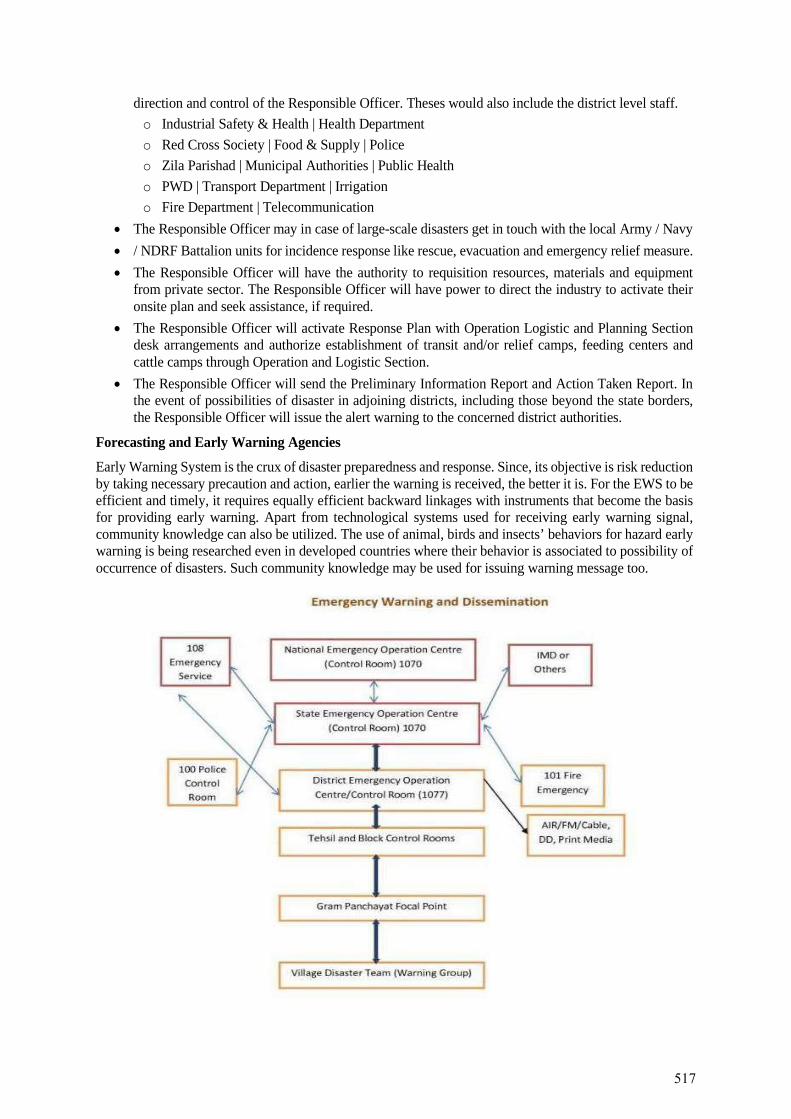
direction and control of the Responsible Officer. Theses would also include the district level staff. o Industrial Safety & Health | Health Department o Red Cross Society | Food & Supply | Police o Zila Parishad | Municipal Authorities | Public Health o PWD | Transport Department | Irrigation o Fire Department | Telecommunication
• The Responsible Officer may in case of large-scale disasters get in touch with the local Army / Navy • / NDRF Battalion units for incidence response like rescue, evacuation and emergency relief measure. • The Responsible Officer will have the authority to requisition resources, materials and equipment
from private sector. The Responsible Officer will have power to direct the industry to activate their onsite plan and seek assistance, if required.
• The Responsible Officer will activate Response Plan with Operation Logistic and Planning Section desk arrangements and authorize establishment of transit and/or relief camps, feeding centers and cattle camps through Operation and Logistic Section.
• The Responsible Officer will send the Preliminary Information Report and Action Taken Report. In the event of possibilities of disaster in adjoining districts, including those beyond the state borders, the Responsible Officer will issue the alert warning to the concerned district authorities.
Forecasting and Early Warning Agencies
Early Warning System is the crux of disaster preparedness and response. Since, its objective is risk reduction by taking necessary precaution and action, earlier the warning is received, the better it is. For the EWS to be efficient and timely, it requires equally efficient backward linkages with instruments that become the basis for providing early warning. Apart from technological systems used for receiving early warning signal, community knowledge can also be utilized. The use of animal, birds and insects’ behaviors for hazard early warning is being researched even in developed countries where their behavior is associated to possibility of occurrence of disasters. Such community knowledge may be used for issuing warning message too.
517
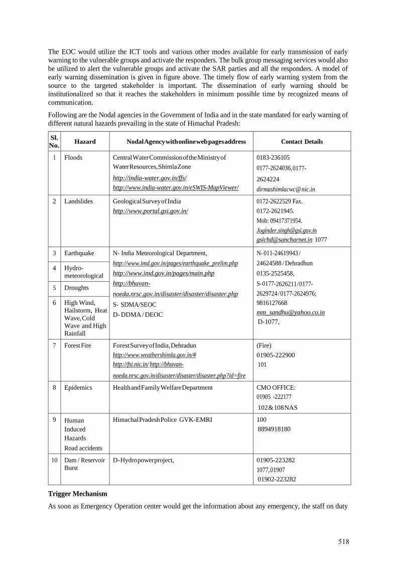
The EOC would utilize the ICT tools and various other modes available for early transmission of early warning to the vulnerable groups and activate the responders. The bulk group messaging services would also be utilized to alert the vulnerable groups and activate the SAR parties and all the responders. A model of early warning dissemination is given in figure above. The timely flow of early warning system from the source to the targeted stakeholder is important. The dissemination of early warning should be institutionalized so that it reaches the stakeholders in minimum possible time by recognized means of communication.
Following are the Nodal agencies in the Government of India and in the state mandated for early warning of different natural hazards prevailing in the state of Himachal Pradesh:
Sl. No. Hazard Nodal Agency with online web pages address Contact Details
1 Floods Central Water Commission of the Ministry of Water Resources, Shimla Zone
http://india-water.gov.in/ffs/ http://www.india-water.gov.in/eSWIS-MapViewer/
0183-236105 0177-2624036, 0177- 2624224 dirmashimlacwc@ nic.in
2 Landslides Geological Survey of India http://www.portal.gsi.gov.in/
0172-2622529 Fax. 0172-2621945. Mob: 09417371954. [email protected] [email protected] 1077
3 Earthquake N- India Meteorological Department, http://www.imd.gov.in/pages/earthquake_prelim.php http://www.imd.gov.in/pages/main.php http://bhuvan- noeda.nrsc.gov.in/disaster/disaster/disaster.php S- SDMA/SEOC D- DDMA / DEOC
N- 011-24619943 / 24624588 / Dehradhun 0135-2525458, S- 0177-2626211 / 0177- 2629724 / 0177-2624976; 9816127668 [email protected] D-1077,
4 Hydro-meteorological
5 Droughts
6 High Wind, Hailstorm, Heat Wave, Cold Wave and High Rainfall
7 Forest Fire Forest Survey of India, Dehradun http://www.weathershimla.gov.in/# http://fsi.nic.in/ http://bhuvan-
noeda.nrsc.gov.in/disaster/disaster/disaster.php?id=fire
(Fire) 01905-222900 101
8 Epidemics Health and Family Welfare Department CMO OFFICE: 01905 -222177 102 & 108 NAS
9 Human Induced Hazards Road accidents
Himachal Pradesh Police GVK-EMRI 100 8894918180
10 Dam / Reservoir Burst
D- Hydro power project, 01905-223282 1077, 01907 01902-223282
Trigger Mechanism
As soon as Emergency Operation center would get the information about any emergency, the staff on duty
518
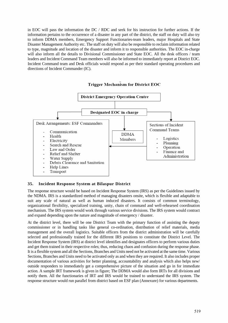
in EOC will pass the information the DC / RDC and seek for his instruction for further actions. If the information pertains to the occurrence of a disaster in any part of the district, the staff on duty will also try to inform DDMA members, Emergency Support Functionaries-team leaders, major Hospitals and State Disaster Management Authority etc. The staff on duty will also be responsible to reclaim information related to type, magnitude and location of the disaster and inform it to responsible authorities. The EOC in-charge will also inform all the details to Divisional Commissioner and State EOC. All the desk officers / team leaders and Incident Command Team members will also be informed to immediately report at District EOC. Incident Command team and Desk officials would respond as per their standard operating procedures and directions of Incident Commander (IC).
35. Incident Response System at Bilaspur District
The response structure would be based on Incident Response System (IRS) as per the Guidelines issued by the NDMA. IRS is a standardized method of managing disasters onsite, which is flexible and adaptable to suit any scale of natural as well as human induced disasters. It consists of common terminology, organizational flexibility, specialized training, unity, chain of command and well-rehearsed coordination mechanism. The IRS system would work through various service divisions. The IRS system would contract and expand depending upon the nature and magnitude of emergency / disaster.
At the district level, there will be one District Team with the primary function of assisting the deputy commissioner or in handling tasks like general co-ordination, distribution of relief materials, media management and the overall logistics. Suitable officers from the district administration will be carefully selected and professionally trained for the different IRS positions to constitute the District Level. The Incident Response System (IRS) at district level identifies and designates officers to perform various duties and get them trained in their respective roles; thus, reducing chaos and confusion during the response phase. It is a flexible system and all the Sections, Branches and Units need not be activated at the same time. Various Sections, Branches and Units need to be activated only as and when they are required. It also includes proper documentation of various activities for better planning, accountability and analysis which also helps new/ outside responders to immediately get a comprehensive picture of the situation and go in for immediate action. A sample IRT framework is given in figure; The DDMA would also form IRTs for all divisions and notify them. All the functionaries of IRT and IRS would be trained to understand the IRS system. The response structure would run parallel from district based on ESF plan (Annexure) for various departments.
519
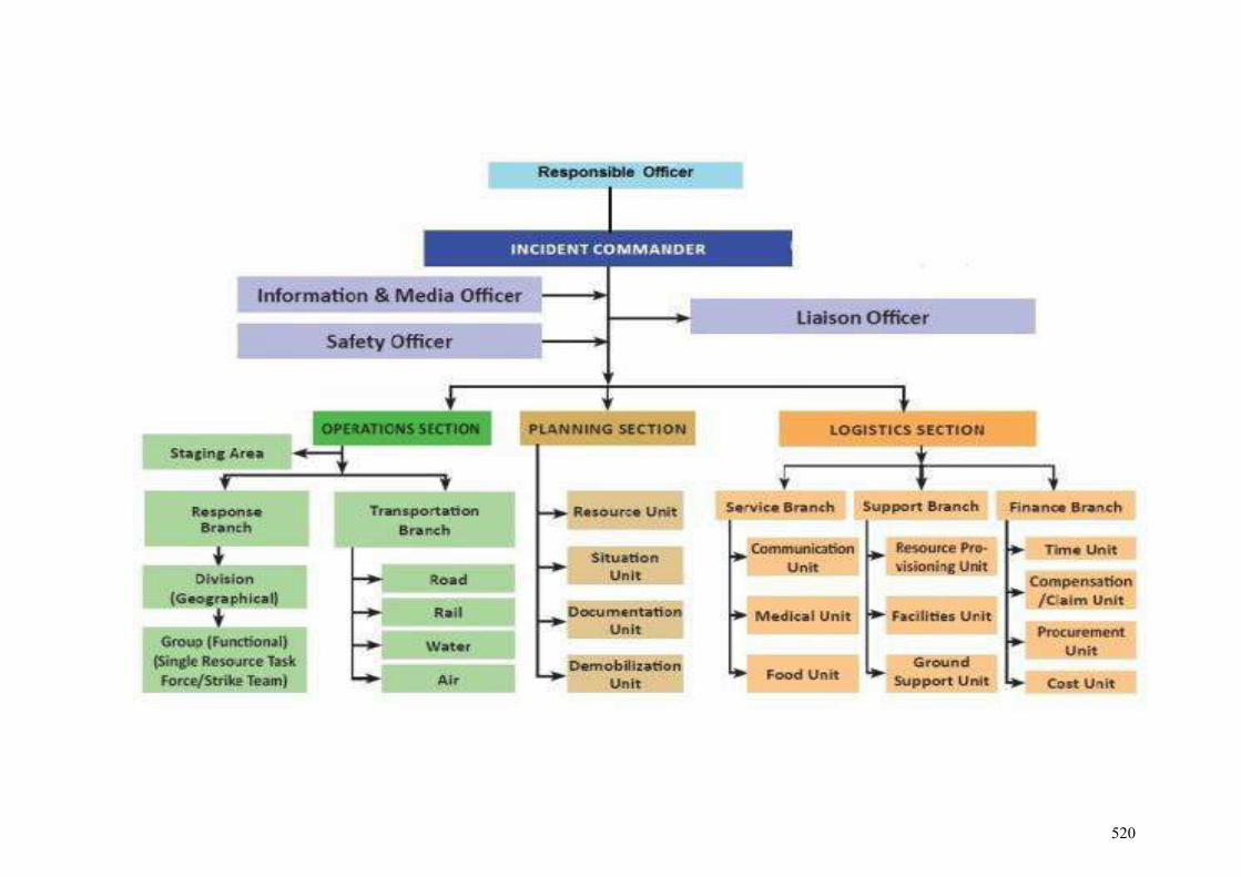
520
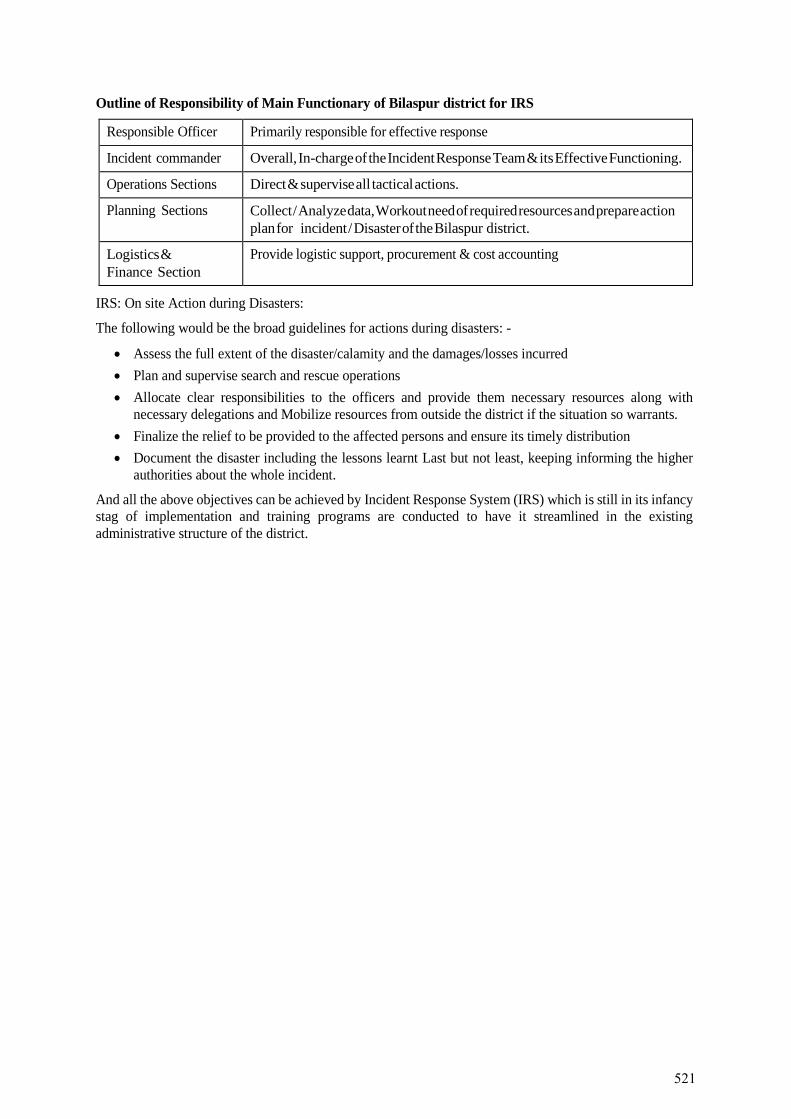
Outline of Responsibility of Main Functionary of Bilaspur district for IRS
Responsible Officer Primarily responsible for effective response
Incident commander Overall, In-charge of the Incident Response Team & its Effective Functioning.
Operations Sections Direct & supervise all tactical actions.
Planning Sections Collect / Analyze data, Workout need of required resources and prepare action plan for incident / Disaster of the Bilaspur district.
Logistics & Finance Section
Provide logistic support, procurement & cost accounting
IRS: On site Action during Disasters:
The following would be the broad guidelines for actions during disasters: -
• Assess the full extent of the disaster/calamity and the damages/losses incurred• Plan and supervise search and rescue operations• Allocate clear responsibilities to the officers and provide them necessary resources along with
necessary delegations and Mobilize resources from outside the district if the situation so warrants.• Finalize the relief to be provided to the affected persons and ensure its timely distribution• Document the disaster including the lessons learnt Last but not least, keeping informing the higher
authorities about the whole incident.
And all the above objectives can be achieved by Incident Response System (IRS) which is still in its infancy stag of implementation and training programs are conducted to have it streamlined in the existing administrative structure of the district.
521
Disaster Management and Emergency Response Plan at Project Road Level (to be prepared
separately for Project Road & Jetty Facility)
522
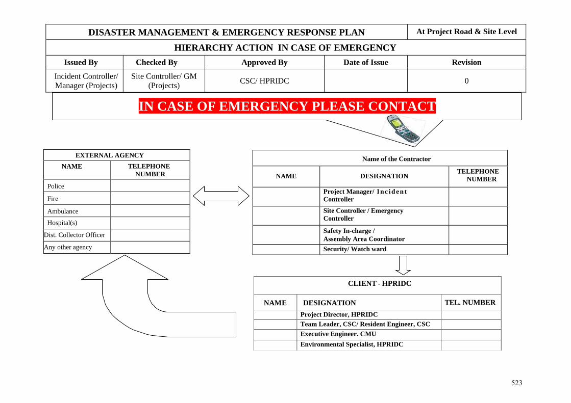
DISASTER MANAGEMENT & EMERGENCY RESPONSE PLAN At Project Road & Site Level
HIERARCHY ACTION IN CASE OF EMERGENCY Issued By Checked By Approved By Date of Issue Revision
Incident Controller/ Manager (Projects)
Site Controller/ GM (Projects) CSC/ HPRIDC 0
IN CASE OF EMERGENCY PLEASE CONTACT
Name of the Contractor
NAME DESIGNATION TELEPHONE
NUMBER
Project Manager/ Inc id en t Controller
Site Controller / Emergency Controller
Safety In-charge / Assembly Area Coordinator Security/ Watch ward
EXTERNAL AGENCY NAME TELEPHONE
NUMBER
Police
Fire
Ambulance
Hospital(s)
Dist. Collector Officer
Any other agency
CLIENT - HPRIDC
NAME DESIGNATION TEL. NUMBER Project Director, HPRIDC Team Leader, CSC/ Resident Engineer, CSC Executive Engineer. CMU Environmental Specialist, HPRIDC
523
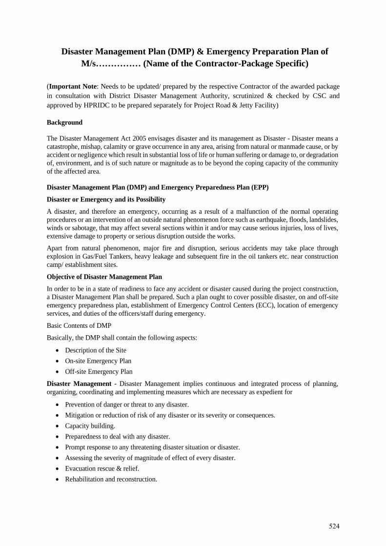
Disaster Management Plan (DMP) & Emergency Preparation Plan of M/s…………… (Name of the Contractor-Package Specific)
(Important Note: Needs to be updated/ prepared by the respective Contractor of the awarded package in consultation with District Disaster Management Authority, scrutinized & checked by CSC and approved by HPRIDC to be prepared separately for Project Road & Jetty Facility)
Background
The Disaster Management Act 2005 envisages disaster and its management as Disaster - Disaster means a catastrophe, mishap, calamity or grave occurrence in any area, arising from natural or manmade cause, or by accident or negligence which result in substantial loss of life or human suffering or damage to, or degradation of, environment, and is of such nature or magnitude as to be beyond the coping capacity of the community of the affected area.
Disaster Management Plan (DMP) and Emergency Preparedness Plan (EPP)
Disaster or Emergency and its Possibility
A disaster, and therefore an emergency, occurring as a result of a malfunction of the normal operating procedures or an intervention of an outside natural phenomenon force such as earthquake, floods, landslides, winds or sabotage, that may affect several sections within it and/or may cause serious injuries, loss of lives, extensive damage to property or serious disruption outside the works.
Apart from natural phenomenon, major fire and disruption, serious accidents may take place through explosion in Gas/Fuel Tankers, heavy leakage and subsequent fire in the oil tankers etc. near construction camp/ establishment sites.
Objective of Disaster Management Plan
In order to be in a state of readiness to face any accident or disaster caused during the project construction, a Disaster Management Plan shall be prepared. Such a plan ought to cover possible disaster, on and off-site emergency preparedness plan, establishment of Emergency Control Centers (ECC), location of emergency services, and duties of the officers/staff during emergency.
Basic Contents of DMP
Basically, the DMP shall contain the following aspects:
• Description of the Site• On-site Emergency Plan• Off-site Emergency Plan
Disaster Management - Disaster Management implies continuous and integrated process of planning, organizing, coordinating and implementing measures which are necessary as expedient for
• Prevention of danger or threat to any disaster.• Mitigation or reduction of risk of any disaster or its severity or consequences.• Capacity building.• Preparedness to deal with any disaster.• Prompt response to any threatening disaster situation or disaster.• Assessing the severity of magnitude of effect of every disaster.• Evacuation rescue & relief.• Rehabilitation and reconstruction.
524
BASIC DEFINITIONS
1. On-Site Plans - address incidents originating at any of construction/ operation sites orestablishment sites
2. Off-Site Plans - address incidents originating at any of construction/ operation sites orestablishment sites outside but affecting the Project Work
3. Risk - The chance of an adverse event occurring in some period or in a specificcircumstance, in the process of engaging in an activity
4. Hazard - A phenomenon which may cause disruption to persons and their infrastructure;and is an undesirable outcome in the process of engaging in an activity
5. Disaster - An event which can cause immense damage and disruption and causing loss to live ofworkforce and property.
6. Emergency - Serious sudden situation or occurrence that happens unexpectedly anddemands immediate action to correct or to protect lives and/or property.
7. Crisis - Unstable situation of extreme danger. and may lead to the following elements: -Surprise- -Rapid flow of events-Lack of or insufficient information-Internal conflict-confusion
8. Disaster Management - Set of actions and processes designed to lessen disastrous effectsbefore, during and after a disaster.
9. Preparedness - Measures undertaken in advance to ensure that individuals and agencieswill be ready to react, such as emergency plans, logistical support and resource, inventories,and emergency information & communications systems
10. Response - Those measures undertaken immediately after a disastrous or hazardous eventhas occurred and for a limited period thereafter, primarily to save human life, property, treatingthe injured, prevent further injury and other forms of property loss and to mitigate disruption.They include response plan activation, declaration and communication of emergency to theconcerned potential population and facilities at risk, opening and staffing of emergencyoperation centers, mobilization of resources, issuance of warnings and directions and provisionof aid.
11. Mitigation - Those measures and activities aimed at reducing or eliminating hazards orlessening the impact of the event.
12. Prevention - Mitigation of hazard effects through public education, early warning or detectionsystems, safety systems, building and land- use codes and regulation.
13. Recovery - Those measures undertaken to restore normal conditions. The time frame forrecovery begins as soon as a reduction in critical response activities permits the re-allocation of resources and could include physical restoration and reconstruction.
14. All Clear – Direction given by the incident coordinator (or authorized person) that theemergency has been revoked and that there is no further damage.
15. Assembly Areas – On decision of evacuation, the place where people will move first toassembly area where further instruction will be given.
16. Suspect Device – Any item that contains an explosive or mechanical device designated toexplode by means of timer, touching, impact or by remote control a suspect device mayappear suspicious by its placement, the circumstances surrounding its location or otherinformation that may cause any person to become suspicious and decide that further
525
investigation is necessary.
Key Objectives of the Plan
• To build a safe and disaster resilient project construction sites by developing• a holistic,• proactive,• multi-disaster oriented and• technology driven strategy through• prevention,• mitigation,• preparedness and• response
Objective of Disaster Management Plan
• To improve state of preparedness to meet any contingency• To reduce response time in organizing assistance by• defining responsibilities,• procedures for facilitating the curtailment and/ or restoration of Asset(s).• To identify• major resources,• manpower, material & equipment needed to make the plan operational• Making optimum use of resources.• Closure of emergency, its analysis and identification of lessons learnt
Scope of Disaster Management Plan
• Landslides• Floods• earthquake• Cloud burst• Fire• Terrorist Attack• Any other hazard
Prevention of Disasters
Design the system after considering factors like:
• Highest flood level• Seismic zones• Wind zones• Fire protection system• Physical Security arrangements• Other critical parameter
Disaster Management Cell at Contractor
• Management level at Contractor’s Corporate Office• Site level at respective project sites
526
Site level Disaster Management Committee
• Site Manager• Site Engineers• Safety In charge
Disaster Management at Site Level Responsibilities
• To maintain and update emergency call out list of persons:• for emergency control,• key personnel of Client• fire safety• first aid, medical emergencies• Security, Police, District Administration Authorities• Display communication details of nodal officers to be contacted in emergency• Fixing of permanent notice boards at all suitable locations at project operation/ establishment sites
displaying information, map, escape routes, precautions to be taken during emergency.• To arrange food, drinking water, Tent for office space at site, accommodation for deployed employees/
workers (all levels)
Appointment of Key Persons and their Role at Project Road/ Site Level
1. Site Controller (SC)
The General Manager (however called) or his nominated deputy will assume overall responsibility for the Site and its personnel.
2. Incident Controller (IC)
Project Manager or an Officer of similar rank will be nominated to act as the IC. Immediately on learning about an emergency, he will rush to the incident site and take overall charge and report to the SC.
3. Liaison Officer (LO)
Personnel/Administrative Manager or his nominated Officer of deputy rank will work as LO and will be stationed at the Nodal Control Centers during emergency to handle Police, District Administration, Hospitals and other enquiries.
4. Forward Area Controller (FAC)
Departmental In charge of the concerned area will be the FAC to take care of the respective departments during emergency.
5. Task Specific Team Leaders (TLs)
As number of specified activities may have to be carried out, for which specific teams have to be formulated and their roles or duties defined, each of them will be headed by a Team Leader, in accordance. The following teams are suggested:
• Task Force• Repair Team• Fire Fighting Team• Communication Team• Security Team
527

• Manpower Team• Safety Team• Transport Team• Medical Team
Emergency Control Centers (ECC)
Emergency Control Room is to be set up and marked on the site plan for the knowledge of all concerned. ECC is the focal point and it should be well connected with internal and external telephones and furnished with list of personnel and their addresses.
Assembly Points
Assembly points, the pre-determined safe places, where people will be directed after evaluation from the hazardous locality, have to be set up and marked on the site plan. Escape routes from assembly points have to be clearly defined and depicted.
Alarms
Suitable sirens will be provided at Site, which could be operated from the Nodal Control Rooms. The coding of the siren should be as per the standards and well circulated within the facility.
Tie Ups for Aid with Institutions (Hospitals, Wards, Police Stations etc.)
It is essential to have mutual aid arrangements among the industries in the neighborhood which would help in the case of a major disaster.
Training and Mock Drills
Proper training of the key personnel and other non-key personnel, who will take part in case of an emergency, should be arranged through engagement of district level disaster management authorities. Mock drills shall be performed to test the performance of the procedure laid
Emergency Callout List
Sl. No. Name of Official/ Agency Mobile No. Landline No. Address
1 Site Manger
2 Site Engineer
3 Safety In charge
4 Team Leader, CSC
5 Resident Engineer, CSC
6 Executive Engineer, CMU
7 Environmental Specialist HPRIDC
8 Project Director, HPRIDC
9 Nearest Fire Station-I
10 Nearest Fire Station-II
11 Nearest Hospital-I
528

Sl. No. Name of Official/ Agency Mobile No. Landline No. Address
12 Nearest Hospital-II
13 Police Station
14 District Magistrate
15 Superintendent of Police
16 District Disaster Management Cell
17 State Disaster Management Cell
18 National Disaster Management Cell
529
APPENDIX-16
Air Quality Dispersion Modelling for Project Road
530
Ragunathpura-Mandi-Haripura-Bharari Road (OSR011)
Air Dispersion Modeling Report
531
Contents 1.0. Introduction ...................................................................................................................................... 3
1.1 Aim ................................................................................................................................................ 3
2. Project location ......................................................................................................................................... 3
3. 0. Dispersion modeling .............................................................................................................................. 4
3.1 Analysis details.............................................................................................................................. 4
3.1.1 Tools and methods .................................................................................................................... 4
3.1.2 Input(s) and assumptions .......................................................................................................... 4
3.1.3 Modeling approach ................................................................................................................... 4
3.2 Data collection .............................................................................................................................. 5
3.2.1 Traffic survey data ........................................................................................................................ 5
3.3 Baseline Data ................................................................................................................................ 5
3.4 Emission Estimates .............................................................................................................................. 6
3.5 Model Input ........................................................................................................................................ 6
3.5.1. Control Pathway Inputs .............................................................................................................. 7
3.5.2. Source Parameters ...................................................................................................................... 7
3 . 5 . 3 . Receptors pathway inputs....................................................................................................... 7
3 . 5 . 4 . Terrain grid Pathway inputs .................................................................................................... 7
3.5.5. Meteorological Data ................................................................................................................... 7
3.5.5. Output Pathway .......................................................................................................................... 9
4.0 Scenario analysis results & discussion .................................................................................................. 10
5.0. Conclusion ............................................................................................................................................ 11
6.0. Ground concentration maps of pollutants .......................................................................................... 12
7.0. Ground concentration maps at Monitoring stations (500m buffer) ................................................... 28
7.1. Along Project Road ........................................................................................................................... 28
532
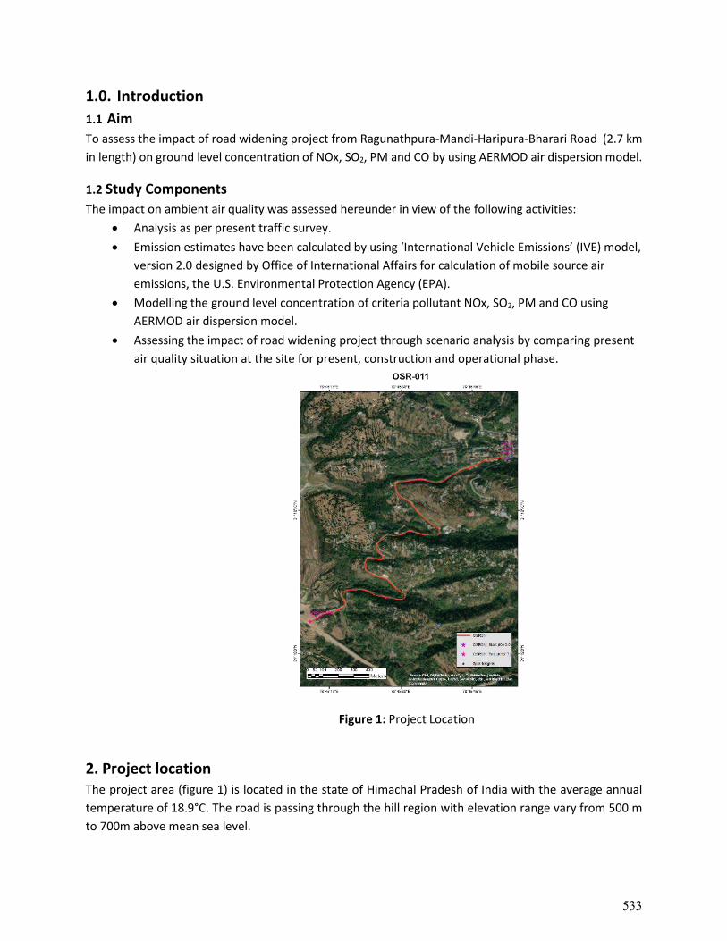
1.0. Introduction 1.1 Aim To assess the impact of road widening project from Ragunathpura-Mandi-Haripura-Bharari Road (2.7 km in length) on ground level concentration of NOx, SO2, PM and CO by using AERMOD air dispersion model.
1.2 Study Components The impact on ambient air quality was assessed hereunder in view of the following activities:
• Analysis as per present traffic survey. • Emission estimates have been calculated by using ‘International Vehicle Emissions’ (IVE) model,
version 2.0 designed by Office of International Affairs for calculation of mobile source air emissions, the U.S. Environmental Protection Agency (EPA).
• Modelling the ground level concentration of criteria pollutant NOx, SO2, PM and CO using AERMOD air dispersion model.
• Assessing the impact of road widening project through scenario analysis by comparing present air quality situation at the site for present, construction and operational phase.
Figure 1: Project Location
2. Project location The project area (figure 1) is located in the state of Himachal Pradesh of India with the average annual temperature of 18.9°C. The road is passing through the hill region with elevation range vary from 500 m to 700m above mean sea level.
533
3. 0. Dispersion modeling
The vehicular emission of present, construction and operational phases have been considered during this study. Dispersion modeling has been carried out using Line volume source emissions from vehicles on the proposed road widening project namely Ragunathpura- Mandi- Haripura- Bharari road having length of 2.7 km (refer Figure 1) and meteorology data from 01 Sep 2020 to 31 Dec 2020 to predict ground level concentration of PM, NOx, SO2 and CO from vehicular emissions.
3.1 Analysis details
3.1.1 Tools and methods Line volume dispersion analysis has been carried out based on AERMOD ViewTM model. This model enables analysis with respect to PM, NOx, SOX and CO and gives results in easy to understand in graphical format.
3.1.2 Input(s) and assumptions The following table-1 illustrates series of inputs and some of assumptions gone into the model.
Table 1: Input and Assumptions
S.No. Input Required Availability for project
1 Traffic Parameters
Traffic Volume Yes Traffic Composition Yes Type of Fuel used by each category Yes Average Speed of the Vehicles Yes
2 Meteorological Parameters
Wind Speed, Wind Direction, Cloud Cover, Temperature, Humidity, Station Pressure, etc.
IMD Weather data
5 Emission Parameters Expressed in grams/sec or gram/distance travelled
Calculations form International Vehicle
Emissions (IVE) Model
6 Road Geometry Road Width Google Earth image Median Width Actual
7 Receptor Location Uniform grid along road Yes
3.1.3 Modeling approach Number of vehicles using the road is the most important parameter to quantify the emissions from mobile sources to estimate the GLC of criteria pollutant form vehicular emissions. In addition, the distance travelled by every vehicles on road is known as Vehicle Kilometers Travelled (VKT) and average speed,
534
also considered for the emission estimates. The emission factors have been calculated based on ‘International Vehicle Emissions’ (IVE) model, version 2.0 designed by Office of International Affairs for calculation of mobile source air emissions, the U.S. Environmental Protection Agency (EPA) by considering VKT and driving behavior.
3.2 Data collection This study has used the results of traffic volume survey conducted in project site. This traffic survey results include the review of an external and internal connectivity aspects. The road network under consideration was studied in detail. A vehicle counting program specific to the need for developing emissions inventory was planned and executed at different locations all across the area of influence of the project and projection of future estimates were done.
3.2.1 Traffic survey data The average traffic survey data collected form field surveys are used to get the daily traffic volume by vehicle type and direction were aggregated and an average calculated for the entire survey duration to determine the average daily traffic (ADT) at each survey location. It was found Khansra has more vehicles count along the project road. Growth potential of goods traffic is different from passenger traffic. This is more directly related to zone’s economic activity and production levels than its population and income growth. The Estimated Growth rates thus arrived based on regression equations are presented in the table 2. This data has been used to model the future scenario of emission and the impact of road widening project.
Table 2: Traffic Projections on project road
S No Years Total Vehicles Total PCU
1 Present Condition (2020) 608 573 2 Construction Phase (2023) 823 759 3. Operational Phase (2030) 4237 6770 4. Future Scenario (2038) 6752 10394
3.3 Baseline Data Based on the primary activity data gathered at the site location and has been used as base line data for scenario analysis (Table 3).
Table 3: Base line data from ambient air quality monitoring report S.No.
Locations PM10
(µg/m3) NOx
(µg/m3) SO2
(µg/m3) CO (µg/m3)
A. Along Project Road 1. Bharari village (AAQ1) 65 26 12 0.27 B. At Jetty Facility 2. Near Mukti Dham (AAQ2) 81 12.1 9.2 BDL
535
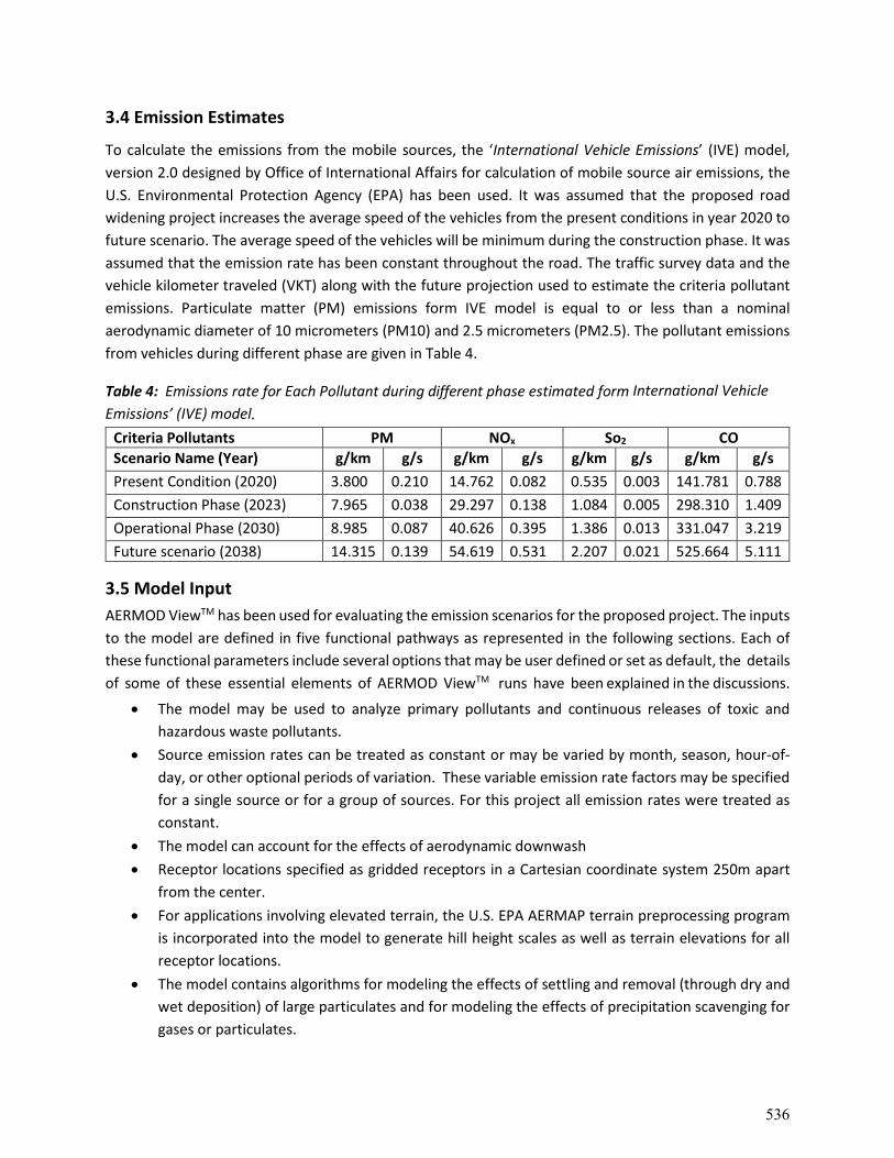
3.4 Emission Estimates
To calculate the emissions from the mobile sources, the ‘International Vehicle Emissions’ (IVE) model, version 2.0 designed by Office of International Affairs for calculation of mobile source air emissions, the U.S. Environmental Protection Agency (EPA) has been used. It was assumed that the proposed road widening project increases the average speed of the vehicles from the present conditions in year 2020 to future scenario. The average speed of the vehicles will be minimum during the construction phase. It was assumed that the emission rate has been constant throughout the road. The traffic survey data and the vehicle kilometer traveled (VKT) along with the future projection used to estimate the criteria pollutant emissions. Particulate matter (PM) emissions form IVE model is equal to or less than a nominal aerodynamic diameter of 10 micrometers (PM10) and 2.5 micrometers (PM2.5). The pollutant emissions from vehicles during different phase are given in Table 4.
Table 4: Emissions rate for Each Pollutant during different phase estimated form International Vehicle Emissions’ (IVE) model.
Criteria Pollutants PM NOx So2 CO Scenario Name (Year) g/km g/s g/km g/s g/km g/s g/km g/s Present Condition (2020) 3.800 0.210 14.762 0.082 0.535 0.003 141.781 0.788 Construction Phase (2023) 7.965 0.038 29.297 0.138 1.084 0.005 298.310 1.409 Operational Phase (2030) 8.985 0.087 40.626 0.395 1.386 0.013 331.047 3.219 Future scenario (2038) 14.315 0.139 54.619 0.531 2.207 0.021 525.664 5.111
3.5 Model Input AERMOD ViewTM has been used for evaluating the emission scenarios for the proposed project. The inputs to the model are defined in five functional pathways as represented in the following sections. Each of these functional parameters include several options that may be user defined or set as default, the details of some of these essential elements of AERMOD ViewTM runs have been explained in the discussions.
• The model may be used to analyze primary pollutants and continuous releases of toxic and hazardous waste pollutants.
• Source emission rates can be treated as constant or may be varied by month, season, hour-of-day, or other optional periods of variation. These variable emission rate factors may be specified for a single source or for a group of sources. For this project all emission rates were treated as constant.
• The model can account for the effects of aerodynamic downwash • Receptor locations specified as gridded receptors in a Cartesian coordinate system 250m apart
from the center. • For applications involving elevated terrain, the U.S. EPA AERMAP terrain preprocessing program
is incorporated into the model to generate hill height scales as well as terrain elevations for all receptor locations.
• The model contains algorithms for modeling the effects of settling and removal (through dry and wet deposition) of large particulates and for modeling the effects of precipitation scavenging for gases or particulates.
536
• AERMOD requires two types of meteorological data files, a file containing surface scalar parameters and a file containing vertical profiles.
3.5.1. Control Pathway Inputs • Default option • Calculate the concentration • Averaging period of 24hr and 8hr depending on the NAAQS and pollutant type
3.5.2. Source Parameters
• Includes definition of source, its locations • Vehicle source parameter include emissions (g/s)
3 . 5 . 3 . Receptors pathway inputs • Cartesian grid starting at the SW corner of the ward with 250 m increment over X & Y
coordinates in the bounding box encompassed by both side 500 m buffer along the road.
3 . 5 . 4 . Terrain grid Pathway inputs • Elevations of receptors taken from the Shuttle Radar Topography Mission (SRTM3) with a
resolution of 3 arc-second (90 meters) for India issued by the USGS, based on the World Geodetic System 1984 (WGS-84). This SRTM3 data was processed with AERMAP in combination with receptors layout of and emission sources taken for modeling. The terrain elevations of all receptors and sources were run in AERMAP model. AERMAP extracted digital terrain data from USGS website for the particular study area.
3.5.5. Meteorological Data The AERMOD model requires hourly surface data values for wind speed, wind direction, temperature, rainfall, relative humidity, pressure, cloud cover and ceiling height and solar radiation and at least once daily mixing height data. These were utilized to generate the required mixing heights for the AERMOD model. Both data files for the surface and mixing heights were then used to generate the meteorological file required by the AERMOD dispersion model using the AERMET meteorological preprocessor programme. This AERMET programme has three stages to process the data. The first stage extracts meteorological data and assesses data quality through a series of quality assessment checks. The second stage merges all data available for 24-hour periods and writes these data together in a single intermediate file. The third and final stage reads the merged meteorological data and estimates the necessary boundary layer parameters for dispersion calculations by AERMOD. During this investigation, the hourly metrological data of near met station (Mandi IMD AWS) for the period of 4 month covering from 01-Sep-2020 to 31-Dec-2020. The monthly summary of metrological data is presented in Table 5. These following parameters input are Hour, Day, Month, Year, Pressure (mbar), Wind Direction (deg), Cloud Cover (tenths), Wind Speed (m/s), Relative Humidity (%), Ceiling Height (Feet), Dry Bulb Temp (°C),Precipitation (mm) etc.
537
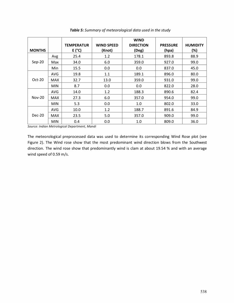
Table 5: Summary of meteorological data used in the study
MONTHS TEMPERATUR
E (°C) WIND SPEED
(Knot)
WIND DIRECTION
(Deg) PRESSURE
(hpa) HUMIDITY
(%)
Sep-20 Avg 25.4 1.2 178.1 893.8 88.9 Max 34.0 6.0 359.0 927.0 99.0 Min 15.5 0.0 0.0 837.0 45.0
Oct-20 AVG 19.8 1.1 189.1 896.0 80.0 MAX 32.7 13.0 359.0 931.0 99.0 MIN 8.7 0.0 0.0 822.0 28.0
Nov-20 AVG 14.0 1.2 188.3 890.6 82.4 MAX 27.3 6.0 357.0 954.0 99.0 MIN 5.3 0.0 1.0 802.0 33.0
Dec-20 AVG 10.0 1.2 188.7 891.6 84.9 MAX 23.5 5.0 357.0 909.0 99.0 MIN 0.4 0.0 1.0 809.0 36.0
Source: Indian Metrological Department, Mandi
The meteorological preprocessed data was used to determine its corresponding Wind Rose plot (see Figure 2). The Wind rose show that the most predominant wind direction blows from the Southwest direction. The wind rose show that predominantly wind is clam at about 19.54 % and with an average wind speed of 0.59 m/s.
538
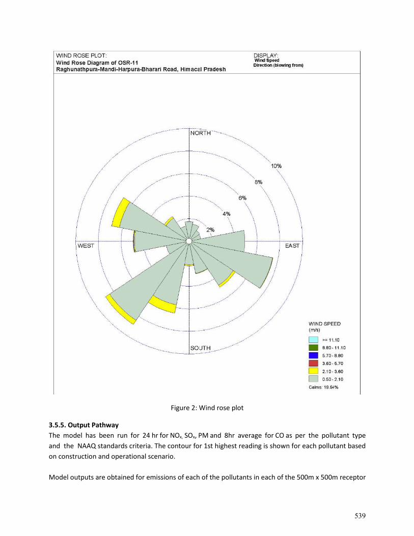
Figure 2: Wind rose plot
3.5.5. Output Pathway The model has been run for 24 hr for NOx, SOx, PM and 8hr average for CO as per the pollutant type and the NAAQ standards criteria. The contour for 1st highest reading is shown for each pollutant based on construction and operational scenario. Model outputs are obtained for emissions of each of the pollutants in each of the 500m x 500m receptor
539
grid spread across gridded impact zone in the figure 3 to figure 14. Contour map are plotted for each of the study pollutants and the impact by the line volume source i.e. present, construction and operational scenarios including growth of vehicle numbers projected based on the traffic survey. This map is superimposed on the road tile map from Open street map of the proposed location.
4.0 Scenario analysis results & discussion The project road has been represented in the contour plots for concentration to understand the impact of vehicular emission from the road on surrounding area. The combined influences have been assessed and modeled for operational (future) scenario i.e. with projected vehicular traffic. Modeled pollutant ground level concentrations were tabulated for present, construction and operations phase scenarios in Table 6. Maximum modeled ground level concentration of pollutants has been seen in the location of 667342.51E and 3465008.60 N Table 6: Maximum modeled ground level concentration of pollutants (µg/m3) due to vehicles on project road for present, construction and operation scenarios.
Parameters Present (2020) Construction (2023)
Operational (2030)
Future Scenario (2038)
PM (24 hr average) 6.35 11.81 10.3 17.4 NOx (24 hr average) 25.5 43.0 59.1 66.7 SOx (24 hr average) 0.91 1.55 1.87 2.80 CO (8 hr average) 441 789 657 1155
Table 6 shows that, the ground level concentration of criteria pollutants are high during construction phase than present and operational phase. However, the increasing number of vehicles is witnessed from the traffic projections, the ground level concentration will be reduced due to increasing velocity of vehicles and also increasing number of BS-6 vehicles during operational phase by 2030. The following table 7 shows the impact of vehicular emission from the proposed road on ambient air quality.
540
Table 7: Comparative account of present, construction near operational phase and future Scenarios
Bharari village (AAQ1)
Present Phase Construction Phase
Operational Phase Future Scenario
NAAQ
BASELINE GLC Resultant GLC Resultant GLC Resultan
t GLC Resultant
PM (24 hr average)
65.00 2.17 67.17 3.64 68.64 3.16 68.16 5.36 70.36
100
Nox (24 hr average)
26.00 7.84 33.84 13.24 39.24 18.18 44.18 20.53 46.53
80
Sox (24 hr average)
12.00 0.31 12.31 0.48 12.48 0.57 12.57 0.86 12.86
80
Co (8 hr average)
0.27 112.00 112.27 241.42 241.69 167.5
6 167.83 294.59 294.86
2000
Concentration are in (µg/m3) *NAAQS – National Ambient Air Quality Standards, 2009
5.0. Conclusion The AERMODTM model simulation showing that the ground level concentration of NOx, SO2, PM and CO pollutants from the vehicular emissions of Ragunathpura- Mandi- Haripura- Bharari road (2.7 km in length) are within the NAAQS standards for present (2020), construction (2023) operational (2030) phases and Future Scenario (2038).
541
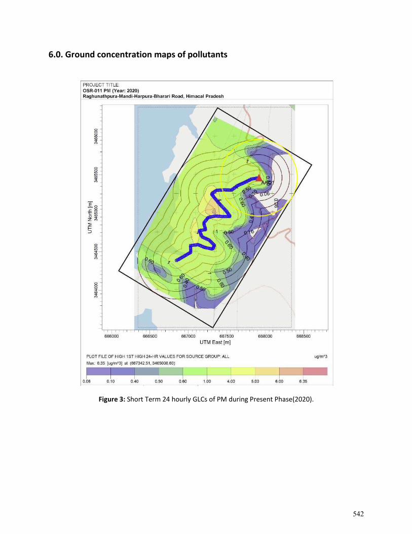
6.0. Ground concentration maps of pollutants
Figure 3: Short Term 24 hourly GLCs of PM during Present Phase(2020).
542
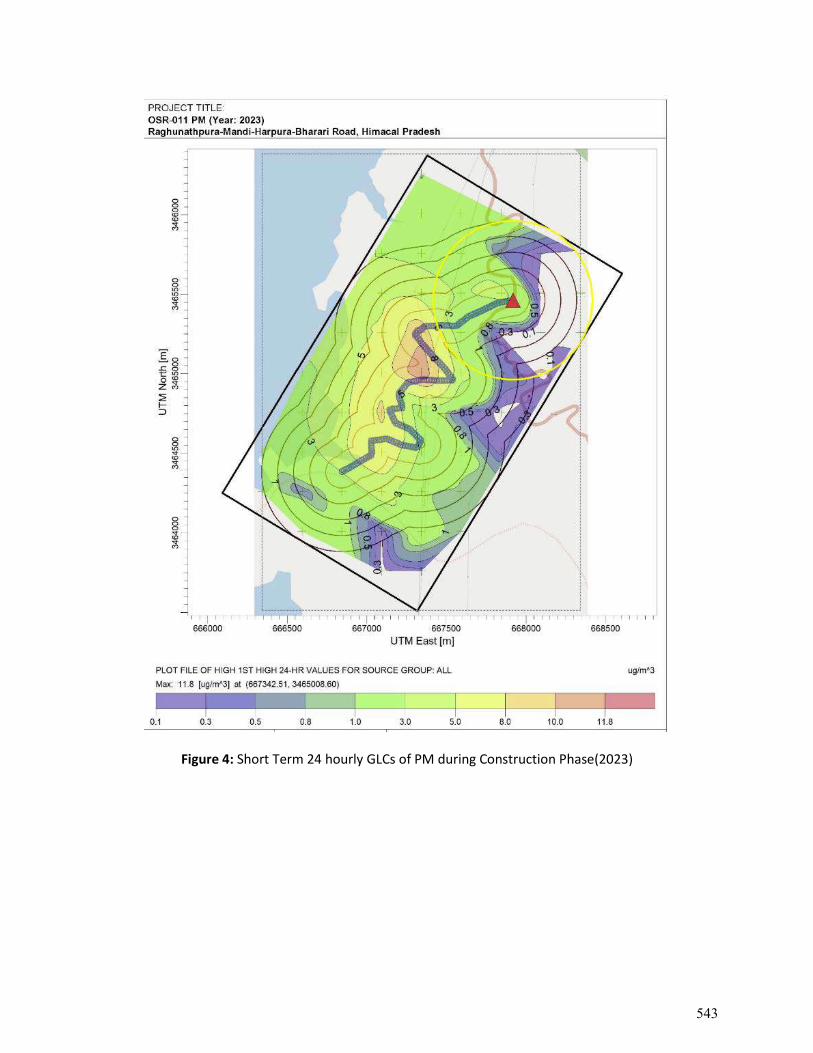
Figure 4: Short Term 24 hourly GLCs of PM during Construction Phase(2023)
543
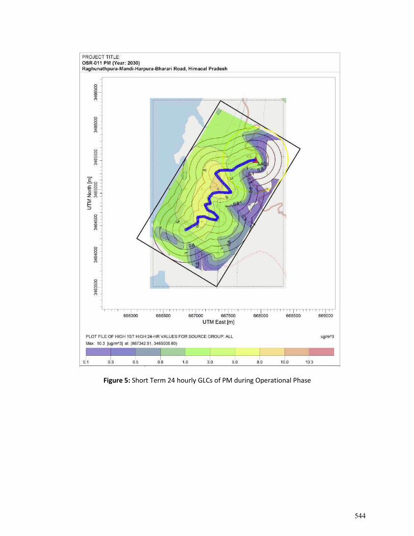
Figure 5: Short Term 24 hourly GLCs of PM during Operational Phase
544
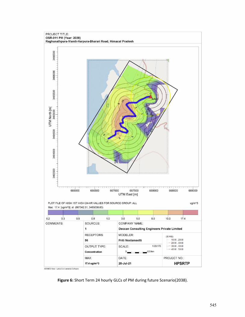
Figure 6: Short Term 24 hourly GLCs of PM during future Scenario(2038).
545
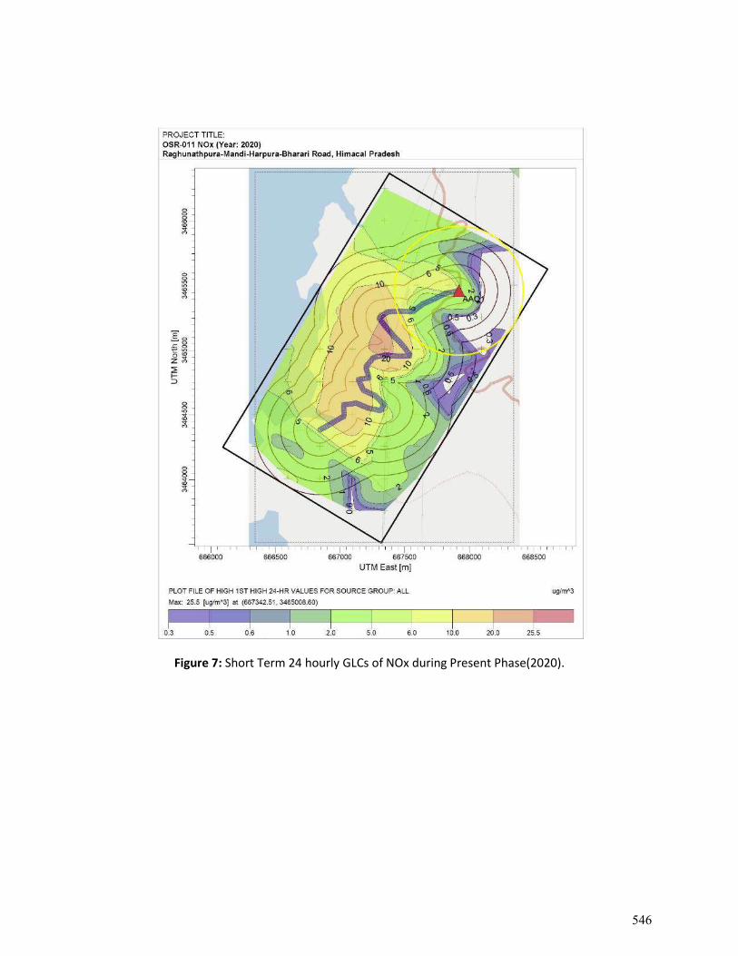
Figure 7: Short Term 24 hourly GLCs of NOx during Present Phase(2020).
546
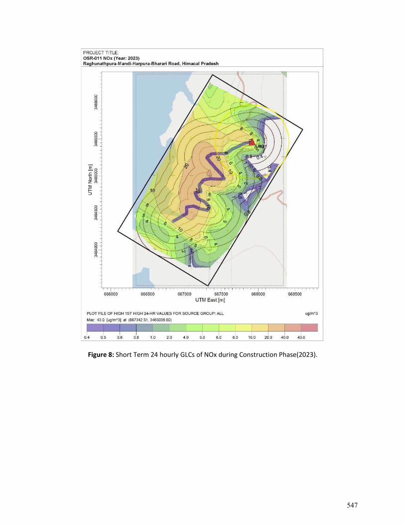
Figure 8: Short Term 24 hourly GLCs of NOx during Construction Phase(2023).
547
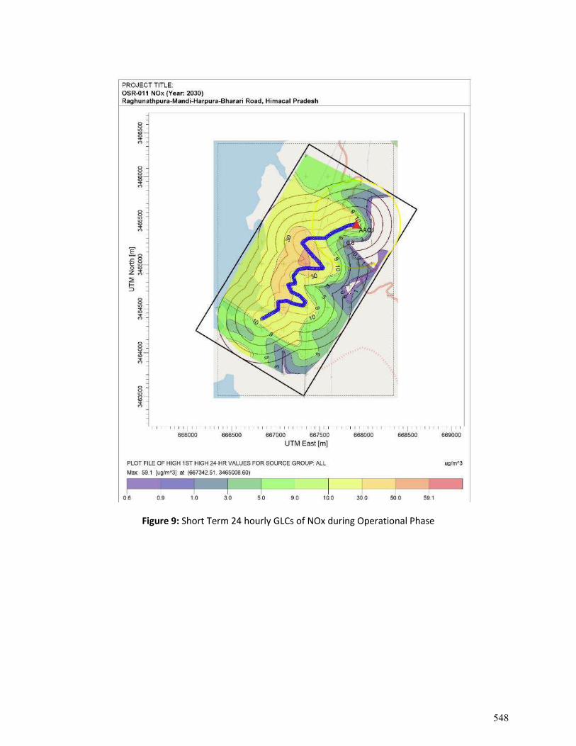
Figure 9: Short Term 24 hourly GLCs of NOx during Operational Phase
548
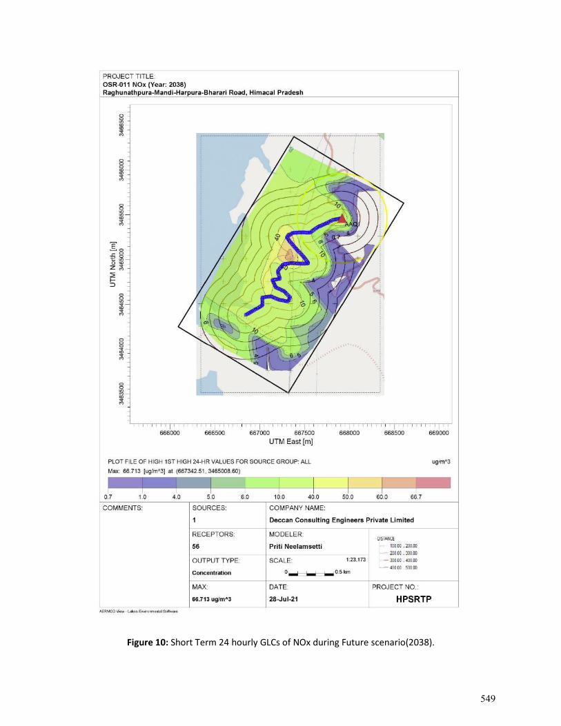
Figure 10: Short Term 24 hourly GLCs of NOx during Future scenario(2038).
549
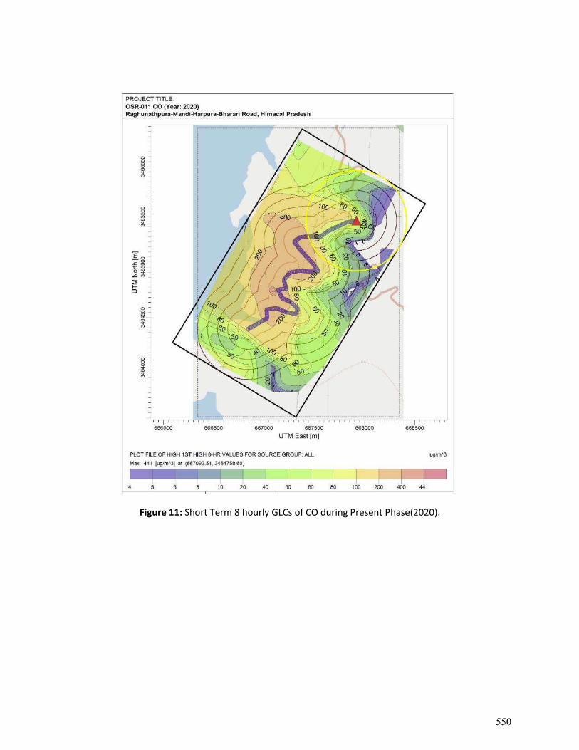
Figure 11: Short Term 8 hourly GLCs of CO during Present Phase(2020).
550
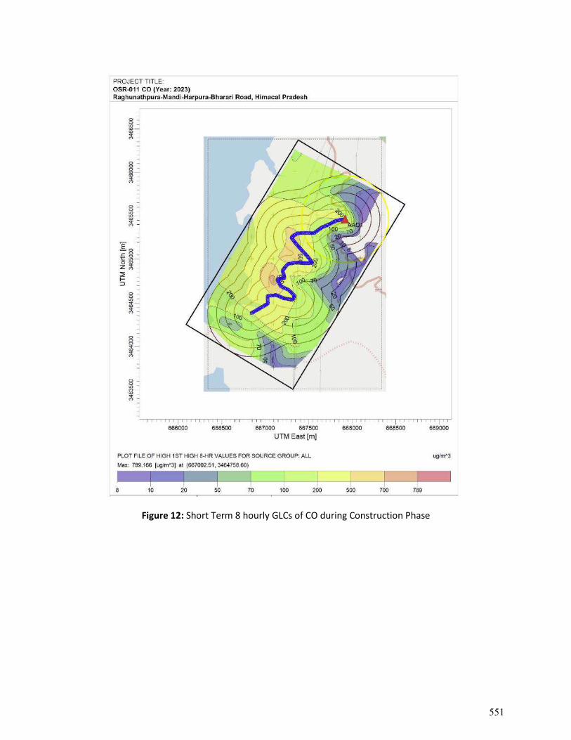
Figure 12: Short Term 8 hourly GLCs of CO during Construction Phase
551
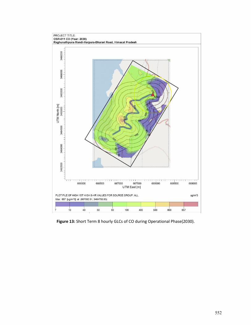
Figure 13: Short Term 8 hourly GLCs of CO during Operational Phase(2030).
552
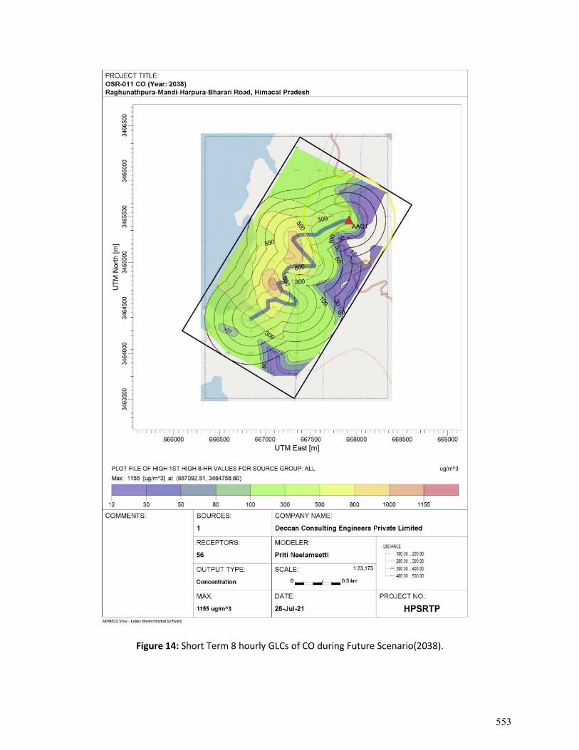
Figure 14: Short Term 8 hourly GLCs of CO during Future Scenario(2038).
553
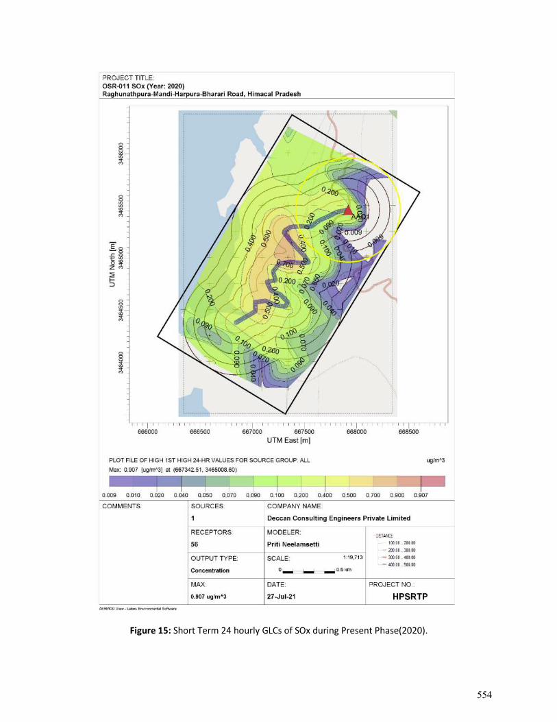
Figure 15: Short Term 24 hourly GLCs of SOx during Present Phase(2020).
554
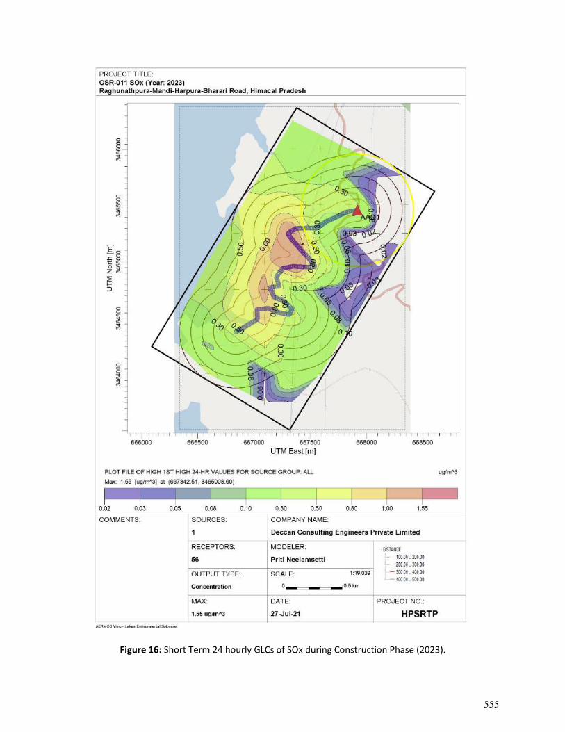
Figure 16: Short Term 24 hourly GLCs of SOx during Construction Phase (2023).
555
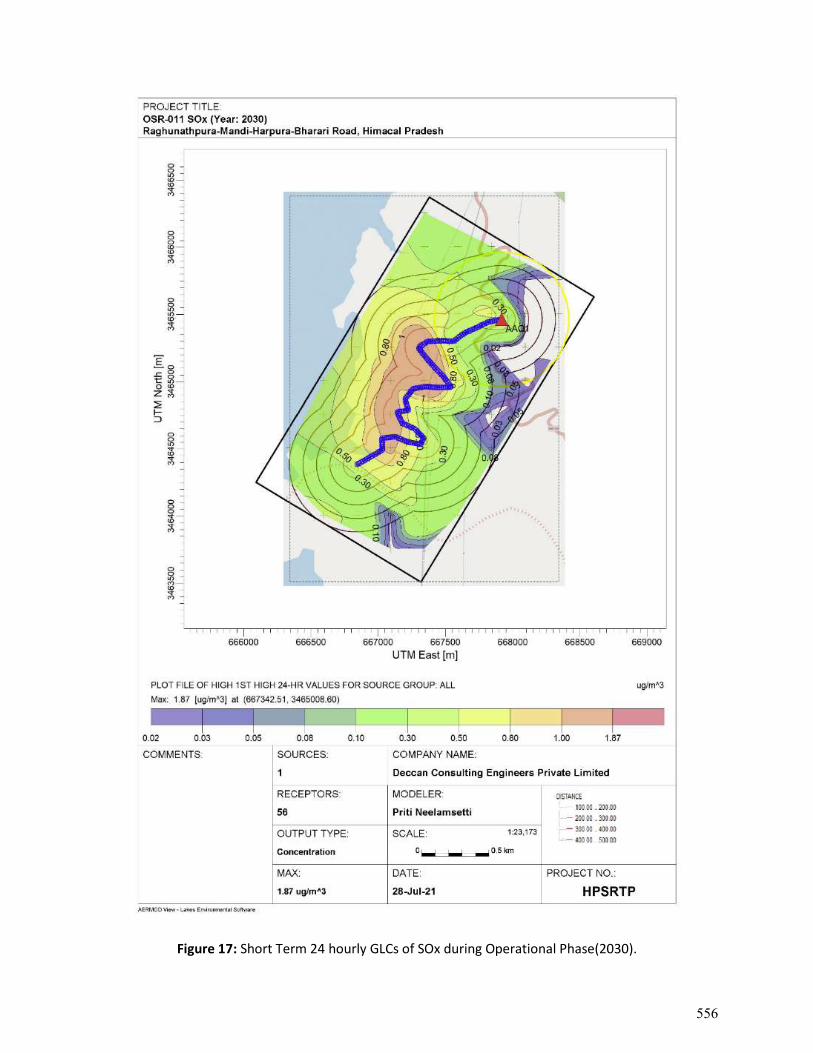
Figure 17: Short Term 24 hourly GLCs of SOx during Operational Phase(2030).
556
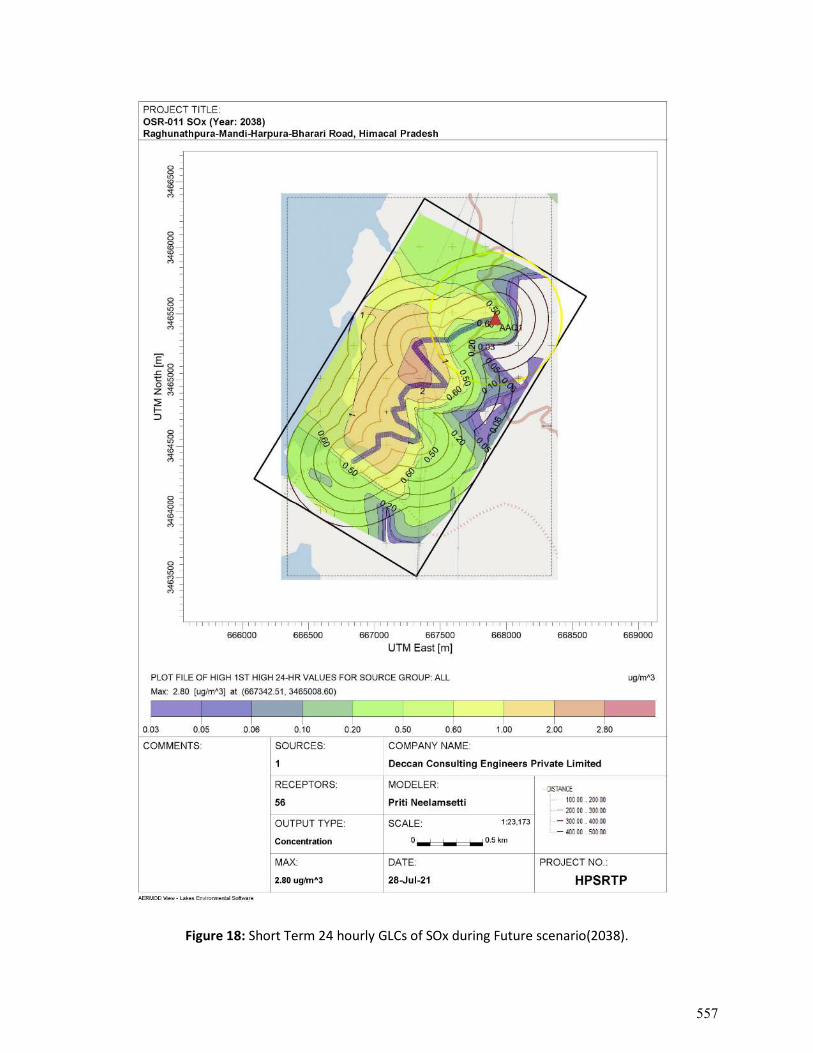
Figure 18: Short Term 24 hourly GLCs of SOx during Future scenario(2038).
557
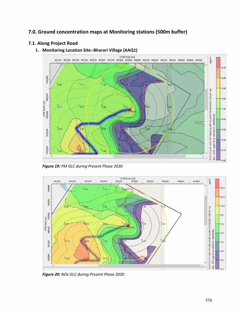
7.0. Ground concentration maps at Monitoring stations (500m buffer)
7.1. Along Project Road 1. Monitoring Location Site:-Bharari Village (AAQ1)
Figure 19: PM GLC during Present Phase 2020
Figure 20: NOx GLC during Present Phase 2020
558
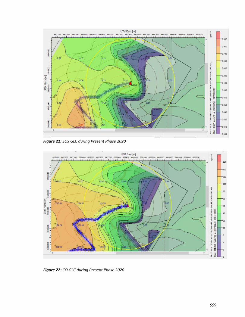
Figure 21: SOx GLC during Present Phase 2020
Figure 22: CO GLC during Present Phase 2020
559
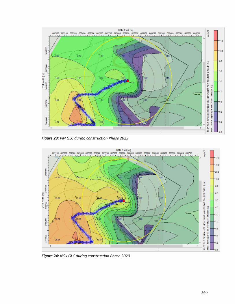
Figure 23: PM GLC during construction Phase 2023
Figure 24: NOx GLC during construction Phase 2023
560
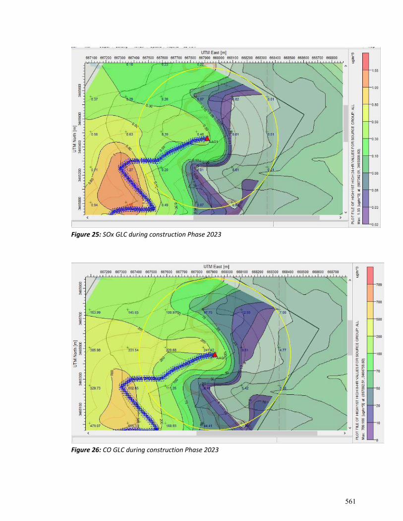
Figure 25: SOx GLC during construction Phase 2023
Figure 26: CO GLC during construction Phase 2023
561
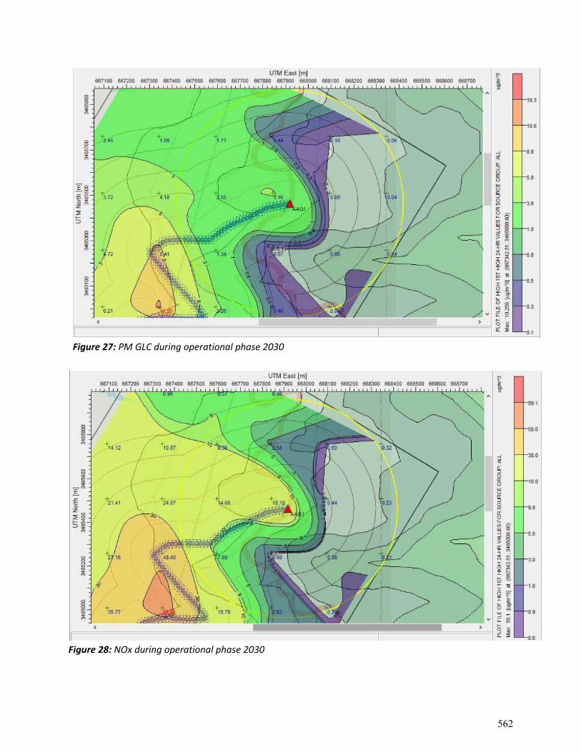
Figure 27: PM GLC during operational phase 2030
Figure 28: NOx during operational phase 2030
562
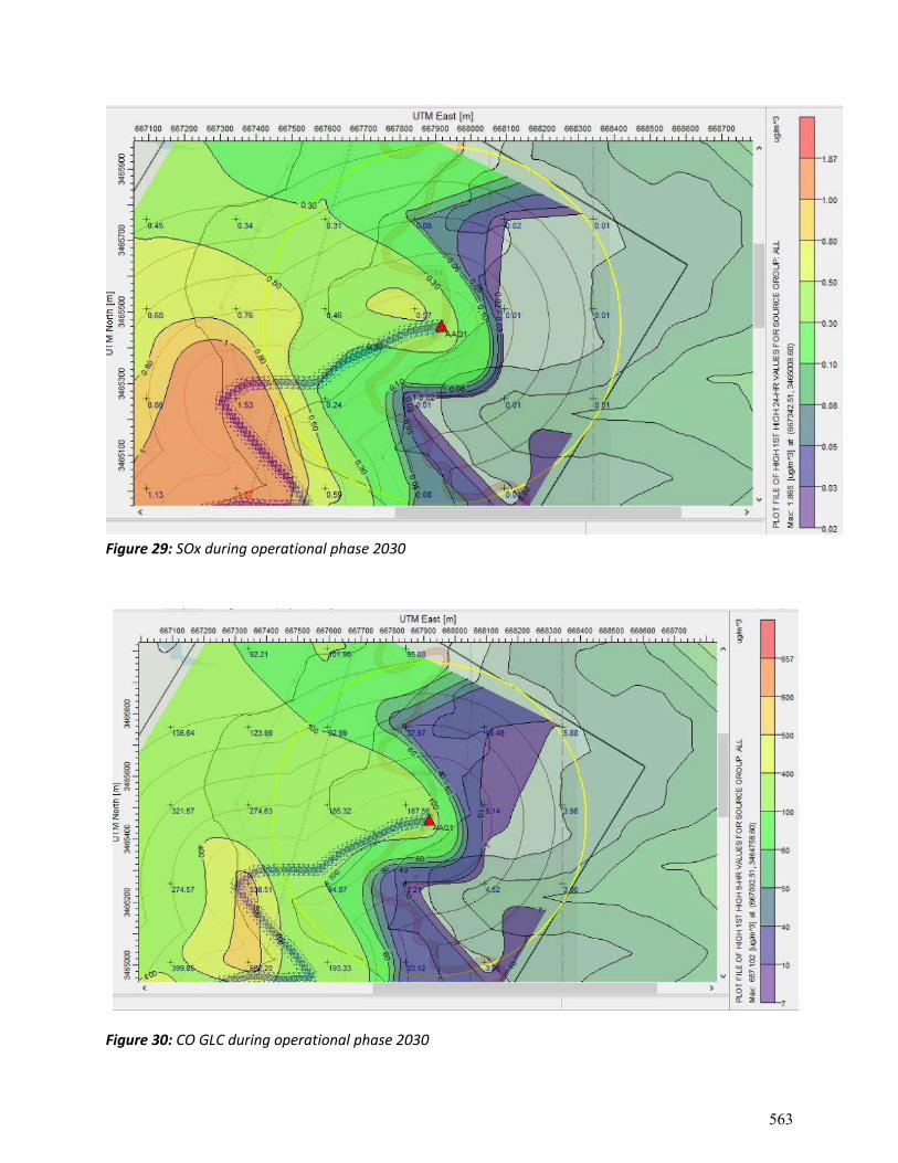
Figure 29: SOx during operational phase 2030
Figure 30: CO GLC during operational phase 2030
563
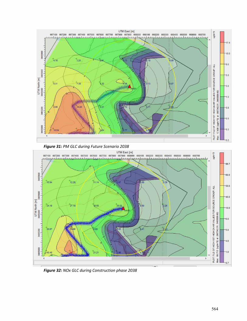
Figure 31: PM GLC during Future Scenario 2038
Figure 32: NOx GLC during Construction phase 2038
564
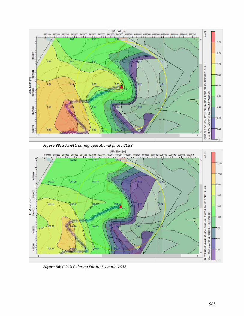
Figure 33: SOx GLC during operational phase 2038
Figure 34: CO GLC during Future Scenario 2038
565

APPENDIX-17
Illustrative Checklist for Work Zone Safety Requirements
566
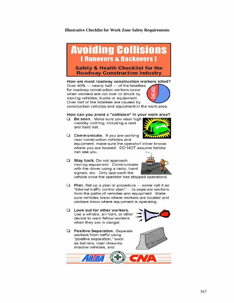
Illustrative Checklist for Work Zone Safety Requirements
567

568

569

570

571
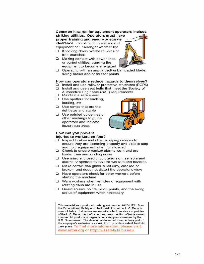
572
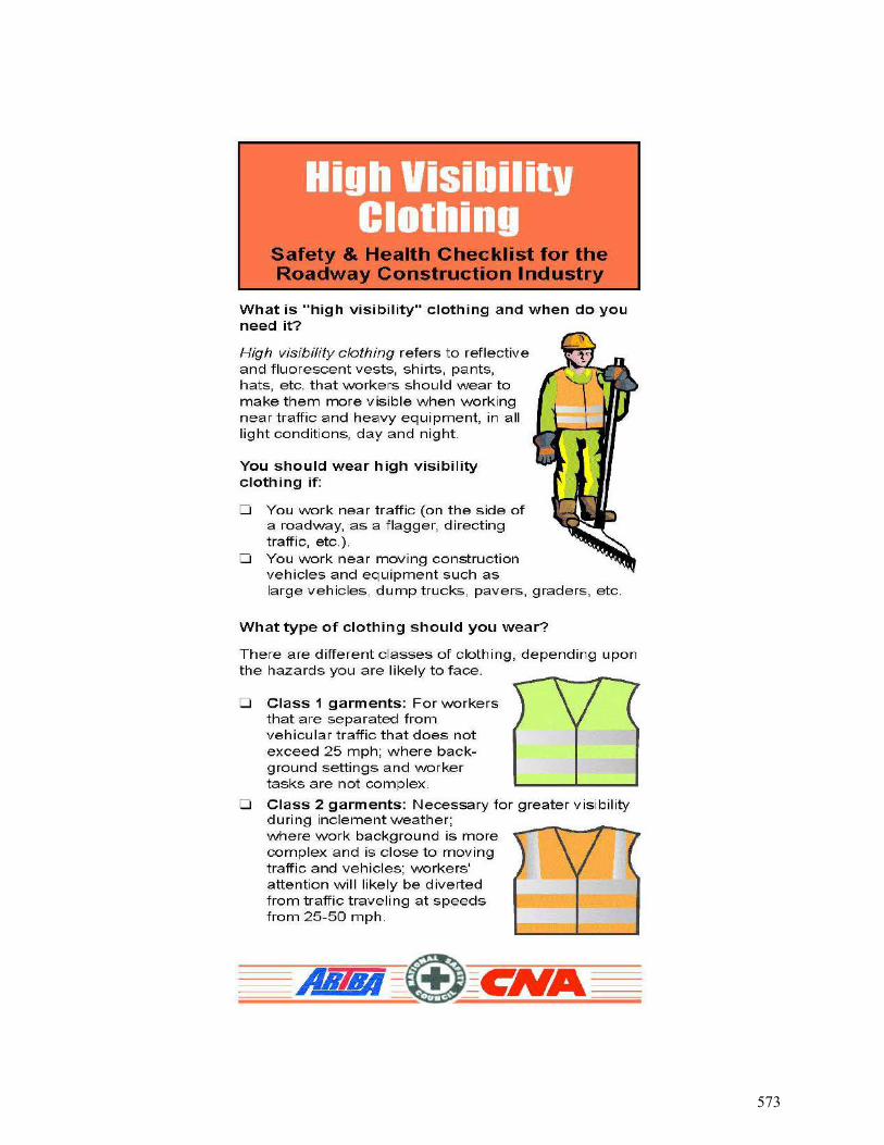
573
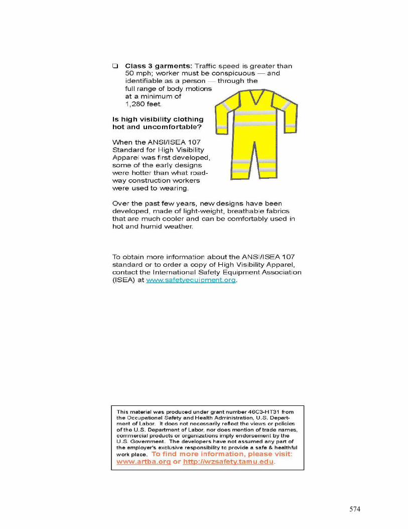
574
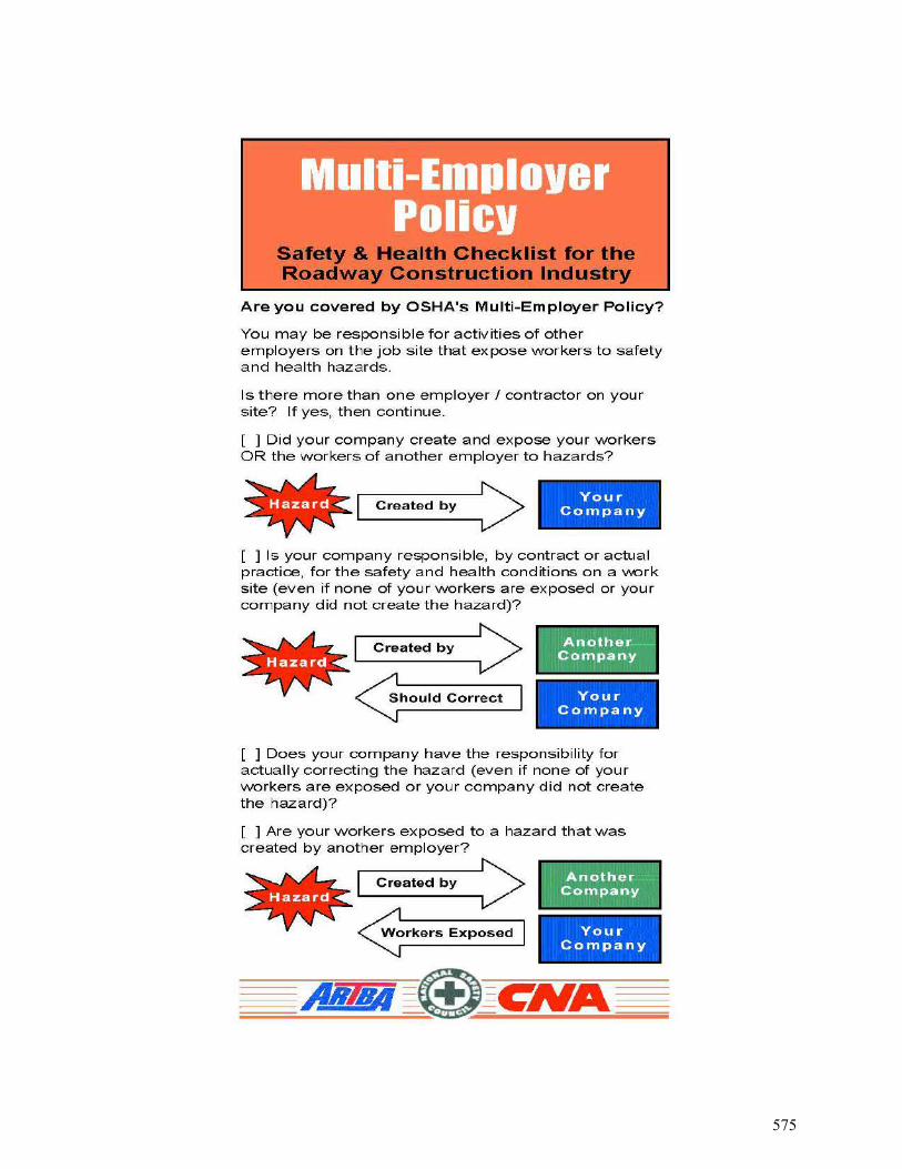
575

576
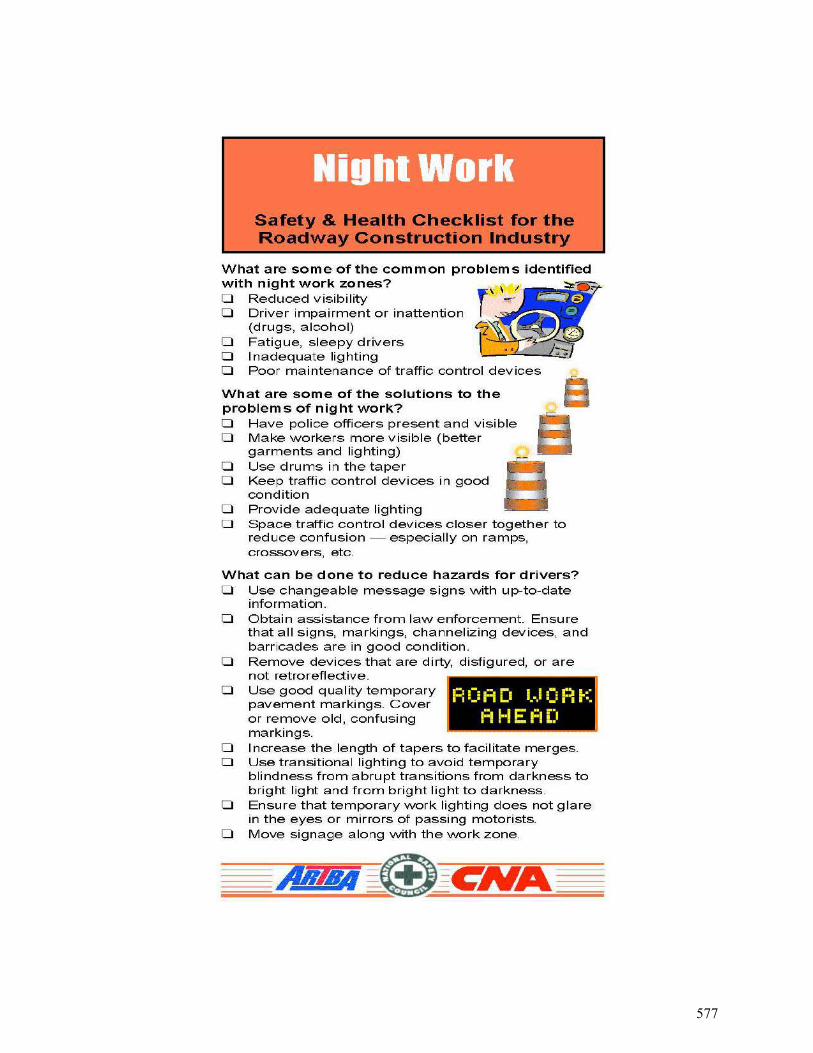
577

578

579
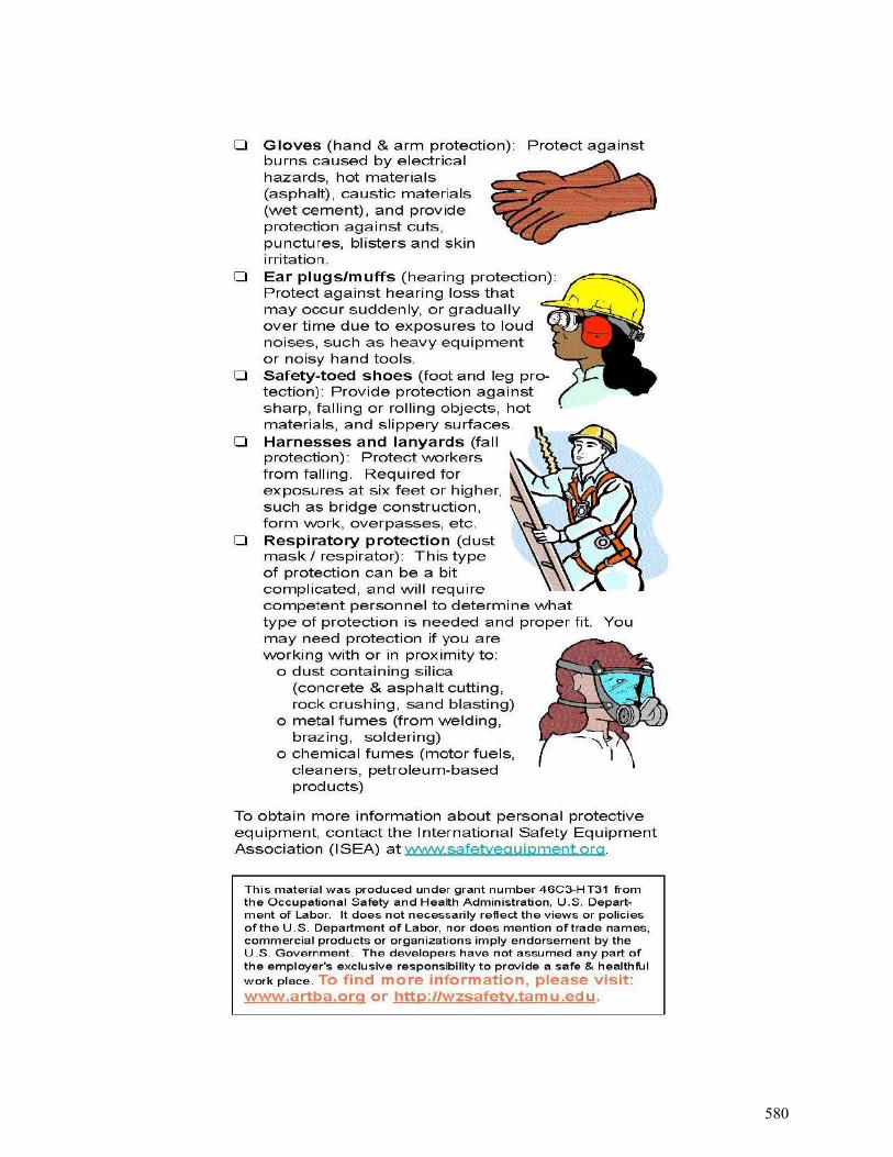
580
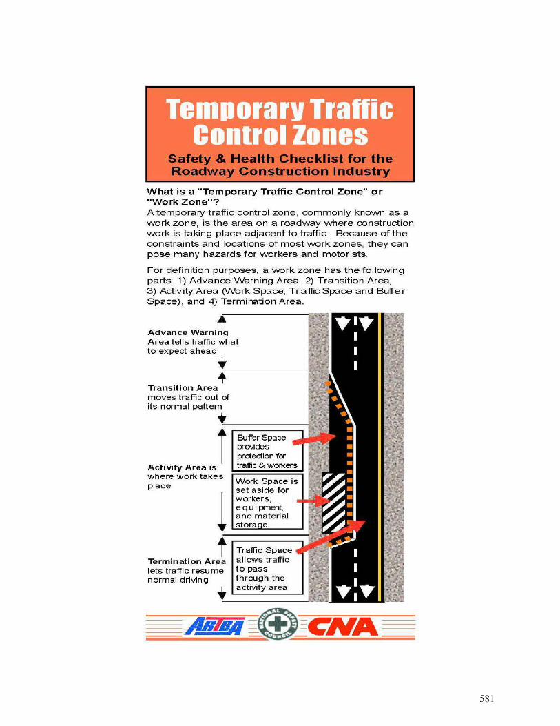
581
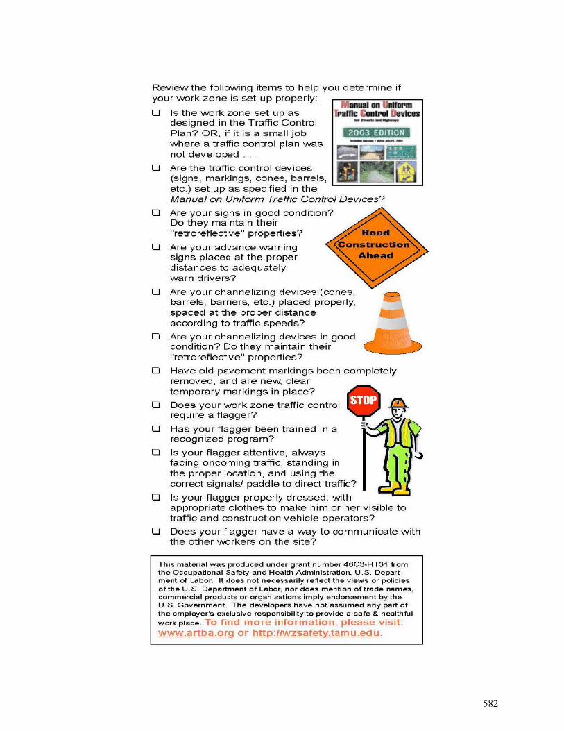
582


![jkti=] fgekpy izns'k - Rajpatra of Himachal Pradesh](https://img.pdfslide.net/doc/110x75/6333bca53108fad7760f316e/jkti-fgekpy-iznsk-rajpatra-of-himachal-pradesh-1682140886.jpg)