Embed Size (px)
Citation preview
Jan
uar
y 20
14
LA RECHERCHE AGRONOMIQUEPOUR LE DEVELOPPEMENT
,
A RAGENCE NATIONALE DE LA RECHERCHE
NSCIENCE & IMPACT
ICARDAScience for Better Livelihoods in Dry Areas
APRI
Agricultural Research Center
Animal Production Research Institute

LiLiLvivi evev
sese totot ck
FaFaFrmrmr
inini gngn SySyS sysy tetet msmsm ofofo EgEgE ygyg pypy tThThT
e chahah
ngngnesese
ininiL
of changes in Livestock Farming Systems,Livelihoods and Landscapes of the North West Coast of Egypt
of changes in Livestock Farming Systems,of changes in Livestock Farming Systems,of changes in Livestock Farming Systems,of changes in Livestock Farming Systems,of changes in Livestock Farming Systems,of changes in Livestock Farming Systems,of changes in Livestock Farming Systems,of changes in Livestock Farming Systems,of changes in Livestock Farming Systems,of changes in Livestock Farming Systems,of changes in Livestock Farming Systems,of changes in Livestock Farming Systems,of changes in Livestock Farming Systems,of changes in Livestock Farming Systems,
ThThTe c
hahahngngn
eseseinini
LiLiLvivi evev
sese totot ck
FaFaFrmrmr
inini gngn SySyS sysy tetet msmsm ofofo EgEgE ygyg pypy t

LiLiLvivi evev
sese totot ck
FaFaFrmrmr
inini gngn SySyS sysy tetet msmsm ofofo EgEgE ygyg pypy tThThT
e chahah
ngngnesese
ininiL
Pascal BONNET (first from left)
is a veterinarian who held a PhD in health geography. He also carried out research in epidemiology, animal science and livestock economics. He works in France at CIRAD (Centre for Agricultural Research for Development). His background covers livestock research and development in Sub Saharan Africa, South East and Western Asia. He has carried out research on animal health services in Ethiopia and Eastern Africa with ILRI, in partnership with the civil society (NGO’s, pastoralist’ associations). He worked for EU EDF projects in Southern Africa and more recently for national projects in the Mediterranean area (Tunisia, Egypt). His key interests are livestock development approa-ches that combine geographical and economic analysis at farm, commodity chain and regional levels, focusing on community development and landscape analysis.
Veronique ALARY (second from left)
is agronomist with a PhD in economics. She has carried out research on household viability, risk management and vulnerability in rural areas over the last twenty years in several developing countries (Cameroon, India, Mali, Tunisia and Egypt). During the last 10 years, she has co-coordinated within ICARDA two projects in Maghreb on innovation adoption and impact in dry areas. Based at ICARDA Cairo since 2009, she has coordinated the ELVUL-MED project. She is now involved in two main research areas: firstly the adaptive capacity of families and the efficiency of their crop-livestock integrated systems in the new reclaimed lands of western Delta and secondly the sustainability of traditional milk supply chains around Greater Cairo. Her works mobilized different approaches and tools (empirical data collection, typology, program-ming model).
Adel ABOUT-NAGA (fifth from left)
is animal scientist with a PhD in Agriculture Science. He has occupied different functions in Egypt and abroad over the last 50 years: head of the sheep and goat production division at APRI (Animal production research Institute), APRI acting director for research and development, director of technology transfer at Agricultural Research Centre, undersecretary for the animal production sector at the Ministry of Agriculture in Egypt, Deputy permanent and representative of Egypt to FAO, WFP and IFAD in Rome over 5 years, senior advisor to ICARDA’ director general. Since 2006, he is supervisor at APRI and chairman of different councils in animal breeding and genetic. He was the co-coordinator for Egypt of the research activities undertaken by the ElVulmed project.
Photo de situation Photo de situation Photo de situation
a: Centre de Coopération International en Recherche Agronomique pour le Développementb: International Center for Agricultural Research in the Dry Areasc: Animal production research Institute
a ab c
Cartography: Slim Saidi, Pascal Bonnet, Ibrahim Daoud, Vincent MartinGraphic Layout: Slim Saidi
English Proof reading: Thibaud Smerko
Photo de situationPhoto de situation Photo de situation

LiLiLvivi evev
sese totot ck
FaFaFrmrmr
inini gngn SySyS sysy tetet msmsm ofofo EgEgE ygyg pypy tThThT
e chahah
ngngnesese
ininiL
Authors of the Atlas:
Pascal Bonnet, CIRAD Véronique Alary, CIRAD/ICARDA Ibrahim Daoud, PhD candidate, CIRAD-AgroParisTechFawzi Abdel-Kader, University of Alexandria Slim Saïdi, International Consultant, Montpellier, FranceAdel Aboulnaga, APRI/ARC Mona Osman Abdelzaher, APRI/ARC Laura Duarte Consultant, CIRAD/ICARDA Jean-François Tourrand, CIRAD Naeem Moselhy, DRC Denis Bastianelli, CIRAD Ferial Hassan, APRI/ARC Omar Salama, APRI/ARC Jean-Pierre Boutonnet, INRA Taha Hosni, APRI/ARC Vincent Martin, ESITPA Student Contributors to the Elvulmed Project:
Xavier Juanes, CIRAD Samir Messad, CIRAD Faten Fahmy, APRI/ARC Helmi Metawi, APRI/ARCPierre Valarié, CIRAD/CNRS Jacques Lasseur, INRA Ehab Salal, APRI/ARC Philippe Lescouat, INRATahana Farig, University of Alexandria Nastassja Hoffet, MSc Student London School of Economics Aden Aw-Assan, ICARDA
ThThTe c
hahahngngn
eseseiinini
LLiLiLvivi evev
sese totot ck
FaFaFrmrmr
inini gngn SySyS sysy tetet msmsm ofofo EgEgE ygyg pypy t

LiLiLvivi evev
sese totot ck
FaFaFrmrmr
inini gngn SySyS sysy tetet msmsm ofofo EgEgE ygyg pypy tThThT
e chahah
ngngnesese
ininiL
ThThTe c
hahahngngn
eseseiinini
LLiLiLvivi evev
sese totot ck
FaFaFrmrmr
inini gngn SySyS sysy tetet msmsm ofofo EgEgE ygyg pypy t
1. Context and objective of the Atlas
1.1. ELVULMED project description 1.2. Collective vulnerability1.3. Objective of the Atlas1.4. AC, DPSIR, and models of landscape change processes
2. Drivers of change: Trends and hypothesis on collective vulnerability in the North West Coastal zone (Egypt)
2.1. Main historical changes, Timeline2.2. Geographical description of the zone2.3. Historical data on climate (Rainfall & Temperature)
2.3.1. Global climatic change2.3.2. Regional climatic change
2.4.1. Water resource management & infrastructurea. Description of water catchment, wadi sheds and hydrologyb. Main water management infrastructures: dykes, cisterns, reservoirsc. Description of Wadi Nagamish
2.4.2. Demographics, urbanization & change in life styles
a. Matrouh governorate: population and demographicsb. Urbanization and change of Bedouin habitat in the Marsa Matrouh areac. Tourism development in NWCZ of Egyptd. Changes of life styles in the Bedouin societye. Education and Increase in the Proportion of Educated Peoplef. Water consumption patterns
2.4.3. Socio-Economic activities: services, infrastructures road networka. Road network and services b. Animal Health and Veterinary servicec. Marketing places and livestock Value chains
2.4. Socio-economic changes
13
17
13 131515
172227 2727
29293033
33
333436373838
3939 3941
29
LiLiLvivi evev
sese totot ck
FaFaFrmrmr
inini gngn SySyS sysy tetet msmsm ofofo EgEgE ygyg pypy tThThT
e chahah
ngngnesese
ininiL
ThThTe c
hahahngngn
eseseiinini
LLiLiLvivi evev
sese totot ck
FaFaFrmrmr
inini gngn SySyS sysy tetet msmsm ofofo EgEgE ygyg pypy t
2.5. Institution and policies2.5.1. Local social organization: Tribes Beit Family 2.5.2. Livestock & land arrangements
3. Land use, land cover dynamic over the last 18 years (1993 to 2011)
4. Micro adaptation to changes
3.1. Focus on wadi Nagamish3.2. Results of 2 wadis for 1993, 2006, 2011
4.1. Changes of agrarian systems in two wadis (Halazin, Anthily)
4.1.1. Three adaptation schemes of production systems4.1.2. Use of Geographical Space
4.2. Household Vulnerability profiles
4.3. Poultry development
5.1. Drawings & Representation of change by women & children5.2. Models and perception of future
5. Perception of change
Conclusion
References
4343 44
45
47
4546
47
474750
53
5558
55
59
61

LiLiLvivi evev
sese totot ck
FaFaFrmrmr
inini gngn SySyS sysy tetet msmsm ofofo EgEgE ygyg pypy tThThT
e chahah
ngngnesese
ininiL
1. Context and objective of the Atlas
1.1. ELVULMED project description
The Mediterranean basin has faced important changes in its environment: (i) urbanization and demographic pressure on natural resources, mainly land and water; (ii) increased food demand, and changes in habit and culture, and (iii) climate. Due to strong historical and cultural links with the natural and social environment, livestock activities hold a structural role in the social and spatial organization and in the family economy, thanks mainly to their adaptive capacities to harsh conditions. Moreover through the use of rangelands, livestock strengthens the cement between the Mediterranean cities and hinterland.However, the capacity of livestock breeding activities to adapt to harsh conditions has become more complex considering the social and societal changes within and outside of the livestock territory, such as the opening of select traditional zones in the hinterlands to tourism development. This leads to new social and spatial organization having different impacts on the vulne-rability at the farm and territorial levels. This phenomenon is particularly relevant in the Mediterranean region; demographic pressure causes dramatic damage to water and other natural resources, this effect is being exacerbated by erratic climatic events (drought, flood). Many rapid adjustments of land ownership occur, reinforcing the complementarities or/and competitions between economic activities regarding the access to resources. If the role of livestock activities in terms of adapta-bility to global change reaches a consensus, the indicators of their impact in terms of reducing vulnerability or increasing adaptive capacity are always discussed. This is due to the very variable and contradictory results obtained from studies, accor-ding to their different spatial and time scales.
The main research question was: how to integrate the multiple functions, time and space scales of livestock farming activities, with their direct and indirect impacts on environment, society, and the economy?
This ELVULMED project was funded by the French National Research Agency (project ANR 10-CEPL-002). It is part of the current development of a CIRAD-INRA research program under-taken in collaboration with APRI/ARC and ICARDA (CGIAR) on the Mediterranean basin.
1.2. Collective vulnerability
Studying collective vulnerability in geography is studying the “space at risk” (Figure 2). Areas can be under risk for many reasons and geographers have long studied the impact of natural disasters on social and natural space, on how they affect households and ecosystems. Collective vulnerability is then associated with stakes of various natures: human (diseases, death), social (damage to social cohesion), environmental (damage to the ecosystems, biodiversity, natural resources), economic/financial (damage to economic activities, to value chains and firms, to infrastructures), or cultural (memorial and heritage) (Veyret, 2004). Agriculture is therefore emblematic as an activity which depends highly on external and non-controlla-ble factors (rainfall) and involves many aspects hereby underli-ned. How a major stressor like drought has affected main natural resources (rangelands, water) or rainfall-dependent resources (agricultural lands for feed crops) used by livestock in the studied area is questionable. How livestock rearing as a component of the North West Coast (NWC) agro-pastoral systems and the way of life for many households, has mitigated or aggravated the situation of farmers facing drought is also questionable. Given the diversity of farming systems that exist in the area, which systems and which households have more or less suffered from situations encountered?
The response to such questions firstly depends on original family endowments and social links (Scoones, 1998). It secondly depends on the dynamic situation of geographical space that households occupy and use be it local (habitat, wadi-based agricultural land) or remote (transhumance areas, feed-crop areas in the Nile delta, remote markets and cities).
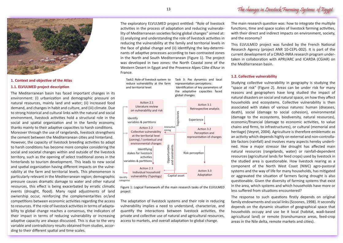
The exploratory ELVULMED project entitled: “Role of livestock activities in the process of adaptation and reducing vulnerabi-lity of Mediterranean societies facing global changes” aimed at: (i) analyzing and understanding the role of livestock activities in reducing the vulnerability at the family and territorial levels in the face of global change and (ii) identifying the key-determi-nants of adaptive processes according to two contrasted zones in the North and South Mediterranean (Figure 1). The project was developed in two zones: the North Coastal zone of the Western Desert in Egypt and the Provence Alpes Côte d’Azur in France.
Figure 1: Logical framework of the main research tasks of the ELVULMED project
The adaptation of livestock systems and their role in reducing vulnerability implies a need to understand, characterize, and quantify the interactions between livestock activities, the private and collective use of natural and agricultural resources, access to markets, and overall adaptation to global change.
The changes in Livestock Farming Systems of Egypt
Risk perception
Experience
Traj
ecto
ries
Interactivezoning
Identifyvariables & partitions
Opp
ortu
nitie
san
d co
nstr
aint
s
Identifyingstakes for livestock
activitiesvariables & partitions
Capital assetIdentify categories
Task 3: Pas dynamics and local representation perceptions: Identification of key parameters of the adaptative capacities faced global changes.
Action 3.3AdaptationAction 3.3Adaptation
Action 2.3Individual household
vulnerability (Typology)
Action 2.3Individual household
vulnerability (Typology)categories
Action 3.2Perception and
representation of changes
Action 3.2Perception and
representation of changes
Action 2.2Collective vulnerabilityat the territorial level
(zoning) / contextual and environmental changes
Action 2.2Collective vulnerabilityat the territorial level
(zoning) / contextual and environmental changes
Action 3.1Retrospective analysis
Action 3.1Retrospective analysis
Action 2.1Literature review
on vulnerability and risk
Task2: Role of livestock system to reduce vulnerability at the farm and territorial level.
13
The changes in Livestock Farming Systems of Egypt
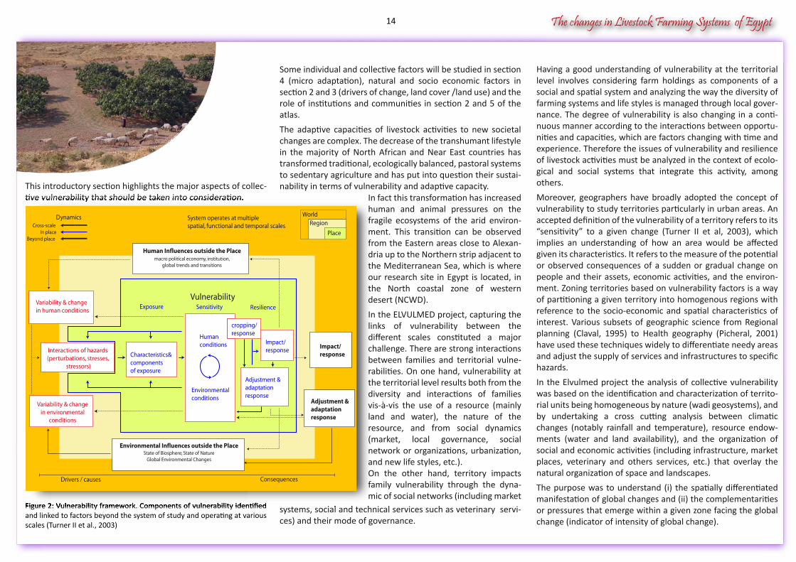
This introductory section highlights the major aspects of collec-tive vulnerability that should be taken into consideration.
Figure 2: Vulnerability framework. Components of vulnerability identified and linked to factors beyond the system of study and operating at various scales (Turner II et al., 2003)
Having a good understanding of vulnerability at the territorial level involves considering farm holdings as components of a social and spatial system and analyzing the way the diversity of farming systems and life styles is managed through local gover-nance. The degree of vulnerability is also changing in a conti-nuous manner according to the interactions between opportu-nities and capacities, which are factors changing with time and experience. Therefore the issues of vulnerability and resilience of livestock activities must be analyzed in the context of ecolo-gical and social systems that integrate this activity, among others.
Moreover, geographers have broadly adopted the concept of vulnerability to study territories particularly in urban areas. An accepted definition of the vulnerability of a territory refers to its “sensitivity” to a given change (Turner II et al, 2003), which implies an understanding of how an area would be affected given its characteristics. It refers to the measure of the potential or observed consequences of a sudden or gradual change on people and their assets, economic activities, and the environ-ment. Zoning territories based on vulnerability factors is a way of partitioning a given territory into homogenous regions with reference to the socio-economic and spatial characteristics of interest. Various subsets of geographic science from Regional planning (Claval, 1995) to Health geography (Picheral, 2001) have used these techniques widely to differentiate needy areas and adjust the supply of services and infrastructures to specific hazards.
In the Elvulmed project the analysis of collective vulnerability was based on the identification and characterization of territo-rial units being homogeneous by nature (wadi geosystems), and by undertaking a cross cutting analysis between climatic changes (notably rainfall and temperature), resource endow-ments (water and land availability), and the organization of social and economic activities (including infrastructure, market places, veterinary and others services, etc.) that overlay the natural organization of space and landscapes.
The purpose was to understand (i) the spatially differentiated manifestation of global changes and (ii) the complementarities or pressures that emerge within a given zone facing the global change (indicator of intensity of global change).
Some individual and collective factors will be studied in section 4 (micro adaptation), natural and socio economic factors in section 2 and 3 (drivers of change, land cover /land use) and the role of institutions and communities in section 2 and 5 of the atlas.
The adaptive capacities of livestock activities to new societal changes are complex. The decrease of the transhumant lifestyle in the majority of North African and Near East countries has transformed traditional, ecologically balanced, pastoral systems to sedentary agriculture and has put into question their sustai-nability in terms of vulnerability and adaptive capacity.
systems, social and technical services such as veterinary servi-ces) and their mode of governance.
tive vulnerability that should be taken into consideration.
Figure 2: Vulnerability framework. Components of vulnerability identified systems, social and technical services such as veterinary servi
System operates at multiplespatial, functional and temporal scales
Dynamics WorldRegion
Human Influences outside the Placemacro political economy, institution,
global trends and transitions
Variability & changein human conditions
Variability & changein environmental
conditions
Characteristics&componentsof exposure
Humanconditions
Environmentalconditions
cropping/response
Impact/response
Adjustment &adaptationresponse
Impact/response
Adjustment &adaptationresponse
Exposure Sensitivity Resilience
Vulnerability
Environmental Influences outside the PlaceState of Biosphere; State of Nature
Global Environmental Changes
Drivers / causes Consequences
Cross-scaleIn place
Beyond place
Interactions of hazards(perturbations, stresses,
stressors)
Place
In fact this transformation has increased human and animal pressures on the fragile ecosystems of the arid environ-ment. This transition can be observed from the Eastern areas close to Alexan-dria up to the Northern strip adjacent to the Mediterranean Sea, which is where our research site in Egypt is located, in the North coastal zone of western desert (NCWD).
In the ELVULMED project, capturing the links of vulnerability between the different scales constituted a major challenge. There are strong interactions between families and territorial vulne-rabilities. On one hand, vulnerability at the territorial level results both from the diversity and interactions of families vis-à-vis the use of a resource (mainly land and water), the nature of the resource, and from social dynamics (market, local governance, social network or organizations, urbanization, and new life styles, etc.).On the other hand, territory impacts family vulnerability through the dyna-mic of social networks (including market
14
The changes in Livestock Farming Systems of Egypt
1.3. Objective of the atlas
The main purpose of an Atlas is to gather all visual information relevant for an understanding of the multifaceted characteris-tics of a zone, made up of the co-existence in a social space of “risks and protection factors”, i.e. natural, artificial, or social factors of change and vulnerability. The main focus of the project was the North Western Coastal Zone (NWCZ) that covers an area from Alexandria to the border with Libya and includes the southern part of the desert and Siwa oasis. The Atlas focuses on the North West Coast which is generally the part of NWCZ restricted to the rain fed strata. In the ELVULMED project, the atlas serves two different objectives. It provides the baseline illustration of the human and natural geography of the studied area (locations), and illustrates, using thematic analysis, some dimensions of vulnerability and adaptive responses of local farmer populations on different geographic scales. Moreo-ver, the Atlas illustrates five major aspects of a territorial analy-sis when it comes to the role of actors in interaction with their landscape:
First, the Atlas locates main geographic features (towns, roads, zones, etc.) that are cited for the illustration of the research
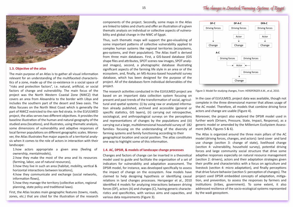
Figure 3: Model for studying changes, From: HERSPERGER A.M., et al, 2010.
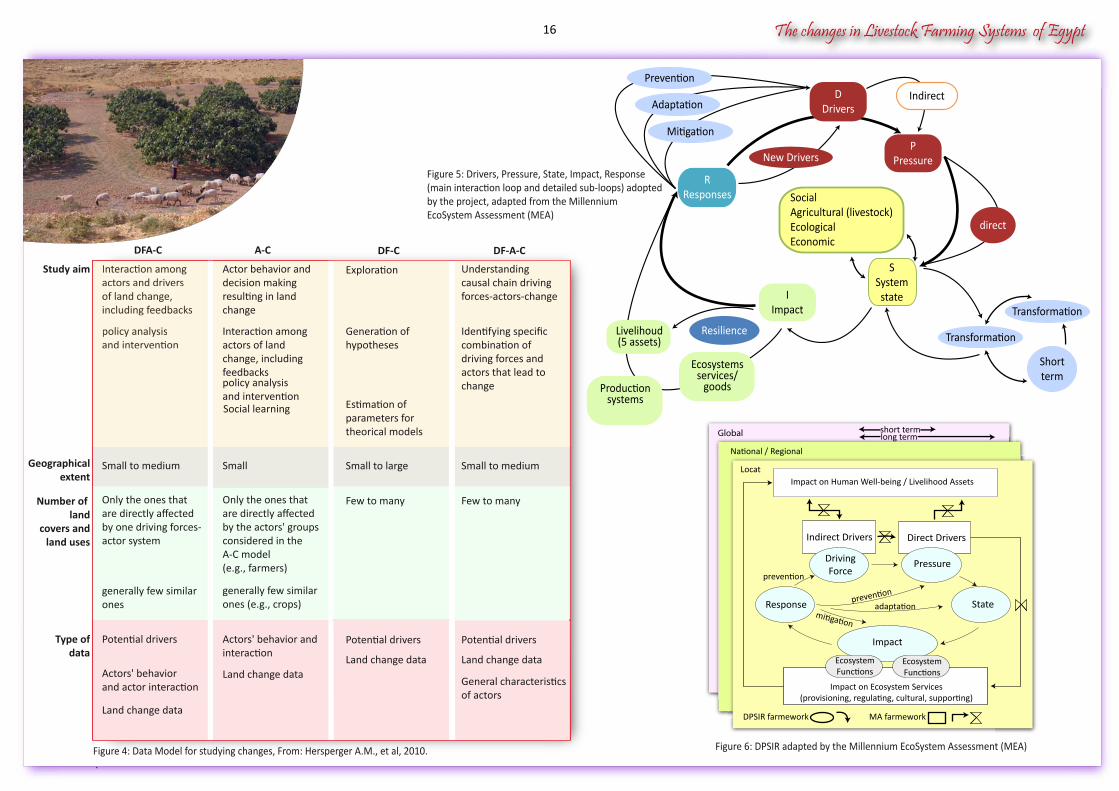
In the case of ELVULMED, project data was available, though not complete in the three dimensional manner that allows usage of the AC model. Therefore, all models that combine driving force actors and change are usable (Figure 4).
Moreover, the project also explored the DPSIR model used in further work (Drivers, Pressure, State, Impact, Response), as a generic model or amended by the Millenium EcoSystem Assess-ment (MEA, Figures 5 & 6).
The Atlas is organized around the three main pillars of the AC model (driving forces, changes, and actors): land cover and land use change (section 3: change of state), livelihood change (section 4: vulnerability, household survey), potential driving forces and large community social structure that drive some adaptive responses especially on natural resource management (section 2: drivers), actors and their adaptation strategies given their profile and characteristics with a focus on agriculture and livestock (section 4: micro adaptation), and finally perceptions that drive future behavior (section 5: perception of changes). The project used DPSIR embedded concepts of adaptation, mitiga-tion, and prevention, to assess the responses by farmers and institutions (tribes, government). To some extent, it also addressed resilience of the socio-ecological systems represented by the wadi geosystem.
components of the project. Secondly, some maps in the Atlas are linked to tables and charts and offer an illustration of a given thematic analysis on individual or collective aspects of vulnera-bility and global change in the NWC of Egypt.
Thus, such thematic maps will support the geo-visualizing of some important patterns of collective vulnerability applied to complex human systems like regional territories (ecosystems, geo-systems, and their population). The Atlas itself is derived from three main databases. First, a GIS-based database (GIS shape files and attributes, SPOT scenes raw images, SPOT analy-zed images), second, a photographic database illustrating significant aspects of the farming life style in an area or of the ecosystem, and, finally, an MS-Access-based household survey database, which has been designed for the purpose of the project. All of the databases form individual deliverables of the project.
The research activities conducted in the ELVULMED project are based on an important data collection system focusing on present and past trends of the transformation of social, agricul-tural and spatial systems: (i) by using raw or analyzed informa-tion already published, archived and accessible (general or specific statistics, GIS layers), (ii) carrying out retrospective, sociological, and anthropological surveys on the perceptions and representations of changes by the populations and (iii) carrying out a large, multidimensional household survey of 182 families- focusing on the understanding of the diversity of farming systems and family functioning according to their geographical location and social position. The atlas constitutes one way to highlight some of this information.
1.4. AC, DPSIR, & models of landscape change processes
Changes and factors of change can be inserted in a theoretical model used to guide and facilitate the organization of a set of indicators for vulnerability and adaptation assessment. The DPSIR model, for instance, was developed specifically to assess the impact of change on the ecosystem. Few models have claimed to help designing hypothesis or identifying causal relations in land changes processes. Hersperger et al., 2010 identified 4 models for analyzing interactions between driving forces (DF), actors (A) and changes (C), having generic characte-ristics and specificities, with various aims and capacities, and various data requirements (Figure 3).
Figure 3: Model for studying changes, From: HERSPERGER A.M., et al, 2010.
Driving forces
Change
Driving forces
Change
Actor
Driving forces
Driving forces Driving forces
Change
Actor
Driving forces
Change
Actor
DF-C DF-A-C DFA-C
A-C
1.how actors appropriate a given area (feeling of ownership, mentalmodels),2.how they make the most of the area and its resources (farming, labor, use of natural resources),3.how they live in such an area (habitat, mobility, vertical & horizontal interactions between locations),4.how they communicate and exchange (social networks, information flows), 5.how they manage the territory (collective action, regional planning, state policy and traditional laws).
15
The changes in Livestock Farming Systems of Egypt
Figure 4: Data Model for studying changes, From: Hersperger A.M., et al, 2010. .
Figure 5: Drivers, Pressure, State, Impact, Response (main interaction loop and detailed sub-loops) adoptedby the project, adapted from the Millennium EcoSystem Assessment (MEA)
Understanding causal chain drivingforces-actors-change
Identifying specific combination ofdriving forces and actors that lead tochange
Estimation of parameters fortheorical models
Small to large Small to medium
Few to many Few to many
Potential driversPotential drivers
Land change data Land change data
General characteristicsof actors
Exploration
Generation ofhypotheses
DF-C DF-A-C
Geographicalextent
Number of land
covers andland uses
Study aim
Type ofdata
Actor behavior anddecision makingresulting in land change
Interaction among actors of landchange, including feedbackspolicy analysis and intervention
Interaction among actors and driversof land change, including feedbacks
policy analysisand intervention
Social learning
Small to medium Small
Only the ones that are directly affectedby one driving forces-actor system
Only the ones that are directly affectedby the actors' groups considered in theA-C model(e.g., farmers)
generally few similar ones
generally few similar ones (e.g., crops)
Potential drivers Actors' behavior andinteraction
Actors' behavior and actor interaction
Land change data
Land change data
DFA-C A-C
Indirect Drivers Direct Drivers
Response State
Impact
prevention
adaptationmitigation
Impact on Human Well-being / Livelihood AssetsLocat
National / Regional
Global short termlong term
Impact on Ecosystem Services(provisioning, regulating, cultural, supporting)
DPSIR farmework MA farmework
prevention
EcosystemFunctions
EcosystemFunctions
DrivingForce
Pressure
Figure 6: DPSIR adapted by the Millennium EcoSystem Assessment (MEA)
Interaction among actors and driversof land change, including feedbacks
policy analysisand intervention
Transformation
PPressure
SSystemstate
RResponses
IImpact
Mitigation
Adaptation
Prevention
direct
Livelihoud(5 assets)
Ecosystemsservices/
goods
IndirectDDrivers
Resilience
Productionsystems
Transformation
Shortterm
SocialAgricultural (livestock)EcologicalEconomic
New Drivers
16
The changes in Livestock Farming Systems of Egypt
2. DRIVERS of change: Trends and hypothesis on collective vulnerability in the North West Coastal zone (Egypt)
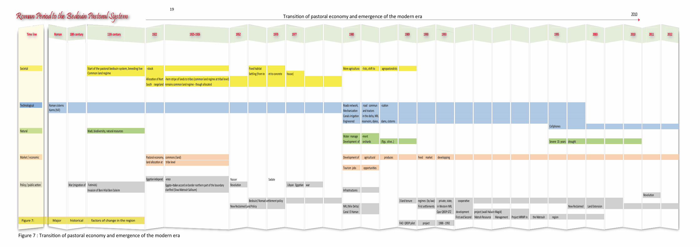
2.1. Main historical changes, Timeline
Historical overview of changes in the North West Coastal zone (NWCZ), Egypt
Global change has affected the NWCZ in various ways. Global change is a multifaceted concept, which refers to the changes of a different nature, and the time frame one selects to retros-pectively analyze changes. Various types of changes have affected the Bedouin society since its settlement in the NWCZ in the 11th century continuing to the modern era. Some aspects of its recent history are displayed on a Facebook page specific to the region (search for “facebook matrouh Egypt”).
Figure 7 describes major factors of change that have historically affected the region with time frames referring to specific dates. From the Roman period to the establishment of the Bedouin Pastoral System in the 11th century; from the 1922 Egyptian Independence to the 1952 Nasser revolution and the start of the Bedouin modern settlement and New Reclaimed Land policies; and finally from the 1980’s man-controlled enginee-ring of water management and adoption of new agricultural practices to the recent Egyptian revolution, there has been a long transition from a pastoral economy and a gradual emer-gence of a modern era for the Bedouin society. Moreover, the specific changes that occurred throughout time were of different natures:
1. Societal (e.g. within tribal system, emergence of tourism, change in traditional land tenure, demography),
Furthermore, the highly-specialized subterranean aqueduct discovered near Marsa Matruh in 1931 (Walpole, 1932 cited by Kassas, 1972) acts as a key example of the complexity of these farmland water infrastructures. This aqueduct was used to harvest water in one place and irrigate other locations several kilometers away. It is made up of a main channel and numerous side galleries that collect and store water. It was dug through a limestone ridge associated with a considerable body of sand dunes on its seaward side and an extensive catchments area of rocky plateau dissected by an intricate system of wadis on the inland side.
By the end of the 10th century, the NWCZ gradually declined (Weedon, 1912 cited by Kassas 1972); the vineyards were progressively replaced by an arid rangeland. By 1400 AD, only a tiny town was in existence west of Alexandria and five centuries later, the district was described as covered with ruins of towns and villages. Much evidence indicates no-climate change during the last two-three thousand years, especially the presence of some ancient plaster constructions, for example inside the cisterns (Weedon, 1912), and the temperate climate in Alexan-dria in Greek and Egyptian times (De Cosson, 1935).
The 10th century was a theatre of extended wars during the migration of Fatimids from Tunisia to Egypt. During these battles, the local people took refuge in Alexandria where many of them settled and stayed. The lack of maintenance of the water supplies and infrastructure contributed to the decrease of the irrigated system. The end arrived in the 11th century, which saw the destructive invasion of Beni Hilal and the Beni Soleim nomads, when these tribes were pushed westward out of Egypt. They established themselves in the NWCZ and in Eastern Libya and brought with them the pastoral system and the nomadic lifestyle. The available data about the Bedouin pastoral system shows that all land was common and each family could move from one place to another in search of pasture, at will. Animal husbandry of sheep, goats, and camels acted as the main activities for Bedouin tribes.
1: Marsa Matrouh is the ancient Paraetonium. It was the western-most city of Aegyptus as defined in the Hellenistic period.
2. Technological (e.g. water management, cell phones),
3. Natural (e.g. climate hazards),
4. Market-related (e.g. demand in livestock produce, feed supply),
5. Public policy (e.g. change in boundaries, war, state versustribal regulation, development projects MRMP/QRDP, change in political power).
From the Roman period to the establishment of the Bedouin Pastoral System during the 11th century
The NWCZ was one of the main grain-baskets of the Roman Empire, and, before, an important farmland of antic Egypt and Greece. “Eastern Libya (Cyrenaica) and northern Egypt were ruled by the Ptolemaic Greeks. Later Cyrenaica and Egypt became provinces of the Roman Empire ». (WIKIPEDIA, 2013).
Many vestiges show the skill of these civilizations to adapt to harsh and dry conditions, especially with regard to water supply and water management (Kassas, 1972). An excellent example is made of the location of the farms at the feet of the limestone ridges where run-off water can be manipulated to accumulate, these ridges being effective means of natural redistribution of rainwater (Ball, 1952; Said, 1962). Another example is the building quality of the three thousand Roman cisterns, which continue to be used from Alexandria to El Salloum (now at the Libyan border) (Shata, 1991). The sites of these cisterns were carefully chosen for collecting run-off water from large areas and subsidiary channels on the ground to direct the water into the cisterns.
In the same way, the karm is an interesting form of water collec-ting the majority of which were established near the coast at very low altitudes. The run-off water of the rainfall flows inside the karm, artificial hillock, less 3-4 meters high and 40 meters at the base, proof of an old hamlet (maybe an old house, since destroyed and covered by sand). There, water is collected and concentrated into limited areas where plants are grown (Hume & Hughes, 1921 and De Cosson, 1935, cited by Kassas, 1972). Moreover, small and circular Roman cisterns are located near the karms and old villages, while large and rectangular cisterns used for agriculture are located in the fields.
1
17

LiLiLvivi evev
sese totot ck
FaFaFrmrmr
inini gngn SySyS sysy tetet msmsm ofofo EgEgE ygyg pypy tThThT
e chahah
ngngnesese
ininiL
18
Roman Period to the Bedouin Pastoral System Transition of pastoral economy and emergence of the modern era
Time line Roman 10th century 11th century 1922 1925-1926 1952 1970 1977 1980 1989 1990 1993 1995 2003 2010 2011 2012
Societal Start of the pastoral bedouin system, breeding live -stockCommon land regime
Fixed habitat More agricultura -lists, shift to agropastoralistsSettling (from te -nt to concrete house)
Allocation of Nort -hern stripe of lands to tribes (common land regime at tribal level)South rangeland remains common land regime - though allocated
Cellphones
Technological
Engineered reservoirs, dykes, dams, cisterns
Roman cisternsKarms (hill)
Roads network, road commun -icationMechanization and tractorsCanals irrigation in the delta, NRL
Natural Wadi, biodiversity, natural resourcesWater manage -ment Development of orchards (figs, olive..) Severe 15 years drought
Market / economic Pastoral economy, commons (land)land allocation at tribe level
Development of agricultural produces Feed market developping
Tourism jobs opportunities
Egyptian independ -ence Nasser Sadate
Policy / public action War (migration of Fatimids) Egypto–Italian accord on border northern part of the boundaryclarified (Siwa Matrouh Salloum)
Revolution Libyan Egyptian warInvasion of Beni Hilal Beni Soleim Infrastructures
Revolution
Bedouin/ Nomad settlement policy 3 land tenure regimes (by law): private, state, cooperative
FAO QRDP pilot project 1988 - 1992
New Reclaimed Land Policy NRL (Nile Delta) First settlements in Western NRL New Reclaimed Land Extension
Canal El Haman Qasr QRDP GTZ development project (wadi Halazin Magid)First and Second Matruh Resource Management Project MRMP in the Matrouh region
2010
Figure 7: Major historical factors of change in the region
Figure 7 : Transition of pastoral economy and emergence of the modern era
19

LiLiLvivi evev
sese totot ck
FaFaFrmrmr
inini gngn SySyS sysy tetet msmsm ofofo EgEgE ygyg pypy tThThT
e chahah
ngngnesese
ininiL
20
The changes in Livestock Farming Systems of Egypt
The nomadic nature of the Bedouin lifestyle imposed no fixed boundaries between tribes and revolved around tent housing. During the dry season, drinking water, for humans and animals, was collected from the Roman cisterns.
“…we were depending completely on the rangeland; we were searching grass anywhere that we could find it; and for that reason we were nomads, moving from one place to other, searching for grass; and also for that reason the land was common land for a long time” (source: Project Interview).
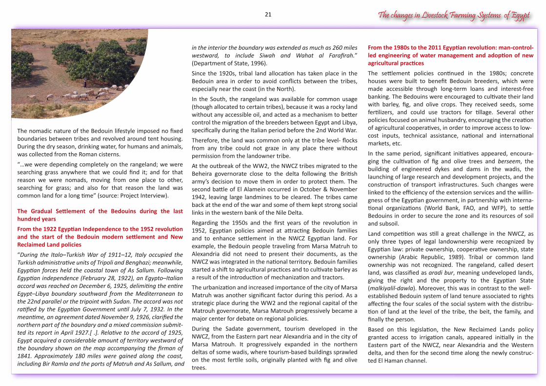
The Gradual Settlement of the Bedouins during the last hundred years
From the 1922 Egyptian Independence to the 1952 revolution and the start of the Bedouin modern settlement and New Reclaimed Land policies
“During the Italo–Turkish War of 1911–12, Italy occupied the Turkish administrative units of Tripoli and Benghazi; meanwhile, Egyptian forces held the coastal town of As Sallum. Following Egyptian independence (February 28, 1922), an Egypto–Italian accord was reached on December 6, 1925, delimiting the entire Egypt–Libya boundary southward from the Mediterranean to the 22nd parallel or the tripoint with Sudan. The accord was not ratified by the Egyptian Government until July 7, 1932. In the meantime, an agreement dated November 9, 1926, clarified the northern part of the boundary and a mixed commission submit-ted its report in April 1927.[ .]. Relative to the accord of 1925, Egypt acquired a considerable amount of territory westward of the boundary shown on the map accompanying the firman of 1841. Approximately 180 miles were gained along the coast, including Bir Ramla and the ports of Matruh and As Sallum, and
From the 1980s to the 2011 Egyptian revolution: man-control-led engineering of water management and adoption of new agricultural practices
The settlement policies continued in the 1980s; concrete houses were built to benefit Bedouin breeders, which were made accessible through long-term loans and interest-free banking. The Bedouins were encouraged to cultivate their land with barley, fig, and olive crops. They received seeds, some fertilizers, and could use tractors for tillage. Several other policies focused on animal husbandry, encouraging the creation of agricultural cooperatives, in order to improve access to low-cost inputs, technical assistance, national and international markets, etc.
In the same period, significant initiatives appeared, encoura-ging the cultivation of fig and olive trees and berseem, the building of engineered dykes and dams in the wadis, the launching of large research and development projects, and the construction of transport infrastructures. Such changes were linked to the efficiency of the extension services and the willin-gness of the Egyptian government, in partnership with interna-tional organizations (World Bank, FAO, and WFP), to settle Bedouins in order to secure the zone and its resources of soil and subsoil.
Land competition was still a great challenge in the NWCZ, as only three types of legal landownership were recognized by Egyptian law: private ownership, cooperative ownership, state ownership (Arabic Republic, 1989). Tribal or common land ownership was not recognized. The rangeland, called desert land, was classified as aradi bur, meaning undeveloped lands, giving the right and the property to the Egyptian State (malkiyalil-dawla). Moreover, this was in contrast to the well-established Bedouin system of land tenure associated to rights affecting the four scales of the social system with the distribu-tion of land at the level of the tribe, the beit, the family, and finally the person.
Based on this legislation, the New Reclaimed Lands policy granted access to irrigation canals, appeared initially in the Eastern part of the NWCZ, near Alexandria and the Western delta, and then for the second time along the newly construc-ted El Haman channel.
in the interior the boundary was extended as much as 260 miles westward, to include Siwah and Wahat al Farafirah.” (Department of State, 1996).
Since the 1920s, tribal land allocation has taken place in the Bedouin area in order to avoid conflicts between the tribes, especially near the coast (in the North).
In the South, the rangeland was available for common usage (though allocated to certain tribes), because it was a rocky land without any accessible oil, and acted as a mechanism to better control the migration of the breeders between Egypt and Libya, specifically during the Italian period before the 2nd World War.
Therefore, the land was common only at the tribe level- flocks from any tribe could not graze in any place there without permission from the landowner tribe.
At the outbreak of the WW2, the NWCZ tribes migrated to the Beheira governorate close to the delta following the British army’s decision to move them in order to protect them. The second battle of El Alamein occurred in October & November 1942, leaving large landmines to be cleared. The tribes came back at the end of the war and some of them kept strong social links in the western bank of the Nile Delta.
Regarding the 1950s and the first years of the revolution in 1952, Egyptian policies aimed at attracting Bedouin families and to enhance settlement in the NWCZ Egyptian land. For example, the Bedouin people traveling from Marsa Matruh to Alexandria did not need to present their documents, as the NWCZ was integrated in the national territory. Bedouin families started a shift to agricultural practices and to cultivate barley as a result of the introduction of mechanization and tractors.
The urbanization and increased importance of the city of Marsa Matruh was another significant factor during this period. As a strategic place during the WW2 and the regional capital of the Matrouh governorate, Marsa Matrouh progressively became a major center for debate on regional policies.
During the Sadate government, tourism developed in the NWCZ, from the Eastern part near Alexandria and in the city of Marsa Matrouh. It progressively expanded in the northern deltas of some wadis, where tourism-based buildings sprawled on the most fertile soils, originally planted with fig and olive trees.
21
The changes in Livestock Farming Systems of Egypt
Through the development of new irrigated lands, this ambitious program aimed to reduce the pressure on landownership in the traditional irrigated land of the Nile delta and valley, permitting granting land to young people who did not have access to it. Besides the surviving of the new small farmers, the leitmotiv of the New Reclaimed Lands program was to develop the Egyptian exportation capacity based on large farms, but also using small farmers in partnership with big farms.
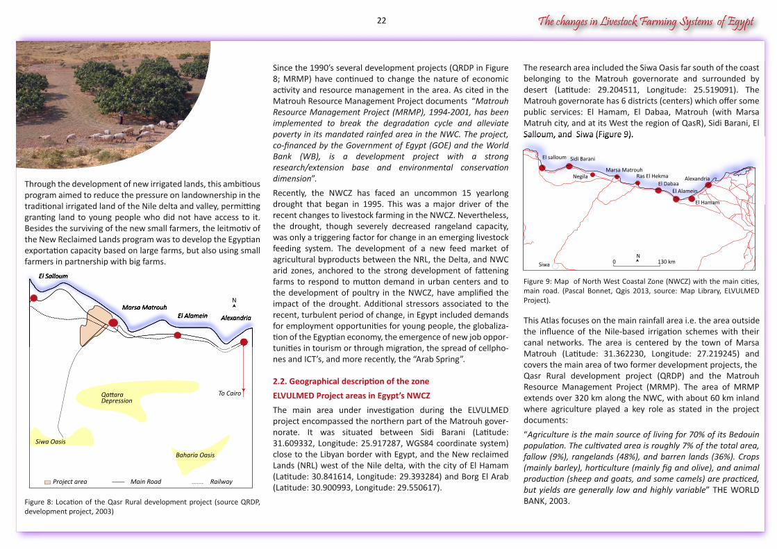
Figure 8: Location of the Qasr Rural development project (source QRDP, development project, 2003)
The research area included the Siwa Oasis far south of the coast belonging to the Matrouh governorate and surrounded by desert (Latitude: 29.204511, Longitude: 25.519091). The Matrouh governorate has 6 districts (centers) which offer some public services: El Hamam, El Dabaa, Matrouh (with Marsa Matruh city, and at its West the region of QasR), Sidi Barani, El Salloum, and Siwa (Figure 9).
Figure 9: Map of North West Coastal Zone (NWCZ) with the main cities, main road. (Pascal Bonnet, Qgis 2013, source: Map Library, ELVULMED Project).
This Atlas focuses on the main rainfall area i.e. the area outsidethe influence of the Nile-based irrigation schemes with their canal networks. The area is centered by the town of Marsa Matrouh (Latitude: 31.362230, Longitude: 27.219245) and covers the main area of two former development projects, theQasr Rural development project (QRDP) and the Matrouh Resource Management Project (MRMP). The area of MRMP extends over 320 km along the NWC, with about 60 km inland where agriculture played a key role as stated in the project documents:
“Agriculture is the main source of living for 70% of its Bedouin population. The cultivated area is roughly 7% of the total area, fallow (9%), rangelands (48%), and barren lands (36%). Crops (mainly barley), horticulture (mainly fig and olive), and animal production (sheep and goats, and some camels) are practiced, but yields are generally low and highly variable” THE WORLD BANK, 2003.
Since the 1990’s several development projects (QRDP in Figure 8; MRMP) have continued to change the nature of economic activity and resource management in the area. As cited in the Matrouh Resource Management Project documents “Matrouh Resource Management Project (MRMP), 1994-2001, has been implemented to break the degradation cycle and alleviate poverty in its mandated rainfed area in the NWC. The project, co-financed by the Government of Egypt (GOE) and the World Bank (WB), is a development project with a strong research/extension base and environmental conservation dimension”.
Recently, the NWCZ has faced an uncommon 15 yearlong drought that began in 1995. This was a major driver of the recent changes to livestock farming in the NWCZ. Nevertheless, the drought, though severely decreased rangeland capacity, was only a triggering factor for change in an emerging livestock feeding system. The development of a new feed market of agricultural byproducts between the NRL, the Delta, and NWC arid zones, anchored to the strong development of fattening farms to respond to mutton demand in urban centers and to the development of poultry in the NWCZ, have amplified the impact of the drought. Additional stressors associated to the recent, turbulent period of change, in Egypt included demands for employment opportunities for young people, the globaliza-tion of the Egyptian economy, the emergence of new job oppor-tunities in tourism or through migration, the spread of cellpho-nes and ICT’s, and more recently, the “Arab Spring”.
2.2. Geographical description of the zone
ELVULMED Project areas in Egypt’s NWCZ
The main area under investigation during the ELVULMED project encompassed the northern part of the Matrouh gover-norate. It was situated between Sidi Barani (Latitude: 31.609332, Longitude: 25.917287, WGS84 coordinate system) close to the Libyan border with Egypt, and the New reclaimed Lands (NRL) west of the Nile delta, with the city of El Hamam (Latitude: 30.841614, Longitude: 29.393284) and Borg El Arab (Latitude: 30.900993, Longitude: 29.550617).
To CairoQattaraDepression
Siwa Oasis
Project area Main Road Railway
Baharia Oasis
AlexandriaEl AlameinMarsa Matrouh
El Salloum
AlexandriaEl AlameinMarsa Matrouh
El Salloum
N
Salloum, and Siwa (Figure 9).
Alexandria
El Alamein
El Hamam
El DabaaRas El Hekma
Marsa MatrouhNegila
Sidi BaraniEl salloum
Siwa 0 130 kmN
22
The changes in Livestock Farming Systems of Egypt
Wadi Anthily
Wadi Nagamish
Wadi Magid
Wadi Halazin
16 km0463000
499000
3 46
5 00
03
445
000
3 4
85 0
00
N
Wadi HalazinWadi HalazinWadi Halazin
499000
Figure 11: Matrouh Governorate’sboundaries with Location of Households surveyed during the ElVulMed project in the NWCZ, the NRL, and Siwa Oasis. Pascal Bonnet
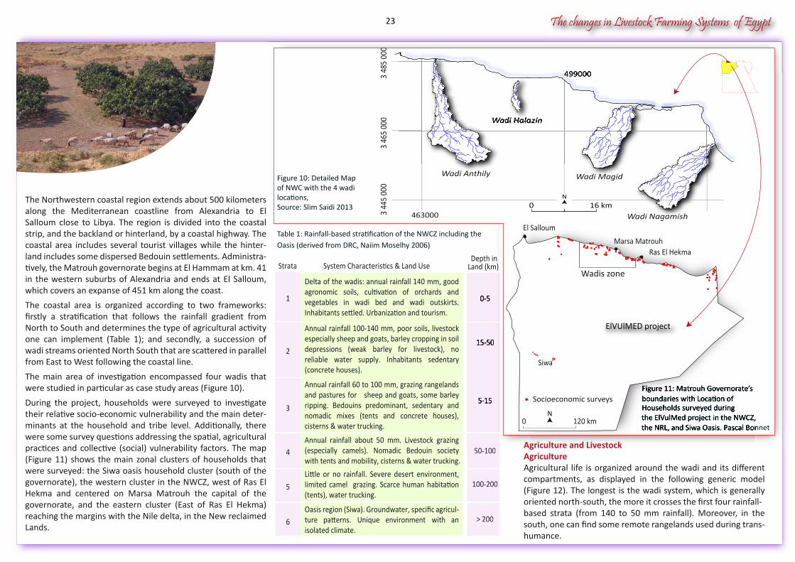
The Northwestern coastal region extends about 500 kilometers along the Mediterranean coastline from Alexandria to El Salloum close to Libya. The region is divided into the coastal strip, and the backland or hinterland, by a coastal highway. The coastal area includes several tourist villages while the hinter-land includes some dispersed Bedouin settlements. Administra-tively, the Matrouh governorate begins at El Hammam at km. 41 in the western suburbs of Alexandria and ends at El Salloum, which covers an expanse of 451 km along the coast.
The coastal area is organized according to two frameworks: firstly a stratification that follows the rainfall gradient from North to South and determines the type of agricultural activity one can implement (Table 1); and secondly, a succession of wadi streams oriented North South that are scattered in parallel from East to West following the coastal line.
The main area of investigation encompassed four wadis that were studied in particular as case study areas (Figure 10).
During the project, households were surveyed to investigate their relative socio-economic vulnerability and the main deter-minants at the household and tribe level. Additionally, there were some survey questions addressing the spatial, agricultural practices and collective (social) vulnerability factors. The map (Figure 11) shows the main zonal clusters of households that were surveyed: the Siwa oasis household cluster (south of the governorate), the western cluster in the NWCZ, west of Ras El Hekma and centered on Marsa Matrouh the capital of the governorate, and the eastern cluster (East of Ras El Hekma) reaching the margins with the Nile delta, in the New reclaimed Lands.
Wadi Nagamish
Figure 11: Matrouh Governorate’sboundaries with Location of Households surveyed during the ElVulMed project in the NWCZ, the NRL, and Siwa Oasis. Pascal Bonnet
0 120 km
El Salloum
Wadis zone
Ras El HekmaMarsa Matrouh
ElVUlMED project
N
Socioeconomic surveys
Figure 10: Detailed Map of NWC with the 4 wadi locations, Source: Slim Saidi 2013
Table 1: Rainfall-based stratification of the NWCZ including the Oasis (derived from DRC, Naiim Moselhy 2006)
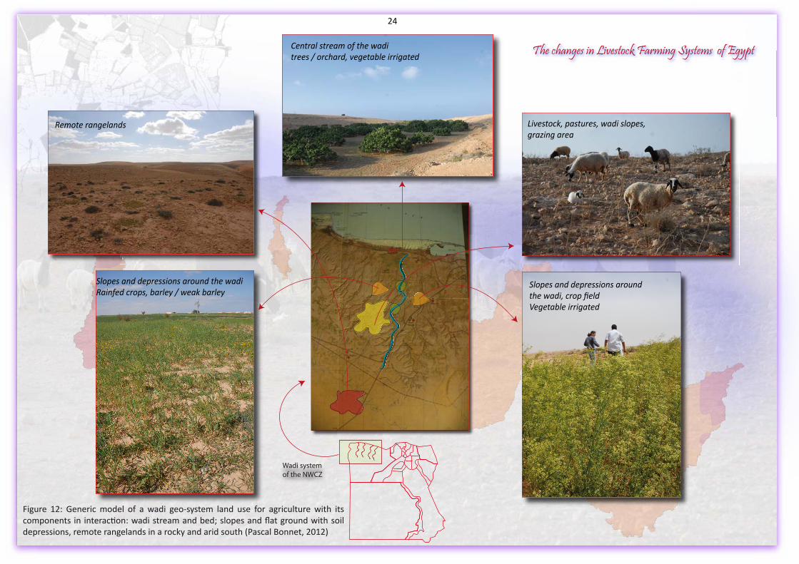
Agriculture and LivestockAgricultureAgricultural life is organized around the wadi and its different compartments, as displayed in the following generic model (Figure 12). The longest is the wadi system, which is generally oriented north-south, the more it crosses the first four rainfall-based strata (from 140 to 50 mm rainfall). Moreover, in the south, one can find some remote rangelands used during trans-humance.
Delta of the wadis: annual rainfall 140 mm, good agronomic soils, cultivation of orchards and vegetables in wadi bed and wadi outskirts. Inhabitants settled. Urbanization and tourism.
1 0-5
Annual rainfall 100-140 mm, poor soils, livestock especially sheep and goats, barley cropping in soil depressions (weak barley for livestock), no reliable water supply. Inhabitants sedentary (concrete houses).
2
5-15
Annual rainfall about 50 mm. Livestock grazing (especially camels). Nomadic Bedouin society with tents and mobility, cisterns & water trucking.
4 50-100
Little or no rainfall. Severe desert environment, limited camel grazing. Scarce human habitation (tents), water trucking.
5 100-200
Oasis region (Siwa). Groundwater, specific agricul-ture patterns. Unique environment with an isolated climate.
6 > 200
Annual rainfall 60 to 100 mm, grazing rangelands and pastures for sheep and goats, some barley ripping. Bedouins predominant, sedentary and nomadic mixes (tents and concrete houses), cisterns & water trucking.
3
15-50
Strata System Characteristics & Land UseDepth in
Land (km)
0-5
15-50
50-100
100-200
> 200
5-15
Siwa
23
Slopes and depressions around the wadiRainfed crops, barley / weak barley
Livestock, pastures, wadi slopes,grazing area
Central stream of the waditrees / orchard, vegetable irrigated
Figure 12: Generic model of a wadi geo-system land use for agriculture with its components in interaction: wadi stream and bed; slopes and flat ground with soil depressions, remote rangelands in a rocky and arid south (Pascal Bonnet, 2012)
The changes in Livestock Farming Systems of Egypt
Remote rangelands
Slopes and depressions aroundthe wadi, crop fieldVegetable irrigated
Wadi system of the NWCZ
24
The changes in Livestock Farming Systems of Egypt
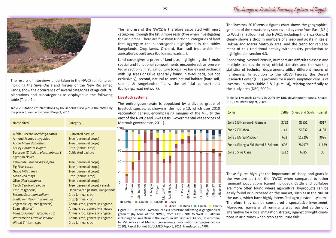
The results of interviews undertaken in the NWCZ rainfall area, including the Siwa Oasis and fringes of the New Reclaimed Lands, show the occurrence of several categories of agricultural plantations and subcategories as displayed in the following table (Table 2).
Table 2: Citations of plantations by households surveyed in the NWCZ by the project, Source Elvulmed Project, 2011
The livestock 2010 census figures chart shows the geographical gradient of the structure by species and by zone from East (NRL) to West (El Salloum) of the NWCZ, including the Siwa Oasis. It clearly shows a drop in numbers of sheep and goats in Ras el Hekma and Marsa Matrouh area, and the trend for replace-ment of this traditional activity with poultry production as highlighted in section 4.3.
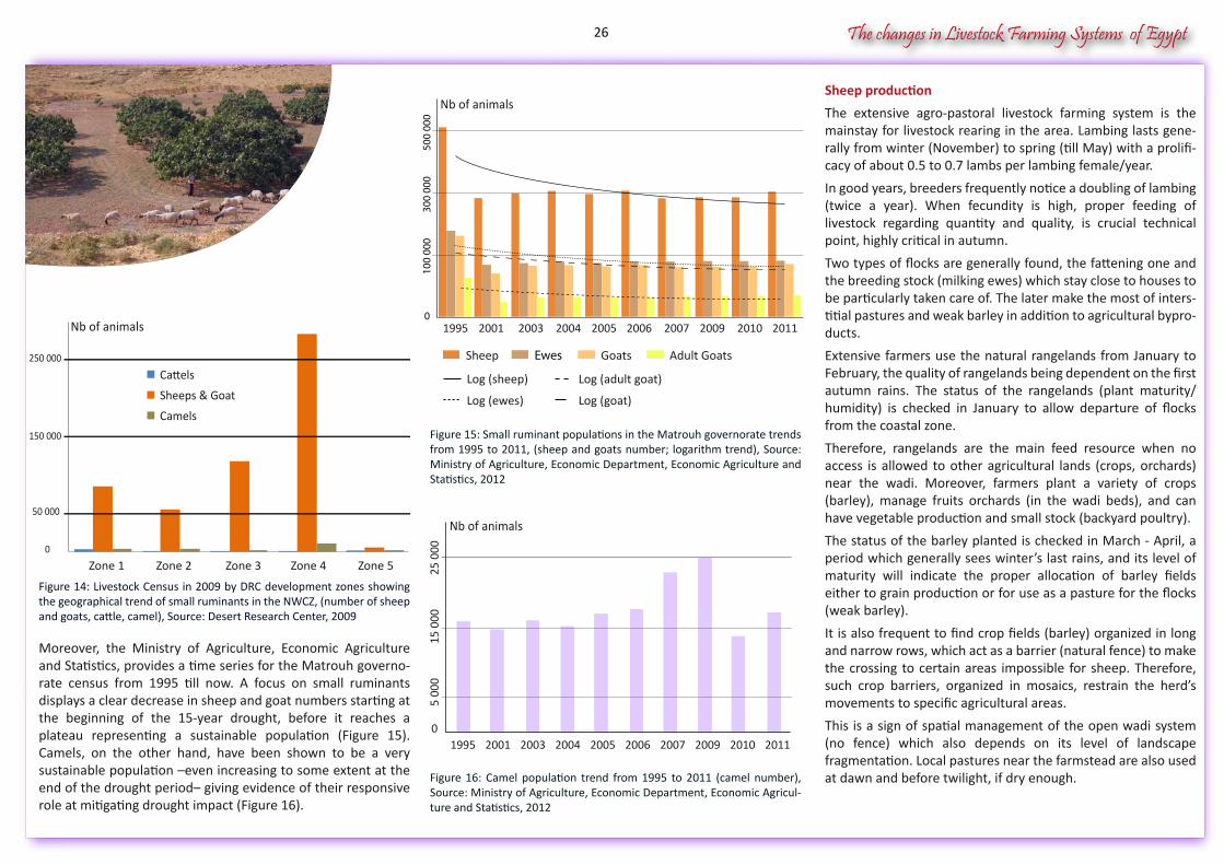
Concerning livestock census, numbers are difficult to assess and multiple sources do exist; official statistics and the working statistics of technical departments utilize different means of numbering. In addition to the GOVS figures, the Desert Research Center (DRC) provides for a more simplified census of livestock in 2009 (Table 3 & Figure 14), relating specifically to the study area (DRC, 2009).
Table 3: Livestock Census in 2009 by DRC development zones, Source: DRC, Elvulmed Project, 2009
These figures highlight the importance of sheep and goats in the western part of the NWCZ when compared to other ruminant populations (camel included). Cattle and buffaloes are more often found where agricultural byproducts can be easily found or purchased on the market, such as in the NRL or the oasis, which have highly intensified agro-pastoral systems. Therefore they can be considered a speculative investment. Moreover, rearing small ruminants was regarded as the only alternative for a local mitigation strategy against drought condi-tions in arid zones when crop agriculture fails.
The land use of the NWCZ is therefore associated with most categories, though the list is more restrictive when investigating the arid areas. There are five main functional categories of land that aggregate the subcategories highlighted in the table: Rangelands, Crop lands, Orchard, Bare soil (not usable for agriculture), built area (buildings, roads... ).
Land cover gives a proxy of land use, highlighting the 3 main spatial and functional compartments encountered, as presen-ted in section 3: first, agriculture (crops like barley and orchards with Fig Trees or Olive generally found in Wadi beds, but not exclusively), second, natural to semi natural habitat (bare soil, sebkha & rangelands), finally, the artificial compartment (buildings, road network).
Livestock systems
The entire governorate is populated by a diverse group of livestock species, as shown in the figure 13, which uses 2010 vaccination census, encompassing margins of the NRL to the east of the NWCZ and Siwa Oasis (Governmental Vet services of Matrouh governorate, 2011).
Figure 13: Detailed Livestock census structure following a geographical gradient (by zone of the NWCZ, from East - NRL to West El Salloum including the Siwa Oasis in the South) in 2010 (source: GOVS, Governmen-tal Vet services of Matrouh governorate, vaccination campaigns census 2010), Pascal Bonnet ELVULMED Report, 2011, translated at APRI.
Name cited Category
Alfalfa Lucerne Medicago sativa Cultivated pastureAlmond Prunus amygdalus Tree (perennial crops)Apple Malus domestica Tree (perennial crops)Barley Hordeum vulgare Crop (annual crop)Berseem (Trifolium alexandrinum )egyptian clover
Cultivated pasture
Palm date Phoenix dactylifera Tree (perennial crops)Fig Ficus carica Tree (perennial crops)Grape Vitis genus Tree (perennial crops)Maize Zea mays Crop (annual crop)Olive Olea europaea Tree (perennial crops)Carob Ceratonia siliqua Tree (perennial crops) / shrubPasture (generic) Uncultivated pasture, RangelandsSesame Sesamum indicum Crop (annual crop)Sunflower Helianthus annuus Crop (annual crop)Vegetable legumes (generic) Annual crop, generally irrigatedBean (all sorts) Annual crop, generally irrigatedTomato Solanum lycopersicum Annual crop, generally irrigatedWatermelon Citrullus lanatus Annual crop, generally irrigatedWheat Triticum spp. Crop (annual crop)
Siw
a
El S
allo
um
Sidi
Bar
ani
Mat
hani
El N
egila
El Q
sar
100%
80
60
40
20
0
Vill
age
24
Vill
age
27
Vill
age
28
El R
way
sat
El H
amam
El A
lam
ein
El D
abaa
Fuka
Ras
El H
ek.
Mar
sa M
at.
Cattle Camels Rabbits GoatsBuffalo Equine PoultrySheep
Zones Cattle Sheep and Goats Camel
Zone 1 El Hamam-El Alamein 3722 85951 4017
Zone 2 El Dabaa 141 56632 4188
Zone 3 Marsa Matrouh 672 119202 3026
Zone 4 El Negila-Sidi Barani-El Salloum 606 284976 11679
Zone 5 Siwa Oasis 1212 6385 30
25
The changes in Livestock Farming Systems of Egypt
Figure 14: Livestock Census in 2009 by DRC development zones showing the geographical trend of small ruminants in the NWCZ, (number of sheep and goats, cattle, camel), Source: Desert Research Center, 2009
Moreover, the Ministry of Agriculture, Economic Agriculture and Statistics, provides a time series for the Matrouh governo-rate census from 1995 till now. A focus on small ruminants displays a clear decrease in sheep and goat numbers starting at the beginning of the 15-year drought, before it reaches a plateau representing a sustainable population (Figure 15). Camels, on the other hand, have been shown to be a very sustainable population –even increasing to some extent at the end of the drought period– giving evidence of their responsive role at mitigating drought impact (Figure 16).
Sheep production
The extensive agro-pastoral livestock farming system is the mainstay for livestock rearing in the area. Lambing lasts gene-rally from winter (November) to spring (till May) with a prolifi-cacy of about 0.5 to 0.7 lambs per lambing female/year.
In good years, breeders frequently notice a doubling of lambing (twice a year). When fecundity is high, proper feeding of livestock regarding quantity and quality, is crucial technical point, highly critical in autumn.
Two types of flocks are generally found, the fattening one and the breeding stock (milking ewes) which stay close to houses to be particularly taken care of. The later make the most of inters-titial pastures and weak barley in addition to agricultural bypro-ducts.
Extensive farmers use the natural rangelands from January to February, the quality of rangelands being dependent on the first autumn rains. The status of the rangelands (plant maturity/ humidity) is checked in January to allow departure of flocks from the coastal zone.
Therefore, rangelands are the main feed resource when no access is allowed to other agricultural lands (crops, orchards) near the wadi. Moreover, farmers plant a variety of crops (barley), manage fruits orchards (in the wadi beds), and can have vegetable production and small stock (backyard poultry).
The status of the barley planted is checked in March - April, a period which generally sees winter’s last rains, and its level of maturity will indicate the proper allocation of barley fields either to grain production or for use as a pasture for the flocks (weak barley).
It is also frequent to find crop fields (barley) organized in long and narrow rows, which act as a barrier (natural fence) to make the crossing to certain areas impossible for sheep. Therefore, such crop barriers, organized in mosaics, restrain the herd’s movements to specific agricultural areas.
This is a sign of spatial management of the open wadi system (no fence) which also depends on its level of landscape fragmentation. Local pastures near the farmstead are also used at dawn and before twilight, if dry enough.
Figure 15: Small ruminant populations in the Matrouh governorate trends from 1995 to 2011, (sheep and goats number; logarithm trend), Source: Ministry of Agriculture, Economic Department, Economic Agriculture and Statistics, 2012
Figure 16: Camel population trend from 1995 to 2011 (camel number), Source: Ministry of Agriculture, Economic Department, Economic Agricul-ture and Statistics, 2012
250 000
150 000
50 000
0
Zone 1 Zone 4Zone 3Zone 2 Zone 5
Cattels
Sheeps & Goat
Camels
Nb of animals
Nb of animals
1995 2011201020092007200620052004200320010
100
000
500
000
300
000
Sheep Adult GoatsGoatsEwes
Log (adult goat)
Log (goat)Log (ewes)
Log (sheep)
Nb of animals
5 00
0
0
15 0
0025
000
1995 201120102009200720062005200420032001
26
The changes in Livestock Farming Systems of Egypt
Wadi Halazin
Wadi NagamishWadi Nagamish
2.3. Historical data on climate (Rainfall & Temperature) 2.3.1. Global climatic change
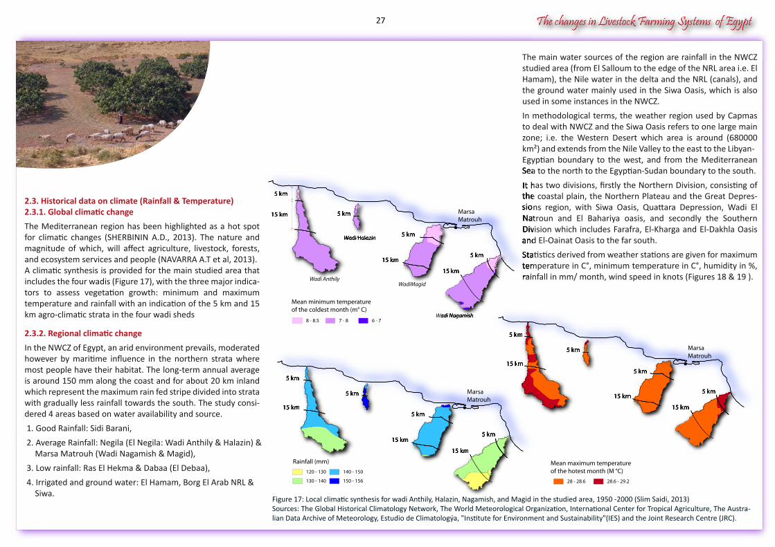
The Mediterranean region has been highlighted as a hot spot for climatic changes (SHERBININ A.D., 2013). The nature and magnitude of which, will affect agriculture, livestock, forests, and ecosystem services and people (NAVARRA A.T et al, 2013).A climatic synthesis is provided for the main studied area that includes the four wadis (Figure 17), with the three major indica-tors to assess vegetation growth: minimum and maximum temperature and rainfall with an indication of the 5 km and 15 km agro-climatic strata in the four wadi sheds
2.3.2. Regional climatic change
In the NWCZ of Egypt, an arid environment prevails, moderated however by maritime influence in the northern strata where most people have their habitat. The long-term annual average is around 150 mm along the coast and for about 20 km inland which represent the maximum rain fed stripe divided into strata with gradually less rainfall towards the south. The study consi-dered 4 areas based on water availability and source.
1. Good Rainfall: Sidi Barani,
2. Average Rainfall: Negila (El Negila: Wadi Anthily & Halazin) & Marsa Matrouh (Wadi Nagamish & Magid),
3. Low rainfall: Ras El Hekma & Dabaa (El Debaa),
4. Irrigated and ground water: El Hamam, Borg El Arab NRL & Siwa.
The main water sources of the region are rainfall in the NWCZ studied area (from El Salloum to the edge of the NRL area i.e. El Hamam), the Nile water in the delta and the NRL (canals), and the ground water mainly used in the Siwa Oasis, which is also used in some instances in the NWCZ.
In methodological terms, the weather region used by Capmas to deal with NWCZ and the Siwa Oasis refers to one large main zone; i.e. the Western Desert which area is around (680000 km²) and extends from the Nile Valley to the east to the Libyan-Egyptian boundary to the west, and from the Mediterranean Sea to the north to the Egyptian-Sudan boundary to the south.
It has two divisions, firstly the Northern Division, consisting of the coastal plain, the Northern Plateau and the Great Depres-sions region, with Siwa Oasis, Quattara Depression, Wadi El Natroun and El Bahariya oasis, and secondly the Southern Division which includes Farafra, El-Kharga and El-Dakhla Oasis and El-Oainat Oasis to the far south.
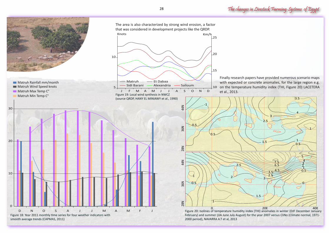
Statistics derived from weather stations are given for maximum temperature in C°, minimum temperature in C°, humidity in %, rainfall in mm/ month, wind speed in knots (Figures 18 & 19 ).
Figure 17: Local climatic synthesis for wadi Anthily, Halazin, Nagamish, and Magid in the studied area, 1950 -2000 (Slim Saidi, 2013)Sources: The Global Historical Climatology Network, The World Meteorological Organization, International Center for Tropical Agriculture, The Austra-lian Data Archive of Meteorology, Estudio de Climatologýa, "Institute for Environment and Sustainability"(IES) and the Joint Research Centre (JRC).
120 - 130 140 - 150
Rainfall (mm)
130 - 140 150 - 156
5 km
15 km
5 km
5 km
15 km5 km
15 km
5 km5 km
15 km15 km
5 km5 km5 km
5 km
15 km5 km
15 km15 km
28 - 28.6 28.6 - 29.2
Mean maximum temperature of the hotest month (M °C)
5 km
15 km
5 km
5 km
15 km5 km
15 km
5 km5 km
15 km15 km
5 km5 km5 km
5 km
15 km15 km5 km
15 km15 km
8 - 8.5
Mean minimum temperature of the coldest month (m° C)
6 - 77 - 8
5 km
15 km 5 km
5 km
15 km5 km
15 km
Wadi HalazinWadi HalazinWadi Halazin
Sea to the north to the Egyptian-Sudan boundary to the south.
It has two divisions, firstly the Northern Division, consisting of the coastal plain, the Northern Plateau and the Great Depressions region, with Siwa Oasis, Quattara Depression, Wadi El Natroun and El Bahariya oasis, and secondly the Southern Division which includes Farafra, El-Kharga and El-Dakhla Oasis and El-Oainat Oasis to the far south.
Statistics derived from weather stations are given for maximum temperature in C°, minimum temperature in C°, humidity in %, rainfall in mm/ month, wind speed in knots (Figures 18 & 19 ).
5 km
15 km 5 km5 km5 km
5 km
15 km5 km
15 km15 km
,
MarsaMatrouh
Wadi AnthilyWadiMagid
MarsaMatrouh
MarsaMatrouh
27
The changes in Livestock Farming Systems of Egypt
Matruh Max Temp C°Matruh Min Temp C°
Matruh Rainfall mm/monthMatruh Wind Speed knots
0
10
20
30
JFMAMJJASOND
Matruh Et DabaaSidi Barani Alexandria Salloum
15
105
1020
25Km/hKnots
J F M A M J J A S O N D
3.5
0.5
1
43
2.5
1
0.5
-0.5
-1
1.5
44N
28N
36N
45
231
0.5
0
6.57.5
4.5
1.5
22.53.5
-1
-0.5
2
2.5
1
0 20E 40E
44N
28N
36N
Figure 18: Year 2011 monthly time series for four weather indicators with smooth average trends (CAPMAS, 2011)
Figure 20: Isolines of temperature humidity index (THI) anomalies in winter (DJF December January February) and summer (JJA June July August) for the year 2007 versus CliNo (Climate normal, 1971-2000 period), NAVARRA A.T et al, 2013
The area is also characterized by strong wind erosion, a factor that was considered in development projects like the QRDP.
Figure 19: Local wind synthesis in NWCZ(source QRDP, HANY EL MINIAWY et al., 1990)
Finally research papers have provided numerous scenario maps with expected or concrete anomalies, for the large region e.g. on the temperature humidity index (THI, Figure 20) LACETERA et al., 2013.
28
The changes in Livestock Farming Systems of Egypt
2.4. Socio-Economic changes
2.4.1. Water resource management & infrastructure
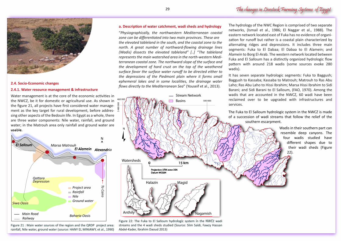
Water management is at the core of the economic activities in the NWCZ, be it for domestic or agricultural use. As shown in the figure 21, all projects have first considered water manage-ment as the key target for rural development, before addres-sing other aspects of the Bedouin life. In Egypt as a whole, there are three water components: Nile water, rainfall, and ground water; in the Matrouh area only rainfall and ground water are usable.
Figure 21 : Main water sources of the region and the QRDP project area: rainfall, Nile water, ground water (source: HANY EL MINIAWY, et al., 1990)
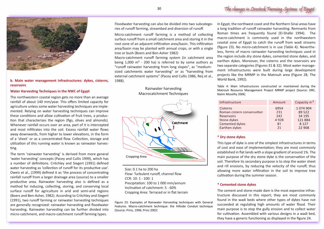
a. Description of water catchment, wadi sheds and hydrology
“Physiographically, the northwestern Mediterranean coastal zone can be differentiated into two main provinces. These arethe elevated tableland in the south, and the coastal zone to thenorth. A great number of northward-flowing drainage lines (Wadis) dissects the elevated tableland” [..] “The tableland represents the main watershed area in the north-western Medi-terranean coastal zone. The northward slope of the surface and the development of hard crust on the top of the weathered surface favor the surface water runoff to be directed either to the depressions of the Piedmont plain where it forms small ephemeral lakes and in some localities, the drainage water flows directly to the Mediterranean Sea” (Youseif et al., 2013).
Figure 22: The Fuka to El Salloum hydrologic system in the NWCZ wadi streams and the 4 wadi sheds studied (Source: Slim Saïdi, Fawzy Hassan Abdel-Kader, Ibrahim Daoud 2013)
The hydrology of the NWC Region is comprised of two separate networks, (Ismail et al., 1986; El Naggar et al., 1988). The eastern network located east of Fuka has no evidence of organi-zation for runoff but rather is a coastal plain characterized by alternating ridges and depressions. It includes three main segments: Fuka to El Dabaa; El Dabaa to El Alamein; and Alamein to Borg El-Arab. The western network located between Fuka and El Salloum has a distinctly organized hydrologic flow pattern with around 218 wadis (some sources evoke 280 wadis).
It has seven separate hydrologic segments: Fuka to Baggush; Baggush to Kassaba; Kassaba to Matrouh; Matrouh to Ras Abu Laho; Ras Abu Laho to Hissi Ibrahim; Marsa Hissi Ibrahim to Sidi Barani; and Sidi Barani to El Salloum, (FAO, 1970). Among the wadis that are accounted in the NWCZ, 60 wadi have been reclaimed over to be upgraded with infrastructures and services. The Fuka to El Salloum hydrologic system in the NWCZ is made of a succession of wadi streams that follow the relief of the
southern escarpment.
Wadis in their southern part can resemble deep canyons. The
four wadis studied have different shapes due to their wadi sheds (Figure
22).
3 48
0 00
0
460 000500 000
0 15 km
Projection UTM zone 35NDatum WGS84
N
Basins
Stream Network
Watersheds0 15 km15 km
Projection UTM zone 35NDatum WGS84
Figure 22: The Fuka to El Salloum hydrologic system in the NWCZ wadi
00
Projection UTM zone 35NDatum WGS84
Figure 22: The Fuka to El Salloum hydrologic system in the NWCZ wadi
Magid
Nagamish
Halazin
Anthily
To Cairo
QattaraDepression
Siwa Oasis
Main RoadRailway
Baharia Oasis
AlexandriaEl AlameinEl Salloum
usable.
AlexandriaEl AlameinEl Salloum
N
Marsa Matrouh
Ground waterNileRainfallProject area
29
The changes in Livestock Farming Systems of Egypt
b. Main water management infrastructures: dykes, cisterns, reservoirs
Water Harvesting Techniques in the NWC of Egypt
The northwestern coastal region gets no more than an average rainfall of about 140 mm/year. This offers limited capacity for agriculture unless some water harvesting techniques are imple-mented. Relying on water harvesting techniques can improve these conditions and allow cultivation of fruit trees, a produc-tion that characterizes the region (figs, olives and almonds). Whenever rainfall occurs over an area, part of it is intercepted and most infiltrates into the soil. Excess rainfall water flows away downwards, from higher to lower elevations, in the form of a ‘sheet’ or as a concentrated flow. Collection, storage and utilization of this running water is known as rainwater harves-ting.
The term ‘rainwater harvesting’ is derived from more general ‘water harvesting’ concepts (Pacey and Cullis 1999), which has a number of definitions. Critchley and Siegert (1991) defined water harvesting as ‘collection of runoff for its productive use’. Oweis et al., (1999) defined it as ‘the process of concentrating rainfall runoff from a larger drainage area (source) to a smaller productive area. Rainwater harvesting also is defined as a method for inducing, collecting, storing, and conserving local surface runoff for agriculture in arid and semi-arid regions (Boers and Ben-Asher, 1982). According to Critchley and Siegert (1991), two runoff farming or rainwater harvesting techniques are generally recognized: rainwater harvesting and floodwater harvesting. Rainwater harvesting can be further divided into micro-catchment, and macro-catchment runoff farming types.
Floodwater harvesting can also be divided into two subcatego-ries of runoff farming, streambed and diversion of runoff.
Micro-catchment runoff farming is a method of collecting surface runoff from a small catchment area and storing it in the root zone of an adjacent infiltration area/basin. This infiltration area/basin may be planted with annual crops, or with a single tree or bush (Boers and Ben-Asher 1982)Macro-catchment runoff farming system (in catchment area being 1,000 m² - 200 ha) is referred to by some authors as "runoff rainwater harvesting from long slopes", as "medium-sized catchments water harvesting" or as "harvesting from external catchment systems" (Pacey and Cullis 1986, Reij et al., 1988).
Figure 23: Examples of Rainwater Harvesting techniques with General Features. Macro-catchment technique: the Hillside Conduit technique (Source: Prinz, 1996; Prinz 2002)
Cisterns 6954Roman cistern conservation 231Reservoirs 243Stone dykes 4 928Cemented dykes 81Earthen dykes 21
Infrastructure Amount
6954231243
4 9288121
CisternsRoman cistern conservationReservoirsStone dykesCemented dykesEarthen dykes
AmountInfrastructure
1 074 90489 52234 195
121 8848 127
22 908
Capacity m3Capacity m3
In Egypt, the northwest coast and the Northern Sinai areas have a long tradition of runoff rainwater harvesting. Remnants from Roman times are frequently found (El-Shafei 1994). The macro-catchment is commonly used in the northwestern coastal zone of Egypt to catch the runoff from wadi streams (figure 23). No micro-catchment is in use (Table 4). Neverthe-less, forms of macro rainwater harvesting techniques used in the region include dry stone dykes, cemented stone dykes, and earthen dykes. Moreover, the cisterns and the reservoirs are two separate categories (Figures 31 & 32). Most water manage-ment infrastructures were built during large development projects like the MRMP in the Matrouh area (Figure 28, The World Bank, 1992).
Table 4: Main infrastructures constructed or maintained during the Matrouh Resource Management Project MRMP project (Source: DRC, Naiim Moselhy 2006)
* Dry stone dykes
This type of dyke is one of the simplest infrastructures in terms of cost and ease of implementation; they are most commonly established in flat lands with a slope gradient of around 1%. The main purpose of the dry stone dyke is the conservation of the soil. Therefore its secondary purpose is to stop the water sheet and rill erosions, by reducing the velocity of the runoff, thus allowing more water infiltration in the soil to improve tree cultivation during the summer season.
* Cemented stone dykes
The cement and stone-made dam is the most expensive infras-tructure discussed in this report; they are most commonly found in the wadi beds where other types of dykes have not succeeded at regulating high amounts of water flood. Their main purpose is to stop the gully erosion and to collect water for cultivation. Assembled with various designs in a wadi bed, they have a generic functioning as displayed in the figure 24.
Catchment
Cropping Area
Rainwater harvestingMacrocatchment Techniques
Catchment
Size: 0.1 ha to 200 ha Flow: Turbulent runoff, channel flowCCR: 10: 1 - 100: 1Precipitation: 100 to 1 000 mm/annumInclination of catchment: 5 - 60%Cropping Area: Terraced or in flat terrain
30
The changes in Livestock Farming Systems of Egypt
The dam consists of a dyke body with a good foundation not less than one meter under the soil surface and a spillway to evacuate the extra water so that there is no damage to the body of the dykes and to soil (Figures 25 & 26).
Figure 24: Generic sketch map of Water flows and functioning of inner stone dikes (Nastassja Hoffet et al. 2011)
Figure 25: Cemented stone dykes (Source: DRC, Naiim Moselhy 2006)
Figure 26: Cemented Stone dykes (Source: Ibrahim Daoud, 2011)
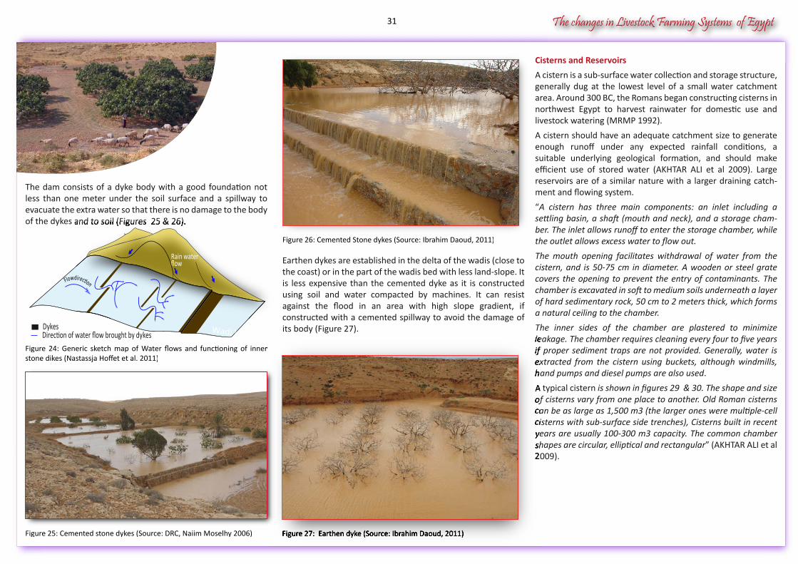
Earthen dykes are established in the delta of the wadis (close to the coast) or in the part of the wadis bed with less land-slope. It is less expensive than the cemented dyke as it is constructed using soil and water compacted by machines. It can resist against the flood in an area with high slope gradient, if constructed with a cemented spillway to avoid the damage of its body (Figure 27).
Cisterns and Reservoirs
A cistern is a sub-surface water collection and storage structure, generally dug at the lowest level of a small water catchment area. Around 300 BC, the Romans began constructing cisterns in northwest Egypt to harvest rainwater for domestic use and livestock watering (MRMP 1992).
A cistern should have an adequate catchment size to generate enough runoff under any expected rainfall conditions, a suitable underlying geological formation, and should make efficient use of stored water (AKHTAR ALI et al 2009). Large reservoirs are of a similar nature with a larger draining catch-ment and flowing system.
“A cistern has three main components: an inlet including a settling basin, a shaft (mouth and neck), and a storage cham-ber. The inlet allows runoff to enter the storage chamber, while the outlet allows excess water to flow out.
The mouth opening facilitates withdrawal of water from the cistern, and is 50-75 cm in diameter. A wooden or steel grate covers the opening to prevent the entry of contaminants. The chamber is excavated in soft to medium soils underneath a layer of hard sedimentary rock, 50 cm to 2 meters thick, which forms a natural ceiling to the chamber.
The inner sides of the chamber are plastered to minimize leakage. The chamber requires cleaning every four to five years if proper sediment traps are not provided. Generally, water is extracted from the cistern using buckets, although windmills, hand pumps and diesel pumps are also used.
A typical cistern is shown in figures 29 & 30. The shape and size of cisterns vary from one place to another. Old Roman cisterns can be as large as 1,500 m3 (the larger ones were multiple-cell cisterns with sub-surface side trenches), Cisterns built in recent years are usually 100-300 m3 capacity. The common chamber shapes are circular, elliptical and rectangular” (AKHTAR ALI et al 2009).
Figure 24: Generic sketch map of Water flows and functioning of inner
Figure 27: Earthen dyke (Source: Ibrahim Daoud, 2011)
leakage. The chamber requires cleaning every four to five years if proper sediment traps are not provided. Generally, water is extracted from the cistern using buckets, although windmills, hand pumps and diesel pumps are also used
A typical cisternof cisterns vary from one place to another. Old Roman cisterns can be as large as 1,500 m3 (the larger ones were multiple-cell cisterns with sub-surface side trenches), Cisterns built in recent years are usually 100-300 m3 capacity. The common chamber shapes are circular, elliptical and rectangular2009).
of the dykes and to soil (Figures 25 & 26).
Dykes Wadi bed
Rain waterflow
Direction of water flow brought by dykes
Flowdirection
31
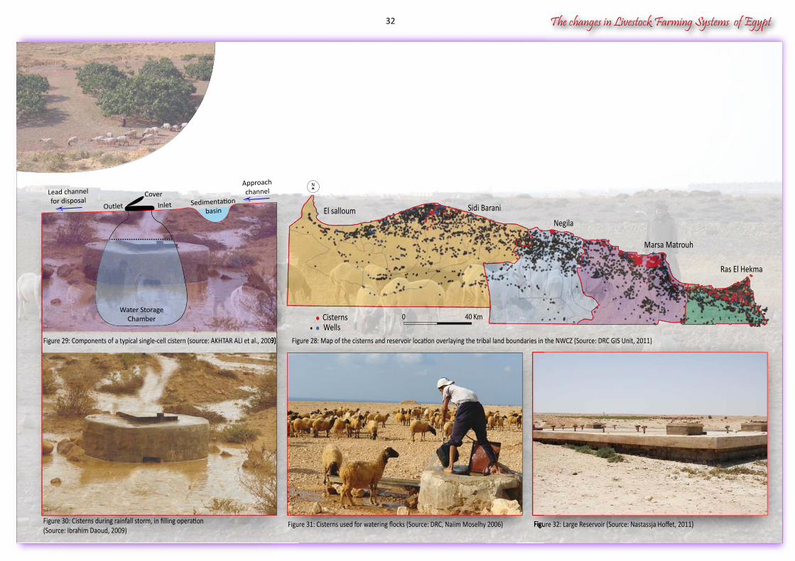
Figure 30: Cisterns during rainfall storm, in filling operation(Source: Ibrahim Daoud, 2009)
Figure 29: Components of a typical single-cell cistern (source: AKHTAR ALI et al., 2009)
Figure 32: Large Reservoir (Source: Nastassja Hoffet, 2011)
Figure 29: Components of a typical single-cell cistern (source: AKHTAR ALI et al., 2009)
Figure 32: Large Reservoir (Source: Nastassja Hoffet, 2011)Figure 31: Cisterns used for watering flocks (Source: DRC, Naiim Moselhy 2006)
Figure 28: Map of the cisterns and reservoir location overlaying the tribal land boundaries in the NWCZ (Source: DRC GIS Unit, 2011)
0 40 KmWellsCisterns
InletOutlet
CoverLead channelfor disposal
Approachchannel
The changes in Livestock Farming Systems of Egypt
Sedimentationbasin El salloum
N
Sidi Barani
Negila
Ras El Hekma
Marsa Matrouh
Water StorageChamber
32
The changes in Livestock Farming Systems of Egypt
c. Description of Wadi Nagamish
Wadi Nagamish is situated about 20 km east of Marsa Matrouh (Figure 33 ). Its development was strongly influenced by its proximity to the city, market places, and the existing roadway network.
Figure 33: Location of Wadi Nagamish, East of Marsa MatrouhSource: Pascal Bonnet, Ibrahim Daoud, 2013
Moreover, it covers almost the three rainfall strata from the coastal area to the 15 km hinterland strata. Therefore, changes of multiple natures (urbanization, drought, market) have occur-red there. This wadi is diverse in both its agricultural and nona-gricultural land use. The wadi bed represents 10% of the wadi shed area, and 7% of the area is covered by local habitat and tourism villages (Figure 34 ).
2.4.2. Demographics, urbanization & change in life styles
a. Matrouh governorate: population and demographics
The Matrouh governorate and the NWCZ have historically been considered as empty areas in Egypt. The region lacked substan-cial dynamic urbanization and livelihood relied heavily on basic agricultural production factors.
Since the 1960s, Egypt’s population has seen rapid growth, reaching approximately 85 million in 2013. Moreover this growth was also observed in frontier governorates such as Matrouh (Figure 36 ), which now accounts for 416,923 people (CAPMAS, population statistics, 2013).
As a matter of fact, in 2006, the population growth rate of the Matrouh governorate equaled that of Egypt, and until 2013 even exceeded the national rate of growth.
This situation reveals a trend for a demographic expansion, and a speeding up of the reclamation process, be it in NWCZ wadis or on the western lands of the Nile delta. Reclaimed Lands (RL) in Matrouh governorate represented a 14% share in 2007- 2008 (Figure 37, CAPMAS, Agriculture statistics 2013).
Figure 34 : Wadi Nagamish, estimated share in land use in the surveyed area in 2011 (area in feddans), Source: Ibrahim Daoud surveys , 2013
Barley cultivation is the mainstay of crop agriculture outside the orchards. A local forest is watered with recycled sewage water. The wadi is also diverse in its social nature as it is occupied by several tribes: Qnashat, Gebihat, Manefa, Mawalek, and the Al Havian (Figure 35 ). These 4 tribes represent 9 beits and 374 families in the study area..
0 12 Km
Marsa MatrouhMarsa Matrouh
0 12 Km
10%3%
2%
4% 0.4%
13%68%
Wadi bedTourism villagesForest Local habitatStone crushersBarley cultivationOther
10%3%
2%
44% 0.4%
13%68%
Wadi bedTourism villagesTourism villagesTForest Local habitatStone crushersBarley cultivationOther
Main tribes in wadiNagamish area
Abu Baker45 Families
Scbak43 Families
Manafatribe
Abu Gdida25 Families
Al Haviantribe
Mawalek9 Families
Mawalektribe
Malof43 Families
Abu Borma25 Families
Abu Khatra77 Families
Gebihattribe
Masrana62 Families
Abd Allah45 Families
Qnashattribe
Figure 35: Tribal structure in Nagamish: beits represented in the study area, number of families in beits (Source Ibrahim Daoud, 2013)
Nagamish basin
33
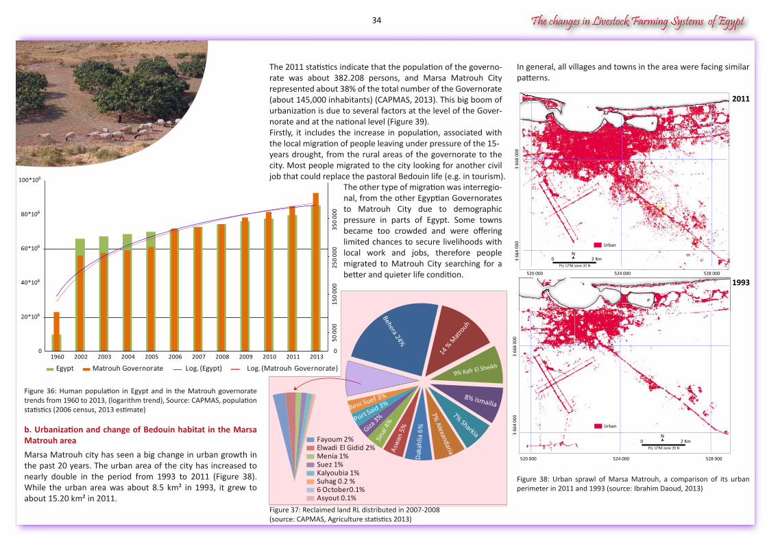
The changes in Livestock Farming Systems of Egypt
Figure 36: Human population in Egypt and in the Matrouh governorate trends from 1960 to 2013, (logarithm trend), Source: CAPMAS, population statistics (2006 census, 2013 estimate)
b. Urbanization and change of Bedouin habitat in the Marsa Matrouh area
Marsa Matrouh city has seen a big change in urban growth in the past 20 years. The urban area of the city has increased to nearly double in the period from 1993 to 2011 (Figure 38). While the urban area was about 8.5 km² in 1993, it grew to about 15.20 km² in 2011.
In general, all villages and towns in the area were facing similar patterns.
.
Figure 38: Urban sprawl of Marsa Matrouh, a comparison of its urban perimeter in 2011 and 1993 (source: Ibrahim Daoud, 2013)
The 2011 statistics indicate that the population of the governo-rate was about 382.208 persons, and Marsa Matrouh City represented about 38% of the total number of the Governorate (about 145,000 inhabitants) (CAPMAS, 2013). This big boom of urbanization is due to several factors at the level of the Gover-norate and at the national level (Figure 39).Firstly, it includes the increase in population, associated with the local migration of people leaving under pressure of the 15-years drought, from the rural areas of the governorate to the city. Most people migrated to the city looking for another civil job that could replace the pastoral Bedouin life (e.g. in tourism). The other type of migration was interregio-
nal, from the other Egyptian Governorates to Matrouh City due to demographic pressure in parts of Egypt. Some towns became too crowded and were offering limited chances to secure livelihoods with local work and jobs, therefore people migrated to Matrouh City searching for a better and quieter life condition.
0
50 0
0015
0 00
025
0 00
035
0 00
0
01960 2002 2003 2004 2005 2006 2007 2008 2009 2010 2011 2013
Egypt Matrouh Governorate Log. (Egypt) Log. (Matrouh Governorate)
524 000 528 000520 000
3 66
4 00
03
668
000
Urban
0 2 KmN
Prj. UTM zone 35 N
Figure 37: Reclaimed land RL distributed in 2007-2008(source: CAPMAS, Agriculture statistics 2013)
524 000 528 000520 000
3 66
4 00
03
668
000
0 2 KmN
Urban
Prj. UTM zone 35 N
Figure 37: Reclaimed land RL distributed in 2007-2008Figure 37: Reclaimed land RL distributed in 2007-2008
Dak
ahlia
6%
Asw
an 5
%
Sina
ï 4%
Giza 3%
Port Said 3% Beni Suef 3%
Fayoum 2% Elwadi El Gidid 2% Menia 1% Suez 1% Kalyoubia 1% Suhag 0.2 % 6 October0.1% Asyout 0.1%
Behera 24%
14 %
Mat
rouh
9% Kafr El Sheikh
8% Ismailia7% Sharkia
7% Alexandaria
2011
1993
34
The changes in Livestock Farming Systems of Egypt
Center
West
East
CenterCenter
EastMarsa Matrouh
Another change in the society was more associated to the style of housing and the places the Bedouin inhabit in the NWCZ, be it in urban centers or in rural villages and areas:
A field survey in 1990 by the Qasr Rural Development Project (QRDP) (HANY EL MINIAWY, et al., 1990) showed that there was a gradual change in the two main forms of habitat (concrete house or/and tent) considering the three geo-climatic strata, from the coastal area (zone 1) to the middle of the rainfall area (zone 2) and then to the most remote area in the south (zone 3) respectively:
In 1990 the majority of houses were built with stone blocks from Matrouh. The use of such material was influenced by former projects by the World Food Program (WFP) which requi-red the use of stone to qualify for housing funds. The traditional method of using locally made mud blocks for bearing walls was diminishing partially due to the requirement to use stone (HANY EL MINIAWY et al, 1990). Bedouins maintained the habit of using cut stones and blocks because they were cheaper than the irregular boulders and stone found in their land and because of the difference in wall thickness and labor cost.At present, the old style of houses is seen only in the southern region in zone 3, whereas in zone 1 and in zone 2 a large propor-tion of houses are built using concrete.
Moreover there was a gradual change in the shape of the Bedouin housing design (Figures 40 & 41). From the beginning of settlement and the construction of houses in the NWCZ area until the beginning of the 1990s, the shape of the Bedouin’ houses had a very simple design. The house consisted of two rows of rooms on both sides in addition to the guest room (called Marboaa). The later had a separate door to the outside away from the house to avoid guests seeing women. The kitchen was a stand-alone building outside the home and the majority of houses were built with stone, whereas clay was used as a substitute for cement and the roof consisted of wood.
The Bedouin concrete home architecture in a village of wadi Anthily
• 93% of the people in zone 1 lived in concrete houses only and the remaining 7% had both a house and a tent, • 48% of the people in zone 2 had a house only, 41% had both a house and a tent and 11% had a tent only,• 49% of the people in zone 3 had a house only, 27% had both a house and a tent and 24% had a tent only.
In particular, the survey showed that in 1990 a significant percentage of Bedouins still lived a nomadic lifestyle, with 11% in zone 2 and 24% in zone 3 living in tents only. Presently, the ELVULMED project field surveys show that 100% of the popula-tion interviewed in zone 1, 2 and 3 lived in a house.
In the past Bedouins used to keep a tent beside their house for purposes such as meetings, celebrations, as a living room especially for the men in the summer, or as housing for migrant workers. At present, there is no more population living in tents except shepherds moving in remote rangeland areas during transhumance. Moreover, tents are used only on special occasions or when the family moves to harvesting work with others in the barley, fig, and olive fields. There are no more pure nomads in the study area. The type of the population which lived in houses and tents are likely to have fully disappeared.
Figure 39: The regional development plan of towns and cities for the North West Coast of Egypt. Cited by Metwally, M. and Abdalla, S. 2005
The Bedouin concrete home architecture in a village of wadi Anthily
35
The changes in Livestock Farming Systems of Egypt
At present housing design has become more complex and modern. The majority of houses are now constructed with regular limestone rocks. The house is surrounded by a balcony on at least one of its sides. The roof is made of concrete, and cement is currently used as a material for building. There are two kitchens, a small one within the house and a big one outside the house.
In the Wadi Nagamish area, the old house design is still predo-minant in the southern area in zone 3. This is due to several reasons. Firstly, this area was the most dependent on livestock and small agriculture, thus the most vulnerable to drought. Therefore the poor economic situation of the population during the drought may have prevented them from modernizing their homes as if time had stopped in that zone.
Additionally, accessibility to electricity, roads, transportation, education, and health care was higher there, and this made life more comfortable and offered a clearer perception of a future for themselves and their children. Finally, they now expect that the neighboring urban sprawl of Matrouh will reach them in a few years and this encourages them to invest in the construc-tion of modern houses.
c. Tourism development in NWCZ of Egypt
The development of national tourism in NWCZ has long been included in national tourism plans as is shown on planning maps (Figure 42), in urbanism consultancy papers, or in research papers (Attia, 1999).
This development responded to the social demand for summer vacation of national citizens and had a vision for international tourism. Moreover, the area has a dramatic coastline with white sandy beaches and pristine water (Al-Abyad Beach, Agiba Beach, about 20 km and 28 km west of Marsa Matruh respecti-vely) (Jobbins J. and Megalli M., 2006). It also has historical endowments from the Greek-Roman antiquities (the pharaonic temple of Amon in Siwa, Cleopatra's bath in Marsa Matrouh), or from the modern era (war sites of 1942 Alamein tank battle, headquarters of Marshal Rommel) which would have been major international tourism attraction for Europeans (Metwally, M. and Abdalla, S. 2005).
Moreover there were hopes that such an economic driver would lead to a change in Bedouin life as it would offer employ-ment opportunities, though only seasonal, and sustainable markets opportunities for local products. Indeed Bedouin families have found alternatives to adapt to this new context, offering agricultural products from wadi cultivation (olive and fig), rain fed crops, and livestock farming systems.
“Tourism is an important tool to achieve national development goals. The North West Coast of Egypt is a promising region for development, able to provide great economic help to the local community and to the national economy, if it is properly mana-ged, developed and sustained” ( Metwally, M. and Abdalla, S. 2005).
Secondly, the population had the perception that their presence in this region is nowadays associated with an increasing portfolio of risks and that the area has no future. Therefore investment in the establishment of modern houses gradually became less attractive. Besides, in the presence of a declining trend in developing new electricity, education, and health care infrastructures in the region, the only incentive for the sustainable presence of the population is the desire to not abandon the land of their forefathers. Therefore, most Bedouin do not want to leave and cling to their ancestors land.
In contrast, the modern houses in Nagamish are found in zone 1 in the north and zone 2 in the intermediate strata. Indeed, the economic situation of its population was much better than in the southern region for a variety of reasons. Firstly, the existence of many economic alternatives allowed the popula-tion to better cope with drought.
Since the population owned lands in the Wadi bed with figs or olive trees, they could add supplementary irrigation for these orchards to get a timely viable crop production and decrease uncertainty at times of drought. The diversity of agro-pastoral farming systems in that area has allowed them to be more flexible and resistant to drought. Moreover, they were close to the city of Matrouh which provided them with many alternative opportunities for civil jobs at a relatively short distance from home.
Change in habitat:
Figures 40 & 41: Sketch drawing of the old (left) and modern (right) Bedouin house’s design (Source: Ibrahim Daoud, 2013)
Fig.40 Fig.41
Marboaa
Room
Room
Room
Fig.40 Fig.41
Balcony
Room
Room
RoomHal
Marboaa
36
The changes in Livestock Farming Systems of Egypt
"The average Egyptian family spends no more than three weeks per year vacationing in the area, usually between mid-July and late August, leaving the villages completely vacant for 10 months of the year" (Business Today, 1998).Eventually this development of touristic resorts has rather served the national mass tourism. Resorts have grabbed the coastal land with little interest in natural zones or social habits of locals bringing big changes in Bedouin habits. It has been regarded by Bedouins as an opportunity for jobs but also as a threat of land possession. Tourism has also generated some controversial debate in newspapers like in Marakia in 1998 (“The pillaging of the North Coast”, Egypt Today, 1998, cited by Attia, 1999).
Before the revolution, about 85% of tourism in the NWC could be categorized as sun-and-beach tourism including visits of Second World War sites (coastal belt), 10% as cultural health-and-recreation tourism (Siwa) and finally 5% as business and transit tourism (Marsa Matrouh) (El-Bastawissi, E. 1997).
d. Changes of life styles in the Bedouin society
The most important feature of the Bedouin community is to keep its customs and traditions that distinguish it from other communities. Nevertheless, over time, creeping urbanization affected the Bedouin community and some change in customs and traditions has occured.
Bedouin Cultural Heritage, traditional clothing, carpets, and tents
The Bedouin community heritage includes wearing specific garments, using traditional tents, and weaving carpets with specific designs.
Traditional dress is still used by Bedouins who live in the desert away from the city. Nevertheless working in the city makes members of the Bedouin community change their style of dress as well as increase their level of education. Moreover in the southern region, most of the population is still clinging to traditional dress, because traditions are predominantly influen-ced by elderly Bedouins who consider such change as unworthy given their age. The traditional Bedouin tent was used as housing in the community until recently.
Regional boundary
Coastal highway
Major road
Railway
Beach tourism zone
Agriculture
Regional centre
Sub-Regional centreLocal services centre
IndustryProposed Water Lines
Pumping station
Regional boundary
Coastal highway
Major road
Railway
Beach tourism zoneBeach tourism zone
Agriculture
Regional centre
Sub-Regional centreLocal services centre
IndustryProposed Water Lines
Pumping station
The tourism development area includes the eastern sector with a length of about 166 km, the middle sector with 135 km, and the western sector with about 150 km. The regional develop-ment plan for the North West concentrates on the develop-ment of the middle sector. While the mass tourism has especially occurred in the eastern part of the NWCZ at the edge of the Nile Delta, the city of Marsa Matrouh and its vicinity, a region with many tourist amenities (beaches, Bedouin culture, Oasis..) has been affected too.
National Strategy of Tourism Development
The north west coast tourism development started at the beginning of the sixties after the issuance in 1961 of the Repu-blican Decree number 1899 to establish the Egyptian Organiza-tion for Tourism and Hotels (EGOT). The race for establishment of tourist villages began in the 80s as a result of tremendous gains achieved by real estate companies. This trend was a result of the massive investment that followed the escalation of the rehabilitation of the northwest coast to be a promising destina-tion for international tourism. In January 2010 the number of tourist villages reached 120 tourist villages including 65,425 real estate units, its absorptive capacity reached 361,000 people. (Khalaf, 2010).
The new strategy of development established in 1980 was to reinforce tourism development in the Sinai region and in the NWC region. The five year development strategy of Egypt (1982-1987) considered tourism as the mainstay of planned economic development in the northwest coast, which needed to be integrated with agriculture and industrial development in order to obtain comprehensive socio-economic development objectives (HASSAN G.F., 2000).
Figure 42: Development Plan by specialization zones for the NWCZ area from Alexandria to El Salloum, Source: Attia, 1999
37
The changes in Livestock Farming Systems of Egypt
Now tents are only used on specific occasions or as a temporary residence. The results of the project’s surveys in Nagamish show that there is a limited number of traditional tents in the area and all were made in the recent past. Nowadays all the tents are being made by older women; the young women have lost the know-how. Therefore, this kind of cultural heritage could vanish in a few years. What applies to the traditional Bedouin tent also applies to traditional Bedouin handmade textiles. Nowadays women do not make handmade textiles (carpets woven at home or in cooperatives) because it requires time, is costly, and can be replaced by cheaper alternatives.
Change for Females
Despite the strong cultural identity and the weight of social norms that still prevail among the Bedouin, literature and interviews confirm that there are significant social changes that have impact on the place of women in the society. However these changes must be contextualized. There is a huge difference between living conditions and opportunities for women living in remote communities and living in cities. Firstly, the majority of mothers are aware the importance of education for the future of their daughters. However, changes in traditio-nal ways of life are slow. As noted by Duarte et al. (2013), the absence or distance of schools in remote desert areas where the Bedouins live is one of the factors that impede access of girls to education, especially at intermediate and higher levels. And, in some desert communities, school- age girls do not attend school because their parents do not allow.
Another rule and habit in the Bedouin community was the control of marriage conditions (“Mask Bent al Am”).
Preschools are also found mainly in villages with high popula-tions densities, while secondary schools are found only in larger cities.
f. Water consumption patterns
The water consumption in the past was very low according to the Bedouin recounts of this period. The main source of drinking water was the roman cisterns, whose quantity and accessibility were very limited. Cisterns were often far away from home (a few kilometers). In order to access them, Bedouins used donkeys to transfer the water. Moreover storage means were also limited and people had a limited number of jerrycans to transfer and store the water. Finally there were no motors to raise water from the cisterns and all extraction was handmade.
Since the last decades, the situation has changed completely. The number of cisterns has significantly increased due to development projects, with new cisterns established near homes for both drinking and home use. Moreover the impro-ved access to electricity for remote homes in the desert, enabled the use of water pumps, coupled with new availability of vehicles, tractors and water tank trailers to transport water over long distances. All these factors help to ease access to water and thus increase water consumption, adding more pressure on water resources (Gleick P. H., 1996).
Human consumption including drinking, sanitary and other uses in dry areas is estimated about 50 liters per person meeting basic human water requirements and excluding livestock (AKHTAR ALI T.O. et al, 2009). Therefore the current daily water consumption reaches 350 liter for a family consis-ting of an average number of 7 persons, whereas the past consumption was more restrictive.
The young women were not allowed to marry someone from outside the tribe, except with the permission of her father and uncles. If it is noted some change in the coastal towns, in rural desert communities, the family still has a great influence on the choice of husbands for girls.
Finally, preventing the inheritance of land by females was one of the traditional Bedouin laws. This rule was solidly anchored on tradition and it was caused by the unwillingness of members of the tribe to share their land territory. At present, some female Bedouin would have access to land. However we haven’t enough data to measure the importance of this change. e. Education and Increase in the Proportion of Educated People
The education rate in the Bedouin community was very low in the past. This was not due to the reluctance of Bedouins to obtain education but rather to the lack of adapted school facilities in remote desert areas.
As the nature of the nomadic Bedouin community keeps contri-buting to the reduction of the proportion of learners, an educa-tion initiative was adopted by the tribes known as “KOTAB” which was bringing a simple education curriculum lasting a few months just to learn writing and reading.
Recently the Bedouin settlement process with the establish-ment of schools helped to increase the proportion of learners. Given the difficulty of establishing schools in all villages scatte-red in the desert, the concept of “one-class schools” emerged. Such schools facilities also called “societal” or “Ahlia” appeared in the 60’s under the supervision the Ministry of Education. It needed only one teacher and one classroom. This type of education facility was then developed to accept girls over the usual school age. In 1994 it became a girl school. In 2006 the rules changed to offer a mixed education that includes both male and female students.
There are now 149 schools in the Matrouh Governorate. The teacher is often a resident of the village and has medium to high qualifications. With an increase in the number of students, those school systems are now being replaced with a three educational system: preschool, primary school and secondary school.
38
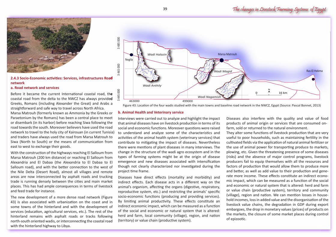
The changes in Livestock Farming Systems of Egypt
2.4.3 Socio-Economic activities: Services, infrastructures Road networka. Road network and services
Before it became the current International coastal road, the coastal road from the delta to the NWCZ has always provided Greeks, Romans (including Alexander the Great) and Arabs a straightforward and safe way to travel across North Africa.Marsa Matrouh (formerly known as Ammonia by the Greeks or Paraetonium by the Romans) has been a central place to meet or disembark (in its harbor) before reaching Siwa following the road towards the south. Moreover believers have used the road network to travel to the holy city of Kairouan (in current Tunisia)and traders have always used the road from Marsa Matrouh to Siwa (North to South) or the means of communication from east to west to exchange their goods.
With the construction of the highways reaching El Salloum from Marsa Matrouh (200 km distance) or reaching El Salloum from Alexandria and El Dabaa (the Alexandria to El Dabaa to El Salloum road), and with the better connection to the west of the Nile Delta (Desert Road), almost all villages and remote areas are now interconnected by asphalt roads and trucking trade is running densely between the cities and main market places. This has had ample consequences in terms of livestock and feed trade for instance.
The new development of a more dense road network (Figure 43) is also associated with urbanization on the coast and in some towns of the hinterland and with the development of services (education, agricultural services, etc.). The rest of the hinterland remains with asphalt roads or tracks following north-south oriented wadis, or interconnecting the coastal road with the hinterland highway to Libya.
Diseases also interfere with the quality and value of food products of animal origin or services that are consumed on-farm, sold or returned to the natural environment. They alter some functions of livestock production that are very useful to poor households, such as maintaining fertility in the cultivated fields via the application of natural animal fertilizer or the use of animal power for transporting produce to markets, plowing, etc. Given the threatening presence of some diseases (risks) and the absence of major control programs, livestock producers fail to equip themselves with all the resources and factors of production that would allow them to produce more and better, as well as add value to their production and gene-rate more income. These effects constitute an indirect econo-mic impact, which can be measured as a function of the social and economic or natural system that is altered: herd and farm or value chain (productive system), territory and community (village), region and nation. We can mention losses in house-hold incomes, loss in added value and the disorganisation of the livestock value chains, the degradation in GDP during export embargoes, the drop in monetary values (prices) of products on the markets, the closure of some market places during control of epizootic.
b. Animal Health and Veterinary service
Interviews were carried out to analyze and highlight the impact that animal diseases have on livestock production in terms of its social and economic functions. Moreover questions were raised to understand and analyze some of the characteristics and activities of the animal health system (veterinary services) that contribute to mitigating the impact of diseases. Nevertheless there were mentions of plant diseases in many interviews. The change in the structure of the wadi agro ecosystem and in the types of farming systems might be at the origin of disease emergence and new diseases associated with intensification though not clearly characterized nor investigated during the project time frame.
Diseases have direct effects (mortality and morbidity) and indirect effects. Each disease acts in a different way on the animal’s organism, affecting the organs (digestive, respiratory, reproductive system, etc.) and restricting the animals’ specific socio-economic functions (producing and providing services). By limiting animal productivity. These effects constitute an indirect economic impact, which can be measured as a function of the social and economic or natural system that is altered: herd and farm, local community (village), region, and nation (territory) or value chain (productive system).
Figure 43: Location of the four wadis studied with the main towns and baseline road network in the NWCZ, Egypt (Source: Pascal Bonnet, 2013)
2.4.3 Socio-Economic activities: Services, infrastructures Road
Before it became the current International coastal road, the coastal road from the delta to the NWCZ has always provided
Wadi Anthily
Wadi Nagamish
Wadi Magid
Wadi Halazin
16 km0
463000 499000
3 46
5 00
03
445
000
3 4
85 0
00
N
Marsa Matrouh
Ras El Hekma
Negila
39
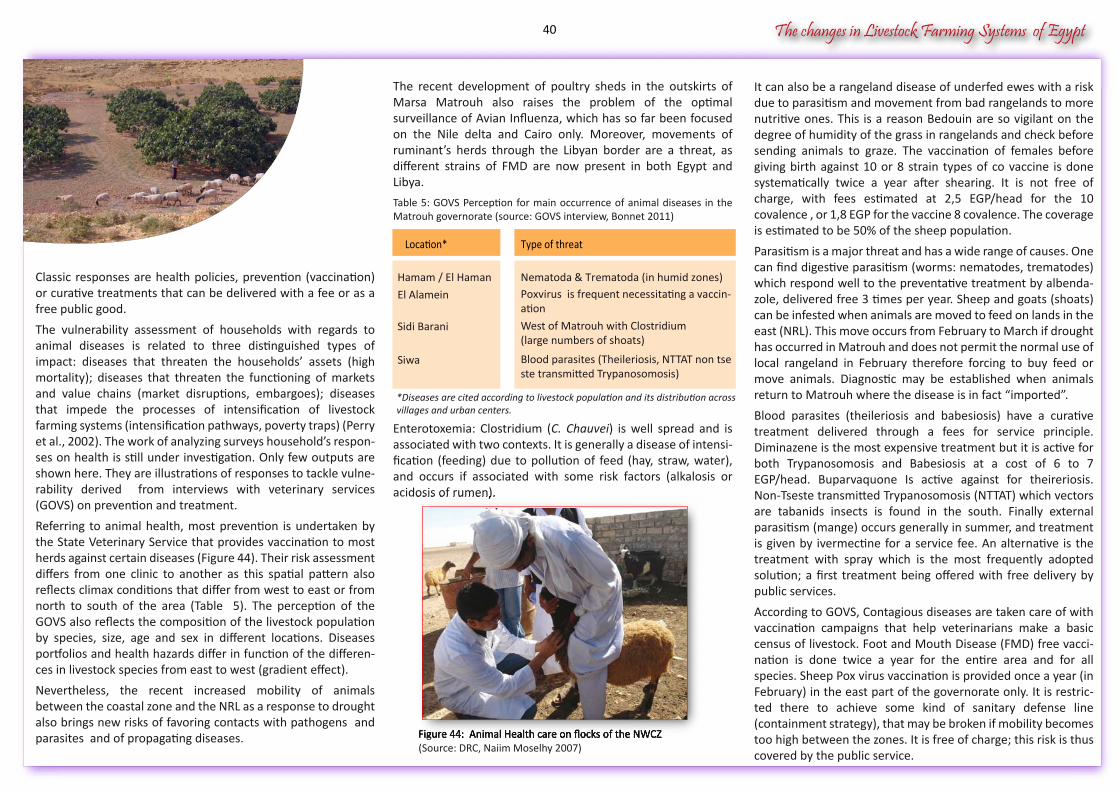
The changes in Livestock Farming Systems of Egypt
Classic responses are health policies, prevention (vaccination) or curative treatments that can be delivered with a fee or as a free public good.
The vulnerability assessment of households with regards to animal diseases is related to three distinguished types of impact: diseases that threaten the households’ assets (high mortality); diseases that threaten the functioning of markets and value chains (market disruptions, embargoes); diseases that impede the processes of intensification of livestock farming systems (intensification pathways, poverty traps) (Perry et al., 2002). The work of analyzing surveys household’s respon-ses on health is still under investigation. Only few outputs are shown here. They are illustrations of responses to tackle vulne-rability derived from interviews with veterinary services (GOVS) on prevention and treatment.
Referring to animal health, most prevention is undertaken by the State Veterinary Service that provides vaccination to most herds against certain diseases (Figure 44). Their risk assessment differs from one clinic to another as this spatial pattern also reflects climax conditions that differ from west to east or from north to south of the area (Table 5). The perception of the GOVS also reflects the composition of the livestock population by species, size, age and sex in different locations. Diseases portfolios and health hazards differ in function of the differen-ces in livestock species from east to west (gradient effect).
Nevertheless, the recent increased mobility of animals between the coastal zone and the NRL as a response to drought also brings new risks of favoring contacts with pathogens and parasites and of propagating diseases.
It can also be a rangeland disease of underfed ewes with a risk due to parasitism and movement from bad rangelands to more nutritive ones. This is a reason Bedouin are so vigilant on the degree of humidity of the grass in rangelands and check before sending animals to graze. The vaccination of females before giving birth against 10 or 8 strain types of co vaccine is done systematically twice a year after shearing. It is not free of charge, with fees estimated at 2,5 EGP/head for the 10 covalence , or 1,8 EGP for the vaccine 8 covalence. The coverage is estimated to be 50% of the sheep population.
Parasitism is a major threat and has a wide range of causes. One can find digestive parasitism (worms: nematodes, trematodes) which respond well to the preventative treatment by albenda-zole, delivered free 3 times per year. Sheep and goats (shoats) can be infested when animals are moved to feed on lands in the east (NRL). This move occurs from February to March if drought has occurred in Matrouh and does not permit the normal use of local rangeland in February therefore forcing to buy feed or move animals. Diagnostic may be established when animals return to Matrouh where the disease is in fact “imported”.
Blood parasites (theileriosis and babesiosis) have a curative treatment delivered through a fees for service principle. Diminazene is the most expensive treatment but it is active for both Trypanosomosis and Babesiosis at a cost of 6 to 7 EGP/head. Buparvaquone Is active against for theireriosis. Non-Tseste transmitted Trypanosomosis (NTTAT) which vectors are tabanids insects is found in the south. Finally external parasitism (mange) occurs generally in summer, and treatment is given by ivermectine for a service fee. An alternative is the treatment with spray which is the most frequently adopted solution; a first treatment being offered with free delivery by public services.
According to GOVS, Contagious diseases are taken care of with vaccination campaigns that help veterinarians make a basic census of livestock. Foot and Mouth Disease (FMD) free vacci-nation is done twice a year for the entire area and for all species. Sheep Pox virus vaccination is provided once a year (in February) in the east part of the governorate only. It is restric-ted there to achieve some kind of sanitary defense line (containment strategy), that may be broken if mobility becomes too high between the zones. It is free of charge; this risk is thus covered by the public service.
The recent development of poultry sheds in the outskirts of Marsa Matrouh also raises the problem of the optimal surveillance of Avian Influenza, which has so far been focused on the Nile delta and Cairo only. Moreover, movements of ruminant’s herds through the Libyan border are a threat, as different strains of FMD are now present in both Egypt and Libya.
Table 5: GOVS Perception for main occurrence of animal diseases in the Matrouh governorate (source: GOVS interview, Bonnet 2011)
Enterotoxemia: Clostridium (C. Chauvei) is well spread and is associated with two contexts. It is generally a disease of intensi-fication (feeding) due to pollution of feed (hay, straw, water), and occurs if associated with some risk factors (alkalosis or acidosis of rumen).
Figure 44: Animal Health care on flocks of the NWCZ(Source: DRC, Naiim Moselhy 2007)
acidosis of rumen).
Figure 44: Animal Health care on flocks of the NWCZ
Location* Type of threat
Hamam / El Haman Nematoda & Trematoda (in humid zones)
El Alamein Poxvirus is frequent necessitating a vaccin-ation
Sidi Barani
Siwa Blood parasites (Theileriosis, NTTAT non tseste transmitted Trypanosomosis)
West of Matrouh with Clostridium(large numbers of shoats)
*Diseases are cited according to livestock population and its distribution acrossvillages and urban centers.
40
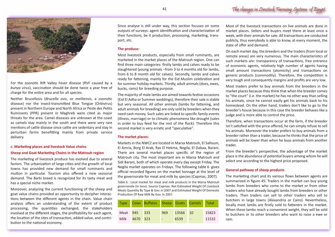
The changes in Livestock Farming Systems of Egypt
For the zoonotic Rift Valley Fever disease (RVF caused by a bunya virus), vaccination should be done twice a year free of charge for the entire area and for all species.
Neither Brucellosis (Brucella ovis, or melitensis, a zoonotic disease) nor the insect-transmitted Blue Tongue (Orbivirus) present in Northern Europe and North Africa or Peste des Petits Ruminants (PPR) present in Maghreb were cited as major threats for the area. Camel diseases are unknown at the coast as camels stay mainly in the south and there were very rare mentions of cattle disease since cattle are sedentary and stay in periurban farms benefitting mainly from private service delivery.
c. Marketing places and livestock Value chains
Sheep and Goat Marketing Chains in the Matrouh region
The marketing of livestock produce has evolved due to several factors. The urbanization of large cities and the growth of local towns has provided new demand for small ruminants and mutton in particular. Tourism also offered a new seasonal demand. The Barki breed is recognized for its tasty meat and has a special niche market.
Moreover, analyzing the current functioning of the sheep and goat value chains provided an opportunity to decipher interac-tions between the different agents in the chain. Value chain analysis offers an understanding of the extent of product processing, the quantities exchanged, the stakeholders involved at the different stages, the profitability for each agent, the location of the sites of transaction, added value, and contri-bution to the national economy.
Most of the livestock transactions on live animals are done in market places. Sellers and buyers meet there at least once a week, with their animals for sale. All transactions are conducted publicly, thus everybody is able to know, at every moment, the state of offer and demand.
On each market day, the breeders and the traders (from local or remote areas) are very numerous. The main characteristics of such markets are: transparency of transactions, free entrance of economic agents, relatively high number of agents having small amount transactions (atomicity) and transactions on generic products (commodity). Therefore, the competition is very tough and consequently margins and profits are very low.
Most traders prefer to buy animals from the breeders in the market places because they think that when the breeder comes to “the court” (i.e. the market) he has no other way than selling his animals, since he cannot easily get his animals back to his homestead. On the other hand, traders don't like to go to the breeder's house because in this case the breeder behaves like a judge and is more able to control the price.
Therefore, when transactions occur at the farm, if the breeder isn’t satisfied with the price offered, he can simply refuse to sell his animals. Moreover the trader prefers to buy animals from a breeder rather than a trader, because he thinks that the price of animals will be lower than when he buys animals from another trader.
From the breeder’s perspective, the advantage of the market place is the abundance of potential buyers among whom he will select one according to the highest price proposed.
General pathway of sheep products
The marketing chart and its various flows between agents are summarized in figure 45. Traders in the market can buy young lambs from breeders who come to the market or from other traders who have already bought lambs from breeders or other traders. Then traders can sell to other traders who sell to butchers in large towns (Alexandria or Cairo). Nevertheless, locally most lambs are firstly sold to fatteners in the market. When these lambs reach a convenient weight, they will be sold to butchers or to other breeders who want to raise a ewe or ram.
Since analyse is still under way, this section focuses on some outputs of surveys: agent identification and characterization of their functions, be it production, processing, marketing, trans-port, etc.
The produce:
Most livestock products, especially from small ruminants, are marketed in the market places of the Matrouh region. One can find three main categories: firstly lambs and calves ready to be slaughtered (young animals –from 3 to 4 months old for lambs, from 6 to 8 month old for calves). Secondly, lambs and calves ready for fattening, mainly for the Eid Muslim celebration and for summer holiday markets. Thirdly, adult animals (does, ewes, bucks, rams) for breeding purpose.
The majority of male lambs are aimed towards festive occasions (Eid El Adha or Summer weddings), therefore their sale is stable but very seasonal. All other animals (lambs for fattening, and adult animals for breeding) are only sold by breeders when they need cash money. Such sales are linked to specific family events (illness, marriage) or to climatic phenomena like drought (sales in order to buy feed for the rest of the flock). Therefore this second market is very erratic and “speculative”.
The market places:
Markets in the NWCZ are located in Marsa Matrouh, El Salloum, El Amria, Borg El Arab, Ras El Hekma, Negila, El Dabaa, Barani. There are several market places specific of the region of Matrouh city. The most important are in Marsa Matrouh and Sidi Barani, both of which operate every day except Friday. The Negila market operates on Fridays. The following table 6 gives official recorded figures on the market tonnage at the level of the governorate for meat and milk by species (Capmas, 2007).Table 6 : Local market for meat and milk products in the Marsa Matrouh governorate (in tons). Source Capmas: Net Estimated Weight Of Livestock Meats Quantity By Type & Gov. in 2007 and Estimated Weight Of Domestic Production Of Raw Milk By Gov. in 2007.
Type Cows Buffalos Sheep Goats Camels Total
Meat 945 333 969 13566 10 15823
Milk 4670 323 - -6539 11532
41
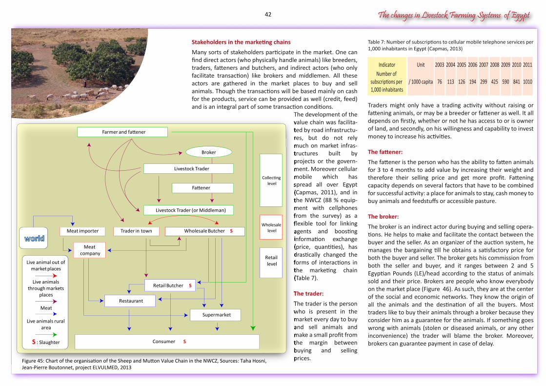
The changes in Livestock Farming Systems of Egypt
Table 7: Number of subscriptions to cellular mobile telephone services per 1,000 inhabitants in Egypt (Capmas, 2013)
Traders might only have a trading activity without raising or fattening animals, or may be a breeder or fattener as well. It all depends on firstly, whether or not he has access to or is owner of land, and secondly, on his willingness and capability to invest money to increase his activities.
The fattener:
The fattener is the person who has the ability to fatten animals for 3 to 4 months to add value by increasing their weight and therefore their selling price and get more profit. Fattening capacity depends on several factors that have to be combined for successful activity: a place for animals to stay, cash money to buy animals and feedstuffs or accessible pasture.
The broker:
The broker is an indirect actor during buying and selling opera-tions. He helps to make and facilitate the contact between the buyer and the seller. As an organizer of the auction system, he manages the bargaining till he obtains a satisfactory price for both the buyer and seller. The broker gets his commission from both the seller and buyer, and it ranges between 2 and 5 Egyptian Pounds (LE)/head according to the status of animals sold and their price. Brokers are people who know everybody on the market place (Figure 46). As such, they are at the center of the social and economic networks. They know the origin of all the animals and the destination of all the buyers. Most traders like to buy their animals through a broker because they consider him as a guarantee for the animals. If something goes wrong with animals (stolen or diseased animals, or any other inconvenience) the trader will blame the broker. Moreover, brokers can guarantee payment in case of delay.
Stakeholders in the marketing chains
Many sorts of stakeholders participate in the market. One can find direct actors (who physically handle animals) like breeders, traders, fatteners and butchers, and indirect actors (who only facilitate transaction) like brokers and middlemen. All these actors are gathered in the market places to buy and sell animals. Though the transactions will be based mainly on cash for the products, service can be provided as well (credit, feed) and is an integral part of some transaction conditions.
The development of the value chain was facilita-ted by road infrastructu-res, but do not rely much on market infras-tructures built by projects or the govern-ment. Moreover cellular mobile which has spread all over Egypt (Capmas, 2011), and in the NWCZ (88 % equip-ment with cellphones from the survey) as a flexible tool for linking agents and boosting information exchange (price, quantities), has drastically changed the forms of interactions in the marketing chain (Table 7).
The trader:
The trader is the person who is present in the market every day to buy and sell animals and make a small profit from the margin between buying and selling prices.
IndicatorNumber of
subscriptions per 1,000 inhabitants
Unit
/ 1000 capita
2003
76
2004
113
2005
126
2006
194
2007
299
2008
425
2009
590
2010
841
2011
1010
The development of the value chain was facilitated by road infrastructures, but do not rely much on market infrastructures built by projects or the government. Moreover cellular mobile which has spread all over Egypt (Capmas, 2011), and in the NWCZ (88 % equipment with cellphones from the survey) as a flexible tool for linking agents and boosting information exchange (price, quantities), has drastically changed the forms of interactions in the marketing chain (Table 7).
The trader:
The trader is the person who is present in the market every day to buy and sell animals and make a small profit from the margin between buying and selling prices.
Retail Butcher
Farmer and fattener
Livestock Trader (or Middleman)
Wholesale Butcher
Supermarket
Restaurant
Consumer S
Broker
S
Collecting level
Wholesale level
Retail level
Trader in townMeat importer
Meat company
S
Live animal out of market places
Live animals through markets
places
Meat
Live animals rural area
S : Slaughter
Livestock Trader
Fattener
Figure 45: Chart of the organisation of the Sheep and Mutton Value Chain in the NWCZ, Sources: Taha Hosni,Jean-Pierre Boutonnet, project ELVULMED, 2013
42
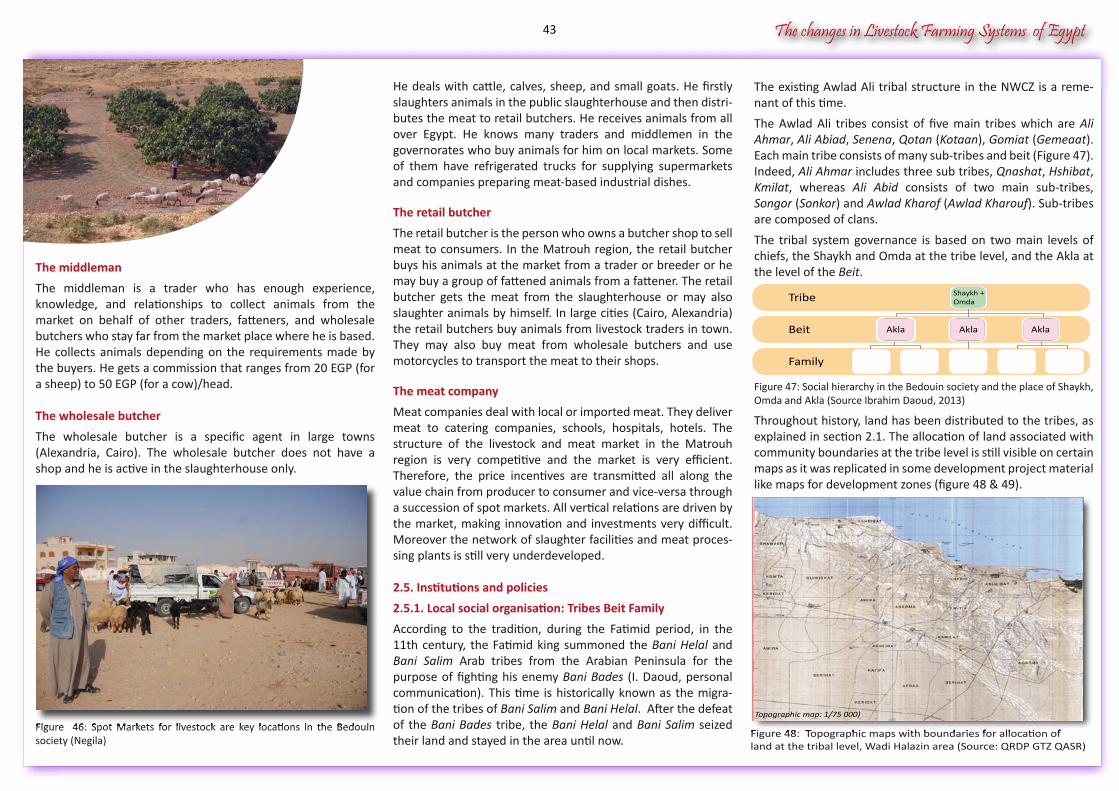
The changes in Livestock Farming Systems of Egypt
The middleman
The middleman is a trader who has enough experience, knowledge, and relationships to collect animals from the market on behalf of other traders, fatteners, and wholesale butchers who stay far from the market place where he is based. He collects animals depending on the requirements made by the buyers. He gets a commission that ranges from 20 EGP (for a sheep) to 50 EGP (for a cow)/head. The wholesale butcher
The wholesale butcher is a specific agent in large towns (Alexandria, Cairo). The wholesale butcher does not have a shop and he is active in the slaughterhouse only.
Figure 46: Spot Markets for livestock are key locations in the Bedouin society (Negila)
The existing Awlad Ali tribal structure in the NWCZ is a reme-nant of this time.
The Awlad Ali tribes consist of five main tribes which are Ali Ahmar, Ali Abiad, Senena, Qotan (Kotaan), Gomiat (Gemeaat). Each main tribe consists of many sub-tribes and beit (Figure 47). Indeed, Ali Ahmar includes three sub tribes, Qnashat, Hshibat, Kmilat, whereas Ali Abid consists of two main sub-tribes, Songor (Sonkor) and Awlad Kharof (Awlad Kharouf). Sub-tribes are composed of clans.
The tribal system governance is based on two main levels of chiefs, the Shaykh and Omda at the tribe level, and the Akla at the level of the Beit.
Figure 47: Social hierarchy in the Bedouin society and the place of Shaykh, Omda and Akla (Source Ibrahim Daoud, 2013)
Throughout history, land has been distributed to the tribes, as explained in section 2.1. The allocation of land associated with community boundaries at the tribe level is still visible on certain maps as it was replicated in some development project material like maps for development zones (figure 48 & 49)..
He deals with cattle, calves, sheep, and small goats. He firstly slaughters animals in the public slaughterhouse and then distri-butes the meat to retail butchers. He receives animals from all over Egypt. He knows many traders and middlemen in the governorates who buy animals for him on local markets. Some of them have refrigerated trucks for supplying supermarkets and companies preparing meat-based industrial dishes.
The retail butcher
The retail butcher is the person who owns a butcher shop to sell meat to consumers. In the Matrouh region, the retail butcher buys his animals at the market from a trader or breeder or he may buy a group of fattened animals from a fattener. The retail butcher gets the meat from the slaughterhouse or may also slaughter animals by himself. In large cities (Cairo, Alexandria) the retail butchers buy animals from livestock traders in town. They may also buy meat from wholesale butchers and use motorcycles to transport the meat to their shops.
The meat company
Meat companies deal with local or imported meat. They deliver meat to catering companies, schools, hospitals, hotels. The structure of the livestock and meat market in the Matrouh region is very competitive and the market is very efficient. Therefore, the price incentives are transmitted all along the value chain from producer to consumer and vice-versa through a succession of spot markets. All vertical relations are driven by the market, making innovation and investments very difficult. Moreover the network of slaughter facilities and meat proces-sing plants is still very underdeveloped.
2.5. Institutions and policies
2.5.1. Local social organisation: Tribes Beit Family
According to the tradition, during the Fatimid period, in the 11th century, the Fatimid king summoned the Bani Helal and Bani Salim Arab tribes from the Arabian Peninsula for the purpose of fighting his enemy Bani Bades (I. Daoud, personal communication). This time is historically known as the migra-tion of the tribes of Bani Salim and Bani Helal. After the defeat of the Bani Bades tribe, the Bani Helal and Bani Salim seized their land and stayed in the area until now.
Figure 48: Topographic maps with boundaries for allocation ofland at the tribal level, Wadi Halazin area (Source: QRDP GTZ QASR)
Figure 46: Spot Markets for livestock are key locations in the Bedouin
Family
Beit
Tribe Shaykh +Omda
Akla Akla Akla
.
Figure 48: Topographic maps with boundaries for allocation of
Topographic map: 1/75 000)
43
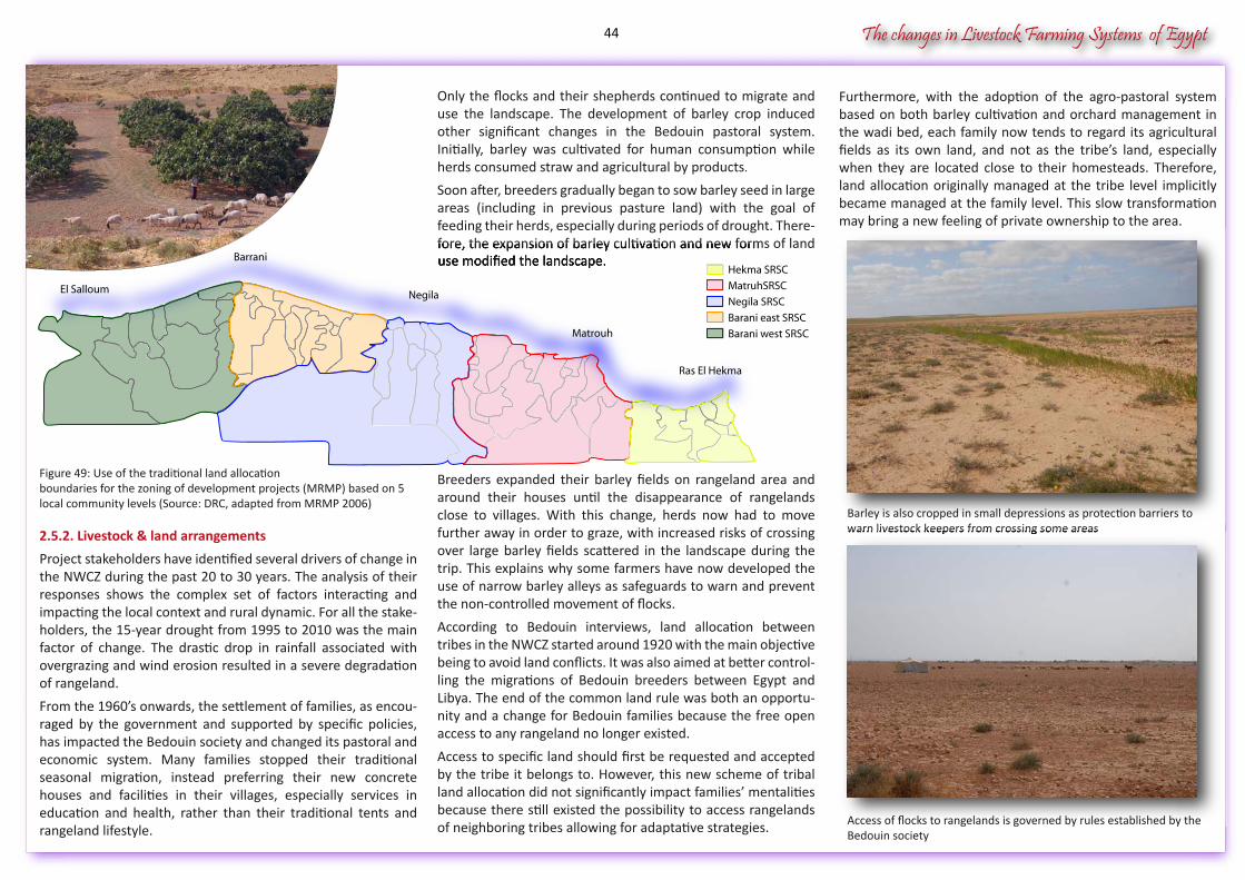
The changes in Livestock Farming Systems of Egypt
Barley is also cropped in small depressions as protection barriers to warn livestock keepers from crossing some areas warn livestock keepers from crossing some areas
Access of flocks to rangelands is governed by rules established by theBedouin society
Figure 49: Use of the traditional land allocation boundaries for the zoning of development projects (MRMP) based on 5 local community levels (Source: DRC, adapted from MRMP 2006)
2.5.2. Livestock & land arrangements
Project stakeholders have identified several drivers of change in the NWCZ during the past 20 to 30 years. The analysis of their responses shows the complex set of factors interacting and impacting the local context and rural dynamic. For all the stake-holders, the 15-year drought from 1995 to 2010 was the main factor of change. The drastic drop in rainfall associated with overgrazing and wind erosion resulted in a severe degradation of rangeland.
From the 1960’s onwards, the settlement of families, as encou-raged by the government and supported by specific policies, has impacted the Bedouin society and changed its pastoral and economic system. Many families stopped their traditional seasonal migration, instead preferring their new concrete houses and facilities in their villages, especially services in education and health, rather than their traditional tents and rangeland lifestyle.
Furthermore, with the adoption of the agro-pastoral system based on both barley cultivation and orchard management in the wadi bed, each family now tends to regard its agricultural fields as its own land, and not as the tribe’s land, especially when they are located close to their homesteads. Therefore, land allocation originally managed at the tribe level implicitly became managed at the family level. This slow transformation may bring a new feeling of private ownership to the area.
Only the flocks and their shepherds continued to migrate and use the landscape. The development of barley crop induced other significant changes in the Bedouin pastoral system. Initially, barley was cultivated for human consumption while herds consumed straw and agricultural by products.
Soon after, breeders gradually began to sow barley seed in large areas (including in previous pasture land) with the goal of feeding their herds, especially during periods of drought. There-fore, the expansion of barley cultivation and new forms of land use modified the landscape.
Breeders expanded their barley fields on rangeland area and around their houses until the disappearance of rangelands close to villages. With this change, herds now had to move further away in order to graze, with increased risks of crossing over large barley fields scattered in the landscape during the trip. This explains why some farmers have now developed the use of narrow barley alleys as safeguards to warn and prevent the non-controlled movement of flocks.
According to Bedouin interviews, land allocation between tribes in the NWCZ started around 1920 with the main objective being to avoid land conflicts. It was also aimed at better control-ling the migrations of Bedouin breeders between Egypt and Libya. The end of the common land rule was both an opportu-nity and a change for Bedouin families because the free open access to any rangeland no longer existed.
Access to specific land should first be requested and accepted by the tribe it belongs to. However, this new scheme of tribal land allocation did not significantly impact families’ mentalities because there still existed the possibility to access rangelands of neighboring tribes allowing for adaptative strategies.
fore, the expansion of barley cultivation and new forms of land use modified the landscape. Barrani
Negila
Matrouh
Ras El Hekma
MatruhSRSC
Barani west SRSC
Negila SRSC
Hekma SRSC
Barani east SRSC
El Salloum
44
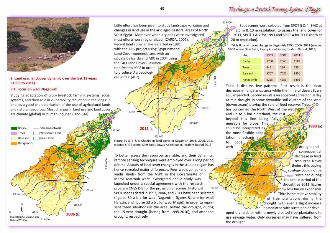
The changes in Livestock Farming Systems of Egypt
535 000
529 000
523 000
3 45
0 00
0
535 000
529 000
523 000
3 45
0 00
0
Stream Network
Watershed limit
Basin limit
Barley
Trees
Bare soil
Rangelands
0 4 km
N
Projection UTM zone 35NDatum WGS84
drought and consequential
decrease in feed resources. Never
theless this coping strategy could not be sustained during the entire period of the
drought as 2011 figures show less barley expansion.
Third is the relative stability of tree plantations during the
drought, with even a slight increase be it associated with sustained or devel-
Table 1 displays few patterns. First result is the clear decrease in rangelands area while the mineral desert (bare soil) expanded. Second result is an apparent spread of Barley at mid drought in some favorable soil clusters of the wadi (downstream) playing the role of feed reserve. This has concerned the North West of the wadi and up to 5 km hinterland, the rest beyond this line being fully unusable for crops. This could be interpreted as the most flexible adap-tation mechanism to cope with
oped orchards or with a newly created tree plantations to use sewage water. Only nurseries may have suffered from the drought.
130 mm
130 mm
130 mm
130 mm
130 mm
130 mm
3. Land use, landcover dynamic over the last 18 years (1993 to 2011)
3.1. Focus on wadi Nagamish
Studying adaptation of crop- livestock farming systems, social systems, and their role in vulnerability reduction in the long run implies a good characterization of the use of agricultural lands and natural resources. Most changes in land use and land cover are climate (global) or human-induced (land-use).
(ha) 20061993 2011
Barley 20631760 1183
Trees 234445 285
Bare soil 76275707 9306
Rangelands 42536265 3402
Little effort has been given to study landscape variation and changes in land use in the arid agro-pastoral areas of North West Egypt. Moreover when drylands were investigated, most efforts were regionalized (ICARDA, 2007). Recent land cover analysis started in 1991 with the ALIS project using Egypt national Land Cover nomenclature, with an update by Icarda and ARC in 2004 using the FAO Land Cover Classifica-tion System LCCS in order to produce ‘Agroecologi-cal Zones’ (AEZ).
Figure 50 a, b & c: Change in land cover in Nagamish 1993, 2006, 2011 (source SPOT scene, Slim Saidi, Fawzy Abdel Kader, Ibrahim Daoud 2013)
To better assess the resources available, and their dynamics, remote sensing techniques were employed over a long period of time. A study of land cover changes in the studied region has hence revealed major differences. Four wadis zones (and wadis sheds) from the NWC in the Governorate of Marsa Matrouh were investigated and a study was launched under a special agreement with the research program CNES ISIS for the provision of scenes. Historical SPOT scenes dated in 1993, 2006, and 2011 have been selected (figures 50 a b c for wadi Nagamish, figures 51 a b for wadi Halazin, and figures 52 a b c for wadi Magid), in order to repre-sent three situations in the area: before the drought, during the 15-year drought (lasting from 1995-2010), and after the drought, respectively.
Spot scenes were selected from SPOT 5 & 4 (SMC at 2,5 m & 10 m resolution) to assess the land cover for
2011, SPOT 1 & 2 for 1993 and SPOT 4 for 2006 (both at 20 m resolution).
Table 8: Land cover change in Nagamish 1993, 2006, 2011 (source: SPOT scene, Slim Saidi, Fawzy Abdel Kader, Ibrahim Daoud, 2013)
1993 (a)2011 (c)
2006 (b)
45
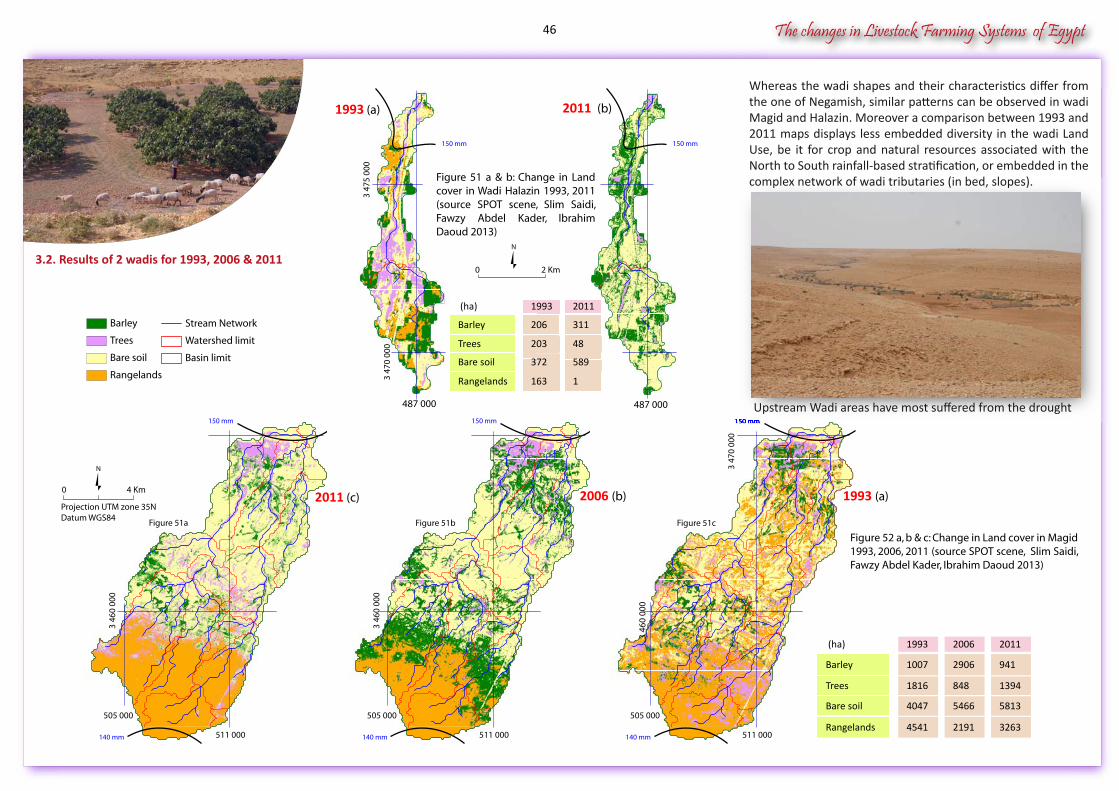
The changes in Livestock Farming Systems of Egypt
3.2. Results of 2 wadis for 1993, 2006 & 2011
505 000
511 000
150 mm
140 mm
3 47
0 00
0
Figure 51a
3 46
0 00
0
505 000
511 000
3 47
0 00
0
Figure 51b
150 mm
140 mm
3 46
0 00
0
140 mm 511 0003
470
000
150 mm
2011 (c) 2006 (b) 1993 (a)
505 000
487 000487 000
3 47
5 00
0
3 47
0 00
0
N
0 2 Km
1993 (a) 2011 (b)
Figure 51 a & b: Change in Land cover in Wadi Halazin 1993, 2011 (source SPOT scene, Slim Saidi, Fawzy Abdel Kader, Ibrahim Daoud 2013)
Stream Network
Watershed limit
Basin limit
Barley
Trees
Bare soil
Rangelands
Figure 51c
Figure 52 a, b & c: Change in Land cover in Magid 1993, 2006, 2011 (source SPOT scene, Slim Saidi, Fawzy Abdel Kader, Ibrahim Daoud 2013)
0 4 Km
N
Projection UTM zone 35NDatum WGS84
150 mm 150 mm
150 mm
Whereas the wadi shapes and their characteristics differ from the one of Negamish, similar patterns can be observed in wadi Magid and Halazin. Moreover a comparison between 1993 and 2011 maps displays less embedded diversity in the wadi Land Use, be it for crop and natural resources associated with the North to South rainfall-based stratification, or embedded in the complex network of wadi tributaries (in bed, slopes).
(ha) 20111993
Barley 311206
Trees 48203
Bare soil 589372
Rangelands 1163
(ha) 20061993 2011
Barley 29061007 941
Trees 8481816 1394
Bare soil 54664047 5813
Rangelands 21914541 3263
3 46
0 00
0
Upstream Wadi areas have most suffered from the drought
46
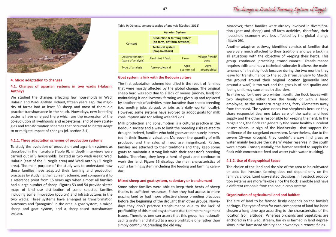
The changes in Livestock Farming Systems of Egypt
4. Micro adaptation to changes
4.1. Changes of agrarian systems in two wadis (Halazin, Anthily)
We studied the changes affecting few households in Wadi Halazin and Wadi Anthily. Indeed, fifteen years ago, the majo-rity of farms had at least 50 sheep and most of them did practice transhumance in the south. Nowadays, new breeding patterns have emerged there which are the expression of the co-evolution of livelihoods and ecosystems, and of new strate-gies and transformation schemes that occurred to better adapt to or mitigate impact of changes (cf. section 2.1).
4.1.1. Three adaptation schemes of production systems
To study the evolution of production and agrarian systems as described in the literature (Table 9), in depth interviews were carried out in 9 households, located in two wadi areas: Wadi Halazin (east of the El Negila area) and Wadi Anthily (El Negila area). The main purpose of the study was to understand how these families have adapted their farming and production practices by studying their current scheme, and comparing it to a reference point from 15 years ago when almost all families had a large number of sheep. Figures 53 and 54 provide sketch maps of land use distribution of some selected families including some innovation (poultry) and infrastructures in the two wadis. Three systems have emerged as transformation outcomes and “paragons” in the area, a goat system, a mixed sheep and goat system, and a sheep-based transhumant system.
Moreover, these families were already involved in diversifica-tion (goat and sheep) and off-farm activities, therefore, their household economy was less affected by the global change (figure 56).
Another adaptive pathway identified consists of families that were very much attached to their traditions and were tackling all situations with the objective of keeping their herds. This group continued practicing transhumance. Transhumance requires skills and has a technical rationale: it allows the main-tenance of a healthy flock because during the two months they leave for transhumance to the south (from January to March) the ground around their original location (generally land around a wadi) is too wet and the grass is of bad quality and feeing on it may cause health disorders. To make up for these two winter month, the flock leaves with two shepherds, either from the family or with a hired employee, to the southern rangelands, forty kilometers away from the coast. The system needs two shepherds because they share responsibilities: one takes care of the water and feed supply and the other is responsible for keeping the herd. In the rangelands, the flock can generally find some healthy succulent desert plants –a sign of the biodiversity– that support the resilience of the rangeland ecosystem. Nevertheless, due to the severe 15-year drought, they couldn’t always find grass or water mainly because the cistern’ water reserves in the south were empty. Consequentially, the farmer needed to supply the flock with concentrate-feed and water (with water trucking).
4.1.2. Use of Geographical Space
The choice of the land and the size of the area to be cultivated or used for livestock farming does not depend only on the family’s choice. Land use-related decisions in livestock produc-tion systems are more flexible since the flock is mobile and have a different rationale from the one in crop systems. Organization of agricultural land and habitat
The size of land to be farmed firstly depends on the family’s heritage. The type of crop for each component of land has been chosen a long time ago according to the characteristics of the location (soil, altitude). Whereas orchards and vegetables are anchored in the wadi stream, barley is farmed in land depres-sions in the farmstead vicinity and nowadays in remote fields.
Table 9: Objects, concepts scales of analysis [Cochet, 2011]
Goat system, a link with the Bedouin culture
The first adaptation scheme identified is the result of families that were mostly affected by the global change. The original sheep herd was sold due to a lack of means (money, land) for maintaining it and livestock farming was given up and replaced by another mix of activities more lucrative than sheep breeding (i.e. poultry, jobs abroad, or jobs as a daily worker locally). However, some systems have evolved to adopt goats for milk consumption and for selling weaned kids.
Milk production and consumption is a cultural practice in the Bedouin society and a way to limit the breeding risks related to drought. Indeed, families who hold goats are not purely interes-ted in their financial valuation. Moreover the quantity of milk produced and the sales of meat are insignificant. Rather, families are attached to their traditions and they keep some goats to maintain a strong link with their ancestor’s breeding habits. Therefore, they keep a herd of goats and continue to work the land. Figure 55 displays the main characteristics of such a farming system, including the feeding and farming calen-dar.
Mixed sheep and goat system, sedentary or transhumant
Some other families were able to keep their herds of sheep thanks to sufficient resources. Either they had access to more grazing land or had more effective sheep breeding practices before the beginning of the drought than other groups. Nowa-days they don’t practice transhumance due to the lack of profitability of this mobile system and due to time management issues. Therefore, one can assert that this group has rationali-zed its system and shifted to a more profitable one rather than simply continuing breeding the old way.
Concept
Production & farming system(on-farm, off-farm activities)
Technical system(crop livestock)
Observation unit(scale of analysis)
Field plot / flock Farm Village / wadi/zone
Type of analysis Agro-ecological Agro-economical
Agro-geographical
Agrarian System
47

The changes in Livestock Farming Systems of Egypt
Rangelands are kept on the rest of the land. For transhumant systems, the situation of rangelands in December is a key factor to prepare the move of flocks to the south, before other sources of feeding can replace them. All of the potential space in the two wadis studied was optimally allocated. It was difficult for farmers to own new lands locally, unless they resort to renting land which became common practice during the drought.
Regarding the families’ habitat around the wadi, the distribu-tion is different from one wadi to another.
Wadi Halazin is less densely occupied than Wadi Anthily (El Negila), and its houses are scattered along the 20 km long wadi.
School or water well infrastructures are centered in the middle of Wadi Halazin offering good average accessibility. Wadi Anthily has more land pressure and its population is rather concentrated close to the coast in the former wadi mouth because the rest of the land belongs to families living in town.
Crop Productions difficult to adapt
Crop production is based on rainfall. During the drought, families needed to develop new techniques to maintain crop yields. Thanks to water harvesting infrastructures and equip-ment set in the wadi stream, the potential of wadi’s land resources was increased to maintain orchards and develop vegetables –a good adaptive solution to face the lack of rainfall water.
Despite their high cost, some families invested in water pumps to optimize the use of water resources in the wadi stream and irrigate some fields.
Chorem
Figure 53: Wadi Anthily, distribution of land use and infrastructures for familyF2 (concentrated habitat and remote barley fields) (Source: Elvulmed, 2013)Figure 53: Wadi Anthily, distribution of land use and infrastructures for family
Pasture2 F2A
Pasture2 F2A Olive Tree F2AOlive Tree F2A
Poultry shed F4A
Olive Tree F2AOlive Tree F2A
Coastal Road
Olive Tree F2A
Pasture2 F2A
Pasture2 F2A
Wadi Anthily
Fig Tree F2A
Barley F2A
Poultry shed F4A
Olive Tree F2AOlive Tree F2AOlive Tree F2AOlive Tree F2A Pasture2 F2A
Wadi Anthily
Barley F2A
Figure 54: Wadi Halazin, distribution of infrastructures and land use for 5families (scattered habitat rangelands and fields) (Source: Elvulmed, 2013)
because the rest of the land belongs to families living in town.
Pasture F3
Barley1 F3
Barley2 F3
Rangeland F5
Barley F5
Pasture2 F4Pasture1 F4
Pasture F2
Barley F1
Barley F2
Wadi Halazin
Barley F4
Main Road
Rangeland F5
Barley F5
Pasture2 F4
Pasture1 F4
Pasture F2
Barley F1
Barley F2
Rangeland F5
Pasture2 F4Pasture2 F4
Pasture1 F4Pasture1 F4Pasture1 F4
Wadi Halazin
Barley F4
Pasture F2
0 2 Km
Oil Mill
Primary school
Chicken farm F1
Chicken farm F1
Primary school
Sea Road
Nevertheless, to make up for the lack of grass, guarded herds could graze between the trees of orchards within the wadi bed and eat the bad quality barley (“weak barley”) in the vicinity, therefore increasing the area devoted to grazing. Planting barley has now become a livestock-oriented practice. Finally some families have invested in a small poultry cooperative to diversify and develop a new cost-effective production system.
But according to chicken farmers, it is too uncertain as a means of production because it is highly dependent on the livestock feed market which is highly volatile.
families (scattered habitat rangelands and fields) (Source: Elvulmed, 2013)
Flocks may graze close to the wadi bed plantation under the guard of theshepherd
Family territory
DykeBarleyPasture / RangelandWadi bedWater Flow
(Source: Slim Saïdi, 2013)
48
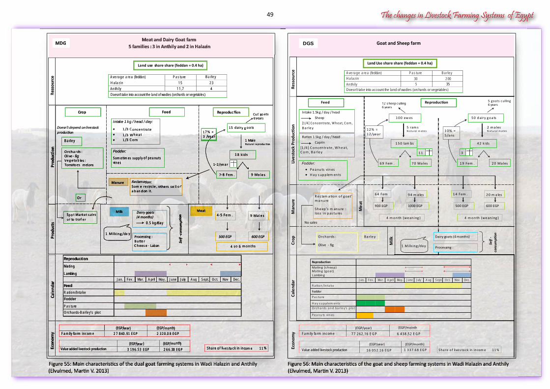
The changes in Livestock Farming Systems of Egypt
Figure 56: Main characteristics of the goat and sheep farming systems in Wadi Halazin and Anthily(Elvulmed, Martin V. 2013)
Figure 55: Main characteristics of the dual goat farming systems in Wadi Halazin and Anthily(Elvulmed, Martin V. 2013)
Doesn’t depend on livestock production
Cale
ndar
Econ
omy
1 5 d airy g o a ts
1 8 kid s
1-2 /ye a r
1 MaleN atura l reproduc tion
Intake 1 kg / head / day:
• 1 /3 C o nce n tra te• 1 /3 W h e a t• 1 /3 C o rn
9 Ma le s7-8 Fem .
Crop Feed Reproduction
Meat and Dairy Goat farm5 families : 3 in Anthily and 2 in Halazin
9 Ma le s4-5 Fem .
4 to 6 m o n ths
500 EGP 600 EGP
Meat
Cu ll goats6 years
Dairy goats(4 months)
0 .5 kg /d a y
Milk
Processing :B u tte r C h ees e - Laban
Self
-con
sum
ption
1 Milkin g /da y
Fodder:
S om e tim es su pp ly o f p e a nu ts vin e s
Reproduction
Ma tin g
L ambin gA pr il Ju ly
FeedR a tio n /In ta ke
Fodder
P a s tu reOrch a rds-B a rle y’s plo t
Prod
ucts
Prod
ucti
on
Manure Reclamation:S om e re cyc le , o the rs se ll o r a b an d on it.
MDG
A ve ra g e a re a (feddan) P a s tu re B a rle yH a la zin 1 5 2 3An th ily 1 1 ,7 4Doesn’t take into account the land of wadies (orchards or vegetab les)
B a rle y
Orch a rds :Olive - figVe g e ta b les :Tomatoes - melons
S p o t Ma rke t s ales o r to tra d e r
Or
(EGP/year) (EGP/month)Fa m ily fa rm in com e 2 7 8 4 0 .9 1 E GP 2 3 2 0 .0 8 E GP
(EGP/year) (EGP/month)Value added livestock production 3 1 9 6 .5 3 E GP 2 6 6 .3 8 E GP S h a re o f live s to ck in in com e 1 1 %
Jan. Fev . Mar. May . June A ug Sept. Oc t. Nov Dec .
1 7 % = 3 /ye a r
Ress
ourc
e
(Elvulmed, Martin V. 2013)(Elvulmed, Martin V. 2013)Figure 55: Main characteristics of the dual goat farming systems in Wadi Halazin and Anthily(Elvulmed, Martin V. 2013)
Doesn’t depend on livestock production
Cale
ndar
Econ
omy
1 5 d airy g o a ts
1 8 kid s
1-2 /ye a r
1 MaleN atura l reproduc tion
Intake 1 kg / head / day:
• 1 /3 C o nce n tra te• 1 /3 W h e a t• 1 /3 C o rn
9 Ma le s7-8 Fem .
Crop Feed Reproduction
9 Ma le s4-5 Fem .
4 to 6 m o n ths
500 EGP 600 EGP
Meat
Cu ll goats6 years
Dairy goats(4 months)
0 .5 kg /d a y
Milk
Processing :B u tte r C h ees e - Laban
Self
-con
sum
ption
1 Milkin g /da y
Fodder:
S om e tim es su pp ly o f p e a nu ts vin e s
Reproduction
Ma tin g
L ambin g
FeedR a tio n /In ta ke
Fodder
P a s tu reOrch a rds-B a rle y’s plo t
Prod
ucts
Prod
ucti
on
Manure Reclamation:S om e re cyc le , o the rs se ll o r a b an d on it.
Meat and Dairy Goat farm5 families : 3 in Anthily and 2 in Halazin
MDG
A ve ra g e a re a (feddan) P a s tu re B a rle yH a la zin 1 5 2 3An th ily 1 1 ,7 4Doesn’t take into account the land of wadies (orchards or vegetab les)
B a rle y
Orch a rds :Olive - figVe g e ta b les :Tomatoes - melons
S p o t Ma rke t s ales o r to tra d e r
Or
(EGP/y(EGP/y(EGP/ ear) (EGP/month)Fa m ily fa rm in com e 2 7 8 4 0 .9 1 E GP 2 3 2 0 .0 8 E GP
(EGP/y(EGP/y(EGP/ ear) (EGP/month)Value added livestock production 3 1 9 6 .5 3 E GP 2 6 6 .3 8 E GP S h a re o f live s to ck in in com e 1 1 %
Jan. Fev . Mar. May . June A ug Sept. Oc t. Nov Dec .A pr ilJan. Fev . Mar. May . June A ug Sept. Oc t. Nov Dec .A pr il Ju lyJan. Fev . Mar. May . June A ug Sept. Oc t. Nov Dec .July
1 7 % = 3 /ye a re a r
Ress
ourc
e
Figure 56: Main characteristics of the goat and sheep farming systems in Wadi Halazin and Anthily(Elvulmed, Martin V. 2013)
No sales
Live
stoc
k Pr
oducti
on
5 0 d airy g o a ts
4 2 k ids
2 0 m a les
3
2 m a lesN atura l m ates
B a rle y
Intake 1.5kg / day / head
Sheep [1 /4 ] C o n cen tra te , W h e a t, C o rn , B a rle y
2 0 Ma les1 9 Fem .
Feed Reproduction
Goat and Sheep farmDGS
1 4 Fem .
4 m o n th (we an ing )
500 EGP 600 EGP
5 goats c u lling6 years
Fodder:
• P e a nu ts vin es• H a y s up p lem en ts
1 0 0 ew es
1 5 0 lam bs
1 1
5 ram sN atura l m ates
7 0 Ma les6 9 Fem .
12 s heep c ulling6 years
Ration 1.5kg / day / head
Caprin
Mea
t
9 4 m a les6 4 Fem
4 m o n th (we an ing )
900 EGP 1000 EGP
Milk
Crop
Man
ure
R e c lam a tio n o f g oa t’s m a n u re
S h e ep ’s m an u re :loss in p as tu res
Orch a rds :
Olive - fig
Reproduction
Ma tin g (s h ee p )Ma tin g (g o a t)L ambin g
R a tio n /In ta ke
Fodder
P a s tu re
H a y s u p plem en tsOrch a rds a n d ba rle y’s p lo t
P e a n u ts vin es
Cale
ndar
Econ
omy 7 7 2 6 2 ,1 6 E GP 6 4 3 8 ,5 2 E GP
Value added livestock production S h a re o f live s to ck in in com e 1 1 %
(EGP/year) (EGP/month)
Fa m ily fa rm in com e(EGP/year) (EGP/mointh
1 6 0 5 2 .1 6 E GP 1 3 3 7 .6 8 E GP
1 Milkin g /da y
Self
-co
nsum
ption
A ve ra g e a re a (feddan) P a s tu re B a rle yH a la zin 30 2 00An th ily 5 35Doesn’t take into account the land of wadies (orchards or vegetab les)
Dairy goats (4 months)
Processing :
A pr il Ju lyJan. Fev . Mar. May . June A ug Sept. Oc t. Nov Dec .
1 0 % = 5 /a ns
1 2 % = 1 2 /ye a r
Ress
ourc
e
Land use share share (feddan = 0.4 ha) Land Use share share (feddan = 0.4 ha)
[1 /4 ] C o n cen tra te , W h e a t,C o rn , B a rle y
49
The changes in Livestock Farming Systems of Egypt
4.2. Household vulnerability profiles
"Vulnerability […] refers to exposure to contingencies and stress, and difficulty in coping with them. Vulnerability thus has two sides: an external side of risks, shocks, and stress to which an individual or household is subject; and an internal side which is defenselessness, meaning a lack of means to cope with loss. Loss can take on many forms –becoming or being physically weaker, economically impoverished, socially dependent, humi-liated, or psychologically harmed." (Chambers, 2006, 33). This well recognized definition of vulnerability was applied in the context of the ELVULMED project and a household survey was launched in voluntary households scattered in wadi environ-ments along the NWCZ and in Siwa. Some results are displayed here, more is available in project publication (cf. annexes).
Risks and vulnerabilitySome risks are shared by the entire area, whereas some are attached to specific areas. In the North Coastal zone of Western desert of Egypt, 78% of farmers living in the rainfed zone decla-red the major risk to be drought (figure 57 ). In the centre of El Hamam, the major risk for livestock is animal diseases in link with the problem of parasites (Nematoda & Tremadota) due to consumption of berseem (Egyptian clover, Trifolium alexandri-num). In the Siwa oasis, the complexity of the agro ecosystem generates a portfolio of risks. According to the capital asset composition of farmers in Siwa, the major risks extend from natural risk to social and environmental risks.When dealing with these different risks, families undertake different strategies according to their own capital assets and their social network (a strong pillar in traditional tribal organiza-tion).
Figure 58: Percentage variation of sheep and goat herd size between 1995 and 2011 per urban center (source: ELVULMED Surveys, 2011, 182 families)
This profile differs from the other centers of the rainfed zone where the monetary wealth may depend both on herd rearing and land cultivation. The herd size doubles in families with less than 2US$ per day per capita as compared to others. The largest inequity of capital assets is observed in Dabaa.
Figure 59: Average livestock and land capital assets for families with less than 2 US$ per day per capita EGP = 0.15 US$ on average (source: ELVUL-MED Surveys, 2011, 182 families)
Figure 57: The major risks declared by the farmers per center (source: ELVULMED Surveys, 2011, 182 breeders)
Variation of livestock assets from 1995 to 2011
In arid and semi-arid areas characterized by marginal lands with low productivity, one of the major assets helping to cope with changes is the livestock capital (mainly small ruminants and camels). Particularly, small ruminants constitute a flexible capital to face urgent needs by de-stocking and re-stocking according to the type and nature of event. While confronting the last 15 year-long drought (1995-2011), in our sample surveyed, herds of sheep and goats were reduced by 64% in size in the rain-fed zone (source: ELVULMED, 120 breeders interviewed in 2011) while herds in the new reclaimed lands in the El-Hamam region recorded an increase of 41% and 6% in the Siwa oasis (figure 58 ). To a certain degree, this may depict the partial translocation of herds to the NRL due to the drought, thanks to social networks. However, a majority of breeders in the rainfed zone declared their intention to re-stocking livestock in 2011.
Physical capital assets and poverty
The recent 15-year drought was considered to be one of the main challenges of global change in these extreme arid zones. The Bedouin society in the NWCZ has developed a set of alternatives that allowed their families and farming systems to survive this shock. Figures 59 and 60 illustrate the different composition of land and livestock capital assets according to the poverty indicator established in Egypt at 2 US$ per day per capita. In the western area of the rainfed zone (Sidi Barani), the wealthiest families depend mainly on land-related agricultural activities.
Sidi Barani Negila Matruh Ras El Hekma Dabaa Borg El Arab Siwa
Rainfed land (feddan)Wadi land (feddan)
Irrigated land (feddan)Adult sheep (heads)
Adult goat (heads)Cattle (heads)
0
20
40
60
fedd
an o
f lan
d an
d he
ads
of a
nim
als
Sidi Barani
Negila
Matrouh
Ras el Hekma
Dabaa
Borg-El-Arab
SiwaDroughtClimaticAnimal diseaseEconomic changeSocial and political eventsInfrastructurePlant disease
0 10 20 30 40 - - -
Sidi Barani
Negila
Matruh
Ras El Hekma
Dabaa
Borg El Arab
Siwa
80% 60% 40% 20% 0% 20% 40% 60%
50
The changes in Livestock Farming Systems of Egypt
Figure 60: Average livestock and land capital assets for families with morethan 2 US$ per day per capita (source: ELVULMED sample, 2011, 181 families)
In Dabaa, some families established along the coast come across an important conflict with public authorities due to local changes in land tenure and land use because of plans to install a nuclear power plant there. Until now, the situation is unstable and the site has been shut down. This conflict was not solved by the representatives of the tribes and has created social tensions. Indeed, these tensions severely affect the living standard in this zone: the families don’t have concrete houses and the cultivated lands don’t exceed 5 feddan with less than 3 feddan within the wadi. Due to encroachment by authorities on lands previously under the traditional land tenure of the tribe, farmers have dramatically reduced their flock size. The feed requirement is covered by feed purchases and by a short term mobility of the flock (less than 4 months).
Figure 61: Off farm jobs per sector and per center (number of jobs) (Source: ELVULMED Surveys, 2011)
Role of social capital
The distribution of the surveyed families per center shows a geographical scattering of the mother tribes over the NWCZ desert (figure 62). The high percentage of Awlad Ali Ahmar, Awlad Kharouf, Gomeat, Sengor and Snena tribes aptly illustrates the importance of these mother tribes in the region.
Figure 62: Tribal composition of the sample per center, from west to east,plus Siwa. (Source: ELVULMED Surveys, 2011)
These families survive mainly thanks to occasional jobs on agricultural farm and off-farm activities, mainly related to the development of touristic resorts in the outskirts of Alamein.
Besides, this zone is still experiencing consequences of the World War Two with landmine fields still occupying a vast area. Landmines are still an acute problem for a majority of families; many people in this area have been injured, with some families having one or two family members being left disabled.
In the new reclaimed lands (NRL) at the eastern part of the North West Coastal Zone or in the Siwa Oasis, the main factors which explain the differences of income per capita is the flock size, although these farmers also benefit from irrigation. In these two zones, only farmers who have maintained a large flock have significant income.
In conclusion, livestock is not only a flexible capital asset in the rainfed zone but a way of diversification and capitalization in the new reclaimed lands that face agricultural land fragmenta-tion.
High diversification
When dealing with the drought, families generally destock animals but also develop a portolio of more diverse activities. The distribution of off-farm jobs per center highlights some geographical patterns.
Firstly, the proximity of urban and tourism areas to the Matrouh and Borg el Arab centers provides an important source of opportunities for off-farm jobs, notably in the public and private sectors.
The development of tourism in the Siwa Oasis also offers jobs opportunities. In the NWCZ, the main opportunities are tempo-rary jobs during summer or jobs indirectly related to the building sector.
Based on figure 61., the most disadvantaged centre is Sidi Barani. Nevertheless since the survey was conducted on March 2011, just at the start of sociopolitical troubles in Libya, it doesn’t capture the current job opportunities in Libya. These opportunities are multiple: from shepherd activities to impor-tant business trade activities. These opportunities are favored by tribal kinship at the Egypto-Libyan border.
Rainfed land (feddan)
Wadi land (feddan)
Irrigated land (feddan)
Adult sheep (heads)
Adult goat (heads)
Cattle (heads)
0
100
200
Feddan of land and heads of animals
Sidi Barani Negila Matruh Ras El Hekma Dabaa Borg El Arab Siwa
Sidi Barani Negila Matruh RasEl Hekma
Dabaa Siwa0
10
20
30
40 Nb. of “off Farm jobs”
Other activityShepherdMigration
Touristic activityBusinessAgricultural worker
Occasional jobPrivate jobGovernmental job
BorgEl Arab
UmiratSnenaSherkeen
SengorQotanGomeat
El HadadyAwlad KharoufAwlad Ali Ahmar
0
20
40
60
80
100%
Sidi Barani Negila Matruh RasEl Hekma
Dabaa Siwa TOTALBorgEl Arab
51
The changes in Livestock Farming Systems of Egypt
Around 68% and 57% of the families (out of 182) declare to have strong links respectively with their Shaykh and their Omda, the two main representatives of their tribe. However, one observes some differences according to the Omda or Shaykh representatives. The strongest trust is given to the Shaykh of the Awlad Ali Ahmad tribe followed by the Shaykh of Snena and Gomeat. Moreover, the strongest trust is given to the Omda of Sengor tribe followed by Awlad Ali Ahmad (Figures 63 & 64).
Figure 63: Declaration of the degree of trust in the Omda by the familiesaccording to the tribe. (Source: ELVULMED Surveys, 2011)
Figure 66: Degree of trust in the Omda for the families with more than2US$ per day per capita for each center. (Source: ELVULMED Surveys, 2011)
Figure 64: Declaration of the degree of trust in the Shaykh by the familiesaccording to the tribe. (Source: ELVULMED Surveys, 2011)
The figures 65 and 66 illustrate the link between the degree of trust in the Omda and monetary wealth. We can notice highest trust in the Omda by the wealthiest families in the rainfed zone, mainly in Negila and Matrouh. Therefore the tribal link constitu-tes an important social capital mainly in such a risky environ-ment.
Figure 65: Degree of trust in the Omda for the families with less than 2US$per day per capita for each center. (Source: ELVULMED Surveys, 2011)
Strong
Medium
LowNo link
0
5
10
15
20
25
30
Sengor Awlad Ali Ahmar
Awlad Kharouf
Gomeat Snena Qotan Hadady Sherkeen Umirat
0
5
10
15
20
25
30
Snena Sengor Awlad Ali Ahmar
Gomeat Awlad Kharouf
Qotan Sherkeen Umirat El Hadady
Strong
Medium
LowNo link
0
20
40
60
80
100%
0
20
40
60
80
100%
No linkLowMediumStrong
No linkLowMediumStrong
Sidi Barani Negila Matrouh Ras Dabaa Borg SiwaEl Hekma El Arab
Sidi Barani Negila Matrouh Ras Dabaa Borg SiwaEl Hekma El Arab
Boys learn early the Bedouin tradition and the tribal organization they live in
52
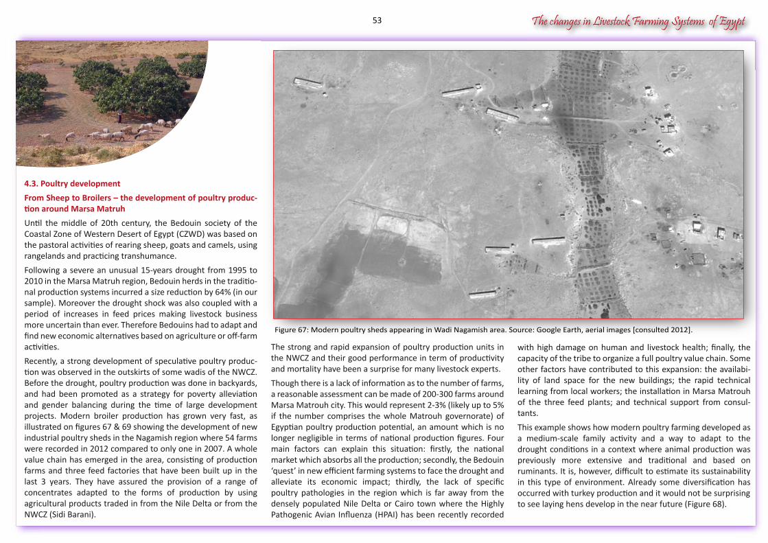
The changes in Livestock Farming Systems of Egypt
4.3. Poultry development
From Sheep to Broilers – the development of poultry produc-tion around Marsa Matruh
Until the middle of 20th century, the Bedouin society of the Coastal Zone of Western Desert of Egypt (CZWD) was based on the pastoral activities of rearing sheep, goats and camels, using rangelands and practicing transhumance.
Following a severe an unusual 15-years drought from 1995 to 2010 in the Marsa Matruh region, Bedouin herds in the traditio-nal production systems incurred a size reduction by 64% (in our sample). Moreover the drought shock was also coupled with a period of increases in feed prices making livestock business more uncertain than ever. Therefore Bedouins had to adapt and find new economic alternatives based on agriculture or off-farm activities.
Recently, a strong development of speculative poultry produc-tion was observed in the outskirts of some wadis of the NWCZ. Before the drought, poultry production was done in backyards, and had been promoted as a strategy for poverty alleviation and gender balancing during the time of large development projects. Modern broiler production has grown very fast, as illustrated on figures 67 & 69 showing the development of newindustrial poultry sheds in the Nagamish region where 54 farms were recorded in 2012 compared to only one in 2007. A whole value chain has emerged in the area, consisting of production farms and three feed factories that have been built up in the last 3 years. They have assured the provision of a range of concentrates adapted to the forms of production by using agricultural products traded in from the Nile Delta or from the NWCZ (Sidi Barani).
with high damage on human and livestock health; finally, the capacity of the tribe to organize a full poultry value chain. Some other factors have contributed to this expansion: the availabi-lity of land space for the new buildings; the rapid technical learning from local workers; the installation in Marsa Matrouh of the three feed plants; and technical support from consul-tants.
This example shows how modern poultry farming developed as a medium-scale family activity and a way to adapt to the drought conditions in a context where animal production was previously more extensive and traditional and based on ruminants. It is, however, difficult to estimate its sustainability in this type of environment. Already some diversification has occurred with turkey production and it would not be surprisingto see laying hens develop in the near future (Figure 68).
The strong and rapid expansion of poultry production units in the NWCZ and their good performance in term of productivity and mortality have been a surprise for many livestock experts.
Though there is a lack of information as to the number of farms, a reasonable assessment can be made of 200-300 farms around Marsa Matrouh city. This would represent 2-3% (likely up to 5% if the number comprises the whole Matrouh governorate) of Egyptian poultry production potential, an amount which is no longer negligible in terms of national production figures. Four main factors can explain this situation: firstly, the national market which absorbs all the production; secondly, the Bedouin ‘quest’ in new efficient farming systems to face the drought and alleviate its economic impact; thirdly, the lack of specific poultry pathologies in the region which is far away from the densely populated Nile Delta or Cairo town where the Highly Pathogenic Avian Influenza (HPAI) has been recently recorded
Figure 67: Modern poultry sheds appearing in Wadi Nagamish area. Source: Google Earth, aerial images [consulted 2012].
53
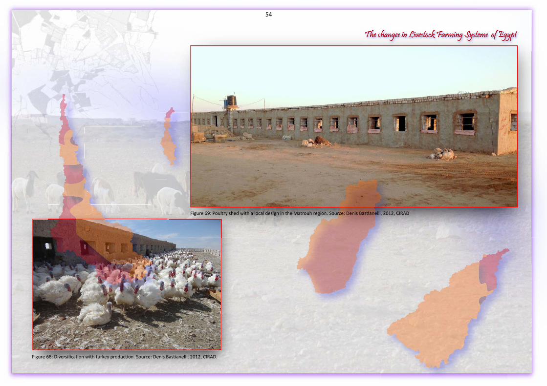
The changes in Livestock Farming Systems of EgyptThe changes in Livestock Farming Systems of EgyptThe changes in Livestock Farming Systems of Egypt
Figure 68: Diversification with turkey production. Source: Denis Bastianelli, 2012, CIRAD.
Figure 69: Poultry shed with a local design in the Matrouh region. Source: Denis Bastianelli, 2012, CIRAD
54
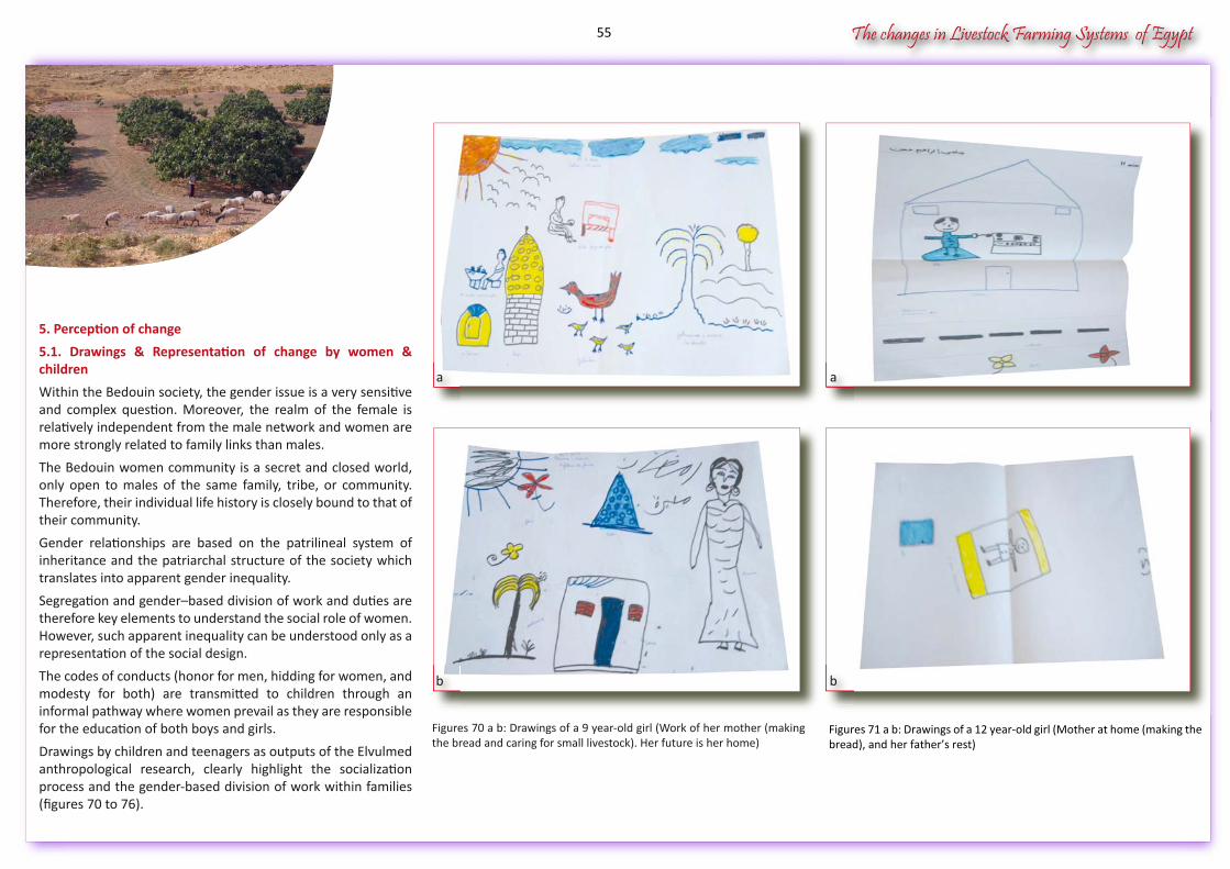
The changes in Livestock Farming Systems of Egypt
5. Perception of change
5.1. Drawings & Representation of change by women & children
Within the Bedouin society, the gender issue is a very sensitive and complex question. Moreover, the realm of the female is relatively independent from the male network and women are more strongly related to family links than males.
The Bedouin women community is a secret and closed world, only open to males of the same family, tribe, or community. Therefore, their individual life history is closely bound to that of their community.
Gender relationships are based on the patrilineal system of inheritance and the patriarchal structure of the society which translates into apparent gender inequality.
Segregation and gender–based division of work and duties are therefore key elements to understand the social role of women. However, such apparent inequality can be understood only as a representation of the social design.
The codes of conducts (honor for men, hidding for women, and modesty for both) are transmitted to children through an informal pathway where women prevail as they are responsible for the education of both boys and girls.
Drawings by children and teenagers as outputs of the Elvulmed anthropological research, clearly highlight the socialization process and the gender-based division of work within families (figures 70 to 76).
Figures 71 a b: Drawings of a 12 year-old girl (Mother at home (making the bread), and her father’s rest)
Figures 70 a b: Drawings of a 9 year-old girl (Work of her mother (making the bread and caring for small livestock). Her future is her home)
a
b
a
b
55
The changes in Livestock Farming Systems of Egypt
Drawings reveal some recent changes in the day-to-day lifestyle of the Bedouin society and highlight the children’s vision of their future. When such visions only envisage activities traditio-nally associated with their mothers (e.g. carpet weaving - figure 72 , bread making, caring of small livestock), these perceptions directly relate to symbols of the family, the homestead, and the household. A new perception of the individual role of women outside the household is neither well developed nor well perceived in the community, because women would bare the risk of not finding a husband.
Because women are excluded from the public arena reserved to men, they stay in their private networks. There, they share the responsibilities of socializing children, managing food security, conserving the diversity of plants used for food or for medicinal treatments, caring for backyard livestock, supervising water management and finally, assuming reproduction of the family model. This being said, it is clear that women have the key role for sustaining communities and the Bedouin cultural heritage.
Nevertheless more and more women now understand the importance of sending their daughters to school. They dream of their daughters knowing how to write and read, as this would open new perspectives to them outside the classic bread baking or carpet weaving role that society has already assigned.
Figures 73 a b c: Other visions of the future in drawings by a 12 year-old girl: Mother’s work (house cleaning and bread baking) & father’s work (farmer). Her future as a professor
Figure 72a: Carpets weaved by elder women in tribes of the NWCZ
Figure 72b: The vision expressed in young boys drawings always refer to their father’ work
Within 20 drawings made by women during the ELVULMED research project, only 4 show a vision of the future different from that of the classic heritage. Two girls had a vision of them-selves as professors and two as medical doctors.
Figures 73 a b c: Other visions of the future in drawings by a 12
a
b
Figures 73 a b c: Other visions of the future in drawings by a 12
c
Figure 72a: Carpets weaved by elder women in tribes of the NWCZa
Figure 72b: The vision expressed in young boys drawings always refer to b
56
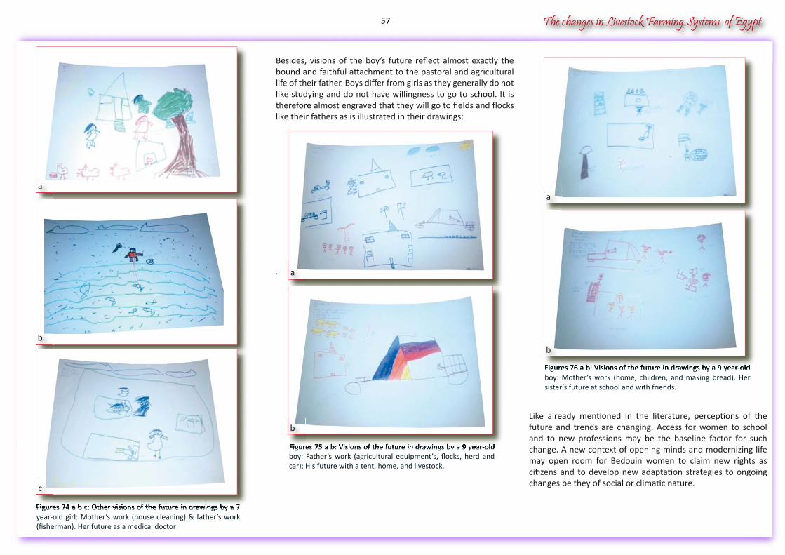
The changes in Livestock Farming Systems of Egypt
Like already mentioned in the literature, perceptions of the future and trends are changing. Access for women to school and to new professions may be the baseline factor for such change. A new context of opening minds and modernizing life may open room for Bedouin women to claim new rights as citizens and to develop new adaptation strategies to ongoing changes be they of social or climatic nature.
Besides, visions of the boy’s future reflect almost exactly the bound and faithful attachment to the pastoral and agricultural life of their father. Boys differ from girls as they generally do not like studying and do not have willingness to go to school. It is therefore almost engraved that they will go to fields and flocks like their fathers as is illustrated in their drawings:
.
Figures 75 a b: Visions of the future in drawings by a 9 year-old boy: Father’s work (agricultural equipment’s, flocks, herd and car); His future with a tent, home, and livestock.
Figures 74 a b c: Other visions of the future in drawings by a 7 year-old girl: Mother’s work (house cleaning) & father’s work (fisherman). Her future as a medical doctor
Figures 76 a b: Visions of the future in drawings by a 9 year-old boy: Mother’s work (home, children, and making bread). Her sister’s future at school and with friends.
Figures 76 a b: Visions of the future in drawings by a 9 year-old
Figures 75 a b: Visions of the future in drawings by a 9 year-old
Figures 74 a b c: Other visions of the future in drawings by a 7
a
b
c
a
b
a
Figures 76 a b: Visions of the future in drawings by a 9 year-old
b
57
The changes in Livestock Farming Systems of Egypt
5.2. Models and perception of future
Thought process on Livestock Farming Systems in the NWCZ
A mental model is an explanation of someone’s thought process about a situation and can be defined as a collective point of view, addressing a topic (e.g. livestock farming systems) with a past, current, and future perspective*. Collective approach and long term horizons are the two key-features of the mental model concept. Addressing mental models through participa-tive methods gives good results to share perceptions, describe human and social processes, understand collective and indivi-dual strategies, and build development scenarios. The two later objectives were used during the project in the NWCZ until now.
Mental model of the Past
Regarding the common perception of the past, all stakeholders refer to a mental model described as the “Bedouin extensive pastoral system”. It is based on sheep, goats and camels farming, grazing rangelands as common lands, and families living in tents. In this mental model, herds were managed at the family scale. Each family gathered, firstly, all household mem-bers of the family head, and secondly his son’s, brother’s and nephew’s households. Since the 1920s, there was a coordina-tion of families at the tribal level, especially for issues of land access and the use of water cisterns. At this time, animal husbandry was the only productive farming activity for the Bedouin, grazing was the only feeding source, and livestock sales were the basis of family income. Little information is available about the size of herds and flocks at that time. Never-theless a commonly admitted figure for herd size and composi-tion per average family would be around 150-200 small ruminants and 30-50 camels.
Furthermore, Bedouin families have invested in wadi agricul-ture, less vulnerable to bad weather conditions, especially figs and olives trees. Additionally vegetables like tomatoes and watermelons developed with help of irrigation.
The Mental Models for the future perspectives
After having faced drought, many Bedouin breeders’ families found new alternatives and added income to survive. Strategies that they recently adopted will sustain them so far. Many young men, household heads or younger, have chosen livestock trading where the Bedouin skill is recognized, or have migrated to Libya to be employed as shepherds, or to some cities to find a job in other sectors (building construction, tourism, services like taxi drivers, housekeepers).
During their time out of the farm, they continue to manage their farms as a secondary activity with their families taking care of their herds and barley fields. Some families have chosen to partly live in the urban area, while usually one person conti-nues to live on the farm.
Their kids will live in urban area and not in the countryside, speeding up the process of urbanization. The resulting agro-pastoral rain-fed system with off-farm income is nowadays predominant. Some specialization farming occurred at the end of the 1990s with small sheep fattening feedlots.
They are usually financed by Bedouin investors from the NWCZ who have other significant incomes outside of agriculture. The system is based on 2-3 shepherds keeping 500-600 sheep fattened during 2-3 months in the rangeland, fed with products purchased in the market and sold for Muslim celebrations in Cairo and Alexandria. The investment is around USD $150-200 per head for a return of 40-50% after 3-5 months.
Nevertheless, access to wadi land is still the biggest challenge since demand for land outweighs the supply of available land. This explains why one common recommendation by Bedouin leaders to create new opportunities is the extension of the wadi reclamation process in order to get more lands equipped with water harvesting techniques.
Stakeholders also highlighted the importance of the seasonal human migrations at a regional scale whose patterns varied according to tribe’s social networks and access to rangelands resources.
The first migration pattern was north to south between the coast and the desert, reaching the oasis of Siwa. The second pattern was east to west between NWCZ and Libya; the third pattern was west to east between the NWCZ and the NRL at the western edge of the Nile Delta.
The Current Mental Models in the NWCZ, after the 15-Year drought
The Bedouin purely extensive pastoral system does not exist anymore in the NWCZ. Agro pastoral systems have replaced it when breeders started to sell animals to purchase hay and feed concentrates to feed flocks after feed subsidies were first offered by the government at the beginning of the drought.
Feeding now occurs not only during the 2-3 months of the dry season, but for six to ten months a year. At a regional scale, since the herd size of sheep and goats has been reduced on average by 64% households had to add new forms of income to complement the herd-based decreased income, though the sheep market benefitted from an increasing demand in large towns.
Therefore, the Bedouin agro-pastoral rain fed system is a direct evolution of the pastoral system by the integration of barley cultivation, mainly used for animal grazing during the dry season as a substitute to the degraded rangeland, with some fig and olive trees in the wadi beds.
The herd management is still the mainstay activity though. Sales of animals give enough cash to cover all farming expenses, including the feed for the herd during the dry season, though this may not cover new family expenses associated with the new urban way of life.
Nevertheless, being exclusively based on rainfall, this system is vulnerable to water restrictions and depends on good weather conditions. When facing abnormal weather conditions it needs supportive policies to help face drought.
* (http://en.wikipedia.org/wiki/Mental_model)
58
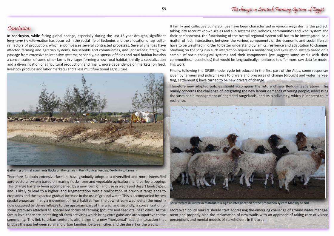
The changes in Livestock Farming Systems of Egypt
Barki feedlot in winter in Matrouh is a sign of intensification of the production system Mobility to NRL
Gathering of small ruminants flocks on the canals in the NRL gives feeding flexibility to farmers
In conclusion, while facing global change, especially during the last 15-year drought, significant long-term transformation has occurred in the social life of Bedouins and the allocation of agricultu-ral factors of production, which encompasses several contrasted processes. Several changes have affected farming and agrarian systems, households and communities, and landscapes: firstly, the passage from extensive to intensive systems; secondly, a dispersal of fields and rural habitat but also a concentration of some other farms in villages forming a new rural habitat; thirdly, a specialization and a diversification of agricultural production; and finally, more dependence on markets (on feed, livestock produce and labor markets) and a less multifunctional agriculture.
Therefore Bedouin extensive farmers have gradually adopted a diversified and more intensified agro-pastoral system based on rearing flocks, tree and vegetable agriculture, and barley cropping. This change has also been accompanied by a new form of land use in wadis and desert landscapes, and is likely to lead to a higher land fragmentation with a reallocation of previous rangelands to croplands and the expected gradual increase in the use of ground water. This is accompanied by two spatial processes: firstly a movement of rural habitat from the downstream wadi delta (the mouth) now occupied by dense villages to the upstream part of the wadi and secondly, a concentration of some premises attached to specialized forms of farming (poultry and feedlots) near cities. At the family level there are increasing off-farm activities which bring extra gains and are supportive to the community. This link to urban centers is also a sign of a new “horizontal” spatial interaction that bridges the gap between rural and urban families, between cities and the desert or the wadis.
If family and collective vulnerabilities have been characterized in various ways during the project, taking into account known scales and sub systems (households, communities and wadi system and their components), the functioning of the overall regional system still has to be investigated. As a matter of fact, interactions between the various components of the economic and social life still have to be weighted in order to better understand dynamics, resilience and adaptation to changes. Studying on the long run such interaction requires a monitoring and evaluation system based on a sample of socio-ecological systems and their components (we suggest some wadis with their communities, households) that would be longitudinally monitored to offer more raw data for mode-ling work.
Finally, following the DPSIR model cycle introduced in the first part of the Atlas, some responses given by farmers and policymakers to drivers and pressures of change (drought and water harves-ting, settlements) have turned to be new drivers of change.
Therefore new adapted policies should accompany the future of new Bedouin generations. This mainly concerns the challenge of integrating the new labour demands of young people; addressing the sustainable management of degraded rangelands; and its biodiversity, which is inherent to its resilience.
Moreover, policy makers should start addressing the emerging challenge of ground water manage-ment and properly plan the reclamation of new wadis with an approach of taking care of visions perceptions and mental models of stakeholders in the area.
In conclusion, while facing global change, especially during the last 15-year drought, significant long-term transformation has occurred in the social life of Bedouins and the allocation of agricultu-
Conclusion
The results of interviews undertaken in the NWCZ rainfall area, including the Siwa Oasis and fringes of the New Reclaimed Lands, show the occurrence of several categories of agricultural plantations and subcategories as displayed in the following table (Table 2).
Table 2: Citations of plantations by households surveyed in the NWCZ by the project, Source Elvulmed Project, 2011
59

LiLiLvivi evev
sese totot ck
FaFaFrmrmr
inini gngn SySyS sysy tetet msmsm ofofo EgEgE ygyg pypy tThThT
e chahah
ngngnesese
ininiL
60
The changes in Livestock Farming Systems of Egypt
6. References Atlas
AKHTAR ALI T.O., ABDUL BARI SALKINI, SOBHI EL NAGGAR, 2009, Rainwater Cisterns. Traditio-nal technologies for dry areas, ICARDA, Aleppo Syria, iv + 20 p.ATTIA AMIR, 1999, PLANNING FOR SUSTAINABLE TOURISM DEVELOPMENT, An Investigation into Implementing Tourism Policy In the North West Coast Region of Egypt, PhD, University College London, LONDON, 426 p.BALL J., 1942, Egypt in the classical geographers, Government Press, Cairo.BOERS T.M., BEN-ASHER J., 1982, A review of rainwater harvesting, Agric. Water Management.CAPMAS, CENTRAL AGENCY FOR PUBLIC MOBILIZATION AND STATISTICS, 2013, population statistics, Distribution & size of Population,<http://capmas.gov.eg/pages_ar.aspx?pageid=854.CAPMAS, CENTRAL AGENCY FOR PUBLIC MOBILIZATION AND STATISTICS, 2013, Agriculture statistics, <http://capmas.gov.eg/pages_ar.aspx?pageid=863>.CAPMAS, CENTRAL AGENCY FOR PUBLIC MOBILIZATION AND STATISTICS, 2013, Climate statis-ticsCAPMAS, CENTRAL AGENCY FOR PUBLIC MOBILIZATION AND STATISTICS, 2013, population statistics, <http://capmas.gov.eg/pages_ar.aspx?pageid=1500>.CAPMAS, CENTRAL AGENCY FOR PUBLIC MOBILIZATION AND STATISTICS, 2013, Social statis-tics, <http://capmas.gov.eg/pages_ar.aspx?pageid=851>.CHAMBERS R., 2006, IDS Bulletin Editorial Introduction In: Vulnerability, Coping and Policy, (IDS, ed.), 37 (4), 33-40.CLAVAL P., 1995, Les méthodes de régionalisation, In: Initiation à la géographie régionale, (PITTE J.R., ed.), Nathan, Paris, 45-66.COCHET H., 2011, L'agriculture comparée, collection Indisciplines, Quae, Paris.CRITCHLEY W., K. S., 1991, Water harvesting – a manual for the design and construction of water harvesting schemes for plant production, FAO, Rome, Italy.DAVID CELIS, EDDY DE PAUW, ROLAND GEERKEN, 2007, Assessment of Land Cover and Land Use in Central and West Asia and North Africa Part 1. Land Cover/Land Use – Base Year 1993, International Center for Agricultural Research in the Dry Areas (ICARDA), Aleppo, Syria, vi+54 p.DAVID CELIS, EDDY DE PAUW, ROLAND GEERKEN, 2007, Assessment of Land Cover and Land Use in Central and West Asia and North Africa CWANA region using AVHRR and agroclimatic data Part 2. Hot Spots of Land Cover Change and Drought Vulnerability, International Center for Agricultural Research in the Dry Areas (ICARDA), Aleppo, Syria, x+69 p.DE COSSON A., 1935, Mareotis, Country Life, London.Department of State, 1996, International Boundary Study, Libya – Egypt (United Arab Republic) Boundary, Department of State, Washington, D.C., 10 p.EL AMAMI S., 1983, Les amenagements hydrauliques traditionels en Tunisie., Centre de Recher-che du Genie Rural, Tunis, Tunisia.EL-BASTAWISSI E., 1997 Coastal resources: The need for a management system: The case of Alexandria.
DUARTE, L.M.G. ; FARIG, T. ; ALARY, V. ; TOURRAND, J.F. ; VALARIE, P.A., 2013, solidariedadecomo um fator de coesão, de integração social e de resiliência das mulheres nas comunidades beduínas de Matrouh, Egito. In: XVI Congresso Brasileiro de Sociologia, 2013, Salvador. A Socio-logia como Artesanato Intelectual. http://www.automacaodeeventos.com.br/sigeventos/sbs2013/inscricao/resumos/0001/PDF_trab-aceito-2579-1.pdf. Salvador: Faculdade de Filosofia e Ciências Humanas da UFBA.EL-NAGGAR S., E., PERRIER R. , SHYKHOUN M., 1988, Evaluation of farm resource management of the northwest coast of Egypt, FRMP ICARDA, Aleppo. Syria.EL-SHAFEI S., 1994, Agricultural Development in the North-West Coastal Zone, Egypt. Report on Water Harvesting. , Expert Consultation, FAO, Rome, Cairo, Egypt.FAO, 1970, Preinvestment survey of the North west coastal region, Physical conditions of water resources United Nations Development Programme Food and Agriculture Organization of The United Nations, Roma, 149 p.GLEICK P.H., 1996, Basic water requirements for human activities: Meeting basic needs, Water International, 21 (2), 83-92.FREEMAN C., 2004, Egypt, Greece and Rome: Civilizations of the Ancient Mediterranean., Oxford University Press.HANY EL MINIAWY, FRIDEL MARK, SANAA TOBAH, 1990, QRDP Qasr Rural development Project, Development Plan Phase II, Draft report and Development strategy, Egyptian Environ-mental Affairs Agency EEAA, German Agency for Technical Cooperation GTZ, Governorate of Governorate of Marsa Matrouh, Cairo, 292 p.HASANAIN M., EL-HALABY, 1996 Environmental Analysis for Fuka - Ras El-Hekma Area, Ministry of Tourism.HASSAN G.F., 2000, Environmental Control Through Urban Planning, Development of Tourist & Recreation Coastal Zones of the Mediterranean Sea, Chapter 5 Comparison Between The North west Coast Of Egypt and The Languedoc-Roussillion Of France, Aims Of Development, Planning Concepts, Implementation, And Relative Environmental Impacts, PhD, Ain Shams University, CPAS Centre of studies and architectural studies, , 138-171 p. http://www.cpasegypt.com/ENG/GhadaFarouk_eng.html.HERSPERGER A.M., M. GENNAIO, P. H. VERBURG, AND M. BÜRGI, 2010, Linking land change with driving forces and actors: four conceptual models, Ecology and Society, 15 (4), http://www.ecologyandsociety.org/vol15/iss4/art1/.ISMAIL H.A., ABDEL RAHMAN S.M.H., ABDEL KADER F.H., 1986, Pedagogical study of Omayed toposequence North Western Mediterranean desert of Egypt, Cah. Orstom, Ser. Pedal., XXII (1), 63-76.JENNY JOBBINS, MARY MEGALLI, 2006, Alexandria and the Egyptian Mediterranean, second edition., collection A traveler's guide, American University of Cairo Press, Cairo Egypt.KHALAF N, 2010, Geographical Evaluation of Resorts in Northwestern Coast of Egypt, Master Thesis, Alexandria University Alexandria, Egypt.KASSAS M.A., 1972, A brief history of land—use in Mareotis region, Egypt, Minerva Biologica (1), 167-174.
61
The changes in Livestock Farming Systems of Egypt
MAGDA METWALLY, SAHAR SOLIMAN ABDALLA, 2005, An Approach to Tourism Development in Coastal Area Egypt, In: International Conference on Tourism and Development in Coastal Areas, Mar. 2005, Sharm El-Sheikh, Egypt., 12p.MARTIN V., 2013, Analyse des processus d’adaptations des communautés bédouines au change-ment global. Etude approfondie des processus, basée sur neuf familles bédouines dans la région de Matrouh, sur la côte Nord Ouest de l’Egypte, MSc, Esitpa, école d’ingénieurs en agriculture, Montpellier, 49 p., http://www.esitpa.org.MILLENIUM ECOSYSTEM ASSESSMENT, 2005, Les écosystèmes et le bien être de l’homme. Un cadre d’évaluation. , http://www.maweb.org/documents/document.6.aspx.pdf.NASTASSJA HOFFET, 2011, Water for the Desert: Participation And Integrated Water Resources Management, a Case Study of The Rainfed Desert Region of Matruh, Egypt, MSc, LONDON SCHOOL OF ECONOMICS AND POLITICAL SCIENCE, 62 p.NAVARRA A., TUBIANA L., ed., Volume 2: Agriculture, Forests and Ecosystem Services and People (Vol. 51), Springer, CIRCE: Climate change and impact research: the Mediterranean environment, 135-156. http://www.springer.com/earth+sciences+and+geography/earth+system+sciences/book/978-94-007-5771-4.NICOLA LACETERA M.S., UMBERTO BERNABUCCI, BRUNO RONCHI, ANDREA VITALI A.T., HELENE GUIS , CYRIL CAMINADE, CARLOS CALVETE, ANDREW MORSE M.B., AND ALESSANDRO NARDONE, 2013, Climate Induced Effects on Livestock Population and Productivity in the Medi-terranean Area, In: Regional Assessment of Climate Change in the Mediterranean, (A.T. NAVARRA, LAURENCE, ed.), Volume 2: Agriculture, Forests and Ecosystem Services and People (Vol. 51), Springer, CIRCE: Climate change and impact research: the Mediterranean environment,135-156 http://www.springer.com/earth+sciences+and+geography/earth+system+sciences/book/978-94-007-5771-4.OWEIS T., PRINZ D., HACHUM A., 2001, Water harvesting: indigenous knowledge for future of the drier environments, ICARDA, Aleppo, Syria.PACEY A., CULLIS A., 1986, Rainwater Harvesting. The collection of rainfall and runoff in rural areas Intermediate Technology Publ., London.PERRY, B.D., RANDOLPH, T.F., MCDERMOTT, J.J., SONES, K.R., THORNTON, P.K., 2002. Investing in animal health research to alleviate poverty . 148p. Nairobi (Kenya): ILRI.PICHERAL H., 2001, Dictionnaire raisonné de géographie de la santé, GEOS , Atelier Géographie de la santé, Université Montpellier 3 - Paul Valery, Montpellier, 307 p.PRINZ D., 1996, Water Harvesting: Past and Future, In: NATO Advanced Research Workshop, Sustainability of Irrigated Agriculture, 21-26.03.1994, Balkema, Rotterdam, (L.S. PEREIRA, ed.), 135-144.PRINZ D., 2002, The Role of Water Harvesting in Alleviating Water Scarcity in Arid Areas, In: International Conference on Water Resources Management in Arid Regions, 23-27 March, 2002, Kuwait, Kuwait Institute for Scientific Research, 107-122, http://plantstress.com/Articles/ drought_m/runoff_farming.pdf.QRDP QASR RURAL DEVELOPMENT PROJECT, 1993, Challenge for the development of Arid Lands on Egypt's North West Coast (Governorate of Matrouh), Egyptian Environmental Affairs Agency, Ministry of Cabinet Affairs, Reconstruction and Development authority for the North - West Coastal Zone, GTZ, 18 p.
REIJ C., MULDER P., BEGEMANN L., 1988, Water Harvesting for Plant Production, Washington DC.SCOONES I., 1998, Sustainable rural livelihoods: a framework for analysis, IDS Institute of Deve-lopment Studies at the University of Sussex, Brighton, UK.SAID R., 1962, The geology of Egypt, Elsevier, Amsterdam.SHATA A.A., 1991, Water resources and the future of arid lands, RIGW/IWACO, Cairo-Rotterdam.SHERBININ A.D., 2013, Climate Change Hotspots Mapping: What Have We Learned?, Climatic Change, Revised Accepted Manuscript submitted, 39, DOI: http://dx.doi.org/10.1007/s10584-013-0900-7, http://www.columbia.edu/~amd155/deSherbinin_2013_CCHotspots_ClimaticChange.pdf.THE WORLD BANK, 1992, Project preparation report of Matrouh Resource Management Project, MRMP, Matrouh Northwest Coast of Egypt.THE WORLD BANK, 2003, Egypt - Second Matruh Resource Management Project (Anglais), http://documents.banquemondiale.org/curated/fr/2003/02/2140346/egypt-second-matruh-resource-management-project.TURNER II B.L., KASPERSON R.E., MATSON P.A., MCCARTHY J.J., CORELL R.W., CHRISTENSEN L., ECKLEY N., KASPERSON J.X., LUERS A., MARTELLO M.L., POLSKY C., PULSIPHER A., SCHILLER A., 2003, Framework for vulnerability analysis in sustainability science, PNAS, 100 (14).VEYRET Y., 2004, La vulnérabilité, définition, In: Géographie des risques naturels en France. De l'aléa à la gestion, (A. CIATTONI, ed.), Initial, Hatier, Paris, 42-46.WEEDON A.L.P., 1912, Report on Mariout district, Cairo Sci. J. (6), 201.WIKIPEDIA, 2013, Egypt–Libya relations, http://en.wikipedia.org/wiki/Egypt%E2%80%93Libya_relations>(consulté le 16/12/2013).YOUSEIF M., EL ABD E.S., BARAKA A., 2013 Assessment of Water Resources in Some Drainage Basins, northwestern coast, Desert Research Center, Cairo, Egypt.
62
The changes in Livestock Farming Systems of Egypt
Published project papers
Aboul-Naga, A., Osman, M.A., Alary, V., Hassan, F., Daoud, I., 2014.Raising goats as adaptation process to prolonged drought incidence at the coastal zone of Western Desert in Egypt, Small Ruminant Research (accepted).Alary, V., Aboul Naga, A., El Shafie, M., Abdelkrim N., H. handom, H. Metawi, 2011. Roles of small ruminants in the rural livelihood improvement – Comparative analysis in Egypt. Communi-cation to LIFLOD Workshop, side event of IXth IRC / International Rangeland Congress, Rosario Argentina. (reviewing for one chapter in: Livestock farming embedded in local development. A functional perspective to alleviate vulnerability of farming communities, Book, Eds: H. Bernard, Tourrand J.F.) (accepted).Alary, V., Aboul Naga, A., El Shafie, M., Abdelkrim N., H. Metawi, 2011 Dynamics and farmers strategies for small ruminant market in Egypt. African Journal of Agricultural Research Vol. 7(1), pp. 115-122, 5 January, 2012.Alary, V., Daoud, I., Salama, O., Aboul-Naga, AD., Merveille, N., Tourrand, J.F., 2012. Adaptation des sociétés bédouines de la côte nord-ouest de l’Égypte au changement global, Autrepart (62), 2012, 183-200.Duarte, M.G., Farig, T., Alary, V., Tourrand, J.F., Valarié, P., 2013. Comunidades Beduí nas de matrough, egito: desvelando o mundo das mulheres e suas vulnerabilidades, Rede de estudos ambientais de países de língua portuguesa, Mayo 2013, n°7, 8-14.Duarte, M.G., Farig, T., Alary, V., Tourrand, J.F., Valarié, P., 2013 A solidariedade como um fator de coesão, de integração social e de resiliência das mulheres nas comunidades beduínas de Matrouh, Egito. Société brésilienne de sociologie-SBS.(http://www.automacaodeeventos.com.br/sigeventos/sbs2013/inscricao/resumos/0001/PDF_trab-aceito-2579-1.pdf.).
Communications Key invited paper:Lasseur, J, Alary V., Aboul-Naga A., Bonnet P., Tourrand J.F., 2013. Adaptability of small ruminant farmers facing global change. A north south analysis in Mediterranean (France/ Egypt). 64th annual meeting EAAP. 26-29 August 2013. Key invited paper.
Other:Aboul Naga A., Alary, V., Osman, M., Tourrand, J.F., 2013. Contribution of livestock to the livelihood of local communities at different agro-ecological zones in the coastal area of Western Desert in Egypt. 11th International Dryland development Conference “Global Climate Change and its impact on Food & Energy Security in the Drylands”, IDDC, 18-21 March 2013, Beijing, China (in press).Alary, V.; Daoud, I., Salama, O.; Abdelzaher, M.., Tourrand, J.F. Human Dimensions of Livestock Farming Suystems in Bedouin Society of North West Coast Zone, Egypt. Congress of Internatio-nal Rural Sociology Association (IRSA), Lisbon, 27 July – 2st August 2012, Work Group 53.Alary, V., Aboul Naga, A., El Shafie, M., Abdelkrim N., H. handom, H. Metawi, 2011. Roles of small ruminants in the rural livelihood improvement – Comparative analysis in Egypt. Communi-cation au LIFLOD Workshop, side event of IXth IRC / International Rangeland Congress, Rosario Argentina.
Alary, V., Lasseur, J., 2012. ELVULMED Livestock Vulnerability Adaptation Mediterranean, ANR Seminar on Environmental Changes, Bordeaux (France), 21-22 may 2012 (Poster).Alary V., Aboul-Naga A., Bonnet P., Osman M., Tourrand J.F., 2013. Role of mobility to face long drought (1995-2011) in the Coastal Zone of Western Desert (Egypt). 64th annual meeting EAAP. 26-29 August 2013. Poster. Bonnet, P., Lasseur, J., Grawitz, T., Boutonnet, J.P., Tourrand , J.F., Combining large scale and small scale analysis to characterize the Vulnerability of Territories for small ruminant farming systems in the PACA region of France: concepts and reality, Communication IFSA / International Farming Systems Association, Denmark, July 2012.Bastianelli D., Daoud I., Lescoat P., Alary V., Tourrand J.F. From sheep to broilers: development of poultry production around Marsa Matrouh, egypt. International congress on advancements in poultry production in the Middle East and African states, Turkey, Oct. 2013.Ding, L.M.; Daoud, I.; Fasioli, E.; Long, R.; Alary, V.; Coronato, F., Dong, S.; Abdelzaher, M.; Schweitzer, A.; Aboul Naga, A.; Bonaudo, T.; Tourrand, J.F. Adaptation Strategies of Breeders Face Global Change in Harsh Conditions. International Grass Land Congress, Australia, (Poster)Duarte L., Farig T., Alary V., Daoud I., Abdelzahar M., Salah E., Naga A. A., Tourrand J.F. O agro nos países pré-emergente do mundo árabe O caso de estudo da zona beduína da NWCZ, Egito. VIII Jornadas Interdisciplinarias de Estudios Agrarios y Agroindustriales. 29 octubre à 01 Novem-bre 2013, Buenos Aires, Argentina. Duarte, M.G., Farig, T., Alary, V., Tourrand, J.F., Valarié, P., A solidariedade como um fator de coesão, de integração social e de resiliência das mulheres nas comunidades beduínas de Matrouh, Egito. Résumé publié dans les Actes du XVI Congresso Brasileiro de Sociologia, GT: Gênero, Feminismo e Transformações Sociais. 10-13 Septembre 2013, Salvador (BA), Brésil.Hoffet, N., Daoud,I., Alary,V., Tourrand, J.F., Moselhy,N., 2012. Participation, Power and Sustai-nable Water Resource Management, A Case Study of The Rainfed Desert Region of Matruh, Egypt. Communication IFSA / International Farming Systems Association, Denmark, July 2012. Link: http://ifsa2012.dk/?page_id=755.Moselhy, N., Daoud, I., Alary, V., Osman, M. A., Abdel-Aal, E., Aboul Naga, A., Salama, O., Duarte, L.G., Tourrand, J.F., 2013. Need of a New Rangeland Management for the Bedouin Society after a 15-years Drought. SER 2013 World Conference on the Society of Ecological Resto-ration, Monona Terrace Convention and Community Center in Madison, Wisconsin, USA during October 6th - 11th, 2013 (communication and accepted for chapter).Osman, M.A., Alary, V., Aboul-Naga, A., Hassan, F., Abdel-Aal, E.S., Metawi H.R. and Tourrand J.F., 2012. Adaptation process of farming systems in response to 14 successive years of drought in North West Coastal Zone (Egypt)- Communication IFSA / International Farming Systems Association, Denmark, July 2012. Link: http://ifsa2012.dk/?page_id=760.
63
The changes in Livestock Farming Systems of Egypt
Reports
Alary V., Lasseur J., Boutonnet, J.P., Tourrand J.F., 2011. Compte rendu intermédiaire T0+6. Projet ANR-10-CELP-002 ELVULMED- Programme CEP&S 2010. Juillet 2011.Alary V., Lasseur J., Boutonnet, J.P., Tourrand J.F., 2011. Compte rendu intermédiaire T0+12. Projet ANR-10-CELP-002 ELVULMED- Programme CEP&S 2010. Janvier 2012.Alary V., Lasseur J., Boutonnet, J.P., Tourrand J.F., 2011. Compte rendu intermédiaire T0+18. Projet ANR-10-CELP-002 ELVULMED- Programme CEP&S 2010. Juillet 2012.Alary V., Lasseur J., Boutonnet, J.P., Tourrand J.F., 2011. Compte rendu intermédiaire T0+24. Projet ANR-10-CELP-002 ELVULMED- Programme CEP&S 2010. Janvier 2013. Alary, V., Lasseur J., Bonnet P. Action 2.1: Review of the literature on vulnerability. Projet ANR-10-CELP-002 ELVULMED- Programme CEP&S 2010. Available at: http://elvulmed.cirad.fr/Duarte, L., 2013. Synthèse de littérature. Rapport action 3.2. Février 2013.Duarte, L., 2013. Les femmes bédouines dans les communautés de Matrouh, Egypte: vulnérabi-lités, perceptions sur les changements climatiques et visions sur l'avenir, rapport action 3.2. Février 2013.Duarte L., 2013. Développement rural et aménagement de territoires ruraux : Les associations et le développement de terres récupérées en Egypte, Juin 2013.Hoffet, N. 2011. Water for the Desert: Participation And Integrated Water Resources Manage-ment, A Case Study of The Rainfed Desert Region of Matrouh, Egypt. LONDON SCHOOL OF ECONOMICS AND POLITICAL SCIENCE. 62p.Kemmerling, B., 2012. PhD. Negotiating water use and materialization of water discourses within the agricultural sector of Egypt_ Field work in Matrouh. Research report.Martin, V., Analyse des processus d’adaptations des communautés bédouines au changement global. Etude approfondie des processus, basée sur neuf familles bédouines dans la région de Matrouh, sur la côte Nord-Ouest de l’Egypte. Dissertation, 2013, ESIPTA, Nancy.Merveilles N., 2011. Note de synthèse- recherché bibliographique pour le volet trois du projet ELVULMED. 8p.
64

LiLiLvivi evev
sese totot ck
FaFaFrmrmr
inini gngn SySyS sysy tetet msmsm ofofo EgEgE ygyg pypy tThThT
e chahah
ngngnesese
ininiL
P h o t o g r a p h s
Véronique AlaryDenis BastianelliPascal BonnetIbrahim DaoudLaura DuarteBernard FayeNastassja HoffetNicolas MerveilleNaeem Moselhy
Véronique AlaryDenis Bastianelli
Photos credits
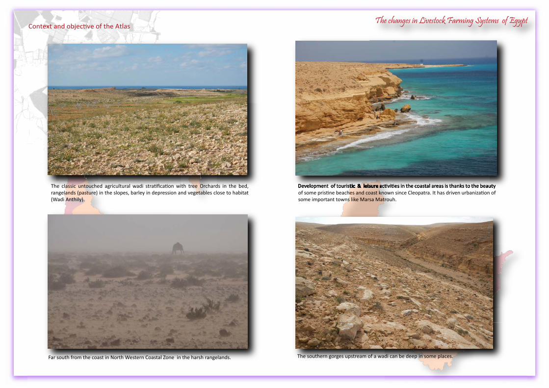
The southern gorges upstream of a wadi can be deep in some places.
The classic untouched agricultural wadi stratification with tree Orchards in the bed, rangelands (pasture) in the slopes, barley in depression and vegetables close to habitat (Wadi Anthily).
Far south from the coast in North Western Coastal Zone in the harsh rangelands.
Development of touristic & leisure activities in the coastal areas is thanks to the beauty of some pristine beaches and coast known since Cleopatra. It has driven urbanization of some important towns like Marsa Matrouh.
Development of touristic & leisure activities in the coastal areas is thanks to the beauty Development of touristic & leisure activities in the coastal areas is thanks to the beauty Development of touristic & leisure activities in the coastal areas is thanks to the beauty Development of touristic & leisure activities in the coastal areas is thanks to the beauty Development of touristic & leisure activities in the coastal areas is thanks to the beauty Development of touristic & leisure activities in the coastal areas is thanks to the beauty Development of touristic & leisure activities in the coastal areas is thanks to the beauty Development of touristic & leisure activities in the coastal areas is thanks to the beauty
Context and objective of the AtlasThe changes in Livestock Farming Systems of Egypt
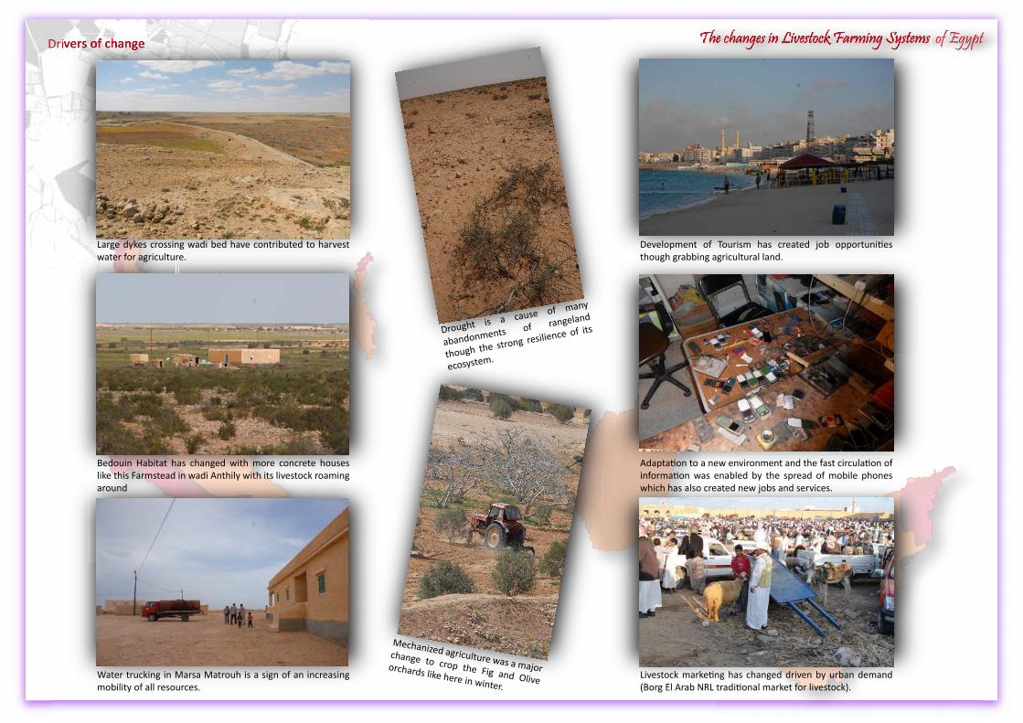
Drivers of change The changes in Livestock Farming Systems of EgyptThe changes in Livestock Farming Systems of EgyptDrivers of change
Development of Tourism has created job opportunities though grabbing agricultural land.
Mechanized agriculture was a major change to crop the Fig and Olive orchards like here in winter.
Livestock marketing has changed driven by urban demand (Borg El Arab NRL traditional market for livestock).
Adaptation to a new environment and the fast circulation of information was enabled by the spread of mobile phones which has also created new jobs and services.
Bedouin Habitat has changed with more concrete houses like this Farmstead in wadi Anthily with its livestock roaming around
Drought is a cause of many
abandonments of rangeland
though the strong resilience of its
ecosystem.
Large dykes crossing wadi bed have contributed to harvest water for agriculture.
Water trucking in Marsa Matrouh is a sign of an increasing mobility of all resources.
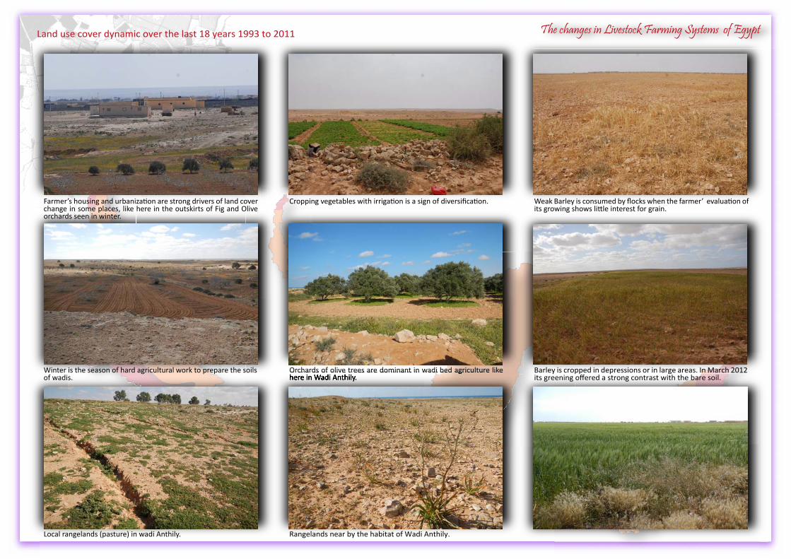
Land use cover dynamic over the last 18 years 1993 to 2011Land use cover dynamic over the last 18 years 1993 to 2011
Cropping vegetables with irrigation is a sign of diversification.
Winter is the season of hard agricultural work to prepare the soils of wadis.
Weak Barley is consumed by flocks when the farmer’ evaluation of its growing shows little interest for grain.
Farmer’s housing and urbanization are strong drivers of land cover change in some places, like here in the outskirts of Fig and Olive orchards seen in winter.
Orchards of olive trees are dominant in wadi bed agriculture like here in Wadi Anthily.
Local rangelands (pasture) in wadi Anthily.
Barley is cropped in depressions or in large areas. In March 2012 its greening offered a strong contrast with the bare soil.
Orchards of olive trees are dominant in wadi bed agriculture like Orchards of olive trees are dominant in wadi bed agriculture like Orchards of olive trees are dominant in wadi bed agriculture like Orchards of olive trees are dominant in wadi bed agriculture like Orchards of olive trees are dominant in wadi bed agriculture like Orchards of olive trees are dominant in wadi bed agriculture like Orchards of olive trees are dominant in wadi bed agriculture like Orchards of olive trees are dominant in wadi bed agriculture like here in Wadi Anthily.
Rangelands near by the habitat of Wadi Anthily.
The changes in Livestock Farming Systems of Egypt
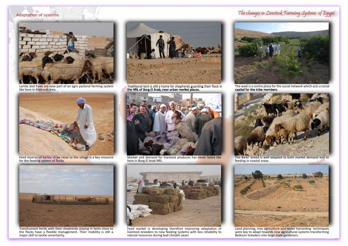
The changes in Livestock Farming Systems of Egypt
Traditional tent is still a home for shepherds guarding their flock in the NRL of Borg El Arab, near urban market places.
Transhumant herds with their shepherds staying in tents close to the flocks have a flexible management. Their mobility is still a major skill to tackle uncertainty.
The wadi is a centre place for the social network which acts a social capital for the tribe members.
Lambs and Ewes are now part of an agro pastoral farming system like here in Matrouh area.
Feed market is developing therefore improving adaptation of livestock breeders to new feeding systems with less reliability to natural resources during bad climatic years
Feed reserve of barley straw close to the village is a key resource for the feeding system of flocks.
The wadi is a centre place for the social network which acts a social The wadi is a centre place for the social network which acts a social capital for the tribe members.
Land planning, tree agriculture and water harvesting techniques were key to adapt towards new agricultural systems transforming Bedouin breeders into large scale gardeners.
The Barki’ breed is well adapted to both market demand and to feeding in coastal areas.
Traditional tent is still a home for shepherds guarding their flock in Traditional tent is still a home for shepherds guarding their flock in Traditional tent is still a home for shepherds guarding their flock in Traditional tent is still a home for shepherds guarding their flock in Traditional tent is still a home for shepherds guarding their flock in Traditional tent is still a home for shepherds guarding their flock in the NRL of Borg El Arab, near urban market places.the NRL of Borg El Arab, near urban market places.the NRL of Borg El Arab, near urban market places.the NRL of Borg El Arab, near urban market places.the NRL of Borg El Arab, near urban market places.
Market and demand for livestock produces has never failed like here in Borg El Arab NRL
Adaptation of systems
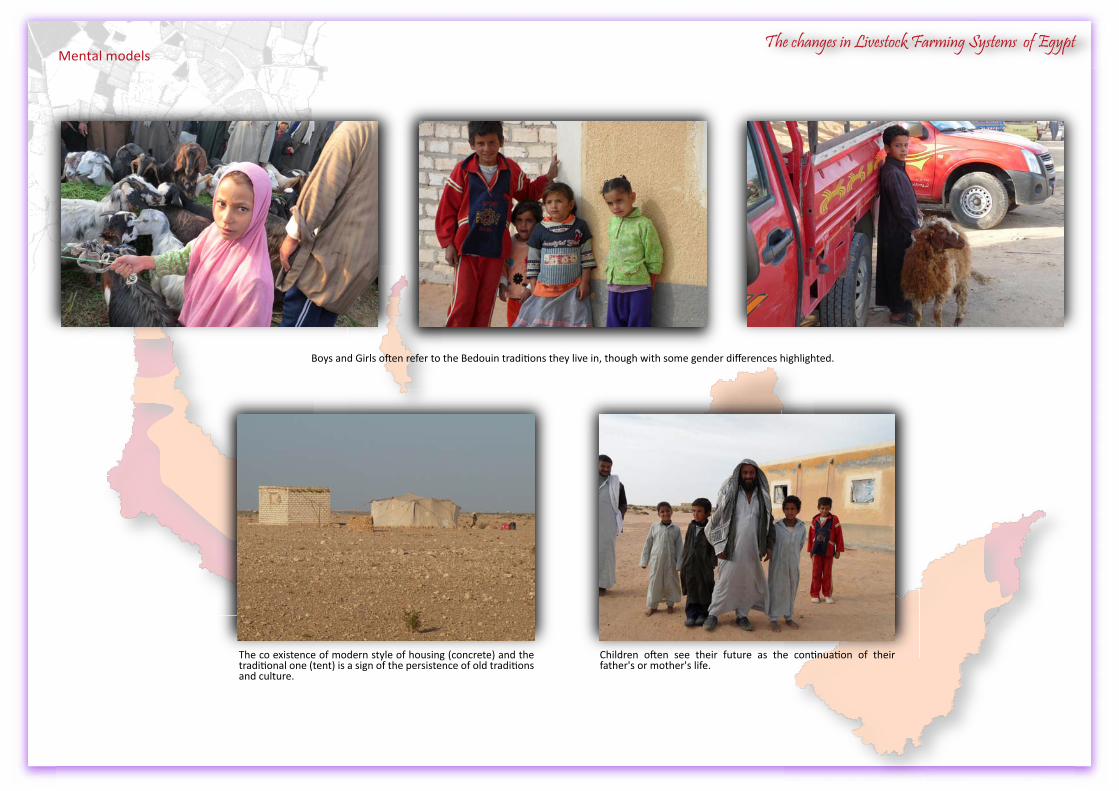
The changes in Livestock Farming Systems of EgyptMental models
Boys and Girls often refer to the Bedouin traditions they live in, though with some gender differences highlighted.
Children often see their future as the continuation of their father's or mother's life.
The co existence of modern style of housing (concrete) and the traditional one (tent) is a sign of the persistence of old traditions and culture.
LiLiLvivi evev
sese totot ck
FaFaFrmrmr
inini gngn SySyS sysy tetet msmsm ofofo EgEgE ygyg pypy tThThT
e chahah
ngngnesese
ininiL
The working
Team
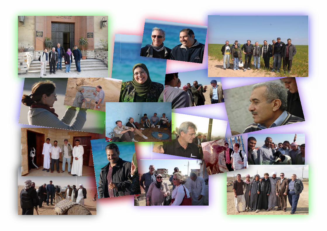

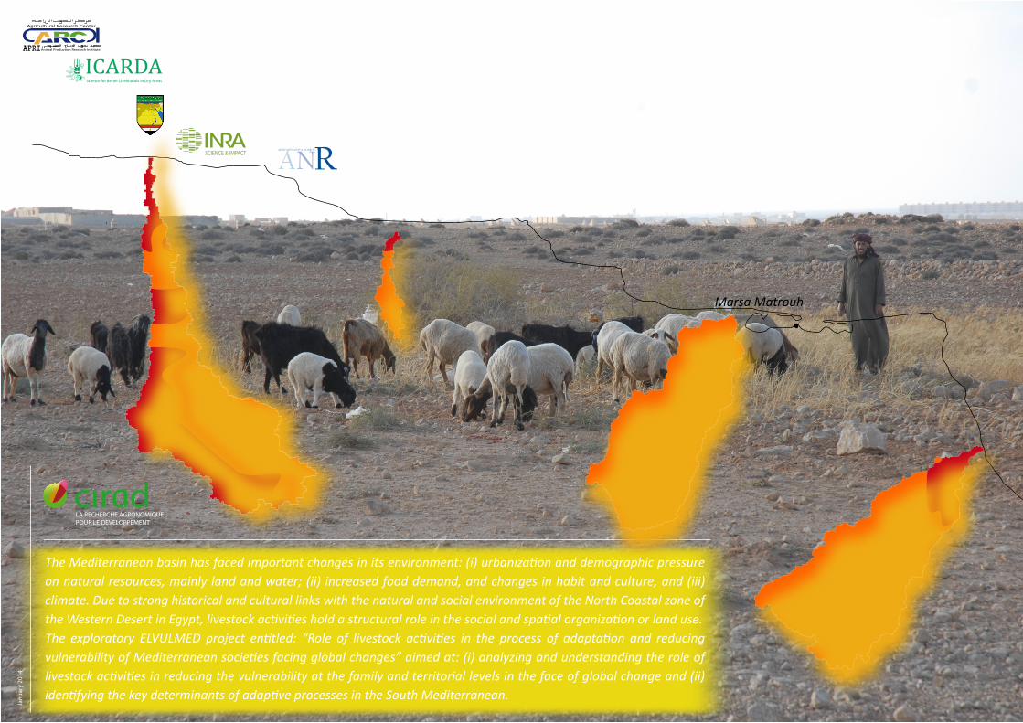
The Mediterranean basin has faced important changes in its environment: (i) urbanization and demographic pressure on natural resources, mainly land and water; (ii) increased food demand, and changes in habit and culture, and (iii) climate. Due to strong historical and cultural links with the natural and social environment of the North Coastal zone of the Western Desert in Egypt, livestock activities hold a structural role in the social and spatial organization or land use.The exploratory ELVULMED project entitled: “Role of livestock activities in the process of adaptation and reducing vulnerability of Mediterranean societies facing global changes” aimed at: (i) analyzing and understanding the role of livestock activities in reducing the vulnerability at the family and territorial levels in the face of global change and (ii) identifying the key determinants of adaptive processes in the South Mediterranean.
Jan
uar
y 20
14
LA RECHERCHE AGRONOMIQUEPOUR LE DEVELOPPEMENT
A RAGENCE NATIONALE DE LA RECHERCHE
NSCIENCE & IMPACT
ICARDAScience for Better Livelihoods in Dry Areas
APRI
Agricultural Research Center
Animal Production Research Institute
Marsa Matrouh


