Embed Size (px)
Citation preview

Journal of Hydrology 391 (2010) 223–234
Contents lists available at ScienceDirect
Journal of Hydrology
journal homepage: www.elsevier .com/ locate / jhydrol
Identification of different groundwater flowpaths within volcanic aquifersusing natural tracers for the evaluation of the influence of lava flowsmorphology (Argnat basin, Chaîne des Puys, France)
Guillaume Bertrand a,b,c,*, Hélène Celle-Jeanton a,b,c, Frédéric Huneau d, Sébastien Loock a,b,c,Christophe Renac b,c,e
a Clermont Université, Université Blaise Pascal, Laboratoire Magmas et Volcans, BP 10448, 5, rue Kessler, 63000 Clermont-Ferrand, Franceb CNRS, UMR 6524, LMV, 63038 Clermont-Ferrand, Francec IRD, R 163, LMV, 63038 Clermont-Ferrand, Franced Université de Bordeaux, GHYMAC Géosciences Hydrosciences, B18, avenue des Facultés, 33405 Talence, Francee Université Jean Monnet, Laboratoire Magmas et Volcans, 23, rue du Dr. P. Michelon, 42023 St. Etienne, France
a r t i c l e i n f o
Article history:Received 9 November 2009Received in revised form 4 June 2010Accepted 19 July 2010
This manuscript was handled by L. Charlet,Editor-in-Chief, with the assistance ofJ. Horita, Associate Editor
Keywords:Basalt aquiferUnsaturated zoneA’a flowsPahoehoe flowsHydrochemistryStable isotopes
0022-1694/$ - see front matter � 2010 Elsevier B.V. Adoi:10.1016/j.jhydrol.2010.07.021
* Corresponding author at: Clermont Université, Uratoire Magmas et Volcans, BP 10448, 5, rue KesslFrance. Tel.: +33 32 718 26 36; fax: +33 32 718 26 03
E-mail addresses: [email protected] (Gopgc.univ-bpclermont.fr (H. Celle-Jeanton), fredericHuneau), [email protected] (S. Loock), christophe.renac@
s u m m a r y
Hydrochemical and stable isotopic (2H, 18O) data were used to characterize the groundwater flow andmajor chemical features within a complex fractured volcanic aquifer system, the Argnat basin, whichis located in the Chaîne des Puys (French Massif Central).
From 10 sampling points, the study of the transfer into the saturated zone from upstream to down-stream, given the geological context and topography, allows to estimate the role of supply from highand low altitudes to the recharge processes. This work shows the existence of different types of supplybetween pahoehoe and a’a flows. Therefore, the morphology of volcanic flows impacts the chemicaland isotopic signatures of groundwater, enhancing or reducing the influence of the unsaturated zoneon the pathways of infiltrated water. Pahoehoe flows imply horizontal water flows of low discharge atthe top of the lava whereas a’a flows seems to be much more heterogeneous and locally able to promotethe existence of perched water bodies and further vertical circulations. Taking into account these twotypes of behaviour, a conceptual scheme of the functioning of this heterogeneous environment isproposed, which will help towards a sustainable management of volcanic aquifers in relation with theEuropean Union Groundwater Directive (2006/118/CE) (2006).
� 2010 Elsevier B.V. All rights reserved.
1. Introduction
The hydrogeology of volcanic aquifers is a vital topic for waterresources management in many locations around the world(Stieltjes, 1988; Cruz and Silva, 2001; Cruz and Franca, 2006;Custodio, 2007; Demlie et al., 2008; D’Ozouville et al., 2008) andespecially in developing countries such as Mexico (Carrillo-Riveraet al., 2007), Ethiopia (Demlie et al., 2008), and India (Kulkarniet al., 2000). Volcanic terrains have been revealed to be non negli-gible valuable sources of fresh water of good quality (Custodio,2007; Josnin et al., 2007). Therefore, the management of volcanicaquifers is and will be an important stake in the future and implies
ll rights reserved.
niversité Blaise Pascal, Labo-er, 63000 Clermont-Ferrand,.. Bertrand), h.celle-jeanton@
[email protected] (F.univ-st-etienne.fr (C. Renac).
first of all the knowledge of their hydrodynamic behaviour andsecondly the consideration of their vulnerability facing the anthro-pogenic pressure.
The hydrological particularities of the Chaîne des Puys regionwere recognized as early as the late 1800s. These volcanic forma-tions have been regarded as valuable sources of fresh water sincethe first half of the 20th century (Michel, 1957; Livet et al.,2006). Around a dozen of aquifers associated with lava flows areused for the domestic water supply or for the bottled mineralwater industry (Josnin et al., 2007). Several studies (Aubignat,1973; Belkessa, 1977; Barbaud, 1983; Fournier, 1983; Bouchet,1987; Belin et al., 1988; Gaubi, 1990; Joux, 2002; Bertrand et al.,2007a,b; Loock et al., 2008) were undertaken, using geological,hydrochemical and geophysical tools, in order to understand thefunctioning of the volcanic aquifers of the Chaîne des Puys. Gaubi(1990) pointed out peculiarly the heterogeneity of the chemicalcontents in wells drilled in the Chaîne des Puys. Heterogeneitycharacterises also volcanic flow structures (a’a or pahoehoe) inwhich packed clinkers or massive rocks constrain the infiltration

224 G. Bertrand et al. / Journal of Hydrology 391 (2010) 223–234
of water i.e. the supply of both unsaturated and saturated zones.Natural tracers allow to identify these flowpaths and to estimatehow lava flows structures, in a given environmental and hydrolog-ical context, can influence the quantity and the quality of thegroundwater. Such an approach will provide precious informationthat can help in the definition of safeguard zones around volcanicsprings, wells or galleries. This aims to meet regulation standardscoming from the implementation of the European Union WaterFramework Directive (2000/60/CE) (2000) and of its groundwater‘‘daughter directive” (2006/118/CE) (2006).
In this purpose, a combination of hydrodynamical data, majorions and stable isotopes (dD, d18O) were used: (1) to identify the re-charge areas, (2) to investigate the environmental and geologicalfactors which influence the chemical composition of groundwater,and (3) to propose a conceptual model of the functioning of theArgnat basin a’a and pahohoe flows.
2. Regional geology and hydrogeological setting
The Argnat basin is located in the Chaîne des Puys which isformed by a North–South alignment of Upper Pleistocene andHolocene volcanoes running in the northern part of the FrenchMassif Central.
From a geological point of view (Fig. 1), the studied area is com-posed of volcanic materials that overlie the fractured granitic andgneissic basement called ‘‘Plateau des Dômes” and the sedimentarybasin of the ‘‘Limagne” mainly composed of marls. Regional volca-nism is mainly characterized by monogenic strombolian volcanoesdue to the activation of hercynian fractures of the plutonic horst ofthe ‘‘Plateau des Dômes” (Camus, 1975), and basaltic and trachyba-saltic flows that settled in paleothalwegs at the end of the volcanicactivity (Boivin et al., 2004; Livet et al., 2006). Basaltic and trac-hybasaltic flows present both a’a and pahoehoe structures(Macdonald, 1953) in the Chaîne des Puys. A’a lava flows, whichare the most common, are constituted by vesicular scoria located
Fig. 1. Geological settings of the Argnat basin and localisation of the studied outlets. VFéligonde, M: Malauzat, GR: Grande source de Reilhat, G: Grosliers.
at the top and at the bottom surrounding a central massive partvertically fissured during the cooling of the lava flow (thermal con-traction). Pahoehoe lava flows are essentially massive and fre-quently present prisms (Kiernan et al., 2003).
The Argnat Basin comprises five lava flows aged between38,000 and 75,000 years, that corresponds to the strombolian vol-canic activity in this area (Boivin et al., 2004). They superimposedin a deep and narrow thalweg on the plutonic basement. At thelowest end of the thalweg, after the Limagne fault, two lava flows(Blanzat on the northern part and Grosliers on the southern part)reached the sedimentary terrains of the Limage where the planetopography permitted these lavas to spread a bit. In this area, vol-canic flows are now thrown into relief. Drillings performed nearFéligonde (Fig. 1) by Belin et al. (1988), geological mapping byBoivin et al. (2004) and field observartions done by Loock et al.(2008) and Celle-Jeanton et al. (2008) permitted to precise theirmorphologies types, dimensions and chronological history fromthe oldest to the youngest. These lava flows are the Groslierspahoehoe lava flow (40–60 m thick), the Blanzat a’a flow (10–20 m thick), the Féligonde a’a flow (5–15 m thick). Additionally,field observations showed that the Mas d’Argnat a’a flow is 30 mthick above Argnat gallery and that the Egaule a’a flow is 10 mthick above the Egaule outlet. From a chemical point of view, theArgnat volcanic rocks are of alkali basalt and potassic trachybasalt(Camus, 1975; Boivin et al., 2004) and composed mainly of olivine,potassic and plagioclase feldspaths (Table 1).
The understanding of the morphology and location of lava flowshas an important influence on water circulations within volcanicaquifers. Basaltic lava has traditionally been classified as eitherpahoehoe or a’a (Macdonald, 1953) based on surface morphology.A’a lava flows (such as Féligonde or Blanzat flows) have a roughsurface composed by clinkers whereas pahoehoe lava flows (suchas Grosliers flow) are characterized by a smooth surface withoutclinkers. According to Hon et al. (1994) and Self et al. (1998), thesemorphological differences are related to the setting features of
: Vergnes, B: Blanzat, A: Argnat, E: Egaule, R: Reilhat catchment, Vd: Vernède, F:

Table 1Chemical composition (main oxides and virtual mineral phases according to the IUGSnomenclature in % of weight) of two lava flows located in the Argnat basin (fromCamus, 1975 and Boivin, unpublished data).
Chemical composition (%) Grosliers lava flow(basalt)
Féligonde lava flow(trachybasalt)
SiO2 45.35 50.52MgO 8.30 3.81CaO 10.35 7.86Na2O 2.80 3.96K2O 1.05 2.70P2O5 0.40 0.83
Normative mineral phases(% weight)
Grosliers lava flow(basalt)
Féligonde lava flow(trachybasalt)
Orthose 9.1 10.64Albite 20.38 17.53Anorthite 22.7 21.86Forstérite 8.63 6.68Diopside 19.66 21.69
G. Bertrand et al. / Journal of Hydrology 391 (2010) 223–234 225
each lava type: a’a flows move heavily as a single mass with clink-ers forming on their surface; pahoehoe flows consist of multiple,overlapping flow lobes, sheets and toes. These placing differencescan also be found in the internal structure of lava flows. As a con-sequence, a’a flows can be described as a massive fractured mate-rial mixed with more or less large scoria masses. Such a structure,from a hydrogeological point of view, is considered to present greatheterogeneities regarding the porosity and the permeability valuesbut it can constitute an efficient sink for rains. Pahoehoe flowspresent a massive, poorly fractured feature (Fig. 2), and thus arenot supposed to be valuable aquifer structures. However, recentstudies, for example in the Deccan Volcanic Province (Walkeret al., 1999; Bondre et al., 2004; Druraiswami et al., 2008 and ref-erences therein), Columbia River Basalt province (MacDonald,1972; Keszthelyi et al., 2001), Iceland or Kerguelen Plateau byKeszthelyi and Thordarson (2000) have precised the detailed mor-phology of pahoehoe flows and their internal arrangements. Thesestructures, called ‘‘rubbly pahoehoe flows”, present a basal zonewith smooth, glassy and often displaying joints, a central zone of-ten jointed, and a crustal part characterized by a variably pre-served, vesicular upper crust and a discontinuous layer of flow-top breccias. These features can locally be observed on the Gros-liers lava flow (Fig. 3) which allows groundwater circulations.
Environmental settings highlight the fact that stromboliancones and lava flows located up to Féligonde are mainly occupiedby coniferous and deciduous forest. Near and downward Féligonde,these lava flows are mainly featured by human occupation such asvillages (Sayat, Malauzat, Blanzat), vineyards (on the Grosliers andthe Blanzat lava flows) and corn fields (on the Blanzat lava flow).Plutonic terrains are mainly featured by meadows used for rearing.Few roads connect cities. On the Chaîne des Puys area, salt is cur-rently spread on roadway during winter in order to favour thesnow melt (Livet, 2001; Joux, 2002).
Fig. 2. Pahoehoe and a’a flows morphologies (from Loock, 2008).
From a hydrological point of view, heterogeneities in the re-charge processes should be pointed out. The Argnat Basin is a smallarea of 26.1 km2 characterized by a high variability in the altitude,from 1159 m (Puy de la Coquille) to 380 m (Blanzat) with a meanaltitude of 811 m. These physical characteristics lead to an impor-tant heterogeneity in the meteorological parameters (precipitation,temperature) that directly affects the recharge. Three pathwayshave been described for infiltrated waters (Barbaud, 1983; Joux,2002; Livet et al., 2006). Precipitation can infiltrate into strombo-lian cones, composed of clinkers, cinders and lapilli, which presentat their base a thin saturated zone (compared with the height ofsuch edifices). This latter recharges the aquifer in the lava flow lo-cated downstream, even though such flows are often many kilome-ters long (Martin-Del Pozzo et al., 2002; Hildenbrand et al., 2005).The recharge can also happen directly on lava flow through scoria,prisms or inflation fissures (Barbaud, 1983; Kiernan et al., 2003;Celle-Jeanton et al., 2008). At last, surface streams circulating overthe plutonic impermeable substratum (Hottin et al., 1989; Joux,2002) may infiltrate into the volcanic aquifer at the contact be-tween basement and the volcanic flows. Thus, water flows down-stream in the basal scoria zone or in the spoiled zone near thevolcanic flow/basement interface.
Meteorological datasets (Temperature, Precipitation) of Sayat,(45�5001800N, 3�0204200E, z = 550 m, Météo-France reference:63417001) Volvic (45�5203000N, 3�0300000E, z = 472 m, Météo-Francereference: 63470001) and Fontaine du Berger (45�4705400N,2�5903000E, z = 971 m, Météo-France reference: 63263005) locatedin the Chaîne des Puys, allow estimating the infiltration amount(hannual precipitation–hannual actual evapotranspiration; see Eq. (1)) for each100 m altitude range). Evapotranspiration was evaluated by usingThornwaite’s method (1954). This led to a calculated annual basindischarge of about 300 l s�1over the period 1994–2007 (Bertrand,2009).
3. Methodology
3.1. Sampling
Sampling was carried out during the December 2005/June 2007period. Ten outlets (Fig. 1) were sampled at least on a monthly ba-sis, the first week of each month: seven springs emerging at thefront of the volcanic flows and three horizontal galleries (Argnat,Grosliers and Malauzat) that were drilled during the first half ofthe 20th century for drinking water supply. Nowadays, only theArgnat and Grosliers galleries are still used for water supply pur-poses. Rainwater was also sampled on a weekly basis at Sayatmeteorological station (Fig. 1) in order to determine the input sig-nal. The can in which rainwater was stored was buried and recov-ered by an isolated case to avoid evaporation processes. Each week,the rainwater was sampled, the can was rinsed with demineralisedwater, dried and then buried again.
Moreover, a weekly-scale sampling of the saturated and unsat-urated zone of the Grosliers pahoehoe flow was organised. Such anapproach is constrained by the accessibility to the sampling site.Concerning the Grosliers flow, the unsaturated zone was sampledthrough the Grosliers gallery (Fig. 1), where infiltration occursand it can be observed through little fractures.
On the Blanzat lava flow, as there is no direct access to theunsaturated zone, we used water wells analysis carried out byGaubi (1990) during the reconnaissance drillings (Belin et al.,1988) of the A89 highway. These data allowed to obtain indirectinformation about the unsaturated compartment of an a’a flow.Considering the low organic and inorganic carbon contents intoArgnat basin water (Barbaud, 1983; Joux, 2002), samples were di-rectly stored in double caps polyethylene bottles for chemical

Fig. 3. Field observations of Grosliers pahoehoe and Blanzat a’a flows. Under the soil a thin layer of scoria is sometimes observable in the grosliers lava. Blanzat flow looksvery heterogeneous (scoria masses, lava tunnel) over a 3 m thick outcrop.
226 G. Bertrand et al. / Journal of Hydrology 391 (2010) 223–234
analyses and into glass bottles with air tight seals to prevent atmo-spheric exchange before isotopic characterisation.
3.2. Analyses
Electrical conductivity, temperature and pH measurements aswell as bicarbonates concentration determination by acidic titra-tion (with a solution of a 0.02 M of H2SO4) were performed directlyafter the sampling, in the field.
Concentrations of ionic species for the December 2005/June 2007period were determined at the ‘‘Observatoire de Physique du Globeof Clermont-Ferrand” (France) by ion chromatography, using a DIO-NEX DX320 chromatograph with detection limits of 0.05 leq l�1 forCl�, 0.1 leq l�1 for NO�3 , 0.6 leq l�1 for SO2�
4 , 0.06 leq l�1 for Na+,0.04 leq l�1 for NHþ4 , 0.3 leq l�1 for K+, 0.1 leq l�1 for Mg2+ andCa2+. The uncertainty of the DX320 chromatograph is 5%. In orderto assess the validity of the sampling device, blanks were determinedfor the analyzed elements. The highest value were 1.0 leq l�1 forsodium and 0.7 leq l�1 for calcium, the other elements were notdetected. The charge balance between anions and cations(P
[Anions] �P
[Cations])/(P
[Anions] +P
[Cations]); concentra-tions in leq l�1) was assessed and analyses were accepted for devi-ations of less than 5%.
The isotopic composition of rainwater and groundwater for theApril 2006/April 2007 period were measured by mass spectrome-try at the ‘‘Observatoire de Physique du Globe of Clermont-Fer-rand” (France). 42 precipitation events (1 < h < 68 mm) wereanalyzed, corresponding to a total height of 954 mm. During thisperiod, 963 mm of precipitation dropped at the Sayat meteorolog-ical station, therefore the collected dataset is considered as repre-sentative of a complete hydrological year. Preparation of sampleswas conducted according to the techniques detailed by Epsteinand Mayeda (1953) for d18O and by Bigeleisen et al. (1952) ford2H. The results are expressed in ‰ versus VSMOW (Vienna Stan-dard Mean Ocean Water). The uncertainties are respectively of±0.2‰ for d18O and ±2‰ for d2H.
Fig. 4. Argnat meteoric water line (AMWL) and annual mean isotopic signature forthe 10 saturated zone sampling locations listed in Table 2. World Meteoric WaterLine (WMWL, Craig, 1961) and Massif Central Meteoric Water Line (MCMWL,Fouillac et al., 1991) are also reported.
4. Results
4.1. Origin of groundwater
Stable isotopic measurements permit the quantitative determi-nation of the origin and flow paths of groundwater on a regionalscale (Fontes, 1980; Rose et al., 1996; Mazor, 2004), and more par-ticularly when examining fracture flow hydrology, since these sys-
tems are difficult to treat using conventional models. On Fig. 4 areplotted the mean isotopic composition of each sampled points(d2H, d18O), the Argnat Meteoric Water Line (AMWL: d2H = 7.9d18O + 7.3) defined using isotopic data (December 2005–June2005) analyzed at Sayat meteorological station, the Massif CentralMeteoric Water Line (MCMWL: d2H = 8 d18O + 13.1; Fouillac et al.,1991) and the World Meteoric Water Line (d2H = 8 d18O + 10; Craig,1961). In order to present results in the clearest way as possible,and because temporal isotopic variations for each sampling pointare quite smooth (Table 2), annual averages are used in the follow-ing part of the paper.
All the groundwater samples fall between the AMWL and theMCMWL (Fig. 4). This feature, firstly, confirms the meteoric originof groundwater. Secondly, positions of groundwater samples areconsistent with the inter-annual and spatial variability of isotopicsignatures trend in precipitations, especially in mountainous areas.Indeed, above these terrains, topographic reliefs strongly influenceprecipitation by lifting atmospheric moisture and by facilitatingprecipitation at the windward slope (mainly west one in the Chaî-ne des Puys). The converse is true on the leeward side, generallyleading to less precipitation amounts. From an isotopic point ofview, on the leeward side, a small amount of precipitation can beisotopically altered by subcloud evaporation and moisture ex-change, resulting in isotopically heavier precipitation in compari-son with that drops on the whole mountain (Liebminger et al.,

Table 2Altitude, d18O, d2H (mean and standard deviation), discharge and recharge altitude of studied springs (SZ and UZ correspond to is saturated zone and unsaturated zone,respectively). Recharge altitude was calculated using the local altitudinal gradient of �0.28 ‰ calculated by Barbaud (1983).
Z(m)
X Y d18O (‰) d2H (‰) Recharge areaaltitude (m)
Mean annual discharge (l s�1) (number ofmeasurements)
Egaule (n = 13) 800 45�5001000N 0300002000E �8.8 ± 0.2 �59 ± 5 990 ± 80 n.d.Argnat (n = 13) 700 45�5003900N 0300305700E �9.1 ± 0.2 �59 ± 2 1090 ± 60 117 ± 9 (n = 17)Féligonde (n = 13) 510 45�5001200N 0300300600E �8.9 ± 0.2 �59 ± 2 1020 ± 80 0.19 ± 0.16 (n = 17)Reilhat G.S. (n = 13) 500 45�5000700N 0300304200E �8.8 ± 0.2 �59 ± 2 1000 ± 60 10a
Malauzat (n = 13) 497 45�5003500N 0300300500E �8.2 ± 0.1 �56 ± 3 780 ± 50 20a
Reilhat catch. (n = 12) 490 45�5000500N 0300305200E �8.7 ± 0.2 �59 ± 2 950 ± 70 20a
Vernède (n = 13) 480 45�4905000N 0300205400E �8.9 ± 0.1 �60 ± 1 1040 ± 50 0.35 ± 0.01 (n = 18)Grosliers SZ (n = 79) 420 45�4902000N 0300305700E �8.8 ± 0.2 �58 ± 4 980 ± 100 9.0 ± 0.9 (n = 79)Vergnes (n = 13) 410 45�4903200N 0300400600E �8.9 ± 0.3 �59 ± 2 1020 ± 100 30a
Blanzat (n = 13) 385 45�4903500N 0300402900E �8.3 ± 0.3 �56 ± 2 820 ± 100 0.78 ± 0.18 (n = 12)Grosliers UZ (n = 79 ) 420 45�4902000N 0300305700E �8.1 ± 0.3 n.d. 740 ± 100 1.0 E�05 ± 9.4E�07 (n = 79)
Precipitation Sayat (n = 42) 550 45�5001800N 3�0204200E �6.9 ± 2.6 �47 ± 20Effective infiltration on the basin
mean altitude811 �8.3 ± 1.0 n.d.
a Estimation on the field.
G. Bertrand et al. / Journal of Hydrology 391 (2010) 223–234 227
2006; Guan et al., 2009). This is consistent with the observedAMWL falling on the right to the regional meteoric water line(MCMWL).
Assuming the absence of physical evaporation once rain hasreached the ground (Barbaud, 1983; Dafny et al., 2006), and usingboth the mean isotopic signal of rainwater sampled at Sayat mete-orological station (�6.9 ‰ d18O; �47.1 d2H at z = 550 m) and thelocal altitudinal gradient (�0.28 d18O/100 m) defined by Barbaud(1983) in the eastern part of the Chaîne des Puys at the hydrolog-ical year scale, the isotopic signature of the effective infiltration atz = 811 m (mean altitude of Argnat basin) was estimated. The firststep was to calculate effective infiltration on a monthly time scale.The second step was to weight the monthly mean isotopic compo-sition of rainwater by the effective infiltration amount. Thus, thevalue of the mean annual isotopic signature of infiltration was esti-mated to be close to �8.3 ‰ d18O. Then, using both the latter valueand the altitudinal gradient of �0.28 d18O/100 m, the recharge alti-tudes of each outlet can be calculated (Table 2). The recharge areaof the Argnat basin is defined between 780 and 1090 m, which cor-responds to the highest areas of the basin, mainly occupied bystrombolian scoria cones. Based on the estimation of the effectiverainfall amount for each altitude range of the basin (Bertrand,2009), it is possible to estimate the contribution of the high-alti-tude infiltration. The highest parts ([900–1000 m], [1000–1100 m] and [1100–1159 m]) correspond to the strombolian conesarea of the basin (9.8 km2 i.e. 38.3% of the total basin surface). Thecalculation of annual infiltration for this surface led to an annualdischarge estimation of 152 l s�1, i.e. 50% of the total discharge ba-sin. Hence, this is consistent with the fact that the infiltrationwhich occurs through strombolian edifices appears to be the majorcomponent of the recharge in the Argnat volcanic hydrosystem.
4.2. Chemical variations along the flowpaths
After entering the saturated zone, water flows downstream intothe basal scoria zone or the spoiled zone near the volcanic flow/basement contact. The evolution of the chemical composition ofwater along this flowpath has been measured in order to precisethe circulation conditions of groundwater and the hydrodynamiccontext of the lava flows within the Argnat basin. Statistics pre-sented on Table 3 shows a limited temporal variability of chemicalparameters during our observation period, and major chemicaltrends along groundwater flowpaths can be viewed through theannual mean values. Additionally, knowing the mean annualchemical rain composition and using an enrichment factor of
2.64, equal to the ratio between the calculated effective rain andtotal rain amount (Eq. (1), Appelo and Postma, 1994), backgroundconcentrations of the effective infiltration were calculated (Eq. (2))by Bertrand (2009) for each chemical parameter (Table 3):
� ¼ hprecip
hprecip � hevapotranspð1Þ
½X�infiltration ¼ �½X�precip ð2Þ
where � is the enrichment factor, hprecip the annual heigh of precip-itation, hevapotranp the actual annual evapotranspiration, [X]infiltration
and [X]precip, respectively the concentration of the element X in theinfiltration and in the total precipitation.
Infiltration water shows a low mean concentration for all themajor ions (between 0.8 mg l�1 for Mg2+ and 8.2 mg l�1 forHCO�3 ) and presents a mean pH of 5.5.
Groundwater presents an Electrical Conductivity ranging from134 to 420 lS/cm, with a mean value of 273 lS cm�1. For mostwaters the pH is close to the neutrality with values ranging from6.3 to 8.3 (mean value of 7.1). Concentrations of Ca2+, Mg2+, Na+,K+ and HCO�3 observed along the flow line are consistent withthe development of alteration processes which may affect volcanicaquifers in lightly acidic water: The increase of the water residencetime causes an increase in the content of these elements (Cruz andFranca, 2006). In addition, alteration can also be enhanced whenwater slows down in the system (Freeze and Cherry, 1979). Stummand Morgan (1981) described the alteration occurring into crystal-line aquifers by the following equation:
Plagioclaseþ FeldspathKþ Olivineþ Pyrox�eneþ CO2 þH2O
! ½Al—Si�MineralsþH4SiO4 þHCO�3þ Ca2þ=Mg2þ=Naþ=Kþ ð3Þ
During this process, cations and balancing bicarbonate ions arereleased into the water and new alumino-silicates such as kaoliniteand smectite are formed (Garrels, 1967; Bertrand, 2009).
Chloride, sulfate and nitrate, considering the types of the aqui-fer rocks and their main chemical composition (Camus, 1975; Ta-ble 1), can not be provided by such an alteration process. Theyare therefore considered being elements provided by either rain-water or anthropogenic inputs. They can be provided by rainwaterdissolving anthropogenic dusts and gas (including Cl�, SO2�
4 , NO�3 )or sea aerosols (including Cl� and SO2�
4 ) during the cloud life(Bertrand et al., 2007b, 2008; Celle-Jeanton et al., 2009). Consider-ing the environmental conditions, Na+ and K+ can be also associ-ated with Cl� because they are constituents of the sea salt

Table 3Precipitations, effective infiltration (calculated values, see Eqs. (1) and (2) and groundwater chemical data statistics: main variables (pH, temperature, electrical conductivity) and major ions composition.
T �C E.C. (lS cm�1) pH SiO2 (mg l�1) HCO�3 (mg l�1) Cl� (mg l�1) NO�3 (mg l�1) SO2�4 (mg l�1) Na+ (mg l�1) K+ (mg l�1) Mg2+ (mg l�1) Ca2+ (mg l�1)
Effective infiltration Mean 8.1 2.7 4.1 2.7 1.4 1.4 0.8 6.0
Sayat meteorological station (n = 70) Mean n.d. 26 5.9 n.d. 3.6 2.1 3.2 1.5 1.1 1.1 0.3 2.6Std dev. n.d. 22 0.6 n.d. 2.5 2.8 5.0 1.4 1.6 1.7 0.4 2.4Min n.d. 5 4.1 n.d. 0.0 0.0 0.0 0.0 0.0 0.0 0.0 0.0Median n.d. 19 5.8 n.d. 3.1 1.2 1.8 1.2 0.6 0.6 0.3 2.0Max n.d. 114 7.3 n.d. 11.0 19.2 36.4 7.6 11.2 13.0 2.6 11.7
Grosliers UZ (n = 79) Mean n.d. 205 7.4 46 112.2 4.1 3.7 4.9 15.3 6.8 9.1 13.6Std dev. n.d. 24 0.2 4 20.8 0.2 0.2 0.2 1.3 0.6 1.8 2.8Min n.d. 175 7.1 34 85.4 3.8 3.3 4.4 13.3 5.8 6.8 9.8Median n.d. 196 7.4 46 102.5 4.1 3.7 4.9 14.9 6.7 8.4 12.9Max n.d. 256 8.0 57 158.6 4.7 4.2 5.3 18.7 8.1 13.6 20.4
Grosliers SZ (n = 79) Mean 10.3 258 7.2 36 83.5 21.5 12.5 12.0 14.6 8.0 11.2 16.3Std dev. 0.0 7 0.4 3 4.2 1.4 0.6 0.5 0.4 0.4 0.6 1.2Min 10.3 244 6.6 28 75.6 19.0 11.2 11.1 13.7 7.3 9.6 13.3Median 10.3 258 7.0 36 83.0 21.5 12.4 12.0 14.6 7.9 11.1 16.3Max 10.3 273 7.9 45 93.9 25.1 13.9 13.5 15.7 9.4 12.3 18.5
Egaule (n = 19) Mean 8.7 135 6.9 22 50.2 8.5 4.5 8.2 6.0 2.2 4.9 12.9Std dev. 0.3 11 0.3 3 6.8 1.3 1.0 0.9 0.4 0.3 0.6 2.0Min 7.9 117 6.5 16 41.5 6.3 3.2 6.7 5.3 1.7 4.2 10.3Median 8.8 133 6.9 23 48.8 8.3 4.3 8.4 6.0 2.2 4.8 12.4Max 9.0 159 7.6 29 61.0 11.4 7.1 9.7 7.1 2.7 6.2 16.9
Argnat (n = 19) Mean 8.6 210 6.7 36 80.6 14.1 6.8 8.2 13.0 6.9 9.2 13.2Std dev. 0.1 2 0.2 2 3.7 0.4 0.3 0.4 0.4 0.3 0.4 1.3Min 8.3 205 6.5 31 73.2 13.4 5.7 7.6 12.5 6.5 8.5 11.4Median 8.6 210 6.7 37 80.5 14.2 6.8 8.2 12.9 7.0 9.2 13.2Max 8.6 213 7.3 39 90.3 14.8 7.2 9.1 14.2 7.5 10.1 16.3
Féligonde (n = 19) Mean 9.9 238 7.3 34 78.6 20.7 11.0 10.0 14.9 7.3 9.8 15.0Std dev. 0.5 11 0.3 4 6.7 2.9 1.6 0.3 0.9 0.3 0.8 1.8Min 8.9 221 6.9 26 68.3 17.2 8.8 9.2 13.7 6.7 8.6 12.5
228G
.Bertrandet
al./Journalof
Hydrology
391(2010)
223–234

Median 9.9 238 7.2 34 79.3 19.7 10.5 10.1 14.8 7.3 9.8 14.7Max 11.5 263 7.8 41 92.7 28.5 13.6 10.5 16.9 8.0 10.8 17.7
Malauzat (n = 19) Mean 10.2 421 7.2 45 101.5 49.1 31.7 16.8 22.0 13.0 17.2 29.1Std dev. 0.3 14 0.4 5 9.4 3.9 3.4 0.8 1.7 1.9 1.4 2.9Min 9.7 401 6.7 35 80.5 42.8 25.7 15.1 20.2 10.7 15.1 25.4Median 10.1 420 7.1 45 102.5 48.9 30.6 16.7 21.6 13.2 16.8 28.7Max 10.8 459 8.0 54 109.8 56.5 39.4 18.1 25.1 17.2 19.4 33.4
Reilhat catch. (n = 18) Mean 10.7 309 7.3 36 89.8 21.9 31.1 13.3 15.8 8.3 13.7 20.7Std dev. 0.6 18 0.4 2 10.2 1.8 5.7 0.9 0.8 0.4 1.5 3.1Min 9.3 272 6.9 31 73.2 19.8 19.1 11.6 14.7 7.4 11.4 16.2Median 10.8 314 7.1 36 91.5 21.2 30.5 13.4 15.7 8.3 13.9 21.0Max 11.6 333 8.3 39 108.6 25.9 42.4 15.2 17.2 9.0 16.4 26.6
Vernède (n = 19) Mean 9.6 232 6.9 36 75.8 20.9 9.5 9.6 15.0 7.1 9.6 14.5Std dev. 0.2 8 0.2 4 4.7 2.7 0.9 0.3 0.7 0.5 0.6 1.5Min 9.1 221 6.3 30 68.3 17.3 8.3 9.2 13.7 6.4 8.7 12.1Median 9.5 229 6.9 35 73.2 20.3 9.2 9.5 15.0 7.0 9.5 14.5Max 9.9 255 7.3 48 86.6 28.3 11.1 10.3 16.7 8.2 10.9 17.2
Vergnes (n = 19) Mean 10.0 244 7.3 35 85.5 19.8 10.3 10.3 14.1 7.5 10.8 15.6Std dev. 0.2 5 0.3 3 5.4 1.0 0.4 0.4 0.4 0.4 0.7 1.7Min 9.6 239 6.8 29 78.1 18.4 9.5 9.3 12.9 7.0 9.7 13.0Median 10.0 244 7.2 35 85.4 19.7 10.3 10.3 14.2 7.4 10.5 15.1Max 10.3 253 8.1 42 97.6 21.9 10.9 11.2 14.7 8.2 12.3 18.6
Blanzat (n = 19) Mean 11.7 404 7.1 37 150.8 25.8 28.3 19.7 20.1 8.7 18.5 32.6Std dev. 0.6 20 0.2 3 7.6 1.8 3.1 1.2 1.5 0.5 1.4 2.6Min 10.0 365 6.7 28 134.2 22.8 23.1 17.7 17.9 8.0 16.0 28.0Median 11.8 410 7.0 36 150.1 26.3 29.1 19.8 20.0 8.6 18.3 32.3Max 12.5 424 7.4 42 165.9 28.6 33.9 21.9 24.0 9.5 20.8 37.1
Reilhat G.S. (n = 15) Mean 10.1 264 6.9 33 82.5 21.7 18.3 11.2 15.0 8.0 11.1 16.9Std dev. 0.0 6 0.2 5 7.7 2.0 1.2 0.5 1.6 1.5 1.1 2.0Min 10.1 251 6.7 21 70.8 19.3 16.1 10.5 10.0 7.1 7.8 11.2Median 10.1 263 6.9 34 83.0 21.2 18.4 11.0 15.2 7.7 11.2 17.4Max 10.2 276 7.7 40 95.2 25.9 20.4 12.2 16.7 13.2 12.5 19.2
G.Bertrand
etal./Journal
ofH
ydrology391
(2010)223–
234229
230 G. Bertrand et al. / Journal of Hydrology 391 (2010) 223–234
aerosols (KCl, NaCl) or of the salt widely spread on roads into theChaîne des Puys during winter (Joux, 2002). In this context, con-centrations of both these elements must be considered with care.Downgradient evolution of these elements implies further suppliesalong the flowpath, where anthropogenic activities are more devel-oped. Sendler (1981) and Barbier (2005) indicate that higher ni-trate content into basalt aquifer than into effective rainwater(calculated levels for the Argnat basin are reported in Table 3)can originate from natural biogenic activity in the uppermost soil.Higher concentrations of nitrate at specific locations are morelikely to indicate massive biogenic contamination from cattle pas-ture fields or sewage from human origin. Moreover, crop fertiliza-tion and manure spraying increase the concentration of NO�3 aswell as this one of SO2�
4 (Appelo and Postma, 1994).In the context of the Argnat basin, low-altitude rainfall can also
reach the saturated zone through two processes. The first one isinfiltration of run-off circulating over plutonic basement in thearea upper than the Limagne fault. From the fault, lava flows arethrown into relief inversion due to erosion process that occurredafter their setting, therefore there is no water streaming whichcan reach the saturated zones of lava flows. The second processis direct infiltration on the volcanic flows through fractures andclinkers.
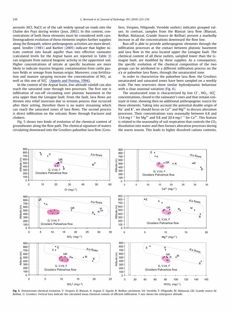
Fig. 5 shows two kinds of evolution of the chemical content ofgroundwater along the flow path. The chemical signature of waterscirculating downward into the Grosliers pahoehoe lava flow (Gros-
Fig. 5. Downstream chemical evolution. V: Vergnes, B: Blanzat, A: Argnat, E: Egaule, R:Reilhat, G: Grosliers. Vertical bars indicate the calculated mean chemical content of effi
liers, Vergnes, Féligonde, Vernède outlets) indicates grouped val-ues. In contrast, samples from the Blanzat lava flow (Blanzat,Reilhat, Malauzat, Grande Source de Reilhat) present a markedlyincrease in all the concentrations downward the flow line.
Run-off is able to provide anthropogenic elements through theinfiltration processes at the contact between plutonic basementand lava flow in the area located upper the Limagne fault. Thechemical content of all these outlets, sampled lower than the Li-magne fault, are modified by these supplies. As a consequence,the specific evolution of the chemical composition of the twogroups can be attributed to a different infiltration process on thea’a or pahoehoe lava flows, through the unsaturated zone.
In order to characterize the pahoehoe lava flow, the Grosliersunsaturated and saturated zones have been sampled on a weeklyscale. The two reservoirs show similar hydrodynamic behaviourwith a clear seasonal variation (Fig. 6).
The unsaturated zone is characterized by low Cl�, NO�3 , SO2�4
concentrations, closed to the rainwater’s ones and that remain con-stant in time, showing then no additional anthropogenic source forthese elements. Taking into account the potential double origin ofNa+ and K+, we should focus on Ca2+ and Mg2+ to discuss alterationprocesses. Their concentrations vary seasonally between 6.8 and13.6 mg l�1 for Mg2+ and 9.8 and 20.4 mg l�1 for Ca2+. This featureis related to the seasonality of soil respiration that controls the CO2
dissolution into water and then favours alteration processes duringthe warm season. This leads to higher dissolved cations contents,
Reilhat catchment, Vd: Vernède, F: Féligonde, M: Malauzat, GR: Grande source decient infiltration. Y axis shows the emergence altitude.

Fig. 5 (continued)
Fig. 6. Temporal variations of discharge, Cl�, NO�3 , SO2�4 , Mg2+, Ca2+, electrical
conductivity, 18O into the saturated (SZ) and unsaturated (UZ) zones of Grosliersgallery and 18O of Sayat rainwater. Note that a factor 106 exists between UZdischarge and SZ discharge.
G. Bertrand et al. / Journal of Hydrology 391 (2010) 223–234 231
especially during summer (Reich and Potter, 1995; Lohila et al.,2007; Bertrand, 2009). This temporal variation testifies of a super-ficial circulation closed to the soil fraction on the lava flow insteadof direct vertical supplies. This is consistent with the temporal sta-bility of d18O, with a mean of �8.1 ± 0.2 d18O‰ and the calculatedmean recharge altitude of 750 m that corresponds to an area lo-cated 3 km far from the unsaturated zone sampling device, thenimplying horizontal circulations. The saturated zone of the Gros-liers lava flow is characterized by higher and variable Cl�, NO�3 ,SO2�
4 concentrations (varying respectively into [15–25 mg l�1][8.9–16.3 mg l�1] and [8.6–13.5 mg l�1] ranges) compared to theunsaturated zone (Fig. 6). On the contrary, elements provided byalteration processes present similar or slightly lower concentrationcompared to the unsaturated zone ([Mg2+] ranges from 8.2 to17.7 mg l�1 and [Ca2+] ranges from 13.3 to 19.7 mg l�1); these con-centrations are more stable in time. This behaviour excludes a sig-nificant impact of infiltration water through the unsaturated zoneof the pahoehoe Grosliers flow. Additionally, the d18O of the unsat-urated and the saturated zones are significatively different allalong the sampling period, which testifies of mainly parallel flowpatterns.
Then, the Grosliers saturated zone appears to be only suppliedby strombolian cones and run-off over plutonic.
Concerning the a’a lava flow, we used data gathered from Gaubi(1990) and reported on Table 4. d18O of the groundwater rangesfrom �7.2 (W17) to �8.9 d18O‰ (W15); that is consistent withthe existence of local vertical supplies through the unsaturatedzone in some areas of the Blanzat a’a flow. A hypothetical contribu-tion of water coming from volcanic terrains of the Limagne can berejected because boreholes are located over the Limagne volcanic
flow. Ca2+ and Mg2+ range respectively from 18.0 mg l�1 (W16) to44.0 mg l�1 (W13) and from 19.4 mg l�1 (W16) to 30.4 mg l�1
(W17). Higher concentrations could be attributed to longerwater–rock interactions and/or stronger alterability of porous sco-ria due to the larger specific surface of this material. Anthropogenicelements tend to also show heterogeneous concentrations: [Cl�]and [NO�3 ] respectively range from 8.2 mg l�1 (W17) to 25.0 mg l�1
(W16) and from 1.2 mg l�1 (W13) to 26.7 mg l�1 (W16) whichcould be due to the influence of various land occupation featureson the a’a Blanzat flow.

Table 4Chemical and isotopic data from Gaubi (1990).
Well z d18O(‰)
pH E.C. (lS/cm)
HCO�3(mg l�1)
Cl�
(mg l�1)NO�3(mg l�1)
SO2�4
(mg l�1)
Na+
(mg l�1)K+
(mg l�1)Mg2+
(mg l�1)Ca2+
(mg l�1)
W13 507.69 �8.19 7.4 508 280.7 18.73 1.24 12.05 30.35 7.038 20.66 44.09W15 495.04 �8.89 7.45 419 195.3 22.57 6.82 14.89 29.2 5.474 21.87 22.04W16 485.05 �8.64 7.6 412 159.3 24.97 26.66 13.83 29.2 11.34 19.44 18.04W17 496.06 �7.21 7.75 460 261.8 8.165 11.78 9.927 17.24 2.737 30.38 32.06
232 G. Bertrand et al. / Journal of Hydrology 391 (2010) 223–234
5. Discussion
5.1. Role of the unsaturated zone within lava flows
Chemical and isotopic heterogeneities observed between unsat-urated and saturated zone of the Grosliers pahoehoe flow providethe illustration of the strong anisotropy in lithologic material prop-erties in a single lava flow. Because of the massive structure of thepahoehoe lava flow of Grosliers, infiltration water’s supply throughthe unsaturated zone seems to be very limited. However, smallparallel horizontal circulations can occur in the upper zone of thelava where a porous crust is developed into ‘‘rubbly pahoehoe lavaflows”. In contrast, local vertical supply into the Blanzat a’a flowimplies the presence of more extensive perched aquifers in the ver-tical axis within the unsaturated zone, which can locally enhancethe low-altitude rainfall recharge and then entail a great modifica-tion of the geochemical conditions of the saturated zone. The water
Fig. 7. Conceptual scheme of th
from perched aquifers is assumed to vertically recharge the basalaquifer through fissures. This additional supply can be providedby a succession of accumulated allochthonous colluvial depositson the very first lava flow that was transformed by the heat fluxcoming from the overriding lava flows during the volcanic buildingprocess. The result is an extensive patchwork of permeable–imper-meable layers in which water accumulates (Aubignat, 1973; Lecoq,1987; Nascimento Prada et al., 2005; D’Ozouville et al., 2008). Thisimplies inter-flow perched aquifers located at the top or the bot-tom of each lava flow and linked by some vertical fractures. Thisscheme was often involved in numerous volcanic areas such asthe Golan heights in Israel (Dafny et al., 2006), Reunion Island (Joinand Coudray, 1993; Violette et al., 1997; Join et al., 2005), MayotteIsland in the Comoros archipelago (Stieltjes, 1988), Madeira Island(Nascimento Prada et al., 2005) Galapagos Islands (D’Ozouvilleet al., 2008) and was also described by Aubignat (1973) in the Vol-vic basin located 3 km north from the Argnat basin. However,
e Argnat basin functioning.

G. Bertrand et al. / Journal of Hydrology 391 (2010) 223–234 233
regarding the geological settings of the a’a Blanzat flow, which tookplace in a single time, the most probable model would rather implyan endogen permeability contrast into the a’a lava due to its plac-ing features, involving the mixing of scoria masses with a fracturedmassive matrix, which was observed on the field (Fig. 3). Thesescoria masses can punctually contain and provide local water ifthey are hydraulically linked with the surface. Locally, the absenceof these scoria masses may allow a higher contribution of a more-distant source of water like into the W15 well. In this case, this sys-tem could be called ‘‘intra-flow perched aquifer”.
Thus, our observations provide new examples of complexhydraulic connectivity into lava materials. However, these resultsshow that overlying of different lava flows of different ages arenot obligatory to observe either parallel flows or inter-flow pat-terns: these kinds of groundwater pathways can be met into a sin-gle lava flow due to its own lithologic heterogeneity.
5.2. Conceptual model of the Argnat basin functioning
By compiling all the evidences based on hydrochemistry, iso-topes, and lava flow morphologies, a conceptual scheme of the Arg-nat basin functioning can be proposed (Fig. 7).
The Argnat system is predominantly supplied by precipitationon scoria cones that ensures a great discharge and an overall goodwater quality. Two types of supply can be identified and are able tomodify the water quality:
– Participation of plutonic slopes run-off that affects all the out-lets and provides allochthonous elements such as NO�3 , SO2�
4
and Cl� (associated with Na+ and K+).– Direct infiltration on lava flows depending of the type of lava
flow. Major differences can be observed between typically a’aand pahoehoe lava flows.
The internal structure of these rocks influences the hydrody-namic and thus the flowpaths of water into the system, which con-trols the acquisition of dissolved species (HCO�3 , Ca2+, Mg2+, K+,Na+). The Grosliers pahoehoe flow is almost impervious whereasthe Blanzat a’a flow locally permits important infiltration wateramount, which modifies the water chemistry due to anthropogenicinfluence and the residence of water in the upper part of the lavaflow. A conceptual model implying the existence of little perchedwater bodies into a’a flows is consistent with our observations.
Furthermore, from a socio-economic point of view, the effectivemanagement of this system has to protect strombolian cones to en-sure the infiltration water quality and amount. In the Chaîne desPuys, these areas are protected because they are included in a Re-gional Park «Parc Naturel Régional des Volcans d’Auvergne», whichavoid all industrial and urban projects in the volcanoes area. Froma qualitative point of view, areas at a lower altitude need to bepeculiarly protected: drainage of run-off waters could notably limitthe pollution fluxes to aquifers. The development of a land man-agement scheme able to take into account the anthropogenic im-pact on low altitude infiltration waters, particularly on Blanzata’a flow has also to be considered.
6. Conclusions
This study has demonstrated the wide spatial variations in thehydrochemistry and the variability of environmental isotopic com-positions of groundwater in the fractured volcanic aquifers of theArgnat catchment. This distribution illustrates the different flowsystems and highlights the complexity of water flowpaths intosuch a system. The water supply from strombolian edifices ensuresan important water discharge with a good quality. However,
although run-off and low altitude infiltration are not a majorway of supply of water to the aquifers, they considerably modifythe saturated zone chemistry because of the local anthropogenicpressure. This study shows the great difference between the hydro-geological behaviour of pahoehoe lava flows and a’a lava flows. Itappears that although pahoehoe lava flows are not especially rec-ognized as valuable aquifers, they play an interesting role in thewater transfer due to the relatively high permeability of their basalzone, and seem to be naturally protected thanks to their massivecentral zone. A’a lava flows are of a special interest because theyallow larger infiltration amount and are assumed to provide mas-sive groundwater discharge. However, the infiltration throughthe unsaturated zone can bring anthropogenic elements that mayalter the quality of groundwater. Cities, industries and agriculturedevelopments can be considerably promoted in these areas butauthorities in charge of the land planning will have to keep in con-sideration the great vulnerability of these terrains to avoid futureconflicts of interests over the water resources.
These results allow to propose a conceptual model of the volca-nic hydrosystem that will be useful for their management. Theywill help to respect the regulations of the water directives of theEuropean Union (2000/60/CE [2000], 2006/118/CE [2006]), includ-ing the objective to meet a ‘‘good chemical status of groundwaterbodies” by 2015, the objective on pollutions trends, and to preventor limit input of pollutants to groundwater.
Acknowledgements
The authors would like to thank M. Féligonde, the municipali-ties of Volvic and Blanzat, the Syndicat Basse Limagne and the AL-TEAU Company for their authorizations to access to springs andwater supply galleries. They are grateful to Xanthippe Boutsiadoufor her assistance in improving the quality of the text. Remarksand suggestions provided by three anonymous reviewers werevery useful and much appreciated.
References
Appelo, C.A.J., Postma, D., 1994. Geochemistry, groundwater and pollution.Balkema, A.A., Rotterdam. 536 p.
Aubignat, A., 1973. Le gisement hydrominéral de Volvic en Auvergne. Revue desSciences Naturelles d’Auvergne 39, 40–68.
Barbaud, J.Y., 1983. Etude chimique et isotopique des aquifères du Nord de la Chaînedes Puys. Temps de transit et vulnérabilité des systèmes de Volvic et d’Argnat.Thèse de 3ème cycle, Université d’Avignon, 209 p.
Barbier, J., 2005. Altitude et géochimie des eaux de sources, Nord-Ouest du MassifCentral, France. CR Géosciences 337, 763–768.
Belin, J.M., Livet, M., Heraud, H., 1988. Autoroute Périgueux Clermont-Ferrand.Dossier d’étude préliminaire de la Chaîne des Puys. Ministère de l’équipementet du Logement, CETE Lyon, laboratoire régional de Clermont-Ferrand.
Belkessa, R., 1977. Hydrogéologie de la Chaîne des Puys. D.E.S. Univ. Clermont-Ferrand.
Bertrand, G., 2009. De la pluie à l’eau souterraine. Apport des traceurs naturels (ionsmajeurs, isotopes) à l’étude du fonctionnement des aquifères volcaniques(Bassin d’Argnat, Auvergne, France). Thèse de doctorat, Université Blaise PascalClermont-Ferrand, 251 p.
Bertrand, G., Celle-Jeanton, H., Chazot, G., Huneau, F., 2007a. Use of natural tracers(major ions, Total Organic Carbon, stable isotopes) to the understanding ofvolcanic aquifers functioning: an example from the Argnat Basin (Auvergne,France). In: Proceedings of the International Symposium on Advances in IsotopeHydrology and its Role in Sustainable Water Resources Management, 21–25May 2007 IAEA, Vienna, Austria, IAEA-CN-151/49.
Bertrand, G., Celle-Jeanton, H., Laj, P., Chazot, G., Fajon, C., Rangognio, J., Parazols, M.,Loock, S., Huneau, F., 2007b. Chemical transfers from atmospheric waterstowards groundwaters. Application to volcanic aquifers (Argnat basin, France).In: 35th International Association of Hydrogeologists Congress, Lisbon,Portugal, 17–21 September 2007. Conference Proceedings, ISBN 978-989-95297-3-1.
Bertrand, G., Celle-Jeanton, H., Laj, P., Rangognio, J., Chazot, G., 2008. Rainfallchemistry: long range transport versus below cloud scavenging. A two-yearstudy at an inland station (Opme, France). Journal of Atmospheric Chemistry 60(3), 253–271. doi:10.1007/s10874-009-9120-y.
Bigeleisen, J., Perlman, M.L., Prosser, H.C., 1952. Conversion of hydrogenic materialsto hydrogen for isotopic analysis. Analytical Chemistry 24, 1356–1357.

234 G. Bertrand et al. / Journal of Hydrology 391 (2010) 223–234
Boivin, P., Besson, J.C., Briot, D., Camus, G., De Goër De Herve, A., Gourgaud, A.,Labazuy, P., De Larouzière, F.D., Livet, M., Mergoil, J., Miallier, D., Morel, J.M.,Vernet, G., Vincent, P.M., 2004. Volcanologie de la Chaîne des Puys, MassifCentral Français, 4ème édition, Editions du parc naturel régional des volcansd’Auvergne.
Bondre, N.R., Duraiswami, R.A., Dole, G., 2004. Morphology and emplacement offlows from the Deccan Volcanic Province, India. Bulletin of Volcanology 66, 29–45.
Bouchet, C., 1987. Hydrogéologie du milieu volcanique, le bassin de la Veyre,analyse et modélisation du bassin versant du lac d’Aydat, étude d’un aquifèrefissuré basaltique. PhD thesis, Université d’Avignon et des Pays de Vaucluse,Avignon, 319 p.
Camus, G., 1975. La Chaîne des Puys (Massif Central Français), étude structurale etvolcanologique. Thèse d’Etat, UER Sciences exactes et naturelles, Université deClermont-Ferrand. Annales Scientifiques de l’Université de Clermont 56, 322 p.
Carrillo-Rivera, J.J., Varsányi, I., Kovács, L., Cardona, A., 2007. Tracing groundwaterflow systems with hydrogeochemistry in contrasting geological environments.Water, Air, and Soil Pollution 184, 77–103.
Celle-Jeanton, H., Bertrand, G., Loock, S., Huneau, F., 2008. Conditions d’alimentationet vulnérabilité des sources de bout de coulées volcaniques de la Chaîne desPuys: exemple du bassin d’Argnat. Géologues 15, 9–13.
Celle-Jeanton, H., Travi, Y., Loye-Pilot, M.D., Huneau, F., Bertrand, G., 2009.Rainwater chemistry at a Mediterranean inland station (Avignon, France):local contribution versus long range supply. Atmospheric Research 91, 118–126. doi:10.1016/j.atmosres.2008.06.003.
Craig, H., 1961. Isotopic variations in meteoric waters. Science 133, 1702–1703.Cruz, J.V., Franca, Z., 2006. Hydrogeochemistry of thermal and mineral water
springs of the Azores archipelago (Portugal). Journal of Volcanology andGeothermal Research 151, 382–398.
Cruz, J.V., Silva, M.O., 2001. Hydrogeologic framework of the Pico island (Azores,Portugal). Hydrogeology Journal 9, 177–189.
Custodio, E., 2007. In: Krasny, J., Sharp, J.M. (Eds.), Groundwater in Volcanic Rocks in‘‘Groundwater in Fractured Rocks”. Taylor and Francis group, London. 46 p.
Dafny, E., Burg, A., Gvirtzman, H., 2006. Deduction of groundwater flow regime in abasaltic aquifer using geochemical and isotopic data: the Golan Heights, Israelcase study. Journal of Hydrology 330, 506–524.
Demlie, M., Wohnlich, S., Ayenew, T., 2008. Major ion hydrochemistry andenvironmental isotope signatures as a tool in assessing groundwateroccurrence and its dynamics in a fractured volcanic aquifer system locatedwithin a heavily urbanized catchment, central Ethiopia. Journal of Hydrology353, 175–188.
D’Ozouville, N., Auken, E., Sorensen, K., Violette, S., De Marsily, G., Deffontaines, B.,Merlen, G., 2008. Extensive perched aquifer and structural implicationsrevealed by 3D resistivity mapping in a Galapagos volcano. Earth andPlanetary Science Letters 269, 518–522.
Druraiswami, R.A., Bondre, N.R., Managrave, S., 2008. Morphology of rubblypahoehoe (simple) flows from the Deccan Volcanic Province: implications forstyle of emplacement. Journal of Volcanology and Geothermal Research 177,822–836.
Epstein, S., Mayeda, T., 1953. Variation of 18O content of waters from naturalsources. Geochimica et Cosmochimica Acta 4, 213–224.
European Union Water Framework Directive (2000/60/CE), 2000. <http://ec.europa.eu/environment/water/water-framework/index_en.html>.
European Union Groundwater Directive (2006/118/CE), 2006. <http://ec.europa.eu/environment/water/water-framework/groundwater/policy/current_framework/new_directive_en.htm>.
Fontes, J.C., 1980. Environmental isotopes in groundwater hydrology. In: Fritz, P.,Fontes, J.-Ch. (Eds.), Handbook of Environmental Isotope Geochemistry. TheTerrestrial Environment, vol. 1. Elsevier, Amsterdam, pp. 75–140.
Fouillac, C., Fouillac, A.M., Chéry L., 1991. Isotopic studies of deep and surface waterin the French Massif Central. In: Poster session in International Symposium onthe Use of Isotopic Techniques in Water Resources Development, Vienna, 11-15/03/1991, pp. 646–648.
Fournier, C., 1983. Méthodes géoéléctriques appliquées à l’hydrogéologie en régionvolcanique (Chaîne des Puys, Massif Central Français). Développement de laméthode des potentiels spontanés en hydrogéologie. PhD thesis, Université desSciences et Techniques du Languedoc, Montpellier.
Freeze, A.R., Cherry, J.A., 1979. Groundwater. Prentice-Hall, Englewood Cliffs, NewJersey, USA. 604 p.
Garrels, R.M., 1967. Genesis of some ground waters from igneous rocks. In: Abelson,Ph.D. (Ed.), Researches in Geochemistry. Wiley and Sons, Inc., New York, pp.405–420.
Gaubi, E.B., 1990. Etude hydrogéologique de l’extrémité aval du bassin d’ Argnat(Chaîne des Puys, Massif Central Français) Projet de l’autoroute Perigueux-Clermont-Ferrand. Mémoire de DEA national d’hydrogéologie, Sciences de l’eauet Aménagement. Université de Franche-Comté, 88 p.
Guan, H., Simmons, C.T., Love, J.L., 2009. Orographic controls on rain water isotopedistribution in the Mount Lofty Ranges of South Australia. Journal of Hydrology374, 255–264.
Hildenbrand, A., Marlin, C., Conroy, A., Gillot, P.-Y., Filly, A., Massault, M., 2005.Isotopic approach of rainfall and groundwater circulation in the volcanicstructure of Tahiti-Nui (French Polynesia). Journal of Hydrology 302, 187–208.
Hon, K., Kauahikaua, J., Denlinger, R., Mackay, K., 1994. Emplacement and inflationof pahoehoe sheet flows: observations and measurements of active lava flowson Kilauea Volcano, Hawaii. Geological Society of America Bulletin 106, 351–370.
Hottin, A.M., Camus, G., Michaeli, B., Marchand, J., Perichaud, J., D’Arcy D., 1989.Notice explicative, carte geol. France (1/50000), feuille Pontgibaud (692),Orléans, BRGM, 103 p.
Join, J.-L., Coudray, J., 1993. Caractérisation géostructurale des émergences ettypologie des nappes d’altitude en milieu volcanique insulaire (île de laRéunion). Geodinamica Acta 6 (4), 243–254.
Join, J.-L., Folio, J.-L., Robineau, B., 2005. Aquifers and groundwater within activeshield volcanoes. Evolution of conceptual models in the Piton de la Fournaisevolcano. Journal of Volcanology and Geothermal Research 147, 187–201.
Josnin, J.Y., Livet, M., Besson, J.C., 2007. Characterizing unsaturated flow frompacked scoriated lapilli: application to Strombolian cone hydrodynamicbehaviour. Journal of Hydrology 335, 225–239.
Joux, M., 2002. Structure et fonctionnement hydrogéologique du système aquifèrevolcanique des eaux minerals de Volvic (Chaîne des Puys, Massif CentralFrançais). Thèse de doctorat, Université d’Avignon et des Pays du Vaucluse, 227p.
Keszthelyi, L., Thordarson, T., 2000. Rubbly pahoehoe: a previously undescribed butwidespread lava type transitional between a’a and pahoehoe. Geol. Soc. Am.Abstr.Progr., 32, 7.
Keszthelyi, L., Thordarson, T., Self, S., 2001. Rubbly pahoehoe: implications for floodbasalt eruptions and their atmospheric effects. Eos, Trans. Am. Geophys. Union82, F1407.
Kiernan, K., Wood, C., Middleton, G., 2003. Aquifer structure and contamination riskin lava flows: insights from Iceland and Australia. Environmental Geology 43,852–865.
Kulkarni, H., Deolankar, S.B., Lalwani, A., 2000. Hydrogeological framework of theDeccan basalt groundwater systems, west-central India. Hydrogeology Journal8, 368–378.
Lecoq, A., 1987. Hydrogéologie en milieu volcanique. Etude de la partie Nord duplateau basaltique du Deves (Massif Central). Thèse de doctorat, UniversitéBlaise Pascal Clermont-Ferrand, 221 p.
Liebminger, A., Haberhauer, G., Papesch, W., Heiss, G., 2006. Correlation of theisotopic composition in precipitation with local conditions in alpine regions.Journal of Geophysical Research – Atmospheres 111, D051045.
Livet, M., 2001. Captages d’Argnat et des Grosliers. Avis sur les mesures deprotection. Technical report, Syndicat Basse Limagne, 55 p.
Livet, M., d’Arcy, A., Dupuy, C., 2006. Synthèse hydrogéologique de l’Auvergne.Aquifères et eaux souterraines en France, BRGM, 956 p.
Lohila, A., Aurela, M., Regina, K., Tuovinen, J.P., Laurila, T., 2007. Wintertime CO2
exchange in a boreal agricultural peat soil. Tellus 59B, 860–873.Loock, S., 2008. Cinématique, déformation et mise en place des laves. Thèse de
doctorat de l’Université Blaise Pascal, Clermont-Ferrand, 220 p.Loock, S., Celle-Jeanton, H., Bertrand, G., Van Wyk de Vries, B., 2008. Les aquifères
des coulées basaltiques. Réunion des Sciences de la Terre, Nancy, France, 21–24avril 2008, presentation 29-d.
MacDonald, G.A., 1953. Pahoehoe, a’a and block lava. American Journal of Science251, 169–191.
Macdonald, G.A., 1972. Volcanoes. Prentice-Hall, Englewood Cliffs. 492 p.Martin-Del Pozzo, A., Aceves, F., Espinasa, R., Aguayo, A., Inguaggiato, S., Morales, P.,
Cienfuegos, E., 2002. Influence of volcanic activity on spring water chemistry atPopocatepetl volcano, Mexico. Chemical Geology 190, 207–229.
Mazor, E., 2004. Chemical and Isotopic Groundwater Hydrology. Marcel Dekker Inc.,New York. 453 p.
Michel, R., 1957. Hydrogéologie des formations volcaniques de l’Auvergne. Bulletinde la Societe Geologique de France 7, 977–994.
Nascimento Prada, S., Silva, M.O., Cruz, J.V., 2005. Groundwater behaviour inMadeira, volcanic island (Portugal). Hydrogeology Journal 13, 800–812.
Reich, J.W., Potter, C.S., 1995. Global patterns of carbon dioxide emission from soils.Global Biogeochemistry 48, 71–90.
Rose, T.P., Davisson, M.L., Criss, R.E., 1996. Isotope hydrology of voluminous coldsprings in fractured rock from an active volcanic region, northeastern California.Journal of Hydrology 179, 207–236.
Self, S., Keszthelyi, L., Thordarson, T., 1998. The importance of pahoehoe. AnnualReview of Earth and Planetary Sciences 26, 81–110.
Sendler, A., 1981. Geochemistry of groundwater from basaltic aquifers at the LowerGalilee and the Golan. M.Sc. diss., The Hebrew University of Jerusalem, GSIReport 81/2, 91 p. (in Hebrew, English Abstract).
Stieltjes, L., 1988. Hydrogéologie de l’île volcanique océanique de Mayotte (archipeldes Comores, océan indien occidental). Hydrogéologie 2, 135–152.
Stumm, W., Morgan, J.J., 1981. Aquatic Chemistry. Wiley. 780 p.Thornthwaite, C.W., 1954. The measurement of potential evapotranspiration. J.M.
Mather, Seabrook, New Jersey. 255 p.Violette, S., Ledoux, E., Goblet, P., Carbonnel, J.P., 1997. Hydrologic and thermal
modelling of an active volcano: the Piton de la Fournaise, La Réunion Island.Journal of Hydrology 191, 37–63.
Walker, G.P.L., Canon-Tapia, E., Herrero-Bervera, E., 1999. Origin of vesicle layeringand double imbrication by endogenous growth in the Birkett basalt flow(Columbia River Plateau). Journal of Volcanology and Geothermal Research 88,15–28.


