Embed Size (px)
Citation preview
_______________________________________________________________________________________ Digby Wells and Associates (South Africa) (Pty) Ltd (Subsidiary of Digby Wells & Associates (Pty) Ltd). Co. Reg. No. 2010/008577/07. Fern Isle, Section 10, 359 Pretoria Ave Randburg Private Bag X10046, Randburg, 2125, South Africa Tel: +27 11 789 9495, Fax: +27 11 789 9498, [email protected], www.digbywells.com _______________________________________________________________________________________ Directors: A Sing*, AR Wilke, DJ Otto, GB Beringer, LF Koeslag, AJ Reynolds (Chairman) (British)*, J Leaver*, GE Trusler (C.E.O) *Non-Executive _______________________________________________________________________________________
Mining Right Application for
Reclamation of the Soweto Cluster
Dumps, Roodepoort, Gauteng
Province
Heritage Impact Assessment
DMR Ref Number: GP 30/5/1/2/2(10020) MR
Project Number:
ERG2613
Prepared for:
Ergo Mining (Pty) Ltd
Digby Wells Environmental i
This document has been prepared by Digby Wells Environmental.
Report Type: Heritage Impact Assessment
Project Name: Mining Right Application for Reclamation of the Soweto Cluster
Dumps, Roodepoort, Gauteng Province
Project Code: ERG2613
Name Responsibility Signature Date
Justin du Piesanie
Heritage Management Consultant
ASAPA Member: 270
Research
Field Survey
Impact Assessments
Report Compilation
Recommendations
May 2014
Johan Nel
HRM Unit Manager
ASAPA Member: 095
Report Reviewer
May 2014
This report is provided solely for the purposes set out in it and may not, in whole or in part, be used for any other purpose without Digby Wells Environmental prior written consent.
Heritage Impact Assessment
Mining Right Application for Reclamation of the Soweto Cluster Dumps, Roodepoort, Gauteng Province
ERG2613
Digby Wells Environmental ii
EXECUTIVE SUMMARY
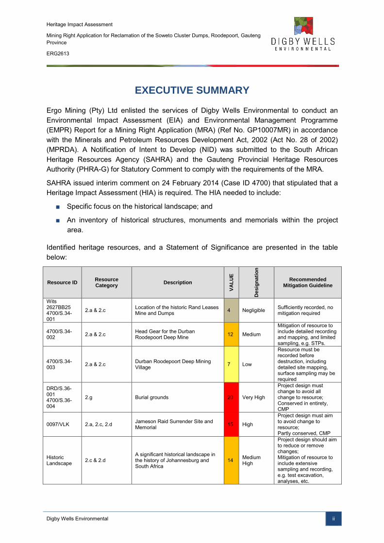
Ergo Mining (Pty) Ltd enlisted the services of Digby Wells Environmental to conduct an Environmental Impact Assessment (EIA) and Environmental Management Programme (EMPR) Report for a Mining Right Application (MRA) (Ref No. GP10007MR) in accordance with the Minerals and Petroleum Resources Development Act, 2002 (Act No. 28 of 2002) (MPRDA). A Notification of Intent to Develop (NID) was submitted to the South African Heritage Resources Agency (SAHRA) and the Gauteng Provincial Heritage Resources Authority (PHRA-G) for Statutory Comment to comply with the requirements of the MRA.
SAHRA issued interim comment on 24 February 2014 (Case ID 4700) that stipulated that a Heritage Impact Assessment (HIA) is required. The HIA needed to include:
■ Specific focus on the historical landscape; and
■ An inventory of historical structures, monuments and memorials within the project area.
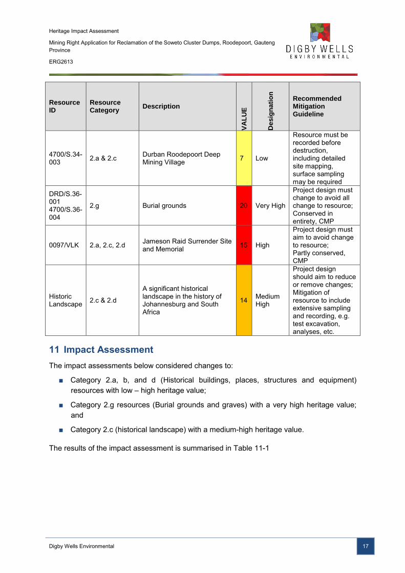
Identified heritage resources, and a Statement of Significance are presented in the table below:
Resource ID Resource Category
Description
VA
LU
E
Desig
na
tio
n
Recommended Mitigation Guideline
Wits 2627BB25 4700/S.34-001
2.a & 2.c Location of the historic Rand Leases Mine and Dumps 4 Negligible Sufficiently recorded, no
mitigation required
4700/S.34-002 2.a & 2.c Head Gear for the Durban
Roodepoort Deep Mine 12 Medium
Mitigation of resource to include detailed recording and mapping, and limited sampling, e.g. STPs.
4700/S.34-003 2.a & 2.c Durban Roodepoort Deep Mining
Village 7 Low
Resource must be recorded before destruction, including detailed site mapping, surface sampling may be required
DRD/S.36-001 4700/S.36-004
2.g Burial grounds 20 Very High
Project design must change to avoid all change to resource; Conserved in entirety, CMP
0097/VLK 2.a, 2.c, 2.d Jameson Raid Surrender Site and Memorial 15 High
Project design must aim to avoid change to resource; Partly conserved, CMP
Historic Landscape 2.c & 2.d
A significant historical landscape in the history of Johannesburg and South Africa
14 Medium High
Project design should aim to reduce or remove changes; Mitigation of resource to include extensive sampling and recording, e.g. test excavation, analyses, etc.
Heritage Impact Assessment
Mining Right Application for Reclamation of the Soweto Cluster Dumps, Roodepoort, Gauteng Province
ERG2613
Digby Wells Environmental iii
In general, project related mitigation measures, such as adjusting the impact footprint is unfeasible as the reclamation of the Soweto Cluster Dumps is dependent on their present location.
The alignment of the proposed pipeline primarily occurs within existing servitudes and does not impact any identified heritage resources. In the event that previously unknown heritage resources are identified within the present alignment, it is recommended that the pipeline route be adjusted to avoid change to the heritage resource.
No mitigation will be required for S.34-001 as this resource has a negligible heritage value, and has been sufficiently recorded. General heritage related mitigation measures for identified heritage resources with low – very high heritage significance include:
■ Demarcation of the heritage resource to minimise potential for accidental damage; and
■ Recording of the heritage resource through mapping and photographs to ensure, as a minimum, preservation by record.
For the burial ground S.36-001, monitoring of the site must be included in the EMPR to assess any cumulative or indirect impacts on the resource over time. In the event that impacts are identified through the monitoring programme, appropriate mitigation measures can be implemented to reduce or rectify the negative change to the resource.
In order to mitigate the historic landscape, it is recommended that the Durban Roodepoort Deep mining complex, inclusive of the mining village and head gear, be retained as a tangible remnant of the mining heritage associated with the development of the Johannesburg. To ensure its sustainability, it is recommended that the complex be restored with the intent to be utilised by the communities for community services and trade, in line with the objectives of the CoJ IDP.
Heritage Impact Assessment
Mining Right Application for Reclamation of the Soweto Cluster Dumps, Roodepoort, Gauteng Province
ERG2613
Digby Wells Environmental iv
TABLE OF CONTENTS
1 Introduction ....................................................................................................................... 1
1.1 Terms of Reference ................................................................................................. 1
1.2 Scope of Work ......................................................................................................... 1
2 Restrictions, Limitations, and Knowledge Gaps ................................................................ 1
3 Project Background Information ........................................................................................ 2
4 Development / Planning Context ....................................................................................... 2
5 Expertise of the Specialists ............................................................................................... 4
6 Methodology...................................................................................................................... 5
6.1 Background Information / Data Collection ............................................................... 6
6.1.1 Published Literature .......................................................................................... 6
6.1.2 Reviewed Heritage Reports .............................................................................. 7
6.1.3 Databases ........................................................................................................ 7
6.1.4 Historical Layering ............................................................................................ 8
6.2 Field Survey ............................................................................................................ 8
6.3 Site Naming ............................................................................................................. 8
6.4 Statement of Significance/Heritage Value ............................................................... 9
6.5 Impact Assessment ............................................................................................... 10
7 Summary of Stakeholder Engagement ........................................................................... 11
8 Discussion ....................................................................................................................... 11
8.1 Summary of NID baseline ...................................................................................... 11
8.2 Updated / additional background information ......................................................... 11
8.3 Summary of Discussion ......................................................................................... 14
9 Sources of Risk ............................................................................................................... 15
9.1 Alternatives Considered ........................................................................................ 16
10 Statement of Significance ............................................................................................... 16
11 Impact Assessment ......................................................................................................... 17
11.1 Impact Assessment of Heritage Resources: Low Heritage Value .......................... 19
Heritage Impact Assessment
Mining Right Application for Reclamation of the Soweto Cluster Dumps, Roodepoort, Gauteng Province
ERG2613
Digby Wells Environmental v
11.2 Impact Assessment of Heritage Resources: Medium Heritage Value .................... 20
11.3 Impact Assessment of Heritage Resources: Very High Heritage Value ................. 22
11.4 Impact Assessment of the Historical Landscape.................................................... 23
12 Recommendation for a Heritage Management Plan ....................................................... 23
12.1 Project Related Mitigation ...................................................................................... 24
12.2 Heritage Related Mitigation ................................................................................... 24
13 Conclusion ...................................................................................................................... 24
14 Bibliography .................................................................................................................... 26
LIST OF FIGURES
Figure 4-1: Employment statistics for Ward 49 of Region D (Adapted from Statistics SA, 2013) .................................................................................................................................... 4
Figure 8-1: Open cutting of the Main Reef in 1888 (von Ketelhodt, 2007) ........................... 12
Figure 8-2: Extract from the 1899 Jeppes Map of the Transvaal. ........................................ 12
Figure 8-3: Historical layering of Durban Roodepoort Deep Mine, dumps 2A5, 2L20 and 2L21 (129/1938). Historic mining village demarcated in red. ............................................... 13
Figure 8-4: Historical layering of Rand Leases Mine, dumps 2A6, 2L16, 2L17 and 2L18 (129/1938). Historic Rand Leases Mine demarcated in red. ................................................ 13
Figure 8-5: Percentage of heritage resources per NHRA section ........................................ 14
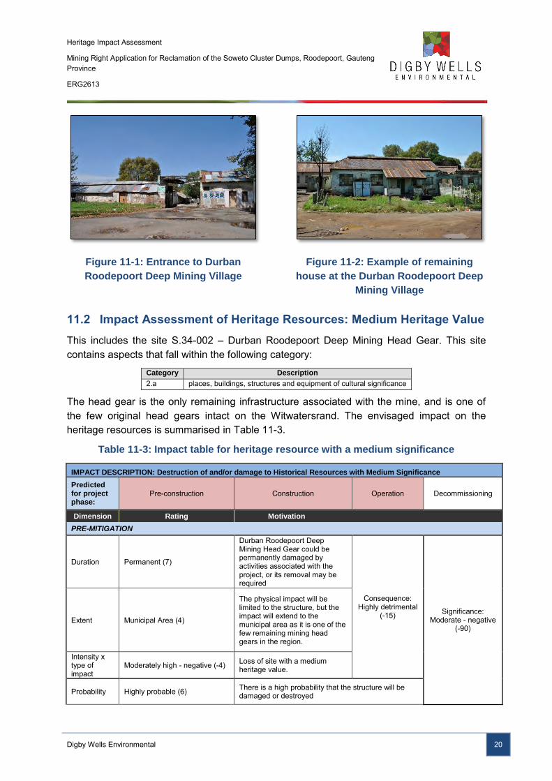
Figure 11-1: Entrance to Durban Roodepoort Deep Mining Village ..................................... 20
Figure 11-2: Example of remaining house at the Durban Roodepoort Deep Mining Village . 20
Figure 11-3: Head gear for the Durban Roodepoort Deep Mine .......................................... 21
LIST OF TABLES
Table 4-1: Summary of annual household income (Adapted from Statistics SA, 2013) ......... 3
Table 4-2: Employment distribution for Region D (Adapted from Statistics SA, 2013) ........... 3
Table 6-1: Categories defined under section 3(2) of the NHRA ............................................. 5
Table 6-2: Historical aerial photographs used for the Soweto Cluster Project area ............... 8
Heritage Impact Assessment
Mining Right Application for Reclamation of the Soweto Cluster Dumps, Roodepoort, Gauteng Province
ERG2613
Digby Wells Environmental vi
Table 6-3: Proposed grading based on NHRA Section 7(1) and SAHRA Minimum Standards ............................................................................................................................................. 9
Table 9-1: Identified issues for the Soweto Cluster Project ................................................. 15
Table 10-1: Summary of Statements of Significance for identified heritage resources ........ 16
Table 11-1Summary of impact assessment ........................................................................ 18
Table 11-2: Impact table for heritage resources with a low significance .............................. 19
Table 11-3: Impact table for heritage resource with a medium significance ......................... 20
Table 11-4: Impact table for heritage resources with a very high significance ..................... 22
Table 11-5: Impact table for the historical landscape .......................................................... 23
LIST OF APPENDICES
Appendix A: CV
Appendix B: Plans and Site List
Appendix C: Impact Matrix Methodology
Appendix D: NID
Heritage Impact Assessment
Mining Right Application for Reclamation of the Soweto Cluster Dumps, Roodepoort, Gauteng Province
ERG2613
Digby Wells Environmental vii
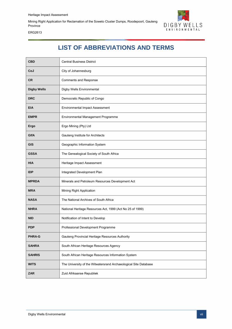
LIST OF ABBREVIATIONS AND TERMS
CBD Central Business District
CoJ City of Johannesburg
CR Comments and Response
Digby Wells Digby Wells Environmental
DRC Democratic Republic of Congo
EIA Environmental Impact Assessment
EMPR Environmental Management Programme
Ergo Ergo Mining (Pty) Ltd
GIfA Gauteng Institute for Architects
GIS Geographic Information System
GSSA The Genealogical Society of South Africa
HIA Heritage Impact Assessment
IDP Integrated Development Plan
MPRDA Minerals and Petroleum Resources Development Act
MRA Mining Right Application
NASA The National Archives of South Africa
NHRA National Heritage Resources Act, 1999 (Act No 25 of 1999)
NID Notification of Intent to Develop
PDP Professional Development Programme
PHRA-G Gauteng Provincial Heritage Resources Authority
SAHRA South African Heritage Resources Agency
SAHRIS South African Heritage Resources Information System
WITS The University of the Witwatersrand Archaeological Site Database
ZAR Zuid Afrikaanse Republiek
Heritage Impact Assessment
Mining Right Application for Reclamation of the Soweto Cluster Dumps, Roodepoort, Gauteng Province
ERG2613
Digby Wells Environmental 1
1 Introduction
Ergo Mining (Pty) Ltd (hereafter Ergo) enlisted the services of Digby Wells Environmental (hereafter Digby Wells) to conduct an Environmental Impact Assessment (EIA) and Environmental Management Programme (EMPR) Report for a Mining Right Application (MRA) (Ref No. GP10007MR) in accordance with the Minerals and Petroleum Resources Development Act, 2002 (Act No. 28 of 2002) (MPRDA). A Notification of Intent to Develop (NID) was submitted to the South African Heritage Resources Agency (SAHRA) and the Gauteng Provincial Heritage Resources Authority (PHRA-G) for Statutory Comment to comply with the requirements of the MRA.
1.1 Terms of Reference
SAHRA issued interim comment on 24 February 2014 (Case ID 4700) that stipulated that a Heritage Impact Assessment (HIA) is required. The HIA needed to include:
■ Specific focus on the historical landscape; and
■ An inventory of historical structures, monuments and memorials within the project area.
1.2 Scope of Work
The Scope of Work for the Soweto Cluster Dump Reclamations HIA was based on comment issued by SAHRA and included:
■ Updating baseline information collated for the NID, where necessary;
■ A site visit to identify heritage resources present in the project area as well as to contribute to the inventory of historical structures, monuments and memorials; and
■ A description and assessment of the historical landscape.
2 Restrictions, Limitations, and Knowledge Gaps
The following restrictions, limitations and knowledge gaps were identified for this study:
■ Heavy rainfall limited accessibility on dirt roads within and surrounding the project area;
■ Access to private property within the project area was restricted as permission to enter was denied; and
■ The presence of illegal miners posed a safety risk and limited the extent of the pedestrian survey.
Heritage Impact Assessment
Mining Right Application for Reclamation of the Soweto Cluster Dumps, Roodepoort, Gauteng Province
ERG2613
Digby Wells Environmental 2
3 Project Background Information
Contact details of the developer, consultant and landowners were provided in the NID, attached as Appendix D.
4 Development / Planning Context
The proposed Soweto Cluster Project is located in the Gauteng Province on the farms Vogelstuisfontein 231 IQ; Roodepoort 237 IQ; and Vlakfontein 238 IQ. The project area is situated adjacent to several suburbs of greater Soweto, approximately 20 km from the Johannesburg Central Business District (CBD). Detailed geographical information was provided in the NID, attached as Appendix D, as well as mapped on the South African Heritage Resources Information System (SAHRIS) (http://www.sahra.org.za/cases/mining-right-application-reclamation-soweto-cluster-dumps).
The development and planning context within which the Soweto Project will operate was summarised from the following relevant sources:
■ Statistics South Africa (Statistics SA, 2013);
■ City of Johannesburg Draft Annual Performance Report (City of Johannesburg, 2012); and
■ City of Johannesburg Integrated Development Plan (IDP) (City of Johannesburg District Municipality, 2013)
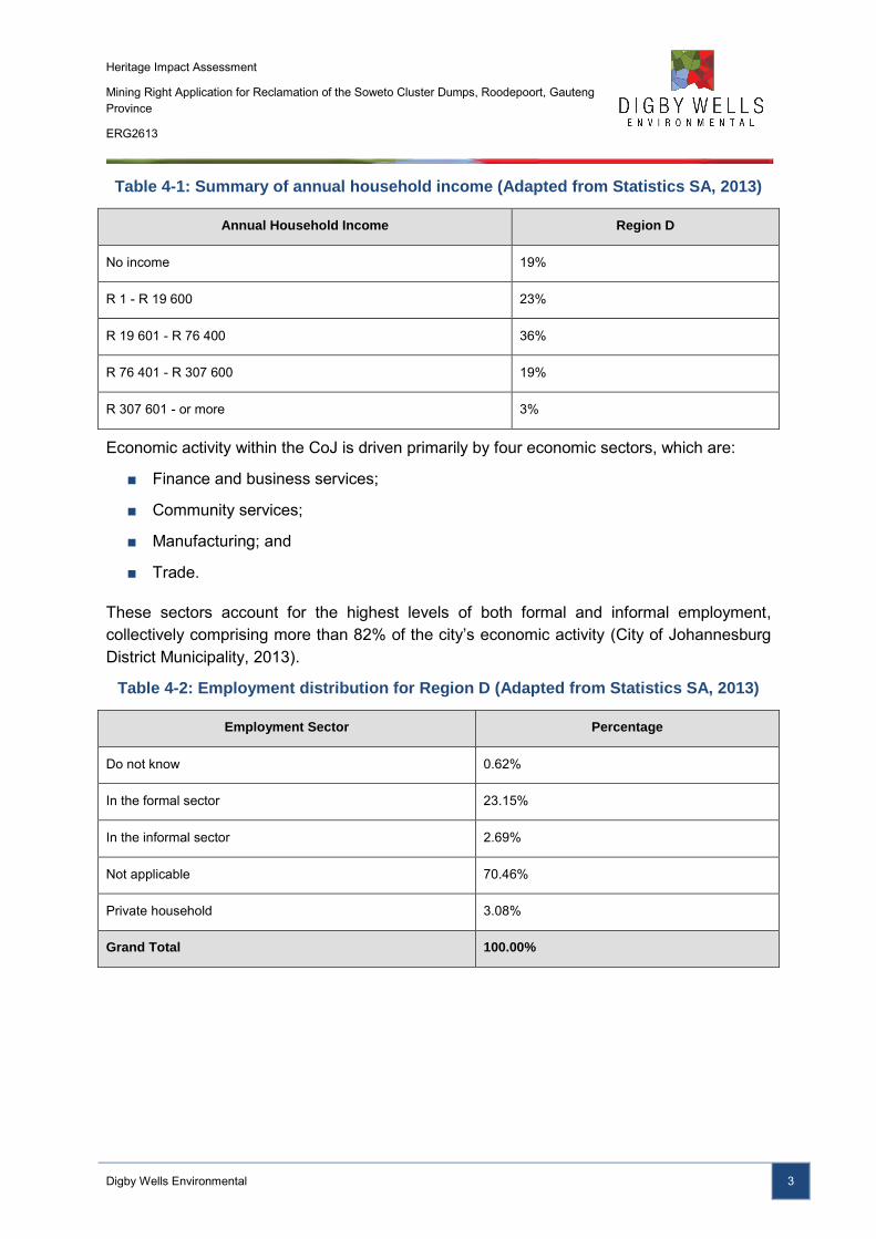
Socio-economic data were inferred from Statistics SA information provided for the City of Johannesburg (CoJ) and the CoJs IDP. The CoJ covers an area of 1 645 km2 with a total population of 4 434 827, contributing approximately 17% to the South African economy (City of Johannesburg, 2012). At a regional level, Region D, within which the project is located, is the most densely populated region of Johannesburg comprising 24.4% of the population (City of Johannesburg District Municipality, 2013).
Average annual household income for Region D, depicted in Table 4-1, range from no income (19%) to greater than R 307 601.00 (3%), with the majority (36%) of household averaging R 19 601.00 to R 76 401.00 (Statistics SA, 2013).
Heritage Impact Assessment
Mining Right Application for Reclamation of the Soweto Cluster Dumps, Roodepoort, Gauteng Province
ERG2613
Digby Wells Environmental 3
Table 4-1: Summary of annual household income (Adapted from Statistics SA, 2013)
Annual Household Income Region D
No income 19%
R 1 - R 19 600 23%
R 19 601 - R 76 400 36%
R 76 401 - R 307 600 19%
R 307 601 - or more 3%
Economic activity within the CoJ is driven primarily by four economic sectors, which are:
■ Finance and business services;
■ Community services;
■ Manufacturing; and
■ Trade.
These sectors account for the highest levels of both formal and informal employment, collectively comprising more than 82% of the city’s economic activity (City of Johannesburg District Municipality, 2013).
Table 4-2: Employment distribution for Region D (Adapted from Statistics SA, 2013)
Employment Sector Percentage
Do not know 0.62%
In the formal sector 23.15%
In the informal sector 2.69%
Not applicable 70.46%
Private household 3.08%
Grand Total 100.00%
Heritage Impact Assessment
Mining Right Application for Reclamation of the Soweto Cluster Dumps, Roodepoort, Gauteng Province
ERG2613
Digby Wells Environmental 4
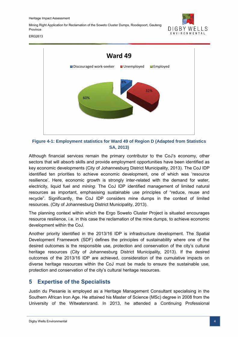
Figure 4-1: Employment statistics for Ward 49 of Region D (Adapted from Statistics
SA, 2013)
Although financial services remain the primary contributor to the CoJ’s economy, other sectors that will absorb skills and provide employment opportunities have been identified as key economic developments (City of Johannesburg District Municipality, 2013). The CoJ IDP identified ten priorities to achieve economic development, one of which was ‘resource resilience’. Here, economic growth is strongly inter-related with the demand for water, electricity, liquid fuel and mining. The CoJ IDP identified management of limited natural resources as important, emphasising sustainable use principles of “reduce, reuse and recycle”. Significantly, the CoJ IDP considers mine dumps in the context of limited resources. (City of Johannesburg District Municipality, 2013).
The planning context within which the Ergo Soweto Cluster Project is situated encourages resource resilience, i.e. in this case the reclamation of the mine dumps, to achieve economic development within the CoJ.
Another priority identified in the 2013/16 IDP is infrastructure development. The Spatial Development Framework (SDF) defines the principles of sustainability where one of the desired outcomes is the responsible use, protection and conservation of the city’s cultural heritage resources (City of Johannesburg District Municipality, 2013). If the desired outcomes of the 2013/16 IDP are achieved, consideration of the cumulative impacts on diverse heritage resources within the CoJ must be made to ensure the sustainable use, protection and conservation of the city’s cultural heritage resources.
5 Expertise of the Specialists
Justin du Piesanie is employed as a Heritage Management Consultant specialising in the Southern African Iron Age. He attained his Master of Science (MSc) degree in 2008 from the University of the Witwatersrand. In 2013, he attended a Continuing Professional
8%
32%
60%
Ward 49
Discouraged work-seeker Unemployed Employed
Heritage Impact Assessment
Mining Right Application for Reclamation of the Soweto Cluster Dumps, Roodepoort, Gauteng Province
ERG2613
Digby Wells Environmental 5
Development Programme (PDP) for Architectural and Urban Conservation presented by the University of Cape Town in conjunction with the Gauteng Institute of Architects (GIfA). He has conducted several heritage assessments throughout South Africa, including Gauteng, and has worked in the Democratic Republic of Congo (DRC), Burkina Faso, Liberia and Mali.
6 Methodology
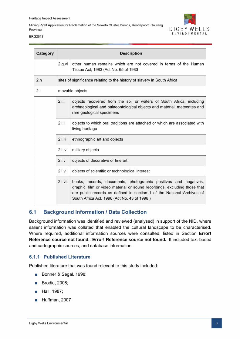
The main purpose of a HIA is to identify and map heritage resources that may occur in an affected area to enable an evaluation of their significance and assessment of project related impacts on them. Identification of heritage resources can be done through various means, discussed below. For the purpose of this HIA report, identified resources have been categorised in accordance with section 3(2) of the National Heritage Resources Act, 1999 (Act No. 25 of 1999) (NHRA). This not only facilitates evaluation of cultural significance and impact assessment, but also recommended mitigation and management measures as diverse resources require different management approaches. Table 6-1 lists and describes the categories used in this report.
Table 6-1: Categories defined under section 3(2) of the NHRA
Category Description
2.a places, buildings, structures and equipment of cultural significance
2.b places to which oral traditions are attached or which are associated with living heritage
2.c historical settlements and townscapes
2.d landscapes and natural features of cultural significance
2.e geological sites of scientific or cultural importance
2.f archaeological and palaeontological sites
2.g graves and burial grounds, including—
2.g.i ancestral graves
2.g.ii royal graves and graves of traditional leaders
2.g.iii graves of victims of conflict
2.g.iv graves of individuals designated by the Minister by notice in the Gazette
2.g.v historical graves and cemeteries and
Heritage Impact Assessment
Mining Right Application for Reclamation of the Soweto Cluster Dumps, Roodepoort, Gauteng Province
ERG2613
Digby Wells Environmental 6
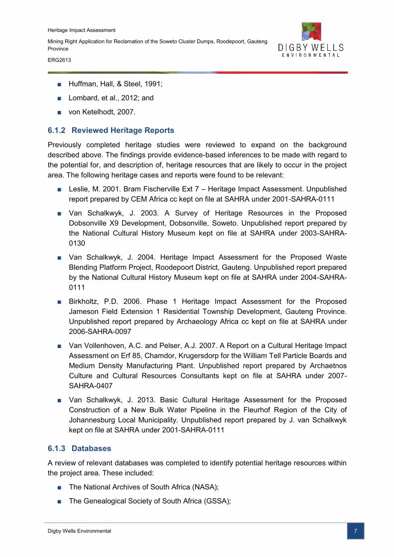
Category Description
2.g.vi other human remains which are not covered in terms of the Human Tissue Act, 1983 (Act No. 65 of 1983
2.h sites of significance relating to the history of slavery in South Africa
2.i movable objects
2.i.i objects recovered from the soil or waters of South Africa, including archaeological and palaeontological objects and material, meteorites and rare geological specimens
2.i.ii objects to which oral traditions are attached or which are associated with living heritage
2.i.iii ethnographic art and objects
2.i.iv military objects
2.i.v objects of decorative or fine art
2.i.vi objects of scientific or technological interest
2.i.vii books, records, documents, photographic positives and negatives, graphic, film or video material or sound recordings, excluding those that are public records as defined in section 1 of the National Archives of South Africa Act, 1996 (Act No. 43 of 1996 )
6.1 Background Information / Data Collection
Background information was identified and reviewed (analysed) in support of the NID, where salient information was collated that enabled the cultural landscape to be characterised. Where required, additional information sources were consulted, listed in Section Error!
Reference source not found.: Error! Reference source not found.. It included text-based and cartographic sources, and database information.
6.1.1 Published Literature
Published literature that was found relevant to this study included:
■ Bonner & Segal, 1998;
■ Brodie, 2008;
■ Hall, 1987;
■ Huffman, 2007
Heritage Impact Assessment
Mining Right Application for Reclamation of the Soweto Cluster Dumps, Roodepoort, Gauteng Province
ERG2613
Digby Wells Environmental 7
■ Huffman, Hall, & Steel, 1991;
■ Lombard, et al., 2012; and
■ von Ketelhodt, 2007.
6.1.2 Reviewed Heritage Reports
Previously completed heritage studies were reviewed to expand on the background described above. The findings provide evidence-based inferences to be made with regard to the potential for, and description of, heritage resources that are likely to occur in the project area. The following heritage cases and reports were found to be relevant:
■ Leslie, M. 2001. Bram Fischerville Ext 7 – Heritage Impact Assessment. Unpublished report prepared by CEM Africa cc kept on file at SAHRA under 2001-SAHRA-0111
■ Van Schalkwyk, J. 2003. A Survey of Heritage Resources in the Proposed Dobsonville X9 Development, Dobsonville, Soweto. Unpublished report prepared by the National Cultural History Museum kept on file at SAHRA under 2003-SAHRA-0130
■ Van Schalkwyk, J. 2004. Heritage Impact Assessment for the Proposed Waste Blending Platform Project, Roodepoort District, Gauteng. Unpublished report prepared by the National Cultural History Museum kept on file at SAHRA under 2004-SAHRA-0111
■ Birkholtz, P.D. 2006. Phase 1 Heritage Impact Assessment for the Proposed Jameson Field Extension 1 Residential Township Development, Gauteng Province. Unpublished report prepared by Archaeology Africa cc kept on file at SAHRA under 2006-SAHRA-0097
■ Van Vollenhoven, A.C. and Pelser, A.J. 2007. A Report on a Cultural Heritage Impact Assessment on Erf 85, Chamdor, Krugersdorp for the William Tell Particle Boards and Medium Density Manufacturing Plant. Unpublished report prepared by Archaetnos Culture and Cultural Resources Consultants kept on file at SAHRA under 2007-SAHRA-0407
■ Van Schalkwyk, J. 2013. Basic Cultural Heritage Assessment for the Proposed Construction of a New Bulk Water Pipeline in the Fleurhof Region of the City of Johannesburg Local Municipality. Unpublished report prepared by J. van Schalkwyk kept on file at SAHRA under 2001-SAHRA-0111
6.1.3 Databases
A review of relevant databases was completed to identify potential heritage resources within the project area. These included:
■ The National Archives of South Africa (NASA);
■ The Genealogical Society of South Africa (GSSA);
Heritage Impact Assessment
Mining Right Application for Reclamation of the Soweto Cluster Dumps, Roodepoort, Gauteng Province
ERG2613
Digby Wells Environmental 8
■ The University of the Witwatersrand Archaeological Site Database (WITS);
■ SAHRIS ; and
■ The Artefacts Architectural Online Database.
6.1.4 Historical Layering
Historical layering is a process whereby diverse cartographic sources from various time periods are layered chronologically using GIS. The rationale behind historical layering is threefold, as it:
■ Enables a virtual representation of changes in the land use of a particular area over time;
■ Provides relative dates based on the presence/absence of visible features; and
■ Identifies potential locations where heritage resources may exist within an area.
The cartographic sources used in this study included:
■ Jeppe’s 1899 Map of the Transvaal.
Table 6-2: Historical aerial photographs used for the Soweto Cluster Project area
Aerial photographs
Job no. Flight plan Photo no. Map ref. Area Date Reference
129 15 54525
2627 Johannesburg / Potchefstroom 1938 129/1938
16 74026
158 10 56865 2627 Krugersdorp / Roodepoort 1941 158/1941
314 05 44489 2627, 2628
Johannesburg / Vereeniging 1952 314/1952
6.2 Field Survey
Primary data was collected through an HIA reconnaissance survey undertaken by Justin du Piesanie on 02 April 2014 on the properties Vogelstuisfontein 231 IQ; Roodepoort 237 IQ; and Vlakfontein 238 IQ. The aim of the survey was to visually record the current state of the environment through photographs, verify select information identified in the background information, and record any additional heritage resources that may occur within the project area.
The survey and identified sites / resources were recorded by GPS waypoints and track logs, depicted in Appendix B.
Heritage Impact Assessment
Mining Right Application for Reclamation of the Soweto Cluster Dumps, Roodepoort, Gauteng Province
ERG2613
Digby Wells Environmental 9
6.3 Site Naming
The site naming conventions employed in this report are summarised below:
■ Sites identified in previous assessments were referred to by their respective report site names and prefixed with the relevant SAHRA Case ID or report reference number;
■ Sites identified in previous assessments without SAHRA references were referred to by their respective report site and prefixed with the report author and date;
■ All newly identified sites were named using this heritage Case ID, followed by the map sheet number and reference to the relevant NHRA section suffixed with the site number; and
■ Reference to sites and resources that have been formally declared are made using the official gazetted names.
Sites discussed in the text of this report are summarised using only the site number, e.g. Site s.35-001.
6.4 Statement of Significance/Heritage Value
To recommend appropriate mitigation and management measures, the cultural significance1 of identified heritage resources was determined. Cultural significance takes into account the importance of a resource in terms of section 3(3) of the NHRA, based on credible sources as well as its integrity. Sources are cited in the NID and this HIA, and listed in the bibliographies of these reports. This methodology – detailed in Appendix C - to determine heritage value fulfils the requirements stipulated in section 3 of the NHRA.
Table 6-3: Proposed grading based on NHRA Section 7(1) and SAHRA Minimum
Standards
FR/Grade Significance Mitigation Recommendation Guideline
National and Provincial Protection, NHRA 7(1)(a, b)
I
National
SAHRA responsibility
High significance
Heritage resource conserved/preserved;
No mitigation as part of development recommended
II Provincial
SAHRA responsibility
Heritage resource conserved/preserved;
No mitigation as part of development recommended
1 Cultural significance is defined in the NHRA as the intrinsic “aesthetic, architectural, historical, scientific, social,
spiritual, linguistic or technological value or significance” of a heritage resource. These attributes are combined and reduced to four themes used in the Digby Wells significance matrix: aesthetic, historical, scientific and social.
Heritage Impact Assessment
Mining Right Application for Reclamation of the Soweto Cluster Dumps, Roodepoort, Gauteng Province
ERG2613
Digby Wells Environmental 10
High significance
Local Protection, NHRA 7(1)(c)
IIIA Local
PHRA responsibility
High significance
Retained as heritage register site;
Mitigation as part of development not advised
IIIB Local
PHRA responsibility
High significance
Could be mitigated and part retained as heritage register site
General Protection, NHRA 7(1)(c)
IV A
Local
PHRA responsibility
High/Medium significance
Heritage resource should be mitigated before destruction
IV B
Local
PHRA responsibility
Medium significance
Heritage resource should be recorded before destruction
IV C
Local
PHRA responsibility
Low significance
Heritage resource has been sufficiently recorded Phase 1 requiring no further recording before destruction
The Statement of Significance has direct bearing in assessing the intensity of potential of impacts on identified heritage resources.
6.5 Impact Assessment
Assessing impacts on heritage resources are based on the value of a resource and how that value may change due to the identified impacts. In order to rate impacts, the following criteria were considered:
■ Spatial scale;
■ Duration;
■ Severity;
■ Consequence;
■ Probability; and
■ Value of the heritage resource.
The impact rating was applied to pre- and post-mitigation with the ideal to remove all impacts to a heritage resource. Where this was not achieved, the recommended mitigation guidelines described in Table 6-3 were considered.
Heritage Impact Assessment
Mining Right Application for Reclamation of the Soweto Cluster Dumps, Roodepoort, Gauteng Province
ERG2613
Digby Wells Environmental 11
7 Summary of Stakeholder Engagement
Information pertaining to the project was communicated to stakeholders as part of the EIA / EMP process governed under Section 22 of the MPRDA. Public meetings were held at Ruimsig Golf View Manor and the Braamfischerville Multipurpose Hall on the 14th of February 2014. Stakeholders that attended included the public, landowners, local government representatives , non-profit organisations and community-based organisations.
Comments from stakeholders were documented and recorded in a Comments and Response Report (CRR) for inclusion into the EIA Scoping Report.
8 Discussion
8.1 Summary of NID baseline
As noted in the NID, the study area was sparsely populated prior to the 1886 discovery of gold on the Witwatersrand (von Ketelhodt, 2007). This discovery prompted the establishment of Johannesburg, and the mining boom that contributed to its historical landscape.
The wealth generated by the Witwatersrand gold rush was controlled by the Zuid Afrikaanse Republiek (ZAR) who imposed restrictions on Uitlanders2. Consequently, the British government through Cecil John Rhodes initiated plans to overthrow President Paul Kruger’s ZAR government. This would involve an Uitlander revolt against the government that would have enabled the presence of British armed forces and the British High Commissioner in Pretoria to ensure the “protection” of British citizens in the ZAR (Birkholtz, 2006). The outcome of this scheme culminated in the unsuccessful 1895 Jameson Raid on the farm Vlakfontein.
8.2 Updated / additional background information
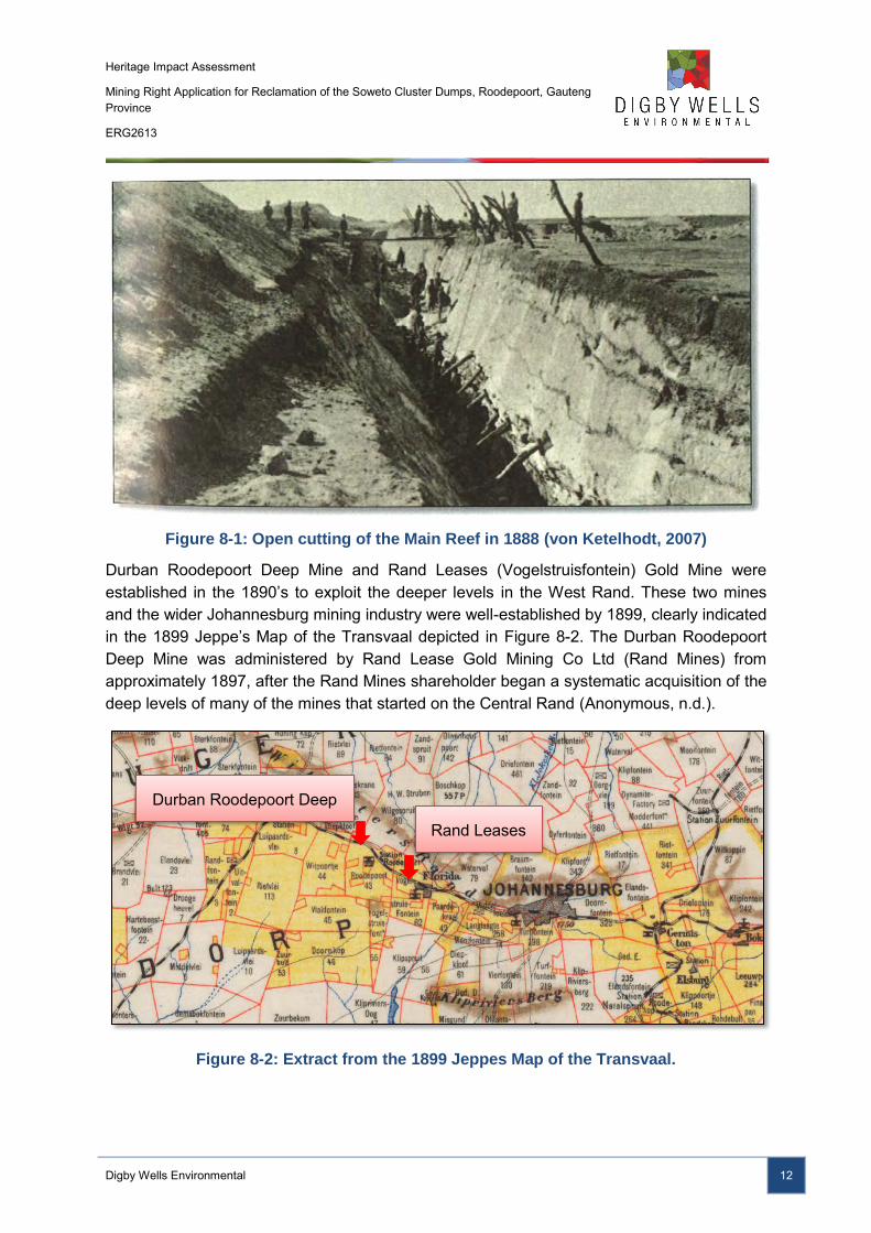
The farms Roodepoort, Vlakfontein and Volgelstruisfontein were all declared ‘public diggings’ shortly after the discovery of gold on the Witwatersrand in 1886 (von Ketelhodt, 2007). As the exposed surface reef was exploited by gold diggers, it became evident that the payable deposit dipped below the surface and would soon be out of their reach (See Figure 8-1). Rather, larger mining houses such as Eckstein & Co. (later Rand Mines), the Gold Field Group and the Johannesburg Consolidated Investment Co. Ltd, with the capability and finances to establish larger industrialised mines, would be required to exploit the deeper deposits (von Ketelhodt, 2007; Brodie, 2008).
2 The name used by the ZAR and its citizens to describe the recent arrival of foreigners, especially the British.
These people were mostly associated with the Rand Gold Rush and lived in Johannesburg.
Heritage Impact Assessment
Mining Right Application for Reclamation of the Soweto Cluster Dumps, Roodepoort, Gauteng Province
ERG2613
Digby Wells Environmental 12
Figure 8-1: Open cutting of the Main Reef in 1888 (von Ketelhodt, 2007)
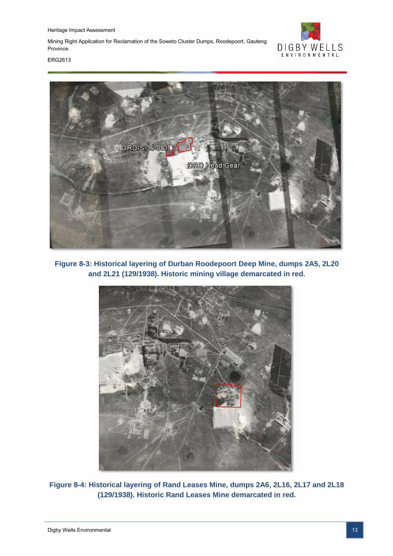
Durban Roodepoort Deep Mine and Rand Leases (Vogelstruisfontein) Gold Mine were established in the 1890’s to exploit the deeper levels in the West Rand. These two mines and the wider Johannesburg mining industry were well-established by 1899, clearly indicated in the 1899 Jeppe’s Map of the Transvaal depicted in Figure 8-2. The Durban Roodepoort Deep Mine was administered by Rand Lease Gold Mining Co Ltd (Rand Mines) from approximately 1897, after the Rand Mines shareholder began a systematic acquisition of the deep levels of many of the mines that started on the Central Rand (Anonymous, n.d.).
Figure 8-2: Extract from the 1899 Jeppes Map of the Transvaal.
Durban Roodepoort Deep
Rand Leases
Heritage Impact Assessment
Mining Right Application for Reclamation of the Soweto Cluster Dumps, Roodepoort, Gauteng Province
ERG2613
Digby Wells Environmental 13
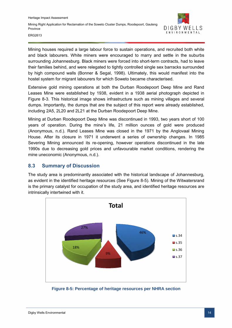
Figure 8-3: Historical layering of Durban Roodepoort Deep Mine, dumps 2A5, 2L20
and 2L21 (129/1938). Historic mining village demarcated in red.
Figure 8-4: Historical layering of Rand Leases Mine, dumps 2A6, 2L16, 2L17 and 2L18
(129/1938). Historic Rand Leases Mine demarcated in red.
Heritage Impact Assessment
Mining Right Application for Reclamation of the Soweto Cluster Dumps, Roodepoort, Gauteng Province
ERG2613
Digby Wells Environmental 14
Mining houses required a large labour force to sustain operations, and recruited both white and black labourers. White miners were encouraged to marry and settle in the suburbs surrounding Johannesburg. Black miners were forced into short-term contracts, had to leave their families behind, and were relegated to tightly controlled single sex barracks surrounded by high compound walls (Bonner & Segal, 1998). Ultimately, this would manifest into the hostel system for migrant labourers for which Soweto became characterised.
Extensive gold mining operations at both the Durban Roodepoort Deep Mine and Rand Leases Mine were established by 1938, evident in a 1938 aerial photograph depicted in Figure 8-3. This historical image shows infrastructure such as mining villages and several dumps. Importantly, the dumps that are the subject of this report were already established, including 2A5, 2L20 and 2L21 at the Durban Roodepoort Deep Mine.
Mining at Durban Roodepoort Deep Mine was discontinued in 1993, two years short of 100 years of operation. During the mine’s life, 21 million ounces of gold were produced (Anonymous, n.d.). Rand Leases Mine was closed in the 1971 by the Anglovaal Mining House. After its closure in 1971 it underwent a series of ownership changes. In 1985 Severing Mining announced its re-opening, however operations discontinued in the late 1990s due to decreasing gold prices and unfavourable market conditions, rendering the mine uneconomic (Anonymous, n.d.).
8.3 Summary of Discussion
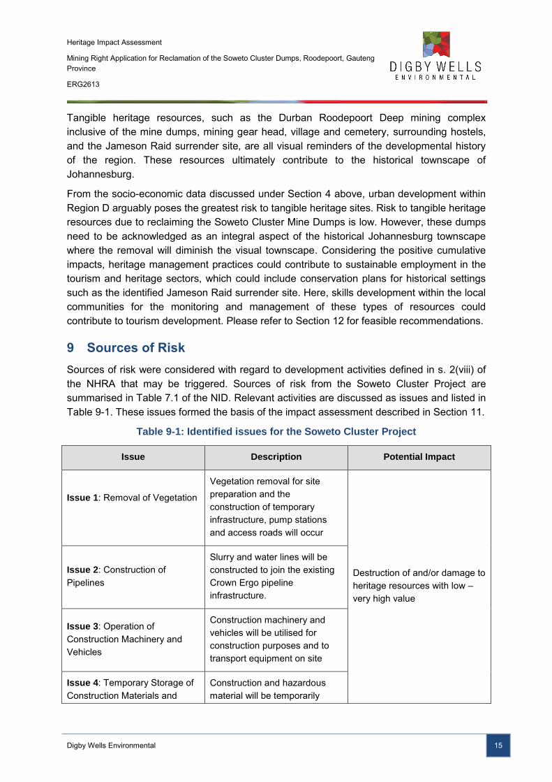
The study area is predominantly associated with the historical landscape of Johannesburg, as evident in the identified heritage resources (See Figure 8-5). Mining of the Witwatersrand is the primary catalyst for occupation of the study area, and identified heritage resources are intrinsically intertwined with it.
Figure 8-5: Percentage of heritage resources per NHRA section
46%
9%
18%
27%
Total
s.34
s.35
s.36
s.37
Heritage Impact Assessment
Mining Right Application for Reclamation of the Soweto Cluster Dumps, Roodepoort, Gauteng Province
ERG2613
Digby Wells Environmental 15
Tangible heritage resources, such as the Durban Roodepoort Deep mining complex inclusive of the mine dumps, mining gear head, village and cemetery, surrounding hostels, and the Jameson Raid surrender site, are all visual reminders of the developmental history of the region. These resources ultimately contribute to the historical townscape of Johannesburg.
From the socio-economic data discussed under Section 4 above, urban development within Region D arguably poses the greatest risk to tangible heritage sites. Risk to tangible heritage resources due to reclaiming the Soweto Cluster Mine Dumps is low. However, these dumps need to be acknowledged as an integral aspect of the historical Johannesburg townscape where the removal will diminish the visual townscape. Considering the positive cumulative impacts, heritage management practices could contribute to sustainable employment in the tourism and heritage sectors, which could include conservation plans for historical settings such as the identified Jameson Raid surrender site. Here, skills development within the local communities for the monitoring and management of these types of resources could contribute to tourism development. Please refer to Section 12 for feasible recommendations.
9 Sources of Risk
Sources of risk were considered with regard to development activities defined in s. 2(viii) of the NHRA that may be triggered. Sources of risk from the Soweto Cluster Project are summarised in Table 7.1 of the NID. Relevant activities are discussed as issues and listed in Table 9-1. These issues formed the basis of the impact assessment described in Section 11.
Table 9-1: Identified issues for the Soweto Cluster Project
Issue Description Potential Impact
Issue 1: Removal of Vegetation
Vegetation removal for site preparation and the construction of temporary infrastructure, pump stations and access roads will occur
Destruction of and/or damage to heritage resources with low – very high value
Issue 2: Construction of Pipelines
Slurry and water lines will be constructed to join the existing Crown Ergo pipeline infrastructure.
Issue 3: Operation of Construction Machinery and Vehicles
Construction machinery and vehicles will be utilised for construction purposes and to transport equipment on site
Issue 4: Temporary Storage of Construction Materials and
Construction and hazardous material will be temporarily
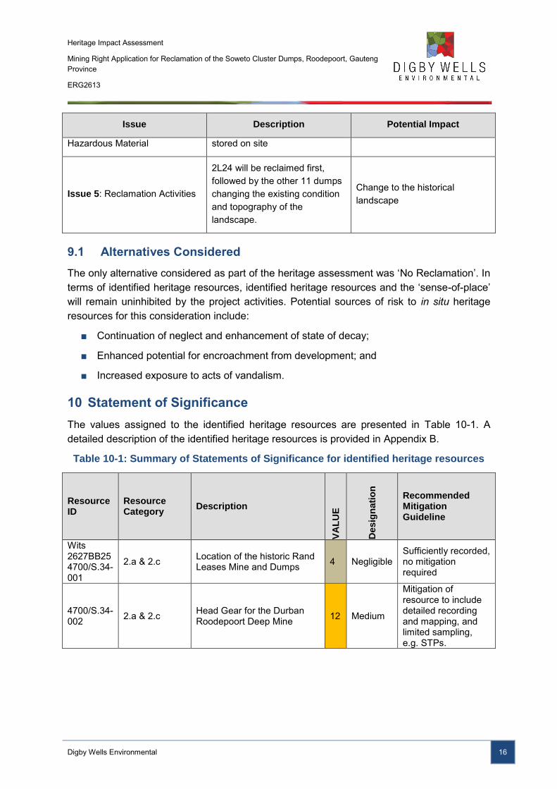
Heritage Impact Assessment
Mining Right Application for Reclamation of the Soweto Cluster Dumps, Roodepoort, Gauteng Province
ERG2613
Digby Wells Environmental 16
Issue Description Potential Impact
Hazardous Material stored on site
Issue 5: Reclamation Activities
2L24 will be reclaimed first, followed by the other 11 dumps changing the existing condition and topography of the landscape.
Change to the historical landscape
9.1 Alternatives Considered
The only alternative considered as part of the heritage assessment was ‘No Reclamation’. In terms of identified heritage resources, identified heritage resources and the ‘sense-of-place’ will remain uninhibited by the project activities. Potential sources of risk to in situ heritage resources for this consideration include:
■ Continuation of neglect and enhancement of state of decay;
■ Enhanced potential for encroachment from development; and
■ Increased exposure to acts of vandalism.
10 Statement of Significance
The values assigned to the identified heritage resources are presented in Table 10-1. A detailed description of the identified heritage resources is provided in Appendix B.
Table 10-1: Summary of Statements of Significance for identified heritage resources
Resource ID
Resource Category
Description
VA
LU
E
Desig
nati
on
Recommended Mitigation Guideline
Wits 2627BB25 4700/S.34-001
2.a & 2.c Location of the historic Rand Leases Mine and Dumps 4 Negligible
Sufficiently recorded, no mitigation required
4700/S.34-002 2.a & 2.c Head Gear for the Durban
Roodepoort Deep Mine 12 Medium
Mitigation of resource to include detailed recording and mapping, and limited sampling, e.g. STPs.
Heritage Impact Assessment
Mining Right Application for Reclamation of the Soweto Cluster Dumps, Roodepoort, Gauteng Province
ERG2613
Digby Wells Environmental 17
Resource ID
Resource Category
Description
VA
LU
E
Desig
nati
on
Recommended Mitigation Guideline
4700/S.34-003 2.a & 2.c Durban Roodepoort Deep
Mining Village 7 Low
Resource must be recorded before destruction, including detailed site mapping, surface sampling may be required
DRD/S.36-001 4700/S.36-004
2.g Burial grounds 20 Very High
Project design must change to avoid all change to resource; Conserved in entirety, CMP
0097/VLK 2.a, 2.c, 2.d Jameson Raid Surrender Site and Memorial 15 High
Project design must aim to avoid change to resource; Partly conserved, CMP
Historic Landscape 2.c & 2.d
A significant historical landscape in the history of Johannesburg and South Africa
14 Medium High
Project design should aim to reduce or remove changes; Mitigation of resource to include extensive sampling and recording, e.g. test excavation, analyses, etc.
11 Impact Assessment
The impact assessments below considered changes to:
■ Category 2.a, b, and d (Historical buildings, places, structures and equipment) resources with low – high heritage value;
■ Category 2.g resources (Burial grounds and graves) with a very high heritage value; and
■ Category 2.c (historical landscape) with a medium-high heritage value.
The results of the impact assessment is summarised in Table 11-1
Heritage Impact Assessment
Mining Right Application for Reclamation of the Soweto Cluster Dumps, Roodepoort, Gauteng Province
ERG2613
Digby Wells Environmental 18
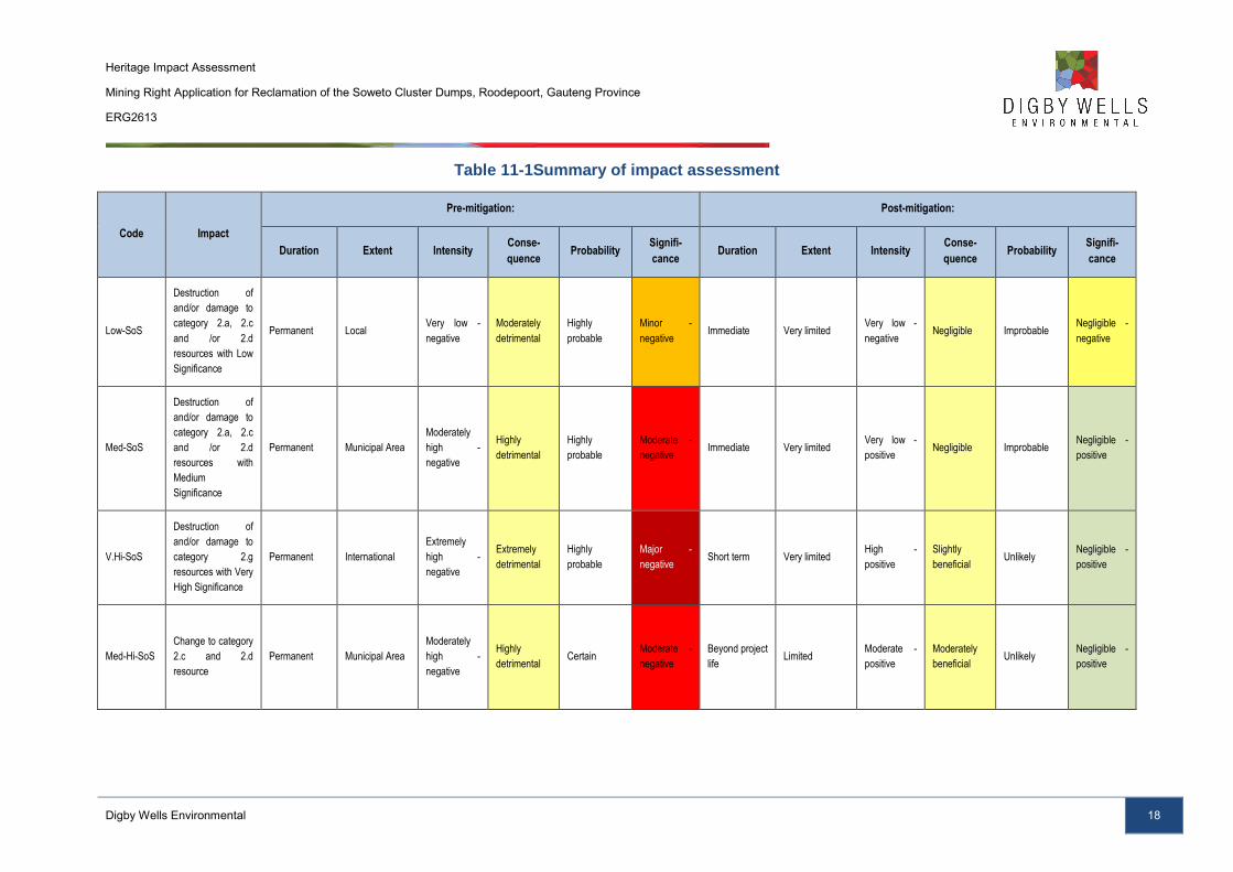
Table 11-1Summary of impact assessment
Code Impact
Pre-mitigation: Post-mitigation:
Duration Extent Intensity Conse-
quence Probability
Signifi-
cance Duration Extent Intensity
Conse-
quence Probability
Signifi-
cance
Low-SoS
Destruction of
and/or damage to
category 2.a, 2.c
and /or 2.d
resources with Low
Significance
Permanent Local Very low -
negative
Moderately
detrimental
Highly
probable
Minor -
negative Immediate Very limited
Very low -
negative Negligible Improbable
Negligible -
negative
Med-SoS
Destruction of
and/or damage to
category 2.a, 2.c
and /or 2.d
resources with
Medium
Significance
Permanent Municipal Area
Moderately
high -
negative
Highly
detrimental
Highly
probable
Moderate -
negative Immediate Very limited
Very low -
positive Negligible Improbable
Negligible -
positive
V.Hi-SoS
Destruction of
and/or damage to
category 2.g
resources with Very
High Significance
Permanent International
Extremely
high -
negative
Extremely
detrimental
Highly
probable
Major -
negative Short term Very limited
High -
positive
Slightly
beneficial Unlikely
Negligible -
positive
Med-Hi-SoS
Change to category
2.c and 2.d
resource
Permanent Municipal Area
Moderately
high -
negative
Highly
detrimental Certain
Moderate -
negative
Beyond project
life Limited
Moderate -
positive
Moderately
beneficial Unlikely
Negligible -
positive
Heritage Impact Assessment
Mining Right Application for Reclamation of the Soweto Cluster Dumps, Roodepoort, Gauteng Province
ERG2613
Digby Wells Environmental 19
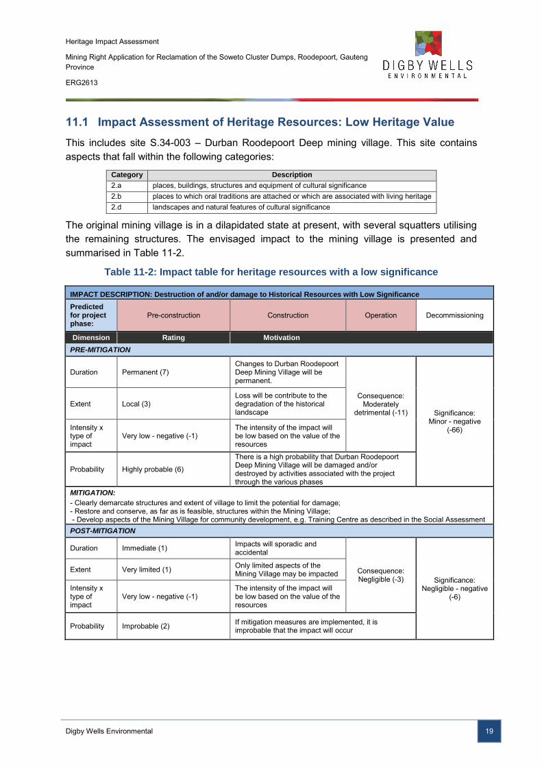
11.1 Impact Assessment of Heritage Resources: Low Heritage Value
This includes site S.34-003 – Durban Roodepoort Deep mining village. This site contains aspects that fall within the following categories:
Category Description
2.a places, buildings, structures and equipment of cultural significance 2.b places to which oral traditions are attached or which are associated with living heritage 2.d landscapes and natural features of cultural significance
The original mining village is in a dilapidated state at present, with several squatters utilising the remaining structures. The envisaged impact to the mining village is presented and summarised in Table 11-2.
Table 11-2: Impact table for heritage resources with a low significance
IMPACT DESCRIPTION: Destruction of and/or damage to Historical Resources with Low Significance
Predicted for project phase:
Pre-construction Construction Operation Decommissioning
Dimension Rating Motivation
PRE-MITIGATION
Duration Permanent (7) Changes to Durban Roodepoort Deep Mining Village will be permanent.
Consequence: Moderately
detrimental (-11) Significance: Minor - negative
(-66)
Extent Local (3) Loss will be contribute to the degradation of the historical landscape
Intensity x type of impact
Very low - negative (-1) The intensity of the impact will be low based on the value of the resources
Probability Highly probable (6)
There is a high probability that Durban Roodepoort Deep Mining Village will be damaged and/or destroyed by activities associated with the project through the various phases
MITIGATION:
- Clearly demarcate structures and extent of village to limit the potential for damage; - Restore and conserve, as far as is feasible, structures within the Mining Village; - Develop aspects of the Mining Village for community development, e.g. Training Centre as described in the Social Assessment POST-MITIGATION
Duration Immediate (1) Impacts will sporadic and accidental
Consequence: Negligible (-3) Significance:
Negligible - negative (-6)
Extent Very limited (1) Only limited aspects of the Mining Village may be impacted
Intensity x type of impact
Very low - negative (-1) The intensity of the impact will be low based on the value of the resources
Probability Improbable (2) If mitigation measures are implemented, it is improbable that the impact will occur
Heritage Impact Assessment
Mining Right Application for Reclamation of the Soweto Cluster Dumps, Roodepoort, Gauteng Province
ERG2613
Digby Wells Environmental 20
Figure 11-1: Entrance to Durban
Roodepoort Deep Mining Village
Figure 11-2: Example of remaining
house at the Durban Roodepoort Deep
Mining Village
11.2 Impact Assessment of Heritage Resources: Medium Heritage Value
This includes the site S.34-002 – Durban Roodepoort Deep Mining Head Gear. This site contains aspects that fall within the following category:
Category Description
2.a places, buildings, structures and equipment of cultural significance
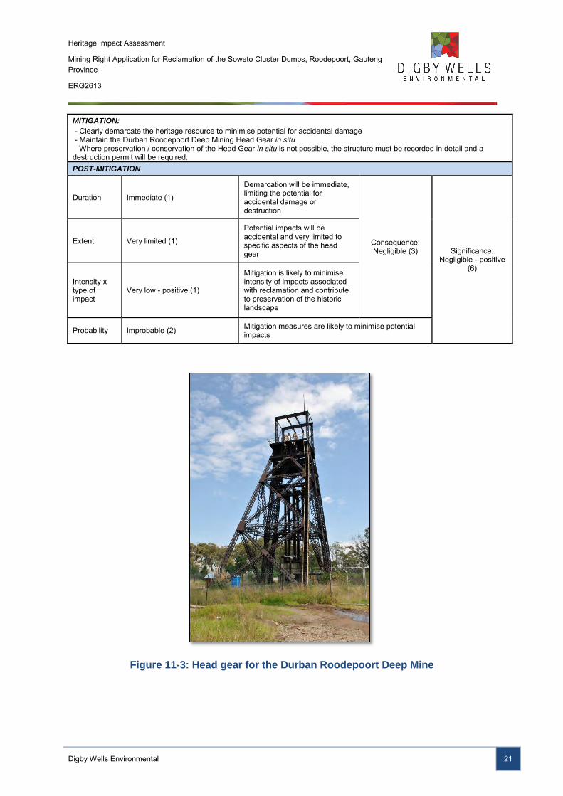
The head gear is the only remaining infrastructure associated with the mine, and is one of the few original head gears intact on the Witwatersrand. The envisaged impact on the heritage resources is summarised in Table 11-3.
Table 11-3: Impact table for heritage resource with a medium significance
IMPACT DESCRIPTION: Destruction of and/or damage to Historical Resources with Medium Significance
Predicted for project phase:
Pre-construction Construction Operation Decommissioning
Dimension Rating Motivation
PRE-MITIGATION
Duration Permanent (7)
Durban Roodepoort Deep Mining Head Gear could be permanently damaged by activities associated with the project, or its removal may be required
Consequence: Highly detrimental
(-15) Significance: Moderate - negative
(-90) Extent Municipal Area (4)
The physical impact will be limited to the structure, but the impact will extend to the municipal area as it is one of the few remaining mining head gears in the region.
Intensity x type of impact
Moderately high - negative (-4) Loss of site with a medium heritage value.
Probability Highly probable (6) There is a high probability that the structure will be damaged or destroyed
Heritage Impact Assessment
Mining Right Application for Reclamation of the Soweto Cluster Dumps, Roodepoort, Gauteng Province
ERG2613
Digby Wells Environmental 21
MITIGATION:
- Clearly demarcate the heritage resource to minimise potential for accidental damage - Maintain the Durban Roodepoort Deep Mining Head Gear in situ - Where preservation / conservation of the Head Gear in situ is not possible, the structure must be recorded in detail and a destruction permit will be required. POST-MITIGATION
Duration Immediate (1)
Demarcation will be immediate, limiting the potential for accidental damage or destruction
Consequence: Negligible (3) Significance:
Negligible - positive (6)
Extent Very limited (1)
Potential impacts will be accidental and very limited to specific aspects of the head gear
Intensity x type of impact
Very low - positive (1)
Mitigation is likely to minimise intensity of impacts associated with reclamation and contribute to preservation of the historic landscape
Probability Improbable (2) Mitigation measures are likely to minimise potential impacts
Figure 11-3: Head gear for the Durban Roodepoort Deep Mine
Heritage Impact Assessment
Mining Right Application for Reclamation of the Soweto Cluster Dumps, Roodepoort, Gauteng Province
ERG2613
Digby Wells Environmental 22
11.3 Impact Assessment of Heritage Resources: Very High Heritage
Value
This includes the site S.36-001 – Burial ground. This site contains aspects that fall within the following categories:
Category Description
2.a places, buildings, structures and equipment of cultural significance 2.b places to which oral traditions are attached or which are associated with living heritage 2.g graves and burial grounds
The burial ground is situated to the west of the Durban Roodepoort Deep mining village and at the time of the survey was overgrown. Visible on aerial imagery, the extent of the burial ground was demarcated. The envisaged impacts for the burial ground is summarised in Table 11-4.
Table 11-4: Impact table for heritage resources with a very high significance
IMPACT DESCRIPTION: Destruction of and/or damage to Burial Grounds with Very High Significance
Predicted for project phase:
Pre-construction Construction Operation Decommissioning
Dimension Rating Motivation
PRE-MITIGATION
Duration Permanent (7) Damage or destruction of the burial ground will be permanent
Consequence: Extremely
detrimental (-21) Significance:
Major - negative (-126)
Extent International (7)
Potential for next-of-kin to reside outside of South Africa. Reputational risk to Ergo will be international.
Intensity x type of impact
Extremely high - negative (-7) Universally accepted to have high value, where any impact will have a high intensity
Probability Highly probable (6) Without mitigation measures, it is highly probable that the burial ground will be impacted
MITIGATION:
- Demarcate burial ground to make it clearly visible - Record through mapping and photographs - Include burial ground in monitoring programme for reclamation of mine dumps
POST-MITIGATION
Duration Short term (2) Demarcation will minimise the potential for impacts on the burial ground
Consequence: Slightly
detrimental (-8) Significance:
Negligible - positive (24)
Extent Very limited (1) Where impacts may accidentally occur, these will be limited
Intensity x type of impact
High - positive (5) Mitigation will result in minor change to a heritage resource with a very high value
Probability Unlikely (3) Mitigation will minimise potential damage or destruction of burial grounds
Heritage Impact Assessment
Mining Right Application for Reclamation of the Soweto Cluster Dumps, Roodepoort, Gauteng Province
ERG2613
Digby Wells Environmental 23
11.4 Impact Assessment of the Historical Landscape
The identified heritage resources contribute to the significance of the historical landscape of the project area and Johannesburg as a whole. This resource contains aspects that fall within the following categories:
Category Description
2.a places, buildings, structures and equipment of cultural significance 2.b places to which oral traditions are attached or which are associated with living heritage 2.c historical settlements and townscapes 2.d landscapes and natural features of cultural significance
The impacts on the historical landscape from the proposed reclamation activities associated with the Soweto Cluster Dumps are summarised in Table 11-5.
Table 11-5: Impact table for the historical landscape
IMPACT DESCRIPTION: Change to the Historical Landscape
Predicted for project phase:
Pre-construction Construction Operation Decommissioning
Dimension Rating Motivation
PRE-MITIGATION
Duration Permanent (7) Reclamation of the mine dumps will permanently alter the historic landscape
Consequence: Highly detrimental
(-15) Significance:
Moderate - negative (-105)
Extent Municipal Area (4) The landscape is intrinsically associated with the development of Johannesburg
Intensity x type of impact
Moderately high - negative (-4) Major change to a resource with medium significance
Probability Certain (7) This change will occur with the reclamation of the mine dumps
MITIGATION:
- Maintain the historic Durban Roodepoort Deep mining complex as tangible remnant of the historic landscape - Restore aspects of the Durban Roodepoort Deep mining village for community development- i.e. Training Centre - Encourage economic development through using existing infrastructure for community services and trade
POST-MITIGATION
Duration Beyond project life (6) As for pre-mitigation
Consequence: Moderately
detrimental (-11) Significance: Negligible - positive
(33)
Extent Limited (2) The extent will be limited to the mine dumps
Intensity x type of impact
Moderate - positive (3)
Mitigation measures will create a potential for job creation and economic development in line with the City of Johannesburg IDP
Probability Unlikely (3) If mitigation measures are implemented it is unlikely that the historic landscape will be altered to the degree that the mining history is lost.
12 Recommendation for a Heritage Management Plan
Recommendations were made taking into consideration the significance of resources, the identified risks and the impact assessment discussed in Section 11 above. These are discussed for both project and heritage related mitigation.
Heritage Impact Assessment
Mining Right Application for Reclamation of the Soweto Cluster Dumps, Roodepoort, Gauteng Province
ERG2613
Digby Wells Environmental 24
12.1 Project Related Mitigation
In general, project related mitigation measures, such as adjusting the impact footprint is unfeasible as the reclamation of the Soweto Cluster Dumps is dependent on their present location.
The alignment of the proposed pipeline primarily occurs within existing servitudes and does not impact any identified heritage resources. In the event that previously unknown heritage resources are identified within the present alignment, it is recommended that the pipeline route be adjusted to avoid change to the heritage resource.
12.2 Heritage Related Mitigation
No mitigation will be required for S.34-001 as this resource has a negligible heritage value, and has been sufficiently recorded. General heritage related mitigation measures for identified heritage resources with low – very high heritage significance include:
■ Demarcation of the heritage resource to minimise potential for accidental damage; and
■ Recording of the heritage resource through mapping and photographs to ensure, as a minimum, preservation by record.
For the burial ground S.36-001, monitoring of the site must be included in the EMPR to assess any cumulative or indirect impacts on the resource over time. In the event that impacts are identified through the monitoring programme, appropriate mitigation measures can be implemented to reduce or rectify the negative change to the resource.
In order to mitigate the historic landscape, it is recommended that the Durban Roodepoort Deep mining complex, inclusive of the mining village and head gear, be retained as a tangible remnant of the mining heritage associated with the development of the Johannesburg. To ensure its sustainability, it is recommended that the complex be restored with the intent to be utilised by the communities for community services and trade, in line with the objectives of the CoJ IDP.
13 Conclusion
The proposed Soweto Cluster Project is located within Gauteng Province. The project will entail the recovery of slimes by hydraulic monitoring and sands to be reclaimed by mechanical means resulting in slurry that will be pumped by way of pipelines to the Ergo beneficiation plant for gold recovery. This report presents the findings of an HIA undertaken in terms of s.38(8) of the NHRA as required in the statutory comments received from SAHRA (CaseID 4700) on 24 February 2014.
The identified heritage resources relate to the historical period and range from negligible to very high significance, and contribute to the historical landscape of the study area. The landscape – as a heritage resource – was determined to be of medium significance.
Heritage Impact Assessment
Mining Right Application for Reclamation of the Soweto Cluster Dumps, Roodepoort, Gauteng Province
ERG2613
Digby Wells Environmental 25
Issues associated with the proposed Soweto Cluster Project range from moderately – highly negative impacts. These impacts, if properly mitigated through the implementation of heritage related mitigation measures described in Section 12.2 above will be reduced to negligible positive in terms of their contribution to the retention of the historical landscape and potential economic development.
Heritage Impact Assessment
Mining Right Application for Reclamation of the Soweto Cluster Dumps, Roodepoort, Gauteng Province
ERG2613
Digby Wells Environmental 26
14 Bibliography
Anonymous, n.d.. DRD Lease. [Online] Available at: http://www.westwitsmining.com/projects/west-rand-south-africa/drd-lease/ [Accessed 13 January 2014].
Anonymous, n.d.. Rand Leases. [Online] Available at: http://www.westwitsmining.com/projects/west-rand-south-africa/rand-leases/ [Accessed 2014 January 2014].
Birkholtz, P. D., 2006. Phase 1 Heritage Impact Assessment for the Proposed Jameson Field Extention 1 Residential Township Development, Gauteng Province, Unpublished report by: Archaeology Africa cc kept on file at SAHRIS under 2006-SAHRA-0097.
Bonner, P. & Segal, L., 1998. Soweto: A History. Cape Town: Maskew Miller Longman.
Brodie, N., 2008. The Joburg Book: A Guide to the City's History, People & Places. Johannesburg: Sharp Sharp Media.
City of Johannesburg District Municipality, 2013. Integrated Development Plan 2013/16, District Municipality: Johannesburg.
City of Johannesburg, 2012. Building on a Legacy of Success: Draft Annual Performance Report for the Period 1 July 2011 to 30 June 2012, Johannesburg: City of Johannesburg.
Hall, M., 1987. The Changing Past: Farmers, Kings and Traders in Southern Africa 2000 - 1860. Cape Town: David Phillip Publishing.
Huffman, T. N., 2007. Handbook to the Iron Age: The Archaeology of Pre-Colonial Farming Societies in Southern Africa. Cape Town: University of KwaZulu-Natal Press.
Huffman, T. N., Hall, S. L. & Steel, R. H., 1991. Archaeological Survey of the Rietfontein Housing Scheme, Southern Transvaal, Gauteng: Unpublished report.
Lombard, M. et al., 2012. South African and Lesotho Stone Age Sequence Updated (I). South African Archaeological Bulletin, 67(195), pp. 123-144.
Statistics SA, 2013. City of Johannesburg. [Online] Available at: http://beta2.statssa.gov.za/?page_id=1021&id=city-of-johannesburg-municipality [Accessed 25 03 2014].
von Ketelhodt, G. F., 2007. The Golden Crown of Johannesburg. Johannesburg: Willsan Mining Publishers.
Heritage Impact Assessment
Mining Right Application for Reclamation of the Soweto Cluster Dumps, Roodepoort, Gauteng Province
ERG2613
Appendix A: CV
_________________________________________________ Digby Wells and Associates (South Africa) (Pty) Ltd (Subsidiary of Digby Wells & Associates (Pty) Ltd). Co. Reg. No. 2010/008577/07. Fern Isle, Section 10, 359
Pretoria Ave Randburg Private Bag X10046, Randburg, 2125, South Africa Tel: +27 11 789 9495, Fax: +27 11 789 9498, [email protected], www.digbywells.com
________________________________________________ Directors: A Sing*, AR Wilke, DJ Otto, GB Beringer, LF Koeslag, AJ Reynolds (Chairman) (British)*, J Leaver*, GE Trusler (C.E.O)
*Non-Executive _________________________________________________
p:\company_info\staff_cvs_and_bios\cvs\7_heritage\j_du_piesanie_2014.docx
Mr. Justin du Piesanie
Heritage Management Consultant: Archaeologist
Social Sciences Department
Digby Wells Environmental
1 Education
Date Degree(s) or Diploma(s) obtained Institution
2013 Continued Professional Development Programme, Architectural and Urban Conservation: Researching and Assessing Local Environments
University of Cape Town
2008 MSc University of the Witwatersrand
2005 BA (Honours) (Archaeology) University of the Witwatersrand
2004 BA University of the Witwatersrand
2001 Matric Norkem Park High School
2 Language Skills
Language Written Spoken
English Excellent Excellent
Afrikaans Proficient Good
3 Employment
Period Company Title/position
08/2011 to present
Digby Wells Environmental Heritage Management Consultant: Archaeologist
Digby Wells Environmental 2
Period Company Title/position
2009-2011 University of the Witwatersrand Archaeology Collections Manager
2009-2011 Independent Archaeologist
2006-2007 Maropeng & Sterkfontein Caves UNESCO World Heritage Site
Tour guide
4 Professional Affiliations
Position Professional Body Registration Number
Member Association for Southern African Professional Archaeologists (ASAPA);
ASAPA Cultural Resources Management (CRM) section
270
Member International Council on Monuments and Sites (ICOMOS)
14274
Member Society for Africanist Archaeologists (SAfA) N/A
5 Publications
■ Huffman, T.N. & du Piesanie, J.J. 2011. Khami and the Venda in the Mapungubwe Landscape. Journal of African Archaeology 9(2): 189-206
6 Experience
I have 5 years experiences in the field of heritage resources management (HRM) including archaeological and heritage assessments, grave relocation, social consultation and mitigation of archaeological sites. During my studies I was involved in academic research projects associated with the Stone Age, Iron Age, and Rock Art. These are summarised below:
■ Wits Fieldschool - Excavation at Meyersdal, Klipriviersberg Johannesburg (Late Iron Age Settlement).
■ Wits Fieldschool - Phase 1 Survey of Prentjiesberg in Ugie / Maclear area, Eastern Cape.
■ Wits Fieldschool – Excavation at Kudu Kopje, Mapungubwe National Park Limpopo Province.
Digby Wells Environmental 3
■ Wits Fieldschool – Excavation of Weipe 508 (2229 AB 508) on farm Weipe, Limpopo Province.
■ Survey at Meyerdal, Klipriviersberg Johannesburg.
■ Mapping of Rock Art Engravings at Klipbak 1 & 2, Kalahari.
■ Survey at Sonop Mines, Windsorton Northern Cape (Vaal Archaeological Research Unit).
■ Excavation of Kudu Kopje, Mapungubwe National Park Limpopo Province.
■ Excavation of KK (2229 AD 110), VK (2229 AD 109), VK2 (2229 AD 108) & Weipe 508 (2229 AB 508) (Origins of Mapungubwe Project)
■ Phase 1 Survey of farms Venetia, Hamilton, Den Staat and Little Muck, Limpopo Province (Origins of Mapungubwe Project)
■ Excavation of Canteen Kopje Stone Age site, Barkley West, Northern Cape
■ Excavation of Khami Period site AB32 (2229 AB 32), Den Staat Farm, Limpopo Province
Since 2011 I have been actively involved in environmental management throughout Africa, focusing on heritage assessments incompliance with International Finance Corporation (IFC) Performance Standards and other World Bank Standards and Equator Principles. This exposure to environmental, and specifically heritage management has allowed me to work to international best practice standards in accordance with international conservation bodies such as UNESCO and ICOMOS. In addition, I have also been involved in the collection of quantitative data for a Relocation Action Plan (RAP) in Burkina Faso. The exposure to this aspect of environmental management has afforded me the opportunity to understand the significance of integration of various studies in the assessment of heritage resources and recommendations for feasible mitigation measures. I have work throughout South Africa, as well as Burkina Faso, the Democratic Republic of Congo, Liberia and Mali.
7 Project Experience
Please see the following table for relevant project experience:
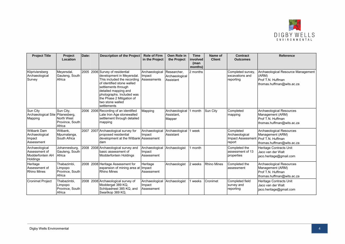
Digby Wells Environmental 4
Project Title Project Location
Date: Description of the Project Role of Firm in the Project
Own Role in the Project
Time involved
(man months)
Name of Client
Contract Outcomes
Reference
Klipriviersberg Archaeological Survey
Meyersdal, Gauteng, South Africa
2005 2006 Survey of residential development in Meyersdal. This included the recording of identified stone walled settlements through detailed mapping and photographs. Included was the Phase 2 Mitigation of two stone walled settlements
Archaeological Impact Assessments
Researcher, Archaeological Assistant
2 months Completed survey, excavations and reporting
Archaeological Resource Management (ARM) Prof T.N. Huffman [email protected]
Sun City Archaeological Site Mapping
Sun City, Pilanesberg, North West Province, South Africa
2006 2006 Recording of an identified Late Iron Age stonewalled settlement through detailed mapping
Mapping Archaeological Assistant, Mapper
1 month Sun City Completed mapping
Archaeological Resources Management (ARM) Prof T.N. Huffman [email protected]
Witbank Dam Archaeological Impact Assessment
Witbank, Mpumalanga, South Africa
2007 2007 Archaeological survey for proposed residential development at the Witbank dam
Archaeological Impact Assessment
Archaeological Assistant
1 week Completed Archaeological Impact Assessment report
Archaeological Resources Management (ARM) Prof T.N. Huffman [email protected]
Archaeological Assessment of Modderfontein AH Holdings
Johannesburg, Gauteng, South Africa
2008 2008 Archaeological survey and basic assessment of Modderfontein Holdings
Archaeological Impact Assessment
Archaeologist 1 month Completed the assessment of 13 properties
Heritage Contracts Unit Jaco van der Walt [email protected]
Heritage Assessment of Rhino Mines
Thabazimbi, Limpopo Province, South Africa
2008 2008 Heritage Assessment for expansion of mining area at Rhino Mines
Heritage Impact Assessment
Archaeologist 2 weeks Rhino Mines Completed the assessment
Archaeological Resources Management (ARM) Prof T.N. Huffman [email protected]
Cronimet Project Thabazimbi, Limpopo Province, South Africa
2008 2008 Archaeological survey of Moddergat 389 KQ, Schilpadnest 385 KQ, and Swartkop 369 KQ,
Archaeological Impact Assessment
Archaeologist 1 weeks Cronimet Completed field survey and reporting
Heritage Contracts Unit Jaco van der Walt [email protected]
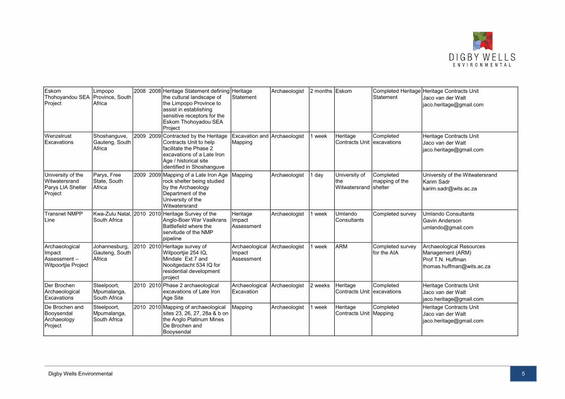
Digby Wells Environmental 5
Eskom Thohoyandou SEA Project
Limpopo Province, South Africa
2008 2008 Heritage Statement defining the cultural landscape of the Limpopo Province to assist in establishing sensitive receptors for the Eskom Thohoyadou SEA Project
Heritage Statement
Archaeologist 2 months Eskom Completed Heritage Statement
Heritage Contracts Unit Jaco van der Walt [email protected]
Wenzelrust Excavations
Shoshanguve, Gauteng, South Africa
2009 2009 Contracted by the Heritage Contracts Unit to help facilitate the Phase 2 excavations of a Late Iron Age / historical site identified in Shoshanguve
Excavation and Mapping
Archaeologist 1 week Heritage Contracts Unit
Completed excavations
Heritage Contracts Unit Jaco van der Walt [email protected]
University of the Witwatersrand Parys LIA Shelter Project
Parys, Free State, South Africa
2009 2009 Mapping of a Late Iron Age rock shelter being studied by the Archaeology Department of the University of the Witwatersrand
Mapping Archaeologist 1 day University of the Witwatersrand
Completed mapping of the shelter
University of the Witwatersrand Karim Sadr [email protected]
Transnet NMPP Line
Kwa-Zulu Natal, South Africa
2010 2010 Heritage Survey of the Anglo-Boer War Vaalkrans Battlefield where the servitude of the NMP pipeline
Heritage Impact Assessment
Archaeologist 1 week Umlando Consultants
Completed survey Umlando Consultants Gavin Anderson [email protected]
Archaeological Impact Assessment – Witpoortjie Project
Johannesburg, Gauteng, South Africa
2010 2010 Heritage survey of Witpoortjie 254 IQ, Mindale Ext 7 and Nooitgedacht 534 IQ for residential development project
Archaeological Impact Assessment
Archaeologist 1 week ARM Completed survey for the AIA
Archaeological Resources Management (ARM) Prof T.N. Huffman [email protected]
Der Brochen Archaeological Excavations
Steelpoort, Mpumalanga, South Africa
2010 2010 Phase 2 archaeological excavations of Late Iron Age Site
Archaeological Excavation
Archaeologist 2 weeks Heritage Contracts Unit
Completed excavations
Heritage Contracts Unit Jaco van der Walt [email protected]
De Brochen and Booysendal Archaeology Project
Steelpoort, Mpumalanga, South Africa
2010 2010 Mapping of archaeological sites 23, 26, 27, 28a & b on the Anglo Platinum Mines De Brochen and Booysendal
Mapping Archaeologist 1 week Heritage Contracts Unit
Completed Mapping
Heritage Contracts Unit Jaco van der Walt [email protected]
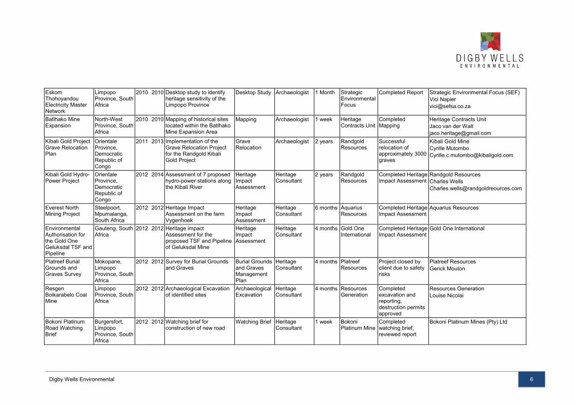
Digby Wells Environmental 6
Eskom Thohoyandou Electricity Master Network
Limpopo Province, South Africa
2010 2010 Desktop study to identify heritage sensitivity of the Limpopo Province
Desktop Study Archaeologist 1 Month Strategic Environmental Focus
Completed Report Strategic Environmental Focus (SEF) Vici Napier [email protected]
Batlhako Mine Expansion
North-West Province, South Africa
2010 2010 Mapping of historical sites located within the Batlhako Mine Expansion Area
Mapping Archaeologist 1 week Heritage Contracts Unit
Completed Mapping
Heritage Contracts Unit Jaco van der Walt [email protected]
Kibali Gold Project Grave Relocation Plan
Orientale Province, Democratic Republic of Congo
2011 2013 Implementation of the Grave Relocation Project for the Randgold Kibali Gold Project
Grave Relocation
Archaeologist 2 years Randgold Resources
Successful relocation of approximately 3000 graves
Kibali Gold Mine Cyrille Mutombo [email protected]
Kibali Gold Hydro-Power Project
Orientale Province, Democratic Republic of Congo
2012 2014 Assessment of 7 proposed hydro-power stations along the Kibali River
Heritage Impact Assessment
Heritage Consultant
2 years Randgold Resources
Completed Heritage Impact Assessment
Randgold Resources Charles Wells [email protected]
Everest North Mining Project
Steelpoort, Mpumalanga, South Africa
2012 2012 Heritage Impact Assessment on the farm Vygenhoek
Heritage Impact Assessment
Heritage Consultant
6 months Aquarius Resources
Completed Heritage Impact Assessment
Aquarius Resources
Environmental Authorisation for the Gold One Geluksdal TSF and Pipeline
Gauteng, South Africa
2012 2012 Heritage impact Assessment for the proposed TSF and Pipeline of Geluksdal Mine
Heritage Impact Assessment
Heritage Consultant
4 months Gold One International
Completed Heritage Impact Assessment
Gold One International
Platreef Burial Grounds and Graves Survey
Mokopane, Limpopo Province, South Africa
2012 2012 Survey for Burial Grounds and Graves
Burial Grounds and Graves Management Plan
Heritage Consultant
4 months Platreef Resources
Project closed by client due to safety risks
Platreef Resources Gerick Mouton
Resgen Boikarabelo Coal Mine
Limpopo Province, South Africa
2012 2012 Archaeological Excavation of identified sites
Archaeological Excavation
Heritage Consultant
4 months Resources Generation
Completed excavation and reporting, destruction permits approved
Resources Generation Louise Nicolai
Bokoni Platinum Road Watching Brief
Burgersfort, Limpopo Province, South Africa
2012 2012 Watching brief for construction of new road
Watching Brief Heritage Consultant
1 week Bokoni Platinum Mine
Completed watching brief, reviewed report
Bokoni Platinum Mines (Pty) Ltd
Digby Wells Environmental 7
SEGA Gold Mining Project
Burkina Faso 2012 2013 Socio Economic and Asset Survey
RAP Social Consultant
3 months Cluff Gold PLC
Completed field survey and data collection
Cluff Gold PLC
SEGA Gold Mining Project
Burkina Faso 2013 2013 Specialist Review of Heritage Impact Assessment
Reviewer Heritage Consultant
1 week Cluff Gold PLC
Reviewed specialist report and made appropriate recommendations
Cluff Gold PLC
Consbrey and Harwar Collieries Project
Breyton, Mpumalanga, South Africa
2013 2013 Heritage Impact Assessment for the proposed Consbrey and Harwar Collieries
Heritage Impact Assessment
Heritage Consultant
2 months Msobo Completed Heritage Impact Assessments
Msobo
New Liberty Gold Project
Liberia 2013 2014 Implementation of the Grave Relocation Project for the New Liberty Gold Project
Grave Relocation
Heritage Consultant
On-going Aureus Mining Project is on-going Aureus Mining
Falea Uranium Mine Environmental Assessment
Falea, Mali 2013 2013 Heritage Scoping for the proposed Falea Uranium Mine
Heritage Scoping
Heritage Consultant
2 months Rockgate Capital
Completed scoping report and recommended further studies
Rockgate Capital
Putu Iron Ore Mine Project
Petroken, Liberia
2013 2014 Heritage impact Assessment for the proposed Putu Iron Ore Mine, road extension and railway line
Heritage Impact Assessment
Heritage Consultant
6 months Atkins Limited Completed Heritage Impact Assessment and provided recommendations for further studies
Atkins Limited Irene Bopp [email protected]
Sasol Twistdraai Project
Secunda, Mpumalanga, South Africa
2013 2014 Notification of intent to Develop and Heritage Statement for the Sasol Twistdraai Expansion
NID Heritage Consultant
2 months ERM Southern Africa
Completed NID and Heritage Statement
ERM Southern Africa Alan Cochran [email protected]
Daleside Acetylene Gas Production Facility
Gauteng, South Africa
2013 2013 Project Management of the heritage study
NID Project Manager
3 months ERM Southern Africa
Project completed ERM Southern Africa Kasantha Moodley [email protected]
Exxaro Belfast, Paardeplaats and Eerstelingsfontein GRP
Belfast, Mpumalanga, South Africa
2013 2014 Grave Relocation Plan for the Belfast, Paardeplaats and Eerstelingsfontein Projects
GRP Project Manager, Heritage Consultant
On-going Exxaro Project is on-going Exxaro Johan van der Bijl [email protected]
Digby Wells Environmental 8
Nzoro 2 Hydro Power Project
Orientale Province, Democratic Republic of Congo
2014 2014 Social consultation for the Relocation Action Plan component of the Nzoro 2 Hydro Power Station
RAP Social Consultant
On-going Randgold Resources
Completed introductory meetings – project on-going
Kibali Gold Mine Cyrille Mutombo [email protected]
Eastern Basin AMD Project
Springs, Gauteng, South Africa
2014 2014 Heritage Impact Assessment for the proposed new sludge storage facility and pipeline
Heritage Impact Assessment
Heritage Consultant
On-going AECOM Project is on-going AECOM
Soweto Cluster Reclamation Project
Soweto, Gauteng, South Africa
2014 2014 Heritage Impact Assessment for reclamation activities associated with the Soweto Cluster Dumps
Heritage Impact Assessment
Heritage Consultant
On-going ERGO Project is on-going ERGO Greg Ovens [email protected]
Klipspruit South Project
Ogies, Mpumalanga, South Africa
2014 2014 NID and Heritage Statement for the Section 102 Amendment of the Klipspruit Mine EMP
NID Heritage Consultant
On-going BHP Billiton Project is on-going BHP Billiton
Klipspruit Extension: Weltevreden Project
Ogies, Mpumalanga, South Africa
2014 2014 NID and Heritage Statement for the expansion of the Klipspruit Mine
NID Heritage Consultant
On-going BHP Billiton Project is on-going BHP Billiton
Ergo Rondebult Pipeline Basic Assessment
Johannesburg, South Africa
2014 2014 NID and Heritage Statement for the construction of the Rondebult Pipeline
NID Heritage Consultant
1 Week ERGO Completed screening assessment and NID
ERGO
Kibali ESIA Update Project
Orientale Province, Democratic Republic of Congo
2014 2014 Update of the Kibali ESIA for the inclusion of new open-cast pit areas
Heritage Impact Assessment
Heritage Consultant
On-going Randgold Resources
Project is on-going Randgold Resources Charles Wells [email protected]
GoldOne EMP Consolidation
Westonaria, Gauteng, South Africa
2014 2014 Gap analysis for the EMP consolidation of operations west of Johannesburg
Gap Analysis Heritage Consultant
On-going Gold One International
Project is on-going Gold One International
JOHAN NEL
Digby Wells and Associates (South Africa) (Pty) Ltd (Subsidiary of Digby Wells & Associates (Pty) Ltd). Co. Reg. No. 2010/008577/07. Fern Isle, Section 10, 359 Pretoria Ave Randburg Private Bag X10046, Randburg, 2125, South Africa
Tel: +27 11 789 9495, Fax: +27 11 789 9498, [email protected], www.digbywells.com
________________________________________________ Directors: A Sing*, AR Wilke, DJ Otto, GB Beringer, LF Koeslag, AJ Reynolds (Chairman) (British)*, J Leaver*, GE Trusler (C.E.O)
*Non-Executive _________________________________________________
Mr Johan Nel
Unit manager: Heritage Resources Management
Social Sciences
Digby Wells Environmental
1 EDUCATION
Date Degree(s) or Diploma(s) obtained Institution
2014 Integrated Heritage Resources Management Certificate, NQF Level 6
Rhodes University
2002 BA (Honours) (Archaeology) University of Pretoria
2001 BA University of Pretoria
1997 Matric with exemption Brandwag Hoërskool
2 LANGUAGE SKILLS
Language Speaking Writing Reading
English Excellent Excellent Excellent
Afrikaans Excellent Excellent Excellent
3 EMPLOYMENT
Period Company Title/position
09/2011 to present
Digby Wells Environmental Manager: Heritage Resources Management unit
05/2010-2011 Digby Wells Environmental Archaeologist
10/2005-05/2010 Archaic Heritage Project Management Manager and co-owner
2003-2007 Freelance archaeologist
Rock Art Mapping Project Resident archaeologist

2
2002-2003 Department of Anatomy, University of Pretoria Special assistant: Anthropology
2001-2002 Department of Anatomy, University of Pretoria Technical assistant
1999-2001 National Cultural History Museum & Department of Anthropology and Archaeology, UP
Assistant: Mapungubwe Project,
4 EXPERIENCE
Johan Nel has 13 years of combined experience in the field of cultural heritage resources management (HRM) including archaeological and heritage assessments, grave relocation, social consultation and mitigation of archaeological sites. I have gained experience both within urban settings and remote rural landscapes. Since 2010 I have been actively involved in environmental management that has allowed me to investigate and implement the integration of heritage resources management into environmental impact assessments (EIA). Many of the projects since have required compliance with International Finance Corporation (IFC) requirements and other World Bank standards. This exposure has allowed me to develop and implement a HRM approach that is founded on international best practice and leading international conservation bodies such as UNESCO and ICOMOS. I have worked in most South African Provinces, as well as Swaziland, the Democratic Republic of the Congo, Liberia and Sierra Leone. I am fluent in English and Afrikaans, with excellent writing and research skills.
5 PROFESSIONAL REGISTRATION
Position Professional Body Registration Number
Council member Association for Southern African Professional Archaeologists (ASAPA);
ASAPA Cultural Resources Management (CRM) section
095
Member International Association of Impact Assessors (IAIA)
N/A
Member International Council on Monuments and Sites (ICOMOS)
Member Society for Africanist Archaeologists (SAfA) N/A
6 PUBLICATIONS AND CONFERENCE PAPERS
Authors and Year Title Published in/presented at
3
Nel, J. (2001) Cycles of Initiation in Traditional South African Cultures.
South African Encyclopaedia (MWEB).
Nel, J. 2001.. Social Consultation: Networking Human Remains and a Social Consultation Case Study
Research poster presentations at the. Bi-annual Conference (SA3) Association of Southern African Professional Archaeologists the National Museum, Cape Town
Nel, J. 2002. Collections policy for the WG de Haas Anatomy museum and associated Collections.
Unpublished. Department of Anatomy, School of Medicine: University of Pretoria.
Nel, J. 2004.. Research and design of exhibition for Eloff Belting and Equipment CC
Institute of Quarrying 35th Conference and Exhibition on 24 – 27 March 2004
Nel, J. 2004. Ritual and Symbolism in Archaeology, Does it exist?
Research paper presented at the Bi-annual Conference (SA3) Association of Southern African Professional Archaeologists: Kimberley
Nel, J & Tiley, S. 2004.
The Archaeology of Mapungubwe: a World Heritage Site in the Central Limpopo Valley, Republic of South Africa.
Archaeology World Report, (1) United Kingdom p.14-22.
Nel, J. 2007. The Railway Code: Gautrain, NZASM and Heritage.
Public lecture for the South African Archaeological Society, Transvaal Branch: Roedean School, Parktown.
Nel, J. 2009. Un-archaeologically speaking: the use, abuse and misuse of archaeology in popular culture.
The Digging Stick. April 2009. 26(1): 11-13: Johannesburg: The South African Archaeological Society.
Nel, J. 2011. ‘Gods, Graves and Scholars’ returning Mapungubwe human remains to their resting place.’ In: Mapungubwe Remembered.
University of Pretoria commemorative publication: Johannesburg: Chris van Rensburg Publishers.
Nel, J. 2012 HIAs for EAPs. . Paper presented at IAIA annual conference: Somerset West.
4
Nel, J. 2013. The Matrix: A proposed method to evaluate significance of, and change to, heritage resources.
Paper presented at the 2013 ASAPA Biennial conference: Gaborone, Botswana.
Nel, J. 2013 HRM and EMS: Uncomfortable fit or separate process.
. Paper presented at the 2013 ASAPA Biennial conference: Gaborone, Botswana.
7 PROJECT EXPERIENCE
■ 2003-2004. Freelance consulting archaeologist. Archaeological Impact Assessment. Roodt&Roodt. RSA. Limpopo, Mpumalanga, Northwest. Project manager/specialist
■ 2004-2005. Resident archaeologist Rock Art Mapping Project. Archaeological surveys. UKZN. RSA. Didima, KZN. Specialist
■ 2006. Exploratory excavation of an unknown cemetery at Du Preezhoek, Fountains Valley, Portion 383 of the farm Elandspoort 357 JR, Pretoria, Gauteng. Section 36 Grave relocation. Bombela Civil Joint Venture. RSA. Pretoria, Gauteng. Specialist
■ 2006. Report on exhumation, relocation and re-internment of 49 graves on Portion 10 of the farm Tygervallei 334 JR, Kungwini Municipality, Gauteng. Section 36 Grave relocation. D. Georgiades East Farm (Pty) Ltd. RSA. Kungwini, Gauteng. Specialist
■ 2006. Social consultation for Elawini Lifestyle Estate Grave Relocation. Section 36 Consultation. PGS (Pty) Ltd. RSA. Nelspruit, Mpumalanga. Project manager/specialist
■ 2007-2008. Research report on the remains of kings Mampuru I and Nyabela. Research report. National Department of Arts and Culture. RSA. Graafwater, Western Cape. Specialist
■ 2007. Summary report: Old dump on premises of the new Head Offices, Department of Foreign Affairs, Pretoria, Gauteng. Archaeological Impact Assessment. Imbumba-Aganang D & C Joint Venture. RSA. Pretoria, Gauteng. Project manager/specialist
■ 2007. Final consolidated Heritage Impact Assessment report: Proposed development of high-cost housing and filling station, Portion of the farm Mooiplaats 147 JT. Heritage Impact Assessment. Go-Enviroscience. RSA. Schoemanskloof, Mpumalanga. Project manager/specialist
■ 2007. Final consolidated report: Watching Brief on Soutpansberg Road Site for the new Head Offices of the Department of Foreign Affairs, Pretoria Gauteng. Section 35 Phase 2 Archaeological Mitigation. Imbumba-Aganang D & C Joint Venture. RSA. Pretoria, Gauteng. Project manager/specialist
■ 2007. Recommendation of Exemption: Above ground SASOL fuel storage tanks located at grain silos in localities in the Eastern Free State. Request for Exemption. SASOL (Pty) Ltd. RSA. Eastern Free State. Project manager/specialist
5
■ 2007. Final consolidated report: Phase 2 test excavations ascertaining the existence of alleged mass graves, Tlhabane West, Extension 2, Rustenburg, Northwest Province. Section 36 Test excavations. Bigen Africa Consulting Engineers. RSA. Rustenburg, Northwest. Project manager/specialist
■ 2007. Archaeological investigation of Old Johannesburg Fort. Section 35 Phase 2 Archaeological Mitigation. JDA. RSA. Johannesburg, Gauteng. Project manager/specialist
■ 2007. Social consultation for Motaganeng Residential Development Grave Relocation. Section 36 Consultation. PGS (Pty) Ltd. RSA. Burgersfort, Limpopo. Project manager/specialist
■ 2007. Repatriation of Mapungubwe Human Remains. Repatriation. DEAT. RSA. Mapungubwe, Limpopo. Project manager/specialist
■ 2007. Research report on cultural symbols. Research report. Ministery of Intelligence Services. RSA. Graafwater, Western Cape. Project manager/specialist
■ 2008. Phase 1 Heritage and Archaeological Impact Assessment: Proposed establsihement of an access road between Sapekoe Drive and Koedoe Street, Erf 3366 (Extension 22) and the Remainder of Erf 430 (Extension 4). Archaeological Impact Assessment. AGES (Polokwane). RSA. Tzaneen, Limpopo. Specialist
■ 2008. Heritage Impact Assessment for proposed water pipeline routes, Mogalakwena District, Limpopo Province. Heritage Statement. AGES (Polokwane). RSA. Mogalakwena District Municipality, Limpopo. Specialist
■ 2008. Final report: Heritage resources Scoping survey and preliminary assessment for the Transnet Freight Line EIA, Eastern Cape and Northern Cape. Heritage Statement. Transnet. RSA. Eastern Cape; Northern Cape. Specialist
■ 2008. Heritage resources scoping survey and preliminary assessment: Proposed establishment of township on Portion 28 of the farm Kennedy's Vale 362 KT, Steelpoort, Limpopo Province. Heritage Statement. AGES (Polokwane). RSA. Steelpoort, Limpopo. Specialist
■ 2008. Report on skeletal material found at Pier 30, R21 Jones Street offramp, Kempton Park. Heritage Statement. Bombela Civil Joint Venture. RSA. Kempton Park, Gauteng. Specialist
■ 2008. Social consultation for Smoky Hills Platinum Mine Grave Relocation. Section 36 Consultation. PGS (Pty) Ltd. RSA. Maandagshoek, Limpopo. Specialist
■ 2008. Southstock Collieries Grave Relocation. Section 36 Grave relocation. Doves Funerals, Witbank. RSA. Southstock, Mpumalanga. Specialist
■ 2008. Social consultation for Zondagskraal Coal Mine Grave Relocation. Section 36 Consultation. PGS (Pty) Ltd. RSA. Zondagskraal, Mpumalanga. Specialist
6
■ 2009. Proposed road upgrade of existing, and construction of newroads in Burgersfort, Limpopo Province. Archaeological Impact Assessment. AGES (Polokwane). RSA. Burgersfort, Limpopo. Specialist
■ 2009. Randwater Vlakfontein-Mamelodi water pipeline survey. Heritage Impact Assessment. Archaeology Africa cc. RSA. Pretoria, Gauteng. Specialist
■ 2009. Van Reenen Eco-Agri Development Project. Heritage Impact Assessment. Go-Enviroscience. RSA. Vanreenen, Freestate/KwaZulu-Natal. Specialist
■ 2009. Social consultation for Zonkezizwe Grave Relocation. Section 36 Consultation. PGS (Pty) Ltd. RSA. Midrand, Gauteng. Specialist
■ 2009. Heritage Impact Assessment for conversion of PR to MRA. Heritage Impact Assessment. Georock Environmental. RSA. Musina, Limpopo. Specialist
■ 2010-2012. Kibali Gold Mine Grave Relocation. International grave relocation project. Randgold Resources. DRC. Watsa, Province Orientale. Specialist
■ 2010. Archaeological Impact Assessment for Galaxy Gold Mine Tailings Dam Extension, Barberton, Mpumalanga Province. Archaeological Impact Assessment. Galaxy Gold. RSA. Barberton, Mpumalanga. Specialist
■ 2010. Archaeological Impact Assessment for the HCI Khusela Coal: Palesa Extension ESIA Update on portions of the farm Roodepoort 349 JR, Thembisile Local Municipality (Mpumalanga) and Kungwini Municipality (Gauteng). Archaeological Impact Assessment. HCI Khusela. RSA. Mpumalanga; Gauteng. Specialist
■ 2010. Heritage scoping survey for the amendment of the existing City Deep EMP for the reclamation of Slimes Dam 3/L/42 and 3/L/40. Heritage Statement. Crown Gold Recoveries. RSA. Johannesburg, Gauteng. Specialist
■ 2010. Letter of Recommendation of Exemption for the proposed Crown Gold Recoveries (Pty) Litd Pipeline Project. Request for Exemption. Crown Gold Recoveries. RSA. Johannesburg, Gauteng. Specialist
■ 2010. Mitigation of an archaeological metalworking site for Kibali Gold Mine. Archaeological mitigation. Randgold Resources. DRC. Watsa, Province Orientale. Specialist
■ 2010. Heritage Impact Assessment for Nzoro Hydropower Station. Heritage Impact Assessment. Randgold Resources. DRC. Watsa, Province Orientale. Specialist
■ 2010. Heritage Impact Assessment for Temo Coal EIA. Heritage Impact Assessment. Temo Coal. RSA. Steenbokpan, Limpopo. Specialist
■ 2011-2012. Platreef Platinum Mine Burial Grounds and Graves Census. Burial Grounds and Graves Census. Platreef (Pty) Ltd. RSA. Mokopane, Limpopo. Project manager/specialist
■ 2011. Addendum to Phase 1 Archaeological Impact Assessment for the Boikarabelo Coal Mine (proposed railway link from the farm Kruishout to the farm Buffelsjagt). Archaeological Impact Assessment. Resources Generation. RSA. Lephalale, Limpopo. Project manager/specialist
7
■ 2011. Heritage Impact Assesment for Koidu Diamond Mine. Heritage Impact Assessment. Koidu . Sierra Leone. Koidu, . Project manager/specialist
■ 2011. Mitigation of an archaeological metalworking site for Koidu Diamond Mine. Archaeological mitigation. Koidu . Sierra Leone. Koidu, . Project manager/specialist
■ 2011. Nzoro hydropower station ESIA. Heritage Impact Assessment. Randgold Resources. DRC. Watsa, Province Orientale. Project manager/specialist
■ 2011. Specialist review of Heritage Impact Assessment report for Zod Gold Mine, Armenia. Review report. Zod Gold Mine. Armenia. Desktop review. Project manager/specialist
■ 2012. Phase 1 Archaeological Impact Assessment for MBET Pipeline. Archaeological Impact Assessment. Resources Generation. RSA. Lephalale, Limpopo. Project manager/specialist
■ 2012. Heritage Impact Assessment for the Witwatersrand Goldfields Acid Mine Drainage Project (Western Basin). Heritage Impact Assessment. BKS (PTY) LTD. RSA. Johannesburg, Gauteng. Project manager/specialist
■ 2012. Phase 1 Heritage Impact Assessment of the proposed Geluksdal Tailings Storage Facility and Pipeline Infrastructure. Heritage Impact Assessment. Gold One. RSA. Johannesburg, Gauteng. Project manager/specialist
■ 2012. Heritage Statement for the Central Basin, Witwatersrand AMD Project. Heritage Statement. BKS (PTY) LTD. RSA. Johannesburg, Gauteng. Project manager/specialist
■ 2012. Heritage Statement for Rhodium Reefs Ltd Platinum Operation, 2430CA & CC, De Goedeverwachting 332 KT; Boschkloof 331 KT; Belvedere 362 KT; Kennedy's Vale 361 KT; and Tweefontein 360 KT, Limpopo. Heritage Statement. Eastplats Group. RSA. Steelpoort, Limpopo. Project manager/specialist
■ 2012. Notification of Intent to Develop: Proposed Aggeneys Photo-voltaic soal power plant on Portion 1 of the farm Aroams 57 RD, Northern Cape (DEA ref: 12/12/20/2630). Heritage Statement. Orlight Solar. RSA. Aggeneys, Northern Cape. Specialist
■ 2012. Notification of Intent to Develop: Proposed Kenhardt Photo-voltaic soal power plant on RE of the farm Klein Zwartbast 188 RD, Northern Cape (DEA ref: 12/12/20/2631). Heritage Statement. Orlight Solar. RSA. Kenhardt, Northern Cape. Project manager/specialist
■ 2012. Notification of Intent to Develop: Proposed Loeriesfontein Photo-voltaic soal power plant on Portion 1 of the farm Klein Rooiberg 227 RD, Northern Cape (DEA ref: 12/12/20/2632). Heritage Statement. Orlight Solar. RSA. Loeriesfontein, Northern Cape. Specialist
■ 2012. Notification of Intent to Develop: Proposed Vanrhynsdorp Photo-voltaic soal power plant on RE of the farm Paddock 257 RD, Western Cape (DEA ref: 12/12/20/2633). Heritage Statement. Orlight Solar. RSA. Vanrhynsdorp, Western Cape. Project manager/specialist
■ 2012. Notification of Intent to Develop: Proposed Graafwater Photo-voltaic soal power plant on Portion 1 of the farm Graafwater 97 RD amd RE of Bueroskraal 220 RD, Western Cape
8
(DEA ref: 12/12/20/2636). Heritage Statement. Orlight Solar. RSA. Graafwater, Western Cape. Specialist
■ 2012. Phase 2 archaeological impact assessment mitigation for Boikarabelo Coal Mine (SAHRA Permit No: 80/11/07/015/51). . Section 35 Phase 2 Archaeological Mitigation. Resources Generation. RSA. Steenbokpan, Limpopo. Project manager/specialist
■ 2012. Final Phase 2 archaeological impact assessment mitigation report for Boikarabelo Coal Mine, Limpopo (SAHRA Permit No: 80/11/07/015/51). . Section 35 Phase 2 Archaeological Mitigation. Resources Generation. RSA. Steenbokpan, Limpopo. Specialist
■ 2012. Holder of Destruction Permit No. 84 for archaeological sites at Boikarabelo Coal Mine. Section 35 Destruction permit. Resources Generation. RSA. Steenbokpan, Limpopo. Project manager/specialist
■ 2012. Specialist review of Heritage Impact Assessment report for Mkuju Uraniam Mine. Review report. Uranex . Zambia. Desktop review. Project manager/specialist
■ 2013. Heritage Impact Assessment for the proposed Consbrey Colliery Project, 2629BB and 2629BD, Mpumalanga Province. Heritage Impact Assessment. Msobo Coal. RSA. Breyten, Mpumalanga. Project manager/specialist
■ 2013. Heritage Impact Assessment for Rhodium Reef Limited Platinum Operation, 2430CC Kennedys Vale, De Goedeverwachting 332 KT, Limpopo Province. Heritage Impact Assessment. Rhodium Reefs Limited. RSA. Steelpoort, Limpopo. Project manager/specialist
■ 2013. Heritage Statement for the Consbrey Colliery. Heritage Statement. Msobo Coal. RSA. Chrissiesmeer, Mpumalanga. Project manager/specialist
■ 2013. Heritage Statement for the Harwar Colliery. Heritage Statement. Msobo Coal. RSA. Chrissiesmeer, Mpumalanga. Project manager/specialist
■ 2013. Heritage Statement for the Waterberg Prospecting Rights Application, Blouberg, Limpopo Province. Heritage Statement. Platinum Group Metals Ltd. RSA. Breyten, Mpumalanga. Specialist
■ 2013. Destruction Permit Application Report for Kangala Coal Project. Section 34 Built Environment Permit. Universal Coal (Pty) Ltd. RSA. Delmas, Mpumalanga. Specialist
■ 2013. Holder of Destruction Permit No. 399 for archaeological sites at Boikarabelo Coal Mine. Section 35 Destruction permit. Resources Generation. RSA. Steenbokpan, Limpopo. Project manager/specialist
■ 2013. Relocation of graves in Kinjor and Larjor for Aureus New Liberty Gold Mine. International grave relocation project. Aureus Mining. Liberia. Kinjor. Specialist
■ 2013. New Liberty Gold Mine Grave Relocation Plan. International grave relocation project. Aureus Mining. Liberia. Kinjor. Project manager/specialist
■ 2013. Thabametsi Coal Mine Burial Grounds and Graves Census. Burial Grounds and Graves Census. Exxaro Coal. RSA. Lephalale, Limpopo. Specialist
9
■ 2013. Bokoni Platinum Mine Burial Grounds and Graves Census. Burial Grounds and Graves Census. Bokoni Platinum. RSA. Atok, Limpopo. Specialist
■ 2013. Specialist review of Heritage Impacts Assessment for Songwe REE project. Review report. Mkango Resources. Malawi. Desktop review. Project manager/specialist
■ 2013: Heritage Impact Assessment for the Platreef Platinum Mine EIA project. Platreef Resources. RSA. Mokopane, Limpopo. Specialist project manager.
Heritage Impact Assessment
Mining Right Application for Reclamation of the Soweto Cluster Dumps, Roodepoort, Gauteng Province
ERG2613
Appendix B: Plans and Site List
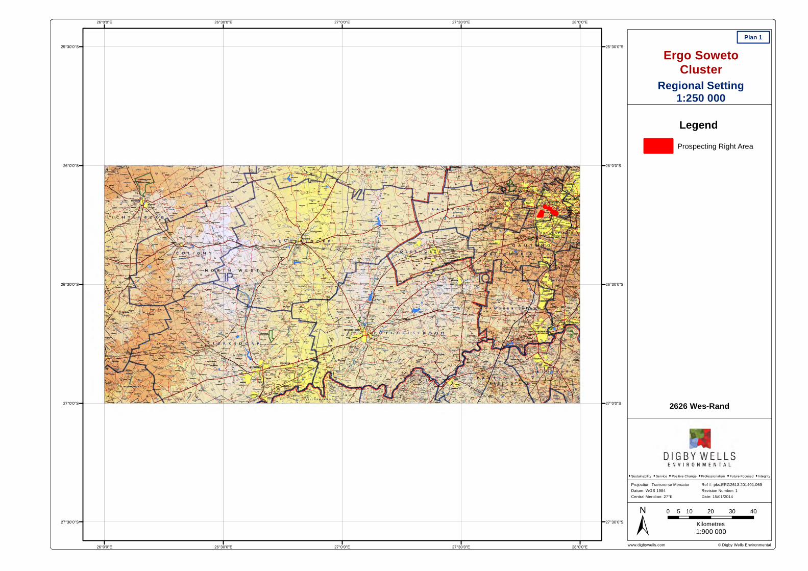
© Digby Wells Environmentalwww.digbywells.com28°0'0"E
28°0'0"E
27°30'0"E
27°30'0"E
27°0'0"E
27°0'0"E
26°30'0"E
26°30'0"E
26°0'0"E
26°0'0"E
25°30'0"S 25°30'0"S
26°0'0"S 26°0'0"S
26°30'0"S 26°30'0"S
27°0'0"S 27°0'0"S
27°30'0"S 27°30'0"S
Ergo SowetoCluster
Plan 1
1:900 000±Projection: Transverse MercatorDatum: WGS 1984Central Meridian: 27°E
Ref #: pks.ERG2613.201401.069Revision Number: 1Date: 15/01/2014
Sustainability Service Positive Change Professionalism Future Focused Integrity
LegendProspecting Right Area
0 10 20 30 405Kilometres
Regional Setting1:250 000
2626 Wes-Rand
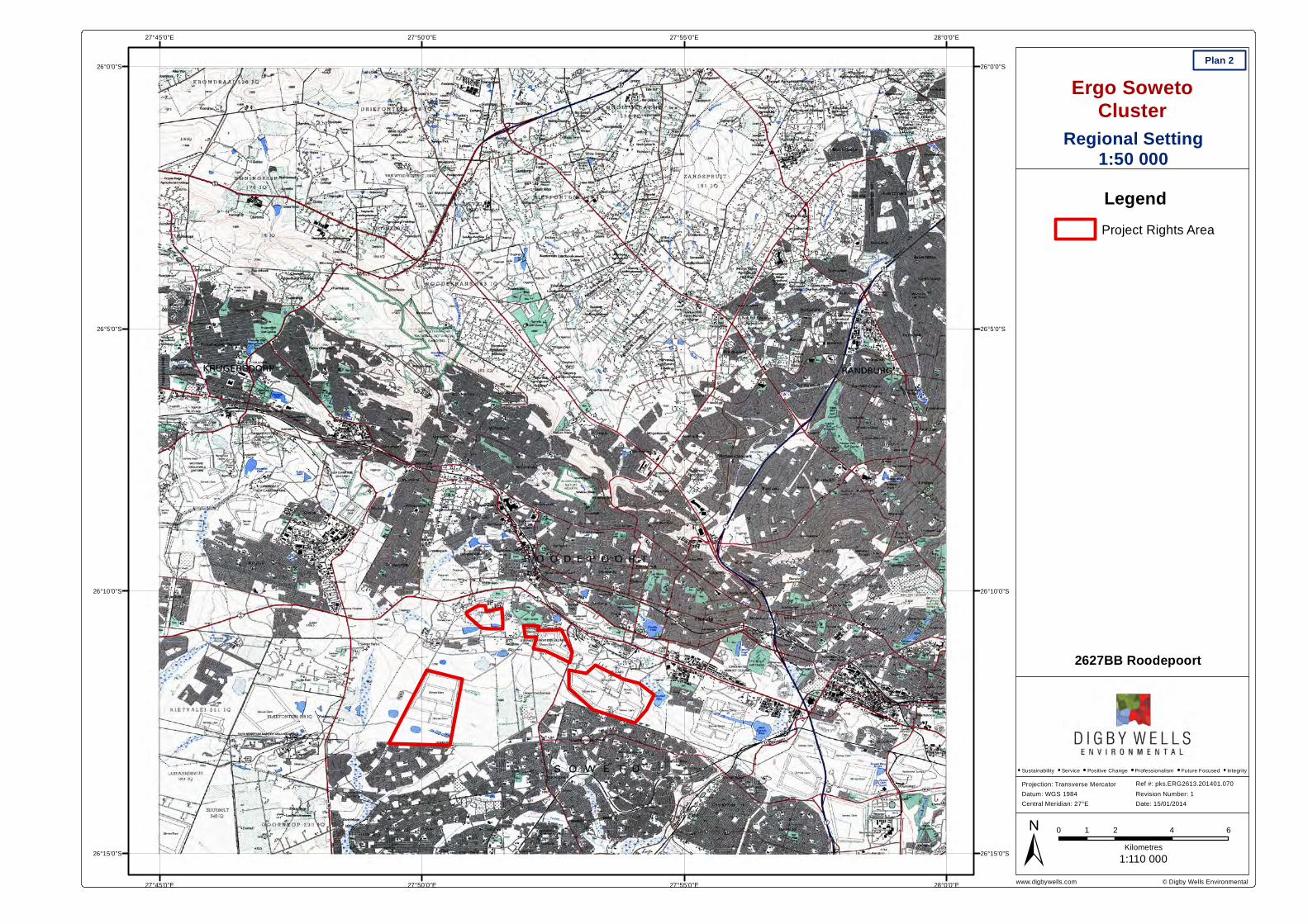
© Digby Wells Environmentalwww.digbywells.com28°0'0"E
28°0'0"E
27°55'0"E
27°55'0"E
27°50'0"E
27°50'0"E
27°45'0"E
27°45'0"E
26°0'0"S 26°0'0"S
26°5'0"S 26°5'0"S
26°10'0"S 26°10'0"S
26°15'0"S 26°15'0"S
Ergo SowetoCluster
Plan 2
1:110 000±Projection: Transverse MercatorDatum: WGS 1984Central Meridian: 27°E
Ref #: pks.ERG2613.201401.070Revision Number: 1Date: 15/01/2014
Sustainability Service Positive Change Professionalism Future Focused Integrity
LegendProject Rights Area
0 2 4 61Kilometres
Regional Setting1:50 000
2627BB Roodepoort
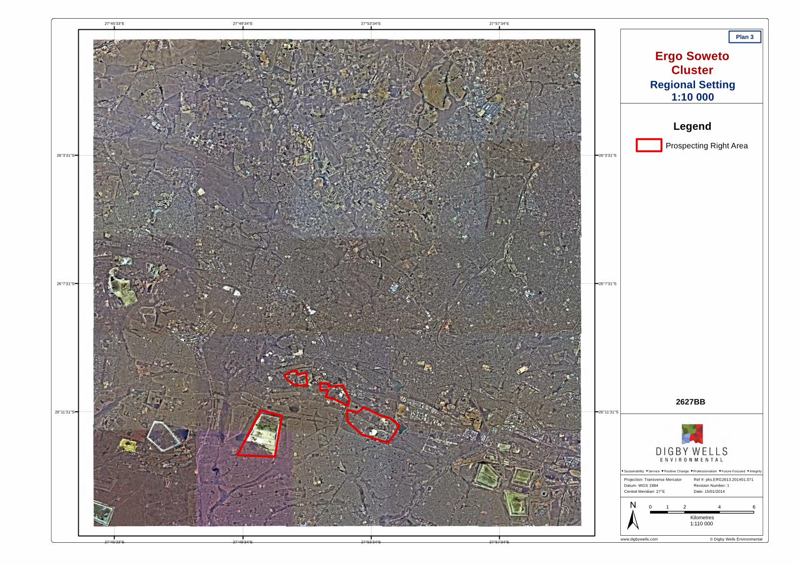
© Digby Wells Environmentalwww.digbywells.com27°57'34"E
27°57'34"E
27°53'34"E
27°53'34"E
27°49'34"E
27°49'34"E
27°45'33"E
27°45'33"E
26°3'31"S 26°3'31"S
26°7'31"S 26°7'31"S
26°11'31"S 26°11'31"S
Ergo SowetoCluster
Plan 3
1:110 000±Projection: Transverse MercatorDatum: WGS 1984Central Meridian: 27°E
Ref #: pks.ERG2613.201401.071Revision Number: 1Date: 15/01/2014
Sustainability Service Positive Change Professionalism Future Focused Integrity
LegendProspecting Right Area
0 2 4 61Kilometres
Regional Setting1:10 000
2627BB
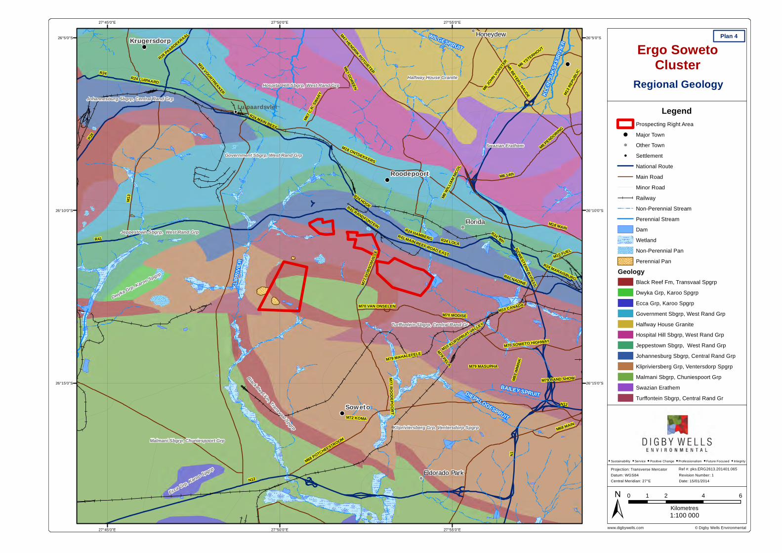
© Digby Wells Environmentalwww.digbywells.com
!
!
!
!
!R
!
!R
!
!R
!
!!
!
KLIPR
IVIER
BAILEY SPRUIT
WILGESPRUIT
KLEIN
-JUKS
KEIRI
VIER
DIEPKLOOFSPRUIT
N12
N1
M13
R41
R28
N1 WESTERN BYPASS
M18 ONTDEKKERS
R24 MAIN REEF
M68 POTCHEFSTROOM
R41 RANDFONTEIN
M47 HENDRIK POTGIETER
R41 NADINE
M5 BEYERS NAUDE
M77 D
OBSO
NVILL
E
M8 14th
R24
M72 KOMA
M18 VOORTREKKER
M18 MAINR24 HAMBERG
M83 I
MMINK
R24 LUIPAARD
M10 CANADA
M68 MAIN
R24 MARAISBURG
M10 KLIPSPRUIT VALLEY
M70 SOWETO HIGHWAY
R28 PAARDEKRAAL
M10 FUEL
M79 PELA
M13 R
EPUB
LIC
M70 MODISE
M67 C
.R. SW
ART
M79 MASUPHA
R41 MAIN REEF ROAD EAST
R24 LOLA
M6 YSTERHOUT
M67 DOREEN
M79 MAHALEFELE
M70 VAN ONSELEN
M6 JOHN VO
RSTER
M79 RAND SHOW
M8 PENDORING
R24 9th
M77 ROODEPOORT
M8 W
ILLIAM
NICO
L
R24 HOOF
N12Soweto
Roodepoort
Krugersdorp
Florida
Honeydew
Eldorado Park
Luipaardsvlei
Malmani Sbgrp, Chuniespoort Grp
Klipriviersberg Grp, Ventersdorp Spgrp
Turffontein Sbgrp, Central Rand Gr
Halfway House Granite
Government Sbgrp, West Rand GrpSwazian Erathem
Jeppestown Sbgrp, West Rand Grp
Hospital Hill Sbgrp, West Rand Grp
Johannesburg Sbgrp, Central Rand Grp
Black Reef Fm, Transvaal SpgrpEcca Grp, Karoo Spgrp
Dwyka Grp, Karoo Spgrp
27°55'0"E
27°55'0"E
27°50'0"E
27°50'0"E
27°45'0"E
27°45'0"E
26°5'0"S 26°5'0"S
26°10'0"S 26°10'0"S
26°15'0"S 26°15'0"S
Ergo SowetoCluster
Regional Geology
Plan 4
LegendProspecting Right Area
! Major Town!R Other Town! Settlement
National RouteMain RoadMinor RoadRailwayNon-Perennial StreamPerennial StreamDamWetlandNon-Perennial PanPerennial Pan
GeologyBlack Reef Fm, Transvaal SpgrpDwyka Grp, Karoo SpgrpEcca Grp, Karoo SpgrpGovernment Sbgrp, West Rand GrpHalfway House GraniteHospital Hill Sbgrp, West Rand GrpJeppestown Sbgrp, West Rand GrpJohannesburg Sbgrp, Central Rand GrpKlipriviersberg Grp, Ventersdorp SpgrpMalmani Sbgrp, Chuniespoort GrpSwazian ErathemTurffontein Sbgrp, Central Rand Gr
0 2 4 61Kilometres1:100 000±
Projection: Transverse MercatorDatum: WGS84Central Meridian: 27°E
Ref #: pks.ERG2613.201401.065Revision Number: 1Date: 15/01/2014
Sustainability Service Positive Change Professionalism Future Focused Integrity
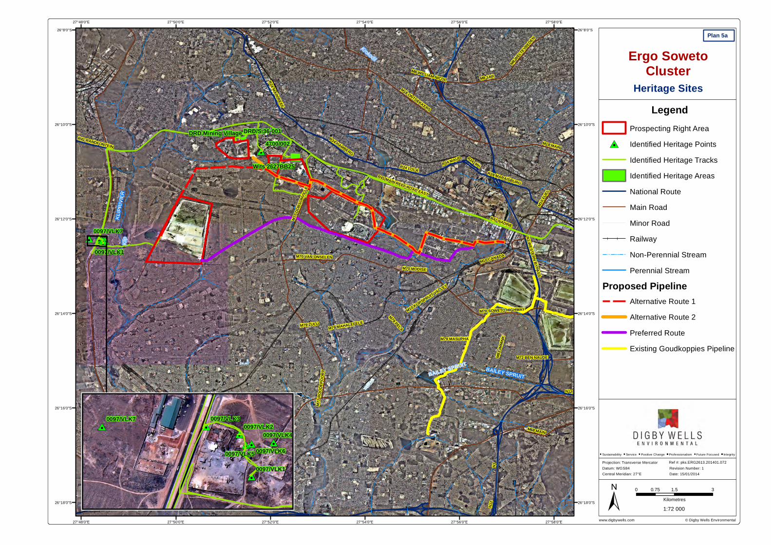
© Digby Wells Environmentalwww.digbywells.com
4700/002
0097/VLK7
0097/VLK1
Wits 2627BB25
DRD Mining Village DRD/S.36-001
KLIPR
IVIER
BAILEY SPRUIT
N1N12
M68 POTCHEFSTROOM
M18 ONTDEKKERS
N1 WESTERN BYPASS
R41 RANDFONTEIN
R41 NADINE
M77 D
OBSO
NVILL
E
M8 14th
M72 KOMA
R24 HAMBERG
M83 I
MMIN
K
M10 CANADA
R24 MAIN REEF
M10 KLIPSPRUIT VALLEY
R24 MARAISBURG
M18 MAIN
M70 SOWETO HIGHWAY
M68 MAIN
M79 PELA
M70 MODISE
M79 MASUPHA
R41 MAIN REEF ROAD EAST
M10 F
UEL
R24 LOLA
M79 MAHALEFELE
M70 VAN ONSELEN
R24 9th
M77 R
OODE
POOR
T
R24 MAUD
M72 BEN NAUDE
M8 WILLIAM NICOL
M8 WELT
EVREDEN
M79 ZULU
N12
N12
BAILEY SPRUIT
Klip
Krokodil
27°58'0"E
27°58'0"E
27°56'0"E
27°56'0"E
27°54'0"E
27°54'0"E
27°52'0"E
27°52'0"E
27°50'0"E
27°50'0"E
27°48'0"E
27°48'0"E26°8'0"S 26°8'0"S
26°10'0"S 26°10'0"S
26°12'0"S 26°12'0"S
26°14'0"S 26°14'0"S
26°16'0"S 26°16'0"S
26°18'0"S 26°18'0"S
Ergo SowetoCluster
Heritage Sites
Plan 5a
LegendProspecting Right AreaIdentified Heritage PointsIdentified Heritage TracksIdentified Heritage AreasNational RouteMain RoadMinor RoadRailwayNon-Perennial StreamPerennial Stream
Proposed PipelineAlternative Route 1Alternative Route 2Preferred RouteExisting Goudkoppies Pipeline
0 1.5 30.75Kilometres1:72 000
Projection: Transverse MercatorDatum: WGS84Central Meridian: 27°E
Ref #: pks.ERG2613.201401.072Revision Number: 1Date: 15/01/2014
Sustainability Service Positive Change Professionalism Future Focused Integrity
0097/VLK7
0097/VLK60097/VLK5
0097/VLK4
0097/VLK30097/VLK2
0097/VLK1
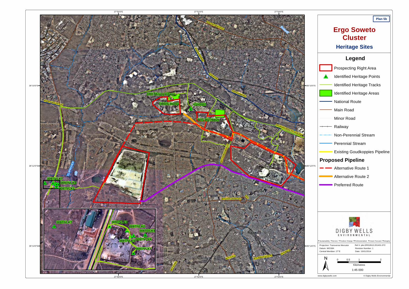
© Digby Wells Environmentalwww.digbywells.com
4700/002
0097/VLK70097/VLK4
0097/VLK1
Wits 2627BB25
DRD Mining Village
DRD/S.36-001
KLIPR
IVIER
R41 RANDFONTEIN
M77 D
OBSO
NVILL
E
M18 ONTDEKKERS
R24 HAMBERG
M72 K
OMA
R24 MAIN REEF
R41 MAIN REEF ROAD EAST
M79 MAHALEFELE
M70 VAN ONSELEN
M79 PELA
M70
R24 HOOF
M79 ZULU
Klip
Krokodil
27°54'0"E
27°54'0"E
27°52'0"E
27°52'0"E
27°50'0"E
27°50'0"E
26°10'0"S 26°10'0"S
26°12'0"S 26°12'0"S
26°14'0"S 26°14'0"S
Ergo SowetoCluster
Heritage Sites
Plan 5b
LegendProspecting Right AreaIdentified Heritage PointsIdentified Heritage TracksIdentified Heritage AreasNational RouteMain RoadMinor RoadRailwayNon-Perennial StreamPerennial StreamExisting Goudkoppies Pipeline
Proposed PipelineAlternative Route 1Alternative Route 2Preferred Route
0 1 20.5Kilometres
1:45 000
Projection: Transverse MercatorDatum: WGS84Central Meridian: 27°E
Ref #: pks.ERG2613.201401.072Revision Number: 1Date: 15/01/2014
Sustainability Service Positive Change Professionalism Future Focused Integrity
0097/VLK7
0097/VLK60097/VLK5
0097/VLK4
0097/VLK30097/VLK2
0097/VLK1
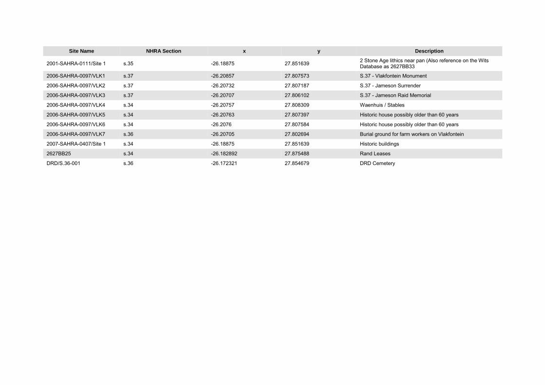
Site Name NHRA Section x y Description
2001-SAHRA-0111/Site 1 s.35 -26.18875 27.851639 2 Stone Age lithics near pan (Also reference on the Wits Database as 2627BB33
2006-SAHRA-0097/VLK1 s.37 -26.20857 27.807573 S.37 - Vlakfontein Monument
2006-SAHRA-0097/VLK2 s.37 -26.20732 27.807187 S.37 - Jameson Surrender
2006-SAHRA-0097/VLK3 s.37 -26.20707 27.806102 S.37 - Jameson Raid Memorial
2006-SAHRA-0097/VLK4 s.34 -26.20757 27.808309 Waenhuis / Stables
2006-SAHRA-0097/VLK5 s.34 -26.20763 27.807397 Historic house possibly older than 60 years
2006-SAHRA-0097/VLK6 s.34 -26.2076 27.807584 Historic house possibly older than 60 years
2006-SAHRA-0097/VLK7 s.36 -26.20705 27.802694 Burial ground for farm workers on Vlakfontein
2007-SAHRA-0407/Site 1 s.34 -26.18875 27.851639 Historic buildings
2627BB25 s.34 -26.182892 27.875488 Rand Leases
DRD/S.36-001 s.36 -26.172321 27.854679 DRD Cemetery

Heritage Impact Assessment
Mining Right Application for Reclamation of the Soweto Cluster Dumps, Roodepoort, Gauteng Province
ERG2613
Appendix C: Impact Matrix Methodology
_________________________________________________ Digby Wells and Associates (South Africa) (Pty) Ltd (Subsidiary of Digby Wells & Associates (Pty) Ltd). Co. Reg. No. 2010/008577/07. Fern Isle, Section 10, 359 Pretoria
Ave Randburg Private Bag X10046, Randburg, 2125, South Africa Tel: +27 11 789 9495, Fax: +27 11 789 9498, [email protected], www.digbywells.com
________________________________________________ Directors: A Sing*, AR Wilke, LF Koeslag, PD Tanner (British)*, AJ Reynolds (Chairman) (British)*, J Leaver*, GE Trusler (C.E.O)
*Non-Executive _________________________________________________
DIGBY WELLS ENVIRONMENTAL
HERITAGE IMPACT MATRIX
METHODOLOGY
HRM UNIT MANAGER: JOHAN NEL
FEBRUARY 2014
DIGBY WELLS ENVIRONMENTAL HERITAGE IMPACT MATRIX METHODOLOGY
ii
TABLE OF CONTENTS
1 INTRODUCTION .............................................................................................................. 3
2 STATEMENT OF SIGNIFICANCE OR VALUE ................................................................ 3
2.1 IMPORTANCE ............................................................................................................ 4
2.1.1 Authenticity ...................................................................................................... 5
2.1.2 Credibility ......................................................................................................... 5
2.2 INTEGRITY ................................................................................................................ 5
3 IMPACT ASSESSMENT ................................................................................................... 6
4 REFERENCES ............................................................................................................... 13
LIST OF TABLES
Table 2-1: Summary of dimensions and attributes ................................................................................ 4
Table 2-2: Integrity definitions ................................................................................................................ 6
Table 3-1: Impact characteristic terminology ......................................................................................... 6
Table 3-2: Description of magnitude ratings .......................................................................................... 8
Table 3-3: Scores, descriptions and ratings determining consequence of impact ................................ 9
Table 3-4: Significance of impact on categories of heritage resources ............................................... 11
DIGBY WELLS ENVIRONMENTAL HERITAGE IMPACT MATRIX METHODOLOGY
3
1 INTRODUCTION
The impact assessment stage includes several steps aimed to evaluate the way in which environmental aspects will/may interact with the cultural landscape (the environment) resulting in environmental impacts to heritage resources. Environmental aspects and impacts are defined as:
■ Environmental aspects: an element of an organisation’s activities or products or
services that can interact with the environment’ (ISO 14001: 2004 - 3.6); and
■ Environmental impacts: any change to the environment, whether adverse or
beneficial, wholly or partially resulting from an organization's environmental aspects
(ISO 14001: 2004 - 3.7).
However, in terms of cultural heritage resources, environmental impacts should be assessed relative to the heritage value or significance of a resource. The methodology employed in the various stages of the impact assessment process is described in more detail below.
2 STATEMENT OF SIGNIFICANCE OR VALUE
Heritage resources – both cultural and natural – are finite, non-renewable and irreplaceable. They characterise community identity and cultures and are therefore are intrinsic to the history and beliefs of communities. As sources of information, heritage resources have inherent potential to contribute significantly to research, education and tourism, as well as allowing capacity for reconciliation, understanding and mutual respect.
Considering the innate value of heritage resources, the foundation of heritage resources management (HRM) is the acknowledgement that heritage resources have lasting worth as evidence of the origins of life, humanity and society. Every generation is therefore morally obligated to act as trustees of heritage for future generations through conservation, preservation and protection.
Accordingly, HRM must take into account rights of affected communities to be consulted and to participate. Where heritage resources are developed and presented the dignity and respect of diverse cultural values must be ensured. In addition, heritage in its broadest sense must never be used for sectarian purposed or political gain.
Notwithstanding the fundamental value ascribed to heritage, significance of individual resources needs to be determined to allow implementation of appropriate management measures. This is achieved through assessing a heritage resource’s value relative to certain prescribed criteria, encapsulated in international conventions as well as national legislation. This is addressed in Section 2.1 below.
The significance/value is established by determining the level of importance taking and assessing the degree of integrity of cultural heritage resources. A resource’s value thus influences the intensity of environmental impacts. As a result, environmental impacts that are rated low may cause severe change in a heritage resources rated as highly significant. Vice versa, severe impacts may cause negligible change to an insignificant resource.
DIGBY WELLS ENVIRONMENTAL HERITAGE IMPACT MATRIX METHODOLOGY
4
The steps involved in determining the value of a heritage resource is described in more detail below.
2.1 Importance
The importance of a heritage resource is determined on four dimensions – aesthetic, historic, scientific, and social. In turn, each dimension is measured against one or more descriptive attributes, defined in national legislation and international convention: NHRA (1999), UNESCO World Heritage Convention (1972), ICOMOS Guidance on Heritage Impact Assessments for Cultural World Heritage Properties and the Australian ICOMOS Charter for Places of Cultural Significance (1999) (Burra Charter). These attributes, or criteria, are aimed to provide a guide as to whether a resource should be included in the national estate as defined in these documents and presented in Table 2-1 below.
Importance of each dimension and subsequent attributes must be considered in relation to the resource's authenticity. Notions of authenticity are addressed under Section 2.1.1. Importance ratings must be informed and motivated by certain information sources. The credibility of information sources must therefore be evaluated and referred to when importance is discussed. Credibility is addressed under Section 2.1.2.
Table 2-1: Summary of dimensions and attributes
Dimension Attributes considered NHRA
Ref.
UNESCO
Ref.
Aesthetic &
technical
1 Importance in aesthetic characteristics S.3(3)(e) Article 1
2 Degree of technical / creative skill at a particular period S.3(3)(f) Article 1
Historical
importance
&
associations
3 Importance to community or pattern in country's history S.3(3)(a) Article 1
4 Site of significance relating to history of slavery S.3(3)(i) Article 1
5 Association with life or work of a person, group or organisation of importance in the history of the country
S.3(3)(h) Article 1
Information
potential
6 Possession of uncommon, rare or endangered natural or cultural heritage aspects
S.3(3)(b) Article 1 & Article 2
7 Information potential S.3(3)(c) Article 1 & Article 2
8 Importance in demonstrating principle characteristics S.3(3)(d) Article 1 & Article 2
Social 9 Association to community or cultural group for social, cultural or spiritual reasons
S.3(3)(g) Article 1
DIGBY WELLS ENVIRONMENTAL HERITAGE IMPACT MATRIX METHODOLOGY
5
2.1.1 Authenticity
Authenticity is an integral concept in cultural heritage resources management and must be considered when determining significance/value of cultural landscapes and heritage resources. The Nara Document on Authenticity (Nara Document) (1993) forms the basis of determining authenticity. Authenticity can refer to design, material, workmanship and setting of a resource. Aesthetic and historical aspects of a landscape or site including its physical, social and historical context, use and function are also covered (Winter & Baumann, 2005, p. 4).
Determining authenticity of a resource requires a sound knowledge of the type of heritage resource as well as the context within which occurs – the cultural landscape. This knowledge can only be gained through a detailed baseline accessing credible information sources.
2.1.2 Credibility
The Nara Document (1993) accepts that understanding authenticity and thus determining importance attributed to heritage resources rely on credible information sources. Information sources are defined as all physical, written, oral, and figurative sources, which make it possible to know the authenticity – nature, specificities, meaning, and history – of cultural heritage resources. This requires knowledge and understanding of information sources employed in relation to original and subsequent characteristics of heritage resources, and their meaning.
Information that should be considered are published, peer reviewed literature, archival research, popular publications, and any other information source that may be relevant (Nara Document on Authenticity, 1993).
Information sources need to be assessed as credible and truthful and referenced when determining importance of a resource and in motivation of its authenticity. Credibility of information sources forms the basis in determining the importance of heritage resources. The importance rating per dimension and attribute discussed above is thus intrinsically linked to the credibility of information sources used.
2.2 Integrity
Integrity is determined by examining the physical condition of a heritage resource – as witnessed at the time of assessment – compared to an ideal or other existing example. Integrity ought to be assessed only after the resource’s authenticity has been determined, as the information source/s used should provide comparative examples against which its present condition may be measured. Thresholds and definitions for integrity are described in Table 2-2 below.
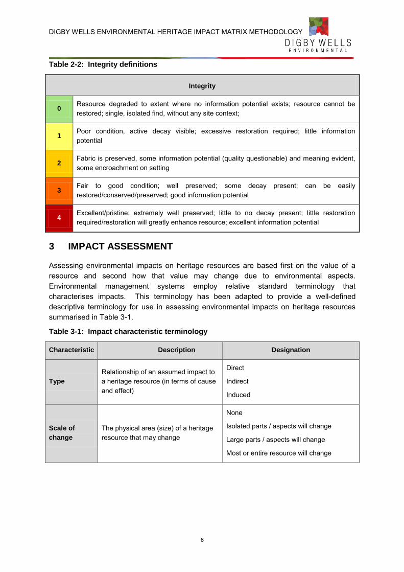
DIGBY WELLS ENVIRONMENTAL HERITAGE IMPACT MATRIX METHODOLOGY
6
Table 2-2: Integrity definitions
Integrity
0 Resource degraded to extent where no information potential exists; resource cannot be restored; single, isolated find, without any site context;
1 Poor condition, active decay visible; excessive restoration required; little information potential
2 Fabric is preserved, some information potential (quality questionable) and meaning evident, some encroachment on setting
3 Fair to good condition; well preserved; some decay present; can be easily restored/conserved/preserved; good information potential
4 Excellent/pristine; extremely well preserved; little to no decay present; little restoration required/restoration will greatly enhance resource; excellent information potential
3 IMPACT ASSESSMENT
Assessing environmental impacts on heritage resources are based first on the value of a resource and second how that value may change due to environmental aspects. Environmental management systems employ relative standard terminology that characterises impacts. This terminology has been adapted to provide a well-defined descriptive terminology for use in assessing environmental impacts on heritage resources summarised in Table 3-1.
Table 3-1: Impact characteristic terminology
Characteristic Description Designation
Type
Relationship of an assumed impact to a heritage resource (in terms of cause and effect)
Direct
Indirect
Induced
Scale of
change
The physical area (size) of a heritage resource that may change
None
Isolated parts / aspects will change
Large parts / aspects will change
Most or entire resource will change
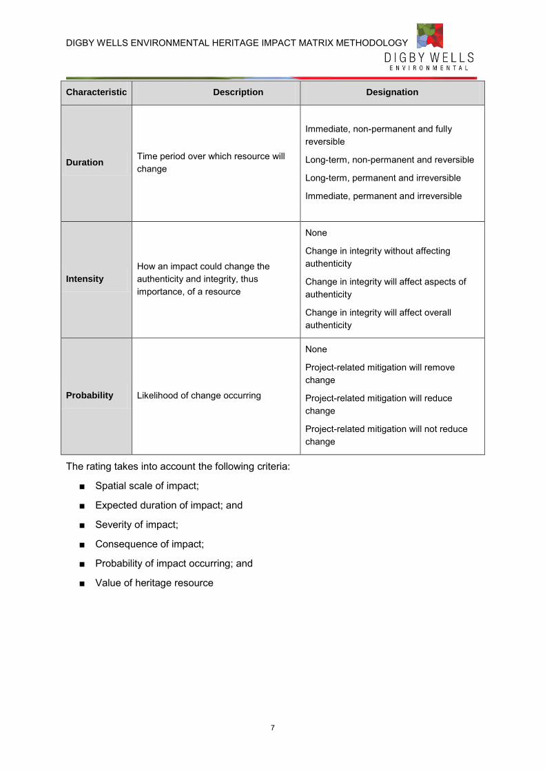
DIGBY WELLS ENVIRONMENTAL HERITAGE IMPACT MATRIX METHODOLOGY
7
Characteristic Description Designation
Duration Time period over which resource will change
Immediate, non-permanent and fully reversible
Long-term, non-permanent and reversible
Long-term, permanent and irreversible
Immediate, permanent and irreversible
Intensity
How an impact could change the authenticity and integrity, thus importance, of a resource
None
Change in integrity without affecting authenticity
Change in integrity will affect aspects of authenticity
Change in integrity will affect overall authenticity
Probability Likelihood of change occurring
None
Project-related mitigation will remove change
Project-related mitigation will reduce change
Project-related mitigation will not reduce change
The rating takes into account the following criteria:
■ Spatial scale of impact;
■ Expected duration of impact; and
■ Severity of impact;
■ Consequence of impact;
■ Probability of impact occurring; and
■ Value of heritage resource
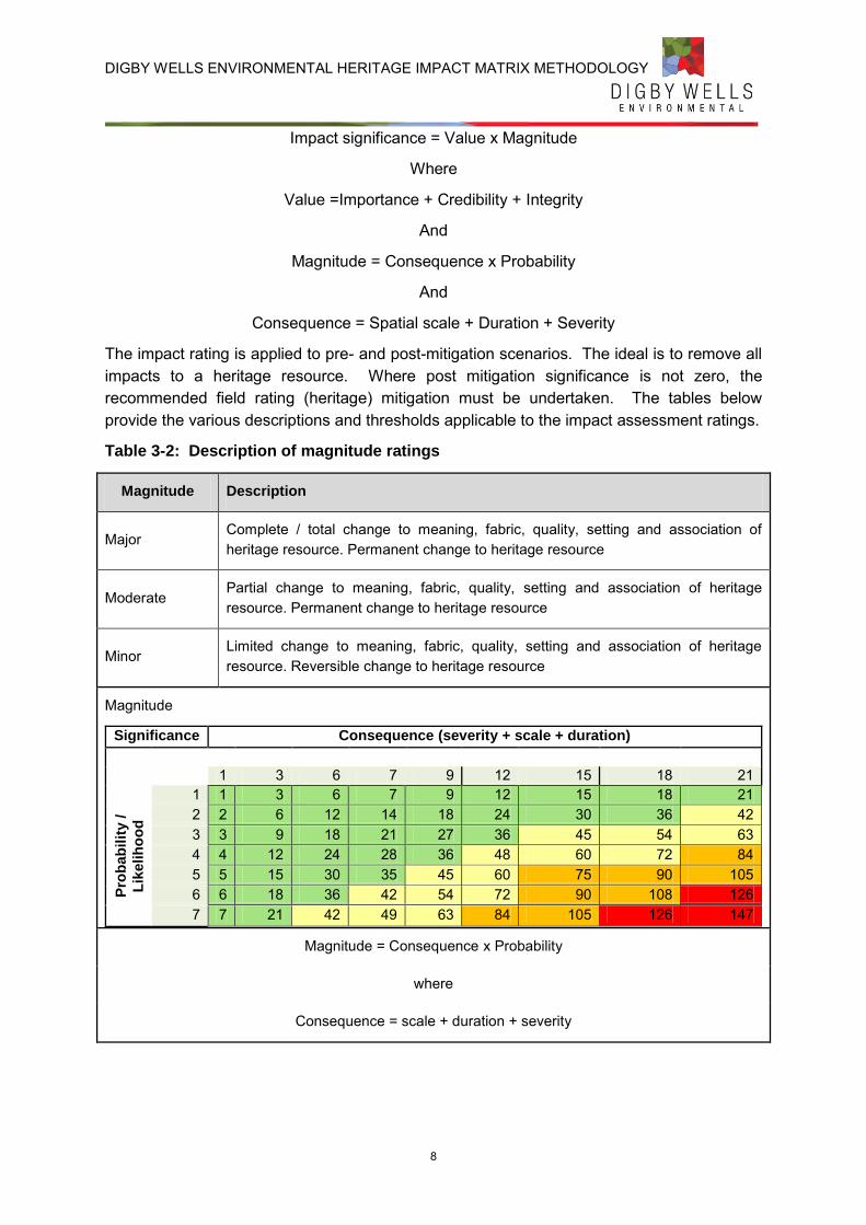
DIGBY WELLS ENVIRONMENTAL HERITAGE IMPACT MATRIX METHODOLOGY
8
Impact significance = Value x Magnitude
Where
Value =Importance + Credibility + Integrity
And
Magnitude = Consequence x Probability
And
Consequence = Spatial scale + Duration + Severity
The impact rating is applied to pre- and post-mitigation scenarios. The ideal is to remove all impacts to a heritage resource. Where post mitigation significance is not zero, the recommended field rating (heritage) mitigation must be undertaken. The tables below provide the various descriptions and thresholds applicable to the impact assessment ratings.
Table 3-2: Description of magnitude ratings
Magnitude Description
Major Complete / total change to meaning, fabric, quality, setting and association of heritage resource. Permanent change to heritage resource
Moderate Partial change to meaning, fabric, quality, setting and association of heritage resource. Permanent change to heritage resource
Minor Limited change to meaning, fabric, quality, setting and association of heritage resource. Reversible change to heritage resource
Magnitude
Significance Consequence (severity + scale + duration)
1 3 6 7 9 12 15 18 21
Pro
bab
ilit
y /
Lik
elih
oo
d
1 1 3 6 7 9 12 15 18 21 2 2 6 12 14 18 24 30 36 42 3 3 9 18 21 27 36 45 54 63 4 4 12 24 28 36 48 60 72 84 5 5 15 30 35 45 60 75 90 105 6 6 18 36 42 54 72 90 108 126 7 7 21 42 49 63 84 105 126 147
Magnitude = Consequence x Probability
where
Consequence = scale + duration + severity
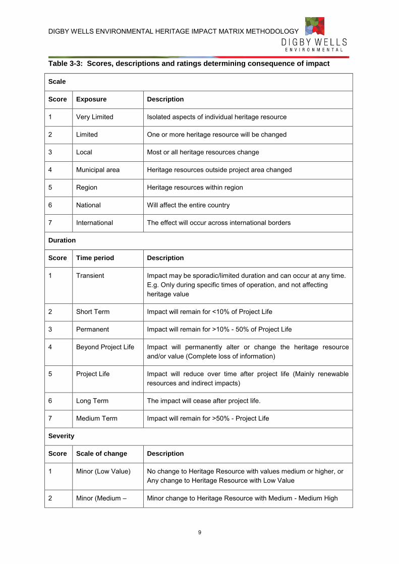
DIGBY WELLS ENVIRONMENTAL HERITAGE IMPACT MATRIX METHODOLOGY
9
Table 3-3: Scores, descriptions and ratings determining consequence of impact
Scale
Score Exposure Description
1 Very Limited Isolated aspects of individual heritage resource
2 Limited One or more heritage resource will be changed
3 Local Most or all heritage resources change
4 Municipal area Heritage resources outside project area changed
5 Region Heritage resources within region
6 National Will affect the entire country
7 International The effect will occur across international borders
Duration
Score Time period Description
1 Transient Impact may be sporadic/limited duration and can occur at any time. E.g. Only during specific times of operation, and not affecting heritage value
2 Short Term Impact will remain for <10% of Project Life
3 Permanent Impact will remain for >10% - 50% of Project Life
4 Beyond Project Life Impact will permanently alter or change the heritage resource and/or value (Complete loss of information)
5 Project Life Impact will reduce over time after project life (Mainly renewable resources and indirect impacts)
6 Long Term The impact will cease after project life.
7 Medium Term Impact will remain for >50% - Project Life
Severity
Score Scale of change Description
1 Minor (Low Value) No change to Heritage Resource with values medium or higher, or Any change to Heritage Resource with Low Value
2 Minor (Medium – Minor change to Heritage Resource with Medium - Medium High
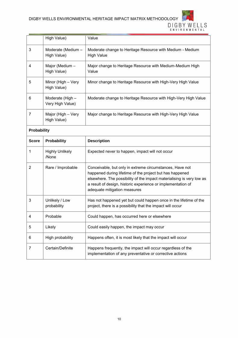
DIGBY WELLS ENVIRONMENTAL HERITAGE IMPACT MATRIX METHODOLOGY
10
High Value) Value
3 Moderate (Medium – High Value)
Moderate change to Heritage Resource with Medium - Medium High Value
4 Major (Medium – High Value)
Major change to Heritage Resource with Medium-Medium High Value
5 Minor (High – Very High Value)
Minor change to Heritage Resource with High-Very High Value
6 Moderate (High – Very High Value)
Moderate change to Heritage Resource with High-Very High Value
7 Major (High – Very High Value)
Major change to Heritage Resource with High-Very High Value
Probability
Score Probability Description
1 Highly Unlikely /None
Expected never to happen, impact will not occur
2 Rare / Improbable Conceivable, but only in extreme circumstances, Have not happened during lifetime of the project but has happened elsewhere. The possibility of the impact materialising is very low as a result of design, historic experience or implementation of adequate mitigation measures
3 Unlikely / Low probability
Has not happened yet but could happen once in the lifetime of the project, there is a possibility that the impact will occur
4 Probable Could happen, has occurred here or elsewhere
5 Likely Could easily happen, the impact may occur
6 High probability Happens often, it is most likely that the impact will occur
7 Certain/Definite Happens frequently, the impact will occur regardless of the implementation of any preventative or corrective actions
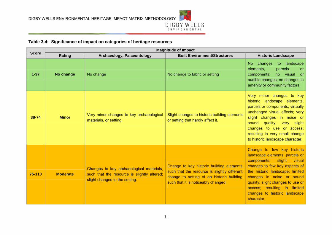
DIGBY WELLS ENVIRONMENTAL HERITAGE IMPACT MATRIX METHODOLOGY
11
Table 3-4: Significance of impact on categories of heritage resources
Score Magnitude of Impact
Rating Archaeology, Palaeontology Built Environment/Structures Historic Landscape
1-37 No change No change No change to fabric or setting
No changes to landscape elements, parcels or components; no visual or audible changes; no changes in amenity or community factors.
38-74 Minor Very minor changes to key archaeological materials, or setting.
Slight changes to historic building elements or setting that hardly affect it.
Very minor changes to key historic landscape elements, parcels or components; virtually unchanged visual effects; very slight changes in noise or sound quality; very slight changes to use or access; resulting in very small change to historic landscape character.
75-110 Moderate
Changes to key archaeological materials, such that the resource is slightly altered; slight changes to the setting.
Change to key historic building elements, such that the resource is slightly different; change to setting of an historic building, such that it is noticeably changed.
Change to few key historic landscape elements, parcels or components; slight visual changes to few key aspects of the historic landscape; limited changes in noise or sound quality; slight changes to use or access; resulting in limited changes to historic landscape character.
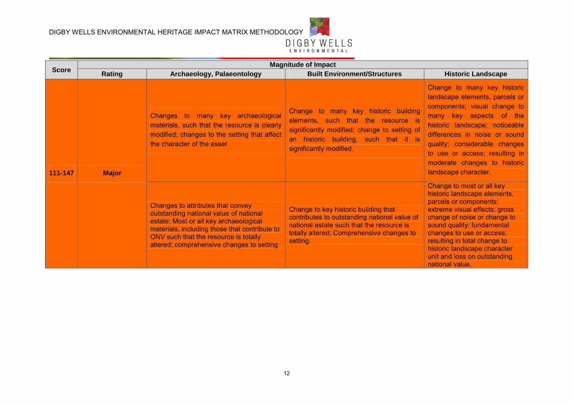
DIGBY WELLS ENVIRONMENTAL HERITAGE IMPACT MATRIX METHODOLOGY
12
Score Magnitude of Impact
Rating Archaeology, Palaeontology Built Environment/Structures Historic Landscape
111-147 Major
Changes to many key archaeological materials, such that the resource is clearly modified; changes to the setting that affect the character of the asset
Change to many key historic building elements, such that the resource is significantly modified; change to setting of an historic building, such that it is significantly modified.
Change to many key historic landscape elements, parcels or components; visual change to many key aspects of the historic landscape; noticeable differences in noise or sound quality; considerable changes to use or access; resulting in moderate changes to historic landscape character.
Changes to attributes that convey outstanding national value of national estate; Most or all key archaeological materials, including those that contribute to ONV such that the resource is totally altered; comprehensive changes to setting
Change to key historic building that contributes to outstanding national value of national estate such that the resource is totally altered; Comprehensive changes to setting.
Change to most or all key historic landscape elements, parcels or components; extreme visual effects; gross change of noise or change to sound quality; fundamental changes to use or access; resulting in total change to historic landscape character unit and loss on outstanding national value.
DIGBY WELLS ENVIRONMENTAL HERITAGE IMPACT MATRIX METHODOLOGY
13
4 REFERENCES
Nara Document on Authenticity, 1993. ICOMOS: The Nara Document on Authenticity, United Nations Educational, Scientific and Cultural Organisation: International Council on Monuments and Sites.
Winter, S. & Baumann, N., 2005. Guideline for Involving Heritage Specialist in EIA Process Edition 1: CSIR Report No ENV-S-C 2005 E , Cape Town: Republic of South Africa, Provincial Government of the Western Cape, Department of Environmental Affairs & Development Planning.
Heritage Impact Assessment
Mining Right Application for Reclamation of the Soweto Cluster Dumps, Roodepoort, Gauteng Province
ERG2613
Appendix D: NID
_________________________________________________ Digby Wells and Associates (South Africa) (Pty) Ltd (Subsidiary of Digby Wells & Associates (Pty) Ltd). Co. Reg. No. 2010/008577/07. Fern Isle, Section 10, 359 Pretoria
Ave Randburg Private Bag X10046, Randburg, 2125, South Africa Tel: +27 11 789 9495, Fax: +27 11 789 9498, [email protected], www.digbywells.com
________________________________________________ Directors: A Sing*, AR Wilke, LF Koeslag, PD Tanner (British)*, AJ Reynolds (Chairman) (British)*, J Leaver*, GE Trusler (C.E.O)
*Non-Executive _________________________________________________
p:\projects\ergo\erg2613_eia_emp_soweto_cluster\9_specialist_studies\hrm\5_hia_stat_and_nid\2_final\erg2613_hs_final.docx
NOTIFICATION OF INTENT TO DEVELOP
AND HERITAGE STATEMENT FOR THE
MINING RIGHT APPLICATION FOR THE
RECLAMATION OF THE SOWETO
CLUSTER DUMPS, ROODEPOORT,
GAUTENG PROVINCE
ERGO MINING (PTY) LIMITED
FEBRUARY 2014
Notification of Intent to Develop and Heritage Statement for the Mining Right Application for the Reclamation of the Soweto Cluster Dumps,
Roodepoort, Gauteng Province
ERG2613
ii
This document has been prepared by Digby Wells Environmental.
Report Title: Notification of Intent to Develop and Heritage Statement
for the Mining Right Application for the Reclamation of the
Soweto Cluster Dumps, Roodepoort, Gauteng Province
Project Number: ERG2613
Name Responsibility Signature Date
Justin du Piesanie Report Compiler
February 2014
Johan Nel HRM Unit Manager and Reviewer
February 2014
This report is provided solely for the purposes set out in it and may not, in whole or in part, be used for any other purpose
without Digby Wells Environmental prior written consent.
Notification of Intent to Develop and Heritage Statement for the Mining Right Application for the Reclamation of the Soweto Cluster Dumps,
Roodepoort, Gauteng Province
ERG2613
iii
EXECUTIVE SUMMARY AND NOTICE OF INTENT TO DEVELOP
Introduction
Digby Wells Environmental (hereafter Digby Wells) was requested by Ergo Mining (Pty) Ltd (Ergo) to conduct an Environmental Impact Assessment (EIA) study and Environmental Management Programme (EMP) Report, inclusive of specialist studies, for a Mining Right Application (MRA) (Ref No. GP10007MR) in accordance with the Minerals and Petroleum Resources Development Act, 2002 (Act No. 28 of 2002) (MPRDA).
Project Location
Name of property/ies Roodepoort, Vlakfontein and Vogelstruisfontein
Street address or location (e.g.:
Off R44)
Off the R41, M77 and R558
Erf or farm number/s Roodepoort 237 IQ Portions 1, 5 and 14; Vlakfontein 238 IQ Portions 1; Vogelstruisfontein 231 IQ Portions 17, 18 and 161
Coordinates of approximate
centre of project area S 26˚ 11’ 54.5”
E 27˚ 51’ 40.1”
Town or District City of Johannesburg District Municipality
Responsible Municipality City of Johannesburg Metropolitan Municipality
Current use Industrial and Residential
Predominant land use/s of
surrounding properties
Industrial and Residential
Registered Owners of Properties
Property Title Deed Owner Contact Information Notification Method
Roodepoort 237 IQ Portion 1
Dino Prop (Pty) Ltd
381 Ontdekkers Road, Florida Park, Ext 3. Roodepoort, 1709 P. O. Box 268 Florida Hills, 1716
Advertisement, Site Notice and Letter Roodepoort 237 IQ
Portion 5
Roodepoort 237 IQ Portion 14
Living Africa Dev (Pty) Ltd
No Information Advertisement and Site Notice
Vlakfontein 238 IQ Portion 1
DRD Gold Ltd Quadrum Office Park 1st Floor, Building 1 50 Constantia Boulevard
Advertisement, Site Notice and Letter
Notification of Intent to Develop and Heritage Statement for the Mining Right Application for the Reclamation of the Soweto Cluster Dumps,
Roodepoort, Gauteng Province
ERG2613
iv
Property Title Deed Owner Contact Information Notification Method
Constantia Kloof Ext 28 Roodepoort 1709 P.O. Box 390 Maraisburg 1700
(011) 470 2600
Vogelstruisfontein 231 IQ Portion 17
Suid-Afrikaanse Spoorpendel Korporasie Ltd
No Information Advertisement and Site Notice
Vogelstruisfontein 231 IQ Portion 18
Fleurhof Extension 2 (Pty) Ltd
Cedarwood House Ballywoods Office Park Bryanston, 2196
(011) 472 4325
Advertisement, Site Notice and Letter
Vogelstruisfontein 231 IQ Portion 161
Rand Leases Securitisation (Pty) Ltd
Rand Leases House, Peter Place Office Park 54 Peter Place 2191,
P.O. Box 1 Florida, Johannesburg 1710
Advertisement, Site Notice and Letter
Project / development details
Ergo is currently conducting gold bearing tailings reclamation operations from sand dumps and slimes dams (dumps), created from historic gold mining located on the Witwatersrand, Gauteng. An MRA was submitted to the Department of Mineral Resources (DMR) by Ergo in terms of Section 22 of the MPRDA for the various tailings dumps as part of the Soweto Cluster in the District of Roodepoort, Gauteng Province.
It is the intention that the mining operation will make use of the infrastructure owned by Crown Gold Recoveries (Pty) Ltd (CGR) and the other assets held by Ergo. New reclamation plant and equipment will be constructed at the Soweto Cluster to enable slimes to be recovered by hydraulic monitoring and sands to be reclaimed by mechanical means. The resulting slurry will be pumped by way of new pipelines via the CGR assets to the Ergo beneficiation plant for gold recovery. Tailings will be deposited on the Brakpan/Withok TSF.
NHRA Section 38 Triggers
The following aspects of Section 38 of the NHRA may be triggered by the proposed project.
NHRA Section 38 (1) Activities / Triggers Summary description
(e.g. 500 m conveyor belt, open cast pit, etc.)
Notification of Intent to Develop and Heritage Statement for the Mining Right Application for the Reclamation of the Soweto Cluster Dumps,
Roodepoort, Gauteng Province
ERG2613
v
NHRA Section 38 (1) Activities / Triggers Summary description
(e.g. 500 m conveyor belt, open cast pit, etc.)
a
Any linear development or barrier >300 m
The project will require the construction of a pipeline for the transportation of slimes to the beneficiation plant for gold recovery
b Any bridge or similar structure >50 m
c Any development or activity that will change the character of a site:
i ≥5 000m2 in extent Reclamation activities of the dumps will
change the character of the site.
ii Involving ≥3 existing erven/ subdivisions
iii Involving ≥3 or more erven/ divisions consolidated within past 5 years.
d Rezoning of a site ≥10 000m2 in extent.
e Other triggers, e.g.: in terms of other legislation, (i.e.: National Environment Management Act, etc.)
Environmental authorisation as part of an MRA application in accordance with Section 22 of the MPRDA
Activities
The following activities will take place during the lifespan of the proposed project.
Activity Description Source of Risk
Construction Phase
1. Employment of workers
Preparation for reclamation activities
None
2.
Removal of Vegetation
Vegetation will be removed on the dump, and clearing for the construction of temporary infrastructure, pump stations and access roads.
This activity constitutes development as defined in terms of Section 2(viii) (f) where ‘any physical intervention …result in a change to the nature, appearance or physical
Notification of Intent to Develop and Heritage Statement for the Mining Right Application for the Reclamation of the Soweto Cluster Dumps,
Roodepoort, Gauteng Province
ERG2613
vi
Activity Description Source of Risk
nature of a place including any removal or destruction of trees, or removal of vegetation or topsoil.’
The identified risk is therefore changes in the character of the site described in Sections 34 (1) and 38(1) (c) of the NHRA.
3.
Construction of pipelines
A slurry and water line will be constructed and will meet up with the existing Crown-Ergo pipeline
This activity constitutes development as defined in terms of Section 2(viii) (a) and (b) where ‘any physical intervention …result in a change to the nature, appearance or physical nature of a place including construction, alteration, demolition, removal or change of use of a place or a structure at a place [and] carrying out any works on or over or under a place.’
The identified risk is therefore changes in the character of the site described in Sections 34 (1) and 38(1) (a) of the NHRA.
4.
Operation of construction machinery and vehicles
Construction machinery and vehicles will be utilised to construct the temporary infrastructure, pump station and access roads. Vehicles will be used to transport equipment on site.
This activity constitutes development as defined in terms of Section 2(viii) (b) where ‘any physical intervention …result in a change to the nature, appearance or physical nature of a place including carrying out any works on or over or under a place.’
The identified risk is therefore changes to resources that are
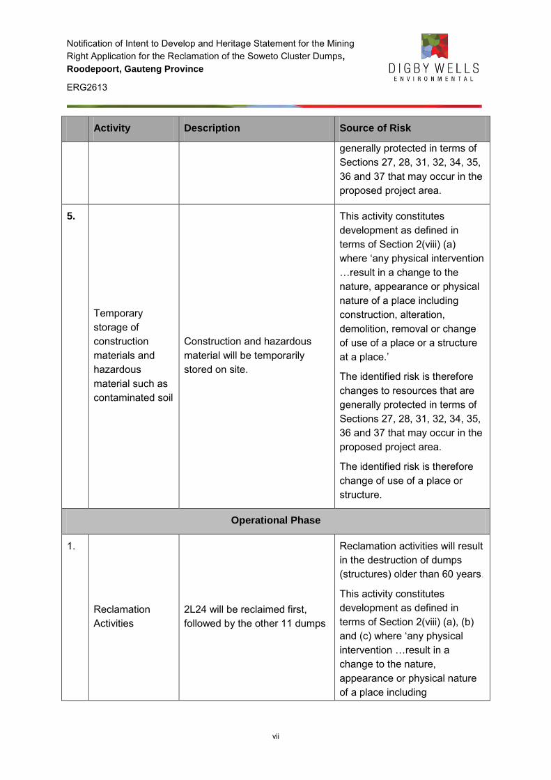
Notification of Intent to Develop and Heritage Statement for the Mining Right Application for the Reclamation of the Soweto Cluster Dumps,
Roodepoort, Gauteng Province
ERG2613
vii
Activity Description Source of Risk
generally protected in terms of Sections 27, 28, 31, 32, 34, 35, 36 and 37 that may occur in the proposed project area.
5.
Temporary storage of construction materials and hazardous material such as contaminated soil
Construction and hazardous material will be temporarily stored on site.
This activity constitutes development as defined in terms of Section 2(viii) (a) where ‘any physical intervention …result in a change to the nature, appearance or physical nature of a place including construction, alteration, demolition, removal or change of use of a place or a structure at a place.’
The identified risk is therefore changes to resources that are generally protected in terms of Sections 27, 28, 31, 32, 34, 35, 36 and 37 that may occur in the proposed project area.
The identified risk is therefore change of use of a place or structure.
Operational Phase
1.
Reclamation Activities
2L24 will be reclaimed first, followed by the other 11 dumps
Reclamation activities will result in the destruction of dumps (structures) older than 60 years.
This activity constitutes development as defined in terms of Section 2(viii) (a), (b) and (c) where ‘any physical intervention …result in a change to the nature, appearance or physical nature of a place including
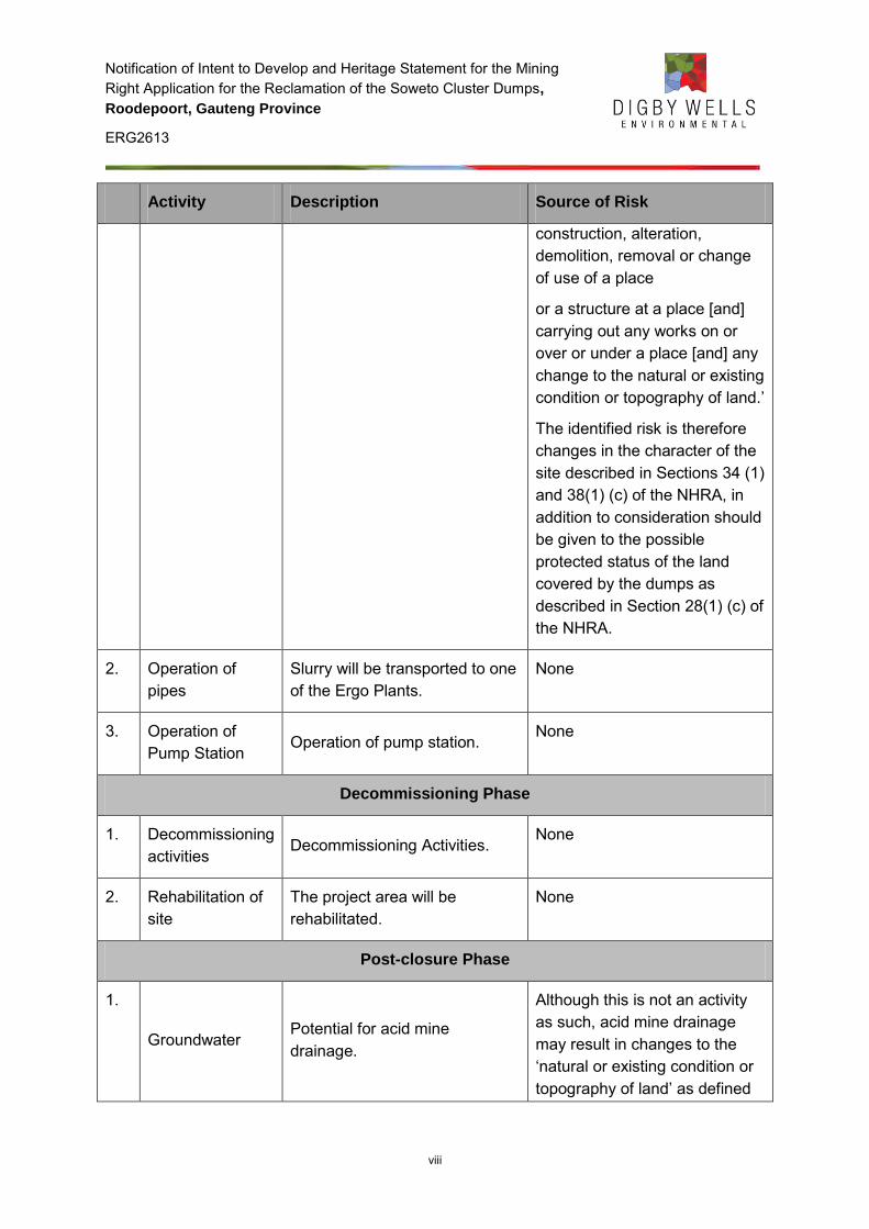
Notification of Intent to Develop and Heritage Statement for the Mining Right Application for the Reclamation of the Soweto Cluster Dumps,
Roodepoort, Gauteng Province
ERG2613
viii
Activity Description Source of Risk
construction, alteration, demolition, removal or change of use of a place
or a structure at a place [and] carrying out any works on or over or under a place [and] any change to the natural or existing condition or topography of land.’
The identified risk is therefore changes in the character of the site described in Sections 34 (1) and 38(1) (c) of the NHRA, in addition to consideration should be given to the possible protected status of the land covered by the dumps as described in Section 28(1) (c) of the NHRA.
2. Operation of pipes
Slurry will be transported to one of the Ergo Plants.
None
3. Operation of Pump Station
Operation of pump station. None
Decommissioning Phase
1. Decommissioning activities
Decommissioning Activities. None
2. Rehabilitation of site
The project area will be rehabilitated.
None
Post-closure Phase
1.
Groundwater Potential for acid mine drainage.
Although this is not an activity as such, acid mine drainage may result in changes to the ‘natural or existing condition or topography of land’ as defined
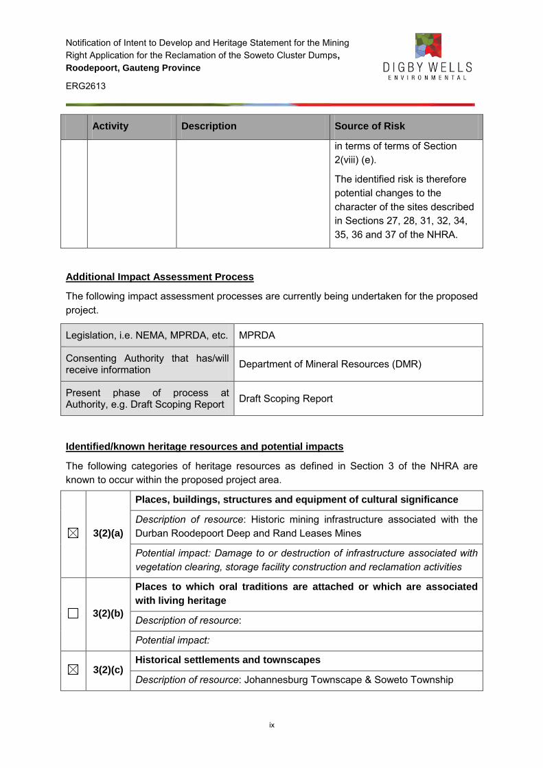
Notification of Intent to Develop and Heritage Statement for the Mining Right Application for the Reclamation of the Soweto Cluster Dumps,
Roodepoort, Gauteng Province
ERG2613
ix
Activity Description Source of Risk
in terms of terms of Section 2(viii) (e).
The identified risk is therefore potential changes to the character of the sites described in Sections 27, 28, 31, 32, 34, 35, 36 and 37 of the NHRA.
Additional Impact Assessment Process
The following impact assessment processes are currently being undertaken for the proposed project.
Legislation, i.e. NEMA, MPRDA, etc. MPRDA
Consenting Authority that has/will receive information Department of Mineral Resources (DMR)
Present phase of process at Authority, e.g. Draft Scoping Report Draft Scoping Report
Identified/known heritage resources and potential impacts
The following categories of heritage resources as defined in Section 3 of the NHRA are known to occur within the proposed project area.
3(2)(a)
Places, buildings, structures and equipment of cultural significance
Description of resource: Historic mining infrastructure associated with the Durban Roodepoort Deep and Rand Leases Mines
Potential impact: Damage to or destruction of infrastructure associated with vegetation clearing, storage facility construction and reclamation activities
3(2)(b)
Places to which oral traditions are attached or which are associated
with living heritage
Description of resource:
Potential impact:
3(2)(c) Historical settlements and townscapes
Description of resource: Johannesburg Townscape & Soweto Township
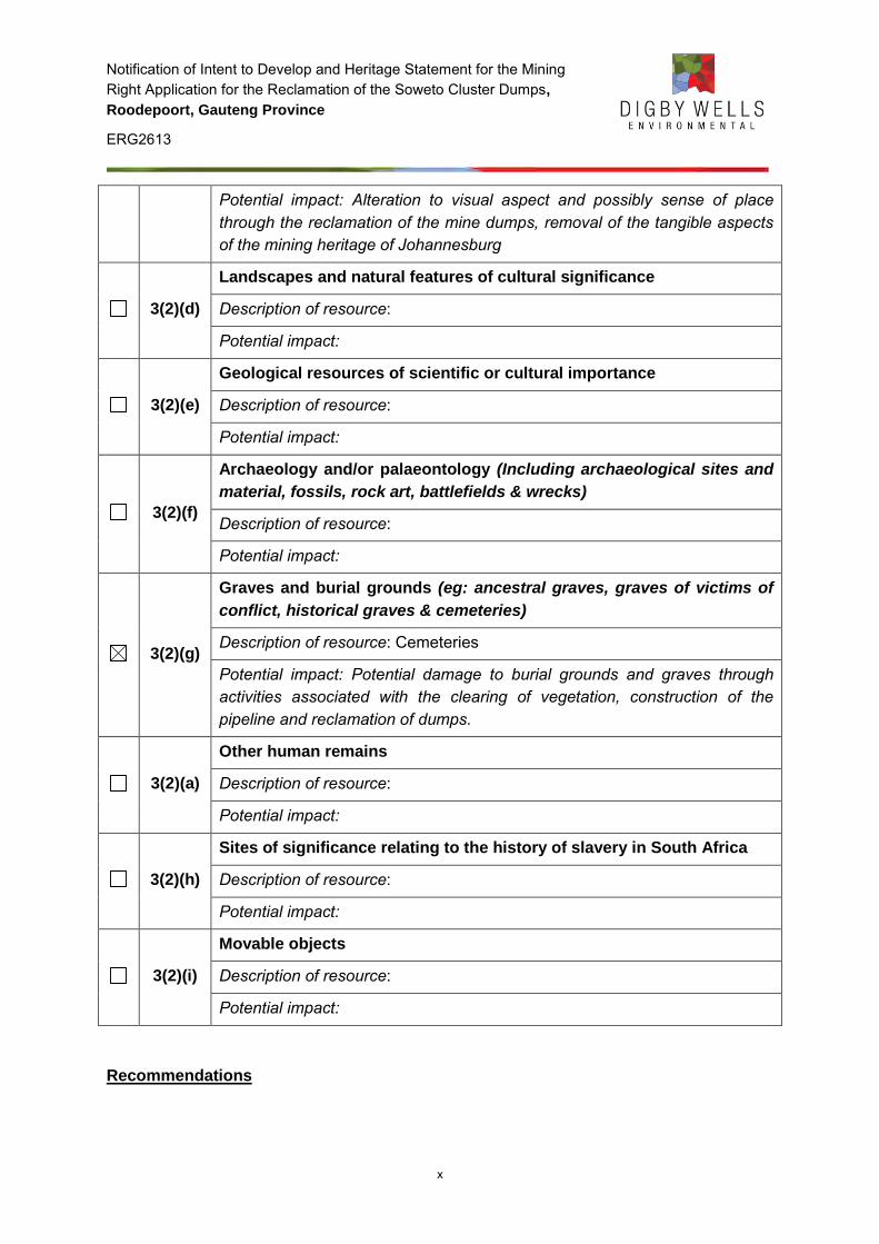
Notification of Intent to Develop and Heritage Statement for the Mining Right Application for the Reclamation of the Soweto Cluster Dumps,
Roodepoort, Gauteng Province
ERG2613
x
Potential impact: Alteration to visual aspect and possibly sense of place through the reclamation of the mine dumps, removal of the tangible aspects of the mining heritage of Johannesburg
3(2)(d)
Landscapes and natural features of cultural significance
Description of resource:
Potential impact:
3(2)(e)
Geological resources of scientific or cultural importance
Description of resource:
Potential impact:
3(2)(f)
Archaeology and/or palaeontology (Including archaeological sites and
material, fossils, rock art, battlefields & wrecks)
Description of resource:
Potential impact:
3(2)(g)
Graves and burial grounds (eg: ancestral graves, graves of victims of
conflict, historical graves & cemeteries)
Description of resource: Cemeteries
Potential impact: Potential damage to burial grounds and graves through activities associated with the clearing of vegetation, construction of the pipeline and reclamation of dumps.
3(2)(a)
Other human remains
Description of resource:
Potential impact:
3(2)(h)
Sites of significance relating to the history of slavery in South Africa
Description of resource:
Potential impact:
3(2)(i)
Movable objects
Description of resource:
Potential impact:
Recommendations
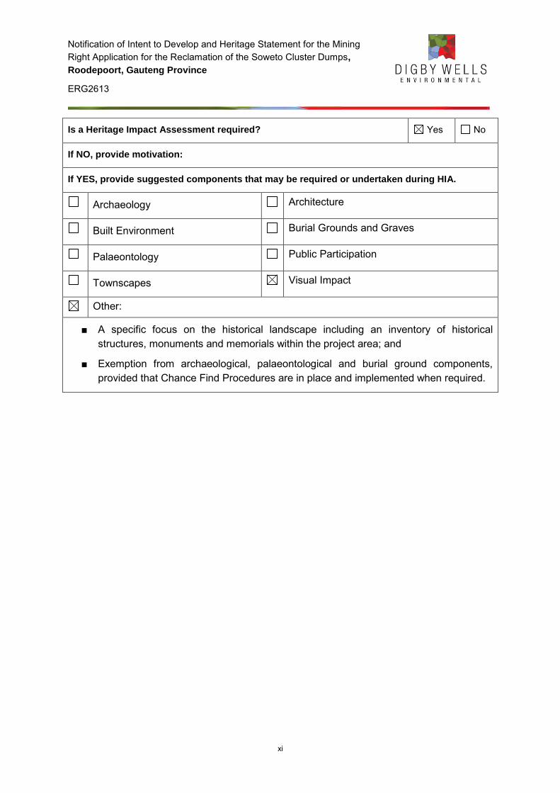
Notification of Intent to Develop and Heritage Statement for the Mining Right Application for the Reclamation of the Soweto Cluster Dumps,
Roodepoort, Gauteng Province
ERG2613
xi
Is a Heritage Impact Assessment required? Yes No
If NO, provide motivation:
If YES, provide suggested components that may be required or undertaken during HIA.
Archaeology Architecture
Built Environment Burial Grounds and Graves
Palaeontology Public Participation
Townscapes Visual Impact
Other:
■ A specific focus on the historical landscape including an inventory of historical structures, monuments and memorials within the project area; and
■ Exemption from archaeological, palaeontological and burial ground components, provided that Chance Find Procedures are in place and implemented when required.
Notification of Intent to Develop and Heritage Statement for the Mining Right Application for the Reclamation of the Soweto Cluster Dumps,
Roodepoort, Gauteng Province
ERG2613
xii
GLOSSARY OF ABBREVIATIONS AND TERMS
CGR Crown Gold Recoveries (Pty) Ltd
Digby Wells Digby Wells Environmental
DMR Department of Mineral Resources
EIA Environmental Impact Assessment
EMP Environmental Management Programme
Ergo Ergo Mining (Pty) Ltd
HIA Heritage Impact Assessment
HRA Heritage Resources Authority
IDP Integrated Development Plan
MJS Major Jackson Series
MPRDA Minerals and Petroleum Resources Development Act, 2002 (Act No. 28 of 2002)
MRA Mining Right Application
NEM:WA National Environmental Management : Waste Act, 2009 (Act No. 59 of 2009)
NEMA National Environmental Management Act, 1998 (Act No. 107 of 1998)
NHRA National Heritage Resources Act, 1999 (Act No. 25 of 1999)
NID Notice of Intent to Develop
PHRA-G Provincial Heritage Resources Authority - Gauteng
SAHRA South African Heritage Resources Authority
SCF Statutory Comment Feedback
SDF Spatial Development Framework
SEP Stakeholder Engagement Plan
Notification of Intent to Develop and Heritage Statement for the Mining Right Application for the Reclamation of the Soweto Cluster Dumps,
Roodepoort, Gauteng Province
ERG2613
xiii
TSF Tailings Storage Facility
ZAR Zuid Afrikaanse Republiek
Notification of Intent to Develop and Heritage Statement for the Mining Right Application for the Reclamation of the Soweto Cluster Dumps,
Roodepoort, Gauteng Province
ERG2613
xiv
TABLE OF CONTENTS
1 INTRODUCTION .............................................................................................................. 1
2 BACKGROUND INFORMATION OF PROJECT .............................................................. 1
2.1 Project Details ................................................................................................. 1
2.2 Description of Property and/or Affected Environment ...................................... 2
2.2.1 Location Data.................................................................................................. 2
2.3 Relevant Contact Details ................................................................................ 2
2.4 Legislative Framework .................................................................................... 4
2.4.1 Minerals and Petroleum Resources Development Act, 2002 (Act No. 28 of 2002) (MPRDA) .............................................................................................. 4
2.4.2 National Environmental Management Act, 1998 (Act No. 107 of 1998) (NEMA) ....................................................................................................................... 4
2.4.3 National Environmental Management: Waste Act, 2009 (Act No. 59 of 2009) (NEMWA) ....................................................................................................... 5
2.4.4 National Heritage Resources Act, 1999 (Act No. 25 of 1999) (NHRA) ............ 5
2.5 Summary of Stakeholder Engagement Plan (SEP) ......................................... 5
2.6 Terms of Reference ........................................................................................ 5
2.7 Scope of Work ................................................................................................ 5
3 METHODOLOGY .............................................................................................................. 6
3.1 Literature review ............................................................................................. 6
3.2 Historical layering ........................................................................................... 6
3.3 Site Naming .................................................................................................... 6
3.3.1 Confirmed sites identified during desktop study .............................................. 6
3.3.2 Unconfirmed sites identified during desktop study .......................................... 7
3.3.3 Sites identified during screening assessment.................................................. 7
4 RESTRICTIONS AND LIMITIATIONS .............................................................................. 7
5 STATE OF THE RECEIVING ENVIRONMENT/CULTURAL LANDSCAPE ..................... 7
5.1 Development context of Study Area ................................................................ 7
5.2 Literature Review ............................................................................................ 8
5.3 Review of Previous Heritage Reports ........................................................... 10
Notification of Intent to Develop and Heritage Statement for the Mining Right Application for the Reclamation of the Soweto Cluster Dumps,
Roodepoort, Gauteng Province
ERG2613
xv
5.4 Historical Layering ........................................................................................ 11
6 IDENTIFIED HERITAGE RESOURCES ......................................................................... 14
7 SOURCES OF RISK ....................................................................................................... 16
8 DISCUSSION OF FINDINGS ......................................................................................... 19
9 RECOMMENDATIONS AND CONCLUSION ................................................................. 20
10 BIBLIOGRAPHY ............................................................................................................. 21
LIST OF FIGURES
Figure 5-1: 1899 Jeppes Map of the Transvaal with farms, railway and mines depicted ..................... 12
Figure 5-2: Aerial imagery dating to 1938 of Durban Roodepoort Deep and Rand Leases respectively .............................................................................................................................................................. 12
Figure 5-3: Aerial imagery dating to 1952. Note the footprint of 2/L/24 in the southern portion of the photograph ............................................................................................................................................ 13
Figure 5-4: Contemporary satellite imagery of the Soweto Cluster Project .......................................... 13
Figure 6-1: Identified heritage sites during the desktop study. ............................................................. 15
LIST OF TABLES
Table 2-1: Tailings dumps included in the MRA and the associated farms ............................................ 1
Table 2-2: Location data for the Ergo Soweto Cluster Project ................................................................ 2
Table 2-3: Client contact details .............................................................................................................. 3
Table 2-4: Consultant contact details ...................................................................................................... 3
Table 2-5: Land owner contact details .................................................................................................... 3
Table 6-1: Identified heritage resources within and surrounding the Soweto Cluster Project .............. 14
Table 7-1: List of activities associated with the reclamation of the Soweto cluster dumps .................. 16
LIST OF APPENDICES
Appendix A: Curriculum Vitae
Appendix B: Location and Site Maps
Notification of Intent to Develop and Heritage Statement for the Mining Right Application for the Reclamation of the Soweto Cluster Dumps,
Roodepoort, Gauteng Province
ERG2613
1
1 INTRODUCTION
Digby Wells Environmental (hereafter Digby Wells) was requested by Ergo Mining (Pty) Ltd (Ergo) to conduct an Environmental Impact Assessment (EIA) study and Environmental Management Programme (EMP) Report, inclusive of specialist studies, for a Mining Right Application (MRA) in accordance with the Minerals and Petroleum Resources Development Act, 2002 (Act No. 28 of 2002) (MPRDA). This heritage statement serves as the heritage component for the scoping phase as required under Section 39(3)(b)(iii) of the MPRDA and Section 38 of the National Heritage Resources Act, 1999 (Act No. 25 of 1999) (NHRA).
2 BACKGROUND INFORMATION OF PROJECT
2.1 Project Details
Ergo is currently conducting gold bearing tailings reclamation operations from sand dumps and slimes dams (dumps), created from historic gold mining located on the Witwatersrand, Gauteng. An MRA was submitted to the Department of Mineral Resources (DMR) by Ergo in terms of Section 22 of the MPRDA for the various tailings dumps as part of the Soweto Cluster in the District of Roodepoort, Gauteng Province (See Table 2-1).
Table 2-1: Tailings dumps included in the MRA and the associated farms
Tailings Dump Farm
2/L/8;
2/L/9(2); and
2/L/12
Portions 17, 18 and 161 of the Farm Vogelstruisfontein 231 IQ
2/L/20; and
2/L/21
Portions 1 and 14 of the Farm Roodepoort 237 IQ
2/L/17;
2/L/18;
2/L/16;
2/A/5; and
2/A/6
Portions 1, 5 and 14 of the Farm Roodepoort 237 IQ
2/L/24 Portion of Portion 1 of the Farm Vlakfontein 238 IQ
It is the intention that the mining operation will make use of the infrastructure owned by Crown Gold Recoveries (Pty) Ltd (CGR) and the other assets held by Ergo. New reclamation plant and equipment will be constructed at the Soweto Cluster to enable slimes to be recovered by hydraulic monitoring and sands to be reclaimed by mechanical means. The
Notification of Intent to Develop and Heritage Statement for the Mining Right Application for the Reclamation of the Soweto Cluster Dumps,
Roodepoort, Gauteng Province
ERG2613
2
resulting slurry will be pumped by way of new pipelines via the CGR assets to the Ergo beneficiation plant for gold recovery. Tailings will be deposited on the Brakpan/Withok Tailings Storage Facility (TSF).
2.2 Description of Property and/or Affected Environment
The Soweto Cluster mine dumps neighbour the suburbs of Bram Fischerville, Meadowlands and Dobsonville of Soweto. They constitute a total mining footprint of approximately 887.5 ha. The surrounding environment is characterised by residential and industrial areas interspersed with numerous old tailings facilities from historical gold mining activities associated with the Durban Roodepoort Deep and Rand Leases Mines. The receiving environment of the proposed reclamation of the Soweto Cluster has been disturbed and thus has little aesthetic value.
2.2.1 Location Data
Table 2-2: Location data for the Ergo Soweto Cluster Project
Province Gauteng Province
Magisterial district Roodepoort Magisterial district
District municipality City of Johannesburg District Municipality
Local municipality City of Johannesburg Metropolitan Municipality
Town Johannesburg
Farm name/s and number/s: Vogelstuisfontein 231 IQ; Roodepoort 237 IQ; and Vlakfontein 238 IQ
Map reference 2627 BB
Co-ordinates for the centre of the project area Latitude: S 26˚ 11’ 54.5”
Longitude: E 27˚ 51’ 40.1
Location maps The regional settings of the project area are depicted in Plans 1 – 3 in Appendix B
2.3 Relevant Contact Details
The contact details of the developer, consultant and landowners are provided in Table 2-3, Table 2-4 and Table 2-5 respectively.
Notification of Intent to Develop and Heritage Statement for the Mining Right Application for the Reclamation of the Soweto Cluster Dumps,
Roodepoort, Gauteng Province
ERG2613
3
Table 2-3: Client contact details
ITEM COMPANY CONTACT DETAILS
Company Ergo Mining (Pty) Ltd
Contact person Greg Ovens
Tel no 011 470 2600
E-mail address [email protected]
Postal address P.O. Box 390 Maraisburg 1700
Table 2-4: Consultant contact details
ITEM COMPANY CONTACT DETAILS
Company Digby Wells Environmental
Contact person Grant Beringer
Tel no 011 789 9495
Fax no 011 789 9498
E-mail address [email protected]
Postal address Private Bag X10046, Randburg, 2125
Table 2-5: Land owner contact details
Property Title Deed Owner Contact Information Notification Method
Roodepoort 237 IQ Portion 1
Dino Prop (Pty) Ltd
381 Ontdekkers Road, Florida Park, Ext 3. Roodepoort, 1709 P. O. Box 268 Florida Hills, 1716
Advertisement, Site Notice and Letter Roodepoort 237 IQ
Portion 5
Roodepoort 237 IQ Portion 14
Living Africa Dev (Pty) Ltd
No Information Advertisement and Site Notice
Vlakfontein 238 IQ Portion 1
DRD Gold Ltd
Quadrum Office Park 1st Floor, Building 1 50 Constantia Boulevard Constantia Kloof Ext 28 Roodepoort 1709 P.O. Box 390 Maraisburg 1700
Advertisement, Site Notice and Letter
Notification of Intent to Develop and Heritage Statement for the Mining Right Application for the Reclamation of the Soweto Cluster Dumps,
Roodepoort, Gauteng Province
ERG2613
4
Property Title Deed Owner Contact Information Notification Method
(011) 470 2600
Vogelstruisfontein 231 IQ Portion 17
Suid-Afrikaanse Spoorpendel Korporasie Ltd
No Information Advertisement and Site Notice
Vogelstruisfontein 231 IQ Portion 18
Fleurhof Extension 2 (Pty) Ltd
Cedarwood House Ballywoods Office Park Bryanston, 2196
(011) 472 4325
Advertisement, Site Notice and Letter
Vogelstruisfontein 231 IQ Portion 161
Rand Leases Securitisation (Pty) Ltd
Rand Leases House, Peter Place Office Park 54 Peter Place 2191,
P.O. Box 1 Florida, Johannesburg 1710
Advertisement, Site Notice and Letter
2.4 Legislative Framework
2.4.1 Minerals and Petroleum Resources Development Act, 2002 (Act No. 28
of 2002) (MPRDA)
The requirements for a MRA are embodied under Section 22. Within this section of the MPRDA, it stipulates that (4) if an application is accepted by the Regional Manager, (a) an EIA must be conducted and EMP be submitted in terms of Section 39.
Section 39(3) stipulates that in preparation of an EMP – (b) the applicant must investigate, assess and evaluate the impact of the operation on – (iii) any national estate referred to in Section 3(2) of the NHRA with exception of the national estate contemplated in Section 3(2)(i)(vi) and (vii) of that Act.
2.4.2 National Environmental Management Act, 1998 (Act No. 107 of 1998)
(NEMA)
The NEMA stipulates under Section 2(4)(a) that sustainable development requires the consideration of all relevant factors including (iii) the disturbance of landscapes and sites that constitute the nation’s cultural heritage must be avoided, or where it cannot be altogether avoided, is minimised and remedied. Section 24(1) stipulates that in order to give effect to the general objectives of integrated environmental management laid down… the potential impact on - (c) the cultural heritage, of activities that require authorisation or permission by law and which may significantly affect the environment, must be considered, investigated and assessed prior to their implementation and reported to the organ of state
Notification of Intent to Develop and Heritage Statement for the Mining Right Application for the Reclamation of the Soweto Cluster Dumps,
Roodepoort, Gauteng Province
ERG2613
5
charged by law with authorising, permitting or otherwise allowing the implementation of an activity.
2.4.3 National Environmental Management: Waste Act, 2009 (Act No. 59 of
2009) (NEMWA)
The NEM:WA requires in terms of Section 48(b) that the likely effect of pollution on existing cultural heritage be taken into account. Section 48(c)(ii) requires that cultural heritage be protected from adverse change due to pollution.
2.4.4 National Heritage Resources Act, 1999 (Act No. 25 of 1999) (NHRA)
Section 38(8) of the NHRA requires that heritage resources management be implemented if impact assessments are required in terms other legislation – the MPRDA, NEMA and NEM:WA in this case.- Where studies are undertaken in terms of Section 38(8) the heritage authorities are commenting authorities, provided that the consenting authority (for example the DMR) ensures that the study complies with fulfils the requirements of the relevant heritage resources authority in terms of Section 38(3). The consenting authority furthermore needs to take into account all statutory comment issued by the relevant heritage resources authority in terms of Section 38(8) prior to granting authorisation for activities and/or developments.
2.5 Summary of Stakeholder Engagement Plan (SEP)
Stakeholder engagement is required by the MPRDA under Section 22(4)(b) where it states that interested and affected parties must be notified and consulted with regards to the proposed project. This requirement is reiterated in the NHRA, Section 5(4) acknowledging the right of affected communities to be consulted and to participate in the management of heritage resources.
Please refer to the Draft Scoping Report for detailed records of the SEP for the Soweto Cluster Project.
2.6 Terms of Reference
Ergo has enlisted the services of Digby Wells to conduct an EIA and EMP in support of the MRA inclusive of relevant specialist studies in accordance with the MPRDA for the reclamation of the Soweto Cluster Dumps near Soweto and Roodepoort, Gauteng. In order to comply with the agreed Terms of Reference, a heritage study was required as one of the requisite studies.
2.7 Scope of Work
In order to comply with the legislated requirements, a Heritage Statement was compiled to inform the Notice of Intent to Develop (NID) required under Section 38 of the NHRA. The Heritage Statement includes appropriate information regarding existing and potential
Notification of Intent to Develop and Heritage Statement for the Mining Right Application for the Reclamation of the Soweto Cluster Dumps,
Roodepoort, Gauteng Province
ERG2613
6
heritage resources that may occur in the project location. The nature of the development was also described in sufficient detail to enable the South African Heritage Resources Agency (SAHRA) and Provincial Heritage Resources Authority – Gauteng (PHRA-G) to determine whether a Heritage Impact Assessment (HIA) is required.
Official comment from the relevant Heritage Resources Authority (HRA) will be summarised in a Statutory Comment Feedback (SCF) report and submitted to Ergo.
3 METHODOLOGY
In order to compile the Heritage Statement, a number of tasks were required to be completed. This study employed qualitative text-based research methodologies to aid in assessing the cultural landscape within which the Soweto Cluster Project is situated. These methodologies are discussed separately below.
3.1 Literature review
A literature review of relevant and available published works was completed to provide a baseline characterisation of the cultural landscape discussed under Section 5 below. Sources used to inform this baseline included peer reviewed academic publications, unpublished reports, relevant heritage assessments previously conducted and where applicable, relevant databases and authoritative websites. Sources that were consulted and cited in this report are listed under Section 10.
Due to the nature of the project and landscape, the literature review was focussed on the historical period. Due to the extensive development and alteration of the landscape over time, it is expected that little to no archaeological resources are likely to occur, therefore detailed review and discussion of prehistoric periods is irrelevant.
3.2 Historical layering
A review of historical cartographic information was undertaken to conduct historical layering. Historical layering is a process whereby diverse cartographic sources from various time periods are layered chronologically to:
■ Enable the virtual representation of changes in the land use over time;
■ Provide relative dates based on the presence or absence of features; and
■ Identify potential locations where heritage resources may exist.
Historical maps, such as Jeppes 1899 Map Series of the Transvaal, the Major Jackson Series (MJS) and previous 1:50 000 topographic maps were reviewed. In addition, historical aerial imagery was reviewed, dating from 1938 to 1952.
The results from the historical layering contributed to the characterisation of the cultural landscape and are discussed under Section 5.4 below.
Notification of Intent to Develop and Heritage Statement for the Mining Right Application for the Reclamation of the Soweto Cluster Dumps,
Roodepoort, Gauteng Province
ERG2613
7
3.3 Site Naming
3.3.1 Confirmed sites identified during desktop study
Sites that were identified in previous assessment reports are named and numbered according to the system used in the respective reports but are prefixed with the relevant report or case number if available. For example, a heritage resource identified by Roodt (1999) described as an archaeological site and numbered Site 1 in that report will be:
1999-SAHRA-0021/1
Where the report or case numbers do not exist, the site names and / or numbering will be used, but prefixed with the relevant author. For example, a heritage resources identified by Van Schalkwyk (2007) described as an archaeological site and numbered ‘1’ in that report will be:
Van Schalkwyk-2007/1
3.3.2 Unconfirmed sites identified during desktop study
Sites not previously recorded, but identified through historical layering, desktop studies or during field surveys were named using the SAHRIS case ID 4700, followed by the map sheet number and reference to the relevant NHRA section suffixed with the site number:
4700/2627BB/S.35-001
3.3.3 Sites identified during screening assessment
Sites identified during the screening assessment were named using the site naming format described in Section 3.3.2 above.
4 RESTRICTIONS AND LIMITIATIONS
During the course of this study, the following restrictions and limitations were encountered:
■ Heritage Screening Survey was not possible due to the time constraints and safety concerns. Therefore, sites identified during the literature review could not be verified; and
■ Due to the change in land use through time, and associated alterations to the landscape, the potential for identifying any archaeological resources is limited, and has as such not been comprehensively included in the report.
Notification of Intent to Develop and Heritage Statement for the Mining Right Application for the Reclamation of the Soweto Cluster Dumps,
Roodepoort, Gauteng Province
ERG2613
8
5 STATE OF THE RECEIVING ENVIRONMENT/CULTURAL
LANDSCAPE
5.1 Development context of Study Area
The Integrated Development Plan (IDP) deals with issues pertaining to the greater Johannesburg area. Region D, within which the Soweto Cluster Dumps are situated, is the most densely populated region of the City of Johannesburg District Municipality. Aspects within the IDP that are given high-priority status include skills development in dealing with unemployment, lack of education, and infrastructure development. Cultural development, tourism and conservation of heritage resources do not feature within the 2013/16 IDP as a priority but is listed as one of the functions under community development and within the Spatial Development Framework (SDF). Within the SDF under the principle of sustainability, one of the desired outcomes is the responsible use, protection and conservation of the city’s cultural heritage resources (City of Johannesburg District Municipality, 2013).
5.2 Literature Review
The current landscape is dominated by historical industrial development associated with the Durban Roodepoort Deep and Rand Leases Mines and the established suburbs of Soweto. The resultant impact from these activities is the creation of the distinctly characteristic city scape of Johannesburg as well as the alteration of the landscape through time from undisturbed Highveld through to its current state.
The study area has evidence for occupation over an extensive period of time, spanning from the Stone Age through to the historical period. Briefly, the Stone Age is associated with the manipulation of lithics to create tools. These date from as early as 2.5 million years ago through to less than 150 years ago (Lombard, et al., 2012). This period overlaps with the migration of Bantu speakers into southern Africa bringing with them agricultural technologies, herding and a settled way of life manifested through stone walling (Huffman, 2007).For the purposes of this study, the literature review was primarily focused on the historical period as activities associated with the project would be limited to the dump cluster and associated pipelines.
European settlers first arrived on the Highveld as Voortrekkers associated with the Great Trek of 1838, seeking land outside of British rule. During this period farms were established (Brodie, 2008), but the Highveld was to a large extent sparsely inhabited as attested by J.B Taylor who wrote in 1885 (von Ketelhodt, 2007, p. 4) while camping on the farm Langlaagte:
“For miles there was no sign of habitation”.
Under the Zuid Afrikaanse Republiek (ZAR) Government, immigrant burghers were allotted 2 farms, a freehold farm and loan farm (Brodie, 2008). In 1886 Gold was discovered on the Witwatersrand by George Harrison on the farm Langlaagte, owned by G. C. Oosthuizen. After the discovery, prospecting rights on the portion of Langlaagte where the reef was
Notification of Intent to Develop and Heritage Statement for the Mining Right Application for the Reclamation of the Soweto Cluster Dumps,
Roodepoort, Gauteng Province
ERG2613
9
identified was granted, and as word spread, the explosive development of the Witwatersrand was set in motion (von Ketelhodt, 2007). The land on which the project area is situated includes Roodepoort, Vlakfrontein and Volgelstruisfontein farms, all of which were declared public diggings.
Shortly after the discovery of gold, it became evident that the gold deposit was in fact payable and in time, would not be suited to being worked by individual diggers. Rather, a different sort of effort, energy and finance would be required. This was accomplished through the backing of large companies (Brodie, 2008), including the more prestigious H. Eckstein & Co (later Rand Mines), The Gold Fields Group, and the Johannesburg Consolidated Investment Co Ltd (von Ketelhodt, 2007). The Durban Roodepoort Deep Mine was administered by Rand Lease Gold Mining Co Ltd (Rand Mines) from approximately 1897, after the Rand Mines shareholder began a systematic acquisition of the deep levels of many of the mines that started on the Central Rand (Anonymous, n.d.). The historic Rand Lease Mine was opened in the late 1800’s by the Rand Leases (Vogelstuisfontein) Gold Mining Company Limited (Anonymous, n.d.). Rand Mines continued with the process of amalgamation of 17 different mining companies that involved acquisition of claims, water area rights and a complex exercise involving assets of various syndicates (von Ketelhodt, 2007).
With all the wealth in the Witwatersrand under the control of the ZAR and the restriction imposed on Uitlanders1, Rhodes started to develop a plan to overthrow the ZAR government which would involve a revolt against the government of Paul Kruger, armed British forces to protect British citizens and the British High Commissioner travelling to Pretoria to ensure British “protection” of the Transvaal (Birkholtz, 2006). This plan ultimately culminated in the unsuccessful Jameson Raid of 1895. With all plan in place, the Reform Committee and Rhodes himself delayed the plan and even suggested it be dropped. Dr. Leander Starr Jameson, responsible for leading the armed force, continued with the plans despite these concerns. As the armed forces entered the Transvaal, the element of surprise was lost due to not severing the telegraphs lines properly, and after several skirmishes with Boer forces, surrendered on the farm Vlakfontein (Birkholtz, 2006).
An integral part of the mining industry was the use of a cheap labour force, initially associated with migrant African population, and later the addition of Chinese labour. These groups were housed in the many mining compounds either on or adjacent to the mine property, reducing transport costs and increase savings for the mines who would deduct communal eating and living costs from the workers’ wages (Brodie, 2008). As Johannesburg grew, more people migrated into the town to work as domestic workers, shop workers, brick makers, washer men and so on although their employers had no interest in housing them. These groups found accommodation in either one of the three locations near the city centre
1 The name used by the ZAR and its citizens to describe the recent arrival of foreigners, especially the British. These people were mostly associated with the Rand Gold Rush and lived in Johannesburg.
Notification of Intent to Develop and Heritage Statement for the Mining Right Application for the Reclamation of the Soweto Cluster Dumps,
Roodepoort, Gauteng Province
ERG2613
10
established in the 1890’s for Africans, Indians or Muslims, or in the slums of the inner city. Following the Anglo-Boer War in 1902, the population grew rapidly with the influx of over 10 000 poor white Afrikaners who lost their farms through the ‘scorched earth policy’ of the British, taking up residence in increasingly crowded and racially mixed slums (Bonner & Segal, 1998). These groups were known as ‘bywoners’, a name given to poor white families settling on the Highveld after the war (Huffman, Hall, & Steel, 1991).
In 1905, the town of Klipspruit (present day Pimville) was established in reaction to the supposed outbreak of the bubonic plague in the Brickfields slums (present day Newtown) and was one of the first African townships, and the first suburb of Soweto. From the date of the establishment of Klipspruit, no Africans were permitted by law to reside in the city except as domestic servants residing in their employers’ gardens, or as workers housed in industrial compounds. In 1907, Klipspruit started to receive waste as part of the Klipspruit Sewage Disposal Works although it did not even have a proper treatment plant until 1910. By 1919 some 105 000 Africans resided in Johannesburg, with only 4 000 living in municipal compounds such as Klipspruit. Most resisted these townships opting rather for the slums of the city (Bonner & Segal, 1998; Brodie, 2008).
To address the increasing populations in the Johannesburg slums, the Johannesburg City Council bought land on the farm Klipspruit Number 8 in 1930 to establish Orlando, or what they termed the ‘biggest and finest township in the Union of South Africa’. Though this was the official stance, the conditions in Orlando were poor and there was a lack of facilities that could only be found in the city. By 1936, 12 000 people lived in Orlando and with the ‘slum clearance programme’ initiated by the Johannesburg City Council, the numbers were growing resulting in squatters. By 1946, squatters from Orlando forcibly occupied the construction site of the new Orlando West Township as a protest to what was said to be housing for black resident from areas the government wanted to declare ‘white areas’. On 28 January 1947, the council conceded that the housing shortage and squatters was a serious problem that could no longer be controlled by force and established a new emergency camp called Moroko (Bonner & Segal, 1998).
With the establishment of the Apartheid Government, Soweto became the centre of political resistance for African communities. At the centre were grievances against the pass laws with forced removals and unaffordable rents also at the forefront of contention and thereby instigating the defiance campaign. Meadowlands was established in 1953 as the site for the relocation of Sophiatown residents and in 1955 the forced removals were carried out. A second major event in the history of Soweto in 1955 was the Congress of the People held at Kliptown between 26 and 27 June 1955. The congress was a culmination of a two year campaign aimed at drawing up a charter of demands on behalf of the disenfranchised black population (Bonner & Segal, 1998).
Notification of Intent to Develop and Heritage Statement for the Mining Right Application for the Reclamation of the Soweto Cluster Dumps,
Roodepoort, Gauteng Province
ERG2613
11
5.3 Review of Previous Heritage Reports
A total of seven heritage assessment reports surrounding the Soweto cluster were reviewed to aid in the identification of potential heritage resources that may be impacted upon through activities associated with the reclamation of the Soweto cluster dumps. These include:
■ Leslie, M. 2001. Bram Fischerville Ext 7 – Heritage Impact Assessment. Unpublished report prepared by CEM Africa cc kept on file at SAHRA under 2001-SAHRA-0111
■ Van Schalkwyk, J. 2003. A Survey of Heritage Resources in the Proposed Dobsonville X9 Development, Dobsonville, Soweto. Unpublished report prepared by the National Cultural History Museum kept on file at SAHRA under 2003-SAHRA-0130
■ Van Schalkwyk, J. 2004. Heritage Impact Assessment for the Proposed Waste Blending Platform Project, Roodepoort District, Gauteng. Unpublished report prepared by the National Cultural History Museum kept on file at SAHRA under 2004-SAHRA-0111
■ Birkholtz, P.D. 2006. Phase 1 Heritage Impact Assessment for the Proposed Jameson Field Extension 1 Residential Township Development, Gauteng Province. Unpublished report prepared by Archaeology Africa cc kept on file at SAHRA under 2006-SAHRA-0097
■ Van Vollenhoven, A.C. and Pelser, A.J. 2007. A Report on a Cultural Heritage Impact Assessment on Erf 85, Chamdor, Krugersdorp for the William Tell Particle Boards and Medium Density Manufacturing Plant. Unpublished report prepared by Archaetnos Culture and Cultural Resources Consultants kept on file at SAHRA under 2007-SAHRA-0407
■ Van Schalkwyk, J. 2013. Basic Cultural Heritage Assessment for the Proposed Construction of a New Bulk Water Pipeline in the Fleurhof Region of the City of Johannesburg Local Municipality. Unpublished report prepared by J. van Schalkwyk kept on file at SAHRA under 2001-SAHRA-0111
5.4 Historical Layering
In order to understand the development of the area within which the Soweto cluster is situated, a survey of available historic cartographic information and aerial imagery was conducted. The earliest cartographic information was from the 1899 Jeppes Map of the Transvaal. Clearly depicted on this map are the farms Roodepoort 43, Vlakfontein 45 and Vogelstruisfontein 55 and 52 with the railway, Roodepoort Stations, and the mines situated on Roodepoort and Vogelstruisfontein (See Figure 5-1). What this clearly indicates is that the Witwatersrand was heavily industrialised only some 13 years after the discovery of gold in 1886.
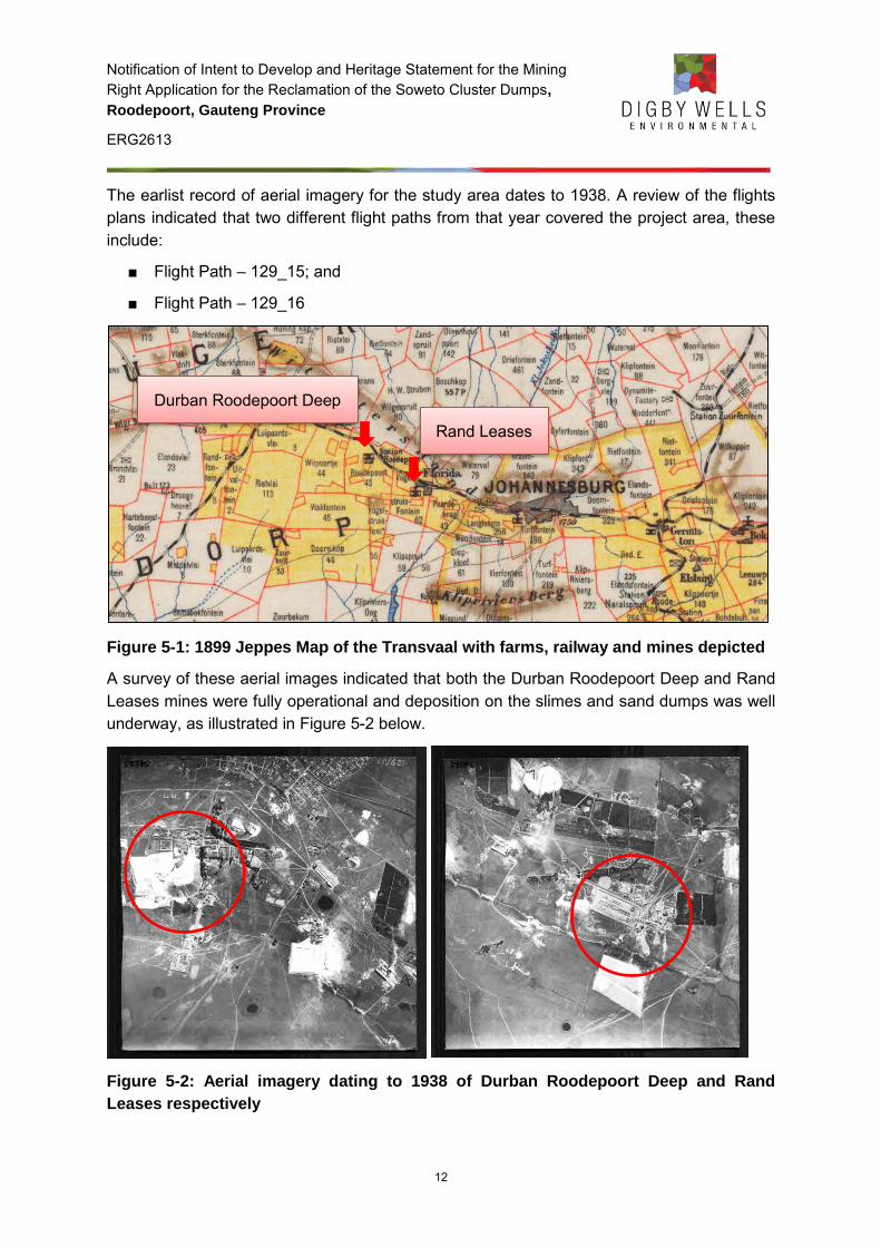
Notification of Intent to Develop and Heritage Statement for the Mining Right Application for the Reclamation of the Soweto Cluster Dumps,
Roodepoort, Gauteng Province
ERG2613
12
The earlist record of aerial imagery for the study area dates to 1938. A review of the flights plans indicated that two different flight paths from that year covered the project area, these include:
■ Flight Path – 129_15; and
■ Flight Path – 129_16
Figure 5-1: 1899 Jeppes Map of the Transvaal with farms, railway and mines depicted
A survey of these aerial images indicated that both the Durban Roodepoort Deep and Rand Leases mines were fully operational and deposition on the slimes and sand dumps was well underway, as illustrated in Figure 5-2 below.
Figure 5-2: Aerial imagery dating to 1938 of Durban Roodepoort Deep and Rand
Leases respectively
Durban Roodepoort Deep
Rand Leases
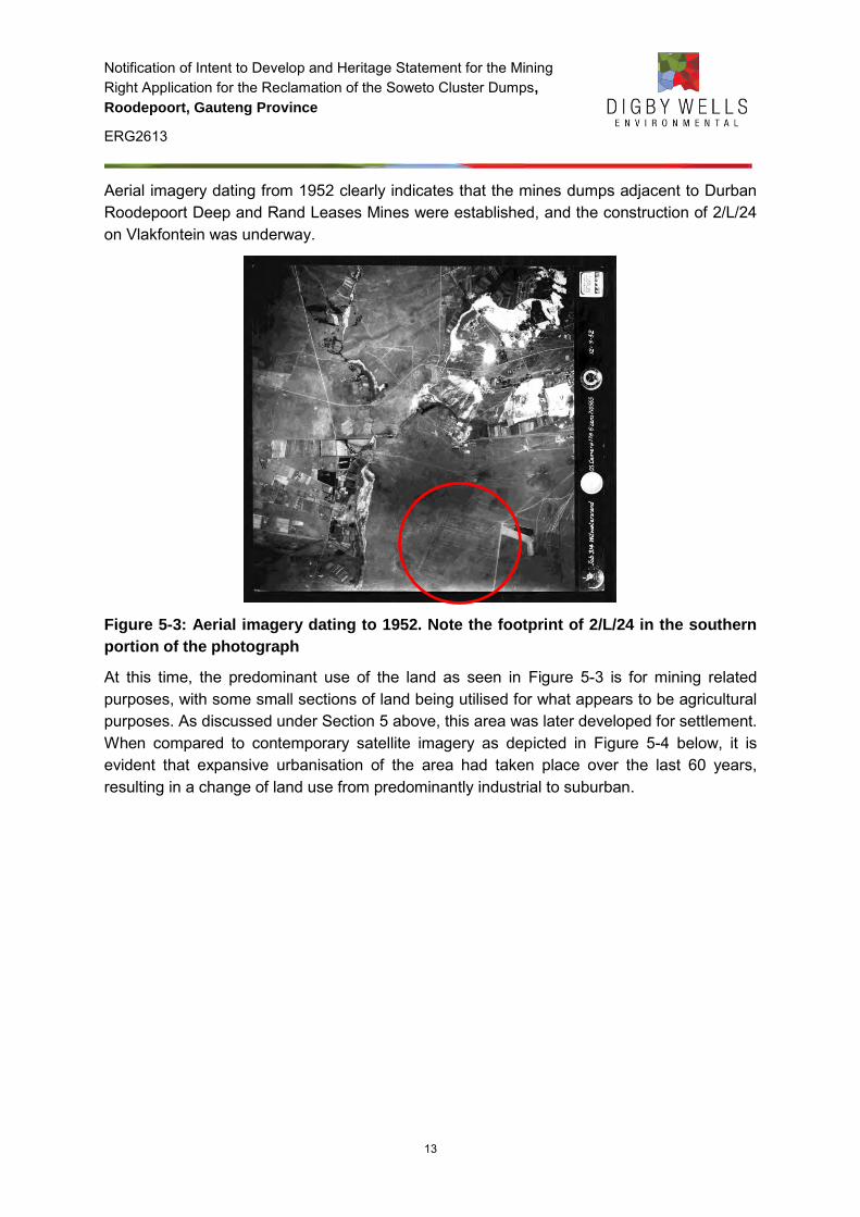
Notification of Intent to Develop and Heritage Statement for the Mining Right Application for the Reclamation of the Soweto Cluster Dumps,
Roodepoort, Gauteng Province
ERG2613
13
Aerial imagery dating from 1952 clearly indicates that the mines dumps adjacent to Durban Roodepoort Deep and Rand Leases Mines were established, and the construction of 2/L/24 on Vlakfontein was underway.
Figure 5-3: Aerial imagery dating to 1952. Note the footprint of 2/L/24 in the southern
portion of the photograph
At this time, the predominant use of the land as seen in Figure 5-3 is for mining related purposes, with some small sections of land being utilised for what appears to be agricultural purposes. As discussed under Section 5 above, this area was later developed for settlement. When compared to contemporary satellite imagery as depicted in Figure 5-4 below, it is evident that expansive urbanisation of the area had taken place over the last 60 years, resulting in a change of land use from predominantly industrial to suburban.
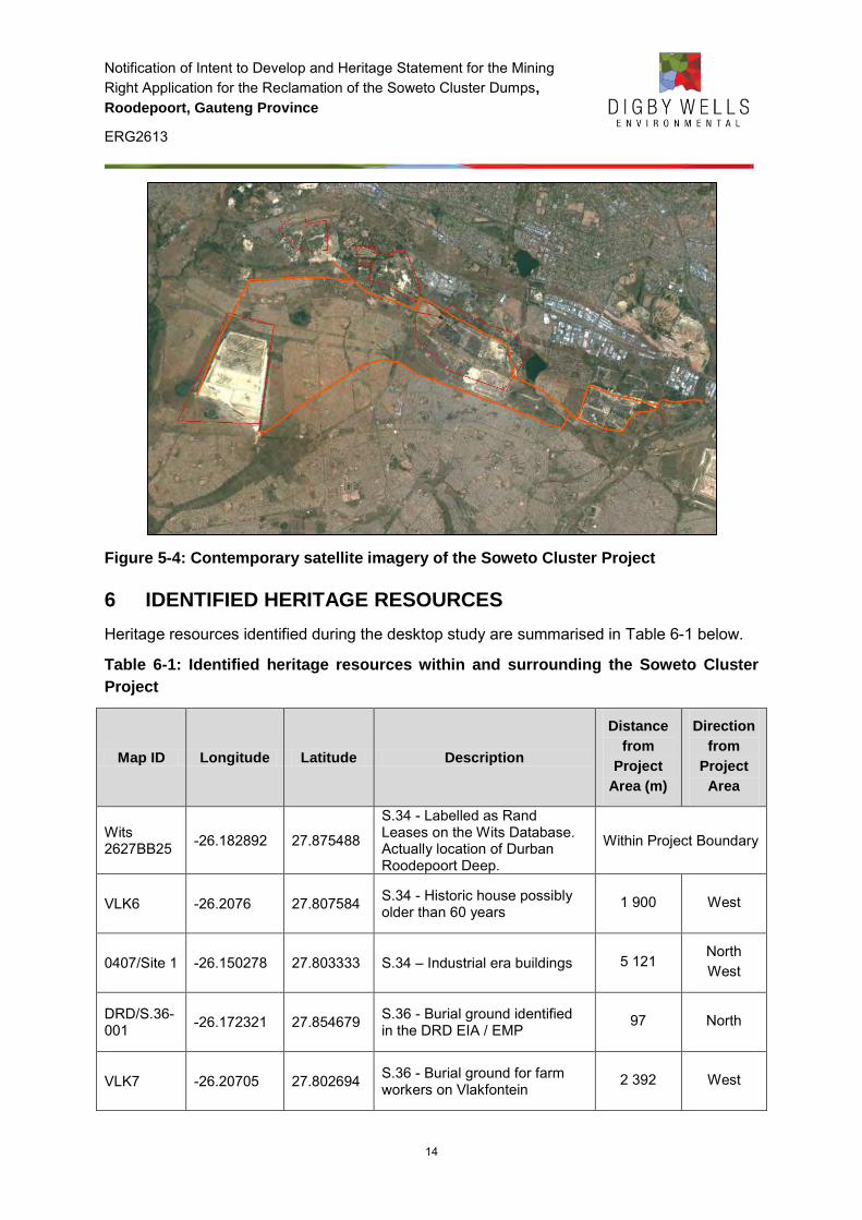
Notification of Intent to Develop and Heritage Statement for the Mining Right Application for the Reclamation of the Soweto Cluster Dumps,
Roodepoort, Gauteng Province
ERG2613
14
Figure 5-4: Contemporary satellite imagery of the Soweto Cluster Project
6 IDENTIFIED HERITAGE RESOURCES
Heritage resources identified during the desktop study are summarised in Table 6-1 below.
Table 6-1: Identified heritage resources within and surrounding the Soweto Cluster
Project
Map ID Longitude Latitude Description
Distance
from
Project
Area (m)
Direction
from
Project
Area
Wits 2627BB25 -26.182892 27.875488
S.34 - Labelled as Rand Leases on the Wits Database. Actually location of Durban Roodepoort Deep.
Within Project Boundary
VLK6 -26.2076 27.807584 S.34 - Historic house possibly older than 60 years
1 900 West
0407/Site 1 -26.150278 27.803333 S.34 – Industrial era buildings 5 121 North West
DRD/S.36-001 -26.172321 27.854679 S.36 - Burial ground identified
in the DRD EIA / EMP 97 North
VLK7 -26.20705 27.802694 S.36 - Burial ground for farm workers on Vlakfontein
2 392 West
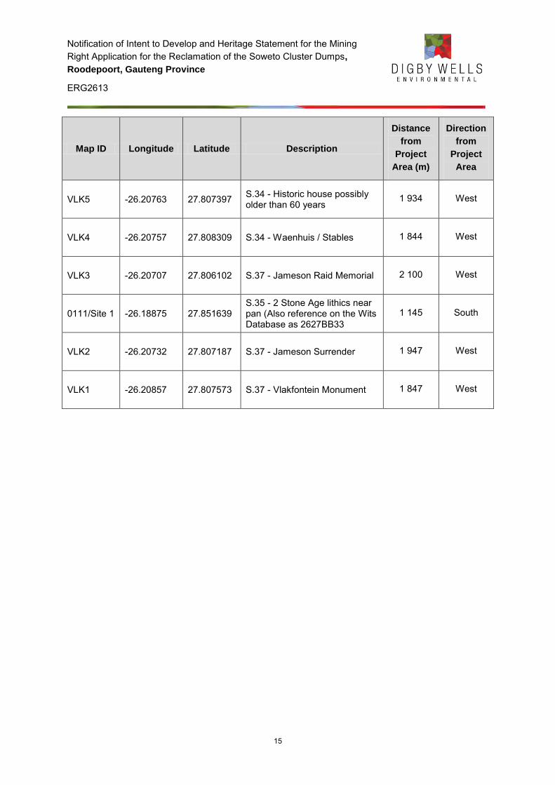
Notification of Intent to Develop and Heritage Statement for the Mining Right Application for the Reclamation of the Soweto Cluster Dumps,
Roodepoort, Gauteng Province
ERG2613
15
Map ID Longitude Latitude Description
Distance
from
Project
Area (m)
Direction
from
Project
Area
VLK5 -26.20763 27.807397 S.34 - Historic house possibly older than 60 years
1 934 West
VLK4 -26.20757 27.808309 S.34 - Waenhuis / Stables 1 844 West
VLK3 -26.20707 27.806102 S.37 - Jameson Raid Memorial 2 100 West
0111/Site 1 -26.18875 27.851639 S.35 - 2 Stone Age lithics near pan (Also reference on the Wits Database as 2627BB33
1 145 South
VLK2 -26.20732 27.807187 S.37 - Jameson Surrender 1 947 West
VLK1 -26.20857 27.807573 S.37 - Vlakfontein Monument 1 847 West
Notification of Intent to Develop and Heritage Statement for the Mining Right Application for the Reclamation of the Soweto Cluster Dumps,
Roodepoort, Gauteng Province
ERG2613
16
Figure 6-1: Identified heritage sites during the desktop study.
Notification of Intent to Develop and Heritage Statement for the Mining Right Application for the Reclamation of the Soweto Cluster Dumps,
Roodepoort, Gauteng Province
ERG2613
17
7 SOURCES OF RISK
The activities associated with the reclamation of the dumps, as described in Table 7-1 could potentially pose a risk to identified heritage resources. The potential risks are discussed according to the various phases of the project below.
Table 7-1: List of activities associated with the reclamation of the Soweto cluster
dumps
Activity Description Source of Risk
Construction Phase
1. Employment of workers
Preparation for reclamation activities
None
2.
Removal of Vegetation
Vegetation will be removed on the dump, and clearing for the construction of temporary infrastructure, pump stations and access roads.
This activity constitutes development as defined in terms of Section 2(viii) (f) where ‘any physical intervention …result in a change to the nature, appearance or physical nature of a place including any removal or destruction of trees, or removal of vegetation or topsoil.’
The identified risk is therefore changes in the character of the site described in Sections 34 (1) and 38(1) (c) of the NHRA.
3.
Construction of pipelines
A slurry and water line will be constructed and will meet up with the existing Crown-Ergo pipeline
This activity constitutes development as defined in terms of Section 2(viii) (a) and (b) where ‘any physical intervention …result in a change to the nature, appearance or physical nature of a place including construction, alteration, demolition, removal or change of use of a place or a structure at a place [and] carrying out any
Notification of Intent to Develop and Heritage Statement for the Mining Right Application for the Reclamation of the Soweto Cluster Dumps,
Roodepoort, Gauteng Province
ERG2613
18
Activity Description Source of Risk
works on or over or under a place.’
The identified risk is therefore changes in the character of the site described in Sections 34 (1) and 38(1) (a) of the NHRA.
4.
Operation of construction machinery and vehicles
Construction machinery and vehicles will be utilised to construct the temporary infrastructure, pump station and access roads. Vehicles will be used to transport equipment on site.
This activity constitutes development as defined in terms of Section 2(viii) (b) where ‘any physical intervention …result in a change to the nature, appearance or physical nature of a place including carrying out any works on or over or under a place.’
The identified risk is therefore changes to resources that are generally protected in terms of Sections 27, 28, 31, 32, 34, 35, 36 and 37 that may occur in the proposed project area.
5.
Temporary storage of construction materials and hazardous material such as contaminated soil
Construction and hazardous material will be temporarily stored on site.
This activity constitutes development as defined in terms of Section 2(viii) (a) where ‘any physical intervention …result in a change to the nature, appearance or physical nature of a place including construction, alteration, demolition, removal or change of use of a place or a structure at a place.’
The identified risk is therefore changes to resources that are generally protected in terms of Sections 27, 28, 31, 32, 34, 35, 36 and 37 that may occur in the
Notification of Intent to Develop and Heritage Statement for the Mining Right Application for the Reclamation of the Soweto Cluster Dumps,
Roodepoort, Gauteng Province
ERG2613
19
Activity Description Source of Risk
proposed project area.
The identified risk is therefore change of use of a place or structure.
Operational Phase
1.
Reclamation Activities
2L24 will be reclaimed first, followed by the other 11 dumps
Reclamation activities will result in the destruction of dumps (structures) older than 60 years.
This activity constitutes development as defined in terms of Section 2(viii) (a), (b) and (c) where ‘any physical intervention …result in a change to the nature, appearance or physical nature of a place including construction, alteration, demolition, removal or change of use of a place
or a structure at a place [and] carrying out any works on or over or under a place [and] any change to the natural or existing condition or topography of land.’
The identified risk is therefore changes in the character of the site described in Sections 34 (1) and 38(1) (c) of the NHRA, in addition to consideration should be given to the possible protected status of the land covered by the dumps as described in Section 28(1) (c) of the NHRA.
2. Operation of pipes
Slurry will be transported to one of the Ergo Plants.
None
Notification of Intent to Develop and Heritage Statement for the Mining Right Application for the Reclamation of the Soweto Cluster Dumps,
Roodepoort, Gauteng Province
ERG2613
20
Activity Description Source of Risk
3. Operation of Pump Station
Operation of pump station. None
Decommissioning Phase
1. Decommissioning activities
Decommissioning Activities. None
2. Rehabilitation of site
The project area will be rehabilitated.
None
Post-closure Phase
1.
Groundwater Potential for acid mine drainage.
Although this is not an activity as such, acid mine drainage may result in changes to the ‘natural or existing condition or topography of land’ as defined in terms of terms of Section 2(viii) (e).
The identified risk is therefore potential changes to the character of the sites described in Sections 27, 28, 31, 32, 34, 35, 36 and 37 of the NHRA.
8 DISCUSSION OF FINDINGS
As is evidenced by the desktop study, the project is located within a predominantly historical and industrial and associated with the historical period. The Soweto Cluster Dumps are the result of mining activities associated with the Durban Roodepoort Deep and Rand Leases Mines. These mines are some of the earliest established mines on the Witwatersrand, and are intrinsically valuable in the mining history of the Witwatersrand and the city of Johannesburg. The resultant tailings dams and sand dumps are integrated elements in the history, heritage and identity of Johannesburg.
Other notable historic events in the surrounding areas include the culmination of the 1895 Jameson Raid on the farm Vlakfontein. It is in this location that the botched attempt to overthrow the ZAR government ended with the surrender of Jameson and the arrest and trial of many prominent British figures associated with the Reform Committee.
Notification of Intent to Develop and Heritage Statement for the Mining Right Application for the Reclamation of the Soweto Cluster Dumps,
Roodepoort, Gauteng Province
ERG2613
21
Later in time the Township of Soweto was established. Meadowlands specifically, being declared in 1953 to accommodate for the forced removals of residents from Sophiatown in 1955 has a direct association with the history of the Apartheid regime.
The sources of risk posed to heritage resources (See Table 7-1 above) are limited to the construction and operational phase of the project. Potential sources of risk include the removal of vegetation, construction of a pipeline, operation of construction machinery and vehicles, and reclamation of the dumps. When one considers the historic context of the project area, consideration must be given to the potential levels of change the project activities may have on tangible heritage resources, such as the dumps and mining infrastructure, as well as the intangible aspects, for example the contribution to the sense of place of the historical landscape.
9 RECOMMENDATIONS AND CONCLUSION
Based on the description of activities associated with the Soweto Cluster Dumps, including clearing of vegetation, construction of pipeline, and reclamation of dumps, it is recommended that a Heritage Impact Assessment be conducted with:
■ A specific focus on the historical landscape including an inventory of historical structures, monuments and memorials within the project area; and
■ Exemption from archaeological and palaeontological components.
.
Notification of Intent to Develop and Heritage Statement for the Mining Right Application for the Reclamation of the Soweto Cluster Dumps,
Roodepoort, Gauteng Province
ERG2613
22
10 BIBLIOGRAPHY
Anonymous. (n.d.). DRD Lease. Retrieved January 13, 2014, from West Wits Mining: http://www.westwitsmining.com/projects/west-rand-south-africa/drd-lease/
Anonymous. (n.d.). Rand Leases. Retrieved January 2014, 2014, from West Wits Mining: http://www.westwitsmining.com/projects/west-rand-south-africa/rand-leases/
Birkholtz, P. D. (2006). Phase 1 Heritage Impact Assessment for the Proposed Jameson Field Extention 1 Residential Township Development, Gauteng Province. Unpublished report by: Archaeology Africa cc kept on file at SAHRIS under 2006-SAHRA-0097.
Bonner, P., & Segal, L. (1998). Soweto: A History. Cape Town: Maskew Miller Longman.
Brodie, N. (2008). The Joburg Book: A Guide to the City's History, People & Places. Johannesburg: Sharp Sharp Media.
City of Johannesburg District Municipality. (2013). Integrated Development Plan 2013/16. District Municipality: Johannesburg.
Hall, M. (1987). The Changing Past: Farmers, Kings and Traders in Southern Africa 2000 - 1860. Cape Town: David Phillip Publishing.
Huffman, T. N. (2007). Handbook to the Iron Age: The Archaeology of Pre-Colonial Farming Societies in Southern Africa. Cape Town: University of KwaZulu-Natal Press.
Huffman, T. N., Hall, S. L., & Steel, R. H. (1991). Archaeological Survey of the Rietfontein Housing Scheme, Southern Transvaal. Gauteng: Unpublished report.
Lombard, M., Wadley, L., Deacon, J., Wurz, S., Parsons, I., Mohapi, M., et al. (2012). South African and Lesotho Stone Age Sequence Updated (I). South African Archaeological Bulletin, 67(195), 123-144.
von Ketelhodt, G. F. (2007). The Golden Crown of Johannesburg. Johannesburg: Willsan Mining Publishers.