Embed Size (px)
Citation preview
NCHRPREPORT 480
NATIONALCOOPERATIVEHIGHWAYRESEARCHPROGRAM
A Guide to Best Practices for Achieving Context Sensitive Solutions
TRANSPORTATION RESEARCH BOARD EXECUTIVE COMMITTEE 2002 (Membership as of September 2002)
OFFICERSChair: E. Dean Carlson, Secretary of Transportation, Kansas DOTVice Chair: Genevieve Giuliano, Professor, School of Policy, Planning, and Development, University of Southern California, Los AngelesExecutive Director: Robert E. Skinner, Jr., Transportation Research Board
MEMBERSWILLIAM D. ANKNER, Director, Rhode Island DOTTHOMAS F. BARRY, JR., Secretary of Transportation, Florida DOTMICHAEL W. BEHRENS, Executive Director, Texas DOTJACK E. BUFFINGTON, Associate Director and Research Professor, Mack-Blackwell National Rural Transportation Study Center,
University of ArkansasSARAH C. CAMPBELL, President, TransManagement, Inc., Washington, DCJOANNE F. CASEY, President, Intermodal Association of North AmericaJAMES C. CODELL III, Secretary, Kentucky Transportation CabinetJOHN L. CRAIG, Director, Nebraska Department of RoadsROBERT A. FROSCH, Senior Research Fellow, John F. Kennedy School of Government, Harvard UniversitySUSAN HANSON, Landry University Professor of Geography, Graduate School of Geography, Clark UniversityLESTER A. HOEL, L. A. Lacy Distinguished Professor, Department of Civil Engineering, University of VirginiaRONALD F. KIRBY, Director of Transportation Planning, Metropolitan Washington Council of GovernmentsH. THOMAS KORNEGAY, Executive Director, Port of Houston AuthorityBRADLEY L. MALLORY, Secretary of Transportation, Pennsylvania DOTMICHAEL D. MEYER, Professor, School of Civil and Environmental Engineering, Georgia Institute of TechnologyJEFF P. MORALES, Director of Transportation, California DOTDAVID PLAVIN, President, Airports Council International, Washington, DCJOHN REBENSDORF, Vice President, Network and Service Planning, Union Pacific Railroad Co., Omaha, NECATHERINE L. ROSS, Executive Director, Georgia Regional Transportation AgencyJOHN M. SAMUELS, Senior Vice President-Operations Planning & Support, Norfolk Southern Corporation, Norfolk, VAPAUL P. SKOUTELAS, CEO, Port Authority of Allegheny County, Pittsburgh, PAMICHAEL S. TOWNES, Executive Director, Transportation District Commission of Hampton Roads, Hampton, VAMARTIN WACHS, Director, Institute of Transportation Studies, University of California at BerkeleyMICHAEL W. WICKHAM, Chairman and CEO, Roadway Express, Inc., Akron, OHM. GORDON WOLMAN, Professor of Geography and Environmental Engineering, The Johns Hopkins University
MIKE ACOTT, President, National Asphalt Pavement Association (ex officio)MARION C. BLAKEY, Federal Aviation Administrator, U.S.DOT (ex officio)REBECCA M. BREWSTER, President and CEO, American Transportation Research Institute, Atlanta, GA (ex officio)JOSEPH M. CLAPP, Federal Motor Carrier Safety Administrator, U.S.DOT (ex officio)THOMAS H. COLLINS (Adm., U.S. Coast Guard), Commandant, U.S. Coast Guard (ex officio)JENNIFER L. DORN, Federal Transit Administrator, U.S.DOT (ex officio)ELLEN G. ENGLEMAN, Research and Special Programs Administrator, U.S.DOT (ex officio)ROBERT B. FLOWERS (Lt. Gen., U.S. Army), Chief of Engineers and Commander, U.S. Army Corps of Engineers (ex officio)HAROLD K. FORSEN, Foreign Secretary, National Academy of Engineering (ex officio)EDWARD R. HAMBERGER, President and CEO, Association of American Railroads (ex officio)JOHN C. HORSLEY, Executive Director, American Association of State Highway and Transportation Officials (ex officio)MICHAEL P. JACKSON, Deputy Secretary of Transportation, U.S.DOT (ex officio)ROBERT S. KIRK, Director, Office of Advanced Automotive Technologies, U.S. Department of Energy (ex officio)WILLIAM W. MILLAR, President, American Public Transportation Association (ex officio)MARGO T. OGE, Director, Office of Transportation and Air Quality, U.S. Environmental Protection Agency (ex officio)MARY E. PETERS, Federal Highway Administrator, U.S.DOT (ex officio)JEFFREY W. RUNGE, National Highway Traffic Safety Administrator, U.S.DOT (ex officio)JON A. RUTTER, Federal Railroad Administrator, U.S.DOT (ex officio)WILLIAM G. SCHUBERT, Maritime Administrator, U.S.DOT (ex officio)ASHISH K. SEN, Director, Bureau of Transportation Statistics, U.S.DOT (ex officio)ROBERT A. VENEZIA, Earth Sciences Applications Specialist, National Aeronautics and Space Administration (ex officio)
NATIONAL COOPERATIVE HIGHWAY RESEARCH PROGRAM
Transportation Research Board Executive Committee Subcommittee for NCHRPE. DEAN CARLSON, Kansas DOT (Chair)GENEVIEVE GIULIANO, University of Southern California,
Los AngelesLESTER A. HOEL, University of VirginiaJOHN C. HORSLEY, American Association of State Highway and
Transportation Officials
MARY E. PETERS, Federal Highway Administration JOHN M. SAMUELS, Norfolk Southern Corporation, Norfolk, VA ROBERT E. SKINNER, JR., Transportation Research Board
T R A N S P O R T A T I O N R E S E A R C H B O A R DWASHINGTON, D.C.
2002www.TRB.org
NATIONAL COOPERATIVE HIGHWAY RESEARCH PROGRAM
NCHRP REPORT 480
Research Sponsored by the American Association of State Highway and Transportation Officials in Cooperation with the Federal Highway Administration
SUBJECT AREAS
Highway and Facility Design
A Guide to Best Practices for Achieving Context Sensitive Solutions
Prepared by CH2M Hill:
TIMOTHY R. NEUMAN
MARCY SCHWARTZ
LEOFWIN CLARK
JAMES BEDNAR
Contributors:
DON FORBES
DAVID VOMACKA
CRAIG TAGGART (EDAW)MARIE GLYNN
KEVIN SLACK
AND
DOUG ABERE
In Association with:
Edaw, Inc.
NATIONAL COOPERATIVE HIGHWAY RESEARCH PROGRAM
Systematic, well-designed research provides the most effectiveapproach to the solution of many problems facing highwayadministrators and engineers. Often, highway problems are of localinterest and can best be studied by highway departmentsindividually or in cooperation with their state universities andothers. However, the accelerating growth of highway transportationdevelops increasingly complex problems of wide interest tohighway authorities. These problems are best studied through acoordinated program of cooperative research.
In recognition of these needs, the highway administrators of theAmerican Association of State Highway and TransportationOfficials initiated in 1962 an objective national highway researchprogram employing modern scientific techniques. This program issupported on a continuing basis by funds from participatingmember states of the Association and it receives the full cooperationand support of the Federal Highway Administration, United StatesDepartment of Transportation.
The Transportation Research Board of the National Academieswas requested by the Association to administer the researchprogram because of the Board’s recognized objectivity andunderstanding of modern research practices. The Board is uniquelysuited for this purpose as it maintains an extensive committeestructure from which authorities on any highway transportationsubject may be drawn; it possesses avenues of communications andcooperation with federal, state and local governmental agencies,universities, and industry; its relationship to the National ResearchCouncil is an insurance of objectivity; it maintains a full-timeresearch correlation staff of specialists in highway transportationmatters to bring the findings of research directly to those who are ina position to use them.
The program is developed on the basis of research needsidentified by chief administrators of the highway and transportationdepartments and by committees of AASHTO. Each year, specificareas of research needs to be included in the program are proposedto the National Research Council and the Board by the AmericanAssociation of State Highway and Transportation Officials.Research projects to fulfill these needs are defined by the Board, andqualified research agencies are selected from those that havesubmitted proposals. Administration and surveillance of researchcontracts are the responsibilities of the National Research Counciland the Transportation Research Board.
The needs for highway research are many, and the NationalCooperative Highway Research Program can make significantcontributions to the solution of highway transportation problems ofmutual concern to many responsible groups. The program,however, is intended to complement rather than to substitute for orduplicate other highway research programs.
Note: The Transportation Research Board of the National Academies, theNational Research Council, the Federal Highway Administration, the AmericanAssociation of State Highway and Transportation Officials, and the individualstates participating in the National Cooperative Highway Research Program donot endorse products or manufacturers. Trade or manufacturers’ names appearherein solely because they are considered essential to the object of this report.
Published reports of the
NATIONAL COOPERATIVE HIGHWAY RESEARCH PROGRAM
are available from:
Transportation Research BoardBusiness Office500 Fifth Street, NWWashington, DC 20001
and can be ordered through the Internet at:
http://www.national-academies.org/trb/bookstore
Printed in the United States of America
NCHRP REPORT 480
Project C15-19 FY’2000
ISSN 0077-5614
ISBN 0-309-06770-7
Library of Congress Control Number 2002113180
© 2002 Transportation Research Board
Price $21.00
NOTICE
The project that is the subject of this report was a part of the National Cooperative
Highway Research Program conducted by the Transportation Research Board with the
approval of the Governing Board of the National Research Council. Such approval
reflects the Governing Board’s judgment that the program concerned is of national
importance and appropriate with respect to both the purposes and resources of the
National Research Council.
The members of the technical committee selected to monitor this project and to review
this report were chosen for recognized scholarly competence and with due
consideration for the balance of disciplines appropriate to the project. The opinions and
conclusions expressed or implied are those of the research agency that performed the
research, and, while they have been accepted as appropriate by the technical committee,
they are not necessarily those of the Transportation Research Board, the National
Research Council, the American Association of State Highway and Transportation
Officials, or the Federal Highway Administration, U.S. Department of Transportation.
Each report is reviewed and accepted for publication by the technical committee
according to procedures established and monitored by the Transportation Research
Board Executive Committee and the Governing Board of the National Research
Council.

The National Academy of Sciences is a private, nonprofit, self-perpetuating society of distinguished schol-ars engaged in scientific and engineering research, dedicated to the furtherance of science and technology and to their use for the general welfare. On the authority of the charter granted to it by the Congress in 1863, the Academy has a mandate that requires it to advise the federal government on scientific and techni-cal matters. Dr. Bruce M. Alberts is president of the National Academy of Sciences.
The National Academy of Engineering was established in 1964, under the charter of the National Acad-emy of Sciences, as a parallel organization of outstanding engineers. It is autonomous in its administration and in the selection of its members, sharing with the National Academy of Sciences the responsibility for advising the federal government. The National Academy of Engineering also sponsors engineering programs aimed at meeting national needs, encourages education and research, and recognizes the superior achieve-ments of engineers. Dr. William A. Wulf is president of the National Academy of Engineering.
The Institute of Medicine was established in 1970 by the National Academy of Sciences to secure the services of eminent members of appropriate professions in the examination of policy matters pertaining to the health of the public. The Institute acts under the responsibility given to the National Academy of Sciences by its congressional charter to be an adviser to the federal government and, on its own initiative, to identify issues of medical care, research, and education. Dr. Harvey V. Fineberg is president of the Institute of Medicine.
The National Research Council was organized by the National Academy of Sciences in 1916 to associate the broad community of science and technology with the Academy’s purposes of furthering knowledge and advising the federal government. Functioning in accordance with general policies determined by the Acad-emy, the Council has become the principal operating agency of both the National Academy of Sciences and the National Academy of Engineering in providing services to the government, the public, and the scientific and engineering communities. The Council is administered jointly by both the Academies and the Institute of Medicine. Dr. Bruce M. Alberts and Dr. William A. Wulf are chair and vice chair, respectively, of the National Research Council.
The Transportation Research Board is a division of the National Research Council, which serves the National Academy of Sciences and the National Academy of Engineering. The Board’s mission is to promote innovation and progress in transportation by stimulating and conducting research, facilitating the dissemination of information, and encouraging the implementation of research results. The Board’s varied activities annually engage more than 4,000 engineers, scientists, and other transportation researchers and practitioners from the public and private sectors and academia, all of whom contribute their expertise in the public interest. The program is supported by state transportation departments, federal agencies including the component administrations of the U.S. Department of Transportation, and other organizations and individuals interested in the development of transportation. www.TRB.org
www.national-academies.org
COOPERATIVE RESEARCH PROGRAMS STAFF FOR NCHRP REPORT 480
ROBERT J. REILLY, Director, Cooperative Research ProgramsCRAWFORD F. JENCKS, Manager, NCHRPB. RAY DERR, Senior Program OfficerEILEEN P. DELANEY, Managing Editor
NCHRP PROJECT C15-19 PANELField of Design—Area of General Design
JAMES C. CODELL III, Kentucky Transportation Cabinet (Chair)CHARLES B. ADAMS, Maryland DOTCARL F. BARD, Connecticut DOT DAVID BOYD, FOCUS, St. Louis, MOEUGENE CLECKLEY, FHWA, Atlanta, GADELBERT GERDES, Minnesota DOTMEG MAGUIRE, Scenic America, Washington, DCP.K. MOHANTY, Utah DOTMARY ANN NABER, FHWASEPPO SILLAN, FHWA Liaison RepresentativeSTEPHEN F. MAHER, TRB Liaison Representative
Author AcknowledgmentsThe research team acknowledges the assistance and contributions of the following individuals and agencies who provided insights, project examples, and other information in support of NCHRP Project 15-19.
Primary Authors: Timothy R. Neuman, P.E., Marcy Schwartz, Leofwin Clark, and James Bednar
Contributors: Don Forbes, David Vomacka, Craig Taggart (Edaw), Marie Glynn, Kevin Slack, and Doug Abere
Alaska Department of Transportation and Public FacilitiesMike Downing Director, Design and Engineering ServicesJohn R. Mazzitello EnvironmentalDave McCaleb Preconstruction
Arizona Department of TransportationJoe Salazar Landscape Architectural Design
Connecticut Department of TransportationJim Byrnes Chief EngineerCarl Bard Roadway DesignDavid Harms Roadway DesignSimone Cristofori Roadway DesignPeter Talerico Roadway DesignArt Gruhn Construction
Federal Highway AdministrationAllen Burden Eastern Federal Lands DivisionRay Krammes Turner-Fairbank Highway Research CenterMike Griffith Turner-Fairbank Highway Research CenterKeith Harrison Western Federal Lands DivisionHarold Peaks Headquarters
Illinois Department of TransportationKathy Ames Chief Coordination UnitPeter Frantz Chief Environmental Section
Iowa Department of TransportationHarry Budd Project Planning, Corridor Development, and Pre-location StudiesKimball Olson Aesthetic Bridge Specialist, US 71 Project ManagerMarty Sankey Preliminary DevelopmentDennis Smith Section Leader, Urban Design ProjectsTom Welch Traffic Safety Engineer
Kansas Department of TransportationJim Brewer Chief Engineer
Kentucky Transportation CabinetAnnette Coffey Director, Division of PlanningDaryl Green Planning John L. Metille Jr. Director, Division of Environmental AnalysisJerry Pigman University of KentuckyJohn Sacksteder Director, Division of Highway DesignRicky Young Public Involvement
Maryland State Highway AdministrationParker Williams AdministratorDoug Rose Chief AdministratorLiz Homer Deputy AdministratorCynthia Williams Deputy Director, Office of Planning and Preliminary EngineeringClyde Pyers RetiredCharlie Adams Director, Office of Environmental DesignWendy Wolcott TBTP Program DirectorKirk McClelland Chief, Highway Design DivisionNeil Pedersen Deputy Administrator/Chief Engineer, Planning and EngineeringBob Douglass Deputy Chief Engineer, Office of Highway DevelopmentJerry Poggi Chief Learning Officer
Miami Valley Regional Planning CommissionNora Lake Executive Director
Michigan Department of TransportationWin Stebbins Engineer, Design Services Section
Minnesota Department of TransportationDel Gerdes Director, OTS/State Design EngineerTim Quinn Manager, Design ServicesJim Reierson Manager, Site DevelopmentBob Johns Director, Center for Transportation StudiesDave Ekern Assistant Commissioner, National AffairsDennis Adams Environmental ServicesGerry Larson Environmental ServicesFrank Pafko Environmental ServicesRick Dalton Project LiaisonAmr Jabr Design Standards EngineerRon Erickson Geometric EngineerMike Spielman Tort LiabilityPaul Stine State Aid EngineerTerry Humbert District 3Tim Henkel Metro PlanningDave Hall BridgeCarol Braun Site Development UnitJoe Hudak Cultural ResourcesMary Daher Public InvolvementLynette Rochel Metro Project ManagerBob Works Trans Action ModelRod Garver District 1 Project ManagerAdam Josephson Metro Project ManagerLisa Bigham Mankato Project ManagerMark Benson Consultant (S.E.H.)Charleen Zimmer Consultant (S.R.F.) Scott Bradley Landscape Architect
Mississippi Department of TransportationWendell Ruff Deputy Chief Engineer
Missouri Department of TransportationMark Kross EnvironmentalJay Smith Chief CounselSam Masters Environmental
National Conference of State LegislatorsMelissa Savage Transportation Policy Specialist
Nevada Department of TransportationFrank Csiga Principal Road Design EngineerSusan Martinovich Assistant Director, EngineeringTodd Montgomery Project Manager
Ohio Department of TransportationElvin Pinckney Environmental SupervisorJulie Walcoff CommunicationsKaren Young Major New Coordinator
Oldham Historic PropertiesSally Oldham
Oregon Department of TransportationTerry Cole Special Project Coordinator
Utah Department of TransportationClare Wardle Project ManagerP.K. Mohanty Preconstruction EngineerTom Warne Executive DirectorClare Wardell Project Manager
Washington Department of TransportationShari Schafftlein Deputy Director, Environmental Services
Wisconsin Department of TransportationJohn Haverberg Director, Bureau of Highway Development
Wyoming Department of TransportationTim Stark Environmental Services EngineerDave Pope Engineer

This guide demonstrates how state departments of transportation (DOTs) and othertransportation agencies can incorporate context sensitivity into their transportationproject development work. The guide is applicable to a wide variety of projects thattransportation agencies routinely encounter. While the guide is primarily written fortransportation agency personnel who develop transportation projects, other stake-holders may find it useful in better understanding the project development process.Example project documents are included on the accompanying CD-ROM (CRP-CD-23).
Seven qualities of excellence in transportation design and eight characteristics ofthe process that would yield excellence were identified during the seminal “ThinkingBeyond the Pavement: A National Workshop on Integrating Highway Developmentwith Communities and the Environment,” held in May 1998. These qualities and char-acteristics were termed principles of “context sensitive design.” Many barriers to con-text sensitive design were identified during the workshop, including rigid segmentationof responsibility during project development, failure to consider the full range of designalternatives, and lack of clear communication between the stakeholders and the trans-portation agency.
In September 1998, a National Training Steering Committee was created to over-see pilot efforts to institutionalize context sensitive design principles in five stateDOTs: Connecticut, Kentucky, Maryland, Minnesota, and Utah. It was agreed that eachof these states would proceed with a policy review and a training program tailored toits individual institutional needs, but that the five states would benefit from frequentexchange of information about the design and progress of these pilot efforts and thatall 50 states would then benefit from understanding the experiences of these five states.
Under NCHRP Project 15-19, CH2M Hill identified approaches for adopting con-text sensitive design principles, barriers to adoption in a transportation agency, andways to overcome those barriers. They met with each of the five pilot states and othertransportation agencies to learn how each is integrating context sensitive design into itsexisting project development processes. The information gathered was condensed intoan easy-to-read guide that highlights the advantages of context sensitive design, identi-fies potential disadvantages, describes a range of approaches for adopting and apply-ing context sensitive design principles in the project development process, documentshow barriers to context sensitive design are being overcome within state DOTs, andillustrates context sensitive design through case studies.
The CD-ROM included with this printed report (CRP-CD-23) reorganizes thematerial into a matrix of project development process steps and issues related to con-text sensitivity. It also includes significant background material drawn from actual proj-ects (e.g., evaluation criteria, public involvement plans, aesthetic design guidelines, andanimated views of design alternatives) that provide concrete examples of context sen-sitive solutions.
FOREWORDBy B. Ray Derr
Staff OfficerTransportation Research
Board

1 SECTION A. IntroductionLegislative Background on Context Sensitive Design, 2Recent Activities in Context Sensitive Design, 2Terminology, 3The CSD/CSS Vision, 3Insights on CSD/CSS, 4CSD/CSS Framework, 5Organization of This Guide, 6
7 SECTION B. About This Guide—Multi-Disciplinary Approach to Context Sensitive Design
CSD/CSS for Project Managers, 8CSD/CSS for the Transportation and Highway Design Professionals, 8CSD/CSS for the Environmental Managers, 9CSD/CSS for Public Involvement Specialists, 9CSD/CSS for Senior Managers and Administrators of Transportation Agencies, 9How to Use This Document, 9
11 SECTION C. Effective Decision MakingManagement Structure, 11
Develop Decision Process, 11Form, Resource, and Charter Project Team, 15
Problem Definition, 15Develop and Document Understanding of the Problem, 15
Project Development and Evaluation Framework, 16Develop Evaluation Criteria, 16Develop Evaluation Process, 16
Alternative Development, 17Develop and Document Full Range of Alternative Solutions, 17Ensure Education of All Parties on Innovative Solutions, 17Portray Alternatives in an Understandable Format, 17
Alternatives Screening, Evaluation, and Selection, 18Provide “Apples-to-Apples” Comparison of Alternatives, 18Tailor Level of Analysis to Issue and Project, 18Document Alternative Evaluation and Selection, 18Decision-Making Authority, 20
Implementation, 20Develop Project Funding Plan, 20Monitor Changes in Design and Mitigation, 20
Key Resources and References, 21
23 SECTION D. Reflecting Community ValuesManagement Structure, 23
Developing a Public Involvement Plan, 23Problem Definition, 27
Identifying Community Issues and Constraints, 27Confirming and Refining Problem Definition, 27
Project Development and Evaluation Framework, 27Involving Stakeholders in Framework Development, 27
Alternatives Development, 29Engaging Stakeholders in Identification of Alternatives, 29Identifying Opportunities for Enhancing Resources, 29Identifying Opportunities for Avoiding/Minimizing Adverse Effects, 30Identifying Mitigation for Unavoidable Adverse Effects, 31Engaging Stakeholders in Alternative Evaluation, 31
Implementation, 31Maintaining Communication Through Construction, 31Evaluating the Public Involvement Program, 32
Key Resources and References, 33
CONTENTS
35 SECTION E. Achieving Environmental SensitivityManagement Structure, 35
Establish Environmental Review Process, 35Develop Agency Outreach Plan, 36Provide Staffing Support, 37
Problem Definition, 37Develop Problem Statement, 37Conduct Scoping to Confirm and Refine Problem Statement, 38
Project Development and Evaluation Framework, 38Involve Stakeholders in Framework Development, 38Develop Purpose and Need, 38
Alternatives Development, 40Engage Stakeholders in Alternative Identification, 40Identify Opportunities for Reducing Adverse Environmental Impacts, 40
Alternatives Screening, Evaluation, and Selection, 41Tailor Level of Analysis, 41Engage Stakeholders in Alternative Evaluation, 42Refine and Commit to Mitigation Strategies, 42Refining and Committing to Mitigation Strategies, 42
Implementation, 42Monitor Changes in Design and Mitigation, 42
Key Resources and References, 43
45 SECTION F. Ensuring Safe and Feasible SolutionsManagement Structure, 45
Establishing Design Criteria—The AASHTO Policy on Geometric Design, 45
State Design Manuals and “Standards” Related to the AASHTO Policy, 46Design Philosophy and Background on Design Criteria (AASHTO), 46Alternative Sources of Design Criteria and Guidelines, 47Tort Liability, Design Exceptions, and Risk Management, 47Overview of Tort Issues, 49Best Practices for Risk Management, 50Philosophical Approach to Design Exceptions, 50Best Practices for Risk Management, 51Project Funding, Programs, and Policies, 51
Problem Definition, 52Highway Safety Problems—Understanding Substantive
and Nominal Safety, 52Nominal and Substantive Safety Thresholds, 53Mobility-Driven Projects, 55Economic Development Related Projects, 55Infrastructure Projects, 56
Project Development and Evaluation Framework, 56Selecting a Design Speed, 56Design Traffic and Level of Service, 58Design Vehicle(s), 59
Alternatives Development, 59Develop Multiple Alternatives; Start with a Blank Sheet of Paper, 59Design Choices and Their Consequences, 60Flexibility and Creativity, 62
Alternatives Screening, Evaluation, and Selection, 62Tools and Techniques for Evaluating the Safety
and Feasibility of Alternatives, 62Visualization, 62Traffic Operational Simulation, 64Quantitative Safety Models and Applied Research, 65GIS Technology, 66Demonstrating a Commitment to Mitigate Safety Concerns, 66Decision Making, 66
Implementation, 66Key Resources and References, 68
71 SECTION G. Organizational NeedsManagement Structure, 71
Adopting a CSD/CSS Culture, 71Defining a Process Change/Implementation Process, 72Policies and Procedures, 73Project Management, 74
Problem Definition, 74The Role of Community Values in Defining Problems, 74Performance-Based Problem Definitions, 78Asset Management, 79
Alternatives Development—Alternatives Screening, Evaluation, and Selection, 82Project Team Technical Structure, 82Skill Acquisition and Development, 82Design Standards and Criteria, 83Project Continuity, 86Project Decisions, 87Risk Management, 88
Implementation, 88The Business Case for CSD/CSS, 89Strategies for Implementing CSD/CSS, 90
Key Resources and References, 91
95 SECTION H. Case StudiesCase Study No. 1 Merritt Parkway Gateway Project, Greenwich,
Connecticut, 95Case Study No. 2 Minnesota TH-61, North Shore Scenic Drive, 99Case Study No. 3 Maryland Route 108, 103Case Study No. 4 Maryland Route 355, 107Case Study No. 5 Washington SR99 International Boulevard, 111Case Study No. 6 Cobblestone Street Interpretive Park, Boonville,
Missouri, 117Case Study No. 7 U.S. Route 6, Brooklyn, Connecticut, 119Case Study No. 8 Kentucky Proposed I-66, 123Case Study No. 9 Towson Roundabout, Towson, Maryland, 127
131 KEY RESOURCES AND REFERENCES
137 APPENDICES

1
National Cooperative Highway Research Program Report 480 Section A: Introduction
For many years, planning, design, and construction of highways and streets has been left mostly to the “professionals” – highway and traffic engineers. Selection of routes, the design of the align-ment, location of intersections, and the roadway features were based primarily on engineering considerations, with the objec-tive being to provide the highest quality service at the lowest construction cost. Solutions to mobility and safety problems have been infrastructure-oriented, reflecting the training and background of those responsible for solving the problems. Sub-stantive decisions regarding the design of a road itself were left to professional engineers and planners with limited input from the public and external agencies.
As the nation moved into the latter part of the 20th century, the automobile emerged as the predominant mode of travel for both persons and goods. With growth in both the population and national economy, demand for travel increased, resulting in more autos and more and larger trucks using the highway system.
The nation’s engineers, through state and federal transportation agencies, responded to the increase in demand for travel and to public policy directives to promote highway travel with more and “better” roads, i.e., roads that enabled traffic to move faster and safer to the travelers’ destinations. Their efforts, foremost among them being the 42,000-mile interstate system, have done much to shape the landscape of America. And, despite the significant increase in travel, highway travel has become increasingly safer, with fatalities decreasing significantly over the past 20 years.
A. INTRODUCTION
Beginning in the 1960s, strong cultural trends emerged. The general public began to have concern and interest in the adverse environmental impacts of man’s intrusions on the landscape (including, but certainly not limited to road building). Such interest culminated in the passing of what was among the most important pieces of legislation of the latter 20th century, the National Environmental Policy Act (NEPA) in 1969. From this point forward, roadway design and construction, and indeed, all public works, became more than a matter of building the most economic, short-est, widest, or fastest facility. Rather, engineers and plan-ners are now required to consider features and effects such as wetlands, threatened and endangered species, adverse noise, and other environmental considerations.
The public also has begun to generate a renewed interest and concern with the cultural, historic, and other values that define a community. Americans have become more aware of their sense of place and history, both locally and regionally. Any changes to a community, whether to develop open space, tear down a long-standing building
with unique architecture, or build a new road are now increasingly viewed as potential threats to that sense of place and the cultural fabric of the community.
The above trends have produced what in retrospect seems an inevitable result. Departments of Transportation (DOTs) and professional engineers trained to provide a certain quality of design using traditional approaches began to run into resistance from the public and commu-nity interests, when highway projects were perceived as having clear, measurable adverse impacts on the commu-nities through which they passed. No longer are the ben-efits of these “improvements” (faster travel times, greater safety, less delay) widely accepted or perceived as worth the costs in terms of right-of-way, community disruption, etc. No longer does the public unquestioningly accept the proposals of engineering professionals, regardless of how well thought-out they are. Roads, along with other major infrastructure projects, despite being recognized as neces-sary to the public health and economic well-being of a community, are now increasingly viewed as permanent intrusions on the landscape.
����������
About this
Guide
Effective
Decision
Making
Reflecting
Community
Values
Achieving
Environmental
Sensitivity
Ensuring Safe
and Feasible
Solutions
Organizational
Needs
Case
StudiesAppendices
Management Structure
Problem Definition
Project Development and
Evaluation Framework
Alternatives Development
Alternatives Screening
Evaluation and Selection
Implementation
C
B
D
E
F
G
H
Introduction
to CSD
A
2
Section A: Introduction A Guide to Best Practices for Achieving Context Sensitive Solutions
3
National Cooperative Highway Research Program Report 480 Section A: Introduction
Context Sensitive Design (CSD) is among the most sig-nificant concepts to emerge in highway project planning, design, and construction in recent years. Also referred to as “Thinking Beyond the Pavement,” CSD reflects the increasingly urgent need for DOTs to consider highway projects as more than transportation. CSD recognizes that a highway or road itself, by the way it is integrated within the community, can have far-reaching impacts (positive and negative) beyond its traffic or transportation function. The term CSD refers to as much an approach or process as it does to an actual outcome.
LEGISLATIVE BACKGROUND ON CONTEXT SENSITIVE DESIGNBeginning in 1969, NEPA required that agencies perform-ing federally funded projects undergo a thorough analysis of their impacts to both natural and human environmental resources. Since that time, the U.S. Congress passed a series of policy acts and regulations to strengthen and increase the commitment to environmental quality. In 1991, Congress emphasized the federal commitment to preserve historic, scenic, and cultural resources as part of the Intermodal Surface Transportation Efficiency Act. Section 1016(a) of that Act provides approval for transportation projects that affect historic facilities or are located in areas of historic or scenic value only if projects are designed to appropriate standards or if mitigation measures allow for the preservation of these resources.
In 1995, Congress passed the National Highway System Designation Act, emphasizing, among other things, flexi-bility in highway design to further promote preservation of historic, scenic, and aesthetic resources. This act provided funding capabilities for transportation enhancements and supported applications to modify design standards for the purpose of preserving important historic and scenic
resources. Most importantly, the Act extended these con-siderations to federally funded transportation projects not on the National Highway System.
Thirty years of history in national environmental policy making has demonstrated a response to increasing public interest and concern about transportation projects’ impacts. The public and local officials have begun to question not only the design or physical features of projects, but also the basic premise or assumptions behind them as put forth by the many agencies. Evidence of this trend is the great number of major projects around the country that have been significantly delayed or stopped, not for lack of fund-ing or even demonstrated transportation need, but for lack of satisfaction that the proposed solution met community and other non-transportation needs.
RECENT ACTIVITIES IN CONTEXT SENSITIVE DESIGNBy the mid 1990s a clear consensus emerged that new approaches to solving traditional highway projects were needed. The recent laws and statements of public policy required those charged with the planning, design, and construction of highways to adopt a new direction. In response, the Federal Highway Administration (FHWA) and other agencies committed to develop a program to change the way highway projects are performed.
The following activities have framed where the transporta-tion profession stands with CSD:
• The FHWA partnered with AASHTO, Bicycle Fed-eration of America, National Trust for Historic Pres-ervation, and Scenic America to produce a landmark publication, Flexibility in Highway Design. This design guide illustrates how it is possible to make highway improvements while preserving and enhanc-ing the adjacent land or community. Flexibility in Highway Design urges highway designers to explore beyond the most conservative use of A Policy on the Geometric Design of Highways and Streets (AASHTO Green Book). Within an open, interdisciplinary frame-work, project teams should develop roadway designs that fully consider the aesthetic, historic, and scenic values along with considerations of safety and mobil-ity—the essence of CSD.
• An invitation-only conference, “Thinking Beyond the Pavement: A National Workshop on Integrating Highway Development with Communities and the Environment” was held in May 1998. This confer-ence, co-sponsored by the Maryland State Highway Administration, FHWA, and AASHTO, was targeted at state DOTs and environmental and community stakeholder groups.
“Context sensitive design asks questions first about the need and purpose of the transportation project, and then equally addresses safety, mobility, and the preservation of scenic, aesthetic, historic, environmental, and other community values. Context sensitive design involves a collaborative, interdisciplinary approach in which citizens are part of the design team.”
THINKING BEYOND THE PAVEMENT, MARYLAND STATE HIGHWAY ADMINISTRATION WORKSHOP, 1998
2
Section A: Introduction A Guide to Best Practices for Achieving Context Sensitive Solutions
3
National Cooperative Highway Research Program Report 480 Section A: Introduction
• Five pilot state DOTs (Connecticut, Kentucky, Maryland, Minnesota, and Utah) were selected to work with FHWA in defining and institutionalizing CSD principles and practices. Policy reviews, train-ing, and other activities have been conducted, with the results shared with other AASHTO members at national conferences and meetings.
• A second conference, co-sponsored by FHWA and the American Society of Civil Engineers (ASCE), was held in Reston, Virginia, in June 1999. This confer-ence, “Flexibility in Highway Design,” was targeted at highway design professionals. It introduced the con-cepts of CSD, presented case studies, and produced findings regarding design professional needs to meet CSD demands.
• Following the success of Flexibility in Highway Design, AASHTO embarked on developing their own publication to provide further guidance on how design-ers can develop flexible highway designs. NCHRP Project 20-7 (Task 114) was commissioned to prepare a companion document (referred to as a “bridging document”) to Flexibility in Highway Design based on the work of four AASHTO Task Forces.
• An FHWA/AASHTO International Scanning Tour was conducted in 2000 to visit European coun-tries and uncover their CSD problems, practices, and solutions.
This report summarizes findings from National Coop-erative Highway Research Project 15-19, Application of Context Sensitive Design Best Practices. The research was performed to summarize activities in the CSD field, and to provide transportation planning and design practitioners and their organizations with a guide for implementing CSD at both the organizational and project level.
Research tasks performed to support the findings in this report are summarized below:
• Literature on environmental process, highway safety and design, community and public involvement, and related subjects was reviewed.
• Telephone interviews were conducted with agency staff in DOTs and other transportation agencies to gain perspective on the extent and commonalities of CSD problems and solutions.
• Visits were made to the five pilot states and to the Eastern Federal Lands (FHWA) offices to interview staff working on CSD initiatives, review projects, and collect materials from these agencies.
• National and regional conferences in Connecticut and Montana on CSD were attended and further informa-tion and insights gained on national activities.
TERMINOLOGYThe principles and concepts behind CSD have many advocates. Different organizations have coined their own terminology to express CSD. In Maryland, the first state DOT to embrace and institutionalize CSD, the term “Thinking Beyond the Pavement” (TBTP) was adopted to express the viewpoint that a highway project in many per-spectives extends beyond just the highway itself. Scenic America refers to “place sensitive design,” focusing on the topographic, visual, and community surroundings.
Many agencies, including most notably the Utah DOT, are concerned with outcomes rather than just process. Suc-cessful transportation projects include not only a “design” process or task, but also construction, maintenance, and operations. A successful project is sustainable in the sense that promises and commitments are maintained past any construction. Thus, a context sensitive solution (CSS) integrates all key functions of an agency.
Another view of context sensitivity emphasizes the broad nature of potential solutions. Not every context sensi-tive project includes a design component. Operational “solutions” may be appropriate.
For many, the term “Context Sensitive Solutions” (rather than design) better captures the overall intent and philosophy of the movement.
While no firm consensus on one set of terms has emerged, the terms context sensitive design and context sensi-tive solutions are well understood. In this document the acronym CSD/CSS will be used to express the concept.
THE CSD/CSS VISIONThe seminal national workshop held in Maryland in 1998 developed a strong vision for the CSD/CSS move-ment. The vision developed by the workshop participants addressed both the outcome (qualities of the project) and the process (characteristics):
A vision for excellence in transportation design includes these qualities:
• The project satisfies the purpose and needs as agreed to by a full range of stakeholders. This agreement is forged in the earliest phase of the project and amended as warranted as the project develops.
• The project is a safe facility both for the user and the community.
• The project is in harmony with the community and preserves environmental, scenic, aesthetic, historic, and natural resource values of the area.
4
Section A: Introduction A Guide to Best Practices for Achieving Context Sensitive Solutions
5
National Cooperative Highway Research Program Report 480 Section A: Introduction
• The project exceeds the expectations of both design-ers and stakeholders and achieves a level of excellence in people’s minds.
• The project involves efficient and effective use of resources (time, budget, community) of all involved parties.
• The project is designed and built with minimal disrup-tion to the community.
• The project is seen as having added lasting value to the community.
A vision of the process which would yield excellence includes these characteristics:
• Communicate with all stakeholders in a manner that is open and honest, early and continuous.
• Tailor the highway development process to the cir-cumstances. Employ a process that examines mul-tiple alternatives and that will result in consensus on approaches.
• Establish a multi-disciplinary team early with disci-plines based on the needs of the specific project and include the public.
• Seek to understand the landscape, the community, and valued resources before beginning engineering design.
• Involve a full range of stakeholders with transporta-tion officials in the scoping phase. Clearly define the purposes of the project and forge consensus on the scope before proceeding.
• Tailor the public involvement process to the project. Include informal meetings.
• Use a full range of tools for communication about project alternatives (e.g. visualization).
• Secure commitment to the process from top agency officials and local leaders.
INSIGHTS ON CSD/CSSAs expressed by the vision statement above, the terms Context Sensitive Design and Context Sensitive Solutions refer to an approach or process as much as it they do an outcome. What is unique and “groundbreaking” is that CSD/CSS recognizes that road and highway projects are not just the responsibility or concern of engineers and con-structors, or for that matter only the responsibility of the DOT or transportation agency. Instead, CSD/CSS calls for the interdisciplinary collaboration of technical profession-als, local community interest groups, landowners, facility users, the general public, and essentially any and all stake-holders who will live and work near or use the road. It is through this process and team approach that the owning agency gains an understanding and appreciation of com-munity values and strives to incorporate or address these in the evolution of the project.
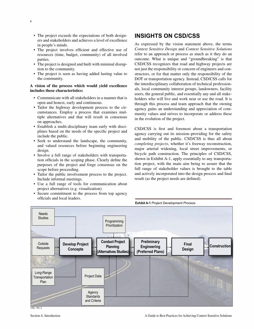
CSD/CSS is first and foremost about a transportation agency carrying out its mission–providing for the safety and mobility of the public. CSD/CSS is thus all about completing projects, whether it’s freeway reconstruction, major arterial widening, local street improvements, or bicycle path construction. The principles of CSD/CSS, shown in Exhibit A-1, apply essentially to any transporta-tion project, with the main aim being to assure that the full range of stakeholder values is brought to the table and actively incorporated into the design process and final result (as the project needs are defined).
���������
NeedsStudies
OutsideRequests
Develop ProjectConcepts
FinalDesign
Conduct ProjectPlanning
(Alternatives Studies)
PreliminaryEngineering
(Preferred Plans)
Long-RangeTransportation
PlanProject Data
AgencyStandards
and Criteria
Construction
ProgrammingPrioritization
Exhibit A-1 Project Development Process
4
Section A: Introduction A Guide to Best Practices for Achieving Context Sensitive Solutions
5
National Cooperative Highway Research Program Report 480 Section A: Introduction
CSD/CSS begins early, and continues throughout the entire project development process (from project concepts through alternative studies to construction), and indeed, to beyond project completion. CSD/CSS means maintaining commitments to communities.
Much literature, including most notably the publication Flexibility in Highway Design, stresses the importance of being “context sensitive” where a highway runs through or adjacent to parklands, scenic areas, or special environmen-tal areas or viewsheds. While such facilities are clearly of special interest, the notion of context sensitivity extends beyond these “special” projects.
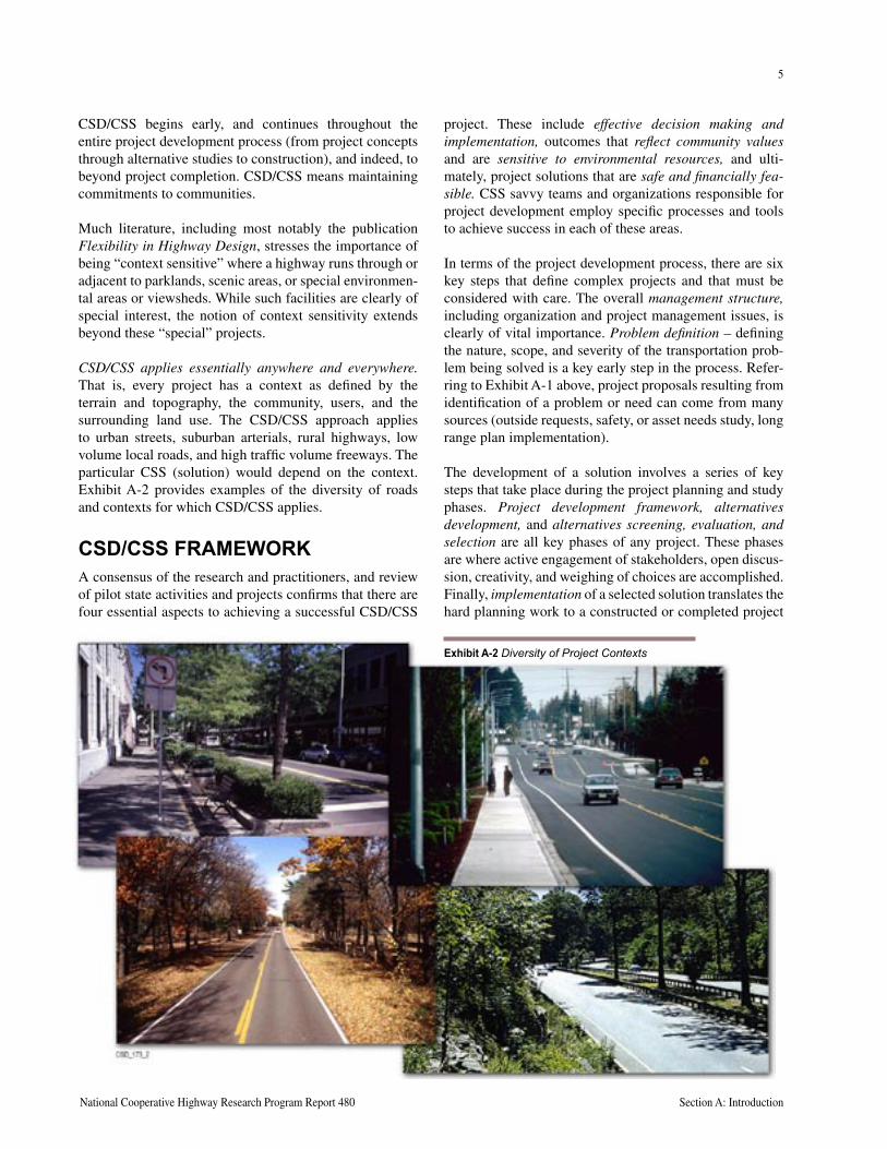
CSD/CSS applies essentially anywhere and everywhere. That is, every project has a context as defined by the terrain and topography, the community, users, and the surrounding land use. The CSD/CSS approach applies to urban streets, suburban arterials, rural highways, low volume local roads, and high traffic volume freeways. The particular CSS (solution) would depend on the context. Exhibit A-2 provides examples of the diversity of roads and contexts for which CSD/CSS applies.
CSD/CSS FRAMEWORKA consensus of the research and practitioners, and review of pilot state activities and projects confirms that there are four essential aspects to achieving a successful CSD/CSS
project. These include effective decision making and implementation, outcomes that reflect community values and are sensitive to environmental resources, and ulti-mately, project solutions that are safe and financially fea-sible. CSS savvy teams and organizations responsible for project development employ specific processes and tools to achieve success in each of these areas.
In terms of the project development process, there are six key steps that define complex projects and that must be considered with care. The overall management structure, including organization and project management issues, is clearly of vital importance. Problem definition – defining the nature, scope, and severity of the transportation prob-lem being solved is a key early step in the process. Refer-ring to Exhibit A-1 above, project proposals resulting from identification of a problem or need can come from many sources (outside requests, safety, or asset needs study, long range plan implementation).
The development of a solution involves a series of key steps that take place during the project planning and study phases. Project development framework, alternatives development, and alternatives screening, evaluation, and selection are all key phases of any project. These phases are where active engagement of stakeholders, open discus-sion, creativity, and weighing of choices are accomplished. Finally, implementation of a selected solution translates the hard planning work to a constructed or completed project
Exhibit A-2 Diversity of Project Contexts
6
Section A: Introduction A Guide to Best Practices for Achieving Context Sensitive Solutions
that will yield real benefits. It also includes activities and actions of the agency after construction, including main-tenance, operation, and monitoring of the performance of the implemented project solution.
ORGANIZATION OF THIS GUIDEThe above discussion suggests a two-dimensional frame-work for describing CSD/CSS. This framework is used to organize and present recommendations and findings in the following manner. The document has been prepared to be interactive in a CD-ROM format.
Following brief introductory comments in Sections A and B, the material on CSD/CSS is presented in the following six sections :
• Effective Decision Making (Section C)
• Reflecting Community Values (Section D)
• Achieving Environmental Sensitivity (Section E)
• Ensuring Safe and Feasible Solutions (Section F)
• Organizational Needs (Section G)
• Case Studies in CSD/CSS (Section H)
The first four sections (C through F) are project-focused. The text focuses on best practice discussions, with “box” inserts integrated to highlight particular lessons learned from projects around the country. Section G, Organiza-tional Needs, addresses management issues and lessons learned from those transportation agencies that have institutionalized CSD/CSS. Section H presents a series of case studies.
Each section is organized around the six key steps in the project development process outlined above. For example, in Section E, the body of knowledge related to Environ-mental Sensitivity is organized around the process from beginning (problem definition) to end (implementation). Each chapter includes a bibliography of resources related to its topic. These are combined into a master bibliography in Appendix A/B. In the interest of keeping the presenta-tion as brief as possible and to minimize resources needed to produce this document, additional examples and other supporting materials are assembled in the Appendices located on the accompanying CD.
7
The key strength of the CSD/CSS concept and methodology is its applicability to all of the agency participants in the transportation development process. Because of this flexibility, CSD/CSS can be applied from numerous perspectives and, in doing so, bridge differing points of view to successfully implement projects. For example:
• Project managers must bal-ance a wide range of budget and resource prioritization issues and determine how to efficiently deliver the right resources at the right times during the project.
• The highway engineer’s perspective focuses on the development and application of critical design criteria, and on providing the intended performance, including safety and operational efficiency. In the CSD/CSS environment, high-way and traffic engineers are concerned with how to develop creative, affordable design solutions that are consistent with good engineering practice and principles.
• Environmental managers, whose staffs are responsible for assessing the impacts of project alternatives, providing documentation, and proposing mitigation, will be concerned with interacting effectively with highway engineers, resource agency representatives, and the public as part of the project team.
• Public involvement specialists are concerned with identifying who should be involved in the project, how best to seek their input, and how to integrate that input so that it provides meaningful information to project technical staff.
• Senior managers and transportation agency administrators are ultimately responsible for meeting the needs of their customers and seeing that the project is delivered on time and within budget.
All of these roles are critical to the success of transportation improvements – and CSD/CSS is an approach that enables disciplines to effectively accommodate what otherwise might be competing interests. The interaction among these profes-sional disciplines is complex. The management and integration of staff resources represents perhaps the greatest challenge in effective project development for an agency, because project success will be achieved not by individual “pockets” of professionals working independently, but by forming teams and integrating activities.
The sections in this document are designed to reflect these different perspectives, as described below.
B. ABOUT THIS GUIDE – THE MULTI-DISCIPLINARY APPROACH TO CSD/CSS
����������
About thisGuide
EffectiveDecisionMaking
ReflectingCommunity
Values
AchievingEnvironmental
Sensitivity
Ensuring Safeand Feasible
SolutionsOrganizational
NeedsCase
Studies Appendices
Management Structure
Problem Definition
Project Development andEvaluation Framework
Alternatives Development
Alternatives ScreeningEvaluation and Selection
Implementation
CB D E F G HIntroduction
to CSD
A
National Cooperative Highway Research Program Report 480 Section B: Multi-Disciplinary Approach to Context Sensitive Design
8
Section B: Multi-Disciplinary Approach to Context Sensitive Design A Guide to Best Practices for Achieving Context Sensitive Solutions
9
CSD/CSS FOR PROJECT MANAGERSEvery decision maker is confronted with balancing numer-ous options, stakeholders, and professional disciplines while delivering transportation projects. Often, this bal-ance is achieved through the day-to-day management of resources and staff; in the end, effective projects are designed and built. As programs become more complex and stakeholders more interested in influencing how projects impact their communities, delivering success-ful projects becomes much more complex. Additional requirements come from the environmental process and the formal public input process required by NEPA.
Singly, each of the disciplines and stakeholders that must be included in the development of a project is manageable. As input from multiple sources is required, the risk of mis-communication, of improper analysis or technical omis-sion, or of alienating a key constituent grows dramatically. A worst case scenario: a needed project is derailed because a critical point of view was left unconsidered; a significant environmental impact was not recognized; or constituency rallies a community against the project.
CSD/CSS is a formalized process for significantly reduc-ing the risk that a project gets derailed. The worst case scenarios listed above are generally avoidable – had there been the one public meeting to capture a previously unknown stakeholder’s point of view or better communi-cation among designers and environmental experts, the project may have been completed without a problem.
Using CSD/CSS processes effectively takes some effort and resources, but these are generally well worth the ben-efits gained from ensuring that all disciplines are work-ing together; that they have a process for identifying and resolving differences; and that decisions are documented and defensible.
Although project managers will generally not be expert in all technical disciplines, they should have an appreciation of the duties and challenges of each discipline and the ways each discipline can contribute to the project. For that reason, project managers will likely be interested in all content in this guide. Specifically, project managers may want to focus on the portions of each chapter related to management structure and specifically to Section C, Effec-tive Decision Making. CSD/CSS is all about completing projects, which can be seen as completing a series of pro-cesses, tasks, and work efforts, each of which involves one or more key decisions.
CSD/CSS FOR THE TRANSPORTATION AND HIGHWAY DESIGN PROFESSIONALSCSD/CSS presents significant challenges – and oppor-tunities – for engineers and other design professionals responsible for implementing transportation projects. From this perspective, CSD/CSS focuses on identifying problems in functional or performance terms, and arriving at solutions that address them. In developing those solu-tions, the design process is presented as a series of choices, with the designer’s task being to make effective choices that balance the often competing interests of operational efficiency, cost, serving multiple users, and achieving environmental sensitivity.
Of course, designers will be concerned with how to effec-tively employ the proven design criteria and policies pub-lished by AASHTO and their respective agency, without increasing the risk to their agency. Section F, Ensuring Safe and Feasible Solutions, addresses these primary concerns. In particular, the Problem Definition and Alter-natives Development sub-sections present non-traditional approaches that may be of special interest.
Many designers will also be concerned with how they can effectively present or communicate ideas to non-technical stakeholders, how they should interact with other fellow professionals such as environmental specialists, and how they can play an appropriate role in the overall decision process. CSD/CSS provides a methodology for design-ers to present the rationale for guidelines and criteria and a working environment to determine which guidelines might be adjusted while maintaining safety. While CSD/CSS may result in more effort than simply “going by the book,” it is unlikely that today’s community stakeholders will allow untenable projects to proceed. Since successful projects will require a level of compromise and trade-off, CSD/CSS is an excellent tool for providing structure to the process. In the end, key decisions will be documented, absolutely necessary design requirements will be met, and guidelines that can be adjusted for the betterment of other factors will be modified in a reasonable, defensible manner. Thus, individual areas of other chapters in the guide will be valuable and of interest to highway designers as well.
Finally, designers should be interested in how the con-cepts, research, and ideas are translated into real project solutions. Section H, Case Studies, provides a wide range of CSD/CSS creative design solutions and applications of the concepts to illustrate in real terms what CSD/CSS is all about.
8
Section B: Multi-Disciplinary Approach to Context Sensitive Design A Guide to Best Practices for Achieving Context Sensitive Solutions
9
CSD/CSS FOR THE ENVIRONMENTAL MANAGERSSince the enactment of NEPA, recognizing the importance of natural and human environmental issues has become a key component of most infrastructure projects. Obtaining public input and understanding community needs is a key benefit of the environmental process that is now making its way into all aspects of project evaluation, development, and implementation. CSD/CSS is a key tool for extending the benefits of an inclusive project development approach and as such, should be most familiar to environmentally focused disciplines.
CSD/CDD offers additional opportunity beyond address-ing environmental issues. It allows all points of view, including community concerns, questions about design standards, and project delivery and management issues, to be addressed in a structured, iterative process. This allows those responsible for the environmental process to gain an understanding of engineering issues that might affect a project’s safety or constructibility. This process also pro-vides a forum for resolving conflicts in the early phases of a project, as part of initial alternative development, thereby reducing the likelihood that they will become larger proj-ect risks or fatal flaws during the formal environmental review. Section E, Achieving Environmental Sensitivity, was prepared to provide an overview of CSD/CSS from the perspective of the environmental process. Of course, environmental planners should also be interested in issues addressed in other sections of the guide, including alterna-tive development, screening, and decision making.
CSD/CSS FOR PUBLIC INVOLVEMENT SPECIALISTSPublic involvement has become a key recognized compo-nent of most successful transportation projects. Starting with the environmental process, stakeholder input is an essential part of an overall project development effort. Many transportation agencies gather and use community input very effectively throughout the lives of projects – and CSD/CSS recognizes and documents programs that have turned out to be most effective. CSD/CSS integrates the best aspects of a robust community involvement and public information program throughout the project devel-opment process and across all of its technical disciplines. In addition to public, jurisdiction, and resource agency stakeholders, highway designers, environmental profes-sionals, and project managers within the sponsoring agency are viewed as necessary stakeholders. CSD/CSS builds on what has worked, and expands the concept to a new audience. Section D, Reflecting Community Values,
captures the body of knowledge and experience to date from agencies that have successfully incorporated public involvement into their transportation projects.
Public involvement specialists may wish to consider making this manual available to the public-at-large. Community stakeholders will benefit from an awareness that a process such as CSD/CSS exists and is available for their participation. For the involved stakeholder, an in-depth understanding of CSD/CSS will be of consider-able benefit, especially when it comes to appreciating and understanding the roles and responsibilities of the various participants described here.
CSD/CSS FOR SENIOR MANAGERS AND ADMINISTRATORS OF TRANSPORTATION AGENCIESSenior managers of transportation agencies are concerned with the overall performance and effectiveness of their agency in meeting the needs of their customers. Complet-ing projects that stakeholders support, that are on time and within budget, and that deliver value to customers are key objectives. Minimizing the potential for adverse outcomes from lawsuits is also a concern. While CSD/CSS offers significant opportunities to achieve these goals, its imple-mentation may require management and cultural changes, or may call for investments in reorganization, retraining, and new skill development. Such implementation mea-sures may present serious challenges to budget-strapped public transportation agencies.
Section G, Organizational Needs, addresses how some senior managers have transformed their agencies to be context sensitive in everything they do. Section G also addresses the benefits of organizational change. In addi-tion, the management structure portions of all the guide chapters should be of interest to administrators and senior managers.
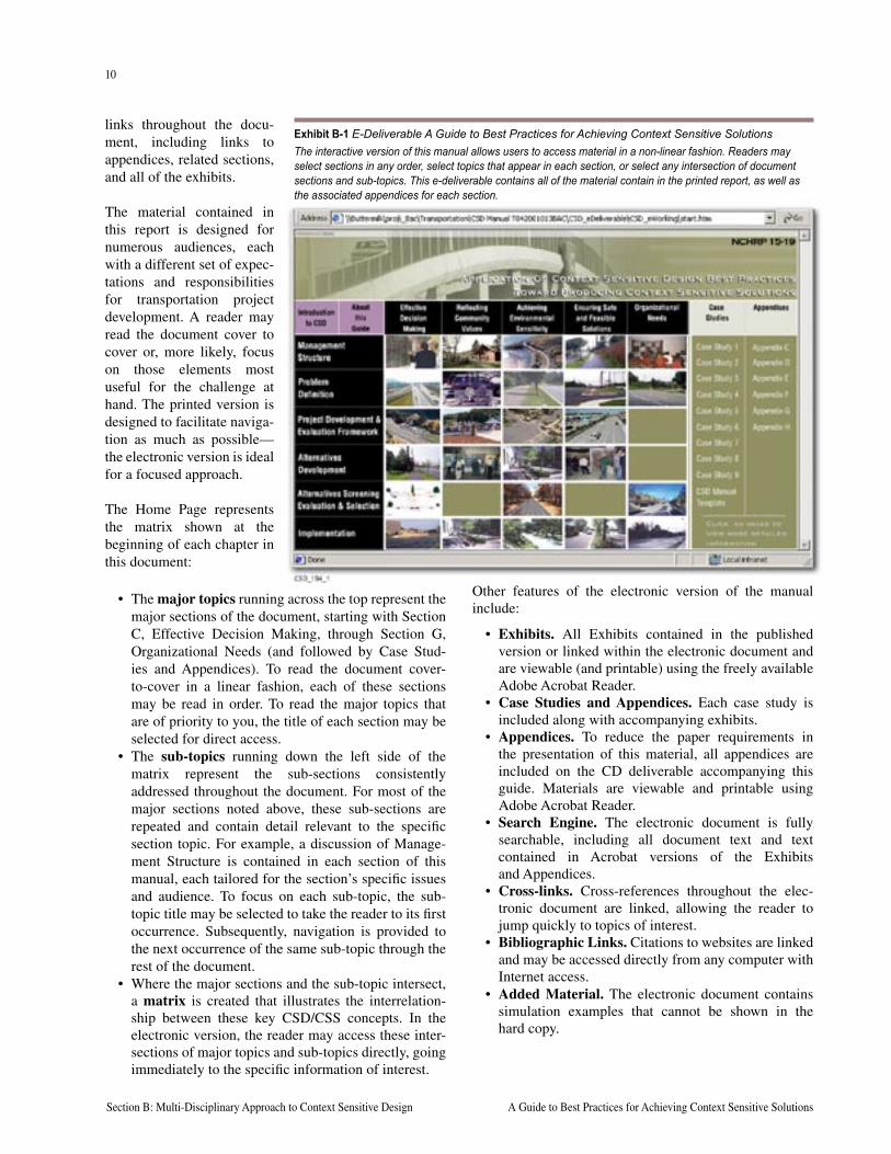
HOW TO USE THIS DOCUMENTThe CSD/CSS process is aimed at capturing all necessary interactions among the various professional activities. This is often a non-linear, iterative process, ideally communi-cated through Web technology that can present informa-tion in a non-linear, interactive format. For that reason, a key component of this report is the accompanying elec-tronic version, the home page of which is shown in Exhibit B-1 (following page). This “e-deliverable” allows users to access each report element in whatever order he or she chooses. The e-deliverable also contains cross-reference
National Cooperative Highway Research Program Report 480 Section B: Multi-Disciplinary Approach to Context Sensitive Design
10
Section B: Multi-Disciplinary Approach to Context Sensitive Design A Guide to Best Practices for Achieving Context Sensitive Solutions
links throughout the docu-ment, including links to appendices, related sections, and all of the exhibits.
The material contained in this report is designed for numerous audiences, each with a different set of expec-tations and responsibilities for transportation project development. A reader may read the document cover to cover or, more likely, focus on those elements most useful for the challenge at hand. The printed version is designed to facilitate naviga-tion as much as possible—the electronic version is ideal for a focused approach.
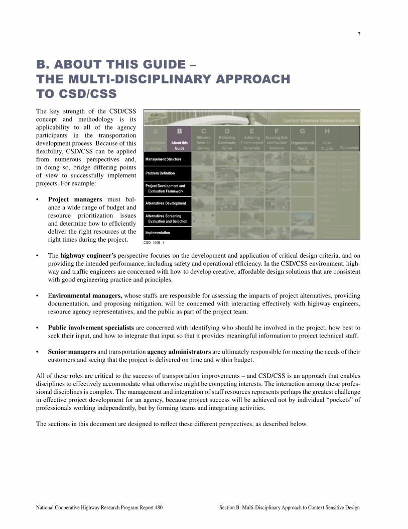
The Home Page represents the matrix shown at the beginning of each chapter in this document:
• The major topics running across the top represent the major sections of the document, starting with Section C, Effective Decision Making, through Section G, Organizational Needs (and followed by Case Stud-ies and Appendices). To read the document cover-to-cover in a linear fashion, each of these sections may be read in order. To read the major topics that are of priority to you, the title of each section may be selected for direct access.
• The sub-topics running down the left side of the matrix represent the sub-sections consistently addressed throughout the document. For most of the major sections noted above, these sub-sections are repeated and contain detail relevant to the specific section topic. For example, a discussion of Manage-ment Structure is contained in each section of this manual, each tailored for the section’s specific issues and audience. To focus on each sub-topic, the sub-topic title may be selected to take the reader to its first occurrence. Subsequently, navigation is provided to the next occurrence of the same sub-topic through the rest of the document.
• Where the major sections and the sub-topic intersect, a matrix is created that illustrates the interrelation-ship between these key CSD/CSS concepts. In the electronic version, the reader may access these inter-sections of major topics and sub-topics directly, going immediately to the specific information of interest.
Other features of the electronic version of the manual include:
• Exhibits. All Exhibits contained in the published version or linked within the electronic document and are viewable (and printable) using the freely available Adobe Acrobat Reader.
• Case Studies and Appendices. Each case study is included along with accompanying exhibits.
• Appendices. To reduce the paper requirements in the presentation of this material, all appendices are included on the CD deliverable accompanying this guide. Materials are viewable and printable using Adobe Acrobat Reader.
• Search Engine. The electronic document is fully searchable, including all document text and text contained in Acrobat versions of the Exhibits and Appendices.
• Cross-links. Cross-references throughout the elec-tronic document are linked, allowing the reader to jump quickly to topics of interest.
• Bibliographic Links. Citations to websites are linked and may be accessed directly from any computer with Internet access.
• Added Material. The electronic document contains simulation examples that cannot be shown in the hard copy.
Exhibit B-1 E-Deliverable A Guide to Best Practices for Achieving Context Sensitive SolutionsThe interactive version of this manual allows users to access material in a non-linear fashion. Readers may select sections in any order, select topics that appear in each section, or select any intersection of document sections and sub-topics. This e-deliverable contains all of the material contain in the printed report, as well as the associated appendices for each section.
11
National Cooperative Highway Research Program Report 480 Section C: Effective Decision Making
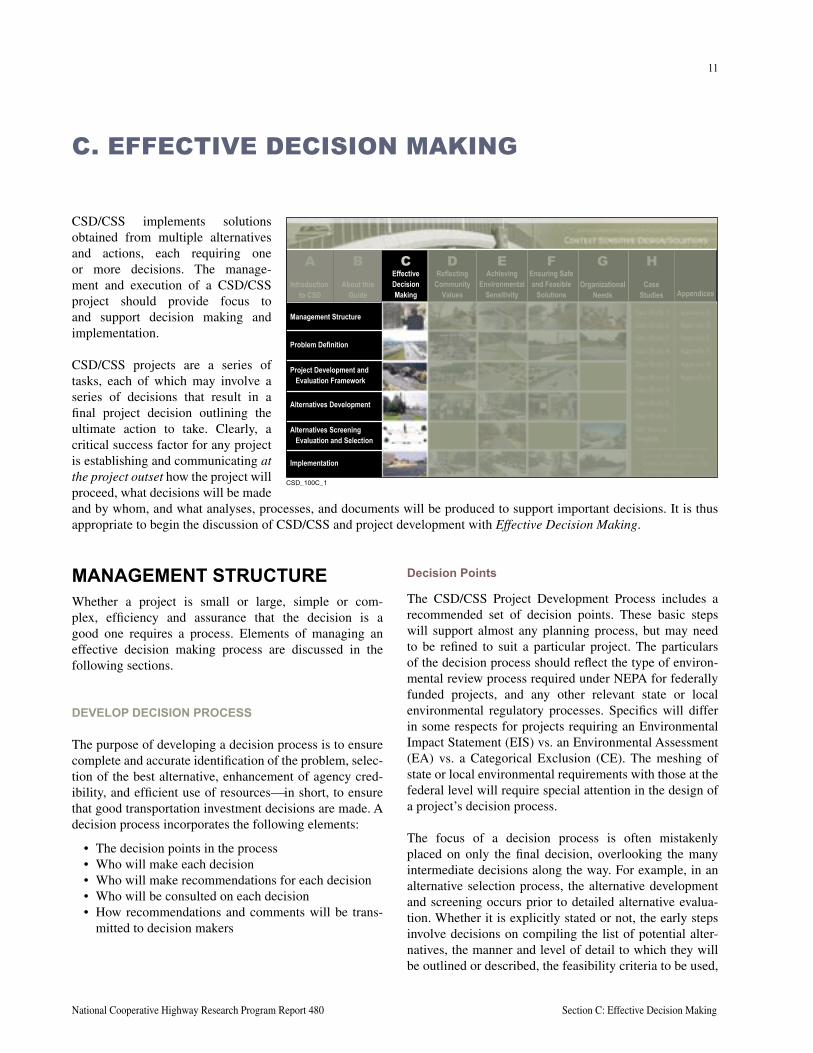
CSD/CSS implements solutions obtained from multiple alternatives and actions, each requiring one or more decisions. The manage-ment and execution of a CSD/CSS project should provide focus to and support decision making and implementation.
CSD/CSS projects are a series of tasks, each of which may involve a series of decisions that result in a final project decision outlining the ultimate action to take. Clearly, a critical success factor for any project is establishing and communicating at the project outset how the project will proceed, what decisions will be made and by whom, and what analyses, processes, and documents will be produced to support important decisions. It is thus appropriate to begin the discussion of CSD/CSS and project development with Effective Decision Making.
C. EFFECTIVE DECISION MAKING
MANAGEMENT STRUCTUREWhether a project is small or large, simple or com-plex, efficiency and assurance that the decision is a good one requires a process. Elements of managing an effective decision making process are discussed in the following sections.
DEVELOP DECISION PROCESS
The purpose of developing a decision process is to ensure complete and accurate identification of the problem, selec-tion of the best alternative, enhancement of agency cred-ibility, and efficient use of resourcesin short, to ensure that good transportation investment decisions are made. A decision process incorporates the following elements:
• The decision points in the process• Who will make each decision• Who will make recommendations for each decision• Who will be consulted on each decision• How recommendations and comments will be trans-
mitted to decision makers
Decision Points
The CSD/CSS Project Development Process includes a recommended set of decision points. These basic steps will support almost any planning process, but may need to be refined to suit a particular project. The particulars of the decision process should reflect the type of environ-mental review process required under NEPA for federally funded projects, and any other relevant state or local environmental regulatory processes. Specifics will differ in some respects for projects requiring an Environmental Impact Statement (EIS) vs. an Environmental Assessment (EA) vs. a Categorical Exclusion (CE). The meshing of state or local environmental requirements with those at the federal level will require special attention in the design of a project’s decision process.
The focus of a decision process is often mistakenly placed on only the final decision, overlooking the many intermediate decisions along the way. For example, in an alternative selection process, the alternative development and screening occurs prior to detailed alternative evalua-tion. Whether it is explicitly stated or not, the early steps involve decisions on compiling the list of potential alter-natives, the manner and level of detail to which they will be outlined or described, the feasibility criteria to be used,
����������
About thisGuide
EffectiveDecisionMaking
ReflectingCommunity
Values
AchievingEnvironmental
Sensitivity
Ensuring Safeand Feasible
SolutionsOrganizational
NeedsCase
Studies Appendices
Management Structure
Problem Definition
Project Development andEvaluation Framework
Alternatives Development
Alternatives ScreeningEvaluation and Selection
Implementation
CB D E F G HIntroduction
to CSD
A
12
Section C: Effective Decision Making A Guide to Best Practices for Achieving Context Sensitive Solutions
13
National Cooperative Highway Research Program Report 480 Section C: Effective Decision Making
and the list of feasible alternatives to be considered further. Specification of each decision step in this way highlights the importance of individual decisions. For example, if it is made clear that only alternatives emerging from an early screening process will be considered during the evalua-tion phase, the importance of active participation by staff, stakeholders, and decision makers in the early screening process will be heightened.
Breaking down larger decisions into their component pieces also helps to identify the differences in needed stakeholder involvement at various points in the process. It may be important for different stakeholders to be involved at various decision points, or for different parties to make various decisions. For example, some decisions require very specific technical expertise (for example, what are appropriate or feasible ways of mitigating traffic noise, and what are their costs and other attributes). Others require broader participation and perhaps less technically oriented input (for example, community inputs on the aes-thetics of special bridge designs, or on the incorporation of public art as enhancements to a project).
The nature of decisions within the process often requires clarification as well. For example, are particular decisions binding or can they be revisited later in the process, and if so, under what conditions? Is the decision dependent on data or conclusions provided from another source outside the current project process? Can the decision be revised or reversed as part of a concurrent or future planning activ-ity? Will it be used as the basis for another upcoming planning or programming activity? Knowing the answers to these questions at the outset of the project supports the credibility of the process and increases the likelihood that the resulting decisions will “stick.”
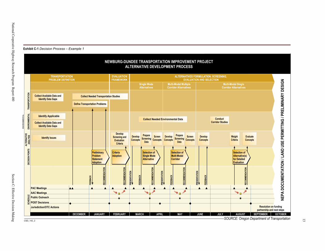
A diagram representing the decision process can be a very helpful management tool throughout the project. It can be used to clarify the relationship between past, current, and future activities and to show progress. Examples of decision process diagrams are included in Exhibits C-1 and C-2.
Participants in the Decision Process
Acknowledging who has the authority for each decision ensures that expectations are consistent with reality. An advisory committee may make initial recommendations in the process, but elected officials or agency staff may make final decisions. Stakeholders may have only an indirect communication link to decision makers, and should know in what form their recommendations or comments will be transmitted to decision makers, and how their input will be weighed or used.
In many cases identification of decision makers is obvi-ous—they are the regional or district managers, department heads, or management teams of the transportation agency; or in some cases elected public officials. But sometimes it isn’t clear who will make a particular decision. Will this decision be made by the district or headquarters staff? Will it be made by the city manager, a special task force, or the city council? Will it be made by a group of mid-level managers or the senior manager? Establishing who spe-cifically or what level of an agency will make decisions is important because the context for the decision is governed by who makes the decision.
Just as the regulatory processes that govern the project affect the decision process, they will also affect the choice of decision makers. For example, by statute, the lead and cooperating agencies in a NEPA process will have deci-sion making authority for determining that the alternative evaluation is complete and accurate, and for selecting a preferred alternative.
It is often useful to represent the groups involved in the decision process in a diagram that can be used to explain the management structure. This helps to clarify the roles and responsibilities of the various groups and the con-nections between them. Some examples of management structure diagrams are included in Appendix C.
Agency “Buy-In”
The adoption of the decision process is a decision in itself, and is one that mandates buy-in at all levels of the orga-nizations involved in the decision, prior to presentation to stakeholders for review. Agreement about the decision steps at the outset of the project development process improves the agency’s ability to determine where public input can be incorporated into decisions and where public input will not be sought. Agency review and buy-in to the decision process are also useful in uncovering any major internal disagreements about how decisions should be made, and can prevent costly and time-consuming contro-versies about methodology or level of public participation that often arise later in the process.
Thoughtfulness in developing a decision process and care-ful implementation of that process facilitates cost-effective project delivery. If each step in the process is completed in a thorough manner and leads logically to the next step, it is easier to resist the inevitable requests to go back to the beginning, to reconsider previous steps, to commit ever greater levels of staff and resources. Milestones can be established as freeze points that will not be revisited, and momentum and adherence to schedule can therefore be maintained. This is particularly important for larger,
12Section C: Effective D
ecision Making
A G
uide to Best Practices for A
chieving Context Sensitive Solutions
13
National C
ooperative Highw
ay Research Program
Report 480
Section C: Effective D
ecision Making
� ������ � ������
���������� ���������� ����� ��� ��� ��� ������
� ������ � ����� � ������ � ������ � ������ � �����
�������� �������� ���� � � ������ ���� ��������
PAC MeetingsAAC MeetingsPublic Outreach
POST DecisionsJurisdiction/OTC Actions
DECEMBER JANUARY FEBRUARY MARCH APRIL MAY JUNE JULY AUGUST SEPTEMBER OCTOBER
FEBRUARY Resolution on fundingpartnership and next steps
PRES
ENTA
TION
PRES
ENTA
TION
PRES
ENTA
TION
FEED
BACK
RECO
MMEN
DATIO
N
FEED
BACK
FEED
BACK
RECO
MMEN
DATIO
N
RECO
MMEN
DATIO
N
RECO
MMEN
DATIO
N
RECO
MMEN
DATIO
N
FEED
BACK
���������
DECI
SION
POIN
TSSC
HEDU
LEEN
VIRON
MENT
ALTR
ANSP
ORTA
TION
ALTE
RNAT
IVEAN
ALYS
IS
EN
VIR
ON
ME
NT
AL
NEWBURG-DUNDEE TRANSPORTATION IMPROVEMENT PROJECTALTERNATIVE DEVELOPMENT PROCESS
NEPA
DOCU
MENT
ATIO
N/L
AND
USE
PERM
ITTI
NG/P
RELI
MINA
RYDE
SIGN
TRANSPORTATIONPROBLEM DEFINITION
EVALUATIONFRAMEWORK
ALTERNATIVES FORMULATION, SCREENING,EVALUATION AND SELECTION
Single ModeAlternatives
Multi-Modal MultipleCorridor Alternatives
Multi-Modal SingleCorridor Alternatives
Collect Needed Transportation Studies
Collect Needed Environmental Data
Define Transportation Problems
Identify Applicable
Identify Issues
Collect Available Data andIdentify Data Gaps
Collect Available Data andIdentify Data Gaps
ConductCorridor Studies
DevelopScreening and
EvaluationCriteria
DevelopConcepts
ScreenConcepts
PrepareScreening
Data
DevelopConcepts
ScreenConcepts
PrepareScreening
Data
DevelopConcepts
EvaluateConcepts
WeightCriteria
CriteriaAdoption
Selection ofSingle ModeAlternative
Selection ofMulti-ModalCorridor
Selection ofAlternative(s)for DetailedEvaluation
PreliminaryProblemStatementAdoption
SOURCE: Oregon Department of Transportation
Exhibit C-1 Decision Process – Example 1
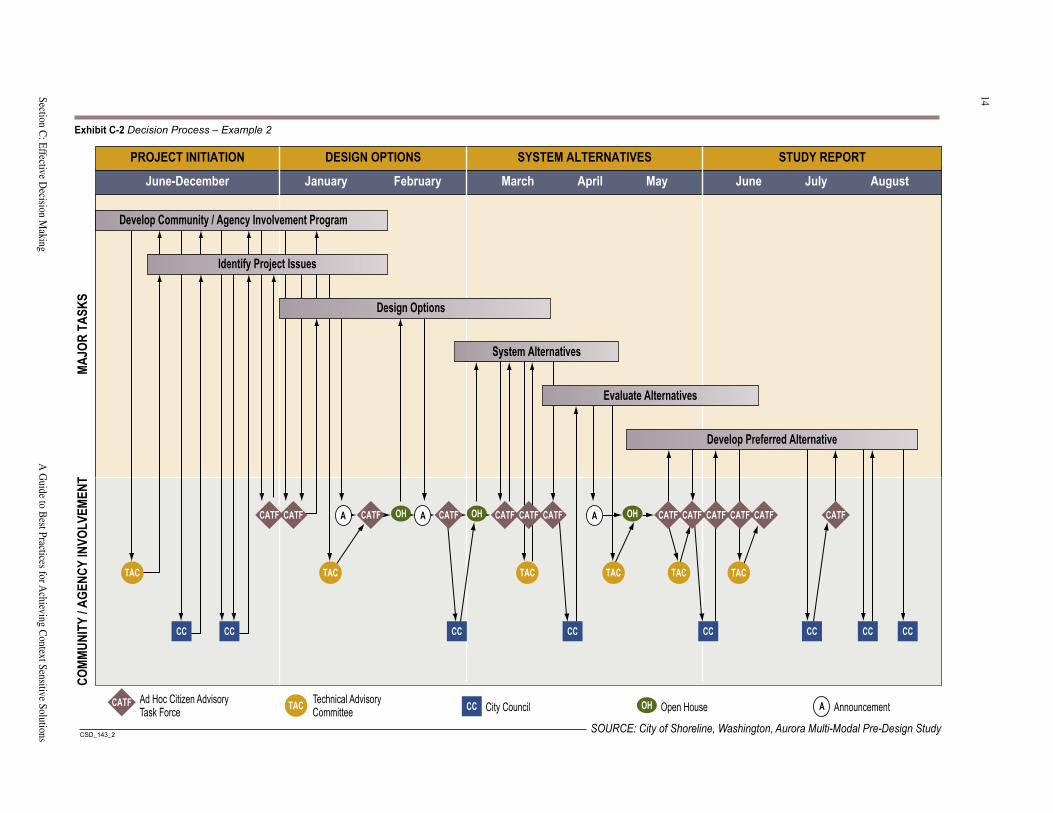
14Section C: Effective D
ecision Making
A G
uide to Best Practices for A
chieving Context Sensitive Solutions
15
National C
ooperative Highw
ay Research Program
Report 480
Section C: Effective D
ecision Making
���������
PROJECT INITIATION DESIGN OPTIONS SYSTEM ALTERNATIVES STUDY REPORT
June-December January February March April May June July August
MAJO
RTA
SKS
COMM
UNIT
Y/A
GENC
YIN
VOLV
EMEN
T
CATF Ad Hoc Citizen AdvisoryTask Force TAC Technical Advisory
Committee CC City Council OH Open House A Announcement
Develop Community / Agency Involvement Program
System Alternatives
Develop Preferred Alternative
CATF
TAC
CC CC CC
Identify Project Issues
Design Options
CATF
CC CC CC CC CC
OHA A ACATF CATF CATF CATF CATF CATF CATF CATF CATF CATF CATF
TAC TAC TAC TAC TAC
OH OH
Evaluate Alternatives
SOURCE: City of Shoreline, Washington, Aurora Multi-Modal Pre-Design Study
Exhibit C-2 Decision Process – Example 2
14
Section C: Effective Decision Making A Guide to Best Practices for Achieving Context Sensitive Solutions
15
National Cooperative Highway Research Program Report 480 Section C: Effective Decision Making
complex projects that may take a year or more to complete the planning and decision making. A risk inherent to such projects is changes in staff, elected officials, or other key stakeholders during the project. Lacking a firmly docu-mented decision process and background, the tendency is often for new participants to want to revisit decisions or actions previously completed by their predecessors.
FORM, RESOURCE, AND CHARTER PROJECT TEAM
Forming an appropriate project team, ensuring it has the needed budget and staff resources, and chartering the proj-ect team members are key elements of success in achieving CSD/CSS. The literature on project delivery suggests that the most effective project teams include representatives of all the parts of an organization with responsibility for ulti-mate implementation of the project. Project teams should remain intact and engaged throughout the project.
This highlights the importance for transportation projects of building multi-discipline teams with members experi-enced in such areas as geometric design, traffic engineer-ing, maintenance and operations, environmental impact analysis, landscape architecture, urban design, and public involvement. Organization of such teams may run counter to typical agency organizational structures, which are dis-cussed in the chapter on Organizational Needs, Section G.
Project teams can be quite large to encompass all of the needed expertise, or they can be comprised of a core group supported by a pool of broader resources. These teams can incorporate consultants and other outside assistance (from other agencies and organizations), or can be comprised solely of agency staff, with outside support called upon as needed. In either case, it is critical for the team members to understand they are collectively responsible for delivering a successful project, and to have the resources necessary to get the job done. Having a realistic sense of the available project development resources at the start helps to craft appropriate methodologies for data collection, alternative development and evaluation, public outreach, and so on. It is less likely that promises will be made that cannot be kept due to budget and staffing constraints.
Team chartering is a focused way to guide the project team through the process of defining itself—its purpose, scope, goals, behaviors, responsibilities, and other ele-ments that provide the clarity of purpose essential for high quality performance. Chartering sessions in which external facilitators are generally used enable all of the team members to participate fully. Chartering sessions can be used to generate a common vision of the project—what objectives should be achieved, what outcomes are desired, how the project should be viewed by the community. Char-
tering is also an excellent way to establish ground rules for how the team will operate and make decisions, com-municate internally and externally, document its activities, and so on. Chartering of the project team with advisory groups, decision makers, and other groups key to project implementation can also be very helpful in successful project execution.
Best practices for chartering involve the holding of work-shops (which can be anywhere from a half-day to two days depending on the size and complexity of the project) at which all key stakeholders, both internal and external, involved in decision making, are invited. Chartering docu-ment examples are provided in Appendix C.
PROBLEM DEFINITION
DEVELOP AND DOCUMENT UNDERSTANDING OF THE PROBLEM
Initial project decisions begin with development of a list of the transportation problems to be addressed. These problems are generally described in quantitative measures of accident rates, travel delays, or geometric deficiencies in relation to applicable decision standards or averages. Many projects initiate from a need to reconstruct aging or deteriorating infrastructure. Some problems may be noted as the absence or lack of a transportation service, such as sidewalks. (See Section F for more detail on quantitatively defining transportation problems.)
The list of problems can then be transformed into a com-prehensive need statement. It is critical for this statement to reflect the full range of public values identified through the public involvement process, and to legitimize all of the affected interests without appearing to favor one particular solution. For example, a problem definition should likely be stated as “provide for efficient movement of people and goods from Area A to Area B” rather than “widen Highway X from four to six lanes between Point A and Point B.” The broader statement allows for consideration of transportation system management and transportation demand management strategies, and/or promotion of alternate modes, as well as a variety of highway solutions. It also clearly highlights early on the nature and types of decisions that will need to be made.
Successful execution of this problem definition step requires testing the need for the project as it has been defined by the agency, often through extensive stakeholder communication. It results in a common understanding and public acceptance of the defined need. If a NEPA process is involved, this dialogue represents the beginning of project scoping (see Section E). The end result becomes
16
Section C: Effective Decision Making A Guide to Best Practices for Achieving Context Sensitive Solutions
17
National Cooperative Highway Research Program Report 480 Section C: Effective Decision Making
the basis for the statement of purpose and need, although the problem definition may incorporate non-transportation elements that would not necessarily be part of the NEPA statement of purpose and need. Examples of problem defi-nitions are provided in Appendix C.
PROJECT DEVELOPMENT AND EVALUATION FRAMEWORKAfter the transportation problem and need has been defined, it is possible to develop a framework for evaluat-ing alternatives. This step in the process establishes crite-ria for measuring effectiveness of alternatives in meeting the identified need, defines data needs, and focuses the study effort. It also determines how the evaluation will be conducted.
It is critical to develop the evaluation framework before alternatives have been formulated. Otherwise, stakehold-ers may attempt to structure criteria to lead to selection of their preferred alternative rather than to focus on the outcomes they believe to be most important.
Evaluation criteria can be quantitative or qualitative, depending on the complexity of the problem, the expected level of controversy, the structure and scope of the public involvement process, and the preference of decision makers. For the most part, projects involving difficult trade-offs and high degrees of controversy benefit from the use of quantitative measures. They can help to objectify the discussion and move stakeholders from strongly held posi-tions to consideration of specific outcomes from various alternatives. They can also provide decision makers with a definitive rationale for trade-off decisions and alternative selection. However, the use of quantitative criteria requires technical experience in quantitative evaluation methodol-ogy, careful work with a dedicated and balanced group of stakeholders, and strong support from decision makers.
Whether the criteria are qualitative or quantitative, they help to focus the data collection and the discussion on the relative merits of the alternatives in relation to critical issues, and on factors that distinguish among the alternatives.
DEVELOP EVALUATION CRITERIA
Different types of criteria can be used at different points in an alternative screening and evaluation process, to deter-mine if alternatives are feasible, to reduce the number of feasible alternatives that will be evaluated in detail, or to select a preferred alternative from the reduced universe.
Feasibility criteria are used to ensure that the alternatives meet minimum performance levels, are constructible, and are reasonable. Reasonability criteria can be difficult to formulate, but can relate to such items as proven tech-nologies and cost. Note that cost is generally not permitted to be a sole criterion for eliminating alternatives from a NEPA process.
Evaluation criteria are used to evaluate the performance of alternatives that emerge from the feasibility screening against desired project characteristics. These characteris-tics represent the full range of stakeholder values and pro-vide the “context” for CSD/CSS. In a NEPA process, it is helpful if these criteria incorporate the elements evaluated under NEPA. Within the broad NEPA elements, specific criteria can be developed to highlight items likely to differ-entiate among alternatives and issues of particular impor-tance to stakeholders. For example, criteria can define what specific impacts would adversely affect neighbor-hood cohesion. Is it roadways bisecting the neighborhood, diversion of traffic through the neighborhood, or removal of neighborhood institutions? With respect to effects on existing businesses, do critical items relate to changes in traffic circulation, consolidation of access points, or removal of parking? With respect to visual resources, is tree removal, provision of landscaping, or roadway eleva-tion important? Example evaluation criteria are provided in Appendix C.
DEVELOP EVALUATION PROCESS
The evaluation process can be conducted simply or in an elaborate or formalized manner depending on the needs of the project. For example:
• Staff can rate the alternatives against the criteria and provide that information for review and comment in the public involvement process. Staff ratings and public comments can be provided to decision makers.
• Stakeholder group(s) can review information provided by staff and rate the alternatives. Staff and stakeholder group ratings can be provided to decision makers.
• Ratings by various stakeholder groups can be com-bined by staff into an overall rating summary for con-sideration by decision makers.
16
Section C: Effective Decision Making A Guide to Best Practices for Achieving Context Sensitive Solutions
17
National Cooperative Highway Research Program Report 480 Section C: Effective Decision Making
• Staff can rate the alternatives and stakeholders can establish criteria weights to distinguish the relative importance of one criteria over another. Quantita-tive rates and weights can be combined into an alternative ranking. The use of multiattribute utility analyses techniques for comparison of rankings of disparate attributes is used by some agencies for assisting in decisions among significantly different alternatives. Ranking information and stakeholder recommendations can be used to inform decision makers of preferences. A hypothetical case study illustrating this process is included in Appendix C. Also included is an example decision model from a project in Illinois and Iowa.
The criteria and the method in which they will be used to evaluate the alternatives is documented in the evalu-ation framework, which should reflect the results of information exchange with project stakeholders and broad public outreach.
ALTERNATIVES DEVELOPMENT
DEVELOP AND DOCUMENT FULL RANGE OF ALTERNATIVE SOLUTIONS
As in the developing problem definition, it is critical to ensure that the full range of stakeholder values is reflected in the universe of alternative solutions considered at the outset. This avoids the all too common problem of sug-gestions for viable alternatives being raised near the end of the process, resulting in a “back to square one” loop of activities.
Each proposed solution should be formulated to its best advantage, to be as robust an alternative as possible. “Strawmen” are not conducive to building credibility or trust with stakeholders. Ideas from stakeholders that are not initially feasible as presented can be modified in a col-laborative process to make them more viable rather than rejected out of hand. The aim is to emerge from this step with a group of alternativesany one of which could be approved for implementation. Stakeholders should be pro-vided a complete explanation of why unfeasible alterna-tives are eliminated, to maintain their trust and minimize the chances of such alternatives resurfacing.
In the case of the Newberg Dundee Management Infor-mation System (MIS) in Oregon, alternatives were devel-oped as multi-modal packages, each including highway, bicycle, pedestrian, public transit, and land use elements. Some alternatives were focused on major highway improvements with support from the other modal ele-ments; some featured light rail and interurban rail as the
featured components. This set of alternatives reflected public concerns and Oregon DOT’s commitment to thor-ough consideration of non-auto transportation elements as part of the total solution set. An example description of a multi-modal alternative from the Oregon DOT is included in Appendix C.
ENSURE EDUCATION OF ALL PARTIES ON INNOVATIVE SOLUTIONS
Often stakeholders, including staff from the sponsoring agency, enter the project development process with a set of fixed ideas about the best solution. Such ideas often vary widely from one group to another. In some cases, poten-tial solutions are not even considered because they fall outside the ideas initially brought to the table. CSD/CSS “best practices” suggest seeking outside known channels for potential solutions. This requires a willingness of all parties to become educated on a broad range of solution sets. Of course, just because a concept works in one place does not automatically make it appropriate for another. The project team should work collaboratively with stake-holders to ensure mutual understanding of potential solu-tions and their applicability to the identified problems. Examples of concepts that may work some places but not others include strategies such as high occupancy vehicle lanes, traffic calming, and unique interchange forms such as single point diamonds. In some cases, travel patterns or local preferences work against such solutions; in other cases, the topography or climate (snow and ice conditions) may preclude certain design solutions that work well in the sun belt.
PORTRAY ALTERNATIVES IN AN UNDERSTANDABLE FORMAT
Experience across the country suggests that engineering plan view drawings of arterial, highway, and freeway improvements are not understandable to non-engineer stakeholder groups. For this reason, it is important to place emphasis on preparation of understandable presentation formats to ensure a high quality of information exchange during the development of alternatives between the agency and stakeholders.
Photo-simulation and three-dimensional animation or simulation of alternatives represent the most effective form of presentation. Note, however, that they are often too costly to undertake early in the development process when many alternatives are still being considered. Less costly approaches for presenting alternatives in an under-standable way include:
18
Section C: Effective Decision Making A Guide to Best Practices for Achieving Context Sensitive Solutions
19
National Cooperative Highway Research Program Report 480 Section C: Effective Decision Making
TAILOR LEVEL OF ANALYSIS TO ISSUE AND PROJECT
Depending on the nature of the project, the steps in the decision process may be repeated several times—first for developing conceptual alternatives for a TIP or STIP, second for developing and narrowing down the list of alternatives to be considered in an EA or EIS, and third for evaluating those alternatives in technical reports and the EA or EIS. During each of these processes, the level of analysis required to make a decision is different, as are the techniques for stakeholder involvement. As a project moves through these phases, alternatives are refined and their impacts can be identified with greater precision. Early evaluations may include qualitative measures, and later evaluations more quantitative. The evaluation criteria and methodology should vary accordingly, with lesser degrees of specificity at the early stages.
Stakeholders generally demand high levels of detail for their areas of concern, regardless of the project develop-ment stage. Agencies can work collaboratively with key stakeholder groups (resource agency staffs, potentially affected property owners) to understand and accept the different levels of detail appropriate for the different stages of the project. Many of the sponsoring agency’s own tech-nical staff also desire highly detailed information, even at early stages of project development. Developing protocols for various types of analyses suited to the particular stages of project development is a useful approach for matching resource requirements to project needs.
DOCUMENT ALTERNATIVE EVALUATION AND SELECTION
Documentation of the alternatives development process is critical for establishing the credibility of the alternatives analysis process. Establishing naming conventions at the outset of the process assists in clear tracking of alterna-tives and their variations. Keeping careful notes of each meeting at which alternatives are discussed, and recording specific reasons why each alternative was either forwarded for further evaluation or rejected, provides the backbone of this documentation.
For projects requiring NEPA compliance, this material is included in an EA or EIS to document alternatives considered but rejected. In these projects, the alternative evaluation and selection process ends with selection of a preferred alternative as documented in a Finding of No Significant Impact (FONSI) for an EA, or a Record of Decision (ROD) for an EIS. Detailed documentation of the evaluation process is provided in technical reports, the Draft EA or EIS, and the Final EA or EIS.
• Overlaying plan drawings onto aerial photography at a large scale so that landmarks and major impacts can be identified
• Eliminating unnecessary engineering detail from plan drawings so that key features of the alternatives are recognizable
• Providing schematics showing the direction of traffic flow for projects with complex circulation patterns
• Developing clear naming/numbering conventions that help to group “families” of alternatives and facilitate tracking of alternatives through the entire project development process
Where a new (to an area or community) concept is proposed, such as traffic calming, or a roundabout, it can be useful to show photos or videos from existing applications elsewhere.
Types of drawings, use of color, appropriate scales and detail, and use of topographic mapping or aerial photogra-phy are all factors in creating good presentation graphics.
Examples of display graphics for presentation of alterna-tives are shown in Exhibit C-3 (following page).
In addition to clarity of presentation, it is also important to present all the alternatives in a common format for easy and honest comparison. Alternatives prepared to differing levels of detail or sophistication may present an appear-ance of bias, whether intended or not. Common scales, quality of drawings, use of common coloring schemes, and presentation of supporting information should be consis-tent among alternatives that are developed and presented.
ALTERNATIVES SCREENING, EVALUATION, AND SELECTION
PROVIDE “APPLES-TO-APPLES” COMPARISON OF ALTERNATIVES
A key aspect of alternatives evaluation is highlighting the trade-offs among the various alternativeshere’s what you get in this one, here’s what you don’t getrelating back to the criteria identified earlier in the process. The focus is on distinguishing among the alternatives in an “apples-to-apples” comparison of impacts or outcomes of importance to the public and decision makers.
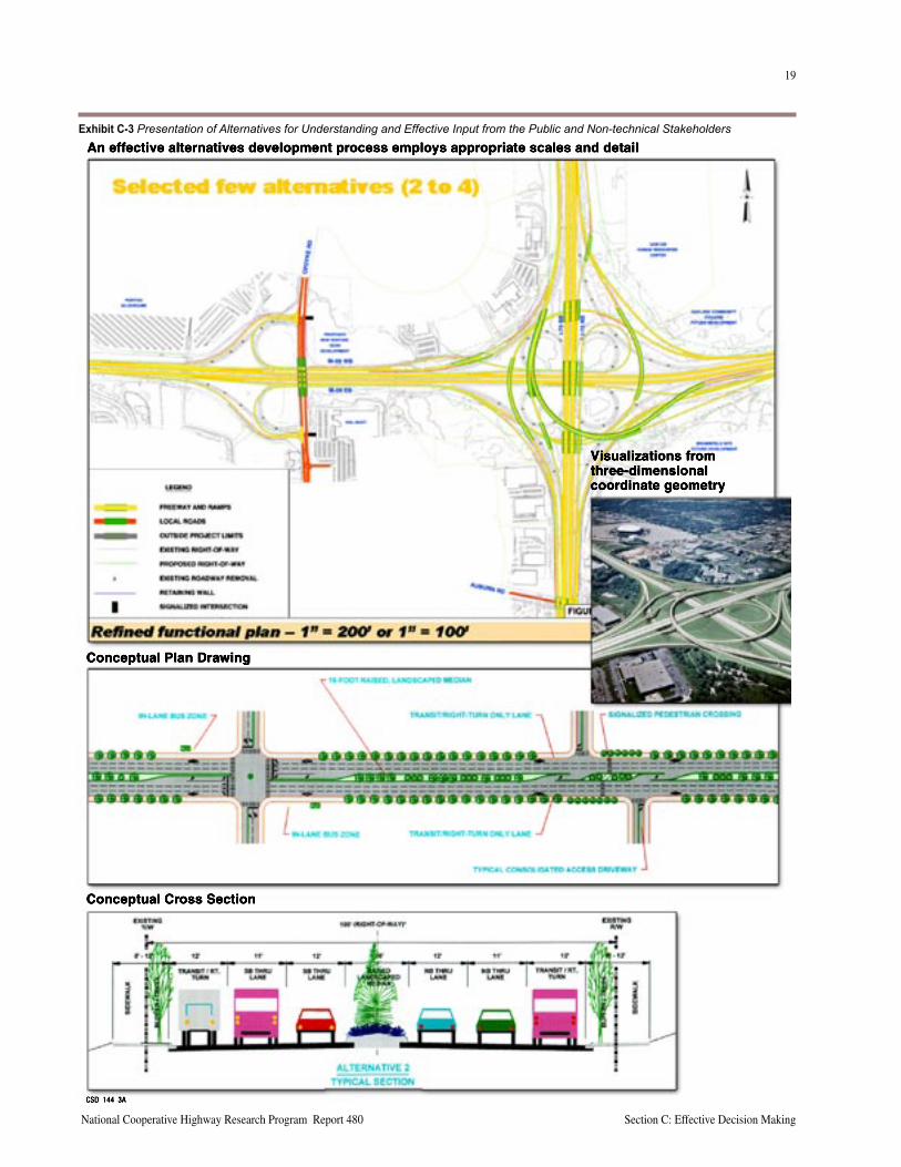
18
Section C: Effective Decision Making A Guide to Best Practices for Achieving Context Sensitive Solutions
19
National Cooperative Highway Research Program Report 480 Section C: Effective Decision Making
An effective alternatives development process employs appropriate scales and detail
Conceptual Plan Drawing
Conceptual Cross Section
Visualizations fromthree-dimensionalcoordinate geometry
CSD_144_3A
Exhibit C-3 Presentation of Alternatives for Understanding and Effective Input from the Public and Non-technical Stakeholders
20
Section C: Effective Decision Making A Guide to Best Practices for Achieving Context Sensitive Solutions
21
National Cooperative Highway Research Program Report 480 Section C: Effective Decision Making
DECISION MAKING AUTHORITY
Stakeholders, as individuals or members of advisory com-mittees, should have meaningful input to the decisions made during a project. Acceptance of a CSD/CSS process does not mean relinquishing the authority and responsibil-ity for the owning agency. Stakeholders are owed an open and honest process, and a well-documented and commu-nicated decision. Final decisions on the preferred solution remain the responsibility of the owning agency.
IMPLEMENTATION
DEVELOP PROJECT FUNDING PLAN
A critical part of the decision-making process is the fund-ing plan. Most agencies are resource constrained. Stake-holders should know or be informed of what the budget constraints are and what sources of funds are available, as well as any schedule or other “strings” attached to fund-ing. This includes not only initial construction, but also maintenance and preservation or other funding to operate the solution as needed.
Development of a reasonable funding plan and continual reference to it during the project can assure that project alternatives remain financially feasible. This issue is dis-cussed further in Section F, Ensuring Safe and Feasible Solutions.
MONITOR CHANGES IN DESIGN AND MITIGATION
A key part of the decision process that is often overlooked involves decisions made following completion of proj-ect planning. For example, in projects requiring NEPA compliance, formal decision tracking is often considered complete when the FONSI or ROD is issued. However, as a project proceeds through final design and construc-tion, many variations in design and mitigation can occur. Stakeholders are often surprised by these changes because they assume the project will proceed on the assumptions included in the environmental review process documents. Maintaining clear records of these changes, the rationale, and the resulting impacts can add to the credibility of the overall process with stakeholder groups, especially resource agencies and affected property owners.
20
Section C: Effective Decision Making A Guide to Best Practices for Achieving Context Sensitive Solutions
21
National Cooperative Highway Research Program Report 480 Section C: Effective Decision Making
KEY RESOURCES AND REFERENCESFuller, J.W., Relevance of Economic Analysis for Decision Making: Importance of Communicating Research Results, Conference Proceedings 21, 2000.
Guegan, D. P., Martin, P.T., Cottrell, W.D. Prioritizing Traffic-Calming Projects Using the Analytic Hierarchy Process, Transportation Research Record - Journal of the Transportation Research Board 1708, 2000.
Hauser, Ed. Guidelines for Developing and Maintaining Successful Partnerships for Multimodal Transportation Projects, NCHRP 8-32(4),Volumes I-III, 1996.
Khasnabis, S., Naseer, M. Procedure to Evaluate Alternatives to Transit Bus Replacement, Transportation Research Record - Journal of the Transportation Research Board 1731, 2000.
Madanat, S. M., Lin, D. Bridge Inspection Decision Making Using Sequential Hypothesis Testing Methods (Abstract Only), Transportation Research Circular, June 2000.
Mehndiratta, S.R., Parody, T.E., Options Approach to Risk Analysis in Transportation Planning, Transportation Research Record - Journal of the Transportation Research Board 1706, 2000.
Mehndiratta, S.R., Parody, T.E., How Transportation Planners and Decision Makers Address Risk and Uncertainty, Transportation Research Record - Journal of the Transportation Research Board 1706, 2000.
NCHRP Research Results Digest. Development of a Computer Model for Multimodal, Multicriteria Investment Analysis, Digest No. 258, 2001.
Pickrell, S., Neumann, L. Use of Performance Measures in Transportation Decision Making, Conference Proceedings 26, 2001.
Schofer, J.L., Czepiel, E. J. Success Factors and Decision Issues for High Occupancy Vehicle Facilities, Transportation Research Record - Journal of the Transportation Research Board 1711, 2000.
Schwartz, Marcy. Opening the Black Box: The Role of a Structured Decision Process in Building Public Consensus, Proceedings from TRB Fifth National Conference on Transportation Needs of Small and Medium Sized Communities, Transportation Research Board, 1996.
Schwartz, M., Eichhorn, C. Collaborative Decision Making: Using Multiattribute Utility Analysis to Involve Stakeholders in Resolution of Controversial Transportation Issues, Transportation Research Record, Issue 1606, 1997.
Schwartz, M., Merkhofer, M., Upton, R. Innovative Approach to Multiple-Criteria Evaluation of Multimodal Alternatives: Newberg-Dundee Transportation Improvement Project Case Study, Transportation Research Record, Issue 1617, 1998.
Speicher, D., Schwartz, M., Mar, T. Prioritizing Major Transportation Improvement Projects: Comparison of Evaluation Criteria, Transportation Research Record - Journal of the Transportation Research Board 1706, 2000.
Stone, J.R., Ahmed, T., Valevanko, A. Internet-based Decision Support for Advanced Public Transportation Systems Technology, Transportation Research Record - Journal of the Transportation Research Board 1731, 2000.
Tsamboulas, D. A., Kapros, S. Decision Making Process in Intermodal Transportation, Transportation Research Record - Journal of the Transportation Research Board 1707, 2000.
Turochy, R.E. Prioritizing Proposed Transportation Improvements: Methods, Evaluation, and Research Needs, Transportation Research Record 1777, 2001

22
Section C: Effective Decision Making A Guide to Best Practices for Achieving Context Sensitive Solutions
This page intentionally left blank
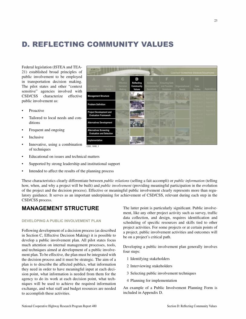
23
National Cooperative Highway Research Program Report 480 Section D: Reflecting Community Values
Federal legislation (ISTEA and TEA-21) established broad principles of public involvement to be employed in transportation decision making. The pilot states and other “context sensitive” agencies involved with CSD/CSS characterize effective public involvement as:
• Proactive
• Tailored to local needs and con-ditions
• Frequent and ongoing
• Inclusive
• Innovative, using a combination of techniques
• Educational on issues and technical matters
• Supported by strong leadership and institutional support
• Intended to affect the results of the planning process
These characteristics clearly differentiate between public relations (selling a fait accompli) or public information (telling how, when, and why a project will be built) and public involvement (providing meaningful participation in the evolution of the project and the decision process). Effective or meaningful public involvement clearly represents more than regu-latory guidance. It serves as an important underpinning for achievement of CSD/CSS, relevant during each step in the CSD/CSS process.
D. REFLECTING COMMUNITY VALUES
MANAGEMENT STRUCTURE
DEVELOPING A PUBLIC INVOLVEMENT PLAN
Following development of a decision process (as described in Section C, Effective Decision Making) it is possible to develop a public involvement plan. All pilot states focus much attention on internal management processes, tools, and techniques aimed at development of a public involve-ment plan. To be effective, the plan must be integrated with the decision process and it must be strategic. The aim of a plan is to describe the affected publics, what information they need in order to have meaningful input at each deci-sion point, what information is needed from them for the agency to do its work at each decision point, what tech-niques will be used to achieve the required information exchange, and what staff and budget resources are needed to accomplish these activities.
The latter point is particularly significant. Public involve-ment, like any other project activity such as survey, traffic data collection, and design, requires identification and scheduling of specific resources and skills tied to other project activities. For some projects or at certain points of a project, public involvement activities and outcomes will be on a project’s critical path.
Developing a public involvement plan generally involves four steps:
1 Identifying stakeholders
2 Interviewing stakeholders
3 Selecting public involvement techniques
4 Planning for implementation
An example of a Public Involvement Planning Form is included in Appendix D.
����������
About thisGuide
EffectiveDecisionMaking
ReflectingCommunity
Values
AchievingEnvironmental
Sensitivity
Ensuring Safeand Feasible
SolutionsOrganizational
NeedsCase
Studies Appendices
Management Structure
Problem Definition
Project Development andEvaluation Framework
Alternatives Development
Alternatives ScreeningEvaluation and Selection
Implementation
CB D E F G HIntroduction
to CSD
A
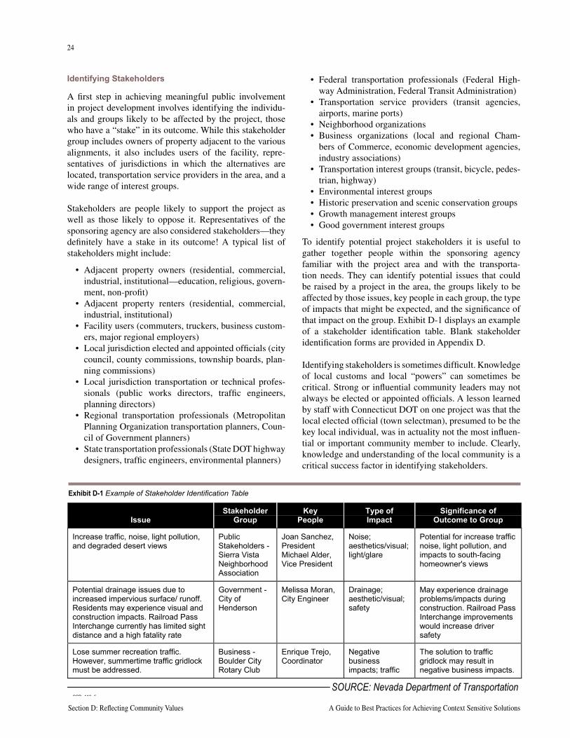
24
Section D: Reflecting Community Values A Guide to Best Practices for Achieving Context Sensitive Solutions
25
National Cooperative Highway Research Program Report 480 Section D: Reflecting Community Values
Identifying Stakeholders
A first step in achieving meaningful public involvement in project development involves identifying the individu-als and groups likely to be affected by the project, those who have a “stake” in its outcome. While this stakeholder group includes owners of property adjacent to the various alignments, it also includes users of the facility, repre-sentatives of jurisdictions in which the alternatives are located, transportation service providers in the area, and a wide range of interest groups.
Stakeholders are people likely to support the project as well as those likely to oppose it. Representatives of the sponsoring agency are also considered stakeholders—they definitely have a stake in its outcome! A typical list of stakeholders might include:
• Adjacent property owners (residential, commercial, industrial, institutional—education, religious, govern-ment, non-profit)
• Adjacent property renters (residential, commercial, industrial, institutional)
• Facility users (commuters, truckers, business custom-ers, major regional employers)
• Local jurisdiction elected and appointed officials (city council, county commissions, township boards, plan-ning commissions)
• Local jurisdiction transportation or technical profes-sionals (public works directors, traffic engineers, planning directors)
• Regional transportation professionals (Metropolitan Planning Organization transportation planners, Coun-cil of Government planners)
• State transportation professionals (State DOT highway designers, traffic engineers, environmental planners)
• Federal transportation professionals (Federal High-way Administration, Federal Transit Administration)
• Transportation service providers (transit agencies, airports, marine ports)
• Neighborhood organizations• Business organizations (local and regional Cham-
bers of Commerce, economic development agencies, industry associations)
• Transportation interest groups (transit, bicycle, pedes-trian, highway)
• Environmental interest groups• Historic preservation and scenic conservation groups• Growth management interest groups• Good government interest groups
To identify potential project stakeholders it is useful to gather together people within the sponsoring agency familiar with the project area and with the transporta-tion needs. They can identify potential issues that could be raised by a project in the area, the groups likely to be affected by those issues, key people in each group, the type of impacts that might be expected, and the significance of that impact on the group. Exhibit D-1 displays an example of a stakeholder identification table. Blank stakeholder identification forms are provided in Appendix D.
Identifying stakeholders is sometimes difficult. Knowledge of local customs and local “powers” can sometimes be critical. Strong or influential community leaders may not always be elected or appointed officials. A lesson learned by staff with Connecticut DOT on one project was that the local elected official (town selectman), presumed to be the key local individual, was in actuality not the most influen-tial or important community member to include. Clearly, knowledge and understanding of the local community is a critical success factor in identifying stakeholders.
IssueStakeholder
GroupKey
PeopleType ofImpact
Significance ofOutcome to Group
Increase traffic, noise, light pollution,and degraded desert views
PublicStakeholders -Sierra VistaNeighborhoodAssociation
Joan Sanchez,PresidentMichael Alder,Vice President
Noise;aesthetics/visual;light/glare
Potential for increase trafficnoise, light pollution, andimpacts to south-facinghomeowner's views
Potential drainage issues due toincreased impervious surface/ runoff.Residents may experience visual andconstruction impacts. Railroad PassInterchange currently has limited sightdistance and a high fatality rate
Government -City ofHenderson
Melissa Moran,City Engineer
Drainage;aesthetic/visual;safety
May experience drainageproblems/impacts duringconstruction. Railroad PassInterchange improvementswould increase driversafety
Lose summer recreation traffic.However, summertime traffic gridlockmust be addressed.
Business -Boulder CityRotary Club
Enrique Trejo,Coordinator
Negativebusinessimpacts; traffic
The solution to trafficgridlock may result innegative business impacts.
CSD_112_5
SOURCE: Nevada Department of Transportation
Exhibit D-1 Example of Stakeholder Identification Table
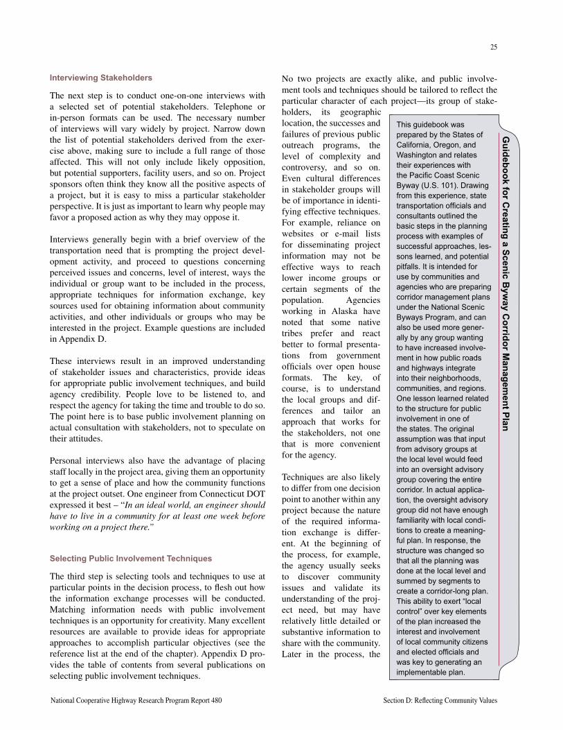
24
Section D: Reflecting Community Values A Guide to Best Practices for Achieving Context Sensitive Solutions
25
National Cooperative Highway Research Program Report 480 Section D: Reflecting Community Values
Interviewing Stakeholders
The next step is to conduct one-on-one interviews with a selected set of potential stakeholders. Telephone or in-person formats can be used. The necessary number of interviews will vary widely by project. Narrow down the list of potential stakeholders derived from the exer-cise above, making sure to include a full range of those affected. This will not only include likely opposition, but potential supporters, facility users, and so on. Project sponsors often think they know all the positive aspects of a project, but it is easy to miss a particular stakeholder perspective. It is just as important to learn why people may favor a proposed action as why they may oppose it.
Interviews generally begin with a brief overview of the transportation need that is prompting the project devel-opment activity, and proceed to questions concerning perceived issues and concerns, level of interest, ways the individual or group want to be included in the process, appropriate techniques for information exchange, key sources used for obtaining information about community activities, and other individuals or groups who may be interested in the project. Example questions are included in Appendix D.
These interviews result in an improved understanding of stakeholder issues and characteristics, provide ideas for appropriate public involvement techniques, and build agency credibility. People love to be listened to, and respect the agency for taking the time and trouble to do so. The point here is to base public involvement planning on actual consultation with stakeholders, not to speculate on their attitudes.
Personal interviews also have the advantage of placing staff locally in the project area, giving them an opportunity to get a sense of place and how the community functions at the project outset. One engineer from Connecticut DOT expressed it best – “In an ideal world, an engineer should have to live in a community for at least one week before working on a project there.”
Selecting Public Involvement Techniques
The third step is selecting tools and techniques to use at particular points in the decision process, to flesh out how the information exchange processes will be conducted. Matching information needs with public involvement techniques is an opportunity for creativity. Many excellent resources are available to provide ideas for appropriate approaches to accomplish particular objectives (see the reference list at the end of the chapter). Appendix D pro-vides the table of contents from several publications on selecting public involvement techniques.
No two projects are exactly alike, and public involve-ment tools and techniques should be tailored to reflect the particular character of each project—its group of stake-holders, its geographic location, the successes and failures of previous public outreach programs, the level of complexity and controversy, and so on. Even cultural differences in stakeholder groups will be of importance in identi-fying effective techniques. For example, reliance on websites or e-mail lists for disseminating project information may not be effective ways to reach lower income groups or certain segments of the population. Agencies working in Alaska have noted that some native tribes prefer and react better to formal presenta-tions from government officials over open house formats. The key, of course, is to understand the local groups and dif-ferences and tailor an approach that works for the stakeholders, not one that is more convenient for the agency.
Techniques are also likely to differ from one decision point to another within any project because the nature of the required informa-tion exchange is differ-ent. At the beginning of the process, for example, the agency usually seeks to discover community issues and validate its understanding of the proj-ect need, but may have relatively little detailed or substantive information to share with the community. Later in the process, the
Guidebook for C
reating a Scenic Byw
ay Corridor M
anagement Plan
This guidebook was prepared by the States of California, Oregon, and Washington and relates their experiences with the Pacific Coast Scenic Byway (U.S. 101). Drawing from this experience, state transportation officials and consultants outlined the basic steps in the planning process with examples of successful approaches, les-sons learned, and potential pitfalls. It is intended for use by communities and agencies who are preparing corridor management plans under the National Scenic Byways Program, and can also be used more gener-ally by any group wanting to have increased involve-ment in how public roads and highways integrate into their neighborhoods, communities, and regions. One lesson learned related to the structure for public involvement in one of the states. The original assumption was that input from advisory groups at the local level would feed into an oversight advisory group covering the entire corridor. In actual applica-tion, the oversight advisory group did not have enough familiarity with local condi-tions to create a meaning-ful plan. In response, the structure was changed so that all the planning was done at the local level and summed by segments to create a corridor-long plan. This ability to exert “local control” over key elements of the plan increased the interest and involvement of local community citizens and elected officials and was key to generating an implementable plan.
26
Section D: Reflecting Community Values A Guide to Best Practices for Achieving Context Sensitive Solutions
27
National Cooperative Highway Research Program Report 480 Section D: Reflecting Community Values
agency is seeking feedback on particular alternatives and may need opportunities to present a large amount of detailed information.
The tendency in planning for public involvement is to schedule project-specific events and encourage stakehold-ers to participate in them. Experience on many projects has shown that while it may be a bit less efficient, project team participation in community- and stakeholder-sponsored activities may yield much more satisfactory results. In many cases, taking the project to the stakeholders, rather than the reverse, increases the likelihood of successful information exchange.
It is important to recognize that no matter how thorough a stakeholder identification activity is conducted at the outset of the project, the list of stakeholders will change as the project progresses. As more detailed information is available, members of the general public who were previ-ously uninterested in the project will become stakeholders. The earlier all of the interested parties can be identified
the better. For that reason, it is a good practice to include mechanisms for outreach to the general public, in addi-tion to known stakeholders, as a continuing element of the overall public involvement plan.
The pilot states have all focused on development of mate-rials to aid in planning for public involvement. Minnesota DOT has developed a guide to public involvement entitled Hear Every Voice. Chapter 5 of the guide includes descrip-tions of public involvement techniques as well as evalua-tions of how they have worked within the context of a plan or project. Appendix D includes excerpts from the docu-ment to illustrate the types of techniques discussed and the evaluation template. Appendix D also contains example public involvement plans and options for assembling stakeholder advisory groups.
Planning for Implementation
Implementation planning involves integrating the selected public involvement activities into the total project scope, schedule, and budget, and obtaining final buy-in from management. Some agencies less experienced in CSD/CSS do not yet treat public involvement as a task that must be planned and budgeted. “You never know how many meetings you are going to have to hold” is sometimes heard. Of course, one of the points of up-front stakeholder identification and rigorous planning is to find out what the needs are. The issue is no different than, for example, not performing traffic counts and then asserting “you don’t know how much traffic you need to design for.” Clearly, part of being successful is understanding the requirements ahead of time and knowing where to get needed resources, inside the agency or elsewhere.
While it is often stated that good public involvement is expensive, and poor public involvement is even more expensive, budgets for public involvement must be real-istic. There are many ways to leverage resources; addi-tional resources and references are presented at the end of this chapter.
Finally, a public involvement plan is a useful tool, a key element of the project implementation strategy. But, it is only a road map, and will likely require modifications as the project proceeds. For that reason, it should not be viewed as a sacred document, set in stone. Of course, it should also not be set on the shelf as an interesting but irrelevant document.
Min
neso
ta D
OT
Publ
ic In
volv
emen
t Gui
delin
es
Minnesota DOT developed the following public involve-ment guidelines to assist its personnel in implementing public involvement plans and activities. They reflect the mandates of ISTEA, reinforced by TEA-21, as well as public agency best practices.
• For all Mn/DOT plans and projects, public involvement plans should be developed and tailored to the complexi-ties of the project.
• Solicit public involvement as early as possible.
• When possible and appropriate, Mn/DOT employees will plan for smaller, more informal group meetings and discussion.
• Mailing lists, including known neighborhood associations, civic and cultural groups, environmental organizations, citizen advisory committees, and organizations and asso-ciations with low income, minority , elderly, and disabled constituents will be kept up-to-date as appropriate.
• Mn/DOT employees will make an effort to go where the people are.
• Communication must be two-way, continuing, and consis-tent.
• Mn/DOT is committed to being clear about the process of public involvement and how it ties to decision making.
• Varying types of incentives may be necessary given the type of project, or plan, and the people who are invited to the meeting.
Each of these guidelines is discussed in Chapter 2 of Hear Every Voice (Minnesota Department of Transporta-tion. Hear Every Voice, A Guide to Public Involvement at Mn/DOT. June 1999).
26
Section D: Reflecting Community Values A Guide to Best Practices for Achieving Context Sensitive Solutions
27
National Cooperative Highway Research Program Report 480 Section D: Reflecting Community Values
PROBLEM DEFINITION
IDENTIFYING COMMUNITY ISSUES AND CONSTRAINTS
Stakeholder interviews conducted as part of public involve-ment plan development should provide a set of community issues, values, and constraints concerning the project. Results from such interviews may not necessarily provide a complete picture of all community values and interests. Most good public involvement plans call for broad com-munity outreach at an early point in the project to ensure mutual understanding between the agency and the stake-holders of the full set of concerns associated with the proj-ect. Upon further examination, it may be determined that some of the identified issues cannot be dealt with in the current project development process; they may need to be referred to other agencies that can take appropriate action, shifted to another planning or project development process better suited to address them, or postponed for consider-ation at a later stage of project development. Those identi-fied issues that do pertain to the project at hand should be incorporated into the problem definition and documented as input to the evaluation framework in the next step.
Outreach should be focused on understanding community attitudes about the nature of transportation problems or issues associated with the identified project. Specific concerns about safety or mobility, about land use or land development are of interest. Outreach should also focus on finding out the specific values associated with the local context. Importance of adverse effects (noise, cut-through traffic, speed of traffic, on-street parking, circulation, access to parks, schools, businesses) should be expressed. Individuals or groups may note a concern or issue that might seem irrelevant to the project, but agency staff should strive to maintain an open mind and to listen to what is being said. Often the issue will surface at some point in the project if left unaddressed.
Typical techniques for broad outreach to the public for the purpose of issue identification include newsletters with response forms, websites with electronic comment options, information telephone lines, surveys, elected offi-cial briefings, open houses, and advisory groups.
CONFIRMING AND REFINING PROBLEM DEFINITION
A problem definition can be crafted from the issues iden-tified by the agency and the community through similar techniques as described for issue identification. The point of this outreach is to assure congruence between the agency’s view of the problems to be addressed and those
recognized by the community. If these views are differ-ent (and they often are!), it is very difficult for affected property owners and stakeholders to consent to trade-offs that adversely affect their interests later in project develop-ment. The absence of general endorsement of the problem definition is a strong signal that the project is not ready to proceed to the next step.
The Pennsylvania DOT uses a four-stage project develop-ment process as part of their environmental streamlining efforts. As discussed in Exhibit D-2 (following page), the Visioning Stage, a Development Stage, a Refinement Stage, and a Final Comparison Stage are all intended to gain understanding of community values and interests as they pertain to the project and its effects on the community and environment.
PROJECT DEVELOPMENT AND EVALUATION FRAMEWORK
INVOLVING STAKEHOLDERS IN FRAMEWORK DEVELOPMENT
Agencies are usually comfortable with evaluating alterna-tives based on quantitative measures of capacity, safety, design standard compliance, plan compliance, and mini-mization of direct impacts to known natural resources. However, they are generally less comfortable with attempts to measure the effects of alternatives on issues such as “quality of life” or “community cohesion.” These are often viewed as intangible and, therefore, unmeasur-able. However, if these are important issues to the stake-holders, they must be tackled head-on. Ignoring these just
Interstate 83 Com
munity D
esign Center
As part of identifying alternatives for improvements to an aging and unsafe segment of Interstate 83 near York, Pennsylvania, Pennsylvania DOT conducted an exten-sive collaborative process with community stakeholders. In addition to creating a community advisory committee, project website, toll-free number, e-mail address, and newsletters, the core of the effort involved a week-long “community design center” process. Participants could recommend possible roadway alignments and other solutions and see them drawn on a large-screen CAD system while they watched. During the design sessions, project staff also presented background information on the environmental process and on traffic modeling, helping participants develop the same understanding as the project planners and designers. Eight alternatives resulted from the collaborative process. In a subsequent design center session, the alternatives were evaluated against engineer-ing constraints, cost, the project needs statement, and environmental constraints using a GIS database, again allowing the participants to understand and participate in the alternative design and selection process.
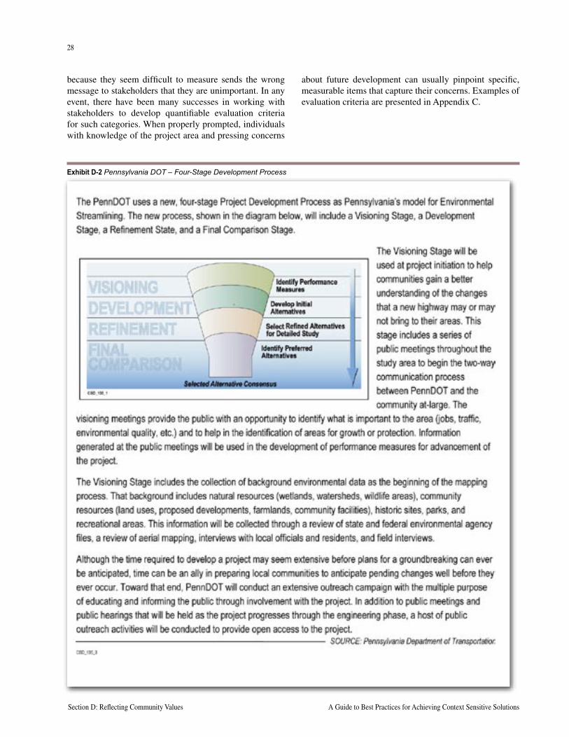
28
Section D: Reflecting Community Values A Guide to Best Practices for Achieving Context Sensitive Solutions
29
National Cooperative Highway Research Program Report 480 Section D: Reflecting Community Values
because they seem difficult to measure sends the wrong message to stakeholders that they are unimportant. In any event, there have been many successes in working with stakeholders to develop quantifiable evaluation criteria for such categories. When properly prompted, individuals with knowledge of the project area and pressing concerns
about future development can usually pinpoint specific, measurable items that capture their concerns. Examples of evaluation criteria are presented in Appendix C.
Exhibit D-2 Pennsylvania DOT – Four-Stage Development Process
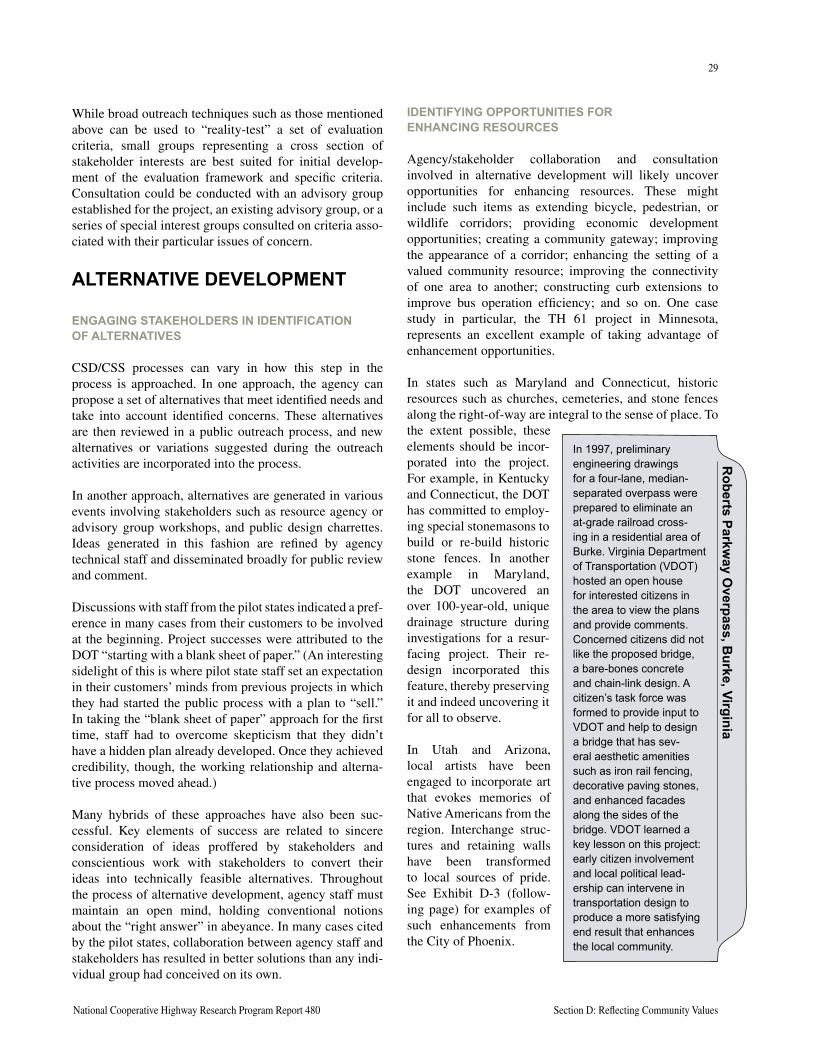
28
Section D: Reflecting Community Values A Guide to Best Practices for Achieving Context Sensitive Solutions
29
National Cooperative Highway Research Program Report 480 Section D: Reflecting Community Values
While broad outreach techniques such as those mentioned above can be used to “reality-test” a set of evaluation criteria, small groups representing a cross section of stakeholder interests are best suited for initial develop-ment of the evaluation framework and specific criteria. Consultation could be conducted with an advisory group established for the project, an existing advisory group, or a series of special interest groups consulted on criteria asso-ciated with their particular issues of concern.
ALTERNATIVE DEVELOPMENT
ENGAGING STAKEHOLDERS IN IDENTIFICATION OF ALTERNATIVES
CSD/CSS processes can vary in how this step in the process is approached. In one approach, the agency can propose a set of alternatives that meet identified needs and take into account identified concerns. These alternatives are then reviewed in a public outreach process, and new alternatives or variations suggested during the outreach activities are incorporated into the process.
In another approach, alternatives are generated in various events involving stakeholders such as resource agency or advisory group workshops, and public design charrettes. Ideas generated in this fashion are refined by agency technical staff and disseminated broadly for public review and comment.
Discussions with staff from the pilot states indicated a pref-erence in many cases from their customers to be involved at the beginning. Project successes were attributed to the DOT “starting with a blank sheet of paper.” (An interesting sidelight of this is where pilot state staff set an expectation in their customers’ minds from previous projects in which they had started the public process with a plan to “sell.” In taking the “blank sheet of paper” approach for the first time, staff had to overcome skepticism that they didn’t have a hidden plan already developed. Once they achieved credibility, though, the working relationship and alterna-tive process moved ahead.)
Many hybrids of these approaches have also been suc-cessful. Key elements of success are related to sincere consideration of ideas proffered by stakeholders and conscientious work with stakeholders to convert their ideas into technically feasible alternatives. Throughout the process of alternative development, agency staff must maintain an open mind, holding conventional notions about the “right answer” in abeyance. In many cases cited by the pilot states, collaboration between agency staff and stakeholders has resulted in better solutions than any indi-vidual group had conceived on its own.
IDENTIFYING OPPORTUNITIES FOR ENHANCING RESOURCES
Agency/stakeholder collaboration and consultation involved in alternative development will likely uncover opportunities for enhancing resources. These might include such items as extending bicycle, pedestrian, or wildlife corridors; providing economic development opportunities; creating a community gateway; improving the appearance of a corridor; enhancing the setting of a valued community resource; improving the connectivity of one area to another; constructing curb extensions to improve bus operation efficiency; and so on. One case study in particular, the TH 61 project in Minnesota, represents an excellent example of taking advantage of enhancement opportunities.
In states such as Maryland and Connecticut, historic resources such as churches, cemeteries, and stone fences along the right-of-way are integral to the sense of place. To the extent possible, these elements should be incor-porated into the project. For example, in Kentucky and Connecticut, the DOT has committed to employ-ing special stonemasons to build or re-build historic stone fences. In another example in Maryland, the DOT uncovered an over 100-year-old, unique drainage structure during investigations for a resur-facing project. Their re-design incorporated this feature, thereby preserving it and indeed uncovering it for all to observe.
In Utah and Arizona, local artists have been engaged to incorporate art that evokes memories of Native Americans from the region. Interchange struc-tures and retaining walls have been transformed to local sources of pride. See Exhibit D-3 (follow-ing page) for examples of such enhancements from the City of Phoenix.
Roberts Parkw
ay Overpass, B
urke, Virginia
In 1997, preliminary engineering drawings for a four-lane, median-separated overpass were prepared to eliminate an at-grade railroad cross-ing in a residential area of Burke. Virginia Department of Transportation (VDOT) hosted an open house for interested citizens in the area to view the plans and provide comments. Concerned citizens did not like the proposed bridge, a bare-bones concrete and chain-link design. A citizen’s task force was formed to provide input to VDOT and help to design a bridge that has sev-eral aesthetic amenities such as iron rail fencing, decorative paving stones, and enhanced facades along the sides of the bridge. VDOT learned a key lesson on this project: early citizen involvement and local political lead-ership can intervene in transportation design to produce a more satisfying end result that enhances the local community.
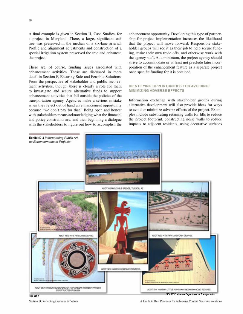
30
Section D: Reflecting Community Values A Guide to Best Practices for Achieving Context Sensitive Solutions
31
National Cooperative Highway Research Program Report 480 Section D: Reflecting Community Values
A final example is given in Section H, Case Studies, for a project in Maryland. There, a large, significant oak tree was preserved in the median of a six-lane arterial. Profile and alignment adjustments and construction of a special irrigation system preserved the tree and enhanced the project.
There are, of course, funding issues associated with enhancement activities. These are discussed in more detail in Section F, Ensuring Safe and Feasible Solutions. From the perspective of stakeholder and public involve-ment activities, though, there is clearly a role for them to investigate and secure alternative funds to support enhancement activities that fall outside the policies of the transportation agency. Agencies make a serious mistake when they reject out of hand an enhancement opportunity because “we don’t pay for that.” Being open and honest with stakeholders means acknowledging what the financial and policy constraints are, and then beginning a dialogue with the stakeholders to figure out how to accomplish the
enhancement opportunity. Developing this type of partner-ship for project implementation increases the likelihood that the project will move forward. Responsible stake-holder groups will see it as their job to help secure fund-ing, make their own trade-offs, and otherwise work with the agency staff. At a minimum, the project agency should strive to accommodate or at least not preclude later incor-poration of the enhancement feature as a separate project once specific funding for it is obtained.
IDENTIFYING OPPORTUNITIES FOR AVOIDING/MINIMIZING ADVERSE EFFECTS
Information exchange with stakeholder groups during alternative development will also provide ideas for ways to avoid or minimize adverse effects of the project. Exam-ples include substituting retaining walls for fills to reduce the project footprint, constructing noise walls to reduce impacts to adjacent residents, using decorative surfaces
CSD_201_1SOURCE: Arizona Department of Transportation
Exhibit D-3 Incorporating Public Art as Enhancements to Projects
30
Section D: Reflecting Community Values A Guide to Best Practices for Achieving Context Sensitive Solutions
31
National Cooperative Highway Research Program Report 480 Section D: Reflecting Community Values
on project structures to better fit the project into its set-ting, adding landscaping and other streetscape elements to enhance the connection of the facility to adjacent land uses, and so on.
Often the way to mitigate adverse effects is merely to “re-engineer” the corridor. Connecticut DOT engineers speak of literally walking a project alignment, noting the terrain, proximity of buildings, tress, etc., and adjusting the cen-terline as they proceed. They consider this good design practice – paying attention to details, and designing the alignment almost foot by foot.
The Federal Lands design philosophy is strongly in this camp. Clients of theirs include the National Park Service. Federal Lands staff understand that first and foremost the alignment and cross section must be placed in a manner that “lies lightly on the land,” in other words, that looks as if it belongs.
IDENTIFYING MITIGATION FOR UNAVOIDABLE ADVERSE EFFECTS
If adverse effects cannot be avoided, a collaborative alter-native development process can help identify opportuni-ties for mitigation. Key environmental technical staff are consulted to develop mitigation plans.
ENGAGING STAKEHOLDERS IN ALTERNATIVE EVALUATION
As discussed in Section C, Effective Decision Making, stakeholders can be involved in the screening and evalu-ation of alternatives in a variety of ways. The level and type of involvement should be determined in the Evalu-ation Framework document. Staff analysis results can be shared broadly with stakeholders for review and comment through newsletters with response forms, websites with electronic comment options, information telephone lines, surveys, elected official briefings, open houses, commu-nity workshops, and radio and television talk shows. Town meetings, using electronic voting or more conventional methods, can be used to elicit stakeholder preferences.
Stakeholders can also be involved in conducting the screening and evaluation. For example, alternative rating and criteria weighting workshops can be designed for advisory groups, other types of stakeholder groups, or large public gatherings.
In projects for which NEPA documents are being prepared, it is often useful to share initial results from technical reports with stakeholders to ensure the analysis is accurate
and complete. Although accuracy and completeness are ultimately addressed during public review of Draft EAs and EISs, agency credibility can be enhanced by selec-tive outreach earlier in the process. In this way, agencies can be assured that the draft documents do not contain easily avoidable errors or omissions. This review can be accomplished through presentations to advisory groups or special interest groups.
Public hearings provide the public with a last chance for direct input into the NEPA alternative selection process. Research indicates that “open” public hearings, which are conducted like open houses and allow participants to pro-vide testimony at private court reporter stations rather than in a large public forum, are preferred by most state DOTs because they increase active public input.
By the time of the public hearing, though, a well-executed project should not encounter any new or previously unex-pressed views or inputs on the project or the alternatives. One good measure of the success of a public involvement program is “no surprises” at the public hearing.
IMPLEMENTATION
MAINTAINING COMMUNICATION THROUGH CONSTRUCTION
Many public involvement processes conclude at the end of the alternative selection process. This ignores the con-tinuing interest many stakeholders have in the details of final design and construction. It also ignores importance to maintaining agency credibility for communicating any changes in the project that occur during these post-plan-ning activities. Staff from some of the pilot states indi-cate this is a painful lesson learned – that hard work to achieve credibility and buy-in can be erased by ignoring stakeholder concerns or important project activities after a decision is reached.
Any number of events can have an unforeseen effect on the project or individuals. Changes to the plan, schedule delays, changes to construction detours, etc., all present risks if not communicated to stakeholders.
An extension of existing newsletters and websites can be used to update stakeholders, and occasional meetings with existing advisory groups and elected officials can be scheduled at key milestones (Exhibit D-4, following page). A more extensive outreach program may be needed during construction to provide traveler information about revised routing and adjacent property owner/renter infor-mation about planned construction activities.
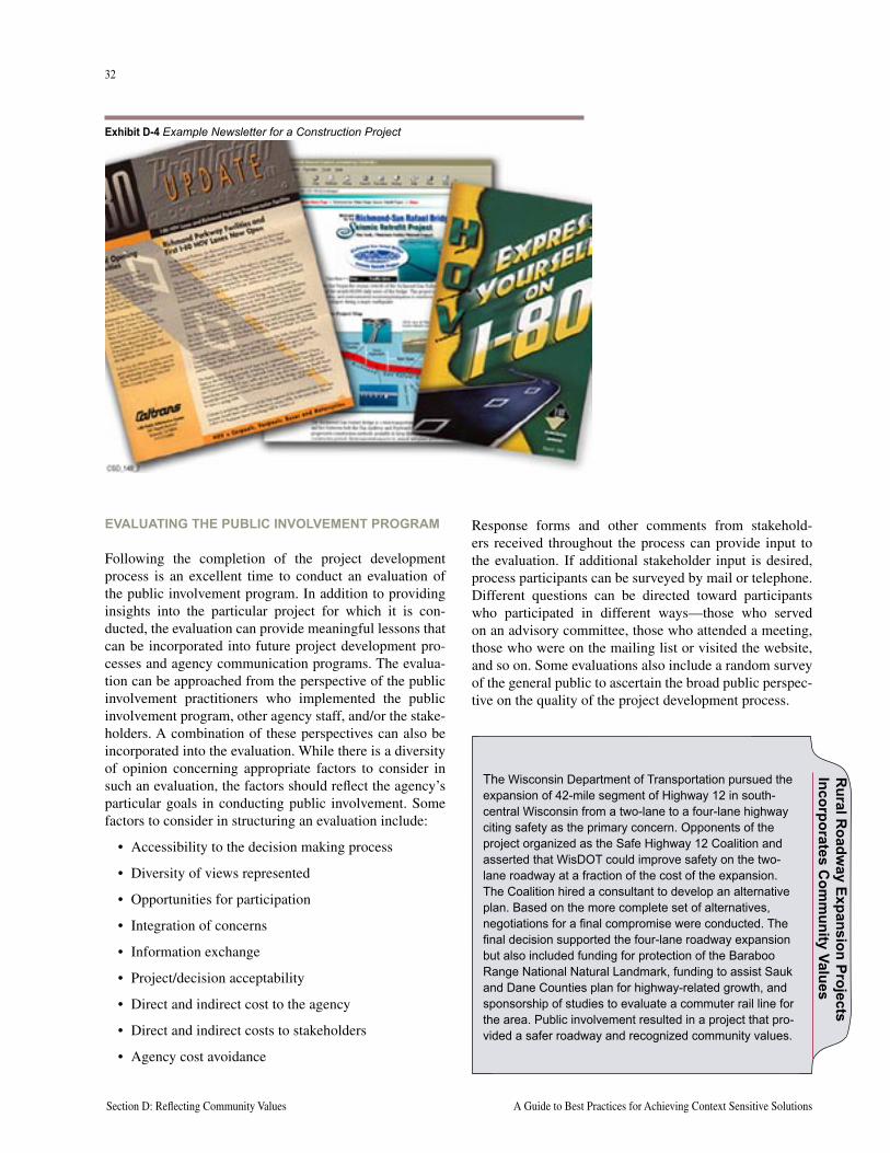
32
Section D: Reflecting Community Values A Guide to Best Practices for Achieving Context Sensitive Solutions
33
National Cooperative Highway Research Program Report 480 Section D: Reflecting Community Values
EVALUATING THE PUBLIC INVOLVEMENT PROGRAM
Following the completion of the project development process is an excellent time to conduct an evaluation of the public involvement program. In addition to providing insights into the particular project for which it is con-ducted, the evaluation can provide meaningful lessons that can be incorporated into future project development pro-cesses and agency communication programs. The evalua-tion can be approached from the perspective of the public involvement practitioners who implemented the public involvement program, other agency staff, and/or the stake-holders. A combination of these perspectives can also be incorporated into the evaluation. While there is a diversity of opinion concerning appropriate factors to consider in such an evaluation, the factors should reflect the agency’s particular goals in conducting public involvement. Some factors to consider in structuring an evaluation include:
• Accessibility to the decision making process
• Diversity of views represented
• Opportunities for participation
• Integration of concerns
• Information exchange
• Project/decision acceptability
• Direct and indirect cost to the agency
• Direct and indirect costs to stakeholders
• Agency cost avoidance
Response forms and other comments from stakehold-ers received throughout the process can provide input to the evaluation. If additional stakeholder input is desired, process participants can be surveyed by mail or telephone. Different questions can be directed toward participants who participated in different ways—those who served on an advisory committee, those who attended a meeting, those who were on the mailing list or visited the website, and so on. Some evaluations also include a random survey of the general public to ascertain the broad public perspec-tive on the quality of the project development process.
Exhibit D-4 Example Newsletter for a Construction Project
Rural R
oadway Expansion Projects
Incorporates Com
munity Values
The Wisconsin Department of Transportation pursued the expansion of 42-mile segment of Highway 12 in south-central Wisconsin from a two-lane to a four-lane highway citing safety as the primary concern. Opponents of the project organized as the Safe Highway 12 Coalition and asserted that WisDOT could improve safety on the two-lane roadway at a fraction of the cost of the expansion. The Coalition hired a consultant to develop an alternative plan. Based on the more complete set of alternatives, negotiations for a final compromise were conducted. The final decision supported the four-lane roadway expansion but also included funding for protection of the Baraboo Range National Natural Landmark, funding to assist Sauk and Dane Counties plan for highway-related growth, and sponsorship of studies to evaluate a commuter rail line for the area. Public involvement resulted in a project that pro-vided a safer roadway and recognized community values.
32
Section D: Reflecting Community Values A Guide to Best Practices for Achieving Context Sensitive Solutions
33
National Cooperative Highway Research Program Report 480 Section D: Reflecting Community Values
KEY RESOURCES AND REFERENCESCreighton, James, National Civic League. Involving Citizens in Community Decision Making: A Guidebook, Program for Community Problem Solving, 1992.
Keever, David, PhD., and Lyncott, Jana, AICP. “In the Possibilities Are the Solutions: Assessment and Implications of the Public Involvement Process During the Environmental Impact Study of Woodrow Wilson Bridge”, Presented at 1999 Annual TRB Meeting, Washington, D.C.
Maryland State Highway Administration. Thinking Beyond the Pavement, A National Workshop on Integrating Highway Development with Communities and the Environment while Maintaining Safety and Performance. May, 1998.
Maryland State Highway Administration. Thinking Beyond the Pavement, Conference Summary, May, 1998.
Maryland State Highway Administration. Thinking Beyond the Pavement, Integrating Highway Development with Communities and the Environment. Charrette’s Executive Summary, May-June, 1999.
Minnesota Department of Transportation. Hear Every Voice, A Guide to Public Involvement at Mn/DOT. June 1999.
Myerson, Deborah L., AICP. Getting It Right In the Right-of-Way, Action Guide, Scenic America, 2000.
O’Leary, Amy A., Arnold, E.D., Jr., Kyte, Cherie A ., and Perfater, Michael A. An Assessment of the Virginia Department of Transportation’s Use of the Open-Forum Hearing Format. Transportation Research Record 1780, 2001.
Transportation Research Board, Committee on Public Involvement in Transportation. Assessing the Effectiveness of Project-Based Public Involvement Processes: A Self-Assessment Tool for Practioners, 1999.
U.S. Department of Transportation, FHWA, and FTA. Innovations in Public Involvement for Transportation Planning, 1994.
U.S. Department of Transportation, FHWA, and FTA. Public Involvement Techniques for Transportation Decision-making, 1996.
U.S. Department of Transportation, FHWA. Community Impact Assessment: A Quick Reference for Transportation, Publication No. FHWA-PD-96-HEP-30/8-96 (10M)P, 1996.
U.S. Department of Transportation, FHWA. Flexibility in Highway Design. Publication No. FHWA-PD-97-062 HEP-30/7-97 (10M)E. 1997.

34
Section D: Reflecting Community Values A Guide to Best Practices for Achieving Context Sensitive Solutions
This page intentionally left blank
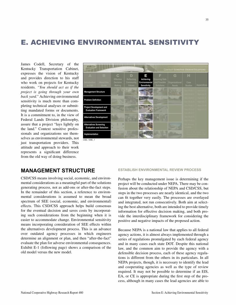
35
National Cooperative Highway Research Report 480 Section E: Achieving Environmental Sensitivity
James Codell, Secretary of the Kentucky Transportation Cabinet, expresses the vision of Kentucky and provides direction to his staff who work on projects for Kentucky residents. “You should act as if the project is going through your own back yard.” Achieving environmental sensitivity is much more than com-pleting technical analyses or submit-ting mandated forms or documents. It is a commitment to, in the view of Federal Lands Division philosophy, assure that a project “lays lightly on the land.” Context sensitive profes-sionals and organizations see them-selves as environmental stewards, not just transportation providers. This attitude and approach to their work represents a significant difference from the old way of doing business.
E. ACHIEVING ENVIRONMENTAL SENSITIVITY
MANAGEMENT STRUCTURECSD/CSS means involving social, economic, and environ-mental considerations as a meaningful part of the solutions generating process, not as add-ons or after-the-fact steps. In the remainder of this section, a reference to environ-mental considerations is assumed to mean the broad spectrum of SEE (social, economic, and environmental) effects. This CSD/CSS approach helps build consensus for the eventual decision and saves costs by incorporat-ing such considerations from the beginning when it is easier to accommodate change. Environmental sensitivity means incorporating consideration of SEE effects within the alternatives development process. This is an advance over outdated agency processes in which engineers determine an alignment or plan, and then “after-the-fact” evaluate the plan for adverse environmental consequences. Exhibit E-1 (following page) shows a comparison of the old model versus the new model.
ESTABLISH ENVIRONMENTAL REVIEW PROCESS
Perhaps the key management issue is determining if the project will be conducted under NEPA. There may be con-fusion about the relationship of NEPA and CSD/CSS, but steps in the two processes are nearly identical, and the two can fit together very easily. The processes are overlayed and integrated, not run consecutively. Both aim at select-ing the best alternative, both are intended to provide timely information for effective decision making, and both pro-vide the interdisciplinary framework for considering the positive and negative impacts of the proposed action.
Because NEPA is a national law that applies to all federal agency actions, it is almost always implemented through a series of regulations promulgated by each federal agency and in many cases each state DOT. Despite this national law, and the common aim to provide the agency with a defensible decision process, each of these agency regula-tions is different from the others in its particulars. In all NEPA projects, though, it is necessary to identify the lead and cooperating agencies as well as the type of review required. It may not be possible to determine if an EIS, EA, or CE is appropriate during the first step of the pro-cess, although in many cases the lead agencies are able to
����������
About thisGuide
EffectiveDecisionMaking
ReflectingCommunity
Values
AchievingEnvironmental
Sensitivity
Ensuring Safeand Feasible
SolutionsOrganizational
NeedsCase
Studies Appendices
Management Structure
Problem Definition
Project Development andEvaluation Framework
Alternatives Development
Alternatives ScreeningEvaluation and Selection
Implementation
CB D E F G HIntroduction
to CSD
A
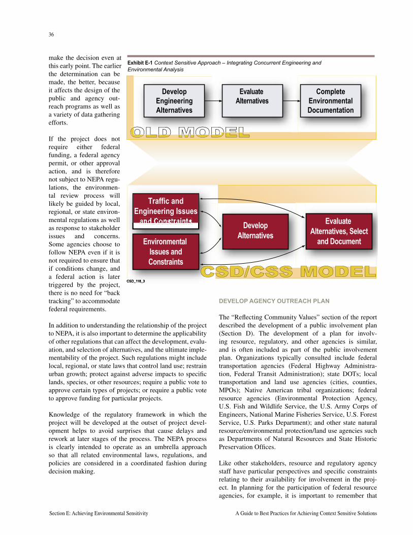
36
Section E: Achieving Environmental Sensitivity A Guide to Best Practices for Achieving Context Sensitive Solutions
37
National Cooperative Highway Research Program Report 480 Section E: Achieving Environmental Sensitivity
make the decision even at this early point. The earlier the determination can be made, the better, because it affects the design of the public and agency out-reach programs as well as a variety of data gathering efforts.
If the project does not require either federal funding, a federal agency permit, or other approval action, and is therefore not subject to NEPA regu-lations, the environmen-tal review process will likely be guided by local, regional, or state environ-mental regulations as well as response to stakeholder issues and concerns. Some agencies choose to follow NEPA even if it is not required to ensure that if conditions change, and a federal action is later triggered by the project, there is no need for “back tracking” to accommodate federal requirements.
In addition to understanding the relationship of the project to NEPA, it is also important to determine the applicability of other regulations that can affect the development, evalu-ation, and selection of alternatives, and the ultimate imple-mentability of the project. Such regulations might include local, regional, or state laws that control land use; restrain urban growth; protect against adverse impacts to specific lands, species, or other resources; require a public vote to approve certain types of projects; or require a public vote to approve funding for particular projects.
Knowledge of the regulatory framework in which the project will be developed at the outset of project devel-opment helps to avoid surprises that cause delays and rework at later stages of the process. The NEPA process is clearly intended to operate as an umbrella approach so that all related environmental laws, regulations, and policies are considered in a coordinated fashion during decision making.
DEVELOP AGENCY OUTREACH PLAN
The “Reflecting Community Values” section of the report described the development of a public involvement plan (Section D). The development of a plan for involv-ing resource, regulatory, and other agencies is similar, and is often included as part of the public involvement plan. Organizations typically consulted include federal transportation agencies (Federal Highway Administra-tion, Federal Transit Administration); state DOTs; local transportation and land use agencies (cities, counties, MPOs); Native American tribal organizations; federal resource agencies (Environmental Protection Agency, U.S. Fish and Wildlife Service, the U.S. Army Corps of Engineers, National Marine Fisheries Service, U.S. Forest Service, U.S. Parks Department); and other state natural resource/environmental protection/land use agencies such as Departments of Natural Resources and State Historic Preservation Offices.
Like other stakeholders, resource and regulatory agency staff have particular perspectives and specific constraints relating to their availability for involvement in the proj-ect. In planning for the participation of federal resource agencies, for example, it is important to remember that
Traffic and Engineering Issues
and Constraints
Environmental Issues and Constraints
Develop Alternatives
Evaluate Alternatives, Select
and Document
CSD/CSS MODEL
Develop Engineering Alternatives
Evaluate Alternatives
Complete Environmental Documentation
Exhibit E-1 Context Sensitive Approach – Integrating Concurrent Engineering and Environmental Analysis
36
Section E: Achieving Environmental Sensitivity A Guide to Best Practices for Achieving Context Sensitive Solutions
37
National Cooperative Highway Research Program Report 480 Section E: Achieving Environmental Sensitivity
their operating procedures often make it very difficult for staff to participate in activities not directly connected to an ongoing NEPA process or permit action. Moreover, in most regulatory agencies staff is often spread very thin and forced to prioritize among many important projects and concurrent activities. Limited availability of agency staff often requires scheduling of special activities for them at selected project milestones rather than assuming they can participate as regular members of broad-based project advisory groups that will meet often during the develop-ment process. Field trips, special resource agency advisory groups that meet only several times during project develop-ment, and focused resource agency workshops are proven effective approaches for achieving agency involvement.
Pilot states working with agency stakeholders have attempted to maintain an environmental stewardship focus and at the same time improve efficiencies. The Connecti-cut DOT is working with the FHWA Division Office and Connecticut State Historic Preservation Office (SHPO) to develop programmatic agreements covering minor proj-ects and even minor work efforts on the Merritt Parkway, which is listed on the National Register of Historic Places. Other agreements involve continual coordination at every stage of an archaeological investigation. In Kentucky, as part of a section 106 Programmatic agreement, a consulta-tion procedure is being established between the State and Native Americans, even though there are no federally rec-ognized tribes in the state.
North Carolina DOT is acting as an environmental stream-lining laboratory. The vision of NCDOT is to engage all stakeholders in a shared, efficient, and balanced process that advances environmental streamlining while maintain-ing environmental stewardship.
Despite budget and time constraints, it is critical to the success of the CSD/CSS (and NEPA) process to obtain information from the appropriate resource and regulatory agencies concerning problem definition, evaluation crite-ria, alternatives development, alternatives evaluation, and the identification of a preferred alternative.
PROVIDE STAFFING SUPPORT
Achieving environmental sensitivity and maintaining control over a project’s schedule and budget requires com-mitment of resources at the project level. In Kentucky, the Transportation Cabinet created 12 staff positions to moni-tor all environmental activities at the District level. The Maryland SHA has undertaken similar action. Kentucky also has established an Environmental Advisory Team,
consisting of KTC staff, FHWA staff, and consultants to track environmental commitments and look for opportuni-ties to streamline and improve the process.
Agencies new to CSD/CSS may find it necessary to increase the level of staff support or retain consulting ser-vices for environmental coordination and project develop-ment activities.
PROBLEM DEFINITION
DEVELOP PROBLEM STATEMENT
An early step in both the CSD/CSS and NEPA processes is the identification of the problems to be solved and the development of a problem statement. It is critical that the statement be useful for development and evaluation of potential solutions. Problems must be stated in terms of underlying causes. For example, congestion, in itself, may not a problem, but rather a symptom of a problem. If, instead, the problem is defined as travel demand that exceeds capacity, the problem has been framed in a way that can lead to a solution—it is either possible to attack the problem from the demand side or the capacity side, or a combination of the two.
Similarly, problem statements should avoid being mode specific. Thus, for example, a problem is not the lack of light rail transit lines from point A to point B. Rather, there may be a lack of transportation options within a particu-lar corridor where only auto transportation options exist. Solutions could include expanding opportunities for bike, pedestrian, light rail, bus, and other public transportation.
In some cases, a problem could relate to a particular type of vehicle. For example, roadway geometry that makes it difficult for emergency vehicles or particular types of trucks to gain access or to complete specific turning move-ments could be a significant problem in a corridor used heavily for freight movement.
Problem statements generally define the current conditions as well as conditions at the end of the forecast year, gener-ally accepted as a 20-year planning period. Even though transportation performance may not be a problem now, future conditions may not meet local or state performance guidelines of a road segment or intersection. Projecting traffic demand 20 years in the future can be very con-troversial. Making sure there is agreement concerning the modeling assumptions involved in these projections is critical to the success of most urban projects because it goes directly to the heart of gaining agreement on the problems to be addressed.
38
Section E: Achieving Environmental Sensitivity A Guide to Best Practices for Achieving Context Sensitive Solutions
39
National Cooperative Highway Research Program Report 480 Section E: Achieving Environmental Sensitivity
While traditional problem statements focus on transpor-tation performance issues, it is possible for them to also incorporate broader community issues such as economic development, visual identity, community character, and livability. In fact, this provides a much stronger problem statement and will more than likely help to differentiate among possible alternative solutions.
Staff from all pilot states are unanimous in their view that well thought-out, clearly communicated, and commonly understood problem statements go a long way to achieving both environmental sensitivity and project success.
CONDUCT SCOPING TO CONFIRM AND REFINE PROBLEM STATEMENT
The context of the pro-posed project is defined through scoping, a col-laborative process with resource and regulatory agencies. This is one of the first opportunities to gather information about the environmental issues and constraints, about the natural and community resources that could be affected by the project. Scoping can also serve to help define the range of solutions or alternatives considered feasible. Most importantly, it provides agencies an opportunity to help separate issues of significance from those of less importance with
the intent of being able to focus resources appropriately. It parallels the identification of issues and constraints described in Section D, Reflecting Community Values, in which public outreach is used to identify issues from a citizen perspective.
Scoping is an excellent opportunity to make sure that envi-ronmental considerations are not an after-thought in devel-oping and evaluating alternatives, and to ensure that all of the relevant information is on the table early in the project so all of the trade-offs can be considered. This is the right time to gather ideas on what features could make the project better, more implementable, and more worthy of celebration. While scoping is often focused on discovery
of natural resource issues and constraints, it is important to also incorporate examination of the social and economic (human environment) context as well.
If the project is being conducted under NEPA, scoping is required as part of the preparation of an EIS, and is often conducted during preparation of an EA. However, even if the project is not following a formal NEPA process, this collaborative data gathering activity is considered an essential part of the CSD/CSS process.
PROJECT DEVELOPMENT AND EVALUATION FRAMEWORK
INVOLVE STAKEHOLDERS IN FRAMEWORK DEVELOPMENT
Establishing criteria to be used in screening and evaluat-ing project alternatives early in the process is absolutely critical to the defense of the eventual solution. Criteria can be derived from information gathered through the scoping process. Endorsement from the resource and regulatory agencies can then be sought prior to formal adoption of the evaluation framework. Some states, such as Pennsyl-vania, Oregon, and Washington, have processes in place to formalize agency review and endorsement of evalua-tion criteria, but informal review processes can be used to achieve alignment. Examples of evaluation criteria are included in Appendix D.
DEVELOP PURPOSE AND NEED
The Project Purpose and Need is a formal element of NEPA documentation. As such, it is technically not required for non-NEPA projects, but is strongly recommended because it firmly establishes the beginning framework for evaluat-ing alternatives. The first question one must ask of any alternative is, “Does it meet the Purpose and Need?” The Purpose and Need must be derived from the problem state-ment, but it is limited to a discussion of transportation issues. It represents the reason the federal agency is con-templating taking action. While the USDOT may recog-nize the importance of achieving community livability, it is not authorized to invest in the transportation infrastructure solely for that reason.
Information provided in a Purpose and Need typically includes:
• Brief project history
• Transportation system linkage
• Capacity issues
With the replacement of the Flansburg/Nobleboro Bridges in Herkimer County, New York, the New York State DOT established a scenic West Canada Creek overlook, recreational crossings, and 1.5 acres of restored wetlands at minimal cost by including these fea-tures into project staging and excavation. External agency coordination was conducted with the Adiron-dack Park Agency; U.S. Fish and Wildlife Service, Environmental Protection Agency, and Park Service; the Town of Ohio; and the Ridge Runners Snowmo-bile Club.
Rec
reat
ion
and
Nat
ural
Res
ourc
e En
hanc
emen
ts P
rovi
ded
at L
ow C
ost
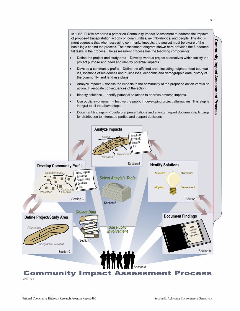
38
Section E: Achieving Environmental Sensitivity A Guide to Best Practices for Achieving Context Sensitive Solutions
39
National Cooperative Highway Research Program Report 480 Section E: Achieving Environmental Sensitivity
Com
munity Im
pact Assessm
ent Process
In 1966, FHWA prepared a primer on Community Impact Assessment to address the impacts of proposed transportation actions on communities, neighborhoods, and people. The docu-ment suggests that when assessing community impacts, the analyst must be aware of the basic logic behind the process. The assessment diagram shown here provides the fundamen-tal tasks in the process. The assessment process has the following components:
• Define the project and study area – Develop various project alternatives which satisfy the project purpose and need and identify potential impacts.
• Develop a community profile – Define the affected area, including neighborhood boundar-ies, locations of residences and businesses, economic and demographic data, history of the community, and land use plans.
• Analyze impacts – Assess the impacts to the community of the proposed action versus no action. Investigate consequences of the action.
• Identify solutions – Identify potential solutions to address adverse impacts.
• Use public involvement – Involve the public in developing project alternatives. This step is integral to all the above steps.
• Document findings – Provide oral presentations and a written report documenting findings for distribution to interested parties and support decisions.
���������
Community Impact Assessment Process
Define Project/Study Area
Develop Community Profile
Analyze Impacts
Identify Solutions
Document FindingsCollect Data
Select Anaylsis Tools
Use PublicInvolvement
Section 2
Section 3
Section 5
Section 7
Section 9
Section 6
Section 4
Section 8
Minimization
Enhancement
Avoidance
Mitigation
Minimization
Enhancement
Avoidance
Mitigation
NEPA
Community
Impact
Assessment
Study Area Boundaries
Alternatives
DemographicsEconomicsSocial HistoryLand UseEtc.
Neighborhoods
CommunityFacilitiesPopulation
Social andEconomicImpactsEtc
Access
DevelopmentRelocation
40
Section E: Achieving Environmental Sensitivity A Guide to Best Practices for Achieving Context Sensitive Solutions
41
National Cooperative Highway Research Program Report 480 Section E: Achieving Environmental Sensitivity
• Transportation demand
• Legislative mandate
• Moral relationships
• Safety issues
• Rendering deficiencies
Preparation of the project Purpose and Need requires care because it, like the problem statement, must not imply a specific solution, but must be stated in terms of underlying causes. Yet, it cannot be so broad as to invite investigation of alternatives outside a reasonable spectrum of options. Again, asking that first question can help narrow the range of alternatives and facilitate spending resources on only examining reasonable potential solutions.
In many cases, a great deal of problem analysis may already have been completed as part of the agency’s prior planning process. This prior planning work can provide data that can be used to narrow down the Purpose and Need. For example, the corridor in questions may have been evaluated and rejected as a new transit corridor, indi-cating it is only viable for Transportation System Manage-ment, Transportation Demand Management, auto, bicycle, and pedestrian modal solutions. Or, a regional planning study may have evaluated a number of bridge repair and replacement options, indicating that repair is not viable and that a new bridge must be built serving the existing corridor. It is important to take advantage of any previous work in developing a Purpose and Need statement.
ALTERNATIVES DEVELOPMENT
ENGAGE STAKEHOLDERS IN ALTERNATIVE IDENTIFICATION
This is the most creative part of the project devel-opment process, in which sets of solutions are crafted in response to the problem statement and the evaluation criteria. Alternatives are generally developed through itera-tive processes, including public, agency, and project team input.
It is important that resource and regulatory agencies as well as the general public have a meaningful opportunity to contribute ideas for solutions to the defined problem, and that the range of alternatives considered reflects the full range of ideas expressed. Documenting alternatives suggested through outreach activities, even though many will be screened out in the next step of the process, adds to the credibility of the process. It should be straightfor-ward to understand why the establishment of evaluation criteria early in the process provides an excellent frame-work for quickly narrowing the alternatives receiving full consideration.
IDENTIFY OPPORTUNITIES FOR REDUCING ADVERSE ENVIRONMENTAL IMPACTS
A key concept in both CSD/CSS and NEPA is the notion that consideration of approaches for reducing adverse environmental impacts is required in the course of developing alternatives. The first aim is to avoid impacts entirely. Avoidance not only is best environmentally, but is generally the least expensive option. One pilot state, the Minnesota DOT, illustrates the value of focusing agency resources on avoidance. Mn/DOT’s investment in MnModel (see Appendix E) was intended to provide their staff with the means to avoid archaeological sites during highway route location studies throughout the state.
If avoidance is not possible or impractical, the second aim is to minimize adverse impacts to the extent possible. Then, and only then, is mitigation considered. In other words, providing brick facing on sound walls to improve their visual appearance is a mitigation measure—com-pletely avoiding the need for sound walls, or greatly reducing the linear feet of needed sound walls are both preferable choices.
In recent years, the concept of environmental steward-ship has increasingly gained acceptance. Environmental stewardship is the practice of not only protecting, but enhancing the environment as a routine part of project development. While quite different from the formal Trans-portation Enhancements Program and dedicated funding created under ISTEA and maintained under TEA-21, it takes the familiar “avoid, minimize, mitigate” approach one step further. Environmental stewardship aims to leave environmental conditions better than they were before the project and encourages consideration of activities that are modest, natural extensions of project activities. For exam-ple, adding a fish ladder to a culvert that is included in a project is an enhancement that requires a bit more invest-ment but adds an important benefit. This approach builds credibility and trust between transportation and resource agency staff, and with the public. This broad concept of
Wildlife plantings and nest boxes for kestrels and wood ducks enhance the aesthetics of the Lake Ontario State Parkway in Monroe and Orleans County, New York, while providing wildlife shel-ter and food. Habitat is managed by mowing and selective thinning. Volunteer groups maintain the annual nest boxes. Partners in New York DOT project included the Braddock Bay Raptor Research Center; the New York State Office of Parks, Recreation, and Historic Preservation; the Nature Conservancy; and the Boy Scouts of America.
Wild
life
Feat
ures
Add
Aes
thet
ic V
alue
40
Section E: Achieving Environmental Sensitivity A Guide to Best Practices for Achieving Context Sensitive Solutions
41
National Cooperative Highway Research Program Report 480 Section E: Achieving Environmental Sensitivity
not only protecting, but enhancing the environment, is gaining acceptance and is commonly referred to as “envi-ronmental stewardship.”
Many agencies, including a number of the pilot states, have formalized processes for enhancing projects. Examples of landscaping and aesthetic design guidance documents are provided in Appendix E.
The cultural attitudes of professional design staff can also play a significant role in achieving environmental sensi-tivity and minimizing adverse impacts. Skilled highway designers take pride in minimizing construction cost or maximizing operational effectiveness of a highway. Designers that are environmental stewards can be just as effective. For example, the Maryland Route 355 project (see Section H, Case Studies) includes a unique design solution that retained a prominent, beautiful oak tree as part of a project to widen from two to six lanes. The solu-tion, which involved plan, profile, and special irrigation systems, was identified not by local or environmental stakeholders, but by highway design staff who were also environmental stewards.
ALTERNATIVES SCREENING, EVALUATION, AND SELECTION
TAILOR LEVEL OF ANALYSIS
The level of environmental analysis varies dramatically depending on the type of study and the nature of the deci-sion being made. For example, an environmental analysis of a variety of transportation improvements in a 60-mile corridor will be conducted at a much more general level of analysis than the improvements to a specific interchange. In the first case, the analysis is generally made from exist-ing secondary source information and policy-level issues; the second requires comparisons of specific project foot-print impacts.
In all cases, it is critical to obtain agreement from partici-pating agencies (and oftentimes from resource and regula-tory agencies) about the appropriate level of detail for the environmental analysis. The CSD/CSS process is likely to increase the amount of up front data gathering needed. It requires careful thinking about the types of information needed to consider all of the issues raised by stakehold-ers and embodied in the evaluation framework. If the cost of data collection is too high to be acceptable, additional work with stakeholders may be needed to modify data requirements to a more reasonable level. Existing data can be used in place of original data development. Keep in mind that the early consideration of this information is always with the goal that more options exist early in the process before there is an over-commitment of resources.
Successful and efficient project development and delivery almost always requires synchronicity between the level of detail in the engineering and environmental analysis. Failure can be expected when the level of engineering greatly exceeds the level of environmental analysis or vice versa. For example, not having enough information about the affected environment while advancing a design concept can lead to the discovery of a deal-breaker late in the process and the need to go back and search for another alternative. Conversely, having adequate information about the surrounding environment, but failing to consider the feasibility of tying in an interchange to a freeway cor-ridor can also lead to backing up and looking for another alternative. It is also critical that construction feasibility be kept in mind as attempts to avoid, minimize, or mitigate environmental issues are pursued.
The Florida Department of Transportation teamed with the Florida Department of Environmental Protection to fund the University of Florida GeoPlan Center’s efforts to consolidate, house, and maintain Florida’s publicly-funded GIS data in a digital “library” (FGDL). Data and images were gathered from numerous state and federal agencies, nonprofit organizations, and private agencies. The data was converted into uniform file formats and projections, subjected to quality control, documented, and organized into a series of CD-ROMs. The library provides uniform data, allowing professionals as well as less technically proficient people to use land use, roads, soils, hydrology, cultural features, habitat, aerial photography, and other data. Applications of the data are being used to plan Flor-ida’s Statewide Greenways System and for the Wetlands Rapid Assessment Procedure Application that assists in evaluating wetlands. A new application being developed is the Environmental Screening Analysis tools that will help screen projects with significant secondary and cumulative impacts early in the planning process.
Geo
grap
hic
Dat
a Li
brar
y Pr
ovid
es
Info
rmat
ion
for E
nviro
nmen
tal P
lann
ing
42
Section E: Achieving Environmental Sensitivity A Guide to Best Practices for Achieving Context Sensitive Solutions
43
National Cooperative Highway Research Program Report 480 Section E: Achieving Environmental Sensitivity
ENGAGE STAKEHOLDERS IN ALTERNATIVE EVALUATION
As discussed in Section C, Effective Decision Making, and Section D, Reflecting Community Values, there are many effective ways for involving stakeholders in the alterna-tives screening, evaluation, and selection process. This alternatives evaluation is central to CSD/CSS and is also the heart of the NEPA process. It is the primary method of balancing impacts and benefits while satisfying the under-lying purpose and need for the project.
Screening processes for eliminating alternatives with fatal flaws are generally employed. The aim is to eliminate infeasible concepts, ones that do not address the identified problems (that do not demonstrate a fit with the purpose and need), that cannot be reasonably engineered, that rely on untested technologies, and that are inconsistent with agency plans or policies. Cost alone cannot be used as the criterion for eliminating alternatives from consideration on projects following the NEPA process. There may be some circumstances, such as situations in which proj-ect funding is provided by a local ballot measure with a funding cap, where cost may be an acceptable screening criterion. Another example is when competing alternatives have similar benefits and impacts, but very different costs - eliminating the higher cost alternatives would be accept-able. Environmental impacts are also not generally used as screening criteria because there is no absolute standard for unacceptable levels of impact, or there are potential ways to mitigate the adverse effect. There always must be a trade-off analysis of the various benefits and impacts associated with the reasonable alternatives.
REFINE AND COMMIT TO MITIGATION STRATEGIES
Following selection of the preferred alternative, the CSD/CSS process encourages refinement of mitigation actions to be incorporated into the project, and formal commitment of resources to implement them. This allows for development of more accurate project cost estimates and easy tracking of commitments through the following phases of the project.
REFINING AND COMMITTING TO MITIGATION STRATEGIES
Public and agency comments on Draft EAs and EISs pro-vide a basis for refinement of proposed mitigation strategies in NEPA processes. Final commitments are made through agency approvals of FONSIs and RODs. In projects not involving the NEPA process, or to cover agreements made between various state and local agencies that are not signa-tories to the FONSI or ROD, an interagency agreement or
Memorandum of Understandings can be used to document agreements made by various project partners. Examples of such agreements are provided in Appendix E.
IMPLEMENTATION
MONITOR CHANGES IN DESIGN AND MITIGATION
One likely result of CSD/CSS is improvement in the level of trust between transportation and resource agencies. Considering effects on environmental resources as an integral part of alternatives development, rather than an after thought following selection of the preferred alter-native, will address many resource agency and public criticisms of transportation decision making processes. However, this trust can easily be broken if commitments made during the project development process are not honored during the final design and construction phases of the project. CSD/CSS calls for monitoring the project design and construction processes to identify changes that could affect implementation of agreed upon envi-ronmental impact avoidance, reduction, and mitigation measures. Continued consultation with resource and regulatory agencies throughout these processes is needed to ensure that inevitable changes do not increase impacts to unacceptable levels.
New
York Route 110 Interm
odal Transportation and Land U
se Study
The primary goal of this study for the New York DOT was to identify options to reduce personal vehicle use in the Route 110 Corridor in the middle of Long Island. The study examined both transportation and land use practices using a three-dimensional computer-based simulation. A preliminary visualization tool—a video-based simulation of a significant intersection in the cor-ridor—was used to inform the towns of Huntington and Babylon about the uses of visual simulation as a land use and transportation planning tool. Realistic traffic flow was correlated with the visual scene and presented in a live interactive session. This application also sets the stage for four-dimensional master planning—that is, including the element of time in simulated integrated transportation and land use planning.
42
Section E: Achieving Environmental Sensitivity A Guide to Best Practices for Achieving Context Sensitive Solutions
43
National Cooperative Highway Research Program Report 480 Section E: Achieving Environmental Sensitivity
KEY RESOURCES AND REFERENCESFederal Highway Administration. Flexibility in Highway Design, 1998.
Institute of Transportation Engineers. Traditional Neighborhood Development: Street Design Guidelines, 1999.
Maryland State Highway Administration. Aesthetic Bridges, User’s Guide. 1993.
Maryland State Highway Administration. Thinking Beyond the Pavement, A National Workshop on Integrating Highway Development with Communities and the Environment while Maintaining Safey and Performance. May, 1998.
Maryland State Highway Administration. Thinking Beyond the Pavement, Conference Summary, May, 1998.
Maryland State Highway Administration. Thinking Beyond the Pavement, Integrating Highway Development with Communities and the Environment. Charrett’e Executive Summary, May-June, 1999.
Myerson, Deborah L., AICP. Getting It Right In the Right-of-Way, Action Guide, Scenic America, 2000.
New York State Department of Transportation. Environmental Analysis Bureau Home Page. [www.dot.state.ny.us./eab/eab.html].
Project for Public Spaces, Inc. “Getting Back to Place: Using Streets to Rebuild Communities,” 1997. For copies call (212) 620-5660 or access http://www.pps.org
Transportation Research Board. Technologies to Improve Consideration of Environmental Concerns in Transportation Decisionmaking, NCHRP 25:22, CRP-CD-14, 2002.
U.S. Department of Transportation, FHWA. Community Impact Assessment: A Quick Reference for Transportation, Publication No. FHWA-PD-96-HEP-30/8-96 (10M)P, 1996.
U.S. Department of Transportation, FHWA. Community Impact Mitigation: Case Studies, Publication No. FHWA-PD-98-024-HEP-30/5-98 (30M)P, 1998.
U.S. Government Accounting Office. Scenic Byways—States’ Use of Geometric Design Standards, Report to the Chairman, Committee on Environment and Public Works, U.S. Senate. September 1995.

44
Section E: Achieving Environmental Sensitivity A Guide to Best Practices for Achieving Context Sensitive Solutions
This page intentionally left blank
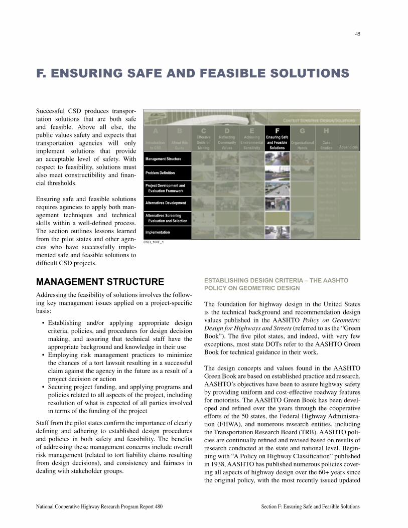
45
National Cooperative Highway Research Program Report 480 Section F: Ensuring Safe and Feasible Solutions
Successful CSD produces transpor-tation solutions that are both safe and feasible. Above all else, the public values safety and expects that transportation agencies will only implement solutions that provide an acceptable level of safety. With respect to feasibility, solutions must also meet constructibility and finan-cial thresholds.
Ensuring safe and feasible solutions requires agencies to apply both man-agement techniques and technical skills within a well-defined process. The section outlines lessons learned from the pilot states and other agen-cies who have successfully imple-mented safe and feasible solutions to difficult CSD projects.
F. ENSURING SAFE AND FEASIBLE SOLUTIONS
MANAGEMENT STRUCTUREAddressing the feasibility of solutions involves the follow-ing key management issues applied on a project-specific basis:
• Establishing and/or applying appropriate design criteria, policies, and procedures for design decision making, and assuring that technical staff have the appropriate background and knowledge in their use
• Employing risk management practices to minimize the chances of a tort lawsuit resulting in a successful claim against the agency in the future as a result of a project decision or action
• Securing project funding, and applying programs and policies related to all aspects of the project, including resolution of what is expected of all parties involved in terms of the funding of the project
Staff from the pilot states confirm the importance of clearly defining and adhering to established design procedures and policies in both safety and feasibility. The benefits of addressing these management concerns include overall risk management (related to tort liability claims resulting from design decisions), and consistency and fairness in dealing with stakeholder groups.
ESTABLISHING DESIGN CRITERIA – THE AASHTO POLICY ON GEOMETRIC DESIGN
The foundation for highway design in the United States is the technical background and recommendation design values published in the AASHTO Policy on Geometric Design for Highways and Streets (referred to as the “Green Book”). The five pilot states, and indeed, with very few exceptions, most state DOTs refer to the AASHTO Green Book for technical guidance in their work.
The design concepts and values found in the AASHTO Green Book are based on established practice and research. AASHTO’s objectives have been to assure highway safety by providing uniform and cost-effective roadway features for motorists. The AASHTO Green Book has been devel-oped and refined over the years through the cooperative efforts of the 50 states, the Federal Highway Administra-tion (FHWA), and numerous research entities, including the Transportation Research Board (TRB). AASHTO poli-cies are continually refined and revised based on results of research conducted at the state and national level. Begin-ning with “A Policy on Highway Classification” published in 1938, AASHTO has published numerous policies cover-ing all aspects of highway design over the 60+ years since the original policy, with the most recently issued updated
����������
About thisGuide
EffectiveDecisionMaking
ReflectingCommunity
Values
AchievingEnvironmental
Sensitivity
Ensuring Safeand Feasible
SolutionsOrganizational
NeedsCase
Studies Appendices
Management Structure
Problem Definition
Project Development andEvaluation Framework
Alternatives Development
Alternatives ScreeningEvaluation and Selection
Implementation
CB D E F G HIntroduction
to CSD
A
46
Section F: Ensuring Safe and Feasible Solutions A Guide to Best Practices for Achieving Context Sensitive Solutions
47
National Cooperative Highway Research Program Report 480 Section F: Ensuring Safe and Feasible Solutions
policy in 2001. Research continues in anticipation of further updates to Policy as needs change and knowledge increases.
AASHTO has developed the Policy to be flexible, recog-nizing the importance of its applicability across a wide range of conditions. AASHTO’s Bridging document to FHWA’s Flexibility in Highway Design discusses at length the flexibility in the Policy and the intent of its use.
A related design policy is the AASHTO Roadside Design Guide (RDG). This document addresses design of slopes, clear zones and recovery areas, traffic barriers (guardrail, bridge rail, median barrier), roadside hardware, curbs, and median treatments.
STATE DESIGN MANUALS AND “STANDARDS” RELATED TO THE AASHTO POLICY
Although the AASHTO policy reflects input and a consen-sus of all states, it is recognized that differences in state needs exist. States are free to adopt their own design poli-cies and guidelines, or to accept the AASHTO Policy as written. Indeed, contrary to the understanding of many, the AASHTO Policy does not represent a national standard for design of all roads. The adoption and publication of design standards for highways are the responsibility of each state DOT. While practice varies somewhat, for the most part state DOT design manuals and practices closely follow the guidance in the AASHTO Policy. Some states (Arkansas, for example) adopt the AASHTO policy as written for their practice. Most states develop independent design manuals, design charts, procedures, etc. Note, however, that in most cases the technical content of these manuals is very close to or identical to the AASHTO Policy, particularly for basic geometric design elements of the cross section and horizontal and vertical alignment.
The FHWA is by statute responsible for approving the design of highways on the designated National Highway System. Through rule-making, FHWA has adopted the AASHTO Policy as the applicable set of design values and criteria that apply to such facilities. Finally, it is important
to recognize that roads under local jurisdiction (owned and operated by counties, municipalities, or townships) may be designed and maintained to different design criteria, depending on the individual owner. Again, practice varies across the country, but many counties and municipalities follow the design guidelines and practices published by their state DOT.
The Manual on Uniform Traffic Control Devices (MUTCD), published by the FHWA, is also a key refer-ence. The MUTCD describes requirements and recom-mendations for the application and design of traffic control devices, navigational and warning signing, pavement markings, and work zone traffic control devices. Adher-ence to the MUTCD is a requirement by law.
DESIGN PHILOSOPHY AND BACKGROUND ON DESIGN CRITERIA (AASHTO)
Geometric design is defined as the design of the visible dimensions of a highway, with the objective being the “forming” of the facility to meet the functional and opera-tional characteristics of drivers, vehicles, pedestrians, and traffic. This is both a science as well as an art. Geometric design deals with features of location, alignment, profile, cross section, and intersections for a range of highway types and classification.
The geometric form and dimensions of the highway should properly reflect driver safety, desires, expectations, comfort, and convenience. It should do so within the con-text of a host of constraints and considerations, including terrain, land use features, roadside and community effects, and cost considerations.
Central to the geometric design process is the applica-tion of design criteria, guidelines, and standards. Such criteria and standards provide acceptable dimensions or values for the purpose of producing a facility of a given quality (operational and safety) in a cost-effective manner. Experience has shown that the use of generally accepted practices and concepts and uniform design values can provide a reasonable degree of safety. A uniform approach to design provides a consistent “expectation” for the user (e.g., red light at the top of a signal indication, exit to the right, appropriate operating speed, etc.). This expectation is particularly important for the inexperienced driver, the older driver, a driver unfamiliar with the road or area, the distracted or inattentive driver, or the impaired driver. A uniform design approach also addresses the safety and other needs of pedestrians and bicyclists.
“The intent of this policy is to provide guidance to the designer by referencing a recommended range of values for critical dimensions. It is not intended to be a detailed design manual….Sufficient flexibility is permitted to encourage independent designs tailored to particular situations.”
FOREWORD – AASHTO POLICY ON GEOMETRIC
DESIGN OF HIGHWAYS AND STREETS, 2001 EDITION
46
Section F: Ensuring Safe and Feasible Solutions A Guide to Best Practices for Achieving Context Sensitive Solutions
47
National Cooperative Highway Research Program Report 480 Section F: Ensuring Safe and Feasible Solutions
Most agencies develop and use what are referred to as standard drawings, standard details, and other documents referred to as design standards. Such documents are useful in that they promote design efficiencies (i.e., in most cases it is not necessary and not cost effective to originally design a feature from scratch each time a project is designed) and as such represent good quality control practices.
Designers and the public should not confuse use of design standards with providing a “standard” design. A standard design is not always the “best” design. Site-specific issues that dictate another, more “context-sensitive” solution must often be considered. Merely applying a design that complies with standards or criteria is not always the best solution. Designers are often required to be creative and sensitive in addressing the many facets of design to fit a particular situation. As designers respond to increasing concerns over community values, social, economic, and environmental constraints, the need for flexibility in the design process becomes more significant. Flexibility is best achieved by experienced design professionals in con-sideration of all known factors and related trade-offs. It should not be viewed as a reduction in geometric criteria. Of course, in the pursuit of flexibility, the expected safety performance of the facility should be consistent with that expected of a “full standard” design.
ALTERNATIVE SOURCES OF DESIGN CRITERIA AND GUIDELINES
AASHTO is not the only source of geometric design cri-teria. Other agencies have developed alternative design criteria and dimensions to suit their special context and needs. For example, the AASHTO Policy reflects a strong consideration of travel efficiency, and meeting driver desires to minimize travel times. Thus, emphasis is placed on geometric values that enable as high a design speed as is practical for the context. For roads designed for the National Park Service, a different design philosophy applies, with attendant different design values.
FHWA’s Flexibility in Highway Design suggests the use of special design criteria for special purpose roads such as scenic byways, parkways, etc.
The Institute of Transportation Engi-neers is another source of design criteria for urban roads and residential streets.
Another case is represented by the Vermont Agency of Transportation. In response to statewide dissatisfaction
with the design impacts associated with AASHTO Policy values, the Vermont legislature passed legislation direct-ing the use of alternative design values for Vermont roads. These values represent somewhat lesser dimensions than are suggested by AASHTO Policy, although the differences are in many cases nominal. (These new design standards have been in effect now for about 5 years, with no apparent degradation in safety or loss of design flexibility.)
The Florida DOT has developed design values for projects or corridors in urban areas identified as relating to livable community problems. Somewhat different design dimen-sions apply than other state highway facilities.
Finally, most transportation agencies recognize there is a difference between projects that are newly constructed or completely reconstructed, versus those involving 3R. For the latter projects, it is typical practice to employ differ-ent, generally less restrictive design criteria. One source of such criteria that is referenced by many states is Transpor-tation Research Board Special Report 214.
Exhibit F-1 (following page) illustrates the range of design values suggested in the AASHTO Policy and the other sources of criteria for both Rural Principal Arterials and Rural Minor Collectors. While there are clearly simi-larities, also note that, depending on the agency and condi-tions, all basic cross section dimensions may vary.
TORT LIABILITY, DESIGN EXCEPTIONS, AND RISK MANAGEMENT
Most state DOTs and local agencies must deal with the issue of tort liability. Agencies are faced with defending their actions such as design decisions in the face of lawsuits stemming from traffic crashes on their system. Given that a certain number of crashes is inevitable, and laws permit such suits, the number of lawsuits filed and increasing sizes of awards to plaintiffs are a source of great concern among many personnel of transportation agencies.
An agency’s management structure and project development processes, including use of design criteria, design decision making, and documentation practices, are all important aspects of good risk management.
“Park roads are for leisurely driving only. If you are in a hurry, you might do well to take another route now, and come back when you have more time.”
PARK ROAD STANDARDS, NATIONAL PARK SERVICE, 1984
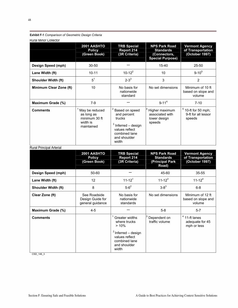
48
Section F: Ensuring Safe and Feasible Solutions A Guide to Best Practices for Achieving Context Sensitive Solutions
49
National Cooperative Highway Research Program Report 480 Section F: Ensuring Safe and Feasible Solutions
Rural Minor Collector2001 AASHTO
Policy(Green Book)
TRB SpecialReport 214
(3R Criteria)
NPS Park RoadStandards
(Connectors,Special Purpose)
Vermont Agencyof Transportation
(October 1997)
Design Speed (mph) 30-50 — 15-40 25-50
Lane Width (ft) 10-11 10-122 10 9-105
Shoulder Width (ft) 51 2-33 3 2
Minimum Clear Zone (ft) 10 No basis fornationwidestandard
No set dimensions Minimum of 10 ftbased on slope and
volume
Maximum Grade (%) 7-9 — 9-114 7-10
Comments 1 May be reducedas long asminimum 30 ftwidth ismaintained
2 Based on speedand percenttrucks
3 Inferred – designvalues reflectcombined laneand shoulderwidth
4 Higher maximumassociated withlower designspeeds
5 10-ft for 50 mph;9-ft for all lessorspeeds
Rural Principal Arterial2001 AASHTO
Policy(Green Book)
TRB SpecialReport 214
(3R Criteria)
NPS Park RoadStandards
(Principal ParkRoad)
Vermont Agencyof Transportation
(October 1997)
Design Speed (mph) 50-60 — 45-60 35-55
Lane Width (ft) 12 11-121 11-123 11-124
Shoulder Width (ft) 8 5-62 3-83 6-8
Clear Zone (ft) See RoadsideDesign Guide forgeneral guidance
No basis fornationwidestandards
No set dimensions Minimum of 12 ftbased on slope and
volume
Maximum Grade (%) 4-5 — 5-8 5-7
Comments 1 Greater widthswhere trucks> 10%
2 Inferred – designvalues reflectcombined laneand shoulderwidth
3 Dependent ontraffic volume
4 11-ft lanesadequate for 45mph or less
CSD_146_3
Exhibit F-1 Comparison of Geometric Design Criteria
48
Section F: Ensuring Safe and Feasible Solutions A Guide to Best Practices for Achieving Context Sensitive Solutions
49
National Cooperative Highway Research Program Report 480 Section F: Ensuring Safe and Feasible Solutions
OVERVIEW OF TORT ISSUES
Technical staff of agencies and consultants responsible for roadway design should understand basic concepts of tort law as they apply to highway planning and design. For the most part, states have similar common law of torts. If there is a legal duty that is breached (negligence), and it caused injury or damages, then the injured party can be compen-sated by the negligent party through the courts.
The courts do not expect public officials, including staff of the transportation agency, to be perfect, nor to make the best possible decisions. It is simply asked that the decisions made and actions taken be reasonable under the circumstances. In many cases in which a transportation agency is found negligent and the plaintiff receives a large award, it is because either someone in that agency was found to have simply failed to exercise ordinary, reason-able care, or the decision making process was so poorly documented that it could not be shown to be reasonable in court.
When negligence is claimed, there are usually six principle issues that must be resolved in court.
Did damages occur? It must first be proven that the plaintiff suffered damages.
Did a potentially dangerous defect exist? The courts do not expect transportation agencies to guarantee that their roads are absolutely safe under all possible conditions. However, drivers should be able to expect that a highway is reasonably safe for usual and ordinary traffic and road users who are exercising reasonable and prudent care, both in the daytime and at night. “Defects” may be conditions or objects that are extraordinary in nature that drivers cannot see or anticipate or have not been warned about.
Was the defect a “proximate” cause of the damages? The fact that a defective condition existed does not neces-sarily mean that the governmental agency was negligent. The defect must be found to be a proximate cause of the plaintiff’s damages.
Did the agency have knowledge of the defect? Negli-gence requires knowledge of a problem. Once a govern-mental agency has received notice of a defect, a duty may arise to repair the defect or at least to warn drivers until it can be repaired. Simply ignoring a safety problem, or failing to document and study it, does not shield an agency from tort claims.
Was the transportation agency acting in a “discretionary” or “ministerial” role? Discretion means the power and duty to make a choice among alternatives. Agencies exer-
cise discretion through the independent judgment of how to allocate available resources, what impacts to accept, and which priorities to address. Planning, design, policy, and legislative actions are typically considered discretion-ary. In the absence of obvious defects, some courts may provide protection for discretionary decisions. In other words, a plaintiff may not be able to challenge a decision that was discretionary in nature. The concept is that judges and juries should not substitute their judgment for those of professionals in technical matters.
Ministerial functions are considered distinctly different in some jurisdictions from discretionary functions. These generally involve clearly defined tasks performed with minimal leeway for personal judgment. Roadway mainte-nance functions (filling potholes, replacing signs, plowing snow) are typically considered to be ministerial in nature.
Did the plaintiff contribute to the crash through neg-ligent behavior? Contributory negligence is considered conduct which falls below the standard of care which individuals must exercise for their own safety and which contributed to the injuries. In most states, the relative negligence of all parties is compared, and any award to the plaintiff may be reduced proportional to the plaintiff’s relative contribution to the crash. The concept of “joint and several liability,” used in many, but not all states, means that all defendants have a joint responsibility to the plain-tiff. If one defendant cannot afford to pay their share of the award to the plaintiff, then the other defendants must increase their payments to fully compensate the plaintiff.
As was noted above, roadway planning and design are by their nature discretionary processes, involving profes-sionals assessing trade-offs among operational efficiency, costs, safety, environmental impacts, and community concerns. Such trade-offs are inherent to CSD. In gen-eral, many courts will support the role of the designer in making such discretionary decisions. Discretionary decisions can enjoy protection from claims of negligence as long as the designers can show that, in fact, they exer-cised this discretion by carefully evaluating alternatives and weighing the important trade-offs. (Note that in some jurisdictions courts may apply tests of reasonableness to decide whether a design action is discretionary and thus immune from challenge. Adherence to accepted practices (e.g., consistency with the AASHTO policy) may serve as proof of reasonableness.) However, immunity has been held not to apply to decisions made without prior study or conscious deliberation; in other words, when there is a failure to exercise “due care” in the planning and design process. (Note that the ability to prove that “due care” was exercised will more often than not depend on the availabil-ity of required documentation.)
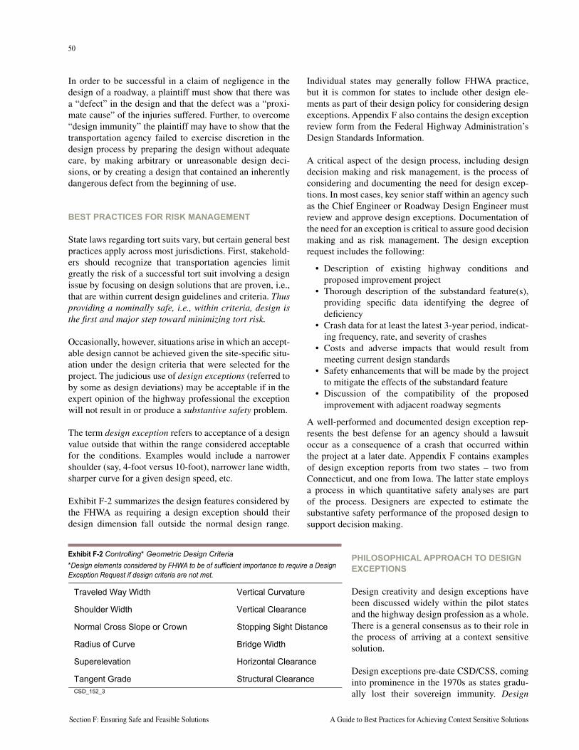
50
Section F: Ensuring Safe and Feasible Solutions A Guide to Best Practices for Achieving Context Sensitive Solutions
51
National Cooperative Highway Research Program Report 480 Section F: Ensuring Safe and Feasible Solutions
In order to be successful in a claim of negligence in the design of a roadway, a plaintiff must show that there was a “defect” in the design and that the defect was a “proxi-mate cause” of the injuries suffered. Further, to overcome “design immunity” the plaintiff may have to show that the transportation agency failed to exercise discretion in the design process by preparing the design without adequate care, by making arbitrary or unreasonable design deci-sions, or by creating a design that contained an inherently dangerous defect from the beginning of use.
BEST PRACTICES FOR RISK MANAGEMENT
State laws regarding tort suits vary, but certain general best practices apply across most jurisdictions. First, stakehold-ers should recognize that transportation agencies limit greatly the risk of a successful tort suit involving a design issue by focusing on design solutions that are proven, i.e., that are within current design guidelines and criteria. Thus providing a nominally safe, i.e., within criteria, design is the first and major step toward minimizing tort risk.
Occasionally, however, situations arise in which an accept-able design cannot be achieved given the site-specific situ-ation under the design criteria that were selected for the project. The judicious use of design exceptions (referred to by some as design deviations) may be acceptable if in the expert opinion of the highway professional the exception will not result in or produce a substantive safety problem.
The term design exception refers to acceptance of a design value outside that within the range considered acceptable for the conditions. Examples would include a narrower shoulder (say, 4-foot versus 10-foot), narrower lane width, sharper curve for a given design speed, etc.
Exhibit F-2 summarizes the design features considered by the FHWA as requiring a design exception should their design dimension fall outside the normal design range.
Individual states may generally follow FHWA practice, but it is common for states to include other design ele-ments as part of their design policy for considering design exceptions. Appendix F also contains the design exception review form from the Federal Highway Administration’s Design Standards Information.
A critical aspect of the design process, including design decision making and risk management, is the process of considering and documenting the need for design excep-tions. In most cases, key senior staff within an agency such as the Chief Engineer or Roadway Design Engineer must review and approve design exceptions. Documentation of the need for an exception is critical to assure good decision making and as risk management. The design exception request includes the following:
• Description of existing highway conditions and proposed improvement project
• Thorough description of the substandard feature(s), providing specific data identifying the degree of deficiency
• Crash data for at least the latest 3-year period, indicat-ing frequency, rate, and severity of crashes
• Costs and adverse impacts that would result from meeting current design standards
• Safety enhancements that will be made by the project to mitigate the effects of the substandard feature
• Discussion of the compatibility of the proposed improvement with adjacent roadway segments
A well-performed and documented design exception rep-resents the best defense for an agency should a lawsuit occur as a consequence of a crash that occurred within the project at a later date. Appendix F contains examples of design exception reports from two states – two from Connecticut, and one from Iowa. The latter state employs a process in which quantitative safety analyses are part of the process. Designers are expected to estimate the substantive safety performance of the proposed design to support decision making.
PHILOSOPHICAL APPROACH TO DESIGN EXCEPTIONS
Design creativity and design exceptions have been discussed widely within the pilot states and the highway design profession as a whole. There is a general consensus as to their role in the process of arriving at a context sensitive solution.
Design exceptions pre-date CSD/CSS, coming into prominence in the 1970s as states gradu-ally lost their sovereign immunity. Design
Traveled Way Width Vertical Curvature
Shoulder Width Vertical Clearance
Normal Cross Slope or Crown Stopping Sight Distance
Radius of Curve Bridge Width
Superelevation Horizontal Clearance
Tangent Grade Structural ClearanceCSD_152_3
Exhibit F-2 Controlling* Geometric Design Criteria*Design elements considered by FHWA to be of sufficient importance to require a Design Exception Request if design criteria are not met.
50
Section F: Ensuring Safe and Feasible Solutions A Guide to Best Practices for Achieving Context Sensitive Solutions
51
National Cooperative Highway Research Program Report 480 Section F: Ensuring Safe and Feasible Solutions
exceptions are not viewed as essential to successful CSD/CSS. Creativity or flexibility in design should not be equated with ignoring design criteria or an agency’s accepted design practices. Staff from the pilot states con-firm that the concept of flexibility in highway design does not translate to operating outside their geometric design policies. In Maryland, staff note that the number of design exceptions has not increased since Thinking Beyond the Pavement/Context Sensitive Design has become the normal course of business. This view is also confirmed by staff in Connecticut. Kentucky’s most difficult and land-mark CSD/CSS project, reconstruction of the Paris Pike, was completed without any design exceptions.
BEST PRACTICES FOR RISK MANAGEMENT
The minimizing of tort claims and the support of good decisions, should be a concern to all stakeholders. It is in everyone’s interest to avoid situations that increase the substantive safety risk to motorists, pedestrians, or others. Tort claims paid by an agency represent taxpayer funds that cannot be used for other public purposes.
Discussions with risk managers for various DOTs, and a review of the literature on tort laws and liability provide a consistent message. Full application of the CSD/CSS design processes discussed here supports risk manage-ment, as demonstrated in the following:
Consider Multiple Alternatives – Thorough consideration of multiple alternatives, including explanation for why a full standard design may not be possible or desirable, and what alternatives are, represents good risk management practices. This practice highlights the concept of design as representing discretionary choices.
Evaluate and Document Design Decisions—Design reports should document the expected operational and safety performance of the proposal. Stakeholder engage-ment, including developing, evaluating, and discussing different alternatives requires documentation. All such documentation can and should be readily available to place in project files for later reference. Special care should be taken where a new or creative concept is proposed such as a roundabout or traffic calming feature. If a design exception is needed, documentation should be complete, including a full description of the need for the excep-tion based on adverse effects on community values, the environment, etc.
Maintain Control Over Design Decision Making – The owning agency must stay in control of decisions regard-ing basic design features or elements. Active stakeholder
involvement and input does not translate to abrogation of the responsibility of the agency to make fundamental design decisions.
Demonstrate a Commitment to Mitigate Safety Concerns – Where a design exception or unusual solution is pro-posed, plan completion should focus on mitigation. Deci-sions to maintain trees along the roadside, for example, may be accompanied by special efforts to delineate the edgeline and/or trees, implement shoulder rumble strips, or provide guardrail or other roadside barriers.
Monitor Design Exceptions to Improve Decision Making – A few states make a special effort to keep a record of design exceptions by location, committing to review their safety performance over time. The intent is not to second guess a decision, but to build on and improve a knowledge base for future decisions regarding design exceptions.
Despite the best efforts of designers, crashes occur and tort claims are filed. An overriding concern of design agency staff (designers, quality managers, decision makers, and risk managers) is not necessarily the avoidance of such claims, but rather the defense of a good and appropriate decision should a claim be made. Some risk managers try to encourage their agency’s staff to do the right thing, i.e., to perform their job in the best professional manner and not worry about the agency being sued. Following the best practices outlined above is all that can and should be expected of professional staff of an agency.
PROJECT FUNDING, PROGRAMS, AND POLICIES
A financially feasible project is one that can be imple-mented completely within the normal constraints, prior-ity programs, and agency policies. A context sensitive approach and solution may involve incorporating special design features, enhancements, or other investments that either mitigate an adverse effect or help to achieve accep-tance by key stakeholders. Such features may require not only an initial investment, but also an ongoing commit-ment for maintenance or other resources. The management challenge, of course, is to avoid the Christmas tree effect on every project, and also to make commitments consis-tently for all stakeholders.
Project staff from Minnesota and Maryland DOTs high-lighted the importance of establishing policies regarding what would or could be included as part of any project. Best management practices suggest that policies be estab-lished and communicated to stakeholders at the beginning of the project so ground rules are established prior to alter-natives development.
52
Section F: Ensuring Safe and Feasible Solutions A Guide to Best Practices for Achieving Context Sensitive Solutions
53
National Cooperative Highway Research Program Report 480 Section F: Ensuring Safe and Feasible Solutions
Most states have well-defined policies and programs for implementing noise barriers, wetland mitigation sites, and other environmental mitigation. Other issues, however, not specifically mandated by NEPA or other regulation, have become commonplace, particularly with projects in urban areas. The following are areas that pilot states and other DOTs have focused on in development CSD/CSS-related management policies on project funding:
• Undergrounding of utilities (what would be paid for, cost sharing)
• Pedestrian and streetscape amenities (roadside fur-niture, decorative lighting), including what can be included in a project and what can be paid for by the state
• Landscape maintenance (agreements for local juris-dictional care of median and roadside landscaping; note that such agreements in the case of Maryland influence what the DOT is willing to commit to implementing)
• Policies on funding and/or including artwork• Policies on funding aesthetic bridge and retaining
wall treatments (practice in Minnesota is to commit a fixed percentage of a project based on its estimated construction cost)
Even in cases where state DOT policies preclude direct reimbursement for certain items, best practices as put forth by Maryland, for example, allow for their inclusion in a project, with the DOT reimbursed separately by the local government.
These policies are seen by the pilot states as being essen-tial to striking a balance between adhering to financial controls and limits, and properly dealing with these impor-tant issues not as extras but rather as important aspects of each project. At a minimum, they set the ground rules with communities so that an understanding exists at the project outset.
PROBLEM DEFINITIONEvery transportation project is intended to address one or more problems. Successful CSD/CSS starts with a clear definition of the transportation problem(s). This includes both technical analysis and communication with stakeholders. Transportation problems can be broadly categorized as:
• Safety driven
• Mobility driven
• Infrastructure replacement or rehabilitation
• Enhancement
• Economic development
The type and nature of the problems being addressed should relate directly to a project’s purpose and need (see Section E). While not all projects require a purpose and need statement, all projects are intended to address one or more problems.
Pilot state staff agree that projects that run into difficul-ties in completion are often those for which the problem is either not well understood, not agreed to by key stakehold-ers, or not articulated or explained.
HIGHWAY SAFETY PROBLEMS – UNDERSTANDING SUBSTANTIVE AND NOMINAL SAFETY
Not every project is safety driven. However, in the execu-tion of every project, concerns about public safety are almost always evident. The characterization of a highway or alternative as being “safe” or “unsafe” is often at the center of controversy involving a proposal and even in some cases the entire project.
Best practice in engaging stakeholders and making deci-sions about what is acceptable focuses on two aspects of safety. Hauer refers to the concept of nominal safety and substantive safety. While this terminology is rela-tively new, the concepts are not and are reflected in good practices by many of the pilot states.
Nominal safety refers to a design or alternative’s adher-ence to design criteria and/or standards. Designers and agencies responsible for the transportation network have an obligation to provide a design that meets the needs of most drivers, that allows for drivers to operate both legally and safely, and that is consistent with accepted design practices. Design criteria such as are published in the AASHTO policy, and signing and traffic control practices as indicated in the MUTCD represent or define nominal safety for a highway.
Substantive safety refers to the actual performance of a highway or facility as measured by its crash experience (number of crashes per mile per year, consequences of those crashes as specified by injuries, fatalities, or prop-erty damage). One would characterize a road or road segment as being substantively safe or unsafe based on its performance relative to expectation.
It is important to note that the two types of safety, while often related, are not the same thing. It is not uncommon to have a road that is nominally safe (i.e., all of its geometric features meet design criteria) but substantively unsafe (i.e., there is a known or demonstrated high crash problem).
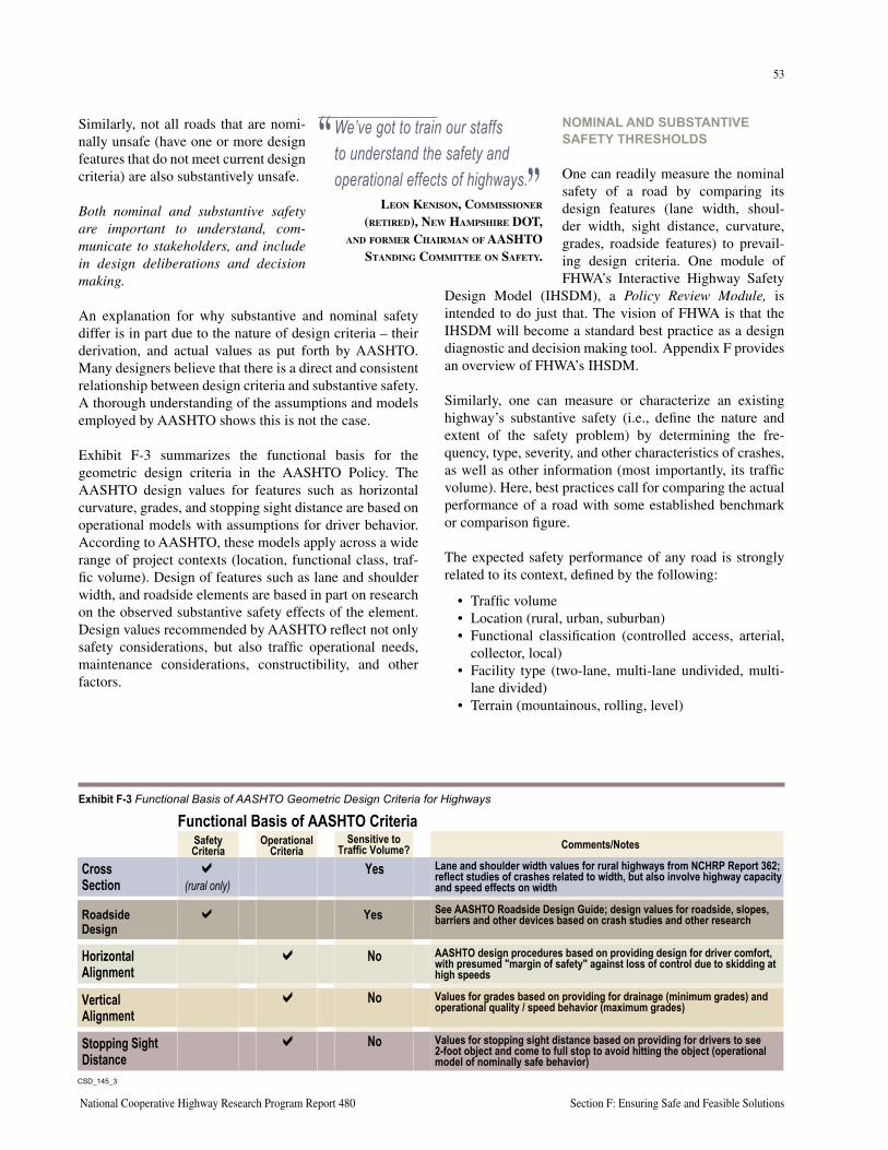
52
Section F: Ensuring Safe and Feasible Solutions A Guide to Best Practices for Achieving Context Sensitive Solutions
53
National Cooperative Highway Research Program Report 480 Section F: Ensuring Safe and Feasible Solutions
Similarly, not all roads that are nomi-nally unsafe (have one or more design features that do not meet current design criteria) are also substantively unsafe.
Both nominal and substantive safety are important to understand, com-municate to stakeholders, and include in design deliberations and decision making.
An explanation for why substantive and nominal safety differ is in part due to the nature of design criteria – their derivation, and actual values as put forth by AASHTO. Many designers believe that there is a direct and consistent relationship between design criteria and substantive safety. A thorough understanding of the assumptions and models employed by AASHTO shows this is not the case.
Exhibit F-3 summarizes the functional basis for the geometric design criteria in the AASHTO Policy. The AASHTO design values for features such as horizontal curvature, grades, and stopping sight distance are based on operational models with assumptions for driver behavior. According to AASHTO, these models apply across a wide range of project contexts (location, functional class, traf-fic volume). Design of features such as lane and shoulder width, and roadside elements are based in part on research on the observed substantive safety effects of the element. Design values recommended by AASHTO reflect not only safety considerations, but also traffic operational needs, maintenance considerations, constructibility, and other factors.
NOMINAL AND SUBSTANTIVE SAFETY THRESHOLDS
One can readily measure the nominal safety of a road by comparing its design features (lane width, shoul-der width, sight distance, curvature, grades, roadside features) to prevail-ing design criteria. One module of FHWA’s Interactive Highway Safety
Design Model (IHSDM), a Policy Review Module, is intended to do just that. The vision of FHWA is that the IHSDM will become a standard best practice as a design diagnostic and decision making tool. Appendix F provides an overview of FHWA’s IHSDM.
Similarly, one can measure or characterize an existing highway’s substantive safety (i.e., define the nature and extent of the safety problem) by determining the fre-quency, type, severity, and other characteristics of crashes, as well as other information (most importantly, its traffic volume). Here, best practices call for comparing the actual performance of a road with some established benchmark or comparison figure.
The expected safety performance of any road is strongly related to its context, defined by the following:
• Traffic volume• Location (rural, urban, suburban)• Functional classification (controlled access, arterial,
collector, local)• Facility type (two-lane, multi-lane undivided, multi-
lane divided)• Terrain (mountainous, rolling, level)
“ We’ve got to train our staffs to understand the safety and operational effects of highways.”
LEON KENISON, COMMISSIONER (RETIRED), NEW HAMPSHIRE DOT,
AND FORMER CHAIRMAN OF AASHTO STANDING COMMITTEE ON SAFETY.
CSD_145_3
Cross a Yes Section (rural only)
Roadside a Yes Design
Horizontal a NoAlignment
Vertical a No Alignment
Stopping Sight a No Distance
Safety Criteria
Operational Criteria
Sensitive to Traffic Volume? Comments/Notes
Functional Basis of AASHTO Criteria
Lane and shoulder width values for rural highways from NCHRP Report 362; reflect studies of crashes related to width, but also involve highway capacity and speed effects on width
See AASHTO Roadside Design Guide; design values for roadside, slopes, barriers and other devices based on crash studies and other research
AASHTO design procedures based on providing design for driver comfort, with presumed "margin of safety" against loss of control due to skidding at high speeds
Values for grades based on providing for drainage (minimum grades) and operational quality / speed behavior (maximum grades)
Values for stopping sight distance based on providing for drivers to see 2-foot object and come to full stop to avoid hitting the object (operational model of nominally safe behavior)
Exhibit F-3 Functional Basis of AASHTO Geometric Design Criteria for Highways
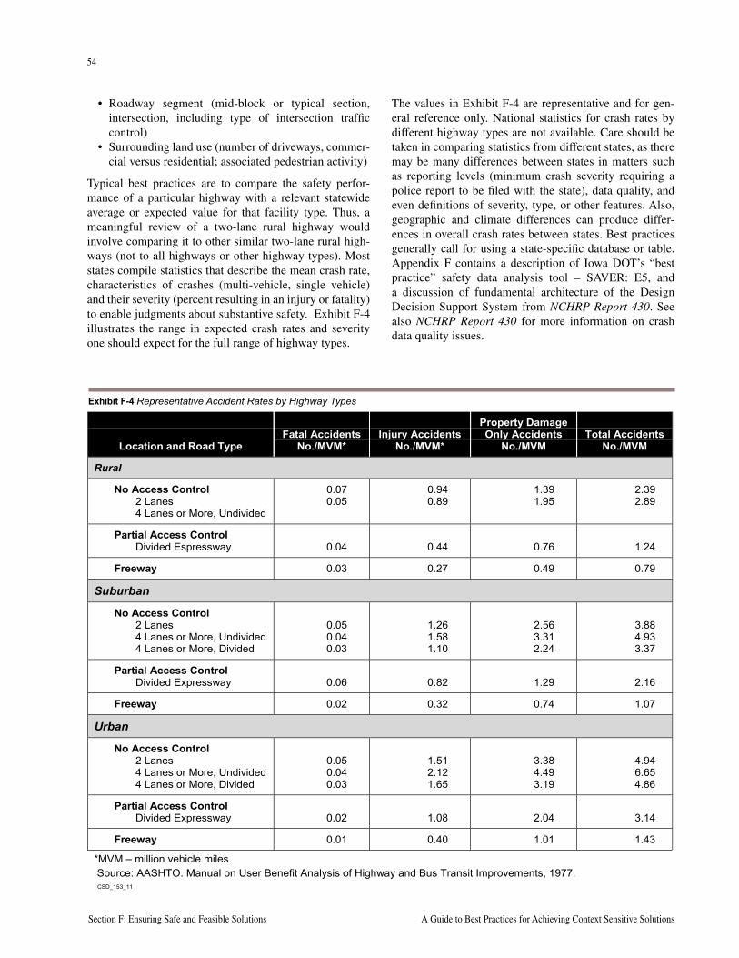
54
Section F: Ensuring Safe and Feasible Solutions A Guide to Best Practices for Achieving Context Sensitive Solutions
55
National Cooperative Highway Research Program Report 480 Section F: Ensuring Safe and Feasible Solutions
• Roadway segment (mid-block or typical section, intersection, including type of intersection traffic control)
• Surrounding land use (number of driveways, commer-cial versus residential; associated pedestrian activity)
Typical best practices are to compare the safety perfor-mance of a particular highway with a relevant statewide average or expected value for that facility type. Thus, a meaningful review of a two-lane rural highway would involve comparing it to other similar two-lane rural high-ways (not to all highways or other highway types). Most states compile statistics that describe the mean crash rate, characteristics of crashes (multi-vehicle, single vehicle) and their severity (percent resulting in an injury or fatality) to enable judgments about substantive safety. Exhibit F-4 illustrates the range in expected crash rates and severity one should expect for the full range of highway types.
The values in Exhibit F-4 are representative and for gen-eral reference only. National statistics for crash rates by different highway types are not available. Care should be taken in comparing statistics from different states, as there may be many differences between states in matters such as reporting levels (minimum crash severity requiring a police report to be filed with the state), data quality, and even definitions of severity, type, or other features. Also, geographic and climate differences can produce differ-ences in overall crash rates between states. Best practices generally call for using a state-specific database or table. Appendix F contains a description of Iowa DOT’s “best practice” safety data analysis tool – SAVER: E5, and a discussion of fundamental architecture of the Design Decision Support System from NCHRP Report 430. See also NCHRP Report 430 for more information on crash data quality issues.
Location and Road TypeFatal Accidents
No./MVM*Injury Accidents
No./MVM*
Property DamageOnly Accidents
No./MVMTotal Accidents
No./MVM
Rural
No Access Control2 Lanes4 Lanes or More, Undivided
0.070.05
0.940.89
1.391.95
2.392.89
Partial Access ControlDivided Espressway 0.04 0.44 0.76 1.24
Freeway 0.03 0.27 0.49 0.79
Suburban
No Access Control2 Lanes4 Lanes or More, Undivided4 Lanes or More, Divided
0.050.040.03
1.261.581.10
2.563.312.24
3.884.933.37
Partial Access ControlDivided Expressway 0.06 0.82 1.29 2.16
Freeway 0.02 0.32 0.74 1.07
Urban
No Access Control2 Lanes4 Lanes or More, Undivided4 Lanes or More, Divided
0.050.040.03
1.512.121.65
3.384.493.19
4.946.654.86
Partial Access ControlDivided Expressway 0.02 1.08 2.04 3.14
Freeway 0.01 0.40 1.01 1.43
*MVM – million vehicle miles Source: AASHTO. Manual on User Benefit Analysis of Highway and Bus Transit Improvements, 1977. CSD_153_11
Exhibit F-4 Representative Accident Rates by Highway Types
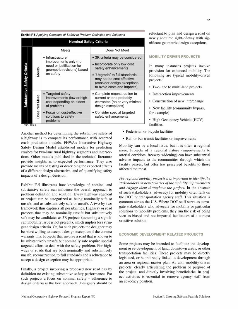
54
Section F: Ensuring Safe and Feasible Solutions A Guide to Best Practices for Achieving Context Sensitive Solutions
55
National Cooperative Highway Research Program Report 480 Section F: Ensuring Safe and Feasible Solutions
Another method for determining the substantive safety of a highway is to compare its performance with accepted crash prediction models. FHWA’s Interactive Highway Safety Design Model established models for predicting crashes for two-lane rural highway segments and intersec-tions. Other models published in the technical literature provide insights as to expected performance. They also provide means of testing or describing the expected effects of a different design alternative, and of quantifying safety impacts of a design decision.
Exhibit F-5 illustrates how knowledge of nominal and substantive safety can influence the overall approach to problem definition and solution. Every highway segment or project can be categorized as being nominally safe or unsafe; and as substantively safe or unsafe. A two-by-two framework thus captures all possibilities. Highway or road projects that may be nominally unsafe but substantively safe may be candidates as 3R projects (assuming a signifi-cant mobility issue is not present), which implies less strin-gent design criteria. Or, for such projects the designer may be more willing to accept a design exception if the context warrants this. Projects that involve a road that is known to be substantively unsafe but nominally safe require special targeted effort to deal with the safety problem. For high-ways or roads that are both nominally and substantively unsafe, reconstruction to full standards and a reluctance to accept a design exception may be appropriate.
Finally, a project involving a proposed new road has by definition no existing substantive safety performance. For such projects a focus on nominal safety – adherence to design criteria is the best approach. Designers should be
reluctant to plan and design a road on newly acquired right-of-way with sig-nificant geometric design exceptions.
MOBILITY-DRIVEN PROJECTS
In many instances projects involve provision for enhanced mobility. The following are typical mobility-driven projects:
• Two-lane to multi-lane projects
• Intersection improvements
• Construction of new interchange
• New facility (community bypass,for example)
• High Occupancy Vehicle (HOV) facilities
• Pedestrian or bicycle facilities
• Rail or bus transit facilities or improvements
Mobility can be a local issue, but it is often a regional issue. Projects of a regional nature (improvements to arterial corridors, freeway widening) can have substantial adverse impacts to the communities through which the facility passes, but offer few perceived benefits to those affected the most.
For regional mobility projects it is important to identify the stakeholders or beneficiaries of the mobility improvements and engage them throughout the project. In the absence of such stakeholders, advocacy for mobility often falls on the DOT or transportation agency staff. This situation is common across the U.S. Where DOT staff serve as surro-gate stakeholders who advocate for mobility or particular solutions to mobility problems, they run the risk of being seen as biased and not impartial facilitators of a context sensitive solution.
ECONOMIC DEVELOPMENT RELATED PROJECTS
Some projects may be intended to facilitate the develop-ment or re-development of land, downtown areas, or other transportation facilities. These projects may be directly legislated, or be indirectly linked to development through an area or regional master plan. As with mobility-driven projects, clearly articulating the problem or purpose of the project, and directly involving beneficiaries in proj-ect activities is essential to remove agency staff from an advocacy position.
CSD_163_NOMINALVSSUBSTANTIVE_REV2.DOC 1
Nominal Safety Criteria
Meets Does Not Meet
Mee
ts
• Infrastructureimprovements only (noneed or justification forgeometric revisions) basedon safety
• 3R criteria may be considered
• Incorporate only low costsafety enhancements
• “Upgrade” to full standardsmay not be cost effective(consider design exceptionsto avoid costs and impacts)
Subs
tant
ive
Safe
ty C
riter
ia
Doe
s N
ot M
eet • Targeted safety
improvements (low or highcost depending on extentof problem)
• Focus on cost-effectivesolutions to safetyproblems
• Complete reconstruction tocurrent criteria probablywarranted (no or very minimaldesign exceptions)
• Consider special targetedsafety enhancements
CSD_163_2
Exhibit F-5 Applying Concepts of Safety to Problem Definition and Solutions
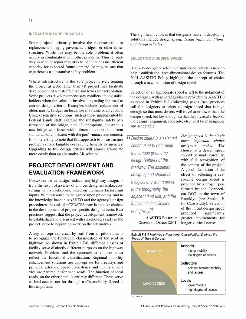
56
Section F: Ensuring Safe and Feasible Solutions A Guide to Best Practices for Achieving Context Sensitive Solutions
57
National Cooperative Highway Research Program Report 480 Section F: Ensuring Safe and Feasible Solutions
INFRASTRUCTURE PROJECTS
Some projects primarily involve the reconstruction or replacement of aging pavement, bridges, or other infra-structure. While this may be the sole problem, it often occurs in combination with other problems. Thus, a road-way in need of repair may also be one that has insufficient capacity for expected future demand, or may be one that experiences a substantive safety problem.
Where infrastructure is the sole project driver, treating the project as a 3R rather than 4R project may facilitate development of a cost-effective and lower impact solution. Some projects develop unnecessary conflicts among stake-holders when the solution involves upgrading the road to current design criteria. Examples include replacement of older, narrow bridges on local, lower volume county roads. Context sensitive solutions, such as those implemented by Federal Lands staff, examine the substantive safety per-formance of the bridge, and, if appropriate, construct a new bridge with lesser width dimensions than the current standard, but consistent with the performance and context. It is interesting to note that this approach to infrastructure problems offers tangible cost saving benefits to agencies. Upgrading to full design criteria will almost always be more costly than an alternative 3R solution.
PROJECT DEVELOPMENT AND EVALUATION FRAMEWORK Context sensitive design; indeed, any highway design, is truly the result of a series of choices designers make, con-sulting with stakeholders, based on the many factors and inputs. With reference to the agreed upon problems, and to the knowledge base in AASHTO and the agency’s design procedures, the task of a CSD/CSS team is to make choices in the development of project-specific design criteria. Best practices suggest that the project development framework be established and discussed with stakeholders early in the project, prior to beginning work on the alternatives.
A key concept expressed by staff from all pilot states is to recognize the functional classification of the road or highway. As shown in Exhibit F-6, different classes of facility serve distinctly different purposes on the highway network. Problems and the approach to solutions must reflect the functional classification. Regional mobility enhancement solutions are appropriate for freeways and principal arterials. Speed consistency and quality of ser-vice are paramount for such roads. The function of local roads, on the other hand, is entirely different. These serve as land access, not for through traffic mobility. Speed is less important.
The significant choices that designers make in developing solutions include design speed, design traffic conditions, and design vehicles.
SELECTING A DESIGN SPEED
Highway designers select a design speed, which is used to help establish the three-dimensional design features. The 2001 AASHTO Policy highlights the concept of choice through a new definition of design speed:
Selection of an appropriate speed is left to the judgment of the designer, with general guidance provided by AASHTO as noted in Exhibit F-7 (following page). Best practices call for designers to select a design speed that is high enough so that most drivers will travel at or lower than the design speed, but low enough so that the physical effects of the design (alignment, roadside, etc.) will be manageable and acceptable.
Design speed is the single most important choice designers make. The choice of a design speed should be made carefully, with full recognition of the context of the project. A good illustration of the effect of selecting a rea-sonable design speed is provided by a project per-formed by the Connecti-cut DOT in the town of Brooklyn (see Section H for Case Study). Selection of the initial design speed produced significantly greater requirements for longer vertical curves, and
“ Design speed is a selected speed used to determine the various geometric design features of the roadway. The assumed design speed should be a logical one with respect to the topography, the adjacent land use, and the functional classification of highway.”
AASHTO POLICY ON GEOMETRIC DESIGN (2001)
���������
• higher mobility• low degree of access
• lower mobility• high degree of access
Arterials
• balance between mobilityand access
Collectors
Locals
MOBILITY
LAND ACCESS
Exhibit F-6 A Highway’s Functional Classification Defines the Types of Trips it Serves
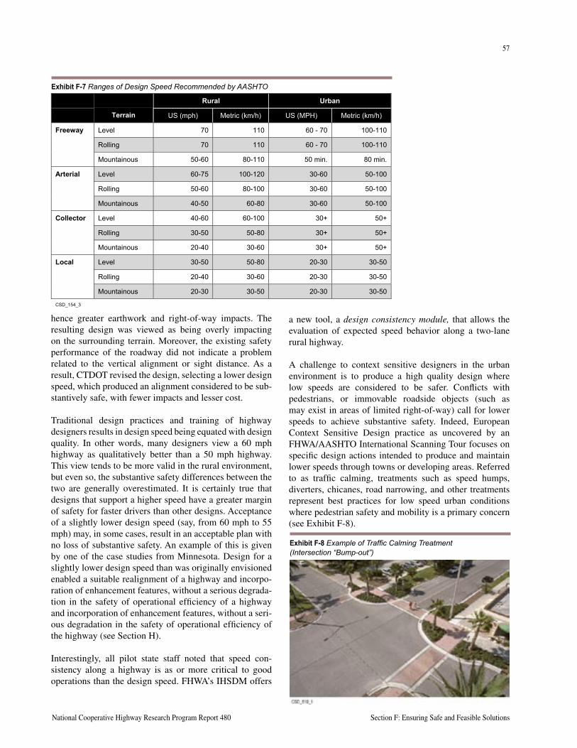
56
Section F: Ensuring Safe and Feasible Solutions A Guide to Best Practices for Achieving Context Sensitive Solutions
57
National Cooperative Highway Research Program Report 480 Section F: Ensuring Safe and Feasible Solutions
hence greater earthwork and right-of-way impacts. The resulting design was viewed as being overly impacting on the surrounding terrain. Moreover, the existing safety performance of the roadway did not indicate a problem related to the vertical alignment or sight distance. As a result, CTDOT revised the design, selecting a lower design speed, which produced an alignment considered to be sub-stantively safe, with fewer impacts and lesser cost.
Traditional design practices and training of highway designers results in design speed being equated with design quality. In other words, many designers view a 60 mph highway as qualitatively better than a 50 mph highway. This view tends to be more valid in the rural environment, but even so, the substantive safety differences between the two are generally overestimated. It is certainly true that designs that support a higher speed have a greater margin of safety for faster drivers than other designs. Acceptance of a slightly lower design speed (say, from 60 mph to 55 mph) may, in some cases, result in an acceptable plan with no loss of substantive safety. An example of this is given by one of the case studies from Minnesota. Design for a slightly lower design speed than was originally envisioned enabled a suitable realignment of a highway and incorpo-ration of enhancement features, without a serious degrada-tion in the safety of operational efficiency of a highway and incorporation of enhancement features, without a seri-ous degradation in the safety of operational efficiency of the highway (see Section H).
Interestingly, all pilot state staff noted that speed con-sistency along a highway is as or more critical to good operations than the design speed. FHWA’s IHSDM offers
a new tool, a design consistency module, that allows the evaluation of expected speed behavior along a two-lane rural highway.
A challenge to context sensitive designers in the urban environment is to produce a high quality design where low speeds are considered to be safer. Conflicts with pedestrians, or immovable roadside objects (such as may exist in areas of limited right-of-way) call for lower speeds to achieve substantive safety. Indeed, European Context Sensitive Design practice as uncovered by an FHWA/AASHTO International Scanning Tour focuses on specific design actions intended to produce and maintain lower speeds through towns or developing areas. Referred to as traffic calming, treatments such as speed humps, diverters, chicanes, road narrowing, and other treatments represent best practices for low speed urban conditions where pedestrian safety and mobility is a primary concern (see Exhibit F-8).
Rural Urban
Terrain US (mph) Metric (km/h) US (MPH) Metric (km/h)
Level 70 110 60 - 70 100-110
Rolling 70 110 60 - 70 100-110
Freeway
Mountainous 50-60 80-110 50 min. 80 min.
Level 60-75 100-120 30-60 50-100
Rolling 50-60 80-100 30-60 50-100
Arterial
Mountainous 40-50 60-80 30-60 50-100
Level 40-60 60-100 30+ 50+
Rolling 30-50 50-80 30+ 50+
Collector
Mountainous 20-40 30-60 30+ 50+
Level 30-50 50-80 20-30 30-50
Rolling 20-40 30-60 20-30 30-50
Local
Mountainous 20-30 30-50 20-30 30-50
CSD_154_3
Exhibit F-7 Ranges of Design Speed Recommended by AASHTO
Exhibit F-8 Example of Traffic Calming Treatment (Intersection “Bump-out”)
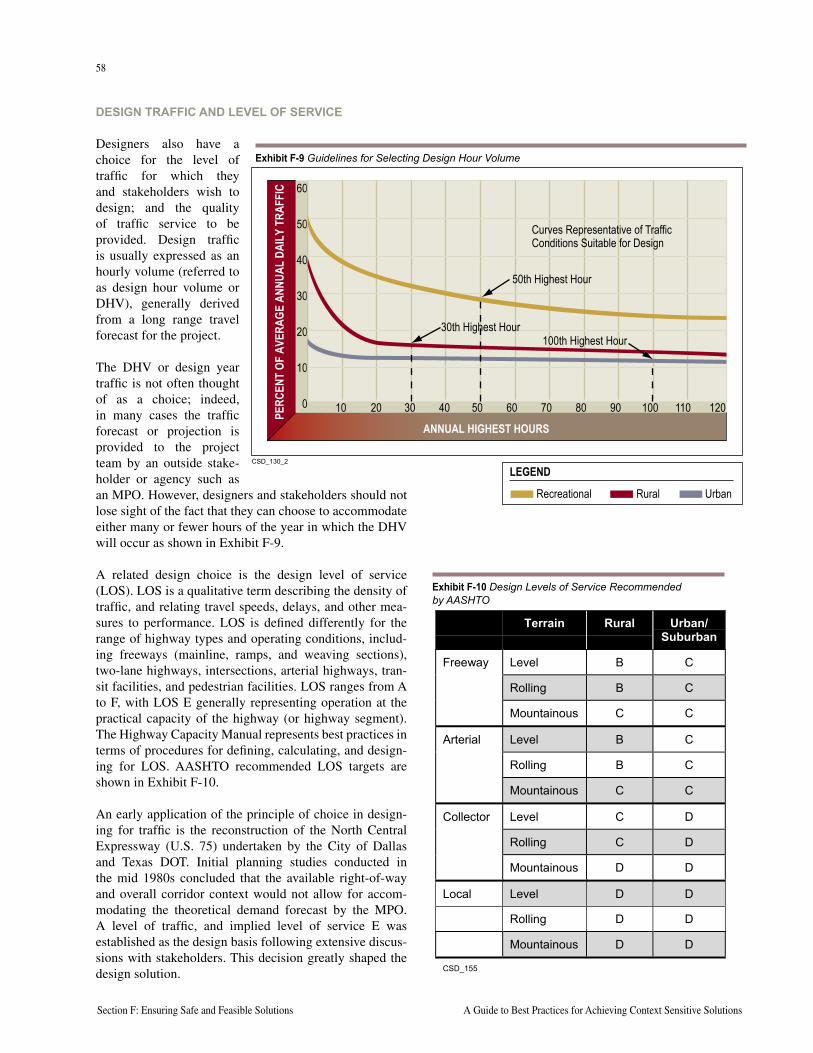
58
Section F: Ensuring Safe and Feasible Solutions A Guide to Best Practices for Achieving Context Sensitive Solutions
59
National Cooperative Highway Research Program Report 480 Section F: Ensuring Safe and Feasible Solutions
DESIGN TRAFFIC AND LEVEL OF SERVICE
Designers also have a choice for the level of traffic for which they and stakeholders wish to design; and the quality of traffic service to be provided. Design traffic is usually expressed as an hourly volume (referred to as design hour volume or DHV), generally derived from a long range travel forecast for the project.
The DHV or design year traffic is not often thought of as a choice; indeed, in many cases the traffic forecast or projection is provided to the project team by an outside stake-holder or agency such as an MPO. However, designers and stakeholders should not lose sight of the fact that they can choose to accommodate either many or fewer hours of the year in which the DHV will occur as shown in Exhibit F-9.
A related design choice is the design level of service (LOS). LOS is a qualitative term describing the density of traffic, and relating travel speeds, delays, and other mea-sures to performance. LOS is defined differently for the range of highway types and operating conditions, includ-ing freeways (mainline, ramps, and weaving sections), two-lane highways, intersections, arterial highways, tran-sit facilities, and pedestrian facilities. LOS ranges from A to F, with LOS E generally representing operation at the practical capacity of the highway (or highway segment). The Highway Capacity Manual represents best practices in terms of procedures for defining, calculating, and design-ing for LOS. AASHTO recommended LOS targets are shown in Exhibit F-10.
An early application of the principle of choice in design-ing for traffic is the reconstruction of the North Central Expressway (U.S. 75) undertaken by the City of Dallas and Texas DOT. Initial planning studies conducted in the mid 1980s concluded that the available right-of-way and overall corridor context would not allow for accom-modating the theoretical demand forecast by the MPO. A level of traffic, and implied level of service E was established as the design basis following extensive discus-sions with stakeholders. This decision greatly shaped the design solution.
Terrain Rural Urban/Suburban
Level B C
Rolling B C
Freeway
Mountainous C C
Level B C
Rolling B C
Arterial
Mountainous C C
Level C D
Rolling C D
Collector
Mountainous D D
Local Level D D
Rolling D D
Mountainous D D
CSD_155
Exhibit F-10 Design Levels of Service Recommended by AASHTO
CSD_130_2
LEGEND
Recreational Rural Urban
ANNUAL HIGHEST HOURS
PERC
ENT
OF A
VERA
GE A
NNUA
L DA
ILY
TRAF
FIC
10 20 30 40 50 60 70 80 90 100 110 120
60
50
40
30
20
10
0
30th Highest Hour100th Highest Hour
50th Highest Hour
Curves Representative of Traffic Conditions Suitable for Design
Exhibit F-9 Guidelines for Selecting Design Hour Volume
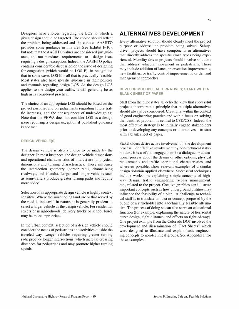
58
Section F: Ensuring Safe and Feasible Solutions A Guide to Best Practices for Achieving Context Sensitive Solutions
59
National Cooperative Highway Research Program Report 480 Section F: Ensuring Safe and Feasible Solutions
Designers have choices regarding the LOS to which a given design should be targeted. The choice should reflect the problem being addressed and the context. AASHTO provides some guidance in this area (see Exhibit F-10), but note that the AASHTO values are considered just guid-ance, and not mandates, requirements, or a design issue requiring a design exception. Indeed, the AASHTO policy contains considerable discussion on the issue of designing for congestion (which would be LOS E), in recognition that in some cases LOS E is all that is practically feasible. Most states also have specific guidance in their policies and manuals regarding design LOS. As the design LOS applies to the design year traffic, it will generally be as high as is considered practical.
The choice of an appropriate LOS should be based on the project purpose, and on judgements regarding future traf-fic increases, and the consequences of under-designing. Note that the FHWA does not consider LOS as a design issue requiring a design exception if published guidance is not met.
DESIGN VEHICLE(S)
The design vehicle is also a choice to be made by the designer. In most instances, the design vehicle dimensions and operational characteristics of interest are its physical dimensions and turning characteristics. These influence the intersection geometry (corner radii, channelizing roadways, and islands). Larger and longer vehicles such as semi-trailers produce greater turning paths and require more space.
Selection of an appropriate design vehicle is highly context sensitive. Where the surrounding land use or that served by the road is industrial in nature, it is generally prudent to select a larger vehicle as the design vehicle. For residential streets or neighborhoods, delivery trucks or school buses may be more appropriate.
In the urban context, selection of a design vehicle should consider the needs of pedestrians and activities outside the traveled way. Longer vehicles requiring greater turning radii produce longer intersections, which increase crossing distances for pedestrians and may promote higher turning speeds.
ALTERNATIVES DEVELOPMENTEvery alternative solution should clearly meet the project purpose or address the problem being solved. Safety-driven projects should have components or alternatives that directly address the specific crash types being expe-rienced. Mobility-driven projects should involve solutions that address vehicular movement or pedestrians. These may include addition of lanes, intersection improvements, new facilities, or traffic control improvements; or demand management approaches.
DEVELOP MULTIPLE ALTERNATIVES; START WITH A BLANK SHEET OF PAPER
Staff from the pilot states all echo the view that successful projects incorporate a principle that multiple alternatives should always be considered. Creativity, within the context of good engineering practice and with a focus on solving the identified problem, is central to CSD/CSS. Indeed, the most effective strategy is to initially engage stakeholders prior to developing any concepts or alternatives – to start with a blank sheet of paper.
Stakeholders desire active involvement in the development process. For effective involvement by non-technical stake-holders, it is useful to engage them in a dialogue or educa-tional process about the design or other options, physical requirements and traffic operational characteristics, and wherever possible, show relevant examples of a similar design solution applied elsewhere. Successful techniques include workshops explaining simple concepts of high-way design, traffic engineering, access management, etc., related to the project. Creative graphics can illustrate important concepts such as how underground utilities may influence the feasibility of a plan. A challenge to techni-cal staff is to translate an idea or concept proposed by the public or a stakeholder into a technically feasible alterna-tive. The process of doing so can also serve an educational function (for example, explaining the nature of horizontal curve design, sight distance, and effects on right-of-way). One project example from the Colorado DOT involved the development and dissemination of “Fact Sheets” which were designed to illustrate and explain basic engineer-ing concepts to non-technical groups. See Appendix F for these examples.
60
Section F: Ensuring Safe and Feasible Solutions A Guide to Best Practices for Achieving Context Sensitive Solutions
61
National Cooperative Highway Research Program Report 480 Section F: Ensuring Safe and Feasible Solutions
Stakeholder involvement is essential to uncover aspects of a project about which the design staff may not be sensitive. For example, projects involving corridors in agricultural areas generally must address issues of farm field access, drainage tiles, use of the road by farming equipment, and leasing of parcels (in other words, know-ing the ownership of a parcel may not be enough, as the property may be farmed by someone else). Very few highway designers understand all of these issues and needs without working directly with farmers and learning how they do their jobs. In urban commercial areas, stakeholders are interested in on-street parking, in disruptions to their businesses during the construction period, and in access to their properties by both vehicles and pedestrians. Regard-ing the latter, many highway engineers require help from pedestrians and pedestrian advocacy groups to understand the needs and issues of pedestrian mobility and safety.
Alternatives development involving stakeholders is often iterative. Successful CSD/CSS staff do not become wedded to a given plan, but are instead flexible, willing to work with individual stakeholders to address a local prob-lem. The success of committing to multiple alternatives and involving stakeholders was highlighted by staff from Kentucky Transportation Cabinet (KYTC). They admit-ted that being forced to go back and consider a different alignment alternative resulted in a better solution than one originally put forth by KYTC.
DESIGN CHOICES AND THEIR CONSEQUENCES
Agency staff will often reference their policies in making choices about LOS, design criteria, etc. While such policies are developed for reasons, and should be respected, stakeholders may challenge the policies or expect their rationale be explained in the context of the particular project. Saying “we need to use a 70 mph design speed because that is what our policy says” begs the question of what the right choice should be for the specific project application, or at least what the functional reason for the policy is.
The choices that designers and stakeholders have should be made with full consideration of the project’s context and the problem being addressed. Thus, if a project involves increasing capacity for through traffic, care-ful consideration of the design traffic and LOS is appropriate. If the project is primar-ily a rural highway safety-driven project, then selecting a high enough design speed would be paramount, and providing a high quality roadside of great concern.
Designers should not make inappropriate choices just to avoid conflicts or right-of-way acquisition. Designers and stakeholders should recognize that there are relationships between design choices and operational consequences. For example, there is both research and anecdotal evidence of an adverse relationship between substantive safety and congestion; thus, choosing to design for, say, LOS E may in some cases be expected to be accompanied by a less substantively safe facility.
The cumulative effect of the many choices designers make (in consultation with stakeholders) can significantly influence the resulting solution, and its feasibility and/or acceptability. Exhibit F-11 (following page) illustrates two different design solutions for the same basic set of circumstances as defined by average daily traffic and intersection geometry. Depend-ing on the designer choices for design speed, design vehicle, design traffic, and design LOS, completely different design solutions and their related footprints may result. Note that each solution may be optimal in its proper context. In one case, design for a suburban intersection of two primary arte-rial highways may call for somewhat greater speeds, higher LOS, and larger design vehicles. Design features may include double left-turn lanes, 12-foot lane widths for operations, and raised medians for access control. Of course, the right-of-way footprint and overall design would be greater. In the second instance (a central city), the context may call for lower speeds; pedestrians may be relatively more important (and hence minimizing crossing distances and promoting lower speeds more important). There may not be available right-of-way, and the overall location more constrained. Here, use of narrower lane widths, single left-turn lanes, painted medians, and smaller radius turns accommodating a bus or single unit truck may be more appropriate.
“ We’ve come to the realization that the Highway Department doesn’t have all the answers.”
CHARLES ADAMS, MARYLAND STATE HIGHWAY
ADMINISTRATION
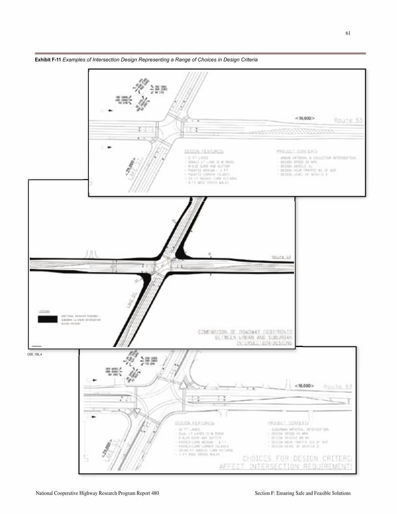
60
Section F: Ensuring Safe and Feasible Solutions A Guide to Best Practices for Achieving Context Sensitive Solutions
61
National Cooperative Highway Research Program Report 480 Section F: Ensuring Safe and Feasible Solutions
CSD_156_4
Exhibit F-11 Examples of Intersection Design Representing a Range of Choices in Design Criteria
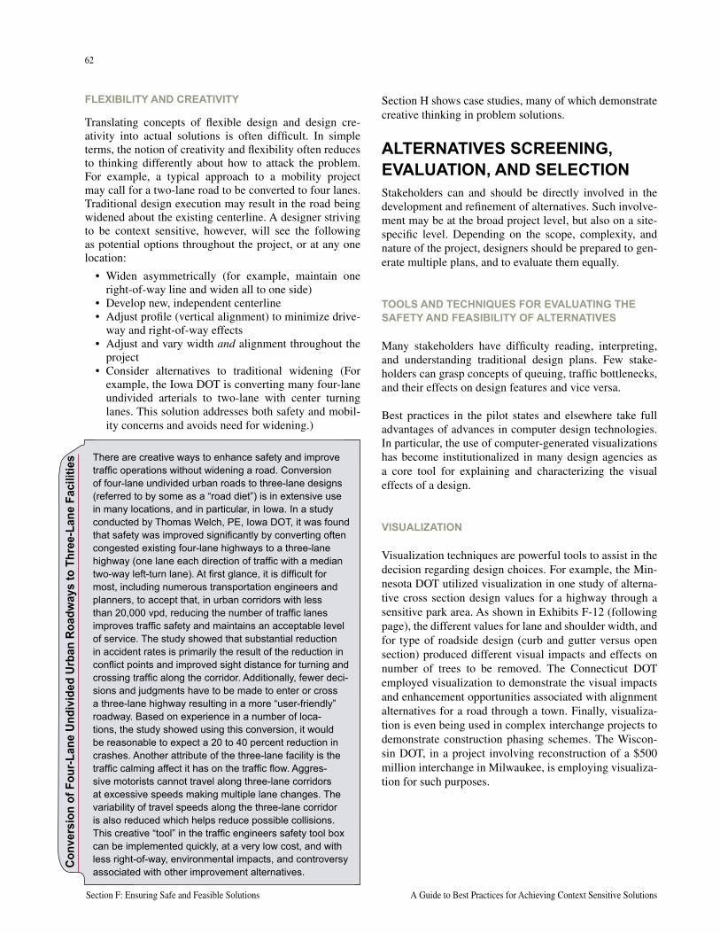
62
Section F: Ensuring Safe and Feasible Solutions A Guide to Best Practices for Achieving Context Sensitive Solutions
63
National Cooperative Highway Research Program Report 480 Section F: Ensuring Safe and Feasible Solutions
Section H shows case studies, many of which demonstrate creative thinking in problem solutions.
ALTERNATIVES SCREENING, EVALUATION, AND SELECTIONStakeholders can and should be directly involved in the development and refinement of alternatives. Such involve-ment may be at the broad project level, but also on a site-specific level. Depending on the scope, complexity, and nature of the project, designers should be prepared to gen-erate multiple plans, and to evaluate them equally.
TOOLS AND TECHNIQUES FOR EVALUATING THE SAFETY AND FEASIBILITY OF ALTERNATIVES
Many stakeholders have difficulty reading, interpreting, and understanding traditional design plans. Few stake-holders can grasp concepts of queuing, traffic bottlenecks, and their effects on design features and vice versa.
Best practices in the pilot states and elsewhere take full advantages of advances in computer design technologies. In particular, the use of computer-generated visualizations has become institutionalized in many design agencies as a core tool for explaining and characterizing the visual effects of a design.
VISUALIZATION
Visualization techniques are powerful tools to assist in the decision regarding design choices. For example, the Min-nesota DOT utilized visualization in one study of alterna-tive cross section design values for a highway through a sensitive park area. As shown in Exhibits F-12 (following page), the different values for lane and shoulder width, and for type of roadside design (curb and gutter versus open section) produced different visual impacts and effects on number of trees to be removed. The Connecticut DOT employed visualization to demonstrate the visual impacts and enhancement opportunities associated with alignment alternatives for a road through a town. Finally, visualiza-tion is even being used in complex interchange projects to demonstrate construction phasing schemes. The Wiscon-sin DOT, in a project involving reconstruction of a $500 million interchange in Milwaukee, is employing visualiza-tion for such purposes.
FLEXIBILITY AND CREATIVITY
Translating concepts of flexible design and design cre-ativity into actual solutions is often difficult. In simple terms, the notion of creativity and flexibility often reduces to thinking differently about how to attack the problem. For example, a typical approach to a mobility project may call for a two-lane road to be converted to four lanes. Traditional design execution may result in the road being widened about the existing centerline. A designer striving to be context sensitive, however, will see the following as potential options throughout the project, or at any one location:
• Widen asymmetrically (for example, maintain one right-of-way line and widen all to one side)
• Develop new, independent centerline • Adjust profile (vertical alignment) to minimize drive-
way and right-of-way effects• Adjust and vary width and alignment throughout the
project• Consider alternatives to traditional widening (For
example, the Iowa DOT is converting many four-lane undivided arterials to two-lane with center turning lanes. This solution addresses both safety and mobil-ity concerns and avoids need for widening.)
Conv
ersi
on o
f Fou
r-Lan
e Un
divi
ded
Urba
n Ro
adw
ays
to T
hree
-Lan
e Fa
cilit
ies There are creative ways to enhance safety and improve
traffic operations without widening a road. Conversion of four-lane undivided urban roads to three-lane designs (referred to by some as a “road diet”) is in extensive use in many locations, and in particular, in Iowa. In a study conducted by Thomas Welch, PE, Iowa DOT, it was found that safety was improved significantly by converting often congested existing four-lane highways to a three-lane highway (one lane each direction of traffic with a median two-way left-turn lane). At first glance, it is difficult for most, including numerous transportation engineers and planners, to accept that, in urban corridors with less than 20,000 vpd, reducing the number of traffic lanes improves traffic safety and maintains an acceptable level of service. The study showed that substantial reduction in accident rates is primarily the result of the reduction in conflict points and improved sight distance for turning and crossing traffic along the corridor. Additionally, fewer deci-sions and judgments have to be made to enter or cross a three-lane highway resulting in a more “user-friendly” roadway. Based on experience in a number of loca-tions, the study showed using this conversion, it would be reasonable to expect a 20 to 40 percent reduction in crashes. Another attribute of the three-lane facility is the traffic calming affect it has on the traffic flow. Aggres-sive motorists cannot travel along three-lane corridors at excessive speeds making multiple lane changes. The variability of travel speeds along the three-lane corridor is also reduced which helps reduce possible collisions. This creative “tool” in the traffic engineers safety tool box can be implemented quickly, at a very low cost, and with less right-of-way, environmental impacts, and controversy associated with other improvement alternatives.
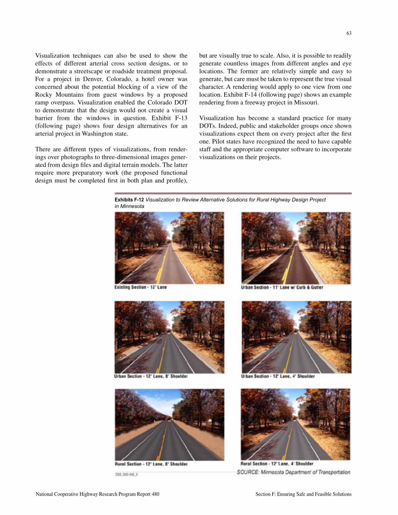
62
Section F: Ensuring Safe and Feasible Solutions A Guide to Best Practices for Achieving Context Sensitive Solutions
63
National Cooperative Highway Research Program Report 480 Section F: Ensuring Safe and Feasible Solutions
Visualization techniques can also be used to show the effects of different arterial cross section designs, or to demonstrate a streetscape or roadside treatment proposal. For a project in Denver, Colorado, a hotel owner was concerned about the potential blocking of a view of the Rocky Mountains from guest windows by a proposed ramp overpass. Visualization enabled the Colorado DOT to demonstrate that the design would not create a visual barrier from the windows in question. Exhibit F-13 (following page) shows four design alternatives for an arterial project in Washington state.
There are different types of visualizations, from render-ings over photographs to three-dimensional images gener-ated from design files and digital terrain models. The latter require more preparatory work (the proposed functional design must be completed first in both plan and profile),
Exhibits F-12 Visualization to Review Alternative Solutions for Rural Highway Design Project in Minnesota
but are visually true to scale. Also, it is possible to readily generate countless images from different angles and eye locations. The former are relatively simple and easy to generate, but care must be taken to represent the true visual character. A rendering would apply to one view from one location. Exhibit F-14 (following page) shows an example rendering from a freeway project in Missouri.
Visualization has become a standard practice for many DOTs. Indeed, public and stakeholder groups once shown visualizations expect them on every project after the first one. Pilot states have recognized the need to have capable staff and the appropriate computer software to incorporate visualizations on their projects.
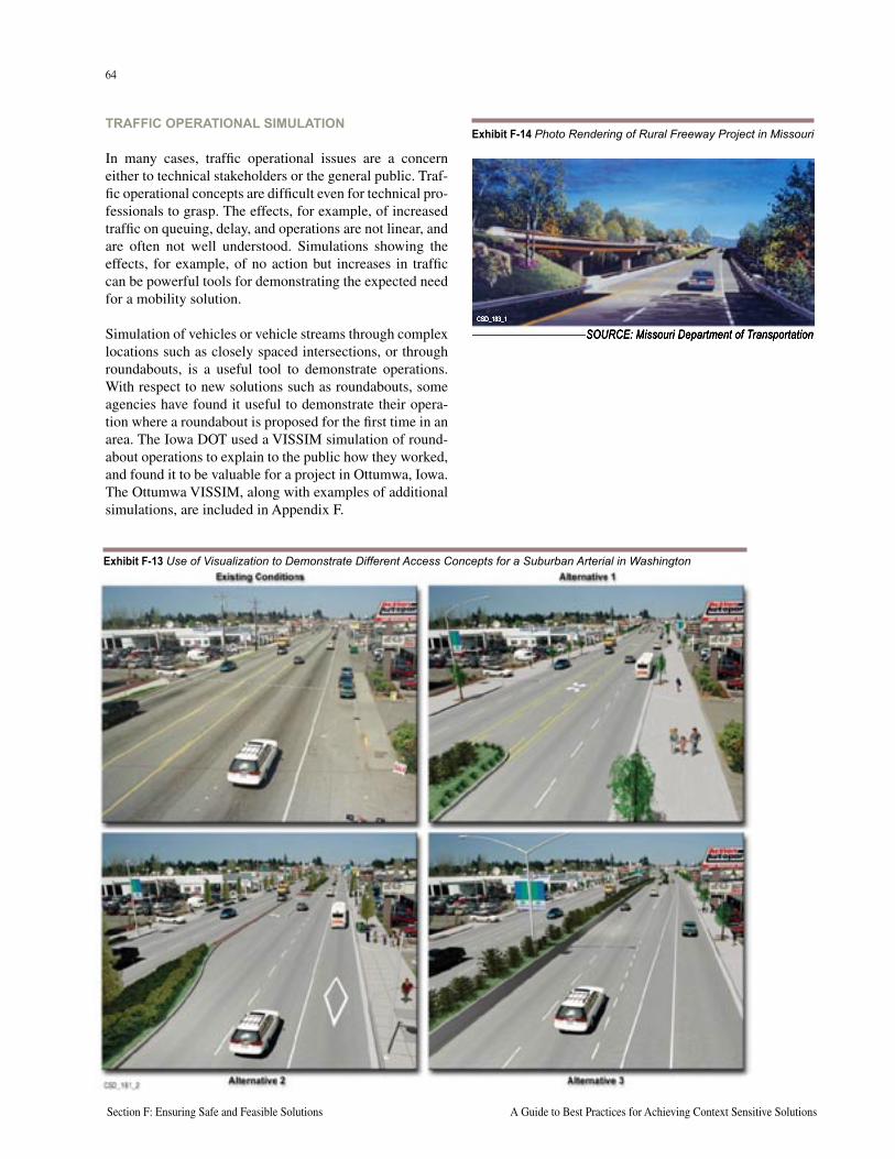
64
Section F: Ensuring Safe and Feasible Solutions A Guide to Best Practices for Achieving Context Sensitive Solutions
65
National Cooperative Highway Research Program Report 480 Section F: Ensuring Safe and Feasible Solutions
TRAFFIC OPERATIONAL SIMULATION
In many cases, traffic operational issues are a concern either to technical stakeholders or the general public. Traf-fic operational concepts are difficult even for technical pro-fessionals to grasp. The effects, for example, of increased traffic on queuing, delay, and operations are not linear, and are often not well understood. Simulations showing the effects, for example, of no action but increases in traffic can be powerful tools for demonstrating the expected need for a mobility solution.
Simulation of vehicles or vehicle streams through complex locations such as closely spaced intersections, or through roundabouts, is a useful tool to demonstrate operations. With respect to new solutions such as roundabouts, some agencies have found it useful to demonstrate their opera-tion where a roundabout is proposed for the first time in an area. The Iowa DOT used a VISSIM simulation of round-about operations to explain to the public how they worked, and found it to be valuable for a project in Ottumwa, Iowa. The Ottumwa VISSIM, along with examples of additional simulations, are included in Appendix F.
Exhibit F-14 Photo Rendering of Rural Freeway Project in Missouri
SOURCE: Missouri Department of TransportationCSD_183_1
Exhibit F-13 Use of Visualization to Demonstrate Different Access Concepts for a Suburban Arterial in Washington
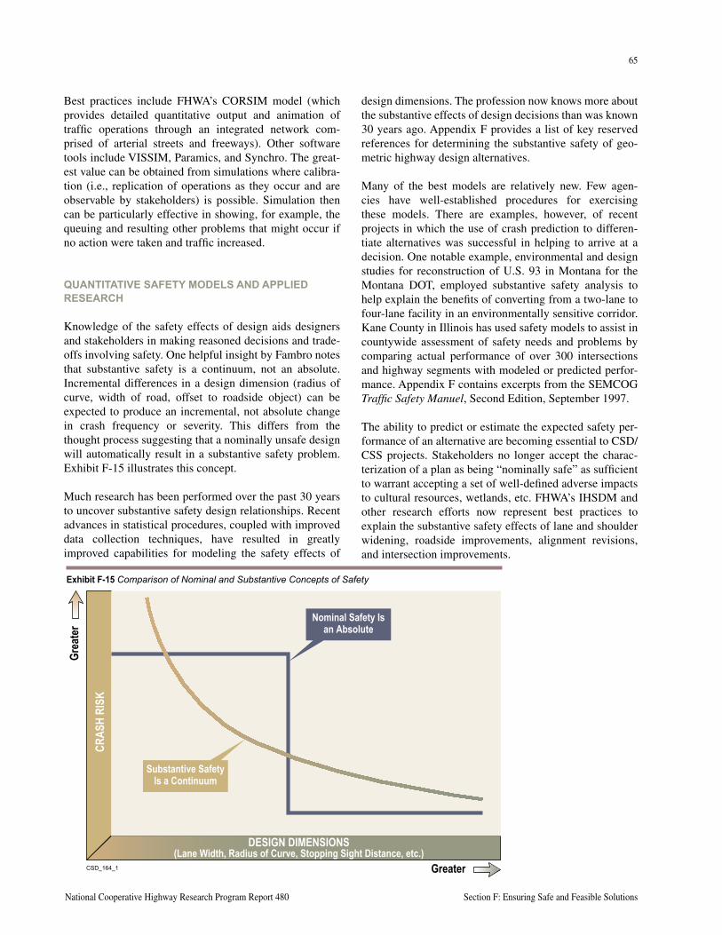
64
Section F: Ensuring Safe and Feasible Solutions A Guide to Best Practices for Achieving Context Sensitive Solutions
65
National Cooperative Highway Research Program Report 480 Section F: Ensuring Safe and Feasible Solutions
Best practices include FHWA’s CORSIM model (which provides detailed quantitative output and animation of traffic operations through an integrated network com-prised of arterial streets and freeways). Other software tools include VISSIM, Paramics, and Synchro. The great-est value can be obtained from simulations where calibra-tion (i.e., replication of operations as they occur and are observable by stakeholders) is possible. Simulation then can be particularly effective in showing, for example, the queuing and resulting other problems that might occur if no action were taken and traffic increased.
QUANTITATIVE SAFETY MODELS AND APPLIED RESEARCH
Knowledge of the safety effects of design aids designers and stakeholders in making reasoned decisions and trade-offs involving safety. One helpful insight by Fambro notes that substantive safety is a continuum, not an absolute. Incremental differences in a design dimension (radius of curve, width of road, offset to roadside object) can be expected to produce an incremental, not absolute change in crash frequency or severity. This differs from the thought process suggesting that a nominally unsafe design will automatically result in a substantive safety problem. Exhibit F-15 illustrates this concept.
Much research has been performed over the past 30 years to uncover substantive safety design relationships. Recent advances in statistical procedures, coupled with improved data collection techniques, have resulted in greatly improved capabilities for modeling the safety effects of
CSD_164_1
DESIGN DIMENSIONS (Lane Width, Radius of Curve, Stopping Sight Distance, etc.)
CRAS
H RI
SK
Grea
ter
Greater
Nominal Safety Is an Absolute
Substantive SafetyIs a Continuum
Exhibit F-15 Comparison of Nominal and Substantive Concepts of Safety
design dimensions. The profession now knows more about the substantive effects of design decisions than was known 30 years ago. Appendix F provides a list of key reserved references for determining the substantive safety of geo-metric highway design alternatives.
Many of the best models are relatively new. Few agen-cies have well-established procedures for exercising these models. There are examples, however, of recent projects in which the use of crash prediction to differen-tiate alternatives was successful in helping to arrive at a decision. One notable example, environmental and design studies for reconstruction of U.S. 93 in Montana for the Montana DOT, employed substantive safety analysis to help explain the benefits of converting from a two-lane to four-lane facility in an environmentally sensitive corridor. Kane County in Illinois has used safety models to assist in countywide assessment of safety needs and problems by comparing actual performance of over 300 intersections and highway segments with modeled or predicted perfor-mance. Appendix F contains excerpts from the SEMCOG Traffic Safety Manuel, Second Edition, September 1997.
The ability to predict or estimate the expected safety per-formance of an alternative are becoming essential to CSD/CSS projects. Stakeholders no longer accept the charac-terization of a plan as being “nominally safe” as sufficient to warrant accepting a set of well-defined adverse impacts to cultural resources, wetlands, etc. FHWA’s IHSDM and other research efforts now represent best practices to explain the substantive safety effects of lane and shoulder widening, roadside improvements, alignment revisions, and intersection improvements.
66
Section F: Ensuring Safe and Feasible Solutions A Guide to Best Practices for Achieving Context Sensitive Solutions
67
National Cooperative Highway Research Program Report 480 Section F: Ensuring Safe and Feasible Solutions
DEMONSTRATING A COMMITMENT TO MITIGATE SAFETY CONCERNS
In many cases where the context sensitive solution cannot meet normal new-construction design criteria, additional safety enhancement measures can be built into the project to mitigate possible safety concerns. Examples of alterna-tive safety mitigation measures that may be considered in conjunction with a design exception or to address a specific safety problem are shown in Exhibit F-16 (following page).
DECISION MAKING
The weighing of attributes and process for selecting an alternative are discussed in Section E, Achieving Envi-ronmental Sensitivity. Involving stakeholders in the entire process, including alternatives development and evaluation and screening, will result in an open and honest decision process. Commitment to CSD/CSS does not translate to abdication of an agency’s responsibility to make the final decision. CSD/CSS is not about taking a vote – but rather, about decisions made with all stakeholders involved and given the opportunity to have input.
IMPLEMENTATIONThe objective of the CSD/CSS process is implementa-tion, which in many cases means construction. Success-fully implementing a solution that was openly arrived at requires great care and a management commitment to follow through. In most agencies, staff assigned to develop the plan are not directly involved in construction. Pilot state staff in many states observed that the hand-off from planning and design staff to construction staff, if not done properly, can result in the negation of carefully developed plans and commitments to stakeholders.
It is common practice in many agencies to perform value engineering (VE) studies prior to construction or bidding. Such practices, although well-intentioned, can lead to unforeseen adverse decisions. In Maryland, it was noted that an unintended result of VE studies was the removal of items from the project that represented commitments to stakeholders in the effort to maintain economy. Best implementation practices incorporate meetings and project plan reviews between design staff, construction engineers, and contractors. Important issues that involve stakeholders include right-of-way commitments (avoidance), trees or other landscaping, avoidance impacts and related roadside design decisions, property access and driveways, detours and other traffic issues during construction, construction schedules (time of day), and noise and dust mitigation.
GIS TECHNOLOGY
Safety and other information that is geo referenced can be powerful tools to answer questions, explain alterna-tives, and demonstrate site-specific solutions that relate to a problem. The use of GIS systems for cataloging design impacts (right-of-way, wetland parcels, etc.) and for crash analysis represents best practices.
A safety-driven urban freeway project in Minnesota met partial resistance initially from community groups. Suc-cess in explaining the need for the improvements was in part attributed to Mn/DOT’s ability to show the residences (home locations) of those involved in crashes on the seg-ments in question. Stakeholders were surprised to see how many of their neighbors had been involved in a crash on the freeway in question. A system-wide problem became personalized, and support for the safety improvements was generated by the ability to generate location-specific data.
The Montana Department of Transportation has used quantitative safety prediction models to evaluate align-ment and cross section alternatives studied for corridor improvement projects. A study of a 16-mile segment of Montana Primary State Route 78 from Absorokee to Columbus in Stillwater County included published models from FHWA-sponsored research to investigate trade-offs between safety and environmental impacts.
The project purpose and need statement noted that the crash rate for the route was four times greater than the state average for similar highway types. High crash experience was attributed to outdated geometry (i.e., the route was “nominally unsafe”). Substantive safety effects of 32-foot versus 36-foot and 40-foot cross sections were compared with right-of-way, construction cost, farmland, wetland, and other environmental effects. Models derived from FHWA research by Zegeer, et. al. (Safety Cost-Effec-tiveness of Incremental Changes in Cross-Section Design, Informational Guide, 1987) on the expected safety effects of various lane and shoulder widths were applied to the route-specific crash and traffic data to compare quantita-tive measures of cost, acres, and number of relocations.
The draft environmental impact statement (DEIS) noted that reconstruction of the entire alignment was required to meet safety purposes and needs. A 32-foot cross section (including two 12-foot lanes and 4-foot shoulders) would produce a 33 percent reduction in crashes. The DEIS also noted that other alternatives, such as a 36-foot or 40-foot width would produce some additional crash reduction and other transportation benefits over the 32-foot width, but the additional benefits were not judged to be worth the cumulative impacts and costs. Consistent with the pur-pose and need statement, the 32-foot cross section was identified as the preferred alternative for this project.
Use
of S
afet
y Pr
edic
tion
Mod
els
by M
onta
na D
OT
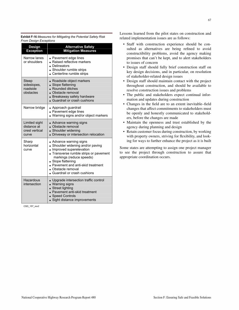
66
Section F: Ensuring Safe and Feasible Solutions A Guide to Best Practices for Achieving Context Sensitive Solutions
67
National Cooperative Highway Research Program Report 480 Section F: Ensuring Safe and Feasible Solutions
Lessons learned from the pilot states on construction and related implementation issues are as follows:
• Staff with construction experience should be con-sulted as alternatives are being refined to avoid constructibility problems, avoid the agency making promises that can’t be kept, and to alert stakeholders to issues of concern
• Design staff should fully brief construction staff on key design decisions, and in particular, on resolution of stakeholder-related design issues
• Design staff should maintain contact with the project throughout construction, and should be available to resolve construction issues and problems
• The public and stakeholders expect continual infor-mation and updates during construction
• Changes in the field are to an extent inevitable–field changes that affect commitments to stakeholders must be openly and honestly communicated to stakehold-ers, before the changes are made
• Maintain the openness and trust established by the agency during planning and design
• Retain customer focus during construction, by working with property owners, striving for flexibility, and look-ing for ways to further enhance the project as it is built
Some states are attempting to assign one project manager to see the project through construction to assure that appropriate coordination occurs.
CSD_157_ALTERNATIVESAFETYMEASURES_REV2.DOC 1
DesignException
Alternative SafetyMitigation Measures
Narrow lanesor shoulders
Pavement edge lines Raised reflective markers Delineators Shoulder rumble strips Centerline rumble strips
Steepsideslopes,roadsideobstacles
Roadside object markers Slope flattening Rounded ditches Obstacle removal Breakaway safety hardware Guardrail or crash cushions
Narrow bridge Approach guardrail Pavement edge lines Warning signs and/or object markers
Limited sightdistance atcrest verticalcurve
Advance warning signs Obstacle removal Shoulder widening Driveway or intersection relocation
Sharphorizontalcurve
Advance warning signs Shoulder widening and/or paving Improved superelevation Transverse rumble strips or pavement
markings (reduce speeds) Slope flattening Pavement and anti-skid treatment Obstacle removal Guardrail or crash cushions
Hazardousintersection
Upgrade intersection traffic control Warning signs Street lighting Pavement anti-skid treatment Speed Controls Sight distance improvements
CSD_157_rev2
Exhibit F-16 Measures for Mitigating the Potential Safety Risk From Design Exceptions
68
Section F: Ensuring Safe and Feasible Solutions A Guide to Best Practices for Achieving Context Sensitive Solutions
69
National Cooperative Highway Research Program Report 480 Section F: Ensuring Safe and Feasible Solutions
KEY RESOURCES AND REFERENCESAmerican Association of State Highway and Transportation Officials. A Manual on User Benefit Analysis for Highway and Bus Transit Improvements, 1977.
American Association of State Highway and Transportation Officials. A Policy on Geometric Design of Highways and Streets, 4th Edition, Washington, DC, 2001.
American Association of State Highway and Transportation Officials. Roadside Design Guide, Washington, DC, 2001.
Bonneson, J.A. and McCoy, P.T. Capacity and Operational Effects of Midblock Left-Turn Lanes, Transportation Research Board, National Cooperative Highway Research Program (NCHRP) Report 395, Washington, DC, 1997.
Council, F., et. al., Accident Research Manual, Federal Highway Administration, 1980.
Fambro, et. al., Determination of Stopping Sight Distances, Transportation Research Board, National Cooperative Highway Research Program (NCHRP) Report 400, Washington, DC, 1997.
Fitzpatrick, K. et. al., Accident Mitigation Guide for Congested Two-lane Rural Highways, Transportation Research Board, National Cooperative Highway Research Program (NCHRP) Report 440, Washington, DC, 2000.
Federal Highway Administration. Flexibility in Highway Design, 1998.
Federal Highway Administration. Safety Effects of the Conversion of Rural Two-lane Roadways to Four-lane Roadways, Highway Safety Information System Study Report, Washington, DC, 1999.
Federal Highway Administration. Roundabouts, An Informational Guide, 2000.
Glennon, J.C. et. al., Safety and Operational Considerations for Design of Rural Highway Curves, Federal Highway Administration, Washington, DC, 1985.
Harwood, D. W. and Hoban, C., Low-cost Methods for Improving Traffic Operations on Two-lane Roads: An Informational Guide, Federal Highway Administration, Washington, DC, 1987.
Harwood, D.W. et. al., Intersection Sight Distance, Transportation Research Board, National Cooperative Highway Research Program (NCHRP) Report 383, Washington, DC, 1996.
Harwood, D.W. et. al., Prediction of the Expected Safety Performance of Rural Two-Lane Highways, Federal Highway Administration, 2000.
Hauer, Ezra, Highway Design Choices and Safety.
Hauer, Ezra, Safety in Geometric Design Standards, University of Toronto, December 1999.
Institute of Transportation Engineers. Traffic Safety Toolbox, 2nd Edition, 1999.
Leisch, J.E., et. al., Dynamic Design for Safety, Seminar Notes, Federal Highway Administration, 1995.
McGee, H.W., Hughes, W.E., and Daily, K., Effect of Highway Standards on Safety, NCHRP Report 374, Transportation Research Board, Washington, DC, 1995
Pfefer, R. C., Neuman, T. R., and Raub, R.A. Improved Safety Information to Support Highway Design, Transportation Research Board, National Cooperative Highway Research Program (NCHRP) Report 430, Washington, DC, 1999.
68
Section F: Ensuring Safe and Feasible Solutions A Guide to Best Practices for Achieving Context Sensitive Solutions
69
National Cooperative Highway Research Program Report 480 Section F: Ensuring Safe and Feasible Solutions
Transportation Research Board. Designing Safer Roads, Practices for Resurfacing, Restoration and Rehabilitation, Special Report 214, Washington, DC, 1987.
Transportation Research Board. Effect of Alignment on Safety, in State of the Art Report 6, Relationship Between Safety and Key Highway Features, A Synthesis of Prior Research, Washington, DC, 1987.
Transportation Research Board. Cross Section and Alignment Design Issues, Transportation Research Record 1445, 1994.
Transportation Research Board. Customer-Based Quality in Transportation, National Cooperative Highway Research Program (NCHRP) Report 376, Washington, DC, 1996.
Transportation Research Board. Design Speed, Operating Speed and Sight Distance Issues, Transportation Research Record 1701, Washington, DC, 2000.
Transportation Research Board. Highway Capacity Manual, Transportation Research Board Special Report 209, 2000.
Turner, D. S., and Blaschke, J. D., Effects of Tort Liability on Roadway Design Decisions, Transportation Research Board, Transportation Research Board Record 1512, Washington, DC, 1995.
U.S. Government Accounting Office. Scenic Byways—States’ Use of Geometric Design Standards, Report to the Chairman, Committee on Environment and Public Works, U.S. Senate, September 1995.
Zegeer, C.Z., et. al., Roadway Widths for Low-Traffic-Volume Roads, National Cooperative Highway Research Program (NCHRP) Report 362, Transportation Research Board, Washington, DC, 1994.
Zegeer, C.Z., et. al., Safety Improvements for Curves on Two-lane Rural Highways, Federal Highway Administration, Washington, DC, 1991.

70
Section F: Ensuring Safe and Feasible Solutions A Guide to Best Practices for Achieving Context Sensitive Solutions
This page intentionally left blank
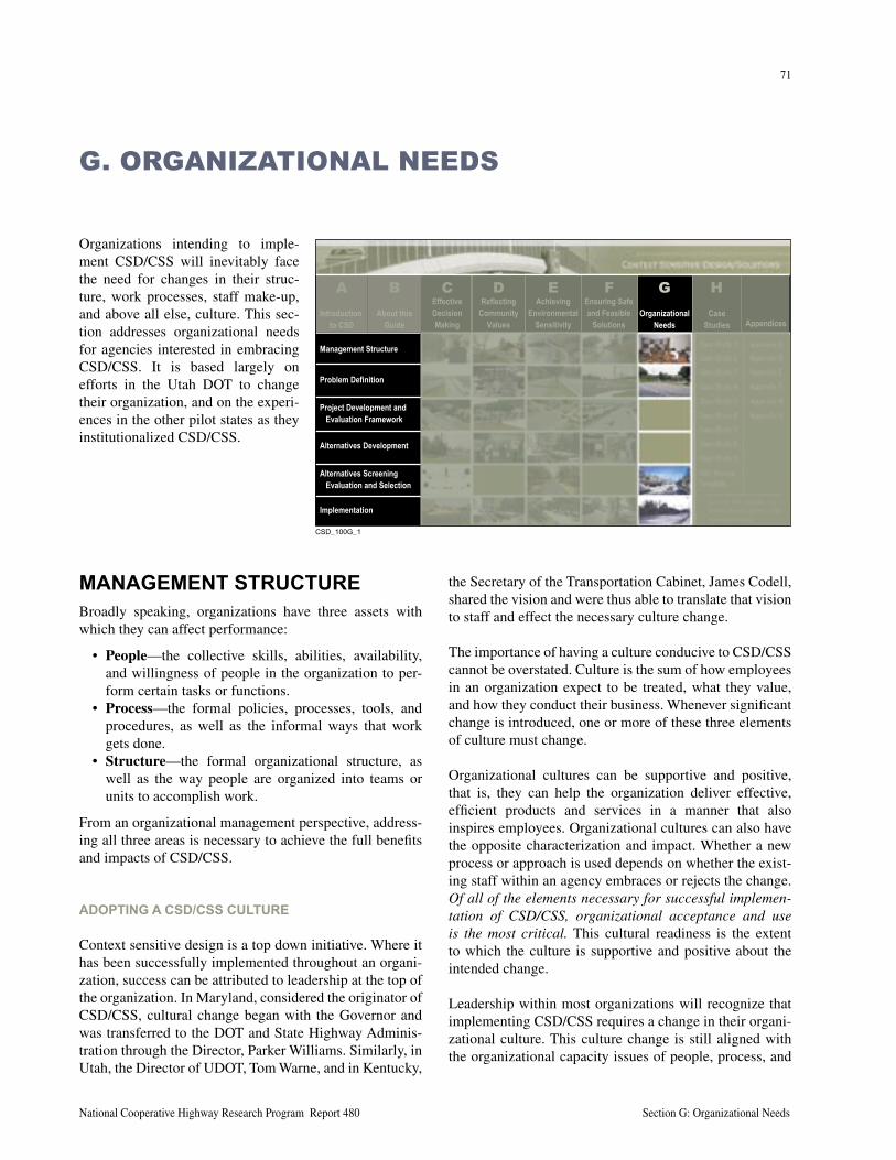
71
National Cooperative Highway Research Program Report 480 Section G: Organizational Needs
Organizations intending to imple-ment CSD/CSS will inevitably face the need for changes in their struc-ture, work processes, staff make-up, and above all else, culture. This sec-tion addresses organizational needs for agencies interested in embracing CSD/CSS. It is based largely on efforts in the Utah DOT to change their organization, and on the experi-ences in the other pilot states as they institutionalized CSD/CSS.
G. ORGANIZATIONAL NEEDS
MANAGEMENT STRUCTUREBroadly speaking, organizations have three assets with which they can affect performance:
• People—the collective skills, abilities, availability, and willingness of people in the organization to per-form certain tasks or functions.
• Process—the formal policies, processes, tools, and procedures, as well as the informal ways that work gets done.
• Structure—the formal organizational structure, as well as the way people are organized into teams or units to accomplish work.
From an organizational management perspective, address-ing all three areas is necessary to achieve the full benefits and impacts of CSD/CSS.
ADOPTING A CSD/CSS CULTURE
Context sensitive design is a top down initiative. Where it has been successfully implemented throughout an organi-zation, success can be attributed to leadership at the top of the organization. In Maryland, considered the originator of CSD/CSS, cultural change began with the Governor and was transferred to the DOT and State Highway Adminis-tration through the Director, Parker Williams. Similarly, in Utah, the Director of UDOT, Tom Warne, and in Kentucky,
the Secretary of the Transportation Cabinet, James Codell, shared the vision and were thus able to translate that vision to staff and effect the necessary culture change.
The importance of having a culture conducive to CSD/CSS cannot be overstated. Culture is the sum of how employees in an organization expect to be treated, what they value, and how they conduct their business. Whenever significant change is introduced, one or more of these three elements of culture must change.
Organizational cultures can be supportive and positive, that is, they can help the organization deliver effective, efficient products and services in a manner that also inspires employees. Organizational cultures can also have the opposite characterization and impact. Whether a new process or approach is used depends on whether the exist-ing staff within an agency embraces or rejects the change. Of all of the elements necessary for successful implemen-tation of CSD/CSS, organizational acceptance and use is the most critical. This cultural readiness is the extent to which the culture is supportive and positive about the intended change.
Leadership within most organizations will recognize that implementing CSD/CSS requires a change in their organi-zational culture. This culture change is still aligned with the organizational capacity issues of people, process, and
����������
About thisGuide
EffectiveDecisionMaking
ReflectingCommunity
Values
AchievingEnvironmental
Sensitivity
Ensuring Safeand Feasible
SolutionsOrganizational
NeedsCase
Studies Appendices
Management Structure
Problem Definition
Project Development andEvaluation Framework
Alternatives Development
Alternatives ScreeningEvaluation and Selection
Implementation
CB D E F G HIntroduction
to CSD
A
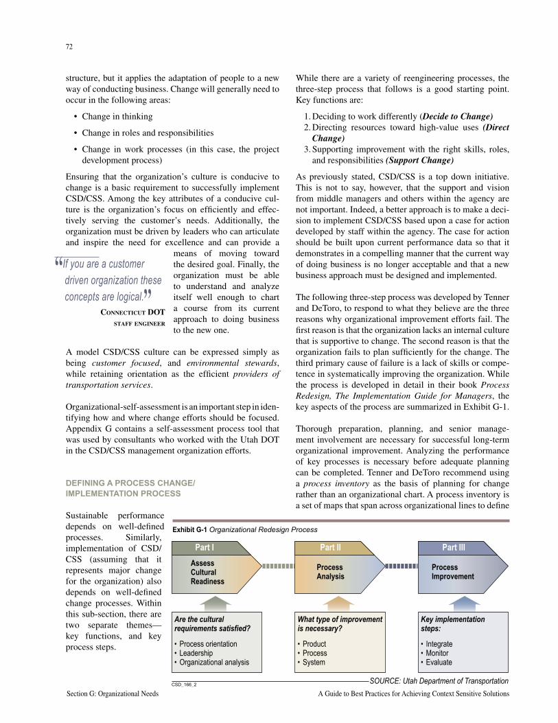
72
Section G: Organizational Needs A Guide to Best Practices for Achieving Context Sensitive Solutions
73
National Cooperative Highway Research Program Report 480 Section G: Organizational Needs
structure, but it applies the adaptation of people to a new way of conducting business. Change will generally need to occur in the following areas:
• Change in thinking
• Change in roles and responsibilities
• Change in work processes (in this case, the project development process)
Ensuring that the organization’s culture is conducive to change is a basic requirement to successfully implement CSD/CSS. Among the key attributes of a conducive cul-ture is the organization’s focus on efficiently and effec-tively serving the customer’s needs. Additionally, the organization must be driven by leaders who can articulate and inspire the need for excellence and can provide a
means of moving toward the desired goal. Finally, the organization must be able to understand and analyze itself well enough to chart a course from its current approach to doing business to the new one.
A model CSD/CSS culture can be expressed simply as being customer focused, and environmental stewards, while retaining orientation as the efficient providers of transportation services.
Organizational-self-assessment is an important step in iden-tifying how and where change efforts should be focused. Appendix G contains a self-assessment process tool that was used by consultants who worked with the Utah DOT in the CSD/CSS management organization efforts.
DEFINING A PROCESS CHANGE/IMPLEMENTATION PROCESS
Sustainable performance depends on well-defined processes. Similarly, implementation of CSD/CSS (assuming that it represents major change for the organization) also depends on well-defined change processes. Within this sub-section, there are two separate themes—key functions, and key process steps.
While there are a variety of reengineering processes, the three-step process that follows is a good starting point. Key functions are:
1. Deciding to work differently (Decide to Change)2. Directing resources toward high-value uses (Direct
Change)3. Supporting improvement with the right skills, roles,
and responsibilities (Support Change)
As previously stated, CSD/CSS is a top down initiative. This is not to say, however, that the support and vision from middle managers and others within the agency are not important. Indeed, a better approach is to make a deci-sion to implement CSD/CSS based upon a case for action developed by staff within the agency. The case for action should be built upon current performance data so that it demonstrates in a compelling manner that the current way of doing business is no longer acceptable and that a new business approach must be designed and implemented.
The following three-step process was developed by Tenner and DeToro, to respond to what they believe are the three reasons why organizational improvement efforts fail. The first reason is that the organization lacks an internal culture that is supportive to change. The second reason is that the organization fails to plan sufficiently for the change. The third primary cause of failure is a lack of skills or compe-tence in systematically improving the organization. While the process is developed in detail in their book Process Redesign, The Implementation Guide for Managers, the key aspects of the process are summarized in Exhibit G-1.
Thorough preparation, planning, and senior manage-ment involvement are necessary for successful long-term organizational improvement. Analyzing the performance of key processes is necessary before adequate planning can be completed. Tenner and DeToro recommend using a process inventory as the basis of planning for change rather than an organizational chart. A process inventory is a set of maps that span across organizational lines to define
“If you are a customer driven organization these concepts are logical.”
CONNECTICUT DOT STAFF ENGINEER
SOURCE: Utah Department of Transportation���������
Part IAssessCulturalReadiness
Part II
ProcessAnalysis
Part III
ProcessImprovement
Are the culturalrequirements satisfied?
What type of improvementis necessary?
Key implementationsteps:
• Process orientation• Leadership• Organizational analysis
• Product• Process• System
• Integrate• Monitor• Evaluate
Exhibit G-1 Organizational Redesign Process
72
Section G: Organizational Needs A Guide to Best Practices for Achieving Context Sensitive Solutions
73
National Cooperative Highway Research Program Report 480 Section G: Organizational Needs
the steps of how things get done. The performance of each process should be measured against two criteria: effective-ness and efficiency. The degree of process effectiveness defines how well the process leads to the right product or level of service. Process efficiency defines in relative terms how much resource (labor hours, materials, dollars) is expended to generate the product or service. The pro-cess analysis is used to define the critical gaps between the desired situation and the current situation. This gap can be used to develop a case for action to mobilize the organiza-tion into changing.
POLICIES AND PROCEDURES
More often than not, existing policy will be adequate to implement CSD/CSS processes and approaches because the purpose of policy is to set general direction and intent as well as to grant general authority, not to define behavior
for each and every activity within an agency. If any changes in written authority are required, it is more likely that operating guidelines or procedures must change.
The states that have fully institutionalized CSD/CSS, such as Maryland, have discovered the need to review certain specific operational policies, articulate new ones, and clar-ify others. The following is a summary of areas in which pilot states have focused:
• Funding of certain project items (roadside amenities, pedestrian lighting, undergrounding of utilities).
• Development of guidelines for aesthetic design treat-ments (types, strategies, funding).
• Local maintenance agreements for roadside landscap-ing and other features.
• Prequalification and/or certification of specialty service providers (example, stone wall construction).
Thinking Beyond the Pavem
ent – A Team A
pproach
In Maryland, early recognition that a team approach to the Thinking Beyond the Pavement (TBTP) initiative was essential to addressing organizational and process issues. Teams were established and work plans developed for the following specific areas of focus:
Organization and Policy Task Team
• Review current policies and develop policy recommendations addressing pedestrian lighting, right-of-way, utilities, and the funding of certain project items.
• Create internal and external awards recognizing the TBTP approach to project development.
• Review graduate engineer interview criteria for their support of TBTP principles and modify as needed.
• Develop data to better estimate man-hour and consultant requirements for project development while meeting current requirements.
• Include the TBTP approach in Maryland State Highway Administration (MSHA) business plans.
• Develop outcome measures for public and private investments associated with the Neighborhood Conservation Project Development Program.
Project Development Process Team
• Develop a streamlined process for delivering transportation projects that provides continuity between all phases.
• Identify other states that have undertaken similar process reviews and learn from their efforts.
• Identify a pilot project that will use one project manager and/or consultant team in all stages from planning to maintenance.
• Develop guidelines for the preparation of project development plans that address public involvement, schedule, resources, and delivery process strategies.
• Identify the appropriate time and use of independent value engineering and budget for needed time and resources.
• Improve the effectiveness of the preliminary field investigation, final review, and constructibility review meetings and processes.
Community Involvement Team
• Develop MSHA community involvement guidance document.
• Develop community involvement skills training for MSHA staff and consultants.
• Develop a strategy for more intensive use of visualization in project development.
• Include community involvement skills in the consultant selection process.
Project Management and Leadership Development Team
• Develop an orientation course for the MSHA organization and MSHA’s project development process
• Develop an Orientation Resource/Reference Guide for project managers.
• Develop introductory- and advanced-level project management courses.
• Develop advanced-level, topic-specific project management courses and a support system for project managers that would include mentors and other resources.
74
Section G: Organizational Needs A Guide to Best Practices for Achieving Context Sensitive Solutions
75
National Cooperative Highway Research Program Report 480 Section G: Organizational Needs
PROJECT MANAGEMENT
One of the most important needs identified by many of the pilot states was the area of project management. Project success or failure, measured by stakeholder acceptance, and schedule and budget adherence, is recognized to be in large part a function of the skills and capabilities of project managers. Pilot states have invested substantially in the development and delivery of project management train-ing courses. A benchmark example is Minnesota DOTs Project Management Academy Course (see Appendix G for course outline).
The skills, approaches, and attributes of good project man-agers are evolving in the CSD/CSS environment. Tradi-tionally, agencies have selected and promoted experienced highway design staff to project management. The historic Project Manager (PM) model has generally been that the PM is the technical overseer of a project, which consists primarily of a series of technical assignments (survey, geo-technical, roadway design, right-of-way plans, etc.).
Agencies involved with CSD/CSS now recognize that effective project management requires the PM to be:
• Manager of resources of a diverse technical nature, some of which may come from outside the agency
• Manager of the overall schedule • Facilitator and manager of unforeseen changes in
the project • Facilitator and communicator of both technical and
policy information to external stakeholders• Negotiator and decision maker, empowered to act on
the agency’s behalf in a constantly evolving project environment
In many cases, the key resource areas and focus are not on traditional highway technical areas but more public involvement activities, or the environmental process. Exhibit G-2 (following pages) provides an example of a checklist for project managers. Appendix G also contains additional information taken from “Thinking Beyond the Pavement.”
PROBLEM DEFINITIONFrom the perspective of the agency, how its staff define problems and approach their solution should reflect a cus-tomer focus. This begins with an understanding of the role the agency plays in the evolution and articulation of long-range transportation plans, and proceeds through STIP execution, construction, and even maintenance.
Problem definition and problem solutions are clearly context sensitive at a state and regional level, as well as at a local level. Decisions to invest in highways versus
transit, to promote controlled or smart growth, to facili-tate economic development of a type or by location, are all made in the political arena, not a purely technical one. Acceptable solutions to mobility issues will reflect not only practical physical or budgetary constraints, but also public policy.
In certain parts of the country, land development patterns and population are stable; community values strongly favor preservation of resources. In these contexts, mobil-ity solutions such as road widening, building bypasses, or other similar infrastructure may run counter to the community values. In other parts of the country, com-munities may desire new roads to open up land for devel-opment, or to compete economically with others. Other examples include the applicability of transit or demand management solutions. These clearly are accepted and effective in some cities, and are ineffective or simply not reasonable in others. Agency staff must understand and adapt to the public values in defining and solving their transportation problems.
THE ROLE OF COMMUNITY VALUES IN DEFINING PROBLEMS
CSD/CSS efforts in Utah directly addressed the issue of problem definition and the mindset to solutions. As part of its pilot state activities, UDOT’s senior management held workshops to engage staff in discussions of their approach to their work. During the course of these workshops they proposed a name change to “context sensitive solutions” (CSS) and they developed a concise set of principles with descriptions. Exhibit G-3 summarizes UDOT’s adopted process for problem definition and solutions.
The proposed adoption of the term Context Sensitive Solu-tions for Utah is based on the following insights:
• The users of Utah’s transportation system aren’t interested in design, they’re interested in solutions. To them design sounds like a process or a means to an outcome. As transportation users, they are paying for and they expect outcomes.
• By focusing on the intended outcome rather than the process or activity, UDOT can help strengthen its own accountability for performance.
• Not all transportation solutions require a design or physical infrastructure.
The set of recommended principles was established to be few in number so UDOT staff can more easily remember and use them. To make each principle more useable, each has an “evidenced by” and an “achieved by” box that fur-ther describes what “success looks like” in practice and how to make it happen.
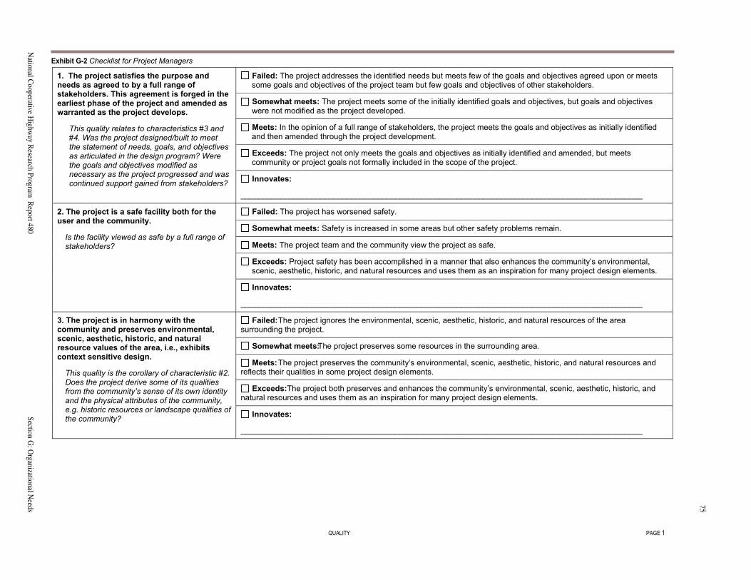
74Section G: O
rganizational Needs
A G
uide to Best Practices for A
chieving Context Sensitive Solutions
75
National C
ooperative Highw
ay Research Program
Report 480
Section G: O
rganizational Needs
QUALITY PAGE 1
Failed: The project addresses the identified needs but meets few of the goals and objectives agreed upon or meetssome goals and objectives of the project team but few goals and objectives of other stakeholders.
Somewhat meets: The project meets some of the initially identified goals and objectives, but goals and objectiveswere not modified as the project developed.
Meets: In the opinion of a full range of stakeholders, the project meets the goals and objectives as initially identifiedand then amended through the project development.
Exceeds: The project not only meets the goals and objectives as initially identified and amended, but meetscommunity or project goals not formally included in the scope of the project.
1. The project satisfies the purpose andneeds as agreed to by a full range ofstakeholders. This agreement is forged in theearliest phase of the project and amended aswarranted as the project develops.
This quality relates to characteristics #3 and#4. Was the project designed/buil� to meetthe statement of needs, goals, and objectivesas articulated in the design program? Werethe goals and objectives modified asnecessary as the project progressed and wascontinued support gained from stakeholders? Innovates:
___________________________________________________________________________________________
Failed: The project has worsened safety.
Somewhat meets: Safety is increased in some areas but other safety problems remain.
Meets: The project team and the community view the project as safe.
Exceeds: Project safety has been accomplished in a manner that also enhances the community�s environmental,scenic, aesthetic, historic, and natural resources and uses them as an inspiration for many project design elements.
2. The project is a safe facility both for theuser and the community.
Is the facility viewed as safe by a full range ofstakeholders?
Innovates:
___________________________________________________________________________________________
�������The project ignores the environmental, scenic, aesthetic, historic, and natural resources of the areasurrounding the project.
����������������The project preserves some resources in the surrounding area.
��������The project preserves the community�s environmental, scenic, aesthetic, historic, and natural resources andreflects their qualities in some project design elements.
��������The project both preserves and enhances the community�s environmental, scenic, aesthetic, historic, andnatural resources and uses them as an inspiration for many project design elements.
3. The project is in harmony with thecommunity and preserves environmental,scenic, aesthetic, historic, and naturalresource values of the area, i.e., exhibitscontext sensitive design.
This quality is the corollary of characteristic #2.Does the project derive some of its qualitiesfrom the community�s sense of its own identityand the physical attributes of the community,e.g. historic resources or landscape qualities ofthe community? ����������
___________________________________________________________________________________________
Exhibit G-2 Checklist for Project Managers
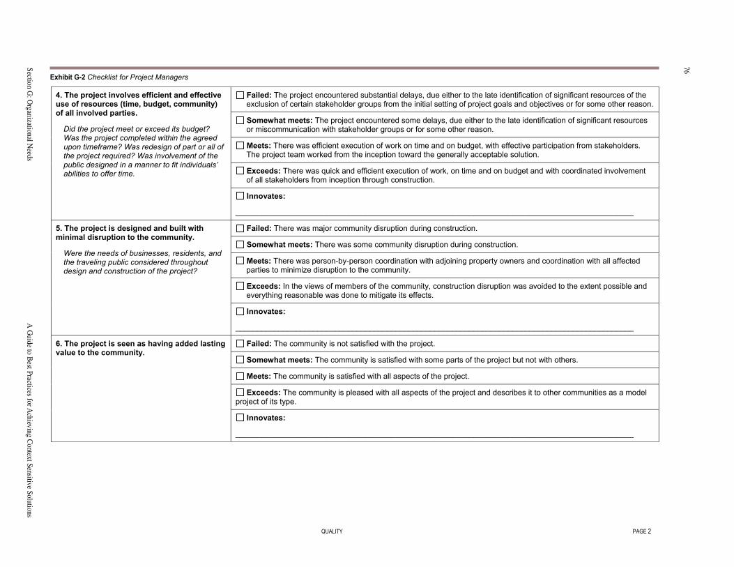
76Section G: O
rganizational Needs
A G
uide to Best Practices for A
chieving Context Sensitive Solutions
77
National C
ooperative Highw
ay Research Program
Report 480
Section G: O
rganizational Needs
QUALITY PAGE 2
Failed: The project encountered substantial delays, due either to the late identification of significant resources of theexclusion of certain stakeholder groups from the initial setting of project goals and objectives or for some other reason.
Somewhat meets: The project encountered some delays, due either to the late identification of significant resourcesor miscommunication with stakeholder groups or for some other reason.
Meets: There was efficient execution of work on time and on budget, with effective participation from stakeholders.The project team worked from the inception toward the generally acceptable solution.
Exceeds: There was quick and efficient execution of work, on time and on budget and with coordinated involvementof all stakeholders from inception through construction.
4. The project involves efficient and effectiveuse of resources (time, budget, community)of all involved parties.
Did the project meet or exceed its budget?Was the project completed within the agreedupon timeframe? Was red�sign of part or all ofthe project required? Was involvement of thepublic designed in a manner to fit individuals�abilities to offer time.
Innovates:
____________________________________________________________________________________________
Failed: There was major community disruption during construction.
Somewhat meets: There was some community disruption during construction.
Meets: There was person�by�person coordination with adjoining property owners and coordination with all affectedparties to minimize disruption to the community.
Exceeds: In the views of members of the community, construction disruption was avoided to the extent possible andeverything reasonable was done to mitigate its effects.
5. The project is designed and built withminimal disruption to the community.
Were the needs of business��, residents, andthe traveling public considered throughoutdesign and construction of the project?
Innovates:
____________________________________________________________________________________________
Failed: The community is not satisfied with the project.
Somewhat meets: The community is satisfied with some parts of the project but not with others.
Meets: The community is satisfied with all aspects of the project.
Exceeds: The community is pleased with all aspects of the project and describes it to other communities as a modelproject of its type.
6. The project is seen as having added lastingvalue to the community.
Innovates:
____________________________________________________________________________________________
Exhibit G-2 Checklist for Project Managers
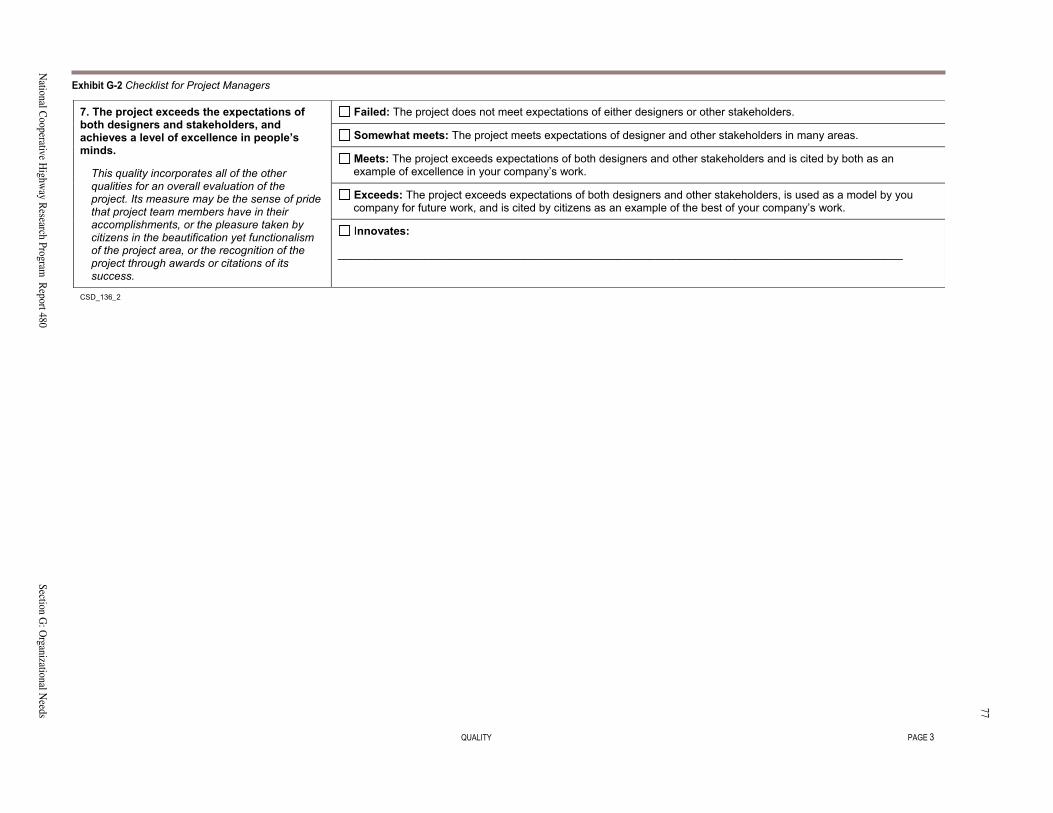
76Section G: O
rganizational Needs
A G
uide to Best Practices for A
chieving Context Sensitive Solutions
77
National C
ooperative Highw
ay Research Program
Report 480
Section G: O
rganizational Needs
QUALITY PAGE 3
Failed: The project does not meet expectations of either designers or other stakeholders.
Somewhat meets: The project meets expectations of designer and other stakeholders in many areas.
Meets: The project exceeds expectations of both designers and other stakeholders and is cited by both as anexample of excellence in your company�s work.
Exceeds: The project exceeds expectations of both designers and other stakeholders, is used as a model by youcompany for future work, and is cited by citizens as an example of the best of your company�s work.
7. The project exceeds the expectations ofboth designers and stakeholders, andachieves a level of excellence in people�sminds.
This quality incorporates all of the otherqualities for an overall evaluation of theproject. Its measure may be the sense of pridethat project team members have in theiraccomplishments, or the pleasure taken bycitizens in the beautification yet functionalismof the project area, or the recognition of theproject through awards or citations of itssuccess.
Innovates:
___________________________________________________________________________________________
CSD_136��
Exhibit G-2 Checklist for Project Managers
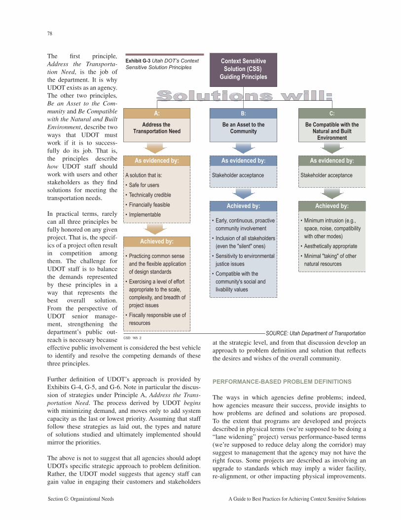
78
Section G: Organizational Needs A Guide to Best Practices for Achieving Context Sensitive Solutions
79
National Cooperative Highway Research Program Report 480 Section G: Organizational Needs
The first principle, Address the Transporta-tion Need, is the job of the department. It is why UDOT exists as an agency. The other two principles, Be an Asset to the Com-munity and Be Compatible with the Natural and Built Environment, describe two ways that UDOT must work if it is to success-fully do its job. That is, the principles describe how UDOT staff should work with users and other stakeholders as they find solutions for meeting the transportation needs.
In practical terms, rarely can all three principles be fully honored on any given project. That is, the specif-ics of a project often result in competition among them. The challenge for UDOT staff is to balance the demands represented by these principles in a way that represents the best overall solution. From the perspective of UDOT senior manage-ment, strengthening the department’s public out-reach is necessary because effective public involvement is considered the best vehicle to identify and resolve the competing demands of these three principles.
Further definition of UDOT’s approach is provided by Exhibits G-4, G-5, and G-6. Note in particular the discus-sion of strategies under Principle A, Address the Trans-portation Need. The process derived by UDOT begins with minimizing demand, and moves only to add system capacity as the last or lowest priority. Assuming that staff follow these strategies as laid out, the types and nature of solutions studied and ultimately implemented should mirror the priorities.
The above is not to suggest that all agencies should adopt UDOTs specific strategic approach to problem definition. Rather, the UDOT model suggests that agency staff can gain value in engaging their customers and stakeholders
at the strategic level, and from that discussion develop an approach to problem definition and solution that reflects the desires and wishes of the overall community.
PERFORMANCE-BASED PROBLEM DEFINITIONS
The ways in which agencies define problems; indeed, how agencies measure their success, provide insights to how problems are defined and solutions are proposed. To the extent that programs are developed and projects described in physical terms (we’re supposed to be doing a “lane widening” project) versus performance-based terms (we’re supposed to reduce delay along the corridor) may suggest to management that the agency may not have the right focus. Some projects are described as involving an upgrade to standards which may imply a wider facility, re-alignment, or other impacting physical improvements.
CSD_165_2
B:
Be an Asset to the Community
C:
Be Compatible with the Natural and Built
Environment
A:Address the
Transportation Need
As evidenced by:
Stakeholder acceptance
As evidenced by:
Stakeholder acceptance
As evidenced by:
A solution that is:• Safe for users• Technically credible• Financially feasible• Implementable
Achieved by:
• Practicing common sense and the flexible application of design standards
• Exercising a level of effort appropriate to the scale, complexity, and breadth of project issues
• Fiscally responsible use of resources
Achieved by:
• Early, continuous, proactive community involvement
• Inclusion of all stakeholders (even the "silent" ones)
• Sensitivity to environmental justice issues
• Compatible with the community's social and livability values
Achieved by:
• Minimum intrusion (e.g., space, noise, compatibility with other modes)
• Aesthetically appropriate• Minimal "taking" of other
natural resources
Solutions will:
Context Sensitive Solution (CSS)
Guiding Principles
SOURCE: Utah Department of Transportation
Exhibit G-3 Utah DOT’s Context Sensitive Solution Principles
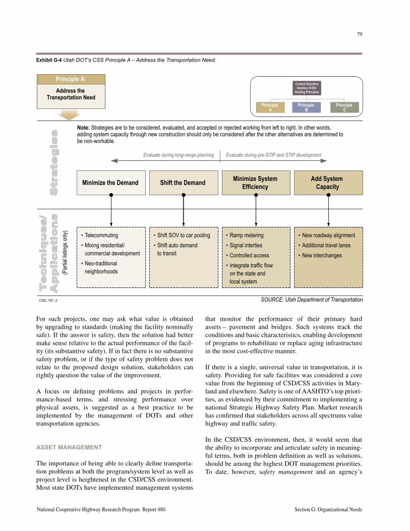
78
Section G: Organizational Needs A Guide to Best Practices for Achieving Context Sensitive Solutions
79
National Cooperative Highway Research Program Report 480 Section G: Organizational Needs
For such projects, one may ask what value is obtained by upgrading to standards (making the facility nominally safe). If the answer is safety, then the solution had better make sense relative to the actual performance of the facil-ity (its substantive safety). If in fact there is no substantive safety problem, or if the type of safety problem does not relate to the proposed design solution, stakeholders can rightly question the value of the improvement.
A focus on defining problems and projects in perfor-mance-based terms, and stressing performance over physical assets, is suggested as a best practice to be implemented by the management of DOTs and other transportation agencies.
ASSET MANAGEMENT
The importance of being able to clearly define transporta-tion problems at both the program/system level as well as project level is heightened in the CSD/CSS environment. Most state DOTs have implemented management systems
that monitor the performance of their primary hard assets – pavement and bridges. Such systems track the conditions and basic characteristics, enabling development of programs to rehabilitate or replace aging infrastructure in the most cost-effective manner.
If there is a single, universal value in transportation, it is safety. Providing for safe facilities was considered a core value from the beginning of CSD/CSS activities in Mary-land and elsewhere. Safety is one of AASHTO’s top priori-ties, as evidenced by their commitment to implementing a national Strategic Highway Safety Plan. Market research has confirmed that stakeholders across all spectrums value highway and traffic safety.
In the CSD/CSS environment, then, it would seem that the ability to incorporate and articulate safety in meaning-ful terms, both in problem definition as well as solutions, should be among the highest DOT management priorities. To date, however, safety management and an agency’s
Note: Strategies are to be considered, evaluated, and accepted or rejected working from left to right. In other words,adding system capacity through new construction should only be considered after the other alternatives are determined tobe non-workable.
(Par
tialli
sting
sonly
)
���������
Principle A:Address the
Transportation Need
Strategies
PrincipleA
PrincipleB
PrincipleC
Context SensitiveSolution (CSS)
Guiding Principles
Shift the Demand
• Shift SOV to car pooling• Shift auto demand
to transit
Minimize SystemEfficiency
• Ramp metering• Signal interties• Controlled access• Integrate traffic flow
on the state andlocal system
Add SystemCapacity
• New roadway alignment• Additional travel lanes• New interchanges
Evaluate during long-range planning Evaluate during pre-STIP and STIP development
Minimize the Demand
• Telecommuting• Mixing residential/
commercial development• Neo-traditional
neighborhoods
Techniques/
Applications
SOURCE: Utah Department of Transportation
Exhibit G-4 Utah DOT’s CSS Principle A – Address the Transportation Need.
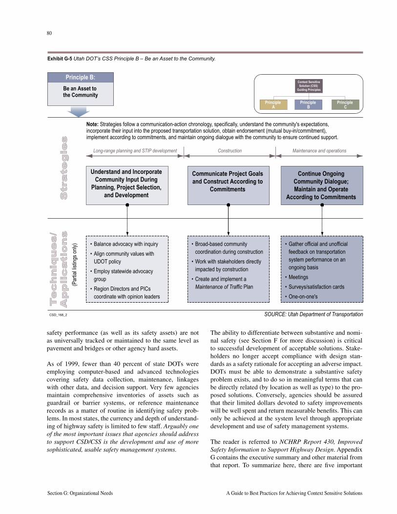
80
Section G: Organizational Needs A Guide to Best Practices for Achieving Context Sensitive Solutions
81
National Cooperative Highway Research Program Report 480 Section G: Organizational Needs
safety performance (as well as its safety assets) are not as universally tracked or maintained to the same level as pavement and bridges or other agency hard assets.
As of 1999, fewer than 40 percent of state DOTs were employing computer-based and advanced technologies covering safety data collection, maintenance, linkages with other data, and decision support. Very few agencies maintain comprehensive inventories of assets such as guardrail or barrier systems, or reference maintenance records as a matter of routine in identifying safety prob-lems. In most states, the currency and depth of understand-ing of highway safety is limited to few staff. Arguably one of the most important issues that agencies should address to support CSD/CSS is the development and use of more sophisticated, usable safety management systems.
The ability to differentiate between substantive and nomi-nal safety (see Section F for more discussion) is critical to successful development of acceptable solutions. Stake-holders no longer accept compliance with design stan-dards as a safety rationale for accepting an adverse impact. DOTs must be able to demonstrate a substantive safety problem exists, and to do so in meaningful terms that can be directly related (by location as well as type) to the pro-posed solutions. Conversely, agencies should be assured that their limited dollars devoted to safety improvements will be well spent and return measurable benefits. This can only be achieved at the system level through appropriate development and use of safety management systems.
The reader is referred to NCHRP Report 430, Improved Safety Information to Support Highway Design. Appendix G contains the executive summary and other material from that report. To summarize here, there are five important
Note: Strategies follow a communication-action chronology, specifically, understand the community's expectations,incorporate their input into the proposed transportation solution, obtain endorsement (mutual buy-in/commitment),implement according to commitments, and maintain ongoing dialogue with the community to ensure continued support.
(Par
tialli
sting
sonly
)
���������
Principle B:Be an Asset tothe Community
Strategies
PrincipleA
PrincipleB
PrincipleC
Context SensitiveSolution (CSS)
Guiding Principles
Communicate Project Goalsand Construct According to
Commitments
• Broad-based communitycoordination during construction
• Work with stakeholders directlyimpacted by construction
• Create and implement aMaintenance of Traffic Plan
Continue OngoingCommunity Dialogue;Maintain and Operate
According to Commitments
• Gather official and unofficialfeedback on transportationsystem performance on anongoing basis
• Meetings• Surveys/satisfaction cards• One-on-one's
Long-range planning and STIP development Construction Maintenance and operations
Understand and IncorporateCommunity Input During
Planning, Project Selection,and Development
• Balance advocacy with inquiry• Align community values with
UDOT policy• Employ statewide advocacy
group• Region Directors and PICs
coordinate with opinion leaders
Techniques/
Applications
SOURCE: Utah Department of Transportation
Exhibit G-5 Utah DOT’s CSS Principle B – Be an Asset to the Community.
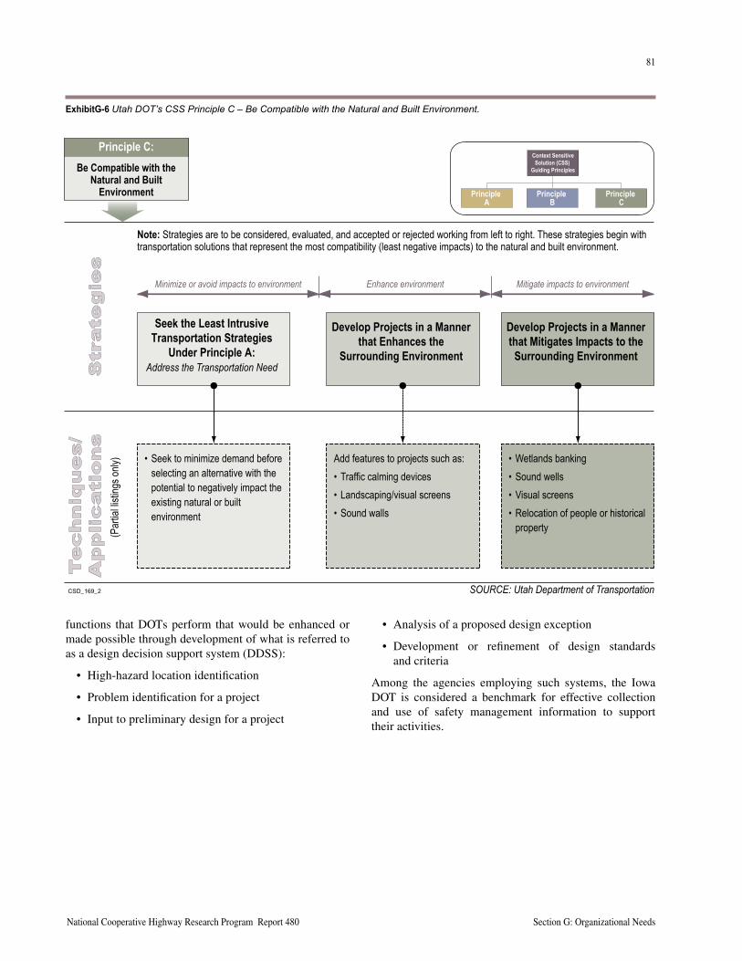
80
Section G: Organizational Needs A Guide to Best Practices for Achieving Context Sensitive Solutions
81
National Cooperative Highway Research Program Report 480 Section G: Organizational Needs
functions that DOTs perform that would be enhanced or made possible through development of what is referred to as a design decision support system (DDSS):
• High-hazard location identification
• Problem identification for a project
• Input to preliminary design for a project
• Analysis of a proposed design exception
• Development or refinement of design standards and criteria
Among the agencies employing such systems, the Iowa DOT is considered a benchmark for effective collection and use of safety management information to support their activities.
Note: Strategies are to be considered, evaluated, and accepted or rejected working from left to right. These strategies begin withtransportation solutions that represent the most compatibility (least negative impacts) to the natural and built environment.
(Par
tialli
sting
sonly
)
���������
Principle C:Be Compatible with the
Natural and BuiltEnvironment
Strategies
PrincipleA
PrincipleB
PrincipleC
Context SensitiveSolution (CSS)
Guiding Principles
Develop Projects in a Mannerthat Enhances the
Surrounding Environment
Add features to projects such as:• Traffic calming devices• Landscaping/visual screens• Sound walls
Develop Projects in a Mannerthat Mitigates Impacts to the
Surrounding Environment
• Wetlands banking• Sound wells• Visual screens• Relocation of people or historical
property
Minimize or avoid impacts to environment Enhance environment Mitigate impacts to environment
Seek the Least IntrusiveTransportation Strategies
Under Principle A:Address the Transportation Need
• Seek to minimize demand beforeselecting an alternative with thepotential to negatively impact theexisting natural or builtenvironment
Techniques/
Applications
SOURCE: Utah Department of Transportation
ExhibitG-6 Utah DOT’s CSS Principle C – Be Compatible with the Natural and Built Environment.
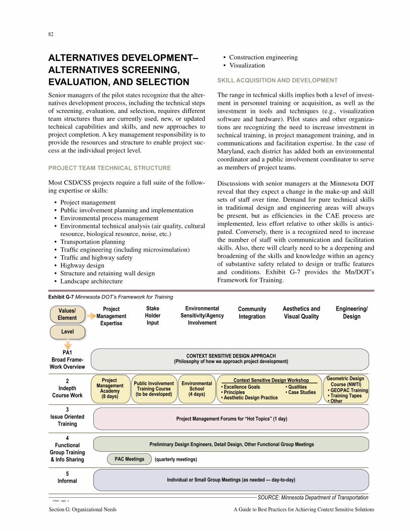
82
Section G: Organizational Needs A Guide to Best Practices for Achieving Context Sensitive Solutions
83
National Cooperative Highway Research Program Report 480 Section G: Organizational Needs
ALTERNATIVES DEVELOPMENT–ALTERNATIVES SCREENING, EVALUATION, AND SELECTIONSenior managers of the pilot states recognize that the alter-natives development process, including the technical steps of screening, evaluation, and selection, requires different team structures than are currently used, new, or updated technical capabilities and skills, and new approaches to project completion. A key management responsibility is to provide the resources and structure to enable project suc-cess at the individual project level.
PROJECT TEAM TECHNICAL STRUCTURE
Most CSD/CSS projects require a full suite of the follow-ing expertise or skills:
• Project management• Public involvement planning and implementation• Environmental process management• Environmental technical analysis (air quality, cultural
resource, biological resource, noise, etc.)• Transportation planning• Traffic engineering (including microsimulation)• Traffic and highway safety• Highway design• Structure and retaining wall design• Landscape architecture
• Construction engineering• Visualization
SKILL ACQUISITION AND DEVELOPMENT
The range in technical skills implies both a level of invest-ment in personnel training or acquisition, as well as the investment in tools and techniques (e.g., visualization software and hardware). Pilot states and other organiza-tions are recognizing the need to increase investment in technical training, in project management training, and in communications and facilitation expertise. In the case of Maryland, each district has added both an environmental coordinator and a public involvement coordinator to serve as members of project teams.
Discussions with senior managers at the Minnesota DOT reveal that they expect a change in the make-up and skill sets of staff over time. Demand for pure technical skills in traditional design and engineering areas will always be present, but as efficiencies in the CAE process are implemented, less effort relative to other skills is antici-pated. Conversely, there is a recognized need to increase the number of staff with communication and facilitation skills. Also, there will clearly need to be a deepening and broadening of the skills and knowledge within an agency of substantive safety related to design or traffic features and conditions. Exhibit G-7 provides the Mn/DOT’s Framework for Training.
���������
Values/Element
Level
ProjectManagement
Expertise
PA1Broad Frame-
Work Overview
2Indepth
Course Work
3Issue Oriented
Training
4Functional
Group Training& Info Sharing
5Informal
StakeHolderInput
EnvironmentalSensitivity/Agency
Involvement
CommunityIntegration
Aesthetics andVisual Quality
Engineering/Design
CONTEXT SENSITIVE DESIGN APPROACH(Philosophy of how we approach project development)
Project Management Forums for “Hot Topics” (1 day)
Preliminary Design Engineers, Detail Design, Other Functional Group Meetings
PAC Meetings (quarterly meetings)
Individual or Small Group Meetings (as needed — day-to-day)
ProjectManagement
Academy(8 days)
Public InvolvementTraining Course
(to be developed)
EnvironmentalSchool(4 days)
Context Sensitive Design Workshop Geometric DesignCourse (NWTI)• Excellence Goals
• Principles• Aesthetic Design Practice
• Qualities• Case Studies • GEOPAC Training
• Training Tapes• Other
SOURCE: Minnesota Department of Transportation
Exhibit G-7 Minnesota DOT’s Framework for Training
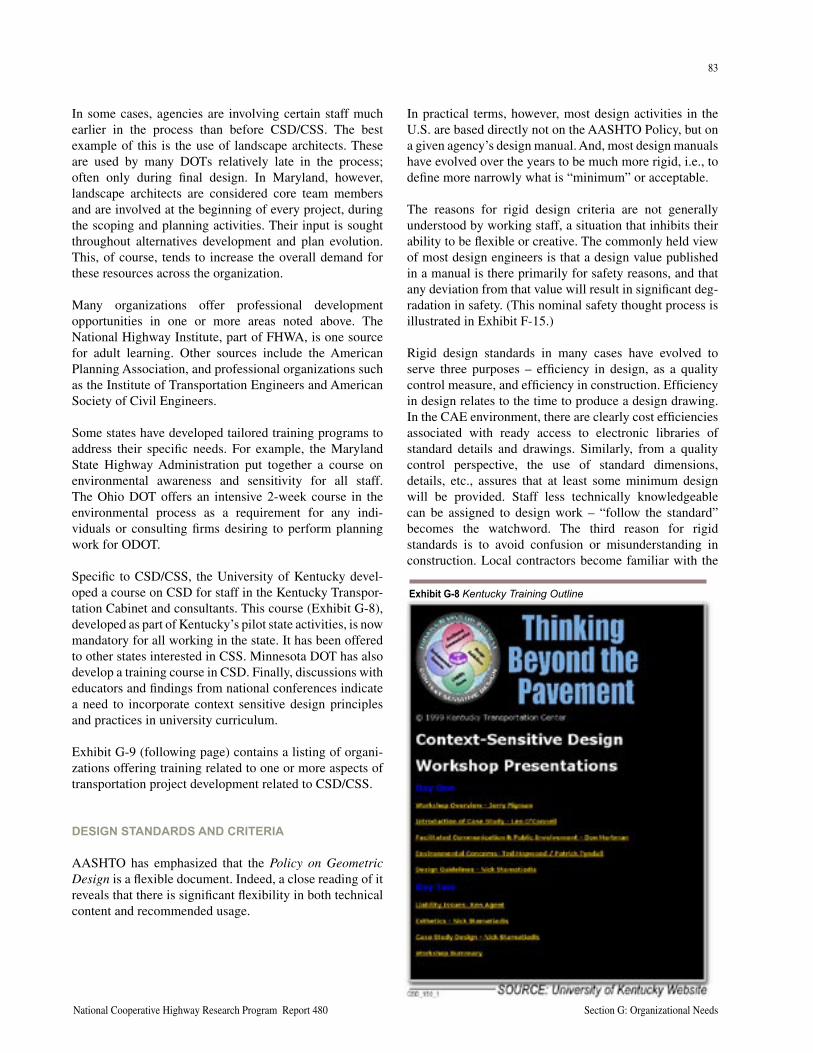
82
Section G: Organizational Needs A Guide to Best Practices for Achieving Context Sensitive Solutions
83
National Cooperative Highway Research Program Report 480 Section G: Organizational Needs
In some cases, agencies are involving certain staff much earlier in the process than before CSD/CSS. The best example of this is the use of landscape architects. These are used by many DOTs relatively late in the process; often only during final design. In Maryland, however, landscape architects are considered core team members and are involved at the beginning of every project, during the scoping and planning activities. Their input is sought throughout alternatives development and plan evolution. This, of course, tends to increase the overall demand for these resources across the organization.
Many organizations offer professional development opportunities in one or more areas noted above. The National Highway Institute, part of FHWA, is one source for adult learning. Other sources include the American Planning Association, and professional organizations such as the Institute of Transportation Engineers and American Society of Civil Engineers.
Some states have developed tailored training programs to address their specific needs. For example, the Maryland State Highway Administration put together a course on environmental awareness and sensitivity for all staff. The Ohio DOT offers an intensive 2-week course in the environmental process as a requirement for any indi-viduals or consulting firms desiring to perform planning work for ODOT.
Specific to CSD/CSS, the University of Kentucky devel-oped a course on CSD for staff in the Kentucky Transpor-tation Cabinet and consultants. This course (Exhibit G-8), developed as part of Kentucky’s pilot state activities, is now mandatory for all working in the state. It has been offered to other states interested in CSS. Minnesota DOT has also develop a training course in CSD. Finally, discussions with educators and findings from national conferences indicate a need to incorporate context sensitive design principles and practices in university curriculum.
Exhibit G-9 (following page) contains a listing of organi-zations offering training related to one or more aspects of transportation project development related to CSD/CSS.
DESIGN STANDARDS AND CRITERIA
AASHTO has emphasized that the Policy on Geometric Design is a flexible document. Indeed, a close reading of it reveals that there is significant flexibility in both technical content and recommended usage.
In practical terms, however, most design activities in the U.S. are based directly not on the AASHTO Policy, but on a given agency’s design manual. And, most design manuals have evolved over the years to be much more rigid, i.e., to define more narrowly what is “minimum” or acceptable.
The reasons for rigid design criteria are not generally understood by working staff, a situation that inhibits their ability to be flexible or creative. The commonly held view of most design engineers is that a design value published in a manual is there primarily for safety reasons, and that any deviation from that value will result in significant deg-radation in safety. (This nominal safety thought process is illustrated in Exhibit F-15.)
Rigid design standards in many cases have evolved to serve three purposes – efficiency in design, as a quality control measure, and efficiency in construction. Efficiency in design relates to the time to produce a design drawing. In the CAE environment, there are clearly cost efficiencies associated with ready access to electronic libraries of standard details and drawings. Similarly, from a quality control perspective, the use of standard dimensions, details, etc., assures that at least some minimum design will be provided. Staff less technically knowledgeable can be assigned to design work – “follow the standard” becomes the watchword. The third reason for rigid standards is to avoid confusion or misunderstanding in construction. Local contractors become familiar with the
Exhibit G-8 Kentucky Training Outline
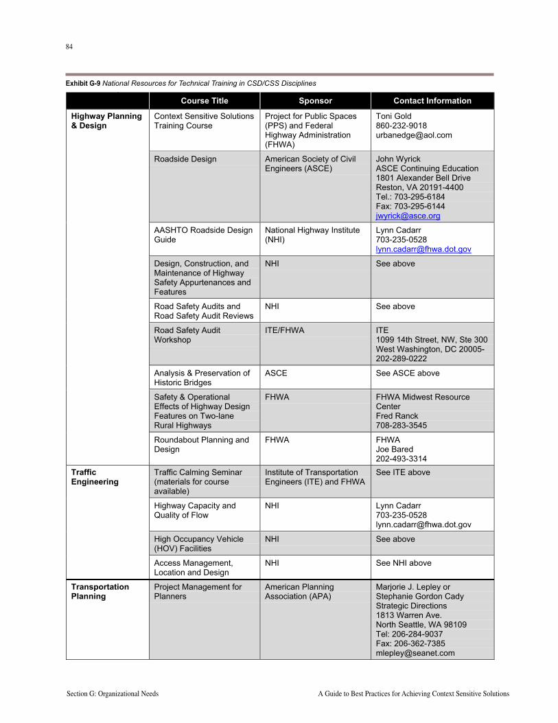
84
Section G: Organizational Needs A Guide to Best Practices for Achieving Context Sensitive Solutions
85
National Cooperative Highway Research Program Report 480 Section G: Organizational NeedsCSD_134_LIST TRAINING COURSES.DOC 1
EXHIBIT CSD_134List of Training Courses
Course Title Sponsor Contact Information
Context Sensitive SolutionsTraining Course
Project for Public Spaces(PPS) and FederalHighway Administration(FHWA)
Toni [email protected]
Roadside Design American Society of CivilEngineers (ASCE)
John WyrickASCE Continuing Education1801 Alexander Bell DriveReston, VA 20191-4400Tel.: 703-295-6184Fax: [email protected]
AASHTO Roadside DesignGuide
National Highway Institute(NHI)
Lynn [email protected]
Design, Construction, andMaintenance of HighwaySafety Appurtenances andFeatures
NHI See above
Road Safety Audits andRoad Safety Audit Reviews
NHI See above
Road Safety AuditWorkshop
ITE/FHWA ITE1099 14th Street, NW, Ste 300West Washington, DC 20005-202-289-0222
Analysis & Preservation ofHistoric Bridges
ASCE See ASCE above
Safety & OperationalEffects of Highway DesignFeatures on Two-laneRural Highways
FHWA FHWA Midwest ResourceCenterFred Ranck708-283-3545
Highway Planning& Design
Roundabout Planning andDesign
FHWA FHWAJoe B�red202-493-3314
Traffic Calming Seminar(materials for courseavailable)
Institute of TransportationEngineers (ITE) and FHWA
See ITE above
Highway Capacity andQuality of Flow
NHI Lynn [email protected]
High Occupancy Vehicle(HOV) Facilities
NHI See above
TrafficEngineering
Access Management,Location and Design
NHI See NHI above
TransportationPlanning
Project Management forPlanners
American PlanningAssociation (APA)
Marjorie J. Lepley orStephanie Gordon CadyStrategic Directions1813 Warren Ave.North Seattle, WA 98109Tel: 206-284-9037Fax: [email protected]
Exhibit G-9 National Resources for Technical Training in CSD/CSS Disciplines
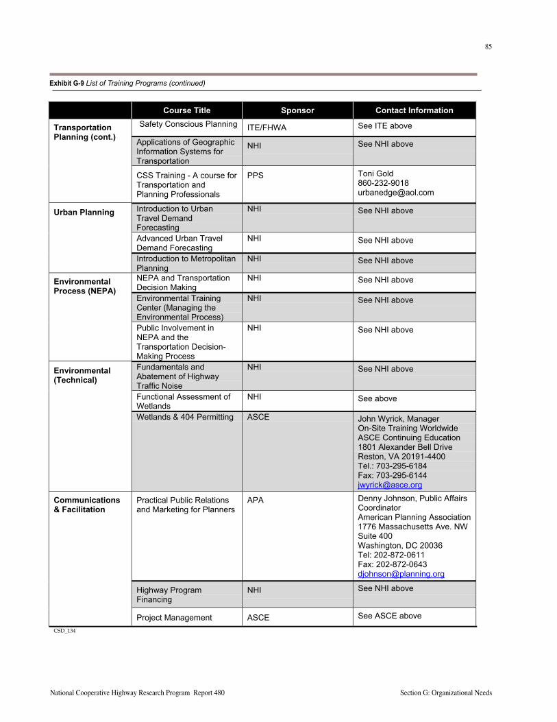
84
Section G: Organizational Needs A Guide to Best Practices for Achieving Context Sensitive Solutions
85
National Cooperative Highway Research Program Report 480 Section G: Organizational Needs
CSD_134_LIST TRAINING COURSES.DOC 2
Course Title Sponsor Contact InformationSafety Conscious Planning ITE/FHWA See ITE above
Applications of GeographicInformation Systems forTransportation
NHI See NHI above
TransportationPlanning (cont.)
CSS Training - A course forTransportation andPlanning Professionals
PPS Toni [email protected]
Introduction to UrbanTravel DemandForecasting
NHI See NHI above
Advanced Urban TravelDemand Forecasting
NHI See NHI above
Urban Planning
Introduction to MetropolitanPlanning
NHI See NHI above
NEPA and TransportationDecision Making
NHI See NHI above
Environmental TrainingCenter (Managing theEnvironmental Process)
NHI See NHI above
EnvironmentalProcess (NEPA)
Public Involvement inNEPA and theTransportation Decision-Making Process
NHI See NHI above
Fundamentals andAbatement of HighwayTraffic Noise
NHI See NHI above
Functional Assessment ofWetlands
NHI See above
Environmental(Technical)
Wetlands & 404 Permitting ASCE John Wyrick, ManagerOn-Site Training WorldwideASCE Continuing Education1801 Alexander Bell DriveReston, VA 20191-4400Tel.: 703-295-6184Fax: [email protected]
Practical Public Relationsand Marketing for Planners
APA Denny Johnson, Public AffairsCoordinatorAmerican Planning Association1776 Massachusetts Ave. NWSuite 400Washington, DC 20036Tel: 202-872-0611Fax: [email protected]
Highway ProgramFinancing
NHI See NHI above
Communications& Facilitation
Project Management ASCE See ASCE aboveCSD_134
Exhibit G-9 List of Training Programs (continued)
86
Section G: Organizational Needs A Guide to Best Practices for Achieving Context Sensitive Solutions
87
National Cooperative Highway Research Program Report 480 Section G: Organizational Needs
DOT’s standard approaches and details, and can bid lower and construct more efficiently knowing them.
What is unfortunate is that the focus on rigid standards has been translated in the minds of working level staff to a belief that standards equals safety, and that no compromises can be accepted. This view holds even with design values that clearly are not related to design exceptions or to sub-stantive safety. Thus, for example, an agency may have in their manual a design drawing showing that a rural front-age road should intersect a crossroad no closer than 300 feet from a freeway ramp terminal intersection. Designers consulting such a drawing and confronted with a situation in which the intersection is 280 feet away will consider this 1) substandard; 2) unsafe; and 3) requiring some sort of design improvement. Note that this type of analysis is often done with no consideration or reference to actual
crash records, and often without a site visit. The costs to the agency of this sort of decision process are obvious – unnecessary expen-diture in a realignment, unnecessary impact to a landowner, and in many cases, unneces-sary conflict with an environmental resource or stakeholder.
The problem of intelli-gent use of criteria and technical knowledge is not new. Encourage-ment for designers to be flexible, use their judg-ment, and apply design criteria judiciously goes back many years. In the CSD/CSS envi-ronment, this approach will become more and more critical to success of an agency.
Empowering staff to be flexible within design criteria will mean that
1) staff need to become more knowledgeable in not just the criteria, but the reasons for them (which may include safety, operations, maintenance, constructibility, and other issues); and 2) a commitment to address the rigidity in current criteria and design manuals. With respect to the former point, FHWA has developed a course to educate
design staff on the background behind AASHTO design criteria and to highlight the relationship between design features and substantive safety for two-lane roads. See Appendix F for the course outline. With respect to the latter point, management of DOTs should carefully review their design manuals and standard drawings to assure that they are not overly rigid.
PROJECT CONTINUITY
Projects pass through major phases, from planning and environmental studies (culminating in a FONSI or ROD) to preliminary and final engineering, to construction and ultimately maintenance. Typical project delivery involves a hand-off from one part of the organization to another at each of these major phases, and often one project manager to another. Exhibit G-10 (following page) shows a typi-cal project flow chart provided by the Connecticut DOT, which highlights through the use of color the key hand-off phases in the project.
Best management practices, reflective of experience from the pilot states, recognize the hand-off or transition as an area of high risk of failure. From the perspective of exter-nal stakeholders, they are dealing with one organization. To the extent that the organization has worked with them, made commitments and promises, and extracted support, the expectation is that the commitments and promises will be kept.
Some of the greatest problems and CSD/CSS failures have occurred in the transition from design to construction. Commitments to save trees, accommodate a driveway or other seemingly minor (from the overall project’s perspec-tive) issues can be violated if construction staff are not properly briefed, are not themselves context sensitive, or if the promise could not be kept because of a construction problem that was unforeseen during design.
These performance gaps can be addressed by continuity of staff assignments, and in some cases technical train-ing. Certainly awareness training can help for both design and construction staff. Some states have begun to assign one project manager to follow the project from planning through construction. Where this does not occur, inclusion of construction staff on the project team during the plan-ning and design phases is used to avoid conflicts, followed by a full briefing of construction staff concerning promises that have been made. One of the reasons for inclusion of landscape architects early in Maryland’s efforts is to high-light early key maintenance issues and concerns (e.g., who will care for median plantings).
“The direct application of established design criteria or standards is no assurance that a certain quality of design will be achieved – indicating that such criteria are not sufficient in themselves…The design professional applies the design criteria or standards, chooses minimum, above-minimum or desirable values, and develops the composition of the facility in three dimensions. Thus the attitude and capability of the designer can play a significant role in determining operational efficiency and safety.”
JACK E. LEISCH, PHILOSOPHICAL CONSIDERATIONS IN HIGHWAY DESIGN, DYNAMIC DESIGN FOR
SAFETY, 1974.
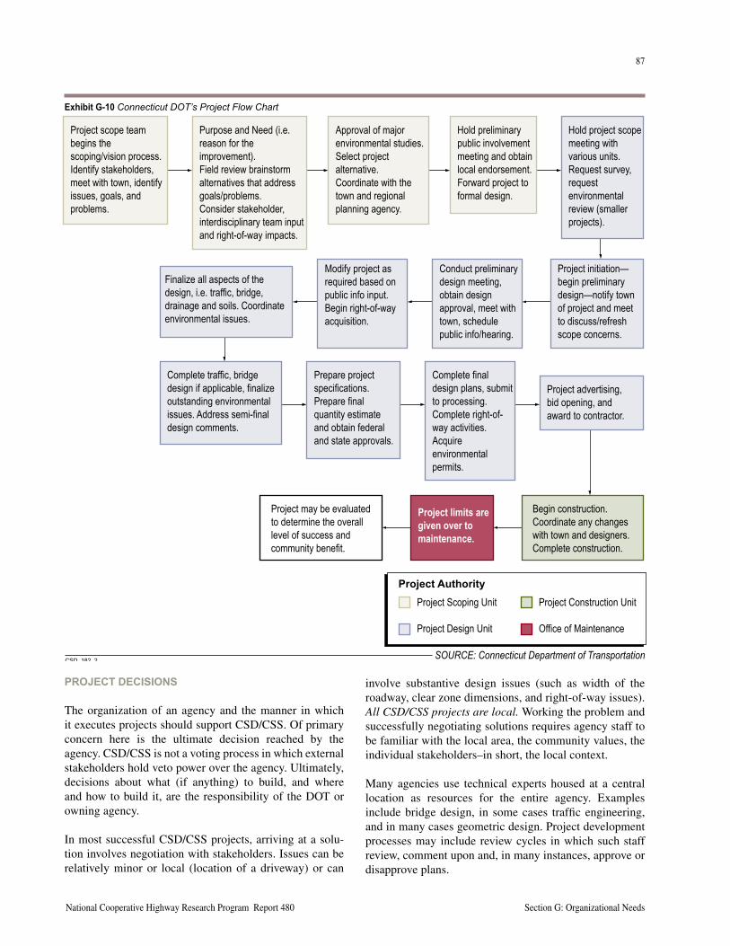
86
Section G: Organizational Needs A Guide to Best Practices for Achieving Context Sensitive Solutions
87
National Cooperative Highway Research Program Report 480 Section G: Organizational Needs
PROJECT DECISIONS
The organization of an agency and the manner in which it executes projects should support CSD/CSS. Of primary concern here is the ultimate decision reached by the agency. CSD/CSS is not a voting process in which external stakeholders hold veto power over the agency. Ultimately, decisions about what (if anything) to build, and where and how to build it, are the responsibility of the DOT or owning agency.
In most successful CSD/CSS projects, arriving at a solu-tion involves negotiation with stakeholders. Issues can be relatively minor or local (location of a driveway) or can
involve substantive design issues (such as width of the roadway, clear zone dimensions, and right-of-way issues). All CSD/CSS projects are local. Working the problem and successfully negotiating solutions requires agency staff to be familiar with the local area, the community values, the individual stakeholders–in short, the local context.
Many agencies use technical experts housed at a central location as resources for the entire agency. Examples include bridge design, in some cases traffic engineering, and in many cases geometric design. Project development processes may include review cycles in which such staff review, comment upon and, in many instances, approve or disapprove plans.
Project scope teambegins thescoping/vision process.Identify stakeholders,meet with town, identifyissues, goals, andproblems.
Purpose and Need (i.e.reason for theimprovement).Field review brainstormalternatives that addressgoals/problems.Consider stakeholder,interdisciplinary team inputand right-of-way impacts.
Approval of majorenvironmental studies.Select projectalternative.Coordinate with thetown and regionalplanning agency.
Hold project scopemeeting withvarious units.Request survey,requestenvironmentalreview (smallerprojects).
Project initiation—begin preliminarydesign—notify townof project and meetto discuss/refreshscope concerns.
Conduct preliminarydesign meeting,obtain designapproval, meet withtown, schedulepublic info/hearing.
Modify project asrequired based onpublic info input.Begin right-of-wayacquisition.
Finalize all aspects of thedesign, i.e. traffic, bridge,drainage and soils. Coordinateenvironmental issues.
Complete traffic, bridgedesign if applicable, finalizeoutstanding environmentalissues. Address semi-finaldesign comments.
Prepare projectspecifications.Prepare finalquantity estimateand obtain federaland state approvals.
Complete finaldesign plans, submitto processing.Complete right-of-way activities.Acquireenvironmentalpermits.
Project advertising,bid opening, andaward to contractor.
Begin construction.Coordinate any changeswith town and designers.Complete construction.
Project may be evaluatedto determine the overalllevel of success andcommunity benefit.
Project Scoping Unit
Project Design Unit
Project Construction Unit
Office of Maintenance
������� ���������
Project limits aregiven over tomaintenance.
Hold preliminarypublic involvementmeeting and obtainlocal endorsement.Forward project toformal design.
���������SOURCE: Connecticut Department of Transportation
Exhibit G-10 Connecticut DOT’s Project Flow Chart
88
Section G: Organizational Needs A Guide to Best Practices for Achieving Context Sensitive Solutions
89
National Cooperative Highway Research Program Report 480 Section G: Organizational Needs
Recognizing that agency staff assigned to the project must work locally, it is important for DOTs and other agen-cies to establish protocols and procedures, and to clarify roles and responsibilities of all internal staff to support the stakeholder working process at the local project level. Local agency staff need full understanding of what is and is not negotiable. They need to have ready access to a resource or individual to answer a question or help develop a solution. Conversely, agencies putting their staff in a position to negotiate and make judgments need to support staff judgments and decisions. Local project staff are less effective and less apt to be creative when they have to “run it by the central office” before they can make a promise or propose an approach.
RISK MANAGEMENT
It is also clear that DOT management needs to assure that their staff understand the applicable tort laws in their jurisdiction, that quality review processes are well estab-lished and followed, and that design exception policies and procedures, including documentation are understood and followed. Tort concerns are present, CSD/CSS or not. But tort concerns should not be held as a reason for not endors-ing CSD/CSS. More technical background on tort liability and best risk management practices is outlined in Section F, Ensuring Safe and Feasible Solutions.
Information Management Practices
Context sensitive practices (consider alternatives, weigh trade-offs, design using good industry practices, make and explain decisions openly, and document fully all aspects of the project) will build a strong case for an agency’s defense of tort claims.
Of course, complete documentation and then document retention and management become key aspects of risk management, as both crashes and tort claims may occur many years after the decisions and construction. In such cases, defense of the agency’s actions may be led by professionals who were not directly involved in the actual project execution. It is unfortunately the case that design agencies lose or settle claims not because their staff actions were inappropriate, but because the project files are incomplete or missing key documentation, and staff responsible for the project are no longer available to explain what was done and why.
Information management systems are now being used by some agencies to build and maintain all records or files associated with major projects. To date, these practices are associated with environmentally sensitive projects in
which challenges or lawsuits are anticipated. Agencies such as the Iowa DOT and the Illinois State Toll Highway Authority are now proactively employing document man-agement technology for selected projects considered as high risk of future litigation. These technologies include retention, keyword search capabilities and other time and space saving features.
The application of document management technologies and information management infrastructure appears appro-priate for managing design exception and design decision files, although no instances of this have been identified.
IMPLEMENTATION Institutionalization of CSD/CSS requires effort, resources, and some cost. Parker Williams of Maryland inserted the Thinking Beyond the Pavement (TBTP) initiative into the SHA’s business plan, in recognition of both the importance and effort needed to accomplish the work. At a minimum, the implementation of CSD/CSS represents real out of pocket costs for an organization. Depending on the extent of the change, the implementation may represent signifi-cant costs. These costs can be broken into the following three cost components.
• Process redesign/training design - Process design and training design represent explicit costs, including internal staff cost and vendor/consultant costs.
• Implementation cost - Implementation costs should include all costs related to making the process changes fully operational. These costs should include team meetings, training, and a post-implementation evaluation.
• Opportunity costs - Opportunity costs represent those things that cannot be done because of the cur-rent way of doing business. While somewhat difficult to quantify, opportunity costs can be calculated. For example, if a DOT has to delay a project because it didn’t respond to community concerns about CSD/CSS issues, the cost of the delay can be calculated.
The use of teams appears to be fundamental to the success-ful design and implementation of organizational change. The reason behind their effectiveness has to do with the nature of the work required to change. This work deals with complex issues that requires the real time integration of skills, experiences, and perspectives that are unlikely to reside in a single individual. Additionally, the success-ful implementation and sustained use of a new process depends on its broad-based understanding and acceptance within an organization. The use of teams during the cre-ation and roll out of a process change by their very nature begins to build a broader basis of acceptance.
88
Section G: Organizational Needs A Guide to Best Practices for Achieving Context Sensitive Solutions
89
National Cooperative Highway Research Program Report 480 Section G: Organizational Needs
THE BUSINESS CASE FOR CSD/CSS
Business organizations, whether they are public or private, for-profit or non-profit, make changes for reasons. The rea-sons can be to survive in a changing business climate, or to improve their standing and grow. In the case of transporta-tion agencies, the compelling reasons for embracing CSD/CSS may vary depending on how well (or poorly) they are performing their jobs as measured by the following:
• Customer satisfaction (the traveling public, business community, state, and local elected officials)
• Productivity or value produced (number of projects completed, constructed dollar value of projects, fatalities and injuries reduced, number of person trips served on the system, surveys of conditions of the assets of the system components)
• Cost of doing business (total agency costs to deliver all services)
In discussions and interviews with senior and middle man-agement of DOTs, there is a common concern about the organizational implications of CSD/CSS. “CSD sounds expensive” is a theme often heard when discussing how an organization might need to change. A variation of that at the project level is “all that stakeholder and environmental
stuff makes sense for com-plex projects, but we can’t afford (or don’t need) to do that on the routine projects.” This latter point is usually driven home by noting that the current business climate for state DOTs forces them to do more with a smaller and in many cases less experienced work force.
Agencies that have institutionalized CSD/CSS confirm that real, measurable benefits accrue to the agency and ultimately the taxpayers and constituents of their states. The benefits can be broadly categorized as reducing agency costs of doing business, as delivering projects on schedule (avoiding delays or project halts that were previ-ously common), and as improving the relationship with their customers.
Many of the presentations highlighted in the national CSD/CSS conferences feature projects that had been stalled for years (Paris Pike in Kentucky is a notable example). On a lesser scale, every agency has their list of projects that have not been completed, or have been started and stopped mul-tiple times, for any number of reasons. Each such project represents a drain on the staff time and other resources of the DOT. In some notable cases, the cost of planning and environmental studies and re-studies ends up exceeding the construction cost of the project! To the extent that busi-ness as usual can be expected to result in a continuation of such project failures, not addressing the underlying rea-sons (which are invariably related to one or more aspects of CSD/CSS) will result in continued inefficiencies.
Efficiencies and savings are also evident in the develop-ment of processes established by context-sensitive orga-nizations. For example, the Minnesota DOT investment in MnModel, a GIS-based tool to help predict or identify potential archaeological sites, has saved millions of dollars by enabling Mn/DOT to find alternatives that avoid con-flicts in alignment location studies. This is a considerably less expensive proposition than paying to recover or miti-gate sites. As one planner from Minnesota put it in express-ing their desire to avoid Native American burial grounds, “We’re not in the archaeology business!” Another example is the practice of Maryland of negotiating landscape main-tenance agreements at the project outset with local units of government, thus avoiding unnecessary investment in expensive planting treatments if the local government is unwilling or unable to maintain them.
Another cost of delays that may not be counted by an agency, but that is surely felt by the state or region in which it works, is the loss of value associated with a project not delivered on time (or at all). Every project is intended to address one or more problems, whether they are related to mobility (hours of delay), safety (lives lost, injuries suffered), or economic development (jobs created, property values enhanced). When investment in a transpor-tation project is halted or delayed, the stream of benefits that completion would have produced is lost forever. This can have tragic consequences in the case of a known sub-stantive safety problem that is left unaddressed for years while stakeholder conflicts are resolved. Final resolution,
“If we could do everywhere what we did here, we would waste fewer resources.”
JIM BYRNES, COMMISSIONER,
CONNECTICUT DOT
“...in the kinds of broad-based change that organizations increasingly confront today, teams can help concentrate the direction and quality of top-down leadership, foster new behaviors, and facilitate cross-functional activities. When teams work, they represent the best proven way to convert embryonic visions and values into consistent action patterns because they rely on people working together. They also are the most practical way to develop a shared sense of direction among people through out an organization.”
KATZENBACH AND SMITH
90
Section G: Organizational Needs A Guide to Best Practices for Achieving Context Sensitive Solutions
91
National Cooperative Highway Research Program Report 480 Section G: Organizational Needs
even involving a highly effective solution, may never recover the lost lives or injuries that were incurred during the years of delays.
Longer term benefits to the entire organization are clearly evident as CSD/CSS is implemented, as projects are com-pleted that are sources of pride, and as stakeholders per-ceive a positive change in their relationship with the DOT. Pilot state project-level as well as senior management staff observe that, once they “prove themselves” to their cus-tomers, projects that follow become less contentious (or at least, the tone and working relationships are better). The benefit of a customer base that is supportive takes many forms. The management of all pilot states assert that DOT staff morale improves as working relationships improve, and as the agency develops a sense of pride in being stew-ards of CSD/CSS. Local governmental leaders become more supportive, are less inclined to reject proposals out of hand, and are more open to working on issues following a positive experience with the agency.
Regarding the issue of “we can’t afford to do this all the time,” it would seem that being customer focused is not something one can choose to do or not do depend-ing on the project. Thus, the view that “we can’t do this all the time” to an extent misses the point and misunderstands what CSD/CSS is all about. It may be true that an agency can’t afford a $200,000 public involvement campaign on every project, but it is also true that one can’t afford to not make an effort to identify and address community values and stakeholder concerns. As was noted earlier in Section D, an effective “context sensitive” public involvement plan is one that is tailored to the project and stakeholders in form, substance and resources.
“ Context sensitive design is personal.”
CONNECTICUT DOT ENGINEER
As a final note, the marginal costs of CSD/CSS, once insti-tutionalized, may significantly decrease and in fact disap-pear. Staff well trained in how to manage such projects and who use the proper resources and perform CSD/CSS as a matter of routine will be more productive. They and the agency as a whole will not view the effort as extra work but rather as business as usual. As one engineer from a pilot state put it, “These concepts (CSD/CSS) are logical and common sense.”
STRATEGIES FOR IMPLEMENTING CSD/CSS
Management of transportation agencies need not feel as if CSD/CSS requires an all or nothing approach. Of course, the notion of being customer-focused is clearly central to the initiative. To the extent that an agency’s self-assess-ment suggests a lack of customer focus, this arguably may be the top priority. However, in terms of implementing spe-cific management programs, agencies are encouraged to focus on areas where their self-assessment suggests clear
improvements are needed. Thus, senior management of some agencies may believe that improving their public involvement programs, capabilities, resources, etc., is the highest priority. Others may believe that technical staff skill development, project management, or development of
safety management capabilities has the greatest payback. What is most important is that agencies move forward, as stakeholder and public expectations most certainly are evolving. In the view of many, the CSD/CSS approach is viewed as key to successful project development.
90
Section G: Organizational Needs A Guide to Best Practices for Achieving Context Sensitive Solutions
91
National Cooperative Highway Research Program Report 480 Section G: Organizational Needs
KEY RESOURCES AND REFERENCESBechtell, M.L., The Management Compass: Steering the Corporation Using Hoshin Planning, AMA Membership Pub-lications, 1995.
Champy, J., Reengineering Management: The Mandate for New Leadership, Harper Collins Publishers, Inc., New York, NY, 1995.
Katzenbach, J.R., and Smith, D., The Wisdom of Teams, Harper Collins Publishers, Inc., New York, NY, 1993.
Project Management Institute, A Guide to the Project Management Body of Knowledge, Newton Square, PA, 2001.
Tenner, A.R., and DeToro, I.J., Process Redesign: The Implementation Guide for Managers, Addison Wesley Longman, Inc., Reading, MA, 1996.

92
Section G: Organizational Needs A Guide to Best Practices for Achieving Context Sensitive Solutions
This page intentionally left blank
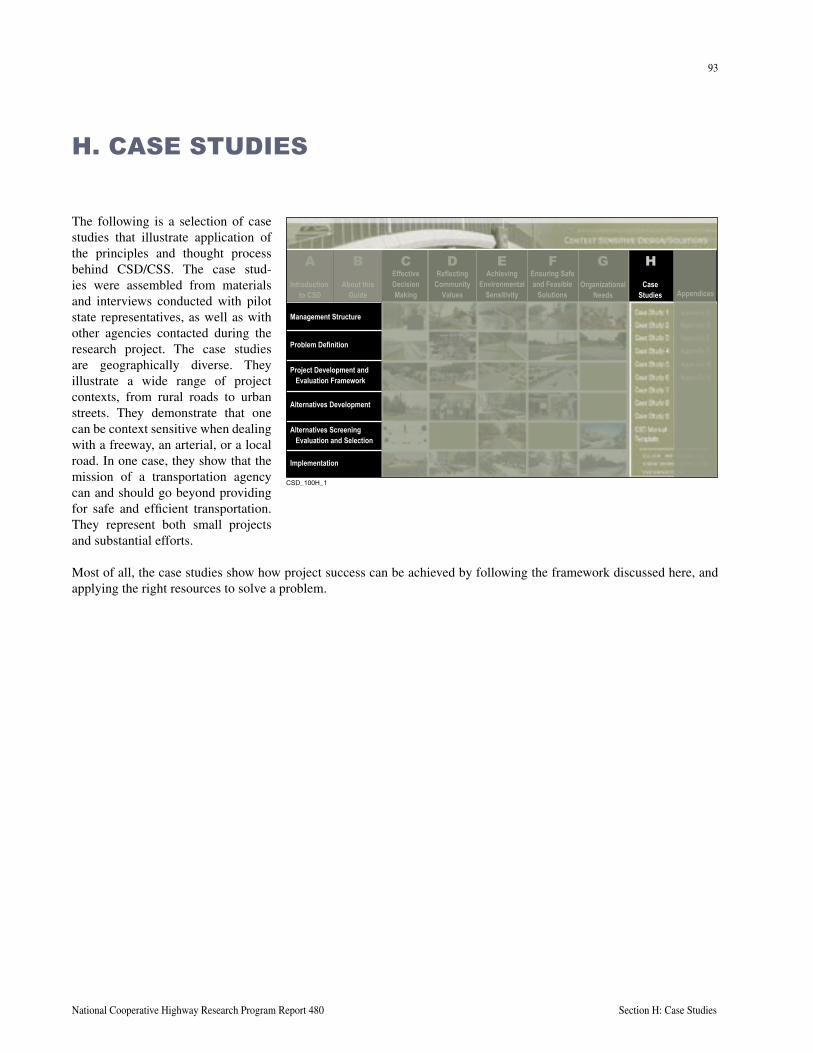
93
National Cooperative Highway Research Program Report 480 Section H: Case Studies
The following is a selection of case studies that illustrate application of the principles and thought process behind CSD/CSS. The case stud-ies were assembled from materials and interviews conducted with pilot state representatives, as well as with other agencies contacted during the research project. The case studies are geographically diverse. They illustrate a wide range of project contexts, from rural roads to urban streets. They demonstrate that one can be context sensitive when dealing with a freeway, an arterial, or a local road. In one case, they show that the mission of a transportation agency can and should go beyond providing for safe and efficient transportation. They represent both small projects and substantial efforts.
Most of all, the case studies show how project success can be achieved by following the framework discussed here, and applying the right resources to solve a problem.
H. CASE STUDIES
����������
About thisGuide
EffectiveDecisionMaking
ReflectingCommunity
Values
AchievingEnvironmental
Sensitivity
Ensuring Safeand Feasible
SolutionsOrganizational
NeedsCase
Studies Appendices
Management Structure
Problem Definition
Project Development andEvaluation Framework
Alternatives Development
Alternatives ScreeningEvaluation and Selection
Implementation
CB D E F G HIntroduction
to CSD
A

94
Section H: Case Studies A Guide to Best Practices for Achieving Context Sensitive Solutions
This page intentionally left blank
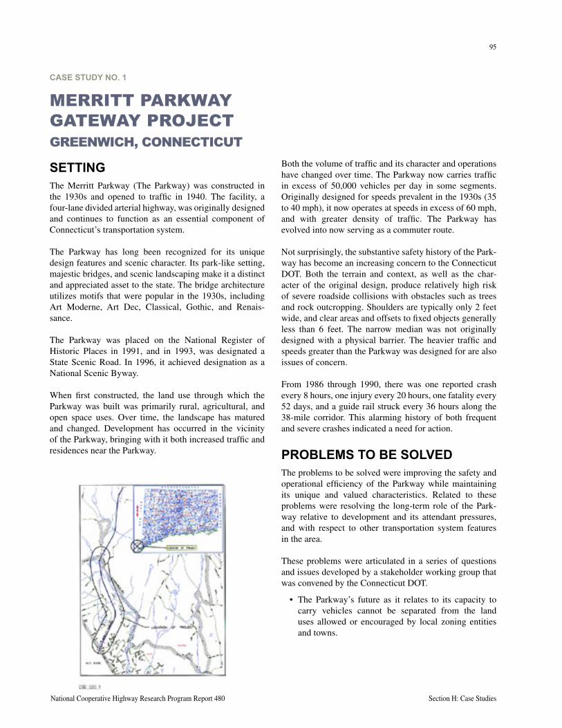
95
National Cooperative Highway Research Program Report 480 Section H: Case Studies
CASE STUDY NO. 1
MERRITT PARKWAY GATEWAY PROJECTGREENWICH, CONNECTICUT
SETTINGThe Merritt Parkway (The Parkway) was constructed in the 1930s and opened to traffic in 1940. The facility, a four-lane divided arterial highway, was originally designed and continues to function as an essential component of Connecticut’s transportation system.
The Parkway has long been recognized for its unique design features and scenic character. Its park-like setting, majestic bridges, and scenic landscaping make it a distinct and appreciated asset to the state. The bridge architecture utilizes motifs that were popular in the 1930s, including Art Moderne, Art Dec, Classical, Gothic, and Renais-sance.
The Parkway was placed on the National Register of Historic Places in 1991, and in 1993, was designated a State Scenic Road. In 1996, it achieved designation as a National Scenic Byway.
When first constructed, the land use through which the Parkway was built was primarily rural, agricultural, and open space uses. Over time, the landscape has matured and changed. Development has occurred in the vicinity of the Parkway, bringing with it both increased traffic and residences near the Parkway.
Both the volume of traffic and its character and operations have changed over time. The Parkway now carries traffic in excess of 50,000 vehicles per day in some segments. Originally designed for speeds prevalent in the 1930s (35 to 40 mph), it now operates at speeds in excess of 60 mph, and with greater density of traffic. The Parkway has evolved into now serving as a commuter route.
Not surprisingly, the substantive safety history of the Park-way has become an increasing concern to the Connecticut DOT. Both the terrain and context, as well as the char-acter of the original design, produce relatively high risk of severe roadside collisions with obstacles such as trees and rock outcropping. Shoulders are typically only 2 feet wide, and clear areas and offsets to fixed objects generally less than 6 feet. The narrow median was not originally designed with a physical barrier. The heavier traffic and speeds greater than the Parkway was designed for are also issues of concern.
From 1986 through 1990, there was one reported crash every 8 hours, one injury every 20 hours, one fatality every 52 days, and a guide rail struck every 36 hours along the 38-mile corridor. This alarming history of both frequent and severe crashes indicated a need for action.
PROBLEMS TO BE SOLVEDThe problems to be solved were improving the safety and operational efficiency of the Parkway while maintaining its unique and valued characteristics. Related to these problems were resolving the long-term role of the Park-way relative to development and its attendant pressures, and with respect to other transportation system features in the area.
These problems were articulated in a series of questions and issues developed by a stakeholder working group that was convened by the Connecticut DOT.
• The Parkway’s future as it relates to its capacity to carry vehicles cannot be separated from the land uses allowed or encouraged by local zoning entities and towns.
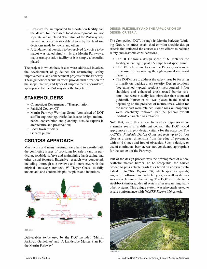
96
Section H: Case Studies A Guide to Best Practices for Achieving Context Sensitive Solutions
97
National Cooperative Highway Research Program Report 480 Section H: Case Studies
• Pressures for an expanded transportation facility and the desire for increased local development are not separate and unrelated. The future of the Parkway was viewed as being inextricably driven by the land use decisions made by towns and others.
• A fundamental question to be resolved (a choice to be made) was stated simply – Is the Merritt Parkway a major transportation facility or is it simply a beautiful place?
The project in which these issues were addressed involved the development of guidelines for resurfacing, safety improvements, and enhancement projects for the Parkway. These guidelines would in effect provide firm direction for the scope, nature, and types of improvements considered appropriate for the Parkway over the long term.
STAKEHOLDERS• Connecticut Department of Transportation• Fairfield County, CT• Merritt Parkway Working Group (comprised of DOT
staff in engineering, traffic, landscape design, mainte-nance, construction and planning; outside experts in architecture and preservation)
• Local town officials• General public
CSD/CSS APPROACHMuch work and many meetings were held to wrestle with the conflicting issues of providing for safety (and in par-ticular, roadside safety) and maintaining landscaping and other visual features. Extensive research was conducted, including thorough site reviews and interviews with the original landscape architect, W. Thayer Chase, to fully understand and confirm his philosophies and intentions.
Deliverables to be used by the DOT included ‘Merritt Parkway Guidelines’ and ‘A Landscape Master Plan For the Merritt Parkway.’
DESIGN FLEXIBILITY AND THE APPLICATION OF DESIGN CRITERIA
The Connecticut DOT, through its Merritt Parkway Work-ing Group, in effect established corridor-specific design criteria that reflected the consensus best efforts to balance safety and aesthetic considerations.
• The DOT chose a design speed of 60 mph for the facility, intending to post a 50 mph legal speed limit.
• The DOT chose not to view the Parkway as a route to be used for increasing through regional east-west capacity.
• The DOT chose to address the safety issue by focusing primarily on roadside crash severity. Design solutions (see attached typical sections) incorporated 4-foot shoulders and enhanced crash tested barrier sys-tems that were visually less obtrusive than standard guiderail. Barrier or rail was placed in the median depending on the presence of mature trees, which for the most part were retained. Some rock outcroppings were selectively removed, but the general overall roadside character was retained.
Note that, were this a new freeway or expressway, or a similar route in a different context, the DOT would apply more stringent design criteria for the roadside. The AASHTO Roadside Design Guide suggests up to 30 foot clear as a target dimension from the edge of pavement, with mild slopes and free of obstacles. Such a design, or use of continuous barrier, was not considered appropriate for the context of the Parkway.
Part of the design process was the development of a new, aesthetic median barrier. To be acceptable, the barrier needed to pass vehicle crash tests based on criteria estab-lished in NCHRP Report 350, which specifies speeds, angles of collision, and vehicle types, as well as defines success or failure in the testing. The DOT also selected a steel-back timber guide rail system after researching many other systems. This unique system was also crash tested to assure conformance with NCHRP Report 350 criteria.
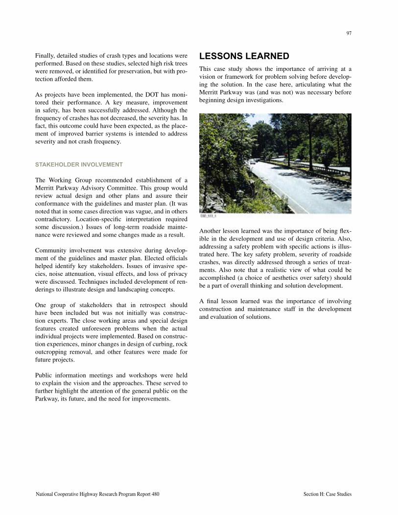
96
Section H: Case Studies A Guide to Best Practices for Achieving Context Sensitive Solutions
97
National Cooperative Highway Research Program Report 480 Section H: Case Studies
Finally, detailed studies of crash types and locations were performed. Based on these studies, selected high risk trees were removed, or identified for preservation, but with pro-tection afforded them.
As projects have been implemented, the DOT has moni-tored their performance. A key measure, improvement in safety, has been successfully addressed. Although the frequency of crashes has not decreased, the severity has. In fact, this outcome could have been expected, as the place-ment of improved barrier systems is intended to address severity and not crash frequency.
STAKEHOLDER INVOLVEMENT
The Working Group recommended establishment of a Merritt Parkway Advisory Committee. This group would review actual design and other plans and assure their conformance with the guidelines and master plan. (It was noted that in some cases direction was vague, and in others contradictory. Location-specific interpretation required some discussion.) Issues of long-term roadside mainte-nance were reviewed and some changes made as a result.
Community involvement was extensive during develop-ment of the guidelines and master plan. Elected officials helped identify key stakeholders. Issues of invasive spe-cies, noise attenuation, visual effects, and loss of privacy were discussed. Techniques included development of ren-derings to illustrate design and landscaping concepts.
One group of stakeholders that in retrospect should have been included but was not initially was construc-tion experts. The close working areas and special design features created unforeseen problems when the actual individual projects were implemented. Based on construc-tion experiences, minor changes in design of curbing, rock outcropping removal, and other features were made for future projects.
Public information meetings and workshops were held to explain the vision and the approaches. These served to further highlight the attention of the general public on the Parkway, its future, and the need for improvements.
LESSONS LEARNEDThis case study shows the importance of arriving at a vision or framework for problem solving before develop-ing the solution. In the case here, articulating what the Merritt Parkway was (and was not) was necessary before beginning design investigations.
Another lesson learned was the importance of being flex-ible in the development and use of design criteria. Also, addressing a safety problem with specific actions is illus-trated here. The key safety problem, severity of roadside crashes, was directly addressed through a series of treat-ments. Also note that a realistic view of what could be accomplished (a choice of aesthetics over safety) should be a part of overall thinking and solution development.
A final lesson learned was the importance of involving construction and maintenance staff in the development and evaluation of solutions.

98
Section H: Case Studies A Guide to Best Practices for Achieving Context Sensitive Solutions
This page intentionally left blank
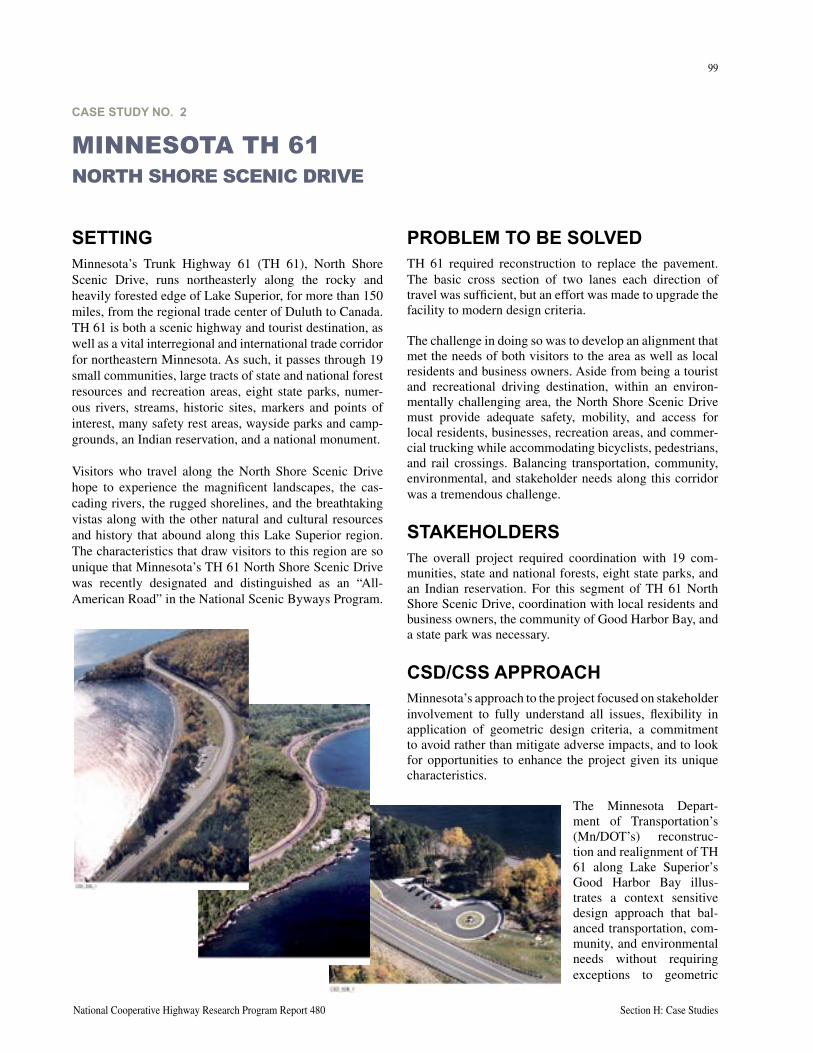
99
National Cooperative Highway Research Program Report 480 Section H: Case Studies
SETTINGMinnesota’s Trunk Highway 61 (TH 61), North Shore Scenic Drive, runs northeasterly along the rocky and heavily forested edge of Lake Superior, for more than 150 miles, from the regional trade center of Duluth to Canada. TH 61 is both a scenic highway and tourist destination, as well as a vital interregional and international trade corridor for northeastern Minnesota. As such, it passes through 19 small communities, large tracts of state and national forest resources and recreation areas, eight state parks, numer-ous rivers, streams, historic sites, markers and points of interest, many safety rest areas, wayside parks and camp-grounds, an Indian reservation, and a national monument.
Visitors who travel along the North Shore Scenic Drive hope to experience the magnificent landscapes, the cas-cading rivers, the rugged shorelines, and the breathtaking vistas along with the other natural and cultural resources and history that abound along this Lake Superior region. The characteristics that draw visitors to this region are so unique that Minnesota’s TH 61 North Shore Scenic Drive was recently designated and distinguished as an “All-American Road” in the National Scenic Byways Program.
PROBLEM TO BE SOLVEDTH 61 required reconstruction to replace the pavement. The basic cross section of two lanes each direction of travel was sufficient, but an effort was made to upgrade the facility to modern design criteria.
The challenge in doing so was to develop an alignment that met the needs of both visitors to the area as well as local residents and business owners. Aside from being a tourist and recreational driving destination, within an environ-mentally challenging area, the North Shore Scenic Drive must provide adequate safety, mobility, and access for local residents, businesses, recreation areas, and commer-cial trucking while accommodating bicyclists, pedestrians, and rail crossings. Balancing transportation, community, environmental, and stakeholder needs along this corridor was a tremendous challenge.
STAKEHOLDERSThe overall project required coordination with 19 com-munities, state and national forests, eight state parks, and an Indian reservation. For this segment of TH 61 North Shore Scenic Drive, coordination with local residents and business owners, the community of Good Harbor Bay, and a state park was necessary.
CSD/CSS APPROACHMinnesota’s approach to the project focused on stakeholder involvement to fully understand all issues, flexibility in application of geometric design criteria, a commitment to avoid rather than mitigate adverse impacts, and to look for opportunities to enhance the project given its unique characteristics.
The Minnesota Depart-ment of Transportation’s (Mn/DOT’s) reconstruc-tion and realignment of TH 61 along Lake Superior’s Good Harbor Bay illus-trates a context sensitive design approach that bal-anced transportation, com-munity, and environmental needs without requiring exceptions to geometric
CASE STUDY NO. 2
MINNESOTA TH 61NORTH SHORE SCENIC DRIVE
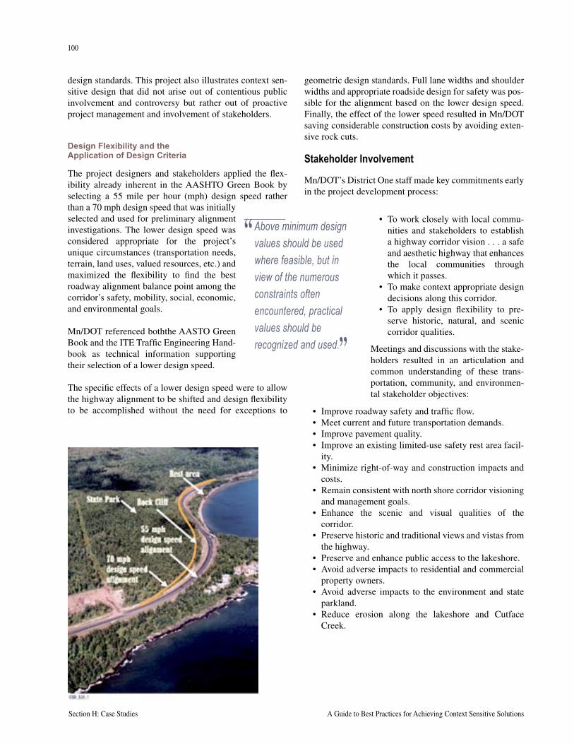
100
Section H: Case Studies A Guide to Best Practices for Achieving Context Sensitive Solutions
101
National Cooperative Highway Research Program Report 480 Section H: Case Studies
design standards. This project also illustrates context sen-sitive design that did not arise out of contentious public involvement and controversy but rather out of proactive project management and involvement of stakeholders.
Design Flexibility and the Application of Design Criteria
The project designers and stakeholders applied the flex-ibility already inherent in the AASHTO Green Book by selecting a 55 mile per hour (mph) design speed rather than a 70 mph design speed that was initially selected and used for preliminary alignment investigations. The lower design speed was considered appropriate for the project’s unique circumstances (transportation needs, terrain, land uses, valued resources, etc.) and maximized the flexibility to find the best roadway alignment balance point among the corridor’s safety, mobility, social, economic, and environmental goals.
Mn/DOT referenced boththe AASTO Green Book and the ITE Traffic Engineering Hand-book as technical information supporting their selection of a lower design speed.
The specific effects of a lower design speed were to allow the highway alignment to be shifted and design flexibility to be accomplished without the need for exceptions to
geometric design standards. Full lane widths and shoulder widths and appropriate roadside design for safety was pos-sible for the alignment based on the lower design speed. Finally, the effect of the lower speed resulted in Mn/DOT saving considerable construction costs by avoiding exten-sive rock cuts.
Stakeholder Involvement
Mn/DOT’s District One staff made key commitments early in the project development process:
“ Above minimum design values should be used where feasible, but in view of the numerous constraints often encountered, practical values should be recognized and used.”
• To work closely with local commu-nities and stakeholders to establish a highway corridor vision . . . a safe and aesthetic highway that enhances the local communities through which it passes.
• To make context appropriate design decisions along this corridor.
• To apply design flexibility to pre-serve historic, natural, and scenic corridor qualities.
Meetings and discussions with the stake-holders resulted in an articulation and common understanding of these trans-portation, community, and environmen-tal stakeholder objectives:
• Improve roadway safety and traffic flow.• Meet current and future transportation demands.• Improve pavement quality.• Improve an existing limited-use safety rest area facil-
ity.• Minimize right-of-way and construction impacts and
costs.• Remain consistent with north shore corridor visioning
and management goals.• Enhance the scenic and visual qualities of the
corridor.• Preserve historic and traditional views and vistas from
the highway.• Preserve and enhance public access to the lakeshore.• Avoid adverse impacts to residential and commercial
property owners.• Avoid adverse impacts to the environment and state
parkland.• Reduce erosion along the lakeshore and Cutface
Creek.
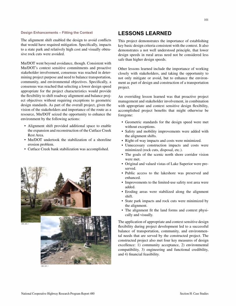
100
Section H: Case Studies A Guide to Best Practices for Achieving Context Sensitive Solutions
101
National Cooperative Highway Research Program Report 480 Section H: Case Studies
Design Enhancements – Fitting the Context
The alignment shift enabled the design to avoid conflicts that would have required mitigation. Specifically, impacts to a state park and relatively high cost and visually obtru-sive rock cuts were avoided.
Mn/DOT went beyond avoidance, though. Consistent with Mn/DOT’s context sensitive commitments and proactive stakeholder involvement, consensus was reached in deter-mining project purpose and need to balance transportation, community, and environmental objectives. Specifically, a consensus was reached that selecting a lower design speed appropriate for the project characteristics would provide the flexibility to shift roadway alignment and balance proj-ect objectives without requiring exceptions to geometric design standards. As part of the overall project, given the vision of the stakeholders and importance of the route as a resource, Mn/DOT seized the opportunity to enhance the environment by the following actions:
• Alignment shift provided additional space to enable the expansion and reconstruction of the Cutface Creek Rest Area.
• Mn/DOT undertook the stabilization of a shoreline erosion problem.
• Cutface Creek bank stabilization was accomplished.
LESSONS LEARNEDThis project demonstrates the importance of establishing key basic design criteria consistent with the context. It also demonstrates a not well understood principle, that lower design speeds in rural areas need not be considered less safe than higher design speeds.
Other lessons learned include the importance of working closely with stakeholders, and taking the opportunity to not only mitigate or avoid, but to enhance the environ-ment as part of design and construction of a transportation project.
An overriding lesson learned was that proactive project management and stakeholder involvement, in combination with appropriate and context sensitive design flexibility, accomplished project benefits that might otherwise be foregone:
• Geometric standards for the design speed were met without exceptions.
• Safety and mobility improvements were added with the alignment shifts.
• Right-of-way impacts and costs were minimized.• Unnecessary construction impacts and costs were
minimized (rock cuts, disposal, etc.).• The goals of the scenic north shore corridor vision
were met.• Original and valued vistas of Lake Superior were pre-
served.• Public access to the lakeshore was preserved and
enhanced.• Improvements to the limited-use safety rest area were
added.• Eroding areas were stabilized along the alignment
shift.• State park impacts and rock cuts were minimized by
the alignment.• The alignment fit the land forms and context physi-
cally and visually.
The application of appropriate and context sensitive design flexibility during project development led to a successful balance of transportation, community, and environmen-tal needs that are served by the constructed project. The constructed project also met four key measures of design excellence: 1) community acceptance, 2) environmental compatibility, 3) engineering and functional credibility, and 4) financial feasibility.

102
Section H: Case Studies A Guide to Best Practices for Achieving Context Sensitive Solutions
This page intentionally left blank
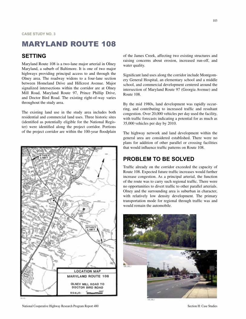
103
National Cooperative Highway Research Program Report 480 Section H: Case Studies
CASE STUDY NO. 3
MARYLAND ROUTE 108of the James Creek, affecting two existing structures and raising concerns about erosion, increased run-off, and water quality.
Significant land uses along the corridor include Montgom-ery General Hospital, an elementary school and a middle school, and commercial development centered around the intersection of Maryland Route 97 (Georgia Avenue) and Route 108.
By the mid 1980s, land development was rapidly occur-ring, and contributing to increased traffic and resultant congestion. Over 20,000 vehicles per day used the facility, with traffic forecasts indicating a potential for as much as 35,000 vehicles per day by 2010.
The highway network and land development within the general area are considered established. There were no plans for addition of other parallel or crossing facilities that would influence traffic patterns on Route 108.
PROBLEM TO BE SOLVEDTraffic already on the corridor exceeded the capacity of Route 108. Expected future traffic increases would further increase congestion. As a principal arterial, the function of the route was to carry such regional traffic. There were no opportunities to divert traffic to other parallel arterials. Olney and the surrounding area is suburban in character, with relatively low density development. The primary transportation mode for regional through traffic was and would remain the automobile.
SETTINGMaryland Route 108 is a two-lane major arterial in Olney Maryland, a suburb of Baltimore. It is one of two major highways providing principal access to and through the Olney area. The roadway widens to a four-lane section between Homeland Drive and Hillcrest Avenue. Major signalized intersections within the corridor are at Olney Mill Road, Maryland Route 97, Prince Phillip Drive, and Doctor Bird Road. The existing right-of-way varies throughout the study area.
The existing land use in the study area includes both residential and commercial land uses. Three historic sites (identified as potentially eligible for the National Regis-ter) were identified along the project corridor. Portions of the project corridor are within the 100-year floodplain
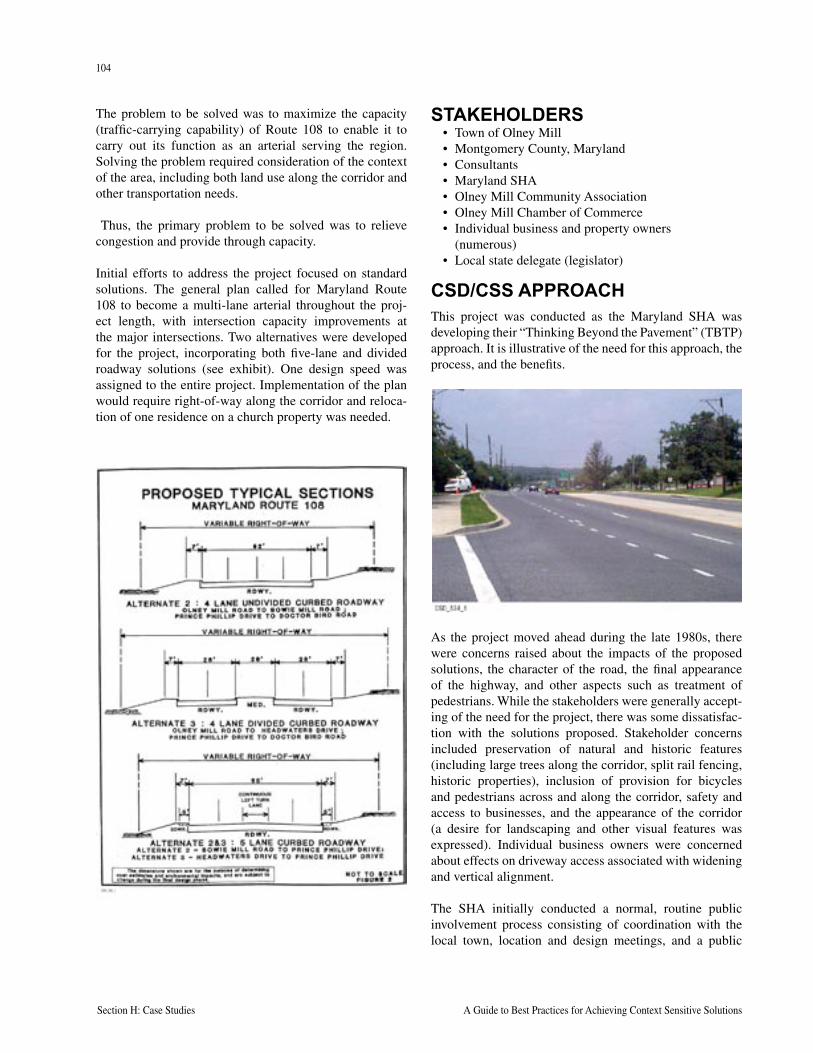
104
Section H: Case Studies A Guide to Best Practices for Achieving Context Sensitive Solutions
105
National Cooperative Highway Research Program Report 480 Section H: Case Studies
The problem to be solved was to maximize the capacity (traffic-carrying capability) of Route 108 to enable it to carry out its function as an arterial serving the region. Solving the problem required consideration of the context of the area, including both land use along the corridor and other transportation needs.
Thus, the primary problem to be solved was to relieve congestion and provide through capacity.
Initial efforts to address the project focused on standard solutions. The general plan called for Maryland Route 108 to become a multi-lane arterial throughout the proj-ect length, with intersection capacity improvements at the major intersections. Two alternatives were developed for the project, incorporating both five-lane and divided roadway solutions (see exhibit). One design speed was assigned to the entire project. Implementation of the plan would require right-of-way along the corridor and reloca-tion of one residence on a church property was needed.
STAKEHOLDERS• Town of Olney Mill• Montgomery County, Maryland• Consultants• Maryland SHA• Olney Mill Community Association• Olney Mill Chamber of Commerce• Individual business and property owners
(numerous)• Local state delegate (legislator)
CSD/CSS APPROACHThis project was conducted as the Maryland SHA was developing their “Thinking Beyond the Pavement” (TBTP) approach. It is illustrative of the need for this approach, the process, and the benefits.
As the project moved ahead during the late 1980s, there were concerns raised about the impacts of the proposed solutions, the character of the road, the final appearance of the highway, and other aspects such as treatment of pedestrians. While the stakeholders were generally accept-ing of the need for the project, there was some dissatisfac-tion with the solutions proposed. Stakeholder concerns included preservation of natural and historic features (including large trees along the corridor, split rail fencing, historic properties), inclusion of provision for bicycles and pedestrians across and along the corridor, safety and access to businesses, and the appearance of the corridor (a desire for landscaping and other visual features was expressed). Individual business owners were concerned about effects on driveway access associated with widening and vertical alignment.
The SHA initially conducted a normal, routine public involvement process consisting of coordination with the local town, location and design meetings, and a public
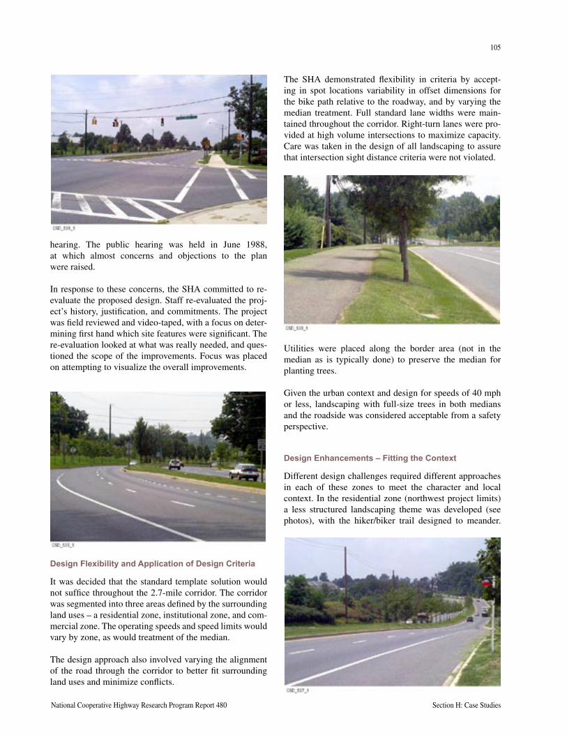
104
Section H: Case Studies A Guide to Best Practices for Achieving Context Sensitive Solutions
105
National Cooperative Highway Research Program Report 480 Section H: Case Studies
hearing. The public hearing was held in June 1988, at which almost concerns and objections to the plan were raised.
In response to these concerns, the SHA committed to re-evaluate the proposed design. Staff re-evaluated the proj-ect’s history, justification, and commitments. The project was field reviewed and video-taped, with a focus on deter-mining first hand which site features were significant. The re-evaluation looked at what was really needed, and ques-tioned the scope of the improvements. Focus was placed on attempting to visualize the overall improvements.
Design Flexibility and Application of Design Criteria
It was decided that the standard template solution would not suffice throughout the 2.7-mile corridor. The corridor was segmented into three areas defined by the surrounding land uses – a residential zone, institutional zone, and com-mercial zone. The operating speeds and speed limits would vary by zone, as would treatment of the median.
The design approach also involved varying the alignment of the road through the corridor to better fit surrounding land uses and minimize conflicts.
The SHA demonstrated flexibility in criteria by accept-ing in spot locations variability in offset dimensions for the bike path relative to the roadway, and by varying the median treatment. Full standard lane widths were main-tained throughout the corridor. Right-turn lanes were pro-vided at high volume intersections to maximize capacity. Care was taken in the design of all landscaping to assure that intersection sight distance criteria were not violated.
Utilities were placed along the border area (not in the median as is typically done) to preserve the median for planting trees.
Given the urban context and design for speeds of 40 mph or less, landscaping with full-size trees in both medians and the roadside was considered acceptable from a safety perspective.
Design Enhancements – Fitting the Context
Different design challenges required different approaches in each of these zones to meet the character and local context. In the residential zone (northwest project limits) a less structured landscaping theme was developed (see photos), with the hiker/biker trail designed to meander.
106
Section H: Case Studies A Guide to Best Practices for Achieving Context Sensitive Solutions
In the commercial zone, the right-of-way and median are narrower, and design treatment more structured. Provision for left-turn lanes precluded the ability to provide treed landscaping, but plantings along the roadside in keeping with the commercial district’s environment were provided. In the institutional zone, the design focused on providing for a transition in view between the other two zones.
Stakeholder Involvement
The SHA and its consultants committed to working closely with the residents and community to address all concerns. The CSD approach relied on numerous meetings with town staff, elected officials, civic organizations and business owners, and the public. Plans were continuously reviewed, ideas suggested, and refinements made. Discus-sions about trees, split rail fencing, the location and design of bike trails, commercial area traffic patterns and access, and pedestrian safety were held over a series of months. Professional staff demonstrated a willingness to be flexi-ble, propose different solutions, and strive for a consensus. Note, however, that the fundamental purpose was retained, the addition of through-carrying capacity.
In summary, Maryland’s CSD approach focused on active, field-involvement of their staff to visualize the project, work directly with local stakeholders, and strive for a tai-lored solution that addressed the problem but was designed to fit the local context.
LESSONS LEARNEDThis project was initiated in the mid-1980s and continued through the mid-1990s. As such, it followed Maryland’s advance into TBTP and CSD. This project contributed greatly to Maryland’s knowledge base and advancement in CSD. A number of specific lessons were learned by Maryland’s staff :
• Early in the project, review and confirm the planning framework, including the functional classification for the project and speeds (design speed).
• Assess what is proposed, what is desired, and what is needed. Look beyond mere mitigation; and look beyond the right-of-way to assess how the project will relate to the area.
• Multidisciplinary teams, including specifically land-scape architects, were recognized as being essential to project success.
• Project engineers should get out in the field to visual-ize the project.
• Develop the project with an emphasis on design principles, utilizing engineering principles to achieve desired safety and functionality.
“ A standard design template approach will not allow, or usually doesn’t provide, the opportunity to address site-specific issues. This point is particularly important given what we perceive to be a trend toward having computers (CADD) design projects. Software programs should be used for engineering. Design requires more attention to detail, and is something that computers can’t do.”
MD 108 RE-EVALUATION PROCESS REPORT BY DAN UEBERSAX AND JEFF SMITH
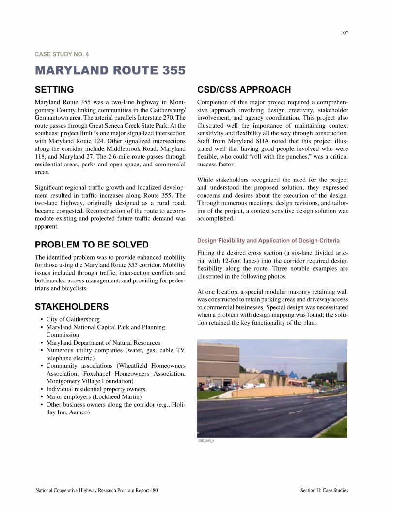
107
National Cooperative Highway Research Program Report 480 Section H: Case Studies
CASE STUDY NO. 4
MARYLAND ROUTE 355CSD/CSS APPROACHCompletion of this major project required a comprehen-sive approach involving design creativity, stakeholder involvement, and agency coordination. This project also illustrated well the importance of maintaining context sensitivity and flexibility all the way through construction. Staff from Maryland SHA noted that this project illus-trated well that having good people involved who were flexible, who could “roll with the punches,” was a critical success factor.
While stakeholders recognized the need for the project and understood the proposed solution, they expressed concerns and desires about the execution of the design. Through numerous meetings, design revisions, and tailor-ing of the project, a context sensitive design solution was accomplished.
Design Flexibility and Application of Design Criteria
Fitting the desired cross section (a six-lane divided arte-rial with 12-foot lanes) into the corridor required design flexibility along the route. Three notable examples are illustrated in the following photos.
At one location, a special modular masonry retaining wall was constructed to retain parking areas and driveway access to commercial businesses. Special design was necessitated when a problem with design mapping was found; the solu-tion retained the key functionality of the plan.
SETTINGMaryland Route 355 was a two-lane highway in Mont-gomery County linking communities in the Gaithersburg/Germantown area. The arterial parallels Interstate 270. The route passes through Great Seneca Creek State Park. At the southeast project limit is one major signalized intersection with Maryland Route 124. Other signalized intersections along the corridor include Middlebrook Road, Maryland 118, and Maryland 27. The 2.6-mile route passes through residential areas, parks and open space, and commercial areas.
Significant regional traffic growth and localized develop-ment resulted in traffic increases along Route 355. The two-lane highway, originally designed as a rural road, became congested. Reconstruction of the route to accom-modate existing and projected future traffic demand was apparent.
PROBLEM TO BE SOLVEDThe identified problem was to provide enhanced mobility for those using the Maryland Route 355 corridor. Mobility issues included through traffic, intersection conflicts and bottlenecks, access management, and providing for pedes-trians and bicyclists.
STAKEHOLDERS• City of Gaithersburg• Maryland National Capital Park and Planning
Commission • Maryland Department of Natural Resources• Numerous utility companies (water, gas, cable TV,
telephone electric)• Community associations (Wheatfield Homeowners
Association, Foxchapel Homeowners Association, Montgomery Village Foundation)
• Individual residential property owners • Major employers (Lockheed Martin)• Other business owners along the corridor (e.g., Holi-
day Inn, Aamco)
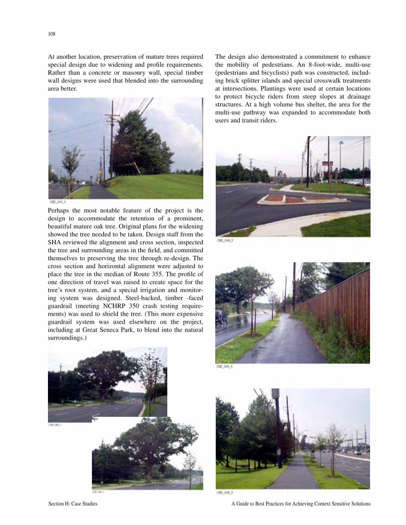
108
Section H: Case Studies A Guide to Best Practices for Achieving Context Sensitive Solutions
109
National Cooperative Highway Research Program Report 480 Section H: Case Studies
At another location, preservation of mature trees required special design due to widening and profile requirements. Rather than a concrete or masonry wall, special timber wall designs were used that blended into the surrounding area better.
Perhaps the most notable feature of the project is the design to accommodate the retention of a prominent, beautiful mature oak tree. Original plans for the widening showed the tree needed to be taken. Design staff from the SHA reviewed the alignment and cross section, inspected the tree and surrounding areas in the field, and committed themselves to preserving the tree through re-design. The cross section and horizontal alignment were adjusted to place the tree in the median of Route 355. The profile of one direction of travel was raised to create space for the tree’s root system, and a special irrigation and monitor-ing system was designed. Steel-backed, timber -faced guardrail (meeting NCHRP 350 crash testing require-ments) was used to shield the tree. (This more expensive guardrail system was used elsewhere on the project, including at Great Seneca Park, to blend into the natural surroundings.)
The design also demonstrated a commitment to enhance the mobility of pedestrians. An 8-foot-wide, multi-use (pedestrians and bicyclists) path was constructed, includ-ing brick splitter islands and special crosswalk treatments at intersections. Plantings were used at certain locations to protect bicycle riders from steep slopes at drainage structures. At a high volume bus shelter, the area for the multi-use pathway was expanded to accommodate both users and transit riders.
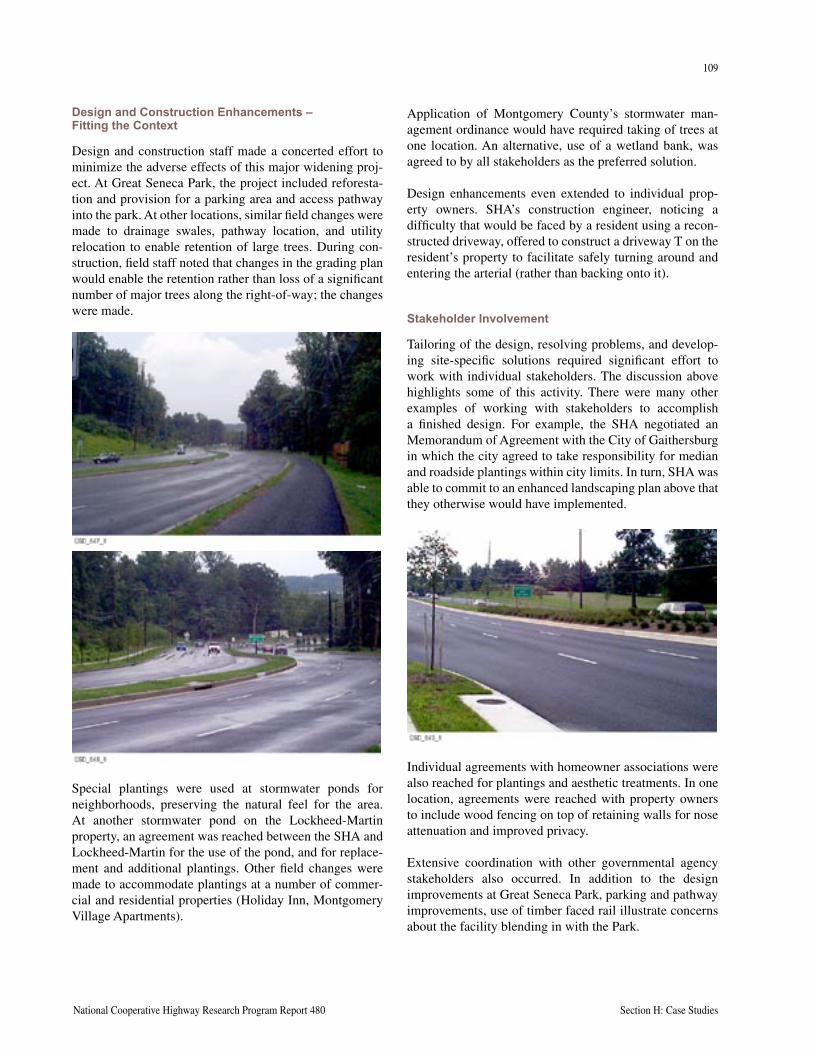
108
Section H: Case Studies A Guide to Best Practices for Achieving Context Sensitive Solutions
109
National Cooperative Highway Research Program Report 480 Section H: Case Studies
Design and Construction Enhancements – Fitting the Context
Design and construction staff made a concerted effort to minimize the adverse effects of this major widening proj-ect. At Great Seneca Park, the project included reforesta-tion and provision for a parking area and access pathway into the park. At other locations, similar field changes were made to drainage swales, pathway location, and utility relocation to enable retention of large trees. During con-struction, field staff noted that changes in the grading plan would enable the retention rather than loss of a significant number of major trees along the right-of-way; the changes were made.
Special plantings were used at stormwater ponds for neighborhoods, preserving the natural feel for the area. At another stormwater pond on the Lockheed-Martin property, an agreement was reached between the SHA and Lockheed-Martin for the use of the pond, and for replace-ment and additional plantings. Other field changes were made to accommodate plantings at a number of commer-cial and residential properties (Holiday Inn, Montgomery Village Apartments).
Application of Montgomery County’s stormwater man-agement ordinance would have required taking of trees at one location. An alternative, use of a wetland bank, was agreed to by all stakeholders as the preferred solution.
Design enhancements even extended to individual prop-erty owners. SHA’s construction engineer, noticing a difficulty that would be faced by a resident using a recon-structed driveway, offered to construct a driveway T on the resident’s property to facilitate safely turning around and entering the arterial (rather than backing onto it).
Stakeholder Involvement
Tailoring of the design, resolving problems, and develop-ing site-specific solutions required significant effort to work with individual stakeholders. The discussion above highlights some of this activity. There were many other examples of working with stakeholders to accomplish a finished design. For example, the SHA negotiated an Memorandum of Agreement with the City of Gaithersburg in which the city agreed to take responsibility for median and roadside plantings within city limits. In turn, SHA was able to commit to an enhanced landscaping plan above that they otherwise would have implemented.
Individual agreements with homeowner associations were also reached for plantings and aesthetic treatments. In one location, agreements were reached with property owners to include wood fencing on top of retaining walls for nose attenuation and improved privacy.
Extensive coordination with other governmental agency stakeholders also occurred. In addition to the design improvements at Great Seneca Park, parking and pathway improvements, use of timber faced rail illustrate concerns about the facility blending in with the Park.
110
Section H: Case Studies A Guide to Best Practices for Achieving Context Sensitive Solutions
LESSONS LEARNEDA number of key lessons can be gleaned from this case study. First, CSD/CSS applies all the way through con-struction. Indeed, many of the long lasting positive fea-tures of the constructed solution were arrived at in the construction phase. Second, related to the above, effective CSD/CSS requires a local presence in the field. Third, active engagement with individual stakeholders is neces-sary to maintain context sensitivity. Solving problems one by one requires working on an individual basis. Fourth, paying attention to details is important. The cumulative effect of a long series of small, seemingly insignificant actions can have a measurable effect on the final product and on stakeholder perceptions of the agency (SHA).
Finally, a lesson learned is that bringing the right resources with the right sense of professional responsibility and environmental stewardship, who are flexible and able to deal with a number of unforeseen circumstances, is essen-tial to project success. Converting a two-lane highway into a six-lane arterial in a built-up area, and doing so in a manner that the finished project fits with the surrounding area, is no small feat.
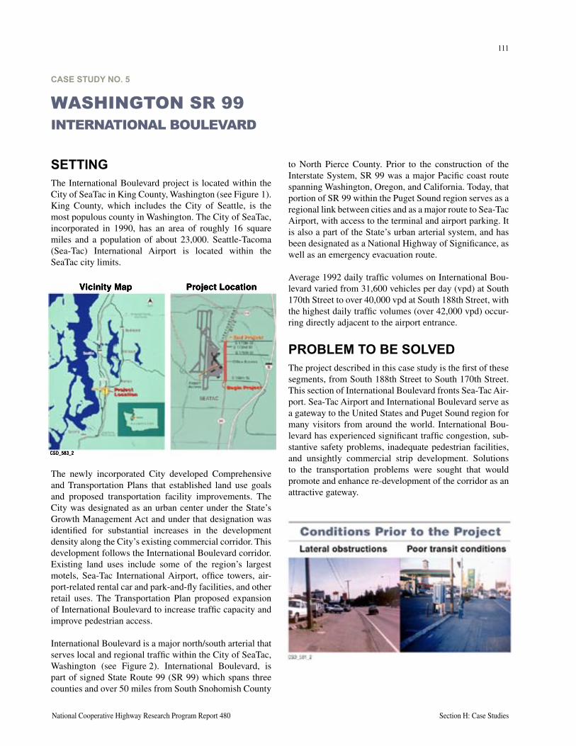
111
National Cooperative Highway Research Program Report 480 Section H: Case Studies
CASE STUDY NO. 5
WASHINGTON SR 99INTERNATIONAL BOULEVARD
SETTINGThe International Boulevard project is located within the City of SeaTac in King County, Washington (see Figure 1). King County, which includes the City of Seattle, is the most populous county in Washington. The City of SeaTac, incorporated in 1990, has an area of roughly 16 square miles and a population of about 23,000. Seattle-Tacoma (Sea-Tac) International Airport is located within the SeaTac city limits.
The newly incorporated City developed Comprehensive and Transportation Plans that established land use goals and proposed transportation facility improvements. The City was designated as an urban center under the State’s Growth Management Act and under that designation was identified for substantial increases in the development density along the City’s existing commercial corridor. This development follows the International Boulevard corridor. Existing land uses include some of the region’s largest motels, Sea-Tac International Airport, office towers, air-port-related rental car and park-and-fly facilities, and other retail uses. The Transportation Plan proposed expansion of International Boulevard to increase traffic capacity and improve pedestrian access.
International Boulevard is a major north/south arterial that serves local and regional traffic within the City of SeaTac, Washington (see Figure 2). International Boulevard, is part of signed State Route 99 (SR 99) which spans three counties and over 50 miles from South Snohomish County
to North Pierce County. Prior to the construction of the Interstate System, SR 99 was a major Pacific coast route spanning Washington, Oregon, and California. Today, that portion of SR 99 within the Puget Sound region serves as a regional link between cities and as a major route to Sea-Tac Airport, with access to the terminal and airport parking. It is also a part of the State’s urban arterial system, and has been designated as a National Highway of Significance, as well as an emergency evacuation route.
Average 1992 daily traffic volumes on International Bou-levard varied from 31,600 vehicles per day (vpd) at South 170th Street to over 40,000 vpd at South 188th Street, with the highest daily traffic volumes (over 42,000 vpd) occur-ring directly adjacent to the airport entrance.
PROBLEM TO BE SOLVEDThe project described in this case study is the first of these segments, from South 188th Street to South 170th Street. This section of International Boulevard fronts Sea-Tac Air-port. Sea-Tac Airport and International Boulevard serve as a gateway to the United States and Puget Sound region for many visitors from around the world. International Bou-levard has experienced significant traffic congestion, sub-stantive safety problems, inadequate pedestrian facilities, and unsightly commercial strip development. Solutions to the transportation problems were sought that would promote and enhance re-development of the corridor as an attractive gateway.
CSD_583_2
Vicinity Map Project Location
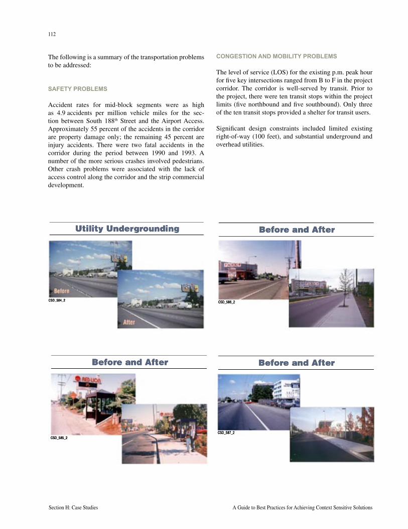
112
Section H: Case Studies A Guide to Best Practices for Achieving Context Sensitive Solutions
113
National Cooperative Highway Research Program Report 480 Section H: Case Studies
The following is a summary of the transportation problems to be addressed:
SAFETY PROBLEMS
Accident rates for mid-block segments were as high as 4.9 accidents per million vehicle miles for the sec-tion between South 188th Street and the Airport Access. Approximately 55 percent of the accidents in the corridor are property damage only; the remaining 45 percent are injury accidents. There were two fatal accidents in the corridor during the period between 1990 and 1993. A number of the more serious crashes involved pedestrians. Other crash problems were associated with the lack of access control along the corridor and the strip commercial development.
CONGESTION AND MOBILITY PROBLEMS
The level of service (LOS) for the existing p.m. peak hour for five key intersections ranged from B to F in the project corridor. The corridor is well-served by transit. Prior to the project, there were ten transit stops within the project limits (five northbound and five southbound). Only three of the ten transit stops provided a shelter for transit users.
Significant design constraints included limited existing right-of-way (100 feet), and substantial underground and overhead utilities.
CSD_584_2
Utility Undergrounding
CSD_585_2
Before and After
CSD_586_2
Before and After
CSD_587_2
Before and After
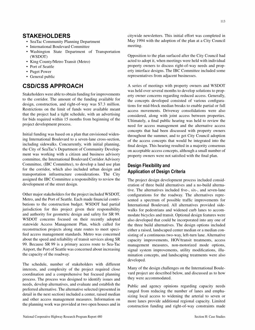
112
Section H: Case Studies A Guide to Best Practices for Achieving Context Sensitive Solutions
113
National Cooperative Highway Research Program Report 480 Section H: Case Studies
STAKEHOLDERS• SeaTac Community Planning Department• International Boulevard Committee• Washington State Department of Transportation
(WSDOT) • King County/Metro Transit (Metro) • Port of Seattle• Puget Power• General public
CSD/CSS APPROACHStakeholders were able to obtain funding for improvements to the corridor. The amount of the funding available for design, construction, and right-of-way was $7.3 million. Restrictions on the limit of funds were available meant that the project had a tight schedule, with an advertising for bids required within 15 months from beginning of the project development process.
Initial funding was based on a plan that envisioned widen-ing International Boulevard to a seven-lane cross-section, including sidewalks. Concurrently, with initial planning, the City of SeaTac’s Department of Community Develop-ment was working with a citizen and business advisory committee, the International Boulevard Corridor Advisory Committee, (IBC Committee), to develop a land use plan for the corridor, which also included urban design and transportation infrastructure considerations. The City assigned the IBC Committee a responsibility to review the development of the street design.
Other major stakeholders for the project included WSDOT, Metro, and the Port of Seattle. Each made financial contri-butions to the construction budget. WSDOT had partial jurisdiction for this project given their responsibility and authority for geometric design and safety for SR 99. WSDOT concerns focused on their recently adopted statewide Access Management Plan, which called for reconstruction projects along state routes to meet speci-fied access management standards. Metro was concerned about the speed and reliability of transit services along SR 99. Because SR 99 is a primary access route to Sea-Tac Airport, the Port of Seattle was concerned about increasing the capacity of the roadway.
The schedule, number of stakeholders with different interests, and complexity of the project required close coordination and a comprehensive but focused planning process. The process was designed to identify issues and needs, develop alternatives, and evaluate and establish the preferred alternative. The alternative selected (presented in detail in the next section) included a center, raised median and other access management measures. Information on the planning work was provided at two open houses and in
citywide newsletters. This initial effort was completed in May 1994 with the adoption of the plan at a City Council meeting.
Opposition to the plan surfaced after the City Council had acted to adopt it, when meetings were held with individual property owners to discuss right-of-way needs and prop-erty interface designs. The IBC Committee included some representatives from adjacent businesses.
A series of meetings with property owners and WSDOT was held over several months to develop solutions to prop-erty owner concerns regarding reduced access. Generally, the concepts developed consisted of various configura-tions for mid-block median breaks to enable partial or full access movements. Driveway consolidations were also considered, along with joint access between properties. Ultimately, a final public hearing was held to review the need for access management and the alternative access concepts that had been discussed with property owners throughout the summer, and to get City Council adoption of the access concepts that would be integrated into the final design. This hearing resulted in a majority consensus on acceptable access concepts, although a small number of property owners were not satisfied with the final plan.
Design Flexibility and Application of Design CriteriaThe project design development process included consid-eration of three build alternatives and a no-build alterna-tive. The alternatives included five-, six-, and seven-lane configurations for the roadway. The alternatives repre-sented a spectrum of possible traffic improvements for International Boulevard. All alternatives provided side-walks for pedestrians and widened curb lanes to accom-modate bicycles and transit. Optional design features were also developed that could be incorporated into any one of the three build alternatives. The design options included either a raised, landscaped center median or a median con-sisting of a continuous two-way, left-turn lane. Alternative capacity improvements, HOV/transit treatments, access management measures, non-motorized mode options, signal system improvements, utility modifications, illu-mination concepts, and landscaping treatments were also developed.
Many of the design challenges on the International Boule-vard project are described below, and discussed as to how they were accommodated.
Public and agency opinions regarding capacity needs ranged from reducing the number of lanes and empha-sizing local access to widening the arterial to seven or more lanes provide additional regional capacity. Limited construction funding and right-of-way constraints made
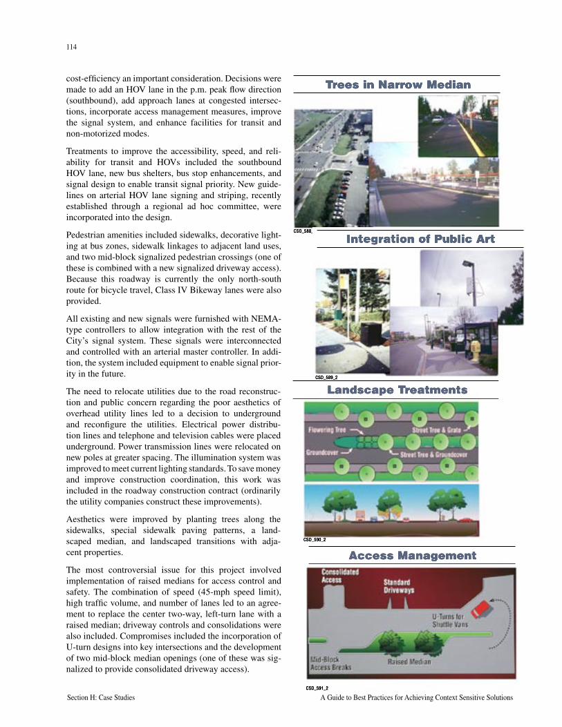
114
Section H: Case Studies A Guide to Best Practices for Achieving Context Sensitive Solutions
115
National Cooperative Highway Research Program Report 480 Section H: Case Studies
cost-efficiency an important consideration. Decisions were made to add an HOV lane in the p.m. peak flow direction (southbound), add approach lanes at congested intersec-tions, incorporate access management measures, improve the signal system, and enhance facilities for transit and non-motorized modes.
Treatments to improve the accessibility, speed, and reli-ability for transit and HOVs included the southbound HOV lane, new bus shelters, bus stop enhancements, and signal design to enable transit signal priority. New guide-lines on arterial HOV lane signing and striping, recently established through a regional ad hoc committee, were incorporated into the design.
Pedestrian amenities included sidewalks, decorative light-ing at bus zones, sidewalk linkages to adjacent land uses, and two mid-block signalized pedestrian crossings (one of these is combined with a new signalized driveway access). Because this roadway is currently the only north-south route for bicycle travel, Class IV Bikeway lanes were also provided.
All existing and new signals were furnished with NEMA-type controllers to allow integration with the rest of the City’s signal system. These signals were interconnected and controlled with an arterial master controller. In addi-tion, the system included equipment to enable signal prior-ity in the future.
The need to relocate utilities due to the road reconstruc-tion and public concern regarding the poor aesthetics of overhead utility lines led to a decision to underground and reconfigure the utilities. Electrical power distribu-tion lines and telephone and television cables were placed underground. Power transmission lines were relocated on new poles at greater spacing. The illumination system was improved to meet current lighting standards. To save money and improve construction coordination, this work was included in the roadway construction contract (ordinarily the utility companies construct these improvements).
Aesthetics were improved by planting trees along the sidewalks, special sidewalk paving patterns, a land-scaped median, and landscaped transitions with adja-cent properties.
The most controversial issue for this project involved implementation of raised medians for access control and safety. The combination of speed (45-mph speed limit), high traffic volume, and number of lanes led to an agree-ment to replace the center two-way, left-turn lane with a raised median; driveway controls and consolidations were also included. Compromises included the incorporation of U-turn designs into key intersections and the development of two mid-block median openings (one of these was sig-nalized to provide consolidated driveway access).
CSD_588_2
Trees in Narrow Median
CSD_589_2
Integration of Public Art
CSD_590_2
Landscape Treatments
CSD_591_2
Access Management
114
Section H: Case Studies A Guide to Best Practices for Achieving Context Sensitive Solutions
115
National Cooperative Highway Research Program Report 480 Section H: Case Studies
STAKEHOLDER INVOLVEMENT
The plan reflected an active and ongoing effort to negoti-ate solutions and design compromises among the vari-ous stakeholders. The final plan included some concepts that did not meet WSDOT standard design approaches. Unusual features included U-turn median openings, provi-sion for landscaping in the median, and a mid-block pedes-trian signal. WSDOT was involved in the decision process and understood the required compromises. Land owners compromised as well, accepting access consolidation and the raised median in return for other amenities. The City of SeaTac submitted requests and justifications for several design exceptions to WSDOT and received approval to implement the adopted plan.
LESSONS LEARNEDThis project illustrated well that dealing with multiple, conflicting stakeholders within a constrained budget and schedule is possible as long as the key stakeholders under-stand the problem, have a clear vision of the solution, employ an open and creative process, and commit them-selves to compromise. The project also illustrated well that CSD/CSS represents a series of choices, not mandates. Issues of number of lanes, mobility for different users, dif-ferent ways to treat access safety problems were all looked at from different perspectives.
Many design issues and constraints needed to be addressed during the course of planning and design of the project. The affected community and agencies were actively involved in the development and evaluation of alternatives, and negotiation of modifications to the design. Diverse views of the various community and agency stakeholders needed to be considered. The adopted design was a com-prehensive solution to the conditions, and the design incor-porated elements of transportation capacity, HOV/transit treatments, access management measures, non-motorized mode improvements, signal system improvements, utility and illumination enhancements, and landscaping improve-ments.
Specific lessons learned dealt with access management, which is generally the most difficult issue to address in built-up urban arterials. For the International Boulevard project, access management was the single most contro-versial and challenging aspect of the project.
• Access management is only one part of the design for reconstruction of an arterial street. Access man-agement measures were integrated into the overall, comprehensive design. Access management measures alone would not have satisfied all of the conditions at hand, including the needs of the community and agency stakeholders.
• Use of raised medians within the arterial cross-sec-tion is only one of the access management tools to be considered. Access management should be considered as a solution to solve traffic safety concerns. Other measures such as driveway designs, controls, reduc-tions, and consolidations should also be emphasized to address safety problems.
• Inclusion of medians on arterial reconstruction proj-ects has some problems that need to be considered. These include change or reduction of access to some properties and generation of U-turn demand at inter-sections, which affects safety and traffic capacity. Therefore, it is likely that reconstruction to include a median may only be warranted under certain condi-tions such as high volumes (e.g. greater than 30 thou-sand vehicles per day), high speeds (e.g. greater than 40 miles per hour), and multi-lane cross-sections (e.g. greater than four lanes).
• Medians can provide other benefits (beyond vehicle traffic safety) for a comprehensive design solution. These can include safety for transit, bicycles, and pedestrians. They provide opportunity for landscaping and aesthetic improvements. They can help reduce the amount of impervious surface and thereby reduce the amount of stormwater drainage and detention system requirements.
• Substantial public education and involvement is needed when considering access management as a part of a major arterial design solution. Business owners are almost always going to oppose these measures at the beginning of the design process. The community and agency stakeholders need to be brought along slowly, first understanding the issues and problems (such as accident problems), then look-ing at the solutions (which may include some access management measures).
While good technical guidance is important for agencies to employ, in actual application it is likely that compromises will be needed in order to get agreement to include any access management measures in a typical design problem. In the case of the International Boulevard project, if com-promise breaks in the raised median were not identified and accepted, the project may not have been acceptable to the key stakeholders.

116
Section H: Case Studies A Guide to Best Practices for Achieving Context Sensitive Solutions
This page intentionally left blank
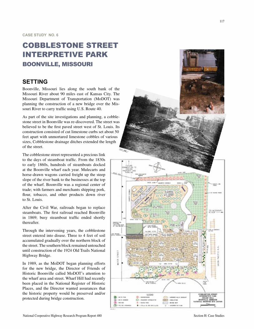
National Cooperative Highway Research Program Report 480 Section H: Case Studies
CASE STUDY NO. 6
COBBLESTONE STREET INTERPRETIVE PARKBOONVILLE, MISSOURI
SETTINGBoonville, Missouri lies along the south bank of the Missouri River about 90 miles east of Kansas City. The Missouri Department of Transportation (MoDOT) was planning the construction of a new bridge over the Mis-souri River to carry traffic using U.S. Route 40.
As part of the site investigations and planning, a cobble-stone street in Boonville was re-discovered. The street was believed to be the first paved street west of St. Louis. Its construction consisted of cut limestone curbs set about 50 feet apart with unmortared limestone cobbles of various sizes, Cobblestone drainage ditches extended the length of the street.
The cobblestone street represented a precious link to the days of steamboat traffic. From the 1830s to early 1860s, hundreds of steamboats docked at the Boonville wharf each year. Mulecarts and horse-drawn wagons carried freight up the steep slope of the river bank to the businesses at the top of the wharf. Boonville was a regional center of trade; with farmers and merchants shipping pork, flour, tobacco, and other products down river to St. Louis.
After the Civil War, railroads began to replace steamboats. The first railroad reached Boonville in 1869; busy steamboat traffic ended shortly thereafter.
Through the intervening years, the cobblestone street entered into disuse. Three to 4 feet of soil accumulated gradually over the northern block of the street. The southern block remained untouched until construction of the 1924 Old Trails National Highway Bridge.
In 1989, as the MoDOT began planning efforts for the new bridge, the Director of Friends of Historic Boonville called MoDOT’s attention to the wharf area and street. Wharf Hill had recently been placed in the National Register of Historic Places, and the Director wanted assurances that the historic property would be preserved and/or protected during bridge construction.
117
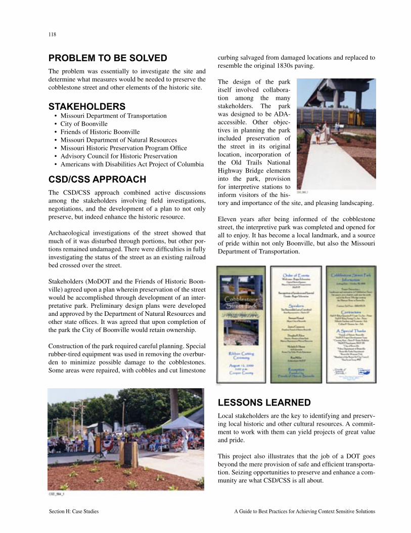
118
Section H: Case Studies A Guide to Best Practices for Achieving Context Sensitive Solutions
PROBLEM TO BE SOLVEDThe problem was essentially to investigate the site and determine what measures would be needed to preserve the cobblestone street and other elements of the historic site.
STAKEHOLDERS• Missouri Department of Transportation• City of Boonville• Friends of Historic Boonville • Missouri Department of Natural Resources• Missouri Historic Preservation Program Office• Advisory Council for Historic Preservation• Americans with Disabilities Act Project of Columbia
CSD/CSS APPROACHThe CSD/CSS approach combined active discussions among the stakeholders involving field investigations, negotiations, and the development of a plan to not only preserve, but indeed enhance the historic resource.
Archaeological investigations of the street showed that much of it was disturbed through portions, but other por-tions remained undamaged. There were difficulties in fully investigating the status of the street as an existing railroad bed crossed over the street.
Stakeholders (MoDOT and the Friends of Historic Boon-ville) agreed upon a plan wherein preservation of the street would be accomplished through development of an inter-pretative park. Preliminary design plans were developed and approved by the Department of Natural Resources and other state offices. It was agreed that upon completion of the park the City of Boonville would retain ownership.
Construction of the park required careful planning. Special rubber-tired equipment was used in removing the overbur-den to minimize possible damage to the cobblestones. Some areas were repaired, with cobbles and cut limestone
curbing salvaged from damaged locations and replaced to resemble the original 1830s paving.
The design of the park itself involved collabora-tion among the many stakeholders. The park was designed to be ADA-accessible. Other objec-tives in planning the park included preservation of the street in its original location, incorporation of the Old Trails National Highway Bridge elements into the park, provision for interpretive stations to inform visitors of the his-tory and importance of the site, and pleasing landscaping.
Eleven years after being informed of the cobblestone street, the interpretive park was completed and opened for all to enjoy. It has become a local landmark, and a source of pride within not only Boonville, but also the Missouri Department of Transportation.
LESSONS LEARNEDLocal stakeholders are the key to identifying and preserv-ing local historic and other cultural resources. A commit-ment to work with them can yield projects of great value and pride.
This project also illustrates that the job of a DOT goes beyond the mere provision of safe and efficient transporta-tion. Seizing opportunities to preserve and enhance a com-munity are what CSD/CSS is all about.
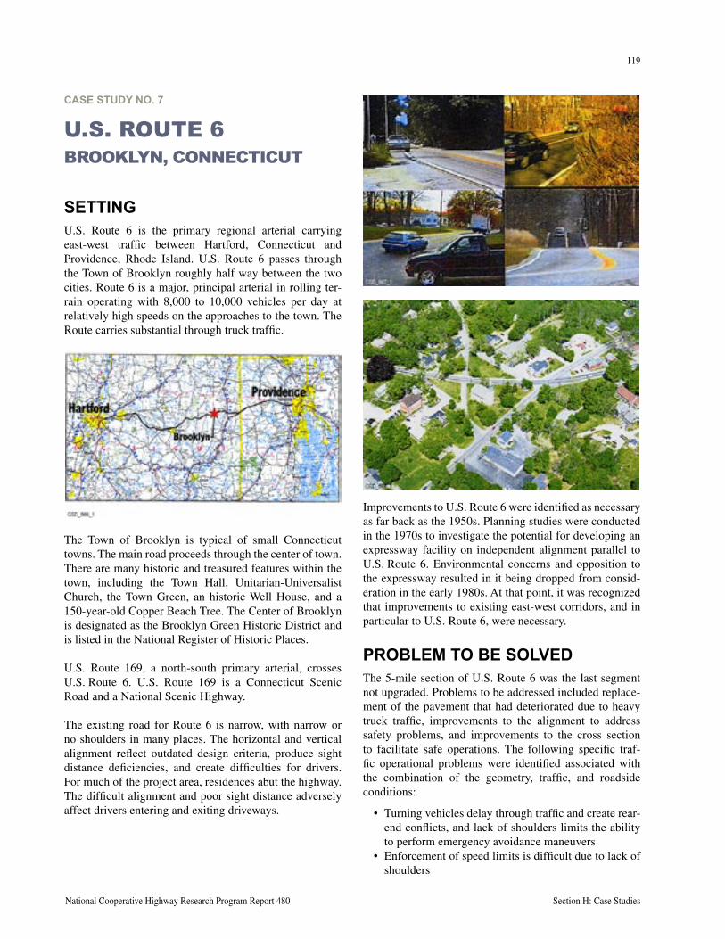
119
National Cooperative Highway Research Program Report 480 Section H: Case Studies
CASE STUDY NO. 7
U.S. ROUTE 6BROOKLYN, CONNECTICUT
SETTINGU.S. Route 6 is the primary regional arterial carrying east-west traffic between Hartford, Connecticut and Providence, Rhode Island. U.S. Route 6 passes through the Town of Brooklyn roughly half way between the two cities. Route 6 is a major, principal arterial in rolling ter-rain operating with 8,000 to 10,000 vehicles per day at relatively high speeds on the approaches to the town. The Route carries substantial through truck traffic.
The Town of Brooklyn is typical of small Connecticut towns. The main road proceeds through the center of town. There are many historic and treasured features within the town, including the Town Hall, Unitarian-Universalist Church, the Town Green, an historic Well House, and a 150-year-old Copper Beach Tree. The Center of Brooklyn is designated as the Brooklyn Green Historic District and is listed in the National Register of Historic Places.
U.S. Route 169, a north-south primary arterial, crosses U.S. Route 6. U.S. Route 169 is a Connecticut Scenic Road and a National Scenic Highway.
The existing road for Route 6 is narrow, with narrow or no shoulders in many places. The horizontal and vertical alignment reflect outdated design criteria, produce sight distance deficiencies, and create difficulties for drivers. For much of the project area, residences abut the highway. The difficult alignment and poor sight distance adversely affect drivers entering and exiting driveways.
Improvements to U.S. Route 6 were identified as necessary as far back as the 1950s. Planning studies were conducted in the 1970s to investigate the potential for developing an expressway facility on independent alignment parallel to U.S. Route 6. Environmental concerns and opposition to the expressway resulted in it being dropped from consid-eration in the early 1980s. At that point, it was recognized that improvements to existing east-west corridors, and in particular to U.S. Route 6, were necessary.
PROBLEM TO BE SOLVEDThe 5-mile section of U.S. Route 6 was the last segment not upgraded. Problems to be addressed included replace-ment of the pavement that had deteriorated due to heavy truck traffic, improvements to the alignment to address safety problems, and improvements to the cross section to facilitate safe operations. The following specific traf-fic operational problems were identified associated with the combination of the geometry, traffic, and roadside conditions:
• Turning vehicles delay through traffic and create rear-end conflicts, and lack of shoulders limits the ability to perform emergency avoidance maneuvers
• Enforcement of speed limits is difficult due to lack of shoulders
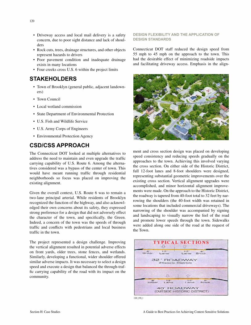
120
Section H: Case Studies A Guide to Best Practices for Achieving Context Sensitive Solutions
121
National Cooperative Highway Research Program Report 480 Section H: Case Studies
• Driveway access and local mail delivery is a safety concern, due to poor sight distance and lack of shoul-ders
• Rock cuts, trees, drainage structures, and other objects represent hazards to drivers
• Poor pavement condition and inadequate drainage exists in many locations
• Four creeks cross U.S. 6 within the project limits
STAKEHOLDERS• Town of Brooklyn (general public, adjacent landown-
ers)
• Town Council
• Local wetland commission
• State Department of Environmental Protection
• U.S. Fish and Wildlife Service
• U.S. Army Corps of Engineers
• Environmental Protection Agency
CSD/CSS APPROACHThe Connecticut DOT looked at multiple alternatives to address the need to maintain and even upgrade the traffic carrying capability of U.S. Route 6. Among the alterna-tives considered was a bypass of the center of town. This would have meant running traffic through residential neighborhoods so focus was placed on improving the existing alignment.
Given the overall context, U.S. Route 6 was to remain a two-lane principal arterial. While residents of Brooklyn recognized the function of the highway, and also acknowl-edged their own concerns about its safety, they expressed strong preference for a design that did not adversely effect the character of the town, and specifically, the Green. Indeed, a concern of the town was the speeds of through traffic and conflicts with pedestrians and local business traffic in the town.
The project represented a design challenge. Improving the vertical alignment resulted in potential adverse effects on front yards, older trees, stone fences, and wetlands. Similarly, developing a functional, wider shoulder offered similar adverse impacts. It was necessary to select a design speed and execute a design that balanced the through-traf-fic carrying capability of the road with its impact on the community.
DESIGN FLEXIBILITY AND THE APPLICATION OF DESIGN STANDARDS
Connecticut DOT staff reduced the design speed from 55 mph to 45 mph on the approach to the town. This had the desirable effect of minimizing roadside impacts and facilitating driveway access. Emphasis in the align-
ment and cross section design was placed on developing speed consistency and reducing speeds gradually on the approaches to the town. Achieving this involved varying the cross section. On either side of the Historic District, full 12-foot lanes and 8-foot shoulders were designed, representing substantial geometric improvements over the existing cross section. Vertical alignment upgrades were accomplished, and minor horizontal alignment improve-ments were made. On the approach to the Historic District, the roadway is tapered from 40-foot total to 32 feet by nar-rowing the shoulders (the 40-foot width was retained in some locations that included commercial driveways). The narrowing of the shoulder was accompanied by signing and landscaping to visually narrow the feel of the road and promote lower speeds through the town. Sidewalks were added along one side of the road at the request of the Town.
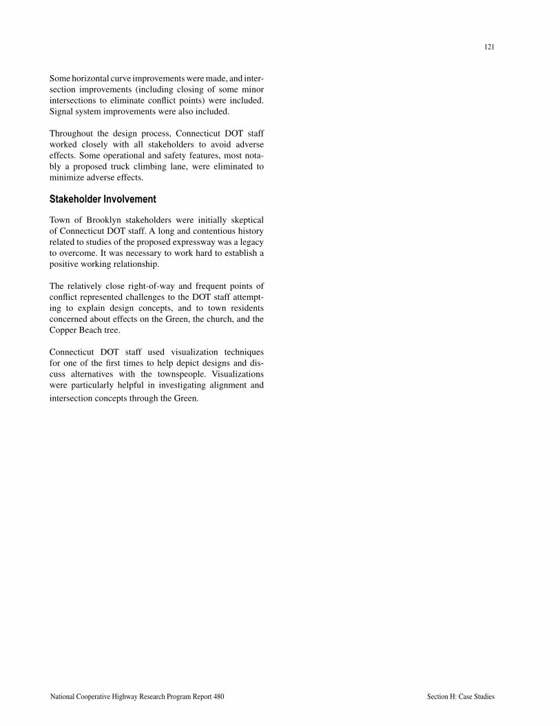
120
Section H: Case Studies A Guide to Best Practices for Achieving Context Sensitive Solutions
121
National Cooperative Highway Research Program Report 480 Section H: Case Studies
Some horizontal curve improvements were made, and inter-section improvements (including closing of some minor intersections to eliminate conflict points) were included. Signal system improvements were also included.
Throughout the design process, Connecticut DOT staff worked closely with all stakeholders to avoid adverse effects. Some operational and safety features, most nota-bly a proposed truck climbing lane, were eliminated to minimize adverse effects.
Stakeholder Involvement
Town of Brooklyn stakeholders were initially skeptical of Connecticut DOT staff. A long and contentious history related to studies of the proposed expressway was a legacy to overcome. It was necessary to work hard to establish a positive working relationship.
The relatively close right-of-way and frequent points of conflict represented challenges to the DOT staff attempt-ing to explain design concepts, and to town residents concerned about effects on the Green, the church, and the Copper Beach tree.
Connecticut DOT staff used visualization techniques for one of the first times to help depict designs and dis-cuss alternatives with the townspeople. Visualizations were particularly helpful in investigating alignment and
intersection concepts through the Green.

122
Section H: Case Studies A Guide to Best Practices for Achieving Context Sensitive Solutions
This page intentionally left blank
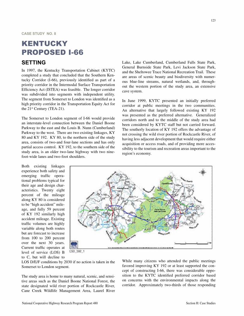
123
National Cooperative Highway Research Program Report 480 Section H: Case Studies
CASE STUDY NO. 8
KENTUCKY PROPOSED I-66SETTINGIn 1997, the Kentucky Transportation Cabinet (KYTC) completed a study that concluded that the Southern Ken-tucky Corridor (I-66), previously identified as part of a priority corridor in the Intermodal Surface Transportation Efficiency Act (ISTEA) was feasible. The longer corridor was subdivided into segments with independent utility. The segment from Somerset to London was identified as a high priority corridor in the Transportation Equity Act for the 21st Century (TEA-21).
The Somerset to London segment of I-66 would provide an interstate-level connection between the Daniel Boone Parkway to the east and the Louis B. Nunn (Cumberland) Parkway to the west. There are two existing linkages, KY 80 and KY 192. KY 80, to the northern side of the study area, consists of two-and four-lane sections and has only partial access control. KY 192, to the southern side of the study area, is an older two-lane highway with two nine-foot-wide lanes and two-foot shoulders.
Both existing linkages experience both safety and emerging traffic opera-tional problems typical for their age and design char-acteristics. Twenty eight percent of the mileage along KY 80 is considered to be “high accident” mile-age, and fully 59 percent of KY 192 similarly high accident mileage. Existing traffic volumes are highly variable along both routes but are forecast to increase from 100 to 200 percent over the next 30 years. Current traffic operates at level of service (LOS) B to C, but will decline to LOS D/E/F conditions by 2030 if no action is taken in the Somerset to London segment.
The study area is home to many natural, scenic, and sensi-tive areas such as the Daniel Boone National Forest, the state designated wild river portion of Rockcastle River, Cane Creek Wildlife Management Area, Laurel River
Lake, Lake Cumberland, Cumberland Falls State Park, General Burnside State Park, Levi Jackson State Park, and the Sheltowee Trace National Recreation Trail. These are areas of scenic beauty and biodiversity with numer-ous blue-line streams, natural wetlands, and, through-out the western portion of the study area, an extensive cave system.
In June 1999, KYTC presented an initially preferred corridor at public meetings in the two communities. An alternative that largely followed existing KY 192 was presented as the preferred alternative. Generalized corridors north and to the middle of the study area had been considered by KYTC staff but not carried forward. The southerly location of KY 192 offers the advantage of not crossing the wild river portion of Rockcastle River, of having less adjacent development that would require either acquisition or access roads, and of providing more acces-sibility to the tourism and recreation areas important to the region’s economy.
While many citizens who attended the public meetings favored improving KY 192 or at least supported the con-cept of constructing I-66, there was considerable oppo-sition to the KYTC identified preferred corridor based on concerns with the environmental impacts along the corridor. Approximately two-thirds of those responding
124
Section H: Case Studies A Guide to Best Practices for Achieving Context Sensitive Solutions
125
National Cooperative Highway Research Program Report 480 Section H: Case Studies
favored I-66 but about half of those responding identi-fied an alternative other than KYTC’s initially preferred alternative.
PROBLEM TO BE SOLVEDThe problem faced by KYTC was how to:
• Address a priority corridor identified in TEA-21 and receiving considerable Congressional attention
• Prevent extensive LOS “F” as traffic volumes increased in a popular recreation area
• Reduce already high accident rates likely to increase as traffic volume increased
• Improve economic conditions in a traditionally higher unemployment/lower income area through improved transportation facilities
• Provide a revised process for corridor(s) evaluation that would involve stakeholders while yielding rec-ommendations consistent with the project goals
STAKEHOLDERSA wide range of stakeholders representing environmental, economic development, statewide, and local interests were involved in the project. Due to the sensitive nature of the study area, many resource and regulatory agencies were also directly involved.
• Cumberland Valley Area Development District• Federal Highway Administration• Kentuckians for the Commonwealth• Kentucky Department of Fish and Wildlife• Kentucky Heartwood • Kentucky Heritage Council• Kentucky Tourism Development Cabinet• Kentucky Transportation Cabinet• KICK 66• Lake Cumberland Area Development District• National Speleological Society• Sierra Club Cumberland Chapter• U.S. Fish and Wildlife Service• U.S. Forest Service, Daniel Boone National Forest
CSD APPROACHThe planning phase of I-66 Somerset to London segment occurred about the same time that Kentucky was moving into the national forefront of the context sensitive design movement. While not yet in the final design stage where design flexibility is most appropriate, KYTC has been implementing the spirit of CSD/CSS on I-66 through their approach to public involvement, environmental consider-ations, and open decision making.
This approach was evident in the KYTC’s reaction to public input from the 1999 meetings. Following the June 1999 meetings, KYTC acknowledged the need to reexam-ine the criteria and process that led them to identify the initially preferred alternative.
The northern corridors, including the KY 80 corridor, that were previously not given detailed consideration in part because of the crossing of a wild river, were reexamined with a realization that use of the existing right-of-way would not constitute the same level of impact as the need for new right-of-way.
An alternative corridor was identified that would cross more National Forest land, but would cross through areas that have been extensively modified through logging and mining.
The level of information available to the public was expanded substantially. The data and decision making processes are well documented on the Internet as well as through more traditional media. The Evaluation Matrix explicitly shows the tradeoffs involved in this complex multi-disciplinary decision.
Through the new alternatives development process and active stakeholder engagement, KYTC staff determined that an overall better alignment solution was available. The selection of what is known as the N-4 Alternative as the preferred alternative kept open the door for ongoing refinements, particularly still greater use of the KY 80 cor-ridor near Somerset.
In the planning stage, KYTC decided to use fairly typical AASHTO design criteria. However, even in a planning report KYTC acknowledges the role flexibility plays in highway design. Future phases of the I-66 corridor project may involve further geometric criteria and issues, at which point it would be appropriate to begin consideration of potential flexible design components. The purpose of flex-ible design methods is to aid designers in the design and construction of a roadway while preserving or enhancing scenic, historic, environmental and community resources in the vicinity of the project.
Current preliminary design efforts in the vicinity of Somerset include a stakeholder group that has developed criteria to evaluate alternatives. These evaluations will be part of the data reviewed by the project team as they make project decisions.
Public involvement near Somerset has resulted in refine-ment of preliminary alternatives so that they do not divide areas that are already developed.

124
Section H: Case Studies A Guide to Best Practices for Achieving Context Sensitive Solutions
125
National Cooperative Highway Research Program Report 480 Section H: Case Studies
LESSONS LEARNEDIn one form or another, the I-66 project has been under consideration in Kentucky since the mid-1980s and is actively moving forward today. In some respects the proj-ect is one of the reasons Kentucky has not only embraced Thinking Beyond the Pavement and Context Sensitive Design, they have become a leader.
Public involvement needs to be a more significant part of the planning process than it has been in the past. Although Kentuckians are historically more receptive of new high-way projects than citizens elsewhere, the level of dissat-isfaction on this project threatened to stop what had the hallmarks of a popular and needed project.
Initial impressions of desirable features are not necessar-ily correct. In part, a southerly alternative was initially preferred in order to bring more traffic to tourist recreation areas. However, these areas are heavily used now and may not be able to accommodate significant increased traffic.
Although all of the corridor alternates pass through the Daniel Boone National Forest, more detailed review determined that there were major differences among the corridors with regard to the levels of impacts. Examin-ing alternatives and highlighting the differences led to a different decision than was earlier made, but one that has appeared to garner more widespread support.

126
Section H: Case Studies A Guide to Best Practices for Achieving Context Sensitive Solutions
This page intentionally left blank
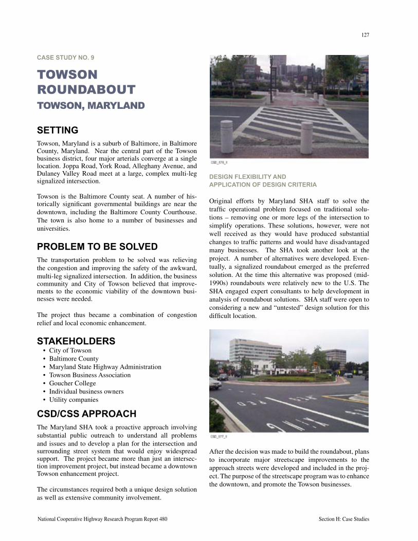
127
National Cooperative Highway Research Program Report 480 Section H: Case Studies
CASE STUDY NO. 9
TOWSON ROUNDABOUTTOWSON, MARYLAND
SETTINGTowson, Maryland is a suburb of Baltimore, in Baltimore County, Maryland. Near the central part of the Towson business district, four major arterials converge at a single location. Joppa Road, York Road, Alleghany Avenue, and Dulaney Valley Road meet at a large, complex multi-leg signalized intersection.
Towson is the Baltimore County seat. A number of his-torically significant governmental buildings are near the downtown, including the Baltimore County Courthouse. The town is also home to a number of businesses and universities.
PROBLEM TO BE SOLVEDThe transportation problem to be solved was relieving the congestion and improving the safety of the awkward, multi-leg signalized intersection. In addition, the business community and City of Towson believed that improve-ments to the economic viability of the downtown busi-nesses were needed.
The project thus became a combination of congestion relief and local economic enhancement.
STAKEHOLDERS• City of Towson• Baltimore County• Maryland State Highway Administration• Towson Business Association• Goucher College• Individual business owners• Utility companies
CSD/CSS APPROACHThe Maryland SHA took a proactive approach involving substantial public outreach to understand all problems and issues and to develop a plan for the intersection and surrounding street system that would enjoy widespread support. The project became more than just an intersec-tion improvement project, but instead became a downtown Towson enhancement project.
The circumstances required both a unique design solution as well as extensive community involvement.
DESIGN FLEXIBILITY AND APPLICATION OF DESIGN CRITERIA
Original efforts by Maryland SHA staff to solve the traffic operational problem focused on traditional solu-tions – removing one or more legs of the intersection to simplify operations. These solutions, however, were not well received as they would have produced substantial changes to traffic patterns and would have disadvantaged many businesses. The SHA took another look at the project. A number of alternatives were developed. Even-tually, a signalized roundabout emerged as the preferred solution. At the time this alternative was proposed (mid-1990s) roundabouts were relatively new to the U.S. The SHA engaged expert consultants to help development in analysis of roundabout solutions. SHA staff were open to considering a new and “untested” design solution for this difficult location.
After the decision was made to build the roundabout, plans to incorporate major streetscape improvements to the approach streets were developed and included in the proj-ect. The purpose of the streetscape program was to enhance the downtown, and promote the Towson businesses.
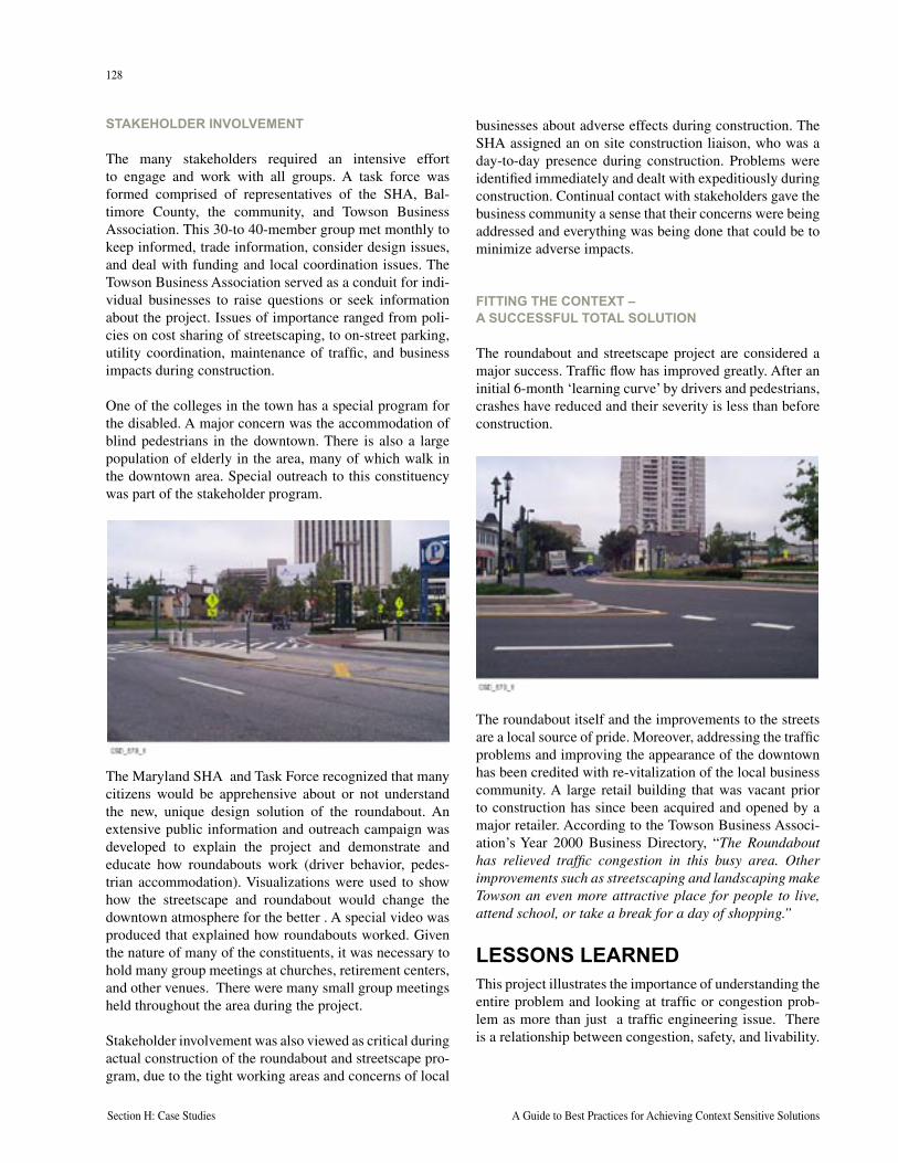
128
Section H: Case Studies A Guide to Best Practices for Achieving Context Sensitive Solutions
129
National Cooperative Highway Research Program Report 480 Section H: Case Studies
STAKEHOLDER INVOLVEMENT
The many stakeholders required an intensive effort to engage and work with all groups. A task force was formed comprised of representatives of the SHA, Bal-timore County, the community, and Towson Business Association. This 30-to 40-member group met monthly to keep informed, trade information, consider design issues, and deal with funding and local coordination issues. The Towson Business Association served as a conduit for indi-vidual businesses to raise questions or seek information about the project. Issues of importance ranged from poli-cies on cost sharing of streetscaping, to on-street parking, utility coordination, maintenance of traffic, and business impacts during construction.
One of the colleges in the town has a special program for the disabled. A major concern was the accommodation of blind pedestrians in the downtown. There is also a large population of elderly in the area, many of which walk in the downtown area. Special outreach to this constituency was part of the stakeholder program.
The Maryland SHA and Task Force recognized that many citizens would be apprehensive about or not understand the new, unique design solution of the roundabout. An extensive public information and outreach campaign was developed to explain the project and demonstrate and educate how roundabouts work (driver behavior, pedes-trian accommodation). Visualizations were used to show how the streetscape and roundabout would change the downtown atmosphere for the better . A special video was produced that explained how roundabouts worked. Given the nature of many of the constituents, it was necessary to hold many group meetings at churches, retirement centers, and other venues. There were many small group meetings held throughout the area during the project.
Stakeholder involvement was also viewed as critical during actual construction of the roundabout and streetscape pro-gram, due to the tight working areas and concerns of local
businesses about adverse effects during construction. The SHA assigned an on site construction liaison, who was a day-to-day presence during construction. Problems were identified immediately and dealt with expeditiously during construction. Continual contact with stakeholders gave the business community a sense that their concerns were being addressed and everything was being done that could be to minimize adverse impacts.
FITTING THE CONTEXT – A SUCCESSFUL TOTAL SOLUTION
The roundabout and streetscape project are considered a major success. Traffic flow has improved greatly. After an initial 6-month ‘learning curve’ by drivers and pedestrians, crashes have reduced and their severity is less than before construction.
The roundabout itself and the improvements to the streets are a local source of pride. Moreover, addressing the traffic problems and improving the appearance of the downtown has been credited with re-vitalization of the local business community. A large retail building that was vacant prior to construction has since been acquired and opened by a major retailer. According to the Towson Business Associ-ation’s Year 2000 Business Directory, “The Roundabout has relieved traffic congestion in this busy area. Other improvements such as streetscaping and landscaping make Towson an even more attractive place for people to live, attend school, or take a break for a day of shopping.”
LESSONS LEARNEDThis project illustrates the importance of understanding the entire problem and looking at traffic or congestion prob-lem as more than just a traffic engineering issue. There is a relationship between congestion, safety, and livability.
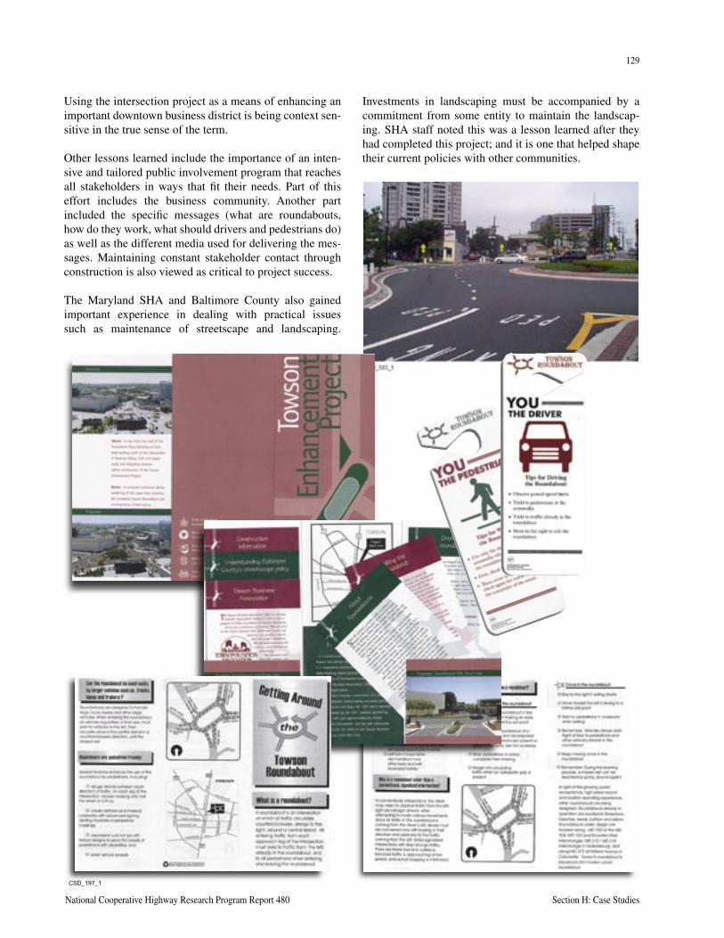
128
Section H: Case Studies A Guide to Best Practices for Achieving Context Sensitive Solutions
129
National Cooperative Highway Research Program Report 480 Section H: Case Studies
Using the intersection project as a means of enhancing an important downtown business district is being context sen-sitive in the true sense of the term.
Other lessons learned include the importance of an inten-sive and tailored public involvement program that reaches all stakeholders in ways that fit their needs. Part of this effort includes the business community. Another part included the specific messages (what are roundabouts, how do they work, what should drivers and pedestrians do) as well as the different media used for delivering the mes-sages. Maintaining constant stakeholder contact through construction is also viewed as critical to project success.
The Maryland SHA and Baltimore County also gained important experience in dealing with practical issues such as maintenance of streetscape and landscaping.
Investments in landscaping must be accompanied by a commitment from some entity to maintain the landscap-ing. SHA staff noted this was a lesson learned after they had completed this project; and it is one that helped shape their current policies with other communities.
���������

130
Section H: Case Studies A Guide to Best Practices for Achieving Context Sensitive Solutions
This page intentionally left blank
Appendices All appendices can be found on the CD accompanying this document.
Section C – Effective Decision Making
Proposed Management Structure and Decision Process – Oregon DOT
Management Structure Organization Charts – Nevada DOT
Example Project Team Chartering Meeting Agenda and Meeting Notes – Rice Avenue/Highway 101, Oxnard, California
Example Charter Meeting Notes – I-74 Quad Cities Study
Project Evaluation Criteria from Alaska DOT and Public Facilities
Example Evaluation Criteria – Oregon DOT Project
Example Transportation Problem Definition – Sacramento, California
Example Transportation Problem Statement/Definition – Oregon DOT
Hypothetical Case Study Consensus Building, Alternative Selection, and Decision Making for Transportation Projects – Don Speicher
Example Decision Tree Analysis from I-74 Quad Cities Project
Example Description of Multi-Modal Alternatives – Oregon DOT
Section D – Reflecting Community Values
Public Involvement Planning Form
Stakeholder Identification Form
Examples of Stakeholders Questions
Table of Contents and Appendix D from Innovations in Public Involvement for Transportation Planning
Excerpts from “Hear Every Voice”
Public Involvement Plan – I-5/Beltline Interchange, Oregon
Public Involvement Plan – Gravina Access Project, Alaska
Public Involvement Plan – I-580 Freeway, Nevada
Advisory Group Options Matrix and Application Form
Section E – Achieving Environmental Sensitivity
History of Mn/DOT Model
I-580 Aesthetic Design Guidelines – Nevada DOT
Example Agreement: Workshop Summary – US 68 Project, Chinn Lake to Chatham Road – Kentucky
Example Agreement: I-25 New Pueblo Freeway Project Leadership Team Memo – Colorado
Section F – Ensuring Safe and Feasible Solutions
Design Exception Report – Connecticut DOT
Design Exception Process – Connecticut DOT
Design Exception Process – Iowa DOT
Appendix H, Fundamental Architecture of the Design Decision Support System (DDSS) from NCHRP Report 430, Improved Safety Information to Support Highway Design
Description of Iowa DOTs Safety Data Analysis Tools: SAVER: E5
I-25 New Pueblo Freeway Fact Sheets – Colorado DOT
Overview of FHWA’s Interactive Highway Safety Design Module
Key Reseazrch References for Determining the Substantive Safety of Geometric Highway Design Alternatives
Federal Highway Administration Course on Safety and Operational Effects of Highway Design Features on Two-lane Rural Highways – Course Outline
Excerpts from the SEMCOG Traffic Safety Manual, Second Edition, September 1997.
Technical Proposal CH2M HILL Appendices – Page 2 Context Sensitive Design Manual
Use
of t
his
shee
t is
subj
ect t
o th
e re
stric
tion
on th
e tit
le p
age
of th
is p
ropo
sal.
FHWA Federal Lands Highway Divisions Design Standards Information
Section G – Organizational Needs
Self-Assessment Process for Organizations Considering Implementing CSD/CSS
Executive Summary from NCHRP Report 430
Thinking Beyond the Pavement Checklist
Minnesota DOT’s Project Management Academy Course Outline
FHWA’s AASHTO Design Criteria Training Course Outline


