Embed Size (px)
Citation preview
Open source geographicalresources analysis support
system (GRASS) for landslidehazard assessment
Mohammad Firuz Ramli, Wan Nor Azmin Sulaiman,Mohd Kamil Yusoff and Yoke Yee Low
Department of Environmental Sciences,Faculty of Science and Environmental Studies, Universiti Putra Malaysia,
Serdang, Malaysia, and
Mohamad Abd. ManapMineral and Geoscience Department Malaysia, Jalan Tun Razak,
Kuala Lumpur, Malaysia
Abstract
Purpose – The primary aim of this research is to investigate the application of open sourcegeographic information system software, geographical resources analysis support system (GRASS)for landslide hazard assessment.
Design/methodology/approach – Five parameters affecting landslide occurrence derived fromtopographical, geological and land use maps of Cameron highland were used for the assessment.
Findings – The results showed that about 93 percent of the study area falls under zone II that is oflow hazard, with less than 7 percent on zone III with moderate hazard and only less than 1 percent fallsunder zone IV, which is of high hazard.
Research limitations/implications – The accuracy of the landslide hazard map needs to beassessed by cross-correlation with landslide occurrence in the field.
Practical implications – The map produced showed the potential application of GRASS as a toolfor producing landslide hazard assessment map.
Originality/value – The major outcome of this research is the possible use of open source GISsoftware in the application of landslide hazard assessment. The capability of GRASS in performingsuch environmental assessment will certainly attract many researchers and organizations with limitedbudgets, especially in developing countries such as Malaysia.
Keywords Geographic information systems, Landslides, Open systems, Geology, Malaysia
Paper type Research paper
IntroductionWith the advance of internet technology, open source software is becomingincreasingly popular. There are several open source GIS in the internet such as
The Emerald Research Register for this journal is available at The current issue and full text archive of this journal is available at
www.emeraldinsight.com/researchregister www.emeraldinsight.com/0965-3562.htm
The authors would like to express their gratitude to Universiti Putra Malaysia for researchfunding (Project code ¼ 55003) and to Professor Kaoru Fukuyama from University of Mie,Japan for introducing GRASS to the authors. Also to Associate Professor Dr Mohd Pauzi Zakariaand Pn. Tengku Hanidza from Department of Environmental Sciences, UPM for commentingupon this manuscript.
DPM14,4
522
Disaster Prevention and ManagementVol. 14 No. 4, 2005pp. 522-532q Emerald Group Publishing Limited0965-3562DOI 10.1108/09653560510618357
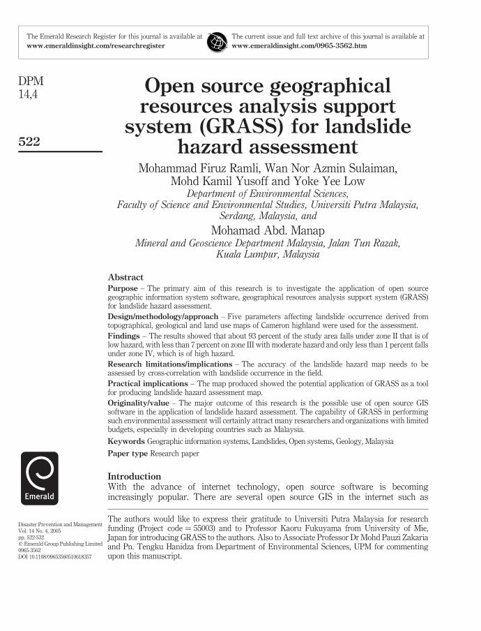
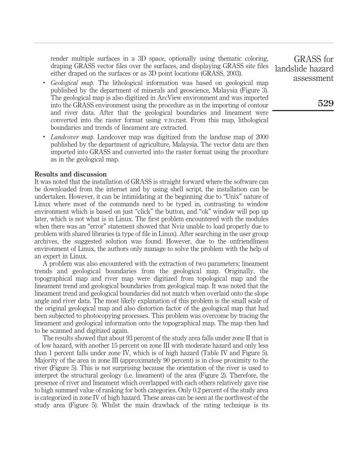
mapServer, generic mapping tools (GMT), open source software image map (OSSIM)and GIS viewer to name, amongst others. The most popular and comprehensive is thegeographical resources analysis support system (GRASS). GRASS is the raster/vectorGIS software with more than 350 modules for analyzing, storing, displaying, andmodeling data. As the open-source software, GRASS is continuously updated bymulti-national teams consisting of many researchers. Internet is the backbone of theproject where distribution, user support, and centralized management of the GRASSdevelopment are undertaken (Neteler and Mitasova, 2002). Whilst GRASS has limitedcapability in database and statistical analysis, it is linked to the many open sourcestatistical software such as PostgreSQL and R stats (Figure 1).
GRASS software operates under various UNIX compliant systems such as Linux,Sun Solaris and also under Microsoft-Windows NT/2000/XP (with Cygwin). Formaximum effectiveness, a familiarity with UNIX environment is required (Neteler andMitasova, 2002). For this study, GRASS was installed under Linux operating systemwhich is also the open-source software. Presently, GIS application is gaining popularityand becoming a necessity in environmental studies. However, due to the high cost ofcommercial software, the use of GIS is limited, especially in developing countries suchas Malaysia. The availability of free comprehensive GIS software such as GRASS willenable the financial costing for GIS software to be channeled for the purchasing ofbetter hardware or data acquisition. Owing to its “free” nature, it is much anticipatedthat GRASS will be widely used by many organizations, however in reality, it is not.The nature of such free software with modifiable source code without direct technicalsupport is probably the biggest obstacle to its potential users.
However, there are indirect supports from user group and also archives of pastqueries and answers in the internet (http://op.gfz-potsdam.de/GRASS-List/). Full list oftutorials for GRASS can be found in the main GRASS homepage (www.geog.uni-hannover.de/grass/).
Landslides often occur during or after heavy rainfall due to an increase in porewater pressures, which reduce the effective shear strength of the slope material, thus
Figure 1.GRASS and its relations
with other software
GRASS forlandslide hazard
assessment
523
reducing their factor of safety. The stability of natural and cut slopes is governed bytopographic, geologic and climatic variables which control shear stress and shearresistance in the slope. Combination of hilly areas, deeply weathered rock profile andhigh intensity tropical rainfall is a near-ideal condition for the landslide development inthe highlands of Malaysia.
Changes in slope morphology, which may occur as a result of natural or humaninfluences, can induce failure. These changes may alter the drainage conditions of thesurface and subsurface and/or induce “over-steepening” of the slope (Jones and Lee,1994).
This condition has been shown in the increasing trend of landslides occurrence inMalaysia as a result of intensive “human influence” or development especially in hillyarea. Fatalities caused by landslides were rare in Malaysia before 1993. However, thishas changed: in December 1993 the Highland Tower tragedy claimed the lives of 48people where a massive landslide swept away the building. After that in 1995,landslides at Genting bypass had caused 14 deaths. In August 1996, 35 died whentorrent of water and debris from a nearby hill swept away an orang asli settlement inPos Dipang. In January 2002 landslides caused 17 fatalities in Sarawak. The latest wason 26 November 2003 when major landslides occurred with an estimated 100,000 m3 ofrock and soil blocking the 21.8 kilometer North Klang Valley Expressway betweenJalan Duta and Bukit Lanjan. These landslides occurrence shows that demarcating andmapping of potentially unstable area prior to, and after development are therefore,crucial.
GIS has been recognized as useful tools in landslide studies as early as in 1990 byDikau, where geological maps, landslide inventories, and landform morphometryinformation were utilized to produce hazard classification map (Dikau, 1990). Whilstlandslides can be defined as the movement of mass of rock, debris or earth down aslope (Cruden, 1991), hazard can be defined as a likelihood of occurrence of an event inarea within a specified period of time (Varnes, 1984).
There are several different methods that have been proposed for evaluatinglandslide hazard assessment which mostly can be classified into two major classessuch as rating (Sinclair, 1991; Anbalagan, 1992) and deterministic techniques (Casciniet al., 1991; Gokceoglu and Aksoy, 1996). The advantage of rating technique is that thedata collection process is less intensive than the deterministic techniques, although theformer has lower accuracy compared to the latter. The advantage of a well-constructedhazard rating is that it is user-friendly and can be understood by a non-specialist.
Only one published study of landslide using GRASS has been undertaken by usingdeterministic technique to evaluate the landslide susceptibility in Handslovska KotlinaBasin in Slovakia (Paudits and Bednarik, 2002). It was concluded that GRASS GISenvironment is an ideal tool, not only for its “price performance ratio” but also for itscapability that is on par with other commercial software. However, this study did notmention anything on the status of the user-friendliness of the software.
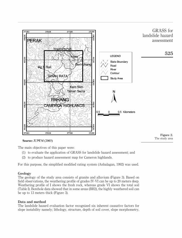
For that reason, a study in producing landslide hazard assessment was undertakenin Tanah Rata, Cameron Highlands, Northwestern corner of Pahang about 250 km byroad from Kuala Lumpur, Malaysia (Figure 2). Although, there are already twoprevious studies undertaken in this area (Talib, 1997; KPU, 1999), however bothstudies were based on regional area and both were not utilizing GRASS as their GISsoftware.
DPM14,4
524
The main objectives of this paper were:
(1) to evaluate the application of GRASS for landslide hazard assessment; and
(2) to produce hazard assessment map for Cameron highlands.
For this purpose, the simplified modified rating system (Anbalagan, 1992) was used.
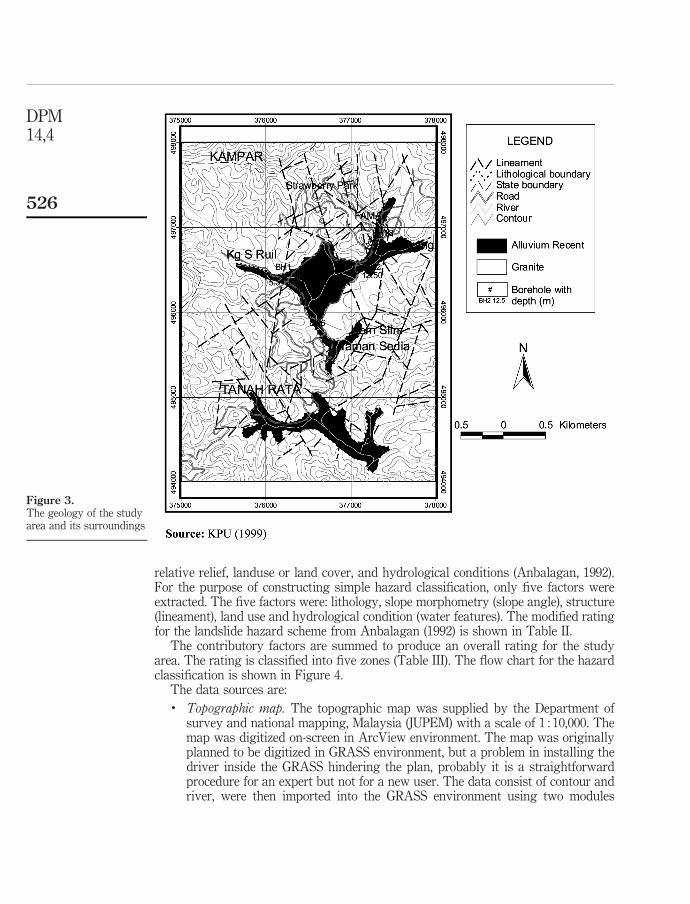
GeologyThe geology of the study area consists of granite and alluvium (Figure 3). Based onfield observations, the weathering profile of grades IV-VI can be up to 20 meters deep.Weathering profile of I shows the fresh rock, whereas grade VI shows the total soil(Table I). Borehole data showed that in some areas (BH2), the highly weathered soil canbe up to 13 meters thick (Figure 3).
Data and methodThe landslide hazard evaluation factor recognized six inherent causative factors forslope instability namely; lithology, structure, depth of soil cover, slope morphometry,
Figure 2.The study area
GRASS forlandslide hazard
assessment
525
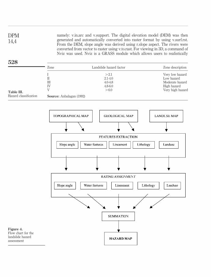
relative relief, landuse or land cover, and hydrological conditions (Anbalagan, 1992).For the purpose of constructing simple hazard classification, only five factors wereextracted. The five factors were: lithology, slope morphometry (slope angle), structure(lineament), land use and hydrological condition (water features). The modified ratingfor the landslide hazard scheme from Anbalagan (1992) is shown in Table II.
The contributory factors are summed to produce an overall rating for the studyarea. The rating is classified into five zones (Table III). The flow chart for the hazardclassification is shown in Figure 4.
The data sources are:. Topographic map. The topographic map was supplied by the Department of
survey and national mapping, Malaysia (JUPEM) with a scale of 1 : 10,000. Themap was digitized on-screen in ArcView environment. The map was originallyplanned to be digitized in GRASS environment, but a problem in installing thedriver inside the GRASS hindering the plan, probably it is a straightforwardprocedure for an expert but not for a new user. The data consist of contour andriver, were then imported into the GRASS environment using two modules
Figure 3.The geology of the studyarea and its surroundings
DPM14,4
526
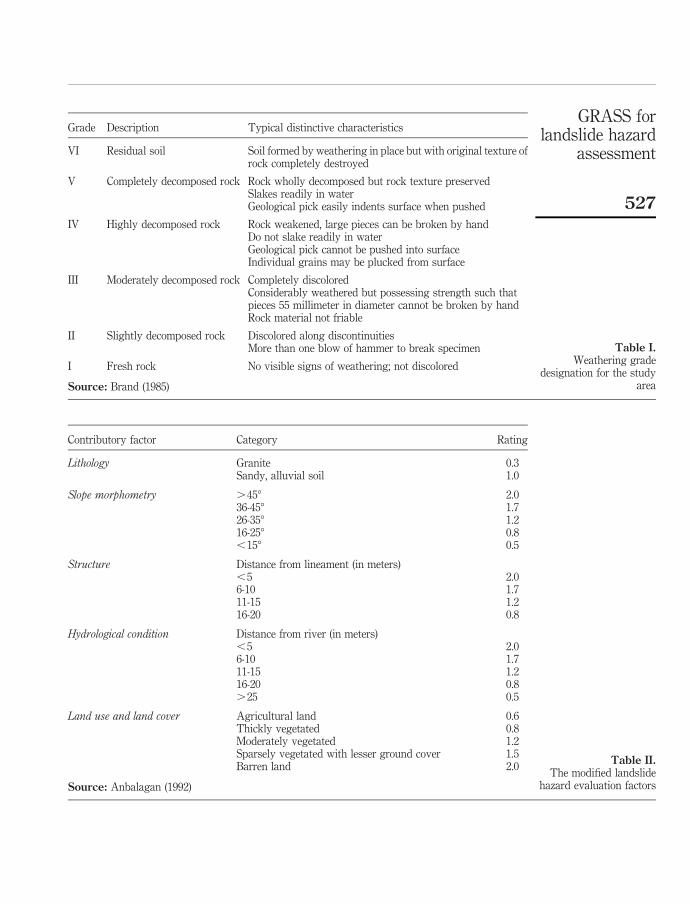
Contributory factor Category Rating
Lithology Granite 0.3Sandy, alluvial soil 1.0
Slope morphometry .458 2.036-458 1.726-358 1.216-258 0.8,158 0.5
Structure Distance from lineament (in meters),5 2.06-10 1.711-15 1.216-20 0.8
Hydrological condition Distance from river (in meters),5 2.06-10 1.711-15 1.216-20 0.8.25 0.5
Land use and land cover Agricultural land 0.6Thickly vegetated 0.8Moderately vegetated 1.2Sparsely vegetated with lesser ground cover 1.5Barren land 2.0
Source: Anbalagan (1992)
Table II.The modified landslide
hazard evaluation factors
Grade Description Typical distinctive characteristics
VI Residual soil Soil formed by weathering in place but with original texture ofrock completely destroyed
V Completely decomposed rock Rock wholly decomposed but rock texture preservedSlakes readily in waterGeological pick easily indents surface when pushed
IV Highly decomposed rock Rock weakened, large pieces can be broken by handDo not slake readily in waterGeological pick cannot be pushed into surfaceIndividual grains may be plucked from surface
III Moderately decomposed rock Completely discoloredConsiderably weathered but possessing strength such thatpieces 55 millimeter in diameter cannot be broken by handRock material not friable
II Slightly decomposed rock Discolored along discontinuitiesMore than one blow of hammer to break specimen
I Fresh rock No visible signs of weathering; not discolored
Source: Brand (1985)
Table I.Weathering grade
designation for the studyarea
GRASS forlandslide hazard
assessment
527
namely: v.in.arc and v.support. The digital elevation model (DEM) was thengenerated and automatically converted into raster format by using v.surf.rst.From the DEM, slope angle was derived using r.slope aspect. The rivers wereconverted from vector to raster using v.to.rast. For viewing in 3D, a command ofNviz was used. Nviz is a GRASS module which allows users to realistically
Zone Landslide hazard factor Zone description
I .2.1 Very low hazardII 2.1-4.0 Low hazardIII 4.0-4.8 Moderate hazardIV 4.8-6.0 High hazardV .6.0 Very high hazard
Source: Anbalagan (1992)Table III.Hazard classification
Figure 4.Flow chart for thelandslide hazardassessment
DPM14,4
528
render multiple surfaces in a 3D space, optionally using thematic coloring,draping GRASS vector files over the surfaces, and displaying GRASS site fileseither draped on the surfaces or as 3D point locations (GRASS, 2003).
. Geological map. The lithological information was based on geological mappublished by the department of minerals and geoscience, Malaysia (Figure 3).The geological map is also digitized in ArcView environment and was importedinto the GRASS environment using the procedure as in the importing of contourand river data. After that the geological boundaries and lineament wereconverted into the raster format using v.to.rast. From this map, lithologicalboundaries and trends of lineament are extracted.
. Landcover map. Landcover map was digitized from the landuse map of 2000published by the department of agriculture, Malaysia. The vector data are thenimported into GRASS and converted into the raster format using the procedureas in the geological map.
Results and discussionIt was noted that the installation of GRASS is straight forward where the software canbe downloaded from the internet and by using shell script, the installation can beundertaken. However, it can be intimidating at the beginning due to “Unix” nature ofLinux where most of the commands need to be typed in, contrasting to windowenvironment which is based on just “click” the button, and “ok” window will pop uplater, which is not what is in Linux. The first problem encountered with the moduleswhen there was an “error” statement showed that Nviz unable to load properly due toproblem with shared libraries (a type of file in Linux). After searching in the user grouparchives, the suggested solution was found. However, due to the unfriendlinessenvironment of Linux, the authors only manage to solve the problem with the help ofan expert in Linux.
A problem was also encountered with the extraction of two parameters; lineamenttrends and geological boundaries from the geological map. Originally, thetopographical map and river map were digitized from topological map and thelineament trend and geological boundaries from geological map. It was noted that thelineament trend and geological boundaries did not match when overlaid onto the slopeangle and river data. The most likely explanation of this problem is the small scale ofthe original geological map and also distortion factor of the geological map that hadbeen subjected to photocopying processes. This problem was overcome by tracing thelineament and geological information onto the topographical map. The map then hadto be scanned and digitized again.
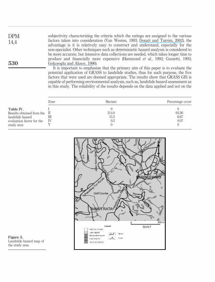
The results showed that about 93 percent of the study area falls under zone II that isof low hazard, with another 15 percent on zone III with moderate hazard and only lessthan 1 percent falls under zone IV, which is of high hazard (Table IV and Figure 5).Majority of the area in zone III (approximately 90 percent) is in close proximity to theriver (Figure 5). This is not surprising because the orientation of the river is used tointerpret the structural geology (i.e. lineament) of the area (Figure 2). Therefore, thepresence of river and lineament which overlapped with each others relatively gave riseto high summed value of ranking for both categories. Only 0.2 percent of the study areais categorized in zone IV of high hazard. These areas can be seen at the northwest of thestudy area (Figure 5). Whilst the main drawback of the rating technique is its
GRASS forlandslide hazard
assessment
529
subjectivity characterizing the criteria which the ratings are assigned to the variousfactors taken into consideration (Van Westen, 1993; Donati and Turrini, 2002), theadvantage is it is relatively easy to construct and understand, especially for thenon-specialist. Other techniques such as deterministic hazard analysis is considered tobe more accurate, but intensive data collections are needed, which takes longer time toproduce and financially more expensive (Hammond et al., 1992; Guzzetti, 1993;Gokceoglu and Aksoy, 1996).
It is important to emphasize that the primary aim of this paper is to evaluate thepotential application of GRASS to landslide studies, thus for such purpose, the fivefactors that were used are deemed appropriate. The results show that GRASS GIS iscapable of performing environmental analysis, such as, landslide hazard assessment asin this study. The reliability of the results depends on the data applied and not on the
Figure 5.Landslide hazard map ofthe study area
Zone Hectare Percentage cover
I 0 0II 214.0 93.26III 15.3 6.67IV 0.2 0.07V 0 0
Table IV.Results obtained from thelandslide hazardevaluation factor for thestudy area
DPM14,4
530
tool as in this case, GRASS. The accuracy of the map may be assessed bycross-correlation with landslide occurrence in the field, which is the subject for furtherstudies.
Limited knowledge in UNIX environment and the command base GRASSinstructions that need to be remembered and typed in, posed a greatest challenge forthis study. This “not so user-friendly environment” will certainly discourage potentialusers. Although GRASS provides a menu-based command in Tcl/Tk (window based)environment, its application is not extensive and constantly affected by errors duringcommand execution. This problem is, however, not encountered in the UNIXenvironment. Extensive functionality either in GIS or image processing for remotesensing is the main strength of GRASS. GRASS is certainly not the typical stereotypeof open source software where it is strained by bugs and limited functionality.
ConclusionsThe major outcome of this research is the possible use of open source GIS software inthe application of landslide hazard assessment. The use of GRASS permits a reliablesolution for environmental analysis for budget-constraint researchers or organizations.
Although further research is required, the use of GRASS could produce a significantcost saving, where financial costing can be directed toward acquiring better hardwareor for more reliable data collection, which will increase the reliability and accuracy ofthe environmental analysis undertaken. However, it certainly will incur initial cost fortraining in an unfriendly UNIX compliance system such as Linux, which not manypeople are familiar with.
References
Anbalagan, R. (1992), “Terrain evaluation and landslide hazard zonation for environmentalregeneration and landuse planning in mountainous terrain”, in Bell, F. (Ed.), Landslides,Balkema, Rotterdam, pp. 861-8.
Brand, E.W. (1985), “Landslides in Hong Kong”, Proceedings of the Eighth Southeast AsiaGeotechnical Conference, Kuala Lumpur, pp. 108-22.
Cascini, L., Critelli, S., Gulla, G. and Di Nocera, S. (1991), “A methodological approach to landslidehazard assessment: a case history”, in Bell, F. (Ed.), Landslides, Balkema, Rotterdam,pp. 899-904.
Cruden, D.M. (1991), “A simple definition of landslide”, Bulletin of the International Associationof Engineering Geology, Vol. 43, pp. 27-9.
Dikau, R. (1990), “Derivatives from detailed geoscientific maps using computer methods”,Zeitschrift fuer Geomorphologie Suppl, Vol. 80, pp. 45-55.
Donati, L. and Turrini, M.C. (2002), “An objective method to rank the importance of the factorspredisposing to landslides with the GIS methodology: application to an area of theApennines (Valnerina; Perugia, Italy)”, Engineering Geology, Vol. 63, pp. 277-89.
Gokceoglu, C. and Aksoy, H. (1996), “Landslide susceptibility mapping of the slopes in theresiduals soils of the Mengen region (Turkey) by deterministic stability analyses andimage processing techniques”, Engineering Geology, Vol. 44, pp. 147-61.
GRASS homepage (2003), available at: http://grass.itc.it/ (accessed April 18, 2003).
Guzzetti, F. (1993), “Landslide hazard and risk by GIS-based multi-variate models”, paperpresented at Workshop on Geographic Information Systems in Assessing Natural Hazard,Perugia, pp. 83-91.
GRASS forlandslide hazard
assessment
531
Hammond, C.J., Prellwitz, R.W. and Miller, S.M. (1992), “Landslide hazard assessment usingMonte Carlo simulation”, Proceedings of 6th International Symposium on Landslides,Christchurch, pp. 959-64.
Jones, D.K.C. and Lee, M. (1994), Landsliding in Great Britain, Department of Environment,London.
KPU (1999), “Laporan kajian integrasi geologi kawasan Tanah Rata-Brinchang, CameronHighlands, Pahang. Jilid II”, Kementerian Perusahaan Utama, Kuala Lumpur.
Neteler, M. and Mitasova, H. (2002), Open Source GIS: A GRASS GIS Approach, Kluwer, Boston,MA.
Paudits, P. and Bednarik, M. (2002), “Using GRASS in evaluation of landslide susceptibility inHandslovska Kotlina Basin”, Proceedings of the Open Source GIS-GRASS UsersConference, Trento, available at: www.ing.unitn.it/,grass/conferences/GRASS2002/proceedings/proceedings/pdfs/Paudits_Peter.pdf
Sinclair, T.J.E. (1991), “SCARR: a slope condition and risk rating”, in Bell, F. (Ed.), Landslides,Balkema, Rotterdam, pp. 1057-64.
Talib, J. (1997), “Slope instability and hazard zonation mapping using remote sensing”,Proceedings of 18th Asian Conference on Remote Sensing, Kuala Lumpur, available at:www.gisdevelopment.net/aars/acrs/1997/ts3/ts3001.shtml
Van Westen, C.J. (1993), Gissiz, Training Package for Geographic Information Systems in SlopeInstability Zonation, Publication no. 15, ITC, Enschede.
Varnes, D.J. (1984), Hazard Zonation: A Review of Principal and Practice, Commission ofLandslide of International Association of Engineering Geology, UNESCO, Paris.
Further reading
JUPEM (2003), Digital Map Sheet 3662, Department of Survey and National Mapping, KualaLumpur.
DPM14,4
532