Embed Size (px)
Citation preview
lable at ScienceDirect
Quaternary International 267 (2012) 20e29
Contents lists avai
Quaternary International
journal homepage: www.elsevier .com/locate/quaint
Palaeolandscapes of Southern Apennines during the late Early and the MiddlePleistocene
Nicoletta Santangelo a,*, Valentino Di Donato a, Vincent Lebreton b, Paola Romano a, Elda Russo Ermolli b,c
aDipartimento di Scienze della Terra, Università di Napoli Federico II, Largo San Marcellino 10, 80138 Napoli, ItalybDépartement de Préhistoire du Muséum National d’Histoire Naturelle, USM103 MNHN, UMR7194 CNRS, Institut de Paléontologie Humaine, 1 rue René Panhard, 75013 Paris, FrancecDipartimento di Arboricoltura, Botanica e Patologia vegetale, Università di Napoli Federico II, via Università 100, 80055 Portici, Italy
a r t i c l e i n f o
Article history:Available online 11 March 2011
* Corresponding author.E-mail addresses: [email protected] (N. Santange
Donato), [email protected] (V. Lebreton), [email protected] (E. Russo Ermolli).
1040-6182/$ e see front matter � 2011 Elsevier Ltd adoi:10.1016/j.quaint.2011.02.036
a b s t r a c t
A palaeolandscape reconstruction of the Southern Apennine chain for the late Early and the MiddlePleistocene is presented with the main aim of highlighting the evolution of this sector of the chain duringa key-period for the diffusion of Palaeolithic humans in the Italian peninsula. During the Calabrian stage(1.8e0.78 Ma) Italy was an elongated peninsula, narrower than present, extended between the Tyr-rhenian and the foreland seas with two big islands (nowadays Gargano and Murge) in the central part ofthe foredeep basin. This area started to emerge at the end of Early Pleistocene (1.2e0.78 Ma) whenoccasional communications among the islands and the Southern Apennine peninsula may have occurred,probably in conjunction with eustatic low-stands. This scenario opens interesting questions on themigration pathways followed by ancient Palaeolithic humans to reach the site of Pirro Nord (1.6e1.3 Ma;NW Gargano). The definitive emersion of the studied area was completed at the beginning of the Ionianstage when several lakes punctuated the axial portion of the chain together with two great activevolcanoes: Roccamonfina and Vulture. In the surroundings of the palaeo-lakes, Palaeolithic humansstarted moving from 600 to 200 ka, as indicated by the artefacts of Acheulean tradition recovered, amongothers, at Isernia La Pineta and Notarchirico.
� 2011 Elsevier Ltd and INQUA. All rights reserved.
1. Introduction
During the late Early and the Middle Pleistocene, the Italianpeninsula experienced deep palaeogeographical changes that led tothe definitive rise of the Apennine Chain, to the formation of intra-mountain basins and to the modern delineation of the coastalplains and promontories. Such palaeogeographical and physio-graphical evolution was mainly linked to the geodynamics of theMediterranean domain. The consequent changes in marine andcontinental environments were also modulated by the cyclicclimatic oscillations which characterised the Quaternary period.
The diachronic formation of marine and continental basins allalong the Southern Apennine chain allowed the environmentalchanges to be recorded in sedimentary successions. Numerousgeomorphological, stratigraphical and palynological studies carriedout on these deposits, even if isolated and discontinuous, gaveinsights in the landscape evolution of this sector of the chain during
lo), [email protected] (V. [email protected] (P. Romano),
nd INQUA. All rights reserved.
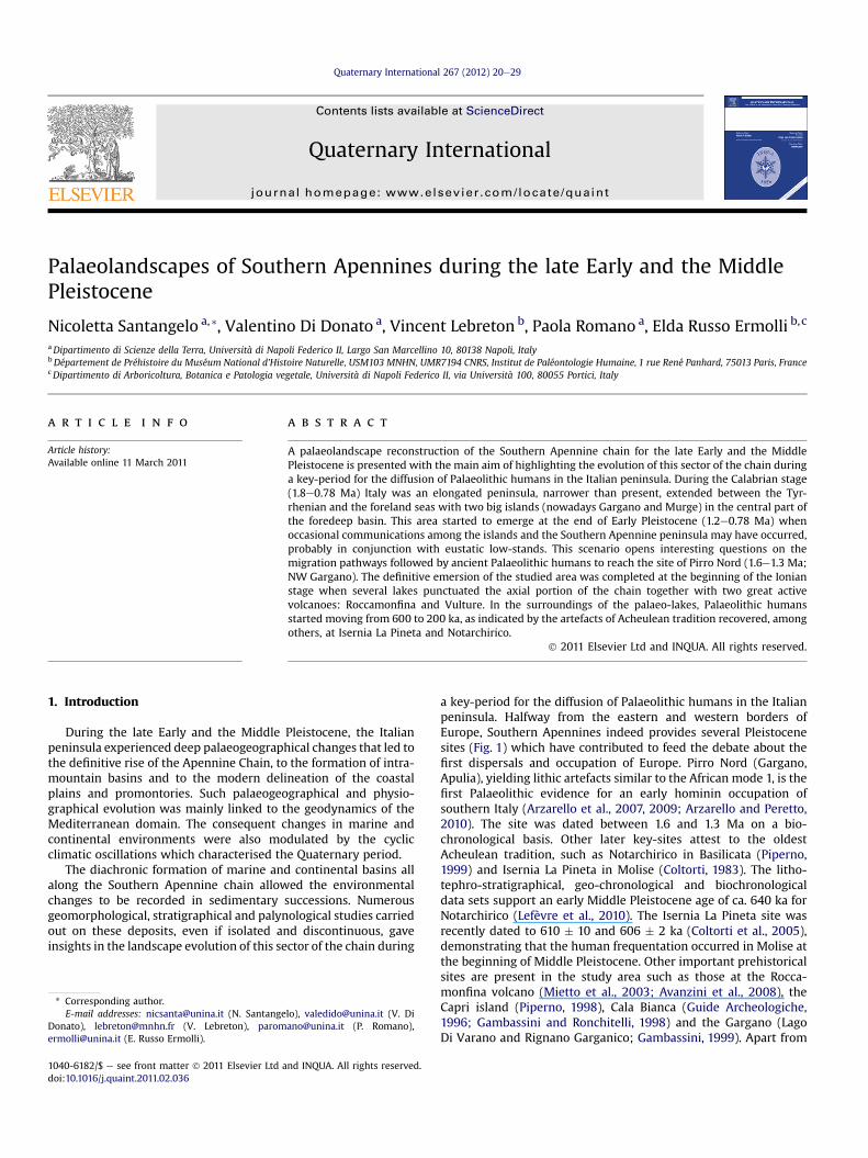
a key-period for the diffusion of Palaeolithic humans in the Italianpeninsula. Halfway from the eastern and western borders ofEurope, Southern Apennines indeed provides several Pleistocenesites (Fig. 1) which have contributed to feed the debate about thefirst dispersals and occupation of Europe. Pirro Nord (Gargano,Apulia), yielding lithic artefacts similar to the African mode 1, is thefirst Palaeolithic evidence for an early hominin occupation ofsouthern Italy (Arzarello et al., 2007, 2009; Arzarello and Peretto,2010). The site was dated between 1.6 and 1.3 Ma on a bio-chronological basis. Other later key-sites attest to the oldestAcheulean tradition, such as Notarchirico in Basilicata (Piperno,1999) and Isernia La Pineta in Molise (Coltorti, 1983). The litho-tephro-stratigraphical, geo-chronological and biochronologicaldata sets support an early Middle Pleistocene age of ca. 640 ka forNotarchirico (Lefèvre et al., 2010). The Isernia La Pineta site wasrecently dated to 610 � 10 and 606 � 2 ka (Coltorti et al., 2005),demonstrating that the human frequentation occurred in Molise atthe beginning of Middle Pleistocene. Other important prehistoricalsites are present in the study area such as those at the Rocca-monfina volcano (Mietto et al., 2003; Avanzini et al., 2008), theCapri island (Piperno, 1998), Cala Bianca (Guide Archeologiche,1996; Gambassini and Ronchitelli, 1998) and the Gargano (LagoDi Varano and Rignano Garganico; Gambassini, 1999). Apart from
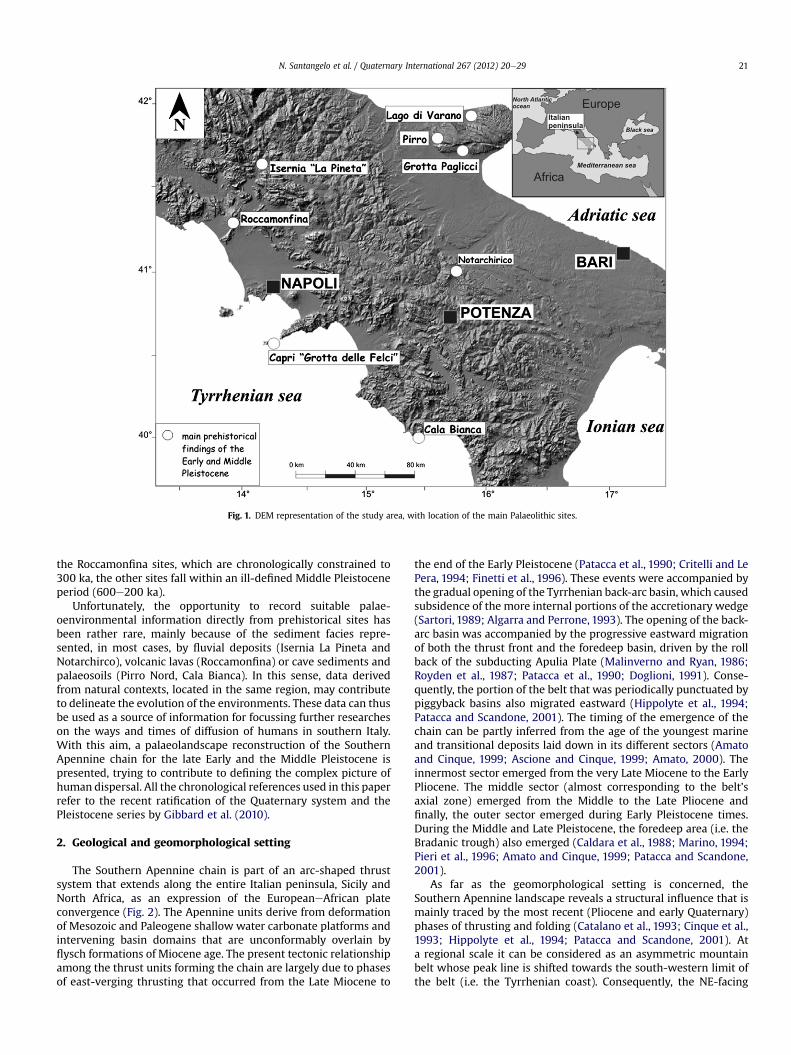
Fig. 1. DEM representation of the study area, with location of the main Palaeolithic sites.
N. Santangelo et al. / Quaternary International 267 (2012) 20e29 21
the Roccamonfina sites, which are chronologically constrained to300 ka, the other sites fall within an ill-defined Middle Pleistoceneperiod (600e200 ka).
Unfortunately, the opportunity to record suitable palae-oenvironmental information directly from prehistorical sites hasbeen rather rare, mainly because of the sediment facies repre-sented, in most cases, by fluvial deposits (Isernia La Pineta andNotarchirco), volcanic lavas (Roccamonfina) or cave sediments andpalaeosoils (Pirro Nord, Cala Bianca). In this sense, data derivedfrom natural contexts, located in the same region, may contributeto delineate the evolution of the environments. These data can thusbe used as a source of information for focussing further researcheson the ways and times of diffusion of humans in southern Italy.With this aim, a palaeolandscape reconstruction of the SouthernApennine chain for the late Early and the Middle Pleistocene ispresented, trying to contribute to defining the complex picture ofhuman dispersal. All the chronological references used in this paperrefer to the recent ratification of the Quaternary system and thePleistocene series by Gibbard et al. (2010).
2. Geological and geomorphological setting
The Southern Apennine chain is part of an arc-shaped thrustsystem that extends along the entire Italian peninsula, Sicily andNorth Africa, as an expression of the EuropeaneAfrican plateconvergence (Fig. 2). The Apennine units derive from deformationof Mesozoic and Paleogene shallow water carbonate platforms andintervening basin domains that are unconformably overlain byflysch formations of Miocene age. The present tectonic relationshipamong the thrust units forming the chain are largely due to phasesof east-verging thrusting that occurred from the Late Miocene to
the end of the Early Pleistocene (Patacca et al., 1990; Critelli and LePera, 1994; Finetti et al., 1996). These events were accompanied bythe gradual opening of the Tyrrhenian back-arc basin, which causedsubsidence of the more internal portions of the accretionary wedge(Sartori, 1989; Algarra and Perrone, 1993). The opening of the back-arc basin was accompanied by the progressive eastward migrationof both the thrust front and the foredeep basin, driven by the rollback of the subducting Apulia Plate (Malinverno and Ryan, 1986;Royden et al., 1987; Patacca et al., 1990; Doglioni, 1991). Conse-quently, the portion of the belt that was periodically punctuated bypiggyback basins also migrated eastward (Hippolyte et al., 1994;Patacca and Scandone, 2001). The timing of the emergence of thechain can be partly inferred from the age of the youngest marineand transitional deposits laid down in its different sectors (Amatoand Cinque, 1999; Ascione and Cinque, 1999; Amato, 2000). Theinnermost sector emerged from the very Late Miocene to the EarlyPliocene. The middle sector (almost corresponding to the belt’saxial zone) emerged from the Middle to the Late Pliocene andfinally, the outer sector emerged during Early Pleistocene times.During the Middle and Late Pleistocene, the foredeep area (i.e. theBradanic trough) also emerged (Caldara et al., 1988; Marino, 1994;Pieri et al., 1996; Amato and Cinque, 1999; Patacca and Scandone,2001).
As far as the geomorphological setting is concerned, theSouthern Apennine landscape reveals a structural influence that ismainly traced by the most recent (Pliocene and early Quaternary)phases of thrusting and folding (Catalano et al., 1993; Cinque et al.,1993; Hippolyte et al., 1994; Patacca and Scandone, 2001). Ata regional scale it can be considered as an asymmetric mountainbelt whose peak line is shifted towards the south-western limit ofthe belt (i.e. the Tyrrhenian coast). Consequently, the NE-facing
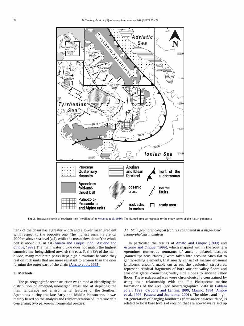
Fig. 2. Structural sketch of southern Italy (modified after Moussat et al., 1986). The framed area corresponds to the study sector of the Italian peninsula.
N. Santangelo et al. / Quaternary International 267 (2012) 20e2922
flank of the chain has a greater width and a lower mean gradientwith respect to the opposite one. The highest summits are ca.2000 m above sea level (asl), while themean elevation of thewholebelt is about 650 m asl (Amato and Cinque, 1999; Ascione andCinque, 1999). The main water divide does not match the highestsummits line, being shifted towards the east. To the SWof the maindivide, many mountain peaks kept high elevations because theyrest on rock units that are more resistant to erosion than the onesforming the outer part of the chain (Amato et al., 1995).
3. Methods
The palaeogeografic reconstructionwas aimed at identifying thedistribution of emerged/submerged areas and at depicting themain landscape and environmental features of the SouthernApennines during the late Early and Middle Pleistocene. It wasmainly based on the analysis and reinterpretation of literature dataconcerning two palaeoenvironmental proxies:
3.1. Main geomorphological features considered in a mega-scalegeomorphological analysis
In particular, the results of Amato and Cinque (1999) andAscione and Cinque (1999), which mapped within the SouthernApennines numerous remnants of ancient palaeolandscapes(named “palaeosurfaces”), were taken into account. Such flat togently-rolling elements, that mostly consist of mature erosionallandforms unconformably cut across the geological structures,represent residual fragments of both ancient valley floors anderosional glacis connecting valley side slopes to ancient valleyfloors. These palaeosurfaces were chronologically constrained byusing their relationship with the PlioePleistocene marineformations of the area (see biostratigraphical data in Caldaraet al., 1988; Carbone and Lentini, 1990; Marino, 1994; Amoreet al., 1996; Patacca and Scandone, 2001). The oldest and high-est generation of hanging landforms (first-order palaeosurface) isrelated to local base levels of erosion that are nowadays raised up
N. Santangelo et al. / Quaternary International 267 (2012) 20e29 23
at 1000/1200 m asl, and can be assigned to SanternianeEmiliantimes (1.8e1.2 Ma). The youngest and lowest one (second-orderpalaeosurface) is related to local base levels that are nowadayslocated at 500e900 m asl, and can be considered as shaped ina time interval that includes the Sicilian (1.2e0.78 Ma) and,possibly, the very initial part of the Middle Pleistocene. Withinthe chain, this land surface is erosional in nature, while in theeastern piedmont area it substantially corresponds to the uppersurface of the regressive sequences (closing with deltaic andfluvial deposits) that filled the foredeep basin when its subsi-dence came to end.
3.2. Distribution, nature and facies of the main marine andcontinental successions covering this time interval
All available data concerning the marine and continentalsuccessions cropping out in the study area were taken into accountin order to constrain the palaeolandscape reconstruction (Figs. 3and 4). Age and facies of marine sediments allowed the locationof submerged and emerged areas to be defined, whereas pollenanalysis of marine and continental deposits was used to giveinsights in vegetation distribution and landscapes. Based onthese data, two main temporal windows were selected for thepalaeolandscape reconstruction, one for the “Calabrian” stage(1.8e0.78 Ma), the other for the Middle Pleistocene (“Ionian” stage;0.78e0.126 Ma).
Fig. 3. Palaeolandscape reconstruction of Southern Italy during the end of the Calabrian stag(Sant’Arcangelo basin); 5) Serra del Cedro formation; 6) Pirro Nord site; 7) Montalbano Jonbasin); 10) Eboli formation; 11) Iumaiano conglomerates; 12) Camerota basin.
4. Reconstructed palaeolandscapes
4.1. “Calabrian” stage (late Early Pleistocene, 1.8e0.78 Ma)
As shown in Fig. 3, during the “Calabrian” stage the main coastalgrabens along the Tyrrhenian coast (Campana and Sele presentcoastal plains) were completely invaded by the sea as testified bythe age of marine sediments found in the deep boreholes drilled inthe areas (Brancaccio et al., 1991, 1995 and references therein). Inparticular, themost recent data coming from the reinterpretation ofthe Agip borehole Tre case 1 (Brocchini et al., 2001) allowed thelowest marine deposits found in the core to be dated to the Sicilian.In the Sele-Salerno coastal graben, an age not older than theGelasian stage is assigned to marine sediments found between 990and 2000 m depth in the Mina 1 borehole (Sacchi et al., 1994;Cinque et al., 2009). The main promontories separating thecoastal grabens were wider than now as testified by the presentdistribution of upliftedmarine terraces, the oldest of which dates tothe Middle Pleistocene (Brancaccio et al., 1991; Ascione andRomano, 1999; Caiazzo et al., 2006). Most of the Southern Apen-nine chain was already emerged, except for a few areas, such as theCalvello basin, where Santernian (1.8e1.48 Ma) marine sedimentscrop out (Amore et al., 1996). However, moving southward, a verybig piggyback basin (the Sant’Arcangelo Basin) was collectinga large amount of sediments representing a prograding marine fandelta system (Vezzani, 1967; Pieri et al., 1996). At around 1.1 Ma,syn-sedimentary tectonics caused the closing up of its inner
e. 1) Tre Case 1 borhelole; 2) Mina 1 borehole; 3) Calvello basin; 4) San Lorenzo sectionico succession; 8) Vallo di Diano basin; 9) Sant’Agata dei Goti section (Valle Caudina
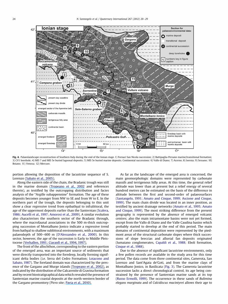
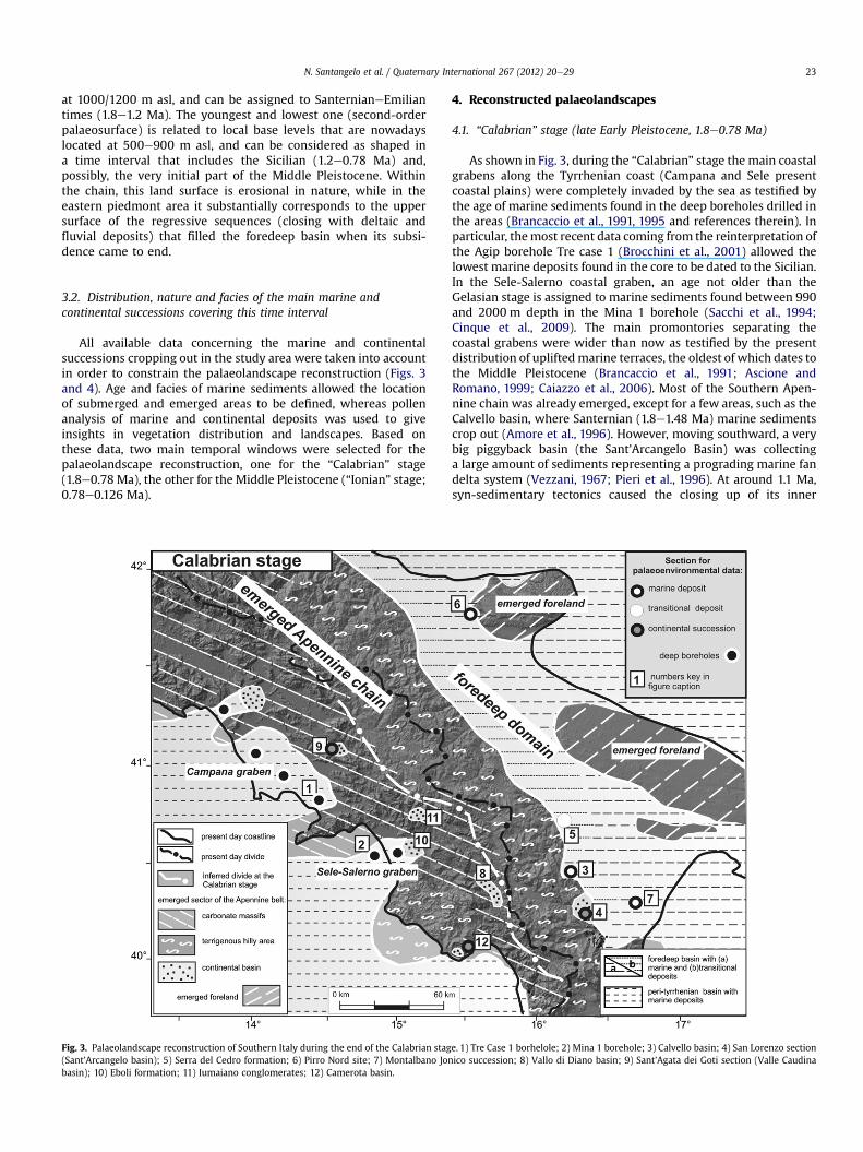
Fig. 4. Palaeolandscape reconstruction of Southern Italy during the end of the Ionian stage. 1) Fornaci San Nicola succession; 2) Battipaglia-Persano marine/transitional formation;3) CV1 borehole; 4) MIS 7 and MIS 5e buried lagoonal deposits; 5) MIS 5e buried marine deposits. Continental successions: 6) Vallo di Diano; 7) Acerno; 8) Isernia; 9) Sessano; 10)Boiano; 11) Venosa; 12) Mercure.
N. Santangelo et al. / Quaternary International 267 (2012) 20e2924
portion allowing the deposition of the lacustrine sequence of S.Lorenzo (Sabato et al., 2005).
Along the eastern side of the chain, the Bradanic trough was stillin the marine domain (Tropeano et al., 2002 and referencestherein), as testified by the outcropping distribution and faciesanalysis of the “Argille subappennine” formation. The age of thesedeposits becomes younger from NW to SE and from W to E. In thenorthern part of the trough, the deposits belonging to this unitshow a clear regressive trend from epibathyal to infralittoral, theage of the uppermost deposits earlier than the Santernian (Scalera,1986; Aucelli et al., 1997; Amorosi et al., 2009). A similar evolutionalso characterises the southern sector of the Bradanic through,where the macrofaunal associations in the 500 m-thick outcrop-ping succession of Montalbano Jonico indicate a regressive trendfrom bathyal to shallow sublittoral environments, with a maximumpalaeodepth of 500e600 m (D’Alessandro et al., 2000). In thissector, however, the age of the succession is Early to Middle Pleis-tocene (Verhallen, 1991; Ciaranfi et al., 1994, 1997).
The front of the allochthon, corresponding to the eastern portionof the emerged area, was an important source of sediments thatwere directly transported into the foredeep, locally forming signif-icant delta bodies (i.e. Serra del Cedro Formation; Loiacono andSabato, 1987). The foreland domain was characterized by the pres-ence of the Gargano and Murge islands (Tropeano et al., 2002), asindicated by the distribution of the Calcarenite di Gravina formationandby recent biostratigraphical datawhich revealed the presence ofSanternian marine coastal deposits at the north-western border ofthe Gargano promontory (Pirro site; Pavia et al., 2010).
As far as the landscape of the emerged area is concerned, themain geomorphologic domains were represented by carbonatemassifs and terrigenous hilly areas. At this time, the general reliefaltitude was lower than at present but a relief energy of severalhundred metres can be estimated on the basis of the difference inaltitude between the first and second-order of palaeosurfaces(Santangelo, 1991; Amato and Cinque, 1999; Ascione and Cinque,1999). The main chain divide was located in an inner position, astestified by ancient drainage networks (Amato et al., 1995; Amatoand Cinque, 1999). The most striking difference from the presentgeography is represented by the absence of emerged volcaniccentres; also the main intramontane basins were not yet formed,except from the Vallo di Diano and the Valle Caudina basins whichprobably started to develop at the end of this period. The maindomains of continental deposition were represented by the pied-mont areas of the structural carbonate slopes where thick succes-sions of slope breccias and alluvial fan deposits originated(Iumaiano conglomerates, Capaldi et al., 1988; Eboli formation,Cinque et al., 1988).
Due to the absence of significant lacustrine environments, onlya few pollen records are available in the study area for this timeperiod. The data come from three continental sites, Camerota, SanLorenzo and Sant’Agata de’Goti, and from the marine clays ofMontalbano Jonico, in Basilicata (Fig. 3). The Camerota lacustrinesuccession lacks a direct chronological control, its age being con-strained by the presence of Santernian marine sands at its top(Russo Ermolli, 1999). The occurrence in these sands of Buliminaelegans marginata and of Calcidiscus macintyrei allows their age to
N. Santangelo et al. / Quaternary International 267 (2012) 20e29 25
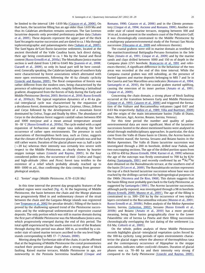
be limited to the interval 1.84e1.619 Ma (Caiazzo et al., 2006). Onthat basis, the lacustrine filling has an age older than 1.619 Ma andthus its Calabrian attribution remains uncertain. The San Lorenzolacustrine deposits only provided preliminary pollen data (Sabatoet al., 2005). These deposits represent the upper part of the thickSant’Arcangelomarine succession and are dated to ca.1Ma throughtephrostratigraphic and palaeomagnetic data (Sabato et al., 2005).The Sant’Agata de’Goti fluvio-lacustrine sediments, located at theancient threshold of the Valle Caudina basin, lack direct dating,their age being constrained to ca. 1 Ma by the faunal and floralcontent (Russo Ermolli et al., 2010a). TheMontalbano Jonicomarinesection is well dated from 1.240 to 0.645 Ma (Joannin et al., 2008;Ciaranfi et al., 2009), so only its basal part will be here consid-ered. Generally speaking, the Calabrian landscapes of southern Italywere characterised by forest associations which alternated withmore open environments, following the 41-ka climatic cyclicity(Lisiecki and Raymo, 2005). The floral composition of forests wasrather different from the modern ones, being characterised by thepresence of subtropical taxa which, roughly following a latitudinalgradient, disappeared from the forests of Italy during the Early andMiddle Pleistocene (Bertini, 2003; Bertini et al., 2010; Russo Ermolliet al., 2010a,b). The typical vegetation dynamics of a 41-ka gla-cialeinterglacial cycle was characterised by the expansion ofa deciduous forest, dominated by Quercus, Carpinus, Ulmus, Zelkovaand Carya followed by the development of a mountain forestdominated by Cedrus, Tsuga and finally by Abies. The abundance ofCarya in the deciduous forest suggests rainfall values between 850and 1000 mm/year and a mean annual temperature around16e18 �C (Russo Ermolli et al., 2010a). The cycle ended with a rapidexpansion of herbaceous and steppe taxa indicating the briefoccurrence of rather open environments. The presence in suchassociations of thermophilous herb taxa, such as Cistus, suggeststhat the climate of the Early Pleistocene glacial periods was arid butstill rather warm. Duration of the glacial phases was ca. half a cycle(w20 ka) whereas their intensity was certainly less severe withrespect to the Middle Pleistocene, as clearly shown by heavieroxygen isotope values (Lisiecki and Raymo, 2005). In the fourconsidered pollen sites, the occurrence of mid- (Cedrus and Tsuga)and high-altitude (Abies and Picea) forest taxa testifies to theexistence of a relief which probably already reached up to800e1000 m asl., thus confirming the data coming from geomor-phological analysis.
4.2. “Ionian” stage (Middle Pleistocene, 0.78e0.126 Ma)
In this time interval the present day geographic features of thestudied region were reached (Fig. 4). At the beginning of MiddlePleistocene, the basin between the chain and the Murge plateauxwas progressively filled in and sedimentary closure of the straitbetween the chain and the Gargano-Murge islands was registered(see Tropeano et al., 2002 for peculiar details). Filling of the basin isproved by the shallowing upward trend of the Pleistocene succes-sions and by the widespread sedimentation of regressive coastaldeposits. The only portionwhich was still in marine domain duringthe first part of Middle Pleistocenewas theMontalbano Jonico area,which progressively emerged during the end of this period. Thetotal uplift experienced by the south-eastern sector of the Bradanicthrough during this period was about 300 m, as testified by a six-order stair of raised marine terraces ascribed to the sea level high-stands corresponding to MIS 17e7 (Amato, 2000).
Moving along the Tyrrhenian side of the chain, it can be affirmedthat at the beginning of Middle Pleistocene the costal promontoriesreached their present planar shape after a strong phase of blockfaulting. Raised marine terraces, Middle Pleistocene in age, arenoteworthy in the Penisola Sorrentina headland (Cinque and
Romano, 1990; Caiazzo et al., 2006) and in the Cilento promon-tory (Cinque et al., 1994; Ascione and Romano, 1999). Another six-order stair of raised marine terraces, stepping between 100 and14 m asl, is also present in the southern coast of the Policastro Gulf;it was chronologically constrained to the Middle Pleistocene bya multiproxy palaeoenvironmental study of the Fornaci San Nicolasuccession (Filocamo et al., 2009 and references therein).
The coastal grabens were still in marine domain as testified bythe marine/transitional Battipaglia-Persano formation in the SelePlain (Amato et al., 1991; Cinque et al., 2009) and by the marinesands and clays drilled between 1000 and 150 m of depth in theCampana plain (CV1 borehole, Brancaccio et al., 1991 and refer-ences therein). A significant difference in the behaviour of the twoareas was recorded at the end of this time interval. While theCampana coastal graben was still subsiding, as the presence ofburied lagoons and marine deposits belonging to MIS 7 and 5e inthe Caserta and San Marcellino area indicates (Romano et al., 1994;Santangelo et al., 2010), the Sele coastal graben started uplifting,causing the emersion of its inner portion (Amato et al., 1991;Cinque et al., 2009).
Concerning the chain domain, a strong phase of block faultingoccurred at the transition between Early and Middle Pleistocene(Cinque et al., 1993; Caiazzo et al., 2006) and triggered the forma-tion of the Vulture and Roccamonfina volcanoes (aged 0.67 and0.63 Ma respectively; Ballini et al., 1989; Villa and Buettner, 2009)and the origin of the main intramontane basins (Vallo di Diano,Noce, Mercure, Agri, Acerno, Boiano, Isernia, Venosa).
For this time period the number and quality of palae-oenvironmental data are more significant. Most of the lacustrinesuccessions hosted in the abovementioned basins were analysed indetail through multidisciplinary approaches. In particular, the datacome from the Vallo di Diano basin in Cilento, the Acerno basin inthe Picentini massif, the Isernia, Sessano and Boiano basins in theMolise Apennines. The Vallo di Diano lacustrine succession wasinvestigated through a 200 m borehole, drilled near Padula, andtwo outcropping sections. The age of the drilled portion spans fromca. 650 to 450 ka (Russo Ermolli, 1994; Karner et al., 1999) whereasthe age of the outcrops was firstly constrained to 700 ka by K/Ardating (Santangelo, 1991) and recently confirmed by an 40Ar/39Ardate obtained on the Buonabitacolo terrace, at the southern end ofthe basin (Di Leo et al., 2009). The Buonabitacolo section representsthe top of a thick buried lacustrine succession whose base was notreached by the drillings carried out for hydrogeological purposes inthe 1960s (Nicotera and De Riso, 1968). This datum suggests thatthe basin filling most probably goes back to the Early Pleistocene, assuggested by Santangelo (1991). The Acerno lacustrine succession,although partly exposed, was investigated through a 98m borehole(Russo Ermolli, 2000; Munno et al., 2001). The age of the filling isconstrained to ca. 500e250 ka by the occurrence of two tephralayers correlated to the Roccamonfina volcano (Munno et al., 2001;Russo Ermolli et al., 2010b). Pollen analysis of the Molise Apenninebasins, Isernia, (Lebreton, 2002), Sessano (Russo Ermolli et al.,2010b) and Boiano (Amato et al., 2010) has a more peculiarmeaning, being these basins geographically close to the LowerPalaeolithic site of Isernia La Pineta and their filling successionschronologically overlapping the last dating of the settlement (ca.0.6 Ma; Coltorti et al., 2005).
On the whole, pollen analysis of these Middle Pleistocenerecords highlights glacialeinterglacial vegetation cycles forced bythe 100-ka cyclicity. Long periods of open environments charac-terise the glacial stages where the absence of thermophilous taxaand the contemporary occurrence of Hippophae in the steppeassociation, indicates rather cool/cold climates. Duration of glacialphases was ca. 70e80 ka and their intensity very strong ifcompared to the Early Pleistocene (Lisiecki and Raymo, 2005).
N. Santangelo et al. / Quaternary International 267 (2012) 20e2926
These long periods of open landscapes alternated with denselyforested phases. The composition of forests is impoverished withrespect to that of the Early Pleistocene and is more similar to themodern associations; the few remaining subtropical tree taxadisappear during this period (Fig. 5), the length and severity ofMiddle Pleistocene glacial phases being most probably the prin-cipal cause of extinction. The last relict is considered to be Zelkova,a tree of the Ulmaceae family which is still present during the lastinterglacial (MIS 5e) in central and southern Italy (Robustelli et al.,2007) and disappeared from peninsular Italy during the last glacialperiod (Follieri et al., 1986). Another great difference between theMiddle Pleistocene forests and the modern ones concerns thehighest belt which was dominated by fir. This tree has graduallybeen replaced by beech on the mountains of Southern Apenninesand is now only restricted to small relict stands on some tops.
5. Discussion and open questions
The exposed data can be useful to draw the landscape scenarioin which the ancient Palaeolithic humans dispersed. According toliterature data (Arzarello et al., 2007; Arzarello and Peretto, 2010)the first peopling of southern Italy is documented at Pirro Nord(Fig. 1). Here, the African Mode 1 lithic industries are associatedwith a Villafranchian faunal assemblage dated between 1.6 and1.3 Ma on a biochronological base (Arzarello et al., 2009). The ill-defined age of this site, its occurrence in the 41-ka climatic cyclicityperiod and the absence of direct palynological data, do not allowthe environment of this first hominin occupation to be clarified.Anyway, the faunal assemblage considered coeval to the artefacts,
Fig. 5. Chronological position of the marine and continental pollen records cite
suggests the existence of an open environment reflectingpredominantly arid conditions (Arzarello et al., 2007).
The proposed palaeolandscape reconstruction for the late EarlyPleistocene testifies to the presence of an elongated peninsula,narrower than present, extended between the Tyrrhenian and theforeland seas (Figs. 3 and 6) with two big islands (present Garganoand Murge areas) in the central part of the foredeep basin. Thefacies association of the Santernian to Emilian (1.8e1.2 Ma) “Argilleazzurre” formation allowed a palaeobathymetry of several hundredmetres to be hypothesized for the southern portion of the marinebasin interposed between the emerged area of the chain and theforeland. According to Tropeano et al. (2002), this area started toemerge at the end of the Early Pleistocene (1.2e0.78 Ma) due to theprogressive infilling of the basin and to the decrease in subsidingrates. So, on the basis of the existing data it is possible to hypoth-esize that occasional communications among the Gargano andMurge islands and the Southern Apennine peninsula may haveoccurred from 1.2 Ma onwards, probably in concomitance witheustatic low-stands.
This scenario is in disagreement with the presumed age of thefaunal assemblage of Pirro Nord and the associated lithic artefacts.The well-balanced mammal assemblage shows rather clear conti-nental characters (Gliozzi et al., 1997) which, together with theassociated presence of humans, allow the insularity of the Garganoto be excluded at that time. This contradiction opens interestingquestions on the reliability of the chronological constraints fromboth the Pirro Nord fauna and the marine foredeep successions,thus suggesting that further chronological controls are necessary tosolve the problem. If the absolute dating on the lithic assemblages,
d in the text and chronostratigraphical distribution of the last exotic taxa.
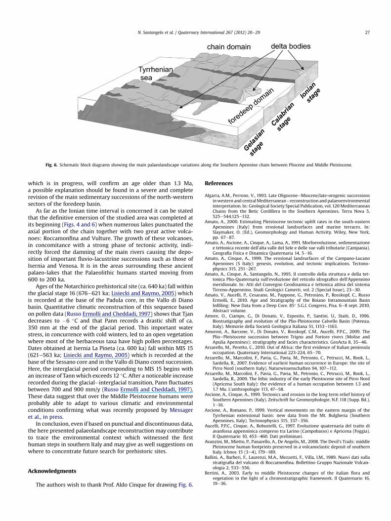
Fig. 6. Schematic block diagrams showing the main palaeolandscape variations along the Southern Apennine chain between Pliocene and Middle Pleistocene.
N. Santangelo et al. / Quaternary International 267 (2012) 20e29 27
which is in progress, will confirm an age older than 1.3 Ma,a possible explanation should be found in a severe and completerevision of the main sedimentary successions of the north-westernsectors of the foredeep basin.
As far as the Ionian time interval is concerned it can be statedthat the definitive emersion of the studied area was completed atits beginning (Figs. 4 and 6) when numerous lakes punctuated theaxial portion of the chain together with two great active volca-noes: Roccamonfina and Vulture. The growth of these volcanoes,in concomitance with a strong phase of tectonic activity, indi-rectly forced the damning of the main rivers causing the depo-sition of important fluvio-lacustrine successions such as those ofIsernia and Venosa. It is in the areas surrounding these ancientpalaeo-lakes that the Palaeolithic humans started moving from600 to 200 ka.
Ages of the Notarchirico prehistorical site (ca. 640 ka) fall withinthe glacial stage 16 (676e621 ka; Lisiecki and Raymo, 2005) whichis recorded at the base of the Padula core, in the Vallo di Dianobasin. Quantitative climatic reconstruction of this sequence basedon pollen data (Russo Ermolli and Cheddadi, 1997) shows that Tjandecreases to �6 �C and that Pann records a drastic shift of ca.350 mm at the end of the glacial period. This important waterstress, in concurrence with cold winters, led to an open vegetationwhere most of the herbaceous taxa have high pollen percentages.Dates obtained at Isernia La Pineta (ca. 600 ka) fall within MIS 15(621e563 ka; Lisiecki and Raymo, 2005) which is recorded at thebase of the Sessano core and in the Vallo di Diano cored succession.Here, the interglacial period corresponding to MIS 15 begins withan increase of Tannwhich exceeds 12 �C. After a noticeable increaserecorded during the glacialeinterglacial transition, Pann fluctuatesbetween 700 and 900 mm/y (Russo Ermolli and Cheddadi, 1997).These data suggest that over the Middle Pleistocene humans wereprobably able to adapt to various climatic and environmentalconditions confirming what was recently proposed by Messageret al., in press.
In conclusion, even if based on punctual and discontinuous data,the here presented palaeolandscape reconstruction may contributeto trace the environmental context which witnessed the firsthuman steps in southern Italy and may give as well suggestions onwhere to concentrate future search for prehistoric sites.
Acknowledgments
The authors wish to thank Prof. Aldo Cinque for drawing Fig. 6.
References
Algarra, A.M., Perrone, V., 1993. Late OligoceneeMiocene/late-orogenic successionsinwestern and centralMediterranean - reconstruction andpalaeoenvironmentalinterpretation. In: Geological Society Special Publication, vol.120MediterraneanChains from the Betic Cordillera to the Southern Apennines. Terra Nova 5,525e544.125e132.
Amato, A., 2000. Estimating Pleistocene tectonic uplift rates in the south-easternApennines (Italy) from erosional landsurfaces and marine terraces. In:Slaymaker, O. (Ed.), Geomorphology and Human Activity. Wiley, New York,pp. 67e87.
Amato, A., Ascione, A., Cinque, A., Lama, A., 1991. Morfoevoluzione, sedimentazionee tettonica recente dell'alta valle del Sele e delle sue valli tributarie (Campania).Geografia Fisica e Dinamica Quaternaria 14, 5e16.
Amato, A., Cinque, A., 1999. The erosional landsurfaces of the Campano-LucanoApennines (S Italy): genesis, evolution, and tectonic implications. Tectono-physics 315, 251e267.
Amato, A., Cinque, A., Santangelo, N., 1995. Il controllo della struttura e della tet-tonica Plio-Quaternaria sull’evoluzione del reticolo idrografico dell’Appenninomeridionale. In: Atti del Convegno Geodinamica e tettonica attiva del sistemaTirreno-Appennino. Studi Geologici Camerti, vol. 2 (Special Issue), 23e30.
Amato, V., Aucelli, P., Cesarano, M., Pappone, G., Petrosino, P., Rosskopf, C., RussoErmolli, E., 2010. Age and Stratigraphy of the Boiano Intramountain BasinInfilling: New Data from a Deep Core. 85� S.G.I. Congress, Pisa. 6e8 sept. 2010,Abstract volume.
Amore, O., Ciampo, G., Di Donato, V., Esposito, P., Santini, U., Staiti, D., 1996.Biostratigraphy and evolution of the Plio-Pleistocene Calvello Basin (Potenza,Italy). Memorie della Società Geologica Italiana 51, 1153e1163.
Amorosi, A., Barcone, V., Di Donato, V., Rosskopf, C.M., Aucelli, P.P.C., 2009. ThePlioePleistocene succession between Trigno and Fortore rivers (Molise andApulia Apennines): stratigraphy and facies characteristics. GeoActa 8, 35e46.
Arzarello, M., Peretto, C., 2010. Out of Africa: the first evidence of Italian peninsulaoccupation. Quaternary International 223-224, 65e70.
Arzarello, M., Marcolini, F., Pavia, G., Pavia, M., Petronio, C., Petrucci, M., Rook, L.,Sardella, R., 2007. Evidence of earliest human occurrence in Europe: the site ofPirro Nord (southern Italy). Naturwissenschaften 94, 107e112.
Arzarello, M., Marcolini, F., Pavia, G., Pavia, M., Petronio, C., Petrucci, M., Rook, L.,Sardella, R., 2009. The lithic industry of the early Pleistocene site of Pirro Nord(Apricena South Italy): the evidence of a human occupation between 1.3 and1.7 Ma. L’anthropologie 113, 47e58.
Ascione, A., Cinque, A., 1999. Tectonics and erosion in the long term relief history ofSouthern Apennines (Italy). Zeitschrift fur Geomorphologie. N.F. 118 (Supp. Bd.),1e16.
Ascione, A., Romano, P., 1999. Vertical movements on the eastern margin of theTyrrhenian extensional basin: new data from the Mt. Bulgheria (SouthernApennines, Italy). Tectonophysics 315, 337e356.
Aucelli, P.P.C., Cinque, A., Robustelli, G., 1997. Evoluzione quaternaria del tratto diavanfossa appenninica compreso tra Larino (Campobasso) e Apricena (Foggia).Il Quaternario 10, 453e460. Dati preliminari.
Avanzini, M., Mietto, P., Panarello, A., De Angelis, M., 2008. The Devil’s Trails: middlePleistocene human footprints preserved in a volcanoclastic deposit of southernItaly. Ichnos 15 (3e4), 179e189.
Ballini, A., Barberi, F., Laurenzi, M.A., Mezzetti, F., Villa, I.M., 1989. Nuovi dati sullastratigrafia del vulcano di Roccamonfina. Bollettino Gruppo Nazionale Vulcan-ologia 2, 533e556.
Bertini, A., 2003. Early to middle Pleistocene changes of the italian flora andvegetation in the light of a chronostratigraphic framework. Il Quaternario 16,19e36.
N. Santangelo et al. / Quaternary International 267 (2012) 20e2928
Bertini, A., Ciaranfi, N., Marino, M., Palombo, M.R., 2010. Proposal for Pliocene andPleistocene land-sea correlation in the Italian area. Quaternary International219, 95e108.
Brancaccio, L., Cinque, A., Romano, P., Rosskopf, C., Russo, F., Santangelo, N.,Santo, A., 1991. Geomorphology and neotectonic evolution of a sector of theTyrrhenian flank of the southern Apennines (region of Naples, Italy). Zeitschriftfur Geomorphologie 82 (Suppl. Bd), 47e58.
Brancaccio, L., Cinque, A., Romano, P., Rosskopf, C., Russo, F., Santangelo, N., 1995.L’evoluzione delle pianure costiere della Campania: geomorfologia e neo-tettonica. Memorie Società Geografica Italiana 53, 313e337.
Brocchini, D., Principe, C., Castratori, D., Laurenzi, M.A., Gorla, L., 2001. Quaternaryevolution of the southern sector of the Campania Plain and early Somma e
Vesuvius activity: insights from the Trecase 1 well. Mineralogy and Petrology73, 67e91.
Caiazzo, C., Ascione, A., Cinque, A., 2006. Late TertiaryeQuaternary tectonics of thesouthern Apennines (Italy): new evidences from the Tyrrhenian slope. Tecto-nophysics 421, 23e51.
Caldara, M., Lojacono, F., Borlotti, E., Pieri, P., Sabato, L., 1988. I depositi plio-pleis-tocenici della parte nord del bacino di S. Arcangelo (Appennino lucano): car-atteri geologici e paleoambientali. Memorie della Società Geologica Italiana 41,391e410.
Capaldi, G., Cinque, A., Romano, P., 1988. Ricostruzione di sequenze morfoevolutivenei Picentini meridionali (Campania, Appennino meridionale). Geografia Fisicae Dinamica Quaternaria (Suppl. 1), 207e222.
Carbone, A., Lentini, E., 1990. Migrazione neogenica del sistema Catena-Avampaesenell’Appennino meridionale: problematiche paleogeografiche e strutturali.Rivista Italiana di Paleontologia e Stratigrafia 96, 271e295.
Catalano, S., Monaco, C., Tortorici, L., 1993. Pleistocene strike-slip tectonics in theLucanian Apennine (Southern Italy). Tectonics 12 (3), 656e665.
Ciaranfi, N., D’Alessandro, A., Marino, M., Sabato, L., 1994. La successione argillosainfra e mediopleistocenica della parte sudoccidentale della Fossa Bradanica: lasezione di Montalbano Jonico in Basilicata. 23 September-1 October 1994. In:Guida alle escursioni, 77 w Congresso della Società Geologica Italiana, 15.Quaderni della Biblioteca Provinciale di Matera, Bari, Italy, pp. 117e156.
Ciaranfi, N., D’Alessandro, A., Marino, M., 1997. A candidate section for the lower-middle Pleistocene boundary (Apennine Foredeep, South Italy). In: Naiwen, W.,Remane, J. (Eds.), Proceeding of 30th Geological Congress, China. VSP Interna-tional Science Publisher, Zeist, the Netherlands, pp. 201e211.
Ciaranfi, N., Lirer, F., Lirer, L., Lourens, L.J., Maiorano, P., Marino, M., Petrosino, P.,Sprovieri, M., Stefanelli, S., Brilli, M., Girone, A., Joannin, S., Pelosi, N.,Vallefuoco, M., 2009. Integrated stratigraphy and astronomical tuning of lower-middle Pleistocene Montalbano Jonico section (southern Italy). QuaternaryInternational 219, 109e120.
Cinque, A., Romano, P., 1990. Segnalazione di nuove evidenze di antiche linee di rivain Penisola Sorrentina (Campania). Geografia Fisica e Dinamica Quaternaria 13,23e36.
Cinque, A., Guida, F., Russo, F., Santangelo, N., 1988. Dati cronologici e stratigrafici sualcuni depositi continentali della piana del F.Sele: i Conglomerati di Eboli.Geografia Fisica e Dinamica Quaternaria 1, 39e44.
Cinque, A., Patacca, E., Scandone, P., Tozzi, M., 1993. Quaternary kinematic evolutionof the Southern Apennines. Relationship between surface geological featuresand deep lithospheric structures. Annali di Geofisica 36, 249e260.
Cinque, A., Romano, P., Rosskopf, C., Santangelo, N., Santo, A., 1994. Morfologiecostiere e depositi quaternari fra Agropoli e Ogliastrto marina (Cilento e ItaliaMeridionale). Il Quaternario 7 (1), 3e16.
Cinque, A., Romano, P., Budillon, F., D’Argenio, B. (Eds.), 2009. Note illustrative dellaCarta Geologica d'Italia alla scala 1:50000, Foglio 486 Foce Sele. ServizioGeologico d’Italia ISPRA.
Coltorti, M. (Ed.), 1983. Isernia La Pineta, un accampamento più antico di 700.000anni. Edizioni Calderini, Bologna.
Coltorti, M., Feraud, G., Marzoli, A., Peretto, C., Ton-That, T., Voinchet, P., Bahain, J.J.,Minelli, A., Thun Hohenstein, U., 2005. New 40Ar/39Ar, stratigraphic andpalaeoclimatic data on the Isernia La Pineta lower Palaeolithic site, Molise, Italy.Quaternary International 131, 11e22.
Critelli, S., Le Pera, E., 1994. Detrital modes and provenance of Miocene sandstonesand modern sands of the Southern Apennines thrust-top basins (Italy). Journalof Sedimentary Research A 64, 824e835.
D’Alessandro, A., La Perna, R., Ciaranfi, N., 25e29 September 2000. Pleistocenedeep-sea deposits in the Bradano Trough (Basilicata, South Italy). Macrobenthicassociations and palaeoenvironmental evolution (abstract). In: The Plio-Pleis-tocene boundary and the LowerwMiddle Pleistocene transition: Type Areas andSections. SEQS Meeting, Bari, Italy.
Di Leo, P., Giano, S.I., Gioia, D., Mattei, M., Pescatore, E., Schiattarella, M., 2009.Evoluzione morfotettonica quaternaria del bacino di Sanza (Appennino mer-idionale). Il Quaternario 22 (2), 189e206.
Doglioni, C., 1991. A proposal for the kinematic modelling of dipping subductions,possible applications to the TyrrhenianeApennines system. Terra Nova 3,423e434.
Filocamo, F., Romano, P., Di Donato, V., Esposito, P., Mattei, M., Porreca, M.,Robustelli, G., Russo Ermolli, E., 2009. Geomorphology and tectonics of upliftedcoasts: new chronostratigraphical constraints for the Quaternary evolution ofTyrrhenian North Calabria (southern Italy). Geomorphology 105, 334e354.
Finetti, I., Lentini, F., Carbone, S., Catalano, S., Del Ben, A., 1996. Il sistema Appenninomeridionale e Arco Calabro e Sicilia nel Mediterraneo centrale: studio geo-logicoegeofisico. Bollettino della Società Geologica Italiana 115, 529e559.
Follieri, M., Magri, D., Sadori, L., 1986. Late Pleistocene Zelkova extinction in centralItaly. New Phytologist 103, 269e273.
Gambassini, P., 1999. Preistoria della Puglia. In: Ricchetti, G., Pieri, P. (Eds.), GuideGeologiche regionali della. Società Geologica Italiana, Puglia e Monte Vulture,pp. 87e90. BE-MA ed.
Gambassini, P., Ronchitelli, A., 1998. Linee di sviluppo dei complessi del Paleoliticoinferiore-medio nel Cilento. Rivista di Scienze Preistoriche 49, 357e376.
Gibbard, P.L., Martin, J.H., Walzer, M.J.C., The Subcommission on Quaternary Stra-tigraphy, 2010. Formal ratification of the Quaternary System/Period and thePleistocene series/Epoch with a base at 2.58 Ma. Journal of Quaternary Science25, 96e102.
Gliozzi, E., Abbazzi, L., Azzaroli, A., Caloi, L., Capasso Barbaro, L., Di Stefano, G.,Esu, D., Ficcarelli, G., Girotti, O., Kotsakis, T., Masini, F., Mazza, P., Mezzabotta, C.,Palombo, M.R., Petronio, C., Rook, L., Sala, B., Sardella, R., Zanalda, E., Torre, D.,1997. Biochronology of selected mammals, molluscs and ostracods from theMiddle Pleistocene to the Late Pleistocene in Italy. Rivista Italiana di Stratigrafiae Paleontologia 90, 369e388.
Guide Archeologiche, 1996. Il Paleolitico dell’Italia centro- meridionale, vol. 1. XIIICongresso UISSP, Forlì. 43e49.
Hippolyte, J.C., Angelier, J., Roure, F., Casero, P., 1994. Piggyback basin developmentand thrust belt evolution: structural and paleostress analyses of Plio-Quaternarybasins in the southern Apennines. Journal of Structural Geology 16 (2), 159e173.
Joannin, S., Ciaranfi, N., Stefanelli, S., 2008. Vegetation changes durino the late EarlyPleistocene at Montalbano Jonico (Province of Matera, southern Italy) based onpollen analysis. Palaeogeography, Palaeoclimatology, Palaeoecology 270,92e101.
Karner, D., Juvigné, E., Brancaccio, L., Cinque, A., Russo Ermolli, E., Santangelo, N.,Bernasconi, S., Lirer, L., 1999. A potential early middle Pleistocene tephros-tratotype for the Mediterranean basin: the Vallo di Diano, Campania, Italy.Global and Planetary Change 21, 1e15.
Lebreton, V., 2002. Végétation et climat au Pléistocène inférieur et moyen à LaPineta (Isernia, Italie). Comptes Rendus Palevol 1, 11e17.
Lefèvre, D., Raynal, J.P., Vernet, G., Kieffer, G., Piperno, M., 2010. Tephro-stratigraphyand the age of ancient Southern Italian Acheulean settlements: the sites ofLoreto and Notarchirico (Venosa, Basilicata, Italy). Quaternary International223/224, 360e368.
Lisiecki, L.E., Raymo, M.E., 2005. A PlioceneePleistocene stack of 57 globallydistributed benthic d18O records. Paleoceanography 20, PA1003. doi:10.1029/2004PA001071.
Loiacono, F., Sabato, L., 1987. Stratigrafia e sedimentologia di depositi pleistocenicidi fan-delta sul margine appenninico della Fossa bradanica (Tricarico, Basili-cata). Memorie della Società Geologica Italiana 38, 275e296.
Malinverno, A., Ryan, W.B.F., 1986. Extension in the Tyrrhenian Sea and shorteningin the Apennines as a result of arc migration driven by sinking of lithosphere.Tectonics 5, 227e245.
Marino, M., 1994. Biostratigrafia integrata a nannofossili calcarei e foraminiferiplanctonici di alcune successioni terrigene pliocenicosuperiori del Bacino diSant’Arcangelo (Appennino Meridionale). Bollettino Società Geologica Italiana113, 329e354.
Messager, E., Lebreton, V., Marquer, L., Russo-Ermolli, E., Orain, R., Renault-Mis-kovsky, J., Lordkipanidze, D., Despriée, J., Peretto, C., Arzarello, M. Palaeo-environments of early hominins in temperate and Mediterranean Eurasia: newpalaeobotanical data from Palaeolithic key-sites and synchronous naturalsequences. Quaternary Science Reviews, in press, doi:10.1016/j.quascirev.2010.09.008.
Mietto, P., Avanzini, M., Rolandi, G., 2003. Human footprints in Pleistocene volcanicash. Nature 422, 133.
Moussat, E., Rehault, J.P., Fabbri, A., 1986. Rifting et évolution tectono-sédimentairedu Bassin Tyrrhénien au cours du Néogène et du Quaternaire. Giornale diGeologia 48 (1/2), 41e62.
Munno, R., Petrosino, P., Romano, P., Russo Ermolli, E., Juvigné, E., 2001. A lateMiddle Pleistocene climatic cycle in southern Italy inferred from pollen analysisand tephrostratigraphy of the Acerno lacustrine succession. Géographiephysique et Quaternaire 55, 87e99.
Nicotera, P., De Riso, R., 1968. Idrogeologia del Vallo di Diano. Memorie e NoteIstituto Geologia Applicata. Facoltà di Ingegneria, Università di Napoli, 11.
Patacca, E., Scandone, P., 2001. Late thrust propagation and sedimentary response inthe thrust belteforedeep system of the southern Apennines (PlioceneePleis-tocene). In: Vai, G.B., Martini, I.P. (Eds.), Anatomy of a Mountain: The Apenninesand the Adjacent Mediterranean Basins. Kluwer Academic, Dordrecht, MA, pp.401e440 (Chapman and Hall).
Patacca, E., Scandone, P., Sartori, R., 1990. Tyrrhenian basin and Apenninic arcs:kinematic relations since Late Tortonian times. Memorie della Società GeologicaItaliana 45, 425e451.
Pavia, G., Bertok, C., Ciampo, G., Di Donato, V., Martire, L., Masini, F., Santangelo, N.,Taddei Ruggiero, E., Zunino, M., 2010. Tectono-sedimentary evolution of thePliocene to Lower Pleistocene succession of the Apricena-Lesina-PoggioImperiale quarrying district (western Gargano, southern Italy). BollettinoSocietà Geologica Italiana 129 (1), 132e155.
Pieri, P., Sabato, L., Tropeano, M., 1996. Significato geodinamico dei caratterideposizionali e strutturali della Fossa Bradanica nel Pleistocene. MemorieSocietà Geologica Italiana 51, 501e515.
Piperno, M., 1998. Il Paleolitico Inferiore dell’isola di Capri. Una sintesi. In:Federico, E., Mirando, E. (Eds.), Capri antica dalla Preistoria alla fine dell’etàromana, pp. 49e59.
N. Santangelo et al. / Quaternary International 267 (2012) 20e29 29
Piperno, M. (Ed.), 1999. Notarchirico: un sito del Pleistocene medio antico nelbacino di Venosa, Osanna, Venosa, p. 621.
Robustelli, G., Russo Ermolli, E., Sole, A., 2007. Palaeoenvironmental significance ofMiddle-Upper Pleistocene alluvial and lacustrine deposits of Mercure basin(southern Italy). 4th International Limnogeology Congress, Barcelona, 11e13July, 2007.
Romano, P., Santo, A., Voltaggio, M., 1994. L’evoluzione geomorfologia della pianuradel F. Volturno (Campania) durante il tardo Quaternario (Pleistocene medio-superiore - Olocene). Il Quaternario 7 (1), 41e56.
Royden, L., Patacca, E., Scandone, P., 1987. Segmentation and configuration of sub-ducted lithosphere in Italy: an importantcontrol on thrust-belt and foredeep-basin evolution. times. Geology 15, 714e717.
Russo Ermolli, E., 1994. Analyse pollinique de la succession lacustre pléistocène duVallo di Diano (Campanie, Italie). Annales de la Société Géologique de Belgique117 (2), 333e354.
Russo Ermolli, E., 1999. Vegetation dynamics and climate changes at Camerota (Cam-pania, Italy) at the Pliocene-Pleistocene boundary. Il Quaternario 12, 207e214.
Russo Ermolli, E., 2000. Pollen analysis of the Acerno palaeolacustrine succession(Middle Pleistocene, southern Italy). In: Hart, M.B. (Ed.), Climates: Past andPresent, 181. Geological Society of London Special Publication, pp. 151e159.
Russo Ermolli, E., Cheddadi, R., 1997. Climatic reconstruction during the MiddlePleistocene: a pollen record from Vallo di Diano (Southern Italy). Geobios 30(6), 735e744.
Russo Ermolli, E., Sardella, R., Di Maio, G., Petronio, C., Santangelo, N., 2010a. Thelate Early Pleistocene record of Saticula (Sant’agata De’ Goti, Benevento, Italy).Quaternary International 225, 128e137.
Russo Ermolli, E., Aucelli, P., Di Rollo, A., Mattei, M., Petrosino, P., Porreca, M.,Rosskopf, C., 2010b. An integrated stratigraphical approach to the late MiddlePleistocene succession of the Sessano lacustrine basin (Molise, Italy). Quater-nary International 225, 114e127.
Sabato, L., Bestini, A., Masini, F., Albianelli, A., Napoleone, G., Pieri, P., 2005. Thelower and middle Pleistocene geological record of the San Lorenzo lacustrine
succession in the Sant’Arcangelo Basin (Southern Apennines, Italy). QuaternaryInternational 131, 59e69.
Sacchi, M., Infuso, S., Marsella, E., 1994. Late-Pliocene e Early Pleistocenecompressional tectonics in offshore Campania (Eastern Tyrrhenian Sea). Bol-lettino di Geofisica Teorica e Applicata 36 (141/144), 469e482.
Santangelo, N., 1991. Evoluzione stratigrafica, geomorfologica e neotettonica dialcuni bacini lacustri del confine Campano-Lucano, Italia meridionale. Ph.D.Thesis, Naples University ‘Federico II’, Ed. De Frede, 1991, 109 p.
Santangelo, N., Ciampo, G., Di Donato, V., Esposito, P., Petrosino, P., Romano, P.,Russo Ermolli, E., Santo, A., Toscano, F., Villa, I., 2010. Late Quaternary buriedlagoons in the northern Campania plain (southern Italy): evolution of a coastalsystem under the influence of volcano-tectonics and eustatism. BollettinoSocietà Geologica Italiana 129 (1), 156e175.
Sartori, R., ODP Leg 107 Scientific Staff, 1989. Drillings of ODP Leg 107 in the Tyr-rhenian Sea: tentative basin evolution compared to deformations in thesurrounding chains. In: Boriani, A., Bonafede, M., Piccardo, G.B. (Eds.), TheLithosphere in Italy, 80. Atti dei Convegni Lincei, pp. 139e156.
Scalera, A., 1986. I1 Pleistocene inferiore della Capitanata occidentale: analisistratigrafico paleontologica. Bollettino della Società Geologica Italiana 105,185e194.
Tropeano, M., Sabato, L., Pieri, P., 2002. Filling and cannibalization of a foredeep: theBradanic Trough, Southern Italy. In: Jones, S.J., Frostick, L.E. (Eds.), SedimentFlux to Basins: Causes, Controls and Consequences. Geological Society, London,Special Publications, vol. 191, pp. 55e79.
Verhallen, P.J.J.M., 1991. Late Pliocene to Early Pleistocene Mediterranean mud-dwelling foraminifera; influence of a changing environments of communitystructure and evolution. Micropaleontological Bulletin 40, 1e219.
Vezzani, I., 1967. I depositi plio-pleistocenici del litorale ionico della Lucania. AttiAccademia Gioenia Scienze Naturali 18, 159e180.
Villa, I.M., Buettner, A., 2009. Chronostratigraphy of Monte Vulture volcano(southern Italy): secondary mineral microtextures and 39Ar-40Ar systematics.Bulletin of Volcanology 71, 1195e1208.


