Embed Size (px)
Citation preview
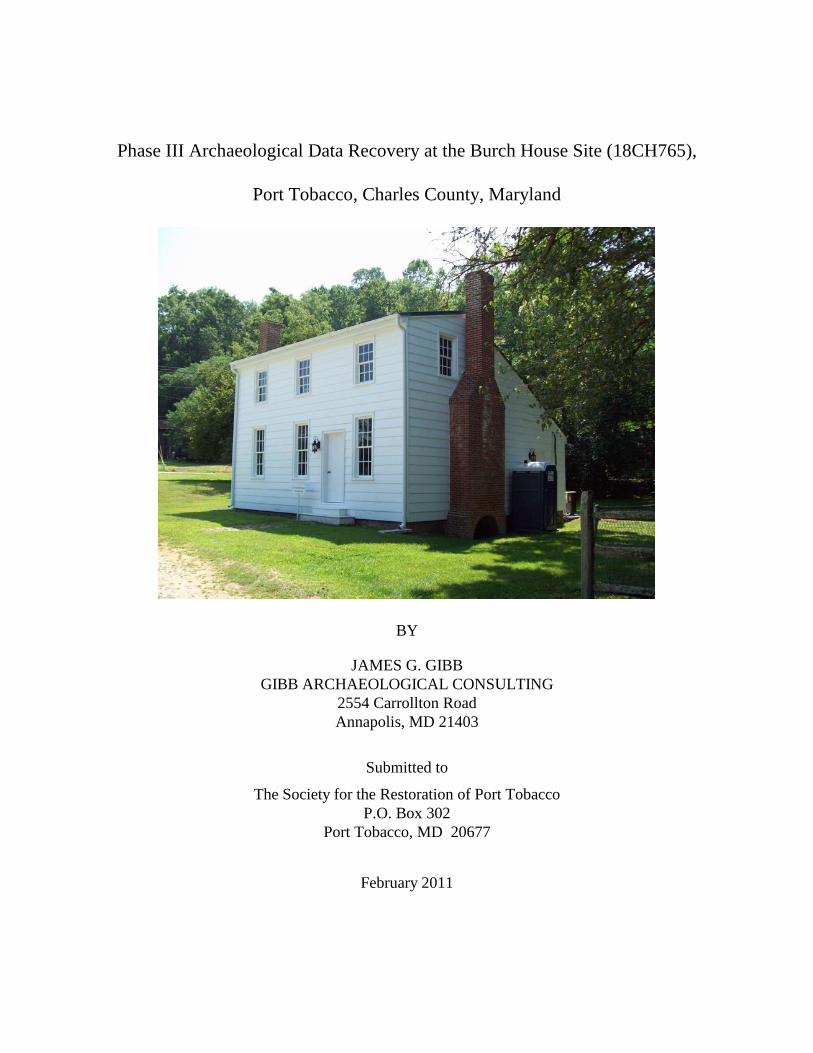
Phase III Archaeological Data Recovery at the Burch House Site (18CH765),
Port Tobacco, Charles County, Maryland
BY
JAMES G. GIBB
GIBB ARCHAEOLOGICAL CONSULTING
2554 Carrollton Road
Annapolis, MD 21403
Submitted to
The Society for the Restoration of Port Tobacco
P.O. Box 302
Port Tobacco, MD 20677
February 2011
2
Abstract
The Society for the Restoration of Port Tobacco, Inc., in cooperation with Charles County
government, sought and received approval from the Maryland Historical Trust (MHT), historical
easement holders, for a 14 ft x 14 ft bathroom extension off of the west gable-end of the Burch
House (CH 23, aka Cat Slide House). As a condition of approval, the Society funded a Phase III
data recovery at the sites of the proposed ell, well, and pump-out septic tank. Justification for the
investigation and the methodology used comes from a Phase I identification study undertaken at
the Burch House in 2006. That study identified deeply buried cultural deposits, the significance
of which subsequent work in the town has borne out.
The Port Tobacco Archaeological Project, a long-term undertaking of the Lost Towns
Foundation, Inc., conducted the study in 2010 under a scope of work approved by the MHT with
a combination of Gibb Archaeological Consulting (GAC) staffers and volunteers from the
Charles County Archaeological Society (CCAS). James G. Gibb served as principal investigator.
The project team stratigraphically excavated eight units within the proposed footprint of
the ell and single units at the approximate proposed sites of the well and pump-out tank. All units
(each measuring 5 ft by 5 ft) revealed a succession of sedimentation events that blanketed a
Colonial period deposit. Materials recovered from those sediments relate to the series of
households occupying the site from the late-17th
through early 20th
centuries. Excavations along
the west façade of the house revealed evidence of an earthfast precursor to the extant frame-on-
brick-foundation dwelling.
Data recovered from units around the Burch House have clarified and confirmed initial
survey results from the 2006 work and provided a basis for preliminary analysis of the
depositional history at Burch House and, by extension, for the town as a whole. The implications
of the depositional analysis is critical to a larger understanding of the geographic transformation
of Chesapeake Basin as Colonial port towns contracted and residents abandoned them for newer
urban settings.
Archaeological survey around the Burch House in 2006 revealed surprisingly deep
cultural deposits, ranging between 2 ft and 3 ft thick. Deposits in Maryland typically are
deflationary…they lose, not gain material, largely as a result of extensive deforestation, intensive
plow agriculture, and erosion. The widespread adoption of motorized agriculture has had an
exceptionally damaging effect on archaeological deposits with some upland areas losing 4 ft or
more in elevation. Even lower, more level elevations have lost in the neighborhood of 1 ft to 2 ft.
Burch House and the village of Port Tobacco differ from the norm in that eroding uplands to the
east and upstream have provided new material. Excavations around the Burch House have
demonstrated that these materials contain poorly sorted silts, sands, clays, and gravels that were
redeposited gradually and episodically. The former are represented by thin, non-extensive
deposits of finer grain sediments with little or no gravel and inclusions of cultural materials
representing relatively narrow time ranges. Episodic deposits appear has poorly sorted gravels
with admixtures of finer sediments, generally thick and varied in terms of the distance of the
sample unit from the source of the sediment.
Unit 96 lies at the base of what appears to be a fan deposit of sediment near the mouth of
a gully that runs down the slope east of Chapel Point Road. The heavier deposits precipitated
from the floodwater or slide. As the water spread across the landscape and lost velocity,
increasingly finer sediments precipitated from the mass. Unit 96 revealed massive deposits of
poorly sorted gravels, sands, and silts. These deposits contain very few artifacts, and those that
3
were recovered are fairly large and may emanate from an undocumented site to the east. Also
among these sediments excavators recovered fossil shark teeth and marine mammal bone and a
chalcedony flake that may derive from the fluting of a Clovis point. Creek terraces along the base
of the upland might contain early Native American sites in their deposits. The redeposited
material lies directly on an 18th
-century horizon that—based on the relative paucity of artifacts—
likely represents the periphery of a site.
Unit 95, excavated well south of the mouth of the ravine, revealed layers of redeposited
material, but the sediments were finer grained and the gravels fewer and less poorly sorted than
those in Unit 96. Here also an 18th
-century horizon survives intact below the sediments. As noted
above, some of the historic materials from the upper strata of Unit 95 may derive from an
undocumented historic site to the east.
Units 84 through 94—the block excavation—revealed complex depositional patterns
rendered more complex by groundhog burrowing, construction, demolition, and gardening. But
again, 18th
-century deposits survive beneath numerous strata of redeposited sediments.
Approaching the sedimentation issue from the perspective of beds, or groups of strata spanning
several units, proved effective; detailed analyses that attempt to reveal aspects of the material
lives of the succession of householders, however, will require a less expansive approach.
Analyses of individual strata followed by the linking of those strata may be more effective.
Detailed faunal analysis, however, must be conducted first to address taphonomic issues. Bone is
better suited to such work because it reacts more clearly to exposure to the elements, rodent and
canine osteophagy, and transportation in water-suspended sediments. The foregoing analyses
have focused on the sedimentary history of the site. They reveal nothing of the temporary use of
the house as a school for African American children and the attribution of specific deposits to
specific households remains to be undertaken.
The stratigraphic sequences indicate a much more complex construction and occupational
sequence for the Burch House and site than previously had been considered. The extant Burch
House is not the first Colonial dwelling on this site and the house probably was built in the late
18th
century, a frame structure with brick foundation and cellar replacing at least one, and
possibly a succession of two, earthfast buildings. Initial fieldwork in 2006 demonstrated the
existence of a cellar beneath the main part of the Burch House. Recently field findings suggest
the remains of a bulkhead entranceway, at least on the west side of the Burch House; a feature
long suspected, but not hitherto documented. Evidence of an earthfast dwelling suggests that the
remains of an earthen cellar might survive beneath the rear ell, the extant main structure likely
having been constructed while the earthfast building remained standing. Any future excavation
and any construction-related monitoring should anticipate the exposure of an earthen cellar hole
and at least one more posthole and mold in unexcavated Unit 97. Such features also can be
expected beneath the rear addition.
4
Table of Contents
Abstract ................................................................................................................2
Table of Contents ...................................................................................................4
List of Figures ........................................................................................................5
List of Tables .........................................................................................................6
Chapter 1. Introduction .......................................................................................7
Chapter 2. Project Location and Environment .................................................8 Location ............................................................................................................................................8 Environment ....................................................................................................................................8
Chapter 3. Historical Background ...................................................................15 Town History .................................................................................................................................15 Lot History .....................................................................................................................................20 Charles W. Barnes .........................................................................................................................22 Washington Burch .........................................................................................................................23 Summary ........................................................................................................................................24
Chapter 4. Prior Archaeological Investigation ................................................25 Introduction ...................................................................................................................................25 Investigation in 2006 .....................................................................................................................25 Mapping ..........................................................................................................................................25 Shovel Testing ................................................................................................................................25 Yards ...............................................................................................................................................25 Cellar ...............................................................................................................................................26 Probing and Sod-stripping............................................................................................................32 Artifacts ..........................................................................................................................................35
Chapter 5. Research Design and Methods .....................................................37 Introduction ...................................................................................................................................37 Research Design .............................................................................................................................37 Questions and Specific Methods .....................................................................................................37 General Methodology ....................................................................................................................38
Chapter 6. Results of 2010 Investigation ........................................................39 Introduction ...................................................................................................................................39 Unit 95 ............................................................................................................................................39 Unit 96 ............................................................................................................................................42 Block Excavation (Units 84-94) ....................................................................................................47 Bed I ................................................................................................................................................49 Bed II ...............................................................................................................................................49 Bed III .............................................................................................................................................49 Bed IV .............................................................................................................................................50 Bed V ..............................................................................................................................................51 Bed VI .............................................................................................................................................54 Bed VII ............................................................................................................................................54 Bed VIII ..........................................................................................................................................56 Bed IX .............................................................................................................................................57 Bed X ..............................................................................................................................................57 Bed XI .............................................................................................................................................58 Bed XII ............................................................................................................................................59 Bed XIII ..........................................................................................................................................61 Bed XIV ..........................................................................................................................................61 Burch House Addition .....................................................................................................................62 Bed XV............................................................................................................................................66 Beds XVI-XVIII ..............................................................................................................................67 Structural Features .......................................................................................................................72
5
Postholes .........................................................................................................................................72 Construction Sequence Features ......................................................................................................76 Summary ........................................................................................................................................81
References Cited ...............................................................................................83
Appendix A: Shovel Test Data .........................................................................88
Appendix B: Artifact catalogue ........................................................................90
Appendix C: Credentials ...................................................................................91
List of Figures FIGURE 2-1. MARYLAND ARCHEOLOGICAL RESEARCH UNIT MAP. ...............................................8 FIGURE 2-2. USGS 7.5‘ TOPOGRAPHIC MAP, PORT TOBACCO, MD (1978).......................................9 FIGURE 2-3. PORT TOBACCO HISTORIC DISTRICT CORE. ................................................................10 FIGURE 2-4. AERIAL VIEW OF VILLAGE AND BURCH HOUSE. .......................................................11 FIGURE 2-5. FRONT FAÇADE OF THE BURCH HOUSE (2010). ..........................................................11 FIGURE 2-6. EAST YARD OF THE BURCH HOUSE. ..............................................................................12 FIGURE 2-7. WEST AND SOUTH YARDS AND FAÇADES (2010). ......................................................12 FIGURE 2-8. BURCH HOUSE SCALED NORTH (FRONT) AND WEST ELEVATIONS. .....................13 FIGURE 2-9. BURCH HOUSE, 1970. ..........................................................................................................14 FIGURE 3-1. LAND CONVEYANCES BY DECADE IN PORT TOBACCO. ..........................................16 FIGURE 3-2. HEYNE MAP OF PARTS OF VIRGINIA, MARYLAND & DELAWARE, (1861). ...........18 FIGURE 3-3. ROAD MAP OF CHARLES COUNTY, MARYLAND (1897). ............................................18 FIGURE 3-4. H. C. PAGE SURVEY (1888). ...............................................................................................19 FIGURE 3-5. PAGE SURVEY, REDRAFTED. ...........................................................................................19 FIGURE 3-6. ROBERT G. BARBOUR MAP (1942, REDRAFTED 2000). ...............................................20 FIGURE 3-7. BURCH HOUSE ADDITION, CA. 1900. ..............................................................................22 FIGURE 3-8. BURCH LOTS, 1879. .............................................................................................................23 FIGURE 4-1. PROJECT AREA. ...................................................................................................................27 FIGURE 4-2. TEST UNITS AT THE BURCH HOUSE SITE. ....................................................................28 FIGURE 4-3. BRICK STRUCTURE IN THE WEST YARD OF THE BURCH HOUSE SITE. ................29 FIGURE 4-4. ACCESS TO AREA BENEATH THE HOUSE. ....................................................................30 FIGURE 4-5. BACKDIRT FROM PRIOR DIGGING. ................................................................................30 FIGURE 4-6. REBUILD OF REAR MAIN WALL. .....................................................................................31 FIGURE 4-7. ARCH IN BASE OF EAST WALL CHIMNEY. ...................................................................31 FIGURE 4-8. STRIPPING SOD AROUND WEST CHIMNEY. .................................................................32 FIGURE 4-9. EXPOSED BRICK PAVEMENT, WEST FAÇADE. ............................................................33 FIGURE 4-10. EXPOSED SOUTH FOUNDATION. ..................................................................................33 FIGURE 4-11. SOLDIER COURSE, EXPOSED SOUTH FOUNDATION. ...............................................34 FIGURE 4-12. SOUTHWEST CORNER OF EXPOSED FOUNDATION. ................................................34 FIGURE 4-13. EXPOSED PAVEMENT AT SOUTHWEST CORNER OF EXTANT HOUSE. ...............35 FIGURE 6-1. BURCH HOUSE SITE MAP. .................................................................................................40 FIGURE 6-2. PROFILES OF UNIT 95. ........................................................................................................41 FIGURE 6-3. OUTWASH FAN. ...................................................................................................................43 FIGURE 6-4. PROFILES OF UNIT 96. ........................................................................................................44 FIGURE 6-5. MATERIAL FROM UNIT 96, STRATUM 4. .......................................................................46 FIGURE 6-6. CHANNEL FLAKE. ...............................................................................................................46 FIGURE 6-7. BLOCK EXCAVATION ON WEST FAÇADE OF BURCH HOUSE. .................................48 FIGURE 6-8. BLOCK EXCAVATION MAP...............................................................................................48 FIGURE 6-9. PLANVIEW OF BURCH HOUSE ADDITION FOUNDATION AND PAVEMENT. ........63 FIGURE 6-10. TOP OF ADDITION FOUNDATION AND PAVEMENT. ................................................64 FIGURE 6-11. EAST WALL FOUNDATION OF BURCH HOUSE ADDITION. .....................................64 FIGURE 6-12. SOUTH WALL FOUNDATION OF BURCH HOUSE ADDITION. ..................................65 FIGURE 6-13. GARDEN PARTITION, FOUNDATION, AND PAVEMENT. ..........................................65 FIGURE 6-14. GARDEN PARTITION. .......................................................................................................66
6
FIGURE 6-15. UNIT 86, STRATA 12 THROUGH 16. ...............................................................................72 FIGURE 6-16. POSTHOLES IN BLOCK EXCAVATION UNITS. ............................................................73 FIGURE 6-17. SCAFFOLDING POSTHOLE, UNIT 90 STRATUM 27. ...................................................74 FIGURE 6-18. POSTHOLE COMPLEX, UNIT 87/93, STRATUM 13/11 (LOTS 906 & 916). .................74 FIGURE 6-19. POSTHOLE COMPLEX, UNIT 84, STRATUM 13 (LOT 912). ........................................75 FIGURE 6-20. SEDIMENTS BELOW HOUSE FOUNDATION. ...............................................................77 FIGURE 6-21. STRATIGRAPHIC PROFILE, UNITS 94 AND 92. ............................................................77 FIGURE 6-22. UNIT 90, NORTH WALL PROFILE. ..................................................................................78 FIGURE 6-23. BUILDERS TRENCH FILL BETWEEN TROWEL AND WALL. ....................................79 FIGURE 6-24. TRUNCATED BUILDERS TRENCH. ................................................................................79 FIGURE 6-25. UNITS 90 AND 94, POSTHOLE AND BUILDER‘S TRENCH. ........................................80 FIGURE 6-26. REVISED NORTH WALL PROFILE OF UNIT 90. ...........................................................81 FIGURE 6-27. EAST-WEST PROFILE OF BLOCK EXCAVATION, UNITS 85, 84, AND 87. ...............82
List of Tables
TABLE 3-1. SUMMARY OF OCCUPATIONAL DISTRIBUTION, 1850-1880. .......................................16 TABLE 3-2. PARTIAL CHAIN OF TITLE. .................................................................................................21 TABLE 4-1. TEMPORALLY DIAGNOSTIC CERAMICS RECOVERED FROM UNITS. ......................36 TABLE 6-1. TOBACCO PIPESTEMS FROM UNIT 95. ............................................................................39 TABLE 6-2. DATABLE VESSEL FORMS SERIATED, UNIT 95. ............................................................41 TABLE 6-3. ARCHITECTURAL ARTIFACTS, UNIT 95 ..........................................................................42 TABLE 6-4. CERAMICS FROM UNIT 96. .................................................................................................44 TABLE 6-5. NAILS BY STRATUM AND TYPE, UNIT 96. ......................................................................45 TABLE 6-6. ARTIFACT SUMMARY, BED I .............................................................................................49 TABLE 6-7. ARTIFACT SUMMARY, BED II ............................................................................................49 TABLE 6-8. SUMMARY DATA, BED III ...................................................................................................50 TABLE 6-9. ARTIFACT SUMMARY, BED IV ..........................................................................................51 TABLE 6-10. ARTIFACT SUMMARY, BED V .........................................................................................53 TABLE 6-11. ARTIFACT SUMMARY, BED VI ........................................................................................54 TABLE 6-12. ARTIFACT SUMMARY, BED VII .......................................................................................55 TABLE 6-13. ARTIFACT SUMMARY, BED VIII .....................................................................................56 TABLE 6-14. ARTIFACT SUMMARY, BED IX ........................................................................................57 TABLE 6-15. ARTIFACT SUMMARY, BED X .........................................................................................58 TABLE 6-16. ARTIFACT SUMMARY, BED XI ........................................................................................59 TABLE 6-17. ARTIFACT SUMMARY, BED XII .......................................................................................60 TABLE 6-18. ARTIFACT SUMMARY, BED XIII .....................................................................................61 TABLE 6-19. ARTIFACT SUMMARY, BED XIV .....................................................................................62 TABLE 6-20. ARTIFACT SUMMARY, BED XV.......................................................................................68 TABLE 6-21. ARTIFACT SUMMARY, BEDS XVI-XVIII ........................................................................69 TABLE 6-22. ARTIFACT SUMMARY, POSTHOLE (LOTS 395 AND 400) ............................................75 TABLE 6-23. ARTIFACT SUMMARY, POSTHOLE (LOT 912)...............................................................76
7
Chapter 1. Introduction
The Society for the Restoration of Port Tobacco, Inc., in cooperation with Charles County
government, sought and received approval from the Maryland Historical Trust (MHT), historical
easement holders, for a 14 ft x 14 ft bathroom extension off of the west gable-end of the Burch
House (CH 23, aka Cat Slide House). As a condition of approval, the Society funded a Phase III
data recovery at the sites of the proposed ell, well, and pump-out septic tank. Justification for the
investigation and the methodology used comes from a Phase I identification study undertaken at
the Burch House in 2006. That study identified deeply buried cultural deposits, the significance
of which subsequent work in the town has borne out.
The Phase III archaeological data recovery consisted of three stratigraphic excavation,
soil sampling, laboratory processing, and analysis. This report documents the methods and results
of the study. It consists of seven sections:
1) Introduction
2) Project Location and Environment
3) Culture History
4) Research Design and Methods
5) Field and Laboratory Results
6) Summary, Interpretations, and Recommendations
7) Supporting Documentation
All of the work described herein was conducted in accordance with the Standards and
Guidelines for Archeological Investigations in Maryland (Shaffer and Cole 1994), the
Specifications for Consulting Engineers Services Manual–Section IV (Maryland Department of
Transportation 1986), and the Consultant Specifications for Archeological Procedures (Maryland
State Highway Administration 1992).
8
Chapter 2. Project Location and Environment
Location
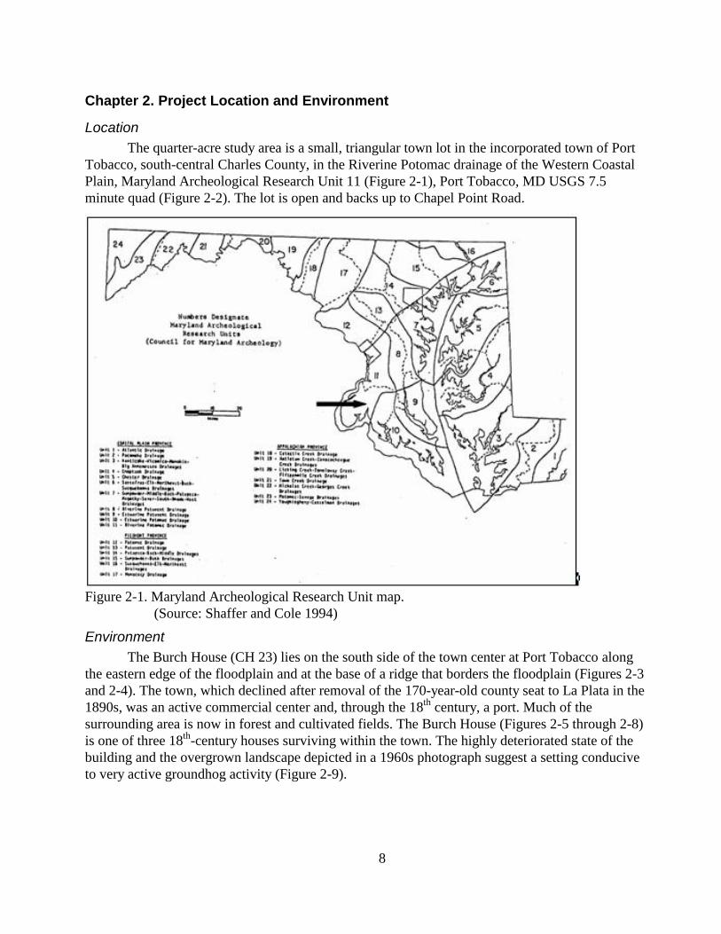
The quarter-acre study area is a small, triangular town lot in the incorporated town of Port
Tobacco, south-central Charles County, in the Riverine Potomac drainage of the Western Coastal
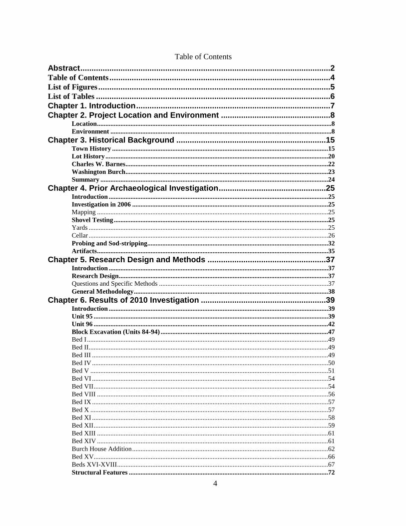
Plain, Maryland Archeological Research Unit 11 (Figure 2-1), Port Tobacco, MD USGS 7.5
minute quad (Figure 2-2). The lot is open and backs up to Chapel Point Road.
Figure 2-1. Maryland Archeological Research Unit map.
(Source: Shaffer and Cole 1994)
Environment
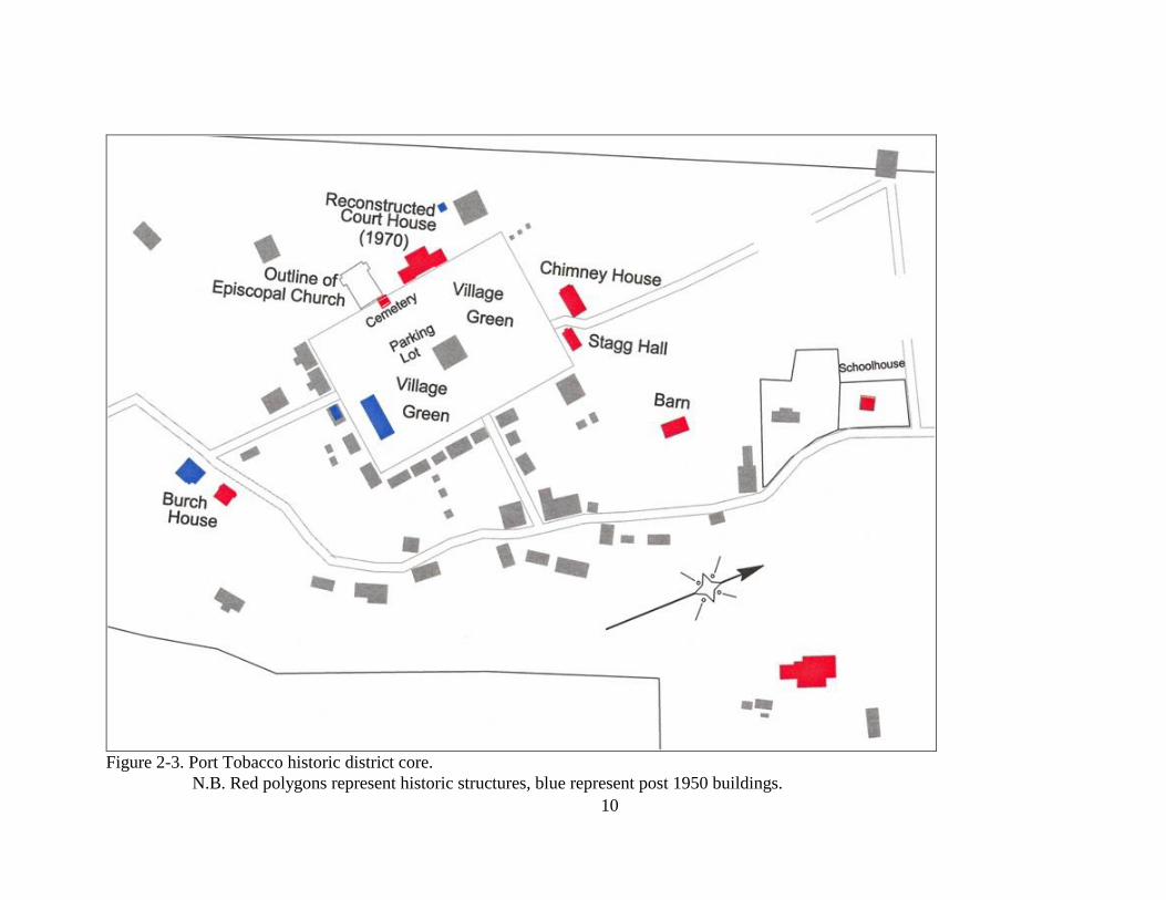
The Burch House (CH 23) lies on the south side of the town center at Port Tobacco along
the eastern edge of the floodplain and at the base of a ridge that borders the floodplain (Figures 2-3
and 2-4). The town, which declined after removal of the 170-year-old county seat to La Plata in the
1890s, was an active commercial center and, through the 18th
century, a port. Much of the
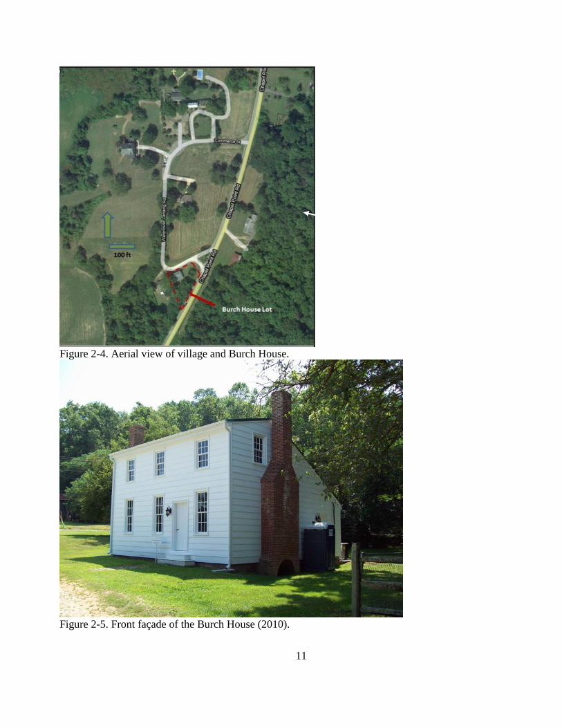
surrounding area is now in forest and cultivated fields. The Burch House (Figures 2-5 through 2-8)
is one of three 18th
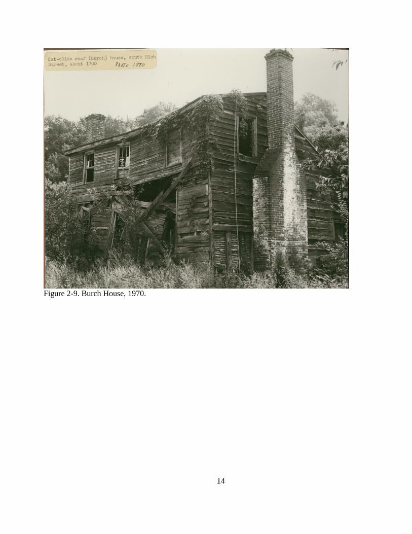
-century houses surviving within the town. The highly deteriorated state of the
building and the overgrown landscape depicted in a 1960s photograph suggest a setting conducive
to very active groundhog activity (Figure 2-9).
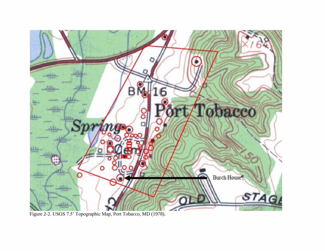
Figure 2-2. USGS 7.5‘ Topographic Map, Port Tobacco, MD (1978).
10
Figure 2-3. Port Tobacco historic district core.
N.B. Red polygons represent historic structures, blue represent post 1950 buildings.
11
Figure 2-4. Aerial view of village and Burch House.
Figure 2-5. Front façade of the Burch House (2010).
Burch House
12
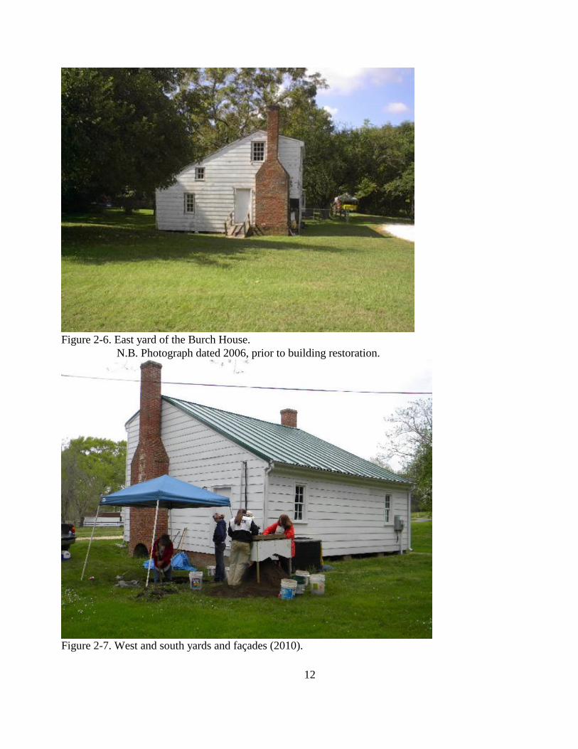
Figure 2-6. East yard of the Burch House.
N.B. Photograph dated 2006, prior to building restoration.
Figure 2-7. West and south yards and façades (2010).
13
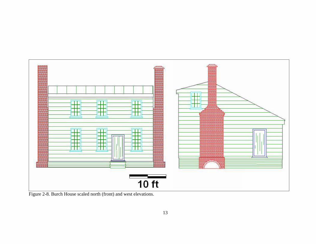
Figure 2-8. Burch House scaled north (front) and west elevations.
14
Figure 2-9. Burch House, 1970.
15
Chapter 3. Historical Background
Town History
The ongoing study of Port Tobacco and the surrounding countryside involves Contact and
pre-Contact aboriginal occupations, as well as the European American establishment of the town. In
part, professional ethics demand this attention; but we also must consider the pre-Colonial
environment, the biotic and geological settings to which Native Americans adapted and which they
changed through their adaptations. Prior work at the Burch House and the current study failed to find
significant aboriginal deposits; hence aboriginal occupation of the site and its environs are not
addressed here, but available data and interpretations can be found in several reports produced to
date and available at www.restoreporttobacco.org. Those reports also raise the possibility that some
of the environmental changes that contributed to the abandonment of Port Tobacco had begun prior
to the Contact Period, exacerbated perhaps by commercial mono-cropping of tobacco, and that issue
is dealt with at length in this report. This chapter summarizes our current state of knowledge of the
history of Port Tobacco and its surroundings.
Maryland‘s General Assembly selected Port Tobacco as the new seat of Charles County
government in 1727, specifying Chandlers Town at the head of Port Tobacco Creek and renaming it
Charles Town. The site presumably was more accessible than the 1674-1727 Moore‘s Lodge
location, recently identified by King, Strickland, and Norris (2008). Land records indicate that Job
Chandler subdivided a portion of his tract, Chandlers Hope, and sold some lots in the early 1720s.
How much earlier the site was occupied by Europeans has not been determined, but there is a
growing body of evidence pointing to an occupation dating to the third quarter of the 17th
century.
The town grew slowly during the 1730s and became an important commercial center by the
beginning of the American Revolution on the strength of its port facilities and administrative center.
Port Tobacco declined during the post-Revolutionary War economic depression, but seems to
have improved after the 1812-1815 war with Great Britain. A spate of land purchases in the first
decade of the 19th
century (Figure 3-1) followed by the erection of a new courthouse and jail (1818-
20), suggests a fluorescence of the town. Definition of town lots must have been a serious enough
problem to warrant the attention of Maryland‘s General Assembly which passed an act in 1820 for the
resurvey of Port Tobacco. Although repealed the following year before the survey was undertaken, the
law is instructive for what it says of the condition of the town‘s system of lots. Section 5 of the 1820
Act of the General Assembly of Maryland required resurvey of the town, charging the county
commissioners to:
[C]ause a full and complete plot thereof, together with a certificate of their proceedings in
virtue of their act, to be recorded among the land records of Charles county, and a duplicate
of said plots, duly certified, to be pasted on linen or board and delivered to the clerk of
Charles county, to be by him filed among the records of his office, for the inspection of all
the persons interested, and that the said plot shall thereafter be considered, deemed and
taken, as the true plot of Port Tobacco, heretofore called Charles-town, and the proprietors
of lots and houses in said town shall be vested within as good, sure and indefeasible an
estate, of and in their several and respective lots and houses, laid down in the manner herein
before directed, as if the original plot of Charles-town had never been torn or defaced.
16
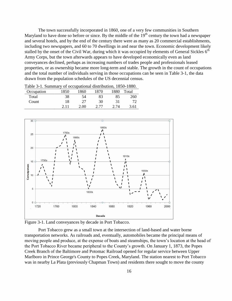
The town successfully incorporated in 1860, one of a very few communities in Southern
Maryland to have done so before or since. By the middle of the 19th
century the town had a newspaper
and several hotels, and by the end of the century there were as many as 20 commercial establishments,
including two newspapers, and 60 to 70 dwellings in and near the town. Economic development likely
stalled by the onset of the Civil War, during which it was occupied by elements of General Sickles 6th
Army Corps, but the town afterwards appears to have developed economically even as land
conveyances declined, perhaps as increasing numbers of trades people and professionals leased
properties, or as ownership became more long-term and stable. The growth in the count of occupations
and the total number of individuals serving in those occupations can be seen in Table 3-1, the data
drawn from the population schedules of the US decennial census.
Table 3-1. Summary of occupational distribution, 1850-1880.
Occupation 1850 1860 1870 1880 Total
Total 38 54 83 85 260
Count 18 27 30 31 72
2.11 2.00 2.77 2.74 3.61
Figure 3-1. Land conveyances by decade in Port Tobacco.
Port Tobacco grew as a small town at the intersection of land-based and water borne
transportation networks. As railroads and, eventually, automobiles became the principal means of
moving people and produce, at the expense of boats and steamships, the town‘s location at the head of
the Port Tobacco River became peripheral to the County‘s growth. On January 1, 1873, the Popes
Creek Branch of the Baltimore and Potomac Railroad opened for regular service between Upper
Marlboro in Prince George's County to Popes Creek, Maryland. The station nearest to Port Tobacco
was in nearby La Plata (previously Chapman Town) and residents there sought to move the county
17
seat to their new town. (A station called Port Tobacco Station was established due east of town and
south of La Plata, but failed to develop into anything more than a hamlet.) Three years after fire
destroyed much of the courthouse in Port Tobacco (1892), their efforts finally succeeded. Port
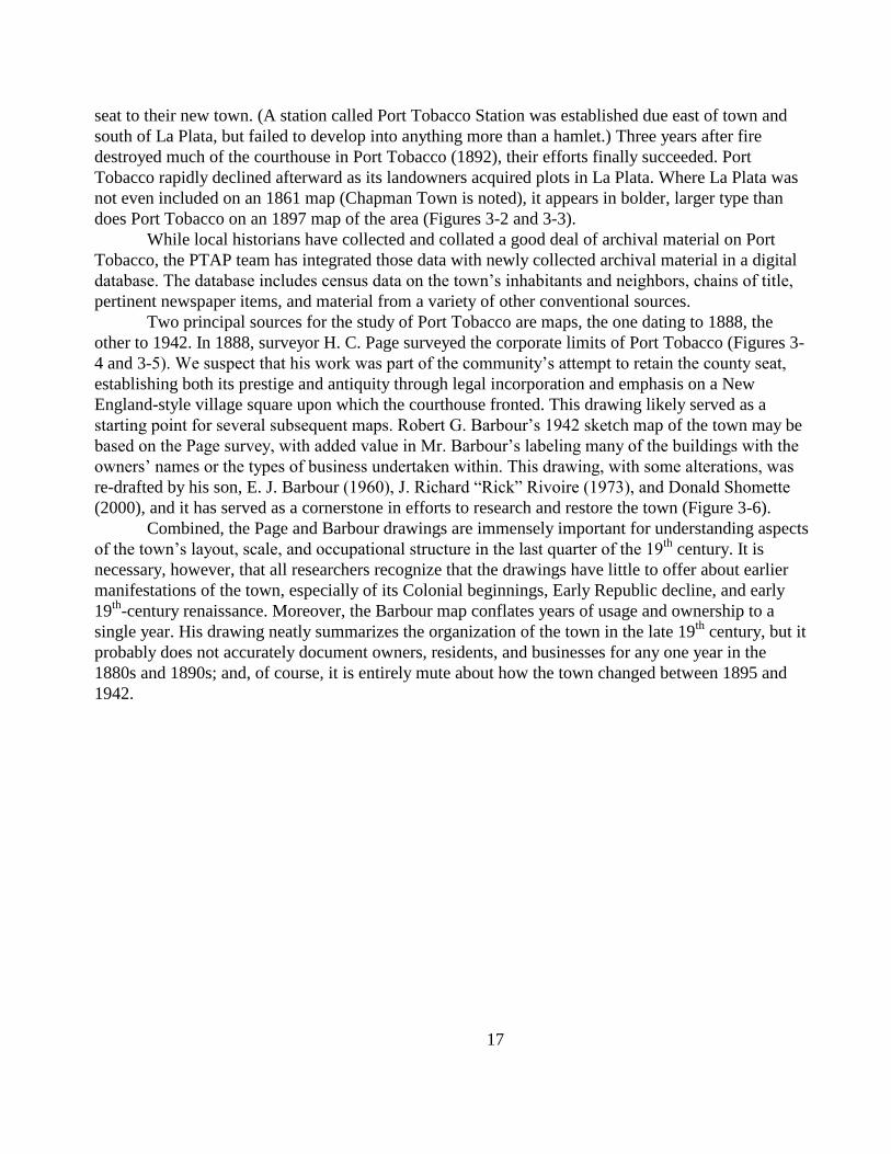
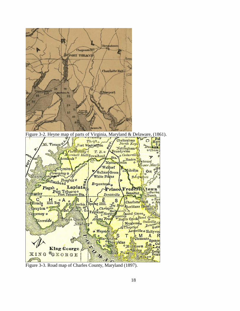
Tobacco rapidly declined afterward as its landowners acquired plots in La Plata. Where La Plata was
not even included on an 1861 map (Chapman Town is noted), it appears in bolder, larger type than
does Port Tobacco on an 1897 map of the area (Figures 3-2 and 3-3).
While local historians have collected and collated a good deal of archival material on Port
Tobacco, the PTAP team has integrated those data with newly collected archival material in a digital
database. The database includes census data on the town‘s inhabitants and neighbors, chains of title,
pertinent newspaper items, and material from a variety of other conventional sources.
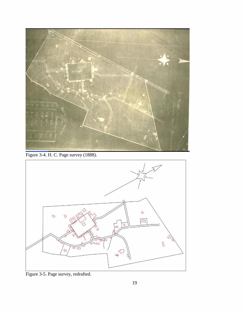
Two principal sources for the study of Port Tobacco are maps, the one dating to 1888, the
other to 1942. In 1888, surveyor H. C. Page surveyed the corporate limits of Port Tobacco (Figures 3-
4 and 3-5). We suspect that his work was part of the community‘s attempt to retain the county seat,
establishing both its prestige and antiquity through legal incorporation and emphasis on a New
England-style village square upon which the courthouse fronted. This drawing likely served as a
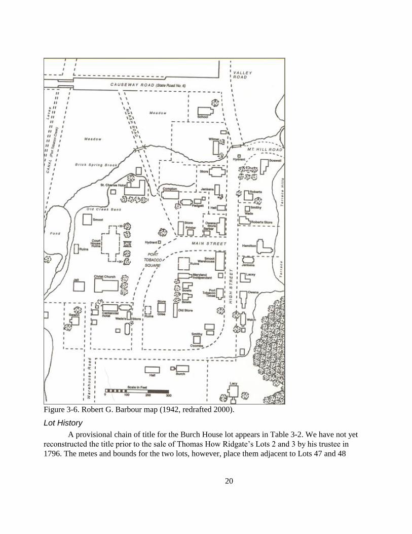
starting point for several subsequent maps. Robert G. Barbour‘s 1942 sketch map of the town may be
based on the Page survey, with added value in Mr. Barbour‘s labeling many of the buildings with the
owners‘ names or the types of business undertaken within. This drawing, with some alterations, was
re-drafted by his son, E. J. Barbour (1960), J. Richard ―Rick‖ Rivoire (1973), and Donald Shomette
(2000), and it has served as a cornerstone in efforts to research and restore the town (Figure 3-6).
Combined, the Page and Barbour drawings are immensely important for understanding aspects
of the town‘s layout, scale, and occupational structure in the last quarter of the 19th
century. It is
necessary, however, that all researchers recognize that the drawings have little to offer about earlier
manifestations of the town, especially of its Colonial beginnings, Early Republic decline, and early
19th
-century renaissance. Moreover, the Barbour map conflates years of usage and ownership to a
single year. His drawing neatly summarizes the organization of the town in the late 19th
century, but it
probably does not accurately document owners, residents, and businesses for any one year in the
1880s and 1890s; and, of course, it is entirely mute about how the town changed between 1895 and
1942.
18
Figure 3-2. Heyne map of parts of Virginia, Maryland & Delaware, (1861).
Figure 3-3. Road map of Charles County, Maryland (1897).
19
Figure 3-4. H. C. Page survey (1888).
Figure 3-5. Page survey, redrafted.
20
Figure 3-6. Robert G. Barbour map (1942, redrafted 2000).
Lot History
A provisional chain of title for the Burch House lot appears in Table 3-2. We have not yet
reconstructed the title prior to the sale of Thomas How Ridgate‘s Lots 2 and 3 by his trustee in
1796. The metes and bounds for the two lots, however, place them adjacent to Lots 47 and 48
21
and, with Lot 1 (purchased from his estate by Ridgate‘s wife Elizabeth), may comprise all or part
of ―Parnham‘s Lot‖ which was adjacent to, and linked through title with, Lots 47 and 48.
Table 3-2. Partial chain of title.
Principal Grantor Grantee Instrument Liber/folio Date
Madeline Brooks Society for the Restoration of Port Tobacco Deed PCM 130/450 6/10/1957
Gertrude M. Hubbard Earl A. & Madaline B. Douglas Deed PCM 95/333 4/18/1951
Madeline Brooks Douglas Gertrude M. Hubbard Deed PCM 95/330 4/18/1951
Elizabeth B.M. Johnson Madaline B. Douglas Will GAW 21/37 1/21/1921
Joseph Smith Elizabeth B.M. Johnson Deed CP 31/662 5/7/1917
Elizabeth B.M. Johnson Mary A. Smith Deed CP 31/327 5/5/1917
Wesly Bowie Washington Burch Deed BGS 4/31 8/27/1879
Washington Burch Frederick Stone Deed BGS 4/24 8/7/1879
Stone, Frederick Washington Burch Deed GAH 4/215 4/21/1874
Stone, Frederick Covall, John D. Deed GAH 4/215 4/1/1874
John Ware Charles W. Barnes Deed WM 2/448 10/3/1847
Frederick Stone John Ware Deed IB 17/168 10/12/1826
Alexander Matthews Frederick Stone & James Weems Deed ? ?
Nathaniel Causin Alexander Matthews Deed IB 14/394 12/6/1821
Daniel Jenifer (Dr) Nathaniel Causin (Dr) Deed IB 11/332 4/16/1816
James Freeman, trustee Daniel Jenifer (Dr.) Confirmatory
Deed for
1796 sale
IB 5/208 5/18/1802
The only specific references to the Burch House are in connection with a fire, reported in
the local paper, wherein a spark from the burning Carrollton boarding house on the opposite side
of the public square appears to have ignited the roof of Washington Burch‘s house on the
southern edge of town on February 21, 1883. The extent of the damage, as mentioned in
Shomette (2000), is uncertain, but appears not to have been catastrophic. R. G. Barbour, a
resident of Port Tobacco, left a pencil sketch of the town, on the south end of which he depicted
the Burch house and identified its owner as Washington Burch (see Figure 3-6). The house is
rectangular in plan with what appear to be a hyphen and wing on the west façade. The extant
house is, in fact, nearly square, but the author likely focused on the general layout of the town,
and the various owners, businesses, and public buildings: It is a sketch map and not a surveyor‘s
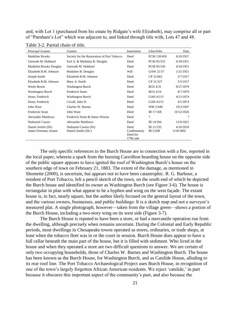
measured plat. A single photograph, however—taken from the village green—shows a portion of
the Burch House, including a two-story wing on its west side (Figure 3-7).
The Burch House is reputed to have been a store, or had a mercantile operation run from
the dwelling, although precisely when remains uncertain. During the Colonial and Early Republic
periods, most dwellings in Chesapeake towns operated as stores, ordinaries, or trade shops, at
least when the tobacco fleet was in or the court in session. Burch House does appear to have a
full cellar beneath the main part of the house, but it is filled with sediment. Who lived in the
house and when they operated a store are two difficult questions to answer. We are certain of
only two occupying households, those of Charles W. Barnes and Washington Burch. The house
has been known as the Burch House, for Washington Burch, and as Catslide House, alluding to
its rear roof line. The Port Tobacco Archaeological Project uses Burch House, in recognition of
one of the town‘s largely forgotten African American residents. We reject ‗catslide,‘ in part
because it obscures this important aspect of the community‘s past, and also because the
22
architectural term is inaccurate for this simple shed roof (the rear pitch is unbroken, but it is more
gradual than the front pitch).
Figure 3-7. Burch House addition, ca. 1900.
N.B. Burch House far left, with two-story addition and chimney at peak on
gable end.
Charles W. Barnes
On October 3, 1847, Charles W. Barnes purchased the house and lot on which he resided
from John Ware and William Ware (Land Records WM 2/448). They had inherited the property
from their father, John Ware, Sr., who had purchased it from Frederick D. Stone and James L.
Weems in 1826. Stone and Weems purchased the property from sheriff Alexander Matthews
sometime between 1822 and 1826. Whether or not any of the Wares lived on the lot is uncertain,
but likely. Barnes appears in the population schedule of the 1840 and 1850 federal censuses. In
the former year—a time when the census provided nothing more than the head of household‘s
name and household demographics—Charles Barnes (aged between 21 and 30) headed a
household of five. It included two male children (one under 5, the other between 11 and 15), a
female between 15 and 20 years of age, and an elderly (55+) female slave. In 1850—the first year
of enhanced census recording—Charles W. Barnes was listed as a 35-year-old tailor living with
four others with the same surname: Mary M. (20), Walter M. (8), Ersula (6), and Sara (4).
Charles W. Barnes appears in the 1860 census, but in the Hill Top district several miles west of
Port Tobacco. The then 38-year-old Barnes owned the farm and lived there with Jane C. (25),
Walter (19), Mary (17), Sarah (15), and Charles, Jr. (10 months). Reconciling the ages of Charles
Barnes in the 1840 and 1850 censuses is easily done if he was ~25 in 1840 and 35 in 1850. The
age of 38 for the 1860 census does not conform, although the ages of Walter and Sara would be
correct.
23
Charles W. Barnes appeared three times in the Port Tobacco Times:
1. Reference to a house formerly occupied by H. Colley in the rear of C.W. Barnes‘
tailoring shop (v. 2, n0. 37, January 15, 1847). Barnes purchased his house and lot
in town later that year.
2. Charles Barnes and James H. Luckett offered for sale a house that was ―large,
comparatively new‖ and, therefore, not the Burch House (v. 25, no. 26, October
30, 1868).
3. House and lot of the late Charles W. Barnes, adjoining those on which Joseph I.
Lacey and John D. Covall reside, offered for sale (v. 28, no. 10, July 7, 1871).
On April 4, 1874, John D. Covall purchased a lot from trustee Frederick Stone which ―formerly
belonged to Charles W. Barnes‖ and ―now in the possession of John Covall‖ (Land Records
GAH 4/215). But this may be the lot to the north. On the same day, his deed recorded
immediately before Covall‘s, Washington Burch purchased Charles W. Barnes house and lot, a
property in which Burch already possessed (Land Records GAH 4/215).
Washington Burch
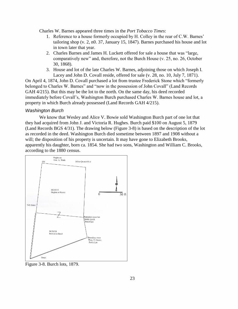
We know that Wesley and Alice V. Bowie sold Washington Burch part of one lot that
they had acquired from John J. and Victoria R. Hughes. Burch paid $100 on August 5, 1879
(Land Records BGS 4/31). The drawing below (Figure 3-8) is based on the description of the lot
as recorded in the deed. Washington Burch died sometime between 1897 and 1908 without a
will; the disposition of his property is uncertain. It may have gone to Elizabeth Brooks,
apparently his daughter, born ca. 1854. She had two sons, Washington and William C. Brooks,
according to the 1880 census.
Figure 3-8. Burch lots, 1879.
24
There are a few things about Washington Burch of which we are certain. He was part of a
group of African American men who acquired a small parcel from William B. and Ann T.
Matthews on December 11, 1868, for the expressed purpose of erecting and running a school for
African American children who were excluded from white schools (Land Records GAH 2/50).
The Port Tobacco Times (v. 51, no. 52) reported on May 31, 1895, that Washington and Mary C.
Burch, and Jennie P. Swann, organized and met at the Burch House to discuss provision of
entertainment for the area‘s colored people. We know that Washington Burch served as court
bailiff in 1875 and as the county jailer as early as 1884 until at least 1896, at which time the new
jail opened in La Plata and he retired. Burch was described in an 1897 court action against the
County sheriff as ―an old and infirm negro.‖ He died by 1908.
Summary
The Burch House occupied a lot on the south edge of Port Tobacco, and its occupants
probably witnessed much of the town‘s initial growth, stagnation and decline, renaissance, and
decline again. Hopefully the house will be part of a new and more enduring renaissance. It is
situated in an area habituated by aboriginal peoples for centuries and possibly occupied at
Contact. Charles County‘s Indian artifacts and deposits likely occur on or adjacent to the lot.
Eighteenth- and 19th
-century deposits related to the domestic and commercial uses of the house
also are likely to occur around—and possibly under—the house. The remains of earlier
occupations (e.g., 17th
-century Chandler‘s Town) and of later outbuildings and additions also
may survive. The Barbour map does suggest a hyphen and wing arrangement off of the west
façade of the extant house.
25
Chapter 4. Prior Archaeological Investigation
Introduction
Prior fieldwork at the Burch House site occurred in two phases: initial shovel-testing,
probing, and—in the west yard—limited sod-stripping (Gibb and Lawrence 2006); and the
excavation of a 3 ft by 3 ft unit in the rear of the lot in April 2007. The initial work was
conducted as part of a feasibility study for redirecting stormwater runoff away from the Burch
House. Follow-up work in 2007 was an attempt to confirm certain observations on the depth and
nature of the stratigraphy as revealed by the shovel tests. This chapter describes the results of
each phase, in turn, along with analyses of the data.
Investigation in 2006
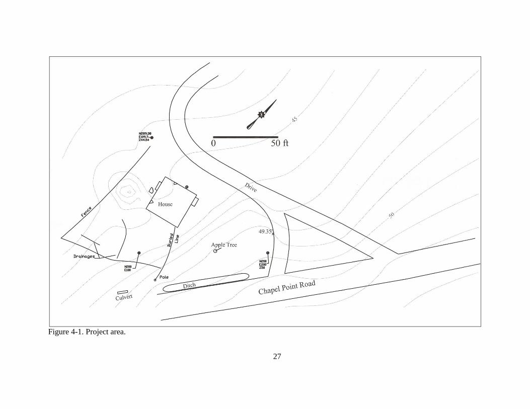
MAPPING
Most of the mapping occurred on the last day of fieldwork, but the results of that work
should be addressed before those of the other two field tasks. The topographic contours (Figure
4-1) were drawn relative to an arbitrarily designated elevation of 50 ft above mean sea level at
datum N200 E200 (changed to E1200 N1200 in subsequent fieldwork), located near the
intersection of the gravel drive and Chapel Point Road. The contours clearly identify at least one
source of the drainage problem: stormwater flows off of Chapel Point Road and the topography
channels that water directly toward the Burch House. The map merely documents what is
apparent to any passerby. The one unexpected result of the topographic mapping is an apparent
slight depression just west of the Burch House. Such depressions on historic sites generally point
to the presence of a foundation or cellar hole.
Surface flow of stormwater, flagged by a representative from the Soil Conservation
Service, were mapped and they are designated ―Drainages‖ on the drawing in the lower left hand
corner. These flows are probably related to the failed culvert running beneath Chapel Point Road.
Shovel Testing
YARDS
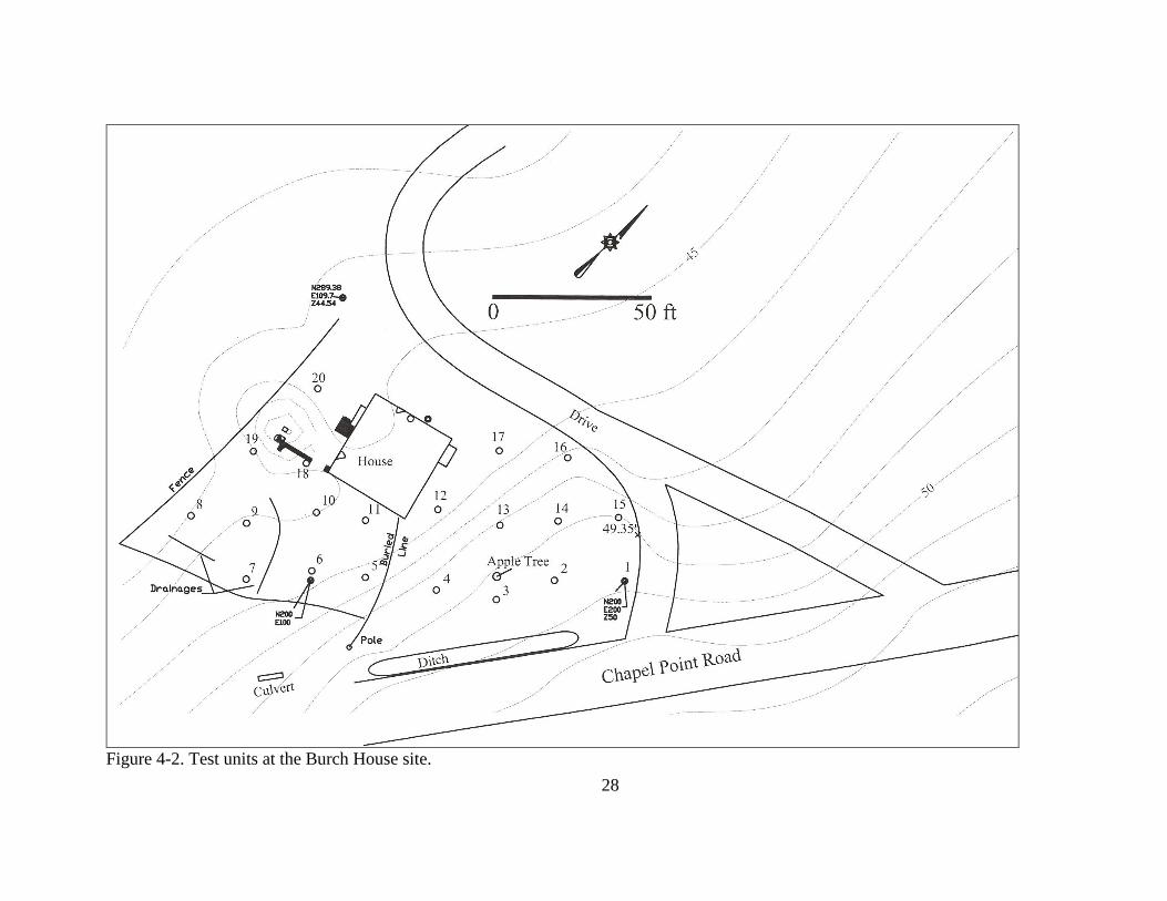
Gibb and Lawrence (2006) excavated 20 shovel tests in the east, south, and west yards
(Figure 4-2). The north yard appeared to be deflated and gravelly, and—so far as we could
ascertain—will be unaffected by proposed restoration and landscaping efforts. Shovel tests 16
and 17 bore out that assessment, both revealing a thin (0.5 ft) gravelly sandy loam (10YR2/1) A1
horizon on top of lensed sands and gravels extending at least 2.0 ft below grade. (The current
study proves that assessment incorrect; see following chapters.)
While we had anticipated deep deposits of recent fill near N200 E200—and, in fact,
found it there in the way of large quantities of mid- to late-20th
-century domestic refuse—we
were surprised by the extreme depth of cultural deposits throughout the east and south yards.
Dark loams with at least traces of cultural material (e.g., brick flecks), if not recoverable artifacts,
extended between 1.8 ft to more than 4 ft below grade, with depths typically ranging between 2.5
and 3 ft. Some of these deep deposits may be subsurface features, but mostly they appear to be
accumulations of alluvial material on buried A-horizons. There was no evidence of cultivation
nor, given the putative age of the dwelling, was there reason to expect it.
26
Units in the west yard proved much shallower, but that does not indicate shallow
deposits. Most of the west yard units were terminated before the excavators reached non-cultural
deposits because of intact brick features or rubble fills that suggested demolition debris within a
structural feature. We avoided unnecessary disturbance of cultural features. These units occur
within and adjacent to the topographic depression depicted in Figure 4-1. Tile probing indicated
an extensive hard surface throughout the yard, much of it immediately below the sod, a point
explored in a subsection below (Figure 4-3).
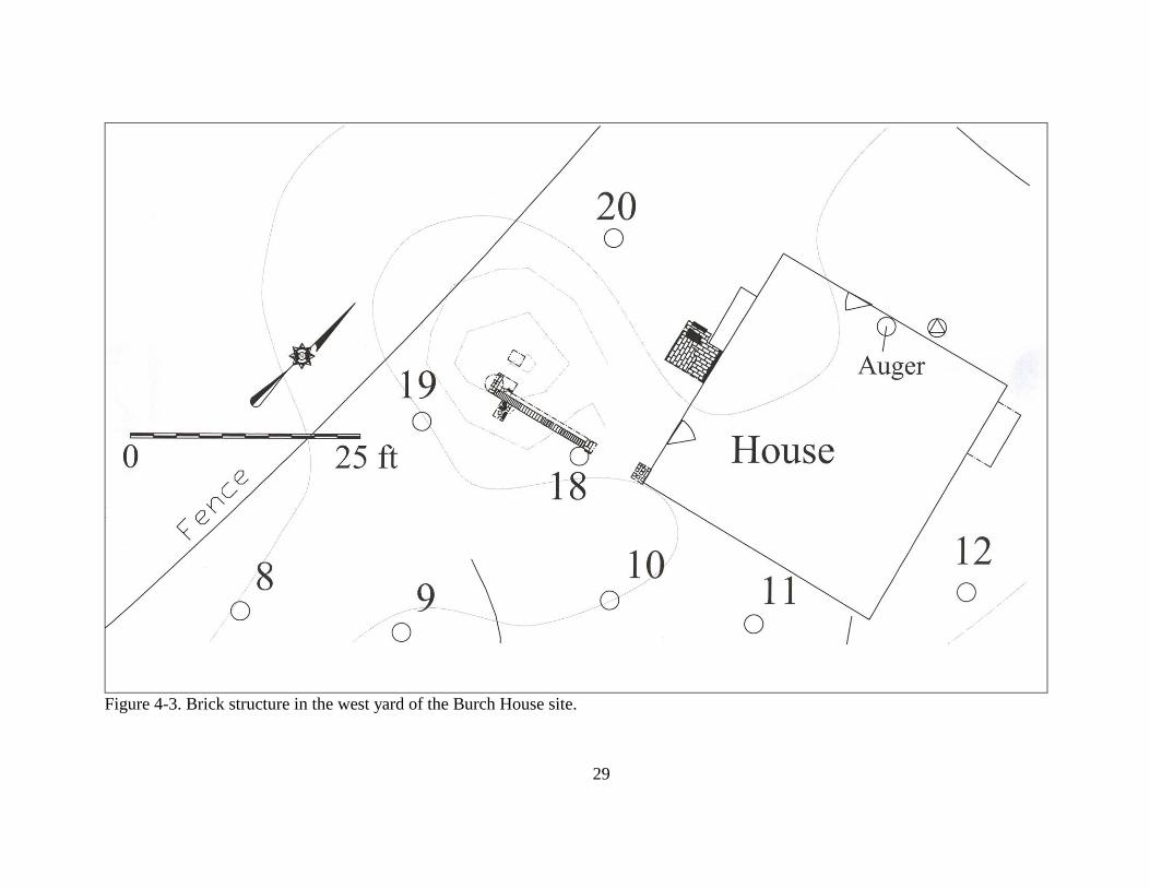
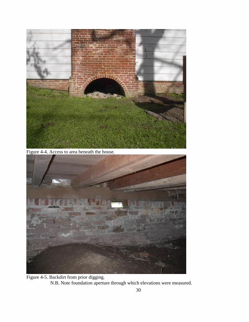
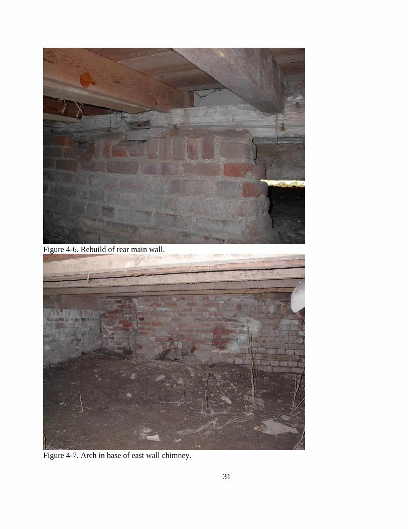
CELLAR
One of the questions we had hoped to answer was: does the Burch House have a full
cellar? A 5 ft by 5 ft unit planned for the west side of the building exterior revealed a brick
feature, probably a floor, just beneath the sod, precluding deeper excavation. The 2.5 ft to 3 ft
clearance below the joists precluded controlled excavation of a deep unit; however, someone had
dug a hole near the center of the front foundation wall. We deepened it slightly and then used a
split spoon auger to plumb the depths of the deposit (Figures 4-4 though 4-7).
We first established a temporary elevation datum at N251.02 E139.96, 45.59 ft, just
outside a small opening in the foundation, east of the front entrance. The split spoon auger
encountered dense clay at 5.25 ft below that datum or at an elevation of 40.34 ft. The mixed soils
above the clay had mortar inclusions, and the clay—which we think is probably a natural,
undisturbed deposit—is about 6 ft below the joists. We did not detect clear evidence of floor
deposit in the auger sample, but the evidence suggests that the house has a cellar and there may
be deposits on the cellar floor related to the occupation and modification of the building. Formal
excavations might be undertaken to determine whether the entrance to the cellar was by means of
the arched aperture in the base of the west chimney. If, through excavation, the arch proves to be
an entrance, then its excavation would make excavations beneath the building more manageable;
however, any such work should implement a plan for keeping rain and stormwater out of the
excavation.
27
Figure 4-1. Project area.
28
Figure 4-2. Test units at the Burch House site.
29
Figure 4-3. Brick structure in the west yard of the Burch House site.
30
Figure 4-4. Access to area beneath the house.
Figure 4-5. Backdirt from prior digging.
N.B. Note foundation aperture through which elevations were measured.
31
Figure 4-6. Rebuild of rear main wall.
Figure 4-7. Arch in base of east wall chimney.
32
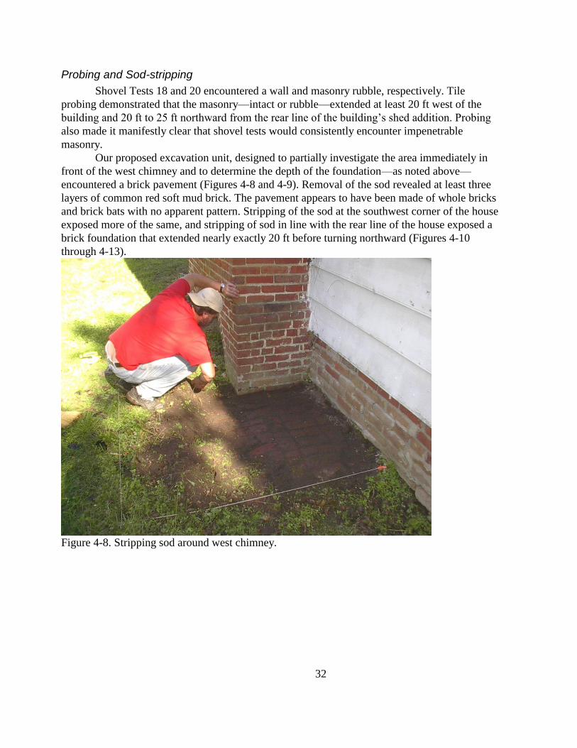
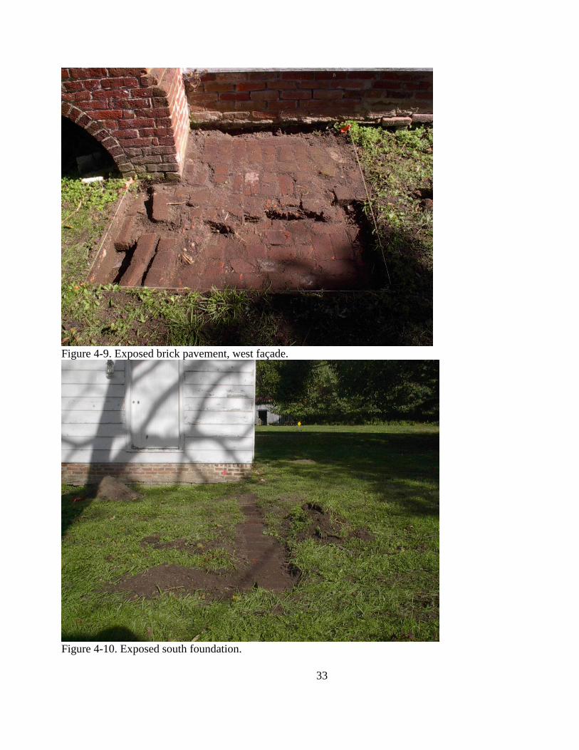
Probing and Sod-stripping
Shovel Tests 18 and 20 encountered a wall and masonry rubble, respectively. Tile
probing demonstrated that the masonry—intact or rubble—extended at least 20 ft west of the
building and 20 ft to 25 ft northward from the rear line of the building‘s shed addition. Probing
also made it manifestly clear that shovel tests would consistently encounter impenetrable
masonry.
Our proposed excavation unit, designed to partially investigate the area immediately in
front of the west chimney and to determine the depth of the foundation—as noted above—
encountered a brick pavement (Figures 4-8 and 4-9). Removal of the sod revealed at least three
layers of common red soft mud brick. The pavement appears to have been made of whole bricks
and brick bats with no apparent pattern. Stripping of the sod at the southwest corner of the house
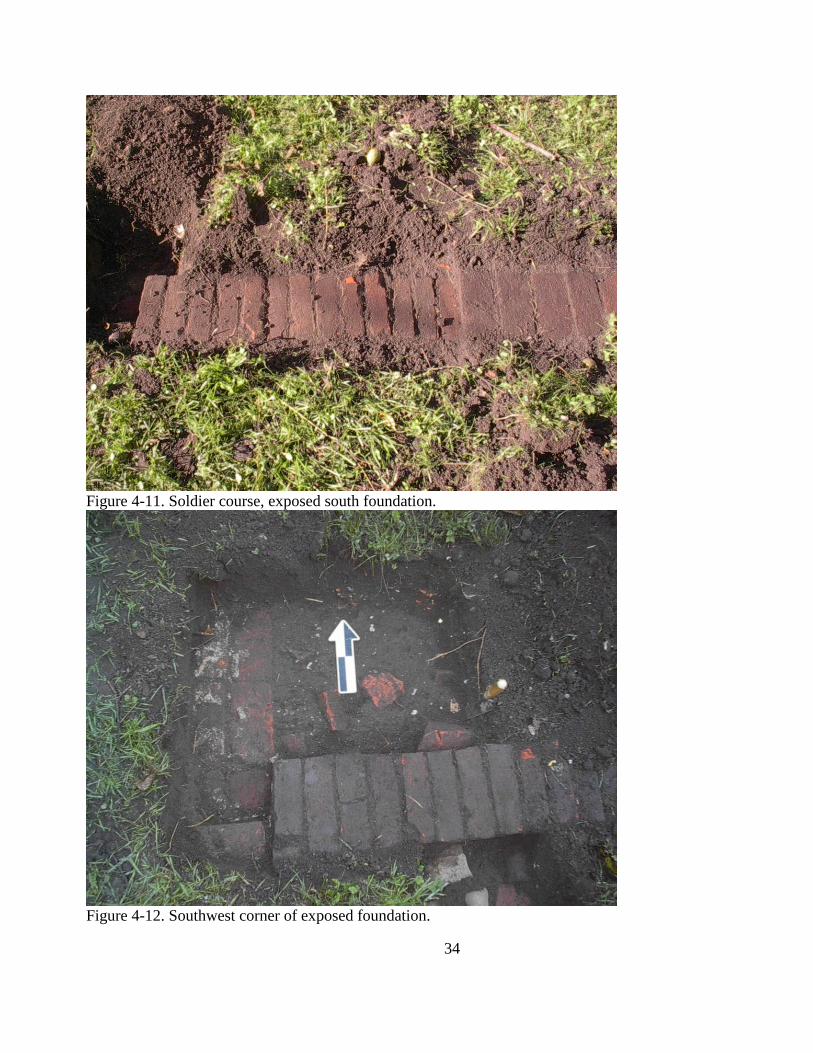
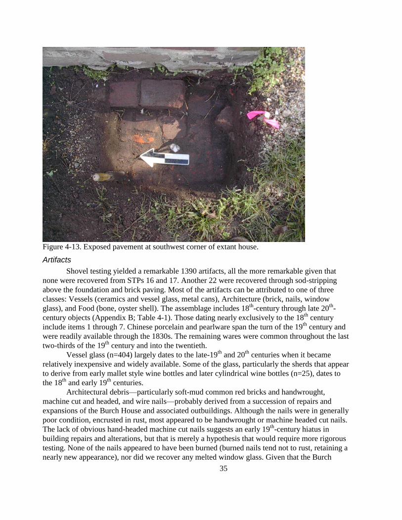
exposed more of the same, and stripping of sod in line with the rear line of the house exposed a
brick foundation that extended nearly exactly 20 ft before turning northward (Figures 4-10
through 4-13).
Figure 4-8. Stripping sod around west chimney.
33
Figure 4-9. Exposed brick pavement, west façade.
Figure 4-10. Exposed south foundation.
34
Figure 4-11. Soldier course, exposed south foundation.
Figure 4-12. Southwest corner of exposed foundation.
35
Figure 4-13. Exposed pavement at southwest corner of extant house.
Artifacts
Shovel testing yielded a remarkable 1390 artifacts, all the more remarkable given that
none were recovered from STPs 16 and 17. Another 22 were recovered through sod-stripping
above the foundation and brick paving. Most of the artifacts can be attributed to one of three
classes: Vessels (ceramics and vessel glass, metal cans), Architecture (brick, nails, window
glass), and Food (bone, oyster shell). The assemblage includes 18th
-century through late 20th
-
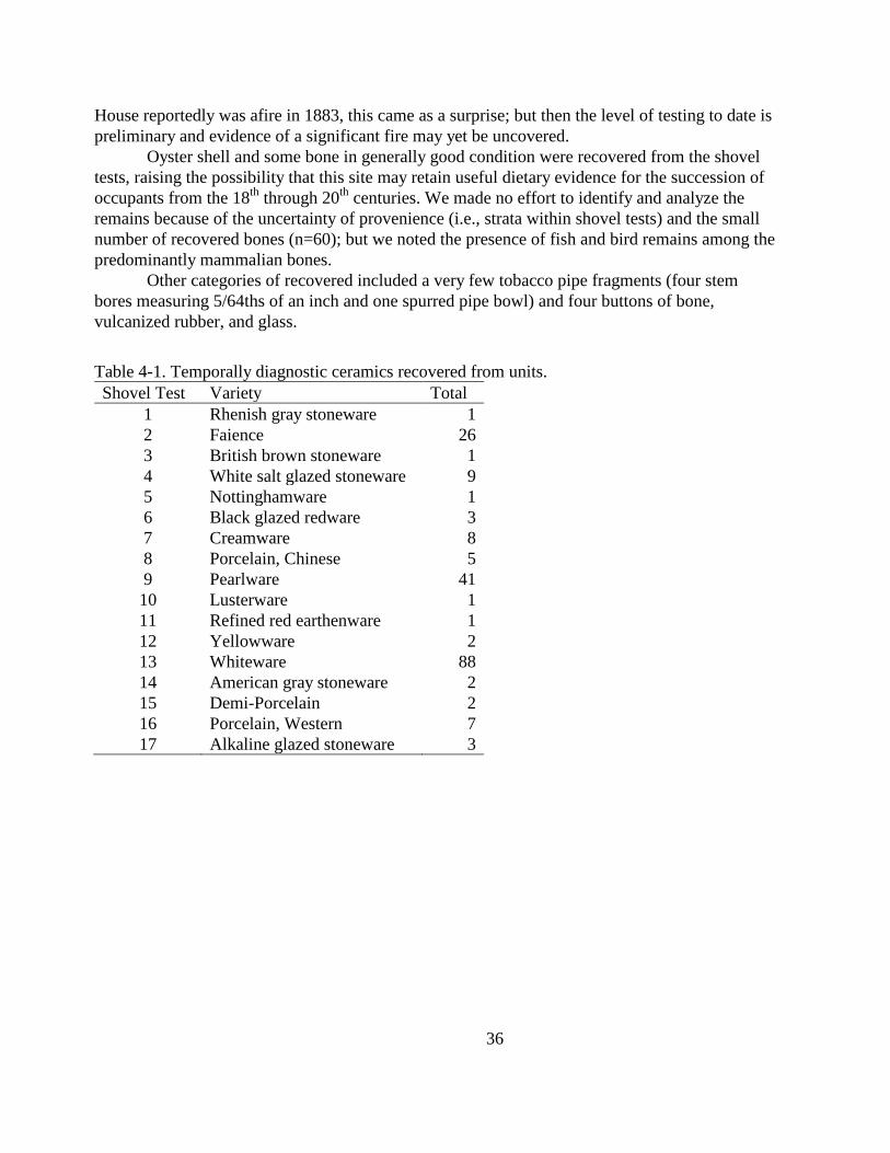
century objects (Appendix B; Table 4-1). Those dating nearly exclusively to the 18th
century
include items 1 through 7. Chinese porcelain and pearlware span the turn of the 19th
century and
were readily available through the 1830s. The remaining wares were common throughout the last
two-thirds of the 19th
century and into the twentieth.
Vessel glass (n=404) largely dates to the late-19th
and 20th
centuries when it became
relatively inexpensive and widely available. Some of the glass, particularly the sherds that appear
to derive from early mallet style wine bottles and later cylindrical wine bottles (n=25), dates to
the 18th
and early 19th
centuries.
Architectural debris—particularly soft-mud common red bricks and handwrought,
machine cut and headed, and wire nails—probably derived from a succession of repairs and
expansions of the Burch House and associated outbuildings. Although the nails were in generally
poor condition, encrusted in rust, most appeared to be handwrought or machine headed cut nails.
The lack of obvious hand-headed machine cut nails suggests an early 19th
-century hiatus in
building repairs and alterations, but that is merely a hypothesis that would require more rigorous
testing. None of the nails appeared to have been burned (burned nails tend not to rust, retaining a
nearly new appearance), nor did we recover any melted window glass. Given that the Burch
36
House reportedly was afire in 1883, this came as a surprise; but then the level of testing to date is
preliminary and evidence of a significant fire may yet be uncovered.
Oyster shell and some bone in generally good condition were recovered from the shovel
tests, raising the possibility that this site may retain useful dietary evidence for the succession of
occupants from the 18th
through 20th
centuries. We made no effort to identify and analyze the
remains because of the uncertainty of provenience (i.e., strata within shovel tests) and the small
number of recovered bones (n=60); but we noted the presence of fish and bird remains among the
predominantly mammalian bones.
Other categories of recovered included a very few tobacco pipe fragments (four stem
bores measuring 5/64ths of an inch and one spurred pipe bowl) and four buttons of bone,
vulcanized rubber, and glass.
Table 4-1. Temporally diagnostic ceramics recovered from units.
Shovel Test Variety Total
1 Rhenish gray stoneware 1
2 Faience 26
3 British brown stoneware 1
4 White salt glazed stoneware 9
5 Nottinghamware 1
6 Black glazed redware 3
7 Creamware 8
8 Porcelain, Chinese 5
9 Pearlware 41
10 Lusterware 1
11 Refined red earthenware 1
12 Yellowware 2
13 Whiteware 88
14 American gray stoneware 2
15 Demi-Porcelain 2
16 Porcelain, Western 7
17 Alkaline glazed stoneware 3
37
Chapter 5. Research Design and Methods
Introduction
Charles County proposes to add a bathroom addition, or ell, to the southeast corner of the
William Burch House (CH-23; aka Catslide House), and to install a well and sewage pump-out
tank to serve the addition. The building does not have, nor has it ever had, running water or a
plumbed sanitary facility; thereby greatly limiting is functionality. Archaeological testing around
the building and across the entirety of the lot on which it sits (October 2006, August 2007)
revealed deep deposits ranging in date from the 18th
through early 20th
centuries. The Maryland
Historical Trust holds an easement on the property and has requested archaeological data
recovery prior to ell construction, and well and tank installation.
Research Design
Systematic shovel testing, a single 3 ft by 3 ft excavation unit, and sod removal from
above a brick foundation and pavement clearly revealed deep, intact deposits and features. The
effects of sedimentation on the degradation of Port Tobacco Creek have been recognized since
the late 18th
century and have been the subject of several studies in the late 19th
and 20th
centuries
(e.g., Weld 1807; US Army Corps of Engineers 1884, 1892; Gottschalk 1945; Defries 1986), and
have been highlighted in every interpretation of the town‘s history (e.g., Shomette 2000). Surveys
of the town conducted by the Port Tobacco Archaeological Project (Gibb and Beisaw 2007,
2008), however, have drawn attention to the deposition of sediments within the town during its
occupation. On might visualize major sedimentation events, such as those that struck towns in
Haiti during storms in 2008, streams of sediment flowing through the streets and into buildings.
Far less dramatic periods of sedimentation may have followed less dramatic storms, with only
thin deposits of fine material forming on the surface.
Deposits around the Burch House are deep, stratified, and rich in datable cultural
material. Research questions, therefore, concern not just the succession of households that
occupied the site, but the nature and timing of sedimentation events that influenced the
development of the town and contributed to its eventual eclipse.
QUESTIONS AND SPECIFIC METHODS
1. Can we model sedimentation around the Burch House and date specific sedimentation
episodes?
a. Stratigraphic excavation and recovery of cultural material: description of strata and
their constituent artifacts is critical to definition of events and their timing.
b. Soil sampling and characterization: standard soil descriptions supplemented with
collection and analysis of sediments in terms of their constituent particles and
shapes. Samples are continuous columns of recovered soils and inclusions subjected
to screening through graduated meshes, weighing and charting different classes of
material, and comparison of sediments from across the site.
2. Local lore has it that Washington Burch provided temporary quarters for the town‘s
African American school after the school had burned. Overlap of domestic and
institutional activities occurred frequently in communities across the state, but has not
38
been studied explicitly by archaeologists; hence, there is no body of data, much less
middle range theory or other expectations for such overlap.
a. Is there evidence of the school use of Burch House; e.g., are there exceptional
numbers of slate pencils or writing slates in deposits associated with the Burch
occupation?
b. Is there any patterning in the spatial distribution of possible school-related artifacts?
3. Can specific deposits be associated with specific households, particularly those of the
Wares, Charles W. Barnes, and the Burch family?
General Methodology
All field and laboratory work will be undertaken in a manner consistent with the MSHA‘s
(1992) Consultant Specifications for Archeological Services and the Maryland Historical Trust‘s
(1994) Standards and Guidelines for Archeological Investigations in Maryland. The Society for
the Restoration of Port Tobacco, Inc., curates the assemblages of materials recovered from sites
in and around the incorporated village. It will curate the artifacts, notes, maps and other materials
compiled during the proposed data recovery.
A series of up to 10 excavation units, measuring 25 ft2
(5 ft by 5 ft) extending to depths of
up to 3 ft at those specific locations that will be directly disturbed by construction. Proposed unit
placements appear in Figure 1. I anticipate five units within the footprint of the proposed 10 ft by
12 ft ell, one unit at the proposed 6 ft by 8 ft well location, one unit at the approximate
intersection of the well and septic lines, and two units at the proposed pump-out tank location. A
tenth unit will remain in reserve. The work will be undertaken by the Port Tobacco
Archaeological Project team, which includes the staff of Gibb Archaeological Consulting and
volunteers.
All units will be: accurately and precisely mapped and located on the overall digital
drawings for Port Tobacco; excavated stratigraphically, the layers recorded and described in
terms of soil colors, textures, and inclusions; and the soils screened through ¼-inch hardware
mesh and collected by provenience. Artifacts will be cleaned and catalogued into the Port
Tobacco artifact catalogue, distinguished from the rest of the collection by unit and strata
numbers and by unit designations expressed as easting and northing coordinates on the town‘s
site wide grid.
Analyses will focus on clear stratigraphic separation of deposits and linking those
deposits with known occupying households, and on relating patterns within those deposits to the
households and layout of the houselot, and to sedimentation events. Mean ceramic dating, in
general, has not been employed because of the wide temporal ranges of materials represented.
Presence-absence observations, although not as readily quantified, are more appropriate in most
instances at the Burch House.
39
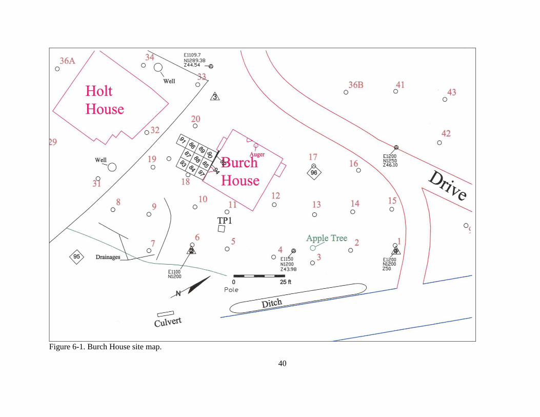
Chapter 6. Results of 2010 Investigation
Introduction
Results of the 2010 data recovery appear in this chapter. This work consisted solely of
stratigraphic excavation of whole or partial 5 ft by 5 ft units. The field team intensively
investigated the proposed footprint of the ell (Units 84-94) and excavated single units in the
vicinity of the proposed well (Unit 95) and of the proposed pump-out tank (Unit 96) locations
(Figure 6-1). The three areas are treated separately.
Unit 95
Unit 95 is located in the narrow wooded buffer between the Burch House and Chapel
Point Road. The surface was irregular as a consequence of recent tree falls. A late 20th
-century
flower pot, broken and spalled, covered much of the surface. It was removed and discarded. The
field crew excavated to a depth of 2.4 ft below current grade, exposing six strata (Figure 6-2).
Soils generally ranged in texture from sandy silt to very fine sandy silt, with varying amounts of
gravel (densest in Strata 1 and 2), and colors ranged from dark grayish brown to yellowish brown
(10YR4/2 to 10YR5/4). Stratum 4 was removed in two levels, the upper (Stratum 4.1) being
more compact than the lower (Stratum 4.2), but otherwise identical in color, texture, and
inclusions. Stratum 6, a dark grayish brown very fine sand, appears to be non-cultural. Deposits
slope slightly down to the south and likely are colluvial, derived from erosion of the uplands
immediately to the east.
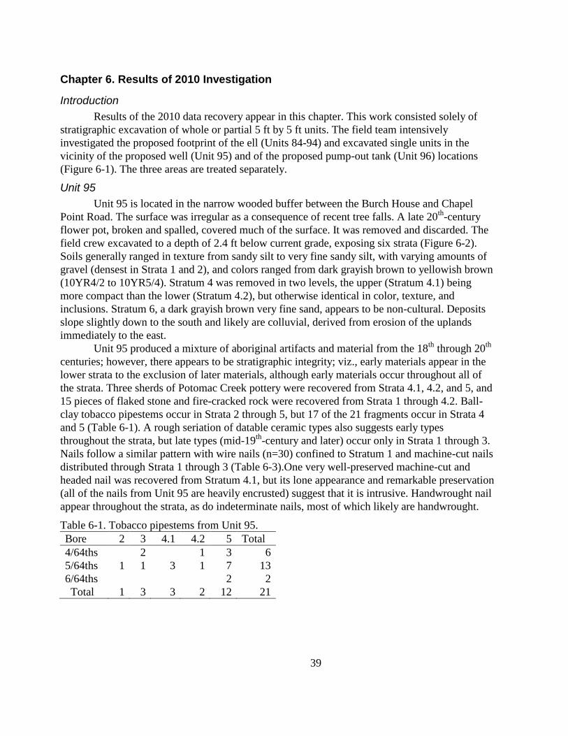
Unit 95 produced a mixture of aboriginal artifacts and material from the 18th
through 20th
centuries; however, there appears to be stratigraphic integrity; viz., early materials appear in the
lower strata to the exclusion of later materials, although early materials occur throughout all of
the strata. Three sherds of Potomac Creek pottery were recovered from Strata 4.1, 4.2, and 5, and
15 pieces of flaked stone and fire-cracked rock were recovered from Strata 1 through 4.2. Ball-
clay tobacco pipestems occur in Strata 2 through 5, but 17 of the 21 fragments occur in Strata 4
and 5 (Table 6-1). A rough seriation of datable ceramic types also suggests early types
throughout the strata, but late types (mid-19th
-century and later) occur only in Strata 1 through 3.
Nails follow a similar pattern with wire nails (n=30) confined to Stratum 1 and machine-cut nails
distributed through Strata 1 through 3 (Table 6-3).One very well-preserved machine-cut and
headed nail was recovered from Stratum 4.1, but its lone appearance and remarkable preservation
(all of the nails from Unit 95 are heavily encrusted) suggest that it is intrusive. Handwrought nail
appear throughout the strata, as do indeterminate nails, most of which likely are handwrought.
Table 6-1. Tobacco pipestems from Unit 95.
Bore 2 3 4.1 4.2 5 Total
4/64ths 2 1 3 6
5/64ths 1 1 3 1 7 13
6/64ths
2 2
Total 1 3 3 2 12 21
40
Figure 6-1. Burch House site map.
41
Figure 6-2. Profiles of Unit 95.
Table 6-2. Datable vessel forms seriated, Unit 95.
Variety 1 2 3 4.1 4.2 5 Total
Bottle, Blown in Mold 1
1
Bottle, Case, Machined 1 1 2
4
Bottle, Machine-Molded 19 4
23
Porcelain, Western 6 9 7
22
Ironstone 5 5 2
12
Stoneware, Alkaline Glazed 1 2 1
4
Earthenware, Whiteware 15 7 1
23
Earthenware, Unglazed Red 1 1 2
4
Yellowware 1 2 1
4
Earthenware, Cream-Colored 2
2
Earthenware, Pearlware 30 46 26 10
1 113
Earthenware, Creamware 9 6 11 13 2 3 44
Earthenware, Refined Red 1
2 3
Earthenware, Mid-Atlantic Slipware
4 4
Earthenware, Lead-Glazed Buff 2 1 1 1
5
Earthenware, Black Glazed Redware 1
2
3
Porcelain, Chinese
1 2 8
3 14
Earthenware, Jackfield
1 1
2
Earthenware, Lead-Glazed Red
1
3
3 7
Earthenware, Tin-Glazed 2 1 4 24 5 9 45
Earthenware, Buckley
1 2
7 10
Earthenware, Staffordshire Slipware
5 5
Stoneware, British Brown
2
2
4
Stoneware, Rhenish Brown 2
1
3
Stoneware, Rhenish Gray 1 1
2
Stoneware, White Salt-Glazed 2
2 1 3 7 15
Aboriginal Pottery
1 1 1 3
Totals 347 206 137 98 22 88 898
42
Table 6-3. Architectural artifacts, Unit 95
Variety 1 2 3 4.1 4.2 5 6 Total
Brick, Common Red
1
1
Metal, Indeterminate
14
1
15
Misc. Modern 4
4
Nail, Wire 30
30
Nail, Machine-Cut 32 7 4 1
44
Nail, Handwrought 2 3
7 2 12
26
Nail, Indeterminate 32 47 57 10 7 10 3 166
Slate, Roofing 4 1 1
6
Totals 104 58 76 18 9 24 3 292
The artifact data correspond to expectations for stratigraphic development except for the
distribution of early artifacts (18th
-century ceramics, handwrought nails) throughout the soil
column. Why do handwrought nails and white salt-glazed stoneware sherds appear in Strata 1
through 3? And why do roofing slate fragments occur only in the top three strata? The answer
may be found in the development of the soil column. Strata 5 and 6 represent Ab and B1 horizons,
respectively. The material above formed through redeposition of eroded upland soils. Stratum 5
represents an 18th
-century surface; the latest ceramic type recovered is a single sherd of pearlware
(manufactured 1780s through 1830s). The assemblage includes 88 datable ceramic sherds
representing 11 types. Stratum 4 yielded a similar range of ceramic types (12), but a larger
number of specimens, including 10 sherds of pearlware. And, again; only one machine-cut nail
was recovered from Strata 4 and 5…the exceptionally well-preserved nail from Stratum 4.1. So,
Strata 4.1 and 4.2 likely represent late 18th
-century surfaces that developed amid a sedimentation
period or event.
Stratum 3 produced not only early artifact types but those dating to the mid- to late-19th
-
century (e.g., ironstone, alkaline-glazed stoneware, machine-molded vessel glass). Sixteen
datable ceramic types are represented by 137 specimens. Stratum 2 produced 206 datable ceramic
sherds, also representing 16 types. Excavators recovered machine-cut nails from both strata.
Finds from Stratum 1 clearly indicate a post-1880 (wire nails) formation date. Both Strata 1 and 2
are gravelly. Interestingly, pearlwares were most common in Strata 1 and 2 (30 and 46,
respectively).
These data suggest that stormwater redeposited not only upland soils, but midden
materials from across what is now Chapel Point Road. Strata 1 through 3 may contain an
amalgam of refuse and architectural debris generated on site and across the road. It is possible
that the material in Stratum 4 was similarly transported, but Stratum 5 appears to be an intact soil
horizon.
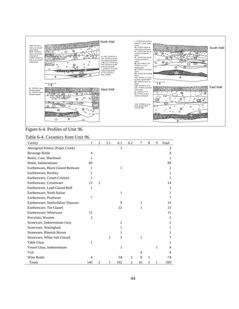
Unit 96
Unit 96 is in the vicinity of the proposed pump-out tank for the proposed septic system
(see Figure 6-1). The precise location of that facility will be determined at the time of
construction. As the unit is meant only to test the locale, and the excavation will be larger than
the 5 ft by 5 ft excavation unit, we did not attempt to recover all of those data…those
deposits…that will be destroyed by tank installation.
The placement of Unit 96 is unusual in that it is at the toe of an outwash fan…a heap of
gravel and other sediments deposited on the floodplain at the mouth of a ravine that extends up
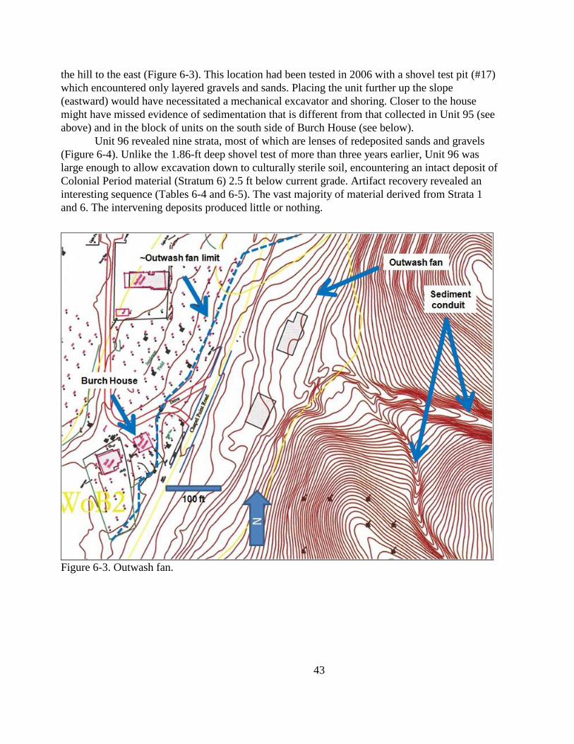
43
the hill to the east (Figure 6-3). This location had been tested in 2006 with a shovel test pit (#17)
which encountered only layered gravels and sands. Placing the unit further up the slope
(eastward) would have necessitated a mechanical excavator and shoring. Closer to the house
might have missed evidence of sedimentation that is different from that collected in Unit 95 (see
above) and in the block of units on the south side of Burch House (see below).
Unit 96 revealed nine strata, most of which are lenses of redeposited sands and gravels
(Figure 6-4). Unlike the 1.86-ft deep shovel test of more than three years earlier, Unit 96 was
large enough to allow excavation down to culturally sterile soil, encountering an intact deposit of
Colonial Period material (Stratum 6) 2.5 ft below current grade. Artifact recovery revealed an
interesting sequence (Tables 6-4 and 6-5). The vast majority of material derived from Strata 1
and 6. The intervening deposits produced little or nothing.
Figure 6-3. Outwash fan.
44
Figure 6-4. Profiles of Unit 96.
Table 6-4. Ceramics from Unit 96.
Variety 1 2 3.1 6.1 6.2 7 8 9 Total
Aboriginal Pottery (Popes Creek) 3 3
Beverage Bottle 4
4
Bottle, Case, Machined 1
1
Bottle, Indeterminate 89
89
Earthenware, Black Glazed Redware 1
1
2
Earthenware, Buckley 1
1
Earthenware, Cream-Colored 1
1
Earthenware, Creamware 12 2
14
Earthenware, Lead-Glazed Buff 1
1
Earthenware, North Italian
1
1
Earthenware, Pearlware 7
7
Earthenware, Staffordshire Slipware
9
1
10
Earthenware, Tin-Glazed
22
1
23
Earthenware, Whiteware 15
15
Porcelain, Western 3
3
Stoneware, Indeterminate Gray
2
2
Stoneware, Nottingham
1
1
Stoneware, Rhenish Brown
1
1
Stoneware, White Salt-Glazed
1 5
1
7
Table Glass 1
1
Vessel Glass, Indeterminate
3
1 4
Vial
4
4
Wine Bottle 4
54 2 9 5
74
Totals 140 2 1 102 2 16 5 1 269
45
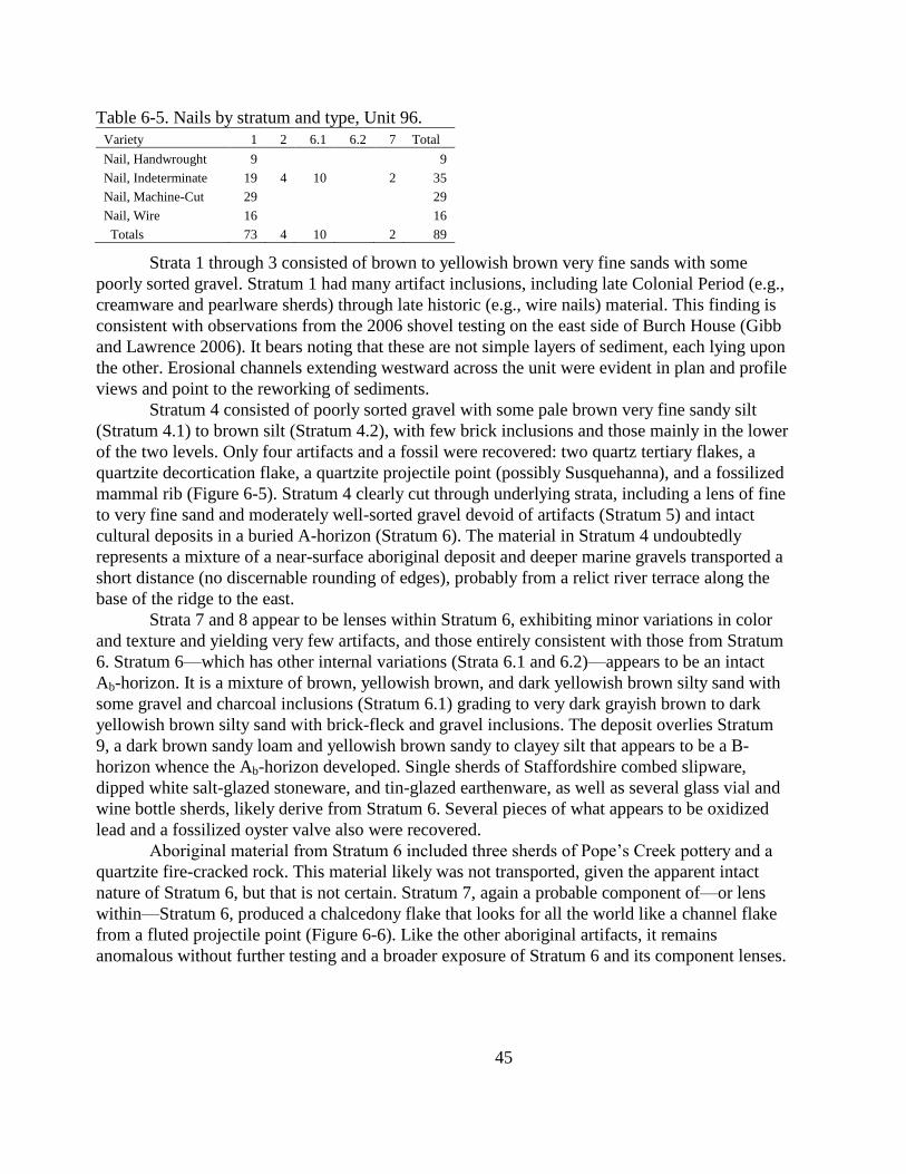
Table 6-5. Nails by stratum and type, Unit 96.
Variety 1 2 6.1 6.2 7 Total
Nail, Handwrought 9
9
Nail, Indeterminate 19 4 10
2 35
Nail, Machine-Cut 29
29
Nail, Wire 16
16
Totals 73 4 10 2 89
Strata 1 through 3 consisted of brown to yellowish brown very fine sands with some
poorly sorted gravel. Stratum 1 had many artifact inclusions, including late Colonial Period (e.g.,
creamware and pearlware sherds) through late historic (e.g., wire nails) material. This finding is
consistent with observations from the 2006 shovel testing on the east side of Burch House (Gibb
and Lawrence 2006). It bears noting that these are not simple layers of sediment, each lying upon
the other. Erosional channels extending westward across the unit were evident in plan and profile
views and point to the reworking of sediments.
Stratum 4 consisted of poorly sorted gravel with some pale brown very fine sandy silt
(Stratum 4.1) to brown silt (Stratum 4.2), with few brick inclusions and those mainly in the lower
of the two levels. Only four artifacts and a fossil were recovered: two quartz tertiary flakes, a
quartzite decortication flake, a quartzite projectile point (possibly Susquehanna), and a fossilized
mammal rib (Figure 6-5). Stratum 4 clearly cut through underlying strata, including a lens of fine
to very fine sand and moderately well-sorted gravel devoid of artifacts (Stratum 5) and intact
cultural deposits in a buried A-horizon (Stratum 6). The material in Stratum 4 undoubtedly
represents a mixture of a near-surface aboriginal deposit and deeper marine gravels transported a
short distance (no discernable rounding of edges), probably from a relict river terrace along the
base of the ridge to the east.
Strata 7 and 8 appear to be lenses within Stratum 6, exhibiting minor variations in color
and texture and yielding very few artifacts, and those entirely consistent with those from Stratum
6. Stratum 6—which has other internal variations (Strata 6.1 and 6.2)—appears to be an intact
Ab-horizon. It is a mixture of brown, yellowish brown, and dark yellowish brown silty sand with
some gravel and charcoal inclusions (Stratum 6.1) grading to very dark grayish brown to dark
yellowish brown silty sand with brick-fleck and gravel inclusions. The deposit overlies Stratum
9, a dark brown sandy loam and yellowish brown sandy to clayey silt that appears to be a B-
horizon whence the Ab-horizon developed. Single sherds of Staffordshire combed slipware,
dipped white salt-glazed stoneware, and tin-glazed earthenware, as well as several glass vial and
wine bottle sherds, likely derive from Stratum 6. Several pieces of what appears to be oxidized
lead and a fossilized oyster valve also were recovered.
Aboriginal material from Stratum 6 included three sherds of Pope‘s Creek pottery and a
quartzite fire-cracked rock. This material likely was not transported, given the apparent intact
nature of Stratum 6, but that is not certain. Stratum 7, again a probable component of—or lens
within—Stratum 6, produced a chalcedony flake that looks for all the world like a channel flake
from a fluted projectile point (Figure 6-6). Like the other aboriginal artifacts, it remains
anomalous without further testing and a broader exposure of Stratum 6 and its component lenses.
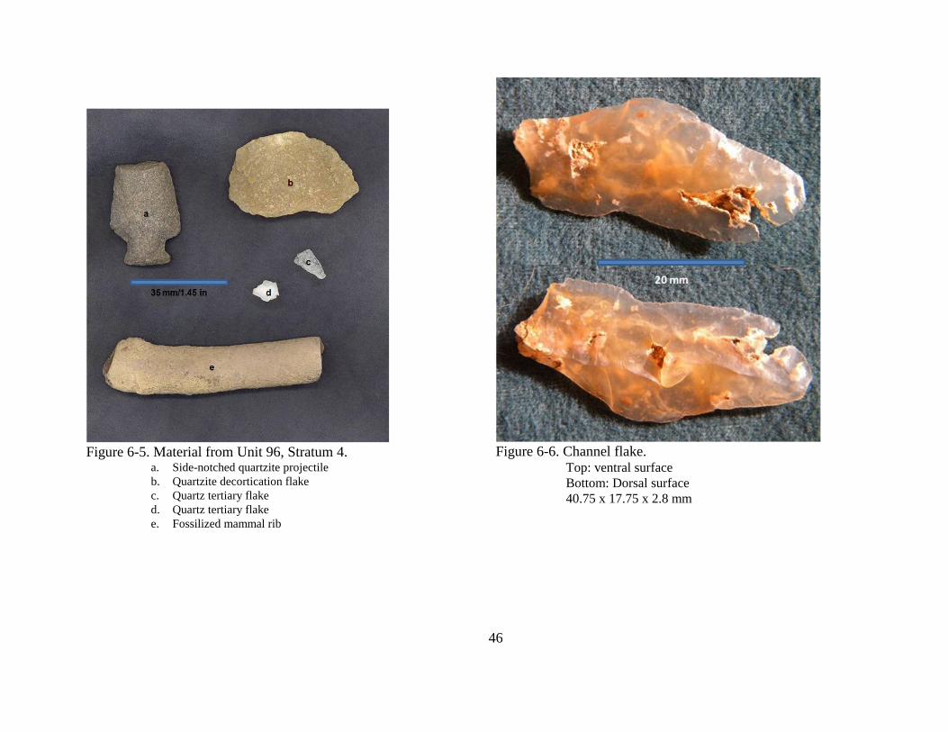
46
Figure 6-5. Material from Unit 96, Stratum 4.
a. Side-notched quartzite projectile
b. Quartzite decortication flake
c. Quartz tertiary flake
d. Quartz tertiary flake
e. Fossilized mammal rib
Figure 6-6. Channel flake.
Top: ventral surface
Bottom: Dorsal surface
40.75 x 17.75 x 2.8 mm
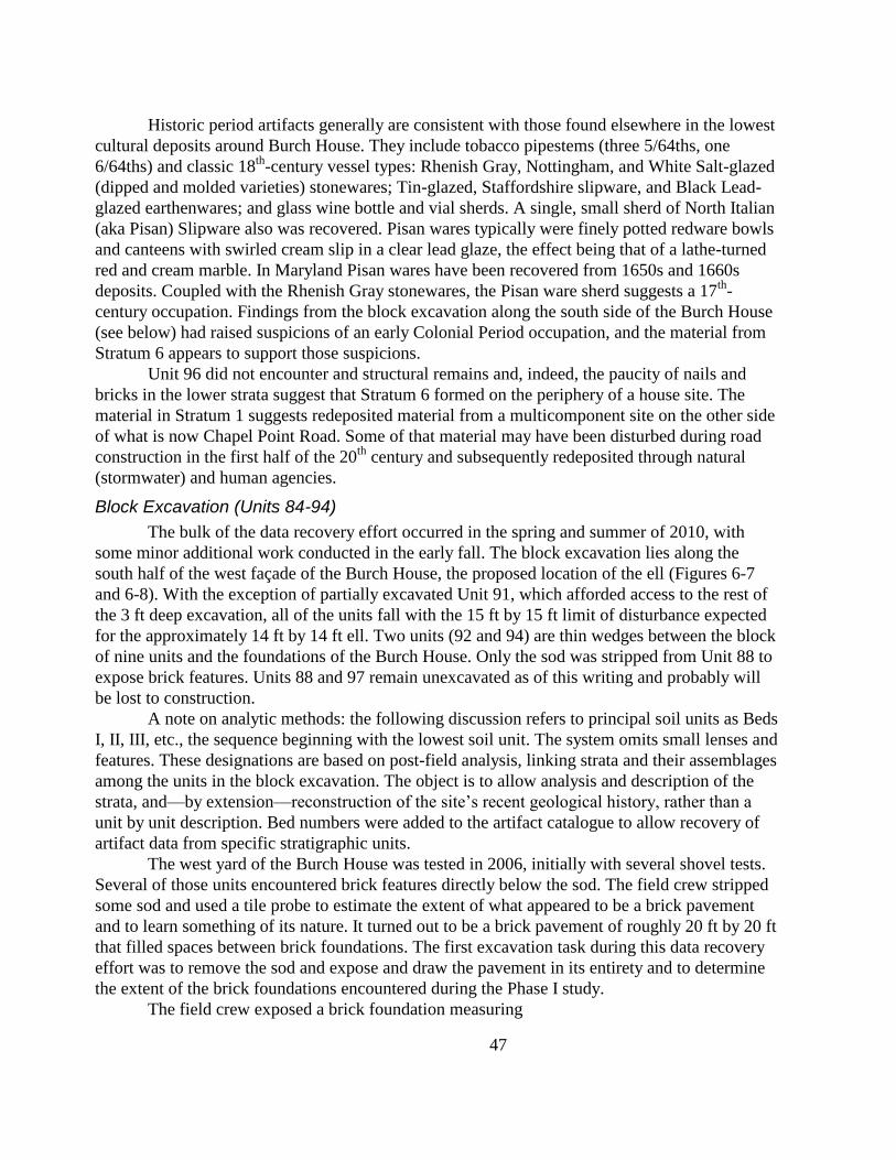
47
Historic period artifacts generally are consistent with those found elsewhere in the lowest
cultural deposits around Burch House. They include tobacco pipestems (three 5/64ths, one
6/64ths) and classic 18th
-century vessel types: Rhenish Gray, Nottingham, and White Salt-glazed
(dipped and molded varieties) stonewares; Tin-glazed, Staffordshire slipware, and Black Lead-
glazed earthenwares; and glass wine bottle and vial sherds. A single, small sherd of North Italian
(aka Pisan) Slipware also was recovered. Pisan wares typically were finely potted redware bowls
and canteens with swirled cream slip in a clear lead glaze, the effect being that of a lathe-turned
red and cream marble. In Maryland Pisan wares have been recovered from 1650s and 1660s
deposits. Coupled with the Rhenish Gray stonewares, the Pisan ware sherd suggests a 17th
-
century occupation. Findings from the block excavation along the south side of the Burch House
(see below) had raised suspicions of an early Colonial Period occupation, and the material from
Stratum 6 appears to support those suspicions.
Unit 96 did not encounter and structural remains and, indeed, the paucity of nails and
bricks in the lower strata suggest that Stratum 6 formed on the periphery of a house site. The
material in Stratum 1 suggests redeposited material from a multicomponent site on the other side
of what is now Chapel Point Road. Some of that material may have been disturbed during road
construction in the first half of the 20th
century and subsequently redeposited through natural
(stormwater) and human agencies.
Block Excavation (Units 84-94)
The bulk of the data recovery effort occurred in the spring and summer of 2010, with
some minor additional work conducted in the early fall. The block excavation lies along the
south half of the west façade of the Burch House, the proposed location of the ell (Figures 6-7
and 6-8). With the exception of partially excavated Unit 91, which afforded access to the rest of
the 3 ft deep excavation, all of the units fall with the 15 ft by 15 ft limit of disturbance expected
for the approximately 14 ft by 14 ft ell. Two units (92 and 94) are thin wedges between the block
of nine units and the foundations of the Burch House. Only the sod was stripped from Unit 88 to
expose brick features. Units 88 and 97 remain unexcavated as of this writing and probably will
be lost to construction.
A note on analytic methods: the following discussion refers to principal soil units as Beds
I, II, III, etc., the sequence beginning with the lowest soil unit. The system omits small lenses and
features. These designations are based on post-field analysis, linking strata and their assemblages
among the units in the block excavation. The object is to allow analysis and description of the
strata, and—by extension—reconstruction of the site‘s recent geological history, rather than a
unit by unit description. Bed numbers were added to the artifact catalogue to allow recovery of
artifact data from specific stratigraphic units.
The west yard of the Burch House was tested in 2006, initially with several shovel tests.
Several of those units encountered brick features directly below the sod. The field crew stripped
some sod and used a tile probe to estimate the extent of what appeared to be a brick pavement
and to learn something of its nature. It turned out to be a brick pavement of roughly 20 ft by 20 ft
that filled spaces between brick foundations. The first excavation task during this data recovery
effort was to remove the sod and expose and draw the pavement in its entirety and to determine
the extent of the brick foundations encountered during the Phase I study.
The field crew exposed a brick foundation measuring
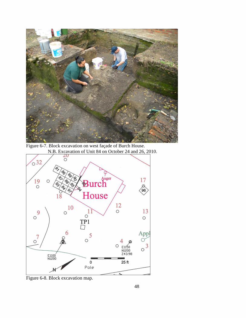
48
Figure 6-7. Block excavation on west façade of Burch House.
N.B. Excavation of Unit 84 on October 24 and 26, 2010.
Figure 6-8. Block excavation map.
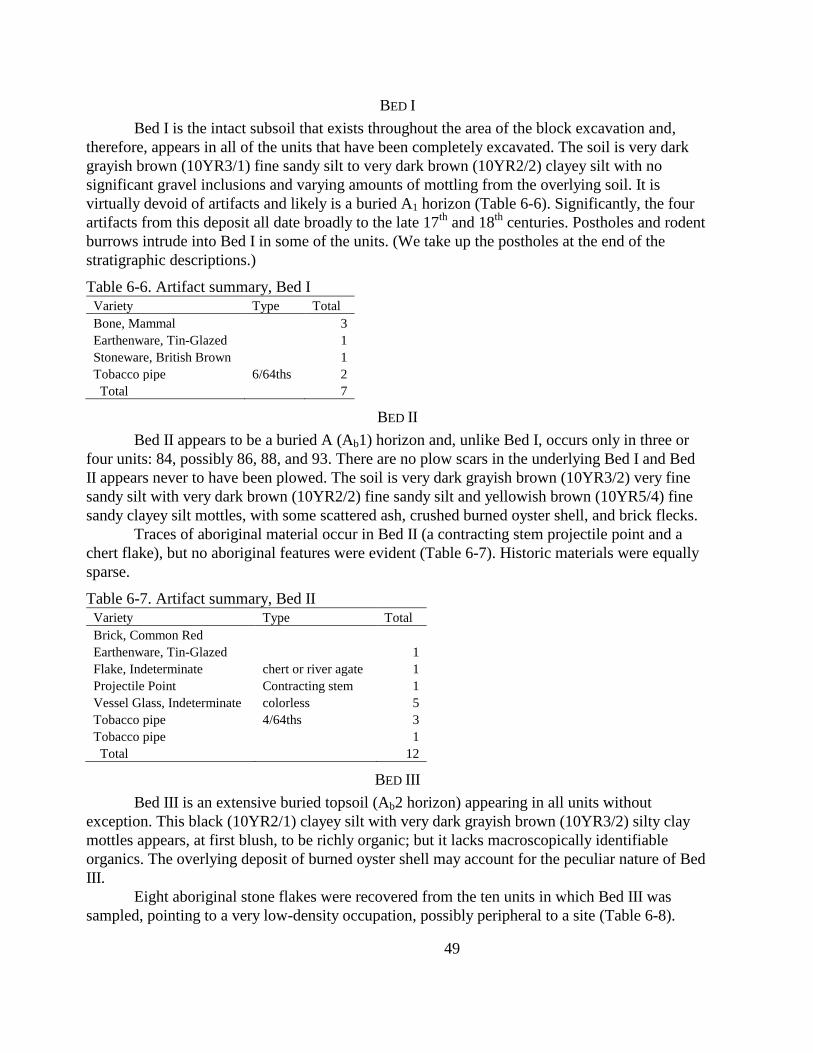
49
BED I
Bed I is the intact subsoil that exists throughout the area of the block excavation and,
therefore, appears in all of the units that have been completely excavated. The soil is very dark
grayish brown (10YR3/1) fine sandy silt to very dark brown (10YR2/2) clayey silt with no
significant gravel inclusions and varying amounts of mottling from the overlying soil. It is
virtually devoid of artifacts and likely is a buried A1 horizon (Table 6-6). Significantly, the four
artifacts from this deposit all date broadly to the late 17th
and 18th
centuries. Postholes and rodent
burrows intrude into Bed I in some of the units. (We take up the postholes at the end of the
stratigraphic descriptions.)
Table 6-6. Artifact summary, Bed I
Variety Type Total
Bone, Mammal
3
Earthenware, Tin-Glazed
1
Stoneware, British Brown
1
Tobacco pipe 6/64ths 2
Total
7
BED II
Bed II appears to be a buried A (Ab1) horizon and, unlike Bed I, occurs only in three or
four units: 84, possibly 86, 88, and 93. There are no plow scars in the underlying Bed I and Bed
II appears never to have been plowed. The soil is very dark grayish brown (10YR3/2) very fine
sandy silt with very dark brown (10YR2/2) fine sandy silt and yellowish brown (10YR5/4) fine
sandy clayey silt mottles, with some scattered ash, crushed burned oyster shell, and brick flecks.
Traces of aboriginal material occur in Bed II (a contracting stem projectile point and a
chert flake), but no aboriginal features were evident (Table 6-7). Historic materials were equally
sparse.
Table 6-7. Artifact summary, Bed II
Variety Type Total
Brick, Common Red
Earthenware, Tin-Glazed
1
Flake, Indeterminate chert or river agate 1
Projectile Point Contracting stem 1
Vessel Glass, Indeterminate colorless 5
Tobacco pipe 4/64ths 3
Tobacco pipe
1
Total
12
BED III
Bed III is an extensive buried topsoil (Ab2 horizon) appearing in all units without
exception. This black (10YR2/1) clayey silt with very dark grayish brown (10YR3/2) silty clay
mottles appears, at first blush, to be richly organic; but it lacks macroscopically identifiable
organics. The overlying deposit of burned oyster shell may account for the peculiar nature of Bed
III.
Eight aboriginal stone flakes were recovered from the ten units in which Bed III was
sampled, pointing to a very low-density occupation, possibly peripheral to a site (Table 6-8).

50
Historic materials were far more common, but still sparse (n=110 from ten units). The field crew
recovered this material from the upper portion of the bed, presumably from the initial Western
occupation in the late 17th
or 18th
centuries. The few dateable pieces (creamware, white salt-
glazed stoneware, and Buckley earthenware) suggest late 18th
century, a date later than Burch
House‘s putative construction date. A mean ceramic date calculated on 19 specimens yields a
mean date of 1749.
Table 6-8. Summary data, Bed III
Variety Type Total
Aboriginal Pottery Potomac Creek? 1
Bone, Bird
3
Bone, Mammal
46
Brick, Common Red
1
Button, Shell
2
Charcoal
6
Comb
1
Earthenware, Buckley
2
Earthenware, Creamware
2
Earthenware, Tin-Glazed painted 2
Earthenware, Tin-Glazed
10
Flake, Decortication quartz 7
Flake, Primary quartz 1
Flat Glass aqua 1
Metal, Indeterminate
1
Nail, Handwrought
1
Nail, Indeterminate
6
Stoneware, White Salt-Glazed molded 2
Stoneware, White Salt-Glazed
1
Table Glass colorless 2
Valve, Oyster
2
Vessel Glass, Indeterminate colorless 2
Wine Bottle olive green 3
Tobacco pipe 4/64ths 1
Tobacco pipe 5/64ths 7
Tobacco pipe
5
Total
118
BED IV
Bed IV is the most distinctive and most enigmatic soil horizon around the Burch House.
It is a thin deposit of crushed, burned oyster shell and very dark grayish brown (10YR3/2) silty
clay that undulates across the excavation, but appears in all units. Aboriginal material is sparse
(six pottery sherds, a few flakes, and a single piece of fire-cracked rock) and appears to be of
Late Woodland vintage (Table 6-9). Again, there is no evidence of dense aboriginal occupation,
but the area could be peripheral to a larger, denser deposit.
All of the identifiable nails are handwrought and the ceramics are decidedly 18th
-century,
although two Rhenish gray stoneware sherds and a North Devon earthenware suggest a late 17th
or very early 18th
-century occupation and three Pearlware sherds offer a bit of symmetry at the
other end of the temporal spectrum, pointing to a very late 18th
or early 19th
-century date for this
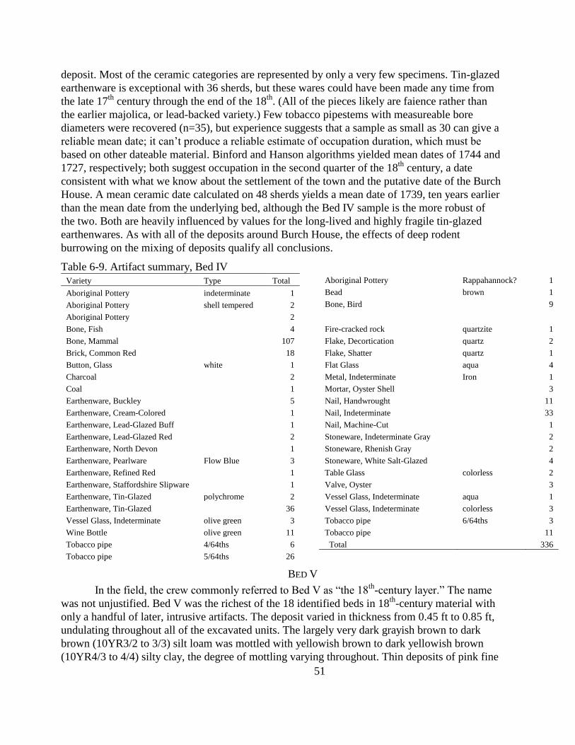
51
deposit. Most of the ceramic categories are represented by only a very few specimens. Tin-glazed
earthenware is exceptional with 36 sherds, but these wares could have been made any time from
the late 17th
century through the end of the 18th
. (All of the pieces likely are faience rather than
the earlier majolica, or lead-backed variety.) Few tobacco pipestems with measureable bore
diameters were recovered (n=35), but experience suggests that a sample as small as 30 can give a
reliable mean date; it can‘t produce a reliable estimate of occupation duration, which must be
based on other dateable material. Binford and Hanson algorithms yielded mean dates of 1744 and
1727, respectively; both suggest occupation in the second quarter of the 18th
century, a date
consistent with what we know about the settlement of the town and the putative date of the Burch
House. A mean ceramic date calculated on 48 sherds yields a mean date of 1739, ten years earlier
than the mean date from the underlying bed, although the Bed IV sample is the more robust of
the two. Both are heavily influenced by values for the long-lived and highly fragile tin-glazed
earthenwares. As with all of the deposits around Burch House, the effects of deep rodent
burrowing on the mixing of deposits qualify all conclusions.
Table 6-9. Artifact summary, Bed IV
Variety Type Total
Aboriginal Pottery indeterminate 1
Aboriginal Pottery shell tempered 2
Aboriginal Pottery
2
Aboriginal Pottery Rappahannock? 1
Bead brown 1
Bone, Bird
9
Bone, Fish
4
Bone, Mammal
107
Brick, Common Red
18
Button, Glass white 1
Charcoal
2
Coal
1
Earthenware, Buckley
5
Earthenware, Cream-Colored
1
Earthenware, Lead-Glazed Buff
1
Earthenware, Lead-Glazed Red
2
Earthenware, North Devon
1
Earthenware, Pearlware Flow Blue 3
Earthenware, Refined Red
1
Earthenware, Staffordshire Slipware
1
Earthenware, Tin-Glazed polychrome 2
Earthenware, Tin-Glazed
36
Fire-cracked rock quartzite 1
Flake, Decortication quartz 2
Flake, Shatter quartz 1
Flat Glass aqua 4
Metal, Indeterminate Iron 1
Mortar, Oyster Shell
3
Nail, Handwrought
11
Nail, Indeterminate
33
Nail, Machine-Cut
1
Stoneware, Indeterminate Gray
2
Stoneware, Rhenish Gray
2
Stoneware, White Salt-Glazed
4
Table Glass colorless 2
Valve, Oyster
3
Vessel Glass, Indeterminate aqua 1
Vessel Glass, Indeterminate colorless 3
Vessel Glass, Indeterminate olive green 3
Wine Bottle olive green 11
Tobacco pipe 4/64ths 6
Tobacco pipe 5/64ths 26
Tobacco pipe 6/64ths 3
Tobacco pipe
11
Total
336
BED V
In the field, the crew commonly referred to Bed V as ―the 18th
-century layer.‖ The name
was not unjustified. Bed V was the richest of the 18 identified beds in 18th
-century material with
only a handful of later, intrusive artifacts. The deposit varied in thickness from 0.45 ft to 0.85 ft,
undulating throughout all of the excavated units. The largely very dark grayish brown to dark
brown (10YR3/2 to 3/3) silt loam was mottled with yellowish brown to dark yellowish brown
(10YR4/3 to 4/4) silty clay, the degree of mottling varying throughout. Thin deposits of pink fine
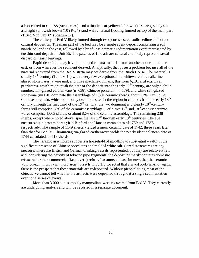
52
ash occurred in Unit 88 (Stratum 20), and a thin lens of yellowish brown (10YR4/3) sandy silt
and light yellowish brown (10YR6/4) sand with charcoal flecking formed on top of the main part
of Bed V in Unit 89 (Stratum 17).
The entirety of Bed V likely formed through two processes: episodic sedimentation and
cultural deposition. The main part of the bed may be a single event deposit comprising a soil
mantle on land to the east, followed by a brief, less dramatic sedimentation event represented by
the thin sand deposit in Unit 89. The patches of fine ash are cultural and likely represent casual
discard of hearth leavings.
Rapid deposition may have introduced cultural material from another house site to the
east, or from wherever the sediment derived. Analytically, that poses a problem because all of the
material recovered from the Bed V strata may not derive from the Burch House. The material is
solidly 18th
century (Table 6-10) with a very few exceptions: one whiteware, three alkaline-
glazed stonewares, a wire nail, and three machine-cut nails, this from 6,191 artifacts. Even
pearlwares, which might push the date of the deposit into the early 19th
century, are only eight in
number. Tin-glazed earthenware (n=636), Chinese porcelain (n=179), and white salt-glazed
stoneware (n=120) dominate the assemblage of 1,301 ceramic sherds, about 72%. Excluding
Chinese porcelain, which commonly occurs on sites in the region in contexts from the early 18th
century through the first third of the 19th
century, the two dominant and clearly 18th
-century
forms still comprise 58% of the ceramic assemblage. Definitive 17th
and 18th
-century ceramic
wares comprise 1,063 sherds, or about 82% of the ceramic assemblage. The remaining 238
sherds, except where noted above, span the late 17th
through early 19th
centuries. The 131
measureable pipestem bores yield Binford and Hanson mean dates of 1759 and 1737,
respectively. The sample of 1149 sherds yielded a mean ceramic date of 1742, three years later
than that for Bed IV. Eliminating tin-glazed earthenware yields the nearly identical mean date of
1744 calculated on 513 sherds.
The ceramic assemblage suggests a household of middling to substantial wealth, if the
significant presence of Chinese porcelains and molded white salt-glazed stonewares are any
measure. There are British and German drinking vessels represented, but they are relatively few
and, considering the paucity of tobacco pipe fragments, the deposit primarily contains domestic
refuse rather than commercial (i.e., tavern) refuse. I assume, at least for now, that the ceramics
were broken in use; viz., these aren‘t vessels imported for retail that arrived broken. And, again,
there is the prospect that these materials are redeposited. Without piece-plotting most of the
objects, we cannot tell whether the artifacts were deposited throughout a single sedimentation
event or a series of events.
More than 3,000 bones, mostly mammalian, were recovered from Bed V. They currently
are undergoing analysis and will be reported in a separate document.
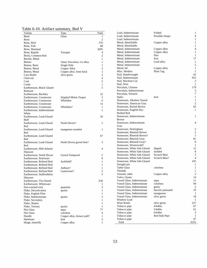
53
Table 6-10. Artifact summary, Bed V Variety Type Total
Bead Glass 1
Bone 2
Bone, Bird 376
Bone, Fish 88
Bone, Mammal 2695
Bone, Reptile Terrapin 4
Brick, Common Red 2
Buckle, Metal 1
Button Glass/ Porcelain, Cu alloy 1
Button, Bone Single Hole 1
Button, Metal Copper Alloy 3
Button, Metal Copper alloy, bone back 1
Case Bottle olive green 2
Charcoal 4
Coal 3
Comb 1
Earthenware, Black Glazed
Redware
5
Earthenware, Buckley 22
Earthenware, Creamware Stippled Melon Teapot 3
Earthenware, Creamware Whieldon 6
Earthenware, Creamware 15
Earthenware, Creamware Whieldon? 1
Earthenware, Indeterminate
White
1
Earthenware, Lead-Glazed
Buff
26
Earthenware, Lead-Glazed
Red
North Devon? 2
Earthenware, Lead-Glazed
Red
manganese mottled 1
Earthenware, Lead-Glazed
Red
67
Earthenware, Lead-Glazed
Red
North Devon gravel-free? 3
Earthenware, Mid-Atlantic
Slipware
4
Earthenware, North Devon Gravel-Tempered 2
Earthenware, Pearlware 8
Earthenware, Refined Red Jackfield? 1
Earthenware, Refined Red 1
Earthenware, Refined Red Astbury? 1
Earthenware, Refined Red Lusterware? 2
Earthenware, Staffordshire
Slipware
5
Earthenware, Tin-Glazed 636
Earthenware, Whiteware 1
Fire-cracked rock quartzite 3
Flake, Decortication quartz 1
Flake, English Flint 1
Flake, Indeterminate quartz 3
Flake, Secondary 1
Flake, Shatter 1
Flake, Tertiary quartz 1
Flat Glass aqua 77
Flat Glass colorless 4
Handle Copper alloy, drawer pull? 1
Hardware Iron 2
Hinge, butterfly Copper alloy 1
Lead, Indeterminate Folded 1
Lead, Indeterminate Possible Straps 4
Lead, Indeterminate 1
Metal, Identifiable Copper alloy 1
Metal, Identifiable 1
Metal, Indeterminate Copper alloy 4
Metal, Indeterminate Copper alloy 1
Metal, Indeterminate Disc 1
Metal, Indeterminate Iron 17
Metal, Indeterminate Lead alloy 1
Metal, Indeterminate 5
Metal, lid Copper alloy 1
Misc. Modern Plant Tag 1
Nail, Handwrought 62
Nail, Indeterminate 932
Nail, Machine-Cut 3
Nail, Wire 1
Porcelain, Chinese 179
Porcelain, Indeterminate 3
Porcelain, Western 7
Spike Iron 1
Stoneware, Alkaline Glazed 1
Stoneware, American Gray 2
Stoneware, British Brown 62
Stoneware, English Dry-
Bodied Red
1
Stoneware, Indeterminate
Brown
1
Stoneware, Indeterminate
Gray
4
Stoneware, Nottingham 2
Stoneware, Rhenish Brown 2
Stoneware, Rhenish Brown? 1
Stoneware, Rhenish Gray 81
Stoneware, Rhenish Gray? 9
Stoneware, Westerwald? 1
Stoneware, White Salt-Glazed dipped 12
Stoneware, White Salt-Glazed molded 8
Stoneware, White Salt-Glazed Scratch Blue 3
Stoneware, White Salt-Glazed Scratch Blue? 4
Stoneware, White Salt-Glazed 105
Straight pin 1
Table Glass colorless 1
Thimble 1
Utensils, table Copper alloy 2
Valve, Oyster 14
Vessel Glass, Indeterminate aqua 11
Vessel Glass, Indeterminate colorless 94
Vessel Glass, Indeterminate green 2
Vessel Glass, Indeterminate heavily patinated 19
Vessel Glass, Indeterminate manganese 1
Vessel Glass, Indeterminate olive green 18
Window Lead 1
Wine Bottle olive green 227
Tobacco pipe 4/64ths 67
Tobacco pipe 5/64ths 61
Tobacco pipe 6/64ths 3
Tobacco pipe Red Stub Pipe 1
Tobacco pipe 47
Total 6191
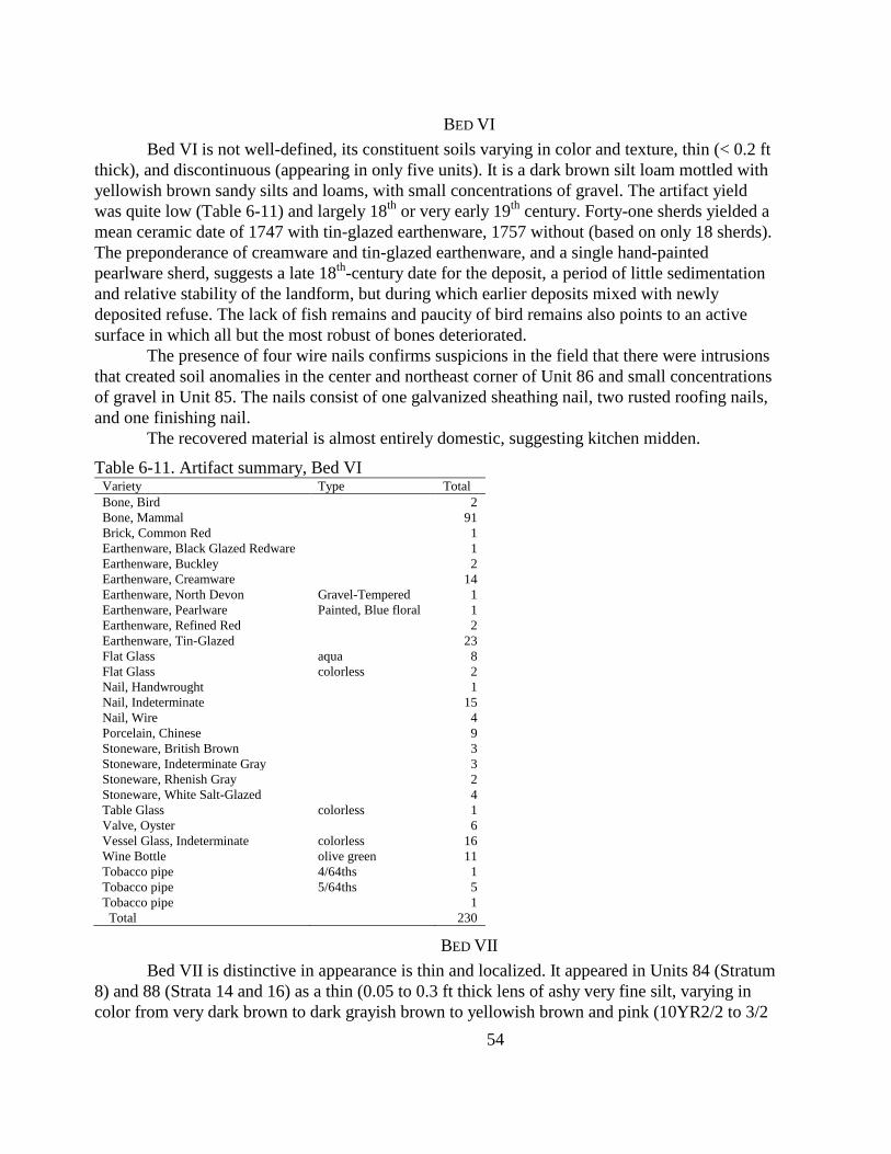
54
BED VI
Bed VI is not well-defined, its constituent soils varying in color and texture, thin (< 0.2 ft
thick), and discontinuous (appearing in only five units). It is a dark brown silt loam mottled with
yellowish brown sandy silts and loams, with small concentrations of gravel. The artifact yield
was quite low (Table 6-11) and largely 18th
or very early 19th
century. Forty-one sherds yielded a
mean ceramic date of 1747 with tin-glazed earthenware, 1757 without (based on only 18 sherds).
The preponderance of creamware and tin-glazed earthenware, and a single hand-painted
pearlware sherd, suggests a late 18th
-century date for the deposit, a period of little sedimentation
and relative stability of the landform, but during which earlier deposits mixed with newly
deposited refuse. The lack of fish remains and paucity of bird remains also points to an active
surface in which all but the most robust of bones deteriorated.
The presence of four wire nails confirms suspicions in the field that there were intrusions
that created soil anomalies in the center and northeast corner of Unit 86 and small concentrations
of gravel in Unit 85. The nails consist of one galvanized sheathing nail, two rusted roofing nails,
and one finishing nail.
The recovered material is almost entirely domestic, suggesting kitchen midden.
Table 6-11. Artifact summary, Bed VI Variety Type Total
Bone, Bird
2
Bone, Mammal
91
Brick, Common Red
1
Earthenware, Black Glazed Redware
1
Earthenware, Buckley
2
Earthenware, Creamware
14
Earthenware, North Devon Gravel-Tempered 1
Earthenware, Pearlware Painted, Blue floral 1
Earthenware, Refined Red
2
Earthenware, Tin-Glazed
23
Flat Glass aqua 8
Flat Glass colorless 2
Nail, Handwrought
1
Nail, Indeterminate
15
Nail, Wire
4
Porcelain, Chinese
9
Stoneware, British Brown
3
Stoneware, Indeterminate Gray
3
Stoneware, Rhenish Gray
2
Stoneware, White Salt-Glazed
4
Table Glass colorless 1
Valve, Oyster
6
Vessel Glass, Indeterminate colorless 16
Wine Bottle olive green 11
Tobacco pipe 4/64ths 1
Tobacco pipe 5/64ths 5
Tobacco pipe
1
Total
230
BED VII
Bed VII is distinctive in appearance is thin and localized. It appeared in Units 84 (Stratum
8) and 88 (Strata 14 and 16) as a thin (0.05 to 0.3 ft thick lens of ashy very fine silt, varying in
color from very dark brown to dark grayish brown to yellowish brown and pink (10YR2/2 to 3/2
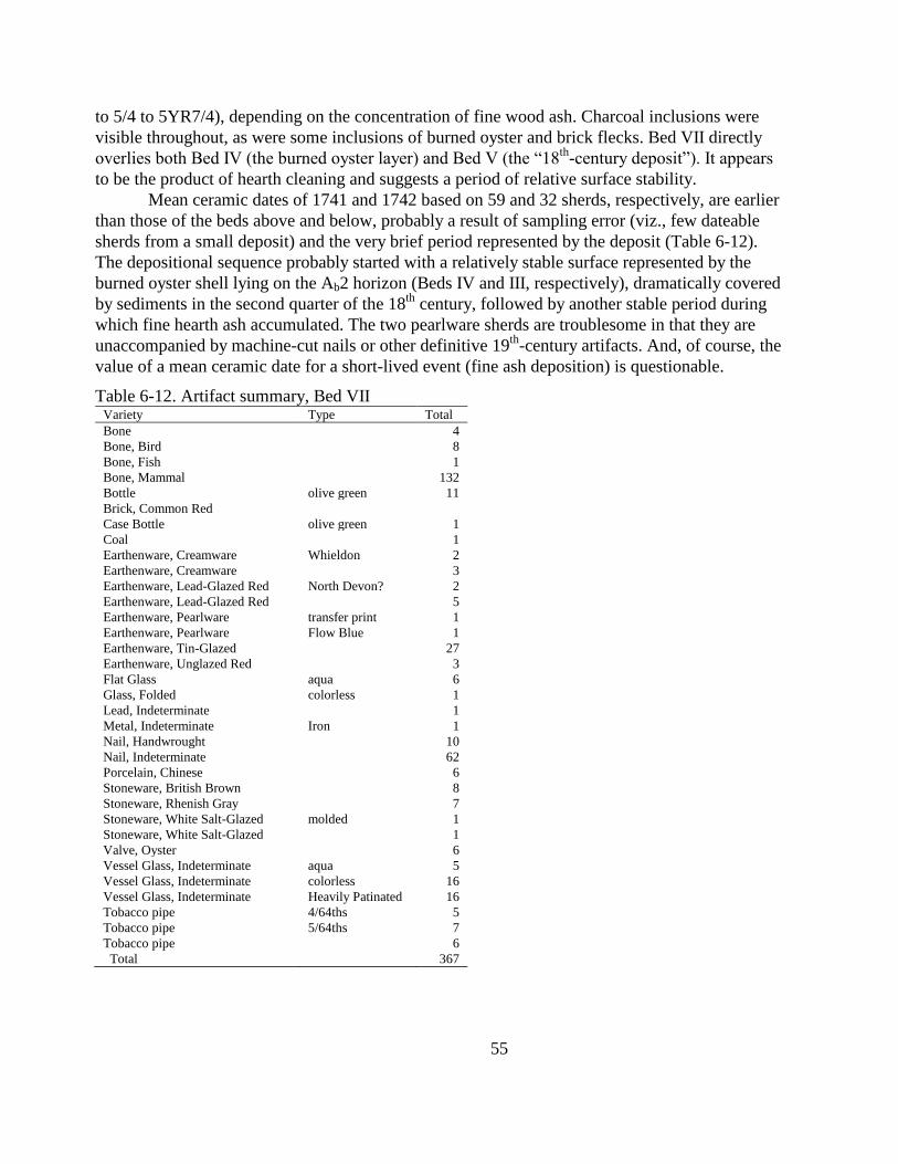
55
to 5/4 to 5YR7/4), depending on the concentration of fine wood ash. Charcoal inclusions were
visible throughout, as were some inclusions of burned oyster and brick flecks. Bed VII directly
overlies both Bed IV (the burned oyster layer) and Bed V (the ―18th
-century deposit‖). It appears
to be the product of hearth cleaning and suggests a period of relative surface stability.
Mean ceramic dates of 1741 and 1742 based on 59 and 32 sherds, respectively, are earlier
than those of the beds above and below, probably a result of sampling error (viz., few dateable
sherds from a small deposit) and the very brief period represented by the deposit (Table 6-12).
The depositional sequence probably started with a relatively stable surface represented by the
burned oyster shell lying on the Ab2 horizon (Beds IV and III, respectively), dramatically covered
by sediments in the second quarter of the 18th
century, followed by another stable period during
which fine hearth ash accumulated. The two pearlware sherds are troublesome in that they are
unaccompanied by machine-cut nails or other definitive 19th
-century artifacts. And, of course, the
value of a mean ceramic date for a short-lived event (fine ash deposition) is questionable.
Table 6-12. Artifact summary, Bed VII Variety Type Total
Bone
4
Bone, Bird
8
Bone, Fish
1
Bone, Mammal
132
Bottle olive green 11
Brick, Common Red
Case Bottle olive green 1
Coal
1
Earthenware, Creamware Whieldon 2
Earthenware, Creamware
3
Earthenware, Lead-Glazed Red North Devon? 2
Earthenware, Lead-Glazed Red
5
Earthenware, Pearlware transfer print 1
Earthenware, Pearlware Flow Blue 1
Earthenware, Tin-Glazed
27
Earthenware, Unglazed Red
3
Flat Glass aqua 6
Glass, Folded colorless 1
Lead, Indeterminate
1
Metal, Indeterminate Iron 1
Nail, Handwrought
10
Nail, Indeterminate
62
Porcelain, Chinese
6
Stoneware, British Brown
8
Stoneware, Rhenish Gray
7
Stoneware, White Salt-Glazed molded 1
Stoneware, White Salt-Glazed
1
Valve, Oyster
6
Vessel Glass, Indeterminate aqua 5
Vessel Glass, Indeterminate colorless 16
Vessel Glass, Indeterminate Heavily Patinated 16
Tobacco pipe 4/64ths 5
Tobacco pipe 5/64ths 7
Tobacco pipe
6
Total
367
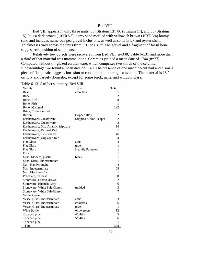
56
BED VIII
Bed VIII appears in only three units: 85 (Stratum 13), 86 (Stratum 14), and 88 (Stratum
15). It is a dark brown (10YR3/3) loamy sand mottled with yellowish brown (10YR5/4) loamy
sand and includes numerous pea gravel inclusions, as well as some brick and oyster shell.
Thicknesses vary across the units from 0.15 to 0.8 ft. The gravel and a fragment of fossil bone
suggest redeposition of sediments.
Relatively few objects were recovered from Bed VIII (n=348; Table 6-13), and more than
a third of that material was mammal bone. Ceramics yielded a mean date of 1744 (n=77).
Computed without tin-glazed earthenware, which comprises two-thirds of the ceramic
subassemblage, we found a mean date of 1749. The presence of one machine-cut nail and a small
piece of flat plastic suggests intrusion or contamination during excavation. The material is 18th
century and largely domestic, except for some brick, nails, and window glass.
Table 6-13. Artifact summary, Bed VIII Variety Type Total
Bead colorless 1
Bone
2
Bone, Bird
8
Bone, Fish
1
Bone, Mammal
122
Brick, Common Red
Button Copper alloy 2
Earthenware, Creamware Stippled Melon Teapot 2
Earthenware, Creamware
3
Earthenware, Mid-Atlantic Slipware
14
Earthenware, Refined Red
1
Earthenware, Tin-Glazed
46
Earthenware, Unglazed Red
4
Flat Glass aqua 4
Flat Glass green 1
Flat Glass Heavily Patinated 1
Fossil
1
Misc. Modern, plastic black 1
Misc. Metal, Indeterminate
1
Nail, Handwrought
4
Nail, Indeterminate
68
Nail, Machine-Cut
1
Porcelain, Chinese
8
Stoneware, British Brown
2
Stoneware, Rhenish Gray
6
Stoneware, White Salt-Glazed molded 3
Stoneware, White Salt-Glazed
7
Valve, Oyster
Vessel Glass, Indeterminate aqua 3
Vessel Glass, Indeterminate colorless 6
Vessel Glass, Indeterminate green 1
Wine Bottle olive green 12
Tobacco pipe 4/64ths 5
Tobacco pipe 5/64ths 6
Tobacco pipe
1
Total
348

57
BED IX
Bed IX extends across at least five units: 84 (Stratum 7), 85 (Stratum 12), 88 (Stratum
13), 89 (Stratum 12), and 92 (Stratum 7). Like Beds VI and VIII, it is irregular in color and
texture, but generally is brown clayey silt with pockets of sandier material and clustering of brick
fragments and gravel. It is mottled throughout with sandy and clayey silts of various colors.
Thickness varies throughout, ranging from 0.2 to 0.45 ft. In Unit 88 the soils are darker, with
more charcoal inclusions, and they rest directly on Bed VII. Mean ceramic dates of 1771 and
1775 are based on 428 and 370 sherds, with and without tin-glazed earthenwares, respectively
(Table 6-14). Pipestems yielded Binford and Hanson dates of 1752 and 1733 based on 64
measureable pipestem bores, but the assemblage appears to date beyond the effective reach of
pipestem dating.
The mottled, irregular nature of Bed IX, combined with the appearance of some large and
small gravel, suggests that it formed as a sedimentation event involving relatively slow-moving
water with a load of fine-grained materials.
Table 6-14. Artifact summary, Bed IX Variety Type Total
Bone, Bird
16
Bone, Fish
8
Bone, Mammal
139
Bottle, Case, Machined green 7
Bottle, Indeterminate aqua 4
Bottle, Indeterminate colorless 1
Brick, Common Red
1
Button, Bone
1
Case Bottle olive green 1
Earthenware, Black Glazed Redware
2
Earthenware, Buckley
1
Earthenware, Creamware Whieldon 1
Earthenware, Creamware
204
Earthenware, Jackfield
1
Earthenware, Lead-Glazed Buff
1
Earthenware, Lead-Glazed Red Agateware 1
Earthenware, Lead-Glazed Red
2
Earthenware, Lead-Glazed Red
North Devon
gravel-free? 2
Earthenware, Mid-Atlantic Slipware
1
Earthenware, Pearlware annular 7
Earthenware, Pearlware Edgeware 1
Earthenware, Pearlware Mochaware 1
Earthenware, Pearlware painted 1
Earthenware, Pearlware transfer print 6
Earthenware, Pearlware
28
Earthenware, Tin-Glazed painted 2
Earthenware, Tin-Glazed
56
Flake, Decortication quartzite 1
Flake, English Flint
1
Flake, Indeterminate quartz 2
Flake, Shatter quartz 1
Flat Glass aqua 498
Flat Glass colorless 15
Lead, Indeterminate
2
Metal, Identifiable Lead Shot 2
Metal, Indeterminate Iron 13
Mortar
1
Nail, Handwrought
20
Nail, Indeterminate Conglomerate 3
Nail, Indeterminate
505
Nail, Machine-Cut
4
Nail, Wire
1
Porcelain, Chinese
39
Porcelain, Western
2
Stoneware, British Brown
54
Stoneware, Indeterminate Brown
1
Stoneware, Nottingham
3
Stoneware, Rhenish Gray
6
Stoneware, Rhenish Gray?
1
Stoneware, Westerwald
7
Stoneware, White Salt-Glazed
8
Table Glass colorless 6
Table Glass
2
Valve, Oyster
Vessel Glass, Indeterminate aqua 169
Vessel Glass, Indeterminate colorless 310
Vessel Glass, Indeterminate green 28
Vessel Glass, Indeterminate olive green 1
Wine Bottle olive green 91
Tobacco pipe 4/64ths 25
Tobacco pipe 5/64ths 33
Tobacco pipe 6/64ths 6
Tobacco pipe
48
Total
2405
BED X
Bed X comprises seven strata or lenses among three units: 88 (Strata 10 and 12), 89
(Strata 11 and 15), and 90 (Strata 11, 12, and 16). Interbedded lenses and rodent disturbances
made these layers especially difficult to excavate and document. Coarser grained than the
underlying deposits and with gravel throughout, these deposits probably represent a series of
small sedimentation events alternating with burrowing.
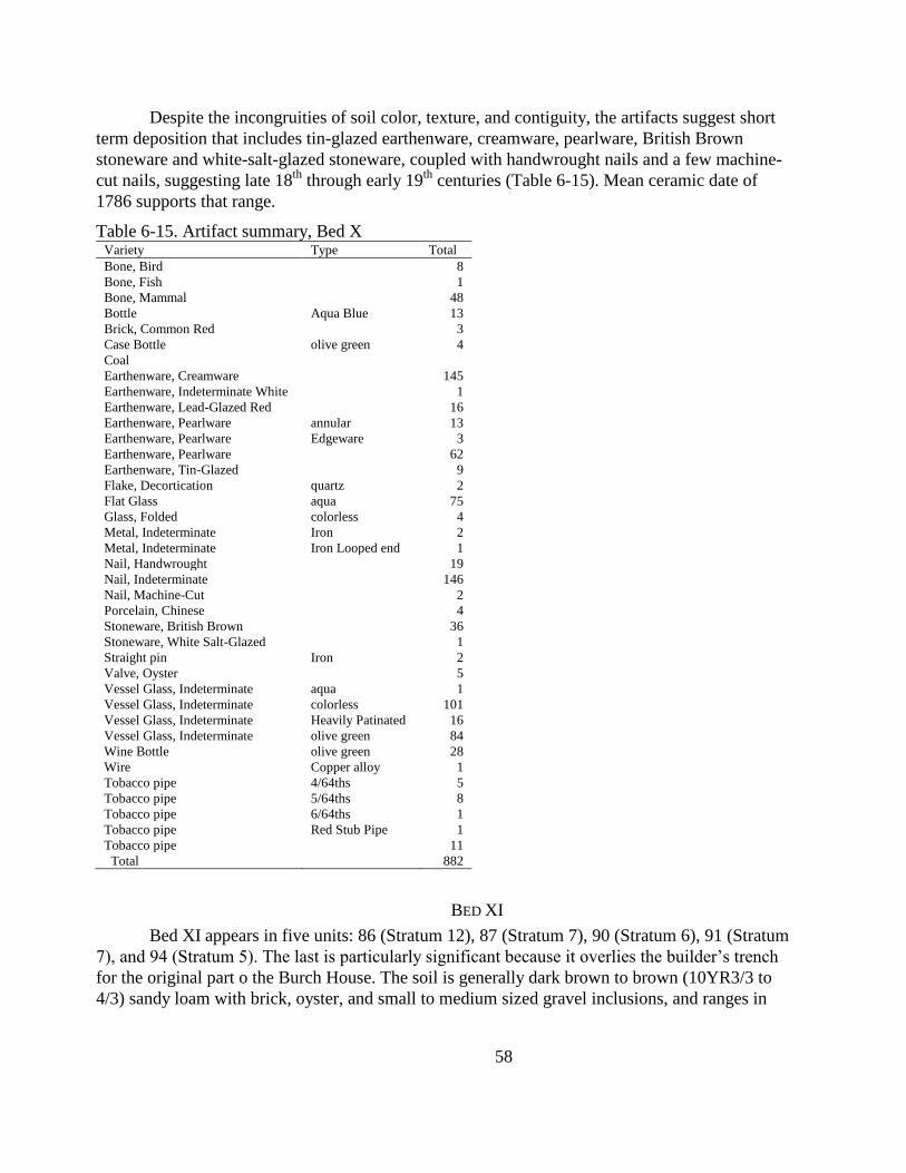
58
Despite the incongruities of soil color, texture, and contiguity, the artifacts suggest short
term deposition that includes tin-glazed earthenware, creamware, pearlware, British Brown
stoneware and white-salt-glazed stoneware, coupled with handwrought nails and a few machine-
cut nails, suggesting late 18th
through early 19th
centuries (Table 6-15). Mean ceramic date of
1786 supports that range.
Table 6-15. Artifact summary, Bed X Variety Type Total
Bone, Bird
8
Bone, Fish
1
Bone, Mammal
48
Bottle Aqua Blue 13
Brick, Common Red
3
Case Bottle olive green 4
Coal
Earthenware, Creamware
145
Earthenware, Indeterminate White
1
Earthenware, Lead-Glazed Red
16
Earthenware, Pearlware annular 13
Earthenware, Pearlware Edgeware 3
Earthenware, Pearlware
62
Earthenware, Tin-Glazed
9
Flake, Decortication quartz 2
Flat Glass aqua 75
Glass, Folded colorless 4
Metal, Indeterminate Iron 2
Metal, Indeterminate Iron Looped end 1
Nail, Handwrought
19
Nail, Indeterminate
146
Nail, Machine-Cut
2
Porcelain, Chinese
4
Stoneware, British Brown
36
Stoneware, White Salt-Glazed
1
Straight pin Iron 2
Valve, Oyster
5
Vessel Glass, Indeterminate aqua 1
Vessel Glass, Indeterminate colorless 101
Vessel Glass, Indeterminate Heavily Patinated 16
Vessel Glass, Indeterminate olive green 84
Wine Bottle olive green 28
Wire Copper alloy 1
Tobacco pipe 4/64ths 5
Tobacco pipe 5/64ths 8
Tobacco pipe 6/64ths 1
Tobacco pipe Red Stub Pipe 1
Tobacco pipe
11
Total
882
BED XI
Bed XI appears in five units: 86 (Stratum 12), 87 (Stratum 7), 90 (Stratum 6), 91 (Stratum
7), and 94 (Stratum 5). The last is particularly significant because it overlies the builder‘s trench
for the original part o the Burch House. The soil is generally dark brown to brown (10YR3/3 to
4/3) sandy loam with brick, oyster, and small to medium sized gravel inclusions, and ranges in
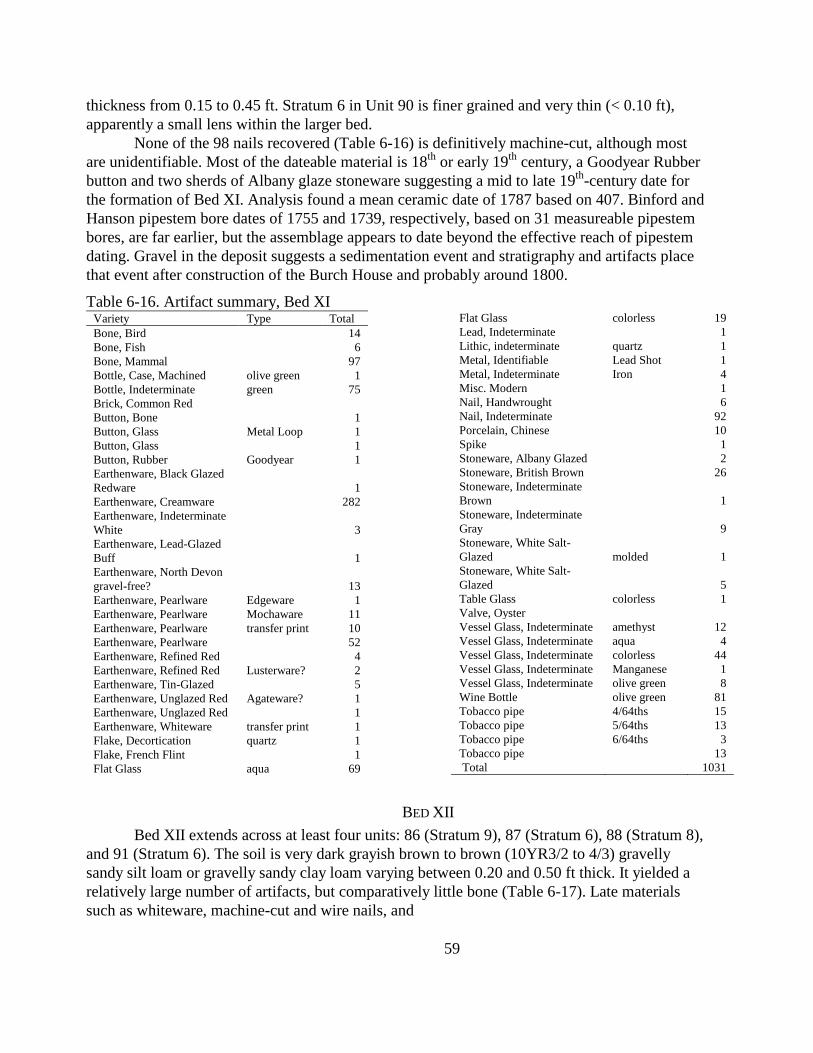
59
thickness from 0.15 to 0.45 ft. Stratum 6 in Unit 90 is finer grained and very thin (< 0.10 ft),
apparently a small lens within the larger bed.
None of the 98 nails recovered (Table 6-16) is definitively machine-cut, although most
are unidentifiable. Most of the dateable material is 18th
or early 19th
century, a Goodyear Rubber
button and two sherds of Albany glaze stoneware suggesting a mid to late 19th
-century date for
the formation of Bed XI. Analysis found a mean ceramic date of 1787 based on 407. Binford and
Hanson pipestem bore dates of 1755 and 1739, respectively, based on 31 measureable pipestem
bores, are far earlier, but the assemblage appears to date beyond the effective reach of pipestem
dating. Gravel in the deposit suggests a sedimentation event and stratigraphy and artifacts place
that event after construction of the Burch House and probably around 1800.
Table 6-16. Artifact summary, Bed XI Variety Type Total
Bone, Bird
14
Bone, Fish
6
Bone, Mammal
97
Bottle, Case, Machined olive green 1
Bottle, Indeterminate green 75
Brick, Common Red
Button, Bone
1
Button, Glass Metal Loop 1
Button, Glass
1
Button, Rubber Goodyear 1
Earthenware, Black Glazed
Redware
1
Earthenware, Creamware
282
Earthenware, Indeterminate
White
3
Earthenware, Lead-Glazed
Buff
1
Earthenware, North Devon
gravel-free?
13
Earthenware, Pearlware Edgeware 1
Earthenware, Pearlware Mochaware 11
Earthenware, Pearlware transfer print 10
Earthenware, Pearlware
52
Earthenware, Refined Red
4
Earthenware, Refined Red Lusterware? 2
Earthenware, Tin-Glazed
5
Earthenware, Unglazed Red Agateware? 1
Earthenware, Unglazed Red
1
Earthenware, Whiteware transfer print 1
Flake, Decortication quartz 1
Flake, French Flint
1
Flat Glass aqua 69
Flat Glass colorless 19
Lead, Indeterminate
1
Lithic, indeterminate quartz 1
Metal, Identifiable Lead Shot 1
Metal, Indeterminate Iron 4
Misc. Modern
1
Nail, Handwrought
6
Nail, Indeterminate
92
Porcelain, Chinese
10
Spike
1
Stoneware, Albany Glazed
2
Stoneware, British Brown
26
Stoneware, Indeterminate
Brown
1
Stoneware, Indeterminate
Gray
9
Stoneware, White Salt-
Glazed molded 1
Stoneware, White Salt-
Glazed
5
Table Glass colorless 1
Valve, Oyster
Vessel Glass, Indeterminate amethyst 12
Vessel Glass, Indeterminate aqua 4
Vessel Glass, Indeterminate colorless 44
Vessel Glass, Indeterminate Manganese 1
Vessel Glass, Indeterminate olive green 8
Wine Bottle olive green 81
Tobacco pipe 4/64ths 15
Tobacco pipe 5/64ths 13
Tobacco pipe 6/64ths 3
Tobacco pipe
13
Total
1031
BED XII
Bed XII extends across at least four units: 86 (Stratum 9), 87 (Stratum 6), 88 (Stratum 8),
and 91 (Stratum 6). The soil is very dark grayish brown to brown (10YR3/2 to 4/3) gravelly
sandy silt loam or gravelly sandy clay loam varying between 0.20 and 0.50 ft thick. It yielded a
relatively large number of artifacts, but comparatively little bone (Table 6-17). Late materials
such as whiteware, machine-cut and wire nails, and
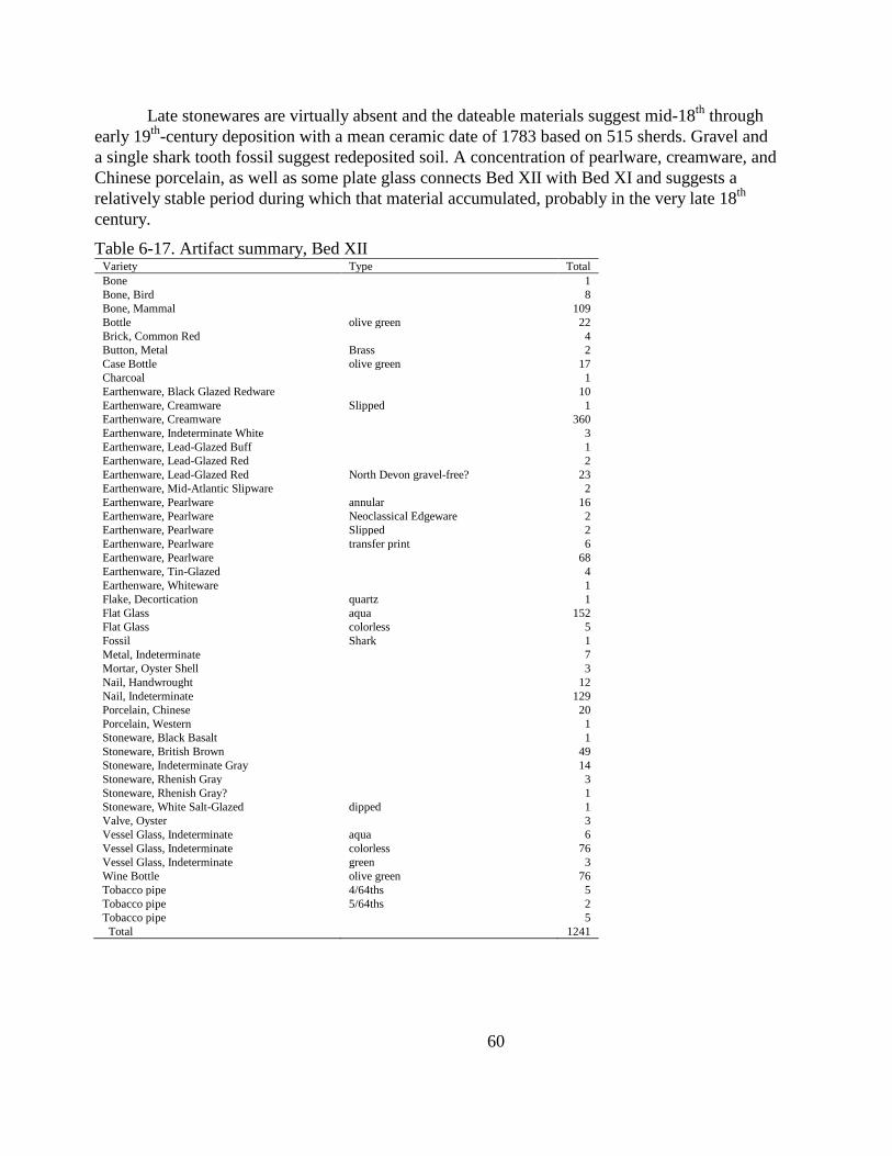
60
Late stonewares are virtually absent and the dateable materials suggest mid-18th
through
early 19th
-century deposition with a mean ceramic date of 1783 based on 515 sherds. Gravel and
a single shark tooth fossil suggest redeposited soil. A concentration of pearlware, creamware, and
Chinese porcelain, as well as some plate glass connects Bed XII with Bed XI and suggests a
relatively stable period during which that material accumulated, probably in the very late 18th
century.
Table 6-17. Artifact summary, Bed XII Variety Type Total
Bone
1
Bone, Bird
8
Bone, Mammal
109
Bottle olive green 22
Brick, Common Red
4
Button, Metal Brass 2
Case Bottle olive green 17
Charcoal
1
Earthenware, Black Glazed Redware
10
Earthenware, Creamware Slipped 1
Earthenware, Creamware
360
Earthenware, Indeterminate White
3
Earthenware, Lead-Glazed Buff
1
Earthenware, Lead-Glazed Red
2
Earthenware, Lead-Glazed Red North Devon gravel-free? 23
Earthenware, Mid-Atlantic Slipware
2
Earthenware, Pearlware annular 16
Earthenware, Pearlware Neoclassical Edgeware 2
Earthenware, Pearlware Slipped 2
Earthenware, Pearlware transfer print 6
Earthenware, Pearlware
68
Earthenware, Tin-Glazed
4
Earthenware, Whiteware
1
Flake, Decortication quartz 1
Flat Glass aqua 152
Flat Glass colorless 5
Fossil Shark 1
Metal, Indeterminate
7
Mortar, Oyster Shell
3
Nail, Handwrought
12
Nail, Indeterminate
129
Porcelain, Chinese
20
Porcelain, Western
1
Stoneware, Black Basalt
1
Stoneware, British Brown
49
Stoneware, Indeterminate Gray
14
Stoneware, Rhenish Gray
3
Stoneware, Rhenish Gray?
1
Stoneware, White Salt-Glazed dipped 1
Valve, Oyster
3
Vessel Glass, Indeterminate aqua 6
Vessel Glass, Indeterminate colorless 76
Vessel Glass, Indeterminate green 3
Wine Bottle olive green 76
Tobacco pipe 4/64ths 5
Tobacco pipe 5/64ths 2
Tobacco pipe
5
Total
1241
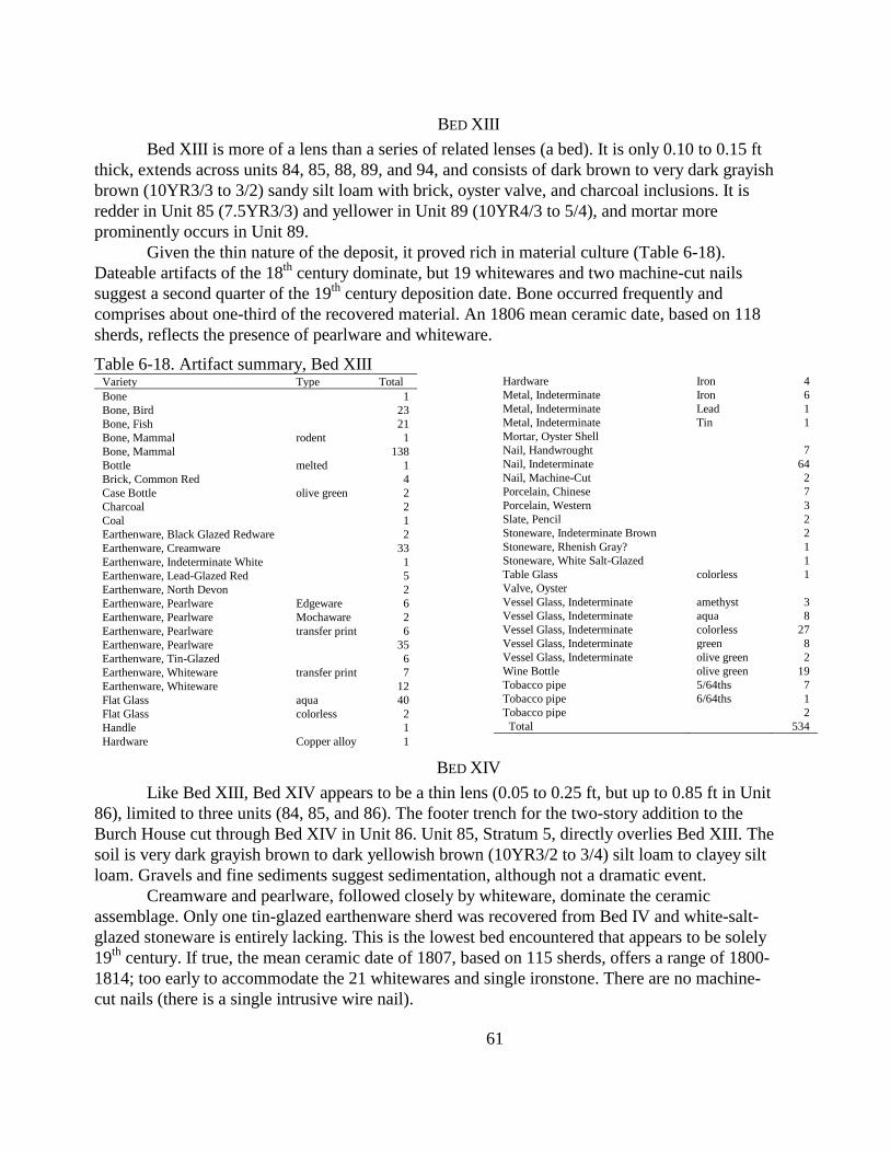
61
BED XIII
Bed XIII is more of a lens than a series of related lenses (a bed). It is only 0.10 to 0.15 ft
thick, extends across units 84, 85, 88, 89, and 94, and consists of dark brown to very dark grayish
brown (10YR3/3 to 3/2) sandy silt loam with brick, oyster valve, and charcoal inclusions. It is
redder in Unit 85 (7.5YR3/3) and yellower in Unit 89 (10YR4/3 to 5/4), and mortar more
prominently occurs in Unit 89.
Given the thin nature of the deposit, it proved rich in material culture (Table 6-18).
Dateable artifacts of the 18th
century dominate, but 19 whitewares and two machine-cut nails
suggest a second quarter of the 19th
century deposition date. Bone occurred frequently and
comprises about one-third of the recovered material. An 1806 mean ceramic date, based on 118
sherds, reflects the presence of pearlware and whiteware.
Table 6-18. Artifact summary, Bed XIII Variety Type Total
Bone
1
Bone, Bird
23
Bone, Fish
21
Bone, Mammal rodent 1
Bone, Mammal
138
Bottle melted 1
Brick, Common Red
4
Case Bottle olive green 2
Charcoal
2
Coal
1
Earthenware, Black Glazed Redware
2
Earthenware, Creamware
33
Earthenware, Indeterminate White
1
Earthenware, Lead-Glazed Red
5
Earthenware, North Devon
2
Earthenware, Pearlware Edgeware 6
Earthenware, Pearlware Mochaware 2
Earthenware, Pearlware transfer print 6
Earthenware, Pearlware
35
Earthenware, Tin-Glazed
6
Earthenware, Whiteware transfer print 7
Earthenware, Whiteware
12
Flat Glass aqua 40
Flat Glass colorless 2
Handle
1
Hardware Copper alloy 1
Hardware Iron 4
Metal, Indeterminate Iron 6
Metal, Indeterminate Lead 1
Metal, Indeterminate Tin 1
Mortar, Oyster Shell
Nail, Handwrought
7
Nail, Indeterminate
64
Nail, Machine-Cut
2
Porcelain, Chinese
7
Porcelain, Western
3
Slate, Pencil
2
Stoneware, Indeterminate Brown
2
Stoneware, Rhenish Gray?
1
Stoneware, White Salt-Glazed
1
Table Glass colorless 1
Valve, Oyster
Vessel Glass, Indeterminate amethyst 3
Vessel Glass, Indeterminate aqua 8
Vessel Glass, Indeterminate colorless 27
Vessel Glass, Indeterminate green 8
Vessel Glass, Indeterminate olive green 2
Wine Bottle olive green 19
Tobacco pipe 5/64ths 7
Tobacco pipe 6/64ths 1
Tobacco pipe
2
Total
534
BED XIV
Like Bed XIII, Bed XIV appears to be a thin lens (0.05 to 0.25 ft, but up to 0.85 ft in Unit
86), limited to three units (84, 85, and 86). The footer trench for the two-story addition to the
Burch House cut through Bed XIV in Unit 86. Unit 85, Stratum 5, directly overlies Bed XIII. The
soil is very dark grayish brown to dark yellowish brown (10YR3/2 to 3/4) silt loam to clayey silt
loam. Gravels and fine sediments suggest sedimentation, although not a dramatic event.
Creamware and pearlware, followed closely by whiteware, dominate the ceramic
assemblage. Only one tin-glazed earthenware sherd was recovered from Bed IV and white-salt-
glazed stoneware is entirely lacking. This is the lowest bed encountered that appears to be solely
19th
century. If true, the mean ceramic date of 1807, based on 115 sherds, offers a range of 1800-
1814; too early to accommodate the 21 whitewares and single ironstone. There are no machine-
cut nails (there is a single intrusive wire nail).
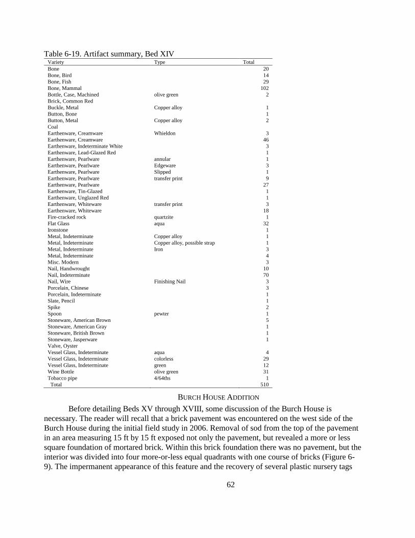
62
Table 6-19. Artifact summary, Bed XIV Variety Type Total
Bone
20
Bone, Bird
14
Bone, Fish
29
Bone, Mammal
102
Bottle, Case, Machined olive green 2
Brick, Common Red
Buckle, Metal Copper alloy 1
Button, Bone
1
Button, Metal Copper alloy 2
Coal
Earthenware, Creamware Whieldon 3
Earthenware, Creamware
46
Earthenware, Indeterminate White
3
Earthenware, Lead-Glazed Red
1
Earthenware, Pearlware annular 1
Earthenware, Pearlware Edgeware 3
Earthenware, Pearlware Slipped 1
Earthenware, Pearlware transfer print 9
Earthenware, Pearlware
27
Earthenware, Tin-Glazed
1
Earthenware, Unglazed Red
1
Earthenware, Whiteware transfer print 3
Earthenware, Whiteware
18
Fire-cracked rock quartzite 1
Flat Glass aqua 32
Ironstone
1
Metal, Indeterminate Copper alloy 1
Metal, Indeterminate Copper alloy, possible strap 1
Metal, Indeterminate Iron 3
Metal, Indeterminate
4
Misc. Modern
3
Nail, Handwrought
10
Nail, Indeterminate
70
Nail, Wire Finishing Nail 3
Porcelain, Chinese
3
Porcelain, Indeterminate
1
Slate, Pencil
1
Spike
2
Spoon pewter 1
Stoneware, American Brown
5
Stoneware, American Gray
1
Stoneware, British Brown
1
Stoneware, Jasperware
1
Valve, Oyster
Vessel Glass, Indeterminate aqua 4
Vessel Glass, Indeterminate colorless 29
Vessel Glass, Indeterminate green 12
Wine Bottle olive green 31
Tobacco pipe 4/64ths 1
Total
510
BURCH HOUSE ADDITION
Before detailing Beds XV through XVIII, some discussion of the Burch House is
necessary. The reader will recall that a brick pavement was encountered on the west side of the
Burch House during the initial field study in 2006. Removal of sod from the top of the pavement
in an area measuring 15 ft by 15 ft exposed not only the pavement, but revealed a more or less
square foundation of mortared brick. Within this brick foundation there was no pavement, but the
interior was divided into four more-or-less equal quadrants with one course of bricks (Figure 6-
9). The impermanent appearance of this feature and the recovery of several plastic nursery tags
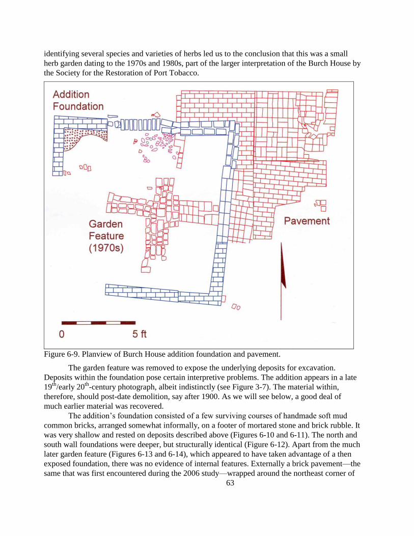
63
identifying several species and varieties of herbs led us to the conclusion that this was a small
herb garden dating to the 1970s and 1980s, part of the larger interpretation of the Burch House by
the Society for the Restoration of Port Tobacco.
Figure 6-9. Planview of Burch House addition foundation and pavement.
The garden feature was removed to expose the underlying deposits for excavation.
Deposits within the foundation pose certain interpretive problems. The addition appears in a late
19th
/early 20th
-century photograph, albeit indistinctly (see Figure 3-7). The material within,
therefore, should post-date demolition, say after 1900. As we will see below, a good deal of
much earlier material was recovered.
The addition‘s foundation consisted of a few surviving courses of handmade soft mud
common bricks, arranged somewhat informally, on a footer of mortared stone and brick rubble. It
was very shallow and rested on deposits described above (Figures 6-10 and 6-11). The north and
south wall foundations were deeper, but structurally identical (Figure 6-12). Apart from the much
later garden feature (Figures 6-13 and 6-14), which appeared to have taken advantage of a then
exposed foundation, there was no evidence of internal features. Externally a brick pavement—the
same that was first encountered during the 2006 study—wrapped around the northeast corner of
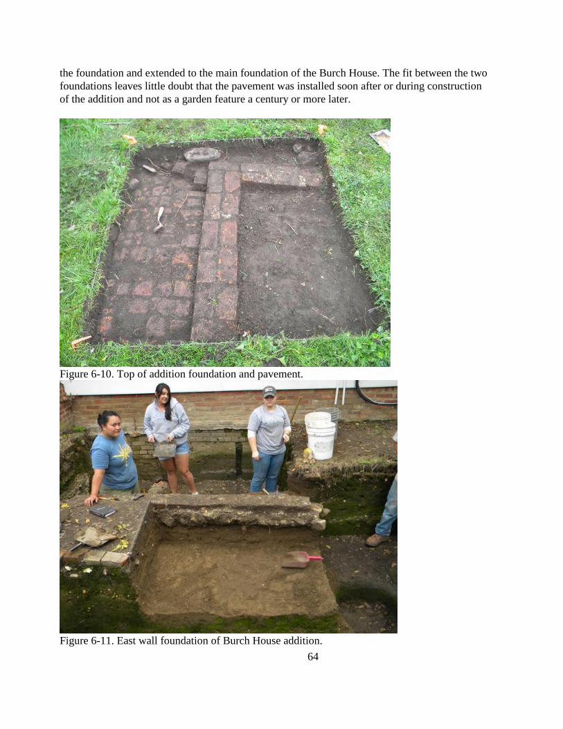
64
the foundation and extended to the main foundation of the Burch House. The fit between the two
foundations leaves little doubt that the pavement was installed soon after or during construction
of the addition and not as a garden feature a century or more later.
Figure 6-10. Top of addition foundation and pavement.
Figure 6-11. East wall foundation of Burch House addition.
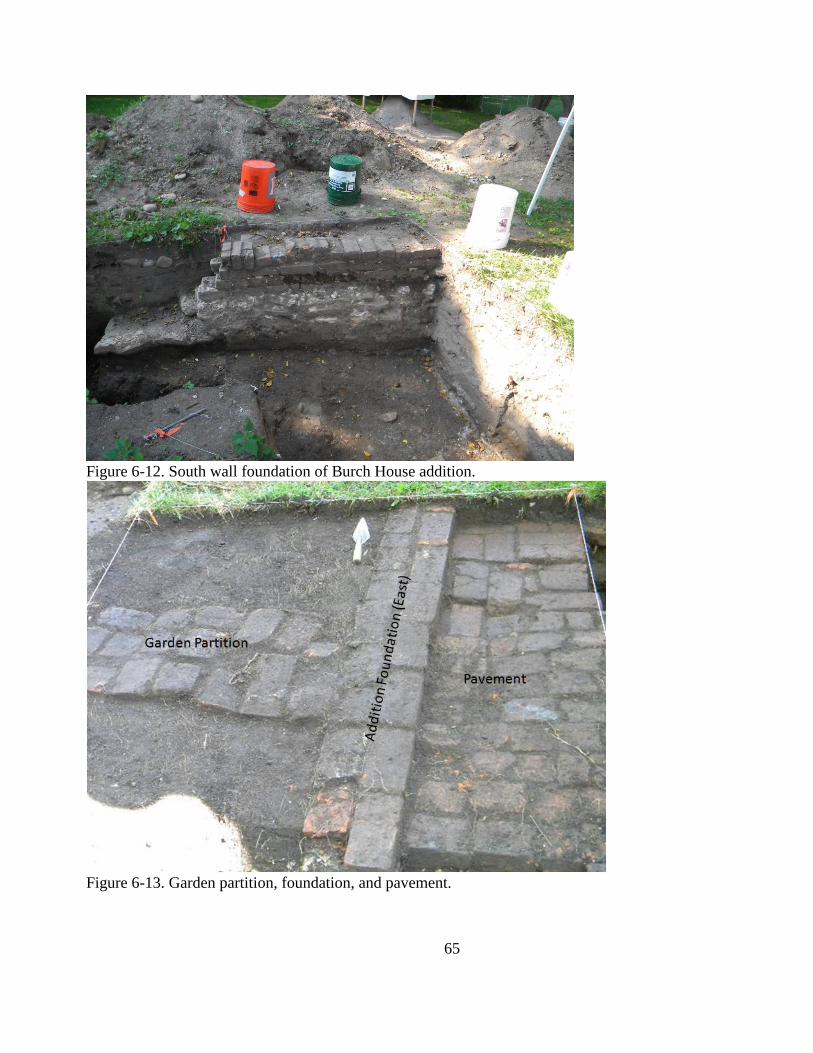
65
Figure 6-12. South wall foundation of Burch House addition.
Figure 6-13. Garden partition, foundation, and pavement.
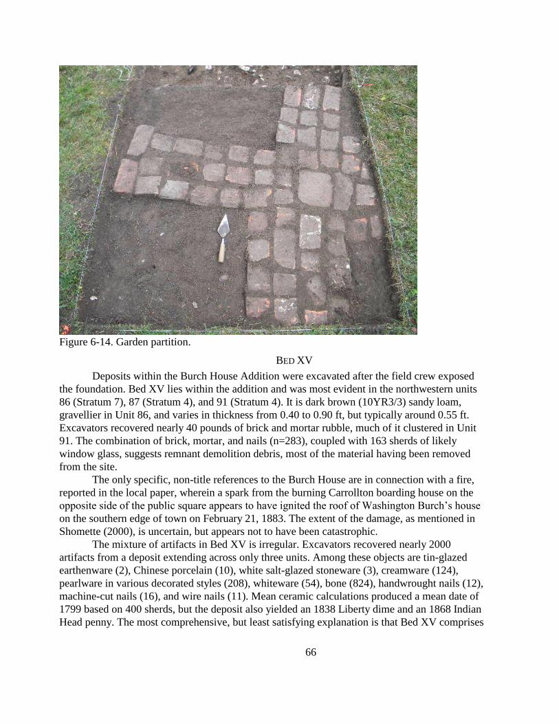
66
Figure 6-14. Garden partition.
BED XV
Deposits within the Burch House Addition were excavated after the field crew exposed
the foundation. Bed XV lies within the addition and was most evident in the northwestern units
86 (Stratum 7), 87 (Stratum 4), and 91 (Stratum 4). It is dark brown (10YR3/3) sandy loam,
gravellier in Unit 86, and varies in thickness from 0.40 to 0.90 ft, but typically around 0.55 ft.
Excavators recovered nearly 40 pounds of brick and mortar rubble, much of it clustered in Unit
91. The combination of brick, mortar, and nails (n=283), coupled with 163 sherds of likely
window glass, suggests remnant demolition debris, most of the material having been removed
from the site.
The only specific, non-title references to the Burch House are in connection with a fire,
reported in the local paper, wherein a spark from the burning Carrollton boarding house on the
opposite side of the public square appears to have ignited the roof of Washington Burch‘s house
on the southern edge of town on February 21, 1883. The extent of the damage, as mentioned in
Shomette (2000), is uncertain, but appears not to have been catastrophic.
The mixture of artifacts in Bed XV is irregular. Excavators recovered nearly 2000
artifacts from a deposit extending across only three units. Among these objects are tin-glazed
earthenware (2), Chinese porcelain (10), white salt-glazed stoneware (3), creamware (124),
pearlware in various decorated styles (208), whiteware (54), bone (824), handwrought nails (12),
machine-cut nails (16), and wire nails (11). Mean ceramic calculations produced a mean date of
1799 based on 400 sherds, but the deposit also yielded an 1838 Liberty dime and an 1868 Indian
Head penny. The most comprehensive, but least satisfying explanation is that Bed XV comprises
67
materials from footer trench excavation, primary refuse, demolition debris, and redeposited
sediments.
BEDS XVI-XVIII
Beds XVI through XVIII are similar to Bed XV in that they include varied soils and
artifacts ranging from the middle of the 18th
century through the late 20th
century (Table 6-21).
Excavators recovered white salt-glazed stoneware (ca. 1720-1800) from the same deposits that
yielded 20th
-century coins. Precisely why these deposits are extensively mixed remains uncertain.
Identifiable events and processes include: footer trench excavation for the addition; demolition;
sedimentation; and gardening. Unfortunately, Beds XV through XVIII are the deposits mostly
likely to provide insight into the material lives of Washington Burch and his family. The material
is not without value, but far more detailed analysis of soils and artifacts than is possible at this
time will have to be undertaken. Analysis of the faunal material might help in illuminating some
of the taphonomic processes and, thereby, contribute to the more detailed analysis of deposits.
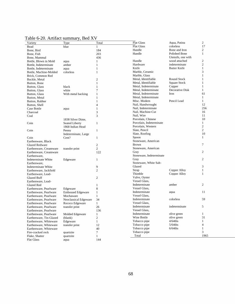
68
Table 6-20. Artifact summary, Bed XV Variety Type Total
Bead blue 1
Bone, Bird
184
Bone, Fish
203
Bone, Mammal
436
Bottle, Blown in Mold aqua 1
Bottle, Indeterminate amber 1
Bottle, Indeterminate aqua 1
Bottle, Machine-Molded colorless 1
Brick, Common Red
Buckle, Metal
2
Button, Bone
1
Button, Glass black 1
Button, Glass white 7
Button, Glass With metal backing 1
Button, Metal
1
Button, Rubber
1
Button, Shell
4
Case Bottle aqua 1
Charcoal
3
Coal
3
Coin
1838 Silver Dime,
Seated Liberty 1
Coin
1868 Indian Head
Penny 1
Coin
Indeterminate, Large
Cent? 1
Earthenware, Black
Glazed Redware
2
Earthenware, Creamware transfer print 2
Earthenware, Creamware
122
Earthenware,
Indeterminate White Edgeware 1
Earthenware,
Indeterminate White
9
Earthenware, Jackfield
2
Earthenware, Lead-
Glazed Buff
2
Earthenware, Lead-
Glazed Red
1
Earthenware, Pearlware Edgeware 8
Earthenware, Pearlware Embossed Edgeware 1
Earthenware, Pearlware Mochaware 1
Earthenware, Pearlware Neoclassical Edgeware 34
Earthenware, Pearlware Rococo Edgeware 1
Earthenware, Pearlware transfer print 26
Earthenware, Pearlware
136
Earthenware, Pearlware Molded Edgeware 1
Earthenware, Tin-Glazed (blank) 2
Earthenware, Whiteware Edgeware 1
Earthenware, Whiteware transfer print 12
Earthenware, Whiteware
40
Fire-cracked rock quartzite 7
Flake, Shatter quartzite 1
Flat Glass aqua 144
Flat Glass Aqua, Patina 2
Flat Glass colorless 17
Handle Bone and Iron 2
Handle Polished Bone 1
Handle
Utensils, one with
wood attached 2
Hardware indeterminate 2
Knife Butter Knife 1
Marble, Ceramic
3
Marble, Glass
1
Metal, Identifiable Round Stock 1
Metal, Identifiable Square Stock 1
Metal, Indeterminate Copper 1
Metal, Indeterminate Decorative Disk 1
Metal, Indeterminate Iron 61
Metal, Indeterminate
1
Misc. Modern Pencil Lead 1
Nail, Handwrought
12
Nail, Indeterminate
256
Nail, Machine-Cut
16
Nail, Wire
11
Porcelain, Chinese
10
Porcelain, Indeterminate
1
Porcelain, Western
2
Slate, Pencil
2
Slate, Roofing
10
Spoon
1
Stoneware, American
Brown
7
Stoneware, American
Gray
2
Stoneware, Indeterminate
Gray
2
Stoneware, White Salt-
Glazed
3
Strap Copper Alloy 1
Thimble Copper Alloy 1
Valve, Oyster
Vessel Glass,
Indeterminate amber 2
Vessel Glass,
Indeterminate aqua 11
Vessel Glass,
Indeterminate colorless 59
Vessel Glass,
Indeterminate indeterminate 5
Vessel Glass,
Indeterminate olive green 1
Wine Bottle olive green 31
Tobacco pipe 4/64ths 1
Tobacco pipe 5/64ths 4
Tobacco pipe 6/64ths 1
Tobacco pipe
3
Total
1965
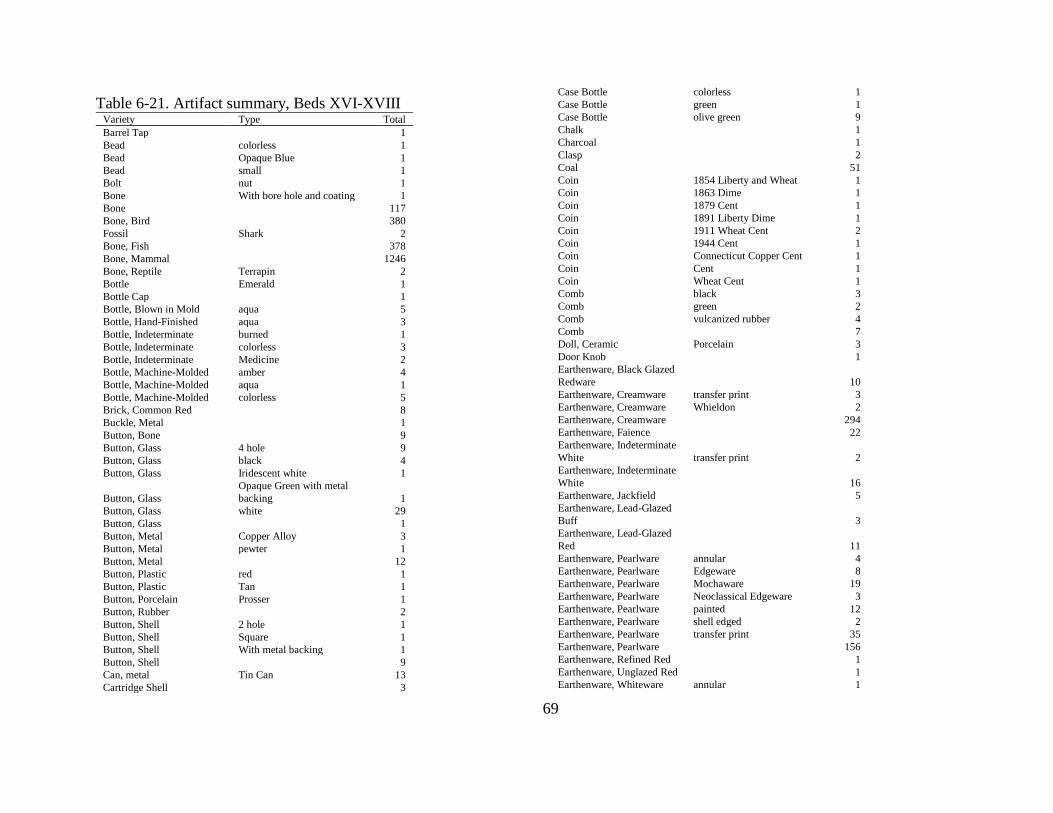
69
Table 6-21. Artifact summary, Beds XVI-XVIII Variety Type Total
Barrel Tap
1
Bead colorless 1
Bead Opaque Blue 1
Bead small 1
Bolt nut 1
Bone With bore hole and coating 1
Bone
117
Bone, Bird
380
Fossil Shark 2
Bone, Fish
378
Bone, Mammal
1246
Bone, Reptile Terrapin 2
Bottle Emerald 1
Bottle Cap
1
Bottle, Blown in Mold aqua 5
Bottle, Hand-Finished aqua 3
Bottle, Indeterminate burned 1
Bottle, Indeterminate colorless 3
Bottle, Indeterminate Medicine 2
Bottle, Machine-Molded amber 4
Bottle, Machine-Molded aqua 1
Bottle, Machine-Molded colorless 5
Brick, Common Red
8
Buckle, Metal
1
Button, Bone
9
Button, Glass 4 hole 9
Button, Glass black 4
Button, Glass Iridescent white 1
Button, Glass
Opaque Green with metal
backing 1
Button, Glass white 29
Button, Glass
1
Button, Metal Copper Alloy 3
Button, Metal pewter 1
Button, Metal
12
Button, Plastic red 1
Button, Plastic Tan 1
Button, Porcelain Prosser 1
Button, Rubber
2
Button, Shell 2 hole 1
Button, Shell Square 1
Button, Shell With metal backing 1
Button, Shell
9
Can, metal Tin Can 13
Cartridge Shell
3
Case Bottle colorless 1
Case Bottle green 1
Case Bottle olive green 9
Chalk
1
Charcoal
1
Clasp
2
Coal
51
Coin 1854 Liberty and Wheat 1
Coin 1863 Dime 1
Coin 1879 Cent 1
Coin 1891 Liberty Dime 1
Coin 1911 Wheat Cent 2
Coin 1944 Cent 1
Coin Connecticut Copper Cent 1
Coin Cent 1
Coin Wheat Cent 1
Comb black 3
Comb green 2
Comb vulcanized rubber 4
Comb
7
Doll, Ceramic Porcelain 3
Door Knob
1
Earthenware, Black Glazed
Redware
10
Earthenware, Creamware transfer print 3
Earthenware, Creamware Whieldon 2
Earthenware, Creamware
294
Earthenware, Faience
22
Earthenware, Indeterminate
White transfer print 2
Earthenware, Indeterminate
White
16
Earthenware, Jackfield
5
Earthenware, Lead-Glazed
Buff
3
Earthenware, Lead-Glazed
Red
11
Earthenware, Pearlware annular 4
Earthenware, Pearlware Edgeware 8
Earthenware, Pearlware Mochaware 19
Earthenware, Pearlware Neoclassical Edgeware 3
Earthenware, Pearlware painted 12
Earthenware, Pearlware shell edged 2
Earthenware, Pearlware transfer print 35
Earthenware, Pearlware
156
Earthenware, Refined Red
1
Earthenware, Unglazed Red
1
Earthenware, Whiteware annular 1
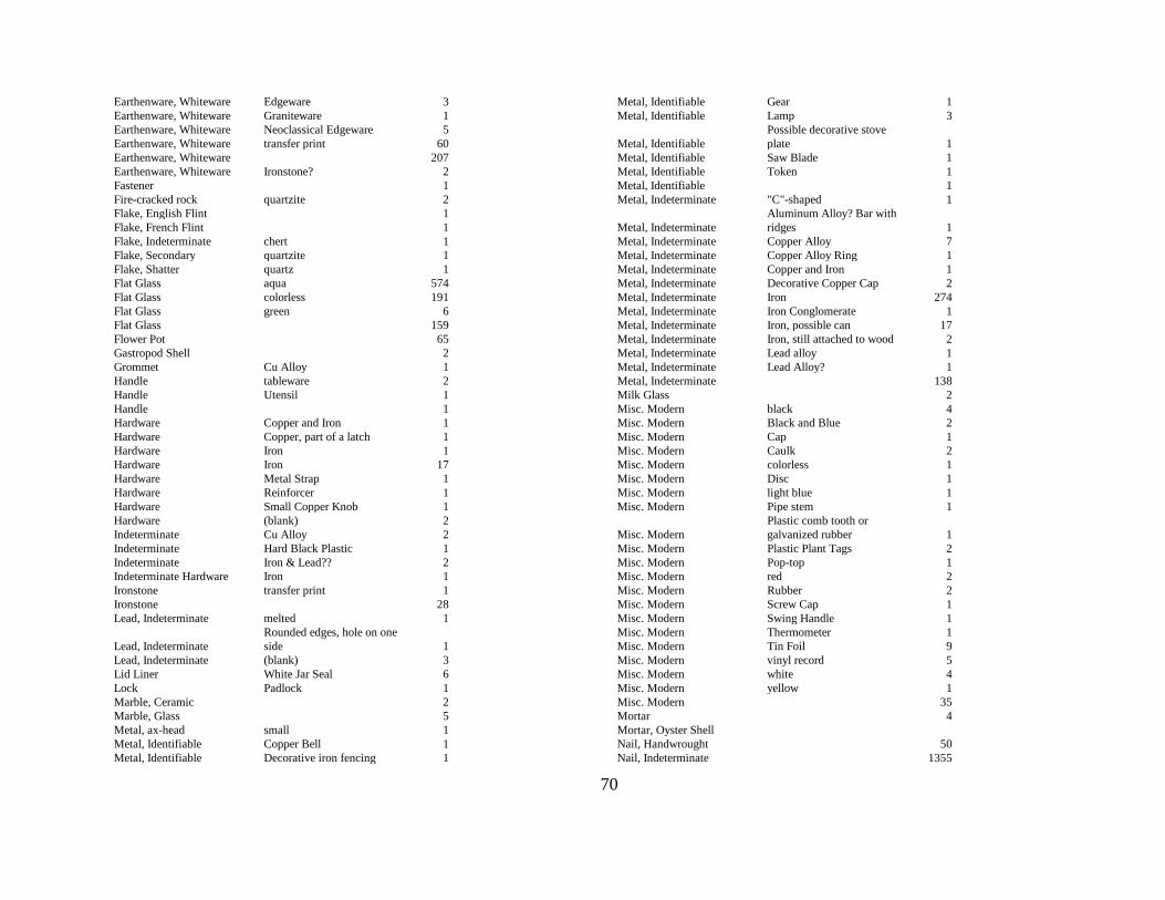
70
Earthenware, Whiteware Edgeware 3
Earthenware, Whiteware Graniteware 1
Earthenware, Whiteware Neoclassical Edgeware 5
Earthenware, Whiteware transfer print 60
Earthenware, Whiteware
207
Earthenware, Whiteware Ironstone? 2
Fastener
1
Fire-cracked rock quartzite 2
Flake, English Flint
1
Flake, French Flint
1
Flake, Indeterminate chert 1
Flake, Secondary quartzite 1
Flake, Shatter quartz 1
Flat Glass aqua 574
Flat Glass colorless 191
Flat Glass green 6
Flat Glass
159
Flower Pot
65
Gastropod Shell
2
Grommet Cu Alloy 1
Handle tableware 2
Handle Utensil 1
Handle
1
Hardware Copper and Iron 1
Hardware Copper, part of a latch 1
Hardware Iron 1
Hardware Iron 17
Hardware Metal Strap 1
Hardware Reinforcer 1
Hardware Small Copper Knob 1
Hardware (blank) 2
Indeterminate Cu Alloy 2
Indeterminate Hard Black Plastic 1
Indeterminate Iron & Lead?? 2
Indeterminate Hardware Iron 1
Ironstone transfer print 1
Ironstone
28
Lead, Indeterminate melted 1
Lead, Indeterminate
Rounded edges, hole on one
side 1
Lead, Indeterminate (blank) 3
Lid Liner White Jar Seal 6
Lock Padlock 1
Marble, Ceramic
2
Marble, Glass
5
Metal, ax-head small 1
Metal, Identifiable Copper Bell 1
Metal, Identifiable Decorative iron fencing 1
Metal, Identifiable Gear 1
Metal, Identifiable Lamp 3
Metal, Identifiable
Possible decorative stove
plate 1
Metal, Identifiable Saw Blade 1
Metal, Identifiable Token 1
Metal, Identifiable
1
Metal, Indeterminate "C"-shaped 1
Metal, Indeterminate
Aluminum Alloy? Bar with
ridges 1
Metal, Indeterminate Copper Alloy 7
Metal, Indeterminate Copper Alloy Ring 1
Metal, Indeterminate Copper and Iron 1
Metal, Indeterminate Decorative Copper Cap 2
Metal, Indeterminate Iron 274
Metal, Indeterminate Iron Conglomerate 1
Metal, Indeterminate Iron, possible can 17
Metal, Indeterminate Iron, still attached to wood 2
Metal, Indeterminate Lead alloy 1
Metal, Indeterminate Lead Alloy? 1
Metal, Indeterminate
138
Milk Glass
2
Misc. Modern black 4
Misc. Modern Black and Blue 2
Misc. Modern Cap 1
Misc. Modern Caulk 2
Misc. Modern colorless 1
Misc. Modern Disc 1
Misc. Modern light blue 1
Misc. Modern Pipe stem 1
Misc. Modern
Plastic comb tooth or
galvanized rubber 1
Misc. Modern Plastic Plant Tags 2
Misc. Modern Pop-top 1
Misc. Modern red 2
Misc. Modern Rubber 2
Misc. Modern Screw Cap 1
Misc. Modern Swing Handle 1
Misc. Modern Thermometer 1
Misc. Modern Tin Foil 9
Misc. Modern vinyl record 5
Misc. Modern white 4
Misc. Modern yellow 1
Misc. Modern
35
Mortar
4
Mortar, Oyster Shell
Nail, Handwrought
50
Nail, Indeterminate
1355
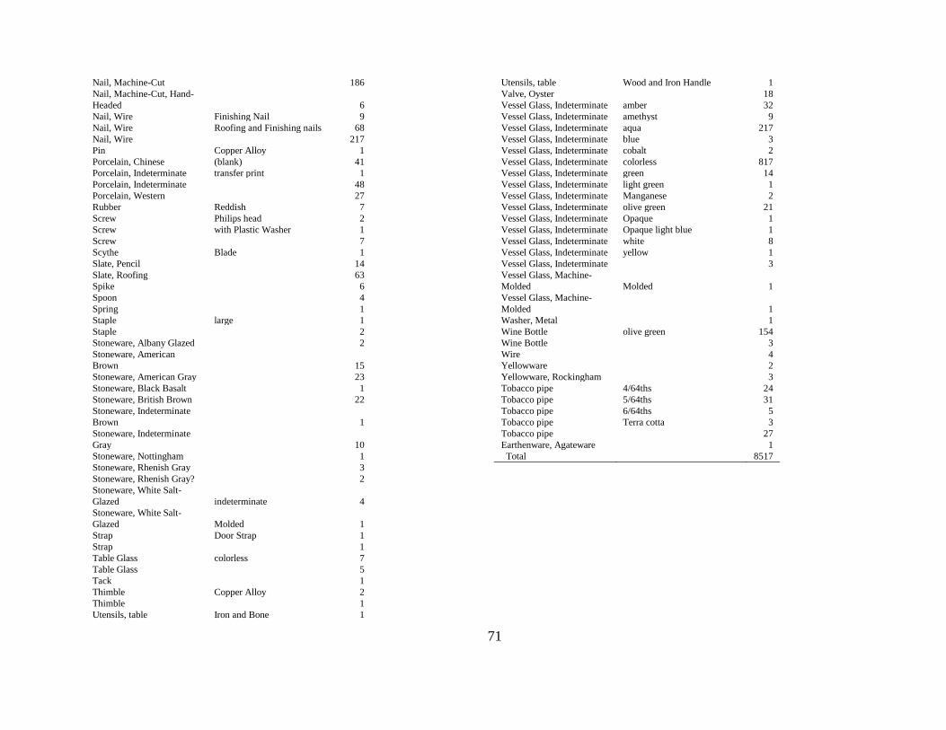
71
Nail, Machine-Cut
186
Nail, Machine-Cut, Hand-
Headed
6
Nail, Wire Finishing Nail 9
Nail, Wire Roofing and Finishing nails 68
Nail, Wire
217
Pin Copper Alloy 1
Porcelain, Chinese (blank) 41
Porcelain, Indeterminate transfer print 1
Porcelain, Indeterminate
48
Porcelain, Western
27
Rubber Reddish 7
Screw Philips head 2
Screw with Plastic Washer 1
Screw
7
Scythe Blade 1
Slate, Pencil
14
Slate, Roofing
63
Spike
6
Spoon
4
Spring
1
Staple large 1
Staple
2
Stoneware, Albany Glazed
2
Stoneware, American
Brown
15
Stoneware, American Gray
23
Stoneware, Black Basalt
1
Stoneware, British Brown
22
Stoneware, Indeterminate
Brown
1
Stoneware, Indeterminate
Gray
10
Stoneware, Nottingham
1
Stoneware, Rhenish Gray
3
Stoneware, Rhenish Gray?
2
Stoneware, White Salt-
Glazed indeterminate 4
Stoneware, White Salt-
Glazed Molded 1
Strap Door Strap 1
Strap
1
Table Glass colorless 7
Table Glass
5
Tack
1
Thimble Copper Alloy 2
Thimble
1
Utensils, table Iron and Bone 1
Utensils, table Wood and Iron Handle 1
Valve, Oyster
18
Vessel Glass, Indeterminate amber 32
Vessel Glass, Indeterminate amethyst 9
Vessel Glass, Indeterminate aqua 217
Vessel Glass, Indeterminate blue 3
Vessel Glass, Indeterminate cobalt 2
Vessel Glass, Indeterminate colorless 817
Vessel Glass, Indeterminate green 14
Vessel Glass, Indeterminate light green 1
Vessel Glass, Indeterminate Manganese 2
Vessel Glass, Indeterminate olive green 21
Vessel Glass, Indeterminate Opaque 1
Vessel Glass, Indeterminate Opaque light blue 1
Vessel Glass, Indeterminate white 8
Vessel Glass, Indeterminate yellow 1
Vessel Glass, Indeterminate
3
Vessel Glass, Machine-
Molded Molded 1
Vessel Glass, Machine-
Molded
1
Washer, Metal
1
Wine Bottle olive green 154
Wine Bottle
3
Wire
4
Yellowware
2
Yellowware, Rockingham
3
Tobacco pipe 4/64ths 24
Tobacco pipe 5/64ths 31
Tobacco pipe 6/64ths 5
Tobacco pipe Terra cotta 3
Tobacco pipe
27
Earthenware, Agateware
1
Total
8517
72
Structural Features
By definition, the numerous deposits uncovered around the Burch House are features.
This section, however, is devoted to those that appear to be structural features; sp., foundations,
footers, and posthole and mold complexes (hereinafter termed postholes). Perhaps the most
surprising and interesting structural features form a complex along the foundation of the Burch
House. These are discussed separately. First, I discuss a number of postholes found in several of
the block units. The foundations of the Burch House addition, pavement, and garden partition
have been discussed above.
POSTHOLES
Deposits next to the Burch House are complex, partly because of the vagaries of
sedimentation, which includes such variables as turbidity, nature of sediment load, and the
condition of the surface at the time of the sedimentation event. Those deposits were then
modified by human activities, rodent and amphibian burrowing, plant growth, microbial action,
and chemical weathering. The two principal variables that must detain us here are human and
rodent activities; specifically, excavation associated with building construction and maintenance,
and ground hog (Marmota monax) burrowing. (Deep units uncovered active toad dens and
mole/vole burrows, but these disturbances mostly have resulted in assemblage contamination
rather than the creation of substantial soil anomalies.)
Excavation of Unit 86 revealed a series of overlapping anomalies (Figure 6-15)
designated Strata 12 through 16. All proved shallow (< 0.35 ft thick) and no definitive postmolds
were observed. We could not determine whether these were truncated burrows or shallow beds
created by household livestock. They do not appear to be cultural and they certainly aren‘t
structural.
Figure 6-15. Unit 86, Strata 12 through 16.
73
Excavators did find a half dozen soil anomalies extending into the A1 horizon at the base
of the block excavation units (Figure 6-16). Four of these (Units 86 and 90) are small, a foot or
so in their longest dimensions, and encompass a small mold (Figure 6-17). Those in Unit 90 may
be scaffolding postholes. These would have been temporary features in which poles were placed
for scaffolding during building construction. Two other postholes are paired original and
replacement holds (Unit 84, Stratum 13, and Unit 93, Stratum 11), the newer holes excavated to
remove and replace deteriorating posts (Figures 6-18 and 6-19). They are common on Colonial
earthfast building sites and they belie assertions that earthfast buildings were ‗impermanent,‘
evidence of a people committed to leaving as soon as they accumulated wealth (Carson, et al.,
1981). How these various postholes relate to one another remains uncertain. Clarification
requires more extensive excavation to reveal one or more building footprints.
Figure 6-16. Postholes in block excavation units.
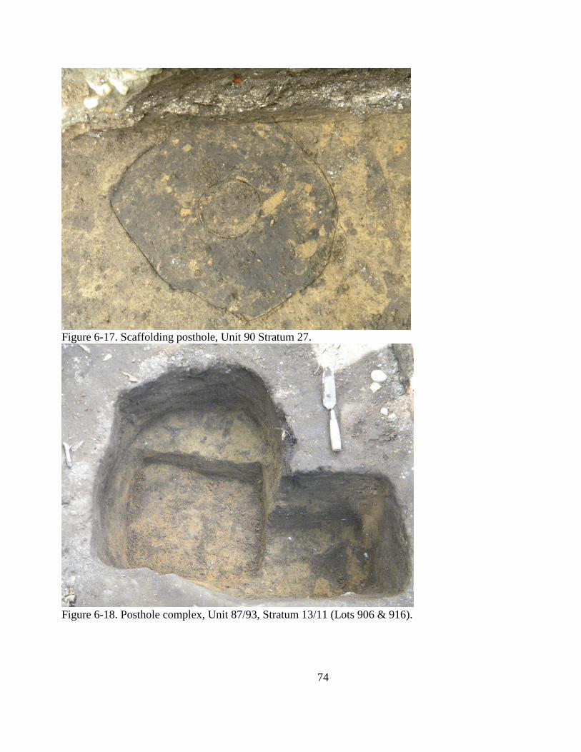
74
Figure 6-17. Scaffolding posthole, Unit 90 Stratum 27.
Figure 6-18. Posthole complex, Unit 87/93, Stratum 13/11 (Lots 906 & 916).
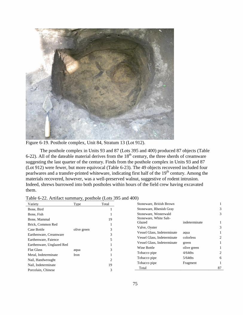
75
Figure 6-19. Posthole complex, Unit 84, Stratum 13 (Lot 912).
The posthole complex in Units 93 and 87 (Lots 395 and 400) produced 87 objects (Table
6-22). All of the dateable material derives from the 18th
century, the three sherds of creamware
suggesting the last quarter of the century. Finds from the posthole complex in Units 93 and 87
(Lot 912) were fewer, but more equivocal (Table 6-23). The 49 objects recovered included four
pearlwares and a transfer-printed whiteware, indicating first half of the 19th
century. Among the
materials recovered, however, was a well-preserved walnut, suggestive of rodent intrusion.
Indeed, shrews burrowed into both postholes within hours of the field crew having excavated
them.
Table 6-22. Artifact summary, posthole (Lots 395 and 400)
Variety Type Total
Bone, Bird
1
Bone, Fish
1
Bone, Mammal
19
Brick, Common Red
1
Case Bottle olive green 3
Earthenware, Creamware
3
Earthenware, Faience
5
Earthenware, Unglazed Red
1
Flat Glass aqua 3
Metal, Indeterminate Iron 1
Nail, Handwrought
2
Nail, Indeterminate
19
Porcelain, Chinese
3
Stoneware, British Brown
1
Stoneware, Rhenish Gray
3
Stoneware, Westerwald
3
Stoneware, White Salt-
Glazed indeterminate 1
Valve, Oyster
3
Vessel Glass, Indeterminate aqua 1
Vessel Glass, Indeterminate colorless 2
Vessel Glass, Indeterminate green 1
Wine Bottle olive green 1
Tobacco pipe 4/64ths 2
Tobacco pipe 5/64ths 6
Tobacco pipe Fragment 1
Total 87
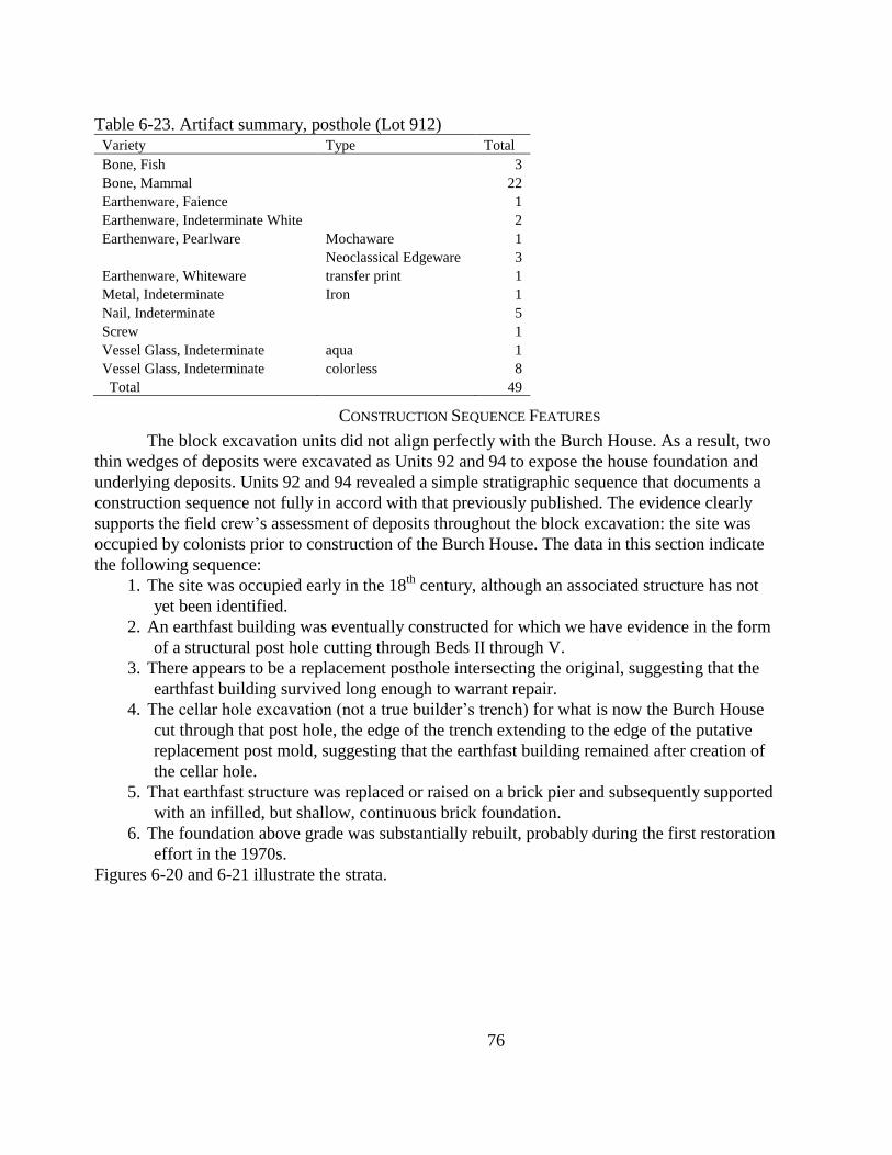
76
Table 6-23. Artifact summary, posthole (Lot 912)
Variety Type Total
Bone, Fish
3
Bone, Mammal
22
Earthenware, Faience
1
Earthenware, Indeterminate White
2
Earthenware, Pearlware Mochaware 1
Neoclassical Edgeware 3
Earthenware, Whiteware transfer print 1
Metal, Indeterminate Iron 1
Nail, Indeterminate
5
Screw
1
Vessel Glass, Indeterminate aqua 1
Vessel Glass, Indeterminate colorless 8
Total 49
CONSTRUCTION SEQUENCE FEATURES
The block excavation units did not align perfectly with the Burch House. As a result, two
thin wedges of deposits were excavated as Units 92 and 94 to expose the house foundation and
underlying deposits. Units 92 and 94 revealed a simple stratigraphic sequence that documents a
construction sequence not fully in accord with that previously published. The evidence clearly
supports the field crew‘s assessment of deposits throughout the block excavation: the site was
occupied by colonists prior to construction of the Burch House. The data in this section indicate
the following sequence:
1. The site was occupied early in the 18th
century, although an associated structure has not
yet been identified.
2. An earthfast building was eventually constructed for which we have evidence in the form
of a structural post hole cutting through Beds II through V.
3. There appears to be a replacement posthole intersecting the original, suggesting that the
earthfast building survived long enough to warrant repair.
4. The cellar hole excavation (not a true builder‘s trench) for what is now the Burch House
cut through that post hole, the edge of the trench extending to the edge of the putative
replacement post mold, suggesting that the earthfast building remained after creation of
the cellar hole.
5. That earthfast structure was replaced or raised on a brick pier and subsequently supported
with an infilled, but shallow, continuous brick foundation.
6. The foundation above grade was substantially rebuilt, probably during the first restoration
effort in the 1970s.
Figures 6-20 and 6-21 illustrate the strata.
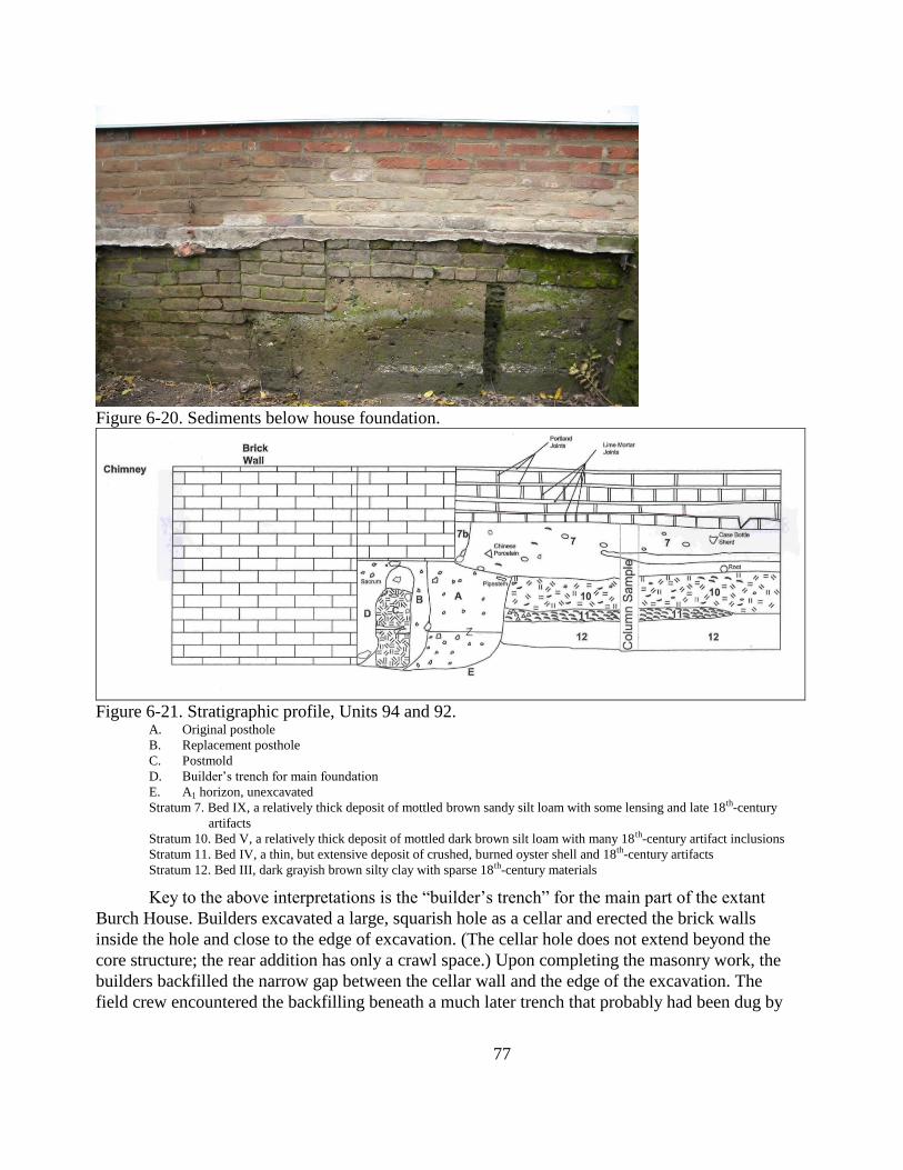
77
Figure 6-20. Sediments below house foundation.
Figure 6-21. Stratigraphic profile, Units 94 and 92.
A. Original posthole
B. Replacement posthole
C. Postmold
D. Builder‘s trench for main foundation
E. A1 horizon, unexcavated
Stratum 7. Bed IX, a relatively thick deposit of mottled brown sandy silt loam with some lensing and late 18th-century
artifacts
Stratum 10. Bed V, a relatively thick deposit of mottled dark brown silt loam with many 18th-century artifact inclusions
Stratum 11. Bed IV, a thin, but extensive deposit of crushed, burned oyster shell and 18th-century artifacts
Stratum 12. Bed III, dark grayish brown silty clay with sparse 18th-century materials
Key to the above interpretations is the ―builder‘s trench‖ for the main part of the extant
Burch House. Builders excavated a large, squarish hole as a cellar and erected the brick walls
inside the hole and close to the edge of excavation. (The cellar hole does not extend beyond the
core structure; the rear addition has only a crawl space.) Upon completing the masonry work, the
builders backfilled the narrow gap between the cellar wall and the edge of the excavation. The
field crew encountered the backfilling beneath a much later trench that probably had been dug by
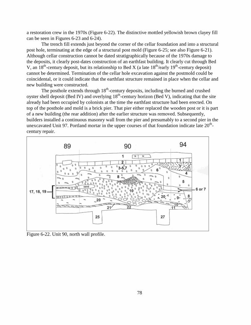
78
a restoration crew in the 1970s (Figure 6-22). The distinctive mottled yellowish brown clayey fill
can be seen in Figures 6-23 and 6-24).
The trench fill extends just beyond the corner of the cellar foundation and into a structural
post hole, terminating at the edge of a structural post mold (Figure 6-25; see also Figure 6-21).
Although cellar construction cannot be dated stratigraphically because of the 1970s damage to
the deposits, it clearly post-dates construction of an earthfast building. It clearly cut through Bed
V, an 18th
-century deposit, but its relationship to Bed X (a late 18th
/early 19th
-century deposit)
cannot be determined. Termination of the cellar hole excavation against the postmold could be
coincidental, or it could indicate that the earthfast structure remained in place when the cellar and
new building were constructed.
The posthole extends through 18th
-century deposits, including the burned and crushed
oyster shell deposit (Bed IV) and overlying 18th
-century horizon (Bed V), indicating that the site
already had been occupied by colonists at the time the earthfast structure had been erected. On
top of the posthole and mold is a brick pier. That pier either replaced the wooden post or it is part
of a new building (the rear addition) after the earlier structure was removed. Subsequently,
builders installed a continuous masonry wall from the pier and presumably to a second pier in the
unexcavated Unit 97. Portland mortar in the upper courses of that foundation indicate late 20th
-
century repair.
Figure 6-22. Unit 90, north wall profile.
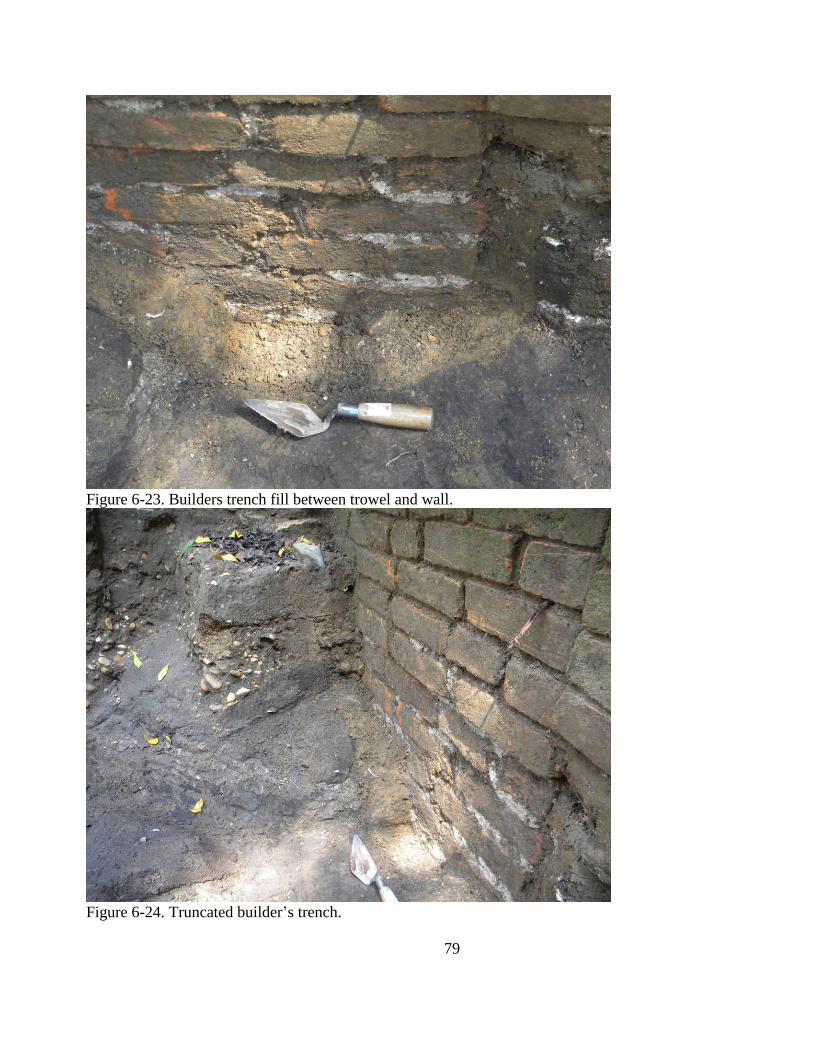
79
Figure 6-23. Builders trench fill between trowel and wall.
Figure 6-24. Truncated builder‘s trench.
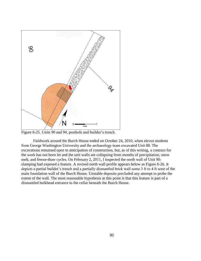
80
Figure 6-25. Units 90 and 94, posthole and builder‘s trench.
Fieldwork around the Burch House ended on October 24, 2010, when eleven students
from George Washington University and the archaeology team excavated Unit 88. The
excavations remained open in anticipation of construction, but, as of this writing, a contract for
the work has not been let and the unit walls are collapsing from months of precipitation, snow
melt, and freeze-thaw cycles. On February 2, 2011, I inspected the north wall of Unit 90:
slumping had exposed a feature. A revised north wall profile appears below as Figure 6-26. It
depicts a partial builder‘s trench and a partially dismantled brick wall some 3 ft to 4 ft west of the
main foundation wall of the Burch House. Unstable deposits precluded any attempt to probe the
extent of the wall. The most reasonable hypothesis at this point is that this feature is part of a
dismantled bulkhead entrance to the cellar beneath the Burch House.
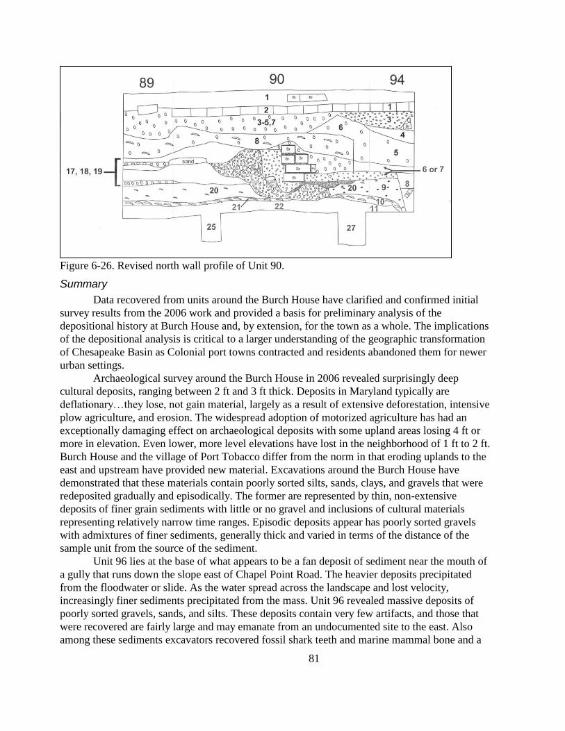
81
Figure 6-26. Revised north wall profile of Unit 90.
Summary
Data recovered from units around the Burch House have clarified and confirmed initial
survey results from the 2006 work and provided a basis for preliminary analysis of the
depositional history at Burch House and, by extension, for the town as a whole. The implications
of the depositional analysis is critical to a larger understanding of the geographic transformation
of Chesapeake Basin as Colonial port towns contracted and residents abandoned them for newer
urban settings.
Archaeological survey around the Burch House in 2006 revealed surprisingly deep
cultural deposits, ranging between 2 ft and 3 ft thick. Deposits in Maryland typically are
deflationary…they lose, not gain material, largely as a result of extensive deforestation, intensive
plow agriculture, and erosion. The widespread adoption of motorized agriculture has had an
exceptionally damaging effect on archaeological deposits with some upland areas losing 4 ft or
more in elevation. Even lower, more level elevations have lost in the neighborhood of 1 ft to 2 ft.
Burch House and the village of Port Tobacco differ from the norm in that eroding uplands to the
east and upstream have provided new material. Excavations around the Burch House have
demonstrated that these materials contain poorly sorted silts, sands, clays, and gravels that were
redeposited gradually and episodically. The former are represented by thin, non-extensive
deposits of finer grain sediments with little or no gravel and inclusions of cultural materials
representing relatively narrow time ranges. Episodic deposits appear has poorly sorted gravels
with admixtures of finer sediments, generally thick and varied in terms of the distance of the
sample unit from the source of the sediment.
Unit 96 lies at the base of what appears to be a fan deposit of sediment near the mouth of
a gully that runs down the slope east of Chapel Point Road. The heavier deposits precipitated
from the floodwater or slide. As the water spread across the landscape and lost velocity,
increasingly finer sediments precipitated from the mass. Unit 96 revealed massive deposits of
poorly sorted gravels, sands, and silts. These deposits contain very few artifacts, and those that
were recovered are fairly large and may emanate from an undocumented site to the east. Also
among these sediments excavators recovered fossil shark teeth and marine mammal bone and a
82
chalcedony flake that may derive from the fluting of a Clovis point. Creek terraces along the base
of the upland might contain early Native American sites in their deposits. The redeposited
material lies directly on an 18th
-century horizon that—based on the relative paucity of artifacts—
likely represents the periphery of a site.
Unit 95, excavated well south of the mouth of the ravine, revealed layers of redeposited
material, but the sediments were finer grained and the gravels fewer and less poorly sorted than
those in Unit 96. Here also an 18th
-century horizon survives intact below the sediments. As noted
above, some of the historic materials from the upper strata of Unit 95 may derive from an
undocumented historic site to the east.
Units 84 through 94—the block excavation—revealed complex depositional patterns
rendered more complex by groundhog burrowing, construction, demolition, and gardening
(Figure 6-27). But again, 18th
-century deposits survive beneath numerous strata of redeposited
sediments. Approaching the sedimentation issue from the perspective of beds, or groups of strata
spanning several units, proved effective; detailed analyses that attempt to reveal aspects of the
material lives of the succession of householders, however, will require a less expansive approach.
Analyses of individual strata followed by the linking of those strata may be more effective.
Detailed faunal analysis, however, must be conducted first to address taphonomic issues. Bone is
better suited to such work because it reacts more clearly to exposure to the elements, rodent and
canine osteophagy, and transportation in water-suspended sediments. The foregoing analyses
have focused on the sedimentary history of the site. They reveal nothing of the temporary use of
the house as a school for African American children and the attribution of specific deposits to
specific households remains to be undertaken.
The stratigraphic sequences indicate a much more complex construction and occupational
sequence for the Burch House and site than previously had been considered. The extant Burch
House is not the first Colonial dwelling on this site and the house probably was built in the late
18th
century, a frame structure with brick foundation and cellar replacing at least one, and
possibly a succession of two, earthfast buildings. Initial fieldwork in 2006 demonstrated the
existence of a cellar beneath the main part of the Burch House. Recently field findings suggest
the remains of a bulkhead entranceway, at least on the west side of the Burch House; a feature
long suspected, but not hitherto documented. Evidence of an earthfast dwelling suggests that the
remains of an earthen cellar might survive beneath the rear ell, the extant main structure likely
having been constructed while the earthfast building remained standing. Any future excavation
and any construction-related monitoring should anticipate the exposure of an earthen cellar hole
and at least one more posthole and mold in unexcavated Unit 97. Such features also can be
expected beneath the rear addition.
Figure 6-27. East-West profile of block excavation, Units 85, 84, and 87.
83
References Cited
Ballweber, Hettie L.
1994 Return to the Luce Creek Site (18AN143). Maryland Archeology 30(1): 1–16.
Barse William P.
1982 Results of a Phase I Archeological Reconnaissance of the Proposed Ryceville-Loveville
Transmission Line, Charles and St. Mary‘s County, Maryland. Thunderbird Archeological
Associates. Submitted to the Southern Maryland Electric Cooperative.
Berry, Brian J.L.
1967 Geography of Market Centers and Retail Distribution. Prentice–Hall, Princeton, New
Jersey.
Brown, Lois
1979 Fluted Projectile Points in Maryland. Paper distributed by the Council for Maryland
Archeology.
Carbone, Victor
1976 Environment and Prehistory in the Shenendoah Valley. Unpublished Ph.D.
dissertation, Department of Anthropology, The Catholic University of America,
Washington, D.C.
Carson, Cary, Norman F. Barka, William M. Kelso, Garry W. Stone, and Dell Upton
1981 Impermanent Architecture in the Southern American Colonies. Winterthur Portfolio
16:135–196.
Cheek, Charles H., Amy Friedlander, and Cheryl A. Holt
1983 A Phase II Investigation of the Prehistory and History of Five Sites in St. Mary‘s County,
Maryland. Soil Systems, Alexandria, VA. Submitted to Southern Maryland Electric
Cooperative, Hughesville, MD.
Custer, Jay F.
1984 Delaware Prehistoric Archaeology: An Ecological Approach. University of Delaware
Press, Newark.
1986 Late Woodland Cultures of the Middle Atlantic Region. University of Delaware Press,
Newark.
Dent, Richard J., Jr.
1995 Chesapeake Prehistory: Old Traditions, New Directions. Plenum Press, New York.
Ebright, Carol A.
1992 Early Native American Prehistory of the Maryland Western Shore: Archeological
Investigations at the Higgins Site. Maryland State Highway Administration,
Archeological Report Number 1. 3 vols.
Ford, T. L.
1976 Adena Sites on the Chesapeake Bay. Archaeology of Eastern North America 4: 63–89.
84
Gardner, William M.
1982 Early Woodland in the Middle Atlantic: An Overview. Occasional Papers of the
American Archaeological Institute 3:53–87.
Gardner, William, Carole L. Nash, Joan M. Walker, and William P. Barse
1989 Excavations at 18CV272. Submitted to CRJ Associates, Camp Springs, Maryland.
Gibb, James G.
2004 A Phase I Intensive Archeological Survey of the Stanwick Farm, Aquasco, Prince
George‘s County, Maryland. Andrew Garte & Associates, Shady Side, Maryland.
Submitted to LANDESIGN, Bowie, Maryland.
1996 The Archaeology of Wealth: Consumer Behavior in English America. Plenum Press.
1991 An Intensive Systematic Surface Collection of the Allens Fresh Number 1 Site on Zekiah
Swamp/Allens Fresh, Westwood Point, Charles County, Maryland. Submitted to the Tri-County
Council of Southern Maryland, Hughesville, Maryland.
Gibb, James G., and April M. Beisaw
2007 Seeking Port Tobacco: An Intensive Archaeological Investigation of a Maryland Town
Site, Part 1. Gibb Archaeological Consulting, Annapolis, Maryland. Submitted to The
Society for the Restoration of Port Tobacco, the Maryland Historical Trust, and the
Archeological Society of Maryland.
2008 Seeking Port Tobacco: An Intensive Archaeological Investigation of a Maryland Town
Site, Part 2. Gibb Archaeological Consulting, Annapolis, Maryland. Submitted to
Preservation Maryland, Inc.,The Southern Maryland Heritage Area Consortium, Mr.
Ed Edelen & Ms Lexy Edelen, Ms Sheila Smith, and The Society for the Restoration
of Port Tobacco, Inc.
Gibb, James G., and Anson H. Hines
1997 Selby Bay Phase Subsistence Strategies at the Smithsonian Pier Site, Anne Arundel
County, Maryland. Maryland Archeology 33 (1 & 2) 59-76.
Gibb, James G., and Scott D. Lawrence
2006 Phase I Intensive Archaeological Survey of the Burch House Site (18CH765), Port Tobacco,
Charles County, Maryland. Gibb Archaeological Consulting, Annapolis, Maryland. Submitted
to The Society for the Restoration of Port Tobacco.
Gottschalk, L. C.
1945 Effects of Soil Erosion on Navigation on Upper Chesapeake Bay. Geographical
Review 35 (2) 219-238.
Griffith, Daniel R.
1980 Townsend Ceramics of the Late Woodland of Southern Delaware. Maryland
Historical Magazine 75(1): 23–41.
Hall, Richard L., and Earl D. Matthews
1967 Soil Survey of Prince George’s County, Maryland. U.S. Department of Agriculture,
Soil Conservation Service. U.S. Government Printing Office, Washington, DC.
85
Hickey, Joseph Vincent
1970 The Prehistory of Southeastern Charles County, Maryland: An Archaeological Reconnaissance
of the Zekiah Swamp. Unpublished M.A. thesis, Department of Anthropology, George
Washington University.
Kavanagh, Maureen
1982 Archeological Resources of the Monocacy River Region, Frederick and Carroll
Counties, Maryland. Maryland Geological Survey, Division of Archeology File Report
Number 164.
King, Julia A., Scott M. Strickland, and Kevin Norris
2008 The Search for the Court House at Moore‘s Lodge: Charles County‘s First County Seat.
Prepared for the Citizens of Charles County.
Land Records of Charles County
n.d. Land records, patents, warrants, rent rolls, wills, and guardian accounts available at the
Maryland State Archives, Annapolis, and the Prince George‘s County Courthouse,
Annapolis, Maryland.
Lee, Jean B.
1994 The Price of Nationhood: The American Revolution in Charles County. W.W. Norton,
NY.
Lippson, Alice Jane
1973 The Chesapeake Bay in Maryland: An Atlas of Natural Resources. The Johns Hopkins
University Press, Baltimore.
Luckenbach, Alvin H., Wayne Clark, and Richard S. Levy
1987 Rethinking Cultural Stability in Eastern North American Prehistory: Linguistic
Evidence from Eastern Algonqian. Journal of Middle Atlantic Archaeology 3:1–33.
Lukezic, Craig
1990 Soils and Settlement Location in 18th Century Colonial Tidewater Virginia. Historical
Archaeology 24 (1): 1–17.
Marks, Bayly Ellen
1979 Economics and Society in a Staple Plantation System: St. Mary‘s. University
Microfilms, Ann Arbor, MI.
Maryland Department of Transportation
1986 Specifications for Consulting Engineers’ Services, Section IV. Maryland Department
of Transportation, Baltimore, Maryland.
Maryland State Highway Administration
1992 Specifications for Archeological Procedures. Maryland Department of Transportation,
State Highway Administration, Baltimore, Maryland.
Nassaney, Michael S., and Kendra Pyle
1999 The Adoption of the Bow and Arrow in Eastern North America: A View from Central
Arkansas. American Antiquity 64 (3): 243–263.
86
Pogue, Dennis J.
1984 Town Rearing on the Maryland Chesapeake Frontier, A Reinterpretation. Paper
presented at the annual meeting of the Society for Historical Archaeology.
Reps, John W.
1972 Tidewater Towns: City Planning in Colonial Virginia and Maryland. Colonial
Williamsburg Foundation, Williamsburg, Virginia.
Schubel, J.R.
1981 The Living Chesapeake. The Johns Hopkins University Press, Baltimore.
Shaffer, Gary D., and Elizabeth J. Cole
1994 Standards and Guidelines for Archeological Investigations in Maryland. Maryland
Historical Trust Technical Report Number 2.
Shomette, Donald G.
2000 Lost Towns of Tidewater Maryland. Tidewater Publishers, Centreville, MD.
Smolek, Michael A.
1984 ―Soyle light, Well–Watered and On the River‖: Settlement Patterning of Maryland‘s
Frontier Plantations. Paper presented at the Third Hall of Records Conference on
Maryland History, St. Mary‘s City, MD.
Steponaitis, Laurie C.
1983 An Historical Study of the Patuxent River Drainage, Maryland. Maryland Historical
Trust Monograph Series 1.
1980 A Survey of Artifact Collections from the Patuxent River Drainage, Maryland.
Submitted to the Maryland Historical Trust and the Coastal Zone Administration,
Department of Natural Resources, Annapolis, Maryland.
1978 An Archeological Survey of the South River Drainage Basin, Anne Arundel County,
Maryland, Maryland Geological Survey, Division of Archeology File Report Number
138.
Stephenson, Robert L. and Alice L.L. Fergeson
1963 Accokeek Site: A Middle Atlantic Seaboard Cultural Sequence. Museum of
Anthropology, University of Michigan Anthropological Papers Number 20. Ann
Arbor, Michigan.
Stiverson, Gregory A.
1977 Poverty in a Land of Plenty: Tenancy in Eighteenth Century Maryland. The Johns
Hopkins University Press, Baltimore.
Thomas, Joseph B., Jr.
1994 Settlement, Community, and Economy: The Development of Towns on Maryland‘s
Eastern Shore, 1660-1775. Unpublished Ph.D. dissertation, Department of Geography,
University of Maryland, College Park, Maryland.
87
United States Army Corps of Engineers
1866 Central Virginia showing Lieut. Gen'l. U.S. Grant's Campaign and marches of the
armies under his command in 1864-65. Engineer Bureau, War Department. Prepared
by order of the Secretary of War for the officers of the U.S. Army under the command
of Lieut. Gen. U.S. Grant. 39th Cong., 1st Session [1866]-Report No. 11. Bowen &
Co. Lithographers, Philadelphia.
United States Geological Survey
1966 U.S.G.S. 7.5–Minute Topographic map, Port Tobacco, MD. U.S. Government Printing
Office, Washington, D.C.
Wanser, Jeffrey C.
1982 A Survey of Artifact Collections from Central Southern Maryland, Maryland
Historical Trust Manuscript Series Number 23.
Weld, Isaac
1807 Travels through the States of North America and the Provinces of Upper and Lower
Canada During the Years 1795, 1796, and 1797. 2 vols. London: John Stockdale.
Wesler, Kit W., Dennis J. Pogue, Al Luckenbach, Gordon J. Fine, Patricia A. Sternheimer, and
Elisabeth Glyn Furgurson
1981 The Maryland Department of Transportation Archeological Resources Survey,
Volume 2: Western Shore. Maryland Historical Trust Manuscript Series Number 6.
Wright, Henry T.
1968 A Report on the Archeological Survey of the Chesapeake Bay Center for Field Biology
of the Smithsonian Institution. Report submitted to the Smithsonian Institution.
1969 A Report on the Archeological Survey of the Chesapeake Bay Center for Field Biology
of the Smithsonian Institution. Report submitted to the Smithsonian Institution.
1973 An Archeological Sequence in the Middle Chesapeake Region, Maryland. Maryland
Geological Survey, Archeological Studies Number 1.
Wyckoff, V. J.
1937 The Sizes of Plantations in Seventeenth–Century Maryland. Maryland Historical
Magazine 32: 331–339.
88
Appendix A: Shovel Test Data
STP North
Eas
t
Stratu
m Depth Munsell Texture Horizon Notes/Inclusions
1 200 200 1 0.55 10YR2/2 Sandy silt loam A1
1 200 200 2 1.25 10YR3/2 Gravelly sand loam Fill 10YR5/4; late trash
1 200 200 3 2.30 10YR3/3 Sandy silt loam A1
1 200 200 4 2.70 10YR3/2 Silt loam Ab
1 200 200 5 Gravel ? Impenetrable
2 200 180 1 0.60 10YR2/2 Sandy silt loam A1
2 200 180 2 1.60 10YR3/2 Gravelly sandy silt loam A2 Brick flecks
2 200 180 3 2.20 10YR4/2 Silt loam Ab
2 200 180 4 Gravel ? Impenetrable
3 200 160 1 0.50 10YR2/1 Silt loam A1
3 200 160 2 1.95 10YR3/2 Silt loam A1 Gravel
3 200 160 3 2.40 10YR3/3 Sandy silt loam Feature? Under-fired brick; variegated soil
3 200 160 4 4.00 10YR4/2 Very fine sandy silt loam Bw
4 200 140 1 0.60 10YR3/2 Silt loam A1 Brick flecks
4 200 140 2 3.30 10YR3/3 Gravelly silt loam A2
4 200 140 3 4.50 10YR3/3 Sandy loam Ab
4 200 140 4 4.80 10YR4/2 Very fine sandy silt loam Bw
5 200 120 1 1.00 10YR2/2 Gravelly sandy silt loam Fill
5 200 120 2 3.20 10YR2/2 Silt loam Ab Early historic
5 200 120 3 3.40 10YR4/2 Very fine sandy silt loam Bw
6 200 100 1 0.70 10YR4/3 Silt loam A1 10YR3/2
6 200 100 2 2.70 10YR3/2 Silt loam Ab Chinese porcelain
6 200 100 3 3.00 10YR4/2 Very fine sandy silt loam Bw
7 200 80 1 0.60 10YR3/3 Silt loam A1
7 200 80 2 1.10 10YR3/2 Silt loam A2 10YR4/2
7 200 80 3 1.90 10YR2/2 Silt loam A3
7 200 80 4 2.70 10YR2/2 Silt loam Ab Brick flecks
7 200 80 5 3.00 10YR4/2 Very fine sandy silt loam Bw
8 220 60 1 0.65 10YR2/2 Silt loam A1 10YR4/4
8 220 60 2 3.00 10YR2/1 Silt loam Ab
8 220 60 3 3.30 10YR4/2 Very fine sandy silt loam Bw
9 220 80 1 3.60 10YR3/2 Silt loam Feature? Compact, seemingly undifferentiated
9 220 80 2 3.80 10YR4/2 Very fine sandy silt loam Bw
10 220 100 1 0.40 10YR3/3 Silt loam A1 Ash
10 220 100 2 1.50 10YR3/3 Silt loam A2
10 220 100 3 3.10 10YR3/2 Silt loam Ab Oyster shell & mortar
10 220 100 4 3.80 10YR4/3 Clay loam Bt
11 220 120 1 1.70 10YR2/1 Silt loam A1
11 220 120 2 3.00 10YR2/2 Silt loam Ab1
11 220 120 3 3.30 10YR3/2 Silt loam Ab2
11 220 120 4 3.50 10YR4/4 Clay loam Bt
12 220 140 1 0.40 10YR2/1 Silt loam A1
12 220 140 2 0.80 10YR3/2 Sandy silt loam A2
12 220 140 3 1.20 10YR4/3 Gravelly sand Fill
12 220 140 4 1.40 10YR4/3 Silt loam A3 10YR3/2
12 220 140 5 3.00 10YR2/2 Silt loam Ab tin-glazed earthenware, bottle glass
12 220 140 6 3.60 10YR4/3 Clayey silt loam Bt
13 220 160 1 0.70 10YR3/2 Sandy silt loam A1
13 220 160 2 1.50 10YR3/3 Sandy loam A2
13 220 160 3 2.00 10YR3/4 Gravelly sand C1
13 220 160 4 Gravelly sand C2 Impenetrable
14 220 180 1 0.60 10YR3/2 Sandy silt loam A1
89
14 220 180 2 1.30 10YR4/2 Sandy silt loam A2
14 220 180 3 1.80 10YR4/3 Sandy silt A3
14 220 180 4 2.00 10YR4/3 Gravelly sand C
15 220 200 1 0.50 10YR2/2 Silt loam A1
15 220 200 2 1.10 10YR4/3 Silt loam A2
15 220 200 3 1.50 10YR4/2 Sandy silt loam A3
15 220 200 4 1.90 10YR4/3 Sand C1
15 220 200 5 2.10 Gravelly sand C2 Unconsolidated
16 240 180 1 0.50 10YR2/1 Gravelly sand loam A1
16 240 180 2 2.00 Gravelly sand C Banded gravels & sands
17 240 200 1 0.50 10YR2/1 Sandy silt loam
17 240 200 2 2.00 Gravelly sand Mixed sands & gravels
18 240 100 1 0.60 10YR2/1 Silt loam A1
18 240 100 2 10YR2/1 Silt loam Feature Pebbles on brick
19 240 80 1 0.60 10YR3/2 Silt loam A1
19 240 80 2 1.20 10YR3/3 Silt loam A2
19 240 80 3 1.90 10YR2/2 Silt loam A3 Oyster shell
19 240 80 4 4.00 10YR3/3 Silt loam Ab
19 240 80 5 4.40 10YR4/2 Very fine sandy silt loam Bw
20 260 100 1 0.70 10YR2/2 Silt loam A1
20 260 100 2 1.40 10YR2/1 Sandy silt loam Feature Dense brick rubble & whole oyster shell

90
Appendix B: Artifact catalogue (not included)
91
Appendix C: Credentials
James G. Gibb, Ph.D
2554 Carrollton Road
Annapolis, Maryland 21403
(443) 482–9593
Education
2003 Certification in Computer Aided Design and Drafting, Anne Arundel Community College, Department of
Engineering Technologies.
1994 Ph.D. in Anthropology, Binghamton University
1985 M.A. in Anthropology, Binghamton University
1978 B.A. in Anthropology, State University of New York at Stony Brook
Continuing Education
1996 University of Nevada Cultural Resource Management Program: Assessing the Archaeological Significance
of Historical Sites.
1994+ Washington Ceramic Seminar: Master Class in Antique Ceramics.
Professional Experience
Twenty–five years of archaeological field and laboratory experience in six eastern states and Arizona, on sites
ranging in age from early prehistoric to late 19th century. Author of more than 60 technical reports.
Eighteen years of supervisory experience and eleven years as Principal Investigator in Sole Proprietorship consulting
firm.
Select Publications
2000 Imaginary, But by No Means Unimaginable: Storytelling, Science, and Historical Archaeology. Historical
Archaeology 33 (2): 1–6.
2000 Reflection, Not Truth, the Hero of My Tale: Responding to Lewis, Little, Majewski, and McKee and Galle.
Historical Archaeology 33(2): 20–24.
1999 A Layperson’s Guide to Historical Archaeology in Maryland. Archeological Society of Maryland. (Editor
and contributor)
1997 Selby Bay Phase Subsistence Strategies at the Smithsonian Pier Site, Anne Arundel County, Maryland.
Maryland Archeology. 33(1&2): 59–76. (with Anson H. Hines)
1997 Necessary but Insufficient: Archaeology Reports and Community Action. In ―In the Realm of Politics:
Prospects for Public Participation in African–American and Plantation Archaeology,‖ edited by Carol
McDavid and David W. Babson. Special Issue of Historical Archeology 31(3): 51–64.
1996 The Archaeology of Wealth: Consumer Behavior in English America. Plenum Press, New York.
1995 The History of Helb Barn. The Calvert Historian 10(2):5–18. (with Matt Croson)
1994 Dated Window Leads from Colonial Sites in Anne Arundel County, Maryland. Maryland Archeology
30(2):23–28.(with Al Luckenbach)
1994 English Trade Tokens from a 17th Century Colonial Site in Southern Maryland. Maryland Archeology 29(1
& 2):55–60.
1994 “Dwell Here, Live Plentifully, and Be Rich”: Consumer Behavior and the Interpretation of 17th Century
Archaeological Assemblages from the Chesapeake Bay Region. UMI, Ann Arbor Michigan.
1993 Dutch Pots in Maryland Middens; or, What light from yonder pot breaks? Journal of Middle Atlantic
Archaeology 9:67–86. (With Wesley J. Balla)
1993 Publishing in Local History Journals. Journal of Middle Atlantic Archaeology 9:41–48.
1991 Gender, Activity Areas and Homelots in the 17th Century Chesapeake Region. Historical Archaeology
25(4):109-131. (with Julia A. King)
92
1990 Making Cheese: Archaeology of a 19th Century Industry. Historical Archaeology 24(1):18-33. (with David
Bernstein and Daniel F. Cassedy)
1989 History Exhibits and Theories of Material Culture. Journal of American Culture 12(2):27-34. (with Karen
Lee Davis)
1988 Unpuzzling the Past: Critical Thinking in History Museums. Museum Studies Journal 3:41-45. (with Karen
Lee Davis)
PUBLICATIONS: PUBLIC INFORMATION AND INTERPRETATION
submitted Fischer‘s Station on the Chesapeake Beach Railway, Anne Arundel County, Maryland (1908–
1935). The Calvert Historian.
2000 The Lesson of the Selby Bay People: Oysters eaten 1,800 years ago have a moral for our times. Bay Weekly
November 16–November 22, 2000.
2000 Linden: An Urban Farmstead in Prince Frederick, Calvert County, Maryland (1868–1988. The Calvert
Historian 26: 39–55.
2000 Animating History at Colonial London Town. Chesapeake Life Magazine (January–February): 92–95. (with
John Kille)
1999 Revolutionary Spirits: A Play in Two Acts. Performed at London Town Historic Park by the London Town
Publik House Players, April 1999.
1998 Ghosts of London: A Play in Three Acts. Performed at London Town Historic Park by the London Town
Publik House Players, October 1998; reprised October 1999.
1998 Letters from London: A Provident Visit. The New Bay Times August 6–August 12, 1998.
1998 Letters from London II. The New Bay Times June 25–July 1, 1998.
1998 Letters from London: Sheriff Rawlings Expected Trouble; He Found it. The New Bay Times May 28–June
3, 1998.
1997 The Dorsey–Bibb Tobacco Flue: Innovation and Entrepreneurship in Southern Maryland Agriculture. The
Calvert Historian 11(2): 4–20.
1995 Helb Barn: A Pennsylvania German Barn in Calvert County. The Calvert Historian 10(2): 5–18. (with
Matthew E. Croson)
1994 Railroad Ghosts. The New Bay Times 2(10): 14–16 (May/June 1994). Reprinted in The Calvert Historian
21(1): 63–70.
1993 Chesapeake Bay Life: Finding History through Garbage. The New Bay Times 8(1):10 (July 29–August
11, 1993). Reprinted as ―Archaeological Clues to Life in Colonial Calvert County: The William Stephens
Land Site, c.1660–1680,‖ in The Calvert Historian 21(1): 7–16.
1990 A Road Without Rails: The Baltimore and Drum Point Railroad, 1868–1891. The Calvert Historian
5(2):20–35.(With Paula F. Mask)
1990 Using Calvert County's Agricultural Censuses. The Calvert Historian. 5(2): 9–17.